Embed Size (px)
Citation preview

The investigations of the Runsa Hilltop Site 2011–2013
Runsa borg – Representative Lifestyle on a Hilltop Site 15
The investigations of the Runsa Hilltop Site 2011–2013
The investigations of the Runsa Hilltop Site 2011–2013
by Michael Olausson
The book Runnhusa: a Settlement on the Hill with Many Houses (Sw.: Runnhusa, bosättningen på berget med de många husen, 2011) outlined the findings at the site in 2010. This article is an account and interpretation of the investigations done at Runsa between 2011 and 2013. As with earlier investigations, most of the studies concentrated on the highest area, called Area A, Runsa’s representative centre (see fig. 1). The Great House on Terrace I was examined as a whole in 2011. In 2011, surveys of the adjacent terrace, No. III, were also initiated. Within Sub-area B, a large trench – Trench X – on a smaller terrace, No. X, which lies between a ledge and the fort wall, was investigated. The hilltop site’s waterhole were also investigated in 2013. The fieldwork took place anywhere from one to one and a half months a year. Marine archaeologists from the National Maritime Museums and Södertörn University have carried out limited dives in the inlet below Runsa (Lilla Borgviken) since 2011. A discussion of the results of these dives can be found in Jim Hansson’s article in this book. In addition to the dives in 2013, the mapping of various structures – interpreted as traces of Runsa’s harbour – were begun, and occasional test pits were examined. An account of the results of the different test trenches in the area around the harbour is also provided. The investigations of this important, one might even say unique, relic will continue in 2014. The results of a survey with a geodimeter, conducted by Andreas Viberg within a larger area within the northern part of Area C, will be discussed in another context.1

The investigations of the Runsa Hilltop Site 2011–2013
16 Runsa Borg – Representative Lifestyle on a Hilltop Site
The investigations of the Runsa Hilltop Site 2011–2013
Fig. 1 The Runsa Hilltop Site with excavated areas marked by a thick line. Small, black file boxes; trailpits. The terraces are marked with Roman numerals. The different inner areas are marked with letters. 1:1 500.
Lake Mälaren
Lake Mälaren
"Lilla Borgviken"
XI
The investigations of the Runsa Hilltop Site 2011–2013
Runsa borg – Representative Lifestyle on a Hilltop Site 17
The investigations of the Runsa Hilltop Site 2011–2013
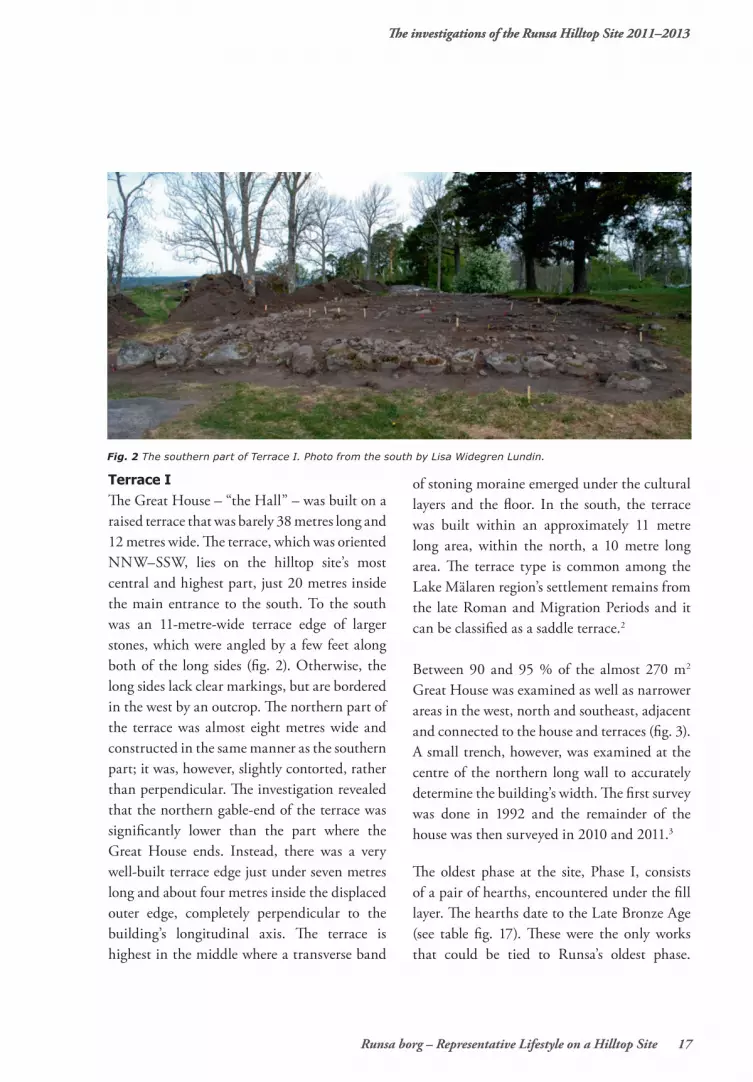
Terrace IThe Great House – “the Hall” – was built on a raised terrace that was barely 38 metres long and 12 metres wide. The terrace, which was oriented NNW–SSW, lies on the hilltop site’s most central and highest part, just 20 metres inside the main entrance to the south. To the south was an 11-metre-wide terrace edge of larger stones, which were angled by a few feet along both of the long sides (fig. 2). Otherwise, the long sides lack clear markings, but are bordered in the west by an outcrop. The northern part of the terrace was almost eight metres wide and constructed in the same manner as the southern part; it was, however, slightly contorted, rather than perpendicular. The investigation revealed that the northern gable-end of the terrace was significantly lower than the part where the Great House ends. Instead, there was a very well-built terrace edge just under seven metres long and about four metres inside the displaced outer edge, completely perpendicular to the building’s longitudinal axis. The terrace is highest in the middle where a transverse band
of stoning moraine emerged under the cultural layers and the floor. In the south, the terrace was built within an approximately 11 metre long area, within the north, a 10 metre long area. The terrace type is common among the Lake Mälaren region’s settlement remains from the late Roman and Migration Periods and it can be classified as a saddle terrace.2
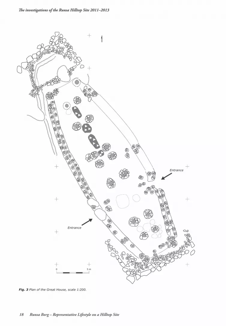
Between 90 and 95 % of the almost 270 m2 Great House was examined as well as narrower areas in the west, north and southeast, adjacent and connected to the house and terraces (fig. 3). A small trench, however, was examined at the centre of the northern long wall to accurately determine the building’s width. The first survey was done in 1992 and the remainder of the house was then surveyed in 2010 and 2011.3
The oldest phase at the site, Phase I, consists of a pair of hearths, encountered under the fill layer. The hearths date to the Late Bronze Age (see table fig. 17). These were the only works that could be tied to Runsa’s oldest phase.
Fig. 2 The southern part of Terrace I. Photo from the south by Lisa Widegren Lundin.
The investigations of the Runsa Hilltop Site 2011–2013
18 Runsa Borg – Representative Lifestyle on a Hilltop Site
The investigations of the Runsa Hilltop Site 2011–2013
Fig. 3 Plan of the Great House, scale 1:200.
Entrance
Entrance

The investigations of the Runsa Hilltop Site 2011–2013
Runsa borg – Representative Lifestyle on a Hilltop Site 19
The investigations of the Runsa Hilltop Site 2011–2013
Otherwise, finds came from the Migration Period cultural layer or in the form of individual works, for example the posthole’s stone fill, which belongs to the Late Bronze Age phase. A fragment of a so-called textile ceramic – part of a flint chip re-used as a strike-a-light stone – as well as some quartz chippings and a hammerstone were also found.
Phase 2 is represented by the construction of Terrace I, where the northern and southern surfaces were levelled and raised to the desired level inside Terrace I’s structures. The height, in relation to the foundation, was up to 0,3 and 0,4 metres. The fill material consisted of older cultural layers, partially dark and coal-mixed with elements of smaller stone, including fire-cracked stones. The layer was not particularly find-rich, but it did contain, in some places, burnt clay, occasional pottery fragments of the Iron Age type as well as burnt and unburnt bone. A centimetre-thick floor layer consisting of silt was found in the Great House’s northern part as well as in parts of the south. In the more moraine-rich central part, the layer was difficult to identify.
Phase 3 is represented by the actual construction of the building. The Great House was a three-aisled construction, 29.5 metres long and 10.7 metres wide, and had a pronounced convex shape. The inner roof structure consisted of seven pairs of trestles. The design was underbalanced, with a trestle width forming the central aisle between two and two and a half metres. The span length between the trestle pairs was, starting from the north: three, five, one and a half, three, seven and three metres.
In the Great House’s central area, there was only one and a half metres of space between two pairs of trestles; a small hearth is wedged between each trestle pair. Such execution suggests some form of re-development, which means that there were originally five metres between the second and the third and the third and the fourth trestle pairs. This is one of the few examples of remodelling, but within the same measurement module. Farthest to the north, a sibling is missing in what would have been the last trestle pair. Possibly, the pole was put directly on the ground with stone support. The postholes averaged one metre in diameter (fig. 4). The depths, on the other hand, varied since the bedrock was higher up in several places. Here, the postholes were only between 0.3 and 0.4 metres deep, but with a slightly wider support gasket than the more normal deep postholes, which were between 0.6 and 0.9 metres deep. In several cases, the empty spaces left by the posts were on average half a metre wide, which indicates posts with massive dimensions.
Fig. 4 Partly excavated posthole of one of the supporting roof posts. The surrounding stone packing is visible. Photo: Michael Olausson.

The investigations of the Runsa Hilltop Site 2011–2013
20 Runsa Borg – Representative Lifestyle on a Hilltop Site
Also belonging to the Phase 3 is the extremely well-preserved wall. The wall originates from strong corner gable posts and runs along as two parallel gullies with thinner postholes set closely as if to wrap around each other (fig. 5). The wall was an average of one metre wide, where each gulley was 0.4 metres wide and 0.3 metres deep. Plenty of burnt wood residue was found at the poles, where pine was dominant, especially in the west. Along the house’s southwestern part, it was difficult to distinguish between the different gullies along the wall and the individual postholes. The surface was very stony and burnt. The corner posts were, on average, 0.8 to one metre wide. Two entrances were able to be determined,
both in the southern part of the house, where they were placed opposite each other. The southeast entrance was clearly demarcated, with withdrawn, smaller posts and the inner gulley folds inwards and ends in postholes. Both of the entrances were narrow; they were both almost a metre wide. The corresponding entrance on the western side was not as clear, but it was marked by a flat ledge of rock with a couple of smaller postholes inside it.
Phase 4 is represented by a deposited cultural layer that is, on average, a decimetre thick and tends to be somewhat stronger out against the walls as well as in the northern and southern parts of the house. In the northern part, the layer was soot and coal-mixed in the central part, but also out towards the eastern long wall. Adjacent to, and partially under, the layer, three larger and two smaller hearths were revealed. The smaller hearths were barely a metre in diameter, the larger hearths were almost rectangular with rounded corners. Here, the finds consisted mainly of burnt bones. The cultural layer was generally brownish-grey and consisted of finer materials with scattered elements of burnt clay. This phase also includes a number of small postholes in the house’s southeast section as well as a pit in the southern part. Moreover, it includes a drainage gulley, which was determined just about a metre outside the wall in the north-western part. The gulley was partly paved with stone and had a fill of dark silt. Towards the north, it can be followed down to the northern lower terrace where it bends in an L-shape. Soil samples from the gulley contained brackish water diatoms. This indicates that there were stored water containers with water from Lake Mälaren by the Great House (see below for more about the waterhole).
Fig. 5 A section of the western part of the long wall. Note the stone packing around the densely fitted wall posts and the red, burnt clayish filling. Photo from S, Michael Olausson.

The investigations of the Runsa Hilltop Site 2011–2013
Runsa borg – Representative Lifestyle on a Hilltop Site 21
After Phase 4, a fierce fire destroyed the Great House and thus Phase 5 is also known as the destruction phase. Phase 5 manifests with particular clarity in the heavily burnt western wall: red burnt fill, large pieces of burnt – almost sintered – clay and lots of carbon in the gulley and the area closest to it. A reddish, partly orange-coloured layer covered the cultural layers of the house’s western half, four to five metres into the house when counted from the wall. Otherwise, the upper parts of the cultural layer are sooty and coal-mixed in the northern and south-western parts. The southern gable wall, like the western long wall, was strongly impacted by fire, as evidenced by a layer of burnt clay and charcoal. In addition, traces of fire in the form of carbon can be found in all structures. The most obvious traces of fire can be found in the Great House’s western part, suggesting that the fire may have started there, fuelled by strong winds from the southwest. Finally, Phase 6 can be seen as a closure of the Great House. The clearest example of this is
that the oldest layers were dug through in order to establish a large pit hearth (2×1.5 metre wide and 0.4 metre deep), which was aligned with the row of trestle pairs (figs. 6a and 6b). The bottom of the pit was covered with very large and long pieces of carbon. After the fire pit was put out of use, a pointy, pyramid-like rock was placed in the middle of the hearth pit. During the same phase, or shortly thereafter, parts of the south-eastern wall and its entrance were covered in a sandy, gravelly layer with elements of smaller stones. This layer can even be found on the uppermost parts of Terrace II. A fine and ornate silver ring (fig. 7) was found at the bottom of the gravelly layer directly above the eastern long wall. A few hearths have been linked to this layer on Terrace II and they have been dated between 500 and 600 AD (see fig. 17 table 14C below).
FindsThe Great House was surprisingly find-poor, as evidenced by the small amount of bone, especially burnt bone, in the house’s northern
Fig. 6a The erected stone placed on top of a hearth pit in the southern part of the Great House. The stone can be interpreted as a symbolic closing of the house after it had burned to the ground. The smaller stones seen in the background represent the bottom packing of the terrace foundation. Photo from S, Michael Olausson.
Fig. 6b The erected stone above a partly excavated hearth pit. The remains indicate that the pit was used only for a very short period and firing occured on only a few occasions. Photo from S, Michael Olausson.

The investigations of the Runsa Hilltop Site 2011–2013
22 Runsa Borg – Representative Lifestyle on a Hilltop Site
unburnt. The find pattern of the hall and Terrace I, however, is an anomaly and diverges from the ones of the adjoining Terraces II and III. Food waste is the dominant element of the burnt bones, which amounts to just about a kilogram, but offal can also be found. The largest amount is from the northern half of the Great House – in and around the three larger hearths. While horse is scarce, cattle comprised the majority, followed by sheep/goat and pig; fowl and swan as well. An additional example of exclusive elements of this elite milieu is fragments of charred bread.
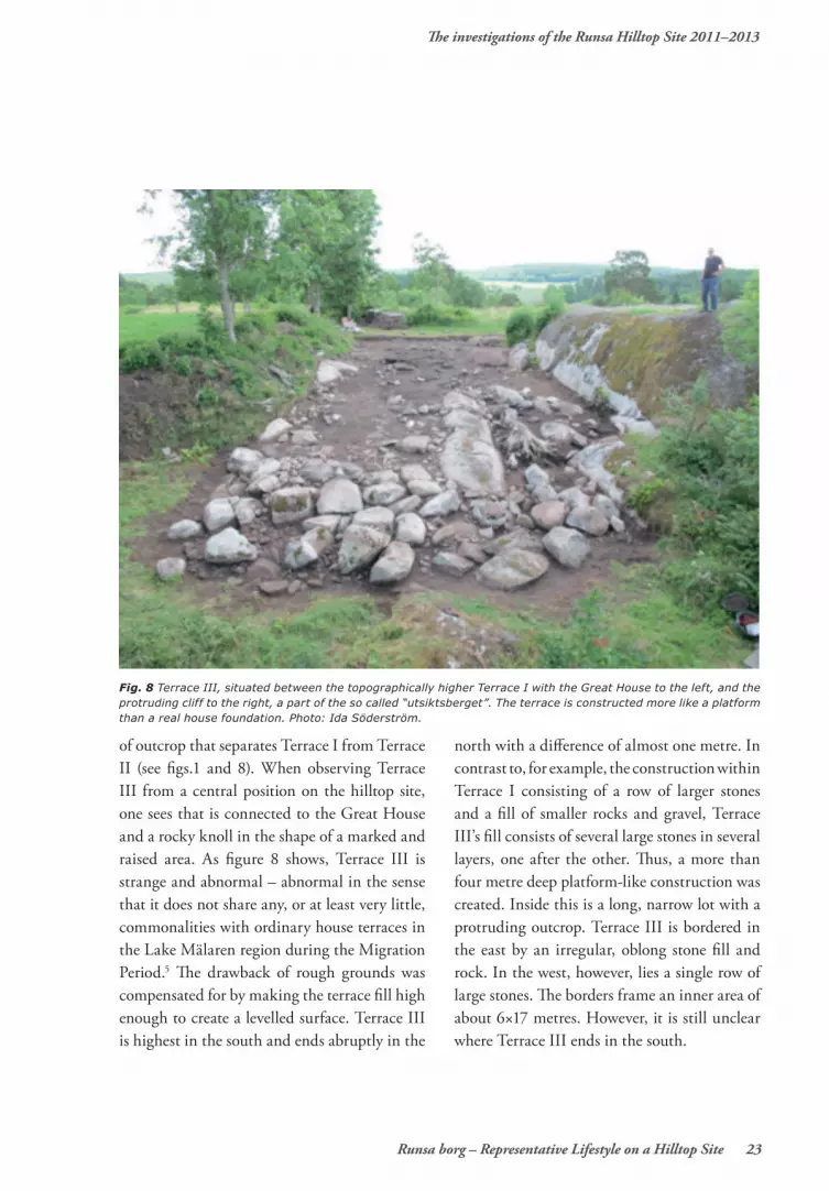
Terrace IIIIn contrast to Terrace I, which has a large representative house leaving it quite visible and exposed, Terrace III is considerably smaller – one might even say an example of the opposite of Terrace I. Terrace I is squeezed between the so-called outlook in the west and a lower part
half as well as parts of the south. The central and middle parts of the Great House had the least amount of finds. Among the finds include a few beads – two of them red – fragments of a glass chalice (Snartemo type), part of a bronze tweezers, part of a composite comb, knives, pins, nails, rivets, rivet washers, fragments of loom weights and a spindle whorl. These objects were mainly found in the terrace fill and in some postholes. A piece of a sword hilt was found at the top of posthole A3677 and it is one of the true high status objects of Runsa (fig 7). The piece is gilded and significantly damaged by fire. The find supports the theory of a violent struggle and burning of “the hall” and other hilltop sites4 (a more detailed discussion of Runsa Hall can be found in Olausson’s other article in this book).
Typical finds at Runsa are animal bones; large amounts of animal bones were found, primarily
Fig. 7 The silver ring from layers covering parts of the Great House. The ring represents the youngest find from the site; c:a AD 650–700.
The investigations of the Runsa Hilltop Site 2011–2013
Runsa borg – Representative Lifestyle on a Hilltop Site 23
of outcrop that separates Terrace I from Terrace II (see figs.1 and 8). When observing Terrace III from a central position on the hilltop site, one sees that is connected to the Great House and a rocky knoll in the shape of a marked and raised area. As figure 8 shows, Terrace III is strange and abnormal – abnormal in the sense that it does not share any, or at least very little, commonalities with ordinary house terraces in the Lake Mälaren region during the Migration Period.5 The drawback of rough grounds was compensated for by making the terrace fill high enough to create a levelled surface. Terrace III is highest in the south and ends abruptly in the
north with a difference of almost one metre. In contrast to, for example, the construction within Terrace I consisting of a row of larger stones and a fill of smaller rocks and gravel, Terrace III’s fill consists of several large stones in several layers, one after the other. Thus, a more than four metre deep platform-like construction was created. Inside this is a long, narrow lot with a protruding outcrop. Terrace III is bordered in the east by an irregular, oblong stone fill and rock. In the west, however, lies a single row of large stones. The borders frame an inner area of about 6×17 metres. However, it is still unclear where Terrace III ends in the south.
Fig. 8 Terrace III, situated between the topographically higher Terrace I with the Great House to the left, and the protruding cliff to the right, a part of the so called “utsiktsberget”. The terrace is constructed more like a platform than a real house foundation. Photo: Ida Söderström.

The investigations of the Runsa Hilltop Site 2011–2013
24 Runsa Borg – Representative Lifestyle on a Hilltop Site
Already after the removal of the grass sod, which was done with a machine, a dark, partially sooty layer with elements of fire-cracked rock and unburnt animal bone appeared. The layer spanned a large area – approximately 7×5 metres wide – in Terrace III’s central area. The layer is characterized by animal bones, both scattered and in smaller concentrations. Worked bone was also discovered in this layer. The bone represents different stages of a manufacturing process: from the raw material of cattle metatarsals to larger and smaller sawed parts, often in the form of plates. These are between two and five centimetres wide and a few millimetres thick. Similar plates occur in the workshop site of House Group 3 on Helgö and in parts of the ring fort Eketorp II on the island of Öland.
Comparing the Runsa finds with waste material from the Viking Period comb-maker’s workshop at Birka, the similarities are striking. Therefore, the bone wastes from Terrace III can be interpreted as craft waste from comb production. Besides parts of composite combs, other bone objects, such as spindle whorls from knucklebones and various needles, were produced. The fact that cattle bones (metacarpus) were the main raw material at Runsa separates the site from both Helgö and Eketorp II, where moose antlers were the most common one, but also from Continental hilltop sites such as Runder Berg bei Urach in Baden-Württemberg (5th century – early 6th century) and Late Roman citadels such as Sporneck on the Rhine in Baden (mainly second half 4th century) where smaller deer
Fig. 9 Some non-metal finds from Terrace III, from the left to the right: gamble pieces made of various materials; bone, glass and stone, a comb made in one piece, a sword bead, a small piece of a blue glass beaker, and three different types of beads made of glass. Photo: Andrea Jäderlund.

The investigations of the Runsa Hilltop Site 2011–2013
Runsa borg – Representative Lifestyle on a Hilltop Site 25
antlers were the main raw material. At Dinas Powys in Wales (450/500–650/750 AD) bone and horn crafts from domestic cattle and wild animals occurred; however, without evidence of any comb production. 6
The differences cannot be explained solely by differences in physical geography –proximity to wildlife-rich forests etc. The differences should also be attributed to various degrees of trade contact control of the hinterland. To answer this question more precisely is not currently possible. In order to address the problem, which, as indicated above, also comprises questions of supply chain management and control of Runsa’s hinterland, we intend to carry out series of animal bone tests to determine trace elements, particularly strontium. If possible, the purpose is to pinpoint the areas from which the animals of Runsa came.
Remaining findsThe finds are rich and varied, but their composition is somewhat difficult to determine regarding the context. In addition to the waste, there are half-finished products, mainly of bones, but there are also high status objects. There are several belt fittings, including a gilded one, and gaming pieces of glass and horn (fig. 9). The glass consists of a single fragment from a thin, almost cobalt blue chalice, identical to one found earlier on Terrace II, which has only been partially investigated.7 Additionally, a piece of tan glass, which, when compared to the blue glass, was slightly thicker, was found. A bronze needle with a polyhedral head, a few bone needles and occasional iron buckles represent finds that are more common to the late Migration and early
Vendel Periods – not to dwelling places, however, but rather to graves. 8
Beads appear in Migration Period graves. Whole sets of beads are rarely found; instead, one usually comes across a handful. Yellow and blue beads are the most common. There are also multi-coloured beads and, occasionally, red and reddish yellow glass beads. Bronze beads may also be found in certain instances.9 A variety of beads were found on Terrace III, from the more commonly used red to the occasional bead with dot and thread inlay. 10
As the fieldwork drew to a close in 2013, a number of structures and layers were found outside, and adjacent to, Terrace III’s northern edge. Additionally, there was plenty of fire-cracked rock as well as finds between and under the large stones and the trestle. A hearth and a smaller pit were examined. The latter contained parts of a pottery vessel, fifteen burnt tubers of dropwort (Filipendula vulgaris) and a blue faceted bead. The dropwort has been 14C -dated to the early Merovingian Period. The bead is identical to the ones of grave nr 54:1 at the cemetery of Roirhage in Grötlingbo on the island of Gotland, which in total contained 11 blue faceted beads.
The find of a sword bead can be seen as an expression of a weapon-bearing elite. The bead is three centimetres long and two centimetres high. In all of Sweden, eight sword beads have been found (as listed on SHM), including five on Öland, four from Skedemosse and one from Sörby, all a part of Gärdlösa parish. The bead from Sörby is made from bone and is ornate.

The investigations of the Runsa Hilltop Site 2011–2013
26 Runsa Borg – Representative Lifestyle on a Hilltop Site
There is a bead from Värnhem on Gotland from a rich weapon grave with, among other things, a spear, shield, thumb rings and a fibula. A very beautiful sword bead was found in the rich weapon grave at Lilla Vi, Djursdala parish in Småland. Sword beads occur in two contexts: in sacrificial bogs and in graves. But, as the Runsa find demonstrates, they can also occur in settlement contexts. The Ölandic sword beads can be linked to sacrificial bogs, similar to a variety of Danish sword bead finds, such as Nydam and Porskjaer.11 A pair of sword beads from a sacrificial bog was found at Finnestorp in Västergötland. A review of the bead material from tested graves would likely lead to the discovery of more sword beads.
The beads are between 3 and 4.5 centimetres in diameter. Most of them are made from glass, but one from quartzite and another from bone. The majority has an almost flat bottom and a curved top, while a few are thinner like the so-called Runsa bead.
In addition to finds of sword beads in sacrificial bogs and occasional high status graves, one might expect them to have appeared in aristocratic milieus such as major farms and elite residences. Therefore, the find of a sword bead at the hill top site of Skoftesta Skans in Västmanland was essential. During the 1920s and 1930s, Ivar Schnell did a research project on the “hillforts” of Västmanland and Uppland and Skoftesta Skans was the only one in which Schnell found cultural layers. Besides the sword bead, he also found a bone spoon and pottery. The sword bead, which unfortunately was lost, was scarcely 3 centimetres wide and had the
shape of what can be described as a conical melon.12 There are equivalents to this type of bead in both Nydam and Porskjaer, dated between 400 and 450 AD.13
Considering the context of sword beads, the find of a bead in a stone wall at Järnstad in Stora Åby parish, province of Östergötland. The excavated stone wall was part of a much larger stone wall system. The bead was 3 cm and 1,9 cm high, made of a light green glass decorated with red wave bands and yellow dots.14
Aside from the finds mentioned above, other finds exist as well: an intact iron fishing hook, a variety of knives of different sizes, pottery, fragments of loom weights of varying sizes, iron knifes and other small iron items, pieces of flint and a large amount of animal bones, the majority of them unburnt.
Terrace X/Trench X Terrace X lies on the hilltop site’s northern area on a smaller ledge, between one to two metres inside the rampart and below the plateau that forms the bulk of Area C. Terrace X followed the ledge in a NW–SE direction; its full size is unknown, but estimated to have been between 10 and 15 metres. Part of Terrace X is overlain by a low earth rampart which runs towards the southeast at a distance of 15 to 20 metres. A small ledge above Terrace X contains stone fill and cultural layers. Terrace X was discovered in conjunction with the clearing of vegetation and a larger test pit during an investigation in the fall of 2010. Large amounts of unburnt animals bones, as well as parts of a large hearth, were found.

The investigations of the Runsa Hilltop Site 2011–2013
Runsa borg – Representative Lifestyle on a Hilltop Site 27
Terrace X was framed by large boulders, partly in double rows. The terrace was investigated by a 40 m2 trench (fig. 10), which uncovered 5 metres of its length and 4.5 metres of its depth. To the north, the row of boulders turned to the left marking its end.
Given the sharply sloping, rocky bottom topography, the areas within the large terrace boulders had been levelled gradually to a height of between 1.5 and 1.7 metres, partly by activities on the site, partly by replenishing masses. The investigation revealed that the area has been used primarily for intense firing,
which has occurred during at least three separate stratigraphic periods. The construction of Terrace X was preceded by firing, but with unclear purpose. In the bottom of the pit, remains from the first phase were found in the form of a large hearth. The hearth was shallow, only about 0.05 m deep, and was apparently partially removed. A sooty layer, which was found on the slope below, can be seen as removed remains from this hearth.
Terrace X followed the ledge in a NW–SE direction was built at a later stage (phase 2). Terrace X’s full propagation – its length – is
Fig. 10 Terrace X; Built on a ledge where the boulders to the left represent the front of the terrace. This was one of many works that aimed to get as much m2 as possible for use inside the ramparts. Successive fillings and activities on the terrace resulted in 1.5 meter thick layers. The measuring stick is 0,5 m. Note the black layer in top of the section, which represents activities around a large hearth. The rampart runs a bit down to the left in picture. Photo from N, Richard Heimdahl.

The investigations of the Runsa Hilltop Site 2011–2013
28 Runsa Borg – Representative Lifestyle on a Hilltop Site
still unclear. It was bordered to the NE by one to two rows of large boulders and some smaller stones. To the north, the row of boulders and a band of smaller stones turned left, marking the end of the terrace in this part. The fill layer that lay inside, in the SW, was made up of stones about a metre thick. This consisted mainly of two larger, surface-covering layers. In the bottom of these layers, a couple of horse skulls were found. The skulls should be interpreted as a sacrifice in conjunction with the construction of Terrace X’s edge of larger boulders. Layer 4, which was at the bottom, was partially sooty, the content likely stemming from the firing in the first few phases. The layer is probably deposited on site, or possibly formed in conjunction with the construction of Terrace X. Layer 3, above, was lighter in colour and less sooty, and was probably mainly composed of replenished masses. The deposits of bones and finds in the layer also suggest this conclusion. Many of the bones were almost vertically deposited. Northwest of the eventual northern limit of Terrace X were a couple of small areas with a layer of fire-affected, replenished material, which lay between layers 2A/3 and 4 (layer 8). These differed from the fill layer that existed south of the possible limit of Terrace X, possibly another indication that the terrace ends there.
Sometime just before, or in connection with, the construction of Terrace X, a small hearth was used for firing in the northern part of the trench. The hearth was at layer 4 and layer 6, which was a small, stone-mixed layer on slope’s upper part. On Terrace X, firing occurred in a last stage (phase 3) in a large firing pit (A8488),
whose last phase, in turn, was a large hearth in the southwestern part of the pit (A8262). Remains of the firing are seen in the form of a sooty layer, partially in the bottom of the pit and partially around and across the slope below the hearth and hearth pit. The layers show repeated firing on the site and that the firing pit has been regularly emptied of soot, coal and fire-cracked rocks. The slope above the hearth pit exhibited exposed rocks near the surface. These parts of the terrace were covered by a deposited layer, which contained a lot of metal finds as well as an equal-arm fibula (fig 11). The fibula dated to the period around the mid-500s AD.15 There were also knives and buckles. These findings were probably dumped from the ledge above the pit.
In the southern part of the excavation was a flat earth rampart (A8495), which continues beyond the southeastern trench. This rampart is at least 15 metres long and about two to four metres wide and within the trench, about 0.3 metres high. The rampart is slightly higher further south. The function is unclear, but one possibility is that it was built to level the ground, thereby creating a couple of additional square metres to utilize. The embankment represents the last phase of use of the site (phase 4).
Additional findsAnimal bones from Terrace X, which were mainly unburnt, were by far the biggest find category – a total of 50 kilograms (fig. 11). Besides the animal bones, there was waste in the form of ceramic works and spindle whorls, as well as metal: horseshoe-caulks, rivets, knives and single buckles of iron. A few fragments

The investigations of the Runsa Hilltop Site 2011–2013
Runsa borg – Representative Lifestyle on a Hilltop Site 29
of crucibles and moulds show that bronze casting took place. The small amount, however, indicates that the production site was not on the terrace, but near it. The same applies to the finding of single pieces of slag. Interestingly, even on the other terraces, there were traces of bone- and horn crafts, with the production of large needles.
Terrace X is a good example of how intensely people used the area within the walls. All disposable land, regardless of topographic inconvenience, was utilized.
But where was the drinking water?Trench XI: the waterholeConstant access to a water supply was paramount in choosing the location for the Runsa Hilltop Site. Access to water is an issue that is too rarely discussed by archaeologists involved in settlement investigations. Lack of access to a waterhole on hilltop sites is an issue that is mentioned from time to time, but rarely addressed in a thorough manner.16 References to military logistics are, in this context, of the utmost importance if one is to really understand the extent of the efforts to access water.15 In this case, a large amount of people resided on a
Fig. 11 A ritual deposition of a horse cranium in the bottom of Terrace X, an action that represents its foundation. In comparison with other excavated parts of Runsa, horse was rather frequent on Terrace X. Photo from W; Richard Heimdahl.
The investigations of the Runsa Hilltop Site 2011–2013
30 Runsa Borg – Representative Lifestyle on a Hilltop Site
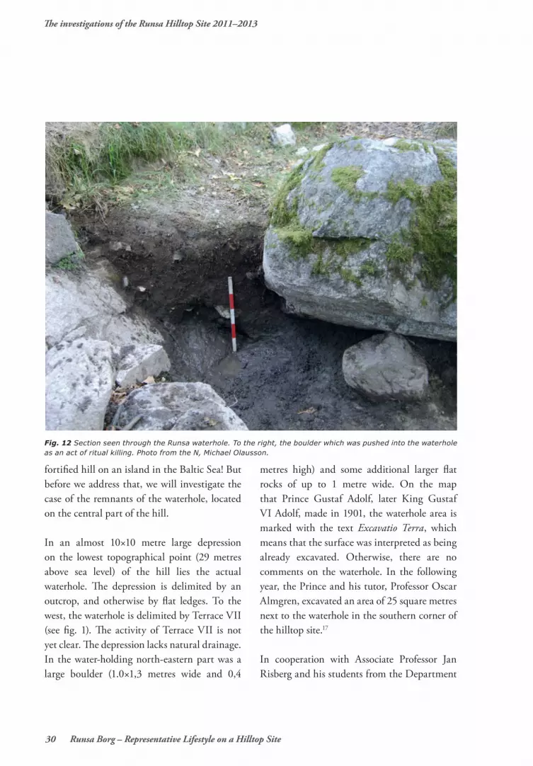
fortified hill on an island in the Baltic Sea! But before we address that, we will investigate the case of the remnants of the waterhole, located on the central part of the hill.
In an almost 10×10 metre large depression on the lowest topographical point (29 metres above sea level) of the hill lies the actual waterhole. The depression is delimited by an outcrop, and otherwise by flat ledges. To the west, the waterhole is delimited by Terrace VII (see fig. 1). The activity of Terrace VII is not yet clear. The depression lacks natural drainage. In the water-holding north-eastern part was a large boulder (1.0×1,3 metres wide and 0,4
metres high) and some additional larger flat rocks of up to 1 metre wide. On the map that Prince Gustaf Adolf, later King Gustaf VI Adolf, made in 1901, the waterhole area is marked with the text Excavatio Terra, which means that the surface was interpreted as being already excavated. Otherwise, there are no comments on the waterhole. In the following year, the Prince and his tutor, Professor Oscar Almgren, excavated an area of 25 square metres next to the waterhole in the southern corner of the hilltop site.17
In cooperation with Associate Professor Jan Risberg and his students from the Department
Fig. 12 Section seen through the Runsa waterhole. To the right, the boulder which was pushed into the waterhole as an act of ritual killing. Photo from the N, Michael Olausson.

The investigations of the Runsa Hilltop Site 2011–2013
Runsa borg – Representative Lifestyle on a Hilltop Site 31
of Physical Geography and Quarternary Geography at the University of Stockholm, a 7×2 metres wide trench (NE–SW), the waterhole was examined. The natural geographical conditions in the depression, which lacked drainage, are such that this is a place where water that melts, as well as rain, is collected. During the spring, and sometimes during the early summer, the water may still be fairly high. The drying up during the summers shows that it is not a case of an artesian well or the like. The aim of studying the layers all the way down to the bedrock – with the help of phytoliths and diatoms – was to see whether, and for how long, the depression functioned as the hilltop site’s waterhole. Surprisingly, there were large amounts of stone in the 3×3 m waterhole – several of them very large. Most interesting was a very large boulder, about 1×1.5 m wide. It became apparent that the boulder had been levered into the waterhole intentionally (fig. 12 and 13). The bottom layer consisted of a thin layer of silt moraine. Finds of unaffected moraine in the deepest layers show that the bottom was dug as deeply as possible. Around the edges there were smaller stone works, likely to allow the unimpeded absorption of water.
The deposited layers in the waterhole can be divided roughly in two: an upper layer, which is richer in peat and has a higher content of organic
materials, and a lower layer, which contains finer materials of silt. The determination of the diatoms shows a significant difference between these two layers. Unlike the upper layer, with its freshwater diatoms, there is a considerable element of brackish water diatoms between circa 45 centimetres down to the bedrock.18 All species in the waterhole have been identified in sediments from the inlet below Runsa. These species did not live in the waterhole, but were transported there from the surrounding water (Littorina Sea/The Baltic Sea). All tests showed an abundance of different species and the phytoliths as well as a general effect from a terrestrial environment with very high nutrient levels such as golden algae, Chrosofytcea which indicates infuences of the surroundings with high nutrition contents.19
There are material culture remains in the waterhole including plenty of herbs as well as spruce (Picea). Pollen from barley (Hordeum) has also been found. The presence of spruce indicates that the material is younger than 500 BC. Otherwise, a comprehensive pollen analysis supports the interpretation that everything in the Waterhole can be seen as a cultural layer (fig. 13).
Aside from the occasional burnt bone, there were no finds found in the waterhole. The bones
Fig. 13 Section through the waterhole; to the right in the drawing, parts of the adjacent Terrace VII to the right on the drawing. Sample site for the radiocarbon dating is marked with a cross circle. Scale: 1:60.
Terrace VII
9 meters abovesea level 0 1 m

The investigations of the Runsa Hilltop Site 2011–2013
32 Runsa Borg – Representative Lifestyle on a Hilltop Site
come from the surrounding cultural layers and from Terrace VII. The rainy season had, in all certainty, a great impact on the waterhole; there was, for example, an inflow of nutrients like nitrogen from the surrounding cultural layers. The question is how and to what extent this affected drinkability.
What was first interpreted to be “stair stones” turned out to be the inner boundary of Terrace VII. A little less than 4 m2 of Terrace VII was examined and it consisted of sand and gravel-mixed stone fill with smaller elements of cultural layers. Dispersed around Terrace VII, occasionally, were burnt and unburnt animal bones, a couple of flints, fragments of a ground stone, and a hammer stone. The few bone fragments that could be identified came
from pigs and cattle. A radiocarbon sample from the bottom of the waterhole, which when calibrated to 2-sigma, gave a date of 330–540 AD. The coal comes from the bottom edge of the excavated pit (see fig. 13) in a thinner layer with elements of fire-cracked rocks.
Ensuring a constant supply of water would have been fundamental to the establishment of the settlement. Once the decision to build the fort had been made – during the 400s AD according to the 14C results – hollowing out the depression of the hill in order to create the waterhole must have been one of the first tasks. No layers have been deposited on top of the waterhole. Rather, the large boulder and several other large rocks must be interpreted as the closing of the settlement’s vital waterhole.
Fig. 14 The waterhole on Darsgärde was situated just inside the gateway at the Hilltop site s lowest area. Photo Björn Ambrosiani 1957.
The investigations of the Runsa Hilltop Site 2011–2013
Runsa borg – Representative Lifestyle on a Hilltop Site 33
The date of which this occurred cannot be given exactly, although it was probably during the first half of the 7th century AD. The burnt down fortifications were not maintained during this time, much less rebuilt, and only limited activities have been verified.
The “well” on DarsgärdeAccess to water was an obvious requirement for living permanently on the different hilltop settlements. The problems relating to this issue have been a frequent part of the discussion surrounding the functioning of the hilltop sites, but never or rarely dealt with thoroughly. Upon closer inspection, however, there appear to be waterholes – of varying levels of execution – on several of the hilltop sites in Uppland and, occasionally, in Södermanland. Springs also
occur outside the sites, but at lower levels, like in the case of Lundboborg, Edsbro parish, where a holy well has been found 100 metres from the hilltop site. In some cases, such as the hilltop sites of Mannö in Botkyrka, Södermanland, and Darsgärde, Skederid parish in Roslagen, the waterholes have clear delimitations of low embankments and/or large rocks. The hilltop sites of Frötuna in Roslagen and Fållnäs in Sorunda have examples of natural depressions that were strengthened, to a lesser extent, with stone and earth materials. These, however, have yet to be scientifically investigated.
The 4×4 metre waterhole on the hilltop site of Mannö has been investigated with a smaller trial trench. The waterhole’s depth has been estimated to be about 0.6 metres. No finds
Rampart
Rampart
A5
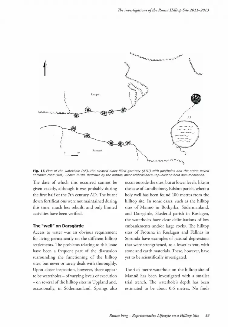
Fig. 15 Plan of the waterhole (A5), the cleared older filled gateway (A1II) with postholes and the stone paved entrance road (A4I). Scale: 1:100. Redrawn by the author, after Ambrosiani's unpublished field documentation.
0 1 m

The investigations of the Runsa Hilltop Site 2011–2013
34 Runsa Borg – Representative Lifestyle on a Hilltop Site
were located in the waterhole. The waterhole is located in the courtyard, a few metres from a group of five house terraces. It is water-bearing during spring and autumn.20
The waterhole at Runsa can be compared to the one that was examined between 1957–1958 at Darsgärde. The construction was characterized as a “well” (A5) and was situated in the hilltops site’s western part (fig. 14 and 15) in a paved street that went from one of the gates (A4). The gate was sealed in the later period of Darsgärde around the second half the 400s Ad. The area around the sealed gate, the waterhole, the rampart and the adjacent house terraces – provide insight into, and are good tools to sort out, the different stratigraphic stages chronologically. They are central to the understanding of the history of Darsgärde – especially its violent end. The documentation
material also demonstrates a good example of contextual archaeology, long before the term was coined and became fashionable. The street was flanked by house terraces. The terraces are constructed on a thin layer of topsoil, which in turn lay on top of older layers of settlement remains from the late Bronze Age. As is the case at Runsa, the waterhole on Darsgärde was located in a place where the rainwater gathered. Raised rocks made drainage impossible; just like at Runsa. A street enclosed the almost 2 metres wide and 0.6 deep waterhole that was dug out of an older cultural layer from the late Bronze Age (fig. 15). The bottom of the waterhole contained pure sand and rock. The edges of the waterhole were surrounded by several large stones and boulders. No finds were located. There was another waterhole inside of the hilltop site; sometimes called a “well”. It is situated higher up in the terrain and outside
Fig. 16 The “terrace” A 16. It should rather be interpreted as a working platform, limited by parts of the bedrock on three sides and a man-made row of stones on the fourth side. No structures that can be associated with a building were found. Just outside the row is another waterhole, similar in width as the other waterhole (see fig. 15). There is no information about this waterhole. The site A 16 may have been used as a working area. There are finds of casting moulds and loom weights close to the two hearth pits. Redrawn from field drawing. Scale: 1:100. Redrawn by the author, after Ambrosiani's unpublished field documentation.
LoomweightCrucible
0 1 m

The investigations of the Runsa Hilltop Site 2011–2013
Runsa borg – Representative Lifestyle on a Hilltop Site 35
of the smaller terrace (fig. 16); with a width of 2 metres (depth unknown). Terrace A16 contains two hearths as well as moulds and loom weights; however of limited numbers. No direct traces of a building were found.
A sanitary hazard?During Late Antiquity, authors expressed, almost as a maxim, that successfully running an army, and undertaking a military campaign, was dependent on the soldiers’ stomachs and equipment. “An army’s health,” writes Vegetius,
is preserved “by means of site, water supply, seasonings, medicine and exercise.” Vegetius’ text can be dated to the beginning of the 5th century AD, probably during the reign of Honorius. His famous maxim that “armies are more thwart destroyed by starvation than battle, and hunger is more savage than the sword,” is important to bear in mind.21 Poor drinking water, such as marsh water, is like poison, causing sickness. It was difficult for sick soldiers to fight a battle against both their enemies and their illness, writes Vegetius. Whether the water
Lab. Nr Material BP ± Cal 1 sigma Cal 2 sigma RemarksUa-5868 Charcoal 2490 ± 75 770–520 BC 790–410 BC Hearth pit superposed by the hall
building.Ua-4292 Charcoal 2285 ± 65 410–200 BC 520–170 BC ”-”Ua-4293 Charcoal 1660 ± 65 250–530 AD 230–550 AD Posthole in the hall building.Ua-5865 Quercus 1650 ± 75 260–540 AD 230–580 AD Middle part of the rampart.Ua-33254 Carbonized
bread1650 ± 40 330–510 AD 250–540 AD Hordeum vulgare from the hall building
Ua-47237 Charcoal 1645 ± 34 340–510 AD 260–540 AD From the bottom of the waterholeUa-5867 Quercus 1640 ± 75 330–540 AD 230–580 AD Lower part of the rampart.Ua-33255 Carbonized
bread1580 ± 40 430–540 AD 400–570 AD Hordeum vulgare and Triticum spelta
from the hall buildingSt-13757 Charcoal 1575 ± 70 420–540 AD 380–600 AD Posthole in the hall building.Ua-5866 Quercus 1555 ± 75 420–580 AD 340–650 AD Upper part of the rampart.Ua-39019 Picea 1545 ± 30 430–570 AD 420–590 AD The Prince´s trench; upper part of the
rampart.Ua-39019 Salix sp 1529 ± 30 440–590 AD 430–610 AD Bottom layer in the Prince´s trench.Ua-47236 Charcoal 1528 ± 32 440–590 AD 430–610 AD Hearth, Terrace III, A10451Ua-5864 Charcoal 1525 ± 75 430–610 AD 380–660 AD Hearth pit superposed by the latest
phase of the rampart. Close by, a bronze dress pin dated to the second half of the 5th century.
Ua-39017 Quercus 1512 ± 30 535–605 AD 430–630 AD The prince´s trench, upper part of the rampart.
Ua-47073 Filipendula Vulgaris
1485 ± 35 545–615 AD 460–650 AD Pit, A13011, outside Terrace III
Ua-39021 Betula 1468 ± 30 565–630 AD 545–645 AD Hearth pit A 607:7.Ua-39020 Pomoideae 1436 ± 30 600–650 AD 565–655 AD Hearth pit A 607:3.Ua-47235 Charcoal 1422 ± 33 605–650 AD 570–665 AD Hearth, A10445, Terrace IIISt-13758 Charcoal 1370 ± 45 615–685 AD 590–770 AD Hearth pit on the top of the ruined
rampart.
Fig. 17 The table shows all the radiocarbon datings from the Runsa Hilltop Site so far.
The investigations of the Runsa Hilltop Site 2011–2013
36 Runsa Borg – Representative Lifestyle on a Hilltop Site
from the waterhole at Runsa was drinkable can only be discerned by way of an educated guess. When full, the waterhole at Runsa is estimated to have contained between 3000 and 4000 litres. Water has a variety of important functions: it is necessary for washing and chores, as well as for different handicrafts. And animals, of course, need water, too. The term “animal” refers to smaller animals like chickens, pigs, dogs and cats up on the hilltop site; animals that have been osteologically verified among the bone finds at Runsa. Extensive traces of brackish water diatoms in the waterhole clearly indicate that the melt and rainwater was complemented
with water from the Baltic Sea. The element of salt, however, decreased gradually with the land elevation that, correspondingly, increased the influx of fresh water. The degree of salinity in the water was apparently acceptable. It appears that up to 2 per thousand salinity is acceptable for humans, although <1 per thousand is preferred.22
A major problem has been both keeping the water on the hill reasonably clean as well as keeping it circulating. The latter is a key consideration in Strategikon, a military manual written around the turn of the 6th or 7th century AD under the reign of Emperor
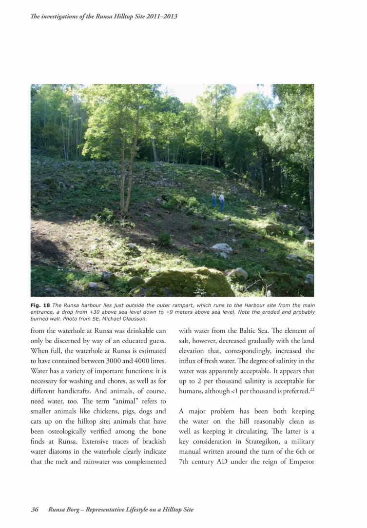
Fig. 18 The Runsa harbour lies just outside the outer rampart, which runs to the Harbour site from the main entrance, a drop from +30 above sea level down to +9 meters above sea level. Note the eroded and probably burned wall. Photo from SE, Michael Olausson.

The investigations of the Runsa Hilltop Site 2011–2013
Runsa borg – Representative Lifestyle on a Hilltop Site 37
Maurice of Byzantium. In Book X, which deals with sieges, the advice on building a border fortress stealthily, and without open battle, is detailed and accurate.23
Darsgärde appears to have been more vulnerable than Runsa, and the situation was, during periods, precarious. The waterhole belongs to the hilltop site’s later stratigraphic periods; after the gate was sealed. The rampart and the sealed gate effectively locked the water in the waterhole, and so it must have been full of undesired small particles and impurities.
Runsa’s harbourDown at Lilla Borgviken, remnants of what must have been Runsa’s harbour (see fig. 18) have been found. The area lies between two heights and in the northern slope of a passage
entrance, "threshold", (circa 12.5 metres above sea-level). At between 7.5 to 6 metres above sea level, a curved natural terrace edge runs between the two surrounding heights. On the terrace edge is a wall-like low row of stones that partly runs with double stones. It can be followed for a distance of 35 metres. It then passes over the natural terrace edge towards a steep rock face on the eastern side of the inlet. Just before it reaches the rock face the stone wall has an almost slanted form. This part of the stone wall, however, is rather indistinct. The stone wall runs from the north parallel with, and between one and two metres outside of the outer rampart. In a couple of places next to the stone wall, some irregular collections of stones continue down to the inlet. These are likely foundations of the harbour’s piers. The outer rampart runs from the southern entry of
Fig. 19a and b (next page). Parts of the harbour’s unique constructions were excavated and revealed a low stone wall construction a few meters outside the rasmassor from the outer rampart. The Harbour with the stone wall runs on a partly natural terrace, + 7–7,50 meters above sea level, and can be dated to the Migration Period. Photo: Michael Olausson.

The investigations of the Runsa Hilltop Site 2011–2013
38 Runsa Borg – Representative Lifestyle on a Hilltop Site
Fig. 19b

The investigations of the Runsa Hilltop Site 2011–2013
Runsa borg – Representative Lifestyle on a Hilltop Site 39
the plateau (28 metres above sea level) to the harbour area (8–8.5 metres above sea level), see figs. 20 and 21.
The trial trenches revealed that the stone wall consists of up to half metre high stones. These stones were planted in the moraine and stabilized with smaller ones (fig. 19a and 19b). In the bottom of a thin layer of topsoil and sand directly inside the stone wall was a spread coal layer. Occasional finds such as nails, unburnt animal bones and flint were found. The stone wall lies 7.2 metres above sea level, which corresponds to the sea level of the Migration
Period (with a reservation of a deviation of ± 1 metres). Below these remains lies still a sandy beach. The sand is on top of an older layer of wooden pieces and chips. The layer can be followed under the water and further under the upper layers of the sediment (see Jim Hansson’s article in this book). In the layer of chips, boat remains that have been 14C dated to the 7th century have been discovered. The layer also contains remains of 11th and 12th century vessels. Lilla Borgviken is still considered to be one of Lake Mälaren’s foremost natural harbours.

The investigations of the Runsa Hilltop Site 2011–2013
40 Runsa Borg – Representative Lifestyle on a Hilltop Site
REFERENCESPrimary sourcesMaurice´s Strategicon: Handbook of Byzantine Military Strategi, edited and translated by George T Dennis, Dumbarton Oaks 2001.
Vegetius, Epitome of Military Science, translated with notes and introduction by N. P. Milner, translated texts for Historians, Liverpool.
Secondary sourcesAlcock, Leslie, 1987. Economy, Society and Warfare among the Britons and Saxons, Cardiff.
Bahman, A. M., Rooket, J. A & Topps, J. H. 1993. The performance of diary cows offered drinking water of low or high salinity in a hot arid climate, British Society of Animal production, Public Authority for Agriculture and Fisheries, Safat, Kuwait. (The author points out, among other things, that cows in Kuwait can accept up to 3.5 per thousand salinity in drinking water.)
Bennett, Agneta. 1987. Graven – religiös och social symbol: Strukturer i folkvandringstidens gravskick i Mälarområdet. Thesis and Papers in North European Archaeology, Stockholm.
Biuw, Anita. 1992. Norra Spånga, bebyggelse och samhälle under järnåldern, Stockholm.
NOTES
1 Vibergs report published in the report from the investigations 2010–2013.
2 Hjulström p 47.3 Olausson 1995, 19964 Fischer et al 20135 Hamilton 2007, 20086 About bone- and horn handicrafts on hilltop
sites, hilltop stations, see Koch 1994, Quast 2008; Runder Berg, Swoboda 1986; Sproneck, Alcock 1987; Dinas Powys
7 Olausson 20118 Bennet 1987, Biuw 1992, Waller 20119 Bennett 198710 SHM 602-1276–2002, inv. nr 3262311 Nørgård Jørgensen 2008, Rau 2010 12 Olausson 198713 Nørgård Jørgensen 2008, Rau 201014 Björkhager, Ohlsén, Ranheden 2002:53–54
15 Åberg 1953 p 6216 Mather & Rose 201217 Olausson 201118 The following exotic species have been
observed (after c 1 traverse on the slide): Ellerbeckia arenaria, Campylodiscus clypeus, C. echeneis, Epithemia turgida, Stephanodiscus medius. All of the species have been identified as being from the sediment of the inlet. Pinnularia spp, Eunotia spp and phytoliths and Chrysophyta cysts. They indicate a general influence of a terrestrial milieu with very high nutrient levels (N, P, K).
19 Miller, U. ett al. Risberg, J. et al. 200220 A special thank you to David Damell for
allowing me to access the documentation material.
21 Vegetius Book III 2, 3, cf III 2622 Bahman et al 199323 Maurice s Strategicon Book X 4
The investigations of the Runsa Hilltop Site 2011–2013
Runsa borg – Representative Lifestyle on a Hilltop Site 41
Björkhager, Viktoria., Ohlsén, Marie,. Ranheden, Håkan. 2002. Järnstad ett fossilt odlingslandskap, Östergötlands länsmuseum, Linköping.
Fischer, Svante, Soulat, Jean, Linton Fischer, Teodora. 2010. Sword parts and their depositional contexts Symbols in Migration and Merovingian period martial society, Fornvännen p. 109–122, Stockholm.
Hamilton, John. 2007. Terrasshus och bebyggelseutveckling. In: Anund, Johan (ed) Gården, tingen, graven. Arkeologiska perspektiv på Mälardalen. RAÄ Skrifter nr 17, Stockholm.
— 2009. Storgården vid Sylta och den uppländska stensträngsbygdens boplatser, I: Olausson, Michael (ed.). Hem till Jarlabanke Jord, makt och evigt liv i östra Mälardalen under järnålder och medeltid, Lund.
Hjulström, Björn. 2008, Patterns in Diversity. Geochemical analyses and settlement changes during the Iron Age – Early Medieval time in the Lake Mälaren Region, Sweden. Thesis and Papers in Scientific Archaeology 11, Stockholm University.
Koch, Ursula, 1994. Frügeschichtliche Funde aus Bein, Geräte aus Ton und Stein aus den Plangrabunge. 1967–1984, Der Runde Berg bei Urach VIII, Heidelberg.
Mather, John D, Rose, P F Edward. 2012. Military aspects of hydrogeology: an introduction and overwiew. Geological Society London, Special publications, v 362, p 1–18, London.
Nørgård Jørgensen, Anne. 2008 Porskjaer Mosefund, Jysk Arkaeologisk Selskab Skrifter 59, Moesgård/Aarhus.
Olausson, Michael. 1987. Hillforts, subsistence and economic centralization AD 300–500 in eastern middle Sweden, In Burenhult, Göran et al. (eds) Theoretical Approaches to Artefacts, Settlement and Society, Festschrift to Mats P. Malmer, BAR Int. Ser. 366, Oxford.
— 1995. Det inneslutna rummet. Om kultiska hägnader, fornborgar och befästa gårdar i Uppland från 1300 f.Kr. till Kristi födelse. RAÄ Skrifter nr 9, Stockholm.
— 1996. Runsa fornborg – en befäst stormannagård från folkvandringstid, Upplands-Väsby.
— 2011. Undersökningen av Runsa borg, 2010. In: Olausson, Michael (ed). Runnhusa Bosättningen på berget med de många husen, Skrifter från projektet Runsa borg nr 1,Stockholm.
Quast, Dieter, 2008. Der Runder Berg bei Urach, Die alamannische Besiedlung im 4. und 5. Jahrhundert, In: Steuer, H & Bierbrauer, V (eds) Höhensiedlungen zwischen Antike und Mittelalter von den Ardennen bis zu Adria, Berlin.
Rau, Andreas. 2010. Nydam Mose 2 Die personengebundenen Gegenstände. Jysk Arkaeologisk Selskab Skrifter 72, Moesgård/Aarhus.
Risberg, Jan., Bengtsson, Lisbeth., Kihlstedt, Britta., Lidström Holmberg, Cecilia., Olausson, Michael., Olsson, Eva & Tingvall, Carin, 2002: Siliceous microfossils, especially phytoliths, as recorded in five prehistoric sites in eastern middle Sweden. Journal of Nordic Archaeological Science 13, Stockholm, p 11–26.
Swoboda, Roksanda M, 1986. Die Spätrömische Befestigung Sponeck am Kaiserstuhl, Münchner Beiträge zur Vor- und Frügeschichte, Band 36, München.
Waller, Jutta, 2011. Folkvandringstida kronologi i östra Mälardalen, AUN 43, Uppsala.
Åberg, Nils, 1953. Den historiska relationen mellan Folkvandringstid och Vendeltid, KVHAA Handlingar del 82, Stockholm.


