Embed Size (px)
Citation preview
Archaeological Investigation of the Site of
Nadrogā (1-NKR-046),
District of Noikoro, Navosa Province, Fiji Islands
By
Julie S. Field1
Report prepared for the Immigration Department, Fiji Islands, the Fiji Museum,
and the Nadrogā / Navosa Provincial Office
1Department of Anthropology, University of Hawai‘i, Manoa
Honolulu, USA
December 1st, 2003

ii
Acknowledgements
Funding for this research was provided by the National Science Foundation
(Dissertation Improvement Grant # BCS-0106221), the University of Hawai‘i Space
Grant College (Fellowship 1997-1998), the Honolulu Branch of the American
Association of University Women (Pacific Fellowship, 2001), and the Waikato
Radiocarbon Dating Laboratory (Waikato Archaeological Dating Fund, 2002). Special
thanks must go to the Roko Tui of the Nadrogā/Navosa Provincial Office, Lote
Naikasewa, for permitting archaeological research in Nadrogā and Navosa from August
2001 to March of 2002. Aid was also provided by Marika Nagata of the Navatumali
Office. Research permits and advising were provided by the Fiji Museum, and my
sincere thanks go to the Director, Sagale Buadromo, past director, Tarisi Sorovi-
Vunidilo, and also the Archaeology Department, in particular Jone Naucabalavu and
Sepeti Matararaba. Use of a 4WD vehicle was permitted by Australian National
University, and my gratitude goes out to Drs. Geoff Hope (ANU) and Paddy Nunn
(USP), and also Lyndall Fisher (FASANOC).
Research at the site of Nadrogā would not have been possible without the
blessings of Nubuyanitu village, Navosa. My special thanks go to the Taukei
Narukutabua, Nemia Vanua. My gratitude also goes to the Tui Nakoro, Adi Kuini
Vuikaba Speed. The results of the excavations at the site of Nadrogā has provided
important cultural and historical information concerning the prehistory of Fiji, and I must
express my immense gratitude for the opportunity to investigate the site further. In
addition, guiding to the site of Nadrogā was expertly provided by Eli Togavou and
Tuwaqa Lemeki.

iii
Abstract
This report describes a series of excavations and investigations performed upon
the site of Nadrogā, located in the district of Noikoro, Navosa Province, Fiji. The
investigation of this site was part of a larger research project that explored the emergence
and consequences of competitive and cooperative strategies in Fijian prehistory. Nadrogā
is unusual in that it lacks any evidence of fortification, yet is located atop an alluvial
terrace that is easily reached by foot. Nadrogā also contains unique architectural features,
including a chief’s burial mound, and an extensive stone wall. Excavations at the site
indicate that occupation dates to between AD 1650 and 1875.
Environmental analyses are also compared to the archaeological record for other
sites in the Sigatoka Valley, and used to determine the presence of three modes of
habitation/subsistence: territorial strongholds, remote refuges, and agricultural production
sites. Archaeological testing of these classes in tandem with GIS-based environmental
research indicate that the Sigatoka Valley was initially occupied between Cal BC 20 –
Cal AD 80, in association with dense and predictable resources. Fortifications that
utilized natural topography, and also remote refuges, were established ca. AD 700, and
remained in use throughout the prehistoric period. Environmental refuges associated
with the effects of the LCO/LIA transition were established ca. AD 1300-1500.
Constructed fortifications that utilized an annular ditch, and which were located in the
valley bottom, appeared ca. AD 1700 – 1850.

iv
Fijian Language Abstract
NA VEIKA E KUNE ENA VAKADIKEVINI KORO MAKAWA KO NADROGA. Oqo nai vakamacala ni veika e kunei ena vakadidike ni kelikeli ka a vakayacori ena yavu ni koro makawa ko Nadroga,ka rawa ni kunei ena Tikina ko Noikoro,ena Yasana ko Navosa,ena noda vanua ko Viti.Na vakadidike oqo e tikiga ni dua na vakadidike levu me dikevi kina na veika e curu mai ka mai vakavuna na kena tovalei me vakaduavatataki kei nai vakarau ni bula sei nai tukutukumakawa kei Viti.Na koro makawa ko Nadroga e veivakurobuitaki ni sega ni dua nai vakaraitaki ni dua na koro e a tara me koro ni valu,ia e tara toka ena duaa na delana lailai ga ka dau rawa ni da yacova ni da taubale takaga.Na koro talega ko Nadroga e sinai sara tu ena veika ga e a qai taraga na tamata,oqo e wili kina edua nai bulubulu ni dua na Turaga,e dua na lalaga baivatu balavu.Na kena mai vakadikevi na veika e a kunei (tikitiki ni kuro qele,qa ni vivili,kei na qilaiso)ena kelikelimai na yavu ni koro makawa ko Nadroga e kunei ni a sa tawani taumada tu ena yabaki AD1650 ki na 1875. Na kena vakadikevi na veikabula e vakavolivolita e vakatautauvatataki kei na veika e kunei ena vakadidike ni kelikeli ka volai tukutukutaki tu me baleta naveikoro makawa ena Bucabuca e Sigatoka ka vakadeitaki kina e tolu na ka era bula kina ,na vanua era dau taqomaki se vakarurugi kina kei na veika era teivaka.E vakadeitaka talega ni veika e kunei ena kelikeli ena kenai vakatagedegede ka muria ga na kena vakadeitaki ena misinika vakatokai na GIS,kei na veika e vakavolivoliti ira e vakaraitaka ni a sa tawani taumadana Bucabuca e Sigatokaena maliwa ni gauna main a BC20 ki na 80AD. Na veikoro ni valu ka vakayagataki kina na veidelana kei na veibucabuca mebai ni valu kai vakaruru ena gauna ni tiko yavavala,era a tauyavutaki ni rauta na yabaki 700AD,ka ra a tu mera vakayagataka ena loma ni gauna taucoko ni nodra bula ni se bera ni cabe na lotu.Na kena vakayagataki na veika ga e tu vakavolivoliti ira e a tauyavutaki mai na yabaki AD1300 ki na 1500.Na kena kelivaki nai keli me bai ni koro ena bucabuca se ena veivanua lolovira e a mai tauyavutaki ena yabaki AD1700 ki na 1850.
v
Table of Contents
Acknowledgments…………………………………………………………………… ii Abstract……………………………………………………………………………… iii List of Tables………………………………………………………………………… vi List of Figures……………………………………………………………………… vii Research in the Sigatoka Valley, Fiji Islands……………..………………………… 1 Nadrogā (1-NKR-046): Site Description and History………………………………. 4 Subsurface Investigation of Nadrogā………………………………………………… 8
Test Unit 1: Summary of Deposits…………………………………………. 11 Test Unit 1: Artifact Descriptions…………………………………………… 13 Test Unit 1: AMS Dating Results…………………………………………… 15
The Chronology of Nadrogā…………………………………………………………… 15 GIS-based Environmental Analyses in the Sigatoka Valley………………………… 16 Nadrogā: Site Function and Placement in the Sigatoka Valley Chronology………… 22 The Establishment of Territorial Fortifications and Refuges………………… 24 Relocation to Environmental Refuges During Periods of Disturbance……… 26 Constructed Fortifications and Undefended Production Sites…………. 27 Conclusion…………………………………………………………………………… 29 Appendix A: Ceramics of Nadrogā…………………………………………………. 30 References…………………………………………………………………………… 36
vi
List of Tables
Table 1.1. List of artifacts from Test Unit 1………………………………………… 14
Table 1.2. AMS dates for the site of Nadrogā……………………………………… 16
Table. 3.1 List of decorative attributes recorded for the lips and rims of ceramic vessels from Nadrogā………………………………………………………………… 33 Table 3.2 Temper types and variations in density and grain-size recorded in the classification of ceramic vessels from Nadrogā……………………………………….. 34 Table 3.3. List of attributes recorded for the ceramic vessels of Nadrogā…………….. 35
vii
List of Figures
Figure 1.1. Archaeological sites of the Sigatoka Valley…………………………… 2
Figure 1.2. Agricultural features of the Sigatoka Valley…………………………… 3
Figure 1.3. Map of the Noikoro District, Navosa Province………………………… 6
Figure 1.4. Aerial view of Nadrogā ……………………………………………….. 8 Figure 1.5. Map of the site of Nadrogā……..……………………………………… 9
Figure 1.6. Close-up of inclosure wall……………………………………………… 11
Figure 1.7. East profile of deposits in Test Unit 1………………………………… 13
Figure 1.8. Decorated ceramic fragment…………………………………………… 14 Figure 1.9. Profile of jar rim………………………………………………………… 15 Figure 2.1. Environmental zones of the Sigatoka Valley…………………………… 18
Figure 2.2. Comparison of the environmental zones identified by soil/topographic analyses………………………………………………………………………………. 21 Figure 2.3. Calibrated ages for the 2001-2002 Sigatoka Valley excavations…… 23 Figure 2.4. The distribution of earliest occupations for each excavated site according to temporal period…………………………………………………… 25 Figure 3.1 Diagram of a ceramic jar………………………………………………….. 31 Figure 3.2 Coded classification for the non-metric morphological attributes recorded for the ceramic assemblage of Nadrogā……………………………………………….. 32
1
Research in the Sigatoka Valley, Fiji Islands
Fiji is famous for its fortifications. Their ubiquitous presence throughout the
archipelago has led archaeologists and historians to privilege raiding and conflict as the
causal mechanism behind the development of Fijian society and history (e.g., Clunie
1977; Frost 1974; Green 1967). However, the causes of conflict have not been fully
investigated. Recent research in Fiji (e.g., Parry 1997; Nunn and Britton 2001, Nunn
2003) has suggested that environmental variations, including droughts related to the El
Niño Southern Oscillation (ENSO), and the transition between the Little Climatic
Optimum (LCO) and the Little Ice Age (LIA) ca. AD 1300 played a primary role in the
development of competitive settlement strategies in Fijian prehistory.
The research reported herein describes the archaeological investigation of
competition and conflict in Fijian prehistory. This research is focused upon the Sigatoka
Valley, located in the southwestern corner of the island of Viti Levu, Fiji.
Archaeological excavations at the mouth of the Sigatoka River in the 1960s by Birks
(1973) yielded evidence of the colonization of the region by 2640 ± 90 BP (GaK 946). In
addition, an excavation performed within the valley interior in 1972 has produced a
single radiocarbon date, that of 1000 ± 70 BP (GaK 4311) for a fortified occupation
(Palmer n.d., in Parry 1987:31). Geographical studies of fortified sites in the region were
also completed by Parry (1987), which provided the basis for subsequent work using
aerial photos, satellite imagery, and geographic information systems by the author (Field
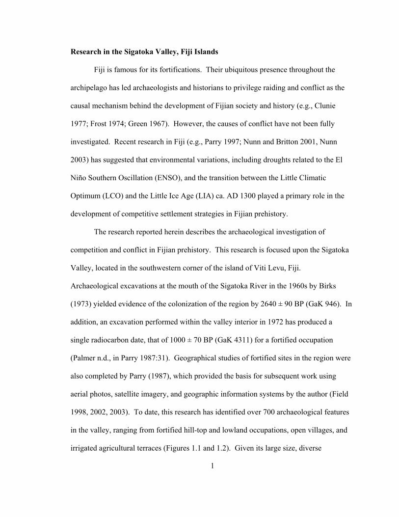
1998, 2002, 2003). To date, this research has identified over 700 archaeological features
in the valley, ranging from fortified hill-top and lowland occupations, open villages, and
irrigated agricultural terraces (Figures 1.1 and 1.2). Given its large size, diverse
Figu
re 1
.1.
Arc
haeo
logi
cal s
ites o
f the
Sig
atok
a V
alle
y.
2

Figu
re 1
.2.
Agr
icul
tura
l fea
ture
s of t
he S
igat
oka
Val
ley.
3
4
environmental zones, and the quantity and richness of the archaeological record, the
Sigatoka Valley provides an excellent opportunity to investigate prehistoric settlement
patterns, social units, and the effects of environmental variability on the development and
persistence of warfare and conflict.
This research incorporates two bodies of data: GIS-based environmental analyses,
and archaeological excavations. Excavations were performed between August 2001 and
March 2002 at 12 sites: Korokune (Conua District, Nadrogā), Bātiri (Sigatoka District,
Nadrogā), Nokonoko (Nokonoko District, Nadrogā), Korovatuma, Bukusia, Korohewa
(Mavua District, Nadrogā), Qoroqorovakatini (Qalimare District, Nadrogā), Vitogo
(Bemana District, Nadrogā), Tatuba Cave (Namataku District, Navosa), Malua (Noikoro
District, Navosa), Nadrogā (Noikoro District, Navosa), and Madraya (Noikoro District,
Navosa). The goal of excavation was to obtain samples for radiometric dating, and thus
determine the age of fortified and unfortified settlements in the Sigatoka Valley. The
results from the excavation of Nadrogā (1-NKR-046) are the focus of this report. The
place of this site in the prehistory of the Sigatoka Valley, and the role it may have played
in the development of Fijian culture, are also discussed herein.
Nadrogā (1-NKR-046): Site Description and History
According to oral traditions, the ancestors of the yavusa Koroivakabeka lived at
the site of Nadrogā, which was located along the east bank of the Sigatoka river, just
above the confluence of Nasa creek in the old district of Nuyakoro. Following a dispute
over land title during the 17th or 18th centuries, the yavusa Koroivakabeka split and the
inhabitants moved away to found the two villages of Korolevu and Nubuyanitu. Thus,

5
the site of Nadrogā is claimed as the koro makawa for both villages (personal
communication, Taukei Narukutabua, Nemia Vanua, chief of Nubuyanitu village).
Currently, the land is claimed by the mataqali Nawaimalua, who reside in Nubuyanitu.
The site is not mentioned in Gordon’s report of the Little War (Gordon 1879), thus it is
possible that the site had been abandoned prior to 1875.
As mentioned, Nadrogā lies atop an alluvial terrace on the east bank of the
Sigatoka river, at an elevation of 100 m above sea level (1907.163 Northing, 3900.864
Easting) (Figure 1.3). Although in a low area compared to most ancient villages in the
Sigatoka Valley, the site appears to be above flood level. Nadrogā is also located on the
leeward side of a westward bend in the river, thus it is largely protected by the gravel bars
and embankments that lie upstream and to the northeast. A much larger alluvial terrace
that is composed of sand and large river cobbles also stretches between Nadrogā and the
river’s edge. One kilometer to the south and across the Nasa creek lies the flattened
hilltop of Sautabu, which according to the villagers of Nubuyanitu, Korolevu, and the
settlement of Varelobo was the burial ground for ancient chiefs. Sautabu may have also
served as a defensive fortification, as it is encircled by a ditch on the north and east sides,
and has mounds and additional constructed fortifications on the peak to the south
(Nakubulevu).
The naga site of Togalevu is also within close proximity to Sautabu, and it is
considered to be the most complex site of its type known in Fiji (Palmer 1971:95).
Palmer collected oral histories from the region that suggest that Togalevu was one of the
homes of the ancestors of the Nukuilau people, prior to their removal to the site of Naviti.
Ultimately these people converted to Christianity sometime in the 19th century, and

Figure 1.3. Map of the Noikoro District, Navosa Province. The site of Nadrogā is located near the center of the image.
6

7
moved downriver to found Nukuilau. Palmer notes that the site of Togalevu was used for
religious practices until the mid 19th century, and upon survey the site contained many
fragments of the long bodied kuro balavu pot, similar to the style of Nakoro village
ceramics. He also indicates that the site remains important to the villages of Nubuyanitu
and Korolevu, who (with Nukuilau) use the site for burials (Palmer 1971:96). Due to the
sensitive nature of these sites however, neither Sautabu nor Togalevu was investigated
during the 2001-2002 field season.
Nadrogā is a very small site (approx. 1.5 ha), but for its size it contains a
significant amount of dry-laid stone architecture. The site also contains mounds and yavu
of various sizes and shapes, two of which may be associated with ancient chiefs or
priests. Save for a configuration of low stone walls (which may not have been
constructed for defense, but rather served to partition the site), the site appears to have
been unfortified. It is also laid out upon level ground, and is surrounded on the north and
east by fertile alluvial deposits. Nadrogā is most easily reached from the settlement of
Varelobo, which is located approximately 1 km north of the village of Nukuilau, and
along a high cliff overlooking the west side of the Sigatoka River. A trail leads
downriver from Varelobo and crosses to the eastern side of the river, and the site stands
out as a cluster of mango and coconut trees amongst several agricultural fields (Figure
1.4).
Nadrogā is laid out in a roughly northeast-southwest orientation, and a trail that is
used by people and livestock cuts through the middle of the site (Figure 1.5). Two yavu
(Yavu 1 and 2) are located in the most northerly part of the site, near a small rubble pile
of unknown function. Yavu 1 is square in shape, stone faced, .75 m high, and nearly 10

Figure 1.4. Aerial view of Nadrogā.
m across at its widest part. A few meters to the southwest is Yavu 2, which is round,
stone faced, and 1 m high. Approximately 12 m to the south is Yavu 3, which is of
identical size and form as Yavu 2 (6-7 m in diameter). However, on the eastern side of
the site is the monolithic Yavu 4, which is surrounded by a 1 m high stone wall. This
wall encircles Yavu 4, and forms an enclosure with a diameter of approximately 26 m.
Yavu 4 itself is known as Tabu ni Vunilagi by the people of Nubuyanitu, and it is
presumed to be the house foundation and/or grave of one of the ancient chiefs of the area.
8
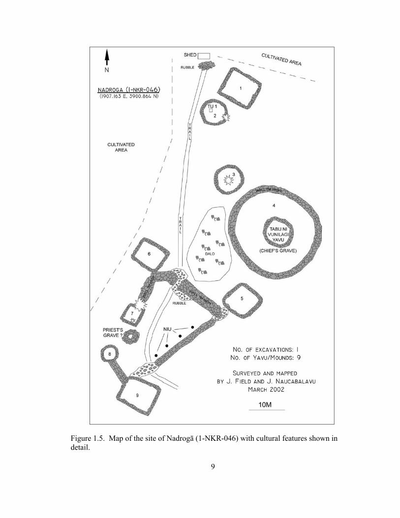
Figure 1.5. Map of the site of Nadrogā (1-NKR-046) with cultural features shown in detail.
9
10
The mound is round and approximately 8 m in diameter, and rises to a height of 2 m, with
a flattened top.
To the south and west of Tabu ni Vunilagi is a very unusual complex of yavu and
a stone enclosure, which are fronted on the north by a small plot of dalo. Yavu 5 and 6
are both square in shape, approximately 6 m wide and 1m high, with stone facing. These
yavu lie at the northern corners of a roughly triangular enclosure, the wall of which is
between 1.5 and 1 m wide, and approximately 1 m to 1.5 m high. The enclosure wall is
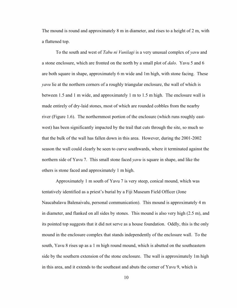
made entirely of dry-laid stones, most of which are rounded cobbles from the nearby
river (Figure 1.6). The northernmost portion of the enclosure (which runs roughly east-
west) has been significantly impacted by the trail that cuts through the site, so much so
that the bulk of the wall has fallen down in this area. However, during the 2001-2002
season the wall could clearly be seen to curve southwards, where it terminated against the
northern side of Yavu 7. This small stone faced yavu is square in shape, and like the
others is stone faced and approximately 1 m high.
Approximately 1 m south of Yavu 7 is very steep, conical mound, which was
tentatively identified as a priest’s burial by a Fiji Museum Field Officer (Jone
Naucabalavu Balenaivalu, personal communication). This mound is approximately 4 m
in diameter, and flanked on all sides by stones. This mound is also very high (2.5 m), and
its pointed top suggests that it did not serve as a house foundation. Oddly, this is the only
mound in the enclosure complex that stands independently of the enclosure wall. To the
south, Yavu 8 rises up as a 1 m high round mound, which is abutted on the southeastern
side by the southern extension of the stone enclosure. The wall is approximately 1m high
in this area, and it extends to the southeast and abuts the corner of Yavu 9, which is

Figure 1.6. Close-up of enclosure wall, Nadrogā.
similar in size and form to Yavu 1. The enclosure wall then continues to the northeast,
where it is eroded to some extent by the cross-cutting of the livestock trail. Past this
point the wall is fairly intact, and continues for approximately 20 m, at which point it
abuts Yavu 5. Along its length, 4 coconut trees have been planted at regular intervals
along the eastern (interior) side of the enclosure.
Excavations at Nadrogā: Test Unit 1
Summary of Deposits A single 50 x 50cm test excavation was performed atop Yavu 2. Time constraints
prohibited the excavation of additional yavu, although as most of the mounds appeared to
11
12
be in relatively similar condition, it was assumed that the site was constructed during a
single short episode (i.e., within a span of 10-15 years). Test Unit 1 was placed in the
northwestern quadrant of Yavu 1, and oriented to 348°. Within the first 20 cmbs, the soil
consisted of a dark organic sandy clay, with small amounts of roots. Three lithic
fragments and less than one gram of charcoal were recovered from this deposit, in
addition to 22 ceramic fragments. A single bowl rim, as well as a large body fragment
decorated with broad, crossed paddle impressions, were counted amongst the ceramic
assemblage from these levels.
At 20 cmbs, the deposit transitioned into a marbled grey sandy clay. Although
there were no features in this deposit, there was a slight increase in the frequency of
ceramics, charcoal, and lithics. Between 20 and 40 cmbs, 2 g of charcoal and a lithic
fragment that may have been part of a stone adze were recovered. In addition, the rim of
a jar with a square lip, and also 26 additional undecorated body fragments were
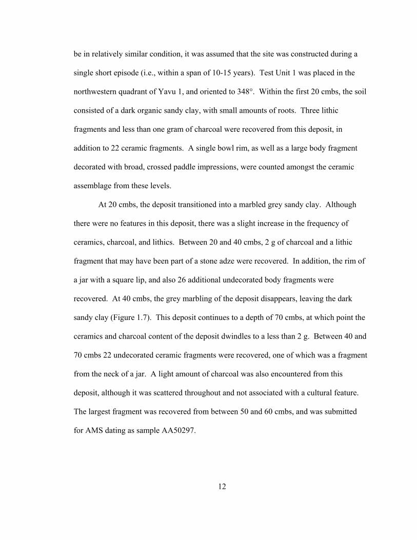
recovered. At 40 cmbs, the grey marbling of the deposit disappears, leaving the dark
sandy clay (Figure 1.7). This deposit continues to a depth of 70 cmbs, at which point the
ceramics and charcoal content of the deposit dwindles to a less than 2 g. Between 40 and
70 cmbs 22 undecorated ceramic fragments were recovered, one of which was a fragment
from the neck of a jar. A light amount of charcoal was also encountered from this
deposit, although it was scattered throughout and not associated with a cultural feature.
The largest fragment was recovered from between 50 and 60 cmbs, and was submitted
for AMS dating as sample AA50297.
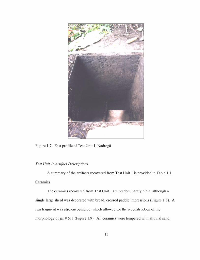
Figure 1.7. East profile of Test Unit 1, Nadrogā.
Test Unit 1: Artifact Descriptions
A summary of the artifacts recovered from Test Unit 1 is provided in Table 1.1.
Ceramics
The ceramics recovered from Test Unit 1 are predominantly plain, although a
single large sherd was decorated with broad, crossed paddle impressions (Figure 1.8). A
rim fragment was also encountered, which allowed for the reconstruction of the
morphology of jar # 511 (Figure 1.9). All ceramics were tempered with alluvial sand.
13
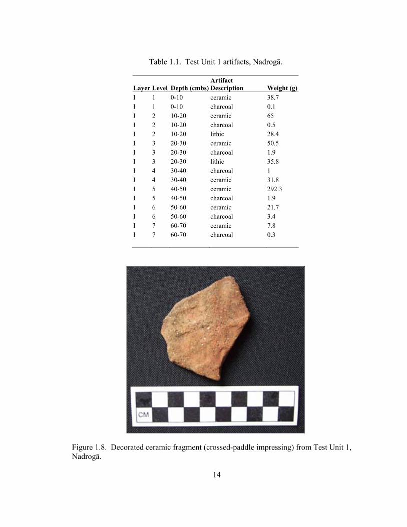
Table 1.1. Test Unit 1 artifacts, Nadrogā.
Artifact Description Layer Level Depth (cmbs) Weight (g)
I 1 0-10 ceramic 38.7 I 1 0-10 charcoal 0.1 I 2 10-20 ceramic 65 I 2 10-20 charcoal 0.5 I 2 10-20 lithic 28.4 I 3 20-30 ceramic 50.5 I 3 20-30 charcoal 1.9 I 3 20-30 lithic 35.8 I 4 30-40 charcoal 1 I 4 30-40 ceramic 31.8 I 5 40-50 ceramic 292.3 I 5 40-50 charcoal 1.9 I 6 50-60 ceramic 21.7 I 6 50-60 charcoal 3.4 I 7 60-70 ceramic 7.8 I 7 60-70 charcoal 0.3
Figure 1.8. Decorated ceramic fragment (crossed-paddle impressing) from Test Unit 1, Nadrogā.
14

Jar # 511, Nadrogā, TU 1, 30-40 cmbs Temper Class: 2
Figure 1.9. Profile of jar rim recovered from Test Unit 1. Lithics
Four lithic fragments were recovered from Test Unit 1. All are primary and
secondary fragments of dense-grained basalt river cobbles. These fragments do not show
extensive shaping or sharpening, but may have been used as expedient hammers and
cutting tools.
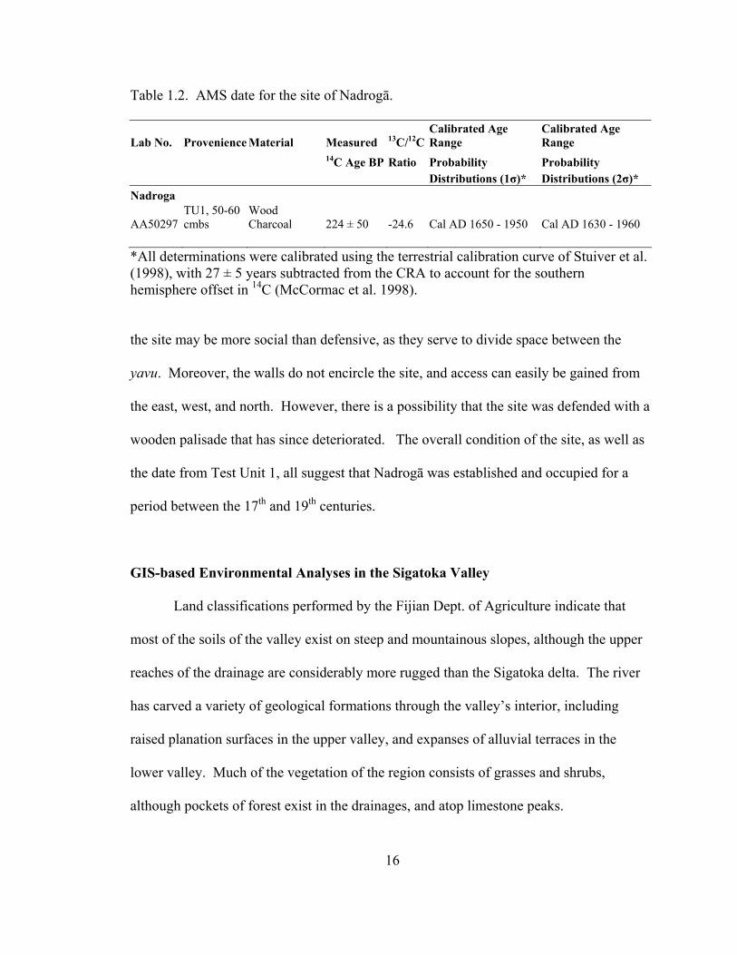
Test Unit 1: AMS Dating Results
The results of AMS dating of sample AA50297 indicate that the charcoal
fragment dates to 224 ± 50 BP. With calibration, these data suggest that Yavu 2 and its
was constructed between Cal AD 1650 and 1950 (1σ) (Table 1.2). It is assumed that the
other features of Nadrogā, including the large burial mound, date to this period. As the
sites is known from oral histories in the region, most likely it was constructed between
AD 1650 and 1875.
The Chronology of Nadrogā
The site of Nadrogā is unusual in that it lacks extensive constructed fortifications.
Although it is technically classified as a defended production site, the walls that cross-cut
15
16
Table 1.2. AMS date for the site of Nadrogā.
Lab No. Provenience Material Measured 13C/12CCalibrated Age Range
Calibrated Age Range
14C Age BP Ratio Probability Probability Distributions (1σ)* Distributions (2σ)* Nadroga
AA50297 TU1, 50-60 cmbs
Wood Charcoal 224 ± 50 -24.6 Cal AD 1650 - 1950 Cal AD 1630 - 1960
*All determinations were calibrated using the terrestrial calibration curve of Stuiver et al. (1998), with 27 ± 5 years subtracted from the CRA to account for the southern hemisphere offset in 14C (McCormac et al. 1998).
the site may be more social than defensive, as they serve to divide space between the
yavu. Moreover, the walls do not encircle the site, and access can easily be gained from
the east, west, and north. However, there is a possibility that the site was defended with a
wooden palisade that has since deteriorated. The overall condition of the site, as well as
the date from Test Unit 1, all suggest that Nadrogā was established and occupied for a
period between the 17th and 19th centuries.
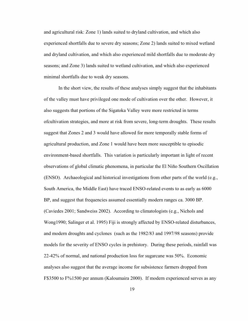
GIS-based Environmental Analyses in the Sigatoka Valley
Land classifications performed by the Fijian Dept. of Agriculture indicate that
most of the soils of the valley exist on steep and mountainous slopes, although the upper
reaches of the drainage are considerably more rugged than the Sigatoka delta. The river
has carved a variety of geological formations through the valley’s interior, including
raised planation surfaces in the upper valley, and expanses of alluvial terraces in the
lower valley. Much of the vegetation of the region consists of grasses and shrubs,
although pockets of forest exist in the drainages, and atop limestone peaks.

17
In prehistoric times, the inhabitants of the Sigatoka Valley subsisted on
hydrophilic crops (plants that grow in partially submerged conditions) such as dalo
(Colocasia esculenta) and via kana ‘giant swamp taro’ (Cyrtosperma chamissonis), and
dryland crops such as uvi (Dioscorea spp.), and dryland taro (Barrau 1961; Kirch 1994;
Spriggs 1982). These crops require particular conditions for high yield cultivation. With
adequate amounts of moisture and silty soils, dalo can yield approximately 20+
tons/hectare/year, and can be planted year round, and harvested every 8-10 months
(Brookfield 1979, in Spriggs 1984:129). Earthworks, such as ponded-fields (vuci) and
terraces with irrigation (tabawai) provided by nearby streams, were often installed to take
advantage of naturally productive environments and encourage vibrant growth. In
contrast, uvi and other dryland crops were cultivated in swiddens (slash and burn
gardens) that were well-drained and occasionally terraced to retard erosion. With
adequate amounts of rainfall, uvi and dryland taro yield between 5-15 tons/hectare/year
(Kirch 1994:8; Tindall 1983:203). However, unlike dalo, uvi are only planted at the
beginning of the wet season, and can be harvested 7-9 months later.
Sedimentological analyses of the Sigatoka Valley indicate that most soils would
have provided enough nutrients to allow for cultivation of both uvi and dalo. However,
the severity of slope, in particular the higher elevations and portions of the upper valley,
would have significantly reduced the amount of land available for cultivation. In
addition, the effects of the dry season would have made the cultivation of dalo impossible
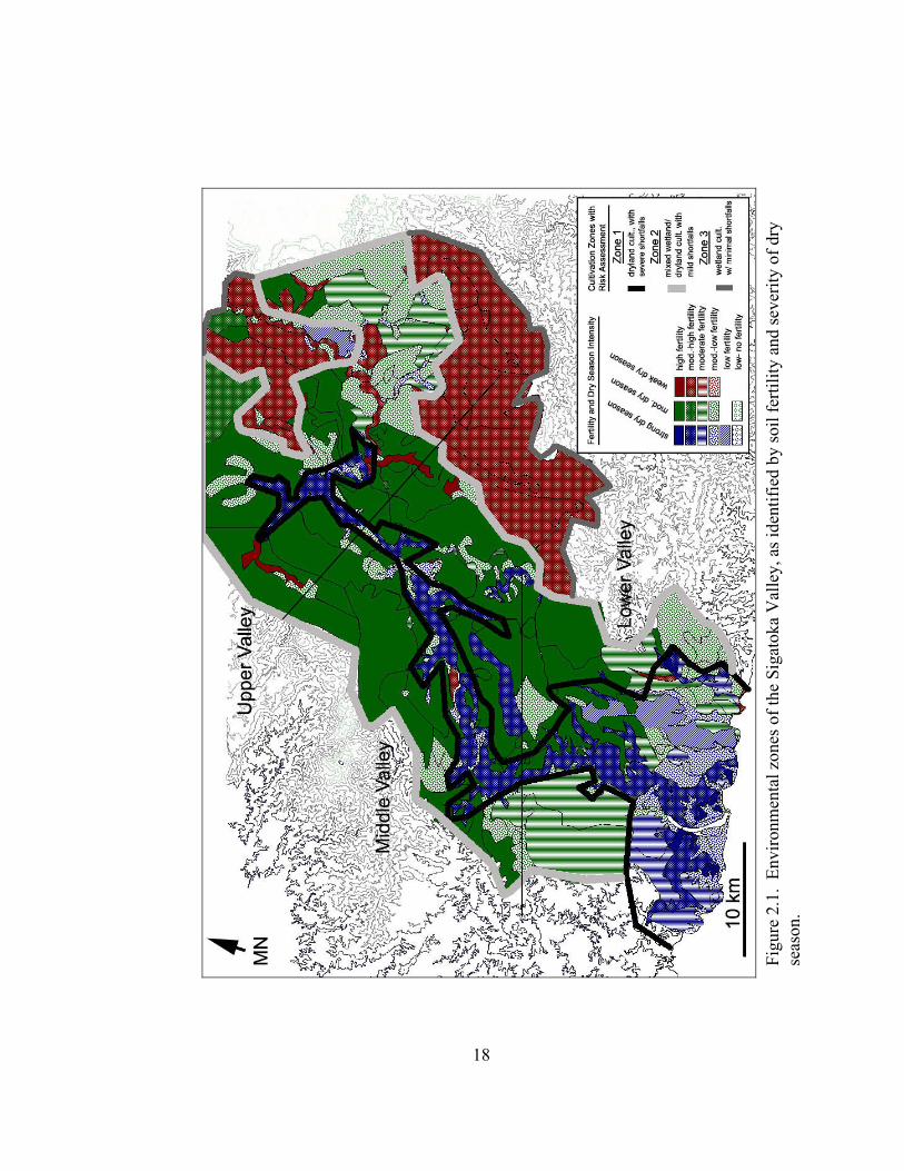
in all but the most well-watered portions of the valley. Figure 2.1 provides a summary
image of the environmental zones of the Sigatoka Valley, based upon soil fertility and
dry season intensity. These data also suggest the existence of three zones of productivity
Figu
re 2
.1.
Envi
ronm
enta
l zon
es o
f the
Sig
atok
a V
alle
y, a
s ide
ntifi
ed b
y so
il fe
rtilit
y an
d se
verit
y of
dry
se
ason
.
18
19
and agricultural risk: Zone 1) lands suited to dryland cultivation, and which also
experienced shortfalls due to severe dry seasons; Zone 2) lands suited to mixed wetland
and dryland cultivation, and which also experienced mild shortfalls due to moderate dry
seasons; and Zone 3) lands suited to wetland cultivation, and which also experienced
minimal shortfalls due to weak dry seasons.
In the short view, the results of these analyses simply suggest that the inhabitants
of the valley must have privileged one mode of cultivation over the other. However, it
also suggests that portions of the Sigatoka Valley were more restricted in terms
ofcultivation strategies, and more at risk from severe, long-term droughts. These results
suggest that Zones 2 and 3 would have allowed for more temporally stable forms of
agricultural production, and Zone 1 would have been more susceptible to episodic
environment-based shortfalls. This variation is particularly important in light of recent
observations of global climatic phenomena, in particular the El Niño Southern Oscillation
(ENSO). Archaeological and historical investigations from other parts of the world (e.g.,
South America, the Middle East) have traced ENSO-related events to as early as 6000
BP, and suggest that frequencies assumed essentially modern ranges ca. 3000 BP.
(Caviedes 2001; Sandweiss 2002). According to climatologists (e.g., Nichols and
Wong1990; Salinger et al. 1995) Fiji is strongly affected by ENSO-related disturbances,
and modern droughts and cyclones (such as the 1982/83 and 1997/98 seasons) provide
models for the severity of ENSO cycles in prehistory. During these periods, rainfall was
22-42% of normal, and national production loss for sugarcane was 50%. Economic
analyses also suggest that the average income for subsistence farmers dropped from
F$3500 to F%1500 per annum (Kaloumaira 2000). If modern experienced serves as any

20
guide, the Sigatoka Valley (in particular Zone 1) was subject to devastation during a
severe ENSO episode. The antiquity of ENSO in the Pacific further suggests that this
cycle of devastation repeated itself throughout Fijian prehistory, providing the impetus
for human conflict over resources.
Paloeclimatic data from New Zealand caves as well as shell conglomerates in
Fijian shorelines indicate that dramatic environmental perturbations occurred in Fiji
approximately 700 years ago. These events mark the transition period between the
warmer Little Climatic Optimum (1250-700 BP) and cooler Little Ice Age (700-200 BP).
According to recent analyses in Fiji and Niue by Nunn and others (Nunn 2000a, 2000b,
2003; Nunn et al. 2003; Nunn and Britton 2001), the disturbances of the transition were
quite dramatic, and were marked by cooler weather and sea temperatures, and a rapid
lowering of sea level by over one meter between 730-525 BP. Nunn and Britton
proposes that these changes were devastating for both coastal and interior populations:
sea-level fall would have converted embayments to brackish wetlands, and also caused
the submersion of groundwater for the interiors of the Fiji Islands. Extensive incising of
the riverbeds and streambeds, as well as decreased soil moisture levels in many of the
alluvial terraces that supported uvi cultivation, would have resulted in dramatic reduction
of uvi yields in the lowlands. Torrential rains and floods may have also occurred in the
higher elevations.
Figure 2.2 combines the results of the analyses described above and allow for the
formulation of the following conclusions: 1) Zone 1 would have experienced the most
severe effects of ENSO-related droughts and floods, and also suffered from sea-level fall
during the LCO/LIA transition; 2) Zone 2 would have experienced moderate ENSO-

Figure 2.2 Comparison of the environmental zones identified by soil/topographic analyses with the extent of disturbance related to ENSO and the LCO/LIA transition. would have experienced severe ENSO-related droughts.
21

22
related droughts, and been affected to a limited degree by the landslides and erosion
associated with the LCO/LIA transition; and 3) Zone 3 would have only been weakly
affected by ENSO-related droughts or floods, and experienced a high/moderate amount
of erosion during the LCO/LIA transition.
Nadroga: Site Function and Placement within the Sigatoka Valley Chronology
According to GIS-based environmental analyses, Nadrogā had immediate access
to land suited to dryland cultivation, and it was of moderate-high fertility. The site is also
located along the boundary between Zones 2 and 3, which suggests that the conditions of
the soil and climate in the area would have lessened the impact of ENSO-related
droughts. However, the site would have been threatened by severe floods. The late age
of Nadrogā suggests that it was not affected by the LCO/LIA transition, but in any case
the site would have not felt the effects of sea-level fall or landslides.
Figure 2.3 displays the range of dates associated with the 12 other sites excavated
in the Sigatoka Valley. Four temporal periods are identified: T1 (2000-1500 BP), T2
(1500-1000 BP), T3 (1000-500 BP), and T4 (500-150 BP). The period proposed for the
transition between the Little Climatic Optimum (LCO) and the Little Ice Age (LIA) is
also indicated in the diagram. The location of these sites in the Sigatoka Valley, and their
placement into one of four temporal categories, is indicated in Figure 2.4 In brief, the
results of archaeological investigations and environmental analyses suggest the following
chronology for the Sigatoka Valley.
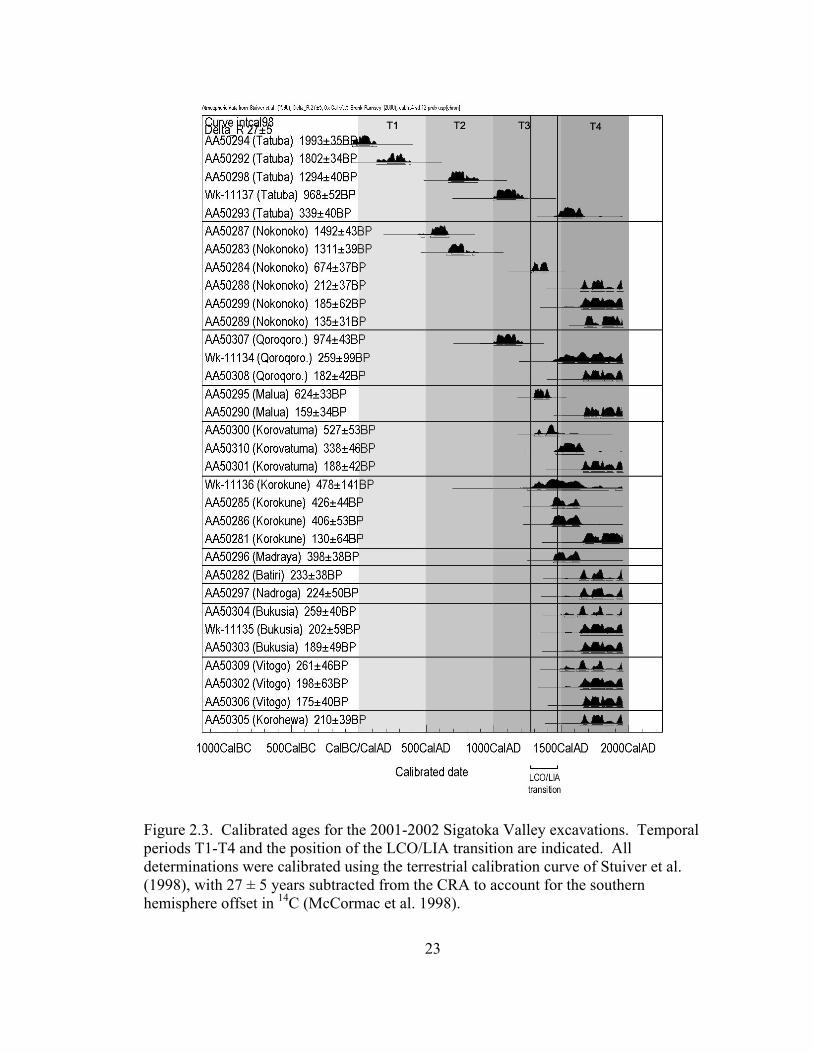
Figure 2.3. Calibrated ages for the 2001-2002 Sigatoka Valley excavations. Temporal periods T1-T4 and the position of the LCO/LIA transition are indicated. All determinations were calibrated using the terrestrial calibration curve of Stuiver et al. (1998), with 27 ± 5 years subtracted from the CRA to account for the southern hemisphere offset in 14C (McCormac et al. 1998).
23
24
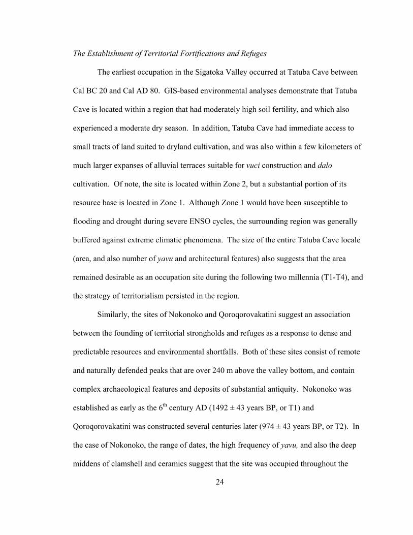
The Establishment of Territorial Fortifications and Refuges
The earliest occupation in the Sigatoka Valley occurred at Tatuba Cave between
Cal BC 20 and Cal AD 80. GIS-based environmental analyses demonstrate that Tatuba
Cave is located within a region that had moderately high soil fertility, and which also
experienced a moderate dry season. In addition, Tatuba Cave had immediate access to
small tracts of land suited to dryland cultivation, and was also within a few kilometers of
much larger expanses of alluvial terraces suitable for vuci construction and dalo
cultivation. Of note, the site is located within Zone 2, but a substantial portion of its
resource base is located in Zone 1. Although Zone 1 would have been susceptible to
flooding and drought during severe ENSO cycles, the surrounding region was generally
buffered against extreme climatic phenomena. The size of the entire Tatuba Cave locale
(area, and also number of yavu and architectural features) also suggests that the area
remained desirable as an occupation site during the following two millennia (T1-T4), and
the strategy of territorialism persisted in the region.
Similarly, the sites of Nokonoko and Qoroqorovakatini suggest an association
between the founding of territorial strongholds and refuges as a response to dense and
predictable resources and environmental shortfalls. Both of these sites consist of remote
and naturally defended peaks that are over 240 m above the valley bottom, and contain
complex archaeological features and deposits of substantial antiquity. Nokonoko was
established as early as the 6th century AD (1492 ± 43 years BP, or T1) and
Qoroqorovakatini was constructed several centuries later (974 ± 43 years BP, or T2). In
the case of Nokonoko, the range of dates, the high frequency of yavu, and also the deep
middens of clamshell and ceramics suggest that the site was occupied throughout the

Figu
re 2
.4.
The
dist
ribut
ion
of e
arlie
st o
ccup
atio
ns fo
r eac
h ex
cava
ted
site
acc
ordi
ng to
tem
pora
l per
iod.
25

26
prehistoric period. Thus, this site most closely represents a territorial stronghold that was
occupied year-round. In contrast, Qoroqorovakatini contains deposits that indicate
episodic occupations, hence the site may represent a combination of remote refuge and
territorial stronghold. However, the long chronologies of Nokonoko and
Qoroqorovakatini reflect the persistence of a territorial and refuge strategy through all
temporal periods (T2-T4) relating to environmental limitations and climatic perturbations
in Fiji. Of note, the site of Korokune reflects a similar adherence to the strategy of
territorial stronghold, although this site was not established until the third temporal
period.
Relocation to Environmental Refuges During Periods of Disturbance
Four of the 12 excavated sites were established during the third temporal period
(1000-500 BP), and also within the period proposed for the transition between the
LittleClimatic Optimum and Little Ice Age (1250 – 700 BP). The increase in site
frequency during this period suggests significant population growth between periods T1
and T3. More importantly, the location of three newly founded habitations in Zones 2
and 3 suggests the development of a new strategy of habitation and subsistence that is
directly related to environmental disturbance. In particular, the environmental conditions
surrounding these sites, their topographic positions in remote drainages, and also the
presence of faunal material indicating a diversified resource base, are suggestive of a
distinctive and new settlement pattern focused on environmental buffering.
Malua, and Korovatuma (and perhaps also Bukusia) are emblematic of this new
trend. Both were established between AD 1300-1630, and are located atop dramatic
27
outcrops that provided natural defense. The surrounding lands were of moderate quality
but extraordinarily rugged. Cultivation of dalo was certainly possible, but the arable land
was restricted to ‘pocket gardens,’ (i.e., small isolated patches along minor creeks).
Neither site had access to the large tracts of alluvial deposits that were available in earlier
periods (e.g., Nokonoko, Tatuba Cave, and Qoroqorovakatini). However, environmental
analyses place these sites within Zone 2, which indicates that the resource base
surrounding these sites would not have been affected by severe drought or a reduction of
soil moisture due to sea-level fall predicted for the LCO/LIA transition. Unlike
significant portions of the valley bottom (Zone 1), cultivation of dalo and uvi in Zones 2
and 3 would have continued as normal. The timing of the founding of the sites, as well as
quality of the surrounding environment, strongly suggest that these new habitations
represent a strategy of environmental refuge relating to the effects of the LCO/LIA
transition. Cumulatively, these data suggest that the LCO/LIA transition encouraged
populations to optimize in a new way: 1) less investment in large but risk-laden
agricultural surplus, and increased focus on temporally stable resources; 2) variable
patterns of population aggregation and dispersal, perhaps coupled with mobility; 3)
diversification of the resource base; and 4) exchange or travel for non-local food items.
Constructed Fortifications and Undefended Production Sites
The final phase of Sigatoka Valley prehistory (period T4) witnessed the
persistence of previously established strategies (territorial strongholds, remote refuges,
and environmental refuges), and also the emergence of a new form of fortification on the
valley bottom: villages surrounded by a constructed moat and ditch. The sudden
28
appearance of this kind of fortification suggests the diffusion of new ideas concerning
defensive construction, and also an increasingly large population. The sites of Vitogo
and Bātiri are a case in point. Both of these sites were constructed between 260-150 BP
and are of the ‘ring-ditch’ type; (i.e., protected with an annular ditch, bank, and palisade).
Unlike previous centuries, these villages did not make use of any topographical features
for defense, but were located within swampy, riparian environments that would have
been prime locations for growing dalo. The size of annular ditch and bank construction
for these sites suggests a significant investment and labor pool: in the case of Bātiri, the
ditch was 10 m wide with a circumference of 390 m. This is a marked difference from
the fortifications of previous centuries, which employed naturally fortified positions that
required minimal initial investment, and which also did not require a sizeable population
for defense or construction tasks. Therefore, the restriction of manufactured fortifications
in the latest period is almost certainly a factor of population size, and perhaps also related
to the transmission of this innovative design throughout Fiji in the late prehistoric period.
The emergence of undefended habitation sites in the valley bottom may also be
related to population growth, and perhaps the integration of small communities with
larger territorial strongholds. The sites of Nadrogā and Korohewa are representative of
this strategy. These habitations were of small size, late age, and were located on the
valley bottom. No visible defenses were encountered at Korohewa, and only a modest
wall unrelated to defense was present at Nadrogā. The lack of defenses at these sites
breaks nearly two millennia of tradition for the Sigatoka Valley; for the first time,
villages did not employ topography as the first line of defense against invaders. This
omission strongly suggests that these populations were integrated with regional centers,
29
or were protected by another form of defense-- armed warriors. Moreover, the presence
of undefended habitation sites may be related to cooperative strategies that were
established during the establishment LCO/LIA transition. In this case, undefended
settlements may have been linked to fortifications maintained by close relatives.
Conclusion
In conclusion, the results of analyses in the Sigatoka Valley suggest that: 1)
fortifications are the result of competitive strategies that originated early in Fijian
prehistory (ca. AD 700) as a response to spatio-temporal environmental variability,
specifically the effects of the El Niño Southern Oscillation; 2) fortifications utilized
natural topography from the earliest period onwards, and this pattern persisted throughout
all temporal periods, with annular ditch style fortifications only occurring in the latest
temporal period (ca. AD 1700); 3) changes in settlement patterns ca. AD 1300 can be
linked to the LCO/LIA transition, as opposed to the influx of migrants (cf. Frost 1974).
The analytical capabilities of a GIS, in particular the analysis of landscapes via slope,
aspect, and viewshed, are shown in this research to have particular value to spatial
analysis, and can be modified to incorporate a temporal aspect. When coupled with
archaeological investigations, this approach allows for extensive analyses of the variables
that impinge upon subsistence and habitation. Increasing resolution of the data involved
in these kinds of analyses will undoubtedly multiply the analytical potential for
archaeological studies, and contribute more to studies of Fijian prehistory.
30
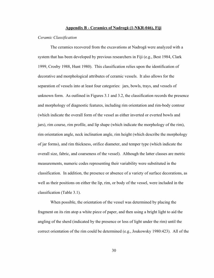
Appendix B - Ceramics of Nadrogā (1-NKR-046), Fiji
Ceramic Classification
The ceramics recovered from the excavations at Nadrogā were analyzed with a
system that has been developed by previous researchers in Fiji (e.g., Best 1984, Clark
1999, Crosby 1988, Hunt 1980). This classification relies upon the identification of
decorative and morphological attributes of ceramic vessels. It also allows for the
separation of vessels into at least four categories: jars, bowls, trays, and vessels of
unknown form. As outlined in Figures 3.1 and 3.2, the classification records the presence
and morphology of diagnostic features, including rim orientation and rim-body contour
(which indicate the overall form of the vessel as either inverted or everted bowls and
jars), rim course, rim profile, and lip shape (which indicate the morphology of the rim),
rim orientation angle, neck inclination angle, rim height (which describe the morphology
of jar forms), and rim thickness, orifice diameter, and temper type (which indicate the
overall size, fabric, and coarseness of the vessel). Although the latter classes are metric
measurements, numeric codes representing their variability were substituted in the
classification. In addition, the presence or absence of a variety of surface decorations, as
well as their positions on either the lip, rim, or body of the vessel, were included in the
classification (Table 3.1).
When possible, the orientation of the vessel was determined by placing the
fragment on its rim atop a white piece of paper, and then using a bright light to aid the
angling of the sherd (indicated by the presence or loss of light under the rim) until the
correct orientation of the rim could be determined (e.g., Joukowsky 1980:423). All of the

Figure 3.1. Diagram of a ceramic jar, detailing the morphological features (metric only) that were recorded for the ceramic assemblage of Nadrogā.
31
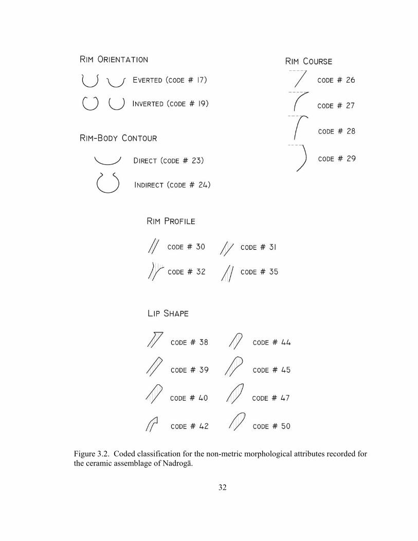
Figure 3.2. Coded classification for the non-metric morphological attributes recorded for the ceramic assemblage of Nadrogā.
32
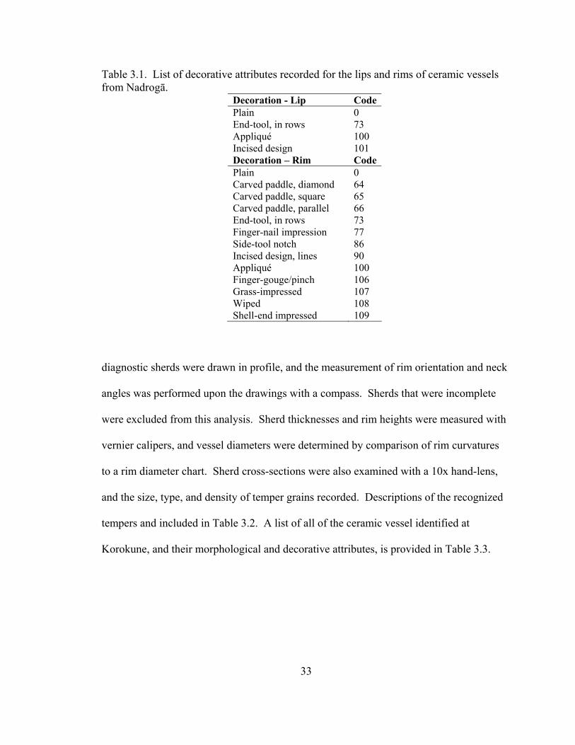
33
Table 3.1. List of decorative attributes recorded for the lips and rims of ceramic vessels from Nadrogā.
Decoration - Lip CodePlain 0 End-tool, in rows 73 Appliqué 100 Incised design 101 Decoration – Rim CodePlain 0 Carved paddle, diamond 64 Carved paddle, square 65 Carved paddle, parallel 66 End-tool, in rows 73 Finger-nail impression 77 Side-tool notch 86 Incised design, lines 90 Appliqué 100 Finger-gouge/pinch 106 Grass-impressed 107 Wiped 108 Shell-end impressed 109
diagnostic sherds were drawn in profile, and the measurement of rim orientation and neck
angles was performed upon the drawings with a compass. Sherds that were incomplete
were excluded from this analysis. Sherd thicknesses and rim heights were measured with
vernier calipers, and vessel diameters were determined by comparison of rim curvatures
to a rim diameter chart. Sherd cross-sections were also examined with a 10x hand-lens,
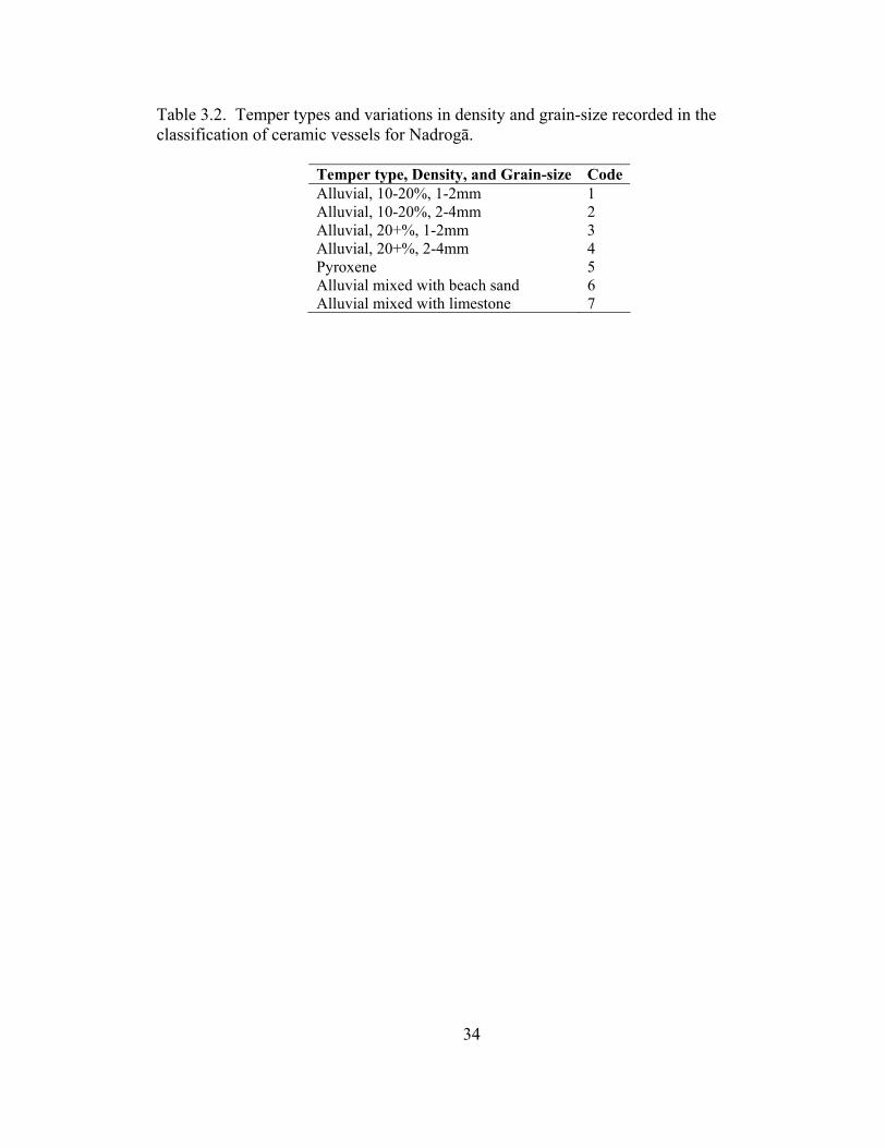
and the size, type, and density of temper grains recorded. Descriptions of the recognized
tempers and included in Table 3.2. A list of all of the ceramic vessel identified at
Korokune, and their morphological and decorative attributes, is provided in Table 3.3.
34
Table 3.2. Temper types and variations in density and grain-size recorded in the classification of ceramic vessels for Nadrogā.
Temper type, Density, and Grain-size Code Alluvial, 10-20%, 1-2mm 1 Alluvial, 10-20%, 2-4mm 2 Alluvial, 20+%, 1-2mm 3 Alluvial, 20+%, 2-4mm 4 Pyroxene 5 Alluvial mixed with beach sand 6 Alluvial mixed with limestone 7
35
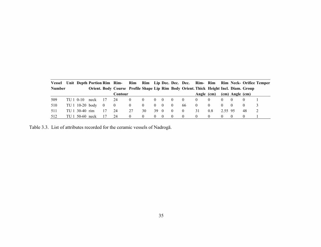
Vessel Unit Depth Portion Rim Rim- Rim Rim Lip Dec. Dec. Dec. Rim- Rim Rim Neck- Orifice TemperNumber Orient. Body Course Profile Shape Lip Rim Body Orient. Thick Height Incl. Diam. Group Contour Angle (cm) (cm) Angle (cm) 509 TU 1 0-10 neck 17 24 0 0 0 0 0 0 0 0 0 0 0 1
1
510 TU 1 10-20 body 0 0 0 0 0 0 0 66 0 0 0 0 0 3 511 TU 1 30-40 rim 17 24 27 30 39 0 0 0 31 0.8 2.55 95 48 2
0 0 0 0 0 512 TU 1 50-60 neck 17 24 0 0 0 0 0 0 Table 3.3. List of attributes recorded for the ceramic vessels of Nadrogā.

36
References Barrau, J. 1961 Subsistence Agriculture in Polynesia and Micronesia. Bernice P. Bishop Museum Publication 219. Bishop Museum Press, Honolulu. Best, S. 1984 Lakeba: The Prehistory of a Fijian Island. Unpublished PhD thesis, University of Auckland. Birks, L. 1973 Archaeological Excavations at Sigatoka Dune Site, Fiji. Bulletin of the Fiji Museum No. 1. The Fiji Museum, Suva. Brewster, A. B. 1922 The Hill Tribes of Fiji. Seeley Service and Co., London. Brookfield, H. C. 1979 Lakeba: Environmental Change, Population Dynamics and Resource Use. The UNESCO/UNFPA. Population and Environment Project in the Eastern Islands of Fiji, Island Reports No. 5. Australian National University Press, Canberra. Caviedes, C. N. 2001 El Niño in History: Storming Through the Ages. University Press of Florida, Gainsville. Clark, G. R. 1999b Post-Lapita Fiji: Cultural Transformation in the Mid-Sequence. Unpublished PhD thesis, Australian National University, Canberra. Clunie, F. 1977 Fijian Weapons and Warfare. Bulletin of the Fiji Museum, No. 2. The Fiji Museum, Suva. Crosby, A. 1988 Beqa: Archaeology, Structure, and History of Fiji. Unpublished MA thesis, University of Auckland, Auckland. Field, J. S. 1998 Natural and Constructed Defenses in Fijian Fortifications. Asian Perspectives 37: 32-58. 2002 GIS-based Analyses of Agricultural Production and Habitation in the Sigatoka Valley, Fiji. In Pacific Landscapes: Archaeological Approaches, edited by
37
T. Ladefoged and M.W. Graves, pp. 97-124. Easter Island Foundation Press, Los Osos. 2003 The Evolution of Competition and Cooperation in Fijian Prehistory: Archaeological Research in the Sigatoka Valley, Fiji. Unpublished PhD dissertation. University of Hawai‘i, Manoa. Fijian Dept. of Forestry 1996 A Guide to Some Indigenous Fijian Trees. Department of Forestry, Suva, Fiji. Fowler, H. W. 1955 Archaeological Fishbones Collected by E. W. Gifford in Fiji. Bulletin of the Bernice P. Bishop Museum, No. 214. BPBM, Honolulu. Frost, E. L. 1974 Archaeological Excavations of Fortified Sites on Taveuni, Fiji. Asian and Pacific Archaeology Series No. 6, University of Hawai‘i Press, Honolulu. Gifford, E. W. 1952 Tribes of Viti Levu and their Origin Places. Anthropological Records 13(5):337-341. University of California Press, Berkeley and Lost Angeles. Gordon, A. 1879 Letters and Notes Written During the Disturbances in the Highlands (known as the ‘devil country’) of Viti Levu, Fiji, 1876. R. and R. Clark, Edinburgh. Green, R. 1967 Fortifications in Other Parts of Tropical Polynesia. New Zealand Archaeological Newsletter, 10:96-113. Haynes, A. 2001 Freshwater Snails of the Tropical Pacific Islands. Institute of Applied Sciences, University of the South Pacific, Suva. Hunt, T. L. 1980 Toward Fiji's Past: Archaeological Research on Southwestern Viti Levu. Unpublished MA thesis, University of Auckland, New Zealand. Kaloumaira, A. 2000 Reducing the Impact of Environmental Emergencies Through Early Warning and Preparedness- The case of El Niño-Southern Oscillation (ENSO). South Pacific Applied Geosciences Commission < http://www.esig.ucar.edu/un/fiji.html (June 16th, 2003).
38
Kirch, P. V. 1994 The Wet and the Dry: Irrigation and Agricultural Intensification in Polynesia. The University of Chicago Press, Chicago. McCormac, F. G. A. G. Hogg, T. F. G. Higham, J. Lynch-Steiglitz, W. S. Broeker, M. G. L. Baille, J. G. Palmer, L. Xiong, J. R. Pilcher, D. Brown, and S. T. Hooper. 1998 Temporal Variation in the Interhemisphere 14C Offset. Geophysical Research Letters 25(9):1321-4. Nichols, N. and K. K. Wong 1990 Dependence of Rainfall Variability on Mean Rainfall, Latitude, and the Southern Oscillation. Journal of Climate 3:163-170. Nunn, P. D. 2000a Environmental Catastrophe in the Pacific Islands about AD 1300. Geoarchaeology 15: 715-740. 2000b Illuminating Sea-Level Fall around AD 1220-1510 (730-440 cal yr BP) in the Pacific Islands: Implications for Environmental Change and Cultural Transformation. New Zealand Geographer 56:46-54. 2003 Revising Ideas About Environmental Determinism: Human-Environment Relations in the Pacific Islands. Asia Pacific Viewpoint 44, 63-72. Nunn, P., J. Britton 2001 Human-Environmental Relationships in the Pacific Islands around A.D. 1300. Environment and History 7, 3-22. Nunn, P., J. Stone, and R. Kumar 2003 Corroborating the ‘AD-1300 sea-level fall’ in the South Pacific: New Dates from Niue and Fiji. South Pacific Journal of Natural Science 20: in press. Parkinson, B. J. 1982 The Specimen Shell Resources of Fiji. South Pacific Commission, Noumea. Parry, J. 1987 The Sigatoka Valley- Pathways into Prehistory. Fiji Museum Bulletin No. 9. The Fiji Museum, Suva. 1997 The North Coast of Viti Levu Bā to Rā: Air Photo Archaeology and Ethnohistory. Bulletin of the Fiji Museum, No. 10. The Fiji Museum, Suva. Salinger, M. J., R. Basher, B. Fitzharris, J. Hay, P. Jones, J. McVeigh, and I. Schmidely-Leleu. 1995 Climate Trends in the South-West Pacific. International Journal of Climatology 15: 285-302. Sandweiss, D. H.

39
2002 The Prehistory of El Nino: An Archaeological Perspective. Presented at the Smithsonian Tropical Research Institute Annual meeting for the Association for Tropical Biology, Panama City, Panama. Severns, M. 2000 Hawaiian Seashells. Island Heritage Publishing, Aiea. Spriggs, M. 1982 Taro Cropping Systems in the Southeast Asian-Pacific Region. Archaeology in Oceania 17: 7-15. 1984 Taro Irrigation Techniques in the Pacific. In Edible Aroids, edited by S. Chandra, pp. 123-55. Clarendon Press, Oxford. Stuiver M., P. Reimer, E. Bard, J. Beck, G. Burr, K. Hughen, B. Kromer, G. McCormac, J. van der Plicht, and M. Spurk 1998 INTCAL98 Radiocarbon Age Calibration, 24000-0 Cal BP. Radiocarbon 40: 1041-1083. Tindall, H. D. 1983 Vegetables in the Tropics. The Macmillan Press, Ltd., New Hampshire.


