Embed Size (px)
Citation preview

Acknowledgements
I'd like to thank Dr. Tom Thomas, the landowner, for allowing to excavate at the
Pottersville site. My appreciation also goes out to all of the field school staff and students
for making the summer a productive and enjoyable one. Those students were: Rori Arce,
Jim Cooper, Tia Earman, Katherine Gray, Amy Haluska, Ruth Heronemus, Tamara Hull,
Stephanie Kazmierzak, Josh Kocher, Sarah Lima, Reuben Man, Matt Nowak, Bobbie
Saye, Daniel Seib, Brandy Snyder, Paul Stumpner, and Paul Tamburro. Special thanks to
Brian Redmond for letting me in on the northern Ohio literature; to Melody Pope for
volunteering her skills to perform microwear analysis on some of the stone tools; and to
Leslie Bush for volunteering her free time to help out digging at yet another GBL Oliver
phase excavation.

Table of Contents
Introduction ............................................................................................................................... 1 Summary of Previous Research . 1 Natural Setting 3 Research Goals 4 Summary of Investigations 6
Research Methods ……………………………………………………………………………. 8 Results …………...……………………………………………………………………………. 10
Features 10 Burial Feature 1 (by Laura K. Pate) 21 Lithics 26 Ceramics (by Laura K. Pate) 33
The Nature of the Pottersville Occupation …………...…………………………………….. 48 References Cited……………..………………………………………………………………... 55 Figures…………………………………………………………………………………………. 59 Tables ……………………………………………………………….……………………........ 79 Appendix A: Results of Radiocarbon Assay ………………………………………………... 82 Appendix B: Faunal Remains from the Pottersville Site (by Daniel Seib)………………... 83 Appendix C: Macrobotanical Remains from the Pottersville Site (by Leslie L. Bush)…... 104 Appendix D: Analysis of Standard Volumetric Sample Unit Excavations at the Pottersville Site (by Staffan Peterson) ……………………………………………………………………. 135 Appendix E: Magnetic Surveys at the Pottersville Site (by Stephen Ball) ……………….. 141

List of Figures Figure 1. Location of artifacts on surface and location of permanent datum points. 59 Figure 2. Location of Pottersville site on USGS 7.5’ Freedom quadrangle. 60 Figure 3. Elevation map of the farm field surrounding the Pottersville site. 61 Figure 4. Excavation unit designations 62 Figure 5a. Planview map of feature 1. 63 Figure 5b. Profile map of feature 1. 63 Figure 6. Planview maps of features 2, 3, 6, 7a, 8N, 8S, and 9, showing bisect lines 64 Figure 7a. Profile map of feature 2. 65 Figure 7b. Profile maps of feature 3. 65 Figure 8a. Profile maps of feature 6. 66 Figure 8b. Profile map of feature 7a. 66 Figure 9a. Profile map of features 8N and 8S. 67 Figure 9b. Profile map of feature 9. 67 Figure 10. Profile map of circular structure (feature 10) 68 Figure 11a. Profile maps from slot trenches 1, 2, and 3, feature 10. 69 Figure 11b. Profile map of bisect 1, feature 10J. 69 Figure 12. Selection of triangular projectile points from 12Ow431 (two complete examples
on right). 70 Figure 13. Groundstone tools from 12Ow431. 70 Figure 14. Lip, rim, and neck motifs (after McCullough 2000:234, 237-239, 241-242). 71 Figure 15. Rim band categories (after McCullough 2000:235-236). 72 Figure 16. Rim profile categories (after McCullough 2000:235-236). 73 Figure 17. Rim shape categories (after McCullough 2000:241). 73 Figure 18. Neck and rim band heights. 74 Figure 19. Maximum thickness of body sherds larger than 2 cm2. 74 Figure 20. Oliver sites meeting criteria from inclusion in seriation. 75 Figure 21. Trend sensitive rim band frequencies at 11 Oliver sites (data from sites other
than 12Ow431 are from McCullough 2000). 76 Figure 22. Trend sensitive rim profile frequencies at 11 Oliver sites (data from sites other
than 12Ow431 are from McCullough 2000). 76 Figure 23. Rim surface treatment frequencies at 11 Oliver sites (data from sites other than
12Ow431 are from McCullough 2000). 77 Figure 24. Neck surface treatment frequencies at 11 Oliver sites (data from sites other than
12Ow431 are from McCullough 2000). 77 Figure 25. Neck decorative technique frequencies at 11 Oliver sites (data from sites other
than 12Ow431 are from McCullough 2000). 78 Figure C-1. Uncharred seeds versus sample depth. 123 Figure C-2. Correspondence map of 11 Oliver sites, 1 Mississippianized Oliver site, and 6
plant types. 124 Figure D-1. Artifact density in SVS units is indicated by bars. Surface collection artifact
distribution is shown as blue background. 138 Figure D-2. Artifact counts by SVS unit. 139 Figure E-1. Location of magnetic survey grid shown in blue. 146 Figure E-2. Image map of magnetic survey grid. 147 Figure E-3. Magnetic survey grid with restricted range of values. 148 Figure E-4. Magnetic survey with excavation units, features and Unit K marked. 149

List of Tables
Table 1. Summary of feature contents. 79 Table 2. Surface treatment frequencies for rim and neck sherds larger than 2 cm2. 79 Table 3. Decorative technique frequencies for rim and neck sherds larger than 2 cm2. 79 Table 4. Motif frequencies for rim and neck sherds larger than 2 cm2. 79 Table 5. Sherd thickness frequencies for rim and neck sherds larger than 2 cm2. 80 Table 6. Quantities of body sherds in each size category 80 Table 7. Quantities of body sherds in each size category recovered from the plowzone and
from beneath the plowzone. 80 Table 8. Frequency of vessel part by location. 81 Table 9. Rim band frequencies by location. 81 Table 10. Rim shape frequencies by location. 81 Table 11. Rim motif frequencies by location. 81 Table B-1. Minimum number of individuals 12Ow431. 97 Table B-2. Burned bone from 12Ow431. 98 Table B-3. Cutmarked bone from 12Ow431. 100 Table B-4. 12Ow431, Bone distribution by unit. 101 Table B-5. 12Ow431, Freshwater mussel shells by unit 103 Table C-1. Floodplain forest composition of the White River system, Indiana
(from Lee 1945). 125 Table C-2. Materials recovered from Heavy Fraction, Fea 8N, Zone A’,
Catalog #10280/1114. 126 Table C-3. Charred Macrobotanical remains from Pottersville, 12Ow431, Fagaceae
nutshell counts and weights. 127 Table C-4. Uncharred macrobotanical remains from Pottersville, 12Ow431. Raw counts. 128 Table C-5. Charred macrobotanical remains from Pottersville, 12Ow431. Wood charcoal
identification. 130 Table C-6. Charred macrobotanical remains from Pottersville, 12Ow431. Raw counts 131 Table C-7 Charred macrobotanical remains from Pottersville, 12Ow431. Raw weights
in grams. 133
GBL Research Reports, No. 20 1
Introduction
As a part of the 2001 Indiana University/Glenn A. Black Laboratory Field School
in Archaeology, excavations were conducted at the Pottersville site (12Ow431), in Owen
County, Indiana. The site is located on the floodplain of the West Fork White River,
about 8.5km southwest of the town of Spencer, Indiana. Excavations took place from
May 14th through June 14th, 2001 and were supervised by Michael Strezewski, with
assistance from other GBL personnel, Stephen Ball, Laura Pate, Staffan Peterson, and
Joshua Wells. Sixteen undergraduate and graduate students from Indiana University
participated in the investigation as well as one student from Purdue University.
Excavation was conducted under a Department of Natural Resources, Division of
Historic Preservation and Archaeology (DHPA) permit number 200133. All of the
recovered artifacts have been washed, catalogued, and labeled and are curated at the
Glenn A. Black Laboratory of Archaeology, Bloomington, Indiana, under accession
number 10280 along with all site maps, photos, and notes. All cataloged materials have
also been entered into a database.
Summary of Previous Research
Site 12Ow431 was originally reported in 1996 by two local collectors, Richard
and Julie Chaney. The reported site location was surveyed later that year by Timothy
Wright, who reported a high density of Oliver phase related materials on the surface--
confined to an oval area approximately 98 by 129m (approximately 1.0ha) in extent.
Evidence from the surface confirmed that the main component at Pottersville was Late
Prehistoric, consisting of Oliver phase ceramics and triangular projectile points. Other
GBL Research Reports, No. 20 2
diagnostic materials reported from the site included Late Woodland Raccoon side-
notched points and a Late Archaic Riverton point. These other diagnostics however,
occurred in relatively small quantities in relation to the more abundant Late Prehistoric
materials. Based upon this initial survey, it was thought that the site may have significant
potential for intact subsurface deposits.
In May of 2000, the Indiana University Field School in Archaeology visited
12Ow431 and conducted a controlled surface collection of the entire farm field
encompassing the site. At the time of the controlled surface collection, overall surface
density was light, covering a roughly circular area approximately .6 ha in extent, smaller
than what had been reported in the initial survey. Our surface collection also included site
12Ow432, a previously reported, small, non-diagnostic lithic scatter in the northeast
corner of the farm field. All lithics and ceramics visible on the surface were collected and
their locations were recorded with a total station (Figure 1). Subsequent analysis of these
artifacts (Peterson 2000) confirmed the Oliver phase affiliation of those materials from
12Ow431.
The distribution of cultural material, as reflected in the controlled surface
collection data, initially suggested the possibility that the site was a circular palisaded
village similar to those identified in other Oliver phase excavations, such as those at
Cox’s Woods in Orange county (Redmond and McCullough 1996) and at the Clampitt
site in Lawrence county (Redmond 1994). Pottersville however was somewhat small
compared to other known Oliver villages, which typically cover 1.0ha or more (Redmond
and McCullough 2000:668). The overall light density of artifacts also suggested that
Pottersville may represent a relatively short-term or low-intensity occupation.

GBL Research Reports, No. 20 3
Natural Setting
The Pottersville site is located on the floodplain of the West Fork White River in
Owen County, Indiana, approximately 250m south of the current river bank.
(Figure 2). Soils in the immediate area are silt loams of the Genesee
series (Sanders et al. 1964:42), which have been characterized as “well-drained bottom-
land soils formed in alluvium and subject to occasional overflow”. These soils are
generally neutral, with a pH ranging from 6.6-7.3 (Sanders et al. 1964:42). The area
immediately surrounding the site is quite flat, with only a little more than a meter
between the lowest and highest portions of the immediate area (Figure 3). The highest
spot within the farm field is a very low ridge that lies just to the east of the site and runs
generally north-south. The surface collection data however, indicated a nearly complete
absence of artifacts on this ridge, which suggests that its formation postdates the Oliver
occupation of the Pottersville site.
Currently the field is in agricultural use, with corn and beans grown in
the last few years.
Pottersville lies near the border of two physiographic zones (Linsey et al.
1970:50-53). The first is the Southwestern Lowland division, which lies to the west.
Pottersville is located in the northern portion of this division, in an area that was
dominated by beech-maple forest. To the east of Pottersville is the South-central Oak and
Mixedwoods division. This division comprises the unglaciated part of Indiana, which was

GBL Research Reports, No. 20 4
dominated by mixed oak-hickory and beech-maple forests in the pre-European settlement
period.
Research Goals
Oliver phase investigations over the past decade have focused predominantly on
larger palisade-and-ditch nucleated villages (e.g., Redmond and McCullough 1996;
Redmond 1994). Excavations have shown that these villages typically follow a Middle
Fort Ancient layout, consisting of a concentric arrangement of pit features, cooking
facilities, structures, and burials—all surrounding an open, central plaza area that was
relatively free of cultural activity (Redmond and McCullough 2000:669). Oliver phase
houses most likely faced the plaza and the sites were often surrounded by a circular
stockade. Small clusters of habitations (possibly farmsteads) and linear settlements along
natural levees have also been identified on the floodplain and terraces (McCullough
2000:75). Although evidence suggests that Oliver peoples were relatively sedentary,
living in villages for most of the year, it has been presumed that the relatively rapid
depletion of soils and/or fuel supplies would have obliged Oliver peoples to move to a
new location on a fairly regular basis (McCullough 2000:75). How often this occurred
however, is not well understood. Although a pattern of summer aggregation and winter
dispersal is well-known from the ethnohistoric record of many Great Lakes groups (e.g.,
the Miami) (Callender 1978c:682) not much is currently known about possible summer
and winter movements of Oliver phase peoples.
Although survey and surface collection data have identified many smaller scale
Oliver settlements (based upon the presence of Oliver phase ceramics and lithics),
GBL Research Reports, No. 20 5
excavations at these sites have been limited. Survey data suggest that most of these
smaller habitation sites are located within 1.5km of the White River and less than 2km
from a secondary drainage (Redmond and McCullough 2000:669). Redmond and
McCullough's (1993) test excavations at the Abner (12Lr431) and Pless (12Lr370) sites
in the East Fork White River are the only published investigations of smaller-scale Oliver
sites. These excavations revealed only a few features and an overall low density of
artifacts and did not provide adequate data to characterize the smaller-scale Oliver
settlements with any certainty. The Pottersville site excavations therefore, had
considerable potential to shed some light on the nature of these smaller habitation sites.
That is, were they farmsteads, winter encampments, resource extraction sites, or
something else?
Given the paucity of data on small habitation sites, our investigation attempted to
address the following research goals:
1) to determine the nature of the occupation and overall community pattern of the site.
Our initial surface collections at the site suggested that Pottersville may represent a
circular Oliver phase village, albeit a small one;
2) to locate and identify cultural patterns of domestic activity areas as demonstrated by
the location of pit features and midden concentrations resulting from domestic activities;
3) to obtain additional samples of well-preserved floral and faunal remains in order to
more adequately assess prehistoric subsistence practices and to determine the seasonality

GBL Research Reports, No. 20 6
of the Oliver phase occupation. Given the acidic soil conditions in most of the area
occupied by Oliver phase peoples, faunal data have been particularly limited.;
4) to look for evidence of Oliver phase habitation structures, the nature of which has
proven elusive (Redmond and McCullough 2000:670);
5) to collect samples for radiocarbon dating of the site.
Summary of Investigations
Initial investigations at Pottersville this summer were disappointing. Our eight
initial test units revealed a very shallow plowzone, on the order of 15cm in some places,
which suggested active scouring and deflation. When Tim Wright, who did the initial
survey of Pottersville, was consulted, he confirmed our suspicions, stating that during the
spring the site was often flooded, apparently taking a considerable amount of soil with it.
When larger excavation units were finally opened, we found that the presence of artifacts
in the plowzone had little to do with the presence of subsurface deposits. In many areas
we found a fair amount of artifacts in the plowzone--this then abruptly ended as we
reached the base of plow. In other areas, we discovered areas of very light charcoal
flecking at the base of plow, probably representing severely truncated features and/or
leached out areas beneath the spot where these features once were. After three weeks of
work and approximately 150m2 exposed, the only intact features that were identified
consisted of one storage pit, three smudge pits, and an area of burnt soil. A few scattered
GBL Research Reports, No. 20 7
postmolds were also found. Apparently the majority of the features had already been
obliterated by occasional flooding and/or plowing.
Late in the excavation however, we encountered a large, dark stain at the base of
plow, near the northern edge of the site. After opening up larger areas around the stain, it
became apparent that this was a circular structure, the interior dimensions of which
measured approximately 7m north-south by 7.5m east-west. Dark, artifact-laden soil in
the center of the structure indicated portions of an intact housefloor containing domestic-
type debris. In the little time we had left, we were able to expose about 2/3 of the house
in planview and open four small test trenches to determine its method of construction.
Our excavations established that the structure was built by digging a deep wall-trench.
Only about 15 to 18cm of the wall-trench remained, but considering the possibility of
considerable deflation at the site, these trenches must have been much deeper at one time.
Posts were set vertically into the trench, probably at regular intervals, about 58cm apart.
The posts were from about 14 to 19cm in diameter, which strongly suggests that they
were fairly substantial, and therefore too thick to have been bent over and tied at the top
of the roof.
A number of bone, mussel shell, and charcoal concentrations were found in the
interior of the structure at the base of plow. These probably represent the very bases of
interior storage pits that were later filled in with refuse. No other interior features were
positively identified and it appeared that most of the archaeological deposits within the
house interior did not extend much beyond the base of the plowzone. A single tightly
flexed interment of a young adult was also encountered 2.5m to the southeast of the
house, just below the base of the plowzone. The burial was poorly preserved. Grave
GBL Research Reports, No. 20 8
goods were minimal, and consisted of a large piece of limestone at the knees and two
articulated adult raccoons at the back of the head. A number of human teeth in the
plowzone, found close to the first individual, suggest the presence of the disturbed burials
of at least two additional young adults in the immediate vicinity. The results of three
radiocarbon assays place the occupation of the Pottersville site within the latter portion of
the 13th century, most likely circa A.D. 1275 (see Appendix A).
Research Methods
Initial investigations at the Pottersville site involved the re-establishment of the
site grid from semi-permanent datum points placed during the previous year's surface
collection. After the grid had been re-established, two permanent datums were placed in
the wooded area at the western edge of the field, at coordinates N500, E240 and at N425,
E225 (Figure 1). It was considered unlikely that these areas would be greatly disturbed in
the near future. Both datums consisted of a large iron nail set into concrete, flush with the
ground level.
Initial plans were to conduct a second surface collection at the site in order to gain
more information about the distribution of artifacts and identify possible “hot spots”. This
however, proved to be impossible, due to unforeseen difficulties in obtaining permission
to be on the site during the first few days of field school. After permission had been
granted, the field had already been planted in tight rows of soybeans, which were
beginning to germinate. In order to prevent an inordinate amount of crop damage, it was
decided to use the data from the previous year's surface collection, along with data from
the magnetic survey. Unfortunately, the magnetic survey data provided little additional

GBL Research Reports, No. 20 9
information for determining the placement of excavation units and we were forced to rely
only on the summer 2000 surface collection as a guide.
Excavation was conducted using shovels and trowels. All large excavation units
were given a letter designation (Figure 4). Twenty-two excavation units of various size
were opened, and were given the letter designations A through V. An additional 19 test
units, each measuring 50 by 50cm were placed in a cross-shaped pattern corresponding to
the known distribution of artifacts on the surface (see Appendix D). Each test unit was
excavated down to the base of the plowzone and all materials were put through 1/4in
screen. The purpose of these test units was to provide an independent confirmation of the
surface collection data, to document the frequency of artifacts across the site, to examine
the depth of the plowzone in various areas of the field, and to provide a statistically
comparable sample of artifact densities. These test units were given number designations
(1 through 19). Overall, 226.5m2 of the site were exposed in planview during the 2001
field season.
Prior to the excavation of the first four 3 by 3m units (A through D) a series of
standard volumetric samples (SVS) was excavated. These SVS units consisted of a 50 by
50cm unit placed in both the northeast and southwest corners of the four larger units.
Each of the eight SVS units was excavated down to at least the base of the plowzone. All
soil excavated from the SVS units was passed through 1/4in screen and bagged
separately. Like the test units mentioned above, the SVS units served mainly as a test of
the density of artifacts within the plowzone. These SVS units also served a pedagogical
purpose: SVS units placed in the first unit that each crew excavated gave student crew
members experience in identifying site stratigraphy and cultural material prior to the
GBL Research Reports, No. 20 10
excavation of the entire larger unit. Although the plowzone was not otherwise
systematically sampled, much of the ceramic and lithic material from the plowzone was
saved when it was noted during the process of shovel scraping the unit.
After removal of the plowzone soil in the excavation units, the exposed subsoil
was cleanly scraped and all features were mapped. Features within the excavation units
were cross-sectioned, photographed, and excavated by hand using standard
archaeological techniques. The contents of all excavations below the level of the
plowzone were screened through 1/4in screen. Soil samples for flotation were taken from
all natural levels identified within cultural contexts. Control samples for flotation were
also taken from two plowzone and two matrix contexts. At the completion of the
excavation, all units were backfilled, and the original surface contours were restored.
Results
Features
A total of nine prehistoric features were identified as part of the 2001 excavations,
along with a number of isolated postholes. These features included a large circular
structure (feature 10), a storage/trash pit (feature 8N), three smudge pits (features 3, 8S,
and 9), a possible post (feature 2), and three features of unknown function that probably
represented the very bottom of otherwise plowed out or severely deflated cultural features
(features 1, 6, 7A). The contents of the features are summarized in Table 1.
Feature 1 was identified at the base of plowzone and consisted of an area of very light
charcoal flecking that was otherwise undistinguishable from the surrounding medium

GBL Research Reports, No. 20 11
brown sterile soil (Figure 5a). The individual pieces of charcoal found in the feature were
very small. Since the feature extended into the northern wall of Unit C, Unit F was
opened to the north to provide a complete planview of the extent of the flecking. The
feature was somewhat oblong-shaped in planview and measured 54 by 47cm. The zone of
charcoal flecking extended approximately 10cm below the base of plow, but no distinct
profile was visible when the feature was cross-sectioned (Figure 5b). Very few artifacts
were found with feature 1. These included four very small pieces of chert debitage and a
piece of red ocher. Due to the paucity of artifacts and its very faint outline, feature 1 most
likely represents a leached zone below a plowed-out feature of unknown type. The few
artifacts recovered from this feature then, may be the result of bioturbation or other non-
cultural activities. Feature 1 was the only feature identified from the southeastern portion
of the excavation area.
Feature 2 was a small, teardrop-shaped stain identified at the base of plowzone in unit D
(Figure 6). It was 27cm in length and 16cm wide, and extended a maximum of 18cm
below the point of definition. The soil within the feature was a medium brown color,
slightly darker than the surrounding sterile matrix. This soil was also mottled with a
considerable amount of gray ash-like soil. In profile, feature 2 appears to have been
considerably disturbed, although it does seem to come to a point near the base (Figure
7a). A complete absence of cultural material upon excavation leaves open the possibility
that the feature is not cultural in origin. Excavations in the circular structure (feature 10)
revealed that the structural posts found in the wall trench were often quite similar to this
feature, having a similar gray, ash-like soil and often without charcoal flecking. Based
GBL Research Reports, No. 20 12
upon these similarities, it is also possible that feature 2 represents the base of an isolated
post.
Feature 3 was a roughly circular stain that was a probable smudge pit. The feature was
identified at the base of plowzone in the northwest corner of unit D (Figure 6). Unit G
was then opened up to reveal the entire feature in planview. The feature measured 70 by
57cm in planview and consisted of med gray soil, contrasting with the yellowish-brown
sterile subsoil. A fair amount of charcoal was visible at the point of definition, along with
lighter concentrations of FCR and mussel shell. The profile of the feature (Figure 7b)
revealed a shallow, flat bottomed pit. The pit contained a discrete, dense concentration of
wood charcoal and extended 18cm below the point of definition. Aside from the large
amounts of charcoal, the contents of feature 3 include a number of plain and cordmarked
grit-tempered sherds (n=23), and a number of small pieces of lithic debitage (n=18). The
only diagnostic artifact from this feature was an incised broad lined neck sherd, most
likely from an Oliver guilloche-decorated vessel. A zone of light charcoal flecking lay
directly beneath the dense charcoal area. Apart for very small amounts of charcoal, this
diffuse zone contained only a single grit-tempered sherd. The diffuse zone below the
feature then, most likely represents a leaching of charred material from the feature proper
and is therefore non-cultural. Five postholes were identified surrounding this feature and
may have been related to its use as a smudge pit.
Feature 4 was a very light soil stain in unit D that was bisected and was determined to be
due to differential soil moisture and therefore was non-cultural.
GBL Research Reports, No. 20 13
Feature 5 was a linear stain in unit A that was also determined to be due to differential
soil moisture. The feature was non-cultural in origin and was not excavated.
Feature 6: Near the base of the plowzone, in the north-central portion of unit J, a
concentration of cultural material was noted (figure 6). This included heavy
concentrations of charcoal, chert, and ceramics, along with bone in lighter densities.
Upon complete removal of the plowzone however, the presence of cultural material
quickly dropped off, leaving only a roughly circular area of slightly darker yellowish-
brown soil, with an irregularly-shaped zone of brick-red burnt soil in the center. At the
base of plow, the feature was about 70 by 100cm in extent. Aside from the burnt soil, no
other cultural material was visible at the point of definition. The debris found just above
the base of plow then, may represent the very base of the feature—material that had been
minimally disturbed. Feature 6 was bisected in two directions (figure 8a). Both profiles
were irregular and suggested that the red soil visible from the point of definition was
probably a leach zone from a plowed out area of intense in situ burning that had lain
directly above. The red soil was quite irregularly distributed throughout the profile and
only continued a maximum of about 10cm beyond the point of definition. Feature 6 was
very nearly devoid of cultural material. The small amount that was recovered included
two very small pieces of debitage, a very small non-diagnostic sherd, and a small piece of
bone, all of which may be the result of non-cultural factors, such as rodent or root
activities.

GBL Research Reports, No. 20 14
Feature 7 was identified in the east half of unit L and contained a great deal of charcoal at
the point of definition. Upon excavation however, the feature was determined to have
been a charred in situ stump and therefore non-cultural.
Feature 7A was found in the northeast corner of unit J (Figure 6). Like feature 6, feature
7A was first identified based upon the presence of concentrations of cultural material in
the plowzone. This material consisted of pieces of bone, charcoal, and ceramics,
including a cord-wrapped dowel rimsherd. Also like feature 6, the density of cultural
material quickly diminished as the base of plowzone was reached. Only a few pieces of
FCR, bone, a number of rounded pebbles, and light charcoal flecking were visible at the
base of plow. When bisected (Figure 8b), a very shallow zone of cultural material was
revealed, that extended a maximum of only 6cm below the point of definition. What little
portion of the feature remained appeared to be of a shallow basin-shape. The soil within
the feature was an identical color to that of the yellowish brown surrounding subsoil, and
was distinguished from the subsoil only by the occasional presence of cultural material in
the profile. Feature 7A may represent the base of a pit of some sort, the vast majority of
which had been either plowed away or deflated due to erosion.
Features 8N and 8S were found in the south-central portion of unit J and in planview,
appeared to be a vague dumbbell-shaped stain without a clear border separating the two
portions (Figure 6). It was decided that the feature would be excavated as two different
features, feature 8 north (8N) and feature 8 south (8S). This strategy was designed to
keep all of the materials from the two portions separate in the event that feature 8 was
GBL Research Reports, No. 20 15
actually two features instead of one. At the point of definition, the soil comprising feature
8 was mostly dark yellowish-brown, mottled with smaller amounts of with lighter
yellowish-brown soil, but was not otherwise appreciably different from the surrouding
undisturbed subsoil. Artifacts visible in feature 8N at the point of definition included a
few grit-tempered sherds and charcoal flecks, while feature 8S contained mostly patches
of concentrated charcoal flecks and larger pieces of charcoal. Pieces of bone were also
noted in the feature 8 vicinity, just above the base of plowzone.
Upon excavation, feature 8N was determined to be a probable storage/trash pit in
which at least five discrete zones of infilling were identified (Figure 9a). The feature
extended nearly 50cm below the point of definition and was approximately 80 by 75cm
in planview dimensions. It contained considerable quantities of cultural material,
including ash, charcoal, bone, and ceramics. Zones A and A’ in particular, contained
large amounts of faunal remains, including a complete beamer. The entire feature
contained over 800g of bone. Two hundred grit-tempered sherds were also found in
feature 8N, weighing 452.8g. Ceramics from the feature included 11 rimsherds, including
a number of sherds from a crude, miniature bowl with an unusual punctuate design.
Feature 8S was a identified as a smudge pit. When cross-sectioned, this feature
consisted of a large concentration of wood charcoal surrounded by an area of lighter
charcoal flecking and soil that was slightly darker than the surrounding matrix. The
charcoal-laden zone began about 5cm below the point of definition and was up to 11cm
thick. Aside from the charcoal deposit, the feature was nearly devoid of any other cultural
material. Although features 8N and 8S overlapped slightly in profile, we were unable to
determine any superpositioning of the two.
GBL Research Reports, No. 20 16
Feature 9: Immediately to the west of features 8N and 8S, a small circular stain was
identified at the base of plow (Figure 6). It was approximately 40 by 40cm in extent. The
feature was identified by the presence of discrete chunks of charcoal and reddish burnt
soil surrounded by darker, organic-looking soil. When cross-sectioned (Figure 9b),
feature 9 appeared to be very much similar to the other smudge pits found at the site
(features 3 and 8S). The first 5cm or so seemed to be relatively free of cultural material.
Below this, a dense concentration of wood charcoal was encountered, which made up a
layer about 12cm thick. Again, apart from the charcoal concentration, little other cultural
material was found in feature 9.
Feature 10 was a large, circular structure, measuring about 7m north-south by 7.5m east-
west (Figure 10). Feature 10 was first identified in late in the field season, in unit N.
Units R, S, T, U, and V were subsequently opened up in order to expose a larger portion
of the structure in planview and to establish its dimensions. A total of 10 different zones
(features 10A through 10J) were identified within the structure. Due to time constraints,
only four small areas of the structure were excavated (slot trenches 1, 2, and 3, and bisect
1). The remaining portion of the structure was exposed in planview, mapped, and then
reburied. Nearly all of the material visible on the surface at the base of plow was piece-
plotted and collected. In general, the southern portion of the structure was the most easily
visible, with the number of artifacts and the degree of soil staining considerably lighter
on the northern half of the structure. The northern portion of the structure in fact, became

GBL Research Reports, No. 20 17
so light, that if we had not had the southern portion to act as a guide, it would have been
otherwise difficult to trace the outlines of the wall trenches at the base of plow.
The wall trench varied from 35 to 50cm in width at the point at which it was
identified. Three small slot trenches and a short bisection of the well trench were
excavated in order to determine the method of construction (Figure 11a). The profiles
from these four units, although faint, indicated that the remaining portion of the wall
trench extended approximately 15 to 18cm below the base of plowzone and was U-
shaped in cross-section. Cultural material from within the slot trenches was light and
consisted mainly of small bits of charcoal. Structural posts were identified slot trenches 1
and 3 (Figure 10). The posts ranged from 14 to 19cm in diameter. Due to time
constraints, these posts were not cross-sectioned.
The bisection of the wall trench revealed two posts, visible in planview, that were
spaced 58cm apart. In profile however, only one the posts was detectable (Figure 11b).
This post was set vertically into the trench and extended 21cm beyond the base of the
trench. The majority of a grit-tempered, collared vessel was also recovered from within
the wall trench, lying in between the two posts. Since large portions of the vessel were
missing, it is presumed that this vessel section was placed in the wall trench to add to the
stability of the posts.
10A: 10YR 4/4, dark yellowish brown. This portion of feature 10 is the wall trench. This
was the most artifact-laden portion of the wall-trench, containing shell, ceramics,
charcoal, and FCR. This zone was darkest at its eastern portion, gradually becoming
lighter and containing less cultural material at its western edge.

GBL Research Reports, No. 20 18
10B: 10YR 4/4, dark yellowish brown. This portion of feature 10 represents a
continuation of the wall trench. The zone was described as a dark-yellowish brown area,
of a slightly darker color than feature 10A, but with less cultural material present in
planview. Charcoal flecking was present at the base of plow, as well as a few fragments
of mussel shell. The portion of feature 10B inside the southwest corner of the structure
appeared superficially similar to the other areas of feature 10B. Slot trench 2 however,
revealed that this portion of feature 10B did not extend below the base of the plowzone
and was therefore probably not a portion of the wall trench.
10C: 10YR 4/3, brown. This small oval zone was found on the interior edge of the wall
trench (zone 10A), in the southeastern portion of the structure. The zone was about 40cm
in length and 27cm wide. Large pieces of charcoal in dense concentrations were present
at the base of plow. Significant quantities of FCR and mussel shell were also present.
Although unexcavated, this zone may possibly represent an interior post or pit of some
sort.
10D: 10YR 4/3, brown. Zone 10D also had concentrations of charcoal, mussel shell,
FCR, bone, and ceramics, but was slightly lighter in color than zones 10A and 10B. The
western portion of zone 10D in particular contained a large concentration of faunal
material, consisting of mostly deer bone, the majority of which was found directly above
the base of plow. This portion of zone 10D at least may be the severely truncated base of
an interior storage pit.

GBL Research Reports, No. 20 19
10E: 10YR 4/3, brown. Zone 10E was a small circular area about 50cm in diameter,
found within zones 10F and 10G, but visibly darker than either of these two areas. This
area contained concentrations of cultural material as well, consisting of mussel shell,
charcoal, and ceramics. Like zones 10C and 10D, this zone may also be an interior pit.
10F: 10YR 4/4, dark yellowish brown. This area within the structure’s interior was
slightly darker than the sterile matrix and, although cultural material was found in this
zone, its density was lighter than other areas in the interior of the structure (e.g., zone
10G). The frequency of cultural material in zone 10F appeared to be the greatest in the
southeastern portion, decreasing noticeably to the north and west. At its northernmost
extent, the zone graded into the sterile matrix without a very clear border separating the
two. Charcoal flecking, bits of bone and shell, and FCR were reported from this zone.
Some large Oliver phase sherds were also present.
10G: 10YR 4/3, dark brown. The east-central portion of the structure’s interior (zone
10G) was darker than the surrounding sterile subsoil contained cultural material as well.
This zone most likely represents the very base of an intact house floor or a trash deposit
that accumulated after the structure was abandoned. Concentrations of charcoal, FCR,
mussel shell, and large pieces of charcoal were noted in this zone. It appears that zone
10G did not extend much beyond the base of plowzone, since the density of artifacts
became noticeably lighter as the excavation went a couple of centimeters below this
level. The excavators remarked that zone 10G began to appear more like zone 10F only a

GBL Research Reports, No. 20 20
slight distance below the base of plowzone. It most likely survived repeated plowing and
erosion longer than zone 10F due to the fact that it was nearer to the center of the
structure. Presumably then, the house floor near the center of the structure was slightly
deeper than at the edges.
10H: 10YR 4/3, dark brown. The soil within this zone was almost clayey in consistency,
in contrast to the sandy loam found elsewhere in the structure. Filamentous strands of
organic matter were visible in planview and from our experience at the site, these areas
invariably turned out to be decomposed roots. Although it was not excavated, it is
probable that feature 10H is a decomposed or burnt tree stump that intruded into the
structure at some later point in time.
10I: 10YR 3/4, brown/dark brown and 4/4, dark yellowish brown. Although this zone did
contain a small amount of mussel shell, the soil in this area was similar to that found in
10H, with filamentous strands of organic material evident at the base of plow. It is
thought that this area is also non-cultural in origin.
10J: 10YR 5/4, yellowish brown. This zone comprised the northeastern portion of the
wall trench. It was very faint in planview and was only slightly distinguishable from the
surrounding sterile subsoil. It appeared to be discontinuous, giving the appearance of a
gap in the northeast edge of the structure. The available photographs suggest however,
that feature 10J was in fact, a continuous stain and that the gap shown in planview was
not real.
GBL Research Reports, No. 20 21
Burial Feature 1: (by Laura K. Pate)
A single human burial, located approximately 3 meters southwest of Structure 1,
was found at 12Ow431. After consultation with the Indiana Department of Historic
Preservation and Archaeology, we exposed the burial. The bones and associated material
were studied, mapped, and photographed in situ, and then, following a ceremony
conducted by an Abenaki field school student, they were reburied.
The skeletal material was not well preserved, and many skeletal elements were
missing entirely. Fragments of the frontal, right temporal, occipital, maxilla, and
mandible, shaft sections of the left and right femurs and the left and right tibias, small
sections of the left and right fibulas, and a phalange and a carpal of the right hand were
present. Visible maxillary teeth were: LI1, RI1, RI2, RC1, RP3, RP4, RM1, RM2, and
RM3. The left side of the maxilla was not exposed. Mandibular teeth noted to be present
were: LM3, LM2, LM1, LP4, LP3, RC1, RM1, RM2, RM3, and either RI1 or RI2. Other
mandibular teeth may have been present but still buried. No abnormalities of bones or
teeth were observed.
Although the area between the skull and the leg bones was excavated very deeply,
no bones from the torso were found. Under the right femur were tiny, highly degraded
remnants of what may have been arm bones, but these could not be identified
definitively, and no other pieces were located. Two factors may account for the absence
of these bones, which include some very dense ones. First, there was evidence that the
burial, a shallow one, was plow-damaged. A plow scar ran from northeast to southwest
through the area where the torso and the arms would have been, and the right femur had

GBL Research Reports, No. 20 22
been broken by the plow. It is possible that pelvic, spinal, shoulder, chest, and arm bones
were broken up and dragged away during plowing. Second, rodents have been digging
around the burial—several burrows, both inactive and active, were discovered nearby—
and bones or bone fragments may have been moved about or destroyed by the animals.
Sex and age determinations are tentative, at best, given the fragmentary nature of
the bones and the absence of so many critical elements. The bones were gracile, perhaps
those of a female or a young male. The third molars were in occlusion, indicating that
the individual was an adult. No teeth had been lost from the visible sections of the
maxilla and mandible; this, the minimal wear on all the teeth, and the absence of caries
on the right molars at least suggest that the individual may have been a young adult.
(Although the connection between age and dental attrition and disease is tenuous, at the
Bowen Site, an Oliver Phase site just north of Indianapolis, almost every individual over
20 had lost at least one tooth, and caries were common (Dorwin 1971:291-293).)
The skeleton was lying on its left side and was oriented roughly east-west. The
skull, at the west, appeared to be resting on the left temporal and facing north. The legs
were twisted to the north, and both legs and arms probably were tightly flexed. The knee
flexure was approximately 25°, and the relation of the legs and the skull suggests that the
degree of flexure at the hip also would have been small. The position of the right carpal
and right phalange at the left knee indicates that the right arm, at least, was raised toward
the head and may have been tightly flexed between the legs and the torso. Arm bones
under the right femur would support this hypothesis. Maximum dimensions of the burial
were only 74 cm from east to west and 60 cm from north to south.

GBL Research Reports, No. 20 23
No grave goods were included in the burial. A limestone rock, however, was
discovered at the left knee. It has been suggested that pieces of sandstone found near the
torso in several Albee Phase burials may have been used to anchor fabric or matting over
the face (Mangold 1994:28). A similar explanation may account for the limestone at
Pottersville. A flake and a raccoon tooth also were found in the burial. Both were most
likely accidental inclusions, and neither was reburied.
Less than 20 centimeters south of the burial were the articulated skeletons of two
raccoons, one an old male, the other a young male. These bones appear to date from the
same general time period as the human bones and were found at roughly the same
elevation. Given that the skeletons were articulated, these raccoons clearly had not been
butchered for food, and, in fact, Seib found no cutmarks or evidence of burning on the
bones (See Appendix B of this report for details.). Curious though this feature is, it
should be noted that the raccoon tooth commingled with the human bones came from
neither of these animals, and nothing, other than proximity, suggests that the deposition
of the raccoon skeletons was connected with the human burial.
Three isolated human teeth, two RM1s and an LP3, also were found in the
plowzone near Structure 1. Neither molar could have come from the skeleton in Burial
Feature 1 since its right first molar was present. This raises the distinct possibility that at
least three individuals were buried near the structure. Given the condition of Burial
Feature 1, however, little may remain of other burials if they ever existed.
No material suitable for C-14 dating was recovered from the burial, and no
diagnostic artifacts were found in it. Both RI1 and RI2 were shovel shaped, however,
indicating that the individual probably was Native American. Given both the apparent
GBL Research Reports, No. 20 24
age of the burial and the fact that 12 Ow 431 is a single component Oliver Phase site, the
presumption is that the burial dates to that phase.
Very few human burials from the Oliver Phase have been discovered. They have
been found at only a few sites, always within habitation areas, and, in most cases, only
one burial has been located at the site. Amateur archaeologists encountered a burial at
the Melvin Site (12B401) in southeastern Bartholemew County (Redmond and
McCullough 1997:59). At the Clampitt Site (12Lr329) in central Lawrence County,
fragments of an adult skeleton and a mano were found in a basin-shaped burial pit; these
bones were so disturbed that body position and orientation could not be determined
(Redmond 1994:17-18). At the Bundy-Voyles site (12Mg1) in southern Morgan County,
the semi-flexed skeleton of an adult female was found, oriented north-south with the head
to the south. In the burial pit were a few flakes, sherds, and fire-cracked rocks. Most of
what is known of Oliver Phase mortuary practices, thus, is based on information gathered
at the Bowen Site (12Ma61) where, over a three-year period in the late 1950s and early
1960s, 40 burials were excavated (Dorwin 1971:290-291).
At the Bowen Site, burial treatment does not appear to vary greatly with age or
sex. There skeletons of men and women, adults and children, all were found. Age at
death ranged from 7 months to 70 years. Twelve females and seven males died between
the ages of 17 and 70. Twenty individuals were younger than 17; of these, four could be
identified as female, three as male. One burial was too fragmentary to analyze. Grave
goods were rare, occurring in only three burials. Included in the burial of a 70-year-old
woman were a bone awl and two shells. Under the right hand of a 54-year-old male was
a celt. In the right hand of a 40-year-old male was a miniature celt, and under his scapula
GBL Research Reports, No. 20 25
was a drill. Burials, most of which were located in one of four clusters, were not
separated by age or sex (Dorwin 1971:290-299).
Body position and orientation were examined in photographs of 25 of the 33 non-
fragmentary primary burials at the Bowen Site. (Two burials, one a 24-year-old male and
the other a 13-year-old male, were secondary (Dorwin 1971:298-299).) All but one of
the primary burials, that of an infant, exhibited some degree of flexure at the hip. One
was tightly flexed (the legs and the spine were almost parallel), and five were semi-flexed
(the angle between the legs and the spine exceeded 90°). Almost three-quarters (n =16)
were flexed (the angle between the legs and the spine was less than 90°). Of the burials
for which photographs were not available, four were described by Dorwin (1971:297-
299) as semi-flexed, two were described as flexed, and one, another infant, was described
as extended. Typically, arms also were flexed and raised toward the head. Arm position
could be determined for 22 burials. In 20, at least one arm was raised: In 12 of these
cases, both arms were raised, and in another four, only one arm could be seen. In only
one case were the arms extended, and in only one were the arms crossed over the pelvis.
Most of the skeletons were lying on the right side (n = 13), but some were lying on the
back (n = 5) and some on the left side (n = 4). Orientation could be determined for 23
burials at the Bowen Site. Nine were oriented east-west; in six cases, the head was to the
west, in three, to the east. Five burials were oriented north-south; in all cases, the head
was to the north. Another five burials were oriented northeast-southwest; in three cases,
the head was to the southwest, in two cases, to the northeast. Four burials were oriented
northwest-southeast; in three cases, the head was to the southeast, in one, to the
GBL Research Reports, No. 20 26
northwest. Body position and orientation are not related to location within the site, to the
sex of the individual, or to the age of the individual.
In summary, Oliver Phase mortuary practices tend to be simple. Burials are
located within habitation areas and contain few grave goods. Legs and arms both tend to
be flexed. Otherwise, body position appears to be haphazard, as does the orientation of
the body. The Pottersville burial, a flexed burial with no grave goods and close to a
house structure, certainly is consistent with this pattern.
Postholes: Four small, isolated postholes were identified; one each in units D, H, K, and
L (Figure 6). They however did not make up any discernable pattern and their function is
unknown.
Lithics
All chipped stone tools at Pottersville were made of chert. The chipped stone
assemblage was divided into two primary categories, debitage and tools. All materials
that were the result of flintknapping, but did not show macroscopic signs of having been
further modified or used were considered “debitage”. Although not quantified, the
presence of the full range of debitage types indicates that all stages of toolmaking had
taken place on site, from raw material to finished tool. All of the Pottersville debitage
was counted, weighed, and catalogued, but was not otherwise analyzed (n=984,
g=2110.4).
The other primary sorting category, “tools” includes all of the lithic material that
shows evidence for edge modification, edge use, unifacial, or bifacial flaking. Tools were
GBL Research Reports, No. 20 27
separated into four categories: hafted bifaces, unhafted bifaces, flake tools, and cores, all
of which are discussed below. Definitions of the various tool types are modified from
Metcalf and Associates (1992) and O’Brien and Pirkl (1997). The 2001 excavations at
Pottersville yielded a total of 42 flake tools (134.9g), 10 unhafted bifaces (148.8g), 16
hafted bifaces (41.2g), 9 cores (216.5g), and 6 groundstone tools (808.7g).
Hafted bifaces (n=16)
This analytical category includes all bifaces that possess a hafting element and
show signs of having been finished tools. This includes projectile points, projectile point
tips, knives, drill bases, drill tips, and humpbacked knives. Technically, unnotched
triangular bifaces such as those typically found in Oliver contexts lack clear evidence for
hafting. Such evidence might be basal grinding or signs of having been resharpened while
hafted. Based upon ethnohistoric and archaeological information however, the
assumption has been made here these triangular bifaces were projectile points and had
therefore been hafted.
All of the hafted bifaces from Pottersville were recovered from plowzone contexts
(Figure 12), thirteen of which can be attributed to the Late Prehistoric component. This
number includes eleven triangular projectile points or fragments thereof, one
humpbacked biface, and the tip of a perforator that was probably fashioned from a
reworked triangular projectile point.
The majority of the Oliver phase hafted bifaces (n=10) can be categorized as
within the color, texture, and quality range of Indian Creek chert. Indian Creek chert is
abundant, and is found in tabular and nodular forms in stream beds as small nodules of

GBL Research Reports, No. 20 28
golf ball-to-softball size, in Greene, Lawrence, and Monroe counties (Cantin 1994:19;
Munson and Munson 1984:155). The quality of Indian Creek is medium to high and can
be found fewer than 20km from the Pottersville site (Cantin 1994:19).
One Late Prehistoric hafted biface, (a projectile point) was identified as having
been made of Lead Creek chert. Deposits of Lead Creek chert, found in bedded and
residual forms, are also located within the vicinity of Pottersville. However, the knapping
quality of Lead Creek is generally poor (Cantin 1994:24). The final two Late Prehistoric
hafted bifaces were made of unidentified cherts. Pebble cherts of variable quality can also
be found on gravel bars on the West Fork White River. Since the cherts found within
these deposits could have been washed down the river from any number of parent
sources, it is difficult to identify tools made from them. It is assumed then, that a
significant portion of the tools and debitage for which a chert source cannot not be
identified originated from these river gravels. Other raw material sources in Monroe and
Lawrence counties consist of a number of fossiliferous cherts and Bryantsville chert
(Munson and Munson 1984). Both cherts are of medium to poor quality. The limited
analysis presented here coupled with a general observation of the other tools and debitage
suggests that these cherts were generally not utilized by the inhabitants of the Pottersville
site.
Overall, from the analysis of the tools, it appears that the Oliver phase occupants
at Pottersville were employing a strategy in which a local medium to high quality chert
(Indian Creek) was the main source of raw material. Various medium to high quality
cherts from gravel bars of the adjacent West Fork White River were probably also used
periodically. Other nearby cherts of lesser quality were used infrequently. There is no
GBL Research Reports, No. 20 29
evidence for the Late Prehistoric use of extra-local cherts at Pottersville. In addition, an
informal examination of the lithic assemblage suggests that heat-treating was rarely, if
ever employed on the Indian Creek material from Pottersville. There are only a few
flakes that show signs of exposure to heat, and even these may have been unintentionally
burned.
A single humpbacked biface was recovered from the 2001 excavations.
Morphologically, humpbacked bifaces are crude, bifacially worked, trianguloid pieces
with a distinct hump on one or both faces (Jeske 1992; Munson and Munson 1972).
These forms are typically found in Late Prehistoric contexts throughout Indiana, northern
Illinois, central, northern, and southern Ohio, and Pennsylvania (Jeske 1992; Munson and
Munson 1972; Redmond 1999; Redmond and McCullough 2000), including Oliver phase
assemblages. The humpbacked biface from Pottersville conforms to the published
descriptions of the tool type. It is made of Indian Creek chert, and has a hump on one
face, with numerous step fractures surrounding it. The edge of the tool is somewhat
sinuous and was not retouched. Although some humpbacked bifaces show traces of use
(Munson and Munson 1972:32), microscopic analysis of the Pottersville specimen
showed an absence of wear (Melody Pope, pers. comm. 2002).
One hafted biface has been categorized as the tip of a perforator. Superficially,
this small biface fragment appears similar to the tips of typical Late Prehistoric drills,
which consist of a modified triangular projectile point in which the distal end has been
reworked into a drill bit. Microscopic examination of this tool however revealed heavy
use-wear that was consistent with use as a perforating tool. Moreover, the wear pattern
reflects use on soft materials, such as hides (Melody Pope, pers. comm. 2002).

GBL Research Reports, No. 20 30
Eleven of the hafted bifaces were Late Prehistoric triangular projectile points.
Only two of these were complete examples. It is apparent however, that the triangles
found at Pottersville conform to those found in other Oliver contexts (Bailey 1993,
Redmond and McCullough 1996, Strezewski n.d.a). The triangles vary widely in
workmanship, from fairly crudely executed forms to thin, finely made examples. In
general, the bases of the triangles were straight to slightly excurvate, while the sides were
straight to slightly incurvate. They generally conform to Railey’s (1993) “type 2” and
“type 5”, a pattern that has been noted in other Oliver phase contexts (Redmond 1999;
Strezewski n.d.a).
The other three hafted bifaces recovered at Pottersville were non-Late Prehistoric
in origin or were non-diagnostic biface fragments. Both of the non-diagnostic projectile
point fragments were probably manufactured from Indian Creek chert. One seems to be
from a large knife-like biface, while the other is a bifacially flaked perforator-type tool
made from a large flake that is triangular in cross-section. The only non-Late Prehistoric
projectile point recovered from the 2001 excavations at Pottersville was a rather crudely
manufactured Lowe Flared Base point, a type which dates to the early Late Woodland
period (Justice 1987:213). It was made of a chalky, tan chert, which also may be a lower
grade of Indian Creek.
Unhafted bifaces (n=10)
This category consists of all tools that have been bifacially thinned, have evidence
for at least an initial attempt to shape the piece, but lack evidence for a hafting element.
The scope of these pieces runs from early stage attempts at bifacial reduction to late stage

GBL Research Reports, No. 20 31
“preforms”, which are finished tools that lack only a hafting element, demonstrating that
the full range of toolmaking activities took place on the site. Again, all of the unhafted
bifaces were found in the plowzone. Nine of the ten were made from Indian Creek chert,
while the remaining biface fragment is of an unidentified chert.
Flake tools (n=42)
Flakes tools were defined as flakes or portions of flakes that showed evidence of
use either macroscopically or under a low-magnification hand lens. Such evidence
includes macroscopically visible polish or edge wear, microchipping of the tool edge
related to use, or intentional edge retouch. Flake tools may have been bifacially
retouched, but none have been bifacially thinned.
These tools do not have any attributes that would suggest that they belong to any
formal tool type. Rather, the Pottersville flake tools are manufactured from small to
medium-sized flakes that had a serviceable edge, and were used for a variety of tasks. It
is likely that such “expedient” tools were used for a short period of time and then
discarded. A similar lack of formal flake tools has been noted in other Late Prehistoric
contexts in south-central Indiana (Strezewski n.d.a). The vast majority of the Pottersville
flake tools were of Indian Creek chert.
Cores (n=9)
This category includes all pieces of knappable material that exhibit evidence of
having had any number of flakes struck from it, but did not exhibit a definite shaping of
the piece. Those cores that retain some cortex almost invariably show that the vast

GBL Research Reports, No. 20 32
majority of Late Prehistoric tools were initially struck from small waterworn pebbles. In
keeping with the predominance of Indian Creek chert throughout the site, seven of the
nine cores were of Indian Creek and one was of an unidentifiable material. One core was
of a highly fossiliferous tan chert, similar to the Allen’s Creek/Harrodsburg cherts found
in Monroe and Lawrence counties to the east of the site (Munson and Munson 1984:153).
Groundstone (n=6)
A total of six groundstone tools was identified (Figure 13), four of which were
made from a similar-looking well-cemented sandstone. Two of these were identified as
abraders. Both were made of small amorphous chunks of sandstone. Each has a number
of grooves that were probably made as a result of bone or antler tool sharpening, or of
edge preparation during chipped stone tool manufacture. A third piece of sandstone has a
single smoothed face, and may have been used as a grinding stone of some sort. The final
piece of modified sandstone is somewhat spherical and has a small pit on one face,
suggesting that it had been used for smashing nuts or some other small objects. Also
identified during the excavations was what may have been a piece of a grinding slab. The
piece is obviously a small fragment of a larger tool, and has one small section remaining
that is ground flat and smooth. No celts were found during the 2001 excavations,
although a very small flake from a celt bit was recovered from the plowzone, suggesting
that such tools were in use on the site.

GBL Research Reports, No. 20 33
Ceramics (by Laura K. Pate)
Introduction
Approximately 3,500 sherds weighing slightly more than 7,600 grams were
recovered at 12Ow4311. Most came either from a cluster of pits in the contiguous units
D, G, H, J, L, M, O, and P and the plowzone above these units or from Structure 1 in the
contiguous units N, R, S, T, U, and V and the plowzone above those units (Figure 4).
The vast majority of the sherds were recovered from the plowzone, and, as the counts and
weights indicate, many are quite small.
The Pottersville site was a single component Oliver Phase site, and so, the pottery
reflected both the influence of the Springwells Phase of the Western Basin tradition,
located in the Lake Erie basin and in northwestern Indiana, and the influence of the
Anderson Phase of the Fort Ancient tradition, from the Middle Ohio River valley. The
prevalence of various attribute states associated with one or the other of these traditions
and particular combinations of attributes on a single vessel seem to be indicative of either
early or late Oliver assemblages (McCullough 2000). Preliminary examination of the
sherds in the field and during the cataloguing process indicated that the Pottersville
sample was in many ways typical of early Oliver pottery. Many rims were collared, and
some of the collars were cordmarked. Several rims had nodes, and numerous rims were
decorated with cord impressed designs or dowel impressed designs. These are decorative
styles, typical of Springwells Phase assemblages, which one would expect to find in large
numbers at an early Oliver site. Other attributes and attribute combinations typical of late
1 Counts and weights presented in this chapter are based on a detailed examination of the sherds after many had been refitted and may differ from numbers presented in other chapters, which are based on the initial cataloguing of the artifacts.

GBL Research Reports, No. 20 34
Oliver pottery, such as handles, pottery discs, cordwrapped dowel impressions on rim
strips, and cordwrapped dowel impressions on rim strips combined with guilloche
designs on the neck (McCullough 2000), were absent from the Pottersville assemblage.
On the other hand, neck sherds with broad line incising, an Anderson Phase decoration,
were recovered in the large quantities that one would expect at a late Oliver site.
In light of this contradiction, the Pottersville assemblage was examined in more
detail and compared to other Oliver assemblages. McCullough (2000) developed a
seriation of Oliver pottery based on the assemblages from 10 Oliver village sites. He
established several criteria for sites to be included in seriation; primarily, these had to do
with the size of the site and the size of the pottery assemblage and were intended to limit
the analysis to sites of a single type. The Pottersville site met these criteria. At .6
hectares, it was slightly larger than the minimum of .5 hectares. And, intensive refitting
of small sherds produced 56 sherds—21 rim and 35 neck sherds—that are at least 2 cm2;
50 sherds of this size were required for inclusion in the seriation2.
Assemblage Description
Vessel Sections
Although the primary reason for refitting sherds was to create an adequate sample
of large sherds for analysis, the work, as a side benefit, did produce one almost complete
miniature vessel and two large vessel sections. The miniature vessel was found in feature
8N, a storage/trash pit in the pit cluster. Miniature vessels have been found at quite a few
Oliver sites. Typically, they were crudely made, as is the Pottersville example, and the
2McCullough (2000) also included refitted sherds in his site totals.
GBL Research Reports, No. 20 35
presumption is that they were made by children. If decorated, Oliver miniature vessels
tended to have finger or dowel impressions on the lip or incising on the body. Dorwin
(1971:255) described vessels from the Bowen site, for example, with thin-line curvilinear
guilloche decorations and piecrust rims. The Pottersville vessel, however, had
punctations on the lip and in a restricted area of the interior wall; there were also
punctations in the matching area on the exterior of the pot. Somewhat similar miniature
pots have been found at least two Springwells sites: At the Bellamy site, miniature
vessels with randomly spaced punctations were recovered, and miniature vessels with
both incising and punctations were found at the Depencier-Shaw site (Murphy & Ferris
1990:216). Although interesting because of the possible Springswells connection, the
Pottersville miniature vessel was not included in the detailed analysis of the assemblage
because miniature vessels frequently exhibit characteristics atypical of the assemblage as
a whole (Dorwin 1971:255; McCullough 2000:188).
A cluster of approximately 75 sherds was recovered from the house wall trench
between two post molds. These sherds were extremely friable when excavated, and
many remain fragile. Most, however, could be refitted, producing two large vessel
sections, and all seem likely to have come from the same pot—a typical Late Woodland
jar. The vessel was grit tempered. The rim, which was only moderately everted, was
collared. Both the body and the rim are cordmarked, and, although the cordmarking on
the neck had been smoothed over, this area was undecorated. The only decoration on the
vessel was on the lip, where what appeared to be cordwrapped dowel impressions
produced a subtly scalloped rim shape. The rim and the shoulder seem to have been
fairly complete when placed, rim uppermost and tilted slightly to the side, in the trench,

GBL Research Reports, No. 20 36
but no sherds from the lower part of the vessel were found. Although it is possible that
there was some ritual significance to the presence of this vessel in the wall trench, a
practical explanation—that part of a broken pot was tossed into the trench as fill—seems
equally if not more likely.
Rim And Neck Sherds
Attribute Analysis Methodology
A sherd was identified as a rim sherd if some portion of the vessel lip was present
or as a neck sherd if the inflection point but not the lip were present. Nine continuous
and seventeen categorical attributes were observed for each of the 56 sherds—21 rims
and 35 necks—that were at least 2 cm2. Smaller sherds were excluded both because it
can be difficult or impossible to determine attribute values for very small sherds and in
order to produce data comparable to that generated by McCullough (2000). With the
exception of incising width and weight, the variables examined in this study are the same
as those examined by McCullough, and, in analyzing the Pottersville assemblage, I used
the same procedures for measurement and categorization as did he. Brief descriptions of
particular attribute values and explanations of the methods for determining values are
presented here; more detailed descriptions can be found in McCullough’s dissertation.
The continuous attributes examined were: lip thickness, defined as the maximum
thickness within 1 cm of the lip edge; rim thickness, defined as the maximum thickness
between the lip edge and the inflection point; neck thickness, defined as the maximum
thickness at the inflection point; rim band height, defined as the maximum height of the
band; neck height, defined as the maximum measurement between the inflection point

GBL Research Reports, No. 20 37
and the highest point of the lip interior; neck angle, defined as the angle formed by the
exterior walls at the inflection point; neck diameter, defined as the circumference at the
inflection point; incising width, defined as the maximum width of the incised line; and
weight.
The categorical attributes examined concerned manufacturing methods,
decorative elements, and vessel morphology. They included the following: lip surface
treatment; rim surface treatment; neck surface treatment; lip motif; rim motif; neck motif;
lip decorative technique; rim decorative technique; neck decorative technique; drag and
jab; lip decorative placement; rim band type; rim profile; rim shape; vessel form;
appendage type; and temper.
Surface treatment refers to the texture produced by manufacturing techniques.
Surface treatment categories present at Pottersville were cordmarked, smoothed-over-
cord/plain, smoothed-over-cord/smoothed, fabric marked, and plain. Cordmarks were
produced by striking the exterior surface of the vessel with a cordwrapped paddle in order
to compress the clay. Sherds were described simply as cordmarked if no effort had been
made to remove these cordmarks. If the surface had been smoothed over but some
cordmarks still were readily visible, the sherd was described as smoothed-over-
cord/smoothed. If cordmarks could be seen only with a hand lens, the sherd was
described as smoothed-over-cord/plain. Fabric marking was produced by pressing a
crumpled piece of fabric against the exterior surface of the vessel and was probably
functionally similar to cordmarking. Sherds with completely unmarked surfaces, either
because they never had been marked or because all markings had been completely
obliterated, were described as plain.

GBL Research Reports, No. 20 38
Motif refers to the arrangement of decorative elements. Six motifs have been
identified on the lips of Oliver Phase pottery. Two, the transverse motif, in which
parallel lines run perpendicularly to the lip edges, and the oblique motif, in which parallel
lines run diagonally to the lip edges, were present at Pottersville. Of 14 possible motifs
on the rim, four were found at Pottersville: oblique, parallel alternating oblique,
chevrons, and nested triangles. Of the nine motifs found on necks, only the guilloche
motif was present at Pottersville. All these motifs are illustrated in Figure 14.
Decorative technique refers to the method used to create the motifs. At
Pottersville, designs were created by impressing cords, cordwrapped dowels, dowels, and
tools into the wet clay or by pushing a tool into the wet clay and then pulling, a technique
called drag and jab. In addition, narrow and broad lines sometimes were trailed in the
wet clay to form decorative motifs; these techniques are called, by convention, broad-line
incising and thin-line incising. Finally, the sort of tool used in drag and jab decoration
was recorded; options were corded implements or smooth implements. Lip decorative
placement refers to the area on the lip where decoration was applied.
Five attributes characterize vessel morphology. Rim band type refers to the shape
of clay strips added to the exterior of the pot just below the lip. Collars, rim strips, flat
strip/straight collars, and square extruded lips are illustrated in Figure 15. Rim profile
refers to the degree and direction of curvature of the rim between the eversion point and
the lip and, thus, was recorded only if both these elements were present. Excurvate,
straight, and cambered rim profiles are illustrated in Figure 16. Occasionally, the tops of
Oliver vessel rims were not flat but were pressed into undulating shapes. Rim shape
refers to the shape of undulations or the lack of them; flat, scalloped, and smoothly
GBL Research Reports, No. 20 39
castellated rims are illustrated in Figure 17. Vessel type refers to vessel form: Only jars
and miniature vessels were found at Pottersville. Appendage type refers to the sort of
node or handle that was added to the vessel; none were found in the Pottersville
subsample of sherds larger than 2 cm2.
Finally, temper was observed with a 10x hand lens. Grit temper was
distinguished from sand temper by the shape of the mineral inclusions, grit being angular
and sand being rounded; if both grit and sand were observed in a single sherd, the temper
for that sherd was categorized as grit.
Attribute Analysis Results
For many attributes, there was little or no variability in the Pottersville subsample
of 56 sherds larger than 2 cm2; some of this homogeneity may be related to the small
sample size. The only identifiable vessel types were jars (n = 26) and miniature vessels
(n = 1). As mentioned earlier, the miniature vessel was excluded from further analysis
because this vessel type tends to exhibit atypical characteristics; thus, the data presented
in the remainder of this section are based on the analysis of 55, rather than 56, sherds.
Those 55 sherds were, without exception, grit tempered. No appendages were
observed. All but 1 of the 19 rims for which the attribute could be observed had some
sort of rim band, and 15 (78.95%) of these bands were collars. Single examples of rim
strips, squared extruded lips, and flat strip/straight collars, each accounting for 5.26% of
the total, also were observed. Rim shape could be identified on 17 sherds.
Approximately three-quarters of these rims (n = 13) were flat. Three (17.65%) were
scalloped, and one (5.88%) had smooth castellations. The rim profile could be identified
GBL Research Reports, No. 20 40
on only nine sherds, but two-thirds of these were excurvate. Two others (22.22%) were
straight, and one (11.11%) was cambered. Rims were only moderately everted. The
angle at the eversion point varied from 120º to 160º, with a mean of 136º and a median of
140º.
Any manufacturing marks, such as cordmarks or fabric marks, that may once have
existed were at least partially smoothed over on all but five sherds (9% of the
subsample): One rim sherd had fabric marking on the neck, rim, and lip; two rim sherds
(the vessel sections which are almost certainly from the same pot) had cordmarks on the
rim and the lip and almost completely obliterated cordmarks on the neck; one rim sherd
had cordmarks on the lip but not on the rim; and one neck sherd was cordmarked. Some
smoothed-over cordmarks were visible on another six sherds (11% of the subsample).
Thus, about three-quarters of the identifiable surfaces were plain (Table 2).
Although a surprisingly high percentage, 62.26%, of the sherds were decorated,
very few decorative techniques were employed at Pottersville (Table 3). Impressions
were made on vessel lips only with cordwrapped dowels (n = 1) or smooth dowels (n =
1). Impressions were made on rims with cordwrapped dowels (n = 6), smooth dowels (n
= 4), or cords (n = 2), and a single instance of drag and jab decoration, made with a
smooth tool, also was noted. The only type of neck decoration observed was broad-line
incising (n = 18). There was, however, substantial variation in the width of the incising,
which varied from 3.4 mm to 7.5 mm, with a mean of 5.97 mm and a median of 6.3 mm.
The depth of the incised line also varied dramatically, but this attribute was not
quantified. Motifs were as limited as techniques (Table 4). Two rim sherds had
transverse motifs on the lip, and two had oblique motifs on the lip that projected slightly

GBL Research Reports, No. 20 41
onto the rim. On the rim itself, six examples of the oblique motif, two examples of the
nested triangle motif, and one example each of the parallel alternating oblique motif and
the chevron motif were observed. Neck motif could be identified on only one sherd.
This was a guilloche. Most of the other broad-line incised neck decorations probably
were parts of guilloche designs but were so fragmentary that the motif could not be
identified. Tangentially, a large number of these seemed to be fragments of rectilinear
guilloches rather than the curvilinear guilloche more commonly found in Oliver
assemblages.
If the continuous variables, many of which concern vessel size and shape, are
considered, the range of variation at Pottersville seems slightly less restricted than for
categorical variables. Neck diameter could be measured on only five sherds, but both
large (n = 3) and medium (n = 2) vessels were represented. Two of the five sherds came
from vessels with neck diameters of 36 mm, one from a vessel with a neck diameter of 34
mm, and two from vessels with neck diameters of 24 mm. Sherd thickness, which might
be related to vessel size, could be measured on many more sherds, and varied quite a bit.
Lip thickness varied from 6.5 mm to 10.6 mm, with a mean of 7.9 mm and a median of
7.5 mm; rim thickness varied from 6.3 mm to 12.5 mm with a mean and a median of 9.2
mm; and, neck thickness varied from 4.6 mm to 9.5 mm with a mean of 7.2 mm and a
median of 7.1 mm. Sherd thickness frequencies within size ranges are presented in Table
5. Neck height varied considerably from 23.4 mm to 69.0 mm, with a mean of 35.3 mm
and a median of 29.6 mm. There was also a good bit of variation in rim band height,
although no rim bands were exceedingly narrow or exceedingly wide. Height varied
from 10.3 mm to 28.6 mm. The mean height was 20.3 mm, the median, 21.5 mm. Both

GBL Research Reports, No. 20 42
neck height and rim band height could be measured on only nine sherds, but the latter
does not seem to have been influenced by the former (Figure 18). It is worth noting that
there was more variability in the sample as a whole than in the subsample of sherds larger
than 2 cm2. Included in the sample of sherds smaller than 2 cm2 were, for example,
sherds with punctations, sherds with channeled decorations on the lip, one sherd with
cord impressions on the lip, one sherd with horizontal cord impressions on the rim, and
one sherd with a thickened rim band. There also were several nodes in the sample,
including one with cord impressions centered on the node.
Little can be said about particular attribute combinations at this site given both the
size of the sherds and the breakage patterns. As is often the case with Oliver pottery,
many rim sherds were broken just beneath the rim band; thus, both rim and neck
decorative techniques could be identified for only 12 sherds. Although none exhibited
decorations in both zones, a single sherd with both an undecorated collar and broad line
incising on the neck was recovered. This is characteristic of the early Oliver pottery
assemblages in which Great Lakes and Fort Ancient pottery attributes are rarely if ever
found on the same vessel (McCullough 2000).
Body Sherds
Methodology
After extensive refitting, the body sherds were sorted into three size categories:
Sherds that would pass through a 1 cm2 opening were in Category 1, sherds that would
pass through a 2 cm2 opening but not a 1 cm2 opening were in Category 2, and sherds that
would not pass through a 2 cm2 opening were in Category 3. The number and combined
GBL Research Reports, No. 20 43
weight of sherds in each category were recorded. Additionally, surface treatment, temper
type, maximum thickness, and individual weight were recorded for each sherd larger than
2 cm2. With one exception, the methods used to determine temper type and surface
treatment for body sherds were the same as those used for rim and neck sherds. The
exception relates to the cordmarked category. Following McCullough’s (2000:193)
methodology, the rim and neck surface treatment categories of smoothed-over-
cord/smoothed and smoothed-over-cord/plain were not used with the body sherds;
instead, body sherds with any visible cordmarks were classified as cordmarked. As in the
rim and neck sherd analysis, the smaller body sherds were excluded from the detailed
analysis both because attribute values are more accurately determined with larger sherds
and in order to produce a database comparable to McCullough’s.
Results
Size category data are presented in Table 6. Most of the body sherds recovered at
Pottersville were exceedingly small. A total of 2,007 was less than 1 cm2, with an
average weight of only 0.60 g per sherd, and 930 were between 1 cm2 and 2 cm2, with an
average weight of 2.37 g per sherd. Only 92 sherds were larger than 2 cm2. Even these
92 sherds were not particularly large; the mean weight for this group was 15.34 g, the
median, 12.80 g. Thus, approximately 97% of the body sherds were smaller than 2 cm2.
Even if weights rather than counts are considered, almost three-quarters of the sample
consists of these very small sherds.
Surprisingly, the high frequency of small sherds does not seem to be related to the
context in which they were found. The vast majority of the body sherds, 2,246 of 3,029,

GBL Research Reports, No. 20 44
were recovered from the plowzone. However, the relative frequencies of size categories
are almost identical within the plowzone and beneath the plowzone (Table 7). This is
particularly striking given that the plowzone was not screened and the areas beneath the
plowzone were.
More than three-quarters of the sherds larger than 2 cm2 were recovered in or
above the house structure (n = 76; 82.61%). Another 12 large sherds (13.04%) were
found in or above the pit cluster, and only 4 (4.35%) were found in other areas of the site.
There was very little variation in these sherds, at least for the few attributes that were
examined. Two sherds contained no temper; all the rest were grit tempered. Seventy-one
sherds (77.17%) were cordmarked, sixteen (17.39%) were fabric marked, and five
(5.44%) were plain. Maximum sherd thickness varied from 3.9 mm to 12.9 mm (Figure
19), but almost two-thirds of the sherds were between 4.6 mm and 6.5 mm (n = 56).
There is, however, much more variability in the sample than these data would suggest.
The temper density, for example, varied tremendously, as did the size of the grit
inclusions and the number of sand inclusions. Cordmarks also were applied in multiple
ways—in crisscross patterns, horizontally, neatly, sloppily—producing very different
visual effects.
Ceramic Artifacts
Other ceramic artifacts recovered at Pottersville included 34.6 g of fired clay, none of
which could be identified conclusively as either daub or waste clay, and a single
cylindrical clay bead. The majority of the fired clay (28.4 g) was found in Feature 8N.
Another 0.1 g was found in SVS #5, about 10 meters to the east of Feature 8N, and bits of

GBL Research Reports, No. 20 45
fired clay weighing 6.1 g were found in Structure 1. The bead, which was approximately
9.7 mm long and 5.7 mm in diameter, was found in Feature 8N.
Intrasite Comparison
Ceramic material associated with Structure 1 was compared with that associated with
the pit cluster. These two areas of the site were not particularly close together—the
structure was about 20 meters north of the pits—and no pottery refits were found between
the two areas. Additionally, three carbon samples, two from features in the pit cluster
and one from the wall trench of the house, were submitted for radiocarbon assay, and the
date returned from the house sample was slightly later than those from the pit cluster
(Appendix A). Given all this, it seemed possible that the house and the pits might not
have been contemporaneous. In order to determine whether major differences existed
between the pottery from the house and the pottery from the pit cluster, several attribute
frequencies for the two areas were compared. The results were not conclusive both
because the subsamples were quite small and because the Structure 1 subsample, though
small itself, was much larger than the pit cluster subsample (Table 8). Nevertheless, the
similarity of the subsamples does suggest that the two areas of the site were utilized at the
same time.
Generally, attribute values present in the pit cluster subsample also were present in the
house subsample. Only collared rim bands, for example, were found in the pit cluster,
while the house subsample contained three sorts of rim bands, including collars (Table 9).
Again, the pit cluster subsample contained only flat rims, while the house subsample
contained flat, scalloped, and castellated rims (Table 10); and, three of the five rim motifs
found in the house also were found in the pit cluster (Table 11). All the pit cluster body
GBL Research Reports, No. 20 46
sherds larger than 2 cm2 were plain, while plain, cordmarked, and fabric marked body
sherds were recovered from the house area. Finally, the relative proportions of sherds
with undecorated necks and with broadline incising on the neck were similar in the two
areas. In the pit cluster, 57% of the necks were undecorated, and 43% had broadline
incising; in the house area, 53% of the necks were undecorated, and 47% had broadline
incising. Some major differences in the two areas were noted. Only straight rims, for
example, were found in the pit cluster, while only cambered and excurvate rims were
found in the house. Despite these differences, however, it seems that the pit cluster
subsample is simply a restricted version of the house subsample.
Intersite Comparisons
Presented in McCullough’s (2000) dissertation were summary data for 25 rim and
neck sherd attributes at each of 10 Oliver village sites: Moffit Farm (12H6/46), Oliver
Farm (12Ma1), Jose (12Ma47), Bosson (12Ma4), Bowen (12Ma61), Bundy-Voyles
(12Mg1), Sugar Creek (12Jo289), Clampitt (12Lr239), Bair (12Lr500), and Cox’s Woods
(12Or1). The locations of these sites and of 12Ow431 are shown in Figure 20.
Comparison of the Pottersville data and McCullough’s data confirmed that the
Pottersville assemblage was, in many respects, unusual. A few of these anomalies are
discussed briefly below.
Eight categories of rim bands have been found in Oliver assemblages; six of these
seem to be trend sensitive (McCullough 2000). Figure 21 illustrates the relative
frequencies of the trend sensitive categories at McCullough’s 10 sites and at Pottersville.

GBL Research Reports, No. 20 47
The sites are arranged in one of the seriation orders McCullough produced, with early
sites to the left, later sites to the right3. The position for the Pottersville site is an
estimate, based on its geographical relation to the other sites and on its C-14 dates. Two
points are striking. First, at most of the sites, between 20% and 60% of the rims had no
rim band of any kind. At Pottersville, less than 10% had no rim band. Second, almost all
the rim bands (78.95%) at Pottersville were collars. This is a much higher relative
frequency than at any other site regardless of the site’s place in the seriation.
Three of the five possible rim profiles also are trend-sensitive. Generally, straight
rims predominated in the early Oliver Phase, cambered rims were slightly more common
at early Oliver sites than at late Oliver sites, and excurvate rims became more common
late in the phase (McCullough 2000). Given this, the percentage (66.67%) of excurvate
rims at the Pottersville site is quite surprising. No other site contained a percentage so
high (Figure 22).
An unexpectedly large number of rims and necks with plain surface treatments were
recovered at Pottersville. Almost three-quarters of the rim surfaces were plain. Only at
Cox’s Woods, a late Oliver site, was the percentage higher (94.17%). At the nine other
sites analyzed by McCullough (2000), plain surface rims comprised between 25.52% and
48.40% of the assemblage, and, as illustrated in Figure 23, the frequency of plain surfaces
tends to increase from left to right. An even higher percentage (84.09%) of the necks at
Pottersville had plain surfaces. Again, a higher percentage (85.59%) was found only at
Cox’s Woods (Figure 24).
Most intriguing, however, is the large number of broad-line incised decorations on
necks at Pottersville. Presented in Figure 25 are the relative frequencies of neck
3 The other two potential orders are almost identical to this one.

GBL Research Reports, No. 20 48
decorative techniques at the 11 sites. There are two very clear patterns in this figure:
The percentage of undecorated necks decreases from left to right, and the percentage of
broad-line incising increases from left to right. Just as clearly, Pottersville does not fit
either pattern. Only 57.14% of the Pottersville necks were undecorated, and a stunningly
high 42.86% percentage had broad-line incising. Only Cox’s Woods (12Lr1) and the
Bair site (12Lr500), the two latest sites, had lower percentages of undecorated necks and
higher percentages of necks with broad-line incising.
In summary, the pottery from the Pottersville site does not fit neatly into
McCullough’s seriation. Although the site dates to the early Oliver Phase, its assemblage
differs in important ways from the early sites in the seriation. It also is not consistently
similar to the later sites. Some of these differences may be related to site size. The
Pottersville site was smaller than any of the other sites. It may be that assemblages at
smaller sites simply tend to be more idiosyncratic that those at larger sites. Site function
might also play a part. It is not clear whether Pottersville was a farmstead, a small
habitation site, or a village. If, in fact, it was not a village, then comparisons with village
sites become problematic. The anomalies at Pottersville do suggest, however, that it
might be fruitful to look at non-village sites and situate variations there—perhaps related
to individual preferences—within the framework McCullough has established.
The Nature of the Pottersville Occupation
Given the generally deflated nature of the site, and the limited horizontal exposure
undertaken in the 2001 excavations, not much can yet be said about intra-site activity

GBL Research Reports, No. 20 49
patterning at Pottersville. It is interesting however, that all three of the smudge pits
located during the excavation were confined to a relatively small area in the west-central
portion of the site. Perhaps only in this case then, we can speak of a “use area”. It is
obvious though from the distribution of materials on the surface, that many areas of the
site must have had features of various types, but that these features have been obliterated
over the years.
Perhaps the most interesting aspect of the Pottersville excavations however, was
the identification of the circular wall-trench structure. Both the presence and type of
structure at Pottersville was unexpected, since the nature of Oliver phase structures has
remained somewhat elusive up to now. This however, has not been due to a lack of active
searching over the past decade. Despite excavations at numerous Oliver phase habitation
sites (Dorwin 1971; McCullough and Wright 1997; Redmond 1994; Redmond and
McCullough 1996), evidence for structures has proven difficult to come by. If the Oliver
similarities to Fort Ancient ceramics extended to method of house construction as well,
one might expect Oliver phase houses to be square to rectangular and of single post
construction (that is, built by setting single posts vertically into the ground without a
wall-trench) (Drooker 1997:48; Henderson 1992). In contrast, domestic structures in the
Northern Ohio region are generally of a long house type, with walls built by driving
individual posts into the ground (Abel 1995: 131; Stothers et al. 1994:164-165), whereas
Mississippian-affiliated structures to the south and west are typically of the square-to-
rectangular wall trench variety (Black 1967; Strezewski n.d.b). None of these structure
types has been identified in Oliver phase contexts.
GBL Research Reports, No. 20 50
Indiana University’s 1995 field school revealed one probable Oliver phase
structure at the Cox’s Woods site (12Or1), a large circular palisaded village (Redmond
and McCullough 1996:26-31). Although the borders were indistinct, it appears that the
Cox’s Woods structure was approximately four by six meters and subrectangular, and of
a shallow wall trench construction. Evidence for posts was minimal. Portions of wall
trenches from two other possible Oliver phase structures were partially exposed in
planview at the Sugar Creek site (12Jo289) (McCullough and Wright 1997:88). Overall
though, these structures seem to differ from classic Mississippian-style wall-trench
houses, in that the trenches were wide and shallow, rather than narrow and deep. It is
possible then, that these remains reflect a rectangular wigwam-like dwelling, built of
bent-over saplings that were buried in shallow trenches (Robert McCullough pers. comm.
2000). Regardless, the evidence suggests that typical Oliver houses may have been of
ephemeral construction. The interesting point here is that the Pottersville structure was
most definitely not an ephemeral construction. It seems if all Oliver phase structures were
all as substantial as this one, then they would have been more archaeologically visible.
This strongly suggests that the type of house found at Pottersville was not typical of the
variety found within the palisaded villages.
Geographically, the closest parallel to the Pottersville structure is at the Middle
Mississippian multi-mound Angel site on the Ohio River to the south, where at least two
circular structures have been identified (Black 1967:300, 352). Those at Angel however
were larger than that found at Pottersville, on the order of about 10 meters or more in
diameter and were atypical for the site--the standard Angel site domestic dwelling being a
square to rectangular wall-trench house. The fact also that one of these circular structures
GBL Research Reports, No. 20 51
was a submound construction strongly suggests that these were probably special use
facilities, council houses perhaps, rather than domestic dwellings.
A closer parallel to the Pottersville circular structure however, can be found
among Late Prehistoric cultures in northern Ohio, specifically within the Sandusky and
Whittlesey Traditions. Circular wall-trench structures similar to that found at Pottersville
have been reported from a number of sites in the region. These vary in size from 4 to 8
meters in diameter, with interior hearths sometimes present. Their apparently sturdy
construction, coupled with limited faunal indications of winter occupation, have
suggested that these circular wall-trench structures may be winter dwellings, in contrast
to the more commonly found longhouse-type structures that were presumably occupied
during the summer (Abel 1995:129; Bush 1984; Redmond 1999; Stothers et al.
1994:165).
Ethnohistoric evidence garnered from Historic period Great Lakes and Ohio
Valley Native American groups has reinforced the archaeological possibility of dual
summer/winter domestic dwellings. These Native American groups generally practiced a
pattern of summer aggregation in villages, followed by dispersal into winter occupations.
These winter camps were described as smaller than the summer villages, ranging in size
from one to two families, all the way up to larger aggregations of multiple families
(Callender 1978b:637). The winter houses were also often described as being of different
construction than the summer dwellings (cf. Trigger, ed 1978). Among the Historic
period Fox for example, winter houses were round or oval structures covered with cattail
mats, which contrasted with their bark-covered longhouse-type summer dwellings
(Callender 1978b:637).
GBL Research Reports, No. 20 52
Indeed, the spatial extent of the surface scatter at Pottersville suggests that
perhaps no more than four or five additional structures and associated facilities may have
been present at any one time. The density of surface materials as well suggests that the
site does not represent an intense occupation. Based upon the archaeological and
ethnohistoric evidence then, it is possible that Pottersville may have been a smaller scale
winter habitation, in contrast to the larger Oliver phase summer villages which had more
ephemeral dwellings of lighter construction. The evidence suggesting a winter occupation
at Pottersville is not conclusive, but there are a few indications that this might be the case.
Typically Oliver palisaded villages (presumably occupied mostly during the
summer) are found on slightly higher ground on the floodplain or terraces adjacent to it.
Pottersville however, is in the river bottom, approximately 250m from the present river
channel. Current conditions suggest that the area may have been periodically flooded
during the spring. This would suggest that Pottersville was not suitable as a year-round
habitation site, especially during the spring flooding.
Perhaps however, the strongest argument for a winter occupation at Pottersville is
the fact that the house was there at all. All evidence points to a severely deflated site, in
which the vast majority of the features had been completely obliterated. The presence of
this structure strongly suggests that it was semi-subterranean, which presumably then,
was designed to provide insulation during colder months. Since only about two-thirds of
the structure's interior was exposed in planview, we do not have a complete picture of its
contents. Nonetheless, what was exposed did not reveal any evidence of an interior
hearth, which would have provided a stronger argument for winter use. It is also possible
however, that such a hearth was plowed away long ago.

GBL Research Reports, No. 20 53
None of these indicators however, strongly rules out a year-round occupation of
Pottersville. Since Oliver phase summer dwellings have proven notoriously difficult to
identify, it is possible that even if they were present, they may have been so ephemeral so
as to escape detection. Indeed, one must consider that Pottersville may have been a small
aggregation of one or more families that was occupied in both summer and winter, with
two types of dwellings present on site. In this case, we might classify Pottersville as an
Oliver phase “farmstead”, representing a more dispersed portion of the population that
did not live in the village. Although not conclusive, data from the analysis of floral
materials suggest that the site was most likely occupied from late October through early
spring (see Appendix C). The faunal indicators were more ambiguous, but these indicate
an occupation of the site from early summer through late fall (see Appendix B).
Indeed, in two of the four cases, the circular dwellings identified in northern Ohio
have been found in conjunction with longhouse-type summer dwellings, indicating a
year-round occupation of the site for at least a portion of the village population (Abel
1995; Redmond 1999). In the case of the Peterson site, for example a single winter
structure was identified amidst 13 summer longhouse-type dwellings (Abel 1995:figure
19). This skewed ratio of summer to winter dwellings however, probably indicates that
only a small minority of the inhabitants remained in the village, while the vast majority
went elsewhere for the winter. Among the Historic Shawnee and Fox for example, the
summer villages were nearly completely abandoned in the winter, except for older
persons and children, who stayed behind (Callender 1978a:624, 1978b:637). The
presence then, of winter dwellings along with summer ones may not indicate year-round
occupation of the entire village, but rather only a small portion of it.
GBL Research Reports, No. 20 54
The Pottersville excavations have provided the first suggestion of a pattern of
seasonal aggregation and village abandonment within the Oliver culture. Although the
Great Lakes influence on the Oliver phase has been generally seen as confined to ceramic
decorative motifs, based upon the presence of a circular wall-trench structure, the current
excavations have suggested that this influence may have been much deeper. Although
Oliver phase palisaded villages clearly follow a Fort Ancient organizational pattern, our
work this past summer suggests that relationships to the north may have also played an
important part in Late Prehistoric settlement, subsistence, and seasonal movements in
central Indiana.
GBL Research Reports, No. 20 55
References cited
Abel, Timothy J.
1995 The Petersen Site and New Perspectives on the Late Prehistory of Northwestern Ohio. Unpublished M.A. Thesis, University of Toledo.
Black, Glenn A.
1967 Angel Site: An Archaeological, Historical, and Ethnological Study. Indiana Historical Society, Indianapolis.
Bush, David R.
1984 The Erie Indians and the Whittlesey Focus: Late Aboriginal Life in Northeastern Ohio. Lake County Historical Quarterly 26(4):17-25.
Bush, Leslie
1994 Results of Botanical Analysis. Appendix G in The Archaeology of the Clampitt Site (12Lr329), an Oliver Phase Village in Lawrence County, Indiana, by Brian G. Redmond. Research Reports 16. Glenn A. Black Laboratory of Archaeology, Indiana University, Bloomington.
Callender, Charles
1978a Shawnee: In, Handbook of North American Indians, Vol. 15, Northeast. Smithsonian Institution, Washington, D.C.
1978b Fox: In, Handbook of North American Indians, Vol. 15, Northeast.
Smithsonian Institution, Washington, D.C. 1978c Miami: In, Handbook of North American Indians, Vol. 15, Northeast.
Smithsonian Institution, Washington, D.C. Dorwin, John T.
1971 The Bowen Site: An Archaeological Study of Cultural Process in the Late Prehistory of Central Indiana. Indiana Historical Society Prehistory Research Series IV, Indianapolis.
Drooker, Penelope
1997 The View from Madisonville: Protohistoric Western Fort Ancient Interaction Patterns. University of Michigan, Memiors of the Museum of Anthropology, No. 31, Ann Arbor.
Henderson, A. Gwynn
1992 Capitol View: An Early Madisonville Horizon Settlement in Franklin County, Kentucky. In, Current Archaeological Research in Kentucky: Volume Two. D. Pollack and A. Gwynn Henderson, eds. Kentucky Heritage Council.
GBL Research Reports, No. 20 56
Mangold, William L., Nawrocki, Stephen P., & Scherbauer, Jennifer.
1994 The Shaffer site (12 Gr 109): Additional information on an Albee Phase site in the White River Valley. In Current Research in Indiana Archaeology and Prehistory: 1994, pp. 28-32. Brian G. Redmond, ed. Indiana University, Glenn A. Black Laboratory of Archaeology, Research Reports, No. 15.
McCullough, Robert G.
2000 The Oliver Phase of Central Indiana: A Study of Settlement Variability as a Response to Social Risk. Unpublished Ph.D. dissertation, department of anthropology, Southern Illinois University, Carbondale.
McCullough, Robert G. and Timothy M. Wright
1997 An Archaeological Investigation of Late Prehistoric Subsistence-Settlement Diversity in Central Indiana. Indiana University Glenn A. Black Laboratory of Archaeology Research Reports, No. 18. Bloomington.
Metcalf Archaeological Associates
1992 Analysis Manual for Artifacts from the Colorado Interstate Gas Company Uinta Basin Lateral Project. Prepared by Metcalf Archaeological Consultants, Inc. Prepared for the Colorado Interstate Gas Company.
Munson, Patrick J. and Cheryl Ann Munson
1972 Unfinished Triangular Projectile Points or ‘Hump-Backed’ Knives? Pennsylvania Archaeologist 42(3):31-36.
Murphy, Carl and Neal Ferris
1990 The Late Woodland Western Basin Tradition of Southwestern Ontario. In Archaeology of southern Ontario to A.D. 1650, pp. 189-278. Chris J. Ellis & Neal Ferris, eds. Occasional Publications of the London Chapter, Ontario Archaeological Society, Number 5.
O’Brien, Patrick K. and Mary E. Pirkl
1997 Phase II Subsurface Archaeological Investigations at Site 12 Jo 8, Johnson County, Indiana. Glenn A. Black Laboratory of Archaeology, Reports of Investigations, 96-35.
Peterson, Staffan
2000 Report on Archaeological Survey at 12Ow431 on the West Fork of the White River--May 2000. Paper presented at the 116th meeting of the Indiana Academy of Sciences, November 2-3, Richmond Indiana.
Redmond, Brian G. and Robert G. McCullough

GBL Research Reports, No. 20 57
1993 Survey and Test Excavation of Late Prehistoric Oliver Phase Components in Martin, Lawrence, and Orange Counties, Indiana. Glenn A. Black Laboratory of Archaeology, Indiana University, Reports of Investigations 93-13.
1996 Excavations at the Cox’s Woods Site (12 Or 1), A Late Prehistoric Oliver
Phase Village in the Pioneer Mothers Memorial Forest, Orange County, Indiana. Indiana. Glenn A. Black Laboratory of Archaeology, Indiana University, Research Reports, No. 17.
1997 Late Woodland to Late Prehistoric Occupations of Central Indiana. Paper
presented at the Urbana Late Woodland Conference, March 1, 1997. 2000 The Late Woodland to Late Prehistoric Occupations of Central Indiana. In,
Late Woodland Societies: Tradition and Transformation Across the Midcontinent. T.E. Emerson, D.L. McElrath, and A.C. Fortier, eds. University of Nebraska Press, Lincoln.
Redmond, Brian G.
1994 The Archaeology of the Clampitt Site (12Lr329), an Oliver Phase Village in Lawrence County, Indiana. Glenn A. Black Laboratory of Archaeology, Indiana University, Research Reports, No. 16.
1999 White Fort and the Middle Sandusky Tradition Occupation of the Black
River Valley in Northern Ohio. Archaeology of Eastern North America 27:109-156.
Sanders, F.W., S. Brownfield, S. Lehman, and R. Fields
1964 Soil Survey of Owen County, Indiana. United States Department of Agriculture, Soil Conservation Service. U.S. Government Printing Office, Washington, D.C.
Stothers, David M., James R. Graves, Susan K. Bechtel and Timothy J. Abel
1994 Current Perspectives on the Late Prehistory of the Western Lake Erie Region: An Alternative to Murphy and Ferris. Archaeology of Eastern North America 22:136-196.
Strezewski, Michael
n.d.a Lithics from the Heaton Farm Site (12Gr122), Greene County, Indiana. Manuscript on file, Glenn A. Black Laboratory of Archaeology, Bloomington, Indiana.
n.d.b Structures from the Heaton Farm Site (12Gr122), Greene County, Indiana.
Manuscript on file, Glenn A. Black Laboratory of Archaeology, Bloomington, Indiana.

GBL Research Reports, No. 20 58
Trigger, Bruce G., ed. 1978 Handbook of North American Indians, Vol. 15, Northeast. Smithsonian
Institution, Washington, D.C.


GBL Research Reports, No. 20 60
Figure 2. Location of Pottersville site on USGS 7.5’ Freedom quadrangle.

GBL Research Reports, No. 20 61
Figure 3. Elevation map of the farm field surrounding the Pottersville site.
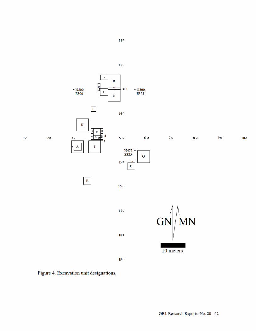
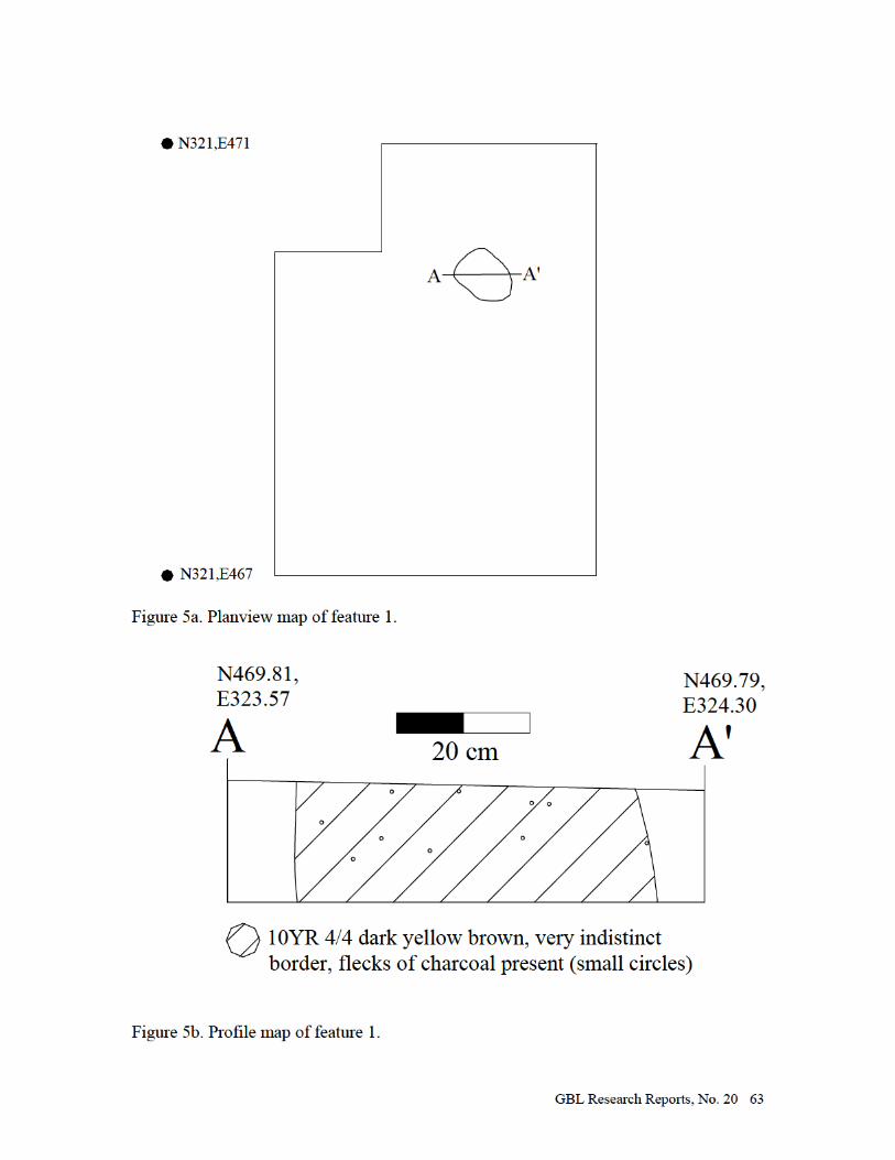


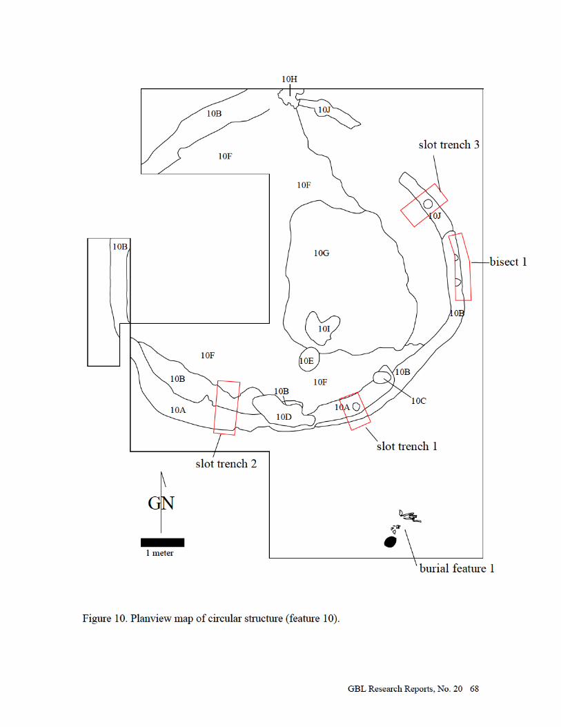


GBL Research Reports, No. 20 70
Figure 12. Selection of triangular projectile points from 12Ow431 (two complete examples on right).
Figure 13. Groundstone tools from 12Ow431.
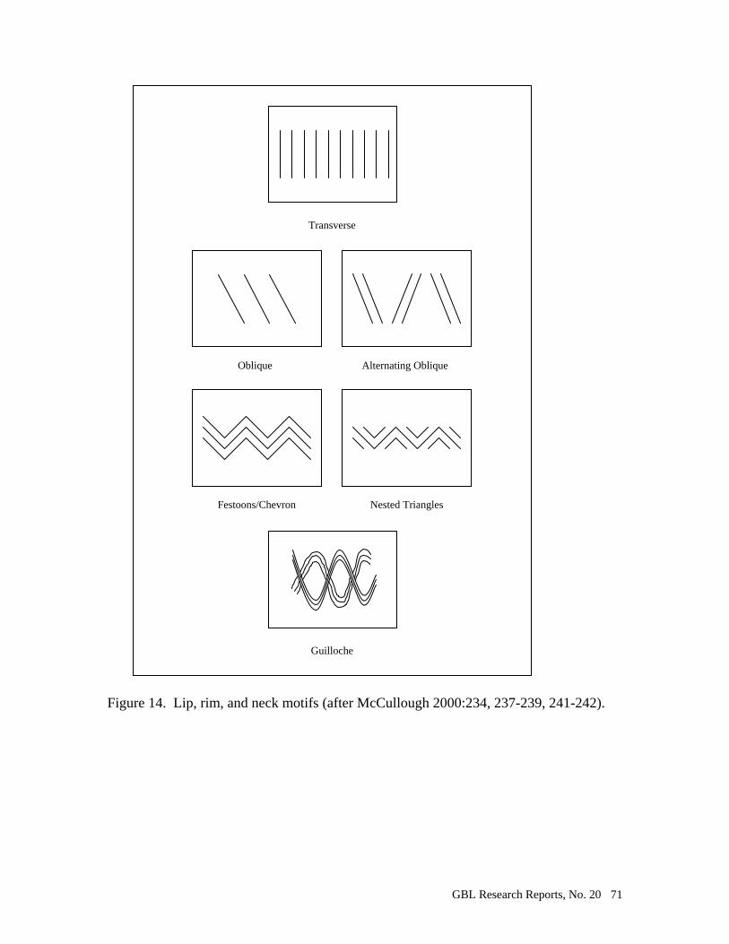
GBL Research Reports, No. 20 71
Figure 14. Lip, rim, and neck motifs (after McCullough 2000:234, 237-239, 241-242).
Oblique Alternating Oblique
Festoons/Chevron Nested Triangles
Transverse
Guilloche
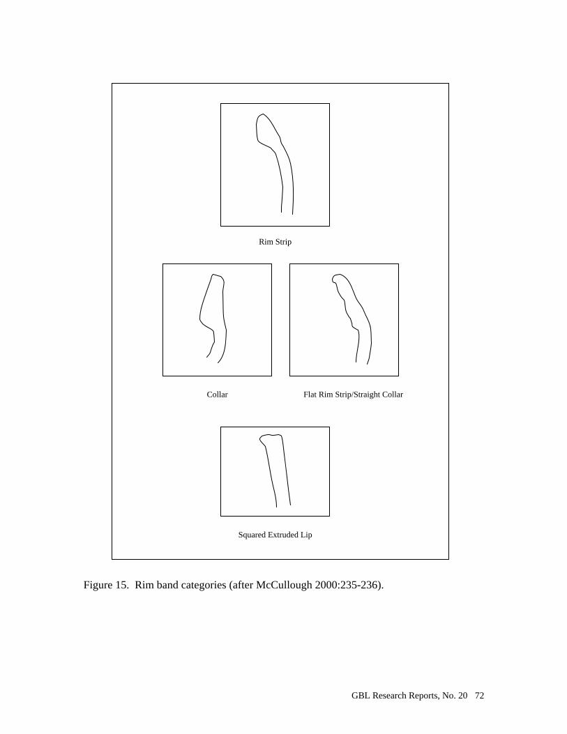
GBL Research Reports, No. 20 72
Figure 15. Rim band categories (after McCullough 2000:235-236).
Collar Flat Rim Strip/Straight Collar
Squared Extruded Lip
Rim Strip
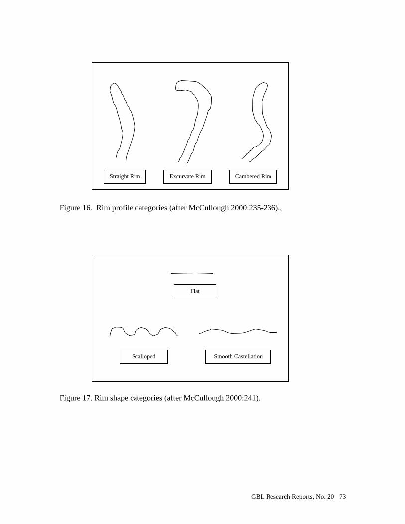
GBL Research Reports, No. 20 73
Figure 16. Rim profile categories (after McCullough 2000:235-236).. Figure 17. Rim shape categories (after McCullough 2000:241).
Straight Rim Excurvate Rim Cambered Rim
Flat
Scalloped Smooth Castellation
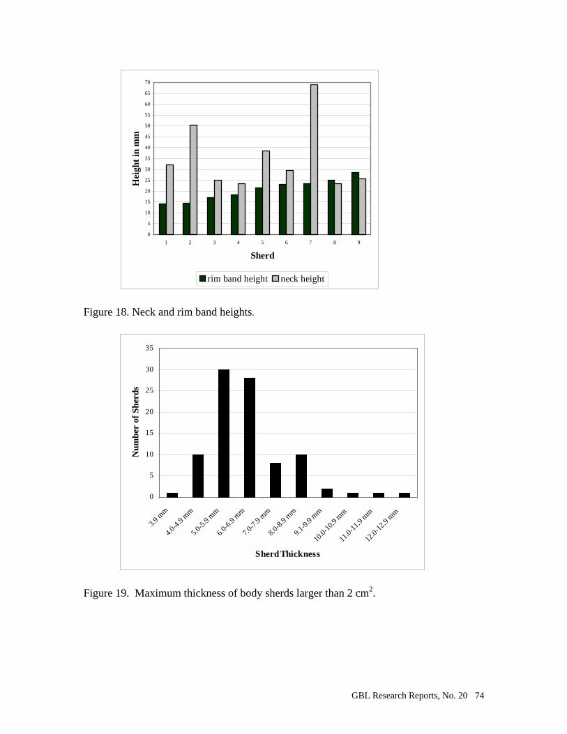
GBL Research Reports, No. 20 74
0
5
10
15
20
25
30
35
40
45
50
55
60
65
70
1 2 3 4 5 6 7 8 9
Sherd
Hei
ght
in m
m
rim band height neck height
Figure 18. Neck and rim band heights.
0
5
10
15
20
25
30
35
3.9 m
m
4.0-4
.9 mm
5.0-5
.9 mm
6.0-6
.9 mm
7.0-7
.9 mm
8.0-8
.9 mm
9.1-9
.9 mm
10.0-
10.9
mm
11.0-
11.9
mm
12.0-
12.9
mm
Sherd Thickness
Nu
mb
er o
f S
her
ds
Figure 19. Maximum thickness of body sherds larger than 2 cm2.
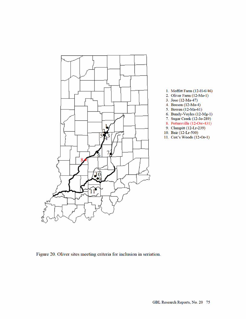
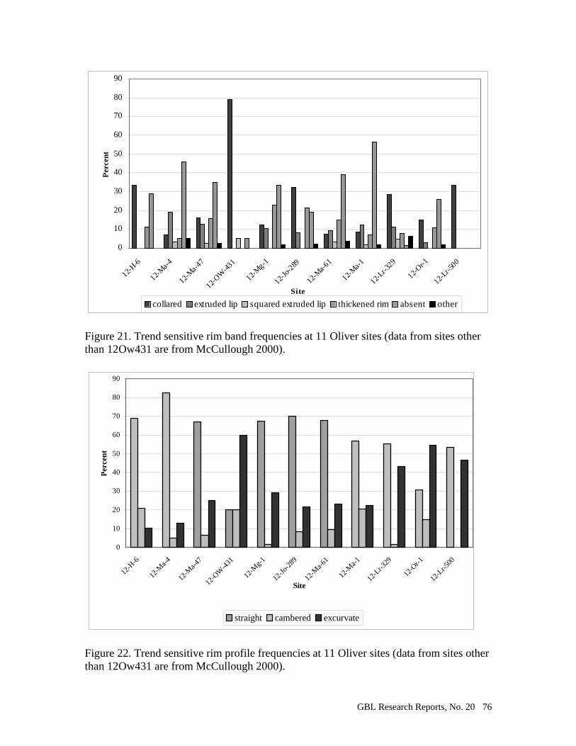
GBL Research Reports, No. 20 76
0
10
20
30
40
50
60
70
80
90
12-H-6
12-M
a-4
12-M
a-47
12-OW
-431
12-M
g-1
12-Jo
-289
12-M
a-61
12-M
a-1
12-Lr-3
29
12-Or-1
12-Lr-5
00
Site
Per
cent
collared extruded lip squared extruded lip thickened rim absent other
Figure 21. Trend sensitive rim band frequencies at 11 Oliver sites (data from sites other than 12Ow431 are from McCullough 2000).
0
10
20
30
40
50
60
70
80
90
12-H
-6
12-M
a-4
12-M
a-47
12-O
W-4
31
12-M
g-1
12-Jo
-289
12-M
a-61
12-M
a-1
12-L
r-329
12-O
r-1
12-L
r-500
Site
Per
cen
t
straight cambered excurvate
Figure 22. Trend sensitive rim profile frequencies at 11 Oliver sites (data from sites other than 12Ow431 are from McCullough 2000).
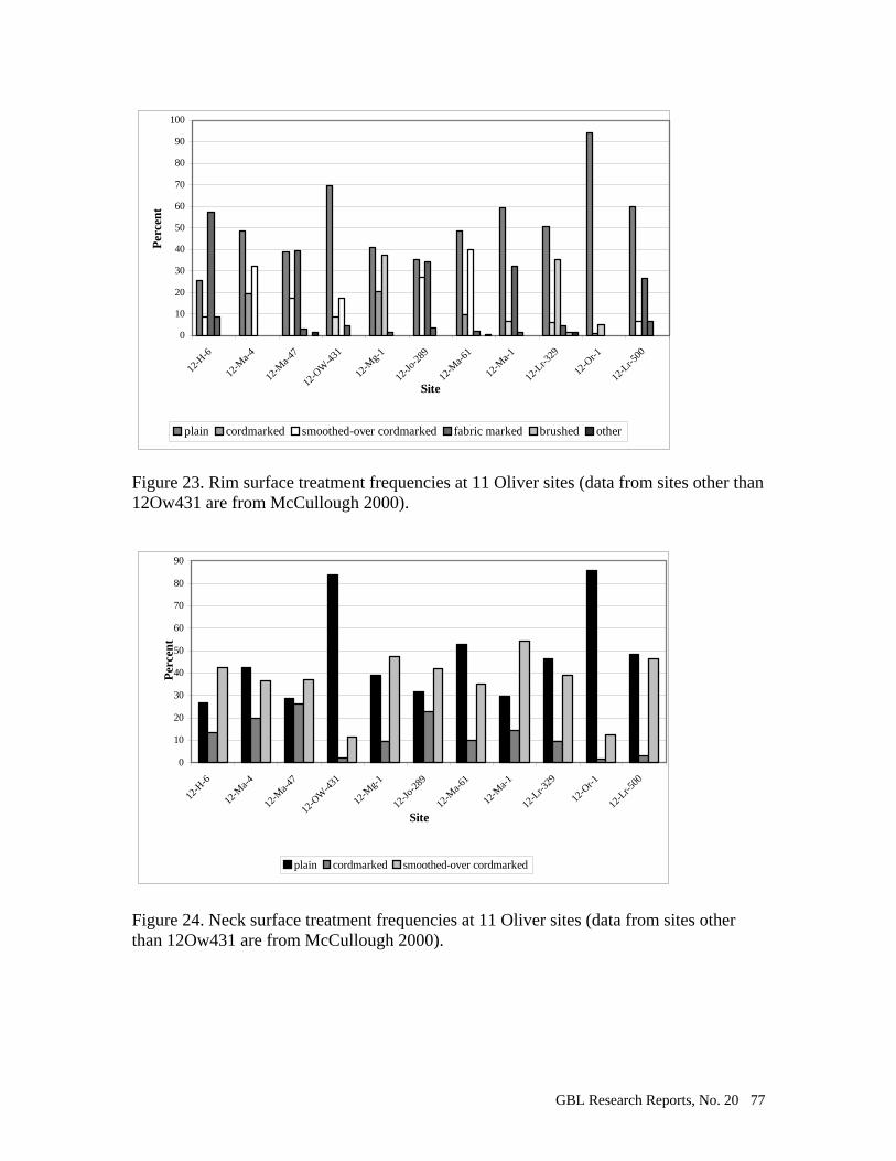
GBL Research Reports, No. 20 77
0
10
20
30
40
50
60
70
80
90
100
12-H
-6
12-M
a-4
12-M
a-47
12-O
W-4
31
12-M
g-1
12-Jo
-289
12-M
a-61
12-M
a-1
12-L
r-329
12-O
r-1
12-L
r-500
Site
Per
cen
t
plain cordmarked smoothed-over cordmarked fabric marked brushed other
Figure 23. Rim surface treatment frequencies at 11 Oliver sites (data from sites other than 12Ow431 are from McCullough 2000).
0
10
20
30
40
50
60
70
80
90
12-H
-6
12-M
a-4
12-M
a-47
12-O
W-4
31
12-M
g-1
12-Jo
-289
12-M
a-61
12-M
a-1
12-L
r-329
12-O
r-1
12-L
r-500
Site
Per
cen
t
plain cordmarked smoothed-over cordmarked
Figure 24. Neck surface treatment frequencies at 11 Oliver sites (data from sites other than 12Ow431 are from McCullough 2000).
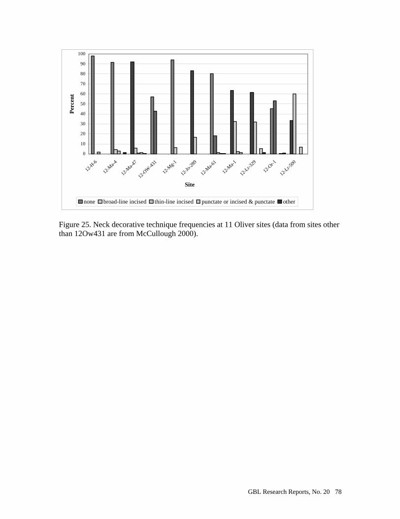
GBL Research Reports, No. 20 78
0
10
20
30
40
50
60
70
80
90
100
12-H
-6
12-M
a-4
12-M
a-47
12-O
W-4
31
12-M
g-1
12-Jo
-289
12-M
a-61
12-M
a-1
12-L
r-329
12-O
r-1
12-L
r-500
Site
Per
cen
t
none broad-line incised thin-line incised punctate or incised & punctate other
Figure 25. Neck decorative technique frequencies at 11 Oliver sites (data from sites other than 12Ow431 are from McCullough 2000).

GBL Research Reports, No. 20 79
Feature Feature type Ceramic Lithics Rock Fauna
count weight(g) count weight(g) count weight(g) weight(g)1 unknown 0 0 4 1.1 1 24.6 02 large post? 0 0 0 0 0 0 03 smudge pit 23 88.3 18 4.2 12 108.5 138.66 unknown 1 0.2 2 0.3 2 7.5 0.1
7A unknown 9 10.1 8 4 30 324.9 10.28N storage/trash pit 200 452.8 69 60.6 160 872.9 829.88S smudge pit 0 0 1 0.8 1 0.6 2
9 smudge pit 2 0.6 0 0 0 0 0
10 structure 553 2799.1 60 73.2 40 1663.2 1161.3
Table 1. Summary of feature contents.
Sherd Area
Plain Cordmarked Smoothed-over-cord/Plain
Smoothed-over-cord/Smoothed
Fabric marked
Total
Lip 14 (77.78%) 3 (16.67%) 0 (0%) 0 (0%) 1 (5.56%) 18 (100.01%) Rim 17 (73.91%) 2 (8.70%) 2 (8.70%) 1 (4.35%) 1 (4.35%) 23 (100.01%) Neck 37 (84.09%) 1 (2.27%) 3 (6.82%) 2 (4.55%) 1 (2.27%) 44 (100.00%)
Table 2. Surface treatment frequencies for rim and neck sherds larger than 2 cm2.
Sherd Area
None Smooth dowel impressed
Cordwrapped dowel impressed
Cord impressed
Drag & Jab
Broad-line Incised
Total
Lip 14 (87.50%) 1 (6.25%) 1 (6.25%) 0 0 0 16 (100.00%) Rim 9 (40.91%) 4 (9.09%) 6 (18.18%) 2 (27.27%) 1 (4.55%) 0 22 (100.00%) Neck 24 (57.14%) 0 0 0 0 18 (42.86%) 42 (100.00%)
Table 3. Decorative technique frequencies for rim and neck sherds larger than 2 cm2.
Sherd Area
None Transverse Oblique Parallel alternating oblique
Chevrons Nested triangles
Guilloche Total
Lip 14 (77.78%) 2 (11.11%) 2 (11.11%) 0 0 0 0 18 Rim 9 (47.37%) 0 6 (31.58%) 1 (5.26%) 1 (5.26%) 2 (10.53%) 0 19 Neck 25 (96.15%) 0 0 0 0 0 1 (3.85%) 26
Table 4. Motif frequencies for rim and neck sherds larger than 2 cm2.
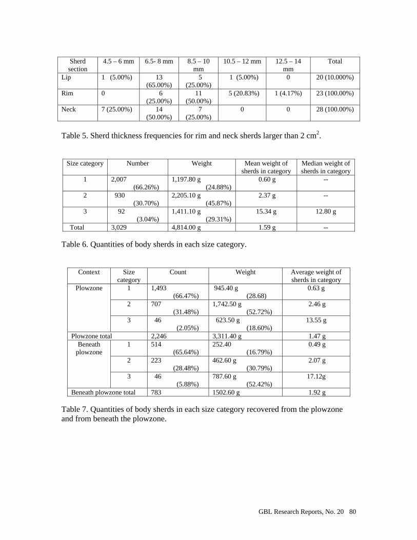
GBL Research Reports, No. 20 80
Sherd section
4.5 – 6 mm 6.5- 8 mm 8.5 – 10 mm
10.5 – 12 mm 12.5 – 14 mm
Total
Lip 1 (5.00%) 13 (65.00%)
5 (25.00%)
1 (5.00%) 0 20 (10.000%)
Rim 0 6 (25.00%)
11 (50.00%)
5 (20.83%) 1 (4.17%) 23 (100.00%)
Neck 7 (25.00%) 14 (50.00%)
7 (25.00%)
0 0 28 (100.00%)
Table 5. Sherd thickness frequencies for rim and neck sherds larger than 2 cm2.
Size category Number Weight Mean weight of sherds in category
Median weight of sherds in category
1 2,007 (66.26%)
1,197.80 g (24.88%)
0.60 g --
2 930 (30.70%)
2,205.10 g (45.87%)
2.37 g --
3 92 (3.04%)
1,411.10 g (29.31%)
15.34 g 12.80 g
Total 3,029 4,814.00 g 1.59 g -- Table 6. Quantities of body sherds in each size category.
Context Size category
Count Weight Average weight of sherds in category
Plowzone 1 1,493 (66.47%)
945.40 g (28.68)
0.63 g
2 707 (31.48%)
1,742.50 g (52.72%)
2.46 g
3 46 (2.05%)
623.50 g (18.60%)
13.55 g
Plowzone total 2,246 3,311.40 g 1.47 g Beneath
plowzone 1 514
(65.64%) 252.40 (16.79%)
0.49 g
2 223 (28.48%)
462.60 g (30.79%)
2.07 g
3 46 (5.88%)
787.60 g (52.42%)
17.12g
Beneath plowzone total 783 1502.60 g 1.92 g Table 7. Quantities of body sherds in each size category recovered from the plowzone and from beneath the plowzone.
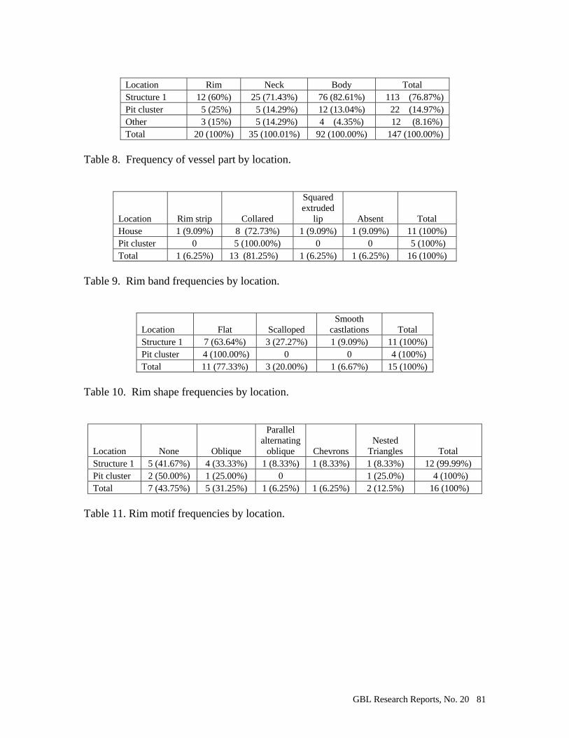
GBL Research Reports, No. 20 81
Location Rim Neck Body Total Structure 1 12 (60%) 25 (71.43%) 76 (82.61%) 113 (76.87%) Pit cluster 5 (25%) 5 (14.29%) 12 (13.04%) 22 (14.97%) Other 3 (15%) 5 (14.29%) 4 (4.35%) 12 (8.16%) Total 20 (100%) 35 (100.01%) 92 (100.00%) 147 (100.00%)
Table 8. Frequency of vessel part by location.
Location Rim strip Collared
Squared extruded
lip Absent Total House 1 (9.09%) 8 (72.73%) 1 (9.09%) 1 (9.09%) 11 (100%) Pit cluster 0 5 (100.00%) 0 0 5 (100%) Total 1 (6.25%) 13 (81.25%) 1 (6.25%) 1 (6.25%) 16 (100%)
Table 9. Rim band frequencies by location.
Location Flat Scalloped Smooth
castlations Total Structure 1 7 (63.64%) 3 (27.27%) 1 (9.09%) 11 (100%) Pit cluster 4 (100.00%) 0 0 4 (100%) Total 11 (77.33%) 3 (20.00%) 1 (6.67%) 15 (100%)
Table 10. Rim shape frequencies by location.
Location None Oblique
Parallel alternating
oblique Chevrons Nested
Triangles Total Structure 1 5 (41.67%) 4 (33.33%) 1 (8.33%) 1 (8.33%) 1 (8.33%) 12 (99.99%) Pit cluster 2 (50.00%) 1 (25.00%) 0 1 (25.0%) 4 (100%) Total 7 (43.75%) 5 (31.25%) 1 (6.25%) 1 (6.25%) 2 (12.5%) 16 (100%)
Table 11. Rim motif frequencies by location.
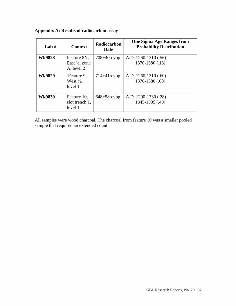
GBL Research Reports, No. 20 82
Appendix A: Results of radiocarbon assay
Lab # Context Radiocarbon
Date
One Sigma Age Ranges from Probability Distribution
Wk9828 Feature 8N,
East ½, zone A, level 2
708±40rcybp A.D. 1260-1310 (.56) 1370-1380 (.13)
Wk9829 Feature 9, West ½, level 1
714±41rcybp A.D. 1260-1310 (.60) 1370-1380 (.08)
Wk9830 Feature 10, slot trench 1, level 1
648±58rcybp A.D. 1290-1330 (.28) 1345-1395 (.40)
All samples were wood charcoal. The charcoal from feature 10 was a smaller pooled sample that required an extended count.

GBL Research Reports, No. 20 83
Appendix B: Faunal Remains from the Pottersville site (12Ow431).
by Daniel Seib
The Pottersville site was excavated using standard archaeological techniques.
When faunal materials were discovered during digging, careful attention was paid to
document its location and every attempt was made to remove the materials with minimal
damage. Excavators dug around the bones as much as possible with shovels and trowels,
then utilized bamboo picks and brushes to remove the bones from the soil. Despite the
careful measures taken by excavators, many bones, already weakened by the taphonomic
effects of the Indiana soils, were fragmented or crumbled while being removed from the
soil. Despite these conditions, excavators were able to recover some interesting material,
including a complete beamer, several fragmentary beamers, and two articulated raccoon
skeletons buried together. All faunal remains had their locations noted in the field,
wrapped in aluminum foil, and bagged separately to avoid being crushed by heavier
artifacts.
Once back at the lab, faunal remains were gently washed with water using a brush
when possible, and placed in a drying oven to dry. The bone was then sorted and bagged
again to await analysis. Several flotation samples were taken from heavy midden
deposits during the excavation. These samples yielded a surprising number of faunal
specimens. Flotation samples were run through a water screening machine, with the
resulting sample also being dried in the drying ovens. Faunal remains from the flotation
samples were removed by hand using tweezers and a magnifying glass to ensure that
microfauna would not be overlooked in the matrix. Once the faunal material was

GBL Research Reports, No. 20 84
separated from the remaining artifacts, there were bagged and labeled separately from the
other flotation samples while awaiting analysis.
Analysis
Once faunal specimens were ready for study, they were identified and coded
according to the Vertebrate Faunal Coding System developed by Shaffer and Baker
(1992). Identifying information such as context, quantity, weight, taxon, element, portion
of element, side, age, age criteria, sex, burning, cutmarks, gnawing, and modification
were recorded. Every attempt was made to identify specimens as thoroughly as possible,
but as was the case with many of the taphonomically affected bones, specific
identification was impossible. The ideal was to identify each fragment to the species
level. Due to poor bone preservation of some of the sample, some bone could only be
identified as vertebrate, mammal, bird, fish, amphibian, or reptile. If possible, these
specimens were further placed into general size categories: large, medium, small, and
micro. Much of the sample was fragmentary, but some was remarkably well preserved,
and could be identified to a family, genus, or species level. The NISP and MNI were
calculated based on the resulting data.
Results
A total of 92 bags of faunal material weighing 1,981.4 grams were analyzed from
the Pottersville Site. The number of identified specimens for the sample was 5975
specimens. This sample included all fauna recovered from regular excavation and from
GBL Research Reports, No. 20 85
floatation samples. Floatation samples were taken from every feature excavated and
from each level of the midden deposits.
The summary data for the site are listed in Table B-1. This table divides
recovered material into major taxonomic groups. Poorly preserved specimens are divided
into groups such as unidentified vertebrates, mammals, birds, amphibians, reptiles, and
fish; with the approximate size indicated as well. The numbers of identified specimens
for each taxon are listed along with the total weight for each category. Table B-2 is a
listing of the minimum number of individuals for each taxonomic group. Minimum
numbers of individuals were determined based on element, portion of element, side, and
age of specimens present from each taxonomic group (Reitz and Wing, 2000). MNI’s
were not calculated for vertebrates, mammals, amphibians, rodents, and squirrels where
the species was indeterminate. Table B-3 lists all burned bone from the sample, Table B-
4 lists all cutmarked bone, Table B-5 lists all the bone from the sample divided by unit,
and Table B-6 lists all the recovered shell by unit.
Vertebrates
Only one specimen was identified only as a vertebrate. Bone preservation was
poor in most regards, but identification to at least major taxonomic groups was possible
in most cases. In most instances, the appearance of the cortical and trabecular bone
indicated in which category the bone belonged.

GBL Research Reports, No. 20 86
Fish
Two fish ribs were identified in the faunal sample for the Pottersville site. One
rib was complete and was from a small fish, species indeterminate. The other bone was a
shaft fragment from a medium sized fish, species also indeterminate. Given the
proximity to the White River and the evidence for fish consumption among Oliver Phase
peoples (Garniewicz, 1996, 1997; Redmond and McCullough, 1993, 1996, 2000) it is
probable that most of the fish remains have been destroyed by taphonomy, dissolved by
acidic soils, or possibly were disposed of in another area of the site.
Freshwater Mussels
Freshwater mussel shells were collected from throughout the site, with the
greatest concentrations in the midden areas. Not all shell was recoverable, with much of
it disintegrating despite extremely careful collection methods. Identifiable shells in the
sample that was recovered were yellow sandshell, black sandshell, mucket, round pigtoe,
pyramid pigtoe, spike, kidneyshell, pimpleback, three ridge, and sheepnose (Cummings
and Mayer, 1992). Shell remains were weighed but not counted due to their extremely
fragmented state. Collected shell weighed 1,820 grams, as compared to the 1,981.4
grams of bone for the sample. The nearly 1 to 1 ratio of bone to shell may explain the
preservation of bone present at a site with such acidic soils. Table B-6 lists the amounts
of shell collected by unit and by depth (below surface).
GBL Research Reports, No. 20 87
Reptiles/Amphibians
Four fragments of turtle shell and one fragment of toad bone were recovered from
the site. The presence of turtles in an Oliver Phase site is to be expected (see Garniewicz,
1996 and 1997), and intrusive toad remains are to be expected as well (Garniewicz,
1997). Of particular significance is the large amount of frog remains (Rana sp.)
recovered at the site. With an NISP of 512 and an MNI of 24, frogs make up 9% of the
total faunal assemblage by number, but only 3% by weight. The MNI calculations are
based on 47 complete pterygoids and 161 complete or nearly complete vertebrae. This is
the largest collection of frog remains at an Oliver Phase site to date. Most of the sample
appears to be from the species Rana clamitans (green frog), which is a water frog, and
not from burrowing toads that may be intrusive into the site. Rana clamitans is
widespread throughout eastern North America. It lives close to shallow water, and may
be found among the rotting debris of fallen trees. They are nocturnal, and are not as wary
of humans as other species of frogs. They seldom scream in alarm when caught (Behler
and King, 1979). Several specimens were burned or calcined (Table B-3), which
suggests that the inhabitants of the Pottersville site were utilizing frogs in subsistence
activities.
Birds
Birds were represented in the sample by 45 bones, less than 1 percent of the total
number of bones. The only identifiable bones belong to Meleagris gallapavo, or the wild
turkey. Wild turkey probably also accounts for a large part of the other 43 bird bones in

GBL Research Reports, No. 20 88
this sample, as they were a staple of Oliver Phase faunal subsistence (Garniewicz, 1996,
1997; Redmond and McCullough, 1993, 1996, 2000).
Mammals
Unidentified mammal bone made up the vast majority of the faunal sample of this
site. Sixty-nine percent of the sample was identified as large, medium, small, micro, or
indeterminate sized mammal. Most of this bone was long bone shaft and end fragments,
and most of that probably came from deer. Elk remains, being so similar to deer in
everything but size, probably constitute a percentage of this category as well.
Deer (Odocoileus virginianus) were the most abundant species at the site, making
up 31% of the total bone weight of the sample. The MNI for deer was 5, which was
determined primarily from 5 right distal radius fragments.
The next most common species was raccoon, with an MNI of 3 based on 3 os
pubises in the sample. The total number of raccoon bones in the sample (485) is
misleading due to the fact that most of these come from the articulated burial of two
complete raccoons at the site. Both were buried in a single pit near the head of the
human burial on the site, and both showed no signs of cutmarks or consumption. One of
these raccoons was a juvenile, while the other was older with very worn teeth. Their
significance is unclear, but it is possible that they were kept as pets or were left as a grave
offering.
Elk were represented in the sample with an MNI of 2 based on two separate atlas
fragments. Many of the elk remains identified were juveniles, as evidenced by their
GBL Research Reports, No. 20 89
unfused epiphyses. A small elk’s bones are similar to a large deer’s bones, so many of
the bones attributed to large mammal/indeterminate in the sample may actually be elk.
One tooth (a carnassial) was identified as being from a gray wolf. The
significance of this is unclear. No other canid remains were discovered, and no bones
were found to exhibit gnaw marks of carnivores.
Gray squirrels were present in the sample, represented by an MNI of two. Only
gray squirrel remains were found, which indicates that the area that they came from was a
heavily forested area (Reidhead, 1981).
Human Remains
Human remains were encountered during excavation of the Pottersville site. One
articulated burial was found in the field (see Burial Feature 1). It was excavated, but not
removed, and covered again once measurements, photographs, and notes were taken.
Three human teeth were also discovered among the faunal material during analysis. The
human MNI count for the entire excavated site for the summer 2001 Pottersville project
area is 3, but in the faunal analysis presented here the MNI is only 2 (obtained from the
three teeth mistaken as animal teeth and included in the faunal sample).
Tools
Complete or fragmentary portions of three beamers were found in the sample.
Beamers were hide-scraping tools fashioned from animal long bones, usually deer
metapodials. Beamers were common tools throughout this section of the country, with
their construction and use being almost identical among neighboring cultures. The

GBL Research Reports, No. 20 90
complete beamer in the sample even had its corresponding navicular cuboid and
ectocuneiform found in association with it. This suggests that the tool was fashioned
soon after the kill and was used with the associated bones still attached. It also implies
that the tool was not used for long, since the navicular cuboid and ectocuneiform would
have fallen off and been lost as the connecting tissues decomposed.
The only other bones showing possible modification into tools were fragments of
turtle shell that may have been smoothed into shell bowls. Unfortunately, the fragments
were too small and poorly preserved to positively identify modification to the shell.
Tools produced from animal bones were scarce in this sample. This may be the
result of the overall poor bone preservation at the site. It is possible that other bones
showing signs of use were either too worn or did not survive at all.
Burned Bone, Cutmarks, and Gnawing
Tables B-3 and B-4 list all burned bones and bones that showed evidence of cut
marks. There were no gnaw marks found on any bone in this sample. The lack of gnaw
marks was interesting due to the presence of raccoon and rodents in the faunal
assemblage, which shows that there were gnawing animals present in the area. There
were also no domestic dog remains found at the site. Dogs could have kept nuisance
animals away from the habitation site and its middens. Only one canid remain was
found, a gray wolf carnassial which was found in a midden deposit. Cut marks were
found almost exclusively on deer bones, with one possible raccoon bone showing signs of
cutting. Two articulated raccoons were found buried together at the site and neither one
showed signs of cut marking. This is interesting since cut and burned specimens of
GBL Research Reports, No. 20 91
raccoon were found at the site, and previous research has shown that raccoon was utilized
as a food resource by Oliver Phase peoples (Garniewicz, 1996, 1997; Reidhead, 1981).
Nine grams of burned freshwater mussel shell were found in the sample as well.
Seasonality
The Pottersville site was probably not occupied year-round. Seasonality, or the
season in which a site is occupied, can be determined through many methods. One
method open to zooarchaeologists is to identify fauna that are only present at specific
times of the year. An obvious example in this faunal sample is the frog remains. Green
frogs hibernate in the winter by burrowing into the mud at the bottoms of bodies of water.
At other times of the year they are abundant in and near bodies of water (Behler and
King, 1979). These data tend to favor a spring to fall occupation, unless the inhabitants
of this site were somehow digging up frogs from their burrows during the winter.
Another indicator of seasonality found at the site was a single juvenile deer third
molar. The tooth appeared to have been just erupting from the mandible. Based on
analysis with comparative specimens, an age of 14 months was assigned to the tooth. In
south-central Indiana, deer give birth between April and June, which would put the date
of this juvenile deer’s death sometime between June and August. Looking at the faunal
evidence as a whole, the remains indicate a site occupation in the range of early summer
to late fall, but do not rule out occupation of the site into the winter.
GBL Research Reports, No. 20 92
Comparison with other Oliver Phase sites
Redmond and McCullough (2000) cite that over 100 Oliver Phase components
have been recorded in Indiana. Most of these sites are located near the East and West
forks of the White River in Central Indiana. Faunal remains recovered from Oliver Phase
sites show a heavy reliance on deer (Dorwin, 1971; Garniewicz, 1996, 1997; McCullough
and Wright, 1997; Redmond, 1994; Redmond and McCullough, 1993, 1996, 2000). The
Pottersville site shows a heavy reliance on deer as well; 31% of the total assemblage of
bone weight is deer. Elk was another favorite of Oliver Phase peoples, and was
represented in the Pottersville sample. Deer and elk would have been plentiful and
available year round. Other animals utilized heavily by Oliver Phase peoples were
turkey, raccoon, squirrel, turtle, and fish. All of these were represented in the Pottersville
sample. Oliver Phase subsistence is also characterized by a reliance on aquatic and semi-
aquatic animal resources. The Bundy-Voyles site highlights this characterization with the
recovery of beaver, muskrat, and shellfish remains (Garniewicz, 1997). The Pottersville
site mirrors this reliance on aquatic resources with its evidence for fish and mussel
utilization, as well as the large cache of frog and amphibian bones in its faunal
assemblage.
Most Oliver Phase sites have poor bone preservation due to the acidic soils that
are common in Indiana (Wright, 1996). A test of the soils at the Pottersville site yielded
an average pH of 5.1, with slightly more acidic soils in the woods and slightly less acidic
soils in the soybean field where excavations took place. At previous sites where bone
preservation has been more favorable, such as the Bundy-Voyles and Sugar Creek sites,
GBL Research Reports, No. 20 93
depositional factors have aided in bone preservation. In the case of the above-mentioned
sites, large concentrations of freshwater mussel shells surrounded the animal bone in
large refuse pits, shielding them from the acidity of the Indiana soils. At Pottersville,
1,820 grams of shell were collected from the site (see Table B-5), and this may have
acted to reduce the acidity of the soil surrounding the faunal remains. The precise nature
of this relationship is unclear, since the units with the most (and best) preserved bone
were not the units containing the most shell. Unit N contained the most shell (1,007.7
grams) and yielded a moderate amount of bone (603.6 grams), while Unit J yielded twice
as much bone (1,181.8 grams) while containing only a fraction of the shell (55.1 grams).
Unit J contained the deposit of frog bones, and their preservation may be due to the
present of large amounts of bone around them which was affected by the acidic soils
while they remained insulated within.
Conclusions
The faunal data from the Pottersville site are incomplete due to the small sample
size, but available data does give us some insight on the inhabitants’ way of life. The
faunal data support the conclusion that this probably was not a year-round occupation
site. The range of animal remains excavated is too narrow to suggest a full utilization of
the species diversity that would be available to the site if it were occupied year-round.
Faunal data suggests a early summer to late fall occupation of the site. The Pottersville
site’s reliance on aquatic and semi-aquatic faunal resources is consistent with previous

GBL Research Reports, No. 20 94
Oliver Phase studies, and the new discovery of comparatively large amounts of frog bone
at this site adds to the overall picture of Oliver Phase subsistence.
GBL Research Reports, No. 20 95
References Cited Behler, John L. and F. Wayne King
1979 National Audubon Society Field Guide to North American Reptiles and Amphibians. Alfred A. Knopf, New York.
Cummings, Kevin S. and Christine A. Mayer
1992 Field Guide to Freshwater Mussels of the Midwest. Illinois Natural History Survey Manual 5, Champaign.
Dorwin, John T.
1971 The Bowen Site: An Archaeological Study of Cultural Process in the Late Prehistory of Central Indiana. Indiana Historical Society Prehistory Research Series IV. Indianapolis.
Garniewicz, R.C.
1997 Appendix 3: Faunal Analysis, in McCullough, Robert G. and Timothy M. Wright (1997) An Archaeological Investigation of Late Prehistoric Subsistence-Settlement Diversity in Central Indiana. Glenn A. Black Laboratory of Archaeology, Research Report No. 18: 282-305.
1996 Appendix D: Analysis of Faunal Remains, in Redmond, B.G. and R.G.
Mcullough (1996) Excavations at the Cox’s Woods Site (12Or1), A Late Prehistoric Oliver Phase Village in the pioneer Mothers Memorial Forest, Orange County, Indiana. Glenn A. Black Laboratory of Archaeology, Research Report No. 17: 142-145.
McCullough, Robert G. and Timothy M. Wright
1997 An Archaeological Investigation of Late Prehistoric Subsistence-Settlement Diversity in Central Indiana. Indiana University Glenn A. Black Laboratory of Archaeology Research Reports, No. 18. Bloomington.
Redmond, Brian G. and Robert G. McCullough
1993 Survey and Test Excavation of Late Prehistoric Oliver Phase Components in Martin, Lawrence, and Orange Counties, Indiana. Glenn A. Black Laboratory of Archaeology, Indiana University, Reports of Investigations 93-13.
1996 Excavations at the Cox’s Woods Site (12 Or 1), A Late Prehistoric Oliver
Phase Village in the Pioneer Mothers Memorial Forest, Orange County, Indiana. Indiana. University Glenn A. Black Laboratory of Archaeology Research Reports, No. 17. Bloomington.
2000 The Late Woodland to Late Prehistoric Occupations of Central Indiana. In,
Late Woodland Societies: Tradition and Transformation Across the

GBL Research Reports, No. 20 96
Midcontinent. T.E. Emerson, D.L. McElrath, and A.C. Fortier, eds. University of Nebraska Press, Lincoln.
Redmond, Brian G.
1994 The Archaeology of the Clampitt Site (12Lr329), an Oliver Phase Village in Lawrence County, Indiana. Research Reports 16. Glenn A. Black Laboratory of Archaeology, Indiana University, Bloomington.
1999 White Fort and the Middle Sandusky Tradition Occupation of the Black
River Valley in Northern Ohio. Archaeology of Eastern North America 27:109-156.
Reidhead, V.A.
1981 A Linear Programming Model of Prehistoric Subsistence Optimization: A Southeastern Indiana Example. Indiana Historical Society Prehistory Research Series 6(1): 1-277.
Reitz, Elizabeth J. and Elizabeth S. Wing.
2000 Zooarchaeology. Cambridge University Press, Cambridge. Shaffer, B. S. and B.W. Baker.
1992 University of Michigan Museum of Anthropology Technical Report 23 A Vertebrate Faunal Analysis Coding System. University of Michigan, Ann Arbor.
Wright, Timothy M.
1996 Investigation of Soil pH at Cox’s Woods Site, 12Or1, in Redmond, B.G. and R.G. Mcullough (1996) Excavations at the Cox’s Woods Site (12Or1), A Late Prehistoric Oliver Phase Village in the pioneer Mothers Memorial Forest, Orange County, Indiana. Glenn A. Black Laboratory of Archaeology, Research Report No. 17: 124-139.
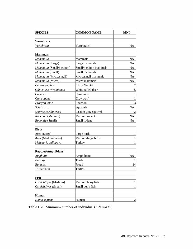
GBL Research Reports, No. 20 97
Table B-1. Minimum number of individuals 12Ow431.
SPECIES COMMON NAME MNI
Vertebrata
Vertebrata Vertebrates NA
Mammals
Mammalia Mammals NA
Mammalia (Large) Large mammals NA
Mammalia (Small/medium) Small/medium mammals NA
Mammalia (Small) Small mammals NA
Mammalia (Micro/small) Micro/small mammals NA
Mammalia (Micro) Micro mammals NA
Cervus elephus Elk or Wapiti 2
Odocoileus virginianus White-tailed deer 5
Carnivora Carnivores 1
Canis lupus Gray wolf 1
Procyon lotor Raccoon 3
Sciurus sp. Squirrels NA
Sciurus carolinensis Eastern gray squirrel 2
Rodentia (Medium) Medium rodent NA
Rodentia (Small) Small rodent NA
Birds
Aves (Large) Large birds 1
Aves (Medium/large) Medium/large birds 1
Meleagris gallapavo Turkey 1
Reptiles/Amphibians
Amphibia Amphibians NA
Bufo sp. Toads 1
Rana sp. Frogs 24
Testudinata Turtles 1
Fish
Osteichthyes (Medium) Medium bony fish 1
Osteichthyes (Small) Small bony fish 1
Human
Homo sapiens Human 2

GBL Research Reports, No. 20 98
Table B-2. Burned bone from 12 Ow431.
Species Common Name Element Portion Quantity Weight Burning
Vertebrates
Vertebrata Vertebrates Indeterminate Fragment 1 0.2 indet.
Mammals
Mammalia (Large) Large mammals Flat bone Fragment 58 1.9 calcined
Mammalia (Large) Large mammals Flat bone Frontal fragment 1 0.2 calcined
Mammalia (Large) Large mammals Long bone Diaphyseal fragment 84 22.4 calcined
Mammalia (Large) Large mammals Long bone Fragment 23 4.5 calcined
Mammalia (Large) Large mammals Flat bone Fragment 13 1.3 charred
Mammalia (Large) Large mammals Long bone Diaphyseal fragment 36 14 charred
Mammalia (Large) Large mammals Long bone Fragment 6 1.7 charred
Mammalia (Large) Large mammals Flat bone Fragment 1 0.1 present
Mammalia (Large) Large mammals Long bone Diaphyseal fragment 1 0.1 present
Mammalia (Small/medium) Small/medium mammals Caudal vertebra Complete or nearly complete 2 0.2 calcined
Mammalia (Small/medium) Small/medium mammals Femur Proximal end 1 0.1 calcined
Mammalia (Small/medium) Small/medium mammals Flat bone Fragment 13 0.6 calcined
Mammalia (Small/medium) Small/medium mammals Humerus Diaphyseal fragment 1 0.1 calcined
Mammalia (Small/medium) Small/medium mammals Long bone Diaphyseal fragment 56 4.1 calcined
Mammalia (Small/medium) Small/medium mammals Tibia Distal end 1 0.1 calcined
Mammalia (Small/medium) Small/medium mammals Flat bone Fragment 1 0.1 charred
Mammalia (Small/medium) Small/medium mammals Long bone Diaphyseal fragment 10 0.7 charred
Mammalia (Small/medium) Small/medium mammals Radius Proximal end 1 0.1 charred
Mammalia (Small) Small mammals Long bone Diaphyseal fragment 8 0.2 calcined
Mammalia (Small) Small mammals Phalange Distal end 1 0.1 calcined
Mammalia (Micro/small) Micro/small mammals Flat bone Fragment 1 0.1 calcined
Mammalia (Micro/small) Micro/small mammals Long bone Diaphyseal fragment 7 0.7 calcined
Mammalia Mammals Indeterminate Fragment 2 0.5 charred
Cervus elephus Elk or Wapiti Femur Complete proximal epiphysis 1 7.2 charred
Odocoileus virginianus White-tailed deer Fused 3rd & 4th metatarsal Distal end 1 5.7 calcined
Odocoileus virginianus White-tailed deer Fused 3rd & 4th metatarsal Posterior portion of shaft 1 1.3 calcined
Odocoileus virginianus White-tailed deer Metapodial Diaphyseal fragment 2 0.9 calcined
Odocoileus virginianus White-tailed deer Metapodial Proximal end 1 1.3 calcined
Odocoileus virginianus White-tailed deer Permanent tooth Cheek tooth 1 0.1 calcined
Odocoileus virginianus White-tailed deer First tarsal Complete or nearly complete 1 1.4 charred
Odocoileus virginianus White-tailed deer Fused 3rd & 4th metatarsal Diaphyseal fragment 1 2.1 charred
Odocoileus virginianus White-tailed deer Metapodial Diaphyseal fragment 1 0.8 charred
Carnivora Carnivores Permanent tooth Canine 1 0.1 calcined
Procyon lotor Raccoon Femur Complete proximal epiphysis 1 0.4 charred
Sciurus sp. Squirrels Femur Proximal end 1 0.1 calcined
Sciurus sp. Squirrels Metapodial Distal end 1 0.1 calcined
Sciurus sp. Squirrels Metapodial Proximal end 1 0.1 calcined
Sciurus sp. Squirrels Tibia Distal end 2 0.2 calcined
Sciurus sp. Squirrels Metapodial Distal end 1 0.1 charred
Sciurus sp. Squirrels Metapodial Proximal end 1 0.1 charred
Sciurus sp. Squirrels Permanent tooth Lower M 1 0.1 charred
Sciurus carolinensis Eastern gray squirrel Clavicle Distal end 1 0.1 charred
Sciurus carolinensis Eastern gray squirrel Humerus Distal end 1 0.2 charred
Rodentia (Medium) Medium rodent Permanent tooth Incisor 1 0.1 calcined
Rodentia (Medium) Medium rodent Permanent tooth Incisor 7 0.6 charred
Rodentia (Small) Small rodent Mandible Horiz.ramus w/incisor alveolus 1 0.1 charred
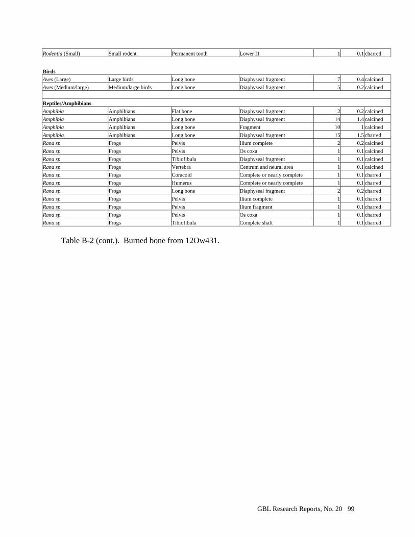
GBL Research Reports, No. 20 99
Rodentia (Small) Small rodent Permanent tooth Lower I1 1 0.1 charred
Birds
Aves (Large) Large birds Long bone Diaphyseal fragment 7 0.4 calcined
Aves (Medium/large) Medium/large birds Long bone Diaphyseal fragment 5 0.2 calcined
Reptiles/Amphibians
Amphibia Amphibians Flat bone Diaphyseal fragment 2 0.2 calcined
Amphibia Amphibians Long bone Diaphyseal fragment 14 1.4 calcined
Amphibia Amphibians Long bone Fragment 10 1 calcined
Amphibia Amphibians Long bone Diaphyseal fragment 15 1.5 charred
Rana sp. Frogs Pelvis Ilium complete 2 0.2 calcined
Rana sp. Frogs Pelvis Os coxa 1 0.1 calcined
Rana sp. Frogs Tibiofibula Diaphyseal fragment 1 0.1 calcined
Rana sp. Frogs Vertebra Centrum and neural area 1 0.1 calcined
Rana sp. Frogs Coracoid Complete or nearly complete 1 0.1 charred
Rana sp. Frogs Humerus Complete or nearly complete 1 0.1 charred
Rana sp. Frogs Long bone Diaphyseal fragment 2 0.2 charred
Rana sp. Frogs Pelvis Ilium complete 1 0.1 charred
Rana sp. Frogs Pelvis Ilium fragment 1 0.1 charred
Rana sp. Frogs Pelvis Os coxa 1 0.1 charred
Rana sp. Frogs Tibiofibula Complete shaft 1 0.1 charred
Table B-2 (cont.). Burned bone from 12Ow431.
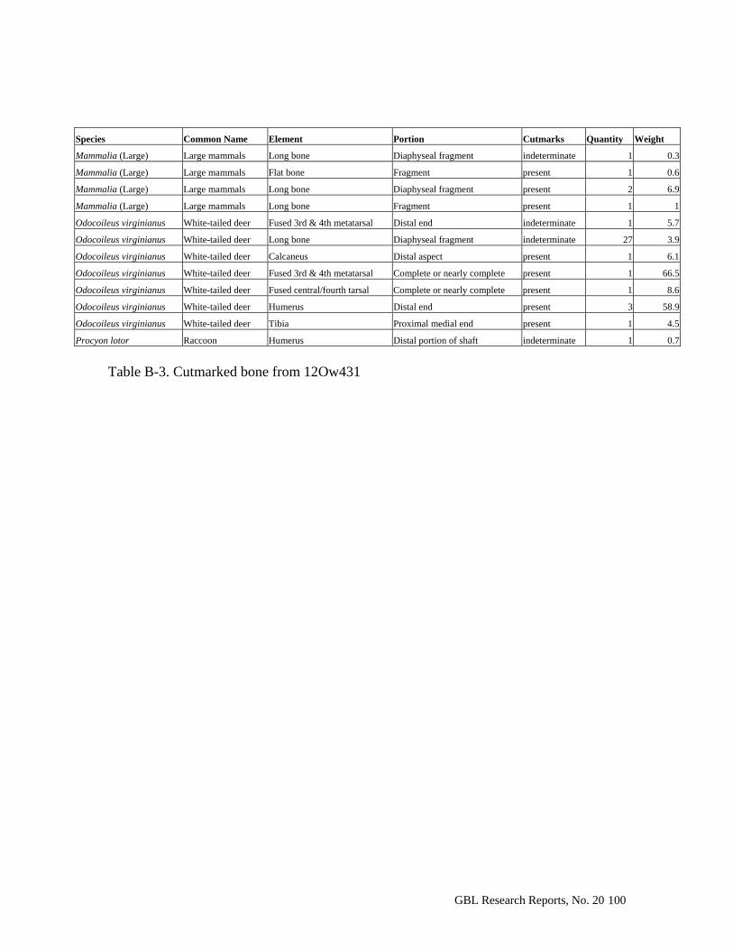
GBL Research Reports, No. 20 100
Species Common Name Element Portion Cutmarks Quantity Weight
Mammalia (Large) Large mammals Long bone Diaphyseal fragment indeterminate 1 0.3
Mammalia (Large) Large mammals Flat bone Fragment present 1 0.6
Mammalia (Large) Large mammals Long bone Diaphyseal fragment present 2 6.9
Mammalia (Large) Large mammals Long bone Fragment present 1 1
Odocoileus virginianus White-tailed deer Fused 3rd & 4th metatarsal Distal end indeterminate 1 5.7
Odocoileus virginianus White-tailed deer Long bone Diaphyseal fragment indeterminate 27 3.9
Odocoileus virginianus White-tailed deer Calcaneus Distal aspect present 1 6.1
Odocoileus virginianus White-tailed deer Fused 3rd & 4th metatarsal Complete or nearly complete present 1 66.5
Odocoileus virginianus White-tailed deer Fused central/fourth tarsal Complete or nearly complete present 1 8.6
Odocoileus virginianus White-tailed deer Humerus Distal end present 3 58.9
Odocoileus virginianus White-tailed deer Tibia Proximal medial end present 1 4.5
Procyon lotor Raccoon Humerus Distal portion of shaft indeterminate 1 0.7
Table B-3. Cutmarked bone from 12Ow431

GBL Research Reports, No. 20 101
Table B-4. 12Ow431, Bone distribution by unit.
Unit SPECIES NAME COMMON NAME Quantity Weight (g) Unit Weight (g)
A Mammalia (Large) Large mammals 2 0.4 0.4
D Mammalia (Large) Large mammals 11 1 1
D/G Mammalia (Large) Large mammals 8 2.1 2.1
G Mammalia (Large) Large mammals 25 4.7 10.8
Odocoileus virginianus White-tailed deer 1 6.1
J Amphibia Amphibians 493 56.2 1,181.8
Aves (Large) Large birds 33 3.3
Aves (Medium/large) Medium/large birds 8 0.6
Bufo sp. Toads 1 0.1
Cervus elephus Elk or Wapiti 17 54.6
Meleagris gallapavo Turkey 2 0.8
Mammalia (Large) Large mammals 2966 741.4
Mammalia (Small/medium) Small/medium mammals 127 9.1
Mammalia (Small) Small mammals 12 1
Mammalia (Micro/small) Micro/small mammals 13 1.3
Mammalia (Micro) Micro mammals 1 0.1
Odocoileus virginianus White-tailed deer 74 251.8
Osteichthyes (Small) Small bony fish 1 0.1
Osteichthyes (Medium) Medium bony fish 1 0.1
Procyon lotor Raccoon 1 0.4
Rana sp. Frogs 512 51.2
Rodentia (Medium) Medium rodent 18 1.6
Rodentia (Small) Small rodent 2 0.2
Sciurus sp. Squirrels 21 2.2
Sciurus carolinensis Eastern gray squirrel 25 4.9
Testudinata Turtles 4 0.6
Vertebrata Vertebrates 1 0.2
K Mammalia (Large) Large mammals 2 0.4 0.4
L Mammalia (Large) Large mammals 1 0.1 0.1
LMOP Mammalia (Large) Large mammals 4 2 2
N Aves (Large) Large birds 2 0.2 603.6
Canis lupus Gray wolf 1 3.2
Carnivora Carnivores 1 0.1
Cervus elephus Elk or Wapiti 2 2.5
Homo sapiens Human 3 1.8
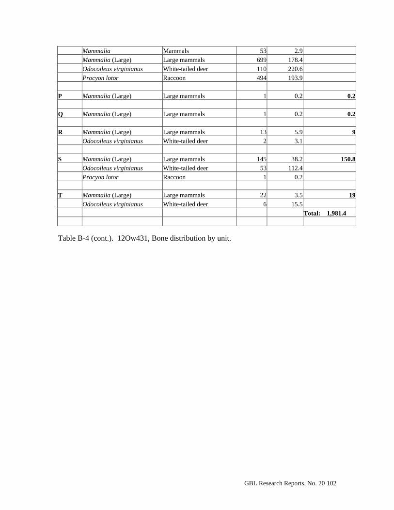
GBL Research Reports, No. 20 102
Mammalia Mammals 53 2.9
Mammalia (Large) Large mammals 699 178.4
Odocoileus virginianus White-tailed deer 110 220.6
Procyon lotor Raccoon 494 193.9
P Mammalia (Large) Large mammals 1 0.2 0.2
Q Mammalia (Large) Large mammals 1 0.2 0.2
R Mammalia (Large) Large mammals 13 5.9 9
Odocoileus virginianus White-tailed deer 2 3.1
S Mammalia (Large) Large mammals 145 38.2 150.8
Odocoileus virginianus White-tailed deer 53 112.4
Procyon lotor Raccoon 1 0.2
T Mammalia (Large) Large mammals 22 3.5 19
Odocoileus virginianus White-tailed deer 6 15.5 Total: 1,981.4
Table B-4 (cont.). 12Ow431, Bone distribution by unit.

GBL Research Reports, No. 20 103
Table B-5. 12Ow431, Freshwater mussel shells by unit.
Unit DEPTH WEIGHT (g) Total Weight (g)
A 0-10 cm 43.3 43.3
D
0-10 cm 4.9 4.9
Unrecorded 124.5 124.5
I 0-10 cm 0.8 0.8
J
0-10 cm 13
55.1 20-30 cm 5.9 30-40 cm 36.2
N 0-10 cm 128.4
1,007.70 10-20 cm 879.3
R 0-10 cm 38.5
131.8 10-20 cm 93.3
S 0-10 cm 245.4
396.7 10-20 cm 151.3 T 0-10 cm 54.4 54.4
Total: 1819.2
GBL Research Reports, No. 20 104
Appendix C: Macrobotanical Remains from the Pottersville site (12Ow431).
by Leslie L. Bush
The Pottersville site, 12 Ow 431, lies on the floodplain of the West Fork White
River, about 2.5 miles east-northeast of the modern town of Freedom, Indiana. Although
a few diagnostic artifacts from other time periods have been found on the surface, the
only substantial component at the site appears to be a small (0.6 hectare) Oliver Phase
habitation occupied during the late 13th century. The site was first recorded in 1996, and
the first archaeological excavations were carried out in the summer of 2001 by Indiana
University field school teams led by Michael Strezewski. This manuscript reports the
macrobotanical remains recovered during those investigations.
Natural Setting
Pottersville is situated south of the Wisconsin glacial boundary in the rugged
driftless region of Indiana. It lies within the Escarpment section of the Shawnee Hills
natural region, as defined by Homoya and colleagues (Homoya et al. 1985). As its name
suggests, most natural communities in this section are upland forest types (Homoya et al.
1985:258). Oaks and hickories are typically found on the well-drained upper slopes, but
cove forests tend more toward Braun’s (1950) mixed mesophytic forest and include
beech, tulip tree, red oak, sugar maple, walnut, white ash, and other trees (Homoya et al.
1985:259). Understory trees in these forests include dogwood, hop-hornbeam, redbud,
blue-beech, pawpaw, and spicebush (Petty and Jackson 1965:282, 288). In contrast to the
general forest types of this part of Indiana, however, the immediate vicinity of the
GBL Research Reports, No. 20 105
Pottersville site would have been covered by a floodplain forest. These forests contain a
wider diversity of species than do most upland forests, and the species necessarily have a
high tolerance for floods and attendant disturbances. The composition of floodplain
forests along the White River system in Indiana tends to be quite uniform (Lee 1945); the
most common species are shown in Table C-1.
Although the floodplain of the White River is not extremely wide in this area, in
some places near the Pottersville site it extends for 1000 meters or more on one side of
the river. The site area is nearly flat and is often inundated in the spring. The shallow
plow zones encountered during excavation at Pottersville, as little as 15 cm, suggest
active scouring and erosion of archaeological deposits. The occasionally-saturated soils
may also to have allowed for some limited movement of botanical remains even in the
subsoil, as discussed below.
The Pottersville vicinity sees about 42 inches of rain each year (Newman
1997:88). It has a frost-free growing season of 170-180 days and a mean annual
temperature of about 54 degrees Fahrenheit (Newman 1997:86).
Excavations
Excavations at Pottersville are fully described elsewhere (Strezewski 2002).
Crews exposed a total area of 226.5 m2. Intact cultural features consisted of one structure,
one storage pit, three smudge pits, and an area of burned soil. The structure, which is
roughly circular, about 7 meters in diameter, and of wall trench construction, is perhaps
the most significant feature on the site. It was encountered too late in the excavations to
permit full investigation, however, and no flotation samples are available. Flotation
GBL Research Reports, No. 20 106
samples varying in size from 0.2 to 20 liters were taken from 19 contexts at Pottersville.
Of these, eight were from the storage pit (Fea. 8N), two were from smudge pits, and two
were control samples from plow zone and subsoil matrix. Other samples came from
contexts that were assigned feature numbers but which were either badly damaged or
could not be definitively attributed to cultural processes.
Laboratory Methods
Flotation
All 19 samples were processed at the Glenn A. Black Laboratory of Archaeology,
Indiana University, in June and July 2001 using a Flote-Tech machine (Dausman 1989;
see also Hunter and Gassner 1998; Rossen 1999). The soils at the site, silt loams of the
Genesee series, allowed use of a 0.5 mm bottom mesh in the flotation tank. Inspection of
the heavy fractions in the spring of 2002 revealed poor separation, so heavy fractions
from the original flotation were re-processed by hand in small basins by members of the
2002 Indiana University Field School in Archaeology. Microscopic inspection of one of
the resulting re-processed heavy fractions identified some nutshell still in the heavy
fraction. As shown in Table C-2, all remains recovered from this heavy fraction consist of
nutshell. Although the absolute numbers are substantial, they represent only 4% of the
total nutshell found in this large, productive flotation context. Nutshell may be somewhat
underrepresented in flotation samples from other contexts, where heavy fractions were
not examined under the microscope, but the figures from Fea. 8 Zone A’, the largest
sample processed, likely represent a worst-case scenario. No correction factors for
potentially missing heavy fraction remains have been applied to the other samples.
GBL Research Reports, No. 20 107
Michael Strezewski selected eleven light fractions and one heavy fraction for
analysis, and sent them to the author in May 2002. These samples represent two control
contexts, six contexts from the large storage pit (Fea. 8N), and one sample each from two
smudge pits (Feas. 3 and 9). 4. In all, the samples from Pottersville represent 130 liters of
fill, of which 103 come from cultural contexts.
Sorting and identification
Each sample was weighed on an electronic balance having a resolution of 0.01 g
before being size-sorted through a stack of geologic mesh with openings of 2 mm, 1.4
mm, and 0.71 mm. Materials in the > 2 mm size fraction were completely sorted, and all
charred botanical remains were counted, weighed, recorded, and labeled. For samples
where more than 50 wood charcoal fragments were present, counts were estimated from
the weight of a random sample of 50 fragments. Twenty fragments of wood charcoal
from each context were selected at random, snapped in half, and examined at 60-80x
magnification for identification. Materials other than charred botanical remains in the > 2
mm size fraction were weighed, recorded, and labeled but not counted. Faunal material
had previously been removed from flotation samples, but a very few identifiable elements
were encountered under the microscope. These are noted in Table C-7 and on laboratory
forms. All materials in the > 2 mm size fraction other than charred plants or identifiable
faunal elements are referred to as “contamination” in Table C-7 and on laboratory forms.
At Pottersville, these materials usually consisted of roots, rootlets, and unidentifiable
4 Feas. 3 and 9 are not the classic, Binfordian smudge pits filled with charred corn cobs (Binford 1967). Rather, they seem to be a variant common to the Oliver Phase and are filled with wood charcoal that appears to have decayed before it burned. Murphey noted
GBL Research Reports, No. 20 108
bone fragments. Materials that fell through the 2 mm mesh, referred to as “residue,” were
examined carefully under a stereoscopic microscope at 7-30x magnification for charred
botanical remains other than nutshell of the hickory-walnut family, fungus, and wood
charcoal. Following the usual practice of C. M. Scarry (e.g., 1991, 1992), nutshell of the
beech-oak family was searched for in the residue down to the 1.4 mm size fraction in all
samples but one, since it tends to break up in the soil far more easily than nutshell of the
more durable hickory-walnut family. All plant material removed from the residue was
counted, weighed, and labeled. The presence of uncharred taxa in the residue was also
recorded on laboratory forms, but these materials were not usually removed from residue.
Botanical materials from Pottersville were identified to the lowest possible
taxonomic level by comparison to materials in the author’s comparative collection and
through the use of standard reference works (e.g., Davis 1993; Martin and Barkley 1961;
Schopmeyer 1974; U.S.D.A. 1971). Seeds, fruits, and woody tissue are not always
sufficient, by themselves, to allow identification of the plant from which they came to the
species level. Some taxa were identified to species through positive identification or
elimination of other possible members of the genus. Most commonly, botanical materials,
whether charred and uncharred, were identified to the level of genus. Botanical
nomenclature follows the United States Department of Agriculture PLANTS database at
http://plants.usda.gov/.
such a use of rotted wood to tan hides on the Warm Springs reservation in Oregon (Murphey 1990[1958]:55).

GBL Research Reports, No. 20 109
A special note on nutshell identification
Beechnut is relatively rare on archaeological sites and such quantities as have
been recovered from Pottersville are even rarer. For this reason, a special note on its
identification is in order here. Separation of beechnut from acorn shell was made
primarily through the use of materials in the author’s comparative collection. In
descending order of importance, shape, thickness, and texture appear to the be most
important criteria for distinguishing the two. Beechnuts are roughly pyramidal in shape,
and the corners where the planes of the pyramid come together are diagnostic of that nut.
The ridges and creases where the planes draw together at the bottom of the nut can also
be readily distinguished in many charred fragments. Acorns are roughly spherical and
have no such corners. Acorn nutshell is at once more delicate and (usually) thicker than
beechnut, consisting of a thin outer shell protecting several thinner interior layers.
Beechnut, in contrast, usually has a denser, single- or double-layered shell. The circular
surface where the cap covers an acorn is rougher and flatter than most acorn shell and is
readily identified under the microscope. Surface texture appears to be the least reliable
criterion for distinguishing acorn from beechnut, but it can be useful for small fragments
where no other diagnostic features are found. The methods of preparation, deposition,
and recovery employed at Pottersville appear to result in beechnut usually developing a
papillate (“bubbled”) exterior surface texture while acorn sometimes developed the
classic reticulate pattern (“fishnet stockings”) often seen on the exterior of acorn shell in
the Eastern Woodlands. Occasionally, an acorn fragment appears papillate at Pottersville,
but beechnut seems never to develop the characteristic reticulate texture of acorn.
GBL Research Reports, No. 20 110
As implied above, botanical analysts have not yet developed a uniform method
for comparing thick, durable nutshell of the hickory-walnut family (Juglandaceae) with
the more delicate nutshell of the acorn-beech family (Fagaceae). Tables C-6 and C-7 of
this report follow C. M. Scarry in recording acorn-beech nutshell as small as 1.4 mm but
hickory-walnut nutshell only when it is larger than 2 mm. Other analysts record only
nutshell greater than 2 mm and leave all smaller fragments in the residue, regardless of
the type of nutshell. Table C-3 presents a break-down of how much acorn-beech nutshell
was found in each of the 2 mm and 1.4 mm size fractions at Pottersville. Table C-3 can
therefore be used by those seeking comparative data to other sites where only nutshell
greater than 2 mm is reported. Pulling, sorting, counting, and weighing acorn-beech
nutshell smaller than 2 mm is also very time-consuming. Table C-3 suggests multipliers
that can be used to estimate counts and weights of nutshell in the 1.4 mm size fraction
when only the 2 mm size fraction has been examined – or, alternatively, to estimate
counts and weights of acorn-beech nutshell in the 2 mm size fraction when both are
recorded together. It is not clear to what extent these multipliers apply to other sites,
where conditions of nut processing, deposition, preservation and recovery may be
different, but it is hoped that, with additional data, the reliability of the suggested
multipliers can be assessed.
As shown in Table C-3, the ratios of large:small acorn and large:small beechnut
are very similar, for both counts and weights. (In consequence, the multipliers are also
very similar.) This suggests that the acorn and beechnut at Pottersville underwent similar
processing and deposition in addition to enduring similar post-depositional conditions in
the soil at Pottersville. The multipliers for acorn and beechnut may therefore be averaged
GBL Research Reports, No. 20 111
(3.06 for counts; 1.66 for weights). For one sample in this study, the light fraction from
re-flotation of Fea. 8 Zone A’, only acorn-beech nutshell greater than 2 mm was sorted.
These are the multipliers used to estimate the total acorn-beech nutshell in that sample in
Tables C-6 and C-7.
Results
Macrobotanical remains recovered by flotation from Pottersville are reported in
Tables C-4-C-7. Table C-4 indicates uncharred plant taxa on a presence/absence basis.
Table C-5 shows results of wood charcoal identification. Table C-6 shows charred
macrobotanical remains by count; Table C-7 provides the same information by weight.
Uncharred plant remains
On open-air sites in the eastern woodlands, uncharred plant material can be
assumed to be of modern origin unless compelling evidence suggests otherwise (Lopinot
and Brussell 1982). To date, the Pottersville site has offered no such evidence, and only
charred plant remains are believed to be ancient. The uncharred taxa at Pottersville,
shown in Table C-4, are dominated by weedy taxa commonly found on field and forest
margins in Indiana. Seven of the uncharred taxa are also found among the charred plant
remains on the site. These are: beechnut, grass family, purslane, pokeweed, bramble,
nightshade, and corn.5 Even these remains are almost certainly not ancient however, but
rather represent the continuity of conditions favorable to the growth of these plants in the
Pottersville vicinity over the past 700 years. As indicated in Figure C-1, the primary
5 Specimens labeled “bean family” (Fabaceae) also appear in both charred and uncharred forms, but these are clearly different taxa.

GBL Research Reports, No. 20 112
determinant of taxa abundance for uncharred species at Pottersville is the depth of the
sample. The outlier in this figure consists of a 2-liter sample whose size makes it
unreliable. When this sample is excluded, the coefficient of correlation between depth
and number of uncharred taxa is –0.87. Uncharred plant remains at Pottersville almost
certainly represent modern seed rain and other remains of modern plants.
Control samples
Two control samples, one from plow zone and one from subsoil, were examined
to assess the possibility that significant archaeological macrobotanical remains might
exist outside feature contexts. The two samples totaled 27 liters of soil and produced a
grand total of 4 wood charcoal fragments. The presence of charcoal in the subsoil
suggests two possible scenarios: wood charcoal may have been deposited onto the site by
natural processes (spring floods, forest fires), or wood charcoal of cultural origin may
have migrated from feature contexts into the subsoil. Erosional and deflational processes
appear to have been more common than depositional processes at Pottersville over the
last 700 years, making the latter possibility more likely. However they were deposited,
the very small number and weight of remains recovered from control contexts at
Pottersville indicate that macroremains in non-feature contexts are extremely rare.
Charred plant remains
Wood charcoal
Wood charcoal is the most common plant remain recovered from Pottersville,
both by count (n=10,249) and by weight (g=178.92). White oak, beech, and elms are the
GBL Research Reports, No. 20 113
most common woods at the site. Oaks, beech, and walnut would have been readily
available in the hills and valleys of the Escarpment section of the Shawnee Hills natural
region. Comparison of Tables C-5 and C-1 shows that some species of all other taxa
noted in the wood charcoal assemblage would likely have been available in the floodplain
environment of the immediate site locality. (Although not as common as the species in
Table C-1, honeylocust is also a tree of the floodplain canopy of the White River system
[Lee 1945:Table 1].)
Not surprisingly, the wood charcoal contents of the two smudge pits, Feas. 3 and
9, differ from that of the storage pit, Fea. 8N. In general, the two smudge pits contain
more elm and honeylocust than does the storage pit. The most common taxa from Fea.
8N (white oak, beech, maple/dogwood) are entirely absent from the smudge pits. A word
of caution is in order, however. The wood charcoal from the smudge pits, and especially
Fea. 9, was in poorer condition than the wood charcoal in Fea. 8N. Of the 75.00 g of
wood charcoal in Fea. 9, only 0.57 g appeared at 7x magnification to be in good enough
condition to be identifiable. All identified wood charcoal fragments from Fea. 9 were
selected from these 0.57 g. Identified wood charcoal from this context may therefore not
be representative of its wood charcoal as a whole.
Crops
Remains of three cultivated plants were identified among the Pottersville flora.
Corn (Zea mays ssp. mays; n=34, g=0.17) is the most common of these, but it is relatively
scarce for a Late Prehistoric site in Indiana. Further, all but one of the corn fragments

GBL Research Reports, No. 20 114
consist of cupules, which are inedible fragments of the corn cob. This suggests that corn
processing, rather than corn consumption, was the dominant activity at Pottersville.
Fea. 8N Zone A’ yielded a single tobacco seed (Nicotiana sp.). Tobacco seeds
first appear on archaeological sites in the eastern woodlands during the first few centuries
of the common era. These were long believed to represent remains of the South American
N. rustica, the only tobacco cultivar mentioned in early historic records for the eastern
woodlands. Recent discovery of N. quadrivalvis or N. multivalvis in sub-Mound 51 at
Cahokia, however, casts doubt on this universal identification (Pauketat et al. 2002).
Larger sample sizes than the single seed recovered from Pottersville are necessary to
distinguish N. rustica from these other taxa, so the species identification of the
Pottersville specimen remains unknown.
One bottle gourd (Lagenaria siceraria) seed was recovered from the lowest level
(Zone AA) of Fea. 8N. Bottle gourd appears on archaeological sites in the eastern
woodlands as early as 7,000 B.P. (Doran et al. 1990). The plant is believed to have
drifted on ocean currents from its native Africa to tropical or North America, where it
was taken into cultivation (Heiser 1979:85, Doran et al. 1990). Bottle gourd is widely
noted in early historic accounts of Native American subsistence, but this is the first time
it has been recovered from an Oliver Phase site.
Nutshell
After wood charcoal, nutshell is the most common macrofloral remain recovered
from Pottersville. Fea. 9 and all zones of Fea. 8N are dominated by acorn and beechnut.
As noted above, this is an unusual pattern of nutshell deposition. Most Oliver sites, like

GBL Research Reports, No. 20 115
most sites of the Ohio and Middle Mississippi river valleys, are dominated by nutshell of
the hickory-walnut family. A few sites, including the Oliver habitations at Bundy-Voyles
and Prairie View, are dominated by acorn. Beechnut, however, is much less common. For
example, Wagner reports no beechnut at all in her comprehensive survey of Fort Ancient
plant remains (Wagner 1987). Similarly, Johannessen found no beechnut significant
enough to include in her summary report on the paleoethnobotany of the American
Bottom at any time period (Johannessen 1984). In this context, the substantial quantities
of beechnut at Pottersville demand explanation. Small, dark brown beechnuts are difficult
for humans to see among the leaf litter on the forest floor, but they are quickly consumed
by small animals after they fall (Munson 1984:465). Historic accounts of beechnut
consumption by Native Americans often omit mention of how the nuts were acquired or
shelled (Moerman 1998:231-232). When acquisition is described, the usual method is
raiding the caches made by mice and chipmunks during the winter (Smith 1933:100 and
Gilmore 1933:128 in Munson 1984:465 and Moerman 1998:231-232). Chipmunks do not
shell beechnuts before caching, although they do remove the outer husk, so the
Pottersville beechnut shell could conceivably have come from such a cache.
The wood charcoal assemblage at Pottersville, most particularly the high
percentages of beech and oak in Fea. 8N, raises the possibility that nutshell in the
archaeobotanical assemblage is incidental to the burning of branches bearing acorns and
beechnuts. It is difficult, however, to envision a scenario by which this might have
happened. Any nut-bearing branches brought down in a catastrophic storm would have
been raided by animals long before the wood was sufficiently dry for use as fuel. A
nearly-whole beechnut from Fea. 8N Zone AA indicates that at least some of the nuts
GBL Research Reports, No. 20 116
were mature at the time of burning, and other acorn and beechnut fragments are
consistent with mature-sized nuts. Economic use of the plants by humans who exploited
the same oak and beech trees for both firewood and nuts seems the most parsimonious
explanation at this time for the quantities of these plants found at Pottersville. The similar
size distributions exhibited by both kinds of nuts (Table C-3) suggests that both kinds of
nuts were being processed by similar methods.
All other nutshell recovered at Pottersville belongs to the hickory-walnut family:
hickory, walnut/butternut, and pecan. The latter is most commonly associated with the
Mississippi River valley, but it is known in Indiana as far north as Greene County on the
White River and Fountain County on the Wabash River (Deam 1940:368). No hazelnut
or chestnut was recovered at Pottersville.
Other wild plants
Of the non-nut wild plants, sumac (n=48), purslane (n=12) and grass seeds (n=10)
were the most common taxa at Pottersville. All three are among the most ubiquitous and
abundant non-nut wild taxa on Oliver sites (Bush 2001:182-183). Seven small seeds of
the nightshade family were also found from five contexts at Pottersville. These four most
common plants at Pottersville, like most of the other non-nut wild plants in the
assemblage, are weedy species that thrive in disturbed environments such as those near
human habitation or on fields and forest margins. In addition, two taxa, grape and
hawthorn, are common constituents of floodplains on the White River (Table C-1).
Like the corn and nut remains described above, the wild plants recovered at
Pottersville have obvious food uses: Bramble, sumac, hawthorn, nightshade, pokeweed
GBL Research Reports, No. 20 117
and grape have edible fruits, and the seeds of wild legumes, smartweed, knotweed, and
grasses are also edible, although the presence of the latter taxon may represent use of
grass stems in such crafts as mat-making or basketry. The lone plant that is far more
likely to have been used for medicine than for food is bedstraw, which has several known
medicinal uses (Moerman 1998:241-242). This plant, whose seed is a bur, could also
have been intentionally burned as a nuisance plant before deposition in Fea. 8N at
Pottersville.
Discussion
The macrobotanical assemblage at Pottersville appears consistent with
macrofloral remains recovered from other Oliver sites. If differs primarily in having less
corn and more nutshell, particularly beechnut, than is typical. Non-nut wild plant remains
at Pottersville, like those at other Oliver sites, mostly represent taxa common to disturbed
and ecotonal areas of central Indiana. Figure C-2 shows a correspondence map of major
groups of macrofloral taxa recovered from 11 Oliver sites, including Pottersville, and one
Mississippianized Oliver site (12 Gr 122). Bølviken and colleagues (1982) explain the
theory and application of correspondence analysis (CA) for archaeologists. In brief, CA is
a method of data reduction that allows visualization of many variables (in this case, sites
and plant types) in a single plane. One great strength of CA for archaeobotanical analysis
is that data sets of widely divergent size and/or data sets that include small absolute
numbers may be legitimately compared. Figure C-2 shows that Pottersville clusters neatly
with the majority of Oliver sites. Its macrobotanical assemblage is particularly similar to
those at site 12 Mg 195 and Abner (12 Lr 431), both of which are believed to represent
GBL Research Reports, No. 20 118
small-scale, probably seasonal, habitation sites. Specifically, the botanical similarities lie
in the relatively large quantities of nutshell, relatively small quantities of corn, and
absence of native starchy- and oily-seeded cultigens (EAC plants) found on these sites.
Oliver ceramics are widely known for – in fact, are defined by – their similarities
to both Fort Ancient and Great Lakes Late Woodland pottery (McCullough 2000).
Strezewski suggests that Oliver sites and structures also exhibit such dual affinities, with
palisaded villages following a Fort Ancient pattern and seasonal dwellings constructed
according to Great Lakes principles (Strezewski 2002). The charred macrobotanical
remains from Oliver sites have clear Fort Ancient affinities in their lesser reliance on corn
than Mississippian systems, their use of beans, and the occasional presence of starchy-
and oily-seeded native cultigens. Oliver differs from Fort Ancient, however, in generally
its greater nutshell:corn ratios and a greater diversity of wild plant types. Unfortunately,
substantial flotation-era botanical assemblages from northern Indiana and Ohio are not
available. Whether the differences between Oliver and Fort Ancient macrobotanical
assemblages may be attributed to Great Lakes influence remains to be determined.
Conclusion
The chief value of the Pottersville macrobotanical assemblage is that it documents
uses of plants by the site’s residents, but the Pottersville macroflora also has implications
beyond the site itself. The recovery of a specimen of bottle gourd adds a new plant to the
list of documented Oliver crops. Further, the Pottersville macrobotanical remains suggest
that small habitation sites of the Oliver Phase share a pattern of plant use, which may be

GBL Research Reports, No. 20 119
related to similarities of seasonality and/or functionality among the sites. Finally, the site
is extremely unusual in the substantial amounts of beechnut that were recovered.

GBL Research Reports, No. 20 120
References cited Binford, L. R.
1967 Smudge Pits and Hide Smoking: The Use of Analogy in Archaeological Reasoning. American Antiquity 32(1):1-12.
Braun, E. L.
1950 Deciduous Forests of Eastern North America. Hafner Publishing Company, New York.
Bølviken, E., E. Helskog, K. Helskog, I. M. Holm-Olsen, L. Solheim and R. Bertelsen
1982 Correspondence Analysis: An Alternative to Principal Components. World Archaeology 14(1):46-60.
Bush, L. L.
2001 Boundary Conditions: Botanical Remains of the Oliver Phase, Central Indiana, A.D. 1200-1450. Unpublished Ph.D. dissertation, Indiana University.
Dausman, R. J.
1989 Multimodal Flotation. Wisconsin Archaeologist 70(3):362-366. Davis, L. W.
1993 Weed Seeds of the Great Plains: A Handbook for Identification. University Press of Kansas, Lawrence.
Deam, C. C.
1940 Flora of Indiana. Department of Conservation, Division of Forestry, Indianapolis, Indiana.
Doran, G. H., D. N. Dickel and L. A. Newsom
1990 A 7,290-year-old Bottle Gourd from the Windover site, Florida. American Antiquity 55:354-360.
Gilmore, M. R.
1933 Some Chippewa Uses of Plants. Papers of the Michigan Academy of Science, Arts and Letters 17:119-143.
Heiser Jr., C. B.
1979 The Gourd Book. University of Oklahoma Press, Norman. Homoya, M. A., D. B. Abrell, J. R. Aldrich and T. W. Post
1985 The Natural Regions of Indiana. Proceedings of the Indiana Academy of Science 94:245-268.
Hunter, A. A. and B. R. Gassner

GBL Research Reports, No. 20 121
1998 Evaluation of the Flote-Tech Machine-Assisted Flotation System. American Antiquity 63(1):127-132.
Johannessen, S.
1984 Paleoethnobotany. In American Bottom Archaeology: A Summary of the FAI-270 Project Contribution to the Culture History of the Mississippi River Valley, edited by C. J. Bareis and J. W. Porter, pp. 197-214. University of Illinois Press, Urbana.
Lee, M. B.
1945 An Ecological Study of the Floodplain Forest along the White River System of Indiana. Butler University Botanical Studies 7:155-175.
Lopinot, N. H. and D. E. Brussell
1982 Assessing Uncarbonized Seeds from Open-air Sites in Mesic Environments: An Example from Southern Illinois. Journal of Archaeological Science 9:95-108.
Martin, A. C. and W. D. Barkley
1961 Seed Identification Manual. University of California Press, Berkeley. McCullough, R. G.
2000 The Oliver Phase of Central Indiana: A Study of Settlement Variability as a Response to Social Risk. Unpublished Ph. D. dissertation, Southern Illinois University.
Moerman, D. E.
1998 Native American Ethnobotany. Timber Press, Portland, Oregon. Munson, P. J.
1984 Comments on Some Additional Species, and Summary of Seasonality. In Experiments and Observations on Aboriginal Wild Plant Food Utilization in Eastern North America, edited by P. J. Munson, pp. 459-473. Prehistory Research Series Vol. VI, Number 2. Indiana Historical Society, Indianapolis.
Murphey, E. V. A.
1990 [1958] Indian Uses of Native Plants. Meyerbooks, Glenwood, Illinois. Newman, J. E.
1997 Our Changing Climate. In The Natural Heritage of Indiana, edited by M. T. Jackson, pp. 85-98. Indiana University Press, Bloomington and Indianapolis.
Pauketat, T. R., L. S. Kelly, G. J. Fritz, N. H. Lopinot, S. Elias and E. Hargrave
2002 The Residues of Feasting and Public Ritual at Early Cahokia. American

GBL Research Reports, No. 20 122
Antiquity 67(2):257-279. Petty, R. O. and M. T. Jackson
1966 Plant Communities. In Natural Features of Indiana, edited by A. A. Lindsey, pp. 264-296. Indiana Academy of Science, Indianapolis.
Rossen, J.
1999 The Flote-Tech Flotation Machine: Messiah or Mixed Blessing? American Antiquity 64(2):370-372.
Scarry, C. M.
1991 Archaeobotanical remains (Foster site). In Archaeological investigations at the proposed Scott Paper plant in Daviess County, Kentucky, edited by T. Sussenbach, pp. 79-111. Program for Cultural Resource Assessment, University of Kentucky, Lexington.
1992 Plant remains from the Bratfish site (12D74). Ms. on file at the Kentucky
Anthropological Research Facility, Lexington. Schopmeyer, C. S.
1974 Seeds of Woody Plants in the United States Agricultural Handbook No. 450. Forest Service, United States Department of Agriculture, Washington, DC.
Smith, H. H.
1933 Ethnobotany of the Forest Potawatomi Indians. Public Museum of the City of Milwaukee Bulletin 7(1).
Strezewski, M.
2002 Investigations at the Pottersville site (12Ow431), a Small Oliver Phase Habitation Site in Owen County. Ms. on file, Glenn A. Black Laboratory of Archaeology, Indiana University, Bloomington.
U.S.D.A. (United States Department of Agriculture)
1971 Common Weeds of the United States. Dover. Wagner, G. E.
1987 Uses of plants by the Fort Ancient Indians. Unpublished Ph.D. dissertation, Washington University.
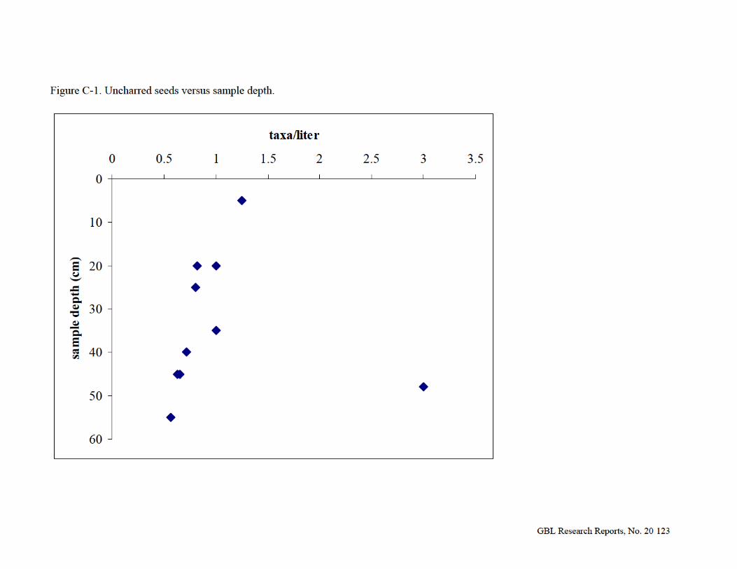

GBL Research Reports, No. 20 124
Figure C-2: Correspondence map of 11 Oliver sites, 1 Mississippianized Oliver site, and 6 plant types.

GBL Research Reports, No. 20 125
Table C-1: Floodplain forest composition of the White River system, Indiana (from Lee 1945).
Canopy Small Trees Shrubs Vines Boxelder Acer negundo
Redbud Cercis canadensis
Elderberry Sambucus canadensis
Poison ivy Rhus radicans
Silver maple Acer saccharinum
Dogwood Cornus florida
Pawpaw Asimina triloba
Grape Vitis spp.
Hackberry Celtis occidentalis
Hawthorn Crataegus spp.
Wahoo Euonymus atropurpureus
White ash Fraxinus americana
Swamp-privet Forestiera acuminata
Sycamore Platanus occidentalis Cottonwood Populus deltoides Swamp willow Salix nigra American elm Ulmus americana Rock elm Ulmus thomasii

GBL Research Reports, No. 20 126
Count Weight (g)
Hickory (Carya spp.) 22 0.15Pecan (C. illinoinensis) Walnut/butternut (Juglans spp.) 6 0.04Hickory/Walnut family (Juglandaceae) 7 0.05Acorn (Quercus spp.) 13 0.02
Beechnut (Fagus grandifolia) 28 0.07 Table C-2. Materials recovered from Heavy Fraction, Fea 8N, Zone A’, Catalog #10280/1114.
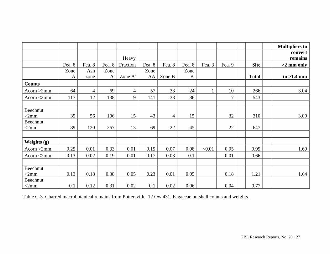
GBL Research Reports, No. 20 127
Multipliers to
Heavy convert remains
Fea. 8 Fea. 8 Fea. 8 Fraction Fea. 8 Fea. 8 Fea. 8 Fea. 3 Fea. 9 Site >2 mm only
Zone
A Ash
zone Zone
A' Zone A'Zone
AA Zone BZone
B' Total to >1.4 mm
Counts
Acorn >2mm 64 4 69 4 57 33 24 1 10 266 3.04Acorn <2mm 117 12 138 9 141 33 86 7 543 Beechnut >2mm 39 56 106 15 43 4 15 32 310 3.09Beechnut <2mm 89 120 267 13 69 22 45 22 647
Weights (g)
Acorn >2mm 0.25 0.01 0.33 0.01 0.15 0.07 0.08 <0.01 0.05 0.95 1.69Acorn <2mm 0.13 0.02 0.19 0.01 0.17 0.03 0.1 0.01 0.66 Beechnut >2mm 0.13 0.18 0.38 0.05 0.23 0.01 0.05 0.18 1.21 1.64Beechnut <2mm 0.1 0.12 0.31 0.02 0.1 0.02 0.06 0.04 0.77
Table C-3. Charred macrobotanical remains from Pottersville, 12 Ow 431, Fagaceae nutshell counts and weights.
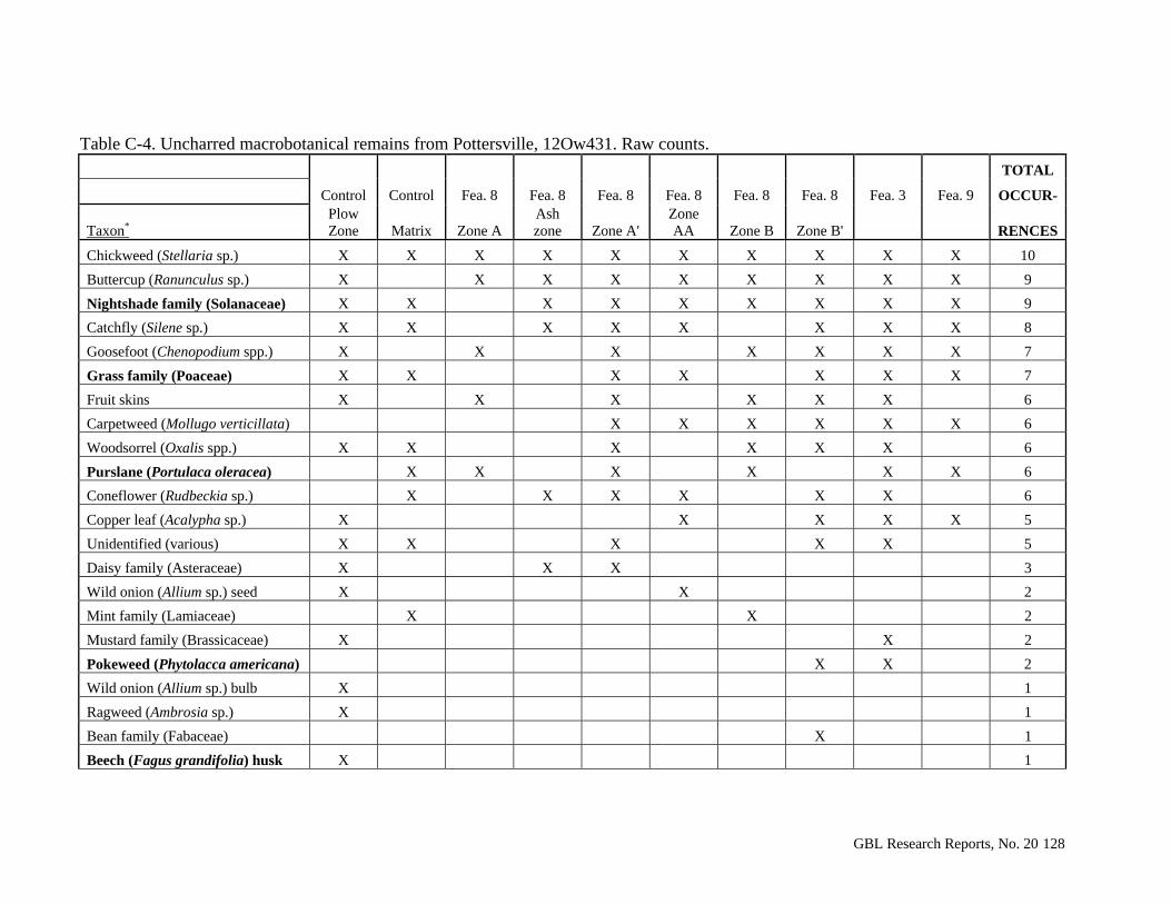
GBL Research Reports, No. 20 128
Table C-4. Uncharred macrobotanical remains from Pottersville, 12Ow431. Raw counts.
TOTAL
Control Control Fea. 8 Fea. 8 Fea. 8 Fea. 8 Fea. 8 Fea. 8 Fea. 3 Fea. 9 OCCUR-
Taxon* Plow Zone Matrix Zone A
Ash zone Zone A'
Zone AA Zone B Zone B' RENCES
Chickweed (Stellaria sp.) X X X X X X X X X X 10
Buttercup (Ranunculus sp.) X X X X X X X X X 9
Nightshade family (Solanaceae) X X X X X X X X X 9
Catchfly (Silene sp.) X X X X X X X X 8
Goosefoot (Chenopodium spp.) X X X X X X X 7
Grass family (Poaceae) X X X X X X X 7
Fruit skins X X X X X X 6
Carpetweed (Mollugo verticillata) X X X X X X 6
Woodsorrel (Oxalis spp.) X X X X X X 6
Purslane (Portulaca oleracea) X X X X X X 6
Coneflower (Rudbeckia sp.) X X X X X X 6
Copper leaf (Acalypha sp.) X X X X X 5
Unidentified (various) X X X X X 5
Daisy family (Asteraceae) X X X 3
Wild onion (Allium sp.) seed X X 2
Mint family (Lamiaceae) X X 2
Mustard family (Brassicaceae) X X 2
Pokeweed (Phytolacca americana) X X 2
Wild onion (Allium sp.) bulb X 1
Ragweed (Ambrosia sp.) X 1
Bean family (Fabaceae) X 1
Beech (Fagus grandifolia) husk X 1
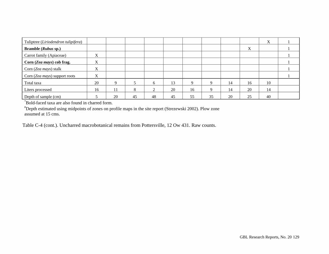
GBL Research Reports, No. 20 129
Tuliptree (Liriodendron tulipifera) X 1
Bramble (Rubus sp.) X 1
Carrot family (Apiaceae) X 1
Corn (Zea mays) cob frag. X 1
Corn (Zea mays) stalk X 1
Corn (Zea mays) support roots X 1
Total taxa 20 9 5 6 13 9 9 14 16 10
Liters processed 16 11 8 2 20 16 9 14 20 14
Depth of sample (cm) 5 20 45 48 45 55 35 20 25 40 *Bold-faced taxa are also found in charred form. #Depth estimated using midpoints of zones on profile maps in the site report (Strezewski 2002). Plow zone assumed at 15 cms.
Table C-4 (cont.). Uncharred macrobotanical remains from Pottersville, 12 Ow 431. Raw counts.

GBL Research Reports, No. 20 130
Control Fea. 8 Fea. 8 Fea. 8 Fea. 8 Fea. 8 Fea. 8 Fea. 8 Fea. 3 Fea. 9 Site
Matrix Zone A Ash
zone Zone A'& Zone A'
Zone AA Zone B Zone B' Total
Total wood charcoal 4 506 229 764 2578 652 544 665 988 3319 10249
Oak (Quercus spp.) white group* 1 4 14 9 2 7 6 43
Beech (Fagus grandifolia)* 4 4 9 5 22 Elm family (Ulmaceae) 1 2 1 1 2 1 2 12 22 Honeylocust (Gleditsia triacanthos) 1 6 7 Walnut/butternut (Juglans spp.) 1 1 3 5 Oak/Chestnut (Quercus/Castanea) 1 1 1 3
Blue-beech (Carpinus caroliniana) 3 3 Honeylocust/Kentucky Coffeetree (Gleditsia/Gymnocladus) 2 2 Oak (Quercus spp.) red group 1 1 Ash (Fraxinus sp.) 1 1 Diffuse-porous 1 7 11 4 5 7 3 5 43
Diffuse-porous subgroup III-3# 3 6 1 8 18 Ring-porous 1 6 1 8 Hardwood 3 3 6 Unidentifiable 1 1 2 1 5
* Boldface ring-porous woods; italics indicates diffuse-porous woods. # Probably Maple (Acer) or Dogwood (Cornus). & Light fraction from re-flotation. Table C-5. Charred macrobotanical remains from Pottersville, 12 Ow 431. Wood charcoal identification.
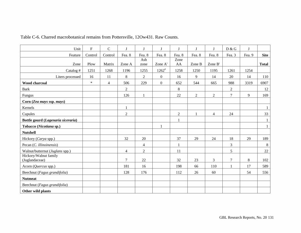
GBL Research Reports, No. 20 131
Table C-6. Charred macrobotanical remains from Pottersville, 12Ow431. Raw Counts.
Unit F C J J J J J J D & G J
Feature Control Control Fea. 8 Fea. 8 Fea. 8 Fea. 8 Fea. 8 Fea. 8 Fea. 3 Fea. 9 Site
Zone Plow Matrix Zone A Ash zone Zone A'
Zone AA Zone B Zone B' Total
Catalog # 1251 1268 1196 1255 1262# 1258 1250 1195 1261 1254
Liters processed 16 11 8 2 0 16 9 14 20 14 110
Wood charcoal * 4 506 229 0 652 544 665 988 3319 6907
Bark 2 8 2 12
Fungus 126 1 22 2 2 7 9 169
Corn (Zea mays ssp. mays)
Kernels 1 1
Cupules 2 2 1 4 24 33
Bottle gourd (Lagenaria siceraria) 1 1
Tobacco (Nicotiana sp.) 1 1
Nutshell
Hickory (Carya spp.) 32 20 37 29 24 18 29 189
Pecan (C. illinoinensis) 4 1 3 8
Walnut/butternut (Juglans spp.) 4 2 11 5 22 Hickory/Walnut family (Juglandaceae) 7 22 32 23 3 7 8 102
Acorn (Quercus spp.) 181 16 198 66 110 1 17 589
Beechnut (Fagus grandifolia) 128 176 112 26 60 54 556
Nutmeat
Beechnut (Fagus grandifolia)
Other wild plants
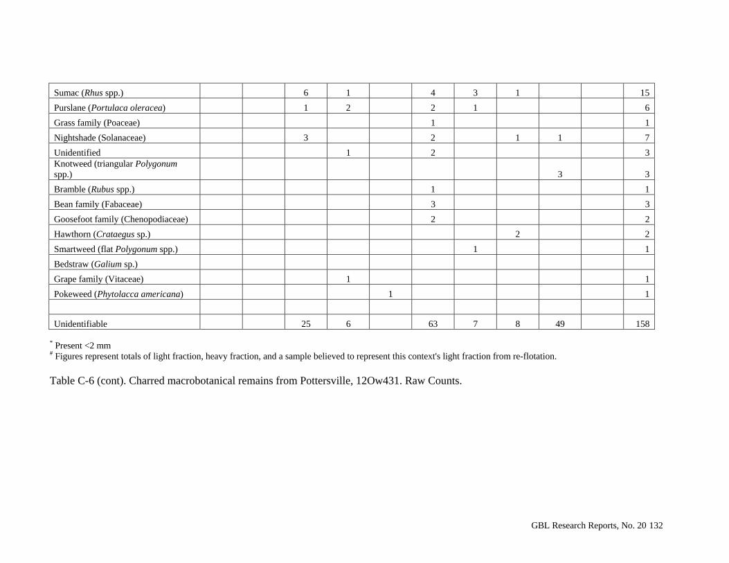
GBL Research Reports, No. 20 132
Sumac (Rhus spp.) 6 1 4 3 1 15
Purslane (Portulaca oleracea) 1 2 2 1 6
Grass family (Poaceae) 1 1
Nightshade (Solanaceae) 3 2 1 1 7
Unidentified 1 2 3 Knotweed (triangular Polygonum spp.) 3 3
Bramble (Rubus spp.) 1 1
Bean family (Fabaceae) 3 3
Goosefoot family (Chenopodiaceae) 2 2
Hawthorn (Crataegus sp.) 2 2
Smartweed (flat Polygonum spp.) 1 1
Bedstraw (Galium sp.)
Grape family (Vitaceae) 1 1
Pokeweed (Phytolacca americana) 1 1
Unidentifiable 25 6 63 7 8 49 158
* Present <2 mm # Figures represent totals of light fraction, heavy fraction, and a sample believed to represent this context's light fraction from re-flotation. Table C-6 (cont). Charred macrobotanical remains from Pottersville, 12Ow431. Raw Counts.

GBL Research Reports, No. 20 133
Table C-7. Charred macrobotanical remains from Pottersville, 12Ow431. Raw weights in grams.
Unit F C J J J J J J D & G J Feature Control Control Fea. 8 Fea. 8 Fea. 8 Fea. 8 Fea. 8 Fea. 8 Fea. 3 Fea. 9 Site
Zone Plow Zone Matrix Zone A
Ash zone Zone A'
Zone AA Zone B Zone B' Total
Catalog # 1251 1268 1196 1255 1262# 1258 1250 1195 1261 1254 Liters processed 16 11 8 2 16 9 14 20 14 110
Sample weight 20.29 7.20 28.43 9.66 55.97 12.36 35.59 34.72 164.85 369.07 Contamination weight 7.90 0.24 0.41 0.22 1.64 0.29 0.56 1.10 0.38 12.74
Residue weight 12.16 6.92 19.28 5.94 39.74 6.84 23.26 20.64 75.48 210.26 Bone weight 0.09 0.09
Wood charcoal * 0.03 7.28 2.66 12.00 13.49 11.04 11.66 75.00 133.16 Bark 0.01 0.04 0.03 0.08 Fungus 0.15 <0.01 0.41 0.02 0.01 0.04 0.13 0.76
Corn (Zea mays ssp. mays) Kernels <0.01 Cupules 0.01 0.01 <0.01 0.03 0.11 0.16
Bottle gourd (Lagenaria siceraria) 0.03 0.03
Tobacco (Nicotiana sp.) <0.01 -- Nutshell Hickory (Carya spp.) 0.45 0.25 0.45 0.32 0.20 0.29 0.94 2.90 Pecan (C. illinoinensis) 0.02 0.01 0.02 0.05 Walnut/butternut (Juglans spp.) 0.03 0.03 0.18 0.11 0.35 Hickory/Walnut family (Juglandaceae) 0.05 0.12 0.18 0.12 0.01 0.05 0.06 0.59 Acorn (Quercus spp.) 0.38 0.03 0.32 0.10 0.18 <0.01 0.06 1.07 Beechnut (Fagus grandifolia) 0.23 0.30 0.33 0.03 0.11 0.22 1.22 Nutmeat Beechnut (Fagus grandifolia) Other wild plants Sumac (Rhus spp.) 0.01 <0.01 <0.01 <0.01 <0.01 0.01
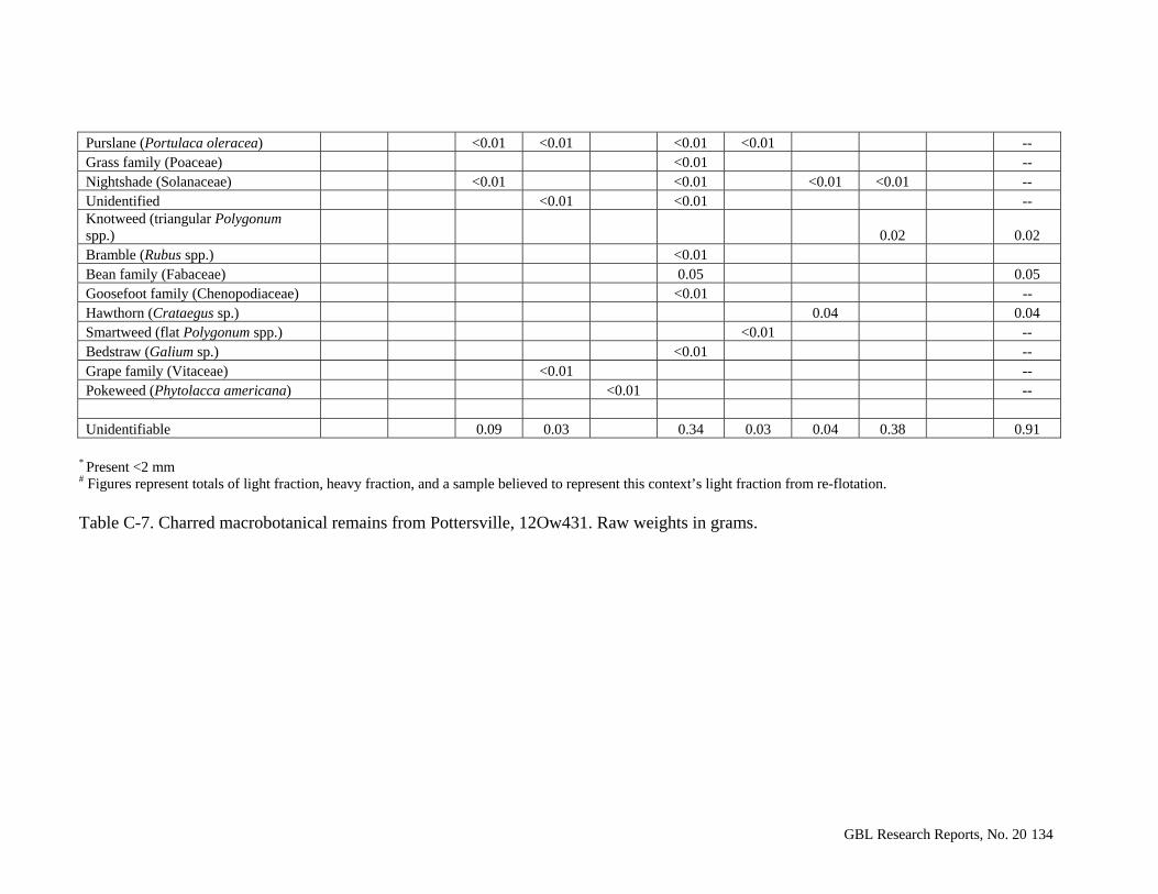
GBL Research Reports, No. 20 134
Purslane (Portulaca oleracea) <0.01 <0.01 <0.01 <0.01 -- Grass family (Poaceae) <0.01 -- Nightshade (Solanaceae) <0.01 <0.01 <0.01 <0.01 -- Unidentified <0.01 <0.01 -- Knotweed (triangular Polygonum spp.) 0.02 0.02 Bramble (Rubus spp.) <0.01 Bean family (Fabaceae) 0.05 0.05 Goosefoot family (Chenopodiaceae) <0.01 -- Hawthorn (Crataegus sp.) 0.04 0.04 Smartweed (flat Polygonum spp.) <0.01 -- Bedstraw (Galium sp.) <0.01 -- Grape family (Vitaceae) <0.01 -- Pokeweed (Phytolacca americana) <0.01 -- Unidentifiable 0.09 0.03 0.34 0.03 0.04 0.38 0.91
* Present <2 mm # Figures represent totals of light fraction, heavy fraction, and a sample believed to represent this context’s light fraction from re-flotation. Table C-7. Charred macrobotanical remains from Pottersville, 12Ow431. Raw weights in grams.
GBL Research Reports, No. 20 135
Appendix D: Analysis of Standard Volumetric Sample Unit Excavations at the
Pottersville Site (12 Ow 431).
by Staffan Peterson
Introduction and Methods.
The initial excavations at the site were standard volumetric sample (SVS) units
placed in the southwest and northeast corners of excavation units A, B, C, and D (a total
of eight SVS units). An additional nineteen SVS units were placed using a Leica total
station at ten meter intervals along ninety meter N-S and E-W axes across and beyond the
presumed extent of the site. All SVS units were .5 x .5m in planview dimensions, and
extended as deep as necessary to ascertain the plowzone/subsoil transition. Excavation
was accomplished with shovels and trowels, and all dirt was screened using ¼" mesh.
Excavation of an SVS was terminated when the base of the plowzone became apparent.
Artifacts for SVS units were catalogued according to the standard hierarchical cataloging
key used by the Glenn A. Black Laboratory of Archaeology. Statistical and geographic
data were analyzed using SPSS 10.0 and ESRI ArcMap 8.1.1.
Soil Stratigraphy.
Soil stratigraphy at the Pottersville site was limited to an actively forming A
horizon, underlain by a sterile sub-plowzone stratum. Average depth of the plowzone in
the SVS units was .18 m, (std. dev. 0.03, n = 27). The sub-plow zone was similar in color
to the upper stratum but more compact and slightly clayier. In some cases, this boundary
was difficult to distinguish. The soil on the Pottersville site is a Genessee silty clay loam

GBL Research Reports, No. 20 136
(10YR 4/4 to dark yellowish brown), which is present throughout the bottom lands of the
West Fork of the White River and many other floodplains along streams in areas of
Wisconsinan glaciation. Genesee soil is formed in alluvium washed mainly from areas of
calcareous loamy glacial drift. It is neutral to mildly alkaline, well drained, and typically
used for corn and soybeans (Soil Survey Division, NRCS 2002; Sanders et al.1964:79)
Agricultural activities spanning over a century, including deforestation and
mechanized agriculture, was expected to have affected topography of the site subsequent
to the Oliver occupations. The dynamics of land use, erosion and siltation were expected
to have deflated higher elevation portions of the site and to have buried any lower areas.
In order to test this hypothesis, the absolute elevation of each unit was compared to the
depth of plow zone of the unit. A correlation test reveals no significant relationship
between depth of plow zone and the absolute elevation of the SVS unit (Pearson's R =
0.109, p = .58, n = 27). The lack of correlation may be due to the relative flatness of the
floodplain (elevation range = 41cm), differential agricultural treatments across the site, or
complexities in the alluviation history of the floodplain in the immediate vicinity of the
site.
Artifact Distribution.
Artifact distributions are presented in Figure D-1, which shows artifact density for
each SVS. SVS excavations generally indicated that artifact densities were higher in
areas where the surface collection showed high artifact counts, though not all surface
concentrations of artifacts were associated with higher subsurface artifact densities. This
may be due to bias in the collection procedure, though it is also likely that some features

GBL Research Reports, No. 20 137
that had been plowed out are well represented on the surface but not in the below surface
deposits.
Artifacts are, by category, roughly proportional to each other in the SVS units
(Figure D-2). This suggests that no specialized use areas were present in the vicinity of
the SVS units. Differences in artifact density may be due to localized differences in the
intensity rather than the type of activity across the sampled area. This is in accordance
with the assessment that the site was a small habitation site where generalized subsistence
activities occurred.

GBL Research Reports, No. 20 138

GBL Research Reports, No. 20 140
References
Soil Survey Division, Natural Resources Conservation Service, United States Department of Agriculture. Official Soil Series Descriptions [Online WWW]. Available URL: "http://www.statlab.iastate.edu/soils/osd/" [Accessed 08 July 2002].
Sanders, F.W., S. Brownfield, S. Lehman, R, Fields. 1959 Soil Survey, Owen County, Indiana. United States Department of Agriculture.
Soil Conservation Service, in cooperation with Purdue University Agricultural Experiment Station. West Lafayette.

GBL Research Reports, No. 20 141
Appendix E: Magnetic Surveys at the Pottersville site (12 Ow431).
By Stephen Ball
Dr. Stephen Ball and Indiana University field school personnel conducted a
magnetic survey at the Pottersville site on May 14, 2001. The survey consisted of four
adjoining 20 x 20 meter survey squares (figure E-1) stretching from N460-480/E290-310.
The survey was performed with a Geoscan FM36 gradiometer set at a .1 nanotesla
sensitivity. The grids were sampled at a .5 meter transect interval taking readings every
1/8 meter along the transects. This resulted in 6,400 magnetic readings per grid,
producing a total of 25,600 magnetic readings for the survey.
Magnetic surveys detect slight changes in the earth’s magnetic field near the
surface of the ground (Weymouth 1986). This is of interest to archaeologists since many
human behaviors can modify the magnetic properties of various materials. The heating
of soils, especially clays, enhances their natural magnetic properties. Buried deposits of
pottery, hearths, heated rock and many ancient earth moving activities can be detected
and mapped by magnetic surveys (Weymouth 1986, Clark 1999).
Other Oliver phase sites have responded quite well to magnetic surveys. At the
Clampitt, Cox’s Woods and Bundy-Voyles sites magnetic surveys were able to locate
concentrations of pottery in pits and wall trenches. They were quite helpful in the
planning of the subsequent excavations and the overall interpretation of site structure
(Redmond and McCullough 1996, Redmond 1994, McCullough and Wright 1997).
GBL Research Reports, No. 20 142
Analysis
The magnetic map of the survey area revealed very few indications of subsurface
features (figure E-2). What was obvious were the ridges in the tilled field (moving
diagonally across the survey grid) showing up as slight magnetic highs. This was caused
by the slightly higher elevation of these ridges, which stood a few inches above the
surrounding soil. It resulted in a higher magnetic reading being recorded over the ridges
by the gradiometer and can be regarded as background “soil noise”. The anomalies
marked 1-5 represented small pieces of metal in the plough zone. This was indicated by
the high-low dipole (paired high and low magnetic readings) structure of the anomaly and
the deflected north-south orientation of the signal (Weymouth 1986). Both phenomena
indicated a ferric source, and the low intensity of the readings suggested small pieces of
metal in the near surface zone. Figure E-3 displays a more restricted range of the
magnetic data. The natural magnetic background of the soil ranges from -1 to 1 nanotesla
in intensity, this range of values has been blanked out in the image. The values from -5
to -20 nanoteslas are entirely found within the low half of the high-low dipoles produced
by the ferric objects in the plowzone. Furthermore, the high magnetic values from 3 to
25 nanoteslas are also associated with these high-low dipoles. This left the magnetic
values from 1 to 3 nanoteslas as the most likely range in which subsurface prehistoric
features, if they existed in the grid, would be detected. Unfortunately, many of these
readings occurred in conjunction with field ridges. This made the analysis of the
magnetic signals problematic. There was no filter or statistical process appropriate for
separating these slight magnetic highs from the natural variation in the soil magnetism at
the site.
GBL Research Reports, No. 20 143
The results of the magnetic survey were not promising for the detection of
archaeological features. The survey itself was quite clean, only a few scattered pieces of
metal to disrupt the overall magnetic readings. Yet, it was impossible to distinguish the
slight magnetic highs created by the field ridges from the slight magnetic highs to be
expected of subsurface archaeological features. Therefore, most of the magnetic
anomalies shown in color in figure E3 could not be identified as subsurface features prior
to excavation. In previous surveys at Oliver phase sites (Redmond and McCullough
1996, Redmond 1994, McCullough and Wright 1997) the anomalies produced by
subsurface prehistoric features range from 1.5 to 9 nanoteslas above the background soil
noise. The magnetic survey at the Pottersville site indicated that if there were prehistoric
features beneath the survey grid they were of a more ephemeral nature than those
detected at the village sites of Clampitt and Cox’ Woods.
Due to the inconclusive nature of the magnetic survey, it was not referred to when
setting out the initial excavation units on the site. These were placed based on the surface
collection data. Later in the excavation, Unit K was placed over a broad weak anomaly
that was located in a furrow, thus making it a more likely target as a prehistoric feature
(figure E-4). The unit revealed no subsurface features, but several large potsherds from a
historic crock were recovered in the plough zone from the general location of the
magnetic anomaly, providing a likely source for the anomaly itself. A post-excavation
analysis of the magnetic data revealed that the magnetic survey successfully detected
features 3, 7 and 8. It did not detect the southern edge of the wall-trench structure;
excepting section 10b (figure E-4).
GBL Research Reports, No. 20 144
Conclusion
The magnetic survey of the Pottersville site was unsuccessful at distinguishing subsurface
prehistoric features. The weak magnetic nature of the features at the site made it
impossible to distinguish subsurface features from natural variations in soil magnetism.
A post-hoc analysis could distinguish several of the subsurface features within the
magnetic data, but it was impossible to predict this prior to excavation. The weakness of
the magnetic response of the features supports the general impression of an ephemeral
occupation at the Pottersville site. In contrast to the Clampitt and Cox’s Woods sites,
substantial village occupations, the Pottersville site appears to have been a less intensely
occupied seasonal occupation.
GBL Research Reports, No. 20 145
References McCullough, Robert G. and Timothy M. Wright
1997 An Archaeological Investigation of Late Prehistoric Subsistence-Settlement Diversity in Central Indiana. Indiana University Glenn A. Black Laboratory of Archaeology Research Reports, No. 18. Bloomington.
Redmond, Brian G. and Robert G. McCullough
1996 Excavations at the Cox’s Woods Site (12 Or 1), A Late Prehistoric Oliver Phase Village in the Pioneer Mothers Memorial Forest, Orange County, Indiana. Indiana. University Glenn A. Black Laboratory of Archaeology Research Reports, No. 17. Bloomington.
Redmond, Brian G.
1994 The Archaeology of the Clampitt Site (12Lr329), an Oliver Phase Village in Lawrence County, Indiana. Research Reports 16. Glenn A. Black Laboratory of Archaeology, Indiana University, Bloomington.
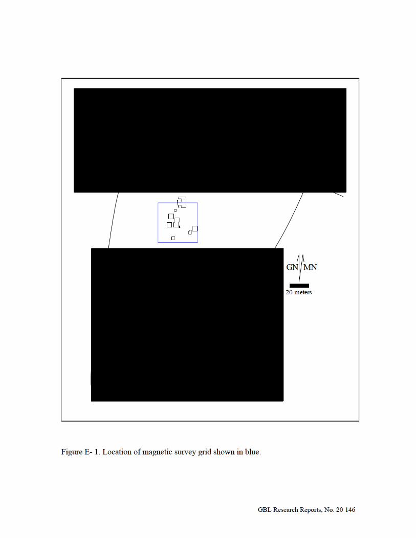
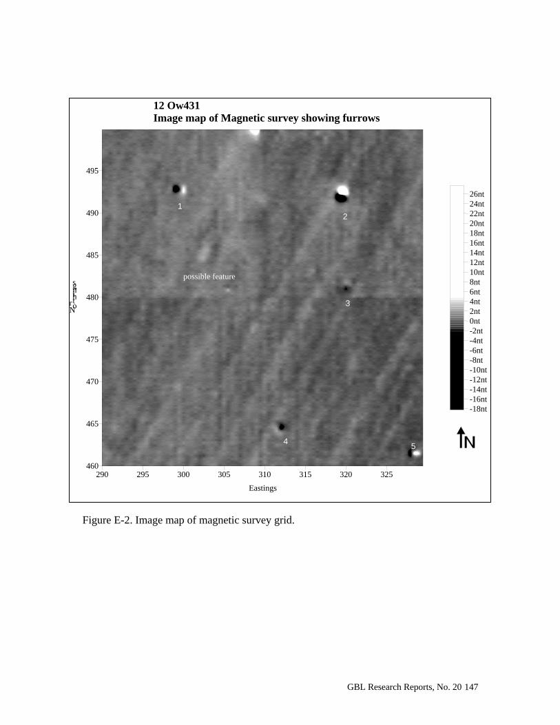
GBL Research Reports, No. 20 147
Figure E-2. Image map of magnetic survey grid.
290 295 300 305 310 315 320 325
Eastings
12 Ow431 Image map of Magnetic survey showing furrows
460
465
470
475
480
485
490
495
No rth in g s
-18nt-16nt-14nt-12nt-10nt-8nt-6nt-4nt-2nt0nt2nt4nt6nt8nt10nt12nt14nt16nt18nt20nt22nt24nt26nt
possible feature
1 2
3
45
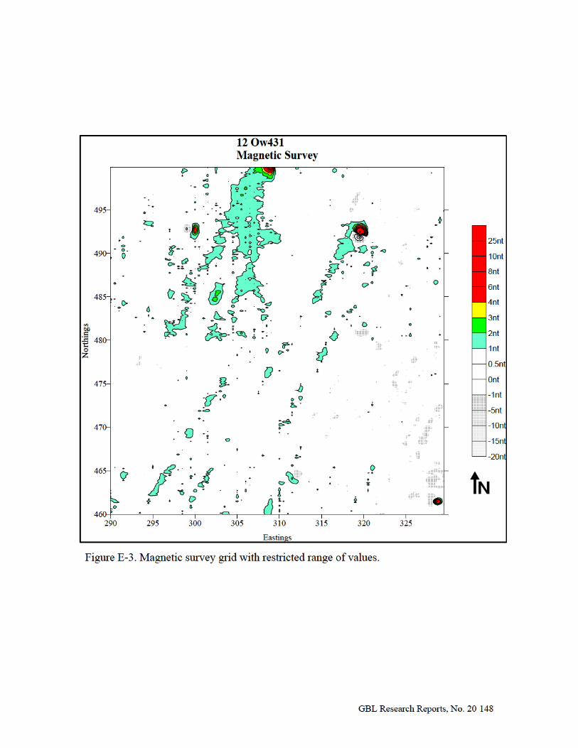


![Oliver Daniel Papers [finding aid]. Music Division, Library of](https://img.dokumen.tips/doc/110x75/6327fa22051fac18490e839c/oliver-daniel-papers-finding-aid-music-division-library-of-.jpg)


