Embed Size (px)
Citation preview

Transactions in GIS
, 2005, 9(2): 199–221
© Blackwell Publishing Ltd. 2005. 9600 Garsington Road, Oxford OX4 2DQ, UK and 350 Main Street, Malden, MA 02148, USA.
Research Article
Natural Conversational Interfaces to Geospatial Databases
Guoray Cai
School of Information Sciences and Technology and GeoVISTA Center Pennsylvania State University
Alan M. MacEachren
Department of Geography and GeoVISTA Center Pennsylvania State University
Hongmei Wang
School of Information Sciences and Technology and GeoVISTA Center Pennsylvania State University
Sven Fuhrmann
Department of Geography and GeoVISTA Center Pennsylvania State University
Abstract
Natural (spoken) language, combined with gestures and other human modalities,provides a promising alternative for interacting with computers, but such benefithas not been explored for interactions with geographical information systems.This paper presents a conceptual framework for enabling conversational human-GIS interactions. Conversations with a GIS are modeled as human-computercollaborative activities within a task domain. We adopt a mental state view ofcollaboration and discourse and propose a plan-based computational model forconversational grounding and dialogue generation. At the implementation level,our approach is to introduce a dialogue agent,
GeoDialogue
, between a userand a geographical information server.
GeoDialogue
actively recognizes user’sinformation needs, reasons about detailed cartographic and database procedures,and acts cooperatively to assist user’s problem solving.
GeoDialogue
serves as asemantic ‘bridge’ between the human language and the formal language that aGIS understands. The behavior of such dialogue-assisted human-GIS interfaces isillustrated through a scenario simulating a session of emergency response during ahurricane event.
Address for correspondence:
Guoray Cai, School of Information Sciences and Technologyand GeoVISTA Center, Pennsylvania State University, University Park, PA 16802, USA. E-mail:[email protected]
200
G Cai, H Wang, A M MacEachren and S Fuhrmann
© Blackwell Publishing Ltd. 2005
1 Introduction
Today, the majority of geographical information users are not experts in operating ageographical information system (GIS). However, the familiar devices (keyboard andmouse), interface objects (windows, icons, menus, and pointers), and query languagestend to work only for experts in a desktop environment. Practical application environ-ments often introduce an intermediary person to delegate the tasks of communicatingwith a computer to technical experts (Mark and Frank 1992, Traynor and Williams1995), but such solutions are not always possible when geographical information needsarise outside of the office environment (in the field or on the move) (Zerger and Smith2003). Alternatively, human-GIS interfaces can be made more natural and transparentso that people can walk-up to the system and start utilizing geographical informationwithout prior training. Towards this goal, progress has been made in the incorporationof human communication modalities into human-computer interaction systems (Zue etal. 1990; Shapiro et al. 1991; Lokuge and Ishizaki 1995; Oviatt 1996, 2000; Cohen etal. 1997; Sharma et al. 1998; Kettebekov et al. 2000; Rauschert et al. 2002). Designingsuch interface environments faces a number of challenges, including sensing and recog-nition, multimodal fusion, as well as semantic mediation and dialogue design. Of theseissues, sensing technologies have made the most progress, particularly in the areas ofautomated speech recognition (Juang and Furui 2000, O’Shaughnessy 2003) and gesturerecognition (Sharma et al. 1999, Wilson and Bobick 1999). Totally device-free acquisi-tion of human speech and free-hand gestures has been demonstrated to be feasible forinteracting with maps (Sharma et al. 2003). In contrast, multimodal fusion and dialoguemanagement seems more difficult, and solutions are likely to depend on tasks andapplication domains (Flanagan and Huang 2003). Within the domain of geographicalinformation science, a dialogue-based interface for GIS was envisioned more than adecade ago (see Frank and Mark 1991), but has not been attempted seriously.
This paper introduces the concept of conversational dialogues as a new paradigmof human-GIS interactions. Dialogue-based interaction with GIS differs from thetraditional query/response style of interaction in that it requires modeling human-GISinteractions at the discourse level. In addition to taking user’s input and extractingcommands, the system is expected to actively engage in conversations with the user. Theuse of “conversation” as a metaphor for human-GIS interaction is particularly attractivein the context of multimodal interfaces for a number of reasons:
1.
Conversations ease the problems of
recognition errors.
No current multimodal(speech-gesture) interface is free from
recognition errors
. In human-computer com-munication, the system should be able to detect its own misrecognitions and initiatedialogues for correcting errors before continuing with the interaction. Wang (2003)demonstrated that speech recognition errors can be ‘repaired’ using a fuzzy grammarapproach. Alternatively, a conversational dialogue system can be a graceful error-correction mechanism.
2.
Conversations make it possible to construct requests
incrementally and interactively
.Traditional query-based systems enforce a strict three-phase process: collectinguser input, processing query, and generating response, where each phase must becomplete and successful before moving to the next phase. However, natural multi-modal requests to GIS rarely follow such artificial patterns. It is much easier forhumans to specify a complex request in multiple steps, each of which is followed by
Natural Conversational Interfaces to Geospatial Databases
201
© Blackwell Publishing Ltd. 2005
a grounding process. Such interactions are best managed as a conversational dia-logue where both the human and the system keep track of the dialogue contextnecessary for grounding the meanings of subsequent inputs.
3.
Conversation is the way to deal with vagueness and ambiguity.
Natural languagerequests for geographical information often include concepts (spatial or non-spatial)that are vague or ambiguous. The key to processing such requests is to incorporatemachine intelligence so that the machine makes an intentional effort to understandthe context within which the user makes use of the vague concepts. Through sharingcontextual knowledge with the user, the system can avoid misunderstanding of suchconcepts (see Cai et al. 2003 for an example). A shared visual display can provideboth a shared context and
boundary objects
through which meaning is negotiated(MacEachren and Brewer 2004).
4.
Conversations foster human-GIS joint problem-solving.
Professionals are experts intheir problem domains and associated tasks, but not in the use of GIS. Conversa-tional interfaces for GIS have the potential of enabling computers to participate inhuman’s problem-solving activities. The goal here would be to reduce the user’scognitive load by communicating in the language of the application domain that theuser is familiar with, and by making relevant information available proactively.
The approach we take to enable conversational human-GIS interactions is to add adialogue agent between the user and a GIS. As part of our research prototype DAVE_G(
D
ialogue-
A
ssisted
V
irtual
E
nvironment for GeoInformation) that supports multimodalinteractions with GIS (Rauschert et al. 2002), we have developed a computational agent,
GeoDialogue
, which implements the idea of conversational dialogues for human-GISinteractions. The design of
GeoDialogue
draws an analogy between a conversationaldialogue agent and the role of the GIS specialist who traditionally serves as the ‘media-tor’ between professionals (who perform spatial tasks in a domain) and the GIS in manyworkplaces. As earlier work (Mondschein 1994, Armstrong and Densham 1995, Joneset al. 1997) has shown, the tasks of a GIS specialist in a group decision-making situationare usually to listen to and discuss information needs with other users, and to translatetheir understanding of the information needs into cartographic and database operationsexecutable by a particular GIS. Having such a GIS specialist (when properly trained)allows professionals to request a map simply by having a natural conversation with aGIS specialist. As appropriate as it can be, Armstrong (2001) and Nyerges et al. (1997)referred to such a GIS specialist as the “chauffeur”. Our design of conversational dia-logue systems has the goal of capturing the reasoning and communication skills of theGIS “chauffeur” and making them available through a software agent. In the long run,the goal of
GeoDialogue
is to eliminate the human-GIS interaction bottleneck causedby the ‘middle person’ (Mondschein 1994, Traynor and Williams 1995) so that userinteractions with geographical information become more direct.
Like any intelligent agents (Jennings et al. 1998),
GeoDialogue
has the ability ofassimilating perceived information (user’s multimodal input), performing some cogni-tive computation, and controlling actions executed on the environment (i.e. spatial data-bases and information displays). When functioning within a multimodal interface,
GeoDialogue
extracts and integrates semantic information from multiple streams ofuser input (speech, gesture, gaze etc.), reasons on user’s intentions and beliefs usingdomain and task knowledge, and engages in dialogue with the user utilizing the avail-able store of geospatial data.
202
G Cai, H Wang, A M MacEachren and S Fuhrmann
© Blackwell Publishing Ltd. 2005
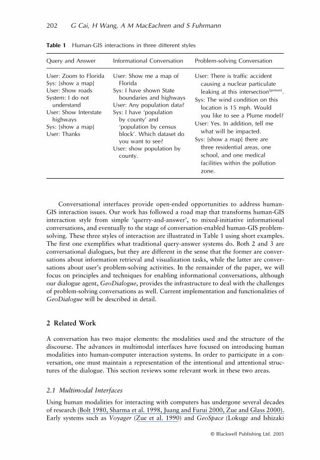
Conversational interfaces provide open-ended opportunities to address human-GIS interaction issues. Our work has followed a road map that transforms human-GISinteraction style from simple ‘querry-and-answer’, to mixed-initiative informationalconversations, and eventually to the stage of conversation-enabled human-GIS problem-solving. These three styles of interaction are illustrated in Table 1 using short examples.The first one exemplifies what traditional query-answer systems do. Both 2 and 3 areconversational dialogues, but they are different in the sense that the former are conver-sations about information retrieval and visualization tasks, while the latter are conver-sations about user’s problem-solving activities. In the remainder of the paper, we willfocus on principles and techniques for enabling informational conversations, althoughour dialogue agent,
GeoDialogue
, provides the infrastructure to deal with the challengesof problem-solving conversations as well. Current implementation and functionalities of
GeoDialogue
will be described in detail.
2 Related Work
A conversation has two major elements: the modalities used and the structure of thediscourse. The advances in multimodal interfaces have focused on introducing humanmodalities into human-computer interaction systems. In order to participate in a con-versation, one must maintain a representation of the intentional and attentional struc-tures of the dialogue. This section reviews some relevant work in these two areas.
2.1 Multimodal Interfaces
Using human modalities for interacting with computers has undergone several decadesof research (Bolt 1980, Sharma et al. 1998, Juang and Furui 2000, Zue and Glass 2000).Early systems such as
Voyager
(Zue et al. 1990) and
GeoSpace
(Lokuge and Ishizaki
Table 1 Human-GIS interactions in three different styles
Query and Answer Informational Conversation Problem-solving Conversation
User: Zoom to FloridaSys: [show a map]User: Show roadsSystem: I do not
understandUser: Show Interstate
highwaysSys: [show a map]User: Thanks
User: Show me a map of Florida
Sys: I have shown State boundaries and highways
User: Any population data?Sys: I have ‘population
by county’ and ‘population by census block’. Which dataset do you want to see?
User: show population by county.
User: There is traffic accident causing a nuclear particulate leaking at this intersection[gesture].
Sys: The wind condition on thislocation is 15 mph. Would you like to see a Plume model?
User: Yes. In addition, tell mewhat will be impacted.
Sys: [show a map] there are three residential areas, one school, and one medical facilities within the pollution zone.
Natural Conversational Interfaces to Geospatial Databases
203
© Blackwell Publishing Ltd. 2005
1995) use speech input only. Speech provides an effective and direct way of expressingactions, pronouns and abstract relations. However, using speech alone for interactingwith a GIS can be cumbersome when spatial references to regions and features on themap are needed. Gestures offer an effective second modality that is more suitable forexpressing spatial relations. Specifications of user information needs using a combina-tion of speech and gesture were shown to be less error prone than those expressed inwords alone (Oviatt 1996).
CUBRICON
(Neal et al. 1989, 1998) was the first multi-modal system that incorporated natural language and gestures into a GIS query inter-face. A more recent system,
QuickSet
(Cohen et al. 1997), uses speech and pen-basedgestures to enable multimodal interactions with maps, and was shown to be moreexpressive and efficient than ‘traditional’ WIMP (windows, icons, menus, and pointers)interfaces, especially in a mobile computing environment (Oviatt and Cohen 2000).Similarly,
Sketch and Talk
(Egenhofer 1996) processed speech and direct sketch on amap display for querying spatial databases.
The systems mentioned above require the use of devices (such as pens) to capturegesture input, which may interfere with the user’s ability to focus on the problem itself.Using free hand gestures to interact with maps was envisioned by the
WallBoard
con-cept (Florence et al. 1996), but did not become a reality until the success of
i
Map(Sharma et al. 1998, 1999; Kettebekov and Sharma 2000), which demonstrated thefeasibility of free hand gestures as a new modality for human computer interaction. Thegeneral framework of
i
Map has recently been extended by
DAVE_G
(Dialogue-AssistedVirtual Environment for GeoInformation) (Rauschert et al. 2002), which supportsspeech/gesture interactions with large-screen map displays driven by GIS.
In
i
Map, as well as in earlier versions of
DAVE_G
(MacEachren et al. 2005),human use of speech and gestures are highly constrained to the expression of GIScommands and their parameters. Each request carries a very explicit meaning thatdirectly maps to GIS actions by semantic grammar-based translation rules. Such asimplistic model of multimodal interactions does not reflect the complexity in practicaluses of GIS. Human interactions with GIS are part of their problem-solving processthat involves not only database and visualization commands, but also steps for definingand discussing a task, exploring ways to perform the task, and collaborating to get itdone. Each step of human-GIS interactions is embedded within the larger structure of aproblem-solving dialogue that provides the contexts for planning system’s actions andfor evaluating the effect of such actions. For this reason, it is necessary for computersto have a model of the discourse if a GIS is to be more cooperative and helpful to humanproblem-solving activities.
2.2 Discourse Models
Research on conversational human-computer interfaces (Zue and Glass 2000, Allenet al. 2001) explicitly models human-computer interactions on the principles of human-human communication. When humans solve problems together, they must communicatetheir understanding of the problem and construct solutions. Such processes involveextended dialogues where utterances and groups of utterances relate to each other ina coherent manner to form a discourse. The key for discourse processing is the recogni-tion and representation of discourse structure (Lochbaum et al. 2000). Approaches todiscourse structures generally fall into two categories:
informational
and
intentional
.Informational approaches model discourse structure as text units and a set of coherence
204
G Cai, H Wang, A M MacEachren and S Fuhrmann
© Blackwell Publishing Ltd. 2005
relations (such as Cause, Evaluation, Background, Elaboration, Purpose, and Effect)(Hobbs 1979, Mann and Thompson 1987) among text units. These works provide solu-tions to problems such as references and syntactic ambiguities, but they lack the reason-ing capability necessary for modeling cooperative behavior of conversations. In contrastto informational approaches, Grosz and Sidner (1986, 1990) argues that discourse isinherently intentional. Their theory of discourse structure recognized three interrelatedcomponents of a discourse: a linguistic structure (discourse segments and embeddingrelations), intentional structure (purposes of discourse segments and their interrelations),and an attentional state (a record of salient entities at any time in the discourse).
A discourse is fundamentally a collaborative behavior (Grosz and Sidner 1990).Based on this notion, Lochbaum (1994, 1998) developed a model of intentional struc-ture using the collaborative planning framework of SharedPlans (Grosz and Kraus1996). In the SharedPlans formalism, a plan consists of a set of complex mental atti-tudes (beliefs, intentions, and commitments) towards a joint goal and its subgoals. Aset of agents have a full SharedPlan (FSP) when all the mental attitudes required forsuccessful collaboration have been established; otherwise, a SharedPlan is consideredpartial. The generation of a discourse can be modeled as a process that conversationalparticipants elaborate on a partial SharedPlan towards a full SharedPlan.
There currently exist spoken dialogue interfaces with conversational properties.For example, the MIT Voyager system (Glass et al. 1995) can engage in limited verbaldialogue with users about common geographical knowledge in a region (such as hotels,restaurants, banks, as well as distance, directions, and travel time). AT&T’s “HowMay I Help You” system (Gorin et al. 1997) can automatically route telephone callsto appropriate destinations in a telecommunications environment. A recent survey ofexisting spoken dialogue research projects can be found in McTear (McTear 2002).
The work reported in this paper builds on the success of conversational dialoguetechnologies and multimodal GIS systems, with the intention of integrating the twocomponents for the development of more natural interfaces to interactive maps. Our workon
GeoDialogue
integrates both the informational approaches and intentional approachesof discourse structure for the development of conversational human-computer interfaceswith geospatial databases. With a collaborative planner embedded in the dialogue engine,
GeoDialogue
shares the same objective with the Copas and Edmonds’ interactiveplanners (Copas and Edmonds 2000) in overcoming the usability difficulties of high-functionality information systems (Fischer 2001).
3 G
EO
D
IALOGUE
: Managing Conversations with Interactive Maps
GeoDialogue
is a software agent that mediates natural conversational dialogues betweenusers and geographical information systems. By natural, we mean that the system canunderstand and act upon what people naturally say rather than forcing them to makerequests in a formal command-like language. By adopting a human conversation metaphorfor information-seeking with a GIS,
GeoDialogue
makes the processes of browsing,discussing, filtering, and summarizing more interactive through conversational acts. Thedesign goal was to enable natural, multimodal dialogue with geographical informationdisplays. We focus initially on geographical information retrieval and visualizationactivities. In this section, we first introduce the design principles of
GeoDialogue
, andthen describe the architecture and functionalities of
GeoDialogue
as implemented.
Natural Conversational Interfaces to Geospatial Databases
205
© Blackwell Publishing Ltd. 2005
3.1 Design Principles
In
GeoDialogue
, the process of communication between the system and the user ismodeled after the principles of human-human communication. Here, a computer istreated as an intelligent agent capable of rational and cooperative behavior (Bratman1992). Human-GIS interaction is viewed as a goal-directed activity that involves col-laborative planning and coordination between a human agent and a computer agent(Terveen 1995). For such interactions, there exists a direct correspondence between theintentional structure of a discourse and the structure of the tasks (goals and solutions)under discussion.
GeoDialogue
explicitly represents and reasons about the intentionalstructure and attentional state of human-GIS dialogues and uses such knowledge forinterpreting spoken inputs and generating responses (speech output and interactivemaps).
Conversations with geographical information through
GeoDialogue
are mixed-initiative (Hagen 1999), meaning that both the user and the system can initiate a newagenda. The system knows when to take, keep, and relinquish control and initiatives, aswell as recognizes when the user takes, keeps, and relinquishes control and initiatives.The system may choose to follow a user’s initiative or make a new initiative, dependingon the need for advancing the agenda. For example, when
GeoDialogue
serves the roleof a geographical information assistant, the system will yield control to the user onhigher-level (domain related) intentions, and will take controls when the focus of theagenda moves to low-level data retrieval and presentation tasks. In this way, the useroffloads some of the cognitive efforts to the computer while still feeling the ‘steering’of the interaction. In particular,
GeoDialogue
tends to take initiatives when it detectsan opportunity to protect the user from doing erroneous actions (by rejecting theseactions), to correct user’s misconceptions, and to volunteer choices and constraintswhile the user is making a decision. We will show how our model of human-GIS dia-logues allows the system and the user to alternate the control of dialogue initiativesbased on the status of their tasks and collaboration.
3.2 Representation of the Discourse Contexts
In
GeoDialogue
, the discourse context of a human-computer conversation is repre-sented as a plan graph (or PlanGraph). A PlanGraph is similar to the notion of recipegraph (Rgraph) developed by Lochbaum (1994, 1998), except that PlanGraph extendsRgraph on the handling of knowledge-preconditions in collaborative plans. Beforedescribing the structure of PlanGraph, we need to introduce three important concepts:
actions
,
recipes
,
and
plans
.An
action
refers to a specific goal as well as the effort needed to achieve it. In theknowledge store of
GeoDialogue
, an action can be either basic or complex. A
basic
action is directly executable by one or more agents. Examples of basic action may be‘retrieving a named map layer’, or ‘making a buffer around a known point’, which canbe directly executed by a GIS. A
complex
action, on the other hand, is not directlyexecutable because certain knowledge pre-conditions or details about performingthe action are subject to elaboration and instantiation. For each complex action
α
,
GeoDialogue
knows one or more possible ways (called
recipes
) to implement it. A recipeof an action encodes the system’s knowledge about the abstract and schematic structureof that action. A recipe describes components of an action in terms of parameters,
206
G Cai, H Wang, A M MacEachren and S Fuhrmann
© Blackwell Publishing Ltd. 2005
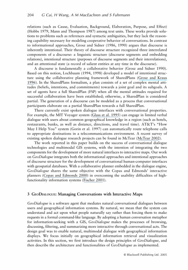
subactions, and constraints (see Figure 1a). Parameters of a recipe describe the knowledgepre-condition for executing subactions of that recipe. Subactions in a recipe have accessto all the parameters in that recipe. All parameters of the recipe must be identified (i.e.instantiated with proper values) before subactions can be executed.
GeoDialogue
’srecipe definition language also supports constraints, which specify any pre- or post-conditions and partial orders of the subactions.
GeoDialogue
separates the notion of
recipes
from that of
plans
. A recipe for acomplex action
α
describes how it is decomposed into subgoals in a domain. A
plan, onthe other hand, corresponds to a schema describing not only how to perform an action,but, more importantly, the mental attitudes (beliefs, commitments, and execution status)the participating agents must have towards the action (see Figure 1b). In this sense, ournotion of plan follows Pollack’s (1990) mental-state view of collaborative plans. A planrepresents the mental states of the agents on planning and performing an action, whilea recipe represents the knowledge that an agent has about performing an action. Tovisually distinguish a recipe of an action from a plan of an action, we use slightlydifferent graphical notations for them (cf. Figures 1a and 1b). In case of mediatinghuman-GIS dialogues, two agents (the user and the computer) cooperatively act on α.Then, a plan may include the following components:
• Intention(Agents, α) are slots recording the intention of each agent towards action α(which can take a value of ‘Intend-To’, ‘Intend-Not-To’, or ‘Unknown’).
• Recipe(α) is a slot holding the recipe selected for the action. It can be empty, indicat-ing that no recipe has been selected for the action. The system may know a numberof different recipes for an action α, but only one of them is selected in a particularplan.
• Beliefs(Agents, α) are slots for recording what each agent believes about theperformance of action α. Agents that participate in a plan on action α must establishbeliefs about the ability of the agents to identify a recipe for α and to perform theaction α following the recipe.
• Commitment(Agents, α) indicate whether the collaborating agents have committedto the success of the action. In many cases, the commitment of an agent to an actionmeans that the agent has allocated resources (e.g. time and money) to perform itsshare of a collaborative action. For example, if Jim commits to have a lunch withTom between 1 and 2 p.m., he cannot commit the doing anything else during thattime. If conflicts happen, Jim has to re-plan his schedule by canceling or changingother meetings.
Figure 1 The concepts of action, recipe, and plan
Natural Conversational Interfaces to Geospatial Databases 207
© Blackwell Publishing Ltd. 2005
• Exec_Status (α) indicates the execution status of the plan. A plan can have a statusof ‘executable,’ ‘not executable,’ ‘not executed,’ ‘executed with success,’ or ‘executedwith failure.’
When two or more agents collaboratively construct a plan, we call it a collaborativeplan. As an example of a collaborative plan, consider the case where two persons (hus-band and wife) need to make a detailed plan for a family vacation. Both of them mustintend to take a vacation. They must also have the shared belief that the two togethercan figure out all the details of the vacation plan and can carry it through successfully.Among many planning and preparation issues, they must be able to negotiate and agreeupon ‘where to go’ and ‘what to do’. Some details of the vacation can be planned eitherindividually or collaboratively. The wife may be responsible for selecting travel modes(by car, train, or airplane) and routes by consulting various information sources (maps,travel agents, and weather reports). The husband may be responsible for preparingclothes and food, shopping, and getting children ready. The husband and wife maywork together to decide what activities to do on the destination. During the process,they will keep each other informed and use each other as a source of help. Finally, theyneed to commit themselves to actually carrying out the vacation plan. Sometimes, acommitment can be complicated since an individual may have to re-plan other parts ofhis/her life in order to create conditions for this collaborative activity (vacation). Thisexample, although intuitive, has all the essential components of collaborative inter-actions: recognizing and sharing each other’s intentions, communicating knowledge tothe details of the plan, negotiating agreements, and coordinating actions.
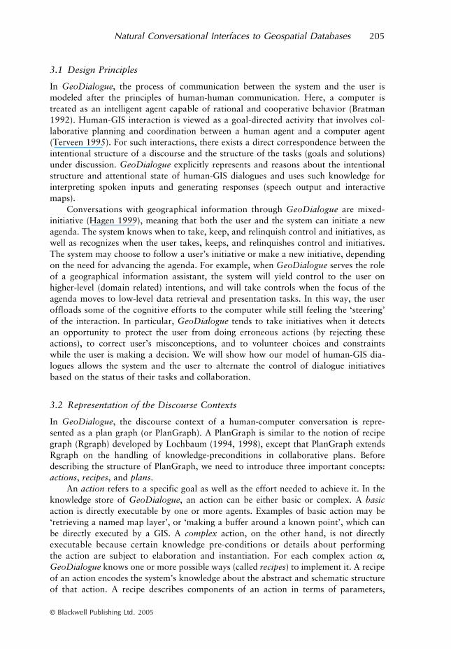
Now we introduce the concept of a plan graph, or PlanGraph. While a plan is arepresentation of collaboration status on a single goal, a PlanGraph is a schematicrepresentation of all plans and subplans about a large, complex goal. A PlanGraphcommonly has a complex goal at its root, which is decomposed recursively as subgoals(or subactions) through the adoption of recipes. For this reason, a PlanGraph is com-monly a hierarchically organized set of plans. Figure 2 explains the general structureof PlanGraphs used in GeoDialogue. Nodes with oval shape indicate parameters, andnodes with rectangle shape represent subplans. A plan underneath a parameter node isthe plan for identifying the parameter. For example, Plan γ1 is for identifying parameter‘Para1’ of plan α.
Figure 2 Structure of a PlanGraph
208 G Cai, H Wang, A M MacEachren and S Fuhrmann
© Blackwell Publishing Ltd. 2005
A conversational dialogue is modeled as the process of constructing a collaborativeplan by the two participating agents. Before agents start to communicate, the discoursecontext is none, thus the PlanGraph is initially empty. As agents propose new initiativesduring the dialogue, new plan nodes are introduced to the PlanGraph. The ‘root plan’of the PlanGraph represents the most encompassing goal mentioned so far. If the actionof the root plan is complex, agents will elaborate it on more details by selecting a recipecollaboratively. Then, agents move their attention to the parameters and subactions(as specified in the recipe). If the value of a parameter is unknown, a subplan is formedfor identifying the parameter. If a subaction is not directly executable (i.e. a complexaction), a subplan will be formed for performing this subaction. These subplans maythemselves be complex, and will become the subjects of further elaboration.
A PlanGraph will become a Full SharedPlan (FSP) when: (1) participating agentshave the shared beliefs that everyone intends and is committed to the whole plan; (2) allactions on the leaf-nodes are basic actions; and (3) for each of the parameters, eitherthat it is already instantiated, or agents have a Full SharedPlan (FSP) for identifying theparameter. If the above conditions are not met, we say that the PlanGraph is only aPartial SharedPlan (PSP). A PSP represents an ongoing dialogue, while a FSP representsa complete dialogue. The progression of the dialogue corresponds to the process of evolv-ing a collaborative plan from a PSP towards a FSP (Lochbaum 1998). GeoDialogue usesa PlanGraph to capture the discourse context of a dialogue, because it records informa-tion about the collaboration states underlying an ongoing dialogue.
Due to the limits of human attention and the linear nature of conversational dialogues,agents commonly talk about a complex task by focusing on one subgoal at one time,and by shifting the attention of the collaboration as one partial goal is accomplished andanother partial goal is selected. In GeoDialogue, the attention state of a dialogue isrepresented by a ‘cursor’ (in the PlanGraph) pointing to the plan that is currently underthe focus of the collaboration. We call the action under the cursor an Action-in-Focus(AiF). For example, ‘Plan β1’ is the Action-in-Focus in the PlanGraph of Figure 2.
In summary, GeoDialogue models discourse as collaborative plans (or SharedPlan).The system response is driven by its intention to advance the SharedPlan, and, at thesame time, to be responsive and helpful to users.
3.3 Modeling Activities of Geographical Information Dialogues
Human-GIS dialogues commonly happen within the context of an activity. Activitiescorrespond to users’ intention and knowledge in a problem domain. Complex activitiescan be broken down to some intermediate level tasks (called subtasks) and GIS opera-tions. Timpf’s (2003) work on geographical activity models is a significant step towardsformally describing geographical information processing activities as a set of problem-solving methods, task ontologies, and their dependencies.
In GeoDialogue, we use the term ‘actions’ to refer to both tasks and operations asused by Timpf. We adopt a subset of action ontology developed by Albrecht (1997) andconsider four types of actions (Figure 3). Type I actions deal with spatial data retrievaltasks such as ‘retrieving a map layer’ and ‘selecting a subset of features from a layer’.Type II actions are about analytical tasks (spatial and/or statistical) such as ‘making abuffer around certain features’, ‘finding spatial clusters’, and ‘areal aggregation’.Type III actions are cartographic and visualization tasks such as ‘adding/removinglayer’, ‘showing/hiding layer’, ‘zoom in/zoom out’, ‘pan’, ‘highlighting’, and ‘changing

Natural Conversational Interfaces to Geospatial Databases 209
© Blackwell Publishing Ltd. 2005
cartographic symbols’. Type IV actions are domain specific tasks such as ‘planning forevacuation’ in a hurricane response domain.
The ontology of actions in GeoDialogue also specifies how complex actions canbe decomposed into subactions. This is accomplished by the definition of recipes inGeoDialogue’s recipe library. Given the role of GeoDialogue as a geographicalinformation assistant to human users, GeoDialogue’s recipe definition allows thefollowing patterns:
• A (complex) domain action may subordinate other domain actions, cartographicactions, spatial analysis actions, and/or spatial data retrieval actions.
• A (complex) cartographic action may subordinate other cartographic actions, spatialanalysis actions, and/or spatial data retrieval actions.
• A (complex) spatial analysis action may subordinate other spatial analysis actions,and/or spatial data retrieval action.
• A (complex) spatial data retrieval action may subordinate other spatial data retrievalactions only.
These rules are represented in Figure 3 by arrows pointing from one type of actions toanother.
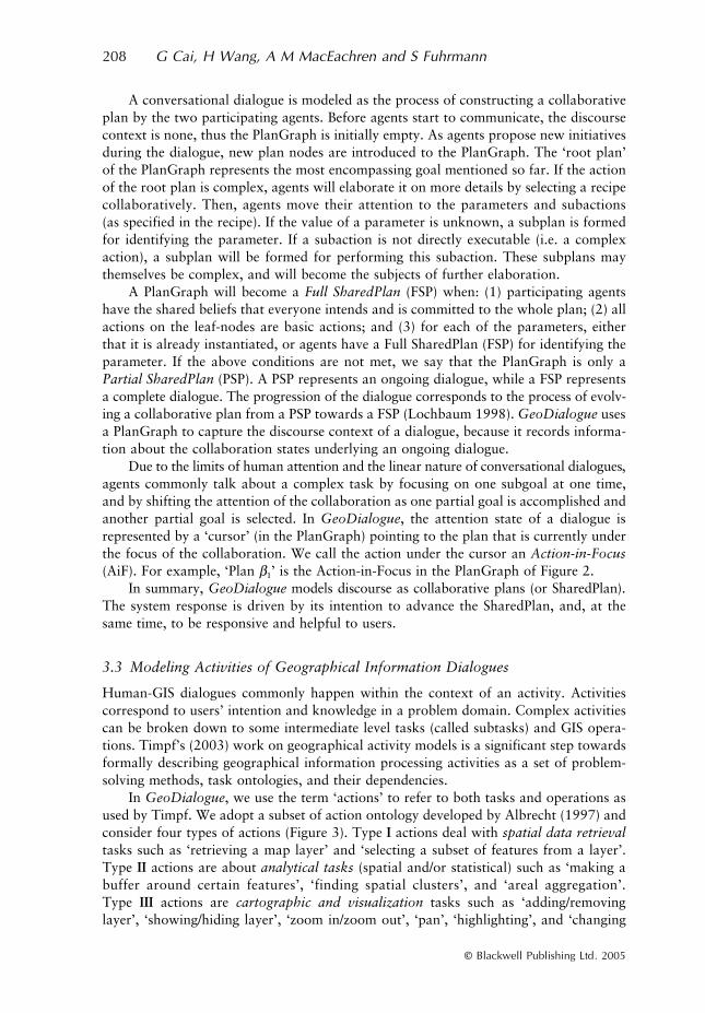
The above task model of geographical information activities serves as the basis forGeoDialogue to construct collaborative plans of an ongoing conversation. As a concreteexample, Figure 4 shows the PlanGraph representation of a dialogue centered on anuclear release event. Here the PlanGraph is rooted at a domain action “understandingimpacted area”. The “ShowMap” action (which is the main cartographic action) is asubordinate action contributing to the domain action at the root. The “Buffer analysis”action (which is a type II action) contributes to the “show map” action by adding a layer(which records the result of the buffer) to the map. Finally, “IdentifyNamedFeature” isa spatial data retrieval action (type I) contributing to the “buffer analysis” action.
3.4 Reasoning in Conversational Grounding and Generation
Each time the system detects a user’s event in the form of a multimodal utterance, itwill trigger a reasoning process for interpreting the user’s message and subsequentlygenerating responses. Following the theories of collaborative discourse (Lochbaum 1998)and conversational grounding (Clark and Brennan 1991, Brennan 1998), this reasoning
Figure 3 A typology of actions in GeoDialogue. Arrow means that one type of actions canbe the subactions of another
210 G Cai, H Wang, A M MacEachren and S Fuhrmann
© Blackwell Publishing Ltd. 2005
process drives both the interpretation of user’s input and generation of response bytwo objectives: (1) maintaining common ground, and (2) advancing the joint activity. Indoing so, GeoDialogue draws knowledge from two sources: (1) the PlanGraph repre-sentation of the discourse context, and (2) the activity model in the domain of geograph-ical information dialogues.
Conversational grounding involves two steps of analysis: semantic interpretationand explanation. Semantic interpretation is the process of parsing a user’s utterance intomeaningful phrases and subsequently assigning a meaning to each phrase. Suppose thatan utterance U is composed of a number of phrases U = {pi, i = 0, 1, . . . , n}. Thecontents of recognizable phrases are defined by a grammar, which specifies what com-binations of words, gestures, or even other phrases are legitimate phrases. For eachphrase pi, the system knows one or more senses (or meanings) about it. At the end ofthis step, the system has a set of candidate meanings, ϕ(pi), for each phrase pi. However,the system has not yet decided which meaning from ϕ(pi) is what the user intended. Thisis the purpose of the second step.
Explanation is the step where the system attempts to explain how the meanings ofthe new input relate to each other and to previous conversations. The purpose is to inferwhat the intended meaning of the user’s utterance is. An explanation Ψ of utterance Uexists under the current discourse context DC and a task model T if:
1. There exists Ψ = {ϕ1, ϕ2, . . . , ϕi, . . . ϕn}, where ϕi = NULL or ϕi ∈ ϕ(pi);2. Ψ can be “meaningfully merged” with DC with the task domain specified by T. The
result is a new discourse context DCnew.
Figure 4 An Example of PlanGraphs
Natural Conversational Interfaces to Geospatial Databases 211
© Blackwell Publishing Ltd. 2005
In this case, the system believes that the intended meaning of utterance U is Ψ. The term“meaningfully merged” has a specific meaning here. The intended meaning ϕ of phrasep is said to be meaningfully merged with the current discourse context DC if one ofthe following conditions is present: (1) ϕ provides a piece of information that helps thesystem to assign a value to a parameter in the current PlanGraph; (2) ϕ provides moredetails on the implementation of a complex action in the PlanGraph; or (3) ϕ helpsestablishing necessary mental states for a collaborative act.
If explanation is successful, GeoDialogue will merge the meaning of utterance Uinto the discourse context and update the PlanGraph accordingly. If some phrasesof U can not be successfully explained, they will not be dropped immediately. Instead,un-explained phrases are pushed into a stack of “unexplained phrases”, and will befurther explained together with subsequent inputs. This mechanism is critical forGeoDialogue to deal with over-specified input which is a common phenomena inspoken dialogues (McTear 2002). An over-specified input includes information that isnot immediately useful but the speaker anticipates the need of such information insubsequent steps.
The grounding process is followed by another reasoning stage, called elaboration.The main goal in this stage is to advance the human-GIS joint activity through thecooperative acts from the system side. The system can elaborate the current PlanGraphin several ways: (1) contributing a recipe to achieve the current Action-in-Focus; (2)identifying one or more parameters in the Action-in-Focus; or (3) executing anysubplans that have been fully developed. This elaboration process also attempts todiscover further obstacles for advancing the plan (e.g. conflicting beliefs, impossiblegoals, missing details, or ambiguous choices). A data structure called Agenda isused to collect all the detected ‘obstacles’ into action items. An action item includes adescription of the nature of the problem and what needs to be done. This processallows the system to gather all the potential issues first, and then deal with them inthe order of their priorities. The elaboration process ends when no more parts ofthe PlanGraph can be further elaborated without the intervention of the user. Theelaboration process may also generate partial results (such as a map or an answer toa question).
For response generation, GeoDialogue make decisions on two things: (1) whatthe system intends to communicate back to the user; and (2) how. First, the systemwill derive its communicative intention by selecting an action item from the Agenda.When there are many items in the Agenda, the item with the highest priority will bechosen. Second, the system will decide on a strategy to communicate back to theuser. There can be many strategies to accomplish the same communicative goal. Forexample, if a critical parameter is missing and the system intends to get it from theuser, the system can either generate a verbal question to ask the user explicitly, orpropose a best guess while expecting corrections from the user. In addition, a conceptualmessage can be communicated to the user using different modalities and media. Forexample, drawing a user’s attention to an object on the screen can be accomplishedby visual or iconic labeling, textual (spoken or screen text) labeling, gestures (anima-tion and flashing), or using a combination of the above. Currently, the selectionof communicative strategies and media in GeoDialogue is relatively naïve, where asmall number of situation types are considered. This problem is being investigatedseparately.
212 G Cai, H Wang, A M MacEachren and S Fuhrmann
© Blackwell Publishing Ltd. 2005
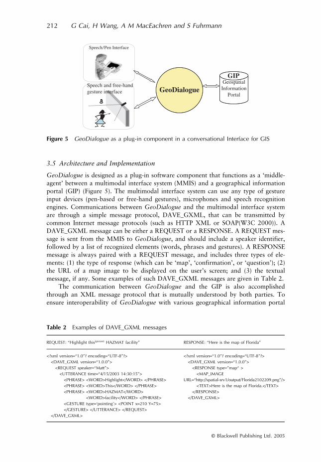
3.5 Architecture and Implementation
GeoDialogue is designed as a plug-in software component that functions as a ‘middle-agent’ between a multimodal interface system (MMIS) and a geographical informationportal (GIP) (Figure 5). The multimodal interface system can use any type of gestureinput devices (pen-based or free-hand gestures), microphones and speech recognitionengines. Communications between GeoDialogue and the multimodal interface systemare through a simple message protocol, DAVE_GXML, that can be transmitted bycommon Internet message protocols (such as HTTP XML or SOAP(W3C 2000)). ADAVE_GXML message can be either a REQUEST or a RESPONSE. A REQUEST mes-sage is sent from the MMIS to GeoDialogue, and should include a speaker identifier,followed by a list of recognized elements (words, phrases and gestures). A RESPONSEmessage is always paired with a REQUEST message, and includes three types of ele-ments: (1) the type of response (which can be ‘map’, ‘confirmation’, or ‘question’); (2)the URL of a map image to be displayed on the user’s screen; and (3) the textualmessage, if any. Some examples of such DAVE_GXML messages are given in Table 2.
The communication between GeoDialogue and the GIP is also accomplishedthrough an XML message protocol that is mutually understood by both parties. Toensure interoperability of GeoDialogue with various geographical information portal
Figure 5 GeoDialogue as a plug-in component in a conversational Interface for GIS
Table 2 Examples of DAVE_GXML messages
REQUEST: “Highlight this[gesture] HAZMAT facility” RESPONSE: “Here is the map of Florida”
<?xml version=“1.0”? encoding=“UTF-8”?><DAVE_GXML version=“1.0.0”>
<REQUEST speaker=“Matt”><UTTERANCE time=“4/15/2003 14:30:15”>
<PHRASE> <WORD>Highlight</WORD> </PHRASE><PHRASE> <WORD>This</WORD> </PHRASE><PHRASE> <WORD>HAZMAT</WORD>
<WORD>facility</WORD> </PHRASE><GESTURE type=‘pointing’> <POINT x=210 Y=75></GESTURE> </UTTERANCE> </REQUEST>
</DAVE_GXML>
<?xml version=“1.0”? encoding=“UTF-8”?><DAVE_GXML version=“1.0.0”>
<RESPONSE type=”map“ ><MAP_IMAGE
URL=“http://spatial-srv1/output/Florida2102209.png”/><TEXT>Here is the map of Florida.</TEXT>
</RESPONSE></DAVE_GXML>

Natural Conversational Interfaces to Geospatial Databases 213
© Blackwell Publishing Ltd. 2005
technologies, this message protocol should be defined as close as possible to the existingstandards such as the Web Mapping Service specification published by the Open Geo-spatical Consortium (OGC at www.opengeospatial.org). In our current implementation,the GIP is running on ESRI’s ArcIMS, and its communication with GeoDialogue isthrough a subset of ArcXML language (ESRI 2002).
Internally, GeoDialogue is composed of several processing modules (Figure 6).These modules have a close correspondence to the reasoning process as described insection 3.4. First, the “Semantic Analysis” module iterates through the collection ofphrases and searches for candidate meanings to each phrase. This stage of processingrequires accessing grammatical and semantic knowledge available from the system’sKnowledge Base. The ‘Explanation’ module and the “Elaboration” module cause thechange of the PlanGraph structure as new inputs are explained and new plan nodes areintroduced. Both modules consult the knowledge-base when recipes for complex actionsare needed. Finally, the “Response Generation” module needs to access knowledge aboutthe database queries and mapping services offered by the GIP. The four process modulesin GeoDialogue (as described above) form a complete processing flow necessary formediating conversational dialogue between the user and the geographical informationportal.
3.6 Functionalities
GeoDialogue, in its current implementation, can handle multimodal (speech/gesture)dialogues with GIS for basic geographical information retrieval and display tasks.Beyond responding to isolated requests related to general GIS commands (such asrequests for displaying layers, selection of features on the map, generation of bufferzones, zooming the map and panning the map), GeoDialogue is unique in its capabilityto handle two types of extended dialogues when users interact with geographicalinformation using natural modalities.
First, the system supports human-computer collaboration in constructing one or aseries of dynamic maps. Making a map that meets the user’s need is a complex task thatrequires careful planning of many details (what layers to be added, what map extent tobe shown, what part of the map should be highlighted, what symbols should be usedon each of the map features, etc.), all of which needs to be communicated to the system.GeoDialogue does not require the user to provide all details at one time and in a fixed
Figure 6 Architecture of GeoDialogue
214 G Cai, H Wang, A M MacEachren and S Fuhrmann
© Blackwell Publishing Ltd. 2005
structure (as a formal command language interface does). Instead, GeoDialoguecaptures similar conceptual schemas as those used by humans to structure their spatialinformation request naturally in spoken language. These schemas, stored as recipes inour system, are the abstract knowledge structure of the tasks and their relationshipsdescribed in Figure 3. At the time of interaction, the system follows the user’s commu-nicated intentions and activates proper schemas (recipes) to assimilate and organizeuser’s inputs. In addition to attending to user’s input, GeoDialogue also plays activeroles ensuring that the overall goal of composing a map will be successful. First, thesystem is made responsible for raising issues to the user if the system believes that someuser’s intended goal is not achievable or parts of user’s beliefs are not true or need tobe revised. Second, the system actively communicates its belief about the user’s requestby using the map display as visual feedback. Since such maps afford user’s guidance andcorrections through gestures and speech input, the system may rely on the user’s furtherreactions to provide clues for improving its model of the user’s map request.
The second unique capability of GeoDialogue is that it is able to handle maprequests that involve ambiguous or vague concepts. A concept is ambiguous to thesystem if it finds more than one match in the database or it is subject to several inter-pretations. For example, the concept “roads” may refer to highways, and/or local free-ways, and/or local streets. A concept is vague to a computer if the concept correspondsto a fuzzy category or objects of broad boundaries. When ambiguity is detected, Geo-Dialogue will initiate clarification dialogues that involve the user in making the choice.A vague concept is hard to communicate among humans and is even harder to commu-nicate between a human and a machine. As Cai et al. (2003) explained, there are poten-tially a large number of contexts that may influence the meaning of a vague concept inan unknown fashion. GeoDialogue is capable of initiating conversational dialogueswhen a vague spatial concept is detected in the user’s input. This functionality isexplained more fully in the hypothetical scenario given below.
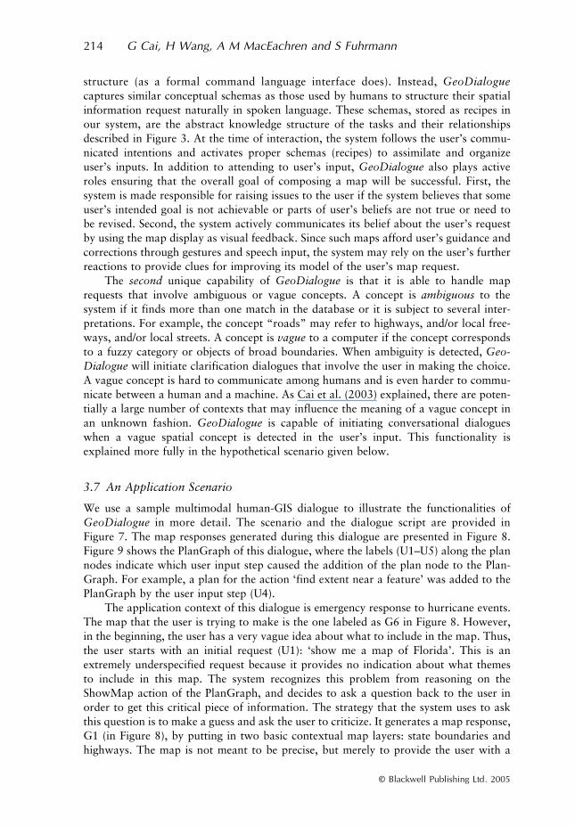
3.7 An Application Scenario
We use a sample multimodal human-GIS dialogue to illustrate the functionalities ofGeoDialogue in more detail. The scenario and the dialogue script are provided inFigure 7. The map responses generated during this dialogue are presented in Figure 8.Figure 9 shows the PlanGraph of this dialogue, where the labels (U1–U5) along the plannodes indicate which user input step caused the addition of the plan node to the Plan-Graph. For example, a plan for the action ‘find extent near a feature’ was added to thePlanGraph by the user input step (U4).
The application context of this dialogue is emergency response to hurricane events.The map that the user is trying to make is the one labeled as G6 in Figure 8. However,in the beginning, the user has a very vague idea about what to include in the map. Thus,the user starts with an initial request (U1): ‘show me a map of Florida’. This is anextremely underspecified request because it provides no indication about what themesto include in this map. The system recognizes this problem from reasoning on theShowMap action of the PlanGraph, and decides to ask a question back to the user inorder to get this critical piece of information. The strategy that the system uses to askthis question is to make a guess and ask the user to criticize. It generates a map response,G1 (in Figure 8), by putting in two basic contextual map layers: state boundaries andhighways. The map is not meant to be precise, but merely to provide the user with a
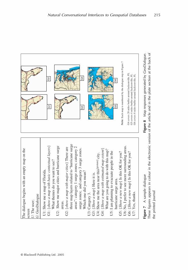
Natural Conversational Interfaces to Geospatial Databases 215
© Blackwell Publishing Ltd. 2005
Figu
re 7
A s
ampl
e di
alog
ueTh
ese
figur
es a
ppea
rs i
n co
lour
in
the
elec
tron
ic v
ersi
on o
f th
e ar
ticle
and
in
the
plat
e se
ctio
n at
the
bac
k of
the
prin
ted
jour
nal
Figu
re 8
Map
res
pons
es g
ener
ated
by
Geo
Dia
logu
e.
216 G Cai, H Wang, A M MacEachren and S Fuhrmann
© Blackwell Publishing Ltd. 2005
visual aid for further improving the specification of the map request. A textual message,“what themes do you want to see?” is sent to the user along with the map, promptingthe user’s attention to this issue. In the spirit of collaboration, the user answers thequestion by requesting that “major cities” and “hurricane surge areas” be added tothe map.
The dialogue segment (U2)–(G3) gives an example of how GeoDialogue handlesambiguous concepts. After receiving the request (U2), the system successfully finds oneand only one data layer that matches exactly to the concept “major cities”. However,the concept “hurricane surge areas” is ambiguous (to the system), since the system findsmultiple matches according to its knowledge about the geographical database contents.The user does not realize this problem until the system shares the situation through(G2) and asks for clarification. Such behavior in mixed-initiative interactions makesGeoDialogue fundamentally different from traditional types of GIS interfaces.
The dialogue segment from U4 to G5 presents an example of how GeoDialoguehandles vague concepts when they are part of a map request. The concept ‘near’ in U4is a well-known concept that corresponds to a vague spatial relation. The problem ofcommunicating such a vague concept is that there are borderline cases that may or maynot be covered by the meaning of such concepts depending on a variety of contextualfactors (such as the task, the spatial scale, spatial arrangement of features, and user-specific preferences). One possible way of dealing with this situation is to generate aquestion “what do you mean by near?” and expect that the user will answer directly ina form as exact as “use 10 miles radius around this city”. Unfortunately, the user maynot be able to define the concept in that form, and humans are notoriously poor (andoften reluctant) in giving numerical definitions for vague concepts. The approach takenby GeoDialogue in this case is to generate shared contextual knowledge between theuser and the system, so that the system can adapt its understanding of vague conceptsaccording to contexts. This strategy explains why the system poses a question (in G4)
Figure 9 Structure of a PlanGraph
Natural Conversational Interfaces to Geospatial Databases 217
© Blackwell Publishing Ltd. 2005
about the user’s task. By learning that the user was trying to plan for evacuation inresponse to a hurricane, the system was able to adapt its understanding of ‘near’ fromthe initial 28-mile radius around the city of Jacksonville (see G4 in Figure 8) to the 4-mile radius (as shown in G5 in Figure 8). More details on this function can be found inCai et al. (2003).
This scenario illustrates the process through which GeoDialogue and the userboth actively reason about each other’s goals in relation to the overall collaboration.GeoDialogue implements a flexible control on dialogue initiatives. The user controls thehigher-level dialogue initiatives in terms of what details to focus on, but the system isable to take some temporary initiatives that are consistent with the user’s broader initi-atives. For example, (G1) uses an explicit question to ask for a missing informationpiece, and (G3) clarifies a concept that has multiple mappings to database entities.
4 Discussion and Future Work
Conversational interfaces (Zue and Glass 2000, Allen et al. 2001, McTear 2002) havebeen accepted as a promising alternative to traditional graphical user interfaces, buthave made little impact on how people access geographical information and use GIS.We made the first step of exploring the benefit of this technology by presenting aconceptual framework for developing natural conversational interfaces to GIS. This wasmotivated by the fact that technological progress in capturing human modalities forinteracting with computers (and GIS in particular) has not been matched by advancesin the semantic management of that interaction. Our computational model follows thehuman emulation approach to bring human and GIS into collaboration, focusing on theuse of human modalities and conversational dialogues. The architecture of GeoDialoguemirrors the cognitive architecture for human perception and communication, where theSharedPlan model of dialogue context plays much the same role as the instantiatedschemata in human information processing. The GeoDialogue prototype demonstratesthe feasibility of a new paradigm for interacting with geospatial information. Suchtechnologies, once robust and domain-relevant, have the potential to change fundamen-tally the way individuals, businesses and government agencies make use of geographicalinformation. Users in these contexts will be able to interact with geographical informa-tion directly (instead of mediated by a technician) and naturally (through spoken lan-guage and gestures).
Towards intelligent dialogue management for more nature interaction with GIS, wehave identified a number of challenging issues that require a sound computationalframework if we are to make progress toward their solution. The approach taken byGeoDialogue is based on deep analysis of user tasks in natural geographical informationseeking behavior, and is grounded in well-established theories in collaborative discourseand multi-agent planning. A difficulty faced in this task is the lack of data on or obser-vations about how people interact with multimodal dialogue systems. We overcome thisdifficulty by applying a cognitive systems engineering approach to understand map usein real world contexts (Brewer and McNeese 2003). Throughout the development ofthe GeoDialogue prototype, application scenarios and dialogue scripts, generated fromour field knowledge about current emergency operation environments, are used to guidethe development of human-GIS dialogue behavior. In this sense, we have followed thescenario-based approach (Carroll 2000).
218 G Cai, H Wang, A M MacEachren and S Fuhrmann
© Blackwell Publishing Ltd. 2005
While our focus here has been on human-computer interaction, the interactionparadigm developed has important implications for addressing research challenges asso-ciated with both collaborative visualization and group spatial decision support. Forboth, research challenges recently delineated include making interfaces more natural andsupporting shared concepts and collaborative construction of knowledge (MacEachrenand Kraak 2001, Muntz et al. 2003). Both geovisualization and spatial-decision supportfocus on ill-structured problems. Support for group work in either activity will requiretools that enable partial specification of a problem and an iterative process of work-ing toward a solution. The collaborative dialogue approach, as outlined above forGeoDialogue, addressed these issues directly.
The approach we have taken is to model a dialogue as two agents negotiatingmeaning and sharing perspectives through a collaborative discourse. Future work willextend this model to provide system support for sharing ideas among multiple humancollaborators engaged in the application of collaborative visualization tools to knowledgeconstruction activities. Similarly, potential mechanisms for extending our GeoDialogueapproach to multi-user environments are suggested by work in collaborative geovisualiza-tion on the semiotics of shared representation and the potential of map-based visualdisplay to provide boundary objects through which to connect ontologies from differentknowledge domains (MacEachren and Brewer 2004).
In order to assess the progress made by GeoDialogue towards creating a user-centered, usable, and robust geographical information environment, we are in theprocess of conducting a series of usability studies on the new interaction style enabled byGeoDialogue. Due to the unique challenge of evaluating agent-based dialogue systems,our usability studies apply several methods in combination. Three types of studies areplanned: (1) expert guideline-based evaluations (user interface experts identify potentialusability problems using heuristics); (2) formative usability assessments (domain usersapply task-based scenarios, discuss and test the prototype); and (3) summative usabilityassessments (the prototype is tested against other comparable tools) (Nielsen 1993,Rubin 1994, Torres 2002). The qualitative and quantitative results of the usabilityassessments will support the refinement of GeoDialogue and provide a good basis forfuture developments of user-centered conversational interfaces.
Acknowledgements
This material is based upon work supported by the National Science Foundation underGrant No. BCS-0113030 and EIA-0306845.
References
Albrecht J 1997 Universal analytical GIS operations: A task-oriented systematization of data-structure-independent GIS functionality. In Craglia M and Onsrud H (eds) GeographicInformation Research: Transatlantic Perspectives. London, Taylor and Francis: 577–91
Allen J, Byron D, Dzikovska M, Ferguson G, Galescu L, and Stent A 2001 Towards conversationalhuman-computer interaction. AI Magazine 22(4): 27–37
Armstrong M P 2001 The four way intersection of geospatial information and information tech-nology. In Proceedings of the NRC/CSTB Workshop on Intersections between GeospatialInformation and Information Technology, Washington, D.C.
Natural Conversational Interfaces to Geospatial Databases 219
© Blackwell Publishing Ltd. 2005
Armstrong M P and Densham P J 1995 A conceptual framework for improving human-computerinteraction in locational decison-making. In Nyerges T L, Mark D M, Laurini R, and Egen-hofer M J (eds) Cognitive Aspects of Human-Computer Interaction for Geographic Informa-tion Systems. Dordrecht, Kluwer Academic Publishers: 343–54
Bolt R A 1980 Put-that-there: Voice and gesture at the graphics interface. ACM Computer Graph-ics 14: 262–70
Bratman M E 1992 Shared cooperative activity. Philosophical Review 101: 327–41Brennan S E 1998 The grounding problem in conversation with and through computers. In Fussell
S R and Kreuz R J (eds) Social and Cognitive Psychological Approaches to InterpersonalCommunication. Hillsdale, NJ, Lawrence Erlbaum: 201–25
Brewer I and McNeese M D 2003 Using cognitive systems engineering to develop collaborativegeospatial military technologies. In Proceedings of the International Conference on MilitaryGeology and Geography, West Point, New York
Cai G, Wang H, and MacEachren A M 2003 Communicating vague spatial concepts in human-GIS interactions: A collaborative dialogue approach. In Kuhn W, Worboys M F, and TimpfS (eds) Spatial Information Theory: Foundations of Geographic Information Science. Berlin,Springer Lecture Notes in Computer Science No 2825: 287–300
Carroll J M 2000 Five reasons for scenario-based design. Interacting with Computers 13: 43–60Clark H H and Brennan S E 1991 Grounding in communication. In Resnick L B, Levine R M, and
Teasley S D (eds) Perspectives on Socially Shared Cognition. Washington, DC, APA: 127–49Cohen P R, Johnston M, McGee D, Oviatt S, Pittman J, Smith I, Chen L, and Clow J 1997
QuickSet: Multimodal interaction for distributed applications. In Proceedings of the FifthACM International Conference on Multimedia, Seattle, Washington: 31–40
Copas C V and Edmonds E 2000 Intelligent interfaces through interactive planners. Interactingwith Computers 12: 545–64
Egenhofer M J 1996 Multi-modal spatial querying. In Kraak J M and Molenaar M (eds) Advancesin GIS Research II: Proceedings of The Seventh International Symposium on Spatial DataHandling. London, Taylor and Francis: 785–99
ESRI 2002 ArcXML Programmer’s Reference Guide – ArcIMS 4.0. Redlands, CA, EnvironmentalSystems Research Institute
Fischer G 2001 User modeling in human-computer interaction. User Modeling and User-AdaptedInteraction 11: 1–18
Flanagan J L and Huang T S 2003 Scanning the special issue on human-computer multimodalinterfaces. Proceedings of the IEEE 91: 1267–70
Florence J, Hornsby K, and Egenhofer M J 1996 The GIS wallboard: Interactions with spatialinformation on large-scale displays. In Kraak J M and Molenaar M (eds) Advances in GISResearch II: Proceedings of the Seventh International Symposium on Spatial Data Handling.London, Taylor and Francis: 449–63
Frank A U and Mark D M 1991 Language issues for GIS. In Maguire D J, Goodchild M F, andRhind D W (eds) Geographical Information Systems: Principles and Applications. London,Longman: 147–63
Glass J, Flammia G, Goodine D, Phillips M, Polifroni J, Sakai S, Seneff S, and Zue V 1995Multilingual spoken-language understanding in the MIT Voyager system. Speech Communi-cations 17: 1–18
Gorin A L, Riccardi G, and Wright J H 1997 How may I help you? Speech Communications 23:113–27
Grosz B J and Kraus S 1996 Collaborative plans for complex group action. Artificial Intelligence86: 269–357
Grosz B J and Sidner C L 1986 Attention, intentions, and the structure of discourse. Computa-tional Linguistics 12: 175–204
Grosz B J and Sidner C L 1990 Plans for discourse. In Cohen P R, Morgan J L, and Pollack M E(eds) Intentions in Communication. Cambridge, MA, MIT Press: 417–44
Hagen E 1999 An approach to mixed initiative spoken information retrieval dialogue. UserModeling and User-Adapted Interaction 9: 167–213
Hobbs J R 1979 Coherence and coreference. Cognitive Science 3: 67–89Jennings N R, Sycara K, and Wooldridge M 1998 A roadmap of agent research and development.
Autonomous Agents and Multi-Agent Systems 1: 7–38
220 G Cai, H Wang, A M MacEachren and S Fuhrmann
© Blackwell Publishing Ltd. 2005
Jones R M, Copas C V, and Edmonds E A 1997 GIS support for distributed group-work inregional planning. International Journal of Geographical Information Science 11: 53–71
Juang B H and Furui S 2000 Automatic recognition and understanding of spoken language: A firststep toward natural human-machine communication. Proceedings of the IEEE 88: 1142–65
Kettebekov S and Sharma R 2000 Understanding gestures in a multimodal human computerinteraction. International Journal of Artificial Intelligence Tools 9: 205–24
Kettebekov S, Krahnstöver N, Leas M, Polat E, Raju H, Schapira E, and Sharma R 2000 i2Map:Crisis management using a multimodal interface. In Proceedings of the ARL Federate Labo-ratory 4th Annual Symposium, College Park, Maryland
Lochbaum K E 1994 Using Collaborative Plans to Model the Intentional Structure of Discourse.Unpublished Ph.D. Dissertation, Harvard University
Lochbaum K E 1998 A collaborative planning model of intentional structure. ComputationalLinguistics 24: 525–72
Lochbaum K E, Grosz B J, and Sidner C L 2000 Discourse structure and intention recognition. InDale R, Moisl H, and Somers H (eds) Handbook of Natural Language Processing. NewYork, Marcel Dekker: 123–46
Lokuge I and Ishizaki S 1995 Geospace: An interactive visualization system for exploring complexinformation spaces. In Proceedings of the International Conference in Human Factors inComputer Systems (CHI’95), New York: 409–14
MacEachren A M and Brewer I 2004 Developing a conceptual framework for visually-enabledgeocollaboration. International Journal of Geographical Information Science 18: 1–34
MacEachren A M, Cai G, Sharma R, Brewer I and Rauschert I 2005 Enabling collaborativegeoinformation access and decision-making through a natural, multimodal interface. Interna-tional Journal of Geographical Information Science 19: 1–26
MacEachren A M and Kraak M-J 2001 Research challenges in geovisualization. Cartography andGeographic Information Science 28: 3–12
Mann W C and Thompson S A 1987 Rhetorical Structure Theory: A Theory of Text Organiza-tion. Los Angeles, CA, Information Science Institute (ISI) Report No. RR-87–90
Mark D and Frank A 1992 User Interfaces for Geographic Information Systems. Santa Barbara,CA, National Center for Geographic Information and Analysis Technical Report No. 92–3
McTear M F 2002 Spoken dialogue technology: Enabling the conversational user interface. ACMComputing Surveys 34: 90–169
Mondschein L G 1994 The role of spatial information systems in environmental emergency man-agement. Journal of the American Society for Information Science 45: 678–85
Muntz R R, Barclay T, Dozier J, Faloutsos C, MacEachren A M, Martin J L, Pancake C M, andSatyanarayanan M 2003 IT Roadmap to a Geospatial Future: Report of the Committee onIntersections Between Geospatial Information and Information Technology. Washington,DC, National Academy of Sciences Press
Neal J G, Thielman C Y, Dobes Z, Haller S M, and Shapiro S C 1998 Natural language withintegrated deictic and graphic gestures. In Maybury M T and Wahlster W (eds) Readings inIntelligent User Interfaces. San Francisco, CA, Morgan Kaufman: 38–51
Neal J G, Thielman C Y, Funke D J, and Byoun J S 1989 Multimodal output composition forhuman-computer dialogues. In Proceedings of the IEEE AI Systems in Government Confer-ence, Washington, DC: 250–7
Nielsen J 1993 Usability Engineering. Boston, AP ProfessionalNyerges T, Barndt M, and Brooks K 1997 Public participation geographic information systems.
In Proceedings of Auto-Carto 13, Seattle, Washington: 224–33O’Shaughnessy D 2003 Interacting with computers by voice: Automatic speech recognition and
synthesis. Proceedings of the IEEE 91: 1272–305Oviatt S 1996 Multimodal interfaces for dynamic interactive maps. In Proceedings of the Inter-
national Conference on Human Factors in Computing Systems (CHI’96): 95–102Oviatt S and Cohen P 2000 Multimodal interfaces that process what comes naturally. Communi-
cations of the ACM 43(3): 45–53Oviatt S, Cohen P, Wu L, Vergo J, Duncan L, Suhm B, Bers J, Holzman T, Winograd T,
Landay J, Larson J, and Ferro D 2000 Designing the user interface for multimodal speechand pen-based gesture applications: State-of-the-art systems and future research directions.Human-Computer Interaction 15: 263–322
Natural Conversational Interfaces to Geospatial Databases 221
© Blackwell Publishing Ltd. 2005
Pollack M E 1990 Plans as complex mental attitude. In Cohen P R and Morgan J L (eds) Inten-tions in Communication. Cambridge, MA, MIT Press: 77–103
Rauschert I, Agrawal P, Fuhrmann S, Brewer I, Sharma R, Cai G, and MacEachren A 2002Designing a user-centered, multimodal GIS interface to support emergency management.In Proceedings of the Tenth ACM International Symposium on Advances in GeographicInformation Systems, McLean, Virginia: 119–24
Rubin J 1994 Handbook of Usability Testing: How to Plan, Design, and Conduct Effective Tests.New York, John Wiley and Sons
Shapiro S C, Chalupski C H, and Chou H C 1991 Linking Arc/INFO with SNACTor. SantaBarbara, CA, National Center for Geographic Information and Analysis Technical ReportNo. 91–11
Sharma R, Pavlovic V I, and Huang T S 1998 Toward multimodal human-computer interface.Proceedings of the IEEE 86: 853–69
Sharma R, Poddar I, Ozyildiz E, Kettebekov S, Kim H, and Huang T S 1999 Toward interpreta-tion of natural speech/gesture: Spatial planning on a virtual map. In Proceedings of ARLAdvanced Displays Annual Symposium, Adelphi, Maryland: 35–9
Sharma R, Yeasin M, Krahnstoever N, Rauschert, Cai G, Brewer I, MacEachren A, and SenguptaK 2003 Speech-gesture driven multimodal interfaces for crisis management. Proceedings ofthe IEEE 91: 1327–54
Terveen L G 1995 Overview of human-computer collaboration. Knowledge-Based Systems 8: 67–81
Timpf S 2003 Geographic activity models. In Duckham M, Goodchild M, and Worboys M F (eds)Foundations of Geographic Information Science. London, Taylor and Francis: 241–54
Torres R J 2002 Practitioner’s Handbook for User Interface Design and Development. UpperSaddle River, NJ, Prentice Hall
Traynor C and Williams M G 1995 Why are geographic information systems hard to use? InProceedings of the International Conference on Human Factors in Computing Systems(CHI’95), Denver, Colorado: 288–9
W3C 2000 Simple Object Access Protocol (SOAP) 1.1, World Wide Web ConsortiumWang F 2003 Handling grammatical errors, ambiguity and impreciseness in GIS natural language
queries. Transactions in GIS 7: 103–21Wilson A and Bobick A 1999 Parametric hidden Markov models for gesture recognition. IEEE
Transactions on Pattern Analysis and Machine Intelligence 21: 884–900Zerger A and Smith D I 2003 Impediments to using GIS for real-time disaster decision support.
Computers, Environment and Urban Systems 27: 123–41Zue V, Glass J, Goddeau D, Goodine D, Leung H, McCandless M, Phillips M, Polfroni J, Seneff
S, and Whitney D 1990 Recent progress on the MIT voyager spoken language system. InProceedings of the ICSLP: 1317–20
Zue V W and Glass J R 2000 Conversational interfaces: advances and challenges. Proceedings ofthe IEEE 88: 1166–80


