Embed Size (px)
Citation preview
Marine Geology
of GuamGEOLOGICAL SURVEY PROFESSIONAL PAPER 403-B
Marine Geology
of GuamBy K. O. EMERY
GEOLOGY AND HYDROLOGY OF GUAM, MARIANA ISLANDS
GEOLOGICAL SURVEY PROFESSIONAL PAPER 403-B
A study of the topography and sediments
of submerged terraces, fringing reefs,
channels, and the lagoon and of various shore
features of a tropical island
UNITED STATES GOVERNMENT PRINTING OFFICE, WASHINGTON : 1962
UNITED STATES DEPARTMENT OF THE INTERIOR
STEWART L. UDALL, Secretary
GEOLOGICAL SURVEY
Thomas B. Nolan, Director
For sale by the Superintendent of Documents, U.S. Government Printing OfficeWashington 25, D.C.
CONTENTS
Abstract.._--_---_______________Introduction _-_--_-_____________Acknowledgments- __ ___________Regional bathymetry and geology__
General topography._________Slopes and terraces___________Sediments__ ________________
Cocos Lagoon floor_______________Topography____ _____________General composition. ________Vegetation._________________Sediments._________________
General features.________Horizontal distribution___ Vertical distribution- Overall composition______Chemical composition. ___ Comminution of sediment-
Channels through reef-___________Topography_______________Composition ________________Water characteristics _________Origin._ ____________________
Reef surface._.-_-_-__-__________Topography..
Page Bl
12444
11141418182020222425272828283236383838
Reef surface Continued page Composition- __________________________________ B41
Achang Reef-__________Pago Bay______________Summary of composition.
Texture ___________________Brown-stained sands-____--_Effects of holothurians ______Water characteristics. _______
Methods of study_____Results of study. _______Oxygen production__ __ Calcium carbonate......
Beaches _______________________Composition- ______________Texture ________-_---___--_Slopes.______--_-___-__--_.Effects of typhoons_________Interstitial water___________
Rocky shores_________________Nips ______________________Rimmed terraces ___________Solution basins._____________
Conclusions- ___________________References cited________________Index._-_-_-___-__-____-_-_-__.
414143434346474748485252525455596164646668717173
ILLUSTRATIONS
Page PLATE 1. Profiles of upper slopes fringing Guam____________________________________--------_________________ In pocketFIGURE 1. Climatological data for Guam______________________________________________-----_-----_-----------_--- B3
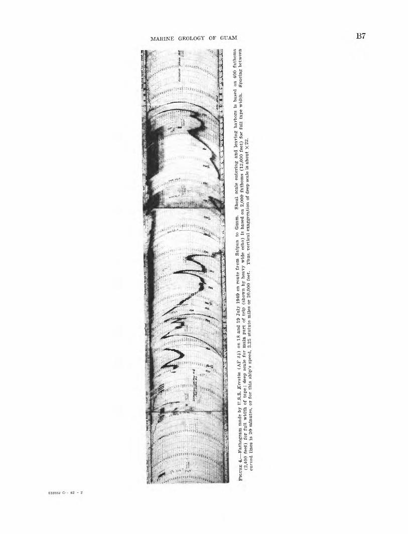
2. General bathymetric chart of region_-___________________-_______--_---___--------_-_------------------- 53. Bathymetric chart of Guam and vicinity._________________________-______--___-------_----------------- 64. Fathogram made by U.S.S. Kerstin (AF 84) on July 18 and 19, 1949, en route from Saipan to Guam_________ 75. East-west profile through Mount Lamlam____________________-________________--_--____----_--------_-_ 86. Automatically recorded echo soundings made aboard U.S.S. Abnaki (ATF 96) ----------------------------- 97. Graphical interpretation of plate l__________________________________-_____--_-_-_----__---------------- 108. Distribution of deep-sea sediments near Guam, compiled from various sources_-__--------_------------------ 12
9-12. Sediments from outer slopes-___________________--__-____________-_______------_----------------------- 1313. Cocos Island showing reef and part of lagoon_______________________-______-_____-__--_------------------ 1614. Topography of Cocos Lagoon_______-________-_____________-_____-______-_-__-------__-_-------------- 1715. Histogram and cumulative depth curves of Cocos Lagoon.______________________-___--__-_--_----------_ 1816. SES 500____________________________________________________________________________________________ 1817. Percentage of sand and coral bottom on floor of Cocos Lagoon.______________-___--___--__---------------- 19
18-21. Sediments from Cocos Lagoon and Pago Bay________________________-___--___--------_------------ --- 2122. A, Percentage of fine sand and silt in sediments of Cocos Lagoon. B, Percentage of Halimeda debris. C,
Percentage of pelecypod and gastropod shells. D, Percentage of combined madreporian coral and litho- thamnioid algae.-__-_-__--__---_____________-______________________--__---------__---------------- 23
23. Profile across Cocos Lagoon along line shown in figure 26___________________-_-_--------__---------------- 2424. Vertical distribution of sediment composition in terms of average percentage composition of sediment samples
at various depth increments__---___-_____-______---______-_____________-------_-_-__---------------- 25in
IV CONTENTS
FIGURE 25. Vertical distribution of sediment composition corrected for actual area of the lagoon floor at various depths-- B2626. Generalized sediment map of Cocos Lagoon_______-__-_____-__--______-____-__--_____--_-___-________ 2727. Classes of reef indentations or channels..-___________________________________________________________ 2928. Geographic distribution of different classes of reef indentations or channels.--_________________________ 3029. Talofofo Bay reef channel._-_-__-_____________---__________--____--____-___-____---_______________ 3130. Pago Bay reef channel.___________________ _____________-___________-_____________________________ 3231. Togcha Bay reef channel. _________________________________________________________________________ 3332. Asgadao Bay reef channel_________________________________________________________________________ 3433. Pago-Channel topography, sediment grain size, percentage insoluble residue, and types of sediment------ 3534. Grain-size distribution of sediment from channel and river at Pago Bay _________________________________ 3635. Temperature, chlorinity, and transparency of water of Pago Channel and adjacent reef flat during surveys of
21 July and 3 August 1952.__._______________________________________________________________ 3736. Vertical section of water along axis of Pago Channel__________________________________________________ 3937. Achang Reef topography and surface composition.....________________________________________________ 4038. General view of mounds made by echiuroid worms on inner half of Achang Reef off Manell Point-___________ 41
39-42. Sediments from reef flats and beaches._______________________________________________________________ 4243. Pago Bay from south shore________________________________________________________________________ 4344. Pago Reef composition of sediment._______________________________________________________________ 4445. Topography and sediment characteristics along profile at Agana Bay ___________________________________ 4546. Measuring water characteristics at Agana Bay _ ______________________________________________________ 4847. Characteristics of water during a 24-hour study of the water at Agana Bay from shore to reef edge. _______ 4948. Air temperature and tide curves during the study of reef water at Agana Bay__________________________ 5049. Oxygen production, oxygen percentage saturation, and calcium carbonate percentage saturation in water of
reef at Agana Bay._____________________________________________________________________________ 5150. Oxygen gain (values above zero) and loss (values below zero) at two stations of reef at Agana Bay as com
pared with reef at Rongelap Atoll________________________________________________________________ 5251. Beach sands_____________________________________________________________________________________ 5352. Relationship of median diameter of beach sands to the percentage insoluble residue and to beach slope.____ 5653. Histograms of two beach sands that contain large percentages of detrital sediments.._____________________ 5754. Beach profiles at localities of figure 51A_______._____________________________________________________ 5855. Mean and limiting beach profiles_________________________________________________________________ 5956. Cocos Island_-------------------__________________-___-___-__________________________________._ 6057. Rills on Gognga Beach formed by escape of fresh water through the beach at low tide____________________ 62
58-61. Rimmed terraces_________________________________________________________________________________ 6362. Pago Point---_-------------------_-__________--__-________-___---_____________________________ 6463. Profile of nip and characteristics of distribution of limpets (Acmaea sp.) at Gognga Beach__________________ 6564. About 0.5 mile south of Pago Point. A solution basin that was the site of water studies __________________ 6965. Typical diurnal changes in the characteristics of the water in solution basins _____________________________ 70
TABLES
Page TABLE 1. Description of samples from slopes of Guam.____________________________________________________________ B14
2. Percentage of specimens of benthonic Foraminifera in selected samples--___--____---__-_-____---_________-_~; 153. Magnesium carbonate content of organisms.-____________________________________________________________ 204. Composition of lagoon sediments _______________________________________________________________________ 265. Chemical composition of sediments_____________________________________________________________________ 286. River discharge and tidal data for Pago Channel_________________________________________________________ 367. Water characteristics at Pago Bridge, 5 August 1952._____________________________________________________ 388. Composition of reef-flat sediments._____________________________________________________________________ 419. Textural characteristics of reef sands __________________________________________________________________ 43
10. Brown sands of reef flat near Tumon Beach______________________________________________________________ 4611. Acidity (pH) of holothurians_________________________________________________________________________ 4712. Changes in sediment ingested by Holothurians___________________________________________________________ 4713. Composition of beach sands__________________________________________________________________________ 5414. Composition of detrital beach sands partial chemical analyses___________________________________________ 54
CONTENTS V
Page TABLE 15. Characteristics of beach sands--__-_-_-____-_---___----___-----_---------------------_-----_---------- B55
16. Comparison of beach sands collected before and after typhoon Hester-____________________________________ 6017. Characteristics of beach interstitial water and of some other island waters.________________________________ 6118. Temperature of interstitial water at Gognga Beach, 22 July 1952 (1400) ______--__-___-__-___---__---______ 6119. Temperature of reef-flat water 40 feet from shore at Gogziga Beach, 22 July 1952 (1400)____________________ 6120. Composition of water in gravity spring, overpumped well, and open sea___________________________________ 6221. Animals from rims of rimmed terraces________________________--__________-_----_-___-_-___-----_____ 6722. Characteristics of water in pools of rimmed terraces.___-________________________________________________ 6823. Characteristics of water in solution basins.____-___-_____________-__________---_----__--_---.-------_--- 69

GEOLOGY AND HYDROLOGY OF GUAM, MARIANA ISLANDS
MARINE GEOLOGY OF GUAM
By K. O. EMERY
ABSTRACT
During the summer of 1952 a study was made of the marine geology of Guam. Soundings of the outer slopes showed the presence of four well-defined submarine terraces, at average depths of 55, 105, 195, and 315 feet. The risers between ter races have slopes ranging from 5° to 44° with no differences of steepness for areas off reefs and areas off bedrock of the island. The slope topography below a depth of 50 to 100 feet is mantled by at least a veneer of loose calcareous sediments whose content of algae and reef coral indicates derivation from shallow water at the reef edge.
Cocos Lagoon at the south end of Guam is an area of irregular floor having a maximum depth of 43 feet. The deepest area is floored by the finest sediment. In areas bordering the reef and in other shallow parts the lagoon sediments are chiefly coarse coral sand. The composition of the lagoon sediment is similar to that of sediments from the reef flat with constituents derived almost entirely from calcareous organisms in the fol lowing decreasing order of frequency: coral, calcareous red algae, shells, Halimeda debris, and Foraminifera. This order is much different from that of atolls in the Marshall Islands, owing to the shallower depth and the larger ratio of reef to lagoon area.
The fringing reef, particularly in the southern half of Guam, is cut by deep channels of several types. All are located off river mouths and have continuous gradient downward from the head to the reef edge, where several reach a depth of about 100 feet. The walls are steep, locally vertical, and consist of reef coral as far as could be determined. The bottom is of poorly sorted mud, sand, and gravel of either bioclastic or volcanic origin, depending on locality. Study of the water in the channels showed that even when the rivers are in flood their muddy water, because of its lower density, moves sea ward atop the clear undiluted sea water of the channels. Thus, the muddy fresh water does not now inhibit coral growth in the channels, but probably did so in the past when the reef was thin and growing upward to its present level. The great depth and the muddy substrate prevent choking of the channels by coral growth now.
Several reef flats were studied in detail. They are flat and at a level just below mean lower tide, except where coral and algal growth have raised the surface, particularly along the outer halves. The inner portions consist chiefly of sand, locally held in place by vegetation. The composition of the sand is
similar to that of the lagoon floor, but it exhibits less local variation in texture and composition. Distribution is con trolled by the growth sites of contributing organisms, by waves and currents, and to a minor extent by sand-feeding organisms. The water atop the reef flat varies diurnally in oxygen content in response to respiration and photosynthesis. Heating of the water and use of carbon dioxide by plants during the daytime result in an increase of the degree of supersaturation of cal cium carbonate in the water above that in the open sea. Possibly some chemical deposition of calcium carbonate occurs, but it is quantitatively unimportant as compared to bioclastic sediment.
Beaches inshore of reefs are characterized by dominance of calcareous bioclastic sand in contrast to the volcanic beach sands at the mouths of rivers which generally debouch in small coastal bays. The sand of beaches is better sorted than that of reef flats, owing to the winnowing action of waves. The beach slopes average 8^2°, about the same as oceanic beaches of the mainland. The upper parts of exposed beaches were eroded to a depth of about 1 foot during 2 typhoons of 1952 and 1953. Beachrock is relatively rare at Guam as compared to atolls, and examination of interstitial waters of the beaches showed the reason. The water is brackish, especially at low tide, owing to escape of ground water from the Ghyben-Herzberg lens, and such water proved to be undersaturated with calcium carbonate in contrast to supersaturated sea water that occupies the pore spaces of atoll beaches.
Rocky shores have many nips, rimmed terraces, and solution basins, all possessing shapes and surface textures that must have been produced dominantly by solution. Chemical studies of the water, however, showed that at all times the water was apparently supersaturated with calcium carbonate and thus was unable to dissolve limestone. A vertical gradient in the degree of saturation exists, however, suggesting that the water in contact with the rock surface may be undersaturated. In addi tion, much of the calcium may be complexed and not free to enter into diurnal carbonate and bicarbonate reactions.
INTRODUCTION
Guam, the southernmost of the Mariana Islands, lies at lat 13°28' N., long 144°45' E. It is the largest of the group, with a maximum altitude of 1,334 feet, maximum dimensions of 32 by 11 miles, and an area
Bl
B2 GEOLOGY AND HYDROLOGY OF GUAM, MARIANA ISLANDS
of about 246 square miles of which about 10 percent is reefs and lagoons. The northern half is a limestone plateau whereas the more rugged southern half con sists mostly of lava flows, conglomerates, and water- laid tuffs. At the south end is a small lagoon enclosed by a barrier reef; most of the rest of the coast is bor dered by fringing reefs (General Geology, chapter A).
The climate is typical of the oceanic trade-wind areas, uniformly warm and of fairly high humidity. As shown by figure 1, most of the year's average of about 90 inches of rain falls during the late summer and early fall. From January to March the northeast trade winds blow steadily, but in April, May, and June they are variable, though still easterly. Winds during the summer and fall are more variable, mostly from the southeast, and often related to intertropical fronts. The trade winds cause the predominant swell to come from the northeast. Similarly, they produce the North Equatorial Current, a broad westward-mov ing oceanic current, part of which is split at the north east corner of Guam into two branches which flow around the island to rejoin off Apra Harbor. Some details of the surface flow are indicated by current studies made by the Pacific Island Engineers (1951).
According to Reed (1952) Guam was settled as early as about 1500 B.C. by Chamorros, who retained their habits and culture unchanged until influenced by Europeans. Numerous village sites have been found and the island is believed to have once supported a population of perhaps 50,000. Though these people traveled extensively and obtained much of their food from the sea, little of their marine lore seems to have survived. Most of the natives now living at Guam have little to do with the ocean, except for net fishing and spear fishing from shore or on the reef flats.
On March 6,1521, the Mariana Islands received their first European visitor, Ferdinand Magellan, who made a landfall and stayed for 3 days at a presently un known point, possibly Umatac Bay near the south end of Guam. Because of the activities of the natives, Ma gellan named the islands, "Islas de las Ladrones," or "Isles of Thieves." From 1565 to 1815 the annual Ma nila galleons stopped at Umatac for fresh water while en route to the Philippine Islands. Colonization of Guam, however, began only in 1668 with the landing of Augustinian Father Sanvitores and a party of priests and soldiers. Resistance of the Chamorros toward con version to Christianity and lack of resistance toward European diseases soon resulted in virtual extermina tion of the native population. During the 18th cen tury immigrants from the Philippines and Carolines partly repopulated the island. Among the famous pirates and explorers who visited the island in this pe
riod were Woodes Rogers, William Dampier, Alexan der Selkirk, John Clipperton, George Anson, Samuel Wallis, Comte de la Perouse, and Adelbert von Cha- misso. In 1898 Spanish occupation was ended, and the United States administered the island, through the Navy. Except for the period of Japanese occupation between December 1941 and July 1944, Guam has since remained under control of the United States.
Because Guam is the largest landmass and the best resupply point in that part of the Pacific Ocean, it has been visited by many scientific expeditions, chief of which from the oceanographic point of view are those of the Challenger, Albatross, Nero, Manshu, Carnegie, Bowditch, and Challenger II, Virtually all the work in submarine geology by these expeditions was restricted to the deep-water portions of the area. Work on the reefs before the present studies was done by Stearns (1940), Cloud (1951), Tayama (1952), and others. Little study, however, had been made of the interven ing shallow areas of lagoon floor and fringing slopes.
The present investigation of submarine geology was superimposed on a survey of the land geology conducted by the personnel of the U.S. Geological Survey under the leadership of J. I. Tracey, Jr. Fieldwork was confined to the period June 26 to August 27, 1952 and the manuscript was submitted in 1954.
During the field work, studies were made of the fol lowing general aspects of submarine geology: island slopes, lagoon floor, channels through the fringing reef, surfaces of barrier and fringing reefs, beaches, and rocky shores. The available time in the field was such that the investigation was necessarily a reconnaissance, yet it produced considerable new information owing to the application of new techniques. Some of the re sults are of particular interest because of their relation to the geology of atolls of the Marshall Islands, pre viously studied by the same general methods (Emery and others, 1954).
ACKNOWLEDGMENTS
Both land and submarine surveys were part of a pro gram of geologic and soil mapping in the western Pa cific conducted jointly by the Corps of Engineers, U.S. Army, and the U.S. Geological Survey.
Without the help provided by many people, the proj ect could not have been successfully completed. Out standing aid was given by Stuart A. Keesling, who served both as field and laboratory assistant, perform ing uncomplainingly and carefully the many uninspir ing tasks that had to be done. He also did the bulk of the sample study of the reef and channel at Pago Bay as a master's thesis at the University of Southern California. In addition to their other duties
88
-r5i 84LJ LJ
orLJ C/) Q_ LJ
Q
72
if I5fi^Ix I0
£ - 5z o
0
30
£.20
§ 10
0
ffg 10
>^ °
i 1 10of
o
M
MARINE GEOLOGY OF GUAM
A M J J A S 0
B3
FIGURE 1. Climatological data for Guam. Ten-year (plusT summary before October 1949 is largely from Combs (1949). Data on water temperature are from the U.S. Coast and Geodetic Survey.
B4 GEOLOGY AND HYDROLOGY OF GUAM, MARIANA ISLANDS
as members of the Geological Survey, Harold G. May periodically measured beach slopes and David B. Doan aided in making chemical analyses. Together with J. I. Tracey, Jr., J. T. Stark, and S. O. Schlanger, they also helped to make studies of water on the reef and in solution basins over two 24-hour periods. The excel lent seamanship ami spirit of cooperation of Lt. W. C. D. Keehn, commanding officer of U.S.S. Abnaki (ATF 96) , and Lt. J. H. Danenhower, of U.S.S. Metaco (ATF 86) made possible the taking of detailed sound ing profiles off the reefs. Appreciation is also due the Allan Hancock Foundation of the University of South ern California, which made available a field chemical kit and also provided laboratory facilities for the study of sediments.
REGIONAL BATHYMETRY AND GEOLOGY
GENERAL TOPOGRAPHY
Along the entire western margin of the Pacific Ocean is a series of connected arcuate topographic forms that are called tectogenes. Each consists of a deep trench that is convex seaward and is bordered on the landward side by a ridge, parts of which rise above sea level to form a chain of islands. Locally, as is in the Mariana Islands region, several such arcs are concentric. The outer one is generally an active seismic zone with hypo-
centers at progressively greater depths in a landward direction. The islands are dominantly andesitic, in contrast to the basaltic rocks of the abyssal zone farther seaward; thus, they mark the position of the andesite line (chapter C). These various relationships were more fully discussed by Hess (1948), one of the foremost students of tectogenes.
The trenches of the tectogenes are the deepest points of the ocean, and with the development of adequate echo-sounding equipment they have received increased attention. Since 1945 progressively deeper points have been found in various Pacific trenches by the Ameri can ship Cape Johnson, the Danish ship Galathea, and the British ship Challenger II. The latest maximum depth was found in the Mariana Trench near Guam (lat 11°19' N.; long 142°15' E.) during October 1951 by H.M.S. Challenger II. Using supersonic equipment a maximum accepted depth of 5,940 fathoms, or 35,640 feet, was obtained (Carruthers and Lawford, 1952; Gaskell and other, 1953). In the same area the bathy scaphe Trieste reached bottom at 35,800 feet on Janu ary 23, 1960 (Piccard and Dietz, 1961).
Guam is only one in the chain of islands on the con cave side of the Mariana Trench (fig. 2). Other islands from south to north are: Eota, Aguijan, Tinian, Sai- pan, and a dozen small ones. Between and near the islands are many separate reefs, banks and seamounts,
nine or ten of which are shown by the detailed chart of 3,700 square miles of sea floor near Guam (fig. 3). One of these, Santa Eosa Eeef, lacks only 21 feet of reaching the water surface. It is evident that the islands of the chain represent only a few of the high points on a very irregular ridge. A better apprecia tion of the irregularity of the submarine topography can be gained by examination of a fathogram made between Saipan and Guam (fig. 4).
SLOPES AND TERRACES
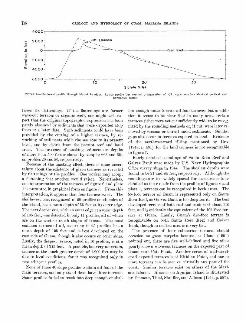
The slopes east of Guam that lead down into the Mariana Trench are fairly simple, smooth, and gentle. The average declivity from the shoreline of the east side to the 6,000-foot depth contour is about 4°. There is a considerable steepening of gradient between the shoreline and the 1,200-foot contour so that this sec tion averages about 11°. The slopes of the west side, in contrast, are complex, and off the south half of Guam they are steep, averaging about 141/^° between the reef edge and the 6,000-foot contour. This asym metry is more obvious in the profile of figure 5.
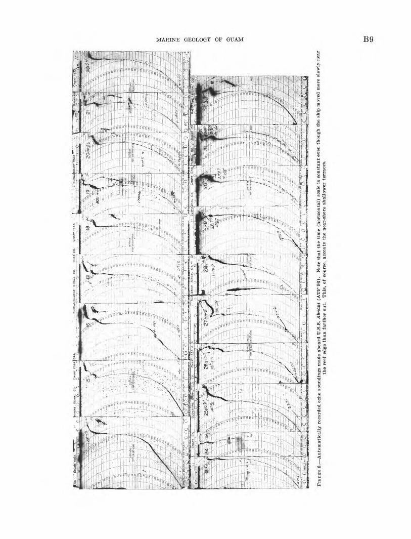
A series of detailed profiles (numbered 1 through 40) of the upper portions of the submarine slopes of the island of Guam were measured (fig. 6; pi. 1) to de termine the steepness and whether terraces are present. The positions of these profiles are indicated on the in sert map of plate 1. Profiles 6 and 7 were made by hand sounding from a skiff, but all others are from sonic soundings obtained aboard two large tugs U.S.S. Abnaki (ATI* 96) and U.S.S. Metaco (ATF 86), that were made available by the Navy Base at Guam. Pro files 1 through 5, 8 through 13, and 33 through 40 were made from U.S.S. Metaco, and 14 through 32 from U.S.S. Abnaki. The latter ship carried the better echo sounder; the windward profiles, therefore, were ex tended to greater depths than the leeward ones. The echo sounder on U.S.S. Metaco was of the automatic recording type (fig. 6), but on both ships soundings were also read visually from the flashing dial at 10- second (or 10- to 70-yard) intervals. Position fixes were obtained at 1-minute intervals, using pelorus bearings on two to six shore objects. For lack of sur vey beacons, control was based mostly on tangents to islands and cliffs, on mountain peaks, or on man-made structures which had been mapped either by the U.S. Navy Hydrographic Office or by ourselves. No slope or velocity corrections were made, though each would have tended to increase slightly the steepness of the profiles. Three profiles had inaccurate positions, which left a total of 40 for making physiographic in terpretations. These profiles and the soundings on which they are based were plotted only to a distance
MARINE GEOLOGY OF GUAM
144° 146'
B5
35,640 feetChallenger October 1951
I 42 o 144° 146° 148'
FIGURE 2. General bathymetric chart of region (adapted from Hess, 1948). Contour interval is 6,000 feet (1,000 fathoms). Shaded insertshows position of detailed chart of sea floor near Guam (flg. 3).
of 2,000 yards from shore (pi. 1) because positions at greater distance were considered of lower accuracy. The landward ends were carried as close to shore or into as shallow water as was deemed safe for the ships, considering the conditions of wind and sea.
Inspection of the profiles (fig. 6; pi. 1) shows the common presence of a flattening, or terrace, at the shal low end of most profiles, as, for example, profiles 2,
29, and 31. This terrace was not crossed in profiles 28, 32, and others, yet it is evident that there must be a flattening at some depth shallower than the shallowest depth that was reached on these profiles. In many profiles one or two additional but deeper flattenings may be observed, for example, profiles 12, 21, 27, and 39. These flattenings have slopes of 0° to 4°, in con trast to the steeper slopes of 5° to 44° on the steps be-
B6 GEOLOGY AND HYDROLOGY OF GUAM, MARIANA ISLANDS
FIGURE 3. Bathymetric chart of Guam and vicinity. Contour interval is 600 feet (100 fathoms) on both land and seafloor. Reef areas shown by solid black pattern.
MARINE GEOLOGY OF GUAM B7
618552 O - 62 - 2
B8 GEOLOGY AND HYDROLOGY OF GUAM, MARIANA ISLANDS
4000
600030
Statute Miles
FIGURE 5. East-west profile through Mount Lamlam. Lower profile has vertical exaggeration of X 5; upper one has identical vertical andhorizontal scales.
tween the flattenings. If the flattenings are former wave-cut terraces or organic reefs, one might well ex pect that the original topographic expression has been partly obscured by sediments that were deposited atop them at a later date. Such sediments could have been provided by the cutting of a higher terrace, by re working of sediments while the sea rose to its present level, and by debris from the present reef and land areas. The presence of masking sediments at depths of more than 500 feet is shown by samples 663 and 664 on profiles 20 and 26, respectively.
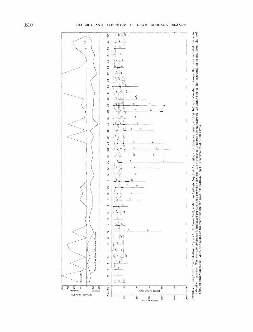
Because of the masking effect, there is some uncer tainty about the existence of given terraces as revealed by flattenings of the profiles. One worker may accept a flattening that another would reject. Nevertheless, one interpretation of the terraces of figure 6 and plate 1 is presented in graphical form on figure 7. From this interpretation, it appears that four terraces exist. The shallowest one, recognized in 20 profiles on all sides of the island, has a mean depth of 55 feet at its outer edge. The next deeper one, with an outer edge at a mean depth of 105 feet, was detected in only 11 profiles, all of which are on the w^est or north slopes of Guam. The most common terrace of all, occurring in 25 profiles, has a mean depth of 195 feet and is best developed on the east side of Guam, though it also occurs on other sides. Lastly, the deepest terrace, noted in 16 profiles, is at a mean depth of 315 feet. A possible, but very uncertain, terrace at the much greater depth of 1,200 feet may be due to local conditions, for it was recognized only in two adjacent profiles.
None of these 40 slope profiles contain all four of the main terraces, and only six of them have three terraces. Some profiles failed to reach into deep enough or shal
low enough water to cross all four terraces, but in addi tion it seems to be clear that in many areas certain terraces either were not cut sufficiently wide to be recog nized by the sounding methods or, if cut, were later re moved by erosion or buried under sediments. Similar gaps also occur in terraces exposed on land. Evidence of the northwestward tilting mentioned by Hess (1948, p. 431) for the land terraces is not recognizable in figure 7.
Fairly detailed soundings of Santa Rosa Reef and Galvez Bank were made by U.S. Navy Hydrographic Office survey ships in 1944. The shoalest depths \vere found to be 21 and 84 feet, respectively. Although the soundings are too widely spaced for measurements as detailed as those made from the profiles of figures 6 and plate 1, terraces can be recognized in both areas. The 55-foot terrace of Guam is represented only on Santa Rosa Reef, as Galvez Bank is too deep for it. The best developed terrace of both reef and bank is at about 110 feet, and is evidently the equivalent of the 105-foot ter race at Guam. Lastly, Guam's 315-foot terrace is recognizable on both Santa Rosa Reef and Galvez Bank, though in neither area is it very flat.
The presence of four submarine terraces should occasion no great surprise because, as Cloud (1951) pointed out, there are five well-defined and five other poorly shown wave-cut terraces on the exposed part of Guam near Pati Point. Another series of well-devel oped exposed terraces is at Ritidian Point, and one or more terraces can be seen on virtually any part of the coast. Similar terraces exist on others of the Mari ana Islands. A series on Aguijan Island is illustrated by Emmons, Thiel, Stauffer, and Allison (1949, p. 287).
'
lilA
FU
NE
, S
IGN
AL
C
O.'
CH
AR
T IS
AA
tSA
A-
r '.
Q
-.p..'p
.-
~j 0
7 '
1
'^S
t,
"-
SU
BM
AilB
MA
RIN
t S
IGN
AL
CO
. C
HA
R'
CO
. C
HA
RT
1S
AA
T
_
_. ~
'_
~
J?
'SU
BM
AJC
HA
RT
Tg
AJ
^-
I M
l- -
L
-
j 11
10 .
«;
U
pw
nii
"-,,.rfj&
-i
FEET
OBF
ATH
y '--
,?--
'
/fV7
". 5
***-
'" Hi-
, .--
'..;i'
r /
:JL
i s-g
:.-?
, 4
1-
££
-I
" f »
+"-
'°o
"_ __
_m
-"^
1J
t
J /
,. U
U_
J4
-"
°U-
J- ^
.£"£
<
"-
L1-/
1
^.
- ;^/;
±«
» -,^ jr
f^Z
- c:./
1B5/r
. ..
. , x
*r
IBS
^
dii
r. _.T
<_i"
-MS
. H
O *E
CO
HID
8 V
K- «
CH
*HT
~T
]ME
MB
LIN
E
F8
ET
. 2
0 B
fiC
OU
D*
FA
Tt
KF
*T
HQ
Ma,iB
09IC
OH
DB
.yE
l..»
OU
KB
-
0 C
0 i-
C
0 O
O
'.
"'-0
- 'C
(
0
FIG
URE
6. A
uto
mat
ical
ly r
ecor
ded
echo
sou
ndin
gs m
ade
aboa
rd U
.S.S
. A
bnaM
(A
TF
96)
. N
ote
that
the
tim
e (h
oriz
onta
l) s
cale
is
cons
tant
eve
n th
ough
the
shi
p m
oved
mor
e sl
owly
nea
rth
e re
ef e
dge
than
far
ther
out
. T
his,
of
cour
se,
acce
nts
the
near
-sho
re s
hall
ower
ter
race
s.
co
w I I o
1000
-
750-
«,
Ig
fsoo
i >
5S
25
0
g 2
50-
(I
500
Dis
tanc
e fr
om s
hore
to
begi
nnin
g of
pro
file
I 2
3 4
5 6
7 8
9 10
II
12
13
14
15
16
17
18
19
20
21
22
23
24
25
26
27
28
29
30
31
32
33
34
35
36
37
38
39
40
FIG
URE
7. G
raphic
al i
nter
pret
atio
n of
pla
te 1
. In
low
er h
alf,
wid
e li
nes
indi
cate
dep
th o
f fl
atte
ning
s or
te
rrac
es ;
narr
ow
line
s in
dica
te
the
dept
h ra
nge
that
w
as
soun
ded
but
con
ta
ined
no
terr
aces
. T
he a
vera
ge s
teep
ness
is
indi
cate
d fo
r th
e st
eps
betw
een
terr
aces
. T
he
uppe
r ha
lf s
how
s th
e di
stan
ce o
f th
e in
ner
end
of t
he s
urro
undi
ng p
rofi
le f
rom
the
ree
f ed
ge,
or o
ther
sho
reli
ne.
Als
o, t
he w
idth
of
the
reef
opp
osit
e th
e pr
ofile
is
indi
cate
d up
to
a m
axim
um o
f 1,
000
yard
s.
MARINE GEOLOGY OF GUAM Bll
The presence of a submarine terrace at 55 feet is of particular interest, for at a corresponding depth of 48 to 50 feet a terrace is found both inside and outside the present reefs at Bikini, Eniwetok, and Rongelap Atolls in the Marshall Islands. Stearns (1945) mentioned a terrace at about 60 feet at Espiritu Santo Island in the New Hebrides group. Evidently another terrace also exists at the same depth (Norman Newell, 1953, oral communication) at Andros Island in the Bahamas and at Raroia in the Marquesas. A terrace at about 60 feet may also occur off Japan (Hiroshi Niino, 1952, oral communication) and off Oahu, T.H. (Stearns, 1935). Soundings around San Nicolas Island off southern Cali fornia revealed terraces at the following depths: 55 to 65 feet, 110 to 130 feet, 160 to 180 feet, 230 feet, and 330 to 340 feet (Norris, 1951). Elsewhere, deposits of coarse sediment may mark the level of the sea when the 60-foot terrace w^as cut. Off San Diego, Calif., beveled strata of Cretaceous age at a depth from 60 to 120 feet and sev eral areas of coarse iron-stained sand from 30 to 180 feet mark former low stands of the sea (Emery and others, 1952). Similarly, in the Mediterranean Sea, Bourcart (Umbgrove, 1947, p. 108) has found parallel strips of gravel at depths shallower than 50 meters. The presence of related features at the same depth else where in the world would seem to indicate that the 55- foot terrace at Guam is a representative of a very wide spread eustatic feature. Knowledge of topography at these depths is scant, for they are too deep for most land geologists to study and too shallow for most marine geo logists. Off gently shelving coasts such a terrace is generally obscured by later sediments, and off a steep rocky coast navigation so close to shore is dangerous. According to Dietz and Menard (1951), depths of 60 feet are generally well below wave base, a belief shared by the writer; the terrace, therefore, is not a present-day but an ancient one.
The 315-foot terrace is also a common one, for its depth probably corresponds to the level of marine erosion during glacial times at which a flat surface was cut, forming a platform for the growth of present atoll reefs (Emery and others, 1954). The same level is also known at other places in the world (Dietz and Menard, 1951) as the site of submarine terraces. The interven ing 105- and 195-foot terraces are less known, though representative terraces have been found near those depths off California.
As shown by the upper part of figure 7, there is no relationship between the number or depth of the ter race and the presence or absence of reefs. The terraces and the steepness of the steps between them also are independent of the kind of bedrock and the known
structure. Even the slope between 0 and 55 feet is un related to volcanic or reef rock, as shown by diving by Tracey, Schlanger, and others.
SEDIMENTS
Generalized charts of the Pacific Ocean floor show that the sediments near the Mariana Islands consist of either "coral mud and sand" or volcanic mud and sand, both of which grade downward and outward into Globigerina ooze, which in turn grades into radiolarian ooze and red clay at very great depth (Murray and Renard, 1891; Hanzawa, 1928; Revelle, 1944). A sam ple from near the deepest oceanic sounding by the Challenger II in 1951 is diatomaceous (Wiseman and Hendey, 1953). A more detailed picture of the distri bution of sediments is presented in figure 8, covering the same geographic area as figure 3. Although Chal lenger 11 and Albatross took no bottom samples with in this area, U.S.S. Nero took 29 samples in 1899 (Flint, 1905). Five other samples near the entrance of Apra Harbor are shown on Japanese Hydro- graphic Bureau chart 2105 (1935) "Guam Island and Plans," and are presumed to have been obtained by Japanese ships. Six additional samples of the deeper slopes were taken aboard U.S.S. Abnaki during the course of this study, making a total of 40 deep-sea samples for figure 8. Figures 9-12 are en largements of four of these samples.
The samples show that reef debris is fairly well restricted to depths less than 3,000 feet, except off Apra Harbor, where, perhaps because of tidal currents, it may extend down to 6,000 feet. The tops and upper slopes of Santa Rosa Reef and Galvez Bank probably consist of similar debris, though no samples are avail able. At greater depth and distance from shore the sediment is Globigerma. ooze, except for 4 samples of volcanic mud, which may possibly have been derived from the small conical seamount that is located about 15 miles northwest of Guam.
More detailed information on the composition of the upper part of the slopes is available from samples taken by handline aboard a launch (SES 800} at depths as great as 315 feet off Mamaon Channel and by winch aboard U.S.S. Abnaki (ATF 96) from depths between 570 and 1,170 feet. Positions of the latter samples are shown in figure 8, and brief descriptions of all are in table 1. It is notable that Halimeda segments are abundant in most samples even to the greatest depths. Because Halimeda lives only in the photosynthetic zone
B12 GEOLOGY AND HYDROLOGY OF GUAM, MARIANA ISLANDS
40' 50" I45°00'
STATUTE MILES
Reef debris
Volcanic mud
Globigerina ooze
Sample position 12°
I44°30' 40' 50' I45°00'
FIGURE 8. Distribution of deep-sea sediments near Guam, compiled from various sources.
MARINE GEOLOGY OF GUAM B13
FIGURE 9. 'Sample 611; outer slope off Mamaon Channel; lat 13°16.3' N., long 144°39.0' E.; 135 feet. Sample consists dominantly of For- aminifera with some fine sand and silt. X 3%.
FIGURE 10. Sample 660 ; outer slope off Ritidian Point; lat 13°40.0' N., long 144°50.0' E.; 810 feet. Sample consists dominantly of Foram- inifera, comminuted coral, fine sand and silt, with some Hallmeda debris. X3y2 .
FIGURE 12. Nodule or pebble from slope in sample 664 ; outer slope off Togcha Bay; lat 13°22.0' N., long 144°47.2' E., 570 feet. X 3.
FIGURE 11. Sample 662 ; outer slope off Ritidian Point; lat 13°41.5' N., long 144°50.3' E., 1,170 feet. Sample consists mostly of Foraminif- era and Halimeda debris reworked from shallower depths. X3%.
SEDIMENTS FROM OUTER SLOPES
B14 GEOLOGY AND HYDROLOGY OF GUAM, MARIANA ISLANDS
(principally shallower than 200 feet) the abundance of its debris at greater depth is a good indication of reworking or shifting of sediments on the slope. Simi larly, encrusting calcareous red algae, the lithotham- nioids, also require sunlight, yet their remains occur at great depth. Fragments of shells of gastropods,
pelecypods, echinoid spines, sponge spicules, and ptero- pods occur in most of the samples, but these are less definitely restricted to shallow water during their life time. Corals of the massive reef type were found at great depth in broken condition (samples 607, 608, 609, 663), which probably also indicate reworking.
TABLE 1. Description of samples from slopes of Guam
Sample No.
613... ........................606... .....................614.-. .....................615-. -. _-_-_._.__617.. _ _____616-- 618.. ___ 619.. ...... .607-- 608-- 609.. ...... .610A__ ...610B... . .......... 611-- 664.. ....... 661. .660- - 663 666.- .......662-
Depth (feet)
27283437404146
108115120135165235315570690810079
1,0001,170
Latitude
13°17.36'16.14'17.35'17.33'17.27'17.29'17.24'17.26'16.17'16.17'16.18'16.23'16.29'16.31'22.0'39.0'40.0'29.8'
41.5'
Longitude
144°39.24'39.33'39.22'39.22'39.18'39.18'39.16'39.07'39.28'39.26'39.18'39.10'39.03'38.97'47.2'50.4'50.0'54.1'38.3'50.3'
Quantity
5g3g
15 g60 g10 g10 g6glg
150 glOg9*. o
300 g5g
910 o-10kg10kgin to-in to-in to-in to-
Foram- inifera
1135
1540
31
1500
150
40406540154540
Shells
57
2020
5121000
100
055
5
Fine sand and silt
175
53
5010
12
1000
250
23250
20403520
Halimeda debris
382
70
271
301800
100
10103410301032
Litho- thamnion
4028
401013101022005
602
00022
Coral
135
1545
804025
10010035401015
1251031
Median diameter
(milli meters)
2.20
.64
.44
.221.08.48.58.48.75.80
Trask sorting coeffi cient
1.60
1.40
1.53
4.531.713.023.521.801.88
Insolu ble
residue (percent)
0.7
.9
2.4
9.93.4.0.3.1
4.3.7
Foraminifera generally increase in numbers with depth and show a higher percentage of planktonic tests at greater depths. Among the benthonic Foraminif era, listed in table 2, Baculogypsina, Marginopora, Homotrema, Amphistegina, and Elphidium are typi cally reef-flat forms or very shallow water forms. Yet, many specimens were found in deep samples, particu larly in sample 662 (fig. 11), the deepest one. Homo- trema, an encrusting form, coats many pieces of coral and limestone in samples 660,661,663, and 664 (fig. 12). The presence of the shallow-water forms in deep sam ples mixed with typically deeper water genera is an indication of reworking from shallow depth. The greater abundance of planktonic species of Foraminif era at depth indicates less deposition of shallow-water sediments with increasing depth.
In summary, the Halimeda, calcareous red algae, and reef corals of samples from the slopes of Guam indi cate movement of organic debris from the reef edge to great depths on the slopes by sliding or other means. Redeposition is also suggested by the lack of relation ship to depth of the median diameter, sorting coeffi cient, and percentage insoluble residue of the sand and pebble matrix of the slope samples (table 1). The high sorting coefficients of samples 660, 663, and 664 (3.02, 3.52, and 4.53, respectively) contrast with those of the beach sands of Guam which have a mean of
1.34. The insoluble residues consist chiefly of silts and clays from weathered volcanic rocks, though grains of feldspar and olivine are also present. No ledges of bedrock were found in the dredgings.
COCOS LAGOON FLOOR
TOPOGRAPHY
Cocos Lagoon near the south end of Guam is an area of quiet water protected by a barrier reef which con tinues beyond each end of the lagoon as a fringing reef (fig. 13). The lagoon is of triangular shape, about 2.5 miles on each side, with an area of 2.8 square statute miles, or including the enclosing reef, 3.9 square miles.
Somewhat similar to Cocos Lagoon in size and shape, but more controlled by structure than by reef growth, is the lagoon of Apra Harbor, near the middle of the west side of Guam. Owing to extensive modification by man, this area no longer can serve as a model of natural lagoon processes and therefore no studies were made of it.
The topography of the floor of Cocos Lagoon is known chiefly from about 3,000 sonic soundings made in 1945 by sound boats of U.S.S. Bowditch (AGS 4)- Contours drawn at 10-foot intervals on the basis of these soundings were closely checked by about 300 hand- line soundings made during collection of bottom samples in 1952.
MARINE GEOLOGY OF GUAM B15
TABLE 2. Percentage of specimens of benthonic Foraminifera in selected samples
[Identified and counted by Ruth Todd and Doris Low]
Location
Depthffeet).
Miliolids.^ _ ...... ..-- __ __Buliminids . . ___ _____ __ _______Cibicides-.. . - ... .-_. .-___----__- _ _ , .-___-_- -_--___---
Other genera --. _ .._- _ . _ _ _
Cocos Island Beach
2010
953
Trace00
Trace0
Trace0000000
0
Tarague Beach
320
96
552503
Trace0000000
Trace
1
Achang Reef
2172
7417
23
0Trace
02000000
0
Cocos Lagoon
55643
02007000
611193007
11±
611315
020
10Trace
0Trace
160
Trace0
60Trace
12
5±
664570
000
120000
12TraceTraceTrace
202036
14±
Outer slop<
660810
Trace30
30
000
10TraceTrace
50
51
11±
5
663Q79
80
23
00
1015
TraceTrace
4Trace
40
18±
6621,170
4677
29
0003000206
5±
The contour lines show that the lagoon consists of five main physiographic units (fig. 14). Closest to shore is a unit herein termed the "nearshore shelf." This appears to be merely a seaward continuation of the small coastal plain that borders the lagoon. Its slope is gentle from the shore to depths of about 5 feet at its outer margin, which varies from less than 100 feet wide off Merizo to about a quarter of a mile off Jaotan Point. At its eastern end and extending to the deep channel of Achang Bay (700 yards beyond the east margin of figure 14), it separates the reef from the shore, forming an area that is 1 or 2 feet deeper than a normal reef flat. Near the middle is a large landward indentation of the shore where the Geus River empties. A small mangrove swamp is present along the shore of this indentation.
The outermost physiographic unit of the lagoon is the reef itself. It averages about 300 yards in width except at its northern end, where the reef is blunt and 600 yards wide, possibly because of better growth condi tions along the side of Mamaon Channel. The outer edge of the reef has a low algal ridge ("Litho- thamniori*'1 ridge), and near its southern tip is Cocos Island, a mass of sand and gravel 0.11 square mile in area that nowhere reaches an elevation of more than about 10 feet. Because all the material seen above high tide is unconsolidated, it is believed that the island owes its origin to waves and currents that have transported sediment along and across the reef. An example of the transporting ability of large waves was presented by the Typhoon Allyn of November 17, 1949, which destroyed installations at the west end of the island, carried awTay part of the eastern quarter mile of the island, removed a small islet just north of the east end
(fig. 13), and built another small islet farther north (fig. 14). The area of land removal is marked by the trunks and stumps of coconut trees that also were washed several hundred yards into the lagoon. Al though the new islet is only a few years old, already a coconut that was washed ashore had sprouted and be gun to form a tree in 1952.
Between the nearshore shelf and the north end of the reef is the deep Mamaon Channel. This is fairly straight, 1 mile long within the reef, 100 to 200 yards wide, and reaches a depth of about 100 feet where it passes through the reef (fig. 15). Soundings show a continuation to depths of at least 400 feet about 1,100 yards out from the reef. The current in the channel flows outward strongly at ebbing tide, and either in ward or outward weakly at flooding tide. The channel may owe its origin to its having been the chief original means of exit from the lagoon of fresh water brought by streams, as discussed below under "Channels Through Reef."
The fourth physiographic unit is an irregular shallow area, in the northern half of the lagoon, that separates the nearshore shelf and the channel units from the main part of the lagoon. Most of the top of this area is less than 10 feet deep, and it consists largely of branching corals; thus, it is called a reef bar (fig. 14). Its posi tion and distance from shore indicate that it may origi nally have been a fringing reef that now has been cut off from the open sea by the building of the present barrier reef on which Cocos Island is situated. Blast ing operations for improved navigation in Mamaon Channel may have produced minor modifications of this area.
B16 GEOLOGY AND HYDROLOGY OF GUAM, MARIANA ISLANDS
FIGURE 13. Cocos Island showing reef and part of lagoon. Taken June 1949 before Typhoon Allyn. Small island at opposite end was removed by typhoon. Note refraction of waves around reef projection. Photograph by U.S. Navy.
The fifth and last physiographic unit is the deep area that has been termed the "lagoon hollow." Its southern part is a gently undulating surface mostly less than 10 feet deep, but the northern part against the reef bar is deep and irregular. There are 3 main holes having maximum sonic depths of 34, 40, and 43 feet. The topography of the deep area is suggestive of ground-
water sinkhole origin, though it probably also has been influenced by irregular deposition of sediment and by coral growth. Similar features found in the 60-foot terrace at Bikini and EniwTetok were also judged of possible solution origin, a belief that was strengthened by the finding of solution cavities belowT 60 feet in the drill holes at Bikini island.
MARINE GEOLOGY OF GUAM B17
COCOS LAGOON
FIGURE 14. Topography of Cocos Lagoon. Sonic soundings obtained by U.S. Navy Hydrographic Office in 1944, supplemented by data of presentstudy. Shoreline outlined by wide black line.
B18 GEOLOGY AND HYDROLOGY OF GUAM, MARIANA ISLANDS
PERCENTAGE AREA
40 60
Area of lagoon, 2.80 square statute miles Area of reef, 0.97 square statute mile Area of island, 0.11 square statute mile
FIGURE 15. Histogram and cumulative depth curves of Cocos Lagoon.
GENERAL COMPOSITION
Samples of the floor of the lagoon were taken with a snapper and a simplified Van Veen dredge lowered by handline from the launch SES 800, a modified B-17 drop boat (fig. 16). Positions were determined by
FIGURE 16. SES 800. Note glass ports near stern. Propulsion is by an outboard motor.
double horizontal sextant angles between objects shown on U.S. Navy charts or between objects that were located during the survey. The general procedure was
to sample at 3- or 4-minute intervals while the launch drifted across the lagoon. The drift rate was such that most samples are about 100 yards apart. Oc casionally the wind direction veered so, that, in order to keep the sampling lines approximately parallel, the launch had to be maneuvered into position by using its outboard motor. Altogether 254 samples were obtained (fig. 14), including about a dozen collected near the shore by wading. Because of the small draft of the launch, about 6 inches, some samples were taken by drifting across part of the reef at high tide.
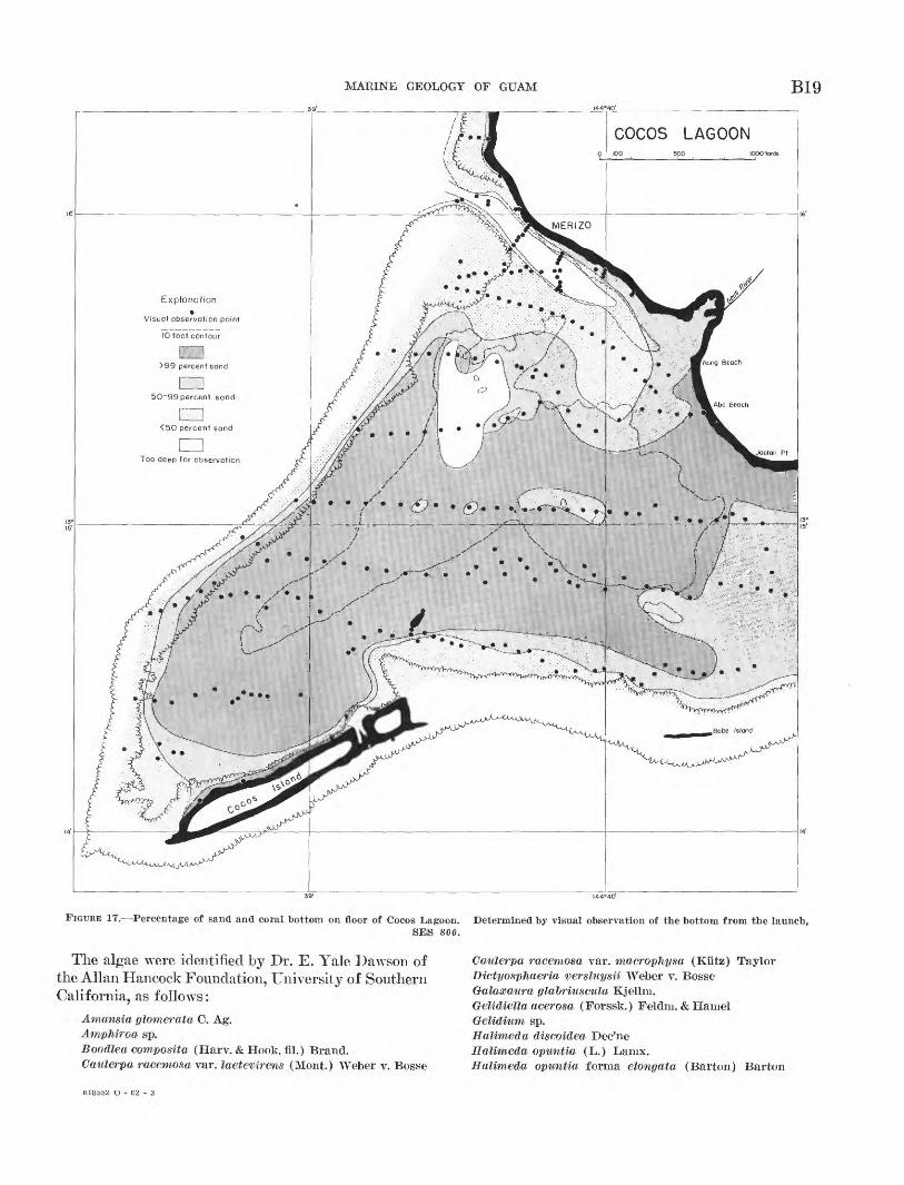
Mounted in the bottom of the launch were two glass ports that permitted observation of the bottom during the drift between sampling points. The water was clear enough so that the bottom could be viewed to depths of about 30 feet. Using the ports and, where the water was shallow enough, direct observation overside, an estimate was formed of the percentage of sand, dead coral, and living coral.
The most significant of the three measures proved to be sand, which was plotted and contoured in figure 17. Most of the lagoon hollow is floored by a broad expanse of sand that contains little coral or other rocky masses. The southern shallow part of the area, except near the shore of Cocos Island is, in fact, vir tually 100 percent sandy bottom. Similarly, sand covers the eastern shallow part of the reef bar and the nearshore shelf physiographic units. Most of the near- shore shelf unit and the parts of the lagoon near the reef were judged to consist of between 50 and 100 per cent sand, whereas the seaward side of the reef and most of the reef bar is less than 50 percent sand. The embayment of the nearshore shelf unit contains some mud mixed with the sand. Otherwise, practically all bottom material, other than sand, was either dead or living coral. The ratio of dead to living coral varied widely and unsystematically, and therefore was not plotted. However, the most striking expanse of living coral was found at the entrance of Mamaon Channel. Other large areas of living coral (mostly Porites) are present along both sides of the channel off Merizo and atop the reef bar. Very different corals, less branching and more massive, form the reef surface and the areas just lagoon ward of the reef.
VEGETATION
No systematic collection of plants was made, but usually when specimens were found in the samples of bottom sediments from the floor of Cocos Lagoon, they were placed together in a jar of formalin. In addition, a collection was made of the more obvious plants that were encountered in a traverse across the reef flat a few hundred yards east of Cocos Lagoon.
MARINE GEOLOGY OF GUAM B19|44°4Q'
Explonation
Visual observation point
10 foot contour
>99 percent sand
50-99 percent sand
<50 percent sand
Too deep for observat : on
FIGURE 17. Percentage of sand and coral bottom on floor of Cocos Lagoon. Determined by visual observation of the bottom from the launch,SES 800.
The algae were identified by Dr. E. Yale Dawson of the Allan Hancock Foundation, University of Southern California, as follows:
Amansia glomerata C. Ag.AmpMroa sp.Boodlea composite/, (Harv. & Hook, fil.) Brand.Catilerpa racemosa var. laetevirens (Mont.) Weber v. Bosse
Cattlerpa racemosa var. macrophysa (Kiitz) TaylorDictyosphaeria versUiysii Weber v. BosseGalaocaura glabriu&culu Kjellm.Gelidiella acerosa (Forssk.) Feldm. & HamelGeMditim sp.Halimeda discoidea Dec'neHalimeda opuntia (L.) Lanix.Halimeda opuntia forma elongata (Barton) Barton
618552 O - 62 - 3
B20 GEOLOGY AND HYDROLOGY OF GUAM, MARIANA ISLANDS
Halymenia durvilaei Bory Herposiphonia secunda (C. Ag.) Ainbron Jania radiata (Yendo) Yendo Lithothamnion sitmilans (Foslie) Foslie? Lithothamnion sp. Lomentaria sp. LyngKya sp.Mastophora rosea (C. Ag.) Setchell Padina commersonii Bory Sphacelaria novae-hollandiae Sender Struvea anastomosans (Harv.) Turbinaria trialata (J. Ag.) Klitz.
Most important as sediment-producing1 plants are the various species of Halimeda, a genus of calcareous green algae. As discussed in the following section on sediments, Halimeda is present at all depths in the lagoon, but is most abundant in Mamaon Channel. Lithothamnion and related massive calcareous red al gae are largely restricted to the outer edge of the reef where they form the low algal ridge. The smaller cal careous red algae, Amphiroa and Jania, are more widely distributed. Galaxaura, Mastophora, and Pa dina are somewhat calcareous, but all the other algae that are listed are noncalcareous and are not likely to be preserved in the geologic record. Most of these at tached algae are so fragile that they disintegrate soon after death; nevertheless, they form a substantial part of the food base for the lagoon and reefs.
During the fieldwork it was noted that several grasses form dense masses along the shore, binding the soil together sufficiently to reduce erosion by waves and also serving to trap sediment carried from the land by runoff. Both functions result in some upbuilding and prograding of the shore. Samples of these grasses collected along the eastern shore of Cocos Lagoon were identified by E. Y. Hosaka, Marie C. Neal, and E. H. Bryan, Jr., of the Bernice P. Bishop Museum, Hono lulu, as follows:
Paspalum conjugatum Berg. Paspalum vaginatum Sw. Sporobolus virginicus (L.) Kunth.
This list is by no means exhaustive because many other plants, largely shrubs, grow near the water's edge, and mangroves live in the water at the mouth of the Geus River and at the head of Achang Bay; however, these grasses are believed to be the commonest of the shore plants that have much geologic significance.
Beyond the shore and rarely or never exposed above the water are at least two strictly marine flowering plants. These are more closely related to land plants than to marine algae:
Enhalus acoroides (L. fil.) Steud. Halophila ovata Gaudichaud.
The more abundant one, Enhalus, is an important geo logic agent because it grows in dense patches of ribbon- like strands which trap and hold sand that is being moved across the reef by waves and currents. These patches are particularly common on the landward side of the reefs below low tide (fig. 37), where they have formed mounds of sand several inches high and several yards to tens of yards in diameter.
SEDIMENTS
GENERAL, FEATURES
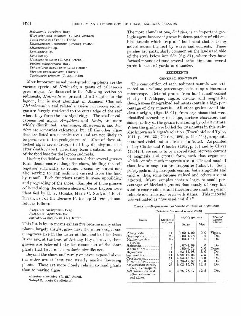
The composition of each sediment sample was esti mated on a volume percentage basis using a binocular microscope. Detrital grains from land runoff consist chiefly of feldspar, augite, olivine, and magnetite, though some fine-grained sediments contain a high per centage of clay minerals. All other grains are of bio- clastic origin, (figs. 18-21), from organisms that were identified according to shape, surface character, and susceptibility of the grains to staining by cobalt nitrate. When the grains are boiled for 20 minutes in this stain, also known as Meigen's solution (Twenhofel and Tyler, 1941, p. 128-133; Clarke, 1920, p. 549-553), aragonite is stained violet and calcite is not affected. As pointed out by Clarke and Wheeler (1917, p. 56) and by Chave (1954), there seems to be a correlation between content of magnesia and crystal form, such that organisms which contain much magnesia are calcitic and most of those low in magnesia are aragonitic (table 3). Some pelecypods and gastropods contain both aragonite and calcite; thus, some become stained and others are not affected. Many samples contain large to small per centages of bioclastic grains dominantly of very fine sand to coarse silt size and therefore too small to permit reliable identification, even with stains. This material was estimated as "fine sand and silt."
TABLE 3. Magnesiiim carbonate content of organisms
[Data from Clarke and Wheeler (1917)]
Group
Madreporariancorals.
Alcyonarian corals,except Heliopora.
Lithothamnion andother calcareousred algae.
Number of analyses
112030
56
111111
925
43
MgCOs (percent)
Range
0. 00-1. 00. 00-1. 78. 09-1. 11
. 02-1. 09
. 00-9. 72. 63-11. 08
5. 99-12. 264. 84-15. 991. 79-12. 526. 03-15. 73
3. 76-25. 17
Mean
0.0. 2.5
.65.06.07.58.0
10.012.5
12. 5
Effect of Melgen solution
Violet.Do.Do.
Do.None.
Do.Do.Do.Do.Do.
Do.
MARINE GEOLOGY OF GUAM B21
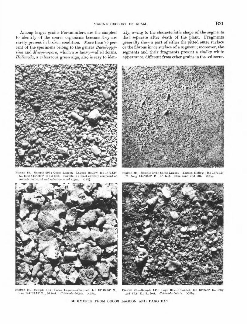
Among larger grains Foraminifera are the simplest to identify of the source organisms because they are rarely present in broken condition. More than 95 per cent of the specimens belong to the genera Baculogyp- sina and Marginopora, which are heavy-walled forms, Halimeda, a calcareous green alga, also is easy to iden
tify, owing to the characteristic shape of the segments that separate after death of the plant. Fragments generally show a part of either the pitted outer surface or the fibrous inner surface of a segment; moreover, the segments and their fragments present a chalky white appearance, different from other grains in the sediment.
FIGURE 18. Sample 503 ; Cocos Lagoon Lagoon Hollow, lat 13°14.9' N., long 144°39.6' E.; 3 feet. Sample is almost entirely composed of comminuted coral and calcareous red algae. X3%.
FIGTJEE 19. Sample 556; Cocos Lagoon Lagoon Hollow; lat 13°15.3' N., long 144°39.5' E.; 40 feet. Fine sand and silt. X3%.
FIGURE 20. Sample 464; Cocos Lagoon Channel; lat 13° 15.96' N., long 144°39.73' E.; 36 feet. Halimeda debris. X3y2 .
FIGURE 21. Sample 141; Pago Bay Channel; lat 13°25.0' N., long 144°47.1' E.; 21 feet. Halimeda debris. X3%.
SEDIMENTS FROM COCOS LAGOON AND PAGO BAY
B22 GEOLOGY AND HYDROLOGY OF GUAM, MARIANA ISLANDS
They also become stained by Meigen solution. Pelecy- pod and gastropod shells are mostly present in broken condition, but they can usually be identified by rem nants of flat or curved surface and occasionally by traces of decorative colors. Their greater density and hardness also prevent confusion with fragments of Halimeda. Highly worn fragments of large shells can not always be distinguished from pieces of madreporar- ian coral by either shape or stain; thus, it is likely that a small proportion of the estimated percentages of coral in reality consist of shell fragments. Most madrepo rarian corals are recognizable by their pores, translu cent appearance, and irregular shape. Well-worn small pieces, however, are not only confused with worn shell fragments, but also they are similar to worn pieces of calcareous red algae from which they can be distin guished only by staining. The madreporarian corals consistently become stained as aragonite, whereas the calcareous red algae remain unstained as calcite.
In summary, the main constituents of the sediments in order of decreasing ease of identification are: detrital grains, silt, Foraminifera, Halimeda^ shells of pelecy- pods and gastropods, madreporarian corals, and litho- thamnioid algae. In addition, nearly every sample con tains a few calcitic grains from the following organisms in quantities never greater than 1 percent:
segments of Amphiroa (a jointed calcareous red alga) sclerodermites of Gorgonidae (an alcyonarian coral) claws of crabs spines of sea urchins worm tubes (rare) bryozoans (vary rare)
Siliceous sponge spicules are also present in some sam ples.
Near the shore the grains are commonly shiny, evi dently having been polished by rubbing together through wave motion. Beyond the shore, however, most of the grains have a dull surface as though they had been slightly corroded by sea water. In addition, most samples contain 1 to 5 percent, and in a few in stances as much as 40 percent, of dark-gray or black grains that are otherwise indistinguishable from the white ones. Among the grains are tests of Foraminif era and segments of Halimeda. The mixture of white and black grains gave rise to a salt-and-pepper appear ance of the sediment. Similar grains in the sediments of atolls in the Marshall Group are believed to have been discolored by a boring green alga (Emery and others, 1954, p. 57). Teichert (1946) has reported the same kind of discoloration of gravels on coralline islands off Australia.
HORIZONTAL. DISTRIBUTION
After completion of the estimates of percentage com position of the samples, the figures for each constituent were plotted in map form (fig. 22). Only in samples within about a hundred feet of the mainland shore were more than a few grains of insoluble detrital ori gin found; for all practical purposes, therefore, the sediments of the lagoon are entirely bioclastic. Abun dant Foraminifera are restricted to beaches, compris ing more than 40 percent of the grains in samples from beaches of Cocos Island and those northwest of Merizo. Foraminifera are present in proportions rarely greater than 1 percent in samples from beaches southeast of Merizo and in most samples from the lagoon floor.
Fine sand and silt is absent in most samples, but is the only constituent in some. Throughout about 70 percent of the lagoon area deeper than 10 feet (the lagoon hollow and Mamaon Channel) silt and some clay form 25 to 100 percent of the material with the highest percentages in the deepest spots (figs. 19, 22). The general appearance of the silt in the lagoon hollow is that of highly comminuted Halimeda segments, which certainly are fragile enough to have contributed heavily to the finer sediments. Among the finest sediment, Heinz A. Lowenstam, of California Institute of Tech nology (oral communication, 1954), identified aragonite needles that he believed were derived from calcareous algae.
Halimeda segments are present in most samples, but only in the northern half of the lagoon do they com prise more than 50 percent of each sample; where dominant, they form a sediment that is termed "Hali meda debris" (fig. 20). Characteristically this material fringes areas of silt along the north side of the deep part of the lagoon hollow and the north slope of Ma maon Channel (fig. 225).
Shell fragments range mostly between 5 and 40 per cent. No samples consist chiefly of shells; the distribu tion of shells, therefore, is not very distinctive (fig. 22<7).
Fragments of madreporian corals and calcareous red algae were judged together for all samples, and sepa rately by staining for every fifth one. The two, com bined in figure 22Z>, are generally most abundant where fine sand and silt and Halimeda debris are least abun dant. Thus, they are lacking or minor in the deepest areas and reach their greatest abundance in areas that border the reef (fig. 18). Intermediate concentrations occur near the shore between Merizo and Jaotan Point. In the 45 samples in which calcareous red algae were determined by stains, they average 29 percent of the coral plus calcareous red algae. Thus, the coral is a
MARINE GEOLOGY OF GUAM
LAGOONlOOO YARDS
B23
Percentage of Madreporarian coral plus red algal debris in sediments
FIGURE 22. A, Percentage of fine sand and silt in sediments of Cocos Lagoon. Dots indicate positions of bottom samples from which the data were derived. B, Percentage of Halimeda debris in sediments of Cocos Lagoon. C, Percentage of pelecypod and gastropod shells in sedi ments of Cocos Lagoon. D, Percentage of combined madreporarian coral and lithothamnioid algae in sediments of Cocos Lagoon.
little more than twice as abundant as calcareous reel bordering the reef than nearer the center of the lagoon,algae. Though not very certain, the ratio of calcareous which agrees with the general observations 011 the posi-recl algae to coral seems to be somewhat higher in areas tion of abundant living calcareous reel algae.
B24 GEOLOGY AND HYDROLOGY OF GUAM, MARIANA ISLANDS
VERTICAL, DISTRIBUTION
Across the middle of the lagoon, following the line shown in figure 26, a profile was made of the bottom and of the composition and grain size of the sediments (fig. 23). This shows graphically the concentration of silt along the shore at Merizo, in the bottom of Mamaon Channel, and in the deepest part of the lagoon hollow. Halimeda debris is most abundant near the channel, and Foraminifera near Cocos Island. Sand from comminuted coral and calcareous red algae is dominant in the shallow area just south of the channel (reef bar) and in the shallow area bordering the main reef at Cocos Island.
Inspection of the graph of grain-size distribution shows a close correlation with composition. Halimeda debris is the coarsest sediment, followed in turn by coral and calcareous red algae, shells, Foraminifera, and fine sand and silt. Trask sorting coefficients are highest, about 6.0, for the clayey silt that is near shore at Merizo, showing the absence of much working over by waves. Intermediate sorting, averaging l.YO for 6
samples, characterizes the sand that is composed domi- nantly of coral and calcareous red algae. Where the sands have been worked over by waves on the island beaches, the sorting is further reduced to 1.41, very well sorted. This wave action results in the leaving behind or burial of large pieces and the winnowing out of small ones, producing a concentrate of grains of medium size. Equally well sorted is the fine sand and silt of the deep lagoon hollow, averaging 1.41 for 3 samples. Such a low sorting coefficient can be ex pected only where sediments have been selectively sorted. It is evident that the fine sand and silt in the lagoon hollow is a concentrate of the fine grains that have been winnowed out of other sediments by waves and currents, finally to accumulate in the deep areas where they are generally free from further disturbance by waves. Such a mechanism explains the absence of mixing with coarser sediment in the center of the lagoon hollow.
All samples from the lagoon floor were grouped into depth increments, and the average composition of sedi-
1000 3000 YARDS
COCOS ISLAND
BOTTOM PROFILE
1 ss B
SILT-
SHELLS
CORALAND
RED ALGAL DEBRI!
FINE SAND AND SILT
CORAL AND RED ALGAL DEBRIS
COMPOSITION
GRAIN-SIZE DISTRIBUTION
TEXTURAL PARAMETERS
FIGURE 23. Profile across Cocos Lagoon along line shown in figure 26. Sediment character is shown in terms of composition, grain-sizedistribution, and median diameter and Trask sorting coefficient.
MARINE GEOLOGY OF GUAM B25
ments in each depth increment was determined (fig. 24). There is clearly present a depth dependence with Foraminifera most abundant near the surface, coral and calcareous red algal sand, at intermediate depths, and fine sand and silt at the greatest depth. Some care must be taken in interpreting figure 24, for it shows only the average composition of samples at given
OVERALL, COMPOSITION
To simplify the picture of sediment distribution, the samples were classed as fine sand and silt, Foraminif era, Halimeda debris, and coral according to the most abundant constituent. Calcareous red algae and shells had to be omitted because they were the chief constitu ent in few or none of the samples. The results plotted
CUMULATIVE PERCENTAGE COMPOSITION OF COCOS LAGOON SAMPLES
10-
20-
30-
LiJ Uu_
iijQ
60-
70-
80
10 30 40 50 60
FINE SAND
.AND SILT:
ep 90 100
: .CORAL AND;V.. RED ALGAL DEBRIS!
16
63
37
UJ_1Q.
u_ otriijGO
ID Z
20
FIGURE 24. Vertical distribution of sediment composition in terms of average percentage composition of sediment samples at various depthincrements.
depths. No account is taken of the differences in total bulk of sediment at different depths. The same data were replotted with proper weight given to the actual area of the lagoon floor covered by each depth zone (fig. 25). This graph shows the true proportions of each constituent of the sediments, and thus it reduces the accent placed by figure 24 on fine sand and silt.
in chart form (fig. 26) are easier to visualize than the separate charts of each constituent.
In summary, it is evident that detrital sediments (insoluble residue fractions) from the land are not carried far into the lagoon. The chief Foraminifera are heavy ones that live on the reef, and after death of the organism the empty tests collect on the beaches
B26 GEOLOGY AND HYDROLOGY OF GUAM, MARIANA ISLANDS
oo 0,5
AREA. IN SQUARE STATUTE MILES i.o
CORAL AND RED ALGAL DEBRIS
UJ
FIGURE 25. Vertical distribution of sediment composition corrected for actual area of the lagoon floor at various depths.
inshore of the reefs. Halimeda evidently live best in the areas that receive new water from Mamaon Channel, for the debris is most abundant there. Madreporarian corals and calcareous red algae form the bulk of the sediment in areas that border the reef. The finest sedi ment from comminuted organic remains collects in the deeper areas of presumed quieter water. Organic growth is less rapid in these areas, probably because less sunlight reaches the bottom; thus, coarse debris is not available locally, and only the finer sediment is carried there by currents from more distant areas of growth.
A rough value for the overall composition of the present lagoon floor and adjacent reef and beaches can be obtained by totaling the areas of the various constit uents shown by figure 25. If the samples had been evenly distributed over the lagoon floor, the same re sult would be obtained by averaging together the com position of all 254 samples and approximately the same values were obtained (table 4). The results from both methods show that the contribution by animals is about
TABLE 4. Composition of lagoon sediments, in percent
Guam (Cocos Lagoon): Simple average of all
Samples weighted by areas of depth zones, .-
Corrected for areas of coral seen from boat_._
Bikini (Lagoon): Samples weighted by
areas of depth zones. -
Fo-rami- nifera
2
3
2
11
Shells
16
15
11
7
Fine sand and silt
11
8
5
25
Halimeda debris
15
11
8
43
Madre porarian
corals
40
45
60
13
Calcar eous red
algae
16
18
14
1
twice that of plants, unlike in Bikini and other atoll lagoons of the Marshall Islands where plants are domi nant. This difference is mostly a result of the shallower average depth of Cocos Lagoon and of its greater ratio of reef area to lagoon area, because these factors con trol the distribution of living coral, calcareous red al gae, and Halimeda. Both kinds of lagoons are charac terized by bioclastic (reworked organic sediment) rather than by undisturbed organic material. Eventu ally such sediments would produce a clastic rather
MARINE GEOLOGY OF GUAM B27144° 39'
FIGURE 26. Generalized sediment map of Cocos Lagoon.
than a simple organic limestone. Similar bioclastic cal- CHEMICAL COMPOSITIONcareous sediments from Florida, Bahamas, Bermuda, Chemical analyses of selected samples from theand California, lead to the question, "Are not most beaches, reefs, lagoon, channels, and outer slope werelimestones of bioclastic origin?" Only the relatively made by the Mitsui Chemical Co. of Tokyo (table 5).narrow reef limestones at Guam are largely of direct Silica and alumina are lower than 1 percent, except inorganic growth and even they may be composed mostly some samples that contain large quantities of detritalof bioclastic material. material. In these latter samples magnesia also is high
B28 GEOLOGY AND HYDROLOGY OF GUAM, MARIANA ISLANDS
owing to detrital materials (table 14). In all other samples magnesia ranges between 1.57 and 2.81 percent. Computed as magnesium carbonate, these values become 3.3 to 5.9 percent. Comparison with mean values of MgCO3 in hard parts of various organisms (table 4) shows that the relatively high MgCO3 in samples 201, 660A, and 662 results from large percentages of Foram inifera, and high MgCO3 in sample 60T and probably in sample 660B results from large percentages of cal careous red algae. Contents of magnesia are only about one-tenth those required for dolomite.
In all but the samples containing much detrital ma terial (samples 302, 602, 464, 469, 141, 611) calcium carbonate and magnesium carbonate (computed from CaO and MgO) total 94 to 9T percent of the whole sample. The carbon dioxide needed for these carbon ates makes up all but 1 to 4 percent of the ignition loss, the remainder being water and organic matter. Phosphate amounts to only 0.1 to 0.2 percent, in line with the known absence of phosphorite in tropical reef limestones except wyhere enrichment by guano has oc curred.
TABLE 5. Chemical composition of sediments
[Analyses by Mitsui Chemical Co., Tokyo, Japan] C, coral; F, Foraminifera; Sh, shells; S, silt; H, Halimeda; fs, fine sand; A, red algae; L, limestone.
Sample __ _.Depth (feet)_ Dominant con
stituent.
SiO 2 -_ _ (Al,Fe) 2 03-----MgO._.__ ______CaO_______-_._S03 _____________P2 0s_ ___________Ignition loss __
CaCOs - MgCO3 __ ___
Beaches
Agana Bay
63 0
C
0.19 .11
1.71 52.25
.44
.09 44.93
.003 93.2 3.6
Cocos Island
201 0 F
0.14 .13
2.81 51.16
.46
.10 45.10
.010 91.3 5.9
Reef flats
Agana Bay
89 2
C, Sh
0.25 .15
2.02 51.43
.52
.11 44.86
.003 91.8 4.2
Pago Bay
302 2
C
5.75 4.24 3.56
44.01 .40 .12
40.95 .067
649 2
C
0.51 .50
2.58 50.45
.51
.12 44.57
.044 90.0 5.4
Achang Bay
635 2
C
0.47 .52
2.17 51.05
.48
.12 44.19
.015 91.2 4.6
602 2S
18.66 14.31 2.51
30.41 .32 .15
31.37 .100
Lagoon
Cocos
503 3
C
0.29 .19
1.57 51.76
.48
.11 44.66
.010 90.6 3.3
407 6
Sh
0.24 .13
2.48 51.21
.49
.14 44.77
.018 91.5 5.2
464 36 H
3.80 2.89 2.37
47.50 .48 .11
42.63 .068
556 45
fs, S
1.15 .91
2.06 50.07
.55
.12 44.04
.036 89.54.3
Channels
Pago
469 79
fs, S
20.42 14.76 5.49
28.99 .31 .16
28.13 .034
Ma- maon
141 21S
13.139.98 2.30
36.14 .30 .09
35.73 .074
Outer slopes
Off Merizo
607 115
C.red A
0.81 .75
2.41 50.61
.49
.12 44.20
.015 90.55.1
611 315
F, fs
5.314.58 3.65
44.50 .34 .11
40.81 .015
Off Ritidian Point
660A 810
F, H, fs
0.39 .58
2.18 50.34
.52
.13 44.69
.007 90.0 4.6
662 1,170 F, H
0.24 .27
2.53 51.54
.42
.12 44.73
.010 92.1 5.3
660B 810
L
0.51 .34
4.81 48.52
.49
.19 44.45
.012 86.8 10.1
Nitrogen ranges between 0.003 and 0.100 percent with the highest values in fine-grained sediments of a man grove swamp (sample 602) and at the bottom of Pago Channel (sample 141). Multiplied by a factor of 19 (Emery and Rittenberg, 1952) these nitrogen figures correspond to a range of total organic matter of between 0.06 and 1.3) percent (0.3 percent mean) in contrast to 7.5 percent in California basin sediments and between 0.6 and 6.1 percent in calcareous sediments of Cuba and the Bahamas (Trask, 1932, p. 166-172). Similar lowr values of organic matter were found at Bikini, which lead to the belief that reefs such as these do not themselves contain enough organic matter to be transformed into significant quantities of petroleum.
COMMINUTION OF SEDIMENT
Under ordinary conditions the waves of Cocos Lagoon are so small that it is doubtful whether they can have a significant part in breakdown of coral and calcareous red algae into bioclastic sediments. Certainly, typhoon waves are capable of such work and so are organisms, though the relative importance of waves and organisms as sediment producers is unknown. Among the more obvious organic agents are coral-grazing fish, which have strong teeth that are used to break off and crush
pieces of coral in search of the fleshy polyps or boring \vorms beneath. Commonly, corals and encrusting red algae of reefs and lagoons bear parallel scratches made by these fish. Among the men wyho have reported on the activity of these fish are Wood-Jones (1912, p. 264- 265) who studied them at Cocos-Keeling Atoll and Cloud (1952) wyho described the clouds of calcareous sediment that are evacuated by parrot fish when they are disturbed. Organisms such as boring green algae, sponges, wTorms, pelecypods, chitons, sea urchins, and probably others are also significant sediment producers (Duerden, 1902; Bertram, 1936).
CHANNELS THROUGH REEF
TOPOGRAPHY
Comparison of the indentations of the coast of Guam shows that they belong to four different classes. All four constitute a series that ranges from a large bay containing a small reef to a large reef containing a small bay or channel. All are associated with streams that generally bear the same name, as, for example, Pago Bay and Pago Kiver. The first of these classes (A of fig. 27) is a narrow, long, steep-wall bay evi dently the drowned mouth of a stream valley. At the
TA
LO
FO
FO
B
AY
INA
RA
JA
N
BA
YP
AU
LIL
UC
B
AY
O
AC
HA
NG
B
AY
AN
D
MA
NE
LL
C
HA
NN
EL
Por
tly
art
ifici
al
AG
AN
A
CH
AN
NE
L
D SU
MA
Y
BA
Y
AS
AN
B
AY
A G
AT
B
AY
FIG
UR
E 2
7.
Cla
sses
of
reef
ind
enta
tion
s or
cha
nnel
s.
A,
Bay
wit
h na
rrow
ree
f p
artl
y a
roun
d si
des.
B
, B
ay w
ith
reef
aro
und
side
s an
d he
ad.
C,
Cha
nnel
acr
oss
enti
re r
eef.
D
, C
hann
elac
ross
out
er p
art
of r
eef
only
. N
umbe
rs s
how
dep
th,
in f
eet,
at m
outh
of
bays
. L_
I
to CO
B30
I3"40'I4°35'
GEOLOGY AND HYDROLOGY OF GUAM, MARIANA ISLANDS
40' 45' 50'55' I4°58'
I3°40'
2 I 0
35'
30'
25'
20'-
15'-
To/of of o Bay /\oxSella
Cetti Bay Fouha Bay
Umatac Bay
PaulHue Bay Inarajan Bay
Agfayan Bay
Toguan 8 Mamaon Channel
I4°35' 40' 45' 50' 55'
FIGURE 28., Geographic distribution of different classes of reef indentations or channels.
35'
30'
25'
20'
15'
0 °58'
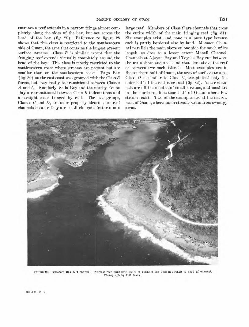
MARINE GEOLOGY OF GUAM B31
entrance a reef extends in a narrow fringe almost com pletely along the sides of the bay, but not across the head of the bay (fig. 29). Reference to figure 28 shows that this class is restricted to the southeastern side of Guam, the area that contains the largest present surface streams. Class B is similar except that the fringing reef extends virtually completely around the head of the bay. This class is mostly restricted to the southwestern coast where streams are present but are smaller than on the southeastern coast. Pago Bay (fig. 30) on the east coast was grouped with the Class B forms, but may really be transitional between Classes A and C. Similarly, Sella Bay and the nearby Fouha Bay are transitional between Class B indentations and a straight coast fringed by reef. The last groups, Classes C and Z>, are more properly identified as reef channels because they are small elongate features in a
large reef. Members of Class C are channels that cross the entire width of the main fringing reef (fig. 31). Six examples exist, and none is a pure type because each is partly bordered also by land. Mamaon Chan nel parallels the main shore on one side for much of its length, as does to a lesser extent Manell Channel. Channels at Ajayan Bay and Togcha Bay run between the main shore and an island that rises above the reef or between two such islands. Most examples are in the southern half of Guam, the area of surface streams. Class D is similar to Class C', except that only the outer half of the reef is crossed (fig. 32). These chan nels are off the mouths of small streams, and most are in the northern, limestone half of Guam where few streams exist. Two of the examples are at the narrow neck of Guam, where minor streams drain from swampy areas.
FIGURE 29. Talofofo Bay reef channel. Narrow reef lines both sides of channel but does not reach to head of channel. Photograph by U.S. Navy.
618552 O - 62 - 4
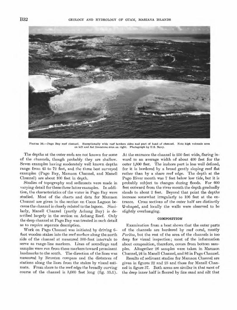
B32 GEOLOGY AND HYDROLOGY OF GUAM, MARIANA ISLANDS
FIGURE 30. Pago Bay reef channel. Exceptionally wide reef borders sides and part of head of channel.on left and flat limestone area on right. Photograph by U.S. Navy.
Note high volcanic area
The depths at the outer ends are not known for some of the channels, though probably they are shallow. Seven examples having moderately well known depths range from 45 to 72 feet, and the three best surveyed examples (Pago Bay, Mamaon Channel, and Manell Channel) are about 100 feet in depth.
Studies of topography and sediments were made in varying detail for these three latter examples. In addi tion, the characteristics of the water in Pago Bay were studied. Most of the charts and data for Mamaon Channel are given in the section on Cocos Lagoon be cause the channel is closely related to the lagoon. Simi larly, Manell Channel (partly Achang Bay) is de scribed largely in the section on Achang Reef. Only the deep channel at Pago Bay was treated in such detail as to require separate description.
Work on Pago Channel was initiated by driving 6- foot wooden stakes into the reef surface along the north side of the channel at measured 300-foot intervals to serve as range-line markers. Lines of soundings and samples were run from these markers toward prominent landmarks to the south. The direction of the lines was measured by Brunton compass and the distances of stations along the lines from the stakes by visual esti mate. From shore to the reef edge the broadly curving course of the channel is 3,000 feet long (fig. 33A).
At the entrance the channel is 250 feet wide, flaring in ward to an average width of about 400 feet for the outer 1,800 feet. The inshore part is less well defined, for it is bordered by a broad gently sloping reef flat rather than by a share reef edge. The depth at the Pago River mouth was 7 feet below low tide, but it is probably subject to changes during floods. For 600 feet outward from the river mouth the depth gradually shoals to about 2 feet. Beyond that point the depths increase somewhat irregularly to 106 feet at the en trance. Cross sections of the outer half are distinctly U-shaped, and locally the walls were observed to be slightly overhanging.
COMPOSITION
Examination from a boat shows that the outer parts of the channels are bordered by reef coral, mostly Porites, but the rest of the area of the channels is too deep for visual inspection; most of the information about composition, therefore, comes from bottom sam ples. Altogether 26 samples were taken in Mamaon Channel, 24 in Manell Channel, and 86 in Pago Channel.
Results of sediment studies for Mamaon Channel are given in figures 22 and 23 and those for Manell Chan nel in figure 37. Both areas are similar in that most of the deep inner half is floored by fine sand and silt that
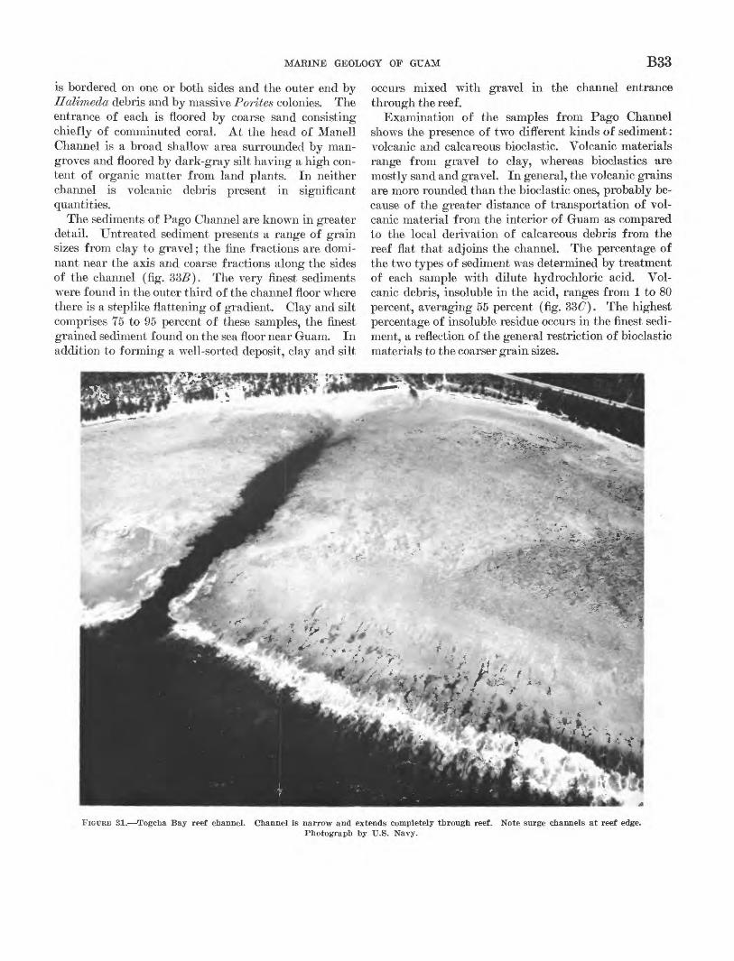
MARINE GEOLOGY OF GUAM B33
is bordered on one or both sides and the outer end by Halimeda debris and by massive Forties colonies. The entrance of each is floored by coarse sand consisting chiefly of comminuted coral. At the head of Manell Channel is a broad shallow area surrounded by man groves and floored by dark-gray silt having a high con tent of organic matter from land plants. In neither channel is volcanic debris present in significant quantities.
The sediments of Pago Channel are known in greater detail. Untreated sediment presents a range of grain sizes from clay to gravel; the fine fractions are domi nant near the axis and coarse fractions along the sides of the channel (fig. 335). The very finest sediments were found in the outer third of the channel floor where there is a steplike flattening of gradient. Clay and silt comprises 75 to 95 percent of these samples, the finest grained sediment found on the sea floor near Guam. In addition to forming a well-sorted deposit, clay and silt
occurs mixed with gravel in the channel entrance through the reef.
Examination of the samples from Pago Channel shows the presence of two different kinds of sediment: volcanic and calcareous bioclastic. Volcanic materials range from gravel to clay, whereas bioclastics are mostly sand and gravel. In general, the volcanic grains are more rounded than the bioclastic ones, probably be cause of the greater distance of transportation of vol canic material from the interior of Guam as compared to the local derivation of calcareous debris from the reef flat that adjoins the channel. The percentage of the two types of sediment was determined by treatment of each sample with dilute hydrochloric acid. Vol canic debris, insoluble in the acid, ranges from 1 to 80 percent, averaging 55 percent (fig. 3&C). The highest percentage of insoluble residue occurs in the finest sedi ment, a reflection of the general restriction of bioclastic materials to the coarser grain sizes.
FIGURE SI. Togcha Bay reef channel. Channel is narrow and extends completely through reef. Photograph by U.S. Navy.
Note surge channels at reef edge.
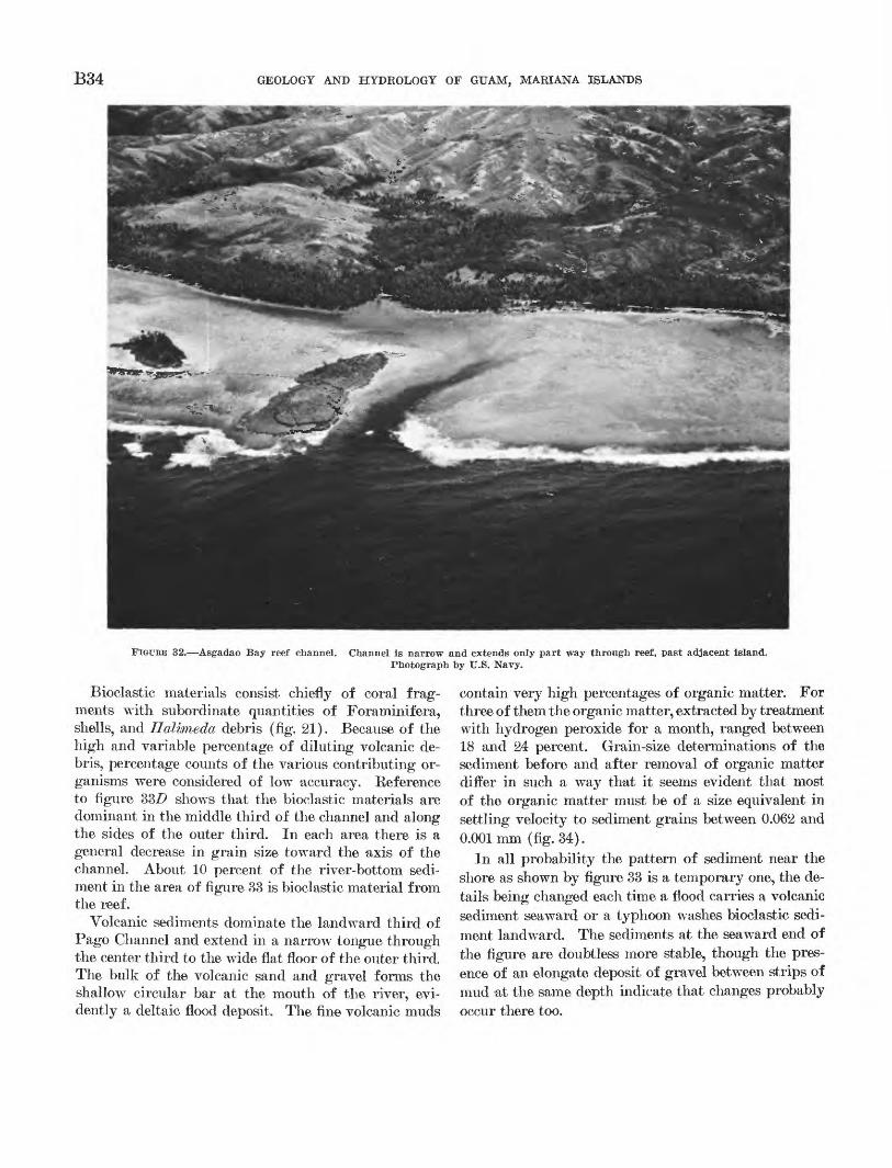
B34 GEOLOGY AND HYDROLOGY OF GUAM, MARIANA ISLANDS
FIGURE 32. Asgadao Bay reef channel. Channel is narrow and extends only part way through reef, past adjacent island. Photograph by U.S. Navy.
Bioclastic materials consist chiefly of coral frag ments with subordinate quantities of Foraminifera, shells, and Halimeda debris (fig. 21). Because of the high and variable percentage of diluting volcanic de bris, percentage counts of the various contributing or ganisms were considered of low accuracy. Reference to figure 33/> shows that the bioclastic materials are dominant in the middle third of the channel and along the sides of the outer third. In each area there is a general decrease in grain size toward the axis of the channel. About 10 percent of the river-bottom sedi ment in the area of figure 33 is bioclastic material from the reef.
Volcanic sediments dominate the landward third of Pago Channel and extend in a narrow tongue through the center third to the wide flat floor of the outer third. The bulk of the volcanic sand and gravel forms the shallow circular bar at the mouth of the river, evi dently a deltaic flood deposit. The fine volcanic muds
contain very high percentages of organic matter. For three of them the organic matter, extracted by treatment with hydrogen peroxide for a month, ranged between 18 and 24 percent. Grain-size determinations of the sediment before and after removal of organic matter differ in such a way that it seems evident that most of the organic matter must be of a size equivalent in settling velocity to sediment grains between 0.062 and 0.001mm (fig. 34).
In all probability the pattern of sediment near the shore as shown by figure 33 is a temporary one, the de tails being changed each time a flood carries a volcanic sediment seaward or a typhoon washes bioclastic sedi ment landward. The sediments at the seaward end of the figure are doubtless more stable, though the pres ence of an elongate deposit of gravel between strips of mud at the same depth indicate that changes probably occur there too.
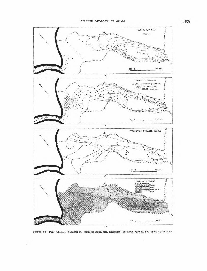
MARINE GEOLOGY OF GUAM B35
ft ̂ >Silt and clay percentage contours
SifiwS >50 percent gravel '. '. '. '.''. 25 to 50 percent gravel
TYPES OF SEDIMENT Volcanic Bioclastjc^
GravelSandSand and mudMud
FIGURE 33. Pago Channel topography, sediment grain size, percentage insoluble residue, and types of sediment.
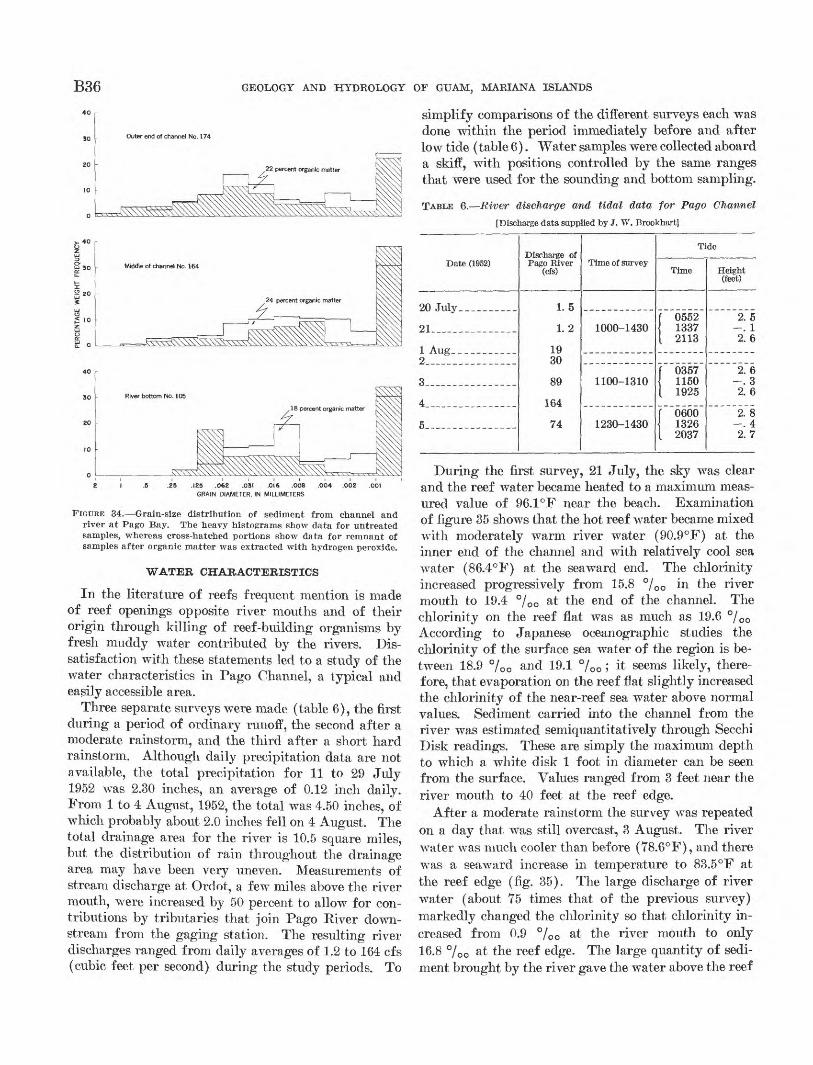
B36 GEOLOGY AND HYDROLOGY OF GUAM, MARIANA ISLANDS
.23 .123 .062 .031 .016 .008 .004 .002 .001 GRAIN DIAMETER, IN MILLIMETERS
FIGURE 34. Grain-size distribution of sediment from channel and river at Pago Bay. The heavy histograms show data for untreated samples, whereas cross-hatched portions show data for remnant of samples after organic matter was extracted with hydrogen peroxide.
In the literature of reefs frequent mention is made of reef openings opposite river mouths and of their origin through killing of reef-building organisms by fresh muddy water contributed by the rivers. Dis satisfaction with these statements led to a study of the water characteristics in Pago Channel, a typical and easily accessible area.
Three separate surveys were made (table 6), the first during a period of ordinary runoff, the second after a moderate rainstorm, and the third after a short hard rainstorm. Although daily precipitation data are not available, the total precipitation for 11 to 29 July 1952 was 2.30 inches, an average of 0.12 inch daily. From 1 to 4 August, 1952, the total was 4.50 inches, of which probably about 2.0 inches fell on 4 August. The total drainage area for the river is 10.5 square miles, but the distribution of rain throughout the drainage area may have been very uneven. Measurements of stream discharge at Ordot, a few miles above the river mouth, were increased by 50 percent to allow for con tributions by tributaries that join Pago River down stream from the gaging station. The resulting river discharges ranged from daily averages of 1.2 to 164 cfs (cubic feet per second) during the study periods. To
simplify comparisons of the different surveys each was done within the period immediately before and after low tide (table 6). Water samples were collected aboard a skiff, with positions controlled by the same ranges that were used for the sounding and bottom sampling.
TABLE 6. River discharge and tidal data -for Pago Channel
[Discharge data supplied by J. W. Brookhart]
Date (1952)
20 July.. ________
21________-_-____
1 Aug_ _ _2 _______ __
3__ _-
4 ___ ____ __
5- --_- __ __--
Discharge ofPago River
(cfs)
1.5
1.2
1930
89
164
74
Time of survey
1000-1430
1100-1310
1230-1430
Ti
Time
f 0552 1337
I 2113
f 0357 1150
[ 1925
f 0600 1326
I 2037
de
Height (feet)
2.5 _ -^2.6
2.6 -. 3
2. 6
2. 8 -. 42.7
During the first survey, 21 July, the sky was clear and the reef water became heated to a maximum meas ured value of 96.1°F near the beach. Examination of figure 35 shows that the hot reef water became mixed with moderately warm river water (90.9°F) at the inner end of the channel and with relatively cool sea water (86.4°F) at the seaward end. The chlorinity increased progressively from 15.8 °/00 in the river mouth to 19.4 °/00 at the end of the channel. The chlorinity on the reef flat was as much as 19.6 °/ 00 According to Japanese oceanographic studies the chlorinity of the surface sea water of the region is be tween 18.9 °/00 and 19.1 °/00 ; it seems likely, there fore, that evaporation on the reef flat slightly increased the chlorinity of the near-reef sea water above normal values. Sediment carried into the channel from the river was estimated semiquantitatively through Secchi Disk readings. These are simply the maximum depth to which a white disk 1 foot in diameter can be seen from the surface. Values ranged from 3 feet near the river mouth to 40 feet at the reef edge.
After a moderate rainstorm the survey was repeated on a day that was still overcast, 3 August. The river water was much cooler than before (78.6°F), and there was a seaward increase in temperature to 83.5°F at the reef edge (fig. 35). The large discharge of river water (about 75 times that of the previous survey) markedly changed the chlorinity so that chlorinity in creased from 0.9 °/00 at the river mouth to only 16.8 °/00 at the reef edge. The large quantity of sedi ment brought by the river gave the water above the reef
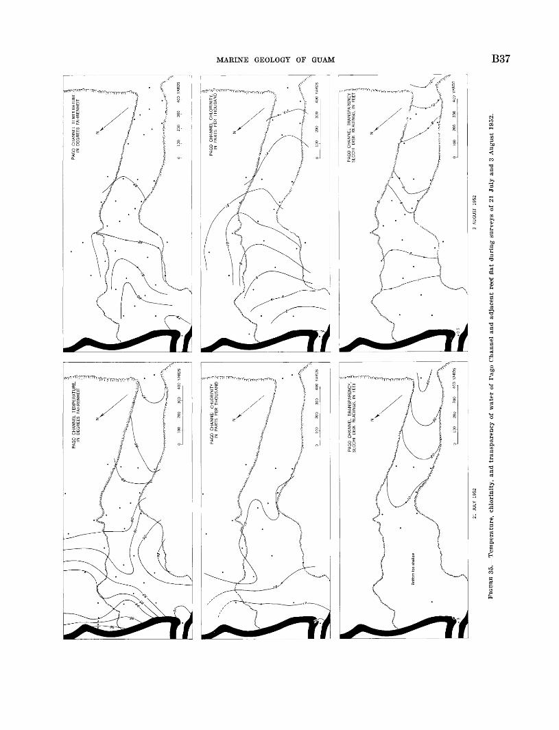
PA
GO
C
HA
NN
EL
TR
AN
SP
AR
EN
CY
S
EC
CH
I D
ISK
R
EA
DIN
GS
, IN
FE
ETP
AG
O
CH
AN
NE
L T
RA
NS
PA
RE
NC
Y
SE
CC
HI
DIS
K
RE
AD
ING
S,
IN
FEET
§
21 JULY 19
523 AUGUST 19
52
FIG
UR
E 3
5.
Tem
per
atu
re,
chlo
rinit
y,
and t
ransp
aren
cy o
f w
ater
of
Pag
o C
hann
el a
nd a
dja
cen
t re
ef f
lat
du
rin
g s
urve
ys o
f 21
Ju
ly a
nd 3
August
195
2.w C
O
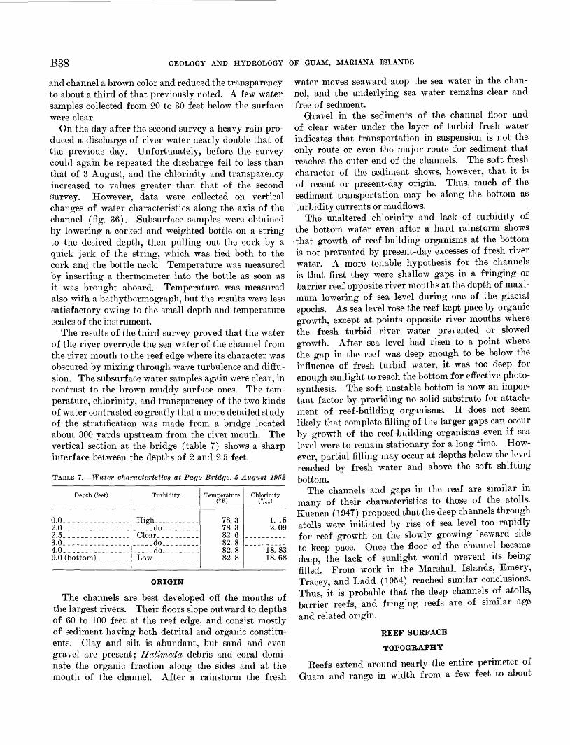
B38 GEOLOGY AND HYDROLOGY OF GUAM, MARIANA ISLANDS
and channel a brown color and reduced the transparency to about a third of that previously noted. A few water samples collected from 20 to 30 feet below the surface were clear.
On the day after the second survey a heavy rain pro duced a discharge of river water nearly double that of the previous day. Unfortunately, before the survey could again be repeated the discharge fell to less than that of 3 August, and the chlorinity and transparency increased to values greater than that of the second survey. However, data were collected on vertical changes of water characteristics along the axis of the channel (fig. 36). Subsurface samples were obtained by lowering a corked and weighted bottle on a string to the desired depth, then pulling out the cork by a quick jerk of the string, which was tied both to the cork and the bottle neck. Temperature was measured by inserting a thermometer into the bottle as soon as it was brought aboard. Temperature was measured also with a bathythermograph, but the results were less satisfactory owing to the small depth and temperature scales of the instrument.
The results of the third survey proved that the water of the river overrode the sea water of the channel from the river mouth to the reef edge where its character was obscured by mixing through wave turbulence and diffu sion. The subsurface water samples again were clear, in contrast to the brown muddy surface ones. The tem perature, chlorinity, and transparency of the two kinds of water contrasted so greatly that a more detailed study of the stratification was made from a bridge located about 300 yards upstream from the river mouth. The vertical section at the bridge (table 7) shows a sharp interface between the depths of 2 and 2.5 feet.
TABLE 7. Water characteristics at Pago Bridge, 5 August 1952
Depth (feet)
o.o_._. _ ___2.0 _2.5 _3.0___.__ ___ __4.0- __9.0 (bottom) _ _ ..
Turbidity
High_. _________do
__ do_____do_________
Temperature <°F)
78.378.382. 682.882.882. 8
Chlorinity(°/oo)
1. 152.09
18. 8318.68
OKIGIN
The channels are best developed off the mouths of the largest rivers. Their floors slope outward to depths of 60 to 100 feet at the reef edge, and consist mostly of sediment having both detrital and organic constitu ents. Clay and silt is abundant, but sand and even gravel are present; Halimeda debris and coral domi nate the organic fraction along the sides and at the mouth of the channel. After a rainstorm the fresh
water moves seaward atop the sea water in the chan nel, and the underlying sea water remains clear and free of sediment.
Gravel in the sediments of the channel floor and of clear water under the layer of turbid fresh water indicates that transportation in suspension is not the only route or even the major route for sediment that reaches the outer end of the channels. The soft fresh character of the sediment shows, however, that it is of recent or present-day origin. Thus, much of the sediment transportation may be along the bottom as turbidity currents or mudflows.
The unaltered chlorinity and lack of turbidity of the bottom water even after a hard rainstorm shows that growth of reef-building organisms at the bottom is not prevented by present-day excesses of fresh river water. A more tenable hypothesis for the channels is that first they were shallow gaps in a fringing or barrier reef opposite river mouths at the depth of maxi mum lowering of sea level during one of the glacial epochs. As sea level rose the reef kept pace by organic growth, except at points opposite river mouths where the fresh turbid river water prevented or slowed growth. After sea level had risen to a point where the gap in the reef was deep enough to be below the influence of fresh turbid water, it was too deep for enough sunlight to reach the bottom for effective photo synthesis. The soft unstable bottom is now an impor tant factor by providing no solid substrate for attach ment of reef-building organisms. It does not seem likely that complete filling of the larger gaps can occur by growth of the reef-building organisms even if sea level were to remain stationary for a long time. How ever, partial filling may occur at depths below the level reached by fresh water and above the soft shifting bottom.
The channels and gaps in the reef are similar in many of their characteristics to those of the atolls. Kuenen (1947) proposed that the deep channels through atolls were initiated by rise of sea level too rapidly for reef growth on the slowly growing leeward side to keep pace. Once the floor of the channel became deep, the lack of sunlight would prevent its being filled. From work in the Marshall Islands, Emery, Tracey, and Ladd (1954) reached similar conclusions. Thus, it is probable that the deep channels of atolls, barrier reefs, and fringing reefs are of similar age and related origin.
REEF SURFACE
TOPOGRAPHY
Reefs extend around nearly the entire perimeter of Guam and range in width from a few feet to about
100
200
DIS
TAN
CE
, IN
Y
AR
DS
FR
OM
PA
GO
R
IVER
B
RID
GE
TO
R
EEF
EDG
E50
0 60
0 70
0 80
0 90
0J_
__
__
__
__
__
L11
0012
001
30
0
84
6
O o
d
FIQ
UK
B 36.
Ver
tica
l se
ctio
n of
wat
er a
long
axi
s of
Pag
o C
hann
el.
w oo
B40 GEOLOGY AND HYDROLOGY OF GUAM, MARIANA ISLANDS
FIGURE 37. Achang Reef topography and surface composition.
MARINE GEOLOGY OF GUAM B41
2,500 feet. Where the reef is wide and well developed, as at Tarague, Pago, Togcha, Agana, and Tumon Bays, its outer edge is marked by an algal ridge that is cut locally by surge channels. The reef flat inshore of the algal ridge is fairly horizontal, but is given a degree of minor irregularity by small colonies of reef coral that project a foot or so above the general level. Gen erally the smoothest areas are in the inshore half of the reef flat. The surface of most reefs is within 1 foot of the level of lowest low tide, but in 2 areas (western Achang Reef and Agana Bay, figs. 37, 45) depths of about 2 feet are common in belts parallel to shore.
COMPOSITION
Most of the information about the composition of the reef flat came from the Achang Reef (east of Cocos Lagoon) and from Pago Bay. Additional but briefer studies were made of the reef surface at Agana and of other reefs opposite some of the beach profiles (tableS).
TABLE 8. Composition of reef-flat sediments, in percent
Reef
AchangCocosAganaPago
Weighted av-pT*orrp
Num ber of sam ples
90?,f>^?,30
Fo- rami- nifera
4168
4
Shells
?51832?A
?A
Fine sand and silt
41fi3
4
Hali- meda debris
17768
13
Madre- porarian
coral
57
4131
5
Calcar eous red
algae
03
1026
5
ACHANG REEF
At Achang Reef 90 samples were taken by wading across the reef flat at low tide or by using the launch SES 800 at high tide. Just as for Cocos Lagoon, between sampling sites the percentage of bottom that consisted of sand and dead or living coral was estimated visually, except where the water was so deep or so turbid that the bottom could not be seen. The results (fig. 37) indicate that the inner half of the reef flat is dominantly of sand, in part covered by patches of the ribbonlike Enhalus. Abundant mounds of sand 1 to 3 feet in diameter and several inches high (fig. 38) are made by burrowing activities of echiuroid worms, ac cording to A. B. Bronson, of Agana. The outer half of the reef and the areas bordering the deep channel of Achang Bay consist chiefly of coral, reef rock, and algal pavement with sand occurring only in pockets or as a thin mat on the surface. Samples of the sand from both inner and outer halves of the reef flat were ex amined microscopically, and the percentages of detrital grains, Foraminifera, shells, Halimeda debris, coral, calcareous red algae, and fine sand and silt were deter-
FIGUEE 38. General view of mounds made by echluroid worms on inner half of Achang Reef off Manell Point.
mined just as was done for the samples from Cocos Lagoon. The distribution of these constituents atop the reef surface proved to be monotonously uniform and dominated by comminuted coral (fig. 39). Hali- meda debris (fig. 37) presents the greatest variation; the highest concentrations are on the deep reef flat west of Achang Bay, and the lesser ones are near the reef edge, along part of the deep channel, and at some beaches. Fine sand and silt is abundant only in the deep channel and along the shore at its head. Detrital grains average 25 percent in the beach samples, but are rare beyond about 200 feet from shore.
Each of the samples was classified according to its dominant constituent and plotted on figure 37, a gen eralized sediment map. This map shows the domi nance of coral sand with most variations occurring at the edge of the reef flat.
PAGO BAY
The sediments of the reef flat at Pago Bay (fig. 43), like those at Achang Bay, are not dominated by any one constituent, but contain approximately equal per centages of several kinds of organic remains (figs. 40, 44). Foraminiferal sand is most abundant, 10 to 20 percent, about midway across the southern reef and some of the beaches. Shells are about twice as abun dant as Foraminifera and have a similar distribution though slightly nearer the outer edge of the reef. Fine sand and silt presents a pattern of decreasing concentra tion outward from the mouth of Pago River and is vir tually absent on the reef flat. This material, evidently contributed by Pago River, is of volcanic origin and not bioclastic like the rest of the reef flat sediment. Hali- media debris is most abundant, 20 to 35 percent, along
B42 GEOLOGY AND HYDROLOGY OF GUAM, MARIANA ISLANDS
FIGURE 39. Sample 94 ; Agana Bay ; lat 13°28.9' N., long 144°4,5.5' E.; FIGURE 40. Sample 649 ; Pago Bay ; lat 13°25.4' N., long 144°47.4' E.;1 foot. Reef sand composed chiefly of comminuted coral and shells. 1 foot. Reef sand composed dominantly of comminuted coral andX3%. calcareous red algae. X3%.
FIGURE. 41. Sample 201 ; Cocos Island; lat 1S°14.3' N., long 144°39.1' E. Beach sand consisting dominantly of Foraminifera and com minuted coral. X3%.
FIGURE 42. Sample 7; Agfayan Bay; lat 13°15.9' N., long 149°44.2' E. Beach sand composed of inorganic detrital grains (mostly serpentine, hornblende, and plagioclase) that comprise 38.5 percent of whole sample; remainder is mostly comminuted coral and shells. X3%.
SEDIMENTS FROM REEF FLATS AND BEACHES
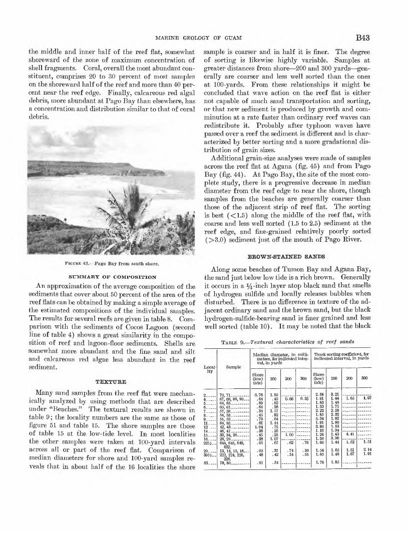
MARINE GEOLOGY OF GUAM B43
the middle and inner half of the reef flat, somewhat shoreward of the zone of maximum concentration of shell fragments. Coral, overall the most abundant con stituent, comprises 20 to 30 percent of most samples on the shoreward half of the reef and more than 40 per cent near the reef edge. Finally, calcareous red algal debris, more abundant at Pago Bay than elsewhere, has a concentration and distribution similar to that of coral debris.
'<,*&_¥-~ -.
FIGURE 43. Pago Bay from south shore.
SUMMARY OF COMPOSITION
An approximation of the average composition of the sediments that cover about 50 percent of the area of the reef flats can be obtained by making a simple average of the estimated compositions of the individual samples. The results for several reefs are given in table 8. Com parison with the sediments of Cocos Lagoon (second line of table 4) shows a great similarity in the compo sition of reef and lagoon-floor sediments. Shells are somewhat more abundant and the fine sand and silt and calcareous red algae less abundant in the reef sediment.
TEXTURE
Many sand samples from the reef flat were mechan ically analyzed by using methods that are described under "Beaches." The textural results are shown in table 9 ; the locality numbers are the same as those of figure 51 and table 15. The shore samples are those of table 15 at the low-tide level. In most localities the other samples were taken at 100-yard intervals across all or part of the reef flat. Comparison of median diameters for shore and 100-yard samples re veals that in about half of the 16 localities the shore
sample is coarser and in half it is finer. The degree of sorting is likewise highly variable. Samples at greater distances from shore 200 and 300 yards gen erally are coarser and less well sorted than the ones at 100-yards. From these relationships it might be concluded that wave action on the reef flat is either not capable of much sand transportation and sorting, or that new sediment is produced by growth and com minution at a rate faster than ordinary reef waves can redistribute it. Probably after typhoon waves have passed over a reef the sediment is different and is char acterized by better sorting and a more gradational dis tribution of grain sizes.
Additional grain-size analyses were made of samples across the reef flat at Agana (fig. 45) and from Pago Bay (fig. 44). At Pago Bay, the site of the most com plete study, there is a progressive decrease in median diameter from the reef edge to near the shore, though samples from the beaches are generally coarser than those of the adjacent strip of reef flat. The sorting is best (<1.5) along the middle of the reef flat, with coarse and less well sorted (1.5 to 2.5) sediment at the reef edge, and fine-grained relatively poorly sorted (>3.0) sediment just off the mouth of Pago Eiver.
BROWN-STAINED SANDS
Along some beaches of Tumon Bay and Agana Bay, the sand just below low tide is a rich brown. Generally it occurs in a %-inch layer atop black sand that smells of hydrogen sulfide and locally releases bubbles when disturbed. There is no difference in texture of the ad jacent ordinary sand and the brown sand, but the black hydrogen-sulfide-bearing sand is finer grained and less well sorted (table 10). It may be noted that the black
TABLE 9. Textural characteristics of reef sands
ity
2- 4__ 5- 6- 7 8_
11_ 12_ 14- 15- 16 _ .22^-.
29_ _ 39J,___
53_
70, 71 - 67, 68, 88, 90-64, 65 _ -60, 61
54, 55__ -- -
84, 85 42, 43 46, 47 -
28, 29 - 644, 645, 649,
652.13, 14, 15, 16 _222, 224, 226,
228.79, 80
Median diameter, in milli meters, for indicated interval, in yards
ShoreQow)tide)
0.76.64.89.64
.457O
.61
.38
.38
.65
.60
.48
.91
100
1.50.45.52.26
1.17.9264
1.447>;
.25
1.07 .67
.37
.42
.54
200
0.66
1 60~~V62~
.74
.54
300
0.35
- -
"."76"
.50
.55
Trask sorting coefficient, for indicated interval, in yards
Shore(low)tide)
2.581.911.831.339 991.855 341.91S on
1.10 1.241.50 1.60
1.54 1.85
1.76
100
3.211.441.481.712 CO
2.321.921.80
1.34 1.433.36 1.44
1.65 1.48
1.85
200
1.65
_______
"Til"
"~L52
1.51 1.67
300
1.97
____
...... .
""I.ll
2.14 1.91
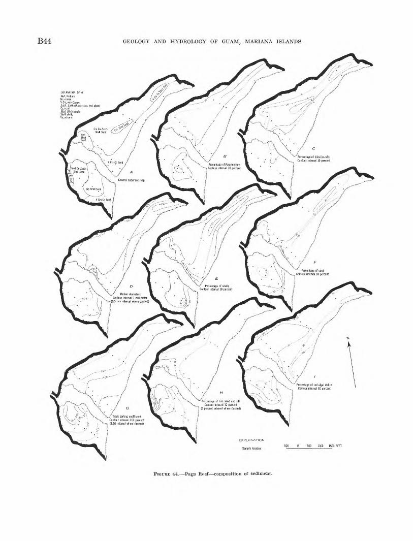
B44 GEOLOGY AND HYDROLOGY OF GUAM, MARIANA ISLANDS
EXPLANATION OF A Med, medium
V Crs, very CoarseLitk, Lilhothamnion (red algae)Co. coralHal, HtdimednShell, shellyVo, volcanic
Percentage of Halimeda Contour interval 10 percent
rcentage of Forammifi Contour interval 10 perc
Percentage of coral Contour interval 10 percent
Percentage of shells Contour interval 10 percent
Median diametersContour interval 1 millimeter
(0.5 mm interval where dashed)
Percentage of red algal deb Contour interval 10 percen
f Trask sorting coefficient Contour mterva, 1 00 percent (1.50 interval where dashed)
FIGURE 44. Pago Reef composition of sediment.
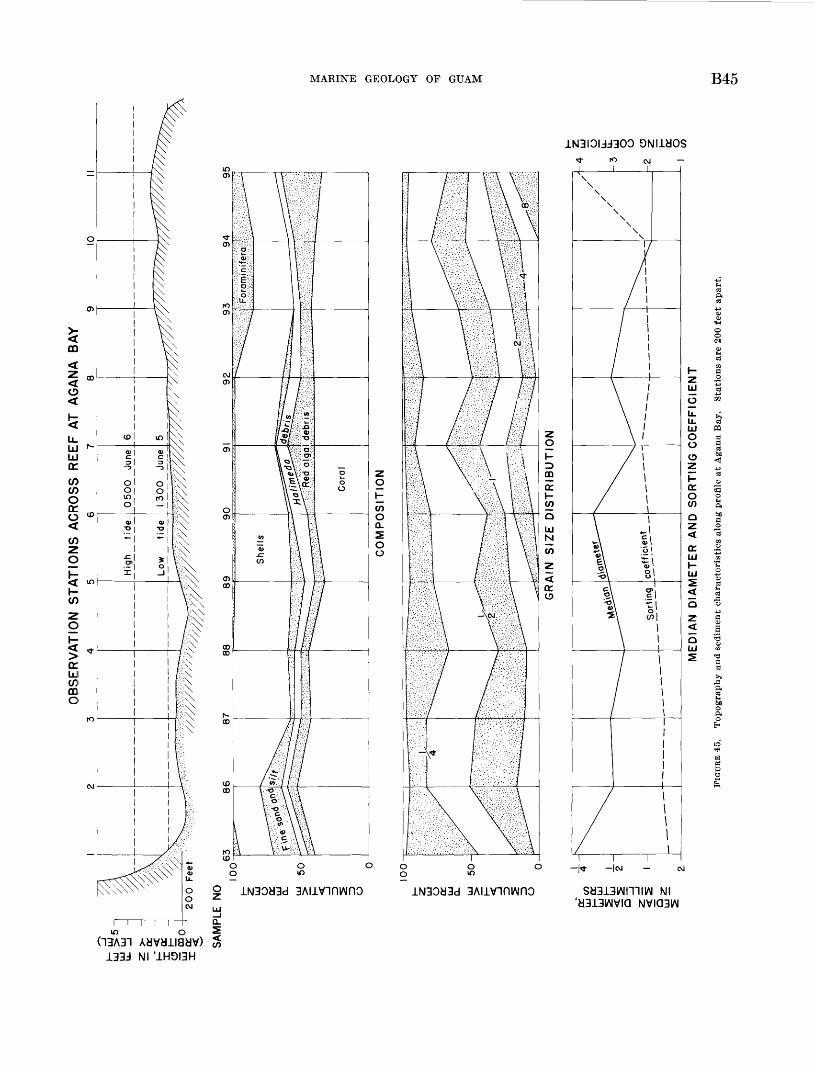
HEIGHT, IN FEETg (ARBITRARY LEVEL) 2 o 01 0 J L_L
MEDIAN DIAMETER, IN MILLIMETERSCUMULATIVE PERCENT
SORTING COEFFICIENT
HVflDAD0103D
B46 GEOLOGY AND HYDROLOGY OF GUAM, MARIANA ISLANDS
sand is unusually fine grained for reef-flat sediment containing no volcanic debris. Why the black sedi ments should originally be finer with a probably higher- than-normal organic content is not known, but holo thurians evidently have discovered that fact themselves because they seem to be more abundant in the areas of black hydrogen-sulfide-bearing sand than elsewhere.
TABLE 10. Brown sands of reef flat near Tumon Bay
Median diameter __ millimeters __
FeO __ -percent
Nitrogen_ _ do
Type of sand
Ordi nary
60
0. 64 1. 33
. 11
. 20
.06
. 00
Brown
62
0. 64 1. 36
. 17
. 39
.05
.00
268
0 69 1 42
09 20 04 04
Black
269
0 25 2 00
10 19 06 00
It is believed that the hydrogen sulfide is formed through activities of sulfate-reducing bacteria (Emery and Eittenberg, 1952) during the process of oxidation of organic matter that ordinarily is most abundant in finer grained sediments. Reaction of hydrogen sulfide with iron from organic matter or limonite is known to form black iron monosulfides, which accounts for the blackness of the subsurface sediment. Exposure of this sediment through organic activities or wave action should result in oxidation of the iron to limonite or a related brown iron mineral, which need not be present in large quantities to contribute a brown color to the sediment. As this color is clearly a surface stain, it can easily be removed by abrasion between grains on the beach, so that the unstained beach sands are of the same grain size as the brown sands a few feet away.
Chemical analyses (table 10) fail to support- this theory, for they show no definite change in the ratio of FeO toFe2O 3 ; perhaps because in the analyses it is necessary to include the iron within the grains as well as that of the surface stain. Similarly, the organic carbon and nitrogen are so low that differences are not reliably indicated by these chemical methods.
EFFECTS OF HOLOTHUBIANS
Whenever the reef surface is sandy, it supports scattered holothurians. Parts of the landward side of the reef at Tumon Bay have an average of perhaps 1 per square yard, but on the reefs at Agana, Pago, and Achang Bays and Tarague Beach holothurians are much less abundant. More than 95 percent of the
holothurians are Holothuria atra Jager, as identified by Elizabeth Deichman, of the Museum of Comparative Zoology, Harvard University.
The geologic work of holothurians is of two types: transportation and alteration. Transportation fol lowed by deposition and mixing occurs through travels of the animal in search of better feeding grounds, the sediment being liberated in the form of fecal castings. Also important geologically is the alteration of sedi ment as it passes through the digestive tract of the animals. Some preliminary investigations in the Mar shall Islands (Emery and others, 1954, p. 100) showed that the acidity of the intestinal tract modifies cal careous sediment by solution of the smaller grains (largely parts of the calcareous binding alga, Jania) that have a greater surface area per unit volume than have ordinary sand grains. Grain-size measurements by Bertram (1936) seem to lead to a similar conclusion. These results differ from those of Yamanouti (1939) who found no change in the sediments ingested by holothurians at Palau. Further study to resolve these differences was in order at Guam.
On 6 and 22 August a series of pH measurements were made on holothurians of Tumon Bay (table 11). The results show that the intestinal fluids are much more acid than the sea water in which the holothurians live and that mixing of the fluids with the calcareous sand in the intestines causes the sediment to become progressively more acid during its passage through the intestine. At the same time, of course, the acid in the intestinal fluid becomes neutralized by reaction with the calcium carbonate. The pH of the calcareous material proved to be variable and subject to change during ex posure to air; the measurements therefore, had to be made quickly. To find the pH of the fluid alone, holothurians that contained little or no sediment at the times were selected. Values of 6.9 pH are fully capable of dissolving calcium carbonate at the existing temperature and chlorinity. Even lower pH's of 5 to 6.7 were found in specimens of Stichopus inobii from Bermuda (Crozier, 1918) and in various holothurians from Palau by Yamanouti (1939). Experiments by Mayor (1924) at Tortugas, Fla., showed that a speci men of S. mobi'i dissolved calcareous sand at a rate of 414 grams per year, supposedly about 1 percent of all the sediment that it ingests. Probably modification of the sand is by chemical action alone because the in testines are too thin and weak to exert mechanical pressure to fracture sand grains, and in fact Crozier and other investigators have even found living Fora- minifera, copepods, and other small animals in the feces of holothurians.
MARINE GEOLOGY OF GUAM B47
TABLE 11. Acidity (pH) of holothurians
[Figures in parentheses indicate number of specimens tested]
Time
Afternoon....
Temper ature (°F)
84 81
Seawater
Chlorin- ity
(%o)
18± 17.48
PH
8.25 7.85
]
Mouth
7.51 (5) 7.61 (4)
Jolothurians
Anus
7.40 (5) 7.32 (6)
Fluids
6.90 (1) 6.88 (5)
A more direct way of evaluating the effect of holothu- rians on sand is to study the sands themselves through visual examination, grain-size distribution, and per centage of insoluble residue. The sand that the holothurians were resting upon and the sand in their intestines showed no obvious differences when viewed with a binocular microscope. Moreover, both sands contain a wide range of grain sizes from silt to granules. To avoid erratic biasing effects of a few very large grains on the median diameter of small samples, it was decided to omit grains coarser than 1 mm. from the grain-size analyses. The samples from Pago Bay offer ed a unique method of estimating the effect of holothu rians on the calcareous grains. These samples contain insoluble detrital grains mostly of feldspar, serpentine, and hornblende whose weight ratio to calcareous grains should increase on partial solution of the latter.
The results (table 12) show that the sediment in 4 of the 5 holothurians underwent a loss of grains finer than one-half millimeter with respect to grains between 1/2 and 1 mm. This loss is just what would be expected if acid removed a layer of equal thickness from the sur face of all grains. Removal by solution of some of the finer grains is also indicated by an increase in the per centage of insoluble residue in the sand during its passage through the animal. Irregularities in table 12 and consequent uncertainties in interpretation result from the fact that holothurians are animals that move about during their feeding and also are capable of some selection of the sediment to be ingested.
TABLE 12. Changes in sediment ingested 'by holothurians
[Weight of 1- to Mi-mm fraction divided by weight of <}4-mm fraction (samples range in weight from 0.4 to 6 g). Underscored items indicate the insoluble residue in the < J-^-mm fraction, in percent]
Place
Tumon Bay__
Pago Bay___
Sample
270, 271, 272 690, 691, 692287, 288, 289
667, 668, 669
670, 671, 672
Sand surface
0. 29 . 62
0.30 7.6 0. 96
14. 50.58
12. 6
Holothurians
Mouth
0. 34 .51. 84
0. 27 30.2
1. 22 12. 4
Middle
1.30 8.0
Anus
0.36 .25
1. 308. 7 0. 44
33. 71. 72
12. 6
WATER CHARACTERISTICS
METHODS OF STUDY
During 1946 a series of water measurements (tem perature, chlorinity, oxygen, depth, velocity) was made for the reef flat that separates the lagoon of Rongelap Atoll from the open sea (Sargent and Austin, 1949). As no similar work had been reported for a fringing reef, a study was planned for the wide reef flat, of Agana Bay.
In preparation for the study 8-foot steel rods were driven into the reef 200 feet apart in a profile at beach locality 4 (fig. 51) from shore to the reef edge. The bottom along this line consists chiefly of algal pavement and coral in the outer half and of sand underlain by reef rock in the inner half. The outer half is shallower, and at low tide much of it is exposed above water (fig. 45). In contrast, the inner half is so deep that part of it is covered by as much as IVz feet of water at low tide. The depth and distance relationship is re flected in the grain size of sediment samples, such that the samples from the outer half were much coarser, with less fine sand and silt and more calcareous red algae and Foraminifera than the inshore area (fig. 45).
Six series of water samples at each of the 11 sta tions were collected at approximately 4-hour inter vals from 0900 5 July to 0620 6 July. Collections and observations of temperature, tide height, and cur rent direction were made by Stuart Keesling, Harold May, Seymour Schlanger, and Joshua Tracey working in pairs by shifts.
The current, was measured by noting the time re quired for a largely submerged float to move a measured distance. At high tide the traverse was made by skiff (fig. 46) and at low tide by wading and towing the skiff at least part of the way to serve as a storage depot. After each series the samples were returned to the laboratory where analyses were made by David B. Doan and the author.
Chlorinity was determined by titration with silver nitrate using a potassium chromate indicator. Oxygen was analyzed using the standard Winkler method by which oxygen in the water oxidizes manganous hydrox ide, which, in the presence of sulfuric acid, liberates free iodine from potassium iodide. The free iodine is titrated with sodium thiosulfate. Hydrogen-ion con centration, pH, was measured directly with a Heilige pH-meter using a calomel and a glass electrode. Alka linity (the equivalent concentration of strong bases balanced against weak acids carbonate, bicarbonate, and borate) was determined by adding an excess of hydrochloric acid to a filtered sample of water, boiling
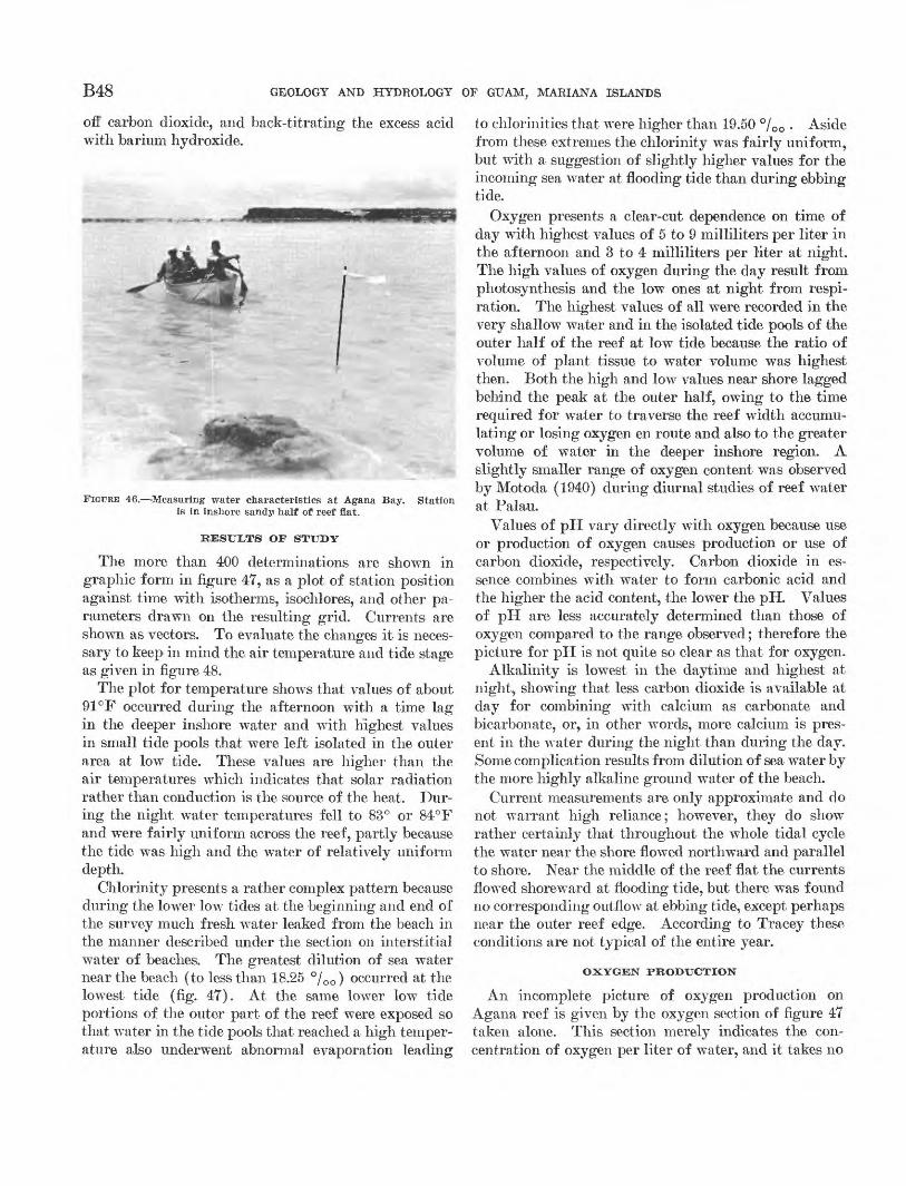
B48 GEOLOGY AND HYDROLOGY OF GUAM, MARIANA ISLANDS
off carbon dioxide, and back-titrating the excess acid with barium hydroxide.
FIGURE 46. -Measuring water characteristics at Agana Bay. Station Is In inshore sandy half of reef flat.
RESULTS OF STUDY
The more than 400 determinations are shown in graphic form in figure 47, as a plot of station position against time with isotherms, isochlores, and other pa rameters drawn on the resulting grid. Currents are
D O
shown as vectors. To evaluate the changes it is neces sary to keep in mind the air temperature and tide stage as given in figure 48.
The plot for temperature shows that values of about 91 °F occurred during the afternoon with a time lag in the deeper inshore water and with highest values in small tide pools that were left isolated in the outer area at low tide. These values are higher than the air temperatures which indicates that solar radiation rather than conduction is the source of the heat. Dur ing the night, water temperatures fell to 83° or 84°F and were fairly uniform across the reef, partly because the tide was high and the water of relatively uniform depth.
Chlorinity presents a rather complex pattern because during the lower low tides at the beginning and end of the survey much fresh water leaked from the beach in the manner described under the section on interstitial water of beaches. The greatest dilution of sea water near the beach (to less than 18.25 °/00 ) occurred at the lowest tide (fig. 47). At the same lower low tide portions of the outer part of the reef were exposed so that water in the tide pools that reached a high temper ature also underwent abnormal evaporation leading
to chlorinities that were higher than 19.50 °/00 . Aside from these extremes the chlorinity was fairly uniform, but with a suggestion of slightly higher values for the incoming sea water at flooding tide than during ebbing tide.
Oxygen presents a clear-cut dependence on time of day with highest values of 5 to 9 milliliters per liter in the afternoon and 3 to 4 milliliters per liter at night. The high values of oxygen during the day result from photosynthesis and the low ones at night from respi ration. The highest values of all were recorded in the very shallow water and in the isolated tide pools of the outer half of the reef at low tide because the ratio of volume of plant tissue to water volume was highest then. Both the high and low values near shore lagged behind the peak at the outer half, owing to the time required for water to traverse the reef width accumu lating or losing oxygen en route and also to the greater volume of water in the deeper inshore region. A slightly smaller range of oxygen content was observed by Motoda (1940) during diurnal studies of reef water at Palau.
Values of pH vary directly with oxygen because use or production of oxygen causes production or use of carbon dioxide, respectively. Carbon dioxide in es sence combines with water to form carbonic acid and the higher the acid content, the lower the pH. Values of pH are less accurately determined than those of oxygen compared to the range observed; therefore the picture for pH is not quite so clear as that for oxygen.
Alkalinity is lowest in the daytime and highest at night, showing that less carbon dioxide is available at day for combining with calcium as carbonate and bicarbonate, or, in other words, more calcium is pres ent in the water during the night than during the day. Some complication results from dilution of sea water by the more highly alkaline ground water of the beach.
Current measurements are only approximate and do not warrant high reliance; however, they do show rather certainly that throughout the whole tidal cycle the water near the shore flowed northward and parallel to shore. Near the middle of the reef flat the currents flowed shoreward at flooding tide, but there was found no corresponding outflow at ebbing tide, except perhaps near the outer reef edge. According to Tracey these conditions are not typical of the entire year.
OXYGEN PRODUCTION
An incomplete picture of oxygen production on Agana reef is given by the oxygen section of figure 47 taken alone. This section merely indicates the con centration of oxygen per liter of water, and it takes no
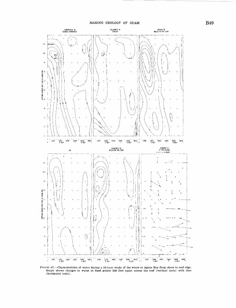
MARINE GEOLOGY OF GUAM B49
1200 1600 2000 2400 0400 0800 1200 1600 2000 2400 0400 0800 1200 1600 2000 2400 04005 JULY I 6 JULY I I 5 JULY I 6 JULY I I 5 JULY I 6 JULY I
ALKALINITY, IN MILLILITER PER LITER
FIGURE 47. Characteristics of water during a 24-hour study of the water at Agana Bay from shore to reef edge. Graph shows changes in water at fixed points 200 feet apart across the reef (vertical scale) with time (horizontal scale).
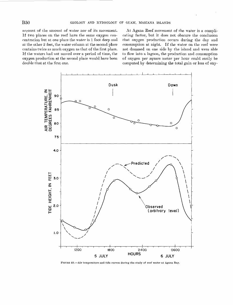
B50 GEOLOGY AND HYDROLOGY OF GUAM, MARIANA ISLANDS
account of the amount of water nor of its movement. If two places on the reef have the same oxygen con centration but at one place the waiter is 1 foot deep and at the other 2 feet, the water column at the second place contains twice as much oxygen as that of the first place. If the waters had not moved over a period of time, the oxygen production at the second place would have been double that at the first one.
At Agana Reef movement of the water is a compli cating factor, but it does not obscure the conclusion that oxygen production occurs during the day and consumption at night. If the water on the reef were not dammed on one side by the island and were able to flow into a lagoon, the production and consumption of oxygen per square meter per hour could easily be computed by determining the total gain or loss of oxy-
Observed \ \ (arbitrary level)
1200 1800 2400HOURS
060O
5 JULY HOURS g J(JLY
FIGURE 48. Air temperature and tide curves during the study of reef water at Agana Bay.
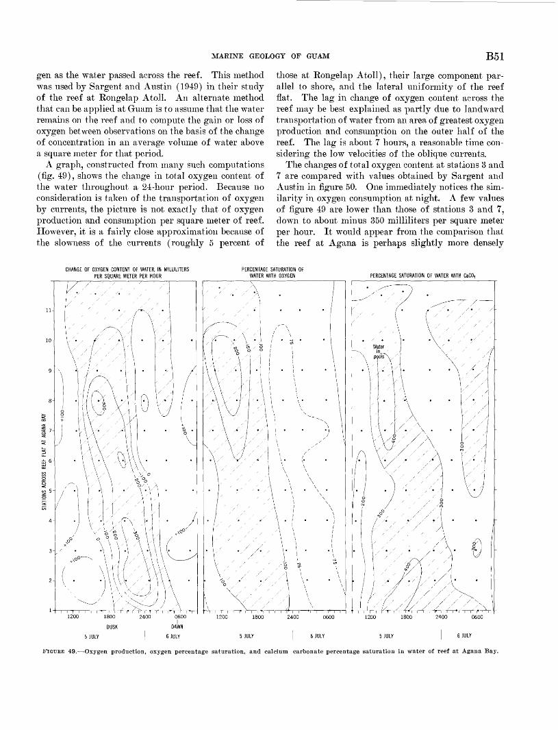
MARINE GEOLOGY OF GUAM B51
gen as the water passed across the reef. This method was used by Sargent and Austin (1949) in their study of the reef at Rongelap Atoll. An alternate method that can be applied at Guam is to assume that the water remains on the reef and to compute the gain or loss of oxygen between observations on the basis of the change of concentration in an average volume of water above a square meter for that period.
A graph, constructed from many such computations (fig. 49), shows the change in total oxygen content of the water throughout a 24-hour period. Because no consideration is taken of the transportation of oxygen by currents, the picture is not exactly that of oxygen production and consumption per square meter of reef. However, it is a fairly close approximation because of the slowness of the currents (roughly 5 percent of
those at Rongelap Atoll), their large component par allel to shore, and the lateral uniformity of the reef flat. The lag in change of oxygen content across the reef may be best explained as partly due to landward transportation of water from an area of greatest oxygen production and consumption on the outer half of the reef. The lag is about 7 hours, a reasonable time con sidering the low velocities of the oblique currents.
The changes of total oxygen content at stations 3 and 7 are compared with values obtained by Sargent and Austin in figure 50. One immediately notices the sim ilarity in oxygen consumption at night. A few values of figure 49 are lower than those of stations 3 and 7, down to about minus 350 milliliters per square meter per hour. It would appear from the comparison that the reef at Agana is perhaps slightly more densely
CHANGE OF OXYGEN CONTENT OF WATER, IN MILLILITERS PER SQUARE METER PER HOUR
PERCENTAGE SATURATION OF WATER WITH OXYGEN PERCENTAGE SATURATION OF WATER WITH CaCOs
i r i I r~"i I I i I I i H i I I
1200 1800 2400 0600
5 JULY 6 JULY
FIGURE 49. Oxygen production, oxygen percentage saturation, and calcium carbonate percentage saturation in water of reef at Agana Bay.
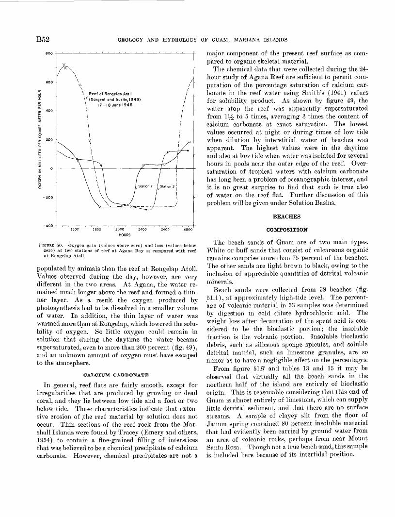
B52 GEOLOGY AND HYDROLOGY OF GUAM, MARIANA ISLANDS
-400
FIGURE 50. Oxygen gain (values above zero) and loss (values below zero) at two stations of reef at Agana Bay as compared with reef at Rongelap Atoll.
populated by animals than the reef at Rongelap Atoll. Values observed during the day, however, are very different in the two areas. At Agana, the water re mained much longer above the reef and formed a thin ner layer. As a result the oxygen produced by photosynthesis had to be dissolved in a smaller volume of water. In addition, the thin layer of water was warmed more than at Rongelap, which lowered the solu bility of oxygen. So little oxygen could remain in solution that during the daytime the water became supersaturated, even to more than 200 percent (fig. 49), and an unknown amount of oxygen must have escaped to the atmosphere.
CALCIUM CARBONATE
In general, reef flats are fairly smooth, except for irregularities that are produced by growing or dead coral, and they lie between low tide and a foot, or two below tide. These characteristics indicate that exten sive erosion of ,the reef material by solution does not occur. Thin sections of the reef rock from the Mar shall Islands were found by Tracey (Emery and others, 1954) to contain a fine-grained filling of interstices that was believed to be a chemical precipitate of calcium carbonate. However, chemical precipitates are not a
major component of the present reef surface as com pared to organic skeletal material.
The chemical data that were collected during the 24- hour study of Agana Reef are sufficient to permit com putation of the percentage saturation of calcium car bonate in the reef water using Smith's (1941) values for solubility product. As shown by figure 49, the water atop the reef was apparently supersaturated from 11/2 to 5 times, averaging 3 times the content of calcium carbonate at exact saturation. The lowest values occurred at night or during times of low tide when dilution by interstitial water of beaches was apparent. The highest values were in the daytime and also at low tide when water was isolated for several hours in pools near the outer edge of the reef. Over- saturation of tropical waters with calcium carbonate has long been a problem of oceanographic interest, and it is no great surprise to find that such is true also of water on the reef flat. Further discussion of this problem will be given under Solution Basins.
BEACHES
COMPOSITION
The beach sands of Guam are of two main types. White or buff sands that consist of calcareous organic remains comprise more than 75 percent of the beaches. The other sands are light brown to black, owing to the inclusion of appreciable quantities of detrital volcanic minerals.
Beach sands were collected from 58 beaches (fig. 5 Li), at approximately high-tide level. The percent age of volcanic material in 53 samples was determined by digestion in cold dilute hydrochloric acid. The weight loss after decantation of the spent acid is con sidered to be the bioclastic portion; the insoluble fraction is the volcanic portion. Insoluble bioclastic debris, such as siliceous sponge spicules, and soluble detrital matrial, such as limestone granules, are so minor as to have a negligible effect on the percentages.
From figure 51B and tables 13 and 15 it may be observed that virtually all the beach sands in the northern half of the island are entirely of bioclastic origin. This is reasonable considering that this end of Guam is almost entirely of limestone, which can supply little detrital sediment, and that there are no surface streams. A sample of clayey silt from the floor of Janum spring contained 80 percent insoluble material that had evidently been carried by ground water from an area of volcanic rocks, perhaps from near Mount Santa Rosa. Though not a true beach sand, this sample is included here because of its intertidal position.
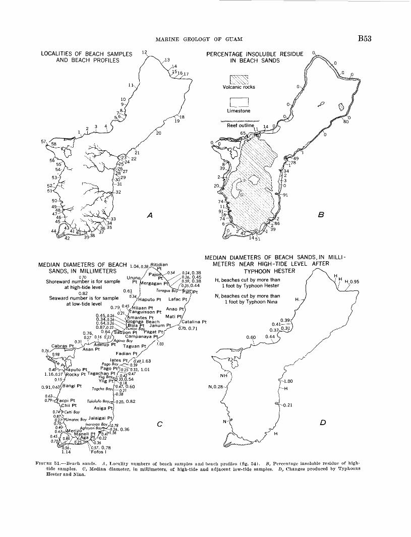
MARINE GEOLOGY OF GUAM B53
LOCALITIES OF BEACH SAMPLES 12S AND BEACH PROFILES
PERCENTAGE INSOLUBLE RESIDUE IN BEACH SANDS
39
14 51
0.24,0.38 0.26, 0.45 0.59, 0.38
!5,0.44
MEDIAN DIAMETERS OF BEACH : 04 038 Ritidian SANDS, IN MILLIMETERS ' ' ^^
°U° 4 , UrUn°<Shoreward number is for sample Pt at high-tide level
0.82 °' 6£ Seaward number is for sample
at low-tide level0.79
0\2 i '/Tanguisson Pt^Amantes Pt Mati P*y
Beach /Catalina Pt
n ^----VY JanUm P^70, 0.71 076 0.64/Sttrpon Pt Pagat ~' 0.27' O.J6 o!23 ) Campanaya
03) '\^Jk__\-^A Cabras ptV^^Adelup Pt
076/ T=Y~'^Asan Pt '' Fadian Pt
MEDIAN DIAMETERS OF BEACH SANDS, IN MILLI METERS NEAR HIGH-TIDE LEVEL AFTER
TYPHOON HESTER
H, beaches cut by more than 1 foot by Typhoon Hester
N, beaches cut by more than 1 foot by Typhoon Nina
H 0.95
1.16,0.2lARocky Pt TaSachan 0.15-/ YMg
0.91,0.63/Bangi Pt ^^
, 1.01
0.63o.;
).38
Talofofo Boyc^_o.20, 0.82
Asiga Pt)0.74-^ Ceffi Boy°6827!^umotoc 8oy Jalaigai Pt, 0.70--\ (noro/on 0.4^" 0.4
0.45°'7^
1.14
.26, 0.36 56
D
FIGURE 51. Beach sands. A, Locality numbers of beach samples and beach profiles (fig. 54). B, Percentage insoluble residue of high- tide samples. C, Median diameter, in millimeters, of high-tide and adjacent low-tide samples. D, Changes produced by Typhoons Hester and Nina.
B54 GEOLOGY AND HYDROLOGY OF GUAM, MARIANA ISLANDS
A more complex provenance exists in the southern half of Guam where the surface rocks are dominantly of volcanic types, and where large streams that drain the area debouch at the heads of coastal embayments. Characteristically, the sands at the heads of these em bayments contain large percentages of insoluble, or volcanic, grains (fig. 42). Samples from each of two such areas contain 91 percent volcanic grains. Between the embayments relatively straight coasts lie inshore of wide reef flats. These areas have beaches composed of bioclastic sands that generally contain less than 2 percent insoluble grains, or none at all. Evidently, the bioclastic sand from the reefs is washed ashore to the adjacent beaches and little of it enters the em bayments, particularly embayments of the type whose sides have only narrow reefs. In turn, the volcanic sands that are brought by streams are prevented from leaving the embayments by wave wash from the sea. Little detrital sand is contributed by sea cliffs because they consist chiefly of limestone, or, where of volcanic rock, they are protected from much wave erosion by the quiet water of wide reef flats.
A third and intermediate beach environment exists on the west coast between Umatac and Agat (fig. 51A-C) where the volcanic rocks reach the coast and form sea cliffs that are subject to wave erosion. In this area almost the entire beach is supplied with sedi ment from both land and the reef flat. As a result the beaches consist of a mixture of bioclastic and vol canic sediment with neither being overwhelmingly dominant.
The volcanic sand grains were separated from the calcareous ones as insoluble residues and split into heavy and light fractions in acetylene tetrabromide. Identifications were made with a petrographic micro scope and frequency estimates with a, binocular micro scope. The predominant detrital mineral is serpentine that is present as brown to green rounded masses having specific gravity varying between slightly less than jto slightly more than acetylene tetrabromide, so that serpentine occurs in both the light and the heavy fractions. Presumably it is an alteration or weather ing product of olivine. Hornblende, augite, and oli- vine are common; magnetite fairly common; and biotite and an opaque spinel, picotite, relatively rare. The light minerals consist of plagioclase, volcanic glass, and some quartz. Percentage frequency of minerals in two beach sands are included in table 13. Chemical analyses of the acid-insoluble fraction of the two detrital beach sands are given in table 14. The results show higher Fe2O3 , higher A12O3 , and lower MgO than might be expected from the mineral composition. Possibly this is a reflection of the basic nature of the rocks of Guam
and the variable composition of the olivine, augite, hornblende, and serpentine minerals derived from these rocks.
TABLE 13. Composition of beach sands, in percent
Shells-.
Coral. Calcareous red algae.
A-tisite
5 63
100 5 25 20 5
35 10 0 0
6 59
100 1
38 01
55 5 0 0
11 83
100 2 10 0 1
77 10 0 0
15 32
100 1
20 0 15 50 14 0 0
20 26
100 1
44 0 20 20 15 0 0
23 109
44.3 2 15 1 0 65 17 0 55.7 2.3
20.133.2
.07.610.914 36.01.93.5.2
31 193
100 12 30 0 15 13 30 0 0
367
61.5 1
38 0 0
25 35 1
38.5 1.0
20.240.4
.218.46 17 34.3.6.51.0
41 2
98.0 0 39 0 1
20 40 0 2.0
43 201
100 58 5 0 2
20 15 0 0
5378
98.0 2
50 1 3 15 27 2 2.0
TABLE 14. Composition of detrital beach sands partial chemical analyses
[Analyses by Mitsui Chemical Co., Tokyo, Japan]
SiO2_ --- - - ---- FpiOiA12O3- -----------------------------Cr2O3 ----------------------------CaO -_-._-__--__-_-_____---------MgO-__-_---_---_--_--__-----------K2O-_. ----------------------------Na2O-__-__------------------------
23109
50. 210. 812.8
.67.89.8
. 61.9
945
367
46. 416. 613.3
. 27. 98.6.3.9
94.2
Partial analyses, In percent
The acid-soluble fraction of the samples is virtually entirely of bioclastic origin, for it consists of the cal careous hard parts of both animals and plants (table 13). The dominant constituent proved to be coral. Shell fragments generally constitute the next most com mon constituent, followed by calcareous red algae and Halinieda debris. Foraminifera are definitely a minor constituent of the beaches along the shores of Guam it self, but they dominate on the beaches of Cocos Island (fig. 41), just as they do on beaches of the similar low islands of most atolls.
TEXTURE
Texture, or grain size, is another important character istic of sediments. Because the beach sands contain little silt and clay, a rapid method of making size analyses by settling through a long column of water was employed (Emery, 1938). These measurements permitted the construction of a cumulative grain- size curve, from which the 25, 50, and 75 percentiles
MARINE GEOLOGY OF GUAM B55
were read. The 50 percentile is the median diameter, and the 25 and 75 percentiles were combined into the Trask sorting coefficient, 8o = \/Q25/Q75 (Trask, 1932, p. 67-76). The degree of accuracy of results is indi cated by inadvertently repeated analyses of several samples, yielding the following median diameters: sam ple 26 1.03, 1.04; sample 33 0.70, 0.76, 0.84; sample 37 0.32, 0.38; and sample 41 0.52, 0.56. Sands that contain pebbles had to be partly analyzed by sieving be cause grains of more than 4-mm diameter cannot be passed through the settling tube. Also, sediments that consist of fine silt or clay were analyzed by the standard pipette method.
The median diameters and sorting coefficients were determined for the 58 samples that were collected from the approximate level of high tide at as many beaches and for 24 samples from the approximate low-tide level (table 15). The slope of the beach at 25 localities is also listed.
For each of the 24 pairs of high-tide and low-tide samples except one, the low-tide sample is coarser in spite of the fact that the beach is steeper at the high- tide level. Somewhat, similar results were found by Bascom (1951) for mainland beaches of the west coast of the United States. He interpreted his results as meaning that the coarsest particles remain concentrated at the plunge point just seaward of the backrush, which is the point of maximum turbulence. This cannot be the complete explanation at Guam, however, for the sand of the reef flat is not consistently either finer or coarser than that of the beach at low tide (table 9). Evidently, the wave motion on the f oreslope and upper part of the beach has either comminuted the coarser grains or winnowed out and redeposited there the finer ones from the reef flat. This belief is supported by the progressively better sorting from reef flat to high- tide zone, with mean values of 1.95, 1.86, and 1.34, re spectively. Knowing the median diameter, but not the position of a sample relative to tide level, it would be impossible to estimate correctly the slope of ancient beach deposits.
Examination of table 15 and figure 52 shows that in general the samples that contain the highest percent age of insoluble residue have the smaller median diam eters. The relationship is such that, for samples that contain less than 3 percent insoluble material the mean median diameter is 0.48 mm, in contrast to 0.29 mm for samples having more than 3 percent insoluble material. This must mean that the detrital grains are finer than the organic ones, a fact that is also evident from the histograms of several selected samples (fig. 53).
TABLE 15. Characteristics of beach sands
Beach locality
I....... ....... .... -2 .... 3 .... .............4 5 ._
6. -. ........7 _. 8 . . 9. .... ... ... ......10
11 12 13 14 15
16 17 ..18 19 20
21 22 23 ......24 ................25
26 27 28 29 30
31 32 ................33 34 .35
36 37 38 39---. .40
41 42 .43 44....... ............45
4647 48. . . .49. -- CA
51 CO
53 5455
56 K7
58
Sample
72 69-70
73 66-67 63-64
59-60 56-57 53-54 50-51
48
83-84 41-42
265 45-46 32-33
27-28 30-31 36-37
96 26
24-25 204
22-23 21
190
20 17-18
19 12-13
192
193 10-11
194 8-9 195
7 196
6 4-5 197
2-3200 201 202 199
198 621
1 620 612
7677
78-79 75
81-82
74 263 264
Insolu ble
residue (per cent)
65 1114
0 0
0 0 0 0 0
0 0 0 0 0
0 0 0
80 0
1
4978
1
34
2 3
0 91 2
86 2
39 1
51 1442
2 0 0 0 6
74 18 91 11 74
20 2
398
0 0
2
Median di ameter, in millimeters
High tide
0.31 .27 .16 .23 .23
.26
.26
.26
.21
.45
.34
.38
.54
.24
.26
.59
.35
.70
.01 1.03
.49
.39
.33
.25
.47
.42
.33
.18
.43
.21
.38
.21
.77
.26 1.56
.47
.35
.36
.57
.25
.54
.86
.45
.70
.47
.40
.70
.21
.87
.74
.63
.63
.15
.21
4.0
.76
.98
.39
Low tide
0.76
.64
.89
.64
.34
.45
.79
.61 1.04
.38
.45
.38
.44
.71
1.63
1.01
.54
.60
.82
.35
.78
1.14
.91
1.16
.73
Trask sorting coefficient
High tide
1.16 1.501.22 1.38
1.33 1.60 1.25 1.23 1.15
1.25 1.26 1.691.13 1.23
1.36 1.45 1.22
1.52
1.27 1.171.67 1.431.18
1.471.46 1.091.33 1.16
1.081.29 1.421.29 1.72
1.571.581 651.301 4.P1
1.27 1.541.281.721.25
1.312.161.221.561.77
1.521.62 1.581.17
1.172.03 1.53
1.34
Low tide
2.58
1.91 1.83
1.332.22 1.85 5.34
1.91 3.80
1.10 1.24
1.50 2.24 2.65
2.30
1.39
1.30
1.54
1.86
1.24
1.78
1.88
1.76
2.32
1.86
Slope, in degrees
High tide
6.8
7.2 7.1
7.7 5.7 9.1 8.4
15.0 10.5
12.4 10.7
11.9 7.9
11.7
10.7
8.5
7.1
6.0
8.9
10.0
10.4
5.0
6.9
3.3
8.0
8.4
Low tide
0.0
.0 5.1
4.0 .0 .0 .0
1.7.0
.0
.0
.0 3.3 3.4
4.0
.0
2.5
.0
2.4
2.2
.6
3.1
.0
5.0
0.0
SLOPES
Profiles of the beaches at 25 localities (figs. 51 A, 54) were measured, using a simple survey method, to expand the present sparse information about beach slopes of reef areas and also to be able to evaluate the effects of subsequent typhoons on beaches of Guam. At each site a bench mark or arbitrary base level was set up by driving a 20-penny nail into the base of a coconut or casuarina tree growing near the shore. A
B56 GEOLOGY AND HYDROLOGY OF GUAM, MARIANA ISLANDS
18-
16-
14-
12-
10-
oo
fe 8-
4-
2-
Sample at high-tide level
Sample at low-tide level
iuu-
UJ
OCOUl(T
Ul_j CQ
| 50-
;NTAGE
O
Ul Q-
n-
Mec Mec
ian ian
Jiame Jiarn*
ter of
ter of
Samp
samples
samples
e at higl-
having >3
having <3
-tide level
percent insoluble=0 aercent insoluble^O
29
48
(2C
(24
)
).
*
.
"
10 9 8 7 6 5 4 2 1 0.90.80.7 0.6 0.5 0.4 0.3 0.2
MEDIAN DIAMETER, IN MILLIMETERS
0.1
FIGURE 52. Relationship of mean diameter of beach sands to the percentage insoluble residue and to beach slope.
MARINE GEOLOGY OF GUAM B57
60
50
V 40OzuDauu_
zLJoccu0-
20
10
0
^
C, calcareous material_ F, feldspar _
S, serpentine
-
-
I
,
F
H
O
/ 1 \
O, olivineA, augiteQ, quartz and glassB, biotiteM, magnetiteP, spinel picotite _
N, not identified
Locality 36
Sample 7
C
F C
s F c
a,M£ a,p HAAA N
^ '/4 '/8 ^6 C
_______
) ^
c
\ ;
c
s
o,A,a
>
c
F
S
0
A
C
F
H
0
A
Locality 23
Sample 109
c
F
S
H O
a 1 M 1 H,OAO. N
GRAIN DIAMETER, IN MILLIMETERS
FIGURE 53. Histograms of two beach sands that contain large percentages of detrital sediments. The size distribution of the commonerdetrital minerals is also indicated.
profile was run directly seaward from this bench mark. For this work 2 poles were needed, each 6 feet long and marked off in feet and tenths of feet. The poles were held in a vertical position 1 length, or 6 feet, apart in a line at right angles to the shore with the bottom end of each resting on the sand surface. The ob server holding the landward pole read off the distance below the top of his pole of the point that was alined with the top of the seaward pole and the horizon. This distance is the difference in height of the beach at the two sites. It was recorded along with notes on the general grain size and other description of this 6-foot
portion of the beach. The next setup of the poles was 6 feet farther seaward, and this was followed by re peated setups generally until the profile was carried to the rocky reef flat or into the surf zone.
The chief source of error is that of accidentally thrusting the poles into the sand. This can be either a positive or a negative error depending on which pole was pushed into the sand. Several of the profiles ended on fairly flat reef rock about 100 feet seaward of the bench mark. Repeated measurements of 6 such profiles showed a mean difference of 0.2 foot, which might be considered the error of measurement. Actu-
B58 GEOLOGY AND HYDROLOGY OF GUAM, MARIANA ISLANDS
9 a a o^r'o o l:j_Jower low water, 0 1020 30 40
VERTICAL EXAGGERATION x 2 Dates of survey
-28 June to 2 July 1952" x 3-9 January 1953o o 13-17 August 1953
Mean tide range, 1.6 ft Spring tide range, 1.9 ft
^.» ^^___/84
FIGURE 54. ^Beach profiles at localities of figure 51A.
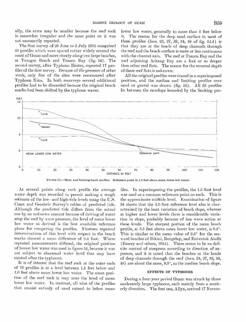
MARINE GEOLOGY OF GUAM B59
ally, the error may be smaller because the reef rock is somewhat irregular and the same point on it was not necessarily repeated.
The first survey of 28 June to 2 July 1952 comprised 25 profiles which were spaced rather widely around the coast of Guam and more closely along two large beaches, at Tarague Beach and Tumoii Bay (fig. 54). The second survey, after Typhoon Hester, repeated 17 pro files of the first survey. Because of tlie pressure of other work, only five of the sites were remeasured after Typhoon Nina. In both resurveys several additional profiles had to be discarded because the original bench marks had been shifted by the typhoon waves.
lower low water, generally to more than 2 feet below it. The reason for the deep sand surface in most of these profiles (Iocs. 2,3, 27, 32, 34, 48 of fig. 514) is that they are at the heads of deep channels through the reef and the beach surface is more or less continuous with the channel axis. The reef at Tumon Bay and the reef adjoining Achang Bay are a foot or so deeper than other reef flats. The reason for the unusual depth of these reef flats is unknown.
All the original profiles were traced in a superimposed position, and the median and limiting profiles over sand or gravel was drawn (fig. 55). All 25 profiles lie between the envelope bounded by the limiting pro-
-5
20 30 40 50 60 70 DISTANCE, IN FEET
80 90 100 110 120
FIGURE 55. Mean and limiting beach profiles. Reference point is 1.5 feet above mean lower low water.
At several points along each profile the average water depth was recorded to permit making a rough estimate of the low- and high-tide levels using the U.S. Coast and Geodetic Survey's tables of predicted tide. Although the predicted tide differs from the actual one by an unknown amount because of driving of water atop the reef by wave pressure, the level of mean lower low water so derived is the best available reference plane for comparing the profiles. Nineteen repeated determinations of this level with respect to the bench marks showed a mean difference of 0.4 foot. Where repeated measurements differed, the original position of lowest low water was used in figure 54, because it was not subject to abnormal water level that may have existed after the typhoons.
It is of interest that the reef rock at the outer ends of 16 profiles is at a level between 1.5 feet below and 1.0 feet above mean lower low water. The mean posi tion of the reef rock is very near the level of mean lower low water. In contrast, all nine of the profiles that consist entirely of sand extend to below mean
files. In superimposing the profiles, the 1.5-foot level was used as a common reference point on each. This is the approximate midtide level. Examination of figure 54 shows that the 1.5-foot reference level also is char acterized by the least variation of beach slope, whereas at higher and lower levels there is considerable varia tion in slope, probably because of less wave action at these levels. The steepest portion of the mean beach profile, at 3.5 feet above mean lower low water, is 8.4°. This is similar to the mean value of 9.5° for the sea ward beaches of Bikini, Rongelap, and Eniwetok Atolls (Emery and others, 1954). There seems to be no defi nite control of steepness according to direction of ex posure, and it is noted that the beaches at the heads of deep channels through the reef (Iocs. 23, 27, 32, 34, 48) are about the same, 8.3°, as the median beach slope.
EFFECTS OF TYPHOONS
During a four-year period Guam was struck by three moderately large typhoons, each mainly from a south erly direction. The first one, Allyn, arrived 17 Novem-
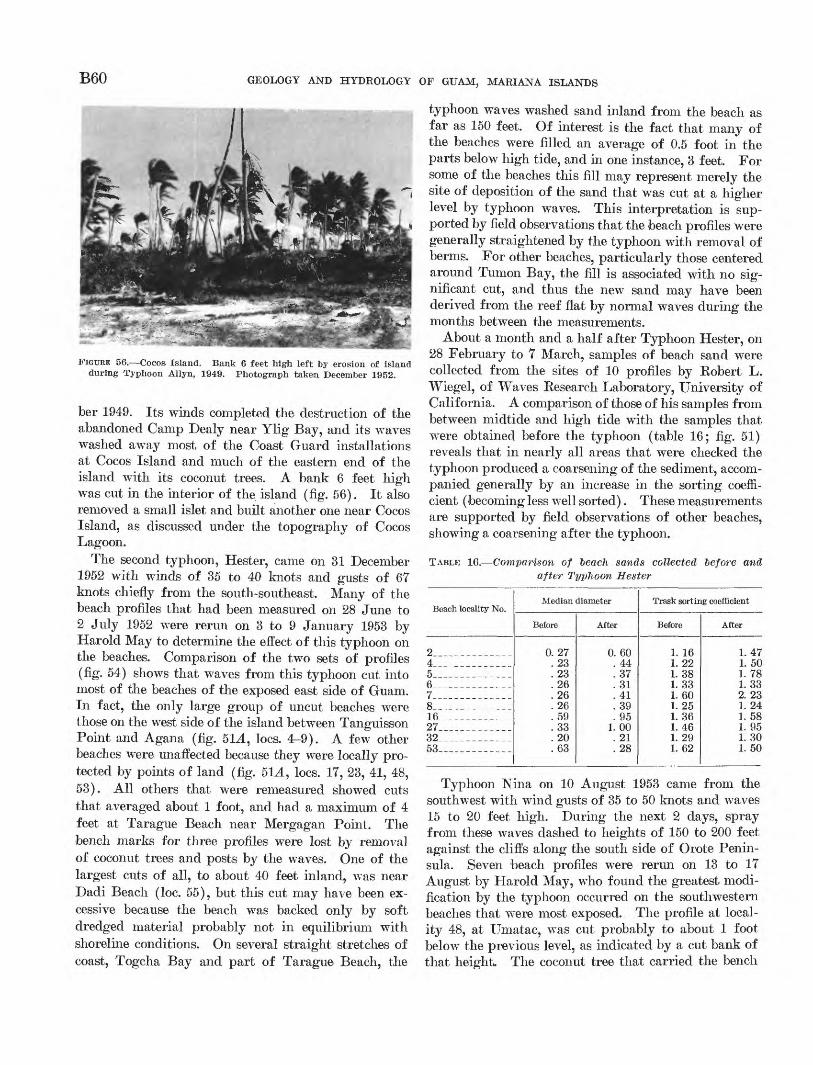
B60 GEOLOGY AND HYDROLOGY OF GUAM, MARIANA ISLANDS
FIGURE 56. Cocos Island. Bank 6 feet high left by erosion of island during Typhoon Allyn, 1949. Photograph taken December 1952.
ber 1949. Its winds completed the destruction of the abandoned Camp Dealy near Ylig Bay, and its waves washed away most, of the Coast Guard installations at Cocos Island and much of the eastern end of the island with its coconut trees. A bank 6 feet high was cut in the interior of the island (fig. 56). It also removed a small islet and built another one near Cocos Island, as discussed under the topography of Cocos Lagoon.
The second typhoon, Hester, came on 31 December 1952 with winds of 35 to 40 knots and gusts of 67 knots chiefly from the south-southeast. Many of the beach profiles that had been measured on 28 June to 2 July 1952 were rerun on 3 to 9 January 1953 by Harold May to determine the effect of this typhoon on the beaches. Comparison of the two sets of profiles (fig. 54) shows that waves from this typhoon cut into most of the beaches of the exposed east side of Guam. In fact, the only large group of uncut beaches were those on the west side of the island between Tanguisson Point and Agana (fig. 5L4, Iocs. 4-9). A few other beaches were unaffected because they were locally pro tected by points of land (fig. 5L4, Iocs. IT, 23, 41, 48, 53). All others that were remeasured showed cuts that averaged about 1 foot, and had a maximum of 4 feet at Tarague Beach near Mergagan Point. The bench marks for three profiles were lost by removal of coconut trees and posts by the waves. One of the largest cuts of all, to about 40 feet inland, was near Dadi Beach (loc. 55), but this cut may have been ex cessive because the beach was backed only by soft dredged material probably not in equilibrium with shoreline conditions. On several straight stretches of coast, Togcha Bay and part of Tarague Beach, the
typhoon waves washed sand inland from the beach as far as 150 feet. Of interest is the fact that many of the beaches were filled an average of 0.5 foot in the parts below high tide, and in one instance, 3 feet. For some of the beaches this fill may represent merely the site of deposition of the sand that was cut at a higher level by typhoon waves. This interpretation is sup ported by field observations that the beach profiles were generally straightened by the typhoon with removal of berms. For other beaches, particularly those centered around Tumon Bay, the fill is associated with no sig nificant cut, and thus the new sand may have been derived from the reef flat by normal waves during the months between the measurements.
About a month and a half after Typhoon Hester, on 28 February to T March, samples of beach sand were collected from the sites of 10 profiles by Eobert L. Wiegel, oi Waves Research Laboratory, University of California. A comparison of those of his samples from between midtide and high tide with the samples that were obtained before the typhoon (table 16; fig. 51) reveals that in nearly all areas that were checked the typhoon produced a coarsening of the sediment, accom panied generally by an increase in the sorting coeffi cient (becoming less well sorted). These measurements are supported by field observations of other beaches, showing a coarsening after the typhoon.
TABLE 16. Comparison of beacJi sands collected before and, after Typhoon Hester
Beach locality No.
24 ______ __5___-__--______67-_______-__-__8-. -- - -_16_____________27_____________32_____________53 -- ___-
Median diameter
Before
0 27 23 23 26 26 26 59 33 20 63
After
0 60 44 37 31 41 39 95
1 00 21 28
Trask sorting coefficient
Before
1. 16 1. 22 1.38 1.33 1.60 1. 25 1. 36 1. 46 1. 29 1. 62
After
1.47 1.50 1. 78 1. 33 2. 23 1. 24 L 58 1. 95 1.30 1. 50
Typhoon Nina on 10 August 1953 came from the southwest with wind gusts of 35 to 50 knots and waves 15 to 20 feet high. During the next 2 days, spray from these waves dashed to heights of 150 to 200 feet against the cliffs along the south side of Orote Penin sula. Seven beach profiles were rerun on 13 to IT August by Harold May, who found the greatest modi fication by the typhoon occurred on the southwestern beaches that were most exposed. The profile at local ity 48, at Umatac, was cut probably to about 1 foot below the previous level, as indicated by a cut bank of that height,. The coconut tree that carried the bench
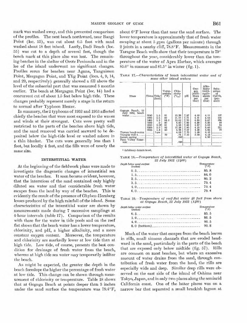
MARINE GEOLOGY OF GUAM B61
mark was washed away, and this prevented comparison of the profiles. The next beach northward, near Bangi Point (loc. 53), was cut about 0.5 foot with sand washed about 18 feet inland. Lastly, Dadi Beach (loc. 55) was cut to a depth of several feet, though the bench mark at this place also was lost. The remain ing beaches in the shelter of Orote Peninsula and in the lee of the island underwent no significant, changes. Profiles rerun for beaches near Agana, Tanguisson Point, Mergagan Point, and Ylig Point (Iocs. 4, 9, 14, and 29, respectively) generally showed a fill above the level of the subaerial part that was measured 5 months earlier. The beach at Mergagan Point (loc. 14) had a concurrent cut of about 1.5 feet below high tide. These changes probably represent merely a stage in the return to normal after Typhoon Hester.
In summary, the 2 typhoons of 1952 and 1953 affected chiefly the beaches that were most exposed to the waves and winds at their strongest. Cuts were pretty well restricted to the parts of the beaches above high tide, and the sand removed was carried seaward to be de posited below the high-tide level or washed ashore in a thin blanket. The cuts were generally less than 1 foot, but locally 4 feet, and the fills were of nearly the same size.
INTERSTITIAL WATER
At the beginning of the fieldwork plans were made to investigate the diagenetic changes of interstitial sea water of the beaches. It soon became evident, however, that the interstices of the sand contained only highly diluted sea water and that considerable fresh water escapes from the land by way of the beaches. This is evidently the result of the presence of Ghyben-Herzberg lenses produced by the high rainfall of the island. Some characteristics of the interstitial water are shown by measurements made during 7 successive samplings at 4-hour intervals (table 17). Comparison of the results with those for the water in tide pools and on the reef flat shows that the beach water has a lower temperature, chlorinity, and pH, a higher alkalinity, and a more constant oxygen content. Moreover, the temperature and chlorinity are markedly lower at low tide than at high tide. Low tide, of course, presents the best con dition for drainage of fresh water from the beach, whereas at high tide sea water may temporarily infilter the beach.
As might be expected, the greater the depth in the beach foreslope the higher the percentage of fresh water at low tide. This change can be shown through meas urement of chlorinity or temperature. Table 18 shows that at Gognga Beach at points deeper than 3 inches under the sand surface the temperature was 79.4° F,
about 6°F lower than that near the sand surface. The lower temperature is approximately that of fresh water escaping at about 5 gpm (gallons per minute) through 2 joints in a nearby cliff, 78.8°F. Measurements in the Tarague Beach wells show that their temperature is 79° throughout the year, considerably lower than the tem perature of the water of Apra Harbor, which averages 85.0° in summer and 81.5° in winter (fig. 1).
TABLE 17. Characteristics of beach interstitial water and of some other island waters
Place
Gognga Beach, 12July 1952, beach
Fena Valley Reser-
Time
0640100014001800221002000605
Tide*(feet)
1.62.61.3.9
2.072.01.3
Temperature(°F)
818284.580818280
79
Chlorinity(°/oo)
10.3811.7512.624.804.93
17.286.984.63
.74
.012
PH
7.877.717.707.607.807.807.677.707.55
Oxygen
(milli-litersper
liter)
4.654.414.094.384.874.254.281.485.08
Alkalinity(milli-equiv-alents
perliter)
4.114.683.675.355.633.604.866.454.134.90
Saturation
ofCaCO3(percent)
1571541364854
21175
»Arbitrary datum level.
TABLE 18. Temperature of interstitial water at Gognga Beach, 22 July 1952 (IJfOO)
Depth below sand surface Temperature (inches) (°F)0. 5_ .1.5 .2.5- .
4 06.0__ ____ _ ___ _ _
_________________ 85.8.__________-__--- 84.0._-_____-_______- 80.2_________________ 79.4. _______________ 79.4._______-__--_--- 79.4
TABLE 19. Temperature of reef-flat water 40 feet from shore at Gognga Beach, 22 July 1952 (1400)
Depth below water surface Temperature (inches) (°F)0. 5-_---_-------__-_________-___-_-_- 85. 51. 0 ______________ - ___ - ___- 86.54. 0____________________________ 90. 58.0 (bottom)____________________ 90.8
Much of the water that escapes from the beach leaves in rills, small sinuous channels that are eroded head- ward in the sand, particularly in the parts of the beach that are exposed only below midtide (fig. 57). Rills are common on most beaches, but where an excessive amount of water drains from the sand, through con tribution of fresh water from the land, the rills are especially wide and deep. Similar deep rills were ob served on the east side of the island of Oshima near Tokyo, Japan, and in only two places along the semiarid California coast. One of the latter places was on a narrow bar that separated a small brackish lagoon at
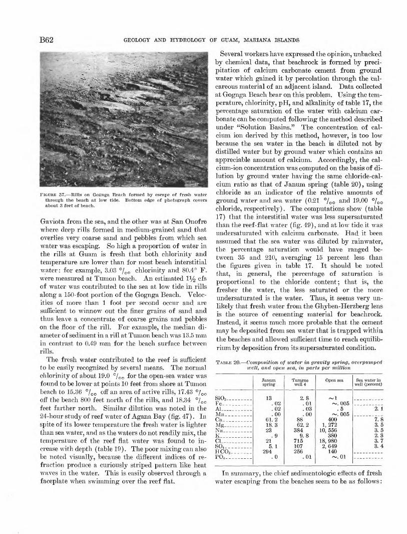
B62 GEOLOGY AND HYDROLOGY OF GUAM, MARIANA ISLANDS
FIGURE 57. Rills on Gognga Reach formed by escape of fresh water through the beach at low tide. Bottom edge of photograph covers about 3 feet of beach.
Gaviota from the sea, and the other was at San Onofre where deep rills formed in medium-grained sand that overlies very coarse sand and pebbles from which sea water was escaping. So high a proportion of water in the rills at Guam is fresh that both chlorinity and temperature are lower than for most beach interstitial water: for example, 3.03 °/o0 chlorinity and 80.4° F. were measured at Tumon beach. An estimated iy2 cfs of water was contributed to the sea at low tide in rills along a 150-foot portion of the Gognga Beach. Veloc ities of more than 1 foot per second occur and are sufficient to winnow out the finer grains of sand and thus leave a concentrate of coarse grains and pebbles on the floor of the rill. For example, the median di ameter of sediment in a rill at Tumon beach was 13.5 mm in contrast to 0.49 mm for the beach surface between rills.
The fresh water contributed to the reef is sufficient to be easily recognized by several means. The normal chlorinity of about 19.0 °/00 for the open-sea water was found to be lower at points 10 feet from shore at Tumon beach to 15.36 °/00 off an area of active rills, 17.43 °/00 off the beach 800 feet north of the rills, and 18.34 °/00 feet farther north. Similar dilution was noted in the 24-hour study of reef water of Agana Bay (fig. 47). In spite of its lower temperature the fresh water is lighter than sea water, and as the waters do not readily mix, the temperature of the reef flat water was found to in crease with depth (table 19). The poor mixing can also be noted visually, because the different indices of re fraction produce a curiously striped pattern like heat waves in the water. This is easily observed through a faceplate when swimming over the reef flat.
Several workers have expressed the opinion, unbacked by chemical data, that beachrock is formed by preci pitation of calcium carbonate cement from ground water which gained it by percolation through the cal careous material of an adjacent island. Data collected at Gognga Beach bear on this problem. Using the tem perature, chlorinity, pH, and alkalinity of table 17, the percentage saturation of the water with calcium car bonate can be computed following the method described under "Solution Basins." The concentration of cal cium ion derived by this method, however, is too low because the sea water in the beach is diluted not by distilled water but by ground water which contains an appreciable amount of calcium. Accordingly, the cal cium-ion concentration was computed on the basis of di lution by ground water having the same chloride-cal cium ratio as that of Janum spring (table 20), using chloride as an indicator of the relative amounts of ground water and sea water (0.21 °/00 and 19.00 °/00 chloride, respectively). The computations show (table 17) that the interstitial water was less supersaturated than the reef-flat water (fig. 49), and at low tide it was undersaturated with calcium carbonate. Had it been assumed that the sea water was diluted by rainwater, the percentage saturation would have ranged be tween 35 and 210, averaging 15 percent less than the figures given in table 17. It should be noted that, in general, the percentage of saturation is proportional to the chloride content; that is, the fresher the water, the less saturated or the more undersaturated is the water. Thus, it seems very un likely that fresh water from the Ghyben-Herzberg lens is the source of cementing material for beachrock. Instead, it seems much more probable that the cement may be deposited from sea water that is trapped within the beaches and allowed sufficient time to reach equilib rium by deposition from its supersaturated condition.
TABLE 20. Composition of water in gravity spring, overpumped icell, and open sea, in parts per million
SiO2_________Fe__________Al .___Mn_ _______Ca__ ______Mg_____.__._Na__ _______K_________._Cl___________S04 _________HCO3 ----__-P04 _________
Janum spring
13.02.02.00
61.218.323
.921
5. 1294
.0
Tarague well 4
2.8.01.03.00
8862. 2
3849.8
715107256
.01
Open sea
~1~. 005
. 5~. 005
4001, 272
10, 556380
18, 9802,649
140~. 01
Sea water in well (percent)
2. 1
7.83.53. 52.33.73. 4
111 summary, the chief sedimentologic effects of fresh wTater escaping from the beaches seem to be as follows:
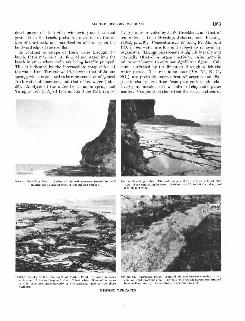
MARINE GEOLOGY OF GUAM B63
development of deep rills, winnowing out fine sand grains from the beach, probable prevention of forma tion of beachrock, and modification of ecology on the landward edge of the reef flat.
In contrast to escape of fresh water through the beach, there may be a net flow of sea water into the beach in areas where wells are being heavily pumped. This is indicated by the intermediate composition of the water from Tarague well 4, between that of Janum spring, which is assumed to be representative of typical fresh water of limestone, and that of sea water (table 20). Analyses of the water from Janum spring and Tarague well (3 April 1952 and 22 June 1951, respec
tively) were provided by J. W. Brookhart, and that of sea water is from Sverdup, Johnson, and Fleming (1942, p. 176). Concentrations of SiO2 , Fe, Mn, and PO4 in sea water are low and subject to removal by organisms. Though bicarbonate is high, it is easily and markedly affected by organic activity. Aluminum is minor and known to only one significant figure. Cal cium is affected by the limestone through which the water passes. The remaining ions (Mg, Na, K, Cl, SO4 ) are probably independent of organic and dia- genetic changes resulting from passage through rela tively pure limestone of low content of clay and organic matter. Computation shows that the concentrations of
FIGURE 58. Ylig Point. Series of rimmed terraces backed by cliff FIGURE 59. Ylig Point. Rimmed terraces that are filled only at high having nip at base at level of top rimmed terrace. tide. Note branching borders. Raisins are 0.5 to 1.0 foot deep and
3 to W feet wide,
FIGURE 60. Point 0.5 mile south of Fadian Point. Rimmed terraces each about 2 inches deep and about 2 feet wide. Rimmed terraces of this type are characteristic of the seaward edge of the shore platform.
RIMMED TERRACES
FIGURE 61. Tagachan Point. Edge of rimmed terrace showing brown vein or joint crossing rim. The vein was traced across the rimmed terrace floor and up the adjoining limestone sea cliff.
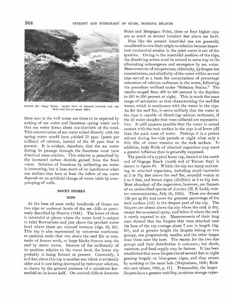
B64 GEOLOGY AND HYDROLOGY OF GUAM, MARIANA ISLANDS
FIGURE 62.- -Pago Point. Aerial view of rimmed terraces and Note reef flat at upper right.
mp.
these ions in the wrell water are those to be expected by mixing of sea water and limestone spring wrater such that sea water forms about one-thirtieth of the total. This concentration of sea water mixed directly with the spring water would have yielded 72 ppm (parts per million) of calcium, instead of the 88 ppm that is present. It is evident, therefore, that the sea water during its passage through the limestone must have dissolved some calcium. This solution is permitted by the increased carbon dioxide gained from the fresh water. Solution of limestone by infiltering sea water is interesting, but it loses much of its significance when one realizes that here at least the inflowr of sea water depends on an artificial change of wrater table by over- pumping of wells.
ROCKY SHORES
NIPS
At the base of most rocky headlands of Guam are two nips or undercut levels of the sea cliffs as previ ously described by Stearns (1941). The lower of these is intertidal at places where the water level is subject to tidal fluctuations and just above the perched water level where there are rimmed terraces (figs. 58, 62). This nip is also represented by numerous mushroom or pedestal rocks that rise above the reef flat as rem nants of former reefs, or large blocks thrown atop the reef by storm wraves. Because of the uniformity of its position relative to the wrater level, the lowrer nip probably is being formed at present. Commonly, 4 to 8 feet above this nip is another one which is evidently older and is nowr being destroyed by rainwater solution, as showrn by the general presence of a miniature kar- renfeld on its lower half. On vertical cliffs at Amantes
Point and Mergagan Point, three or four higher nips are as much as several hundred feet above sea level.
Nips like the present intertidal one are generally considered to owe their origin to solution because impor tant mechanical erosion in the quiet wrater is out of the question. Owing to the intertidal position of the nips, the dissolving action must be related in some wray to the alternating submergence and emergence by sea wrater. Measurements of temperature, chlorinity, hydrogen-ion concentration, and alkalinity of the wrater writhin several nips served as a basis for computations of percentage saturation of calcium carbonate in the wrater, following the procedure outlined under "Solution Basins." The results ranged from 480 to 550 percent in the daytime to 250 to 350 percent at night. This is much the same range of saturation as that characterizing the reef-flat water, which is continuous with the wrater in the nips. As for the reef flat, it seems unlikely that the wrater in the nips is capable of dissolving calcium carbonate, if the 15 water samples that were collected are representa tive. It still appears possible that the water in actual contact with the rock surface in the nips is of lowrer pH than the main mass of water. Perhaps 'it is a potent solvent during lowr-tide periods at night when only a thin film of water remains on the rock surface. In addition, body fluids of attached organisms may exert a greater influence than is generally supposed.
The profile of a typical lower nip, located at the north end of Gognga Beach (north end of Tumon Bay) is shown in figure 63. Within the nip are many encrust ing or attached organisms, including small barnacles at 2 to 31/2 feet above the reef flat, serpulid worms at 2 to 3 feet, and brown algae (Ralfsia) at 3 to S1/^ feet. Most abundant of the organisms, howrever, are limpets of an undescribed species of Acmaea (H. S. Ladd, writ ten communication, July 25, 1952). These are densest (36 per sq ft) and cover the greatest percentage of the rock surface (3.9) in the deepest part of the nip. The limpets are absent above the nip where the rock is dry, except for occasional spray, and below it where the rock is rarely exposed to air. Measurements of their long axes showed that the limpets that wrere attached near the base of the nip average about 7 mm in length (fig. 63), and at greater height the limpets belong to two groups, one progressively smaller and the other larger than those near the base. The reason for the two size groups and their distribution is unknown; but shade, moisture, and food supply may be factors. It has been established that some limpets travel several feet at night grazing largely on blue-green algae, and they return by morning to the same hole (Stephenson, 1936; Rick- etts and others, 1952, p. 17). Presumably, the larger limpets have a greater mobility, moisture storage capac-
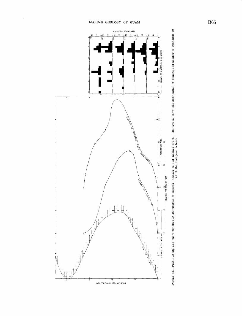
NU
MB
ER
, P
ER
S
QU
AR
E
FOO
T
FIG
UR
E 63.
Pro
file
of
nip
and
char
acte
rist
ics
of d
istr
ibu
tio
n o
f li
mpe
ts
(Acm
aea
sp.)
at
Gog
nga
Bea
ch.
His
tog
ram
s sh
ow
size
dis
trib
uti
on o
f li
mpe
ts a
nd n
umbe
r of
sp
ecim
ens
onw
hich
th
e his
togra
m i
s ba
sed.
w Oi
B66 GEOLOGY AND HYDROLOGY OF GUAM, MARIANA ISLANDS
ity, and food demand than the smaller ones; thus, the question of size distribution is a complex biologic problem.
The correspondence of the curves of abundance of limpets with the profile of the nip suggests a relation ship such that the presence of the limpets is either a partial cause or a result of the nip. Many of the limp ets occupy small holes of the same shape and size as their shells; it may be inferred, therefore, that acids from life processes have etched the holes in the lime stone. If this conclusion is correct, the pH of the water between the limpet and the rock should be lower than about 7.5. Measurements of pH were made by holding the soles of freshly collected limpets against the electrodes of a pH meter. Readings for 50 limpets ranged between 5.7 and 7.5, with a mean of 7.2. It seems probable, therefore, that the dissolving action of limpets may be a major factor in producing nips; where there are more limpets, there are more holes which coalesce and deepen the nip faster than at the top and bottom of the nip where limpets are less abun dant. A few nips that contained no limpets may have been formed at an earlier date and then the limpets died out, or those nips were formed in a different way. In this connection, it should be noted that a nip, similar in all respects to those in limestone, was found in basalt at the base of the cliff beneath Fort Santo Angel at Umatac.
Other organisms, such as boring green algae, chitons, worms, sponges, and crates, may also be important agents in developing the nips by biochemical and me chanical actions (Bertram, 1936). All would find the intertidal environment of the nip a more favorable habitat than the dry rock above or the loose sand below, so that any activity directed toward rock destruction should produce a nip or indentation in an originally vertical rock surface.
RIMMED TERRACES
Steplike terraces occur along the base of many of the cliffed coasts of Guam where protecting reefs are narrow. The top step of each series is generally near the highest point that is reached by waves or by their spray on relatively calm days. Each step is in reality a hollow saucer bounded on one side by the wall of the next higher rimmed terrace or by the sea cliff and elsewhere by a horizontal or even-crested rim that re tains water, like the geyserite terraces of Yellowstone Park.
The terraces belong to two main groups on the basis of size. The smaller, but more common, type occurs on gently sloping parts of the rock near the base of the cliffs where they are washed over by waves at high tide
(fig. 60). The rim height and water depth generally is less than 2 inches, and the width and length are only a few feet. More spectacular are the large terraces, some of which are 3 to 6 feet deep and have rims of the same or somewhat greater height and smooth to irregular floors. The diameter of such terraces may exceed 20 feet, and their shapes range from round to angular. The rims themselves vary in thickness gen erally between about 3 and 15 inches, with greater thickness characteristic of the higher rims. These terraces reach much higher above the sea than the smaller ones, even to about 10 feet above low tide (figs. 58, 59), but all can be reached by spray at high tide. Tayama) 1952, p. 225-227) described at Guam and Tinian "rimmed pools," which included both rimmed terraces and ordinary solution basins. Similar features have been recognized elsewhere by other workers who do not agree on the mode of origin, perhaps partly because there is more than one origin. Lister (1891) considered that rimmed terraces at Tonga are built up by red encrusting algae which grow more vigorously at the edges; however, his report is brief and his field study relatively incomplete. Kuenen (1933, p. 82-83), Umbgrove (1947), and others have reported that rim med terraces are composed of the same kind of rock as the rest of the reef flat, and thus are of erosional origin. These two modes of origin are diametrically opposite, for in one the terraces are being raised whereas in the other they are being lowered. Because of the uncertainty of the origin of rimmed terraces, several days were devoted to their study at Guam. Most of the work was done at Tagachan Point, north of Ylig Bay. Briefer studies were made just south of Pago Point, southwest of Inarajan village, and finally at Unai Halaihai on Saipan. Three lines of investiga tion were followed: geologic, biologic, and oceano- graphic.
The geologic evidence is that of rock type and surface character of the rock. Inspection showed that the mass of the rock in the rims and even most of the top surface of them consists of the same limestone that forms the sea cliff and the small nip commonly present behind the terraces. The surest means of rec ognition of this rock was the presence of brownish filled joints or limestone veins that could commonly be traced continously down the cliff and across the floor of a pool and its confining rim (fig. 61). Also signifi cant is the fact that no rimmed terraces were found adjacent to cliffs consisting of volcanic rocks, but only off the limestone ones. Examples of the smaller type of terraces having floors and rims of tuff have been observed at Hanauma Bay on Oahu, Hawaii, and they may also exist at Guam, though if present they are
MARINE GEOLOGY OF GUAM B67
rare. Particularly in the areas below water level the surface is commonly irregular and pitted. This means that the chief erosive agent must be solution rather than abrasion, and in fact, few of the pools contained pebbles or cobbles that might serve as abrasive tools. Some of the lower pools, where water movement must sometimes be vigorous, do contain rounded cobbles and even true potholes which indicate that for these pools abrasion is a factor.
The biologic evidence concerns both plants and ani mals. Swimming and floating forms of both groups have only an indirect, or biochemical, function com pared to the sessile forms that, in addition, may add to the rocks by attaching their skeletons or may destroy it by boring activities. Most apparent of the attached organisms are fleshly algae such as Gelidiella acerosa (Forssk.) Feldm. & Hamel, small filamentous species of Oladophora and Boodlea, and the jointed coralline Jania tenetta Kiitz. These live wherever they are at least partly covered by water, and are most abundant where there is a steady renewal of water either by splashing inward from the sea or by flowing outward from the pool through a low point on the rim. In the latter site the plants commonly grow so densely as to retard the flow of water. On death most of these plants completely disintegrate. Probably more important are several species of thin encrusting lithothamnioid and peyssonelioid algae that also live most profusely where water renewal is greatest. Though these algae are inconspicuous, on death they leave a thin deposit over the rock surface; thus, they tend to build up the rim, especially at low points. Nowhere, however, was more than a small fraction of an inch of the algal deposit noted, with the thickest deposits consisting of litho thamnioid algae. Boring green algae also are present, but it is doubtful that they contribute appreciably to rock destruction in the rimmed terraces.
The animals have a more complex function in the origin of the rimmed terraces than the plants, for some of them are rock builders, whereas others take an active role in rock destruction, and most have no direct influ ence on the rocks. The most abundant forms are worms, identified by Olga Hartman, of Allan Hancock Foun dation and vermetid mollusks, identified by Myra Keen, of Stanford University (table 21). The chief rock- building animals are the vermetid mollusks, which form a deposit locally several inches thick. The deposit can be recognized by its content of more than 50 percent of purplish-brown curved tubes 1 or 2 mm in diameter. Because of their shape, these tubes have often been considered in the field as deposits made by worms. Like the algae, these mollusks prefer areas of moving water, and their thickest, and presumably fastest accumulating
deposits, occur at low points of the rims. Locally, the deposits may be several inches thick, forming a patch for a broken wall, an overhanging section on the inside of the wall, or a spoutlike spillway for overflowing water. One worm, Spirobis, builds coiled tubes on the rocks; but these are small, rare, and of no significance in the local rock building. Worms that deposit cal careous tubes seem to be rare in the tropics, and only a few tubes were found in the sediment samples from Guam.
TABLE 21. Animals from rims of rimmed terraces
Vermetid mollusk: Spiroglyphus sp. (Pago Bay form)___
Polychaetous annelids: FVunir.p, afro. Orossland
Platynereis dumerilii (Audouin and Edwards) .
K-nirarhis Cdftxtrfl.llMiscellaneous:
Kinnnp.iilirl wnrms. sfivfvra.l snfioifisr^ni'iTio' QTirm o*p
Amphipod, 1 species. ______ _______
Limpets ._ _____ _ __________ _
Builders
X
X
X
Borers
X X
X
X X
Nestlers
X
X
X
X X X X X X
X X X X X
X
The third and last kind of evidence examined was water composition. Measurements of temperature, chlorinity, alkalinity, hydrogen-ion concentration, and oxygen content were made in the afternoon and before sunrise on different days to allow the time of high tide to change (table 22). The results clearly show a diur nal variation of these properties greater than that of reef water and similar to that found in the solution basins that are discussed below. During the daytime photosynthesis by the plankton and attached plants produces an excess of oxygen, so much in fact, that it was not unusual to observe bubbles of oxygen rising to the surface, showing that the water was more than saturated with oxygen. In producing the oxygen, car bon dioxide was used up and its loss is shown by raised pH and lower alkalinity. This change must mean that if the water enters the pool in a saturated condition in the morning, some of its calcium carbonate must be deposited during the daytime. As no deposits were found, it is inferred that they are in the form of a
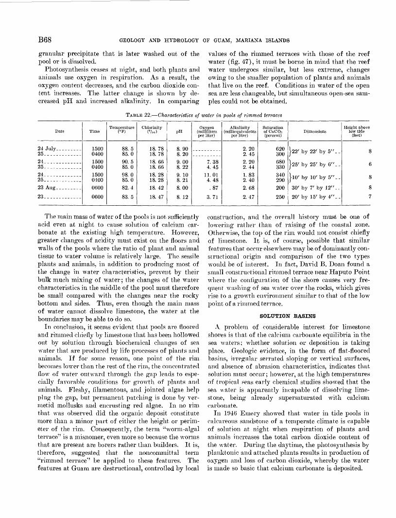
B68 GEOLOGY AND HYDROLOGY OF GUAM, MARIANA ISLANDS
granular precipitate that is later washed out of the pool or is dissolved.
Photosynthesis ceases at night, and both plants and animals use oxygen in respiration. As a result, the oxygen content decreases, and the carbon dioxide con tent, increases. The latter change is shown by de creased pH and increased alkalinity. In comparing
values of the rimmed terraces with those of the reef water (fig. 47), it must be borne in mind that the reef water undergoes similar, but less extreme, changes owing to the smaller population of plants and animals that live on the reef. Conditions in water of the open sea are less changeable, but simultaneous open-sea sam ples could not be obtained.
TABLE 22. Characteristics of water in pools of rimmed terraces
Date
24 July__.______25_____________24__. __________25--_-_-__-.-__24_____. _______25_. _____-__.._23 Aug--_-_-.__
23____ _______
Time
1500040015000400150004000600
0600
Temperature(°F)
88.585. 090. 585. 098. 085.082.4
83. 5
Chlorinity(%o)
18.7818. 7818. 6618. 6618. 2818.2818. 42
18. 47
pH
8. 908. 209. 008. 22Q in8. 218. 00
8 1 o
Oxygen (milliliters per liter)
7. 384 4^
11.014. 48.87
q 7l
Alkalinity (millie qui valents
per liter)
2. 202. 452. 209 44
1. 832. 402. 68
9 47
Saturation of CaCOs (percent)
620300680330340290200OKfl
Dimensions
W by 22' by 5"__
J25' by 25' by 6"__
J10' by 10' by 5"__
30' by 7' by 12" _.
20' by 15' by 4"__
Height above low tide
(feet)
8
7
The main mass of water of the pools is not sufficiently acid even at night to cause solution of calcium car bonate at the existing high temperature. However, greater changes of acidity must exist on the floors and walls of the pools where the ratio of plant and animal tissue to water volume is relatively large. The sessile plants and animals, in addition to producing most of the change in water characteristics, prevent by their bulk much mixing of water; the changes of the water characteristics in the middle of the pool must therefore be small compared with the changes near the rocky bottom and sides. Thus, even though the main mass of water cannot dissolve limestone, the water at the boundaries may be able to do so.
In conclusion, it seems evident that pools are floored and rimmed chiefly by limestone that has been hollowed out by solution through biochemical changes of sea water that are produced by life processes of plants and animals. If for some reason, one point of the rim becomes lower than the rest of the rim, the concentrated flow of water outward through the gap leads to espe cially favorable conditions for growth of plants and animals. Fleshy, filamentous, and jointed algae help plug the gap, but permanent patching is done by ver- metid mollusks and encrusting red algae. In no rim that was observed did the organic deposit constitute more than a minor part of either the height or perim eter of the rim. Consequently, the term "worm-algal terrace" is a misnomer, even more so because the worms that are present are borers rather than builders. It is, therefore, suggested that the noncommittal term "rimmed terrace"1 ' be applied to these features. The features at Guam are destructional, controlled by local
construction, and the overall history must be one of lowering rather than of raising of the coastal zone. Otherwise, the top of the rim would not consist chiefly of limestone. It is, of course, possible that similar features that occur elsewhere may be of dominantly con structional origin and comparison of the two types would be of interest. In fact, David B. Doan found a small constructional rimmed terrace near Haputo Point where the configuration of the shore causes very fre quent washing of sea water over the rocks, which gives rise to a growth environment similar to that of the low point of a rimmed terrace.
SOLUTION BASINS
A problem of considerable interest for limestone shores is that of the calcium carbonate equilibria in the sea waters; whether solution or deposition is taking place. Geologic evidence, in the form of flat-floored basins, irregular serrated sloping or vertical surfaces, and absence of abrasion characteristics, indicates that solution must occur; however, at the high temperatures of tropical seas early chemical studies showed that the sea water is apparently incapable of dissolving lime stone, being already supersaturated with calcium carbonate.
In 1946 Emery showed that water in tide pools in calcareous sandstone of a temperate climate is capable of solution at night when respiration of plants and animals increases the total carbon dioxide content of the water. During the daytime, the photosynthesis by planktonic and attached plants results in production of oxygen and loss of carbon dioxide, whereby the water is made so basic that calcium carbonate is deposited.
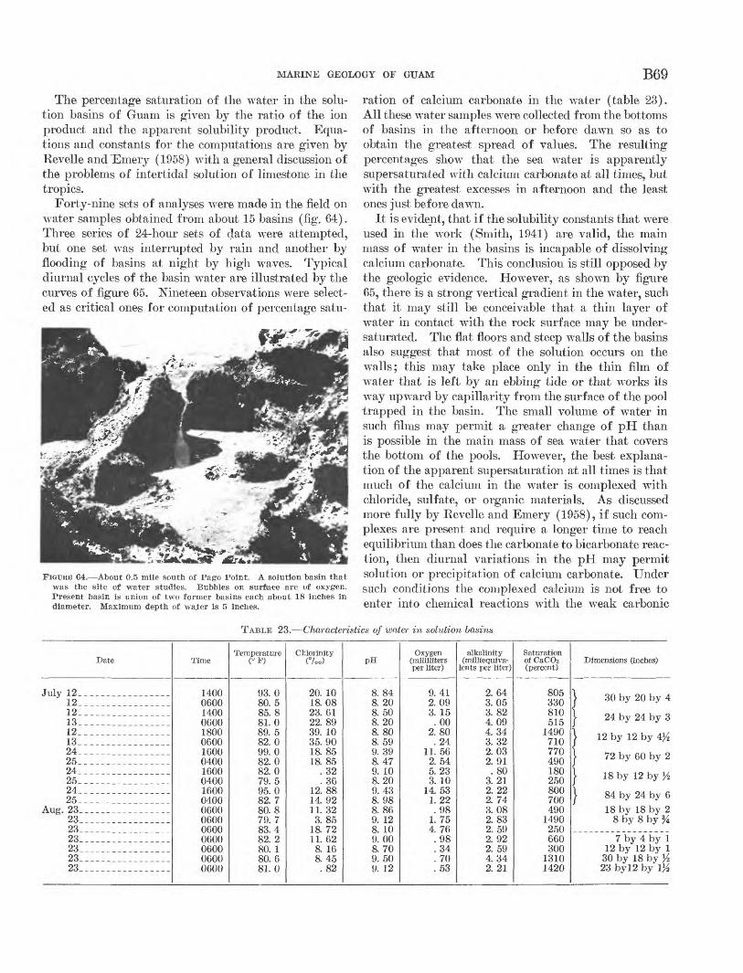
MARINE GEOLOGY OF GUAM B69
The percentage saturation of the water in the solu tion basins of Guam is given by the ratio of the ion product and the apparent solubility product. Equa tions and constants for the computations are given by Revelle and "Emery (1958) with a general discussion of the problems of intertidal solution of limestone in the tropics.
Forty-nine sets of analyses were made in the field on water samples obtained from about 15 basins (fig. 64). Three series of 24-hour sets of data were attempted, but one set was interrupted by rain and another by flooding of basins at night by high waves. Typical diurnal cycles of the basin water are illustrated by the curves of figure 65. Nineteen observations were select ed as critical ones for computation of percentage satu-
FIGTJRB 64. About 0.5 mile south of Pago Point. A solution basin that was the site of water studies. Bubbles on surface are of oxygen. Present basin is union of two former basins each about 18 inches in diameter. Maximum depth of waier is 5 inches.
ration of calcium carbonate in the water (table 23). All these water samples were collected from the bottoms of basins in the afternoon or before dawn so as to obtain the greatest spread of values. The resulting percentages show that the sea water is apparently supersaturated with calcium carbonate at all times, but with the greatest excesses in afternoon and the least ones just before dawn.
It is evident, that if the solubility constants that were used in the work (Smith, 1941) are valid, the main mass of wTater in the basins is incapable of dissolving calcium carbonate. This conclusion is still opposed by the geologic evidence. However, as shown by figure 65, there is a strong vertical gradient in the water, such that it may still be conceivable that a thin layer of water in contact with the rock surface may be under- saturated. The flat floors and steep walls of the basins also suggest that most of the solution occurs on the walls; this may take place only in the thin film of water that is left by an ebbing tide or that works its way upward by capillarity from the surface of the pool trapped in the basin. The small volume of water in such films may permit a greater change of pH than is possible in the main mass of sea water that covers the bottom of the pools. However, the best explana tion of the apparent supersaturation at all times is that much of the calcium in the water is complexed with chloride, sulfate, or organic materials. As discussed more fully by Revelle and Emery (1958), if such com plexes are present and require a longer time to reach equilibrium than does the carbonate to bicarbonate reac tion, then diurnal variations in the pH may permit solution or precipitation of calcium carbonate. Under such conditions the complexed calcium is not free to enter into chemical reactions with the weak carbonic
TABLE 23. Characteristics of water in solution basins
Date
July 12____ __ ___ ____ _12_________________12_____13_________________12______ _ _ _ ____13_________________24_________________25_________________24_____ _ _ __25_________________24_____25
Aug. 23_ ___ ______2323_________________23 ___23 _23_________________23_________________
Time
1400060014000600180006001600040016000400160004000600060006000600060006000600
Temperature <°F)
93.080. 585. 881.089. 582.099. 082.082.07Q ^95.082. 780. 87Q 783 482. 280 180. 681.0
Chlorinity(°/oo)
20. 1018.0823. 6122.8939. 1035.9018. 8518. 85
. 32. 36
12. 8814. 9211. 323.85
1&7211. 62
8. 168.45
. 82
PH
8. 848. 208. 508. 208. 808. 599. 398 479. 108. 209. 438.988. 869. 128. 109.008. 709. 509. 12
Oxygen (milliliters per liter)
9. 412.093. 15.00
2.80. 24
11. 562. 545.233. 10
14. 531. 22.98
1. 754. 76.98.34. 70.53
alkalinity (milliequiva-
lents per liter)
2. 643.053.824.094. 343. 322.032.91.80
3.212. 222. 743.082. 832. 592. 922. 594. 342. 21
Saturation of CaCO3 (pa- cent)
805330810515
1490710770490180250800700490
1490250660300
13101420
Dimensions (inches)
! 30 by 20 by 4
24 by 24 by 3
} 12 by 12 by 4>£
| 72 by 60 by 2
} 18 by 12 by >'2
J 84 by 24 by 618 by 18 by 2
8 by 8 by %
7 by 4 by 112 by 12 by 1
30 by 18 by l/z23 by!2 by 1%
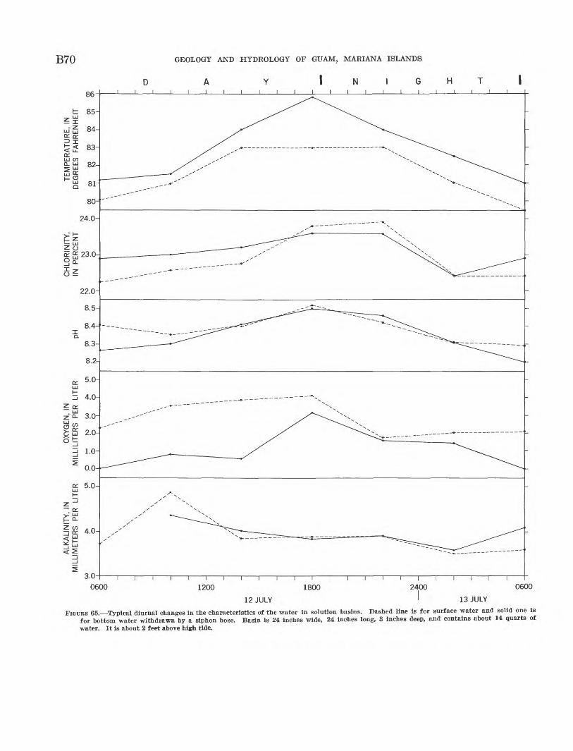
B70 GEOLOGY AND HYDROLOGY OF GUAM, MARIANA ISLANDS
86 i i i i i i i i i
3.0
0600 1200 0600
12 JULY 13 JULY
FIGURE 65. Typical diurnal changes in the characteristics of the water in solution basins. Dashed line is for surface water and solid one is for bottom water withdrawn by a siphon hose. Basin is 24 inches wide, 24 inches long, 3 inches deep, and contains about 14 quarts of water. It is about 2 feet above high tide.
MARINE GEOLOGY OF GUAM B71
acid. This reasoning is borne out by the fact that the alkalinity measurements do indicate the existence of additions to the calcium concentration in water of solu tion basins at night and losses during the daytime.
CONCLUSIONS
In marine geology there is a well-developed inter relationship between topography, water characteristics, sediments, and biology whereby each is partly controlled by, and itself partly controls, the other three fields. These relationships are especially obvious at Guam. On the extensive reef flats the topography is subdued mainly a flat area at a level just below low tide. Its flatness is believed to be the result of solution of parts that once stood exposed above low tide, together with filling of holes by loose bioclastic sediments and by organic growth. This flatness, in turn, permits the movement of waves and tidal and wind currents which carry the sediment to fill holes, to build the beaches, and to dump some excess over the reef edge to slide down the slopes. The shallow partly rocky surface provides places for attachment, and the continously resupplied water brings food to growing organisms that eventually become sediment.
In Cocos Lagoon the quiet deep water behind a small barrier reef permits the settling of finer sediment than can remain atop the reef flats. Similiar sediments should accumulate until the surface reaches a position just below low tide and a wide reef flat is formed. These sediments are bioclastic: coral is the chief con tributor followed by calcareous red algae, shells, Halimeda debris, and Foraminifera. This order of composition is the same as that of the reef flat, and with the observed pattern of distribution it is a supple mentary indicator of derivation largely from the reef. The predominance of coral and calcareous red algae over Halimeda (unlike Bikini Atoll) is a reflection of the shallower depths of Cocos Lagoon and of the higher ratio of reef area to lagoon area than at Bikini. Probably the floor of the lagoon is inherited from a lower relative stand of the ocean, of which several are also indicated by submerged terraces on the fringing outer slopes of Guam.
Around the island the reef is cut by transverse channels of several types. Nearly all the channels are located off the mouths of streams. It is believed that the channels owe their existence to the flow of fresh muddy water across the thin beginning reef during one or more of the stages of lowered sea level. At present the muddy river water, even after rainstorms, flows in a thin sheet across the top of the channels and over the adjoining reef flats. The underlying sea water is left clear and undiluted, and thus capable of support
ing coral growth, where the depth to the bottom is not now too great. The soft muddy bottom of some channels also prevents attachment of organisms. These muds are an indication of the absence of wave action at the bottom of the channels, and it is believed that the sediments, which are largely of volcanic derivation, make their way along the channel floor from the river mouth at the landward end in the form of mudflows or possibly turbidity currents. At most river mouths the beach sands also consist dominantly of volcanic rock and mineral grains, completely unlike the bio clastic beaches inshore from reefs.
The final form and composition of any landforms, including islands such as Guam, are controlled by the relative importance of erosion versus deposition. For all practical purposes the two processes are sep arated at the low-tide level. Erosion by surface or subsurface fresh waters dominates the upper levels of islands, with solution by sea water restricted to the intertidal zone. Though wave and current erosion does reach below sea level, the effect is greatest at very shallow depths and during the storms even somewhat above sea level. The dominant process below sea level is deposition, during which both organic growth and bioclastic sediments are important factors. In time and in the absence of diastrophism or changes of sea level, the continued erosion above sea level and deposition below it should determine the final shape of Guam ultimately a broad flat reef having a shallow core of volcanic rocks in its center.
REFERENCES CITED
Bascom, W. N., 1951, The relationship between sand size and beach-face slope: Am. Geophys. Union Trans., v. 32, p. 866-874.
Bertram, G. O. L., 1936, Some aspects of the breakdown of coral at Ghardaqua, Red Sea: Zool. Soc. London Proc. 1936, v. 2, p. 1011-1026.
Carruthers, J. N., and Lawford, A. L., 1952, The deepest oceanic sounding: Nature, v. 169, no. 4302, p. 601-603.
Chave, K. E., 1954, Aspects of the biogeochemistry of magnesi um 1. Calcareous marine organisms: Jour. Geology, v. 62, p. 266-283.
Clarke, F. W., 1920, The data of geochemistry: U.S. Geol. Sur vey Bull. 695, 832 p.
Clarke, F. W., and Wheeler, W. C., 1917, The inorganic constitu ents of marine invertebrates : U.S. Geol. Survey Prof. Paper 102, 56 p.
Cloud, P. E., Jr., 1951, Reconnaissance geology of Guam and problems of water supply and fuel storage: Military Geol ogy Branch, U.S. Geol. Survey, open-file report, 50 p.
1952, Preliminary report on geology and marine envi ronments of Onotoa Atoll, Gilbert Islands: Atoll Research Bull. 12, 73 p., Pacific Science Board, Natl. Research Council.
Combs, H. L., 1949, Guam climatological data (compiled from various sources) : U.S. Army, Signal Corps, open-file report.
B72 GEOLOGY AND HYDROLOGY OF GUAM, MARIANA ISLANDS
Crozier, W. J., 1918, The amount of bottom material ingestedby holothurians (Stichopus) : Jour. Experimental Zoology,v. 26, p. 378-389.
Dietz, R. S. and Menard, H. W., 1951, Origin of abrupt changein slope at shelf margin: Am. Assoc. Petroleum GeologistsBull., v. 35, p. 1994-2017.
Duerden, J. E., 1902, Boring algae as agents in the disentegra-tion of corals: Am. Mus. Nat. History Bull., v. 16, p. 323-332.
Emery, K. O., 1938, Rapid method of mechanical analysis ofsands: Jour. Sed. Petrology, v. 8, p. 105-111.
1946, Marine solution basins: Jour. Geology, v. 54, p. 209-228.
Emery, K. O., Butcher, W. S., Gould, H. R., and Shepard, F. P., 1952, Submarine geology off San Diego, California: Jour. Geology, v. 60, p. 511-548.
Emery, K. O., and Rittenberg, S. C., 1952, Early diagenesis of California basin sediments in relation to origin of oil: Am. Assoc. Petroleum Geologists Bull., v. 36, p. 735-906.
Emery, K. O., Tracey, J. I., Jr., and Ladd, H. S., 1954, Geology of Bikini and nearby atolls in the Marshall Islands: U.S. Geol. Survey Prof. Paper 260-A, 265 p.
Ernmons, W. H., Thiel, G. A., Stauffer, C. R., and Allison, I. S., 1949, Geology, Principles and Processes: 3d ed., New York, McGraw-Hill Co., 287 p.
Flint, J. M., 1905, A contribution to the oceanography of the Pacific compiled from data collected by the U.S.S. Nero while engaged in the survey of a route for a trans-Pacific cable: U.S. Natl. Mus. Bull., v. 55, p. 1-62.
Gaskell, T. F., Swallow, J. C., and Ritchie, G. S., 1953, Further notes on the greatest oceanic sounding and the topography of the Marianas Trench: Deep-Sea Research, v. 1, p. 60-63.
Hanzawa, S., 1928, Preliminary report on marine deposits from, the southwestern North Pacific Ocean: Japan Oceanog. Works Recs., v. 1, no. 2, p. 59-77.
Hess, H. H., 1948, Major structural features of the Western North Pacific an interpretation of H. O. 5485, Bathymetric chart, Korea to New Guinea : Geol. Soc. America Bull., v. 59, p. 417-^46.
Kuenen, Ph. H., 1933, Geology of coral reefs: Snellius Expedi tion, v. 5, pt. 2, 125 p.
1947, Two problems of marine geology: Koninkl. Ned- erlanclse Akad, Wetensch. Verh., Afd. Nat., Tweede Sectie, v. 42, no. 3, p. 1-33.
Lister, J. J., 1891, Notes on the geology of the Tonga Islands: Geol. Soc. London Quart. Jour., v. 47, p. 590-617.
Mayor, A. C., 1924, Causes which produce stable conditions in the depths of the floors of Pacific fringing reef-flats: Car negie Inst. Washington, v. 19, no<. 34, p. 27-36.
Motoda, S., 1940, The environment and the life of massive reef coral, Goniastrea aspera Verrill, inhabiting the reef flat in Palao: Palao Tropical Biol. Sta. Studies, v. 2, no. 1, p. 61- 104.
Murray, John, and Renard, A F., 1891, Report on the deep-sea deposits based on the specimens collected during the voyage of H.M.S. Challenger in the years 1872 to 1876, London, Longmans, 525 p.
Norris, R. M., 1951, The marine geology of the San Nicholas Island region, California: Scripps Inst. Oceanography, Sub marine Geology Rept. 21, 14 p., open-file report.
Pacific Islands Engineers, 1951, Report on sanitary sewerage districts of Middle Guam: prepared for U.S. Navy, Bur. Yards and Docks, Contract NOY 13626, open-file report.
Piccard, J., and Dietz, R. S., 1961, Seven miles down: New York, G. P. Putnam's Sons, 249 p.
Reed, E. K., 1952, General report on archeology and history of Guam: U.S. Nat. Park Service, 133 p. (mimeographed).
Revelle R. R., 1944, Marine bottom samples collected in the Pacific Ocean by the Carnegie on its seventh cruise Scien tific results of Cruise VII of the Carnegie: Carnegie Inst. Washington Pub. 556, 196 p.
Revelle, R. R., and Emery, K. O., 3958, Chemical erosion of beach rock and exposed reef: U.S. Geol. Survey Prof. Paper 260-U, p. 711-741.
Ricketts, E. F., Calvin, Jack, and Hedgpeth, J. W., 1952, Between Pacific tides: Stanford, Calif., Stanford Univ. Press, 502 p.
Sargent, M. C., and Austin, T. S., 1949, Organic productivity of an atoll: Am. Geophys. Union Trans., v. 30, p. 245-249.
Smith, C. L., 1941, The solubility of calcium carbonate in tropi cal sea water: Marine Biol. Assoc. Jour., v. 25, p. 235-242.
Stearns, H. T., 1935, Pleistocene shore lines on the islands of Oahu and Mani, Hawaii: Geol. Soc. America Bull., v. 46, p. 1927-1956.
1940, Geologic history of Guam : Geol. Soc. America Bull., v. 51, p. 1948.
1941, Shore benches on North Pacific islands: Geol. Soc. America Bull., v. 52, p. 773-780.
1945, Eustatic shore lines in the Pacific: Geol. Soc.America Bull., v. 56, p. 1071-1078.
Stephenson, T. D., 1936, The marine ecology of the SouthAfrican coasts with special reference to the habits oflimpets: Linnean Soc. London Proc., sess. 148, p. 74-79.
Sverdrup, H. U., Johnson, M. W., and Fleming, R. H., 1942,The oceans: New York, Prentice-Hall, 1087 p.
Tayama, RisaburC>, 1952, Coral reefs of the South Seas: JapanHydrog. Office Bull., v. 11, Pub. 941, 292 p., app. 1, 2.
Teichert, Curt, 1946, Contribution to the geology of Houtnian'sAbrolhos, Western Australia: Linnean Soc. New SouthWales Proc., v. 71, p. 145-196.
Trask, P. D., 1932, Orgin and environment of source sedimentsof petroleum : Houston, Tex., Gulf Publ. Co., 323 p.
Twenhofel, W. H., and Tyler, S. A., 1941, Methods of study ofsediments : New York, McGraw-Hill Co., 183 p.
Umbgrove, J. H. F., 1947, The pulse of the Earth, MartinusNijhoff, The Hague, 358 p.
Wiseman, J. D. H., and Hendey, N. I., 1953, The significanceand diatom content of a deep-sea floor sample from theneighbourhood of the greatest oceanic depth: Deep-SeaResearch, v. 1, p. 47-59.
Wood-Jones, F., 1912, Coral and atolls: London, Lovell Reeve &Co., Ltd., 392 p.
Yamanouti, Toshihiko, 1939, Ecological and physicologicalstudies on the holothurians in the coral reef of PalaoIslands: Palao Tropical Biol. Sta. Studies, v. 1, no. 4,p. 603-636.
INDEX
Page Abnaki (ATF96), U.S.S., echo soundings made aboard..___....___.... B4,9
sediment samples taken by---.....-.---.---.-....._.............__... 11Acervulina..-._.__...___.__...__...__..............._.._ 15Achang Bay..... ................................................. 15,20,28,29,32Achang Reef..._.___.______._.___...__.____._____ 59
composition. .-..____.________.__.__.___.____ 40,41 topography.---.---...--.--..-.--.-..--..--..-............................ 40,41
Acknowledgments....._.----._______..._...........___.__ 2,4Acmaeasp __.__._______..___.__.__._____.___ 64,65 Agana Bay, chemical composition of sediments. . . -_._..... 28
composition of reefsand.._________._______________ 42,45 profile......__________._____.______________.. 45water characteristics-.__...____...____.__._.__...... 47-52,62
Agana Bay beach, brown-stained sands._...__._.___.__.__..... 43,46Agana Bay reef-- .-__._..._._________.________..... 41Agana Channel..__.___.______.__...._.____......__.__ 29Agana Reef, calcium carbonate.__..__..____...__..__.__.___ 51,52
oxygen production-.---.-.-...-.................-..--.........- 48,49,50-52Agat ...................................................................... 54Agat Bay, class . ... ......-.-..-................................... 29Agfayan Bay, class....____......__.....__._....._._.....__ 29
composition of beach sand__..___.._.__._._.__..___ 42 Aguijan.._____.______.__.._....__.........._......._. 4Aguijan Island, wave-cut terraces____...._..._._ ___...__ 8Ajayan Bay reef channel -.-. . ..-..-.-...-............................ 29,31Albatross, scientific expedition...._........._.........._._........... 2,11Alcyonarian corals, magnesium carbonate content... __..................... 20Algae, blue-green. . ______._._...__.....____...___... 64
boring green.____........_....__....__...............___ 22,28,67bottom sediments from floor of Cocos Lagoon___.__.........__... 19-20calcareous green..____._._......___._....._..........._ 20,21calcareous red........................... 14,20,21,22,23,24,25,26,28,43,44,45,71
in beach sands._...___.__________..__.__.....__ 54in sediments, Achang Reef__..._______..._._.__... 40,41
Cocos Lagoon...._______________.___.___.___ 28slopes -------_-----_...__--- _.--_._---------_ 14
lithothamnoid__...._....__.______._____._.__... 22,23,67peyssonelioid.___..._..__._________...._._.......__ 67
Alkalinity of water, beach interstitial.----.---.---------.-.-----.-.- 61Agana Bay....----------...--._-......------..-.._.._...--.- 47,48,49pools of rimmed terraces_...._.__...._.____....__.___... 68solution basins. . . ________..__....._..._..___._... 69
Amansiaglomerata--..- ________..___.__...._........... ...__ 19Amantes Point, nips.. .........__......__......._...__.. ...-.- 64Amphipods .___.......__.__.._............__.__....__...._ 67Amphiroa.... ______._.___________________________________............_... 20,22
sp._.-..-... . ....-..._..._ _______....___ 19Amphistegina..... ...... .__-. ....__......_ ____._.______. __ 14,15Analyses, beach sands_....____.___....................____.._ 54
sediments....--.- .._....--.---.-....-.._-_.-.-..._.--._... 28Andros Island, Bahamas, submarine terrace.__.___...__._...._... 11Animals from rims of rimmed terraces..______.._.__.____.._... 67 Annelids, polychaetous..------------------------------------------------- 67Anson, George__..............................___........._....... 2Apra Harbor...___..___..._..___._......._....._______.. 2,11
lagoon._._....__._........_.__._....___._.__.... 14reef debris____.___...___....._____._...__..._..... 11temperature of water...__.____.____....__._._--------- 61
Area of Guam._____.__..._...___.._____.________ 2-3 Asan Bay, class._._____.______.__..._.___._....____ 29Asgadao Bay reef channel..-.-----------.-----.--...--.-.-----------.- 29,30,34
B Baculogypsina................ ...._________.__..______. 14,15,21Bahamas, organic matter in calcareous sediments..._._________.. 28 Barnacles- . ._____.___._____.____________.-.._ 67Beach interstitial water, characteristics____________________ - 61-63
Page Beach sand, Agfayan Bay.. . - - - - - B42
Cocos Island __ ----- ------- ........... - 42Beach sands, composition.. . ..-. ... - -------- 52-54
texture.. __ ... _ __ -------- -... -- 54-55,56Beach slopes of reef areas ...- - .. . - 55-59 Beachrock, origin _ _...... ..-_--. . . -------- --------- -- 62Bikini Atoll.- ----- 11,16,26,28,59,71Bikini island...-- 16BikiniLagoon -.... ---- - 26Bolivina semicostata.. ... _ ........--.--.-..---.... .- - ---- 15Boodlea composite, ... ...-.-. ... --------------- - - ----------- ----- 19
spBowditch (AGS 4), U.S.S., scientific expedition...-..- ----- -------- - 2
sonic soundings made by sound boats - - - - --- 1*Brookhart, J . W., discharge data for Pago River supplied by. .... - - 36Bryan, E. H., Jr., grasses identified by. . - --- -- - -- 2°Bryozoans _ ------ ------- ----- 22
magnesium carbonate content- ------- - - --- ------ 20Buliminids. ------------- - - - 15
California basin sediments, organic matter...__. --------------- 28Calcium carbonate, reef flats------------------------------------------------ 51,52
water, pools of rimmed terraces - ----- - -- 68solution basins -------------------------------------------------- 69reef at Agana Bay.-...--------------------------------------------- 51 ' 52
CampDealynearYlig Bay- --------------------------------------------- 6°Cape Johnson_. . .....-..- . ----------- .. -.-- --------Carnegie, scientific expedition...--------------------------------------------- 2Caulerpa racemosa laetevirens ----------------- -- - -------- 19
macrophysa.-------- ...__ . ---------- ------------- -CettiBay--. 29Challenger, scientific expedition.---- -- - - -- -- -----------Challenger II, oceanic soundings.- - ---- -
scientific expedition ------ - Chamisso, Adelbert von._ ------- ---...-. ---- - . Chamorros-. - - 2Channels, classes....- - - - - -
depths Jdistribution....- - origin ^
Chart, bathymetric, of Guam and vicinity- - ------- -- - *> eChltins... ̂ J!Chlorinityof water, beach interstitial... 61,62
pools of rimmed terraces -- - ----- -------- ----solution basins- -------------------------------------------------------
36,37,38,39PagoChannel.Chrysopetalum ehlersi. Cibiddes--------------Cladophora sp Climate-. _.__ -
1567
2,32Clipperton, John.-.. .... - - -- - --- - --------
Cocoslsland..... - ----------- 15,16,18,22,24,28,42,54 60Cocos Lagoon, constituents in sediments. . >
general composition of floor-.--. - ----------------- 18,19,26,41,«nearshore shelf _- - ... -.-.. ---------- ,g_iyphysiographic units..---- - - - -
Colonization of Guam.. . - - - - ------- ------- 46
in channel. - -- Coral sand, Achang Reef-...---
AganaBay Corals in beach sands.....-------
madreporarian -------------reef, in sediments from slopes-
1840,41
45
- '
B73
B74 INDEX
PageCrabs. __________________ - __________ .. ___ . ____ B22 Crustaceans, magnesium carbonate content -------- ------_---____-- _ - 21Cuba, organic matter in calcareous sediments __ -_-..-_- _ . _ -.-._._ _ .-- 28 Current measurements, Agana Bay- ____ .-.- __ --. ___ .-.- __ 47,48,49,50
D Dadi Beach. _ 61Dampier, William ___ . ______ ___________ _ . ___ . ______ 2 Dawson, E. Yale, algae identified by. ___________ - ____ . _ . __ 18-19 Deichman, Elizabeth, holothurians identified by..--, _ _-_-_-__- _ - _ - _ 46 Dictyosphaeriaverslyusii-.---- .... _ . ------ _ __ _.-.- _ ----- _ ... _ ._ 19Discorbis.- ........ _ ---. __ .._--- __ - __ . __ ... __ - _ - _ __ __-_ . 15
E Echinoid spines. ... _ .. ___________ - _____________ ___ 14Echiuroid worms.--- _ ----- _ __ .. _ __ __ _ _ - _ ........... _ .... 41Elphidium. .......................................... _ _____________ 14,15Enhalus.. .................................................................... 40,41
acoroid««--- -------------- _ ------- __ - ___ _ _ _ --..-.... _ _ .--- 20Enlwetok Atoll. . 11,16,59Espiritu Santo Island, New Hebrides group, submarine terrace..-. _ - ___ 11 Eunice afra. ... _ _ .. ______ _ ___ ___ ... ___ __ __ ..--.-... 67Expeditions, previous scientific ___________________________ 2
FFadian Point, rimmed terraces near- _... __________________ ... 63 Fathogram made by U.S.S. Kerstin (AF 34) en route from Saipan to Guam. _ 7 Fieldwork... ...--_.-..... ....................... ............. _ ............. 2Foraminifera. _ . 26,27,41,42,44,46,71
Achang Reef--.-.. ______________________________ 15,41 Agana Bay.. ___ . _ ------ _ _ _ .. ___ ---------- __ ...... __ .. 45Cocos Island beach _______ . ___ . _______________ _ .. 15,42 Cocos Lagoon__ ____________________ . _______ . __ . 24-25,28 from slopes. _ _____________ . __________________ 13,14, 15 in beach sands--- _ ------- _ __ .. _ ------ ___ ... _ . ___ _ _ ... 42,54magnesium carbonate content- . _______________________ 21,22 Tarague Beach. .. _ -- __ .. _ . _ . _ .-.-.-..----. _ _ .--. _ _ -.- 15
Fort Santa Angel at Umatac_-. ___ __ . _________ . _______ .. 66 Fouha Bay. .... .... .. ...... ...................................... 29-31
QOalathea ...........................Qalaxaura.- .......................
glabriuscula ... ... _ _Qalvez Bank, reef debris on slopes
soundings- _
..................... ________ 4
..................................... 20_ ____ ___ _ __ 19
11... 8
Gastropod shells, Cocos Lagoon-..-.--- __ .-.. _ ___ _ .... _ _ _ . 20,22,23from alopes. .......................... _ ___ ... _ ........ __ ___ ... 14
Gastropods, magnesium carbonate content-- _ --.-. _ __ _ _ . _ _ _ . 20Gaviota, Calif......--.-.- _ ................................................. 62Qelidiella acerosa. ..... _ __ _ ______ .. ________ .. __ ___ . _ 19,67Qelidium sp . __ __ -.. __ .... _ __ ... _ _ . __ _. _ ___ _ - _ 19Geus River-.. ................ _ ............................................ 15,20Glass, volcanic, in beach sands... _ -------- _ . _ .. _ . _ . _ .......... 54,57Qlobigerina ooze _ ....... __ .... _ .............. _ ... __ ......... __ ... 11,12Gognga Beach, profile of nip.... _ ___ . __ . _____ .. _________ 64,65
rills.. ----------------------__.--_------.---.-..------.-_-.......-.-.... 61-62temperature, interstitial water. _ ___ . ______ .. _____ ___ 61reef-fiat water ______________________________ . __ 61
Gorgonidae. _____________ ...... _ _ ___ ____ ______ ... 22Grasses, along eastern shore of Cocos Lagoon. .-..- _ .... _ ..... ___ -... 20
H Hatimeda....... .......................................... 1,20,21,22,26,27,34,39,44
Cocos Lagoon. _ __ . __ ..... _ _ __ ... _ ....... _ .............. _ 28debris...- -- .-. .. 11,13,14,21,22,23,24,25,26,33,38,40,41,43,45,54,71 discoidea..-- ... .... _ .-.-.......-.-.- __ ... _ .. _ _ ....... ___ .... . 19Mamaon Channel ... ____ __________ . ___ ______ ... 19,26 opuntia.-.- _ ___ ... _ ...... _ .. _ . _ _ ... _ . _ ___ ......... 19
f. elongata. ....................................................... . __ 19Hatophila ovata... ...... _______________________________ 20Halymeniadurvillaei .... - _______ _ ________ ________ 20Hanauma Bayou Oahu, Hawaii, terraces.. _______ - __________ 66 Haputo Point, rimmed terrace near _ _ ...- _ .. __ _ ___ . _ _ ... _ 68 Hartman, Olga, worms identified by. _ .. .. ....-.-. ........ .- 67Herposiphonia secunda ........................................................ 20Heterostegina... .............................................................. 15Histograms, beach sands. ____________________________ 57
Cocos Lagoon. __________________________________ 18 limpets, distribution ______ _______ _________ _______ 65
Page Holothuriaatra.-- .............. ...______________________ B46Holothurians in reef-flat sands.-------._-.--.._.--.-.._.__._.__ 46-47Homotrema.-----.... _..__......_.___ _ - _- _____------- 14,15Hosaka, E. Y., grasses identified by...-__..-.-------.--._._.._.. 20Hydrogen sulfide, in brown-stained beach sands of Tumon and Agana Bays.- 43,46
Inarajan Bay, class.-.._.--.----.--..-..Insect larva......___..._.--....Islas de las Ladrones, or Isles of Thieves. Isopodes__._._..._-------.---..
Jania.-.... .-...-.-. . -.. .... . . . ..-- ... 20,46 radiata ............................._....... _ _.. .._..... 20tenella.........._...___ . ... .__ . __ 67
Janum spring, characteristics of water..-...--.-... . ..... -.-.- 61composition of floor.... .. ... 52compositionof water.-.-----------._...__... ... ..-. 63
JaotanPolnt--.. . - 15,22
K
Keen, Myra, vermetid mollusks identified by .--.. - 67 Kerstin (AF&J), U.S.S., fathogram made by.. ___..._ __ 7
la Perouse, Comtede._---------- --------------- - - 2Lagoon Hollow, composition of sediment---------------- _- -- -- 21Lagoon sediments, composition_-... ------ _--. ----- . 26Limestone, in beach sands --------------------------- --_---. - 52,53
in sediments from Cocos Lagoon____..._. .. . 28 rimmed terraces..__..-.__--------_-_ -.- - - . - 66,68
Limpets at Gognga Beach.. _ ............. 64,65,66,67Lithothamnion................................................. 14,15,20,22,23,44,67
ridge. _.--._------------__--------------- -- --- 15simulans.... -.. ___ . . - 20sp... _ _ - 20
Location of Guam..____-__ - . ... 1 Loimia medusa...........- - _.-- -- . .-. .. .- -- 67Lomentaria sp.._- _____-__--- . 20 Low, Doris, Foraminifera identified by. _____ 15 Lyngbya sp...------__...._.... ... 20Lysidice collaris......... .-.-._--.- .- --. - - - 67
M Madreporarian corals- 20,22-23,26,41Magellan, Ferdinand. _______________ 2 Magnesium carbonate con tent of organisms. -------- ------ 20,28Mamaon Channel, chemical composition....--. - 28
composition of samples_ __ -..---------.. 11,13description.._. ....... . . -- 15reef channel....___._._...-..-----. . -. - 31sediment studies.. --------- ---. -- ------ 32silt.-- -- 24
Manell Channel, class-.--..------------------------------------------------ 29-31sediment studies_- __-------------- _____ - . ---- 32,33
Manshu, scientific expedition.-__- _-_-. _ - --- .-.- 2 Marginopora..... ---------- ------------ _ -- .. ------------- 14,15,21Mariana Trench_.-.-.-_-------------------- ---------------- 4,5Marshalllslands 22,26,38,46,52Mastophora.... ---...__...._------------ .... ----- ---- 20
rosea.-..-.... ..._._______. -...--- - 20Mediterranean Sea, gravel strips-- - HMergagan Point, profile________.. .. - 61; pi. 1
nips.-... . 64Merizo....-------- 15,18,22,24,28Metaco (ATF 86), U.S.S *MUiolids.. 15Minerals, aragonite.............. 20
augite-....._. . . 20,54,57biotlte. - 54>57calcite.. . . - 20feldspar... --- - -. . -- - 20,57hornblende. . - 42,54,57magnetite...._________ 20,54,57olivine...................................... 20,54,57picotite._......... - 54,57plagioclase....... 42,54quartz 54,57serpentine ----- ----------- 42,54,57
INDEX B75Page
Mitsui Chemical Co. of Tokyo, Japan, chemical analyses of heach sands. - - - - - B54 chemical analyses of sediments. ._ . 27,28
Mounds of echiuroid worms, Achang Reef off Manell Point..---__-._-_- _ 41 Mount Lamlam, east-west profile...__....-__...__...___...__.. 8 Mount Santa Rosa.......----.---.__.----.-.----._.____..---..__. 52
NNeal, Marie C., grasses identified by...____________________ 20Nero, TI.S.S., scientific expedition_.._____________________ 2
sediment samples taken by.____________.___________. 11North Equatorial Current___________________________. 2
0Oahu, T.H., submarine terrace..
Orote Peninsula..___ Oshima, near Tokyo, Japan... Oxygen in water, beach interstitial.
pools of rimmed terraces-....solution basins_______
. . _ 11_______________________ 15 61 61,_ --.-. 61. . .-...-. - . 68. . ..-..-.... - 69
Oxygen concentration, water at Agana Bay_______.--. 47,48,49,50-52
Padina...........-.. 2°commersonii.-.. ................ 20
PagoBay.. . ------ 2,21,28-32,41composition of sediments of reef flat.-_...---.. ... 41,42,43
Pago Bridge, water characteristics._-- ....-.. . 38,39Pago Channel, chemical composition of sediments - ---- 2s
class - -- .. - ---- ------------- ---- 29sediment studies____________.__.___ - 32,33-36water characteristics ___..-.._______..-.-.- ------ - 36-39
Pago Point, rimmed terraces and nip.__-_____-_ - -- 64 solution basin near.....____.___________.__.. 69
Pago Reef, composition of sediment.-.._________ . ... 43,44 PagoRiver-.- . 28,32,36,41Paldla sicttiensis........................... _____________________ 67Paspalum conjugatum. ..._________..______._________._ 20
vaginatum............... .______..__________________ 20Pati Point, wave-cut terraces. __________________ _ _-_._ 8 Pauliluc Bay, class.______________________-______._ 29 Pelecypod shells, in sediments from Cocos Lagoon________ ____ 20,22,23
in sediments from slopes- ________________________- _ 14 Pelecypods.---------------------..--------..._.......... .. . . 22,28
magnesium carbonate content..________________-____ 20 Perinereis obfuscata...... _.._____.._________-.-_----------- 67pH, holotburians of Tumon Bay..___.____________________ 46, 47
water, beach interstitial_-.-________.-.___.____ 61at Agana Bay--..-...........-......-..............--....---......--.- 47,48between limpets and rock....._____________________ 64,66in rimmed terraces..___.________________. ___. _ 68 in solution basins.----...____________.-___-- 69
Plants, marine.-_________________________________ 20 Platyneris dumerilii................................................. _____ 67Polyophthalmus pictus............... -___________________... 67Forties.-.................................................................. 18,32,33Precipitation................................................................. 36,38Profiles, across Agana Bay_......._----....._-..._.-.._.--._-_ 45
across Cocos Lagoon.. _____ .__ ______ .___ .__ ___ 24 of beaches - _ _ ______.___.._ 53, 55, 57-59, 60-61; pi. 1of nip at Gognga Beach .-___________.___._.______ 64,65 of upper portions of submarine slopes of Guam..._._----- 4, 5, 8,9,10; pi. 1
Pseudonereis gdllapagensis........__..._....___-..-.-._--__------- 67Pteropods__________________________.____________ 14
Q Quinqueloculina parkeri....................................................... 15
R Radiolarianooze..-.._______________...___...._ 11Rainfall..._ . .-..... -.-.............-__................. .. 2,3Ralfnia....................................................................... 64Raroia, Marquesas, submarine terrace_____________________ 11 Reef areas__. __________________________________ 6 Reef channels.. _______________ __________________ 28-32 Reef coral- _______________________________________ 14,32 Reef debris---------...........--...-......-........................-.-....-- 11,12Reef fiats, chemical composition of sediments_________________ 28
composition of sediments. __________________________ 40-43 topography......._............___......._._._.__._._... 71
PageReef sands, textural characteristics-- __ .. ..-._..____ B43,44,45Reef water, characteristics_-______-___________________ 36-38Reefs, classes...___________-__ _. _.______.__ 28-32
geographic distribution. _____________________.__ __ 30organic._______________.______...___.________. 8
Rills on beaches- _____________________.___._____ - 61,62 Rimmed terraces__ -- --.- - ---.---.--.-.... - 63,64,66-68
characteristics of water...___ _. __ .. . ... 68 Ritidian Point, sediments from outer slope....______...___.__... 13,28
wave-cut terraces_________.___.__ - 8 Rogers, Woodes...._____________.__ _ __ 2Rongelap Atoll .. 11,47,51,52,59Rota..- .... . - - 4,5
Saipan.-- __.._ ............. 4,5,7,66San Diego, Calif., beveled strata of Cretaceous age off coast_. __. _ . __ 11 San Nicholas Island, off southern California, submarine terrace________ 11 San Onofre, Calif 62Sand, foraminiferal, Pago Bay reef flat._____________________ 40Sand and gravel, Pago Channel.. ________________________ 33,34Sand and silt, Achang Reef.__________________________.. 40,41
Agana Bay....__._..._...__..__.__ _____.... .... 45Cocos Lagoon......................_............_........... 20,22,23,25,26from slopes.___.-.--___________....________.._ 13,14in beach sands__________ _________. _________.. __ 54 in Lagoon Hollow._______________________________ 24 Pago Bay reef flat-.- . 43
Sand bottom, Achang Reef.. __________________________ 40 Cocos Lagoon....__ ____-.._____._.._____.... 18,19
Sands, brown-stained_________________________________ 43,46 Santa Rosa Reef...._---.____.._.._.._.___..._..._.. 4
slopes..-..__--..---._---...--.__._..._._._.._----.. 11soundings..___.--.__..-_.._.__...____..._...__ 8
Sanvitores, AugustinianFather...._____._...._...._____________ 2Sea urchins, magnesium carbonate content...._...-_..___.-.--.---.- 21
spines._______..____________________________ 22,28 Sea water, composition.._____________________________ 62-63 Sediment producers...____._.....__.____.___.__------- 28Sediments, Cocos Lagoon floor... ______________._______ 20-22,26
PagoChannel. __ ____ . 21,33-36reef-flat, composition____________..________________ 40,41,42 regional, composition____...__________________....... 11-14
distribution._______________________________ 11,12 Selkirk, Alexander.._________________________________ 2 Bella Bay reef channel.__.---......... .. .....-...._.. - 29,30,31S~ES 800................................................................... 11,18,41Settlement of island _______________________________ 2Shells, Achang Reef._______________________________ 41
beach sands.._______________.________._____ 42,44,54Cocos Lagoon.-.---....--...--....--....-.....-.....-...-- 22,23,24,25,26,28Pago Bay reef flat.._.............._...._.............- . 43from reef flats...._........................................ ....... 41,42,43from slopes...._.___._..____.--.-...._.___...._--__. 14,71
Shrimp __ ___ _____ ___ _._ ___,__ 67Silt and fine sand, Cocos Lagoon. ____________________-_- 28 Sipunculid worms._________________________________ 67 Slopes, beach....--.. ._.__._._.____--...__...---__ 55-59
outer, composition..._._____..__.___..._...--- ------ 11,14description..__.__.___..______._____..--.- 4 sediments from.__..._._....___.___-_-_.--__ 14
Solution basins, characteristics of water_____________________.. 68-71 Sphacelaria novae-hollandiae........................................... _...-. 20Spirorbis................................................................ ._.. 67Spiroglyphus sp____________________________..._ 67 Sponge, boring............._.....__.._...._.....___ . .... . 28,67
spicules ........__.....__....._...-...--_...._ .. . 14,22,52Spwobolus virginicus. ________________________... 20 Stichopus mobii............................................................... 46Struvea anastomosans......................................................... 20Sumay Bay, class______________________... 29 Syllis gracilis.................................................................. 67
TTagachan Point, rimmed terrace______________. 63,66 Taleyfac Bay, class________________________ 29 Talofofo Bay reef channel.... 29,30,31Tanguisson Point, beach profile_________________ 61; pi. 1 Tarague Bay reef. ..... __..._._ ... . - 41Tarague Beach, effect of Typhoon Hester____________ 60
B76 INDEX
Page Tarague well 4, characteristics of water...--- ------_______ B61
composition of water_____------._.,--------__-----_____--_____________. 63Tectogenes, depth of trenches.----.---- .. .. .._...-._ 4
western margin of Pacific Ocean..__. .--.-------.____._...._ 4Temperature, air, Agana Bay. _____ .. ____________ 48,49
water..-.____---------- ...._-- __ ...._....___-__ 3interstitial, at Gognga Beach___...-..-__...-__._______. 61 pools of rimmed terraces.... -. ... _. 68reef-flat at Gognga Beach_.-_.. . ...._....___._ 61solution basins_..-..-.--.___.__ __ .._...._...__. 69wells, Tarague Beach_._...___...__._______.__. 61 Agana Bay reef....._.________ ___..._____________ 48,49Pago Channel___ _. _ __ 36,37,38,39
Terebettasp-........................... .____--_._-....---__._-_- 67Terraces, marine..______________________________ 4,5,8,9,10,11
rimmed, on reefs_______________-_____------__.-__. 66Todd, Kuth, Foraminifera identified by 15Togcha Bay, effect of Typhoon Hester.______________________ 60
nodule or pebble from outer slope__ ___..._____________ 13 reef channel...._.....__ __.....--.-...___._.......... 29,30,31,33reef surface...____________________________. 41
Tonga, rimmed terraces...-________________.___-___---. 66Topography, Achang Reef______________________________ 40
Agana Bay____________________________________ 45Cocos Lagoon floor..________--____________-___.. 14-17general....__________________________________ 4Pago Channel.__________________________________ 35 reef channels.--..______________________________ 28-32 reef surface..__-__________________.._.....__ 38,40,71
Trask sorting coefficients of sediment_________________.___ 24,45,55 Trieste.. .... ........................................................... 4Tumon Bay. ... -----------_....._....._......................._ 59,60Tumon Bay beach, brown-stained sands______________________ 43,46
Page Tumon Bay reef.. _ .. .... ___ ___________ B59Tumon beach water, characteristics..._______________________ 61, 62 Turbinaria trialata.........____.....__....__-____...____. 20Typhoon Allyn........... ........................................... 15,16, 59-60TyphoonHester..-.... ..-.. .....-.-. ..... ............ 53,59,60,61Typhoon Nina_._____________________________________ 53, 60 Typhoons, effects on beaches.___.___..____..____________ 59-60
UUmatac-.-_________________________________._ 2,54,60 Umatac Bay . - - - - ---- -.-. - 2,29Unai Halaihai on Saipan, studies of rimmed terraces.. . _ -------- 66U.S. Navy Hydrographic Office, mapping... ._... __. _.__.. 4,8,17
Vermetidmollusks.._____________--_____._____._____. 67 Volcanic debris in sediments of Pago Channel.._______________ 33,34-35 Volcanicmud-..... .. . .. . . . . ..- 11,12,34 Volcanic rock in beach sands.--..------_. -..._ -------- ------ 52,53,54
W Wallis, Samuel..- --- - --- - 2Water, in pools of rimmed terraces, characteristics__ .._ ..... 68
in solution basins, characteristics.-------- . - - --.. 69, 70Worm tubes-------------------..-------------.-- -------------------- 22,28
magnesium carbonate content. __- ------- - - 21Worms, echiuroid, Achang Reef off Manell Point___..--__ 41
rimmed terraces.__.____------_ -....- .-.- . 67
YllgBay...--. 29,60,66Ylig Point, beach profile.. -.. . . 61; pi. 1
rimmed terraces and nip .. 63
U. S. GOVERNMENT PRINTING OFFICE : 1962 O - 618552


