Embed Size (px)
Citation preview
MANWA EXPLORATION SERVICES LTD.
•42C12NW8ei8 63.4439 MOLSON LAKE 010
REPORT ON THE
INITIAL DIAMOND DRILLING PROGRAM
ON THE B. BOOS CLAIMS
NEAR HEMLO, ONTARIOFOR
SEEMAR MINES LTD., TORONTO, ON
AND
ADNARON RESOURCES LTD., VANCOUVER, BC
P.O. Box ?028Wawa, Ontario R.G. Reid, B.A.Se.July 16, 1984 Geologist
P.O. Box 4, #370 - 625 Howe Street, Vancouver, B.C. V6C 2T6 Telephone: (604) 683-0417
-l-
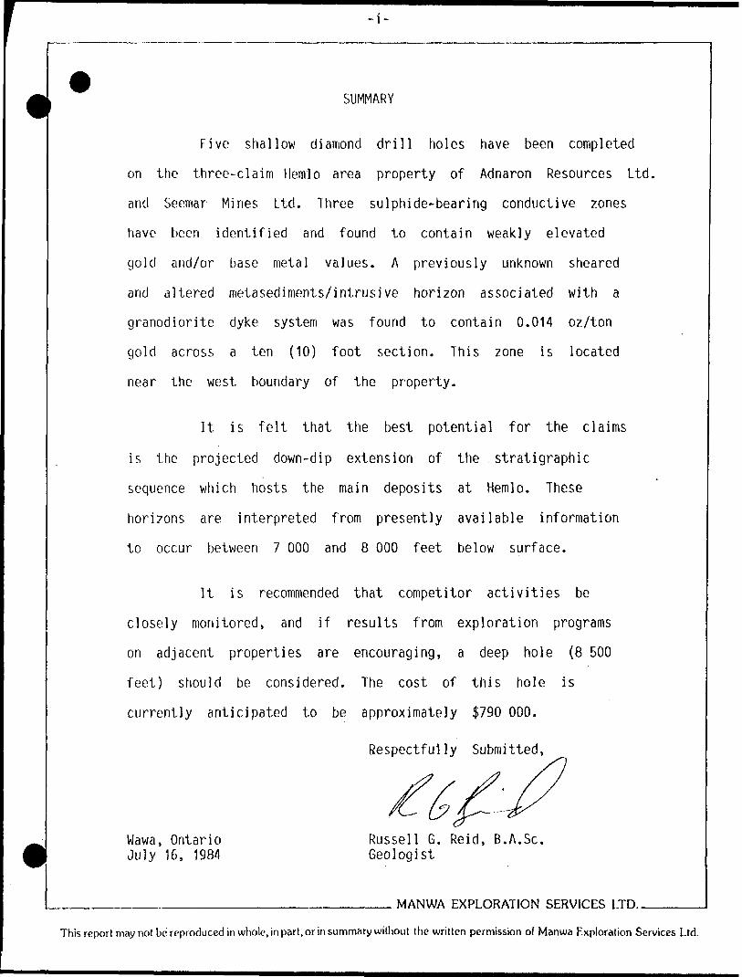
SUMMARY
Five shallow diamond drill holes have been completed
on the three-claim Hemlo area property of Adnaron Resources Ltd,
and Seemar Mines Ltd. Three sulphide-bearing conductive zones
have been identified and found to contain weakly elevated
gold and/or base metal values. A previously unknown sheared
and altered metasediments/intrusive horizon associated with a
granodiorite dyke system was found to contain 0.014 oz/ton
gold across a ten (10) foot section. This zone is located
near the west boundary of the property.
It is felt that the best potential for the claims
is the projected down-dip extension of the .stratigraphic
sequence which hosts the main deposits at Hemlo. These
horizons are interpreted from presently available information
to occur between 7 000 and 8 000 feet below surface.
It is recommended that competitor activities be
closely monitored, and if results from exploration programs
on adjacent properties are encouraging, a deep hole (8 500
feet) should be considered. The cost of this hole is
currently anticipated to be approximately S790 000.
Respectfully Submitted,
Wawa, Ontario July 16, 1984
Russell G. Reid, B.A.Se. Geologist
MANWA EXPLORATION SERVICES LTD..
This report may not be reproduced in whole, in part, or in summary without the written permission of Manwa Exploration Services Ltd.
- - - -- - " ' -' * m m m l i* m mi •••••••••||||||
4SCI2NW8818 63.4439 MOLSON LAKE
TABLE OF lumtmo010C
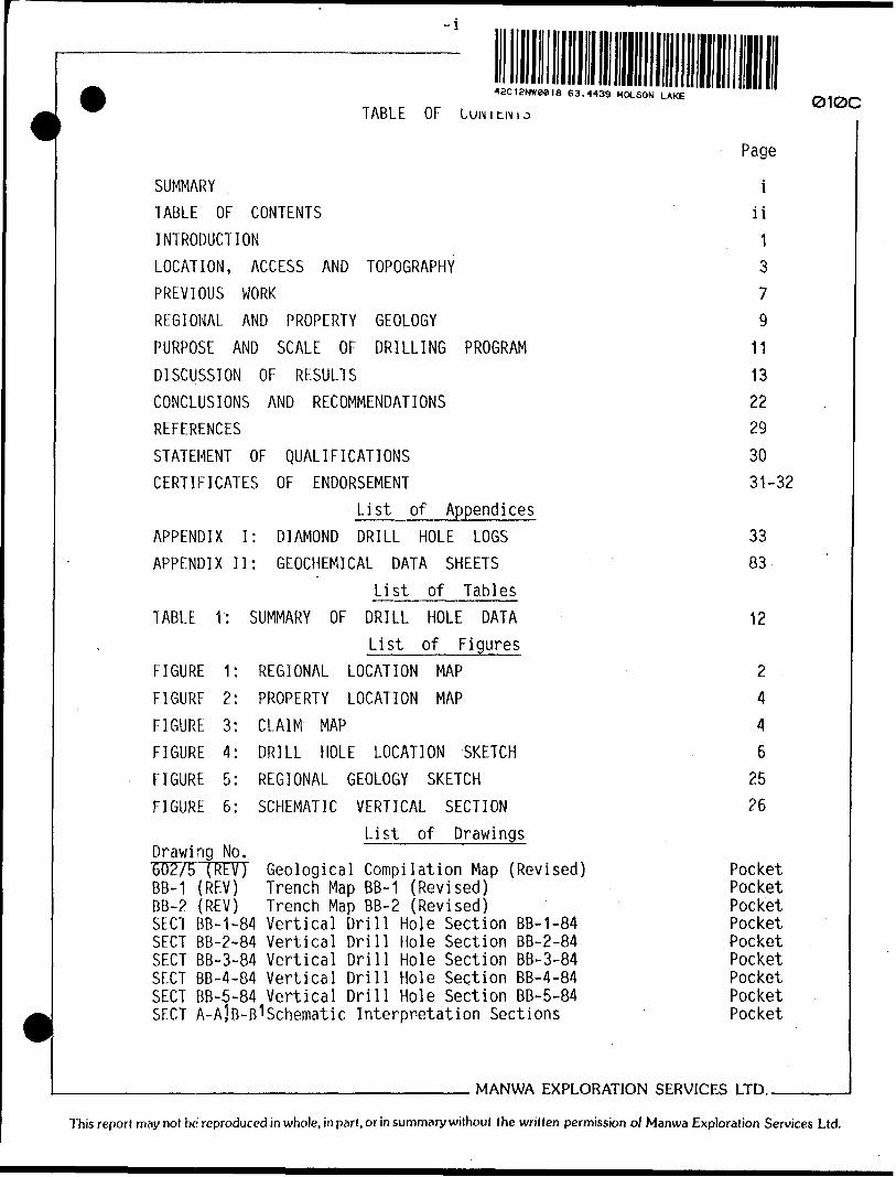
SUMMARY
TABLE OF CONTENTS
INTRODUCTION
LOCATION, ACCESS AND TOPOGRAPHY
PREVIOUS WORK
REGIONAL AND PROPERTY GEOLOGY
PURPOSE AND SCALE OF DRILLINGDISCUSSION OF RESULTS
CONCLUSIONS AND RECOMMENDATIONS
REFERENCES
QUALIFICATIONS
PROGRAM
STATEMENT OF
CERTIFICATES OF
APPENDIX I:
APPENDIX II:
TABLE V:
ENDORSEMENT
List of
DIAMOND
AppendicesDRILL HOLE LOGS
GEOCHEMICAL DATA SHEETS
List of Tables SUMMARY OF DRILL HOLE DATA
List of FiguresFIGURE 1: REGIONAL LOCATION MAP
FIGURE 2: PROPERTY LOCATION MAP
FIGURE 3: CLAIM MAP
FIGURE 4: DRILL HOLE LOCATION SKETCH
FIGURE 5: REGIONAL GEOLOGY SKETCH
FIGURE 6: SCHEMATIC VERTICAL SECTION
List of DrawingsDrawing No. 602/5TRH77 BB-1 (REV) BB-2 (REV)
Geological Compilation Map (Revised) Trench Map BB-1 (Revised) Trench Map BB-2 (Revised)
SECT BB-1-84 Vertical Drill Hole Section BB-1-84 SECT BB-2-84 Vertical Drill Hole Section BB-2-84 SECT BB-3-84 Vertical Drill Hole Section BB-3-84 SECT BB-4-84 Vertical Drill Hole Section BB-4-84 SECT BB-5-84 Vertical Drill Hole Section BB-5-84 SECT A-A]B-B 1 Schematic Interpretation Sections
Page
i iiI 3 7 9
II 13 2229
30 31-32
3383
12
2446
2526
Pocket Pocket Pocket Pocket Pocket Pocket Pocket Pocket Pocket
MANWA EXPLORATION SERVICES LTD..
Thisreport may not bc reproduced in whole, in part, or in summary without the written permission of Manwa Exploration Services Ltd.
-1-
INTRODUCTION
An initial near-surface diamond drilling program has
been completed on the joint venture property of Seemar Mines
Ltd., Toronto, Ontario and Adnaron Resources Ltd., Vancouver,
British Columbia. The property consists of three (3) con
tiguous unpatented mining claims in the heart of the Hemlo
Gold Camp of Northern Ontario (Figure 1).
Diamond drilling was completed on the property,
generally referred to as the B. Boos Claims, by personnel
of D.W. Coates Enterprises during May and June, 1984. Super
vision of the drilling program was supplied by the author,
Russell Reid of Manwa Exploration Services Ltd. of Vancouver,
British Columbia.
The drill program consisted of five (5) holes,
varying in length from 415 feet to 735 feet, with an
aggregate footage for the program of 2 625 feet.
Two trenches completed during the past winter were
washed clean and remapped in detail while the drill program
was in progress.
MANWA EXPLORATION SERVICES LTD..
This report may not be reproduced in whole, in part, or in summary without the written permission of Manwa Exploration Services Ltd.

HUDSON BAY
Miles50 o 100 200
l i i l i :
THUNDER
PROPERTY LOCATION
SEEMAR MINES LIMITED ADNARON RESOURCES LTD,
REGIONAL LOCATION MAP
FIGURE i

-3-
LOCATION, ACCESS AND TOPOGRAPHY
The three-claim property of Seemar Mines Ltd. and
Adnaron Resources Ltd., commonly referred to as the B. Boos
Claims are located in the Hemlo Gold Camp of Northern
Ontario. The claims are approximately one-half (1/2) mile
west of the junction of Highway 614 with Trans-Canada
Highway, Highway 17 (Manitouwadge Corners). The Corona "East"
Ore Zone, is located approximately 7 000 feet southwestward
in an up dip direction (Figure 2).
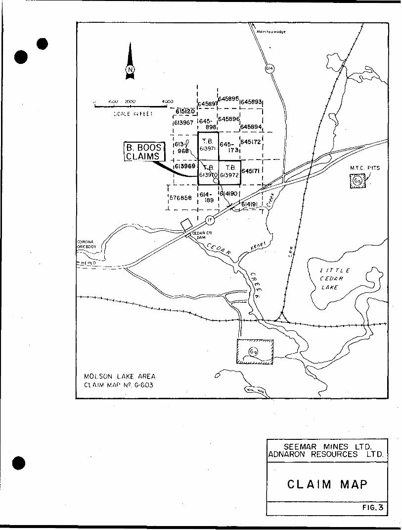
The property consists of three (3) contiguous,
unpatented mining claims numbered TB 613970, TB 613971, and
TB 613972. They are currently in good standing, and have
been legally surveyed (Figure 3). The property is bounded
to the west by Brigade Resources, to the south and east
by Arctic Red Resources, and to the north by Caravel le
Resources. The Noranda-optioned Goliath Gold Mines/Golden
Sceptre Resources ground is to the immediate southwest of
the B. Boos Claims.
Although there is no driveable access road to
the claims, several competitor drill access roads and cut
grid lines approach the southern boundary. The western and
central areas of the property are now accessible by numerous
drill roads and skidder trails cleared during a previous
trenching program and the present diamond drilling program.
A major east-west power line passes through the centre of
____________________________ MANWA EXPLORATION SERVICES LTD..
This report may not be reproduced in whole, in part, or in summary without the written permission of Manwa Exploration Services Ltd.

B. BOOS PROPERTY
SEEMAR MINES LTD. ADNARON RESOURCES LTD.
LOCATION MAP
615120,~ *- — i3CALE IMFEETJ6I3967 1645- ,6^8961 898, _ ^645894^
B. BOOS CLAIMS
LITTLE
CEDAR
LAKE
MOLSON LAKE AREA CLAIM MAP N2. G-603
SEEMAR MINES LTD. ADNARON RESOURCES LTD.
CLAIM MAP
FIG.3
1
the claim group, along which heavy equipment can also be
mobilized (Figure 4).
The main topographic feature on the claims is a
central small basinlike pond into which all drainage ulti
mately flows. A rather steep hill occupies the western
portion of the southwest claim. Vegetation includes spruce,
balsam, birch and poplar with dense moosemaple underbrush
on the higher land, with wet cedar and alder swamps in
the lowlands.
MANWA EXPLORATION SERVICES LTD..
This report may not be reproduced in whole, in part, or in summary without the written permission of Manwa Exploration Services Ltd.
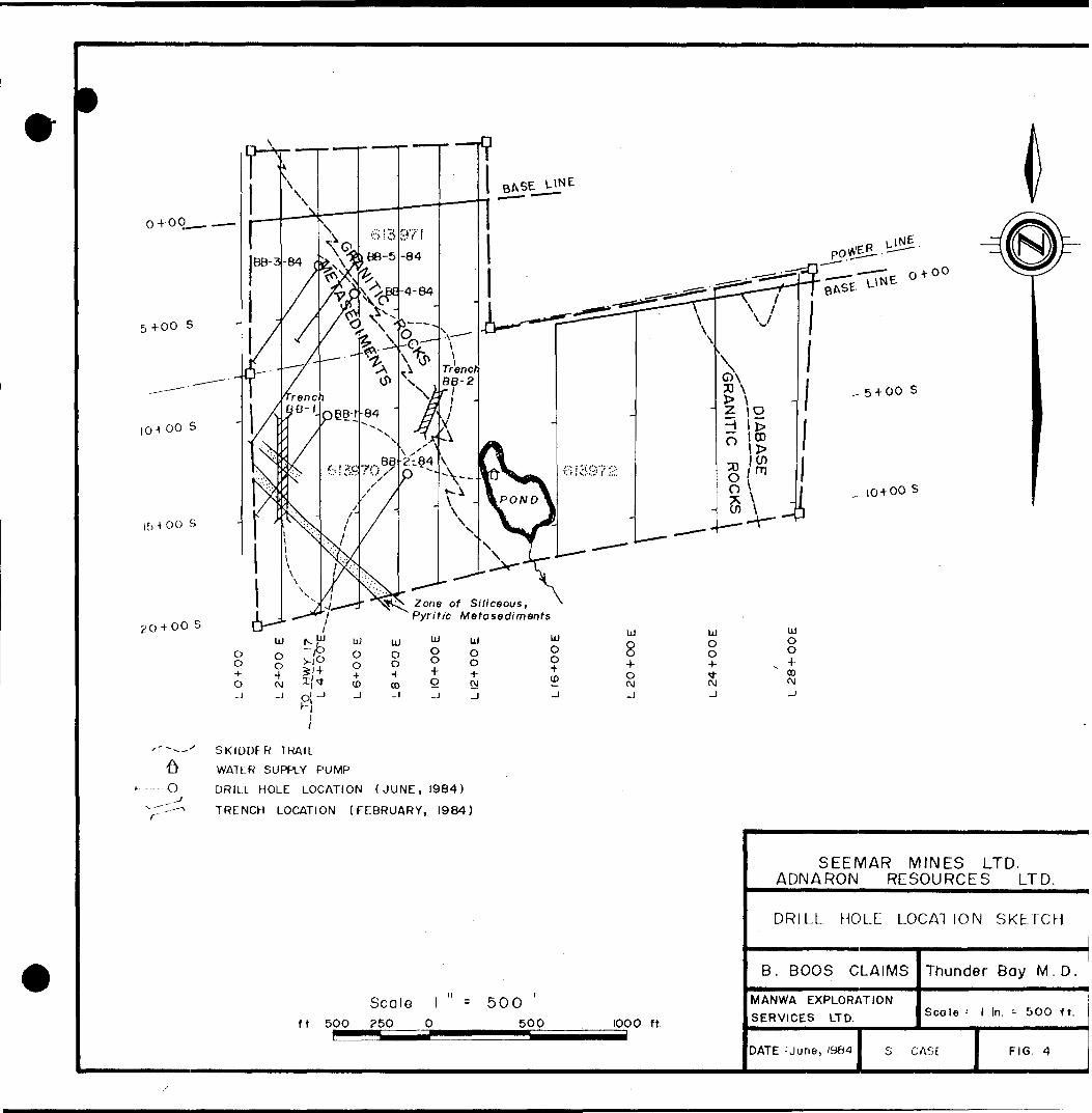
o+oq.
5+00 s
10400 S
15 -t OO S
4 00 S
* 00
Zone of Siliceous, 'Pyritic Metasediments
O o
o-j
UJ
O O4- t\j -j
i . ujN t3swei j
uj o o*CO-J
UJ
o o4-co
UJ
Oo4- O -J
UJO O 4- rvi
UJ O O + (D
UJ
84- o (\j
UJo o4- ^PJ
in O O + oo w-j
,. 5400 S
104-00 S
r"
'"-- x SKIDDER TRAIL
^ WATER SUPPLY PUMP
O DRILL HOLE LOCATION (JUNE, 1984)
TRENCH LOCATION (FEBRUARY, 1984)
ft 50O
Scale l - 5 00250 O 50O 1000 ft.
SEEMAR MINES LTD. ADNARON RESOURCES LTD.
DRILL HOLE LOCATION SKETCH
B. BOOS CLAIMS
MANWA EXPLORATION SERVICES LTD.
Thunder Bay M. D,
Scale ' l In. ^ 500 ft.
DATE : June, 1984 l S CASE FIG 4

-7-
PREVIOUS WORK
The area was included in a geological mapping
program carried out by the Ontario Department of Mines (ODM)
compiled as Map #2220, Manitouwadge/wawa Sheet in 1972. The
immediately adjacent area to the north was covered by a
report entitled, "Geology of the Black River Area", also
for the ODM (Milne, 1968), and the area to the immediate
west by, "Geology of the Hemlo Area", for the Ontario
Geological Survey (Muir, 1982).
The area to the immediate west received a consider
able amount of attention from private industry in the past,
primarily directed towards gold occurrences associated with a
shear zone west of Cedar Creek, These occurrences, the
Williams Prospect and the Lake Superior Mining Company "shear
zone", today are known to be part of the '"Hemlo" orebody(s).
Some of the information from work in this area is available
from assessment files at the Ministry of Natural Resources,
Mines Division.
As a result of the recent activity in the immediate
area of the "Hemlo" deposits, numerous discussion papers in
clude the area of the B. Boos Claims.
An exploration program was initiated on the B. Boos
Claims in April of 1983, with all work completed by or
under the direct supervision of Manwa Exploration Services Ltd.
MANWA EXPLORATION SERVICES LTD..
This report may not be reproduced in whole, in part, or in summary without the written permission of Manwa Exploration Services Ltd.
-8-
of Vancouver, British Columbia. Following linecutting work
to date has included a combined ground magnetometer and
VLF-EM survey (Harder and Foster, 1983), geological mapping
and geochemical (soil) sampling (Foster, 1983), and Induced
Polarization and Resistivity (IP) surveys (Hallof, 1983;
1984 - two reports by Phoenix Geophysics Limited). A 700-foot
trenching program is the most recent work completed on the
property (Sears, 1984).
MANWA EXPLORATION SERVICES LTD..
This report may not be reproduced in whole, in part, or in summary without the written permission of Manwa Exploration Services Ltd.
-g-
REGIONAL AND PROPERTY GEOLOGY
The B. Boos Claims are situated along the southern
edge of an Archean volcano-sedimentary synformal greenstone
belt which lies within the Superior Province of the
Precambrian Canadian Shield. Rocks within this belt are
referred to as the Heron Bay Sequence and described by
Muir (1982) as consisting "...mainly of metamorphosed, inter
mediate to felsic calc-alkalic pyroclastic rocks, related
sedimentary rocks, and high iron tholeiitic basalt flows."
These rocks give way over a large portion of the area to
large felsic intrusive bodies and dykes, including the large
Cedar Lake .Pluton, the Heron Bay Pluton and the Pukaskwa
Gneissic Complex. . Several generations of diabase dykes cut
all of the above units.
Rocks exposed on the three B. Boos Claims include
a thick sequence of northeast-dipping metasediments in contact
with the southwest edge of the Cedar Lake (granodiorite)
Pluton. The latter, along with crosscutting diabase dykes
occupies approximately two-thirds of the claim group at
surface (Foster, 1983), but because of the inferred northeast
dipping configuration of the intrusive/metasediment contact,
additional favourable geology exists with increased depth.
For the same reason, the favourable metavolcanic-metasedimentary
contact zone which is host to the main "Hemlo" gold deposits
is thought to "pass under the claim group at depths estimated
MANWA EXPLORATION SERVICES LTD..
This report may not be reproduced in whole, in part, or in summary without the written permission of Manwa Exploration Services Ltd.

-10-
from 7 000 to 10 000 feet (Sears, 1984).
The more recent discovery of a near-surface gold
deposit situated higher up in the stratigraphic sequence
than the main ore zone (Goliath Gold Mines and Golden
Sceptre Resources - Northern Miner, June 1984) also enhances
the possibility of a favourable geological environment sub
surface to the B. Boos Claims.
MANWA EXPLORATION SERVICES LTD..
This report may not be reproduced in whole, in part, or in summary without the written permission of Manwa Exploration Services Ltd.

-11-
PURPOSE AND SCALE OF DRILLING PROGRAM
The initial diamond drilling program on the B. Boos
Claims was designed to "...test the gold potential of lateral
and down-dip extensions of known sulphide zones, as well as
the cause of untested IP conductors." (Sears, 1984).
In a previous report on the trenching program
{Sears, 1984), a limited diamond drilling program consisting
of four or five holes was recommended, with an estimated
total footage of 2 600 feet. The recommended holes were
spotted in an attempt to test anomalous data from previous
reports, including three (3) IP conductor zones, two (2)
zones showing relatively high magnetic character, and a zone
of geochemically anomalous gold (Au) in the overlying soils.
The drilling program consisted of five (5) holes
drilled with BQ-sized equipment. A Longyear - 38 diamond
drill rig and support equipment was utilized with Mr. R.
St. Amour, as foreman for the contractor.
The crews were accommodated at Gloria's Motel,
eight and one-half miles east of the B. Boos Claims along
Highway 17. Mobilization and demobilization was made from
the main gate area at the Noranda "Golden Giant" mine site.
A skidder was used for moving the drill between holes,
hauling equipment and supplies as well as transporting drill
core to the main highway. Drill core was rough-logged at
MANWA EXPLORATION SERVICES LTD..
This report may not be reproduced in whole, in part, or in summary without the written permission of Manwa Exploration Services Ltd.

-12-
the site, and then transported to the Wawa, Ontario warehouse
of Manwa Exploration Services Ltd. for detailed logging and
sampling. Split samples were sent to Min-En Laboratories Ltd.
in Vancouver, British Columbia, where they were routinely
analysed for gold (by fire assay), and geochemically {A. A.)
for Molybdenum, Copper, Lead, and Zinc. Some selected samples
were also analysed for Silver (A. A. in ppm). A number of
days, in the early part of the drill program, were spent
remapping in detail the two previously excavated surface
trenches to assist in correlating all available data on
the property.
A summary of information pertaining to the drill
program is shown, below (Table 1). Hole locations can be
found in Figure 4.
Table 1 - Summary of Drill Hole Data
HOLE NO. GRID LOCATION ORIENTATIONTOTAL CASINGDEPTH LEFT TARGET
IP,BB-1-84 L4+15E, 10+OOS 45 0 at 215 0 505ft. Yes (Anomaly 'A')
Mag IP,
BB-2-84 L8+25E, 13+OOS 45 0 at 215 0 515ft. Yes (Anomaly 'A')Geochem ___IP, (2 con- ductors),Mag, (Anomaly 'B')
BB-3-84 L3+75E, 2+50S 450 at 2150 415 ft. No
BB-4-84 L5+75E, 4+25S at ai 735 ft Yes /JD TT,. resIP. (3 con- ductors) ,Mag, (Anomalies 'A 1 . 'B')
5-5-84 L5+75E, 2+25S 45 0 at 215 0 455 ft. NoIP, (2 con ductors), Mag, Geology (Anomaly 'B')
MANWA EXPLORATION SERVICES LTD..
This report may not be reproduced in whole, in part, or in summary without the written permission of Manwa Exploration Services Ltd.
-13-
DISCUSSION OF RESULTS
The initial diamond drilling program on the
B. Boos Claims has succeeded in identifying, and testing,
the surficial anomalous zones previously defined. Sulphide
mineralization was encountered in both isolated stratigraphic
horizons, and structurally bound zones.
The surficial program involving the remapping of
washed trenches has resulted in a more complete knowledge
of structural trends on the property. Stratigraphic informa
tion obtained from Trench BB-1 (BB-1 REV) was found to
be accurate, save the finding of an additional narrow zone
of siliceous pyritiferous sediments near 10+20S. The remap
ping of Trench BB-2 (REV) has added a greater understanding
as to the nature of the metasedimentary/intrusive contact.
All contacts are sharp and irregular, with large blocks
of metasediments 'rafted 1 into the granodiorite. The grano
diorite of the Cedar Lake Pluton is also cut by late-stage
granitic and pegmatitic dykes and veins. The metasediments
in the area of Trench BB-2 show a relatively high grade
of contact metamorphism, but with little metasomatic activity
or remobilization of elements. This indicates the nature of
the Cedar Lake Pluton, in the area of the trench, to be
relatively 'dry 1 and intruding with rather high pressure and
temperature conditions.
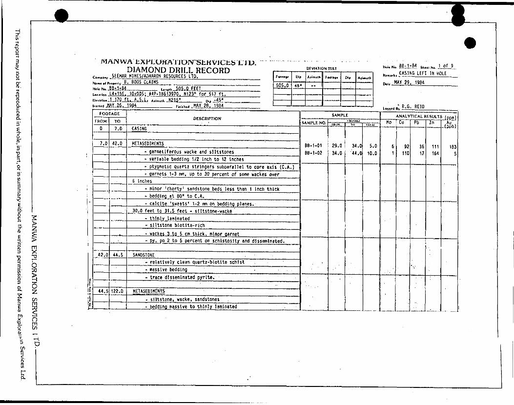
Diamond Drill Hole BB-1-84 was collared as to
___________________________ MANWA EXPLORATION SERVICES LTD..
This report may not be reproduced in.whole, in part, or in summary without the written permission of Manwa Exploration Services Ltd.
-14-
intersect the source of the strong IP anomaly exposed near
the south end of Trench BB-2 at depth. The geophysically
anomalous zone was intersected from 344.0 feet to 369.0 feet
(See SECT. BB-1-84). The twenty-five-foot wide zone consists
of a banded chert-wacke-pyrite-magnetite iron formation with
minor graphitic horizons. Sulphides in this zone occur as
stringers and disseminated pyrite and pyrrhotite, averaging
approximately five percent. The zone shows only background
gold values, but anomalous zinc and copper of 515 ppm and
119 ppm respectively over 25.0 feet.
Rocks overlying the IP conductor consist of thick
units of siltstone, sandstone, and wacke. The coarser sedi
ments are generally composed of quartz-biotite hornblende
schist, while the wackes are biotite-hornblende quartz chlorite
garnet schist. Minor sulphidic horizons were encountered in
narrow structural zones and associated with quartz and
quartz-carbonate veining. Two such zones occur near the top
of Hole BB-1-84, and show anomalous gold values. A five-foot
section of thinly laminated siltstone-wacke containing 2 to
5 percent pyrite, pyrrhotite (29.O 1 - 34.0') returned a gold
value of 183 ppb. A ten-foot-zone (85.O 1 -95.O 1 ) containing
a narrow (life") quartz vein returned a slightly anomalous
gold value of 60 ppb. Both samples returned near background
values for base-metal content.
Directly below the zone of iron formation, a
MANWA EXPLORATION SERVICES LTD..
This report may not be reproduced in whole, in part, or in summary without the written permission of Manwa Exploration Services Ltd.

-15-
H
thick unit of massive chert was encountered, followed
down-hole by thick units of siltstone and sandstone. Minor
units of felsic volcanic crystal tuffs were encountered near
the bottom of the drill hole. No anomalous values for
gold or base-metals were detected below the main conductive
zone.
Drill Hole BB-2-84, collared proximal to the
metasediment/granodiorite contact, tested the source of a
number of anomalous geochemical gold occurrences in the
soils of the area, and intersected the same IP conductor
as encountered in Hole BB-1-84. The drill hole, due to
the proximity to the Cedar Lake Pluton, passed through
numerous granodiorite dykes and veins varying in width from
a few inches to tens of feet {See SECT - BB-2-84). These
intrusive rocks account for approximately 50 percent of the
rock intersected in this hole.
Slightly anomalous gold values were obtained from
two sections near the top of Hole BB-2-84. The zones may
be the cause of the anomalous soil samples previously
reported (Foster, 1983). The two sections are in an area
of abundant granodiorite dykes and veins, with rafted blocks
of highly contact metamorphosed metasediments. The upper' zone,
from 9.0 feet to 15.0 feet, returned a value of 15 ppb,
while the lower zone, from 25.0 feet to 30.0 feet, returned
26 ppb. Although not exceptional, the gold values are well
___________________________ MANWA EXPLORATION SERVICES LTD..
This report may not be reproduced in whole, in part, or in summary without the written permission of Manwa Exploration Services Ltd.
-16-
above the background values received from this area. The
samples zones also show slightly elevated copper values.
The source of the IP conductor was again inter
sected, from 456.0 feet to 493.0 feet. The iron formation
is, however, cut by a large granodiorite dyke, thirteen
feet wide, leaving an actual intersected width of twenty-four
feet. The iron formation, although similar to that inter
sected in Hole BB-1-84, is notably more graphitic and richer
in sulphide content. The zone contains approximately ten
percent pyrite, pyrrhotite, with minor sphalerite and chalco
pyrite. A highly anomalous zone lies directly below the
granodiorite dyke, and over a four-foot section returned
values of 243 ppm copper, 4 330 ppm (G.43%) zinc, and 23 ppb
gold. This lower section of iron formation averaged, over
a continuous ten-foot section, 219 ppm copper, 2 643 ppm
(Q.26%) zinc, and 18 ppb gold.
A narrow unit of thinly bedded wackes near 281.0
feet returned an anomalous molybdenum value of 28 ppm over
ten feet. The zone is both carbonatized and garnetiferous,
and is believed to be a very localized zone of alteration.
Base-metal values 'in the zone are near background levels,
and the gold value is only 3 ppb. ' In contrast, the final
ten feet of Hole BB-2-84 consists of relatively uniform,
unaltered metasediments cut by a narrow granodiorite dyke.
This section returned an anomalous gold value of 43 ppb,*
___________________________ MANWA EXPLORATION SERVICES LTD..
This report may not be reproduced in whole, in part, or in summary without the written permission of Manwa Exploration Services Ltd.

-17-
while molybdenum and base-metal values were of background
levels.
Drill Hole BB-3-84 was intended to test a single-
line IP anomaly, and the relatively weak but continuous IP
anomaly located under the high voltage power line. The upper
IP anomaly was not intersected due to thick overburden in
the area (See SECT BB-3-84). The lower IP conductor,
Anomaly 'B 1 , was encountered from 340.5 feet to 345.0 feet
down-hole. This unit is composed of thinly laminated siltstone
waoke-chert-pyrite iron formation, containing 5 to 10 percent
pyrite, pyrrhotite. This zone, in comparison to Anomaly 'A'
tested in the previous drill holes, was found to be much
thinner, only 4.5 feet in Hole BB-3-84, and limited in
aerial extent. The zone is, however, much lower but still
anomalous in zinc (635 ppm over 5.0 feet), and in Hole
BB-3-84 extremely anomalous in gold (208 ppb over the :same
5.0 feet), and anomalous molybdenum of 10 ppm. Copper values
in the area are also elevated above background.
Other anomalous gold values were obtained from this
hole. The first was found in a leucocratic granodiorite
dyke, from 145.0 feet to 155.0 feet, and returned 132 ppb
gold. Base-metal values were all near background. The other
zone of anomalous gold is situated in a five-foot shear
zone from 215.0 to 220.0 feet. The zone tested also
included a two-foot granodiorite dyke, and over ten feet
MANWA EXPLORATION SERVICES LTD..
This report may not be reproduced in whole, in part, or in summary without the written permission of Manwa Exploration Services Ltd.
•" returned 500 ppb (0.014 oz/ton) from 215.0 to 225.0 feet.
Hole BB-4-84 was collared and drilled to provide
a test of the complete stratigraphic section exposed on
the surface of the B. Boos Claims (See SECT-BB-4-84). The
735-foot hole passed through the upper IP conductor,
Anomaly 'B 1 , with relatively little excitement. The narrow
seven-foot zone from 175.0 feet to 182.0 feet down-hole
shows only slightly elevated zinc of 244 ppm over 5.0 feet
and gold of background values, 1 ppb over 7.0 feet. The
lower IP conductor, Anomaly 'A 1 , consists of three (3)
units of iron formation separated by narrow interbedded
wackes. The upper zone, from 631.0 feet to 645.0 feet,
is composed of thinly laminated iron formation, siltstone,
and wacke. The zone shows slightly anomalous zinc {740 ppm
over 5.0 feet) and gold (21 ppb). The second zone extends
thirty-two feet down-hole from 655.5 feet. The zone is the
more typical siltstone-chert-wacke-pyrite iron formation pre
viously intersected in Holes BB-1-84 and BB-2-84. Base-metal
values in the zone are anomalous, with a five-foot section
running 202 ppm copper and 1 250 ppm zinc. The same section
ran 15 ppb gold, slightly anomalous. The lower iron formation,
from 715.5 to 724.0 feet down-hole is similar in composition
to the main zone above, but sulphides are slightly less
abundant. The base and precious metal values returned from
this zone are also lower, with zinc values being 600 ppm
and 460 ppm over two (2) five-foot sections. Gold values
____________________________ MANWA EXPLORATION SERVICES LTD..
This report may not be reproduced in whole, in part, or in summary without the written permission of Manwa Exploration Services Ltd.

-19-
over the two sections were near background, only 4 ppb and
2 ppb respectively.
A brecciated zone at the upper contact of the
lowest iron formation zone contained abundant quartz-carbonate
as a matrix for brecciated siltstone fragments, and 2 to
3 percent graphite. Base-metal values for the area returned
near background, and gold was slightly anomalous at 19 ppb
over 2.5 feet. A six-inch zone of massive sulphide encountered
in the interbedded wackes of the area returned an anomalous
zinc value of 1 060 ppm, silver of 2.0 ppm, and gold of
20 ppb.
Rocks encountered between the two major IP conductors,
Anomalies 'B 1 and 'A', include thick units of siltstone,
wacke, and minor sandstone. Of interest is a five-foot
section from within a large zone of thick metasediments.
The sample returned an anomalous gold value of 5 ppb, but
only background base-metal values. A narrow, six-inch, quartz
vein and shear zone near 393.5 feet down-hole contained
an interesting, copper value of 320 ppm over one foot.
Hole BB-5-84 was intended to test the isolated,
one-line IP conductor near Line 4 East, 3+00 South, and
also 'retest' the IP conductor, Anomaly 'B'. The hole,
after passing through thick overburden, was. collared in the
granodiorite of the Cedar Lake Pluton (See SECT-BB-5-84).
MANWA EXPLORATION SERVICES LTD..
This report may not be reproduced in whole, in part, or in summary without the written permission of Manwa Exploration Services Ltd.
-20-
4
The isolated IP conductor was found to be caused
by a contact breccia zone, from 180.5 feet to 205.0 feet.
The granodiorite/metasediment contact is very sharp, and the
metasediments are highly brecciated into fragments one to
two inches in diameter. The zone contains 3 to 5 percent
pyrite, pyrrhotite stringers, but little felsic intrusive
material. A five-foot section, including the granodiorite/
metasediment contact, returned an assay of 62 ppb gold, but
near-background base-metal content. A lower ten-foot section,
195.0 feet to 205.0 feet, returned slightly anomalous zinc
and copper of 104 ppm and 121 ppm respectively, but background
gold of 1 ppb.
A source for Anomaly 'B 1 was not clearly defined.
However, a five-foot zone from 409.0 feet to 414.0 feet
was found to contain five to ten percent pyrite, pyrrhotite,
and minor chalcopyrite. This zone returned anomalous base-metal
values of 151 ppm copper over five feet, 133 ppm copper
over the next one foot down-hole, and 198 ppm zinc over
the following four feet. Assay data for gold over the zone
returned as background, 0.001 ounces per ton.
The .correlation of data on Anomaly 'B 1 from drill
Holes BB-3, 4,5-84 (see SECT-A-A 1 , B-B 1 ), indicates the IP
conductor may be caused by a series of localized narrow
sulphide-bearing metasedimentary horizons. These horizons are
believed to be limited in aerial extent or structurally
segregated members of similar horizons. The anomaly may have
___________________________ MANWA EXPLORATION SERVICES LTD.-
This report may not be reproduced in whole, in parl, or in summary without the written permission of Manwa Exploration Services Ltd.
-21-
been enhanced by the zone's proximity to the high voltage
power line traversing the property.
The vertical cross-section also illustrates the
"serrated" nature of the granodiorite/metasedimentary contact
on a gross scale, and the northeast dip of the contact
zone. The section B-B indicates the dip of the contact
beneath the B. Boos Claims sub-parallel to the dip of the
underlying metasediments, and possibly decreasing with depth.
MANWA EXPLORATION SERVICES LTD..
This report may not be reproduced in whole, in part, or in summary without the written permission of Manwa Exploration Services Ltd.

-22-
CONCLUSIONS AND RECOMMENDATIONS
The five diamond drill holes on the B. Boos Claims
have successfully tested three distinct sulphide-bearing hori
zons defined from earlier exploration work, and intersected
one previously unknown, but interesting and anomalous gold
zone. Analysis of samples taken across the three sulphide
zones did not indicate any economic deposits of gold or
base-rnetals in those particular horizons. However, elevated
background values for gold were intersected in one of these
zones (Conductor B, Hole BB-3-84 with 0.006 oz/ton across
5 feet - See SECT-BB-3-84,-, from 340.0' to 345.0'), and
anomalous zinc values were confirmed in Conductor A (Q.43%
Zn across 4 feet in Hole 2 - See SECT-BB-2-84).
The three conductors were found to be caused by
sulphide concentrations within stratigraphically and/or structur
ally bound zones.
Conductor A was found to be caused by an iron
formation from 24. to 35 feet wide. It appears to be
increasing in thickness with increasing depth, and may hold
some potential in its down-dip extension. It is persistently
anomalous in base-metals (zinc and copper), but has very
low gold values (highest value being 23 ppb gold).
Conductor B is caused by a series of thin,
structurally complex or very discontinuous zones of iron-rich
MANWA EXPLORATION SERVICES LTD..
This report may not be reproduced in whole, in part, or in summary without the written permission of Manwa Exploration Services Ltd.
-23-
metasediments. It has slightly elevated zinc content (200 -
300 ppm) and erratic weak gold values (highest being
0.006 oz/ton across 5 feet). The thickest intersection of
this zone was also 5.0 feet.
Conductor C is related to a contact breccia
containing from 2 to 3 percent pyrite across 25 feet.
This zone is located at the granite-metasediment contact,
in proximity to an irregular finger-like protrusion of
metasediments. Although a 5-foot section within this zone
contained slightly anomalous values in gold (62 ppb across
5 feet), it is thought that the sulphide concentration is
very local and the contact breccia zone itself has little
chance for developing any significant size in this area.
The best and most interesting results of the drill
program was a 10-foot section in Hole BB-3-84 . (from 215 to
225 feet) which was found to contain 0.014 oz/ton gold.
This sample consisted of a 5-foot section of sheared and
altered metasediments (215 to 220 feet) and 5 feet of inter
bedded metasediments and narrow (12 to 15-inch) granodiorite
dykes (220 to 225 feet). This zone appears to have also
been intersected in Holes BB-4-84 and BB-5-84, where, in
both cases it is represented by more massive granodioritef
dykes. It is felt that this zone has some potential, but
its location, i.e. very close to the western boundary of
the property, limits much further testing.
_____________________________ MANWA EXPLORATION SERVICES LTD..
This report may not be reproduced in whole, in part, or in summary without the written permission of Manwa Exploration Services Ltd.

-24-
With the exception of the last described zone,
two targets remain untested on the B. Boos Claims. The
most intriguing of these is the down-dip extension of the
East Zone (International Corona/Teck Corp.) of the main
"Hemlo" deposits, described in earlier reports (Sears, 1984).
This zone, or at least the favourable horizon which hosts
the "East Zone" orebody, is projected to pass under the
B. Boos Claims at a point 7 000 to 8 500 feet below sur
face (Figure 6).
Another target, however, might be a zone of
anomalous gold values found from surface sampling (1 800
feet south of the B. Boos Claim Group) by a mapping party
with the Ontario. Geological Survey (Siragusa et al; Map # P-2701,
1984),, On this map, three anomalous samples are reported,
the highest being 750 ppb (0.023 oz/ton). This zone should
pass under the claim group at a point from 2 000 to
3 500 feet deep (Figure 5).
Both of these targets would have been intersected
by a 1983 deep hole on a competitor's ground to the
immediate south (Arctic Red Resources Corp., 1983) hole
located 800 feet south of the B. Boos Claims) (Figures 5
and 6). Also, a hole is currently being drilled (Figure 5)
on the property to the immediate west (Brigade Resources/
Noranda Exploration - 4 300 feet west of the B. Boos Claims).
This hole should intersect the main favourable horizon at
MANWA EXPLORATION SERVICES LTD..
This report may not be reproduced in whole, in part, or in summary without the written permission of Manwa Exploration Services Ltd.

t f
3a
cz:
l 3 l
Oa
LEGEND
DIABASE DYKES
GRANODIORITE
QUARTZ EYE PORPHYRY
METASEDIMENTARY ROCKS a. undividedb. dominantly metasiltstonie c. amphibolitized
INTERMEDIATE TO FELSIC METAVOLCANICS
MAFIC M ETA VOLCAN l C a. amphibolite
Ore zone ( International Corona Resources)
Geological contact (approximate) Competitor drill holes Competitor shaft
Vertical cross-section (see figure 6 )
f AFTER SIRAGUSA, G. M. , I9B4 OGS MAP l P 27OI ; QUARTERMAIN, 1983 , TECK
EXPLORATIONS; MANWA EXPUZRATION \SERVICES LTD., 1984, CORPORATE FILES.
SEEMAR MINES LTD. ADNARON RESOURCES LTD.
REGIONAL GEOLOGY SKETCH
B. BOOS CLAIMS
MANWA EXPLORATION SERVICES LTD.
Thunder Bay M. D.
Scale: l " z I 32O ft.
July, 1984 l S CASE l Fig. 5
t LOOKING NORTHWEST ( 290 e )ANOMALOUS
INTERNATIONAL GOLD IN ARTIC RED HOLE HOLE BB-4-84CORONA ORE ZONE HIGHWAY 17 BEDROCK (PROJECTED) (PROJECTED)
A l I i B\\V\VA \ N\ x N^ \\N x xx \v\ \ \ x \ \N
\ \ ^ X Y, \ \ \ v \ K\ \\\ \C\ \ \ N 3b \ 3o M N\\V\v x \\ \X\Q\ x x
\ \ \v\ x x \lav \ \ \Vx^3a x \ \
\\-\Y' x N N X *^\ \\ \\x \ \\ \ -\ \A X \ \ X\ \ \N ^ yX X X X\ \ \ Y^ \ X \\ *\ ^" ^ \ X XyX .*^f X X/- \ X \
/) ' ^V \ .\ \ \3c x \ X \x(\ \ 2 ^ 3a v^ 3b\ x. x \XA \ \ \
— \_A-\- ^X^ \ ^ favourableOQ ""^\ "\ \^ \ x horizon
O\^ \\\ ^ \A/^ ^\\\x\xxX \\\ x\ x\K \ x ^ v\\^x\ \ X N V N ;4 ^-^^^ \ \ v \ ~2fi v v -v 1
\^\ vV \^v\ T^pU \ ^^ j
^\\ \ \ \N vx \ x x x x 7\ N N\ \\\ \ Xx /X
s N XN v\\ xx 1\ \ ^ \ \. v X j
\ VX^X'^v 1\ \\ V 'V'-O' ^ \ 1
\ \ \ S v\x\\ xx x \ 1\ V ^V j^ \ \ S. "^ f\ *^ y^ "v \ Nfc. * /
2 \ 3c 4\^^X xxX N 2 /x x\ \ XXN^^xX^ N/ X^
\ X- N ^^ XX-*^ y ^ .
k \ \ l ^xX ^xTxJ^^X v-\ X Xx;V^x^^Xs:xNV'N X\
\ "^ X^x Xs x X N X ^\ ^ \X X sX X x v
\ ^ X \ N ^"N^-^ ^ ""\ \ x~ -^^"^-x"^ x-\ \ 3Q""^^ — X^ ^x. *\ \ xx ""x "-'
\ \ ^ X N
\ \ ^
\ X
\ X
, \X N
x y \N ^ X
X xX xx x x
X N
~s ^\ /\
vX . S X
x 3a ^N ^\ 5x x x N-- x\
x x su/ph/d^^ VNX zone — xXx
X x X x X XX N. Nx
N "N •JN^ X^."-^
X N.V v
x3a'^-^
x- v."x
"~
Xx
xx x
xx^
3a x xx
N•^ Nx x-
Nx favourable
x horizonX \ y
Xx ./^x•-X N "x^y\/ N^ "X- ^ N S **" Xv X'xN ^N ""* ^^ X,-xi*? N ^ X N X N,xr-^x N x^x^jo^ Nt; | S*V x |X x. NX ^^ N^
^X N^xVx^^NN X-
X "N-^N ^OX"-X -- N N v*^ X
N N^N ^
X x. NX "
t ——— B. BOOS CLAIMS —— *
X v 5\ ^
5 \ x 3bN
Xx
x
\
x~~~*.
•x x x
XN"X 5x xx
xX x
x x x
N NN N
N XX \
^-, x*- ^ xX x
N ^xX ^N
N NN N
X "NN ^,""x^
* N
X
3b ^x^
x X
xx
xN
NX
XN
Xx^ x.
^ x XX. ^ x
X x N NX X
N X ^x N^N^ XN X X
^•x^ XN^^-x X XX -x^ ^ N x^ N N N
^^x^O^X-N "^xC^ xx Xx X x- x
. ,- r - w n SEEMAR MINES LTD. L t to t N u ADNARON RESOURCES LTD-
[ 5 | GRANODIORITE ^--'^ Geological confact
R"! QUARTZ EYE PORPHYRY ^ "^ ( major , minor ) SCHEMATIC VERTICAL SECTIONr —— — . -,^-* Dri II ho lo
a. undivided //s/ K nown ore zoneb. mainly metasiifst one B. BOOS CLAIMS Thunder Bay M. D.c. amphibolitized
l^. J INTERMEDIATE TO FELSIC METAVOLCANICS MANWA EXPLORATION ^ . "- ___ SERVICES LTD Scale- 1 - I32O ft.
a. amphibolite 1 1 xJuly, 1984 1 S. CASE 1 Fig. 6
-27-
a down-dip distance approximately equal to the earlier
Arctic Red hole. Due to the existence of a granodiorite
intrusion located on the Brigade property, it is unlikely
that the upper (OGS) anomalous zone will be encountered in
this latter hole.
If the Brigade hole currently in progress inter
sects significant mineralization, a deep hole should be
considered on the B. Boos Claims. The hole should be
collared on the Baseline near Line 10 East to allow for
the extreme deviations associated with a deep drill hole
in this environment.
The favourable horizon which hosts . the main ore
zones at Hemlo is estimated to be intersected between
7 500 and 8 000 feet below surface. This would effectively
test the horizon at a point approximately 1 000 feet west
of and 1 500 feet down-dip from the Arctic Red hole.
The cost of such a hole is expected to be.
as follows:
MANWA EXPLORATION SERVICES LTD..
This report may not be reproduced in whole, in part, or in summary without the written permission of Manwa Exploration Services Ltd.

-28-
Diamond Drilling (including deviation tests)8 500 feet @ S707foot $595 ; 000
Assaying400 samples @ S257sample 10 000
Supervision and Support 60 000
Accommodation and Transportation 20 000
Drafting and Report Writing 5 OOPSubtotal S690 000
Contingency 100 OOPTotal S790 000
Respectfully Submitted,
Wawa, Ontario R.G. Reid, B.A.Se. July 16, 1984 Geologist
MANWA EXPLORATION SERVICES LTD..
This report may not be reproduced in whole, in part, or in summary without the written permission of Manwa Exploration Services Ltd.

-29-
REFERENCES
Foster, I.R. 1983. Report on the Geological Mapping, Prospecting, and Geochemical Sampling of the Three Boos Claims, TB 613970, TB 613971, TB 613972 at Hemlo, Thunder Bay Mining Division, Ontario.
Hallof, P. (Phoenix Geophysics). 1983. Report on theReconnaissance Induced Polarization and ResistivitySurvey on the B. Boos Claim Group, Hemlo Area, Ontario.
_____. 1984. Supplementary Report on ^\e DetailedInducedPolarization and Resistivity Survey on the B. Boos Claim Group, Hemlo Area, Ontario for Seemar Mines Limited.
Harder, D.G. and Foster, T.R. 1983. Geophysical Report on Boos Claims, Molson Lake Area, Thunder Bay Mining Division, Ontario.
Milne, V.G. 1968.. Geology of the Black River Area, Geological Report 72, Ontario Dept. of Mines, Toronto.
Muir, T.L. 1982. Geology of the Hemlo Area, District ofThunder Bay, Ontario. Ontario Geological Survey, Geological Report 217.
Ontario Department of Mines/Geological Survey of Canada. 1972. Manitouwadge-Wawa Sheet, Algoma, Cochrane, Sudbury and Thunder Bay Districts, Map 220, 1" ^ 4 miles.
Sears., S.M. 1984. Review of Exploration Program on the 3-claim B. Boos property, Hemlo Area Ontario, for Seemar Mines Limited. (A private memorandum on behalf of Seemar Mines Limited).
Report on a Trenching Program completed on
jtheB.Boos Claims of Seemar Mines Ltd., Hemlo Area, Thunder Bay Mining Division, Ontario.
MANWA EXPLORATION SERVICES LTD..
This report may not be reproduced in whole, in part, or in summary without the written permission of Manwa Exploration Services Ltd.
-30-
STATEMENT OF QUALIFICATIONS
I, RUSSELL G. REID, of 1596 Albert Road, Windsor,
Ontario, do certify that:
1. I am a consulting geologist for Manwa Exploration Services Ltd., P. 0. Box 2028, Wawa, Ontario.
2. I am a graduate of the University of Windsor with a Bachelor of Applied Science, Geological Engineering in 1982.
3. I have worked as a geologist and geological assis tant on a full-time basis since 1982; prior to that as a geological assistant for one field season.
4. I have not received directly or indirectly, nor do l expect to receive any interest, direct or indirect in the property of Seemar Mines Ltd. or Adnaron Resources Ltd., or any of their affiliates nor do I beneficially own, directly or indirectly, any securities of the Companies or any affiliates of the Companies.
5. This report is based upon the field supervisionof the current diamond drill program, and remapping ofsurface exposures, May and June, 1984.
Respectfully Submitted,
P.O. Box 2028 Wawa, Ontario July 16, 1984
Russell G. Reid, B.A.Se. Geologist
MANWA EXPLORATION SERVICES LTD..
This report may not be reproduced in whole, in part, or in summary without the written permission of Manwa Exploration Services Ltd.
-31-
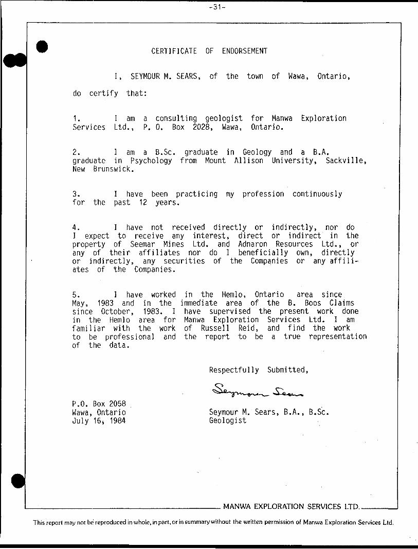
CERTIFICATE OF ENDORSEMENT
I, SEYMOUR M. SEARS, of the town of Wawa, Ontario,
do certify that:
1. I am a consulting geologist for Manwa Exploration Services Ltd.,. P. 0. Box 2028, Wawa, Ontario.
2. l am a B.Se. graduate in Geology and a B.A. graduate in Psychology from Mount Allison University, Sackville, New Brunswick.
3. I have been practicing my profession continuously for the past 12 years.
4. I have not received directly or indirectly, nor do I expect to receive any interest, direct or indirect in the property of Seemar Mines Ltd. and Adnaron Resources Ltd., or any of their affiliates nor do I beneficially own, directly or indirectly, any securities of the Companies or any affili ates of the Companies.
5. I have worked in the Hemlo, Ontario area since May, 1983 and in the immediate area of the B. Boos Claims since October, 1983. I have supervised the present work done in the Hemlo area for Manwa Exploration Services Ltd. I am familiar with the work of Russell Reid, and find the work to be professional and the report to be a true representation of the data.
Respectfully Submitted,
P.O. Box 2058 Wawa, Ontario July 16 4 1984
Seymour M. Sears, B. A., B. Se. Geologist
MANWA EXPLORATION SERVICES LTD..
This report may not be reproduced in whole, in part, or in summary without the written permission of Manwa Exploration Services Ltd.
-32-
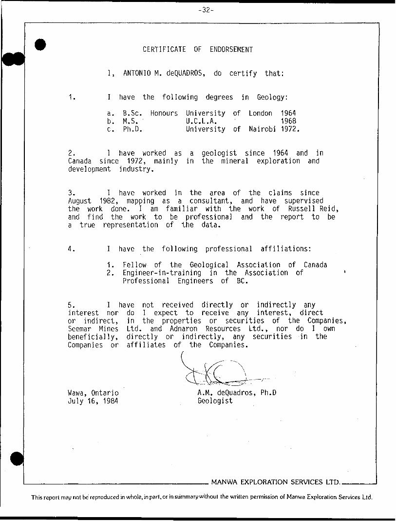
CERTIFICATE OF ENDORSEMENT
I, ANTONIO M. deQUADROS, do certify that:
1. I have the following degrees in Geology:
a. B.Se. Honours University of London 1964b. M.S. U.C.L.A. 1968c. Ph.D. University of Nairobi 1972.
2. l have worked as a geologist since 1964 and in Canada since 1972, mainly in the mineral exploration and development industry.
3. l have worked in the area of the claims since August 1982, mapping as a consultant, and have supervised the work done. I am familiar with the work of Russell Reid, and find the work to be professional and the report to be a true representation of the data.
4. I have the following professional affiliations:
1. Fellow of the Geological Association of Canada2. Engineer-in-training in the Association of
Professional Engineers of BC.
5. I have not received directly or indirectly any interest nor do l expect to receive any interest, direct or indirect, in the properties or securities of the Companies, Seemar Mines Ltd. and Adnaron Resources Ltd., nor do I own beneficially, directly or indirectly, any securities in the Companies or affiliates of the Companies.
Wawa, Ontario A.M. deQuadros, Ph.D July 16, 1984 Geologist
MANWA EXPLORATION SERVICES LTD..
This report may not be reproduced in whole, in part, or in summary without the written permission of Manwa Exploration Services Ltd,

-33-
APPENDIX I
DIAMOND DRILL HOLE LOGS
MANWA EXPLORATION SERVICES LTD..
This report may not be reproduced in whole.inpart.orinsummarywithout the written permission of Manwa Exploration Services Ltd.
*.
y •C2 <S
•g2VA^p
C
OCQiKtszDEVIATK
i•BJ0lise.J U O
D' *.5sjgli;2j <:ck r 1i
UJ
—i
acu. -*r
UJ
C
O
—J
CTt
^-
ox
l/) CM
liii1U
*3^6^^
c
1 s
2I*•*5Jji*-Q
J^
J^
M U
J
:gUJ
5tt'i
t v/l
^J
uj
rU
J
*
^
i
li
nrDn^ n
4-1
V-
r-
vO
L. O
UJ
U
J O
u. **CN
01
"
4^
0l'"* J
ofs.3 eaia.^
t/)C
D
OC
sL-1 U
1
t -*-
CO
-(T
i il!
o4/1
o un(X^ *, ~ *— . u-4
-*
gr-J 3a
oUJ
aco
acT
lj
•a- CO en
^ -
i•v
u.
" iCVJ
i•o*J
l-lESULTi
-i5-
j
. i3i
w -
s!z
c2 i* E 2u
DESCRIPTION
uj O
O
*- KS
gu.
3 Q.
it2Ti)j jio
i/)o
r*O
r*aftCfc\0Ifo01
a1-1oCD
tol—
ZUJ
s: ocu i/)•tU
J
CM
O
1i-S5 rv
J 0
* *-
- ^ooQ.-**C
O
CMCO
•SI
Oc: o*j
TOC•oO)
j**oM0t- atL
. id
O
*1
x: o
c:
CM
OJC
OcCMCt
c•O•o
a*4*
.aAL.
•O
^^
(JXID41i- O5•a t-o34/1t. 0)
enct-
u•DZ)
cruat4-*a.
t
i.S0o*DMH-
04-*CoLa.o
moexC
O14-)
O)
c: i-H
ID*i
Of
-c tJ c:
ux:4VUc;cMai t/t
TOCJ
a*c
o•oc
aM4-*i-ai utt. o"e i
•c
oo O(C4-*
f•Q
1
M
01C•o ci
o*cTO
XI
c
oCMIOS4)
(J1
TO a*4-*to Clic i
x: ut- i at0X)
41c:04-*
trt
1
a c; t.ct- oc"ec xE
UcCOtft
a,K 1' i- py, po 2 to 5 percent on schistosity and dissemln
SANDSTONE .
Lrt
•ST
O
JCuIA
XI
1
ttoo
crc
uf-
o*c•oT3O)
l/l
e
- trace disseminated pyrite.w
—J r
ZUJ
s:oLU
i0CM
C
M
5M A
-siltstone, wacke, sandstones
i™
- bedding massive to thinly laminated
M*
MA
NW
A EX
PLORA
TION
SERVICES I 1"D
'
This report may not be reproduced in w
hole, in part, or in summ
ary without the w
ritten permission of M
anwa Exploral "in
ervices

UJ <<
5
z. QJ
O)
WQ
Ucc:
UJ UJ O) CC
Od
4 a
,— .'
1*t-3y*x -
u-J<Z
^ J5 u
*
-io.1c•i142: t
gKQ
UJ
OO
t-
O
-s s^
XU. ~.xoQ
.C
X—
1
cir-*
d.
USJD:ijuJi
•oc: ooloOJ
OJ
WJ
T
I/IO)
oexcrIA1
*0
^Lf)
Jn'"oLOOoC
D
LO
mo11CO
eac"Oacat.o•c - cI/IcX
)c:in4
-* (OaiIAaicT3
U
1
4-*
WC7l
OJ
SCO
en0o0
0r-Ooo11CO
eaat •a0
)-c LJczOJo
x^ai0)
t*-s•Qa*•cai-Ou.c:t/ic: raraceoi)s
3O)
g1
(A0.c•DO)
i-•QOf
C"3at0V-0*
c: oL
.
tjCg0c01gC
Oo*—jC^^u
o
oCO
•a-
^~ri
C3
C3
OenOLft
CO
Lfto1COea*-**5O
"
*3
O)
-c:LJ
C1O*
O)
CDLO
T—
en*—OO
U)
ooolo11 COeaM
lCaiat
It.uN
4-1
L.
•acrai t-IQO
lJC4J
"i
t-
4-*
"DEL.
O"5i
in Aa*ooco* enct.ccrO
)oL.
O)
cx
oLOa,
gcx1
uo*
oLOMDtsunS
ui•oc^o04i/t
Cra O
l
laJT"5o*oxt
c.O)
oi. atcxo
o*Js1- ocrgc
toC*l
Of
iX3CQCO•*-*IA
4-*
T3O)
X3
*c:
4-*i•*-oC3
en
0o4-J
OCD
r*4-*•o^j^iCDO4-*
encr•oi
c*4-* t-
(OCT
CLO1O)
V-
LO
en
IAOct,A)
Ol
cgL.
Oc1
o*LI
T?
^O
XJ
"i-oIACoo-~1
O)
XJ
"5Ol
JTCea.c: o14-*
01
|enl•*-
004
CD
^~
C
O*
uatexC
DC
OO1-Ol
IpXJc:iCni
-J^Ot*-0
M
cxcx4-*co*ucx
COo4-*tu•H"ocxt*
Ifr.t
-*.J p s*-L/I
r*.
oLOoCD""oLO0r*C
D^CO
CO
v-CMo^
^oL
OC
D"-M *.
fTw
fi-tta!tfoIfoLf
o."~oc
cvCOo1eaea
^OJ.ccLOoCM1
i***
PU
roen
r-wr**
ooo
c*~oc
roen om0 C
O
icoaIA4
-*O
)c
w
aCnal/)ouc;O)
J?ai4-*OX3G
O)
O)
fico
-ot.fDu 1IM4
-*t-3C
71
M
MA
NW
A EX
PLORA
TION
SERVICES LTD
..
This report may not be reproduced in w
hole, in part, or in summ
ary without the w
ritten permission of M
anwa Exploration Services Ltd.
H
ft S
v;
Bi".-* ft)•5oELnS.5'
|.o ST5'•ofcl
in summary withou
he
en pe
MANWA EXPLORATION SERVICES LTD. DIAMOND DRILL RECORD
mission
Manwa Explo
ion Services
m x"Or O PO
m ?oO
qD
Company SEEHAR M1NES/AONARON RESOURCES UO^ Nan* d P.-—., B. BOOS CLAIMS
Hole No. B-1-B4 3 Of 9
FOOTAGE
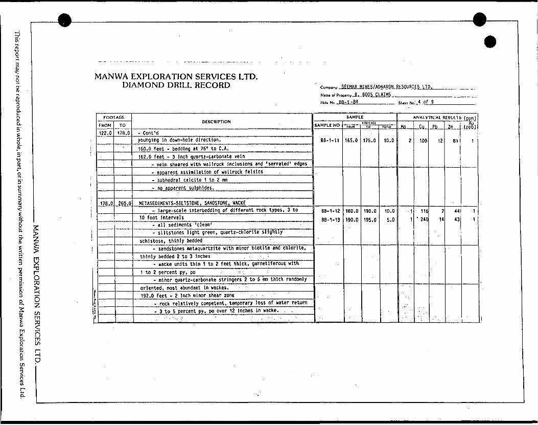
FROM
44.5
122.0
ii
ff
TO
122.0
17B.O
DESCRIPTION
- Cont'd
in diameter- py, po disseminated and stringers 2 to 3 percent- possible tuffaceous origin.
HETASEOmENTS-SllTSTONE. SANDSTONE
- massive appearance, bedding 1 to 3 feet thick- siltstones are quartz-biotite schist, nearly absent of
lithic fragments or phenocrysts (garnets)- sandstones metaquartzite with minor biotite- minor wacke zones amphibolite, possibly tuffaceous- mafic-rich, sulphidic zones persist similar to 106.0 feet
above, possible cyclical tuffaceous.134.5 feet - 18 inch amphibolite zone (epidote)
- possibly sheared quartz vein- po, py 5 to 7 percent, abundant garnet.
143.0 feet - same as above '- more amphibolite, less quartz less sheared- abundant garnet 2 to 5 mm in diameter- minor py, po to 1 percent disseminated.
145.0 to 146.0 feet - mafic unit, tuff or wacke- amphibolite matrix with quartz pods and abundant garnet
phenocrvsts '- trace to minor py disseminated- lower contact with siltstone possibly preserved, core
SAMPLE
SAMPLE NO.
BB-1-10
tfMIlAUI
imiM
145.0
1O
150.0 J
JOTAI
l'
5.
ANALYTICAL RESULTS loom)
Mn f,ll
UK
Ph
15
Zn
42
fnntll
. j
i
i
This report may not be reproduced in who
le, in part, or in summary without the written permission of Manwa Exploration Services Ltd.
————— V ————
MANWA EXPLORATION SERVICES LTD. DIAMOND DRILL RECORD
MANWA EXPLORATION SERVICES LTD. ———————
lf
*-
f ___________________ ....---. , ..-.. . -
FOOTAGE
FROM
122.0
178.0
TO
178.0
-
260.0
DESCRIPTION
- Cont'dyounging In down-hole direction.160.0 feet - bedding it 75" to C. A.162.0 feet - 3 Inch quartz-carbonate vein
- vein sheared with wallrock Inclusions and 'serrated 1 edges- apparent assimilation of wallrock felslcs- subhedral calcite 1 to 2 mi- no apparent sulphides.
KETASED1MENTS-S1LTSTONE, SANDSTONE, WACKE- large-scale Interbeddlng of different rock types, 3 to
10 foot Intervals- all sediments 'clean'- slltstones light green, quartz-chlorite slightly
schistose, thinly bedded- sandstones metaquartzite with minor biotite and chlorite,
thinly bedded 2 to 3 Inches- wacke units thin 1 to 2 feet thick, garnetiferous with
1 to 2 percent py, po - :.- minor quartz-carbonate stringers 2 to 5 inm thick randomly
oriented, most abundant in wackes.192.0 feet - 2 Inch minor shear zone -
- rock relatively competent, temporary loss of water return- 3 to 5 percent py, po over 12 Inches in wacke.
. ' - 1 - "-. '. " ' ' . - ,' - . ' '
Company .J
Nam* of Pro)
Hole No. JH
EEHAR M1NES/ADNARON RESOURCES LTD,~,,u B. BOOS CLAIMS-1-84
SAMPLE
SAMPLE NO.
BB-1-11
BB-1-12
BB-1-13
t DOT A CIIKON
165.0
180.0
190.0
10
175.0
190.0
195.0
1OTAI
10,0
10.0
5.0
ShMI Ne
1
4 of 9
ANALYTICAL RESULTS
MO
2
1
1
••'
Cu
100
116' 240
Ph
12
7 14
?n
81
44
43
.:(PP.mJ -LPP&J
1
1
1
W
0
i
oLft'l
P
II
pCOUJQ
ecu u u
coccZHO
d
SgW <
<5
*i1:S
I
CM
cj-ccC
U
-JDU)
UJQ-
——
Sg-
2
*-iso.SK
CzuaS4t/
RIPTIONa
UJ
Oo
t-
88Lw
2
C*
C**.
CO
0x.
2Jg
-
oc
. o
? dcio
5 sJLffiffi
•oc
o
CJto0uD(MOCOr-*
15ut"OL.
4-*
-O1O)
01
0
U3
en
ooCMen
mildly garnetiferousi
ec O4-*
CMSa s
w
uMl
101
1•o014JO)
O
Hwoo:n
S IS
en en
IA
r*.C
O
CO
0 0
o o
lA
in
CM
CM
0 O
en IA
co *r
CM
CM
IA
VO
t 1
1 1
co ea
CO
CO
01DlQ1crayTOU3
L*nTt
1 iL-S.o*Jdisseminated py,
po 2
'i
UJ
se ol/)_
1Coo: o3EL
U
tJ-(C1t/1zLUXoUJ
t/)4:U
JJCOroC
O
o
oCM
O)
*^osTOct(O3
crL.
OC"esz'S1acO)
2en
fID
•Q1
lA
*~
O
O
CO
**1
co -wr
eg
co —
CM
•v co
en
0 0
O
IA
lA
O
O
O
O
O
lA
lAf**
f** O
CM
CM
CO
0 0
O
*A . o
inua
r*, en
CM
CM
CM
r- CD
Oi
lit
1 1
1C
O
CO
C
Oco
co ea
ii
VI
L.
O)
fi-(AV40
1f.
MD
U
•O3cri•oci-TJC0)(Oi-1
Eminor disseminated py,i
ciVOoiCMC
Ukoo4-*
CM o?garnetiferous,
varlablti-O
f4
-*
i•O
TD
roCOCO
cS
.
o
oo
inCO
oinsO
'CM1lC
D0
0
>Cs^JZ.f2C
MC
ax:ciT
OmT3
T
D
S
Ol
coNt. IO
O
l^MO
)
t.toursit3cr.c ucCOtO
)at
0enCM
,1suEOC
GMauci
c**icIA"acKra210)
TO4iCgUHJc11
:X4-*
•OEO)
4-*0(J
1cCO
cifs.AsCOaat-OJ
CM
C
t.
disseminated and sii
4-*
"cOJ
St-*Vt
cCO 14-J
zlAM
EU
CM04-*
TOOJ
•o •oc
x:4
-*1
f)
0)
cc:i
w—
— *- * l—
— ~
MA
NW
A EX
PLORA
TION
SERVICES LTD
..
This report may not be reproduced in w
hole, in part, or in summ
ary without the w
ritten permission of M
anwa Exploration Services Ltd.

mE
l
•So ao A a.5'
3TDCv
3 Ifi
l
rv
5-
g
Er
S
g'
6'3 O
lmxXJ..o
lm x•X3
O 50
O•zCOm
n mCO
MANWA EXPLORATION SERVICES LTD. DIAMOND DRILL RECORD Comp.ni, 5EEHAR H1NES/ADNARON RESOURCES LTD.
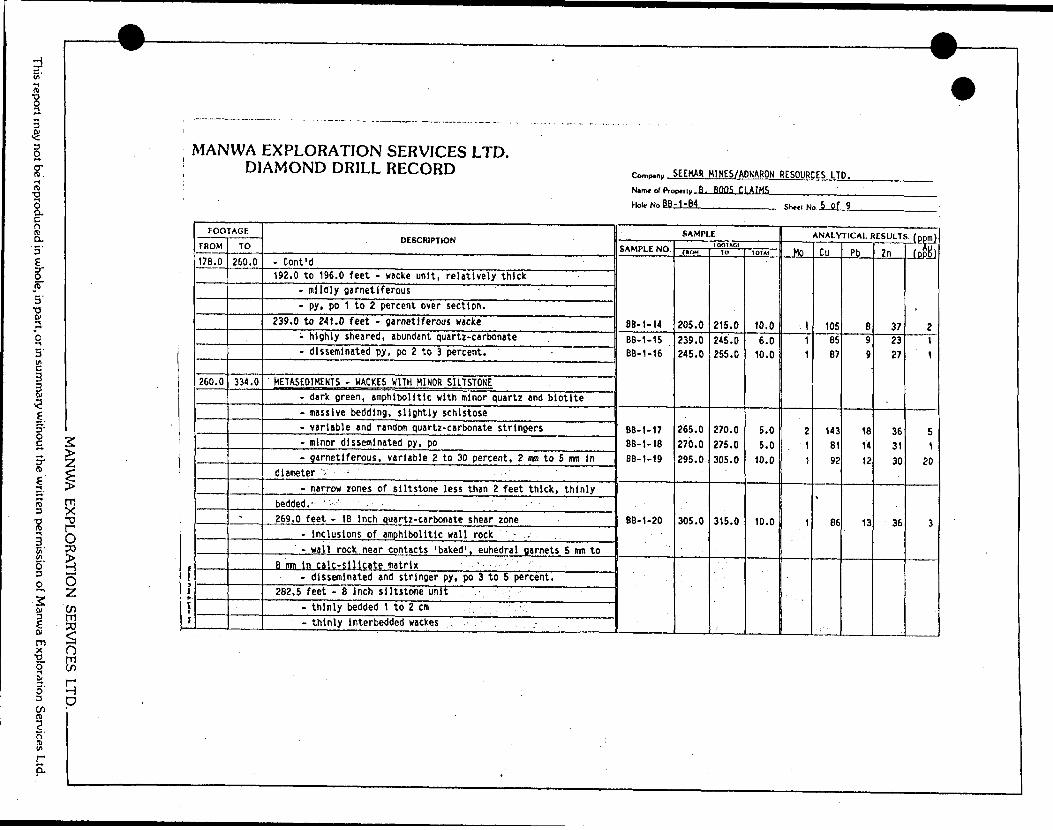
N. o( p-op...,.B. .BOOS.CLAIMS_________ Hoi. No ,BB-1-B4 She,i Kin 6 Of j
iF1f
FOOTAGE
FROM
260.0
334.0
TO
334.0
344.0
DESCRIPTION
282.5 feet - Cont'd- wackes garnetiferous, slightly more aluminous- minor disseminated py, po 1 to Z percent.
304.5 to 306.0 feet - siltstone unit- thinly bedded at 80" to C. A.- 'clean 1 quartz-blotlte schist- possible lithic fragments 2 to 3 inches minimum lengths
parallel to bedding- trace disseminated pyrite.
308.0, 311.0 feet - garnetiferous zones- aluminous garnet 15 to 20 percent of rock- crystals subhedral 2 to 5 mm- amphlbolitic matrix, minor epidote- minor pyrite less than 1 percent, disseminated.
METASED1MENT-SANDSTONE, WACKE- thick, massive sandstone with wacke interbeds 12 to 18
inches thick -- uniform textured quertz-biotite metaquartzite -
- wackes amphibolide with abundant garnet, trace pyrite- 'rafted' wacke fragments 'In sandstone (340.0 feet) may ' .
indicate down-hole younging direction. - -337.5 feet - 1.5 inch 'blob' of tourmaline
- crystals over 1/2-lnch long (?tube). ; ' '- ~ -"' ' * " ''- ' .. ."' ^ - ' '' ' -- -~ , ' '
SAMPLE
SAMPLE NO.
BB-1-21
.. . "'. '
't ' * ' .
rooTAcimoM
334.0
lo
339.0
10! W
5.0
ANALYTICAL RESULTS .(ppm)
Mn
6
v- .
Cu
55
X'
Ph
16
7n
85
fpftB)
6
o COrti n'
D
l/)s
O)
au
u ai
coosZ
J
UJ <i3
gUQ. *
*-S
(5
"w-J
,5
- S
-—
i5
*•f
ca!
51"
W "
Si '
1
iM
:dUl
s! <Ul
DESCRIPTION
u
OU
1-
<STn -t2 iu. i--*n
c oj
rU
3 U
GO r-
U*i
CV
U
0
C
U)
U"
O
C
U*
C
•W
W1*1
f
0
C
O
i/
fO
5
(M
O1
0*1 CVJ
1 1
1 1
CD aa
m
ea
:hert-wacke-pyrite-magneUte
IRON FORMATION
- bended t
oenlOeno
^
S
3 u
". "
1 C
-^ O
J v
1 C
k C
t ucIf u- **csfftCD
to
x
oJZ V504O+J
eaOJ
J310V.
>
VITDCto
-Q1
n u
r r
1
M
U
T
r u
^ a
} C
) ir
) C
1 C
i u;
i fc
!U
1 U
lmi/) f*, 11ffiea
t py. po
stringers cross-cutting- abundan
** c
rt C
O
U
— -
^
•* o
3 C
) O
) U
l
oUl
t W
3i
mo0usC*l
toOJ
1teaCO
g*JcOtt—-sOf
4-*
**"u^TDC0u•4-*
M•0Q.
tt- extensi\
ctucrcucc
r- *-cU
"u:^
*\ tsis bands, disseminated, bleb, and stringers, 3
to
a aI
3
C 5
td
n e
* c
*. r
J C
) C^
) C
* c
5 S
t C
* c
! Pgi
i B
fiC
sectionut g0u
O)59i}>i11
.M?•O2O
•t-*L.
0)
JkC1. fTOC0c
a
•oc3
-O42+J C
V
irt (U(~ exV
Ia*c:0r^4
u- graphlt4-*
C3V-o^J
4-*oXI
Ic
t*~oCMCoE3
+JOJa"Oocuc1*JO)
41S
-
o
o*Lrt
o^
g*uiM- central
cc*-1a0-H
L.
O)
C"ia* */* ot.^ *-*c3^ o
^f4t
H-
V
4-*
^
^^T:"C i
"OcO)
l-OJCocIo
irU3
fo
tx uf.iL.
on
Iu4)
t.^jC
C^r i
* shear/fault plane.
J3
i/ii
sLiJ D
C
tJLU:^t/) t/)
META5E01MENTS
0in8os
O
4-*
i st suDOAc*s t- at
1ow*Zi
JM: u1
I•*J xai
•*-*"o
u4d*c-o -oat A+J cf(Od
. o.•oo
go
r**t-(U
Q.
Ok
3CV
.^
uQ
3cOt/l4-*
C
3C.C
*J1
•DUj5Sa-*5aM l*3J 3
•QJIO t*J)
2
O"w
f, po
stringers, trace over section.exuocnf
——
r
~
-.*
K3
L.S
at-
MA
NW
A EX
PLORA
TION
SERVICES LTD
..
This report may not be reproduced in w
hole, in part, or in summ
ary without the w
ritten permission of M
anwa Exploration Services Ltd.

Hin'
l
if.
Q.
Of) Q.5'
l•o
3 (/l
l
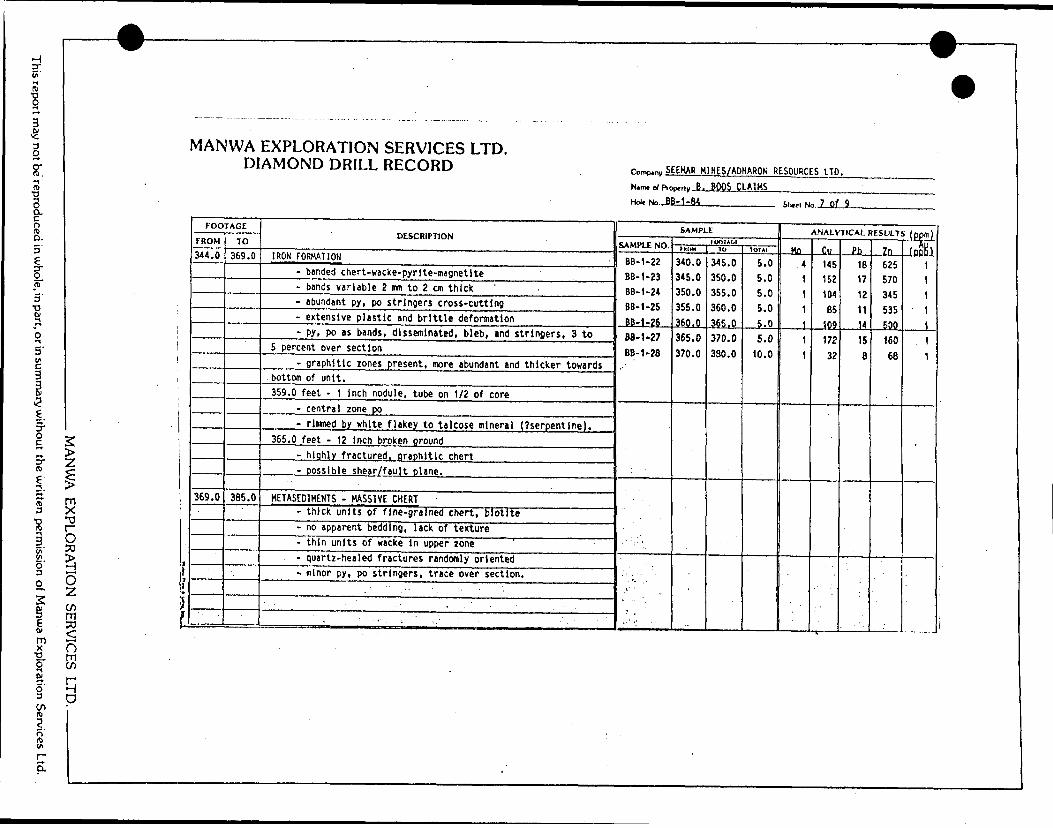
MANWA EXPLORATION SERVICES LTD. DIAMOND DRILL RECORD
g
(6
Di' ui6'3
w3
tum x
fCU5'D
ri'nVI
rQ.
H-UK...8B-1-84
SEEHAR H1NES/ADNARON RESOURCES LTD. ,tly B. BOOS CLAIMS________-
_________ SK... No...8 Of 9
l
T3
O
o zm ^nm en
qD
]
l1*\l
FOOTAGE
FROM
385.0
450.0
TO
450.0 *
495.5
DESCRIPTION
METASE01HENTS - SANDSTONE, SILTSTONE
- massive, uniform texture- variable bedding, 1/2 Inch to Z feet- highly silicified to approximately 450.0 feet- Quartz-healed fractures, domlnent at approximately 30" to
C. A.- minor to trace py, po on fracture planes- silicification aureole noted adjacent to fracture olanes- contact with upper zone qradational- bedding at 78" to C.A. (405.0 feet).
406.0 feet - 1 inch quartz-carbonate vein- subparallel to bedding- no apparent sulphides. .
452.5 feet - 12 inches broken ground- block fractures- thinly bedded wackes, sandstone; silicified- minor carbonate In some beds- minor py, po, cp on schistosity, up to 10 percent over
4 Inches. - ' .
METASED1MENTS - SILTSTONE, SANDSTONE '- thinly bedded, massive texture .- silicification absent- 'clean' of lithic fragments or phenocryst* .
'.. .... - minor fracturino and shearing of select beds 'r ' :
SAMPLE
SAMPLE NO.
BB-1-29
BB-1-31
BS- 1-32 BB-1-33 BB-1-30
BB-1-34
FOOTAGtimw
395.0
450.0454.0 455.0 470.0
495.0
1U
405.0
454.0455.0 460.0 475.0
500.0
1O1AI
10.0
4.01.0 5.0 5.0
5.0
ANALYTICAL RESULTS (ppm)
.Ho-.
1
31 1 1
t
Di
39
6680 26 12
42
Ph
13
1418 8 14
15
Zn
75
102147 69 72
77
(nph1 )
1
1191
1

•-ct*-
uOUJ
CJ
aeZ3
OenU
Jacz0or-czswna::EocU
JU
Jt/)16cj
QainW Q
5Q
au
i U
UJw
es
1 o
dH
^-^J
^fcDC C^O
TT
sigU4 <<
5z1
trt3:3.1 u'A8ea,ea 2ia•31s
en•*-o
en11S1ea eacZx
-
g-5t/) —
5U)Lk!ac
~- .j.jz
iia.S
C2 ua3u
Ot2U(A
UJ
a
u
O0
l~
o ,.
S oac u. 3-Cf.
ac
.*;^
T3CoCJ1
^enoG
Xtt ttoU3
r-*
-jo0o2)
encTQ
"OJS1
SV-
H-(A^crouWl
"ttH™18V-
op*.
50O
•sc•ot.CM
Iatc;
H-
ttCgCMOt/l•o
-*-*i/i
UuM—t
?*A1xL
.
•O
ti4Ogut- ttoi-t30C
*1
0z•sCJ
051—UJ
zCJ
t/)—J
UJ
u.tzUJ
a:oU
J
sLlJ
oorfl*en
uV\
"tt
Milca8CM
Oc•JJ55Ul
ttS•ottT?
4cs**1
ttc
oVI
M
U+JM?ttex
v-^i—*
i
x4-*
H]
ttL.
en iV)
•o •ottL
,
(ZiegoJ2L.
UWl
ttV-1
T3
ttc:*) t. en ittcV-ttUl
Joe*
t~01o4-*cttKS.10ssc
^Oao.
•ott4-*toC1I/I•oU
-ocE1
^W)
ttx: uc
I/I
•ocA3
Wl
C"Si-2l/•c1ta oaCT
C1I4-* tttt
O
aJZuc40c4S04S*~l/aol "etto•o'ott
"—
x"•X
s^^
Ul
.- 1o1C
u. oQU
J
O0U) x^x^
x*x^^
—r
f5s^is.M
*,.
)—~
rtM
* i—
.*-
MANW
A EXPLO
RATIO
N SERV
ICES LTD..
This report may not be reproduced in w
hole, in part, or in summ
ary without the w
ritten permission of M
anwa Exploration Services Ltd.

:*i f
; *
l||iz•ll\A
EXPLORATION SERVICES LTD.
"
DIAMHNn nPlf l Dirorkor*
3. 2<S
y.
Z"Ii/*- H
3•f ii* Ka|u-Allmulh
2t
J-MIHES/APNARON RESOURCES LTD. ^JOOS
CLAIMS
11
- "^ s
LU
J Irt
'^ i ;
oi iU
3E
ii ikAVO^) ,n
Ult.
ouyliA
l 0c\
slli1 a.CM
o^ o
o6
S3l ili
O
U]
•u 1oLf
cv3C
j•*
-J"i4OJ
3El*v*lloh.
uj
CC•fT 1
COenmiII c.
soo
c.w t(3
H
-J D
U)uU1
3ga -o.X
iUt/
DESCRIPTION
uj O
c *-
isu. —5.
id w
cH.—
c cc r* *-U
l
j: o,: -C
J
o
5
oo u
.
12isi -i siCASINGoo
k f-o-*aV-i
CO
0C]
CM
^OCM
1
eaCD
UJ
oh-
-JLA
Zc
oUJ
i/)xooUl
atoVI
.CMl
41
-o41ac c1
•y"
MCM
Xa
wso* 0*oc*
co I
•f*•A
^ex•oc:•oIt-iO
f.c(O41J
E
1
GRANODIORITE VEINS -
oCOoM3
X*
41Cf-o* tatcH-
4)M
IAto EIAC
O"
s
U4?
g*AW*
JC
CU7
XI
V•aCL
4) IA1
^AAt-
T3
4)(O4)X3**
U
41C•Ow•ASIA
MTO41X
METASEDIMENTS-SIL7STONE, WACKE
oCM
OCO
4fIAO0
(At- 4
*
tnocCMC•A
*A41
X*
•o•o4* ^
5C
-Ct
IA
0)
UffC
41
|U
t-oceg "54-*V
I
4J
.Ntft 3cr414-)
*JO2
41Cf-StocTX!
"*
CMSX
h*viSM2
U
*4C
OtAt-f.k.4^
IAi-*a
.
R1
C*o (JW)
-i- 4)
Ocr0)
uCOo
~-1c t.tA
1XJc:fOMt-
4*
ateTVI
4)
V-
4-*
IA
"4-
1/1
'••?
Vdistributed.' •:---.-:r- --- - : '-i.v; •,v; . ; .. .-... r'.'''•"Jt/VC
.
- uti nVa
gi0c o•'
cs0
4-1
U)3C
w4. MiwMC C"tV
I
4)XcVl
'
4C
IMM
P
^f-4)
Tj.Z1 \e. oa0.^iw la41
oMM
4.
- .V
*
. 41C
t-**,
MA
NW
A EX
PLORA
TION
SERVICES LTD
..
This report may not be reproduced in w
hole, in part, or in summ
ary without the w
ritten permission of M
anwa Exploration Services Ltd.

V)•^ Kl
"C
o
O.
o. 5'
l ra
STm
K 6'
l
zls"Oo30
O
(/im se
MANWA EXPLORATION SERVICES LTD. DIAMOND DRILL RECORD
:
!|
f
*
1 I
FOOTAGE
FROM
23.0
25.5
32.0
35.5
•' -
TO
25.5
32.0
35.5
55.2
DESCRIPTION
GRANODIORITE VEIN- massive, very fine-grained- near pegmatitic quartz, feldspar at lower contact- very fine-grained po, py (sph) sre fracture-filling,
approximately 1 percent over section. -r.-.'.1 . -•:.- ' '-'. ''f:-- '•-"':'---.--'"-:. - ;', .
METASEDIMENTS - FELSIC INTRUSIVE- fine-grained granodiorite, with rafts and blocks of
siltstone, wacke, - sediments show abundant plastic deformation and angular
serrated edoes- abundant disseminated ov. DO 3 to 5 percent.
GRANODIORITE VEIN ' - ,- nasslve, fine-grained .- few to no fractures :- small hematitlc feldspars 1 to 3 mm In diameter.
METASEDIMENTS - SILTSTONE, WACKES-;:*", :: 'V: " . " •~ thinly bedded, very schistose/ Y- ' .-; ;V .; .- abundant granodiorite stringers and veins, up to 6 Inches
wide - .'•" : -"' •••:; .•-'••"•,! -' v ;.-' v-'.t. '•••'.' '. ' - ••'•••.'•."••- ~
- m inor disseminated py, po ' " ;- . "••'- " "- Ptigmatlc quartz-carbonate stringers, no apparent . .
sulDhides^'T^Mv.'^ -'. ,-;. : -'. .., ..., : !^'';- : '- -' .:''-vv.';.:- : .:.. ••
ron,^y SEEHAR H1NES/ADNARON RESOURCES LTD.Nam* ci Proi
Hole No .BS
r-r, y B. BOOS CLAIMS-2-fU
SAMPLE
SAMPLE NO.
BB-Z-03
BB-2-04
-*' 1 ' ' ' ^
inoTACiFRCM4 1
25.0
35.0
lo
30.0
45.0
1O1A1
5,0
10.0
Shift No 2 Of 13
ANALYTICAL RESULTS { DDr,J
Mo
2
2
Cu
69
91
Pb
13
e
In
63
56
(pf!H)
26
3
x1 O
s'
oR) l/)
r EL

This report may not be reproduced in whole, in part, or in summary without the written permission of Manwa Exploration Services Ltd.
~^-
MANWA EXPLORATION SERVICES LTD. DIAMOND DRILL RECORD
MANWA EXPLORATION SERVICES LTD. ———————
! i9'
FOOTAGE
r ROM
55.2
62.5
70.5
i.
TO
62.5
70.5
75.5
DESCRIPTION
FELSIC INTRUSIVE VEINS- granodiorite to granite- massive, fine-grained- highly fractured with epidote, quartz on planes, minor py
56.0 feet - 4 Inches, highly fractured granodiorite- py on fractures, 1 to 2 percent of rock.
METASE01MENTS - SILTSTONES- thinly bedded 1 to 3 inches thick- schistose- minor quartz-carbonate stringers and 'sweats' subparallel to
bedding- dark brown to grey biotite schist- trace disseminated py.
QUARTZ PORPHYRY DYKE- fine-grained with quartz porphyry crystals 1 to 3 mn- blotite-rich, slightly schistose ;- disseminated py approximately 1 percent- minor quartz stringers- - - ~ .:., :-,- abundant ouartz-feldsoar veining at upper and lower ;:;N;'v:
contacts. "' ;- : -^ ' ''' ' ; : •'•••- ' : ' '' .' - • '••'•f "'-: S'.!".,: ')...',','s : - - - ... - ; . -
•••• ? .:/ •;. ..S'ii-%; .s;~v. - ; " .'. ' - ' - ' .-•. " " '. ' . ' - -:' •: ^-:'-': ; .^,,-.: : •'-•"i "' : . ' ' -- - ~ .: - -' '
. ... - ,..,,, , ^
\
r^w S EEHAR H1NES/AONARON RESOURCES LTD.
Name of Pro
Hol.No,J3i
^,,^B. RfKlS CLAIMS-2-84
SAMPLE
SAMPLE NO.
BB-2-05
BB-2-06
BB-2-07
1 -,, -
tOOTAUI1KOH
55.0
65.0
70.0
-
TU
60.0
70.0
75.0
10IAI
5.0
5.0
5.0
Shttl No 3 of 13
ANALYTICAL RESULTS, (ppm)
Ho
i
6
1
Cu
15
119
20
Pb
12
11
12
Zn
28
106
97
(nnBt
7
4
3
. '
W
0

This report may not be reproduced in whole, in part, or in summary without the written permission of Manwa Exploration Services Ltd.
W
MANWA EXPLORATION SERVICES LTD. DIAMOND DRILL RECORD
MANU/A EXPLORATION SERVICES LTD. ———————
ly t
} i
FOOTAGE
FROM
75.0
84.0
B9.0
•; -
TO
84. 0
89.0
r*i
115.5
DESCRIPTION
METASED1MENTS - SILTSTONES- thinly bedded biotite, quart; schist- minor wacke units interbedded- bedding at 85" to C. A. {63.0 feet)- no apparent sulphides. .
METASEDIMENTS - HACtCES- thinly laminated-abundant plastic deformation, near gneissic- epidotized quartz lenses less than 1 inch wide- disseminated py, po (sph) 1 to 2 percent- small granodiorite veins 2 to 3 inches wide In upper and
lower zones.
GRANODIORITE DYKE ' ' ' - . - - '- slightly porphyritic quartz- blotite-rich, slightly schistose- small rafts of sediments near upper contacts- lower contact sharp at 75* to C. A. ; ' : .- minor disseminated ov to 1 percent. '*. '
94.5 feet - 6 Inch sediment raft ' ,; . ' - , - " . -- epidotized wackes, massive quartz - ;- s lltstones biotite schist with Z to 5 percent py, po, sph.
~ ' ' . . .' , * - - - .- '' . - . - ' -- , " ' ' - . V ..' , . , . . ' . - . .. . - ,."
,* '' - -- ^' '••'•• r ^ - . -t ^ i^-iV'v ', : . -'., : -'- *.'.;\''. - -' . ' ''. ' ",."--.p ' '
^
romp,ni, SEEHAR M1NES/ADNAROH RESOURCES LTD.
Namt ot Pro)
HolfNo. BE
^,v B . BOOS CLAIMS-2-84
SAMPLE
SAMPLE NO.
BB-2-08
•" ^.''
fOOTAGlFUltM
85.0
10
90.0
TDTAI
5.0
ShMi No 4 of 13
ANALYTICAL RESULTS (ppm)
HA
A
JU-
\
82
ph
12
7n
64
(4)
E
W
9

This report may not be reproduced in whole, in part, or in summary without the written permission of Manu/a Exploration Services Ltd.
j - ____ — ____ — ' ™^ — ^ ——
_ - _ _ —, .. ————— - ——— —— ^— , —————— — — ' —— ;
MANU/A EXPLORATION SEF
o m wq p
, . ^
MANWA EXPLORATION SERVICES LTD. DIAMOND DRILL RECORD
FOOTAGE
FROM
115.5
121.0
: -,
TO
121.0
129.0
DESCRIPTION
METASEDIMENTS - SILTSTONE- thinly bedded, schistose- dark brown to grey, biotlte-rlch- minor wackes Interbedded- trace disseminated py.
FELSIC INTRUSIVE - GRANODIORITE DYKE- massive, fine-grained- slightly porphyritic quartz and feldspar- biotite-rich, slightly foliated- disseminated py, approximate! y 1 percent- minor quartz stringers in upper sections, quartz veins
and rafts of sediments near lower contact- upper contact sharp, lower contact very irregular.
126.0 feet - 2 inch felsic vein- very flne-qrained quartz, feldspar . .- minor DV approximately 1 percent ' - .- in contact with small sediment raft, 3 inches thick
directlv below. - • ". ". - . - : -- -
'.": - i ''...'i - ; ' -"' - ' ' -:. " - ' - ' ' . ' ' :. : :/: - . -•'.: - . : :' •.••"'.- : " , - : v - -' .•" -- - - . , •'- - . •-.•'•••:.: .
- 4 : '' :.;:, ,, p " ;. -. . ; - - : . ' ' . '. - -; - '. -.'— t
- -- '•••'- ' v''.;-.':.'. .; .1-.'. ., ,; :- . .'.•.•,: . i- ;' ' - , : -.•'•'-•: ' .-. -,- - ': : -' ' '-' . '\ -f. it i v ' •''•J-'-"-.'-'-.:;''' -' ' .'-". .' ' .-•••'"''i
o,mp.ny SEEMAR HINES/ADNARON RESOURCES LTD.
N,mt d Pro)
Holt No.-BB
^r B . BOOS CLAIMS-2-B^
SAMPLE
SAMPLE NO.
BB-2-09
BB-2-10
BB-2-11
BB-2-12
BB-2-13
,- ", - .
roOTAGfmoM
90.0
95.0
115.0
125.0
144.0
•'•'
10
95.0
105.0
120.0
130.0
149.0
'i ' ' ' .
TO1A1
5.0
10.0
5.0
5.0
5.0
Shed No 5 of 13
ANALYTICAL RESULTS (ppm)
Mo
5
2
3
1
2
en
38
22
109
49
122S
Pb
15
11
9
B
7
..Zn.
B9
100
73
69
70
fnnh1 )
1
, 1
4
7
3
W
9
s
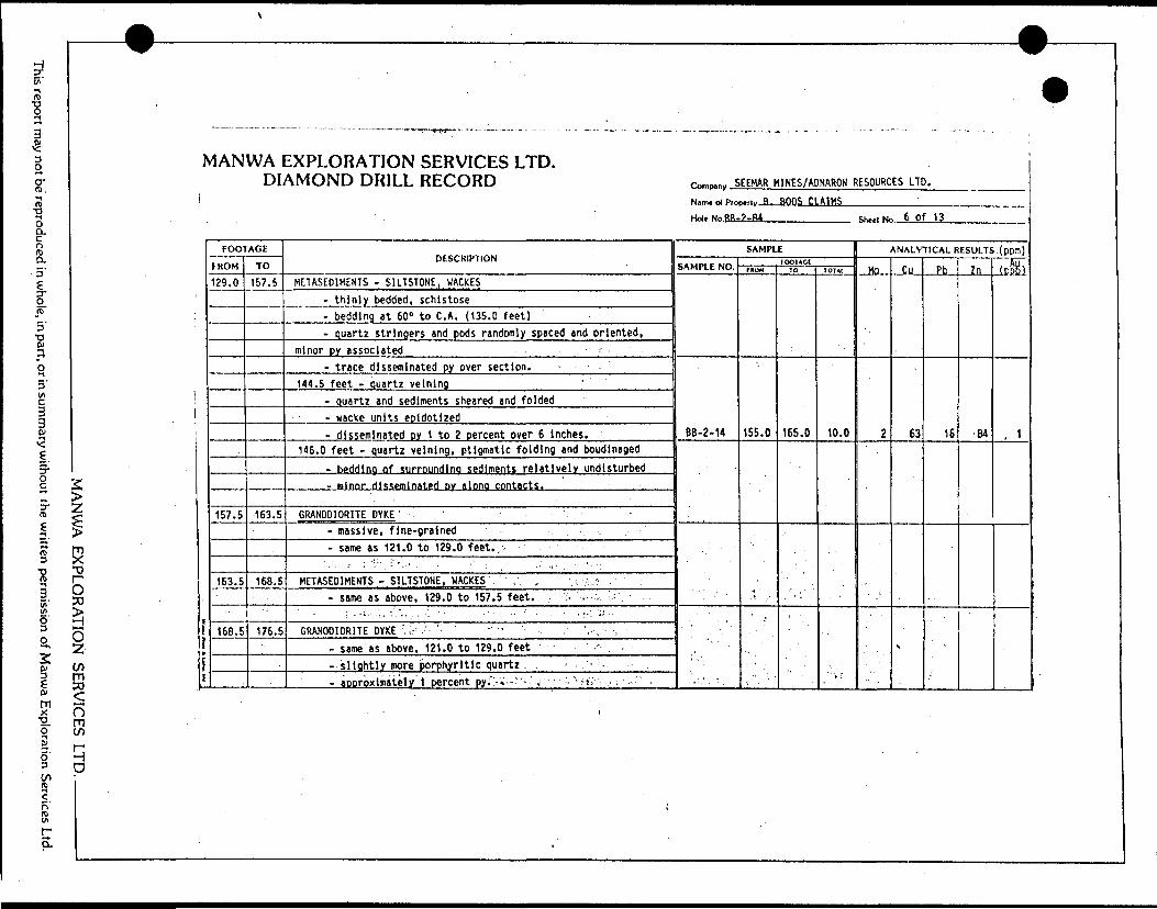
This report may not be reproduced in whole, in part, or in summary without the written permission of Manwa Exploration Services Ltd.
MANWA EXPLORATION SER
MANWA EXPLORATION SERVICES LTD. DIAMOND DRILL RECORD
FOOTAGE
FROM
139.0
157.5
163.5
16S.5
.
TO
157.5
163.5
168.5
176.5
DESCRIPTION
HETASE01MENTS - SILTSTONE, WACKES- thinly bedded, schistose- bedding at 60" to C. A. (135.0 feet)- quartz stringers and pods randomly spaced and oriented,
minor py associated- trace disseminated py over section.
144.5 feet - quartz velnlng- quartz and sediments sheared tnd folded- wacke units epldotlzed- disseminated DY 1 to 2 percent over 6 Inches.
146.0 feet - quartz velnlng, ptigmatic folding and boudinaged- bedding of surroundino sediments relatively undisturbed- mlnnr disseminated py along contacts.
GRANODIORITE DYKE'- massive, fine-grained -; ,- same as 121.0 to 129.0 feet...
: .'. ..- ;'".v. i '..' , : '-' . : ' . - . ;- ,. - -'-•:.'
METASED1HENTS - SILTSTONE, WACKES' . . , v. -;:;- .- same as above, 129.0 to 157.5 feet. :. . . v-
- . ,.i..;.'.v.:V • •'-. ' ' - --- - ' ' : - •••'- -'- 'GRANODIORITE DYKE : i- .' ' ' ' "' ' ,-, ,
-same as above, 121.0 to 129.0 feet - . ~-slightly more porphyritic quartz . .'- aDorbxlmately 1 percent py:";.*-""-'i '- "-fti .. ; •-.•'' .
^
ft,mp,ni, SEEMAR H1NES/ADNARON RESOURCES LTD.
Narrw o( Pro
Holt No Rfis
Hri tt -B, BOOS CLAIMS?-A4
SAMPLE
SAMPLE NO.
BB-2-14
•'
1 l
-- .' . ' .
fOOlACIfftOM
155.0
.1
JO
165.0
JOTM
10.0
T s
ShttlNc 6 of 13
ANALYTICAL RESULTS. (ppm)
.Mo...
2
,
Oil
63
S
Ph
16
Zn
84
Jpfel
, 1
n - K^ p
W"' "
9

This report may not be reproduced in whole, in part, or in summary without the written permission of Manwa Exploration Services Ltd.
W
MANWA EXPLORATION SERVICES LTD. DIAMOND DRILL RECORD
MANWA EXPLORATION SERVICES LTD. ————— —
fJ
f
t
FOOTAGE
FROM
176.5
183.5
190.0
219.0
TO
183.5
190.0
219.0
230.0
DESCRIPTION
METASEDIMENTS - SILTSTOKE, WACKES- fine-grained quartz-biotlte schist- highly fractured, approximately 85 percent core recovered- minor disseminated py, abundant it upper contact 5 to 7
percent over 4 i nches. : '
GRANODIORITE DYKE - -- dark grey quartz-feldspar porphyry, similar to above- slight increase in py, po, 1 to 2 percent disseminated.
METASEDIMENTS - WACKE, SILTSTONE- schistose, thinly bedded 1 to 2 inches- biotite. Quartz schist- abundant quartz strlnoers 3 to 5 mm wide, suboarallel
to bedding "' - -' "'- minor disseminated py, near 1 percent in area of quartz -
stringers. - -. ' 7- :. './.. ; .--,: - . ,. ' , . : :•: .' .-..- , : : - - . . . -,: . ,
FAULT/SHEAR ZONE -: : ' , .' ' , - : :.'.' ::- highly fractured sediments - . ---,- upper zone black, graphitic biotite schist - core recovery
approximately 80 percent" : f -f ^ - :. ' . . -. ' : - '.•"•, --- weakly csrbonatlzed, minor quartz-carbonate stringers- minor py, po approximately 1 percent over section. '' .
•- ' ' \ . . •.;:v ; -:-'. --"I'^s-'S^jJ'v-'-s'iiJ'-'T-i'.V' 1 ' -. : -v V;,-;'-; 's'.^ l-'' :. -
1
Como.ny SEEMAR MI.NES/ADNARON RESOURCES LTD.
Nam* of Ptoj Hoi, No. BB
^,, v B . BOOS CLAIMS-2-M
SAMPLE
SAMPLE NO.
BB-2-15
BB-2-16
'.. . '*
tom AC tmoH
175.0
204.0
TO
185.0
214.0
IOIA1
10.0
10.0
Shed Ne .7 of 13
ANALYTICAL RESULTS (ppm)
Mn
1
1
Cu
56
86
Ph
9
12
7n
63
60
fnftRl
5
3
W
m
iy
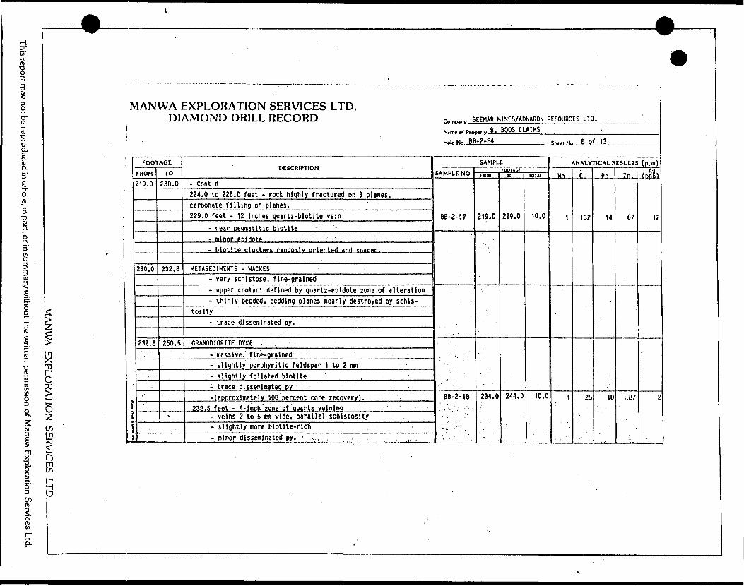
This report may not be reproduced in whole, in part, or in summary without the written permission of Manwa Exploration Services Ltd.
..., ,,., ^ .
MANWA EXPLORATION SERVICES LTD. DIAMOND DRILL RECORD
MANU/A EXPLORATION SERVICES LTD
FOOTAGE
FROM
219.0
230.0
232. B
TO
230.0
232.8
250.5
-
DESCRIPTION
- Cont'd224.0 to 226.0 feet - rock highly fractured on 3 planes,carbonate filling on planes.229.0 feet - 12 Inches quartz-biotite vein
- near peamatitlc biotite- nlnor epidote '
' - biotite clusters randomly oriented and spaced.
HETASE01MENTS - WACKES- very schistose, fine-grained- upper contact defined by quartz-epidote zone of alteration- thinly bedded, bedding planes nearly destroyed by schis
tosity- trace disseminated py.
GRANODIORITE DYKE . .- massive, fine-grained'- slightly porphyritic feldspar 1 to 2 urn
•- slightly foliated biotite- trace disseminated j)y --(approximately 100 percent core recovery).
238.5 feet - 4-lnch zone of Quartz veining ' '- veins 2 to 5 irm wide, parallel schistosity-. slightly more biotite-rlch , .- minor disseminated py,.'; :,\ ; ,;. . ., , ,
—— "' ' ' ' -"\
Comp.^ SEEMAR MINES/ADNARON RESOURCES LTD.
Ntmt ol Proi
Hoi. No.-PJ
p.,,,, B. BOOS CLAIMS-2-84
SAMPLE
SAMPLE NO,
BB-2-57
BB-2-18
'. t ^ ' " ' '
IDOlACrrnuM
219.0
234.0
10
229.0
244.0
TO? W
10.0
10.0
ShntNo 6 Of 13
ANALYTICAL RESULTS (ppm)
Mn
1
1
Cu
132
25
Ph
14
-
10
Zn,
67
..87
(npK)
12
f f.
W~~" ' '
9
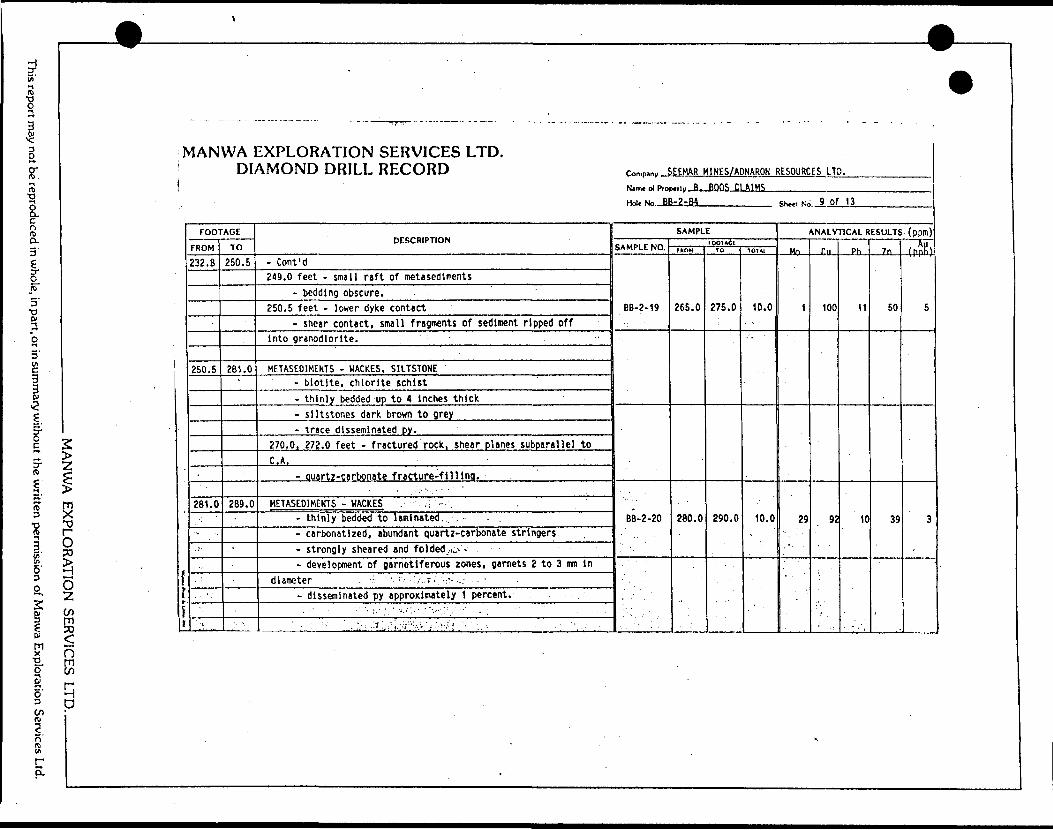
This report may not be reproduced in whole, in part, or in summary without the written permission of Manwa Exploration Services Ltd.
—————— ————
MANWA EXPLORATION SERVICES LTD. DIAMOND DRILL RECORD
MANWA EXPLORATION SERVICES I TD
fr
} ;
FOOTAGE
FROM
232. B
250.5
281.0
•-. . -
';:
TO
250.5
281.0-
289.0
l -
DESCRIPTION
- Coni 'd249.0 feet - small raft of metasediments
- bedding obscure.250.5 feet - lower dyke contact
- sheir contact, small fragments of sediment ripped offinto granodiorite. . ''- •~
METASEDIMENTS - WACKES, SILTSTONE '- biotite, chlorite schist- thinly bedded up to 4 Inches thick- siltstone* dark brown to grey- trace disseminated py.
270.0, 272.0 feet - fractured rock, shear planes subparallel toC. A.
- Quartz-carbonate fracture-filling.
METASEDIMENTS - WACKES , . : .v- thinly bedded to laminated,. , - - .- carbonatlzed, abundant quartz-carbonate stringers- strongly sheared and folded ,u/-- development of garnetiferous zones, garnets 2 to 3 mm in
diameter . ' ;. J ' '- ••.'/..i.".'-;v ,.: - -- disseminated py approximately 1 percent. .
, - - • ••'•' ; .-;. ' •'.••..•.••^"••:.-- - . : ' . "
:.. ". ..:.-iii'.: ••T.vi'lW.' v-.v : i • •'•'1 I . ; '•••' . ... - .' ' '.-'..- .'
——————————————————— — --
r.nmp.ny SEEHAR M1NES/ADNARON RESOURCES LTD.NIITW ol Pro)
Holt No. -li
-,iy .B. BOOS CLAIMS-2-84
SAMPLE
SAMPLE NO.
BB-2-19
BB-2-20
tDOlACtFNOM
265.0
280.0
TO
275.0
290.0
TOTM
10.0
10.0
Shxi No 9 of 13
ANALYTICAL RESULTS (ppm)
Mn
1
29
Cu
100
92
Ph
11
10
7n
50
39
t
Ipftl)
5
3
m
9
K
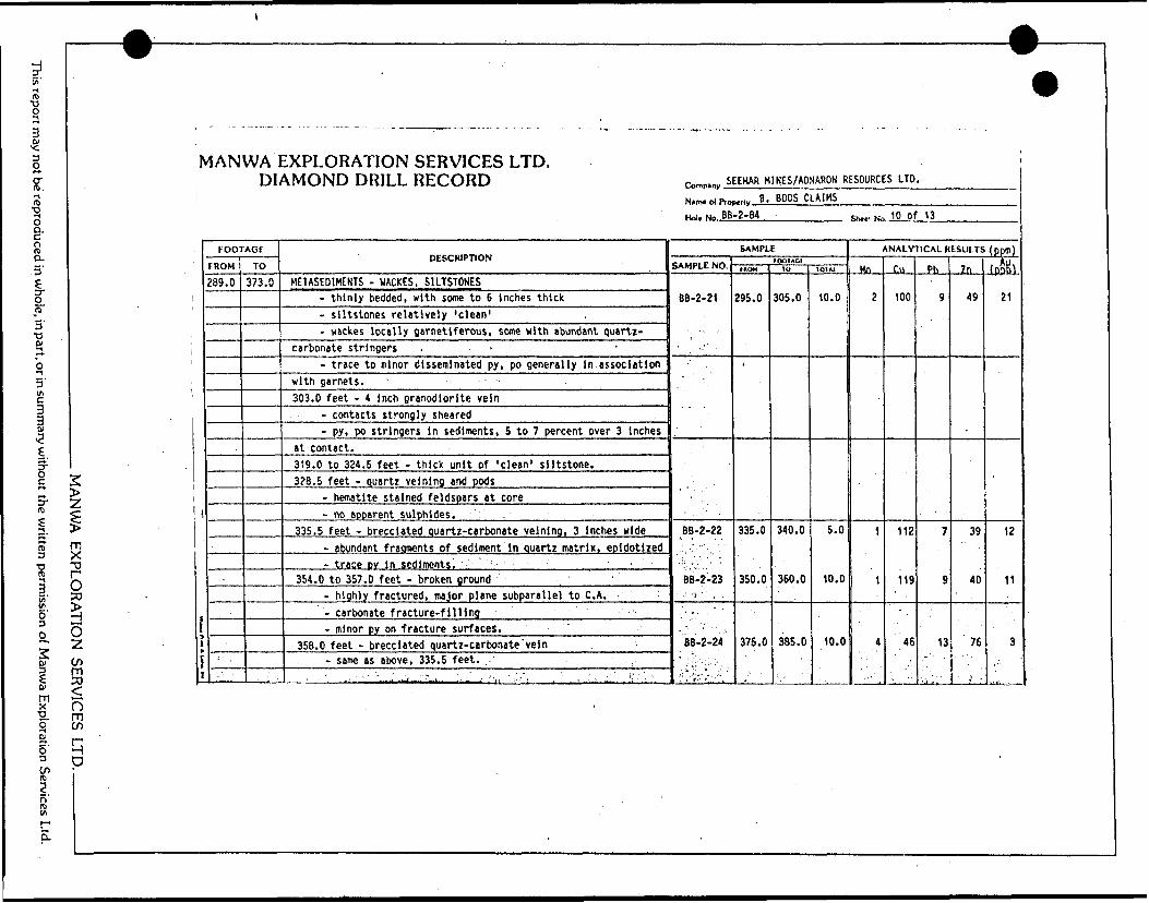
This report may not be reproduced in whole, in part, or in summary without the written permission of Manwa Exploration Services Ltd.
MANVA/A EXPLORATION SER
V1ANWA EXPLORATION SERVICES LTD. DIAMOND DRILL RECORD
FOOTAGE
r IHJM
289. 0TO
373.0
DESCRIPTION
METASED1MENTS - WACKES. S1LTSTONES- thinly bedded, with some to 6 Inches thick- siltstone? relatively 'clean'- wackes locally garnetiferous, some with abundant quartz-
carbonate stringers -- t race to minor disseminated py, po generally In association
with garnets.303.0 feet - 4 Inch granodiorite vein
- contacts strongly sheared- py, po stringers in sediments, 5 to 7 percent over 3 inches
at contact.319.0 to 324.5 feet - thick unit of 'clean' siltstone.328.5 feet - quartz veining and pods
- hematite stained feldspars at core- no apparent sulphides. :
335.5 feet - brecciated quartz-carbonate velnlng, 3 Inches wide- abundant fragments of sediment In quartz matrix, epldotized- trace DV in sediments! :- ' ' '
354.0 to 357.0 feet - broken ground- highly fractured, major plane subparallel to C. A.- carbonate fracture-filling- minor py on fracture surfaces.
358.0 feet - brecciated quartz-carbonate 'vein- same as above, 335.5 feet. . .
^
rw,n,nv SEEHAR MINES/ADNARON RESOURCES LTD.
Nam* ol do
Hoi. No. BB
Mrly B. BOOS CLAWS-2-84
SAMPLE
SAMPLE NO.
BB-2-21
" -
BB-2-22
BB-2-23•' -.1 ' ' , .'- .. -~ :
BB-2-24
''"'.'•'V'-"/''"''
FOOTAGI*NOM i
295.0
335.0
350.0
375.0
10
305.0
340.0
360.0
385.0
1O1JU
10.0
5.0
10.0
10.0
Shed No 10 of 13
ANALYTICAL RESULTS (pp(j|)
Mn
2
1
1
4
Cu
100
112
119
46
Pb
9
7
9
13
Zn
49
39
40
76
\ .
fpnH)i\
12
11
3
O S
P
W
9
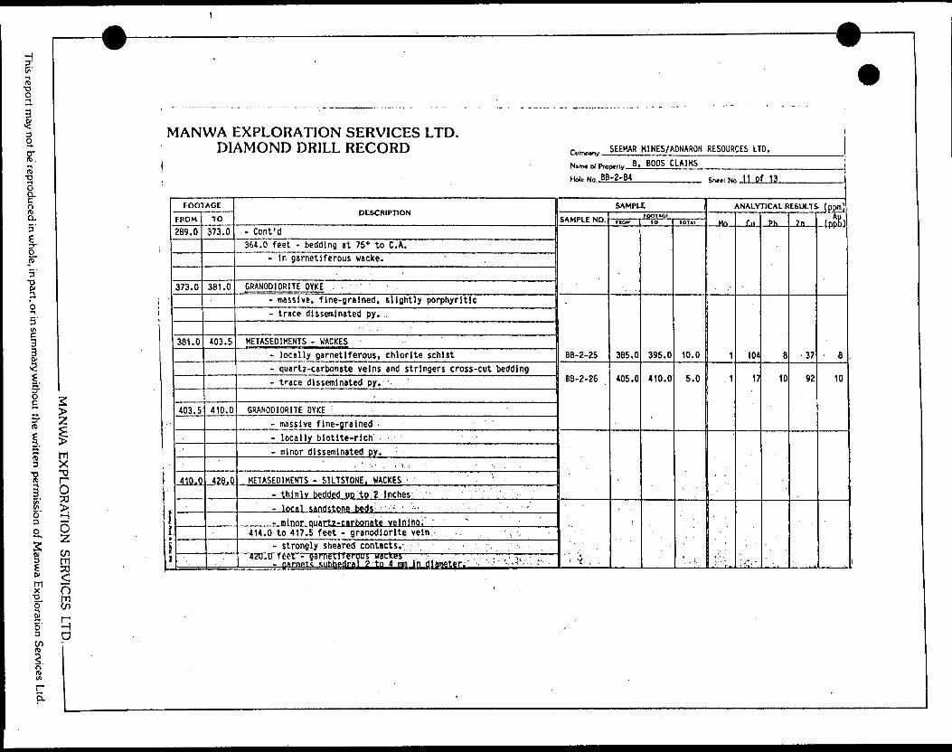
This report may not be reproduced in whole, in part, or in summary without the written permission of Manwa Exploration Services Ltd.
—'W-
MANWA EXPLORATION SERVICES LTD. DIAMOND DRILL RECORD
MANU/A EXPLORATION SERVICES LTD. ———— - —
i
FOOTAGE
289.0
373.0
381.0
403.5
410,0
TO
373.0
381.0
403.5
410.0
428.0
DESCRIPTION
- Cont'd364.0 feet - bedding at 75" to C. A.
- In garnetiferous wacke.
GRANODIORITE DYKE- massive, fine-grained, slightly porphyritic- trace disseminated py. ,
METASEOIMENTS - HACKES '- locally garnetiferous, chlorite schist- quartz-carbonate veins and stringers cross-cut bedding- trace disseminated py. -
GRANODIORITE DYKE- massive fine-grained ' -- locally biotite-rich - .-- m inor disseminated py. :
,. ' -.-' : '. ; : . . . ' .-. , '
METASED1MENTS - SILTSTONE. WACKES '- thinly bedded UD to 2 Inches ' '- local sandstone beds - ; "- minor quartz-carbonate veiniha. " ~"
414.0 to 417.5 feet - granodiorite vein.- . .- strongly sheared contacts.. ; '. ;, -.
42U.U teet - sarnetlferous wackes . . . -.i , - nirnptc subhedral 2 to 4 mn i n diameter:' -. '.'" -'.'^
1
i
Comp.ny SEEMAR HINES/ADNARON RESOURCES LTD.
N*nu ot Pro
Hole No. BB
p.,, v B . BOOS CLAIMS-2-84
SAMPLE
SAMPLE NO.
BB-2-25
BB-2-26
- '''i . .
FPOHOfFROV
385.0
405.0
10
395.0
410.0
totm
10.0
5.0
* , '.
ShttlNo 11 Of 13
ANALYTICAL RESULTS (ppm)
.MO
1
1
Di
104
17
..Pb
B
10
7n
•37
92
-4PP&
' 8
10
9
9
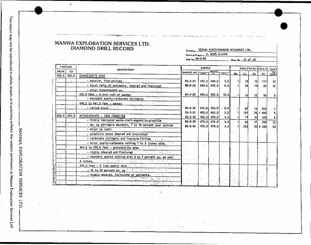
O—. i
t/) LU
C
J
OO
CO
UJ
CK
gCC
aUJ
zzDC
UJ
4/1l
1
NATION SERVICES LTD. )
DRILL RECORD
EXPLOI AMONC
|Q
^
<
?
rt
C\J^i5•a: .jo
oea-^ CO
—
1
S t
Nam* of Prc
Hoi* No. J!
H-i 3
i/iU
J
-J <
U.J <~z. < ™s23 ^C
L•s.<
Cu HS•4(1
DESCRIPTION
u
OO
H
KMU
. ir*.cC^;Ji1 1)
UJ
^3
xj
GRANODIOR
LO
\oLO
*cr
oCO
C
M^~
.
rt-LO
MD
o40
O0•w0LO
mr-.C
M
l C
M
1mC
D
•QO)
C0uO)1O)
c
s-Ol
>
*rt
ra
Ei'
CM
^enw-
rtoLA
OLO^00^r?C
M
1 C
DC
QT3O*
U4"U•o
fc.H
-"•oc-c1C
sW)
4A
4
-*
1X)
o;*A
•sw*+J.**-1
0t-4O1
wr disseminated DY. ' . 1"e i
C*
LO
ovCM
CS
oooLO
L
O
oto•ST
enCM1CM 1
enCOin4f
.^
UIO;*V-o4
-*1*-QJZuc1O
) O
) H
-
OCD
rt^r
*ML.
O)
O)
Ct-4-* trt
at4-*A1.
aa uMtIO3cr4
-*c
•a •o crjoai
aL;a
3l4-*atA
t**-Lft
O4-1
CM
O^r
r*fU"
*a ^r* CC
0ino0to0LO
t/1
7CM
1ea
eaJH2T: ac t- , enC
3ccvQ
C
M
r^.O
V
0LO
0LO
to0o
*ort i c*aiC
Q
CO
toOD
C*oF-*
OLO
0op**
omtOCM
C
O
1C
M1ea ea
O*-0u,
11IS)
J—
zMETASEDIM
om
a**r*n \oL
O*T
**•^gC\
T-
^cv *\
OLO
oLA
r*-
00r*rt rtiC
M
2inly laminated wacke-chert-magnetite-graphltej t
* cr
- c.ir c^^i
' C
S
t-s0^~oen rxosrt iC
M
3|4-*
W
Of
Mt-Ol
S2atss.C3
O4J
r^4O
T3
J2lM
l
4A k.
O
Ol
c
u4-*
44
S?ai
i j)tjj:Q.
Vt
Q.
Ut- 0"E i
•o o*4-*MO
k
rbonate stringers and fracture-filling ' .;*i u
V
•Q"5Wl
VJCuc*oSfca*>at4
-*MSID
UIN*
t•O
3eru. o"e i
15J-
o1 1011s1*-
m*
so
**LO
to~
ghly sheared and fractured '-' . ' . - ;, '-. .
jzi
soa^
o.s tf s.f*- o4**
Ajr4J
"5encrcO)
>tIOZ)o4-*c
•a •oc:JDn
i6
inches.
cat' >MID
3
C
7
JZ
UctOO)
at **-0L
Or**.*r.]
M
-
S-
Qg4-*C
0
)us0
CMO
4-*
LO
UM
*
" W1TCat y*it- oMgWC•c atL.
IDatjrV
)
> x:JZ
,•M
* -j4fIJMW
.
j-i
-.
-
MANW
A EXPLO
RATIO
N SERVICES LTD.
This report may not be reproduced in w
hole, in part, or in summ
ary without the w
ritten permission of M
anwa Exploration Services Ltd.
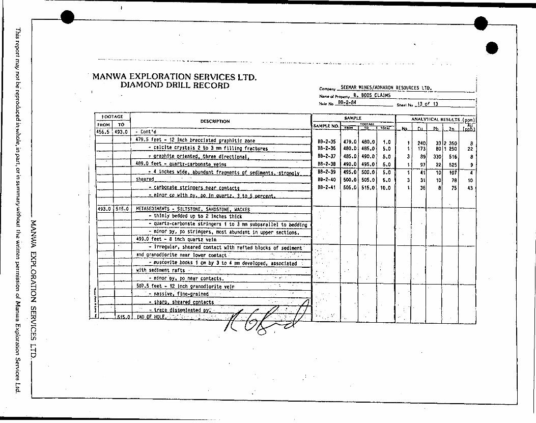
4
MANWA EXPLORATION SERVICES LTD. DIAMOND
DRILL RECORD ^^ SEEMAR MINES/ADNARON RESOURCES LTD.
N.m.o/p.oo.M. B. BOOS CLAIMS
Hoi, NO BB-2-84 t--. NO .13 of 13
l3
tESULT
UP-3Ci
iiul' u
DESCRIPTION
ui O
o *-
e!
.c co CM
co en
jo
o
id
inc
LO m
"r* CM
Ph
CO
CM
4
A
LO
CM
*-
cn o
o
CM-c
(*i co *n
CM
O to
en
i** z
^r r-, co
en *-
CM -~
c IE3I,
'OC
01oro enL
A
uDLft
O O
O
O
*-
Ul
tfj LO
O O
O
0
O
LO
C*
LOco co
en. en
O 0
0
0
55
5 S
LO LO rs.
co
CM
C
M
CM
C
M1
1 1
1m
ea CD
ea ea ea
ea ea
0)
iIS
U4-*
Ji
Q.t
- calcite crystals 2
to 3 mm
filling fractures -
KSOJ•aOJ
OJ
ey
I•o o1
tACa c0utoI0enCO
V
O
CO
s s s0
0
CO
w
m
co
w-
(O
— ~
o o
o
LO
LO
O
o o
o
O
LO
U
)o o
*-
LO
L
O
LO
o o
o
LA
O
L
A
Tt
O
O
enCO
diiC
O
CD>*cc
ofc.4-*It
wCx owccz
c1*Auc1
o
-~ 1
1C
M
CM
1
1
sheared ' " !
KA-*-c
oU
l
k.a cL1A01
11
+Jc
e1LOc
mtcccJCIEct.0c:"E i
CO
u. uMETA5E03HENTS -
-SILTSTONE, SANDSTONE
0LO
LOoma*
0jrc:
CM
5s-•ocz .c1
to 3 mm
subparallel to bedding
Ml
t-
ftlenczf.M41aa
u ir10
3cr i
I4-*
OJ
1A
i-aiCX
d.nc:
4-* C
O
) T
3C2tAt-tu
enczwaext-0c "e t
cOl
Nfl
3cruczCOO)
o0en en
*ith rafted blocks of sediment
i,
ogofc.i- toC
JczL. O1(Ot. en
1ID
4-1
1(A
MmT?
Sat •Qio
m5(A
JH
!o0*OO(A
4-*
H-
Ui 1
1A4-* UCo
of. •oO
Jc2.
St-O"e i
cOJ
OJo1o
Cn3Mat uLOO
OJ
cz1cOf
tAtoa1
- . .
^tqiH
*AS-CV)1
ice disseminated Dvi' - x"
v^ ' ,
/7fc- x^UJ
go:zS
MA
NW
A EX
PLORA
TION
SERVICES LTD
..
This report may not be reproduced in w
hole, in part, or in summ
ary without the w
ritten permission of M
anwa Exploration Services Ltd.
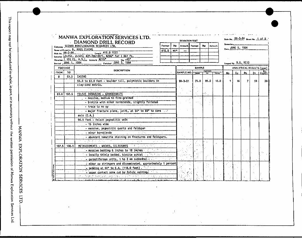
l
ST.-t(D•o3Q.
a 5'
3•oS!
3 in c3
n
5'
2I
g.
l s5- zi i
a10f O50 S6 z
SS 1 of KZ r5- IH3 n
r i
i iE i
F
*
1
MANW.
rmr.w SEEMAR
(ol. No. J
DcalloM J
A EXPLORATION SERVICES LTD.r\I A * jf /"\ x. l rs r*vmr v r*r* *** r^T*r± DEVIATION TESTDIAMOND DRILL RECORD i ——— i —————————————H1NES/ADNARON RESOURCES LTD. Foot... Dip
nrmc ri tiuc ———— —— 'B-3-84 . Un|1h 415.0 FEET ' — -3+75E. 2+50S: #2P-TB613971. N296' for 1 061 ft. . ——— ——
j.v.^.LlSJLfJ..n.d JUHE..1...
FOOTAGE
FROM
0
63.0
102.5
TO
63.0
102.5
138.5
,. A.S.L. A.u.,,,1. N215* n., -45" ———— ——1984 tt.,.^., JUNE 3, 1984 ' ———— ' ——
DESCRIPTION
CASING55.0 to 63.0 feet - boulder till, polymictic boulders inclay-sand matrix.
FELSIC INTRUSIVE - GRANODIORITE. - massive, medium to fine-grained -
- biotite with minor hornblende, slightly foliated- trace to no py ,- major fracture plane, joint, at 60' to 60" to core
axis (C. A.)90.5 feet - felsic pegmatitic vein
- 15 Inches wide- massive, pegmatitic quartz and feldspar- minor hornblende . — .'- abundant hematite staining on fractures and feldspars.
. :V. ^r - ..';- . : - '. . - .;.- '. , . .HETASED1HENTS - WACKES, SILTSTONE* V , . . '
- massive bedding 6 inches to 18 inches -: ' - ' .' -locally thinly bedded, biotite schist -. : - " ••
- garnetiferous units, 1 to 3 mm subhedral^ -.- minor py stringers and disseminated, approximately 1 percent'- bedding at 60e to C.A. (118.0 feet) , ": --"uDper contact zone cut by felsic velning; - ; '- '
-.'•'. •,:' :r t-':,1 'Uii;;/--1 - ;"V.'.''. '. : .;; v .vV:- .- - \ , ; ' •-,y ;.. ;' :' ,, ,- :. - '. -.' . -- iwilLli'l' J..!!i;^Aj- .^7,'ir,^- 'J ji :^ 1- j. L- .(t '.: . . -'' ,,.:-.- ii,V'.'l.'-J.,..'. .:- ,
Ailmulk FoolM' Dir Atlnulh
SAMPLE
SAMPLE NO.
BB-3-01
- V. '. - ' J-' . ;-il : -V - .
V '
IOOHGIMUM
75.0
lu
85 .0
101A]
to .0
Hoi* No, BB-3-84 g,.. M No -1 Of B '
n... JUNE 5. 1984
1^,^11,, R- G. REID
ANALYTICAL RESULTS (ppm)
Ho
1
Cu
16
Pb
7
2n
59
fnnHt
28
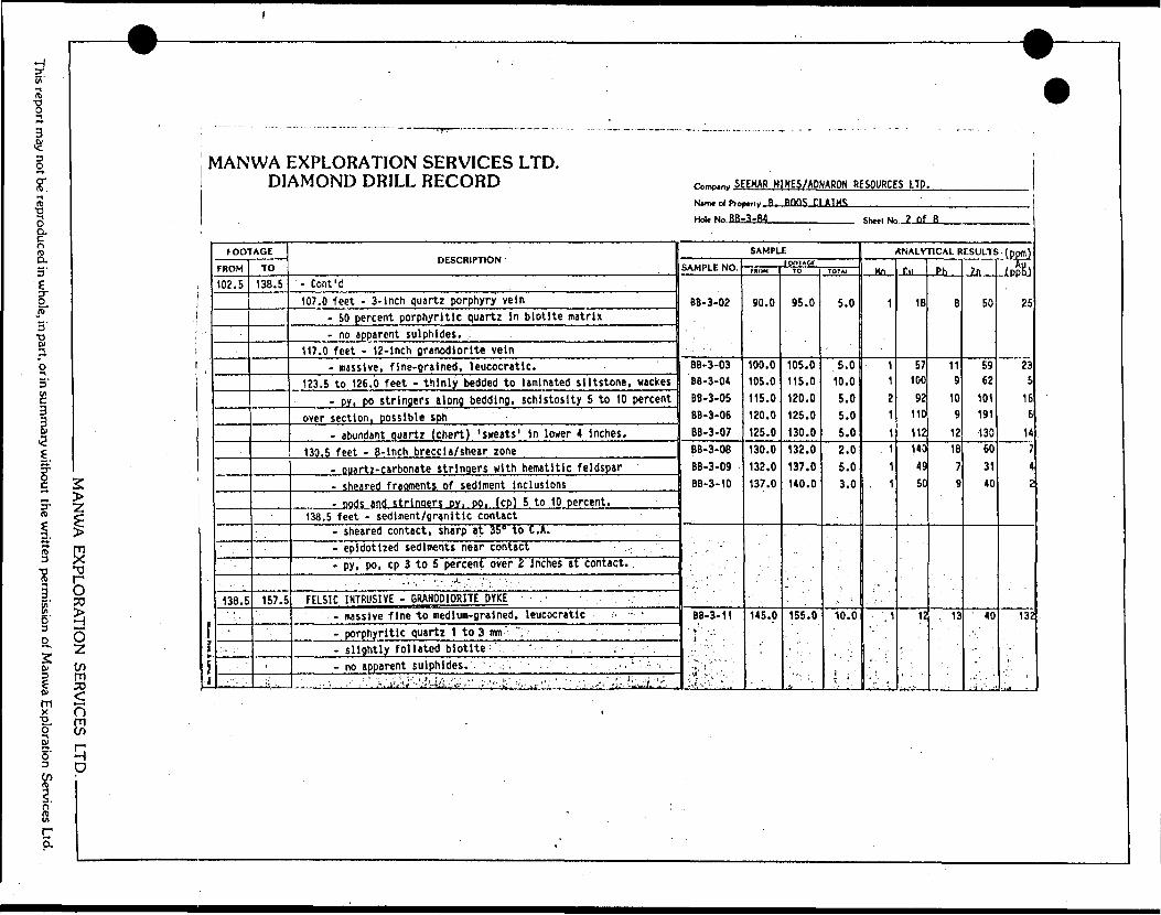
report may not be reproduced in whole, in part, or in summary without the written permission of Manwa Exploration Services Ltd.
MANWA EXPLORATION SERVICES LTD. DIAMOND DRILL RECORD
MANU/A EXPLORATION SERVICES I TD
f l*
l
FOOTAGE
FROM
102.5
138.5
,-
TO
138.5
157.5
i
.-;; . .
DESCRIPTION
- Cont'd107.0 feet - 3-lnch quartz porphyry vein
- 50 percent porphyritic quartz in biotite matrix- no apparent sulphides. :
117.0 feet - 12-inch granodiorite vein- massive, fine-grained, leucocratic.
123.5 to 126.0 feet - thinly bedded to laminated siltstone, vackes- py, po stringers along bedding, schistosity 5 to 10 percent
over section, possible sph- abundant quartz (chert) 'sweats' in lower 4 inches.
130.5 feet - 8-inch breccia/shear zone- ouartz-carbonate stringers with hematltlc feldspar- sheared fragments of sediment inclusions- pods and strinoers DY, po. (cp) 5 to 10 percent.
138.5 feet - sediment/granitic contact- sheared contact, sharp at 35* to C. A.- epidotlzed sediments near contact- py, po, cp 3 to 5 percent over 2 i nches at contact. .
FELSIC INTRUSIVE - GRANODIORITE DYKE . . .- massive fine to medium-grained, leucocratic .- - '
- porphyritic quartz 1 to 3 urn " ": ' .- slightly foliated biotite 1 ' ' , ; . ,- no apparent sulphides.'- ' : ., .". ' ' \
: ': - ' - \ " 'f" * J. f 1 ',,,,'- - ,. ,. , , i.-.. . ,.,.. . . .. . ' t 'V'u ''.J.'. .--* ---' - - . .~,-Y**:* ' '•-';-- j*!.:,-iJ ^v ' f '-.\' . '*^ , - v..- * :.- ' - '. , * ~.* - n;-.f - - iv*. - - '
c^n^n,, SEEHAR M1NES/ADNARON RESOURCES LTD.
Minx of PTOI
Hoi. No.fiBj
^,,v R. Bnn-; ci AIM";3-B4
SAMPLE
SAMPLE NO.
BB-3-02
BB-3-03 8B-3-04 BB-3-05 BB-3-06 BB-3-07BB-3-08 BB-3-09 - BB-3-10
BB-3-11
1001*01FROM
90.0
100.0 105.0 115.0 120.0 125.0130.0 132.0 137.0
145.0
TO
95.0
105.0 115.0 120.0 125.0 130.0132.0 137.0 140.0
155.0
TOTM
5.0
5.0 10.0 5.0 5.0 5.02.0 5.0 3.0
10.0
i . '
Shetl No ? of B
ANALYTICAL RESULTS (ppffl)
. Mn,
1
11 2 1 1
. 1 1
. 1
- ',1
Cll
18
57 100
92 110
112140 49 50
12
..Pb.
B
11 9
10 9
1218
7 9
•. 13
Zn
50
59 62
101 191
13060 31 40
40
••.•i '- ,
. : -
fnftK)
25
235
16 6
147 42
132-
W
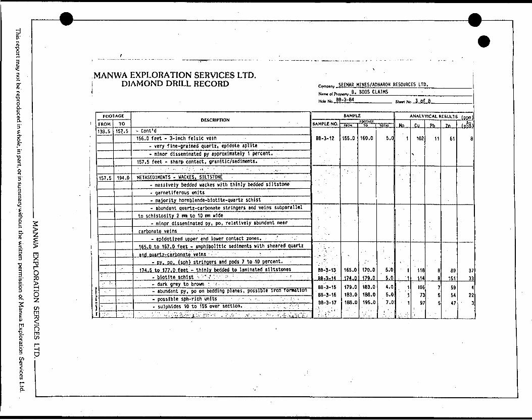
report may not be reproduced in who
e, in part, or in summary without the written permission of Manwa Exploration Services Ltd.
MANU/A FXPLORATION SERVICES LTD. ———————
i
MANWA EXPLORATION SERVICES LTD. DIAMOND DRILL RECORD
FOOTAGE
FROM
38.5
157.5
' ':' ' -
TO
15*. 5
194.0
. ' - -
DESCRIPTION
- Cont'd156.0 feet - 3-inch felsic vein
- very fine-grained quartz, epidote aplite .- minor disseminated py approximately 1 percent.
157.5 feet - sharp contact, granitic/sediments.' . - : ' - ' : •'..'•••. •'•;- - . '-- - . -. ' .....-••••. 'HETASfOlMENTS - WACKES, SILTSTONE '
- massively bedded wackes with thinly bedded siltstone- garnetiferous units- majority hornblende-biotite-quartz schist .- abundant quartz-carbonate stringers and veins subparallel
to schistosity 2 mm to 10 mm wide .- minor disseminated py, po, relatively abundant near
carbonate veins ' '- epidotized upper and lower contact zones. r
165.0 to 167.0 feet - amphibolide sediments with sheared quartzand auartz-carbonate veins - r
- py. PO. (sph) stringers and pods 7 to 10 percent. -174.5 to 177.0 feet - thinly bedded to laminated siltstones
- biotite schist V ;' -' "' - ' ' ^- dark grey to brown ' -- abundant py, po on bedding planes, possible iron formation- possible sph-rl eh units ; . - - - :. . ;,-. -i.- sulphides 10 to 151 over section. ; . . , .. f- : :'\
'•:'. "- -..,~ . '.V. :"r.-.; ;;.fvC- f.;*'../.- ; ; -;.' - v " "- '•• : -t'-i '-'-:^^~i' :
\
Pnmp,^ SEEHAR HINES/ADNARON RESOURCES LTD.
Name of Pro
Holf No. B E
MY B . BOOS CLAIMS-3-84
SAMPLE
SAMPLE NO.
BB-3-12
BB-3-13
BB-3-1ADfi 9 4 C
DO 0 4C
BB-3-17
' S : ' T .
TOOTACCFROM
155.0
165.0 174,0179.0 183.0 188.0
10
160.0
170.0 179-0183.0 188.0 195.0
TOT*!
5.0
5.0 ' 5.0
4.0 5.0 7.0
Shwl No J Of 8
ANALYTICAL RESULTS. ( DDm )
Ho
1
1
1
1
1
fin102
V
118 114
106 73 97
Ph
11
8 fi
7 5 5
7n
61
89 151
59 54 47
(pp^H)
8
3733
4 22
*
W
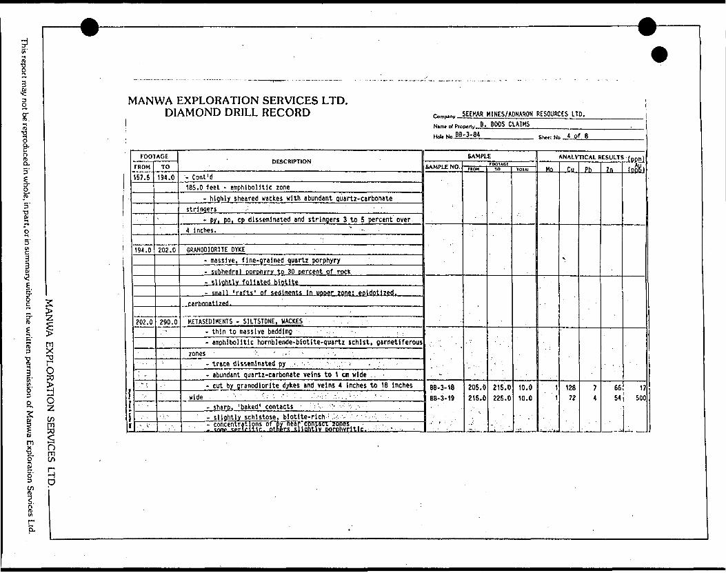
This report may not be reproduced in whole, in part, or in summary without the written permission of Manwa Exploration Services Ltd.
1 MANWA EXPLORATION SEF
f)mCO
S D
MANWA EXPLORATION SERVICES LTD. DIAMOND DRILL RECORD
FOOTAGE
FROM
157.5
194.0
202.0
•' ,-
.-- -
o, s:
TO
194.0
202.0
290.0-
DESCRIPTION
- Cont'd185.0 feet - amphibolide zone
- highly sheared wackes with abundant quartz-carbonatestringers .'
- pyi po, cp disseminated and stringers 3 to 5 percent' over4 Inches. ^ , .
GRANODIORITE DYKE- massive, fine-grained quartz porphyry- subhedral porphyry to 30 percent of rock- slightly foliated biotite- small 'rafts' of sediments In uooer zone: epldotized.
carhonatlzed.
METASED1MENTS - SILTSTONE, WACKES- thin to massive bedding ' -- amphlbolltlc hornblende-biotlte-quartz schist, garnetiferous
zones '', - : . : ••- . ' Y. . .- trace disseminated py '..-, . !', ••'. ' ,." -- - ;- abundant quartz-carbonate veins to 1 cm wide :- cut by granodiorite dykes and veins 4 Inches to 18 Inches
wide . - ''' . -.'.' - ••'•' ' -- •'•••••' .V. .:'-'.' -- ' - - '- sharp, 'baked' contacts -'vv :- . :' ; -- slightly schistose, biottte-rich : -;.-. -, ' - '- concentrations of py near contact zones . - cnmc turiritir. ntners sllahtlv Dorohvrltlc. - ,
1
r™r**r SEEHAR M1NES/ADNARON RESOURCES LTD.
Nsnu el Pro H^i. N" .86
Mrty B. BOOS CLA1KS-3-84
SAMPLE
SAMPLE NO.
: - '
BB-3-18BB-3-19
rooiAciftott
205.0 215.0
\
TO
'''" '
215.0 225.0
^i
101AI
10.0 10.0
Shtrl Ne t of 8
ANALYTICAL RESULTS f nnmi
Mn
i 1
i
fin
x
128 72
Ph
7 4
Zn
6654
fnftRl
17500
w9
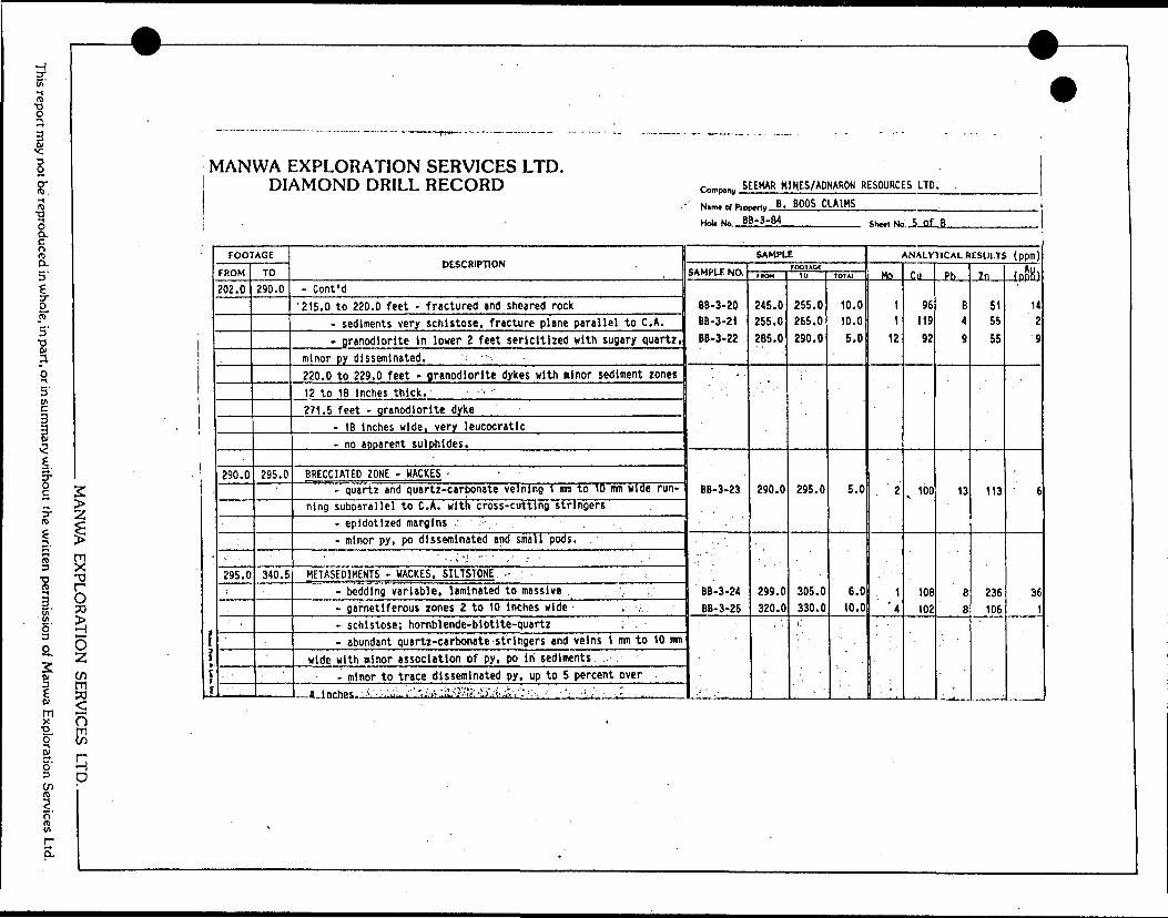
H Ci'
ST.
oQ.O rt) O.5'
l
3 viC3
y ZI lrt)
iio
fl mxo" S o'
(f)
O50
O 2(nm ?on
H D
MANWA EXPLORATION SERVICES LTD. DIAMOND DRILL RECORD
i
[t
i
FOOTAGE
FROM
202.0
290.0
295.0
TO
290.0
295.0
340.5
DESCRIPTION
- Cont'd'215.0 to 220.0 feet - fractured and sheared rock
- sediments very schistose, fracture plane parallel to C. A.- granodiorite In lower 2 feet sericitlzed with sugary quartz,
minor py disseminated. ' -. , ' •••-'220.0 to 229.0 feet - granodiorite dykes with minor sediment zones12 to 18 Inches thick.271.5 feet - granodiorite dyke
- 18 Inches wide, very leucocratic- no apparent sulphides.
BRECCIATED ZONE - HACKES - -- quartz and quartz-carbonate velnlng 1 irm to 10 mn wide run
ning subparallel to C. A. with cross-cutting stringers- epidotized margins ,? ,. ,- minor py, po disseminated and small pods.
1 . ' ' " -. -, -i''- •'•' ' , ' :
HETASED1HENTS - WACKES, SILTSTONE -: ; . :- bedding variable, laminated to massive ,- garnetiferous zones 2 to 10 inches wide - , .-.- schistose; hornblende-blotlte-quartz- abundant quartz-carbonate stringers and veins 1 mm to 10 urn
wide with minor association of py, po in sediments- minor to trace disseminated py, up to 5 percent over
.. A I nchon, i. - .1.;;.. •'.;',;..B'..:-iyll(f?-i'O! j,l.i .''.'".i, .'- ,.- ;, . .--li:..-- ' -'-. -.^:..:.
Comp.ni, 5EEMAR M1HES/ADNARON RESOURCES LTD. .
Nimf cj PiO(
Hob No, .B
M,,y B. BOOS CLAIMSB-3-84
SAMPLE
SAMPLE NO.
BB-3-20 BB-3-21 BB-3-22
BB-3-23
BB-3-24BB-3-25
rooiAccmow
245.0 255.0 285.0
290.0
299.0 320.0
TO
255.0 265.0 290.0
295.0
305.0 330.0
•i"
IOIA1
10.0 10.0 5.0
5.0
6.0 10.0
Snol No 5 of 8
ANALYTICAL RESULTS (ppm)
Ho
1
1
12
2
1 *4
"T -T1J. ±
Cu
96 119 92
v 100
108 102
Pb
B 4
9
13
8 8
Zn
51 55 55
113
236 106
fnpHl
14 2 9
6
361
S'vir S.
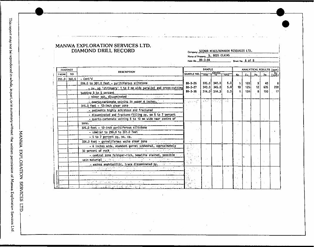
This report may not be reproduced in whole, in part, or in summary without the written permission of Manwa Exploration Services Ltd.
^
MANWA EXPLORATION SERVICES LTD. DIAMOND DRILL RECORD
MANWA FXPI ORATION SERVICES LTD. ———————
FOOTAGE
FROM
95.0
TO
340.5
DESCRIPTION
- Cont'd299.0 to 301.0 feet - pyritlferous siltstone
- DV. DO 'stringers' 1 to 2 mm wide parallel and cross-cuttingbedding 3 to 5 percent
-minor sph, disseminated - , -- '- ouartz-carbbnate velnlng In uooer 4 inches. ' '
315.0 feet - 12-inch shear zone- sediments highly schistose and fractured- disseminated and fracture-filling py, po 5 to 7 'percent- quartz-carbonate veining 5 to 10 mm wide near centre of
zone.325.0 feet - 12-inch pyritiferous siltstone
- similar to 299.0 to 301.0 feet- 5 to 7 percent py, po, cp. -
334.0 feet - garnetiferous wacke shear zone ' , ' - ,- 6 inches wide, abundant garnet subhedral, approximately
30 percent of rock ' ' - ' : - -- central zone feldspar-rich, hematite stained, possible -.
vein materiel . ; 1 - - '- ' -' - ;. : ' -- -- vackes amphlbolltlc, trace disseminated py. V - . .
1 " . - '..'.. ..i 1 '"."-.' ' . , ' . . - . . - " . . ... .- '
. . -: /.' ' ..:.''- ..I'M.- "'.i..'., 1 .. . . ' .': ', . V . - - - - : .••\''j.-"." '-j-'.'-'' i -' - : ':.- ' - • {'•.•'•••••'i.: i' -,. - " , . : -' ' ' -'
™ " ^W
0
rn^p^y SEEMAR M1NES/AONARON RESOURCES LTD.
NllTM Ol PlDI
Holt No. B
,,Ilv B. BOOS CLAIMS ;B-3-B4
SAMPLE
SAMPLE NO.
BB-3-26 8B-3-27 BB-3-35
' "" . '
-,\- ;
, •'••-i', ^' .
FOOTACfmoM
335.0 340.0 314.0
: '.-S
10
340.0 345.0 314.3
TOT At
5.0 5.0 0.3
Shell No 6 of B
AN ALVTICAL RESULTS . ( ppm )
.MO—
110
1
f,n
103 125 124
\
Ph
9 12B
.. Zn
40 635 150
fnftB)B
208 17
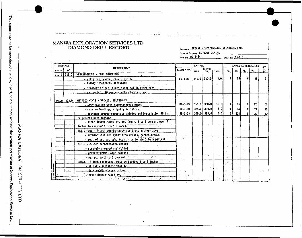
This report may not be reproduced in whol
2, in part, or in summary without the written permission of Manwa Exploration Services Ltd.
MANWA FXPI ORATION SER
MANWA EXPLORATION SERVICES LTD. DIAMOND DRILL RECORD
FOOTAGE
rnUM
340.5
345.0
.
TO
345.0
403.0
..'i' .
DESCRIPTION
METASEDIMENT - IRON FORMATION
- siltstone, wacke, chert, pyrite- thinly laminated, schistose- stronojy folded, tlaht isoclinal in chert beds- DY. DO 5 to 10 oerc^nt with minor CD. sph.
METASEOIMENTS - VACKES, S1LTSTONES- amphibolite with garnetiferous zones- massive bedding, slightly schistose- abundant quartz-carbonate velnlng and brecciation 15 to
20jercent over section- minor disseminated py, po, (sph), 3 to 5 percent over 4
inches in carbonate breccia zones.353.0 feet - 4-inch quartz-carbonate breccia/shear zone
- amphibolite and epidotized wackes, garnetiferous- pods of py, po, sph, (cp) in carbonate 3 to 5 percent.
363.0 - 3-inch carbonatized wackes- strongly sheared and folded-garnetiferous, amphibolitic- py, PO L cp 2 to Sjercent. :
368.5 - 6-inch sandstone, massive bedding 2 to 3 inches- slightly schistose biotite- dark reddish-brown colour '-trace disseminated DV.-'"I: - ' '- ' ~-
........: - ' ;^,.: .-",,., -- ir: -..,i.';:...:'-,.-''- -. , ,,.: " , -, . -- ••,. !'-. v:" ..; , ;'
—————————————————— 1w —— 9
Comp.ny SEEMAR M1NES/ADNARON RESOURCES LTD.
Nam* ot Prog
Hole No. B!
-,,^ B. BOOS CLAIMS)-3-84
SAMPLE
SAMPLE NO.
BB-3-28
BB-3-29
BB-3-30 BB-3-31
rOOTAGtFHOM
345.0
350.0 385.0 390.0
10
350.0
360.0
390.0 395.0
TOTAI
5.0
10.0
5.0 5.0
< ' . • 1I11IIM O3
j
Shctl No 7 of 8
ANALYTICAL RESULTS (pDm)
..Mo.
1
1
1
1
CM
75
86
B4 126
^
Ph
6
6
6 9
7n
38
26
7139
fpftK)21
27
19 12

eport may not be reproduced in whole, in part, or in summary without the written permission of Manwa Exploration Services Ltd.
MANWA EXPLORATION SERVICES LTD. DIAMOND DRILL RECORD
MANWA EXPLORATION SERVICES LTD. .
f*
i
FOOTAGE
FROM
315.0
A03.0
TO
403.0
415.0
415.0
DESCRIPTION
- Cont'd394.0 feet - 12-inch carbonatized shear zone
- possible sheared quartz-feldspar dyke- reddish feldspars in quartz-carbonate matrix- rafted fragments of amphlbolitlzed wacke- abundant py, DO 5 to 7 percent in wackes.
METASEDIMENTS - SILTSTONE, WACKES- gradational contact with upper zones- thinly bedded, less than 1-inch thick- bedding variable 75" to 85" to C. A.- minor ouartz-carbonate stringers 1 mn to 5 mn wide- wackes garnetiferous, crystals 1 to 3 mm, subhedral- py, po disseminated and in stringers in association with
siltstones, 3 to 5 percent over section. f ]Y , ..., . . . , . J 1
") ' 7 'iEND OF HOLE. f J * S/ ' 1 7•l/ f /y - i/i A r; A ^ — ***
/-- -^ - . -
. -. - ' -. -j .' -" i: x ' ' - - i -- - t: -
r™,p.,.|, SEEHAR H1HES/ADNARON RESOURCES LTD.
Nimt di Pro
Hoi. No B]
^,,/B. BOOS CLAIMS i!-3-84
SAMPLE
SAMPLE NO.
BB-3-32 BB-3-33 BB-3-34
rooiACimow
395.0 405.0 410.0
TO
405.0 410.0 415.0
TQTAI
10.0 5.0 5.0
Shttl No B of 8 i
ANALYTICAL RESULTS (ppm)
..MQ...
211
Cu
100 105 105
Ph
10 8 6
.Zn-
43 135 80
fnftKi
1130 16
. x
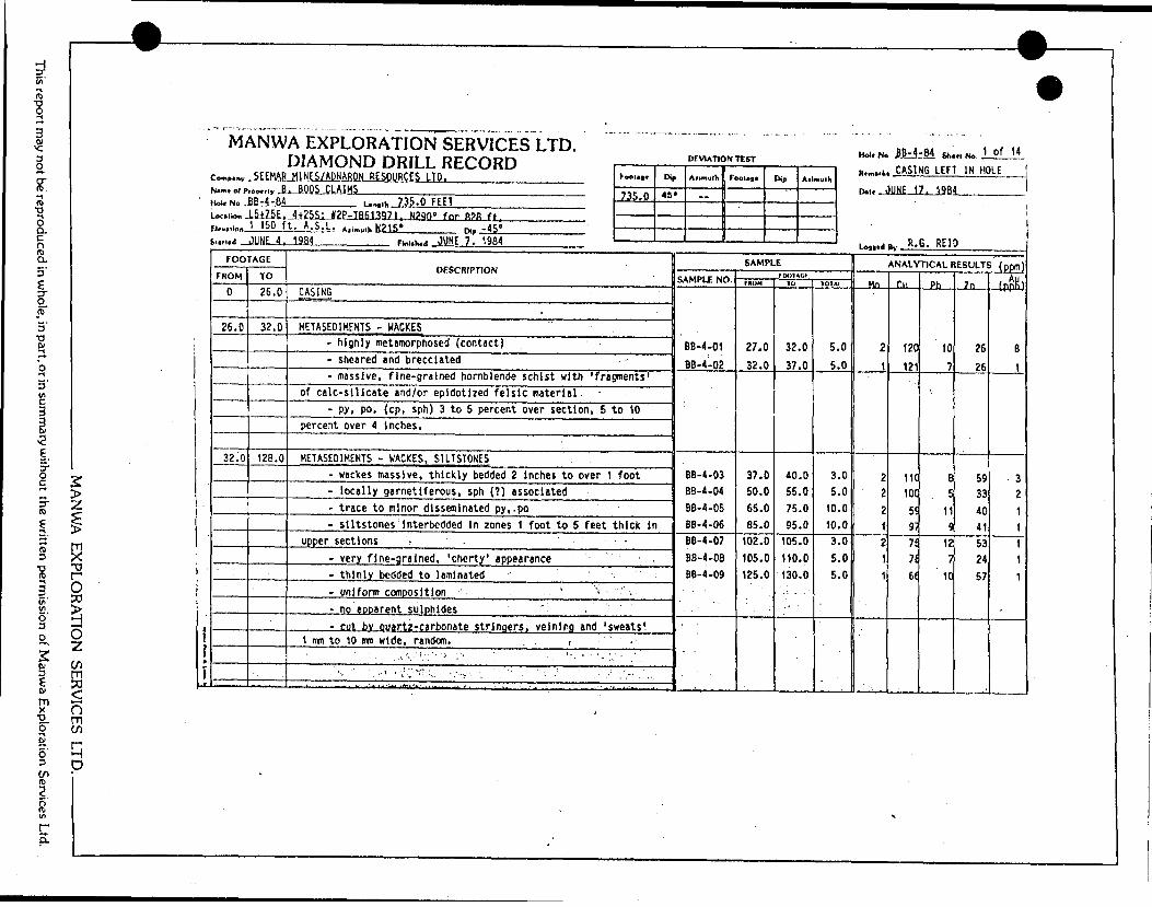
4"o
,' |
. ?
: a
. i
l
s:
e;
g;
pi
A
EXPLORATION SERVICES LTD. niAMniMn npn i orr-rior*
,*
sZf *5
*
UJ
-J
Zu. ea
uj cr
—j
*-oz
r*C
O*C
U
.
" i
l 1
a EH
aJu.•Cc? rt
"
T
r a
5 "
S m
j;
rN
JAM) )ttJ?1
4
UJ
:sJoU
Ji"^ o
to
1 Si's
* •^1 u
j
i^nod col 'sal
li!J
i.,,,i. /3!).U Fttl Ji25iU!2Rja6139H^Ji290'
fnr
ft?ft ft. t.
A. S. L. i.,.....,. N21S' ,v- -i";0
?3!o
T'iSsSXJI U
TI"M
-
1 | j
UJ
acoGCZ4 1
CO
enUJ
•XL•O
Ik
COcrUJ
ZS
T
1"
DUi
U-J1
3sc.z(A
c2uSS
DESCRIPTION
UJ
O3
t-
siK
U
.
C,
cc
f*.xCL
ccX
'
*5o;iis
CD
2COVO
CS*
0
c/)U
J
(JDE
1
toh—Z5OUJ
LA
l—
UJ
O
00
C?
CNJ
e*.0goinoCJ
CO
0OJ
o1CO
C
O
•o1u
•o01oJZZexial-Ceai
Sr**CM
010of. rooco1C
O
CO
-.- sheared and brecciated
Da13
Ik
ftSua5ig3*
l UO)
M
MO1
(U4-* IDUW
*
4*
t*-(U
O•oext,o•Ddai oo
(Jo
0otAi.
eaj- exex ui.
01ocC-
ai01 t-OJex
META5E01MENTS - WACKES, 51LTSTONES
oCOcz*C
Men
enCMoCO
ooor*o iiC
O
CO4-*o
oH-
fc.ai o5or
JZZucCVJ"S-oO
)
uJC.
atw* tnMatJUCo"O
JT
CO
C
O
C3
CM
0U)
0LO
00o1eaCO4-*MS•O
C"ex(A
MIa*aic t. *o en0i
O(M
000r^.
'otoo 11eaC
Oo
exex
5 1•5t-0c "ESat c*t. i
^OV
CTt
OOOenoU1
CO
?CO
COuJZZ
4J
ai atUl
S1MO)
cz oIMCZ
•o a* •o1 1w*O
)c04-)t/l4-1
(A
CO
U)
PU
r*.
CM
Om0iora3O
11 COC
O.upper sections - .
•T
04
QUi
Oooos1CO
C
OVoc:•oi i•a cL
. C
fl 1a*czai t
p*W)
CZ)
o10ooomCg
?tCD
m- thinly bedded to laminated
- uniform ccxnposltlon . ' . . ' ' V ~
-
4-•oaM•oCenczc
"awSVac t.L, l
tC>4-JC1**
c: •a t.1x0oi— ' :-*
4 A
V'
;
"~'
4M
ANWA EX
PLORA
TION
SERVICES LTD
..
This report may not be reproduced in w
hole, in part, or in summ
ary without the w
ritten permission of M
anwa Exploration Services Ltd.
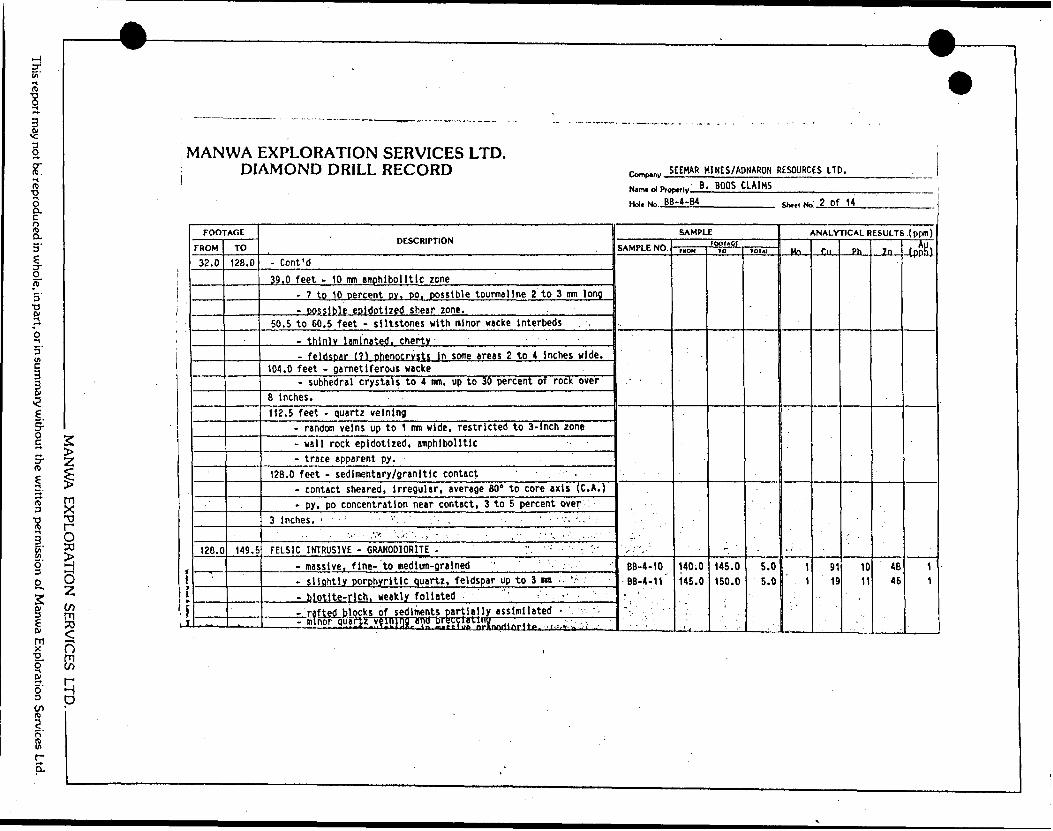
m
l
-g gf.
MANWA EXPLORATION SERVICES LTD. DIAMOND DRILL RECORD SEEMAR H1NES/ADNARON RESOURCES LTD.
reproducedin whole, in part, or in summary without the written permission of Manwa Exploration Services Ltd.
2 zi5"or- O ?o
O Zin-n33
f)
D
Ii
j.
FOOTAGE
FROM
32.0
126.0
TO
128.0
149.5
.
DESCRIPTION
- Cent 'd39.0 feet - 10 mm emphibolltlc zone
- 7 to 10 percent py, po, possible tourmaline 2 to 3 mm long- oossible epidottzed shear zone.
50.5 to 60.5 feet - siltstones with minor wacke interbeds
- thlnlv laminated, cherty- feldspar (?) phenocryst* in some areas 2 to 4 inches wide.
104.0 feet - garnetiferous wacke- subhedral crystals to 4 mm, up to 30 percent of rock over
8 Inches.112.5 feet - quartz veinlng
- random veins up to 1 mm wide, restricted to 3-lnch zone- wall rock epidotized, amphibolide- trace apparent py.
128.0 feet - sedimentary/granitic contact ' -- contact sheared, irregular, average 80" to core axis (C. A.)- py, po concentration near contact, 3 to 5 percent over .
3 Inches. ' - : -, ; •'•. . ' , . . ' . , ' - p c. - .. .. . r..- . - ,V* ''.'.i'.'' 1. .', - , - . ' , '- ; - :. . . . .."
FELSIC INTRUSIVE - GRANODIORITE - . V, - -. ".;'- massive, fine- to medium-grained ' ' ; ;:- slightiyjorphyritic quartz, feldspar up to 3 urn - '.^- biotite-rich, weakly foliated ^' - ,- *- --rafted blocks of sediments partially assimilated r v '- minor quarjz vfinjrjj and br*;ty' oL1 "!innriifir(tB - ^ ' '-
NinwolProi
Hoi. No. BE
^ B , BOOS CLAIMS-4-B4
SAMPLE
SAMPLE NO.
'.. '
r" '~ i '
66-4-10BB-4-11
-.. '
FOOTAGErnoM
140.0 145.0
10
145.0 150.0
101*1
5.0 5.0
Shtel No 2 of 14
ANALYTICAL RESULTS .(ppm)
Mn
1
1
r.n
91 19
Ph
1011
7n
' 46 46
-LDPb^J
'
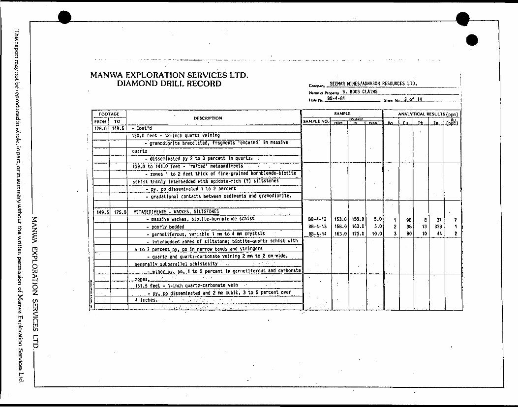
his report may not be' reproduced in whole, in part, or in summary without the written permission of Manwa Exploration Services Ltd.
MANWA EXPLORATION SEF
MANWA EXPLORATION SERVICES LTD. DIAMOND DRILL RECORD
FOOTAGE
FROM
128.0
149.5
-
TO
149.5
175.0
DESCRIPTION
- Cent 'd130.0 feet - 12-inch quartz velning
- granodiorite brecciated, fragments 'encased' in massivequartz . .'
- disseminated py 2 to 3 percent in quartz.139.0 to 144.0 feet - 'rafted' meta sediments
- zones 1 to 2 feet thick of fine-grained hornblende-biotlteschist thinly interbedded with epidote-rlch (?) siltstones
- py, po disseminated 1 to 2 percent- gradatlonal contacts between sediments and granodiorite.
METASED1MENTS - WACKES, S1LTSTONES- massive wackes, biotite-hornblende schist- poorly bedded- garnetiferous, variable 1 mm to 4 mn crystals- Interbedded zones of siltstone; biotlte-quartz schist with
5 to 7 percent py, po in narrow bands and stringers- quartz and quartz-carbonate velning 2 mm to 2 cm wide,
qenerelly suboarallel schistosity- minor DV. DO, 1 to 2 percent in garnetiferous and carbonate
zones. '151.5 feet - 1-inch quartz-carbonate vein
-jPYjJO disseminated and 2 mm cubic, 3 to 5 percent over4 inches. ; , - . * . :
•' -' ••'\--'ii( ' 'i'-: \ ••'•"' ' - ' \ - -. . " . - ": ' , '
9
'romp..,, SEEMAR MINES/ADNARON RESOURCES LTD.
N^m* ot Pro
Hoi. No Bf
My B . BOOS CLAIMS)-4-84
SAMPLE
SAMPLE NO.
BB-4-12 BB-4-13BB-4-14
tOOTACIFIOH
153.0 158.0 163.0
ID
158.0 163.0 173.0
TO7A1
5.0 5.0
10.0
Shttl Ne 3 Of 14
ANALYTICAL RESULTS (ppm)
Mn
1 23
Cu
98 98 80
Pb
8 13 10
Zn
37 333
44
(ppti)
7 1 2
i
Om tn
q p
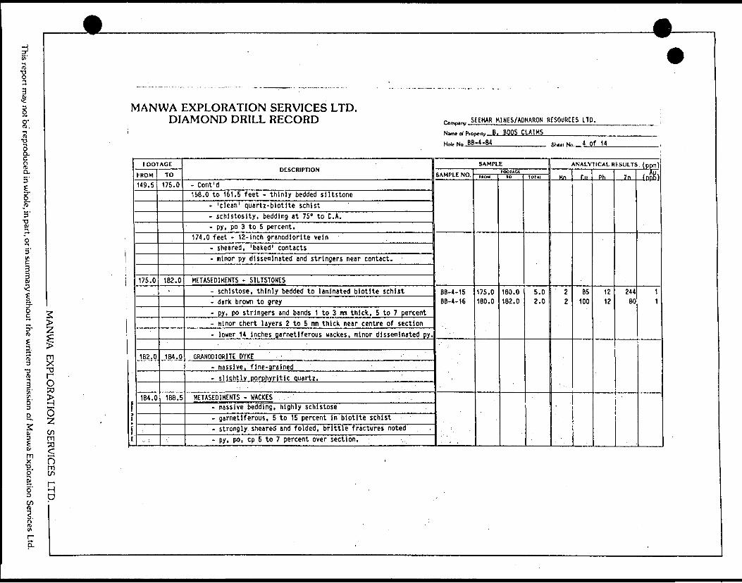
This report may not be reproduced in whole, in part, or in summary without the written permission of Manwa Exploration Services Ltd.
MANWA EXPLORATION SEF
<O8
q P
V1ANWA EXPLORATION SERVICES LTD. DIAMOND DRILL RECORD
FOOTAGE
FROM
149.5
175.0
182.0
184.0
TO
175.0
182. 0-
184.0
188.5
DESCRIPTION
- Cont'd158.0 to 161.5 feet - thinly bedded siltstone
- 'clean 1 quartz-biotite schist- schistosity, bedding at 75" to C. A.- py, po 3 to 5 percent.
174.0 feet - 12-inch granodiorite vein- sheared, 'baked 1 contacts- minor py disseminated and stringers near contact.
HETASED1KENTS - S1LTSTONES- schistose, thinly bedded to laminated biotite schist- dark brown to grey- py, po stringers and bands 1 to 3 mm thick, 5 to 7 percent- minor chert layers 2 to 5 mm thick near centre of section- lower 14 Inches garnetiferous wackes, minor disseminated py.
GRANODIORITE DYKE -- massive, fine-grained ' - ~- s lightly porphyritic Quartz.
HETASE01MENTS - WACKES . - .- massive bedding, highly schistose- garnetiferous, 5 to 15 percent in biotite schist- strongly sheared and folded, brittle fractures noted- py, po, cp 5 to 7 percent over section.
————————————— --"— ---— ' ^
(Vmfu^, SEEMAR M1NES/ADNARON RESOURCES LTD.
Name of Pro
Hot. No. B B
~,i,, B. BOOS CLAIMS-4-84
SAMPLE
SAMPLE NO.
BB-4-15 BB-4-16
rOOTAQtf ROM
175.0 180.0
10
180.0 182.0
tOTAI
5.0 2.0
Shui Ne 4 of 14
ANALYTICAL RESULTS, (ppm)
Mn
2 2
r.n
BS 100
Ph
12 12
7n
244 80
(nnK)
11
w
9
,-
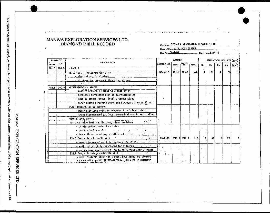
HK' ^ ro
l
l
be repr
MANWA EXPLORATION SERVICES LTD. DIAMOND DRILL RECORD SEEMAR M1NES/AONARON RESOURCES LTD.
Ham. of P.^p^.y :B. BOOS CLAIMS——————
Holt Kin BB-4-B4_________ 5,,,,, jg^ Of 14
ced in whol
in pa
n sum
ry withou
written permission of Manwa Explo
ion Servi
2 >•zlm x•^O30
* O
wS oK qD
frr
i
FOOTAGE
FROM
184.0
188.5
TO
IBS. 5
300.0
',
DESCRIPTION
- Cont'd
187.0 feet - fracture/shear plane- abundant po, cp on plane- slickenside;, movement direction unknown. :
.. , ;, . . .
HETASE01MENTS - WACKES . ' ;- massive bedding 2 Inches to 3 feet thick- schistose hornblende-biotlte-quartzichlorite- locally garnetiferous, locally carbonatlzed- minor quartz-carbonate veins and stringers 2 im to 10 mm
wide, subparallel to bedding- minor siltstone units Interbedded 1 to 3 feet thick- trace disseminated py, local concentrations In association
with altered zones. -191.0 to 193.0 feet - siltstones, minor sandstone
- thinly bedded, under 1 cm thick . '- quartz-biotlte schist i . - !- trace disseminated py, possible sph.
218.5 feet - 1-inch quartz vein :' :- quartz barren of sulphide, epidote inclusions- -- -- wall rock slightly carbonated for 2 Inches . - ' ' .'- po, py near upoer contact, 10 to 15 percent over 2 inches.
226.0 feet - 4-lnch granodiorite vein ' :- small 'splays' below for 1 foot, boudinaged and sheared- surrounding wackes gafrtellferous, 1 [to 3 m i n diameter
SAMPLE
SAMPLE NO.
BB-4-17
BB-4-18
FOf)TAC{riOM
184.0
218.0
10
189.0
219.0
101 At
5.0
1.0
ANALYTICAL RESULTS .(ppm)
Mn
Z
1
'
r.n
161
61
Ph
9
5
7n
30
28
(ppK)
1
1

5"w 1*H
l
ioy.oQ.nH) O.5'
tjT3' •o
OJ
o
*
lS-o573
o' H
o O
i li E* lX (J"2. mO if)
MANWA EXPLORATION SERVICES LTD. DIAMOND DRILL RECORD SEEMAR HINES/ADNARON RESOURCES LTD.
l Nam. ol P.np.,ly B. BOOS CLAIHS Hoi. NO BB-4-84——————-——— ShMl Mn.-6 Of K
j*fI
FOOTAGE
FROM
188.5
TO
300.0
DESCRIPTION
- Cont'd232.0 feet - 14-inch g ranodiorite dyke
- slightly porphyritic quartz- fine-grained, leucocratic- surrounding wackes strongly garnetiferous, carbonate
stringers highly folded/sheared- garnets 1 to 4 mm, up to 40 percent over 2 inches- minor py, po, 1 to 2 percent over 4 Inches.
235.0 feet - 8-inch granodiorite vein- similar to above, 232.0 feet.
237.0 to 240.0 feet - garnetiferous wackes- minor disseminated py, po in carbonatized zones, 1 to 2
percent over 3 Inches.258.0 feet - 8-inch ouartz-feldspar vein
- highly sheared, epldotlzed wacke inclusions- 'vuaov 1 ouartz-carbonate for 2 to 3 inches near contacts- py, po (cp) stringers 3 to 5 percent.
268.0 feet - 4-inch breccia/shear zone- fragments of wacke under 1 cm in quartz stringer network- 'healed' fractures above and below, shear at approximately
20" to C.A. . . 'V v' --'-.::-.." V ... - ' ; - ~- minor py, po on fractures, 2 to 5 percent over 1 foot.
275.0 to 281.0 feet - garnetiferous wackes- garnets 2 to 4 mn in diameter, 20 to 30 percent of rock
———— - dliSertiinaw) py. pa 2 tu S utircBiit, associated ullli yarnets nn anoarent carbonatization. "
SAMPLE
SAMPLE NO.
B8-4-I9
BB-4-20
BB-4-21
BB-4-22
DB-4-iJ
FOOTACIM(J*4
235.0
245.0
255.0
267.0
275.0
TO
240.0
255.0
260.0
270.0
280.0
101*1
5.0
10.0
5.0
3.0
5. t
ANALYTICAL RESULTS (ppm)
Mn
1
1
' 1
1
. 2
Cu
107
100
159
70
111
Ph
8
5
8
12
9
2n
26
26
27
48
29
fnpKl
1
2
1
2
1
O H D
VIP"S.

This report may not be reproduced in who
e, in part, or in summary without the written permission of Manwa Exploration Services Ltd.
W
-
MANWA EXPLORATION SERVICES LTD. DIAMOND DRILL RECORD
MANU/A EXPLORATION SERVICES LTD. —————— -
[ l*
i
FOOTAGE
FROM
300.0
315.0
TO
315.0
396.0
DESCRIPTION
METASED1MENTS - HACKES (CARBONATED)- carbonate-rich, highly sheared- minor schistose hornblende/biotite-rlch zones, schistosity
at 75* to C. A.- disseminated sph, py, po 1 to 3 percent.
303.0 feet - 12-Inch siltstone Interbed- little to no carbonate alteration- 3 to 5 percent py, po, sph.
METASED1MENTS - WACKES, SILTSTONE- bedding massive 1 Inch to 2 feet- locally garnetiferous wackes- minor quartz and quartz-carbonate veins and stringers 2 mtl
to 5 cm wide- slltstones quartz-blotlte schist, wackes hornblende-blotlte-
ouartzichlorite- minor carbonatlzed zones less than 2 Inches wide- trace disseminated py, minor sulphide 1 to 2 percent over
6 Inches In garnetiferous zones.331.5 feet - 12-inch granodiorite dyke
- fine-grained, leucocratic '- highly fractured, possible fault/shear zone.
334.0 to 336.0 feet - siltstone, sandstone- 'dirty 1 metaquartzite thinly bedded with silty quartz-
Diotite scnlsi - trace disseminated oy. '. - ..- ^
1W
9
i cDmp,oV SEEHAR M1NES/ADNARON RESOURCES LTD.
Nimt ol Piot Hnl. Mi . B
MV B , BOOS CLAIMSB-4-B4
SAMPLE
SAMPLE NO.
8B-4-24
BB-4-25 BB-4-26 pp-i.?7
88-4-28 BB-4-29 BB-4-30 BB-4-31
FOO1ACIMOM
280.0
300.0 305.0 ^10,0
330.0 333.0 375.0 380.0
10
285.0
305.0 310.0 AiS.n
333.0 336.0380.0 385.0
101*1
5.0
5.0 5.0
, s.n
3.0 3.0 5.0 5.0
SKttl No 7 of 14 ,(
ANALYTICAL RESULTS, (ppm)
Mn
1
14
4 1
1 1
. 1
1
r.u
80 81 69 f,9
68 76 85 92
Ph
6 14
13 Q
14 12 6 7
Zn
30 128 85 ?B
40 161 20 32
fpplh
1 1 2
20
5 6 1 3

may not be reproduced in whole, in part, or in summary without the written permission of Manwa Exploration Services Ltd.
M ANU/A EXPLORATION SERVICES LTD. ——————
MANWA EXPLORATION SERVICES LTD. DIAMOND DRILL RECORD
llr
1
FOOTAGE
FROM
315.0
396.0
TO
396.0
'*,
4B4.0
DESCRIPTION
- Cont'd375.0 to 381. S feet - garnetiferous wackes
- highly altered, carbonatlzed- amohibolitlc with 15 to 25 oercent oarnet- minor DY. DO 1 to 2 oercent. oosslble soh.
393.5 feet - 6-Inch ouartz vein/shear zone- epldotized wackes with sheared quartz-carbonate veins 5 im
to 1 cm w! rip- large pod sulphide In quartz! 1 Inch In diameter- py, po. cp 10 to 15 percent over 4 Inches.
METASEDIMENTS - SILTSTONE, SANDSTONE. WACKES' thinly bedded, less than 1 inch to 6 Inches- sandstones metaquartzite with Interbedded quartz-blotlte
siltstones p .- wacke units 3 to 10 feet thick, slightly garnetiferous,
crystals under 2 urn in diameter, sparse- minor quartz-carbonate stringers 1 to 5 mm wide, most
abundant in wackes -^ - :' ' :- trace disseminated py, associated with veining. -
425.0 -feet - carbonatlzed wackes, garnetiferous- minor "pods' carbonatized up to 1 Inch wide, 20 percent ove
3-foot zone - - r - : , '. trace disseminated DY: : —" - -
- '. ' .' . .Y.- - : - -:- -- \ -vf'-v -.,. . ' . Y . '..
r^p.0^ SEEMAR HINES/ADNARON RESOURCES LTD. !Nam4 d Prof
Hd. NoJl.
^,,|, B. BOOS CLAIMS-4-84
SAMPLE
SAMPLE NO.
BB-4-32
BB-4-33 BB-4-34BB-4-3?BB-4-36
1001*01FROM
393.0
395.0 410.0 420.0445.0
to
394.0
405.0 415.0 425.0455.0
1OTA1
1.0
10.0 5.0 5.0
10.0
Shtil No B of 14i
ANALYTICAL RESULTS (ppm)
Mo
1
. 1 t12
Cu
320
95 108
10992
Pb
15
8 7
89
Zn
69
35 32 4641
(pftB)
i
10i
55g
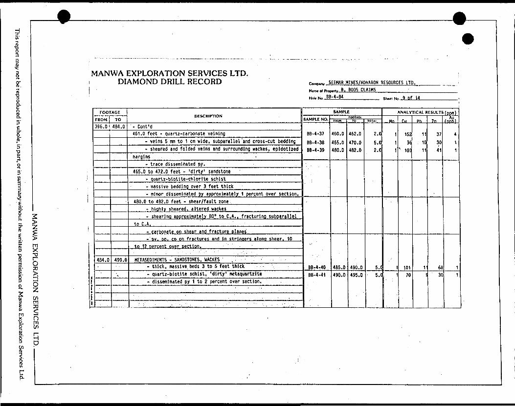
This report may not be reproduced in whole, in part, or in summary without the written permission of Manwa Exploration Services Ltd.
MANU/A EXPLORATION SEF
V1ANWA EXPLORATION SERVICES LTD. DIAMOND DRILL RECORD
FOOTAGE
FROM
396.0
4B4.0
TO
484.0
499.0
\,
DESCRIPTION
- Cont'd461.0 feet - quartz-carbonate veining
- veins S mn to 1 cm wide, subparallel 'and cross-cut bedding- sheared and folded veins and surrounding wackes, epldotlzed
margins -- trace disseminated py. -. :
465.0 to 472.0 feet - 'dirty 1 sandstone- quartz-btotite-chlorite schist- massive bedding over 3 feet thick- minor disseminated py approximately 1 percent over section.
480.0 to 482.0 feet - shear/fault zone- highly sheared, altered wackes- shearing approximate]* 80" to C. A., fracturing subparallel
to C. A.- carbonate on shear and fracture olanes-oy. DO. CD on fractures and in stringers along shear. 10
to 12 percent over section.
METASEDIHENTS - SANDSTONES. WACKES ' . ,- , -- thick, massive beds 3 to 5 feet thick- quartz-biotlte schist, 'dirty' metaquartzite- disseminated py t to 2 percent over section.
^W
9
c*****? SEEHAR HINES/ADNARON RESOURCES LTD. iNairn ol ProfH^Nn BB
MV B , BOOS CLAIMS-4-B4
SAMPLE
SAMPLE NO.
BB-4-37
BB-4-38 BB-4-39
-'
BB-4-40BB-4-41
FOOTACIFKCWH
460.0
465.0 480.0
485.0490.0
TO
462.0
470.0 482.0
490.0495.0
1DTAI
2.0
5.0 2.0
5.(5.C
ShitlNo 9 Df H
ANALYTICAL RESULTS (ppm)
Mn
\
1
1
1
1
r.u
152
36 * 103
10170
Ph
11
10
11
Vl
7n
37
30
41
6830
fppR)
4
11
11
D ' mC/)
q P

•c o
t
""l5.
io*
n Hi
QJau
u u
Od
ea
5a
*az
<
Z
1
"
DU]-JUit-Z
—i3'
z
cba2 •4 t/
DESCRIPTION
3 25 T^
^b
. 1C^ta:c32:31,
UJ
2*:
UJ
^
Ot/1to ISEDIMENT
0.0o"
*-LO
^cttoLO
oLOoU
l
ogCM
~"f
CO
C
D
W*
O)
c
uco4-*Eo0)
•o oO
l1
^,
0CM
CM
OCM
OLO
C
ML
A
OCO
CM
LA
f*1
enCD
to80*g•oo*3**
Ou4^L.
OH4-"
.C
Ok
*-^kfai
o5COLO
C
M
OU)
ooLO
U)
oVO1eaCO
NtacriO)
•occios1
,—sen0oooLO
LO
c*Ul
LA
inCD
C
D
S•DCi
4-*n
CI1OO
l U
l
s4-*
•opU)
o4-*
CMJ*
Ol
c
t-IA a*4-*41g fU
1h*Dcru. c
E i
Ol
o -of1-4
tacruc1101aiCOiLO
-SSV)
OJ
*AtA8.1
f4-JOl
rS•^SU)
IOc1u1 "i4-*C
O
fut.aics•osE
U1
O)
ucCM4*
>O
/fracture zoneiMLO
1g14-* Mor4
-*•JJ-1
tcrc•SID.C
4-*
U
Ytlferouso*cCft
1
Ol
JJsTJ
C•1O
*CT•oO
)
of—*
ttlng subparalle:au
o*•D"*
CO54AO)
.
t t
4-*
carbonatizedz** .*•0
O
l*o
-*: uK
) 7
l
exMQ.
eu
s-g iCO
5S:*Ot-a*
x:M
1
.,
4-*
V-
v-
t- O
)
o4-*cO
)
ifg.oo ot/)VI
J-Of
tytc."' -
UJ
^dTONE, GARNET IFEfil— —Jto1U
l
SEDIMENT•ti —"*"o
SLO
OrnU3
5Lf
Ouo. LO
CO
Ul
ooo u*niCD
C
D
JTUC—1-•sTDOl
-oT3O)
JOXC•C
4JU)
O)
g4-*V
I*JV
I
r*ex oftctc?CV
oLf
ol
CMenLC
l
osr**4iiiC
O
CD
C4-*
4-*
O)
01
oo4-*
COVI
4-*
"c1M
* Cc
J u
1
f
1 V
I
uk
CI
^Ce*1
oir crU
l
oCM
Icn U
l
CO*41leaC
O
S4QIA0)
Voosiliceous1
1— -f t* r
is -
t c
i *
i a
t a
* ^cLf
CLTSCiLCCTi1
CO
eaik aCK(Jc 1
-** n r
- c
^ c
r P
0
Cn
a
— T
l C
i u:
k c:
1 L
fev
1 LCC01
^t
w:uiiea eaean1 sediments0
; >0.>IO
, O
)-
L.1
^*-
-
ffi
3
4O
is
w
~
rt LC
Q C
1 O
t f
t O
k GC
t C
\t
veck 1,Vcc tt
--"
MANW
A EXPLORATION SERVICES LTD..
This report may not be reproduced in w
hole, in part, or in summ
ary without the w
ritten permission of M
anwa Exploration Services Ltd.

os lton *H
i
Q
5O)
UJ
Q
osow
wO
) OSZ
J
Od
01 <l5Z
1c3SK
.JUt.Jzut
2 j cbskbl3o
Zi1pJficjsopJ**
b3a.Zi, 1OKoacu.
:."0Z*c
o*
oCOCMtoo
entOUT)
J*UJC4-*
O)
0)
U)
Ok
CTO•D•^at(A
*A
E4A
a*a
*t
M•0IAUiUT)
04-*
Catt- o.o
enOo4A
1O)
c:nO*
Of
2 "5*AUC0
0t
•MC•09c**c41C
3
-O(Aia4-*cI(A
X*
t.
OcosL.
,*3?SNOh*D1uiu
BwTO
"SenoZt-1t~V*
c0fu1fcr
1"S
•cs0U)
ffiO
k C•o(U
-Oo7ezSV
*
io"TO
t/)ZU
J
QC
gOr
OVDoCO
CM
OD
iriCV-
enw0enOenoOD
OJ
(Miniea eas5H
-OtAOJ
CocsHI
TOatucCOouco*u 1
s14A
gNt. OJC1-314ot
1IM*
tAUtt/l
C
OQ.
1"eTO2!IQ
t.
t*o 1
,-4-*Cg1cx3Mtu4-*Cc"^tMSoNt- O
lo.Q
.
atiNl.a osu
J- O
) Q
.
O04-*
r*Q.
is i
.if.|UJz
a-jbOO|U.
zs1l/Ji0UJ
g310i/)sotO
CN
c c•*!^
^*r-
ao^oLT
S0en10
en4Aiien
m•oc1^cg0fsl
TOai xlix: enf'
- f
j} U3
i rs
r cven
- ^o01^010
oC30Ul
eriniiCD. ea4CO1 'eiIS
*
tCtM3
3
O*
IL.
trt
GC"oc1
c r*cen0CMouC
UoctoU)
Ul1ea
enjca
S4-*
*OCo,oi-tou^stM
cc4-*(JO
) IAi. O>
O1s.c
p*iAtTOez0MS
.aoTU
)
occ1
*M
*
• -
tm A
U"~
' r-
r^-
h.
MA
NW
A EX
PLORA
TION
SERVICES LTD
..
This report may not be reproduced in w
hole, in part, or in summ
ary without the w
ritten permission of M
anwa Exploration Services Ltd.

i JCO
fil-•s
CIDWQ
WU
J UDCC
g dOz
gaZ
|SESULTi
u^ z
ssa.Z
Cua: t
DESCRIPTION
LU
O0
H
O
y
2 1u. 1-tt^j
-
i
:01MEN1S - HACKES
t/)
CDina
c0C"QrcwCifCchTOirwaiiea eao*cz•oO)
Ul
l/tI
3 O
"k•*
r
3 f*
o *4
- C"
D a
- -r
* Ul/k/
t/irCc
Ifr*1
exCOuiaa c
t-cn; aTDeaIS4-110
|4-1aV) n
a
* u
1 *" i*
9 *c
1 C
5
C*
•k U
k *!
k C
k C
k U
k U
k t/ UTSul1cc cc- disseminated oy 2
to 3
oercent Q•k 1r\•kr*kikki
- minor fracture planes aDoroximately 300 to C. A.
EDIMENTS - IRON FORMATION
h-
MJ
X.
rvCOtntn
enu-COCDrv
iro.inounooeniiCOmO)
4-*
1t OIL*tt),1t- O
)JZ u
1 O)g4-*
4-*
VI
woinCMmCM
CD
C
M
C*
tnoo
rvotntooieaCO
1•o cJC4-1cz out4
-*
M•oa*4-1
c
"e4-*
mto toCMU
3
CD
moWk
rvOorv^.iiaaCO4)cz o4-* M
l4-1
VI
Csw*
t- aiu4JCx:4-*
CMrvenCOu*otoogorv
CM11 CO CO•A
VgO*-OJcI/I
cJQT)C
4i/l
1•rtt- (U OCL-4-* 1/1
a a
*~COCMC-OinCD
GQ
CD
SmiiCOea* c
o4-1 .O
O
)V
*
t- Ctfo4-1cO
fex tnoC
D-C.
exex ui. s
COtf cmCMS0en0Soinw
11COCO
t/)Ul
iLO
UJ
u.
UJ
o?g1
UJ
x
oCD CMStO
inCO
to•a-
cvoCMOOenoStnii ea ea- massive
chlorJte-biotlte-hornblende schist
l*1dCVJ
to c\otnOin enOo
entoiCOea- carbonatized,
with abundant quartz-carbonate stringers.
**
~ a (fcccv.crowo3OUl
en^iiCOea4-*
iw•oc0f)c"3
- cc*4CC(TcroIflocog11COCO- py,
po 5
to 10 percent over section disseminated, general )
a*-u1 i/acc t
r*cVGG*"GGenii eaCOtta c oNSiA
01
JC
4-1
|aassoc a rv
r" a1
C
t CO
) to
. ffioCMO.CMO0CD1l
CO
CO
'VE SULPHIDE ZONEt/) t/iCMO
CMrv
M
C
C"gfr- fuCircvGoyiiCOeaL.
a o4-*Castn?iKE> Oc. ex cgo•o cczf. o
1 CIcaVAt
UM
* su331Jlk1
-
4OO)1-ctO
tM
4
OJoc0Ml
ac at/iucto"ei
ut*
CXex
ul"e— '
MANW
A EXPLO
RATIO
N SERV
ICES LTD..
This report may not be reproduced in w
hole, in part, or in summ
ary without the w
ritten permission of M
anwa Exploration Services Ltd.

This report may not be reproduced in whole, in part, or in summary without the written permission of Manwa Exploration Services Ltd.
W
MANWA EXPLORATION SERVICES LTD. DIAMOND DRILL RECORD
MANWA EXPLORATION SERVICES LTD. —————— .
l3
l
i
FOOTAGE
FROM
712.0
712.5
715.5
TO
712.5
715.5
724.0
DESCRIPTION
- Cont'd- mineralization appears primary in nature at sedimentary
facies contact.
BRECCIA ZONE - HETASEDIHENTS- brecciated siltstone* (? base of Iron Formation)- quartz-carbonate stringers as breccia matrix, 1 to 3 mm
wide, general trend 30 C to C. A,- abundant py, po (cp) In stringers and pods, 7 to 10 percent
over section- graphite zones and on fractures, 2 to 3 percent over
section.
HETASEDIHENTS - IRON FORMATION- thinly laminated chert-sIltstone-wacke-pyrlte-Tmagnetlte- minor graphite near 724.0 feet, lops down-hoiel?)- py, po stringers md pods, 5 to 7 percent over section- weakly carbonatized zones 1 to 3 inches wide - .- quartz-carbonate 'healed 1 fractures randomly spaced *t
approximately 30" to C. A.721.5 feet - carbonatized metaquartzite
- cut by fracture at 45* to C. A., filled by radiatingmuscovite, crystals up to 5 mm on long axis.
fW
0
(vmp-v SEEHAR HINES/ADNARON RESOURCES LTD.
Name of Proi
Hoi. No BB
-,,, B. BOOS CLAIMS-4-84
SAMPLE
SAMPLE NO.
BB-4-72
BB-4-73
8B-4-74
FOOIAGIHUH
712.5
715.0
720.0
to
715.0
720.0
725.0
IOTA!
2.5
5.0
5.0
Shell No 13 of 14
ANALYTICAL RESULTS .(pprtl)
Ho
2
1
1
Cu
54
101
72
\
Pb
46
14
13
—20-
75
600
460
fpftH)
19
4
2
1

t/1UJso
g
UJ
UJ
fcO
3
ft
*E
tJ J
O)
tuLUO
J
Od
02
UJ <|B
FtESULTi
~jOg-
-1Z
3i
1
c2kec
RIPTION
bja
w
O0
1-
O
v2 oM
. ^
iC
.CCcJCa.Cc xc3;ii 1
XI
+Jc:
O
OoC4
fi*
C
40
c?ear--
(Ux"5CMO
-4"*
W)
ft)c
oIM
CI
4-1C40.
*-0x:"5C
I oatL.
.at.QJt
fc.O
)
34-*Catt:aircoa xiC
OO4-*
(At.
atoct,i/l
OOoQJ.C
0c 131is-™iAAO
)Dia o
ioor
**3
U
SUJ
z
uUJ
Eh-
i/1t—-Jt/)1
ZUJ
oUJ
LiJ
OfOr*oCM
CM
1at
LOCO
oU)
oor*.
ohA
C
Mr*IA1
CD
aa
x*O)
4-*MC"etoS"Si^cc
CO
l/) C
u
CM^*
(TO
0W)
or-*
OSjoi*rt aaC
O
**gIMi.ofc.u1-iIE4-*"SeMU
U
t
Mt*D314-*
+JO1
5oJ*0t-sJ3W*
(UX
J"5iC
M
O*AUtuc* ck.4-* 1AS"o-0c "e
c: o4-* Ut-
VgO)
wCMOOl
cM"o.
4^(AO4^
•A
JZulACoX)cr(OO*
•o
•o
cCOo4-*
4A•aS*A
~•DC•O1At.atO)
cfc. *jMO•0i.
to uNt3C
T
Oc"i1O
)
0oNa*N4-* d|IO
OJEg—
.
Uii
4-*
O)
cuV-
o
:M
5jlaaoiauujs!Ay1ix* u3^;^i
o*cX)
x*JS•scot0M-
4-*
O4-*
4A
JZu
*tcMl
t/l
2!3
O2 ga~0-
oc ^1
ItstonetA
X)O)
cJS-*-11ts(Vtfr.o0
*
r•to +JoKmC
TCX)
TD
JS
"S,w x^Nu)ss0•x,LMOm
r*.
L^r
\•^s.
sx^s
MM
*
^*^
1 ——
— !9^"•N"-
MANW
A EXPLO
RATIO
N SERVICES LTD
..
This report may not be reproduced in w
hole, in part, or in summ
ary without the w
ritten permission of M
anwa Exploration Services Ltd.
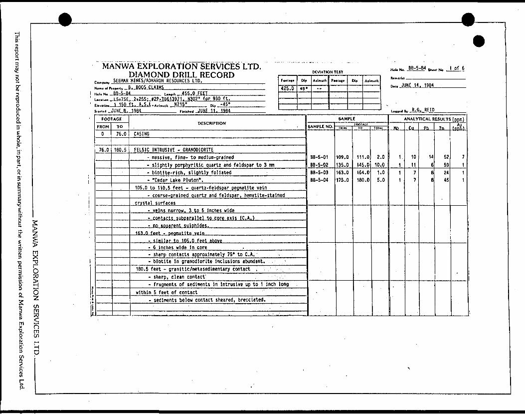
Ci'
3
B
rt) oO O.
o8.
o, ft)5' o01
3
g
0)
D" (O
l6'
c^ 2
lmx•g, oCD6'
l
o30
wlo mC/)
qD
MANWA EXPLORATION SERVICES LTD. DIAMOND DRILL RECORD
r—p^y . 5EEHAR HINES/ADNARON RESOURCES LTD.___^__________N. m.oip,op.nv ..B. BOOS CLAIMS——...—.—...-—...-.——..—-- HOI. NO. JBilbM_______ Umiii-JiiiDL
, L5+7SE, ?-t25S; *2P-TB613971. N302' for 930 ft. 150 ft. A.S.L.A.,^,,, N215'_____ a,-4S
DEVIATION TEST
FooUfl*
425.0D,,
49'
Ailmulh
"
Foolofl. Dip Ailmulh
MJ. N. BB-S-IM SK.., N. 1 01 6
ru.. JUNE 14. 1984
.- B R BF in
l1IS
FOOTAGE
FROM
0
76.0
TO
76.0
160.5
DESCRIPTION
CASING
FELSIC INTRUSIVE - GRANODIORITE- massive, fine- to medium-grained- slightly porphyritic quartz and feldspar to 3 mm- blotite-rich, slightly foliated ;- "Cedar Lake Pluton".
105.0 to 110.5 feet - quartz-feldspar pegmatite vein- coarse-grained quartz and feldspar, hematite-stained
crystal surfaces- veins narrow. 3 to 5 inches wide- contacts suboarallel to core axis (C. A.)- no apparent sulohides.
163.0 feet - pegmatite vein
- similar to 105.0 feet above- 6 Inches wide in core- sharp contacts approximately 75' to C. A. ' .- biotite In granodiorite Inclusions abundant.
180.5 feet - granitlc/netasedlmentary contact ,- sharp, clean contact' -- fragments of sediments In Intrusive up to 1 Inch long
within 5 feet of contact '- sediments below contact sheared, brecciated.
SAMPLE
SAMPLE NO.
BB-5-01 BB-5-02BB-5-03 BB-5-04
IO01AUI(MOM
109.0 135.0163.0 175.0
10
111.0 145.0164.0 180.0
1O1AI
2.0 10.01.0 5.0
ANALYTICAL RESULTS (ppm)
Mo
1,
1
1
1
Cu
10 117 7
Ph
14
6B 8
?n
52 5924 45
ippRi
7 111
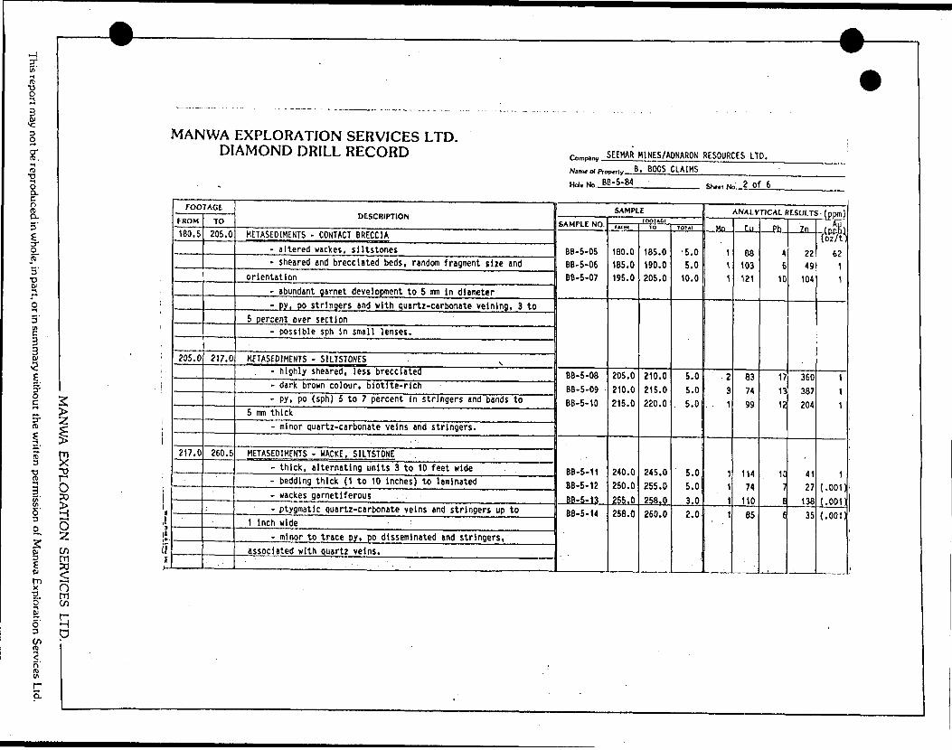
'lis
ttti
Gucfl WU
JUJ
cnce
02
w <
|B
' — ,
S"5U)
UJ(r -
OP-j
otIut
-B!z5
c2uB: i
-z.DESCRIPTIO
uj O
STlia. j3*j^
ico.U*E3Sj11CONTACT BRECCIA1W
O
z:goi/ijjX0MCD
CO
c\ifc\CS•4Soif,oIS!COo1ineaiiCOea
.i
•—enToomoCD
eno2CDI
U)1
CO
C
O
•oc41NVt
•t-*C•oi.V-
1crt.
md brecciated bedssheared ii
^oCM
O0ooCM
CD
enr-*oitnCO
COgcOl
t.o
i.4*r1•Scr1inogarnet development
abundant
cft1 "caa*:|•e uiten-C•oc
•o1at.MS1
c
c4^Ci
Wi
Ml
c*czO)
ffi ECjz: c.(A
possiblei
S
RT STONES4/1
H-
ZUJ
sOLU
'iOrv.?y
OZ*
CM
^Cf*~mCOOUl
C3
0
CM
0mCD
C
M1to1eaffi
•oiA
jz: o
*jz:i
r* cC onr*.
mO\f,0Ul
CM
O*
oeniCOea
JZurfn colour, biotite-ot-.ajIn
,
•o1
vi c: c\,O
lenC
D
rfCDO
CM
C
M
OU1
CM
CD1miCO
ea
o4-*
IAC•a-0i•oIAI.ai encITIACZ
4-*Ckr-** o.cQ
.IAOcx1
I —oin
IASsi-•octotAsrtz-carbonate veinert- o
cz"Ei
WACKE, SRTSTONEi -oE
0U
JIS
)
Jjx:C
3MOCM
r-V
— c*(VCLf
GUSOcs1l/)COea
•o"5O)
Of
00Iternating units 34
0
Jt-f
-Ct
- trc c
- r
r o
5— P
r v
- r*CifCU
Tir c\cc inCN
CSJ1IA1ea cd
1czet—o4-*W)
aioczCDO4-*
UOl
cOJ1
5 C
J
C
"* ^
J **
z — ffi
r- a
* 0
i C
*
k 0CCtftCM
O*
un if*C
M
COT-1
I/ft
eaCO
irnetlferousCD
IAVijrat
iu o"QUaccvcIcccIfc\^11U]1ttea
5a.fc-aio*ckMl
•QCtOMC
OJ
: quartz-carbonate
4-*
*
•*-*Q
.lw
3 M*T 13 ——
•*3)1i' ) J'
O)
•OUC-~
——
*
.
bCc•DC•o4-
Joex0-
KL.
C1"ei•M ft
VI
cz
i
iz^- u, j
4M
ANWA EX
PLORA
TION
SERVICES LTD
..
This report may not be reproduced in w
hole, in part, or in summ
ary without the w
ritten permission of M
anwa Exploration Services Ltd.
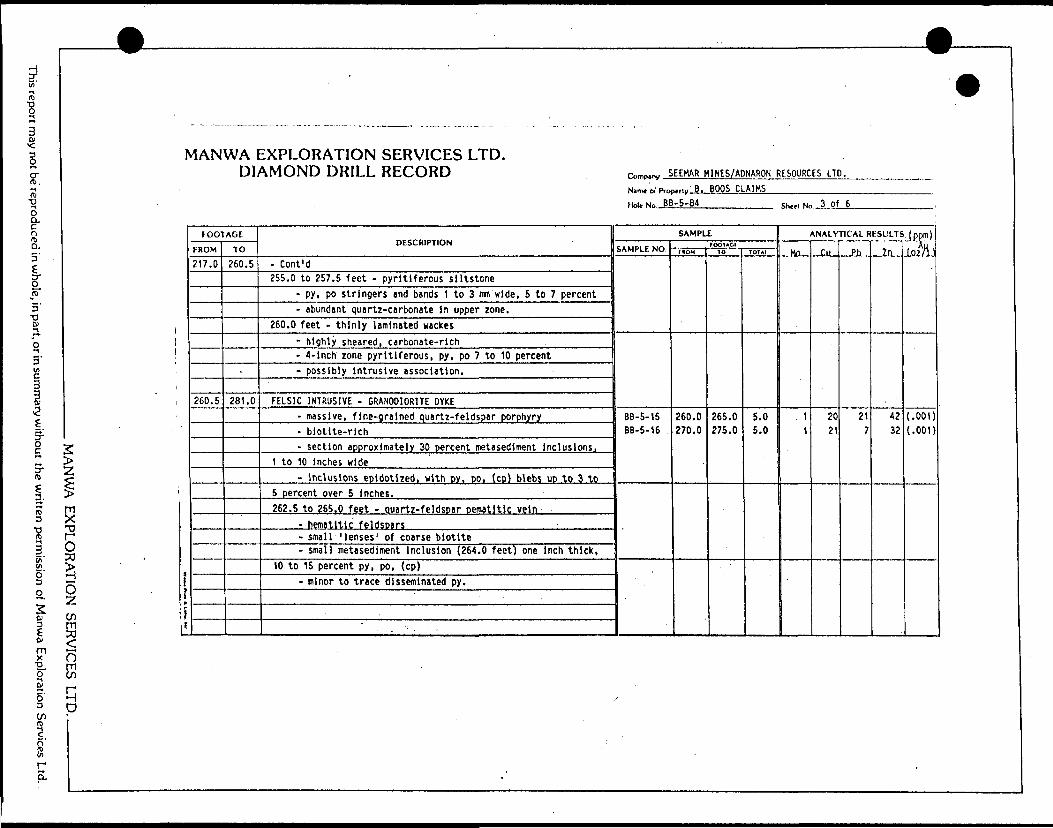
Th,s report may not be reproduced in whole, in part, or in summary without the written permission of Manwa Exploration Services Ltd.
—————— ————
MANWA EXPLORATION SERVICES LTD. DIAMOND DRILL RECORD
MANWA EXPLORATION SERVICES LTD. ———————
t
y
*
S i
FOOTAGE
FROM
217.0
260.5
TO
260.5
-
281.0
DESCRIPTION
- Cont'd255.0 to 257.5 feet - pyritlferous siltstone
- py, po stringers md bands 1 to 3 mm wide, 5 to 7 percent- abundant quartz-carbonate In upper zone.
260.0 feet - thinly laminated wackes- highly sheared, carbonate-rich- 4-inch zone pyritlferous, py, po 7 to 10 percent- possibly Intrusive association.
FELSIC INTRUSIVE - GRANODIORITE DYKE- massive, fine-grained quartz-feldspar porphyry- biotite-rich- section approximately 30 percent metasediment inclusions^
1 to 10 inches wide- inclusions epidotlzed, with py, DO, (cp) blebs up to 3 to
5 percent over 5 inches.262.5 to 265.0 feet - quartz-feldspar pematitic vein
- hematitlc feldspars- small 'lenses' of coarse biotite- small metasediment inclusion (264.0 feet) one inch thick,
10 to 15 percent py, po, (cp)- minor to trace disseminated py.
—————————————————————————— ,. ,. . , ^
r,,mp,nv SEEHAR M1NES/ADNARON RESOURCES LTD.Nim* o) Pro
Hd. No BB
-ri,,- B. BOOS CLAIMS-5-64
SAMPLE
SAMPLE NO.
BB-5-15
BB-5-16 .
FOOTAGIHDM
260.0 270.0
1O
265.0 275.0
TOTA1
5.0 5.0
SSetl Ne 3 of 6
ANALYTICAL RESULTS . (ppm)
Mn
\
1
ClL
20 21
Ph
21 7
Zn
42 32
(oMi
(.001) (.001)
w
9
s
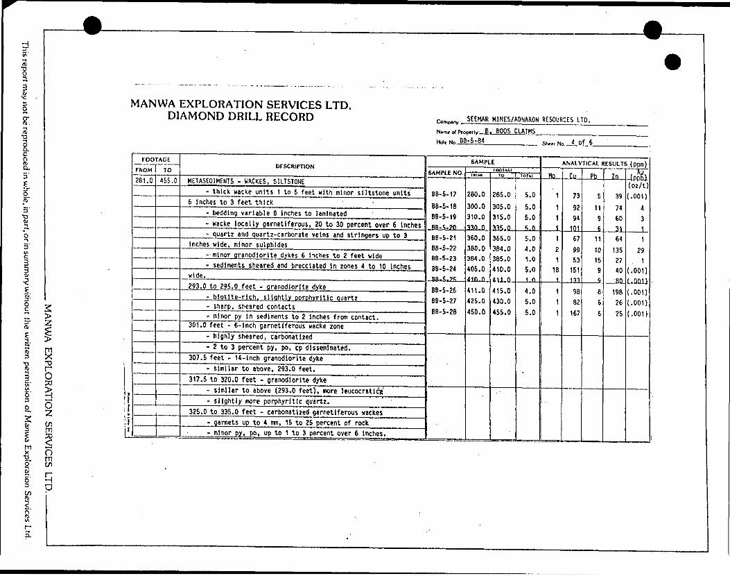
o-~i t/i cjiLlJ
acz
o1V)z
xQC
OJ
UJI
4/1c
)N SERVICES LTD. -L
RECORD
EXPLORATIC AMOND DRII
<Q
Z
<S
vOW^r3Ii/i
^C _
i
i/tOCOea*T
V"? i
1?
Nanu ol
fm Hole No.
JB
R-
CL
IESULT
5 t-2
3i2~
O.
5
iUc: t
DESCRIPTION
UJ
Oo
*-KO
-
2gu.
^~f~
fs5J3O.
si3Ki1 lCKES, SILTSTONE
3
1
4/1
t—ZLU
XQUJ
5^Jx:Q
Ul
Ln-*r
OCO
C
M
[io cl/c* r-oenoIDCO O
J
OOCOr-.iOim
m'M4-i
C31M
4-*
I/I
u oc^jC•f*"5tsuH-
tOo4-*
M±1c3J*UUSac
-*ujr +Ji
9
3rt *
* r
2 *
) C
. CCucucfcc ccc1w 1ac.
auXI
4-*O)
4V
t*~ mo+JMc* x:ucUi
9
t"*
^
- c
*J *
n c
> c
1 U
> c
i U
1 ?
) C
l S
1 0
- W
i
k ir
k a
a alable
6
inches to laminated- bedding var
D
*- D
f
7k 4
T
*-
n c
i c:
i \f
* c
i ir
- i**
i **-
2 C
5 !3
: Si
* L
O
1t
ea1
CC
ly
garnetiferous, 20 to 30 percent over 6
inches !*oa4
V-rf
Ot
^ww
*rucuCuuCc uc\ua a.
quartz-carbonate veins and stringers up to 3•oc*D
MtIO
3cri
c
r L
3
4
- C
— ^
-. c
9 C
) C
t ^5
> C
ilJ C
y c
; ?- o,
J *S
1t
if\1
CC 1
CC
M4U
2'.Co.3tAOc: "eO
) T
3"5iA
(UJT
(JC
1 V*o r
o c
3 t
n c
h k
> c
r *
J C
5U
a
i f
) C^
) af oLf
a aO)
•c ^
•*-*4UO)V
-
CM5t/i O
fJZ uctOV
)4Jo^ •o4
i4-*
U
OXIc4t-cnu0c
1 i
cK
V.
CM
*
n c
n ~-
n L.
d C
- u
? c
; s) **
1 C
r u
l c
t *q
t C*
1 h
1 C
i aaJCucr
0cI/Iaic
oNC-ow
•*-*KUuOJ fc- J3•o c*o•o
att-•Qa*,c- sediments s 3
C
D
C
D
Ca-
c
n c
— c
o o
? c
1
*-
9 C
> ^i
r *s
> c
^ c
3 1-
r ur
J
CS
) U
13
CC
) CC
GJ T
3"5
•t -J a^J
t<<^cb ^c-u cua a
t -
granodiorite dvke(Us- oIrt cr* OJo+J0mo*CSi o
o30C7\B
—
X)n i
TV
3
l
IT i
3
C
n c
— c
r *
3
C
~ b
- c
S P
a c
1 u
3 0
a cHtCO•V-L.
^x:o
o,^1-CcIA
JZTa'c~2t i~~.o
o^-*
LOrwJ3"*J X
)
3
Cfi
i
3
(
3
lO
L
I
*
3
C
n c
W
h
t. C
tl C
n u
i a c
a c
red contactso*-C
u
t
e•o.c4/1
1
.——
O0LA
CMUD•x. lOUADfi fttr33 ooM
13a
*ju*a4
-*c:0u|•AO
)J3 uc4M0*-*•A
4-*
I•oOJ(AS1"e i
,h garnetiferous wacke zonec 1to1*M
(U
Ooo
oo
red, carbonatized^^:O
)
i
ent py, po, cp
disseminated.
t- *u O
.msC
Si
1
ich granodiorite dyke1•W•4-* O
) *U
U)Dm
- similar to
st - granodiorite dyke(UH- o
oxo•4"*
U)
m
above (293.0 feet),
more leucocratic^'
o4-*t~40
"etA1
M
)re porphyritic quartz. ' '- slightly
me
U(*M
* *
IA4J.^
Ua
7irt
|Of
**-
4-*
eraOl
•o(U
N4-*a|*a ui4-*
(U4-
OLft
ro
PO3C*
LA
Cd
PO
•w*
J*UO
fc.H
- O•2Vu
t.at o.inCMO
4-*
U)ir
o4~
*
d3I/I4
-tO
)c
f- *oCT
t~w
4/
O)
x: uc*0L.
OJ^~o4-JcOJut.s.ro o4-*
o4-*
O-
3
o:*s a.u o cr"e^
MA
NW
A EX
PLORA
TION
SERVICES LTD
..
This report may not be reproduced in w
hole, in part, or in summ
ary without the w
ritten permission of M
anwa Exploration Services Ltd.

This report may not be reproduced in whole, in part, or in summary without the written permission of Manwa Exploration Services Ltd.
— - — —— i^^pi ————
MANWA EXPLORATION SERVICES LTD. DIAMOND DRILL RECORD
MANU/A EXPLORATION SERVICES LTD. —————— -
lli ji 1
FOOTAGE
FROM
281.0TO
455.0
DESCRIPTION
- Coni 'd334.5 feet - 2-Inch quartz-carbonate vein
- approximately 5 percent garnets, subhedral 3 to 5 mm- minor epidote, less than IX py.
339.5 feet - 6-lnch quartz and quartz-carbonate shear zone- sediments sheared, rafted, epldotized- minor disseminated py.
353.0 feet - 6-lnch granodiorite vein- very fine-grained, aplitic phases- trace py near contacts.
361.0 to 362.5 feet - granodiorite vein- similar to above, 353.0 feet.
364.0 to 365.0 feet - breccia/shear zone- fragmented sediments, carbonatlzed- ptygmatic quartz vein 1 cm wide- garnetiferous, minor py, po.
384.0 feet - 6-inch breccia zone- angular fragments of sediment In quartz matrix .- little assimilation of sediments- minor py, cp In quartz, 1 to 3 percent.
409.0 to 414.0 feet - slltstones, thinly laminated- py, po, cp stringers and blebs 5 to 10 percent over
section, related to quartz and quartz-carbonate stringers lessthan 1 cm wide
- wackes above and below garnetiferous.
—————————————————————— , ,. . . ^
c™,p.ny SEEHAR MI NES/ADNARON RESOURCES LTD.
Ntrru at Pit*
Hnl. Mn ,, E
,.,, y B, BOOS CLAIMSB-5-84
SAMPLE
SAMPLE NO.f DOlACf
IRUM 10 1OTA1
Shed No 5 of 6
ANALYTICAL RESULTS, (ppm)
.Mn., r.n Ph Zn (ppB)
0

HDi' •^ftE
g
ir. M m•gS cuc n.S-5'
|.o.ren pa
mmary withou
he
en pe
ion
Mamva Explo
2> Zl5TD
O50 SOzen m po
n
MANWA EXPLORATION SERVICES LTD. DIAMOND DRILL RECORD SEEKAR H1NE5/ADNARON RESOURCES LTD.
N. ol P..O.H... B. BOOS CLAIMS_______
Hoi. ^ BB-5-84. ShMI Mn 6 Of 6
FOOTAGE
FROM
281.0
l
'i
TO
455.0
455.0
DESCRIPTION
- Cont'd417.0 to 420.0 feet - garnetiferous wackes
- highly sheared, folded, carbonatized- garnets subhedral 2 to 5 mm In diameter- disseminated py, po 3 to 5 percent.
429.0 feet - 8-lnch granodiorite vein- fine-grained, massive- py disseminated near contacts 1 to 3 percent over 2 Inches.
432.0 to 435.0 feet - massive wackes, abundant quartz velntng- quartz veins up to 1 Inch wide cut at variable angles,
sharp to ptlgmatlc to brecciated contacts- sediments locally epidotlzed and carbonatized- trace to minor disseminated py.
445.0 feet - 2-inch quartz vein-large Inclusions of carbonatized sediments, calc-silicate- vein sheared, folded- no apparent sulphides.
445.0 to 455.0 feet - massive wackes- locally garnetiferous, locally carbonatized- minor quartz-carbonate stringers ana 'sweats' up to 5 mm
wide /i
- trace disseminated py. f j
•s? i ^ " f JEND OF HOLE. 6/ ' /' ^ l/
l '/^ L - — 2^1
SAMPLE
SAMPLE NO. lOOIACtfHUH ID 1O1AI
AN ALynCAL RESULTS (ppm)
Ho Cu Phi **y il ppD j
ion Services H D
-83-
APPENDIX II
GEOCHEMICAL DATA SHEETS
MANWA EXPLORATION SERVICES LTD..
This report may not be reproduced in whole, in part, or in summary without the written permission of Manwa Exploration Services Ltd.
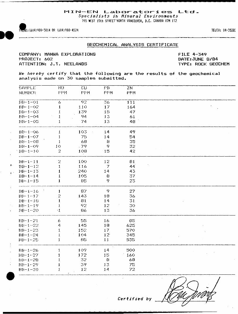
M I I^J — EIIxJ L-aa too r--a-t or~ i e?sSpecialists in Mineral Environments
705 HEST 15th STREETVNORTH VANCOUVER, B.C. CANADA V7M 1T2
E: (60-5)980-5614 OR (604)968-4524 TELEX: 04-35282
GEOCHEMICAL ANALYSIS CERTIFICATE
COMPANY: MANWA EXPLORATIONSPROJECT! 602ATTENTION: J. T. NEELANDS
FILE 4-349 DATE:JUNE 8/84 TYPE: ROCK GEOCHEM
We hereby certify that the -following are the results o-f the geochemical analysis made on 3O samples submitted.
SAMPLE NUMBER
MO PPM
CU PPM
PB PPM
ZN PPM
BB--1-01
BB- 1 -02BB-1 -03BB--1--04BB.-1-05
BB-1--06BB-1 ~07BB-1 --08BB- 1-09BB-1-10
BB- i -- 1 1BB--1-12BB--1-13BB-1-14BB-1-15
611i1
.1.11
10i
21ii1
921101 399474
1 037568
. 791 08
1 0011624010585
3617151313
14148915
127
1489
111164476148
4954353242
8144433723
BB- 1BB- 1BB- 1BB- 1BB- 1
BB- 1BB--1
BB- 1BB- 1BB- 1
BB-1
BB- 1BB-1
BB- iBB-3
- 1 6 '
- 1 7~ 1 8- 1 9-20
-21-22" j!'.. O
-24M| or;.-
-26-27O O" *. U
-29-30
1211 1
64111
11111
87143819286
5514515210485
109172323912
918141213
16181712
. 11
14158
1314
2736313036
8562557O345535
j
500160687572
Certified by
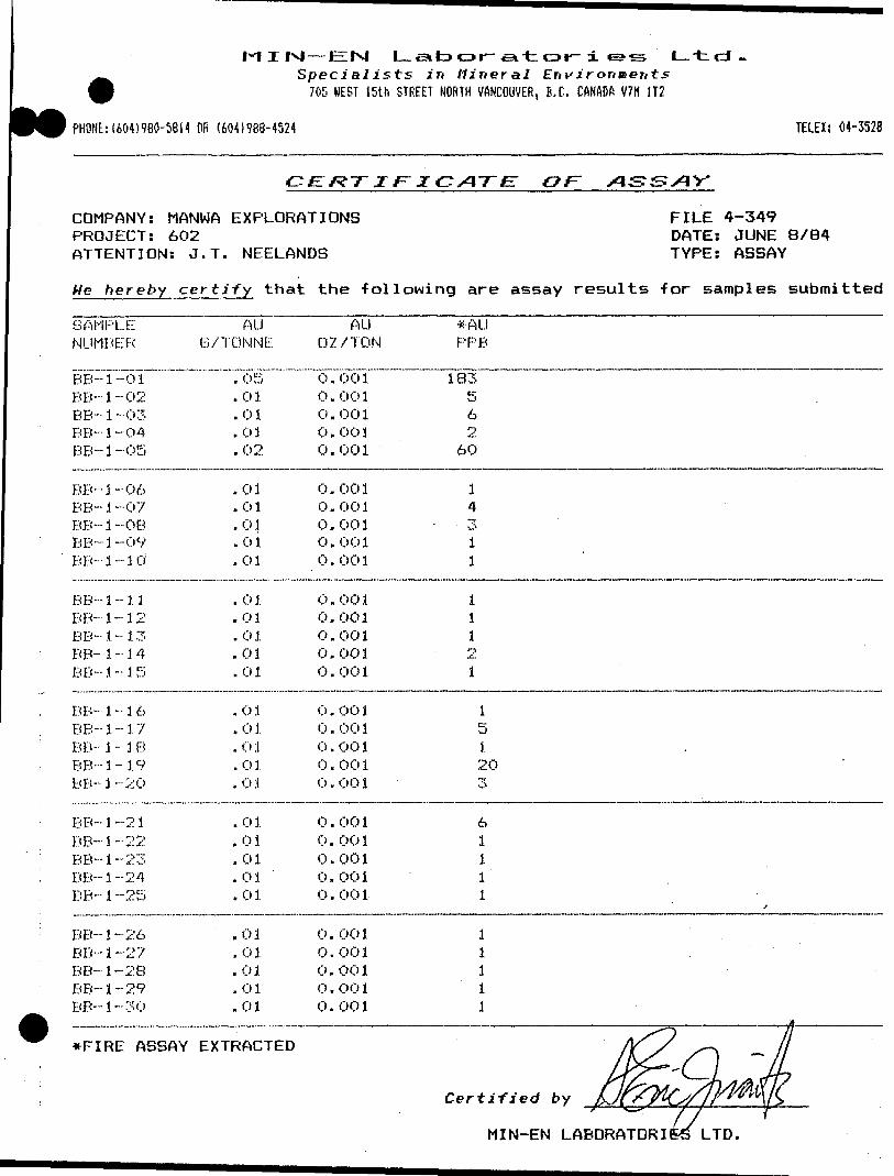
I-I I IN| — EM L en to o r-si ter* t- i e**s ' L--t.cJ-Specialists in Mineral Environments
705 BEST 15th STREET NORTH VANCOUVER, B.C. CANADA V7H 1T2
PHONE:(604)980-5814 OR (604)988-4524 TELEX: 04-352828
c E: K ~r i ir z c AT e: OF
COMPANY: MANWA EXPLORATIONSPROJECT: 602ATTENTION: J.T. NEELANDS
FILE 4-349 DATE: JUNE 8/84 TYPE: ASSAY
He hereby certify that the following are assay results -for samples submitted.
SAMPLENUMBER
BE- 1-0 1 BB-1-02BE- 1-03BB- 1 -04BB-1-Q5
BB-1--06BB- i -07BB-1--08BB-1-09BB- 1 -~ 1 0
BB- 1 - 1 1BB- 1-12BB-1-13BB- 1-14
BB- 1 - 1 5
BB- 1 - i 6BB-1-17BB-1-1BBB-1-19BB-1-2O
BB-1-21
BB- 1 -22BB-1-23BB-1-24BB-1-25
BB--1-26BB--1-27
BB- 1 -28BB-1-29
BB- i -30
AUB/TONNE
. 05
.01
.01
.01
.02
.01
.01
.01
. 0 1
.01
. 0 1
.01
.01
.01
.01
.01
. 0 1
.01. 0 1. 0 1
. 0 1
. 0 1
.01
. 0 1
. 0 1
.01
.01
.01
.01
.01
AU02 /TON
0.001 0 . 00 10 . 00 1O.O010.001
0.0010.0010.0010 . 00 10.001
0.0010.0010 . 00 10,0010.001
0 . OO 10 . 00 1o . oo i0 . 00 10 . OO 1
0 . 00 10.0010.001O.O010 . 00 1
0.0010.0010.0010 . OO 10 . 00 1
*AUPPB
183562
60
1431 .1
11121
15120"i-O*
61111
f
l1 .111
.,,,.,.,.,.,....,,.. . . ,,,, . , ,, ,,,..,...,.....,,,,,...,. -,.,-.,,,...,,,.--,.,-.....,...,,,,.....,,-.,,jj..,,...,,-.-,.,,,-,..,...,,,,..
*FIRE ASSAY EXTRACTED
Certified by
MIN-EN LABORATORIES lLTD.

T. |N| — t-. sj l_ .eit3or^~.e*tcDr-iSpecialists in Mineral Eni'ir
70? ly'EST 15th STREET NORTH VANCOUVER, B.C. CANADA V7fi 1T2
Ltd . ^'
PHONE: I604)9BO-5BM OR (600986-4524\ ;
TELEIi: 04-35282f
OiT
COMPANY: SEEhAR MINES LTD. PROJECT: 602 ATTENTION: MR. B. BOOS
FILE 4-354/P1 DATE: JUNE 12/84 TYPE: ROCK ASSAY
He hereby certify that the -following are assay results -for samples submitted.
SAMPLENUMBER
BB-2- 01BB-2-02BB-2-03BB-2-04BB-2-05
BB-2-06BB-2-07BB-2- OBBB-2-09BB- 2~ 3 0
BB-2- 3 1BB-2- 12BB-2- 33BB- 2- 3 '1BB-2- 1 5
BB-2- 3 6BB-2- 17
BB- 2- 3 8BB-2- 1 9BB-2- 20
BB-2- 21BB-2-22BB-2- 23BB-2- 24BB-2--25
BB-2- 26BB-2-27BB-2 -28BB-2- 29BB-2-30
AUB/TONN1
.01
.01
.03
. 03
.03
.03
.03
.03
.03
.03
. 03
. 03
.03
. 03
.01
.03
. 03
.03
.03NO
NONONO. 03. 03
.03
.03
. 03
. 03
.03
AU"f; OZ/ TON
0. 001O . OO 30. 001C). 0030 . O 0 1
O. C'C)10. 001O. O030. 0010 . OO 1
0. 0010 . 00 10.001Ci . C* C* 30. C* C' 3
O.O03O . (li C' 10. C) C) 3C*. Ci C' 3
SAMPLE
SAMPLESAMPLESAMPLE
0.0030 . C* Ci 3
O. 0010. 0010 . 00 3C'. 00 i0. 001
AU*PPB
157
26~T
7
4T;
611
4 '7~T
1rr
7;
1 2'"T-1
cr vJ
~T
8
10131297
*FIRE ASSAY EXTRACTED.
Certified by
MIN-EN LABORATORIES LTD.
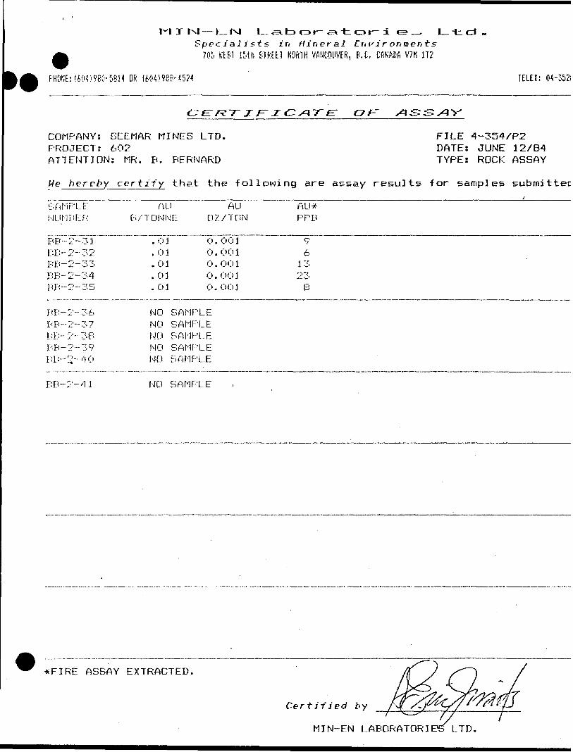
I h-4 — L-f*J L SL too t~ aa t or- i e?Specj'aJj'sts in W i ri era J Eri\' i r
705 HE ST 15th STREET NORTH VANCOUVER, B.C. CANADA V7M 1T2
L t
PHONE: (604)960-5814 OR (604)988-4524 TELEX: 04-35281
COMPANY: SEEMAR MINES LTD.PROJECT: 602ATTENTION: MR. B. BERNARD
FILE 4-354/P2 DATE: JUNE 12/84 TYPE: ROCK ASSAY
He hereby certify that the following are assay results for samples submitted
SAMPLENLH1BER
BB-- BB-BB-BB-BB--
BB-BB--BB-BB-BB--
2-31
2-332-342-35
2-36. , -;, J J-. — -J' f
2-362-392-40
AU AU AU*Q. /TONNE 02 7 T ON PPB
. 0 1 O .
. 0 1 0 .
. 0 1 (I) .
. 0 1 0 .
. 0 1 0 .
NO SAMPLENO SAMPLENO SAMPLENO SAMPLENO SAMPLE
O01 9 001 6OO 1 1 3001 23001 8
BB-2-41 NO SAMPLE
*FIRE ASSAY EXTRACTED.
MIN-EN LABORATORIES LTD

1-1 I
(604)980-5814 OR (604)988-4524
— F~lN| L-^fc*or-c3it or- i'pe^ tlifts in Mineral Ent'ironi ts705 HEST 15th STREET HDRTH VANCOUVER, B.C. CANADA VVtl IT?
l t d .
TELEX: 04-352!
BEOCHEMICAL ANALYSIS CERTIFICATE
COMPANY: SEEMAR MINES LTD. PROJECT: 602 ATTENTION: MR. B. BOOS
FILE 4-354/P1 DATE: JUNE 14/84 TYPE: ROCK BEOCHEM
We hereby certify that the -following are the results of the geochemical analysis made on 30 samples submitted.
SAMPLENUMBER
BB-2- 01 BB-2- 02BB-2-03BB-2-04BB-2--05
BB-2-06BB-2-07BB-2-08BB-2-09BB-2- 10
BB-2- 11BB-2- 12
BB-2- 1 3BB-2- 14BB-2- 15
BB-2- 16BB-2- 17BB-2- IBBB-2- 19BB-2-20
BB-2- 21BB-2-22BE'- 2~23BB-2-24
BB-2 -2 5
BB-2-26BB-2-27BB-2-28BB-2-29BB-2-30
MOPF;'
1221
61A52.
31221
1111NO
NONONO41
111.11
cuM PPM
122 78699115
119 .20823822
1 0949
' 1 226356
8613225
1 00SAMPLE
SAMPLESAMPLESAMPLE
46104
1715341287
P BPPM
15 1113B12
1112121511
9B7
169
12141011
138
1015141214 .
2NPPM
18149635828
106976489100
7389708463
60 ;678750
7637
9211194 :96
353
Certified' by
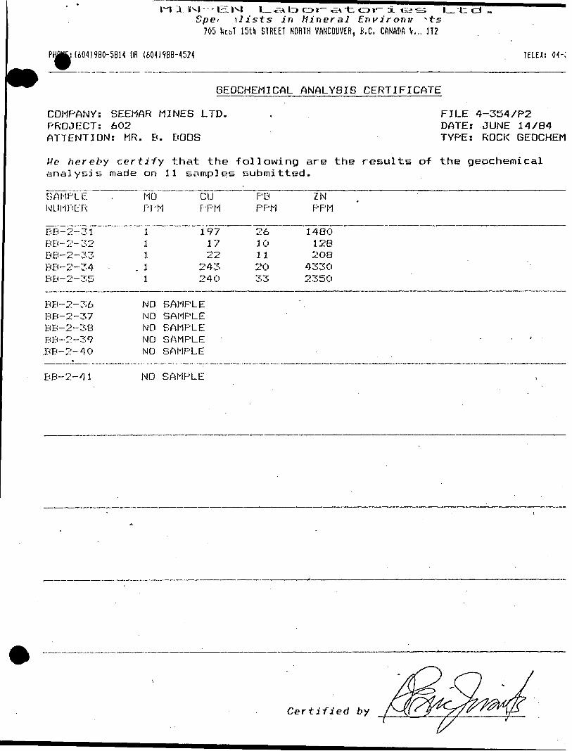
i ivi —IE:Spe*
705
l_ -e* LD o i— -ax -t C3 t— x ti?\lists in Mineral Environir ^ts15th STREET NORTH VANCOUVER, B.C. CANADA \ ... H2
L. td -
IiO^)980-5BH OR (6041988-4524 TELEX: (M-352(
GEOCHEMICAL ANALYSIS CERTIFICATE
COMPANY: SEEMAR MINES LTD. PROJECT: 6O2 ATTENTION: MR. B. BOOS
FILE 4-354/P2 DATE: JUNE 14/84 TYPE: ROCK BEOCHEM
We h ereby certify that the following are the results of the geochemical analysis made on 11 samples submitted.
SAMPLENUMBER
BB-2-31 BB-2-32BB-2-33BB-2-34BB-2-35
BB-2-36BB-2-37BB-2-3BBB-2-39.BB-2-40
*
MOPP
1 11
. 11
NONONONONO
CDM PPM
197 1722
243240
SAMPLESAMPLESAMPLESAMPLESAMPLE
P BPPM
26 10112033
ZNPPM
1480 128203
43302350
'
p.B-2-41 NO SAMPLE
Certified by
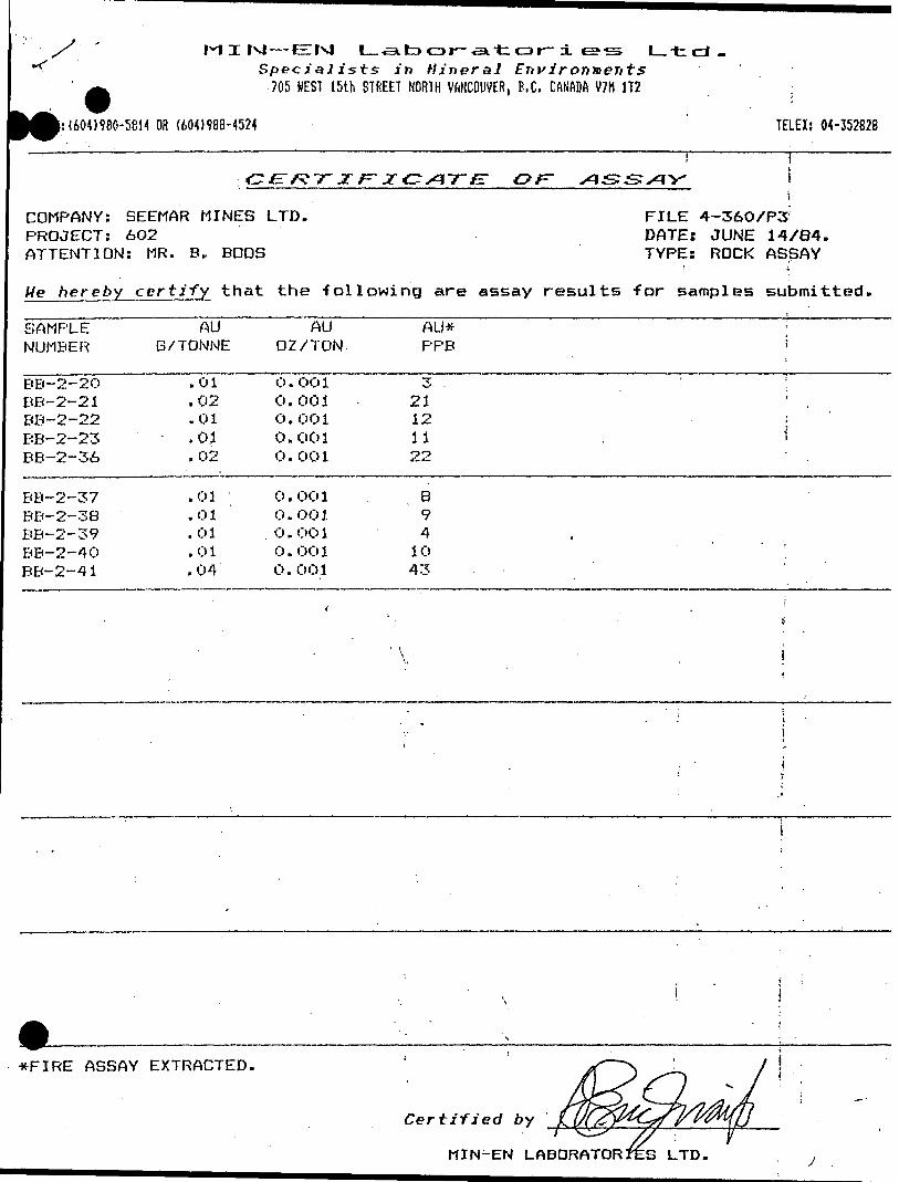
l—t d .Specialists in Hineral Environments
705 HEST 15th STREET NORTH VftNCOUVER, B.C. CANADft V7H 1T2
(604)980-5814 OR (60-1)988-4524 TELEX; 04-352828
l
COMPANY: SEEMAR MINES LTD. PROJECT: 6O2 ATTENTION: MR. B, BOOS
FILE 4-36O/P3 DATEi JUNE 14/84. TYPE: ROCK ASSAY
He hereby certify that the -following are assay results for samples submitted.
SAMPLE NUMBER
AU B/TONNE
AU OZ/TON
AU* PPB
BB-2-2O BB-2-21 BB-2-22 BB-2-23 BB-2-36
.01
.02
.01
. 01
. 02
0 . CO 1 0.001 O. 001 0.001 O.O01
321121122
BB-2-37 BB-2-38 BB-2-39 BB-2-40 BB-2-41
.01
.01
.01
.01
.04
0 . OO 1 0.001 0 . OO 1 0.001 O.O01
8941043
*FIRE ASSAY EXTRACTED.
Certified by
MIN-EN LTD.

*^l— EM L. si to CD r-.a-t ot~ i e~*s L--tci-Specialists in Mineral Environments
705 WEST 15th STREET NORTH VANCOUVER, B.C. CANADA V7M 1T2
PHONEi(604)9BO-5BM OR (604)988-4524 TELEX: (H-
6EOCHEM I CAL ANALYBIS CERTIFIGATE
COMPANY: BEEMAR MINES LTD. PROJECT: 602 ' ATTENTION: MR. B. BOOB
FILE 4-360/P3 DATE: JUNE 14'X84 TYPE ROCK GEOCHEM
We hereby certify that the -following are the results of the geochemical analysis made on 10 samples submitted,
SAMPLE ~ MO CUPB [ ZN : NUMBER PPM PPM. PPM PPM
BB-2-20BB-2-21BB-2-22BB-2-23BB-2-36
282111
92100112119173
10979
80
39493640
1250
BB-2-37 BB-2-38 BB-2-39 BB-2-40 BB-2-41
l lT
8997413136
3302210108
5165231077875
Certi-fied by
M X M —EN L a b CD r-^a "t o r~ ± *s*s L.-t cd .Specialists in Mineral Environments
705 HEST 15th STREET NORTH VANCOUVER. B.C. CftNADft V7H 1T2
1:1604)980-5814 OR (604)988-4524 TELEK: 04-352
COMPANY: SEEMAR MINES LTD. PROJECT: 602 ATTENTION: M. B. BOOS
FILE 4-360/P1 DATE: JUNE 14/84, TYPE: ROCK ASSAY
He hereby certify that the following are assay results for samples submittei
SAMPLENUMBER
BB-3-O1 BB-3-02BB-3-03BB-3-04BB-3-05
BB-3-06BB-3-07BB-3-OBBB-3-09BB-3- 10
BB-3- 11BB-3- 12BB-3- 13BB-3- 14BB-3- 15
BB-3- 1 6BB-3-17BB-3- 18BB-3- 19BB-3-20
BB-3-21BB--3-22BB-3-23BB-3-24BB-3-25
BB-3-26BB-3-27BB-3- 28BB-3-29BB-3-30
AUB/TONNE
. 03
.02
.02
.01
.01
.01
.01
.01
.01
.01
. 12
.01j . 03
. 03
.01
.02
.01
.02
.49
.01
.01
. 0 1
.01
.03 .
.01
.01
. 20
.02
.02
.02
AUOZ/TON
0.001 0.0010.0010.001O.O01
0.0010.0010.0010.0010.001
0 . 003O.OO'l0.0010.0.010.001
0.0010.0010.0010.0140.001
O. 0010.0010. 0010 . 00 10.001
C) . 00 10 . 0060.0010 . OO 10.001
AU*PPB
28 25235 ' '!16
6147 (4 ; - -2
132 ;t
837334
223
1750014
296
361
8208212719
*FIRE ASSAY EXTRACTED
Certified by
MIN-EN LABORATORIES LTD
l~ l
Specialists in Hineral Environments705 WEST 15th STREET NORTH VANCOUVER, B.C. CAIJADft V7H 1T2
PHQiE;1604)980-5814 OR (601)988-4524PHONE; (l TELE*; 04-352
GEOCHEMICAL ANALYSIS CERTIFICATE
COMPANY: SEEMAR MINES LTD. PROJECT! 602 ATTENTION: MR. B. BOOS
FILE 4-360/P1 DATES JUNE 14/84 TYPE: ROCK GEOCHEM
We hereby certify that the -following are the results of the geochemical analysis made on 30 samples submitted.
SAMPLENUMBER
BB-3- 01BB-3-02BB-3-03BB-3-04BB-3-05
BB-3-06BB-3-07BB-3-08 BB-3- 09BB-3- 10
BB-3- 1 1BB-3-12,BB-3- 13BB-3- 14
B B- 3- 15
BB-3- 16BB-3-17BB-3- 18BB-3- 19BB-3-20
BB-3-21BB-3-22B B- 3-23BB-3-24BB-3-25
BB-3-26BB-3-27BB-3-28BB-3-29BB-3-30
MO -
PPM
11il2
111 11
11111
11111
112214
110111
cuPPM
16185710092
no11214O '
50
121O2 . i1181141 06
73971287296
11992
1 OO1081 02
103125758684
F'B
PPM
78
119
10
91218 79
1311B '
87
55748
49
13e .8
912666
ZNPPM
59505962 :101 - , :
191130
60 - i31 l - -40
40618915159
5447665494
5155113236106
40635382671 :
Certified by
I lvl —EIlNl L-^Specialists in Mineral Environments
705 WEST 15th STREET NORTH VANCOUVER, B.C. CANADA V7H JT2
t d -
PH0^604)9BO-5B14 OR (604)988-4524 TELEX: 04-3528
F:-z c AT z: OJT
COMPANY:. SEEMAR MINES LTD. PROJECT: 602 ATTENTION: MR. B. BOOS
FILE 4-360/P2 DATE: JUNE 14/84. TYPE: ROCK ASSAY
He hereby certify that the following are assay results for samples submitted,
Gf NUMBER
AU GXTONNE
AU 02XTON
AU* PPB
BB-3-31BB-3-32BB-3-33BB-3-34BB-3-35
.01 .
.01
.03
.01
.02
0. O01O . OO 10 . 00 10. 0010. 001
1211301617
i
J
l
ASSAY EXTRACTED.
Certified by
MIN-EN LABORATORIES LTD

ixl —Specialists in Mineral
705 NEST 15th STREET NORTH VANCOUVER,
or- xEnvironmentsB.C. CftNftDA V7H 1T2
L.-tcl-
(604)988-4524 TELEX: 04-352
GEOCHEMICAL ANALYSIS CERTIFICATE
COMPANY: SEEMAR MINES LTD. PROJECT: 602 ATTENTION: MR. B. BOOS
FILE 4-360/P2 DATE: JUNE 14/84 TYPE: ROCK BEOCHEM
We hereby certify that the following are the results of the geochemical analysis made on 5 samples submitted. i
SAMPLENUMBER
BB-3-31 BB-3-32BB-3-33BB-3-34BB-3-35
MOPPM
1 2111
CUPPM
126 100105105124
PB. PPM
9 10B6B
ZNPPM
39 43
13580
1 50
Certified by
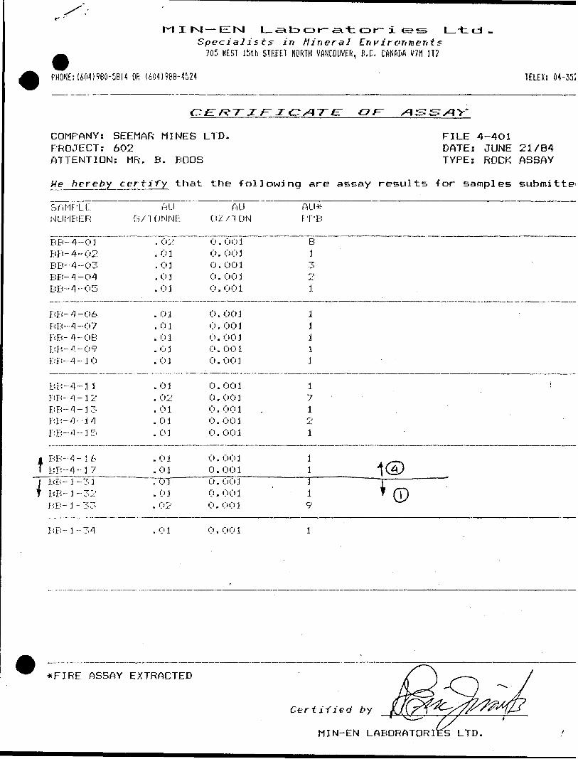
M I |x| — Eltxl L-^Specialists in Mineral Environments
705 WEST 15th STREET NORTH VANCOUVER, B.C. CANADA V7M 3T2
PHONE:1604)980-5814 OR (604)968-4524 TELEX: 04-3528
tl
COMPANY:PROJECT:ATTENTION
We hereby
SAMPLENUMBER
BB-4-OJ BB-4-02BB--4-03BB-4-O4BB-4-05
BB-4-06BB-4-07BB-4-OBBB-4-09BB--4-10
BB-4-1 1BB- 4-12BB-4-33BB-4-1 4BB-4-1 5
BB- -4- 16EJP-4-37BB-1-31BB-1-32I.-: Ei- 3 - 33
SEEMAR MINES602: MR. B. BOOS
certify that
AUB/ T ON NE
. 02 . 0 1.03.03.03
. 0 1
.01. ol.01
. ol
.01
. 02
.01
. 03
. 0 1
. 01
.01
.0]
. 01
. 02
E:f?-r z F~ x
LTD.
the follow!
AU02 X T ON
O. 001 0 . 00 1O. 001O. 0030 . 00 1
0. 0010. 0010. 0010. 0010. 001
0. 0010 . OO 10. 0010. 0010. 003
O. O010. 001o. uol0. 0010 . O C) 1
CATE: or xis^xiv
FILE 4-401DATE: JUNE 21/84TYPE: ROCK ASSAY
ng are assay results for samples submitted
AU*F'PB
8 3323.
11111
1 i71o
1
11 ^ 1 1
i CD9
BB-1-34 01 O, 001
*FIRE ASSAY EXTRACTED
Certified by ________^^
MIN-EN LABORATORIES LTD.
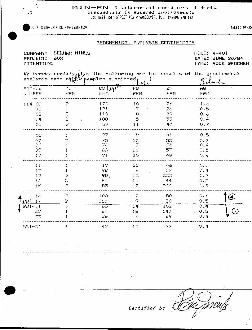
N— EM l_-sitDot'~.e*.tar-i*H?"S l_td-Specialists in Mineral Environ&ents
705 BEST 15th STF.'EET WORTH VANCOUVER, B.C. CANADA m 1 T2
|lE:!iOmeO-5S!4 DF: (600960-4524 TELEX: 04-35;
GEOCHEMICAL ANALYSIS CERTIFICATE
COMPANY: SEEMAR MINES PROJECT: 602 ATTENTION:
FILE: 4-401DATE: JUNE 20/84TYPE: ROCK GEOCHEM
k'e hereby certify^that the following are tjhe results of the geochemicalanalysis made oM'J&ys kampl es submitted 4 l C*'/ X
I ^ , LM.V ^*A,-^~U^
BB1-34
SAMPLENUMBER
BB4-0102030405
0607080930
11121 "T,
1 /i
55
4 1 6TBB4-17l BB1-31J "TO
MOPPM
21o
22
1211]
11H'.T;j ,
2O
1 J.
CU \jJ\^PPM
1201211101 0059
9775766691
199898BOBS
1 0016166 BO 26
P BPPM
107B .5
11
9127
1010
11B
131012
12914 IB B
ZNPPM
2626593340
41532457.48
4637
33344
244
BO30102 147 69
AB 'PPM
1.60.50.60.40.7
0.50.70.40.50 . 4
0 . 30.40.70.5O.9
0.6 f g)0.5 l0.4 \ 0.5 1 (T) 0.4 ^
42 15 77 O. 4
Certified by

cJ ,Specialists in Mineral Envirortiaents
70!' WEST 15th STREET NORTH VANCOUVER, B.C. CANADA V7M 1T2
PHONE:1604)960-5814 OR (604)988-4524 TELEX: 04-352625
Z F- Jf
COMPANY: SEEMAR MINES LTD, PROJECT: 602 ATTENTION: MR. B. BOOS
FILE 4-424DATE: JUNE 26/84TYPE: ROCK ASSAY
He hereby certify that the -following are assay results -for samples submitted,
SAMPL.EHUMP
BB-4BB-4BB-4BB-4BB-4
BB-4BB-4BB-4BB-4
PDr-4
BB-4BB-4BB-4DB-4
BF- 4
Mi-4BB-4BB-4B B --4
HP- 4
BB-4BB-4BB-4BB-4BB-4
BB-4BB-4BF.:- 4
:ER
-38- 1 9-20-21
.L.. J.' ,
-2~''-24- , ~'.' c"
.. . -""J /. ,il W
i
-2B.-. o r.*
30-31-32
-- \"\
-34-;r t;r
" V.'**--1
"r /' ~ --:- L.*
-37
- 3Ei-39-40-4 i-42
- 4 3.-44--45
AU6/TDNNE
.03
. 01
.03
. 03
. 01
. Ci .1
. 0 3
. 03
. 0 1
. (32
. 01
.03
.01
. 03
. 0 1
. 0 1
.03
. C) 5
.03
. (3 .1
. (33
. 0 1
.01, 0 1.01
.03
. 03
. (3 3'
AU07. 7 TON
C* . 00 1(3, C) 010 . 00 10 . O (3 3Ci . (3(3 1
0. 0030. 001Ci. OO J
0. (3 (33.Ci. C' C' J
(3. 003.0. C* Ci 3O , OO 10 . 00 1(3 . '30 1
0. 0030 . C* (3 1Ci. C) (310. 001C) , 0 Ci 3
0. 001C* . Ci (310 . 00 1(3. Ci 01Ci. 001
Ci . 00 1Ci, 0030 . Ci (3 3
AU*PPB
1I212
i11.2
2(3
561T(
j.
101
- 555A
1l1
. li
330 .
J
*FIRE ASSAY EXTRACTED.
Certified by
MI N-EN LABORATORIES LTD.
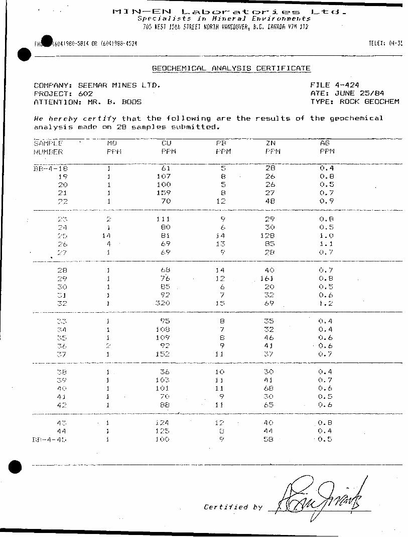
M ISpecialists in HineraJ Environments
705 BEST 15th STREET NORTH VANCOUVER, B.C. CANADA V7H 1T2
Ltd .
FHWI60419BO-5BH OR (604)986-4521 TELEK: 04-35282E
GEOCHEMICAL ANALYSIS CERTIFICATE
COMPANY: SEEMAR MINES LTD. PROJECT: 602 ATTENTION: MR. B. BOOS
FILE 4-424ATE: JUNE 25/84TYPE: ROCK BEOCHEM
We h ereby certify that the -following are the results o-f the geochemical analysis made on 28 samples submitted.
SAMF: LENUMBER
BB--4
^
E: B -4
-18192021. j r~\
77,2425262 f
2829303132
7,7,34353637
3839404142
4344
- 4 5
MOPF:'M
11111
r-,
i1441
11113
11i21
! .1111
113
CUPPM
6110710015970
11180816969
687685 .92
320
9510810992152
361 031017088
1241 25J 00
PBPPM
585B
12
96
54139
14126715
87e9
11
101 1119
11
12BC.)
ZNPPM
2826262748
2930128852 B
4016120-;r/-;,
69
3532464137
3041683 O65
4 O4458
ABPPM
0.40.80.50.70.9
0.80 . 51.0i. l0. 7
0.70.80.50 . 61.2
0 . 40.40.6
- 0.60 . 7
0.40.70.60.5i). 6
u.B0.4 0.5
Certified by
i/
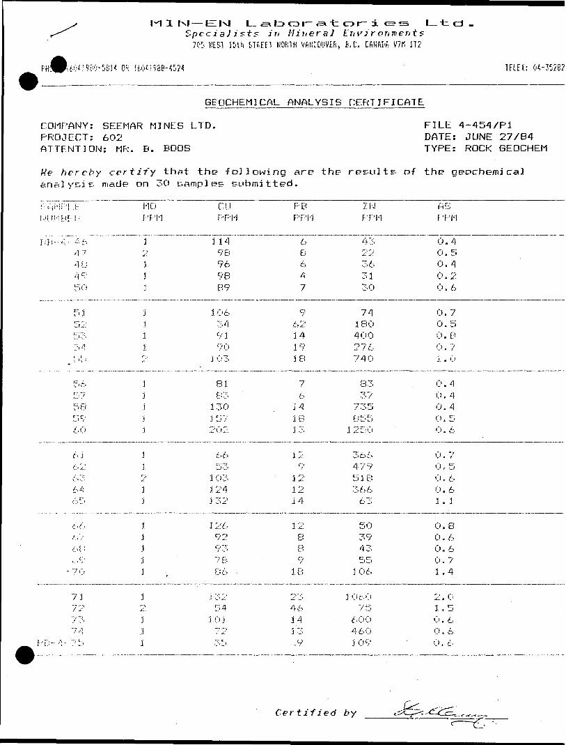
M I txj — EIIxJ L to cr*r~ -s t or~ i e? s Ltd.Specialists Jri Mineral Environ men is
70!' KLS1 U'th STREET NORTH VftNCOUVEfi, B.C. CANftDh V7M 1T2
'9*0-561* OR (604)988-4524 TELE*: 04-352828
GEOCHEMICAL ANALYSIS CERTIFICATE
COUPANY: SEEMAR MINES LTD. PROJECT: 602 ATTENTION: MR. B. BOOS
FILE 4-454/P1 DATE: JUNE 27/84 TYPE: ROCK GEOCHEM
We hereby certify that the following are the results of the geochemical analysis made on 30 samples submitted.
8AHP!.. FKM. 1MB E: P
l\l'.-"\- 4 6 4 748495 0
5 J52l" --^
34L i v '
5657585960
6 J626' 36465
666768
1 C''
- 7'0
7172737-^
Hi'--!- ;; 5
1-10
PPM
3
3j3
jili2
1jjj]
j323j
3.j.1j3
1o
j;i1
C LIPPM
11498969889
10634919 0
J C-1 3
8183130J 572O2
6653103124J 32
12692937886 .
J 3254
i C) Jj- 1 ' 2
3 5
P BPPM
6e647
96214191 El
76
141813
12LJ f
121214
12B89
18
2346143 3.9
ZNPPM
43
363130
74180400276740
8337
735855
1 2 5 C*
36647951836663
50394355306
J '06075
600460109
A6PPM
0.4 0. 50.40 . 20 . 6
0.70 . 50 . B0 . 7i . o
0 . 40.40. 40 , 5C* . 6
0 . 70 , 50 . 60 . 61 . 1
0 . 80 . 60 , 60.71 .4
2.01.5Ci . 60, 60 , L -
Certified by

M I M — EM L ,a to o i—-en t or~ i e?s L--fccd.SpecJaJists in HJrieraJ Environments
705 WEST 15th STREET NORTH VANCOUVER, E.C, CftNADft V7H !T2
OF; (604)968-4524 TELEX: 04-352826
GEOCHEMICAL ANALYSIS CERTIFICATE
COMPANY: SEEMAR MINES LTD. PROJECT: 602 ATTENTION: MR. B. BOOS
FILE 4-454/P2 DATE: JUNE 27/84 TYPE: ROCK GEOCHEM
He hereby certify that the -following are the results o-f the geochemical analysis made on l samples submitted.
F; Wi F i.. E N LI M H E R
1-10 PPM
CU PPM
F*-4-76
P B PPM
T2~~
ZN F-'PM
125
AE PPM
O. B
Certified 'by
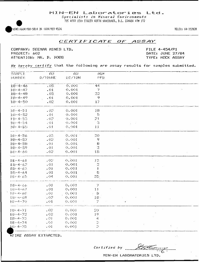
M J IN! E fsj L t? a r- -e* t o r~ ± e sJ rv M ineral En v i r o r/men t
705 K'ESJ 15th STREET NORTH VANCOUVER, P. C. CANADA V7H 1T2
L t cd .
PHONE:(6041980-5814 OR (604)988-1524 TELEX: CM-352628
COMPANY: SEEMAR MINES LTD. PROJECT: 6O2 ATTENTION: MR. B. BOOS
FILE 4-454/P1 DATE: JUNE 27/84 TYPE: ROCK ASSAY
hereby certify t hat the -following are assay results -for samples submitted.
BAI-1PL.tr.NUMF-:ER
BB-4-46 BB-4-47BB-4-48BB-4-49BB--4-50
BB-4-51BB-4--52BB-4-53BB-4--54BB- 4-55
BB-4-56BB-4-57BB-4-5BBB-4-59BB-4-60
BB-4-61BB-4-62BB-4-63BB-4-64BB-4-65
Fi Fi- 4-66BB-4-67BB--4-6PBB-4-69I-:B-4-70
B B- 4 -71BB-4-72BB-4-73132-4-74
K^ -4 7 iri ' . . --
AUE/TONNE
. 05
. 0 1
. 03
. 01
.02
. 02
. 03, 02, 0 1. 0 1
. C* 3
. 02
.01, o i.02
. 02
.03
. 01
.01.
. 04
.01. 01. 0 1. 02.01
. 02
. 02
. 0 3. 03.01.
AUO2 /T ON
O . OO 1 O . OO 10.0010 . 00 10. 001
0 . 00 1Or 0030 . 00 1O. O010 . 00 1
0 . OO 10 . 00 10. O01.0. 0010. 001.
0. 0010. 001O. 0010, 0010. O01
o. 0010., 00 10. 0010 . 00 30, O01
0. 001O , OO10 . 00 10. 0010. 001
AU#PPB
44 7
329
17
IB5
21~r
i i
309B3
15
13218
35
71 3B
18- '7 '
2019A'P
V
*FIRE ASSAY EXTRACTED.
Certified by -6 *MIN-EN LABORATORIES LTD.

—EIIsl L-a* to a i--s t or- i e?s I— t cd .pecialists in Mineral Environments705 HES1 15th STREET NORTH VANCOUVER, P,C. CfiNAPA V7M ]T2
PHONE:(604)960-5814 OR (604)988-4524 TELEX: CM-3528
COMPANY: BEEMAR MINES LTD. PROJECT: 6O2 ATTENTION: MR. B. BODS
FILE 4-454/P2 DATE: JUNE 27/84 TYPE:ROCK ASSAY
hereby cert i fy t hat the -following are assay results for samples submitted
SAMPLE NUMBER
AUB/TONNE:
AU02 XT ON
AU* PPB
BB-4-76 . O l 0. 001
*FIRE ASSAY EXTRACTED.
Certified by
MIN-EN LABORATORIES LTD.

M X 1-4—Specialists in Mineral Environments
705 WEST 15th STREET NORTH VANCOUVER, B .C. CANADA V7H 1T2
IE: (604)980-5614 OR (604)986-4524
GEOCHEMICAL ANALYSIS CERTIFICATE
COMPANY: SEEMAR MINES LTD. PROJECT: 602 ATTENTION: MR. B. BODS
FILE 4-417DATE: JUNE 25/84TYPE: ROCK 6EOCHEM
We hereby certify that the -following are the results of the geochemical analysis made on 17 samples submitted.
SAMPLENUMBER
BB-5-01 02O 30405
06070809
' 10
11IB192021
22BB-5-23
MOPPM
1 1111
112pr
1
1
1
1
1
1
21
CUPPM
101177
88
103121B37499
li4929410167
9953
PBPPM
14 6BB4
610171312
101196
11
1015
ZNPPM
5259244522
4910436O307204
4174603164
13527
ASPPM "
0.30.4 .'0.30.3 iO. 4
0.70.91.20.91. 1
O. 8O.BO.B0.60.8
0.61. 1
Certified by

M —Specialists in Mineral Environments
705 WEST 15th BTREET NORTH VANCOUVER, B.C. CftNflDft V7H 1 12
PHONE: (604)980-5814 DR (604)988-4524 TELEK: 04-35282
COMPANY: SEEMAR MINES LTD. PROJECT: 602 ATTENTION: MR. B. BOOS
FILE 4-417DATE: JUNE 26/84TYPE: ROCK ASSAY
He hereby certify that the following are assay results -for samples submitted
SAMPLENUMBER
BB-5-01 BB-5-O2BB-5-03BB-5-04E* Ei-5-05
BB-5-06BB-5-07BB-5-OBBB-5-09BB-5-10
BB-5-11BB-5-18 --BB-5-19BB-5-20BB-5-21
BB-5-22BB-5-23
AUB/TONNE
.01
.01
.01
.01
.06
.01
.01
.01
.01
.01
.01
.01
.01
.01
.01
. 03
.01
AUOZ/TON
0.001 0.0010.0010.0010 . 002
0.0010 . 00 10.0010 . 00 10.001
0.0010.0010.0010.001C) . 00 1
0.0010 . OO 1
AU*PPB
7 111
62
11111
14311
291
*FIRE ASSAY EXTRACTED.
Certified by
MIN-EN LABORATORIES LTD.

MIM —E^*N| L-,SL to o r--a t or- i e?*^Spec' l ists in Mineral Ern'irorus' ts70S WEST 15th STREET NORTH VANCOUVER, B.C. CANADA V7M 1T2
Ltd -
;(604)980-5814 OR (604)988-4521 TELEX: 04-15282
GEOCHEMICAL ANALYSIS CERTIFICATE
COMPANY: SEEMAR MINES LTD. PROJECT: 602 ATTENTION: MR. B. BOOS
FILE 4-417DATE: JUNE 25/84TYPE: ROCK BEOCHEM
We hereby certify that the following are the results of the geochemical analysis made on II samples submitted.
SAMPLE NUMBER
BB5--B4--12
13141516
1724252627
1-10 PPM
1 j111
118
331
CI) PPM
74 110852O21
7315113398B 2
PB PPM
7 86 .
217
tr iJ
9986
ZN PPM
27 1383542TO
3940BO39826
AB PPM
0.5 0.60.30.20. 1
0.20.40.30. 40 . 3
BBS-84-28 167 6 - 0.4
Certified by
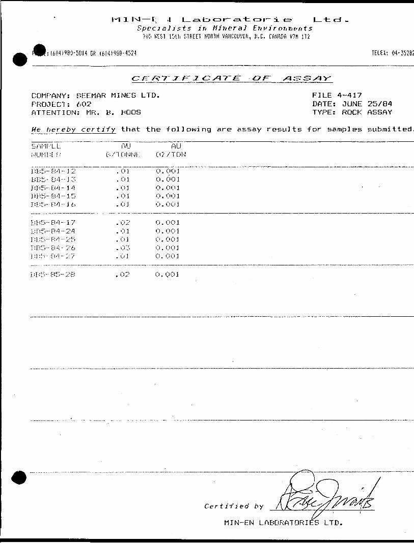
M X r-J — l; 4 L. st* CD r-si-t or~ i e?; Ltd-Specialists in Iliriersl Erivirorititrits
70!' WEST IDUi STREET NORTH VANCOUVER, B.C. CftNfcDfi V7M 1T2
f:(604)960-5814 OR (604)988-4524 TELEX: 04-35282
z F'j:
COMPANY: SEEMAR MINES LTD. FILE 4-417PROJECT: 602 DATE: JUNE 25/84ATTENTION: MR. B. BODS TYPE: ROCK ASSAY
He hereby certify that the following are assay results for samples submitted.
SAMPLENUMBER
BB5-84--1 BB5-B4-J
BB5-B4- 3BBS- 84-1BB^-B'1-3
BBS-84- 1BBS- 84 -2BB5-B4-2B B 5 --84 --2BBI:'~EV!~2
^'
A56
745i)7
AUB/ TONNE
. 01
. 01
. 03
. 01
. O 3
. 02
.01
. 03
. 03
.03
0
0 0ooo
oo(joo
AU2 /TON
. OO1
.001
.O01
. 00 1
. 001
. 00 1
. 00 1
. 003
. 001, OO1
DDS-85-2B .02 0.001
Certified by
M I N-EN LABORATORIIES LTD.

Intermediate to Felsic Intrusive Rocks Pyrrhotite
(a) granodiorite(b) diorite/trondhjemite
B. BOOS CLAIMSFelsic Intrusive Rocks
Strike and dip of foliation
Strike and dip of 'second' foliation(a) quartz(b) feldspar
-feldspar porphyry -quartz porphyry
Volcanic-Sedimentary Rocks Rock outcrop, small
greywacketuffaceous shale or siltstonesericite and quartz predominant in matrixfeldspar conspicuous in matrixchlorite and/or biotite-rich matrixgarnetiferoussiltstonethinly bedded to laminatedchloriticrusty-.sulphide bearing
(^ Area of outcrop
s G eological contact, approximate
5j,Ppy,po large granodiorite boulders
gentle S. slope
balsam, poplar 6. birch cover
(e) banded graphitic chert{ k) rusty or ferruginous cherty rocksBL 0-hOO Frostheave
Diamond drill hole ( June,1984 )
Skidder trail
LOCATION MAPlow. wetFelsic Volcanic Rockscovered MOLSON LAKL AREA
CLAIM MAP No G603( a) massive(e ) tuff(M) thinly bedded to laminated(S) silicified
cedar \ fi birch cove
sloping ground Water supply pump
Trench location (February, 1984)SEE SECT A-A'.BHB 1
l. R AnomaliesIntermediate Volcanic Rocks
large granodiorite Mafic Volcanic Rocksboulders
a m assve (e) tuff (II) thinly bedded to laminated
spruce G poplarBB-3-84
613971
of no outcropspruce 6. a lderBB-4-84
gently ^S. E. sloping+ 00 S f- x ;
\ ^/ arge granodrqn tic
boulderssteep m
low, flat ground
(J M inor fold axisat IIOVSO'E
gentle to moderateflat groundS\ SE. slope towards pond
5-IO 0Xo pospruce 6* balsam
coverEE MAPBB-2 balsam.
SEE MAP BB-I (rev.) granodioriteboulders
T. B. 613972BB-l-84 vi \ iIO + OO S -
low. flat
ve burden low, flat ground613970
--——-xBB-2-84gently
sloping O /5c,f,hj,k5f,g,h (q.v.)
S ' '
(1-2 0Xo v.f.g.po)
very thick alders
old pit? 5jk
x 51/lft. 6a \/5+OOS —
thick alders, poplar, spruce6* brush
SEEMAR MINES LTD. / A DNARON RESOURCES LTD
GEOLOGICAL COMPILATION14+00 5 —
THUNDER BAY M. D ONTARIOMOLSON LAKE AREA
a ~ 1 00 ft. JUNE, 1984MANWA E XPLORATION SERVICES LTD.
F. CASTELLO REVISED BY: S. CASE 602/5 (REV
SCALE100 200
42C12N*0ei8 63.4439 MOLSON LAKE
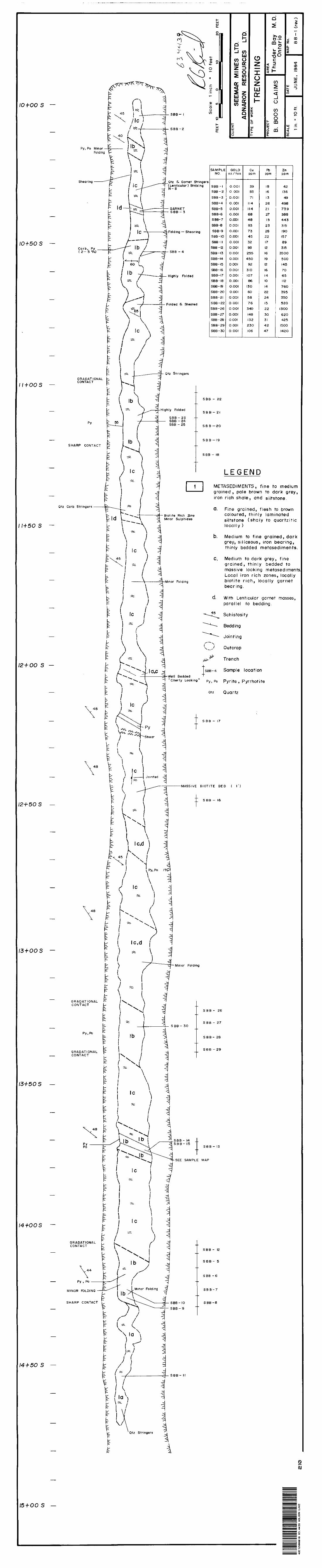
10+OOS —
Py, Po Minor -Folding
Shearing ——— -"
10+503 —Carb, PyI *} E O/ \
GRADATIONALii+oo s - C ONTACT
Py
SHARP CONTACT
Qtz Carb Stringers ———— \
11+503 —
12+OO S —
f
•8 r:
V
12+50 S —
\ 8
1
f ^
13 + 005 — \
t
kGRADATIONAL P CONTACT
Py,Po ^
GRADATIONAL ^ —— CONTACT
-^ -^
13+503 — f
Py ————— 1Po f
fc f E_ L-
14+003 ~ r^
GRADATIONAL , CONTACT C
\44 p
^ fe—— Py , Po ———— ^
MINOR FOLDING —— j—
SHARP CONTACT ^
^F li
/4f 50 S — ^
/\^ " i^~ -**^X;*** * f\.
l O -5- u, l45 J ___
J ^ /le) 1
^ ^ l\ \ l
^ s y '| V 3- -J-. l "^
:: M _ t'^-Ji ^. __ :L
- "^ 1' 'Til— li X \ —**P1 f 1 ^
: t- — 7 j•""r t 'f /^r *\ \^ \
t ) v i\ \ ~ f \
^ ( l b\ Ir \* "l-^-H "t J 71r K) /^uii it- "^"--^ H —— -d F- i^i "**A ~3 b ^ la ^ A -q 1^
1 \~:^ 4^ le \ ^
? ' \ '^~ —— N —— -
1 . \ i
? il i - \ \ 1i A \ ^
: l ) ''' 1 *? 1 i
* T *, *, ^
V * *v ™^
^ v^^l* rt *^^Tj ^1 /' 1 Sh9ar 1
r
\ \ \ - f \ le 'rf ^ j ——— Jointed -^
l ^ \ ^' — 1-"""""""'^ -^~ \ i -*
- / \ : ^ ^ * 1t \ M ; t 1 \ i^ l lcfd ] ^
t" ^^ S1 ) ro m* ( l c \
" ^~Xx- \: l l c - d 1" ) * \i -~- \n 71- : \) i
Ib j -J ; ^
Txx \\ :1 \ -c \
i * i
~ ^i
\ - i-j il 1C
y - ^ ^\ r
-/j^ i•~~^^' v^L Minor Folding
^T^\ ^^\ -^
c \ ? . Ni l a J i
^ 11 } /' |
r\)
^ ^ 7 i ^ V• I 3t v\ 1fc \ "5W; Qtz Stringers ^P -
J?
/5T-OOS —
5 --su. ^ o
rt-S^"\ ora O T
-J ^^V 1 ri ~* CD u z CD
^MlJ i i i g l" s^ ^ *" 1 ^OT^ 1" 2\ "X " 1 -* Hi U ul
N\J ^ 1 S^Z 2 u 1" 0N 1 ^ ^ li"1 2 Z ry < Q" 1 w o F -i — i -1 8 5 "" 00 1 -9- X. *~o II Z a CO t4-
SBB-I W 1 Q g O 9r . " E t s . -SRR P lu 2 ^ ^ * -J "~bbb *i ujuj Q-oCQ^
-i v o: o0 h- Q. W
SAMPLE GOLD Cu Pb Zn NO. oz /ton ppm ppm ppm
^Qtz 6. Garnet Stringers.(Lenticular) Striking SBB-I O.OOI 39 8 42 N-S
SBB-2 O.OOI 83 16 136SBB-3 O.OOI 71 3 49
SBB-4 O.OOI 114 26 498
-GARNET SBB-5 O.OOI 114 21 739U D -J
SBB-6 O.OOI 68 27 388
ISBB-7 O.OOI 48 5 443
SBB-8 O.OOI 93 23 315
-Foldtng- Shearing SBB-9 O.OOI 73 28 190
SBB-IO O.OOI 45 22 157
SBB-II O.OOI 32 17 89
SBB -12 O.OOI 93 12 315
SBbl * SBB-13 O.OOI 255 16 35OO
SBB-14 O.OOI 45O 19 50O
SBB- 15 O.OOI 92 12 145
SBB-16 O.OOI 3IO 16 7O
Highly Folded SBB-17 O.OOI IO7 14 65
SBB-18 O.OOI 86 IO 112
SBB-19 O.OOI I3O 14 76O
SBB-20 O.OOI 6O 22 395
SBB-21 O.OOI 58 24 35O
Folded S Sheared SBB-22 O.OOI 76 15 52O SBB-26 O.OOI 340 22 I3OO
SBB-27 O.OOI 148 30 620
SBB-28 O.OOI 132 3 425
SBB- 29 O.OOI 230 42 I5OO
SBB - 3O 0. 001 IO6 47 I42O
3tz Stringers
SBB - 22
hly Folded SBB-2
SBB - 23SBB -24ODO — tO COD Of\ ODD —— cU
SBB-19
SBB-18
LEGEND
1 METASEDIMENTS, fine to medium1 ———— ' giuinecl, pole brown lo dark grey,
iron rich shale, and siltstone.
Q. Fine grained, flesh to brown iotite Rich 2bne coloured, thinly laminatedlinor Sulphides S J | fstope ( s h a | y f0 quartz tic
loca ly )
b. Medium to fine grained, dark grey, sil ceous, ron bearing, thinly bedded metasediments.
C. Medium to dark grey, fine grained, thin y bedded to massive looking metasediments, Local iron rich zones, locally
viinor Folding biotite r eh, loca ly garnet bearing.
d. With Lenticular garnet masses, para lei to bedding.
~^-JJ^ Schistosity
^""c--- Bedding
^*^~- Joint ng
\^.; Outcrop
^^ Trench
SBB- 4 Sample location-Well Bedded
"Cherty Looking" Py) Po pyr jfe , Pyrrhot te
Qtz Quartz
SBB- 17
T —————— MASSIVE BIOTITE BED { ')
E II S BB - 16^
*r
^
.f
*
t
\i
4.~Tj— Minor Folding
1 1 f
SBB- 26
S BB - 27 SBB - 30
l SBB- 2B
SBB - 29f*
-^ -^
-^-^ f*~
—2 - SBB - 14 .. - SBB- 5j; SBB - 13
"^^-SEE SAMPLE MAP
iM
S B B - 12
SBB-5
j: SBB-6.•t
J SBB-7
ODD \ f*\ GOO Q
ODD V
S D D I I
\i i
Q CU
^^^^^^^^^ ^^^^^^^^^i^B^^^^^
••^^•^^H^•^^^••••••••B
••^•^•••••••B ^^^^^^^^^^^ ^^^^^^^^^^^
^^^^^^^^^^m m
^•••••••IMM ^ ^^IVIBmHH^HHI^ ^
^^^^^^^ — — ^^ o^—— —— to
^^^^^^ s^s s

f- coLU
CD
LU
r 8 +8O S
SAMPLE No
SBB- 31
GOLD oz / ton
0.001
Cu Pb Zn
p p m
71 10 43
4
•\ x
MINOR
FE STAINING
LEGEND
METASEDIMENTS, medium to fine grained tan to grey thinly laminated, highly metamorphosed.
EARLY FELSIC INTRUSIVE, granite texture, local boudinage.
GRANODIORITE, fine to medium grained, massive to locally porphyritic.
LATE FELS 1C l NTRUSIVEa. pegmatiticb. medium grained granitic
Outcrop
Trench
HIGHLY MIXED G FOLDED-U
sBB- 31 Sample location
ME TASEDIMENTS BLOCKS IN GRANODIORITE
VERY COARSE GRAINED "PEGMATITIC"
METASEDIMENT XENOLITH5
- 9+00 S
- 9 +5O S
HIGHLY FOLDED MIXED ZONE MEDISEDIMENT t- BLOCKS IN GRANODIORITE^
- 10 + 00 S
HIGHLY MIXED ZONE
t L''s'^ i^l/^ ^ /'.VV^v-r-T-
- to + so s
1 + 00 S
L 1 1+30 S
Scale 1 inchFEET 1O 5 O 20 FEET
•42C12N*eei8 63.4439 MOLSON LAKE220
CLIENTSEEMAR M INES LTD.
ADNARON RESOURCES LTD.TYPE OF WORK
TRENCHINGPROJECT
B BOOS CLAIMS
SCALE
1 in. * 1O ft.
AREA
Th under Bay M. D. Ontario
DATE
JUNE, ( 984
MAP No.
BB-2(rev.)
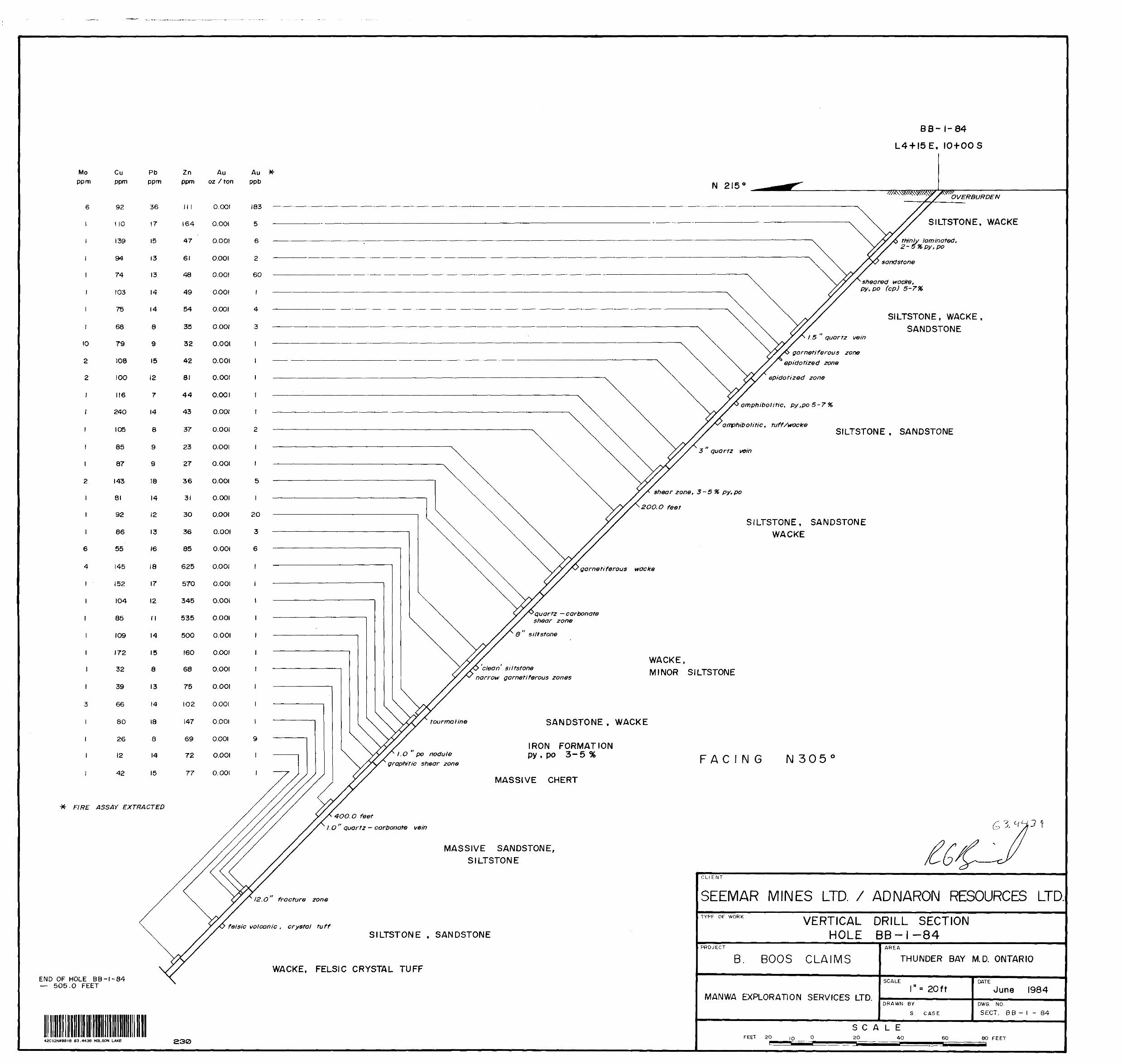
Moppm
10
2
2
Cu ppm
92
l 10
139
94
74
103
75
68
79
108
100
116
240
105
85
87
143
81
92
86
55
145
152
IO4
85
109
172
32
39
66
80
26
12
42
FIRE ASSAY EXTRACTED
6
4
l
END OF HOLE BB-l-84 — 505.0 FEET
BB- 1-84
L4 + I5E, 10+OOS
thinly laminated, 2-5*X,py,po
sandstone
sheared wacke, py, po (cp) S-7%
SILTSTONE, WACKE, SANDSTONE
15 quartz vein
garneti ferous zone epidotized zone
epidotized zone
amphibolide, py,po S-7%
amphib otitic , tuff/wackeSILTSTONE t SANDSTONE
3 quartz vein
shear zone, 3-5 % py.po
2OO.O feet
SILTSTONE, SANDSTONE WACKE
SILTSTONE, WACKE
garnetiferous wacke
1 quartz —carbonate shear zone
8 siltstone
clean siltstone narrow garnetiferous zones
WACKE,MINOR SILTSTONE
tourmaline
l.O po nodule graphitic shear zone
SANDSTONE , WACKE
IRON FORMATION py , po 3-5 % FACING N 305
MASSIVE CHERT
4OO.O feet
l.O " quartz — carbonate vein
MASSIVE SANDSTONE, SILTSTONE
12.0 fracture zone
felsic volcanic, crystal tuffSILTSTONE , SANDSTONE
WACKE, FELSIC CRYSTAL TUFF
42C12NWeeiS 63.4439 MOLSON LAKE 230
CLIENT
SEEMAR MINES LTD. / ADNARON RESOURCES LTD.TYPE OF WORK VERTICAL
HOLEDRILL SECTION BB-l-84
PROJECT
B. BOOS CLAIMS
MANWA EXPLORATION SERVICES LTD.
AREA
THUNDER BAY M. D. ONTARIO
SCALE
" * 20 f fDRAWN BY
S CASE
DATE
June 1984DWG. NO.
SECT. B B - l - 84
FEET 20 10
SCALE2O 4O 60 80 FEET
B B - 2 - 84
L 8+25E, 13 + OOS
Mo ppm
Z
2
l
6
l
4
5
2
3
1
2
2
l
28
2
l
l
4
l
l
Cu ppm
122
69
91
15
119
2O
82
38
22
109
49
122
63
56
86
132
25
100
92
IOO
112
119
46
104
17
15
34
12
87
197
17
22
243
240
173
89
97
41
31
36
Pb ppm
15
M
13
8
12
11
12
12
15
II
9
8
7
16
9
12
14
10
11
10
9
7
9
13
8
10
15
14
12
14
26
10
11
20
33
80
330
22
10
IO
8
Zn ppm
181
49
63
58
28
106
97
64
89
IOO
73
89
70
84
63
60
67
87
50
39
49
36
40
76
37
92
III
94
96
353
1480
128
208
4330
2350
1250
516
525
107
78
75
FIRE ASSAY EXTRACTED
Au oz Aon
0.001
0.001
0.001
O.OOI
O.OOI
0.001
O.OOI
O.OOI
O.OOI
O.OOI
O.OOI
O.OOI
O.OOI
O.OOI
O.OOI
O.OOI
O.OOI
O.OOI
O.OOI
O.OOI
O.OOI
O.OOI
0.001
O.OOI
O.OOI
O.OOI
O.OOI
O.OOI
O.OOI
O.OOI
O.OOI
O.OOI
O.OOI
O.OOI
O.OOI
O.OOI
O.OOI
O.OOI
O.OOI
O.OOI
O.OOI
Au ppb
15
7
26
3
7
4
3
6
l
l
4
7
3
12
3
21
12
M
3
8
10
13
12
9
7
9
6
13
23
8
22
8
9
4
10
43
GRANODIORITE VEINSILTSTONE
QUARTZ PORPHYRY VEINSILTSTONE
WACKE
GRANODIORITE DYKE
SILTSTONE GRANODIORITE DYKE
SILTSTONE, WACKEsheared quartz veins
GRANODIORITE VEIN SILTSTONE, WACKE
GRANODIORITE VEIN SILTSTONE, WACKE
GRANODIORITE VEIN
2OO.O feet
2 pegmatite vein
4.O " quartz veining
SHEARED GRAPHITIC SEDIMENTS
WACKE
S OVERBURDEN
ar™?d''on'te S ILTSTONEv™9 WACKE
py, po stringers'GRANODIORITE VEIN
RAFTED SEDIMENTS GRANODIORITE VEIN
SILTSTONE, WACKE
GRANODIORITE DYKE
WACKE f SILTSTONE
shear zone
WACKE
O granodiorite vein
siltstone
3.0 " breccia fed quartz — carbona te veining
WACKE, SILTSTONEfracture zone
GRANODIORITE DYKE
WACKE
FACING N 305
'4OO.O feet
GRANODIORITE DYKE
SILTSTONE, WACKE
GRANODIORITE DYKE
IRON FORMATION
GRANODIORITE DYKE
12.0 " brecciated graphitic zone
IRON FORMATIONquartz — carbonate veining ny QQ f ~ 1 0 h
8.0 quartz vein
12.0 " granodiorite vein S ILTSTONE, SANDSTONE, WACKE
END OF HOLE BB-2-84 — 515.0 FEET
4aC12NW*0l8 63.4439 MOLSON LAKE240
CLI ENT
SEEMAR MINES LTD. / ADNARON RESOURCES LTD.TYPE OF WORK VERTICAL DRILL SECTION
HOLE BB-2-84PROJECT
B. BOOS CLAIMS
MANWA EXPLORATION SERVICES LTD.
AREA
THUNDER BAY M. D. ONTARIO
SCALE r* 20ftDRAWN BY
S CASE
DATE
June 1984DWG. NO
SECT. B 8 - 2 - 84
FEET 20 10
SCALE2O 4O 6O 60 FEET
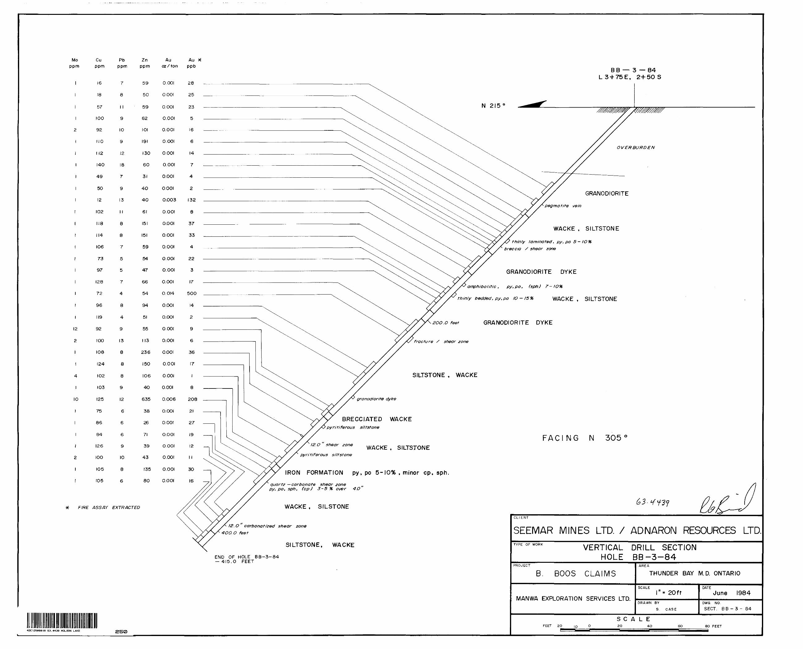
Mo ppnn
12
2
4
l
10
Cu ppm
16
18
57
100
92
110
M2
140
49
50
12
102
118
114
IO6
73
97
128
72
96
119
92
IOO
108
124
102
103
125
75
86
84
126
IOO
105
105
Pb ppm
7
8
I l
9
10
9
12
18
7
9
13
II
8
8
7
5
5
7
4
8
4
9
13
8
8
8
9
12
6
6
6
9
10
8
6
Zn ppm
59
50
59
62
IOI
191
130
60
31
40
40
61
151
151
59
54
47
66
54
94
51
55
113
236
150
106
4O
635
38
26
71
39
43
135
80
Au Au X 02 /ton ppb
FIRE ASSAY EXTRACTED
0.001
0.001
O.OOI
0.001
0.001
O.OOI
0.001
O.OOI
O.OOI
O.OOI
0.003
O.OOI
O.OOI
O.OOI
O.OOI
O.OOI
O.OOI
O.OOI
0.014
O.OOI
O.OOI
O.OOI
O.OOI
O.OOI
O.OOI
O.OOI
O.OOI
0.006
O.OOI
O.OOI
O.OOI
O.OOI
O.OOI
O.OOI
O.OOI
28
25
23
5
16
6
14
7
4
2
132
8
37
33
4
22
3
17
500
14
2
9
6
36
17
8
208
21
27
19
12
l l
3O
16
B B — 3 — 84 L3H-75E, 2+50 S
OVERBURDEN
GRANODIORITE
pegmatite vein
WACKE , SILTSTONE
thinly laminated, pyt po S-10% breccia S shear zone
GRANODIORITE DYKE
amphibolite , oy,po, (sph) 7-
thinly bedded, py.po IO - 15* WACKE , SILTSTONE
2OO.O feet
fracture / shear zone
GRANODIORITE DYKE
SILTSTONE , WACKE
granodiorite dyke
BRECCIATED WACKEpyritiferous siltstone
FACING N 30512.0 shear zone
pyri tiferous siltstoneWACKE , SILTSTONE
IRON FORMATION py, po S-10% , minor cp, sph
quartz —carbonate shear zonepy, po, sph, (cp) 3-5 96 over 4.O
WACKE , SILSTONE
12.0 carbonatized shear zone4OO.O feet
SILTSTONE, WACKE
END OF HOLE BB-3-84 — 415.0 FEET
42C12NW0018 63.4439 MOLSON LAKE 2B0
CLI ENT
SEEMAR MINES LTD. X ADNARON RESOURCES LTD.TYPE OF WORK VERTICAL DRILL SECTION
HOLE BB-3-84PROJECT
B. BOOS CLAIMS
MANWA EXPLORATION SERVICES LTD.
AREA
THUNDER BAY M. D. ONTARIO
SCALE"' 20ft
DRAWN BY
S. CASE
DATE
June 1984DWG. NO.
SECT. B B - 3 - 84
SCALEFEET 20 10 2O 4O 6O 80 FEET
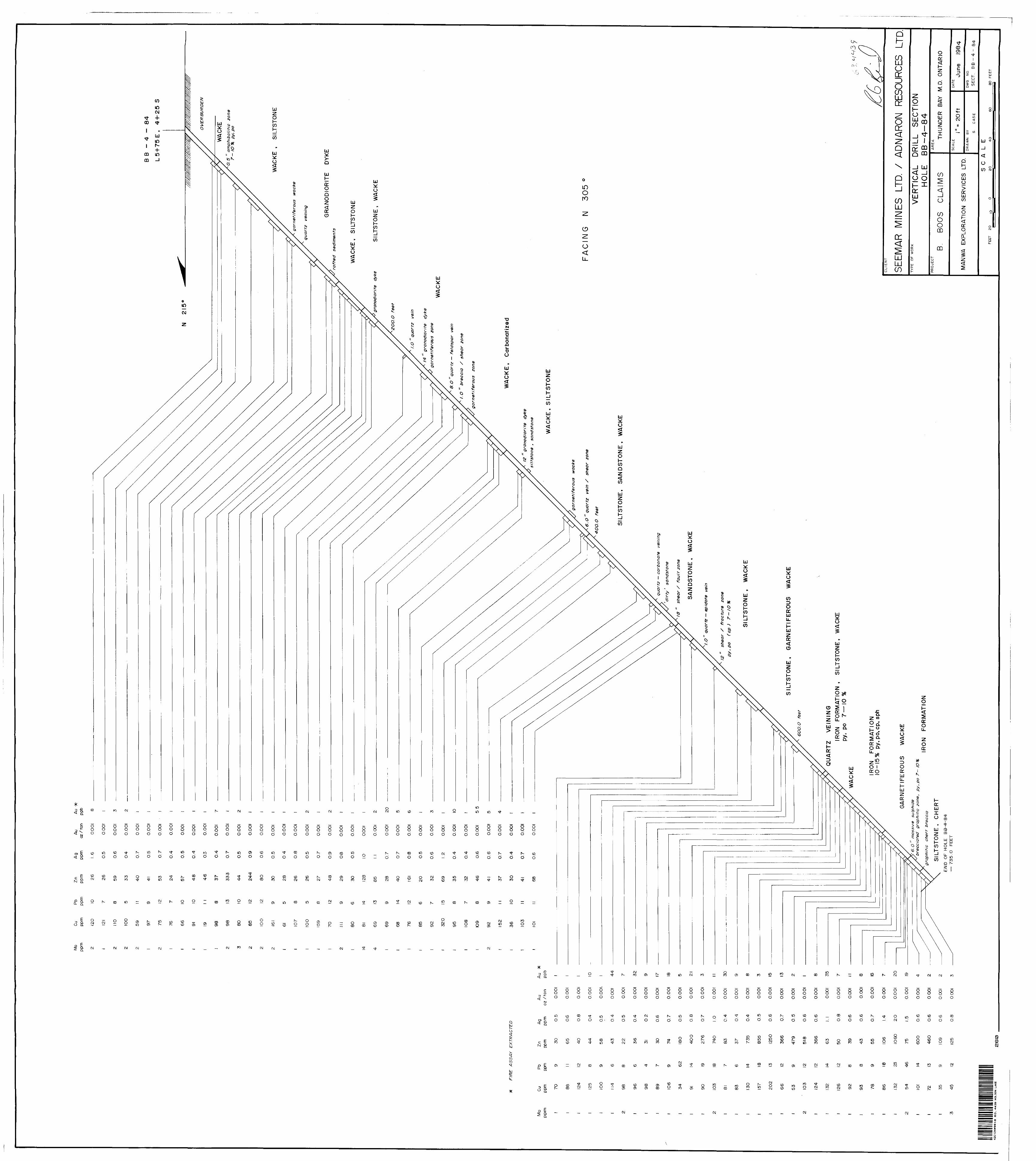
Mo
ppm
Cu
Pb
Zn
A g
Au
Au
ppm
pp
m
ppm
pp
m
oz/
ton
pp
b
Mo
ppm
FIR
E
AS
SA
Y
EX
TR
AC
TE
D
Cu
ppm 7O
88 124
125
100
114
98 96 98 89 106
34 91 90 103
81 83 130
157
202
66
53 103
124
132
126
92 93 78 86 132
54 101
72 35 45
Pb
ppm 9 l! 12 8 9 6 8 6 4 7 9 62 14 19 18 7 6 14 18 13 12 9 12 12 14 12 8 8 9 18 23 46 14 13 9 12
Zn
ppm 30 65 40 44 58 43 22 36 31 3O 74 180
40
0
276
740
83 37 735
855
1250
366
479
518
366
63 50 39 43 55 106
IO6O
75 6OO
460
109
125
Ag
ppm 0.
5
0,6
0.8 0.4
0.5
0.4
0.5
O.4
0.2
O.6
0.7
0.5
0.8
0.7
1.0
0.4
O.4
0.4
0.5
0.6
0.7
0.5
0.6
0.6
1.1 0.8
O.6 0.6
0.7
1.4
2.O
1.5 O.6
0.6
O.6
0.8
Au
oz /
ron
0.00
1
O.O
OI
O.O
OI
0.00
1
O.O
OI.
OO
OI
O.O
OI
O.O
OI
O.O
OI
O.O
OI
O.O
OI
O.O
OI
O.O
OI
O.O
OI
O.O
OI
O.O
OI
O.O
OI
O.O
OI
O.O
OI
O.O
OI
O.O
OI
O.O
OI
O.O
OI
O.O
OI
O.O
OI
O.O
OI
O.O
OI
O.O
OI
O.O
OI
O.O
OI
O.O
OI
O.O
OI
0,001
O.O
OI
O.O
OI
O.O
OI
B B
- 4
-
84
L5 +
75
E,
4-H
25 S
WA
CK
E ,
S
ILTS
TON
E
GR
AN
OD
IOR
ITE
D
YK
E
WA
CK
E,
SIL
TS
TO
NE
SIL
TS
TO
NE
, W
AC
KE
l. O
q
ua
rtz
vein
gra
nodio
rite
dy
ke
gar
net
ifer
ou
s zo
ne
B. O
q
ua
rtz
— f
eld
spar
vein
l. O
" b
recc
ia / s
hea
r zo
ne
gar
net
ifer
ou
s zo
ne
WA
CK
E
WA
CK
E f
Car
bona
tized
OV
ER
BU
RD
EN
0.5
a
mp
hib
olid
e
zone
py.p
o
ga
rne
tife
rou
s
wack
e
quart
z
vein
ing
raft
ed
sedi
men
ts
gran
odio
rite
dy
ke
2OO
.O f
eet
12
g ra n
od i o
r i te
dy
ke
silts
tone
f
sand
ston
e
WA
CK
E,
SIL
TS
TO
NE
gar
net
ifer
ou
s w
acke
6. O
" q
uar
tz
vein
/
shea
r zo
ne
4OO
.O
feet
SIL
TS
TO
NE
, S
AN
DS
TO
NE
, W
AC
KE
FA
CIN
G
N 3
05
0
qu
art
z —
ca
rbo
na
te
vein
ing
dirty
' sa
ndst
one
18 "
sh
ear
S fa
ult
zone
SA
ND
ST
ON
E,
WA
CK
E
V. O
qu
artz
— e
pido
te
vein
12
shea
r S
fr
actu
re
zone
p
y, p
o (c
p )
7
— IO
*
SIL
TS
TO
NE
t
WA
CK
E
SIL
TS
TO
NE
t
GA
RN
ET
IFE
RO
US
W
AC
KE
QU
AR
TZ
V
EIN
ING
IRO
N
FO
RM
AT
ION
, S
ILT
ST
ON
E,
WA
CK
E
py,
po
7—
10
*K
IRO
N
FO
RM
AT
ION
IQ
-15
%
py,
po.c
p, s
ph
GA
RN
ET
IFE
RO
US
W
AC
KE
6.0
m
ass
ive
su
lph
ide
b
recc
iate
d
gra
ph
itic
zon
e,
py.p
o 7
- IO
%
gra
ph
itic
ch
ert
b
recc
ia
SIL
TS
TO
NE
, C
HE
RT
EN
D
OF
HO
LE
BB
-4-8
4
— 7
35.O
FE
ET
RO
N
FO
RM
AT
ION
42C12NW08TS S3.-4439 MOLSON LAKE
seta
CLI
EN
T
SEEM
AR
MIN
ES
LT
D. 7
AD
NAR
ON
RE
SOUR
CES
LTD.
TY
PE
O
F W
OR
KV
ER
TIC
AL
DR
ILL
SEC
TIO
N
HO
LE
BB
-4-8
4P
RO
JEC
'
B.
BO
OS
C
LAIM
S
MA
NW
A
EX
PLO
RA
TIO
N
SE
RV
ICE
S
LTD
.
AR
EA
THU
ND
ER
BA
Y M
. D.
ON
TAR
IO
SC
ALE
*
2O
f t
DR
AW
N
BY S
CA
SE
DA
TE
June
19
84D
WG
. N
O.
SE
CT.
B
B -
4 -
84
SC
ALE
FEE
T 2O
IO2O
4O6O
8O
FE
ET

Mo ppm
N/A
2
3
l
l
18
Cu ppm
10
11
7
7
88
103
121
83
74
99
114
74
110
85
20
21
73
92
94
101
67
99
53
151
133
98
82
167
Pb ppm
14
6
8
8
4
6
IO
17
13
12
10
7
8
6
21
7
5
II
9
6
II
10
15
9
9
8
6
6
FIRE ASSAY EXTRACTED DATA NOT AVAILABLE
Znppm
52
59
24
45
22
49
104
360
387
204
41
27
138
35
42
32
39
74
60
31
64
135
27
4O
80
198
26
25
Au or X ton
0.001
0.001
0.001
0.001
0.002
O.GOI
0.001
O.OOI
O.OOI
0.001
O.OOI
O.OOI
O.OOI
O.OOI
O.OOI
O.OOI
O.OOI
O.OOI
O.OOI
O.OOI
O.OOI
O.OOI
O.OOI
O.OOI
O.OOI
O.OOI
O.OOI
O.OOI
Au ppb
62
N/A
N/A
N/ft
N/A
N/A
N/a
4
29
l
N/A
N/A
N/A
N/A
N/A
B B - 5 -84
L5 + 75E, 2-I-25S
N 215 0
quar t z — feldspar pegmatite vein
GRANODIORITE
Cedar Lake Pluton
pegmatite vein
CONTACT BRECCIA Wacke, Siltstone
SILTSTONE
WACKE , SILTSTONE
pyritiferous siltstone* 5-7 %
GRANODIORITE DYKEFACING N 305
granodiorite dyke
f4 "granodiorite dyke
granodiorite dyke
carbonatizQd wacke
2.0 ' quartz — carbonate vein
8 granodiorite dyke
granodiorite dyke 12 "breccia / shear zone WACKE , SILTSTONE
6 breccia zone
4OO.O feet
siltstone, 5- IO*X py,po, cp
garnetiferous wacke
8 "granodiorite dyke massive wacke
2. O " quartz vein
END OF HOLE BB-5-84 — 455.0 FEET
42C12NW00ia 63.4439 MOLSON LAKE 27-0
CLIENT
SEEMAR MINES LTD. X AD N APON RESOURCES LTD.TYPE OF WORK VERTICAL DRILL SECTION
HOLE BB-5-84PROJECT
B. BOOS CLAIMS
MANWA EXPLORATION SERVICES LTD.
AREA
THUNDER BAY M. D. ONTARIO
SCALE r- 20ftDRAWN BY
S. CASE
DATE
June I984DWG. NO SECT. B B - 5 - 84
FEET 2O 10 0
SCALE2O 4O 60 80 FEET

L 4E
3+
90 S
L6E
l 4-
SO
S
A
N 21
5B
B-5
-84
Str
eam
A
II5O
ft.
A
.S.L
.
B
CED
AR
L
AK
E
PLU
TON
\
\ \ \\
LE
GE
ND
FELS
IC
INTR
US
IVE
R
OC
KS
a.
gran
odio
rite
dyke
b.
gr
anod
iorit
e ,
Ced
ar L
ake
Plu
ton
CH
EM
ICA
L M
ETA
SE
DIM
EN
TS
a iro
n fo
rmat
ion
— w
acke
-ch
ert
—py
rite
b. m
assi
ve
cher
t
CLA
ST
IC
ME
TAS
ED
IME
NTS
a.
sa
ndst
one
b.
silts
tone
c.
wac
ke
BRX
Con
tact
br
ecci
a zo
ne
gar
py
po
Gar
net
Pyr
ite
Pyr
rhot
ite
Loca
lized
sh
ear
X br
ecci
a zo
ne
42C12NW0016 63.4439 MOLSON LAKE
N2I
50
N3
O 5
0
L6E
3 +
80 S
l. R
CO
ND
UC
TOR
B
1150
ft
A.S
.L.
CED
AR
L
AK
E
PLU
TON
\ \\
2S
0
CLIE
NT
SEEM
AR
MIN
ES
LT
D. 7
AD
NAR
ON
RE
SOUR
CES
LTD.
TY
PE
O
F W
OR
KS
CH
EM
AT
IC
INTE
RP
RE
TATI
ON
S
EC
TIO
NS
A
-A'.
B -B
*P
RO
JEC
T
B.
BOO
S C
LAIM
S
MA
NW
A
EX
PLO
RA
TIO
N
SE
RV
ICE
S
LTD
.
AR
EA
THU
ND
ER
BA
Y M
. D.
ON
TAR
IO
SC
ALE
* 5
0 f
t.D
RA
WN
B
Y S.
CA
SE
DA
TE
June
19
84D
WG
. N
O.
SE
CT.
A
-A'
, B
-B
SC
ALE
FEET
5O
25
O
5OIC
O15
0___
____
_2Q
OF
EE
T