Embed Size (px)
Citation preview
LATE QUATERNARY VEGETATION HI STORY
OF THE YELLOWSTONE LAKE BASIN,
WYOMING

Late Quaternary Vegetation History of the Yellowstone Lake Basin, Wyoming By RICHARD G. BAKER
GEOLOGY OF YELLOWSTONE NATIONAL PARK
GEOLOGICAL SURVEY PROFESSIONAL PAPER 729-E
Analyses of poUen and plant macrofossils from sediment cores indicate complex changes in the vegetation succession from deglaciation about 19,000 years ago to the present
UNITED STATES GOVERNMENT PRINTING OFFICE, WASHINGTON 1976
UNITED STATES DEPARTMENT OF THE INTERIOR
THOMAS S. KLEPPE, Secretary
GEOLOGICAL SURVEY
V. E. McKelvey, Director
Library of Congress Cataloging in Publication Data Baker, Richard G. Late Quaternary vegetation history of the Yellowstone Lake Basin, Wyoming. (Geology of Yellowstone National Park) (Geological Survey Professional Paper 729-E) Bibliography: p. Includes index. Supt. of Docs. no.: I 19.16:729-E 1. Paleobotany-Quaternary. 2. Paleobotany-Wyoming-Yellowstone Lake basin. 3. Palynology-Wyoming-Yellowstone Lake
basin. I. Title. II. Series. III. Series: United States Geological Survey Professional Paper 729-E. QE931.B34 560'.178 75-619373
For sale by the Superintendent of Documents, U.S. Government Printing Office
Washington, D.C. 20402
Stock Number 024-001-02860-3

Yellowstone National Park, the oldest of the areas set aside as part of the national park system, lies amidst the Rocky Mountains in northwestern Wyoming and adjacent parts of Montana and Idaho. Embracing large, diverse, and complex geologic features, the park is in an area that is critical to the interpretation of many significant regional geologic problems. In order to provide basic data bearing on these problems, the U.S. Geological Survey in 1965 initiated a broad program of comprehensive geologic and geophysical investigations within the park. This program was carried out with the cooperation of the National Park Service, and ~as also aided by the National Aeronautics and Space Administration, which supported the gathering of geologic information needed in testing and in interpreting results from various remote sensing devices. This professional paper chapter is one of a series of technical geologic reports resulting from these investigations.

CONTENTS
Page
Metric-English equivalents............................... VI Abstract . . . . . . . . . . . . . . . . . . . . . . . . . . . . . . . . . . . . . . . . . . . . . . . E1 Introduction . . . . . . . . . . . . . . . . . . . . . . . . . . . . . . . . . . . . . . . . . . . . 1
Location and climate . . . . . . . . . . . . . . . . . . . . . . . . . . . . . . . . . 1 Acknowledgments . . . . . . . . . . . . . . . . . . . . . . . . . . . . . . . . . . 2
Methods of study . . . . . . . . . . . . . . . . . . . . . . . . . . . . . . . . . . . . . . . . 2 Glacial history . . . . . . . . . . . . . . . . . . . . . . . . . . . . . . . . . . . . . . . . . . 5 Vegetation of Yellowstone National Park and surrounding area 7
Regional vegetation . . . . . . . . . . . . . . . . . . . . . . . . . . . . . . . . . 10 Artemisia steppe association . . . . . . . . . . . . . . . . . . . . . . 10 Pseudotsuga association . . . . . . . . . . . . . . . . . . . . . . . . . 10 Pinus contorta forest association . . . . . . . . . . . . . . . . . . 12 Picea-Abies-Pinus albicaulis forest association . . . . . . 12 Alpine association . . . . . . . . . . . . . . . . . . . . . . . . . . . . . . . 12
Local vegetation around the coring sites . . . . . . . . . . . . . . . . 13 Nuphar-Potamogeton type . . . . . . . . . . . . . . . . . . . . . . . 114 Menyanthes trifoliata type . . . . . . . . . . . . . . . . . . . . . . . 14 Carex utriculata type . . . . . . . . . . . . . . . . . . . . . . . . . . . . 14 Carex diandra-PotentiUa palustris type . . . . . . . . . . . . 14 Calamagrostis-Salix-Sedum rhodanthum type. . . . . . . 15
Other paleobotanical work in the area . . . . . . . . . . . . . . . . . . 15 Pollen surface samples . . . . . . . . . . . . . . . . . . . . . . . . . . . . . . . . . . . 15
Surface samples from the Artemisia steppe............. 16 Surface sample from Pseudotsuga association . . . . . . . . . . . 18 Surface samples in Pinus contorta forests . . . . . . . . . . . . . . . 18 Surface samples from Picea-Abies-Pt"nus albicaulis
forests........................................... 18 Surface samples from Picea-Abies-Pinus albicaulis
parklands and tundra . . . . . . . . . . . . . . . . . . . . . . . . . . . . . . 19 Pollen ratios . . . . . . . . . . . . . . . . . . . . . . . . . . . . . . . . . . . . . . . . 20
Quaternary palynology . . . . . . . . . . . . . . . . . . . . . . . . . . . . . . . . . . 20 Materials and procedures . . . . . . . . . . . . . . . . . . . . . . . . . . . . 20 Pollen and seed identification . . . . . . . . . . . . . . . . . . . . . . . . . 24
Selaginellaceae . . . . . . . . . . . . . . . . . . . . . . . . . . . . . . . . . 24 Pinaceae . . . . . . . . . . . . . . . . . . . . . . . . . . . . . . . . . . . . . . . 24 Betulaceae . . . . . . . . . . . . . . . . . . . . . . . . . . . . . . . . . . . . . 27
Page Quatenary palynology-Continued
Pollen and seed identification-Continued Compositae ..................................... E28 Crassulaceae . . . . . . . . . . . . . . . . . . . . . . . . . . . . . . . . . . . 28 Cruciferae . . . . . . . . . . . . . . . . . . . . . . . . . . . . . . . . . . . . . . 28 Haloragaceae . . . . . . . . . . . . . . . . . . . . . . . . . . . . . . . . . . . 28 Loranthaceae . . . . . . . . . . . . . . . . . . . . . . . . . . . . . . . . . . . 28 Menyanthaceae . . . . . . . . . . . . . . . . . . . . . . . . . . . . . . . . . 28 Nymphaeaceae . . . . . . . . . . . . . . . . . . . . . . . . . . . . . . . . . 28 Onagraceae . . . . . . . . . . . . . . . . . . . . . . . . . . . . . . . . . . . . 28 Polemoniaceae . . . . . . . . . . . . . . . . . . . . . . . . . . . . . . . . . . 28 Polygonaceae . . . . . . . . . . . . . . . . . . . . . . . . . . . . . . . . . . . 28 Ranunculaceae . . . . . . . . . . . . . . . . . . . . . . . . . . . . . . . . . . 29 Rosaceae . . . . . . . . . . . . . . . . . . . . . . . . . . . . . . . . . . . . . . . 29 Sa.J.icaceae . . . . . . . . . . . . . . . . . . . . . . . . . . . . . . . . . . . . . . 29 Saxifragaceae . . . . . . . . . . . . . . . . . . . . . . . . . . . . . . . . . . 29 Cyperaceae. . . . . . . . . . . . . . . . . . . . . . . . . . . . . . . . . . . . . 29 Gramineae . . . . . . . . . . . . . . . . . . . . . . . . . . . . . . . . . . . . . 30 Naiadaceae . . . . . . . . . . . . . . . . . . . . . . . . . . . . . . . . . . . . . 30 Typhaceae ..................................... 30 Other types of fossils . . . . . . . . . . . . . . . . . . . . . . . . . . . . 30 Algae .......................................... 30
Description of pollen zones . . . . . . . . . . . . . . . . . . . . . . . . . . . 30 Picea-Juniperus-Pinus albicaulis zone
(960 -770 em) . . . . . . . . . . . . . . . . . . . . . . . . . . . . . 30 Betula subzone (960- 875 em) . . . . . . . . . . . . . . . . . 31 Populus subzone (875 -770 em) . . . . . . . . . . . . . . . 35
Pinus contorta zone (770 - 0 em) . . . . . . . . . . . . . . . . . . . 36 Pinus contorta-Pinus albicaulis subzone
(770- 600 em). .. .. .. .. .. .. .. .. .. .. .. .. .. . . 37 Pinus contorta subzone (600 -420 em).......... 37 Picea-Abies-Pinus contQTta subzone
(420-0cm) ............................... 38 Discussion and conclusions . . . . . . . . . . . . . . . . . . . . . . . . . . . . . . . 39 References cited . . . . . . . . . . . . . . . . . . . . . . . . . . . . . . . . . . . . . . . . 41 Index .................................................. 45
ILLUSTRATIONS
[Plates follow index)
PLATE 1-4. Photomicrographs of fossil pollen grains from Buckbean fen. 5 -10. Photomicrographs of plant macrofossils and modern seeds and fruits.
Page FIGURE 1. Photograph of Southeast Arm of Yellowstone Lake showing coring area . . . . . . . . . . . . . . . . . . . . . . . . . . . . . .. . . . . . . . . . . . E2
2. Charts summarizing climatic data for Yellowstone National Park . . . . . . . . . . . . . . . . . . . . . . . . . . . . . . . . . . . . . . . . . . . . . . . 3 3. Photograph showing shorelines above Southeast Arm of Yellowstone Lake . . . . . . . . . . . . . . . . . . . . . . . . . . . . . . . . . . . . . . 4 4. Schematic cross section showing relationship between Two Ocean Plateau, the filled lagoons, the lake levels, and the
coring sites . . . . . . . . . . . . . . . . . . . . . . . . . . . . . . . . . . . . . . . . . . . . . . . . . . . . . . . . . . . . . . . . . . . . . . . . . . . . . . . . . . . . . . . . . . 4 5. Sketch maps showing geomorphic development of coring area as glacier ice melted and lake level fell . . . . . . . . . . . . . . . . 6 6. Vegetation map of the southeast corner of Yellowstone National Park showing highestlake level . . . . . . . . . . . . . . . . . . . 11
v
VI CONTENTS
Page FIGURE 7 o Map of local vegetation around coring site, showing surface sample and core localities at Buckbean fen and Lilypad
pond ................................................................ : . ............................. E13 8- 110 Photographs:
8o Coring site at Buckbean fen. . . . . . . . . . . . . . . . . . . . . . . . . . . . . . . . . . . . . . . . . . . . . . . . . . . . . . . . . . . . . . . . . . . . . . . . . 14 9o Closeup of small pond shown in figure 8 . . . . . . . . . . . . . . . . . . . . . . . . . . . . . . . . . . . . . . . . . . . . . . . . . . . . . . . . . . . . . . 14
100 Carex utricu'Ulta type . . . . . . . . . . . . . . . . . . . . . . . . . . . . . . . . . . . . . . . . . . . . . . . . . . . . . . . . . . . . . . . . . . . . . . . . . . . . . . 14 11o Carex diandra-Potenti/J4 palustris type .. .. .. .. .. .. .. .. .. .. .. .... . .. .. .. .. .. .. .. . . . . .. .. .. .. .. . . .. .. .. 15
120 Map of Yellowstone National Park, showing localities of surface samples and coring areas. . . . . . . . . . . . . . . . . . . . . . . . . . 16 13o Diagram showing pollen from surface samples arranged by elevations and by vegetation types . . . . . . . . . . . . . . . . . . . . . 18 14o Diagram showing ratios for surface pollen samples . . . . . . . . . . . . . . . . . . . . . . . . . . . . . . . . . . . . . . . . . . . . . . . . . . . . . . . . . . . 21 15o Diagram of pollen from Buckbean fen core . . . . . . . . . . . . . . . . . . . . . . . . . . . . . . . . . . . . . . . . . . . . . . . . . . . . . . . . . . . . . . . . . . . 22 160 Diagrammatic sketch showing relationships between zones, carbon-14 and extrapolated ages, and time stratigraphic
boundaries . . . . . . . . . . . . . . . . . . . . . . . . . . . . . . . . . . . . . . . . . . . . . . . . . . . . . . . . . . . . . . . . . . . . . . . . . . . . . . . . . . . . . . . . . . 24 17 o Diagram of plant macrofossils from Buckbean fen core. . . . . . . . . . . . . . . . . . . . . . . . . . . . . . . . . . . . . . . . . . . . . . . . . . . . . . . . . 32 18o Diagram of plant macrofossils from lower 2 metres of.Lilypad pond core. . . . . . . . . . . . . . . . . . . . . . . . . . . . . . . . . . . . . . . . . 34 19o Diagram showing ratios for fossil pollen from Buckbean fen . . . . . . . . . . . . . . . . . . . . . . . . . . . . . . . . . . . . . . . . . . . . . . . . . . . . 36
TABLES
Page
TABLE 1. Scientific names, and common names ii available, of plant taxa mentioned in text, tables, and illustrations . . . . . . . . . . E7 2o Locality .and description of surface samples and collection stations . . . . . . . . . . . . . . . . . . . . . . . . . . . . . . . . . . . . . . . . . . . . . 17 3o Summary ofinferred changes in environment at Buckbean fen during the last 12,000+ years. . . . . . . . . . . . . . . . . . . . . . 25 4o Pollen counts for Buckbean fen . . . . . . . . . . . . . . . . . . . . . . . . . . . . . . . . . . . . . . . . . . . . . . . . . . . . . . . . . . . . . . . . . . . . . . . . . . . 26 5o Lithologic description of Buckbean fen and basal section of Lilypad pond . . . . . . . . . . . . . . . . . . . . . . . . . . . . . . . . . . . . . . 31 6o Tentative correlation of pollen sequences . . . . . . . . . . . . . . . . . . . . . . . . . . . . . . . . . . . . . . . . . . . . . . . . . . . . . . . . . . . . . . . . . . . 41
METRIC-ENGLISH EQUIVALENTS
Metric unit
millimetre (mm) metre (m) kilometre ( km)
square metre (m2) square kilometre (km2) hectare (ha)
cubic centimetre (cm3 )
litre (1) cubic metre (mS) cubic metre cubic hectometre (hm3) litre litre litre cubic metre
cubic metre
gram (g) gram tonne (t) tonne
English equivalent
Length 0.03937 inch (in) 3.28 feet (ft)
.62 mile (mi)
Area
10.76 .386
2.47
Volume
square feet (ft2) square mile (mi2) acres
0.061 cubic inch (ina) 61.03 cubic inches 35.31 cubic feet (ft3 )
.00081 acre-foot (acre-ft) =810.7 acre-feet
2.113 pints (pt) 1.06 quarts (qt)
.26 gallon (gal)
.00026 million gallons (Mgal or 10a gal)
6.290 barrels (bbl) (1 bbl=42 gal)
Weight
O.O:l5 ounce, avoirdupois (oz avdp) .0022 pound, avoirdupois (lb avdp)
1.1 tons, short (2,000 lb) .98 ton, long (2,240 lb)
Specific combinations
kilogram per square centimetre (kg/cm2)
kilogram per square centimetre
cubic metre per second (ms/s)
0.96
.98
35.3
atmosphere (atm)
bar (0.9869 atm)
cubic feet per second (fts;s)
Metric unit English equivalent
Specific combinations--Continued
litre per second (1/s) cubic metre per second
per square kilometre [(ma;s)/km2)
metre per day (m/d)
metre per kilometre (m/km)
kilometre per hour (km/h)
metre per second (m/s) metre squared per day
(m2jd)
cubic metre per second (ms;s)
cubic metre per minute (m3/min)
litre per second (1/s) litre per second per
metre [(1/s)/m]
kilometre per hour (km/h)
metre per second (m/s) gram per cubic
centimetre (g/cm3) gram per square
centimetre (g/cm2) gram per square
centimetre
degree Celsius (°C) degrees Celsius
(temperature)
.0353 cubic foot per second
91.47 cubic feet per second per
= 3.28 square mile [ (fts;s) /mi2)
feet per day (hydraulic conductivity) (ft/d)
5.28 feet per mtle (ft/mi)
.9113 foot per second (ft/s) 3.28 feet per second
10.764 feet squared per day (ft2jd) (transmissivity)
22.826 million gallons per day (Mgal/d)
=264.2 gallons per minute (gal/min) 15.85 gallons per minute
4.83 gallons per minute per foot [(gal/min) /ft]
.62 mtle per hour (mi/h) 2.237 miles per hour
62.4:-l pounds per cubic foot (lb/ft3)
2.048 pounds per square foot (lb/ft2 )
.0142 pound per square inch (lb/inll)
Temperature
= 1.8 degrees Fahrenheit (°F)
= [ (1.8 X •c) + 32] degrees Fahrenheit
GEOLOGY OF YELLOWSTONE NATIONAL PARK
LATE QUATERNARY VEGETATION HISTORY OF THE YELLOWSTONE LAKE BASIN, WYOl\fiNG
By RICHARD G. BAKER
ABSTRACT
A large icecap flowed radially from the Yellowstone Lake basin during Pinedale Hate Pleistocene) time. As it melted, kettles, ice-marginal lakes, and associated ice-contact deposits formed between the glacier and the basin sides. With further wasting, lake levels dropped, beaches formed at progressively lower elevations, and "lagoons occupied the kettles. A core from Buckbean fen, an abandoned lagoon 15 feet above modern lake level, was analyzed for pollen and seeds. Macrofossils from the base of lagoon sediments in Lilypad pond 40 feet above the lake were also examined.
Surface pollen samples were collected to relate modern pollen rain to vegetation distribution and to aid in the interpretation of fossil pollen spectra. Steppe, Pinus contorta forests, and PiceaAbies-Pinus albicaulis forests can be recognized from their pollen rain. Pollen rain in alpine tundra is similar to that in subalpine parklands, but both are distinct from pollen rain in other vegetation associations. Few data are available from Pseudotsuga forests.
The Buckbean fen core has two pollen zones-a lower zone and an upper zone. The lower zone (960-770 em) is characterized by more than 50 percent nonarboreal pollen with maxima of Picea, Abies, Pinus albicaulis, Betula, Juniperus, Populus, Gramineeae, and Compositae. It has two subzones-the Betula and the Populus. The Betula subzone (960-875 em) has a Betula pollen maximum, Betula gla:ndulosa seeds, a few alpine macrofossils, and very rare arboreal macrofossils. This fossil assemblage suggests that the site was about at treeline for some time after the glacier melted and that treeline was about 2,000 feet lower than at present in this part of Yellowstone National Park. The assemblage suggests that the climate was cold and moist. The sediments of the subzone contain too little organic matter for radiocarbon dating, but the base of the subzone is estimated to be about 14,500 years old.
The Populus subzone (875 -770 em) contains a Populus maximum and common arboreal macrofossils. Betula pollen decreases, but other pollen types remain at nearly constant levels. This subzone marks the invasion of forest in the area and suggests a slightly warmer climate. The top of the Picea-Abies-Pinus albicaulis zone is radiocarbon dated at 11,630± 180 years B.P. oefore present).
The upper pollen, or Pinus contorta, zone (770- 0 em) is characterized by Pinus contorta pollen and needles and by 60-85 percent total Pt'nus pollen. Three subzones are defined, as follows.
A Pinus contorta-Pt'nus albicaulis subzone (770- 600 em) is characterized by pollen and needles of both Pinus albicaulis and Pinus contorta. The two pines apparently grew together locally in
the absence ofPicea and Abies, which suggests a cool, dry climate. This subzone was deposited from about 11,630 to about 10,160 years B.P.
A Pinus contorta subzone (600 -420 em) contains high values of pine pollen, mainly lodgepole, and low values of Pinus albicaulis, Picea, and Abies. This subzone includes the Altithermal period, and represents a warmer, drier climate from about 10,160 to about 5,000 years B.P., but a hiatus representing as much as 4,000 years is probably present in this interval.
APicea-Abies-Pinus contorta subzone (420 -0 em), representing about the last 5,000 years, shows a recurrence of Picea and Abies pollen and needles. This is the Neoglacial period, and the pollen suggest a climate that is cooler and moister than during deposition
l of the preceding subzone.
INTRODUCTION The primary purpose of this study was to deduce
the vegetation history during the last 13,000 years of the Yellowstone Lake region. Secondary purposes were (1) to infer general climatic changes during this period, and (2) to provide a standard sequence of dated climatic and vegetation changes for correlation with glacial fluctuations.
The fieldwork was carried out in 1966 and 1967 under the supervision of G. M. Richmond, as part of the glacial geology project, Yellowstone National Park study, conducted by the U.S. Geological Survey in eooperation with the National Aeronautics and Space Administration and the National Park Service.
LOCATION AND CLIMATE
Materials for this study were collected from Yellowstone National Park, northwest Wyoming. Much of the park is a plateau (referred to informally in this report as the Yellowstone plateau) that is 8,000- 9,000 feet above sea level. The Absaroka Range on the eastern margin of the park exceeds 11,000 feet, and isolated peaks in the park exceed 10,000 feet. Fossil pollen samples were collected from depressions near the tip of the Southeast Arm of
El
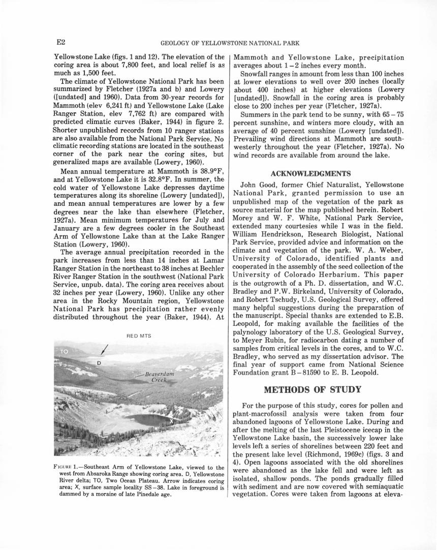
E2 GEOLOGY OF YELLOWSTONE NATIONAL PARK
Yellowstone Lake (figs. 1 and 12). The elevation of the coring area is about 7,800 feet, and local relief is as much as 1,500 feet.
The climate of Yellowstone National Park has been summarized by Fletcher (1927a and b) and Lowery ([undated] and 1960). Data from 30-year records for Mammoth (elev 6,241 ft) and Yellowstone Lake (Lake Ranger Station, elev 7, 762 ft) are compared with predicted climatic curves (Baker, 1944) in figure 2. Shorter unpublished records from 10 ranger stations are also available from the National Park Service. No climatic recording stations are located in the southeast corner of the park near the coring sites, but generalized maps are available (Lowery, 1960).
Mean annual temperature at Mammoth is 38.9°F, and at Yellowstone Lake it is 32.8°F. In summer, the cold water of Yellowstone Lake depresses daytime temperatures along its shoreline (Lowery [undated]), and mean annual temperatures are lower by a few degrees near the lake than elsewhere (Fletcher, 1927 a). Mean minimum temperatures for July and January are a few degrees cooler in the Southeast Arm of Yell ow stone Lake than at the Lake Ranger Station (Lowery, 1960).
The average annual precipitation recorded in the park increases from less than 14 inches at Lamar Ranger Station in the northeast to 38 inches at Bechler River Ranger Station in the southwest (National Park Service, unpub. data). The coring area receives about 32 inches per year (Lowery, 1960). Unlike any other area in the Rocky Mountain region, Yellowstone National Park has precipitation rather evenly distributed throughout the year (Baker, 1944). At
RED MTS
FIGURE !.-Southeast Arm of Yellowstone Lake, viewed to the west from Absaroka Range showing coring area. D, Yellowstone River delta; TO, Two Ocean Plateau. Arrow indicates coring area; X, surface sample locality SS -38. Lake in foreground is dammed by a moraine of late Pinedale age.
Mammoth and Yellowstone Lake, precipitation averages about 1 - 2 inches every month.
Snowfall ranges in amount from less than 100 inches at lower elevations to well over 200 inches (locally about 400 inches) at higher elevations (Lowery [undated]). Snowfall in the coring area is probably close to 200 inches per year (Fletcher, 1927 a).
Summers in the park tend to be sunny, with 65 - 75 percent sunshine, and winters more cloudy, with an average of 40 percent sunshine (Lowery [undated]). Prevailing wind directions at Mammoth are southwesterly throughout the year (Fletcher, 1927a). No wind records are available from around the lake.
ACKNOWLEDGMENTS
John Good, former Chief Naturalist, Yellowstone National Park, granted permission to use an unpublished map of the vegetation of the park as source material for the map published herein. Robert Morey and W. F . White, National Park Service, extended many courtesies while I was in the field. William Hendrickson, Research Biologist, National Park Service, provided advice and information on the climate and vegetation of the park. W. A. Weber, University of Colorado, identified plants and cooperated in the assembly of the seed collection of the University of Colorado Herbarium. This paper is the outgrowth of a Ph. D. dissertation, and W.C. Bradley and P. W. Birkeland, University of Colorado, and Robert Tschudy, U.S. Geological Survey, offered many helpful suggestions during the preparation of the manuscript . Special thanks are extended to E.B. Leopold, for making available the facilities of the palynology laboratory of the U.S. Geological Survey, to Meyer Rubin, for radiocarbon dating a number of samples from critical levels in the cores, and to W.C. Bradley, who served as my dissertation advisor. The final year of support came from National Science Foundation grant B- 81590 to E. B. Leopold.
METHODS OF STUDY
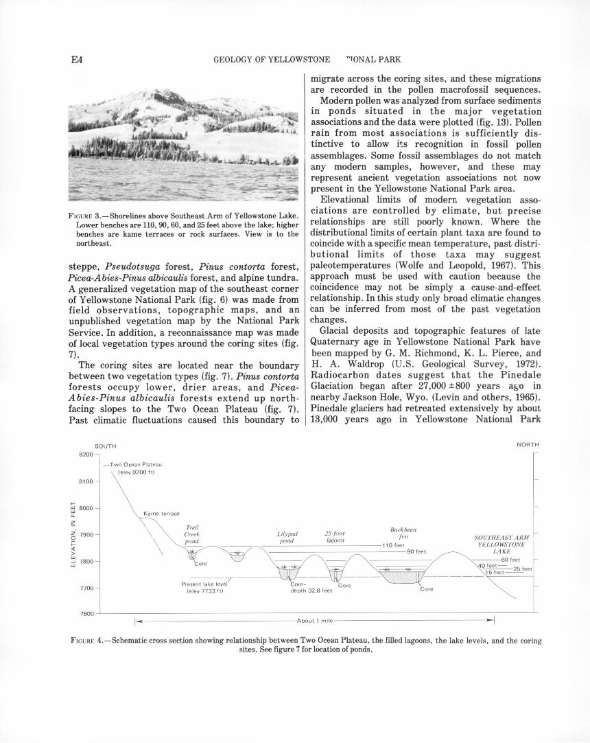
For the purpose of this study, cores for pollen and plant-macrofossil analysis were taken from four abandoned lagoons of Yellowstone Lake. During and after the melting of the last Pleistocene icecap in the Yellowstone Lake basin, the successively lower lake levels left a series of shorelines between 220 feet and the present lake level (Richmond, 1969c) (figs. 3 and 4). Open lagoons associated with the old shorelines were abandoned as the lake fell and were left as isolated, shallow ponds. The ponds gradually filled with sediment and are now covered with semiaquatic vegetation. Cores were taken from lagoons at eleva-

VEGETATION HISTORY OF THE YELLOWSTONE LAKE BASIN E3
12,000
1- 10,000 UJ UJ lL
~ 8000 z· Q 1- 6000 < > UJ ....J UJ 4000
~ 10,000 UJ lL
~
z 0 1-< > UJ ....J UJ
8000
6000
4000
~ 10,000 UJ lL
~ 8000 z 0
~ 6000 > w ....J UJ 4000
120 JULY TEMPERATURE, IN DEGREES F.
JANUARY TEMPERATURE, IN DEGREES F.
LENGTH OF GROWING SEASON, IN DAYS
15
~ 10 UJ u a: ~ 5
• •
• • •
II OJ FMAM J J AS OND
MONTHLY PRECIPITATION
~ 10,000 r---r---.------.---...----, UJ lL
~
z' 0 1-< > UJ ....J UJ
1-UJ UJ lL
~
z Q 1-< > UJ ....J UJ
8000
6000
10,000
8000
6000
40000
PRECIPITATION, IN INCHES
50 100 150 200 250 SNOWFALL, IN INCHES
FiGURE 2.-Summary of climatic data (dots) for Yellowstone National Park compared with predicted climatic curves (lines). Dots at 6,241-foot elevation are data for Mammoth; dots at 7,762-foot elevation are data for Yellowstone Lake (Lake Ranger Station). (From F. S. Baker, 1944; data from Becker and Alyea, 1964a and b, Lowery, [undated] and 1960.)
tions of 90, 40, 25, and 15 feet above modern lake level. The core from the 15-foot lagoon (here informally called Buckbean fen) contained the most complete sequence and was selected for detailed pollen and seed analysis. Macrofossils from the basal2 m of the 40-foot lagoon (here informally called Lilypad pond) are shown in a separate diagram and correlated with the bottom 2 m of the Buckbean fen core.
The pollen assemblages represent mainly upland plants whose pollen was produced in large quantities, was efficiently dispersed, and was well preserved. Analysis provided information on regional vegetation patterns down to the level of families or selected genera. Species and even some genera cannot be
est;tblished from pollen alone. Some of the pollen types apparently blew in from considerable distances. Study of plant macrofossils (seeds, fruits, bracts, leaves, flowers, twigs, and cone scales) provided information on local vegetation, usually to the level of species. The pollen and macrofossil data that show changes in vegetation through time are plotted in figures 15 and 17. Radiocarbon dates on organic material from the core, which show the ages at four levels in the core, are also plotted in figures 15 and 17.
Studies of modern vegetation and pollen rain in Yellowstone N a tiona! Park were important aids in interpreting past vegetation. Modern vegetation associations, with increasing elevation, are Artemisia
E4 GEOLOGY OF YELLOWSTONE ~~ONAL PARK
FIGURE 3.-Shorelines above Southeast Arm of Yellowstone Lake. Lower benches are 110, 90, 60, and 25 feet above the lake; higher benches are kame terraces or rock surfaces. View is to the northeast.
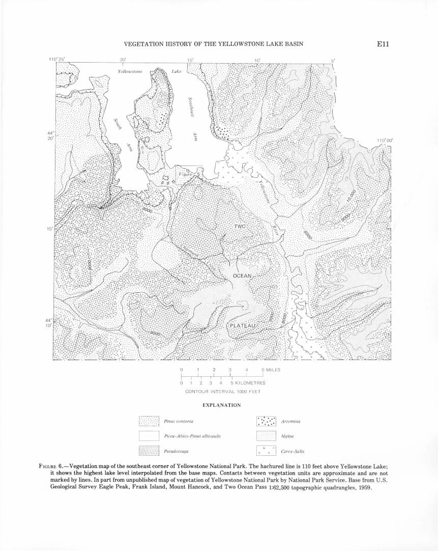
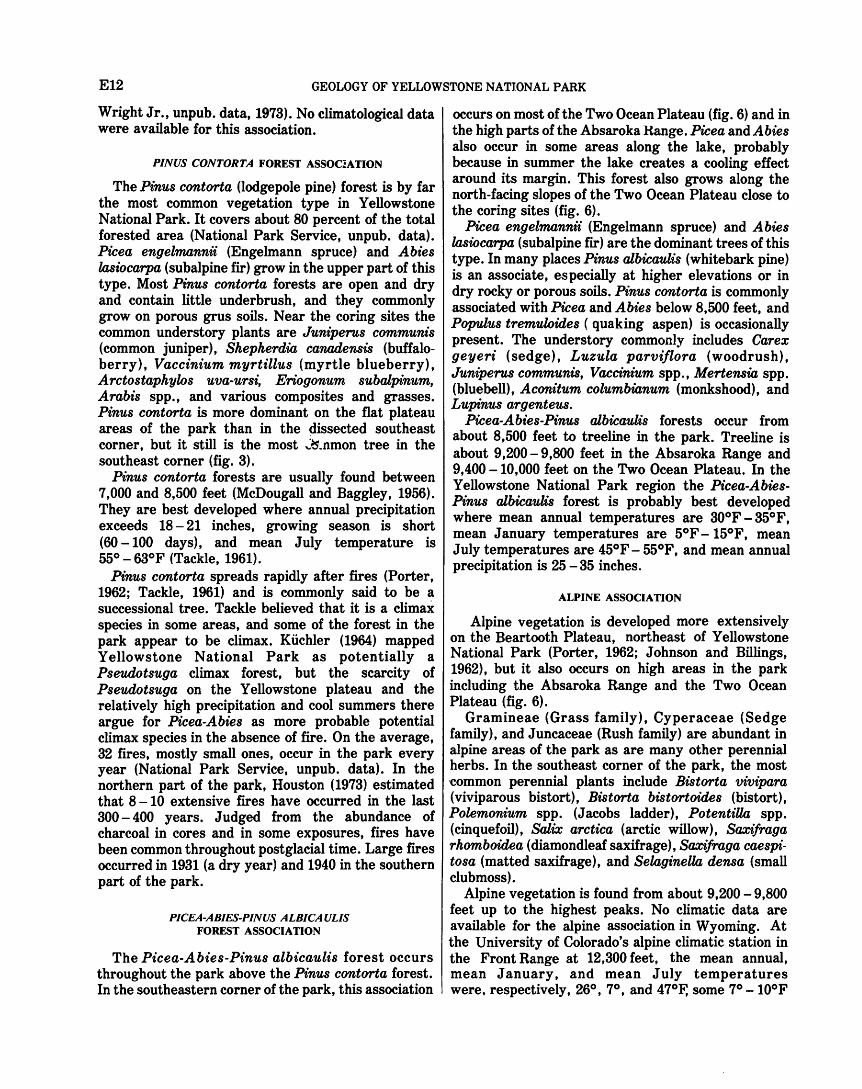
steppe, Pseudotsuga forest, Pinus contorta forest, Picea-Abies-Pinus albicaulis forest, and alpine tundra. A generalized vegetation map of the southeast corner of Yellowstone National Park (fig. 6) was made from field observations, topographic maps, and an unpublished vegetation map by the National Park Service. In addition, a reconnaissance map was made of local vegetation types around the coring sites (fig. 7).
The coring sites are located near the boundary between two vegetation types (fig. 7). Pinus contorta forests occupy lower, drier areas, and PiceaAbies-Pinus albicaulis forests extend up northfacing slopes to the Two Ocean Plateau (fig. 7). Past climatic fluctuations caused this boundary to
8200
8100
f-~ 8000 u.
6 7900
f-< > w _.J 7800 w
SOUTH
- Two Ocean P la tea u (e lev 9200 ft)
Kame ter race
\ \ \
Trail Creek pond
~
migrate across the coring sites, and these migrations are recorded in the pollen macrofossil sequences.
Modern pollen was analyzed from surface sediments in ponds situated in the major vegetation associations and the data were plotted (fig. 13). Pollen rain from most associations is sufficiently distinctive to allow its recognition in fossil pollen assemblages. Some fossil assemblages do not match any modern samples, however, and these may represent ancient vegetation associations not now present in the Yellowstone National Park area.
Elevational limits of modern vegetation associations are controlled by climate, but precise relationships are still poorly known. Where the distributional limits of certain plant taxa are found to coincide with a specific mean temperature, past distributional limits of those taxa may suggest paleotemperatures (Wolfe and Leopold, 1967). This approach must be used with caution because the coincidence may not be simply a cause-and-effect relationship. In this study only broad climatic changes can be inferred from most of the past vegetation changes.
Glacial deposits and topographic features of late Quaternary age in Yellowstone National Park have been mapped by G. M. Richmond, K. L. Pierce, and H. A. Waldrop (U.S. Geological Survey, 1972). Radiocarbon dates suggest that the Pinedale Glaciation began after 27,000 ±800 years ag·o in nearby Jackson Hole, Wyo. (Levin and others, 1965). Pinedale glaciers had retreated extensively by about 13,000 years ago in Yellowstone National Park
25-foo t lagoon
NORTH
SOUTHEAST A R M YELL OWSTONE
LA KE
7700
___ T ___ _ Present lake level Core - Core
Core (ele v 77 33 ft ) de pth 32.8 feet
7600~------------------------------------------~
r------------------About 1 m ile -------- ------------;-.j
FIGURE 4.-Schematic cross section showing relationship between Two Ocean Plateau, the filled lagoons, the lake levels, and the coring sites. See figure 7 for location of ponds.

VEGETATION HISTORY OF THE YELLOWSTONE LAKE BASIN E5
(Richmond, 1970b; Bender and others, 1971). Dates on glacial advances elsewhere in the western cordillera (Richmond, 1965, 1970b; Porter and Denton, 1967) correlate well with cool, moist periods inferred from my paleobotanical record and support geomorphic and soil-stratigraphic correlation of the Yellowstone glacial deposits with the standard Rocky Mountain glacial sequence (Richmond, 1965).
Our knowledge of late Quaternary regional climatic changes is still sketchy. This study provides new data in an area heretofore unstudied. More data of this sort will contribute answers to questions such as the following: How synchronous were regional climatic changes? Were climatic changes similar in nature from one region to another?
GLACIAL HISTORY
Yellowstone National Park was glaciated several times during early and mid-Quaternary time (Richmond, 1969c, 1970a). Glacial till underlies an ash-flow tuff about 600,000 years old near Tower Falls (U.S. Geological Survey, 1972) and midQuaternary sections containing glacial deposits are known from scattered sections elsewhere in the park.
The Bull Lake Glaciation is the oldest glaciation that has extensive till and constructional topographic features remaining. The Bull Lake icecap was somewhat larger than the succeeding Pinedale icecap, and large areas underlain by Bull Lake Till are fo~nd in the western part of the park (U.S. Geological Survey, 1972). Bull Lake Till underlies wood-bearing lake sediments dated at greater than 42,000 years B.P. (before present) and greater than 45,000 years B.P. in the Yellowstone Lake basin (Richmond, 1969c, 1970a).
Pinedale Glaciation is estimated to have begun about 25,000 years ago and stagnated about 14,500-13,000 years ago in the Yellowstone National Park region (Richmond, 1970a, b; Waddington and Wright, 1974). The Pinedale icecap centered along a north-south axis through Yellowstone Lake (Richmond and Pierce, 1968, 1972; Richmond, 1969c). Ice flowed radially from the lake area to the north, to the east through divides in the Absaroka Range, and to the south and southwest across the rugged plateaus and ridges. As the Pinedale icecap melted, local ice-marginal lakes and kame terraces formed in the northeastern part of the Yellowstone Lake basin and gradually extended southward (Richmond, 1969a; U.S. Geological Survey, 1972). Channels carried the melt water away from the basin at several points around the lake (Richmond, 1969a). In the coring area
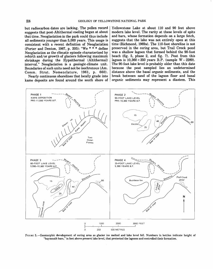
a kame terrace formed along the lower slopes at the northwest margin of the Two Ocean Plateau (fig. 5, phase 1). Later, large ice blocks calved off, became buried by outwash and lake sediments, and formed kettles approximately parallel to the ice margin (locations shown in fig. 5, phase 2).
After the Pinedale icecap had melted, cirque and valley glaciers readvanced in the Absaroka Range and on the Two Ocean Plateau (Richmond and Pierce, 1972). Some valley glaciers were 5 miles long, and their terminal moraines (fig. 1) reached elevations as low as 7,880 feet, but averaged 8,400 feet (Richmond, 1969b). Outwash terraces extended from these moraines down the valleys to a level about 60 feet above Yellowstone Lake. Lake sediments beneath a delta that graded to the 60-foot level at Grouse Creek on the South Arm of Yellowstone Lake were dated at 9,060 ± 300 years B.P. (Sullivan and others, 1970, sample W- 2041; Richmond, 1970a). The coring sites were not glaciated and apparently received no glacierderived sediments at this time.
An interval of maximum warmth and dryness (the Altithermal interval) is recognized in the Rocky Mountain area following the retreat of late Pinedale ice (Richmond, 1965, p. 227). Antevs (1955) placed the Altithermal interval between 7,500 and 4,000 years B.P.; however, these boundaries have not been consistently used, and they may transgress time. Valley and cirque glaciers apparently retreated during this warm period.
Neoglaciation is the period of glacier expansion following the Altithermal period and extending to the present time. In the Rocky Mountain region it has been divided into the Temple Lake Stade, thought to have formed moraines about 2,800 years B.P. (Richmond, 1969b), and the Gannett Peak Stade, which began about 700 years ago and continues to the present (Porter and Denton, 1967, p. 201). Recently, however, Birkeland and Miller (1973), Miller and Birkeland (1974), and Currey (1974) showed that the type section of the Temple Lake in the Wind River Range is pre-Altithermal and may be late Pinedale in age. A new type section and name should be chosen for this 2,800-year-old glacial advance. Hence, the report will use the term "early neoglacial," rather than "Temple Lakes." In the Absaroka Range the average elevation is 9,460 feet for early neoglacial end moraines and 9,845 feet for Gannett Peak end moraines (Richmond, 1969b).
Recent evidence suggests that some areas experienced glacial expansion as early as 5,000 years ago (Porter and Denton, 1967, p. 198). No moraines of this age are recognized in Yellowstone National Park,
E6 GEOLOGY OF YELLOWSTONE NATIONAL PARK
but radiocarbon dates are lacking. The pollen record suggests that post-Altithermal cooling began at about that time. Neoglaciation in the park could thus include all sediments younger than 5,000 years. This usage is consistent with a recent definition of N eoglaciation (Porter and Denton, 1967, p. 205): "We • • • define Neoglaciation as the climatic episode characterized by rebirth and/ or growth of glaciers following maximum shrinkage during the Hypsithermal (Altithermal) interval." Neoglaciation is a geologic-climate unit. Boundaries of such units need not be isochronous (Am. Comm. Strat. Nomenclature, 1961, p. 660).
Nearly continuous shorelines that locally grade into kame deposits are found around the south shore of
/
PHASE 1 ------,~o<Y. /
(
KAME DEPOSITION _..J,.:;:_'7 I \ I
PRE-11,550 YEARS B.P. 1 '\ '-~-?0 I \ '\tQ \ I ~,; \.; 'f .....
I /
----
PHASE 3 -------~o<Y. / '1&,.1}
60-FOOT LAKE LEVEL /(.',.r: I 5,590-10,360 YEARS B.P. ( \ <>o,., \
\ I v-". ) \ I '~ / \_1 '- ....... ______ /
0
0
./ /
1000
250
Yellowstone Lake at about 110 and 90 feet above modern lake level. The rarity at these levels of spits and bars, whose formation depends on a large fetch, suggests that the lake was not entirely open at this time (Richmond, 1969a). The 110-foot shoreline is not preserved in the coring area, but Trail Creek pond was a shallow lagoon that formed behind the 90-foot beach (fig. 5, phase 2, and fig. 7). Peat from this lagoon is 10,360 ± 350 years B.P. (sample W- 2289). The 90-foot lake level is probably older than this date because the peat sampled lies an undetermined distance above the basal organic sediments, and the break between sand of the lagoon floor and basal organic sediments may represent a diastem. This
'- ///
PHASE 2 ,..._ ______ ~o<Y. I
90-FOOT LAKE LEVEL 1 _)~(~.r: ~ PRE-10,360 YEARS B.P. \ \ ~~(Q/.· \
\ I ,,_,(Q I \ .. ../ "- ............. ___ //
... ------ ...
....... // PHASE 4 ....... ..._ _____ Itt. I
----'o<Y. I 25-FOOT LAKE LEVEL \~'7 \ 5,390 YEARS B.P. ( \1 '-~'%>,., \
\ ~, ) \ I '(Q // '-) ........ ____ ,....,
Trail Creek pond
' .. :: ..... ~
N
I 2000 3000 FEET
500 METRES
FIGURE 5.-Geomorphic development of coring area as glacier ice melted and lake level fell. Numbers in kettles indicate height of "baymouth bars," in feet above present lake level, that protected the lagoons and controlled their formation.

VEGETATION HISTORY OF THE YELLOWSTONE LAKE BASIN E7
90-foot lagoon probably formed during retreat of middle Pinedale ice; the organic sediment may have formed in part during the late Pinedale advance.
Lower shorelines at 60, 40, 25, 15, 10, and 5 feet above modern lake level have associated large spits, bars, and lagoons similar in size to modern ones. Richmond (1969a) concluded that these lower beaches formed in an open, ice-free Yellowstone Lake after the icecap had entirely melted because the lower shorelines are cut into kame deposits and do not grade into them.
The 60-foot shoreline correlates with a glacial advance (late Pinedale of Richmond, 1970b; Birkeland and others, 1971) that ended about 9,000 years B.P. in Yellowstone National Park. When the lake was at the 60-foot level, rims of kettles must have projected above water to form isolated bays in the coring area (fig. 5, phase 3).
Subsequent lowering of lake level converted Lilypad pond, Buckbean fen, and other kettles to lagoons and finally to isolated ponds (fig. 5, phase 4). Radiocarbon dates of 5,590 ± 250 years B. P. (sample W- 2286) from Lilypad pond and 5,390 ± 250 years B. P. (sample W- 2281) from Buckbean fen indicate that lake level had fallen below these lagoons before about 5,500 years ago. The late Pinedale and younger levels were apparently controlled by erosion of glacial drift along the Yellowstone River (Richmond, 1969a).
VEGETATION OF YELLOWSTONE NATIONAL PARK AND SURROUNDING AREA
Yellowstone National Park has distinct elevational zonation of vegetation similar to that of other parts of the Rocky Mountain region (Daubenmire, 1943). Five broad vegetation zones, herein called vegetation associations, are briefly discussed. Scientific names of plants, and common names if available, are listed in table 1.
TABLE 1. -Scientific names, and common names if avaiW.ble, of pW.nt taxa mentioned in text, tables, and iUustrations
[(p), pollen or spores of the taxon were found; (m), macrofossils of the taxon were found]
Scientific name and author Common name, if available
DIVISION CHOLOROPHYTA HYDRODICTYACEAE
lm) Pediastrum DIVISION CHAROPHYTA
CHARACEAE (m) Ohara
DIVISION BRYOPHYTA--------------------- Mosses
TABLE !.-Scientific names, and common names if avaiW.ble, of pW.nt taxa mentioned in text, tables, and iUustrations-Continued
Scientific name and author
DIVISION BRYOPHYTA-Continued
AULACOMNIACEAE (m) Aulacomnium palustre
(W. & M.) Schw. HYPNACEAE
C1i.macium dendroides (Hedw.) W. & M.
(m) Drepanocw.dus LESKEACEAE
Helodium bW.ndowii (W. & M.) Warnst.
SPHAGNACEAE
Common name, if available
(m) Sphagnum·-------------------- Sphagnum moss (m?) Sphagnum warnstorfianum
Dr. DIVISION PTERIDOPHYTES
EQUISETACEAE (p) Equisetum ------------------- Horsetail
ISOETACEAE Isoetes -·----------------------- Quillwort
SELAGINELLACEAE (p) SelagineUa densa Rydb. --- Rock selaginella
Selagi1teUa seW.ginoides (L.) Link
POLYPODIACEAE (p) ---------------------------------- Fern
DIVISION SPERMATOPHYTA CUPRESSACEAE
(p) Juniperus (p)?(m)Juniperus communis L. --- Common juniper
Juniperus virg,"niana L.
PINACEAE
var. scopulorum Lemmon-------------------- Redcedar, Rocky
Mountain juniper
(p) (m) Abies W.Siocarpa (Hook.) Nutt. ------------- Subalpine fir
(p) (m) Picea engelmannii (Parry) Engelm.---------- Engelmann spruce
Picea pungens Engelm. --- Colorado blue spruce (p) (m) Pinus albicaulis Engelm. -- Whitebark pine (p) (m) P'"nus contorta Dougl. ----- Lodgepole pine (p)? Pinus flexilis James -------- Limber pine (p)? Ps"nus ponderosa Laws.---- Ponderosa pine (p) (m) Pseudotsuga menziesii
(Mirb.) Franco------------ Douglas-fir (p) Tsuga heterophyUa
(Rafn.) Sarg. -------------- Western hemlock (p) Tsuga mertensiana
(Bong.) Carr.-------------- Mountain hemlock EPHEDRACEAE
(p) Ephedra torreyana S. Wats. (p) Ephedra viridis Coville---- Green jointfir
ACERACEAE (p) Acer ---------------------------- Maple
(p) AMARANTHACEAE BETULACEAE
(p) (m) Alnus tenuifo/i,a Nutt. ----- Thinleaf alder
EB GEOLOGY OF, YELLOWSTONE NATIONAL PARK
TABLE !.-Scientific names, and common names if available, of plant taxa mentioned in text, tables, and iUustrations-Continued
Scientific name and author Common name, if availllble
DIVISION SPERMATOPHYTA-Continued BETULACEAE-Continued
(p) Betula-------------------------- Birch (p) (m) Betula glandulosa
Michx. ---------------------- Bog birch (p)? Betula occidentalis
Hook. ----------------------- River birch BORAGINACEAE
Mertensia --------------------- Bluebell, chiming bells
CALLITRICHACEAE CaUitricke--------------------- Water-starwort
CAMPANULACEAE Campanula rotundifolia
L. ---------------------------- Common harebell CAPRIFOLIACEAE
(p) ---------------------------------- Honeysuckle family (p) CARYOPHYLLACEAE
CERATOPHYLLACEAE (m) CeratopkyUum demersum
L. ---------------------------- }Jornwort (p) CHENOPODIACEAE
(p)? Atriplex sp.------------------ Saltbush (p) Sarcobatus vermiculatus
(Hook.) Torr.-------------- Greasewood (p) CHENOPODIACEAE-
AMARANTHACEAE ----------------- Cheno-Ams COMPO SITAE
(p) Subfamily Tubuliflorae AckiUea lanulosa Nutt. ---- Yarrow
(p) Ambrosia --------------------- Ragweed Antennaria ------------------- Pussytoes
(p) Artemisia--------------------- Sagebrush (p) Artemisia tridentata
Nutt. ------------------------ Big sagebrush Aster Ckrysotkamnus ------------- Rabbitbrush
(p)? Franseria --------------------- Sand bur (p) Subfamily Liguliflorae
CRASSULACEAE Sedum lanceolatum Torr. Stonecrop
(m) Sedum rkodantkum Gray Rosecrown Sedum rosea (L.) Scop. ssp.
integrifolium (Raf.)
Hulten ---------------------- Kings Crown
(p) CRUCIFERAE Arabis ------------------------- Rockcress Arabis glabra (L.) Bernh. Tower mustard
(m) Descurainia califomica (A. Gray) Schulz --------- Tansymustard
(m) Rorippa islandica (Oeder) Borbas ---------------------- Marshcress
ELEAGNACEAE (p) Skepkerdia canadensis
(L.) Nutt. ------------------ Buffaloberry ERICACEAE
Arctostaphylos uva-ursi (L.) Spreng.--------------- Kinnikinnik,
bearberry
TABLE 1.-Scienti/ic names, and common names if available, of plant taxa mentioned in text, table, and iUustrations-Continued
Scientific name and author
DIVISION SPERMATOPHYTA-Continued ERICACEAE-Continued
Common name, if availllble
Kalmiapolifolia Wang.---- Swamp laurel Ledum glandulosum
Nutt. PkyUodoce empetriformis
(Smith) D. Don----------- Mountainheath Vaccinium myrtiUus L. ---- Myrtle blueberry
FAGACEAE (p) Quercus ----------------------- Oak
GENTIANACEAE Gentianopsis tkermalis
(0. Kuntze) litis (=Gentiana tkermalis
Kuntze)·------------------ Rocky Mountain fringed gentian
HALORAGACEAE (m) MyriopkyUum (m)? MyriopkyUum spicatum L.
ssp. exalbescens (Fern.) Hulb~n ---------------------- Watermilfoil
(m)? MyriopkyUum verticilUJ.tum L. ---------------------------- Greenmilfoil
HYDROPHYLLACEAE Pkacelia ----------------------- Scorpion-weed
JUGLANDACEAE (p) Juglans ------------------------ Walnut
(p) LEGUMINOSAE Lupt"nus argenteus
Pursh. ---------------------- Silvery lupine LENTIBULARIACEAE
Utricularia minor L.-------- Small bladderwort Utricularia vulgaris L.----- Common bladderwort
LORANTHACEAE (p) Arceutkobium (p)? Arceutkobium americanum
Nutt. ------------------------ Lodgepole pine dwarf mistletoe
Arceutkobium campylo-podum Engelm. ---------- Western dwarf
mistletoe Arceutkobium douglasii
Engelm. -------------------- Douglas-fir dwarf mistletoe
MENYANTHACEAE (p) (m) Menyantkes trifoliata L. -- Buckbean
NYMPHAEACEAE (p) (m) Nupkar luteum
OLEACEAE
Sibth. & Sm. ssp. polysepalum (Engelm.) Beal-------------------------- Yellow pond lily
(p) Fraxt"nus ---------------------- Ash (p) ONAGRACEAE
(m)? Epilobium adenocaulon Hausskn.
(m)? Epilobium glandulosum Lehm.
(m) Epilobium lactiflorum Hausskn. ------------------- Pale willow-herb
VEGETATION HISTORY OF THE YELLOWSTONE LAKE BASIN E9
TABLE 1-Scienti.fic names, and common names if available, of pln.nt taxa mentioned in text, tables, and iUustrations-Continued
Scientific name and author Common name, if available
DIVISION SPERMATOPHYTA-Continued PLATAGINACEAE
(p) Plantago----------------------- Plantain POLEMONIACEAE
Phlox multijloro A. Nels. -------------------- Common phlox
(p) Polemonium ------------------ Jacobs ladder POLYGONACEAE
(p) Bistorta (p) Bistorta bistortoides
(Pursb.) Small (=Polygonum bistortoides Pursh) ---------------------- Bistort
(p)? Bistorta vivipara (L.) S. Gray (=Polygonum vivipan~,m L.) ------------- Viviparous bistort
(p) Eriogonum-------------------- Umbrellaplant (p) Koenigia islandica L. (p) Oxyria ------------------------- Alpine sorrel (p)? Persicaria amphibia (L.)
S. Gray Water smartweed ( =Polygonum amphibium L.)
(p)? Persicaromaculata (Raf.) S. Gray Ladysthumb ( =Polygonum persicaria L.)
(p)? Polygonum ramosissimum Michx. ---------------------- Busby knotweed
(p) Rumex------------------------- Dock (p)?(m)Rumex fu,eginus Phil.------ Golden dock
(=Rumexmaritimus L. var.fu,eginus (Phil.) Dusen)
Rumex paucifolius Nutt. (p)?(m)Rumex salicifolius Weinm.
ssp. triangulivalvis Danser---------------------- Willow dock
RANUNCULACEAE Aconitum columbianum
Nutt. ------------------------ Monkshood Anemone multi/ida Pair.
var. globosa (Nutt.) T & G.----------------------- Globose anemone
(p) Ranunculus (m) Ranunculus aquatilis L. --- Water crowfoot (p) Tha/ictn~,m-------------------- Meadow rue
RHAMNACEAE (p)? Ceanothus velutinus
, . Dougl.----------------------- Sticky-laurel (p) ROSACEAE
(p )? Cercocarpus ------------------ Mountainmahogany Fragaria----------------------- Strawberry Geum macrophyUum
Willd. ----------------------- Large-leaf avens PentaphyUoides jloribunda
(Pursb) A. Love---------- Shrubby cinquefoil (=PotentiUafru,ticosa L.)
(m)? PotentiUa biennis Greene (m)? PotentiUa gracilis Dougl.
ex. Hook.------------------- Soft cinquefoil
TABLE 1.-Scienti.fic names, and common names if available, of pln.nt taxa mentioned in text, tables, and iUustrations-Contin-ued
Scientific name and author Common name, if available
DIVISION SPERMATOPHYTA-Continued (p) ROSACEAE-Continued
(m)? Potentilla norvegica L. ---- Norway cinquefoil (p)?(m)PotentiUa palustris (L.)
Scop. ------------------------ Marsh cinquefoil (m) SibbaUlia procumbens L.
RUBIACEAE Galium trifidum L.---------- Small bedstraw
SALICACEAE (p) Populus (p)?(m)Populus balsamifera L. ---- Balsam poplar
Populus tremuloides Michx. ---------------------- Quaking aspen
Populus trichocarpa Torr. and Gray ----------- Black cottonwood
(p) Salix---------------------------- Willow Salix arctica Pallas. Salix ligu,lifolia (Ball) Ball
(m)? Salix subcoerulea Piper --- Blue willow SAXIFRAGACEAE
(ui) Saxifraga caespitosa L.---- Matted saxifrage (m) Saxifraga rhomboidea
Greene---------------------- Diamondleaf saxifrage
(p)? SCROPHULARIACEAE (p)? Pedicularis
Pedicularis groenlandica Retz ------------------------- Elepbantella
(p)? Mimulus ----------------------- Monkey flower (p) UMBELLIFERAE
URTICACEAE (p) Urtica -------------------------- Nettle
(p) CYPERACEAE (m) Carex aquatilis Wablenb. (m) Carex canescens L. (m) Carex diandra Schrank
Carex geyeri Boott Carex hoodii Boott
(m) Carex li'mosa L. Carex phaeocephala Piper
(m) Carex utriculata Boott (=Carex rostrata Stokes)
(m) Carex vesicaria L. (m) Eleocharis macrostachya
Britt.------------------------ Spikerush Erioph0n1,m ------------------ Cottongrass Scirpus acutus Muhl.------- Hardstem bulrush
(p) GRAMINEAE Agropyron-------------------- Wheatgrass Bromus ------------------------ Bromegrass Bromus inermis Leyss. ---- Smooth brome Calamagrostis canadensis
(Micbx.) Beauv. ---------- Bluejointgrass Cala:magrostis inexpansa
A. Gray--------------------- Northern reedgrass Deschampsia caespitosa
(L.) Beauv. ---------------- Tufted bairgrass . Elymus ------------------------ Wild-rye Glyceria borealis (Nash)
Batchelder----------------- Northern mannagrass
E10 GEOLOGY OF YELLOWSTONE NATIONAL PARK
TABLE 1.-Scientijic names, and common names if avaiWhle, of pW.nt taxa mentioned in text, tables, and iUustrotions-Continued
DIVISION SPERMATOPHYTA-Continued (p) GRAMINEAE-Continued
(m) Glyceria maxima (Hartm.) Holmb. ssp. grandis (Wats.) Hulten ( =Glyceria grondis
Common name, if available
S. W ats.) ------------------- Large manna grass Poa ----------------------------- Bluegrass Sitanion longifolium J. G.
Smith ----------------------- Squirrel-tail (=Sitanion hystrix (Nutt.) J. G. Smith)
Stipa --------------------------- Needlegrass JUNCACEAE
L'UZ'Ula parvijlora (Ehrh.) Desv. ------------------------ W oodrush
LuzuUJ. spicata (L.) DC.---- Spike woodrush NAIADACEAE
(m) Naias flexilis (Willd.) Rostk. and Schmidt----- Naiad
(m) Potamogeton alpinus Balbis ----------------------- Northern pondweed
(m) Potamogeton filiformis Pers.
(m) Potamogeton gram,"neus L. (m)? Potamogeton iUinoensis
Morong Potamogeton pecUnatus
L. ---------------------------- Sago pond weed Potamogeton vaginatus
Turcz. SP ARGANIACEAE
(p)? Sparganium Sparganium angusti-
folium Michx. ------------- Burreed Sparganium mim"mum
Fries ------------------------ Arctic burreed TYPHACEAE
(p)? Typha angustifolia L. ------ Narrowleafed cattail (p) Typha W.tifolia L.------------ Broadleaf cattail
REGIONAL VEGETATION ARTEMISIA STEPPE ASSOCIATION
The lowest vegetation type in the park is Artemisia (sagebrush) steppe at the base of the north edge of the Yellowstone plateau (fig. 6). Artemisia tridentata is the dominant plant in this association, but Sarcobatus vermiculatus (greasewood) and Atriplex spp. (saltbush) are common on clayey or alkaline sites, and in many places Ckrysotkamnus spp. are scattered among the sagebrush. Grasses including Elymus spp. (wild-rye) and Bromus spp. (bromegrass) are locally common. This type occurs between Mammoth and Gardiner in the northern part of the park and is common around the margins of the park below about
6,000 feet. Large areas of Artemisia steppe on the Snake River Plain southwest of the park may be an important source of Artemisia pollen.
The lower limit of trees above the Artemisia steppe is highly variable because of local factors. Near Mammoth, it ranges from about 5,800 to 6,800 feet. East of the park in the rain shadow of the Absaroka Range it is 6,500-7,600 feet (H. E. Wright Jr., unpub. data, 1967). At Mammoth it is associated with a mean annual temperature of about 40°F, mean January temperature of 18°F, mean July temperature of 63°F, and mean annual precipitation of 15.5 inches.
Artemisia tridentata (big sagebrush) also dominates in forest openings up to several acres in size on the Yellowstone plateau, where it is more stunted than at lower elevations. In the southeast corner of the park, these Artemisia openings occur on dry south-facing slopes adjacent to the Southeast Arm of Yellowstone Lake (fig. 3). They occur locally on south-facing slopes of Buckbean fen and adjacent lagoons (fig. 7).
Plants associated with Artemisia in the southeast part of the park include Eriogonum subalpinum (umbrellaplant), Lupinus argenteus (silvery lupine), Achillea lanutosa (yarrow), Antennaria sp. (pussytoes), Pkacelia sp. (scorpion-weed), Arabis glabra (rockcress), Phlox multiflora (common phlox), Carex koodii (sedge), Carex petasata (sedge), Agropyron spp. (wheatgrass), Stipa spp. (needlegrass), Bromus inermis (bromegrass), Campanula rotundifolia (common harebell), Sitanion kystrix (squirrel-tail), ~.
and Arctostaphylos uva-ursi (kinnikinnick). Artemisia tridentata in this community may have been an important supplier of Artemisia pollen in the fossil record.
PSEUDOTSUGA ASSOCIATION
Pseudotsuga menziesii (Douglas-fir) is dominant in the next lowest vegetation association but is sporadic in occurrence in the Yellowstone region. Locally Pinus flexilis (limber pine) and Populus tremuloides (quaking aspen) are common in this association. Pinus ponderosa (ponderosa pine), which normally occurs in this elevational zone, is not present in northwestern Wyoming (Choate, 1963). Juniperus virginiana var. scopulorum (Rocky Mountain juniper) occurs at lower elevations along the forest-steppe boundary. Pseudotsuga menziesii is not common on the Yellowstone plateau, but it grows sparsely about 6 miles north of the coring sites and on the east slope of the Absaroka Range about 12 miles to the east.
The Pseudotsuga association grows as low as 6,000 feet in an open savanna, along stream valleys, and in closed forests as high as about 8,000 feet (H. E.
VEGETATION HISTORY OF THE YELLOWSTONE LAKE BASIN
0 2 3 4 5 Ml LES
0 2 3 4 5 KILOMETRES
CONTOUR INTERVA L 1000 FEET
EXPLANATION
CB Pinus contorca
D Picea-A bies-Pinus albicau/is
~~t~~j Pseudotsuga
Artemisia
D Alpine
D Carex-Sa lix
Ell
FIGURE 6.-Vegetation map of the southeast corner of Yellowstone National Park. The hachured line is 110 feet above Yellowstone Lake; it shows the highest lake level interpolated from the base maps. Contacts between vegetation units are approximate and are not marked by lines. In part from unpublished map of vegetation of Yellowstone National Park by National Park Service. Base from U.S. Geological Survey Eagle Peak, Frank Island, Mount Hancock, and Two Ocean Pass 1:62,500 topographic quadrangles, 1959.
E12 GEOLOGY OF YELLOWSTONE NATIONAL PARK
Wright J~., unpub. data, 1973). No climatological data were available for this association.
PINUS CONTORTA FOREST ASSOC!ATION
The Pinus contorta (lodgepole pine) forest is by far the most common vegetation type in Yellowstone National Park. It covers about 80 percent of the total forested area (National Park Service, unpub. data). Picea engelmannii (Engelmann spruce) and Abies lJLsiocarpa (subalpine fir) grow in the upper part of this type. Most Pinus contorta forests are open and dry and contain little underbrush, and they commonly grow on porous grus soils. Near the coring sites the common understory plants are Juniperus communis (common juniper), Shepherdia canadensis (buffaloberry), Vaccinium myrtillus (myrtle blueberry), Arctostaphylos uva-ursi, Eriogonum subalpinum, Arabis spp., and various composites and grasses. Pinus contorta is more dominant on the flat plateau areas of the park than in the dissected southeast corner, but it still is the most ~~-nmon tree in the southeast corner (fig. 3).
Pinus contorta forests are usually found between 7,000 and 8,500 feet (McDougall and Baggley, 1956). They are best developed where annual precipitation exceeds 18- 21 inches, growing season is short (60 -100 days), and mean July temperature is 55° - 63°F (Tackle, 1961).
Pinus contorta spreads rapidly after fires (Porter, 1962; Tackle, 1961) and is commonly said to be a successional tree. Tackle believed that it is a climax species in some areas, and some of the forest in the park appear to be climax. Kuehler (1964) mapped Yellowstone National Park as potentially a Pseudotsuga climax forest, but the scarcity of Pseudotsuga on the Yellowstone plateau and the relatively high precipitation and cool summers there argue for Picea-Abies as more probable potential climax species in the absence of fire. On the average, 32 fires, mostly small ones, occur in the park every year (National Park Service, unpub. data). In the northern part of the park, Houston (1973) estimated that 8 - 10 extensive fires have occurred in the last 300- 400 years. Judged from the abundance of charcoal in cores and in some exposures, fires have been common throughout postglacial time. Large fires occurred in 1931 (a dry year) and 1940 in the southern part of the park.
PICEA-ABIES-PINUS ALBICA ULIS FOREST ASSOCIATION
The Picea-Abies-Pinus albicaulis forest occurs throughout the park above the Pinus contorta forest. In the southeastern corner of the park, this association
occurs on most of the Two Ocean Plateau (fig. 6) and in the high parts of the Absaroka Hange. Picea and Abies also occur in some areas along the lake, probably because in summer the lake creates a cooling effect around its margin. This forest also grows along the north-facing slopes of the Two Ocean Plateau close to the coring sites (fig. 6).
Picea engelmannii (Engelmann spruce) and Abies lJLsiocarpa (subalpine fir) are the dominant trees of this type. In many places Pinus albicaulis (white bark pine) is an associate, especially at higher elevations or in dry rocky or porous soils. Pinus contorta is commonly associated with Picea and Abies below 8,500 feet, and Populus tremuloides ( quaking aspen) is occasionally present. The understory commonly includes Carex geyeri (sedge), Luzula parviflora (woodrush), Juniperus communis, Vaccinium spp., Mertensia spp. (bluebell), Aconitum columbianum (monkshood) and Lupinus argenteus. '
Picea-Abies-Pinus albicaulis forests occur from about 8,500 feet to treeline in the park. Treeline is about 9,200-9,800 feet in the Absaroka Range and 9,400 -10,000 feet on the Two Ocean Plateau. In the Yellowstone National Park region the Picea-AbiesPinus albicaulis forest is probably best developed where mean annual temperatures are 30°F- 35°F, mean January temperatures are 5°F- 15°F, mean July temperatures are 45°F- 55°F, and mean annual precipitation is 25 - 35 inches.
ALPINE ASSOCIATION
Alpine vegetation is developed more extensively on the Beartooth Plateau, northeast of Yellowstone National Park (Porter, 1962; Johnson and Billings, 1962), but it also occurs on high areas in the park including the Absaroka Range and the Two Ocean Plateau (fig. 6).
Gramineae (Grass family), Cyperaeeae (Sedge family), and J uneaeeae (Rush family) are abundant in alpine areas of the park as are many other perennial herbs. In the southeast corner of the park, the most ·common perennial plants include Bistorta vivipara (viviparous bistort), Bistorta bistortoides (bistort), Polemonium spp. (Jacobs ladder), PotentiUa spp. (cinquefoil), Salix arctica (arctic willow), Saxifraga rhomboidea ( diamondleaf saxifrage), Saxifraga caespitosa (matted saxifrage), and SelagineUa densa (small elubmoss).
Alpine vegetation is found from about 9,200 - 9,800 feet up to the highest peaks. No climatic data are available for the alpine association in Wyoming. At the University of Colorado's alpine climatic station in the Front Range at 12,300 feet, the mean annual, mean January, and mean July temperatures were. respectively, 26°, 7°, and 47°F, some 7° -10°F
VEGETATION HISTORY OF THE YELLOWSTONE LAKE BASIN E13
cooler than at the subalpine station at 10,000 feet for the years 1953 - 64 (Marr and others, 1968). Precipitation averaged about 26 inches annually at the subalpine and the alpine stations in Colorado for the years 1953-64.
LOCAL VEGETATION AROUND THE CORING SITES
A reconnaissance map of the local vegetation was made in early September, 1966 and 1967. Four mesic to xeric communities and five semiaquatic communi-
. . .. .. .
. . _ ... .. ......... :
o ,o
. . . . . . .
44° 17' 30" ·.::
·. ·: : :·
.. '•o
·. -~ ~ : . : : : . .·. ·. ··
.· ......
·.·.·.·.· . ..
·:: .. ::: . :: · ...... . . : .
.·:.:.·: · · .. ·.· . · ·.· .·.· -:.:::·
. . . . : .. . : ·. :' : ~ :":. ·. : .. ... . ·.··:·:.·:·: · ·
·.· .... · .·.;:· . .... .
· ... ·.· ·.
0
0
1000
250
ties (herein called vegetation types) are recognized (fig. 7). Of the mesic to xeric communities, Pinus contorta forest surrounds the coring area, and PiceaAbies-Pinus albicaulis forest grows down to the base of the steep slope along the north edge of the Two Ocean Plateau (fig. 7). Grass-forb meadows grow on gentle slopes underlain by silty lake sediments, and Artemisia openings occur on south-facing steeper slopes underlain by gravel (fig. 7). The two forest types and the Artemisia openings are predominant in the regional vegetation and were discussed in the
2000
500 METRES
Sowh eas1 Arm Yellows/on e Lake
3000 FEET
·-::: • 0 •
. . . . . . . . . :: ... _: ·.:: ~ · .. : ': ': .. ·. : . ·.·.· ... . . .... · ·:-· . . : · ... ~. :. >~ ........ ..... .
· · . ·: ·: :· . . . . .·. ·. ·.·.·.·.·.: . . .
··.· .·.··.'::'. ·.··. :·.' ·
. ·.·.::-· · .. •, . .... · ... . • o.
0 0 •
. ·.· .. ·. ::·:·."·
EXPLAN ATION
AQ ATIC A D DAMP-G ROU D VEGETATION (SEMIAQUAT JC)
UP AND VEGETATION (MES IC TO XER IC)
Nuphar 0 Potamogero11 (shal lo w-po nd aquatic) type .. :: ...... _. ~ .. ·. Pinus contorta forest
Me11yantlies tnjoliata type Picea-A bies-Pinus albicau/i. forest
Carex wriculaia fen Artemisia tride111a1a openi ngs
Carex diandra-Polelltilla palustris fen Gramineae-forb mead ows
Ca/amagrostis-Sa/ix-Sedum rliodan!hum type
FiGU RE 7. - Map of local vege tation around coring sites, showing surface sample and core localities at Buckbean fen and Lilypad pond.
E14 GEOLOGY OF YELLOWSTONE NATIONAL PARK
preceding section. Grass-forb meadows are locally common where lake silts are present. The five semiaquatic types are discussed in the following paragraphs.
NUPHAR-POTAMOGETON TYPE
This type is the only true aquatic community. It is found in ponds on Buckbean fen and Lilypad pond (figs. 7, 8, and 9). The aquatic flora contains Nuphar luteum ssp. polysepalum (yellow pond lily), Utricularia vulgaris (common bladderwort), U. minor (small bladderwort), Potamogeton alpinus (northern pondweed), and Potamogeton sp. (pondweed). Only two or three of these species usually occur in any one pond.
MENY ANTHES TRIFOLIA TA TYPE
The Menyanthes trifoliata type occurs locally only in Buckbean fen (fig. 7) and perhaps should be included in the Nuphar-Potamogeton type. It contains mainly Menyanthes trifoliata (buckbean) with occasional Carex utriculata (sedge). The dominant moss is Drepanocladus sp. These species grow on organic mud which was covered with a few inches of water in the fall in 1966 and 1967. The mudflats may be filled-in remnants of small ponds.
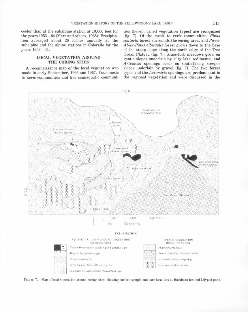
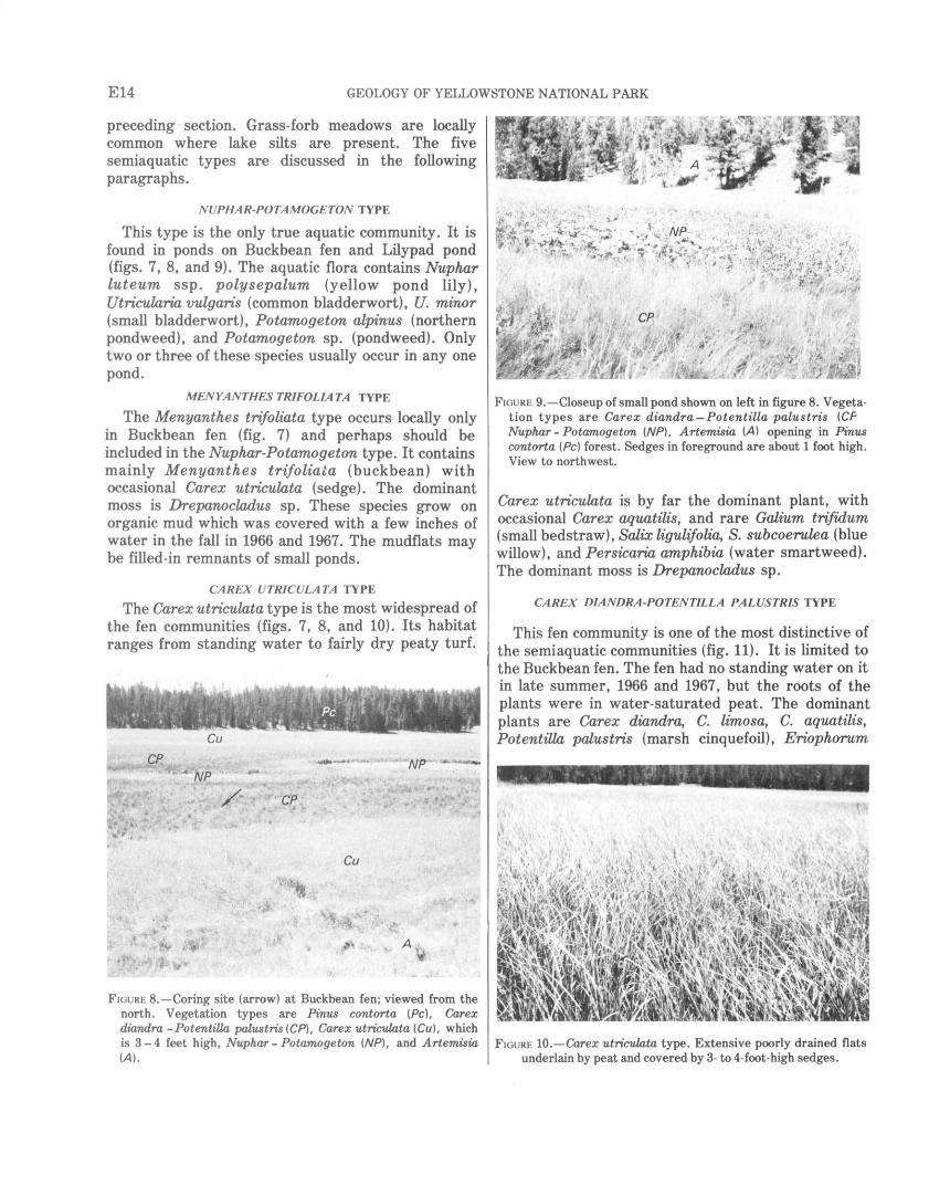
CAR EX UTRICULA T A TYPE
The Carex utriculata type is the most widespread of the fen communities (figs. 7, 8, and 10). Its habitat ranges from standing water to fairly dry peaty turf.
Cu
FIGURE 8.-Coring site (arrow) at Buckbean fen; viewed from the north. Vegetation types are Pinus contorta (Pc), Carex diandra -PotentiUa palustris (CP), Carex utriculata (Cu), which is 3-4 feet high, Nuphar- Potamogeton (NP), and Artemisia (A).
FIGURE 9.-Closeup of small pond shown on left in figure 8. Vegetation types are Carex diandra -Potentilla palustris (CF Nuphar- Potamogeton (NP), Artemisia (A) opening in Pinus contorta (Pc) forest. Sedges in foreground are about 1 foot high. View to northwest.
Carex utriculata is by far the dominant plant, with occasional Carex aquatilis, and rare Galium trifidum (small bedstraw), Salix ligulifolia, S. subcoerulea (blue willow), and Persicaria amphibia (water smartweed). The dominant moss is Drepanocladus sp.
CAREX DIANDRA-POTENTILLA PALUSTRIS TYPE
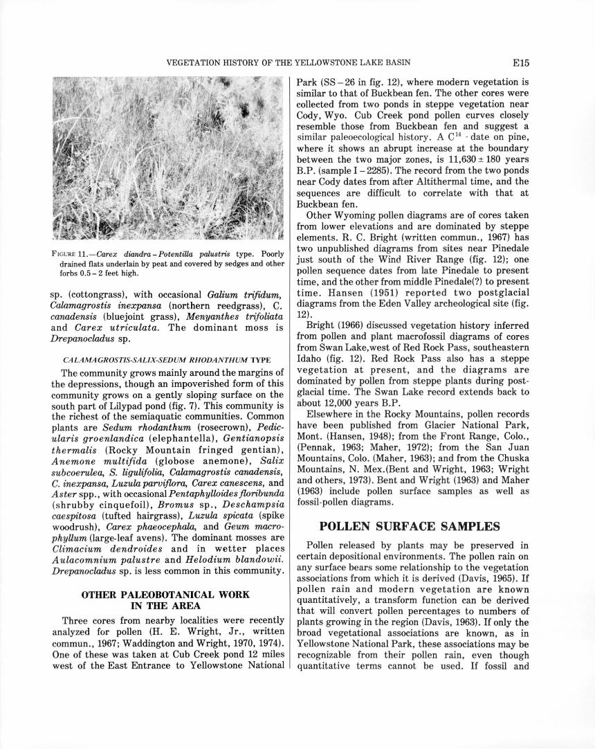
This fen community is one of the most distinctive of the semiaquatic communities (fig. 11). It is limited to the Buckbean fen. The fen had no standing water on it in late summer, 1966 and 1967, but the roots of the plants were in water-saturated peat. The dominant plants are Carex diandra, C. limosa, C. aquatilis, Potentilla palustris (marsh cinquefoil), Eriophorum
FIGURE 10.-Carex utriculata type. Extensive poorly drained flats underlain by peat and covered by 3- to 4-foot-high sedges.
VEGETATION HISTORY OF THE YELLOWSTONE LAKE BASIN E15
FIGURE 11.- Carex diandra-PotentiUa palustris type. Poorly drained flats underlain by peat and covered by sedges and other forbs 0.5-2 feet high.
sp. (cottongrass), with occasional Galium trifidum, Calamagrostis inexpansa (northern reedgrass), C. canadensis (bluejoint grass), Menyanthes trifoliata and Carex utriculata. The dominant moss is Drepanocladus sp.
CALAMA GROSTIS-SALIX-SEDUM RHODANTHUM TYPE
The community grows mainly around the margins of the depressions, though an impoverished form of this community grows on a gently sloping surface on the south part of Lilypad pond (fig. 7). This community is the richest of the semiaquatic communities. Common plants are Sedum rhodanthum (rosecrown), Pedicularis groenlandica (elephantella), Gentianopsis thermalis (Rocky Mountain fringed gentian), Anemone multifida (globose anemone), Salix subcoerulea, S. ligulifolia, Calamagrostis canadensis, C. inexpansa, Luzula parviflora, Carex canescens, and Aster spp., with occasional Pentaphylloides floribunda (shrubby cinquefoil), Bromus sp., Deschampsia caespitosa (tufted hairgrass), Luzula spicata (spike woodrush), Carex phaeocephala, and Geum macrophyUum (large-leaf avens). The dominant mosses are Climacium dendroides and in wetter places A ulacomnium palustre and H elodium blandowii. Drepanocladus sp. is less common in this community.
OTHER PALEOBOTANICAL WORK IN THE AREA
Three cores from nearby localities were recently analyzed for pollen (H. E. Wright, Jr., written commun., 1967; Waddington and Wright, 1970, 1974). One of these was taken at Cub Creek pond 12 miles west of the East Entrance to Yellowstone National
Park (SS- 26 in fig. 12), where modern vegetation is similar to that of Buckbean fen. The other cores were collected from two ponds in steppe vegetation near Cody, Wyo. Cub Creek pond pollen curves closely resemble those from Buckbean fen and suggest a similar paleoecological history. A C 14
- date on pine, where it shows an abrupt increase at the boundary between the two major zones, is 11,630 ± 180 years B.P. (sample I- 2285). The record from the two ponds near Cody dates from after Altithermal time, and the sequences are difficult to correlate with that at Buckbean fen.
Other Wyoming pollen diagrams are of cores taken from lower elevations and are dominated by steppe elements. R. C. Bright (written commun., 1967) has two unpublished diagrams from sites near Pinedale just south of the Wind River Range (fig. 12); one pollen sequence dates from late Pinedale to present time, and the other from middle Pinedale(?) to present time. Hansen (1951) reported two postglacial diagrams from the Eden Valley archeological site (fig. 12).
Bright (1966) discussed vegetation history inferred from pollen and plant macrofossil diagrams of cores from Swan Lake, west of Red Rock Pass, southeastern Idaho (fig. 12). Red Rock Pass also has a steppe vegetation at present, and the diagrams are dominated by pollen from steppe plants during postglacial time. The Swan Lake record extends back to about 12,000 years B.P.
Elsewhere in the Rocky Mountains, pollen records have been published from Glacier National Park, Mont. (Hansen, 1948); from the Front Range, Colo., (Pennak, 1963; Maher, 1972); from the San Juan Mountains, Colo. (Maher, 1963); and from the Chuska Mountains, N. Mex.(Bent and Wright, 1963; Wright and others, 1973). Bent and Wright (1963) and Maher (1963) include pollen surface samples as well as fossil-pollen diagrams.
POLLEN SURF ACE SAMPLES
Pollen released by plants may be preserved in certain depositional environments. The pollen rain on any surface bears some relationship to the vegetation associations from which it is derived (Davis, 1965). If pollen rain and modern vegetation are known quantitatively, a transform function can be derived that will convert pollen percentages to numbers of plants growing in the region (Davis, 1963). If only the broad vegetational associations are known, as in Yellowstone National Park, these associations may be recognizable from their pollen rain, even though quantitative terms cannot be used. If fossil and
E16 GEOLOGY OF YELLOWSTONE NATIONAL PARK
modern pollen assemblages are similar, it is assumed that they were derived from similar vegetation associations. Yellowstone National Park is well suited for comparison of surface pollen assemblages with fossil pollen assemblages because of its undisturbed vegetation and simplicity of forest composition.
The relationship between the modern pollen rain and modern vegetation was examined for analogs for
I •ss-5
\ (
\_
.ss-7 44oL-I ----'----"------------------_J_----'
0 10 20 MILES
0 10 20 30 Kl LOMETRES
fl•Beartooth Plateau MONTANA
!--/""-- ----------Cody Absaroka Range
'3¥-0 ·(\,a-s(\ ~\'<>' Jackson Hole
IDAHO I I o• Pinedale WYOM lNG
I .s I
~~:l I
0 100MILES
I I I 0 100 KILOMETRES
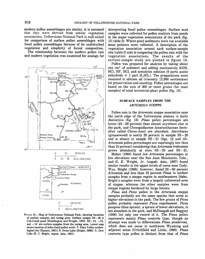
FIGURE 12.-Map of Yellowstone National Park, showing localities of surface samples and coring area. Surface sample SS - 26 is Cub Creek pond (Waddington and Wright, 1970). SS -12, -13, and -14 are surface samples from the coring area. Lower map shows location of other fossil pollen work: E, Eden Valley archeological site (Hansen, 1951); S, Swan Lake (Bright, 1966); D, Dew Lake (R. C. Bright, unpub. data, 1967).
interpreting fossil pollen assemblages. Surface mud samples were collected for pollen analysis from ponds in the major vegetation associations of the park (fig. 12; table 2). Where pond sediments were not available moss polsters were collected. A description of the vegetation association around each surface-sample site (table 2) aids in comparing the pollen rain with the vegetation associations. The results of the surface-sample study are plotted in figure 13.
Pollen was prepared for analysis by taking about one cm3 of sediment and adding successively KOH, HCl, HF, HCl, and acetolysis solution (9 parts acetic anhydride + 1 part H 2SO4 ) • The preparations were mounted in silicone oil (viscosity 12,000 centistokes) for preservation and counting. Pollen percentages are based on the sum of 300 or more grains (for most samples) of total terrestrial-plant pollen (fig. 13).
SURFACE SAMPLES FROM THE ARTEMISIA STEPPE
Pollen rain in the Artemisia steppe association near the north edge of the Yellowstone plateau is fairly distinctive (fig. 13). Pinus pollen percentages are lower (45- 60 percent) than almost anywhere else in the park, and Chenopodiaceae-Amaranthaceae (hereafter called Cheno-Ams) are abundant. Sarcobatus (greasewood) is nearly 20 percent in sample SS - 20 and is absent in sample SS -21 (figs. 12 and 13). Artemisia pollen percentages are suprisingly low (less than 10 percent) considering that Artemisia tridentata grows abundantly at sites SS- 20 and SS - 21.
Maher (1963) found low Artemisia percentages at low elevations near the San Juan Mountains, Colo., and H. E. Wright, Jr. (unpub. data, 1967) found similar results in the upper levels of cores near Cody, Wyo. Bright (1966). however, found 20-60 percent Artemisia and less than 10 percent Pinus in surface samples from a steppe region in southeastern Idaho. Bright's samples were from a largely unforested area of steppe, whereas the other samples were from steppe regions bordered by large forests.
Pinus and Pice a pollen in the Artemisia steppe samples probably are the same species that occur at higher elevations in the park. The few grains of Picea pollen probably represent Picea engelmannii. Picea pungens (blue spruce), a spruce of lower elevations, is not abundant in the park, and McDougall and Baggley (1956) list only one record of it. The Pinus pollen represents mainly Pinus contorta type, though no attempt was made to differentiate Pinus ponderosa, which does not occur in northwest Wyoming and adjacent areas (Critchfield and Little, 1966). Pinus contorta type pollen is distinct from that of Pinus
VEGETATION HISTORY OF THE YELLOWSTONE LAKE BASIN E17
TABLE 2.-Locality and description of surface samples and coUection stations, Yellowstone National Park and vicinity
No. in fig. 12 (SS-)
1 ..
2 ...
5 .. .
7 ... .
8 ..
9 .\.
12 .. 13.
14.
16.
18.
19 ........ . 20 .... .
21 .
22.
23
24
25.
26 ...
27 ....
28 ..
29.
30 ..
33.
34
35
36 .............. .
38.
39 ...
Elevation (ft above sea level)
7,840
9,140
8,660
8,100
7,860
9,880
7,750 7,750
7,750
7,940
10,000
9,760 5,360
5,960
6,800
7,240
7,560
7,750
8,200
8,414
8,466
9,000
9,080
7,790
7,780
7,380
6,880
9,684
9,640
Locality
North of Lake Lodge, north edge of Yellowstone Lake.
Huckleberry Ridge 4.2 miles east of South Entrance.
2.3 miles south of Fox Creek patrol cabin south of park boundary, at west edge of large burn area.
Two Ocean Pass, south of the park.
Near outlet at west end of Bridger Lake, in Yellowstone River valley 0.5 mile south of park boundary.
Lake on Two Ocean Plateau between Phlox and Lynx Creeks and 3 miles north of south boundary of park.
South edge of Buckbean fen (fig. 5). .... do ........................................ .
Near north side of Buckbean fen (fig. 5).
1.1 miles east of Beryl Sprin~ in Gibbon Canyon, southeast of Gibbon Geyser Basm.
North side of Mount Washburn, along moist stream bank just above treeline.
Northwest side of Mount Washburn; near generator. About 1 mile south of North Entrance of park.
About 1 mile southeast of Mammoth near Gardner River.
Hoodoos landslide area about 1 mile south of Mammoth.
Swan Lake Flat, Gardners Hole southwest of Mammoth.
South Twin Lake, north from Norris Junction.
Squaw Lake on north edge of Yellowstone Lake.
Cub Creek pond about 1.6 miles east of Yellowstone Lake along East Entrance Road (also site of Waddington and Wright's (1970) core).
Southwest side Sylvan Lake, on East Entrance Road.
Southeast end of Eleanor Lake on East Entrance Road.
First pond on stream south of Eleanor Lake.
Highest lake south of Eleanor Lake.
Duck Lake near West Thumb.
Lewis Lake.
Small artificial(?) pond between road and Lewis Canyon about 3 miles north of South Entrance.
Pond between road and Snake River 0.2 rriile north of South Entrance.
Pond 1 mile northwest of Mount Schurz, Absaroka Range.
Pond at southeast end of saddle southeast of Mount Langford, Absaroka Range (pond not shown on Eagle Peak quadrangle).
Description
Surface muds of small artificial pond. Forb meadow opening in Pinus contorta forest.
Surface muds of small pond. Carex-Gramineae meadow in PiceaAbies parkland. Pinus albicaulis in nearby areas, but none at the site.
Surface muds of small pond; pond surrounded by mosses and some Cyperaceae speci~s. forest was mixed Pinus contorta-Picea-Abies.
Moss polster from large sedge fen. Fen with Carex utriculata, C. spp., and Salix spp., Pinus contorta locally up to 8,300 ft, but Picea-Abies-Pinus albicaulis forest on surrounding slopes.
Surface muds; Carex fen surrounds outlet area; Pinus contorta dominates valley-bottom forest; Picea and Abies grow on higher valley slopes.
Moss polster from margin of lake; alpine vegetation with PiceaAbies-Pinus albicaulis parkland on nearby slopes.
Surface muds from Carex utriculata community. Moss polster from Calamagrostis-Salix-Sedum rhodanthum
community. Surface muds from small pond. Surface peat from the core in the
Buckbean fen; Carex diandra-Potentilla palustris fen. Surface muds of pond. Aquatics Nuphar, Potamogeton, and
Callitriche in pond; narrow ring of Carex aquatilis and C. utnculata around pond margin; forest is pure Pinus contorta with understory of Juniperus communis.
Moss polster; tundra vegetation with Pinus albicaulis parkland just below.
Soil sample. Pinus albicaulis-Picea parkland, Abies rare. Surface muds from small (ephemeral?) pond; steppe with Sarcobatus
vermiculatus, Artemisia tridentata, and abundant Bromus, Elymus, and other Gramineae.
Surface muds from pond; pond surrounded by dense growth of Scirpus cf. acutus and other sedges, grasses, and rushes; upland steppe vegetation with Artemisia tridentata, Sarcobatus, Chrysothamnus, and numerous Gramineae.
Surface muds from pond; open Populus tremuloides-Pseudotsuga forest; Shepherdia canadensis, Ceanothus velutinus, Juniperus virginiana, and Artemisia tridentata common in open areas.
Mud from between rocks in depression; large open meadow with Carex, Gramineae, Pentaphylloides floribunda; Artemisia tridentata on higher unforested slopes below Pinus contorta forest.
Surface muds from north end of lake; Nuphar, MyriophyUum, and Sparganium in lake; Vaccinium, Kalmia polifolia, Carex, and Gramineae along margin; Picea and Abies sparse near lake; Pinus contorta forest on upland.
Moss polster from east side of lake; a few Picea, Abies, and Pinus albicaulis near lake; Gramineae-Artemisia tridentata steppe surrounding lake; mainly Pinus contorta forest on surrounding uplands.
Surface muds from north edge of pond; large Carex utriculata fen surrounding lake; upland forest is Pinus contorta-Picea-Abieswith occasional Pinus albicaulis.
Surface muds from shallow bay; Potamogeton alpinus and Sparganium in bay; few pond margin Carex; Picea-Abies-Pinus albicaulis-Pt"nus contorta forest.
Silty surface sands. Picea-Abies-Pinus albicaulis-Pinus contorta forest.
Surface muds from northwest shore of pond; Isoetes in pond; PiceaAbies-Pinus albicaulis forest. Juniperus communis and Ledum glandulosum in understory.
Surface muds from north end of lake; Vaccinium, Carex, and PhyUodoce empetriformis on shore; Picea-Abies-Pinus albicaulis forest.
Surface muds from southwest end of lake; Sparganium angustifolium, Persicaria amphibia, and /soetes in lake; Carex vesicaria and several Gramineae spp. around lake border; PiceaAbies on south and east sides of lake, Pinus contorta elsewhere.
Surface muds from fen on north side of lake; Carex utriculata, Persicaria amphibia, Salix sp., and Vaccinium sp. in fen; surrounded by Pinus contorta forest.
Surface muds from pond; Pinus contorta forest.
Surface muds from pond; pond aquatics are Nuphar luteum, Sparganium angustifolium, Eleocharis macrostachya, and Carex spp.; forest is Pinus contorta with reproduction of Pinus flexilis(?).
Surface muds from pond; parkland near upper edge of Picea-AbiesPinus albicaulis forest.
Surface muds from pond; Picea-Abies-Pinus albicaulis parkland.
flexilis and Pinus albicaulis. (See "Pollen and Seed Identification," p. E24). The latter two species are haploxylon pines with verrucae on the distal face of the pollen grain; the former species is diploxylon and
has no verrucae (Ting, 1966, p. 7). Pollen of Pinus albicaulis type includes pollen of Pinus flexilis. Ecological considerations suggest that, of these two, Pinus flexilis pollen should prevail in the Artemisia steppe
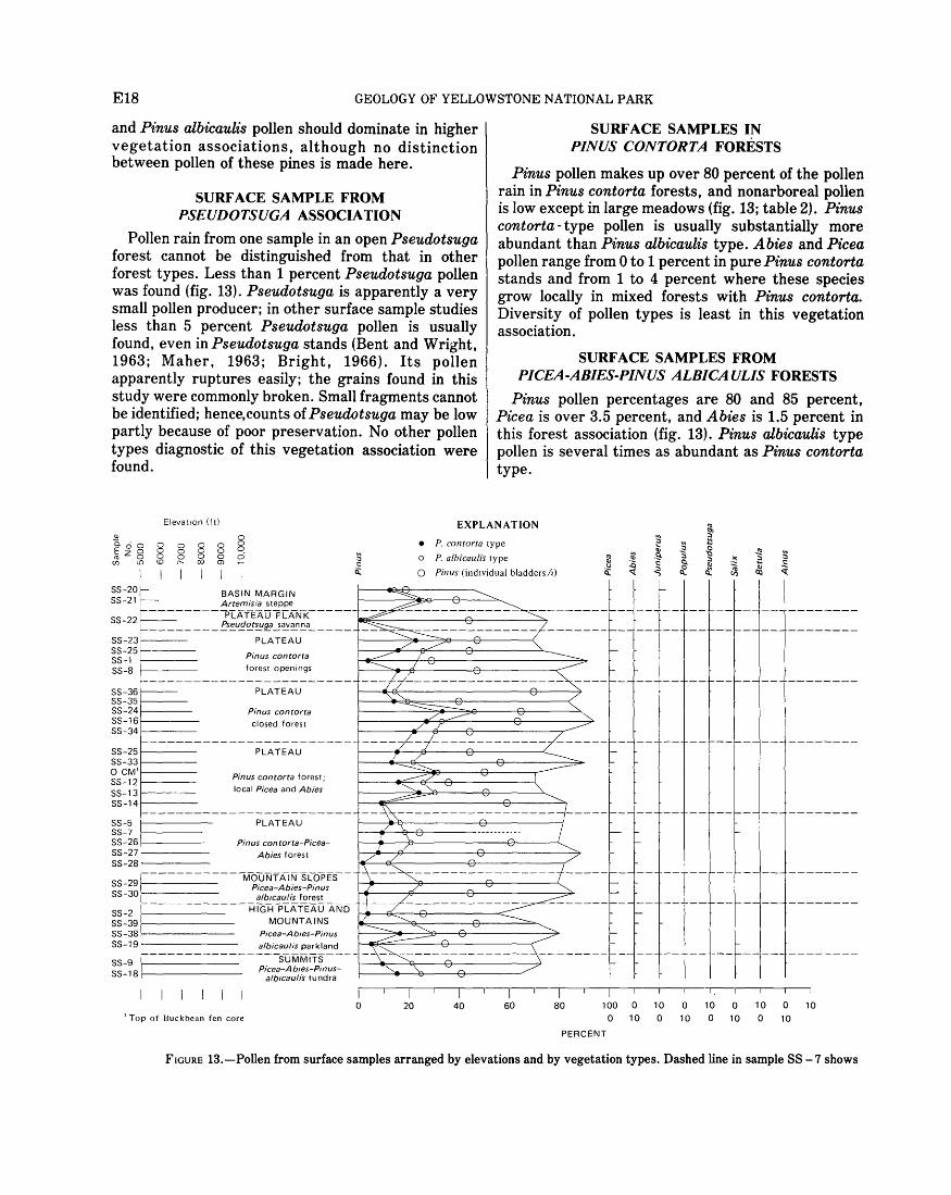
E18 GEOLOGY OF YELLOWSTONE NATIONAL PARK
and Pinus albicaulis pollen should dominate in higher vegetation associations, although no distinction between pollen of these pines is made here.
SURFACE SAMPLE FROM PSEUDOTSUGA ASSOCIATION
Pollen rain from one sample in an open Pseudotsuga forest cannot be distinguished from that in other forest types. Less than 1 percent Pseudotsuga pollen was found (fig. 13). Pseudotsuga is apparently a very small pollen producer; in other surface sample studies less than 5 percent Pseudotsuga pollen is usually found, even in Pseudotsuga stands (Bent and Wright, 1963; Maher, 1963; Bright, 1966). Its pollen apparently ruptures easily; the grains found in this study were commonly broken. Small fragments cannot be identified; hence,counts of Pseudotsuga may be low partly because of poor preservation. No other pollen types diagnostic of this vegetation association were found.
SURFACE SAMPLES IN PINUS CONTORTA FORESTS
Pinus pollen makes up over 80 percent of the pollen rain in Pinus contorta forests, and nonarboreal pollen is low except in large meadows (fig. 13; table 2). Pinus contorta- type pollen is usually substantially more abundant than Pinus albicaulis type. Abies and Picea pollen range from 0 to 1 percent in pure Pinus contorta stands and from 1 to 4 percent where these species grow locally in mixed forests with Pinus contorta. Diversity of pollen types is least in this vegetation association.
SURFACE SAMPLES FROM PICEA-ABIES-PINUS ALBICAULIS FORESTS
Pinus pollen percentages are 80 and 85 percent, Picea is over 3.5 percent, and Abies is 1.5 percent in this forest association (fig. 13). Pinus albicaulis type pollen is several times as abundant as Pinus contorta type.
Elevatton ( ft) EXPLANATION w 0 Cicio o o o o 0
~z8 8 8 8 8 ~ (f) LO(Or--CXJOl
• P. contorta type
o P. albicaulis type
0 Pinus (individual bladders/2)
SS-201- BASIN MARGIN SS-21 1--- Artemisia steppe
,_ _________ PIATEAUFLANK _____ ~::------~c-+---------"'7 SS-22 ~-- ___ !:_S!!_U.f!C!!~~~~~!!_a ____ _
SS-23 PLATEAU SS-25r---SS-1 t---·SS-8
SS-36~ SS-35 SS-24f---SS-16i--·-SS-34
Pinus contorta forest openings
PLATEAU
Pinus contorta closed forest
f-------------------------SS-25 PLATEAU 1---_.....-~ _ __,f'+--------<:...... SS-33 1-----0 CM't----SS-121----SS-131----SS-14 f-----
Pinus contorta forest; local Picea and Abies
f-------·------------------SS -5 PLATEAU f-----j~-------t:t----------1 SS-7 SS-26 Pinus contorta-Picea-SS-27 Abies forest SS-28 f-----
f----------- -M-OUN'fAii\f SLOPES-- f-41>-----"f;-----++-------<... SS-29 Picea-Abies-Pinus SS-30 alb1caulis forest SS-2 f------------HIGH-PLAfEAUAND f-+.--€k---E~-----<:::::_ SS-39~ MOUNTAINS SS-38 Picea-Ab1es-Pinus SS-19 albicaulis parkland ss-9 --------------·-sl.iiViiViiTs ___ f--_.-4t-----e>--------;;;
SS-18 Pi~~~:i:i~s;~~~~;-
0 20 40 60 80 1 Top of Uuckbean fen core
1 00 0 1 0 0 1 0 0 1 0 0 1 0 0 10 0 10 0 10 0 10
PERCENT
FIGURE 13.-Pollen from surface samples arranged by elevations and by vegetation types. Dashed line in sample SS -7 shows
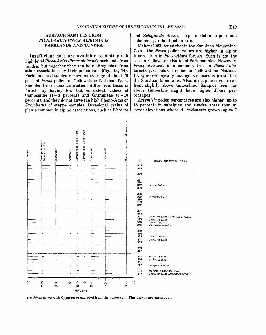
VEGETATION HISTORY OF THE YELLOWSTONE LAKE BASIN E19
SURFACE SAMPLES FROM PICEA-ABIES-PINUS ALBICA ULIS
PARKLANDS AND TUNDRA
Insufficient data are available to distinguish high-levelPicea-Abies-Pinus albicaulis parklands from tundra, but together they can be distinguished from other associations by their pollen rain (figs. 13, 14). Parklands and tundra receive an average of about 70 percent Pinus pollen in Yellowstone National Park. Samples from these associations differ from those in forests by having low but consistent values of Compositae (1- 3 percent) and Gramineae (4 -10 percent), and they do not have the high Cheno-Ams or Sarcobatus of steppe samples. Occasional grains of plants common in alpine associations, such as Bistorta
I Q) Q)
"'"' .~ ~ -o..c O'"' c.C 0 ~ c"' Q) E G<t:
Q)
!!! 'iii 0 c. E 0 u
Q) Ctl
0 ~ :; Cl
:.J a; !!! 'iii 0 c. E 0 u
Q) Ctl Q) u ~ Q)
c. > u
Q)
.s:::
0
and SelaginelliL densa, help to define alpine and subalpine parkland pollen rain.
Maher (1963) found that in the San Juan Mountains, Colo., the Pinus pollen values are higher in alpine tundra than in Picea-Abies forests. Such is not the case in Yellowstone National Park samples. However, Pinus albicaulis is a common tree in Picea-Abies forests just below treeline in Yellowstone National Park; no ecologically analogous species is present in the San Juan Mountains. Also, my alpine sites are all from slightly above timberline. Samples from far above timberline might have higher Pinus percentages.
Artemisia pollen percentages are also higher (up to 18 percent) in subalpine and tundra areas than at lower elevations where A. tridentata grows (up to ·7
~
448 473
296
291 334
SELECTED RARE TYPES
692 Arceuthobium 339
306 328 Arceuthobium 319 309 382
334 413 321 Arceuthobium, Potentilla palustris 333 Arceuthobium 306 Arceuthobium 376 Potentilla pa/ustris
349 396 353 Arceuthobium 341 Arceuthobium 228
339 417
431 cf. Phyllodoce 344 cf. Phy/lodoce 361 526 Selagine/la densa
601 Bistorta, Selagine/la densa 317 Arceuthobium, Selaginella densa
0 20 0
0
20 20 0 10 0 0 10 0 10
20 0
0 10 25
PERCENT
the Pinus curve with Cyperaceae excluded from the pollen sum. Pine curves are cumulative.
E20 GEOLOGY OF YELLOWSTONE NATIONAL PARK
percent) both in Yellowstone National Park and in the San Juan Mountains. Maher (1963) suggested that cirque lakes contain high values of Artemisia because the lakes remain frozen during the early flowering season. Pollen that falls on the ice is washed out during the melt season, and only pollen from lateflowering plants, such as Artemisia, is incorporated into the lake sediments. This process may explain the abundance of Artemisia pollen in high-elevation lakes in Yellowstone National Park.
Whether the flowering season is important or not, the source of the Artemisia pollen in alpine surface samples is still a problem. Does the pollen come from local subalpine or alpine species or does it blow in from steppe vegetation surrounding the park? The alpine species arc small and produce less pollen than the larger steppe species. Pollen of other steppe species apparently were blown 10 - 20 miles laterally and 4,000- 5,000 feet upward before deposition.
The presence of Sarcobatus and 1 Cheno-Ams pollen
in small amounts at some alpine sites (fig. 13) provides evidence that pollen from the steppe association does blow up to the tundra; these taxa grow abundantly in steppe areas but are absent from alpine areas. Compositae and Gramineae pollen in alpine sites may likewise blow up from their abundant steppe representatives, but plants in these families grow at all elevations in the park. Pinus and Picea certainly blow up from just below treeline, and in tundra areas where pollen production is low, relatively small amounts of pollen blowing in from afar could yield high pollen percentages.
POLLEN RATIOS
Ratios between two pollen types often show trends that are masked by other curves on the aggregate pollen diagram (Maher, 1963). A number of ratios were tested in the surface sample and fossil pollen diagrams, and two proved useful. Pinus albicaulis/ Pinus contort a ratios delimit Pice a-Abies-Pinus albicaulis forests from other forest types (fig. 14). The dominance of Pinus contorta over such large areas in the park makes this pollen ratio low (less than 1.3) except where Pinus albicaulis grows locally. At several sites preservation of pine pollen was not good enough to identify a large proportion of the grains as to species. Even with imperfect identification, however, most pine-pollen ratios were ecologically reasonable. The assumption that the two Pinus types are preserved equally well and are representative of the entire sample seems valid.
Gramineae!Pinus ratios distinguish forested from nonforested areas (fig. 14). These ratios are high
(about 0.050- 0.209) in the steppe and alpine vegetation associations and in large forests openings; they are low (less than 0.025) in forested areas (fig. 14; table 2).
Pice a/ Pinus ratios that were used successfully by Maher (1963) as an indication of subalpine vegetation show no meaningful trends in Yellowstone National Park surface samples, probably because of pollen production of Pinus albicaulis in the subalpine vegetation of the park. Lack of an ecologically analogous pine in the San Juan Mountains makes the Pice a/ Pinus ratio a more effective indicator of subalpine vegetation.
QUATERNARY PALYNOLOGY MATERIALS AND PROCEDURES
The cores were taken with a modified 2-inch Livingstone piston sampler (Wright and others, 1965) in early October 1966 and early September 1967. Long cores were taken from Buckbean fen and Lilypad pond (fig. 7), and shorter cores were extracted from Trail Creek pond. When core length was less than penetration, it was arbitrarily assumed for labeling purposes that the basal segment of each drive was missing. The cores were wrapped in the field in saran and heavy -duty aluminum foil, sealed with masking tape, and stored in a refrigerator. Reported here are pollen and macrofossil analyses from the 10-m core taken in Buckbean fen and macrofossil analyses from the basal 2 m of the core taken in Lilypad pond. For Buckbean fen, pollen samples were taken at about 10-cm (centimetres) intervals in the basal2 m and at about 20-cm intervals in the remainder of the core. These samples received the same chemical treatment as the surface samples.
Plant macrofossils were prepared by soaking a 50-ml (millilitre) sample of sediment for as long as 2 days in very weak (less than 5 percent) KOH. The sample was then washed through 32- and 140-mesh (0.5 and 1.0 mm) screens with a shower nozzle. Macrofossils were picked from the washed samples with a small brush and stored in glycerin.
The pollen was identified by comparison with the reference collection at the U.S. Geological Survey, Denver, Colo. The collection is large but is incomplete for Rocky Mountain species. Macrofossils were identified by comparison with the seed collection at the University of Colorado Herbarium. The collection is small and is fairly complete only for taxa encountered as fossils.
The certainty of identification of pollen and macrofossils is indicated by the use of "type" and "cf."
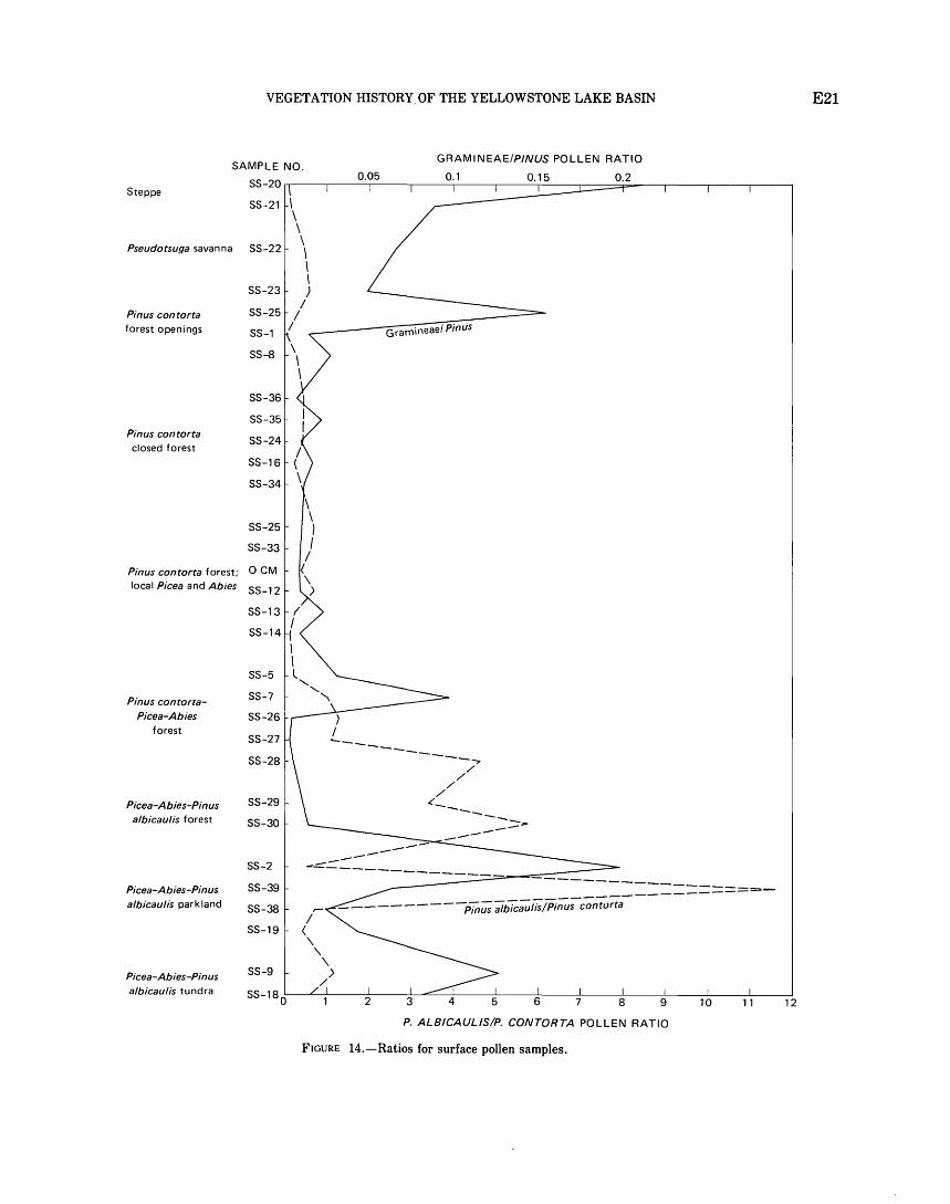
VEGETATION HISTORY, OF THE YELLOWSTONE LAKE BASIN
GRAMINEAE/P/NUS POLLEN RATIO SAMPLE NO.
Steppe SS-20~--~----0~.0_5 ____ ~ ___ 0~.1----~--~~--~----0~·=2----~--~----~--~
SS-21
Pseudotsuga savanna SS-22
SS-23
Pinus contorta SS-25 forest openings SS-1
SS-8
SS-36
Pinus contorta closed forest
SS-16
SS-34
SS-25
SS-33
Pinus contorta forest; OCM
local Picea and Abies SS-12
SS-13
SS-14
SS-5
Pinus contorta- SS-7
Picea-Abies SS-26 forest
SS-27
SS-28
Picea-Abies-Pinus SS-29
a/bicau/is forest SS-30
SS-2
Picea-Abies-Pinus SS-39 albicaulis parkland SS-38
SS-19
Picea-Abies-Pinus SS-9
albicaulis tundra SS-18 0
> I ..... _
Gramineae/ Pinus
---------------.., / ,_
/ /
/
-------> -----
5
========--
11
P. ALB/CAUL/SIP. CONTORTA POLLEN RATIO
FIGURE 14.-Ratios for surface pollen samples.
12
E21
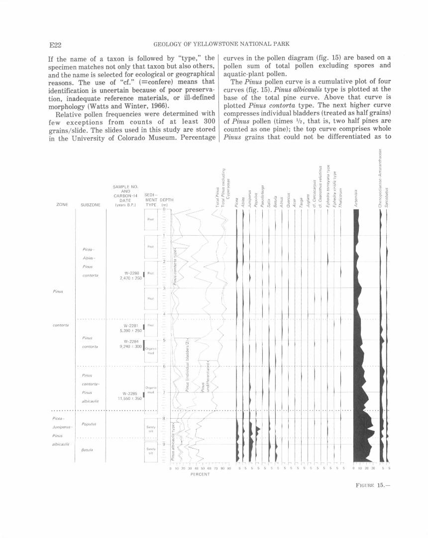
E22 GEOLOGY OF YELLOWSTONE NATIONAL PARK
If the name of a taxon is followed by "type," the specimen matches not only that taxon but also others, and the name is selected for ecological or geographical reasons. The use of "cf." (=confere) means that identification is uncertain because of poor preservation, inadequate reference materials, or ill-defined morphology (Watts and Winter, 1966).
Relative pollen frequencies were determined with few exceptions from counts of at least 300 grains/slide. The slides used in this study are stored in the University of Colorado Museum. Percentage
curves in the pollen diagram (fig. 15) are based on a pollen sum of total pollen excluding spores and aquatic-plant pollen.
The Pinus pollen curve is a cumulative plot of four curves (fig. 15). Pinus albicaulis type is plotted at the base of the total pine curve. Above that curve is plotted Pinus contorta type. The next higher curve compresses individual bladders (treated as half grains) of Pinus pollen (times 1/2, that is, two half pines are counted as one pine); the top curve comprises whole Pinus grains that could not be differentiated as to
ZONE SUBZONE
Picea -
Abies -
Pinus
contorta
Pinus
contorta
Pinus
contorta
Pinus
contorta -
Pinus
albicaulis
Picea -
Juniperus -Populus
Pinus
a!bicaulis Betula
SAMPLE NO.
SEDI -
Ol c
] Q) u ro X ~ ~ u
~ ~ ~ .s .s ~ Q. Q. >
AND CARBON-14
DATE (years B.P.)
MENT DEPTH '-;;; 'iii u 0 0
W-2280 I Peat
2,470 .t 250 l Pea t
W-2284 ~< 1 5 9 240 + 300 0 • rgan1c
mud
. . . . . ' ..... .. . - 6
:\
\
1- 1-
\
-~)_ ·.
1
..... ~~~ .. \ .
,\ > l)p /) I( j \: L~C ... ... .
\ ~ •v
~ ~ I
...,::: <._
W-2285 11 ,550 :!: 350
OrganiC
mud ' ~ :0 /
7 - / <.: 3[ (~, . I
Sandy slit
8
Sandyj 9
s lit
... ::-.., ... · · ···~·······
~ ,~ f ~ J ~ L 1 ·s~:r .. ~ ~ "~ ~ ') ' ;> f' ''' 'f '1 '1 r' '' I r l - 'I' r• r r, I' I' I' 0 1 0 20 30 40 50 60 70 80 90 5 5 5 5 5 5 5 5 5
PERCENT
5 5 5 5 5 5 5 5 0 10 20 30 5 5
FIGURE 15. -
VEGETATION HISTORY OF THE YELLOWSTONE LAKE BASIN E23
species. A separate total Pinus pollen curve is plotted for the upper 400 em of the core. This curve excludes Cyperaceae pollen from the pollen sum because of its local origin.
The pollen diagram (fig. 15) is divided into two pollen assemblage zones (hereafter simply called zones). The zones are biostratigraphic units called assemblage zones as defined by the American
<li Q.
~ <li <li ~ "' "' ~ 0 0 § ~ ~ -~ ::J ~ "' tl
~ Q
:J -~ <li f- l:J "' ~ <li
t:: <li ~ ~ Q) u <li Q.
<li <li ..')1 <li Q. ~ "' <li -'? ~
"' "' <li
- ~ Q. ~ -'? "' "' e: -Q ~ "' Q) Q) <li <li .')1 ~ t:: ~ Q)
. ~ "' "' ~ Q ~ ·~ :5 :5 u t: "' u t:: i3 t::
"' ~ -~ · ~ Q Q. Q)
"' Q) Q "' Q. Q. ~ 0 u Qi ~ "' Q
~
E E Q)
~ t:: 2 "' .0 en ·g .g "" "' ~ -~ Q. "' ::,.. ~ "' -~ ~
0 0 > ~ 0 " -~ Q 0 E ~ e; Q) c u ::) ~ "' u u u Q: ~ a CXl Q_ u a:: ::J _J 0 "1: Q_ Q_
I
-~ -
I -I-f-~ t--- -t-- t-- ·- t---
I
-I- -I- - 1-- --L- -t--- 1--1- t---
~ - -'--- L --
. ..... . . ! . .
t---
~--1---- - .... --- I· - ·- ---
-1-- - I- 1--!--
I·· .. . . . .. ... ... . . . . t • ~ • • • ~
I ~
t
~ c <li
<li
"0
§ Q)
"' Q) u
"' c 0 en >
~
.
Commission on Stratigraphic Nomenclature (1961). The zones are defined by their fossil content and position in the core. The name of each zone carries implications about the ecological conditions at the time of deposition. Similar zones appear in the core from Cub Creek pond (Waddington and Wright, 1970) and other cores (R. G. Baker, unpub. data). This regional similarity of zones implies that vegetation changes
NOT INCLUDED IN POLLEN SUM (f)
,--z ~ a:: l?
z ~ w _J · ~ _J
~ 0 CL ~
<li
"' ·s .')1 a:: Q) :2 w <li u
"' ~ ·s a:J Q.
2 ~ .')1 ~ "' ·~ Cii t::
ill ::J :2 "' ..'? ] ..')1 Q. ~ 2 i3 z ·;::; ..'? ~ "' Q. ~ ..')1 -'? ~ "" -~
~ t:: _J t:: '- ..')1 -!::: g .§ Q Q
l:J ~ <i ~ "' "' ~ "' f--!::: -!::: ~ - ~
(f) Q_ ~ a; §- ~ ~ 0 "' ~ Q a- Q
'G 'G Q_ ~ f- < h 'G ~ Q_
g "' X
"'
321
I r 382
874
• I I 256 I
316 -
453 - I -- -- -
384 I
196
~ ~ 300
357
J- - 336 - -f--
359
309
:i31 ~ 282
I
1- ·-'----- · 262 I
303 :
I 357 I 360 I
I 304 I
I. 350 --·304 ~ · • • 0 . . . .. 351 I
~ t
305
287
~~~ ~ 335
337
.I.- ~ . 354 ... . -·- -375 I
384
336
~ 323
320
345 t 451
504 427 . .. .. •• •356 . .......... .... 286
t--- -
l Ui ~ • r6 15
.. :if3 " ~-- .... . . 478
~~~ - -t---
J 191
~ "0 "0 E 0
11 "0
:2 c
~ ~
r
I
. . . .
...
. ..
~
"' en Q)
"' c
~ "0 c •
• ~ I ~1 I 412
'-, '-, i-t l'l I' -, I'-, -, -,1'1';-'1' r ~ -, I' ..., I' I' I' I' I' I' 262 I' I I I I I "r -,I' rr<l'l' '-, r--.1 I I I' 5 5 50 10 0 10 20 30 5 5 5 5 5 5 5 5 5 5 5 5 5 5 5 5 5 5 5 5 5 5 5 5 5 5 5 5 5 5 5 0 10 20 30
PERCENT
Pollen from Buckbean fen core.
E24 GEOLOGY OF YELLOWSTONE NATIONAL PARK
were similar throughout the region. The zonation of the diagram is summarized in table 3, and the pollen counts for Buckbean fen are listed in table 4.
SELAGINELLACEAE
Trilete spores in the lower part of the Buckbean fen core match Selaginella dens a perfectly (pl. 1), and this is the only species reported in the modern park flora (McDougall and Baggley, 1956). It is most common above timberline. Two other species occur in eastern Wyoming (Porter, 1962). Another species, S. selaginoides, occurs at middle elevations in western Wyoming, but its spores can be distinguished from those of S. densa on morphologic grounds.
The time and stratigraphic relationship between the assemblage zones, the C 14 dates, and the glacial periods is shown in figure 16.
POLLEN AND SEED IDENTIFICATION
PINACEAE
Pollen and spores were identified using the reference collection of the U.S. Geological Survey, Denver, Colo. Plant macrofossils were identified by comparison with a collection that I assembled from the University of Colorado Herbarium. On plates 5- 10, the COLO numbers are the University of Colorado Herbarium numbers of voucher specimens for reference seeds, needles, and bracts. RGB numbers are my own collection. Some of the criteria for identification are discussed here so that the pollen and macrofossil taxa can be better evaluated.
A few grains were found that match Pseudotsuga menziesii (pl. 1). Larix occidentalis Nutt. and Larix lyallii Pari. have similar but smaller grains, and these trees now grow from central Idaho westward (Bright, 1966). Pseudotsuga grows locally in Yellowstone National Park. I have, therefore, identified the pollen as Pseudotsuga. One needle of Pseudotsuga was found (pl. 5).
(/) w a: f-w ~
~ I-f-a... w 0 w a: 0 u
0-r~-~~~\t~~~~----------------------------------------------------------------------------~ //
-
-
2 -
-3 -
4 -
-
5 -
-
6 -
7 -
-
Q.l c 0 N
!S ... 2 c:: 0 u
"' :;:, c:: ~
Picea-AbiesPinus contorta
subzone
~---.--------------------------------------~-~ ~?--+---------? 7----------------~--~lfl~ I
STRATIGRAPHIC ZONE. OF HIATUS I
/ /
/
/ /
/
~
/ /
Pinus contorta J-i- I
subrone ( I EXPLANATION r-------___.____-----1)-•
/ /
/ /
Pinus albicaulis-Pinus con tort a
subzone
/ I [!] Core
// I + - Vertical dimension shows interval ~ TIME MAGNITUDE of core ~ OF
1
1 Horizontal dimension shows age of r1 APPARENT C' 4
- dated sample with error
8 _ ~ ~ /Lr.. HIATUS I [ •] Extrapolated age
~ 2 Populus / 1
- Cl. "' subzone / 1
9- ~ ] Betula /---r' I 2 ~ subzo[.{ i- 1
10~-~-~-·~--------~~----~----_L ____ _L ______________ i_~~----------------------~
PINEDALE GLACIATION
I I I I I 14 13 12 11 10
AL TITHERMAL I
+ I I I I I 9 8 7 6 5
AGE, IN THOUSANDS OF YEARS B.P.
I 4
NEOGLACIATION
I 3
I 2
I
FIGURE 16.-Relationships between assemblage zones, carbon-14 and extrapolated ages, and time-stratigraphic boundaries.
0
TABLE 3.-Summary of inferred changes in environment at Buckbeanfen during the last 12,000+ years
Core c14 date
Pollen (interpolated Subzone depth dates in Terrestrial plant community zone (em) brackets)
Pinus Picea-Abies· 240} 2,470:!:250 Mixed Picea engelmannii, contorta Pinus contorta 260 Abies lasiocarpa, Pinus
contorta forest. Sparse Pseudotsuga
menziesii. [2,800)
420 [5,000) Pinus contorta 440}
460 5,390:!250 Closed· Pinus contorta forest
UNCONFORMITY(?)
. 500} 540
9,240:!:300
600 [10,160) Pinus contorta· Pinus albicaulis
700} 11,550~50 724 2
770 11,630:!:180 Picea-Juniperus· Populus Pinus albicaulis
875
Betula
960 2 14,36Ch400
lThe 15-ft lagoon, Buckbean fen, dried up during this time. 2oate by correlation with Cub Creek pond.
Open Pinus albicaulis-Pinus contorta forest with Picea, Abies and Pseudotsuga rare.
Picea engelmannii-Abies lasiocarpa-Pinus albicaulis garkland, with Populus alsamifera and Juniperus
communis.
Tundra(?) but with subalpine herbs, Juniperus communis and Betula glandul osa. Occasional Picea or Pinus albicaulis may be present nearby.
Aquatic and semiaquatic Inferred Water Lake level Glacial advance or plant community climate depth at above present glacial retreat
coring level site (ft)
Fen v:J.etation with Carex Slightly 0 Present level ...... Gannett Peak Stade, dia ra, C. utricu/ata. C. cooler and Neoglaciation. vesicaria, C. limosa, moister. Potentilla palustris, and Menyanthes trifolin.ta.
Small, shallow pond with 0 10 ft to present Temple Lake Stade, Nuphar; fen with Carex level. Neoglaciation. diandra and C. utricu/ata, encroaching into pond.
Shallow-water a~uatic Maximum 1 0-35 10·, 15·, 25·, and Altithermal. vegetation wit Nuphar warmth and 40-ft levels. luteum, MyriophyUum sp., dryness. Naias flexilis, and Potamogeton gramineus.
Aquatic and shoreline Warm 45-65 60-ft level(?) ....... Late stade, Pinedale macrofossils rare. t Glaciation.
dry cool,
t warm
Aquatic and shoreline Cool, moist. 70-100 90-ft level(?) ....... Middle stade, Pine· macrofossils rare. dale Glaciation.
Pioneer aquatics Cold, moist. 90--or 110-ft level Middle stade, Pine-Potamogeton fi/iformis dale Glaciation. and Potamogeton alpinus.
< M c;") M ~ > ~ 1-4
0 z ::r: 1-4 r:.n ~ 0 ~ ~ 0 "'%j
~ ::r: M ~ M t'-1 t'-1 0 ~ r:.n ~ 0 z M t'-1 > ~ M to > r:.n 1-4 z
t_:l:j ~ 01
E26 GEOLOGY OF YELLOWSTONE NATIONAL PARK
TABLE 4.-Pollen counts for Buckbean fen,
<1> ' <1> <1> <1> 0.. Cll ~ 0.. ~ <1> <1> $
0.. $ Cll <1>"' 0.. <1> <1> "C $ <:::! "'~ .. ~ .. ~
~~ 0, "' ~ 0.. ~.c $ Cll ... <1> ... "' ~ <:::! i; ;:! $ ~ Cll .... ~ ~ 0 ~ 0 ;:! "C~
~ ~ <:::! -~ -g; -~ -~ § -~§ ·= ~ c-z ;:! 1:: 0 "' ~ ~""' e·~ i: -~ ~ ::I c <:::! c o.."' ..c c 8...6 0 ::I .,] ~§ '"t::l .s ~ <..> <1> ~t ~~ ] ~ 0 ~ .c ~ ~ <:::! .; ;:! l1 .e. 1 l: "' co.. s:: E c 1- O..bO .... E "'<;
-~~ ~ ~ ~ (::! ~ ] t~ -c:!C -c:!";; ~ ll<t: l: ..c E ::::~ e·-
fr'-' 0 (::!~ (::! <..> d: ..c ~ 1:: ~ oE-< 0...::1 ~ ~ ~
~ .:; & ~- ~ <:::!
0 E-o ~ c.. ~ ~ ~ \..) kl ~ u ~ ~ u u
0 230 129 4 97 5 1 0 0 0 0 0 1 0 2 2 0 0 28 3 1 1 1 0 20 241 223 8 10 3 8 3 0 0 1 0 0 1 0 0 0 0 31 13 3 2 1 0 40 748 644 19 85 5 6 0 0 0 4 0 0 1 0 0 0 0 62 10 6 0 4 0 60 200 161 4 35 2 4 0 3 0 0 0 2 0 0 0 0 0 22 7 0 1 2 0 80 262 221 16 25 6 1 0 0 2 0 0 0 0 0 0 0 1 26 5 0 1 1 0
105 357 275 10 72 8 5 0 0 1 1 0 0 1 1 0 0 0 30 9 1 0 8 1 125 278 272 2 4 6 2 1 0 1 1 0 0 0 0 0 0 0 30 7 1 0 4 0 140 143 86 5 52 2 3 0 0 0 0 0 0 0 0 0 0 0 7 3 0 0 1 0 160 211 147 17 47 7 2 0 0 1 1 0 0 1 0 0 0 0 11 2 6 1 2 0 180 253 223 10 20 7 6 0 0 0 2 0 1 0 0 2 0 0 29 4 2 0 3 0 200 246 155 8 83 8 6 0 0 0 0 0 0 0 0 0 4 0 17 5 2 1 4 0 220 181 118 8 55 5 0 2 0 1 2 0 0 0 0 0 0 0 16 4 1 1 2 0 240 223 187 10 26 2 0 0 0 0 0 0 0 1 0 0 0 1 24 3 1 0 5 0 260 228 152 12 64 10 0 0 0 1 7 0 0 0 0 0 0 0 21 2 1 1 3 0 280 241 219 6 16 1 0 0 0 1 0 0 2 0 0 0 0 0 22 3 0 0 1 0 300 211 176 15 20 0 1 0 1 0 0 0 1 0 0 0 0 0 33 6 0 0 2 0 320 238 227 3 8 3 2 2 0 1 2 0 1 0 0 1 0 0 33 3 3 0 2 0 340 280 243 10 27 6 4 0 0 0 4 0 2 0 1 0 1 0 23 9 1 2 4 0 360 231 195 20 16 4 5 0 0 0 3 0 0 0 0 0 0 0 22 7 2 0 1 0 380 260 237 10 13 5 2 2 0 1 1 0 1 0 0 0 0 0 15 8 0 2 2 0 405 272 229 3 40 7 3 2 0 0 0 0 2 2 0 0 1 0 30 11 2 1 2 0 420 249 221 12 16 2 2 0 0 0 1 0 0 1 0 0 0 1 33 7 2 2 0 0
440 282 271 5 6 2 3 1 0 0 1 0 0 1 0 1 0 0 38 6 2 1 2 0 460 220 209 4 7 0 1 0 0 3 4 0 1 3 0 0 0 0 34 14 4 1 3 0 480 235 224 2 9 0 1 0 0 1 1 0 0 1 0 0 0 0 31 4 3 2 3 0 505 208 188 3 17 1 0 0 1 2 0 0 0 0 0 0 1 0 37 21 5 1 4 0 515 697 610 13 74 1 2 1 1 2 0 1 3 0 2 0 0 0 126 29 7 8 5 1 525 271 244 8 19 1 2 0 0 2 3 1 0 1 0 0 0 0 34 12 3 2 2 0 550 248 231 9 8 0 2 2 0 3 2 0 0 1 0 0 0 1 54 9 4 3 1 0 580 241 217 9 15 0 1 1 4 2 1 0 0 0 0 0 0 0 50 11 4 8 2 0 600 265 243 14 8 0 2 0 1 3 4 0 0 1 0 0 0 0 43 10 3 5 5 0
620 243 188 26 29 3 1 0 0 8 2 0 0 1 2 0 0 0 63 27 4 5 4 0 640 266 195 58 13 2 0 0 1 4 4 0 1 0 1 0 0 1 59 19 1 3 2 0 660 207 192 12 3 2 1 1 1 2 3 0 0 0 0 0 0 1 65 22 6 3 3 0 680 236 208 25 3 3 1 1 2 0 10 0 0 0 0 1 0 0 39 12 3 3 1 0 700 203 163 27 13 1 0 5 1 3 2 1 1 0 0 0 0 0 56 13 4 6 2 0 720 227 200 17 10 0 2 2 0 3 4 0 0 0 0 0 0 0 76 10 3 3 5 0 730 277 234 13 30 3 2 1 0 5 12 0 0 0 0 0 0 0 105 14 8 5 4 0 750 361 282 20 59 6 4 0 2 4 2 0 0 1 1 0 0 1 78 17 6 6 1 0 760 294 250 24 20 1 3 0 2 2 2 2 2 1 0 0 0 0 80 17 2 4 3 0 770 249 150 76 23 1 3 0 0 0 2 2 2 0 0 0 0 0 48 17 5 0 8 0
782 172 107 34 31 1 6 0 1 1 6 5 0 0 0 0 0 0 61 12 3 2 4 0 801 182 121 42 19 3 5 0 0 4 6 0 0 0 0 0 0 3 97 15 6 10 3 1 810 279 172 58 49 13 5 0 4 7 1 10 3 2 0 0 1 0 161 35 6 8 9 0 820 175 86 75 14 12 7 2 2 9 19 5 0 0 0 0 0 1 122 26 11 8 4 0 830 179 99 53 27 14 3 1 0 6 0 1 3 2 0 0 0 0 113 18 6 4 7 0 842 79 34 30 15 7 4 0 0 6 7 16 0 0 0 0 1 0 41 13 4 0 2 1 850 149 89 53 7 11 14 0 2 2 16 8 0 1 0 0 0 0 121 9 4 7 5 0 860 83 61 14 8 6 1 0 0 3 13 9 0 1 0 0 1 0 67 7 1 9 4 0 870 136 71 59 6 17 6 0 5 6 7 3 0 0 0 0 0 0 102 20 13 5 4 1 880 167 113 51 3 11 6 0 3 5 15 4 0 2 0 0 0 0 69 5 0 7 3 0 890 186 101 82 3 5 11 0 6 9 33 5 1 1 0 1 0 0 106 18 9 1 6 0 900 157 86 65 6 16 12 0 6 10 20 4 1 0 0 0 0 0 97 23 8 2 5 0 910 101 60 38 3 14 4 0 14 13 21 1 0 2 0 1 1 1 103 21 7 4 9 0 920 144 98 39 7 10 5 0 3 5 15 3 0 1 0 0 0 0 85 16 5 1 10 2 930 233 129 87 17 24 5 0 3 9 19 4 0 3 0 0 0 0 135 24 7 2 14 2 943 160 108 47 5 11 10 0 15 7 16 9 0 0 0 0 1 0 97 18 3 4 6 2 953 98 64 32 2 10 2 0 4 1 6 0 0 0 0 0 0 0 36 9 2 3 3 0 958 109 67 38 4 5 3 0 2 3 7 0 1 0 0 0 0 0 75 18 9 3 4 1
Juniperus pollen is common at the bottom of the grows abundantly on the plateau. The only fir that core (pl. 1). Species of Juniperus cannot be dis- grows in the park is Abies lasiocarpa. Needles of Picea tinguished by their pollen, but needles and a twig of engelmanii have been identified (pl. 5). Probably all Juniperus communis are identified from two levels (pl. the spruce and fir pollen belongs to these two species. 5). Juniperus communis is the only juniper that grows Pine pollen (pl. 1) was grouped into haploxylon from low elevations below the plateau up to and above (with distal verrucae) and diploxylon (without distal timberline. Juniperus virginiana L. var. scopulorum verrucae) (Ting, 1966). Two haploxylon pines, Pinus Lemmon grows only at low elevations around flexilis and Pinus albicaulis, occur in the park Mammoth and in other areas. I believe most of the (McDougall and Baggley, 1956). Pinus flexilis grows Juniperus pollen to be Juniperus communis. only at low elevations around the margins of the
Picea pollen (pl. 1) was not differentiated as to plateau. Pinus albicaulis grows mostly up near species, but Picea engelmannii is the only spruce that timberline but also on rocky cliffs and ledges at lower
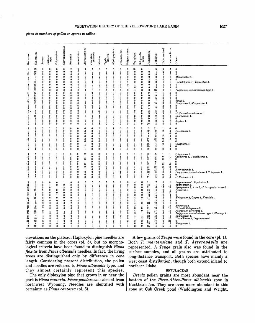
VEGETATION HISTORY OF THE YELLOWSTONE LAKE BASIN E27
given in numbers of poUen or spores in tallies
<I> t.s
1'1 1'1 <I> "0 <I> ~ !:! t.s <I> ....
1'1 l'l ., ·= :S ~ ~ 1'1 c t.s <I>
~ .0 ·2 !S ;g ·~ c:
<I> t.s ·= ;;:. ;g "" Ill t.s ~ c ·~ <I> <I> 0 ~~ t.s 0 !:! ..c: ~ < < "' :a ;... Ill<::! :t c.> t.s 1- 0 ..c: .~ ~ c
~ H -<I> 0 Q. ~ ~ ~ ~~ <::! ~? R. 0 .:: ~ 0 ~
Ill
"§ Ill 8o. 1'1 0 < ·~ 1'1 Q. Q. c <I> ... <I> 1'1 ~ ~ Ill <::! 0 ]'Ill -" <I> <I> -;... ~ c
~ .':;2_ R.
~.s ;... c "<::! "0 ..c: t.s Q.
~ ·~ .... 0 ~ ~ ~ ~ 0 Ill"<:! ~
c: c: ] 0 ~ ;...
~ t.s ~ ;:J ;:J u Q:l u 0:: ~ Cl.. Ill V)
2 29 0 0 0 0 2 0 4 7 2 0 0 0 2 20 0 1 5 9 7 0 9 66 0 0 0 0 0 0 0 0 0 1 0 0 0 0 0 0 1 2 1 0
12 15 0 0 0 0 0 0 0 1 1 0 0 0 0 0 0 0 14 1 0 0 2 3 0 0 0 0 0 0 0 1 2 0 0 0 0 0 0 0 2 1 3 Menyanthes 7. 7 4 0 0 0 0 0 0 0 0 0 0 0 0 0 0 0 2 4 0 1 0 5 24 0 0 0 0 0 0 0 1 0 1 0 0 1 0 0 0 3 0 0 Caprifoliaceae 1, Equisetum 1. 8 45 0 0 0 0 0 0 0 0 0 0 0 0 0 1 0 0 4 1 1 0 2 30 0 0 0 0 0 0 0 0 0 0 0 0 1 0 0 0 18 2 1 0 3 50 0 0 0 0 0 0 1 0 0 0 0 0 0 4 0 0 25 0 0 Polygonum ramosissimum type 1.
10 37 0 0 0 0 0 0 1 0 1 0 0 0 0 0 0 0 7 1 0 0 8 34 0 0 0 0 0 0 0 1 0 0 0 0 0 0 0 0 9 2 5 0 2 142 0 0 0 0 0 0 0 0 0 0 0 0 0 0 0 0 5 0 1 0
10 36 1 0 0 0 0 0 1 0 0 0 0 0 0 0 0 0 7 3 0 Tsuga 1. 5 50 0 0 0 0 0 0 0 0 0 0 0 0 1 0 0 0 16 3 0 Eriogonum 1, Menyanthes 1. 5 5 0 0 0 0 0 0 0 0 7 0 0 0 0 0 0 0 1 2 3 0 4 3 0 0 0 0 0 0 0 0 4 0 0 0 0 1 0 4 7 0 0 0 5 ~ 6 0 0 0 0 0 0 1 0 12 0 0 0 0 0 0 3 5 0 0 0 6 9 0 0 0 0 0 0 2 2 8 0 0 0 0 1 0 3 5 3 2 cf. Ceanothus velutinus 1. 5 14 0 0 0 0 0 0 1 0 4 0 0 0 0 2 0 2 9 0 1 Sparganium 1. 3 1 0 0 0 0 0 0 1 0 7 0 0 0 0 0 0 0 4 6 0 0 2 6 0 0 0 0 0 0 6 0 0 0 0 0 0 2 0 2 2 5 2 Juglans 1. 0 3 0 0 0 0 0 0 1 0 3 0 0 0 0 1 0 16 2 0 0 0
8 3 0 0 0 0 0 0 0 0 2 0 1 0 0 0 0 3 11 1 0 0 6 7 0 0 0 0 0 0 3 0 1 0 2 0 0 1 0 30 2 2 0 Eriogonum 1. 3 2 0 0 0 0 0 0 0 0 0 1 2 0 0 0 0 6 3 1 0 0 3 0 0 0 0 0 0 0 0 0 1 0 0 0 0 0 0 2 0 2 4 0
14 3 0 0 0 0 0 0 2 0 0 0 0 1 0 0 0 54 15 0 3 0 0 4 1 0 0 0 0 0 0 0 0 0 0 0 1 0 0 50 3 0 1 0 3 0 0 0 0 0 0 0 1 0 0 0 0 0 0 1 0 18 4 0 1 Onagraceae 1. 5 5 0 0 0 0 0 0 2 0 0 0 0 1 0 0 0 29 3 1 3 0 7 4 0 0 0 0 0 0 1 0 0 0 1 0 0 3 0 39 3 0 0 0
4 7 0 0 0 0 0 0 2 0 0 0 0 3 0 3 0 26 5 1 1 Polygonum 1. 10 2 0 0 0 0 2 0 1 0 0 1 0 1 1 1 0 21 2 0 1 Cruciferae 1, Umbelliferae 1. 6 7 0 0 0 0 0 0 6 0 0 0 0 0 0 0 0 25 6 0 1 0 6 3 0 1 0 0 0 0 1 0 0 0 0 0 0 0 0 47 6 1 1 0
10 3 0 0 0 0 0 0 8 0 0 0 0 0 0 1 0 21 1 0 0 0 10 1 0 0 0 0 0 0 0 0 0 0 0 1 0 0 0 23 10 2 2 0 13 2 0 0 0 0 0 0 1 0 0 0 0 0 0 4 0 16 12 2 5 Acer negundo 1. 9 1 0 0 0 0 0 0 0 0 0 0 0 1 0 0 0 13 6 0 0 Polygonum ramosissimum 1 Eriogonum 1. 8 4 0 0 0 0 0 0 0 0 0 2 0 0 1 1 0 4 3 0 2 0 9 6 0 0 0 0 0 0 0 0 0 0 0 1 0 0 0 11 5 0 0 cf. Pedicularis 2.
8 3 0 0 0 1 0 0 0 0 0 0 0 0 0 4 0 11 7 3 3 Leguminosae 1, Equisetum 1. 11 8 0 1 0 0 0 0 0 0 0 0 0 0 0 0 0 15 7 3 0 Sparganium 1. 32 7 0 0 1 3 0 0 0 0 0 0 0 0 1 0 0 21 0 15 14 Sparganium 1, Acer3, cf. Scrophulariaceae 1. 17 14 5 0 0 0 0 0 0 0 0 0 0 3 0 4 2 34 4 0 0 Fraxinus 1. 19 2 0 0 0 0 0 0 0 0 0 0 0 0 1 0 0 13 11 ·0 10 0 18 1 0 0 1 0 0 0 1 0 0 0 0 0 0 3 0 6 5 2 1 0 12 11 0 0 0 0 0 1 0 0 0 0 0 2 0 4 0 17 6 2 5 Eriogonum 1, Oxyria 1, Koenigia 1. 8 2 0 0 0 0 0 0 0 0 0 0 0 2 0 2 1 7 3 2 4 0
29 8 2 0 0 0 2 0 0 0 0 0 0 1 0 4 0 23 12 1 2 0 20 3 0 0 0 0 0 0 0 0 0 0 0 3 0 3 1 47 7 2 11 Erigonum3. 45 19 7 0 0 0 0 0 0 0 0 0 0 1 0 8 0 21 13 3 18 Urtica 3, Eriogonum 3. 28 15 0 1 0 1 1 0 0 0 0 0 0 0 0 4 0 37 17 5 11 Polygonum persicaria 1. 34 12 2 0 0 0 0 1 0 0 0 0 0 1 0 5 1 29 14 6 9 Polygonum ramosissimum type 1, Plantago 1. 15 7 4 0 0 0 0 0 0 0 0 0 0 0 0 1 1 32 13 0 3 Sparganium 4. 31 19 5 0 0 0 0 0 0 0 0 1 0 1 0 1 2 29 15 9 10 Umbelliferae 1, Leguminosae 1. 31 12 6 0 1 0 2 1 0 0 0 1 0 1 2 3 3 51 17 6 21 0 9 6 0 0 0 0 0 0 1 0 0 0 0 0 1 0 0 75 5 0 3 Eriogonum 1.
11 10 0 0 0 0 1 0 0 0 0 0 0 1 1 2 0 85 4 5 2 0
elevations on the plateau. Haploxylon pine needles are A few grains of Tsuga were found in the core (pl. 1). fairly common in the cores (pl. 5), but no morpho- Both T. mertensiana and T. heterophylla are logical criteria have been found to distinguish Pinus represented. A Tsuga grain also was found in the flexilis from Pinus albicaulis needles. In fact, the living surface samples, and all grains are attributed to trees are distinguished only by difference in cone long-distance transport. Both species have mainly a length. Considering present distribution, the pollen west coast distribution, though both extend inland to and needles are referred to Pinus albicaulis type, and northern Idaho. they almost certainly represent this species. BETULACEAE
The only diploxylon pine that grows in or near the Betula pollen grains are most abundant near the park is Pinus contorta. Pinus ponderosa is absent from bottom of the Picea-Abies-Pinus albicaulis zone in northwest Wyoming. Needles are identified with Buckbean fen. They are even more abundant in this certainty as Pinus contorta (pl. 5). zone at Cub Creek pond (Waddington and Wright,
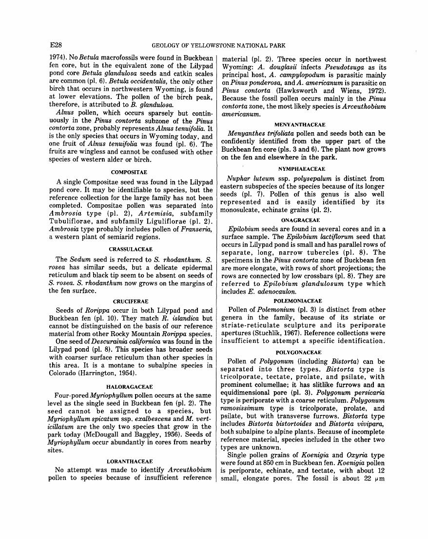
E28 GEOLOGY OF YELLOWSTONE NATIONAL PARK
1974). No Betula macrofossils were found in Buckbean fen core, but in the equivalent zone of the Lilypad pond core Betula glandulosa seeds and catkin scales are common (pl. 6). Betula occidentalis, the only other birch that occurs in northwestern Wyoming, is found at lower elevations. The pollen of the birch peak, therefore, is attributed to B. glandulosa.
Alnus pollen, which occurs sparsely but continuously in the P't'nus contorta subzone of the Pinus contorta zone, probably represents Alnus tenuifolia. It is the only species that occurs in Wyoming today, and one fruit of Alnus tenuijolia was found (pl. 6). The fruits are wingless and cannot be confused with other species of western alder or birch.
COMPOSITAE
A single Compositae seed was found in the Lilypad pond core. It may be identifiable to species, but the reference collection for the large family has not been completed. Compositae pollen was separated into Ambrosia type (pl. 2), Artemisia, subfamily Tubuliflorae, and subfamily Liguliflorae (pl. 2). .Ambrosia type probably includes pollen of Franseria, a western plant of semiarid regions.
CRASSULACEAE
The Sedum seed is referred to S. rhodanthum. S. rosea has similar seeds, but a delicate epidermal reticulum and black tip seem to be absent on seeds of S. rosea. S. rhodanthum now grows on the margins of the fen surface.
CRUCIFERAE
Seeds of Rorippa occur in both Lilypad pond and Buckbean fen (pl. 10). They match R. islandica but cannot be distinguished on the basis of our reference material from other Rocky Mountain Rorippa species.
One seed of Descurainia californica was found in the Lilypad pond (pl. 8). This species has broader seeds with coarser surface reticulum than other species in this area. It is a montane to subalpine species in Colorado (Harrington, 1954).
HALORAGACEAE
Four-pored Myriophyllum pollen occurs at the same level as the single seed in Buckbean fen (pl. 2). The seed cannot be assigned to a species, but Myriophyllum spicatum ssp. exalbescens and M. verticiUatum are the only two species that grow in the park today (McDougall and Baggley, 1956). Seeds of Myriophyllum occur abundantly in cores from nearby sites.
LORANTHACEAE
No attempt was made to identify Arceuthobium pollen to species because of insufficient reference
material (pl. 2). Three species occur in northwest Wyoming: A. douglasii infects Pseudotsuga as its principal host, A. campylopodum is parasitic mainly on Pinus ponderosa, and A. americanum is parasitic on Pinus contorta (Hawksworth and Wiens, 1972). Because the fossil pollen occurs mainly in the Pinus contorta zone, the moc;t likely species is Arceuthobium americanum.
MENYANTHACEAE
Menyanthes trifoliata pollen and seeds both can be confidently identified from the upper part of the Buckbean fen core (pls. 3 and 6). The plant now grows on the fen and elsewhere in the park.
NYMPHAEACEAE
Nuphar luteum ssp. polysepalum is distinct from eastern subspecies of the species because of its longer seeds (pl. 7). Pollen of this genus is also well represented and is easily identified by its monosulcate, echinate grains (pl. 2).
ONAGRACEAE
Epilobium seeds are found in several cores and in a surface sample. The Epilobium lactiflorum seed that occurs in Lilypad pond is small and has parallel rows of separate, long, narrow tubercles (pl. 8). The specimens in the Pinus contorta zone of Buckbean fen are more elongate, with rows of short projections; the rows are connected by low crossbars (pl. 8). They are referred to Epilobium glandulosum type which includes E. adenocaulon.
POLEMONIACEAE
Pollen of Polemonium (pl. 3) is distinct from other genera in the family, because of its striate or striate-reticulate sculpture and its periporate apertures (Stuchlik, 1967). Reference collections were insufficient to attempt a specific identification.
POLYGONACEAE
Pollen of Polygonum (including Bistorta) can be separated into three types. Bistorta type is tricolporate, tectate, prolate, and psilate, with prominent columellae; it has slitlike furrows and an equidimensional pore (pl. 3). Polygonum persicaria type is periporate with a coarse reticulum. Polygonum ramosissimum type is tricolporate, prolate, and psilate, but with transverse furrows. Bistorta type includes Bistorta bistortoides and Bistorta vivipara, both subalpine to alpine plants. Because of incomplete reference material, species included in the other two types are unknown.
Single pollen grains of Koenigia and Oxyria type were found at 850 em in Buckbean fen. Koenigia pollen is periporate, echinate, and tectate, with about 12 small, elongate pores. The fossil is about 22 ~ m

VEGETATION HISTORY OF THE YELLOWSTONE LAKE BASIN E29
(micrometres) in diameter, whereas the reference material is about 25 lAm. Oxyria-type pollen is spheroidal, tricolporate, psilate, and tectate, with slit-shaped furrows and small pores. Both plants are restricted to arctic-alpine envirqnments, and Koenigia is rare in the modern flora of the tundra in the Rocky Mountains (Weber, 1967).
The pollen of Eriogonum or Rumex could not be separated into morphological types. However, one fragmentary and one whole seed of Rumex salicifolius (pl. 6) suggest that Rumex pollen (pl. 4) belongs to that species in the Picea-Juniperus-Pinus albicaulis zone. The seeds also resemble the adventive R. crispus but are distinct in size and shape from other native species. Rumex fueginus seeds and perianths are present in the Pinus contorta zone of Buckbean fen and they are abundant in the upper zones of other cores in the area. The distinctive denticulate valves of R. fueginus (pl. 6) distinguish it from all other species. The separate seeds closely resemble those of R. paucifolius.
RANUNCULACEAE Only two fruits of Ranunculus aquatilis were found
(pl. 8). The distinctive ribbed achenes distinguish it from all other species of Ranunculus.
ROSACEAE
Potentilla seeds were difficult to identify as to species because of the large number of species in the Rocky Mountain area. The PotentiUa cf. gracilis is smaller than all the reference material, but it comes closest in size and shape to Potentilla gracilis (pl. 8). Potentilla biennis type matches both the striated seeds of P. biennis and P. norvegica (pl. 8). For plant-geographical and autoecological reasons, the seeds are referred to asP. biennis. The large, broad seeds of P. palustris are distinct from all other species (pl. 8), and the striate pollen is also distinctive (pl. 4). Sibbaldia procumbens, a genus closely related to Potentilla, has larger and broader seeds distinct in shape from species of Potentilla. It is a subalpine and alpine plant.
SALICACEAE The bracts referred to Populus balsamifera (pl. 6)
also resemble Populus trichocarpa. The former is a boreal forest tree extending from Northeastern United States through western Canada with disjunctions south to the Yellowstone National Park area (Fowells, 1965). Populus trichocarpa is a west coast tree whose distribution extends inland to the Yellowstone National Park area (Fowells, 1965). Their present ranges overlap, and the acceptance of Populus balsamifera in Yellowstone National Park by McDougall and Baggley (1956) is in need of verification. Fossils of these two species are difficult
to distinguish, but bracts of P. balsamifera are narrower than those of P. trichocarpa in our material. Populus trichocarpa grows along stream banks and flood plains at low elevations. Populus balsamifera is not strictly riparian, and it grows in the montane and subalpine zones up to 11,000 feet (Porter, 1967; Weber, 1967). Ecological and morphological considerations support the referral of the fossil bracts to Populus balsamifera, and the pollen probably is of this species also (pl. 4).
A fairly distinct morphologic type of Salix pollen (pl. 4) was found in some alpine surface samples. Inadequate reference material for this genus has made careful study unwarranted. Buds of Salix have not been identified to species, but a few leaf bases can tentatively be referred to Salix subcoerulea. Seed and leaf reference collections are also incomplete for this genus.
SAXIFRAGACEAE A single seed of Saxifraga caespitosa was found in
the Lilypad pond core (pl. 10). The seed is ovate-oblong and has a surface pattern of linear rows of tiny beadlike projections. Only Saxifraga rivularis has a similar beaded pattern, but in that species the beads form a reticulum. I have collected Saxifraga caespitosa from the Two Ocean Plateau and from the Beartooth Plateau, and it is an alpine species.
Another saxifrage seed is referred to Saxifraga rhomboidea (pl. 10). It also is ovate-oblong, and its surface is traversed by discontinuous, often indistinct ridges. This species ranges from the plains to the alpine tundra.
CYPERACEAE Although the genus Carex is represented by many
species in the Rocky Mountain region, collections from wet-ground species in Yellowstone National Park have allowed several species to be identified from their fruits. Usually the perigynium, an inflated sac covering the achene, must be present for identification.
Several fruits with perigynia of Carex aquatilis were found (pl. 9). Separate achenes, when preservation was excellent, were placed in this species, but others less well preserved or with different morphology were placed under Carex biconvex. Carex aquatilis is the commonest of the Carex species with biconvex achenes that grow in wet places in Yellowstone National Park.
Carex canescens fruits are biconvex and their small plump perigynia are strongly veined (pl. 9). Carex diandra fruits (pl. 9) have a corky-based perigynium that tightly encases the achene. The achenes are shaped somewhat like Scirpus fruits, but they are round rather than biconvex in cross section. Achene
E30 GEOLOGY OF YELLOWSTONE NATIONAL PARK
and perigynium are usually found together but can be recognized separately. Carex limosa fruits were never found with perigynia. The achenes are weakly triangular to round in cross section, obovate, and usually indented in one side (pl. 7). They match reference material perfectly, and Carex limosa grows at present in the Carex diandra-PotentiUa palustris community on the fen. Carex vesicaria and C. utriculi:Lta are two other species now common on the fen. Their perigynia are distinguished by shape; C. vesicaria perigynia taper gradually to a slender base, whereas those of C. utriculi:Lta are abruptly expanded to a broader base (pl. 7).
A single Eleocharis macrostachya fruit, corroded but identifiable, was found in the Buckbean fen core (pl. 9). These fruits are much more common in other cores from this area. These biconvex fruits with the small, broad-based tubercle connected only at the top of the fruit are easily separable from other species in the area.
GRAMINEAE
Seeds of this family generally have thin seed coats and only a few genera with thick seed coats fossilize. Spikelets of Calilmagrostis are abundant in one macrofossil surface sample from Buckbean fen but are not found as fossils. Calilmagrostis canadensis and C. inexpansa are common on the fen surface today, and they probably grew there throughout most of postglacial time.
Seeds of Glyceria maxima ssp. grandis are present at only one horizon of the Buckbean fen core but are abundant in other cores from the area (pl. 9). This species has seeds similar to G. borealis, but the seed tip is blunt in G. maxima and sharp in G. borealis. The reference specimens are somewhat larger than the fossil material. Other species are quite different in morphology and size.
NAIADACEAE
Seeds of Naias flexilis are easily distinguishable from other species in the genus by size and surface texture (pl. 9). This species is not reported from the present flora of Wyoming or Colorado, though it does occur in Utah (Porter, 1963; Matsumura and Harrington, 1955). I have found seeds of Naias flexilis in approximately the midpostglacial from four ponds in Yellowstone National Park. The plant probably grows in Wyoming and Colorado, but it is unreported because it is inconspicuous and because aquatic plants are not commonly collected.
Several species of Potamogeton have very distinctive fruit-stones, and many of the North American species are treated in keys (Jessen, 1955; Martin and Barkley, 1961). In Potamogeton alpinus the lid reaches the top of the fruit-stone and is remote
from the style base. One specimen was found with its soft outer covering intact (pl. 7). Potamogeton filiforrnis fruit-stones also have the lid remote from the style base, but the lid does not reach the top of the fruit-stone (pl. 7). It is similar to but smaller than fruit-stones of P. vaginatus and P. pectinatus. P. gramineus fruit-stones are rather small with a low central depression and a low-keeled lid (pl. 7). One fruit-stone w'ithout a lid best matches P. iUinoensis, but certain identification is not possible. It occurs with a fruit-stone of P. alpinus.
TYPHACEAE
Fruits of Typha cannot be identified to species (pl. 10). Pollen of Typha liltifolia remains in tetrads, so this species is recognizable (pl. 2). Typha angustifolia pollen cannot be distinguished from pollen of Sparganium or broken tetrads of Typha liltijolia, and the pollen is here called Sparganium type because fruits of Sparganium angustijolium and S. minimum have been found in other nearby cores.
OTHER TYPES OF FOSSILS
Other types of macrofossils were tallied on a scale from one (rare) to five (very abundant). No attempt was made to differentiate among bryophyte spores, although the one shown on plate 1 is the commonest type. Abundance of Sphagnum leaves was noted, because the two types of cells in the leaves make them easy to recognize.
ALGAE
Pediastrum colonies (pl. 4) were counted and plotted in the pollen diagram (fig. 15) because they indicate an aquatic environment. They are present in many surface samples, especially those from larger or deeper ponds.
Oogonia of charophytes were tallied in the macrofossil diagrams (figs. 17 and 18). They disappear above 820 em in the Buckbean fen core, but they are present in younger horizons from other cores in the area.
One species of diatom (Melosira?) was large enough to be caught by the 140-mesh sieve; specimens were sent to R. C. Bright for identification. The species occurs below 800 em in Buckbean fen and Lilypad pond cores.
Statoblasts of freshwater bryozo~ and shells of rhizopods were not further identified. Both occur mainly in the small pond stage of the Buckbean fen core in the interval 275 - 4 75 em.
DESCRIPTION OF POLLEN ZONES PICEA-JUNIPERUS-PJNUS ALBICA ULIS
ZONE (960-770cm)
The basal zone is defined by relatively low (30- 50 percent) Pinus pollen (dominantly Pinus albicaulis
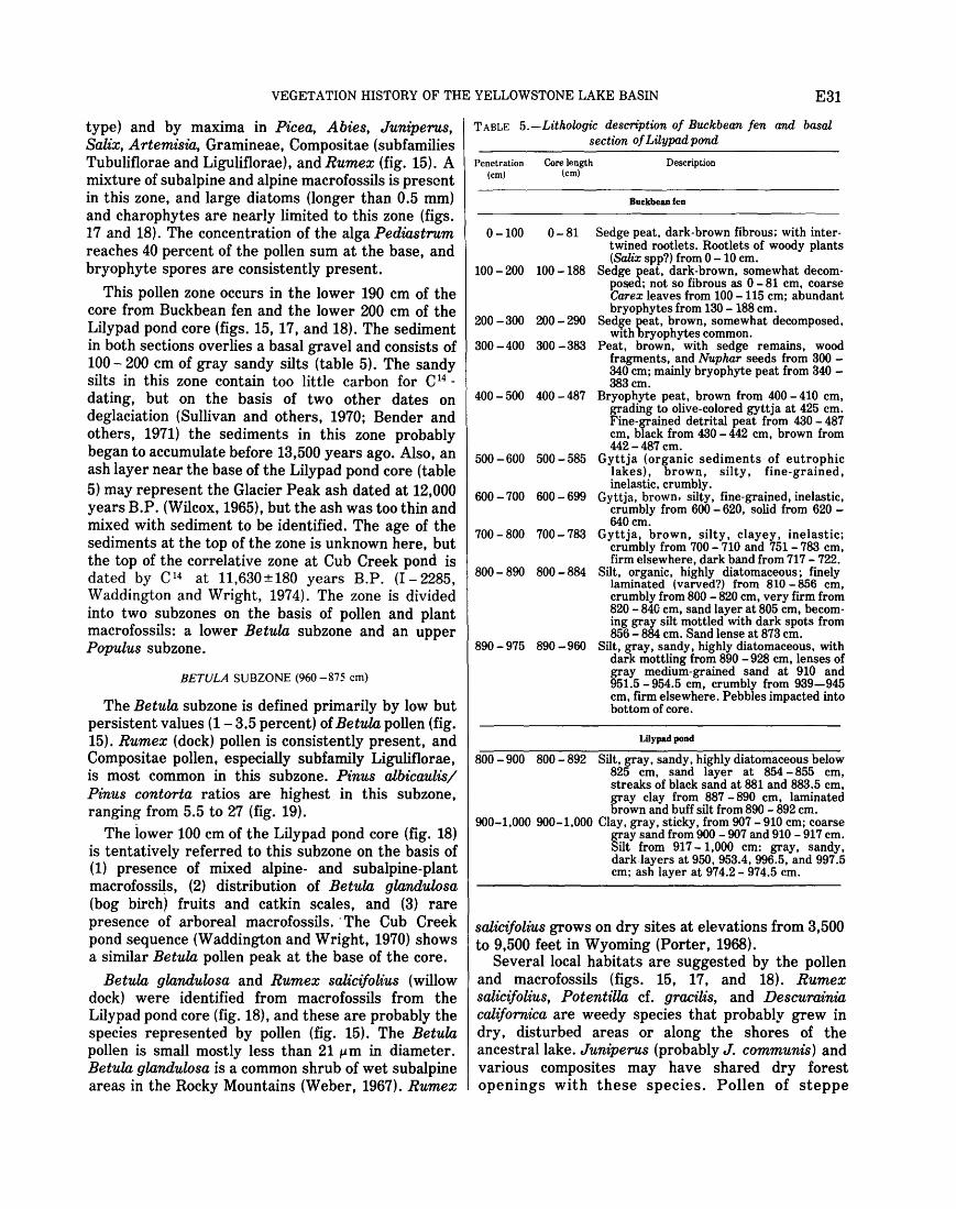
VEGETATION HISTORY OF THE YELLOWSTONE LAKE BASIN E31
type) and by maxima in Picea, Abies, Juniperus, Salix, Artemisia, Gramineae, Compositae (subfamilies Tubuliflorae and Liguliflorae), and Rumex (fig. 15). A mixture of subalpine and alpine macrofossils is present in this zone, and large diatoms (longer than 0.5 mm) and charophytes are nearly limited to this zone (figs. 17 and 18). The concentration of the alga Pediastrum reaches 40 percent of the pollen sum at the base, and bryophyte spores are consistently present.
This pollen zone occurs in the lower 190 em of the core from Buckbean fen and the lower 200 em of the Lilypad pond core (figs. 15, 17, and 18). The sediment in both sections overlies a basal gravel and consists of 100-200 em of gray sandy silts (table 5). The sandy silts in this zone contain too little carbon for C 14 -
dating, but on the basis of two other dates on deglaciation (Sullivan and others, 1970; Bender and others, 1971) the sediments in this zone probably began to accumulate before 13,500 years ago. Also, an ash layer near the base of the Lilypad pond core (table 5) may represent the Glacier Peak ash dated at 12,000 years B.P. (Wilcox, 1965), but the ash was too thin and mixed with sediment to be identified. The age of the sediments at the top of the zone is unknown here, but the top of the correlative zone at Cub Creek pond is dated by C 14 at 11,630±180 years B.P. (I- 2285, Waddington and Wright, 1974). The zone is divided into two subzones on the basis of pollen and plant macrofossils: a lower Betula subzone and an upper Populus subzone.
BETULA SUBZONE (960 -875 em)
The Betula subzone is defined primarily by low but persistent values (1- 3.5 percent) of Betula pollen (fig. 15). Rumex (dock) pollen is consistently present, and Compositae pollen, especially subfamily Liguliflorae, is most common in this subzone. Pinus albicaulis/ Pinus contorta ratios are highest in this subzone, ranging from 5.5 to 27 (fig. 19).
The lower 100 em of the Lilypad pond core (fig. 18) is tentatively referred to this subzone on the basis of (1) presence of mixed alpine- and subalpine-plant macrofossils, (2) distribution of Betula glandulosa (bog bireh) fruits and catkin scales, and (3) rare presence of arboreal macrofossils. ·The Cub Creek pond sequence (Waddington and Wright, 1970) shows a similar Betula pollen peak at the base of the core.
Betula gklndulosa and Rumex salicifolius (willow dock) were identified from macrofossils from the Lilypad pond core (fig. 18), and these are probably the species represented by pollen (fig. 15). The BetukL pollen is small mostly less than 21 1-' m in diameter. BetukL glandulosa is a common shrub of wet subalpine areas in the Rocky Mountains (Weber, 1967). Rumex
TABLE 5.-Lithologic description of Buckbean fen and basal section of Lilypad pond
Penetration Core length (em) (em)
0-100 0-81
100 - 200 100 - 188
200 -300 200 - 290
300 - 400 300 - 383
400 - 500 400 - 487
500 -600 500 - 585
600 -700 600 - 699
700 - 800 700- 783
800- 890 800 - 884
890 - 975 890 -960
Description
Buckbean fen
Sedge peat, dark-brown fibrous; with intertwined rootlets. Rootlets of woody plants (Salix spp?) from 0 - 10 em.
Sedge peat, dark-brown, somewhat decomposed; not so fibrous as 0-81 em, coarse Carex leaves from 100 - 115 em; abundant bryophytes from 130- 188 em.
Sedge peat, brown, somewhat decomposed, with bryophytes common.
Peat, brown, with sedge remains, wood fragments, and Nuphar seeds from 300 -340 em; mainly bryophyte peat from 340-383cm.
Bryophyte peat, brown from 400 - 410 em, grading to olive-colored gyttja at 425 em. Fine-grained detrital peat from 430 - 487 em, black from 430 - 442 em, brown from 442-487 em.
Gyttja (organic sediments of eutrophic lakes), brown, silty, fine-grained, inelastic, crumbly.
Gyttja, brown, silty, fine-grained, inelastic, crumbly from 600- 620, solid from 620 -640cm.
Gyttja, brown, silty, clayey, inelastic; crumbly from 700 - 710 and 751 - 783 em, firm elsewhere, dark band from 717-722.
Silt, organic, highly diatomaceous; finely laminated (varved?) from 810-856 em, crumbly from 800 - 820 em, very firm from 820 - 840 em, sand layer at 805 em, becoming gray silt mottled with dark spots from 856 - 884 em. Sand lense at 873 em.
Silt, gray, sandy, highly diatomaceous, with dark mottling from 890-928 em, lenses of gray medium-grained sand at 910 and 951.5 - 954.5 em, crumbly from 939-945 em, firm elsewhere. Pebbles impacted into bottom of core.
Lilypadpond
800 - 900 800 - 892 Silt, gray, sandy, highly diatomaceous below 825 em, sand layer at 854 - 855 em, streaks of black sand at 881 and 883.5 em, gray clay from 887 - 890 em, laminated brown and buff silt from 890 - 892 em.
900-1,000 900-1,000 Clay, gray, sticky, from 907-910 em; coarse gray sand from 900 - 907 and 910 - 917 em. Silt from 917-1,000 em: gray, sandy, dark.layers at 950, 953.4, 996.5, and 997.5 em; ash layer at 974.2- 974.5 em.
salicifolius grows on dry sites at elevations from 3,500 to 9,500 feet in Wyoming (Porter, 1968).
Several local habitats are suggested by the pollen and macrofossils (figs. 15, 17, and 18). Rumex salicijolius, Potentilla cf. gracilis, and Descurainia californica are weedy species that probably grew in dry, disturbed areas or along the shores of the ancestral lake. Juniperus (probably J. communis) and various composites may have shared dry forest openings with these species. Pollen of steppe
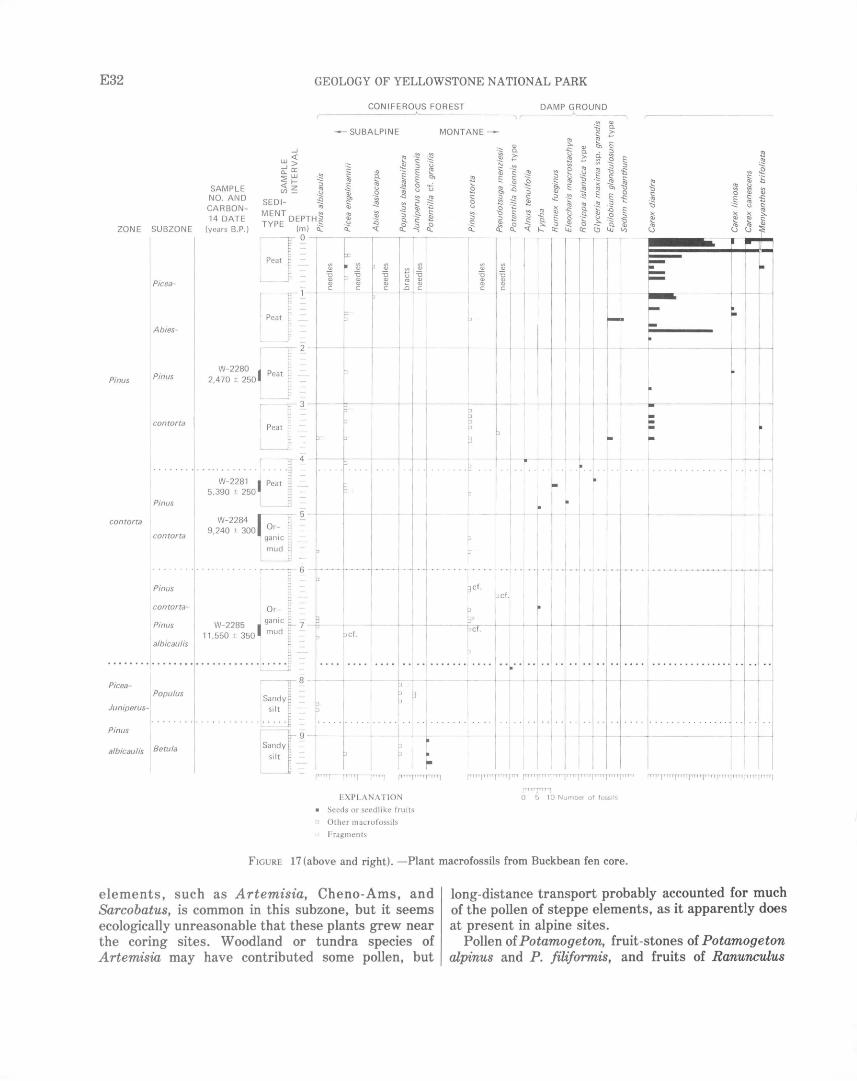
E32 GEOLOGY OF YELLOWSTONE NATIONAL PARK
CONIFEROUS FOREST
ZONE SUBZONE
Abies-
Pinus Pinus
contorta
Pinus
contorta I
contorta
Pinus I
1
contorta-
Pinus
I albicau/is
Picea-
Juniperus-
1 Populus
Pinus
....J
w<t: ....J> a_O: 2w <t:f(/)~
SED I-
~ :::,
.~ ~
"'
.-SUBALPINE
·c: •0 <:: e. "' .§ "' <..> <1l -S? <:>,
~ <:: <1l
~ -~ <::
~ :::, .E ~
E: "' ~ Cl
"' <..>
.Q ~
SAMPLE NO. AND CARBON-14 DATE MENT DEPTH~
TYPE (m) ~ "' .~ <1l -!:: .Q
~ ~ :::, -2-Cl. <:: (years B.P.)
~J o Peat ~
L__ -
~PeaT. ~ I ~ -
It~ W-2280 J Peaj =
2,470 ± 250. -
l = I PeaJ~ L_JJ-
. ~~;,., J ,,, ~c-5.390 ± 250 L J _
W- 2284 ~~ ~ 9,240 ± 300 Or~ -gan1c mud
. :--T ~
Or
W-2285 J ganic 11,550 ± 350 I mud
•••.•••.••• 1 •••••
L
ri
1 ~· 8 -\Sandy
si It
.. ·L···· I
\Sandy
silt
9 -
~ oq: ~ ~
--- ----t ----
1 i
~"
EXPLANATION
• Seeds or seedlike fruits
o Other macrofoss ils
' Fragments
-~ ::::: <..> ~ <:>,
t .!:!1 ~ <:: ~ Cl ~
I
I
. .... ·\·· ................ .
fl'" r'"'l 0 5 10 Number of fossils
FIGURE 17 (above and right). -Plant macrofossils from Buckbean fen core.
elements, such as Artemisia, Cheno-Ams, and Sarcobatus, is common in this subzone, but it seems ecologically unreasonable that these plants grew near the coring sites. Woodland or tundra species of Artemisia may have contributed some pollen, but
long-distance transport probably accounted for much of the pollen of steppe elements, as it apparently does at present in alpine sites.
Pollen of Potamogeton, fruit-stones of Potamogeton alpinus and P. filiformis, and fruits of Ranunculus
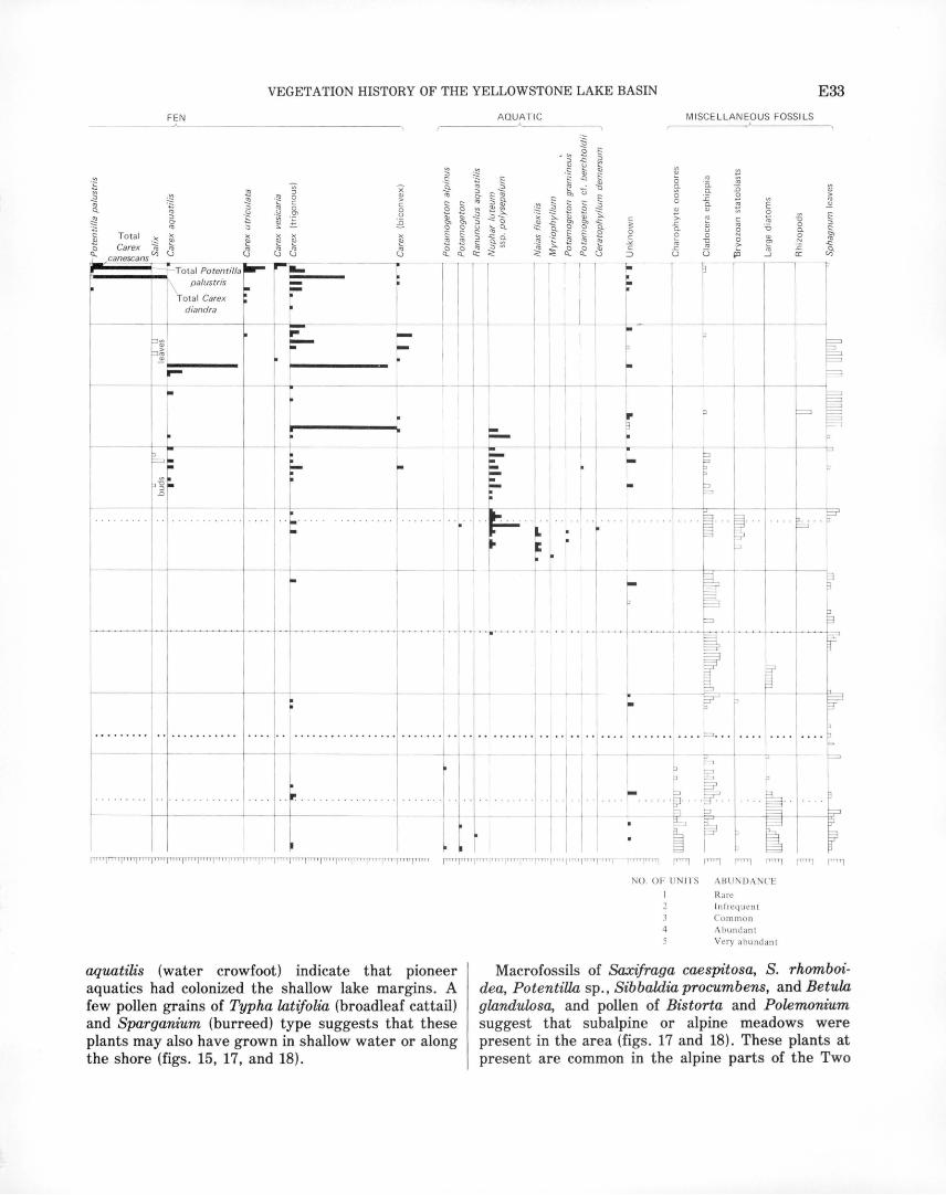
VEGETATION HISTORY OF THE YELLOWSTONE LAKE BASIN
FEN AQUAT IC MISCE LLANEOUS FOSSILS
•§ ~ -~ Ctl ~ Cl.. C1)
~ g. ~ <1J
~ Tota l ~ ~ ti: Carex ~ Cj
canescans Total Potentilla -
~---+.....(\ palustris 1
Tota l Carex : diandra
I
~~
~~ ~ .... ---. I
~ = . :J -g :..
.0
I
-I
. 1=-- 1 :-1 :.
I ! . I
I I I
i I I
-
c ~ 0 c
.:.:. c
::J
I
r
-I
I :.. I : -- +--+------ - I I L -
. .. • .. ...• . • • . .• . I . · I ··~·· .L ·i. ·. I I .. , ..... . . .. . . . .
L _J ~- JL~ ~ I
. r---4-4-----4--4--4-------- I I I t-f-------J---+---.----------j ---+·-+------·~- . + - .. _I_ . - ~ -~ .... I I _ -- --l -
1 I I I
f------+-- - -----1-
--
.
I I I
t ~~
I I .. .... .. ·J·· ....
~ r I
I
Ql
0 a. 0 0 Ql
>. ..c a.
~ u
·t ·-
1
p
F . r .. . . . . . . . I'""' . . . · ~·
- ~ I ~
"' a. a.
:.c ~
"' Ql u 0
~ u
NO. OF UN ITS ABUNDA CE
Rare In frequent Common
4 Abundant Very abundant
-o 0 a. .§ ..c a:
E33
Ql >
"' Ql
aquatilis (water crowfoot) indicate that pioneer aquatics had colonized the shallow lake margins. A few pollen grains of Typha latifolia (broadleaf cattail) and Sparganium (burreed) type suggests that these plants may also have grown in shallow water or along the shore (figs. 15, 17, and 18).
Macrofossils of Saxifraga caespitosa, S. rhomboidea, PotentiUa sp., Sibbaldia procumbens, and Betula glandulosa, and pollen of Bistorta and Polemonium suggest that subalpine or alpine meadows were present in the area (figs. 17 and 18). These plants at present are common in the alpine parts of the Two
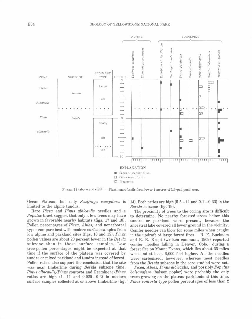
E34 GEOLOGY OF YELLOWSTONE NATIONAL PARK
ALPIN E
~ 2
·~
r3 §, (I)
~
E :::J ....
(I) 0
% <ll
~ (.) 0
.!)? .Q
E 0 u -c: ....
E §, . ~ .Q
(I)
~
SUBALPINE
~ ~ (I) : ~ ~ 'ti
"' .E ~ 0 ·~ c:: tl'> ~ ~
(I) (I) l::J (I) E ~ u c:: ·~ ~ (I)
.!)? :::? tl'> .Q .!)?
tl'> c:: "' ~ .!)? (I) <ll :::J
c:: ~ "' (I) ~
~ ·;;: 2 :::J <ll Q. ~ .s (.)
SEDIMENT ·;;: (I) <ll 0 0
(/) (() Cl i:i: Cl Cl TYPE DEPTH(m) ~ ZO N E SU BZON E 8 --~--~------~--~--~r---r---~--~--~---
Pice a-
Populus
Junip erus-
Pinus Betula
albicaulis
Sandy
si It
Sandy
si It
xxxxxxx ash /
9
L.._._ ______ ...___ 1 0
·····
l''''l''''l''''l''''l''''l''''l''''llllljlllljl I ''I EXPLANATION
• Seeds or seedli ke fruits 0 Other macrofossils
C Fragments
F IGURE 18 (above and right). - Plant macrofossils from lower 2 metres of Lilypad pond core.
Ocean Plateau, but only Saxifraga caespitosa is limited to the alpine tundra.
Rare Picea and Pinus albicaulis needles and a Populus bract suggest that only a few trees may have grown in favorable nearby habitats (figs. 17 and 18). Pollen percentages of Picea, Abies, and nonarboreal types compare best with modern surface samples from low alpine and parkland sites (figs. 13 and 15). Pinus pollen values are about 20 percent lower in the Betuw subzone than in these surface samples. Low tree-pollen percentages might be expected at that time if the surface of the plateau was covered by tundra or mixed parkland and tundra instead of forest. Pollen ratios also support the conclusion that the site was near timberline during Betuw subzone time. Pinus albicaulis/Pinus contorta and Gramineae/Pinus ratios are high (1 - 11 and 0.025- 0.2) in modern surface samples collected at or above timberline (fig.
14). Both ratios are high (5.5 -11 and 0.1 - 0.33) in the Betuw subzone (fig. 19).
The proximity of trees to the coring site is difficult to determine. No nearby forested areas below this tundra or parkland were present, because the ancestral lake covered all lower ground in the vicinity. Conifer needles can blow for some miles when caught in the updraft of large forest fires. R. F. Bucknam and B. B. Kropf (written commun., 1969) reported conifer needles falling in Denver, Colo., during a forest fire on Mount Evans, which lies about 35 miles west and at least 6,000 feet higher. All the needles were carbonized, however, whereas most needles from the Betuw subzone in the core studied were not.
Picea, Abies, Pinus albicaulis, and possibly Populus balsamifera (balsam poplar) were probably the only trees growing on the plateau parklands at this time. Pinus contorta type pollen percentages of less than 2
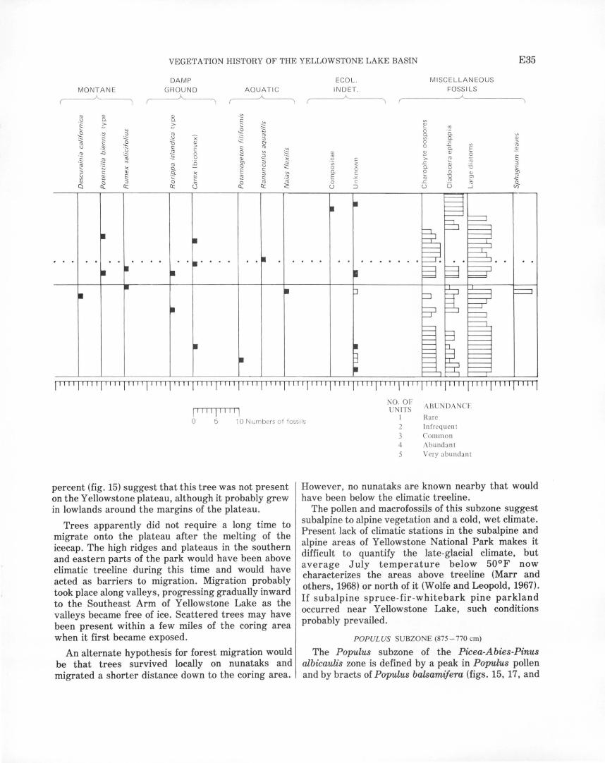
VEGETATION HISTORY OF THE YELLOWSTONE LAKE BASIN E35
DAM P ECOL . M ISCE LLANEOUS
MONTAN E GROU ND A QU AT IC IN D ET . FOSS ILS
'1l QJ QJ - ~ - ~ Q. Q. E "' c::: ~ ~ -~ ~ '- "' ~ ~ 0
ro
~ -~ ::J '1l x '1l Q. Q. "' c::: ~ -~ ::J 0 Q. QJ
~ c::: '0 QJ ;;: tt > ~ -~ :~
c::: > c::: '1l 0 L E ro c ~
Q. ~ -~
..Q ~ 0 2 "' <ll ~ QJ 0
~ -~ u ::J ")( ~ f: c::: ~ Cll :; c > ro .~ -~ ~ "' '1l ii t::ll Cll ·;:;; s L a; ::J
)( Q. 0 ~ .-;:::: 0 Q. u -o c::: f: c::: 0
::J c::: Cll .9- )( ::J V). Q. c e 0 QJ t::ll ~ !:: f: Cll ~ -~ E -o '1l
"' '- c::: .:.:. ro f:l ..c:: Cll 0 ::J 0 '-
ci: '1l '1l 0 c L ro
a co ~ Cl Q.. c:c: c:c: c:c: < u ::l u u ....J
1 I I I I 1 'I'' 1'' ''1'' ''1''' 'I I''' I I' I 'I I I' I 1' I' I I I' I' I I I'' 1 I I I I I I I ''I I I I I I I '''IIIII] I '''I I I ''1''''1 I 11 I I I I I 1 I
1111 1
11111
1
NO. OF ABU DANCE ITS
0 5 10 Numbers of fossils I Rare
Infrequ ent
percent (fig. 15) suggest that this tree was not present on theY ellowstone plateau, although it probably grew in lowlands around the margins of the plateau.
Trees apparently did not require a long time to migrate onto the plateau after the melting of the icecap. The high ridges and plateaus in the southern and eastern parts of the park would have been above climatic treeline during this time and would have acted as barriers to migration. Migration probably took place along valleys, progressing gradually inward to the Southeast Arm of Yellowstone Lake as the valleys became free of ice. Scattered trees may have been present within a few miles of the coring area when it first became exposed.
An alternate hypothesis for forest migration would be that trees survived locally on nunataks and migrated a shorter distance down to the coring area.
2 3 Comm on 4 Abundant 5 Very abundant
However, no nunataks are known nearby that would have been below the climatic treeline.
The pollen and macrofossils of this subzone suggest subalpine to alpine vegetation and a cold, wet climate. Present lack of climatic stations in the subalpine and alpine areas of Yellowstone National Park makes it difficult to quantify the late-glacial climate, but average July temperature below 50°F now characterizes the areas above treeline (Marr and others, 1968) or north of it (Wolfe and Leopold, 1967). If subalpine spruce-fir -whitebark pine parkland occurred near Yellowstone Lake, such conditions probably prevailed.
POPULUS SUBZONE (875- 770 em)
The Populus subzone of the Picea-Abies-Pinus albicaulis zone is defined by a peak in Populus pollen and by bracts of Populus balsamifera (figs. 15, 17, and
E36 GEOLOGY OF YELLOWSTONE NATIONAL PARK
18). A peak in the curve for Ambrosia also occurs in this subzone (fig. 15). Alpine-plant macrofossils are no longer present, Picea and Pinus albicaulis needles are more common, and Juniperus communis needles appear (figs. 17 and 18). Pinus albicaulis/Pinus contorta and Gramineae/ Pinus ratios decrease throughout this zone and range from 1.1 to 7.5 and from 0.047 to 0.228, respectively (fig. 19).
Several local habitats may be inferred from the fossils in this subzone. Betula glandulosa, Potentilla cf. gracilis, Rorippa islandica (marshcress) type, and Epilobium cf. lactiflorum (pale willow-herb) macrofossils (fig. 18) suggest a moist subalpine meadow nearby. A dry, open subalpine environment, such as might have been found near the shores of Yellowstone Lake, is inferred from macrofossils of Rumex salicifolius and Potentilla biennis type. The fossil aquatic flora includes Ranunculus aquatilis, Potamogeton alpinus, and Naias flexilis (naiad). Naias flexilis is not reported from the modern floras of Wyoming or Colorado. Single pollen grains of Oxyria
U) LU
100
200
300
a: 400 1-l.U 2 1-z LU (..)
~
I t 600 LU 0
800
900
960
I
GRAMINEAE/P/NUS POLLEN RATIO
AGE, IN YEARS B.P.
SUBZONE BOUNDARIES ~)
<....._.....Graminae/ Pinus "'>
2,470 / (
I
ca. 5,000
5,590
9,240
ca.10,160
Pinus albicaulis/Pinus conto;tf,550
ca. 11,630
----- -~-====--
Picea-Abies-Pinus contorta subzone
Pinus contorta subzone
Pim:s contortaPinus albicaulis
subzone
Populus subzone
----- ·-------------------·--17
-------:-=~===-~=-- 27
16
2 3 4 5 6 8 9 10 11 12 13 14
P. ALB/CAUL/SIP. CONTORTA POLLEN RATIO
FIGURE 19.-Ratios for fossil pollen from Buckbean fen.
(alpine sorrel) and Koenigia islandica at 850 em suggest that alpine plants may have persisted for a while on exposed sites.
Picea engelrnannii, Pinus albicaulis, Populus balsamifera, and probably Abies lasiocarpa were present locally in a subalpine parkland environment. This interpretation is suggested by analogy with surface samples and from the composition of the pollen and plant-macrofossil spectra. A closed Picea-AbiesPinus albicaulis forest is ruled out by the high nonarboreal pollen curves and high Gramineae/Pinus ratios that typify surface samples from modern parkland or tundra (figs. 14, 15, and 19).
Populus balsamifera probably was a pioneer species along the shores of Yellowstone Lake, perhaps as early as during the previous subzone. Populus trichocarpa (black cottonwood), a closely related species, is an early migrant onto deglaciated surfaces in southeast Alaska (Lawrence, 1958). Populus pollen maxima indicate that it was an early migrant in northwest Minnesota after deglaciation (McAndrews, 1967), and macrofossils of three species, including P. balsamifera, were found in sediments of late glacial age in southern Manitoba (Ritchie and de Vries, 1964).
To summarize the environments of the Picea-AbiesPinus albicaulis zone, the basal subzone represents an environment at or slightly above timberline with few, if any, trees present. During the time of the upper subzone, trees were present in a subalpine parklandtype vegetation. The climate for this zone was probably comparable to that of the high subalpine or low alpine associations today in Yellowstone Park. Treeline was approximately 2,000 feet lower than it is today.
PINUS CONTORTA ZONE(770-0cm)
This zone is defined by high percentages ( 65 - 88 percent) of the total pine pollen and by Pinus contorta macrofossils (figs. 15 and 17). Artemisia declines from more than 20 to less than 10 percent in this zone, and values of Juniperus, Picea, Abies, Betula, and most nonarboreal pollen are low (fig. 15).
The sediments in this zone are silty gyttja in the interval 770 - 500 em, transitional organic detritus in the interval500 - 410 em, and peat from 410 em to the surface (table 5). No dates are available from sediments at the base of this zone, but a date at the zone boundary at Cub Creek pond is 11,630 ± 180 years B.P. (sample I- 2285; Waddington and Wright, 1970).
The zone is divided into the following three subzones: the Pinus contorta-Pinus albicaulis subzone (770- 600 em), the Pinus contorta subzone (600- 420 em), and the Picea-Abies-Pinus contorta subzone (420- 0 em) (fig. 15, table 3).
VEGETATION HISTORY OF THE YELLOWSTONE LAKE BASIN E37
PINUS CONTORTA-PINUSALBICAULIS SUBZONE (770-600 em)
This subzone is defined by a resurgence of Pinus albicaulis/Pinus contorta ratios up to 8.3 (fig. 19), and the occurrence of needles of both pine species (fig. 17). Pinus pollen percentages average 65 - 70 percent, and Artemisia ranges from 15 to 20 percent (fig. 15). Arceuthobium (dwarf mistletoe) is persistently present, and a few grains of Pseudotsuga occur. Concentrations of Picea, Abies, Juniperus, Populus, Betula, Salix, Ambrosia, Compositae, and Gramineae, all significant in the lower subzones, are several times lower in this subzone (fig. 15).
A radiocarbon date near the base of this subzone gives an age of 11,550 ± 350 years B.P. The age of the top of this subzone is interpolated to be 10,160 years B.P. (figs. 15 and 16, table 3), using the rate of sedimentation calculated from adjacent radiocarbon dates.
The pollen spectra from this subzone compare approximately with modern surface samples from forest openings (fig. 13). Gramineae/Pinus ratios for this subzone are between 0.025 and 0.050; these ratios are lower than those of modern surface samples in forest openings and parklands but higher than ratios in closed forests (figs. 14 and 19). An open, mixed forest with Pinus contorta, Pinus albicaulis, and Pseudotsuga menziesii probably grew in the area during the interval represented by this subzone. (Pollen values of Pseudotsuga as low as 1 percent probably indicate its local presence, based on surface samples.) The most significant change in vegetation after deposition of the lower zone was the arrival of Pinus contorta and Pseudotsuga in the coring area (figs. 15 and 17).
It is difficult to infer other habitats that might have been present during this period because few macrofossils other than pine needles are present. A few Carex fruits and a Typha fruit (fig. 17) suggest a possible pond-shore habitat.
Persistence of A rceuthobium in the pollen profile, beginning at 730 em (fig. 15), gives evidence for a tentative mean annual temperature during that time. Its pollen appears at about the same level that Pinus contorta needles first appear (fig. 17). I could not determine the species using pollen morphology, but it is probably Arceuthobium americanum, a parasite that occurs exclusively on Pinus contorta in this region. It is the only species of Arceuthobium reported from the park by McDougall and Baggley (1956), but Hawksworth and Wiens (1972) reported A. douglasi, a parasite on Pseudotsuga, from the park as well. At present the upper limits of Arceuthobium
americanum coincide with the 30°F mean annual isotherm in Colorado and Wyoming (Gill, 1957), suggesting that the temperature when Arceuthobium first appeared was about the same as it is now.
The coexistence of Pinus contorta, Pinus albicaulis, and probably Pseudotsuga menziesii, and the low values of Pice a and Abies suggest a climate drier than the climate of the preceding zone and also the present climate.
PINUS CONTORTA SUBZONE (600-420 em)
This subzone is defined by 70 - 80 percent Pinus pollen, low ratios of Pinus albicaulis!Pinus contorta pollen, and needles of Pinus contorta (figs. 15, 17, and 19). Pseudotsuga pollen is less common than in the preceding subzone, and Picea and Abies are low throughout. Artemisia pollen ranges from 10 to 15 percent, and Arceuthobium and Alnus are present at low but persistent values (fig. 15).
A sediment sample from interval500- 541 em in the Buckbean fen core gives a C 14 date of 9,240±300 years B.P. (W- 2284). Another sample from interval 440-460 em is dated at 5,390±250 . years B.P. (W- 2281). Interpolation between older and younger dates suggests that this subzone began about 10,160 years ago and ended about 5,000 years ago (fig. 15, table 3), but the 4,000-year span of the dates in the zone, over only a 70-cm interval, suggests a hiatus in the core. (See fig. 16.)
The fossil assemblage suggests that a virtually pure Pinus contorta forest was the dominat vegetation association around the coring site during this period. Fossils from local vegetation types are poorly represented, especially from interval 600 -487 em in this subzone.
From interval 487 - 420 em, macrofossils of Nuphar luteum ssp. polysepalum, Naias flexilis, Myriophyllum sp. (watermilfoil), Potamogeton gramineus, and CeratophyUum demersum (hornwort) and pollen of Nuphar and Myriophyllum suggest a small, warm-water pond habitat (fig. 17). The presence of this habitat requires that Yellowstone Lake had fallen to a level within 15 feet of its present level by about 5,000 years ago.
One fragment of an Alnus tenuifolia (thinleaf alder) fruit at 405 em (fig. 17) suggests that the Alnus pollen is also of that species. It is the only species of Alnus that now occurs in Wyoming (Porter, 1967), and it suggests that the habitat was the margin of a lake, pond, or fen.
Macrofossils of Glyceria maxima ssp. grandis (large mannagrass), Rumex fueginus, Carex utriculata, and
E38 GEOLOGY OF YELLOWSTONE NATIONAL PARK
Typha sp. also provide evidence for a wet-ground vegetation around the margins of the pond (fig. 17).
PICEA-ABIES-PINUS CONTORTA SUBZONE (420-0 em)
This subzone is defined by low but persistent values of Picea and Abies pollen, by their macrofossils, and by low pollen ratios of Pinus albicaulis/Pinus contorta (figs. 15 and 19). The Artemisia curve is at its lowest (4 -10 percent) in the entire core. Cyperaceae pollen percentages are high but irregular in the subzone, but macrofossils indicate that the pollen comes from local fen species of Carex (figs. 15 and 17).
A sample from interval 240 - 260 em gave a C 14 date of 2,470±250 years B.P. (W- 2280). The subzone represents the period from about 5,000 years ago by interpolation to the present. An interpolated date of 2,800 years B.P. marks a rise in Picea, Abies, and Cyperaceae pollen percentages (figs. 15 and 16, table 3).
Pollen and macrofossils of Pt"nus contorta, Picea, and Abies indicate that these trees were dominant in the forest association when this subzone was deposited (figs. 15 and 17). Pollen and a needle of Pseudotsuga menziesii and a needle of Pinus albicaulis type suggest that these trees may have been present early during this period, but they played a decreasing role in the forest association.
Most Picea needles in this subzone are charcoal. Frequent fires nearby might explain the carbonization, though other conifer needles are not charcoal. No prominent charcoal layers were observed in this core, but charcoal is abundant in some horizons of other cores taken in the area. Fires would favor propagation of Pinus contorta (Tackle, 1961) and might tend to eliminate Picea and Abies from the forest. However, no injurious long-term effects of fire on Picea and Abies can be recognized in the pollen diagram (fig. 15).
Changes in the local environment are well documented in this subzone by plant macrofossils (fig. 17). From interval 420-375 em, macrofossils of aquatic and pond-margin plants are still present, suggesting that little change in environment had occurred from the top of the previous subzone.
From interval 375 - 275 em, fen plants, such as Carex aquatilis, C. diandra, a trigonous Carex-probably C. utricullLta-Salix sp., Menyanthes trifoliata, and Epilobium gllLndulosum type, appear (fig. 17). Nuphar luteum ssp. polysepalum pollen and seeds, Potamogeton fruits, and Pediastrum still are present (figs. 15 and 17). These macrofossils suggest that a fen began to encroach into the pond. The pond was probably becoming very shallow and was surrounded by sedges, grasses, and other fen plants, perhaps
growing on a floating mat. The aquatic macrofossils testify that a small pond was still present.
From 275 em to the surface, macrofossils of truly aquatic plants, such as Nuphar, are absent (fig. 17). The Cyperaceae pollen curve is high except between 100 and 40 em and represents chiefly fen species of Carex. The Cyperaceae curve ranges from iO to 40 percent in the interval 260 -175 em (fig. 15). A small pollen peak at 260 em is associated with many achenes of a trigonous Carex, probably C. utricullLta or C. vesicaria (figs. 15 and 17). The abrupt disappearance of aquatic-plant macrofossils and the abundance of sedges imply that this interval represents the demise of the pond at this coring site.
In the interval260 - 175 em, few Carex macrofossils are found, even though the Cyperaceae pollen curve reaches its maximum at 220 em (figs. 15 and 17). Sphagnum moss leaves are very abundant in this interval, and the local sedges may have been choked out by this bog moss. The high Cyperaceae pollen values suggest that Carex was still abundant in other parts of the bog, however. Sphagnum warnstorfianum seems to be the most common Sphagnum in the park today, and the fossil leaves are morphologically similar to leaves of this species. Sphagnum liberates acids in its metabolic processes (Parihar, 1965); hence, it creates a rather acidic environment. It apparently grew along the margin of the pond, at least sporadically, throughout the earlier history of this site, and it was able to colonize the bog surface when the lake became overgrown. The most abundant Sphagnum interval coincides with the inferred cooler, moister period about 2,800 to 1,000 years B.P. (see following paragraphs and table 3), but its sporadic occurrence in the core could be controlled by local plant succession.
From interval 175- 100 em, Carex diandra, C. aquatilis, and the trigonous Carex are very abundant, and definite Carex utricullLta and C. vesicariiL (with perigynia) and C.limosa are sparsely present (fig. 17). Cyperaceae pollen values range from 10 to 17 percent (fig. 15). Sphagnum leaves disappear above 125 em, and Salix sp. leaves are present. These data suggest a change from an acid bog to a neutral or slightly alkaline fen. The community was similar if not identical to the Carex limosa-Carex diandra-PotentilllL palustris community that now grows at the coring site.
In the interval 100 - 40 em, Cyperaceae pollen curves drop to less than 2 percent, and only fruits of the sedge Carex diandra are abundant (figs. 15 and 17). Several causes of this locally important change are possible. Recurring fires on the fen surface might
VEGETATION HISTORY OF THE YELLOWSTONE LAKE BASIN E39
have such an effect, but charcoal horizons that would record fire history are not present. The sedges apparently were not again choked by Sphagnum moss inasmuch as no leaves were found. A rising water level in the fen might explain all the changes. As the water level began to rise, Carex might have initially been favored over Sphagnum. As water levels continued to rise, the Carex too might die out locally and survive only on the margins of the basin. There is some support for this latter hypothesis. A few pollen grains (but no seeds) of the water lily Nuphar occur in this interval, whereas none occur in the adjacent sediments above or below (fig. 15). There also is a recurrence of the colonial alga Pediastrum at 80 em (fig. 15). These plants are suggestive of higher water levels, but further evidence is needed to document this hydrologic change.
From a depth of 40 em to the surface, Cyperaceae pollen percentages rise, and fruits of Carex diandra, the trigonous Carex, and PotentiUa palustris are very abundant, at least in some horizons (figs. 15 and 17). Fruits of Carex utricu!J:Lta, C. vesicaria, C. limosa, C. aquatilis, C. canescens, and Menyanthes trifoliata appear near the t~p. The present fen vegetation apparently became reestablished above the 40-cm level. Slight changes in climate in this subzone are apparently marked by subtle shifts in pollen percentages. The recurrence of small amounts of Picea and Abies pollen, substantiated by macrofossils, suggests a cooler, moister climate during the last 5,000 years than in the 11,600- to 5,000-year interval. Two cooling pulses may be indicated by the spruce pollen curve here and at Cub Creek pond (Waddington and Wright, 1974): a mild one that apparently began about 5,000 years ago, and a stronger one that began about 2,800 years ago. Pollen and macrofossils of Pinus albicaulis, Pseudotsuga menziesii, and Pinus contorta that occur in the interval from 5,000 to 2,800 years ago suggest that climate was not as moist during that period as it was from 2,800 to the present, when these species were absent. - The Cyperaceae pollen maximum in the PiceaAbies-Pinus contorta subzone is demonstrably local, and it would seem logical to regard it as a successional phenomenon without any climatic significance. However, the· Cyperaceae curve at Cub Creek pond (Waddington and Wright, 1970) is very similar in its form and its relationship with the increase in Picea and Abies. The apparently identical timing of local lake to fen succession at these two sites may be coincidental. But this succession may also have been triggered at all potential sites by cooler, moister conditions at the end of the Altithermal. Further pollen and plant macrofossil work in progress at sites
near the 15-foot lagoon should help clarify this problem.
DISCUSSION AND CONCLUSIONS
Sediments in Buckbean fen record a vegetational succession beginning with the Betu!J:L subzone (of the Picea-Juniperus-Pinus albicaulis zone) about 12,000-14,500 years ago (table 3). The initial vegetation following deglaciations was probably open and tundralike with few if any trees, but subalpine as well as alpine plants were present. The climate was cold and moist, but it was probably comparable to that of nearby modern high subalpine or low alpine areas. This cold period is correlated with the late stages of the Pinedale Glaciation. The base of this zone is dated at 13,500 ± 130 years B.P. in Swan Lake Flat (sample WIS- 432; Bender and others, 1971). A date of 13,140±700 years B.P. (sample W- 2037; Sullivan and others, 1970) on plant material in silts about 7 miles northeast of Buckbean fen closely postdates retreat of middle Pinedale ice. Waddington and Wright (1974) recently obtained a date of 14,360 ± 500 years B.P. (sample W -2780) from the base of Cub Creek pond.
The Populus subzone marks the invasion of subalpine forest into the coring area. Treeline presumably migrated above the coring area up the slopes of the Two Ocean Plateau as the climate ameliorated. The forests were more open, but otherwise similar to the Picea-Abies-Pinus albicaulis forests in the park today. The climate was still cool and moist, probably much like that in the present subalpine vegetation association. This period probably postdates the last stages of melting of the middle Pinedale icecap.
The basal subzone of the Pinus contorta zone represents about the period 11,630-10,160 years B.P. The Pinus contorta-Pinus albicaulis forest inferred from this subzone was different from any modern vegetation association. The two species at present overlap in their elevational distribution, but they do not grow together in extensive mixed forests in the park. Their joint occurrence suggests a slight lowering of vegetation associations, and a climate slightly cooler than at present. Both trees occur on drier sites, suggesting less precipitation than at present. This inferred cool, dry period postdates retreat of middle Pinedale glaciers, but its relationship to late Pinedale glacial advance is still uncertain.
A Pinus contorta forest much like the modern one was present during deposition of the middle subzone of the Pinus contorta zone, extending from about
E40 GEOLOGY OF YELLOWSTONE NATIONAL PARK
10,160 to 5,000 years ago. Picea and Abies, which now grow in suitable habitats at lake level, were apparently present only at higher elevations on the slopes of the Two Ocean Plateau at that time. Perhaps the gravelly soils near Buckbean fen accentuated the dry conditions and locally exterminated Picea and Abies. The climate was the warmest and driest of any inferred from the core, and this interval is correlated with the Altithermal period.
Radiocarbon dates of 9,240 and 5,390 years in the Pinus contorta subzone are separated by less than 1 metre of sediment (fig. 15), suggesting that a hiatus is present between 500 and 460 em. The dates seem reliable, but no break in the pollen diagram occurs in this interval. Macrofossils and sediment lithology suggest a change from a large open-lake environment to a small pond environment between 500 and 460 em, but this change could be explained without postulating a hiatus. A period of erosion or nondeposition probably occurred in this interval, but more evidence is needed to substantiate it. A smiliar hiatus occurred in the Chuska Mountains, N. Mex., during the Altithermal interval (Bent and Wright, 1963).
The distribution of Picea and Abies· apparently expanded from the slopes of the Two Ocean Plateau down to lake level and they grew in mixed forests with Pinus contorta during the upper subzone of the Pinus contorta zone about 5,000 years ago. Proportions of Picea in these forests probably increased about 2,800 years ago during the climax of Neoglacial activity. Little change in the pollen spectra can be seen during the last 2,800 years. Picea does not now grow at the coring site (elev 7,750 ft), but it grows at the same elevation in many areas around the Southeast Arm of Yellowstone Lake (fig. 6). The pollen sequence supports Porter and Denton's (1967) suggestion that post-Altithermal cooling began about 5,000 years ago.
The pollen sequence at Cub Creek pond (Waddington and Wright, 1970, 1974) correlates well with that from Buckbean fen. The basal date of 14,360 B.P. at Cub Creek pond (H. E. Wright, written commun., 1973) is about 1,000 years older than other dates on deglaciation in Yellowstone National Park. No sedimentological evidence shows contamination with older carbon, and the date is tentatively correlated with the base of Buckbean fen. Pollen curves in the two diagrams are remarkably similar, and they suggest that climatic changes triggered nearly synchronous changes in vegetation over large areas on the Yellowstone Plateau. The primary
. zonation in the diagrams is identical and a date of 11,630 years B.P. on the boundary between the two zones at Cub Creek pond corresponds well with the
Buckbean fen date of 11,550 years B.P. just above the boundary.
Zone 1 at Cub Creek pond contains relatively high percentages of Picea, Juniperus, Abies, Be tum, Gramineae, and Artemisia pollen, and low values of Pinus. Most of the pine in this zone is Pinus albicaulis type. This assemblage suggests a pollen rain identical to that in my Picea-Juniperus-Pinus albicaulis zone. The Betula and Populus subzones cannot be recognized at Cub Creek pond (H. E. Wright, written commun., 1973).
Zone 2 at Cub Creek pond has very high Pinus (mainly P. contorta) pollen percentages, and low values of most other taxa as in my Pinus contorta zone. Other pollen diagrams from Yellowstone National Park which I have prepared (unpub. data) support the zonation of Buckbean fen.
Tentative correlation of pollen sequences of Buckbean fen with those from more distant areas is summarized in table 6. Different vegetation, both past and present, in the other areas complicates correlation of vegetation changes, although direction of shifts may be related. The chart does show that the general climatic trend in all areas is from cold to cool to warm and back to cool again.
Further work is needed to resolve several problems that arose during this study. I have proposed that sediments representing part of Altithermal time are missing in Buckbean fen. Pollen and plant macrofossil work in progress from nearby lagoons, and appropriate C 14 dates, may clarify the validity and nature of this period of erosion or nondeposition. Cores should be taken from other areas in the park to evaluate the areal extent of this hiatus.
More precise dating of high stands of Yellowstone Lake may also be possible with further paleobotanical work and C 14 dating of cores related to each lake level, if sediments deposited during these stands are preserved in abandoned lagoons along the lake. Lagoons at the different levels all became open for lacustrine sedimentation when the lake was 110 feet above its present level, but lagoon isolation progressed from highest to lowest elevations as lake level fell. The horizon of isolation might be recognized in core sediments from lagoons formed by the lake at each of its major levels by a change in macrofossils of aquatic plants from deep- to shallow-water forms. By such a study the horizons could be dated by radiocarbon and the sequence worked out.
Many plant species from arctic tundra grow on peaks in the Rocky Mountains far south of their continuous arctic distribution. Modern alpine tundra in the park appears to have fewer species and
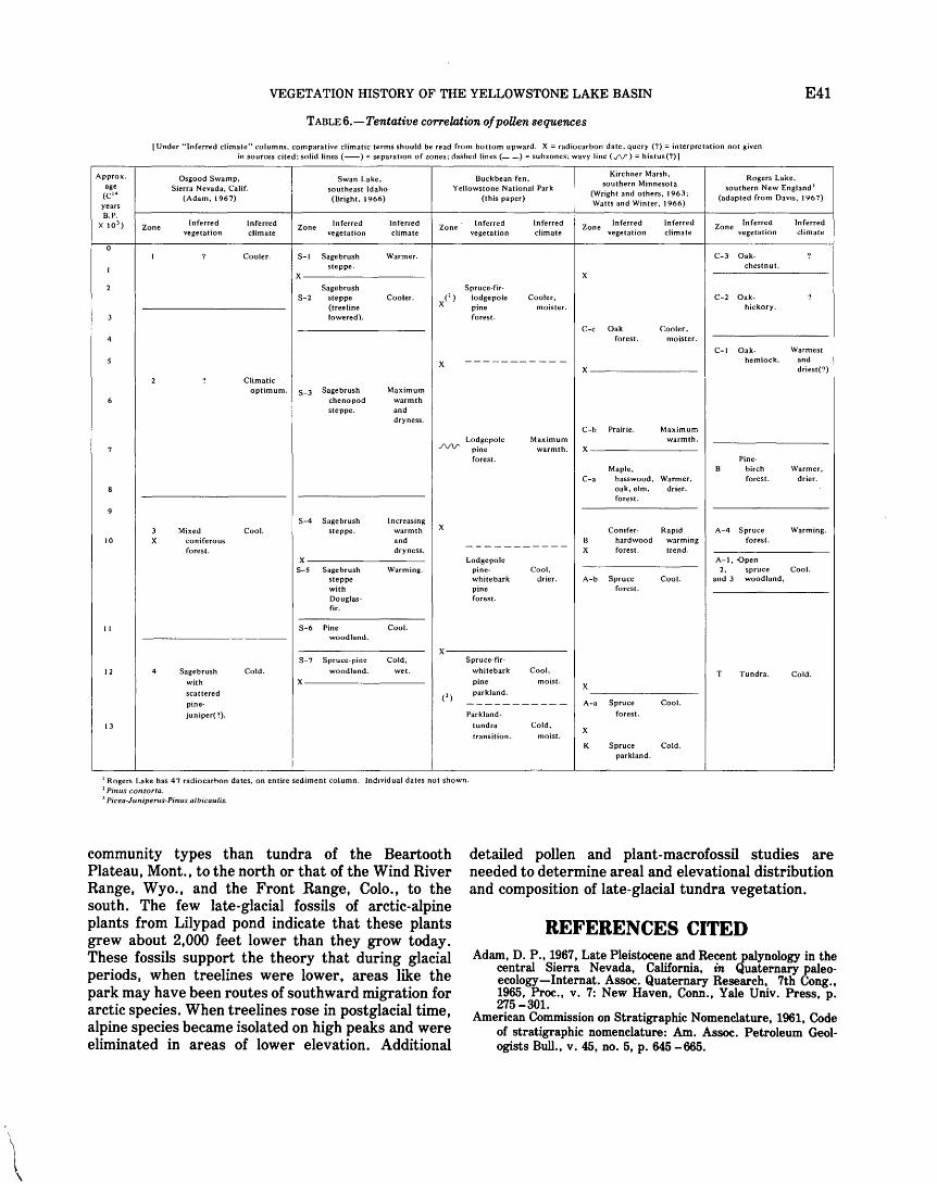
VEGETATION HISTORY OF THE YELLOWSTONE LAKE BASIN E41
TABLE 6.-Tentative correlation of poUen sequences
I Under "Inferred climate" columns, comparative climatic terms should be read from bottom upward. X= radiocarbon date; query(?)= interpretation not given in sources cited; solid lines (-) = separatoon of zones; dashed lines(--)= sub zones; wavy line C.rV') = hiatus(?) I
Approx. Osgood Swamp, Swan Lake, Buckbean fen, Kirchner Marsh, Rogers Lake,
age Sierra Nevada, Calif. southeast Idaho Yellowstone National Park southern Minnesota
(Wright and others, 1963; southern New England 1
<c'• (Adam, 1967) (Bright, 1966) (this paper) Watts and Winter, 1966)
(adapted from Davos, 1967) years B.P.
X 10 3) Inferred Inferred Inferred Inferred Zone Inferred Inferred Zone Inferred Inferred Zone Inferred Inferred
Zone vegetation climate
Zone vegetation climate vegetation climate vegetation climate vegetation climate
Cooler. S-1 Sagebrush Warmer. C-3 Oak· steppe. chestnut.
X X
Sagebrush Spruce-fir· S-2 steppe Cooler. x<'> lodgepole Cooler, C-2 Oak·
(treeline pine moister. hickory. lowered). forest.
C-c Oak Cooler, 4 forest. moister.
C-1 Oak· Warmest
X ----------- hemlock. and X driest(?)
Climatic optimum. S-3 Sagebrush Maximum
chenopod warmth steppe. and
dryness. C-b Prairie. Maximum
Maximum warmth. Lodgepole ./V\.1' pine warmth. X
forest. Pine· Maple, B birch Warmer,
C-a basswood, Warmer, forest. drier. oak, elm, drier. forest.
S-4 Sagebrush Increasing 3 Mixed Cool. steppe. warmth X Conifer- Rapid A-4 Spruce Warming.
10 X coniferous and B hardwood warming forest. -----------forest. dryness. X forest. trend. X Lodgepole A-1, Open
S-5 Sagebrush Warming. pine- Cool, 2, spruce Cool. steppe white bark drier. A-b Spruce Cool. and 3 woodland, with pine forest. Douglas- forest. fir.
II S-6 Pine Cool. woodland.
X S-7 Spruce-pine Cold, Spruce-fir·
12 Sagebrush Cold. woodland. wet. whitebark Cool, T Tundra. Cold. with X pine moist.
X scattered (') parkland.
pine· ----------- A-a Spruce Cool.
juniper(?). Parkland· forest.
13 tundra Cold, X
transition. moist. K Spruce Cold.
parkland.
1 Rogers Lake has 47 radiocarbon dates, on entire sediment column. Indovidual dates not shown. 2 Pinus contorta. 3 Picea-Juniperus-Pinus albicaulis.
community types than tundra of the Beartooth Plateau, Mont., to the north or that of the Wind River Range, Wyo., and the Front Range, Colo., to the south. The few late-glacial fossils of arctic-alpine plants from Lilypad pond indicate that these plants grew about 2,000 feet lower than they grow today. These fossils support the theory that during glacial periods, when treelines were lower, areas like the park may have been routes of southward migration for arctic species. When treelines rose in postglacial time, alpine species became isolated on high peaks and were eliminated in areas of lower elevation. Additional
detailed pollen and plant-macrofossil studies are needed to determine areal and elevational distribution and composition of late-glacial tundra vegetation.
REFERENCES CITED Adam, D.P., 1967, Late Pleistocene and Recent _palynology in the
central Sierra Nevada, California, in Quaternary paleoecology-Internat. Assoc. Quaternary Research, 7th Cong., 1965, Proc., v. 7: New Haven, Conn., Yale Univ. Press, p. 275-301.
American Commission on Stratigraphic Nomenclature, 1961, Code of stratigraphic nomenclature: Am. Assoc. Petroleum Geologists Bull., v. 45, no. 5, p. 645 - 665.
E42 GEOLOGY OF YELLOWSTONE NATIONAL PARK
Antevs, Ernst, 1955, Geologic-climatic dating in the West: Am. Antiquity, v. 20, no. 4, p. 317-335.
Baker, F. S., 1944, Mountain climates of the western United States: Ecol. Mon., v. 14, p. 223-254.
Becker, C. F., and Alyea, J.D., 1964a, Temperature probabilities in Wyoming: Wyoming Univ. Agr. Expt. Sta. Bull. 415, 57 p.
__ 1964b, Precipitation probabilities in Wyoming: Wyoming Univ. Agr. Expt. Sta. Bull. 416, 97 p.
Bender, M. M., Bryson, R. A., and Baerreis, D. A., 1971, University of Wisconsin radiocarbon dates IX: Radiocarbon, v. 13, no. 2, p. 475-486.
Bent, A. M., and Wright, H. E., Jr., 1963, Pollen analyses of surface materials and lake sediments from the Chuska Mountains, New Mexico: Geol. Soc. America Bull., v. 74, no. 4, p. 491-500.
Birkeland, P. W., and Miller, C. D., 1973, Re-interpretation of the type Temple Lake moraine, and other Neoglacial deposits, southern Wind River Mountains, Wyoming: Geol. Soc. America Abs. with Programs, v. 5, no. 6, p. 465-466.
Birkeland, P. W., Crandell, D. R., and Richmond, G. M., 1971, Status of correlation of Quaternary stratigraphic units in the western conterminous United States: Quaternary Research, v. 1, no. 2, p. 208-227.
Bright, R. C., 1966, Pollen and seed stratigraphy of Swan Lake, southeastern Idaho-Its relation to regional vegetational history and to Lake Bonneville history: Idaho State Univ. Mus. Jour., Tebiwa, v. 9, no. 2, p. 1-47.
Choate, G. A., 1963, The forests of Wyoming: U.S. Forest Service Resource Bull. INT- 2, 46 p.
Critchfield, W. B., and Little, E. L., Jr., 1966, Geographic distribution of the pines of the world: U.S. Dept. Agriculture Misc. Pub. 991, 97 p.
Currey, D. R., 1974, Probable pre-Neoglacial age of the type Temple Lake moraine, Wyoming: Arctic and Alpine Research, v. 6, no. 3, p. 293- 300.
Daubenmire, R. F., 1943, Vegetation zonation in the Rocky Mountains: Bot. Rev., v. 9, p. 325-393.
Davis, M. B., 1963, On the theory of pollen analysis: Am. Jour. Sci., v. 261, no. 10, p. 897-912.
__ 1965, A method for determination of absolute pollen frequency, in Kummel, Bernhard, and Raup, D. M., eds., Handbook of paleontological techniques: San Francisco, Calif., W. H. Freeman and Co., p. 674-686.
__ 1967, Pollen accumulation rates at Rogers Lake, Connecticut, during late- and post-glacial time: Rev. Palaeobotany and Palynology, v. 2, nos. 1-4, p. 219-230.
Fletcher, E. H., 1927a, Climatic features of Yellowstone National Park: Sci. Monthly, v. 25, p. 329-336.
__ 1927b, Annual meteorological summary with comparative data, 1927, Yellowstone Park, Wyoming: U.S. Dept. Agriculture, Salt Lake City, Utah, 8 p.
Fowells, H. A., compiler, 1965, Silvics of forest trees of the United States: U.S. Dept. Agriculture, Agriculture Handb. 271, 762 p.
Gill, L. S., 1957, Dwarf mistletoe of lodgepole pine: U.S. Dept. Agriculture, Forest Pest Leaflet 18, 7 p.
Hansen, H. P., 1948, Postglacial forests of the Glacier National Park region: Ecology, v. 29, p. 146-152.
__ 1951, Pollen analysis of peat se.ctions from near the Finley Site, Wyoming, in Moss, J. H., ed., Early Man in the Eden Valley [Wyoming]: Philadelphia, Pennsylvania Univ. Mus. Mon., p. 115-118.
Harrington, H. D., 1954, Manual of the plants of Colorado: Denver, Colo., Sage Books, 666 p.
Hawksworth, F. G., and Wiens, Delbert, 1972, Biology and classifi-
cation of dwarf mistletoes (Arceuthobium): U.S. Forest Service, Agriculture Handb. 401, 234 p.
Houston, D. B., 1973, Wildfires in northern Yellowstone National Park: Ecology, v. 54, no. 5, p. 1111-1117.
Jessen, Knud, 1955, Key to subfossil Potarrwgeton: Botanisk Tidsskr., v. 52, p. 1-7.
Johnson, P. L., and Billings, W. D., 1962, The alpine vegetation of the Beartooth Plateau in relation to cryopedogenic processes and patterns: Ecol. Mon., v. 32, p. 105-135.
KUchler, A. W., 1964, Potential natural vegetation of the conterminous United States: Am. Geog. Soc. Spec. Pub. 36, 116 p., map.
Lawrence, D. B., 1958, Glaciers and vegetation in southeastern Alaska: Am. Scientist, v. 46, no. 2, p. 89- 122.
Levin, Betsy, Ives, P. C., Oman, C. L., and Rubin, Meyer, 1965, U.S. Geological Survey radiocarbon dates VIII: Radiocarbon, v. 7' p. 372 - 398.
Lowery, A. R., [undated], Climatological summary of Yellowstone Park Station, 1930-1959-Cheyenne: U.S. Weather Bur., Climatography of the United States no. 20-48, 2 p.
__ 1960, Climates of the States-Wyoming: U.S. Weather Bur., Climatography of the United States no. 60-48, 16 p.
McAndrews, J. H., 1967, Pollen analysis and vegetational history of the Itasca region, Minnesota, in Quaternary paleoecologyInternat. Assoc. Quaternary Research, 7th Cong., 1965, Proc., v. 7: New Haven, Conn., Yale Univ. Press, p. 219-236.
McDougall, W. B., and Baggley, H. A., 1956, Plants of Yellowstone National Park: Yellowstone Park, Wyo., Yellowstone Library Mus. Assoc., 186 p.
Maher, L. J., Jr., 1963, Pollen analyses of surface materials from the southern San Juan Mountains, Colorado: Geol. Soc. America Bull., v. 74, no. 12, p. 1485-1504.
__ 1972, Absolute pollen diagram of Redrock Lake, Boulder County, Colorado: Quaternary Research, v. 2, no. 4, p. 531-553.
Marr, J. W., Clark, J. M., Osborn, W. S., and Paddock, M. W., 1968, Data on mountain environments III. Front Range, Colorado, four climax regions, 1959-1964: Colorado Univ. Studies, Ser. Biology, no. 29, 181 p.
Martin, A. C., and Barkley, W. D., 1961, Seed identification manual: Berkeley, California Univ. Press, 221 p.
Matsumura, Y., and Harrington, H. D., 1955, The true aquatic vascular plants of Colorado: Colorado Agr. Expt. Sta. Tech. Bull. 57, 130 p.
Miller, C. D., and Birkeland, P. W., 1974, Probable Pre-Neoglacial age of the type Temple Lake moraine, Wyoming-Discussions and additional relative-age data: Arctic and Alpine Research, v. 6, no. 3, p. 301-306.
Parihar, N. S., 1965, An introduction to Embryophyta, Volume I, Bryophyta: Allahabad, Pakistan, Central Book Depot, 375 p.
Pennak, R. W ., 1963, Ecological and radiocarbon correlations in some Colorado mountain lake and bog deposits: Ecology, v. 44, no. 1, p. 1-15.
Porter, C. L., 1962-1968, A Flora of Wyoming, Parts 1-6: Wyoming Univ. Agr. Expt. Sta.
Porter, S.C., and Denton, G. H., 1967, Chronology of neoglaciation in the North American Cordillera: Am. Jour. Sci., v. 265, no. 3, p. 177-210.
Richmond, G. M., 1965, Glaciation of the Rocky Mountains, in Wright, H. E., Jr., and Frey, D. G., eds., The Quaternary of the United States: Princeton, N. J., Princeton Univ. Press, p. 217-230.
__ 1969a, Stagnation of the Pinedale icecap in the Yellowstone Lake Basin, Wyoming, in Abstracts for 1968: Geol. Soc. America Spec. Paper 121, p. 627.
VEGETATION HISTORY OF THE YELLOWSTONE LAKE BASIN E43
__ 1969b, Late Pinedale and Neoglacial glaciation in the Absaroka Range, east of Yellowstone Lake, Wyoming, in Abstracts for 1968: Geol. Soc. America Spec. Paper 121, p. 627-628.
__ 1969c, Development and stagnation of the last Pleistocene icecap in the Yellowstone Lake Basin, Yellowstone National Park, USA: Eiszeitalter u. Gegenwart, v. 20, p. 196-203.
__ 1970a, Glacial history of the Yellowstone Lake Basin [abs.]: Am. Quaternary Assoc. Mtg., 1st, Yellowstone Park, Wyo., and Bozeman, Mont., 1970, Abs., p. 112-113.
__ 1970b, Comparison of the Quaternary stratigraphy of the Alps and Rocky Mountains: Quaternary Research, v. 1, p. 3-28.
Richmond, G. M., and Pierce, K. L., 1968, Late Pleistocene center of ice-accumulation over Yellowstone Lake area, in Abstracts for 1967: Geol. Soc. America Spec. Paper 115, p. 441.
__ 1972, Surficial geologic map of the Eagle Peak quadrangle, Yellowstone National Park and adjoining area, Wyoming: U.S. Geol. Survey Misc. Geol. Inv. Map I-637.
Ritchie, J. C., and de Vries, Bernard, 1964, Contributions to the Holocene paleoecology of westcentral Canada-A late-glacial deposit from the Missouri Coteau: Canadian Jour. Botany, v. 42, no. 6, p. 677- 692.
Stuchlik, Leon, 1967, Pollen morphology of the Polemoniaceae: Grana Palynologica, v. 7, p. 146-240.
Sullivan, B. M., Spiker, Elliott, and Rubin, Meyer, 1970, U.S. Geological Survey radiocarbon dates XI: Radiocarbon, v. 12, p. 319-334.
Tackle, David, 1961, Silvics of Lodgepole Pine: Intermtn. Forest and Range Expt. Sta. Misc. Pub. 19, 24 p.
Ting, W. S., 1966, Determination of Pinus species by pollen statistics: California Univ. Pubs. Geol. Sci., v. 58, 182 p.
U.S. Geological Survey, 1972, Surficial geologic map of
Yellowstone National Park: U.S. Geol. Survey Misc. Geol. Inv. Map I- 710.
Waddington, J. C. B., and Wright, H. E., Jr., 1970, LateQuaternary vegetational changes on the east side of Yellowstone Park, Wyoming [abs.]: Am. Quaternary Assoc. 1st Mtg., Yellowstone Park, Wyo., and Bozeman, Mont., 1970, Abs., p. 139-140.
__ 1974, Late Quaternary vegetational changes on the east side of Yellowstone Park, Wyoming: Quaternary Research, v. 4, no. 2, p. 175-184.
Watts, W. A., and Winter, T. C., 1966, Plant macrofossils from Kirchner Marsh, Minnesota-A paleoecological study: Geol. Soc. America Bull., v. 77, no. 12, p. 1339-1360.
Weber, W. A., 1967, Rocky Mountain Flora: Boulder, Colo., Colorado Univ. Press, 437 p.
Wilcox, R. E., 1965, Volcanic-ash chronology, in Wright, H. E., Jr., and Frey, D. G., eds., The Quaternary of the United States: Princeton, N.J., Princeton Univ. Press, p. 807-816.
Wolfe, J. A., and Leopold, E. B., 1967, Tertiary and Early Quaternary vegetation of northeast Asia and northwest North America, in Hopkins, D. M., ed., The Bering Land Bridge: Stanford, Calif., Stanford Univ. Press, p. 193- 206.
Wright, H. E., Jr., Bent, A.M., Hansen, B.S., and Maher, L. J., Jr., 1973, Present and past vegetation of the Chuska Mountains, northwestern New Mexico: Geol. Soc. America Bull., v. 84, no. 4, p. 1155-1180.
Wright, H. E., Jr., Livingstone, D. A., and Cushing, E. J., 1965, Coring devices for lake sediments, in Kummel, Bernhard, and Raup, D. M., eds., Handbook of paleontological techniques: San Francisco, Calif., W. H. Freeman and Co., p. 494-520.
Wright, H. E., Jr., Winter, T. C., and Patten, H. L., 1963, Two pollen diagrams from southeastern Minnesota-Problems in the regional late-glacial and postglacial vegetational history: Geol. Soc. America Bull., v. 74, no. 11 p. 1371-1396.

A Page
Abies...... .E17,25, 26,31,38 lasiocarpa ............ ........ 7, 12, 25, 26,36
Abies forest, Pinus contorta-Picea- . . . 17 Abies lasiocarpa- Pinus albicaulis parkland,
Pice"' engelmannii- . . . . . . . . 25 AbieP parkland, Picea.................. 17 AbieP-Pinus albicaulis forests, Picea- . . 4,12 17, 18, 39 Abies-Pinus albicaulis- parklands, Picea- . . . 17, 18 Abies-Pinus albicaulis-Pinus contorta
forest, Picea- . . . . . . . . . . 17
Abies-Pinus contorta subzone, Picea-...... 38
Absaroka Range. . . . . . . . . . . . . . . . . . . . . . . . 5, 10, 12 Abstract . . . . . . . . . . . . . . . 1 Acer. 7, 27
negundo. 27 Aceraceae . . . . 7 Achillea lanulosa 8, 10 Aconitum columbianum 9, 12 acutus, Scirpus......................... 9, 17 adenocaulon, EpiWbium.... . . . . . .8, 28; pl. 8 Age, Altithermal ..................... 5, 25, 39, 40
Bull Lake Glaciation. . . . . . . . . . . . . . . . . 5 Gannett Peak Stade. . . . . . . . . . . . . . . . . 5, 25, 38 Hypsithermal interval. . . . . . . . . . . . . . . 6 Neoglaciation . . . . . . . . 5 Pinedale Glaciation . . . . . . . . . . . . . . . . . 4, 5
late stade . . . . . . . . . . . . . . . . . . . . . . 25, 37, 39 middle stade ................ 25, 31, 35, 39
Post-Altithermal . . . . . . . . . . . . . . . . . . . 40 Temple Lake Stade . 5, 25, 38
Agropyron. . . . . . 9, 10 · albicaulis, Pinus . ...... 7, 12, 17, 25, 26, 34, 36, 37, 38;
pis. 1. 5 Adler, thinleaf . . . 7, 37
western........................... 28 Algae................................. 30 Alnus . . . . . . . . . . . . . . . . . . . . . . . . . . . . . . . . . 26, 37
tenuifolia. . . . . . . . . . . . . . . . . . . . .. 7. 28, 37; pl. 6 Alpine association . . . . . . . . . . . . . . . . . . . . 12, 41 Alpine sorrel . . . . . . . . . . . . . . . . . . 9, 36 A I pine tundra . . . . . . . . . . . . . . . . . . . . . . . . . 40 alpinus, Potamogeton .. . 10, 14, 17, 25, 30, 32, 36; pl. 7 Altithermal period ........... 5, 25, 39, 40 Amaranthaceae . . . . . . . . . . . . . . . . . . . . . . . . 7 Ambrosia . . . . . . . . . . . .... 8, 26, 28, 36; pl. 2 americanum, Arceuthobium.............. 8, 28,37 amphibia, Persicaria . . . . . . . . . . . . . . . . . . . . 9, 14, 17 amphibium, Polygonum . . . . . . . . . . . . . . . . . 9 Analysis method, cores . . . . . . . . . . . . . . . . . . 20
pollen............................. 16 Anemone, globose . . . . . . . . . . . . . . . . . . . . . . 9, 15 Anemone multifida . . . . . . . . . . . . . . . . . . . . . 15
globosa............................ 9 angustifolia, Typha . . . . . . . . . . . . . . . . . . . . . 10, 30 angustifolium, Sparganium . . . . . . . . . . . . . . 10, 30 Antennaria . . . . . . . . . . . . . . . . . . . . . . . . . . . . 8, 10 aquatilis, Carex . . . . .. 9, 14, 17, 29, 38; pl. 9
Ranunculus .................. 9, 20, 32, 36; pl. 8 Arabis . . . . . . . . . . . . . . . . . . . . . . . . . . . . . . . 8, 12
glabra............................. 8, 10 Arceuthobium ...................... . 8, 26, 37; pl. 2
americanum . . . . . . . . . . . . . . . . . . . . . . . 8, 28,37 campylopodum..................... 8, 28 douglasii . . . . . . . . . . . . . . . . . . . . . . . . . . 8, 28, 37
Arctic-alpine plants, Lilypad pond . . . . . . . . 41 Arctic burreed . . . . . . . . . . . . . . . . . . . . . . . 10 Arctic willow . . . . . . . . . . . . . . . . . . . . . . . . . . 12
INDEX
[Page numbers of major references are in italic]
Page arctica, Salix. . . . . . . . . . . . . . . . . . . . . . . . . . . E9, 12 Arctostaphylos uva-ursi................ 8, 10, 12 argenteus, Lupinus . . . . . . . . . . . . . . . 8, 10, 12 Artemisia. . ................... 8, 26, 31, 32
tridentata......... . ...... 8,10, 16, 17,19 Artemisia pollen percentages 19 Artemisw steppe association ............ 10, 13, 17
pollen . . . . . . . . . . . . . . . . . . . . . . . . . . 16
Artemisia tridentata steppe, Gramineae-.. 17 Ash. . . . . . . . . . . . . . . . . . . . . . . . . . . 8 Aspen, quaking ......... . Aster ............. . A triplex sp. Aulacomnium palustre Aulacomniaceae .... Avens,large-leaf ..
B
9, 10, 12 8,15 8,10 7,15
7 9,15
Balsam poplar . . . . . . . . . . . . . . . . . 9, 34 balsamifera, Populus .. ...... 9, 25, 29, 34, 35, 36; pl. 6 Basal zone . 30 Bearberry . . . . . . . . 8 Beartooth Plateau, Mont. . . . . . . . . . . . . . . . . 12, 29, 41 Bechler River Ranger Station . . 2 Bedstraw, small . . . . . . . 9, 14 Betula. . . . . . . . . . . . . . . . . . . . . . . . 8, 26, 27
glandulosa ....... ..... 8, 25, 28, 31, 33, 36; pl. 6 occidentalis . . . . . . . . . . . . . . . . . . . . . . . . 8, 28
Betula subzone . . . . . . . . . . . . . . . . . . . . . . . . 31, 39 Betulaceae. . . . . . . . . . . . . . . . . . . . . . . . 7, 8, 27 biennis, Potentilln . 9, 29, 36; pl. 8 Big sagebrush . . . . . . . . . . . . 8, 10 Birch...... 8, 28
bog... 8, 31 river. 8
Bistort . . . . . . . . . . . . . . . . . . . . . . . 9, 12 VIVIparous . . . . . . . . . . . . . . . . . . . . . . . . . 9, 12
Bistorta ......................... ~. 19, 27, 33; pl. 3 bistortaides . . . . . . . . . . . . . . . . . . . . . . . . 9, 12, 28 vivipara . . . . . . . . . . . . . . . . . . . . . . . . . . . 9, 12, 28
bistortaides, Bistorta . . . . . . . . . . . . . . . . . . . 9, 12, 28 Polygonum . . . . . . . . . . . . . . . . . . . . . . . . 9
Black cottonwood....................... 9, 36 Bladderwort, common. . . . . . . . . . . . . . . . . . . 8, 14
small.............................. 8,14 blandowii, Helodium . . . . . . . . . . . . . . . . . . . . 7, 15 Blue spruce . . . . . . . . . . . . . . . . . . . . . . . . . . 16 Blue willow............................. 9,14 Bluebell . . . . . . . . . . . . . . . . . . . 8, 12 Blueberry. myrtle .. .. .. .. .. .. .. .. .. .. .. 8, 12 Bluegrass. . . . . . . . . . . . . . . . . . . . . . . . . . . . . . 10 Blue joint grass . . . . . . . . . . . . . . . . . . . . . . . . . 9, 15 Bog birch.............................. 8, 31 Boraginaceae . . . . . . . . . . . . . . . . . . . . . . . . . . 8 borealis, Glyceria. . . . . . . . . . . . . . . . . . . . . . . 9, 30 Broadleaf cattail. . . . . . . . . . . . . . . . . . . . . . . . 10, 33 Brome, smooth . . . . . . . . . . . . . . . . . . . . . . . . . 9 Bromegrass.. . . . . . . . . . . . . . . . . . . . . . . . . . . 9, 10 Bromus . . . . . . . . . . . . . . . . . . . . . . . . . . . . . . . 9, 17
inermis. . . . . . . . . . . . . . . . . . . . . . . . . . . . 9, 10
~-· 1~ffi Bryophyta . . . . . . . . . . . . . . . . 27 Bryophyte spore. . . . . . . . . . . . . . . . . . . . . . . . pl. 1 Bryozoa. . . . . . . . . . . . . . . . . . 30 Buckbean fen .... 3, 8, 14, 15, 20, 24, 27, 28,31, 39, 40
basal zone 31 dates. · 7
Buffaloberry . . . . . 8, 12
Bull Lake Glaciation .. Burreed.
Arctic ..... . Bushy knot weed ....................... .
c
Page E5
10,33 10 9
caespitosa, Deschampsia . . . . . . . . . . . . . . . . 9, 15 Saxifraga. . . . . . . . . ... 9, 12, 29, 33; pl. 10
Calamagrostis canadensis. . . . . . . . . . . . . . . . 9, 15, 30 inexpansa . . . . . . . . . . . . . . . . . . . . . . . . . 9, 15, 30
Calamagrostis-Salix-Sedum rhodanthum community 15, 17
californica, Descurainia .............. . 8, 28, 31; pl. 8 Callitrichaceae . . . . . . . . . . . . . . . . . . . . . . . . . 8 Callitriche . . . . . . . . . . . . . . . . . . . . . . . . . . . . 8, 17 Campanula rotundifolia. . . . . . . . . . . . . . . . . . 8, 10 Campanulaceae. . . . . . . . . . . . . . . . . . . . . . . . . 8 campylopodum, Arceuthobium . . . . . . . . . . . 8, 28 canadensis, Calamagrostis . . . . . . . . . . . . . . . 9, 15, 30
Shepherdia . . . . . . . . . . . . . . . . . . . . . . . . 8, 12, 17 canescens, Carex . . . . . 9, 15, 29, 39; pl. 9 Caprifoliaceae . . . . . . . . . . . . . . . . . . . . . . . . . . 8, 27 Carex ................................. 17, 29, 37
aquati/;is.. .9,14,17, 29, 38; pl. 9 canescens . . . . . . . 9, 15, 29, 39; pl. 9 diandra . . . 9, 14, 25, 30, 38; pl. 9 geyeri. . . . . . . . . . . . . . . . . . . . . . . . . . . . . 9, 12
hoodii . . . . . . . . . . . . . . . . . . . . . . . . 9, 10 limosa. . ........ 9, 14, 25, 30, 38; pl. 7 petasta............................ 10 phaeocephala . . . . . . . . . . . . . . . . . . . . . . 9, 15 rostrata........................... 9 trigonous . . . . . . . . . . . . . . . . . . . . . . . . . . 38 utriculata ....... 9,14,15,17, 25, 30, 37, 38; pl. 7
vesicaria . . . ..... 9, 17, 25, 30, 38; pl. 7
Carexdiandra-Potentillnpalustris fen . . . . 14,17 Carex fen 17 Carex- Gramineae meadow............... 17
Carex utriculata fen . . . . . . . . . . . . . . . . . . . . 14, 17 Caryophyllaceae. . . . . . . . . . . . . . . . . . . . . . . . 8, 27 Cattail, broadleaf. . . . . . . . . . . . . . . . . . . . . . . 10, 33
narrowleafed . . . . . . . . . . . . . . . . . . . . . . . 10 Ceanothus velutinus . . . . . . . . . . . . . . . . . . . . 9, 17, 27 Ceratopyllaceae . . . . . . . . . . . . . . . . . . . . . . . . 8 CeratophyUum demersum . . . . . . . . . . . . . . . 8, 37 Cercocarpus . . . . . . . . . . . . . . . . . . . . . . . . . . . 9, 26 Chara................................. 7 Characeae . . . . . . . . . . . . . . . . . . . . . . . . . . . . . 7 Charophytes . . . . . . . . . . . . . . . . . . . . . . . . . . . 30,31 Cheno-Ams . . . . . . . . . . . . . . . . . . . . . . . . . . . . 8, 16, 32 Chenopodiaceae . . . . . . . . . . . . . . . . . . . . . . . . 8 Chenopodiaceae -Amaranthaceae . . . . . . . . . 8, 16, 26 Chiming bells . . . . . . . . . . . . . . . . . . . . . . . . . . 8 Chrysothamnus . . . . . . . . . . . . . . . . . . . . . . . . 8, 10, 17 Cinquefoil . . . . . . . . . . . . . . . . . . . . . . . . . . . . . 12
marsh............................. 9,14 Norway........................... 9 shrubby . . . . . . . . . . . . . . . . . . . . . . . . . . . 9, 15 soft............................... 9
Climacium dendraides . . . . . .. . . .. .. . . . . . . 7, 15 Climate . . . . . . . . . . . . . . . . . . . . . . . . . . . . . . . 1
cooler moister . . . . . . . . . . . . . . . . . . . . . . 39 warmest........................... 40
Colorado blue spruce . . . . . . . . . . . . . . . . . . . . 7 columbianum, Aconitum. . . . . . . . . . . . . . . . . 9, 12 Common bladderwort . . . . . . . . . . . . . . . . . . . 8, 14 Common harebell . . . . . . . . . . . . . . . . . . . . . . . 8 Common juniper . . . . . . . . . . . . . . . . . . . . . . . 7
E45
E46
Page Common phlox . . . . . . . . . . . . . . . . . E9, 10 communis, Juniperus . 7, 12, 17, 25, 26, 31, 36; pl. 5 Compositae.. . ......... 8, 20, 26, 28, 31; pl. 2 Conifer needles . . . . . . pl. 5
contorta, Pinus ... 7, 12, 16, 17, 26, 27, 37, 38; pis. 1, 5 Cores . . 2, 13
analysis method . . . . . . . . . . . . . . . . . . . 20 Cottongrass. . . . . . . . . . . . . . . . . . . . . . . . . . . 9, 15 Cottonwood, black. . . . . . . . . . . . . . . . . . . . . 9, 36 Crassulaceae . . . . . . . . . . . . . . . . . . . 8, 28 Crowfoot, water.. . . . . . . . . . . . . . . 9, 33 Cruciferae.. . . . . . . . . . . . . 8, 27, 28 Cub Creek core. . . . . . . . . . . . . . . . 15 Cub Creek pond. . ......... 23, 91, 39,40
basal zone . . . . . . . . . . . . . . . 31 Cupressaceae . . . . . . . . . . . . . . . . . . 7 Cyperaceae . . . ......... 9, 12, 17, 27, 29, 38
D
demersum, CeratophyUum. . . . . . . 8, 37 dendroides, Climacium . . . . . . . . . . 7, 15
densa, SelagtneUa . . . 7, 12, 19, 24, 27; pl. 1 Deschampsia caespitosa . . . . . . . . . . . . . . . . . 9, 15 Descurainiacalifornica .8, 28, 31; pl. 8 Diamond leaf saxifrage . . . . . . . . . . . . . . . . . . 9, 12 diandra, Carex . . . . . 9, 14, 25, 30, 38; pl. 9 Diatoms... . . . . . . . . . . . . . . . . 30, 31 Dock.. . . . . . . . . . . . . . . . . 9
golden . . . . . . . . . . . . 9 willow............................. 9
Douglas-fir . . . . . . . . . . . . . . . . . 7, 10 Douglas-fir dwarf mistletoe . . . . . . . . . . . 8 douglasii, Arceuthobium................. 8, 28, 37 Drepanocladus . . . . . . . . . . . . . . . . . 7
sp.... 14, 15 Dwarf mistletoe . . . . . . . . . . . . . . . 37
Eleagnaceae .......... .
Eleocharis macrostachya Elephantella ......... . Elymus .. empetriformis, PhyUodoce Engelmann spruce .. engelmannii, Picea Ephedra torreyana
viridis ..
E
8 .9, 17, 30; pl. 9
9, 15 9, 10, 17
8, 17 7,12
. 7' 12, 16, 25, 26, 36; pl. 5 7, 26
Ephedraceae . . ......... . 7, 26; pl. 1
7 . 8, 28; pl. 8
.8, 28, 38; pl. 8 Epilobium adenocaulon ..
glandulosum .
lactiflorum . Equisetaceae ... Equisetum.
Ericaceae .. Eriogonum Eriophorum . .
subalpinum ....
. .8, 28, 36; pl. 8 7
7, 27
8 .9, 27
9 10, 12
sp... . ............ . 14 8, 28 excalbescens, MyriophyUum spicatum
F
Fagaceae........ . . . . . . . . . . . . 8 Fen....... . . . . . . . . . . . . . . . . . 38
Buckbean . 3, 7, 8, 14, 15, 20, 24, 27, 28, 91, 39, 40 Carex... . . . . . . . . . . . . . . . . . . . . . . 17
diandra-PotentiUapalustris. 14, 17 utriculata 14, 17
Fen types . . . 14 Fern.. . . . . . . . . . . . . . . 7 filiformis, Potamogeton .......... 10, 25, 30, 32; pl. 7 Fir, Douglas . . . . . . . . . . . . . . 7, 10
subalpine . . . . . . . . . . . . . . . . . 7, 12 Fires, history . . . . . . . . . . . . . . . 12
Pinus contorta . . . . . . . . . . . . . . . . . . . . 38 flexilis, Naias .10, 25, 30, 36, 37; pl. 9
Ptnus ............................ 7, 10, 17, 26
INDEX
Page floribunda, PentaphyUoides... . E9, 15, 17 Forest, fires . . . . . . . . . . . . . . . 34
open, mixed. 37 Picea-Abies-Pinus albicaulis . .... 4, 12, 17, 18, 39 Picea-Abies-Pinus albicaulis-· Pinus
contorta . . . . 17 Pinus albicaulis-Pinus contorta . . . . . . . 25 Pinus contorta .......... 4, 12, 17, 18, 25, 37,39
closed . . . . . . . . . . . . . . . . . 25 open . . . . . . . . . . . . . . . . . . . . . . . . . 12
Pinus contorta- Picea-Abies . . 17 Pinus contorta-Ptnus albicaulis . . . . . . . . 39 Populus tremuWUJ.es-Pseudotsuga . . . . 17 Pseudotsuga 18
Fragaria. . . . . . . . . . . . . . . 9 Franseria. . . . . . . . . . . . . . . . . . 8, 28 Fraxinus . . 8, 27 Front Range, Colo. . . . . . . . . . . . . . . . . . . . . 41 fruticosa, PotentiUa . . . . . . . . . . . . . . . . . . 9 fueginus, Rumex .................... 9, 29, 37; pl. 6
maritimus . . . . . . . . . . . . . . . . 9 Further work . . . . . . 40
G
Galium trifidum . . . . . ............ . Gannett Peak end moraines ....... . Gannett Peak Stade . . . . ......... . Gentian, Rocky Mountain fringed . . . . . . . . Gentiana thermalis .....
9, 14, 15 5, 25,38 5, 25,38
8,15 8
Gentianaceae . . . . . . . . . . . . . . . . . . . . . . 8 Gentianopsis thermalis 8, 15 Geum macrophyUum . . . . . . . . . . . . . 9, 15 geyeri, Carex . . . . . . . . . . . . . . . . 9, 12 glabra, Arabis.............. 8, 10 Glacial history. . . . . . . . . . . . . . . . . . . . . . . . . 5 Glacier Peak . . . . . . . . . . . . . . . 31 glandulosa, Betula ........ . 8, 25, 28, 31, 33, 36; pl. 6 glandulosum, Epilobium. . . 8, 28, 38; pl. 8
Ledum . . . . . . . . . . . . . . . . 8, 17 globosa, Anemone multifida. . . . . . . . 9 Globose anemone . . . . . . . . . . . . . . . . 9, 15 Glyceria borealis . . . . . 9, 30
grandis......... 10 maxima grandis . . .. 10, 30, 37; pl. 9
Golden dock 9 gracilis, PotentiUa. . . . . 9, 20, 31, 36; pl. 8 Gramineae.. . .9, 12, 17, 20, 27, 90,31 Gramineae-Artemisia tridentata steppe. . . 17 Gramineae meadow, Carex- . . . . . . . . . . . . 17 Gramineae/Pinus ratio.... . ...... 20, 34, 36, 37 gramineus, Potamogeton.... . .10, 25, 30, 37; pl. 7 grandis, Glyceria . 10
Glyceria maxima. . . . . . . . ... 10, 30, 37; pi 9 Grass, blue- 10
bluejoint-........ 9, 15 Brome-. . . . . . . . . . . . . . . . . . . 9, 10 large manna- . . . . . . . . . . . . . . . . . . . . . . . 10, 37 needle-............................ 10 northern manna- 9 northern reed- .... . smooth brome ..................... . squirrel-tail. tufted hair- .. wheat- ..... . wild-rye .. .
Grass family .. Greasewood Green jointfir Greenmilfoil ....................... . groenlandica, Pedicularis ............... . Grouse Creek . . ............... .
H
Hairgrass, tufted ...................... . Haloragaceae . . . . ........ . Harebell, common . . . . . . . . . . . . . . . . . . . . . Helodium blando-wii .................... . Hemlock, mountain .................... .
9,15 9
10 9, 15 9,10
9 12
8, 10, 16 7 8
9,15 5
9, 15 8, 28 8,10 7, 15
7
Hemlock-Continued western ........................ .
heterophyUa, Tsuga... . ........... . Honeysuckle family . . .......... . hoodii, Carex . ......................... . Hornwort .............. . Horsetail ............................ . Hydrodictyaceae ...................... . Hydrophyllaceae ...................... . Hypnaceae............ . ............. . Hypsithermal interval. ................. . hystrix, Sitanion .............. .
I, J
Page E7
7, 27 8
9,10 8, 37
7 7 8 7 6
10
illinoensis, Potamogeton................ 10, 30 tnermis, Bromus........................ 9, 10 inexpansa, Calamagrostis. . . . . . . . . . . 9, 15, 30 integrifolium, Sedum rosea . . . . . . . . . . . 8 Isoetaceae . . . . . . . . . . . . . . . . . . . . . . . 7 Isoetes . . . . . . . . . . . . . . . . . . . . . . . . . . . . . . 7, 17 islandica, Koenigia. . . . . . . . . ..... 9, 36; pl. 3
Rorippa ...................... 8, 28, 36; pl. 10
Jacobs ladder . . . . . . . . . . . . . . . . . . . . . . . . . . 9, 12 Jointfir, green . . . . . . . . . . . . . . . . . . 7 Juglandaceae . . . . . . . . . . . . . . . . . . . . . . . . . . 8 Juglans . . . . . . . . . . . . . . . . . . . . . . . . . . . . . . . 8, 27 Juncaceae . . . . . . . . . . . . . . . . . . . . . . . . . . . . . 10, 12 Juniper, common . . . . . . . . . . . . . . . . . . . . . . . 7
Rocky Mountain . . . . . . . . . . . . . . 7, 10 Ju"!iperus ......................... 7, 26, 31; pl. 1
communis .......... 7, 12, 17, 25, 26, 31, 36; pl. 5 virginiana scopulorum . . . . . . . . . ... 7, 10, 17, 26
Juniperus-Pinus albicaulis zone, Picea-.. 30, 99
Kalmia polifolia . . Kame deposits Kings Crown ...
K,L
8,17 7 8
Kinnikinnik . . . 8, 10 Knotweed, bushy . . . . . . . . . . . . . . . . . . . . . . . 9 Koenigia . . . . . . . . . . . . . . . . . . . . 27, 28
islandica. . . . . .................... 9, 36; pl. 3
lactiflorum, Epilobium . . . . . . . ...... 8, 28, 36; pl. 8 Ladysthumb . 9 Lamar Ranger Station. . . . . . . . . . . . . . . . . . . 2 lanceolatum, Sedum . . . . . . . . . . . . 8 lanulosa, Achillea . . . . . . . . . . . . . . 8, 10 Large-leaf avens. . . . . . . . . . . . . 9, 15
mannagrass. . . . . . . . . . . . . . . . . . . . 10, 37 Larix lyaUii . . . . . . . . . . . . . . . . . . . . . . . . . . 24
occidentalis . . . . . . . . . . . . . . . . . . . . . . . . 24 lasiocarpa, Abies. . . . .......... 7, 12, 25, 26, 36 latifolia, Typha ................. . 10, 27, 30, 33; pl. 2 Ledum glandulosum . . . . . . . . . . . . . . . . . . 8, 17 Leguminosae. 8, 27 Lentibulariaceae . . . . . . . . . . . . . . . . . . . . . . . 8 Leskeaceae . . . . . . . . . . . . . . . . . . . . . . . . . . 7 Liguliflorae, subfamily..... . ...... 8, 26, 28, 31 ligulifolia, Salix............... 9, 14, 15 Lily, yellow pond . . . . . . . . . . . . . 8 Lilypad pond .................. 3, 15, 20, 28, 31,41
basal zone . . . . . . . . . . . . . . . 31 dates......... . . . . . . . . . . . . . . . . 7
Limber pine. . . . . . . . . . . . . . . . . . . . . . . . . . . . 7, 10 limosa, Carex. . ........... 9, 14, 25, 30, 38; pl. 7 Lodgepole pine . . . . . . . . . . . . . . . . . . . . . . . 7, 12 Lodgepole pine dwarf mistletoe . . . . . . . . . . 8, 37 longifolium, Sitanion . . . . . . . . . . . . . . . . . . . . 10 Loranthaceae . . . . . . . . . . . . . . . . . . . . . . . . . . 8, 28 Lupine, silvery . . . . . . . . . . . . . . . . . . . . . . . . . 8, 10 Lupinus argenteus . . . . . . . . . . . . . . . . 8, 10, 12 luteum polysepalum, Nuphar ........ 8, 14, 25, 28, 37,
Luzula parviflora .............. . spicata
lyaUt"i, Larix
38; pl. 7 10, 12, 15
10, 15 24
M Page
Macrofossils, identification. . . . . . . . . . . . . . . E20 macrophyUum, Geum . . . . . . . . . . . . . . . . 9, 15 macrostachya, Eleocharis. . . . . . . 9, 17, 30; pl. 9 maculata, Persicara . . . . . . . . . . . . . . . . . 9 Mahogany, mountain.......... 9 Mammoth . . . . . . . . . . . . . . . . . . . . . . . . . . . 10
climate........................ 2 Mannagrass, large . . . . . . . . . . . . . . . . . . . . . . 10, 37
northern . . . . . . . . . . . . . . . . . . 9 Maple.. . . . . . . . . . . . . . . . . . . 7 maritimus fueginus, Rumex . . 9 Marsh cinquefoil. . . . . 9, 14 Marshcress . 8, 36 Matted saxifrage . . . 9, 12 maxima grandis, Glyceria ........... . 10, 30, 37; pl. 9 Meadow, Carex-Gramineae.............. 17 Meadow rue . . . . . . . . . . . . . . . . . . . . . . . . . . . 9 Melosira. . . . . . . . . . . . . . . . . . . . . . . . . . . . . . . 30 Menyanthaceae . . . . . . . . . . . . . . . . . . . . . . . 8, 28 Menyanthes . . . . . . . . . . . . . . . . . . . . . . . . . . . 27; pl. 3
trifoliata .............. 8, 14, 15, 25, 28, 38; pl. 6 menzieii, Pseudntsuga ...... 7, 10, 24, 25, 37, 38; pl. 5 Mertensia . . . . . . . . . . . . . . . . . . . . . . . . . . . . . 8, 12 mertensiana, Tsuga . . . ................ 7, 27; pl. 1
Middle Pinedale glaciers . . . . . . . . . 39 Mimulus . . . . . . . . . . . . . . . 9; pl. 2 minimum, Sparganium............ 10,30 minor, Utricularia . . . . . . . . . . . . . . . . . 8, 14 Mistletoe, Douglas-fir dwarf . . . . . . . . 8
dwarf........................... 97 lodgepole pine dwarf . . . . . . . . . . . . . . . . 8, 37 western dwarf . . . . . . . . . . . . . . . . 8
Monkey flower . . . . . . . . . . . . . . . . . . 9 Monkshood . . 9, 12 Mosses. . . . . . . . . . . . 7, 17 Mount Evans fire . . . . . . . . . . . . . . 34 Mountain hemlock . . . . . . . . . . . . . 7 Mountain mahogany 9 Mountainheath 8 multiflora, Phlox . . . . . . . . . . . . . . 9, 10 multi.fida globosa, Anemone.............. 9 MyriophyUum .......... ........ 8, 17, 27,37; pl. 2
spicatum exalbescens . . . . . . . . . . . . . 8, 28 verticiUatum... 8, 28 sp..................... 25,37
myrtiUus, Vaccinium....... 8, 12 Myrtle blueberry . . . . . . . . . . . . . . . 8, 12
N
Naiad . . . . . . . . . . . . . . . 10, 36 Naiadaceae . . . . . . .. . . . . . . . . . . . . . . . . . 10, 90 Naiasjlexilis. . ........... 10, 25, 30, 36, 37; pl. 9 Narrowleafed cattail·. . . . . . . . . . . . . . . . . . . . 10 Needle, conifer . . . . . . . . . . . . . . . . . . . . . . . . . pl. 5 Needle' distribution . . . . . . . . . . . . . . . . . . . . 34 Needlegrass . . . . . . . . . . . . . . . . . . . . . . . . . . 10 negundn, Acer . . . . . . . . . . . . . . . . . 27 Neoglaciation . . . . . . . . . . . . . . . . . . . . . . . . . . 5 ~~... ··············· 9 Northern mannagrass . . . 9 Northern pondweed . . . 10, 14 Northern reed grass. . . . . . . . . . . . 9, 15 norvegica, PontentiUa. 9, 29 Norway cinquefoil . . . 9 Nuphar . . . . . 17, 27, 37; pl. 2
luteum polysepalum . ........... 8, 14, 25, 28, 37
Nuphm:-Potamogeton type ....... . Nymphaeaceae .................. .
O,P
Oak occidentalis, Betula . Oleaceae ..... .
38; pl. 7 14
8,28
8 8, 28
8 Onagraceae . . . . . . 8, 27, 28 Oxyria ................ ........ 9, 27, 28, 36; pl. 4
INDEX
Page Pale willow-herb . . . . . . . . . . . . . . . . . . . . . . . E8, 36 palustre,Aulacomnium.................. 7,15 palustris, PotentiUa . . 9, 14, 25, 27, 29, 30; pis. 4, 8 Parklands . . . . . . . . . . . . . . . . . . . . . . . . 18, 37
Picea-Abies.... . . . . . . . . . . . . . . . 17 Pinus albicaulis . . . . . . . . . . . . . . . . 17, 18
Picea engelmannii-Abies lasiocarpa-Pinus albicaulis . 25
Pinus albicaulis-Picea . . . . . 17 parviflora, Luzula . . . . . . . . . . . . . . . . . . . 10, 12, 15 paucifolius, Rumex . . . . . . . . . . . . . . . . . . . . . 9 pectinatus, Potamogeton . . . . . . . . . . . . . . . . 10, 30 Pediastrum. . . . . . . . . . . ..... 7, 27, 31, 38, 39; pl. 4 Pediastrum colonies . . . . . . . . . . . . 30 Pedicularis . . . . . . . . 9, 27
groenlandica . . . . . . . . . . . . 9, 15 PentaphyUoidesfloribunda... 9, 15, 17 Persicara maculata . . . . . . . . . . . . . . . . . . . 9 Persicariaamphibta..... 9, 14, 17 persicaria, Polygonum . . . 9, 27, 28 Phacelia . . . . . . . . 8, 10 phaeocephala,Carex . . . . . . . . . . . . . . . . . . . 9, 15 Phlox, common . . . . . . . . . . . . . . . . . . . . . . . . . 9, 10
Phlox multiflora ................ :....... 9, 10 PhyUodoce empetriformis................ 8, 17
Picea .................... . 17, 25, 26, 31, 34, 38; pl. 1 engelmannii ........... 7, 12, 16, 25, 26, 36; pl. 5 pungens . . . . . . . . . . . . . . . . . . . . . . . . . . . . . . 7, 16
Picea-Abies forest, Pinus contorta- . . . . . . . 17 Picea-Abies ."parkland . . . . . . . . . . . . . . . . . . . 17 Picea-Abies,P,nus albicaulis forests .. 4, 12, 17, 39
pollen.... 18 Picea-Abies- Pinus albicaulis parklands . . . 17, 18 Picea-Abies -Pinus albicaulis-Pinus contorta
forest .................... . Picea-Abies~Pinus contorta subzone ...... . Picea engelmannii-Abies lasiocarpa-Pinus
17 25,98
albicaulis parkland . . . . . . . . 25 Picea-Juniperus-Pinus albicaulis zone ..... 25, 90, 39 Picea parkland, Pinus albicaulis- . . . . . . . . . 17 Piceol Ptnus ratio 1 • • • • • • • • • • • • • • 20 Pinaceae . . . . . . . . . . . . . . . . . . . . . . . . . . . . . . 7, 24 Pine, limber . . . . . . . . . . . . . . . . . . . . . . . . . . . 7, 10
lodgepole . . . . . . . . . . . . . . . . . . . . . . . . . . 7, 12 ponderosa . . . . . . . . . . . . . . . . . . . . . . . . . 7, 10 whitebark . . . . . . . . . 7, 12
Pinedale Glaciation ........... 4, 5, 25, 31, 35, 37,39 Ptnus albicaulis ......... 7, 12, 17, 25, 26, 34, 36, 37,
38; pis. 1,5 Pinus albicaulis forest, Pinus contorta- . 39 Pinus albicaulis forests. Picea-Abies- 4,12, 17, 18, 39
Pinus albicaulis parklands, Picea-Abies- . . . 17, 18
Picea engelmannii- Abies lasiocarpa- 25
Pinus albicaulis-Picea parkland . . . . . . . . . . . 17 Pinus albicaulis- Pinus contorta forest . . . . . . 25
Picea-Abies- ...................... · · 17
Pinus albicaulis!Pinus contorta ratio .. 20, 31, 34, 36, 37,38
Pinus albicaulis zone, Picea-Juniperus- . . 30, 99 Pinuscontorta ... . 7,12,16,17,26, 27, 37,38; pls.1,5 Pinus contorta forests ............. 4, 12, 17, 25, 39
po~n .............. ·············· ~ Picea-Abies-Pinus albicaulis 17
Pinus contorta-Picea-Abies forest" .. ·····. 17 Pinus contorta-Pinus albicatLlis forest . . . . 39 Pinus contorta-Pinus albicaulis subzone . . . 97 Pinus contorta subzone . . . . . . . . . . . . . . . 97
hiatus............. 40 Picea-Abies- . . . . . 38
Ptnus contorta zone 96, 39 Pinusflexilis . . . . . . 7, 10, 17, 26
ponderosa . . . . . . . . . . . . . . . . . . . . . . . . . 7, 10 Pinus pollen curve . . . . . . . . . . . . . . . . . . . . . 22 Plantago . . . . . . . . . . . . . . . . . . . . . . . . . . . . . . 9, 27 Plantain............................... 9 Plataginaceae . . . . . . . . . . . . . . . . . . . . . . . . . . 9 Poa................................... 10 Polemoniaceae . . . . . . . . . . . . . . . . . . . . . . 9, 28 Polemonium . . . . . . . . . . .... 9, 12, 27, 28, 33; pl. 3 polijolia, Kalmia . . 8, 17
E47
Page Pollen, analysis method . . . . . . . . . . . . . . . . . E16
Artemisia steppe . . . . . . . . . . . . . . . . . . . 16 Picea-Abies-Pinus albicaulis forests . . . 18 Picea-Abies-Pinus albicaulis parklands 18 Pinus contorta forests . . . . . . . . . . . . . . . 18 Pseudotsuga forest . . . . . . . . . . . . . . . . . 18
Pollen curves . . . . . . . . . . . . . . . . . . . . . . . . . . 22 Pollen inderitification. . . . . . . . . . . . . . . . . . . . 20 Pollen rain . . . . . . . . . . . . . . . . . . . . . . . . . . . . . 4 Pollen ratios . . . . . . . . . . . . . . . . . . . . . . . . . . . 20 Pollen samples, other . . . . . . . . . . . . . . . . . . . 15 Polygonaceae . . . . . . . . . . . . . . . . . . . . . . . . . . 9, 28 Polygonum . . . . . . . . . . . . . . . . . . . . . . . . . . . . 27
amphibium . . . . . . . . . . . . . . . . . . . . . . . . 9 bistortoides . . . . . . . . . . . . . . . . . . . . . . . . 9 persicaria. . . . . . . . . . . . . . . . . . . . . . . . . . 9, 27, 28 ramosissimum...................... 9, 27,28 viviparum . . . . . . . . . . . . . . . . . . . . . . . . . 9
Polypodiaceae . . . . . . . . . . . . . . . . . . . . . . . . . . 7, 27 polysepalum, Nuphar luteum . . . . . . 8, 14, 25, 28, 37,
38; pl. 7 Pond, warm water . . . . . . . . . . . . . . . . . . . . . . 37 Ponderosa pine . . . . . . . . . . . . . . . . . . . . . . . . . 7, 10 ponderosa, Pinus . . . . . . . . . . . . . . . . . . . . . . . 7, 10 Pondweed . . . . . . . . . . . . . . . . . . . . . . . . . . . . . 14
northern . . . . . . . . . . . . . . . . . . . . . . . . . . 10, 14 sago . . . . . . . . . . . . . . . . . . . . . . . . . . . . . . 10
Poplar, balsam . . . . . . . . . . . . . . . . . . . 9, 34
Populus . . . . . . ............ 9, 26, 34; pl. 4 balsamifera . ........... 9, 25, 29, 34, 35, 36; pl. 6 tremuloides. . . . . . . . . . . . . . . . . . . . . . . 9, 10, 12 trichocarpa . . . . . . . . . . . . . . . . . . . . . . . . 9, 29. 36
Populus subzone ....................... _. 25, 95, 39 Populus tremuloides· Pseudotsuga forest . . 17 Post- Altithermal cooling. . . . . . . . . . . . . . . . . 40 Potamogeton ........................... 17, 27,38
alpinus ........... 10, 14, 17, 25, 30, 32, 36; pl. 7 filijormis ................... 10, 25, 30, 32; pl. 7 gramineus ................. . 10, 25, 30, 37; pl. 7 iUinoensis. . . . . . . . . . . . . . . . . . . . . . . . . . 10, 30 pectinatus . . . . . . . . . . . . . . . . . . . . . . . . . 10, 30 vaginatus. . . . . . . . . . . . . . . . . . . . 10, 30
~········ ····················· u PotentiUa biennis. . ............ 9, 29, 36; pl. 8
fruticosa. . . . . . . . . . . . . . . . . . . . . . . . . . . 9 gracilis . ..................... 9, 20, 31, 36; pl. 8 norvegica. . . . . . . . . . . . . . . . . . . . . . . . . . 9, 29 palustris .......... 9, 14, 25, 27, 29, 30; pis. 4, 8 ~········· .................. U,M
PotentiUa palustris fen, Carex diandra- 14, 17 procumbens, Sibbaldia . . . . . . . . . . . . . . 9, 29, M Pseudotsuga . ...................... 25, 26, 37; pl. I
menziesii . ............. 7, 10, 24, 25, 37, 38; pl. 5 Pseudotsuga association . . . . . . . . . . . . . . . . . 10 Pseudotsuga forest, Populus tremuloides- . 17 pun gens, Picea . . . . . . . . . . . . . . . . . . . . . 7, 16 Pussytoes . . . . . . . . . . . . . . . . . . . . . . . 8, 10
Q,R
Quaking aspen . . . . . . . . . . .......... . 9, 10, 12 20
8, 26 7
Quaternary palynology ........... . Quercus ...... . Quillwort ....... .
Rabbitbrush . . . . . . . . . . . . . . . . . . . . 8 Ragweed...... . . . . . . . . . . . . . . . . 8 ramosissimum, Polygonum . . . . . . . . . . . . . . 9, 27, 28 Ranunculaceae . . . . . . . . . . . . . . . . . 9, 29 Ranunculus . . . . . . . . . . . . . . 9, 27
aquatilis. . .... 9, 20, 32, 36; pl. 8 Ratio, Gramineae/Pinus ...... . 20, 34, 36, 37
Picea.j Pinus . . 20 Ptnus albicaulis!Ptnus contorta . . 20, 31, 34, 36,
Redcedar .. Reedgrass, northern References cited .. Rhamnaceae .... . Rhizopods ............ . rhodanthum, Sedum .
37,38 7
9,15 41 9
30 . . . . . . . . . . . . . 8, 15, 28
E48
Page rhomboidea, Saxifraga ......... E9, 12, 29, 33; pl. 10 River birch · 8 Rock selaginella . . . . . . 7 Rockcress . . . . . . . . . . 8, 10 Rocky Mountain fringed gentian . . . . . 8, 15 Rocky Mountain juniper 7, 10
Rorippa. . . . . . . . . . . . . 28 isln.ndica .. 8, 28, 36; pl. 10
Rosaceae . . . . . 9, 27,29 rosea integrijolium, Sedum . . 8 Rosecrown. . . . . . . . . . . . . . . 8, 15 rostrata, Carex . . . . . . . . . . . . . . . . 9 rotundifolia, Campanuln. . 8, 10 Rubiaceae . . . . . . . . . . . . . . . . 9 Rue, meadow . . . . . . . . . . . . . . . . . . . 9 Rumex..... . ................. 9, 27, 31; pl. 4
fueginus. . .. 9, 29, 37; pl. 6 maritimus fueginus . . . . . . . . . . . . . . . . . 9 paucijolius . . . . . . . . . . . . . . . . . . . . . . . . . 9 salicijoli:us ..................... 29, 31, 36; pl. 6
triangulivalvis . . . . . . 9 Rush family . . . . . . . . . . 10, 12
s
Sagebrush . . . . . 8, 10
big........ ················ 8,10 Sago pondweed. . . . . . . . . . . . 10 Salicaceae . . . . . . . . . . . . . . . . . . . . . . . . . . . . . 9, 29 salicijolt"us, Rumex . ................. 29, 31, 36; pl. 6
triangulivalvis, Rumex . . . . . . . . . . . . . . 9 Salix. . . . ............... 9, 26, 29, 31; pl. 4
arctica . 9, 12 ligulifolia . . . . . . . . . . . . . . . . . . 9, 14, 15 subcoerulea . . . . . . . . . . ........... 9, 14, 15, 29 sp.. . . . . . . . .. . . . . .. .. .. .. .. . . . . . . 17,38
Sali:JJ.Sedum rhodanthum community, Caln.magrostis.. 15, 17
Saltbush. . . . . . . . . . . . . . . . . . . . . . . . . . . . . . . 8, 10 Sand bur . . . . . . . . . . . . . . . . . . . . . . . . . . . . . . 8 Sarcobatus ...................... 16, 17, 26, 31; pl. 2
vermiculn.tus....................... 8, 10, 17 Saxifraga caespitosa ............. 9, 12, 29, 33; pl. 10
rhomboidea ................. 9, 12, 29, 33; pl. 10 rivuln.ris . . . . . . . . . . . . . . . . . . . . . . . . . . 29
Saxifragaceae ......................... . Saxifrage, diamondleaf ................. .
matted ........................... . Scirpus ............................... .
acutus ............................ . scopulorum, Juniperus virginiana ....... 7, Scorpion-weed ........................ . Scrophulariaceae ...................... . Sedge ................................ . Sedum ln.nceoln.tum .................... .
rhodanthum ...................... . rosea ............................. .
integrijolium . ................. . Sedum rhodanthum community,
9,29 9,12 9,14
29 9,17
10,17,26 8,10 9,27
10, 12,14 8
8, 15,28 28 8
Calamagrostis-Salix- 15, 17
Selaginella, rock . . . . . . . . . . . . . . . . . . . . . . . . 7 Seln.ginelln.densa .. ............ 7,12,19,24, 27; pl. I
seln.ginoides . . . . . . . . . . . . . . . . . . . . . . . . 7, 24 Selaginellaceae . . . . . . . . . . . . . . . . . . . . . . . . . 7, .24 seln.ginoides, Seln.ginelln.................. 7, 24 Shepherdiacanadensis . . . . . . . . . . . . 8, 12,17 Shrubby cinquefoil. . . . . . . . . . . . . 9, 15 Sibbaldia procumbens . . . . . . . . . . . . . . 9, 29, 33 Silvery lupine . . . . . . . . . . . . . . . . . . . . . . . . . . 8, 10
INDEX
Page Sitanion hystrix . . . . . . . . . . . . . . E10
longifolium . . . . . . . . . . . . . . . . . 10 Small bedstraw... . . . . . . . . . . . . . . . 9, 14 Small bladderwort . . . . . . . . . . . . . . . . . . . . . . 8, 14 Small clubmoss......................... 12 Smartweed, water.. 9, 14
Smooth brome . . . . . . . . . . . . . . . . . . . . . . 9 Soft cinquefoil. . . . . . . . . . . . . . . . . . . . . . . . . 9 Sorrel, alpine . . . . . . . . . . . . . . . . . . . . . . . . . . 9, 36 South Arm of Yellowstone Lake . . . . . . 5 Sparganiaceae . . . . . . . . . . . . . . . . . . . . . . 10 Sparganium ..................... . 10, 17, 27, 30,33
angustijolium 10, 30 minimum.. . . . . . . . . . . . . . . . 10,30
Sphagnaceae . 7 Sphagnum............................. 7, 30,38
warnstorfianum . . . . . . . . . . . . . . . . . . . . 7, 38 Sphagnum moss . . . . . . . . . . 7 spicata, Luzuln. . . . . . . . . . . . . . . . . . . . 10, 15 spicatum excalbescens, MyriophyUum . . . . . 8, 28 Spike woodrush . . . . . . . . . . . . . . . . . . . . . . . . 10, 15 Spikerush . . . . . . . . . . . . . . . . 9 Spruce, Colorado blue............ 7
Engelmann . . . . . . . . . . . . . . . . . . . . . . . 7, 12 Squirrel-tail . . . 10 Steppe, Artemistil . . ................. 10, 13, 16, 17
Gramineae-Artemisia tridentata...... 17 Artemisia 10, 16, 17
Sticky-laurel . . . . . . . . . . . . . . 9 Stipa......... . . . . . . . . . . . . 10 Strawberry.. . . . . . . . . . . 9 Stonecrop . . . . . 8 Subalpine environment. . . 36 Subalpine fir . 7, 12 subalpinum, Eriogonum 10, 12 subcoerulea, Salix ..................... 9, 14, 15, 29
Subfamily Liguliflorae . Subfamily Tubuliflorae. Subzone, Betuln. ....
. .. 8, 26, 28, 31 . ...... 8, 26, 28, 31
Picea-Abies-Pinus contorta ........ . 25, 91, 39
25,98 Pinus contorta ..................... 25, 97, 40
Pinus contorta-Pinus albicault"s . ..... . Populus . . . . . . . ............ .
Swamp-laurel . . . . . ................ .
T
25,97 25, 95, 39
8
Tansymustard . . . . . . . . . . . 8 Temple Lake Stade . . . . . . . . . . 5, 25, 38 tenui/olia, Alnus . .................... 7, 28, 37; pl. 6 Thalictrum 9, 27 thermalis, Gentiana..... 8, 15
Gentianopsis . . . . . . . 8 Thinleaf alder . . . . . . . . . . 7, 37 torreyana, Ephedra . . . . . . . . . . . . . . . . . . . . . 7, 26 Tower mustard . . . . . . . . . . . . . . . . . . . . . . . . . 8 Trail Creek pond . . . . . . . . . . . . . . . 6 tremulnides, Populus.. . . . 9, 10, 12
triangulivalvis, Rumex salicijolius 9 trichocarpa, Populus ...................... 9, 29, 36 tridentata, Artemisia .............. . 8, 10, 16, 17, 19 trifidum, Galium. . . . . . . . . . . . . . . . . . . . . . . . 9, 14, 15 trijlqiata, Menyanthes ...... 8, 14, 15, 25, 28, 38; pl. 6 Tsuga................................. 27
heterophylln. . . . . . . . . . . . . . . . . . . . . . . 7, 27 mertensiana . . . . . . . . . . ..... 7, 27; pl. I
Tubuliflorae, subfamily ................ 8, 26, 28,31
Page Tufted hairgrass . . . . . . . . . . . . . . . . . . . . E9, 15 Tundra communities . . . . . . . . . . . . . . . . . . . . 40 Two Ocean Plateau ........ 4, 5, 12, 13, 29, 34, 39, 40 Typha................................. 37; pl.IO
angustijolia........................ 10,30 ln.tifolia .................... 10,27,30,33;pl.2 sp..... . . . . . . . . . . . . . . . . . . . . . . 38
Typhaceae . . . . . . . . . . . . . . . . . . . . . . . . 10, 90
u
Umbelliferae . . . . . . . . . . . . . . . . . . 9, 27 Umbrellaplant . . . . . . . . . . . . . . . . . . . . . . . . . 9, 10 Urtica................................. 9, 27 Urticaceae...... . . . . . . . . . . . . . . . . . . . . . . 9 Utriculn.ria minor . . . . . . . . . . . . . . . . . . . . . . . 8, 14
vulgaris . . . . . . . . . . . . . . . . . . . . . . . . . . . 8, 14 utriculn.ta, Carex ..... 9,14, 15,17, 25, 30, 37, 38; pl. 7 uva-ursi, Arctostaphylos . . . . ....... 8, 10, 12
v
Vaccinium . . . . . pl. 10 myrtiUus . . . . . . . . . . . . . . . . . . . . . . 8, 12 ~-····· .......................... u.n
vaginatus, Potamogeton................. 10, 30 velutinus, Ceanothus.................... 9, 17,27 vermiculn.tus, Sarcobatus............. 8, 10, 17 verticiUatum, MyriophyUum . . . . . . . . . . . . . 8, 28 vesicaria, Carex ............. 9, 17, 25, 30, 38; pl. 7 virginiana scopulorum, Juniperus ....... 7, 10, 17, 26 viridis, Ephedra. . ................... 7, 26; pl. I vivipara, Bistorta. . . . . . . . . . . . . . . . . . . 9, 12, 28 Viviparous bistort . . . . . . . . . . . . . . 9, 12 viviparum, Polygonum . . . . . . . . . . . . . . . . . . 9 vulgaris, Utriculn.ria . . . . 8, 14
w Walnut..... . . . . . . . . . .......... . Water crowfoot ....................... . Water smartweed . . . . ............... .
Water starwort ....................... . W atermilfoil .......................... . Western alder ......................... . Western dwarf mistletoe ....... . Western hemlock . . .......... . Wheatgrass . . . . . ............ .
Whitebark pine. Wild-rye Willow ..... .
blue. Willow dock. Willow herb, pale ...... . Wind River Range, Wyo .......... . Woodrush .................... .
spike ........ .
Y,Z
8 9, 33 9, 14
8 8, 37
28 8 7
9,10
7, 12 9, 10
9 9
9,31 8
41 10, 12 10,15
Yarrow.............. 8, 10 Yellow pond lily . . . . . . . . . . . . . . . . . . . . . . . . 8, 14 Yellowstone Lake basin, history . . . . . . . . . . 2 Yellowstone Lake Ranger Station, climate . 2
Zone, basal . . . . . . . 30 defined............ 23 Picea-Juniperus-Pinus albicaulis ...... 25, 90, 39 Pinus contorta ..................... 25, 96, 39 See also Subzone.
PLATES 1-10 Contact photographs of the plates in this report are available, at cost, from the U.S. Geological
Survey Photographic Library, Box 25046 Federal Center, Denver, Colorado 80225.
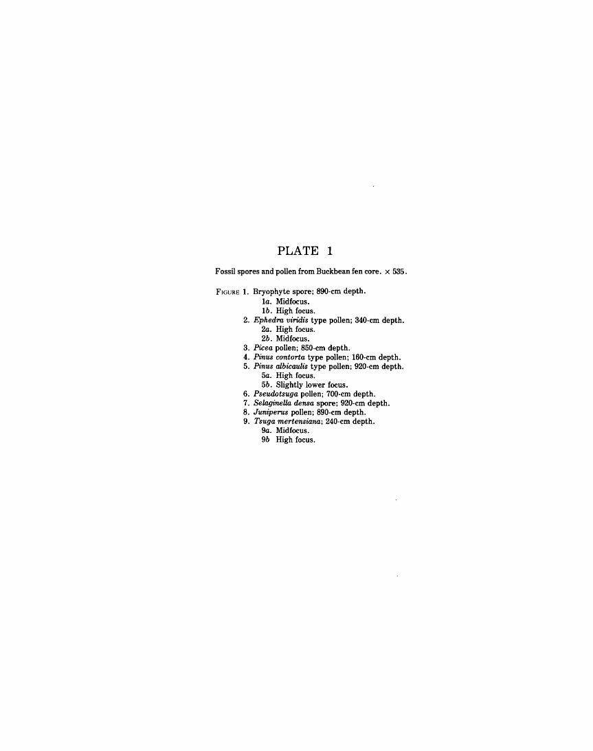
PLATE 1
Fossil spores and pollen from Buckbean fen core. x 535.
FIGURE 1. Bryophyte spore; 890-cm depth. la. Midfocus. lb. High focus.
2. Ephedra viridis type pollen; 340-cm depth. 2a. High focus. 2b. Midfocus.
3. Picea pollen; 850-cm depth. 4. Pinus contorta type pollen; 160-cm depth. 5. Pinus albicaulis type pollen; 920-cm depth.
5a. High focus. 5b. Slightly lower focus.
6. Pseudotsuga pollen; 700-cm depth. 7. SelagineUa densa spore; 920-cm depth. 8. Juniperus pollen; 890-cm depth. 9. Tsuga mertensiana; 240-cm depth.
9a. Midfocus. 9b High focus.
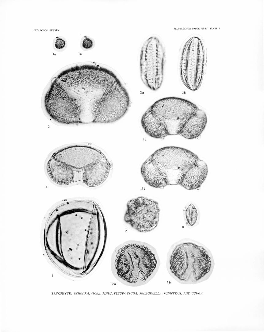
GEOL ICAL SURV EY PROFESSIONAL PAPER 729-E PLATE I
l a 1 b
2b
BRYOPHYTE, EPHEDRA , PICEA , PINUS, PSEUDOTSUGA , SELAGINELLA , JUNIPERUS, AND TSUGA
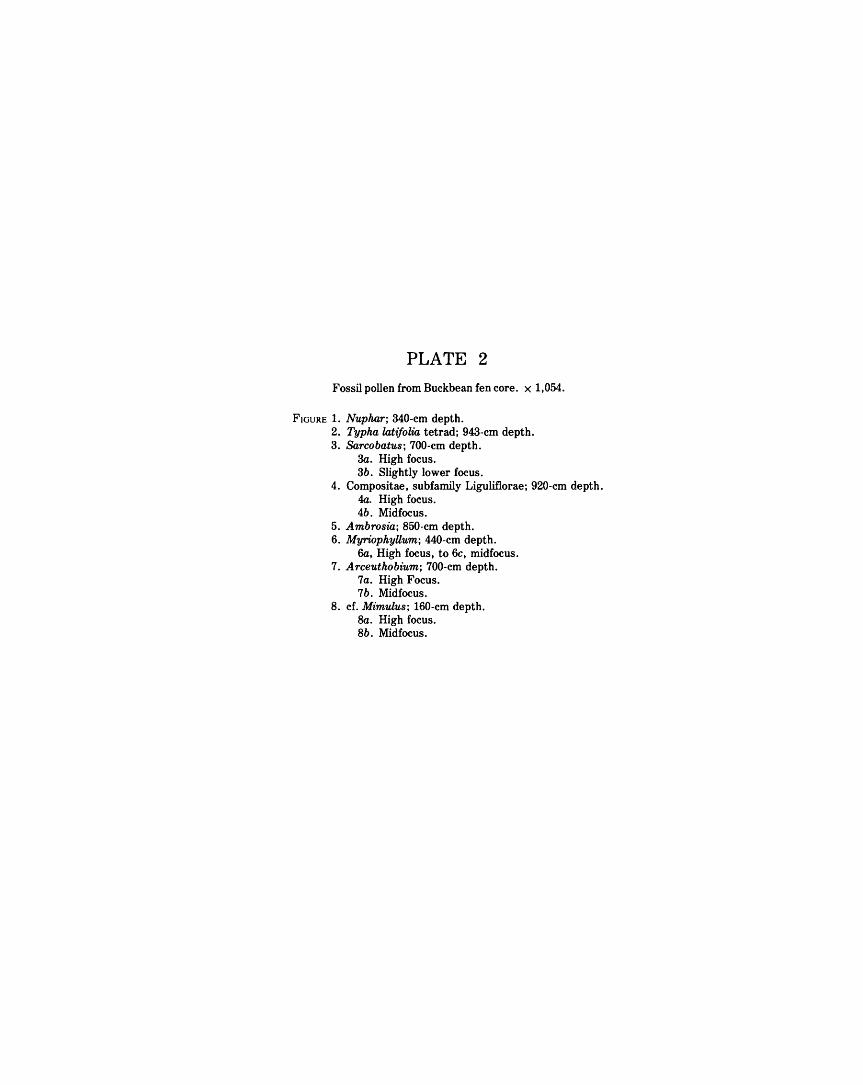
PLATE 2
Fossil pollen from Buckbean fen core. x 1,054.
FIGURE 1. Nuphar; 340-cm depth. 2. Typha latifolia tetrad; 943-cm depth. 3. Sarcobatus; 700-cm depth.
3a. High focus. 3b. Slightly lower focus.
4. Compositae, subfamily Liguliflorae; 920-cm depth. 4a. High focus. 4b. Midfocus.
5. Ambrosia; 850-cm depth. 6. MyriophyUum; 440-cm depth.
6a, High focus, to 6c, midfocus. 7. Arceuthobium; 700-cm depth.
7a. High Focus. 7b. Midfocus.
8. cf. Mimulus; 160-cm depth. Ba. High focus. 8b. Midfocus.
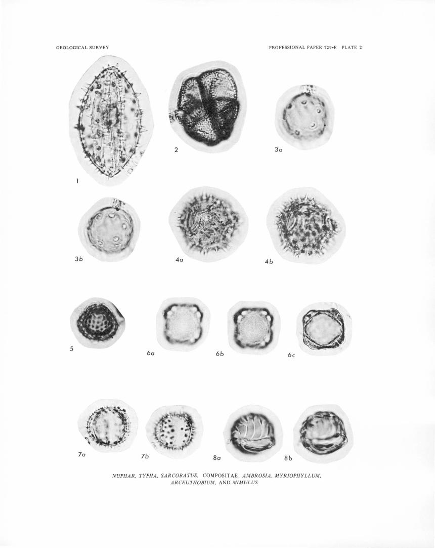
GEOLOGICAL SURVEY
3b
5
la
PROFESSIONAL PAPER 729~E PLATE 2
3a
4a 4b
6a 6b 6c
lb 8a Bb
NUPHAR, TYPHA, SARCOBATUS, COMPOSITAE, AMBROSIA, MYRIOPHYLLUM, ARCEUTHOBIUM, AND MIMULUS

PLATE 3
Fossil pollen from Buckbean fen core. x 1,054.
FIGURE 1. Menyanthes; 60-cm depth. la, High focus, told, low focus.
2. Polemonium; 842-cm depth. 2a, High focus, to 2c, midfocus.
3. Bistorta; 900-cm depth. 3a, High focus, to 3c, midfocus.
4. Koenigia islandica; 850-cm depth. 4a, High focus, to 4d, midfocus.
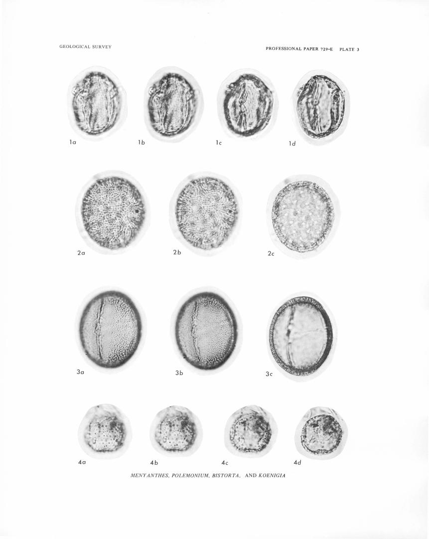
GEOLOGICAL SURVEY PROFESSIONAL PAPER 729-E PLATE 3
la lb lc ld
4a 4b 4c 4d
MENYANTHES, POLEMONIUM, BISTORTA , AND KOENIG/A
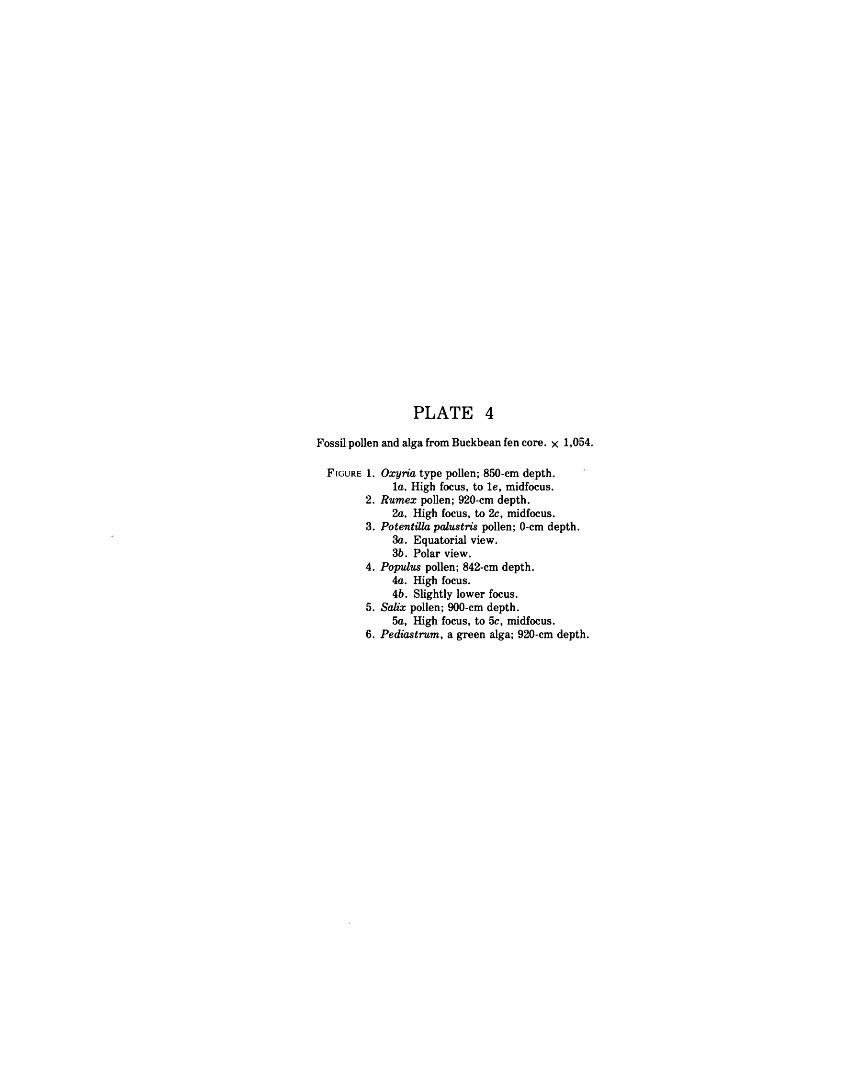
PLATE 4
Fossil pollen and alga from Buckbean fen core. x 1,054.
FIGURE 1. Oxyria type pollen; 850-cm depth. 1a. High focus, tole, midfocus.
2. Rumex pollen; 920-cm depth. 2a. High focus, to 2c, midfocus.
3. Potentilla palustris pollen; 0-cm depth. 3a. Equatorial view. 3b. Polar view.
4. Populus pollen; 842-cm depth. 4a. High focus. 4b. Slightly lower focus.
5. Salix pollen; 900-cm depth. 5a, High focus, to 5c, midfocus.
6. Pediastrum, a green alga; 920-cm depth.

GEOLOGICAL SURVEY PROFESSIONAL PAPER 729-E PLATE 4
la lb lc ld
le 2a 2b
3a 3b 4a 4b
5a 5b 5c
6
OXYRIA, RUMEX, POTENTILLA, POPULUS, SALIX. AND PEDIASTRUM
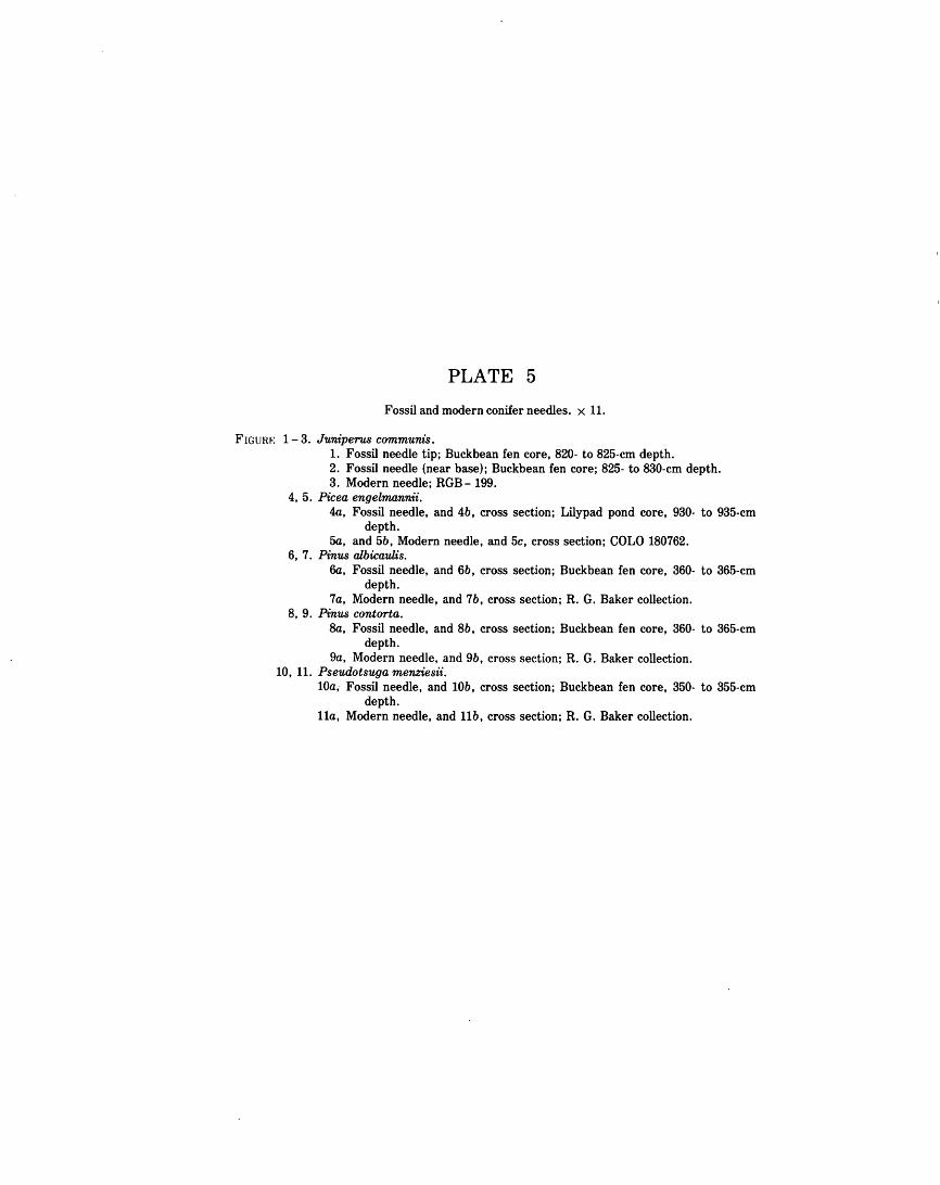
PLATE 5
Fossil and modern conifer needles. x 11.
FIGURE 1-3. Juniperus communis. 1. Fossil needle tip; Buckbean fen core, 820- to 825-cm depth. 2. Fossil needle (near base); Buckbean fen core; 825- to 830-cm depth. 3. Modern needle; RGB- 199.
4, 5. Picea engelmannii. 4a, Fossil needle, and 4b, cross section; Lilypad pond core, 930- to 935-cm
depth. 5a, and 5b, Modern needle, and 5c, cross section; COLO 180762.
6, 7. Pinus albicaulis. 6a, Fossil needle, and 6b, cross section; Buckbean fen core, 360- to 365-cm
depth. 7a, Modern needle, and 7b, cross section; R. G. Baker collection.
8, 9. Pinus contorta. Ba, Fossil needle, and 8b, cross section; Buckbean fen core, 360- to 365-cm
depth. 9a, Modern needle, and 9b, cross section; R. G. Baker collection.
10, 11. Pseudotsuga menziesii. lOa, Fossil needle, and lOb, cross section; Buckbean fen core, 350- to 355-cm
depth. lla, Modern needle, and llb, cross section; R. G. Baker collection.

GEOLOGI AL SUR VEY PROFESSIONAL PAPE R 729-E PLATE 5
5b 5o
·,
2
3
4b
5c
8o
6o 7o 9o
lOa llo
6b 7b
8b 9b lOb llb
J UNIPERUS, P!CEA, PINUS, AND PSEUDOTSUGA
PLATE 6
Fossil and modern fruits, scales, seeds, perianth, and bracts. x 11.
FIGURE 1, 2. Alnus tenuifolia fruits. 1. Fossil fragment; Buckbean fen core, 400- to 405-cm depth. 2. Modern; COLO 2181.
3, 4. Betula glandulosa catkin scales. 3. Fossil; Lilypad pond core, 885- to 890-cm depth. 4. Modern; COLO 2250.
5, 6. Menyanthes trifoliata seeds. 5. Fossil; Buckbean fen core, 55- to 60-cm depth. 6a, 6b. Modern; RGB-197.
7, 8. Rumex fueginus perianth. 7. Fossil; Buckbean fen core, 445- to 450-cm depth. 8. Modern; COLO 56854.
9- 11. Rumex salicifolius fruits. 9. Fossil; Lilypad pond core, 880- to 885-cm depth.
10, 11. Modern; COLO 181168. 12, 13. Populus balsamifera bracts.
12. Fossil fragments; Buckbean fen core, 805- to 810-cm depth. 13. Modern; COLO 107394.
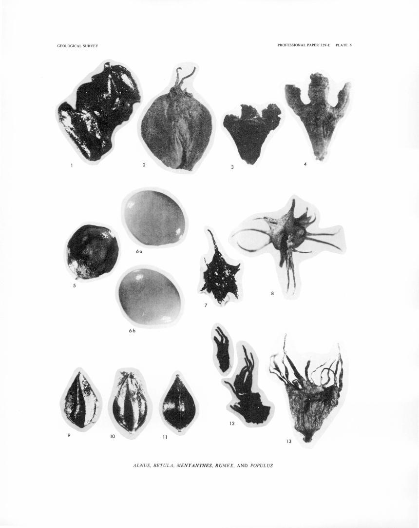
GEOLOGICAL SURVEY PROFESSIONAL PAPER 729-E PLATE 6
4
6a
5
6b
9 10 11
ALNUS, BETULA, MENY .ANTHES, RUMEX, AND POPULUS
PLATE 7
Fossil and modern fruits, perigynia, and fruit-stones. x 11.
FIGURE 1. Nuphar luteum ssp. polysepalum. Fossil fruit; Buckbean fen core, 360- to 365-cm depth.
2-4. Carex limosa fruits. 2. Fossil; Buckbean fen core, 0- to 5-cm depth.
3, 4. Modern; RGB -152. 5 - 7. Carex vesicaria perigynia.
5. Fossil; Buckbean fen core, 0- to 5-cm depth. 6, 7. Modern; RGB- 87.
8-10. Carex ultriculata perigynia. 8. Fossil; Buckbean fen core, 5- to 10-cm depth.
9, 10. Modern; RGB- 277. 11, 12. Potamogeton alpinus fruit with covering.
11. Fossil; Buckbean fen core, 820- to 825-cm depth. 12. Modern; COLO 131646.
13, 14. Potamogeton filiformis fruit-stones. 13. Fossil; Lilypad pond core, 980- to 985-cm depth. 14. Modern; COLO 199776.
15- 17. Potamogeton gamineus fruit-stones. 15. Fossil; Buckbean fen core, 450- to 455-cm depth. 16, 17. Modern; COLO 72388.
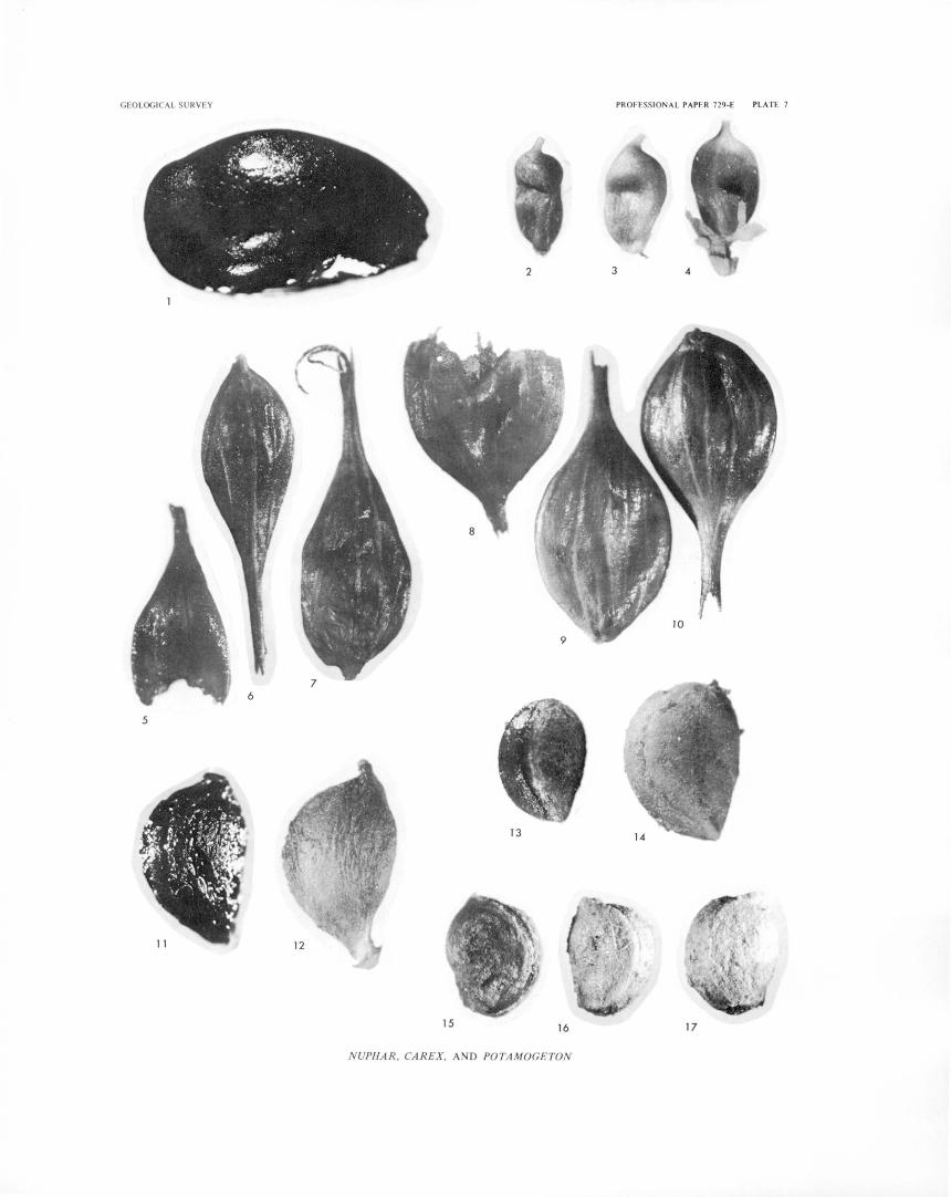
GEOLOGI CAL SU RV EY PROFESS! ON A L PAPER 729-E PLATE 7
2 3
5
13
15 16 17
NUPHAR , CAREX, AND POTAMOGETON
PLATE 8
Fossil and modern seeds and fruits. x 17.
FIGURE 1-3. Descurainia californica seeds. la, lb. Fossil; Lilypad pond core, 910- to 915-cm depth.
2, 3. Modern; COLO 13079. 4- 7. Epilobium glandulosum-type seeds.
4. Fossil; Buckbean fen core, 145- to 150-cm depth. 5-7. Modern-Epilobium adenocaulon (included within this morphological
type); COLO 181161. 8-10. Epilobium lactiflorum seeds.
8. Fossil; Lilypad pond core, 805- to 810-cm depth. 9, 10. Modern; COLO 134413.
11, 12. Ranunculus aquatilis fruits. 11. Fossil; Lilypad pond core, 870- to 875-cm depth. 12. Modern; RGB -151.
13-15. Potentilla biennis fruits. 13. Fossil; Lilypad pond core, 885- to 890-cm depth.
14, 15. Modern; COLO 209920. 16-19. Potentilla gracilis type fruits.
16, 17. Fossil; Lilypad pond core, 955- to 960-cm depth. 18, 19. Modern; RGB-124a.
20-22. Potentilla palustris fruits. 20. Fossil; Buckbean fen core, 5- to 10-cm depth.
21, 22. Modern; RGB-148.
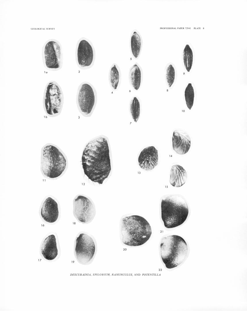
GEOLOG ICAL SURVEY
lo
1 b
16
PROFESSIONAL PAPER 729-E PLATE 8
5
2
4
3
13
21
20
19
22
DESCURAINIA, EPILOBIUM, RANUNCULUS, AND POTENTILLA
9
8
10
14
15
PLATE 9
Fossil perigynia, fruits, and seeds from Buckbean fen core and modern perigynia, fruits, and seeds. x 16.
FIGURE 1, 2. Carex aquatilis perigynia and fruits. 1. Fossil; 165- to 170-cm depth. 2. Modern; COLO 53127.
3-5. Carex canescens perigynia and fruits. 3. Fossil; 0- to 5-cm depth.
4, 5. Modern; R. G. Baker collection. 6- 8. Carex diandra perigynia and fruits.
6. Fossil; 0- to 5-cm depth. 7, 8. Modern; RGB-147.
9-11. Eleocharis macrostachya fruits. 9. Fossil, corroded; 475- to 480-cm depth.
10, 11. Modern; COLO 95235. 12-14. Glyceria maxima ssp. grandis seeds.
12. Fossil; 435- to 440-cm depth. 13, 14. Modern; COLO 20242.
15, 16. Naias jlexilis seeds. 15. Fossil; 475- to 480-cm depth. 16. Modern; COLO 106552.
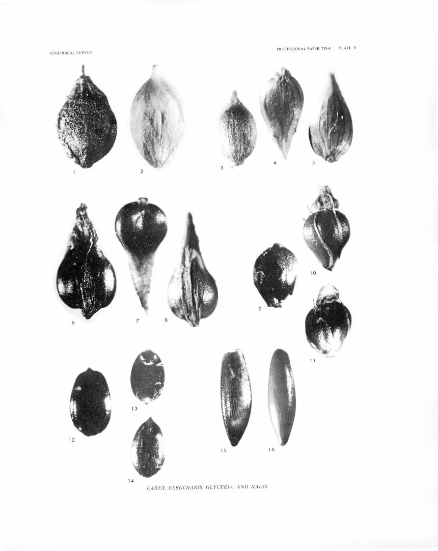
PROFESSIONAL PAPER 729-E PLAT!-. 9 GEOLOGICA L S RV EY
4
2
6
11
13
12
15 16
14 CAREX, ELEOCHARIS, GLYCER! A, AND NA JAS
PLATE 10
Fossil and modern fruits and seeds. x ca. 27
FIGURE 1. cf. Vaccinium. Fossil seed; Lilypad pond core, 990- to 995-cm depth. 2-6. Sa;x;ifraga rhomboidea seeds.
2a, 2b. Fossil; Lilypad pond core, 930- to 935-cm depth. 3-6. Modern; COLO 38885.
7-11. Sa;x;ifraga caespitosa seeds. 7. Fossil; Lilypad pond core; 930- to 935-cm depth.
8-11. Modern; COLO 180253. 12- 14. Rorippa islandica-type seeds.
12. Fossil; Buckbean fen core, 410- to 415-cm depth. 13, 14. Modern; COLO 197251.
15 - 17. Typha fruits. 15. Fossil; Buckbean fen core, 665- to 670-cm depth. 16. Modern fruit with covering membrane; COLO 41239. 17. Modern fruit with membrane removed; COLO 41239.
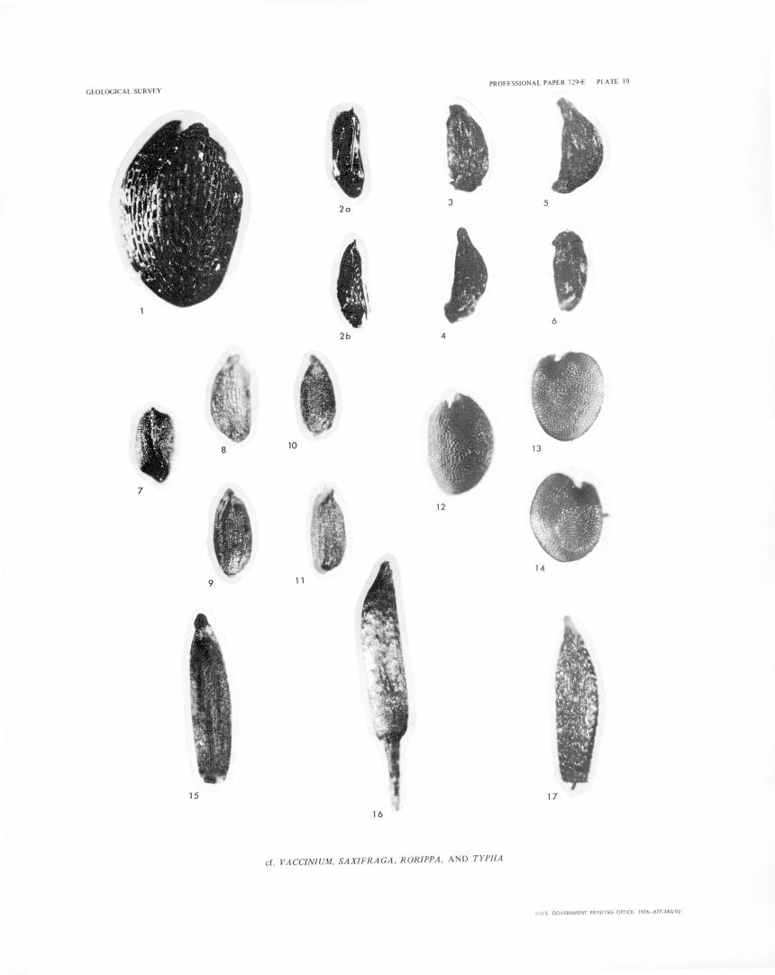
PROFESSIONAL PAPER 729-£ PLATE 10 GEOLOGI AL SURVEY
2a 3 5
6
2b
8 10 13
7
12
14
9 11
15 17
cf. VACCINIUM, SAX/FRAGA , RORIPPA, AND TYPHA
u U.S. GOVERNMENT PRINTING OFFICE' 1976- 677-340/92

Baker-LATE QUATERNARY VEGETATION HISTORY OF THE YELLOWSTONE LAKE BASIN, WYO.-Geological Survey Professional Paper 729-E


