Embed Size (px)
Citation preview
GeoGraphic distribution of the Genera of the tribe oryzomyini
(rodentia: cricetidae: siGmodontinae) in south america: patterns of
distribution and diversity
Joyce R. PRado alexandRe R. PeRcequillo
são paulo – sp – brasil Junho – 2013
volume 44(1):1‑120, 2013
museu de zooLoGia da universidade de sÃo pauLo avenida nazaré, 481 – ipiranga – cep 04263‑000 – são paulo – sp – brasil
www.mz.usp.br
pubLicaciones científicas
El Museu de Zoologia publica dos periódicos, Papéis Avulsos de Zoologia (previamente Papéis Avulsos do Departamento de Zoologia da Secretaria de Agricultura de São Paulo, que inició en 1941) y Arquivos de Zoologia (previamente Arquivos de Zoologia do Estado de São Paulo, que inició en 1940). Los artículos son publicados individualmente y contienen las fechas de recepción y aceptación por la Comisión Editorial.
Ambos periódicos se derivan de los artículos zoológicos de la Revista do Museu Paulista, de forma que los volúmenes 1-3 de Arquivos de Zoologia llevan la numeración de los volúmenes 24-26 de la Revista do Museu Paulista. Con el establecimiento de un periódico diferente para los artículos de zoología, la Revista do Museu Paulista se reinició como una Nueva Serie, especializada en asuntos no relacionados con zoología.
pubLicações científicas
O Museu de Zoologia publica dois periódicos, Papéis Avulsos de Zoologia (previamente Papéis Avulsos do Departamento de Zoologia da Secretaria de Agricultura de São Paulo, iniciada em 1941) e Arquivos de Zoologia (previamente Arquivos de Zoologia do Estado de São Paulo, iniciada em 1940). Os artigos são publicados individualmente e trazem a data de recebimento e de aceite pela Comissão Editorial.
São derivados ambos os periódicos de documentos zoológicos da Revista do Museu Paulista, de forma que os volumes 1-3 de Arquivos de Zoologia englobam os volumes 24-26 da Revista do Museu Paulista. Com o estabelecimento de um periódico diferente para documentos zoológicos, a Revista do Museu Paulista foi reiniciada então como uma Nova Série, dedicado a assuntos não-zoológicos.
scientific pubLications
The Museu de Zoologia publishes two journals, Papéis Avulsos de Zoologia (previously Papéis Avulsos do Departamento de Zoologia da Secretaria da Agricultura de São Paulo, started in 1941) and Arquivos de Zoologia (previously Arquivos de Zoologia do Estado de São Paulo, started in 1940). Papers are published as separate issues, which contain the dates of receipt and acceptance by the Editorial Commitee.
Both journals are derived from zoological papers in the Revista do Museu Paulista, so that volumes 1-3 of Arquivos de Zoologia bear volumes numbers 24-26 of Revista do Museu Paulista. With the establishment of a different journal for zoological papers, the Revista do Museu Paulista was then restarted as a New Series, dedicated to non-zoological subjects.
Arquivos de Zoologia São Paulo v. 44 n. 1 p. 1-120 Junho - 2013
GeoGrAPhic diStribution of the GenerA of the tribe oryZomyini
(rodentiA: cricetidAe: SiGmodontinAe) in South AmericA: PAtternS of
diStribution And diverSity
Joyce R. PRado alexandRe R. PeRcequillo
univerSidAde de SÃo PAuLo Reitor: Prof. Dr. João Grandino Rodas
Vice-Reitor: Prof. Dr. Hélio Nogueira da Cruz
© muSeu de ZooLoGiA dA univerSidAde de SÃo PAuLo Diretor: Prof. Dr. Hussam El Dine Zaher
Vice-Diretor: Prof. Dr. Marcos Domingos Siqueira Tavares
comiSSÃo editoriAL Carlos José Einicker Lamas – Universidade de São Paulo (editor-chefe) Hussam El Dine Zaher – Universidade de São Paulo (editor associado)
Luís Fábio Silveira – Universidade de São Paulo (editor associado) Marcos Domingos Siqueira Tavares – Universidade de São Paulo (editor associado)
Mário Cesar Cardoso de Pinna – Universidade de São Paulo (editor associado) Sérgio Antonio Vanin – Universidade de São Paulo (editor associado)
SeÇÃo de PubLicAÇÕeS Airton de Almeida Cruz (arte-finalista)
indeXAdoreS Biological Abstracts, BIOSIS, Portal de Revistas da USP,
ULRICH’s, Zoological Record.
vendA, PermutA, doAÇÃo e ASSinAturA Museu de Zoologia da USP – Caixa Postal 42.494 – CEP 04218-970 – São Paulo – SP – Brasil
Serviço de Biblioteca e Documentação – Fone: (55-11) 2065-8121 – e-mail: [email protected]
Os periódicos Papéis Avulsos de Zoologia e Arquivos de Zoologia estão credenciados na Comissão de Credenciamento do Programa de Apoio às Publicações Científicas e Periódicas da Universidade de São Paulo.
“depósito legal na biblioteca nacional, conforme Lei n° 10.944, de 14 de dezembro de 2004”
Arquivos de Zoologia / Universidade de São Paulo. Museu de Zoologia. Vol. 15(1967)- São Paulo : O Museu, 1967-
v. : il. ; 26 cm.
Continuação de: Arquivos de Zoologia do Estado de São Paulo: Vol. 1(1940)-14(1966).
Irregular: Vol. 15(1967)- 37(2002/2006) Anual: Vol. 38(2007)-
ISSN: 0066-7870 (versão impressa) ISSN: 2176-7793 (versão on-line disponível em:
http://portal.revistasusp.sibi.usp.br
1. Zoologia. I. Universidade de São Paulo. Museu de Zoologia.
ficha catalográfica de acordo com o código de catalogação Anglo-Americanono (AAcr2)
tiragem: 500 exemplares.
Sumário
44(1):1-120 Geographic distribution of the genera of the Tribe Oryzomyini (Rodentia: Cricetidae: Sigmodontinae) in South America: patterns of distribution and diversity
Joyce R. Prado & Alexandre R. Percequillo

GeoGraphic distribution of the Genera of the tribe oryzomyini (rodentia: cricetidae: siGmodontinae) in south america: patterns of distribution and diversity
Joyce r. prado1,2
alexandre r. percequillo1,3
AbstrAct
The Oryzomyini is the most diverse tribe of the sigmodontine (Cricetidae: Sigmodontinae) radiation, including 28 genera and about 130 species, with this diversity reflected in the ecological and morphological variation observed among members. There are many hypotheses to explain the emergence and diversification of the Sigmodontinae in South America, includ-ing areas of original differentiation (AOD). In this paper we provide information on the geographic distribution of all extant genera in the tribe Oryzomyini, organizing these data in a gazetteer that includes provenance (collection locality, state or province, country), eleva-tion, and geographical coordenates. Distribution maps generated for all genera and species then serve as the starting point for testing patterns of geographic distribution and diversity, and especially the AOD hypothesis advocating origination in the northern Andes. Our re-sults reveal considerable generic and specific richness and show that there are three general patterns of distribution, the Trans-Andean, Andean, and Cis-Andean. Moreover, different genera encompass distributions that are endemic, disjunct, or widely distributed, as well as those restricted by habitats in both forest and open areas. Recent phylogenetic hypotheses in-dicate that the distribution patterns of oryzomyines do not correlate with the major lineages of the inclusive clades; rather, each main lineage displays most of the biogeographic patterns described for the tribe as a whole. The northern Andes cannot be considered as AOD, since the most records for Oryzomyini are located in the Cis-Andes area. The northern Andes is the second region in number of species, while the Trans-Andean represents the third richest region in South America. Patterns of richness of the tribe are strongly concordant with several of the centers or regions of endemism described in the literature. Areas of high richness are located mainly in the Andes, followed in lesser degree by areas in the Guyanan Shield, Brazilian Atlantic and Amazon Forests, and Paraguayan Chaco.
Key-Words: Oryzomyini; Geographic Distribution; AOD; Biogeography.
1. Departamento de Ciências Biológicas, Escola Superior de Agricultura “Luiz de Queiroz”, Universidade de São Paulo. Avenida Pádua Dias, 11, Caixa Postal 9, CEP 13418-900, Piracicaba, São Paulo, Brasil.
2. Programa de Pós-Graduação Ecologia Aplicada Interunidades – ESALQ/CENA.3. E-mail: [email protected]
Volume 44(1):1‑120, 2013
IntroductIon
The subfamily Sigmodontinae includes about 86 genera and 395 species (sensu Reig, 1980; Musser & Carleton, 2005), and is one of the most diverse and complex groups of New World mammals, rep-resenting about 29% of all Neotropical mammals (Weksler, 2006). Members of this subfamily are dis-tributed mainly in South America, but some taxa are also found both in Central America and southeastern North America (Musser & Carleton, 2005). The cur-rent taxonomic concept of the Sigmodontinae and of the subordinate tribes, genera and species, is the result of the fundamental contribution provided by authors such as O. Thomas, J.A. Allen, G. Tate, W. Osgood, P. Hershkovitz, O. Reig, combined with ex-tensive studies published in recent decades (Patton & Hafner, 1983; Carleton & Musser, 1989; Voss, 1991, 1993; Voss & Carleton, 1993; Smith & Patton, 1993, 1999; Musser et al., 1998; Percequillo, 1998, 2003; Carleton & Olson, 1999; Patton et al., 2000; D’Elía, 2003; D’Elía et al., 2003; Weksler, 2003, 2006; Gó-mez-Laverde et al., 2004; Musser & Carleton, 2005; Weksler et al., 2006; Percequillo et al., 2008, 2011).
Throughout history, sigmodontine genera have been grouped in 7 to 9 tribes (for a revision of the generic contents of these tribes, see Reig, 1984; Smith & Patton, 1999; and D’Elía et al., 2007). However, for the last 15 years, morphological and molecular phylog-enies have redefined and delimited those tribes (e.g., Braun, 1993, Phyllotini; Voss & Carleton, 1993, Ory-zomyini; Smith & Patton, 1993, 1999, all tribes; Step-pan, 1995, all tribes; D’Elía et al., 2003, 2005, 2006a, 2006b, 2007, Akodontini, Abrotrichini; Pacheco 2003, Thomasomyini; Weksler, 2003, 2006, Oryzo-myini), causing reconsideration of their definition and contents (see D’Elía et al., 2007), promoting the fol-lowing tribal arrangement: Abrotrichini, Akodontini, Ichthyomyini, Oryzomyini, Phyllotini, Reithrodon-tini, Sigmodontini, Thomasomyini, Wiedomyini.
The Oryzomyini is the most diverse tribe among this large radiation, with 28 extant and about 130 species (Percequillo et al., 2011; Weksler & Per-cequillo, 2011). The tribal diagnosis proposed by Voss & Carleton (1993) has been supported by studies em-ploying phylogenetic methods (Steppan, 1995; Wek-sler, 2003, 2006; McCain et al., 2007; Percequillo et al., 2011), but hitherto published contributions have failed to provide adequate diagnoses for most of the genus-group taxa, or adequate information on the geographical distribution.
Despite these deficiencies, based on substantive advances in our understanding of the geographical
distribution, taxonomy and phylogenetic relation-ships, several authors have hypothesized the place and pattern of geographical diversification, as well as the time of origin and radiation patterns, of this group (Simpson, 1950, 1969; Hershkovitz, 1966, 1972; Pat-terson & Pascual, 1968, 1972; Savage, 1974; Baskin, 1978, 1986; Marshall, 1979; Reig, 1980, 1984, 1986; Jacobs & Lindsay, 1984; Slaughter & Ubelaker, 1984; Steppan, 1995; Engel et al., 1998; Smith & Patton, 1999; Pardiñas et al., 2002; Steppan et al., 2004; Bar-ros et al., 2009; Valencia-Pacheco et al., 2011).
Among the hypothesis erected to explain sigmo-dontine origin and diversification in South America, those presented by Hershkovitz (1962, 1966, 1972) were pivotal on the discussions regarding the habitat occupied by the ancestral lineage (or lineages) that invaded South America. Hershkovitz (1962, 1966, 1972) posited that the Oryzomyini was the most basal Sigmodontinae lineage, a group in his view that con-tained only forest-dwelling and pentalophodont taxa, at the base of an evolutionary transition to open, non-forested (or pastoral) habitats. This pathway was ac-companied by the progressive reduction of the meso-loph/mesolophid, as the members of the Akodontini tribe, culminating in groups with derivative tetralo-phodont molars, inhabiting exclusively open habitats, like the Phyllotini. However, the contemporaneous definition of the Oryzomyini tribe (Voss & Carleton, 1993; Weksler, 2006; Weksler et al., 2006; Percequillo et al., 2011; Weksler & Percequillo, 2011) includes both traditional forest and pentalophodont taxa as well as several lineages of pastoral, tetralophodont sig-modontine genera, formerly allocated to other tribes, such as Holochilus (Sigmodontini), Pseudoryzomys (Phyllotini) and Zygodontomys (Akodontini). Thus, more recent phylogenetic hypotheses contradict the evolutionary scenario proposed by Hershkovitz (op. cit.). Importantly, and despite its importance in the definition and diagnosis of generic suprageneric groupings (Weksler & Percequillo, 2011), the evolu-tionary and adaptive importance of mesoloph (Hersh-kovitz, 1993) is still not fully understood. One of the reasons relates to the inadequate descriptions of geo-graphic distribution and use of habitat (forest or open habitats) for several oryzomyine taxa.
Another important contribution on the origin and diversification in South America sigmodontines based on historic events is the Area of Original Differ-entiation (AOD) hypothesis proposed by Reig (1984; further elaborated in 1986). This model advocates for the existence of areas where sigmodontine taxa experi-enced their main differentiation; for the Oryzomyini, the AOD was posited to be the humid forests of the
Prado, J.R. & Percequillo, A.R.: Oryzomyini geographic distribution2
northern Andes. From this area, extending from the Ecuadorean-Peruvian border northeast to the Colom-bian/Venezuelan border, oryzomyines subsequently dispersed to other forested areas in South America. One merit of Reig’s work (1984, 1986), in addition to the recognition of general areas of original dif-ferentiation, was the delineation of areas of greatest generic and species diversity, as well as the descrip-tion of distribution patterns throughout the Andes for several groups of rodents. Nevertheless, identifi-cation of areas of endemism for Sigmodontinae taxa, similar to those proposed by Cracraft (1985) for the avifauna of South American, has remained incom-plete. Cracraft, employing abundant literature on bird geographic distributions and a well-defined con-cept of endemism, identified 33 areas of endemism in South America, including endemic species of each. It is likely that the minimal advance in the recognition of areas of endemism for sigmodontine rodents has resulted from poor knowledge of both the taxonomy and geographic distribution for most species.
Recently, Valencia-Pacheco et al. (2011) pro-posed an alternative, more ecological hypothesis to explain the diversification of the Oryzomyini tribe. These authors reported the existence of a latitudinal gradient in the number of species, with a marked de-crease in diversity towards north and south, from the Amazon Basin. They also suggested the existence of a source-sink model, which would explain the pat-terns of diversity of the tribe, with the Amazon hav-ing served as a “source” (a kind of “center of origin” of the tribe) from which the oryzomyine species would disperse and colonize new environments.
Clearly, the central aspect to each and all scenar-ios and hypotheses aforementioned is the knowledge on the geographic distribution of the taxon studied. However, confident information on geographic dis-tribution is still inadequate, with few contributions on this subject: several authors enlisted above aimed to explain origin and biogeography of sigmodontine rodents, even before establishing a sound basis on tax-onomy and geographic distribution.
Therefore, we herein provide a comprehensive da-tabase for the collecting localities of oryzomyine genera, which in turn we used in both qualitative and quanti-tative analysis to fill gaps in our current knowledge of the geographic distribution and habitat use at the genus and species level. We also address the definition and va-lidity of the Reig’s Area of Original Differentiation for the Oryzomyini, under a modern systematic concept of the tribe. We furthermore address the identification of patterns of diversity, areas of greatest species richness, and areas of endemism for this clade in South America.
MAterIAl And Methods
concepts and definitions
Terms like center of origin and endemism may be confusing, since their usage is broad and varied. In order to clarify and standardize such terms employed throughout the text, in this section we provide defini-tions for the most common concepts.
Area of Original Differentiation (AOD): according to Reig (1986), AOD is “the geographic space within which a give taxon experienced the main differentia-tion (cladogenesis) of its component taxa of subordi-nate rank”. Despite some additional theoretical and conceptual reasoning that define an AOD [e.g., “(1) it is the areas reached by the ancestral stock after its dis-persal from the AOD of its parental taxon; (2) it is the area where the taxon split most actively into subordi-nate taxa, acquiring through this process its defining properties; (3) it is the area in which the taxon split into apomorphic species, which dispersed into a new AOD to generate there a new sister taxon of the same rank”], Reig identified an AOD based on the num-ber of records and number of endemic taxa in a given area (see areas on material and methods section). In 1986, there were no available phylogenies for the tribe or subfamily that would allowed Reig to apply any of his criteria to recognize an AOD for any tribe of Sigmodontinae.
Center of Origin: this is one of the most prevalent yet controversial concepts permeating biogeographic analyses, and as a consequence its definition varies widely, including but not exclusive of: birthplace, place where the most derived forms reside, or area with the greatest number of species. Cain (1944) de-fined severel criteria to recognize centers of origin, some of them very similar to those employed by Reig in his recognition of an AOD, namely the location of greatest differentiation of a type, and location of dominance or greatest abundance of individuals. De-spite the similarity among these terms, we follow Reig (1986) and consider them as distinct, with the proviso that the AOD concept explicitly includes historical and evolutionary aspects on its definition.
Area or Center of Endemism: Cracraft (1985:50) considers areas of endemism as “regions defined by distributional congruence of the constituent taxa. The simplest hypothesis is that areas of endemism represent common regions of biotic differentiation. Phylogenetic histories of taxa endemic in three or
Arquivos de Zoologia, 44(1), 2013 3
more areas provide evidence for their historical inter-relationship, and it is these hypotheses regarding the history of areas that allow us to investigate patterns of differentiation in the component taxa”. Cracraft (1985:53) further stated “areas of endemism are de-fined by discrete (diagnosable), differentiated taxo-nomic units”. Harold & Mooi (1994) and Morrone (1994) presented a similar definition, which is an area identified by the congruence of distributional bound-aries of two or more species, where congruence does not demand complete agreement on those limits at all possible scales of mapping, but relatively extensive sympatry is a prerequisite.
Species richness: number of species in a sample from a local area or geographic region, also referred to as alpha diversity (Lomolino et al., 2009). We aimed to identify patterns of diversity/richness throughout South America, at both the specific and generic levels, for members of the tribe Oryzomyini in different ar-eas and/or habitats across the continent.
We also provide definitions for other terms cur-rently employed herein, especially those identifying types of vegetation and habitats occupied by oryzo-myine species.
Dry diagonal: a belt that bisects cis-Andean South America diagonally from northeastern Brazil to northern Argentina and Paraguay. Along this diago-nal are distributed important vegetation types, such as Caatinga, Cerrado, and Chaco, usually drier and less mesic than the adjacent vegetation in the Atlantic Forest and Amazon Forest (Vanzolini, 1974).
Open areas: we include in our concept of open areas usually drier habitas as shrublands, periodically flood-ed savanna shrublands, tropical savannas, grasslands, seasonally flooded grasslands, which are typical habi-tats of Cerrado and Chaco, and also moorlands, mon-tane grasslands (like the Andean Puna and Páramo), steppe vegetation (like the Argentinean, Uruguayan and Brazilian pampas), sparse vegetation, barren or bare soil, deserts (like the Peruvian Lomas), salt pans, and areas with permanent ice and snow (Eva et al., 2002).
Forest or Forested areas: in this concept we include closed-canopy mesic and humid forests like evergreen broadleaf forests, evergreen broadleaf forests with bamboo dominance and semi-humid evergreen for-ests, typical of the Atlantic and Amazon Forests; more open, dry forests like deciduous and semi-deciduous tropical forest and semi-deciduous transition tropical
forest, typically observed in Cerrado (cerradão and gallery forests) and Caatinga; the flooded tropical forests like mangroves, periodically fresh water flood-ed tropical forests and permanently flooded forests; temperate forests like evergreen broadleaf temperate forests, evergreen mixed broad and needleleaf forests, and seasonal broadleaf forests; and finally Andean montane and elfin forests occurring between 500 m and 1,000 m and above 1,000 m of altitude, respec-tively (Eva et al., 2002).
sampling
We include information on the geographic dis-tribution for all extant genera of the tribe Oryzomy-ini. Data on the collecting localities were obtained from multiple sources. For 13 genera (Aegialomys, Cerradomys, Eremoryzomys, Euryoryzomys, Hylaeamys, Mindomys, Nephelomys, Oreoryzomys, Oryzomys, Pseu-doryzomys, Transandinomys, Drymoreomys and Soore-tamys) we assembled data from specimens in the fol-lowing institutional and personal collections: Museu de Zoologia da Universidade de São Paulo (MZUSP); Alexandre Uarth Christoff Collection (AUC); Museu Nacional da Universidade Federal do Rio de Janeiro (MNRJ); Laboratório de Mamíferos Aquáticos, Uni-versidade Federal de Santa Catarina (LAMAQ); Museu de Ciências Naturais, Fundação Zoobotânica do Rio Grande do Sul (MCN); Museo Nacional de Ciencias Naturales “Bernardino Rivadavia” (MACN); Museo La Plata (MLP); Material collected by Maria Nazareth F. da Silva (MNFS), to be incorporated to the col-lections of Instituto Nacional de Pesquisas Amazôni-cas, Museu Paraense Emilio Goeldi and Museum of Vertebrate Zoology; Museu Paraense Emílio Goeldi (MPEG); Museum of Vertebrate Zoology, University of California (MVZ); Universidade Federal de Belo Horizonte (UFMG); Departamento de Sistemática e Ecologia da Universidade Federal da Paraíba (UFPB); Departamento de Genética da Universidade Federal do Rio Grande do Sul (UFRGS); Departamento de Zoologia da Universidade de Brasília (UNB); Ameri-can Museum of Natural History (AMNH); Field Museum of Natural History (FMNH); material col-lected by Guillermo D’Elía (GE), to be deposited at the UMMZ; Instituto de Pesquisas Amazônicas (INPA); Museum of Natural History, Kansas Univer-sity (KU); material collected by L.H. Emmons (LHE) to be deposited at the National Museum of Natural History; Museum of Zoology, Louisiana State Uni-versity (LSUMZ); Museum of Comparative Zoology (MCZ); Royal Ontario Museum (ROM); Museum
Prado, J.R. & Percequillo, A.R.: Oryzomyini geographic distribution4
of Zoology, University of Michigan (UMMZ); and National Museum of Natural History (USNM). For another group of 12 genera, as well as six of the taxa listed above, we obtained data from literature: Amphi-nectomys (Musser & Caleton, 2005); Cerradomys (Per-cequillo et al., 2008; Tavares et al., 2011); Euryoryzo-mys (Musser et al., 1998); Handleyomys (Voss et al., 2002); Hylaeamys (Musser et al., 1998); Lundomys (Voss & Carleton, 1993); Melanomys (Allen, 1913; Tate, 1932); Microakodontomys (Hershkovitz, 1993); Microryzomys (Carleton & Musser, 1989); Neacomys (Patton et al., 2000; Voss et al., 2001); Nectomys (Bon-vicino, 1994); Nesoryzomys (Patton & Hafner, 1983); Oryzomys (Sanchéz et al., 2001; Voss & Weksler, 2009); Pseudoryzomys (Pardiñas et al., 2004); Sigmo-dontomys (McCain et al., 2007); Scolomys (Gómez-Laverde et al., 2004); Transandinomys (Musser et al., 1998); Zygodontomys (Voss, 1991). For three genera, Holochilus, Oecomys and Oligoryzomys, there is no available taxonomic review in the current literature. Although Hershkovitz had reviewed both Holochilus (1955) and Oecomys (1960), his taxonomic arrange-ment is obsolete; nevertheless, these papers provide important data on the geographical distribution. While these genera are well represented in Brazilian collections, without a reliable taxonomy we were un-able to prepare a complete database (although we did employ information on the collection localities from museum databases through Manis system [http://manisnet.org]). Therefore, we exclude these three genera from our general conclusions on distribution and geographic diversity patterns.
Gazetteer and Mapping
Data on localities cited above were organized in gazetteers for each genus, which, in addition to the specific locality, contain geographic coordinates, ele-vation (when available), and all the species collected at the site. Gazetteers are organized in alphabetical order by country, state or province, and collection locality.
Geographic coordinates and elevation were ob-tained from several sources (Hershkovitz, 1948; US-BGN, 1955a, 1955b, 1956, 1957a, 1957b, 1961, 1963, 1964, 1968, 1969, 1976; Fairchild & Handley, 1966; Handley, 1976; Paynter Jr., 1982; 1989; 1992; 1993; 1997; Stephens & Traylor Jr., 1983, 1985; Voss, 1988; Paynter Jr. & Traylor Jr., 1991; Vanzo-lini, 1992; Anderson, 1997) and also from http://geonames.nga.mil/ggmagaz. In general, it was diffi-cult to recover the exact coordinates and elevation for many collecting points. Therefore, coordinates given
in gazetteers correspond to the nearest geographic place with the same name (town, river, municipality, range, etc.) mentioned in the above sources.
Maps were drawn to identify distribution pat-terns for each genus and its species. Besides the maps for the genera, we also mapped each of the tribal clades identified by Weksler (2006) and Percequillo et al. (2011) for the Oryzomyini onto the vegetation types identified by Eva et al. (2002). Finally, we pro-duced maps exhibiting the abundance of records and depicting areas of species diversity of the Oryzomyini across South America.
south American regions
In order to evaluate which regions of South America are more diverse and exhibit higher levels of genus-group endemism, we divided the continent into separate areas. We followed Simpson (1975) and Reig (1986), and divided the Andes into 6 geographical unities, but unlike Reig (1986) we separated the non-Andean area in two units, Cis- and Trans-Andean. These Andean areas were also recognized as centers of endemism and well known areas of great species rich-ness by Cracraft (1985). As our purpose is to evaluate Reig’s AOD, we employed the same area delimitation to facilitate comparison of our respective results.
(1) North Andean (NA): all locations, in elevation above 1,000 m, north of the Huancabamba deflection in Peru through Ecuador, the three Andean cordillera in Colombia, the Sierra Ne-vada de Santa Marta in Colombia, and the Sierra Perija and Sierra de Mérida in Colombia and Venezuela;
(2) Center-North Andean (CNA): all locations in elevation above 1,000 m in Peru, south of the Huancabamba deflection north to 15°S south;
(3) Center-South Andean (CSA): all locations in el-evation above 1,000 m between 15°S and 25°S from southern Peru through Bolivia to northern Chile and northwestern Argentina.
(4) North-South Andean (NSA): all locations in el-evation above 1,000 m, along the main Andean axis (excluding the Balcarce, Tandil and La Ven-tana Sierras), in northern and central Argentina and central Chile, between 25°S and 35°S.
(5) South of South Andean (SSA): all locations in el-evation above 1,000 m, in the coastal cordillera of Chile, in the southern portion of Andean axis between 35°S and the southern portion of the Tierra Del Fuego.
Arquivos de Zoologia, 44(1), 2013 5
(6) Trans-Andean (TA): all locations at elevations be-low 1,000 m and west of the Andean Cordillera.
(7) Cis-Andean (CA): all locations at elevations be-low 1,000 m and east of the Andean Cordillera.
Reig (1986) considered that every Cis- and Trans-Andean taxon should be assigned to a single non-Andean region, but his proposal has little prac-tical value since there is a noticeable extra-Andean taxonomic diversity and geographic differentiation between the lowlands on both sides of the Andes. Therefore, for another set of analysis we also divided the Cis- and Trans-Andean regions into two main do-mains: the forested and the open formations, based on the map of the vegetation of South America (Eva et al., 2002).
Beyond the geographical groupings, we also divided South America into elevational classes, with the intention of evaluating how generic diver-sity is organized altitudinally as well as horizontally. Although we were aware that species would not be confined to elevation classes and that altitudinal dis-tribution depended upon the latitude, we used these classes (0-999 m, 1,000-1,999 m, 2,000-2,999 m, 3,000-3,999 m, above 4,000 m), in order to standard-ize the information and to evaluate which elevation zone exhibited more records for the tribe, fully aware that sampling artifacts may have biased our analyses. We also elaborated a diagram depicting the elevation-al range for every oryzomyine genera, allowing direct comparisons between these taxa.
data analysis
We used every registered location estimate Ng, the total number of known geographical occurrences for each taxon. We then estimated the distributional frequency (f ) for each taxon, in each one of the classes and unities (U), through the expression:
These data were organized in tables and, with the fT distribution and the distribution maps, we es-timated the Areas of Original Diferentiation (AOD). We also counted the number of genera and species for each of the seven geographic areas, including the number of endemics for each taxonomic rank. Finally, we used the maps of record abundance and species richness to determine areas of greatest diversity across South America.
results And dIscussIon
the database
Geographic distribution of oryzomyini genera in south America
In this database we provide gazetteers of collect-ing localities, distributional maps, taxonomic con-tent of each genus, data on habitat and summaries of geographical distribution for Oryzomyini genera and species.
Genus Aegialomys Weksler, Percequillo & Voss, 2006
Gazetteerecuadorel oro1. 12 km E by road of Portovelo [ca. 792 m]. Not
located; here are employed the geographical co-ordinates of Portovelo. Aegialomys xanthaeolus, 03°20’S, 79°49’W.
2. Pasage [ca. 61 m]. Aegialomys xanthaeolus, 03°20’S, 79°49’W.
3. Portovelo [ca. 610 m]. Aegialomys xanthaeolus, 03°43’S, 79°39’W.
4. Rio Pindo, Portovelo [ca. 564 m]. Aegialomys xanthaeolus, 03°50’S, 79°45’W.
5. Santa Rosa [ca. 31 m]. Aegialomys xanthaeolus, 03°27’S, 79°58’W.
esmeraldas6. Esmeraldas [sea level]. Aegialomys xanthaeolus,
00°59’N, 79°42’W.
Galápagos7. Barrington Island (synonymous of Santa Fé
Island). Aegialomys galapagoensis, 00°49’S, 90°04’W.
8. Chatham Island. Type locality of Oryzomys galapagoensis. Aegialomys galapagoensis, 00°50’S, 89°26’W.
9. James Island. Aegialomys galapagoensis, 00°14’S, 90°45’W.
Guayas10. Cerro Manglaralto, Santa Elena (part of Sierra
de Colonche) [ca. 365 m]. Not located; here are employed the geographical coordinates of Colonche. Aegialomys xanthaeolus, 02°00’S, 80°20’W.
Prado, J.R. & Percequillo, A.R.: Oryzomyini geographic distribution6
11. Chongoncito, Guayaquil [ca. 365 m]. Aegialo-mys xanthaeolus, 02°14’S, 80°05’W.
12. Huerta Negra, 20 km ESE Balao, east of Ten-guel. Aegialomys xanthaeolus, 03°00’S, 79°46’W.
13. Isla Puna, San Ramon, Guayaquil [ca. 925 m]. Aegialomys xanthaeolus, 02°50’S, 80°08’W.
14. Rio Chongón. 1.5 km SE Chongón [ca. 70 m]. Aegialomys xanthaeolus, 02°14’S, 80°04’W.
15. San Rafael, 7 km S Balao. Aegialomys xanthaeo-lus, 03°59’S, 79°47’W.
loja16. Alamor, San Agustin, Puyango [ca. 1,325 m].
Aegialomys xanthaeolus, 04°02’S, 80°02’W.17. Amaluza. Aegialomys xanthaeolus, 04°36’S,
79°25’W.18. Casanga River Valley [ca. 875 m]. Not located;
here are employed the geographical coordinates of Rio Casanga. Aegialomys xanthaeolus, 04°08’S, 79°49’W.
19. Catacocho, Olmedo, Paltas [1,872 m]. Aegialo-mys xanthaeolus, 04°04’S, 79°38’W.
20. Hacienda Casanga, Paltas [884 m]. Aegialomys xanthaeolus, 04°01’S, 79°45’W.
21. Jatumpamba (used the coordinates of Jatum Pamba). Aegialomys xanthaeolus, 04°16’S, 79°42’W.
22. Loja. Aegialomys xanthaeolus, 04°00’S, 79°13’W.23. Los Pozos, Macara. Aegialomys xanthaeolus,
04°23’S, 79°57’W.24. Malacatos. Aegialomys xanthaeolus, 04°14’S,
79°15’W.25. Sabiango, La Caprilla. Aegialomys xanthaeolus,
04°24’S, 79°52’W.
los ríos26. Hacienda El Carmen, Vinces. Not located;
here are employed the geographical coordinates of Vinces. Aegialomys xanthaeolus, 01°32’S, 79°45’W.
027. Hacienda Pijigual, Vinces. Not located; here are employed the geographical coordinates of Vinc-es. Aegialomys xanthaeolus, 01°32’S, 79°45’W.
28. Hacienda Santa Teresita (Abras de Mantequilla), ca. 12 km NE Vinces. Not located; here are em-ployed the geographical coordinates of Vinces. Aegialomys xanthaeolus, 01°32’S, 79°45’W.
29. Vinces, near Puerto Nuevo and Vinces. Aegialo-mys xanthaeolus, 01°32’S, 79°45’W.
Manabí30. Cuaque, Pedernales [sea level]. Aegialomys xan-
thaeolus, 00°00’S, 80°06’W.
31. Hacienda San Carlos, Bahia de Caraquez, Rio Briseño, Sucre [sea level]. Aegialomys xanthaeo-lus, 00°36’S, 80°25’W.
Pichincha32. Great Quito Railroad, km 8. Not located; here
are employed the geographical coordinates of Quito. Aegialomys xanthaeolus, 00°13’S, 78°30’W.
PeruAmazonas33. 8 km WSW Bagua [ca. 457 m]. Aegialomys xan-
thaeolus, 05°40’S, 78°31’W.34. Balsas, Chachapoyas [ca. 854 m]. Aegialomys
xanthaeolus, 06°50’S, 78°01’W.
Ancash35. 1 km N, 12 km E of Pariacoto [ca. 2,590 m].
Aegialomys xanthaeolus, 09°31’S, 77°53’W.36. 4 km by road NE Chasquitambo, km 51. Not
located; here are employed the geographical co-ordinates of Chasquitambo. Aegialomys xanthae-olus, 13°48’S, 73°23’W.
37. Macate, Santa [ca. 2,712 m]. Aegialomys xan-thaeolus, 08°46’S, 78°05’W.
38. Pariacoto, Huaraz [ca. 1,239 m]. Aegialomys xan-thaeolus, 09°32’S, 77°32’W.
Arequipa39. 7.5 km E Acari. Not located; here are employed
the geographical coordinates of Acari. Aegialomys xanthaeolus, 15°26’S, 74°37’W.
40. 13.5 km NNW Bella Union [ca. 731 m]. Not located; here are employed the geographical co-ordinates of Bella Union. Aegialomys xanthaeolus, 15°26’S, 74°39’W.
41. Chavina, on the coast near Acari, Rio Lomos, Province Caravelli. Aegialomys xanthaeolus, 15°37’S, 74°38’W.
cajamarca42. Cascas [ca. 1,274 m]. Aegialomys xanthaeolus,
07°29’S, 78°49’W.43. El Arenal, Rio Huancabamba, 7 km, 50 km E,
Olmos [ca. 915 m]. Aegialomys xanthaeolus, 05°59’S, 79°46’W.
44. Hacienda Limon, Celendin [ca. 2,048 m]. Ae-gialomys xanthaeolus, 06°50’S, 78°05’W.
45. Malca, Cajabamba [ca. 2,440 m]. Aegialomys xanthaeolus, 07°37’S, 78°03’W.
46. Rio Chamaya, 35 km SE San Felipe [ca. 762 m]. Aegialomys xanthaeolus, 05°46’S, 79°19’W.
Arquivos de Zoologia, 44(1), 2013 7
huánuco47. Hacienda Buena Vista, Chinchao [ca. 1,066 m].
Not located; here are employed the geographical coordinates of Chinchao. Aegialomys xanthaeo-lus, 09°38’S, 76°04’W.
Ica48. Hacienda San Jacinto, Ica. Aegialomys xanthaeo-
lus, 14°09’S, 75°45’W.49. Hacienda San Pablo, El Ingenio, 30 km Nazca.
Not located; here are employed the geographical coordinates of El Ingenio. Aegialomys xanthaeo-lus, 14°39’S, 75°05’W.
50. San Javier, 13 km S Palpa [ca. 275 m]. Aegialo-mys xanthaeolus, 14°32’S, 75°11’W.
la libertad51. 5 km NE Pacasmayo [ca. 61 m]. Aegialomys xan-
thaeolus, 07°24’S, 79°34’W.52. Menocucho, Trujillo [ca. 500 m]. Aegialomys
xanthaeolus, 08°01’S, 78°50’W.53. Pacasmayo [ca. 8 m]. Aegialomys xanthaeolus,
07°24’S, 79°34’W.54. Trujillo [ca. 34 m]. Aegialomys xanthaeolus,
08°07’S, 79°02’W.
lambayeque55. 2 km W Porculla Pass [ca. 1,981 m]. Not lo-
cated; here are employed the geographical coor-dinates of Porculla Pass. Aegialomys xanthaeolus, 05°51’S, 79°31’W.
56. 7.5 km N of Olmos [ca. 304 m]. Not located; here are employed the geographical coordinates of Olmos. Aegialomys xanthaeolus, 05°59’S, 79°46’W.
57. 8 km S Morrope [ca. 304 m]. Not located; here are employed the geographical coordinates of Morrope. Aegialomys xanthaeolus, 06°33’S, 80°01’W.
58. 19 km ENE Olmos [ca. 610 m]. Not located; here are employed the geographical coordinates of Olmos. Aegialomys xanthaeolus, 50°59’S, 79°46’W.
59. Chongoyape, Chiclayo [ca. 209 m]. Aegialomys xanthaeolus, 06°46’S, 79°51’W.
60. Hacienda El Carmen, Motupe [ca. 130 m]. Ae-gialomys xanthaeolus, 06°09’S, 79°44’W.
61. Olmos [ca. 175 m]. Aegialomys xanthaeolus, 05°59’S, 79°46’W.
lima62. 7 km SSE Chilca [ca. 2 m]. Not located; here
are employed the geographical coordinates
of Chilca. Aegialomys xanthaeolus, 12°32’S, 76°44’W.
63. 8 km SE Chilca [ca. 150 m]. Not located; here are employed the geographical coordinates of Chilca. Aegialomys xanthaeolus, 12°32’S, 76°44’W.
64. 10 km ENE Pucusana [ca. 250 m]. Not located; here are employed the geographical coordinates of Pucusana. Aegialomys xanthaeolus, 12°29’S, 76°48’W.
65. 1.5 km W Matucana [ca. 1,981 m]. Not located; here are employed the geographical coordinates of Matucana. Aegialomys xanthaeolus, 11°51’S, 76°24’W.
66. 1.5 km W Surco [ca. 1,828 m]. Not located; here are employed the geographical coordi-nates of Surco. Aegialomys xanthaeolus, 11°52’S, 76°28’W.
67. 8 km E Yanyos. Not located.68. Cerro Azul, Rio Cañete Valley [ca. 100 m]. Ae-
gialomys xanthaeolus, 13°03’S, 76°30’W.69. Chosica [ca. 800 m]. Aegialomys xanthaeolus,
11°54’S, 76°42’W.70. Hacienda Casa Blanca, Cerro del Oro, Canete.
Not located; here are employed the geographical coordinates of Canete. Aegialomys xanthaeolus, 13°04’S, 76°23’W.
71. Lima [ca. 154 m]. Aegialomys xanthaeolus, 12°03’S, 77°03’W.
72. Lomas de Lachay, 22 km N, 11 km W of Can-cay [ca. 396 m]. Aegialomys xanthaeolus, 11°21’S, 77°23’W.
73. Loma Viscachera. Aegialomys xanthaeolus, 12°31’S, 76°30’W.
74. Santa Eulalia [ca. 1,036 m]. Aegialomys xanthae-olus, 11°51’S, 76°41’W.
75. Santa Eulalia Cyn, 9.5 km NNE Chosica. Not located; here are employed the geographical co-ordinates of Santa Eulalia. Aegialomys xanthaeo-lus, 11°51’S, 76°41’W.
76. Tornamesa. Aegialomys xanthaeolus, 11°54’S, 76°31’W.
77. Vitarte. Aegialomys xanthaeolus, 12°02’S, 76°56’W.
Piura78. Catacaos. Aegialomys xanthaeolus, 05°16’S,
80°41’W.79. Chasquitambo, Julcan. Aegialomys xanthaeolus,
10°18’S, 77°36’W.80. Hacienda Bigotes, Morropon [ca. 200 m]. Ae-
gialomys xanthaeolus, 05°19’S, 79°48’W.
Prado, J.R. & Percequillo, A.R.: Oryzomyini geographic distribution8
81. Hacienda Mallares, Sullana. Aegialomys xanthae-olus, 04°53’S, 80°41’W.
82. Hacienda San Luis, La Arena. Not located; here are employed the geographical coordinates of La Arena. Aegialomys xanthaeolus, 05°20’S, 80°44’W.
83. Huancabamba [ca. 1,929 m]. Aegialomys xan-thaeolus, 05°14’S, 79°28’W.
84. Laguna [ca. 1,150 m]. Aegialomys xanthaeolus, 04°41’S, 79°50’W.
85. Lancones, Sullana. Aegialomys xanthaeolus, 04°35’S, 80°30’W.
86. Las Trancas, Cerro Cortezo, Sullana. Aegialomys xanthaeolus, 04°53’S, 80°41’W.
87. Monte Grande, 14 km N, 25 km E of Talara. Aegialomys xanthaeolus, 04°28’S, 81°03’W.
88. Paymas, Ayabaca [ca. 700 m]. Coordinates of Ayabaca. Aegialomys xanthaeolus, 04°38’S, 79°43’W.
89. Piura [ca. 50 m]. Aegialomys xanthaeolus, 05°12’S, 80°38’W.
tumbez90. El Sauce. Aegialomys xanthaeolus, 07°06’S,
79°19’W.91. Matapalo, Zarumilla [ca. 54 m]. Aegialomys xan-
thaeolus, 03°41’S, 80°12’W.92. Positos, Zarumilla [ca. 25 m]. Aegialomys xan-
thaeolus, 04°16’S, 80°30’W.93. Tumbez. Type locality of Oryzomys xanthaeolus.
Aegialomys xanthaeolus, 03°34’S, 80°28’W.
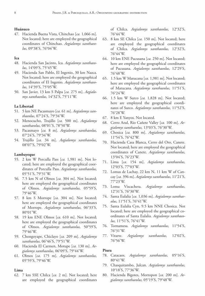
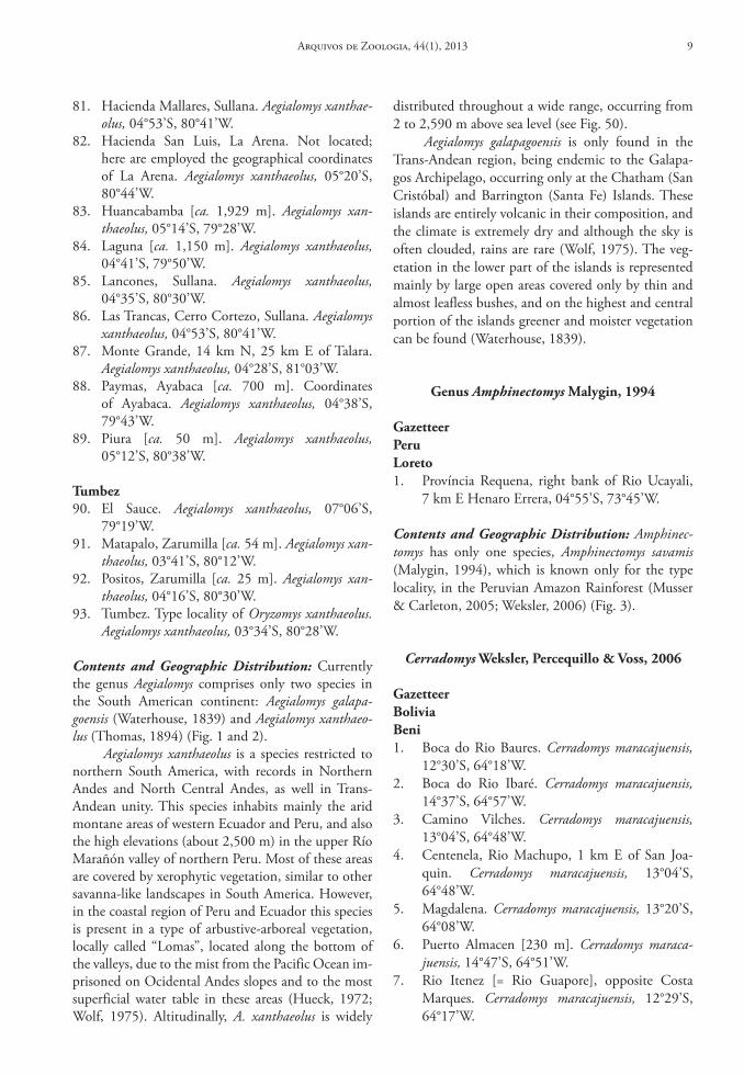
Contents and Geographic Distribution: Currently the genus Aegialomys comprises only two species in the South American continent: Aegialomys galapa-goensis (Waterhouse, 1839) and Aegialomys xanthaeo-lus (Thomas, 1894) (Fig. 1 and 2).
Aegialomys xanthaeolus is a species restricted to northern South America, with records in Northern Andes and North Central Andes, as well in Trans-Andean unity. This species inhabits mainly the arid montane areas of western Ecuador and Peru, and also the high elevations (about 2,500 m) in the upper Río Marañón valley of northern Peru. Most of these areas are covered by xerophytic vegetation, similar to other savanna-like landscapes in South America. However, in the coastal region of Peru and Ecuador this species is present in a type of arbustive-arboreal vegetation, locally called “Lomas”, located along the bottom of the valleys, due to the mist from the Pacific Ocean im-prisoned on Ocidental Andes slopes and to the most superficial water table in these areas (Hueck, 1972; Wolf, 1975). Altitudinally, A. xanthaeolus is widely
distributed throughout a wide range, occurring from 2 to 2,590 m above sea level (see Fig. 50).
Aegialomys galapagoensis is only found in the Trans-Andean region, being endemic to the Galapa-gos Archipelago, occurring only at the Chatham (San Cristóbal) and Barrington (Santa Fe) Islands. These islands are entirely volcanic in their composition, and the climate is extremely dry and although the sky is often clouded, rains are rare (Wolf, 1975). The veg-etation in the lower part of the islands is represented mainly by large open areas covered only by thin and almost leafless bushes, and on the highest and central portion of the islands greener and moister vegetation can be found (Waterhouse, 1839).
Genus Amphinectomys Malygin, 1994
GazetteerPeruloreto1. Província Requena, right bank of Rio Ucayali,
7 km E Henaro Errera, 04°55’S, 73°45’W.
Contents and Geographic Distribution: Amphinec-tomys has only one species, Amphinectomys savamis (Malygin, 1994), which is known only for the type locality, in the Peruvian Amazon Rainforest (Musser & Carleton, 2005; Weksler, 2006) (Fig. 3).
Cerradomys Weksler, Percequillo & Voss, 2006
Gazetteerboliviabeni1. Boca do Rio Baures. Cerradomys maracajuensis,
12°30’S, 64°18’W.2. Boca do Rio Ibaré. Cerradomys maracajuensis,
14°37’S, 64°57’W.3. Camino Vilches. Cerradomys maracajuensis,
13°04’S, 64°48’W.4. Centenela, Rio Machupo, 1 km E of San Joa-
quin. Cerradomys maracajuensis, 13°04’S, 64°48’W.
5. Magdalena. Cerradomys maracajuensis, 13°20’S, 64°08’W.
6. Puerto Almacen [230 m]. Cerradomys maraca-juensis, 14°47’S, 64°51’W.
7. Rio Itenez [= Rio Guapore], opposite Costa Marques. Cerradomys maracajuensis, 12°29’S, 64°17’W.
Arquivos de Zoologia, 44(1), 2013 9
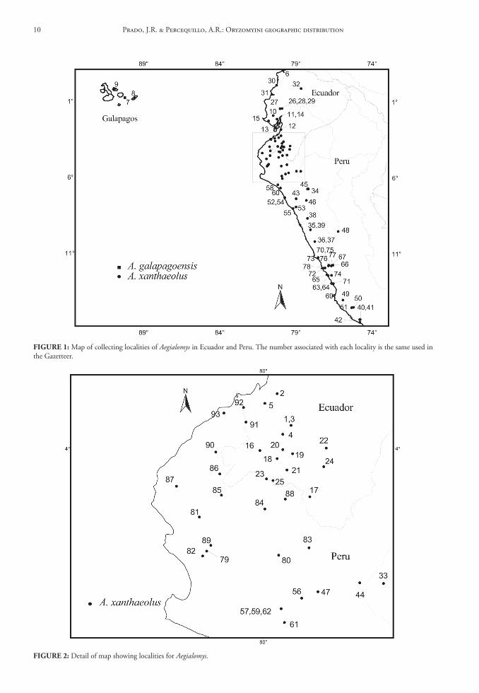
FIGure 2: Detail of map showing localities for Aegialomys.
FIGure 1: Map of collecting localities of Aegialomys in Ecuador and Peru. The number associated with each locality is the same used in the Gazetteer.
Prado, J.R. & Percequillo, A.R.: Oryzomyini geographic distribution10
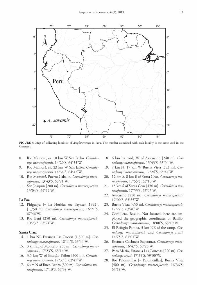
8. Rio Mamoré, ca. 10 km W San Pedro. Cerrado-mys maracajuensis, 14°20’S, 64°55’W.
9. Rio Mamoré, ca. 23 km W San Javier. Cerrado-mys maracajuensis, 14°34’S, 64°42’W.
10. Rio Mamoré, Puerto Caballo. Cerradomys mara-cajuensis, 13°43’S, 65°21’W.
11. San Joaquin [200 m]. Cerradomys maracajuensis, 13°04’S, 64°49’W.
la Paz12. Pitiguaya [= La Florida; see Paynter, 1992],
[1,750 m]. Cerradomys maracajuensis, 16°21’S, 67°46’W.
13. Rio Beni [250 m]. Cerradomys maracajuensis, 10°23’S, 65°24’W.
santa cruz14. 1 km NE Estancia Las Cuevas [1,300 m]. Cer-
radomys maracajuensis, 18°11’S, 63°44’W.15. 3 km SE of Montero [250 m]. Cerradomys mara-
cajuensis, 17°23’S, 63°14’W.16. 3.5 km W of Estação Pailon [300 m]. Cerrado-
mys maracajuensis, 17°39’S, 62°47’W.17. 6 km N of Buen Retiro [300 m]. Cerradomys ma-
racajuensis, 17°13’S, 63°38’W.
18. 6 km by road, W of Ascencion [240 m]. Cer-radomys maracajuensis, 15°43’S, 63°04’W.
19. 7 km N, 17 km W Buena Vista [353 m]. Cer-radomys maracajuensis, 17°24’S, 63°44’W.
20. 12 km S, 8 km E of Santa Cruz. Cerradomys ma-racajuensis, 17°55’S, 63°10’W.
21. 15 km S of Santa Cruz [430 m]. Cerradomys ma-racajuensis, 17°53’S, 63°07’W.
22. Ayacucho [250 m]. Cerradomys maracajuensis, 17°00’S, 63°55’W.
23. Buena Vista [450 m]. Cerradomys maracajuensis, 17°27’S, 63°40’W.
24. Cordillera, Basilio. Not located; here are em-ployed the geographic coordinates of Basilio. Cerradomys maracajuensis, 18°08’S, 63°19’W.
25. El Refugio Pampa, 3 km NE of the camp. Cer-radomys maracajuensis and Cerradomys scotti, 14°75’S, 61°01’W.
26. Estância Cachuela Esperanza. Cerradomys mara-cajuensis, 16°47’S, 63°23’W.
27. Pozo Mario, Estância Las Conchas [220 m]. Cer-radomys scotti, 17°35’S, 59°30’W.
28. Rio Palomitillas [= Palometillas], Buena Vista [400 m]. Cerradomys maracajuensis, 16°36’S, 64°18’W.
FIGure 3: Map of collecting localities of Amphinectomys in Peru. The number associated with each locality is the same used in the Gazetteer.
Arquivos de Zoologia, 44(1), 2013 11
29. San Miguel Rincon [300 m]. Cerradomys mara-cajuensis, 17°23’S, 63°32’W.
30. San Rafael de Amboro [400 m]. Cerradomys ma-racajuensis, 17°36’S, 63°36’W.
31. Santa Rosa de la Roca [250 m]. Cerradomys ma-racajuensis, 15°50’S, 61°27’W.
32. Warnes [275 m]. Cerradomys maracajuensis, 17°30’S, 63°10’W.
brazilbahia33. Andaraí. Cerradomys vivoi, 12°48’S, 41°20’W.34. Caetité. Cerradomys vivoi, 14°04’S, 42°29’W.35. Fazenda Bolandeira, 10 km S Una, Una. Cerra-
domys vivoi, 15°21’S, 39°00’W.36. Fazenda Lagoa D’Água, Conceição do Coité,
Serrinha, Feira de Santana. Not located; we used the geographic coordinates of Conceição do Co-ité. Cerradomys vivoi, 11°33’S, 39°16’W.
37. Fazenda Massapê, 15 km SW Serrinha, Serrinha. Cerradomys vivoi, 11°43’S, 39°05’W.
38. Fazenda Santa Rita, 8 km E Andaraí, Andaraí, 399 m. Cerradomys vivoi, 12°48’S, 41°05’W.
39. Fazenda Sertão do Formoso (formerly known as Fazenda Jucurutu), Jaborandi [775 m]. Type of Oryzomys marinhus. Cerradomys scotti and Cer-radomys marinhus, 14°48’S, 45°57’W.
40. Gandú. Cerradomys vivoi, 13°44’38”S, 39°29’12”W.
41. Lagoa de Itaparica. Cerradomys vivoi, 11°03’S, 42°47’W.
42. Mirorós. Cerradomys vivoi, 11°26’S, 42°19’W.43. Mucujê. Cerradomys vivoi, 13°00’S, 41°23’W.44. Parque Zoobotânico da Comissão Executiva do
Plano de Lavoura Cacaueira (CEPLAC), 6 km E of Itabuna by road, Itabuna. Type locality of Cerra-domys vivoi. Cerradomys vivoi, 14°48’S, 39°20’W.
45. Reserva Biológica de Una. Cerradomys vivoi, 15°10’S, 39°03’W.
46. Rio Unamirim, 14 km W of Valença, Valença. Cerradomys vivoi, 13°17’S, 39°13’W.
47. Sebastião Laranjeiras (Estreito IV). Cerradomys vivoi, 14°34’23”S, 42°56’25”W.
48. Una. Cerradomys vivoi, 15°17’S, 39°04’W.
ceará49. Guaribas, 5 km NW Crato, Crato. Cerradomys
langguthi, 07°13’S, 39°27’W.50. Sítio Friburgo, grota do cafezal, Serra de Ba-
turité, Pacoti. Cerradomys langguthi, 04°13’S, 38°53’W.
51. Sítio Friburgo, Serra de Baturité, Pacoti. Cerra-domys langguthi, 04°13’S, 38°54’W.
52. Sítio Páscoa, 5 km NW Crato, Crato. Cerrado-mys langguthi, 07°13’S, 39°27’W.
distrito Federal53. Fazenda Água Limpa. Cerradomys scotti, 15°57’S,
47°56’W.54. Parque Nacional de Brasília. Cerradomys scotti,
15°40’S, 48°00’W.55. Reserva Biológica de Águas Emendadas. Cerra-
domys scotti, 15°33’S, 47°37’W.56. Reserva Ecológica Roncador, IBGE. Cerradomys
scotti, 15°57’S, 47°52’W.
espírito santo57. Praia das Neves, Presidente Kennedy. Cerrado-
mys goytaca, 21°14’S, 40°57’W.
Goiás58. 3 km E of Mambai. Cerradomys scotti, 14°29’S,
46°08’W.59. 5 km N Alto Paraíso, Alto Paraíso. Cerradomys
scotti, 14°05’S, 47°31’W.60. 14 km N Alto Paraíso, Alto Paraíso. Cerradomys
scotti, 14°01’S, 47°32’W.61. Anápolis. Cerradomys subflavus, 16°19’S,
48°58’W.62. Cerrado Alto, Catalão, Not located; we used the
geographic coordinates of Catalão. Cerradomys scotti, 18°10’S, 47°57’W.
63. Fazenda Bandeirantes, Rio Lageado, Baliza, Not located; we used the geographic coordinates of Baliza. Cerradomys scotti, 16°15’W, 52°25’W.
64. Fazenda Fiandeira, Parque Nacional de Chapada dos Veadeiros, 65 km SSW of Cavalcante. Cer-radomys scotti, 14°19’S, 47°45’W.
65. Morro dos Cabeludos, Corumbá de Goiás. Type locality of Oryzomys scotti. Cerradomys scotti, 15°54’S, 48°48’W.
Maranhão66. Alto Parnahyba (= Alto Parnaíba), [400-600 m].
Cerradomys langguthi, 09°06’S, 45°57’W.67. Estiva, Município Alto Parnaíba. Cerradomys
scotti, 09°16’S, 46°35’W.68. Fazenda Lagoa Nova, Município Bacabal. Not
located; we used the geographic coordinates of Bacabal. Cerradomys langguthi, 04°14’S, 44°47’W.
Mato Grosso69. 264 km N Xavantina, Serra do Roncador
[400 m]. Cerradomys scotti and Cerradomys ma-racajuensis, 12°49’S, 51°46’W.
Prado, J.R. & Percequillo, A.R.: Oryzomyini geographic distribution12
70. Escola Evangélica Buriti, Chapada dos Guimarães. Not located. According to the curator of the collec-tion of mammals UFMT (M. Shiraiwa), this is an evangelical school located near the city Chapada dos Guimarães. Cerradomys scotti, 15°26’S, 55°45’W.
71. Estação Ecológica Serra das Araras, 65 km S of Barra do Bugres, Barra do Bugres. Cerradomys scotti, 15°39’S, 57°13’W.
72. Fazenda Altamira, Ponte Branca. Not located; we used the geographic coordinates of Ponte Branca. Cerradomys scotti, 16°43’S, 52°47’W.
73. Usina Hidroelétrica de Manso, 100 km N of Cuiabá. Cerradomys scotti, 14°42’S, 56°02’W.
74. Usina Hidroelétrica de Manso, Rio Manso, Cha-pada dos Guimarães. Cerradomys scotti, 14°52’S, 55°57’W.
Mato Grosso do sul75. Fazenda da Mata, Maracaju. Type locality of
Oryzomys maracajuensis. Cerradomys maracajuen-sis, 21°38’S, 55°09’W.
76. Fazenda Primavera, Bataiporã. Not located; we used the geographic coordinates of Bataiporã. Cerradomys maracajuensis, 22°20’S, 53°17’W.
77. Maracaju, [500 m]. Cerradomys maracajuensis, 21°38’S, 55°09’W.
Minas Gerais78. Águas Claras, Ravena (= Águas Claras, km 28,
Ravena). Not located; we used the geographic coordinates of Ravena. Cerradomys subflavus, 19°47’S, 43°45’W.
79. [Área 23,] Usina Hidroelétrica de Miranda, Uberlândia [710 m]. Cerradomys subflavus and Cerradomys scotti, 19°05’S, 47°56’W.
80. BR 262, km 580, Ibiá. Not located; we used the geographic coordinates of Ibiá. Cerradomys sub-flavus, 19°29’S, 46°32’W.
81. BR 262, km 609, Campos Altos. Not located; we used the geographic coordinates of Campos Altos. Cerradomys subflavus, 19°42’S, 46°10’W.
82. Campus Ecológico da UFMG, Belo Horizonte. Cerradomys subflavus, 19°55’S, 43°56’W.
83. Caqui, Barra Longa, Not located; we used the geographic coordinates of Barra Longa. Cerrado-mys subflavus, 20°17’S, 43°02’W.
84. Cerrado de Indianópolis, Indianópolis. Not lo-cated; we used the geographic coordinates of In-dianópolis. Cerradomys scotti, 19°02’S, 47°55’W.
85. Cerrado Fazenda Boa, BR 452, km 169, left bank of Rio Araguari. Not located; we used the geographic coordinates of Indianópolis. Cerrado-mys scotti, 19°02’S, 47°55’W.
86. Cerrado João Alonso, Perdizes. Not located [in-cluding Mata de galeria João Alonso, Perdizes], we used the geographic coordinates of Perdizes. Cerradomys scotti, 19°21’S, 47°17’W.
87. COPASA – Área de Proteção Ambiental, Serra Azul, Mateus Leme. Not located; we used the geographic coordinates of Serra Azul. Cerrado-mys scotti and Cerradomys subflavus, 20°04’S, 44°26’W.
88. Coromandel. Cerradomys subflavus and Cerrado-mys scotti, 18°28’S, 47°13’W.
89. EMBRAPA, Sete Lagoas. Not located; we used the geographic coordinates of Sete Lagoas. Cer-radomys subflavus, 19°27’S, 44°14’W.
90. Estação de Pesquisa e Desenvolvimento Ambi-ental de PETI (Estação da CEMIG), Santa Bar-bara. Cerradomys subflavus, 19°23’S, 43°21’W.
91. Fazenda Baroneza, Santa Luzia. Not located; we used the geographic coordinates of Santa Luzia. Cerradomys subflavus, 19°47’S, 43°52’W.
92. Fazenda Barreiro Grande, Pompeu. Not located; we used the geographic coordinates of Pompeu. Cerradomys subflavus, 19°12’S, 44°59’W.
93. Fazenda Canoas, 36 km NE, 12 km W Montes Claros (by road), Juramento. Not located; we used the geographic coordinates of Juramento. Cerradomys vivoi, 16°50’S, 43°35’W.
94. Fazenda Capão Grande, Santa Juliana. Not locat-ed; we used the geographic coordinates of Santa Juliana. Cerradomys scotti, 19°19’S, 47°32’W.
95. Fazenda Cavaia, 17 km N and 11 km W of Lagoa Santa. Cerradomys subflavus, 19°28’S, 43°57’W.
96. Fazenda EPAMIG, Governador Valadares. Not located; we used the geographic coordinates of Governador Valadares. Cerradomys subflavus, 18°51’S, 41°56’W.
97. Fazenda Esmeralda, Rio Casca. Not located; we used the geographic coordinates of Rio Casca. Cerradomys subflavus, 20°13’S, 42°39’W.
98. Fazenda Triângulo Formoso, Buritizeiros. Not located; we used the geographic coordinates of Buritizeiros. Cerradomys subflavus, 17°21’S, 44°58’W.
99. Itaobin. Cerradomys vivoi, 16°33’S, 41°30’W.100. Itinga (TELEMIG). Cerradomys vivoi, 16°36’S,
41°46’W.101. Jequitinhonha (TELEMIG). Cerradomys vivoi,
16°26’S, 41°00’W.102. Lagoa da Pampulha, Belo Horizonte. Cerrado-
mys subflavus, 19°54’S, 43°55’W.103. Lagoa Santa [760 m]. Type locality of Oryzomys
subflavus. Cerradomys subflavus and Cerradomys scotti, 19°37’S, 43°53’W.
Arquivos de Zoologia, 44(1), 2013 13
104. Mata do Edésio, 8 km NW Nova Ponte, Nova Ponte [854 m]. Cerradomys subflavus, 19°07’S, 47°44’W.
105. Mata do Eixo, Canteiro de Obras da CEMIG (Barragem Nova Ponte), Uberlândia. Not locat-ed; we used the geographic coordinates of Uber-lândia, 18°55’S, 48°16’W.
106. Mata do João Lindolfo, 8 km NW Nova Pon-te, Nova Ponte, [706 m]. Cerradomys subflavus, 19°07’10”S, 47°43’53”W.
107. Ouro Preto. Cerradomys subflavus, 20°17’S, 43°30’W.
108. Parque Acangau, Paracatú. Not located; we used the geographic coordinates of Paracatú. Cerrado-mys scotti, 17°13’S, 46°52’W.
109. Parque Estadual do Rio Doce (= Parque Florestal Estadual do Rio Doce). Cerradomys subflavus, 19°32’S, 42°32’W.
110. Parque Estadual do Rio Doce, 13 km E Mar-liéria [300 m]. Cerradomys subflavus, 19°34’S, 42°39’W.
111. Parque Estadual do Rio Preto, 15 km S São Gonçalo do Rio Preto, São Gonçalo do Rio Preto, [950 m]. Cerradomys subflavus, 18°09’S, 43°23’W.
112. Parque Nacional Grande Sertão Veredas [700-800 m]. Cerradomys marinhus, 15°16’S, 45°52’W.
113. Prados, Biquinha. Cerradomys subflavus, 21°03’S, 44°05’W.
114. Reserva do Jacob, Nova Ponte. Not located; we used the geographic coordinates of Nova Ponte. Cerradomys maracajuensis, 19°08’S, 47°40’W.
115. Riacho Mocambinho, Jaíba. Cerradomys vivoi, 15°06’S, 44°03’W.
116. Ribeirão Contendas, Cristália. Cerradomys vivoi, 16°43’S, 42°52’W.
117. Rio Bagaço, Santa Luzia. Not located; we used the geographic coordinates of Santa Luzia. Cer-radomys subflavus, 19°46’S, 43°51’W.
118. Usina Hidroelétrica de Igarapava, Conquista. Cerradomys subflavus and Cerradomys scotti, 20°00’S, 47°35’W.
119. Val da Lagoa, Serra do Cipó. Not located; we used the geographic coordinates of Rio Cipó, a stream that dissects the Serra do Cipó. Cerrado-mys subflavus, 19°14’S, 43°33’W.
120. Vargem do Retiro, Ribeirão Mascates, Parque Nacional da Serra do Cipó [800 m]. Not lo-cated; we used the geographic coordinates of Ri-beirão Mascate. Cerradomys subflavus, 19°20’S, 43°36’W.
Paraíba121. Corredor São João-Fazenda Pacatuba, side W
Mata Pacatuba, Sapé. Type locality of Cerrado-mys langguthi. Cerradomys langguthi, 07°02’S, 35°09’W.
122. João Pessoa [includes Campus Universitário; Mata em Cruz das Armas, próximo a Cimepar; Mata próxima ao Conjunto dos Bancários; Mata Sul UFPB; Mata do Timbó, ao lado Conjunto dos Bancários]. Cerradomys langguthi, 07°06’S, 34°41’W.
123. Fazenda Alagamar, 9 km S and 6 km E of Ma-manguape. Cerradomys langguthi, 06°55’S, 35°04’W.
124. Mata de Pau Ferro, 6 km de Areia. Not located; we used the geographic coordinates of Areia. Cerradomys langguthi, 06°57’S, 35°41’W.
125. Natuba, [includes Povoado Gito, Sítio Chã do Vento, Sítio F. dos Meiros, Sítio Lagoa da Besta, Sítio Malheiro, Sítio Pedra da Bica, Sítio Quicé, Sítio Recreio, Sítio São José, Sítio Tauá]. Cerra-domys langguthi, 07°38’S, 35°34’W.
126. Pico do Jabre, 18 km WSW of Teixeira. Cerrado-mys langguthi, 07°19’S, 37°23’W.
127. Pirauá, Natuba, [includes Proximidade Pirauá and Povoado de Pirauá]. Cerradomys langguthi, 07°36’S, 35°35’W.
128. Salgado de São Felix, [includes Engenho Govão Fazenda T. do Marinheiro, Sítio Campinas, Sí-tio Preguiça, Vila Feira Nova]. Cerradomys lang-guthi, 07°21’S, 35°26’W.
Pernambuco129. Exú. Cerradomys langguthi, 07°30’S, 39°44’W.130. Fazenda Saco IBA, 6.6 km NNE of Serra Tal-
hada. Cerradomys langguthi, 07°59’S, 38°18’W.131. Macaparana, [includes Chã do Pau d’Arco, Fa-
zenda Alegre Velho, Fazenda Monte Alegre, Fa-zenda Monte Alegre Novo, Sítio Bilo, Sítio Cilo, Sítio Fandango, Sítio José Camilo (= Sítio São José Camilo), Sítio Olho d’Água]. Cerradomys langguthi, 07°33’S, 35°29’W.
132. São Vicente Ferrer, [includes Engenho Zabelê Sítio Alto do Miro, São Vicente Ferrer]. Cerra-domys langguthi, 07°35’S, 35°29’W.
133. Sítio Mata Verde, Buíque. Not located; we used the geographic coordinates of Buíque. Cerrado-mys langguthi, 08°37’S, 37°09’W.
Piauí134. Estação Ecológica de Uruçuí-Una. Cerradomys
scotti, 08°50’S, 44°10’W.
Prado, J.R. & Percequillo, A.R.: Oryzomyini geographic distribution14
rio de Janeiro135. Restinga de Iquipari-Grussai, Grussai, São João
da Barra. Cerradomys goytaca, 21°44’S, 41°02’W.136. Restinga do Farolzinho, Farol de São Tomé,
Campos dos Goytacazes. Cerradomys goytaca, 22°00’S, 40°59’W.
137. Sítio Santana, Beira de Lagoa, Quissama. Cer-radomys goytaca, 22°04’S, 41°24’W.
138. Parque Nacional da Restinga de Jurubatiba, Carapebus. Type locality of Cerradomys goytaca. Cerradomys goytaca, 22°15’S, 41°39’W.
são Paulo139. Avanhandava. Cerradomys subflavus, 21°28’S,
49°57’W.140. Barreiro Rico (= Fazenda Barreiro Rico), Santa
Maria da Serra. Cerradomys subflavus, 22°45’S, 48°09’W.
141. Campininha, Mogi Guaçu, Reserva Biológica de Mogi Guaçu. Cerradomys subflavus, 22°17’S, 47°09’W.
142. Cássia dos Coqueiros. Cerradomys subflavus, 21°17’S, 47°10’W.
143. Dois Córregos. Cerradomys subflavus, 22°22’S, 48°21’W.
144. Franca. Cerradomys subflavus, 20°32’S, 47°24’W.145. Itapetininga. Cerradomys subflavus, 23°35’S,
48°03’W.146. Ituverava. Cerradomys subflavus, 20°20’S,
47°47’W.147. Salto de Pirapora, Bairro da Ilha. Cerradomys
subflavus, 23°43’S, 47°37’W.148. São Carlos. Cerradomys subflavus, 22°01’S,
47°54’W.
sergipe149. Fazenda Capivara, 7 km SE of Brejo Grande,
Brejo Grande. Cerradomys vivoi, 10°29’S, 36°26’W.
tocantins150. Rio da Palma rigth bank, upstream of the con-
fluence of the rivers Palma and Paranã, Paranã. Cerradomys scotti, 12°35’S, 47°52’W.
ParaguayAmambay151. 28 km SW of Pedro Juan Caballero. Cerradomys
maracajuensis, 22°43’S, 55°56’W.152. Parque Nacional Cerro Cora, [includes Parque
Nacional Cerro Corá, Aquidaban, sendero NE de pista de avión and Parque Nacional Cerro Cora, near Rio Aquidaban, aprox. 7 km
from casa de Adm.]. Cerradomys maracajuensis, 22°45’S, 55°58’W.
caaguazú153. Estancia San Ignacio, 24 km NNW Carayao.
Cerradomys maracajuensis, 25°00’S, 56°30’W.
canindeyú154. 13.3 km N of Curuguaty, by road. Cerradomys
maracajuensis, 24°22’S, 55°42’W.155. Villa Igatimi [also spelled Ygatimí or Igatimí],
[151 m]. Cerradomys maracajuensis, 24°05’S, 55°30’W.
cordillera156. 1.6 km S Tobatí. Cerradomys scotti, 25°16’S,
57°04’W.157. 20 km N Altos. Cerradomys scotti, 25°04’S,
57°03’W.158. Tobatí. Cerradomys maracajuensis, 25°16’S,
57°04’W.
Paraguarí159. Sapucay [also spelled Sapucaí]. Cerradomys
scotti and Cerradomys maracajuensis, 25°40’S, 56°55’W.
160. Tacuati [Aca Poi]. Cerradomys maracajuensis, 23°27’S, 56°35’W.
san Pedro161. Ganadera La Carolina, 1.5 km SW las casas. Cer-
radomys maracajuensis, 24°06’S, 56°25’W.
PeruPuno162. Rio Heath, Águas Claras Camp [190 m]. Cer-
radomys maracajuensis, 12°57’S, 68°54’W.
Contents and Geographic Distribution: The genus Cerradomys inhabits predominantly open areas (grass-lands and woodlands) and semideciduous forests, usually associated with the diagonal belt of open and drier vegetation formed by the Chaco, Cerrado, Pan-tanal, and Caatinga biomes (Bonvicino, 2003; Per-cequillo et al., 2008). Throughout this distribution, there are also some species that occur peripherically associated with evergreen forests, especially on north-eastern Brazil. The seven species currently recognized in the genus, Cerradomys langguthi (Percequillo, Hingst-Zaher & Bonvincino, 2008); Cerradomys ma-racajuensis (Langguth & Bonvincino, 2002); Cerrra-domys marinhus (Bonvincino, 2003); Cerradomys sub-flavus (Wagner, 1842); Cerradomys vivoi (Percequillo,
Arquivos de Zoologia, 44(1), 2013 15
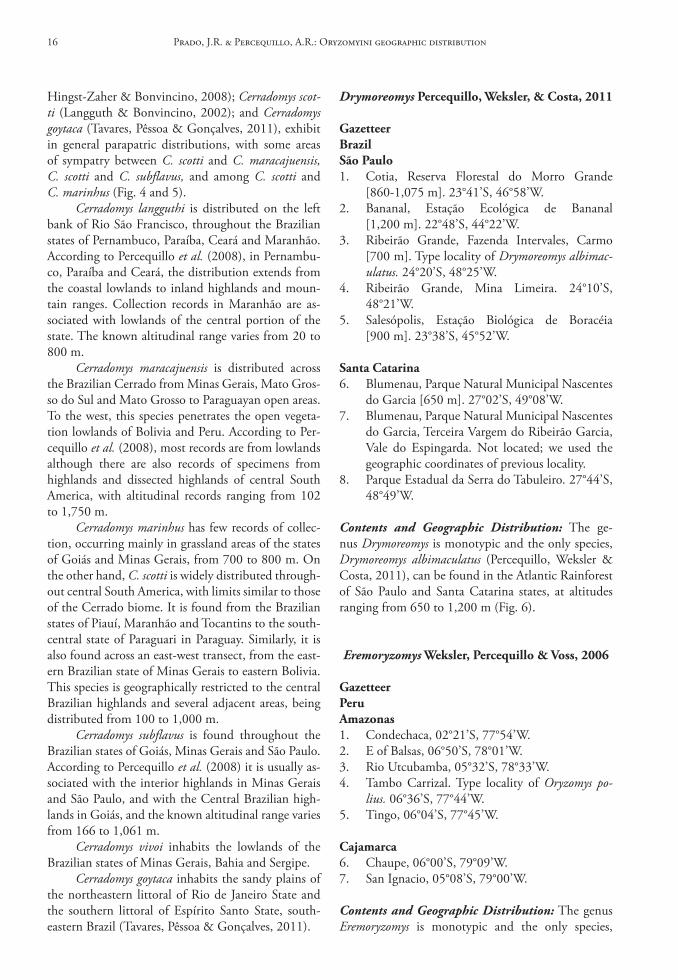
Hingst-Zaher & Bonvincino, 2008); Cerradomys scot-ti (Langguth & Bonvincino, 2002); and Cerradomys goytaca (Tavares, Pêssoa & Gonçalves, 2011), exhibit in general parapatric distributions, with some areas of sympatry between C. scotti and C. maracajuensis, C. scotti and C. subflavus, and among C. scotti and C. marinhus (Fig. 4 and 5).
Cerradomys langguthi is distributed on the left bank of Rio São Francisco, throughout the Brazilian states of Pernambuco, Paraíba, Ceará and Maranhão. According to Percequillo et al. (2008), in Pernambu-co, Paraíba and Ceará, the distribution extends from the coastal lowlands to inland highlands and moun-tain ranges. Collection records in Maranhão are as-sociated with lowlands of the central portion of the state. The known altitudinal range varies from 20 to 800 m.
Cerradomys maracajuensis is distributed across the Brazilian Cerrado from Minas Gerais, Mato Gros-so do Sul and Mato Grosso to Paraguayan open areas. To the west, this species penetrates the open vegeta-tion lowlands of Bolivia and Peru. According to Per-cequillo et al. (2008), most records are from lowlands although there are also records of specimens from highlands and dissected highlands of central South America, with altitudinal records ranging from 102 to 1,750 m.
Cerradomys marinhus has few records of collec-tion, occurring mainly in grassland areas of the states of Goiás and Minas Gerais, from 700 to 800 m. On the other hand, C. scotti is widely distributed through-out central South America, with limits similar to those of the Cerrado biome. It is found from the Brazilian states of Piauí, Maranhão and Tocantins to the south-central state of Paraguari in Paraguay. Similarly, it is also found across an east-west transect, from the east-ern Brazilian state of Minas Gerais to eastern Bolivia. This species is geographically restricted to the central Brazilian highlands and several adjacent areas, being distributed from 100 to 1,000 m.
Cerradomys subflavus is found throughout the Brazilian states of Goiás, Minas Gerais and São Paulo. According to Percequillo et al. (2008) it is usually as-sociated with the interior highlands in Minas Gerais and São Paulo, and with the Central Brazilian high-lands in Goiás, and the known altitudinal range varies from 166 to 1,061 m.
Cerradomys vivoi inhabits the lowlands of the Brazilian states of Minas Gerais, Bahia and Sergipe.
Cerradomys goytaca inhabits the sandy plains of the northeastern littoral of Rio de Janeiro State and the southern littoral of Espírito Santo State, south-eastern Brazil (Tavares, Pêssoa & Gonçalves, 2011).
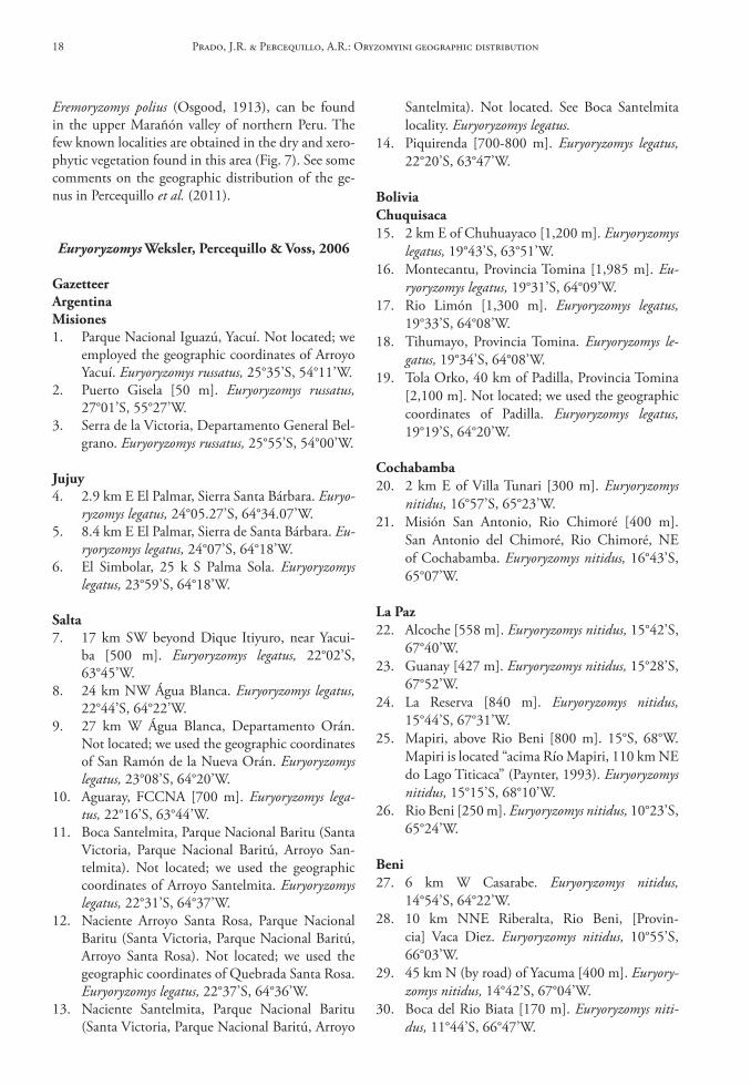
Drymoreomys Percequillo, Weksler, & costa, 2011
Gazetteerbrazilsão Paulo1. Cotia, Reserva Florestal do Morro Grande
[860-1,075 m]. 23°41’S, 46°58’W.2. Bananal, Estação Ecológica de Bananal
[1,200 m]. 22°48’S, 44°22’W.3. Ribeirão Grande, Fazenda Intervales, Carmo
[700 m]. Type locality of Drymoreomys albimac-ulatus. 24°20’S, 48°25’W.
4. Ribeirão Grande, Mina Limeira. 24°10’S, 48°21’W.
5. Salesópolis, Estação Biológica de Boracéia [900 m]. 23°38’S, 45°52’W.
santa catarina6. Blumenau, Parque Natural Municipal Nascentes
do Garcia [650 m]. 27°02’S, 49°08’W.7. Blumenau, Parque Natural Municipal Nascentes
do Garcia, Terceira Vargem do Ribeirão Garcia, Vale do Espingarda. Not located; we used the geographic coordinates of previous locality.
8. Parque Estadual da Serra do Tabuleiro. 27°44’S, 48°49’W.
Contents and Geographic Distribution: The ge-nus Drymoreomys is monotypic and the only species, Drymoreomys albimaculatus (Percequillo, Weksler & Costa, 2011), can be found in the Atlantic Rainforest of São Paulo and Santa Catarina states, at altitudes ranging from 650 to 1,200 m (Fig. 6).
Eremoryzomys Weksler, Percequillo & Voss, 2006
GazetteerPeruAmazonas1. Condechaca, 02°21’S, 77°54’W.2. E of Balsas, 06°50’S, 78°01’W.3. Rio Utcubamba, 05°32’S, 78°33’W.4. Tambo Carrizal. Type locality of Oryzomys po-
lius. 06°36’S, 77°44’W.5. Tingo, 06°04’S, 77°45’W.
cajamarca6. Chaupe, 06°00’S, 79°09’W.7. San Ignacio, 05°08’S, 79°00’W.
Contents and Geographic Distribution: The genus Eremoryzomys is monotypic and the only species,
Prado, J.R. & Percequillo, A.R.: Oryzomyini geographic distribution16
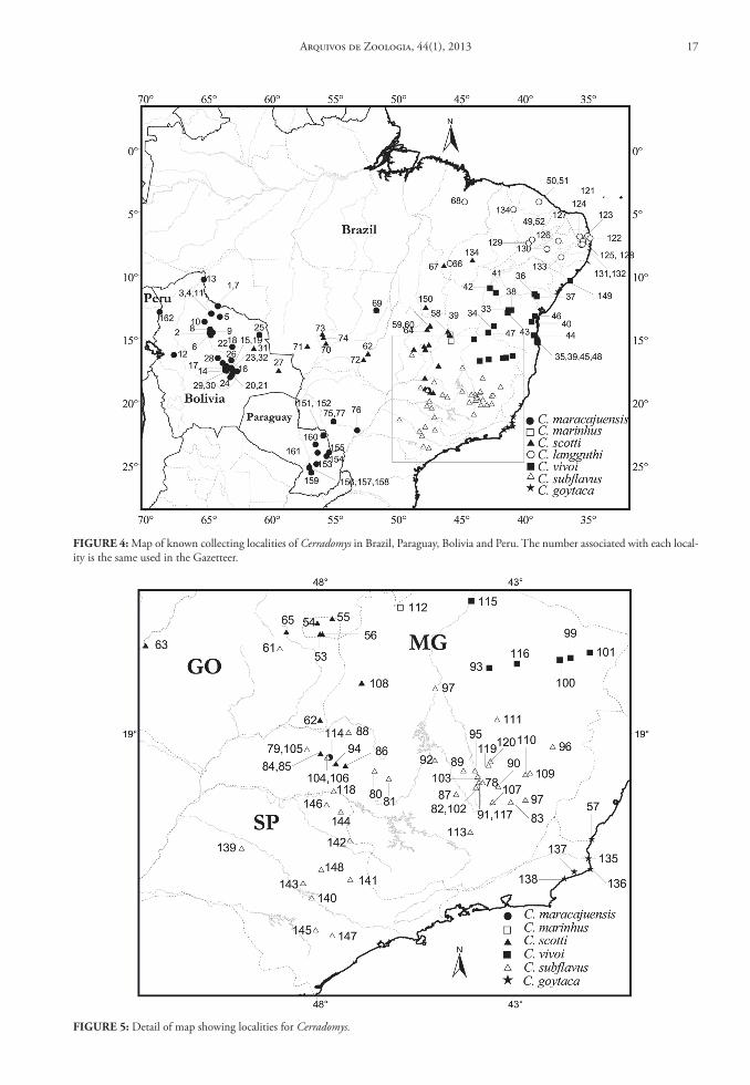
FIGure 4: Map of known collecting localities of Cerradomys in Brazil, Paraguay, Bolivia and Peru. The number associated with each local-ity is the same used in the Gazetteer.
FIGure 5: Detail of map showing localities for Cerradomys.
Arquivos de Zoologia, 44(1), 2013 17
Eremoryzomys polius (Osgood, 1913), can be found in the upper Marañón valley of northern Peru. The few known localities are obtained in the dry and xero-phytic vegetation found in this area (Fig. 7). See some comments on the geographic distribution of the ge-nus in Percequillo et al. (2011).
Euryoryzomys Weksler, Percequillo & Voss, 2006
GazetteerArgentinaMisiones1. Parque Nacional Iguazú, Yacuí. Not located; we
employed the geographic coordinates of Arroyo Yacuí. Euryoryzomys russatus, 25°35’S, 54°11’W.
2. Puerto Gisela [50 m]. Euryoryzomys russatus, 27°01’S, 55°27’W.
3. Serra de la Victoria, Departamento General Bel-grano. Euryoryzomys russatus, 25°55’S, 54°00’W.
Jujuy4. 2.9 km E El Palmar, Sierra Santa Bárbara. Euryo-
ryzomys legatus, 24°05.27’S, 64°34.07’W.5. 8.4 km E El Palmar, Sierra de Santa Bárbara. Eu-
ryoryzomys legatus, 24°07’S, 64°18’W.6. El Simbolar, 25 k S Palma Sola. Euryoryzomys
legatus, 23°59’S, 64°18’W.
salta7. 17 km SW beyond Dique Itiyuro, near Yacui-
ba [500 m]. Euryoryzomys legatus, 22°02’S, 63°45’W.
8. 24 km NW Água Blanca. Euryoryzomys legatus, 22°44’S, 64°22’W.
9. 27 km W Água Blanca, Departamento Orán. Not located; we used the geographic coordinates of San Ramón de la Nueva Orán. Euryoryzomys legatus, 23°08’S, 64°20’W.
10. Aguaray, FCCNA [700 m]. Euryoryzomys lega-tus, 22°16’S, 63°44’W.
11. Boca Santelmita, Parque Nacional Baritu (Santa Victoria, Parque Nacional Baritú, Arroyo San-telmita). Not located; we used the geographic coordinates of Arroyo Santelmita. Euryoryzomys legatus, 22°31’S, 64°37’W.
12. Naciente Arroyo Santa Rosa, Parque Nacional Baritu (Santa Victoria, Parque Nacional Baritú, Arroyo Santa Rosa). Not located; we used the geographic coordinates of Quebrada Santa Rosa. Euryoryzomys legatus, 22°37’S, 64°36’W.
13. Naciente Santelmita, Parque Nacional Baritu (Santa Victoria, Parque Nacional Baritú, Arroyo
Santelmita). Not located. See Boca Santelmita locality. Euryoryzomys legatus.
14. Piquirenda [700-800 m]. Euryoryzomys legatus, 22°20’S, 63°47’W.
boliviachuquisaca15. 2 km E of Chuhuayaco [1,200 m]. Euryoryzomys
legatus, 19°43’S, 63°51’W.16. Montecantu, Provincia Tomina [1,985 m]. Eu-
ryoryzomys legatus, 19°31’S, 64°09’W.17. Rio Limón [1,300 m]. Euryoryzomys legatus,
19°33’S, 64°08’W.18. Tihumayo, Provincia Tomina. Euryoryzomys le-
gatus, 19°34’S, 64°08’W.19. Tola Orko, 40 km of Padilla, Provincia Tomina
[2,100 m]. Not located; we used the geographic coordinates of Padilla. Euryoryzomys legatus, 19°19’S, 64°20’W.
cochabamba20. 2 km E of Villa Tunari [300 m]. Euryoryzomys
nitidus, 16°57’S, 65°23’W.21. Misión San Antonio, Rio Chimoré [400 m].
San Antonio del Chimoré, Rio Chimoré, NE of Cochabamba. Euryoryzomys nitidus, 16°43’S, 65°07’W.
la Paz22. Alcoche [558 m]. Euryoryzomys nitidus, 15°42’S,
67°40’W.23. Guanay [427 m]. Euryoryzomys nitidus, 15°28’S,
67°52’W.24. La Reserva [840 m]. Euryoryzomys nitidus,
15°44’S, 67°31’W.25. Mapiri, above Rio Beni [800 m]. 15°S, 68°W.
Mapiri is located “acima Río Mapiri, 110 km NE do Lago Titicaca” (Paynter, 1993). Euryoryzomys nitidus, 15°15’S, 68°10’W.
26. Rio Beni [250 m]. Euryoryzomys nitidus, 10°23’S, 65°24’W.
beni27. 6 km W Casarabe. Euryoryzomys nitidus,
14°54’S, 64°22’W.28. 10 km NNE Riberalta, Rio Beni, [Provin-
cia] Vaca Diez. Euryoryzomys nitidus, 10°55’S, 66°03’W.
29. 45 km N (by road) of Yacuma [400 m]. Euryory-zomys nitidus, 14°42’S, 67°04’W.
30. Boca del Rio Biata [170 m]. Euryoryzomys niti-dus, 11°44’S, 66°47’W.
Prado, J.R. & Percequillo, A.R.: Oryzomyini geographic distribution18
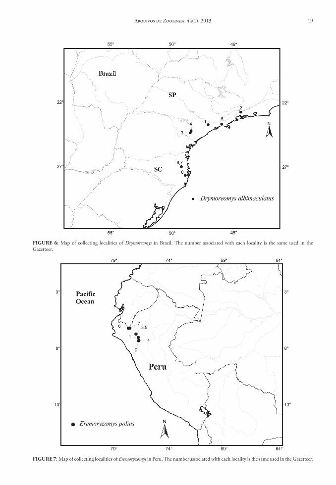
FIGure 6: Map of collecting localities of Drymoreomys in Brazil. The number associated with each locality is the same used in the Gazetteer.
FIGure 7: Map of collecting localities of Eremoryzomys in Peru. The number associated with each locality is the same used in the Gazetteer.
Arquivos de Zoologia, 44(1), 2013 19
31. El Trapiche, Estação Biológica Beni, Província Yacuma [200 m]. Euryoryzomys nitidus, 14°48’S, 66°19’W.
32. Província de Moxos, 3.6 km NNE of San Igna-cio de Moxos. Euryoryzomys nitidus, 14°51’S, 65°35’W.
33. Riberalta, Rio Beni, [Província] Vaca Diez. Eu-ryoryzomys nitidus, 10°59’S, 66°06’W.
34. Rio Mamoré, 4 km NE mouth of Rio Grande. According to Anderson (1997), the correct collection locality is 5 km NW mouth of Rio Grande, Rio Mamoré. Euryoryzomys nitidus, 15°50’S, 64°41’W.
35. Rio Mamoré, Guayarmerin. Euryoryzomys niti-dus, 10°48’S, 65°23’W.
36. Rurrenabaque. Euryoryzomys nitidus, 14°28’S, 67°34’W.
37. San Andres, Orobayaya, 60 km E San Joaquin. Not located; we used the geographic coordinates of Orobayaya. Euryoryzomys nitidus, 13°21’S, 63°45’W.
38. San Joaquin [200 m]. Euryoryzomys nitidus, 13°04’S, 64°49’W.
santa cruz39. 1 km NE Estancia Las Cuevas, 101 km of Santa
Cruz [1,300 m]. Euryoryzomys legatus, 18°11’S, 63°44’W.
40. 2 km SW of Las Cruces [480 m]. Euryoryzomys nitidus, 17°47’S, 63°22’W.
41. 3 km N, 13.5 km W San Rafael de Amboró, Rio Saguayo [400 m]. Euryoryzomys legatus, 17°34’S, 63°48’W.
42. 3.5 km W of Estación Pailón [300 m]. Euryory-zomys nitidus, 17°39’S, 62°47’W.
43. 4 km N, 1 km W of Santiago de Chiquitos [700 m]. Euryoryzomys nitidus, 18°18’S, 59°36’W.
44. 4.5 km N, 1.5 km E Cerro Amboró, Rio Pi-tasama [620 m]. Euryoryzomys nitidus, 17°45’S, 63°40’W.
45. 6 km by road W de Ascención [= Ascención de Guarayos] [240 m]. Euryoryzomys nitidus, 15°43’S, 63°09’W.
46. 6 km N Buen Retiro [300 m]. Euryoryzomys niti-dus, 17°13’S, 63°38’W.
47. 6 km W Santa Cruz. Euryoryzomys nitidus, 17°48’S, 63°14’W.
48. 7 km N Santa Rosa, Província Sara [800 m]. Eu-ryoryzomys nitidus, 17°03’S, 63°35’W.
49. 8 km SE Tita [290 m]. Euryoryzomys nitidus, 18°28’S, 62°07’W.
50. 10 km N San Ramón [250 m]. Euryoryzomys nitidus, 16°36’S, 62°42’W.
51. 14 km NE San Ramón [540 m]. Euryoryzomys nitidus, 16°35’S, 62°25’W.
52. 54 km S boca del Chaparé, Rio Ichilo (rigth bank). Euryoryzomys nitidus, 16°29’S, 64°44’W.
53. Ayacucho [250 m]. Euryoryzomys nitidus, 17°00’S, 63°55’W.
54. ca. 2 km of la Boca del Rio Chapare, Rio Ma-moré. Euryoryzomys nitidus, 15°57’S, 64°41’W.
55. Estância Cachuela Esperanza [300 m]. Euryory-zomys nitidus, 16°47’S, 63°14’W.
56. La Abra, 18 km NE Warnes, [Província] Warnes. Euryoryzomys nitidus, 17°23’S, 63°02’W.
57. Mataracú, Prov. Ichilo [380 to 420 m]. Not lo-cated; we used the geographic coordinates of Rio Mataracú, W Buena Vista [= Rio Maracara]. Eu-ryoryzomys legatus, 17°36’S, 63°56’W.
58. Punta Rieles, Rio Yapacani. Euryoryzomys niti-dus, 16°35’S, 64°12’W.
59. San Rafael de Amboró [400 m]. Euryoryzomys nitidus, 17°36’S, 63°36’W.
60. Santa Rosita, 3 km SW Warnes, [Província] Warnes Euryoryzomys nitidus, 17°32’S, 63°11’W.
61. Santiago de Chiquito, 46 km by road of Santo Corazón, 1 km N of Murcielago Camp Prov. Chiquito [ca. 400 m]. Euryoryzomys nitidus, 18°03’S, 59°01’W.
62. Warnes. Euryoryzomys nitidus, 17°30’S, 63°10’W.
tarija63. 1 km S of Camatindy [650 m]. Euryoryzomys le-
gatus, 21°00’S, 63°23’W.64. 3 km SE Cuyambuyo [900 m]. Euryoryzomys le-
gatus, 22°16’S, 64°33’W.65. 3 km WNW of Caraparí [850 m]. Euryoryzomys
legatus, 21°48’S, 63°47’W.66. 4 km by road N Cuyambuyo, Fábrica de Pa-
pel, Rio Sidras [980 m]. Euryoryzomys legatus, 22°13’S, 64°36’W.
67. 5 km NNW Entre Rios [1,600 m]. Euryoryzomys legatus, 21°29’S, 64°12’W.
68. Caraparí [1,000 m]. Type locality of Oryzomys legatus. Euryoryzomys legatus, 21°49’S, 63°46’W.
69. N of Chiquiacá [990 m]. Euryoryzomys legatus, 21°50’S, 64°08’W.
Pando70. Bella Vista [170 m]. Euryoryzomys nitidus,
11°23’S, 67°12’W.71. Independência [170 m]. Euryoryzomys nitidus,
11°26’S, 67°34’W.72. Isla Gargantúa [180 m]. Euryoryzomys nitidus,
12°23’S, 68°35’W.
Prado, J.R. & Percequillo, A.R.: Oryzomyini geographic distribution20
73. La Cruz [170 m]. Euryoryzomys nitidus, 11°24’S, 67°13’W.
74. Palmira [180 m]. Euryoryzomys nitidus, 11°42’S, 67°56’W.
75. Rio Nareuda. Euryoryzomys nitidus, 11°17’S, 68°55’W.
76. Santa Rosa [180 m]. Euryoryzomys nitidus, 12°13’S, 68°24’W.
brazilAcre77. Igarapé Porongaba, right bank of Rio Juruá. Eu-
ryoryzomys nitidus, 08°40’S, 72°47’W.78. Manuel Urbano, Sena Madureira, BR 364,
km 8. Euryoryzomys nitidus, 08°53’S, 69°18’W.79. Seringal Oriente, near Vila Taumaturgo, Rio Ju-
ruá. Euryoryzomys nitidus, 08°48’S, 72°46’W.
Amapá80. Macapá, Rio Amapari. Euryoryzomys maccon-
nelli, 00°02’N, 51°03’W.81. Serra do Navio [includes C3 and C5]. Euryory-
zomys macconnelli, 00°59’N, 52°04’W.82. Terezinha, Rio Amapari, Serra do Navio. Euryo-
ryzomys macconnelli, 00°58’N, 52°02’W.
Amazonas83. Barro Vermelho, left bank of Rio Juruá. Euryory-
zomys macconnelli, 06°28’S, 68°46’W.84. Condor, left bank of Rio Juruá. Euryoryzomys
macconnelli, 06°45’S, 70°51’W.85. Fazenda Esteio, reserva 1,301, ponto B15,
80 km N Manaus, INPA/WWF-US MCSE Project (PDBFF). Euryoryzomys macconnelli, 02°30’S, 60°00’W.
86. Foz igarapé Caititu, right bank of Rio Uatumã [= Igarapé Caititu, right bank of Rio Uatumã, near the mouth and right bank of Rio Uatumã, near mouth of Igarapé Caititu]. Not located; we used the geographic coordinates of Rio Uatumã. Euryoryzomys macconnelli, 02°35’W, 57°51’W.
87. Lago Vai Quem Quer, rigth bank of Rio Juruá. Euryoryzomys macconnelli, 03°19’S, 66°01’W.
88. Macaco, left bank of Rio Jaú. Euryoryzomys mac-connelli, 02°05’01”S, 62°07’21”W.
89. Manaus. Euryoryzomys macconnelli, 03°08’S, 60°01’W.
90. Reserva 34 1S5, 80 km N Manaus, INPA/WWF-US MCSE Project (PDBFF). Euryoryzo-mys macconnelli, 02°25’S, 59°50’W.
91. Reserva 34 2R11, 80 km N Manaus, INPA/WWF-US MCSE Project (PDBFF). Euryoryzo-mys macconnelli, 02°25’S, 59°50’W.
bahia92. Almada, Rio do Braço, Ilhéus. Not located; we
used the geographic coordinates of Rio do Braço. Euryoryzomys russatus, 14°41’S, 39°15’W.
93. Pirataquissé, Banco da Vitória, Ilhéus. Not located; we used the geographic coordinates of Vitória. Euryoryzomys russatus, 14°47’S, 39°06’W.
94. Ribeirão da Fortuna, Buerarema. Not located; we used the geographic coordinates of Buerare-ma. Euryoryzomys russatus, 14°56’S, 39°19’W.
95. Una, ESCAN. Not located; we used the geo-graphic coordinates of Una, according to Per-cequillo (1998:306). Euryoryzomys russatus, 15°16’S, 39°04’W.
96. Urucutuca, Aritaguá, Ilhéus. Not located; we used the geographic coordinates of Aritaguá. Eu-ryoryzomys russatus, 14°42’S, 39°05’W.
ceará97. IBAMA area, Hill behind Escola Municipal
Granja, Pacoti, Serra de Baturité, CE. Euryory-zomys sp., 04°13’49”S, 38°55’02”W.
98. Guaraciaba do Norte [includes Sítio Benedito, Sítio Cacimba do Meio, Sítio Convento, Sítio Guarrancho, Sítio Mazagão, Sítio Rua Nova, Sí-tio São José, Sítio São Tomé, Sítio Tomé]. Euryo-ryzomys sp., 04°10’S, 40°45’W.
99. São Benedito [includes Sítio Barra, Sítio Cabe-ceira, Sítio Carangueijo do Pereira, Sítio Piment-eira, Sítio Queimadas dos Martins]. Euryoryzo-mys sp., 04°02’S, 40°52’W.
100. Sítio Corolero, Ibiapina. Not located; we used the geographic coordinates of Ibiapina. Euryory-zomys sp., 03°55’S, 40°54’W.
101. Sítio Friburgo, grota do bananal, Pacoti, Serra de Baturité. Euryoryzomys sp., 04°14’S, 38°54’W.
102. Sítio Friburgo, grota do cafezal, Serra de Batu-rité, Pacoti. Euryoryzomys sp., 04°13’S, 38°53’W.
103. Sítio Friburgo, Serra de Baturité, Pacoti. Euryo-ryzomys sp., 04°13’S, 38°54’W.
espírito santo104. 3 km NE of Forno Grande, Castelo. Euryoryzo-
mys russatus, 20°30’S, 41°06’W.105. Estação Biológica de Santa Lúcia, 8.2 km San-
ta Teresa, Santa Teresa. Euryoryzomys russatus, 19°55’S, 40°31’W.
106. Fazenda Santa Terezinha, 33 km NE Lin-hares, Linhares. Euryoryzomys russatus, 19°12’S, 39°50’W.
107. Goipapoaçu (Goipaba-açu), Santa Teresa. Euryo-ryzomys russatus, 19°53’S, 40°28’W.
Arquivos de Zoologia, 44(1), 2013 21
108. Reserva Florestal de Nova Lombardia, Santa Te-resa. Euryoryzomys russatus, 19°53’S, 40°34’W.
109. Santa Teresa. Euryoryzomys russatus, 19°56’S, 40°36’W.
Goiás110. Anápolis. Euryoryzomys lamia, 16°19’S, 48°58’W.111. Fazenda Fiandeira, Parque Nacional de Chapada
dos Veadeiros, 65 km SSW Cavalcante. Euryory-zomys lamia, 14°19’S, 47°45’W.
Mato Grosso112. Serra do Roncador, 264 km N Xavantina [400 m].
Euryoryzomys emmonsae, 12°49’S, 51°46’W.
Mato Grosso do sul113. Urucum, 22 km S Corumbá. Euryoryzomys niti-
dus, 19°09’S, 57°38’W.
Minas Gerais114. Fazenda Paraíso, Além Paraíba. Not located; we
used the geographic coordinates of Além Paraí-ba. Euryoryzomys russatus, 21°51’S, 42°41’W.
115. Lagoa Santa [760 m]. Euryoryzomys russatus, 19°37’S, 43°53’W.
116. Passos. Euryoryzomys russatus, 20°42’S, 46°36’W.117. Rio Jordão, Araguari [700-900 m]. Type locality
of Oryzomys lamia. Euryoryzomys lamia, 18°38’S, 48°11’W.
Pará118. 26 km N and 30 km W of Marabá, near Itu-
piranga, Gleba 5, lote 5. Euryoryzomys emmon-sae and Euryoryzomys macconnelli, 05°06’S, 49°24’W.
119. 52 km SSW Altamira, Rio Xingú, [= Cachoeira do Espelho, rio Xingú]. Type locality of Oryzo-mys emmonsae. Euryoryzomys emmonsae, 03°39’S, 52°22’W.
120. 54 km S, 150 km W of Altamira, Altamira (Gleba 61, Lote 02). Euryoryzomys macconnelli, 03°40’S, 52°45’W.
121. 73 km N and 45 km W of Marabá (near Jatob-al), Gleba 29, Lote 3. Euryoryzomys macconnelli, 04°41’S, 49°32’W.
122. Capim [= São Domingos do Capim]. Euryoryzo-mys macconnelli, 01°41’S, 47°47’W.
123. Capim [= São Domingos do Capim], BR 14, km 87. Euryoryzomys macconnelli, 02°06’S, 47°34’W.
124. Capim [= São Domingos do Capim], BR 14, km 92. Euryoryzomys macconnelli, 02°09’S, 47°35’W.
125. Capim [= São Domingos do Capim], BR 14, km 93 and 94. Euryoryzomys macconnelli, 02°10’S, 47°35’W.
126. Estrada Santarém-Cuiabá, BR165, km 216 (and km 217), Santarém. Euryoryzomys emmonsae and Euryoryzomys macconnelli, 04°09’S, 55°40’W.
127. Flexal, Itaituba-Jacareacanga, km 212, Itai-tuba [includes Itaituba, Itaituba-Jacareacanga, km 213, Flexal]. Euryoryzomys macconnelli, 05°45’S, 57°23’W.
128. Floresta Nacional Tapirapé-Aquiri, Marabá [Companhia Vale do Rio Doce, Carajás]. Euryo-ryzomys emmonsae and Euryoryzomys macconnelli, 05°48’S, 50°30’W.
129. Igarapé-Assu. Euryoryzomys macconnelli, 01°32’S, 47°03’W.
130. Itaituba. Euryoryzomys macconnelli, 04°17’S, 55°59’W.
131. Monte Dourado. Euryoryzomys macconnelli, 00°52’S, 52°31’W.
132. Rio Sacarazinho (km 7), Porto Trombetas, Oriximiná. Not located; we used the geographic coordinates of Porto Trombetas. Euryoryzomys macconnelli, 01°28’S, 56°24’W.
133. Rodovia Transamazônica, km 19, Itaituba-Jac-areacanga, Itaituba. Euryoryzomys macconnelli, 04°20’S, 56°10’W.
134. Serra Norte, Marabá. Not located; we used the geographic coordinates of Marabá. Euryoryzo-mys emmonsae and Euryoryzomys macconnelli, 05°21’S, 49°07’W.
135. S of Santarém, km 217 on the route 165 [0-100 m]. Euryoryzomys macconnelli, 04°00’S, 54°40’W.
136. Utinga, Belém. Euryoryzomys macconnelli, 01°27’S, 48°29’W.
Paraíba137. Mata de Pau Ferro, 6 km de Areia. Not located;
we used the geographic coordinates of Areia. Eu-ryoryzomys sp., 06°57’S, 35°41’W.
rio Grande do sul138. Aratiba. Euryoryzomys russatus, 27°24’S,
52°19’W.139. Barracão. Euryoryzomys russatus, 29°19’S,
49°49’W.140. Lagoa do Jacaré, Torres. Euryoryzomys russatus,
27°40’S, 51°25’W.141. Morro do Osório, Osório. Not located; we used
the geographic coordinates of Osório. Euryoryzo-mys russatus, 29°53’S, 50°16’W.
142. São Nicolau, Fazenda Aldo Pinto. Euryoryzomys russatus, 28°10’S, 55°16’W.
Prado, J.R. & Percequillo, A.R.: Oryzomyini geographic distribution22
143. Taquara do Mundo Novo [= Taquara], [29 m]. Type locality of Hesperomys laticeps var. interme-dia. Euryoryzomys russatus, 29°39’S, 50°47’W.
rio de Janeiro144. Estrada Rio-Teresópolis. Problably Fazenda
Guinle in Teresópolis, today called Granja Com-ary. Euryoryzomys russatus, 22°27’S, 43°00’W.
145. Ilha Grande [today Angra dos Reis]. According to Pinto (1945:277), the correct collection local-ity of E. garbe is Angra dos Reis. Euryoryzomys russatus, 23°00’S, 44°18’W.
146. Ilha Grande, 1 km W of Abraão. Euryoryzomys russatus, 23°08’S, 44°10’W.
147. Ilha Grande, Praia Vermelha. Euryoryzomys rus-satus, 23°09’S, 44°21’W.
148. Pedra Branca, Parati. Euryoryzomys russatus, 23°13’S, 44°43’W.
149. Santa Maria Madalena. Euryoryzomys russatus, 21°57’S, 42°01’W.
150. Serra da Bocaina. According to Pinto (1945), specimens were collected at Fazenda Califórnia, Bananal. Euryoryzomys russatus, 22°53’S, 44°28’W.
santa catarina151. Barragem do Garcia, Angelina. Not located; we
used the geographic coordinates of Angelina. Eu-ryoryzomys russatus, 27°35’S, 48°59’W.
152. Corupá [= Colônia Hansa]. Euryoryzomys russa-tus, 26°25’S, 49°15’W.
153. Parque Estadual da Serra do Tabuleiro, Caldas da Imperatriz [= Santo Amaro da Imperatriz]. Euryoryzomys russatus, 27°44’S, 48°49’W.
154. Rio Cubatão, Joinville. Euryoryzomys russatus, 26°12’S, 48°45’W.
155. Rio Tavares, Casan, Rodovia Estadual SC 405. Euryoryzomys russatus, 27°39’S, 48°30’W.
156. Siderópolis, São Bento do Sul. Not located; we used the geographic coordinates of São Bento do Sul. Euryoryzomys russatus, 26°15’S, 49°22’W.
157. Terceira Vargem, Blumenau/Rancho do Sapo, Rio Garcia. Not located; we used the geographic coordinates of Blumenau. Euryoryzomys russatus, 26°55’S, 49°04’W.
são Paulo158. Ariri. Euryoryzomys russatus, 25°12’S, 48°02’W.159. Bairro da Serra, Iporanga. Euryoryzomys russatus,
24°33’S, 48°41’W.160. Barra do Rio Ribeira. Euryoryzomys russatus,
24°39’S, 47°23’W.161. Bauru [incluides Bauru (Jacutinga)]. Euryoryzo-
mys russatus, 22°20’S, 49°05’W.
162. Boracéia. Estação Biológica de Boracéia do Museu de Zoologia da USP, in Salesópolis (see Travassos & Camargo, 1958). Euryoryzomys rus-satus, 23°38’S, 45°52’W.
163. Cananéia. Euryoryzomys russatus, 25°01’S, 47°57’W.
164. Cananéia, Morro de São João. Euryoryzomys rus-satus, 25°02’S, 47°55’W.
165. Casa Grande, Salesópolis. Little camp near Esta-ção Biológica de Boracéia (see Travassos & Ca-margo, 1958). Euryoryzomys russatus, 23°22’S, 45°56’W.
166. Córrego Cachoeira Grande, Ubatuba. Euryory-zomys russatus, 23°24’S, 45°08’W.
167. Córrego do Cemitério, Ubatuba. Euryoryzomys russatus, 23°24’S, 45°07’W.
168. Cotia. Euryoryzomys russatus, 23°37’S, 46°56’W.169. Estação Experimental, Ubatuba. Not located; we
used the geographic coordinates of Ubatuba. Eu-ryoryzomys russatus, 23°26’S, 45°03’W.
170. Fazenda da Toca, Ilhabela, Ilha de São Sebastião. Euryoryzomys russatus, 23°49’S, 45°54’W.
171. Fazenda Intervales, Base de Saibadela. Euryoryzo-mys russatus, 24°13’S, 48°24’W.
172. Fazenda Intervales, Base do Carmo. Euryoryzo-mys russatus, 24°18’S, 48°24’W.
173. Fazenda Intervales, Sede. Euryoryzomys russatus, 24°16’S, 48°24’W.
174. Fazenda Poço Grande, Juquiá [= Rio Juquiá]. Euryoryzomys russatus, 24°15’S, 47°37’W.
175. Fazenda Sete Lagoas, Mogi Guaçu. Euryoryzomys russatus, 22°13’S, 47°11’W.
176. Iguape. Euryoryzomys russatus, 24°42’S, 47°32’W.177. Iguape, Costão dos Engenhos. Euryoryzomys rus-
satus, 24°41’S, 47°28’W.178. Ilha de São Sebastião. Not located; we used the
geographic coordinates of Ilhabela, administra-tive Center of Ilhabela, in Ilha de São Sebastião. Euryoryzomys russatus, 23°47’S, 45°20’W.
179. Ilha do Cardoso. Euryoryzomys russatus, 25°05’S, 47°57’W.
180. Ilha dos Búzios. Euryoryzomys russatus, 23°48’S, 45°07’W.
181. Ilha Vitória. Euryoryzomys russatus, 23°44’S, 45°01’W.
182. Iporanga. Euryoryzomys russatus, 24°36’S, 48°35’W.
183. Lins (Campestre). Euryoryzomys russatus, 21°40’S, 49°45’W.
184. Onça Parda, [= Ribeirão Onça Parda]. Euryory-zomys russatus, 24°19’S, 47°51’W.
185. Paranapiacaba [= Alto da Serra]. Euryoryzomys russatus, 23°26’S, 46°17’W.
Arquivos de Zoologia, 44(1), 2013 23
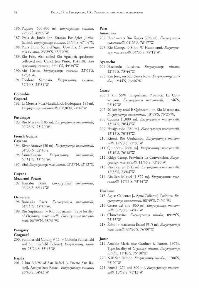
186. Piquete [600-900 m]. Euryoryzomys russatus, 22°36’S, 45°09’W.
187. Praia da Juréia [on Estação Ecológica Juréia-Itatins]. Euryoryzomys russatus, 24°34’S, 47°14’W.
188. Praia Dura, Serra d’Água, Ubatuba. Euryoryzo-mys russatus, 23°29’S, 45°10’W.
189. Rio Feio. Also called Rio Aguapeí; specimens collected near Cancã (see Pinto, 1945:18). Eu-ryoryzomys russatus, 22°01’S, 49°39’W.
190. São Carlos. Euryoryzomys russatus, 22°01’S, 47°54’W.
191. Teodoro Sampaio. Euryoryzomys russatus, 52°10’S, 22°31’W.
colombiacaquetá192. La Morelia [= La Murelia], Rio Bodoquera [183 m].
Euryoryzomys macconnelli, 01°30’N, 74°48’W.
Putumayo193. Rio Mecaya [185 m]. Euryoryzomys macconnelli,
00°28’N, 75°20’W.
French Guianacayenne194. River Arataye [30 m]. Euryoryzomys macconnelli,
04°00’N, 52°40’S.195. Saint-Eugène. Euryoryzomys macconnelli,
04°51’N, 53°04’W.196. Säul. Euryoryzomys macconnelli, 03°37’N, 53°12’W.
GuyanaMazaruni‑Potaro197. Kartabu Point. Euryoryzomys macconnelli,
06°23’S, 58°41’W.
demerara198. Bonasika River. Euryoryzomys macconnelli,
06°45’N, 58°30’W.199. Rio Supinaam [= Rio Supenaam]. Type locality
of Oryzomys macconnelli. Euryoryzomys maccon-nelli, 06°59’N, 58°31’W.
Paraguaycaaguazú200. Sommerfeld Colony # 11 [= Colonia Somerfield
and Summerfield Colony). Euryoryzomys russa-tus, 25°26’S, 55°43’W.
Itapúa201. 2 km NNW of San Rafael [= Puerto San Ra-
fael], Arroyo San Rafael. Euryoryzomys russatus, 26°40’S, 54°43’W.
PeruAmazonas202. Headwaters Río Kagka [793 m]. Euryoryzomys
macconnelli, 04°26’S, 78°17’W.203. Rio Cenepa, 0.8 km W Huampami. Euryoryzo-
mys macconnelli, 04°35’S, 78°12’W.
Ayacucho204. Hacienda Luisiana. Euryoryzomys nitidus,
12°39’S, 73°44’W.205. San Jose, on Rio Santa Rosa. Euryoryzomys niti-
dus, 12°44’S, 73°46’W.
cuzco206. 2 km SSW Tangoshiari, Província La Con-
vencion. Euryoryzomys macconnelli, 11°46’S, 73°19’W.
207. 40 km by road E Quincemil on Rio Marcapata. Euryoryzomys macconnelli, 13°15’S, 70°25’W.
208. Cadena [1,000 m]. Euryoryzomys macconnelli, 13°24’S, 70°43’W.
209. Huajyumbe [680 m]. Euryoryzomys macconnelli, 13°15’S, 70°35’W.
210. Kiteni, Rio Urubamba, Euryoryzomys maccon-nelli, 12°20’S, 72°50’W.
211. Quincemil [680 m]. Euryoryzomys macconnelli, 13°16’S, 70°38’W.
212. Ridge Camp, Província La Convencion. Euryo-ryzomys macconnelli, 11°46’S, 73°20’W.
213. Rio Cosireni [915 m]. Euryoryzomys macconnelli, 12°33’S, 73°04’W.
214. Rio San Miguel [1,372 m]. Euryoryzomys mac-connelli, 12°43’S, 73°14’W.
huánuco215. Águas Calientes [= Água Caliente], Pachitea. Eu-
ryoryzomys macconnelli, 08°49’S, 74°41’W.216. Cerros del Sira [860 m]. Euryoryzomys maccon-
nelli, 09°30’S, 74°47’W.217. Chinchavito. Euryoryzomys nitidus, 09°29’S,
75°55’W.218. Êxito [= Hacienda Êxito] [915 m]. Euryoryzomys
macconnelli, 09°26’S, 76°00’W.
Junin219. Amable María (see Gardner & Patton, 1976).
Type locality of Oryzomys nitidus. Euryoryzomys nitidus, 11°10’S, 75°10’W.
220. NW San Ramon. Euryoryzomys nitidus, 11°08’S, 75°20’W.
221. Perené [274 and 800 m]. Euryoryzomys maccon-nelli, 10°58’S, 75°13’W.
Prado, J.R. & Percequillo, A.R.: Oryzomyini geographic distribution24
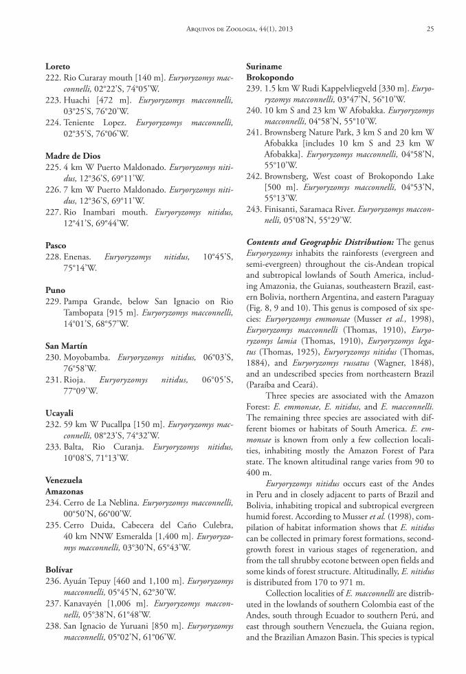
surinamebrokopondo239. 1.5 km W Rudi Kappelvliegveld [330 m]. Euryo-
ryzomys macconnelli, 03°47’N, 56°10’W.240. 10 km S and 23 km W Afobakka. Euryoryzomys
macconnelli, 04°58’N, 55°10’W.241. Brownsberg Nature Park, 3 km S and 20 km W
Afobakka [includes 10 km S and 23 km W Afobakka]. Euryoryzomys macconnelli, 04°58’N, 55°10’W.
242. Brownsberg, West coast of Brokopondo Lake [500 m]. Euryoryzomys macconnelli, 04°53’N, 55°13’W.
243. Finisanti, Saramaca River. Euryoryzomys maccon-nelli, 05°08’N, 55°29’W.
Contents and Geographic Distribution: The genus Euryoryzomys inhabits the rainforests (evergreen and semi-evergreen) throughout the cis-Andean tropical and subtropical lowlands of South America, includ-ing Amazonia, the Guianas, southeastern Brazil, east-ern Bolivia, northern Argentina, and eastern Paraguay (Fig. 8, 9 and 10). This genus is composed of six spe-cies: Euryoryzomys emmonsae (Musser et al., 1998), Euryoryzomys macconnelli (Thomas, 1910), Euryo-ryzomys lamia (Thomas, 1910), Euryoryzomys lega-tus (Thomas, 1925), Euryoryzomys nitidus (Thomas, 1884), and Euryoryzomys russatus (Wagner, 1848), and an undescribed species from northeastern Brazil (Paraíba and Ceará).
Three species are associated with the Amazon Forest: E. emmonsae, E. nitidus, and E. macconnelli. The remaining three species are associated with dif-ferent biomes or habitats of South America. E. em-monsae is known from only a few collection locali-ties, inhabiting mostly the Amazon Forest of Para state. The known altitudinal range varies from 90 to 400 m.
Euryoryzomys nitidus occurs east of the Andes in Peru and in closely adjacent to parts of Brazil and Bolivia, inhabiting tropical and subtropical evergreen humid forest. According to Musser et al. (1998), com-pilation of habitat information shows that E. nitidus can be collected in primary forest formations, second-growth forest in various stages of regeneration, and from the tall shrubby ecotone between open fields and some kinds of forest structure. Altitudinally, E. nitidus is distributed from 170 to 971 m.
Collection localities of E. macconnelli are distrib-uted in the lowlands of southern Colombia east of the Andes, south through Ecuador to southern Perú, and east through southern Venezuela, the Guiana region, and the Brazilian Amazon Basin. This species is typical
loreto222. Rio Curaray mouth [140 m]. Euryoryzomys mac-
connelli, 02°22’S, 74°05’W.223. Huachi [472 m]. Euryoryzomys macconnelli,
03°25’S, 76°20’W.224. Teniente Lopez. Euryoryzomys macconnelli,
02°35’S, 76°06’W.
Madre de dios225. 4 km W Puerto Maldonado. Euryoryzomys niti-
dus, 12°36’S, 69°11’W.226. 7 km W Puerto Maldonado. Euryoryzomys niti-
dus, 12°36’S, 69°11’W.227. Rio Inambari mouth. Euryoryzomys nitidus,
12°41’S, 69°44’W.
Pasco228. Enenas. Euryoryzomys nitidus, 10°45’S,
75°14’W.
Puno229. Pampa Grande, below San Ignacio on Rio
Tambopata [915 m]. Euryoryzomys macconnelli, 14°01’S, 68°57’W.
san Martín230. Moyobamba. Euryoryzomys nitidus, 06°03’S,
76°58’W.231. Rioja. Euryoryzomys nitidus, 06°05’S,
77°09’W.
ucayali232. 59 km W Pucallpa [150 m]. Euryoryzomys mac-
connelli, 08°23’S, 74°32’W.233. Balta, Rio Curanja. Euryoryzomys nitidus,
10°08’S, 71°13’W.
VenezuelaAmazonas234. Cerro de La Neblina. Euryoryzomys macconnelli,
00°50’N, 66°00’W.235. Cerro Duida, Cabecera del Caño Culebra,
40 km NNW Esmeralda [1,400 m]. Euryoryzo-mys macconnelli, 03°30’N, 65°43’W.
bolívar236. Ayuán Tepuy [460 and 1,100 m]. Euryoryzomys
macconnelli, 05°45’N, 62°30’W.237. Kanavayén [1,006 m]. Euryoryzomys maccon-
nelli, 05°38’N, 61°48’W.238. San Ignacio de Yuruani [850 m]. Euryoryzomys
macconnelli, 05°02’N, 61°06’W.
Arquivos de Zoologia, 44(1), 2013 25
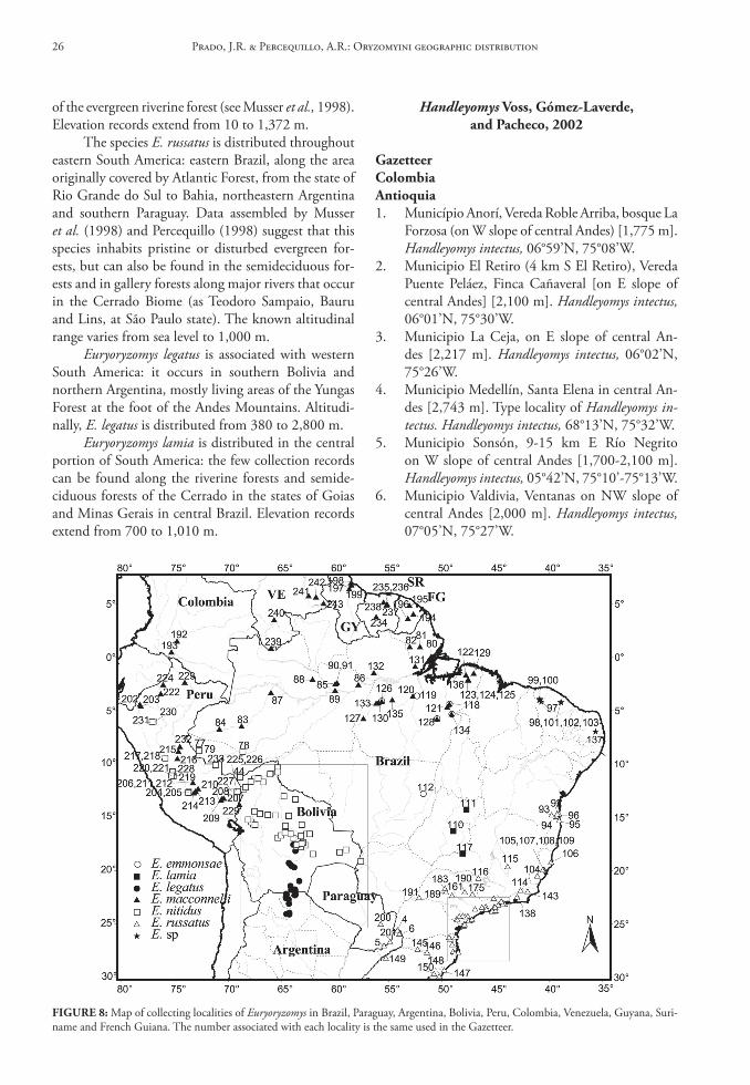
of the evergreen riverine forest (see Musser et al., 1998). Elevation records extend from 10 to 1,372 m.
The species E. russatus is distributed throughout eastern South America: eastern Brazil, along the area originally covered by Atlantic Forest, from the state of Rio Grande do Sul to Bahia, northeastern Argentina and southern Paraguay. Data assembled by Musser et al. (1998) and Percequillo (1998) suggest that this species inhabits pristine or disturbed evergreen for-ests, but can also be found in the semideciduous for-ests and in gallery forests along major rivers that occur in the Cerrado Biome (as Teodoro Sampaio, Bauru and Lins, at São Paulo state). The known altitudinal range varies from sea level to 1,000 m.
Euryoryzomys legatus is associated with western South America: it occurs in southern Bolivia and northern Argentina, mostly living areas of the Yungas Forest at the foot of the Andes Mountains. Altitudi-nally, E. legatus is distributed from 380 to 2,800 m.
Euryoryzomys lamia is distributed in the central portion of South America: the few collection records can be found along the riverine forests and semide-ciduous forests of the Cerrado in the states of Goias and Minas Gerais in central Brazil. Elevation records extend from 700 to 1,010 m.
Handleyomys Voss, Gómez‑laverde, and Pacheco, 2002
GazetteercolombiaAntioquia1. Município Anorí, Vereda Roble Arriba, bosque La
Forzosa (on W slope of central Andes) [1,775 m]. Handleyomys intectus, 06°59’N, 75°08’W.
2. Municipio El Retiro (4 km S El Retiro), Vereda Puente Peláez, Finca Cañaveral [on E slope of central Andes] [2,100 m]. Handleyomys intectus, 06°01’N, 75°30’W.
3. Municipio La Ceja, on E slope of central An-des [2,217 m]. Handleyomys intectus, 06°02’N, 75°26’W.
4. Municipio Medellín, Santa Elena in central An-des [2,743 m]. Type locality of Handleyomys in-tectus. Handleyomys intectus, 68°13’N, 75°32’W.
5. Municipio Sonsón, 9-15 km E Río Negrito on W slope of central Andes [1,700-2,100 m]. Handleyomys intectus, 05°42’N, 75°10’-75°13’W.
6. Municipio Valdivia, Ventanas on NW slope of central Andes [2,000 m]. Handleyomys intectus, 07°05’N, 75°27’W.
FIGure 8: Map of collecting localities of Euryoryzomys in Brazil, Paraguay, Argentina, Bolivia, Peru, Colombia, Venezuela, Guyana, Suri-name and French Guiana. The number associated with each locality is the same used in the Gazetteer.
Prado, J.R. & Percequillo, A.R.: Oryzomyini geographic distribution26
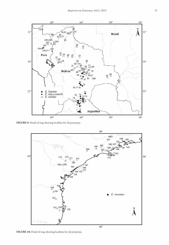
FIGure 9: Detail of map showing localities for Euryoryzomys.
FIGure 10: Detail of map showing localities for Euryoryzomys.
Arquivos de Zoologia, 44(1), 2013 27
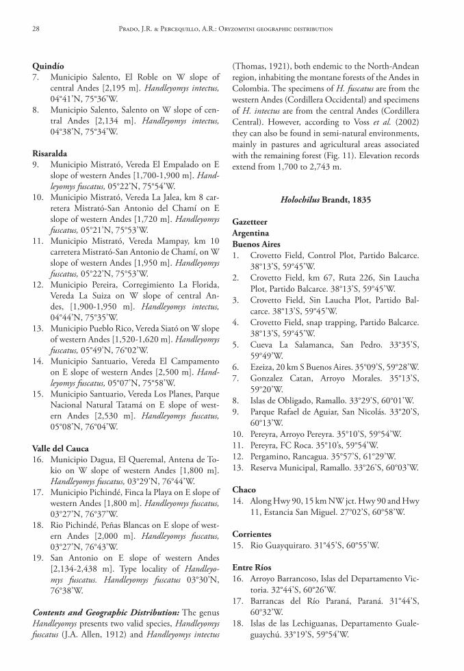
Quindío7. Municipio Salento, El Roble on W slope of
central Andes [2,195 m]. Handleyomys intectus, 04°41’N, 75°36’W.
8. Municipio Salento, Salento on W slope of cen-tral Andes [2,134 m]. Handleyomys intectus, 04°38’N, 75°34’W.
risaralda9. Municipio Mistrató, Vereda El Empalado on E
slope of western Andes [1,700-1,900 m]. Hand-leyomys fuscatus, 05°22’N, 75°54’W.
10. Municipio Mistrató, Vereda La Jalea, km 8 car-retera Mistrató-San Antonio del Chamí on E slope of western Andes [1,720 m]. Handleyomys fuscatus, 05°21’N, 75°53’W.
11. Municipio Mistrató, Vereda Mampay, km 10 carretera Mistrató-San Antonio de Chamí, on W slope of western Andes [1,950 m]. Handleyomys fuscatus, 05°22’N, 75°53’W.
12. Municipio Pereira, Corregimiento La Florida, Vereda La Suiza on W slope of central An-des, [1,900-1,950 m]. Handleyomys intectus, 04°44’N, 75°35’W.
13. Municipio Pueblo Rico, Vereda Siató on W slope of western Andes [1,520-1,620 m]. Handleyomys fuscatus, 05°49’N, 76°02’W.
14. Municipio Santuario, Vereda El Campamento on E slope of western Andes [2,500 m]. Hand-leyomys fuscatus, 05°07’N, 75°58’W.
15. Municipio Santuario, Vereda Los Planes, Parque Nacional Natural Tatamá on E slope of west-ern Andes [2,530 m]. Handleyomys fuscatus, 05°08’N, 76°04’W.
Valle del cauca16. Municipio Dagua, El Queremal, Antena de To-
kio on W slope of western Andes [1,800 m]. Handleyomys fuscatus, 03°29’N, 76°44’W.
17. Municipio Pichindé, Finca la Playa on E slope of western Andes [1,800 m]. Handleyomys fuscatus, 03°27’N, 76°37’W.
18. Rio Pichindé, Peñas Blancas on E slope of west-ern Andes [2,000 m]. Handleyomys fuscatus, 03°27’N, 76°43’W.
19. San Antonio on E slope of western Andes [2,134-2,438 m]. Type locality of Handleyo-mys fuscatus. Handleyomys fuscatus 03°30’N, 76°38’W.
Contents and Geographic Distribution: The genus Handleyomys presents two valid species, Handleyomys fuscatus (J.A. Allen, 1912) and Handleyomys intectus
(Thomas, 1921), both endemic to the North-Andean region, inhabiting the montane forests of the Andes in Colombia. The specimens of H. fuscatus are from the western Andes (Cordillera Occidental) and specimens of H. intectus are from the central Andes (Cordillera Central). However, according to Voss et al. (2002) they can also be found in semi-natural environments, mainly in pastures and agricultural areas associated with the remaining forest (Fig. 11). Elevation records extend from 1,700 to 2,743 m.
Holochilus brandt, 1835
GazetteerArgentinabuenos Aires1. Crovetto Field, Control Plot, Partido Balcarce.
38°13’S, 59°45’W.2. Crovetto Field, km 67, Ruta 226, Sin Laucha
Plot, Partido Balcarce. 38°13’S, 59°45’W.3. Crovetto Field, Sin Laucha Plot, Partido Bal-
carce. 38°13’S, 59°45’W.4. Crovetto Field, snap trapping, Partido Balcarce.
38°13’S, 59°45’W.5. Cueva La Salamanca, San Pedro. 33°35’S,
59°49’W.6. Ezeiza, 20 km S Buenos Aires. 35°09’S, 59°28’W.7. Gonzalez Catan, Arroyo Morales. 35°13’S,
59°20’W.8. Islas de Obligado, Ramallo. 33°29’S, 60°01’W.9. Parque Rafael de Aguiar, San Nicolás. 33°20’S,
60°13’W.10. Pereyra, Arroyo Pereyra. 35°10’S, 59°54’W.11. Pereyra, FC Roca. 35°10’s, 59°54’W.12. Pergamino, Rancagua. 35°57’S, 61°29’W.13. Reserva Municipal, Ramallo. 33°26’S, 60°03’W.
chaco14. Along Hwy 90, 15 km NW jct. Hwy 90 and Hwy
11, Estancia San Miguel. 27°02’S, 60°58’W.
corrientes15. Rio Guayquiraro. 31°45’S, 60°55’W.
entre ríos16. Arroyo Barrancoso, Islas del Departamento Vic-
toria. 32°44’S, 60°26’W.17. Barrancas del Río Paraná, Paraná. 31°44’S,
60°32’W.18. Islas de las Lechiguanas, Departamento Guale-
guaychú. 33°19’S, 59°54’W.
Prado, J.R. & Percequillo, A.R.: Oryzomyini geographic distribution28
colombiaMeta41. Finca el Laqunazo, Vereda Memqua, Puerto Lo-
pez. 04°05’N, 73°02’W.
Paraguaycentral42. 13 km E (by road) Luque. 26°46’S, 58°34’W.43. 17 km E (by road) Luque. 26°45’S, 58°38’W.
chaco44. 50 km W Fortin Madrejon. 21°22’S, 60°07’W.45. Villa Militar. 22°30’S, 59°44’W.
concepción46. E Chaco, NW Concepción [152 m]. 23°00’S,
60°00’W.
Presidente hayes47. Rio Pilcomayo. 25°17’S, 57°41’W.
PeruAyacucho48. Hda. Luisiana. 13°19’S, 74°16’W.49. Sta. Rosa. 13°18’S, 74°13’W.
loreto50. Yarinacocha. 09°45’S, 75°16’W.
san Martín51. Moyobamba. 05°45’S, 77°15’W.
ucayali52. Yarinacocha, Rio Ucayali. 08°18’S, 74°36’W.
uruguaytreinta y tres53. Treinta y Tres. 33°14’S, 54°23’W.
Venezuelatrujillo54. Valera, 30 km NW Valera, Nr. El Dividive.
09°30’S, 71°17’W.
Contents and Geographic Distribution: Unlike most taxa, data for genus Holochilus was obtained from mu-seum databases, without voucher specimen examina-tion. Moreover, there is no recent published revision for the genus, which complicates correct nomencla-tural assignment. Therefore, we employed data on ge-nus level, and based on such information and on data available from the literature (Hershkovitz, 1955), Ho-lochilus is widely distributed in lowland temperate and
19. Riacho Victoria, Islas del Departamento Victo-ria. 32°38’S, 60°12’W.
20. Toma Vieja, Gualeguay. 33°09’S, 59°22’W.
Formosa21. Lado de Ruta 11, 13 km S Clorinda. 26°35’S,
58°16’W.
salta22. Finca Abra Grande, Quebrada de Tartagal.
23°28’S, 64°10’W.23. Tabacal. 24°43’S, 65°45’W.
santa Fé24. Islas del Departamento Rosario, Rosario.
32°52’S, 60°37’W.25. Puerto Gaboto, San Jerónimo. 32°27’S,
60°48’W.26. Río Coronda, San Jerónimo. 31°58’S, 60°55’W.
santiago del estero27. 1 km S, 2 km E Pampa de Los Guanacos.
27°45’S, 62°10’W.
boliviabeni28. 1 km SW Estacion Biologica del Beni,
Totaisal,15°22’S, 67°40’W.29. Rio Tijamuchi, [240 m]. 15°49’S, 65°01’W.
santa cruz30. 3.5 km W Estacion el Pailon. 18°21’S, 63°15’W.31. 8 km SE Tita [290 m]. 19°31’S, 63°52’W.32. Buenavista. 17°27’S, 63°40’W.33. San Rafael de Amboro [400 m]. 18°38’S,
64°16’W.
brazilAmazonas34. Itacoatiara. 03°03’S, 58°26’W.
Mato Grosso35. 105 km S Poconé, Fazenda Boa Vista. 18°47’S,
57°22’W.36. 108 km S Poconé, IBDF Base de Pesquisas.
18°45’S, 57°22’W.37. 115 km S Poconé. 18°42’S, 57°22’W.
Minas Gerais38. Lagoa Santa [760 m]. 19°37’S, 43°53’W.39. Rio São Francisco [416 m]. 15°57’S, 44°52’W.40. Viçosa. 21°15’S, 43°07’W.
Arquivos de Zoologia, 44(1), 2013 29
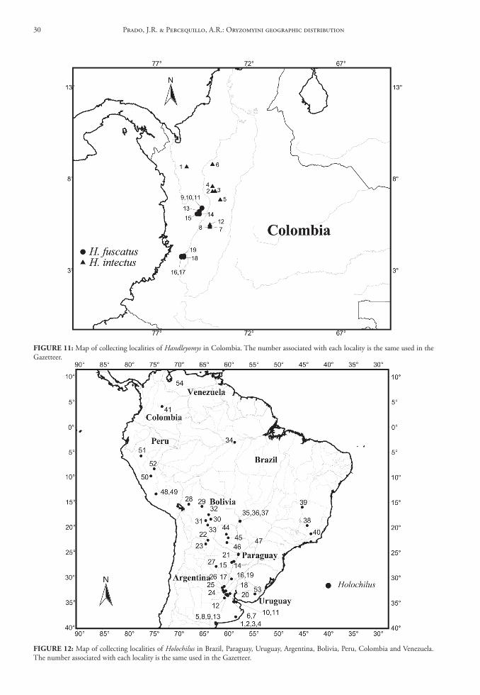
FIGure 12: Map of collecting localities of Holochilus in Brazil, Paraguay, Uruguay, Argentina, Bolivia, Peru, Colombia and Venezuela. The number associated with each locality is the same used in the Gazetteer.
FIGure 11: Map of collecting localities of Handleyomys in Colombia. The number associated with each locality is the same used in the Gazetteer.
Prado, J.R. & Percequillo, A.R.: Oryzomyini geographic distribution30
tropical cis-Andean South America, inhabiting open areas like grasslands, marshes and swamps (Fig. 12).
Hylaeamys Weksler, Percequillo & Voss, 2006
Gazetteerboliviacochabamba1. Charuplaya [1,350 m] (see Musser et al., 1998).
Type locality of Oryzomys yunganus. Hylaeamys yunganus, 16°36’S, 66°37’W.
beni2. 7 km N Lagoinha, Rio Mamoré. Hylaeamys
megacephalus, 11°53’S, 65°06’W.3. 17 km NNW of Nuevo Berlin. Hylaeamys mega-
cephalus, 12°41’S, 65°06’W.4. Bahia de Los Casara, 20 km W Larangeiras,
Rio Iténez. Hylaeamys megacephalus, 13°13’S, 62°21’W.
5. Baures. Hylaeamys megacephalus, 13°35’S, 63°35’W.
6. Boca do Rio Biata [170 m]. Hylaeamys mega-cephalus, 11°44’S, 66°47’W.
7. 4 km opposite Costa Marques, Rio Iténez [= Rio Guaporé]. Hylaeamys megacephalus, 12°29’S, 64°15’W.
8. Camino Vilches, San Joaquin. Hylaeamys mega-cephalus, 13°04’S, 64°48’W.
9. Campamento Busurucucú, Província Yacuma [200 m]. Hylaeamys megacephalus, 14°39’S, 66°17’W.
10. Centenela [= Puerto Centenela ou Centinela], Rio Machupo, 1,6 km E of San Joaquim. Hy-laeamys megacephalus, 13°04’S, 64°50’W.
11. Curicha [= Çuricha], Iténez. Hylaeamys mega-cephalus, 12°37’S, 63°31’W.
12. Estação Biológica de Beni [300 m]. Hylaeamys megacephalus, 14°51’S, 66°21’W.
13. Frente Costa Marques, Rio Iténez. Hylaeamys megacephalus, 12°29’S, 64°17’W.
14. Lado E opposite Cascajal, Rio Mamoré. Hylaea-mys megacephalus, 12°13’S, 65°13’W.
15. Lago Victoria, Iténez. Hylaeamys megacephalus, 13°46’S, 63°30’W.
16. Pampa de Meio, Rio Iténez. Hylaeamys mega-cephalus, 12°30’S, 64°19’W.
17. Remanso [= Remansos], Rio Iténez. Hylaeamys megacephalus, 13°34’S, 61°54’W.
18. Totaizal, 1 km SW of Porvenir, Estação Biológi-ca de Beni. Hylaeamys megacephalus, 14°51’S, 66°21’W.
la Paz19.1 km E La Embocada [= Emboscada], Estância
La Cabaña. Hylaeamys megacephalus, 15°03’S, 67°00’W.
20. 45 km NW by road of Alcoche. Hylaeamys mega-cephalus, 15°40’S, 67°42’W.
Pando21. Gargantua. Hylaeamys megacephalus, 12°23’S,
68°35’W.22. Independencia. Hylaeamys megacephalus,
11°26’S, 67°34’W.23. La Cruz. Hylaeamys megacephalus, 11°24’S,
67°13’W.24. Las Piedras [170 m]. Hylaeamys megacephalus
and Hylaeamys yunganus, 11°02’S, 66°07’W.25. Palmira. Hylaeamys megacephalus, 11°42’S,
67°56’W.26. Santa Rosa. Hylaeamys megacephalus, 12°13’S,
68°24’W.27. West bank of Rio Beni, before Hamburgo. Hy-
laeamys megacephalus, 11°01’S, 66°06’W.
santa cruz28. 2 km SW Las Cruces. Hylaeamys megacephalus,
17°47’S, 63°22’W.29. 3 km N San Rafael de Amboró, Rio Saguayo.
Hylaeamys megacephalus, 17°34’S, 63°42’W.30. 4.5 km N and 1.5 km E Cerro Amboró, Rio
Pitasama [620 m]. Hylaeamys megacephalus, 17°45’S, 63°40’W.
31. Bosque Huanchaca II, Serrania Huanchuca, Província Velasco [200 m]. Hylaeamys megaceph-alus, 14°31’23”S, 60°44’22”W.
32. El Refugio Pampa, 3 km NE camp [= El Refu-gio, 3 km NE Pampa]. Hylaeamys megacephalus, 14°44’35”S, 61°01’20”W.
33. El Refugio, Rio Paraguá/Tarvo [= Rio Turvo], rigth bank, Província Velasco [200 m]. Hylaea-mys megacephalus, 14°46’01”S, 61°02’02”W.
34. Rio Mamoré, 2 km N of the Rio Chapari mouth. Hylaeamys megacephalus, 15°57’S, 64°41’W.
35. San Rafael de Amboró. Hylaeamys megacephalus, 17°36’S, 63°36’W.
36. Lago Caiman, Provincia Velasco. Hylaeamys acri-tus, 13°35’S, 60°54’W.
37. Los Fierros, Provincia Velasco. Hylaeamys acritus, 14°33’S, 60°55’W.
38. Toledo, Provincia Velasco. Hylaeamys acritus, 14°42’S, 61°09’W.
39. San Martín. Hylaeamys acritus, 14°19’S, 62°25’W.
Arquivos de Zoologia, 44(1), 2013 31
40. Urubicha, Rio Negro, Provincia Guarayos. Hy-laeamys acritus, 14°58’S, 62°36’W.
41. Yutioles. Hylaeamys acritus, 13°15’S, 64°48’W.
brazilAcre42. Bairro do Triângulo, Sena Madureira. Not lo-
cated; we used the geographic coordinates of Sena Madureira. Hylaeamys yunganus, 09°04’S, 68°40’W.
43. Igarapé Porongaba, right bank of Rio Juruá. Hylaeamys yunganus and Hylaeamys perenensis, 08°40’S, 72°47’W.
44. Manuel Urbano, Sena Madureira, BR 364, km 8. Hylaeamys yunganus and Hylaeamys pere-nensis, 08°53’S, 69°18’W.
45. Nova Vida, right bank of Rio Juruá. Hylaeamys yunganus and Hylaeamys perenensis, 08°40’S, 72°49’W.
46. Ocidente, right bank of Rio Juruá. Hylaeamys yunganus, 08°34’S, 72°48’W.
47. Oposite Igarapé Porongaba, left bank of Rio Ju-ruá. Hylaeamys yunganus and Hylaeamys perenen-sis, 08°40’S, 72°47’W.
48. Segundo Distrito (Niterói), Sena Madureira. Not located; we used the geographic coordi-nates of Sena Madureira. Hylaeamys yunganus, 09°04’S, 68°40’W.
49. Seringal Triunfo, Plácido de Castro. Hylaeamys perenensis, 09°54’S, 66°38’W.
50. Sobral, left bank of Rio Juruá. Hylaeamys yunga-nus and Hylaeamys perenensis, 08°40’S, 72°49’W.
Alagoas51. Fazenda do Prata, 13 km SSW of São Miguel dos
Campos. Hylaeamys oniscus, 09°53’S, 36°09’W.52. Fazenda Santa Justina, 6 km SSE of Matriz
de Camaragibe. Hylaeamys oniscus, 09°12’S, 35°30’W.
Amapá53. Calçoene, km 26 and km 8, mata “Calçuene”.
Hylaeamys megacephalus, 02°30’N, 50°57’W.54. ICOMI, Serra do Navio. Not located; we used
the geographic coordinates of Serra do Navio. Hylaeamys megacephalus and Hylaeamys yunga-nus, 00°59’N, 52°04’W.
55. km 190 Estrada de Ferro Amapá, Serra do Navio. Not located; we used the geographic coordinates of Serra do Navio. Hylaeamys megacephalus, 00°59’N, 52°04’W.
56. Macapá, Rio Amapari. Hylaeamys megacephalus, 00°02’N, 51°03’W.
57. Serra do Navio [inclui C3 e C5]. Hylaeamys megacephalus and Hylaeamys yunganus, 00°59’N, 52°04’W.
58. Terezinha, Rio Amapari, Serra do Navio. Hy-laeamys megacephalus and Hylaeamys yunganus, 00°58’N, 52°02’W.
Amazonas59. 80 km N Manaus, Projeto INPA/WWF-US
MCSE (PDBFF), Reserva 34 2R11. Hylaeamys megacephalus, 02°25’S, 59°50’W.
60. Altamira, right bank of Rio Juruá. Hylaeamys perenensis and Hylaeamys yunganus, 06°35’S, 68°54’W.
61. Barro Vermelho, left bank of Rio Juruá. Hylaea-mys perenensis, 06°28’S, 68°46’W.
62. Boa Esperança, right bank of Rio Juruá. Hylaea-mys perenensis, 06°32’S, 68°55’W.
63. Condor, left bank of Rio Juruá. Hylaeamys perenensis and Hylaeamys yunganus, 06°45’S, 70°51’W.
64. Estrada Manaus-Itacoatiara, Manaus. Not lo-cated; we used the geographic coordinates of Manaus. Hylaeamys megacephalus, 03°08’S, 60°01’W.
65. Fazenda Esteio, acampamento florestal, 80 km N Manaus, INPA/WWF-US MCSE Project (PDBFF). Hylaeamys megacephalus, 02°30’S, 60°00’W.
66. Foz igarapé Caititu, right bank of Rio Uatumã [= Igarapé Caititu, right bank of Rio Uatumã, near the mouth and right bank of Rio Uatumã, near the mouth of the Igarapé Caititu]. Not located; we used the geographic coordinates of Rio Uatumã. Hylaeamys megacephalus, 02°35’W, 57°51’W.
67. Igarapé Nova Empresa, left bank of Rio Juruá. Hylaeamys perenensis and Hylaeamys yunganus, 06°48’S, 70°44’W.
68. Ilha Paxiúba, right bank of Rio Juruá. Hylaeamys perenensis, 03°19’S, 66°00’W.
69. Ilhazinha, Viravolta, left bank of Rio Juruá in Igarapé Arabidi, tributary of the Paraná Breu [= Ilhazinha, Vira-Volta, left bank Lago Arabidi, left bank tributary Paraná Breu, left bank of Rio Juruá]. Hylaeamys perenensis and Hylaeamys yun-ganus, 03°17’S, 66°14’W.
70. Imediações da Comunidade Tambor, Parque Nacional do Jaú, left bank of Rio Jaú. Hylaeamys megacephalus, 02°13’S, 62°26’W.
71. Jainú, right bank of Rio Juruá. Hylaeamys perenensis and Hylaeamys yunganus, 06°28’S, 68°46’W.
Prado, J.R. & Percequillo, A.R.: Oryzomyini geographic distribution32
72. Lago do Meduinin, left bank of Rio Negro. Hy-laeamys megacephalus, 01°47’S, 56°23’W.
73. Lago Vai Quem Quer, right bank of Rio Juruá. Hylaeamys perenensis, 03°19’S, 66°01’W.
74. Macaco, left bank of Rio Jaú. Hylaeamys mega-cephalus, 02°05’S, 62°07’W.
75. Manaus. Hylaeamys megacephalus, 02°25’S, 59°50’W.
76. Oposite Altamira, left bank of Rio Juruá. Hylaea-mys perenensis and Hylaeamys yunganus, 06°35’S, 68°54’W.
77. Penedo, rigth bank of Rio Juruá. Hylaeamys perenensis and Hylaeamys yunganus, 06°50’S, 70°45’W.
78. Near the foz Igarapé Água Branca, left bank of Rio Pitinga. Not located; we used the geographic coordinates of the mouth of Rio Pitinga. Hylaea-mys megacephalus, 01°04’S, 59°34’W.
79. Reserva Ducke, Manaus. Hylaeamys megacepha-lus, 02°52’S, 59°59’W.
80. Rio Jaú right bank, above the mouth. Hylaeamys megacephalus, 01°57’54”S, 61°29’14”W.
81. Sacado (Condor), right bank of Rio Juruá. Hy-laeamys perenensis, 06°45’S, 70°51’W.
82. Viravolta, left bank of Rio Juruá in Igarapé Ara-bidi, tributary of Paraná Breu [= Vira-Volta, left bank Lago Arabidi, left bank tributary Paraná Breu, left bank of Rio Juruá]. Hylaeamys pere-nensis, 03°17’S, 66°14’W.
bahia83. Almada, Rio do Braço, Ilhéus. Not located; we
used the geographic coordinates of Rio do Braço. Hylaeamys laticeps, 14°41’S, 39°15’W.
84. Companhia Agropecuária Sul Bahia, Fazenda Bulandeira Bradesco, Una [includes EDJAB-CE-PLAC (Comissão Executiva do Plano de Lavou-ra Cacaueira); ESCAN; ESMAI-CEPLAC]. Not located; we used the geographic coordinates of Una. Hylaeamys laticeps, 15°17’S, 39°04’W.
85. Fazenda Brejo Grande, 12 km S, 1.7 km W of Itabuna by road, Itabuna. Hylaeamys laticeps, 14°55’S, 39°17’W.
86. Fazenda Limeira, Ilhéus. Not located; we used the geographic coordinates of Ilhéus. Hylaeamys laticeps, 14°47’S, 39°02’W.
87. Parque Zoobotânico da Comissão Executiva do Plano de Lavoura Cacaueira (CEPLAC), 6 km E of Itabuna by road, Itabuna. Hylaeamys laticeps, 14°48’S, 39°20’W.
88. Pirataquissé, Banco da Vitória, Ilhéus. Not locat-ed; we used the geographic coordinates of Banco da Vitória. Hylaeamys laticeps, 14°47’S, 39°06’W.
89. Ribeirão da Fortuna, Buerarema. Not located; we used the geographic coordinates of Buerare-ma. Hylaeamys laticeps, 14°56’S, 39°19’W.
90. Urucutuca, Aritaguá, Ilhéus. Not located; we used the geographic coordinates of Aritaguá. Hy-laeamys laticeps, 14°42’S, 39°05’W.
ceará91. Serra de Maranguape [919 m]. Hylaeamys mega-
cephalus, 03°54’S, 38°43’W.
distrito Federal92. Brasília. Hylaeamys megacephalus, 15°47’S,
47°53’W.93. Centro de Instrução e Adestramento de Brasí-
lia – Brasília [1,000-1,170 m]. Hylaeamys mega-cephalus, 16°01’S, 47°57’W.
94. Parque Nacional de Brasília. Hylaeamys mega-cephalus, 15°40’S, 48°00’W.
95. Reserva Biológica de Águas Emendadas. Hylaea-mys megacephalus, 15°33’S, 47°37’W.
96. Rio Capetinga, Brasília (Fazenda Água Limpa). Hylaeamys megacephalus, 15°49’S, 48°12’W.
espírito santo97. Engenheiro Reeve [= Rive], [4-600 m]. Hylaea-
mys laticeps, 20°46’S, 41°28’W.98. F.M.A. Linhares. Not located; we used the geo-
graphic coordinates of Linhares. Hylaeamys lati-ceps, 19°25’S, 40°04’W.
99. Reserva Florestal Companhia Vale Rio Doce, Linhares. Hylaeamys laticeps, 19°30’S, 40°00’W.
Goiás100. 3 km E of Mambai. Hylaeamys megacephalus,
14°29’S, 46°08’W.101. Anápolis. Hylaeamys megacephalus, 16°19’S,
48°58’W.102. Cascatinha (SAMA), Minaçu. Not located; we
used the geographic coordinates of Minaçu. Hy-laeamys megacephalus, 13°32’S, 48°13’W.
103. Cerrado Alto, Catalão [includes Fazenda Cas-siano, Vereda; UHE Bocaina; Fazenda Mancha Velha; Vau da Cruz]. Not located; we used the geographic coordinates of Catalão. Hylaeamys megacephalus, 18°10’S, 47°57’W.
104. Cerrado Alto, Davinópolis. Not located; we used the geographic coordinates of Davinópolis. Hy-laeamys megacephalus, 18°10’S, 47°35’W.
105. Fazenda Bandeirantes, Rio Lageado, Baliza. Not located; we used the geographic coordinates of Baliza. Hylaeamys megacephalus, 16°15’W, 52°25’W.
Arquivos de Zoologia, 44(1), 2013 33
125. Rio Saueniná. Hylaeamys yunganus, 12°42’S, 58°40’W.
126. Salto do Utiarity, Rio Papagaio. Hylaeamys mega-cephalus, 13°02’S, 58°17’W.
127. Tapirapuan [= Itapirapuan]. Hylaeamys mega-cephalus, 14°51’S, 57°45’W.
128. UHE [abbreviation of Usina Hidrelátrica] Man-so, 100 km N de Cuiabá. Hylaeamys megacepha-lus, 14°42’S, 56°02’W.
129. UHE [abbreviation of Usina Hidrelátrica] Man-so, Rio Manso, Chapada dos Guimarães. Hy-laeamys megacephalus, 14°52’S, 55°57’W.
130. Vila Rica, NE of Mato Grosso. Hylaeamys mega-cephalus, 10°01’S, 51°07’W.
Mato Grosso do sul131. Balança Velha, 55 km W Dourados, Doura-
dos [518 m]. Hylaeamys megacephalus, 22°20’S, 55°18’W.
132. Fazenda Califórnia, Morraria do Sul, Bodoque-na [520 m]. Hylaeamys megacephalus, 20°42’S, 56°52’W.
133. Fazenda Maringá, 54 km W Dourados, Doura-dos [427 m]. Hylaeamys megacephalus, 22°16’S, 55°18’W.
134. Porto Faia. Hylaeamys megacephalus, 18°28’S, 57°22’W.
135. Salobra. Hylaeamys megacephalus, 20°11’S, 56°28’W.
Minas Gerais136. Coromandel [includes Cerrado do Gato Mouris-
co; Fazenda da Barra; Fazenda Marques; Mata da Abadia, ponte sobre o Rio Parnaíba]. Hylaeamys megacephalus, 18°28’S, 47°13’W.
137. Fazenda Caxambú, Lagamar. Not located; we used the geographic coordinates of Lagamar. Hy-laeamys megacephalus, 18°10’S, 46°48’W.
138. Fazenda do Grotão, Araguari, Piracaíba. Not located; we used the geographic coordinates of Piracaíba. Hylaeamys megacephalus, 18°29’S, 48°26’W.
139. Ibiá BR 262, km 580. Hylaeamys megacephalus, 19°29’S, 46°32’W.
140. Lagoa Santa [760 m]. Hylaeamys megacephalus, 19°37’S, 43°53’W.
141. Mata dos Adolfos, Pedrinópolis. Not located; we used the geographic coordinates of Pedrinópolis. Hylaeamys megacephalus, 19°30’S, 47°28’W.
142. Nova Ponte [includes Fazenda do Sr. Vasco Naves (Fazenda Varginha), Mata do Vasco and Mata Península]. Hylaeamys megacephalus, 19°08’S, 47°40’W.
106. Fazenda Fiandeira, Parque Nacional de Chapada dos Veadeiros, 65 km SSW of Cavalcante. Hy-laeamys megacephalus, 14°19’S, 47°45’W.
107. Fazenda Taquari, Pouso Alto. Not located; we used the geographic coordinates of Pouso Alto [= Piracanjuba]. Hylaeamys megacephalus, 17°18’S, 49°01’W.
Maranhão108. Alto Parnahyba (= Alto Parnaíba) [400-600 m].
Hylaeamys megacephalus, 09°06’S, 45°57’W.109. Imperatriz. Hylaeamys megacephalus, 05°32’S,
47°29’W.
Mato Grosso110. 30 km SSW Cláudia [368 m]. Hylaeamys mega-
cephalus, 11°35’S, 55°10’W.111. 30 km around Gaúcha do Norte, Parantinga
[460 m]. Hylaeamys megacephalus, 13°05’S, 53°17’W.
112. 40 km around Cocalinho [241 m]. Hylaeamys megacephalus, 14°16’S, 50°59’W.
113. 264 km N Xavantina, Serra do Roncador [400 m]. Hylaeamys megacephalus and Hylaeamys yunganus, 12°49’S, 51°46’W.
114. Cáceres. Hylaeamys megacephalus, 16°04’S, 57°41’W.
115. Cidade Laboratório de Humboldt, Aripuanã. Hylaeamys megacephalus, 09°10’S, 60°38’W.
116. Estação Ecológica Serra das Araras – Porto Estre-la. Hylaeamys megacephalus, 15°39’S, 57°12’W.
117. Fazenda Altamira, Ponte Branca. Not located; we used the geographic coordinates of Ponte Bran-ca. Hylaeamys megacephalus, 16°43’S, 52°47’W.
118. Fazenda Lagoa Bonita, 36 km N Barra do Gar-ças, Barra do Garças [331 m]. Hylaeamys mega-cephalus, 15°34’S, 52°21’W.
119. Fazenda Noirumbá, 34 km NW Ribeirão Cas-calheira, Ribeirão Cascalheira [297 m]. Hylaea-mys megacephalus, 12°38’S, 51°55’W.
120. Fazenda São Luis, 30 km N Barra do Garças, Barra do Garças [389 m]. Hylaeamys megacepha-lus, 15°38’S, 52°21’W.
121. Juruena. Hylaeamys megacephalus, 12°51’S, 58°55’W.
122. Palmeiras (Monte Alegre). Hylaeamys megaceph-alus, 15°53’S, 55°24’W.
123. PCH Jesuíta, Rio Juruena. Hylaeamys megaceph-alus, 11°26’48”S, 58°39’W.
124. Reserva Biológica (ou Ecológica) Cristalino, 40 km N Alta Floresta, Alta Floresta [360 m]. Hylaeamys megacephalus, 09°35’S, 55°55’W.
Prado, J.R. & Percequillo, A.R.: Oryzomyini geographic distribution34
143. Parque Acangau, Paracatú. Not located; we used the geographic coordinates of Paracatú. Hylaea-mys megacephalus, 17°13’S, 46°52’W.
144. Parque Estadual do Rio Doce [= Parque Florestal Estadual do Rio Doce]. Hylaeamys megacephalus and Hylaeamys laticeps, 19°32’S, 42°32’W.
145. Parque Nacional Grande Sertão Veredas, For-moso [700-800 m]. Hylaeamys megacephalus, 15°16’S, 45°52’W.
146. Perdizes [includes mata de galeria João Alonso and Cerrado João Alonso]. Hylaeamys megaceph-alus, 19°20’S, 47°17’W.
147. Rio Doce. Hylaeamys laticeps, 20°14’S, 42°53’W.148. Teófilo Otoni. Hylaeamys megacephalus, 17°52’S,
41°30’W.149. Unaí. Hylaeamys megacephalus, 16°23’S,
46°53’W.
Pará150. 8 km N and 75 km W Paragominas (Fazenda
Uraim). Hylaeamys megacephalus, 02°55’S, 48°12’W.
151. 18 km S and 19 km W de Altamira (Agrovila da União). Hylaeamys megacephalus, 03°22’S, 52°23’W.
152. 20 km N and 30 km W of Marabá (near Itu-piranga). Hylaeamys megacephalus, 05°07’S, 49°25’W.
153. 26 km N and 30 km W of Marabá, near Itupi-ranga, Gleba 5, lote 5. Hylaeamys megacephalus, 05°06’S, 49°24’W.
154. 44 km S and 40 km E of Santarém (Curuá-Una). Hylaeamys megacephalus, 02°50’S, 54°22’W.
155. 52 km SSW Altamira, Rio Xingú, east bank [= Cachoeira do Espelho, Rio Xingú]. Hylaeamys megacephalus, 03°39’S, 52°22’W.
156. 54 km S, 150 km W of Altamira, Altamira (Gleba 61, Lote 02). Hylaeamys megacephalus, 03°40’S, 52°45’W.
157. 54 km SSW Altamira, Rio Xingú, east bank [= Cachoeira do Espelho, Rio Xingú]. Hylaeamys megacephalus, 03°40’S, 52°22’W.
158. 73 km N and 45 km W of Marabá (near Jatob-al), Gleba 29, Lote 3. Hylaeamys megacephalus, 04°41’S, 49°32’W.
159. Belém. Hylaeamys megacephalus and Hylaeamys yunganus, 01°27’S, 48°29’W.
160. Bragança, Jandiaí, Caratatena [= Caratateua]. Hylaeamys megacephalus, 00°59’S, 46°43’W.
161. Bragança, Santa Maria. Hylaeamys megacephalus, 01°02’S, 46°54’W.
162. Bragança, Santa Maria, Tracuateua [= Tracuate-na]. Hylaeamys megacephalus, 01°05’S, 46°54’W.
163. Capim [= São Domingos do Capim], BR 14, km 87. Hylaeamys megacephalus, 02°06’S, 47°34’W.
164. Capim [= São Domingos do Capim], BR 14, km 93 and 94. Hylaeamys megacephalus, 02°10’S, 47°35’W.
165. Chiqueirinho, right bank of Rio Tocantins, 70 km S of Tucuruí. Hylaeamys megacephalus, 04°33’S, 49°28’W.
166. Coqueiral [Belém neighborhood], Belém. Hy-laeamys megacephalus, 01°27’S, 48°29’W.
167. Estrada Santarém-Cuiabá, BR165, km 84, Santarém. Hylaeamys megacephalus, 04°09’S, 55°40’W.
168. Extremo Sul Ilha Tocantins, Rio Tocantins, Tucuruí. Hylaeamys megacephalus, 04°28’S, 49°32’W.
169. Flexal, Itaituba-Jacareacanga, km 212, Itai-tuba [includes Itaituba, Itaituba-Jacareacanga, km 213, Flexal]. Hylaeamys megacephalus and Hylaeamys yunganus, 05°45’S, 57°23’W.
170. Floresta Nacional Tapirapé-Aquiri, Marabá; área da Companhia Vale do Rio Doce em Carajás. Hylaeamys megacephalus, 05°48’S, 50°30’W.
171. Foz do Igarapé Tramalhetinho, right bank of Rio Trombetas = Reserva Biológica do Rio Trom-betas. Hylaeamys megacephalus, 01°11’19”S, 56°40’15”W.
172. Ilha Tocantins, Rio Tocantins, 75 km S and 18 km E of Tucuruí. Hylaeamys megacephalus, 04°24’S, 49°32’W.
173. Itaituba. Hylaeamys megacephalus and Hylaeamys yunganus, 04°17’S, 55°59’W.
174. Itaituba, BR165, Santarém-Cuiabá, Zona Sul, km 446. Not located; we used the geographic coordinates of Itaituba. Hylaeamys megacephalus, 04°17’S, 55°59’W.
175. Itaituba, Rodovia Transamazônica, trecho Itaitu-ba-Jacareacanga, km 200. Not located; probably near Flexal. Hylaeamys megacephalus, 05°45’S, 57°23’W.
176. Itaituba-Belomonte, Itaituba, km 52c. Hylaea-mys megacephalus, 03°05’S, 51°46’W.
177. Monte Dourado. Hylaeamys megacephalus, 00°52’S, 52°31’W.
178. Oriximiná, Cachoeira Porteira, km 23. Hylaea-mys megacephalus, 01°02’S, 57°09’W.
179. Oriximiná, Porto Trombetas, Rio Sacarazinho (km 43). Not located; we used the geographic coordinates of Porto Trombetas. Hylaeamys megacephalus, 01°28’S, 56°24’W.
180. Paragominas. Hylaeamys megacephalus, 02°56’S, 47°31’W.
Arquivos de Zoologia, 44(1), 2013 35
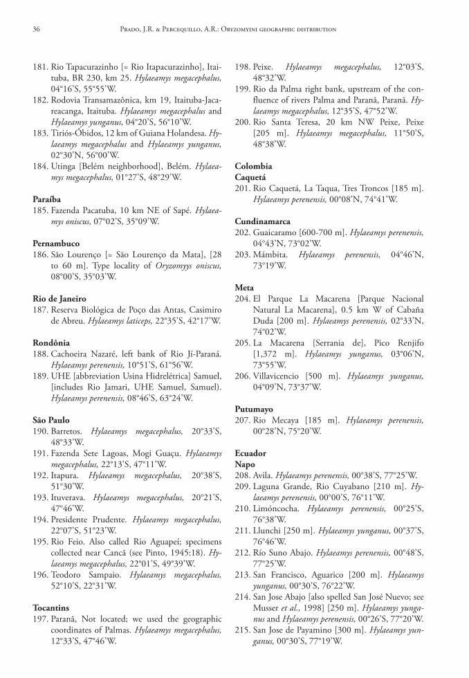
181. Rio Tapacurazinho [= Rio Itapacurazinho], Itai-tuba, BR 230, km 25. Hylaeamys megacephalus, 04°16’S, 55°55’W.
182. Rodovia Transamazônica, km 19, Itaituba-Jaca-reacanga, Itaituba. Hylaeamys megacephalus and Hylaeamys yunganus, 04°20’S, 56°10’W.
183. Tiriós-Óbidos, 12 km of Guiana Holandesa. Hy-laeamys megacephalus and Hylaeamys yunganus, 02°30’N, 56°00’W.
184. Utinga [Belém neighborhood], Belém. Hylaea-mys megacephalus, 01°27’S, 48°29’W.
Paraíba185. Fazenda Pacatuba, 10 km NE of Sapé. Hylaea-
mys oniscus, 07°02’S, 35°09’W.
Pernambuco186. São Lourenço [= São Lourenço da Mata], [28
to 60 m]. Type locality of Oryzomyys oniscus, 08°00’S, 35°03’W.
rio de Janeiro187. Reserva Biológica de Poço das Antas, Casimiro
de Abreu. Hylaeamys laticeps, 22°35’S, 42°17’W.
rondônia188. Cachoeira Nazaré, left bank of Rio Jí-Paraná.
Hylaeamys perenensis, 10°51’S, 61°56’W.189. UHE [abbreviation Usina Hidrelétrica] Samuel,
[includes Rio Jamari, UHE Samuel, Samuel). Hylaeamys perenensis, 08°46’S, 63°24’W.
são Paulo190. Barretos. Hylaeamys megacephalus, 20°33’S,
48°33’W.191. Fazenda Sete Lagoas, Mogi Guaçu. Hylaeamys
megacephalus, 22°13’S, 47°11’W.192. Itapura. Hylaeamys megacephalus, 20°38’S,
51°30’W.193. Ituverava. Hylaeamys megacephalus, 20°21’S,
47°46’W.194. Presidente Prudente. Hylaeamys megacephalus,
22°07’S, 51°23’W.195. Rio Feio. Also called Rio Aguapeí; specimens
collected near Cancã (see Pinto, 1945:18). Hy-laeamys megacephalus, 22°01’S, 49°39’W.
196. Teodoro Sampaio. Hylaeamys megacephalus, 52°10’S, 22°31’W.
tocantins197. Paranã, Not located; we used the geographic
coordinates of Palmas. Hylaeamys megacephalus, 12°33’S, 47°46’W.
198. Peixe. Hylaeamys megacephalus, 12°03’S, 48°32’W.
199. Rio da Palma right bank, upstream of the con-fluence of rivers Palma and Paranã, Paranã. Hy-laeamys megacephalus, 12°35’S, 47°52’W.
200. Rio Santa Teresa, 20 km NW Peixe, Peixe [205 m]. Hylaeamys megacephalus, 11°50’S, 48°38’W.
colombiacaquetá201. Rio Caquetá, La Taqua, Tres Troncos [185 m].
Hylaeamys perenensis, 00°08’N, 74°41’W.
cundinamarca202. Guaicaramo [600-700 m]. Hylaeamys perenensis,
04°43’N, 73°02’W.203. Mámbita. Hylaeamys perenensis, 04°46’N,
73°19’W.
Meta204. El Parque La Macarena [Parque Nacional
Natural La Macarena], 0.5 km W of Cabaña Duda [200 m]. Hylaeamys perenensis, 02°33’N, 74°02’W.
205. La Macarena [Serrania de], Pico Renjifo [1,372 m]. Hylaeamys yunganus, 03°06’N, 73°55’W.
206. Villavicencio [500 m]. Hylaeamys yunganus, 04°09’N, 73°37’W.
Putumayo207. Rio Mecaya [185 m]. Hylaeamys perenensis,
00°28’N, 75°20’W.
ecuadornapo208. Avila. Hylaeamys perenensis, 00°38’S, 77°25’W.209. Laguna Grande, Rio Cuyabano [210 m]. Hy-
laeamys perenensis, 00°00’S, 76°11’W.210. Limóncocha. Hylaeamys perenensis, 00°25’S,
76°38’W.211. Llunchi [250 m]. Hylaeamys yunganus, 00°37’S,
76°46’W.212. Río Suno Abajo. Hylaeamys perenensis, 00°48’S,
77°25’W.213. San Francisco, Aguarico [200 m]. Hylaeamys
yunganus, 00°30’S, 76°22’W.214. San Jose Abajo [also spelled San José Nuevo; see
Musser et al., 1998] [250 m]. Hylaeamys yunga-nus and Hylaeamys perenensis, 00°26’S, 77°20’W.
215. San Jose de Payamino [300 m]. Hylaeamys yun-ganus, 00°30’S, 77°19’W.
Prado, J.R. & Percequillo, A.R.: Oryzomyini geographic distribution36
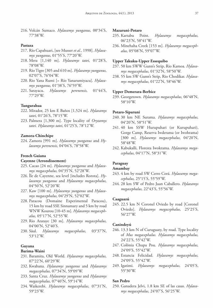
216. Volcán Sumaco. Hylaeamys yunganus, 00°34’S, 77°38’W.
Pastaza217. Río Capahuari, [see Musser et al., 1998]. Hylaea-
mys yunganus, 01°55’S, 77°20’W.218. Mera [1,140 m]. Hylaeamys tatei, 01°28’S,
78°08’W.219. Río Tigre [305 and 610 m]. Hylaeamys yunganus,
02°07’S, 76°04’W.220. Rio Yana Rumi [= Río Yanarumiyacu]. Hylaea-
mys yunganus, 01°38’S, 76°59’W.221. Sarayacu. Hylaeamys perenensis, 01°44’S,
77°29’W.
tungurahua222. Mirador, 25 km E Baños [1,524 m]. Hylaeamys
tatei, 01°26’S, 78°15’W.223. Palmera [1,300 m]. Type locality of Oryzomys
tatei. Hylaeamys tatei, 01°25’S, 78°12’W.
Zamora‑chinchipe224. Zamora [991 m]. Hylaeamys yunganus and Hy-
laeamys perenensis, 04°04’S, 78°58’W.
French Guianacayenne (Arrondissement)225. Cacao [24 m]. Hylaeamys yunganus and Hylaea-
mys megacephalus, 04°35’N, 52°28’W.226. Île de Cayenne, sea level [includes Rorota]. Hy-
laeamys yunganus and Hylaeamys megacephalus, 04°50’N, 52°20’W.
227. Kaw [100 m]. Hylaeamys yunganus and Hylaea-mys megacephalus, 04°29’N, 52°02’W.
228. Paracou (Domaine Experimental Paracou), 15 km by road SSE Sinnamary and 5 km by road WNW Kourou [10-45 m]. Hylaeamys megaceph-alus, 05°17’N, 52°55’W.
229. Rio Arataye [30 m]. Hylaeamys megacephalus, 04°00’N, 52°40’S.
230. Säul. Hylaeamys megacephalus, 03°37’N, 53°12’W.
Guyanabarima‑Waini231. Baramita, Old World. Hylaeamys megacephalus,
07°22’N, 60°29’W.232. Kwabana. Hylaeamys yunganus and Hylaeamys
megacephalus, 07°34’N, 59°09’W.233. Santa Cruz. Hylaeamys yunganus and Hylaeamys
megacephalus, 07°40’N, 59°14’W.234. Waikerebi. Hylaeamys megacephalus, 07°31’N,
59°23’W.
Mazaruni‑Potaro235. Kartabu Point. Hylaeamys megacephalus,
06°23’N, 58°41’W.236. Minehaha Creek [153 m]. Hylaeamys megaceph-
alus, 05°08’N, 59°07’W.
upper takuku‑upper essequibo237. 50 km SWW Gunn’s Strip, Rio Kamoa. Hylaea-
mys megacephalus, 01°32’N, 58°50’W.238. 55 km SW Gunn’s Strip, Rio Chodikar. Hylaea-
mys megacephalus, 01°22’N, 58°46’W.
upper demerara‑berbice239. Georgetown. Hylaeamys megacephalus, 06°48’N,
58°10’W.
Potaro‑siparuni240. 30 km NE Surama. Hylaeamys megacephalus,
04°20’N, 58°51’W.241. 40 km SSW Hurupuhari (or Kurupuhari),
Gorge Camp, Reserva Iwderama (or Iwohrama) [300 m]. Hylaeamys megacephalus, 04°20’N, 58°48’W.
242. Kabukalli, Floresta Iwokrama. Hylaeamys mega-cephalus, 04°17’N, 58°31’W.
ParaguayAmambay243. 4 km by road SW Cerro Corá. Hylaeamys mega-
cephalus, 25°15’S, 55°59’W.244. 28 km SW of Pedro Juan Caballero. Hylaeamys
megacephalus, 22°43’S, 55°56’W.
caaguazú245. 22.5 km N Coronel Oviedo by road [Coronel
Oviedo]. Hylaeamys megacephalus, 25°25’S, 56°27’W.
canindeyú246. 13.3 km N of Curuguaty, by road. Type locality
of Mus megacephalus. Hylaeamys megacephalus, 24°22’S, 55°42’W.
247. Colônia Chupa Pou. Hylaeamys megacephalus, 24°09’S, 55°42’W.
248. Estancia Felicidad. Hylaeamys megacephalus, 24°09’S, 55°42’W.
249. Igatimi. Hylaeamys megacephalus, 24°05’S, 55°30’W.
san Pedro250. Ganadera Jelvi, 1.8 km SE of las casas. Hylaea-
mys megacephalus, 24°07’S, 56°25’W.
Arquivos de Zoologia, 44(1), 2013 37
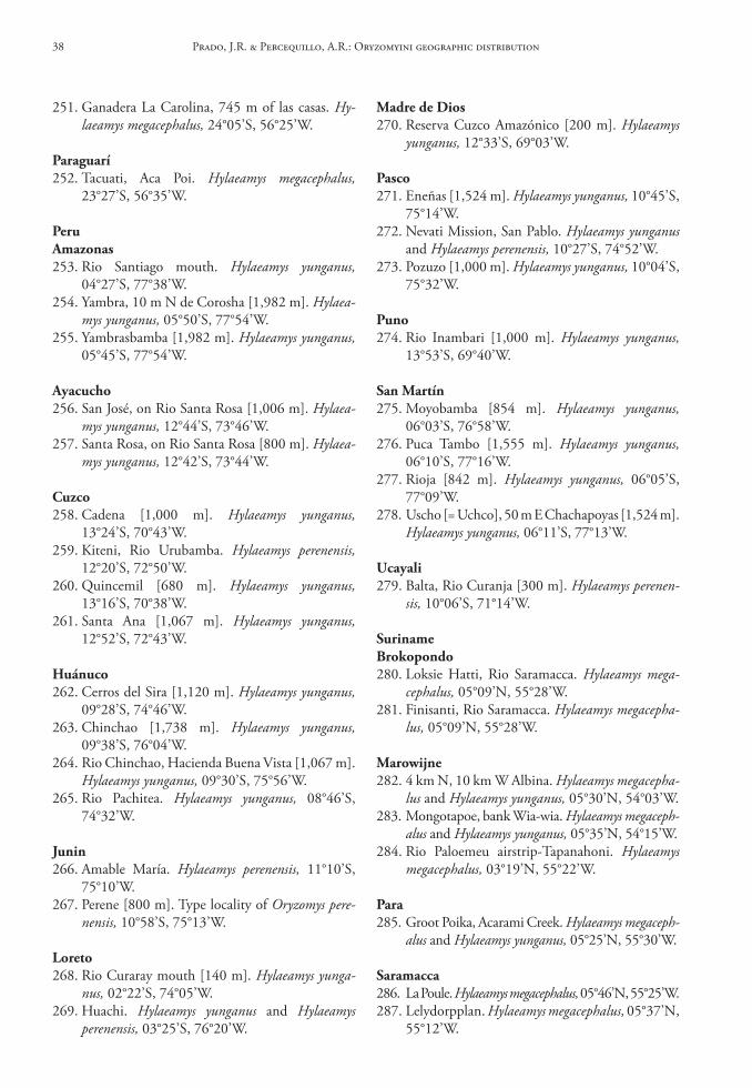
251. Ganadera La Carolina, 745 m of las casas. Hy-laeamys megacephalus, 24°05’S, 56°25’W.
Paraguarí252. Tacuati, Aca Poi. Hylaeamys megacephalus,
23°27’S, 56°35’W.
PeruAmazonas253. Rio Santiago mouth. Hylaeamys yunganus,
04°27’S, 77°38’W.254. Yambra, 10 m N de Corosha [1,982 m]. Hylaea-
mys yunganus, 05°50’S, 77°54’W.255. Yambrasbamba [1,982 m]. Hylaeamys yunganus,
05°45’S, 77°54’W.
Ayacucho256. San José, on Rio Santa Rosa [1,006 m]. Hylaea-
mys yunganus, 12°44’S, 73°46’W.257. Santa Rosa, on Rio Santa Rosa [800 m]. Hylaea-
mys yunganus, 12°42’S, 73°44’W.
cuzco258. Cadena [1,000 m]. Hylaeamys yunganus,
13°24’S, 70°43’W.259. Kiteni, Rio Urubamba. Hylaeamys perenensis,
12°20’S, 72°50’W.260. Quincemil [680 m]. Hylaeamys yunganus,
13°16’S, 70°38’W.261. Santa Ana [1,067 m]. Hylaeamys yunganus,
12°52’S, 72°43’W.
huánuco262. Cerros del Sira [1,120 m]. Hylaeamys yunganus,
09°28’S, 74°46’W.263. Chinchao [1,738 m]. Hylaeamys yunganus,
09°38’S, 76°04’W.264. Rio Chinchao, Hacienda Buena Vista [1,067 m].
Hylaeamys yunganus, 09°30’S, 75°56’W.265. Rio Pachitea. Hylaeamys yunganus, 08°46’S,
74°32’W.
Junin266. Amable María. Hylaeamys perenensis, 11°10’S,
75°10’W.267. Perene [800 m]. Type locality of Oryzomys pere-
nensis, 10°58’S, 75°13’W.
loreto268. Rio Curaray mouth [140 m]. Hylaeamys yunga-
nus, 02°22’S, 74°05’W.269. Huachi. Hylaeamys yunganus and Hylaeamys
perenensis, 03°25’S, 76°20’W.
Madre de dios270. Reserva Cuzco Amazónico [200 m]. Hylaeamys
yunganus, 12°33’S, 69°03’W.
Pasco271. Eneñas [1,524 m]. Hylaeamys yunganus, 10°45’S,
75°14’W.272. Nevati Mission, San Pablo. Hylaeamys yunganus
and Hylaeamys perenensis, 10°27’S, 74°52’W.273. Pozuzo [1,000 m]. Hylaeamys yunganus, 10°04’S,
75°32’W.
Puno274. Rio Inambari [1,000 m]. Hylaeamys yunganus,
13°53’S, 69°40’W.
san Martín275. Moyobamba [854 m]. Hylaeamys yunganus,
06°03’S, 76°58’W.276. Puca Tambo [1,555 m]. Hylaeamys yunganus,
06°10’S, 77°16’W.277. Rioja [842 m]. Hylaeamys yunganus, 06°05’S,
77°09’W.278. Uscho [= Uchco], 50 m E Chachapoyas [1,524 m].
Hylaeamys yunganus, 06°11’S, 77°13’W.
ucayali279. Balta, Rio Curanja [300 m]. Hylaeamys perenen-
sis, 10°06’S, 71°14’W.
surinamebrokopondo280. Loksie Hatti, Rio Saramacca. Hylaeamys mega-
cephalus, 05°09’N, 55°28’W.281. Finisanti, Rio Saramacca. Hylaeamys megacepha-
lus, 05°09’N, 55°28’W.
Marowijne282. 4 km N, 10 km W Albina. Hylaeamys megacepha-
lus and Hylaeamys yunganus, 05°30’N, 54°03’W.283. Mongotapoe, bank Wia-wia. Hylaeamys megaceph-
alus and Hylaeamys yunganus, 05°35’N, 54°15’W.284. Rio Paloemeu airstrip-Tapanahoni. Hylaeamys
megacephalus, 03°19’N, 55°22’W.
Para285. Groot Poika, Acarami Creek. Hylaeamys megaceph-
alus and Hylaeamys yunganus, 05°25’N, 55°30’W.
saramacca286. La Poule. Hylaeamys megacephalus, 05°46’N, 55°25’W.287. Lelydorpplan. Hylaeamys megacephalus, 05°37’N,
55°12’W.
Prado, J.R. & Percequillo, A.R.: Oryzomyini geographic distribution38
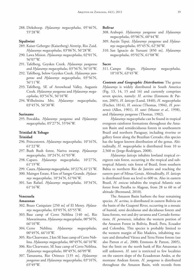
288. Dirkshoop. Hylaeamys megacephalus, 05°46’N, 55°28’W.
sipaliwini289. Kaiser Gebergte (Kaiserberg) Airstrip, Rio Zuid.
Hylaeamys megacephalus, 03°06’N, 56°28’W.290. Lawa Mision. Hylaeamys megacephalus, 02°01’N,
56°07’W.291. Tafelberg, Geyskes Creek. Hylaeamys yunganus
and Hylaeamys megacephalus, 03°56’N, 56°10’W.292. Tafelberg, below Geyskes Creek. Hylaeamys yun-
ganus and Hylaeamys megacephalus, 03°56’N, 56°11’W.
293. Tafelberg, SE of Arrowhead Valley, Augustis Creek. Hylaeamys yunganus and Hylaeamys mega-cephalus, 03°54’N, 56°10’W.
294. Wilhelmina Mts. Hylaeamys megacephalus, 03°45’N, 56°30’W.
suriname295. Powakka. Hylaeamys yunganus and Hylaeamys
megacephalus, 05°27’N, 55°04’W.
trinidad & tobagotrinidad296. Princestown. Hylaeamys megacephalus, 10°16’N,
61°22’W.297. Bush Bush forest, Nariva swamp. Hylaeamys
megacephalus, 10°24’N, 61°03’W.298. Caparo. Hylaeamys megacephalus, 10°27’N,
61°19’W.299. Caura. Hylaeamys megacephalus, 10°22’N, 61°21’W.300. Maingot Estate, 8 km of Sangre Grande. Hylaea-
mys megacephalus, 10°34’N, 61°04’W.301. San Rafael. Hylaeamys megacephalus, 10°34’N,
61°16’W.
VenezuelaAmazonas302. Brazo Casiquiare [250 m] of El Merey. Hylaea-
mys megacephalus, 03°05’N, 65°55’W.303. Base camp of Cerro Neblina [140 m], Rio
Mawarinuma. Hylaeamys megacephalus, 00°50’N, 66°10’W.
304. Cerro Neblina. Hylaeamys megacephalus, 00°49’N, 66°10’W.
305. Rio Clearwater, 2 km SE base camp of Cerro Neb-lina. Hylaeamys megacephalus, 00°49’N, 66°10’W.
306. Rio Clearwater, SE base camp of Cerro Neblina. Hylaeamys megacephalus, 00°49’N, 66°09’W.
307. Tamatama, Rio Orinoco [135 m]. Hylaeamys yunganus and Hylaeamys megacephalus, 03°10’N, 65°49’W.
bolívar308. Arabopó. Hylaeamys yunganus and Hylaeamys
megacephalus, 05°06’N, 60°44’W.309. Auyán Tepui. Hylaeamys yunganus and Hylaea-
mys megacephalus, 05°45’N, 62°30’W.310. San Ignacio de Yuruani [850 m]. Hylaeamys
megacephalus, 05°02’N, 61°08’W.
sucre311. Campo Alegre. Hylaeamys megacephalus,
10°10’N, 63°45’W.
Contents and Geographic Distribution: The genus Hylaeamys is widely distributed in South America (Fig. 13, 14, 15 and 16) and currently comprises seven species, namely: H. acritus (Emmons & Pat-ton, 2005), H. laticeps (Lund, 1840), H. megacephalus (Fischer, 1814), H. oniscus (Thomas, 1904), H. pere-nensis (Allen, 1901), H. tatei (Musser et al., 1998), and Hylaeamys yunganus (Thomas, 1902).
Hylaeamys megacephalus can be found in tropical evergreen rainforest formations throughout the Ama-zon Basin and semideciduous forests in southeastern Brazil and northern Paraguay, including riverine or gallery forest along the Brazilian Cerrado; this species has the largest known distribution of the genus. Alti-tudinally, H. megacephalus is distributed from 10 to 2,560 m (Jorge-Rodrigues, 2008).
Hylaeamys laticeps inhabits lowland tropical ev-ergreen rain forest, occurring in the tropical and sub-tropical Atlantic rain forest of Brazil, from southern Bahia to northern Rio de Janeiro and reaching the eastern part of Minas Gerais. Altitudinally, H. laticeps is distributed from sea level to 600 m. Also in eastern Brazil, H. oniscus inhabits the tropical Atlantic rain forest from Paraíba to Alagoas, from 28 to 60 m of altitude (Brennand, 2010).
The Amazon Basin harbors the four remaining species. H. acritus, is distributed in eastern Bolivia on the basin of the Guaporé River, occurring in a mosaic of humid, semi deciduous and deciduous forests and liana forests, wet and dry savanna and Cerrado forma-tions. H. perenensis, inhabits the western portion of the Amazon Forest in Bolivia, Brazil, Peru, Ecuador and Colombia. This species is probably limited to the western margin of Rio Madeira, inhabiting ma-ture and disturbed Várzea and Terra Firme forests (see also Patton et al., 2000; Emmons & Patton, 2005), but the limit on the north bank of Rio Amazonas is still unknown. H. tatei is restricted to few localities on the eastern slope of the Ecuadorean Andes, at the montane Andean forests. H. yunganus is distributed throughout the Amazon Basin, with records from
Arquivos de Zoologia, 44(1), 2013 39
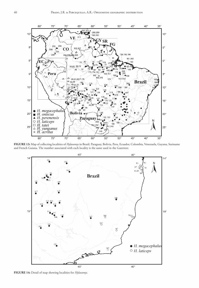
FIGure 13: Map of collecting localities of Hylaeamys in Brazil, Paraguay, Bolivia, Peru, Ecuador, Colombia, Venezuela, Guyana, Suriname and French Guiana. The number associated with each locality is the same used in the Gazetteer.
FIGure 14: Detail of map showing localities for Hylaeamys.
Prado, J.R. & Percequillo, A.R.: Oryzomyini geographic distribution40
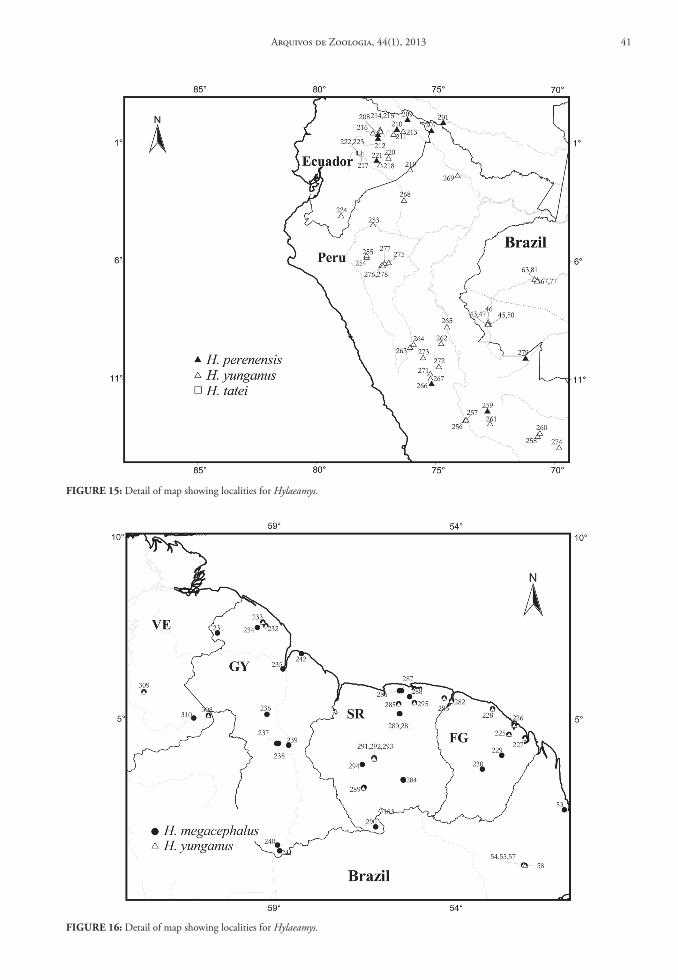
FIGure 15: Detail of map showing localities for Hylaeamys.
FIGure 16: Detail of map showing localities for Hylaeamys.
Arquivos de Zoologia, 44(1), 2013 41
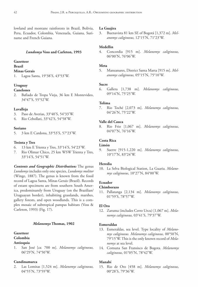
la Guajira3. Buenavista 81 km SE of Bogotá [1,372 m]. Mel-
anomys caliginosus, 12°15’N, 71°23’W.
Medellin4. Concordia [915 m]. Melanomys caliginosus,
06°00’N, 76°06’W.
Meta5. Manzanares, District Santa Marta [915 m]. Mel-
anomys caliginosus, 05°15’N, 75°10’W.
sucre6. Gallera [1,738 m]. Melanomys caliginosus,
09°14’N, 75°25’W.
tolima7. Rio Toché [2,073 m]. Melanomys caliginosus,
04°26’N, 75°22’W.
Valle del cauca8. Rio Frio [1,067 m]. Melanomys caliginosus,
04°07’N, 76°16’W.
costa ricalimón9. Suerre [915-1,220 m]. Melanomys caliginosus,
10°17’N, 83°24’W.
heredia10. La Selva Biological Station, La Guaria. Melano-
mys caliginosus, 10°27’N, 84°00’W.
ecuadorchimborazo11. Pallatanga [2,134 m]. Melanomys caliginosus,
01°59’S, 78°57’W.
el oro12. Zaruma (includes Cerro Urcu) [1,067 m]. Mela-
nomys caliginosus, 03°41’S, 79°37’W.
esmeraldas13. Esmeraldas, sea level. Type locality of Melano-
mys caliginosus. Melanomys caliginosus, 00°50’N, 79°15’W. This is the only known record of Mela-nomys at sea level.
14. Comuna San Fransisco de Bogota. Melanomys caliginosus, 01°05’N, 78°42’W.
Manabí15. Rio de Oro [458 m]. Melanomys caliginosus,
00°28’S, 79°36’W.
lowland and montane rainforests in Brazil, Bolivia, Peru, Ecuador, Colombia, Venezuela, Guiana, Suri-name and French Guiana.
Lundomys Voss and carleton, 1993
GazetteerbrazilMinas Gerais1. Lagoa Santa, 19°38’S, 43°53’W.
uruguaycanelones2. Bafiado de Tropa Vieja, 36 km E Montevideo,
34°47’S, 55°52’W.
lavalleja3. Paso de Averias, 33°40’S, 54°33’W.4. Rio Cebollati, 33°42’S, 54°58’W.
soriano5. 3 km E Cardona, 33°53’S, 57°23’W.
treinta y tres6. 13 km E Trienta y Tres, 33°14’S, 54°23’W.7. Rio Olimar Chico, 25 km WSW Trienta y Tres,
33°14’S, 54°51’W.
Contents and Geographic Distribution: The genus Lundomys includes only one species, Lundomys molitor (Winge, 1887). The genus is known from the fossil record of Lagoa Santa, Minas Gerais (Brazil). Records of extant specimens are from southern South Amer-ica, predominantly from Uruguay (on the Brazilian/Uruguayan border), inhabiting grasslands, marshes, gallery forests, and open woodlands. This is a com-plex mosaic of subtropical pampas habitats (Voss & Carleton, 1993) (Fig. 17).
Melanomys thomas, 1902
GazetteercolombiaAntioquia1. San José [ca. 700 m]. Melanomys caliginosus,
06°29’N, 74°50’W.
cundinamarca2. Las Lomitas [1,524 m]. Melanomys caliginosus,
04°55’N, 73°59’W.
Prado, J.R. & Percequillo, A.R.: Oryzomyini geographic distribution42
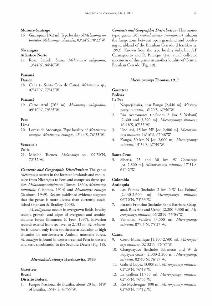
Morona‑santiago16. Gualaquiza [762 m]. Type locality of Melanomys ro-
bustulus. Melanomys robustulus, 03°24’S, 78°33’W.
nicaráguaAtlántico norte17. Rosa Grande, Siuna. Melanomys caliginosus,
13°44’N, 84°46’W.
Panamádarién18. Cana (= Santa Cruz de Cana). Melanomys sp.,
07°47’N, 77°42’W.
Panamá19. Cerro Azul [762 m]. Melanomys caliginosus,
09°10’N, 79°25’W.
Perulima20. Lomas de Atocongo. Type locality of Melanomys
zunigae. Melanomys zunigae, 12°44’S, 76°35’W.
VenezuelaZulia21. Missíon Tucuco. Melanomys sp., 09°50’N,
72°52’W.
Contents and Geographic Distribution: The genus Melanomys occurs in the forested lowlands and moun-tains from Nicaragua to Peru and comprises three spe-cies: Melanomys caliginosus (Tomes, 1860), Melanomys robustulus (Thomas, 1914) and Melanomys zunigae (Sanborn, 1949). Recent published evidence suggests that the genus is more diverse than currently estab-lished (Hanson & Bradley, 2008).
M. caliginosus occurs in overgrown fields, brushy second growth, and edges of evergreen and semide-ciduous forest (Emmons & Feer, 1997). Elevation records extend from sea level to 2,133 m. M. robustu-lus is known only from southeastern Ecuador at high altitudes in northwestern Andean montane forest. M. zunigae is found in western-central Peru in deserts and xeric shrublands, in the Sechura Desert (Fig. 18).
Microakodontomys hershkovitz, 1993
Gazetteerbrazildistrito Federal1. Parque Nacional de Brasília, about 20 km NW
of Brasília. 15°47’S, 47°55’W.
Contents and Geographic Distribution: This mono-typic genus (Microakodontomys transitorius) inhabits the fringe zone between open grassland and border-ing scrubland of the Brazilian Cerrado (Hershkovitz, 1993). Known from the type locality only, but A.P. Carmignotto and R. Paresque (pers. com.) collected specimens of this genus in another locality of Central Brazilian Cerrado (Fig. 19).
Microryzomys thomas, 1917
Gazetteerboliviala Paz1. Ñequejahuira, near Pongo [2,440 m]. Microry-
zomys minutus, 16°20’S, 67°50’W.2. Rio Aceromarca (includes 2 km S Yerbani)
[2,600 and 3,290 m]. Microryzomys minutus, 16°18’S, 07°53’W.
3. Unduavi, 15 km NE [ca. 2,400 m]. Microryzo-mys minutus, 16°16’S, 67°48’W.
4. Zongo, 30 km N [ca. 2,000 m]. Microryzomys minutus, 15°54’S, 67°59’W.
santa cruz5. Siberia, 25 and 30 km W Comarapa
[ca. 2,800 m]. Microryzomys minutus, 17°51’S, 64°42’W.
colombiaAntioquia6. Las Palmas (includes 2 km NW Las Palmas)
[2,440-2,600 m]. Microryzomys minutus, 06°10’N, 75°33’W.
7. Paramo Frontino (includes Santa Batrbara, Guap-anal, Rios Ana and Urrao) [2,200-3,300 m]. Mi-croryzomys minutus, 06°28’N, 76°04’W.
8. Ventanas, Valdivia [3,000 m]. Microryzomys minutus, 07°05’N, 75°27’W.
cauca9. Cerro Munchique [1,500-2,500 m]. Microryzo-
mys minutus, 02°32’N, 76°57’W.10. Charguayaco (includes Sabanetas and W de
Popayan coast) [2,000-2,200 m]. Microryzomys minutus, 02°40’N, 76°57’W.
11. Gabriel Lopez [3,000 m]. Microryzomys minutus, 02°29’N, 76°18’W.
12. La Gallera [1,735 m]. Microryzomys minutus, 02°35’N, 76°55’W.
13. Rio Mechengue [800 m]. Microryzomys minutus, 02°40’N, 77°12’W.
Arquivos de Zoologia, 44(1), 2013 43
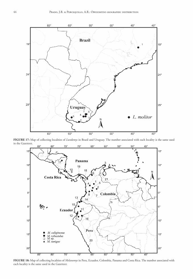
FIGure 17: Map of collecting localities of Lundomys in Brazil and Uruguay. The number associated with each locality is the same used in the Gazetteer.
FIGure 18: Map of collecting localities of Melanomys in Peru, Ecuador, Colombia, Panama and Costa Rica. The number associated with each locality is the same used in the Gazetteer.
Prado, J.R. & Percequillo, A.R.: Oryzomyini geographic distribution44
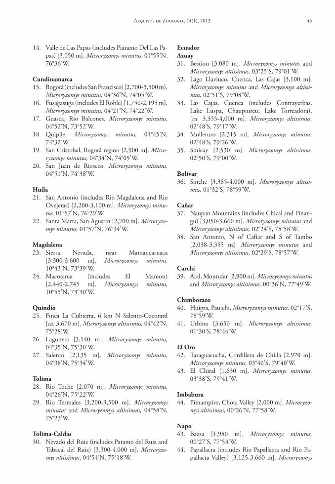
14. Valle de Las Papas (includes Piaramo Del Las Pa-pas) [3,050 m]. Microryzomys minutus, 01°55’N, 76°36’W.
cundinamarca15. Bogotá (includes San Francisco) [2,700-3,500 m].
Microryzomys minutus, 04°36’N, 74°05’W.16. Fusagasuga (includes El Roble) [1,750-2,195 m].
Microryzomys minutus, 04°21’N, 74°22’W.17. Guasca, Rio Balcones. Microryzomys minutus,
04°52’N, 73°52’W.18. Quipile. Microryzomys minutus, 04°45’N,
74°32’W.19. San Cristobal, Bogotá region [2,900 m]. Micro-
ryzomys minutus, 04°34’N, 74°05’W.20. San Juan de Rioseco. Microryzomys minutus,
04°51’N, 74°38’W.
huíla21. San Antonio (includes Rio Magdalena and Rio
Ovejeras) [2,200-3,100 m]. Microryzomys minu-tus, 01°57’N, 76°29’W.
22. Santa Marta, San Agustin [2,700 m]. Microryzo-mys minutus, 01°57’N, 76°34’W.
Magdalena23. Sierra Nevada, near Mamancarnaca
[3,300-3,600 m]. Microryzomys minutus, 10°43’N, 73°39’W.
24. Macotama (includes El Mamon) [2,440-2,745 m]. Microryzomys minutus, 10°55’N, 73°30’W.
Quindío25. Finca La Cubierta, 6 km N Salento-Cocorard
[ca. 3,670 m]. Microryzomys altissimus, 04°42’N, 75°28’W.
26. Laguneta [3,140 m]. Microryzomys minutus, 04°35’N, 75°30’W.
27. Salento [2,135 m]. Microryzomys minutus, 04°38’N, 75°34’W.
tolima28. Rio Toche [2,070 m]. Microryzomys minutus,
04°26’N, 75°22’W.29. Rio Termales [3,200-3,500 m]. Microryzomys
minutus and Microryzomys altissimus, 04°58’N, 75°23’W.
tolima‑caldas30. Nevado del Ruiz (includes Paramo del Ruiz and
Tabacal del Ruiz) [3,300-4,000 m]. Microryzo-mys altissimus, 04°54’N, 75°18’W.
ecuadorAzuay31. Bestion [3,080 m]. Microryzomys minutus and
Microryzomys altissimus, 03°25’S, 79°01’W.32. Lago Llaviuco, Cuenca, Las Cajas [3,100 m].
Microryzomys minutus and Microryzomys altissi-mus, 02°51’S, 79°08’W.
33. Las Cajas, Cuenca (includes Contrayerbas, Lake Luspa, Chaupiurcu, Lake Torreadora), [ca. 3,355-4,000 m]. Microryzomys altissimus, 02°48’S, 79°17’W.
34. Molleturo [2,315 m]. Microryzomys minutus, 02°48’S, 79°26’W.
35. Sinicay [2,530 m]. Microryzomys altissimus, 02°50’S, 79°00’W.
bolívar36. Sinche [3,385-4,000 m]. Microryzomys altissi-
mus, 01°32’S, 78°59’W.
cañar37. Naupan Mountains (includes Chical and Pinan-
gu) [3,050-3,660 m]. Microryzomys minutus and Microryzomys altissimus, 02°24’S, 78°58’W.
38. San Antonio, N of Cafiar and S of Tambo [2,038-3,355 m]. Microryzomys minutus and Microryzomys altissimus, 02°29’S, 78°57’W.
carchi39. Atal, Montufar [2,900 m]. Microryzomys minutus
and Microryzomys altissimus, 00°36’N, 77°49’W.
chimborazo40. Huigra, Paujchi. Microryzomys minutus, 02°17’S,
78°59’W.41. Urbina [3,650 m]. Microryzomys altissimus,
01°30’S, 78°44’W.
el oro42. Taraguacocha, Cordillera de Chilla [2,970 m].
Microryzomys minutus, 03°40’S, 79°40’W.43. El Chiral [1,630 m]. Microryzomys minutus,
03°38’S, 79°41’W.
Imbabura44. Pimampiro, Chota Valley [2,000 m]. Microryzo-
mys altissimus, 00°26’N, 77°58’W.
napo43. Baeza [1,980 m]. Microryzomys minutus,
00°27’S, 77°53’W.44. Papallacta (includes Rio Papallacta and Rio Pa-
pallacta Valley) [3,125-3,660 m]. Microryzomys
Arquivos de Zoologia, 44(1), 2013 45
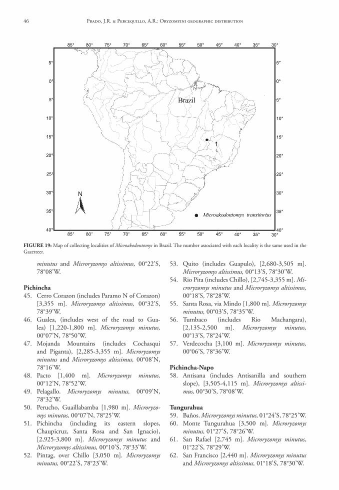
minutus and Microryzomys altissimus, 00°22’S, 78°08’W.
Pichincha45. Cerro Corazon (includes Paramo N of Corazon)
[3,355 m]. Microryzomys altissimus, 00°32’S, 78°39’W.
46. Gualea, (includes west of the road to Gua-lea) [1,220-1,800 m]. Microryzomys minutus, 00°07’N, 78°50’W.
47. Mojanda Mountains (includes Cochasqui and Piganta), [2,285-3,355 m]. Microryzomys minutus and Microryzomys altissimus, 00°08’N, 78°16’W.
48. Pacto [1,400 m]. Microryzomys minutus, 00°12’N, 78°52’W.
49. Pelagallo. Microryzomys minutus, 00°09’N, 78°32’W.
50. Perucho, Guaillabamba [1,980 m]. Microryzo-mys minutus, 00°07’N, 78°25’W.
51. Pichincha (including its eastern slopes, Chaupicruz, Santa Rosa and San Ignacio), [2,925-3,800 m]. Microryzomys minutus and Microryzomys altissimus, 00°10’S, 78°33’W.
52. Pintag, over Chillo [3,050 m]. Microryzomys minutus, 00°22’S, 78°23’W.
53. Quito (includes Guapulo), [2,680-3,505 m]. Microryzomys altissimus, 00°13’S, 78°30’W.
54. Rio Pita (includes Chillo), [2,745-3,355 m]. Mi-croryzomys minutus and Microryzomys altissimus, 00°18’S, 78°28’W.
55. Santa Rosa, via Mindo [1,800 m]. Microryzomys minutus, 00°03’S, 78°35’W.
56. Tumbaco (includes Rio Machangara), [2,135-2,500 m]. Microryzomys minutus, 00°13’S, 78°24’W.
57. Verdecocha [3,100 m]. Microryzomys minutus, 00°06’S, 78°36’W.
Pichincha‑napo58. Antisana (includes Antisanilla and southern
slope), [3,505-4,115 m]. Microryzomys altissi-mus, 00°30’S, 78°08’W.
tungurahua59. Baños. Microryzomys minutus, 01°24’S, 78°25’W.60. Monte Tungurahua [3,500 m]. Microryzomys
minutus, 01°27’S, 78°26’W.61. San Rafael [2,745 m]. Microryzomys minutus,
01°22’S, 78°29’W.62. San Francisco [2,440 m]. Microryzomys minutus
and Microryzomys altissimus, 01°18’S, 78°30’W.
FIGure 19: Map of collecting localities of Microakodontomys in Brazil. The number associated with each locality is the same used in the Gazetteer.
Prado, J.R. & Percequillo, A.R.: Oryzomyini geographic distribution46
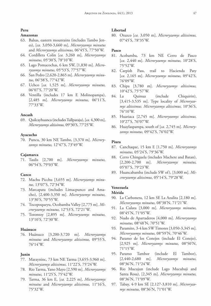
PeruAmazonas63. Balsas, eastern mountains (includes Tambo Jen-
es), [ca. 3,050-3,660 m], Microryzomys minutus and Microryzomys altissimus, 06°45’S, 77°50’W.
64. Cordillera Colin [ca. 3,260 m], Microryzomys minutus, 05°30’S, 78°10’W.
65. Lago Pomacochas, 6 km SW, [1,830 m]. Micro-ryzomys minutus, 05°53’S, 77°57’W.
66. San Pedro [2,620-2,865 m]. Microryzomys minu-tus, 06°38’S, 77°42’W.
67. Uchco [ca. 1,525 m]. Microryzomys minutus, 06°07’S, 77°20’W.
68. Ventilla (includes 17 km E Molinopampa), [2,485 m]. Microryzomys minutus, 06°11’S, 77°33’W.
Ancash69. Quilcayhuanca (includes Tullparaju), [ca. 4,300 m],
Microryzomys altissimus, 09°30’S, 77°25’W.
Ayacucho70. Puncu, 30 km NE Tambo, [3,370 m]. Microry-
zomys minutus, 12°47’S, 73°49’W.
cajamarca71. Taulis [2,700 m]. Microryzomys minutus,
06°54’S, 79°03’W.
cuzco72. Machu Picchu [3,655 m]. Microryzomys minu-
tus, 13°07’S, 72°34’W.73. Marcapata (includes Limacpunco and Ama-
cho), [2,400-3,350 m]. Microryzomys minutus, 13°30’S, 70°55’W.
74. Tocopoqueyu, Ocobamba Valley [2,775 m]. Mi-croryzomys minutus, 12°53’S, 72°21’W.
75. Torontoy [2,895 m]. Microryzomys minutus, 13°10’S, 72°30’W.
huánuco76. Huánuco [3,200-3,720 m]. Microryzomys
minutus and Microryzomys altissimus, 09°55’S, 76°14’W.
Junin77. Maraynioc, 73 km NE Tarma [3,655-3,960 m].
Microryzomys altissimus, 11°22’S, 75°24’W.78. Rio Tarma, Yano Mayo [2,590 m]. Microryzomys
minutus, 11°25’S, 75°42’W.79. Tarma, 36 km E, [ca. 2,225 m], Microryzomys
minutus and Microryzomys altissimus, 11°16’S, 75°32’W.
libertad80. Otuzco [ca. 3,050 m]. Microryzomys altissimus,
07°45’S, 78°35’W.
Pasco81. Acobamba, 73 km NE Cerro de Pasco
[ca. 2,440 m]. Microryzomys minutus, 10°28’S, 75°52’W.
82. Carpish Pass, trail to Hacienda Paty [ca. 2,165 m]. Microryzomys minutus, 09°42’S, 76°09’W.
83. Chipa [3,780 m]. Microryzomys altissimus, 10°42’S, 75°57’W.
84. La Quinua (include Chiquirin), [3,415-3,535 m]. Type locality of Microryzo-mys altissimus. Microryzomys altissimus, 10°36’S, 76°10’W.
85. Huariaca [2,745 m]. Microryzomys altissimus, 10°27’S, 76°07’W.
86. Huaylaspampa, south of [ca. 2,745 m]. Microry-zomys minutus, 09°42’S, 76°02’W.
Piura87. Canchaque, 15 km E [1,750 m]. Microryzomys
minutus, 05°24’S, 79°36’W.88. Cerro Chinguela (includes Machete and Batan),
[2,200-2,700 m]. Microryzomys minutus, 05°07’S, 79°23’W.
89. Huancabamba (include SW of ), [3,000 m]. Mi-croryzomys altissimus, 05°14’S, 79°28’W.
VenezuelaMérida90. La Carbonera, 12 km SE La Azulita [2,180 m].
Microryzomys minutus, 08°38’N, 71°21’W.91. La Culata [3,000 m]. Microryzomys minutus,
08°45’N, 71°05’W.92. Nudo de Apartaderos [4,000 m]. Microryzomys
minutus, 08°48’N, 70°51’W.93. Paramito, 3-4 km SW Timotes [3,050-3,345 m].
Microryzomys minutus, 08°59’N, 70°46’W.94. Paramo de los Conejos (include El Conejo),
[2,925 m]. Microryzomys minutus, 08°50’N, 71°15’W.
95. Paramo Tambor (include El Tambor), [2,440-2,680 m]. Microryzomys minutus, 08°36’N, 71°24’W.
96. Rio Mucujun (include Lago Mucubaji and Santa Rosa), [2,345 m]. Microryzomys minutus, 08°36’N, 71°09’W.
97. Tabay, 4-9 km SE [2,127-3,810 m]. Microryzo-mys minutus, 08°36’N, 71°01’W.
Arquivos de Zoologia, 44(1), 2013 47
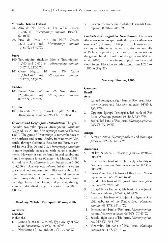
Miranda/distrito Federal98. Alto de No Leon, 33 km WSW Caracas
[1,996 m]. Microryzomys minutus, 10°26’N, 67°10’W.
99. Pico de Avila, 5-6 km NNE Caracas [2,081-2,241 m]. Microryzomys minutus, 10°33’N, 66°52’W.
sucre100. Turumiquire (include Monte Turumiquire),
[1,705 and 2,410 m]. Microryzomys minutus, 10°07’N, 63°52’W.
101. Cerro Negro, 10 km NW Caripe [1,630-1,690 m]. Microryzomys minutus, 10°12’N, 63°32’W.
táchira102. Buena Vista, 41 km SW San Cristobal
[2,350-2,420 m]. Microryzomys minutus, 07°27’N, 72°26’W.
trujillo103. Haciendas Misisi, 15 km E Trujillo [2,360 m].
Microryzomys minutus, 09°21’N, 70°18’W.
Contents and Geographic Distribution: The genus includes two valid species: Microryzomys altissimus (Osgood, 1933) and Microryzomys minutus (Tomes, 1860). The genus Microryzomys is autochthonous to the northern and central Andes, from northern Ven-ezuela, through Colombia, Ecuador and Peru, to cen-tral Bolivia (Fig. 20 and 21). Microryzomys altissimus is more regularly associated with paramo environ-ments. However, it can be found in arid scrubs, and humid temperate forest (Carleton & Musser, 1989). Altitudinally, M. altissimus is distributed from 2,000 to 4,300 m. Microryzomys minutus inhabits a variety of wet and cool Andean forests, like lower subtropical forest, lower montane moist forest, humid temperate forest, mossy subtropical forest, scrubby cloud forest on ridge, heavy cloud forest, and paramo, through a known altitudinal range that varies from 800 to 4,000 m.
Mindomys Weksler, Percequillo & Voss, 2006
GazetteerecuadorPichincha1. Mindo [1,281 to 1,285 m]. Type locality of Nec-
tomys hammondi, 00°03’S, 78°46’W.2. Near Mindo [1,220 m], 00°01’N, 79°00’W.
3. Oriente, Concepción; probably Hacienda Con-cepción, 00°06’S, 78°30’W.
Contents and Geographic Distribution: The genus Mindomys is monotypic, with the species Mindomys hammondi (Thomas, 1913) primarily known in the vicinity of Mindo in the western Andean foothills of Pichincha province, Ecuador (see comments on the geographic distribution of the genus on Weksler et al., 2006). It occurs in subtropical montane and cloud forest. Elevation records extend from 1,220 to 1,285 m (Fig. 22).
Neacomys thomas, 1900
GazetteerbrazilAcre1. Igarapé Porangaba, right bank of Rio Juruá. Nea-
comys musseri and Neacomys spinosus, 08°40’S, 73°47’W.
2. Opposite Igarapé Porongaba, left bank of Rio Juruá. Neacomys spinosus, 08°40’S, 72°47’W.
3. Sobral, left bank of Rio Juruá. Neacomys spinosus, 08°22’S, 72°49’W.
Amapá4. Serra do Navio. Neacomys dubosti and Neacomys
paracou, 00°59’S, 52°03’W.
Amazonas5. 80 km N Manaus. Neacomys paracou, 03°06’S,
60°01’W.6. Altamira, left bank of Rio Juruá. Type locality of
Neacomys minutus. Neacomys minutus, 06°35’S, 68°54’W.
7. Barro Vermelho, left bank of Rio Juruá. Neaco-mys minutus, 06°28’S, 68°46’W.
8. Condor, left bank of Rio Juruá. Neacomys spino-sus, 06°45’S, 70°51’W.
9. Igarapé Nova Empresa, left bank of Rio Juruá. Neacomys minutus, 06°48’S, 70°44’W.
10. Ilhazinha, left bank of Rio Juruá in Igarapé Ara-bidi, tributary of the Paraná Breu. Neacomys minutus, 03°17’S, 66°14’W.
11. Penedo, right bank of Rio Juruá. Neacomys minu-tus and Neacomys spinosus, 06°50’S, 70°45’W.
12. Sacado, right bank of Rio Juruá. Neacomys minu-tus, 06°45’S, 70°51’W.
13. Vira-volta, left bank of Rio Juruá. Neacomys minutus, 03°17’S, 66°14’W.
Prado, J.R. & Percequillo, A.R.: Oryzomyini geographic distribution48
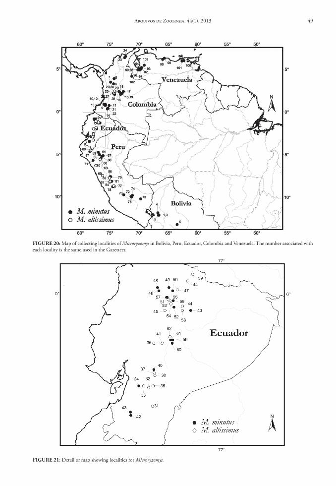
FIGure 20: Map of collecting localities of Microryzomys in Bolivia, Peru, Ecuador, Colombia and Venezuela. The number associated with each locality is the same used in the Gazetteer.
FIGure 21: Detail of map showing localities for Microryzomys.
Arquivos de Zoologia, 44(1), 2013 49
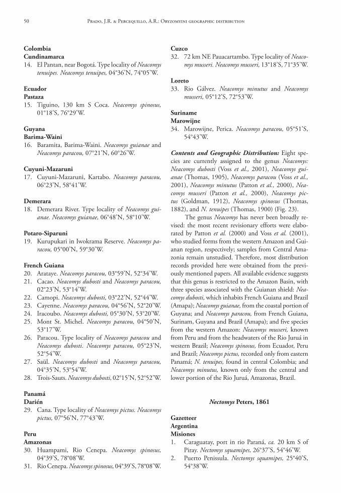
colombiacundinamarca14. El Pantan, near Bogotá. Type locality of Neacomys
tenuipes. Neacomys tenuipes, 04°36’N, 74°05’W.
ecuadorPastaza15. Tiguino, 130 km S Coca. Neacomys spinosus,
01°18’S, 76°29’W.
Guyanabarima‑Waini16. Baramita, Barima-Waini. Neacomys guianae and
Neacomys paracou, 07°21’N, 60°26’W.
cuyuni‑Mazaruni17. Cuyuni-Mazaruni, Kartabo. Neacomys paracou,
06°23’N, 58°41’W.
demerara18. Demerara River. Type locality of Neacomys gui-
anae. Neacomys guianae, 06°48’N, 58°10’W.
Potaro‑siparuni19. Kurupukari in Iwokrama Reserve. Neacomys pa-
racou, 05°00’N, 59°30’W.
French Guiana20. Arataye. Neacomys paracou, 03°59’N, 52°34’W.21. Cacao. Neacomys dubosti and Neacomys paracou,
02°23’N, 53°14’W.22. Camopi. Neacomys dubosti, 03°22’N, 52°44’W.23. Cayenne. Neacomys paracou, 04°56’N, 52°20’W.24. Iracoubo. Neacomys dubosti, 05°30’N, 53°20’W.25. Mont St. Michel. Neacomys paracou, 04°50’N,
53°17’W.26. Paracou. Type locality of Neacomys paracou and
Neacomys dubosti. Neacomys paracou, 05°23’N, 52°54’W.
27. Saül. Neacomys dubosti and Neacomys paracou, 04°35’N, 53°54’W.
28. Trois-Sauts. Neacomys dubosti, 02°15’N, 52°52’W.
Panamádarién29. Cana. Type locality of Neacomys pictus. Neacomys
pictus, 07°56’N, 77°43’W.
PeruAmazonas30. Huampami, Rio Cenepa. Neacomys spinosus,
04°39’S, 78°08’W.31. Rio Cenepa. Neacomys spinosus, 04°39’S, 78°08’W.
cuzco32. 72 km NE Pauacartambo. Type locality of Neaco-
mys musseri. Neacomys musseri, 13°18’S, 71°35’W.
loreto33. Rio Gálvez. Neacomys minutus and Neacomys
musseri, 05°12’S, 72°53’W.
surinameMarowijne34. Marowijne, Perica. Neacomys paracou, 05°51’S,
54°43’W.
Contents and Geographic Distribution: Eight spe-cies are currently assigned to the genus Neacomys: Neacomys dubosti (Voss et al., 2001), Neacomys gui-anae (Thomas, 1905), Neacomys paracou (Voss et al., 2001), Neacomys minutus (Patton et al., 2000), Nea-comys musseri (Patton et al., 2000), Neacomys pic-tus (Goldman, 1912), Neacomys spinosus (Thomas, 1882), and N. tenuipes (Thomas, 1900) (Fig. 23).
The genus Neacomys has never been broadly re-vised: the most recent revisionary efforts were elabo-rated by Patton et al. (2000) and Voss et al. (2001), who studied forms from the western Amazon and Gui-anan region, respectively; samples from Central Ama-zonia remain unstudied. Therefore, most distribution records provided here were obtained from the previ-ously mentioned papers. All available evidence suggests that this genus is restricted to the Amazon Basin, with three species associated with the Guianan shield: Nea-comys dubosti, which inhabits French Guiana and Brazil (Amapa); Neacomys guianae, from the coastal portion of Guyana; and Neacomys paracou, from French Guiana, Surinam, Guyana and Brazil (Amapa); and five species from the western Amazon: Neacomys musseri, known from Peru and from the headwaters of the Rio Juruá in western Brazil; Neacomys spinosus, from Ecuador, Peru and Brazil; Neacomys pictus, recorded only from eastern Panamá; N. tenuipes, found in central Colombia; and Neacomys minutus, known only from the central and lower portion of the Rio Juruá, Amazonas, Brazil.
Nectomys Peters, 1861
GazetteerArgentinaMisiones1. Caraguatay, port in rio Paraná, ca. 20 km S of
Piray. Nectomys squamipes, 26°37’S, 54°46’W.2. Puerto Penissula. Nectomys squamipes, 25°40’S,
54°38’W.
Prado, J.R. & Percequillo, A.R.: Oryzomyini geographic distribution50
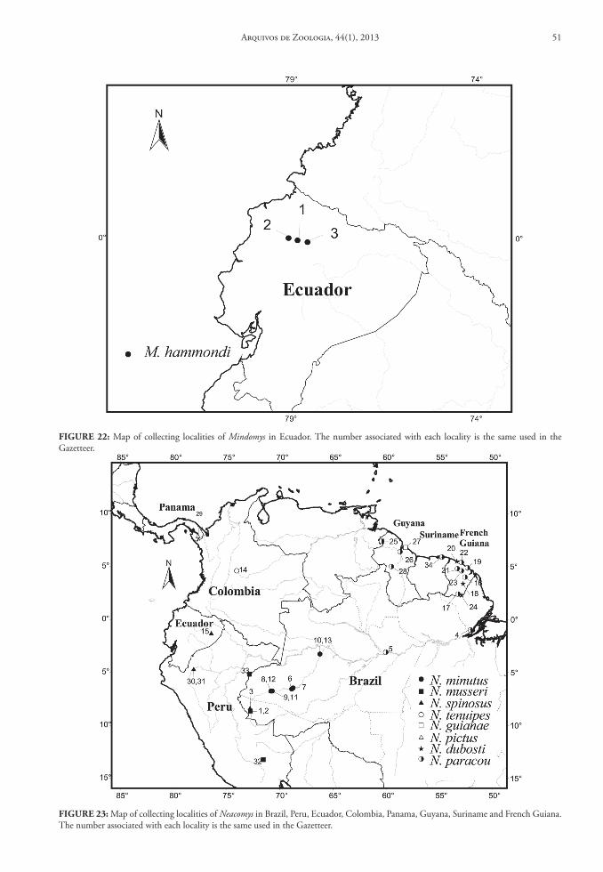
FIGure 22: Map of collecting localities of Mindomys in Ecuador. The number associated with each locality is the same used in the Gazetteer.
FIGure 23: Map of collecting localities of Neacomys in Brazil, Peru, Ecuador, Colombia, Panama, Guyana, Suriname and French Guiana. The number associated with each locality is the same used in the Gazetteer.
Arquivos de Zoologia, 44(1), 2013 51
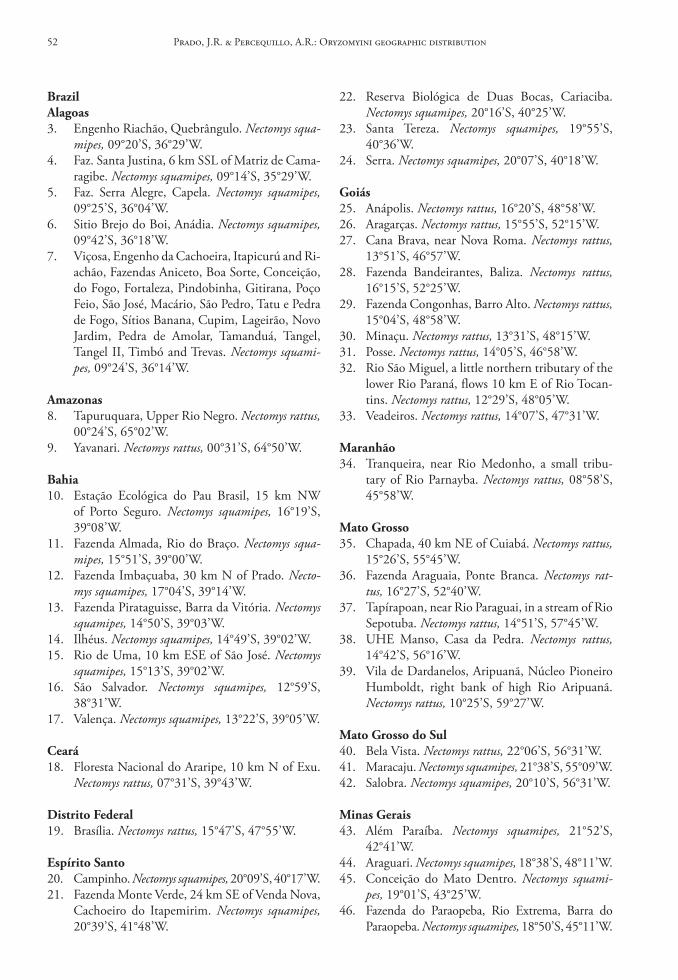
brazilAlagoas3. Engenho Riachão, Quebrângulo. Nectomys squa-
mipes, 09°20’S, 36°29’W.4. Faz. Santa Justina, 6 km SSL of Matriz de Cama-
ragibe. Nectomys squamipes, 09°14’S, 35°29’W.5. Faz. Serra Alegre, Capela. Nectomys squamipes,
09°25’S, 36°04’W.6. Sitio Brejo do Boi, Anádia. Nectomys squamipes,
09°42’S, 36°18’W.7. Viçosa, Engenho da Cachoeira, Itapicurú and Ri-
achão, Fazendas Aniceto, Boa Sorte, Conceição, do Fogo, Fortaleza, Pindobinha, Gitirana, Poço Feio, São José, Macário, São Pedro, Tatu e Pedra de Fogo, Sítios Banana, Cupim, Lageirão, Novo Jardim, Pedra de Amolar, Tamanduá, Tangel, Tangel II, Timbó and Trevas. Nectomys squami-pes, 09°24’S, 36°14’W.
Amazonas8. Tapuruquara, Upper Rio Negro. Nectomys rattus,
00°24’S, 65°02’W.9. Yavanari. Nectomys rattus, 00°31’S, 64°50’W.
bahia10. Estação Ecológica do Pau Brasil, 15 km NW
of Porto Seguro. Nectomys squamipes, 16°19’S, 39°08’W.
11. Fazenda Almada, Rio do Braço. Nectomys squa-mipes, 15°51’S, 39°00’W.
12. Fazenda Imbaçuaba, 30 km N of Prado. Necto-mys squamipes, 17°04’S, 39°14’W.
13. Fazenda Pirataguisse, Barra da Vitória. Nectomys squamipes, 14°50’S, 39°03’W.
14. Ilhéus. Nectomys squamipes, 14°49’S, 39°02’W.15. Rio de Uma, 10 km ESE of São José. Nectomys
squamipes, 15°13’S, 39°02’W.16. São Salvador. Nectomys squamipes, 12°59’S,
38°31’W.17. Valença. Nectomys squamipes, 13°22’S, 39°05’W.
ceará18. Floresta Nacional do Araripe, 10 km N of Exu.
Nectomys rattus, 07°31’S, 39°43’W.
distrito Federal19. Brasília. Nectomys rattus, 15°47’S, 47°55’W.
espírito santo20. Campinho. Nectomys squamipes, 20°09’S, 40°17’W.21. Fazenda Monte Verde, 24 km SE of Venda Nova,
Cachoeiro do Itapemirim. Nectomys squamipes, 20°39’S, 41°48’W.
22. Reserva Biológica de Duas Bocas, Cariaciba. Nectomys squamipes, 20°16’S, 40°25’W.
23. Santa Tereza. Nectomys squamipes, 19°55’S, 40°36’W.
24. Serra. Nectomys squamipes, 20°07’S, 40°18’W.
Goiás25. Anápolis. Nectomys rattus, 16°20’S, 48°58’W.26. Aragarças. Nectomys rattus, 15°55’S, 52°15’W.27. Cana Brava, near Nova Roma. Nectomys rattus,
13°51’S, 46°57’W.28. Fazenda Bandeirantes, Baliza. Nectomys rattus,
16°15’S, 52°25’W.29. Fazenda Congonhas, Barro Alto. Nectomys rattus,
15°04’S, 48°58’W.30. Minaçu. Nectomys rattus, 13°31’S, 48°15’W.31. Posse. Nectomys rattus, 14°05’S, 46°58’W.32. Rio São Miguel, a little northern tributary of the
lower Rio Paraná, flows 10 km E of Rio Tocan-tins. Nectomys rattus, 12°29’S, 48°05’W.
33. Veadeiros. Nectomys rattus, 14°07’S, 47°31’W.
Maranhão34. Tranqueira, near Rio Medonho, a small tribu-
tary of Rio Parnayba. Nectomys rattus, 08°58’S, 45°58’W.
Mato Grosso35. Chapada, 40 km NE of Cuiabá. Nectomys rattus,
15°26’S, 55°45’W.36. Fazenda Araguaia, Ponte Branca. Nectomys rat-
tus, 16°27’S, 52°40’W.37. Tapírapoan, near Rio Paraguai, in a stream of Rio
Sepotuba. Nectomys rattus, 14°51’S, 57°45’W.38. UHE Manso, Casa da Pedra. Nectomys rattus,
14°42’S, 56°16’W.39. Vila de Dardanelos, Aripuanã, Núcleo Pioneiro
Humboldt, right bank of high Rio Aripuanã. Nectomys rattus, 10°25’S, 59°27’W.
Mato Grosso do sul40. Bela Vista. Nectomys rattus, 22°06’S, 56°31’W.41. Maracaju. Nectomys squamipes, 21°38’S, 55°09’W.42. Salobra. Nectomys squamipes, 20°10’S, 56°31’W.
Minas Gerais43. Além Paraíba. Nectomys squamipes, 21°52’S,
42°41’W.44. Araguari. Nectomys squamipes, 18°38’S, 48°11’W.45. Conceição do Mato Dentro. Nectomys squami-
pes, 19°01’S, 43°25’W.46. Fazenda do Paraopeba, Rio Extrema, Barra do
Paraopeba. Nectomys squamipes, 18°50’S, 45°11’W.
Prado, J.R. & Percequillo, A.R.: Oryzomyini geographic distribution52
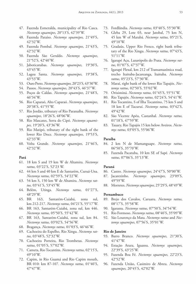
47. Fazenda Esmeralda, municipality of Rio Casca. Nectomys squamipes, 20°13’S, 42°39’W.
48. Fazenda Paraíso. Nectomys squamipes, 21°49’S, 42°32’W.
49. Fazenda Pombal. Nectomys squamipes, 21°43’S, 42°32’W.
50. Fazenda São Geraldo. Nectomys squamipes, 21°52’S, 42°40’W.
51. Jaboticatubas. Nectomys squamipes, 19°30’S, 43°45’W.
52. Lagoa Santa. Nectomys squamipes, 19°38’S, 43°53’W.
53. Ouro Preto. Nectomys squamipes, 20°23’S, 43°30’W.54. Passos. Nectomys squamipes, 20°43’S, 46°37’W.55. Poços de Caldas. Nectomys squamipes, 21°48’S,
46°34’W.56. Rio Caparaó, Alto Caparaó. Nectomys squamipes,
20°38’S, 41°55’W.57. Rio Jordão, tributary of Rio Paranaíba. Nectomys
squamipes, 18°26’S, 48°06’W.58. Rio Mascates, Serra do Cipó. Nectomys squami-
pes, 19°20’S, 43°36’W.59. Rio Matipó, tributary of the right bank of the
lower Rio Doce. Nectomys squamipes, 19°53’S, 42°33’W.
60. Volta Grande. Nectomys squamipes, 21°46’S, 42°32’W.
Pará61. 18 km S and 19 km W de Altamira. Nectomys
rattus, 03°22’S, 52°23 W.62. 44 km S and 40 km E de Santarém, Curuá-Una.
Nectomys rattus, 02°59’S, 54°22’W.63. 54 km S, 150 km W de Altamira. Nectomys rat-
tus, 03°41’S, 53°45’W.64. Belém, Utinga. Nectomys rattus, 01°27’S,
48°29’W.65. BR 163, Santarém-Cuiabá, zona sul,
km 212-217. Nectomys rattus, 04°21’S, 55°17’W.66. BR 163, Santarém-Cuiabá, zona sul, km 446.
Nectomys rattus, 05°50’S, 55°42’W.67. BR 163, Santarém-Cuiabá, zona sul, km 84.
Nectomys rattus, 03°02’S, 54°56’W.68. Bragança. Nectomys rattus, 01°03’S, 46°46’W.69. Cachoeira do Espelho, Rio Xingu. Nectomys rat-
tus, 03°48’S, 52°32’W.70. Cachoeira Porteira, Rio Trombetas. Nectomys
rattus, 01°05’S, 57°02’W.71. Cameta, Rio Tocantins. Nectomys rattus, 02°15’S,
49°10’W.72. Capim, in Rio Guamá and Rio Capim mouth,
BR 010: km 87-107. Nectomys rattus, 01°40’S, 47°47’W.
73. Fordlândia. Nectomys rattus, 03°40’S, 55°30’W.74. Gleba 29, Lote 03, near Jatobal, 75 km N,
45 km W of Marabá. Nectomys rattus, 05°21’S, 49°10’W.
75. Gradaús, Upper Rio Fresco, right bank tribu-tary of the Rio Xingu. Nectomys rattus, 07°43’S, 51°11’W.
76. Igarapé Açu, Lazarópolis do Prata. Nectomys rat-tus, 01°07’S, 47°37’W.
77. Igarapé Flexal, km 212 of Transamazônica road, trecho Itaituba-Jacareanga, Itaituba. Nectomys rattus, 05°23’S, 57°30’W.
78. Maraí, right bank of the lower Rio Tapajós. Nec-tomys rattus, 02°50’S, 55°02’W.
79. Oriximiná. Nectomys rattus, 01°45’S, 55°51’W.80. Rio Tapajós. Nectomys rattus, 02°24’S, 54°41’W.81. Rio Tocantins, S of Ilha Tocantino, 75 km S and
18 km E of Tucuruí. Nectomys rattus, 03°42’S, 49°42’W.
82. São Vicente Apéu, Castanhal. Nectomys rattus, 01°18’S, 47°59’W.
83. Tauary, Rio Tapajós 15 km below Aveiros. Necto-mys rattus, 03°05’S, 55°06’W.
Paraíba84. 2 km N de Mamanguape. Nectomys rattus,
06°50’S, 35°70’W.85. Fazenda Pacatuba, 10 km SE of Sapé. Nectomys
rattus, 07°06’S, 35°13’W.
Paraná86. Castro. Nectomys squamipes, 24°47’S, 50°00’W.87. Jacarezinho. Nectomys squamipes, 23°09’S,
49°59’W.88. Morretes. Nectomys squamipes, 25°29’S, 48°49’W.
Pernambuco89. Brejo dos Cavalos, Caruaru. Nectomys rattus,
08°17’S, 35°58’W.90. Igarassu. Nectomys rattus, 07°50’S, 34°54’W.91. Rio Formoso. Nectomys rattus, 08°40’S, 35°09’W.92. São Lourenço da Mata. Nectomys rattus and Nec-
tomys squamipes, 07°56’S, 35°01’W.
rio de Janeiro93. Barro Branco. Nectomys squamipes, 21°30’S,
41°47’W.94. Estação Atura, Iguassu. Nectomys squamipes,
22°39’S, 43°25’W.95. Fazenda Boa Fé. Nectomys squamipes, 22°23’S,
42°52’W.96. Fazenda União, Casimiro de Abreu. Nectomys
squamipes, 20°45’S, 42°02’W.
Arquivos de Zoologia, 44(1), 2013 53
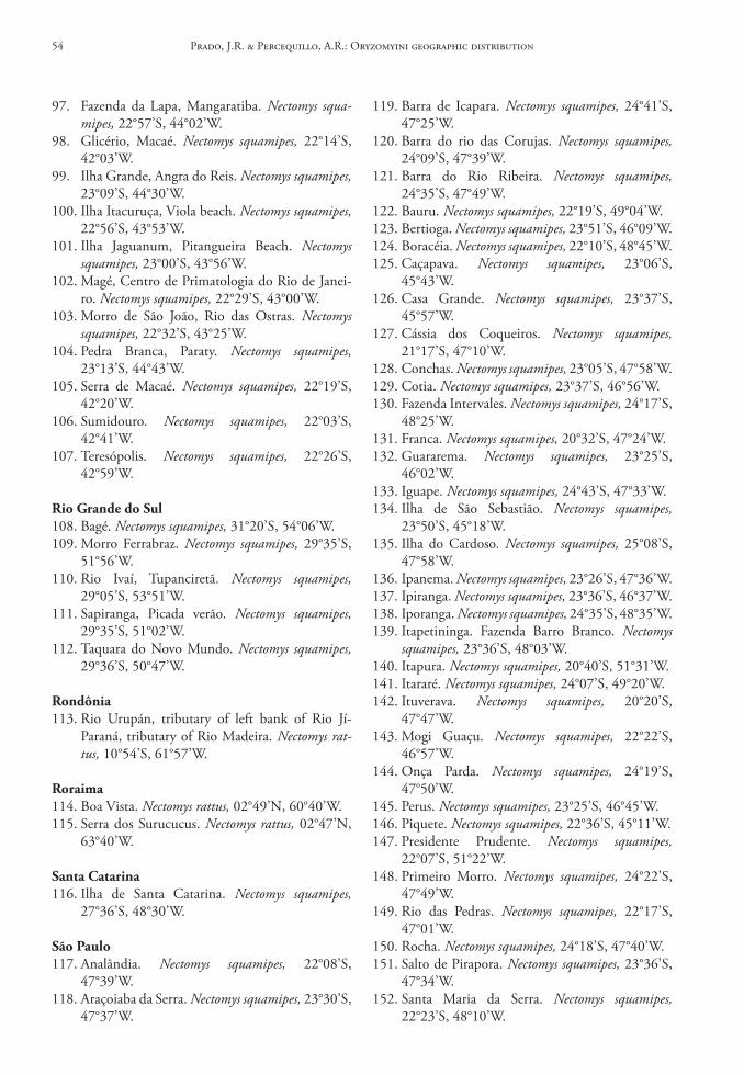
97. Fazenda da Lapa, Mangaratiba. Nectomys squa-mipes, 22°57’S, 44°02’W.
98. Glicério, Macaé. Nectomys squamipes, 22°14’S, 42°03’W.
99. Ilha Grande, Angra do Reis. Nectomys squamipes, 23°09’S, 44°30’W.
100. Ilha Itacuruça, Viola beach. Nectomys squamipes, 22°56’S, 43°53’W.
101. Ilha Jaguanum, Pitangueira Beach. Nectomys squamipes, 23°00’S, 43°56’W.
102. Magé, Centro de Primatologia do Rio de Janei-ro. Nectomys squamipes, 22°29’S, 43°00’W.
103. Morro de São João, Rio das Ostras. Nectomys squamipes, 22°32’S, 43°25’W.
104. Pedra Branca, Paraty. Nectomys squamipes, 23°13’S, 44°43’W.
105. Serra de Macaé. Nectomys squamipes, 22°19’S, 42°20’W.
106. Sumidouro. Nectomys squamipes, 22°03’S, 42°41’W.
107. Teresópolis. Nectomys squamipes, 22°26’S, 42°59’W.
rio Grande do sul108. Bagé. Nectomys squamipes, 31°20’S, 54°06’W.109. Morro Ferrabraz. Nectomys squamipes, 29°35’S,
51°56’W.110. Rio Ivaí, Tupanciretã. Nectomys squamipes,
29°05’S, 53°51’W.111. Sapiranga, Picada verão. Nectomys squamipes,
29°35’S, 51°02’W.112. Taquara do Novo Mundo. Nectomys squamipes,
29°36’S, 50°47’W.
rondônia113. Rio Urupán, tributary of left bank of Rio Jí-
Paraná, tributary of Rio Madeira. Nectomys rat-tus, 10°54’S, 61°57’W.
roraima114. Boa Vista. Nectomys rattus, 02°49’N, 60°40’W.115. Serra dos Surucucus. Nectomys rattus, 02°47’N,
63°40’W.
santa catarina116. Ilha de Santa Catarina. Nectomys squamipes,
27°36’S, 48°30’W.
são Paulo117. Analândia. Nectomys squamipes, 22°08’S,
47°39’W.118. Araçoiaba da Serra. Nectomys squamipes, 23°30’S,
47°37’W.
119. Barra de Icapara. Nectomys squamipes, 24°41’S, 47°25’W.
120. Barra do rio das Corujas. Nectomys squamipes, 24°09’S, 47°39’W.
121. Barra do Rio Ribeira. Nectomys squamipes, 24°35’S, 47°49’W.
122. Bauru. Nectomys squamipes, 22°19’S, 49°04’W.123. Bertioga. Nectomys squamipes, 23°51’S, 46°09’W.124. Boracéia. Nectomys squamipes, 22°10’S, 48°45’W.125. Caçapava. Nectomys squamipes, 23°06’S,
45°43’W.126. Casa Grande. Nectomys squamipes, 23°37’S,
45°57’W.127. Cássia dos Coqueiros. Nectomys squamipes,
21°17’S, 47°10’W.128. Conchas. Nectomys squamipes, 23°05’S, 47°58’W.129. Cotia. Nectomys squamipes, 23°37’S, 46°56’W.130. Fazenda Intervales. Nectomys squamipes, 24°17’S,
48°25’W.131. Franca. Nectomys squamipes, 20°32’S, 47°24’W.132. Guararema. Nectomys squamipes, 23°25’S,
46°02’W.133. Iguape. Nectomys squamipes, 24°43’S, 47°33’W.134. Ilha de São Sebastião. Nectomys squamipes,
23°50’S, 45°18’W.135. Ilha do Cardoso. Nectomys squamipes, 25°08’S,
47°58’W.136. Ipanema. Nectomys squamipes, 23°26’S, 47°36’W.137. Ipiranga. Nectomys squamipes, 23°36’S, 46°37’W.138. Iporanga. Nectomys squamipes, 24°35’S, 48°35’W.139. Itapetininga. Fazenda Barro Branco. Nectomys
squamipes, 23°36’S, 48°03’W.140. Itapura. Nectomys squamipes, 20°40’S, 51°31’W.141. Itararé. Nectomys squamipes, 24°07’S, 49°20’W.142. Ituverava. Nectomys squamipes, 20°20’S,
47°47’W.143. Mogi Guaçu. Nectomys squamipes, 22°22’S,
46°57’W.144. Onça Parda. Nectomys squamipes, 24°19’S,
47°50’W.145. Perus. Nectomys squamipes, 23°25’S, 46°45’W.146. Piquete. Nectomys squamipes, 22°36’S, 45°11’W.147. Presidente Prudente. Nectomys squamipes,
22°07’S, 51°22’W.148. Primeiro Morro. Nectomys squamipes, 24°22’S,
47°49’W.149. Rio das Pedras. Nectomys squamipes, 22°17’S,
47°01’W.150. Rocha. Nectomys squamipes, 24°18’S, 47°40’W.151. Salto de Pirapora. Nectomys squamipes, 23°36’S,
47°34’W.152. Santa Maria da Serra. Nectomys squamipes,
22°23’S, 48°10’W.
Prado, J.R. & Percequillo, A.R.: Oryzomyini geographic distribution54
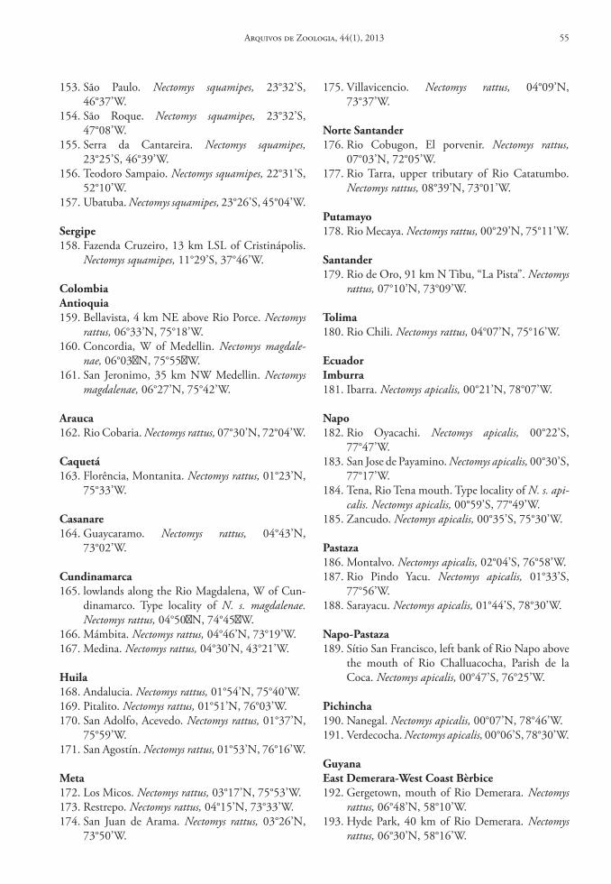
153. São Paulo. Nectomys squamipes, 23°32’S, 46°37’W.
154. São Roque. Nectomys squamipes, 23°32’S, 47°08’W.
155. Serra da Cantareira. Nectomys squamipes, 23°25’S, 46°39’W.
156. Teodoro Sampaio. Nectomys squamipes, 22°31’S, 52°10’W.
157. Ubatuba. Nectomys squamipes, 23°26’S, 45°04’W.
sergipe158. Fazenda Cruzeiro, 13 km LSL of Cristinápolis.
Nectomys squamipes, 11°29’S, 37°46’W.
colombiaAntioquia159. Bellavista, 4 km NE above Rio Porce. Nectomys
rattus, 06°33’N, 75°18’W.160. Concordia, W of Medellin. Nectomys magdale-
nae, 06°03�N, 75°55�W.161. San Jeronimo, 35 km NW Medellin. Nectomys
magdalenae, 06°27’N, 75°42’W.
Arauca162. Rio Cobaria. Nectomys rattus, 07°30’N, 72°04’W.
caquetá163. Florência, Montanita. Nectomys rattus, 01°23’N,
75°33’W.
casanare164. Guaycaramo. Nectomys rattus, 04°43’N,
73°02’W.
cundinamarca165. lowlands along the Rio Magdalena, W of Cun-
dinamarco. Type locality of N. s. magdalenae. Nectomys rattus, 04°50�N, 74°45�W.
166. Mámbita. Nectomys rattus, 04°46’N, 73°19’W.167. Medina. Nectomys rattus, 04°30’N, 43°21’W.
huila168. Andalucia. Nectomys rattus, 01°54’N, 75°40’W.169. Pitalito. Nectomys rattus, 01°51’N, 76°03’W.170. San Adolfo, Acevedo. Nectomys rattus, 01°37’N,
75°59’W.171. San Agostín. Nectomys rattus, 01°53’N, 76°16’W.
Meta172. Los Micos. Nectomys rattus, 03°17’N, 75°53’W.173. Restrepo. Nectomys rattus, 04°15’N, 73°33’W.174. San Juan de Arama. Nectomys rattus, 03°26’N,
73°50’W.
175. Villavicencio. Nectomys rattus, 04°09’N, 73°37’W.
norte santander176. Rio Cobugon, El porvenir. Nectomys rattus,
07°03’N, 72°05’W.177. Rio Tarra, upper tributary of Rio Catatumbo.
Nectomys rattus, 08°39’N, 73°01’W.
Putamayo178. Rio Mecaya. Nectomys rattus, 00°29’N, 75°11’W.
santander179. Rio de Oro, 91 km N Tibu, “La Pista”. Nectomys
rattus, 07°10’N, 73°09’W.
tolima180. Rio Chili. Nectomys rattus, 04°07’N, 75°16’W.
ecuadorImburra181. Ibarra. Nectomys apicalis, 00°21’N, 78°07’W.
napo182. Rio Oyacachi. Nectomys apicalis, 00°22’S,
77°47’W.183. San Jose de Payamino. Nectomys apicalis, 00°30’S,
77°17’W.184. Tena, Rio Tena mouth. Type locality of N. s. api-
calis. Nectomys apicalis, 00°59’S, 77°49’W.185. Zancudo. Nectomys apicalis, 00°35’S, 75°30’W.
Pastaza186. Montalvo. Nectomys apicalis, 02°04’S, 76°58’W.187. Rio Pindo Yacu. Nectomys apicalis, 01°33’S,
77°56’W.188. Sarayacu. Nectomys apicalis, 01°44’S, 78°30’W.
napo‑Pastaza189. Sítio San Francisco, left bank of Rio Napo above
the mouth of Rio Challuacocha, Parish de la Coca. Nectomys apicalis, 00°47’S, 76°25’W.
Pichincha190. Nanegal. Nectomys apicalis, 00°07’N, 78°46’W.191. Verdecocha. Nectomys apicalis, 00°06’S, 78°30’W.
Guyanaeast demerara‑West coast bèrbice192. Gergetown, mouth of Rio Demerara. Nectomys
rattus, 06°48’N, 58°10’W.193. Hyde Park, 40 km of Rio Demerara. Nectomys
rattus, 06°30’N, 58°16’W.
Arquivos de Zoologia, 44(1), 2013 55
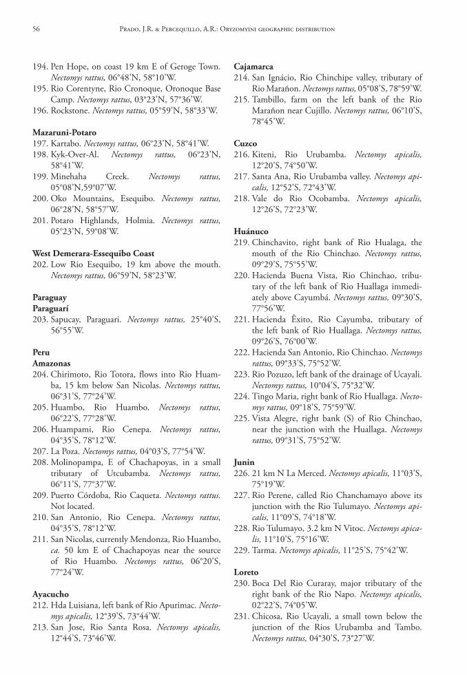
194. Pen Hope, on coast 19 km E of Geroge Town. Nectomys rattus, 06°48’N, 58°10’W.
195. Rio Corentyne, Rio Cronoque, Oronoque Base Camp. Nectomys rattus, 03°23’N, 57°36’W.
196. Rockstone. Nectomys rattus, 05°59’N, 58°33’W.
Mazaruni‑Potaro197. Kartabo. Nectomys rattus, 06°23’N, 58°41’W.198. Kyk-Over-Al. Nectomys rattus, 06°23’N,
58°41’W.199. Minehaha Creek. Nectomys rattus,
05°08’N,59°07’W.200. Oko Mountains, Esequibo. Nectomys rattus,
06°28’N, 58°57’W.201. Potaro Highlands, Holmia. Nectomys rattus,
05°23’N, 59°08’W.
West demerara‑essequibo coast202. Low Rio Esequibo, 19 km above the mouth.
Nectomys rattus, 06°59’N, 58°23’W.
ParaguayParaguarí203. Sapucay, Paraguari. Nectomys rattus, 25°40’S,
56°55’W.
PeruAmazonas204. Chirimoto, Rio Totora, flows into Rio Huam-
ba, 15 km below San Nicolas. Nectomys rattus, 06°31’S, 77°24’W.
205. Huambo, Rio Huambo. Nectomys rattus, 06°22’S, 77°28’W.
206. Huampami, Rio Cenepa. Nectomys rattus, 04°35’S, 78°12’W.
207. La Poza. Nectomys rattus, 04°03’S, 77°54’W.208. Molinopampa, E of Chachapoyas, in a small
tributary of Utcubamba. Nectomys rattus, 06°11’S, 77°37’W.
209. Puerto Córdoba, Rio Caqueta. Nectomys rattus. Not located.
210. San Antonio, Rio Cenepa. Nectomys rattus, 04°35’S, 78°12’W.
211. San Nicolas, currently Mendonza, Rio Huambo, ca. 50 km E of Chachapoyas near the source of Rio Huambo. Nectomys rattus, 06°20’S, 77°24’W.
Ayacucho212. Hda Luisiana, left bank of Rio Apurimac. Necto-
mys apicalis, 12°39’S, 73°44’W.213. San Jose, Rio Santa Rosa. Nectomys apicalis,
12°44’S, 73°46’W.
cajamarca214. San Ignácio, Rio Chinchipe valley, tributary of
Rio Marañon. Nectomys rattus, 05°08’S, 78°59’W.215. Tambillo, farm on the left bank of the Rio
Marañon near Cujillo. Nectomys rattus, 06°10’S, 78°45’W.
cuzco216. Kiteni, Rio Urubamba. Nectomys apicalis,
12°20’S, 74°50’W.217. Santa Ana, Rio Urubamba valley. Nectomys api-
calis, 12°52’S, 72°43’W.218. Vale do Rio Ocobamba. Nectomys apicalis,
12°26’S, 72°23’W.
huánuco219. Chinchavito, right bank of Rio Hualaga, the
mouth of the Rio Chinchao. Nectomys rattus, 09°29’S, 75°55’W.
220. Hacienda Buena Vista, Rio Chinchao, tribu-tary of the left bank of Rio Huallaga immedi-ately above Cayumbá. Nectomys rattus, 09°30’S, 77°56’W.
221. Hacienda Êxito, Rio Cayumba, tributary of the left bank of Rio Huallaga. Nectomys rattus, 09°26’S, 76°00’W.
222. Hacienda San Antonio, Rio Chinchao. Nectomys rattus, 09°33’S, 75°52’W.
223. Rio Pozuzo, left bank of the drainage of Ucayali. Nectomys rattus, 10°04’S, 75°32’W.
224. Tingo Maria, right bank of Rio Huallaga. Necto-mys rattus, 09°18’S, 75°59’W.
225. Vista Alegre, right bank (S) of Rio Chinchao, near the junction with the Huallaga. Nectomys rattus, 09°31’S, 75°52’W.
Junin226. 21 km N La Merced. Nectomys apicalis, 11°03’S,
75°19’W.227. Rio Perene, called Rio Chanchamayo above its
junction with the Rio Tulumayo. Nectomys api-calis, 11°09’S, 74°18’W.
228. Rio Tulumayo, 3.2 km N Vitoc. Nectomys apica-lis, 11°10’S, 75°16’W.
229. Tarma. Nectomys apicalis, 11°25’S, 75°42’W.
loreto230. Boca Del Rio Curaray, major tributary of the
right bank of the Rio Napo. Nectomys apicalis, 02°22’S, 74°05’W.
231. Chicosa, Rio Ucayali, a small town below the junction of the Rios Urubamba and Tambo. Nectomys rattus, 04°30’S, 73°27’W.
Prado, J.R. & Percequillo, A.R.: Oryzomyini geographic distribution56
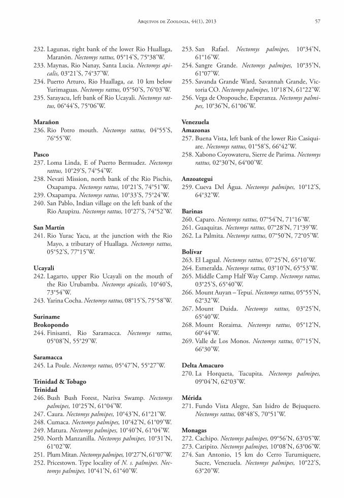
232. Lagunas, right bank of the lower Rio Huallaga, Maranõn. Nectomys rattus, 05°14’S, 75°38’W.
233. Maynas, Rio Nanay, Santa Lucia. Nectomys api-calis, 03°21’S, 74°37’W.
234. Puerto Arturo, Rio Huallaga, ca. 10 km below Yurimaguas. Nectomys rattus, 05°50’S, 76°03’W.
235. Sarayacu, left bank of Rio Ucayali. Nectomys rat-tus, 06°44’S, 75°06’W.
Marañon236. Rio Potro mouth. Nectomys rattus, 04°55’S,
76°55’W.
Pasco237. Loma Linda, E of Puerto Bermudez. Nectomys
rattus, 10°29’S, 74°54’W.238. Nevati Mission, north bank of the Rio Pischis,
Oxapampa. Nectomys rattus, 10°21’S, 74°51’W.239. Oxapampa. Nectomys rattus, 10°33’S, 75°24’W.240. San Pablo, Indian village on the left bank of the
Rio Azupizu. Nectomys rattus, 10°27’S, 74°52’W.
san Martín241. Rio Yurac Yacu, at the junction with the Rio
Mayo, a tributary of Huallaga. Nectomys rattus, 05°52’S, 77°15’W.
ucayali242. Lagarto, upper Rio Ucayali on the mouth of
the Rio Urubamba. Nectomys apicalis, 10°40’S, 73°54’W.
243. Yarina Cocha. Nectomys rattus, 08°15’S, 75°58’W.
surinamebrokopondo244. Finisanti, Rio Saramacca. Nectomys rattus,
05°08’N, 55°29’W.
saramacca245. La Poule. Nectomys rattus, 05°47’N, 55°27’W.
trinidad & tobagotrinidad246. Bush Bush Forest, Nariva Swamp. Nectomys
palmipes, 10°25’N, 61°04’W.247. Caura. Nectomys palmipes, 10°43’N, 61°21’W.248. Cumaca. Nectomys palmipes, 10°42’N, 61°09’W.249. Matura. Nectomys palmipes, 10°40’N, 61°04’W.250. North Manzanilla. Nectomys palmipes, 10°31’N,
61°02’W.251. Plum Mitan. Nectomys palmipes, 10°27’N, 61°07’W.252. Pricestown. Type locality of N. s. palmipes. Nec-
tomys palmipes, 10°41’N, 61°40’W.
253. San Rafael. Nectomys palmipes, 10°34’N, 61°16’W.
254. Sangre Grande. Nectomys palmipes, 10°35’N, 61°07’W.
255. Savanda Grande Ward, Savannah Grande, Vic-toria CO. Nectomys palmipes, 10°18’N, 61°22’W.
256. Vega de Oropouche, Esperanza. Nectomys palmi-pes, 10°36’N, 61°06’W.
VenezuelaAmazonas257. Buena Vista, left bank of the lower Rio Casiqui-
are. Nectomys rattus, 01°58’S, 66°42’W.258. Xabono Coyowateru, Sierre de Parima. Nectomys
rattus, 02°30’N, 64°00’W.
Anzoategui259. Cueva Del Água. Nectomys palmipes, 10°12’S,
64°32’W.
barinas260. Caparo. Nectomys rattus, 07°54’N, 71°16’W.261. Guaquitas. Nectomys rattus, 07°28’N, 71°39’W.262. La Palmita. Nectomys rattus, 07°50’N, 72°05’W.
bolívar263. El Lagual. Nectomys rattus, 07°25’N, 65°10’W.264. Esmeralda. Nectomys rattus, 03°10’N, 65°53’W.265. Middle Camp Half Way Camp. Nectomys rattus,
03°25’S, 65°40’W.266. Mount Auyan – Tepuí. Nectomys rattus, 05°55’N,
62°32’W.267. Mount Duida. Nectomys rattus, 03°25’N,
65°40’W.268. Mount Roraima. Nectomys rattus, 05°12’N,
60°44’W.269. Valle de Los Monos. Nectomys rattus, 07°15’N,
66°30’W.
delta Amacuro270. La Horqueta, Tucupita. Nectomys palmipes,
09°04’N, 62°03’W.
Mérida271. Fundo Vista Alegre, San Isidro de Bejuquero.
Nectomys rattus, 08°48’S, 70°51’W.
Monagas272. Cachipo. Nectomys palmipes, 09°56’N, 63°05’W.273. Caripito. Nectomys palmipes, 10°08’N, 63°06’W.274. San Antonio, 15 km do Cerro Turumiquere,
Sucre, Venezuela. Nectomys palmipes, 10°22’S, 63°20’W.
Arquivos de Zoologia, 44(1), 2013 57
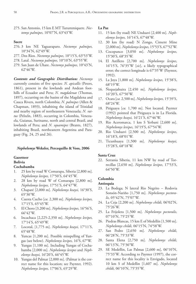
275. San Antonio, 15 km E MT Turummiquere. Nec-tomys palmipes, 10°07’N, 63°43’W.
sucre276. 3 km NE Yaguaraparo. Nectomys palmipes,
10°34’N, 62°49’W.277. Dos Rios. Nectomys palmipes, 10°15’S, 63°53’W.278. Latal. Nectomys palmipes, 10°10’N, 63°55’W.279. San Juan de Uhare. Nectomys palmipes, 10°43’N,
62°46’W.
Contents and Geographic Distribution: Nectomys currently consists of five species: N. apicallis (Peters, 1861), present in the lowlands and Andean foot-hills of Ecuador and Peru; N. magdalenae (Thomas, 1897), occurring on the basins of the Magdalena and Cauca Rivers, north Colombia; N. palmipes (Allen & Chapman, 1893), inhabiting the island of Trinidad and nearby region of northeastern Venezuela; N. rat-tus (Pelzeln, 1883), occurring in Colombia, Venezu-ela, Guianas, Suriname, north and central Brazil, and lowlands of Peru; and N. squamipes (Brants, 1827), inhabiting Brazil, northeastern Argentina and Para-guay (Fig. 24, 25 and 26).
Nephelomys Weksler, Percequillo & Voss, 2006
Gazetteerboliviacochabamba1. 25 km by road W Comarapa, Siberia [2,800 m].
Nephelomys levipes, 17°50’S, 64°45’W.2. 28 km by road W of Comarapa [2,800 m].
Nephelomys levipes, 17°51’S, 64°47’W.3. Chaparé [2,000 m]. Nephelomys keaysi, 16°30’S,
65°30’W.4. Cuesta Cucho [ca. 2,300 m]. Nephelomys levipes,
17°15’S, 65°45’W.5. El Choro [3,200 m]. Nephelomys levipes, 16°56’S,
66°42’W.6. Incachaca [2,225-2,350 m]. Nephelomys levipes,
17°14’S, 65°49’W.7. Locotal, [1,775 m]. Nephelomys keaysi, 17°11’S,
65°48’W.8. Yuncas [1,200 m]. Possible misspelling of Yun-
gas (see below). Nephelomys levipes, 16°S, 67°W.9. Yungas [1,100 m]. Including Yungas of Cocha-
bamba [2,000 m]. Nephelomys levipes and Neph-elomys keaysi, 16°20’S, 66°45’W.
10. Yungas del Palmar [2,000 m]. (Palmar is the cor-rect name for this location; see Paynter, 1992). Nephelomys levipes, 17°06’S, 65°29’W.
la Paz11. 15 km (by road) NE Unduavi [2,400 m]. Neph-
elomys levipes, 16°14’S, 67°48’W.12. 30 km (by road) N Zongo, Ciment Mine
[2,000 m]. Nephelomys levipes, 15°53’S, 67°52’W.13. Cocopunco [3,050 m]. Nephelomys levipes,
15°30’S, 68°35’W.14. El Astillero [2,700 m]. Nephelomys levipes,
16°15’S, 76°35’W [sic], a likely typographical error; the correct longitude is 67°35’W (Paynter, 1992).
15. La Joya [1,800 m]. Nephelomys levipes, 15°38’S, 68°19’W.
16. Ñequejahuira [2,450 m]. Nephelomys levipes, 16°20’S, 67°50’W.
17. Ocara [ca. 2,500 m]. Nephelomys levipes, 15°39’S, 68°24’W.
18. Pitiguaya [ca. 1,700 m]. Not located. Paynter (1992) pointed that Pitiguaya is in La Florida. Nephelomys keaysi, 16°21’S, 67°46’W.
19. Rio Aceromarca, 1 km S Yerbani [2,600 m]. Nephelomys levipes, 16°19’S, 67°54’W.
20. Rio Unduavi [2,500 m]. Nephelomys levipes, 16°18’S, 68°01’W.
21. Ticunhuaya [1,500 m]. Nephelomys keaysi, 15°28’S, 68°18’W.
santa cruz22. Serrania Siberia, 11 km NW by road of Tor-
recillas [2,650 m]. Nephelomys levipes, 17°53’S, 64°50’W.
colombiaAntioquia23. La Bodega; N lateral Rio Negrito – Rodovia
Sonsón-Nariño [1,750 m]. Nephelomys pectora-lis, 05°42’N, 75°07’W.
24. La Ceja [2,200 m]. Nephelomys childi, 06°02’N, 75°26’W.
25. La Frijolera [1,500 m]. Nephelomys pectoralis, 07°10’N, 75°25’W.
26. Piedras Blancas, 15 km E of Medellín [1,500 m]. Nephelomys childi, 06°15’N, 74°58’W.
27. San Pedro [2,650 m]. Nephelomys childi, 06°28’N, 75°33’W.
28. Santa Elena [2,750 m]. Nephelomys childi, 06°13’N, 75°30’W.
29. SE Medellin, Las Palmas [2,600 m], 06°10’N, 75°33’W. According to Paynter (1997), the cor-rect name for this locality is Envigado, located 10 km S of Medellin [1,607 m]. Nephelomys childi, 06°10’N, 75°35’W.
Prado, J.R. & Percequillo, A.R.: Oryzomyini geographic distribution58
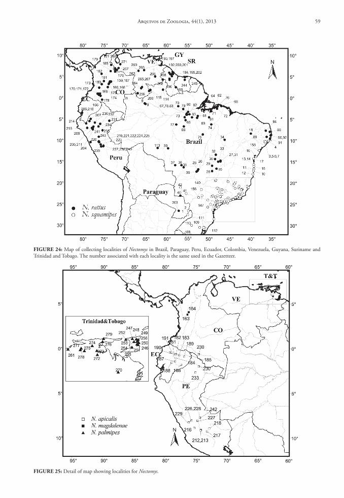
FIGure 25: Detail of map showing localities for Nectomys.
FIGure 24: Map of collecting localities of Nectomys in Brazil, Paraguay, Peru, Ecuador, Colombia, Venezuela, Guyana, Suriname and Trinidad and Tobago. The number associated with each locality is the same used in the Gazetteer.
Arquivos de Zoologia, 44(1), 2013 59
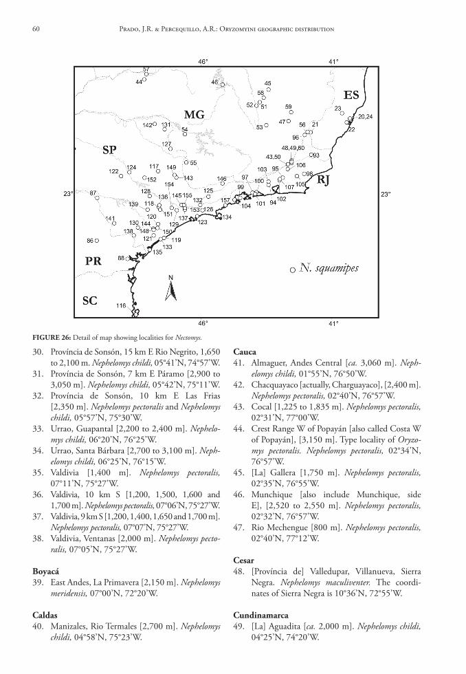
30. Província de Sonsón, 15 km E Rio Negrito, 1,650 to 2,100 m. Nephelomys childi, 05°41’N, 74°57’W.
31. Província de Sonsón, 7 km E Páramo [2,900 to 3,050 m]. Nephelomys childi, 05°42’N, 75°11’W.
32. Província de Sonsón, 10 km E Las Frias [2,350 m]. Nephelomys pectoralis and Nephelomys childi, 05°57’N, 75°30’W.
33. Urrao, Guapantal [2,200 to 2,400 m]. Nephelo-mys childi, 06°20’N, 76°25’W.
34. Urrao, Santa Bárbara [2,700 to 3,100 m]. Neph-elomys childi, 06°25’N, 76°15’W.
35. Valdivia [1,400 m]. Nephelomys pectoralis, 07°11’N, 75°27’W.
36. Valdivia, 10 km S [1,200, 1,500, 1,600 and 1,700 m]. Nephelomys pectoralis, 07°06’N, 75°27’W.
37. Valdivia, 9 km S [1,200, 1,400, 1,650 and 1,700 m]. Nephelomys pectoralis, 07°07’N, 75°27’W.
38. Valdivia, Ventanas [2,000 m]. Nephelomys pecto-ralis, 07°05’N, 75°27’W.
boyacá39. East Andes, La Primavera [2,150 m]. Nephelomys
meridensis, 07°00’N, 72°20’W.
caldas40. Manizales, Rio Termales [2,700 m]. Nephelomys
childi, 04°58’N, 75°23’W.
cauca41. Almaguer, Andes Central [ca. 3,060 m]. Neph-
elomys childi, 01°55’N, 76°50’W.42. Chacquayaco [actually, Charguayaco], [2,400 m].
Nephelomys pectoralis, 02°40’N, 76°57’W.43. Cocal [1,225 to 1,835 m]. Nephelomys pectoralis,
02°31’N, 77°00’W.44. Crest Range W of Popayán [also called Costa W
of Popayán], [3,150 m]. Type locality of Oryzo-mys pectoralis. Nephelomys pectoralis, 02°34’N, 76°57’W.
45. [La] Gallera [1,750 m]. Nephelomys pectoralis, 02°35’N, 76°55’W.
46. Munchique [also include Munchique, side E], [2,520 to 2,550 m]. Nephelomys pectoralis, 02°32’N, 76°57’W.
47. Rio Mechengue [800 m]. Nephelomys pectoralis, 02°40’N, 77°12’W.
cesar48. [Província de] Valledupar, Villanueva, Sierra
Negra. Nephelomys maculiventer. The coordi-nates of Sierra Negra is 10°36’N, 72°55’W.
cundinamarca49. [La] Aguadita [ca. 2,000 m]. Nephelomys childi,
04°25’N, 74°20’W.
FIGure 26: Detail of map showing localities for Nectomys.
Prado, J.R. & Percequillo, A.R.: Oryzomyini geographic distribution60
50. [Provínvia de] Guasca, Rio Balcones [2,720 m]. Nephelomys childi, 04°40’N, 73°33’W.
51. Anolaima [ca. 1,500 m]. Nephelomys pectoralis and Nephelomys childi, 04°46’N, 74°28’W.
52. Choachi [1,966 m]. Nephelomys childi, 04°32’N, 73°56’W.
53. Cuchillas del Carnisero, near Bogotá. Not lo-cated, see Planícies de Bogotá below. Nephelomys pectoralis.
54. El Berjon, near Bogotá. Not located, see Planí-cies de Bogotá below. Nephelomys childi.
55. Fusagasugá [1,830 m]. Nephelomys childi, 04°21’N, 74°22’W.
56. Paime [1,038 m]. Nephelomys childi, 05°22’N, 74°10’W.
57. Planícies de Bogotá [include near Bogotá], [2,590 m]. Type locality of Oryzomys childi. Nephelomys childi, 04°36’N, 74°05’W.
58. Rio San Francisco (Bogotá). Not located, see Planícies de Bogotá above. Nephelomys childi.
59. San Cristóbal, Bogotá [2,800 m]. San Cristóbal is a neighborhood of Bogotá. Not located.
60. San Francisco, Bogotá [3,400 m]. Nephelomys childi, 04°32’N, 73°18’W.
61. San Juan de Rio Seco [Rioseco], [1,303 m]. Nephelomys childi, 04°51’N, 74°38’W.
huíla62. Acevedo, Rio Aguas Claras, San Adolfo
[ca. 1,400-1,500 m]. Nephelomys childi, 01°49’N, 75°52’W.
63. Andalucia, E Andes [ca. 2,100 m]. Nephelomys childi, 01°54’N, 75°40’W.
64. El Parque Las Cuevas, [Includes 20 m pra den-tro da entrada da caverna indiana; 25 m pra dentro da entrada da caverna indiana; 50 m pra dentro de La Cueva de Guacharos]. This is the Parque Nacional Natural Cueva de Los Guacha-ros, ca. 50 km SE de San Agustin [ca. 2,000 m]. Nephelomys childi, 01°41’N, 76°02’W.
65. San Agustin, Rio Ovejera [2,350 m]. Nephelomys childi, 01°57’N, 76°29’W.
66. San Agustin, Rio Magdalena [left or right bank], [2,300 to 2,350 m]. Nephelomys childi, 01°53’N, 76°13’W.
67. San Agustin, San Antonio [2,200, 2,250, 2,300 to 2,400 m]. Nephelomys childi, 01°57’N, 76°29’W.
la Guajira68. Fonseca. Andes, Las Marimondas [ca. 1,000 m].
10°35’N, 72°45’W. A place located about 20 km SE of Fonseca (see Paynter, 1997) is
located in the following geographical coor-dinates. Nephelomys maculiventer, 10°45’N, 72°55’W.
69. Macotama [2,500 m]. Nephelomys maculiventer, 10°55’N, 73°30’W.
70. San Miguel [1,700 m]. Nephelomys maculiventer, 10°58’N, 73°29’W.
Magdalena71. Cerros San Lorenzo, San Lorenzo [ca. 2,600 m].
Nephelomys maculiventer, 11°10’N, 74°07’W.72. El Líbano e Sierra El Líbano [1,850 m]. Type
locality of Oryzomys maculiventer. Nephelomys maculiventer, 11°10’N, 74°00’W.
73. Las Taguas, Santa Marta. Nephelomys maculiven-ter, 11°06’N, 73°57’W.
74. Manzanares [915 m]. Nephelomys maculiventer, 11°14’N, 74°13’W.
75. Valparaíso [actually Cincinati], [1,480 m]. Nephelomys maculiventer, 11°06’N, 74°06’W.
Meta76. Buenavista, above Villavicencio, E Andes
[80 km] SE Bogotá [1,372.5 m]. Nephelomys childi, 04°10’N, 73°41’W.
77. La Macarena (Serrania de), Pico Renjifo [ca. 1,390 m]. Nephelomys childi, ca. 03°06’N, 73°55’W.
78. Macarena Mt. [1,140 m]. Nephelomys childi, 02°45’N, 73°55’W.
norte de santander79. Páramo de Tamá [2,440 m]. Nephelomys mer-
idensis, 07°25’N, 72°26’W.
Quindío80. El Roble [ca. 2,205 m] (Paynter, 1997). Nephelo-
mys pectoralis, 04°41’N, 75°36’W.81. W Quindio Andes, above Salento [ca. 2,775 m].
Nephelomys childi, 04°38’N, 75°34’W.82. W Quindio Andes, La Guneta [ca. 3,150 m].
Nephelomys childi, 04°35’N, 75°30’W.
tolima83. E Quindio Andes, El Edén [ca. 2,560 m] (Payn-
ter, 1997). Nephelomys childi, 04°30’N, 75°20’W.
Valle del cauca84. Las Lomitas [ca. 1,500 m]. Nephelomys pectoralis,
03°38’N, 76°38’W.85. Los Tambos [2,440 m]. Not located, “possibly
in the municipality of Pradera” (Paynter, 1997). Nephelomys childi, 03°25’N, 76°10’W.
Arquivos de Zoologia, 44(1), 2013 61
86. Mira Flores, near Palmira [1,891 m]. Nephelomys pectoralis, 03°35’N, 76°10’W.
87. Peñas Blancas, Rio Pichindé [1,800 m]. Nephelo-mys pectoralis, 03°27’N, 76°43’W.
88. Rio Dagua, or Naranjito, Rio Dagua, W. Colom-bia [1,200 m]. Nephelomys pectoralis, 03°47’N, 76°44’W.
89. San Antonio [1,750 m]. Nephelomys childi, 03°30’N, 76°38’W.
costa ricaAlajuela90. Lajas, Villa Quesada, 13 km by road San Carlos.
Nephelomys devius, 10°15’N, 84°26’W.91. Palmira de Zarcero. Nephelomys devius, 10°12’N,
84°23’W.92. Rio Poasito, highway Volcán Poás. Nephelomys
devius, 10°12’N, 84°23’W.93. Volcán Poás. Nephelomys devius, 10°11’N, 84°13’W.
cartago94. Cordillera de Talamanca, part of the Rio Ma-
cho, Villa Mills. Nephelomys devius, 09°33’N, 83°42’W.
95. Cordillera de Talamanca that extends towards NW/SE. Nephelomys devius, 09°30’N, 83°40’W.
96. El Muñeco (Rio Navarro), 10 km SO Cartago. Nephelomys devius, 09°47’N, 83°59’W.
97. Estrella de Cartago. Nephelomys devius, 09°47’N, 83°58’W.
98. Mt. Irazú. Nephelomys devius, 09°58’N, 83°51’W.99. Parque Nacional Volcán Irazú, Volcán Irazú.
Nephelomys devius, 09°58’N, 83°51’W.
heredia100. 2.4 km S Cariblanco. Nephelomys devius,
10°14’N, 84°11’W.101. 10 km NNE Heredia, Cerro Champipe. Neph-
elomys devius, 10°05’N, 84°05’W.102. Parque Nacional Braulio Carrillo. Nephelomys
devius, 10°17’N, 84°05’W.103. Parque Nacional Braulio Carrillo, 5 km E Vara
Blanca. Nephelomys devius, 10°10’N, 84°06’W.
Puntarenas104. Monteverde, Cerro Amigos. Nephelomys devius,
10°19’N, 84°48’W.105. Monteverde, Investigador. Nephelomys devius,
10°18’N, 84°48’W.106. Monteverde, Quebrada Cuecha. Nephelomys
devius, 10°18’N, 84°48’W.107. Protero Grande, Tres Colinas. Nephelomys devi-
us, 09°04’N, 83°05’W.
108. Reserva Bosque Nuboso Monteverde, 0.5 km below Ventana. Nephelomys devius, 10°18’N, 84°48’W.
san José109. 0.5 km N El Empalme. Nephelomys devius,
09°45’N, 83°57’W.110. 2.2 km E La Trinidad de Dota. Nephelomys devi-
us, 09°49’N, 84°01’W.111. 4 km S, 2 km E, Ojo de Agua. Nephelomys devi-
us, 09°34’N, 83°48’W.112. N San Isidro del General. Nephelomys devius,
09°50’N, 83°59’W.113. Cerro de La Muerte. Nephelomys devius, 09°34’N,
83°31’W.114. Cerro Estaquero. Nephelomys devius, 09°36’N,
83°46’W.115. Fila La Maquina, ca. 3 km E Canaán. Nephelo-
mys devius, 09°28’N, 83°35’W.116. La Piedra, ca. 4.5 km SW Cerro Chirripó. Neph-
elomys devius, 09°27’N, 83°28’W.
ecuadorAzuay117. Las Cajas, Yacutuviana [2,300 m]. Nephelomys
albigularis, 02°49’S, 79°16’W.118. Mazán, Cuenca [2,700 m]. Nephelomys albigula-
ris, 02°52’S, 79°16’W.119. Molleturo [ca. 2,280 m]. Nephelomys albigularis,
02°48’S, 79°26’W.
bolívar120. Carmen, near Sinchic [ca. 2,290 m]. Not locat-
ed, we used the geographic coordinates of Sinch-ic, also spelled Sinchig and Sinche. Nephelomys albigularis, 01°32’S, 78°59’W.
cañar121. Chical (also spelled Shical), [ca. 3,075 m]. Neph-
elomys albigularis, 02°24’S, 78°58’W.122. Hoyaucshi. Not located.
chimborazo123. 4 km NE Pallatanga [ca. 2,225 m]. Nephelomys
albigularis, 01°57’S, 78°55’W.124. Pallatanga [1,509 m]. Type locality of Oryzo-
mys albigularis. Nephelomys albigularis, 01°59’S, 78°57’W.
el oro125. Above Salvias, Cordillera da Chilla, on the
trail of Salvias to Zaragoza, Llano de Guavos [2,013 m]. Not located. See coordinates below. Nephelomys albigularis.
Prado, J.R. & Percequillo, A.R.: Oryzomyini geographic distribution62
126. Cordillera de Chilla, Taraguacocha [2,950 m]. Nephelomys albigularis, 03°40’S, 79°40’W.
127. El Chiral [1,625 m]. Nephelomys albigularis, 03°38’S, 79°41’W.
128. Salvias, Rio Amarillo [ca. 1,050 m] [include Salvias, the way to Zaraguro, 365 m above Sal-vias] [1,450 m]. Nephelomys albigularis, 03°39’S, 79°36’W.
loja129. 8 km W de Loja [2,200 m]. Nephelomys albigula-
ris, 04°00’S, 79°17’W.130. Alamor [1,325 m]. Nephelomys albigularis,
04°02’S, 80°02’W.131. Celica [2,100 m]. Nephelomys albigularis,
04°07’S, 79°59’W.132. Guachanamá, 10 km ENE de Celica; SE Loja
[ca. 2,760 m]. Nephelomys albigularis, 04°02’S, 79°53’W.
133. Quebrada de La Mina, elevation about 125 m above Loja [2,318 m]. Not located, we used the geographic coordinates of Loja. Nephelomys al-bigularis, 04°00’S, 79°13’W.
napo134. Baeza [1,525 m]. Nephelomys nimbosus, 00°27’S,
77°53’W.135. Baeza, by road to Napo [1,830 m]. See location
above. Nephelomys nimbosus.136. Chaco, Río Oyacachi. The proper name for this
locality is El Chaco [1,615 m] (Paynter, 1993). Nephelomys nimbosus, 00°23’S, 77°49’W.
Pastaza137. Chonta-Urcu – E [1,500 m]. Not located.138. Mera [1,140 m]. Nephelomys auriventer, 01°28’S,
78°08’W.
Pichincha139. Alaspungo, Road to Gualea [2,745 m]. Nephelo-
mys moerex, 00°00’S, 78°36’W.140. El Placer, P. Mindo. Not located. See the geograph-
ic coordinates of Mindo, below. Nephelomys moerex.141. Gualea [1,525 m]. Nephelomys moerex, 00°07’N,
78°50’W.142. Guarumos, W Pichincha [2,000 m]. See Guaru-
mos, way to Mindo bellow. Nephelomys moerex.143. Las Maquinas, pathway to San Domingo
[2,135 m]. Also called Las Machinas. Nephelo-mys moerex, 00°28’S, 78°44’W.
144. Mindo [1,281 to 1,285 m]. Type locality of Oryzomys albigularis moerex. Nephelomys moerex, 00°03’S, 78°46’W.
145. Nanegal [road], [1,525 m]. Nephelomys moerex, 00°07’N, 78°40’W.
146. Near Mindo [1,220 m]. Not located. See Min-do, above. Nephelomys moerex.
147. Occidente, El Guarumal [2,245-2,290 m]. Nephelomys moerex, 00°16’S, 78°43’W.
148. Occidente, Guarumos, pathway to Mindo [1,200 m]. Nephelomys moerex, 00°04’S, 78°38’W.
149. Old pathway to Santo Domingo, ca. 2.5 km N (by road) Guarumal [1,982.5 m]. See Guarumal above. Nephelomys moerex.
150. Rio Tulipe, Gualea [1,200 m]. Nephelomys mo-erex, 00°05’N, 78°47’W.
151. San Jose, Oeste de Pichincha [2,800 m]. Neph-elomys moerex, 00°10’N, 78°25’W.
152. San Tadeo, via Mindo [1,600 m] [include San Fadeo]. Nephelomys moerex, 00°01’N, 78°48’W.
153. Valle Ilambo, Gualea [1,800 m]. Not located, here we used the geographic coordinates of Gua-lea (see above). Nephelomys moerex.
154. Zapadores, Rio Saloya [1,952 m]. Nephelomys moerex, 00°14’S, 78°44’W.
tungurahua155. Mirador, Baños [1,500 m]. Type locality of Ory-
zomys auriventer. Nephelomys auriventer, 01°26’S, 78°15’W.
156. Palmera [1,300 m]. Nephelomys auriventer, 01°25’S, 78°12’W.
157. San Antonio [2,051.7 m]. Type locality of Ory-zomys auriventer nimbosus. Nephelomys nimbosus, 01°26’S, 78°22’W.
158. San Francisco, E de Amabato [= Ambato], [2,440 m]. Not located, here we used the geo-graphic coordinates of Ambato. Nephelomys nim-bosus, 01°15’S, 78°37’W.
Panamábocas del toro159. 25 km NNE San Felix. Nephelomys devius,
08°30’N, 81°49’W.160. Fish Camp. Nephelomys devius, 08°58’N, 82°40’W.161. First Camp. Nephelomys devius, 08°56’N, 82°42’W.162. Rio Changuena, Rancho Mojica. Nephelomys
devius, 09°10’N, 82°35’W.
chiriquí163. 14.5 km NW Finca Santa Clara, El Volcán.
Nephelomys devius, 08°51’N, 82°44’W.164. 15.5 km NNW Osta Clara. Nephelomys devius,
08°52’N, 82°44’W.165. 17 km NNW headwaters of the Rio Candela, El
Volcán. Nephelomys devius, 08°54’N, 82°43’W.
Arquivos de Zoologia, 44(1), 2013 63
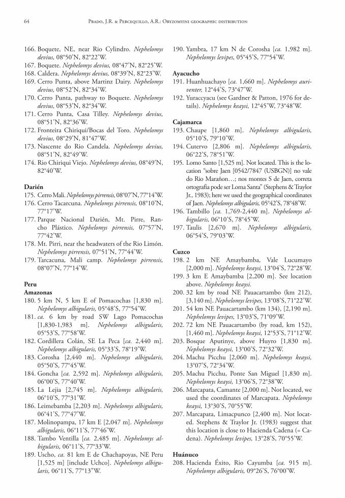
166. Boquete, NE, near Rio Cylindro. Nephelomys devius, 08°50’N, 82°22’W.
167. Boquete. Nephelomys devius, 08°47’N, 82°25’W.168. Caldera. Nephelomys devius, 08°39’N, 82°23’W.169. Cerro Punta, above Martinz Dairy. Nephelomys
devius, 08°52’N, 82°34’W.170. Cerro Punta, pathway to Boquete. Nephelomys
devius, 08°53’N, 82°34’W.171. Cerro Punta, Casa Tilley. Nephelomys devius,
08°51’N, 82°36’W.172. Fronteira Chiriqui/Bocas del Toro. Nephelomys
devius, 08°29’N, 81°47’W.173. Nascente do Rio Candela. Nephelomys devius,
08°51’N, 82°49’W.174. Rio Chiriqui Viejo. Nephelomys devius, 08°49’N,
82°40’W.
darién175. Cerro Mali. Nephelomys pirrensis, 08°07’N, 77°14’W.176. Cerro Tacarcuna. Nephelomys pirrensis, 08°10’N,
77°17’W.177. Parque Nacional Darién, Mt. Pirre, Ran-
cho Plástico. Nephelomys pirrensis, 07°57’N, 77°42’W.
178. Mt. Pirri, near the headwaters of the Rio Limón. Nephelomys pirrensis, 07°51’N, 77°44’W.
179. Tarcacuna, Mali camp. Nephelomys pirrensis, 08°07’N, 77°14’W.
PeruAmazonas180. 5 km N, 5 km E of Pomacochas [1,830 m].
Nephelomys albigularis, 05°48’S, 77°54’W.181. ca. 6 km by road SW Lago Pomacochas
[1,830-1,983 m]. Nephelomys albigularis, 05°53’S, 77°58’W.
182. Cordillera Colán, SE La Peca [ca. 2,440 m]. Nephelomys albigularis, 05°33’S, 78°19’W.
183. Corosha [2,440 m]. Nephelomys albigularis, 05°50’S, 77°45’W.
184. Goncha [ca. 2,592 m]. Nephelomys albigularis, 06°00’S, 77°40’W.
185. La Lejia [2,745 m]. Nephelomys albigularis, 06°10’S, 77°31’W.
186. Leimebamba [2,203 m]. Nephelomys albigularis, 06°41’S, 77°47’W.
187. Molinopampa, 17 km E [2,047 m]. Nephelomys albigularis, 06°11’S, 77°46’W.
188. Tambo Ventilla [ca. 2,485 m]. Nephelomys al-bigularis, 06°11’S, 77°33’W.
189. Uscho, ca. 81 km E de Chachapoyas, NE Peru [1,525 m] [include Uchco]. Nephelomys albigu-laris, 06°11’S, 77°13”W.
190. Yambra, 17 km N de Corosha [ca. 1,982 m]. Nephelomys levipes, 05°45’S, 77°54’W.
Ayacucho191. Huanhuachayo [ca. 1,660 m]. Nephelomys auri-
venter, 12°44’S, 73°47’W.192. Yuraccyacu (see Gardner & Patton, 1976 for de-
tails). Nephelomys keaysi, 12°45’W, 73°48’W.
cajamarca193. Chaupe [1,860 m]. Nephelomys albigularis,
05°10’S, 79°10’W.194. Cutervo [2,806 m]. Nephelomys albigularis,
06°22’S, 78°51’W.195. Lomo Santo [1,525 m]. Not located. This is the lo-
cation “sobre Jaen [0542/7847 (USBGN)] no vale do Rio Marañon…; nos montes S de Jaen, correta ortografia pode ser Loma Santa” (Stephens & Traylor Jr., 1983); here we used the geographical coordinates of Jaen. Nephelomys albigularis, 05°42’S, 78°48’W.
196. Tambillo [ca. 1,769-2,440 m]. Nephelomys al-bigularis, 06°10’S, 78°45’W.
197. Taulis [2,670 m]. Nephelomys albigularis, 06°54’S, 79°03’W.
cuzco198. 2 km NE Amaybamba, Vale Lucumayo
[2,000 m]. Nephelomys keaysi, 13°04’S, 72°28’W.199. 3 km E Amaybamba [2,200 m]. See location
above. Nephelomys keaysi.200. 32 km by road NE Pauacartambo (km 212),
[3,140 m]. Nephelomys levipes, 13°08’S, 71°22’W.201. 54 km NE Pauacartambo (km 134), [2,190 m].
Nephelomys levipes, 13°03’S, 71°09’W.202. 72 km NE Pauacartambo (by road, km 152),
[1,460 m]. Nephelomys keaysi, 12°53’S, 71°12’W.203. Bosque Aputinye, above Huyro [1,830 m].
Nephelomys keaysi, 13°00’S, 72°32’W.204. Machu Picchu [2,060 m]. Nephelomys keaysi,
13°07’S, 72°34’W.205. Machu Picchu, Ponte San Miguel [1,830 m].
Nephelomys keaysi, 13°06’S, 72°38’W.206. Marcapata, Camante [2,000 m]. Not located, we
used the coordinates of Marcapata. Nephelomys keaysi, 13°30’S, 70°55’W.
207. Marcapata, Limacpunco [2,400 m]. Not locat-ed. Stephens & Traylor Jr. (1983) suggest that this location is close to Hacienda Cadena (= Ca-dena). Nephelomys levipes, 13°28’S, 70°55’W.
huánuco208. Hacienda Éxito, Rio Cayumba [ca. 915 m].
Nephelomys albigularis, 09°26’S, 76°00’W.
Prado, J.R. & Percequillo, A.R.: Oryzomyini geographic distribution64
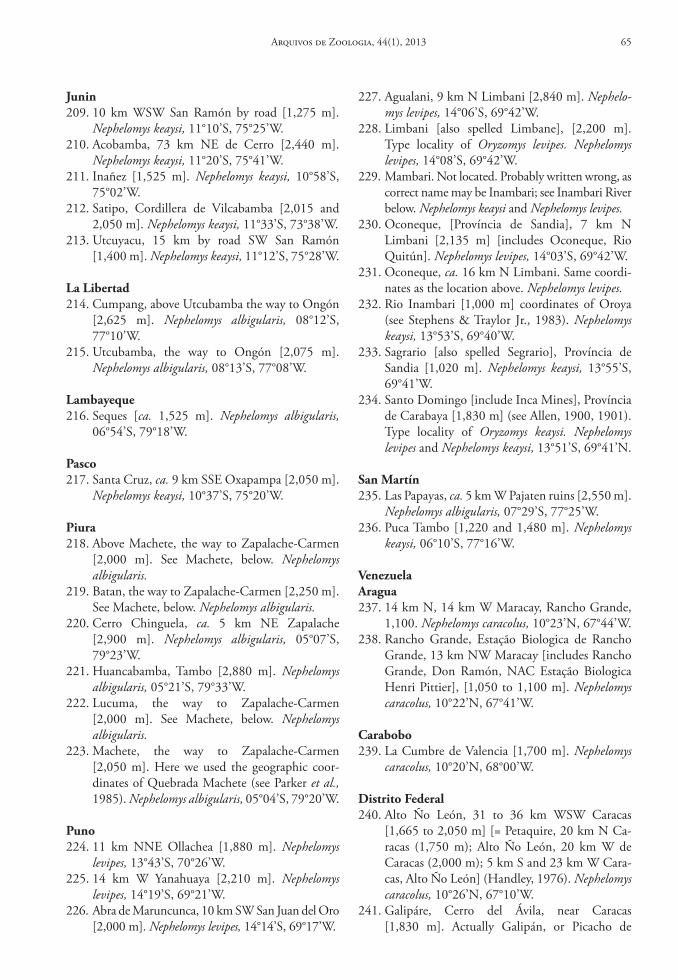
Junin209. 10 km WSW San Ramón by road [1,275 m].
Nephelomys keaysi, 11°10’S, 75°25’W.210. Acobamba, 73 km NE de Cerro [2,440 m].
Nephelomys keaysi, 11°20’S, 75°41’W.211. Inañez [1,525 m]. Nephelomys keaysi, 10°58’S,
75°02’W.212. Satipo, Cordillera de Vilcabamba [2,015 and
2,050 m]. Nephelomys keaysi, 11°33’S, 73°38’W.213. Utcuyacu, 15 km by road SW San Ramón
[1,400 m]. Nephelomys keaysi, 11°12’S, 75°28’W.
la libertad214. Cumpang, above Utcubamba the way to Ongón
[2,625 m]. Nephelomys albigularis, 08°12’S, 77°10’W.
215. Utcubamba, the way to Ongón [2,075 m]. Nephelomys albigularis, 08°13’S, 77°08’W.
lambayeque216. Seques [ca. 1,525 m]. Nephelomys albigularis,
06°54’S, 79°18’W.
Pasco217. Santa Cruz, ca. 9 km SSE Oxapampa [2,050 m].
Nephelomys keaysi, 10°37’S, 75°20’W.
Piura218. Above Machete, the way to Zapalache-Carmen
[2,000 m]. See Machete, below. Nephelomys albigularis.
219. Batan, the way to Zapalache-Carmen [2,250 m]. See Machete, below. Nephelomys albigularis.
220. Cerro Chinguela, ca. 5 km NE Zapalache [2,900 m]. Nephelomys albigularis, 05°07’S, 79°23’W.
221. Huancabamba, Tambo [2,880 m]. Nephelomys albigularis, 05°21’S, 79°33’W.
222. Lucuma, the way to Zapalache-Carmen [2,000 m]. See Machete, below. Nephelomys albigularis.
223. Machete, the way to Zapalache-Carmen [2,050 m]. Here we used the geographic coor-dinates of Quebrada Machete (see Parker et al., 1985). Nephelomys albigularis, 05°04’S, 79°20’W.
Puno224. 11 km NNE Ollachea [1,880 m]. Nephelomys
levipes, 13°43’S, 70°26’W.225. 14 km W Yanahuaya [2,210 m]. Nephelomys
levipes, 14°19’S, 69°21’W.226. Abra de Maruncunca, 10 km SW San Juan del Oro
[2,000 m]. Nephelomys levipes, 14°14’S, 69°17’W.
227. Agualani, 9 km N Limbani [2,840 m]. Nephelo-mys levipes, 14°06’S, 69°42’W.
228. Limbani [also spelled Limbane], [2,200 m]. Type locality of Oryzomys levipes. Nephelomys levipes, 14°08’S, 69°42’W.
229. Mambari. Not located. Probably written wrong, as correct name may be Inambari; see Inambari River below. Nephelomys keaysi and Nephelomys levipes.
230. Oconeque, [Província de Sandia], 7 km N Limbani [2,135 m] [includes Oconeque, Rio Quitún]. Nephelomys levipes, 14°03’S, 69°42’W.
231. Oconeque, ca. 16 km N Limbani. Same coordi-nates as the location above. Nephelomys levipes.
232. Rio Inambari [1,000 m] coordinates of Oroya (see Stephens & Traylor Jr., 1983). Nephelomys keaysi, 13°53’S, 69°40’W.
233. Sagrario [also spelled Segrario], Província de Sandia [1,020 m]. Nephelomys keaysi, 13°55’S, 69°41’W.
234. Santo Domingo [include Inca Mines], Província de Carabaya [1,830 m] (see Allen, 1900, 1901). Type locality of Oryzomys keaysi. Nephelomys levipes and Nephelomys keaysi, 13°51’S, 69°41’N.
san Martín235. Las Papayas, ca. 5 km W Pajaten ruins [2,550 m].
Nephelomys albigularis, 07°29’S, 77°25’W.236. Puca Tambo [1,220 and 1,480 m]. Nephelomys
keaysi, 06°10’S, 77°16’W.
VenezuelaAragua237. 14 km N, 14 km W Maracay, Rancho Grande,
1,100. Nephelomys caracolus, 10°23’N, 67°44’W.238. Rancho Grande, Estação Biologica de Rancho
Grande, 13 km NW Maracay [includes Rancho Grande, Don Ramón, NAC Estação Biologica Henri Pittier], [1,050 to 1,100 m]. Nephelomys caracolus, 10°22’N, 67°41’W.
carabobo239. La Cumbre de Valencia [1,700 m]. Nephelomys
caracolus, 10°20’N, 68°00’W.
distrito Federal240. Alto Ño León, 31 to 36 km WSW Caracas
[1,665 to 2,050 m] [= Petaquire, 20 km N Ca-racas (1,750 m); Alto Ño León, 20 km W de Caracas (2,000 m); 5 km S and 23 km W Cara-cas, Alto Ño León] (Handley, 1976). Nephelomys caracolus, 10°26’N, 67°10’W.
241. Galipáre, Cerro del Ávila, near Caracas [1,830 m]. Actually Galipán, or Picacho de
Arquivos de Zoologia, 44(1), 2013 65
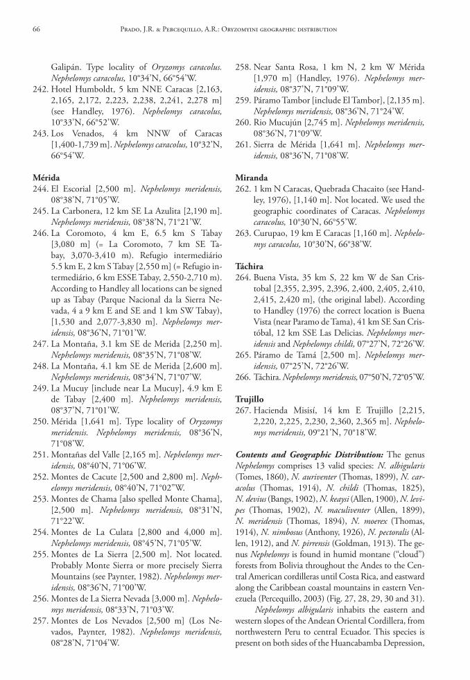
Galipán. Type locality of Oryzomys caracolus. Nephelomys caracolus, 10°34’N, 66°54’W.
242. Hotel Humboldt, 5 km NNE Caracas [2,163, 2,165, 2,172, 2,223, 2,238, 2,241, 2,278 m] (see Handley, 1976). Nephelomys caracolus, 10°33’N, 66°52’W.
243. Los Venados, 4 km NNW of Caracas [1,400-1,739 m]. Nephelomys caracolus, 10°32’N, 66°54’W.
Mérida244. El Escorial [2,500 m]. Nephelomys meridensis,
08°38’N, 71°05’W.245. La Carbonera, 12 km SE La Azulita [2,190 m].
Nephelomys meridensis, 08°38’N, 71°21’W.246. La Coromoto, 4 km E, 6.5 km S Tabay
[3,080 m] (= La Coromoto, 7 km SE Ta-bay, 3,070-3,410 m). Refugio intermediário 5.5 km E, 2 km S Tabay [2,550 m] (= Refugio in-termediário, 6 km ESSE Tabay, 2,550-2,710 m). According to Handley all locations can be signed up as Tabay (Parque Nacional da la Sierra Ne-vada, 4 a 9 km E and SE and 1 km SW Tabay), [1,530 and 2,077-3,830 m]. Nephelomys mer-idensis, 08°36’N, 71°01’W.
247. La Montaña, 3.1 km SE de Merida [2,250 m]. Nephelomys meridensis, 08°35’N, 71°08’W.
248. La Montaña, 4.1 km SE de Merida [2,600 m]. Nephelomys meridensis, 08°34’N, 71°07’W.
249. La Mucuy [include near La Mucuy], 4.9 km E de Tabay [2,400 m]. Nephelomys meridensis, 08°37’N, 71°01’W.
250. Mérida [1,641 m]. Type locality of Oryzomys meridensis. Nephelomys meridensis, 08°36’N, 71°08’W.
251. Montañas del Valle [2,165 m]. Nephelomys mer-idensis, 08°40’N, 71°06’W.
252. Montes de Cacute [2,500 and 2,800 m]. Neph-elomys meridensis, 08°40’N, 71°02”W.
253. Montes de Chama [also spelled Monte Chama], [2,500 m]. Nephelomys meridensis, 08°31’N, 71°22’W.
254. Montes de La Culata [2,800 and 4,000 m]. Nephelomys meridensis, 08°45’N, 71°05’W.
255. Montes de La Sierra [2,500 m]. Not located. Probably Monte Sierra or more precisely Sierra Mountains (see Paynter, 1982). Nephelomys mer-idensis, 08°36’N, 71°00’W.
256. Montes de La Sierra Nevada [3,000 m]. Nephelo-mys meridensis, 08°33’N, 71°03’W.
257. Montes de Los Nevados [2,500 m] (Los Ne-vados, Paynter, 1982). Nephelomys meridensis, 08°28’N, 71°04’W.
258. Near Santa Rosa, 1 km N, 2 km W Mérida [1,970 m] (Handley, 1976). Nephelomys mer-idensis, 08°37’N, 71°09’W.
259. Páramo Tambor [include El Tambor], [2,135 m]. Nephelomys meridensis, 08°36’N, 71°24’W.
260. Rio Mucujún [2,745 m]. Nephelomys meridensis, 08°36’N, 71°09’W.
261. Sierra de Mérida [1,641 m]. Nephelomys mer-idensis, 08°36’N, 71°08’W.
Miranda262. 1 km N Caracas, Quebrada Chacaito (see Hand-
ley, 1976), [1,140 m]. Not located. We used the geographic coordinates of Caracas. Nephelomys caracolus, 10°30’N, 66°55’W.
263. Curupao, 19 km E Caracas [1,160 m]. Nephelo-mys caracolus, 10°30’N, 66°38’W.
táchira264. Buena Vista, 35 km S, 22 km W de San Cris-
tobal [2,355, 2,395, 2,396, 2,400, 2,405, 2,410, 2,415, 2,420 m], (the original label). According to Handley (1976) the correct location is Buena Vista (near Paramo de Tama), 41 km SE San Cris-tóbal, 12 km SSE Las Delicias. Nephelomys mer-idensis and Nephelomys childi, 07°27’N, 72°26’W.
265. Páramo de Tamá [2,500 m]. Nephelomys mer-idensis, 07°25’N, 72°26’W.
266. Táchira. Nephelomys meridensis, 07°50’N, 72°05’W.
trujillo267. Hacienda Misisí, 14 km E Trujillo [2,215,
2,220, 2,225, 2,230, 2,360, 2,365 m]. Nephelo-mys meridensis, 09°21’N, 70°18’W.
Contents and Geographic Distribution: The genus Nephelomys comprises 13 valid species: N. albigularis (Tomes, 1860), N. auriventer (Thomas, 1899), N. car-acolus (Thomas, 1914), N. childi (Thomas, 1825), N. devius (Bangs, 1902), N. keaysi (Allen, 1900), N. levi-pes (Thomas, 1902), N. maculiventer (Allen, 1899), N. meridensis (Thomas, 1894), N. moerex (Thomas, 1914), N. nimbosus (Anthony, 1926), N. pectoralis (Al-len, 1912), and N. pirrensis (Goldman, 1913). The ge-nus Nephelomys is found in humid montane (‘‘cloud”) forests from Bolivia throughout the Andes to the Cen-tral American cordilleras until Costa Rica, and eastward along the Caribbean coastal mountains in eastern Ven-ezuela (Percequillo, 2003) (Fig. 27, 28, 29, 30 and 31).
Nephelomys albigularis inhabits the eastern and western slopes of the Andean Oriental Cordillera, from northwestern Peru to central Ecuador. This species is present on both sides of the Huancabamba Depression,
Prado, J.R. & Percequillo, A.R.: Oryzomyini geographic distribution66
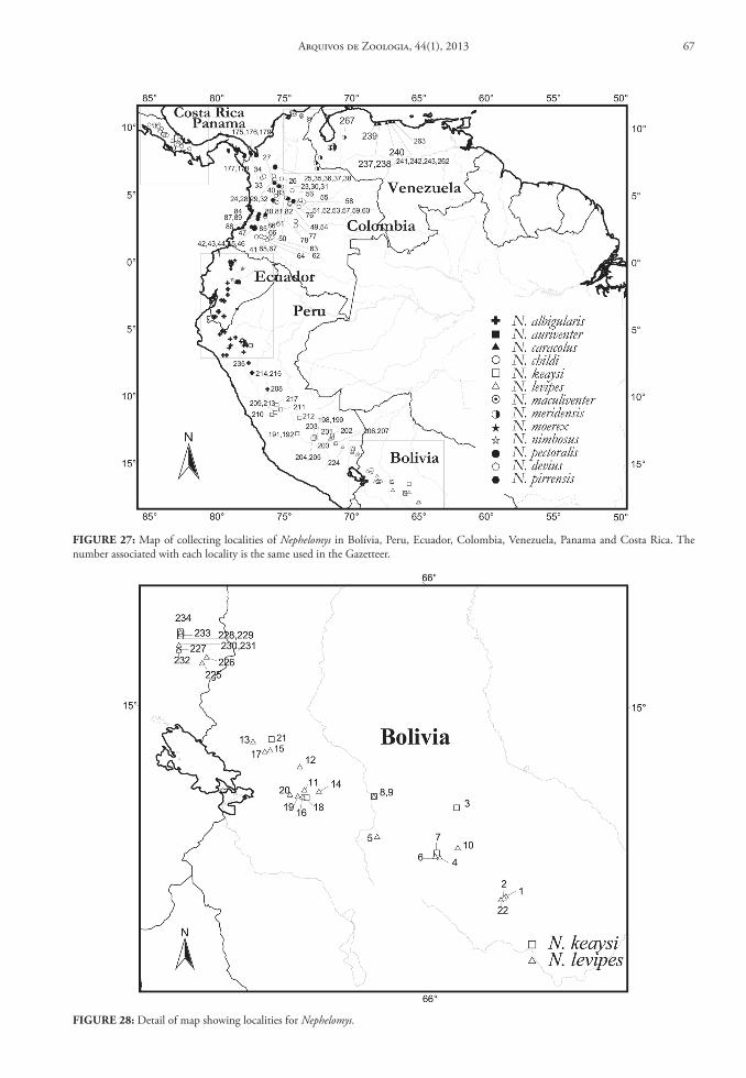
FIGure 27: Map of collecting localities of Nephelomys in Bolívia, Peru, Ecuador, Colombia, Venezuela, Panama and Costa Rica. The number associated with each locality is the same used in the Gazetteer.
FIGure 28: Detail of map showing localities for Nephelomys.
Arquivos de Zoologia, 44(1), 2013 67
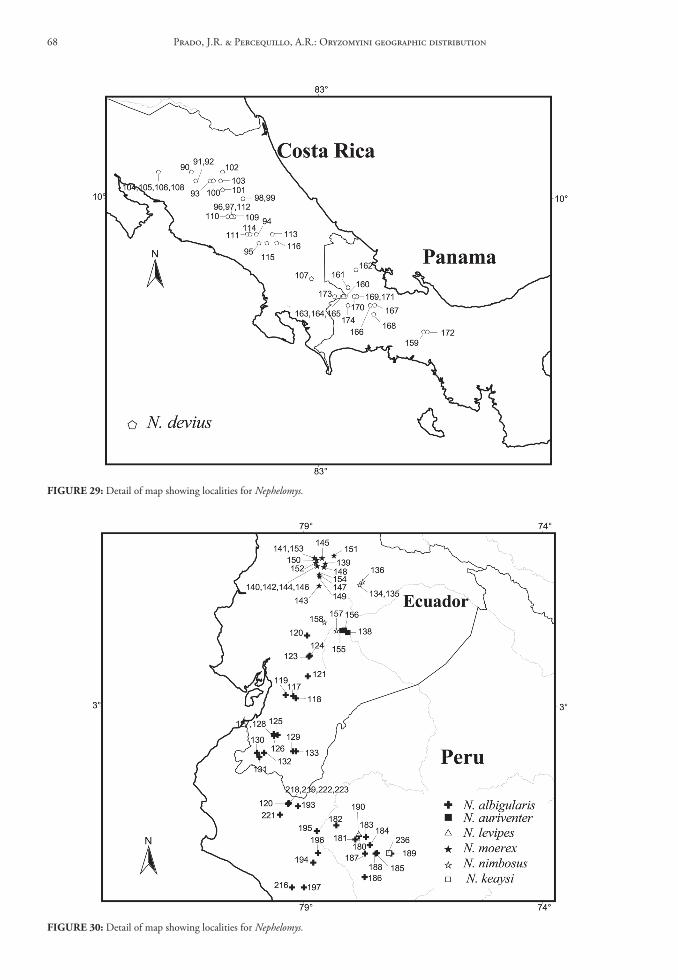
FIGure 29: Detail of map showing localities for Nephelomys.
FIGure 30: Detail of map showing localities for Nephelomys.
Prado, J.R. & Percequillo, A.R.: Oryzomyini geographic distribution68
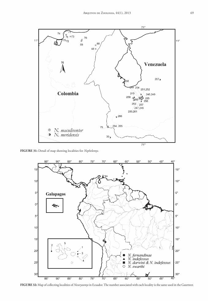
FIGure 31: Detail of map showing localities for Nephelomys.
FIGure 32: Map of collecting localities of Nesoryzomys in Ecuador. The number associated with each locality is the same used in the Gazetteer.
Arquivos de Zoologia, 44(1), 2013 69
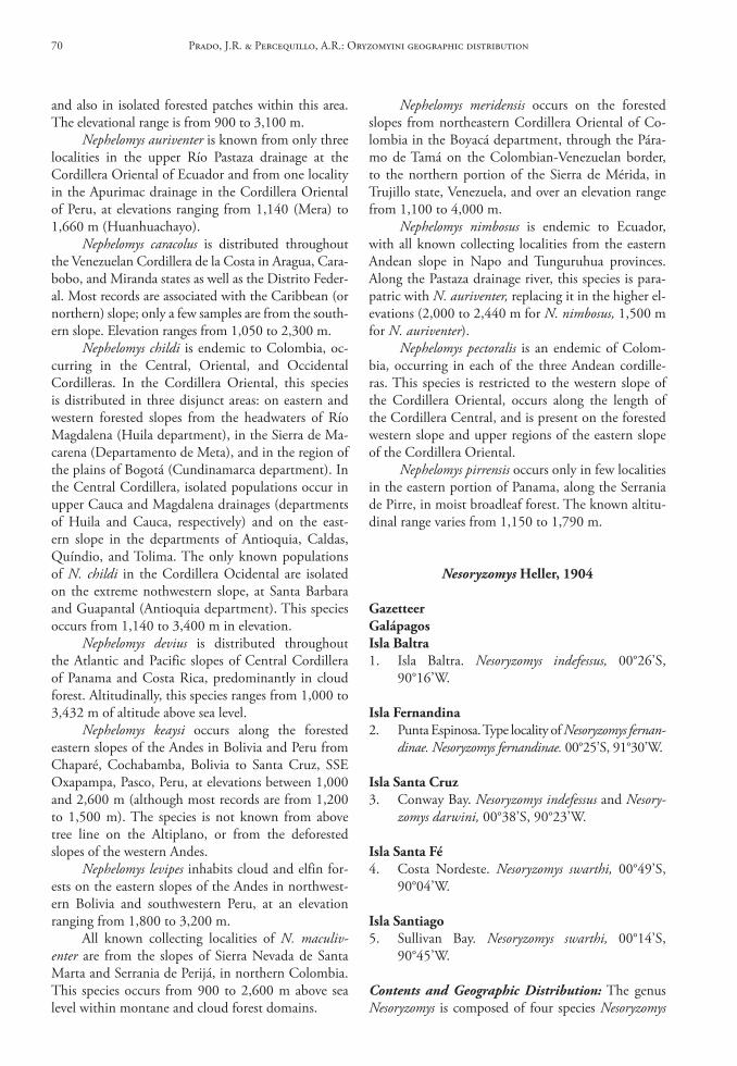
and also in isolated forested patches within this area. The elevational range is from 900 to 3,100 m.
Nephelomys auriventer is known from only three localities in the upper Río Pastaza drainage at the Cordillera Oriental of Ecuador and from one locality in the Apurimac drainage in the Cordillera Oriental of Peru, at elevations ranging from 1,140 (Mera) to 1,660 m (Huanhuachayo).
Nephelomys caracolus is distributed throughout the Venezuelan Cordillera de la Costa in Aragua, Cara-bobo, and Miranda states as well as the Distrito Feder-al. Most records are associated with the Caribbean (or northern) slope; only a few samples are from the south-ern slope. Elevation ranges from 1,050 to 2,300 m.
Nephelomys childi is endemic to Colombia, oc-curring in the Central, Oriental, and Occidental Cordilleras. In the Cordillera Oriental, this species is distributed in three disjunct areas: on eastern and western forested slopes from the headwaters of Río Magdalena (Huila department), in the Sierra de Ma-carena (Departamento de Meta), and in the region of the plains of Bogotá (Cundinamarca department). In the Central Cordillera, isolated populations occur in upper Cauca and Magdalena drainages (departments of Huila and Cauca, respectively) and on the east-ern slope in the departments of Antioquia, Caldas, Quíndio, and Tolima. The only known populations of N. childi in the Cordillera Ocidental are isolated on the extreme nothwestern slope, at Santa Barbara and Guapantal (Antioquia department). This species occurs from 1,140 to 3,400 m in elevation.
Nephelomys devius is distributed throughout the Atlantic and Pacific slopes of Central Cordillera of Panama and Costa Rica, predominantly in cloud forest. Altitudinally, this species ranges from 1,000 to 3,432 m of altitude above sea level.
Nephelomys keaysi occurs along the forested eastern slopes of the Andes in Bolivia and Peru from Chaparé, Cochabamba, Bolivia to Santa Cruz, SSE Oxapampa, Pasco, Peru, at elevations between 1,000 and 2,600 m (although most records are from 1,200 to 1,500 m). The species is not known from above tree line on the Altiplano, or from the deforested slopes of the western Andes.
Nephelomys levipes inhabits cloud and elfin for-ests on the eastern slopes of the Andes in northwest-ern Bolivia and southwestern Peru, at an elevation ranging from 1,800 to 3,200 m.
All known collecting localities of N. maculiv-enter are from the slopes of Sierra Nevada de Santa Marta and Serrania de Perijá, in northern Colombia. This species occurs from 900 to 2,600 m above sea level within montane and cloud forest domains.
Nephelomys meridensis occurs on the forested slopes from northeastern Cordillera Oriental of Co-lombia in the Boyacá department, through the Pára-mo de Tamá on the Colombian-Venezuelan border, to the northern portion of the Sierra de Mérida, in Trujillo state, Venezuela, and over an elevation range from 1,100 to 4,000 m.
Nephelomys nimbosus is endemic to Ecuador, with all known collecting localities from the eastern Andean slope in Napo and Tunguruhua provinces. Along the Pastaza drainage river, this species is para-patric with N. auriventer, replacing it in the higher el-evations (2,000 to 2,440 m for N. nimbosus, 1,500 m for N. auriventer).
Nephelomys pectoralis is an endemic of Colom-bia, occurring in each of the three Andean cordille-ras. This species is restricted to the western slope of the Cordillera Oriental, occurs along the length of the Cordillera Central, and is present on the forested western slope and upper regions of the eastern slope of the Cordillera Oriental.
Nephelomys pirrensis occurs only in few localities in the eastern portion of Panama, along the Serrania de Pirre, in moist broadleaf forest. The known altitu-dinal range varies from 1,150 to 1,790 m.
Nesoryzomys heller, 1904
GazetteerGalápagosIsla baltra1. Isla Baltra. Nesoryzomys indefessus, 00°26’S,
90°16’W.
Isla Fernandina2. Punta Espinosa. Type locality of Nesoryzomys fernan-
dinae. Nesoryzomys fernandinae. 00°25’S, 91°30’W.
Isla santa cruz3. Conway Bay. Nesoryzomys indefessus and Nesory-
zomys darwini, 00°38’S, 90°23’W.
Isla santa Fé4. Costa Nordeste. Nesoryzomys swarthi, 00°49’S,
90°04’W.
Isla santiago5. Sullivan Bay. Nesoryzomys swarthi, 00°14’S,
90°45’W.
Contents and Geographic Distribution: The genus Nesoryzomys is composed of four species Nesoryzomys
Prado, J.R. & Percequillo, A.R.: Oryzomyini geographic distribution70

darwini (Osgood, 1929), Nesoryzomys fernandinae (Hutterer & Hirsch, 1979), Nesoryzomys indefessus (Thomas, 1899), and Nesoryzomys swarthi (Orr, 1938). Nesoryzomys darwini is endemic to Santa Cruz Island, N. fernandinae is endemic to Isla Fernandina, while N. indefessus inhabits Isla Baltra and Isla Santa Cruz, and N. swarthi occurs at Islas Santa Fé and Santiago; all species are dweller of the island’s xeric scrub (Fig. 32).
Oecomys thomas, 1906
Gazetteerboliviabeni1. 35 km NW Yucumo [253 m]. 15°07’S, 68°52’W.2. Rio Tijamuchi, 15°26’S, 66°05’W.
cochabamba3. Mosetenes, Rio Mamoré, 16°40’S, 66°03’W.
la Paz4. 1.6 km W Puerto Linares, 16°31’S, 68°27’W.
santa cruz5. 15 km S Santa Cruz, 18°07’S, 64°52’W.6. Near Camiri, 21°53’S, 64°28’W.7. Parque Nacional Kempff Mercado, El Refugio,
2.5 km NE (of El Refugio buildings), 15°13’S, 62°57’W.
8. San Rafael de Amboro, 18°38’S, 64°16’W.
brazilAcre9. Igarapé Porongaba, right bank of Rio Juruá,
08°40’S, 72°47’W.10. Nova Vida, right bank of Rio Juruá, 08°22’S,
72°49’W.11. Ocidente, right bank of Rio Juruá, 08°34’S,
72°48’W.12. Opposite Igarapé Porongaba, left bank of Rio
Juruá, 08°40’S, 72°47’W.13. Sobral, left bank of Rio Juruá, 08°22’S, 72°49’W.
Amapá14. Serra do Navio, 00°59’N, 52°04’W.
Amazonas15. 80 km N Manaus, 02°30’S, 60°00’W.16. Altamira, right bank of Rio Juruá, 06°35’S,
68°54’W.17. Barro Vermelho, left bank of Rio Juruá, 06°28’S,
68°46’W.
18. Boa Esperança, right bank of Rio Juruá, 06°32’S, 68°55’W.
19. Caioá, right bank of Rio Juruá, 06°44’S, 70°13’W.
20. Colocação Vira-Volta, left bank of Rio Juruá on Igarapé Arabidi, affluent of Paraná Breu, 03°17’S, 66°14’W.
21. Eirunepé, left bank of Rio Juruá, 06°38’S, 69°52’W.
22. Igarapé Nova Empresa, left bank of Rio Juruá, 06°48’S, 00°44’W.
23. Ilha Paxiuba, right bank of Rio Juruá, 03°19’S, 66°00’W.
24. Jainu, right bank of Rio Juruá, 06°28’S, 68°46’W.25. Opposite Altamira, left bank of Rio juruá.
06°35’S, 68°56’W.26. Penedo, right bank of Rio Juruá, 06°50’S,
70°45’W.27. Rio Curicuriari, Rio Negro, below São Gabriel,
00°08’S, 67°05’W.28. Sacado, right bank of Rio Juruá, 06°45’S,
70°51’W.29. Seringal Condor, left bank of Rio Juruá, 06°45’S,
70°51’W.
distrito Federal30. 20 km SW Brasilia, 16°05’S, 49°57’W.31. 25 km S Brasilia, 17°59’S, 48°04’W.32. Fazenda Água Limpa, Universidade de Brasília,
17°15’S, 50°07’W.
Mato Grosso33. Santa Anna da Chapada (= Chapada dos Gui-
marães) [800 m]. 17°26’S, 55°45’W.
Pará34. Belem, Ipean-Apeg, 02°06’S, 49°30’W.35. Igarapé-Assu, 01°07’S, 47°37’W.
santa catarina36. Joinville, 28°18’S, 48°50’W.
colombiahuíla37. 5 km N Villavieja, 03°19’N, 76°49’W.
Magdalena38. Bonda, 11°13’N, 75°52’W.
costa ricaPuntarenas39. El General, 09°22’N, 84°20’W.40. Parrita, Finca Ligia, 09°31’N, 85°41’W.
Arquivos de Zoologia, 44(1), 2013 71
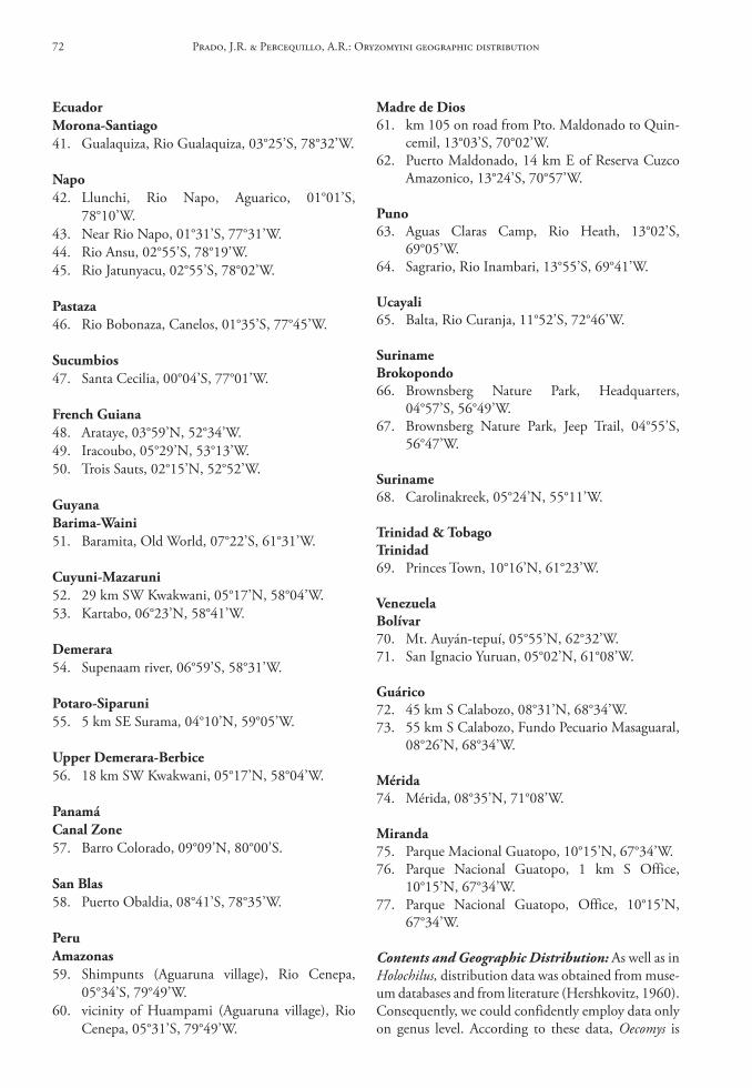
Madre de dios61. km 105 on road from Pto. Maldonado to Quin-
cemil, 13°03’S, 70°02’W.62. Puerto Maldonado, 14 km E of Reserva Cuzco
Amazonico, 13°24’S, 70°57’W.
Puno63. Aguas Claras Camp, Rio Heath, 13°02’S,
69°05’W.64. Sagrario, Rio Inambari, 13°55’S, 69°41’W.
ucayali65. Balta, Rio Curanja, 11°52’S, 72°46’W.
surinamebrokopondo66. Brownsberg Nature Park, Headquarters,
04°57’S, 56°49’W.67. Brownsberg Nature Park, Jeep Trail, 04°55’S,
56°47’W.
suriname68. Carolinakreek, 05°24’N, 55°11’W.
trinidad & tobagotrinidad69. Princes Town, 10°16’N, 61°23’W.
Venezuelabolívar70. Mt. Auyán-tepuí, 05°55’N, 62°32’W.71. San Ignacio Yuruan, 05°02’N, 61°08’W.
Guárico72. 45 km S Calabozo, 08°31’N, 68°34’W.73. 55 km S Calabozo, Fundo Pecuario Masaguaral,
08°26’N, 68°34’W.
Mérida74. Mérida, 08°35’N, 71°08’W.
Miranda75. Parque Macional Guatopo, 10°15’N, 67°34’W.76. Parque Nacional Guatopo, 1 km S Office,
10°15’N, 67°34’W.77. Parque Nacional Guatopo, Office, 10°15’N,
67°34’W.
Contents and Geographic Distribution: As well as in Holochilus, distribution data was obtained from muse-um databases and from literature (Hershkovitz, 1960). Consequently, we could confidently employ data only on genus level. According to these data, Oecomys is
ecuadorMorona‑santiago41. Gualaquiza, Rio Gualaquiza, 03°25’S, 78°32’W.
napo42. Llunchi, Rio Napo, Aguarico, 01°01’S,
78°10’W.43. Near Rio Napo, 01°31’S, 77°31’W.44. Rio Ansu, 02°55’S, 78°19’W.45. Rio Jatunyacu, 02°55’S, 78°02’W.
Pastaza46. Rio Bobonaza, Canelos, 01°35’S, 77°45’W.
sucumbios47. Santa Cecilia, 00°04’S, 77°01’W.
French Guiana48. Arataye, 03°59’N, 52°34’W.49. Iracoubo, 05°29’N, 53°13’W.50. Trois Sauts, 02°15’N, 52°52’W.
Guyanabarima‑Waini51. Baramita, Old World, 07°22’S, 61°31’W.
cuyuni‑Mazaruni52. 29 km SW Kwakwani, 05°17’N, 58°04’W.53. Kartabo, 06°23’N, 58°41’W.
demerara54. Supenaam river, 06°59’S, 58°31’W.
Potaro‑siparuni55. 5 km SE Surama, 04°10’N, 59°05’W.
upper demerara‑berbice56. 18 km SW Kwakwani, 05°17’N, 58°04’W.
Panamácanal Zone57. Barro Colorado, 09°09’N, 80°00’S.
san blas58. Puerto Obaldia, 08°41’S, 78°35’W.
PeruAmazonas59. Shimpunts (Aguaruna village), Rio Cenepa,
05°34’S, 79°49’W.60. vicinity of Huampami (Aguaruna village), Rio
Cenepa, 05°31’S, 79°49’W.
Prado, J.R. & Percequillo, A.R.: Oryzomyini geographic distribution72
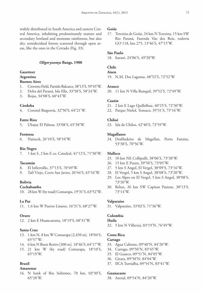
widely distributed in South America and eastern Cen-tral America, inhabiting predominantly mature and secondary lowland and montane rainforests, but also dry, semidecidual forests scattered through open ar-eas, like the ones in the Cerrado (Fig. 33).
Oligoryzomys bangs, 1900
GazetteerArgentinabuenos Aires1. Crovetto Field, Partido Balcarce, 38°13’S, 59°45’W.2. Delta del Paraná, Isla Ella, 33°58’S, 58°24’W.3. Rojas, 34°08’S, 60°43’W.
córdoba4. Coronel Baigorria, 32°50’S, 64°21’W.
entre ríos5. Ubajay El Palmar, 33°08’S, 65°38’W.
Formosa6. Naineck, 26°10’S, 58°10’W.
rio negro7. 1 km S, 2 km E co. Catedral, 41°12’S, 71°30’W.
tucumán8. El Infiernillo, 37°13’S, 70°49’W.9. Tafí Viejo, Cerro San Javier, 26°44’S, 65°16’W.
boliviacochabamba10. 28 km W (by road) Comarapa, 19°31’S, 63°52’W.
la Paz11. 1.6 km W Puerto Linares, 16°31’S, 68°27’W.
oruro12. 2 km E Huancaroma, 18°19’S, 68°31’W.
santa cruz13. 1 km N, 8 km W Comarapa [2,450 m]. 18°04’S,
65°57’W.14. 6 km N Buen Retiro [300 m]. 18°46’S, 64°17’W.15. 21 km W (by road) Comarapa, 18°10’S,
65°19’W.
brazilAmazonas16. N bank of Rio Solimões, 70 km, 03°30’S,
65°28’W.
Goiás17. Terezina de Goiás, 24 km N Terezina, 15 km SW
Rio Paraná, Fazenda Vão dos Bois, rodovia GO 118, km 275, 13°46’S, 47°15’W.
são Paulo18. Itararé, 24°06’S, 49°20’W.
chileAisen19. N.M. Dos Lagunas, 48°52’S, 72°52’W.
Arauco20. 11 km N Villa Ranquil, 39°52’S, 72°49’W.
cautin21. 2 km E Lago Quillelhue, 40°25’S, 72°30’W.22. Parque Nielol, Temuco, 39°31’S, 73°16’W.
chiloé23. Isla de Chiloe, 42°40’S, 73°59’W.
Magallanes24. Desfiladeiro de Magellan, Porto Famine,
53°38’S, 70°56’W.
Malleco25. 10 km NE Collipulli, 38°06’S, 73°38’W.26. 15 km E Puren, 39°58’S, 73°05’W.27. 5 km S Angol, El Vergel, 38°09’S, 73°16’W.28. El Vergel, 5 km S Angol, 38°08’S, 73°20’W.29. Los Alpes on El Vergel, 5 km S Angol, 38°08’S,
73°20’W.30. Relun, 26 km SW Capitan Pastene, 38°13’S,
73°14’W.
Valparaíso31. Valparaíso, 33°02’S, 71°36’W.
colombiahuíla32. 5 km N Villaviej, 03°19’N, 76°49’W.
costa ricacartago33. Agua Caliente, 09°48’N, 84°20’W.34. Cartago, 09°50’N, 83°45’W.35. El Guarco, 09°51’N, 84°05’W.36. Girara, 09°50’N, 84°04’W.37. IICA Turrialba, 09°54’N, 83°41’W.
Guanacaste38. Arenal, 09°54’N, 84°20’W.
Arquivos de Zoologia, 44(1), 2013 73
39. Liberia, 9 km N; Pan Am Hwy, 4 km E, 10°45’N, 85°30’W.
Puntarenas40. Villa Neily, 5 km N, 09°34’N, 84°15’W.
san José41. 15.5 km N San Isidro del General; Cerro de la
Muerte, 09°34’N, 83°45’W.42. El Copey De Dota, 09°35’N, 84°00’W.43. Estrella De Cartago, 09°39’N, 84°04’W.44. San Joaquin De Dota, 09°34’N, 83°59’W.
Guyanaupper takuku‑upper essequibo45. Nappi Creek, Foot of Kanuku Mountain,
40 km E of Lethem, Rupununi, 03°12’N, 59°35’W.
Panamácanal Zone46. Barro Colorado Is, 09°09’N, 79°50’W.
chiriquí47. Volcán de Chiriqui, Boquete, 08°47’N, 82°26’W.
Paraguayboquerón48. 419 km, NW Villa Hayes, 25°05’S, 57°31’W.
Paraguarí49. Parque Nacional de Ybacui, 85 km SSE Atyra,
25°15’S, 57°10’W.
Peruhuánuco50. 1 km S Tingo Maria, 10°41’S, 76°04’W.51. 6 km N Tingo Maria, 10°46’S, 76°01’W.52. 6 km NE Acomayo, 09°48’S, 76°04’W.53. 8 km SE Tita [290 m]. 10°16’S, 77°56’W.54. Haciendas ao longo do Rio Chinchao, 09°30’S,
75°56’W.
la libertad55. Rio Chicama, Hacienda Llagueda, 07°50’S,
79°08’W.
lambayeque56. Eten, 06°55’S, 79°51’W.
uruguayMaldonado57. Maldonado, 34°40’S, 54°55’W.
VenezuelaAmazonas58. Pozon, 50 km NE of Puerto Ayacucho, 06°02’N,
68°34’W.
táchira59. Rio Táchira, W of Páramo de Tamá, 07°38’N,
72°28’W.
Contents and Geographic Distribution: In the genus Oligoryzomys, as in Holochilus and Oecomys, the distribution data was obtained from museum databases. In this way, we could confidently em-ploy data only on genus level again. According to these data, Oligoryzomys comprises a diverse group distributed from northern Central America to the southernmost part of South America, in-habiting environments like rain forest (Amazoni-an and Atlantic Forests), open and dry areas (Cer-rado, Caatinga and Restinga) and flooding-prone areas (Pampas and Pantanal) (Lima et al., 2003; Weksler & Bonvicino, 2005; Paresque, 2010) (Fig. 34).
Oreoryzomys Weksler, Percequillo & Voss, 2006
Gazetteerecuadornapo1. Baeza [1,525 m], 00°27’S, 77°53’W.
tungurahua2. Mirador, Baños [1,500 m]. Type locality of Ory-
zomys balneator, 01°26’S, 78°15’W.
Zamora‑chinchipe3. 4 km E Sabanilla [1,586 m], 04°02’S, 79°01’W.
Perucajamarca4. 4 km W Chaupe. Not located; we used the
geographic coordinates of Chaupe, 05°10’S, 79°10’W.
Contents and Geographic Distribution: Oreoryzo-mys is a monotypic genus, containing O. balneator (Thomas, 1900). This species occurs in few locali-ties on both western and eastern slopes of the An-des in Ecuador and Peru, in humid montane forests (Fig. 35). The known altitudinal range varies from 1,500 to 1,586 m.
Prado, J.R. & Percequillo, A.R.: Oryzomyini geographic distribution74
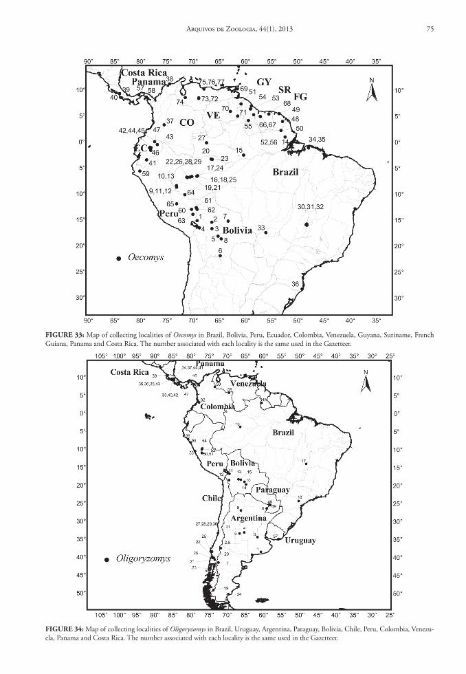
FIGure 33: Map of collecting localities of Oecomys in Brazil, Bolivia, Peru, Ecuador, Colombia, Venezuela, Guyana, Suriname, French Guiana, Panama and Costa Rica. The number associated with each locality is the same used in the Gazetteer.
FIGure 34: Map of collecting localities of Oligoryzomys in Brazil, Uruguay, Argentina, Paraguay, Bolivia, Chile, Peru, Colombia, Venezu-ela, Panama and Costa Rica. The number associated with each locality is the same used in the Gazetteer.
Arquivos de Zoologia, 44(1), 2013 75
Oryzomys baird, 1857
GazetteercolombiaAntioquia1. Left bank of Rio Atrato. Type locality of Oryzo-
mys gorgasi. Oryzomys gorgasi, 07°54’N, 77°00’W.
córdoba2. Montería. Oryzomys couesi, 08°40’N, 76°00’W.
VenezuelaZulia3. El Caimito, 40 km NE de Maracaibo. Oryzomys
gorgasi, 10°57’N, 71°23’W.
Contents and Geographic Distribution: Two spe-cies of the genus Oryzomys are marginally distributed in South America (Fig. 36): Oryzomys couesi (Alston, 1877) and Oryzomys gorgasi (Hershkovitz, 1971).
Oryzomys couesi is known from only one locality in northern Colombia; this species is widely distrib-uted in Central and North America, and this South American record may represent a marginal record of this species. Oryzomys gorgasi is known from two specimens, one from the eastern coast of the gulf of Maracaibo in northern Venezuela and the other from northern Colombia; it occurs in coastal environ-ments, as mangroves and freshwater inundated grass-lands (Hershkovitz, 1971; Sanchéz et al., 2001).
Pseudoryzomys hershkovitz, 1962
GazetteerArgentinachaco1. 4 km S General San Martín, 26°33’S, 59°20’W.2. 5 km N de General Vedia, 26°54’S, 58°37’W.3. 5 km N de Selvas del Rio Oro, 26°47’S, 58°57’W.4. Cancha Larga, 27°04’S, 58°43’W.5. Capitán Solari, 26°48’S, 59°34’W.6. Colonia Bermejo, 26°28’S, 59°15’W.7. Colonia Rio Tragadero, 27°22’S, 58°57’W.8. Estancia Las Rosas and Paso Mono, 27°30’S,
58°47’W.9. General San Martín, 26°32’S, 59°19’W.10. General Vedia, 26°55’S, 58°39’W.11. La Eduvigis, 26°51’S, 59°04’W.12. Las Palmas, 27°03’S, 58°42’W.13. Loma Florida, 26°48’S, 59°06’W.14. Lote 16, 26°51’S, 58°47’W.15. Presidencia Roque Sáenz Peña, 26°47’S, 60°26’W.
16. Pueblo Viejo, Puerto Bermejo, 26°56’S, 58°30’W.17. Selvas del rio de Oro, 26°48’S, 58°57’W.18. Zapallar Norte, 26°27’S, 59°22’W.
Formosa19. Abadie-cué, PN Rio Pilcomayo, 25°08’S, 58°08’W.20. Estancia Guaycolec, 25°58’S, 58°11’W.21. Laguna Naick Neck, 25°13’S, 58°07’W.22. Reserva Ecológica El Bagual, 26°10’S, 58°56’W.23. Rio Porteño, Mision Tacaagle, 24°56’S, 58°46’W.24. Villa dos Trece, 26°10’S, 59°21’W.25. Villa Escolar, 26°37’S, 58°40’W.
santa Fé26. Berna, 29°15’S, 59°52’W.27. Pedro Gómes Cello, 30°01’S, 60°18’W.28. Santa Margarita, 28°18’S, 61°33’W.
boliviabeni29. Estacíon Biológica del Beni, 14°48’S, 66°19’W.30. San Joaquin, 14°08’S, 66°07’W.
la Paz31. Pampas del Heath. Not located; we used the geo-
graphic coordinates of Heath, 12°30’S, 68°40’W.
santa cruz32. Pampa de Meio, Rio Itenés, 12°30’S, 64°19’W.33. Parque Nacional de Noel Kempff Mercado,
14°16’S, 60°52’W.34. Santa Ana, Province Velasco, 17°28’S, 62°44’W.
brazilAmazonas35. Humaitá, Escola Agrotécnica. Not located; we
used the geographic coordinates of Humaitá, 07°30’S, 63°01’W.
Amapá36. Tartarugalzinho, Fazenda Asa Branca. Not lo-
cated; we used the geographic coordinates of Tartarugalzinho, 01°31’S, 50°54’W.
Goiás37. Fazenda Bandeirantes, 16°15’W, 52°25’W.38. Morro da Baleia, Alto Paraíso, PN Chapada dos
Veadeiros, 14°05’S, 47°31’W.
Mato Grosso39. Gaúcha do Norte, 13°14’S, 53°04’W.40. Posto Leonardo, 12°11’S, 53°22’W.41. Rio Culuene, Rio Xingu, 12°11’S, 53°22’W.
Prado, J.R. & Percequillo, A.R.: Oryzomyini geographic distribution76
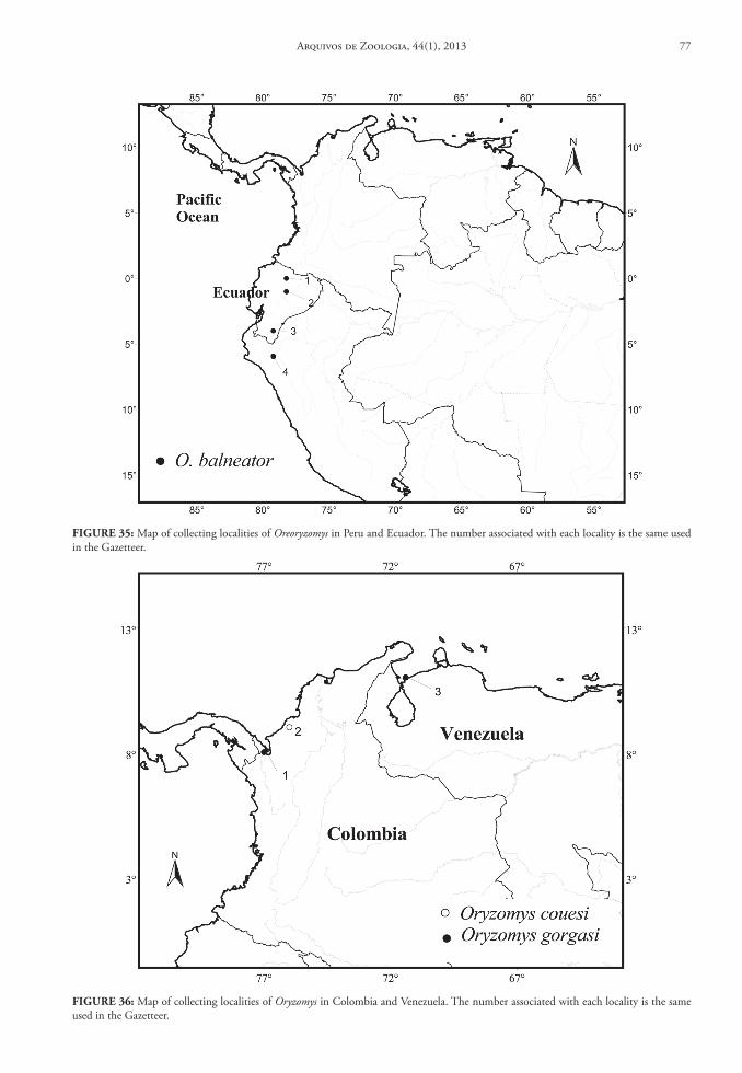
FIGure 35: Map of collecting localities of Oreoryzomys in Peru and Ecuador. The number associated with each locality is the same used in the Gazetteer.
FIGure 36: Map of collecting localities of Oryzomys in Colombia and Venezuela. The number associated with each locality is the same used in the Gazetteer.
Arquivos de Zoologia, 44(1), 2013 77
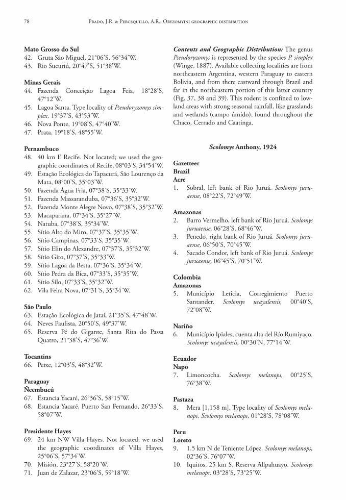
Contents and Geographic Distribution: The genus Pseudoryzomys is represented by the species P. simplex (Winge, 1887). Available collecting localities are from northeastern Argentina, western Paraguay to eastern Bolivia, and from there eastward through Brazil and far in the northeastern portion of this latter country (Fig. 37, 38 and 39). This rodent is confined to low-land areas with strong seasonal rainfall, like grasslands and wetlands (campo úmido), found throughout the Chaco, Cerrado and Caatinga.
Scolomys Anthony, 1924
GazetteerbrazilAcre1. Sobral, left bank of Rio Juruá. Scolomys juru-
aense, 08°22’S, 72°49’W.
Amazonas2. Barro Vermelho, left bank of Rio Juruá. Scolomys
juruaense, 06°28’S, 68°46’W.3. Penedo, right bank of Rio Juruá. Scolomys juru-
aense, 06°50’S, 70°45’W.4. Sacado Condor, left bank of Rio Juruá. Scolomys
juruaense, 06°45’S, 70°51’W.
colombiaAmazonas5. Município Leticia, Corregimiento Puerto
Santander. Scolomys ucayalensis, 00°40’S, 72°08’W.
nariño6. Município Ipiales, cuenta alta del Río Rumiyaco.
Scolomys ucayalensis, 00°30’N, 77°14’W.
ecuadornapo7. Limoncocha. Scolomys melanops, 00°25’S,
76°38’W.
Pastaza8. Mera [1,158 m]. Type locality of Scolomys mela-
nops. Scolomys melanops, 01°28’S, 78°08’W.
Peruloreto9. 1.5 km N de Teniente López. Scolomys melanops,
02°36’S, 76°07’W.10. Iquitos, 25 km S, Reserva Allpahuayo. Scolomys
melanops, 03°28’S, 73°25’W.
Mato Grosso do sul42. Gruta São Miguel, 21°06’S, 56°34’W.43. Rio Sucuriú, 20°47’S, 51°38’W.
Minas Gerais44. Fazenda Conceição Lagoa Feia, 18°28’S,
47°12’W.45. Lagoa Santa. Type locality of Pseudoryzomys sim-
plex, 19°37’S, 43°53’W.46. Nova Ponte, 19°08’S, 47°40’W.47. Prata, 19°18’S, 48°55’W.
Pernambuco48. 40 km E Recife. Not located; we used the geo-
graphic coordinates of Recife, 08°03’S, 34°54’W.49. Estação Ecológica do Tapacurá, São Lourenço da
Mata, 08°00’S, 35°03’W.50. Fazenda Água Fria, 07°38’S, 35°33’W.51. Fazenda Massaranduba, 07°36’S, 35°32’W.52. Fazenda Monte Alegre Novo, 07°38’S, 35°32’W.53. Macaparana, 07°34’S, 35°27’W.54. Natuba, 07°38’S, 35°34’W.55. Sítio Alto do Miro, 07°37’S, 35°35’W.56. Sítio Campinas, 07°33’S, 35°35’W.57. Sítio Elin do Alexandre, 07°37’S, 35°32’W.58. Sítio Gito, 07°37’S, 35°33’W.59. Sítio Lagoa da Besta, 07°36’S, 35°34’W.60. Sítio Pedra da Bica, 07°33’S, 35°35’W.61. Sítio Silo, 07°33’S, 35°32’W.62. Vila Feira Nova, 07°31’S, 35°34’W.
são Paulo63. Estação Ecológica de Jataí, 21°35’S, 47°48’W.64. Neves Paulista, 20°50’S, 49°37’W.65. Reserva Pé do Gigante, Santa Rita do Passa
Quatro, 21°38’S, 47°36’W.
tocantins66. Peixe, 12°03’S, 48°32’W.
ParaguayÑeembucú67. Estancia Yacaré, 26°36’S, 58°15’W.68. Estancia Yacaré, Puerto San Fernando, 26°33’S,
58°07’W.
Presidente hayes69. 24 km NW Villa Hayes. Not located; we used
the geographic coordinates of Villa Hayes, 25°06’S, 57°34’W.
70. Misión, 23°27’S, 58°20’W.71. Juan de Zalazar, 23°06’S, 59°18’W.
Prado, J.R. & Percequillo, A.R.: Oryzomyini geographic distribution78
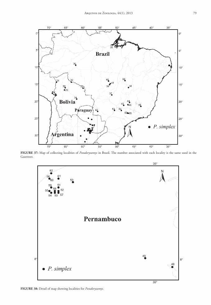
FIGure 37: Map of collecting localities of Pseudoryzomys in Brazil. The number associated with each locality is the same used in the Gazetteer.
FIGure 38: Detail of map showing localities for Pseudoryzomys.
Arquivos de Zoologia, 44(1), 2013 79
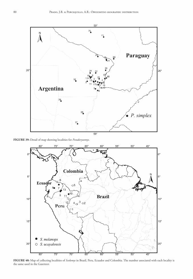
FIGure 39: Detail of map showing localities for Pseudoryzomys.
FIGure 40: Map of collecting localities of Scolomys in Brazil, Peru, Ecuador and Colombia. The number associated with each locality is the same used in the Gazetteer.
Prado, J.R. & Percequillo, A.R.: Oryzomyini geographic distribution80
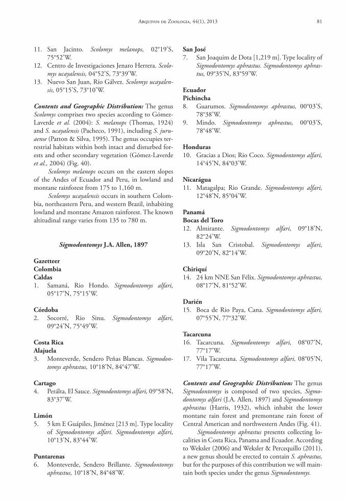
11. San Jacinto. Scolomys melanops, 02°19’S, 75°52’W.
12. Centro de Investigaciones Jenaro Herrera. Scolo-mys ucayalensis, 04°52’S, 73°39’W.
13. Nuevo San Juan, Río Gálvez. Scolomys ucayalen-sis, 05°15’S, 73°10’W.
Contents and Geographic Distribution: The genus Scolomys comprises two species according to Gómez-Laverde et al. (2004): S. melanops (Thomas, 1924) and S. ucayalensis (Pacheco, 1991), including S. juru-aense (Patton & Silva, 1995). The genus occupies ter-restrial habitats within both intact and disturbed for-ests and other secondary vegetation (Gómez-Laverde et al., 2004) (Fig. 40).
Scolomys melanops occurs on the eastern slopes of the Andes of Ecuador and Peru, in lowland and montane rainforest from 175 to 1,160 m.
Scolomys ucayalensis occurs in southern Colom-bia, northeastern Peru, and western Brazil, inhabiting lowland and montane Amazon rainforest. The known altitudinal range varies from 135 to 780 m.
Sigmodontomys J.A. Allen, 1897
Gazetteercolombiacaldas1. Samaná, Rio Hondo. Sigmodontomys alfari,
05°17’N, 75°15’W.
córdoba2. Socorré, Rio Sinu. Sigmodontomys alfari,
09°24’N, 75°49’W.
costa ricaAlajuela3. Monteverde, Sendero Peñas Blancas. Sigmodon-
tomys aphrastus, 10°18’N, 84°47’W.
cartago4. Perálta, El Sauce. Sigmodontomys alfari, 09°58’N,
83°37’W.
limón5. 5 km E Guápiles, Jiménez [213 m]. Type locality
of Sigmodontomys alfari. Sigmodontomys alfari, 10°13’N, 83°44’W.
Puntarenas6. Monteverde, Sendero Brillante. Sigmodontomys
aphrastus, 10°18’N, 84°48’W.
san José7. San Joaquim de Dota [1,219 m]. Type locality of
Sigmodontomys aphrastus. Sigmodontomys aphras-tus, 09°35’N, 83°59’W.
ecuadorPichincha8. Guarumos. Sigmodontomys aphrastus, 00°03’S,
78°38’W.9. Mindo. Sigmodontomys aphrastus, 00°03’S,
78°48’W.
honduras10. Gracias a Dios; Rio Coco. Sigmodontomys alfari,
14°45’N, 84°03’W.
nicarágua11. Matagalpa; Rio Grande. Sigmodontomys alfari,
12°48’N, 85°04’W.
Panamábocas del toro12. Almirante. Sigmodontomys alfari, 09°18’N,
82°24’W.13. Isla San Cristobal. Sigmodontomys alfari,
09°20’N, 82°14’W.
chiriquí14. 24 km NNE San Félix. Sigmodontomys aphrastus,
08°17’N, 81°52’W.
darién15. Boca de Rio Paya, Cana. Sigmodontomys alfari,
07°55’N, 77°32’W.
tacarcuna16. Tacarcuna. Sigmodontomys alfari, 08°07’N,
77°17’W.17. Vila Tacarcuna. Sigmodontomys alfari, 08°05’N,
77°17’W.
Contents and Geographic Distribution: The genus Sigmodontomys is composed of two species, Sigmo-dontomys alfari (J.A. Allen, 1897) and Sigmodontomys aphrastus (Harris, 1932), which inhabit the lower montane rain forest and premontane rain forest of Central American and northwestern Andes (Fig. 41).
Sigmodontomys aphrastus presents collecting lo-calities in Costa Rica, Panama and Ecuador. According to Weksler (2006) and Weksler & Percequillo (2011), a new genus should be erected to contain S. aphrastus, but for the purposes of this contribution we will main-tain both species under the genus Sigmodontomys.
Arquivos de Zoologia, 44(1), 2013 81
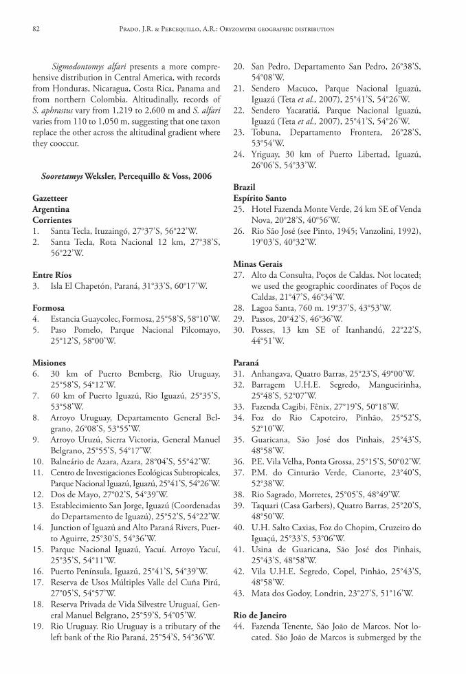
Sigmodontomys alfari presents a more compre-hensive distribution in Central America, with records from Honduras, Nicaragua, Costa Rica, Panama and from northern Colombia. Altitudinally, records of S. aphrastus vary from 1,219 to 2,600 m and S. alfari varies from 110 to 1,050 m, suggesting that one taxon replace the other across the altitudinal gradient where they cooccur.
Sooretamys Weksler, Percequillo & Voss, 2006
GazetteerArgentinacorrientes1. Santa Tecla, Ituzaingó, 27°37’S, 56°22’W.2. Santa Tecla, Rota Nacional 12 km, 27°38’S,
56°22’W.
entre ríos3. Isla El Chapetón, Paraná, 31°33’S, 60°17’W.
Formosa4. Estancia Guaycolec, Formosa, 25°58’S, 58°10’W.5. Paso Pomelo, Parque Nacional Pilcomayo,
25°12’S, 58°00’W.
Misiones6. 30 km of Puerto Bemberg, Rio Uruguay,
25°58’S, 54°12’W.7. 60 km of Puerto Iguazú, Rio Iguazú, 25°35’S,
53°58’W.8. Arroyo Uruguay, Departamento General Bel-
grano, 26°08’S, 53°55’W.9. Arroyo Uruzú, Sierra Victoria, General Manuel
Belgrano, 25°55’S, 54°17’W.10. Balneário de Azara, Azara, 28°04’S, 55°42’W.11. Centro de Investigaciones Ecológicas Subtropicales,
Parque Nacional Iguazú, Iguazú, 25°41’S, 54°26’W.12. Dos de Mayo, 27°02’S, 54°39’W.13. Establecimiento San Jorge, Iguazú (Coordenadas
do Departamento de Iguazú), 25°52’S, 54°22’W.14. Junction of Iguazú and Alto Paraná Rivers, Puer-
to Aguirre, 25°30’S, 54°36’W.15. Parque Nacional Iguazú, Yacuí. Arroyo Yacuí,
25°35’S, 54°11’W.16. Puerto Península, Iguazú, 25°41’S, 54°39’W.17. Reserva de Usos Múltiples Valle del Cuña Pirú,
27°05’S, 54°57’W.18. Reserva Privada de Vida Silvestre Uruguaí, Gen-
eral Manuel Belgrano, 25°59’S, 54°05’W.19. Rio Uruguay. Rio Uruguay is a tributary of the
left bank of the Rio Paraná, 25°54’S, 54°36’W.
20. San Pedro, Departamento San Pedro, 26°38’S, 54°08’W.
21. Sendero Macuco, Parque Nacional Iguazú, Iguazú (Teta et al., 2007), 25°41’S, 54°26’W.
22. Sendero Yacaratiá, Parque Nacional Iguazú, Iguazú (Teta et al., 2007), 25°41’S, 54°26’W.
23. Tobuna, Departamento Frontera, 26°28’S, 53°54’W.
24. Yriguay, 30 km of Puerto Libertad, Iguazú, 26°06’S, 54°33’W.
brazilespírito santo25. Hotel Fazenda Monte Verde, 24 km SE of Venda
Nova, 20°28’S, 40°56’W.26. Rio São José (see Pinto, 1945; Vanzolini, 1992),
19°03’S, 40°32’W.
Minas Gerais27. Alto da Consulta, Poços de Caldas. Not located;
we used the geographic coordinates of Poços de Caldas, 21°47’S, 46°34’W.
28. Lagoa Santa, 760 m. 19°37’S, 43°53’W.29. Passos, 20°42’S, 46°36’W.30. Posses, 13 km SE of Itanhandú, 22°22’S,
44°51’W.
Paraná31. Anhangava, Quatro Barras, 25°23’S, 49°00’W.32. Barragem U.H.E. Segredo, Mangueirinha,
25°48’S, 52°07’W.33. Fazenda Cagibi, Fênix, 27°19’S, 50°18’W.34. Foz do Rio Capoteiro, Pinhão, 25°52’S,
52°10’W.35. Guaricana, São José dos Pinhais, 25°43’S,
48°58’W.36. P.E. Vila Velha, Ponta Grossa, 25°15’S, 50°02’W.37. P.M. do Cinturão Verde, Cianorte, 23°40’S,
52°38’W.38. Rio Sagrado, Morretes, 25°05’S, 48°49’W.39. Taquari (Casa Garbers), Quatro Barras, 25°20’S,
48°50’W.40. U.H. Salto Caxias, Foz do Chopim, Cruzeiro do
Iguaçú, 25°33’S, 53°06’W.41. Usina de Guaricana, São José dos Pinhais,
25°43’S, 48°58’W.42. Vila U.H.E. Segredo, Copel, Pinhão, 25°43’S,
48°58’W.43. Mata dos Godoy, Londrin, 23°27’S, 51°16’W.
rio de Janeiro44. Fazenda Tenente, São João de Marcos. Not lo-
cated. São João de Marcos is submerged by the
Prado, J.R. & Percequillo, A.R.: Oryzomyini geographic distribution82
69. Boracéia. Estação Biológica de Boracéia do Mu-seu de Zoologia da USP, Salesópolis (see Travas-sos & Camargo, 1958), 23°38’S, 45°52’W.
70. Cananéia, 25°01’S, 47°57’W.71. Carlos Botelho (coordinates of National Park),
24°03’S, 47°49’W.72. Casa Grande, Salesópolis, small town near the
Estação Biológica de Boracéia (see Travassos & Camargo, 1958), 23°22’S, 45°56’W.
73. Caucaia do Alto, Cotia, 23°42’S, 47°00’W.74. Condomínio TranSurb, Itapevi, 23°35’S,
46°57’W.75. Corrego Água Limpa, Ribeirão Grande, not
located, we used the coordinates of Ribeirão Grande, 24°05’S, 48°21’W.
76. Corrego Barracão, Ribeirão Grande (coordinates of Ribeirão Grande), 24°05’S, 48°21’W.
77. Corrego Fernandes, Ribeirão Grande (coordi-nates of Ribeirão Grande), 24°05’S, 48°21’W.
78. Cotia, 23°37’S, 46°56’W.79. Cristo, Piedade, 23°50’S, 47°28’W.80. Eme, Piedade, 23°52’S, 47°28’W.81. Estação Ecológia do Bananal, 22°47’S, 44°21’W.82. Estrada, Piedade, 23°52’S, 47°29’W.83. Fazenda Intervales, Base da Bocaina, 24°16’S,
48°27’W.84. Fazenda Intervales, Base do Carmo, 24°18’S,
48°24’W.85. Fazenda Intervales, Sede, 24°16’S, 48°24’W.86. Furnas, Piedade (coordinates of Piedade),
23°43’S, 47°24’W.87. Furnas, Riacho Grande (coordinates of Riacho
Grande), 23°48’S, 46°35’W.88. Iguape, Costão dos Engenhos, 24°41’S,
47°28’W.89. Iguape, 24°42’S, 47°32’W.90. Ilha do Mar Virado, 23°34’S, 45°10’W.91. Iporanga, 24°36’S, 48°35’W.92. Itapetininga, 23°35’S, 48°03’W.93. Itararé, 24°06’S, 49°20’W.94. Lira, Capão Bonito, 24°02’S, 48°18’W.95. Mato da Mina, Ribeirão Grande (coordinates of
Ribeirão Grande), 24°05’S, 48°21’W.96. Moacir, Ribeirão Grande, 24°13’S, 48°21’W.97. Mulheres, Ribeirão Grande, 24°13’S, 48°23’W.98. Museros, Ribeirão Grande, 24°13’S, 48°23’W.99. Paraguai, Ribeirão Grande, 24°13’S, 48°23’W.100. Paranapiacaba (= Alto da Serra), 23°26’S,
46°17’W.101. Piedade, São Paulo, 23°43’S, 47°24’W.102. Piquete [600-900 m]. 22°36’S, 45°09’W.103. Riacho Grande, 23°48’S, 46°35’W.104. Ribeirão Pires, 23°42’S, 46°24’W.
waters of the dam Ribeirão das Lages; the re-maining area of São João de Marcos belongs to the municipality of Rio Claro (Moojen, 1948), 22°46’S, 44°01’W.
45. Mata da Rita (or Rifa), Parque Estadual do De-sengano, 1.7 km N, 5.1 km W, by road of Santa Maria Madalena, 21°57’S, 42°01’W.
46. Pedra Branca, Parati, 23°13’S, 44°43’W.47. Praia Vermelha, Ilha Grande, Angra dos Reis,
23°09’S, 44°21’W.
rio Grande do sul48. 35 km NE de Cruz Alta, 28°26’S, 53°20’W.49. Aratiba, Três Barras, 3 m Rio Uruguai, 27°19’S,
52°14’W.50. Barracão, 27°30’S, 51°30’W.51. Capão do Leão, Mostardas. Not located; we
used the geographic coordinates of Mostardas, 31°06’S, 50°55’W.
52. Cruz Alta, 28°39’S, 53°36’W.53. Faxinal, Norte da Lagoa Itapeva, Torres, 29°22’S,
49°48’W.54. Fazenda Aldo Pinto, São Nicolau, 28°11’S,
55°16’W.55. Lagoa Emboaba, Osório. Not located; we used
the geographic coordinates of Osório, 29°53’S, 50°16’W.
56. Pontal do Norte, Lagoa Palmital, Osório, 50°06’S, 29°50’W.
57. Torres, 29°20’S, 49°43’W.58. Tramandaí, Lenha Seca, Lagoa de Tramandaí
(= Lenha Seca, O da Lagoa de Tramandaí). Not located; we used the geographic coordinates of Tramandaí, 29°59’S, 50°08’W.
santa catarina59. Angelina, Garcia, 27°35’S, 48°59’W.60. Fazenda Cerro Verde, São Cristóvão do Sul,
27°19’S, 50°18’W.61. Fazenda Sta. Alice, Rio Negrinho, 26°28’S,
49°30’W.62. Florianópolis, 27°36’S, 48°33’W.63. Parque Estadual da Serra do Tabuleiro, Caldas
da Imperatriz (= Santo Amaro da Imperatriz), 27°44’S, 48°49’W.
são Paulo64. Alce, Piedade, 66°16’S, 50°35’W.65. Apiaí, 24°30’S, 48°51’W.66. Baleia, Piedade, 23°53’S, 47°27’W.67. Bauru, 22°20’S, 49°05’W.68. Boiadeiro, Ribeirão Grande, 24°05’S, 48°19’W.
Arquivos de Zoologia, 44(1), 2013 83
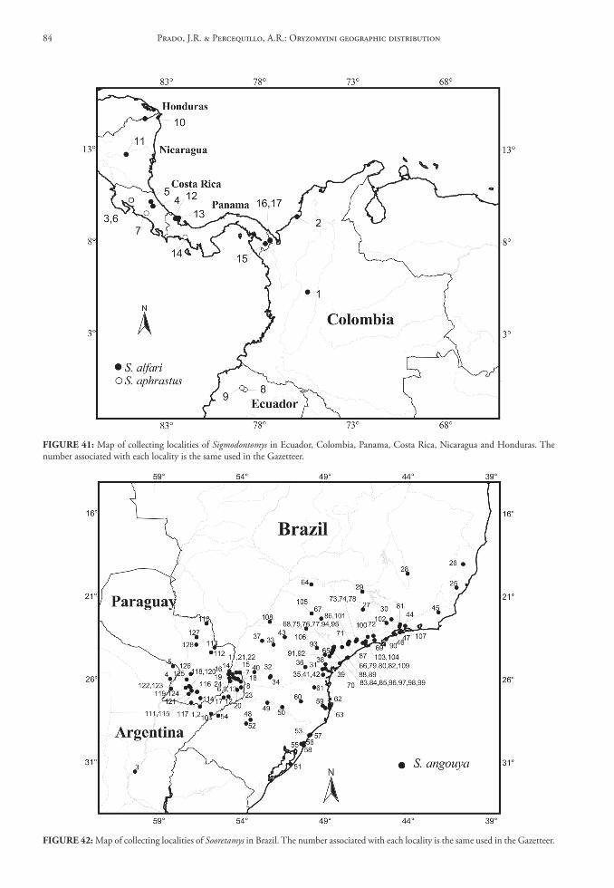
FIGure 41: Map of collecting localities of Sigmodontomys in Ecuador, Colombia, Panama, Costa Rica, Nicaragua and Honduras. The number associated with each locality is the same used in the Gazetteer.
FIGure 42: Map of collecting localities of Sooretamys in Brazil. The number associated with each locality is the same used in the Gazetteer.
Prado, J.R. & Percequillo, A.R.: Oryzomyini geographic distribution84
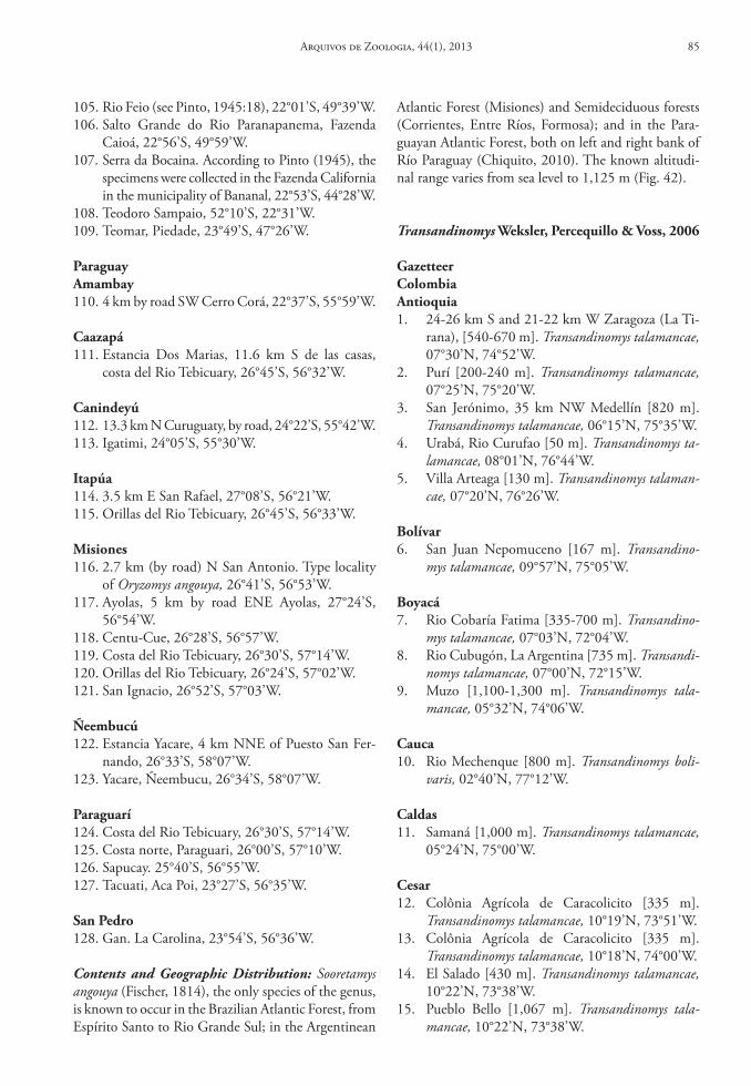
105. Rio Feio (see Pinto, 1945:18), 22°01’S, 49°39’W.106. Salto Grande do Rio Paranapanema, Fazenda
Caioá, 22°56’S, 49°59’W.107. Serra da Bocaina. According to Pinto (1945), the
specimens were collected in the Fazenda California in the municipality of Bananal, 22°53’S, 44°28’W.
108. Teodoro Sampaio, 52°10’S, 22°31’W.109. Teomar, Piedade, 23°49’S, 47°26’W.
ParaguayAmambay110. 4 km by road SW Cerro Corá, 22°37’S, 55°59’W.
caazapá111. Estancia Dos Marias, 11.6 km S de las casas,
costa del Rio Tebicuary, 26°45’S, 56°32’W.
canindeyú112. 13.3 km N Curuguaty, by road, 24°22’S, 55°42’W.113. Igatimi, 24°05’S, 55°30’W.
Itapúa114. 3.5 km E San Rafael, 27°08’S, 56°21’W.115. Orillas del Rio Tebicuary, 26°45’S, 56°33’W.
Misiones116. 2.7 km (by road) N San Antonio. Type locality
of Oryzomys angouya, 26°41’S, 56°53’W.117. Ayolas, 5 km by road ENE Ayolas, 27°24’S,
56°54’W.118. Centu-Cue, 26°28’S, 56°57’W.119. Costa del Rio Tebicuary, 26°30’S, 57°14’W.120. Orillas del Rio Tebicuary, 26°24’S, 57°02’W.121. San Ignacio, 26°52’S, 57°03’W.
Ñeembucú122. Estancia Yacare, 4 km NNE of Puesto San Fer-
nando, 26°33’S, 58°07’W.123. Yacare, Ñeembucu, 26°34’S, 58°07’W.
Paraguarí124. Costa del Rio Tebicuary, 26°30’S, 57°14’W.125. Costa norte, Paraguari, 26°00’S, 57°10’W.126. Sapucay. 25°40’S, 56°55’W.127. Tacuati, Aca Poi, 23°27’S, 56°35’W.
san Pedro128. Gan. La Carolina, 23°54’S, 56°36’W.
Contents and Geographic Distribution: Sooretamys angouya (Fischer, 1814), the only species of the genus, is known to occur in the Brazilian Atlantic Forest, from Espírito Santo to Rio Grande Sul; in the Argentinean
Atlantic Forest (Misiones) and Semideciduous forests (Corrientes, Entre Ríos, Formosa); and in the Para-guayan Atlantic Forest, both on left and right bank of Río Paraguay (Chiquito, 2010). The known altitudi-nal range varies from sea level to 1,125 m (Fig. 42).
Transandinomys Weksler, Percequillo & Voss, 2006
GazetteercolombiaAntioquia1. 24-26 km S and 21-22 km W Zaragoza (La Ti-
rana), [540-670 m]. Transandinomys talamancae, 07°30’N, 74°52’W.
2. Purí [200-240 m]. Transandinomys talamancae, 07°25’N, 75°20’W.
3. San Jerónimo, 35 km NW Medellín [820 m]. Transandinomys talamancae, 06°15’N, 75°35’W.
4. Urabá, Rio Curufao [50 m]. Transandinomys ta-lamancae, 08°01’N, 76°44’W.
5. Villa Arteaga [130 m]. Transandinomys talaman-cae, 07°20’N, 76°26’W.
bolívar6. San Juan Nepomuceno [167 m]. Transandino-
mys talamancae, 09°57’N, 75°05’W.
boyacá7. Rio Cobaría Fatima [335-700 m]. Transandino-
mys talamancae, 07°03’N, 72°04’W.8. Rio Cubugón, La Argentina [735 m]. Transandi-
nomys talamancae, 07°00’N, 72°15’W.9. Muzo [1,100-1,300 m]. Transandinomys tala-
mancae, 05°32’N, 74°06’W.
cauca10. Rio Mechenque [800 m]. Transandinomys boli-
varis, 02°40’N, 77°12’W.
caldas11. Samaná [1,000 m]. Transandinomys talamancae,
05°24’N, 75°00’W.
cesar12. Colônia Agrícola de Caracolicito [335 m].
Transandinomys talamancae, 10°19’N, 73°51’W.13. Colônia Agrícola de Caracolicito [335 m].
Transandinomys talamancae, 10°18’N, 74°00’W.14. El Salado [430 m]. Transandinomys talamancae,
10°22’N, 73°38’W.15. Pueblo Bello [1,067 m]. Transandinomys tala-
mancae, 10°22’N, 73°38’W.
Arquivos de Zoologia, 44(1), 2013 85
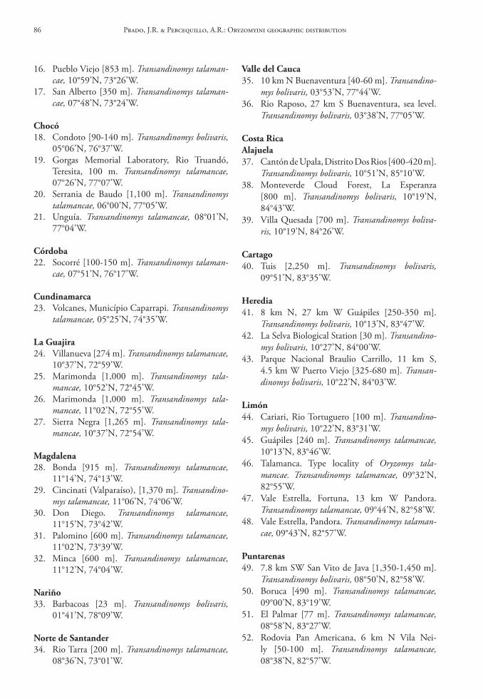
16. Pueblo Viejo [853 m]. Transandinomys talaman-cae, 10°59’N, 73°26’W.
17. San Alberto [350 m]. Transandinomys talaman-cae, 07°48’N, 73°24’W.
chocó18. Condoto [90-140 m]. Transandinomys bolivaris,
05°06’N, 76°37’W.19. Gorgas Memorial Laboratory, Rio Truandó,
Teresita, 100 m. Transandinomys talamancae, 07°26’N, 77°07’W.
20. Serrania de Baudo [1,100 m]. Transandinomys talamancae, 06°00’N, 77°05’W.
21. Unguía. Transandinomys talamancae, 08°01’N, 77°04’W.
córdoba22. Socorré [100-150 m]. Transandinomys talaman-
cae, 07°51’N, 76°17’W.
cundinamarca23. Volcanes, Município Caparrapi. Transandinomys
talamancae, 05°25’N, 74°35’W.
la Guajira24. Villanueva [274 m]. Transandinomys talamancae,
10°37’N, 72°59’W.25. Marimonda [1,000 m]. Transandinomys tala-
mancae, 10°52’N, 72°45’W.26. Marimonda [1,000 m]. Transandinomys tala-
mancae, 11°02’N, 72°55’W.27. Sierra Negra [1,265 m]. Transandinomys tala-
mancae, 10°37’N, 72°54’W.
Magdalena28. Bonda [915 m]. Transandinomys talamancae,
11°14’N, 74°13’W.29. Cincinati (Valparaíso), [1,370 m]. Transandino-
mys talamancae, 11°06’N, 74°06’W.30. Don Diego. Transandinomys talamancae,
11°15’N, 73°42’W.31. Palomino [600 m]. Transandinomys talamancae,
11°02’N, 73°39’W.32. Minca [600 m]. Transandinomys talamancae,
11°12’N, 74°04’W.
nariño33. Barbacoas [23 m]. Transandinomys bolivaris,
01°41’N, 78°09’W.
norte de santander34. Rio Tarra [200 m]. Transandinomys talamancae,
08°36’N, 73°01’W.
Valle del cauca35. 10 km N Buenaventura [40-60 m]. Transandino-
mys bolivaris, 03°53’N, 77°44’W.36. Rio Raposo, 27 km S Buenaventura, sea level.
Transandinomys bolivaris, 03°38’N, 77°05’W.
costa ricaAlajuela37. Cantón de Upala, Distrito Dos Rios [400-420 m].
Transandinomys bolivaris, 10°51’N, 85°10’W.38. Monteverde Cloud Forest, La Esperanza
[800 m]. Transandinomys bolivaris, 10°19’N, 84°43’W.
39. Villa Quesada [700 m]. Transandinomys boliva-ris, 10°19’N, 84°26’W.
cartago40. Tuis [2,250 m]. Transandinomys bolivaris,
09°51’N, 83°35’W.
heredia41. 8 km N, 27 km W Guápiles [250-350 m].
Transandinomys bolivaris, 10°13’N, 83°47’W.42. La Selva Biological Station [30 m]. Transandino-
mys bolivaris, 10°27’N, 84°00’W.43. Parque Nacional Braulio Carrillo, 11 km S,
4.5 km W Puerto Viejo [325-680 m]. Transan-dinomys bolivaris, 10°22’N, 84°03’W.
limón44. Cariari, Rio Tortuguero [100 m]. Transandino-
mys bolivaris, 10°22’N, 83°31’W.45. Guápiles [240 m]. Transandinomys talamancae,
10°13’N, 83°46’W.46. Talamanca. Type locality of Oryzomys tala-
mancae. Transandinomys talamancae, 09°32’N, 82°55’W.
47. Vale Estrella, Fortuna, 13 km W Pandora. Transandinomys talamancae, 09°44’N, 82°58’W.
48. Vale Estrella, Pandora. Transandinomys talaman-cae, 09°43’N, 82°57’W.
Puntarenas49. 7.8 km SW San Vito de Java [1,350-1,450 m].
Transandinomys bolivaris, 08°50’N, 82°58’W.50. Boruca [490 m]. Transandinomys talamancae,
09°00’N, 83°19’W.51. El Palmar [77 m]. Transandinomys talamancae,
08°58’N, 83°27’W.52. Rodovia Pan Americana, 6 km N Vila Nei-
ly [50-100 m]. Transandinomys talamancae, 08°38’N, 82°57’W.
Prado, J.R. & Percequillo, A.R.: Oryzomyini geographic distribution86
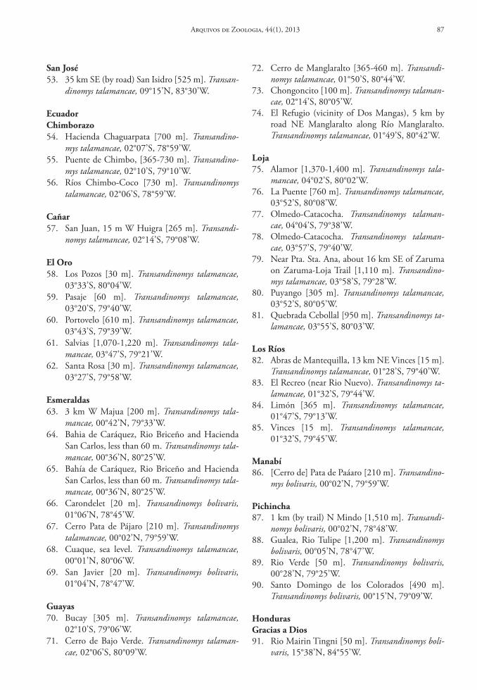
72. Cerro de Manglaralto [365-460 m]. Transandi-nomys talamancae, 01°50’S, 80°44’W.
73. Chongoncito [100 m]. Transandinomys talaman-cae, 02°14’S, 80°05’W.
74. El Refugio (vicinity of Dos Mangas), 5 km by road NE Manglaralto along Río Manglaralto. Transandinomys talamancae, 01°49’S, 80°42’W.
loja75. Alamor [1,370-1,400 m]. Transandinomys tala-
mancae, 04°02’S, 80°02’W.76. La Puente [760 m]. Transandinomys talamancae,
03°52’S, 80°08’W.77. Olmedo-Catacocha. Transandinomys talaman-
cae, 04°04’S, 79°38’W.78. Olmedo-Catacocha. Transandinomys talaman-
cae, 03°57’S, 79°40’W.79. Near Pta. Sta. Ana, about 16 km SE of Zaruma
on Zaruma-Loja Trail [1,110 m]. Transandino-mys talamancae, 03°58’S, 79°28’W.
80. Puyango [305 m]. Transandinomys talamancae, 03°52’S, 80°05’W.
81. Quebrada Cebollal [950 m]. Transandinomys ta-lamancae, 03°55’S, 80°03’W.
los ríos82. Abras de Mantequilla, 13 km NE Vinces [15 m].
Transandinomys talamancae, 01°28’S, 79°40’W.83. El Recreo (near Rio Nuevo). Transandinomys ta-
lamancae, 01°32’S, 79°44’W.84. Limón [365 m]. Transandinomys talamancae,
01°47’S, 79°13’W.85. Vinces [15 m]. Transandinomys talamancae,
01°32’S, 79°45’W.
Manabí86. [Cerro de] Pata de Paáaro [210 m]. Transandino-
mys bolivaris, 00°02’N, 79°59’W.
Pichincha87. 1 km (by trail) N Mindo [1,510 m]. Transandi-
nomys bolivaris, 00°02’N, 78°48’W.88. Gualea, Rio Tulipe [1,200 m]. Transandinomys
bolivaris, 00°05’N, 78°47’W.89. Rio Verde [50 m]. Transandinomys bolivaris,
00°28’N, 79°25’W.90. Santo Domingo de los Colorados [490 m].
Transandinomys bolivaris, 00°15’N, 79°09’W.
hondurasGracias a dios91. Rio Mairin Tingni [50 m]. Transandinomys boli-
varis, 15°38’N, 84°55’W.
san José53. 35 km SE (by road) San Isidro [525 m]. Transan-
dinomys talamancae, 09°15’N, 83°30’W.
ecuadorchimborazo54. Hacienda Chaguarpata [700 m]. Transandino-
mys talamancae, 02°07’S, 78°59’W.55. Puente de Chimbo, [365-730 m]. Transandino-
mys talamancae, 02°10’S, 79°10’W.56. Ríos Chimbo-Coco [730 m]. Transandinomys
talamancae, 02°06’S, 78°59’W.
cañar57. San Juan, 15 m W Huigra [265 m]. Transandi-
nomys talamancae, 02°14’S, 79°08’W.
el oro58. Los Pozos [30 m]. Transandinomys talamancae,
03°33’S, 80°04’W.59. Pasaje [60 m]. Transandinomys talamancae,
03°20’S, 79°40’W.60. Portovelo [610 m]. Transandinomys talamancae,
03°43’S, 79°39’W.61. Salvias [1,070-1,220 m]. Transandinomys tala-
mancae, 03°47’S, 79°21’W.62. Santa Rosa [30 m]. Transandinomys talamancae,
03°27’S, 79°58’W.
esmeraldas63. 3 km W Majua [200 m]. Transandinomys tala-
mancae, 00°42’N, 79°33’W.64. Bahia de Caráquez, Rio Briceño and Hacienda
San Carlos, less than 60 m. Transandinomys tala-mancae, 00°36’N, 80°25’W.
65. Bahía de Caráquez, Rio Briceño and Hacienda San Carlos, less than 60 m. Transandinomys tala-mancae, 00°36’N, 80°25’W.
66. Carondelet [20 m]. Transandinomys bolivaris, 01°06’N, 78°45’W.
67. Cerro Pata de Pájaro [210 m]. Transandinomys talamancae, 00°02’N, 79°59’W.
68. Cuaque, sea level. Transandinomys talamancae, 00°01’N, 80°06’W.
69. San Javier [20 m]. Transandinomys bolivaris, 01°04’N, 78°47’W.
Guayas70. Bucay [305 m]. Transandinomys talamancae,
02°10’S, 79°06’W.71. Cerro de Bajo Verde. Transandinomys talaman-
cae, 02°06’S, 80°09’W.
Arquivos de Zoologia, 44(1), 2013 87
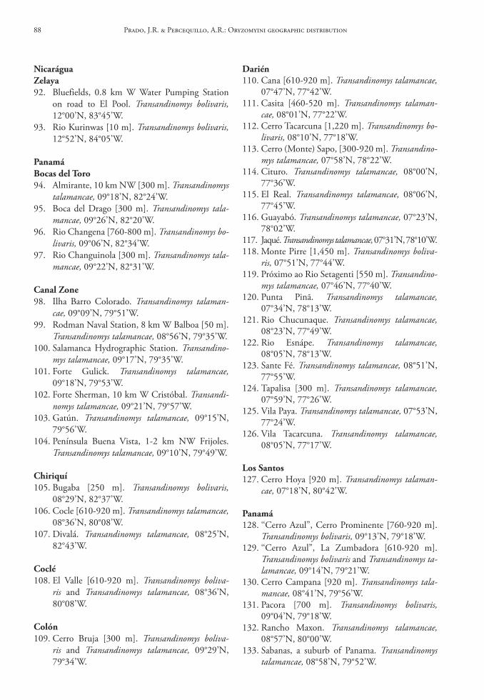
darién110. Cana [610-920 m]. Transandinomys talamancae,
07°47’N, 77°42’W.111. Casita [460-520 m]. Transandinomys talaman-
cae, 08°01’N, 77°22’W.112. Cerro Tacarcuna [1,220 m]. Transandinomys bo-
livaris, 08°10’N, 77°18’W.113. Cerro (Monte) Sapo, [300-920 m]. Transandino-
mys talamancae, 07°58’N, 78°22’W.114. Cituro. Transandinomys talamancae, 08°00’N,
77°36’W.115. El Real. Transandinomys talamancae, 08°06’N,
77°45’W.116. Guayabó. Transandinomys talamancae, 07°23’N,
78°02’W.117. Jaqué. Transandinomys talamancae, 07°31’N, 78°10’W.118. Monte Pirre [1,450 m]. Transandinomys boliva-
ris, 07°51’N, 77°44’W.119. Próximo ao Rio Setagenti [550 m]. Transandino-
mys talamancae, 07°46’N, 77°40’W.120. Punta Pinã. Transandinomys talamancae,
07°34’N, 78°13’W.121. Rio Chucunaque. Transandinomys talamancae,
08°23’N, 77°49’W.122. Rio Esnápe. Transandinomys talamancae,
08°05’N, 78°13’W.123. Sante Fé. Transandinomys talamancae, 08°51’N,
77°55’W.124. Tapalisa [300 m]. Transandinomys talamancae,
07°59’N, 77°26’W.125. Vila Paya. Transandinomys talamancae, 07°53’N,
77°24’W.126. Vila Tacarcuna. Transandinomys talamancae,
08°05’N, 77°17’W.
los santos127. Cerro Hoya [920 m]. Transandinomys talaman-
cae, 07°18’N, 80°42’W.
Panamá128. ‘‘Cerro Azul”, Cerro Prominente [760-920 m].
Transandinomys bolivaris, 09°13’N, 79°18’W.129. ‘‘Cerro Azul”, La Zumbadora [610-920 m].
Transandinomys bolivaris and Transandinomys ta-lamancae, 09°14’N, 79°21’W.
130. Cerro Campana [920 m]. Transandinomys tala-mancae, 08°41’N, 79°56’W.
131. Pacora [700 m]. Transandinomys bolivaris, 09°04’N, 79°18’W.
132. Rancho Maxon. Transandinomys talamancae, 08°57’N, 80°00’W.
133. Sabanas, a suburb of Panama. Transandinomys talamancae, 08°58’N, 79°52’W.
nicaráguaZelaya92. Bluefields, 0.8 km W Water Pumping Station
on road to El Pool. Transandinomys bolivaris, 12°00’N, 83°45’W.
93. Rio Kurinwas [10 m]. Transandinomys bolivaris, 12°52’N, 84°05’W.
Panamábocas del toro94. Almirante, 10 km NW [300 m]. Transandinomys
talamancae, 09°18’N, 82°24’W.95. Boca del Drago [300 m]. Transandinomys tala-
mancae, 09°26’N, 82°20’W.96. Rio Changena [760-800 m]. Transandinomys bo-
livaris, 09°06’N, 82°34’W.97. Rio Changuinola [300 m]. Transandinomys tala-
mancae, 09°22’N, 82°31’W.
canal Zone98. Ilha Barro Colorado. Transandinomys talaman-
cae, 09°09’N, 79°51’W.99. Rodman Naval Station, 8 km W Balboa [50 m].
Transandinomys talamancae, 08°56’N, 79°35’W.100. Salamanca Hydrographic Station. Transandino-
mys talamancae, 09°17’N, 79°35’W.101. Forte Gulick. Transandinomys talamancae,
09°18’N, 79°53’W.102. Forte Sherman, 10 km W Cristóbal. Transandi-
nomys talamancae, 09°21’N, 79°57’W.103. Gatún. Transandinomys talamancae, 09°15’N,
79°56’W.104. Península Buena Vista, 1-2 km NW Frijoles.
Transandinomys talamancae, 09°10’N, 79°49’W.
chiriquí105. Bugaba [250 m]. Transandinomys bolivaris,
08°29’N, 82°37’W.106. Cocle [610-920 m]. Transandinomys talamancae,
08°36’N, 80°08’W.107. Divalá. Transandinomys talamancae, 08°25’N,
82°43’W.
coclé108. El Valle [610-920 m]. Transandinomys boliva-
ris and Transandinomys talamancae, 08°36’N, 80°08’W.
colón109. Cerro Bruja [300 m]. Transandinomys boliva-
ris and Transandinomys talamancae, 09°29’N, 79°34’W.
Prado, J.R. & Percequillo, A.R.: Oryzomyini geographic distribution88
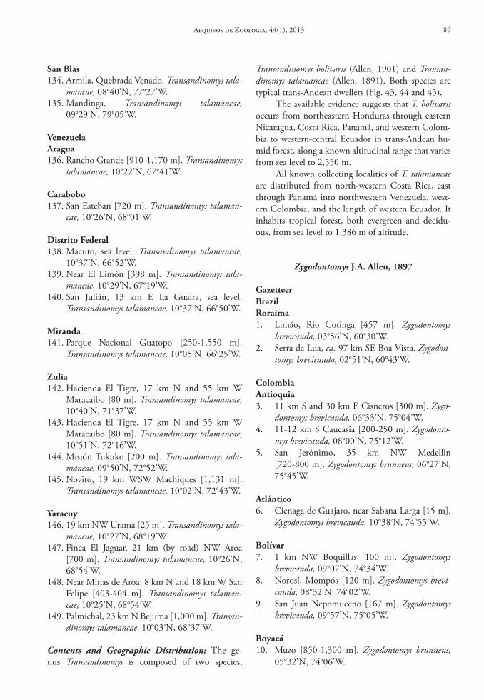
san blas134. Armila, Quebrada Venado. Transandinomys tala-
mancae, 08°40’N, 77°27’W.135. Mandinga. Transandinomys talamancae,
09°29’N, 79°05’W.
VenezuelaAragua136. Rancho Grande [910-1,170 m]. Transandinomys
talamancae, 10°22’N, 67°41’W.
carabobo137. San Esteban [720 m]. Transandinomys talaman-
cae, 10°26’N, 68°01’W.
distrito Federal138. Macuto, sea level. Transandinomys talamancae,
10°37’N, 66°52’W.139. Near El Limón [398 m]. Transandinomys tala-
mancae, 10°29’N, 67°19’W.140. San Julián, 13 km E La Guaira, sea level.
Transandinomys talamancae, 10°37’N, 66°50’W.
Miranda141. Parque Nacional Guatopo [250-1,550 m].
Transandinomys talamancae, 10°05’N, 66°25’W.
Zulia142. Hacienda El Tigre, 17 km N and 55 km W
Maracaibo [80 m]. Transandinomys talamancae, 10°40’N, 71°37’W.
143. Hacienda El Tigre, 17 km N and 55 km W Maracaibo [80 m]. Transandinomys talamancae, 10°51’N, 72°16’W.
144. Misión Tukuko [200 m]. Transandinomys tala-mancae, 09°50’N, 72°52’W.
145. Novito, 19 km WSW Machiques [1,131 m]. Transandinomys talamancae, 10°02’N, 72°43’W.
Yaracuy146. 19 km NW Urama [25 m]. Transandinomys tala-
mancae, 10°27’N, 68°19’W.147. Finca El Jaguar, 21 km (by road) NW Aroa
[700 m]. Transandinomys talamancae, 10°26’N, 68°54’W.
148. Near Minas de Aroa, 8 km N and 18 km W San Felipe [403-404 m]. Transandinomys talaman-cae, 10°25’N, 68°54’W.
149. Palmichal, 23 km N Bejuma [1,000 m]. Transan-dinomys talamancae, 10°03’N, 68°37’W.
Contents and Geographic Distribution: The ge-nus Transandinomys is composed of two species,
Transandinomys bolivaris (Allen, 1901) and Transan-dinomys talamancae (Allen, 1891). Both species are typical trans-Andean dwellers (Fig. 43, 44 and 45).
The available evidence suggests that T. bolivaris occurs from northeastern Honduras through eastern Nicaragua, Costa Rica, Panamá, and western Colom-bia to western-central Ecuador in trans-Andean hu-mid forest, along a known altitudinal range that varies from sea level to 2,550 m.
All known collecting localities of T. talamancae are distributed from north-western Costa Rica, east through Panamá into northwestern Venezuela, west-ern Colombia, and the length of western Ecuador. It inhabits tropical forest, both evergreen and decidu-ous, from sea level to 1,386 m of altitude.
Zygodontomys J.A. Allen, 1897
Gazetteerbrazilroraima1. Limão, Rio Cotinga [457 m]. Zygodontomys
brevicauda, 03°56’N, 60°30’W.2. Serra da Lua, ca. 97 km SE Boa Vista. Zygodon-
tomys brevicauda, 02°51’N, 60°43’W.
colombiaAntioquia3. 11 km S and 30 km E Cisneros [300 m]. Zygo-
dontomys brevicauda, 06°33’N, 75°04’W.4. 11-12 km S Caucasia [200-250 m]. Zygodonto-
mys brevicauda, 08°00’N, 75°12’W.5. San Jerônimo, 35 km NW Medellin
[720-800 m]. Zygodontomys brunneus, 06°27’N, 75°45’W.
Atlántico6. Cienaga de Guajaro, near Sabana Larga [15 m].
Zygodontomys brevicauda, 10°38’N, 74°55’W.
bolívar7. 1 km NW Boquillas [100 m]. Zygodontomys
brevicauda, 09°07’N, 74°34’W.8. Norosí, Mompós [120 m]. Zygodontomys brevi-
cauda, 08°32’N, 74°02’W.9. San Juan Nepomuceno [167 m]. Zygodontomys
brevicauda, 09°57’N, 75°05’W.
boyacá10. Muzo [850-1,300 m]. Zygodontomys brunneus,
05°32’N, 74°06’W.
Arquivos de Zoologia, 44(1), 2013 89
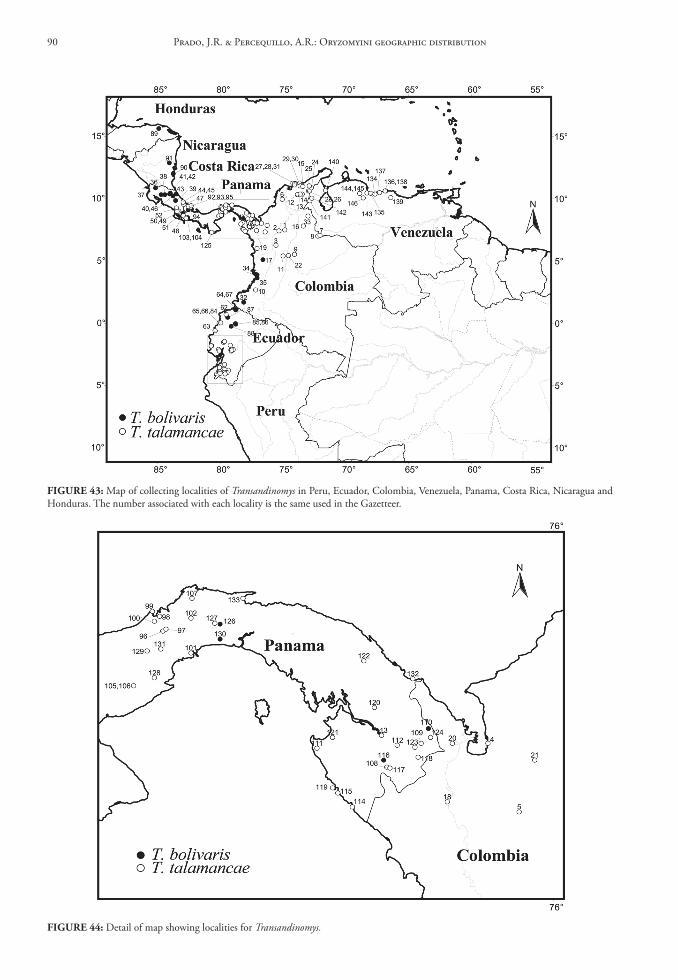
FIGure 43: Map of collecting localities of Transandinomys in Peru, Ecuador, Colombia, Venezuela, Panama, Costa Rica, Nicaragua and Honduras. The number associated with each locality is the same used in the Gazetteer.
FIGure 44: Detail of map showing localities for Transandinomys.
Prado, J.R. & Percequillo, A.R.: Oryzomyini geographic distribution90
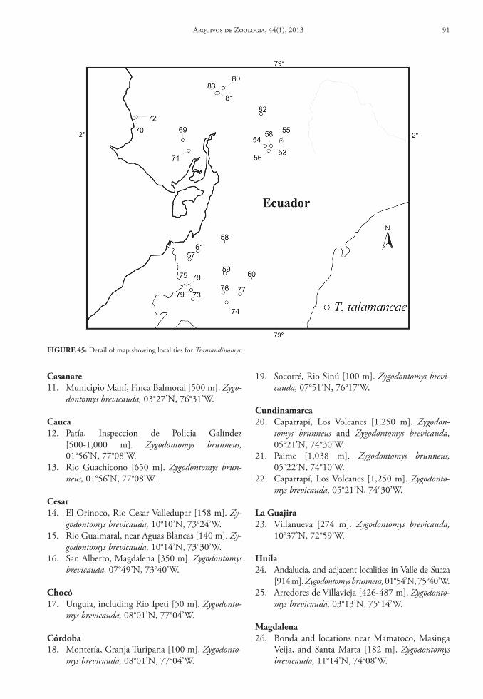
casanare11. Municipio Maní, Finca Balmoral [500 m]. Zygo-
dontomys brevicauda, 03°27’N, 76°31’W.
cauca12. Patía, Inspeccion de Policia Galíndez
[500-1,000 m]. Zygodontomys brunneus, 01°56’N, 77°08’W.
13. Rio Guachicono [650 m]. Zygodontomys brun-neus, 01°56’N, 77°08’W.
cesar14. El Orinoco, Rio Cesar Valledupar [158 m]. Zy-
godontomys brevicauda, 10°10’N, 73°24’W.15. Rio Guaimaral, near Aguas Blancas [140 m]. Zy-
godontomys brevicauda, 10°14’N, 73°30’W.16. San Alberto, Magdalena [350 m]. Zygodontomys
brevicauda, 07°49’N, 73°40’W.
chocó17. Unguia, including Rio Ipeti [50 m]. Zygodonto-
mys brevicauda, 08°01’N, 77°04’W.
córdoba18. Montería, Granja Turipana [100 m]. Zygodonto-
mys brevicauda, 08°01’N, 77°04’W.
19. Socorré, Rio Sinú [100 m]. Zygodontomys brevi-cauda, 07°51’N, 76°17’W.
cundinamarca20. Caparrapí, Los Volcanes [1,250 m]. Zygodon-
tomys brunneus and Zygodontomys brevicauda, 05°21’N, 74°30’W.
21. Paime [1,038 m]. Zygodontomys brunneus, 05°22’N, 74°10’W.
22. Caparrapí, Los Volcanes [1,250 m]. Zygodonto-mys brevicauda, 05°21’N, 74°30’W.
la Guajira23. Villanueva [274 m]. Zygodontomys brevicauda,
10°37’N, 72°59’W.
huíla24. Andalucia, and adjacent localities in Valle de Suaza
[914 m]. Zygodontomys brunneus, 01°54’N, 75°40’W.25. Arredores de Villavieja [426-487 m]. Zygodonto-
mys brevicauda, 03°13’N, 75°14’W.
Magdalena26. Bonda and locations near Mamatoco, Masinga
Veija, and Santa Marta [182 m]. Zygodontomys brevicauda, 11°14’N, 74°08’W.
FIGure 45: Detail of map showing localities for Transandinomys.
Arquivos de Zoologia, 44(1), 2013 91
43. Municipio Dagau, Atuncela and 1.5 km S Lo-boguerrero [700-800 m]. Zygodontomys brun-neus, 03°46’N, 76°42’W.
44. Municipio Ansermanuevo, Hacienda Formosa [930 m]. Zygodontomys brunneus, 04°48’N, 75°59’W.
Vichada45. vicinity of Puerto Carreño [100 m]. Zygodonto-
mys brevicauda, 06°12’N, 67°22’W.46. Maipures [115 m]. Zygodontomys brevicauda,
05°11’N, 67°49’W.47. Territorio Faunistico “El Tuparro” Centro Ad-
ministrativo [100 m]. Zygodontomys brevicauda, 05°20’N, 67°48’W.
costa ricaPuntarenas48. 2 km W Rio Baru, including Dominical and
vicinity [100 m]. Zygodontomys brevicauda, 09°13’N, 83°51’W.
49. Boruca [487 m]. Zygodontomys brevicauda, 09°00’N, 83°20’W.
50. Esterillos Oeste, 15 km SE Jaco [100 m]. Zygo-dontomys brevicauda, 09°36’N, 83°20’W.
51. Finca Helechales [910 m]. Zygodontomys brevi-cauda, 09°05’N, 83°05’W.
52. Gromaco, 15 km ESE Portero Grande [335 m]. Zygodontomys brevicauda, 09°00’N, 83°11’W.
53. Palmar and 20 km SSW Palmar Sur [100 m]. Zygodontomys brevicauda, 08°58’N, 83°29’W.
54. Parrita including Finca Ligia [100 m]. Zygodon-tomys brevicauda, 09°30’N, 84°19’W.
55. Sardinal [100 m]. Zygodontomys brevicauda, 09°32’N, 84°19’W.
French Guianarupununi56. Dadanawa [200 m]. Zygodontomys brevicauda,
02°50’N, 59°30’W.57. Montanhas Kanuku [including “Rupununi
River,” “Upocarit,” “Kwaimatta”, “Wainu,” and “Tewa-Kewa”], [60-182 m]. Zygodontomys brevi-cauda, 03°12’N, 59°30’W.
58. Nappi Creek near Letham, Montanhas Kanuku [200 m]. Zygodontomys brevicauda, 03°23’N, 59°48’W.
east demerara‑West coast bèrbice59. Great Falls [27 m]. Zygodontomys brevicauda,
05°19’N, 58°31’W.60. Parque Hyde [100 m]. Zygodontomys brevicauda,
06°30’N, 58°16’W.
27. Isla de Salamanca, 0.5 km W Los Cocos, sea level. Zygodontomys brevicauda, 10°58’N, 74°30’W.
Meta28. vicinity of Puerto Gaitian [200 m]. Zygodonto-
mys brevicauda, 04°18’N, 72°05’W.29. vicinity of Villavicencio, including Finca El
Buque [500-600 m]. Zygodontomys brevicauda, 04°09’N, 73°37’W.
30. Fuente de Oro, vereda La Esperanza, Finca La Virginia [200-500 m]. Zygodontomys brevicauda, 03°28’N, 73°37’W.
31. Puerto Lopez, vereda Menegua, Finca El La-gunazo [200 m]. Zygodontomys brevicauda, 04°05’N, 72°58’W.
32. Puerto Lleras [500 m]. Zygodontomys brevicauda, 03°16’N, 73°23’W.
33. Restrepo [600 m]. Zygodontomys brevicauda, 04°15’N, 73°33’W.
34. San Juan de Arama including Los Micos [500-1,000 m]. Zygodontomys brevicauda, 03°26’N, 73°50’W.
35. San Martin [422 m]. Zygodontomys brevicauda, 03°42’N, 73°42’W.
nariño36. Finca Arizona, 4.5 km S Remolino
[500-1,000 m]. Zygodontomys brunneus, 02°17’N, 78°28’W.
norte de santander37. El Guayabal, 16 km Cúcuta [200 m]. Zygodonto-
mys brevicauda, 08°01’N, 72°30’W.
santander38. Hacienda Montebello near Cerro San Pablo
[350-500 m]. Zygodontomys brunneus, 07°00’N, 73°25’W.
sucre39. Colosó, Las Campanas [200 m]. Zygodontomys
brevicauda, 09°30’N, 75°21’W.
tolima40. Chicoral [548 m]. Zygodontomys brevicauda,
04°13’N, 74°59’W.41. El Triunfo, near Honda [182 m]. Zygodontomys
brevicauda, 05°12’N, 74°45’W.
Valle del cauca42. vicinity of Cali [957 m]. Zygodontomys brunneus,
03°27’N, 76°31’W.
Prado, J.R. & Percequillo, A.R.: Oryzomyini geographic distribution92
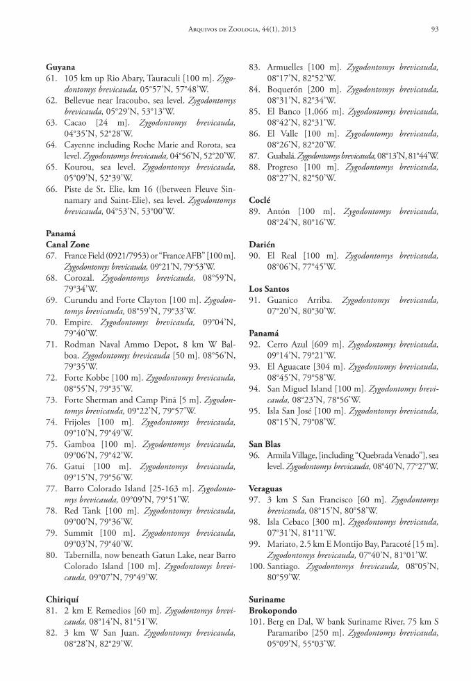
Guyana61. 105 km up Rio Abary, Tauraculi [100 m]. Zygo-
dontomys brevicauda, 05°57’N, 57°48’W.62. Bellevue near Iracoubo, sea level. Zygodontomys
brevicauda, 05°29’N, 53°13’W.63. Cacao [24 m]. Zygodontomys brevicauda,
04°35’N, 52°28’W.64. Cayenne including Roche Marie and Rorota, sea
level. Zygodontomys brevicauda, 04°56’N, 52°20’W.65. Kourou, sea level. Zygodontomys brevicauda,
05°09’N, 52°39’W.66. Piste de St. Elie, km 16 ((between Fleuve Sin-
namary and Saint-Elie), sea level. Zygodontomys brevicauda, 04°53’N, 53°00’W.
Panamácanal Zone67. France Field (0921/7953) or “France AFB” [100 m].
Zygodontomys brevicauda, 09°21’N, 79°53’W.68. Corozal. Zygodontomys brevicauda, 08°59’N,
79°34’W.69. Curundu and Forte Clayton [100 m]. Zygodon-
tomys brevicauda, 08°59’N, 79°33’W.70. Empire. Zygodontomys brevicauda, 09°04’N,
79°40’W.71. Rodman Naval Ammo Depot, 8 km W Bal-
boa. Zygodontomys brevicauda [50 m]. 08°56’N, 79°35’W.
72. Forte Kobbe [100 m]. Zygodontomys brevicauda, 08°55’N, 79°35’W.
73. Forte Sherman and Camp Pinã [5 m]. Zygodon-tomys brevicauda, 09°22’N, 79°57’W.
74. Frijoles [100 m]. Zygodontomys brevicauda, 09°10’N, 79°49’W.
75. Gamboa [100 m]. Zygodontomys brevicauda, 09°06’N, 79°42’W.
76. Gatui [100 m]. Zygodontomys brevicauda, 09°15’N, 79°56’W.
77. Barro Colorado Island [25-163 m]. Zygodonto-mys brevicauda, 09°09’N, 79°51’W.
78. Red Tank [100 m]. Zygodontomys brevicauda, 09°00’N, 79°36’W.
79. Summit [100 m]. Zygodontomys brevicauda, 09°03’N, 79°40’W.
80. Tabernilla, now beneath Gatun Lake, near Barro Colorado Island [100 m]. Zygodontomys brevi-cauda, 09°07’N, 79°49’W.
chiriquí81. 2 km E Remedios [60 m]. Zygodontomys brevi-
cauda, 08°14’N, 81°51’W.82. 3 km W San Juan. Zygodontomys brevicauda,
08°28’N, 82°29’W.
83. Armuelles [100 m]. Zygodontomys brevicauda, 08°17’N, 82°52’W.
84. Boquerón [200 m]. Zygodontomys brevicauda, 08°31’N, 82°34’W.
85. El Banco [1,066 m]. Zygodontomys brevicauda, 08°42’N, 82°31’W.
86. El Valle [100 m]. Zygodontomys brevicauda, 08°26’N, 82°20’W.
87. Guabalá. Zygodontomys brevicauda, 08°13’N, 81°44’W.88. Progreso [100 m]. Zygodontomys brevicauda,
08°27’N, 82°50’W.
coclé89. Antón [100 m]. Zygodontomys brevicauda,
08°24’N, 80°16’W.
darién90. El Real [100 m]. Zygodontomys brevicauda,
08°06’N, 77°45’W.
los santos91. Guanico Arriba. Zygodontomys brevicauda,
07°20’N, 80°30’W.
Panamá92. Cerro Azul [609 m]. Zygodontomys brevicauda,
09°14’N, 79°21’W.93. El Aguacate [304 m]. Zygodontomys brevicauda,
08°45’N, 79°58’W.94. San Miguel Island [100 m]. Zygodontomys brevi-
cauda, 08°23’N, 78°56’W.95. Isla San José [100 m]. Zygodontomys brevicauda,
08°15’N, 79°08’W.
san blas96. Armila Village, [including “Quebrada Venado”], sea
level. Zygodontomys brevicauda, 08°40’N, 77°27’W.
Veraguas97. 3 km S San Francisco [60 m]. Zygodontomys
brevicauda, 08°15’N, 80°58’W.98. Isla Cebaco [300 m]. Zygodontomys brevicauda,
07°31’N, 81°11’W.99. Mariato, 2.5 km E Montijo Bay, Paracoté [15 m].
Zygodontomys brevicauda, 07°40’N, 81°01’W.100. Santiago. Zygodontomys brevicauda, 08°05’N,
80°59’W.
surinamebrokopondo101. Berg en Dal, W bank Suriname River, 75 km S
Paramaribo [250 m]. Zygodontomys brevicauda, 05°09’N, 55°03’W.
Arquivos de Zoologia, 44(1), 2013 93
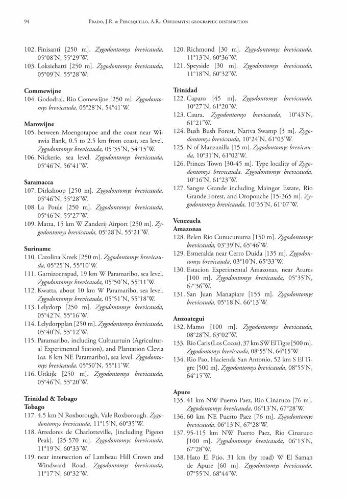
120. Richmond [30 m]. Zygodontomys brevicauda, 11°13’N, 60°36’W.
121. Speyside [30 m]. Zygodontomys brevicauda, 11°18’N, 60°32’W.
trinidad122. Caparo [45 m]. Zygodontomys brevicauda,
10°27’N, 61°20’W.123. Caura. Zygodontomys brevicauda, 10°43’N,
61°21’W.124. Bush Bush Forest, Nariva Swamp [3 m]. Zygo-
dontomys brevicauda, 10°24’N, 61°03’W.125. N of Manzanilla [15 m]. Zygodontomys brevicau-
da, 10°31’N, 61°02’W.126. Princes Town [30-45 m]. Type locality of Zygo-
dontomys brevicauda. Zygodontomys brevicauda, 10°16’N, 61°23’W.
127. Sangre Grande including Maingot Estate, Rio Grande Forest, and Oropouche [15-365 m]. Zy-godontomys brevicauda, 10°35’N, 61°07’W.
VenezuelaAmazonas128. Belen Rio Cunucunuma [150 m]. Zygodontomys
brevicauda, 03°39’N, 65°46’W.129. Esmeralda near Cerro Duida [135 m]. Zygodon-
tomys brevicauda, 03°10’N, 65°33’W.130. Estacion Experimental Amazonas, near Atures
[100 m]. Zygodontomys brevicauda, 05°35’N, 67°36’W.
131. San Juan Manapiare [155 m]. Zygodontomys brevicauda, 05°18’N, 66°13’W.
Anzoategui132. Mamo [100 m]. Zygodontomys brevicauda,
08°28’N, 63°02’W.133. Rio Caris (Los Cocos), 37 km SW El Tigre [500 m].
Zygodontomys brevicauda, 08°55’N, 64°15’W.134. Rio Pao, Hacienda San Antonio, 52 km S El Ti-
gre [500 m]. Zygodontomys brevicauda, 08°55’N, 64°15’W.
Apure135. 41 km NW Puerto Paez, Rio Cinaruco [76 m].
Zygodontomys brevicauda, 06°13’N, 67°28’W.136. 60 km NE Puerto Paez [76 m]. Zygodontomys
brevicauda, 06°13’N, 67°28’W.137. 95-115 km NW Puerto Paez, Rio Cinaruco
[100 m]. Zygodontomys brevicauda, 06°13’N, 67°28’W.
138. Hato El Ftio, 31 km (by road) W El Saman de Apure [60 m]. Zygodontomys brevicauda, 07°55’N, 68°44’W.
102. Finisanti [250 m]. Zygodontomys brevicauda, 05°08’N, 55°29’W.
103. Loksiehatti [250 m]. Zygodontomys brevicauda, 05°09’N, 55°28’W.
commewijne104. Gododrai, Rio Comewijne [250 m]. Zygodonto-
mys brevicauda, 05°28’N, 54°41’W.
Marowijne105. between Moengotapoe and the coast near Wi-
awia Bank, 0.5 to 2.5 km from coast, sea level. Zygodontomys brevicauda, 05°35’N, 54°15’W.
106. Nickerie, sea level. Zygodontomys brevicauda, 05°46’N, 56°41’W.
saramacca107. Dirkshoop [250 m]. Zygodontomys brevicauda,
05°46’N, 55°28’W.108. La Poule [250 m]. Zygodontomys brevicauda,
05°46’N, 55°27’W.109. Matta, 15 km W Zanderij Airport [250 m]. Zy-
godontomys brevicauda, 05°28’N, 55°21’W.
suriname110. Carolina Kreek [250 m]. Zygodontomys brevicau-
da, 05°25’N, 55°10’W.111. Garnizoenspad, 19 km W Paramaribo, sea level.
Zygodontomys brevicauda, 05°50’N, 55°11’W.112. Kwatta, about 10 km W Paramaribo, sea level.
Zygodontomys brevicauda, 05°51’N, 55°18’W.113. Lelydorp [250 m]. Zygodontomys brevicauda,
05°42’N, 55°16’W.114. Lelydorpplan [250 m]. Zygodontomys brevicauda,
05°40’N, 55°12’W.115. Paramaribo, including Cultuurtuin (Agricultur-
al Experimental Station), and Plantation Clevia (ca. 8 km NE Paramaribo), sea level. Zygodonto-mys brevicauda, 05°50’N, 55°11’W.
116. Uitkijk [250 m]. Zygodontomys brevicauda, 05°46’N, 55°20’W.
trinidad & tobagotobago117. 4.5 km N Roxborough, Vale Roxborough. Zygo-
dontomys brevicauda, 11°15’N, 60°35’W.118. Arredores de Charlotteville, [including Pigeon
Peak], [25-570 m]. Zygodontomys brevicauda, 11°19’N, 60°33’W.
119. near intersection of Lambeau Hill Crown and Windward Road. Zygodontomys brevicauda, 11°17’N, 60°32’W.
Prado, J.R. & Percequillo, A.R.: Oryzomyini geographic distribution94
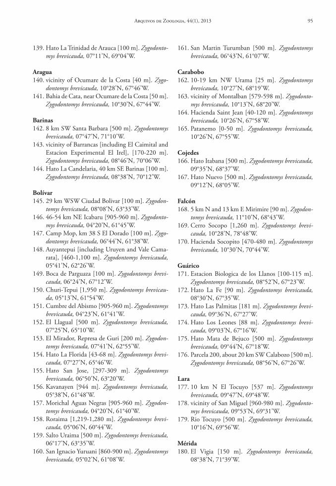
139. Hato La Trinidad de Arauca [100 m]. Zygodonto-mys brevicauda, 07°11’N, 69°04’W.
Aragua140. vicinity of Ocumare de la Costa [40 m]. Zygo-
dontomys brevicauda, 10°28’N, 67°46’W.141. Bahia de Cata, near Ocumare de la Costa [50 m].
Zygodontomys brevicauda, 10°30’N, 67°44’W.
barinas142. 8 km SW Santa Barbara [500 m]. Zygodontomys
brevicauda, 07°47’N, 71°10’W.143. vicinity of Barrancas [including El Caimital and
Estacion Experimental El Irel], [170-220 m]. Zygodontomys brevicauda, 08°46’N, 70°06’W.
144. Hato La Candelaria, 40 km SE Barinas [100 m]. Zygodontomys brevicauda, 08°38’N, 70°12’W.
bolívar145. 29 km WSW Ciudad Bolivar [100 m]. Zygodon-
tomys brevicauda, 08°08’N, 63°33’W.146. 46-54 km NE Icabaru [905-960 m]. Zygodonto-
mys brevicauda, 04°20’N, 61°45’W.147. Camp Mop, km 38 S El Dorado [100 m]. Zygo-
dontomys brevicauda, 06°44’N, 61°38’W.148. Auyantepui [including Uruyen and Vale Cama-
rata], [460-1,100 m]. Zygodontomys brevicauda, 05°41’N, 62°26’W.
149. Boca de Parguaza [100 m]. Zygodontomys brevi-cauda, 06°24’N, 67°12’W.
150. Churi-Tepui [1,950 m]. Zygodontomys brevicau-da, 05°13’N, 61°54’W.
151. Cumbre del Abismo [905-960 m]. Zygodontomys brevicauda, 04°23’N, 61°41’W.
152. El Llagual [500 m]. Zygodontomys brevicauda, 07°25’N, 65°10’W.
153. El Mirador, Represa de Guri [200 m]. Zygodon-tomys brevicauda, 07°41’N, 62°55’W.
154. Hato La Florida [43-68 m]. Zygodontomys brevi-cauda, 07°27’N, 65°46’W.
155. Hato San Jose, [297-309 m]. Zygodontomys brevicauda, 06°50’N, 63°20’W.
156. Kavanayen [944 m]. Zygodontomys brevicauda, 05°38’N, 61°48’W.
157. Morichal Aguas Negras [905-960 m]. Zygodon-tomys brevicauda, 04°20’N, 61°40’W.
158. Roraima [1,219-1,280 m]. Zygodontomys brevi-cauda, 05°06’N, 60°44’W.
159. Salto Uraima [500 m]. Zygodontomys brevicauda, 06°17’N, 63°35’W.
160. San Ignacio Yuruani [860-900 m]. Zygodontomys brevicauda, 05°02’N, 61°08’W.
161. San Martin Turumban [500 m]. Zygodontomys brevicauda, 06°43’N, 61°07’W.
carabobo162. 10-19 km NW Urama [25 m]. Zygodontomys
brevicauda, 10°27’N, 68°19’W.163. vicinity of Montalban [579-598 m]. Zygodonto-
mys brevicauda, 10°13’N, 68°20’W.164. Hacienda Saint Jean [40-120 m]. Zygodontomys
brevicauda, 10°26’N, 67°58’W.165. Patanemo [0-50 m]. Zygodontomys brevicauda,
10°26’N, 67°55’W.
cojedes166. Hato Itabana [500 m]. Zygodontomys brevicauda,
09°35’N, 68°37’W.167. Hato Nuevo [500 m]. Zygodontomys brevicauda,
09°12’N, 68°05’W.
Falcón168. 5 km N and 13 km E Mirimire [90 m]. Zygodon-
tomys brevicauda, 11°10’N, 68°43’W.169. Cerro Socopo [1,260 m]. Zygodontomys brevi-
cauda, 10°28’N, 78°48’W.170. Hacienda Socopito [470-480 m]. Zygodontomys
brevicauda, 10°30’N, 70°44’W.
Guárico171. Estacion Biologica de los Llanos [100-115 m].
Zygodontomys brevicauda, 08°52’N, 67°23’W.172. Hato La Fe [90 m]. Zygodontomys brevicauda,
08°30’N, 67°35’W.173. Hato Las Palmitas [181 m]. Zygodontomys brevi-
cauda, 09°36’N, 67°27’W.174. Hato Los Leones [88 m]. Zygodontomys brevi-
cauda, 09°03’N, 67°16’W.175. Hato Mata de Bejuco [500 m]. Zygodontomys
brevicauda, 09°44’N, 67°18’W.176. Parcela 200, about 20 km SW Calabozo [500 m].
Zygodontomys brevicauda, 08°56’N, 67°26’W.
lara177. 10 km N El Tocuyo [537 m]. Zygodontomys
brevicauda, 09°47’N, 69°48’W.178. vicinity of San Miguel [960-980 m]. Zygodonto-
mys brevicauda, 09°53’N, 69°31’W.179. Rio Tocuyo [500 m]. Zygodontomys brevicauda,
10°16’N, 69°56’W.
Mérida180. El Vigia [150 m]. Zygodontomys brevicauda,
08°38’N, 71°39’W.
Arquivos de Zoologia, 44(1), 2013 95
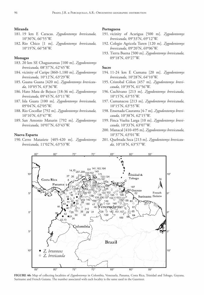
Miranda181. 19 km E Caracas. Zygodontomys brevicauda,
10°30’N, 66°55’W.182. Rio Chico [1 m]. Zygodontomys brevicauda,
10°19’N, 66°58’W.
Monagas183. 20 km SE Chaguaramas [100 m]. Zygodontomys
brevicauda, 08°37’N, 62°45’W.184. vicinity of Caripe [860-1,180 m]. Zygodontomys
brevicauda, 10°12’N, 63°29’W.185. Guana Guana [420 m]. Zygodontomys brevicau-
da, 10°05’N, 63°36’W.186. Hato Mata de Bejuco [18-36 m]. Zygodontomys
brevicauda, 09°45’N, 63°11’W.187. Isla Guara [100 m]. Zygodontomys brevicauda,
09°04’N, 62°05’W.188. Rio Cocollar [792 m]. Zygodontomys brevicauda,
10°10’N, 63°47’W.189. San Antonio Maturin [792 m]. Zygodontomys
brevicauda, 10°07’N, 63°43’W.
nueva esparta190. Cerro Matasiete [405-420 m]. Zygodontomys
brevicauda, 11°02’N, 63°53’W.
Portuguesa191. vicinity of Acarigua [500 m]. Zygodontomys
brevicauda, 09°33’N, 69°12’W.192. Colegio Agricola Turen [120 m]. Zygodontomys
brevicauda, 09°20’N, 69°06’W.193. Tierra Buena [500 m]. Zygodontomys brevicauda,
09°18’N, 69°27’W.
sucre194. 11-24 km E Cumana [20 m]. Zygodontomys
brevicauda, 10°28’N, 64°10’W.195. Cristobal Cólon [457 m]. Zygodontomys brevi-
cauda, 10°39’N, 61°56’W.196. Cuchivano [213 m]. Zygodontomys brevicauda,
10°15’N, 63°55’W.197. Cumanacoa [213 m]. Zygodontomys brevicauda,
10°15’N, 63°55’W.198. Ensenada Cauranta [4-7 m]. Zygodontomys brevi-
cauda, 10°38’N, 62°15’W.199. Finca Vuelta Larga [10 m]. Zygodontomys brevi-
cauda, 10°33’N, 63°07’W.200. Manacal [410-495 m]. Zygodontomys brevicauda,
10°37’N, 63°01’W.201. Quebrada Seca [213 m]. Zygodontomys brevicau-
da, 10°18’N, 63°57’W.
FIGure 46: Map of collecting localities of Zygodontomys in Colombia, Venezuela, Panama, Costa Rica, Trinidad and Tobago, Guyana, Suriname and French Guiana. The number associated with each locality is the same used in the Gazetteer.
Prado, J.R. & Percequillo, A.R.: Oryzomyini geographic distribution96
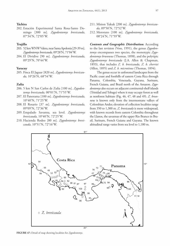
táchira202. Estación Experimental Santa Rosa-Santo Do-
mingo [300 m]. Zygodontomys brevicauda, 07°34’N, 72°05’W.
trujillo203. 52 km WNW Valera, near Santa Apolonia [29-39 m].
Zygodontomys brevicauda, 09°28’N, 71°04’W.204. El Dividive [90 m]. Zygodontomys brevicauda,
09°29’N, 70°44’W.
Yaracuy205. Finca El Jaguar [820 m]. Zygodontomys brevicau-
da, 10°26’N, 68°54’W.
Zulia206. 5 km N San Carlos de Zulia [100 m]. Zygodon-
tomys brevicauda, 00°01’N, 71°55’W.207. El Panorama [100 m]. Zygodontomys brevicauda,
10°40’N, 71°25’W.208. El Rosario [37 m]. Zygodontomys brevicauda,
09°09’N, 72°36’W.209. Empalado Savanna, sea level. Zygodontomys
brevicauda, 10°40’N, 72°25’W.210. Hacienda Rodeo [80 m]. Zygodontomys brevi-
cauda, 10°51’N, 72°16’W.
211. Mision Tukuk [200 m]. Zygodontomys brevicau-da, 09°50’N, 72°52’W.
212. Morotuto [100 m]. Zygodontomys brevicauda, 08°24’N, 71°59’W.
Contents and Geographic Distribution: According to the last revision (Voss, 1991), the genus Zygodon-tomys encompasses two species, the monotypic Zygo-dontomys brunneus (Thomas, 1898), and the polytipic Zygodontomys brevicauda (J.A. Allen & Chapman, 1893), that includes Z. b. brevicauda, Z. b. cherriei (Allen, 1895) and Z. b. microtinus (Thomas, 1894).
The genus occur in unforested landscapes from the Pacific coast and foothills of eastern Costa Rica through Panama, Colombia, Venezuela, Guyana, Surinam, French Guiana, and Brazil north of the Amazon. Zygo-dontomys also occurs on adjacent continental-shelf islands (Trinidad and Tobago) where it may occupy forest as well as nonforest habitats (Fig. 46, 47, 48 and 49). Z. brun-neus is known only from the intermontane valleys of Colombian Andes; elevation of collection localities range from 350 to 1,300 m. Z. brevicauda is more widespread, with known records from eastern Colombia throughout the Llanos, the savannas of the upper Rio Branco in Bra-zil, Surinam, French Guiana and Guyana. The known altitudinal range varies from sea level to 1,180 m.
FIGure 47: Detail of map showing localities for Zygodontomys.
Arquivos de Zoologia, 44(1), 2013 97
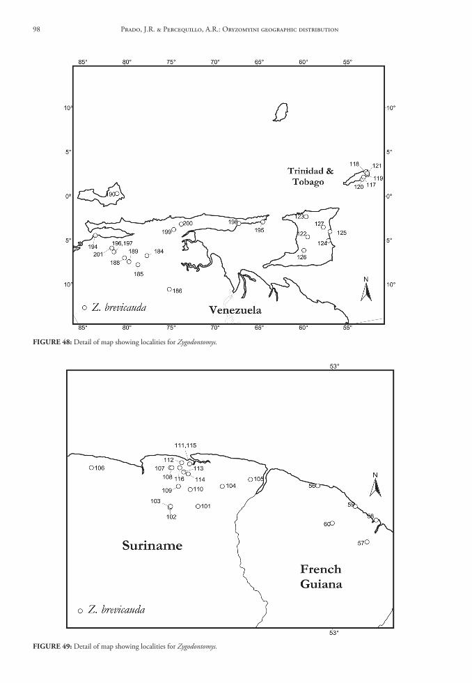
FIGure 48: Detail of map showing localities for Zygodontomys.
FIGure 49: Detail of map showing localities for Zygodontomys.
Prado, J.R. & Percequillo, A.R.: Oryzomyini geographic distribution98
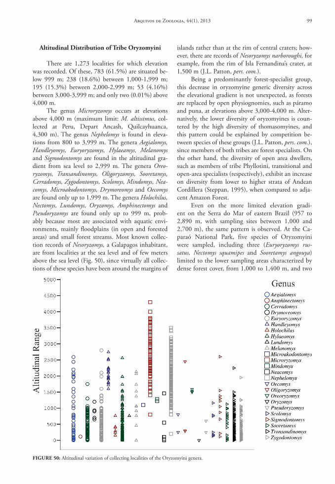
islands rather than at the rim of central craters; how-ever, there are records of Nesoryzomys narboroughi, for example, from the rim of Isla Fernandina’s crater, at 1,500 m (J.L. Patton, pers. com.).
Being a predominantly forest-specialist group, this decrease in oryzomyine generic diversity across the elevational gradient is not unexpected, as forests are replaced by open physiognomies, such as páramo and puna, at elevations above 3,000-4,000 m. Alter-natively, the lower diversity of oryzomyines is coun-tered by the high diversity of thomasomyines, and this pattern could be explained by competition be-tween species of these groups (J.L. Patton, pers. com.), since members of both tribes are forest specialists. On the other hand, the diversity of open area dwellers, such as members of tribe Phyllotini, transitional and open-area specialists (respectively), exhibit an increase on diversity from lower to higher strata of Andean Cordillera (Steppan, 1995), when compared to adja-cent Amazon Forest.
Even on the more limited elevation gradi-ent on the Serra do Mar of eastern Brazil (957 to 2,890 m, with sampling sites between 1,000 and 2,700 m), the same pattern is observed. At the Ca-paraó National Park, five species of Oryzomyini were sampled, including three (Euryoryzomys rus-satus, Nectomys squamipes and Sooretamys angouya) limited to the lower sampling areas characterized by dense forest cover, from 1,000 to 1,400 m, and two
Altitudinal distribution of tribe oryzomyini
There are 1,273 localities for which elevation was recorded. Of these, 783 (61.5%) are situated be-low 999 m; 238 (18.6%) between 1,000-1,999 m; 195 (15.3%) between 2,000-2,999 m; 53 (4.16%) between 3,000-3,999 m; and only two (0.01%) above 4,000 m.
The genus Microryzomys occurs at elevations above 4,000 m (maximum limit: M. altissimus, col-lected at Peru, Depart Ancash, Quilcayhuanca, 4,300 m). The genus Nephelomys is found in eleva-tions from 800 to 3,999 m. The genera Aegialomys, Handleyomys, Euryoryzomys, Hylaeamys, Melanomys and Sigmodontomys are found in the altitudinal gra-dient from sea level to 2,999 m. The genera Oreo-ryzomys, Transandinomys, Oligoryzomys, Sooretamys, Cerradomys, Zygodontomys, Scolomys, Mindomys, Nea-comys, Microakodontomys, Drymoreomys and Oecomys are found only up to 1,999 m. The genera Holochilus, Nectomys, Lundomys, Oryzomys, Amphinectomys and Pseudoryzomys are found only up to 999 m, prob-ably because most are associated with aquatic envi-ronments, mainly floodplains (in open and forested areas) and small forest streams. Most known collec-tion records of Nesoryzomys, a Galapagos inhabitant, are from localities at the sea level and of few meters above the sea level (Fig. 50), since virtually all collec-tions of these species have been around the margins of
FIGure 50: Altitudinal variation of collecting localities of the Oryzomyini genera.
Arquivos de Zoologia, 44(1), 2013 99

were captured, four species only above 1,800 m (two undescribed species of Oxymycterus, one Akodon and one Calomys), all captured in montane scrub and hu-mid montane forests, both vegetation types restricted to upper portions of Caparaó mountains (1,800 to 2,700 m).
(Oligoryzomys nigripes and Oligoryzomys sp.) with a broader range between 1,100 to 2,000 and 1,800 to 2,400 m, respectively. Along the entire gradient, specimens were captured only in montane forest and mountain scrub (Bonvicino et al., 1997). In contrast, among the Akodontini and Phyllotini, seven species
FIGure 51: Map of collecting localities of Oryzomyini in South America.
Prado, J.R. & Percequillo, A.R.: Oryzomyini geographic distribution100
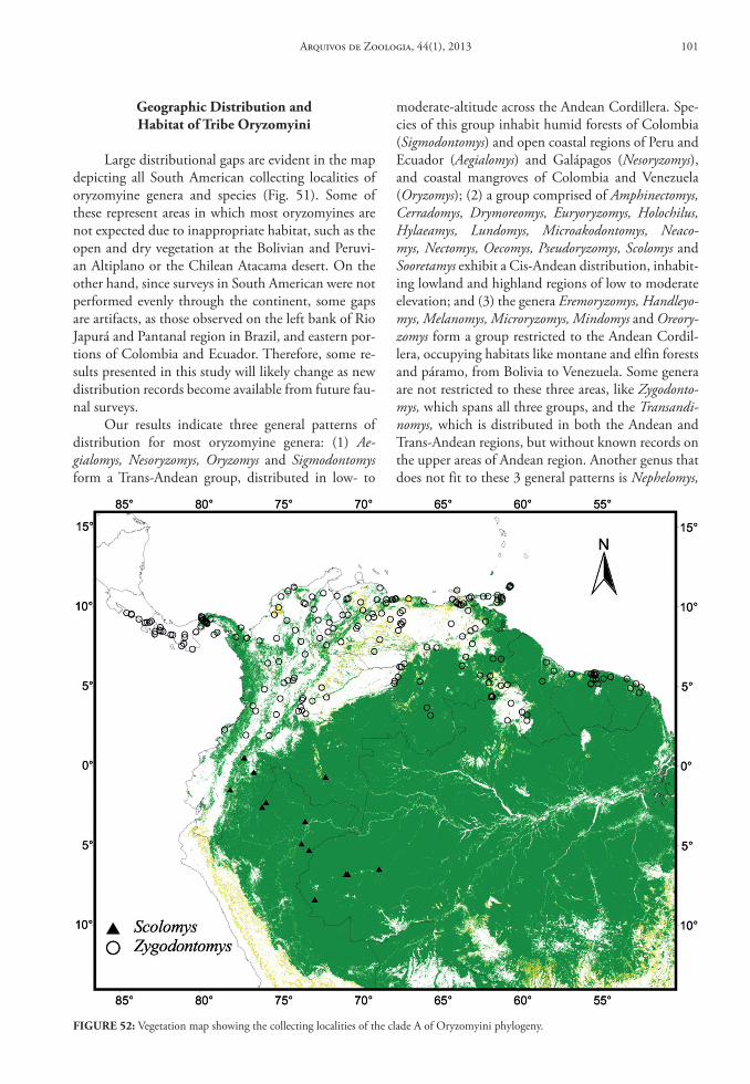
Geographic distribution and habitat of tribe oryzomyini
Large distributional gaps are evident in the map depicting all South American collecting localities of oryzomyine genera and species (Fig. 51). Some of these represent areas in which most oryzomyines are not expected due to inappropriate habitat, such as the open and dry vegetation at the Bolivian and Peruvi-an Altiplano or the Chilean Atacama desert. On the other hand, since surveys in South American were not performed evenly through the continent, some gaps are artifacts, as those observed on the left bank of Rio Japurá and Pantanal region in Brazil, and eastern por-tions of Colombia and Ecuador. Therefore, some re-sults presented in this study will likely change as new distribution records become available from future fau-nal surveys.
Our results indicate three general patterns of distribution for most oryzomyine genera: (1) Ae-gialomys, Nesoryzomys, Oryzomys and Sigmodontomys form a Trans-Andean group, distributed in low- to
moderate-altitude across the Andean Cordillera. Spe-cies of this group inhabit humid forests of Colombia (Sigmodontomys) and open coastal regions of Peru and Ecuador (Aegialomys) and Galápagos (Nesoryzomys), and coastal mangroves of Colombia and Venezuela (Oryzomys); (2) a group comprised of Amphinectomys, Cerradomys, Drymoreomys, Euryoryzomys, Holochilus, Hylaeamys, Lundomys, Microakodontomys, Neaco-mys, Nectomys, Oecomys, Pseudoryzomys, Scolomys and Sooretamys exhibit a Cis-Andean distribution, inhabit-ing lowland and highland regions of low to moderate elevation; and (3) the genera Eremoryzomys, Handleyo-mys, Melanomys, Microryzomys, Mindomys and Oreory-zomys form a group restricted to the Andean Cordil-lera, occupying habitats like montane and elfin forests and páramo, from Bolivia to Venezuela. Some genera are not restricted to these three areas, like Zygodonto-mys, which spans all three groups, and the Transandi-nomys, which is distributed in both the Andean and Trans-Andean regions, but without known records on the upper areas of Andean region. Another genus that does not fit to these 3 general patterns is Nephelomys,
FIGure 52: Vegetation map showing the collecting localities of the clade A of Oryzomyini phylogeny.
Arquivos de Zoologia, 44(1), 2013 101
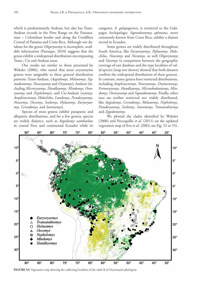
which is predominantly Andean, but also has Trans-Andean records in the Pirre Range on the Panama-nian – Colombian border and along the Cordillera Central of Panama and Costa Rica. Although our da-tabase for the genus Oligoryzomys is incomplete, avail-able information (Paresque, 2010) suggests that the genus exhibit a widespread distribution encompassing Trans-, Cis and Andean areas.
Our results are similar to those presented by Weksler (2006), who stated that most oryzomyine genera were assignable to three general distribution patterns: Trans-Andean, (Aegialomys, Melanomys, Sig-modontomys, Nesoryzomys and Oryzomys); Andean (in-cluding Microryzomys, Handleyomys, Mindomys, Oreo-ryzomys and Nephelomys); and Cis-Andean (ectomys, Amphinectomys, Holochilus, Lundomys, Pseudoryzomys, Neacomys, Oecomys, Scolomys, Hylaeamys, Euryoryzo-mys, Cerradomys, and Sooretamys).
Species of most genera exhibit parapatric and allopatric distributions, and for a few genera, species are widely disjunct, such as Aegialomys xanthaelous in coastal Peru and continental Ecuador while its
congener, A. galapagoensis, is restricted to the Galá-pagos Archipelago; Sigmodontomys aphrastus, more commonly known from Costa Rica, exhibit a disjunt record in Ecuador.
Some genera are widely distributed throughout South America, like Euryoryzomys, Hylaeamys, Holo-chilus, Neacomys and Nectomys, as well Oligoryzomys and Oecomys (a comparison between the geographic coverage of our database and the type localities of val-id species [map not shown] showed that both datasets confirm the widespread distribution of these genera). In contrast, many genera have restricted distributions, including Amphinectomys, Nesoryzomys, Drymoreomys, Eremoryzomys, Handleyomys, Microakodontomys, Min-domys, Oreoryzomys and Sigmodontomys. Finally, other taxa are neither restricted nor widely distributed, like Aegialomys, Cerradomys, Melanomys, Nephelomys, Pseudoryzomys, Scolomys, Sooretamys, Transandinomys and Zygodontomys.
We plotted the clades identified by Weksler (2006) and Percequillo et al. (2011) on the updated vegetation map of Eva et al. (2002; see Fig. 52 to 55),
FIGure 53: Vegetation map showing the collecting localities of the clade B of Oryzomyini phylogeny.
Prado, J.R. & Percequillo, A.R.: Oryzomyini geographic distribution102
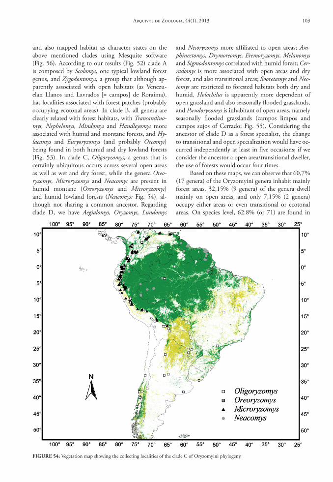
and also mapped habitat as character states on the above mentioned clades using Mesquite software (Fig. 56). According to our results (Fig. 52) clade A is composed by Scolomys, one typical lowland forest genus, and Zygodontomys, a group that although ap-parently associated with open habitats (as Venezu-elan Llanos and Lavrados [= campos] de Roraima), has localities associated with forest patches (probably occupying ecotonal areas). In clade B, all genera are clearly related with forest habitats, with Transandino-mys, Nephelomys, Mindomys and Handleyomys more associated with humid and montane forests, and Hy-laeamys and Euryoryzomys (and probably Oecomys) being found in both humid and dry lowland forests (Fig. 53). In clade C, Oligoryzomys, a genus that is certainly ubiquitous occurs across several open areas as well as wet and dry forest, while the genera Oreo-ryzomys, Microryzomys and Neacomys are present in humid montane (Oreoryzomys and Microryzomys) and humid lowland forests (Neacomys; Fig. 54), al-though not sharing a common ancestor. Regarding clade D, we have Aegialomys, Oryzomys, Lundomys
and Nesoryzomys more affiliated to open areas; Am-phinectomys, Drymoreomys, Eremoryzomys, Melanomys and Sigmodontomys correlated with humid forest; Cer-radomys is more associated with open areas and dry forest, and also transitional areas; Sooretamys and Nec-tomys are restricted to forested habitats both dry and humid, Holochilus is apparently more dependent of open grassland and also seasonally flooded grasslands, and Pseudoryzomys is inhabitant of open areas, namely seasonally flooded grasslands (campos limpos and campos sujos of Cerrado; Fig. 55). Considering the ancestor of clade D as a forest specialist, the change to transitional and open specialization would have oc-curred independently at least in five occasions; if we consider the ancestor a open area/transitional dweller, the use of forests would occur four times.
Based on these maps, we can observe that 60,7% (17 genera) of the Oryzomyini genera inhabit mainly forest areas, 32,15% (9 genera) of the genera dwell mainly on open areas, and only 7,15% (2 genera) occupy either areas or even transitional or ecotonal areas. On species level, 62.8% (or 71) are found in
FIGure 54: Vegetation map showing the collecting localities of the clade C of Oryzomyini phylogeny.
Arquivos de Zoologia, 44(1), 2013 103
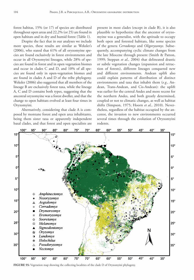
forest habitas, 15% (or 17) of species are distributed throughout open areas and 22,2% (or 25) are found in open habitats and in dry and humid forest (Table 1).
Despite the fact that in our analyses we include more species, these results are similar as Weksler’s (2006), who stated that 61% of all oryzomyine spe-cies are found exclusively in forest environments and occur in all Oryzomyini lineages, while 28% of spe-cies are found in forest and in open vegetation biomes and occur in clades C and D, and 10% of all spe-cies are found only in open-vegetation biomes and are found in clades A and D of the tribe phylogeny. Weksler (2006) also suggested that all members of the lineage B are exclusively forest taxa, while the lineage A, C and D contains both types, suggesting that the ancestral oryzomyine was a forest dweller, and that the change to open habitats evolved at least four times in Oryzomyini.
Alternatively, considering that clade A is com-posed by montane forest and open area inhabitants, being them sister taxa or apparently independent basal clades, and that forest and open specialists are
present in most clades (except in clade B), it is also plausible to hypothesize that the ancestor of oryzo-myine was a generalist, with the aptitude to occupy both open and forested habitats, like some species of the genera Cerradomys and Oligoryzomys. Subse-quently, accompanying cyclic climate changes from the late Miocene through present (Smith & Patton, 1999; Steppan et al., 2004) that delineated drastic or subtle vegetation changes (expansion and retrac-tion of forests), different lineages conquered new and different environments. Andean uplift also could explain patterns of distribution of distinct environments and taxa that inhabit them (e.g., An-dean, Trans-Andean, and Cis-Andean): the uplift was earlier for the central Andes and more recent for the northern Andes, and both greatly determined, coupled or not to climatic changes, as well as habitat shifts (Simpson, 1975; Hoorn et al., 2010). Never-theless, regardless of the habitat occupied by the an-cestor, the invasion to new environments occurred several times through the evolution of Oryzomyini rodents.
FIGure 55: Vegetation map showing the collecting localities of the clade D of Oryzomyini phylogeny.
Prado, J.R. & Percequillo, A.R.: Oryzomyini geographic distribution104
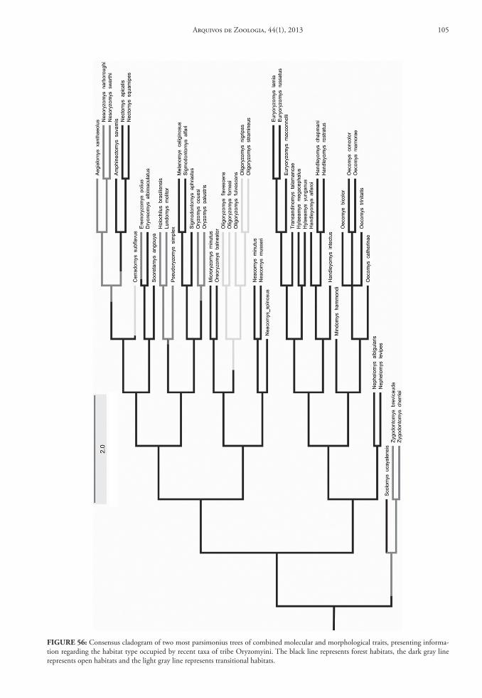
FIGure 56: Consensus cladogram of two most parsimonius trees of combined molecular and morphological traits, presenting informa-tion regarding the habitat type occupied by recent taxa of tribe Oryzomyini. The black line represents forest habitats, the dark gray line represents open habitats and the light gray line represents transitional habitats.
Arquivos de Zoologia, 44(1), 2013 105
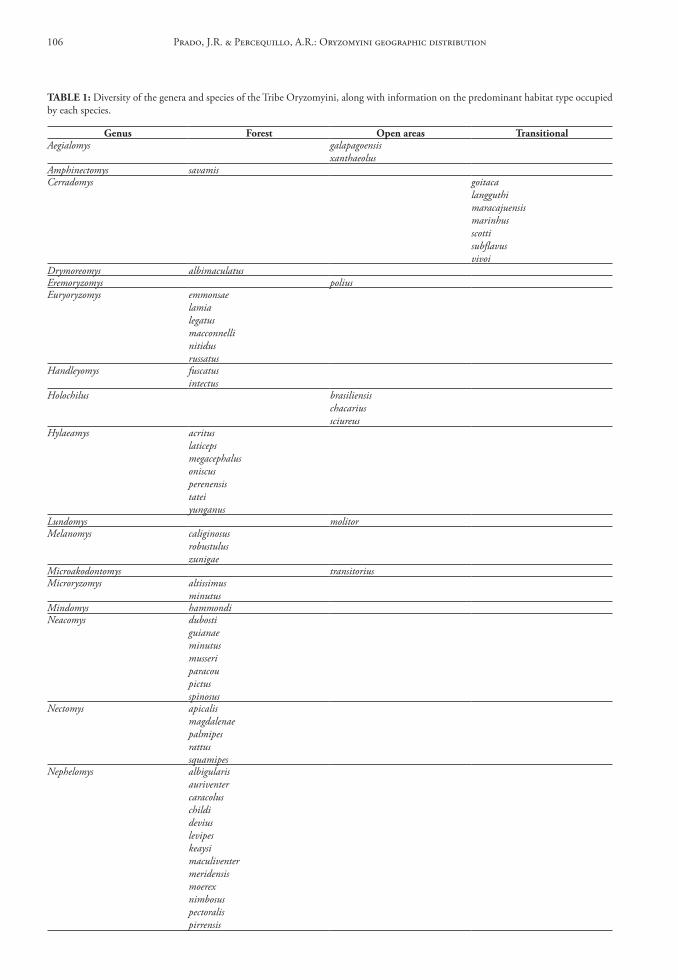
tAble 1: Diversity of the genera and species of the Tribe Oryzomyini, along with information on the predominant habitat type occupied by each species.
Genus Forest open areas transitionalAegialomys galapagoensis
xanthaeolusAmphinectomys savamisCerradomys goitaca
langguthimaracajuensismarinhusscottisubflavusvivoi
Drymoreomys albimaculatusEremoryzomys poliusEuryoryzomys emmonsae
lamialegatusmacconnellinitidusrussatus
Handleyomys fuscatusintectus
Holochilus brasiliensischacariussciureus
Hylaeamys acrituslaticepsmegacephalusoniscusperenensistateiyunganus
Lundomys molitorMelanomys caliginosus
robustuluszunigae
Microakodontomys transitoriusMicroryzomys altissimus
minutusMindomys hammondiNeacomys dubosti
guianaeminutusmusseriparacoupictusspinosus
Nectomys apicalismagdalenaepalmipesrattussquamipes
Nephelomys albigularisauriventercaracoluschildideviuslevipeskeaysimaculiventermeridensismoerexnimbosuspectoralispirrensis
Prado, J.R. & Percequillo, A.R.: Oryzomyini geographic distribution106
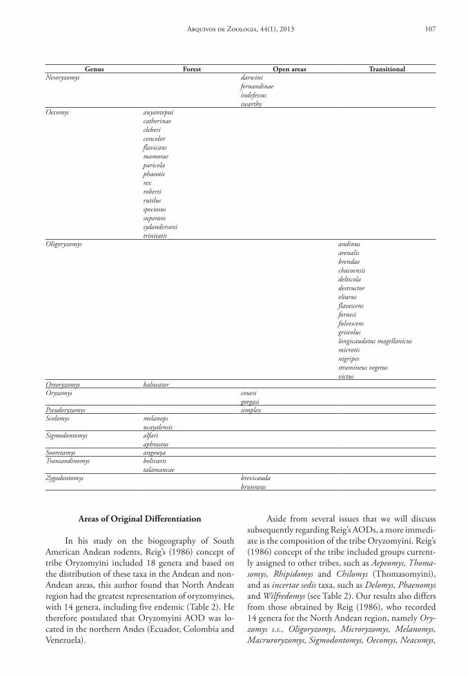
Areas of original differentiation
In his study on the biogeography of South American Andean rodents, Reig’s (1986) concept of tribe Oryzomyini included 18 genera and based on the distribution of these taxa in the Andean and non-Andean areas, this author found that North Andean region had the greatest representation of oryzomyines, with 14 genera, including five endemic (Table 2). He therefore postulated that Oryzomyini AOD was lo-cated in the northern Andes (Ecuador, Colombia and Venezuela).
Aside from several issues that we will discuss subsequently regarding Reig’s AODs, a more immedi-ate is the composition of the tribe Oryzomyini. Reig’s (1986) concept of the tribe included groups current-ly assigned to other tribes, such as Aepeomys, Thoma-somys, Rhipidomys and Chilomys (Thomasomyini), and as incertae sedis taxa, such as Delomys, Phaenomys and Wilfredomys (see Table 2). Our results also differs from those obtained by Reig (1986), who recorded 14 genera for the North Andean region, namely Ory-zomys s.s., Oligoryzomys, Microryzomys, Melanomys, Macruroryzomys, Sigmodontomys, Oecomys, Neacomys,
Genus Forest open areas transitionalNesoryzomys darwini
fernandinaeindefessusswarthy
Oecomys auyantepuicatherinaeclebericoncolorflavicansmamoraeparicolaphaeotisrexrobertirutilusspeciosussuperanssydandersonitrinitatis
Oligoryzomys andinusarenalisbrendaechacoensisdelticoladestructoreliurusflavescensfornesifulvescensgriseoluslongicaudatus magellanicusmicrotisnigripesstramineus vegetusvictus
Oreoryzomys balneatorOryzomys couesi
gorgasiPseudoryzomys simplexScolomys melanops
ucayalensisSigmodontomys alfari
aphrastusSooretamys angouyaTransandinomys bolivaris
talamancaeZygodontomys brevicauda
brunneus
Arquivos de Zoologia, 44(1), 2013 107
Nectomys, Aepeomys, Chilomys, Scolomys, Thomasomys and Rhipidomys, and from these, five genera (Macru-roryzomys, Sigmodontomys, Aepeomys, Chilomys and Scolomys) were considered endemic. However, four of these genera (two endemics) belong no more to the Oryzomyini tribe: Aepeomys, Chilomys, Thoma-somys and Rhipidomys are presently assigned to tribe Thomasomyini (D’Elía et al., 2007). Macruroryzomys is a nomen nudum, and therefore a new generic name, Mindomys, is currently employed for Nectomys ham-mondi (Weksler et al., 2006); despite this nomencla-tural issue, Reig was correct in recognize this taxon as a northern Andes endemic. Sigmodontomys was found also in Trans-Andean region (McCain et al., 2007) and Scolomys was found also in Cis-Andean
region (Gómez-Laverde et al., 2004). Truly, only one of the endemics pointed by Reig is presently recog-nized as so. Furthermore, Reig’s concept of genus Oryzomys s.s. (1986) included species that are cur-rently alocated in 10 new different genera (Weksler et al., 2006), bringing important implications re-garding diversity patterns: just to mention a few ex-amples, Oryzomys is currently a trans-Andean genus, restricted to Colombia and Venezuela (Voss et al., 2001); and the genus Aegialomys is predominantly trans-Andean, with most records on the coast of Ec-uador and Peru (Prado & Percequillo, 2011). Under the current and more restrictive concept of Oryzo-myini (Weksler & Percequillo, 2011), the geographic information assembled by Reig assigns 9 genera to
tAble 2: Comparison between the generic composition of tribe Oryzomyini according to Reig (1986) and to Weksler & Percequillo (2011), with information on the geographic region of South America inhabited by these genera.
Genera reig (1986) non‑Andean nA ncA scA nsA ssA Genera Weksler &
Percequillo (2011)non‑
Andean nA ncA scA nsA ssA
Aegialomys + + + – – –Cerradomys + – – – – –Eremoryzomys – – + – – –Euryoryzomys + – – – – –Hylaeamys + – – – – –
Oryzomys s.s. + + + + – – Mindomys – + – – – –Nephelomys + + + + – –Oreoryzomys – + + – – –Sooretamys + – – – – –Transandinomys + + – – – –Oryzomys + + – – – –
Oligoryzomys + + + + + + Oligoryzomys + + + – – +Microryzomys – + + – – – Microryzomys + + + + – –Melanomys + + – + – – Melanomys + + – – – –Macrororyzomys – + – – – – –Sigmodontomys – + – – – – Sigmodontomys + + – – – –Thomasomys + + + + – – –Oecomys + + + + – – Oecomys + + + + – –Rhipidomys + + + + – – –Nectomys + + + + – – Nectomys + + – + – –Neacomys + + + – – – Neacomys + + – + – –Delomys + – – – – – –Wilfredomys + – – – – – –Aepeomys – + – – – – –Nesoryzomys + – – – – – Nesoryzomys + – – – – –Phaenomys + – – – – – –Chilomys – + – – – – –Scolomys – + – – – – Scolomys + + – – – –– Amphinectomys + – – – – –– Drymoreomys + – – – – –– Handleyomys – + – – – –– Holochilus + + + – – –– Lundomys + – – – – –– Microakodontomys + – – – – –– Pseudoryzomys + – – – – –– Zygodontomys + + – – – –
Prado, J.R. & Percequillo, A.R.: Oryzomyini geographic distribution108
the northern Andes, including Oligoryzomys, Micro-ryzomys, Melanomys, Oecomys, Nectomys, Neacomys, with three endemic taxa (Mindomys, Scolomys and Sigmodontomys). We documented the presence of 17 species on the northern Andes, a number similar to that stated by Reig, but with quite distinct composi-tion (Table 2).
Nevertheless, given the substantive advances and changes in our knowledge about the tribe with regard to phylogenetic relationships, generic composi-tion, number of species and geographical distribution in recent years (Musser et al., 1998; Percequillo 1998, 2003; Weksler, 2003, 2006; Weksler et al. 2006; Per-cequillo et al., 2008, 2011), a re-assessment of the pat-terns of genera and species richness across the South America is needed.
To evaluate areas of generic richness in South America, we used the same methodology (but we se-pared the Non-Andean region adopted by Reig, into Cis- and Trans-Andean) and added data from cur-rent distribution of genera of the tribe Oryzomyini.
The Table 3 provides distributional fT by geographi-cal unit, as well the location of areas of highest rich-ness and greatest generic endemism for the tribe. The North Andes contain 14.7% (or 354 records) of all collecting localities; 4.8% (or 116 records) are in the North-Central Andean region; 2.4% (or 60 records) are in the South-Central Andean region; 64.2% (or 1,557 records) are located in the Cis-Andean region; and 13.9% (or 339 records) are in the Trans-Andean region. The number of localities in both North-South Andean (no records) and South-Southern Andean (just one record) regions are insignificant (these num-ber would change with a more robust database for ge-nus Oligoryzomys, the only Oryzomyini genus known to occur in these areas). Regrettably it is impossible to compare our data on number of records with those published by Reig, even considering only the same oryzomyine genera present in both database, since Reig (op. cit.) does not provide the number or fre-quencies of collecting localities for each genera, only the total observed for the tribe.
tAble 3: Distributional fT exhibited by each geographical unit. North Andean (NA); Center-North Andean (CNA); Center-South An-dean (CSA); North-South Andean (NSA); South of South Andean (SSA); Trans-Andean (TA); Cis-Andean (CA).
Genus Total Ng
NA NCA SCA NSA SSA CA TANg fT Ng fT Ng fT Ng fT Ng fT Ng fT Ng fT
Aegialomys 93 6 0.064 18 0.193 — — — — — — — — 69 0.741Amphinectomys 1 — — — — — — — — — — 1 1 — —Cerradomys 171 — — — — — — — — — — 171 1 — —Drymoreomys 8 — — — — — — — — — — 8 1 — —Eremoryzomys 7 — — 7 1 — — — — — — — — — —Euryoryzomys 245 — — — — — — — — — — 245 1 — —Handleyomys 19 19 1 — — — — — — — — — — — —Holochilus 54 1 0.018 2 0.037 — — — — — — 51 0.944 — —Hylaeamys 352 — — — — — — — — — — 352 1 — —Lundomys 7 — — — — — — — — — — 7 1 — —Melanomys 21 16 0.76 — — — — — — — — — — 5 0.24Microakodontomys 1 — — — — — — — — — — 1 1 — —Microryzomys 114 73 0.64 26 0.23 10 0.09 — — — — 5 0.04 — —Mindomys 3 3 1 — — — — — — — — — —Neacomys 42 1 0.02 — — 1 0.02 — — — — 39 0.94 1 0.02Nectomys 279 26 0.09 12 0.05 9 0.03 — — — — 232 0.83 — —Nephelomys 269 125 0,466 42 0,157 39 0,144 — — — — 15 0,056 48 0,177Nesoryzomys 6 — — — — — — — — — — — — 6 1Oecomys 77 8 0,10 3 0,038 1 0,012 — — — — 61 0,79 4 0,051Oligoryzomys 59 4 0,069 5 0,086 — — — — 1 0.013 33 0,559 16 0,273Oreoryzomys 4 3 0.75 1 0.25 — — — — — — — — — —Oryzomys 3 1 0.333 — — — — — — — — — — 2 0.667Pseudoryzomys 71 — — — — — — — — — — 71 1 — —Scolomys 13 1 0.076 — — — — — — — — 12 0,924 — —Sigmodontomys 17 3 0.176 — — — — — — — — — — 14 0,824Sooretamys 128 — — — — — — — — — — 128 1 — —Transandinomys 151 19 0.13 — — — — — — — — — — 132 0.87Zygodontomys 212 45 0.213 — — — — — — — — 125 0.589 42 0.198
Arquivos de Zoologia, 44(1), 2013 109
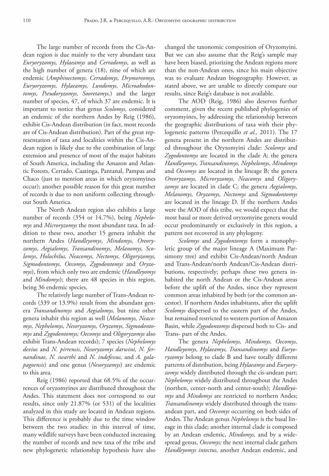
The large number of records from the Cis-An-dean region is due mainly to the very abundant taxa Euryoryzomys, Hylaeamys and Cerradomys, as well as the high number of genera (18), nine of which are endemic (Amphinectomys, Cerradomys, Drymoreomys, Euryoryzomys, Hylaeamys, Lundomys, Microakodon-tomys, Pseudoryzomys, Sooretamys,) and the larger number of species, 47, of which 37 are endemic. It is important to notice that genus Scolomys, considered an endemic of the northern Andes by Reig (1986), exhibit Cis-Andean distribution (in fact, most records are of Cis-Andean distribution). Part of the great rep-resentation of taxa and localities within the Cis-An-dean region is likely due to the combination of large extension and presence of most of the major habitats of South America, including the Amazon and Atlan-tic Forests, Cerrado, Caatinga, Pantanal, Pampas and Chaco (just to mention areas in which oryzomyines occur); another possible reason for this great number of records is due to non uniform collecting through-out South America.
The North Andean region also exhibits a large number of records (354 or 14.7%), being Nephelo-mys and Microryzomys the most abundant taxa. In ad-dition to these two, another 15 genera inhabit the northern Andes (Handleyomys, Mindomys, Oreory-zomys, Aegialomys, Transandinomys, Melanomys, Sco-lomys, Holochilus, Neacomys, Nectomys, Oligoryzomys, Sigmodontomys, Oecomys, Zygodontomys and Oryzo-mys), from which only two are endemic (Handleyomys and Mindomys); there are 48 species in this region, being 36 endemic species.
The relatively large number of Trans-Andean re-cords (339 or 13.9%) result from the abundant gen-era Transandinomys and Aegialomys, but nine other genera inhabit this region as well (Melanomys, Neaco-mys, Nephelomys, Nesoryzomys, Oryzomys, Sigmodonto-mys and Zygodontomys; Oecomys and Oligoryzomys also exhibit Trans-Andean records); 7 species (Nephelomys devius and N. pirrensis, Nesoryzomys darwini, N. fer-nandinae, N. swarthi and N. indefessus, and A. gala-pagoensis) and one genus (Nesoryzomys) are endemic to this area.
Reig (1986) reported that 68.5% of the occur-rences of oryzomyines are distributed throughout the Andes. This statement does not correspond to our results, since only 21.87% (or 531) of the localities analyzed in this study are located in Andean regions. This difference is probably due to the time window between the two studies: in this interval of time, many wildlife surveys have been conducted increasing the number of records and new taxa of the tribe and new phylogenetic relationship hypothesis have also
changed the taxonomic composition of Oryzomyini. But we can also assume that the Reig’s sample may have been biased, priorizing the Andean regions more than the non-Andean ones, since his main objective was to evaluate Andean biogeography. However, as stated above, we are unable to directly compare our results, since Reig’s database is not available.
The AOD (Reig, 1986) also deserves further comment, given the recent published phylogenies of oryzomyines, by addressing the relationship between the geographic distributions of taxa with their phy-logenetic patterns (Percequillo et al., 2011). The 17 genera present in the northern Andes are distribut-ed throughout the Oryzomyini clade: Scolomys and Zygodontomys are located in the clade A; the genera Handleyomys, Transandinomys, Nephelomys, Mindomys and Oecomys are located in the lineage B; the genera Oreoryzomys, Microryzomys, Neacomys and Oligory-zomys are located in clade C; the genera Aegialomys, Melanomys, Oryzomys, Nectomys and Sigmodontomys are located in the lineage D. If the northern Andes were the AOD of this tribe, we would expect that the most basal or more derived oryzomyine genera would occur predominantly or exclusively in this region, a pattern not recovered in any phylogeny.
Scolomys and Zygodontomys form a monophy-letic group of the major lineage A (Maximum Par-simony tree) and exhibit Cis-Andean/north Andean and Trans-Andean/north Andean/Cis-Andean distri-butions, respectively; perhaps these two genera in-habited the north Andean or the Cis-Andean areas before the uplift of the Andes, since they represent common areas inhabited by both (or the common an-cestor). If northern Andes inhabitants, after the uplift Scolomys dispersed to the eastern part of the Andes, but remained restricted to western portion of Amazon Basin, while Zygodontomys dispersed both to Cis- and Trans- part of the Andes.
The genera Nephelomys, Mindomys, Oecomys, Handleyomys, Hylaeamys, Transandinomys and Euryo-ryzomys belong to clade B and have totally different patterns of distribution, being Hylaeamys and Euryory-zomys widely distributed through the cis-andean part; Nephelomys widely distributed throughout the Andes (northen, center-north and center-south); Handleyo-mys and Mindomys are restricted to northern Andes; Transandinomys widely distributed through the trans-andean part, and Oecomys occurring on both sides of Andes. The Andean genus Nephelomys is the basal lin-eage in this clade; another internal clade is composed by an Andean endemic, Mindomys, and by a wide-spread genus, Oecomys; the next internal clade gathers Handleyomys intectus, another Andean endemic, and
Prado, J.R. & Percequillo, A.R.: Oryzomyini geographic distribution110
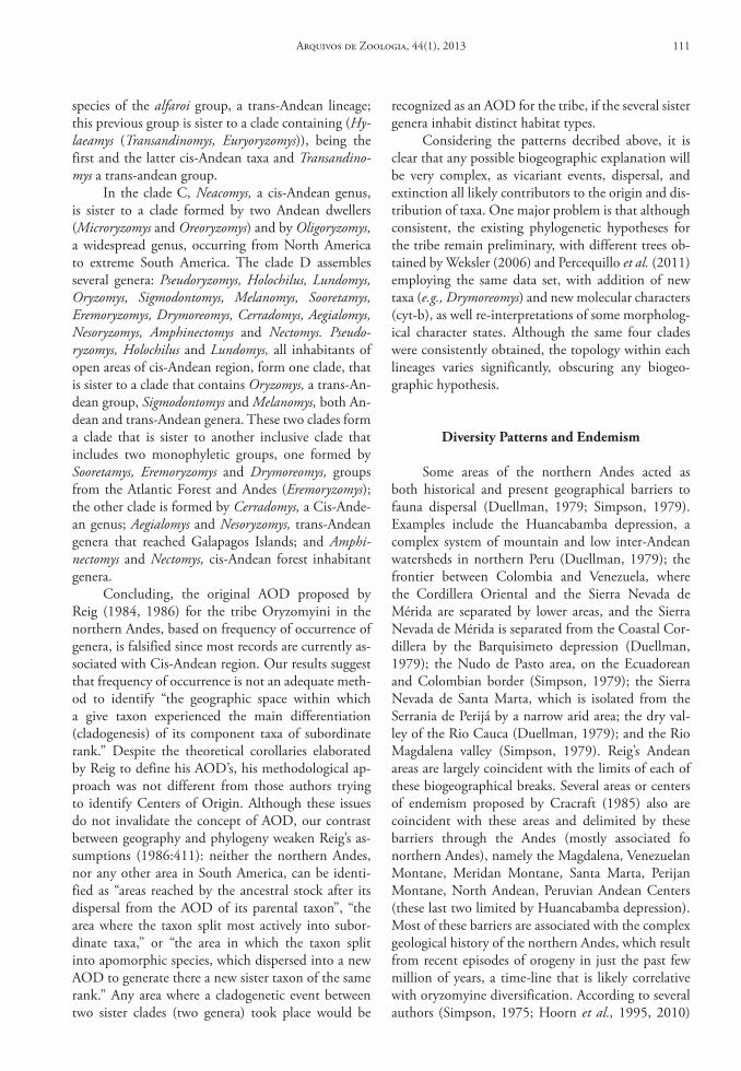
species of the alfaroi group, a trans-Andean lineage; this previous group is sister to a clade containing (Hy-laeamys (Transandinomys, Euryoryzomys)), being the first and the latter cis-Andean taxa and Transandino-mys a trans-andean group.
In the clade C, Neacomys, a cis-Andean genus, is sister to a clade formed by two Andean dwellers (Microryzomys and Oreoryzomys) and by Oligoryzomys, a widespread genus, occurring from North America to extreme South America. The clade D assembles several genera: Pseudoryzomys, Holochilus, Lundomys, Oryzomys, Sigmodontomys, Melanomys, Sooretamys, Eremoryzomys, Drymoreomys, Cerradomys, Aegialomys, Nesoryzomys, Amphinectomys and Nectomys. Pseudo-ryzomys, Holochilus and Lundomys, all inhabitants of open areas of cis-Andean region, form one clade, that is sister to a clade that contains Oryzomys, a trans-An-dean group, Sigmodontomys and Melanomys, both An-dean and trans-Andean genera. These two clades form a clade that is sister to another inclusive clade that includes two monophyletic groups, one formed by Sooretamys, Eremoryzomys and Drymoreomys, groups from the Atlantic Forest and Andes (Eremoryzomys); the other clade is formed by Cerradomys, a Cis-Ande-an genus; Aegialomys and Nesoryzomys, trans-Andean genera that reached Galapagos Islands; and Amphi-nectomys and Nectomys, cis-Andean forest inhabitant genera.
Concluding, the original AOD proposed by Reig (1984, 1986) for the tribe Oryzomyini in the northern Andes, based on frequency of occurrence of genera, is falsified since most records are currently as-sociated with Cis-Andean region. Our results suggest that frequency of occurrence is not an adequate meth-od to identify “the geographic space within which a give taxon experienced the main differentiation (cladogenesis) of its component taxa of subordinate rank.” Despite the theoretical corollaries elaborated by Reig to define his AOD’s, his methodological ap-proach was not different from those authors trying to identify Centers of Origin. Although these issues do not invalidate the concept of AOD, our contrast between geography and phylogeny weaken Reig’s as-sumptions (1986:411): neither the northern Andes, nor any other area in South America, can be identi-fied as “areas reached by the ancestral stock after its dispersal from the AOD of its parental taxon”, “the area where the taxon split most actively into subor-dinate taxa,” or “the area in which the taxon split into apomorphic species, which dispersed into a new AOD to generate there a new sister taxon of the same rank.” Any area where a cladogenetic event between two sister clades (two genera) took place would be
recognized as an AOD for the tribe, if the several sister genera inhabit distinct habitat types.
Considering the patterns decribed above, it is clear that any possible biogeographic explanation will be very complex, as vicariant events, dispersal, and extinction all likely contributors to the origin and dis-tribution of taxa. One major problem is that although consistent, the existing phylogenetic hypotheses for the tribe remain preliminary, with different trees ob-tained by Weksler (2006) and Percequillo et al. (2011) employing the same data set, with addition of new taxa (e.g., Drymoreomys) and new molecular characters (cyt-b), as well re-interpretations of some morpholog-ical character states. Although the same four clades were consistently obtained, the topology within each lineages varies significantly, obscuring any biogeo-graphic hypothesis.
diversity Patterns and endemism
Some areas of the northern Andes acted as both historical and present geographical barriers to fauna dispersal (Duellman, 1979; Simpson, 1979). Examples include the Huancabamba depression, a complex system of mountain and low inter-Andean watersheds in northern Peru (Duellman, 1979); the frontier between Colombia and Venezuela, where the Cordillera Oriental and the Sierra Nevada de Mérida are separated by lower areas, and the Sierra Nevada de Mérida is separated from the Coastal Cor-dillera by the Barquisimeto depression (Duellman, 1979); the Nudo de Pasto area, on the Ecuadorean and Colombian border (Simpson, 1979); the Sierra Nevada de Santa Marta, which is isolated from the Serrania de Perijá by a narrow arid area; the dry val-ley of the Rio Cauca (Duellman, 1979); and the Rio Magdalena valley (Simpson, 1979). Reig’s Andean areas are largely coincident with the limits of each of these biogeographical breaks. Several areas or centers of endemism proposed by Cracraft (1985) also are coincident with these areas and delimited by these barriers through the Andes (mostly associated fo northern Andes), namely the Magdalena, Venezuelan Montane, Meridan Montane, Santa Marta, Perijan Montane, North Andean, Peruvian Andean Centers (these last two limited by Huancabamba depression). Most of these barriers are associated with the complex geological history of the northern Andes, which result from recent episodes of orogeny in just the past few million of years, a time-line that is likely correlative with oryzomyine diversification. According to several authors (Simpson, 1975; Hoorn et al., 1995, 2010)
Arquivos de Zoologia, 44(1), 2013 111
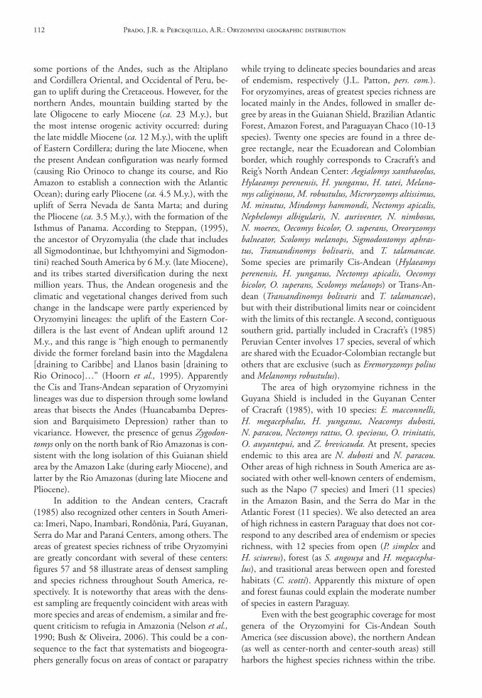
some portions of the Andes, such as the Altiplano and Cordillera Oriental, and Occidental of Peru, be-gan to uplift during the Cretaceous. However, for the northern Andes, mountain building started by the late Oligocene to early Miocene (ca. 23 M.y.), but the most intense orogenic activity occurred: during the late middle Miocene (ca. 12 M.y.), with the uplift of Eastern Cordillera; during the late Miocene, when the present Andean configuration was nearly formed (causing Rio Orinoco to change its course, and Rio Amazon to establish a connection with the Atlantic Ocean); during early Pliocene (ca. 4.5 M.y.), with the uplift of Serra Nevada de Santa Marta; and during the Pliocene (ca. 3.5 M.y.), with the formation of the Isthmus of Panama. According to Steppan, (1995), the ancestor of Oryzomyalia (the clade that includes all Sigmodontinae, but Ichthyomyini and Sigmodon-tini) reached South America by 6 M.y. (late Miocene), and its tribes started diversification during the next million years. Thus, the Andean orogenesis and the climatic and vegetational changes derived from such change in the landscape were partly experienced by Oryzomyini lineages: the uplift of the Eastern Cor-dillera is the last event of Andean uplift around 12 M.y., and this range is “high enough to permanently divide the former foreland basin into the Magdalena [draining to Caribbe] and Llanos basin [draining to Rio Orinoco]…” (Hoorn et al., 1995). Apparently the Cis and Trans-Andean separation of Oryzomyini lineages was due to dispersion through some lowland areas that bisects the Andes (Huancabamba Depres-sion and Barquisimeto Depression) rather than to vicariance. However, the presence of genus Zygodon-tomys only on the north bank of Rio Amazonas is con-sistent with the long isolation of this Guianan shield area by the Amazon Lake (during early Miocene), and latter by the Rio Amazonas (during late Miocene and Pliocene).
In addition to the Andean centers, Cracraft (1985) also recognized other centers in South Ameri-ca: Imeri, Napo, Inambari, Rondônia, Pará, Guyanan, Serra do Mar and Paraná Centers, among others. The areas of greatest species richness of tribe Oryzomyini are greatly concordant with several of these centers: figures 57 and 58 illustrate areas of densest sampling and species richness throughout South America, re-spectively. It is noteworthy that areas with the dens-est sampling are frequently coincident with areas with more species and areas of endemism, a similar and fre-quent criticism to refugia in Amazonia (Nelson et al., 1990; Bush & Oliveira, 2006). This could be a con-sequence to the fact that systematists and biogeogra-phers generally focus on areas of contact or parapatry
while trying to delineate species boundaries and areas of endemism, respectively (J.L. Patton, pers. com.). For oryzomyines, areas of greatest species richness are located mainly in the Andes, followed in smaller de-gree by areas in the Guianan Shield, Brazilian Atlantic Forest, Amazon Forest, and Paraguayan Chaco (10-13 species). Twenty one species are found in a three de-gree rectangle, near the Ecuadorean and Colombian border, which roughly corresponds to Cracraft’s and Reig’s North Andean Center: Aegialomys xanthaeolus, Hylaeamys perenensis, H. yunganus, H. tatei, Melano-mys caliginosus, M. robustulus, Microryzomys altissimus, M. minutus, Mindomys hammondi, Nectomys apicalis, Nephelomys albigularis, N. auriventer, N. nimbosus, N. moerex, Oecomys bicolor, O. superans, Oreoryzomys balneator, Scolomys melanops, Sigmodontomys aphras-tus, Transandinomys bolivaris, and T. talamancae. Some species are primarily Cis-Andean (Hylaeamys perenensis, H. yunganus, Nectomys apicalis, Oecomys bicolor, O. superans, Scolomys melanops) or Trans-An-dean (Transandinomys bolivaris and T. talamancae), but with their distributional limits near or coincident with the limits of this rectangle. A second, contiguous southern grid, partially included in Cracraft’s (1985) Peruvian Center involves 17 species, several of which are shared with the Ecuador-Colombian rectangle but others that are exclusive (such as Eremoryzomys polius and Melanomys robustulus).
The area of high oryzomyine richness in the Guyana Shield is included in the Guyanan Center of Cracraft (1985), with 10 species: E. macconnelli, H. megacephalus, H. yunganus, Neacomys dubosti, N. paracou, Nectomys rattus, O. speciosus, O. trinitatis, O. auyantepui, and Z. brevicauda. At present, species endemic to this area are N. dubosti and N. paracou. Other areas of high richness in South America are as-sociated with other well-known centers of endemism, such as the Napo (7 species) and Imeri (11 species) in the Amazon Basin, and the Serra do Mar in the Atlantic Forest (11 species). We also detected an area of high richness in eastern Paraguay that does not cor-respond to any described area of endemism or species richness, with 12 species from open (P. simplex and H. sciureus), forest (as S. angouya and H. megacepha-lus), and trasitional areas between open and forested habitats (C. scotti). Apparently this mixture of open and forest faunas could explain the moderate number of species in eastern Paraguay.
Even with the best geographic coverage for most genera of the Oryzomyini for Cis-Andean South America (see discussion above), the northern Andean (as well as center-north and center-south areas) still harbors the highest species richness within the tribe.
Prado, J.R. & Percequillo, A.R.: Oryzomyini geographic distribution112
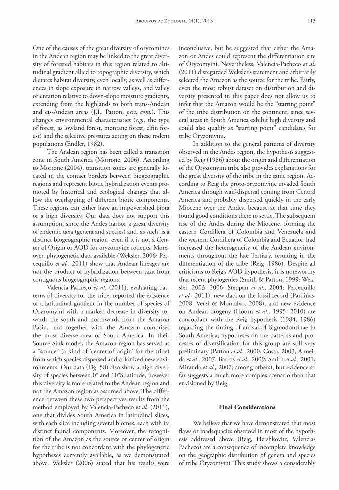
One of the causes of the great diversity of oryzomines in the Andean region may be linked to the great diver-sity of forested habitats in this region related to alti-tudinal gradient allied to topographic diversity, which dictates habitat diversity, even locally, as well as differ-ences in slope exposure in narrow valleys, and valley orientation relative to down-slope moisture gradients, extending from the highlands to both trans-Andean and cis-Andean areas (J.L. Patton, pers. com.). This changes environmental characteristics (e.g., the type of forest, as lowland forest, montane forest, elfin for-est) and the selective pressures acting on these rodent populations (Endler, 1982).
The Andean region has been called a transition zone in South America (Morrone, 2006). According to Morrone (2004), transition zones are generally lo-cated in the contact borders between biogeographic regions and represent biotic hybridization events pro-moted by historical and ecological changes that al-low the overlapping of different biotic components. These regions can either have an impoverished biota or a high diversity. Our data does not support this assumption, since the Andes harbor a great diversity of endemic taxa (genera and species) and, as such, is a distinct biogeographic region, even if it is not a Cen-ter of Origin or AOD for oryzomyine rodents. More-over, phylogenetic data available (Weksler, 2006; Per-cequillo et al., 2011) show that Andean lineages are not the product of hybridization between taxa from contiguous biogeographic regions.
Valencia-Pacheco et al. (2011), evaluating pat-terns of diversity for the tribe, reported the existence of a latitudinal gradient in the number of species of Oryzomyini with a marked decrease in diversity to-wards the south and northwards from the Amazon Basin, and together with the Amazon comprises the most diverse area of South America. In their Source-Sink model, the Amazon region has served as a “source” (a kind of ‘center of origin’ for the tribe) from which species dispersed and colonized new envi-ronments. Our data (Fig. 58) also show a high diver-sity of species between 0° and 10°S latitude, however this diversity is more related to the Andean region and not the Amazon region as assumed above. The differ-ence between these two perspectives results from the method employed by Valencia-Pacheco et al. (2011), one that divides South America in latitudinal slices, with each slice including several biomes, each with its distinct faunal components. Moreover, the recogni-tion of the Amazon as the source or center of origin for the tribe is not concordant with the phylogenetic hypotheses currently available, as we demonstrated above. Weksler (2006) stated that his results were
inconclusive, but he suggested that either the Ama-zon or Andes could represent the differentiation site of Oryzomyini. Nevertheless, Valencia-Pacheco et al. (2011) disregarded Weksler’s statement and arbitrarily selected the Amazon as the source for the tribe. Fairly, even the most robust dataset on distribution and di-versity presented in this paper does not allow us to infer that the Amazon would be the “starting point” of the tribe distribution on the continent, since sev-eral areas in South America exhibit high diversity and could also qualify as “starting point” candidates for tribe Oryzomyini.
In addition to the general patterns of diversity observed in the Andes region, the hypothesis suggest-ed by Reig (1986) about the origin and differentiation of the Oryzomyini tribe also provides explanations for the great diversity of the tribe in the same region. Ac-cording to Reig the proto-oryzomyine invaded South America through waif-dispersal coming from Central America and probably dispersed quickly in the early Miocene over the Andes, because at that time they found good conditions there to settle. The subsequent rise of the Andes during the Miocene, forming the eastern Cordillera of Colombia and Venezuela and the western Cordillera of Colombia and Ecuador, had increased the heterogeneity of the Andean environ-ments throughout the late Tertiary, resulting in the differentiation of the tribe (Reig, 1986). Despite all criticisms to Reig’s AOD hypothesis, it is noteworthy that recent phylogenies (Smith & Patton, 1999; Wek-sler, 2003, 2006; Steppan et al., 2004; Percequillo et al., 2011), new data on the fossil record (Pardiñas, 2008; Verzi & Montalvo, 2008), and new evidence on Andean orogeny (Hoorn et al., 1995, 2010) are concordant with the Reig hypothesis (1984, 1986) regarding the timing of arrival of Sigmodontinae in South America; hypotheses on the patterns and pro-cesses of diversification for this group are still very preliminary (Patton et al., 2000; Costa, 2003; Almei-da et al., 2007; Barros et al., 2009; Smith et al., 2001; Miranda et al., 2007; among others), but evidence so far suggests a much more complex scenario than that envisioned by Reig.
Final considerations
We believe that we have demonstrated that most flaws or inadequacies observed in most of the hypoth-esis addressed above (Reig, Hershkovitz, Valencia-Pacheco) are a consequence of incomplete knowledge on the geographic distribution of genera and species of tribe Oryzomyini. This study shows a considerably
Arquivos de Zoologia, 44(1), 2013 113
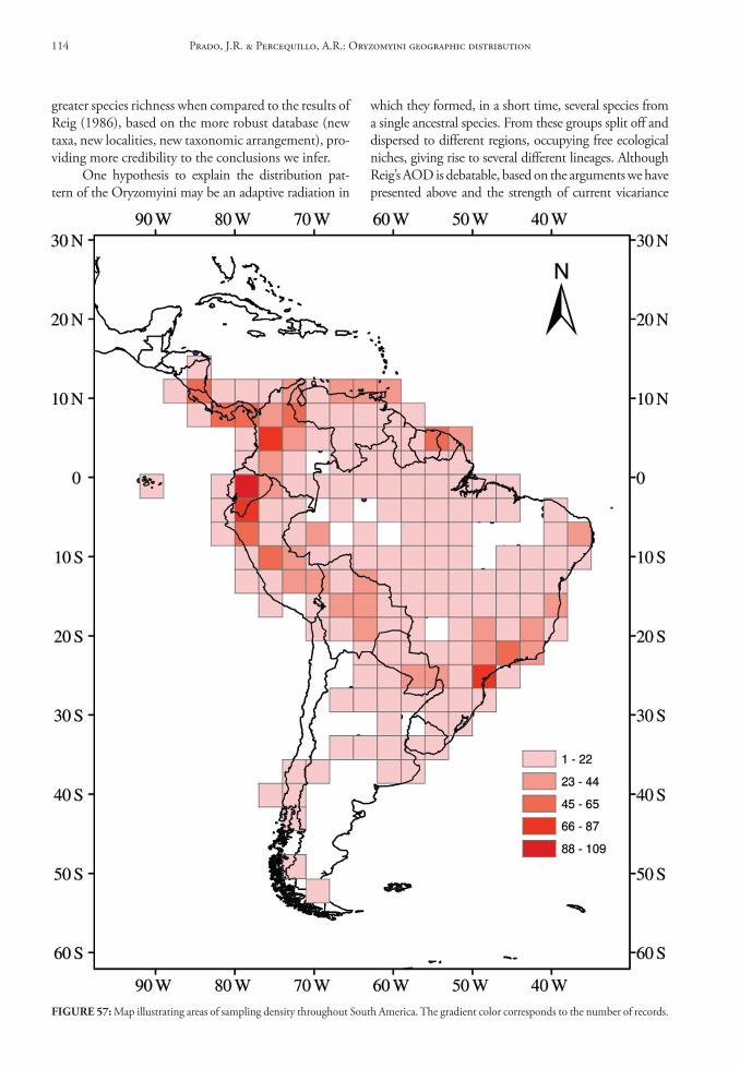
greater species richness when compared to the results of Reig (1986), based on the more robust database (new taxa, new localities, new taxonomic arrangement), pro-viding more credibility to the conclusions we infer.
One hypothesis to explain the distribution pat-tern of the Oryzomyini may be an adaptive radiation in
which they formed, in a short time, several species from a single ancestral species. From these groups split off and dispersed to different regions, occupying free ecological niches, giving rise to several different lineages. Although Reig’s AOD is debatable, based on the arguments we have presented above and the strength of current vicariance
FIGure 57: Map illustrating areas of sampling density throughout South America. The gradient color corresponds to the number of records.
Prado, J.R. & Percequillo, A.R.: Oryzomyini geographic distribution114
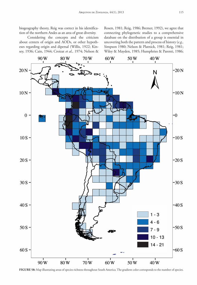
biogeography theory, Reig was correct in his identifica-tion of the northern Andes as an area of great diversity.
Considering the concepts and the criticism about centers of origin and AODs, or other hypoth-eses regarding origin and dipersal (Willis, 1922; Kin-sey, 1936; Cain, 1944; Croizat et al., 1974; Nelson &
Rosen, 1981; Reig, 1986; Bremer, 1992), we agree that connecting phylogenetic studies to a comprehensive database on the distribution of a group is essential in uncovering both the pattern and process of history (e.g., Simpson 1980; Nelson & Platnick, 1981; Reig, 1981; Wiley & Mayden, 1985; Humphries & Parenti, 1986;
FIGure 58: Map illustrating areas of species richness throughout South America. The gradient color corresponds to the number of species.
Arquivos de Zoologia, 44(1), 2013 115
Mayden 1987, 1992; Silva & Patton, 1993; Bush, 1994; Patton et al., 1994; Riddle, 1996). In this paper we describe patterns of current diversity and distribu-tion, through the comparison of distributional data with available phylogenies, thus contributing to the knowledge of the biogeography of tribe Oryzomyini.
resuMo
Oryzomyini é a tribo mais diversa dentro da radiação da Subfamília Sigmodontinae, com 28 gêneros e aproxi-madamente 130 espécies viventes, sendo essa diversidade refletida na variação ecológica e morfológica exibida pela tribo. Existem várias hipóteses para explicar o surgimento e a diversificação da subfamília Sigmodontinae na Amé-rica do Sul, entre elas as áreas de diferenciação original (ADO). Este trabalho fornece informações a respeito da distribuição geográfica de todos os atuais táxons do grupo do gênero da Tribo Oryzomyini sendo estes organizados em índices de localidades com os registros de distribuição (coleção de localidades, estado ou província, país), altitude e coordenadas geográficas. Mapas das localidades de coleta foram elaborados para os gêneros e as espécies e estes foram utilizados como referência para mapear os padrões de dis-tribuição geográfica e de riqueza, além testar a hipótese de ADO da tribo Oryzomyini, a qual advoga que este grupo se originou e se diferenciou no norte dos Andes. Nos-sos resultados revelam uma considerável riqueza genérica e específica e mostra a existência de três padrões gerais de distribuição, o Trans Andino, o Andino e o Cis Andino. Além do mais, diferentes gêneros apresentam a maioria dos principais tipos de distribuição, como endêmicos, disjun-tos, amplamente distribuídos e restritos, e habitam dife-rentes ambientes desde florestas a áreas abertas. Hipóteses filogenéticas recentes indicam que os padrões de distribui-ção dos orizomíneos não mostram correspondência com as linhagens principais do clado Oryzomyini, pelo contrário, cada linhagem principal da tribo exibe a maioria dos padrões biogeográficos descritos anteriormente. A região norte-andina não pode ser considerada como ADO, uma vez que a maioria dos registros para a tribo está localizada na região Cis Andina. A segunda região mais diversa é a Norte andina e a região Trans Andina é a terceira mais rica em número de espécies. Os padrões de riqueza da Tri-bo Oryzomyini são concordantes com vários centros e regi-ões de endemismos descritos na literatura. Áreas de grande riqueza estão localizadas principalmente nos Andes, segui-dos em menor grau por áreas do escudo guianense, Floresta Atlântica, Amazônia e o Chaco Paraguaio.
Palavras-Chaves: Oryzomyini; Distribuição Geo-gráfica; ADO; Biogeografia.
AcknoWledGeMents
We wish to express our thanks to the curators and staff of the museums and collections enlisted above for allowing us to study specimens under their care. We are deeply indebted to M. de Vivo and A.P. Carmignotto for reviewing a previous version of this manuscript: their valuable and inspiring comments and suggestions great-ly improved this contribution; Alfredo Langguth and James L. Patton also provided important criticism; need-less to say that any errors that may remain are, of course, our own. Our research was supported by Fundação de Amparo à Pesquisa do Estado de São Paulo (FAPESP 1998/12273-0, Programa Biota 1998/05075-7; FAPESP 2009/03547-5; FAPESP 2009/16009-1), CNPq (2008/476249) and CNPQ/PIBIC scholarship, as well as grants from the American Museum of Natural History, the Field Museum, the Smithsonian Institu-tion, the Museum of Comparative Zoology.
reFerences
Allen, J.A. 1900. On mammals collected in southeastern Peru, by Mr. H.H. Keays, with descriptions of new species. Bulletin of the American Museum of Natural History, 13:218-227.
Allen, J.A. 1901. On a further collection of mammals from southeastern Peru, collected by Mr. H.H. Keays, with descriptions of new species. Bulletin of the American Museum of Natural History, 14:41-46.
Allen, J.A. 1913. Revision of the Melanomys group of American Muridae. Bulletin of the American Museum of Natural History, 32:533-554.
Almeida, F.C.; Bonvicino, C.R. & Cordeiro-Estrela, P. 2007. Phylogeny and temporal diversification of Calomys (Rodentia, Sigmodontinae): implications for the biogeography of an endemic genus of the open/dry biomes of South America. Molecular Phylogenetics and Evolution, 42:449-466.
Anderson, S. 1997. Mammals of Bolivia, Taxonomy and Distribution. Bulletin of the American Museum of Natural History, 231:1-652.
Barros, M.C.; Sampaio, I.; Schneider, H. & Langguth, A. 2009. Molecular phylogenies, chromosomes and dispersion in Brazilian akodontines (Rodentia, Sigmodontinae). Iheringia. Série Zoologia, 99:373-380.
Baskin, J.A. 1978. Bensonomys, Calomys, and the origin of the phyllotine group of Neotropical cricetines (Rodentia, Cricetidae). Journal of Mammalogy, 59:125-135.
Baskin, J.A. 1986. The late Miocene radiation of Neotropical sigmodontine rodents in North America. Contributions to Geology, University of Wyoming, Special Paper, 3:287-303.
Bonvicino, C.R. 1994. Especiação do rato d’água Nectomys (Roden-tia Cricetidae). Abordagem cariológica, morfológica e geográfica. (Dissertação de mestrado). Universidade Federal do Rio de Ja-neiro, Rio de Janeiro.
Bonvicino, C.R. 2003. A new species of Oryzomys (Rodentia, Sigmodontinae) of the subflavus group from the Cerrado of Central Brazil. Mammalian Biology, 68:78-90.
Bonvicino, C.R.; Langguth, A.; Lindbergh, S.M. & Paula, A.C. 1997. An elevational gradient study of small mammals
Prado, J.R. & Percequillo, A.R.: Oryzomyini geographic distribution116
at Caparaó National Park, southeastern Brazil. Mammalia, 61:547-560.
Braun, J.K. 1993. Systematic relationships of the tribe Phyllotini (Muridae: Sigmodontinae) of South America. Oklahoma Museum of Natural History, Special Publication, p. 1-50.
Bremer, K.1992. Ancestral areas: A cladistic reinterpretation of the center of origin concept. Systematic Biology, 41:436-445.
Brennand, P.G. 2010. Variação Geográfica no gênero Hylaeamys Weksler, Percequillo & Voss (2006) (Cricetidae:Sigmodontinae) na Floresta Atlântica. (Dissertação de Mestrado). Universidade Federal da Paraíba, João Pessoa.
Bush, G.L. 1994. Sympatric speciation in animals: new wine in old bottles. Trends in Ecology and Evolution, 9:285-288.
Bush, M.B. & Oliveira, P.E. 2006. The rise and fall of the Refugial Hypothesis of Amazonian speciation: a paleoecological perspective. Biota Neotropica, 6(1):0-0. (on line)
Cain, S.A. 1944. Criterios para señalar El Centro de Origen. In: Cain, S.A. Foundations of plant geography. New York, Harper & Brothers. p. 227-259.
Carleton, M.D. & Musser, G.G. 1989. Systematic studies of oryzomyine rodents (Muridae, Sigmodontinae): a synopsis of Microryzomys. Bulletin of the American Museum of Natural History, 191:1-83.
Carleton, M.D. & Olson, S.L. 1999. Amerigo Vespucci and the rat of Fernando de Noronha: a new genus and species of Rodentia (Muridae: Sigmodontinae) from a volcanic island of Brazil’s continental shelf. American Museum Novitates, 3256:1-59.
Chiquito, E.A. 2010. Variação geográfica e filogeografia de Sooreta-mys angouya (Fischer, 1814) (Cricetidae: Sigmodontinae). (Dis-sertação de Mestrado). Escola Superior de Agricultura “Luiz de Queiroz”, Universidade de São Paulo, Piracicaba.
Costa, L.P. 2003. The historical bridge between the Amazon and the Atlantic Forest of Brazil: a study of molecular phylogeography with small mammals. Journal of Biogeography, 30:71-86.
Cracraft, J. 1985. Historical biogeography and patterns of differentiation within the South American avifauna: areas of endemism. Ornithological Monographs, 36:49-84.
Croizat, L.; Nelson, G. & Rosen, D.E. 1974. Centers of origin and related concepts. Systematic Zoology, 23:265-287.
D’Elía, G. 2003. Phylogenetics of Sigmodontinae (Rodentia, Muroidea, Cricetidae), with special reference to the akodont group, and with additional comments on historical biogeography. Cladistics, 19:307-323.
D’Elía, G.; Gonzalez, E.M. & Pardiñas, U.F.J. 2003. Phylogenetic analysis of sigmodontine rodents (Muroidea), with special reference to the akodont genus Deltamys. Mammalian Biology, 68:351-364.
D’Elía, G.; Luna, L.; González, E.M. & Patterson, B.D. 2006b. On the Sigmodontinae radiation (Rodentia, Cricetidae): An appraisal of the phylogenetic position of Rhagomys. Molecular Phylogenetics and Evolution, 38:558-564.
D’Elía, G.; Ojeda, A.A.; Ondaca, F.M. & Gallardo, M.H. 2006a. New data of the long-clawed mouse Pearsonomys annectens (Cricetidae, Sigmodontinae) and additional comments on the distinctiveness of Pearsonomys. Mammalian Biology, 71:39-51.
D’Elía, G.; Pardiñas, U.F.J. & Myers, P. 2005. An introduction to the genus Bibimys (Rodentia: Sigmodontinae): phylogenetic position and alpha taxonomy. University of California Publications in Zoology, Berkeley, 133:211-246.
D’Elía, G.; Pardiñas, U.F.J.; Teta, P. & Patton, J.L. 2007. Definition and diagnosis of a new tribe of sigmodontine rodents (Cricetidae: Sigmodontinae), and a revised classification of the subfamily. Gayana, 71:187-194.
Duellman, W.E. 1979. The herpetofauna of the Andes: patterns of distribution, origin, differentiation, and present communities. In: Duellman, W.E. (Ed.), The South American herpetofauna: its origin, evolution and dispersal. Kansas, Monograph of the Museum of Natural History, The University of Kansas. p. 371-459.
Emmons, L.H. & Feer, F. 1997. Neotropics rainforest mammals: a field guide. 2.ed. Chicago,University of Chicago Press,
Emmons, L.H. & Patton, J.L. 2005. A new species of Oryzomys (Rodentia: Muridae) from eastern Bolivia. American Museum Novitates, 3478:1-26.
Endler, J.A. 1982. Pleistocene forest refuges: fact or fancy? In: Prance, G.T. (ed.), Biological diversification in the tropics. New York, Columbia University Press. p. 641-657.
Engel, S.R.; Hogan, K.M.; Taylor, J.F. & Davis, S.K. 1998. Molecular Systematics and paleobiogeography of the South American sigmodontine rodents. Molecular Biology and Evolution, 15:35-49.
Eva, H.D.; Miranda, E.E.; Di Bella, C.M.; Gond, V.; Huber, O.; Sgrenzaroli, M.; Jones, S.; Coutinho, A.; Dorado, A.; Guimarães, M.; Elvidge, C.; Achard, F.; Belward, A.S.; Bartholomé, E.; Baraldi, A.; De Grandi, G.; Vogt, P.; Fritz, S. & Hartley, A. 2002. A Vegetation map of South America, Luxembourg, Office for Official Publications of the European Commission, 2002. 34 p. (EUR 20159 EN).
Fairchild, G.B. & Handley, C.O. 1966. Gazetteer of collecting localities in Panama. In: Wenzel, R.L. & Tipton, V.J. (Eds.). Ectoparasites of Panama. Chicago, Field Museum of Natural History. p. 9-20.
Gardner, A.L. & Patton, J.L. 1976. Karyotipic affinities in Oryzomyine rodents (Cricetidae) with comments on chromosomal evolution in the neotropical cricetinae complex. Occasional. Papers Louisiana State University Museum of Zoology, 49:1-48.
Gómez-Laverde, M.; Anderson, R.P. & Garcia, L.F. 2004. Integrated systematic reevaluation of the Amazonian genus Scolomys (Rodentia: Sigmodontinae). Mammalian Biology, 69:119-139.
Handley, C.O. 1976. Mammals of the Smithsonian venezuelan project. Brigham Young University Science Bulletin, Biological Series, 20:1-89.
Hanson, J.D. & Bradley, R.D. 2008. Molecular diversity within Melanomys caliginosus (Rodentia: Oryzomyini): evidence for multiple species. Occasional Papers, Museum of Texas Tech University, 275:1-11.
Harold, A.S. & Mooi, R.D. 1994. Areas of Endemism: Definition and Recognition Criteria. Systematic Biology, 43:261-266.
Hershkovitz, P. 1948. Mammals of northern Colombia. Preliminary report no. 8: Arboreal rice rats (genus Nectomys), with supplemental notes on related forms. Proceedings of the United States Natural Museum, 98:49-56.
Hershkovitz, P. 1955. South American marsh rats, genus Hochilus, with a summary of sigmodont rodents. Fieldiana Zoology, 37:639-687.
Hershkovitz, P. 1960. Mammals of northern Colombia. Preliminary report nº 8: arboreal rice rats, a systematic revision of the subgenus Oecomys, genus Oryzomys. Proceedings of the United States National Museum, 110:513-568.
Hershkovitz, P. 1962. Evolution of Neotropical cricetine rodents (Muridae) with special reference to the phyllotine group. Fieldiana Zoology, 46:1-524.
Hershkovitz, P. 1966. South American swamp and fossorial rats of the scapteromyine group (Cricetinae, Muridae), with comments on the glans penis in murid taxonomy. Zeitschrift für Säugetierkunde, 31:81-149.
Hershkovitz, P. 1971. A new rice rat of the Oryzomys palustris group (Cricetinae, Muridae) from northwestern Colombia,
Arquivos de Zoologia, 44(1), 2013 117
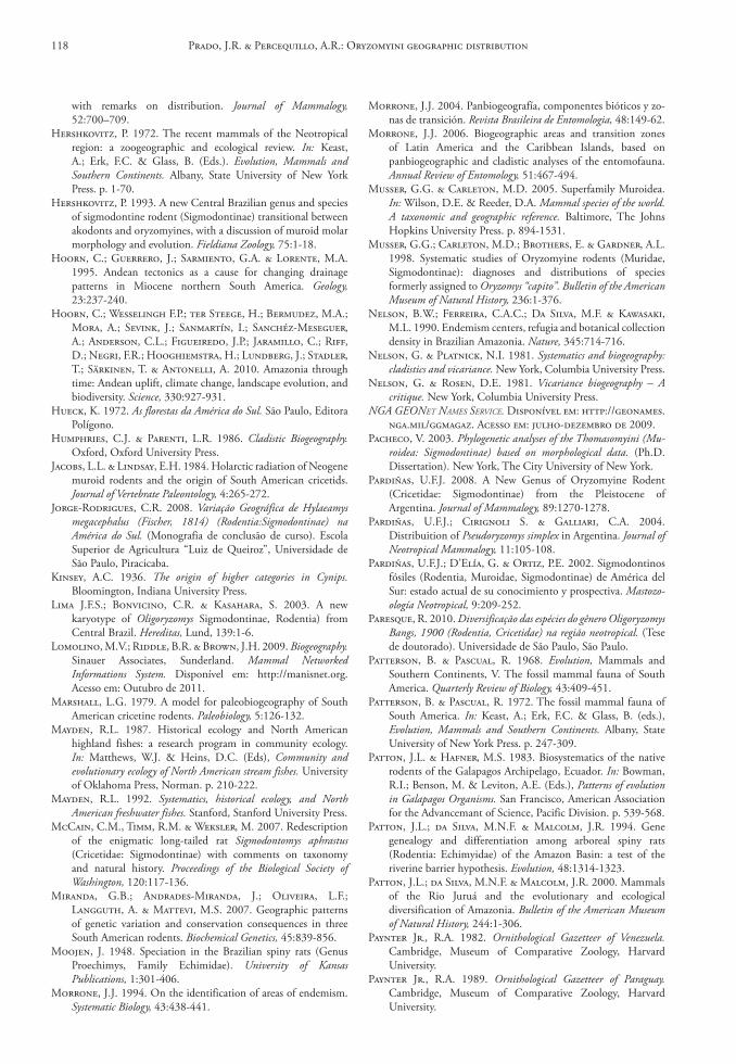
with remarks on distribution. Journal of Mammalogy, 52:700–709.
Hershkovitz, P. 1972. The recent mammals of the Neotropical region: a zoogeographic and ecological review. In: Keast, A.; Erk, F.C. & Glass, B. (Eds.). Evolution, Mammals and Southern Continents. Albany, State University of New York Press. p. 1-70.
Hershkovitz, P. 1993. A new Central Brazilian genus and species of sigmodontine rodent (Sigmodontinae) transitional between akodonts and oryzomyines, with a discussion of muroid molar morphology and evolution. Fieldiana Zoology, 75:1-18.
Hoorn, C.; Guerrero, J.; Sarmiento, G.A. & Lorente, M.A. 1995. Andean tectonics as a cause for changing drainage patterns in Miocene northern South America. Geology, 23:237-240.
Hoorn, C.; Wesselingh F.P.; ter Steege, H.; Bermudez, M.A.; Mora, A.; Sevink, J.; Sanmartín, I.; Sanchéz-Meseguer, A.; Anderson, C.L.; Figueiredo, J.P.; Jaramillo, C.; Riff, D.; Negri, F.R.; Hooghiemstra, H.; Lundberg, J.; Stadler, T.; Särkinen, T. & Antonelli, A. 2010. Amazonia through time: Andean uplift, climate change, landscape evolution, and biodiversity. Science, 330:927-931.
Hueck, K. 1972. As florestas da América do Sul. São Paulo, Editora Polígono.
Humphries, C.J. & Parenti, L.R. 1986. Cladistic Biogeography. Oxford, Oxford University Press.
Jacobs, L.L. & Lindsay, E.H. 1984. Holarctic radiation of Neogene muroid rodents and the origin of South American cricetids. Journal of Vertebrate Paleontology, 4:265-272.
Jorge-Rodrigues, C.R. 2008. Variação Geográfica de Hylaeamys megacephalus (Fischer, 1814) (Rodentia:Sigmodontinae) na América do Sul. (Monografia de conclusão de curso). Escola Superior de Agricultura “Luiz de Queiroz”, Universidade de São Paulo, Piracicaba.
Kinsey, A.C. 1936. The origin of higher categories in Cynips. Bloomington, Indiana University Press.
Lima J.F.S.; Bonvicino, C.R. & Kasahara, S. 2003. A new karyotype of Oligoryzomys Sigmodontinae, Rodentia) from Central Brazil. Hereditas, Lund, 139:1-6.
Lomolino, M.V.; Riddle, B.R. & Brown, J.H. 2009. Biogeography. Sinauer Associates, Sunderland. Mammal Networked Informations System. Disponível em: http://manisnet.org. Acesso em: Outubro de 2011.
Marshall, L.G. 1979. A model for paleobiogeography of South American cricetine rodents. Paleobiology, 5:126-132.
Mayden, R.L. 1987. Historical ecology and North American highland fishes: a research program in community ecology. In: Matthews, W.J. & Heins, D.C. (Eds), Community and evolutionary ecology of North American stream fishes. University of Oklahoma Press, Norman. p. 210-222.
Mayden, R.L. 1992. Systematics, historical ecology, and North American freshwater fishes. Stanford, Stanford University Press.
McCain, C.M., Timm, R.M. & Weksler, M. 2007. Redescription of the enigmatic long-tailed rat Sigmodontomys aphrastus (Cricetidae: Sigmodontinae) with comments on taxonomy and natural history. Proceedings of the Biological Society of Washington, 120:117-136.
Miranda, G.B.; Andrades-Miranda, J.; Oliveira, L.F.; Langguth, A. & Mattevi, M.S. 2007. Geographic patterns of genetic variation and conservation consequences in three South American rodents. Biochemical Genetics, 45:839-856.
Moojen, J. 1948. Speciation in the Brazilian spiny rats (Genus Proechimys, Family Echimidae). University of Kansas Publications, 1:301-406.
Morrone, J.J. 1994. On the identification of areas of endemism. Systematic Biology, 43:438-441.
Morrone, J.J. 2004. Panbiogeografía, componentes bióticos y zo-nas de transición. Revista Brasileira de Entomologia, 48:149-62.
Morrone, J.J. 2006. Biogeographic areas and transition zones of Latin America and the Caribbean Islands, based on panbiogeographic and cladistic analyses of the entomofauna. Annual Review of Entomology, 51:467-494.
Musser, G.G. & Carleton, M.D. 2005. Superfamily Muroidea. In: Wilson, D.E. & Reeder, D.A. Mammal species of the world. A taxonomic and geographic reference. Baltimore, The Johns Hopkins University Press. p. 894-1531.
Musser, G.G.; Carleton, M.D.; Brothers, E. & Gardner, A.L. 1998. Systematic studies of Oryzomyine rodents (Muridae, Sigmodontinae): diagnoses and distributions of species formerly assigned to Oryzomys “capito”. Bulletin of the American Museum of Natural History, 236:1-376.
Nelson, B.W.; Ferreira, C.A.C.; Da Silva, M.F. & Kawasaki, M.L. 1990. Endemism centers, refugia and botanical collection density in Brazilian Amazonia. Nature, 345:714-716.
Nelson, G. & Platnick, N.I. 1981. Systematics and biogeography: cladistics and vicariance. New York, Columbia University Press.
Nelson, G. & Rosen, D.E. 1981. Vicariance biogeography – A critique. New York, Columbia University Press.
NGA GEONEt NAmEs sErvicE. Disponível em: http://geonames.nga.mil/ggmagaz. Acesso em: julho-dezembro de 2009.
Pacheco, V. 2003. Phylogenetic analyses of the Thomasomyini (Mu-roidea: Sigmodontinae) based on morphological data. (Ph.D. Dissertation). New York, The City University of New York.
Pardiñas, U.F.J. 2008. A New Genus of Oryzomyine Rodent (Cricetidae: Sigmodontinae) from the Pleistocene of Argentina. Journal of Mammalogy, 89:1270-1278.
Pardiñas, U.F.J.; Cirignoli S. & Galliari, C.A. 2004. Distribuition of Pseudoryzomys simplex in Argentina. Journal of Neotropical Mammalogy, 11:105-108.
Pardiñas, U.F.J.; D’Elía, G. & Ortiz, P.E. 2002. Sigmodontinos fósiles (Rodentia, Muroidae, Sigmodontinae) de América del Sur: estado actual de su conocimiento y prospectiva. Mastozo-ología Neotropical, 9:209-252.
Paresque, R. 2010. Diversificação das espécies do gênero Oligoryzomys Bangs, 1900 (Rodentia, Cricetidae) na região neotropical. (Tese de doutorado). Universidade de São Paulo, São Paulo.
Patterson, B. & Pascual, R. 1968. Evolution, Mammals and Southern Continents, V. The fossil mammal fauna of South America. Quarterly Review of Biology, 43:409-451.
Patterson, B. & Pascual, R. 1972. The fossil mammal fauna of South America. In: Keast, A.; Erk, F.C. & Glass, B. (eds.), Evolution, Mammals and Southern Continents. Albany, State University of New York Press. p. 247-309.
Patton, J.L. & Hafner, M.S. 1983. Biosystematics of the native rodents of the Galapagos Archipelago, Ecuador. In: Bowman, R.I.; Benson, M. & Leviton, A.E. (Eds.), Patterns of evolution in Galapagos Organisms. San Francisco, American Association for the Advancemant of Science, Pacific Division. p. 539-568.
Patton, J.L.; da Silva, M.N.F. & Malcolm, J.R. 1994. Gene genealogy and differentiation among arboreal spiny rats (Rodentia: Echimyidae) of the Amazon Basin: a test of the riverine barrier hypothesis. Evolution, 48:1314-1323.
Patton, J.L.; da Silva, M.N.F. & Malcolm, J.R. 2000. Mammals of the Rio Juruá and the evolutionary and ecological diversification of Amazonia. Bulletin of the American Museum of Natural History, 244:1-306.
Paynter Jr., R.A. 1982. Ornithological Gazetteer of Venezuela. Cambridge, Museum of Comparative Zoology, Harvard University.
Paynter Jr., R.A. 1989. Ornithological Gazetteer of Paraguay. Cambridge, Museum of Comparative Zoology, Harvard University.
Prado, J.R. & Percequillo, A.R.: Oryzomyini geographic distribution118
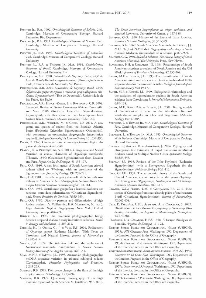
Paynter Jr., R.A. 1992. Ornithological Gazetteer of Bolivia. 2.ed. Cambridge, Museum of Comparative Zoology, Harvard University, Bird Department.
Paynter Jr., R.A. 1993. Ornithological Gazetteer of Ecuador. 2.ed. Cambridge, Museum of Comparative Zoology, Harvard University.
Paynter Jr., R.A. 1997. Ornithological Gazetteer of Colombia. 2.ed. Cambridge, Museum of Comparative Zoology, Harvard University.
Paynter Jr., R.A. & Traylor Jr., M.A. 1991. Ornithological Gazetteer of Brazil. Cambridge, Museum of Comparative Zoology, Harvard University. 2 v.
Percequillo, A.R. 1998. Sistemática de Oryzomys Baird, 1858 do Leste do Brasil (Muroidea, Sigmodontinae). (Dissertação de mes-trado) Universidade de São Paulo, São Paulo.
Percequillo, A.R. 2003. Sistemática de Oryzomys Baird, 1858: definição dos grupos de espécies e revisão do grupo albigularis (Ro-dentia, Sigmodontinae). (Tese de Doutorado). Universidade de São Paulo, São Paulo.
Percequillo, A.R.; Hingst-Zaher, E. & Bonvicino, C.R. 2008. Systematic Review of Genus Cerradomys Weksler, Percequillo and Voss, 2006 (Rodentia: Cricetidae: Sigmodontinae: Oryzomyini), with Description of Two New Species from Eastern Brazil. American Museum novitiates, 3622:1-46.
Percequillo, A.R.; Weksler, M. & Costa, L.P. 2011. A new genus and species of rodent from the Brazilian Atlantic Forest (Rodentia: Cricetidae: Sigmodontinae: Oryzomyini), with comments on oryzomyine biogeography (subscription required). Zoological Journal of the Linnean Society, 161:357-390.
Pinto, O. 1945. Cinquenta anos de investigação ornitológica. Ar-quivos de Zoologia, 4:261-340.
Prado, J.R. & Percequillo, A.R. 2011. Ontogenetic and Sexual Variation in cranial characters of Aegialomys xanthaeolus (Thomas, 1894) (Cricetidae: Sigmodontinae) from Ecuador and Peru. Papéis Avulsos de Zoologia, 51:155-177.
Reig, O.A. 1980. A new fossil genus of South American cricetid rodents allied to Wiedomys, with an assessment of the Sigmodontinae. Journal of Zoology, 192:257-281.
Reig, O.A. 1981. Teoría del origen y desarrollo de la fauna de ma-míferos de América del Sur. Monographiae Naturae Museo Mu-nicipal Ciencias Naturales “Lorenzo Scaglia”, 1:1-161.
Reig, O.A. 1984. Distribuição geográfica e história evolutiva dos roedores muroideos sulamericanos (Cricetidae: Sigmodonti-nae). Revista Brasileira de Genética, 7:333-365.
Reig, O.A. 1986. Diversity patterns and differentiation of high Andean rodents. In: Vuilleumier, F. & Monasterio, M. (eds.), High Altitude Tropical Biogeography. New York, Oxford University Press. p. 404-439.
Riddle, B.R. 1996. The molecular phylogeographic bridge between deep and shallow history in continental biotas. Trends in Ecology and Evolution, 11:207-211.
Sanchéz H., J.; Ochoa G., J. & Voss, R.S. 2001. Rediscovery of Oryzomys gorgasi (Rodenta: Muridae). With Notes on Taxonomy and Natural History. Journal of Mammalogy, 65:205-214.
Savage, J.M. 1974. The isthmian link and the evolution of Neotropical mammals. Contributions in Science Natural History Museum of Los Angeles County, 260:1-51.
Silva, M.N.F. & Patton, J.L. 1993. Amazonian phylogeography: mtDNA sequence variation in arboreal echimyid rodents (Caviomorpha). Molecular Phylogenetics and Evolution, 2:243-255.
Simpson, B.B. 1975. Pleistocene changes in the flora of the high tropical Andes. Paleobiology, 1:273-294.
Simpson, B.B. 1979. Quaternary biogeography of the high montane regions of South America. In: Duellman, W.E. (Ed.).
The South American herpetofauna: its origin, evolution, and dispersal. Lawrence, University of Kansas. p. 157-188.
Simpson, G.G. 1950. History of the fauna of Latin America. American Scientist Burlington, 38:361-389.
Simpson, G.G. 1969. South American Mammals. In: Fittkau, J.J. & Dr. W. Junk N.V. (Eds.). Biogeography and ecology in South America. Madison, Universidade de Wisconsin. p. 879-909.
Simpson, G.G. 1980. Splendid Isolation. The curious history of South American Mammals. Yale University Press, New Haven.
Slaughter, B.H. & Ubelaker, J.E. 1984. Relationships of South American cricetines to rodents of North America and the Old World. Journal of Vertebrate Paleontology, 42:255-264.
Smith, M.F. & Patton, J.L. 1993. The diversification of South American murid rodents: evidence from mitochondrial DNA sequence data for the akodontine tribe. Biological Journal of the Linnean Society, 50:149-177.
Smith, M.F. & Patton, J.L. 1999. Phylogenetic relationships and the radiation of sigmodontine rodents in South America: evidence from Cytochrome b. Journal of Mammalian Evolution, 6:89-128.
Smith, M.F.; Kelt, D.A. & Patton, J.L. 2001. Testing models of diversification in mice in the Abrothrix olivaceus/xanthorhinus complex in Chile and Argentina. Molecular Ecology, 10:397-405.
Stephens, L. & Traylor Jr., M.A. 1983. Ornithological Gazetteer of Peru. Cambridge, Museum of Comparative Zoology, Harvard University.
Stephens, L. & Traylor Jr., M.A. 1985. Ornithological Gazetteer of the Guianas. Cambridge, Museum of Comparative Zoology, Harvard University.
Steppan, S.; Adkins, R. & Anderson, J. 2004. Phylogeny and Divergence-Date Estimates of Rapid Radiations in Muroid Rodents Based on Multiple Nuclear Genes. Systematic Biology, 53:533-553.
Steppan, S.J. 1995. Revison of the Tribe Phyllotini (Rodentia: Sigmodontinae), with a Phylogenetic hypothesis for the Sigmodontinae. Fieldiana Zoology, 80:1-112.
Tate, G.H.H. 1932. The taxonomic history of the South and Central American cricetid rodents of the genus Oryzomys. Part 2: subgenera Oligoryzomys, Thallomyscus and Melanomys. American Museum Novitates, 580:1-17.
Tavares, W.C.; Pessôa, L.M. & Gonçalves, P.R. 2011. New species of Cerradomys from coastal sandy plains of southeastern Brazil (Cricetidae: Sigmodontinae). Journal of Mammalogy, 92:645-658.
Teta, P.; Pardiñas, U.F.J.; Andrade, A. & Cirignoli, S. 2007. Distribución de los Géneros Euryoryzomys y Sooretamys (Ro-dentia, Cricetidae) en Argentina. Mastozoología Neotropical, 14:279-284.
Travassos, L. & Camargo, H.F.A. 1958. A Estação Biológica de Boracéia. Arquivos de Zoologia, 11:1-21.
United States Board on Geographical Names (USBGN). 1955a. NIS Gazetteer Peru. Washington, DC, Department of the Interior, Prepared in the Office of Geography.
United States Board on Geographical Names (USBGN). 1955b. Gazetteer nº 4, Bolivia. Washington, DC, Department of the Interior, Prepared in the Office of Geography.
United States Board on Geographical Names (USBGN). 1956. Gazetteer nº 18 Costa Rica. Washington, DC, Department of the Interior, Prepared in the Office of Geography.
United States Board on Geographical Names (USBGN). 1957a. Gazetteer nº 35 Paraguai. Washington, DC, Department of the Interior, Prepared in the Office of Geography.
United States Board on Geographical Names (USBGN). 1957b. Gazetteer nº 36 Ecuador. Washington, DC, Department of the Interior, Prepared in the Office of Geography.
Arquivos de Zoologia, 44(1), 2013 119
United States Board on Geographical Names (USBGN). 1961. NIS Gazetteer Venezuela. Washington, DC, Department of the Interior, Prepared in the Office of Geography.
United States Board on Geographical Names (USBGN). 1963. Gazetteer nº 71 Brazil. Washington, DC, Department of the Interior,Prepared in the Office of Geography.
United States Board on Geographical Names (USBGN). 1964. Gazetteer nº 86, Colombia. Washington, DC, Department of the Interior, Prepared in the Office of Geography.
United States Board on Geographical Names (USBGN). 1968. Gazetteer nº 103 Argentina. Washington, DC, Department of the Interior, Prepared in the Office of Geography.
United States Board on Geographical Names (USBGN). 1969. Gazetteer nº 110, Panama and the Canal Zone. Washington, DC, Department of the Interior, Prepared in the Office of Geography.
United States Board on Geographical Names (USBGN). 1976. Guyana. Washington, DC, Department of the Interior,Prepared in the Office of Geography.
Valencia-Pacheco, E.; Avaria-Llautureo, J.; Muñoz-Escobar, C.; Boric-Bargetto, D. & Hernández, C.E. 2011. Patro-nes de distribución geográfica de la riqueza de especies de roedores de la Tribu Oryzomyini (Rodentia: Sigmodontinae) em Sudamérica: Evaluando la importancia de los procesos de colonización y extinción. Revista Chilena de Historia Natural, 84:365-377.
Vanzolini, P.E. 1974. Ecological and geographical distribution of lizards in Pernambuco, northeastern Brasil (Sauria). Papéis Avulsos de Zoologia, 28:61-90.
Vanzolini, P.E. 1992. A supplement to the Ornithological Gazetteer of Brazil. São Paulo, Museu de Zoologia, Universidade de São Paulo.
Verzi, D.H. & Montalvo, C.I. 2008. The oldest South American Cricetidae (Rodentia) and Mustilidae (Carnivora): late Miocene faunal turnover in central Argentina and the Great American Biotic Interchange. Palaeogeography, Palaeoclimatology, Palaeoecology, 267:284-291.
Voss, R.S. 1988. Systematics and ecology of Ichthyomyine rodents (Muroidea): patterns of morphological evolution in a small adaptive radiation. Bulletin of the American Museum of Natural History, 188:259-493.
Voss, R.S. 1991. An introduction to the neotropical muroid rodent genus Zygodontomys. Bulletin of the American Museum of Natural History, 210:1-113.
Voss, R.S. 1993. A revision of the brazilian Muroid rodent genus Delomys with remarks on “Thomasomyine” characters. American Museum Novitates, 3073:1-44.
Voss, R.S. & Carleton, M.D. 1993. A new genus for Hesperomys molitor Winge and Holochilus magnus Hershkovitz (Mammalia, Muridae) with an analysis of its phylogenetic relationships. American Museum Novitates, 3085:1-39.
Voss, R.S. & Weksler, M.W. 2009. On the taxonomic status of Oryzomys curasoae McFarlane and Debrot, 2001, (Rodentia: Cricetidae: Sigmodontinae) with remarks on the phylogenetic relationships of O. gorgasi Hershkovitz, 1971. Caribbean Journal of Science, 45:73-79.
Voss, R.S.; Gómez-Laverde, M. & Pacheco, V. 2002. A new genus for Aepeomys fuscatus Allen, 1912, and Oryzomys intectus Thomas, 1921: enigmatic murid from Andean Cloud Forests. American Museum Novitates, 3373:1-42.
Voss, R.S.; Lunde, D.P. & Simmons, N.B. 2001. The Mammals of Paracou, French Guiana: A Neotropical Lowland Fauna. Part 2. Nonvolant Species. Bulletin of the American Museum of Natural History, 263:1-236.
Waterhouse, G.R. 1839. The zoology of the voyage of H.M.S. Beagle, under the command of Captain Fitzroy, R.N., during the years 1832 to 1836. Part II: Mammalia. London, Smith, Elder & Co.
Weksler, M. 2003. Phylogeny of neotropical oryzomyine rodents (Muridae: Sigmodontinae) based on the nuclear IRBP exon. Molecular Phylogenetics and Evolution, 29:331-349.
Weksler, M. 2006. Phylogenetic relationships of oryzomyine rodents (Muroidea: Sigmodontinae): separate and combined analyses of morphological and molecular data. Bulletin of the American Museum of Natural History, 296:1-149.
Weksler, M. & Bonvicino, C.R. 2005. Taxonomy of pigmy rice rats genus Oligoryzomys bangs, 1900 (Rodentia, Sigmodontinae) of the Brazilian Cerrado, with the description of two new species. Arquivos do Museu Nacional, Rio de Janeiro, 63:113-130.
Weksler, M. & Percequillo, A.R. 2011. Key to the genera of the Tribe Oryzomyini (Rodentia: Cricetidae: Sigmodontinae). Mastozoología Neotropical, 18:281-292.
Weksler, M.; Percequillo, A.R. & Voss, R.S. 2006. Ten New Genera of Oryzomyine Rodents (Cricetidae: Sigmodontinae). American Museum Novitates, 3537:1-29.
Wiley, E.O. & Mayden, R.L. 1985. Species and speciation in phylogenetic systematics, with examples from the North American fish fauna. Annals of the Missouri Botanical Graden, 72:596-635.
Willis, J.C. 1922. Age and area. Cambridge, Cambridge University Press.
Wolf, T. 1975. Geografía y geología del Ecuador. Quito, Editorial Casa de la Cultura Ecuatoriana.
Aceito em: 28/02/2013 Impresso em: 30/06/2013
Prado, J.R. & Percequillo, A.R.: Oryzomyini geographic distribution120
editoriaL committeepublisher: Museu de Zoologia da Universidade de São Paulo. Avenida Nazaré, 481, Ipiranga, CEP 04263-000, São Paulo, SP, Brasil.
editor‑in‑chief: Carlos José Einicker Lamas, Serviço de Invertebrados, Museu de Zoologia, Universidade de São Paulo, Caixa Postal 42.494, CEP 04218-970, São Paulo, SP, Brasil. E-mail: [email protected].
associate editors: Mário César Cardoso de Pinna (Museu de Zoologia, Universidade de São Paulo, Brasil); Luís Fábio Silveira (Museu de Zoologia, Universidade de São Paulo, Brasil); Marcos Domingos Siqueira Tavares (Museu de Zoologia, Universidade de São Paulo, Brasil); Sérgio Antonio Vanin (Instituto de Biociências, Universidade de São Paulo, Brasil); Hussam El Dine Zaher (Museu de Zoologia, Universidade de São Paulo, Brasil).
editorial board: Rüdiger Bieler (Field Museum of Natural History, U.S.A.); Walter Antonio Pereira Boeger (Universidade Federal do Paraná, Brasil); Carlos Roberto Ferreira Brandão
(Universidade de São Paulo, Brasil); James M. Carpenter (American Museum of Natural History, U.S.A.); Ricardo Macedo Corrêa e Castro (Universidade de São Paulo, Brasil); Mario de Vivo (Universidade de São Paulo, Brasil); Marcos André Raposo Ferreira (Museu Nacional, Rio de Janeiro, Brasil); Darrel R. Frost (American Museum of Natural History, U.S.A.); William R. Heyer (National Museum of Natural History, U.S.A.); Ralph W. Holzenthal (University of Minnesota, U.S.A.); Adriano Brilhante Kury (Museu Nacional, Rio de Janeiro, Brasil); Gerardo Lamas (Museo de Historia Natural “Javier Prado”, Lima, Peru); John G. Maisey (American Museum of Natural History, U.S.A.); Naércio Aquino Menezes (Universidade de São Paulo, Brasil); Christian de Muizon (Muséum National d’Histoire Naturelle, Paris, France); Nelson Papavero (Universidade de São Paulo, Brasil); James L. Patton (University of California, Berkeley, U.S.A.); Richard O. Prum (University of Kansas, U.S.A.); Olivier Rieppel (Field Museum of Natural History, U.S.A.); Miguel Trefaut Urbano Rodrigues (Universidade de São Paulo, Brasil); Randall T. Schuh (American Museum of Natural History, U.S.A.); Ubirajara Ribeiro Martins de Souza (Universidade de São Paulo, Brasil); Richard P. Vari (National Museum of Natural History, U.S.A.).
instructions to authors ‑ (april 2007)General information: Papéis Avulsos de Zoologia (PAZ) and Arquivos de Zoologia (AZ) cover primarily the fields of Zoology, publishing original contributions in systematics, paleontology, evolutionary biology, ontogeny, faunistic studies, and biogeography. Papéis Avulsos de Zoologia and Arquivos de Zoologia also encourage submission of theoretical and empirical studies that explore principles and methods of systematics.
All contributions must follow the International Code of Zoological Nomenclature. Relevant specimens should be properly curated and deposited in a recognized public or private, non-profit institution. Tissue samples should be referred to their voucher specimens and all nucleotide sequence data (aligned as well as unaligned) should be submitted to GenBank (www.ncbi.nih.gov/Genbank) or EMBL (www.ebi.ac.uk).
peer review: All submissions to Papéis Avulsos de Zoologia and Arquivos de Zoologia are subject to review by at least two referees and the Editor-in-Chief. All authors will be notified of submission date. Authors may suggest potential reviewers. Communications regarding acceptance or rejection of manuscripts are made through electronic correspondence with the first or corresponding author only. Once a manuscript is accepted providing changes suggested by the referees, the author is requested to return a revised version incorporating those changes (or a detailed explanation of why reviewer’s suggestions were not followed) within fifteen days upon receiving the communication by the editor.
proofs: Page-proofs with the revised version will be sent to e-mail the first or corresponding author. Page-proofs must be returned to the editor, preferentially within 48 hours. Failure to return the proof promptly may be interpreted as approval with no changes and/or may delay publication. Only necessary corrections in proof will be permitted. Once page proof is sent to the author, further alterations and/or significant additions of text are permitted only at the author’s expense or in the form of a brief appendix (note added in proof ).
submission of manuscripts: Manuscripts should be sent to the scieLo submission (http://submission.scielo.br/index.php/paz/login), along with a submission letter explaining the importance and originality of the study. Address and e-mail of the corresponding author must be always updated since it will be used to send the 50 reprints in titled by the authors. Figures, tables and graphics should not be inserted in the text. Figures and graphics should be sent in separate files with the following formats: “.JPG” and “.TIF” for figures, and “.XLS” and “.CDR” for graphics, with 300 DPI of minimum resolution. Tables should be placed at the end of the manuscript.
Manuscripts are considered on the understanding that they have not been published or will not appear elsewhere in substantially the same or abbreviated form. The criteria for acceptance of articles are: quality and relevance of research, clarity of text, and compliance with the guidelines for manuscript preparation.
Manuscripts should be written preferentially in English, but texts in Portuguese or Spanish will also be considered. Studies with a broad coverage are encouraged to be submitted in English. All manuscripts should include an abstract and key-words in English and a second abstract and key-words in Portuguese or Spanish.
Authors are requested to pay attention to the instructions concerning the preparation of the manuscripts. Close adherence to the guidelines will expedite processing of the manuscript.
manuscript form: Manuscripts should not exceed 150 pages of double-spaced, justified text, with size 12 and source Times New Roman (except for symbols). Page format should be A4 (21 by 29.7 cm), with 3 cm of margins. The pages of the manuscript should be numbered consecutively.
The text should be arranged in the following order: title page, abstracts with Key‑Words, body of text, Literature cited, tables, appendices, and figure captions. Each of these sections should begin on a new page.
(1) title page: This should include the title, short title, author(s) name(s) and institutions. The title should be concise and, where appropriate, should include mention of families and/or higher taxa. Names of new taxa should not be included in titles.
(2) abstract: All papers should have an abstract in english and another in portuguese or spanish. The abstract is of great importance as it may be reproduced elsewhere. It should be in a form intelligible if published alone and should summarize the main facts, ideas, and conclusions of the article. Telegraphic abstracts are strongly discouraged. Include all new taxonomic names for referencing purposes. Abbreviations should be avoided. It should not include references. Abstracts and key-words should not exceed 350 and 5 words, respectively.
(3) body of text: The main body of the text should include the following sections: introduction, material and methods, results, discussion, conclusion, acknowledgments, and references at end. Primary headings in the text should be in capital letters, in bold and centered. Secondary headings should be in capital and lower case letters, in bold and centered. Tertiary headings should be in capital and lower case letters, in bold and indented at left. In all the cases the text should begin in the following line.
(4) Literature cited: Citations in the text should be given as: Silva (1998) or Silva (1998:14-20) or Silva (1998: figs. 1, 2) or Silva (1998a, b) or Silva & Oliveira (1998) or (Silva, 1998) or (Rangel, 1890; Silva & Oliveira, 1998a, b; Adams, 2000) or (Silva, pers. com.) or (Silva et al., 1998), the latter when the paper has three or more authors. The reference need not be cited when authors and date are given only as authority for a taxonomic name.
(5) references: The literature cited should be arranged strictly alphabetically and given in the following format:
• Journal article - Author(s). Year. Article title. Journal name, volume: initial page-final page. Names of journals must be spelled out in full.
•books - Author(s). Year. Book title. Publisher, Place.
•chapters of books - Author(s). Year. Chapter title. In: Author(s) ou Editor(s), Book title. Publisher, Place, volume, initial page-final page.
•dissertations and theses - Author(s). Year. Dissertation title. (Ph.D. Dissertation). University, Place.
•electronic publications - Author(s). Year. Title. Available at: <electronic address>. Access in: date.
tables: All tables must be numbered in the same sequence in which they appear in text. Authors are encouraged to indicate where the tables should be placed in the text. They should be comprehensible without reference to the text. Tables should be formatted with vertical (portrait), not horizontal (landscape), rules. In the text, tables should be referred as Table 1, Tables 2 and 4, Tables 2-6. Use “TABLE” in the table heading.
illustrations: Figures should be numbered consecutively, in the same sequence that they appear in the text. Each illustration of a composite figure should be identified by capital letters and referred in the text as: Fig. 1A, Fig. 1B, for example. When possible, letters should be placed in the left lower corner of each illustration of a composite figure. Hand-written lettering on illustrations is unacceptable. Figures should be mounted in order to minimize blank areas between each illustration. Black and white or color photographs should be digitized in high resolution (300 DPI at least). Use “Fig(s).” for referring to figures in the text, but “FIGURE(S)” in the figure captions and “fig(s).” when referring to figures in another paper.
responsability: Scientific content and opinions expressed in this publication are sole responsibility of the respective authors. copyrights: The journals Papéis Avulsos de Zoologia and Arquivos de Zoologia are licensed under a Creative Commons Licence (http://creativecommons.org).
For other details of manuscript preparation of format, consult the CBE Style Manual, available from the Council of Science Editors (www.councilscienceeditors.org/publications/style).
Papéis Avulsos de Zoologia and Arquivos de Zoologia are publications of the Museu de Zoologia da Universidade de São Paulo (www.mz.usp.br). Always consult the Instructions to Authors printed in the last issue or in the electronic home pages: www.scielo.br/paz or www.mz.usp.br/publicacoes.