Embed Size (px)
Citation preview
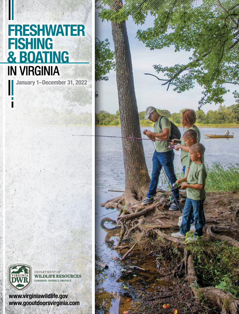
FRESHWATER FISHING & BOATINGIN VIRGINIAIN VIRGINIA
January 1–December 31, 2022
www.virginiawildlife.govwww.gooutdoorsvirginia.com

BLEEDB
LEE
D
SAFE
TY
SAFETY
TRIM TR
IM
FISHING REGULATIONS GUIDE - VA(AND VARIOUS OTHER STATES)
TRIM: . . . . . . . . . . . . . . . . . . . . . . 8˝ X 10-1/2˝
BLEED: . . . . . . . . . . . . . . . . . . 8-1/4˝ X 10-3/4˝
SAFETY: . . . . . . . . . . . . . . . . . . . . . . . 7˝ X 10˝
BLEED
SAFETY
TRIM
BLE
ED
SAFE
TY
TRIM
BLE
ED
SAFE
TY
TRIM
SAFETY
BLEED
TRIM
BLEED
SAFETY
TRIM
BLE
ED
SAFE
TY
TRIM
Client: Progressive
Job No: 20S80235.NW
Created by: Dalon Wolford
Applications: InDesign CC, Adobe Photoshop CC, Adobe Illustrator CC
Job Description: Full Page, 4 Color Ad
Document Name: No Wake ad / Fishing Regulations Guide - Various States
Final Trim Size: 7-7/8˝ X 10-1/2˝
Final Bleed: 8-1/8˝ X 10-13/16˝
Safety: 7˝ X 10˝
Date Created: 03/04/21
Shhhhh. No wake zone.
Protect your baby (and their toys) with coverage for � shing gear and personal property too. 1 - 8 0 0 - P R O G R E S S I V E / P R O G R E S S I V E . C O M
Pro
gre
ssiv
e C
asu
alty
Insu
ran
ce C
o. &
af�
liat
es. A
dd
itio
nal
ch
arg
e m
ay a
pp
ly. P
rice
s va
ry b
ased
on
ho
w y
ou
buy
.
Commonwealth of VirginiaRalph S. Northam, Governor
Secretary of Natural ResourcesAnn Jennings
Department of Wildlife ResourcesRyan J. Brown, Executive Director
Members of the BoardBrian Vincent, Chair, FarmvilleG .K. Washington, Vice-chair, DillwynFrank Adams, King WilliamLeon Boyd, VansantRovelle Brown, PalmyraCatherine H. Claiborne, RichmondJohn W. Daniel, II, Richmond Tammy Jo Grimes, Big Stone GapMamie A. Parker, Ph.D., DullesTom Sadler, VeronaKaren Terwilliger, Locustville
Mission StatementConserve and manage wildlife populations and habitat for the benefit of present and future generations. Connect people to Virginia’s outdoors through boating, education, fishing, hunting, trapping, wildlife viewing and other wildlife-related activities. Protect people and property by promoting safe outdoor experiences and managing human-wildlife conflicts.
The Department of Wildlife Resources shall afford to all persons an equal access to Department programs and facilities without regard to race, sex, color, national origin, religion, sexual orientation, gender identity, age, political affiliation, or persons with disabilities. If you believe that you have been discriminated against in any program, activity, or facility, please write to: Virginia Department of Wildlife Resources, Attn: Executive Director’s Office, 7870 Villa Park Dr, Suite 400, P.O. Box 90778, Henrico, VA 23228.
On the Cover:A beautiful day to take the family out for a day of fishing on Lake Brittle. Photo by Meghan Marchetti / DWR
This publication is for general use and contains information regarding programs, policies, regulations, rules, or fees of the Virginia Depart-ment of Wildlife Resources (DWR) current at the time of printing. Information may change after printing and any changes will supersede the information in this publication. DWR’s programs, policies, regulations, rules, or fees can be found at www.virginiawildlife.gov. Specific laws are found in the Code of Virginia (http://law.lis.virginia.gov/vacode) or the Wildlife Resources Department Regulation Manual (http://law.lis.virginia.gov/admincode/title4/agency15). For answers to specific questions about hunting and fishing, contact the Department of Wildlife Resources office nearest you or visit www.virginiawildlife.gov.
The sale of advertising paid a large portion of the cost of this publication. The Department of Wildlife Resources neither endorses the products or services offered in the advertising, nor accepts any liability from the use of such products or services.
FRESHWATER FISHING & BOATINGIN VIRGINIAIN VIRGINIA
January–December 2022
FRESHWATER FISHING WHAT’S NEW FOR 2022 ................................................................................................. 6FISHING LICENSE INFORMATION AND FEES ................................................................. 9
Where to Get a License ................................................................................................ 9Freshwater/Saltwater License Lines on Tidal Waters ................................................... 12Reciprocal Licenses ................................................................................................... 13
GENERAL INFORMATION .............................................................................................. 14Department-owned Lakes, Ponds, Streams or Boat Access Sites ............................... 14Fish Consumption Advisories ...................................................................................... 16Best Practices for Catch-and-Release Fishing............................................................. 17
FRESHWATER FISH REGULATIONS ..............................................................................20Fish Bait Information ...................................................................................................20Creel (Harvest) and Length Limit Tables ......................................................................22
NONGAME FISH, REPTILE, AMPHIBIAN, AND AQUATIC INVERTEBRATE REGULATIONS .........................................................27TROUT FISHING GUIDE ................................................................................................29
Special Regulation Trout Waters ................................................................................ 312022 Catchable Trout Stocking Plan ..........................................................................36
FISH IDENTIFICATION AND FISHING INFORMATION ................................................38PUBLIC LAKES GUIDE ...................................................................................................46MAJOR FISHING RIVERS ..............................................................................................53VIRGINIA STATE RECORD FRESHWATER FISH .............................................................56ONLINE ANGLER RECOGNITION PROGRAM ................................................................57
VIRGINIA BOATER’S GUIDEWATERCRAFT REGISTRATION, TITLING, AND SALES TAX REQUIREMENTS ................................................................................58REQUIRED EQUIPMENT ................................................................................................ 61
Summary of Boating Safety Equipment Requirements ................................................. 61SAFE BOATING
Virginia Boating Safety Education ................................................................................65Enforcement; Alcohol, Drugs, and Boating ..................................................................65Speed Laws; Other Unlawful Acts ...............................................................................66Towed Watersports Safety .......................................................................................... 67Personal Watercraft (PWC) Operation ......................................................................... 67Navigation Rules ......................................................................................................... 67Aids to Navigation....................................................................................................... 70
OTHER SAFETY CONCERNSBoating Accident Reporting ........................................................................................ 71Naval Protection Zones; America’s Waterway Watch ................................................... 71Boat Theft Prevention; Carbon Monoxide .................................................................... 71Capsizing and Falls Overboard .................................................................................... 72
ENJOYING THE WATERTowed Sports Safety; Paddling Safety ......................................................................... 72 Environmental Laws ................................................................................................... 72Boat Ramps and Access Points .................................................................................. 73
VA BOATING ACCIDENT REPORT FORM .................................................................75–76
2 2022 VIRGINIA FRESHWATER FISHING & BOATING WWW.VIRGINIAWILDLIFE.GOV
DIRECTOR’SMESSAGE
Greetings Virginia Anglers and Boaters,I hope that you caught plenty of fish in 2021 and that your 2022
season is even more productive.Our FishLocalVA initiative is underway and provides a great way for
you to get outdoors and catch some fish, no matter where you live. Take a look at our website, at https://dwr.virginia.gov/fishing/fish-local/, to find out which FishLocalVA waters are in your neighborhood. In addition to great fishing opportunities, most FishLocalVA waters have other amenities such as hiking trails and picnic areas — and this information can be found at each water’s page. So, plan your trip and get the whole family outdoors for the day!
DWR’s annual freshwater Free Fishing Days are scheduled for June 3–5, 2022 — on these days, you don’t need a license to fish in nearly all freshwater lakes, streams, and rivers in Virginia, with the exception of our Fee Fishing Areas. These days are a great time to take a friend or a family member out fishing and to connect them to the outdoors. If you are learning to fish or haven’t fished before, DWR will be leading fishing workshops across the state and will have tackle, bait, and instructors on site. It’s a great way to get into the sport of fishing.
On another note, I want to call your attention to a great resource we have in Virginia — Saugeye — a cross between a walleye and a sauger that does well in Virginia’s reservoirs. Saugeye are stocked in Lake Chesdin, Little Creek Reservoir, Flannagan Reservoir, Philpott Reservoir and Leesville Lake, and the Appomattox River has a strong population. Currently, the state record for saugeye is open, and recent surveys have caught several saugeye that exceed the 6 lb. minimum required for state record status. Get out there this year and try your luck — you may find yourself with a record fish! See page 39 for information about how to catch saugeye.
And, if you are looking for fishing tips, check out our YouTube page to see monthly fishing videos that highlight various tactics and techniques to catch a variety of different fish species. These videos are aimed to raise your awareness of public access at DWR-owned and/or man-aged fisheries in addition to providing tips that will help you find and catch fish on the water!
Good luck this season, and I’ll see you on the water.
Ryan J. BrownExecutive Director
About This GuideThis high-quality guide is offered to you by the Virginia Department of Wildlife Resources through its unique partnership with J.F. Griffin Publishing, LLC.
The revenue generated through ad sales significantly lowers production costs and generates savings. These savings translate into additional funds for other important agency programs.
If you have any feedback or are inter-ested in advertising, please contact us at 413.884.1001 or at www.JFGriffin.com
Graphic Design: Jon Gulley, Dane Fay, John Corey, Evelyn Haddad, Chris Sobolowski
Williamstown, MA | Birmingham, AL
This guide is also available online at
nglers and boaters like you make it possible for Virginia to enjoy exceptional fishing and boating opportunities. Through the Federal Aid in Sport Fish Restoration Program, you help the Virginia Department of Wildlife Resources and Virginia Marine Resources Commission make fishing and boating even better each time you buy a fishing reel, fishing lure, trolling motor, or gas for your boat because a portion of the federal tax goes to the Sport Fish Restoration Program. Virginia annually receives about $5.4 million of that money, which pays 75% of many of the fish management and boating access projects that improve your angling pleasure.
Virginia’s Sport Fish Program and YouA
Meghan Marchetti / DWR
����������
First, Point & Click.First, Point & Click.First, Point & Click.
Then, Catch & Release.Then, Catch & Release. Catch & Release. Catch & Release.Then, Catch & Release.
Great fi shing begins at FishVirginiaFirst.com
Fish Virginia First is the place to fi nd inspiration and
trip planning resources for the best freshwater fi shing in Virginia.
www.greentophuntfish.com
(804) 550-2188 | 10150 Lakeridge Parkway | Ashland, Virginia 23005
M-F 9am-7pm • SAT 8am-6pm • SUN 9am-5pm
Super Fastup to 48% less
rotational inertia
4 WWW.VIRGINIAWILDLIFE.GOV
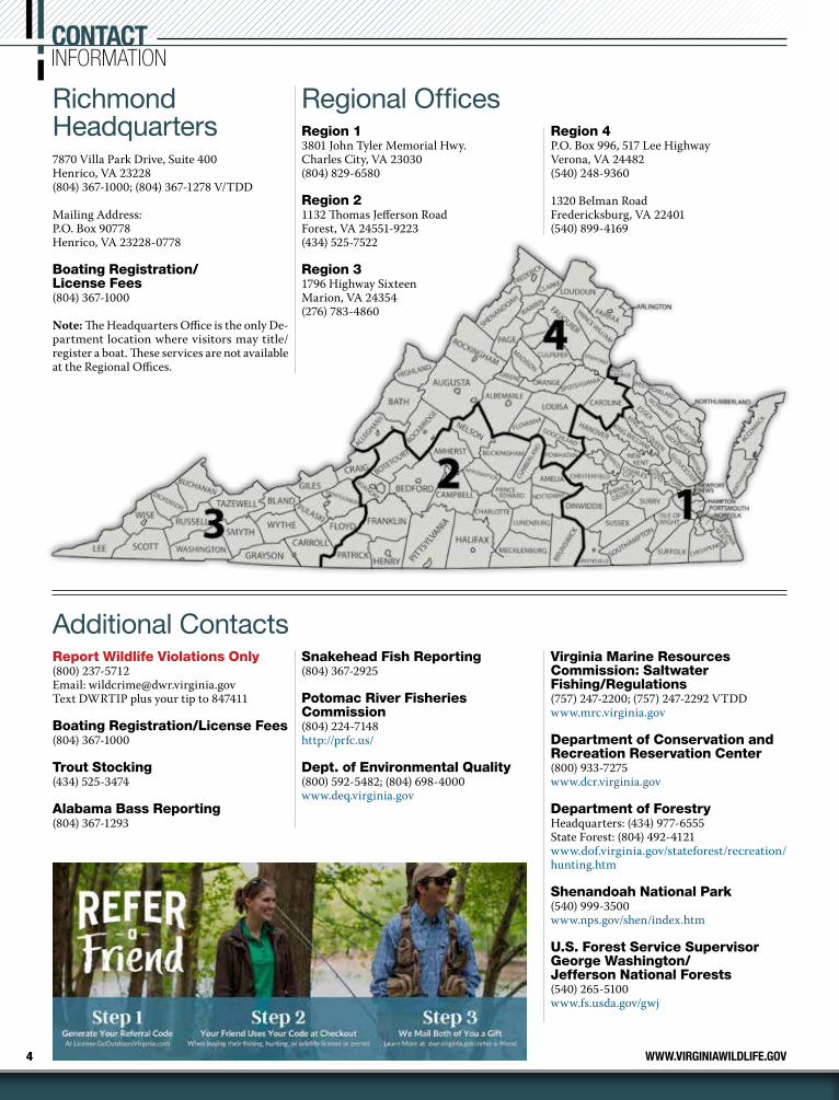
Richmond Headquarters7870 Villa Park Drive, Suite 400Henrico, VA 23228(804) 367-1000; (804) 367-1278 V/TDD
Mailing Address:P.O. Box 90778Henrico, VA 23228-0778
Boating Registration/ License Fees(804) 367-1000
Note: The Headquarters Office is the only De-partment location where visitors may title/register a boat. These services are not available at the Regional Offices.
Regional OfficesRegion 13801 John Tyler Memorial Hwy.Charles City, VA 23030(804) 829-6580
Region 21132 Thomas Jefferson RoadForest, VA 24551-9223(434) 525-7522
Region 31796 Highway SixteenMarion, VA 24354(276) 783-4860
Region 4P.O. Box 996, 517 Lee HighwayVerona, VA 24482(540) 248-9360
1320 Belman RoadFredericksburg, VA 22401(540) 899-4169
Additional ContactsReport Wildlife Violations Only(800) 237-5712Email: [email protected] DWRTIP plus your tip to 847411
Boating Registration/License Fees(804) 367-1000
Trout Stocking(434) 525-3474
Alabama Bass Reporting(804) 367-1293
Snakehead Fish Reporting(804) 367-2925
Potomac River Fisheries Commission(804) 224-7148http://prfc.us/
Dept. of Environmental Quality(800) 592-5482; (804) 698-4000www.deq.virginia.gov
Virginia Marine Resources Commission: Saltwater Fishing/Regulations (757) 247-2200; (757) 247-2292 VTDDwww.mrc.virginia.gov
Department of Conservation and Recreation Reservation Center(800) 933-7275www.dcr.virginia.gov
Department of ForestryHeadquarters: (434) 977-6555State Forest: (804) 492-4121www.dof.virginia.gov/stateforest/recreation/hunting.htm
Shenandoah National Park(540) 999-3500www.nps.gov/shen/index.htm
U.S. Forest Service Supervisor George Washington/Jefferson National Forests(540) 265-5100www.fs.usda.gov/gwj
CONTACTINFORMATION
CALL US AT:
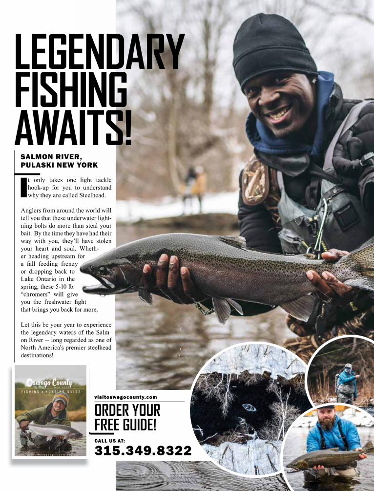
315.349.8322
visitoswegocounty.com
ORDER YOUR FREE GUIDE!
LEGENDARYFISHING AWAITS!
SALMON RIVER, PULASKI NEW YORK
It only takes one light tackle hook-up for you to understand why they are called Steelhead.
Anglers from around the world will tell you that these underwater light-ning bolts do more than steal your bait. By the time they have had their way with you, they’ll have stolen your heart and soul. Wheth-er heading upstream for a fall feeding frenzy or dropping back to Lake Ontario in the spring, these 5-10 lb. “chromers” will give you the freshwater fight that brings you back for more.
Let this be your year to experience the legendary waters of the Salm-on River -- long regarded as one of North America’s premier steelhead destinations!

6
WHAT’S NEWFOR 2022
If the water is calling you, you’ll find it in Mecklenburg County. Go ahead and plan that fishing trip; we’ll give you 800 miles of uncrowded shoreline, 20 boat ramps and over 500 campsites to choose from. Throw in a lakeside brewery and a world-record catch to beat and you’ve got yourself a vacation.
More of what matters. More Mecklenburg.try our new trip planner at visitmeckva.com #moremeck||
more shorelineTHAN highway.
More details can be found in sections that fol-low this summary.
License Information & Fees• A Nonresident 1-Day Freshwater Fishing Li-
cense is no longer valid in designated stocked trout waters.
• A Resident 5-Day Freshwater Fishing License is valid in designated stocked trout waters with a Resident Trout Fishing License.
• The cost for a nonresident trout license to fish in designated stocked trout waters has been reduced to the same price as a resident trout license ($23.00).
Fish Bait Information• As of July 1, 2021, salamanders can no longer
be used as bait in Virginia. This action was taken to help restore and protect Virginia’s native salamander species, many of which are threatened or endangered.
FishLocalVA • DWR’s FishLocalVA initiative focuses on
creating and maintaining quality fishing opportunities near population centers. Our website, located at dwr.virginia.gov/fishing/fish-local/, provides information on Fish-LocalVA program waters. The website also includes information on other outdoor activi-
ties and opportunities at these sites — so take the entire family and make a day out of it!
Trout• As a reminder, a trout license is not required
to fish designated stocked trout waters dur-ing Free Fishing Days. A daily permit is still required to fish at Clinch Mountain, Crooked Creek, and Douthat State Park Fee Fishing Areas.
• The Delayed Harvest section of Passage Creek (Warren Co.) will be closed (not stocked) due to construction at the Front Royal Fish Hatchery.
State Record Fish Program• New species were recognized, including
white crappie, black crappie, bluegill sun-fish, redear sunfish, saugeye, a category for all other sunfish, and goldfish (archery only). White crappie, bluegill, saugeye, and other sunfish categories are currently open until qualifying catches are submitted and ap-proved. For qualifying minimum sizes and program rules, see page 56.
Online Angler Recognition Program• As of January 1, 2021, the angler recognition
program went entirely online. Mail-in trophy fish applications are no longer accepted and
trophy fish certificates are no longer mailed. Anglers can apply online and print their cita-tions at home through Go Outdoors Virginia at www.gooutdoorsvirginia.com/
• New species added to the Angler Recogni-tion Program in 2021 include black crappie, white crappie, saugeye, fallfish, bluegill, red-ear sunfish, and other sunfish. For details on minimum lengths and weights see page 57.
• A photo of the fish is now required for every application. For more details see page 57.
Virginia Boaters Guide—Engine Cutoff Switch• A new federal law requires that vessel op-
erators of boats less than 26 feet use (attach to person) the engine cutoff switch when traveling on plane or above displacement speed. See page 62.
Boat Ramps and Access Points• The listing of boat ramps and access points
has been removed from the digest. For the most up-to-date information go to our website: www.virginiawildlife.gov/boating/access, see page 73.
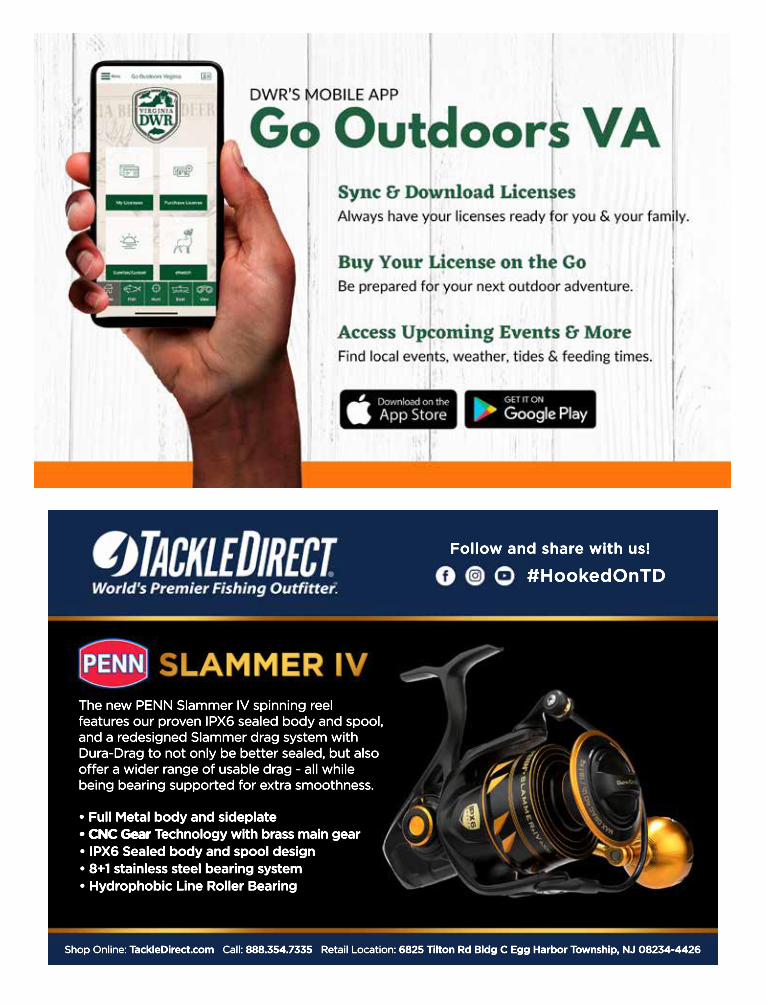
The new PENN Slammer IV spinning reel features our proven IPX6 sealed body and spool, and a redesigned Slammer drag system with Dura-Drag to not only be better sealed, but also offer a wider range of usable drag - all while being bearing supported for extra smoothness.
• Full Metal body and sideplate• CNC Gear • CNC Gear Technology with brass main gear• IPX6 Sealed body and spool design• 8+1 stainless steel bearing system• Hydrophobic Line Roller Bearing
SLAMMER IV
Shop Online: TackleDirect.com Call: 888.354.7335 Retail Location: 6825 Tilton Rd Bldg C Egg Harbor Township, NJ 08234-4426
#HookedOnTDFollow and share with us!
8
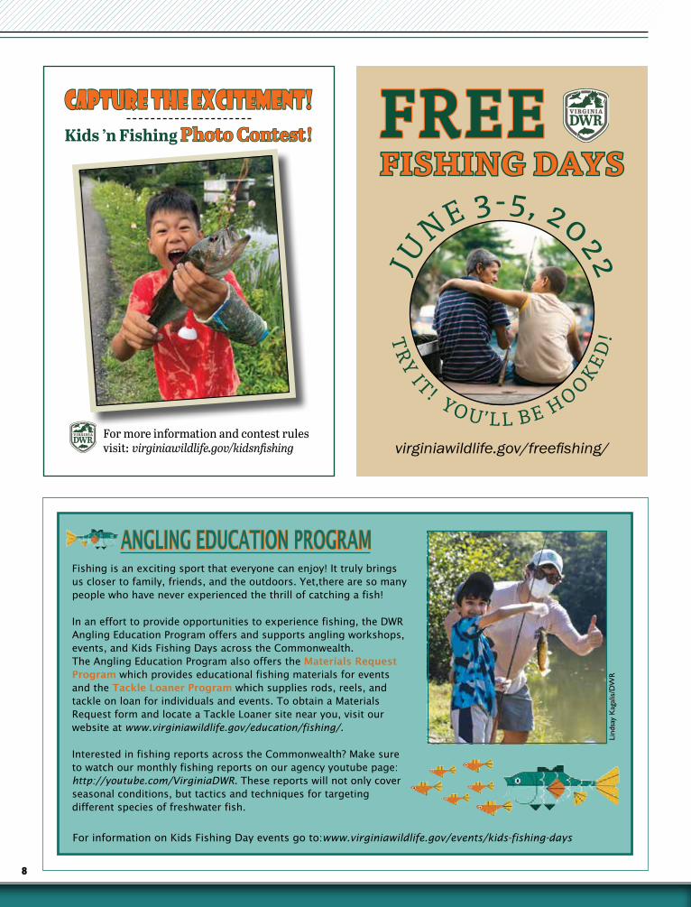
CAPTURE THE EXCITEMENT!CAPTURE THE EXCITEMENT!Kids ’n Fishing Photo Contest!Photo Contest!
For more information and contest rules visit: virginiawildlife.gov/kidsnfishing
FREEFREEFISHING DAYSFISHING DAYS
virginiawildlife.gov/freefishing/
JU
NE 3-5, 2022
TRY IT! YO U ’L L B E H O OKED
!
ANGLING EDUCATION PROGRAM
For information on Kids Fishing Day events go to:www.virginiawildlife.gov/events/kids-fishing-days
Lind
say
Kag
alis
/DW
R
Fishing is an exciting sport that everyone can enjoy! It truly brings us closer to family, friends, and the outdoors. Yet,there are so many people who have never experienced the thrill of catching a fish!
In an effort to provide opportunities to experience fishing, the DWR Angling Education Program offers and supports angling workshops, events, and Kids Fishing Days across the Commonwealth. The Angling Education Program also offers the Materials Request Program which provides educational fishing materials for events and the Tackle Loaner Program which supplies rods, reels, and tackle on loan for individuals and events. To obtain a Materials Request form and locate a Tackle Loaner site near you, visit our website at www.virginiawildlife.gov/education/fishing/.
Interested in fishing reports across the Commonwealth? Make sure to watch our monthly fishing reports on our agency youtube page: http://youtube.com/VirginiaDWR. These reports will not only cover seasonal conditions, but tactics and techniques for targeting different species of freshwater fish.

9WWW.VIRGINIAWILDLIFE.GOV
Fishing License InformationEvery person who is required to have a license to fish, hunt, and/or trap must carry such license with them (electronic copy, printed paper, or annual hard card) and show the license imme-diately upon request of any officer whose duty it is to enforce the game and inland fish laws, or upon the demand of any owner or lessee, or any employee or representative of such owner or lessee, upon whose land or water such person may be hunting, trapping, or fishing.
Residency Qualifications1. Persons who have been a bonafide resident
of the city, county, or state for six consecu-tive months immediately preceding the date of application for license;
2. Persons who have been domiciliary resi-dents of the state for at least two months upon approval of a completed affidavit to be furnished by the DWR;
3. Legal voters in Virginia;4. Any member of the armed forces of the
United States, or a member of the immedi-ate family of such a member as defined in § 2.2-3101, upon execution of a certificate of residence if the member (i) resides in the Commonwealth, (ii) is on active duty, and (iii) is stationed at a military installa-tion within, or in a ship based in, the Com-monwealth;
5. Students (including nonresident students boarding on campus) residing in Virgin-ia who are enrolled in bonafide Virginia schools;
6. Any unnaturalized person who owns real estate in the county or city and who has actually resided there not less than five years next preceding the date of the application for the license in the county or city where they qualify.
ExceptionsAll persons, except those listed below, must purchase the proper licenses before fishing.
• Resident or nonresident landowners, their spouses, their children and grandchildren and the spouses of such children and grand-children, or the landowner’s parents, resident or non resident, do not need a license to hunt, trap, or fish within the boundaries of their own lands and inland waters.
• Residents under 16 years of age (also do not need a trout license).
• Resident, active-duty members of the armed forces while on official leave. However, when trout fishing they must have copy of their Military Orders in their possession.
• Tenants, on the land they rent and occupy, are not required to have a license, but must have the written permission of the landowner.
• Guests fishing in individually owned private ponds.
• Nonresident children under 16 years of age (also do not need a trout license).
• Legally blind persons.• Any Indian who “habitually” resides on
an Indian reservation or a member of the Virginia-recognized tribes who resides in the Commonwealth is not required to have a freshwater license; however, such Indian must have on his person an identification card or paper signed by the chief of his tribe, a valid tribal identification card, writ-ten confirmation through a central tribal registry, or certification from a tribal of-fice. However, a saltwater fishing license is required.
• Stockholders owning 50 percent or more of the stock of any domestic corporation own-ing land in Virginia, his or her spouse and children and minor grandchildren, resident or nonresident, to hunt, trap and fish within the boundaries of lands and inland waters owned by the domestic corporation.
• Persons 65 years of age or older do not need a saltwater license but must comply with the Virginia Fisherman Identification Program (FIP) requirements. See page 11.
• Any person not fishing but aiding a disabled license holder.
Where to Get a LicenseOnline: www.gooutdoorsvirginia.com• New Customers: Create a unique customer
account to access licenses and other products.• Existing Customers: Log in using your date
of birth, last name, and either your DWR Customer ID, the last 4 digits of your SSN or driver’s license number.
Select the license(s) you want, pay with your credit card and print your license if needed.
In Person:Sold by some clerks of the Circuit Court , license agents across Virginia, and DWR headquarters. Not sold at DWR regional offices.
To find a license agent visit: https://license.gooutdoorsvirginia.com/Licensing/LocateAgent.aspx
By Phone/Mobile Phone:(804) 367-1000 during regular business hours, or use your GoOutdoors Virginia mobile app.
Dropbox (Headquarters)Same day processing. Pick up times: 9:00 a.m., 12 noon, and 3:00 p.m.
LICENSEINFORMATION & FEES
10 2022 VIRGINIA FRESHWATER FISHING & BOATING WWW.VIRGINIAWILDLIFE.GOV
LICENSEINFORMATION & FEES
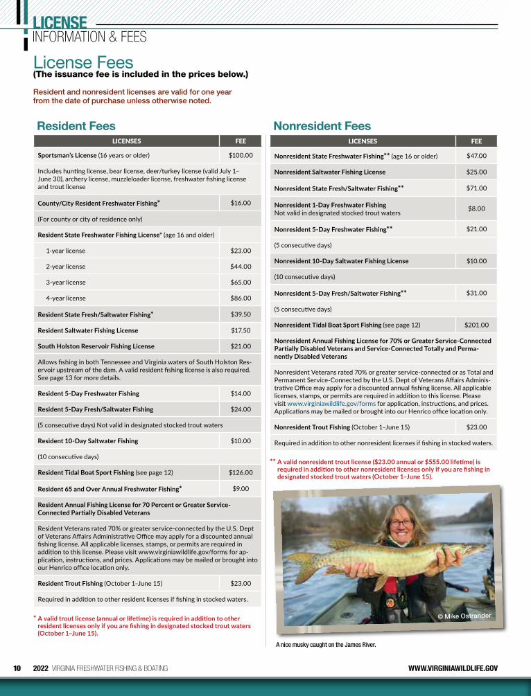
License Fees(The issuance fee is included in the prices below.)
Resident Fees Nonresident FeesLICENSES FEE
Sportsman’s License (16 years or older) $100.00
Includes hunting license, bear license, deer/turkey license (valid July 1–June 30), archery license, muzzleloader license, freshwater fishing license and trout license
County/City Resident Freshwater Fishing* $16.00
(For county or city of residence only)
Resident State Freshwater Fishing License* (age 16 and older)
1-year license $23.00
2-year license $44.00
3-year license $65.00
4-year license $86.00
Resident State Fresh/Saltwater Fishing* $39.50
Resident Saltwater Fishing License $17.50
South Holston Reservoir Fishing License $21.00
Allows fishing in both Tennessee and Virginia waters of South Holston Res-ervoir upstream of the dam. A valid resident fishing license is also required. See page 13 for more details.
Resident 5-Day Freshwater Fishing $14.00
Resident 5-Day Fresh/Saltwater Fishing $24.00
(5 consecutive days) Not valid in designated stocked trout waters
Resident 10-Day Saltwater Fishing $10.00
(10 consecutive days)
Resident Tidal Boat Sport Fishing (see page 12) $126.00
Resident 65 and Over Annual Freshwater Fishing* $9.00
Resident Annual Fishing License for 70 Percent or Greater Service-Connected Partially Disabled Veterans
Resident Veterans rated 70% or greater service-connected by the U.S. Dept of Veterans Affairs Administrative Office may apply for a discounted annual fishing license. All applicable licenses, stamps, or permits are required in addition to this license. Please visit www.virginiawildlife.gov/forms for ap-plication, instructions, and prices. Applications may be mailed or brought into our Henrico office location only.
Resident Trout Fishing (October 1–June 15) $23.00
Required in addition to other resident licenses if fishing in stocked waters.
LICENSES FEE
Nonresident State Freshwater Fishing** (age 16 or older) $47.00
Nonresident Saltwater Fishing License $25.00
Nonresident State Fresh/Saltwater Fishing** $71.00
Nonresident 1-Day Freshwater Fishing Not valid in designated stocked trout waters $8.00
Nonresident 5-Day Freshwater Fishing** $21.00
(5 consecutive days)
Nonresident 10-Day Saltwater Fishing License $10.00
(10 consecutive days)
Nonresident 5-Day Fresh/Saltwater Fishing** $31.00
(5 consecutive days)
Nonresident Tidal Boat Sport Fishing (see page 12) $201.00
Nonresident Annual Fishing License for 70% or Greater Service-Connected Partially Disabled Veterans and Service-Connected Totally and Perma-nently Disabled Veterans
Nonresident Veterans rated 70% or greater service-connected or as Total and Permanent Service-Connected by the U.S. Dept of Veterans Affairs Adminis-trative Office may apply for a discounted annual fishing license. All applicable licenses, stamps, or permits are required in addition to this license. Please visit www.virginiawildlife.gov/forms for application, instructions, and prices. Applications may be mailed or brought into our Henrico office location only.
Nonresident Trout Fishing (October 1–June 15) $23.00
Required in addition to other nonresident licenses if fishing in stocked waters.
Resident and nonresident licenses are valid for one year from the date of purchase unless otherwise noted.
* A valid trout license (annual or lifetime) is required in addition to other resident licenses only if you are fishing in designated stocked trout waters (October 1–June 15).
** A valid nonresident trout license ($23.00 annual or $555.00 lifetime) is required in addition to other nonresident licenses only if you are fishing in designated stocked trout waters (October 1–June 15).
© Mike Ostrander
A nice musky caught on the James River.
11WWW.VIRGINIAWILDLIFE.GOV 2022 VIRGINIA FRESHWATER FISHING & BOATING
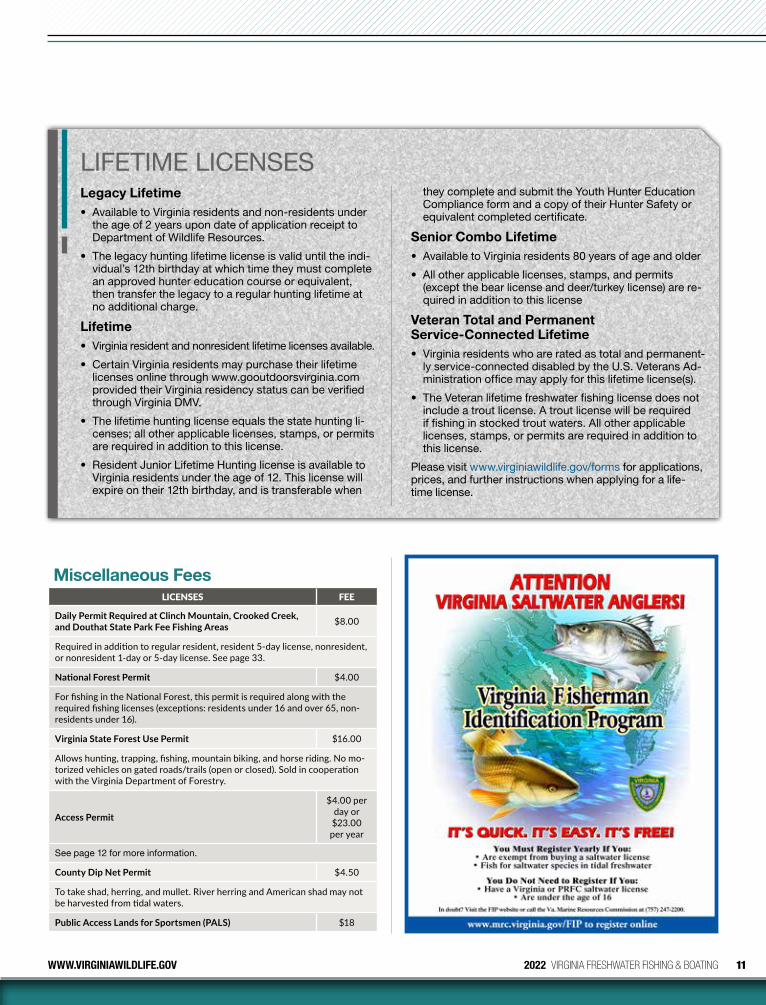
Miscellaneous FeesLICENSES FEE
Daily Permit Required at Clinch Mountain, Crooked Creek, and Douthat State Park Fee Fishing Areas $8.00
Required in addition to regular resident, resident 5-day license, nonresident, or nonresident 1-day or 5-day license. See page 33.
National Forest Permit $4.00
For fishing in the National Forest, this permit is required along with the required fishing licenses (exceptions: residents under 16 and over 65, non-residents under 16).
Virginia State Forest Use Permit $16.00
Allows hunting, trapping, fishing, mountain biking, and horse riding. No mo-torized vehicles on gated roads/trails (open or closed). Sold in cooperation with the Virginia Department of Forestry.
Access Permit
$4.00 per day or $23.00 per year
See page 12 for more information.
County Dip Net Permit $4.50
To take shad, herring, and mullet. River herring and American shad may not be harvested from tidal waters.
Public Access Lands for Sportsmen (PALS) $18
LIFETIME LICENSESLegacy Lifetime• Available to Virginia residents and non-residents under
the age of 2 years upon date of application receipt to Department of Wildlife Resources.
• The legacy hunting lifetime license is valid until the indi-vidual’s 12th birthday at which time they must complete an approved hunter education course or equivalent, then transfer the legacy to a regular hunting lifetime at no additional charge.
Lifetime• Virginia resident and nonresident lifetime licenses available.
• Certain Virginia residents may purchase their lifetime licenses online through www.gooutdoorsvirginia.com provided their Virginia residency status can be verified through Virginia DMV.
• The lifetime hunting license equals the state hunting li-censes; all other applicable licenses, stamps, or permits are required in addition to this license.
• Resident Junior Lifetime Hunting license is available to Virginia residents under the age of 12. This license will expire on their 12th birthday, and is transferable when
they complete and submit the Youth Hunter Education Compliance form and a copy of their Hunter Safety or equivalent completed certificate.
Senior Combo Lifetime• Available to Virginia residents 80 years of age and older
• All other applicable licenses, stamps, and permits (except the bear license and deer/turkey license) are re-quired in addition to this license
Veteran Total and Permanent Service-Connected Lifetime• Virginia residents who are rated as total and permanent-
ly service-connected disabled by the U.S. Veterans Ad-ministration office may apply for this lifetime license(s).
• The Veteran lifetime freshwater fishing license does not include a trout license. A trout license will be required if fishing in stocked trout waters. All other applicable licenses, stamps, or permits are required in addition to this license.
Please visit www.virginiawildlife.gov/forms for applications, prices, and further instructions when applying for a life-time license.
12 2022 VIRGINIA FRESHWATER FISHING & BOATING WWW.VIRGINIAWILDLIFE.GOV
LICENSEINFORMATION & FEES
FALL LINEThe Fall Line is defined as the following landmarks:
Appomattox:The remnants of Harvell Dam approx. 0.5 mi upstream of Rt. 1
Chickahominy River:Walkers Dam
James River (Richmond):14th Street Bridge (Mayo Bridge)
Mattaponi River:Rt. 360 Bridge
Pamunkey River:Rt. 360 Bridge
Potomac River:Little Falls
Occoquan River:I-95 Bridge
Rappahannock River:Rt. 1 Bridge
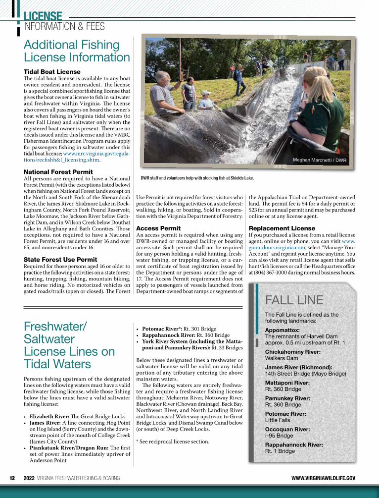
Additional Fishing License InformationTidal Boat LicenseThe tidal boat license is available to any boat owner, resident and nonresident. The license is a special combined sport fishing license that gives the boat owner a license to fish in saltwater and freshwater within Virginia. The license also covers all passengers on board the owner’s boat when fishing in Virginia tidal waters (to river Fall Lines) and saltwater only when the registered boat owner is present. There are no decals issued under this license and the VMRC Fisherman Identification Program rules apply for passengers fishing in saltwater under this tidal boat license; www.mrc.virginia.gov/regula-tions/recfishh&l_licensing.shtm.
National Forest PermitAll persons are required to have a National Forest Permit (with the exceptions listed below) when fishing on National Forest lands except on the North and South Fork of the Shenandoah River, the James River, Skidmore Lake in Rock-ingham County, North Fork Pound Reservoir, Lake Moomaw, the Jackson River below Gath-right Dam, and in Wilson Creek below Douthat Lake in Alleghany and Bath Counties. Those exceptions, not required to have a National Forest Permit, are residents under 16 and over 65, and nonresidents under 16.
State Forest Use PermitRequired for those persons aged 16 or older to practice the following activities on a state forest: hunting, trapping, fishing, mountain biking, and horse riding. No motorized vehicles on gated roads/trails (open or closed). The Forest
Freshwater/Saltwater License Lines on Tidal WatersPersons fishing upstream of the designated lines on the following waters must have a valid freshwater fishing license, while those fishing below the lines must have a valid saltwater fishing license:
• Elizabeth River: The Great Bridge Locks• James River: A line connecting Hog Point
on Hog Island (Surry County) and the down-stream point of the mouth of College Creek (James City County)
• Piankatank River/Dragon Run: The first set of power lines immediately upriver of Anderson Point
Use Permit is not required for forest visitors who practice the following activities on a state forest: walking, hiking, or boating. Sold in coopera-tion with the Virginia Department of Forestry.
Access PermitAn access permit is required when using any DWR-owned or managed facility or boating access site. Such permit shall not be required for any person holding a valid hunting, fresh-water fishing, or trapping license, or a cur-rent certificate of boat registration issued by the Department or persons under the age of 17. The Access Permit requirement does not apply to passengers of vessels launched from Department-owned boat ramps or segments of
• Potomac River*: Rt. 301 Bridge• Rappahannock River: Rt. 360 Bridge• York River System (including the Matta-
poni and Pamunkey Rivers): Rt. 33 Bridges
Below these designated lines a freshwater or saltwater license will be valid on any tidal portion of any tributary entering the above mainstem waters.
The following waters are entirely freshwa-ter and require a freshwater fishing license throughout: Meherrin River, Nottoway River, Blackwater River (Chowan drainage), Back Bay, Northwest River, and North Landing River and Intracoastal Waterway upstream to Great Bridge Locks, and Dismal Swamp Canal below (or south) of Deep Creek Locks.
* See reciprocal license section.
the Appalachian Trail on Department-owned land. The permit fee is $4 for a daily permit or $23 for an annual permit and may be purchased online or at any license agent.
Replacement LicenseIf you purchased a license from a retail license agent, online or by phone, you can visit www.gooutdoorsvirginia.com, select “Manage Your Account” and reprint your license anytime. You can also visit any retail license agent that sells hunt/fish licenses or call the Headquarters office at (804) 367-1000 during normal business hours.
Meghan Marchetti / DWR
DWR staff and volunteers help with stocking fish at Shields Lake.
13WWW.VIRGINIAWILDLIFE.GOV 2022 VIRGINIA FRESHWATER FISHING & BOATING
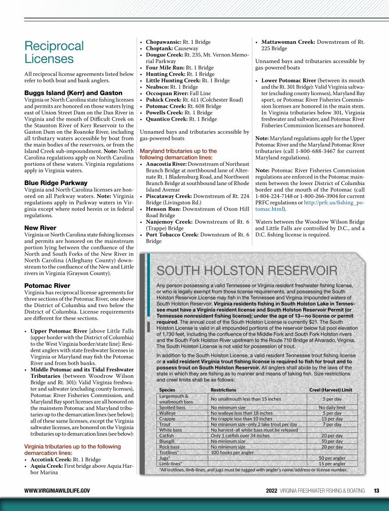
Reciprocal LicensesAll reciprocal license agreements listed below refer to both boat and bank anglers.
Buggs Island (Kerr) and GastonVirginia or North Carolina state fishing licenses and permits are honored on those waters lying east of Union Street Dam on the Dan River in Virginia and the mouth of Difficult Creek on the Staunton River of Kerr Reservoir to the Gaston Dam on the Roanoke River, including all tributary waters accessible by boat from the main bodies of the reservoirs, or from the Island Creek sub-impoundment. Note: North Carolina regulations apply on North Carolina portions of these waters. Virginia regulations apply in Virginia waters.
Blue Ridge ParkwayVirginia and North Carolina licenses are hon-ored on all Parkway waters. Note: Virginia regulations apply in Parkway waters in Vir-ginia except where noted herein or in federal regulations.
New RiverVirginia or North Carolina state fishing licenses and permits are honored on the mainstream portion lying between the confluence of the North and South Forks of the New River in North Carolina (Alleghany County) down-stream to the confluence of the New and Little rivers in Virginia (Grayson County).
Potomac RiverVirginia has reciprocal license agreements for three sections of the Potomac River, one above the District of Columbia and two below the District of Columbia. License requirements are different for these sections.
• Upper Potomac River [above Little Falls (upper border with the District of Columbia) to the West Virginia border/state line]: Resi-dent anglers with state freshwater licenses in Virginia or Maryland may fish the Potomac River and from both banks.
• Middle Potomac and its Tidal Freshwater Tributaries (between Woodrow Wilson Bridge and Rt. 301): Valid Virginia freshwa-ter and saltwater (excluding county licenses), Potomac River Fisheries Commission, and Maryland Bay sport licenses are all honored on the mainstem Potomac and Maryland tribu-taries up to the demarcation lines (see below); all of these same licenses, except the Virginia saltwater licenses, are honored on the Virginia tributaries up to demarcation lines (see below):
Virginia tributaries up to the following demarcation lines:• Accotink Creek: Rt. 1 Bridge• Aquia Creek: First bridge above Aquia Har-
bor Marina
• Chopawansic: Rt. 1 Bridge• Choptank: Causeway• Dougue Creek: Rt. 235, Mt. Vernon Memo-
rial Parkway• Four Mile Run: Rt. 1 Bridge• Hunting Creek: Rt. 1 Bridge• Little Hunting Creek: Rt. 1 Bridge• Neabsco: Rt. 1 Bridge• Occoquan River: Fall Line• Pohick Creek: Rt. 611 (Colchester Road)• Potomac Creek: Rt. 608 Bridge• Powells Creek: Rt. 1 Bridge• Quantico Creek: Rt. 1 Bridge
Unnamed bays and tributaries accessible by gas-powered boats
Maryland tributaries up to the following demarcation lines:• Anacostia River: Downstream of Northeast
Branch Bridge at northbound lane of Alter-nate Rt. 1 Bladensburg Road, and Northwest Branch Bridge at southbound lane of Rhode Island Avenue
• Piscataway Creek: Downstream of Rt. 224 Bridge (Livingston Rd.)
• Henson Run: Downstream of Oxon Hill Road Bridge
• Nanjemoy Creek: Downstream of Rt. 6 (Trappe) Bridge
• Port Tobacco Creek: Downsteam of Rt. 6 Bridge
• Mattawoman Creek: Downstream of Rt. 225 Bridge
Unnamed bays and tributaries accessible by gas-powered boats
• Lower Potomac River (between its mouth and the Rt. 301 Bridge): Valid Virginia saltwa-ter (excluding county licenses), Maryland Bay sport, or Potomac River Fisheries Commis-sion licenses are honored in the main stem. In Virginia tributaries below 301, Virginia fresh water and saltwater, and Potomac River Fisheries Commission licenses are honored.
Note: Maryland regulations apply for the Upper Potomac River and the Maryland Potomac River tributaries (call 1-800-688-3467 for current Maryland regulations).
Note: Potomac River Fisheries Commission regulations are enforced in the Potomac main-stem between the lower District of Columbia border and the mouth of the Potomac (call 1-804-224-7148 or 1-800-266-3904 for current PRFC regulations or http://prfc.us/fishing_po-tomac.html).
Waters between the Woodrow Wilson Bridge and Little Falls are controlled by D.C., and a D.C. fishing license is required.
SOUTH HOLSTON RESERVOIRAny person possessing a valid Tennessee or Virginia resident freshwater fishing license, or who is legally exempt from those license requirements, and possessing the South Holston Reservoir License may fish in the Tennessee and Virginia impounded waters of South Holston Reservoir. Virginia residents fishing in South Holston Lake in Tennes-see must have a Virginia resident license and South Holston Reservoir Permit (or Tennessee nonresident fishing license); under the age of 13—no license or permit required. The annual cost of the South Holston License is currently $21. The South Holston License is valid in all impounded portions of the reservoir below full pool elevation of 1,730 feet, including the confluence of the Middle Fork and South Fork Holston rivers and the South Fork Holston River upstream to the Route 710 Bridge at Alvarado, Virginia. The South Holston License is not valid for possession of trout.
In addition to the South Holston License, a valid resident Tennessee trout fishing license or a valid resident Virginia trout fishing license is required to fish for trout and to possess trout on South Holston Reservoir. All anglers shall abide by the laws of the state in which they are fishing as to manner and means of taking fish. Size restrictions and creel limits shall be as follows:
Species Restrictions Creel (Harvest) LimitLargemouth & smallmouth bass No smallmouth less than 15 inches 5 per day
Spotted bass No minimum size No daily limitWalleye No walleye less than 18 inches 5 per dayCrappie No crappie less than 10 inches 15 per dayTrout No minimum size–only 2 lake trout per day 7 per dayWhite bass No harvest–all white bass must be releasedCatfish Only 1 catfish over 34 inches 20 per dayBluegill No minimum size 50 per dayRock bass No minimum size 20 per dayTrotlines* 100 hooks per anglerJugs* 50 per anglerLimb-lines* 15 per angler*All trotlines, limb-lines, and jugs must be tagged with angler’s name/address or license number.
14 2022 VIRGINIA FRESHWATER FISHING & BOATING WWW.VIRGINIAWILDLIFE.GOV
GENERALINFORMATION• Fishing in inland waters must be by angling
with a hook and line or rod and reel. (See ex-ceptions for nongame fish on pages 27–28.)
• All fishing on inland waters requires a fresh-water fishing license, unless license exempt.
• A hand landing net may be used to land fish legally hooked in all waters.
• It is unlawful to have more than the daily creel limit of any fish in possession while afield or on the waters. The daily creel limit includes live possession of fish.
• Any person who fishes on another’s property must have the landowner’s permission to do so except on designated stocked trout waters along which signs have been placed indicat-ing that the waters are open to public fishing.
• It shall be unlawful for any person, while fishing, to remove the head or tail or oth-erwise change the appearance of any game fish (except bluegill sunfish and bream of the sunfish family) having a daily creel or size limit so as to obscure its species or render it impracticable to measure its total original length or count the number of such fish in possession. In addition, it shall be unlaw-ful for any person to possess or transport such altered game fish while on the water. However, the prohibition against possession and transportation in the previous sentence shall not apply to the preparation of lawfully obtained fish for immediate use as food or any lawful commercial use of such fish.
• It is unlawful to use lime, dynamite, or any oth-er substances to destroy fish, or to cast or allow noxious matter to pass into watercourses that might destroy fish or fish spawn, or to deposit trash in streams or lakes or along their banks.
• It is illegal to use SCUBA (Self-contained Underwater Breathing Apparatus) gear to take or attempt to take fish.
• Remove all trotlines, juglines, or set poles from public waters when not in use (see page 27).
• Marking fish with tagging equipment for personal information or research requires agency permission.
• No species of fish, freshwater mussel, or mol-lusk may be taken in inland waters to be sold, except under special permits provided by law.
• It is unlawful to take, kill, capture, or pos-sess any threatened or endangered species.
Virginia Game FishIncludes the following: trout, largemouth bass, smallmouth bass, spotted bass, rock bass, roa-noke bass, bream, bluegill, crappie, walleye, sauger, saugeye, chain pickerel, muskellunge, northern pike, striped bass, and white bass.
Stocking FishIt is unlawful to stock any species of fish into the inland waters of Virginia without first obtaining written approval from the Department (private ponds excepted). Also, blue catfish and their hybrids, as well as spotted bass, Alabama bass, and Northern snakehead cannot be stocked in privately owned ponds and lakes.
Trout As BaitArtificially raised rainbow trout may be sold as bait for use in the James and New rivers, and in impoundments (ponds, lakes, reservoirs), except impoundments listed as designated stocked trout waters and Lake Moomaw. Persons pos-sessing purchased rainbow trout for bait must have a valid invoice or bill of sale, specifying date of purchase, the number of trout purchased, and name of an individual or business permit-ted to sell trout.
Special RegulationsLick Creek, Bear Creek, Susong Branch, Mumpower Creek, Timbertree Branch, and Streams and Their Tributaries That Flow Into Hungry Mother LakeIt shall be unlawful to use fish as bait in Lick Creek in Smyth and Bland counties, Bear Creek in Smyth County, Laurel Creek in Tazewell and Bland counties (North Fork Holston River drain-age), Big Stony Creek in Giles County, Dismal Creek in Bland and Giles counties, Laurel Creek in Bland County (Wolf Creek drainage) and Cripple Creek in Smyth and Wythe counties.
It shall be unlawful to use seines, nets, or traps to take fish in Lick Creek in Smyth and Bland counties, Bear Creek in Smyth County, and streams and their tributaries that flow into Hungry Mother Lake in Smyth County, Laurel Creek and tributaries upstream of the Highway 16 Bridge in Tazewell and Bland counties, Su-song Branch and Mumpower Creek in Wash-ington County and the City of Bristol, and in Timbertree Branch in Scott County.
Dam RegulationsBuggs IslandMechanical lure launchers may not be used within 600 yards below Buggs Island Dam.
Walkers DamOnly rod and reel and hand lines permitted within 500 yards below dam. It is illegal to snag fish at Walkers Dam.
Leesville DamIt shall be unlawful to fish, attempt to fish, assist others in fishing, collect or attempt to collect bait while wading, or operating, or anchoring any vessel in the waters of the Roanoke River from Leesville Dam downstream 840 feet to a
permanent overhead cable. The Leesville Tail-race Bank Fishing Area is closed to all access until further notice. No fishing and/or trespass-ing in this area is currently allowed. The canoe launch immediately downstream from the bank fishing access is still open for use.
FishwaysIt shall be unlawful to fish or to collect bait from March 1 through June 15 within 300 feet of Boshers Dam Fishway on the north bank of the James River.
Department-owned Lakes, Ponds, Streams, or Boat Access SitesMotors and boatsUnless otherwise posted, the use of boats pro-pelled by gasoline motors or sail is prohibited atDepartment-owned lakes, ponds, or streams.However, in Department-owned water bodiesthat prohibit the use of gasoline motors, it ispermissible to use a boat equipped with sucha motor provided the motor is turned off at alltimes (including launch and retrieval).
Method of fishingTaking any fish at any Department-owned lake, pond, or stream by any means other than by use of one or more attended poles with hook and line attached is prohibited unless otherwise posted.
Hours for fishingFishing is permitted 24 hours a day unless otherwise posted at Department-owned lakes, ponds, streams, or boat access sites.
Seasons, hours and methods of fishing, size and creel limits, huntingThe open seasons for fishing, as well as fishing hours, methods of taking fish, and the size, possession and creel limits, and hunting and trapping on Department-owned lakes, ponds, streams, or boat access sites shall conform to the regulations of the board unless otherwise excepted by posted rules by the director or his designee. Such posted rules shall be displayed at each lake, pond, stream, or boat access site, in which case the posted rules shall be in effect. Failure to comply with posted rules concerning seasons, hours, methods of taking, bag limits, and size, possession, and creel limits shall con-stitute a violation of this regulation.
Other usesCamping overnight or building fires (except in developed and designated areas), swimming, or wading in Department-owned lakes, ponds, or streams (except by anglers, hunters, and trappers actively engaged in fishing, hunting, or trapping), is prohibited. All other uses shall conform to the regulations of the board unless excepted by posted rules.
Fishing tournaments & boat ramp special useA boat ramp special use permit is required to organize, conduct, supervise or solicit entries for fishing tournaments, rodeos or other fishing
To learn more about recycling your fishing line and angling etiquette visit our website at www.virginiawildlife.gov/recycle-your-line.
16
GENERALINFORMATIONevents on lakes, ponds, or streams owned by the department, for which prizes are offered, awarded or accepted based on size or numbers of fish caught, either in money or other valuable considerations. Any fish captured and entered for scoring or consideration during a permitted fishing tournament, rodeo, or other fishing event on lakes, ponds or streams owned by the department must be immediately released at the capture site. A boat ramp special use permit is not required for tournaments, rodeos or other fishing events that occur on a statewide or na-tionwide basis and that do not have a designated meeting or gathering location.
Fish Consumption AdvisoriesFishing provides many benefits, including food and recreational enjoyment. Many anglers keep, cook, and eat their catches. Fish are routinely monitored for contaminants by the Depart-ment of Environmental Quality. Sometimes the fish in certain waters are found to contain potentially harmful levels of chemicals. When this happens, the Department of Health issues warnings for the affected bodies of water. For specific, up-to-date fish consumption advi-sories, please go to the Health Department website, fishadvisories.vdh.virginia.gov or call the Health Department at 804-864-8182.
Anglers should realize that they may still fish these waters and enjoy excellent recre-ational fishing. Below is a section on cleaning
and cooking your fish, which will help reduce contamination levels in fish you eat.
Cleaning and Cooking Your FishPolychlorinated biphenyls (PCBs) and most other organic contaminants usually build up in a fish’s fat deposits and just underneath the skin. By removing the skin and fat before cook-ing, you can reduce the levels of these chemi-cals. Mercury collects in the fish’s muscle and cannot be reduced by cleaning and cooking methods. You can reduce the fat and contami-nants (e.g. pesticides, PCBs) in the fish you eat. To reduce the potential harmful effects from eating contaminated fish, VDH recommends the following:
• Eat smaller, younger fish. Younger fish are less likely to contain harmful levels of con-taminants than older, larger fish.
• Remove the skin, the fat from the belly and top, and the internal organs before cooking.
• Bake, broil, or grill on an open rack to allow fats to drain. Avoid pan frying in butter or ani-mal fat because these methods hold fat juices.
• Discard the fat that cooks out of the fish, and avoid or reduce the amount of fish drippings that are used to flavor the meal.
• Eat less deep fried fish since frying seals con-taminants into the fatty tissue.
IMPORTANT: The meal advice included in this information is based on fish that have been skinned, trimmed, and cooked properly.Also remember that larger and older fish tend to collect more contaminants, and fatty fish (such as channel catfish and carp) tend to col-lect PCBs and other organic chemicals. Eating smaller, younger fish and avoiding fatty species can help limit your exposure. Your exposure depends not only on the contaminant levels in the fish, but also on the amount of fish you eat.
Q: What do I do if I catch a tagged fish?
A: Anglers should call the regional office that corresponds to the area where the fish was caught and report their catch information or provide that information by mail. If a study is ongoing that provides a “reward” for tag returns, the tag must be removed from fish and returned to DWR to receive the reward.
SOME LIMITATIONS APPLY
FREESHIPPING
SALE! Request your FREE PRODUCT CATALOG
Online or Toll-Free at 888-213-0393
GoDRpower.comDR POWER EQUIPMENT
DRtrimmer.com
USAENGINEERED AND BUILT
Assembled in the USA using domestic and
foreign parts.
• TRIM fencelines & perimeters
• MOW waist-high grass & weeds
• 5X the power of hand-held trimmers
• Self-propelled models
• Gas- or battery-powered
Trim and Mow the EASY Way!
DR® TrimmerMower• MOW FIELD GRASS up to 8' high
• CUT BRUSH up to 3" thick
• Engines up to 22 HP
DRfieldbrush.com
• Decks up to 34" wide
• Power steering
PLUS ALL-NEWCommercial Grade XD Series with hydrostatic drive!
USAENGINEERED AND BUILT
Assembled in the USA using domestic and
foreign parts.
America’s Original
Field & Brush Mower
17
Best Practices for Catch-and-Release Fishing• Always wet your hands before handling a fish.
Never handle a fish with dry hands. Handling a fish with dry hands can take the protective slime coating off of a fish.
• Use a net when landing a fish. A large net will allow you to keep the fish wet while you prepare to remove the lure, fly, or hook. This also allows you to keep the fish wet if you’re preparing to take photos. A soft rubber net is preferable to knotted nylon nets. Cradle nets are best used for larger species of fish like musky.
• When photographing a fish, keep it quick and get the fish back into the water as soon as you can.
• Avoid contact with boat surfaces such as carpet and metal when handling a fish.
• Make sure you have a pair of long pliers such as needlenose for unhooking fish, especially for those fish that are hooked in hard to reach places. Heavy wire cutters and jaw spreaders are essential for toothy critters like musky.
• If the hook is too deep, it is best to cut the line as close to the hook eye as you can. Most non-stainless hooks will rust out and dissolve
over time and this will give the fish a much better chance of survival than the stress that comes with attempting to remove the hook with pliers.
• When handling a fish out of the water, make sure to keep your hands and fingers away from the gills and gill arches. Don’t hold the fish too tightly and never hold a fish by the eyeball sockets
• When releasing a fish, it’s important to let the fish recover on its own terms; the fish will swim out of your hands when it’s ready. To help revive the fish, it is best to hold the fish upright and move the fish gently forward so water runs over the gills. When fishing in rivers and moving water, always face a fish upstream during a release.
• Make sure you have the correct size rod and reel for the species of fish you are targeting and don’t fight a fish longer than you need to which can cause additional stress.
• Carry a thermometer with you and consider water temperatures when targeting coldwa-ter oriented species like trout, musky, and striped bass during the summer months in Virginia. Plan to fish in the early morning hours as this is when the coolest water tem-peratures of the day will occur. Catching a trout in water temperatures of 70 degrees or warmer is often lethal to the fish. In the sum-mer months, it can be beneficial to focus your efforts on fishing for trout in tailwaters and
spring creeks that provide cooler and stable temperatures. Anglers are encouraged to be extra careful when handling trout, musky, and striped bass in the summer months to reduce delayed mortality.
• If you are a tournament angler, make sure you have an aerator running to keep your livewell oxygenated for the fish. Having an inflow of freshwater into your livewell can prevent ammonia spikes. In the warmer sum-mer months, consider adding a frozen water bottle to your livewell to keep temperatures cooler. Also consider using non-penetrating culling tags for the fish.
• Anglers who enjoy mounting fish and reliv-ing the memories of a trophy can consider fiberglass mounts. All you need is a good photo of the fish with a length and girth mea-surement. Fiberglass mounts last longer than traditional skin mounts and are oftentimes even more realistic.
• See the “Qualifying a Trophy Fish by Length and Photo” option for Trophy Fish Awards on page 57.
VisitCherokeeNC.com
VisitCherokeeNC.com VisitCherokeeNC.com
VisitCherokeeNC.com
From the setting, with miles of freestone streams fed by the Great Smokies, to trout that aren’t just fish stories; they’re legendary—your best day on the water is waiting. VisitCherokeeNC.com | 828.359.6110
The most up-to-date regulations online.
18
ATTENTION ANGLERSTransfer and Unauthorized Release of Fish into Virginia’s Rivers and Lakes is Illegal!Unauthorized introduction (i.e., stocking) of fish or wildlife, including game, bait, and aquarium species, into new waters can harm the environment and destroy public fisheries.
Releasing exotic or potentially harmful species is illegal:
• Alabama Bass, an invasive species that outcompetes large-mouth bass and hybridizes with smallmouth bass, directly harming these important and popular resources;
• Blue Catfish, which are overabundant in our tidal rivers, with ongoing efforts to reduce their abundance;
• Flathead Catfish, native to the Upper Tennessee River, Big Sandy River, and New River drainages in Virginia, prey on other fish species almost from the time they hatch;
• Northern Snakeheads, which are exotics from Asia, with un-known impacts on other species;
• Minnows released from bait buckets, which can out-com-pete native species and/or disrupt spawning of important species;
• Rusty Crayfish, which can destroy aquatic vegetation used as nursery habitat by game fish;
• Zebra or Quagga Mussels, and New Zealand Mud Snails; all invasive exotic mollusks that may be easily and accidentally transported on or in boats, trailers, bait buckets, waders, or other fishing equipment; and
• Hydrilla, Eurasian Milfoil, and Water Chestnut; many exotic in-vasive aquatic plants are easily transported on boats and trailers.
Many introduced species cause significant and irreversible dam-age, but their long-term impacts may not be recognized until the population is established and eradication is impossible.
You can help by:
• Stop Aquatic Hitchhikers! Carefully inspect your boat, trailer, and equipment every time you launch or retrieve your boat, and every time you fish a new waterbody.
• Clean, Drain, and Dry! Remember that some of the most de-structive invasive species (e.g., zebra mussels or didymo) can survive and spread from INSIDE your boat engine, live wells, bilge, coolers, waders, or other recreational gear.
• Destroy, or hold for future use, any unused live bait.
• Remember that blue catfish and their hybrids, as well as spot-ted bass, Alabama bass, and Northern snakehead cannot be stocked into privately-owned ponds and lakes.
• Report suspicious and illegal activity to 1-800-237-5712.
• Report suspected new populations of invasive plants or ani-mals at: www.invasivespeciesva.org/report-sightings
GENERALINFORMATION
KEEPING WILD FISH POPULATIONS HEALTHY Working to protect the health of Virginia’s native and stocked fish populations is critical to ensure that Virginia’s fishery resources are maintained for future generations of fishermen. There are several ways in which anglers can reduce their chances of inadvertently spreading disease causing organisms from one location to another:
• Do not purposefully move fish, other aquatic organisms, sediment, or water from one body of water to another.
• Remove any mud, plants, fish, or sediment from fishing gear and boats before using them at another location.
• Pour out any water that may have accumulated in boats or equipment before use in another location.
• Dispose of any fish leftover parts that remain after cleaning by burying or incinerating them or by plac-ing them in a tightly closed garbage bag and placing them in a dumpster, landfill, or trash bin.
For individuals that stock ponds and public waters, it is important that only healthy fish are released. To ensure that only healthy fish are stocked, individuals that stock either private ponds or public waters are encouraged to purchase their stockers from production facilities that regularly test their fish for diseases. This information may be obtained by asking the producer about the fish health testing history of his or her facility.
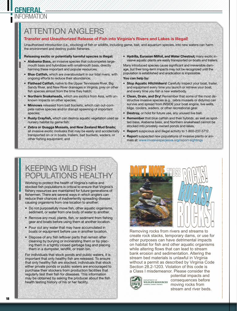
Removing rocks from rivers and streams to create rock stacks, temporary dams, or use for other purposes can have detrimental impacts on habitat for fish and other aquatic organisms while altering flows that can lead to stream bank erosion and sedimentation. Altering the stream bed materials is unlawful in Virginia without a permit as described by Virginia Code Section 28.2-1203. Violation of this code is a Class I misdemeanor. Please consider the
potential impacts and consequences before moving rocks from stream and river beds.
DEPARTMENT OFWILDLIFE RESOURCES
ROCKS!ROCKS!ROCKS!ROCKS!
ROCKS!ROCKS!DON’TDON’T MOVE MOVE THOSE THOSE
FISH LOCA L VA
FISH LOCA L VA
YY ou don’t have to travel far to find great fishing—excellent fishing opportunities exist in your own backyard, even if you live in one of Virginia’s urban areas.Virginia DWR works closely with municipal, state, and
non-governmental partners to establish quality fisheries in and around metropolitan areas throughout the state, stocking catfish, trout, largemouth bass, and sunfish in many of these waterbod-ies, providing a great chance to connect to the outdoors. To learn more go to: https://dwr.virginia.gov/fishing/fish-local/
Easily find bass, catfish, panfish, and trout by locality and see all Fish Local VA locations using the information provided online!
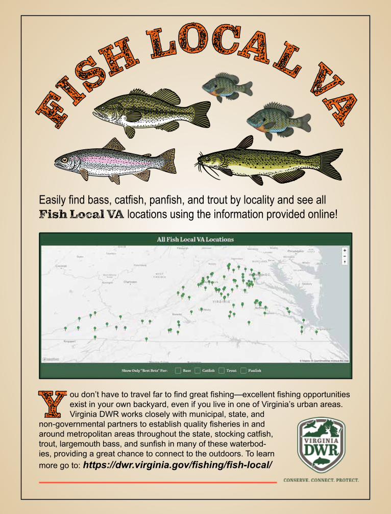
FISH LOCA L VAFISH LOCA L VA
YY ou don’t have to travel far to find great fishing—excellent fishing opportunities exist in your own backyard, even if you live in one of Virginia’s urban areas.Virginia DWR works closely with municipal, state, and
non-governmental partners to establish quality fisheries in and around metropolitan areas throughout the state, stocking catfish, trout, largemouth bass, and sunfish in many of these waterbod-ies, providing a great chance to connect to the outdoors. To learn more go to: https://dwr.virginia.gov/fishing/fish-local/
Easily find bass, catfish, panfish, and trout by locality and see all Fish Local VA locations using the information provided online!
20 2022 VIRGINIA FRESHWATER FISHING & BOATING WWW.VIRGINIAWILDLIFE.GOV
SeasonsThere is a continuous, year-round season for all freshwater fish, with the following exceptions:
• Special times and limited closures for trout (Designated Stocked Trout Waters pg. 29, Youth-only Stocked Trout Waters pg. 30, Trout Heritage Waters pg. 35, Urban Pro-gram Waters pg. 30, Blue Ridge Parkway pg. 30, and Fee Fishing trout waters pg. 35); and
• Certain seasons for special methods to take nongame fish pages 27–28.
Regulations for anadromous (coastal) striped bass, alewife and blueback herring above and be-low the fall line, in tidal rivers of the Chesapeake Bay; and anadromous (coastal) American shad and hickory shad, and all other saltwater fish be-low the fall line, in tidal rivers of the Chesapeake Bay, are set by the Virginia Marine Resources Commission. For more information call (757) 247-2200 or go online at www.mrc.virginia.gov.
Legal Methods for Capturing Nongame Bait:• Seine not exceeding 4 feet depth by 10 feet
in length.• Minnow traps with throat openings no larger
than 1 inch in diameter.• Collected by angling with hook and line.• Cast net.• Hand-held bow nets with diameter no larger
than 20 inches and handle length not to ex-ceed 8 feet.
• Umbrella-type net not to exceed 5 by 5 feet square.
• Dip nets may be used to take shad, herring, mullet, and suckers only but may not be used in waters where anadromous (American) shad and herring cannot be possessed.
Areas Restricted:• Designated stocked trout waters between
October 1 and June 15.• Department-owned lakes, unless otherwise
posted.• Lick Creek in Smyth and Bland counties, Bear
Creek in Smyth County, Laurel Creek and tributaries upstream of the Highway 16 bridge in Tazewell and Bland counties, streams and their tributaries that flow into Hungry Mother Lake in Smyth County, Susong Branch and Mumpower Creek in Washington County and the City of Bristol, and Timbertree Branch in Scott County.
• The use of nets other than cast nets (throw nets) to collect bait in the Roanoke (Staunton) and Dan Rivers in Campbell, Charlotte, Hali-fax, and Pittsylvania counties, and in the City of Danville is prohibited. Cast nets may be used to collect bait in these rivers.
Fish Bait InformationBAIT TYPE POSSESSION
LIMIT NOTE
1 Minnows, Chubs, Madtoms 50 In aggregate with other bait, see below
1 Crayfish 50 In aggregate with other bait, see below
1 Hellgrammites 50 In aggregate with other bait, see below
1 Salamanders 0 No possession allowed
2 Shad (Gizzard, Threadfin, Herring) Unlimited Only permitted in certain waters, see below
3 Trout Unlimited Artificially raised trout only, see below
4 Virginia Game Fish See pages 22–26 Collected by angling with hook and line only
Fathead minnows, golden shiners, goldfish Unlimited
Legally purchased fish bait Unlimited Receipt needed specifying # and species
1– Minnows, chubs, madtoms, crayfish, and hellgrammites are limited to 50 total for all species combined (aggregate), not 50 of each species at the same time.
2– Gizzard and threadfin shad can be used in any of Virginia’s waters but there are geographical limita-tions for herring. There are no restrictions for the use of herring in Virginia waters that are within the Roanoke, New, or Tennessee River drainages. However, it is unlawful to possess herring in all coastal rivers of the Chesapeake Bay, Meherrin River, Nottoway River, Blackwater River (Chowan Drainage), North Landing and Northwest rivers and their tributaries, and Back Bay.
3– Only artificially raised trout may be used as bait. Must have an invoice or bill of sale specifying date of purchase, number of trout purchased and business where trout were purchased. Trout may be used as bait in the James River, New River, and in impoundments except Lake Moomaw and Philpott Reservoir.
4– Any legally possessed game fish may be used as bait when fished whole. Must comply with creel and length limits. The only game fish that can be used as cut bait are bluegill, sunfish, and bream. It is unlawful to remove the head, tail, or change the appearance of any other game fish since it would be impractical to measure original lengths or count the number of fish in possession.
For more information see pages 27–28.
FRESHWATER FISHREGULATIONS
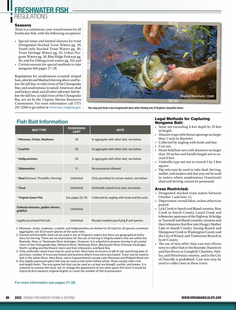
Meghan Marchetti / DWR
You may just hook a nice largemouth bass when fishing one of Virginia’s beautiful rivers.

21
DON’T LET THEM HITCH A RIDEZebra mussels are small (<1") freshwater bivalves with dark and light bands on their shells. They can attach to surfaces, in clusters, leading to tremendous recreation, wildlife, and eco nomic damage. They can be accidentally transported to Virginia by boaters and anglers, and we are counting on you to help stop the spread of zebra mussels by taking the fol-lowing precautions:
• Visually inspect and scrub boat hulls, motors, anchors, and trailers, removing any attached vegetation at site of origin, then hose equipment with hot (140°F) and/or high-pressure water if possible.
• Bilges, live wells, and any other water-holding compart-ments should be drained at the site of origin and flushed with disinfectant or hot water.
• Boat and other equipment should remain completely dry for at least 24 hours before being used again.
• Take same precautions with waders, bait buckets, and other equipment that can hold water or come into contact with water.
If you believe you have seen or found a zebra mussel, please contact the Department immediately at (804) 367-6913 or Brian Watson at the Department’s Forest Office (434-525-7522). For more information on zebra mussels, please see our website.
HOW TO USE CREEL & LENGTH LIMIT TABLEQ: I am fishing for smallmouth bass at Lake Moomaw.
How many and what size may I keep?
A: The statewide creel limit for bass is 5 in the aggregate, with no length limit. However, under GEOGRAPHICAL EXCEPTIONS, Lake Moomaw is listed. The exception is that no bass may be kept less than 12 inches long. Unless otherwise posted at the site, you could keep 5 bass but none of them can be less than 12 inches long.
Q: What does the term “in the aggregate” mean?
A: Aggregate means combined. In the example above for Lake Moomaw, unless otherwise posted, you can keep 5 bass in the aggregate but none can be less than 12 inches long. Example: You could keep 3 largemouth bass and 2 smallmouth bass for a com-bined or aggregate total of 5 but none of the 5 can be less than 12 inches in length.
Q: I am fishing for largemouth bass at Lake Brittle in Fauquier County. How many can I keep and of what size length?
A: Lake Brittle is not listed as a GEOGRAPHICAL EXCEP-TION since this is not a major lake. The DWR website at www.virginiawildlife.gov/lakes under Lake Brittle indicates there is a 12–15 inch slot limit on largemouth, where all bass between 12–15 inches must be released. You could keep 5 bass but none between 12–15 inches long. This restriction should also be posted at Lake Brittle.
Lee Walker / DWR
The Lowcountry AwaitsPROFESSIONAL FISHING GUIDE
FLY AND CONVENTIONAL
INSHORE × NEARSHORE × OFFSHORE Charleston, SC
(843)860-4231 × john@� yrightcharters.comwww.� yrightcharters.com
22 2022 VIRGINIA FRESHWATER FISHING & BOATING WWW.VIRGINIAWILDLIFE.GOV
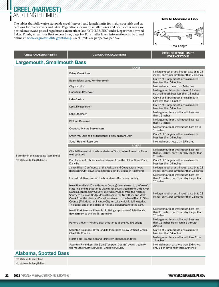
CREEL (HARVEST)AND LENGTH LIMITSThe tables that follow give statewide creel (harvest) and length limits for major sport fish and ex-ceptions for major rivers and lakes. Regulations for many smaller lakes and boat access areas are posted on site, and posted regulations are in effect (see “OTHER USES” under Department-owned Lakes, Ponds, Streams or Boat Access Sites, page 14). For smaller lakes, information can be found online at: www.virginiawildlife.gov/fishing. Creel limits are per person per day.
CREEL AND LENGTH LIMIT GEOGRAPHIC EXCEPTIONS CREEL OR LENGTH LIMITS FOR EXCEPTIONS
Largemouth, Smallmouth Bass
5 per day in the aggregate (combined)No statewide length limits
LAKES
Briery Creek Lake No largemouth or smallmouth bass 16 to 24 inches, only 1 per day longer than 24 inches
Buggs Island Lake/Kerr Reservoir Only 2 of 5 largemouth or smallmouth bass less than 14 inches
Claytor Lake No smallmouth less than 14 inches
Flannagan Reservoir No largemouth bass less than 12 inches; no smallmouth bass less than 15 inches
Lake Gaston Only 2 of 5 largemouth or smallmouth bass less than 14 inches
Leesville Reservoir Only 2 of 5 largemouth or smallmouth bass less than 14 inches
Lake Moomaw No largemouth or smallmouth bass less than 12 inches
Philpott Reservoir No largemouth or smallmouth bass less than 12 inches
Quantico Marine Base waters No largemouth or smallmouth bass 12 to 15 inches
Smith Mt. Lake and its tributaries below Niagara Dam Only 2 of 5 largemouth or smallmouth bass less than 14 inches
South Holston Reservoir No smallmouth less than 15 inchesRIVERS
Clinch River–within the boundaries of Scott, Wise, Russell or Taze-well counties
No largemouth or smallmouth bass less than 20 inches, only 1 per day longer than 20 inches
Dan River and tributaries downstream from the Union Street Dam, Danville
Only 2 of 5 largemouth or smallmouth bass less than 14 inches
James River–Confluence of the Jackson and Cowpasture rivers (Botetourt Cty) downstream to the 14th St. Bridge in Richmond
No largemouth or smallmouth bass 14 to 22 inches, only 1 per day longer than 22 inches
Levisa Fork River–within the boundaries Buchanan CountyNo largemouth or smallmouth bass less than 20 inches, only 1 per day longer than 20 inches
New River–Fields Dam (Grayson County) downstream to the VA-WV state line and its tributaries Little River downstream from Little River Dam in Montgomery County, Big Walker Creek from the Norfolk Southern Railroad Bridge downstream to the New River and Wolf Creek from the Narrows Dam downstream to the New River in Giles County. (This does not include Claytor Lake which is delineated as: The upper end of the island at Allisonia downstream to the dam.)
No largemouth or smallmouth bass 14 to 22 inches, only 1 per day longer than 22 inches
North Fork Holston River–Rt. 91 Bridge upstream of Saltville, Va. downstream to the VA-TN state line
No largemouth or smallmouth bass less than 20 inches, only 1 per day longer than 20 inches
Potomac River – Virginia tidal tributaries above Rt. 301 bridgeNo largemouth or smallmouth bass less than 15 inches from March 1 through June 15
Staunton (Roanoke) River–and its tributaries below Difficult Creek, Charlotte County
Only 2 of 5 largemouth or smallmouth bass less than 14 inches
North Fork, South Fork and Mainstem Shenandoah River No largemouth or smallmouth bass 11 to 14 inches
Staunton River–Leesville Dam (Campbell County) downstream to the mouth of Difficult Creek, Charlotte County
No smallmouth bass less than 20 inches, only 1 per day longer than 20 inches
Alabama, Spotted BassNo statewide daily limitNo statewide length limit
How to Measure a Fish
Total Length
23WWW.VIRGINIAWILDLIFE.GOV 2022 VIRGINIA FRESHWATER FISHING & BOATING
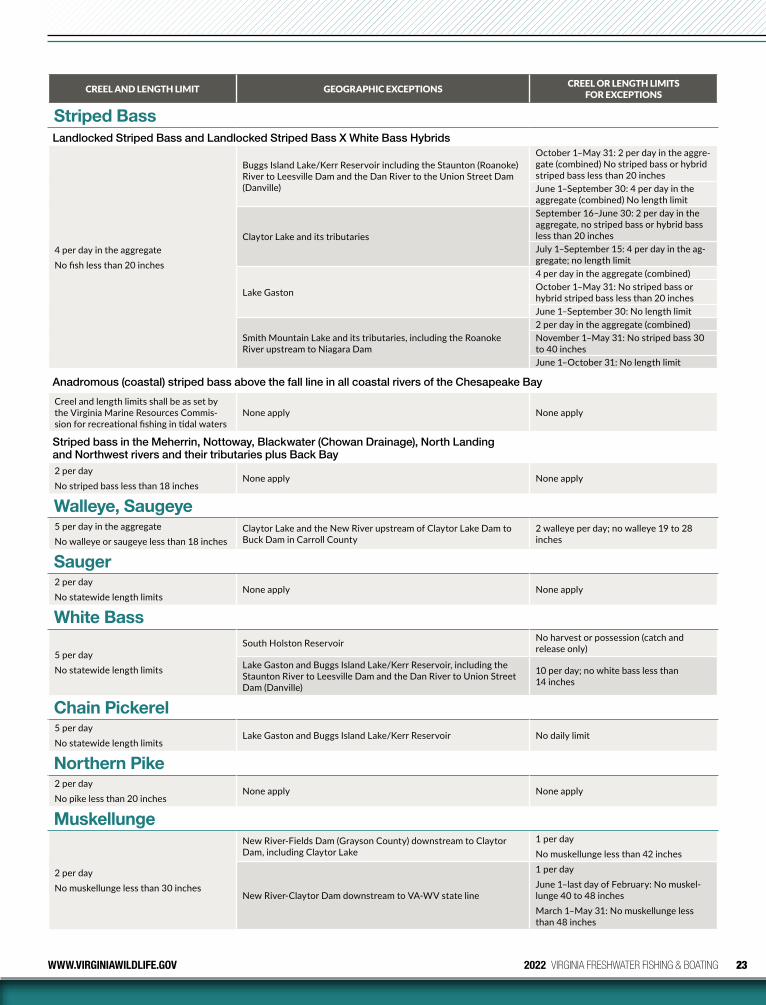
CREEL AND LENGTH LIMIT GEOGRAPHIC EXCEPTIONS CREEL OR LENGTH LIMITS FOR EXCEPTIONS
Striped BassLandlocked Striped Bass and Landlocked Striped Bass X White Bass Hybrids
4 per day in the aggregateNo fish less than 20 inches
Buggs Island Lake/Kerr Reservoir including the Staunton (Roanoke) River to Leesville Dam and the Dan River to the Union Street Dam (Danville)
October 1–May 31: 2 per day in the aggre-gate (combined) No striped bass or hybrid striped bass less than 20 inchesJune 1–September 30: 4 per day in the aggregate (combined) No length limit
Claytor Lake and its tributaries
September 16–June 30: 2 per day in the aggregate, no striped bass or hybrid bass less than 20 inchesJuly 1–September 15: 4 per day in the ag-gregate; no length limit
Lake Gaston
4 per day in the aggregate (combined)October 1–May 31: No striped bass or hybrid striped bass less than 20 inchesJune 1–September 30: No length limit
Smith Mountain Lake and its tributaries, including the Roanoke River upstream to Niagara Dam
2 per day in the aggregate (combined)November 1–May 31: No striped bass 30 to 40 inchesJune 1–October 31: No length limit
Anadromous (coastal) striped bass above the fall line in all coastal rivers of the Chesapeake Bay
Creel and length limits shall be as set by the Virginia Marine Resources Commis-sion for recreational fishing in tidal waters
None apply None apply
Striped bass in the Meherrin, Nottoway, Blackwater (Chowan Drainage), North Landing and Northwest rivers and their tributaries plus Back Bay2 per dayNo striped bass less than 18 inches
None apply None apply
Walleye, Saugeye5 per day in the aggregateNo walleye or saugeye less than 18 inches
Claytor Lake and the New River upstream of Claytor Lake Dam to Buck Dam in Carroll County
2 walleye per day; no walleye 19 to 28 inches
Sauger2 per day No statewide length limits
None apply None apply
White Bass
5 per dayNo statewide length limits
South Holston Reservoir No harvest or possession (catch and release only)
Lake Gaston and Buggs Island Lake/Kerr Reservoir, including the Staunton River to Leesville Dam and the Dan River to Union Street Dam (Danville)
10 per day; no white bass less than 14 inches
Chain Pickerel5 per dayNo statewide length limits
Lake Gaston and Buggs Island Lake/Kerr Reservoir No daily limit
Northern Pike2 per dayNo pike less than 20 inches
None apply None apply
Muskellunge
2 per day No muskellunge less than 30 inches
New River-Fields Dam (Grayson County) downstream to Claytor Dam, including Claytor Lake
1 per dayNo muskellunge less than 42 inches
New River-Claytor Dam downstream to VA-WV state line
1 per dayJune 1–last day of February: No muskel-lunge 40 to 48 inchesMarch 1–May 31: No muskellunge less than 48 inches
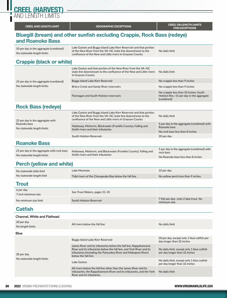
24 2022 VIRGINIA FRESHWATER FISHING & BOATING WWW.VIRGINIAWILDLIFE.GOV
CREEL AND LENGTH LIMIT GEOGRAPHIC EXCEPTIONS CREEL OR LENGTH LIMITS FOR EXCEPTIONS
Bluegill (bream) and other sunfish excluding Crappie, Rock Bass (redeye) and Roanoke Bass50 per day in the aggregate (combined) No statewide length limits
Lake Gaston and Buggs Island Lake/Kerr Reservoir and that portion of the New River from the VA–NC state line downstream to the confluence of the New and Little rivers in Grayson County
No daily limit
Crappie (black or white)
25 per day in the aggregate (combined) No statewide length limits
Lake Gaston and that portion of the New River from the VA–NC state line downstream to the confluence of the New and Little rivers in Grayson County
No daily limit
Buggs Island Lake/Kerr Reservoir No crappie less than 9 inches
Briery Creek and Sandy River reservoirs No crappie less than 9 inches
Flannagan and South Holston reservoirsNo crappie less than 10 inches; South Holston Res.–15 per day in the aggregate (combined)
Rock Bass (redeye)
25 per day in the aggregate with Roanoke bassNo statewide length limits
Lake Gaston and Buggs Island Lake/Kerr Reservoir and that portion of the New River from the VA–NC state line downstream to the confluence of the New and Little rivers in Grayson County
No daily limit
Nottoway, Meherrin, Blackwater (Franklin County), Falling and Smith rivers and their tributaries
5 per day in the aggregate (combined) with Roanoke bassNo rock bass less than 8 inches
South Holston Reservoir 20 per day
Roanoke Bass25 per day in the aggregate with rock bassNo statewide length limits
Nottoway, Meherrin, and Blackwater (Franklin County), Falling and Smith rivers and their tributaries
5 per day in the aggregate (combined) with rock bass No Roanoke bass less than 8 inches
Perch (yellow and white)No statewide daily limit No statewide length limit
Lake Moomaw 10 per day
Tidal rivers of the Chesapeake Bay below the fall line No yellow perch less than 9 inches
Trout6 per day 7 inch minimum size
See Trout Waters, pages 31–35
No minimum size limit South Holston Reservoir 7 fish per day—only 2 lake trout. No minimum size.
CatfishChannel, White and Flathead
20 per day No length limits
All rivers below the fall line No daily limit
Blue
20 per dayNo statewide length limits
Buggs Island Lake/Kerr Reservoir 20 per day, except only 1 blue catfish per day longer than 32 inches
James River and its tributaries below the fall line, Rappahannock River and its tributaries below the fall line, and York River and its tributaries (including the Pamunkey River and Mattaponi River) below the fall line
No daily limit, except only 1 blue catfish per day longer than 32 inches
Lake Gaston No daily limit, except only 1 blue catfish per day longer than 32 inches
All rivers below the fall line other than the James River and its tributaries, the Rappahannock River and its tributaries, and the York River and its tributaries
No daily limit
CREEL (HARVEST)AND LENGTH LIMITS
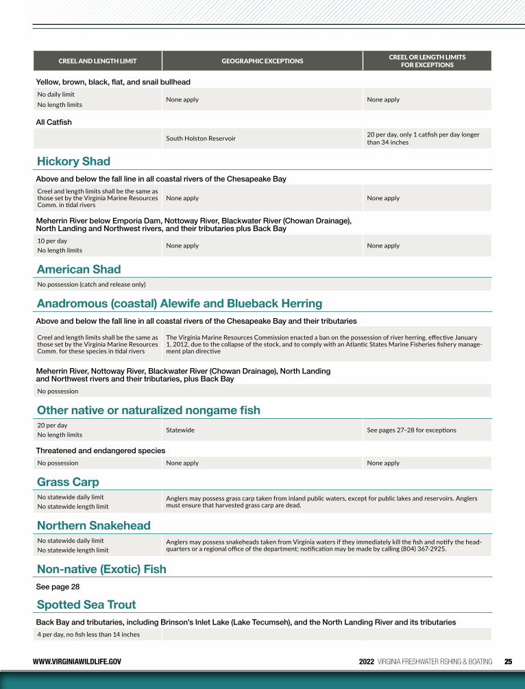
25WWW.VIRGINIAWILDLIFE.GOV 2022 VIRGINIA FRESHWATER FISHING & BOATING
CREEL AND LENGTH LIMIT GEOGRAPHIC EXCEPTIONS CREEL OR LENGTH LIMITS FOR EXCEPTIONS
Yellow, brown, black, flat, and snail bullhead
No daily limit No length limits
None apply None apply
All Catfish
South Holston Reservoir 20 per day, only 1 catfish per day longer than 34 inches
Hickory ShadAbove and below the fall line in all coastal rivers of the Chesapeake Bay
Creel and length limits shall be the same as those set by the Virginia Marine Resources Comm. in tidal rivers
None apply None apply
Meherrin River below Emporia Dam, Nottoway River, Blackwater River (Chowan Drainage), North Landing and Northwest rivers, and their tributaries plus Back Bay
10 per day No length limits
None apply None apply
American ShadNo possession (catch and release only)
Anadromous (coastal) Alewife and Blueback HerringAbove and below the fall line in all coastal rivers of the Chesapeake Bay and their tributaries
Creel and length limits shall be the same as those set by the Virginia Marine Resources Comm. for these species in tidal rivers
The Virginia Marine Resources Commission enacted a ban on the possession of river herring, effective January 1, 2012, due to the collapse of the stock, and to comply with an Atlantic States Marine Fisheries fishery manage-ment plan directive
Meherrin River, Nottoway River, Blackwater River (Chowan Drainage), North Landing and Northwest rivers and their tributaries, plus Back Bay
No possession
Other native or naturalized nongame fish20 per day No length limits
Statewide See pages 27–28 for exceptions
Threatened and endangered species
No possession None apply None apply
Grass CarpNo statewide daily limitNo statewide length limit
Anglers may possess grass carp taken from inland public waters, except for public lakes and reservoirs. Anglers must ensure that harvested grass carp are dead.
Northern SnakeheadNo statewide daily limit No statewide length limit
Anglers may possess snakeheads taken from Virginia waters if they immediately kill the fish and notify the head-quarters or a regional office of the department; notification may be made by calling (804) 367-2925.
Non-native (Exotic) FishSee page 28
Spotted Sea TroutBack Bay and tributaries, including Brinson’s Inlet Lake (Lake Tecumseh), and the North Landing River and its tributaries
4 per day, no fish less than 14 inches
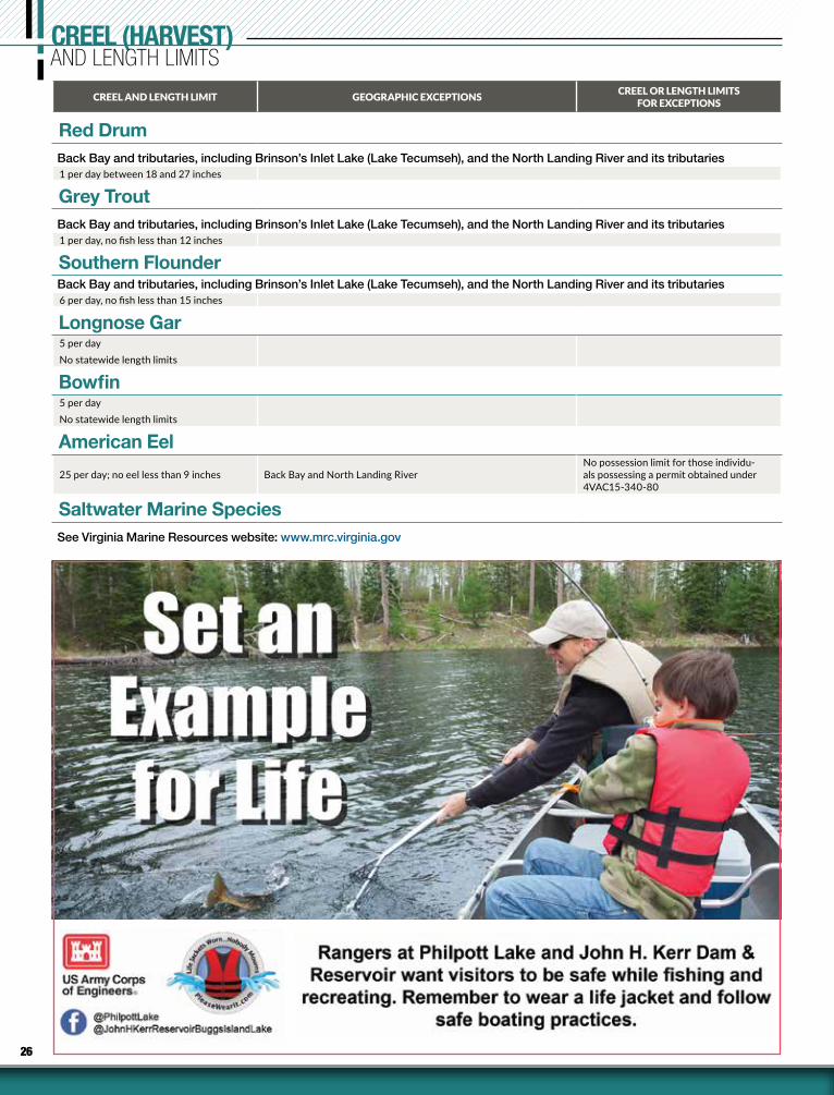
26
CREEL (HARVEST)AND LENGTH LIMITS
CREEL AND LENGTH LIMIT GEOGRAPHIC EXCEPTIONS CREEL OR LENGTH LIMITS FOR EXCEPTIONS
Red DrumBack Bay and tributaries, including Brinson’s Inlet Lake (Lake Tecumseh), and the North Landing River and its tributaries1 per day between 18 and 27 inches
Grey TroutBack Bay and tributaries, including Brinson’s Inlet Lake (Lake Tecumseh), and the North Landing River and its tributaries1 per day, no fish less than 12 inches
Southern FlounderBack Bay and tributaries, including Brinson’s Inlet Lake (Lake Tecumseh), and the North Landing River and its tributaries6 per day, no fish less than 15 inches
Longnose Gar5 per dayNo statewide length limits
Bowfin5 per dayNo statewide length limits
American Eel
25 per day; no eel less than 9 inches Back Bay and North Landing RiverNo possession limit for those individu-als possessing a permit obtained under 4VAC15-340-80
Saltwater Marine SpeciesSee Virginia Marine Resources website: www.mrc.virginia.gov
27WWW.VIRGINIAWILDLIFE.GOV 2022 VIRGINIA FRESHWATER FISHING & BOATING
DIDYMO...Spread the word, not the algae.Didymo is an invasive freshwater algae that can form massive blooms and cover entire river bottoms. It thrives in cold, clear, shallow water and is currently found in at least four Virginia trout rivers: Smith, Jackson, Pound, and Dan rivers below dams.
Four steps anglers can take to help prevent the spread of didymo:
• CHECK: Before leaving the river, look for strands of algae on your equipment. Remove the strands and leave them on-site.
• CLEAN: Soak and scrub all gear for at least one minute in a 2% solution of household bleach. Make sure that all surfaces of your equipment are thoroughly treated.
• DRY: If cleaning is not practical, dry equipment in the sun for at least 48 hours before using in another stream.
• LEAVE: Fish, plants, and vegeta-tion should not be moved between streams.
For more information, visit our website at www.virginiawildlife.gov/fishing/didymo.
GeneralHarvesting or collecting fish by any of the fol-lowing methods listed in this section requires a freshwater fishing license. It shall be unlawful to take, possess, import, cause to be imported, export, cause to be exported, buy, sell, offer for sale or liberate within the Commonwealth any wild animal unless otherwise specifically per-mitted by law or regulation. Native or natural-ized albino reptiles, native or naturalized albino amphibians, and any domestic animals may be imported, possessed, and sold. A list of domestic animals and the Department’s official listing of “Native and Naturalized Fauna of Virginia” is available at www.virginiawildlife.gov/wildlife/wildlife-information.
Native and Naturalized SpeciesPossession Limits(see exceptions for certain species below)
Personal Use & Not for Sale1 – native or naturalized (reptile or amphibian) per residency that is not listed in Virginia’s 2015 Wildlife Action Plan20 – Nongame Fish and Aquatic Invertebrates
Exceptions:1. No possession allowed. Threatened and en-
dangered species, freshwater mussels, candy darter, eastern hellbender, diamondback terrapin, and spotted turtle.
2. No possession limits – can be possessed in unlimited numbers. Carp, mullet, yellow bullhead, brown bullhead, black bullhead, snail bullhead, white sucker, northern hog-sucker, gizzard shad, threadfin shad, white perch, yellow perch (10 fish limit in Lake Moomaw), alewife and blueback herring [see limits under Anadromous (coastal) in table on page 25], stoneroller (hornyhead), fathead minnow, golden shiner, goldfish, and Asian clams.
3. See page 24 for catfish and page 25 for anad-romous (coastal) shad and herring limits.
4. Fish bait: minnows and chubs (Cyprini-dae), crayfish, and hellgrammites—50 in aggregate (all species combined) unless said person has purchased fish bait and has a receipt specifying the number of individu-als purchased by species. Note: Madtoms, crayfish, and salamanders cannot be bought or sold.
5. Bullfrogs – 15 per day. Snapping turtles – 5 per day, only from June 1 to September 30. Cannot be taken from the banks or waters of designated stocked trout waters.
6. Native amphibians and reptiles that are captured within the Commonwealth and possessed live for private use and not for
sale may be liberated under the following conditions: » Period of captivity does not exceed 30 days; » Animals must be liberated at the site
of capture; » Animals must have been housed sepa-
rately from other wild-caught and do-mestic animals; and
» Animals that demonstrate symptoms of disease or illness or that have sustained injury during their captivity may not be released.
Methods to Capture or TakeGeneral Methods:• Except as provided for under “Other Meth-
ods” and except in any waters where the use of nets is prohibited, the species listed in the previous section (Possession Limits) may only be taken by hand, hook and line, with a seine not exceeding 4 feet in depth by 10 feet in length, an umbrella-type net not exceed-ing 5 by 5 feet square, small minnow traps with throat openings no larger than 1 inch in diameter, cast nets, and handheld bow nets with diameter not to exceed 20 inches and handle length not to exceed 8 feet.
• Gizzard shad and white perch may also be taken from below the fall line in all tidal riv-ers of the Chesapeake Bay using a gill net in accordance with Virginia Marine Resources Commission recreational fishing regulations.
• Bullfrogs may also be taken by gigging or bow and arrow and from private waters by firearms no larger than .22 caliber rimfire. Taking bullfrogs with a gig, .22 caliber rimfire, or bow and arrow requires a hunting license.
• Snapping turtles may be taken for personal use with hoop nets not exceeding 6 feet in length with a throat opening not exceeding 36 inches. Taking turtles by hook and line requires a fishing license.
SCUBA:It is illegal to use SCUBA (Self-contained Un-derwater Breathing Apparatus) gear to take or attempt to take fish.
Trotlines, juglines (noodles) or set poles (limb lines):These may be used to take nongame fish and turtles provided they are not baited with live bait (worms are permissible), except on designated stocked trout waters, Department-owned lakes, and within 600 feet of any dam. Live bait other than game fish may be used on trot lines to take catfish in Carroll, Dickenson, Giles, Grayson, Montgomery, Pulaski and Wythe counties, and in the Clinch River in Russell, Scott, and Wise coun-ties. (See page 13 for South Holston Reservoir.)
Any person setting or possessing the above equipment shall have it clearly marked by per-manent means with his or her name, address, and telephone number, and is required to check all lines and remove all fish and animals caught each day.
Remove all trotlines, juglines, or set poles (limb lines) from public waters when not in use.
Additional requirements for juglines (also called “noodles”): Defined as a single hook, in-cluding one treble hook, and line attached to a float. Jugline/noodle sets on public waters shall be restricted to 20 per angler and must be attended (within sight) by anglers at all times. Also, in ad-dition to being labeled with the angler’s name, address and telephone number, jugs/noodles shall also be labeled with a reflective marker that encir-cles the jugs/noodles to allow for visibility at night.
Bow and Arrow (including crossbows):These may be used to take common carp, grass carp, northern snakehead, and gar (fishing li-cense required) during day and night hours (24 hrs.), except from waters stocked with trout. Bowfin and catfish may be taken in tidal waters (below Fall Line, see page 12). Spearguns and
NONGAME FISH, REPTILE, AMPHIBIAN, AND AQUATIC INVERTEBRATE REGULATIONS
DIDYMO. . .spread the word, not the algae
28 2022 VIRGINIA FRESHWATER FISHING & BOATING WWW.VIRGINIAWILDLIFE.GOV
poisoned arrows are prohibited. Snakehead must be immediately killed and reported to DWR. Must comply with creel limits on fish.
Snagging, grabbing, snaring, gigging, and the use of a striking iron: These are legal methods to take nongame fish in certain waters in certain counties as follows (see table page 25 for certain nongame fish limits):
1. In the waters of the following counties [ex-cept public impoundments, the Roanoke (Staunton) and Dan Rivers, and those wa-ters stocked by the Department]: Amelia, Appomattox, Brunswick, Campbell, Char-lotte, Cumberland, Dinwiddie, Goochland (except James River), Greensville, Halifax, Louisa, Lunenburg, Mecklenburg, Not-toway, Pittsylvania, and Prince Edward.
2. It shall be lawful to take nongame fish by gig or fishing spear from a position above the surface of the water on those portions below the fall line of the Rappahannock River and its tributaries and the Potomac River and its tributaries. A fishing spear is defined as an implement with a shaft and sharp point or tines designed to be thrusted or thrown by hand.
3. From April 1 through May 15 and October 1 through November 30 during the daytime in the following waters: Buchanan County, all waters except Dismal River; Grayson County, New River; Lee County, Powell River; Russell County, Clinch River; Scott County, Clinch River and its tributaries; Tazewell County, Dry Run Creek; Wise County, Clinch River; and Washington County, Middle Fork and South Fork of the Holston River. Creel limit: 20 suckers per day.
4. Snagging for carp and suckers during April in Wolf and Big Walkers Creek in Giles County.
5. Snagging for carp and suckers in Walkers Creek, Wolf Creek and the North Fork of the Holston in Bland County.
6. Bow and arrow and gigging for carp year-round in the Shenandoah River.
7. Shooting with a rifle for suckers and carp from April 15 to May 31 during daylight hours in the shoals of the Clinch River within the limits of Scott County, except that it shall be unlawful to shoot fish on Sunday or within the limits of any town, or from any bridge. Fishing license is required. Creel limit: 20 per day.
Dip nets:Dip nets may be used to take shad, herring, mullet and suckers except in designated stocked trout waters, Department-owned or controlled lakes, in certain waters where anadromous shad and herring cannot be possessed (see page 25 for shad and herring limits), and as restricted below. The user and all helpers (regardless of age) must have dip net permits ($4.50) or valid fishing license. Permits are valid in the county’s inland waters for which issued. All other fish species taken are to be immediately returned to the water alive.
Herring: The Virginia Marine Resources Commission enacted a ban on the possession of river her-ring in tidal waters, effective January 1, 2012, due to the collapse of the stock and in order to comply with an Atlantic States Marine Fisheries Commission directive.
Suckers Taken with Dip Nets: Limit of 20 per day.Season: February 15– May 15.Dip nets shall not be more than 6 feet square. Dip net permits are not required for taking suckers in Brunswick, Greensville, and Sus-sex counties.
Nets and Seines:Nets and Seines are prohibited while fishing in designated stocked trout waters and for taking fish from Department-owned or controlled lakes, except as otherwise posted (see table page 20 for certain nongame fish limits). The use of nets and seines, except for hand-landing nets and cast (throw) nets, is prohibited in the public waters of the Roanoke (Staunton) and Dan rivers in Campbell, Charlotte, Halifax and Pittsylvania counties, and in the City of Danville. Seines, nets, and traps are also prohibited in Lick Creek in Smyth and Bland counties, Bear Creek in Smyth County, Laurel Creek and tributaries upstream of Highway 16 bridge in Tazewell and Bland counties, streams and their tributaries that flow into Hungry Mother Lake in Smyth County, Susong Branch and Mumpower Creek in Washington County and the City of Bristol, and Timbertree Branch in Scott County. How-ever, these restrictions do not prohibit the use of a hand-landing net to land fish legally hooked. Seasons and local restrictions governing the use of nets and seines are complex. Persons deciding to try this type of fishing should contact the clos-est DWR regional office for more information. See “Legal Methods for Capturing Nongame Bait” on page 20 for additional information on bait collecting.
Areas/Species RestrictedDesignated Stocked Trout Waters:Nongame fish may be harvested only by hook and line in designated stocked trout waters between October 1 and June 15.
Mollusks:Unlawful to take the spiny riversnail (Io flu-vialis) in the Tennessee drainage in Virginia (Clinch, Powell and the North, South and Mid-dle Forks of the Holston rivers and tributaries). It shall be unlawful to take mussels from any inland waters in Virginia.
Salamanders:Unlawful to take salamanders in Grayson Highlands State Park and on National Forest lands in the Jefferson National Forest in those portions of Grayson, Smyth and Washington counties bounded on the east by Rt. 16, on the north by Rt. 603, and on the south and west by Rt. 58.
Non-Native (Exotic Animals)A special permit is required, and may be issued by the Department, if consistent with the Depart-ment’s fish and wildlife management program, to import, possess, or sell the following non-native (exotic) amphibians, fish, mollusks, aquatic in-vertebrates, and reptiles: giant or marine toad, tongueless or African clawed frog, barred tiger salamander, gray tiger salamander, blotched tiger salamander, smallmouth buffalo, bigmouth buffalo, black buffalo, piranhas, Alabama bass, bighead carp, grass carp or white amur, red shiner, silver carp, black carp, rudd, tench, ruffe, snakeheads, air-breathing catfish, tilapia, swamp eel, tubenose goby, round goby, zebra mussel, New Zealand mudsnail, quagga mussel, rusty crayfish, Australian crayfish, marbled crayfish, Chinese mitten crab, alligators, caimans, brown tree snake, crocodiles, and gavials.
Anglers may legally possess snakehead fish taken from Virginia waters provided they im-mediately kill the fish and notify DWR at 804-367-2925.
Anglers may possess live Alabama bass only on the body of water from which they were cap-tured, and may not transport them alive from the body of water that they were captured. Live Alabama bass may only be released into the body of water from which they are captured. Anglers must ensure all harvested Alabama bass are dead if they plan to transport them away from the body of water from which they were captured.
Grass carp may be legally harvested from public inland waters (rivers and streams), ex-cept from department-owned or department-controlled lakes. Anglers must ensure that all harvested grass carp are dead.
All other non-native (exotic) amphibians, fish, aquatic invertebrates, and reptiles not listed above may be possessed, purchased, and sold, provided that such animals shall be subject to all applicable local, state, and federal laws and regulations, including those that apply to threatened/endangered species, and further provided that such animals shall not be liber-ated within the Commonwealth.
Leave Snakes AloneUnder Virginia law, snakes are classified as a nongame species and are afforded protection under nongame regulations. While killing snakes is not a permitted activity, they can be taken (except for state or federally listed species) when classified as a “Nuisance species” (29.1-100); when found committing or about to commit depreda-tion upon agricultural or property damage, or when concentrated in numbers and manners to constitute a health hazard or other nuisance. For example, if a blacksnake is found in your chicken coop, you have the legal right to kill it; or if a copperhead is found in your garage, you have the legal right to kill it. But to wantonly go out and shoot snakes when they are not posing an imminent threat to human safety or livestock is an unlawful activity. Snakes play a valuable role in our ecosystems as both predator and prey, and killing them for no justifiable reason is contrary to the conservation mission of the Department.
NONGAME FISH, REPTILE, AMPHIBIAN, AND AQUATIC INVERTEBRATE REGULATIONS
29WWW.VIRGINIAWILDLIFE.GOV 2022 VIRGINIA FRESHWATER FISHING & BOATING
Trout FishingVirginia contains over 3,500 miles of trout streams, in addition to numerous ponds, small lakes and reservoirs. The total includes over 2,900 miles of wild trout streams and about 600 miles of water inhabited with stocked trout. Virginia’s diversified trout habitat offers a wide range of trout fishing opportunities.
Trout management in Virginia consists of three basic programs:
• The Catchable Trout Stocking Program is the best known and most popular. “Designat-ed Stocked Trout Waters” are stocked from October through May with catchable-sized trout. See the Trout Stocking Plan for the streams and lakes stocked and their stock-ing schedule.
• The Wild Trout Program includes the man-agement of reproducing populations of brook, rainbow, and brown trout. Efforts are directed primarily at habitat preservation and proper regulation for protection of spawning stocks.
• The Fingerling Trout Stocking Program involves stocking sublegal trout into waters that have cold summer water temperatures and a good food source. This is the smallest of the three programs, but includes many of our high quality, special regulation trout fishing waters.
Virginia’s trout season is open year-round and the general statewide limits are 6 trout per day, no fish less than 7 inches. There are a number of exceptions found below for certain areas and waters (i.e., heritage, urban, special area, special regulation, and fee fishing waters), so please study the sections following for fish-
ing times, dates, and limits. These different restrictions have been applied to certain wild trout waters, as well as several types of stocked trout streams, to provide anglers with the op-portunity to catch more and larger trout.
Success for both wild and stocked trout should be very high through the spring, fall, and mild winter periods. From June through September, normally low stream flows and warming water temperatures make trout fishing more difficult. However, experienced trout anglers can find good trout fishing opportunities throughout the year.
Changes/Updates• As a reminder, a trout license is not required
to fish designated stocked trout waters during Free Fishing Days. A permit is still required to fish at Clinch Mountain, Crooked Creek, and Douthat State Park Fee Fishing Areas.
• The cost for a nonresident trout license to fish in designated stocked trout waters has been reduced to the same price as a resident trout license ($23.00).
• Stocking dates for Urban Stocked Trout Waters will be posted the week prior to stocking on the Department’s trout stocking info page, www.virginiawildlife.gov/fishing/trout-stocking-schedule and trout stocking telephone line.
• The Delayed Harvest section of Passage Creek (Warren Co.) will be closed (not stocked) for construction at the Front Royal Fish Hatchery.
Designated Trout Waters (Catchable Trout Stocking Waters)“Designated Stocked Trout Waters” include those waters that are stocked with catchable-sized trout and are listed by the Director in the annual Trout Stocking Plan (see pages 36–37). These waters will only be considered designated stocked trout waters from October 1 through
June 15 (trout license required). A trout license is not required from June 16 through September 30. Trout angling hours on designated stocked trout waters are from 5:00 am until one hour after sunset. See exceptions for Trout Heritage Waters (page 35), Urban Program Waters (page 30) and Fee Fishing Areas (page 35). Desig-nated stocked trout waters are posted by the Department with appropriate “stocked trout waters” signs.
It is unlawful to fish in designated stocked trout waters after the daily creel limit of trout has been obtained or during the closed hours for taking trout. Once a trout is taken into possession by placing in the creel (basket, bucket, stringer, cooler, etc.) it becomes part of the daily creel limit and may not be released (culled). It is unlawful to feed, bait, or snag trout in designated stocked trout waters. It shall be unlawful for any person fishing in designated stocked trout waters to use more than one rod, one line, and one baited hook (a treble hook is considered one hook); however, any combination of artificial lures is allowed. It shall be unlawful to use seines and nets in designated stocked waters, except that a hand-landing net to land fish legally hooked may be used in all waters.
Kids Fishing EventsKids fishing events that are sponsored by the Department and held on designated stocked trout waters will be closed to adults (anglers over 15 years of age) from noon the day before the event until the conclusion of the special event (only in the posted section). Any person over the age of 15 and accompanying a child who is incapable of hooking and landing a fish unassisted, must be properly licensed to fish in designated stocked trout waters.
LICENSE REQUIREMENTS FOR TROUT FISHING(See pages 10–11 for details and costs)
Note: The trout license is only required from October 1 through June 15. From June 16 through September 30 an-glers can fish in stocked trout waters without a trout license.
Fee Fishing Areas (page 35) require a daily fishing permit in addition to an appropriate freshwater fishing license.
Residents 16 years of age and older.1. A state or county freshwater fishing license.
2. Fishing a Designated Stocked Trout Water? Need an ad-ditional trout license. (Note a resident may not use a 5-day freshwater license in combination with a trout license).
3. Fishing in most waters within the George Washington and Jefferson National Forests? Need a National Forest Stamp (refer to National Forest Stamp exceptions on pg. 12).
4. Fishing in wild trout and most special regulation waters? Some require a signed landowner permit card which can be obtained online at: https://dwr.virginia.gov/fishing/trout/special-regulation-trout-waters/
Nonresidents 16 years of age and older.1. A nonresident annual, daily, or 5-day freshwater fishing
license.
2. Fishing a Designated Stocked Water? Need an additional nonresident trout license.
Note: Nonresident children under 16 not required to have freshwater fishing or trout license.
3. Fishing in most waters within the George Washington and Jefferson National Forests? Need a National Forest Stamp (refer to National Forest Stamp exceptions on pg. 12).
4. Fishing in wild trout and most special regulation waters? Some require a signed landowner permit card which can be obtained online at: https://dwr.virginia.gov/fishing/trout/special-regulation-trout-waters/
TROUT FISHINGGUIDE
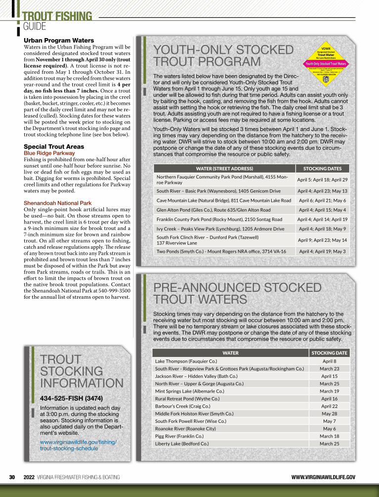
30 2022 VIRGINIA FRESHWATER FISHING & BOATING WWW.VIRGINIAWILDLIFE.GOV
TROUT STOCKING INFORMATION434-525-FISH (3474)Information is updated each day at 3:00 p.m. during the stocking season. Stocking information is also updated daily on the Depart-ment’s website.
www.virginiawildlife.gov/fishing/trout-stocking-schedule
Urban Program WatersWaters in the Urban Fishing Program will be considered designated stocked trout waters from November 1 through April 30 only (trout license required). A trout license is not re-quired from May 1 through October 31. In addition trout may be creeled from these waters year-round and the trout creel limit is 4 per day, no fish less than 7 inches. Once a trout is taken into possession by placing in the creel (basket, bucket, stringer, cooler, etc.) it becomes part of the daily creel limit and may not be re-leased (culled). Stocking dates for these waters will be posted the week prior to stocking on the Department’s trout stocking info page and trout stocking telephone line (see box below).
Special Trout AreasBlue Ridge ParkwayFishing is prohibited from one-half hour after sunset until one-half hour before sunrise. No live or dead fish or fish eggs may be used as bait. Digging for worms is prohibited. Special creel limits and other regulations for Parkway waters may be posted.
Shenandoah National ParkOnly single-point hook artificial lures may be used—no bait. On those streams open to harvest, the creel limit is 6 trout per day with a 9-inch minimum size for brook trout and a 7-inch minimum size for brown and rainbow trout. On all other streams open to fishing, catch and release regulations apply. The release of any brown trout back into any Park stream is prohibited and brown trout less than 7 inches must be disposed of within the Park but away from Park streams, roads or trails. This is an effort to limit the impacts of brown trout on the native brook trout populations. Contact the Shenandoah National Park at 540-999-3500 for the annual list of streams open to harvest.
TROUT FISHINGGUIDE
YOUTH-ONLY STOCKED TROUT PROGRAMThe waters listed below have been designated by the Direc-tor and will only be considered Youth-Only Stocked Trout Waters from April 1 through June 15. Only youth age 15 and under will be allowed to fish during that time period. Adults can assist youth only by baiting the hook, casting, and removing the fish from the hook. Adults cannot assist with setting the hook or retrieving the fish. The daily creel limit shall be 3 trout. Adults assisting youth are not required to have a fishing license or a trout license. Parking or access fees may be required at some locations.
Youth-Only Waters will be stocked 3 times between April 1 and June 1. Stock-ing times may vary depending on the distance from the hatchery to the receiv-ing water. DWR will strive to stock between 10:00 am and 2:00 pm. DWR may postpone or change the date of any of these stocking events due to circum-stances that compromise the resource or public safety.
WATER (STREET ADDRESS) STOCKING DATES
Northern Fauquier Community Park Pond (Marshall), 4155 Mon-roe Parkway April 5: April 18; April 29
South River – Basic Park (Waynesboro), 1405 Genicom Drive April 4; April 23; May 13
Cave Mountain Lake (Natural Bridge), 811 Cave Mountain Lake Road April 6; April 21; May 6
Glen Alton Pond (Giles Co.), Route 635/Glen Alton Road April 4; April 15; May 4
Franklin County Park Pond (Rocky Mount), 2150 Sontag Road April 4; April 14; April 19
Ivy Creek – Peaks View Park (Lynchburg), 1205 Ardmore Drive April 4; April 18; May 9
South Fork Clinch River – Dunford Park (Tazewell) 137 Riverview Lane April 9; April 23; May 14
Two Ponds (Smyth Co.) - Mount Rogers NRA office, 3714 VA-16 April 4; April 19; May 3
Designated Stocked
Youth Only Stocked Trout Waters
VDWR
Trout WaterNo Lure Restrictions
Only youth 15 years of age and younger permitted
Minimum Size - 7 Inches Daily Limit - 3
NO CLOSED SEASON
April 1 - June 15
PRE-ANNOUNCED STOCKED TROUT WATERSStocking times may vary depending on the distance from the hatchery to the receiving water but most stocking will occur between 10:00 am and 2:00 pm. There will be no temporary stream or lake closures associated with these stock-ing events. The DWR may postpone or change the date of any of these stocking events due to circumstances that compromise the resource or public safety.
WATER STOCKING DATE
Lake Thompson (Fauquier Co.) April 8South River - Ridgeview Park & Grottoes Park (Augusta/Rockingham Co.) March 23Jackson River – Hidden Valley (Bath Co.) April 15North River – Upper & Gorge (Augusta Co.) March 25Mint Springs Lake (Albemarle Co.) March 19Rural Retreat Pond (Wythe Co.) April 16Barbour’s Creek (Craig Co.) April 22Middle Fork Holston River (Smyth Co.) May 28South Fork Powell River (Wise Co.) May 7Roanoke River (Roanoke City) May 6Pigg River (Franklin Co.) March 18Liberty Lake (Bedford Co.) March 25
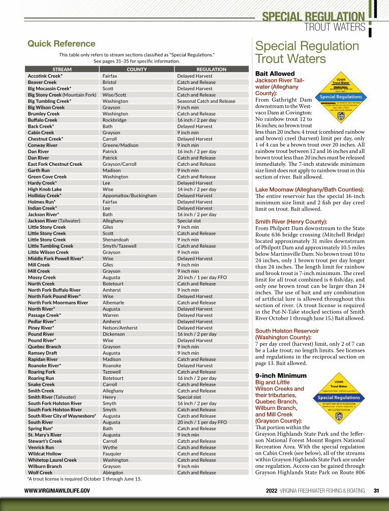
31WWW.VIRGINIAWILDLIFE.GOV 2022 VIRGINIA FRESHWATER FISHING & BOATING
Quick ReferenceThis table only refers to stream sections classified as “Special Regulations.”
See pages 31–35 for specific information.
STREAM COUNTY REGULATIONAccotink Creek* Fairfax Delayed HarvestBeaver Creek Bristol Catch and ReleaseBig Mocassin Creek* Scott Delayed HarvestBig Stony Creek (Mountain Fork) Wise/Scott Catch and ReleaseBig Tumbling Creek* Washington Seasonal Catch and ReleaseBig Wilson Creek Grayson 9 inch minBrumley Creek Washington Catch and ReleaseBuffalo Creek Rockbridge 16 inch / 2 per dayBack Creek* Bath Delayed HarvestCabin Creek Grayson 9 inch minChestnut Creek* Carroll Delayed HarvestConway River Greene/Madison 9 inch minDan River Patrick 16 inch / 2 per dayDan River Patrick Catch and ReleaseEast Fork Chestnut Creek Grayson/Carroll Catch and ReleaseGarth Run Madison 9 inch minGreen Cove Creek Washington Catch and ReleaseHardy Creek* Lee Delayed HarvestHigh Knob Lake Wise 14 inch / 2 per dayHolliday Creek* Appomattox/Buckingham Delayed HarvestHolmes Run* Fairfax Delayed HarvestIndian Creek* Lee Delayed HarvestJackson River* Bath 16 inch / 2 per dayJackson River (Tailwater) Alleghany Special slotLittle Stony Creek Giles 9 inch minLittle Stony Creek Scott Catch and ReleaseLittle Stony Creek Shenandoah 9 inch minLittle Tumbling Creek Smyth/Tazewell Catch and ReleaseLittle Wilson Creek Grayson 9 inch minMiddle Fork Powell River* Wise Delayed HarvestMill Creek Giles 9 inch minMill Creek Grayson 9 inch minMossy Creek Augusta 20 inch / 1 per day FFONorth Creek Botetourt Catch and ReleaseNorth Fork Buffalo River Amherst 9 inch minNorth Fork Pound River* Wise Delayed HarvestNorth Fork Moormans River Albemarle Catch and ReleaseNorth River* Augusta Delayed HarvestPassage Creek* Warren Delayed HarvestPedlar River* Amherst Delayed HarvestPiney River* Nelson/Amherst Delayed HarvestPound River Dickenson 16 inch / 2 per dayPound River* Wise Delayed HarvestQuebec Branch Grayson 9 inch minRamsey Draft Augusta 9 inch minRapidan River Madison Catch and ReleaseRoanoke River* Roanoke Delayed HarvestRoaring Fork Tazewell Catch and ReleaseRoaring Run Botetourt 16 inch / 2 per daySnake Creek Carroll Catch and ReleaseSmith Creek Alleghany Catch and ReleaseSmith River (Tailwater) Henry Special slotSouth Fork Holston River Smyth 16 inch / 2 per daySouth Fork Holston River Smyth Catch and ReleaseSouth River City of Waynesboro* Augusta Catch and ReleaseSouth River Augusta 20 inch / 1 per day FFOSpring Run* Bath Catch and ReleaseSt. Mary’s River Augusta 9 inch minStewart’s Creek Carroll Catch and ReleaseVenrick Run Wythe Catch and ReleaseWildcat Hollow Fauquier Catch and ReleaseWhitetop Laurel Creek Washington Catch and ReleaseWilburn Branch Grayson 9 inch minWolf Creek Abingdon Catch and Release*A trout license is required October 1 through June 15.
Special Regulation Trout WatersBait AllowedJackson River Tailwater (Alleghany County):From Gathright Dam downstream to the West-vaco Dam at Covington: No rainbow trout 12 to 16 inches; no brown trout less than 20 inches; 4 trout (combined rainbow and brown) creel (harvest) limit per day, only 1 of 4 can be a brown trout over 20 inches. All rainbow trout between 12 and 16 inches and all brown trout less than 20 inches must be released immediately. The 7-inch statewide minimum size limit does not apply to rainbow trout in this section of river. Bait allowed.
Lake Moomaw (Alleghany/Bath Counties):The entire reservoir has the special 16-inch minimum size limit and 2 fish per day creel limit on trout. Bait allowed.
Smith River (Henry County):From Philpott Dam downstream to the State Route 636 bridge crossing (Mitchell Bridge) located approximately 31 miles downstream of Philpott Dam and approximately 10.5 miles below Martinsville Dam: No brown trout 10 to 24 inches, only 1 brown trout per day longer than 24 inches. The length limit for rainbow and brook trout is 7-inch minimum. The creel limit for all trout combined is 6 fish/day, and only one brown trout can be larger than 24 inches. The use of bait and any combination of artificial lure is allowed throughout this section of river. (A trout license is required in the Put-N-Take stocked sections of Smith River October 1 through June 15.) Bait allowed.
South Holston Reservoir (Washington County):7 per day creel (harvest) limit, only 2 of 7 can be a Lake trout; no length limits. See licenses and regulations in the reciprocal section on page 13. Bait allowed.
9-inch MinimumBig and Little Wilson Creeks and their tributaries, Quebec Branch, Wilburn Branch, and Mill Creek (Grayson County):That portion within the Grayson Highlands State Park and the Jeffer-son National Forest Mount Rogers National Recreation Area. With the special regulation on Cabin Creek (see below), all of the streams within Grayson Highlands State Park are under one regulation. Access can be gained through Grayson Highlands State Park on Route 806
Special Regulations
VDWRTrout Water
BROWN TROUT - MINIMUM SIZE: 20 INCHES
DAILY LIMIT: 1
RAINBOW TROUT - NO RAINBOW TROUT BETWEEN12 AND 16 INCHES MAY BE IN POSSESSION
DAILY LIMIT: 4 TROUTONLY ONE CAN BE A BROWN
Special Regulations
VDWRTrout Water
Single Point Hook Arti�cial Lures Only
NO BAIT MAY BE IN POSSESSIONMinimum Size - 9 inches Daily Limit - 6
NO CLOSED SEASON
SPECIAL REGULATION TROUT WATERS
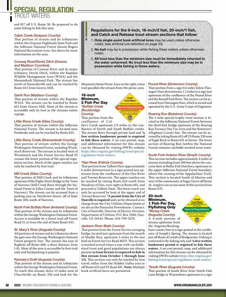
32 2022 VIRGINIA FRESHWATER FISHING & BOATING WWW.VIRGINIAWILDLIFE.GOV
SPECIAL REGULATION TROUT WATERSand 817 off U.S. Route 58. Be prepared to do some hiking to fish this area.
Cabin Creek (Grayson County):That portion of stream and its tributaries within the Grayson Highlands State Park and the Jefferson National Forest Mount Rogers National Recreation Area. See above for more information on the area.
Conway River/Devils Ditch (Greene and Madison Counties):That portion of Conway River and its major tributary, Devils Ditch, within the Rapidan Wildlife Management Area (WMA) and the Shenandoah National Park. The stream lies north of Stanardsville and can be reached by Route 615 from Graves Mill.
Garth Run (Madison County):That portion of stream within the Rapidan WMA. The stream can be reached by Route 615 from Graves Mill. Most of the stream is accessible only by foot as the streams enters a gorge.
Little Stony Creek (Giles County):That portion of stream within the Jefferson National Forest. The stream is located near Pembroke and can be reached by Route 623.
Little Stony Creek (Shenandoah County):That portion of stream within the George Washington National Forest, including Wood-stock Reservoir. The stream is located west of Woodstock and the Forest Service Road 92 crosses the lower portion of the special regu-lation section. Much of the upper reaches can only be reached by foot trail.
Mill Creek (Giles County):That portion of Mill Creek and its tributaries upstream of the Poplar Street Bridge in the Town of Narrows (Mill Creek flows through the Na-tional Forest in Giles County and the Town of Narrows.) The stream can be accessed from a parking area on Northview Street, off of State Route 100, south of Narrows.
North Fork Buffalo River (Amherst County):That portion of the stream and its tributaries within the George Washington National Forest. Access is available by a forest trail off Forest Road 51 or from the end of State Route 635.
St. Mary’s River (Augusta County):All portions of stream and its tributaries above the gate near the George Washington National Forest property line. The stream lies east of Raphine off Route 608, a short distance from I-81. Most of the area is accessible by foot trail only and backpacking is popular.
Ramsey’s Draft (Augusta County):That portion of the stream and its tributaries within the George Washington National Forest. To reach this stream, drive 15 miles west of Churchville on Route 250 and look for the
Mountain Home Picnic Area on the right; a foot trail parallels the stream from the picnic area.
16-inch Minimum, 2 Fish Per Day*Buffalo Creek (Rockbridge County):That portion from the conf luence of Col-lier’s Creek upstream 2.9 miles to the con-fluence of North and South Buffalo creeks. The stream flows through private land and *a free written landowner permit is required to fish these waters. A no-cost permit, map, and addi tional information for this stream can be obtained by visiting DWR’s website https://dwr.virginia.gov/fishing/trout/special-regulation-trout-waters/.
*Dan River (Patrick County):That portion from Talbott Dam approximately 6 miles downstream to a sign posted just up-stream from the confluence of the Dan River and Townes Reservoir. The upper reaches can be reached by taking Route 614 south from Meadows of Dan, turn right on Route 601, and proceed to Talbott Dam. The lower reach can only be accessed by boat at the upper end of Townes Reservoir. *A permit from the City of Danville is required and can be obtained at no charge from the City Utilities Department or on site at the Pinnacles Powerhouse. Contact: City of Danville, Director of Electric Division, Department of Utilities, P.O. Box 3300, Dan-ville, VA 24543. Phone: 434-799-5270.
Jackson River (Bath County):That portion from the Forest Service swinging bridge, located just upstream from the mouth of Muddy Run, upstream 3 miles to the last ford on Forest Service Road 481D. This section is stocked several times a year with catchable-sized trout and good populations are always present (a trout license is required to fish in this stream from October 1 through June 15). This section can only be reached by foot travel, either from the Hidden Valley area or off Route 623 and FS Road 481. Note: Multiple hook artificial lures are permitted.
Special Regulations
VDWRTrout Water
Single Point Hook Arti�cial Lures Only
NO BAIT MAY BE IN POSSESSIONMinimum Size - 16 Inches Daily Limit - 2
NO CLOSED SEASON
Pound River (Dickenson County):That portion from a sign 0.4 miles below Flan-nagan Dam downstream 1.2 miles to a sign just upstream of the confluence of the Pound River and the Russell Fork River. The section can be ac-cessed from Flannagan Dam, which is owned and operated by the U.S. Army Corps of Engineers.
Roaring Run (Botetourt County):The 1-mile special trophy trout section is lo-cated in the Jefferson National Forest between the third foot bridge upstream of the Roaring Run Furnace Day Use Area and the Botetourt/Alleghany County line. The stream can be ac-cessed by taking Route 615 off US Route 220 west of Eagle Rock to Route 621 at Strom. The lower section of Roaring Run (within the National Forest) remains catchable stocked trout water.
South Fork Holston River (Smyth County):This section includes approximately 4 miles of stream extending from 500 feet above the con-crete dam at Buller Fish Hatchery, upstream to the upper Jefferson National Forest boundary (above the crossing of the Appalachian Trail). This section is located South of Marion and west of the community of Sugar Grove off Route 16. Anglers can access most of this section from Route 670.
20-inch Minimum, 1 Fish Per Day, Flyfishing Only*Mossy Creek (Augusta County):A 4-mile portion of stream upstream from the Augusta/Rocking-ham county line to a sign posted at the conflu-ence of Joseph’s Spring. The stream is located just off Route 42 south of Bridgewater. Fishing is restricted to fly-fishing only and *a free written landowner permit is required to fish these waters. A no cost permit, map, and additional information for this stream can be obtained by visiting DWR’s website https://dwr.virginia.gov/fishing/trout/special-regulation-trout-waters/.
*South River (Augusta County):That portion of South River from North Oak Lane Bridge in Waynesboro upstream to a sign
Special Regulations
VDWRTrout Water
Single Point Hook Arti�cial Lures Only Fly Fishing Only
NO BAIT MAY BE IN POSSESSIONMinimum Size - 20 Inches Daily Limit - 1
NO CLOSED SEASON
Regulations for the 9-inch, 16-inch/2 fish, 20-inch/1 fish, and Catch and Release trout stream sections that follow:1. Only single-point hook artificial lures may be used unless otherwise
noted. (see artificial lure definition on page 33)
2. No bait may be in possession while fishing these waters unless otherwise noted.
3. All trout less than the minimum size must be immediately returned to the water unharmed. No trout less than the minimum size may be in possession while fishing in these waters.
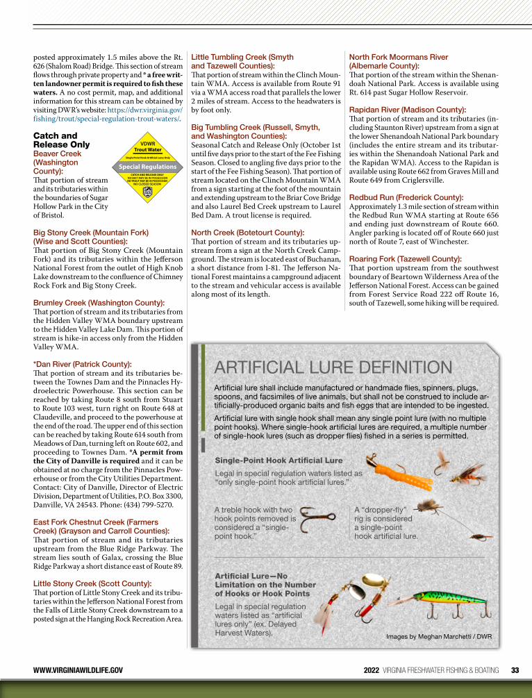
33WWW.VIRGINIAWILDLIFE.GOV 2022 VIRGINIA FRESHWATER FISHING & BOATING
posted approximately 1.5 miles above the Rt. 626 (Shalom Road) Bridge. This section of stream flows through private property and * a free writ-ten landowner permit is required to fish these waters. A no cost permit, map, and additional information for this stream can be obtained by visiting DWR’s website: https://dwr.virginia.gov/fishing/trout/special-regulation-trout-waters/.
Catch and Release OnlyBeaver Creek (Washington County):That portion of stream and its tributaries within the boundaries of Sugar Hollow Park in the City of Bristol.
Big Stony Creek (Mountain Fork)(Wise and Scott Counties):That portion of Big Stony Creek (Mountain Fork) and its tributaries within the Jefferson National Forest from the outlet of High Knob Lake downstream to the confluence of Chimney Rock Fork and Big Stony Creek.
Brumley Creek (Washington County):That portion of stream and its tributaries from the Hidden Valley WMA boundary upstream to the Hidden Valley Lake Dam. This portion of stream is hike-in access only from the Hidden Valley WMA.
*Dan River (Patrick County):That portion of stream and its tributaries be-tween the Townes Dam and the Pinnacles Hy-droelectric Powerhouse. This section can be reached by taking Route 8 south from Stuart to Route 103 west, turn right on Route 648 at Claudeville, and proceed to the powerhouse at the end of the road. The upper end of this section can be reached by taking Route 614 south from Meadows of Dan, turning left on Route 602, and proceeding to Townes Dam. *A permit from the City of Danville is required and it can be obtained at no charge from the Pinnacles Pow-erhouse or from the City Utilities Department. Contact: City of Danville, Director of Electric Division, Department of Utilities, P.O. Box 3300, Danville, VA 24543. Phone: (434) 799-5270.
East Fork Chestnut Creek (Farmers Creek) (Grayson and Carroll Counties):That portion of stream and its tributaries upstream from the Blue Ridge Parkway. The stream lies south of Galax, crossing the Blue Ridge Parkway a short distance east of Route 89.
Little Stony Creek (Scott County):That portion of Little Stony Creek and its tribu-taries within the Jefferson National Forest from the Falls of Little Stony Creek downstream to a posted sign at the Hanging Rock Recreation Area.
Special Regulations
VDWRTrout Water
Single Point Hook Arti�cial Lures Only
NO CLOSED SEASON
CATCH AND RELEASE ONLYNO BAIT MAY BE IN POSSESSIONNO TROUT MAY BE IN POSSESSION
Little Tumbling Creek (Smyth and Tazewell Counties):That portion of stream within the Clinch Moun-tain WMA. Access is available from Route 91 via a WMA access road that parallels the lower 2 miles of stream. Access to the headwaters is by foot only.
Big Tumbling Creek (Russell, Smyth, and Washington Counties):Seasonal Catch and Release Only (October 1st until five days prior to the start of the Fee Fishing Season. Closed to angling five days prior to the start of the Fee Fishing Season). That portion of stream located on the Clinch Mountain WMA from a sign starting at the foot of the mountain and extending upstream to the Briar Cove Bridge and also Laurel Bed Creek upstream to Laurel Bed Dam. A trout license is required.
North Creek (Botetourt County):That portion of stream and its tributaries up-stream from a sign at the North Creek Camp-ground. The stream is located east of Buchanan, a short distance from I-81. The Jefferson Na-tional Forest maintains a campground adjacent to the stream and vehicular access is available along most of its length.
North Fork Moormans River (Albemarle County):That portion of the stream within the Shenan-doah National Park. Access is available using Rt. 614 past Sugar Hollow Reservoir.
Rapidan River (Madison County):That portion of stream and its tributaries (in-cluding Staunton River) upstream from a sign at the lower Shenandoah National Park boundary (includes the entire stream and its tributar-ies within the Shenandoah National Park and the Rapidan WMA). Access to the Rapidan is available using Route 662 from Graves Mill and Route 649 from Criglersville.
Redbud Run (Frederick County):Approximately 1.3 mile section of stream within the Redbud Run WMA starting at Route 656 and ending just downstream of Route 660. Angler parking is located off of Route 660 just north of Route 7, east of Winchester.
Roaring Fork (Tazewell County):That portion upstream from the southwest boundary of Beartown Wilderness Area of the Jefferson National Forest. Access can be gained from Forest Service Road 222 off Route 16, south of Tazewell, some hiking will be required.
ARTIFICIAL LURE DEFINITIONArtificial lure shall include manufactured or handmade flies, spinners, plugs, spoons, and facsimiles of live animals, but shall not be construed to include ar-tificially-produced organic baits and fish eggs that are intended to be ingested.
Artificial lure with single hook shall mean any single point lure (with no multiple point hooks). Where single-hook artificial lures are required, a multiple number of single-hook lures (such as dropper flies) fished in a series is permitted.
Images by Meghan Marchetti / DWR
Single-Point Hook Artificial Lure
Legal in special regulation waters listed as “only single-point hook artificial lures.”
A treble hook with two hook points removed is considered a “single-point hook.”
Artificial Lure—No Limitation on the Number of Hooks or Hook Points
Legal in special regulation waters listed as “artificial lures only” (ex. Delayed Harvest Waters).
A “dropper-fly” rig is considered a single-point hook artificial lure.
34 2022 VIRGINIA FRESHWATER FISHING & BOATING WWW.VIRGINIAWILDLIFE.GOV
Smith Creek (Alleghany County):That portion from the Clifton Forge Dam down-stream to a sign at the Forest Service boundary above the C & O Dam. Best stream access is by Route 606 from Clifton Forge to the Clifton Forge Water Plant access road; anglers must park at the entrance and walk a half mile to the stream.
Snake Creek (Carroll County):That portion of Big Snake Creek below Hall Ford and that portion of Little Snake Creek below the junction of Routes 922 and 674, downstream to Route 58. Fishing downstream of Route 58 is no longer permitted. Parking and angler ac-cess is only permitted along Route 922 and at the Route 58 bridge (unless an individual is a landowner or guest).
South Fork Holston River (Smyth County):That portion of stream from the concrete dam at Buller Fish Hatchery downstream to the lower boundary of the Buller Fish Hatchery. Access can be gained through the Buller Fish Hatchery property off Route 650, south of Marion.
South River (Augusta County/City of Waynesboro)That portion of stream from the Second St. Bridge upstream 2 miles to the Wayne Ave. Bridge in the City of Waynesboro. A trout li-cense is required.
Spring Run (Bath County):That portion of the stream from its confluence with the Cowpasture River upstream to a cable and posted sign at the discharge from Coursey Springs Hatchery. Parking is available at the angler access just below the hatchery. A trout license is required October 1 through June 15.
Stewart’s Creek (Carroll County):Approximately 4.5 miles of Stewart’s Creek and its two major tributaries, North Fork and South Fork Stewart’s Creek, within the Stew-arts Creek WMA. Stewart’s Creek WMA is southeast of Galax on the east side of the Blue Ridge Parkway. Take Exit 1 off I-77. Follow the trailblazer signs to the area.
Venrick Run (Wythe County):That portion of Venrick Run and its tribu-taries within Big Survey WMA and Town of Wytheville property. The stream can be accessed from a parking lot on Town property at the end of State Route 684, off of State Route 21, south of Wytheville.
Whitetop Laurel/Green Cove Creeks (Washington County): Whitetop Laurel (2 sections)—that portion upstream from the first railroad trestle above Taylor Valley to the mouth of Green Cove Creek at Creek Junction and that portion up-stream from the mouth of Straight Branch to a sign at the Forest Service boundary just downstream of Taylors Valley. There remains a section of catchable stocked trout water with-
out special regulations through the village of Taylors Valley.
Green Cove Creek—that portion from Rt. 859 downstream to its mouth. The special regulation area is located east of Damascus (near the Tennessee line) and lies within the Mount Rogers Recreation Area.
Wildcat Hollow (Fauquier County):That portion of stream within the G. R. Thomp-son WMA. Foot access is available from the lower Ted Lake Trail parking area located off of Rt. 688.
Wolf Creek (Washington County):That portion of stream and its tributaries within the Abingdon Muster Grounds in the Town of Abingdon from Colonial Avenue downstream to Stone Mill Road.
Delayed Harvest WatersFrom October 1 through May 31 fish-ing on the following waters is permitted under specific regu-lations only:
1. Only artificial lures may be used. 2. No trout may be in possession (catch and
release only) while fishing these waters.3. No bait may be in possession while fishing
these waters.4. Trout license required October 1–June 15.
Note: During the period of June 1 through Sep-tember 30 restrictions 1 through 3 above will not apply and these waters are like any other designated stocked trout water (see page 29).
Accotink Creek (Fairfax County):That portion of stream from King Arthur Road downstream 3.1 miles to Route 620 (Braddock Road). Primary access is via the FCPA Wakefield Park facility off Braddock Road.
Back Creek (Bath County):That portion of stream from the Rt. 600 Bridge just below the Virginia Power Back Creek Dam downstream 1.5 miles to the Rt. 600 Bridge at the lower boundary of the Virginia Power Recreational Area. Take Route 39 west from Warm Springs to Mountain Grove, then right on Route 600 for 6 miles.
Big Moccasin Creek (Scott County)That portion of the stream from the VDOT foot bridge at the lower end of Gate City downstream to the Wadlow Gap Highway Bridge (Highway 58/421).
Chestnut Creek (Carroll County):That portion of stream from the U.S. Rt. 58 Bridge downstream 11.4 miles to the conflu-ence with the New River. The stream parallels the New River Trail State Park, and parking is available at state road crossings and at the
Delayed Harvest
VDWRTrout Water
Trout License Required October 1 - June 15
October 1 through May 31Arti�cial Lures Only
NO TROUT MAY BE IN POSSESSION
trail head in Galax. In addition to the state park, many private landowners have made this program possible and anglers should be sure to respect adjoining private property.
Hardy Creek (Lee County):That portion of stream from the VDOT swing-ing bridge just upstream of the Route 658 ford downstream to the Route 661 bridge.
Holliday Creek (Appomattox/Buckingham Counties):That portion of stream from the Rt. 640 crossing downstream 2.8 miles to a sign at the headwa-ters of Holliday Lake. This section is located completely within the Appomattox/Bucking-ham State Forest that can be accessed by taking Route 24 north out of Appomattox to Route 626. Anglers should turn onto Routes 640 or 614 to access a series of foot trails to the stream that have been developed by the Virginia Department of Forestry (VDOF). A State Forest Use Permit is required by the VDOF for anyone 16 years and older who fishes in one of Virginia’s 19 State Forests; the Use Permit is available at authorized retailers who sell fishing licenses, or online.
Holmes Run (Fairfax County):That portion of stream from the Lake Barcroft Dam downstream 1.2 miles to a sign posted at the Alexandria City line. A fairly good trail fol-lows (and sometimes crosses) the stream from the parking lot off Columbia Pike (Route 244).
Indian Creek (Lee County)That portion of stream within the boundaries of Wilderness Road State Park. The stream can be accessed from Route 58.
Middle Fork of Powell River (Wise County)That portion of stream from the trestle bridge just downstream of the Town of Appalachia to the trestle bridge just upstream of the Town of Big Stone Gap. This stream reach parallels Business Route 23.
North Fork of Pound and Pound Rivers (Wise County):That portion of the streams from the base of North Fork of Pound Dam downstream to the confluence with Indian Creek. Access is avail-able at the North Fork of Pound Dam and at parking lots within the town of Pound.
North River (Augusta County):That portion of stream from the base of Elkhorn Dam downstream 1.5 miles to a sign posted at the head of Staunton City Reservoir. This is a remote section of stream that can only be reached by foot trail. Access is available by parking at Elkhorn Lake and following the trail along the lake to the spillway.
Passage Creek (Warren County):That portion of stream from the Shenandoah/Warren County line downstream approximately 1 mile through the Department’s Front Royal Fish Hatchery. This section is immediately downstream
SPECIAL REGULATION TROUT WATERS

35WWW.VIRGINIAWILDLIFE.GOV 2022 VIRGINIA FRESHWATER FISHING & BOATING
of the area that has historically been stocked under the put-and-take program. Parking is available on Forest Service lands adjacent to Route 678 or on Department lands adjacent to Route 619.
Pedlar River (Amherst County):That portion of stream from the City of Lynch-burg/George Washington National Forest boundary line (below Lynchburg Reservoir) downstream 2.7 miles to the boundary line of the George Washington National Forest (south-east of Buena Vista). The U.S. Forest Service and the Department have cooperated in the development of three access sites to the river located along FS 39 off Route 607.
Piney River (Nelson/Amherst Counties):That portion of stream from the Piney River Trailhead of the Virginia Blue Ridge Trail (downstream from Route 151) downstream to the Route 674 crossing at Roses Mill Road.
Roanoke River (Roanoke County and City of Salem):There are two delayed harvest sections located on the Roanoke River near Roanoke. The first section is located within Green Hill Park in Roanoke County and was established in 2001. The newest section is located within the City of Salem and was established in 2003. The Green Hill Park section is easily found off Route 11/460 west of Salem and stretches from the Route 760 Bridge (Diguids Lane) upstream 1 mile to a sign posted at the upper end of the park. It is best to access the stream from the park side of the stream, and anglers are encouraged to use the parking areas provided. The Salem section is located along Riverside Drive and stretches from the Colorado Street Bridge downstream approximately 2 miles to the Route 419 Bridge. This section is most easily accessed from the Riverside Drive side of the river.
Fee Fishing AreasThe fee fishing areas of-fer put-and-take trout fishing with the added advantage that trout are stocked several times weekly throughout the season. For those anglers who reminisce about the opening day of trout season, these areas still provide this opportunity on the first Saturday in April when they open at 9:00 a.m. (The fee season may vary among the 3 fee fishing areas. Refer to information listed under each fee area). Fee areas are closed to fishing 5 days prior to opening day. During the fee fishing season, a daily permit ($8.00) is required of any person over 12 years of age, in addition to a valid Virginia freshwater fishing license (all children under 16 are exempted from having a fishing license). Children 12 years of age and under can fish without a permit throughout the fee-fishing area as long as they are accompanied by a permitted adult and their combined creel does not exceed that of the adult (6 trout). Daily permits are available at authorized license agents
Trout Fee Area
VDWR
Daily Permit RequiredFirst Saturday in April until September 30 CLOSED TO ANGLING
Trout License Required October 1 until Five Days Prior to
Minimum Size - 7 Inches Daily Limit - 6Fee Season
Five Days Prior to Start of Fee Season
or online www.gooutdoorsvirginia.com. After the fee fishing season, these areas revert to des-ignated stocked trout waters and a trout license is required instead of the daily permit. The creel limit at these areas is six fish per day, minimum length 7 inches. Fishermen are required to use separate stringers. Bait or artificial lures may be used as posted. Children-only fishing area (where applicable) regulations are posted.
Clinch Mountain Fee Fishing Area:This fee area is located in southwest Virginia, about 7 miles west of Saltville. A daily permit ($8.00) is required from the first Saturday in April through September 30. Trout are stocked 4 times per week throughout the fee period, and fishing begins at 5:00 a.m. daily, except for 9:00 a.m. on opening day, and ends one hour after sunset. The area consists of ap-proximately 7 miles of Big Tumbling Creek and its two major tributaries, Briar Cove Creek and Laurel Bed Creek. Note: Access to Laurel Bed Lake is also closed the 5 days prior to opening day for this fee area.
Directions: From Saltville, turn left off of Rt. 107 onto Rt. 91 (1 ⁄4 mile); then right onto Rt. 634; bear left onto Rt. 613 and proceed 3.5 miles; then right onto Rt. 747 to the area.
Crooked Creek Fee Fishing Area:This area is located in Carroll County, 5 miles east of Galax, and consists of a 5-mile stocked section and an approximately 2-mile section managed as a wild trout fishery. A daily permit
2022 TROUT HERITAGE WATERSThis program was added for those anglers who enjoyed and missed the old opening day. Selected waters are stocked for the first Saturday in April to create an announced stocking event.
The following waters will be stocked for the April 2nd Heritage Day:
Beartree Lake Washington County
Bark Camp Lake Scott County
Clinch Mountain Fee Fishing Area* Washington County
Cripple Creek (Ravens Cliff) Wythe County
Crooked Creek Fee Fishing Area* Carroll County
Douthat State Park Fee Fishing Area* Bath County
Hawksbill Creek Page County
Jennings Creek Botetourt County
Lake Witten Tazewell County
Liberty Lake Bedford County
Lincolnshire Lake Tazewell County
Middle Fork Holston River Smyth County
Passage Creek Shenandoah County
Pedlar River (upper) Amherst County
Pigg River Franklin County
Quantico MCB Prince William County
Robinson River Madison County
Rose River Madison County
South Fork Powell River Wise County
Tinker Creek Roanoke County
* The fee fishing areas are closed to angling from March 28 to April 1. Heritage Waters are closed on April 1. On April 2, fishing can begin at 9:00 a.m.
VDWRTrout Heritage Water
It is unlawful to �sh in this wateron the Friday prior to the �rstSaturday of April. Fishing may resume at 9:00 AM on the �rst
Saturday of April
($8.00) is required from the first Saturday in April through September 30. Trout are stocked 4 times per week throughout the fee period, and fishing begins at 5:00 a.m. daily, except for 9:00 a.m. on opening day, and ends one hour after sunset.
Directions: From Galax, take Rt. 58 east to Woodlawn, then take Rt. 620 south approxi-mately 4 miles to the area.
Douthat State Park Fee Fishing Area:This area includes Douthat State Park Lake (60 acres) and 4 miles of Wilson Creek: above the lake to the park boundary and downstream to the lower USFS boundary. Trout are stocked 2 times per week throughout the fee period with the exception of the final week of the fee season which will receive a single stocking of a double load. A daily permit ($8.00) is required from the first Saturday in April through June 15 and from September 15 through October 31. From June 16 through September 14, no trout will be stocked and no daily fee or trout license is required. Fishing begins at 6:00 a.m daily, except on opening day (9:00 a.m.). A small “children-only” area has been established on Wilson Creek, just below the dam.
Directions: Located 7 miles north of Clifton Forge on Rt. 629 which can be accessed by Exit 27 off of I-64.
For maps and more detailed trout fishing information check out: www.virginiawildlife.gov/fishing/trout/.
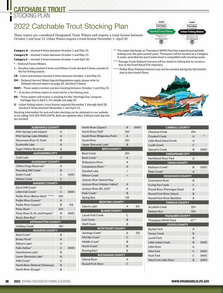
2022 VIRGINIA FRESHWATER FISHING & BOATING WWW.VIRGINIAWILDLIFE.GOV
CATCHABLE TROUTSTOCKING PLAN
Stocked Trout Waters
VDWR
Trout WaterNo Lure Restrictions
Trout License Required October 1 through June 15Minimum Size – 7 inches
NO CLOSED SEASON
Designated Stocked
Daily Limit – 6
2022 Catchable Trout Stocking PlanThese waters are considered Designated Trout Waters and require a trout license between October 1 and June 15. Urban Waters require a trout license November 1–April 30.
Urban Fishing Waters
VDWR
Trout WaterNo Lure Restrictions
Trout License Required November 1 through April 30TROUT: Daily Limit – 4 Fish
NO CLOSED SEASON
Designated Stocked
CATFISH: Daily Limit – 4 Fish
ALBEMARLE COUNTYMint Springs Lake (Upper) AMint Springs Lake (Middle) AMoormans River (S. Fork) BScottsville Lake ASugar Hollow Reservoir A
ALEXANDRIA CITYCook Lake U
ALLEGHANY COUNTYClifton Forge Reservoir* APounding Mill Creek* BSmith Creek* C (NSF)Wilson Creek C
AMHERST COUNTYDavis Mill Creek* CLittle Irish Creek* C (NSF)Pedlar River (Below dam)* ***** DHPedlar River (Lower)* APedlar River (Upper)* B (H)Piney River* DHPiney River (S. Fk. and Proper)* B (NSF)Rocky Row Run* C
APPOMATTOX COUNTYHolliday Creek DH
AUGUSTA COUNTYBack Creek* BBraley Pond* AElkhorn Lake* AFalls Hollow* C (NSF)Hearthstone Lake* BLower Sherando Lake* AMills Creek* CNorth River (Natural Chimneys) BNorth River (Gorge)* B
North River (Upper)* B (NSF)North River (Tail)* DHSouth River (Ridgeview Park) ASouth River DHUpper Sherando Lake* B
BATH COUNTYBack Creek DHBack Creek* ABullpasture River ACowpasture River* ADouthat Lake +Wilson Creek +Jackson River Special Reg.*Jackson River (Hidden Valley)* AJackson River (Rt. 623)* APads Creek* BSpring Run CR
BEDFORD COUNTYLiberty Lake A (H)
BLAND COUNTYLaurel Fork Creek CLick Creek BWolf Creek A
BOTETOURT COUNTYJennings Creek* A (H)McFalls Creek* CMiddle Creek* BNorth Creek* BRoaring Run* B
BUCHANAN COUNTYDismal River ARussell Fork River C
CARROLL COUNTYChestnut Creek DHCrooked Creek A **Little Reed Island Creek ALovills Creek CStewarts Creek B (NSF)
CHESAPEAKE CITYNorthwest River Park U
CRAIG COUNTYBarbours Creek* B (NSF)Potts Creek* A
DICKENSON COUNTYCranesnest River BFrying Pan Creek CPound River (Flannagan Dam) ARussell Fork River (Haysi) BRussell Fork River (Bartlick) A
FAIRFAX COUNTYAccotink Creek DHHolmes Run DH
FAUQUIER COUNTYThompson WMA Pond A***
FLOYD COUNTYBurkes Fork AGoose Creek BLaurel Fork BLittle Indian Creek B (NSF)Little River AMira Fork C (NSF)Rush Fork C (NSF)West Fork Little River B (NSF)
Category A – stocked 8 times between October 1 and May 31.Category B – stocked 5 times between October 1 and May 15.Category C – stocked 3 times between October 1 and April 30.* – National Forest Waters.+ – Douthat Lake stocked 4 times and Wilson Creek stocked 5 times outside of
the fee fishing season. CR – Catch and release-stocked 3 times between October 1 and May 31.DH – Delayed Harvest Water-Special Regulations apply, please refer to
Delayed Harvest waters on page 34. (stocked 3 times)(NSF) – These waters receive one less stocking between October 1 and May 31.** – A section of these waters is reserved for a fee fishing area.(H) – These waters will receive a stocking for the “Heritage Day” program.
Heritage Day is April 2. For details see page 35.U – Urban fishing waters, trout license required November 1 through April 30,
stocked 5 times between November 1 and April 15.Stocking information for put-and-take stocking can be obtained on our website or by calling 434-525-FISH (3474). Both are updated after 3:00 pm each day fish are stocked.
*** The water discharge on Thompson WMA Pond has experienced periodic leaking over the past several years. Thompson will be stocked as a Category A water, provided the pond water level is compatible with stocking needs.
**** Passage Creek Delayed Harvest will be closed to fishing due to construc-tion at the Front Royal Fish Hatchery.
***** Pedlar River Delayed Harvest may not be stocked during the fall months due to low stream flows.
36
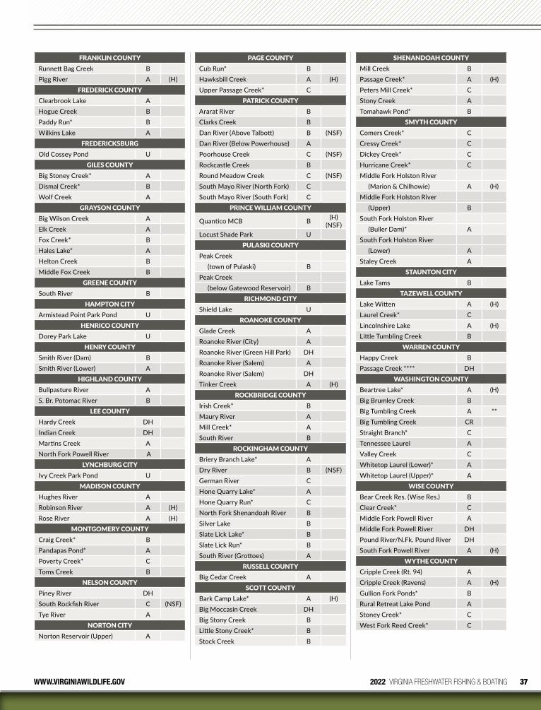
37WWW.VIRGINIAWILDLIFE.GOV 2022 VIRGINIA FRESHWATER FISHING & BOATING
FRANKLIN COUNTYRunnett Bag Creek BPigg River A (H)
FREDERICK COUNTYClearbrook Lake AHogue Creek BPaddy Run* BWilkins Lake A
FREDERICKSBURGOld Cossey Pond U
GILES COUNTYBig Stoney Creek* ADismal Creek* BWolf Creek A
GRAYSON COUNTYBig Wilson Creek AElk Creek AFox Creek* BHales Lake* AHelton Creek BMiddle Fox Creek B
GREENE COUNTYSouth River B
HAMPTON CITYArmistead Point Park Pond U
HENRICO COUNTYDorey Park Lake U
HENRY COUNTYSmith River (Dam) BSmith River (Lower) A
HIGHLAND COUNTYBullpasture River AS. Br. Potomac River B
LEE COUNTYHardy Creek DHIndian Creek DHMartins Creek ANorth Fork Powell River A
LYNCHBURG CITYIvy Creek Park Pond U
MADISON COUNTYHughes River ARobinson River A (H)Rose River A (H)
MONTGOMERY COUNTYCraig Creek* BPandapas Pond* APoverty Creek* CToms Creek B
NELSON COUNTYPiney River DHSouth Rockfish River C (NSF)Tye River A
NORTON CITYNorton Reservoir (Upper) A
PAGE COUNTYCub Run* BHawksbill Creek A (H)Upper Passage Creek* C
PATRICK COUNTYArarat River BClarks Creek BDan River (Above Talbott) B (NSF)Dan River (Below Powerhouse) APoorhouse Creek C (NSF)Rockcastle Creek BRound Meadow Creek C (NSF)South Mayo River (North Fork) CSouth Mayo River (South Fork) C
PRINCE WILLIAM COUNTY
Quantico MCB B (H) (NSF)
Locust Shade Park UPULASKI COUNTY
Peak Creek(town of Pulaski) B
Peak Creek(below Gatewood Reservoir) B
RICHMOND CITYShield Lake U
ROANOKE COUNTYGlade Creek ARoanoke River (City) ARoanoke River (Green Hill Park) DHRoanoke River (Salem) ARoanoke River (Salem) DHTinker Creek A (H)
ROCKBRIDGE COUNTYIrish Creek* BMaury River AMill Creek* ASouth River B
ROCKINGHAM COUNTYBriery Branch Lake* ADry River B (NSF)German River CHone Quarry Lake* AHone Quarry Run* CNorth Fork Shenandoah River BSilver Lake BSlate Lick Lake* BSlate Lick Run* BSouth River (Grottoes) A
RUSSELL COUNTYBig Cedar Creek A
SCOTT COUNTYBark Camp Lake* A (H)Big Moccasin Creek DHBig Stony Creek BLittle Stony Creek* BStock Creek B
SHENANDOAH COUNTYMill Creek BPassage Creek* A (H)Peters Mill Creek* CStony Creek ATomahawk Pond* B
SMYTH COUNTYComers Creek* CCressy Creek* CDickey Creek* CHurricane Creek* CMiddle Fork Holston River
(Marion & Chilhowie) A (H)Middle Fork Holston River
(Upper) BSouth Fork Holston River
(Buller Dam)* ASouth Fork Holston River
(Lower) AStaley Creek A
STAUNTON CITYLake Tams B
TAZEWELL COUNTYLake Witten A (H)Laurel Creek* CLincolnshire Lake A (H)Little Tumbling Creek B
WARREN COUNTYHappy Creek BPassage Creek **** DH
WASHINGTON COUNTYBeartree Lake* A (H)Big Brumley Creek BBig Tumbling Creek A **Big Tumbling Creek CRStraight Branch* CTennessee Laurel AValley Creek CWhitetop Laurel (Lower)* AWhitetop Laurel (Upper)* A
WISE COUNTYBear Creek Res. (Wise Res.) BClear Creek* CMiddle Fork Powell River AMiddle Fork Powell River DHPound River/N.Fk. Pound River DHSouth Fork Powell River A (H)
WYTHE COUNTYCripple Creek (Rt. 94) ACripple Creek (Ravens) A (H)Gullion Fork Ponds* BRural Retreat Lake Pond AStoney Creek* CWest Fork Reed Creek* C
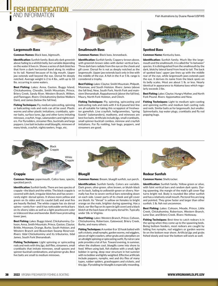
38 2022 VIRGINIA FRESHWATER FISHING & BOATING WWW.VIRGINIAWILDLIFE.GOV
FISH IDENTIFICATIONAND INFORMATION
Largemouth BassCommon Names: Black bass, bigmouth.
Identification: Sunfish family. Basically dark greenish above fading to a whitish belly, but variable depending on the water it lives in. Shows a series of dark blotches that form a dark horizontal band along its midline to its tail. Named because of its big mouth. Upper jaw extends well beyond the eye. Dorsal fin deeply notched. Average weight is 2 to 4 lbs., with up to 10 lbs. occurring in some waters.
Best Fishing: Lakes: Anna, Gaston, Buggs Island, Chickahominy, Chesdin, Smith Mountain, Prince, Briery Creek, Sandy River, Western Branch, Witten, and Flannagan. Rivers: Chickahominy (below Walkers Dam), and James (below the fall line).
Fishing Techniques: Fly, medium spincasting, spinning or baitcasting rods and reels can all be used. Plastic worms and other plastic imitations, crankbaits, spin-ner baits, surface lures, jigs and other lures imitating minnows, crayfish, frogs, salamanders and nightcrawl-ers. For flyrodders, streamer flies, bucktails and large poppers. Live bait includes small bluegills, minnows of many kinds, crayfish, nightcrawlers, frogs, etc.
CrappieCommon Names: papermouth, Calico bass, specks, speckled perch.
Identification: Sunfish family. There are two species of crappie—the black and the white. The black crappie is covered with dark, irregular blotches and has seven—rarely eight—dorsal spines. It shows more yellow and green on its sides and its caudal (tail) and anal fins are heavily flecked. The white crappie has six dorsal spines—rarely five—and it has noticeable vertical bars on its silvery sides as well as a light pearlescent color or iridescent blue and lavendar. Both have protruding lower jaws.
Best Fishing: Lakes: Buggs Island, Chickahominy, Co-hoon, Anna, Smith Mountain, Prince, Gaston, Claytor, Brittle, Moomaw, Orange, Burke, South Holston, and Western Branch and Beaverdam Swamp Reservoir. Rivers: tidal Chickahominy and its tributaries, tidal James, South Fork Shenandoah.
Fishing Techniques: Light spinning or spincasting rods and reels with tiny jigs, doll flies, streamers, small crankbaits that imitate minnows, small spoons and spinner-bucktail combinations, and spinner-grubs. Best live baits are small to medium minnows.
Smallmouth BassCommon Names: Black bass, bronzeback.
Identification: Sunfish family. Coppery-brown above, with greenish-brown sides with darker vertical bars. Three dark bars radiate from the eye on the cheek and gill cover. Dorsal fin is not as deeply notched as the largemouth. Upper jaw extends back only in line with the middle of the eye. A fish in the 4 or 5 lb. range is considered a trophy.
Best Fishing: Lakes: Claytor, Smith Mountain, Philpott, Moomaw, and South Holston. Rivers: James (above the fall line), New, South Fork, North Fork and main-stem Shenandoah, Rappahannock (above the fall line), Maury, North Fork Holston, and Clinch.
Fishing Techniques: Fly, spinning, spincasting and baitcasting rods and reels with 4 to 8 pound test line are all suitable for taking this scrappiest of freshwa-ter gamefish. Live crayfish, hellgrammites, “spring lizards” (salamanders), madtoms, and minnows are best live baits. Artificials include jigs, small crankbaits, small spinner-bucktail combos, minnow and crayfish imitations. For fly rodding, hair bugs, poppers, and streamers are good.
BluegillCommon Names: Bream, bluegill sunfish, sun perch.
Identification: Sunfish family. Colors are variable. Dark green, olive-green, olive brown, or bluish-black on its back, fading to yellowish-green or silvery. Nor-mally has five to seven vertical bars extending down on each side. Lower parts of its cheek and gill cover are bluish. Its “throat” is yellow on females to bright orange on the male, brighter during spawning. Has a black, ear-like flap on its opercle (gill cover) and a black blotch at the back base of its spiny dorsal fin. Typically under 1lb. in Virginia.
Best Fishing: Lakes: Western Branch, Prince, Cohoon, Chickahominy, Robertson, Gatewood, Briery Creek, Burke, and many others.
Fishing Techniques: A number 8 or 10 hook baited with soft crickets, small nymphs, garden worms, red wigglers, pieces of night crawlers, other grubs and caterpillars on an ultralight spinning or spincasting outfit, fly rod or cane pole provides a lot of fun. Toward evening, in summer, when the shallows cool, bluegills come into shore to feed. When using bait, fish shallow with a small, light bobber in spring, deep near structure in hot summer with no bobber and lightly weighted. Effective artificials include poppers, nymphs, wet and dry flies of many types, rubber spiders, grasshoppers and crickets, and tiny jigs. Flyrodding for bluegills is especially rewarding.
Spotted BassCommon Name: Kentucky bass.
Identification: Sunfish family. Much like the large-mouth and the smallmouth, it is called the “in-between” species. It is distinguished from the smallmouth by the dark, blotchy lateral band from head to tail. The back of spotted bass’ upper jaw lines up with the middle rear of the eye, while largemouth jaws extends past the eye. It derives its name from the black spots on its belly scales. Most are about 1 lb. or less. Nearly identical in appearance to Alabama bass which regu-larly exceeds 3 lbs.
Best Fishing: Lakes: Claytor, Hungry Mother, and North Fork Pound. Rivers: Appomattox and New.
Fishing Techniques: Light to medium spin-casting and spinning outfits and medium bait casting rods and reels. Similar baits as for largemouth, but smaller. Spinnerbaits, top water plugs, crankbaits and fly rod popping bugs.
Redear SunfishCommon Name: Shellcracker.
Identification: Sunfish family. Yellow-green or olive, with faint vertical bars and random dark spots. Dur-ing spawning, the margin of the male’s gill cover flap turns bright red. Body is rounded like other sunfish and has a relatively small mouth. Pectoral fins are long and pointed. They grow faster and larger than other sunfish; 1 lb. fish not uncommon.
Best Fishing: Lakes: Cohoon, Meade, Prince, Little Creek, Chickahominy, Robertson, Western Branch, Lone Star, and Briery Creek. Rivers: Nottoway.
Fishing Techniques: Best time to catch redears is in the spring when they come up to the spawning beds. Being bottom feeders, most redears are caught by letting live nymphs, red wigglers or garden worms lie on the bottom near shore. Artificial jigs and grubs fished slowly and near the bottom will work as well.
Fish illustrations by Duane Raver/USFWS
Black Crappie
White Crappie
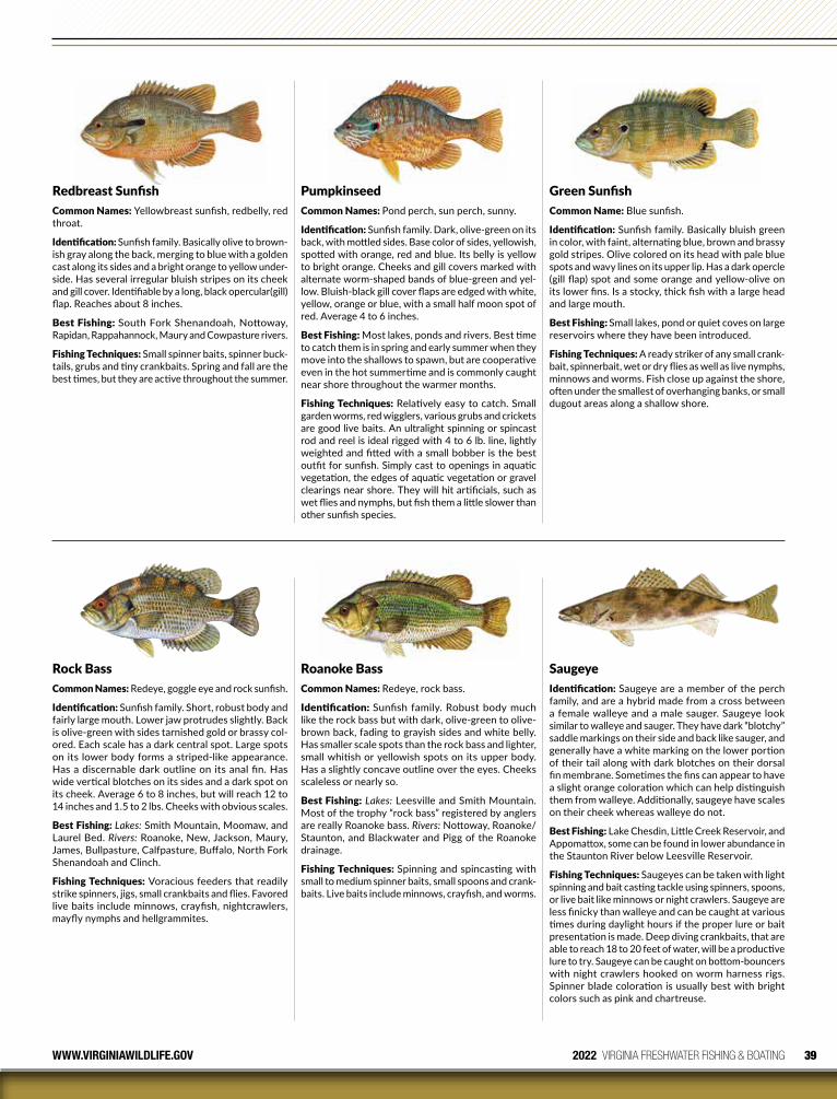
39WWW.VIRGINIAWILDLIFE.GOV 2022 VIRGINIA FRESHWATER FISHING & BOATING
Redbreast SunfishCommon Names: Yellowbreast sunfish, redbelly, red throat.
Identification: Sunfish family. Basically olive to brown-ish gray along the back, merging to blue with a golden cast along its sides and a bright orange to yellow under-side. Has several irregular bluish stripes on its cheek and gill cover. Identifiable by a long, black opercular(gill) flap. Reaches about 8 inches.
Best Fishing: South Fork Shenandoah, Nottoway, Rapidan, Rappahannock, Maury and Cowpasture rivers.
Fishing Techniques: Small spinner baits, spinner buck-tails, grubs and tiny crankbaits. Spring and fall are the best times, but they are active throughout the summer.
Rock BassCommon Names: Redeye, goggle eye and rock sunfish.
Identification: Sunfish family. Short, robust body and fairly large mouth. Lower jaw protrudes slightly. Back is olive-green with sides tarnished gold or brassy col-ored. Each scale has a dark central spot. Large spots on its lower body forms a striped-like appearance. Has a discernable dark outline on its anal fin. Has wide vertical blotches on its sides and a dark spot on its cheek. Average 6 to 8 inches, but will reach 12 to 14 inches and 1.5 to 2 lbs. Cheeks with obvious scales.
Best Fishing: Lakes: Smith Mountain, Moomaw, and Laurel Bed. Rivers: Roanoke, New, Jackson, Maury, James, Bullpasture, Calfpasture, Buffalo, North Fork Shenandoah and Clinch.
Fishing Techniques: Voracious feeders that readily strike spinners, jigs, small crankbaits and flies. Favored live baits include minnows, crayfish, nightcrawlers, mayfly nymphs and hellgrammites.
PumpkinseedCommon Names: Pond perch, sun perch, sunny.
Identification: Sunfish family. Dark, olive-green on its back, with mottled sides. Base color of sides, yellowish, spotted with orange, red and blue. Its belly is yellow to bright orange. Cheeks and gill covers marked with alternate worm-shaped bands of blue-green and yel-low. Bluish-black gill cover flaps are edged with white, yellow, orange or blue, with a small half moon spot of red. Average 4 to 6 inches.
Best Fishing: Most lakes, ponds and rivers. Best time to catch them is in spring and early summer when they move into the shallows to spawn, but are cooperative even in the hot summertime and is commonly caught near shore throughout the warmer months.
Fishing Techniques: Relatively easy to catch. Small garden worms, red wigglers, various grubs and crickets are good live baits. An ultralight spinning or spincast rod and reel is ideal rigged with 4 to 6 lb. line, lightly weighted and fitted with a small bobber is the best outfit for sunfish. Simply cast to openings in aquatic vegetation, the edges of aquatic vegetation or gravel clearings near shore. They will hit artificials, such as wet flies and nymphs, but fish them a little slower than other sunfish species.
Roanoke BassCommon Names: Redeye, rock bass.
Identification: Sunfish family. Robust body much like the rock bass but with dark, olive-green to olive-brown back, fading to grayish sides and white belly. Has smaller scale spots than the rock bass and lighter, small whitish or yellowish spots on its upper body. Has a slightly concave outline over the eyes. Cheeks scaleless or nearly so.
Best Fishing: Lakes: Leesville and Smith Mountain. Most of the trophy “rock bass” registered by anglers are really Roanoke bass. Rivers: Nottoway, Roanoke/Staunton, and Blackwater and Pigg of the Roanoke drainage.
Fishing Techniques: Spinning and spincasting with small to medium spinner baits, small spoons and crank-baits. Live baits include minnows, crayfish, and worms.
Green SunfishCommon Name: Blue sunfish.
Identification: Sunfish family. Basically bluish green in color, with faint, alternating blue, brown and brassy gold stripes. Olive colored on its head with pale blue spots and wavy lines on its upper lip. Has a dark opercle (gill flap) spot and some orange and yellow-olive on its lower fins. Is a stocky, thick fish with a large head and large mouth.
Best Fishing: Small lakes, pond or quiet coves on large reservoirs where they have been introduced.
Fishing Techniques: A ready striker of any small crank-bait, spinnerbait, wet or dry flies as well as live nymphs, minnows and worms. Fish close up against the shore, often under the smallest of overhanging banks, or small dugout areas along a shallow shore.
SaugeyeIdentification: Saugeye are a member of the perch family, and are a hybrid made from a cross between a female walleye and a male sauger. Saugeye look similar to walleye and sauger. They have dark “blotchy” saddle markings on their side and back like sauger, and generally have a white marking on the lower portion of their tail along with dark blotches on their dorsal fin membrane. Sometimes the fins can appear to have a slight orange coloration which can help distinguish them from walleye. Additionally, saugeye have scales on their cheek whereas walleye do not.
Best Fishing: Lake Chesdin, Little Creek Reservoir, and Appomattox, some can be found in lower abundance in the Staunton River below Leesville Reservoir.
Fishing Techniques: Saugeyes can be taken with light spinning and bait casting tackle using spinners, spoons, or live bait like minnows or night crawlers. Saugeye are less finicky than walleye and can be caught at various times during daylight hours if the proper lure or bait presentation is made. Deep diving crankbaits, that are able to reach 18 to 20 feet of water, will be a productive lure to try. Saugeye can be caught on bottom-bouncers with night crawlers hooked on worm harness rigs. Spinner blade coloration is usually best with bright colors such as pink and chartreuse.
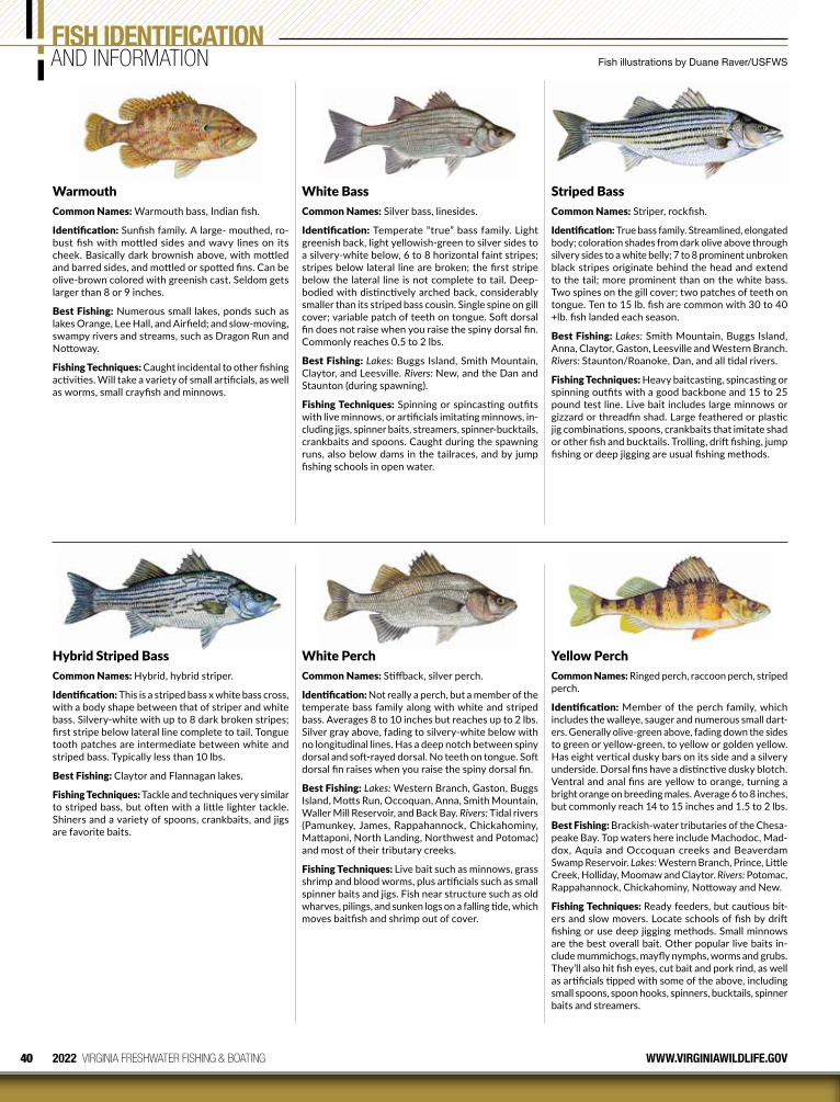
40 2022 VIRGINIA FRESHWATER FISHING & BOATING WWW.VIRGINIAWILDLIFE.GOV
FISH IDENTIFICATIONAND INFORMATION
Yellow PerchCommon Names: Ringed perch, raccoon perch, striped perch.
Identification: Member of the perch family, which includes the walleye, sauger and numerous small dart-ers. Generally olive-green above, fading down the sides to green or yellow-green, to yellow or golden yellow. Has eight vertical dusky bars on its side and a silvery underside. Dorsal fins have a distinctive dusky blotch. Ventral and anal fins are yellow to orange, turning a bright orange on breeding males. Average 6 to 8 inches, but commonly reach 14 to 15 inches and 1.5 to 2 lbs.
Best Fishing: Brackish-water tributaries of the Chesa-peake Bay. Top waters here include Machodoc, Mad-dox, Aquia and Occoquan creeks and Beaverdam Swamp Reservoir. Lakes: Western Branch, Prince, Little Creek, Holliday, Moomaw and Claytor. Rivers: Potomac, Rappahannock, Chickahominy, Nottoway and New.
Fishing Techniques: Ready feeders, but cautious bit-ers and slow movers. Locate schools of fish by drift fishing or use deep jigging methods. Small minnows are the best overall bait. Other popular live baits in-clude mummichogs, mayfly nymphs, worms and grubs. They’ll also hit fish eyes, cut bait and pork rind, as well as artificials tipped with some of the above, including small spoons, spoon hooks, spinners, bucktails, spinner baits and streamers.
WarmouthCommon Names: Warmouth bass, Indian fish.
Identification: Sunfish family. A large- mouthed, ro-bust fish with mottled sides and wavy lines on its cheek. Basically dark brownish above, with mottled and barred sides, and mottled or spotted fins. Can be olive-brown colored with greenish cast. Seldom gets larger than 8 or 9 inches.
Best Fishing: Numerous small lakes, ponds such as lakes Orange, Lee Hall, and Airfield; and slow-moving, swampy rivers and streams, such as Dragon Run and Nottoway.
Fishing Techniques: Caught incidental to other fishing activities. Will take a variety of small artificials, as well as worms, small crayfish and minnows.
Hybrid Striped BassCommon Names: Hybrid, hybrid striper.
Identification: This is a striped bass x white bass cross, with a body shape between that of striper and white bass. Silvery-white with up to 8 dark broken stripes; first stripe below lateral line complete to tail. Tongue tooth patches are intermediate between white and striped bass. Typically less than 10 lbs.
Best Fishing: Claytor and Flannagan lakes.
Fishing Techniques: Tackle and techniques very similar to striped bass, but often with a little lighter tackle. Shiners and a variety of spoons, crankbaits, and jigs are favorite baits.
White BassCommon Names: Silver bass, linesides.
Identification: Temperate “true” bass family. Light greenish back, light yellowish-green to silver sides to a silvery-white below, 6 to 8 horizontal faint stripes; stripes below lateral line are broken; the first stripe below the lateral line is not complete to tail. Deep-bodied with distinctively arched back, considerably smaller than its striped bass cousin. Single spine on gill cover; variable patch of teeth on tongue. Soft dorsal fin does not raise when you raise the spiny dorsal fin. Commonly reaches 0.5 to 2 lbs.
Best Fishing: Lakes: Buggs Island, Smith Mountain, Claytor, and Leesville. Rivers: New, and the Dan and Staunton (during spawning).
Fishing Techniques: Spinning or spincasting outfits with live minnows, or artificials imitating minnows, in-cluding jigs, spinner baits, streamers, spinner-bucktails, crankbaits and spoons. Caught during the spawning runs, also below dams in the tailraces, and by jump fishing schools in open water.
White Perch Common Names: Stiffback, silver perch.
Identification: Not really a perch, but a member of the temperate bass family along with white and striped bass. Averages 8 to 10 inches but reaches up to 2 lbs. Silver gray above, fading to silvery-white below with no longitudinal lines. Has a deep notch between spiny dorsal and soft-rayed dorsal. No teeth on tongue. Soft dorsal fin raises when you raise the spiny dorsal fin.
Best Fishing: Lakes: Western Branch, Gaston, Buggs Island, Motts Run, Occoquan, Anna, Smith Mountain, Waller Mill Reservoir, and Back Bay. Rivers: Tidal rivers (Pamunkey, James, Rappahannock, Chickahominy, Mattaponi, North Landing, Northwest and Potomac) and most of their tributary creeks.
Fishing Techniques: Live bait such as minnows, grass shrimp and blood worms, plus artificials such as small spinner baits and jigs. Fish near structure such as old wharves, pilings, and sunken logs on a falling tide, which moves baitfish and shrimp out of cover.
Striped BassCommon Names: Striper, rockfish.
Identification: True bass family. Streamlined, elongated body; coloration shades from dark olive above through silvery sides to a white belly; 7 to 8 prominent unbroken black stripes originate behind the head and extend to the tail; more prominent than on the white bass. Two spines on the gill cover; two patches of teeth on tongue. Ten to 15 lb. fish are common with 30 to 40 +lb. fish landed each season.
Best Fishing: Lakes: Smith Mountain, Buggs Island, Anna, Claytor, Gaston, Leesville and Western Branch. Rivers: Staunton/Roanoke, Dan, and all tidal rivers.
Fishing Techniques: Heavy baitcasting, spincasting or spinning outfits with a good backbone and 15 to 25 pound test line. Live bait includes large minnows or gizzard or threadfin shad. Large feathered or plastic jig combinations, spoons, crankbaits that imitate shad or other fish and bucktails. Trolling, drift fishing, jump fishing or deep jigging are usual fishing methods.
Fish illustrations by Duane Raver/USFWS
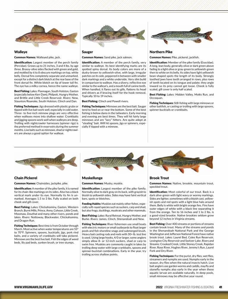
41WWW.VIRGINIAWILDLIFE.GOV 2022 VIRGINIA FRESHWATER FISHING & BOATING
Chain PickerelCommon Names: Chainsides, jackpike, pike.
Identification: A member of the pike family, it is named for its chain-like markings on its sides. Also has a black vertical mark under its eye. Normally its fin is un-marked. Averages 1.5 to 3 lbs. Fully scaled on both cheek and gill cover.
Best Fishing: Lakes: Chickahominy, Gaston, Western Branch, Burnt Mills, Prince, Anna, Cohoon, Little Creek, Moomaw, Douthat and many other rivers, ponds and lakes. Rivers: Nottoway, Black water, Chickahominy, and Dragon Run.
Fishing Techniques: Best time is from October through March. Most active when water temperatures are 55° to 70°F. Spinners, spoons, bucktails, jigs, pork rind baits, and a variety of crankbaits will take pickerel. Minnows are the best live bait. Fish the edges of weed beds, lily pad beds, sunken brush, or tree stumps.
SaugerCommon Names: Sand pike, jack salmon.
Identification: A member of the perch family, very similar to walleye. Its best identifying marks are its spotted spiny dorsal. Its body colors are more of a dusky-brown to yellowish-olive, with large, irregular patches on its side, peppered in between with smaller dark markings and a white underside. Very slim build in comparison to walleye. Has a silvery, reflective eye similar to the walleye’s, and a mouth full of canine teeth. When handled, it flares out its gills, flattens its head and shivers as if bracing itself for the hook removal. Typically 10 to 19 inches.
Best Fishing: Clinch and Powell rivers.
Fishing Techniques: Minnows are the best bait. Sauger tend to feed on or near the bottom. Some of the best fishing is below dams in the tailwaters. Early morning and evening are best times. They will hit fairly large minnows and are “lazy” hitters. Are quite adept at “stealing” bait. Will hit spoons, jigs or spinners, espe-cially if tipped with a minnow.
MuskellungeCommon Names: Musky, muskie.
Identification: Largest member of the pike family. Normally olive to dark gray on its back, with grayish to bluish to yellowish sides. Sides may have faint vertical bars, spots or blotches.
Feeding Habits: Muskies eat mainly other fishes, espe-cially soft-rayed species such as suckers, carp and shad, but also frogs, ducklings, muskrats and other mammals.
Best Fishing: Lakes: Rural Retreat, Hungry Mother, and Burke. Rivers: James, Clinch, Shenandoah and New.
Fishing Techniques: River fishermen use small boats with electric motors or small outboards to float larger pools and fish shoreline snags and submerged brush. Heavy bait casting rods and reels with 30+ lb. test line is used. Using large hooks, 4/0 or larger, some anglers simply allow 8- or 12-inch suckers, shad or carp to swim free. Muskies are commonly caught in lakes by trolling deep water with large crankbaits, spoons and spinner-bucktail combinations. Early in the year, try trolling across shallow points.
Northern PikeCommon Names: Pike, pickerel, jackfish.
Identification: Member of the pike family (Esocidae). A long, lean body, generally olive or dark green above fading to a light olive or gray-green to yellowish-green then to white on its belly. Its sides have light yellowish bean-shaped spots the length of its body. Strongly toothed jaws have teeth arranged in rows, plus rows of teeth located on its tongue and palate; they angle inward so its prey cannot get loose. Cheek is fully scaled, gill cover is only half scaled.
Best Fishing: Lakes: Hidden Valley, Motts Run, and Occoquan.
Fishing Techniques: Still-fishing with large minnows or other baitfish, or casting or trolling with large spoons, spinner-bucktails or crankbaits.
WalleyeCommon Names: Walleyed pike, jack.
Identification: Largest member of the perch family (Percidae). Grows up to 21 inches, 3 and 4 lbs. by age three. Brassy-olive sides flecked with green and gold, and mottled by 6 to 8 obscure markings on top, white belly. Dorsal fins completely separate and unmarked, except for a distinct dark blotch at the rear base of the front dorsal fin. White blotch on tip of lower tail fin. The eye has a milky cornea, hence the name walleye.
Best Fishing: Lakes: Flannagan, South Holston, Gaston (especially below Kerr Dam), Philpott, Hungry Mother, and Brittle and Little Creek Reservoir. Rivers: New, Staunton/Roanoke, South Holston, Clinch and Dan.
Fishing Techniques: Jigs dressed with plastic grubs or tipped with live bait work well, especially in cold water. Three- to five-inch minnow plugs are very effective when walleyes move into shallow water. Crankbaits and jigging spoons work well when walleyes are deep. Trolling with nightcrawler harnesses (spinner rigs) is the preferred method in reservoirs during the summer months. Live baits such as minnows, shad or nightcrawl-ers are always a good option for walleye.
Brook Trout Common Names: Native, brookie, mountain trout, speckled trout.
Identification: Most colorful of our trout. Back is a dark olive-green with light wavy or wormy markings. Sides are lighter, sometimes with a bluish cast, yellow-ish spots and red spots with a light blue halo around them. Belly is white with bright orange fins. Fins have outer edges of white with a black line separating it from the orange. Ten to 16 inches and 1 to 2 lbs. is a good-sized brookie. Native brookies seldom grow beyond 12 inches in Virginia streams.
Best Fishing: Over 400 streams or portions of streams contain brook trout. Many of the streams and ponds in the Shenandoah National Park and the George Washington and Jefferson National Forest have native brook trout. Lakes: Laurel Bed, Coles Run Reservoir, Lexington City Reservoir and Switzer Lake. Rivers and Streams: Crooked Creek, Little Stoney Creek, Rapidan River, Rose River, Hughes River, Jeremy’s Run, Laurel Fork and Dry River.
Fishing Techniques: For the purist, dry flies, wet flies, streamers and nymphs are used. Nymphs early in the season, dry flies when the natural insects hatch. Live bait anglers use garden worms and caddis, mayfly and stonefly nymphs also early in the year when these aquatic larvae are available naturally. In deep pools, small minnows may be effective year round.
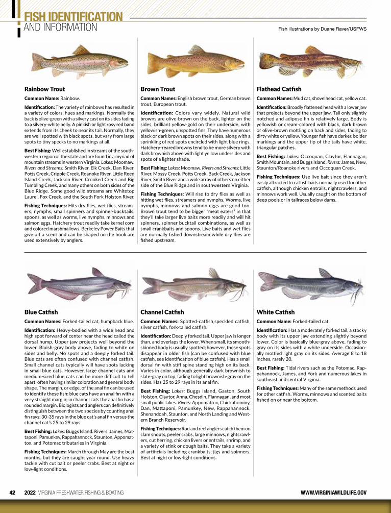
42 2022 VIRGINIA FRESHWATER FISHING & BOATING WWW.VIRGINIAWILDLIFE.GOV
Brown TroutCommon Names: English brown trout, German brown trout, European trout.
Identification: Colors vary widely. Natural wild browns are olive-brown on the back, lighter on the sides, brilliant yellow-gold on their underside, with yellowish-green, unspotted fins. They have numerous black or dark brown spots on their sides, along with a sprinkling of red spots encircled with light blue rings. Hatchery-reared browns tend to be more silvery with dark brownish above with light yellow undersides and spots of a lighter shade.
Best Fishing: Lakes: Moomaw. Rivers and Streams: Little River, Mossy Creek, Potts Creek, Back Creek, Jackson River, Smith River and a wide array of others on either side of the Blue Ridge and in southwestern Virginia.
Fishing Techniques: Will rise to dry flies as well as hitting wet flies, streamers and nymphs. Worms, live nymphs, minnows and salmon eggs are good too. Brown trout tend to be bigger “meat eaters” in that they’ll take larger live baits more readily and will hit spinners, spinner bucktail combinations, as well as small crankbaits and spoons. Live baits and wet flies are normally fished downstream while dry flies are fished upstream.
Blue CatfishCommon Names: Forked-tailed cat, humpback blue.
Identification: Heavy-bodied with a wide head and high spot forward of center near the head called the dorsal hump. Upper jaw projects well beyond the lower. Bluish-gray body above, fading to white on sides and belly. No spots and a deeply forked tail. Blue cats are often confused with channel catfish. Small channel cats typically will have spots lacking in small blue cats. However, large channel cats and medium-sized blue cats can be more difficult to tell apart, often having similar coloration and general body shape. The margin, or edge, of the anal fin can be used to identify these fish: blue cats have an anal fin with a very straight margin; in channel cats the anal fin has a rounded margin. Biologists and anglers can definitively distinguish between the two species by counting anal fin rays; 30-35 rays in the blue cat’s anal fin versus the channel cat’s 25 to 29 rays.
Best Fishing: Lakes: Buggs Island. Rivers: James, Mat-taponi, Pamunkey, Rappahannock, Staunton, Appomat-tox, and Potomac tributaries in Virginia.
Fishing Techniques: March through May are the best months, but they are caught year round. Use heavy tackle with cut bait or peeler crabs. Best at night or low-light conditions.
Channel Catfish Common Names: Spotted-catfish,speckled catfish, silver catfish, fork-tailed catfish.
Identification: Deeply forked tail. Upper jaw is longer than, and overlaps the lower. When small, its smooth-skinned body is usually spotted; however, these spots disappear in older fish (can be confused with blue catfish, see identification of blue catfish). Has a small dorsal fin with stiff spine standing high on its back. Varies in color, although generally dark brownish to slate-gray on top, fading to light brownish-gray on the sides. Has 25 to 29 rays in its anal fin.
Best Fishing: Lakes: Buggs Island, Gaston, South Holston, Claytor, Anna, Chesdin, Flannagan, and most small public lakes. Rivers: Appomattox, Chickahominy, Dan, Mattaponi, Pamunkey, New, Rappahannock, Shenandoah, Staunton, and North Landing and West-ern Branch Reservoir.
Fishing Techniques: Rod and reel anglers catch them on clam snouts, peeler crabs, large minnows, nightcrawl-ers, cut herring, chicken livers or entrails, shrimp, and a variety of stink or dough baits. They take a variety of artificials including crankbaits, jigs and spinners. Best at night or low-light conditions.
Flathead CatfishCommon Names: Mud cat, shovelhead cat, yellow cat.
Identification: Broadly flattened head with a lower jaw that projects beyond the upper jaw. Tail only slightly notched and adipose fin is relatively large. Body is yellowish or cream-colored with black, dark brown or olive-brown mottling on back and sides, fading to dirty white or yellow. Younger fish have darker, bolder markings and the upper tip of the tails have white, triangular patches.
Best Fishing: Lakes: Occoquan, Claytor, Flannagan, Smith Mountain, and Buggs Island. Rivers: James, New, Staunton/Roanoke rivers and Occoquan Creek.
Fishing Techniques: Use live bait since they aren’t easily attracted to catfish baits normally used for other catfish, although chicken entrails, nightcrawlers, and minnows work well. Usually caught on the bottom of deep pools or in tailraces below dams.
White CatfishCommon Name: Forked-tailed cat.
Identification: Has a moderately forked tail, a stocky body with its upper jaw extending slightly beyond lower. Color is basically blue-gray above, fading to gray on its sides with a white underside. Occasion-ally mottled light gray on its sides. Average 8 to 18 inches, rarely 20.
Best Fishing: Tidal rivers such as the Potomac, Rap-pahannock, James, and York and numerous lakes in southeast and central Virginia.
Fishing Techniques: Many of the same methods used for other catfish. Worms, minnows and scented baits fished on or near the bottom.
FISH IDENTIFICATIONAND INFORMATION Fish illustrations by Duane Raver/USFWS
Rainbow TroutCommon Name: Rainbow.
Identification: The variety of rainbows has resulted in a variety of colors, hues and markings. Normally the back is olive-green with a silvery cast on its sides fading to a silvery-white belly. A pinkish or light rosy red band extends from its cheek to near its tail. Normally, they are well spotted with black spots, but vary from large spots to tiny specks to no markings at all.
Best Fishing: Well established in streams of the south-western region of the state and are found in a myriad of mountain streams in western Virginia. Lakes: Moomaw. Rivers and Streams: Smith River, Elk Creek, Dan River, Potts Creek, Cripple Creek, Roanoke River, Little Reed Island Creek, Jackson River, Crooked Creek and Big Tumbling Creek, and many others on both sides of the Blue Ridge. Some good wild streams are Whitetop Laurel, Fox Creek, and the South Fork Holston River.
Fishing Techniques: Hits dry flies, wet flies, stream-ers, nymphs, small spinners and spinner-bucktails, spoons, as well as worms, live nymphs, minnows and salmon eggs. Hatchery trout readily take kernel corn and colored marshmallows. Berkeley Power Baits that give off a scent and can be shaped on the hook are used extensively by anglers.
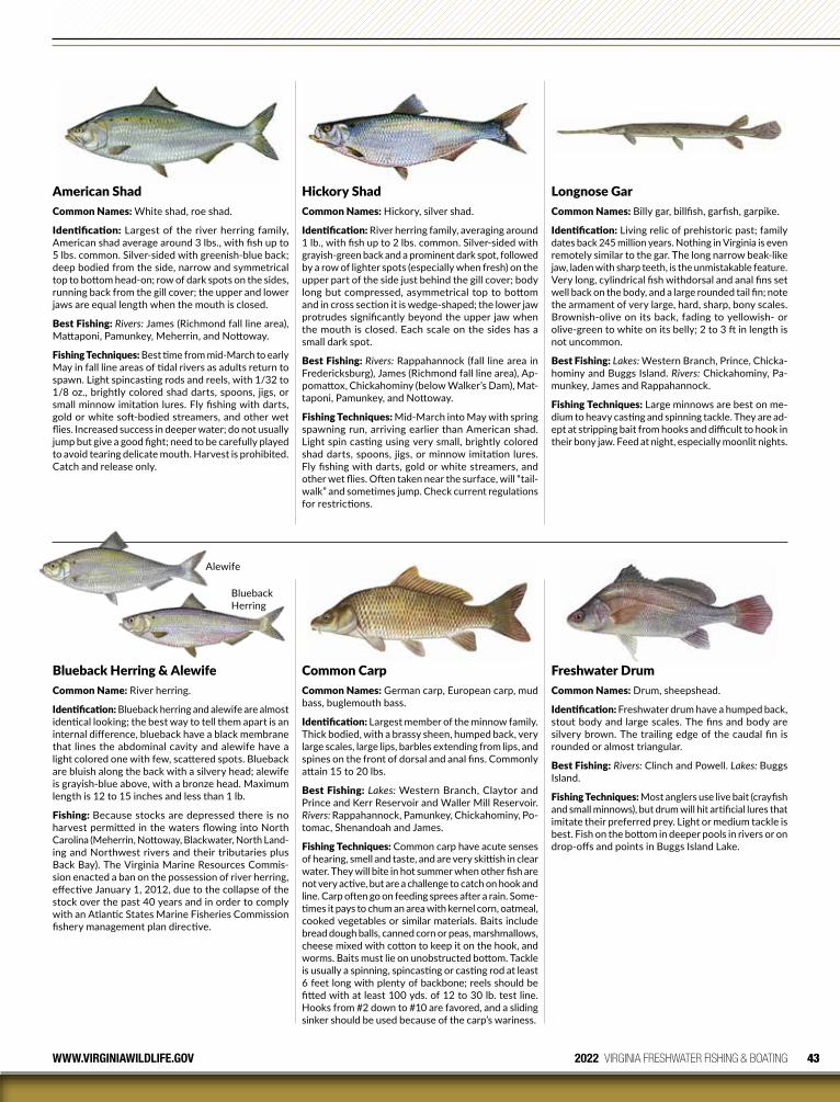
43WWW.VIRGINIAWILDLIFE.GOV 2022 VIRGINIA FRESHWATER FISHING & BOATING
American ShadCommon Names: White shad, roe shad.
Identification: Largest of the river herring family, American shad average around 3 lbs., with fish up to 5 lbs. common. Silver-sided with greenish-blue back; deep bodied from the side, narrow and symmetrical top to bottom head-on; row of dark spots on the sides, running back from the gill cover; the upper and lower jaws are equal length when the mouth is closed.
Best Fishing: Rivers: James (Richmond fall line area), Mattaponi, Pamunkey, Meherrin, and Nottoway.
Fishing Techniques: Best time from mid-March to early May in fall line areas of tidal rivers as adults return to spawn. Light spincasting rods and reels, with 1/32 to 1/8 oz., brightly colored shad darts, spoons, jigs, or small minnow imitation lures. Fly fishing with darts, gold or white soft-bodied streamers, and other wet flies. Increased success in deeper water; do not usually jump but give a good fight; need to be carefully played to avoid tearing delicate mouth. Harvest is prohibited. Catch and release only.
Blueback Herring & AlewifeCommon Name: River herring.
Identification: Blueback herring and alewife are almost identical looking; the best way to tell them apart is an internal difference, blueback have a black membrane that lines the abdominal cavity and alewife have a light colored one with few, scattered spots. Blueback are bluish along the back with a silvery head; alewife is grayish-blue above, with a bronze head. Maximum length is 12 to 15 inches and less than 1 lb.
Fishing: Because stocks are depressed there is no harvest permitted in the waters flowing into North Carolina (Meherrin, Nottoway, Blackwater, North Land-ing and Northwest rivers and their tributaries plus Back Bay). The Virginia Marine Resources Commis-sion enacted a ban on the possession of river herring, effective January 1, 2012, due to the collapse of the stock over the past 40 years and in order to comply with an Atlantic States Marine Fisheries Commission fishery management plan directive.
Hickory ShadCommon Names: Hickory, silver shad.
Identification: River herring family, averaging around 1 lb., with fish up to 2 lbs. common. Silver-sided with grayish-green back and a prominent dark spot, followed by a row of lighter spots (especially when fresh) on the upper part of the side just behind the gill cover; body long but compressed, asymmetrical top to bottom and in cross section it is wedge-shaped; the lower jaw protrudes significantly beyond the upper jaw when the mouth is closed. Each scale on the sides has a small dark spot.
Best Fishing: Rivers: Rappahannock (fall line area in Fredericksburg), James (Richmond fall line area), Ap-pomattox, Chickahominy (below Walker’s Dam), Mat-taponi, Pamunkey, and Nottoway.
Fishing Techniques: Mid-March into May with spring spawning run, arriving earlier than American shad. Light spin casting using very small, brightly colored shad darts, spoons, jigs, or minnow imitation lures. Fly fishing with darts, gold or white streamers, and other wet flies. Often taken near the surface, will “tail-walk” and sometimes jump. Check current regulations for restrictions.
Longnose GarCommon Names: Billy gar, billfish, garfish, garpike.
Identification: Living relic of prehistoric past; family dates back 245 million years. Nothing in Virginia is even remotely similar to the gar. The long narrow beak-like jaw, laden with sharp teeth, is the unmistakable feature. Very long, cylindrical fish withdorsal and anal fins set well back on the body, and a large rounded tail fin; note the armament of very large, hard, sharp, bony scales. Brownish-olive on its back, fading to yellowish- or olive-green to white on its belly; 2 to 3 ft in length is not uncommon.
Best Fishing: Lakes: Western Branch, Prince, Chicka-hominy and Buggs Island. Rivers: Chickahominy, Pa-munkey, James and Rappahannock.
Fishing Techniques: Large minnows are best on me-dium to heavy casting and spinning tackle. They are ad-ept at stripping bait from hooks and difficult to hook in their bony jaw. Feed at night, especially moonlit nights.
Common CarpCommon Names: German carp, European carp, mud bass, buglemouth bass.
Identification: Largest member of the minnow family. Thick bodied, with a brassy sheen, humped back, very large scales, large lips, barbles extending from lips, and spines on the front of dorsal and anal fins. Commonly attain 15 to 20 lbs.
Best Fishing: Lakes: Western Branch, Claytor and Prince and Kerr Reservoir and Waller Mill Reservoir. Rivers: Rappahannock, Pamunkey, Chickahominy, Po-tomac, Shenandoah and James.
Fishing Techniques: Common carp have acute senses of hearing, smell and taste, and are very skittish in clear water. They will bite in hot summer when other fish are not very active, but are a challenge to catch on hook and line. Carp often go on feeding sprees after a rain. Some-times it pays to chum an area with kernel corn, oatmeal, cooked vegetables or similar materials. Baits include bread dough balls, canned corn or peas, marshmallows, cheese mixed with cotton to keep it on the hook, and worms. Baits must lie on unobstructed bottom. Tackle is usually a spinning, spincasting or casting rod at least 6 feet long with plenty of backbone; reels should be fitted with at least 100 yds. of 12 to 30 lb. test line. Hooks from #2 down to #10 are favored, and a sliding sinker should be used because of the carp’s wariness.
Freshwater DrumCommon Names: Drum, sheepshead.
Identification: Freshwater drum have a humped back, stout body and large scales. The fins and body are silvery brown. The trailing edge of the caudal fin is rounded or almost triangular.
Best Fishing: Rivers: Clinch and Powell. Lakes: Buggs Island.
Fishing Techniques: Most anglers use live bait (crayfish and small minnows), but drum will hit artificial lures that imitate their preferred prey. Light or medium tackle is best. Fish on the bottom in deeper pools in rivers or on drop-offs and points in Buggs Island Lake.
Blueback Herring
Alewife

44 2022 VIRGINIA FRESHWATER FISHING & BOATING WWW.VIRGINIAWILDLIFE.GOV
DO YOU KNOW THE DIFFERENCE?
BowfinCommon Names: Grindle, grinnel.
Identification: Bowfin are living relics, with primitive roots back 70 million years ago. Has a long, soft-rayed dorsal which arches in a bow over most of the length of its body. Tail is rounded, with distinct black spot rimmed with orange on males; black spot on females faint or absent and no orange rim. Its back and sides are brownish-green or olive-green, with mottled sides fading to yellowish or white. During spawning, its un-derside turns a bright yellow-green. Has a cylindrical body and a wide flattened head, almost snake-like, with deep-set dark eyes. Snout is rounded with short nasal barbels. Mouth is large and has conical-shaped teeth. Note: While the bowfin shares similar coloration and body shape with the northern snakehead (recently introduced to the Potomac River), the anal fin of a bowfin is much shorter than that of the snakehead, and snakeheads will not have the spot found on bowfin.
Best Fishing: Lakes: Chickahominy, Cohoon, Little Creek and Diascund. Rivers: Chickahominy, Mattaponi, Pamunkey, Nottoway and Blackwater.
Fishing Techniques: They are strong, mus cular fighters and strike at all manner of live bait and many artificials. Often fools an angler into thinking it’s whipped, and then suddenly explodes back to life. Minnows and a variety of jigs are best baits. Spinner baits and bass jigs work well for summertime bowfin; in winter, vertical jigging spoons and blade baits can be effective. Use a good stiff rod with at least 15-lb test line. Steel leaders may be necessary and don’t try to lip hold these fish! Food value is generally considered poor.
FISH IDENTIFICATIONAND INFORMATION Fallfish illustration © Michael Simon. All other fish illustrations by Duane Raver/USFWS.
Anglers are encouraged to contact DWR with all snakehead catches but are required to call if they plan to keep a legally caught fish, which must be killed before being taken into possession.
804-367-2925
Pelvic fins close to pectoral fins and gills
Pelvic fins set back from gills and pectoral fins
Short anal fin
Black spot at base of tail
Extended anal fin
Northern Snakehead
Bowfin
Similar-Appearing Native Species
FallfishCommon Names: Shenandoah tarpon, James River bonefish.
Identification: The largest native minnow in the east-ern United States. This fish is known for its silvery sides and torpedo-shaped body. Fallfish sometimes have a bronze tint with a darker gray to brown back and light white underside. This species has a forked tail and during the spawning season, males will develop tubercles, bumps, on their snout in addition to a light pink tone along their gill plates and sides to attract females. Fallfish play an integral role in the aquatic community as males build a large stone nest mound that become communal spawning sites benefiting a variety of other stream species. Juvenile fallfish will have a dark stripe along their sides extending from their gill plate to their tailfin. Can reach lengths of 18 inches or more and weigh over two pounds.
Best Fishing: James, York, Rappahannock, Shenan-doah, and Potomac drainages. This fish is one of the most common species on our warmwater rivers and streams across the Piedmont and they are often found in the lower reaches of habitable trout water.
Fishing Techniques: Fallfish can be caught with a variety of techniques from bait fishing to artificials. Anglers fishing with bait will have success with worms, minnows, or scented baits. Anglers fishing with spin-ning rods will catch fallfish on mepps spinners, rooster tails, and joe’s flies. They will take small swimbaits and crankbaits too. Anglers fishing with a fly rod will find them with a variety of approaches including dry flies, nymphs, and streamers. Flashy beadhead nymphs and bright woolly buggers work particularly well and anglers will be surprised by how hard fallfish fight.
FlierCommon Names: Round sunfish, millpond flier.
Identification: Sunfish family. A deep-bodied, almost round fish, with many spines on both dorsal and anal fins. Color is a yellow-green or brassy-olive to brown-ish-gold, with a dark brown to black spot on each scale, appearing as rows of spots. A dark vertical streak extends downward from the eye to the lower edge of its cheek. It has large, rounded fins, much like a crappie, with a head and mouth similar in shape to a bluegill’s. Slow growing, they reach up to 10 inches in length.
Best Fishing: Lakes: Drummond, Airfield, Harrison, Kilby, Cohoon, Meade, and Motts Run. Rivers: Dismal Swamp Canal, Nottoway, and Blackwater.
Fishing Techniques: Most are probably caught in-cidentally by fishermen fishing for crappies in early spring. They will hit dry and wet flies, as well as small minnows and worms using typical small panfish rigs. Fish around stumps, sunken brush, cypress trunks and knees, and near or under bridges.
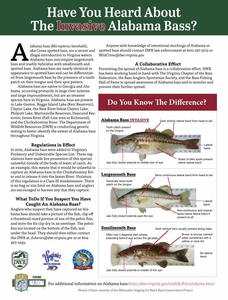
A labama bass (Micropterus henshalli), aka Coosa spotted bass, are a recent and illegal introduction to Virginia waters. Alabama bass outcompete largemouth
bass and readily hybridize with smallmouth and spotted bass. Alabama bass are nearly identical in appearance to spotted bass and can be differentiat-ed from largemouth bass by the presence of a tooth patch on their tongue and their spot pattern. Alabama bass are native to Georgia and Ala-bama, occurring primarily in large river systems and large impoundments, but are an invasive species here in Virginia. Alabama bass are present in Lake Gaston, Buggs Island Lake (Kerr Reservoir), Claytor Lake, the New River below Claytor Lake, Philpott Lake, Martinsville Reservoir, Diascund Res-ervoir, James River (Fall-Line area in Richmond), and the Chickahominy River. The Department of Wildlife Resources (DWR) is conducting genetic testing to better identify the extent of Alabama bass throughout Virginia.
Regulations in Effect In 2021, Alabama bass were added to Virginia’s Predatory and Undesirable Species List. These reg-ulations have made live possession of this species unlawful outside of the body of water of catch. As an example, this means that it would be unlawful to capture an Alabama bass in the Chickahominy Riv-er and to release it into the James River. Violation of this regulation is a Class III misdemeanor. There is no bag or size limit on Alabama bass and anglers are encouraged to harvest any that they capture.
What ToDo If You Suspect You Have Caught An Alabama Bass?
Anglers who suspect they have captured an Ala-bama bass should take a picture of the fish, clip off a thumbnail-sized portion of one of the pelvic fins, and store the fin clip dry in an envelope. The pelvic fins are located on the bottom of the fish, just under the head. They should then either contact the DWR at: [email protected] or at 804-367-1293.
Anyone with knowledge of intentional stockings of Alabama or spotted bass should contact DWR law enforcement at 800-237-5712 or [email protected].
A Collaborative EffortPreventing the spread of Alabama bass is a collaborative effort. DWR has been working hand in hand with The Virginia Chapter of the Bass Federation, the Bass Anglers Sportsman Society, and the Bass Fishing Hall of Fame to spread awareness of Alabama bass and to monitor and prevent their further spread.
Have You Heard About The InvasiveInvasive Alabama Bass?
For additional information on Alabama bass:https://dwr.virginia.gov/wildlife/fish/alabama-bass/
Do You Know The Difference?
Smallmouth Bass
Alabama Bass INVASIVE
Jaw fully closed extends to middle rear of eye
Dark blotchy lateral band from head to tail
Rows of dark spots present below lateral band
Tooth patch present on the tongue
Largemouth Bass
Lateral band
Dark vertical bars usually present along sides
Jaw fully closed extends past the eye
More continuous lateral band from head to tail
Non-continuous and uneven spots below lateral band if present at all.
Generally lacks tooth patch on the tongue
Lateral band
Jaw fully closed extends to middle of the eye
Brown to bronze colored sides sometimes with a yellow or olive tint
Often has 3 diagonal dark stripes extending behind eye across the gill plate
Photos of bass courtesy of the iNaturalist Angling for Black Bass Conservation Project
No lateral band
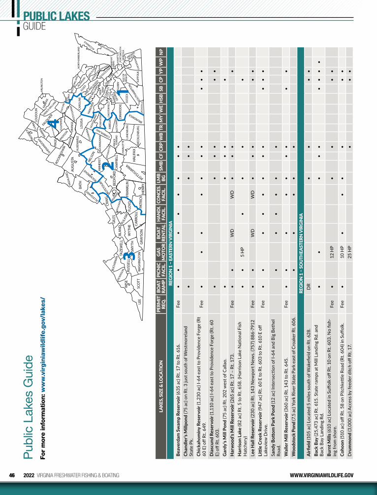
46 2022 VIRGINIA FRESHWATER FISHING & BOATING WWW.VIRGINIAWILDLIFE.GOV
PUBLIC LAKESGUIDE
LEE
SC
OTT
WIS
E
DIC
KEN
SON
BUC
HA
NA
N
RUSS
ELL
WA
SHIN
GTO
N
TAZ
EWEL
L
SMY
TH
GR
AYSO
N
WY
THE
BLA
ND
CA
RRO
LL
PATR
ICK
FLO
YD
PULA
SKI
GIL
ES
HEN
RY
FRA
NK
LIN
MO
NTG
OM
ERY
CRA
IG
ROANOKE
BED
FORD
PITTSYLVANIA
HA
LIFA
X
CA
MPB
ELL
BOTE
TOURT
A
MH
ERST
ALLEGHANY
BAT
H ROCKBRID
GE
AU
GU
STA
NEL
SON
HIG
HLA
ND
ROCK
ING
HA
M
SHEN
ANDOAH
FRED
ERIC
K CLA
RKE
WAR
REN
PAG
E RA
PPA
HA
NN
OC
K
MADIS
ON CU
LPEP
ER
FAUQUIE
R
LOU
DO
UN
PRINCE W
ILLIA
M
FAIR
FAX
ARL
ING
TON
STA
FFO
RD
KIN
G
GEO
RGE
ORA
NG
E SP
OTS
YLVA
NIA
CA
ROLI
NE
LOU
ISA
A
LBEM
ARL
E
FLU
VAN
NA
BU
CK
ING
HA
M
APP
OM
ATTO
X
CH
ARL
OTT
E
PRIN
CE
ED
WA
RD
LUN
ENB
URG
NO
TTO
WAY
AM
ELIA
CUMBERLAND
POW
HAT
AN
GO
OCH
LAN
D H
AN
OVE
R
DIN
WID
DIE
CH
ESTE
RFIE
LD
MEC
KLE
NB
URG
BRUNSWICK GRE
ENSV
ILLE
SOU
THAM
PTO
N
SUSS
EX
SURR
Y IS
LE O
F W
IGH
T
SUFF
OLK
C
HES
APE
AKE
VIRGINIA
BEACH
NO
RFO
LK
PORT
SMO
UTH
H
AM
PTO
N
NEW
PORT
N
EWS
PRIN
CE
GEO
RGE
CH
ARL
ES
CIT
Y
JAMES
CITY
YORK
HENRICO N
EW
K
ENT
KIN
G W
ILLI
AM
KING A
ND QUEEN
GLOUCESTER
NORTHAMPTON
ACCOMACK
MATHEWS
MID
DLESE
X
LANCAST
ER N
ORT
HU
MB
ERLA
ND
WES
TMO
RELA
ND
RIC
HMO
ND
ESSE
X
GRE
ENE
4
32
1
Pub
lic L
akes
Gui
deFo
r m
ore
info
rmat
ion: w
ww
.vir
gin
iaw
ildlif
e.g
ov/l
akes/
LAKE
S, S
IZE
& LO
CATI
ON
PERM
IT
REQ
. BO
AT
RAM
PPI
CNIC
FA
CIL.
GAS
MO
TOR
BOAT
RE
NTA
LH
AND
I. FA
CIL.
CON
CES.
FA
CIL.
LMB
BGSM
BCF
CRP
WB
TRM
YW
EH
SBSB
CPYP
WP
NP
REGI
ON
1 –
EAS
TERN
VIR
GIN
IABe
aver
dam
Sw
amp
Rese
rvoi
r (63
5 ac
) Rt.
17 to
Rt.
616.
Fee
••
••
••
••
Chan
dler
’s M
illpo
nd (7
5 ac
) on
Rt. 3
just
sou
th o
f Wes
tmor
elan
d St
ate
Pk.
••
••
Chic
kaho
min
y Re
serv
oir (
1,23
0 ac
) I-6
4 ea
st to
Pro
vide
nce
Forg
e (R
t 60
E) o
ff Rt
. 649
.Fe
e•
••
••
••
••
•
Dia
scun
d Re
serv
oir (
1,11
0 ac
) I-6
4 ea
st to
Pro
vide
nce
Forg
e (R
t. 60
E)
off
Rt. 6
03.
••
••
••
Gar
dy’s
Mill
Pon
d (7
5 ac
) Rt.
202
wes
t of C
alla
o.•
••
••
Har
woo
d’s M
ill R
eser
voir
(265
ac)
Rt.
17 –
Rt.
173.
Fee
••
WD
WD
••
••
Har
rison
Lak
e (8
2 ac
) Rt.
5 to
Rt.
658.
(Har
rison
Lak
e N
ation
al F
ish
Hat
cher
y)•
•5
HP
••
••
Lee
Hal
l Res
ervo
ir (2
30 a
c) R
t. 14
3 N
ewpo
rt N
ews.
(757
) 886
-791
2Fe
e•
•W
DW
D•
••
••
Litt
le C
reek
Res
ervo
ir (9
47 a
c) R
t. 60
E to
Rt.
603
to R
t. 61
0 E
off
Lake
view
Driv
e.Fe
e•
••
••
••
••
••
Sand
y Bo
ttom
Par
k Po
nd (1
2 ac
) Int
erse
ction
of I
-64
and
Big
Beth
el
Road
.•
••
••
•
Wal
ler M
ill R
eser
voir
(360
ac)
Rt.
143
to R
t. 64
5.Fe
e•
••
••
••
••
Woo
dsto
ck P
ond
(7.5
ac)
Yor
k Ri
ver S
tate
Par
k ea
st o
f Cro
aker
Rt.
606.
••
••
•RE
GIO
N 1
– S
OU
THEA
STER
N V
IRGI
NIA
Airfi
eld
(105
ac)
Loc
ated
5 m
iles s
outh
of W
akefi
eld
on R
t. 62
8.D
R•
••
•Ba
ck B
ay (2
5,47
3 ac
) Rt.
615.
Sta
te ra
mps
at M
ill L
andi
ng R
d. a
nd
Back
Bay
Lan
ding
Rd.
••
••
••
••
•
Burn
t Mill
s (61
0 ac
) Loc
ated
in S
uffol
k off
Rt.
10 o
n Rt
. 603
. No
fish-
ing
from
sho
re.
Fee
•12
HP
••
••
Coho
on (5
10 a
c) o
ff Rt
. 58
on P
itchk
ettle
Roa
d (R
t. 60
4) in
Suff
olk.
Fe
e•
10 H
P•
••
••
•D
rum
mon
d (3
,000
ac)
Acc
ess b
y fe
eder
ditc
h off
Rt.
17.
25 H
P•
••

47WWW.VIRGINIAWILDLIFE.GOV 2022 VIRGINIA FRESHWATER FISHING & BOATING
LAKE
S, S
IZE
& LO
CATI
ON
PERM
IT
REQ
. BO
AT
RAM
PPI
CNIC
FA
CIL.
GAS
MO
TOR
BOAT
RE
NTA
LH
AND
I. FA
CIL.
CON
CES.
FA
CIL.
LMB
BGSM
BCF
CRP
WB
TRM
YW
EH
SBSB
CPYP
WP
NP
Empo
ria (2
10 a
c) W
est o
f I-9
5 on
Rt.
611.
•10
HP
••
•Lo
ne S
tar (
490
ac) F
ishi
ng s
tatio
n lo
cate
d off
Rt.
10 o
n Rt
. 125
in
Suffo
lk.
Fee
••
••
••
•
Mea
de (5
12 a
c) F
ishi
ng s
tatio
n (b
ait s
ales
). Lo
cate
d off
Rt.
58 o
n Pi
tchk
ettle
Rd.
(Rt.
604
) in
Suffo
lk.
Fee
•10
HP
••
••
••
••
•
Oak
Gro
ve L
ake
(70
ac) B
yron
Str
eet o
ff Vo
lvo
Park
way
in C
hesa
-pe
ake.
Sho
re F
ishi
ng.
••
•
Prin
ce (7
77 a
c) O
ff Rt
. 460
on
Lake
Prin
ce (R
t. 60
4) in
Suff
olk.
Fee
•12
HP
••
••
••
Smith
(222
ac)
Boa
t ram
p lo
cate
d on
Rt.
13 (N
orth
ham
pton
Blv
d.) i
n Va
. Bea
ch.
Fee
••
12 H
P•
••
••
•
Spei
ghts
Run
(197
ac)
Loc
ated
on
Rt. 6
46 o
ff Rt
. 58
in S
uffol
k. N
o sh
ore
fishi
ng.
Fee
•10
HP
••
•
Tras
hmor
e (5
2 ac
) Loc
ated
off
Va. B
each
Exp
. in
Va. B
each
. No
priv
ate
boat
s.•
••
••
•
Wes
tern
Bra
nch
(1,5
79 a
c) 2
boa
t ram
ps lo
cate
d off
Rt.
603
and
Rt.
605
in S
uffol
k.Fe
e•
12 H
P•
••
••
••
•
REGI
ON
1 –
CEN
TRAL
VIR
GIN
IABr
yan
Park
Lak
es (1
2 ac
) Ric
hmon
d, H
erm
itage
Rd/
Lake
side
Ave
. to
Brya
n Pa
rk.
••
••
Ches
din
(3,1
00 a
c) I-
95 to
I-85
S to
Rt.
460
W to
Rt.
623
N to
Rt.
601
W to
Rt.
776
N.
••
••
••
••
••
••
Hen
rico
Coun
ty P
ark
Lake
sC
rum
p Pa
rk (2
ac)
Sta
ples
Mill
Rd.
(33
W) t
o C
ourt
ney
Road
•
••
•D
eep
Run
Park
(2) (
2 ac
) I-6
4 to
S. G
aski
ns R
d. to
Rid
gefie
ld
Park
way
.•
••
•
Dor
ey P
ark
(5 a
c) O
ff D
arby
tow
n Rd
.•
••
••
Thre
e La
kes P
ark
(3) (
4 ac
) off
Rt. 3
01 N
to W
ilkin
son
Rd.
••
••
•La
kevi
ew (4
2 ac
) Rt.
1 to
Pic
kett
St.
••
••
•Sh
ield
s (7
ac) i
n By
rd P
ark
in R
ichm
ond.
••
••
•Sw
an (1
3 ac
) in
Byrd
Par
k in
Ric
hmon
d.•
••
•Sw
ift C
reek
(156
ac)
Poc
ahon
tas S
tate
Par
k, R
t. 10
to R
t. 65
5 (B
each
Rd
.) to
Rt.
780.
••
••
••
••
•
Will
cox
Lake
(22
ac) I
-85
to S
quirr
el L
evel
Rd
east
to D
efen
se R
d to
Le
e M
emor
ial P
ark.
••
••
•
REGI
ON
2 –
SO
UTH
SID
E VI
RGIN
IAA
mel
ia (1
00 a
c) fr
om R
t. 36
0 ta
ke R
t. 60
4 N
to R
t. 61
6 to
Rt.
652.
••
••
•Ba
nist
er (4
00 a
c) R
t. 50
1 ju
st n
orth
of H
alifa
x.•
••
••
•Be
ar C
reek
(42
ac) R
t. 60
W to
Rt.
622
to R
t. 62
9.SP
••
••
••
••
KEY
BG –
Blu
egill
CF –
Cat
fish
CL –
Ram
p C
lose
d–A
noth
er
to b
e bu
ilt in
ano
ther
lo
catio
n
CP –
Cha
in P
icke
rel
CRP
– C
rapp
ieD
R –
Dirt
Ram
pFP
– F
ishi
ng P
ier
HSB
– H
ybrid
Str
iped
Bas
s
KB
– Ke
ntuc
ky S
pott
ed B
ass
LMB
– La
rgem
outh
Bas
sM
Y –
Mus
kellu
nge
NF
– N
ation
al F
ores
tN
P –
Nor
ther
n Pi
ke
PK –
Par
king
PR –
Prim
itive
Ram
pRB
r – R
edbr
east
Sun
fish
SB –
Str
iped
Bas
sSF
– S
tate
For
est P
erm
it
SL –
25
mph
Spe
ed L
imit
SMB
– Sm
allm
outh
Bas
sSP
– S
tate
Par
k Fe
eSW
– S
wim
min
gTR
– T
rout
WB
– W
hite
Bas
sW
D –
Wee
kend
s Onl
yW
E –
Wal
leye
WP
– W
hite
Per
chYP
– Y
ello
w P
erch
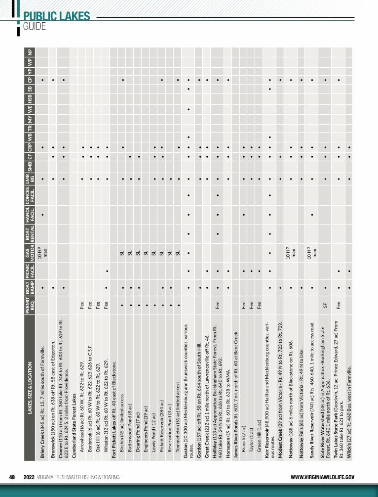
48 2022 VIRGINIA FRESHWATER FISHING & BOATING WWW.VIRGINIAWILDLIFE.GOV
LAKE
S, S
IZE
& LO
CATI
ON
PERM
IT
REQ
. BO
AT
RAM
PPI
CNIC
FA
CIL.
GAS
MO
TOR
BOAT
RE
NTA
LH
AND
I. FA
CIL.
CON
CES.
FA
CIL.
LMB
BGSM
BCF
CRP
WB
TRM
YW
EH
SBSB
CPYP
WP
NP
Brie
ry C
reek
(845
ac)
Rt.
15, 7
mile
s sou
th o
f Far
mvi
lle.
•10
HP
max
••
••
Brun
swic
k (1
50 a
c) o
n Rt
. 638
off
Rt. 5
8 ea
st o
f Edg
erto
n.•
••
••
Conn
er (1
10 a
c) fr
om R
t. 36
0 ta
ke R
t. 74
6 to
Rt.
603
to R
t. 61
9 to
Rt.
623
E to
Rt.
624
S, 2
mile
s fro
m P
rovi
denc
e.•
••
••
Cum
berla
nd S
tate
For
est L
akes
Arro
whe
ad (6
ac)
Rt.
60 W
, Rt.
622
to R
t. 62
9.Fe
e•
••
Bonb
rook
(6 a
c) R
t. 60
W to
Rt.
622-
623-
626
to C
.S.F
.Fe
e•
••
Oak
Hill
(6 a
c) R
t. 60
W to
Rt.
622
to R
t. 62
9.Fe
e•
••
Win
ston
(12
ac) R
t. 60
W to
Rt.
622
to R
t. 62
9.Fe
e•
••
••
Fort
Pic
kett
Lak
es o
ff Rt
. 40
east
of B
lack
ston
e.
Birc
hin
(45
ac) l
imite
d ac
cess
••
SL•
••
Butt
erw
ood
Pond
(8 a
c)•
•SL
••
Dea
ring
Pond
(7 a
c)•
•SL
••
Engi
neer
s Pon
d (1
9 ac
)•
SL
Lew
is Po
nd (
12 a
c)•
SL•
••
Pick
ett R
eser
voir
(384
ac)
••
SL•
••
•
Rese
rvati
on P
ond
(3 a
c)•
•SL
•To
mm
ehet
on (5
1 ac
) lim
ited
acce
ss•
SL•
••
Gas
ton
(20,
300
ac) M
eckl
enbu
rg a
nd B
runs
wic
k co
untie
s, va
rious
ro
utes
.•
••
••
••
••
••
••
Gor
don
(157
ac)
off
Rt. 5
8 on
Rt.
664
sout
h of
Sou
th H
ill.
•
••
••
Gre
at C
reek
(212
ac)
1 m
ile n
orth
of L
awre
ncev
ille
off R
t. 46
. •
••
••
•
Hol
liday
(113
ac)
App
omatt
ox-B
ucki
ngha
m S
tate
For
est.
From
Rt.
460
take
Rt.
24 N
to R
t. 62
6 to
Rt.
640
to R
t. 69
2.Fe
e•
••
••
••
••
Hor
sepe
n (1
9 ac
) Rt.
60 to
Rt.
638
to W
MA
.•
••
••
•
Jam
es R
iver
Pon
ds R
t. 60
7, 7
mi.
nort
h of
Rt.
60 a
t Ben
t Cre
ek.
Bran
ch (7
ac)
Fee
••
••
•
Tayl
or (1
ac)
Fee
••
••
Gre
en H
ill (1
ac)
Fee
••
••
Kerr
Res
ervo
ir (4
8,90
0 ac
) Hal
ifax
and
Mec
klen
burg
cou
nties
, var
i-ou
s rou
tes.
••
••
••
••
••
••
Mod
est C
reek
(29
ac) f
rom
Vic
toria
- Rt
. 49
N to
Rt.
723
to R
t. 73
9.
••
••
Nott
oway
(188
ac)
6 m
iles n
orth
of B
lack
ston
e on
Rt.
606.
•10
HP
max
•
••
•
Nott
oway
Fal
ls (6
0 ac
) fro
m V
icto
ria -
Rt. 4
9 N
to la
ke.
••
••
•
Sand
y Ri
ver R
eser
voir
(740
ac)
Rts
. 460
-640
, 1 m
ile to
acc
ess r
oad.
•10
HP
max
•
••
••
Slat
e Ri
ver W
ater
shed
(38
ac) i
n A
ppom
attox
-Buc
king
ham
Sta
te
Fore
st, R
t. 64
0 1
mile
nor
th o
f Rt.
636.
SF•
••
••
Twin
Lak
es S
tate
Par
k (G
oodw
in, 1
3 ac
; Prin
ce E
dwar
d, 2
7 ac
) Fro
m
Rt. 3
60 ta
ke R
t. 62
1 to
par
k.Fe
e•
••
••
•
Wilc
k’s (
27 a
c) R
t. 46
0 Bu
s. w
est i
n Fa
rmvi
lle.
••
••
•
PUBLIC LAKESGUIDE
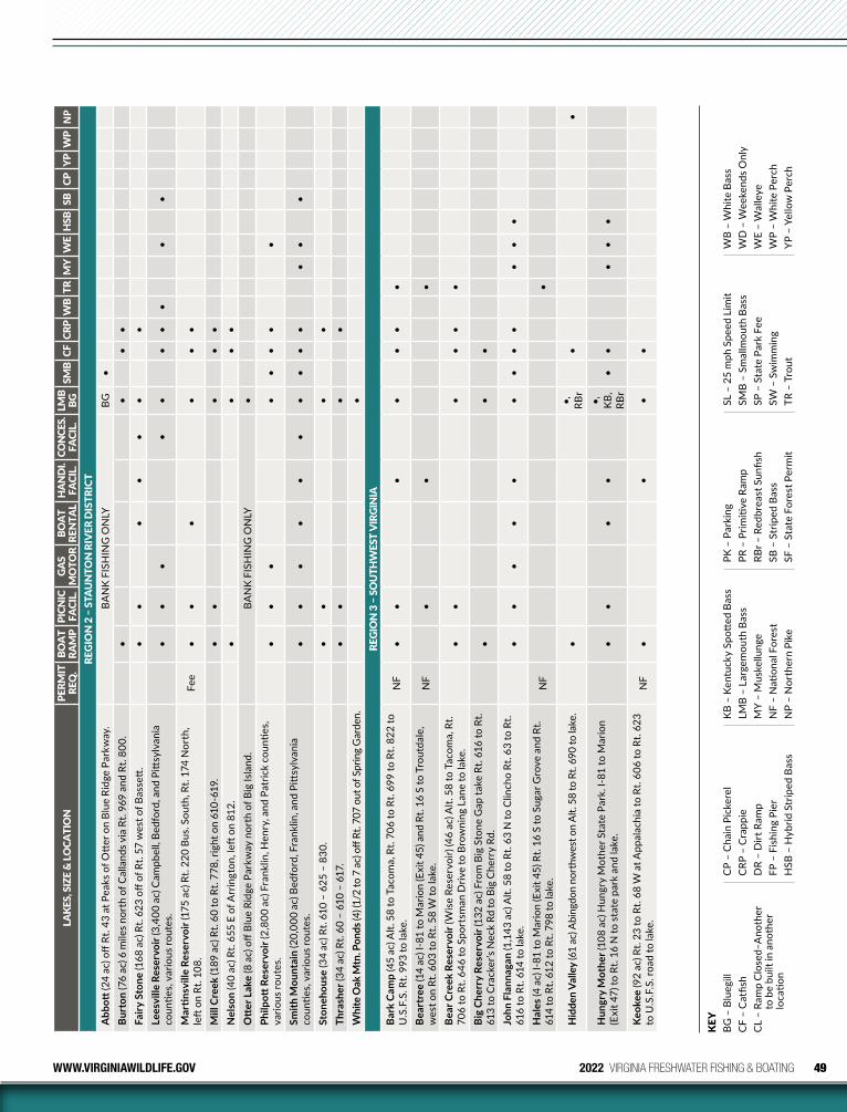
49WWW.VIRGINIAWILDLIFE.GOV 2022 VIRGINIA FRESHWATER FISHING & BOATING
LAKE
S, S
IZE
& LO
CATI
ON
PERM
IT
REQ
. BO
AT
RAM
PPI
CNIC
FA
CIL.
GAS
MO
TOR
BOAT
RE
NTA
LH
AND
I. FA
CIL.
CON
CES.
FA
CIL.
LMB
BGSM
BCF
CRP
WB
TRM
YW
EH
SBSB
CPYP
WP
NP
REG
ION
2 –
STA
UN
TON
RIV
ER D
ISTR
ICT
Abb
ott (2
4 ac
) off
Rt. 4
3 at
Pea
ks o
f Ott
er o
n Bl
ue R
idge
Par
kway
. B
AN
K FI
SHIN
G O
NLY
BG•
Burt
on (7
6 ac
) 6 m
iles n
orth
of C
alla
nds v
ia R
t. 96
9 an
d Rt
. 800
. •
••
•Fa
iry S
tone
(168
ac)
Rt.
623
off o
f Rt.
57 w
est o
f Bas
sett
. •
••
••
••
Lees
ville
Res
ervo
ir (3
,400
ac)
Cam
pbel
l, Be
dfor
d, a
nd P
ittsy
lvan
ia
coun
ties,
vario
us ro
utes
.•
••
••
••
••
•
Mar
tinsv
ille
Rese
rvoi
r (17
5 ac
) Rt.
220
Bus.
Sout
h, R
t. 17
4 N
orth
, le
ft o
n Rt
. 108
.Fe
e•
••
••
•
Mill
Cre
ek (1
89 a
c) R
t. 60
to R
t. 77
8, ri
ght o
n 61
0-61
9.•
••
••
Nel
son
(40
ac) R
t. 65
5 E
of A
rrin
gton
, left
on
812.
••
••
Ott
er L
ake
(8 a
c) o
ff Bl
ue R
idge
Par
kway
nor
th o
f Big
Isla
nd.
BA
NK
FISH
ING
ON
LY•
Philp
ott R
eser
voir
(2,8
00 a
c) F
rank
lin, H
enry
, and
Pat
rick
coun
ties,
va
rious
rout
es.
••
••
••
••
Smith
Mou
ntai
n (2
0,00
0 ac
) Bed
ford
, Fra
nklin
, and
Pitt
sylv
ania
co
untie
s, va
rious
rout
es.
••
••
••
••
••
••
•
Ston
ehou
se (3
4 ac
) Rt.
610
– 62
5 –
830.
••
••
Thra
sher
(34
ac) R
t. 60
– 6
10 –
617
.•
••
•W
hite
Oak
Mtn
. Pon
ds (4
) (1/
2 to
7 a
c) o
ff Rt
. 707
out
of S
prin
g G
arde
n.•
REGI
ON
3 –
SO
UTH
WES
T VI
RGIN
IABa
rk C
amp
(45
ac) A
lt. 5
8 to
Tac
oma,
Rt.
706
to R
t. 69
9 to
Rt.
822
to
U.S
.F.S
. Rt.
993
to la
ke.
NF
••
••
••
•
Bear
tree
(14
ac) I
-81
to M
ario
n (E
xit 4
5) a
nd R
t. 16
S to
Tro
utda
le,
wes
t on
Rt. 6
03 to
Rt.
58 W
to la
ke.
NF
••
•
Bear
Cre
ek R
eser
voir
(Wis
e Re
serv
oir)
(46
ac) A
lt. 5
8 to
Tac
oma,
Rt.
706
to R
t. 64
6 to
Spo
rtsm
an D
rive
to B
row
ning
Lan
e to
lake
.•
••
••
•
Big
Cher
ry R
eser
voir
(132
ac)
Fro
m B
ig S
tone
Gap
take
Rt.
616
to R
t. 61
3 to
Cra
cker
’s N
eck
Rd to
Big
Che
rry
Rd.
••
•
John
Fla
nnag
an (1
,143
ac)
Alt.
58
to R
t. 63
N to
Clin
cho
Rt. 6
3 to
Rt.
616
to R
t. 61
4 to
lake
.•
••
••
••
••
••
•
Hal
es (4
ac)
I-81
to M
ario
n (E
xit 4
5) R
t. 16
S to
Sug
ar G
rove
and
Rt.
614
to R
t. 61
2 to
Rt.
798
to la
ke.
NF
•
Hid
den
Valle
y (6
1 ac
) Abi
ngdo
n no
rthw
est o
n A
lt. 5
8 to
Rt.
690
to la
ke.
••,
RB
r•
•
Hun
gry
Mot
her (
108
ac) H
ungr
y M
othe
r Sta
te P
ark.
I-81
to M
ario
n (E
xit 4
7) to
Rt.
16 N
to s
tate
par
k an
d la
ke.
••
••
•,
KB,
RB
r•
••
••
Keok
ee (9
2 ac
) Rt.
23 to
Rt.
68 W
at A
ppal
achi
a to
Rt.
606
to R
t. 62
3 to
U.S
.F.S
. roa
d to
lake
.N
F•
••
•
KEY
BG –
Blu
egill
CF –
Cat
fish
CL –
Ram
p C
lose
d–A
noth
er
to b
e bu
ilt in
ano
ther
lo
catio
n
CP –
Cha
in P
icke
rel
CRP
– C
rapp
ieD
R –
Dirt
Ram
pFP
– F
ishi
ng P
ier
HSB
– H
ybrid
Str
iped
Bas
s
KB
– Ke
ntuc
ky S
pott
ed B
ass
LMB
– La
rgem
outh
Bas
sM
Y –
Mus
kellu
nge
NF
– N
ation
al F
ores
tN
P –
Nor
ther
n Pi
ke
PK –
Par
king
PR –
Prim
itive
Ram
pRB
r – R
edbr
east
Sun
fish
SB –
Str
iped
Bas
sSF
– S
tate
For
est P
erm
it
SL –
25
mph
Spe
ed L
imit
SMB
– Sm
allm
outh
Bas
sSP
– S
tate
Par
k Fe
eSW
– S
wim
min
gTR
– T
rout
WB
– W
hite
Bas
sW
D –
Wee
kend
s Onl
yW
E –
Wal
leye
WP
– W
hite
Per
chYP
– Y
ello
w P
erch
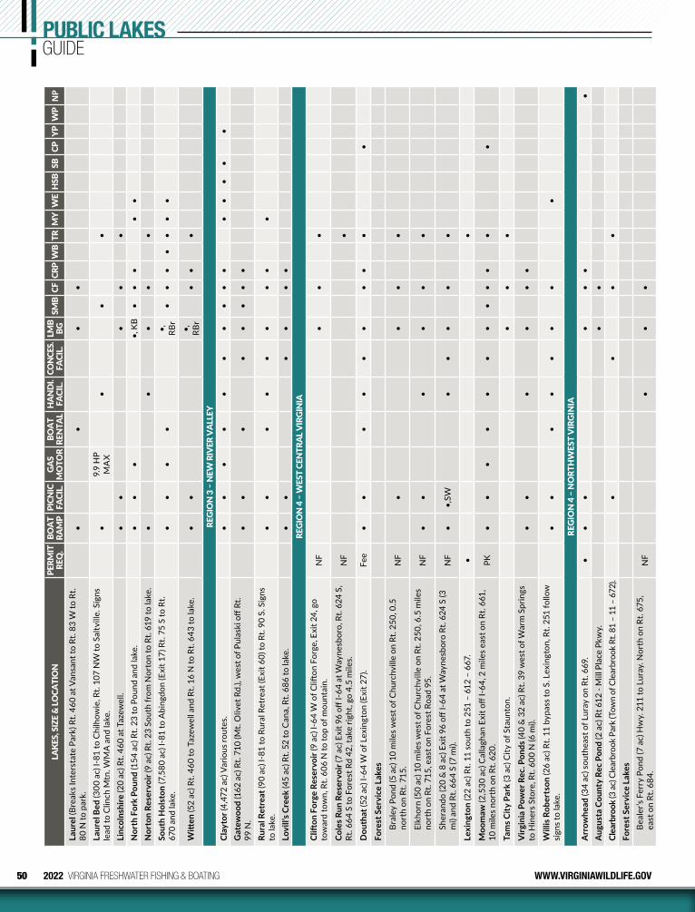
50 2022 VIRGINIA FRESHWATER FISHING & BOATING WWW.VIRGINIAWILDLIFE.GOV
LAKE
S, S
IZE
& LO
CATI
ON
PERM
IT
REQ
. BO
AT
RAM
PPI
CNIC
FA
CIL.
GAS
MO
TOR
BOAT
RE
NTA
LH
AND
I. FA
CIL.
CON
CES.
FA
CIL.
LMB
BGSM
BCF
CRP
WB
TRM
YW
EH
SBSB
CPYP
WP
NP
Laur
el (B
reak
s Int
erst
ate
Park
) Rt.
460
at V
ansa
nt to
Rt.
83 W
to R
t. 80
N to
par
k.•
••
•
Laur
el B
ed (3
00 a
c) I-
81 to
Chi
lhow
ie, R
t. 10
7 N
W to
Sal
tvill
e. S
igns
le
ad to
Clin
ch M
tn. W
MA
and
lake
.•
9.9
HP
MA
X•
••
Linc
olns
hire
(20
ac) R
t. 46
0 at
Taz
ewel
l.•
••
••
Nor
th F
ork
Poun
d (1
54 a
c) R
t. 23
to P
ound
and
lake
.•
••
•, K
B•
••
••
Nor
ton
Rese
rvoi
r (9
ac) R
t. 23
Sou
th fr
om N
orto
n to
Rt.
619
to la
ke.
••
••
•So
uth
Hol
ston
(7,5
80 a
c) I-
81 to
Abi
ngdo
n (E
xit 1
7) R
t. 75
S to
Rt.
670
and
lake
.•
••
••,
RB
r•
••
••
••
Witt
en (5
2 ac
) Rt.
460
to T
azew
ell a
nd R
t. 16
N to
Rt.
643
to la
ke.
••
•,
RBr
••
•
REGI
ON
3 –
NEW
RIV
ER V
ALLE
YCl
ayto
r (4,
472
ac) V
ario
us ro
utes
.•
••
••
••
••
••
••
••
Gat
ewoo
d (1
62 a
c) R
t. 71
0 (M
t. O
livet
Rd.
), w
est o
f Pul
aski
off
Rt.
99 N
.•
••
••
••
•
Rura
l Ret
reat
(90
ac) I
-81
to R
ural
Ret
reat
(Exi
t 60)
to R
t. 90
S. S
igns
to
lake
. •
••
••
••
••
Lovi
ll’s C
reek
(45
ac) R
t. 52
to C
ana,
Rt.
686
to la
ke.
••
••
••
REGI
ON
4 –
WES
T CE
NTR
AL V
IRGI
NIA
Clift
on F
orge
Res
ervo
ir (9
ac)
I-64
W o
f Clift
on F
orge
, Exi
t 24,
go
tow
ard
tow
n, R
t. 60
6 N
to to
p of
mou
ntai
n.N
F•
••
Cole
s Run
Res
ervo
ir (7
ac)
Exi
t 96
off I-
64 a
t Way
nesb
oro,
Rt.
624
S,
Rt. 6
64 S
to F
ores
t Rd
42, t
ake
right
, go
4.5
mile
s.N
F•
Dou
that
(52
ac) I
-64
W o
f Lex
ingt
on (E
xit 2
7).
Fee
••
••
••
••
••
Fore
st S
ervi
ce L
akes
Bral
ey P
ond
(5 a
c) 1
0 m
iles w
est o
f Chu
rchv
ille
on R
t. 25
0, 0
.5
nort
h on
Rt.
715.
NF
••
••
Elkh
orn
(50
ac) 1
0 m
iles w
est o
f Chu
rchv
ille
on R
t. 25
0, 6
.5 m
iles
nort
h on
Rt.
715,
eas
t on
Fore
st R
oad
95.
NF
••
••
••
Sher
ando
(20
& 8
ac)
Exi
t 96
off I-
64 a
t Way
nesb
oro
Rt. 6
24 S
(3
mi)
and
Rt. 6
64 S
(7 m
i).N
F•
•,SW
••
••
•
Lexi
ngto
n (2
2 ac
) Rt.
11 s
outh
to 2
51 –
612
– 6
67.
••
Moo
maw
(2,5
30 a
c) C
alla
ghan
Exi
t off
I-64,
2 m
iles e
ast o
n Rt
. 661
, 10
mile
s nor
th o
n Rt
. 620
.PK
••
••
••
••
••
••
Tam
s City
Par
k (3
ac)
City
of S
taun
ton.
••
•
Virg
inia
Pow
er R
ec. P
onds
(40
& 3
2 ac
) Rt.
39 w
est o
f War
m S
prin
gs
to H
iner
s Sto
re, R
t. 60
0 N
(6 m
i).•
••
••
•
Will
is R
ober
tson
(26
ac) R
t. 11
byp
ass t
o S.
Lex
ingt
on, R
t. 25
1 fo
llow
si
gns t
o la
ke.
••
••
••
••
REG
ION
4 –
NO
RTH
WES
T VI
RGIN
IAA
rrow
head
(34
ac) s
outh
east
of L
uray
on
Rt. 6
69.
••
••
••
•A
ugus
ta C
ount
y Re
c Po
nd (2
ac)
Rt 6
12 -
Mill
Pla
ce P
kwy.
••
Clea
rbro
ok (3
ac)
Cle
arbr
ook
Park
(Tow
n of
Cle
arbr
ook
Rt. 8
1 –
11 –
672
). •
••
•Fo
rest
Ser
vice
Lak
esBe
aler
’s Fe
rry
Pond
(7 a
c) H
wy.
211
to L
uray
. Nor
th o
n Rt
. 675
, ea
st o
n Rt
. 684
.N
F•
••
PUBLIC LAKESGUIDE

51WWW.VIRGINIAWILDLIFE.GOV 2022 VIRGINIA FRESHWATER FISHING & BOATING
LAKE
S, S
IZE
& LO
CATI
ON
PERM
IT
REQ
. BO
AT
RAM
PPI
CNIC
FA
CIL.
GAS
MO
TOR
BOAT
RE
NTA
LH
AND
I. FA
CIL.
CON
CES.
FA
CIL.
LMB
BGSM
BCF
CRP
WB
TRM
YW
EH
SBSB
CPYP
WP
NP
Brie
ry (9
ac)
Rt.
257
W o
f Day
ton
- Rt.
924.
NF
••
•D
ry R
un (1
0 ac
) Rt.
33 W
of R
awle
y Sp
rings
.N
F•
Hon
e Q
uarr
y (6
ac)
Rt.
257
W o
f Day
ton
- Rt.
924.
NF
••
••
Skid
mor
e (1
18 a
c ) R
t. 33
W o
f Har
rison
burg
- PS
227
.•
••
••
Slat
e Li
ck (1
0 ac
) Rt.
33 -
Rt. 6
12N
- Rt
. 230
- PS
127
9.N
F•
••
Tom
ahaw
k (2
ac)
Rt.
263
and
610
W o
f Mt.
Jack
son.
NF
••
••
Laur
a (4
4 ac
) Bry
ce M
tn. R
esor
t at B
ayse
. Rt.
263,
12
mile
s, w
est o
f M
t. Ja
ckso
n.•
••
••
New
man
Lak
e (8
ac)
City
of H
arris
onbu
rg•
•Si
lver
(10
ac) F
rom
Har
rison
burg
take
Rt.
42 s
outh
to D
ayto
n, th
en
right
on
Rt. 7
01.
••
•
Virg
inia
Dep
artm
ent o
f Wild
life
Reso
urce
s Lak
esFr
eder
ick
(117
ac)
Rt.
522
and
340,
5 m
iles n
orth
of F
ront
Roy
al.
••
••
••
••
•Sh
enan
doah
(36
ac) R
t. 27
6 S
of R
t. 33
.•
••
••
••
•W
ilkin
s (3
ac) J
im B
arne
tt Pa
rk (W
inch
este
r).•
••
••
•W
oodr
ow W
ilson
Pon
d (3
ac)
Nea
r Fis
hers
ville
, Rt.
250
East
- W
oodr
ow W
ilson
Ave
.•
•
REG
ION
4 –
NO
RTH
ERN
VIR
GIN
IAA
bel (
185
ac) R
t. 17
N -
Rt. 6
16 N
- Rt
. 651
E.
••
••
Acc
otink
(90
ac) F
CPA
, I-9
5 N
- 64
4 W
- rig
ht o
n Ba
cklic
k, le
ft o
n H
ighl
and,
righ
t on
Acc
otink
.•
••
••
•
Ann
a (9
,600
ac)
Rt.
1 so
uth,
wes
t on
Rt. 2
08 to
lake
.•
••
••
••
••
••
••
•Be
aver
dam
Cr.
(350
ac)
15
N -
50 W
- 65
9 N
.PR
••
••
Cook
(4 a
c) C
amer
on R
un R
eg. P
k. (A
lexa
ndria
).FP
••
•Fa
irfax
Lak
e (2
8 ac
) 7 W
- 60
6 W
- FC
PA s
urro
unde
d by
par
k.
••
••
•G
erm
anto
wn
Lake
(109
ac)
Rt.
17 to
28
N, 6
43 (M
eetz
e Ro
ad) t
o C
.M. C
rock
lett
Park
.•
••
•FP
••
••
Hun
ting
Run
Rese
rvoi
r (43
0 ac
) 3 W
to 6
10 W
.•
••
FP•
••
Hun
tsm
an (2
7 ac
) 123
N- 6
36 N
- 64
1 N
.•
••
Lake
Ann
a St
ate
Park
Pon
d (1
ac)
Rt.
1 to
Fre
deric
ksbu
rg w
est o
n 20
8, n
orth
on
601
to L
ake
Ann
a St
ate
Park
. (K
ids o
nly)
••
••
•
Lake
Moo
ney
(520
ac)
Tak
e Rt
. 17
nort
h fr
om F
rede
ricks
burg
, tur
n le
ft o
nto
Bank
s For
d Pk
wy,
righ
t on
Gre
enba
nk R
d.•
••
•
Locu
st S
hade
(8 a
c) L
ocus
t Sha
de P
ark.
Pad
dle
boat
s ava
ilabl
e.
••
••
Mott
s (16
0 ac
) 95
N -
3 W
- 63
9 N
- 61
8 W
.•
••
•FP
••
••
••
Mtn
. Run
(75
ac) 2
9 S
- 718
W -
719
N.
••
••
••
Ni R
eser
voir
(411
ac)
95
N -
3 W
- 62
0 S
- 627
S.
••
••
••
••
Old
Cos
sey
Pond
(3 a
c) K
enm
ore
Ave,
Fre
deric
ksbu
rg•
••
KEY
BG –
Blu
egill
CF –
Cat
fish
CL –
Ram
p C
lose
d–A
noth
er
to b
e bu
ilt in
ano
ther
lo
catio
n
CP –
Cha
in P
icke
rel
CRP
– C
rapp
ieD
R –
Dirt
Ram
pFP
– F
ishi
ng P
ier
HSB
– H
ybrid
Str
iped
Bas
s
KB
– Ke
ntuc
ky S
pott
ed B
ass
LMB
– La
rgem
outh
Bas
sM
Y –
Mus
kellu
nge
NF
– N
ation
al F
ores
tN
P –
Nor
ther
n Pi
ke
PK –
Par
king
PR –
Prim
itive
Ram
pRB
r – R
edbr
east
Sun
fish
SB –
Str
iped
Bas
sSF
– S
tate
For
est P
erm
it
SL –
25
mph
Spe
ed L
imit
SMB
– Sm
allm
outh
Bas
sSP
– S
tate
Par
k Fe
eSW
– S
wim
min
gTR
– T
rout
WB
– W
hite
Bas
sW
D –
Wee
kend
s Onl
yW
E –
Wal
leye
WP
– W
hite
Per
chYP
– Y
ello
w P
erch
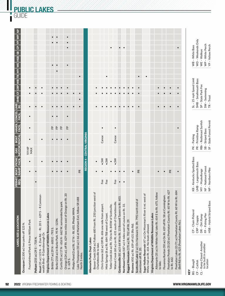
52 2022 VIRGINIA FRESHWATER FISHING & BOATING WWW.VIRGINIAWILDLIFE.GOV
PUBLIC LAKESGUIDE
KEY
BG –
Blu
egill
CF –
Cat
fish
CL –
Ram
p C
lose
d–A
noth
er
to b
e bu
ilt in
ano
ther
lo
catio
n
CP –
Cha
in P
icke
rel
CRP
– C
rapp
ieD
R –
Dirt
Ram
pFP
– F
ishi
ng P
ier
HSB
– H
ybrid
Str
iped
Bas
s
KB
– Ke
ntuc
ky S
pott
ed B
ass
LMB
– La
rgem
outh
Bas
sM
Y –
Mus
kellu
nge
NF
– N
ation
al F
ores
tN
P –
Nor
ther
n Pi
ke
PK –
Par
king
PR –
Prim
itive
Ram
pRB
r – R
edbr
east
Sun
fish
SB –
Str
iped
Bas
sSF
– S
tate
For
est P
erm
it
SL –
25
mph
Spe
ed L
imit
SMB
– Sm
allm
outh
Bas
sSP
– S
tate
Par
k Fe
eSW
– S
wim
min
gTR
– T
rout
WB
– W
hite
Bas
sW
D –
Wee
kend
s Onl
yW
E –
Wal
leye
WP
– W
hite
Per
chYP
– Y
ello
w P
erch
LAKE
S, S
IZE
& LO
CATI
ON
PERM
IT
REQ
. BO
AT
RAM
PPI
CNIC
FA
CIL.
GAS
MO
TOR
BOAT
RE
NTA
LH
AND
I. FA
CIL.
CON
CES.
FA
CIL.
LMB
BGSM
BCF
CRP
WB
TRM
YW
EH
SBSB
CPYP
WP
NP
Occ
oqua
n (2
,100
ac)
two
park
s off
123
N.
Foun
tain
head
Par
k &
Prin
ce W
illia
m P
ark
••
9.9
HP
MA
X•
••
••
•
Pelh
am (2
55 a
c) 2
9 S
– 71
8 N
.•
••
••
Roya
l (35
ac)
123
N –
R. Z
ion
Rd. –
Rt.
20 S
– 6
29 S
– R
Com
mon
-w
ealth
Blv
d.–
R G
ains
boro
ugh
Dr.
••
••
•
Virg
inia
Dep
artm
ent o
f Wild
life
Reso
urce
s Lak
esBr
ittle
(77
ac) 2
9 N
- 60
0 E
- 793
S.
••
•FP
••
••
••
•Bu
rke
(218
ac)
in B
urke
Par
k. 9
5 N
- 12
3N.
••
•FP
••
••
••
••
Cur
tis (9
1 ac
) 17
N -
616
N -
662
W, s
urro
unde
d by
par
k.•
••
FP•
••
Ora
nge
(124
ac)
, off
Rt. 6
29 tw
o m
iles e
ast o
f Ora
nge
on R
t. 20
S
- 629
S.
••
•FP
••
••
••
••
Phel
ps P
ond
(3 a
c) R
t. 17
N –
Rt.
651.
Phe
lps W
MA
.•
•La
ke T
hom
pson
(10
ac) I
-66
at M
arkh
am E
xit,
follo
w S
R 68
8 N
orth
3 m
iles.
PR•
••
•
REGI
ON
4 –
CEN
TRAL
VIR
GIN
IAA
lbem
arle
Par
ks D
ept.
Lake
sBe
aver
Cre
ek (1
04 a
c) F
ollo
w 6
80 fr
om R
t. 25
0 ju
nctio
n w
est o
f C
harlo
ttes
ville
to la
ke.
••
••
•
Chr
is G
reen
e (6
2 ac
) Off
Rt. 6
06 o
ne m
ile fr
om a
irpor
t.Fe
e•
•,SW
Can
oe•
••
•M
int S
prin
gs (8
ac)
Rt.
684-
788
wes
t of C
roze
t.Fe
e•,
SW•
••
•To
tier C
reek
(66
ac) R
t. 72
6 to
Rt.
845W
of S
cott
svill
e.•
••
••
•W
alnu
t Cre
ek (6
0 ac
) on
Rt. 6
31 s
outh
of C
harlo
ttes
ville
.Fe
e•
•,SW
Can
oe•
••
•G
ordo
nsvi
lle (8
1 ac
) I-6
4 W
to R
t. 15
Bos
wel
l Tav
ern
to R
t. 60
3.•
••
••
•N
orth
east
Cre
ek (1
87 a
c) 4
mile
s eas
t of L
ouis
a on
Rt.
33.
••
••
••
Ragg
ed M
ount
ain
(170
ac)
Rt.
702
off R
t. 29
.•
••
Riva
nna
(450
ac)
Rt.
659
off 6
31 (R
io R
d).
••
••
Scott
svill
e La
ke (2
ac)
On
Har
dwar
e St
. (Rt
. 795
) nor
th e
nd o
f do
wnt
own
off R
t. 20
.PR
••
••
Suga
r Hol
low
Res
ervo
ir (4
7 ac
) On
Moo
rman
’s Ri
ver 6
mi.
wes
t of
Whi
te H
all o
n Rt
. 614
. No
boat
s allo
wed
.•
Virg
inia
Dep
artm
ent o
f Wild
life
Reso
urce
s Lak
esA
lbem
arle
(35
ac) I
n W
hite
Hal
l, ta
ke R
t. 61
4 E
to R
t. 67
5, fo
llow
to
lake
.•
••
•
Fluv
anna
Rur
itan
(50
ac) O
n Rt
. 619
off
Rt. 5
8 at
Cun
ning
ham
.•
••
•Po
wha
tan
Pond
s (3)
(20
ac) P
owha
tan
Cou
nty
Rt. 6
0 W
to R
t. 62
7 to
Rt.
662.
PR•
••
Pow
hata
n La
kes (
2) (7
1 ac
) Pow
hata
n C
ount
y Rt
. 60
W to
Rt.
684
(Bel
l Rd)
to R
t. 62
5 (P
owha
tan
Lake
s Rd.
).•
••
••
•
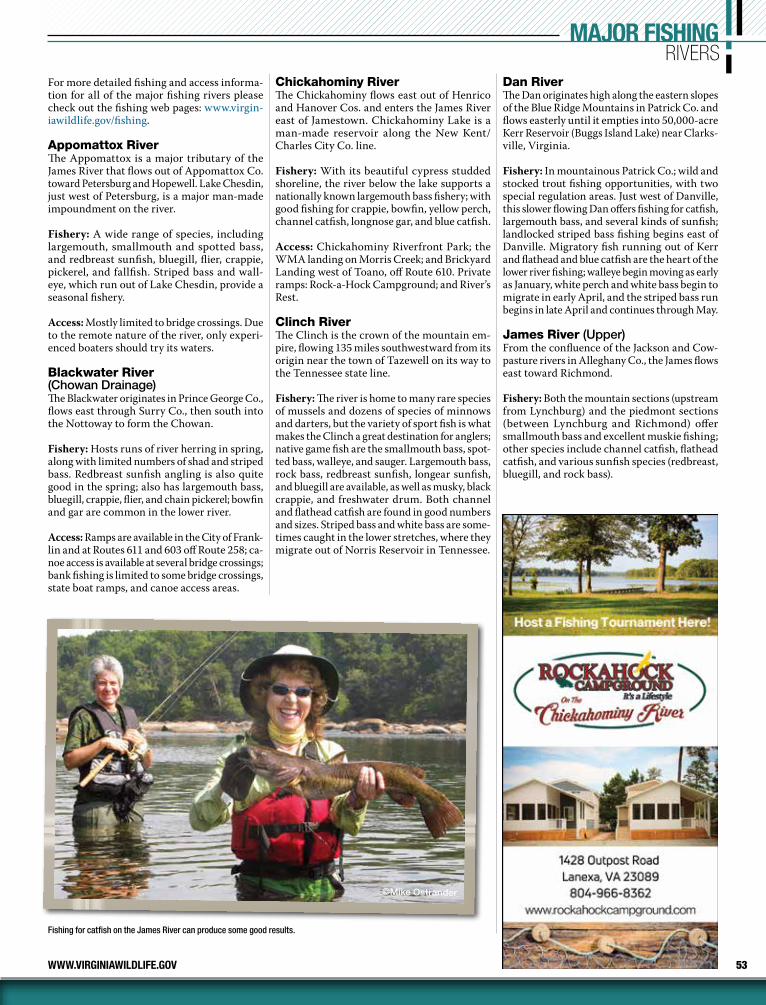
53WWW.VIRGINIAWILDLIFE.GOV
For more detailed fishing and access informa-tion for all of the major fishing rivers please check out the fishing web pages: www.virgin-iawildlife.gov/fishing.
Appomattox RiverThe Appomattox is a major tributary of the James River that flows out of Appomattox Co. toward Petersburg and Hopewell. Lake Chesdin, just west of Petersburg, is a major man-made impoundment on the river.
Fishery: A wide range of species, including largemouth, smallmouth and spotted bass, and redbreast sunfish, bluegill, flier, crappie, pickerel, and fallfish. Striped bass and wall-eye, which run out of Lake Chesdin, provide a seasonal fishery.
Access: Mostly limited to bridge crossings. Due to the remote nature of the river, only experi-enced boaters should try its waters.
Blackwater River (Chowan Drainage)The Blackwater originates in Prince George Co., flows east through Surry Co., then south into the Nottoway to form the Chowan.
Fishery: Hosts runs of river herring in spring, along with limited numbers of shad and striped bass. Redbreast sunfish angling is also quite good in the spring; also has largemouth bass, bluegill, crappie, flier, and chain pickerel; bowfin and gar are common in the lower river.
Access: Ramps are available in the City of Frank-lin and at Routes 611 and 603 off Route 258; ca-noe access is available at several bridge crossings; bank fishing is limited to some bridge crossings, state boat ramps, and canoe access areas.
Chickahominy RiverThe Chickahominy flows east out of Henrico and Hanover Cos. and enters the James River east of Jamestown. Chickahominy Lake is a man-made reservoir along the New Kent/Charles City Co. line.
Fishery: With its beautiful cypress studded shoreline, the river below the lake supports a nationally known largemouth bass fishery; with good fishing for crappie, bowfin, yellow perch, channel catfish, longnose gar, and blue catfish.
Access: Chickahominy Riverfront Park; the WMA landing on Morris Creek; and Brickyard Landing west of Toano, off Route 610. Private ramps: Rock-a-Hock Campground; and River’s Rest.
Clinch RiverThe Clinch is the crown of the mountain em-pire, flowing 135 miles southwestward from its origin near the town of Tazewell on its way to the Tennessee state line.
Fishery: The river is home to many rare species of mussels and dozens of species of minnows and darters, but the variety of sport fish is what makes the Clinch a great destination for anglers; native game fish are the smallmouth bass, spot-ted bass, walleye, and sauger. Largemouth bass, rock bass, redbreast sunfish, longear sunfish, and bluegill are available, as well as musky, black crappie, and freshwater drum. Both channel and flathead catfish are found in good numbers and sizes. Striped bass and white bass are some-times caught in the lower stretches, where they migrate out of Norris Reservoir in Tennessee.
Dan RiverThe Dan originates high along the eastern slopes of the Blue Ridge Mountains in Patrick Co. and flows easterly until it empties into 50,000-acre Kerr Reservoir (Buggs Island Lake) near Clarks-ville, Virginia.
Fishery: In mountainous Patrick Co.; wild and stocked trout fishing opportunities, with two special regulation areas. Just west of Danville, this slower flowing Dan offers fishing for catfish, largemouth bass, and several kinds of sunfish; landlocked striped bass fishing begins east of Danville. Migratory fish running out of Kerr and flathead and blue catfish are the heart of the lower river fishing; walleye begin moving as early as January, white perch and white bass begin to migrate in early April, and the striped bass run begins in late April and continues through May.
James River (Upper)From the confluence of the Jackson and Cow-pasture rivers in Alleghany Co., the James flows east toward Richmond.
Fishery: Both the mountain sections (upstream from Lynchburg) and the piedmont sections (between Lynchburg and Richmond) offer smallmouth bass and excellent muskie fishing; other species include channel catfish, flathead catfish, and various sunfish species (redbreast, bluegill, and rock bass).
MAJOR FISHINGRIVERS
©Mike Ostrander
Fishing for catfish on the James River can produce some good results.
54 2022 VIRGINIA FRESHWATER FISHING & BOATING WWW.VIRGINIAWILDLIFE.GOV
MAJOR FISHINGRIVERS
Meghan Marchetti / DWR
Access: Canoeing is the best way to access the river; jet motor and jon boats can also be used at some access points; numerous sites are avail-able; see the website. Bank and wade fishing access is available throughout.
James River (Lower)Fishery: A nationally recognized largemouth bass fishery; upstream from Hopewell, large-mouth fishing is best in old river channels and abandoned gravel pits; downstream from Hopewell to Hog Island, bass fishing is most productive in larger tributary creeks and large expanses of vegetated tidal flats. The tidal James also provides the best fishing for blue catfish in the state; good crappie fishing in oxbows upstream of Hopewell; and white perch through-out the river. A healthy run of hickory shad has created a very popular spring fishery within the Fall Line from late March through early May; and anadromous striped bass (“rockfish”) fishing is seasonally excellent in the vicinity of the I-95 Bridge in Richmond during the same timeframe.
Maury RiverCalfpasture and Little Calfpasture rivers come together to form the Maury River just before entering famous Goshen Pass; once through the turbulent Pass the river drops into the valley toward Lexington and enters the James River at Glasgow.
Fishery: The Goshen Pass section has an excel-lent stocked trout fishery; smallmouth bass are caught anywhere from the head waters to the mouth of the river where it enters the James; the Maury is loaded with scrappy redbreast sunfish and has some rock bass; other fish include carp, catfish, and suckers.
New RiverThe New is the oldest river in North America and second oldest in the world. It begins in North Carolina and flows northward for 160 miles through Virginia before it turns into Bluestone Lake in West Virginia.
Fishery: The New rivals the James and Rap-pahannock rivers as one of the best sport fisheries in Virginia: smallmouth bass, spot-ted bass, largemouth bass, rock bass, striped bass, hybrid striped bass, muskellunge, wall-eye, black crappie, channel catfish, flathead catfish, yellow perch, redbreast sunfish, and bluegill. State records include musky (45 lbs. 8 oz.), smallmouth (8 lbs. 1 oz.), and walleye (15 lbs. 15 oz.).
Access: Plenty of excitement for whitewater enthusiasts, with several major Class II–III rapids. There is also an abundance of flatwater to please motor boaters and canoeists. Numer-ous sites are available; see the website.
North Fork Holston RiverFrom its origin in Bland Co., the North Fork Holston flows over 100 miles through Southwest Virginia before crossing the Tennessee state line near Yuma.
Fishery: Outstanding smallmouth bass popula-tion, with good numbers of smallmouth 14 to 18 inches, about one-third more than 14 inches, and more than 10% longer than 17 inches; rock bass and several species of sunfish provide good fishing and channel and flathead catfish are available. There is a mercury fish consumption pro hibition in effect from Saltville downstream to the Tennessee line.
North Fork Shenandoah RiverThe North Fork Shenandoah flows north 116 miles from Rockingham Co. to Front Royal where it joins the South Fork Shenandoah to form the Shenandoah River.
Fishery: Anglers can expect to catch small-mouth bass throughout and the North Fork is also home to some largemouth bass and red-breast sunfish, rock bass, bluegill, pumpkinseed sunfish, fallfish, muskie, American eel, white sucker, common carp, crappie, yellow bullhead and channel catfish.
Access: The North Fork is a relatively small, shallow river; is an ideal river to float by canoe; and can easily be waded.
North Landing and Northwest RiversThe North Landing and Northwest rivers in the Tidewater area may be close in proximity and eventually join in North Carolina, but there are plenty of differences between the two.
North Landing, the larger of the two, con-tains part of the Intracoastal Waterway, so you can follow the waterway north to the Elizabeth River, and ultimately, the Chesapeake Bay; head-ing south takes you into Currituck Sound in North Carolina.
Fishery: A wide variety of both fresh water and brackish fish include largemouth bass, blue-gill, pumpkinseed, yellow perch, white perch, and white catfish, with a resurgence of smaller striped bass (up to 10 pounds).
Northwest River, draining eastward from the Great Dismal Swamp, is very dark in color and acidic (commonly referred to as blackwater). There are plenty of small tributaries to explore that keep you away from bigger boats on the main river.
Fishery: Abundant bluegill and pumpkinseed, good numbers of largemouth bass, redear, black crappie, chain pickerel, and a few white perch and white catfish.
Nottoway RiverThe Nottoway begins in Prince Edward and Lunenburg counties and flows 130 miles south-easterly to its confluence with the Blackwater River at the North Carolina line, forming the Chowan River.
Fishery: The fishery is divided at Rt. 630 Bridge on the Greensville-Sussex Co. line: above has numerous redbreast sunfish, smallmouth bass, and Roanoke bass.; below, bluegill, largemouth bass, black crappie, and channel catfish are
55WWW.VIRGINIAWILDLIFE.GOV
more common; spring sees blueback herring, American shad, hickory shad, striped bass, and white perch migrating upstream from North Carolina.
Access: Above Route 630 bridge, canoeists find nice float trips in this shallow, clear and fast flowing section; below Rt. 630, the river slows, deepens, and darkens as numerous swamps in the Coastal Plain join it and this part of the river, particularly in Southampton County, is large enough for bass boats during normal flows.
Rappahannock and Rapidan RiversThe Rappahannock flows from its origin at Chester Gap in Fauquier Co. ~184 miles to the Chesapeake Bay. The first 62 miles, from the headwaters to Mayfield Bridge (Fredericksburg), are designated State Scenic River.
Fishery: Above Fredericksburg and tidal influ-ence: excellent smallmouth bass and redbreast sunfish angling. Below Fredericksburg: herring and shad run each spring and the tidal area also hosts white perch, largemouth bass, striped bass, crappie, yellow perch, channel catfish, and blue catfish.
Access: Upper Rappahannock and Rapidan ac-cess: public access points on the Rapp (traveling downstream) are at Kelly’s Ford (Route 672 off Route 651) in Culpeper Co. and Motts Land-ing (Route 618) in Spotsylvania Co.; about 25 miles separate these canoe/jon boat slides and an overnight camp stop is nearly mandatory to float fish this reach; another access point is located on the Rapidan at Elys Ford (Route 610) in Spotsylvania Co. about 14 miles upstream of Motts Landing. Access may also be gained via several “non-established” points consisting of VDOT rights-of-way along bridges. Tidal area public boat launch sites below Fredericksburg: 4 (two near Fredericksburg), Hicks Landing (Port Royal) and Tappahannock.
Rivanna RiverOriginating in western Greene and Albemar-le counties, the North and South forks of the Rivanna River combine on the western edge of Charlottesville and flow southeast to the river’s confluence with the James River at Columbia (Fluvanna County). The main stem Rivanna Riv-er is a 40-mile stretch of river below the South Rivanna Reservoir that has the recognition of being Virginia’s first designated Scenic River.
Fishery: The main stem Rivanna is known for its excellent smallmouth bass, redbreast sunfish, and channel catfish fisheries. Anglers can also expect to catch bluegill, crappie, fallfish, green sunfish, largemouth bass, longnose gar, and rock bass, with the occasional chance to catch flathead catfish and walleye.
Access: The Rivanna is suited for floating with a canoe or kayak due to its small size, rocky
bottom, and relatively shallow water. Much of the access to the Rivanna is on the main stem section of the river; there are numerous hand-launch access areas from Charlottesville downstream to Columbia.
Shenandoah River (Main Stem)Main stem Shenandoah River is formed when the North Fork and South Fork converge at Front Royal, flows 57 miles, and empties into the Potomac River at Harpers Ferry, West Virginia.
Fishery: The Shenandoah River offers anglers a diverse array of quality sportfish populations. Smallmouth bass, largemouth bass, channel catfish, and various species of sunfish domi-nate the fishery. In addition, walleye and mus-kellunge are also abundant in localized areas throughout the river.
South Fork Shenandoah RiverThe South Fork Shenandoah begins at the con-fluence of the North River and South River near Port Republic and flows north 97 miles to meet the North Fork Shenandoah at Front Royal.
Fishery: The South Fork Shenandoah has a long-standing reputation as an excellent smallmouth bass river. While anglers should see modest numbers of smallmouth through-out the entire length of the river, fluctuations in young fish survival over the past several years has led to non-uniform densities of bass in different reaches of the South Fork. Higher densities of smallmouth are found in the Rockingham and Page County sections of the river. The South Fork also harbors good populations of largemouth bass, redbreast sunfish, channel catfish, and muskellunge (in the longer, deeper pools).
Access: A very popular destination for canoe-ists, over 20 public access points creates the opportunity to plan many different float trips of varying length (check out the fishing web pages).
Staunton (Roanoke) RiverThe Staunton, actually an 81-mile segment of the Roanoke River, begins at Leesville Dam and continues to the confluence with Kerr Reservoir.
Fishery: Seasonal runs of walleye, striped bass, white bass, white perch, and suckers. Catfish, including larger flathead catfish, can be caught throughout the river. Smallmouth bass and Roanoke bass (a larger cousin of the rock bass) are common in the upper sections, particularly around riffles and other rocky habitat. Largemouth and crappie are attractive angling prospects in the lower river, toward the state park.
Access: A canoe launch area is found just be-low Leesville Dam and large sections of the Staunton River also are accessible to motor-boats, with access points at Altavista, Long Island, Brookneal, Watkins Bridge, US 360 E, and Staunton River State Park.
We’ve Got You Covered!
Ed Allen’s Boats & Bait
Jon Boat RentalsPontoon Boat Rentals
Boat RampFully-Stocked Bait & Tackle Shop
New & Used Tohatsu Motors for SaleLakeside Restaurant
Call 804-966-5368 for reservations!
1959 Allen Road, Lanexa, VA804-966-5368 • www.edallensboats.com
Showcaseyour business!
For advertising inquiries, please call
(413) 884-1001
Missed the printed edition?Ask about year-round digital opportunities.
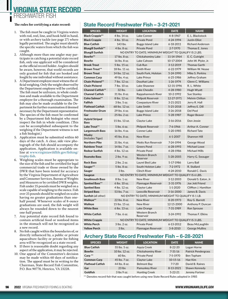
56 2022 VIRGINIA FRESHWATER FISHING & BOATING WWW.VIRGINIAWILDLIFE.GOV
VIRGINIA STATE RECORDFRESHWATER FISHThe rules for certifying a state record:
1. The fish must be caught in Virginia waters with rod, reel, line, and hook held in hand, or with archery tackle (see page 27) where legally permitted. The angler must identify the specific waters from which the fish was caught.
2. Although more than one angler may par-ticipate in catching a potential state record fish, only one applicant will be considered as the official record holder. Anglers should be aware, however, that world records are only granted for fish that are hooked and fought by one individual without assistance.
3. A Department employee must witness the of-ficial weighing. Only the weight observed by the Department employee will be certified. The fish must be unfrozen, in whole condi-tion and made available to the Department employee for a thorough examination. The fish may also be made available to the De-partment for further examination if deemed necessary by the Department representative.
4. The species of the fish must be confirmed by a Department fish biologist who must inspect the fish in whole condition. (This can be accomplished subsequent to the weighing if the Department witness is not a fish biologist.)
5. Application must be submitted within 60 days of the catch. A clear, side view pho-tograph of the fish should accompany the application. Application is available on-line at www.virginiawildlife.gov/fishing/trophy-fish.
6. Weighing scales must be appropriate to the size of the fish and be certified for legal commercial trade or those owned by the DWR that have been tested for accuracy by the Virginia Department of Agriculture and Consumer Services, Bureau of Weights and Measures or by certified DWR weights. Fish under 25 pounds must be weighed on a scale capable of weighing to the ounce. Fish over 25 pounds should be weighed on scales having no greater graduations than one-half pound. When ever scales of 8-ounce graduations are used, the fish weight will always be rounded down to the nearest one-half pound.
7. Any potential state record fish found to contain artificial food or nonfood items in the stomach will not be recognized as a new record.
8. No fish caught within the boundaries of, or directly influenced by, a public or private aquaculture facility or private fee fishing area will be recognized as a state record.
9. If there is reasonable doubt regarding any aspect of the application, it may be rejected.
10. One appeal of the Committee’s decision may be made within 60 days of notifica-tion. The appeal must be in writing to the Chairman, State Record Fish Committee, P.O. Box 90778, Henrico, VA 23228.
State Record Freshwater Fish – 3-21-2021SPECIES WEIGHT LOCATION DATE NAME
Black Crappie** 4 lbs. 14 oz. Lake Conner 4-8-1967 E. L. BlackstockBlack Crappie 4 lbs. 10 oz. Private Pond 4-24-1994 Justin ElliotBlue Catfish 143 lbs. Buggs Island Lake 6-18-2011 Richard AndersonBluegill Sunfish** 4 lbs. 8 oz. Private Pond 2-7-1970 Thomas E. JonesBluegill Sunfish NO ENTRY TO DATE; MINIMIUM WEIGHT TO QUALIFY IS 2 LBS.Bowfin** 17 lbs. 8 oz. Chickahominy Lake 11-14-1964 E. C. CutrightBowfin 16 lbs. 8 oz. Lake Cahoon 10-17-2004 John W. Plyler, Jr.Brook Trout 5 lbs. 15 oz. Cub Run 3-12-2019 Thomas GarthBrown Trout** 18 lbs. 11 oz. Smith River 6-22-1979 William W. NeaseBrown Trout 14 lbs. 12 oz. South Fork, Holston 5-24-1990 Mike S. PerkinsCommon Carp 49 lbs. 4 oz. Lake Prince 6-25-1986 Jeffrey GrahamChain Pickerel** 7 lbs. 12 oz. Douthat Lake 1-26-1974 Glenn C. WilliamsChain Pickerel 7 lbs. 10 oz. Lake Shawnee 12-31-1996 R. L. WhiteChannel Catfish** 32 lbs. Lake Chesdin 4-28-1980 Hugh WyattChannel Catfish 31 lbs. 8 oz. Rappahannock River 10-2-1992 Sue StanleyCoho Salmon** 8 lbs. 12 oz. Philpott Reservoir 12-27-1971 Melvin ChiltonFallfish 3 lbs. 5 oz. Cowpasture River 3-21-2021 Jerry R. HallFlathead Catfish 68 lbs. 12 oz. Lake Smith 5-25-2018 Jeffrey E. DillFreshwater Drum 29 lbs. 6 oz. Buggs Island Lake 3-26-2018 Del PoolGar 25 lbs. 2 oz. Lake Prince 5-28-1987 Roger BeaverHybrid Striped Bass 15 lbs. 13 oz. Claytor Lake 3-16-2016 Don Jessie
Lake Trout** 5 lbs. 6 oz. Philpott Reservoir 7-6-1966 Arthur A. ConnerLargemouth Bass 16 lbs. 4 oz. Conner Lake 5-20-1985 Richard TateMusky (includes Tiger) 45 lbs. 8 oz. New River 6-1-2007 Shannon Hill
Northern Pike 31 lbs. 4 oz. Motts Run Reservoir 7-24-1994 George WoodRainbow Trout 14 lbs. 7 oz. Greers Pond 6-28-1993 Michael LoweRedear Sunfish 4 lbs. 12 oz. Private Pond 4-28-1986 Michael Mills
Roanoke Bass 2 lbs. 9 oz. Western Branch Reservor 5-28-2005 Harry G. Swauger
Rock Bass 2 lbs. 2 oz. Laurel Bed Lake 5-17-1986 Larry BallSauger** 5 lbs. 8 oz. South Holston Lake 7-2-1972 R. StallardSauger 3 lbs. Clinch River 4-24-2010 Ronald C. DavisSaugeye NO ENTRY TO DATE; MINIMIUM WEIGHT TO QUALIFY IS 6 LBS.Smallmouth Bass 8 lbs. 1 oz. New River 3-12-2003 Donald S. Eaton, Jr.Spotted Bass** 6 lbs. 10 oz. Flannagan Reservoir 3-31-1976 Joe Jett FriendSpotted Bass 4 lbs. 12 oz. Claytor Lake 1-1-2020 Cliffton J. HamiltonStriped Bass 53 lbs. 7 oz. Leesville Reservoir 3-16-2000 James B. DavisSunfish (all other) NO ENTRY TO DATE; MINIMIUM WEIGHT TO QUALIFY IS 1 LB.Walleye** 22 lbs. 8 oz. New River 8-20-1973 Roy G. BarrettWalleye 15 lbs. 15 oz. New River 12-15-2000 Anthony P. DuncanWhite Bass 6 lbs. 13 oz. Lake Orange 7-31-1989 Ron Sprouse
White Catfish 7 lbs. 6 oz. Western Branch Reservoir 3-24-1992 Thomas F. Elkins
White Crappie NO ENTRY TO DATE; MINIMIUM WEIGHT TO QUALIFY IS 3 LBS.White Perch 3 lbs. 2 oz. Private Pond 6-13-2012 Beau McLaughlinYellow Perch 3 lbs. Flannagan Reservoir 3-8-2010 George Mullins
Archery State Record Freshwater Fish – 6-28-2021SPECIES WEIGHT LOCATION DATE NAME
Blue Catfish 55 lbs. 5 oz. Aquia Creek 8-22-20 Logan HorneBowfin 10 lbs. 12 oz. Chickahominy River 7-31-16 Patrick PendergrassCarp ** 60 lbs. Private Pond 7-5-1970 Ben TophamCommon Carp 45 lbs. 7 oz. Claytor Lake 10-15-16 Hae KimFlathead Catfish 44 lbs. 8 oz. Belmont Bay 7-7-20 David B. RainesGar 23 lbs Pamunkey River 8-13-2021 Shawn KennedyGoldfish 3 lbs 9 oz. Hunting Creek 5-22-21 Jeremy Fortner** Denotes record fish that was caught before using new State Record Rules adopted in 1985
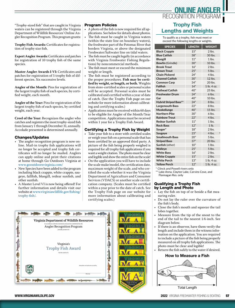
57WWW.VIRGINIAWILDLIFE.GOV 2022 VIRGINIA FRESHWATER FISHING & BOATING
Hereafter set forth into record by
Director
Virginia’sTrophy Fish Award
for the catch of a
in accordance with the standards and practice established by the
Angler Recognition Programproudly presents to
Virginia Department of Wildlife Resources
Qualifying a Trophy Fish by Length and Photo• Lay the fish on top of or beside a flat mea-
suring ruler.• Do not lay the ruler over the curvature of
the fish’s body.• Close the fish’s mouth and squeeze the tail
lobes together.• Measure from the tip of the snout to the
end of the tail to the nearest 1 ⁄4-inch. See diagram below.
• If there is an observer, have them verify the length and include them in the witness infor-mation on the application. You are required to include a picture of the fish being properly measured on all trophy fish applications. The photo must be clear and legible!
• Return the fish safely to the water if desired.
How to Measure a Fish
Total Length
Trophy Fish Lengths and WeightsTo qualify as a trophy, fish must meet or exceed the following lengths or weights.
SPECIES LENGTH WEIGHTBlack Crappie 15” 2 lbs.Blue Catfish 38” 30 lbs.Bluegill 11” 1 lbs.Bowfin (Grindle) 30” 10 lbs.Brook Trout 16” 2 lbs.Brown Trout 25” 5 lbs.Chain Pickerel 24” 4 lbs.Channel Catfish 30” 12 lbs.Common Carp 34” 20 lbs.Fallfish 14” 1 lb. 4 oz.Flathead Catfish 40” 25 lbs.Freshwater Drum 24” 6 lbs.Gar 40” 10 lbs.Hybrid Striped Bass** 24” 8 lbs.Largemouth Bass 22” 8 lbs.Muskellunge 40” 15 lbs.Northern Pike 30” 6 lbs.Rainbow Trout 22” 4 lbs.Redear Sunfish 11” 1 lbs.Rock Bass 12” 1 lb.Sauger* 18” 2 lbs.Saugeye 23” 4 lbs.Smallmouth Bass 20” 5 lbs.Striped Bass 37” 20 lbs.Sunfish (other) 10” 1 lbs.Walleye 25” 5 lbs.White Bass 16” 2 lbs.White Crappie 15” 2 lbs.White Perch 13” 1 lb. 4 oz.Yellow Perch 12” 1 lb. 4 oz.* Clinck and Powell rivers only** Lake Anna, Claytor Lake, Carvins Cove, and
Flannagan Res. only
“Trophy-sized fish” that are caught in Virginia waters can be registered through the Virginia Department of Wildlife Resources’ Online An-gler Recognition Program. This program grants:
Trophy Fish Awards: Certificates for registra-tion of trophy size fish.
Expert Angler Awards: Certificates and patches for registration of 10 trophy fish of the same species.
Master Angler Awards I-VI: Certificates and patches for registration of 5 trophy fish of dif-ferent species. Six successive levels.
Angler of the Month: Pins for registration of the largest trophy fish of each species, by certi-fied weight, each month.
Angler of the Year: Pins for registration of the largest trophy fish of each species, by certified weight, each year.
Creel of the Year: Recognizes the angler who catches and registers the most trophy-sized fish from January 1 through December 31, annually. Accolade presented is determined annually.
Changes/Updates• The angler recognition program is now on-
line. Mail-in trophy fish applications will no longer be accepted and trophy fish cer-tificates will no longer be mailed. Anglers can apply online and print their citations at home through Go Outdoors Virginia at www.gooutdoorsvirginia.com/
• New Species have been added to the program including black crappie, white crappie, sau-geye, fallfish, bluegill, redear sunfish, and other sunfish.
• A Master Level VI is now being offered! For further information and details visit our website at www.virginiawildlife.gov/fishing/trophy-fish/.
Program Policies• A photo of the fish is now required for all ap-
plications. See below for details about photos.• The fish must be caught in Virginia waters
(within the state line on boundary waters), the freshwater part of the Potomac River that borders Virginia, or above the designated Fresh water/Saltwater line on tidal waters.
• The fish must be caught legally (in accordance with Virginia Freshwater Fishing Regula-tions) by noncommercial methods.
• The fish must meet or exceed the minimum weight or length.
• The fish must be registered according to the proper procedures. Fish may be certi-fied by weight, or length, or both. Weights from store-certified scales or personal scales will be accepted. Personal scales must be calibrated and certified within a year of date of catch. (See the Trophy Fish page on our website for more information about calibrat-ing and certifying scales.)
• Applications must be received within 60 days to be eligible for Angler of the Month/Year competition. Applications must be received within 1 year for a Trophy Fish Award.
Certifying a Trophy Fish by Weight• Take your fish to a store with certified scales
or weigh your fish on a personal scale that has been certified by an approved third party. A picture of the fish being properly weighed is required for all trophy fish applications if you want a weight citation. The photo must be clear and legible and show the entire fish on the scale!
• On the application you will have to include the scale make/model, the certification date, maximum weight of the scale, and who cer-tified the scale whether it was the Virginia Department of Agriculture and Consumer Services (VDACS) or another scale certifi-cation company. (Scales must be certified within a year prior to the date of catch. See the Trophy Fish page on our website for more information about calibrating and certifying scales.)
ONLINE ANGLERRECOGNITION PROGRAM
58 2022 VIRGINIA FRESHWATER FISHING & BOATING WWW.VIRGINIAWILDLIFE.GOV
Watercraft Registration, Titling & Sales Tax RequirementsThe Virginia Department of Wildlife Resources (DWR) administers all boat titling and regis-tration of recreational boats in Virginia. If the motorboat is principally used on the public waters of Virginia it must be registered and titled in Virginia as opposed to another state.
• A Certificate of Title and a Certificate of Number (Registration) are required for all watercraft propelled by machinery, includ-ing but not limited to, gasoline, diesel, and electric motors.
• Sail-powered vessels (no motor) greater than 18 feet in length are only required to be titled in Virginia (no registration needed).
• Boats used only on private waters do not require registration or titling.
• New watercraft must be registered before they may be operated on the public waters of Virginia.
• Used watercraft with a current, valid Virginia registration may be operated for 30 days on the previous owner’s registration if a copy of the dated bill of sale and the registration card are carried aboard the watercraft.
• If there is no valid registration or the registra-tion has expired, used watercraft must obtain valid registration before being operated on the public waters of Virginia.
• An owner bringing a watercraft into Virginia from another state may operate the vessel up to 90 consecutive days on the other state’s current, valid registration before registering it in Virginia.
Where to Register Your WatercraftOnline: www.GoOutdoorsVirginia.comApplication(s) and supporting documents sub-
mitted online MUST be mailed to DWR Boat Section, P.O. Box 9930, Henrico, VA 23228.
WalkIn:At DWR Headquarters, 7870 Villa Park Drive, Suite 400, Henrico, VA 23228,8:30 a.m.–4:30 p.m., M–F except holidays
Mail: Mail original application(s) and supporting documents to DWR, Boat Section, P.O. Box 9930, Henrico, VA 23228.
DropBox (Headquarters)Pick up times: 9:00 a.m., 12 p.m., and 3:00 p.m.
Once submitted, applications are usually pro-cessed and the registration materials mailed within 60 days of receipt in Henrico.
Titling and Registering Your WatercraftAll forms can be found at www.virginiawildlife.gov/forms
The “Application for Watercraft Certificate of Title and Certificate of Number (Registra-tion)” form is a combined application for both the registration and title. The application must include a purchase price for the boat and motor only and must also be signed by the buyer(s). The application requires a detailed description of the watercraft that includes:
• Boat make• Length• Model year• Vessel type• Hull material• Propulsion type• Hull Identification Number• Motor make, serial number, and horsepower
VIRGINIA BOATER’S GUIDEREGISTRATION, TITLING, SALES TAX
The Department of Wildlife Resources (DWR) is the state boating agency and its employees work diligently to provide boating access and oppor-tunity to Virginia’s boaters and paddlers to enjoy the many beautiful waters that Virginia offers.
While boating is a great pastime, and offers fun, relaxation, and even exercise when paddling; it also involves preparation and responsibility to have a safe day on the water. Always, be courteous to others on the water and to adjacent landowners, don’t drink and boat, always wear a lifejacket, and take a boating safety course.
Be Responsible, Be Safe, and Have Fun!
– Tom Guess Boating Law Administrator, DWR

59WWW.VIRGINIAWILDLIFE.GOV 2022 VIRGINIA FRESHWATER FISHING & BOATING
DISPLAY OF REGISTRATION NUMBERThe number issued to your watercraft appears on the registration and is to be displayed exactly as it appears on each side of the forward half of the vessel in block letters, at least 3 inches in height, and contrasting in color with hull or background. They may be painted or attached to the watercraft, must read from left to right, and must always be legible. A space or hyphen must sepa-rate both the “VA” abbreviation and the letter suffix from the numerals.
On vessels so configured that a number on the hull or superstructure would not be easily visible, or the number would not remain securely attached (as on an inflatable vessel), the number may be painted on or the number and decal attached to a backing plate that is attached to the forward half of the vessel so that the number is visible from each side of the vessel.
If the watercraft already has Virginia registration numbers (used watercraft), in most instances those same numbers will be reassigned to the new owner. The Virginia registration number assigned to a watercraft should never be removed from the watercraft unless DWR assigns new numbers to the vessel.
(if in excess of 25 horsepower)• Name and mailing address of lienholder (if
applicable)
Most of this information will be available from the Certificate of Title and/or Certificate of Number (Registration) provided by the previ-ous owner or the Manufacturer’s Statement (or Certificate) of Origin provided by the retail outlet where the watercraft was purchased.
The following supporting documents must be submitted with an application for titling and registration as follows:
New Watercraft• Original Manufacturer’s Statement (or Cer-
tificate) of Origin or Importer’s Certificate of Origin with “First Assignment” completed and issued by dealer at the time of purchase.
• Copy of the sales invoice showing gross pur-chase price, watercraft sales tax paid, and a description of the boat must also be provided.
• “Application for Watercraft Certificate of Title and Certificate of Number (Registra-tion)” must be completed and signed by the purchaser(s).
If New Watercraft is Homemade By You• “Statement for Registering and Titling a
Motorboat not Previously Registered and/or Titled” must be provided.
• Copies of receipts for building materials • Printed pictures of the watercraft from all
sides.• “Application for Watercraft Certificate of Ti-
tle and Certificate of Number (Registration)” • Your watercraft may be subject to inspection
by a law enforcement officer.
Used WatercraftIf titled in Virginia• Original Certificate of Title with assignment
of title completed by titled owner(s). • If purchased from a watercraft dealer, the
dealer reassignment portion of the title must be completed.
• “Application for Watercraft Certificate of Title and Certificate of Number (Registra-tion)” must be completed and signed by the purchaser(s).
• Copy of the sales invoice showing gross pur-chase price, watercraft sales tax paid, and a description of the watercraft is required.
If Titled by Someone Else in Another State• Original Certificate of Title with assignment
of title completed by the titled owner(s). • If purchased from a dealer, the dealer reas-
signment portion of the title must be com-pleted.
• “Application for Watercraft Certificate of Title and Certificate of Number (Registra-tion)” must be completed and signed by the purchaser(s).
• Copy of the sales invoice showing gross pur-chase price, watercraft sales tax paid, and a description of the watercraft is required.
Registration and Titling Fees and Watercraft Sales and Use Tax
Most people must pay a registration fee, a titling fee, and watercraft sales and use tax when they acquire a watercraft. These fees are found on the application.
WATERCRAFT REGISTRATION (3 YEARS) FEE
Less than 16 feet in length $32.00
16 feet to less than 20 feet in length $36.00
20 feet to less than 40 feet in length $42.00
40 feet in length and longer $50.00
Duplicate Cards & Decals (Replacements or extra sets) $14.00
Livery of up to 10 watercraft $32.00
Livery of more than 10 watercraft $26.00
TITLING FEE
Original $10.00
Duplicate $7.00
Change of Motor on Title (Original Title must be submitted) $7.00
Record Supplemental Lien on Previously Titled Watercraft (Original Title must be submitted) $10.00
TAX FEE
Watercraft Sales and Use Tax
2% of gross purchase price of watercraft and motor (Maximum $2,000.00)
60 2022 VIRGINIA FRESHWATER FISHING & BOATING WWW.VIRGINIAWILDLIFE.GOV
VIRGINIA BOATER’S GUIDEREGISTRATION, TITLING, SALES TAXIf Titled by You in Another State (Moving the Watercraft to Virginia)• Original Certificate of Title must be sub-
mitted. • “Application for Watercraft Certificate of
Title and Certificate of Number (Registra-tion)” must be completed and signed by the purchaser(s).
If Registered By You in Another State but Not Titled (Moving the Watercraft to Virginia)• A copy of the out-of-state registration is
required. • “Application for Watercraft Certificate of
Title and Certificate of Number (Registra-tion)” must be completed and signed by the purchaser(s).
If Registered in Virginia But Never Titled • Copy of the dated bill of sale. • “Application for Watercraft Certificate of
Title and Certificate of Number (Registra-tion)” must be completed and signed by the purchaser(s).
If Registered by Someone Else in Another State But Not Titled• Copy of the out-of-state registration• Bill of sale signed and dated by the registered
owner(s).• “Application for Watercraft Certificate of
Title and Certificate of Number (Registra-tion)” must be completed and signed by the purchaser(s).
If Never Registered or Titled in Virginia or Any Other State • “Statement for Registering and Titling a
Motorboat not Previously Registered and/or Titled” form must be submitted
• Printed pictures of the watercraft from all sides.
• “Application for Watercraft Certificate of Title and Certificate of Number (Registra-tion)” must be completed and signed by the purchaser(s).
• Bill of sale signed and dated by the seller(s) must be submitted.
Documented WatercraftIf documented with the U.S. Coast Guard (USCG) and being changed to state registration• The Certificate of Documentation, Letter of
Deletion from the USCG (or Abstract of Title with proof of lien release in the documented owner’s name). A signed and dated bill of sale must be submitted.
Note: Watercraft cannot be documented by the USCG and titled at the same time. The owner must choose between documentation or titling. While a documented vessel may not be titled, it may be registered at the owner’s discretion should a registration decal be desired to show proof that sales tax was paid. The registration
ADDITIONAL INFORMATIONAdditional information and forms on watercraft registration and titling may be obtained by calling the Boat Section of DWR at 804-367-6135 or 866-721-6911. Forms can also be downloaded from our website at www.virginiawildlife.gov/forms.
decals may be useful if the watercraft is oper-ated in other states that require a registration decal or other proof that sales tax was paid.
Boat MotorsAny size, type, or horsepower of motor on a watercraft requires it to be registered. Only motors in excess of 25 horsepower are listed on titles.
Duplicate Titles, Registrations, or Decals• If a title, or registration card/decals become
defaced, lost or destroyed, you may obtain an “Application for Duplicate Certificate of Title or Registration” at all of the locations where the application is available (see “Watercraft Registration, Titling & Sales Tax Require-ments” page 58). You may also use this form to order extra registration cards if you want more than one.
Note: Only one valid title is recognized for each watercraft. If a duplicate title is issued, the duplicate title prevails over any previously issued title(s).
Expiration and Renewal of RegistrationRegistrations are valid for three years. Renewal notifications are emailed or mailed to the last known email address or postal address of all watercraft owners approximately 45 days in advance. A second renewal notification is sent 30 days prior to expiration date if not renewed. A final renewal notification is sent 30 days after expiration. The most common reason owners do not receive a renewal notification is because their address has changed within the three years and DWR was not notified within 15 days as required by law. If a renewal notification was not received, the registration may be renewed by completing the “Application for Watercraft Certificate of Title and Certificate of Number (Registration)” and marking the Type of Trans-action as “Renew Registration” at the top of the application. Renewals may also be completed online at www.GoOutdoorsVirginia.com. The information needed to renew online is your current Virginia registration number and re-newal PIN.
Change in Status or Change of Mailing AddressIf a registered watercraft is sold, destroyed, abandoned, or stolen, or if there is a change in your mailing address, you are required by law to report this information within 15 days in writing to the DWR Boat Section. A change in status or change of mailing address may also be com-pleted online at www.GoOutdoorsVirginia.com. The information needed to make this change online is your current Virginia registration num-ber, Hull Identification Number, and the last name of the primary owner. A “Notification of Change in Status of a Numbered Vessel” form is available at all the locations where the applica-tion is available (see “Watercraft Registration, Titling & Sales Tax Requirements” on page 58). The notification can be mailed to DWR, Boat Section, P.O. Box 9930, Henrico, VA 23228 or emailed to [email protected].
Registration Must be Onboard While OperatingYou must have a valid registration card on the vessel before your watercraft may legally be operated on public waters. The three-year registration card is the official document of registration for your watercraft and once it has been issued, it must be carried aboard the watercraft while in use. If you purchased a used watercraft with valid, current registra-tion, you may operate the vessel for 30 days from the date of purchase provided you carry a dated bill of sale and the former owner’s valid registration card.
Validation DecalsDecals are furnished with each three-year reg-istration issued by DWR. Decals indicate the month and year of expiration, and the regis-tration number assigned to your watercraft. Decals must be displayed within 6 inches of the registration number on each side of the watercraft for which they were issued. Only the current decal may be visible. Expired decals must be removed.
Trailers: Title, Registration, and License PlatesTitle, registration, and license plates for wa-tercraft trailers are purchased through the Department of Motor Vehicles (DMV). Check with DMV for rules and regulations regarding trailers.
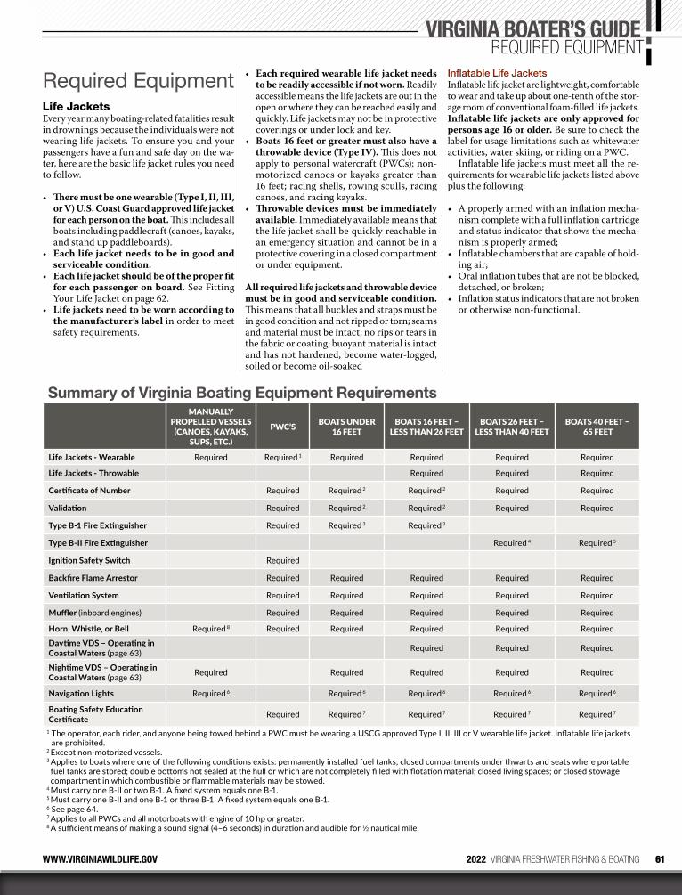
61WWW.VIRGINIAWILDLIFE.GOV 2022 VIRGINIA FRESHWATER FISHING & BOATING
Required EquipmentLife JacketsEvery year many boating-related fatalities result in drownings because the individuals were not wearing life jackets. To ensure you and your passengers have a fun and safe day on the wa-ter, here are the basic life jacket rules you need to follow.
• There must be one wearable (Type I, II, III, or V) U.S. Coast Guard approved life jacket for each person on the boat. This includes all boats including paddlecraft (canoes, kayaks, and stand up paddleboards).
• Each life jacket needs to be in good and serviceable condition.
• Each life jacket should be of the proper fit for each passenger on board. See Fitting Your Life Jacket on page 62.
• Life jackets need to be worn according to the manufacturer’s label in order to meet safety requirements.
• Each required wearable life jacket needs to be readily accessible if not worn. Readily accessible means the life jackets are out in the open or where they can be reached easily and quickly. Life jackets may not be in protective coverings or under lock and key.
• Boats 16 feet or greater must also have a throwable device (Type IV). This does not apply to personal watercraft (PWCs); non-motorized canoes or kayaks greater than 16 feet; racing shells, rowing sculls, racing canoes, and racing kayaks.
• Throwable devices must be immediately available. Immediately available means that the life jacket shall be quickly reachable in an emergency situation and cannot be in a protective covering in a closed compartment or under equipment.
All required life jackets and throwable device must be in good and serviceable condition. This means that all buckles and straps must be in good condition and not ripped or torn; seams and material must be intact; no rips or tears in the fabric or coating; buoyant material is intact and has not hardened, become water-logged, soiled or become oil-soaked
Inflatable Life JacketsInflatable life jacket are lightweight, comfortable to wear and take up about one-tenth of the stor-age room of conventional foam-filled life jackets. Inflatable life jackets are only approved for persons age 16 or older. Be sure to check the label for usage limitations such as whitewater activities, water skiing, or riding on a PWC.
Inflatable life jackets must meet all the re-quirements for wearable life jackets listed above plus the following:
• A properly armed with an inflation mecha-nism complete with a full inflation cartridge and status indicator that shows the mecha-nism is properly armed;
• Inflatable chambers that are capable of hold-ing air;
• Oral inflation tubes that are not be blocked, detached, or broken;
• Inflation status indicators that are not broken or otherwise non-functional.
VIRGINIA BOATER’S GUIDEREQUIRED EQUIPMENT
Summary of Virginia Boating Equipment RequirementsMANUALLY
PROPELLED VESSELS(CANOES, KAYAKS,
SUPS, ETC.)
PWC’S BOATS UNDER 16 FEET
BOATS 16 FEET – LESS THAN 26 FEET
BOATS 26 FEET – LESS THAN 40 FEET
BOATS 40 FEET – 65 FEET
Life Jackets - Wearable Required Required 1 Required Required Required Required
Life Jackets - Throwable Required Required Required
Certificate of Number Required Required 2 Required 2 Required Required
Validation Required Required 2 Required 2 Required Required
Type B-1 Fire Extinguisher Required Required 3 Required 3
Type B-II Fire Extinguisher Required 4 Required 5
Ignition Safety Switch Required
Backfire Flame Arrestor Required Required Required Required Required
Ventilation System Required Required Required Required Required
Muffler (inboard engines) Required Required Required Required Required
Horn, Whistle, or Bell Required 8 Required Required Required Required Required
Daytime VDS – Operating in Coastal Waters (page 63) Required Required Required
Nightime VDS – Operating in Coastal Waters (page 63) Required Required Required Required Required
Navigation Lights Required 6 Required 6 Required 6 Required 6 Required 6
Boating Safety Education Certificate Required Required 7 Required 7 Required 7 Required 7
1 The operator, each rider, and anyone being towed behind a PWC must be wearing a USCG approved Type I, II, III or V wearable life jacket. Inflatable life jackets are prohibited.
2 Except non-motorized vessels.3 Applies to boats where one of the following conditions exists: permanently installed fuel tanks; closed compartments under thwarts and seats where portable fuel tanks are stored; double bottoms not sealed at the hull or which are not completely filled with flotation material; closed living spaces; or closed stowage compartment in which combustible or flammable materials may be stowed.
4 Must carry one B-II or two B-1. A fixed system equals one B-1.5 Must carry one B-II and one B-1 or three B-1. A fixed system equals one B-1.6 See page 64.7 Applies to all PWCs and all motorboats with engine of 10 hp or greater.8 A sufficient means of making a sound signal (4–6 seconds) in duration and audible for 1⁄2 nautical mile.
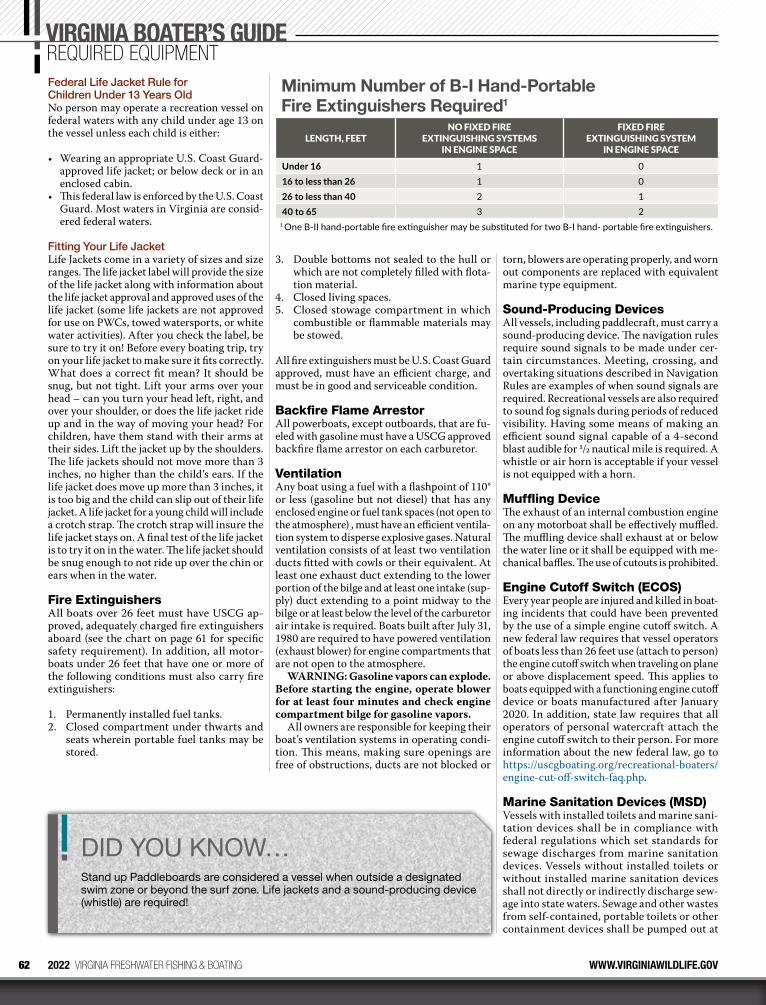
62 2022 VIRGINIA FRESHWATER FISHING & BOATING WWW.VIRGINIAWILDLIFE.GOV
Federal Life Jacket Rule for Children Under 13 Years OldNo person may operate a recreation vessel on federal waters with any child under age 13 on the vessel unless each child is either:
• Wearing an appropriate U.S. Coast Guard- approved life jacket; or below deck or in an enclosed cabin.
• This federal law is enforced by the U.S. Coast Guard. Most waters in Virginia are consid-ered federal waters.
Fitting Your Life JacketLife Jackets come in a variety of sizes and size ranges. The life jacket label will provide the size of the life jacket along with information about the life jacket approval and approved uses of the life jacket (some life jackets are not approved for use on PWCs, towed watersports, or white water activities). After you check the label, be sure to try it on! Before every boating trip, try on your life jacket to make sure it fits correctly. What does a correct fit mean? It should be snug, but not tight. Lift your arms over your head – can you turn your head left, right, and over your shoulder, or does the life jacket ride up and in the way of moving your head? For children, have them stand with their arms at their sides. Lift the jacket up by the shoulders. The life jackets should not move more than 3 inches, no higher than the child’s ears. If the life jacket does move up more than 3 inches, it is too big and the child can slip out of their life jacket. A life jacket for a young child will include a crotch strap. The crotch strap will insure the life jacket stays on. A final test of the life jacket is to try it on in the water. The life jacket should be snug enough to not ride up over the chin or ears when in the water.
Fire ExtinguishersAll boats over 26 feet must have USCG ap-proved, adequately charged fire extinguishers aboard (see the chart on page 61 for specific safety requirement). In addition, all motor-boats under 26 feet that have one or more of the following conditions must also carry fire extinguishers:
1. Permanently installed fuel tanks.2. Closed compartment under thwarts and
seats wherein portable fuel tanks may be stored.
3. Double bottoms not sealed to the hull or which are not completely filled with flota-tion material.
4. Closed living spaces.5. Closed stowage compartment in which
combustible or flammable materials may be stowed.
All fire extinguishers must be U.S. Coast Guard approved, must have an efficient charge, and must be in good and serviceable condition.
Backfire Flame ArrestorAll powerboats, except outboards, that are fu-eled with gasoline must have a USCG approved backfire flame arrestor on each carburetor.
VentilationAny boat using a fuel with a flashpoint of 110° or less (gasoline but not diesel) that has any enclosed engine or fuel tank spaces (not open to the atmosphere) , must have an efficient ventila-tion system to disperse explosive gases. Natural ventilation consists of at least two ventilation ducts fitted with cowls or their equivalent. At least one exhaust duct extending to the lower portion of the bilge and at least one intake (sup-ply) duct extending to a point midway to the bilge or at least below the level of the carburetor air intake is required. Boats built after July 31, 1980 are required to have powered ventilation (exhaust blower) for engine compartments that are not open to the atmosphere.
WARNING: Gasoline vapors can explode. Before starting the engine, operate blower for at least four minutes and check engine compartment bilge for gasoline vapors.
All owners are responsible for keeping their boat’s ventilation systems in operating condi-tion. This means, making sure openings are free of obstructions, ducts are not blocked or
torn, blowers are operating properly, and worn out components are replaced with equivalent marine type equipment.
Sound-Producing DevicesAll vessels, including paddlecraft, must carry a sound-producing device. The navigation rules require sound signals to be made under cer-tain circumstances. Meeting, crossing, and overtaking situations described in Navigation Rules are examples of when sound signals are required. Recreational vessels are also required to sound fog signals during periods of reduced visi bility. Having some means of making an efficient sound signal capable of a 4-second blast audible for 1/2 nautical mile is required. A whistle or air horn is acceptable if your vessel is not equipped with a horn.
Muffling DeviceThe exhaust of an internal combustion engine on any motorboat shall be effectively muffled. The muffling device shall exhaust at or below the water line or it shall be equipped with me-chanical baffles. The use of cutouts is prohibited.
Engine Cutoff Switch (ECOS)Every year people are injured and killed in boat-ing incidents that could have been prevented by the use of a simple engine cutoff switch. A new federal law requires that vessel operators of boats less than 26 feet use (attach to person) the engine cutoff switch when traveling on plane or above displacement speed. This applies to boats equipped with a functioning engine cutoff device or boats manufactured after January 2020. In addition, state law requires that all operators of personal watercraft attach the engine cutoff switch to their person. For more information about the new federal law, go to https://uscgboating.org/recreational-boaters/engine-cut-off-switch-faq.php.
Marine Sanitation Devices (MSD)Vessels with installed toilets and marine sani-tation devices shall be in compliance with federal regulations which set standards for sewage discharges from marine sanitation devices. Vessels without installed toilets or without installed marine sanitation devices shall not directly or indirectly discharge sew-age into state waters. Sewage and other wastes from self-contained, portable toilets or other containment devices shall be pumped out at
VIRGINIA BOATER’S GUIDEREQUIRED EQUIPMENT
Minimum Number of B-I Hand-Portable Fire Extinguishers Required1
LENGTH, FEETNO FIXED FIRE
EXTINGUISHING SYSTEMS IN ENGINE SPACE
FIXED FIRE EXTINGUISHING SYSTEM
IN ENGINE SPACE
Under 16 1 016 to less than 26 1 026 to less than 40 2 140 to 65 3 2
1 One B-II hand-portable fire extinguisher may be substituted for two B-I hand- portable fire extinguishers.
DID YOU KNOW…Stand up Paddleboards are considered a vessel when outside a designated swim zone or beyond the surf zone. Life jackets and a sound-producing device (whistle) are required!
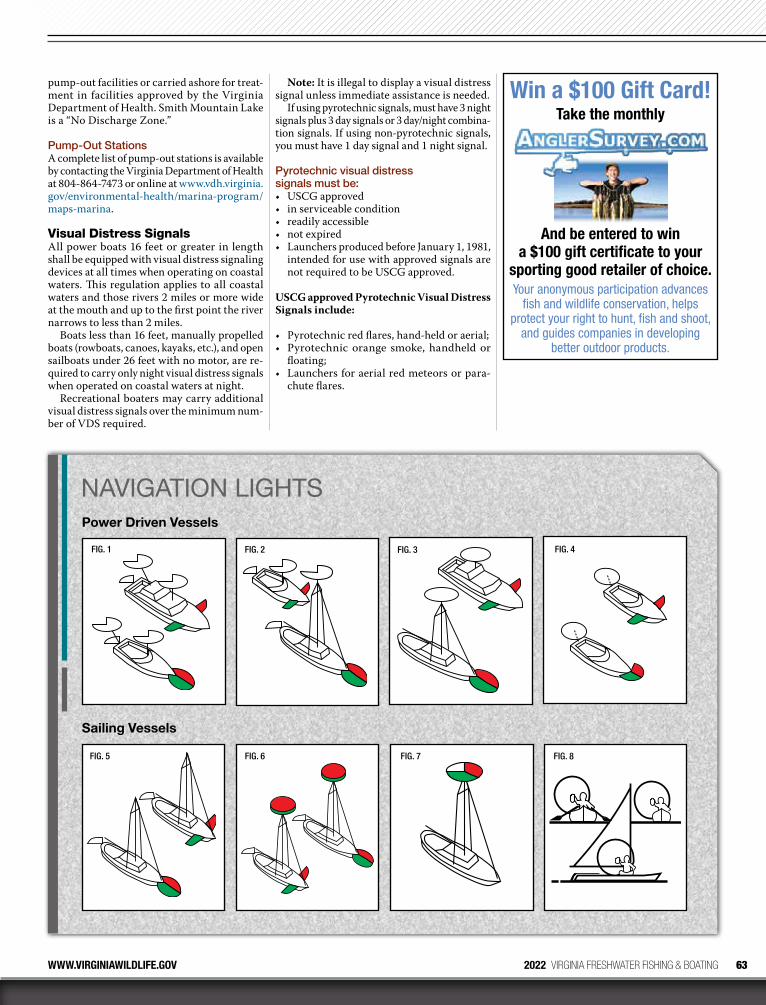
63WWW.VIRGINIAWILDLIFE.GOV 2022 VIRGINIA FRESHWATER FISHING & BOATING
pump-out facilities or carried ashore for treat-ment in facilities approved by the Virginia Department of Health. Smith Mountain Lake is a “No Discharge Zone.”
PumpOut StationsA complete list of pump-out stations is available by contacting the Virginia Department of Health at 804-864-7473 or online at www.vdh.virginia.gov/environmental-health/marina-program/maps-marina.
Visual Distress SignalsAll power boats 16 feet or greater in length shall be equipped with visual distress signaling devices at all times when operating on coastal waters. This regulation applies to all coastal waters and those rivers 2 miles or more wide at the mouth and up to the first point the river narrows to less than 2 miles.
Boats less than 16 feet, manually propelled boats (rowboats, canoes, kayaks, etc.), and open sailboats under 26 feet with no motor, are re-quired to carry only night visual distress signals when operated on coastal waters at night.
Recreational boaters may carry additional visual distress signals over the minimum num-ber of VDS required.
Note: It is illegal to display a visual distress signal unless immediate assistance is needed.
If using pyrotechnic signals, must have 3 night signals plus 3 day signals or 3 day/night combina-tion signals. If using non-pyrotechnic signals, you must have 1 day signal and 1 night signal.
Pyrotechnic visual distress signals must be: • USCG approved• in serviceable condition• readily accessible • not expired • Launchers produced before January 1, 1981,
intended for use with approved signals are not required to be USCG approved.
USCG approved Pyrotechnic Visual Distress Signals include:
• Pyrotechnic red flares, hand-held or aerial; • Pyrotechnic orange smoke, handheld or
floating;• Launchers for aerial red meteors or para-
chute flares.
NAVIGATION LIGHTSPower Driven Vessels
FIG. 3FIG. 1 FIG. 2 FIG. 4
Sailing Vessels
FIG. 5 FIG. 6 FIG. 7 FIG. 8
Win a $100 Gift Card!Take the monthly
And be entered to win a $100 gift certificate to your
sporting good retailer of choice.Your anonymous participation advances
fish and wildlife conservation, helps protect your right to hunt, fish and shoot,
and guides companies in developing better outdoor products.
64
VIRGINIA BOATER’S GUIDEREQUIRED EQUIPMENTNonpyrotechnic visual distress signaling devices must:• Meet USCG requirements. • Be in serviceable condition.• Be readily accessible.
USCG approved non-pyrotechnic visual dis-tress signals include:
• Orange distress flag with black square and black ball, for daytime use;
• Electric distress light for night use.
The following points will be used as the “cutoff points” for enforcement of the visual distress signal regulations on the coastal waters in Virginia. These points can be found on the appropriate nautical chart.
1. Entrance to Hampton Roads up to where the waterway is reduced to 2 nautical miles which is a line drawn between Old Point Comfort and Fort Wool.
2. York River up to where the waterway is re-duced to 2 nautical miles which is a line drawn between Sandy Point and Tue Point, which is in the vicinity of Tue Marshes Light.
3. Mobjack Bay up to, but not including, the Severn, Ware, North and East rivers.
4. Entrance to the Piankatank River where the waterway is reduced to 2 nautical miles which is a line drawn from Cherry Point at Gwynns Island across the river to the opposite shore, which is in the vicinity of Piankatank River Lighted Buoy 6.
5. Rappahannock River up to where the water-way is reduced to 2 nautical miles, which is a line drawn from Parrott Island to Cherry Point, which is just before you get to the first highway bridge.
6. Those parts of the Pocomoke and Tangier Sounds which fall within Virginia.
7. Where the uncharted inlets of the Atlantic Ocean are reduced to 2 nautical miles in width.
Navigation Lights Recreational boats, while underway, are re-quired to display navigation lights between sunset and sunrise and during periods of re-stricted visibility (see navigation lights, pg. 63).
No other lights shall be exhibited that could impair the visibility of required running lights or impair the visibility of approaching vessels.
Lights Used When AnchoredAn anchor light is a 360 degree (all-round) white light exhibited where it can best be seen and visible for 2 miles.
Special Lights for Enforcement VesselsEnforcement vessels of the DWR, the USCG, and other law enforcement agencies may display a rotating or flashing blue light. When such a light is observed you should stop immediately and maneuver in such a way as to permit the boarding officer to come alongside or aboard.
By federal law, blue lights may only be dis-played by enforcement vessels of the federal, state or local governments, and have the same effect on the water as the rotating or flashing blue lights on law enforcement cars traveling our highways.
Vessels Less Than 12 Meters (39.4 ft.) in Length• Vessels or sailboats using power: the lighting
arrangement in Figure 1, 2, 3, or 4 may be used.• Sailboats using sail alone: the lighting ar-
rangement in figure 5, 6, or 7 may be used.
The white masthead light or all around white light must be at least 1 meter (3.3 ft.) higher than the colored sidelights.
Vessels 12 Meters but Less Than 20 Meters (65.5 ft.) in Length• Vessels or sailboats using power: the lighting
arrangement in Figure 1 or 2 may be used. The lighting arrangement in Figure 3 may be used if the vessel was constructed before December 24, 1980.
• Sailboats using sail alone: the lighting ar-rangement in Figure 5, 6, or 7 may be used.
The white masthead light or all around white light must be at least 1 meter (3.3 ft.) higher than the colored sidelights.
Unpowered VesselsA vessel under oars and sailboats less than 7 meters (23 feet) in length may display those lights pre-scribed for a sailing vessel, but it they do not, they shall have ready at hand an electric torch or lighted lantern (Figure 8) shining a white light which shall be exhibited in sufficient time to prevent collision.
International Rules (Past the Line of Demarcation)Beyond three nautical miles of Virginia’s coast-line, if your power-driven vessel is less than 23 feet (7 meters) in length and its maximum speed does not exceed 7 knots, then it may display an all-round white light, and if possible, sidelights instead of the lights previously described.
2022 VIRGINIA FRESHWATER FISHING & BOATING WWW.VIRGINIAWILDLIFE.GOV
Holly Grove MarinaHolly Grove Marina
Boat Ramp • Tackle Shop • FuelFood • Drinks • Restrooms
434.636.3455On Lake Gaston at 8826 Hwy 903, Bracey, VA
www.hollygrovemarina.com
WELL-CRAFTED PLANS FOR THE CABIN OF YOUR DREAMS
WEBSITE: shopatmc.comEMAIL: [email protected]
Courtesy of Water Sports Foundation

65WWW.VIRGINIAWILDLIFE.GOV 2022 VIRGINIA FRESHWATER FISHING & BOATING
Courtesy of National Safe Boating Council
VIRGINIA BOATER’S GUIDESAFE BOATING
The Law about Alcohol, Drugs, and BoatingVirginia’s law states that boat operators with blood alcohol concentrations of .08 percent or more by weight, by volume, shall be presumed to be under the influence of alcoholic intoxicants. Operating a boat under the influence is a Class I Misdemeanor and can result in up to a $2,500 fine and/or up to 12 months in jail as well as the loss of the privilege to operate a motorboat for up to a year.
Implied ConsentThe Virginia Implied Consent Law states that by operating a watercraft, you are agreeing to sub-mit to a breath and/or blood test to determine the amount of alcohol and/or drugs in your blood. Unreasonable refusal to submit to these tests constitutes grounds for the revocation of the operator’s privilege to operate a watercraft on the waters of the Commonwealth.
Zero Tolerance LawVirginia Law prohibits persons younger than 21 from consuming alcohol and operating a watercraft with any measurable alcohol level. Operation under the influence of alcohol or other drugs is a criminal offense. Additionally, persons age 18–20 arrested buying, possessing, or drinking alcohol can be fined up to $2,500, lose their motor vehicle operator’s license for up to 1 year, and be sent to jail.
NO: If you are serving or have qualified as an Officer of the Deck Underway, boat coxswain, boat officer, boat operator, watercraft operator, or Marine Deck Officer in any branch of the Armed Forces of the United States, United States Coast Guard, or Merchant Marine.
NO: If you hold or have held a license to operate a vessel (Master, Captain, or Mate).
NO: If you are or have been a Registered Com-mercial Fisherman.
NO: If you are or have been a surface warfare officer/enlisted surface warfare specialist in the United States Navy.
General Information• You must carry proof of course completion
on board with you while operating. • If your boat is registered in another state
you must meet your home state’s education requirement.
• If you are planning to rent a boat, please check with the boat rental company.
• Refer to our website for more details about the education requirement.
EnforcementBoating laws are enforced primarily by Con-servation Police Officers employed by DWR. These officers have full police powers and have the right to lawfully stop and board your boat at any time to check for proper registration and required safety equipment.
Safe BoatingVirginia Boating Safety Education All PWC operators and motorboat operators of boats registered in Virginia with a motor of 10 horsepower and greater must take a boating safety course.
Boating Education CoursesThe DWR provides a free classroom boating safety course, Boat Virginia. This course is available throughout the year. The DWR also supports NASBLA approved boating courses offered by the USCG Auxiliary (USCGAux) and the U.S. Power Squadrons (USPS). There are several internet courses that meet Virginia’s Boating Safety Education Requirement.
For a up-to-date list of boating safety educa-tion course offerings and boating safety infor-mation, visit our website at www.virginiawild-life.gov/boating/education/requirement/.
To arrange a free vessel safety check, please call 1-800-245-2628 or contact local USCG Auxiliary or USPS member.
Do I Need to Take a Boating Course?YES: If you have never taken a NASBLA ap-proved boating safety course and you operate a PWC or a boat registered in Virginia with a motor of 10 horsepower and greater.
NO: If you have previously taken a NASBLA approved boating safety course and still have a card/certificate.
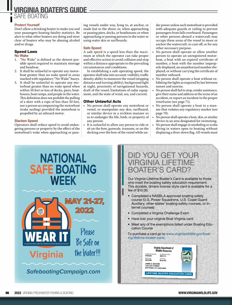
66 2022 VIRGINIA FRESHWATER FISHING & BOATING WWW.VIRGINIAWILDLIFE.GOV
NATIONAL SAFE BOATING
WEEK
SafeboatingCampaign.com
VirginiaIn partnership with the National Safe Boating Council
MAY 21-27,MAY 21-27, 20222022
Please Be Safe on
the Water!!!
VIRGINIA BOATER’S GUIDESAFE BOATING
der power unless such motorboat is provided with adequate guards or railing to prevent passengers from falls overboard. Passengers or other persons aboard a watercraft may occupy these areas of the vessel to moor or anchor the watercraft, to cast off, or for any other necessary purpose.
• No person shall operate or allow another person to operate an unregistered motor-boat, a boat with an expired certificate of number, a boat with the number improp-erly displayed, an unauthorized number dis-played, or without carrying the certificate of number onboard.
• No person shall operate a boat without ex-hibiting the lights as required by law between sunset and sunrise.
• No person shall fail to stop, render assistance, give their name and address at the scene of an accident, or report an incident in the proper timeframe (see page 71).
• No person shall operate a boat in a man-ner that violates any regulatory marker (see page 70).
• No person shall operate a boat, skis, or similar device in an area designated for swimming.
• No person shall engage in snorkeling or scuba diving in waters open to boating without displaying a diver-down flag. All vessels must
ing vessels under way, lying to, at anchor, or made fast to the shore; or, when approaching or passing piers, docks, or boathouses; or when approaching or passing persons in the water or using water skis or surfboards.
Safe SpeedA safe speed is a speed less than the maxi-mum at which the operator can take proper and effective action to avoid collision and stop within a distance appropriate to the prevailing circumstances and conditions.
In establishing a safe operating speed, the operator shall take into account: visibility, traffic density, ability to maneuver the vessel (stopping distance and turning ability), background light at night, proximity of navigational hazards, draft of the vessel, limitations of radar equip-ment, and the state of wind, sea, and current.
Other Unlawful Acts• No person shall operate any motorboat or
vessel, or manipulate any skis, surfboard, or similar device in a reckless manner so as to endanger the life, limb, or property of any person.
• It is unlawful to allow any person to ride or sit on the bow, gunwale, transom, or on the decking over the bow of the vessel while un-
Protect YourselfDon’t allow a drinking boater to make you and your passengers boating fatality statistics. Be alert to what other boaters are doing and steer clear of boaters who may be abusing alcohol and/or drugs.
Speed Laws No Wake1. “No Wake” is defined as the slowest pos-
sible speed required to maintain steerage and headway.
2. It shall be unlawful to operate any motor-boat greater than no wake speed in areas marked with regulatory “No Wake” buoys.
3. It shall be unlawful to operate any mo-torboat greater than no wake speed when within 50 feet or less of docks, piers, boat-houses, boat ramps, and people in the water. This definition does not prohibit the pulling of a skier with a rope of less than 50 feet, nor a person accompanying the motorboat (wake surfing) provided the motorboat is propelled by an inboard motor.
Slacken Speed Operators shall reduce speed to avoid endan-gering persons or property by the effect of the motorboat’s wake when approaching or pass-
DID YOU GET YOUR VIRGINIA LIFETIME BOATER’S CARD?Our Virginia Lifetime Boater’s Card is available to those who meet the boating safety education requirement. This durable, drivers license-style card is available for a fee of $10.00.
• Completed a NASBLA approved boating safety course (U.S. Power Squadrons, U.S. Coast Guard Auxiliary, other states’ boating safety courses, or in-ternet courses)
• Completed a Virginia Challenge Exam
• Have lost your original Boat Virginia card
• Meet any of the exemptions listed under Boating Edu-cation Course
To purchase a card go to www.virginiawildlife.gov/boat-ing/lifetime-boater-card/.

67WWW.VIRGINIAWILDLIFE.GOV 2022 VIRGINIA FRESHWATER FISHING & BOATING
stay at least 25 yards away when the flag is displayed.
Towed Watersports SafetyThe boating law contains several provisions related to the towing of persons on water skis, tubes, surfboards, or similar devices and the manipulation of such devices by the person being towed.
1. All boats towing a water skier(s) or other persons on towed devices MUST have ONE of the following:a. Persons being towed must be wearing
a USCG approved life jacket orb. There must be an observer on the boat
(in addition to the operator) who is in a position to observe the progress of the skier.
2. A person(s) being towed on water skis or other device may not operate in a reckless or dangerous manner.
3. A person(s) being towed on water skis or other device may not operate while under the influence of alcohol or drugs, including prescription narcotics and illegal drugs.
4. The operator of the boat towing a water skier(s) or person(s) on another towing de-vice may not manipulate or control the boat so as to cause the person(s) being towed to collide with any object or person.
5. Water skiing behind a motorboat (or towing of people on other devices) is allowed only between one-half hour before sunrise to one-half hour after sunset. Check the of-ficial sunrise and sunset times for your area.
6. Water skiing behind a PWC (or towing of people on other devices) is allowed only between sunrise to sunset. Check the of-ficial sunrise and sunset times for your area.
Personal Watercraft (PWC) OperationA personal watercraft is a motorboat less than 16 feet in length which uses an inboard mo-tor powering a jet pump as its primary motive power and which is designed to be operated by a person sitting, standing or kneeling on, rather than in the conventional manner of sitting or standing inside the vessel.
PWCs must follow all rules and regulations for motorboats. There are additional rules and regulations for PWC operators as follows:
1. It shall be unlawful for any person to op-erate a PWC, or the owner or any person having control to authorize or knowingly permit a person to operate a PWC, unless the operator is at least 16 years of age. Any person age 14 or 15 may operate a PWC if they have successfully completed an ap-proved boating education safety course, carry proof of successful completion of such course, and show this proof upon request by a law enforcement officer.
2. It is unlawful to operate a PWC unless the operator, each rider and anyone being towed by a PWC is wearing a USCG approved wearable life jacket suited for this activity. Inflatable life jackets are prohibited.
3. If the PWC is equipped with a lanyard-type engine cut-off switch, the operator must
attach the lanyard to his person, clothing, or life jacket.
4. It is unlawful to operate a PWC after sunset or before sunrise.
5. It is unlawful to operate a PWC while car-rying passengers in excess of the number for which the craft was designed by the manufacturer; including towed passengers.
6. A person shall be guilty of reckless opera-tion who operates any PWC recklessly so as to endanger the life, limb, or property of any person, which shall include, but not be limited to: (1) weaving through other ves-sels which are underway, stopped, moored or anchored while exceeding a reasonable speed; (2) following another vessel or skier, crossing the path of another vessel or skier, crossing the path of another vessel more closely than is reasonable and prudent; (3) crossing between the towing vessel and a skier; or (4) steering toward an object or per-son and turning sharply in close proximity to such object or person in order to spray or attempt to spray an object or person with the wash or jet spray of the PWC.
7. PWC operators must maintain “no wake” operation when within 50 feet or less of docks, piers, boathouses, boat ramps, people in the water and vessels other than PWCs. PWCs may tow a skier with a rope less than 50 feet. No wake is defined as “The slowest possible speed required to maintain steer-age and headway.”
The above provisions do not apply to partici-pants in regattas, races, marine parades, tourna-ments or exhibitions approved by the Board of the DWR or the USCG.
Navigation RulesMost boating accidents are the result of a colli-sion, either between two vessels, or between a vessel and a fixed or submerged object. For this reason, boat operators are cautioned to follow the established Navigation Rules, especially maintaining a proper lookout and safe speed. Remember the three basic rules of navigation:
1. Practice Good Seamanship — it is the responsibility of every vessel or PWC op-erator to take all necessary action to avoid collisions. Such action should be taken in ample time to avoid a collision and at a safe distance from other vessels.
2. Keep a Proper Lookout — every operator must keep a proper lookout using both sight and hearing at all times. Watch and listen for other vessels, radio communications, navigation hazards, and others involved in water activities.
3. Maintain a Safe Speed — safe speed will vary depending upon conditions such as wind, water conditions, navigation hazards, visibility, surrounding vessel traffic, and the maneuverability of your vessel.
The boat operator is responsible for knowing and following all of the applicable navigation
VA 4696 AF
Personal Watercraft (PWC) Safety DID YOU REMEMBER?
Full requirements can be found at www.dwr.virginia.gov/boating/
Wearable life jacket must be worn by each person (including skiers)
Open seat for skier
Operator must be at least 14 years old and have taken an approved boating safety course.
Whistle
May only operate between sunrise and sunset
Safety lanyard (must be attached)
Fire Extinguisher
Registration Card, Number and Current Decal
50’ Rule – PWCs must come to “no wake” speed when within 50’ or less of boathouses, piers, docks, boat ramps, people in the water, and vessels other than PWCs.
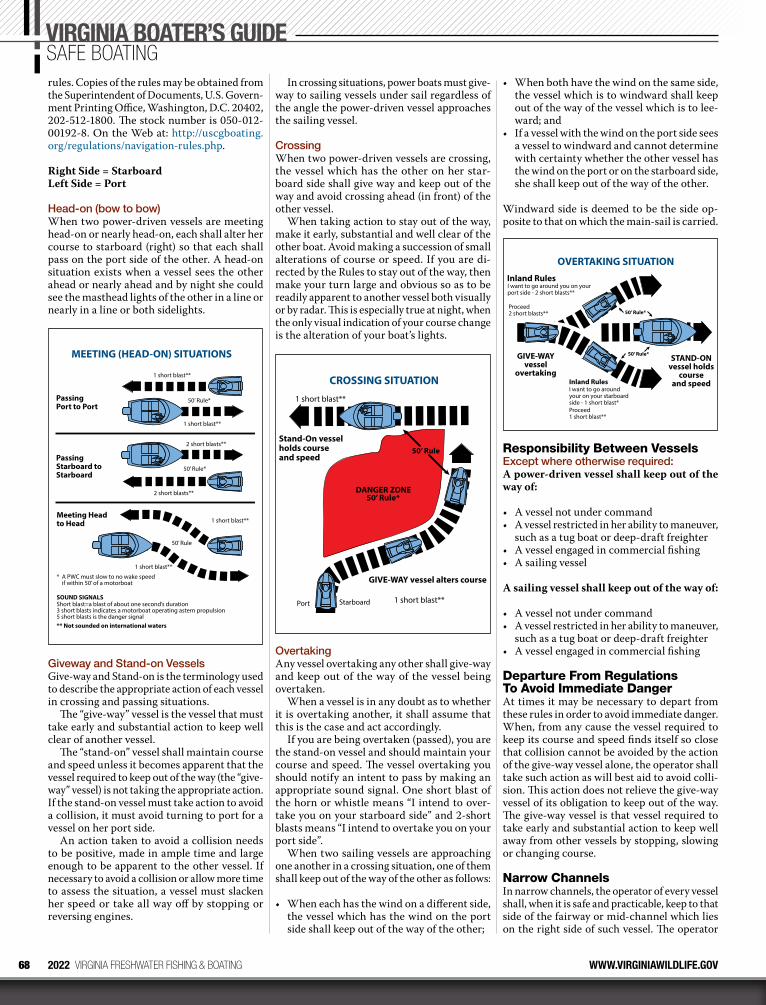
68 2022 VIRGINIA FRESHWATER FISHING & BOATING WWW.VIRGINIAWILDLIFE.GOV
rules. Copies of the rules may be obtained from the Superintendent of Documents, U.S. Govern-ment Printing Office, Washington, D.C. 20402, 202-512-1800. The stock number is 050-012-00192-8. On the Web at: http://uscgboating.org/regulations/navigation-rules.php.
Right Side = Starboard Left Side = Port
Headon (bow to bow) When two power-driven vessels are meeting head-on or nearly head-on, each shall alter her course to starboard (right) so that each shall pass on the port side of the other. A head-on situation exists when a vessel sees the other ahead or nearly ahead and by night she could see the masthead lights of the other in a line or nearly in a line or both sidelights.
MEETING (HEAD-ON) SITUATIONS
1 short blast**
50’ Rule*
1 short blast**
2 short blasts**
50’ Rule*
2 short blasts**
1 short blast**
50’ Rule
1 short blast**
* A PWC must slow to no wake speed if within 50’ of a motorboat
SOUND SIGNALS
Short blast=a blast of about one second’s duration3 short blasts indicates a motorboat operating astern propulsion5 short blasts is the danger signal** Not sounded on international waters
Meeting Head to Head
PassingStarboard toStarboard
Passing Port to Port
Giveway and Standon Vessels Give-way and Stand-on is the terminology used to describe the appropriate action of each vessel in crossing and passing situations.
The “give-way” vessel is the vessel that must take early and substantial action to keep well clear of another vessel.
The “stand-on” vessel shall maintain course and speed unless it becomes apparent that the vessel required to keep out of the way (the “give-way” vessel) is not taking the appropriate action. If the stand-on vessel must take action to avoid a collision, it must avoid turning to port for a vessel on her port side.
An action taken to avoid a collision needs to be positive, made in ample time and large enough to be apparent to the other vessel. If necessary to avoid a collision or allow more time to assess the situation, a vessel must slacken her speed or take all way off by stopping or reversing engines.
In crossing situations, power boats must give-way to sailing vessels under sail regardless of the angle the power-driven vessel approaches the sailing vessel.
Crossing When two power-driven vessels are crossing, the vessel which has the other on her star-board side shall give way and keep out of the way and avoid crossing ahead (in front) of the other vessel.
When taking action to stay out of the way, make it early, substantial and well clear of the other boat. Avoid making a succession of small alterations of course or speed. If you are di-rected by the Rules to stay out of the way, then make your turn large and obvious so as to be readily apparent to another vessel both visually or by radar. This is especially true at night, when the only visual indication of your course change is the alteration of your boat’s lights.
DANGER ZONE
50’ Rule*
50’ Rule
CROSSING SITUATION
Stand-On vesselholds courseand speed
GIVE-WAY vessel alters course
1 short blast**
1 short blast**
StarboardPort
Overtaking Any vessel overtaking any other shall give-way and keep out of the way of the vessel being overtaken.
When a vessel is in any doubt as to whether it is overtaking another, it shall assume that this is the case and act accordingly.
If you are being overtaken (passed), you are the stand-on vessel and should maintain your course and speed. The vessel over taking you should notify an intent to pass by making an appropriate sound signal. One short blast of the horn or whistle means “I intend to over-take you on your starboard side” and 2-short blasts means “I intend to overtake you on your port side”.
When two sailing vessels are approaching one another in a crossing situation, one of them shall keep out of the way of the other as follows:
• When each has the wind on a different side, the vessel which has the wind on the port side shall keep out of the way of the other;
• When both have the wind on the same side, the vessel which is to windward shall keep out of the way of the vessel which is to lee-ward; and
• If a vessel with the wind on the port side sees a vessel to windward and cannot determine with certainty whether the other vessel has the wind on the port or on the starboard side, she shall keep out of the way of the other.
Windward side is deemed to be the side op-posite to that on which the main-sail is carried.
OVERTAKING SITUATION
GIVE-WAYvessel
overtaking
STAND-ONvessel holds
courseand speed
Inland Rules
I want to go around you on yourport side - 2 short blasts**
Proceed2 short blasts**
Inland RulesI want to go aroundyour on your starboardside - 1 short blast*
50’ Rule*
50’ Rule*
Proceed1 short blast**
Responsibility Between VesselsExcept where otherwise required: A power-driven vessel shall keep out of the way of:
• A vessel not under command • A vessel restricted in her ability to maneuver,
such as a tug boat or deep-draft freighter • A vessel engaged in commercial fishing • A sailing vessel
A sailing vessel shall keep out of the way of:
• A vessel not under command • A vessel restricted in her ability to maneuver,
such as a tug boat or deep-draft freighter • A vessel engaged in commercial fishing
Departure From Regulations To Avoid Immediate Danger At times it may be necessary to depart from these rules in order to avoid immediate danger. When, from any cause the vessel required to keep its course and speed finds itself so close that collision cannot be avoided by the action of the give-way vessel alone, the operator shall take such action as will best aid to avoid colli-sion. This action does not relieve the give-way vessel of its obligation to keep out of the way. The give-way vessel is that vessel required to take early and substantial action to keep well away from other vessels by stopping, slowing or changing course.
Narrow ChannelsIn narrow channels, the operator of every vessel shall, when it is safe and practicable, keep to that side of the fairway or mid-channel which lies on the right side of such vessel. The operator
VIRGINIA BOATER’S GUIDESAFE BOATING
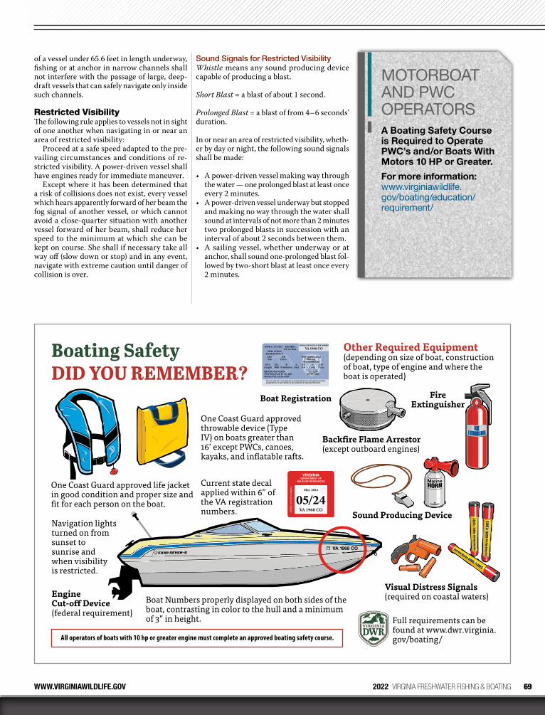
69WWW.VIRGINIAWILDLIFE.GOV 2022 VIRGINIA FRESHWATER FISHING & BOATING
of a vessel under 65.6 feet in length underway, fishing or at anchor in narrow channels shall not interfere with the passage of large, deep-draft vessels that can safely navigate only inside such channels.
Restricted Visibility The following rule applies to vessels not in sight of one another when navigating in or near an area of restricted visibility:
Proceed at a safe speed adapted to the pre-vailing circumstances and conditions of re-stricted visibility. A power-driven vessel shall have engines ready for immediate maneuver.
Except where it has been determined that a risk of collisions does not exist, every vessel which hears apparently forward of her beam the fog signal of another vessel, or which cannot avoid a close-quarter situation with another vessel forward of her beam, shall reduce her speed to the minimum at which she can be kept on course. She shall if necessary take all way off (slow down or stop) and in any event, navigate with extreme caution until danger of collision is over.
Sound Signals for Restricted VisibilityWhistle means any sound producing device capable of producing a blast.
Short Blast = a blast of about 1 second.
Prolonged Blast = a blast of from 4–6 seconds’ duration.
In or near an area of restricted visibility, wheth-er by day or night, the following sound signals shall be made:
• A power-driven vessel making way through the water — one prolonged blast at least once every 2 minutes.
• A power-driven vessel underway but stopped and making no way through the water shall sound at intervals of not more than 2 minutes two prolonged blasts in succession with an interval of about 2 seconds between them.
• A sailing vessel, whether underway or at anchor, shall sound one-prolonged blast fol-lowed by two-short blast at least once every 2 minutes.
One Coast Guard approved throwable device (Type IV) on boats greater than 16’ except PWCs, canoes, kayaks, and inflatable rafts.
Navigation lights turned on from sunset to sunrise and when visibility is restricted.
Current state decal applied within 6” of the VA registration numbers.
Boat Numbers properly displayed on both sides of the boat, contrasting in color to the hull and a minimum of 3” in height.
All operators of boats with 10 hp or greater engine must complete an approved boating safety course.
Other Required Equipment (depending on size of boat, construction of boat, type of engine and where the boat is operated)
Full requirements can be found at www.dwr.virginia.gov/boating/
Boat Registration
Backfire Flame Arrestor (except outboard engines)
Sound Producing Device
Visual Distress Signals (required on coastal waters)Engine
Cut-off Device (federal requirement)
Fire Extinguisher
One Coast Guard approved life jacket in good condition and proper size and fit for each person on the boat.
Boating Safety DID YOU REMEMBER?
MOTORBOAT AND PWC OPERATORSA Boating Safety Course is Required to Operate PWC’s and/or Boats With Motors 10 HP or Greater.
For more information: www.virginiawildlife.gov/boating/education/requirement/
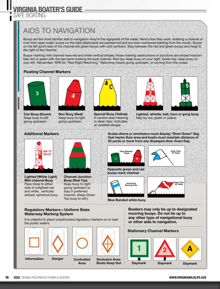
70 2022 VIRGINIA FRESHWATER FISHING & BOATING WWW.VIRGINIAWILDLIFE.GOV
AIDS TO NAVIGATIONBuoys are the most familiar aids to navigation-they’re the signposts of the water. Here’s how they work: entering a channel or river from open water, buoys on the right (starboard) are painted red and are even numbered starting from the mouth. Buoys on the left (port) side of the channel are green buoys with odd numbers. Stay between the red and green buoys and keep to the right of the channel.
Buoys marking mid-channel have red and white vertical stripes; those marking obstructions or junctions are striped horizon-tally red or green with the top band marking the best channel. Red top: keep buoy on your right. Green top: keep buoy on your left. Remember: RRR for “Red Right Returning.” Returning means going upstream, or coming from the ocean.
Scuba divers or snorkelers must display “Diver Down” flag that marks their area and boats must maintain distance of 25 yards or more from any displayed diver down flag.
AnchoringMooring Area
Keep Clear25 Yards
Blue Banded white buoy
Pass Between These
Keep Clear25 Yards
Opposite green and red buoys mark channel
Regulatory Markers—Uniform State Waterway Marking SystemIt is unlawful to place unauthorized regulatory markers on or near the public waters.
Controlled Area
Danger Exclusion Area: Boats Keep Out
InformationDaymarkDaymark Daymark
Stationary Channel Markers
Boaters may only tie up to designated mooring buoys. Do not tie up to any other type of navigational buoy or other aids to navigation.
RW “E”Mo(A)
Lighted (White Light) Mid-channel Buoy Pass close to either side of unlighted red and white , vertically striped, spherical buoy.
Channel Junction Buoy (Red Top) Keep buoy to right going upstream to stay in preferred channel. (Keep Green Top buoy to left.)
Additional Markers
3
Can Buoy (Green) Keep buoy to left going upstream.
Nun Buoy (Red) Keep buoy to right going upstream.
Special Buoy (Yellow) A caution area meaning to steer clear. Indicates an isolated danger.
Lighted, whistle, bell, horn or gong buoy May be red, green or yellow.
Floating Channel Markers
VIRGINIA BOATER’S GUIDESAFE BOATING
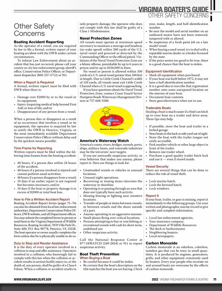
71WWW.VIRGINIAWILDLIFE.GOV 2022 VIRGINIA FRESHWATER FISHING & BOATING
Other Safety ConcernsBoating Accident ReportingAs the operator of a vessel, you are required by law to file a formal, written report of your boating accident with the DWR under certain circumstances.
To inform Law Enforcement about an ac-cident that has just occurred, please call your county or city law enforcement group, sheriff’s office, Conservation Police Officer, or Depart-ment dispatcher (800-237-5712) or 911.
When a Report is RequiredA formal, written report must be filed with DWR when there is:
• Damage over $2000 by or to the vessel or its equipment;
• Injury (requiring medical help beyond First Aid) or loss of life; and/or
• Disappearance of any person from a vessel.
When a person dies or disappears as a result of an occurrence that involves a vessel or its equipment, the operator is required by law to notify the DWR in Henrico, Virginia, or the most immediately available Department Conservation Police Officer without delay and by the quickest means possible.
Time Frame for ReportingWritten reports must be filed within the fol-lowing time frames from the boating accident:
• 48 hours, if a person dies within 24 hours of the accident;
• 48 hours if a person involved is injured and cannot perform usual activities;
• 48 hours if a person disappears from a vessel;• 10 days if an earlier report is not required
but becomes necessary; and/or• 10 days if the boat or property damage is in
excess of $2000 or total boat loss.
How to File a Written Accident ReportBoating Accident Report forms (pages 75–76) can also be obtained from local law enforcement authorities, Department Conservation Police Of-ficers, DWR website, and all Department offices. You may submit the completed forms in person or send them to the Virginia Department of Wildlife Resources, Boating Accident, 7870 Villa Park Dr., Suite 400, P.O. Box 90778, Henrico, VA 23228. The boat operator or owner usually completes the form unless she/he is physically unable to do so.
Duty to Stop and Render AssistanceIt is the duty of every operator involved in a collision to stop and offer assistance. Operators involved in a collision, who knowingly fail to comply with this law when the collision or ac-cident results in serious bodily injury to, or the death of, any person, shall be guilty of a Class 6 Felony. When a collision or accident results in
only property damage, the operator who does not comply with this law shall be guilty of a Class 1 Misdemeanor.
Naval Protection ZonesAll vessels must operate at minimum speed necessary to maintain a steerage and headway (no wake speed) within 500 yards of the U.S. naval vessel and proceed as directed by the Commanding Officer or the official patrol. Vio-lations of the Naval Vessel Protection Zone are a felony offense, punishable by up to 6 years in prison and/or up to $250,000 in fines.
No vessel or person is allowed within 100 yards of a U.S. naval vessel greater than 100 feet in length. Due to Little Creek Channel’s width of 150 yards, all vessels must exit Little Creek Channel when a U.S. naval vessel is approaching.
If you have questions about the Navel Vessel Protection Zone, contact Coast Guard Sector Hampton Roads Waterways Management Divi-sion at 757-668-5580.
Operate at Minimum Speed
KEEP OUT!
500Yards
100Yards
America’s Waterway WatchAmerica’s coasts, rivers, bridges, tunnels, ports, ships, military bases, and waterside industries may be the terrorists’ next targets.
If you see outwardly suspicious activity, or even behavior that makes you uneasy, please report it. Here are things to look for:
• Unattended vessels or vehicles in unusual locations.
• Unusual night operations. • Recovering or tossing items into/onto the
waterway or shoreline. • Operating in or passing through an area that
does not typically have such activity. • Missing fencing or lighting near sensitive
locations. • Transfer of people or items between vessels,
or between vessels and the shore outside of a port.
• Anyone operating in an aggressive manner. • Small planes flying over critical locations. • Persons attempting to buy or rent fishing or
recreational vessels with cash for short-term, undefined use.
• Other suspicious activity.
Call the National Response Center at 877-24WATCH (249-2824) or 911 to report suspicious activity.
Boat Theft PreventionWhen Buying a Boat• Be careful because it could be stolen.• Be certain that the boat’s description on the
title matches the boat you are buying. Check
year, make, length, and hull identification number.
• Be sure the model and serial number on an outboard motor have not been removed, tampered with or altered.
• Be suspicious of a fresh paint job on a late model vessel.
• When buying a used vessel, try to deal with a reputable marine dealer or a broker licensed by the state.
• If the price seems too good to be true, there is a good chance that the boat is stolen.
Equipment Identification• Mark all equipment when purchased. • If your boat was built before 1972, it may not
have a hull identification number.• It is a good idea to inscribe that registration
number onto some unexposed location on the interior of your boat.
• Document boat contents.• Store gear/electronics when not in use.
Trailerable BoatsStealing a boat is much easier if a thief can hitch up to your boat on a trailer and drive away. These tips may help.
• If possible, store the boat and trailer in a locked garage.
• Store boats in the back or side yard out of sight.• Store the boat with the trailer tongue not
easily accessible.• Park another vehicle or other large object in
front of the trailer.• Remove one trailer wheel.• Purchase a good quality trailer hitch lock
and use it — even if stored inside.
Vessel SecurityThere are several things that can be done to reduce the risk of vessel theft.
• Lock marine hatch.• Lock the forward hatch.• Lock windows.
Report It If your boat, trailer, or gear is missing, report it immediately to the following groups. Use your written and photographic marine record to give specific and complete information.
• Local law enforcement agencies.• Your insurance company.• Department of Wildlife Resources.• The dock or harbormaster.• Neighboring boaters.• Local newspapers.
Carbon MonoxideCarbon monoxide is an odorless, colorless, tasteless gas that can be toxic in small quan-tities. It is produced by engines, generators, grills, and other equipment commonly used by boaters. Every year people who recreate on and around boats are overcome by the effects of carbon monoxide.
VIRGINIA BOATER’S GUIDEOTHER SAFETY CONCERNS
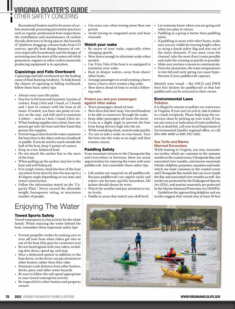
72 2022 VIRGINIA FRESHWATER FISHING & BOATING WWW.VIRGINIAWILDLIFE.GOV
VIRGINIA BOATER’S GUIDEOTHER SAFETY CONCERNS
Recreational boaters need to be aware of car-bon monoxide poisoning prevention practices such as regular professional boat inspections; the installation and maintenance of carbon dioxide detectors in living spaces; the hazards of “platform dragging; exhaust leaks from CO sources, specific boat design features of con-cern (especially houseboats); and the danger of swimming near the stern of the watercraft while generators, engines or other carbon monoxide producing equipment is in operation.
Capsizings and Falls OverboardCapsizings and falls overboard are the leading cause of fatal boating incidents. To help lessen the chance of capsizing or falling overboard, follow these basic safety tips:
• Always wear your life jacket.• Stay low in the boat and maintain 3 points of
contact. Keep 2 feet and 1 hand, or 2 hands and 1 foot in contact with the boat at all times. If seated, you have one point of con-tact on the seat, and still need to maintain 2 others — such as 1 foot, 1 hand, 2 feet, etc.
• When loading supplies into a boat, have one person get into the boat and then hand that person the supplies.
• If retrieving an item from the water, maneuver the boat close to the object and use a boathook or paddle. If you do need to reach outside the hull of the boat, keep 3-points of contact.
• Keep an even, balanced load.• Do not attach the anchor line to the stern
of the boat.• When pulling up the anchor, stay low in the
boat and well balanced.• If in rough waters, head the bow of the boat
anywhere from directly into the seas up to a 45 degree angle depending on sea state and vessel construction.
• Follow the information stated on the “Ca-pacity Plate.” Never exceed the allowable weight, horsepower rating, or maximum number of people.
Enjoying The WaterTowed Sports SafetyTowed watersports is a fun activity for the whole family. When enjoying the water behind the boat, remember these important safety tips:
• Prevent propeller strikes by making sure to turn off your boat when riders get into or out of the boat (this goes for swimmers too)
• Review hand signals with your riders, includ-ing slow down, speed up, and stop
• Have a dedicated spotter in addition to the boat driver, so the driver can pay attention to other boaters rather than their rider
• Maintain a safe distance from other boaters, docks, piers, and other water hazards
• Be sure to follow the safe speed appropriate to your towed watersports activity
• Be respectful to other boaters and property owners
• Use extra care when towing more than one person
• Avoid towing in congested areas and busy channels
Watch your wake• Be aware of your wake, especially when
changing speeds.• Slow down enough to eliminate wake when
needed.• Use Trim Tabs if the boat is so equipped to
minimize your wake.• Boat in deeper waters, away from shore/
other boats.• Arrange passengers to avoid creating a heavy
stern; a heavy stern creates a big wake.• Slow down ahead of time to avoid a follow-
ing wake.
Protect you and your passengers against other wakes• Warn passengers ahead of time.• Slow down but don’t stop. You need headway
to be able to maneuver through the wake.• Keep older passengers aft (near the stern).• Cross at a slight angle to prevent the bow
from being thrown high into the air.• While overtaking a boat, cross its wake quickly.• Try not to take a wake on your beam. Turn
the bow into the wake at an angle and then resume course.
Paddling SafetyFrom mountain streams to the Chesapeake Bay and everywhere in between, there are many opportunities for enjoying the water with your paddlecraft. Just remember these safety tips.
• Life jackets are required on all paddlecraft. Because paddlecraft can capsize easily and waters can become quickly hazardous, life jackets should always be worn.
• Watch the weather and pay attention to wa-ter levels.
• Paddle in areas that match your skill level.
• Let someone know where you are going and when you plan to return.
• Paddling in a group is better than paddling alone.
• If paddling in areas with other boats, make sure you are visible by wearing bright colors or using a kayak safety flag and stay out of the main channels. If you must cross the channel, take the most direct route possible and make the crossing as quickly as possible.
• Make sure you have a means to communicate.• Dress for immersion, the water temperatures
in late fall and early spring can cause hypo-thermia if your paddlecraft capsizes.
Identify your vessel – the USCG and DWR have free stickers for paddlecraft so that lost paddlecraft can be returned to their owner.
Environmental LawsPollutionIt is illegal for anyone to pollute our waterways in Virginia. If you can’t recycle it, take it ashore to a trash receptacle. Please help keep the wa-terways clean by picking up your trash. If you see any source or indication of water pollution, such as dead fish, call your local Department of Environmental Quality regional office, or call 804-698-4000 or 800-592-5482.
Sea Turtle and Marine Mammal EncountersWhile boating in Virginia, you may encounter sea turtles, which are common in the summer months in the coastal ocean, Chesapeake Bay, and associated river mouths, and marine mammals (whales, dolphins, porpoises, manatees and seals), which are most common in the coastal ocean and Chesapeake Bay mouth, but can occur inside the Bay and associated river mouths as well. Sea turtles are protected by the Endangered Species Act (ESA), and marine mammals are protected by the Marine Mammal Protection Act (MMPA).
Guidelines for approaching dolphins and sea turtles suggest that vessels stay at least 50 feet
Meghan Marchetti / DWR
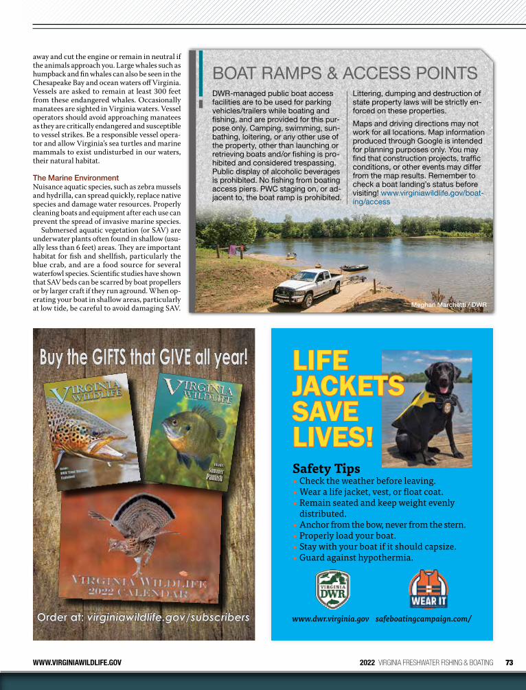
73WWW.VIRGINIAWILDLIFE.GOV 2022 VIRGINIA FRESHWATER FISHING & BOATING
Order at: Order at: virginiawildlife.gov/subscribersvirginiawildlife.gov/subscribers
Inside:Summer
Panfish
MAY/JUNE 2019
FOUR DOLLARS
Buy the GIFTS that GIVE all year!Buy the GIFTS that GIVE all year!
www.dwr.virginia.gov
Safety Tips• Check the weather before leaving.• Wear a life jacket, vest, or float coat.• Remain seated and keep weight evenly
distributed.• Anchor from the bow, never from the stern.• Properly load your boat.• Stay with your boat if it should capsize.• Guard against hypothermia.
LIFE LIFE JACKETS JACKETS SAVE SAVE LIVES!LIVES!
safeboatingcampaign.com/
Meghan Marchetti / DWR
away and cut the engine or remain in neutral if the animals approach you. Large whales such as humpback and fin whales can also be seen in the Chesapeake Bay and ocean waters off Virginia. Vessels are asked to remain at least 300 feet from these endangered whales. Occasionally manatees are sighted in Virginia waters. Vessel operators should avoid approaching manatees as they are critically endangered and susceptible to vessel strikes. Be a responsible vessel opera-tor and allow Virginia’s sea turtles and marine mammals to exist undisturbed in our waters, their natural habitat.
The Marine EnvironmentNuisance aquatic species, such as zebra mussels and hydrilla, can spread quickly, replace native species and damage water resources. Properly cleaning boats and equipment after each use can prevent the spread of invasive marine species.
Submersed aquatic vegetation (or SAV) are underwater plants often found in shallow (usu-ally less than 6 feet) areas. They are important habitat for fish and shellfish, particularly the blue crab, and are a food source for several waterfowl species. Scientific studies have shown that SAV beds can be scarred by boat propellers or by larger craft if they run aground. When op-erating your boat in shallow areas, particularly at low tide, be careful to avoid damaging SAV.
BOAT RAMPS & ACCESS POINTSDWR-managed public boat access facilities are to be used for parking vehicles/trailers while boating and fishing, and are provided for this pur-pose only. Camping, swimming, sun-bathing, loitering, or any other use of the property, other than launching or retrieving boats and/or fishing is pro-hibited and considered trespassing. Public display of alcoholic beverages is prohibited. No fishing from boating access piers. PWC staging on, or ad-jacent to, the boat ramp is prohibited.
Littering, dumping and destruction of state property laws will be strictly en-forced on these properties.
Maps and driving directions may not work for all locations. Map information produced through Google is intended for planning purposes only. You may find that construction projects, traffic conditions, or other events may differ from the map results. Remember to check a boat landing’s status before visiting! www.virginiawildlife.gov/boat-ing/access
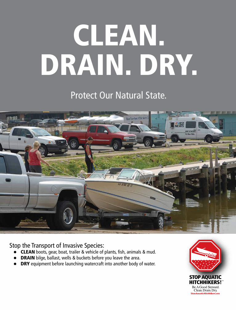
CLEAN.DRAIN. DRY.
Protect Our Natural State.
Stop the Transport of Invasive Species: CLEAN boots, gear, boat, trailer & vehicle of plants, fish, animals & mud. DRAIN bilge, ballast, wells & buckets before you leave the area. DRY equipment before launching watercraft into another body of water.
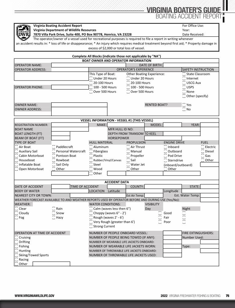
75WWW.VIRGINIAWILDLIFE.GOV 2022 VIRGINIA FRESHWATER FISHING & BOATING
For Office Use:Year:
Virginia Boating Accident ReportVirginia Department of Wildlife Resources7870 Villa Park Drive, Suite 400, PO Box 90778, Henrico, VA 23228 Date Received:The operator/owner of a vessel used for recreational purposes is required to file a report in writing whenever
OPERATOR NAME:OPERATOR ADDRESS: SAFETY INSTRUCTION
This Type of Boat: Other Boating Experience: ꙱ State Classroom꙱ Under 20 Hours ꙱ Under 20 Hours ꙱ Internet꙱ 20‐100 Hours ꙱ 20‐100 Hours ꙱ USCG Aux
OPERATOR PHONE: ꙱ 100 ‐ 500 Hours ꙱ 100 ‐ 500 Hours ꙱ USPS꙱ Over 500 Hours ꙱ Over 500 Hours ꙱ None
꙱ Other (specify)
OWNER NAME: ꙱ YesOWNER ADDRESS: ꙱ No
REGISTRATION NUMBER: MAKE: MODEL: YEAR:BOAT NAME MFR HULL ID NO:BOAT LENGTH (FT) DEPTH FROM TRANSOM TO KEELBEAM OF BOAT (FT) HORSEPOWERTYPE OF BOAT HULL MATERIAL PROPULSION ENGINE DRIVE FUEL꙱ Air Boat ꙱ Paddlecraft ꙱ Aluminum ꙱ Air Thrust ꙱ Inboard ꙱ Electric꙱ Auxiliary Sail ꙱ Personal Watercraft ꙱ Fiberglass ꙱ Manual ꙱ Outboard ꙱ Diesel꙱ Cabin Motorboat ꙱ Pontoon Boat ꙱ Plastic ꙱ Propeller ꙱ Pod Drive ꙱ Gas꙱ Houseboat ꙱ Rowboat ꙱ Rubber/Vinyl/Canvas ꙱ Sail ꙱ Other꙱ Inflatable Boat ꙱ Sail Only ꙱ Steel ꙱ Water Jet꙱ Open Motorboat ꙱ Other ꙱ Wood ꙱ Other ꙱ Other
꙱ Other
DATE OF ACCIDENT TIME OF ACCIDENT COUNTY: STATE:BODY OF WATER LOCATION Latitude LongitudeNEAREST CITY OR TOWN: Est Air Temp:WEATHER FORECAST AVAILABLE TO AND WEATHER REPORTS USED BY OPERATOR BEFORE AND DURING USE (Yes/No): WEATHER: WATER CONDITIONS: VISIBILITY꙱ Clear ꙱ Rain ꙱ Calm (waves less then 6") Day Night꙱ Cloudy ꙱ Snow ꙱ Choppy (waves 6" ‐ 2') ꙱ Good ꙱ ꙱ Fog ꙱ Hazy ꙱ Rough (waves 2' ‐ 6') ꙱ Fair ꙱
꙱ Very Rough (greater than 6') ꙱ Poor ꙱ ꙱ Strong Current
OPERATION AT TIME OF ACCIDENT NUMBER OF PEOPLE ONBOARD VESSEL: FIRE EXTINGUISHERS:꙱ Cruising NUMBER OF PEOPLE BEING TOWED (IF ANY): Number Used:꙱ Drifting NUMBER OF WEARABLE LIFE JACKETS ONBOARD:꙱ Fishing NUMBER OF WEARABLE LIFE JACKETS WORN: Type:꙱ Hunting NUMBER OF THROWABLE LIFE JACKETS ONBOARD:꙱ Skiing/Towed Sports NUMBER OF THROWABLE LIFE JACKETS USED:꙱ Racing꙱ Other
VESSEL INFORMATION ‐ VESSEL #1 (THIS VESSEL)
Est. Water Temp:
ACCIDENT DATA
an accident results in: * loss of life or disappearance; * An injury which requires medical treatment beyond first aid; * Property damage in excess of $2,000 or total loss of vessel.
Complete All Blocks (indicate those not applicable by "NA")
DATE OF BIRTH:
RENTED BOAT?
OPERATOR'S EXPERIENCE
BOAT OWNER AND OPERATOR INFORMATION
꙱ Sterndrive (inboard/outboard)
VIRGINIA BOATER’S GUIDEBOATING ACCIDENT REPORT
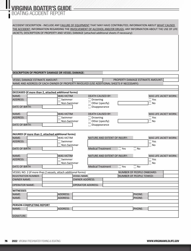
76 2022 VIRGINIA FRESHWATER FISHING & BOATING WWW.VIRGINIAWILDLIFE.GOV
VIRGINIA BOATER’S GUIDEBOATING ACCIDENT REPORT
DESCRIPTION OF PROPERTY DAMAGE OR VESSEL DAMAGE:
VESSEL DAMAGE ESTIMATE AMOUNT:NAME AND ADDRESS OF EACH OWNER OF PROPERTY INVOLVED (USE ADDITIONAL SHEETS IF NECESSARY):
DECEASED (if more than 2, attached additional forms)NAME: WAS VICTIM DEATH CAUSED BY: WAS LIFE JACKET WORN:ADDRESS: ꙱ Swimmer ꙱ Drowning ꙱ Yes
꙱ Non‐Swimmer ꙱ Other (specify) ꙱ NoDATE OF BIRTH: ꙱ Disappearance
NAME: WAS VICTIM DEATH CAUSED BY: WAS LIFE JACKET WORN:ADDRESS: ꙱ Swimmer ꙱ Drowning ꙱ Yes
꙱ Non‐Swimmer ꙱ Other (specify) ꙱ NoDATE OF BIRTH: ꙱ Disappearance
INJURED (if more than 2, attached additional forms)NAME: WAS VICTIM NATURE AND EXTENT OF INJURY: WAS LIFE JACKET WORN:ADDRESS: ꙱ Swimmer ꙱ Yes
꙱ Non‐Swimmer ꙱ NoDATE OF BIRTH Medical Treatment ꙱ Yes ꙱ No
NAME: WAS VICTIM NATURE AND EXTENT OF INJURY: WAS LIFE JACKET WORN:ADDRESS: ꙱ Swimmer ꙱ Yes
꙱ Non‐Swimmer ꙱ NoDATE OF BIRTH Medical Treatment ꙱ Yes ꙱ No
VESSEL NO. 2 (if more than 2 vessels, attach additional forms) NUMBER OF PEOPLE ONBOARD:REGISTRATION NUMBER: VESSEL NAME: NUMBER OF PEOPLE TOWED:OWNER NAME: OWNER ADDRESS:
OPERATOR NAME: OPERATOR ADDRESS:
WITNESSESNAME: ADDRESS: PHONE:NAME: ADDRESS: PHONE:
PERSON COMPLETING REPORTNAME: ADDRESS: PHONE:
SIGNATURE:
PROPERTY DAMAGE ESTIMATE AMOUNT:
ACCIDENT DESCRIPTION ‐ INCLUDE ANY FAILURE OF EQUIPMENT THAT MAY HAVE CONTRIBUTED; INFORMATION ABOUT WHAT CAUSED THE ACCIDENT; INFORMATION REGARDING THE INVOLVEMENT OF ALCOHOL AND/OR DRUGS; ANY INFORMATION ABOUT THE USE OF LIFE JACKETS; DESCRIPTION OF PROPERTY AND VESSEL DAMAGE (attached additional sheets if necessary):
Every time you purchase a fi shing license or register your boat, a portion of the proceeds go toward preserving our nation’s coastlines, lakes, rivers and streams. Protecting our memories on the water for generations to come.
THE SIMPLE ACT OF FISHING, PRESERVES FISHING.
Learn more at TakeMeFishing.org/ConservationLearn more at TakeMeFishing.org/Conservation
46831_TMF_PSA_Pg_Ad.indd 1 2/4/11 9:53 AM

Some discounts, coverages, payment plans, and features are not available in all states, in all GEICO companies, or in all situations. Boat and PWC coverages are underwritten by GEICO. GEICO is a registered service mark of Government Employees Insurance Company, Washington, DC 20076; a Berkshire Hathaway Inc. subsidiary. © 2021 GEICO. 21_5507299281
Switch to GEICO and see how easy it could be to save money on boat insurance. Simply visit geico.com/boat to get started.
geico.com/boat | 1-800-865-4846 | Local Office


