Embed Size (px)
Citation preview
2019
-202
0 ED
ITIO
N
RecreationalBoating & Fishing
GUIDE
QUEENSLAND
“Life is better on OUR BOATS”
PONTOON BOATS
www.runawaybaypontoonboats.comCraig Winch: 0417 646 711
Imag
e co
urte
sy o
f Dr D
avid
Wac
henf
eld
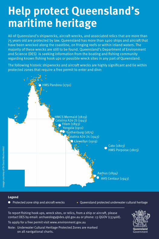
Help protect Queensland’s maritime heritageAll of Queensland’s shipwrecks, aircraft wrecks, and associated relics that are more than 75 years old are protected by law. Queensland has more than 1400 ships and aircraft that have been wrecked along the coastline, on fringing reefs or within inland waters. The majority of these wrecks are still to be found. Queensland’s Department of Environment and Science (DES) is seeking information from the boating and fishing community regarding known fishing hook ups or possible wreck sites in any part of Queensland.
The following historic shipwrecks and aircraft wrecks are highly significant and lie within protected zones that require a free permit to enter and dive:
To report fishing hook ups, wreck sites, or relics, from a ship or aircraft, please contact DES by email: [email protected] or phone: 13 QGOV (137468).
To apply for a free permit visit www.environment.gov.au
Note: Underwater Cultural Heritage Protected Zones are marked on all navigational charts.
HMS Pandora (1791)
Legend Protected zone ship and aircraft wrecks Queensland protected underwater cultural heritage
Llewellyn (1919)
Gothenburg (1875)Yongala (1911)Foam (1893)
HMCS Mermaid (1829)
Cato (1803)HMS Porpoise (1803)
Aarhus (1894)
AHS Centaur (1943)
Catalina A24-25 (1943)
Catalina A24-24 (1943)
ContentsKey contacts ........................................................... 2Fisheries Queensland ................................................ 2Maritime Safety Queensland ...................................... 3Queensland Water Police .......................................... 3National parks, marine parks, fish habitat areasand wildlife ................................................................ 3Great Barrier Reef Marine Park Authority ................... 3BOATING IN QUEENSLANDGeneral rules and requirements ........................... 6General safety obligation ........................................... 6Australian Builders Plate ............................................ 8You and your boat ..................................................... 9Registering a boat ................................................... 10BoatSafe – How to obtain a licence ........................ 10Marine driver licence ................................................ 12Alcohol and drugs ................................................... 12Marine incidents ...................................................... 12Speed limits............................................................. 13Safety equipment ................................................. 14Lifejackets ............................................................... 14Lifejacket checklist .................................................. 17Distress signals, flares & emergency beacons ......... 18Firefighting equipment ............................................. 20Navigation equipment .............................................. 20Other important equipment ..................................... 20Marine radio .......................................................... 22Licences and certificates ......................................... 22Mobile phones ......................................................... 22Coastal distress marine radio network ..................... 22Towing ..................................................................... 22Safety equipment for Queensland regulated ships ... 26Seaplanes ............................................................... 28Water limits .............................................................. 28Safe operation ...................................................... 37Navigating checklist ................................................. 37Skipper safety ......................................................... 37How to avoid marine incidents ................................ 38Collision rules .......................................................... 38Giving way ............................................................... 39Overtaking ............................................................... 39Sailing boats ............................................................ 39Sound signals .......................................................... 40Navigation lights ...................................................... 40Minimum required lights for boats under way .......... 41IALA buoyage system .............................................. 42Ship navigation area tips ......................................... 45Navigating with a Global Positioning System (GPS) ... 46Boating weather ................................................... 46Extreme weather events and cyclones .................... 46Personal watercraft .............................................. 47Personal watercraft licensing ................................... 47Personal watercraft registration ............................... 47Water sports ......................................................... 49Water skiing safety tips ............................................ 50Recognised water skiing symbols ............................ 50Sail boats and sail boards ....................................... 52
Rowing .................................................................... 52Canoes, kayaks and surf skis .................................. 52Divers’ flags ............................................................. 52Kitesurfing ............................................................... 52Boating offshore ................................................... 52Safety tips when boating onshore ........................... 53Bar crossings ........................................................ 53Boating on freshwater ......................................... 53Freshwater boating tips ........................................... 53Carbon monoxide hazard .................................... 54Pollution ................................................................ 54Fuels, oils and chemicals ......................................... 54Sewage ................................................................... 55MARINE PARKS IN QUEENSLANDGreat Barrier Reef Marine Park .......................... 56Great Barrier Reef Marine Park zoning..................... 58Know your zones in Moreton Bay Marine Park ........ 60Artificial reefs ........................................................... 61Fish habitat areas .................................................... 61Great Sandy Marine Park .................................... 63FISHING IN QUEENSLANDRecreational fishing rules for Queensland ................ 66Recreational fishing in Queensland waters ............... 66Size and possession limits ....................................... 66Measuring ............................................................... 66Catch and release ................................................... 67Sustaining our fisheries ............................................ 67Compliance ............................................................. 69Miscellaneous prohibitions ....................................... 69Fishing ethics .......................................................... 70Freshwaters .......................................................... 70No-take species ...................................................... 70Freshwater fishing gear............................................ 71Bait .......................................................................... 73Freshwater closed seasons ..................................... 74Freshwater closed waters ........................................ 74Stocked Impoundment Permit Scheme (SIPS) ........ 76Noxious fish ............................................................. 77Other invasive fish ................................................... 78Non-indigenous fish ................................................. 78Tidal waters .......................................................... 79No-take species ...................................................... 79Tidal fishing gear ..................................................... 80Spearfishing ............................................................ 81Worm digging .......................................................... 82Skin and fillet removal .............................................. 82Tidal waters closed seasons.................................... 83Tidal waters closed waters ...................................... 83Crabbing ................................................................. 85Other crustaceans and shellfish ............................... 86Marine plants ........................................................... 87Size and possession limits .................................. 88Size and possession limits - Tidal waters ................ 88Size and possession limits - Fresh waters ............... 96White spot disease ............................................... 99Map of movement restriction area ......................... 100Pre-trip item checklist ....................................... 104
This handbook should only be used as a guide, and the legislation is determinant. You should review the law if you have any doubts. The information in this edition is current at the time of printing.
1
PUBLISHED BY:
Formerly Inflight Publishing Pty. Ltd.
Publisher: Patrick McElligott
PO Box 670, Stones Corner, QLD 4120T: (07) 3891 7793 F: (07) 3891 7702E: [email protected]
Advertising Enquiries:Patrick McElligott
M: 0417 775 844E: [email protected]
www.transtasmanmediagroup.com
Editorial Coordination:
Fisheries QueenslandGPO Box 46, Brisbane 4001Customer Service Centre phone: 13 25 23E: [email protected]
fisheries.qld.gov.au
© The State of Queensland (Department of Agriculture and Fisheries) 2019
http://creativecommons.org/licences/by/2.5/auYou are free to copy, communicate and adapt the work, as long as you attribute the authors.
The Department of Agriculture and Fisheries (DAF) advisesthat the summarised information in this guide should not be relied on as a complete or accurate representation of the legislativerequirements. Users may access copies of the Fisheries Act 1994and other fisheries legislation via the internet at www.legislation.qld.gov.au and should seek their own legal advice. DAF disclaims all liability for all claims, loss, damages, cost or expense of whatever nature, howsoever occurring as a result of reliance upon theinformation contained in this guide.
Fisheries Queensland
Customer Service Centre Phone: 13 25 23Email: [email protected]: fisheries.qld.gov.au
Queensland Boating and Fisheries Patrol
Report suspected illegal fishing to the Fishwatch hotline: 1800 017 116
Report marine animals entangled in shark control equipment to the Shark Control Program hotline: 1800 806 891
Warwick604 Yangan Road, Warwick (07) 4542 6700 or 13 25 23
Gold Coast40-44 Sea World Dr, Main Beach (07) 5635 6900 or 13 25 23
Redland Bay26-40 Delancey Street, Cleveland (07) 3825 0445 or 13 25 23
Brisbane (Pinkenba)Marine Operations Base, McArthur Avenue East, Pinkenba (07) 3330 4210 or 13 25 23
Mooloolaba18-20 Parkyn Parade, Mooloolaba (07) 5444 4599 or 13 25 23
Noosa2 Russell Street, Noosaville (07) 5449 7555 or 13 25 23
Kingaroy214 Goodger Road, Kingaroy (07) 4182 1828 or 13 25 23
Hervey BayBuccaneer Avenue, Urangan (07) 4125 3989 or 13 25 23
Bundaberg16-32 Enterprise Street, Bundaberg (07) 4131 2365 or 13 25 23
GladstoneQBFP Operations Base 7 Leo Zussino Drive, Gladstone (07) 4971 6523 or 13 25 23
YeppoonJohn Howes Drive, Rosslyn Bay (07) 4991 5105 or 13 25 23
2
Mackay30 Tennyson Street, Mackay (07) 4967 0724 or 13 25 23
Airlie BeachCombined Marine Operations Base, Shingley Drive, Airlie Beach (07) 4962 5250 or 13 25 23
Townsville9-15 Langton Street, Garbutt (07) 3330 4536 or 13 25 23
Ingham7 Haig Street, Ingham (07) 4757 3711 or 13 25 23
Cairns38-40 Tingira Street, Portsmith, Cairns (07) 4241 1270 or 13 25 23
Port Douglas9 Ashford Avenue, Port Douglas (07) 4099 5160 or 13 25 23
Karumba8 Palmer Street, The Point, Karumba (07) 4745 9142 or 13 25 23
WeipaKerr Point Drive, Evans Landing, Weipa (07) 4069 8114 or 13 25 23
Maritime Safety QueenslandGold Coast40–44 Sea World Drive, Main Beach 4217 (07) 5585 1810 A/H (07) 5539 7373
BrisbaneMacArthur Avenue East, Pinkenba 4008 (07) 3632 7500 A/H (07) 3305 1700
Sunshine CoastParkyn Parade (Old Pilot Station), Mooloolaba 4557 (07) 5373 2310 A/H (07) 3305 1700
GladstoneLevel 7, 21 Yarroon Street, Gladstone 4680 (07) 4971 5200 A/H (07) 4971 5200
BundabergFloor 2, 46 Quay Street, Bundaberg 4670 (07) 4132 6600 A/H (07) 4971 5200
Hervey BayBuccaneer Avenue, Hervey Bay 4655 (07) 4194 9600 A/H (07) 4971 5200
MackayFloor 3, 44 Nelson Street, Mackay 4740 (07) 4944 3700 A/H (07) 4956 3489
Airlie Beach384 Shute Harbour Road, Airlie Beach 4802 (07) 4841 4500 A/H (07) 4956 3489
Townsville60 Ross Street, South Townsville 4810 (07) 4421 8100 A/H 1300 721 263
Cairns100–106 Tingira Street, Portsmith 4870 (07) 4052 7400 A/H 1300 551 899
Weipa*1 Iraci Avenue, Weipa 4874 (07) 4069 7165 A/H 1300 551 899
Karumba*Lot 75, Yappar Street, Karumba 4891 (07) 4745 9281 A/H 1300 551 899
Thursday Island*Hastings Street, Thursday Island 4875 (07) 4069 1351 A/H 1300 551 899
# Office is closed on Mondays * Telephone enquiries only.
Queensland Water PoliceGold Coast: (07) 5509 5700Brisbane: (07) 3895 0333Redland Bay (07) 3829 4129Sunshine Coast: (07) 5457 6711Hervey Bay: (07) 4125 3900Gladstone: (07) 4971 3222Yeppoon: (07) 4933 7990Whitsunday: (07) 4967 7222Townsville: (07) 4759 9777Cairns: (07) 4057 3577Thursday Island: (07) 4069 1520
The Water Police are responsible for crime prevention on the water and facilitate search and rescue activities in conjunction with the Australian Maritime Safety Authority.
Please note: All noise complaints must be directed to your local government.
For marine emergencies including search and rescue telephone 000.
National parks, marine parks, fish habitat areas and wildlifePh. 13 QGOV (13 74 68) des.qld.gov.au
Report all wildlife incidents including, marine strandings and crocodile sightings: 1300 130 372.
Great Barrier Reef Marine Park AuthorityTownsville head office 280 Flinders Street, Townsville 4810 (07) 4750 0700 gbrmpa.gov.au
Report marine park offences: 1800 380 048 (24hr hotline)
3
M: 0418 159 162 E: [email protected]
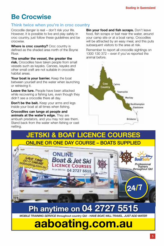
Be CrocwiseThink twice when you’re in croc countryCrocodile danger is real – don’t risk your life. However, it is possible to live and play safely in croc country, just follow these guidelines and be crocwise.
Where is croc country? Croc country is defined as the shaded area north of the Boyne River.
The smaller the vessel, the greater the risk. Crocodiles have taken people from small vessels such as kayaks. Canoes, kayaks and other small craft are not suitable in crocodile habitat areas.
Your boat is your barrier. Keep the boat between yourself and the water when launching or retrieving it.
Leave the lure. People have been attacked while recovering a fishing lure, even though they didn’t see a crocodile there all day.
Don’t be the bait. Keep your arms and legs inside your boat at all times when fishing.
Crocodiles can lunge at people and animals at the water’s edge. They are ambush predators, and you may not see them. Stand back from the water when fishing or cast netting.
Bin your food and fish scraps. Don’t leave food, fish scraps or bait near the water, around your camp site or at a boat ramp. Crocodiles will be attracted by an easy meal, and this puts subsequent visitors to the area at risk.
Remember to report all crocodile sightings on 1300 130 372 – even if you’ve reported the animal before.
5
Boating in Queensland
M: 0418 159 162 E: [email protected]
JETSKI & BOAT LICENCE COURSESONE DAY COURSE - BOAT SUPPLIED
AAB - ALL AUSTRALIAN BOATING
Professional Trainersthroughout Qld
MOBILE TRAINING SERVICE throughout country Qld - HAVE BOAT, WILL TRAVEL, JUST ADD WATER
Phone our Central Booking Office on 04 2727 5515
www.al laustral ianboating.com.auaaboating.com.au
ONLINE OR ONE DAY COURSE – BOATS SUPPLIED
JETSKI & BOAT LICENCE COURSESONE DAY COURSE - BOAT SUPPLIED
AAB - ALL AUSTRALIAN BOATING
Professional Trainersthroughout Qld
MOBILE TRAINING SERVICE throughout country Qld - HAVE BOAT, WILL TRAVEL, JUST ADD WATER
Phone our Central Booking Office on 04 2727 5515
www.al laustral ianboating.com.au
JETSKI & BOAT LICENCE COURSESONE DAY COURSE - BOAT SUPPLIED
AAB - ALL AUSTRALIAN BOATING
Professional Trainersthroughout Qld
MOBILE TRAINING SERVICE throughout country Qld - HAVE BOAT, WILL TRAVEL, JUST ADD WATER
Phone our Central Booking Office on 04 2727 5515
www.al laustral ianboating.com.au
Professional Trainers
throughout Qld
24/7
Ph anytime on 04 2727 5515
General rules and requirementsGeneral safety obligationThe Transport Operations (Marine Safety) Act 1994 imposes a safety obligation on all vessel owners and masterss (skippers and personal watercraft riders) to operate vessels safely at all times.
You’re responsible for making sure your vessel is safe, properly equipped and maintained and operated in a safe manner.
This includes loading people, cargo and stores within the vessel’s limits. Make sure the vessel is suitable for the waters where you will be boating.
You’re the skipper, you’re responsible!Be a responsible skipper, before you head out on the water follow these simple tips:
• check that your boat is serviced and in a seaworthy condition
• have the required safety equipment on board, not expired and in good condition and easily accessible
• tell someone where you are going and when you intend to return
• have the correct marine licence and know how to handle the boat
• know how to use your marine radio
• check the weather and tides before you go out
• know the navigation rules and follow them
• wear your lifejacket–if it’s not on it can’t save you.
MARITIME TRAINING ON THE DOORSTEP OF THE GREAT BARRIER REEF
> Extensive range of AMSA approved short courses Safety & Survival | Security | Fire
> Other short courses Communications | Safety & Survival
> Certificate qualifications in Maritime Operations
Train with industry professionals in our modern, fully-equipped training facilitiesin Cairns, North Queensland.
For training courses and start dates, contact the Great Barrier Reef International Marine College.
4041 9813 gbrimc.com.au32
21 I
RTO
ID 0
275
6
Boating in Queensland
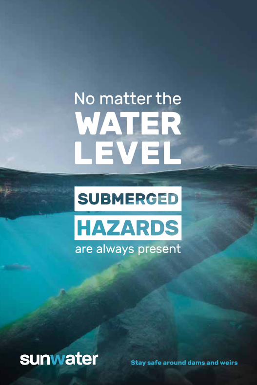
Stay safe around dams and weirs
are always present
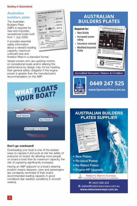
Australian builders plateThe Australian Builders Plate (ABP) is required for new and imported recreational boats built from 1 July 2006.
It provides essential safety information about a vessel’s loading capacity, maximum outboard size and flotation fitted in a standard format.
Vessel owners who are upsizing motors on recreational boats and/or altering the performance by design may not be meeting their general safety obligation if the engine power is greater than the manufacturer’s recommendation on the ABP.
Don’t go overboard!Overloading your boat is one of the easiest ways to capsize it and puts at risk the safety of everyone on board. By allowing more people on board a boat than its maximum capacity, the risk of capsizing significantly increases.
Having an ABP adjacent to a boat’s steering position means skippers, crew and passengers are constantly reminded of their boat’s recommended loading capacity in good conditions (fair weather conditions in smooth waters).
8
Boating in Queensland
AUSTRALIAN BUILDERS PLATES
Required for: New Builds Increased power rating
Insurance renewal Modified/Imported Boats
Accredited Surveyors, Valuers & Certifiers
0449 247 525www.kpsmaritime.com.au
•NewPlates•Re-IssuePlates•Re-RatedPlates•EngineHPUpgrade
AUSTRALIAN BUILDERS PLATES SUPPLIER
P: 0423 938 453 E: [email protected]
www.nelsonssurveys.com.au

The onus of safety rests with the skipper at all times. When using the boat in exposed waters or in rough conditions or carrying heavy loads, the skipper should consider reducing the number of persons taken on the trip.
All skippers must comply with the ABP.
Responsible skippers check the maximum number of people and weight load of a boat, as well as the maximum engine weight and power. Know how to safely load your boat by:
• storing heavy items low and central and secured in a place where they cannot move around
• distributing the weight, including passengers, evenly around the boat
• compensating for the weight of extra fuel and equipment.
You and your boatA new boatNew boats are required to have an ABP with the exception of: an amphibious vehicle; a canoe, kayak or surf ski or similar vessel designed to be powered by paddle; a rowing shell used for racing or rowing training; a sailboard or sail kite; a surf row boat; a hydrofoil or hovercraft; a race boat; a sailing vessel; a submersible; and an aquatic toy.
If safety equipment has been supplied, double check the safety equipment table (page 26) to ensure you have all the required equipment.
Lifejackets are vital items – consider if you need to upgrade to better quality or inflatable lifejackets which can be worn with comfort all of the time.
If the boat is fitted with an under floor fuel tank, ensure a water trap fuel filter has been fitted.
It will help ensure that fuel does not become contaminated resulting in engine problems while out boating.
A second hand boatBecause the boat is older and may have been modified by previous owners, be sure to check that:
• it is safe and any repairs or modifications have been carried out correctly
• it can safely go where you want to go, take who you want to take and do what you want to do
• the outboard fitted meets the requirements of the ABP
• lifejackets meet the current standard
• flares or EPIRB are in date
• if tiller steered, a safety lanyard is attached to the cut-off switch for the motor.
Buy with confidence. Consider getting a person with marine experience like a boat surveyor or builder to inspect the boat and give you a non- biased report.
For more information about choosing a safe boat (old or new) visit msq.qld.gov.au.
Aluminium, Stainless, Mild Steel welding and fabrication, Boats and Trailers Repaired and Modified, T Tops with rod holders for all boats, Custom fuel tanks to survey, Bow rails, Stern rails, Access ladders, Side pockets and control mounts, Water tanks for boats campers 4WD underfloor storage, Vehicle tool boxes and Canopies.JACOBS WELL ROAD & ROTARY PARK ROAD behind GEM FREEDOM SERVICE STATION; Alberton. Ph: 07 3807 7846 Fax: 07 3807 2468 Mobile: 0427 142 201Email: [email protected]
CUSTOM MARINE WELDING
9
Boating in Queensland
barnaclerid.com.auCall Shane: 0410 541 920
920
Save On• Lift Out Fees• Antifouling• Fuel & Maintenance Costs• KEEP Boat's Performance
Copper Ion BarnaclePrevention System
Boat owner responsibilityBoat owners are responsible for their boat from purchase to disposal. As a boat owner you are responsible for ensuring your vessel remains seaworthy, is not a hazard to navigation, and is not a marine pollution risk. Don’t allow your vessel to become derelict.
Insurance for vessels over 15m Legislation requires all ships over 15 metres (for example 15.01 metres) in length to have insurance sufficient to pay for potential pollution clean-up, salvage and wreck removal.
Registering a boatAll boats fitted with a propulsion motor of 3kW or more require registration when on the water in Queensland.
Registration forms must be lodged with a Department of Transport and Main Roads customer service centre. Fees are calculated according to the boat length (exemptions and concessions do apply in some cases).
Your boat will be allocated registration symbols. These must be clearly visible in plain characters in a contrasting colour to the hull of the boat. The size of the symbols depends on the type of boat and must be able to be read from a distance of 30 metres.
• Vessels capable of planing must have symbols a minimum of 150 mm high on both sides.
• Personal watercraft (PWC) registration symbols must be displayed on both sides at least 100 mm high, easily seen while the craft is underway.
• Vessels not capable of planing, (for example canoes with motors, yachts) must have symbols a minimum of 75 mm high on both sides or on the stern.
When a registered boat is sold it is the responsibility of the new owner to lodge an application for transfer of the registration within 14 days. Registration may be cancelled if the boat is no longer used in Queensland, is withdrawn from service or no longer meets registration requirements.
Third party insurance is not included in the cost of registering your vessel. Independent advice should be sought about insurance as required.
From 1 October 2019 the Department of Transport and Mains Roads will no longer be issuing registration labels and it will no longer be a requirement to display one on your boat.
For more information about boat registrations visit msq.qld.gov.au.
Boatsafe is a competency-based scheme to ensure marine licence applicants meet the minimum level of skills and knowledge before obtaining a licence Queensland. When you enrol in a BoatSafe course, you must complete a Medical Fitness Disclosure Statement and give it to the BoatSafe trainer.
For a list of BoatSafe training providers in your local area visit qld.gov.au/transport/ boating.
Queensland recognises other states’ marine licences. If your home state does not have any licensing requirements, you should obtain a marine licence before boating in.
10
Boating in Queensland
11
Boating in Queensland
Big Tip
gpcl.com.au/Big 6 |
The Gladstone Marina, award winning first class facilities, pristine parklands and the gateway to the Southern Great Barrier Reef.
Gladstone MarinaVHF 82 I (07) 4976 1399 [email protected] I gpcl.com.au
TendersTenders are exempt from registration provided they are used within two nautical miles of the primary boat. The tender must be marked with the word ‘tender’ as well as the primary boat’s registration symbols (at least 75 mm high) on the exterior of the tender. If this is not possible, they must be marked on the inside of the boat in the largest characters possible. The tender may be marked with the owner’s name, if it is used for more than one of the owner’s boats.
Marine driver licenceA valid licence is required to operate all recreational boats powered by a motor of more than 4.5kW in Queensland.
Unlicensed drivers may drive a boat (where a licence is needed) provided a licensed driver is on board and is able to take immediate control. Unlicensed drivers are not allowed to tow a person (such as a water skier, knee boarder or an inflatable tow toy).
To obtain a recreational marine driver licence you must be aged 16 years or older and pass an approved BoatSafe course or have a recognised and valid interstate marine licence.
Marine licence forms must be lodged with a Department of Transport and Main Roads customer service centre. You will receive a printed receipt showing you have a marine licence. If you have a valid Queensland driver’s licence, a new licence will be sent to you in the mail with your marine licence/s indicator on the back. If not, you will be sent a marine licence indicator card.
Are your boating skills up to date?The average marine licence holder has their licence for 10 years before they register a boat. Inexperienced or out-of-practice skippers are a major cause of marine incidents. Practice makes perfect. You can refresh your boating skills at any time by re-doing your BoatSafe course. Visit the msq.qld.gov.au and check out the Maritime Matters and Maritime Minutes pages to help stay up to date.
Alcohol and drugsSkippers operating a recreational boat must have a blood alcohol limit of less than .05. Skippers should be aware that under their general safety obligation they must ensure that if they are in a situation where they may need to operate their boat, for example, if their boat drags anchor, that they are under .05 and in a fit state to operate the boat as necessary.
Police can ask you to provide a saliva sample to detect the presence of drugs. There is a zero tolerance for boating under the influence of drugs.
The skipper is also responsible for the safety of passengers and their alcohol consumption.
People on board need to take care because our data tells us that boat passengers are just as likely as skippers to be involved in incidents such as capsizing the vessel or falling overboard as a result of drinking alcohol.
Remember that the effects of alcohol are increased while on the water due to the sun, wind, and constant motion. Reflexes and response times to emergencies are slowed and swimming ability deteriorates considerably.
Alcohol and drugs affect your coordination, judgement, vision, balance and reaction time – increasing your risk of having a marine incident.
Don’t multiply the risks – think before you drink.
Marine incidentsAll marine incidents must be reported to a shipping inspector on the approved form within 48 hours. Shipping inspectors and forms are available at Maritime Safety Queensland, Queensland Boating and Fisheries Patrol and Queensland Water Police offices.
Reportable incidents include:
• the loss of a person from a boat• the death of, grievous bodily harm to, or
injuries to a person caused by a boat’s operations
• the loss or abandonment of a boat• a collision with a boat• the stranding/grounding of a boat• material damage to a boat• material damage caused by a boat’s
operations• danger to a person caused by a boat’s
operations• danger of serious damage to a boat• danger of serious damage to a structure
caused by a boat’s operations.If in doubt about whether an incident is reportable — report it.
Why reporting is importantThe reporting of marine incidents is vital to the development of safety standards, education and on-water compliance programs that will benefit all waterways users.
12
Boating in Queensland
Reporting a marine incident may also help you if you decide to make insurance claims for any damage. Some insurance companies may require a marine incident report to validate claims.
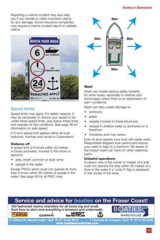
Speed limitsSpeed limits may apply. For safety reasons, it may be necessary to reduce your speed to be under these speed limits, stay below these limits and operate for the conditions. See page 38 for information on safe speed.
A 6 knot speed limit applies within all boat harbours, marinas and canals in Queensland.
Distance offA speed limit of 6 knots within 30 metres of boats anchored, moored to the shore or aground
• jetty, wharf, pontoon or boat ramp
• people in the water
Except PWCs which must not operate at more than 6 knots within 60 metres of people in the water. See page 48 for all PWC rules.
30m
30m 30m
30m
WashWash can create serious safety hazards for other boats, especially in marinas and anchorages where there is an expectation of calm conditions.
Wash can also create damage to:
• pontoons
• jetties
• vessels moored to these structures
• vessels in shallow water or anchored on a foreshore
• shorelines and river banks.
Even at slow speeds your boat will create wash. Responsible skippers look behind and ensure your wash is kept to a minimum. Be aware of the impact wash can have on other waterway users.
Unlawful operationsA person who is the owner or master of a ship must not operate the ship within 30 metres of a diver in the water if a ‘code A’ flag is displayed in the vicinity of the diver.
13
Boating in Queensland
www.boatieswarehouse.com21 Ellena St, Maryborough, QLD P: 07 4122 4819 7 Florence St Urangan, QLD P: 07 4125 3339
Safety equipmentHaving the right safety equipment on board and knowing how to use it is essential – it may save your life in an emergency.
What you are required to carry depends on the size of your boat, whether it needs to be registered and where you’re operating.
Page 26 provides a list of the minimum safety equipment to be carried on all recreational boats and PWCs.
Be prepared for the unexpected!Recommended safety equipment is optional – particularly by unregistered boats but responsible skippers should consider carrying the equipment at all times.
Safety equipment includes parts that can deteriorate over time for example webbing, straps, plastic buckles, and any fabrics or materials. This lowers their usefulness or makes them unusable. You must check your safety equipment regularly to ensure it’s in good condition. Some items will need to be replaced or serviced by the expiry date or according to the manufacturer’s recommendations.
LifejacketsLifejackets are a vital piece of safety equipment. Think of them like your seatbelt on the water.
All lifejackets are designed for different purposes, wearer ages, sizes and weights. So choosing the right life jacket is important.
Lifejackets must display information about which Standard applies. The current Australian Standard is AS 4758 (AS 4758), which has replaced AS 1512–1996, AS 1499–1996 and AS 2260–1996. Lifejackets that meet these previous standards are no longer compliant and must be replaced. You cannot buy a new or replacement lifejacket manufactured/assessed to the old standard for use in Queensland.
The International Standards which are also compliant are:
• ISO12402 • EN399-1993• NZS5823:2005
Good condition means the jacket does not have any rips or tears, pulled stitching, faded colour, broken buckles, water logged foam or any other reason to prevent the lifejacket from performing the way it should.
Lifejackets don’t last forever, check with your lifejacket manufacturer on the lifespan of your lifejackets.
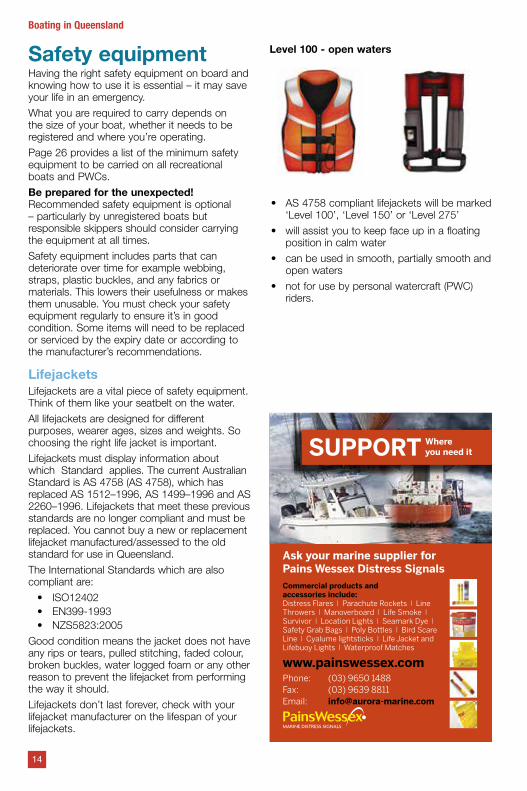
Level 100 - open waters
• AS 4758 compliant lifejackets will be marked ‘Level 100’, ‘Level 150’ or ‘Level 275’
• will assist you to keep face up in a floating position in calm water
• can be used in smooth, partially smooth and open waters
• not for use by personal watercraft (PWC) riders.
14
Boating in Queensland
MARINE DISTRESS SIGNALS
15
Boating in QueenslandMaritime Professionals
The MRG Team of shallow water (up to 10M Depth) recovery specialists, provide all equipment to recover or salvage any type of vessel or submerged object up to a 12 meter length.
The range of services MRG provide is extensive and includes general work boats, creek clearing & crew hiring, towage, dry hire of domestic and commercial vessels.
Call Toby or Jim today for expert advice and assistance.
www.maritimerecoverygroup.com.au
Shallow Water & Marina Salvage Specialists
Specialty Marine ServicesExtending professional high quality workmanship in a competitive marine environment, Aqua Mobile Marine specialise in:
• Marine Diesel Parts & Sales • Engine Alignment • Shaft & Propeller Repairs • Hydraulic Steering Sales & Repairs • Outboard Service and Supply • Inboard Service and Supply • Sterndrive Service & Supply • Petrol & Diesel Motor Service & Supply
Call Jim to discuss your marine service requirements.
www.aquamobilemarine.com.au
Your Marine Inspection SpecialistNavsafe specialise in providing marine inspection reports that deliver the facts without confusion.
Run by Australian Maritime safety Authority accredited marine surveyors, Navsafe provide both Professional and Novice boat owners with safety equipment, pre-purchased inspections, marine surveying insurance risk assessments and more.
Call Toby to assist with your marine inspections.
www.navsafemarine.com.au
Toby Blundell: 0421 570 475Jim McKinnon: 0418 748 023
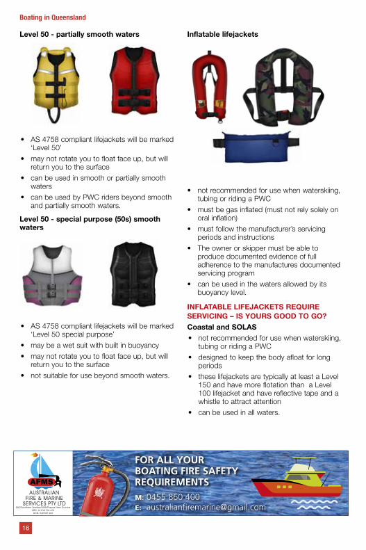
Level 50 - partially smooth waters
• AS 4758 compliant lifejackets will be marked ‘Level 50’
• may not rotate you to float face up, but will return you to the surface
• can be used in smooth or partially smooth waters
• can be used by PWC riders beyond smooth and partially smooth waters.
Level 50 - special purpose (50s) smooth waters
• AS 4758 compliant lifejackets will be marked ‘Level 50 special purpose’
• may be a wet suit with built in buoyancy
• may not rotate you to float face up, but will return you to the surface
• not suitable for use beyond smooth waters.
Inflatable lifejackets
• not recommended for use when waterskiing, tubing or riding a PWC
• must be gas inflated (must not rely solely on oral inflation)
• must follow the manufacturer’s servicing periods and instructions
• The owner or skipper must be able to produce documented evidence of full adherence to the manufactures documented servicing program
• can be used in the waters allowed by its buoyancy level.
INFLATABLE LIFEJACKETS REQUIRE SERVICING – IS YOURS GOOD TO GO?Coastal and SOLAS• not recommended for use when waterskiing,
tubing or riding a PWC
• designed to keep the body afloat for long periods
• these lifejackets are typically at least a Level 150 and have more flotation than a Level 100 lifejacket and have reflective tape and a whistle to attract attention
• can be used in all waters.
16
Boating in Queensland
FOR ALL YOUR BOATING FIRE SAFETY REQUIREMENTSM: 0455 860 400E: [email protected]
AUSTRALIAN FIRE & MARINE
SERVICES PTY LTDQLD/Northern Territory/NSW/Papua New Guinea
ABN: 14 634 354 428ACN: 618 867 182
Compulsory wearing of life jacketsIt is compulsory to wear a life jacket:
• when crossing a designated coastal bar* in an open boat that is less than 4.8 m in length
• if you are under the age of 12 (from 12 months and up to, but not including, 12 years of age) in an open boat that is less than 4.8 m in length and under way
• when riding a PWC, waterskiing or tubing
* the designated coastal bars are listed on page 53
If you’re not wearing it, it can’t save you – wear it!
Lifejacket checklist
• Do you have the right lifejackets for your whole trip?
• Are your lifejackets suited to your activity?• Do you have enough lifejackets for
everyone that will be on board and are they the right size?
• Are your lifejackets in good condition?• If you will be boating at night, do your
lifejackets have reflective tape to help others to see you better at night?
• Do you have a ‘LIFEJACKET’ sticker on your boat to show others where the lifejackets are stored?
17
Boating in QueenslandCB
123-
2299
13 22 87 | centurybatteries.com.au
The ultimate marine battery, incorporating advanced design features, maintenance free technology and specialist hard-wearing components. Designed and built tough here in Australia.
Perfectly adapted to life on the water.
“If it’s a marine battery, it’s got to be a Century!”
MARINE PRO
As used and recommended by
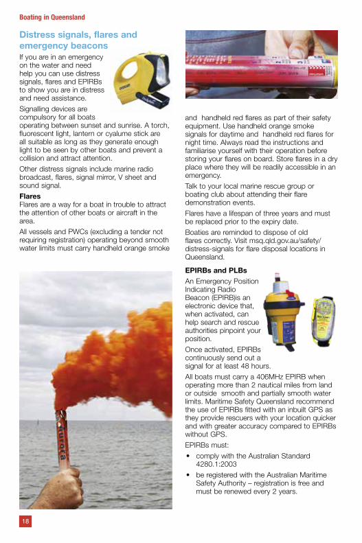
Distress signals, flares and emergency beaconsIf you are in an emergency on the water and need help you can use distress signals, flares and EPIRBs to show you are in distress and need assistance.
Signalling devices are compulsory for all boats operating between sunset and sunrise. A torch, fluorescent light, lantern or cyalume stick are all suitable as long as they generate enough light to be seen by other boats and prevent a collision and attract attention.
Other distress signals include marine radio broadcast, flares, signal mirror, V sheet and sound signal.
FlaresFlares are a way for a boat in trouble to attract the attention of other boats or aircraft in the area.
All vessels and PWCs (excluding a tender not requiring registration) operating beyond smooth water limits must carry handheld orange smoke
and handheld red flares as part of their safety equipment. Use handheld orange smoke signals for daytime and handheld red flares for night time. Always read the instructions and familiarise yourself with their operation before storing your flares on board. Store flares in a dry place where they will be readily accessible in an emergency.
Talk to your local marine rescue group or boating club about attending their flare demonstration events.
Flares have a lifespan of three years and must be replaced prior to the expiry date.
Boaties are reminded to dispose of old flares correctly. Visit msq.qld.gov.au/safety/distress-signals for flare disposal locations in Queensland.
EPIRBs and PLBsAn Emergency Position Indicating Radio Beacon (EPIRB)is an electronic device that, when activated, can help search and rescue authorities pinpoint your position.
Once activated, EPIRBs continuously send out a signal for at least 48 hours.
All boats must carry a 406MHz EPIRB when operating more than 2 nautical miles from land or outside smooth and partially smooth water limits. Maritime Safety Queensland recommend the use of EPIRBs fitted with an inbuilt GPS as they provide rescuers with your location quicker and with greater accuracy compared to EPIRBs without GPS.
EPIRBs must:
• comply with the Australian Standard 4280.1:2003
• be registered with the Australian Maritime Safety Authority – registration is free and must be renewed every 2 years.
18
Boating in Queensland
19
Boating in Queensland
GET PEACE OF MINDAND MORE WITH
CLUB MARINE.
PCLUBMARINE.COM.AU 1300 00 CLUB (2582)
At Club Marine, we know your boat is your pride and joy and we want to help you protect it.
You can enjoy quality cover, as well as other membership benefits, including Club Marine Assist, Club Marine TV, our mobile app and Club Marine magazine.
Insurance is underwritten by Allianz Australia Insurance Limited (Allianz) ABN 15 000 122 850 AFSL No. 234708 of 2 Market Street, Sydney. Club Marine Limited (Club Marine) ABN 12 007 588 347 AFSL No. 236916 is a related body corporate and issues boat insurance as agent of Allianz. Club Marine Assist is provided by Club Marine Limited. Assistance services are provided by AWP Australia Pty Ltd trading as Allianz Worldwide Partners ABN 52 097 227 177. Terms of service are available on clubmarine.com.au.
2018 Recreational Boating & Fishing Guide.indd 1 10/05/2018 2:02 pm
Operators of lightweight craft have a choice if they want to carry an EPIRB or a Personal Locator Beacon (PLB). If you chose to carry a PLB in place of an EPIRB it must comply with the following:
• GPS enabled
• float
• be worn by the operator
• comply with AS/NZ 4280.20
• be registered with AMSA
• in service.
Lightweight craft means off the beach type craft, human powered canoe and kayak, small sailing vessels (less than 6 m in length) and personal watercraft.
For more information on emergency beacons visit beacons.amsa.gov.au.
Search and rescue authorities respond to all activations – you must only activate the EPIRB or PLB in an emergency. If you accidentally activate an EPIRB/PLB or no longer require help you must tell them immediately by radioing your local volunteer marine rescue organisation or calling Rescue Coordination Centre’s 24-hour emergency number on 1800 641 792. To avoid accidental activations store EPIRBs in its mounting bracket in an accessible place away from other gear.
An EPIRB must be serviced or replaced according to the manufacturer’s recommendations before it expires.
Boaties are reminded to dispose of old EPIRB/ PLBs correctly. Do not dispose of old beacons in general waste as it will end up in landfill and could be accidently activate. Contact your local battery store to check whether they disconnect and dispose of beacons. A small fee may apply Your EPIRB manufacturers will also provide a process of how to disable an expired EPIRB and prepare it for the battery to be recycled.
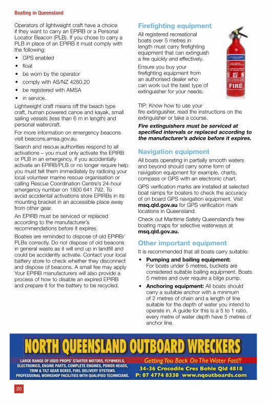
Firefighting equipment All registered recreational boats over 5 metres in length must carry firefighting equipment that can extinguish a fire quickly and effectively.
Ensure you buy your firefighting equipment from an authorised dealer who can work out the best type of extinguisher for your needs.
TIP: Know how to use your fire extinguisher, read the instructions on the extinguisher or take a course.
Fire extinguishers must be serviced at specified intervals or replaced according to the manufacturer’s advice before it expires.
Navigation equipmentAll boats operating in partially smooth waters and beyond should carry some form of navigation equipment for example, charts, compass or GPS with an electronic chart.
GPS verification marks are installed at selected boat ramps for boaters to check the accuracy of on board GPS navigation equipment. Visit msq.qld.gov.au for GPS verification mark locations in Queensland.
Check out Maritime Safety Queensland’s free boating maps for selective waterways at msq.qld.gov.au.
Other important equipment It is recommended that all boats carry suitable:
• Pumping and bailing equipment: For boats under 5 metres, buckets are considered suitable bailing equipment. Boats 5 metres and over require a bilge pump.
• Anchoring equipment: All boats should carry a suitable anchor with a minimum of 2 metres of chain and a length of line suitable for the depth of water you intend to operate in. A guide for this is a 5 to 1 ratio, every metre of water depth have 5 metres of anchor line.
Getting You Back On The Water Fast!!34-36 Crocodile Cres Bohle Qld 4818
P: 07 4774 8330 www.nqoutboards.com
LARGE RANGE OF USED PROPS’ STARTER MOTORS, FLYWHEELS, ELECTRONICS, ENGINE PARTS, COMPLETE ENGINES, POWER HEADS,
TRIM & TILT GEAR BOXES, FUEL DELIVERY SYSTEMS. PROFESSIONAL WORKSHOP FACILITIES WITH QUALIFIED TECHNICIANS.
20
Boating in Queensland
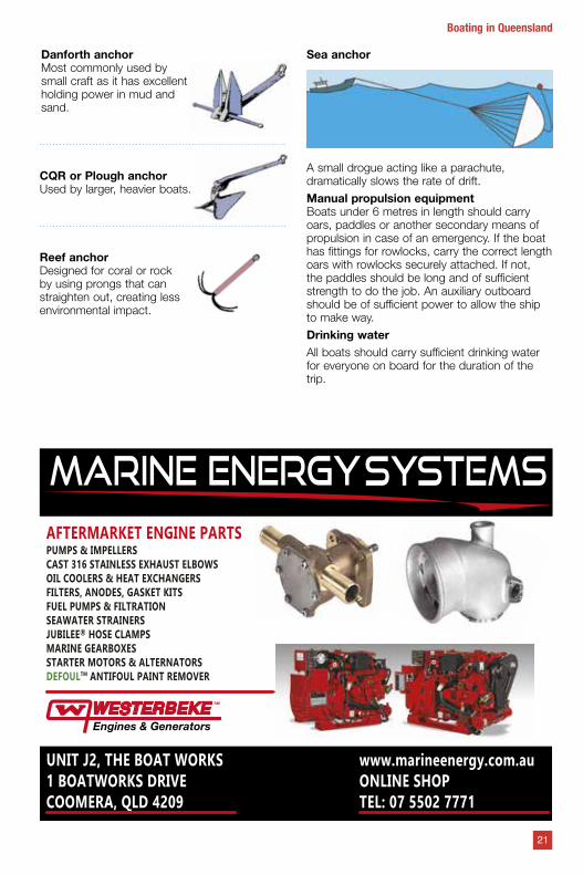
Danforth anchorMost commonly used by small craft as it has excellentholding power in mud andsand.
CQR or Plough anchorUsed by larger, heavier boats.
Reef anchorDesigned for coral or rock by using prongs that can straighten out, creating less environmental impact.
Sea anchor
A small drogue acting like a parachute, dramatically slows the rate of drift.
Manual propulsion equipment Boats under 6 metres in length should carry oars, paddles or another secondary means of propulsion in case of an emergency. If the boat has fittings for rowlocks, carry the correct length oars with rowlocks securely attached. If not, the paddles should be long and of sufficient strength to do the job. An auxiliary outboard should be of sufficient power to allow the ship to make way.
Drinking waterAll boats should carry sufficient drinking water for everyone on board for the duration of the trip.
21
Boating in Queensland
MARINE energySYSTEMS
UNIT J2, THE BOAT WORKS1 BOATWORKS DRIVECOOMERA, QLD 4209
www.marineenergy.com.auONLINE SHOPTEL: 07 5502 7771
AFTERMARKET ENGINE PARTSPUMPS & IMPELLERSCAST 316 STAINLESS EXHAUST ELBOWSOIL COOLERS & HEAT EXCHANGERSFILTERS, ANODES, GASKET KITSFUEL PUMPS & FILTRATIONSEAWATER STRAINERSJUBILEE® HOSE CLAMPSMARINE GEARBOXESSTARTER MOTORS & ALTERNATORSDEFOULTM ANTIFOUL PAINT REMOVER
Marine radioMarine radios are essential safety equipment and can be the only way to communicate with other boats or marine rescue groups and receive navigation warnings and weather updates.
Responsible skippers should know how to operate a marine radio, the distress and safety frequencies and how to properly format and transmit distress and safety messages.
Use your radio to log your trip with your local marine rescue group.
Radio licences and certificatesUnder federal regulations, operators of VHF and MF/HF radios are required to hold an operating certificate. Many Coast Guard and volunteer marine rescue stations provide these courses or the assessment for the certificate.
Visit acma.gov.au and navigate to the ‘marine, amateur and CB radio’ pages for more information.
Mobile phones Although commonly carried on boats, mobile phones are not seen as a substitute for marine radio or emergency radio communications.
Coastal distress marine radio networkMaritime Safety Queensland has a 24 hour listening watch service for distress and urgency calls to cover most coastal waters between the Torres Strait and the New South Wales border on VHF channels 16 and 67
Volunteer marine rescue organisations play an important role in delivering the coastal distress marine radio network service. They maintain a listening watch during their operating hours. For more information on volunteer rescue stations and frequencies monitored in your area contact your local Australian volunteer Coast Guard or Marine Rescue Queensland flotilla or the Moreton Bay Trailer Boat Club Radio Room.
TowingTowing trailers requires additional skills and knowledge. A trailer can greatly affect the handling and performance of a vehicle. Some special rules apply to size and weight of the trailer and its load:
• Towing more than one trailer at a time is not allowed.
• Nobody is to ride in the trailer or in the boat on a trailer.
PART & ACCESSORIES FOR BOATING, CARAVANNING, RV & 4WD ENTHUSIASTS
VISIT YOUR LOCAL SUPERSTORE1300 964 264 roadtechmarine.com.au
FROM LIFE JACKETS TO EPIRBS, FLARES... AND MORE!
FOR ALL YOUR MARINE SAFETY NEEDS
Bundaberg Capalaba
CairnsHervey Bay
KawanaLabrador
MackayNorth Lakes
RockhamptonTownsville
22
Boating in Queensland
23
Boating in Queensland
SUNWEAR WITH
Australian standard RREP:2014 - Bifocal ready made eye protectors which meet medium impact resistance and transmittance requirements when tested to AS1337.1 2010 personal eye protection. Our ready readers are certified to meet these requirements under SAI Global license number PPE40002.
h Medium Impact Polarised Bifocals h Bifocal Reader h 99.9% UV Protection & eliminates glare h Powers available +1.50, +2.00, +2.50
www.shamirohs.com.au
629RX DEFINE
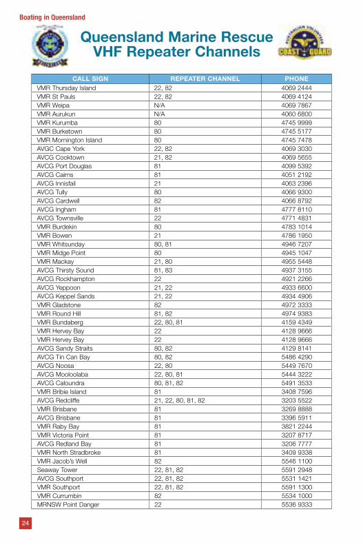
Queensland Marine Rescue VHF Repeater Channels
CALL SIGN REPEATER CHANNEL PHONEVMR Thursday Island 22, 82 4069 2444VMR St Pauls 22, 82 4069 4124VMR Weipa N/A 4069 7867VMR Aurukun N/A 4060 6800VMR Kurumba 80 4745 9999VMR Burketown 80 4745 5177VMR Mornington Island 80 4745 7478AVGC Cape York 22, 82 4069 3030AVCG Cooktown 21, 82 4069 5655AVCG Port Douglas 81 4099 5392AVCG Cairns 81 4051 2192AVCG Innisfail 21 4063 2396AVCG Tully 80 4066 9300AVCG Cardwell 82 4066 8792AVCG Ingham 81 4777 8110AVCG Townsville 22 4771 4831VMR Burdekin 80 4783 1014VMR Bowen 21 4786 1950VMR Whitsunday 80, 81 4946 7207VMR Midge Point 80 4945 1047VMR Mackay 21, 80 4955 5448AVCG Thirsty Sound 81, 83 4937 3155AVCG Rockhampton 22 4921 2266AVCG Yeppoon 21, 22 4933 6600AVCG Keppel Sands 21, 22 4934 4906VMR Gladstone 82 4972 3333VMR Round Hill 81, 82 4974 9383VMR Bundaberg 22, 80, 81 4159 4349VMR Hervey Bay 22 4128 9666VMR Hervey Bay 22 4128 9666AVCG Sandy Straits 80, 82 4129 8141AVCG Tin Can Bay 80, 82 5486 4290AVCG Noosa 22, 80 5449 7670AVCG Mooloolaba 22, 80, 81 5444 3222AVCG Caloundra 80, 81, 82 5491 3533VMR Bribie Island 81 3408 7596AVCG Redcliffe 21, 22, 80, 81, 82 3203 5522VMR Brisbane 81 3269 8888AVCG Brisbane 81 3396 5911VMR Raby Bay 81 3821 2244VMR Victoria Point 81 3207 8717AVCG Redland Bay 81 3206 7777VMR North Stradbroke 81 3409 9338VMR Jacob’s Well 82 5546 1100Seaway Tower 22, 81, 82 5591 2948AVCG Southport 22, 81, 82 5531 1421VMR Southport 22, 81, 82 5591 1300VMR Currumbin 82 5534 1000MRNSW Point Danger 22 5536 9333
24
Boating in Queensland
25
Boating in Queensland
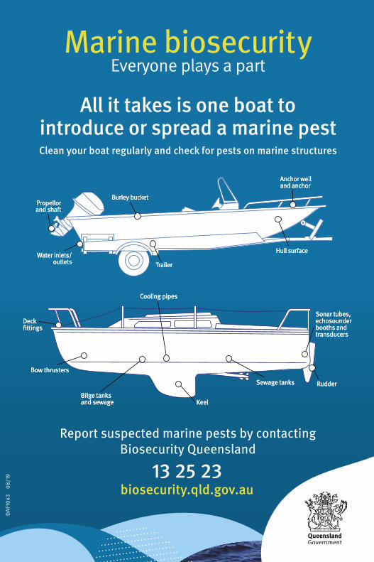
Anchor well and anchor
Propellor and shaft
Water inlets/outlets Trailer
Cooling pipes
KeelBilge tanks and sewage
Bow thrusters
Deck fittings
Sewage tanks Rudder
Sonar tubes, echosounder booths and transducers
Hull surface
Burley bucket
Anchor well and anchor
Propellor and shaft
Water inlets/outlets Trailer
Cooling pipes
KeelBilge tanks and sewage
Bow thrusters
Deck fittings
Sewage tanks Rudder
Sonar tubes, echosounder booths and transducers
Hull surface
Burley bucket
1043_Marine Biosecurity Ad Qld Boat Rec fishing guide_PRINT.indd 1 2/9/19 9:57 am
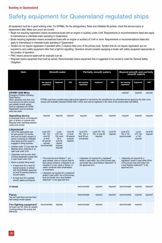
Item Smooth water Partially smooth waters Beyond smooth and partially smooth waters
Not requiring registration
Registered* PWC Not requiring registration
Registered* PWC Not requiring registration§
Registered* PWC§
EPIRB*(406 MHz)Emergency Position Indicating Radio Beacon. When operating more than 2nm from land and not within smooth and partially smooth waters. Must be registered with AMSA. Registration must be renewed every two years.
required required required
EPIRBs must have a printed expiry date and be replaced or serviced by the manufacturer (or authorised service agent) by this date; must comply with Australian Standard AS/NZ 4280.1:2003; and must be registered in the name of the owner/master with AMSA.
Signalling deviceFor example a torch, or fluorescent light, or lantern or cyalume stick. Required when operating between sunset and sunrise.
required required required required required required required required required
Lifejackets#• One of the appropriate size
for each person (12 months and over) on board, except if a person is wearing an inflatable diver jacket and the vessel is engaged in diving activities.
• Children under 12 must wear the lifejacket when underway in an open boat under 4.8m.
• Lifejackets must be worn when crossing designated coastal bars in open boats under 4.8m.
• Skiers or people being towed + At least level 50 or level 50 special purpose, or wetsuit with inbuilt flotation approved as level 50 special purpose in smooth waters.
+ At least level 50 in partially smooth waters and beyond.
Level 275, 150, 100, level 50 or level
50 special purpose
recommended
Level 275, 150, 100, level
50 or level 50 special purpose required
Level 50 or level
50 special purpose required
Level 275, 150, 100, or level 50 rec-ommended
Level 275, 150, 100, or level 50
required
Level 50 required
Level 275, 150 or 100
recommended
Level 275, 150 or 100
required
Level 50 required
• If the boat has level flotation**, and grab handles, lines or a secure hold for each person onboard, a lifejacket is not required in a river, creek or stream, or waters contained within breakwaters or revetments.
• Lifejackets not required for a registered* tender if used within 1km of the primary boat and tender has a level flotation statement** in the approved form.
• Lifejackets not required for a registered* tender if used within 1km of the primary boat and tender has a level flotation statement** in the approved form.
• Lifejackets not required for a registered* tender if used within 500m of the primary boat and tender has a level flotation statement** in the approved form.
V sheet recommended required required^ recommended required required^
FlaresTwo red hand flares and two hand held orange smoke signals.
recommended required required^ recommended required required^
Fire fighting equipmentAll boats over 5m. Must be capable of extinguishing a fire quickly and effectively.
recommended required recommended required recommended required
All equipment must be in good working order. For EPIRBs, fire fire extinguishers, flares and inflatable life jackets, check the service expiry or replacement date. Make sure yours are current.• Boats not requiring registration means recreational boats with an engine or auxiliary under 3 kW. Requirements or recommendations listed also apply
to international or interstate boats operating in Queensland.• Boats requiring registration means recreational boats with an engine or auxiliary of 3 kW or more. Requirements or recommendations listed also
apply to international or interstate boats operating in Queensland.• Tenders do not require registration if operated within 2 nautical miles (nm) of the primary boat. Tenders that do not require registration are not
required to carry safety equipment other than a light for signalling. Operators should consider equipping a tender with safety equipment appropriate to the location of operation.
• PWC means personal watercraft for example a jet ski.• Required means equipment that must be carried. Recommended means equipment that is suggested to be carried to meet the General Safety
Obligation.
Safety equipment for Queensland regulated ships
26
Boating in Queensland
KEY
* Also includes boats/tenders that are required to be registered but are not.** A level flotation statement in the approved form, is an Australian Builders Plate that indicates the boat has level flotation.^ Does not apply to a PWC operating in an approved aquatic event or beyond partially smooth waters and within 0.5 nautical miles from land.# Owners/masters must give each person on board information about where the safety equipment is kept. Lifejackets must be clearly visible to
passengers or readily accessible and indicated by a clearly visible sign with a white background marked with the word ‘lifejackets’ in red letters or vice versa.
º It is recommended the type and weight of anchor and the length and thickness of the cable should be appropriate for the type and weight of the PWC, the weather and sea conditions and the nature of the seabed.
§ Lightweight Craft are permitted to substitute an EPIRB with a PLB. The PLB must float, be registered with AMSA, be GPS enabled, be worn by the operator, in service and comply with the Australian Standard. Lightweight Craft are off the beach type craft, human powered canoe and kayak, small sailing vessels (less than 6m in length) and personal watercraft.
« Oars, paddles or another secondary means of propulsion. Portable fire extinguishers which have a manufacture stamp of more than five years prior, must be pressure tested by an approved agent.
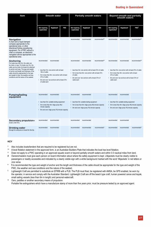
Item Smooth water Partially smooth waters Beyond smooth and partially smooth waters
Not requiring registration
Registered* PWC Not requiring registration
Registered* PWC Not requiring registration§
Registered* PWC§
NavigationA chart and a liquid damped compass appropriate to the operational area, or other directional finding orpositioning equipment. For a PWC without a chart or compass, an electronic navigation device appropriate to the operational area.
recommended recommended recommended^º recommended recommended recommended^º
AnchoringFor boats less than 5m, the cable can be chain or rope. For boats over 5m, the cable can be chain of at least 2m attached to anchor and rope. The type and weight of anchor and length and thickness of the cable should be appropriate for the type and weight of ship, the weather and sea conditions and the nature of the seabed.
recommended recommended recommended recommended recommended^º recommended recommended recommended^º
• less than 5m: one anchor with at least 18m of cable
• 5m to less than 8m: one anchor with at least 27m of cable
• 8m and over: two anchors with at least 37m of cable each
• less than 5m: one anchor with at least 27m of cable
• 5m to less than 8m: one anchor with at least 27m of cable
• 8m and over: two anchors with at least 37m of cable each
• less than 5m: one anchor with at least 27m of cable
• 5m to less than 8m: one anchor with at least 27m of cable
• 8m and over: two anchors with at least 37m of cable each
Pumping/bailing equipment
recommended recommended recommended recommended recommended recommended
• less than 5m: suitable bailing equipment
• 5m to less than 8m: bilge pump 45L/minute capacity
• 8m and over: bilge pump 70L/minute capacity
• less than 5m: suitable bailing equipment
• 5m to less than 8m: bilge pump 45L/minute capacity
• 8m and over: bilge pump 70L/minute capacity
• less than 5m: suitable bailing equipment
• 5m to less than 8m: bilge pump 45L/minute capacity
• 8m and over: bilge pump 70L/minute capacity
Secondary propulsion« (boats under 6m).
recommended recommended recommended recommended recommended recommended
Drinking waterEnough for everyone on board for the trip.
recommended recommended recommended recommended recommended^ recommended recommended recommended^
27
Boating in Queensland
• Over-width boats must comply with special permit conditions.
As a guide always check the following when towing:
• your vehicle towing capacity, to ensure your car can tow the boat and trailer combination
• the brakes on the trailer are the correct type for the load/weight
• the trailer is in good condition and safe to operate
• all lights and brakes work and safety chains are sufficient and securely fitted
• all loose items in the boat or trailer are secured away.
• The boat is secured to the trailer and outboard leg supported.
An over-width boat is• a boat exceeding 2.5 metres wide, or
• a boat exceeding 12.5 metres in length, or
• a boat which, when towed, results in the combination (towing vehicle, trailer and boat) exceeding 19 metres in length, or
• a boat exceeding 4.3 metres in height.
If your boat is over-width refer to the Over-width Boat Towing Bulletin for details on what you have to do to comply with the towing permit.
SeaplanesWhen on the water, seaplanes are just like any other vessel. They are subject to all the restrictions and privileges of other boats and conduct their operations accordingly.
Don’t be alarmed if a seaplane alights or takes off in the waterways near you.
Seaplane pilots are specially trained and qualified to operate upon the water.
Like other boat operators, they hold a marine licence to operate a powered vessel.
Avoid making sudden changes of direction which might confuse the pilot or obstruct the seaplane’s path.
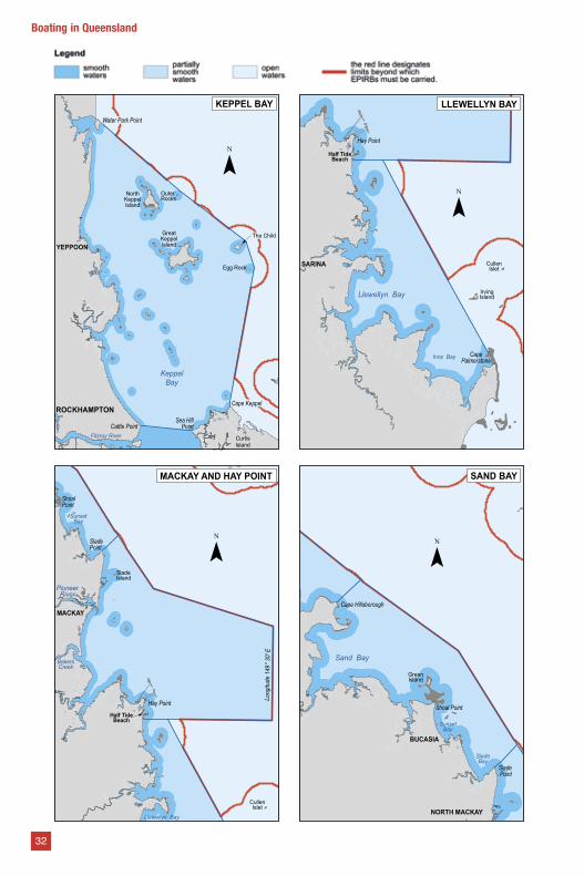
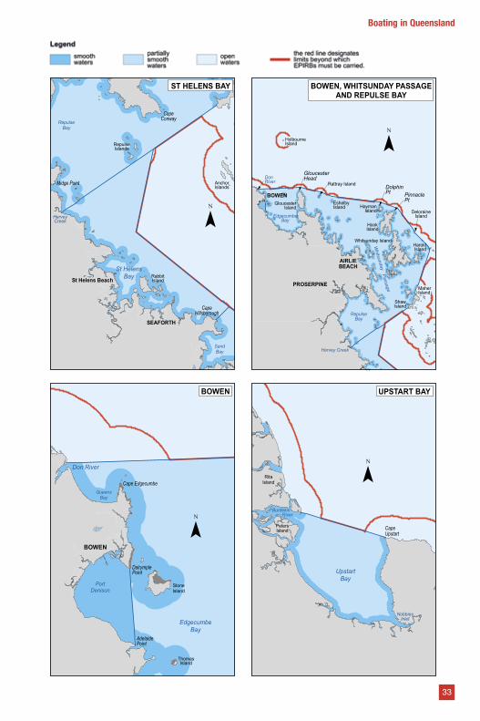
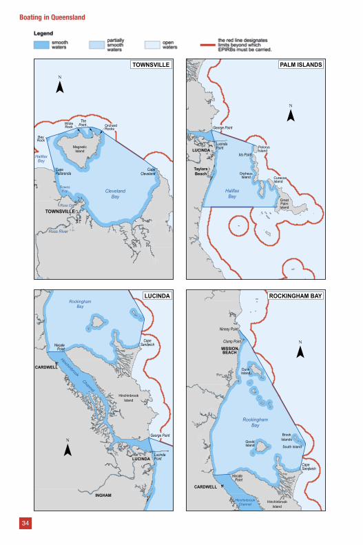
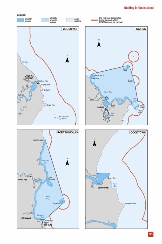
Water limitsBecause Queensland’s waterways are so diverse there are designated water limits affecting the types of safety equipment required.
There are three types of limits:
• smooth waters include rivers, creeks, streams and lakes, waters within breakwaters or revetments and within half a nautical mile from land within partially smooth limits and other waters specified in legislation
• partially smooth waters are determined by Maritime Safety Queensland and are specified in legislation
• open waters are areas beyond these limits.
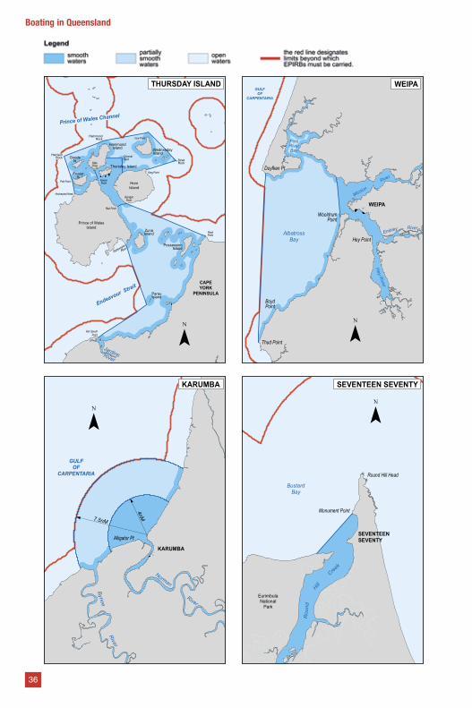
A complete list of maps showing these designated water limits as on page 31 - 36.
BOAT AND JETSKI
LICENCE
Get both on the same day
Call Alan on 0428 729 355Jacobs well
Online courses atwww.boatandjetski.com.au
28
Boating in Queensland
29
Boating in Queensland
Owning a boat should be a lifelong pleasure.
The process of buying a boat should be easy if done right.
Members of the Boating Industry Association pledge to abide by the Associations Code of Practice.
When buying a boat from a boat broker, look for the BIA logo. BIA members can be found at www.bia.org.au or by calling (02) 9438 2077.
Life on the water is great. The process for buying a boat should also be.
www.bia.org.au
Members of the Boating Industry Association pledge to abide by its Code of Practice that also incorporates its Code of Ethics. To make sure a business carrying the BIA logo is a current member, check for their details at
Designated Water Limits
Moreton Bay
BRISBANE
Redcliffe
Jumpinpin
SouthStradbrokeIsland
NorthStradbrokeIsland
MoretonIsland
ClevelandPt
Amity PtReeders Pt
SkirmishPointSouth
Point
'Short Point'
BribieIsland
ComboyuroPoint
Southport The Spit
Caloundra
PumicestonePassage
Cleveland
¯
BRISBANE
Rodds Bay
GLADSTONE East Point
North Point
Connor Bluff
Cape Keppel
Facing Island
The Narrows
LakeAwoonga
CurtisIsland
Division Point
ClewsPoint
South Trees Island
¯GLADSTONE
Keppel Bay
CurtisIsland
CapeKeppel
DivisionPoint
CattlePoint
Sea HillPoint
PeakIsland
The Narrows
PORTALMA
Fitzroy River
¯
PORT ALMA
!
HERVEY BAY
MARYBOROUGH
FraserIsland
HerveyBay
Mary River
RooneyPoint
Hook PointInskip Point
Double Island Point
FairwayBeacon
Burrum Point
Great
Strait
Sandy
¯
MARYBOROUGH
31
Boating in Queensland
KeppelBay
CurtisIsland
ROCKHAMPTONSea Hill
PointCattle Point
Egg Rock
Water Park Point
GreatKeppelIsland
OuterRocks
The Child
YEPPOON
Cape Keppel
NorthKeppelIsland
Fitzroy River
¯
KEPPEL BAY
Long
itude
149
° 30'
E
Llewellyn Bay
Half TideBeach
Hay Point
SladePoint
SladeIsland
MACKAY
SunsetBay
ShoalPoint
CullenIslet
BakersCreek
PioneerRiver
¯
MACKAY AND HAY POINT
Shoal Point
SladePoint
Sand Bay
Cape Hillsborough
SunsetBay
SladeBay
BUCASIA
GreenIsland
NORTH MACKAY
¯
SAND BAY
Llewellyn Bay
SARINA
Ince Bay
IrvingIsland
CullenIslet
Hay Point
Half TideBeach
CapePalmerstone
¯
LLEWELLYN BAY
32
Boating in Queensland
AnchorIslands
CapeHillsborough
SandBay
St HelensBay
RepulseIslands
CapeConway
RepulseBay
HerveyCreek
Midge Point
RabbitIsland
SEAFORTH
St Helens Beach
¯
ST HELENS BAY
BOWEN
EdgecumbeBay
Cape Edgecumbe
AdelaidePoint
DalrymplePoint
StoneIsland
Don River
PortDenison
ThomasIsland
QueensBay
¯
BOWEN
PROSERPINE
AIRLIEBEACH
Hervey Creek
HookIsland
HolbourneIsland
Rattray Island
DeloraineIsland
MaherIsland
RepulseBay
EdgecumbeBay
DonRiver
Whitsunday P
assage
ShawIsland
HaymanIsland
EshelbyIsland
GloucesterIsland
Whitsunday IslandHaroldIsland
GloucesterHead
DolphinPt Pinnacle
PtBOWEN
¯
BOWEN, WHITSUNDAY PASSAGEAND REPULSE BAY
RitaIsland
CapeUpstart
Burdekin River
UpstartBay
NobbiesInlet
PetersIsland
¯
UPSTART BAY
33
Boating in Queensland
TOWNSVILLE
CapeCleveland
ThePoint
CapePallarenda
MagneticIsland
BayRock
WhiteRock Orchard
Rocks
Ross River
Ross Ck
RowesBay
HalifaxBay
ClevelandBay
¯TOWNSVILLE
HinchinbrookIsland
George Point
LucindaPoint
INGHAM
RockinghamBay
CARDWELL
Hinchinbrook Channel
CapeSandwichHecate
Point
LUCINDA¯
LUCINDA
LucindaPointLUCINDA
HalifaxBay
PelorusIsland
CuracoaIsland
OrpheusIsland
GreatPalmIsland
Iris Point
George Point
TaylorsBeach
¯
PALM ISLANDS
Ninney Point
MISSIONBEACH
HinchinbrookIsland
RockinghamBay
CapeSandwich
CARDWELL
HinchinbrookChannel
Clump Point
DunkIsland
BrookIslands
South IslandGooldIsland
HecatePoint
¯
ROCKINGHAM BAY
34
Boating in Queensland
Etty Bay
MoresbyRiver
North BarnardIslands
TOWN OFMOURILYANHARBOUR
Goodman Point
Camp Point
Hayter Point
Double Point
¯
MOURILYAN
TrinityBay
MOSSMAN
Low Islets
DAINTREE
PORTDOUGLAS
DicksonsInlet
AlexandraBay
CapeKimberley
Daintree
River
Cape Tribulation
Island Point
Mossman R
¯
PORT DOUGLAS
Trinity Bay
MissionBay
TrinityInlet
LittleTurtleBayBarron River
CAIRNS
Buchan Point
ElliePoint
BessiePoint
Double Island
UplouReef
GreenIsland
LittleFitzroyIsland
FitzroyIsland
¯
CAIRNS
COOKTOWN
FinchBay
Monkhouse Point
Queens Chair
EndeavourRiver
¯COOKTOWN
35
Boating in Queensland
Endeavour Strait
Prince of WalesIsland
HornIsland
CAPEYORK
PENINSULA
PeakPoint
Van SpeultPoint
JardineRiver
ParauIsland
PossessionIsland
ZunaIsland
RattlesnakePoint
Red Point
Hochepied Head
Pott Point
HarrisonRock
HammondRock
HammondIsland
GoodsIs
FridayIs
Thursday Island
WednesdayIsland
KiwainPoint
ChannelRock
Ince Point
King Point
StraitRock
Prince of Wales Channel
KatePoint
GaragarPoint
¯
THURSDAY ISLAND
Alligator Pt
Norman
KARUMBA
GULFOF
CARPENTARIA
River
River
Bynoe
7.5nM
4nM
¯KARUMBA
BoydPoint
Hey R
iver
Thud Point
AlbatrossBay
WooldrumPoint
Hey Point
Duyfken Pt
RiverEmbley
WEIPA
Mission
River
PineRiverBay
GULFOF
CARPENTARIA
¯
WEIPA
SEVENTEENSEVENTY
Rou
nd
Monument Point
BustardBay
Hill
Creek
EurimbulaNational
Park
Round Hill Head
¯SEVENTEEN SEVENTY
36
Boating in Queensland
Safe operationIt is the responsibility of every boat owner and skipper to operate the boat under their control in a safe manner.
Operating safely combines the following:
• the boat is in good condition and safe to operate
• crew and passengers are safe
• the right equipment is on board and ready to be used
• crew and passengers know what to do in an emergency
• the skipper is competent in operating the boat
• rules are followed so that other waterway users are not injured by unsafe operations.
Driving a boat is very different to driving a car. There are a range of rules that you must know as a boat owner or skipper.
A common situation is when skippers approach head on and try to pass the same way as a car when on the water we pass on the port side (left sides). More information on page 39.
Do not be complacent because of the perception of open water. Often narrow channels restrict boats to passing close to one another, and between beacons and shallow banks. There is plenty to hit when driving a boat.
Navigating checklist• Visibility: Operate slowly in rain, fog, mist,
smoke and glare. Take special care when travelling at night as potential hazards are harder to see. Ensure you do a safe speed.
• Other boats: Slow down in busy areas and when near moored or anchored boats, and remember — working boats and larger ships may have difficulty manoeuvring.
• Navigation hazards: Slow down in shallow areas and when boating in unfamiliar water. Water depth can vary and change quickly, particularly in freshwater.
• Wind, waves and currents: These may affect the boat’s stopping and turning ability. The type of motor, hull and design will all impact on the boat’s manoeuvrability.
• Check your navigation lights are working and fitted correctly.
Skipper safetyMost boats have a fixed throttle system. This means the skipper can set the throttle for a specific speed and the engine will maintain revolutions until the throttle is altered unlike a motor vehicle which has a spring operated foot accelerator.
With a fixed throttle system, if the skipper leaves or is thrown from the helm position, the vessel will maintain speed until the throttle is altered to reduce speed. It is strongly recommended that the skippers of all boats, but especially tiller steered boats and PWC, have a throttle lanyard attached to their wrist which will stop the motor instantly if the skipper loses control of the boat.
Ensure you wear a safety lanyard at all times that will stop the motor in emergencies.
37
Boating in Queensland
How to avoid marine incidentsMost marine incidents are avoidable and are often caused through inattention, lack of knowledge and experience, or complacency of the skipper.CollisionsMake your intentions clear - actions must be clear and deliberate so other skippers can see your intentions. Never assume the skipper of another boat will observe the rules; always be prepared to take action to avoid a collision.Keep a proper lookout – a proper lookout, through sight and sound, must be kept at all times. Slow down and take extra precautions in bad weather, restricted visibility and the hours of darkness to assist with the early detection of other boats in the area.Assess risk of collision and take action - use all means available to assess whether other boats pose a risk of collision. If a risk of collision exists take early, positive action (changing course and/or speed) to eliminate the risk. Never assume the other boat will automatically ‘give way’.GroundingsKnow the waterway – plan your trip and use navigational aids such as charts, GPS and beacons.Pay attention – many groundings occur because the skipper misreads a beacon through inattention.Tides – the height of the tide may mean some waterways are unnavigable at certain times.Check out Maritime Safety Queensland’s free tide tables for official tidal predictions for Queensland ports www.qld.gov.au/transport/boating.Capsizes and swampingBoats capsize or swamp mostly because of poor stability or rough conditions. Poor stability is caused by excess weight on board, whether it is people or cargo, and where the weight is positioned. It is essential to position weight as low as possible and ensure the bow or stern is not lower than the other. If the boat appears to be slow to respond to a roll or pitch then the boat may be overloaded.In rough conditions the boat relies on the bow to provide lift into the prevailing sea condition whether it is wind chop or ocean swell. When a boat breaks down or is drifting, the wind will turn the bow away from the wave direction and the stern will face into the waves. This is a dangerous situation as the stern or transom usually has the lowest freeboard and is subject to taking water.
If you break down or are adrift in rough conditions, anchor immediately if practical or deploy a drogue (a bucket can act as a drogue) to keep the bow into the sea. Never anchor your boat by the stern. Even the passing wake of a boat can come over the transom and cause a swamping.
SpeedingAll boats must travel at a safe speed so you can act to avoid a collision and stop the boat in time to avoid any danger that arises suddenly. Wash created by speed must not cause any damage to the shoreline.
The skipper of a boat must operate the boat at less than six knots (about the same as a brisk walking pace) or the speed necessary to safely control and manoeuvre the boat if it is causing excessive wash that may cause a marine incident or damage the shoreline.
Collision rulesThe ‘International Regulations for Preventing Collisions at Sea’ (COLREGs) are the traffic laws of the sea. They give clear indication about passing, approaching, giving way and overtaking to avoid collisions with other boats.
All boat skippers must thoroughly understand and apply the rules in all situations.
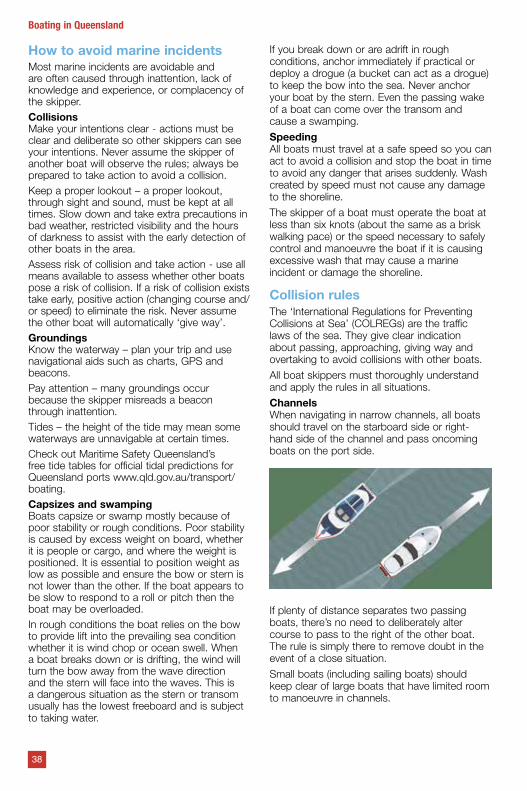
ChannelsWhen navigating in narrow channels, all boats should travel on the starboard side or right-hand side of the channel and pass oncoming boats on the port side.
If plenty of distance separates two passing boats, there’s no need to deliberately alter course to pass to the right of the other boat. The rule is simply there to remove doubt in the event of a close situation.
Small boats (including sailing boats) should keep clear of large boats that have limited room to manoeuvre in channels.
38
Boating in Queensland
Giving wayAll boats, whether power or sail, must always take action to avoid a collision.
Power boats‘Look all around, give way to the right, turn to the right and stay to the right’.
Head onWhen meeting head on, both boats are required to alter course to starboard (right), never to port (left). Any turn should be large enough to be obvious to the other boat.
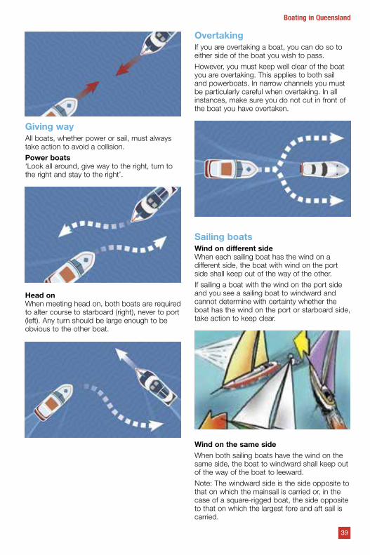
OvertakingIf you are overtaking a boat, you can do so to either side of the boat you wish to pass.
However, you must keep well clear of the boat you are overtaking. This applies to both sail and powerboats. In narrow channels you must be particularly careful when overtaking. In all instances, make sure you do not cut in front of the boat you have overtaken.
Sailing boatsWind on different sideWhen each sailing boat has the wind on a different side, the boat with wind on the port side shall keep out of the way of the other.
If sailing a boat with the wind on the port side and you see a sailing boat to windward and cannot determine with certainty whether the boat has the wind on the port or starboard side, take action to keep clear.
Wind on the same sideWhen both sailing boats have the wind on the same side, the boat to windward shall keep out of the way of the boat to leeward.
Note: The windward side is the side opposite to that on which the mainsail is carried or, in the case of a square-rigged boat, the side opposite to that on which the largest fore and aft sail is carried.
39
Boating in Queensland
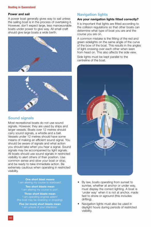
Power and sailA power boat generally gives way to sail unless the sailing boat is in the process of overtaking it. However, don’t expect large, less manoeuvrable boats under power to give way. All small craft should give large boats a wide berth.
Sound signalsMost recreational boats do not use sound signals. However, they are used by ships and larger vessels. Boats over 12 metres should carry sound signals, a whistle and a bell. Vessels under 12 metres should have some means of making an efficient sound signal. You should be aware of signals and what action you should take when you hear a signal. Sound signals may be accompanied by light signals. All boats should use sound signals in restricted visibility to alert others of their position. Use common sense and slow your boat or stop, and be ready to take immediate action. Be extremely cautious when operating in restricted visibility.
One short blast means‘I am altering my course to starboard’.
Two short blasts mean‘I am altering my course to port’.
Three short blasts mean‘I am operating engines astern’
(the boat may be reversing or stopping).
Five (or more) short blasts mean‘I am unsure of your intentions’.
Navigation lightsAre your navigation lights fitted correctly?It is important that lights are fitted according to the collision regulations so that other boats can determine what type of boat you are and the course you are on.
A common mistake is the fitting of the red and green sidelights on the same angle of the curve of the bow of the boat. This results in the angles of light crossing over each other when seen from head on. This also affects the side view.
Side lights must be kept parallel to the centreline of the boat.
• By law, boats operating from sunset to sunrise, whether at anchor or under way, must display the correct lighting. A boat is ‘under way’ when it is not at anchor, made fast to shore or aground (this includes drifting).
• Navigation lights must also be used in daylight hours during periods of restricted visibility.
40
Boating in Queensland
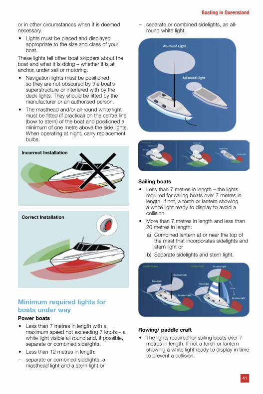
or in other circumstances when it is deemed necessary.
• Lights must be placed and displayed appropriate to the size and class of your boat.
These lights tell other boat skippers about the boat and what it is doing – whether it is at anchor, under sail or motoring.
• Navigation lights must be positioned so they are not obscured by the boat’s superstructure or interfered with by the deck lights. They should be fitted by the manufacturer or an authorised person.
• The masthead and/or all-round white light must be fitted (if practical) on the centre line (bow to stern) of the boat and positioned a minimum of one metre above the side lights. When operating at night, carry replacement bulbs.
Incorrect Installation
Correct Installation
Minimum required lights for boats under wayPower boats• Less than 7 metres in length with a
maximum speed not exceeding 7 knots – a white light visible all round and, if possible, separate or combined sidelights.
• Less than 12 metres in length:
– separate or combined sidelights, a masthead light and a stern light or
– separate or combined sidelights, an all- round white light.
Sailing boats• Less than 7 metres in length – the lights
required for sailing boats over 7 metres in length. If not, a torch or lantern showing a white light ready to display to avoid a collision.
• More than 7 metres in length and less than 20 metres in length:
a) Combined lantern at or near the top of the mast that incorporates sidelights and stern light or
b) Separate sidelights and stern light.
Rowing/ paddle craft• The lights required for sailing boats over 7
metres in length. If not a torch or lantern showing a white light ready to display in time to prevent a collision.
41
Boating in Queensland
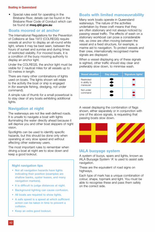
• Special rules exist for operating in the Brisbane River, details can be found in the Brisbane River Code of Conduct which can be found at msq.qld.gov.au
Boats moored or at anchor The International Regulations for the Prevention of Collisions at Sea 1972 (COLREGS) require vessels at anchor to display an all-round white light, where it may be best seen, between the hours of sunset and sunrise and during times of restricted visibility. For moored boats, it is a condition of the buoy mooring authority to display an anchor light.
Under the COLREGS, the anchor light must be visible for 2 nautical miles for all vessels up to 50 metres in length.
There are many other combinations of lights used on boats. The lights shown will relate to the activity the boat or ship is engaged in (for example fishing, dredging, not under command).
A simple rule of thumb for a small powerboat is to stay clear of any boats exhibiting additional lights.
Navigation at nightThe waterways are not like well-defined roads. It is unsafe to navigate a boat with lights illuminating the water directly ahead because it will deprive you and other boat skippers of night vision.
Spotlights can be used to identify specific hazards, but this should be done only when operating at very slow speed and without affecting other waterway users.
The most important rules to remember when driving a boat at night are to slow down and keep a good lookout.
Night navigation tips• Not all navigation hazards have lights
indicating their position (examples are shallow banks, oyster leases, and many navigation markers).
• It is difficult to judge distances at night.
• Background lighting can cause confusion.
• All boats are required to show lights.
• A safe speed is a speed at which sufficient action can be taken in time to prevent a collision.
• Keep an extra good lookout.
Boats with limited manoeuvrability Many work boats operate in Queensland waterways. The nature of the activities undertaken by these craft means that they are often stationary and not always noticed by passing vessel traffic. The effects of wash on a stationary workboat can pose a considerable risk, as crew are often moving between the vessel and a fixed structure, for example, a marine aid to navigation. To protect vessels and their crew, internationally recognised marine signals are displayed.
When a vessel displaying any of these signals is sighted, other traffic should stay clear and preferably slow down, to minimise wash.
Vessel situation Day shapes ‘Signature lights’
Restricted in ability to maneuver
Not under command
A vessel displaying the combination of flags shown, either separately or in conjunction with one of the above signals, is requesting that passing boats slow down.
IALA buoyage systemA system of buoys, spars and lights, known as IALA Buoyage System ‘A’ is used to assist safe navigation.
These are the equivalent of road signs on highways.
Each type of mark has a unique combination of colour, shape, topmark and light. You must be able to recognise these and pass them safely on the correct side.
42
Boating in Queensland
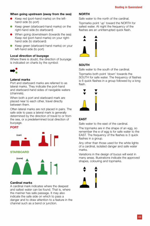
When going upstream (away from the sea) Keep red (port-hand marks) on the left-
hand side (to port)
Keep green (starboard-hand marks) on the right-hand side (to starboard)
When going downstream (towards the sea) Keep red (port-hand marks) on your right- hand side (to starboard)
Keep green (starboard-hand marks) on your left-hand side (to port)
Local direction of buoyageWhere there is doubt, the direction of buoyage is indicated on charts by the symbol:
Lateral marksPort and starboard marks are referred to as lateral marks. They indicate the port-hand and starboard-hand sides of navigable waters (channels).
When both a port and starboard mark are placed near to each other, travel directly between them.
Often lateral marks are not placed in pairs. The safe side to pass a lateral mark is generally determined by the direction of travel to or from the sea, or a predetermined local direction of buoyage.
PORT
(can)
STARBOARD
(cone)
Cardinal marksA cardinal mark indicates where the deepest and safest water can be found. That is, where the mariner has safe passage. It may also indicate the safe side on which to pass a danger and to draw attention to a feature in the channel such as a bend or junction.
NORTHSafe water to the north of the cardinal.
Topmarks point ‘up’ toward the NORTH for safest water. At night the frequency of the flashes are an uninterrupted quick flash.
SOUTHSafe water to the south of the cardinal.
Topmarks both point ‘down’ towards the SOUTH for safe water. The frequency of flashes is 6 quick flashes in a group followed by a long flash.
EASTSafe water to the east of the cardinal.
The topmarks are in the shape of an egg, so remember the e of egg is for safe water to the EAST. The frequency of the flashes is 3 quick flashes in a group.
Any other than those used for the white lights of a cardinal, isolated danger and safe water marks.
Variations in the design of buoys will exist in many areas. Illustrations indicate the approved shapes, colouring and topmarks.
43
Boating in Queensland

WESTSafe water to the West of the cardinal.
The topmarks make the shape of a wine glass so remember the w of wine glass is for safe water to the WEST. The frequency of the flashes is 9 quick flashes in a group.
Safe water marksIndicates that there is navigable water all around the mark – for example, mid channel.
At night a white light shows Isophase, or Occulting, or Mose A, or a single long flash every 10 seconds. To remember this, associate a single sphere with a single flash.
To remember the light flash rates for cardinal marks, the number of flashes for
east, south and west agrees with a clock face.
A north mark has a continuous flashing light.
North
12
West 9 3 East
6+1
South
44
Boating in Queensland
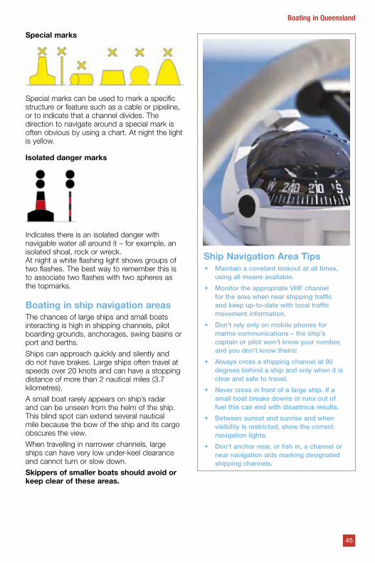
Special marks
Special marks can be used to mark a specific structure or feature such as a cable or pipeline, or to indicate that a channel divides. The direction to navigate around a special mark is often obvious by using a chart. At night the light is yellow.
Isolated danger marks
Indicates there is an isolated danger with navigable water all around it – for example, an isolated shoal, rock or wreck.At night a white flashing light shows groups of two flashes. The best way to remember this is to associate two flashes with two spheres as the topmarks.
Boating in ship navigation areas The chances of large ships and small boats interacting is high in shipping channels, pilot boarding grounds, anchorages, swing basins or port and berths.
Ships can approach quickly and silently and do not have brakes. Large ships often travel at speeds over 20 knots and can have a stopping distance of more than 2 nautical miles (3.7 kilometres).
A small boat rarely appears on ship’s radar and can be unseen from the helm of the ship. This blind spot can extend several nautical mile because the bow of the ship and its cargo obscures the view.
When travelling in narrower channels, large ships can have very low under-keel clearance and cannot turn or slow down.
Skippers of smaller boats should avoid or keep clear of these areas.
Ship Navigation Area Tips• Maintain a constant lookout at all times,
using all means available.
• Monitor the appropriate VHF channel for the area when near shipping traffic and keep up-to-date with local traffic movement information.
• Don’t rely only on mobile phones for marine communications – the ship’s captain or pilot won’t know your number, and you don’t know theirs!
• Always cross a shipping channel at 90 degrees behind a ship and only when it is clear and safe to travel.
• Never cross in front of a large ship. If a small boat breaks downs or runs out of fuel this can end with disastrous results.
• Between sunset and sunrise and when visibility is restricted, show the correct navigation lights.
• Don’t anchor near, or fish in, a channel or near navigation aids marking designated shipping channels.
45
Boating in Queensland
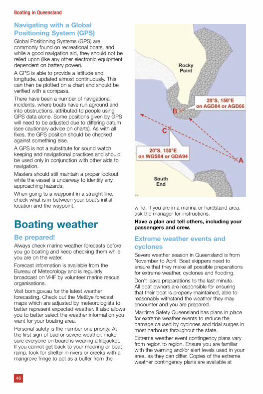
Navigating with a Global Positioning System (GPS)Global Positioning Systems (GPS) are commonly found on recreational boats, and while a good navigation aid, they should not be relied upon (like any other electronic equipment dependent on battery power).
A GPS is able to provide a latitude and longitude, updated almost continuously. This can then be plotted on a chart and should be verified with a compass.
There have been a number of navigational incidents, where boats have run aground and into obstructions, attributed to people using GPS data alone. Some positions given by GPS will need to be adjusted due to differing datum (see cautionary advice on charts). As with all fixes, the GPS position should be checked against something else.
A GPS is not a substitute for sound watch keeping and navigational practices and should be used only in conjunction with other aids to navigation.
Masters should still maintain a proper lookout while the vessel is underway to identify any approaching hazards.
When going to a waypoint in a straight line, check what is in between your boat’s initial location and the waypoint.
Boating weatherBe prepared!Always check marine weather forecasts before you go boating and keep checking them while you are on the water.
Forecast information is available from the Bureau of Meteorology and is regularly broadcast on VHF by volunteer marine rescue organisations.
Visit bom.gov.au for the latest weather forecasting. Check out the MetEye forecast maps which are adjusted by meteorologists to better represent expected weather. It also allows you to better select the weather information you want for your boating area.
Personal safety is the number one priority. At the first sign of bad or severe weather, make sure everyone on board is wearing a lifejacket. If you cannot get back to your mooring or boat ramp, look for shelter in rivers or creeks with a mangrove fringe to act as a buffer from the
wind. If you are in a marina or hardstand area, ask the manager for instructions.
Have a plan and tell others, including your passengers and crew.
Extreme weather events and cyclonesSevere weather season in Queensland is from November to April. Boat skippers need to ensure that they make all possible preparations for extreme weather, cyclones and flooding.
Don’t leave preparations to the last minute. All boat owners are responsible for ensuring that their boat is properly maintained, able to reasonably withstand the weather they may encounter and you are prepared.
Maritime Safety Queensland has plans in place for extreme weather events to reduce the damage caused by cyclones and tidal surges in most harbours throughout the state.
Extreme weather event contingency plans vary from region to region. Ensure you are familiar with the warning and/or alert levels used in your area, as they can differ. Copies of the extreme weather contingency plans are available at
46
Boating in Queensland
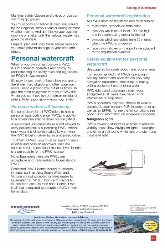
Maritime Safety Queensland offices or you can visit msq.qld.gov.au.
You must obey and follow all directions issued by the Regional Harbour Master during extreme weather events. And don’t leave your cyclone mooring or shelter until the harbour master has given the all clear.
Prepare, plan and obey these simple rules and you could prevent damage to your boat and others.
Personal watercraftWhether you own or just borrow a PWC, it is important to operate it responsibly by understanding the safety rules and regulations for PWCs in Queensland.
It’s easy to lose track of how close you are to the shore, fixed objects and other waterway users - keep a proper look out at all times. To gain the most enjoyment from your PWC ride where you can have fun but remain mindful of others. Ride responsibly – know your limits!
Personal watercraft licensingIt is compulsory for all PWC riders to hold a personal watercraft licence (PWCL) in addition to a recreational marine driver licence (RMDL).
A supervised unlicensed driver is not allowed to carry passengers. A supervising PWCL holder must wear the kill switch safety lanyard when the PWC is being driven by an unlicensed driver.
To obtain a PWCL you must be aged 16 years or older and pass an approved BoatSafe course. A valid recreational marine driver licence is a prerequisite for the PWC licence.
Note: Equivalent interstate PWCL are acceptable and transferable to Queensland’s PWCL.
Restricted PWC Licence issued to children in states such as New South Wales and Victoria are not accepted or transferable to Queensland’s PWCL. Short-term visitors to Queensland can use their boat licence if that is all that is required to operate a PWC in their home state.
Personal watercraft registrationAll PWCs must be registered and must display:
• registration symbols on both sides
• symbols which are at least 100 mm high and in a contrasting colour to the hull
• symbols which are visible from 30 metres when the PWC is underway
• registration sticker on the port side adjacent to the registration symbols.
Safety equipment for personal watercraftSee page 26 for safety equipment requirements.
It is recommended that PWCs operating in partially smooth and open waters also carry navigation equipment, anchoring, pumping/ bailing equipment and drinking water.
PWC riders and passengers must wear a lifejacket at all times. See page 14 for information on lifejackets.
PWCs operators may also choose to wear a personal locator beacon (PLB) in place of, or as well as an EPIRB. To see the full conditions see page 18 for information on emergency beacons.
Navigation lightsPWCs travelling at night or at times of reduced visibility must show navigation lights – sidelights and either an all-round white light or a stern and masthead light.
East Coast Marina, Manly Boat Harbour, Brisbane 330 water berths, 09m to 18m, plus an undercover 240 power boat dry storage facility for boats up to 10m. Power
and water available to all berths. 24 hour security, gas refill and pump-out facility also available. Fuel within Manly Harbour. Clean amenities and laundry, café and full-serviced working marina including shipwright,
engineers, electrician, trimmers, boat sales, and yachting school. Other services close by. Manly Village is only a short walk away for supplies and cafes etc. Markets every weekend. Close to Public transport, Airport and CBD.
Location: Latitude…27º 27.6' S Longitude…153º 11.2' EVisit website: eastcoastmarina.com.au
Find us on Facebook
570 Royal Esplanade, Manly Boat Harbour, Manly QLD 4179Phone: 07 3393 3811Email: [email protected]
No Club or membership
fees.
47
Boating in Queensland
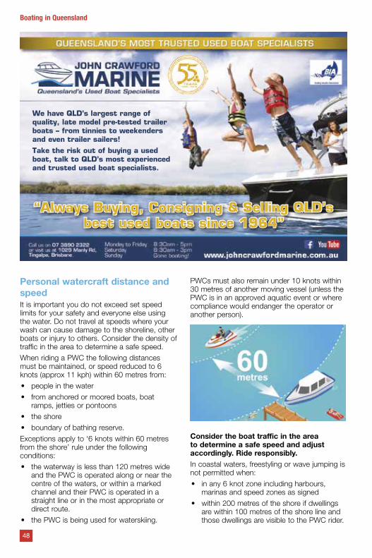
Personal watercraft distance and speedIt is important you do not exceed set speed limits for your safety and everyone else using the water. Do not travel at speeds where your wash can cause damage to the shoreline, other boats or injury to others. Consider the density of traffic in the area to determine a safe speed.
When riding a PWC the following distances must be maintained, or speed reduced to 6 knots (approx 11 kph) within 60 metres from:
• people in the water
• from anchored or moored boats, boat ramps, jetties or pontoons
• the shore
• boundary of bathing reserve.
Exceptions apply to ‘6 knots within 60 metres from the shore’ rule under the following conditions:
• the waterway is less than 120 metres wide and the PWC is operated along or near the centre of the waters, or within a marked channel and their PWC is operated in a straight line or in the most appropriate or direct route.
• the PWC is being used for waterskiing.
PWCs must also remain under 10 knots within 30 metres of another moving vessel (unless the PWC is in an approved aquatic event or where compliance would endanger the operator or another person).
Consider the boat traffic in the area to determine a safe speed and adjust accordingly. Ride responsibly.In coastal waters, freestyling or wave jumping is not permitted when:
• in any 6 knot zone including harbours, marinas and speed zones as signed
• within 200 metres of the shore if dwellings are within 100 metres of the shore line and those dwellings are visible to the PWC rider.
We have QLD’s largest range of quality, late model pre-tested trailer boats – from tinnies to weekenders and even trailer sailers!Take the risk out of buying a used boat, talk to QLD’s most experienced and trusted used boat specialists.
“Always Buying, Consigning & Selling QLD’s best used boats since 1964”
48
Boating in Queensland
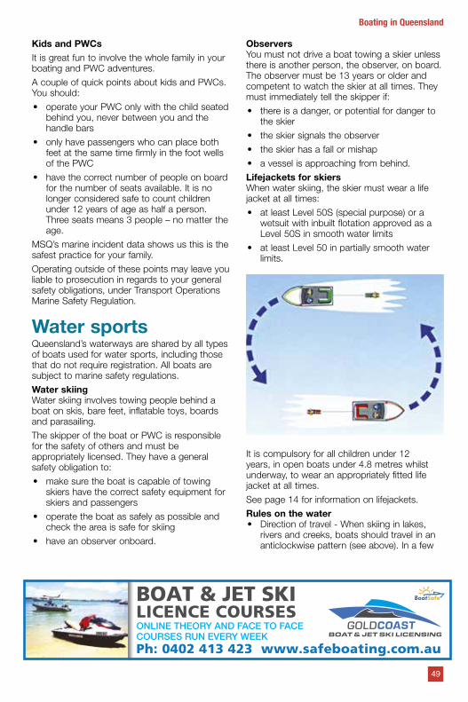
Kids and PWCsIt is great fun to involve the whole family in your boating and PWC adventures.
A couple of quick points about kids and PWCs. You should:
• operate your PWC only with the child seated behind you, never between you and the handle bars
• only have passengers who can place both feet at the same time firmly in the foot wells of the PWC
• have the correct number of people on board for the number of seats available. It is no longer considered safe to count children under 12 years of age as half a person. Three seats means 3 people – no matter the age.
MSQ’s marine incident data shows us this is the safest practice for your family.
Operating outside of these points may leave you liable to prosecution in regards to your general safety obligations, under Transport Operations Marine Safety Regulation.
Water sportsQueensland’s waterways are shared by all types of boats used for water sports, including those that do not require registration. All boats are subject to marine safety regulations.
Water skiingWater skiing involves towing people behind a boat on skis, bare feet, inflatable toys, boards and parasailing.
The skipper of the boat or PWC is responsible for the safety of others and must be appropriately licensed. They have a general safety obligation to:
• make sure the boat is capable of towing skiers have the correct safety equipment for skiers and passengers
• operate the boat as safely as possible and check the area is safe for skiing
• have an observer onboard.
ObserversYou must not drive a boat towing a skier unless there is another person, the observer, on board. The observer must be 13 years or older and competent to watch the skier at all times. They must immediately tell the skipper if:
• there is a danger, or potential for danger to the skier
• the skier signals the observer
• the skier has a fall or mishap
• a vessel is approaching from behind.
Lifejackets for skiersWhen water skiing, the skier must wear a life jacket at all times:
• at least Level 50S (special purpose) or a wetsuit with inbuilt flotation approved as a Level 50S in smooth water limits
• at least Level 50 in partially smooth water limits.
It is compulsory for all children under 12 years, in open boats under 4.8 metres whilst underway, to wear an appropriately fitted life jacket at all times.
See page 14 for information on lifejackets.
Rules on the water• Direction of travel - When skiing in lakes,
rivers and creeks, boats should travel in an anticlockwise pattern (see above). In a few
Ph: 0402 413 423 www.safeboating.com.au
BOAT & JET SKI LICENCE COURSESONLINE THEORY AND FACE TO FACE COURSES RUN EVERY WEEK
49
Boating in Queensland
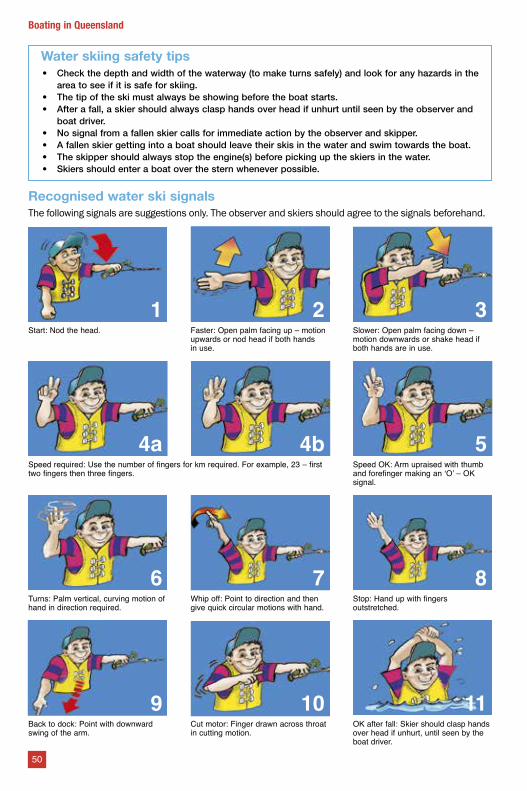
Water skiing safety tips• Check the depth and width of the waterway (to make turns safely) and look for any hazards in the
area to see if it is safe for skiing.• The tip of the ski must always be showing before the boat starts.• After a fall, a skier should always clasp hands over head if unhurt until seen by the observer and
boat driver.• No signal from a fallen skier calls for immediate action by the observer and skipper.• A fallen skier getting into a boat should leave their skis in the water and swim towards the boat.• The skipper should always stop the engine(s) before picking up the skiers in the water.• Skiers should enter a boat over the stern whenever possible.
Recognised water ski signalsThe following signals are suggestions only. The observer and skiers should agree to the signals beforehand.
1 2 3Start: Nod the head. Faster: Open palm facing up – motion
upwards or nod head if both hands in use.
Slower: Open palm facing down – motion downwards or shake head if both hands are in use.
4a 4b 5Speed required: Use the number of fingers for km required. For example, 23 – first two fingers then three fingers.
Speed OK: Arm upraised with thumb and forefinger making an ‘O’ – OK signal.
6 7 8Turns: Palm vertical, curving motion of hand in direction required.
Whip off: Point to direction and then give quick circular motions with hand.
Stop: Hand up with fingers outstretched.
9 10 11Back to dock: Point with downward swing of the arm.
Cut motor: Finger drawn across throat in cutting motion.
OK after fall: Skier should clasp hands over head if unhurt, until seen by the boat driver.
50
Boating in Queensland
locations local customs and conditions may dictate the direction of travel. Always check before skiing.
• Skiing or towing on a personal watercraft
- When towing a skier on a PWC you must obey personal watercraft rules. See Page 48 for more information on PWC requirements.
• Prohibited areas - Water skiing is prohibited in all 6 knot zones including harbours and marinas, within 30 metres of people in the water, anchored boats, diver’s flags, jetties, pontoons or boat ramps.
• Restricted areas – Restricted areas are published on the Maritime Safety Queensland website at msq.qld.gov.au and Gold Coast Waterways Authority website at gcwa.qld.gov.au. Additionally, the Gold and Sunshine Coasts have some designated water ski areas and times for operation - These are usually marked by signs.
Water skiing is permitted in all other areas. However, it is the responsibility of the skipper to ensure the area is safe and suitable for skiing.
Optimise vessel performance today by storing your boat out of the water
Proud member of:
Increase speed and fuel efficiency by eliminating anti-foul paints on the hullLaunch and retrieve your boat in minutesMinimised maintenance time means maximum days on water
+61 7 5587 7888 [email protected] www.airberth.com
WINNER 2015 Maritime
Australia Limited Civil Industry National
Innovation Award
THE PROVEN CHOICE
The SARCA EXCELand SUPER SARCAare certified Super HighHolding Power.
51
Boating in Queensland
Sail boats and sail boardsSail boats and boards are propelled by the wind, requiring special skills to control direction and speed. When learning to sail, choose a quiet area away from anchored boats and activity.
Like all other boat users, operators of these craft have a responsibility to take all action to avoid a collision and operate safely.
RowingLike canoes and kayaks, rowing boats are difficult to see and can be swamped easily.
As a general rule, keep the starboard side close to the shore of busy rivers. An all-round white flashing light is recommended between sunset and sunrise. (see also page 40 on lighting).
A code of conduct has been developed to promote safety on the Brisbane River. All rowing boats must be fitted with an all-round white flashing light if they are on the river before sunrise or after sunset. Download the code of conduct and the Brisbane RiverShare Pocket Guide from msq.qld.gov.au.
Canoes, kayaks and surf skis Canoes and kayaks create little or no noise and have a small profile on the water, often making them difficult to see, and they often appear stationary. It is essential to be seen all the time as speedboats and larger boats can create wash capable of capsizing the boat.
Travel close to banks to avoid high traffic areas. Where possible travel in a group, keep the group together and adopt a one/all stop attitude. Wear a lifejacket.
Divers’ flagsDivers can surface at any time,
sometimes a significant distance from where they enter the water. In the interest of diver safety, any boat is excluded from operating within 30 metres of a diver in the
water if a Code A flag is displayed (see above). It is legal for the boat tending the diver to operate within the 30 metres.
Also a snorkeler in this instance is treated as a diver. A snorkeler is just as hard to see from a boat in the water as a diver using air tanks.
KitesurfingKitesurfing involves a surfboard with a length of line attached to a kite. The kite acts as a sail and propels the rider through the water.
Kitesurfs work best in windy conditions and reach speeds up to 30 knots.
Sailing rules apply to kitesurfing and other boats should give them a wide berth. If a kitesurfer drops the kite, other boats should travel upwind of the kitesurfer to avoid becoming tangled in the line.
Kitesurfers should stay at least 30 metres from swimmers and boats.
Tow-in surfingA code of conduct has been developed to promote the safety of tow-in surfing on the Gold Coast. The code provides guidance on a number of important safety aspects, including:
• general rules relating to proceeding at a safe speed, keeping a proper lookout and avoiding collision
• specific rules of operation for personal watercraft (PWC) in relation to speed and distance off requirements
• rules governing the operation of vessels in and near Gold Coast City Council bathing reserves and requirements to be met to qualify for the tow-in surfing observer exemption
• specific requirements for tow-in surfing operations within Currumbin Alley and Tallebudgera Creek mouth.
Download the code of conduct from msq.qld.gov.au.
Boating offshoreBoating in offshore waters brings with it a new range of safety risks which the skipper must be aware of. The most important thing is to have a boat that can handle offshore conditions and is capable of travelling extended distances in rough conditions.
Dinghies are not suitable offshore craft. While conditions in the morning might look ideal, these can change rapidly and become rough and dangerous. Offshore boats should have an enclosed foredeck to prevent water coming on board, or if the craft is an open boat with centre console configuration, a self-draining deck.
Flotation is a must and many new boats will have buoyancy built in and specified on the Australian Builders Plate. However, the aim is to prevent water coming on board, and if it does, to be able to escape as quickly as possible.
52
Boating in Queensland
Consider installing a second high volume bilge pump which will offload water quickly. Always have at least two heavy-duty buckets ready for use, as a bucket is an extremely efficient method of bailing water.
Consider carrying two batteries, one for starting and one for running accessories. This way you will always be able to start the motor. Make sure they are marine batteries which are designed for the marine environment.
Safety tips when boating offshore• Keep a weather watch — receive
regular weather updates for changes.• Keep a fuel watch — ensure the
boat is fully fuelled before leaving the ramp or marina. Be aware that in rough weather more fuel will be used. Always have a reserve supply.
Bar crossingsA bar is an accumulation of sand or silt at the entrance of a river, creek, lake or harbour. Never underestimate a coastal bar as conditions can change quickly and without warning.
Designated coastal bars in Queensland include Currumbin Bar, Tallebudgera Bar, Jumpinpin Bar, South Passage Bar, Caloundra Bar, Mooloolah River mouth, Noosa Bar, Gold Coast Seaway, Round Hill Creek, and Wide Bay Bar.
Bar crossing rules (under 4.8 m) Everyone in open boats under 4.8 metres, while crossing a designated coastal bar, must be wearing a lifejacket.
If you cross the bar without a lifejacket on, you cross the line!
Bar crossings can be dangerous Bar conditions can produce steep and often breaking seas. Even small waves can capsize, swamp or sink a boat. For these reasons it is important to take a number of precautions and manoeuvre the boat with extreme caution.
All bars are different. Local knowledge, experience and the right kind of boat are critical when trying to cross a bar. Only experienced skippers should try to cross a coastal bar and, even then, you should be very careful. You can learn about each bar by asking local boaters, volunteer marine rescue organisations or local marine authorities who cross it regularly.
It’s a good idea to radio the local marine rescue group for an update on bar conditions and advise them of your intended crossing and safe passing.
Boating on freshwaterQueensland has many inland waterways ideal for fishing, boating and water sports. Operating on freshwater lakes and dams, however, can be quite different to estuary boating.
Boat registration and licensing requirements are the same for freshwater, inland waterways and coastal waters.
Some freshwater impoundments and dams do not allow some types of activities while other have specific restrictions or permit requirements. Petrol motors are not always permitted on some dams for environmental reasons. Always check the local waterway rules before you go.
Freshwater boating tips• Freshwater does not necessarily mean calm
water – have your safety equipment on board and be prepared for any conditions. Always check the weather.
• Freshwater is less buoyant than salt water and the water temperature is usually colder. This increases the risk of cold water shock to the body and reduces the ability to function - so wear a lifejacket.
• If you are using an electric motor on your boat, make sure the battery is fully charged before every trip and have a back-up.
• If you are canoeing and kayaking, travel close to the banks to avoid high traffic area and be aware of wash from larger boats.
• If you are boating, riding your PWC or water- skiing, remember to consider other waterway users and be aware of your speed, wash and freshwater hazards.
• Keep a proper lookout at all times.
• Heavy rain can cause strong currents and bring debris and flotsam to the waterway.
Drought can cause a big drop in the water level and expose submerged objects like old fences, sticks, trees, rocks and sandbanks. Slow down when boating close to shore and avoid hitting underwater hazards.
• Rivers can have blind spots at river bends or caused by land, tree and overhanging branch obstructions.
• Don’t go alone and tell someone where you are. Freshwater areas can be remote and miles wide with no quick access to shelter or assistance if you run into trouble.
53
Boating in Queensland
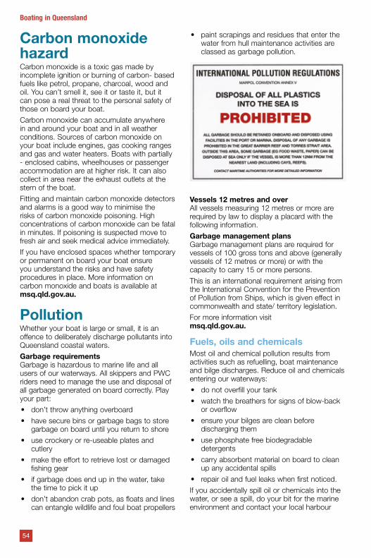
Carbon monoxide hazardCarbon monoxide is a toxic gas made by incomplete ignition or burning of carbon- based fuels like petrol, propane, charcoal, wood and oil. You can’t smell it, see it or taste it, but it can pose a real threat to the personal safety of those on board your boat.
Carbon monoxide can accumulate anywhere in and around your boat and in all weather conditions. Sources of carbon monoxide on your boat include engines, gas cooking ranges and gas and water heaters. Boats with partially - enclosed cabins, wheelhouses or passenger accommodation are at higher risk. It can also collect in area near the exhaust outlets at the stern of the boat.
Fitting and maintain carbon monoxide detectors and alarms is a good way to minimise the risks of carbon monoxide poisoning. High concentrations of carbon monoxide can be fatal in minutes. If poisoning is suspected move to fresh air and seek medical advice immediately.
If you have enclosed spaces whether temporary or permanent on board your boat ensure you understand the risks and have safety procedures in place. More information on carbon monoxide and boats is available at msq.qld.gov.au.
PollutionWhether your boat is large or small, it is an offence to deliberately discharge pollutants into Queensland coastal waters.
Garbage requirementsGarbage is hazardous to marine life and all users of our waterways. All skippers and PWC riders need to manage the use and disposal of all garbage generated on board correctly. Play your part:
• don’t throw anything overboard
• have secure bins or garbage bags to store garbage on board until you return to shore
• use crockery or re-useable plates and cutlery
• make the effort to retrieve lost or damaged fishing gear
• if garbage does end up in the water, take the time to pick it up
• don’t abandon crab pots, as floats and lines can entangle wildlife and foul boat propellers
• paint scrapings and residues that enter the water from hull maintenance activities are classed as garbage pollution.
Vessels 12 metres and overAll vessels measuring 12 metres or more are required by law to display a placard with the following information.
Garbage management plansGarbage management plans are required for vessels of 100 gross tons and above (generally vessels of 12 metres or more) or with the capacity to carry 15 or more persons.
This is an international requirement arising from the International Convention for the Prevention of Pollution from Ships, which is given effect in commonwealth and state/ territory legislation.
For more information visit msq.qld.gov.au.
Fuels, oils and chemicalsMost oil and chemical pollution results from activities such as refuelling, boat maintenance and bilge discharges. Reduce oil and chemicals entering our waterways:
• do not overfill your tank
• watch the breathers for signs of blow-back or overflow
• ensure your bilges are clean before discharging them
• use phosphate free biodegradable detergents
• carry absorbent material on board to clean up any accidental spills
• repair oil and fuel leaks when first noticed.
If you accidentally spill oil or chemicals into the water, or see a spill, do your bit for the marine environment and contact your local harbour
54
Boating in Queensland
master, marina manager or port authority, so it can be contained and cleaned up as soon as possible.
SewageThe discharge of sewage into the marine environment poses serious health and environmental issues. To reduce the impacts associated with vessel sourced sewage prohibitions and restrictions are in place for the discharge of sewage.
Untreated sewageUntreated sewage is sewage that has not passed through an on-board sewage treatment system. In areas where the discharge of untreated sewage is allowed, the effluent must pass through a macerator before being discharged, in order to assist with dispersion and improve visual amenity for all waterways users.
Note: Macerated sewage is not classed as treated sewage. Macerated sewage is untreated sewage.
Untreated sewage is prohibited from being discharged in the following areas:
• Prohibited discharge waters — these are canals, marinas, boat harbours, the Noosa River and designated areas of state marine parks.
• Smooth waters – these are the designated smooth water limits. See page 28 for more information on smooth waters.
• Hervey Bay and Northern Moreton Bay waters within 1852 m (1 nM) of reefs, for example oyster lease or fish farm, the mean low water mark of the mainland, or if the ship is a declared ship, all Hervey Bay and Northern Moreton Bay waters.
Note: (A declared ship has a fixed toilet and is: a domestic commercial vessels with a certificate of operation issued, or taken to be issued, under the Marine Safety (Domestic Commercial Vessel) National Law Act 2012 stating it is a class 1B, 1C, 1D, 1E, 4C, 4D or 4E ship or another Queensland regulated ships regulated under the Transport Operations
(Marine Safety) Act 1994 and Regulation 2016 designed to carry more than 12 passengers.)
• Open waters –
• (a) within 926 m (½ NM) of a wharf or jetty other than a jetty that is a marina (b) within 1852 m (1 NM) of
– Aquaculture fisheries resources
– If a vessel has 7–15 people on board: a reef, or the mean low water mark of an island or the mainland.
Note: If you have 16 or more persons on board, the discharge of untreated sewage is not permitted anywhere in Queensland coastal waters.
Treated sewageTreated sewage is sewage that has passed through an on board sewage treatment system and is categorised as either grade A, B or C depending on the level of treatment it has received.
All treated sewage is prohibited from being discharged in ‘prohibited discharge waters’ such as canals, marinas, boat harbours, the Noosa River and designated areas of state marine parks.
Additionally, the following types of treated sewage have the following restrictions on discharge:
• Grade A treated sewage (highest level of treatment) — No further restrictions.
• Grade B treated sewage (moderate level of treatment)
- Nil discharge in Hervey Bay waters, Northern Moreton Bay waters, open waters and smooth waters within 700 m of a person in the water, an aquaculture fisheries resource and a reef.
• Grade C treated sewage (lowest treatment)
- Nil discharge in Hervey Bay waters, Northern Moreton Bay waters, open waters and smooth waters within 926 m (½ nM) of a person in the water, an aquaculture fisheries resource and a reef.
For more information visit msq.qld.gov.au.
55
Boating in Queensland
Marine Parks in QueenslandGreat Barrier Reef Marine ParkRespect green zones and help to protect the ReefRecreational fishing in no-take green zones continues to be the most commonly detected offence in the Great Barrier Reef World Heritage Area.
While many recreational fishers understand and follow the zoning rules, there are still some who believe occasionally fishing in a green zone has no impact. However, the effects of green zone poaching build up over time: Every fisher who poaches from a green zone has an impact on the health of the Reef and the fish stocks of the future.
Illegal fishing activity increases the pressure on the Great Barrier Reef at a time when it is already under considerable pressure from varied and increasing threats.
The Great Barrier Reef Marine Park Authority is working with the community to protect their special patch of the Reef and make sure the benefits of green zones are understood by everyone.
How do green zones work?The Great Barrier Reef Marine Park is a multiple-use area. Zoning is in place across the 344,400 km2 Marine Park, an area bigger in size than Italy. Zoning defines what activities can occur in each location and helps to manage and protect the values of the World Heritage Area that users enjoy.
No-take green zones make up about a third of the Marine Park and are designed to help protect and conserve ecosystem biodiversity. Research indicates current zoning arrangements, which came into effect in 2004, are having a range of positive effects, including helping to sustain fish stocks in areas open to fishing.
A DNA study in the Keppel Islands found almost 60 per cent of the juvenile coral trout collected from areas open to fishing were the offspring of parents living in green zones. This highlights the value of green zones. It also shows that poachers who are taking these important breeding fish from green zones are impacting the catches of honest fishers in areas open to fishing.
Studies also show that reefs in no-take zones are more resilient to the impacts of coral disease, crown-of-thorns starfish outbreaks, and weather events and are able to recover from impacts much faster compared to reefs open to fishing. Two thirds of the Marine Park is open to fishing.
The consequences of poachingIf you fish in a no-take green zone, you will get caught, and risk a $2100 fine.
The Great Barrier Reef Marine Park Authority coordinates day and night aerial and on water patrols with partners Queensland Parks and Wildlife Service, Queensland Boating and Fisheries, Maritime Border Command, and the Queensland Water Police to target illegal recreational and commercial fishing.
Drones and other technology are being used in compliance operations.
Everyone has a responsibility to understand and follow the zoning rules. Free zoning maps are available at gbrmpa.gov.au or at bait and tackle shops, visitor information centres, ship chandlers, Queensland Parks and Wildlife Service, and Queensland Boating and Fisheries Patrol offices. You can also download the free Eye on the Reef app to access zoning on your phone, which works outside of mobile range. The app is available on the www.gbrmpa.gov.au website, Google Play and the App Store.
Public moorings and no-anchoring areasIn Queensland there are nearly 300 public moorings available for boaties to use for free on a first-come first-served basis, plus around 50 no-anchoring areas marked by reef protection markers, saving areas of sensitive coral from anchoring impacts.
Public moorings are installed at popular locations and have blue, cone shaped buoys with a colour-coded band. This band tells you the class (vessel length), time limits and maximum strength limits that apply to the mooring. Mooring specifications and conditions of use are also displayed on the mooring tag attached to the pick-up line.
Reef protection markers are used to mark the no-anchoring areas. The markers are
56
Marine Parks in Queensland
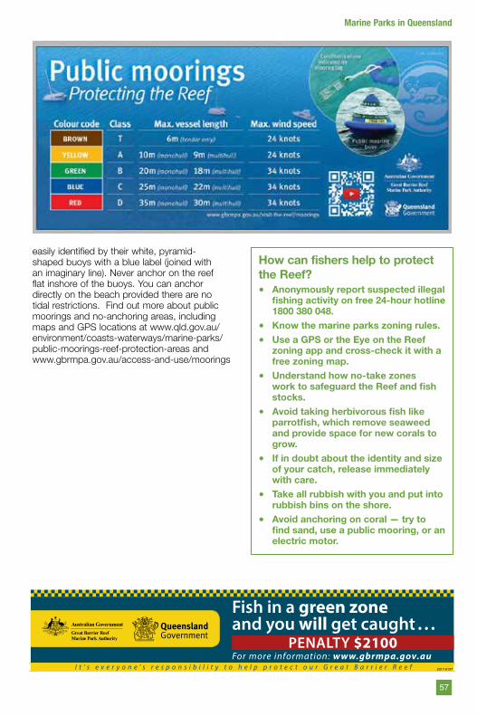
easily identified by their white, pyramid-shaped buoys with a blue label (joined with an imaginary line). Never anchor on the reef flat inshore of the buoys. You can anchor directly on the beach provided there are no tidal restrictions. Find out more about public moorings and no-anchoring areas, including maps and GPS locations at www.qld.gov.au/environment/coasts-waterways/marine-parks/public-moorings-reef-protection-areas and www.gbrmpa.gov.au/access-and-use/moorings
How can fishers help to protect the Reef?• Anonymously report suspected illegal
fishing activity on free 24-hour hotline 1800 380 048.
• Know the marine parks zoning rules.• Use a GPS or the Eye on the Reef
zoning app and cross-check it with a free zoning map.
• Understand how no-take zones work to safeguard the Reef and fish stocks.
• Avoid taking herbivorous fish like parrotfish, which remove seaweed and provide space for new corals to grow.
• If in doubt about the identity and size of your catch, release immediately with care.
• Take all rubbish with you and put into rubbish bins on the shore.
• Avoid anchoring on coral — try to find sand, use a public mooring, or an electric motor.
57
Marine Parks in Queensland
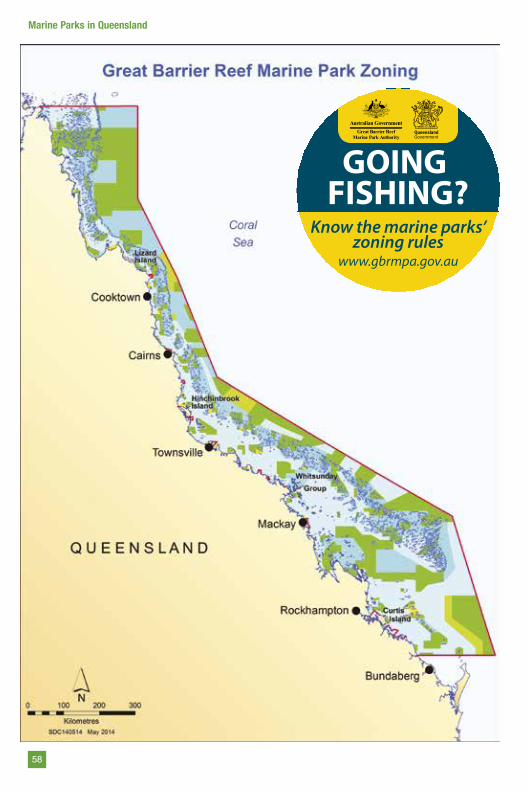
Know the marine parks’
zoning rules www.gbrmpa.gov.au
GOING FISHING?
58
Marine Parks in Queensland
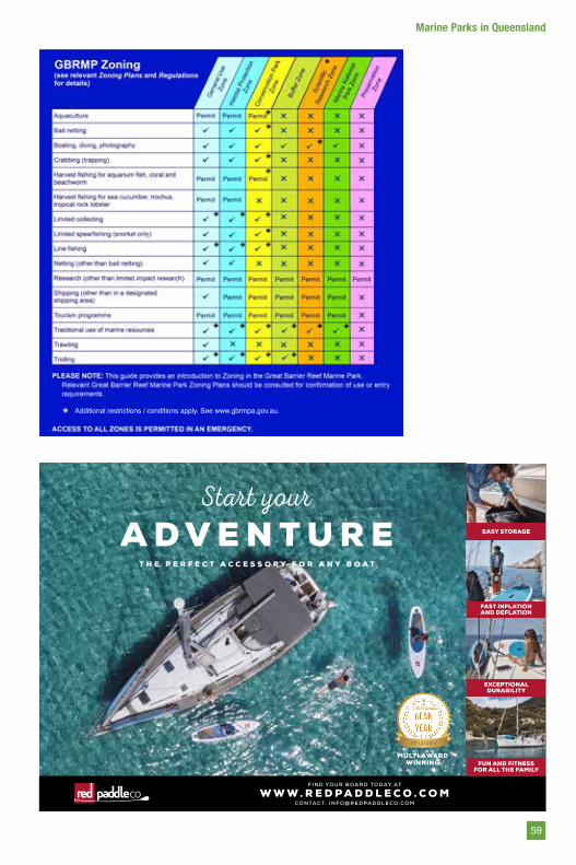
Start yourA D V E N T U R E EASY STORAGE
FAST INFLATION AND DEFLATION
EXCEPTIONALDURABILITY
F I N D YO U R B O A R D T O D AY AT
C O N TA C T: I N F O @ R E D PA D D L E C O . C O MW W W . R E D P A D D L E C O . C O M
FUN AND FITNESSFOR ALL THE FAMILY
MULTI AWARDWINNING
T H E P E R F E C T A C C E S S O R Y F O R A N Y B O A T
i nflatable8
Additional restrictions / conditions apply. See www.gbrmpa.gov.au.
59
Marine Parks in Queensland
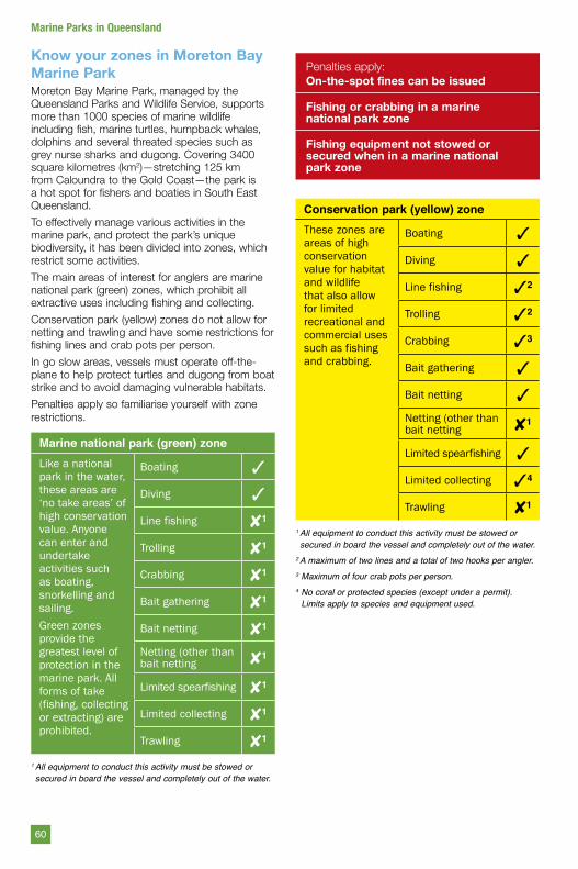
Know your zones in Moreton Bay Marine ParkMoreton Bay Marine Park, managed by the Queensland Parks and Wildlife Service, supports more than 1000 species of marine wildlife including fish, marine turtles, humpback whales, dolphins and several threated species such as grey nurse sharks and dugong. Covering 3400 square kilometres (km2)—stretching 125 km from Caloundra to the Gold Coast—the park is a hot spot for fishers and boaties in South East Queensland.
To effectively manage various activities in the marine park, and protect the park’s unique biodiversity, it has been divided into zones, which restrict some activities.
The main areas of interest for anglers are marine national park (green) zones, which prohibit all extractive uses including fishing and collecting.
Conservation park (yellow) zones do not allow for netting and trawling and have some restrictions for fishing lines and crab pots per person.
In go slow areas, vessels must operate off-the- plane to help protect turtles and dugong from boat strike and to avoid damaging vulnerable habitats.
Penalties apply so familiarise yourself with zone restrictions.
Marine national park (green) zoneLike a national park in the water, these areas are ‘no take areas’ of high conservation value. Anyone can enter and undertake activities such as boating, snorkelling and sailing.Green zones provide the greatest level of protection in the marine park. All forms of take (fishing, collecting or extracting) are prohibited.
Boating 3
Diving 3
Line fishing 81
Trolling 81
Crabbing 81
Bait gathering 81
Bait netting 81
Netting (other than bait netting 81
Limited spearfishing 81
Limited collecting 81
Trawling 81
1 All equipment to conduct this activity must be stowed or secured in board the vessel and completely out of the water.
Penalties apply:On-the-spot fines can be issued
Fishing or crabbing in a marine national park zone
Fishing equipment not stowed or secured when in a marine national park zone
Conservation park (yellow) zoneThese zones are areas of high conservation value for habitat and wildlife that also allow for limited recreational and commercial uses such as fishing and crabbing.
Boating 3
Diving 3
Line fishing 32
Trolling 32
Crabbing 33
Bait gathering 3
Bait netting 3Netting (other than bait netting 81
Limited spearfishing 3
Limited collecting 34
Trawling 81
1 All equipment to conduct this activity must be stowed or secured in board the vessel and completely out of the water.
2 A maximum of two lines and a total of two hooks per angler.3 Maximum of four crab pots per person.4 No coral or protected species (except under a permit).
Limits apply to species and equipment used.
60
Marine Parks in Queensland
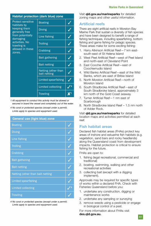
Habitat protection (dark blue) zoneProtect sensitive habitats by keeping them generally free from potentially damaging activities. No trawling is allowed in these zones.
Boating 3
Diving 3
Line fishing 3
Trolling 3
Crabbing 3
Bait gathering 3
Bait netting 3Netting (other than bait netting 3
Limited spearfishing 3
Limited collecting 34
Trawling 81
1 All equipment to conduct this activity must be stowed or secured in board the vessel and completely out of the water.
4 No coral or protected species (except under a permit). Limits apply to species and equipment used.
General use (light blue) zone
Boating 3
Diving 3
Line fishing 3
Trolling 3
Crabbing 3
Bait gathering 3
Bait netting 3
Netting (other than bait netting 3
Limited spearfishing 3
Limited collecting 34
Trawling 3
4 No coral or protected species (except under a permit). Limits apply to species and equipment used.
Visit qld.gov.au/marineparks for detailed zoning maps and other useful information.
Artificial reefsThere are eight artificial reefs in Moreton Bay Marine Park that sustain a diversity of fish species and have been designed to benefit a range of fishing techniques, including spearfishing, bottom fishing and game fishing for pelagic species. These areas make for some exciting fishing:
1. Harry Atkinson Artificial Reef—7 km east- south-east of St Helena Island
2. West Peel Artificial Reef—west of Peel Island and north-east of Cleveland Point
3. East Coochie Artificial Reef—east of Coochiemudlo Island
4. Wild Banks Artificial Reef—east of the Wild Banks, which are east of Bribie Island
5. North Moreton Artificial Reef—north of Moreton Island
6. South Stradbroke Artificial Reef—east of South Stradbroke Island, approximately 3 km north of the Gold Coast seaway.
7. Turner Artificial Reef—1 nm east of Scarborough
8. North Stradbroke Island Reef – 1.5 nm north of Adder Rock.
Visit qld.gov.au/marineparks for detailed location maps and activities permitted at each reef.
Fish habitat areasDeclared fish habitat areas (FHAs) protect key areas of inshore and estuarine fish habitats (e.g. vegetation, sand bars and rocky headlands) along the Queensland coast from development impacts. Habitat protection is critical to ensure fishing for the future.
FHAs are open to:
1. fishing (legal recreational, commercial and traditional)
2. boating, swimming, walking and other recreational activities
3. collecting bait (except with a digging implement).
Approvals may be required for specific types of works within a declared FHA. Check with Fisheries Queensland before you:
1. undertake any construction, digging or maintenance works
2. undertake any sampling or surveying3. remove weeds using a pesticide or engage
in biological control of a pest.
For more information about FHAs visit des.qld.gov.au.
61
Marine Parks in Queensland
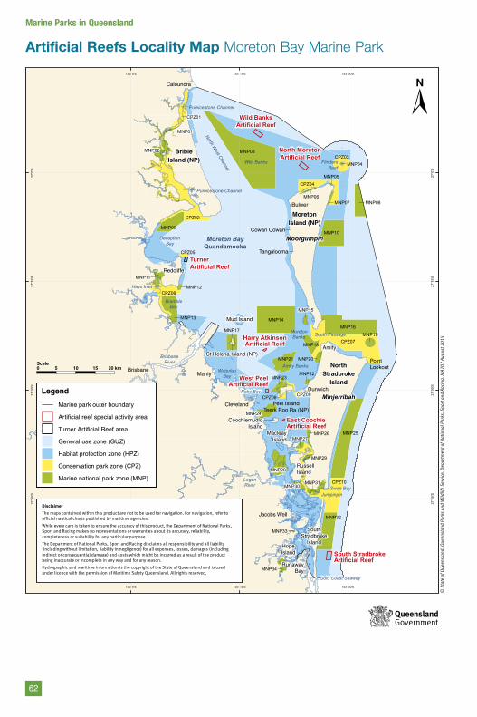
Artificial Reefs Locality Map Moreton Bay Marine Park
153°30'E
153°30'E
153°15'E
153°15'E
153°0'E
153°0'E
27°0
'S
27°0
'S
27°1
5'S
27°1
5'S
27°3
0'S
27°3
0'S
27°4
5'S
27°4
5'S
Wild BanksArtificial Reef
TurnerArtificial Reef
North MoretonArtificial Reef
Harry AtkinsonArtificial Reef
West PeelArtificial Reef
East CoochieArtificial Reef
South StradbrokeArtificial Reef
MoretonIsland (NP)
MoorgumpinMoreton BayQuandamooka
NorthStradbroke
Island
Minjerribah
BribieIsland (NP)
MNP32
MNP30MNP31
MNP34
MNP33
MNP25
CPZ10
MNP28
MNP27MNP26
MNP29
MNP21
MNP16
CPZ07
CPZ09
MNP24
MNP18
MNP19
MNP22MNP23
MNP20
CPZ08
MNP14
MNP10
MNP15
MNP17
MNP13
MNP11
CPZ05
MNP09
CPZ02
CPZ06MNP12
CPZ04MNP05
MNP07
CPZ03MNP03MNP02
MNP01
CPZ01
MNP08
MNP04
MNP06
FlindersReef
DeceptionBay
BrambleBay
Hays Inlet
WaterlooBay
Raby Bay
Jumpinpin
Gold Coast Seaway
MoretonBanks
Wild Banks
Amity Banks
South Passage
Swan Bay
Pumicestone Channel
Pumicestone Channel
North West Channel
Brisbane River
LoganRiver
Cowan Cowan
Bulwer
Dunwich
Amity
PointLookout
HopeIsland
Cleveland
Brisbane
Caloundra
Redcliffe
Manly
Jacobs Well
RunawayBay
Tangalooma
SouthStradbroke
Island
RussellIsland
MacleayIsland
Peel IslandTeerk Roo Ra (NP)
CoochiemudloIsland
Mud Island
St Helena Island (NP)
Artificial reefs locality mapMoreton Bay Marine Park
© S
tate
of Q
ueen
slan
d. Q
ueen
slan
d Pa
rks
and
Wild
life
Serv
ice,
Dep
artm
ent o
f Nat
iona
l Par
ks, S
port
and
Rac
ing.
MA7
07 A
ugus
t 201
5
5 10 15 20 kmScale0
Legend
Marine park outer boundary
Artificial reef special activity area
Turner Artificial Reef area
General use zone (GUZ)
Habitat protection zone (HPZ)
Conservation park zone (CPZ)
Marine national park zone (MNP)
Disclaimer
The maps contained within this product are not to be used for navigation. For navigation, refer to official nautical charts published by maritime agencies.
While every care is taken to ensure the accuracy of this product, the Department of National Parks, Sport and Racing makes no representations or warranties about its accuracy, reliability, completeness or suitability for any particular purpose.
The Department of National Parks, Sport and Racing disclaims all responsibility and all liability (including without limitation, liability in negligence) for all expenses, losses, damages (including indirect or consequential damage) and costs which might be incurred as a result of the product being inaccurate or incomplete in any way and for any reason.
Hydrographic and maritime information is the copyright of the State of Queensland and is used under licence with the permission of Maritime Safety Queensland. All rights reserved.
62
Marine Parks in Queensland
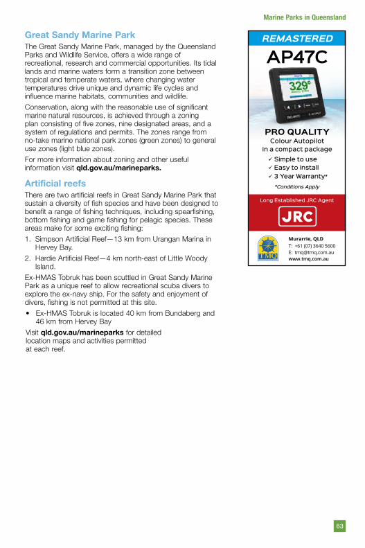
Great Sandy Marine ParkThe Great Sandy Marine Park, managed by the Queensland Parks and Wildlife Service, offers a wide range of recreational, research and commercial opportunities. Its tidal lands and marine waters form a transition zone between tropical and temperate waters, where changing water temperatures drive unique and dynamic life cycles and influence marine habitats, communities and wildlife.
Conservation, along with the reasonable use of significant marine natural resources, is achieved through a zoning plan consisting of five zones, nine designated areas, and a system of regulations and permits. The zones range from no-take marine national park zones (green zones) to general use zones (light blue zones).
For more information about zoning and other useful information visit qld.gov.au/marineparks.
Artificial reefsThere are two artificial reefs in Great Sandy Marine Park that sustain a diversity of fish species and have been designed to benefit a range of fishing techniques, including spearfishing, bottom fishing and game fishing for pelagic species. These areas make for some exciting fishing:
1. Simpson Artificial Reef—13 km from Urangan Marina in Hervey Bay.
2. Hardie Artificial Reef—4 km north-east of Little Woody Island.
Ex-HMAS Tobruk has been scuttled in Great Sandy Marine Park as a unique reef to allow recreational scuba divers to explore the ex-navy ship. For the safety and enjoyment of divers, fishing is not permitted at this site.
• Ex-HMAS Tobruk is located 40 km from Bundaberg and 46 km from Hervey Bay
Visit qld.gov.au/marineparks for detailedlocation maps and activities permittedat each reef.
AP47C
PRO QUALITYColour Autopilot
in a compact package Simple to use Easy to install 3 Year Warranty*
T: +61 (07) 3640 5600E: [email protected] www.tmq.com.au
*Conditions Apply
Long Established JRC Agent
REMASTERED
Murarrie, QLD
63
Marine Parks in Queensland
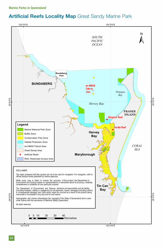
Artificial Reefs Locality Map Great Sandy Marine Park
G
GHardie Reef
Simpson Reef
153°0'0"E
153°0'0"E
152°0'0"E
152°0'0"E
25°0
'0"S
25°0
'0"S
26°0
'0"S
26°0
'0"S
0 10 20 30 405Kilometres
FRASER ISLAND
Bundaberg Port
Maryborough
Tin Can Bay
BUNDABERG
HerveyBay
ex-HMASTobruk
CORALSEA
SOUTHPACIFICOCEAN
PlatypusBay
LegendMarine National Park Zone
Buffer Zone
Conservation Park Zone
Habitat Protection Zone
Great Sandy Area
G Artificial Reefs
RAA- Restricted Access Area
±
Artificial reefs locality mapGreat Sandy Marine Park
DISCLAIMER:
The maps contained with this product are not to be used for navigation. For navigation, refer toofficial nautical charts published by marine agencies.
While every care is taken to ensure the accuracy of this product, the Department ofEnvironment and Science makes no representations or warranties about its accuracy, reliability,completeness or suitability for any particular purpose.
The Department of Environment and Science disclaims all responsibility and all liability(including limitation, liability in negligence) for all expenses, losses, damages (including indirector consequential damage) and costs which might be incurred as a result of the product beinginaccurate or incomplete in any way and for any reason.
Hydrographic and marine informationis the copyright of the State of Queensland and is usedunder licence with the permission of Maritime Safety Queensland.
All rights reserved.
Hervey Bay
ex-HMAS Tobruk Area
(DA)(DA)
64
Marine Parks in Queensland
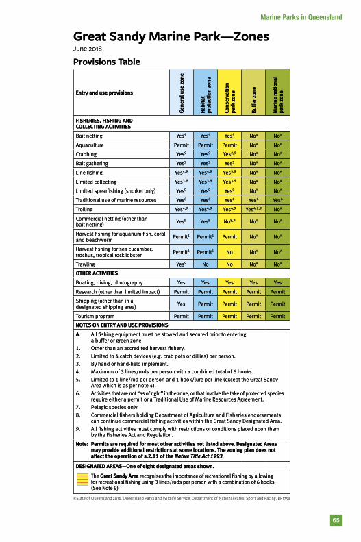
Great Sandy Marine Park—ZonesJune 2018
Provisions Table
Entry and use provisions
Gen
eral
use
zon
e
Hab
itat
pr
otec
tion
zon
e
Cons
erva
tion
pa
rk z
one
Buf
fer z
one
Mar
ine
nati
onal
pa
rk z
one
FISHERIES, FISHING AND COLLECTING ACTIVITIES
Bait netting Yes9 Yes9 Yes9 NoA NoA
Aquaculture Permit Permit Permit NoA NoA
Crabbing Yes9 Yes9 Yes2,9 NoA NoA
Bait gathering Yes9 Yes9 Yes9 NoA NoA
Line fishing Yes4,9 Yes4,9 Yes5,9 NoA NoA
Limited collecting Yes3,9 Yes3,9 Yes3,9 NoA NoA
Limited spearfishing (snorkel only) Yes9 Yes9 Yes9 NoA NoA
Traditional use of marine resources Yes6 Yes6 Yes6 Yes6 Yes6
Trolling Yes4,9 Yes4,9 Yes4,9 Yes4,7,9 NoA
Commercial netting (other than bait netting) Yes9 Yes9 No8,9 NoA NoA
Harvest fishing for aquarium fish, coral and beachworm Permit1 Permit1 Permit NoA NoA
Harvest fishing for sea cucumber, trochus, tropical rock lobster Permit1 Permit1 No NoA NoA
Trawling Yes9 No No NoA NoA
OTHER ACTIVITIES
Boating, diving, photography Yes Yes Yes Yes Yes
Research (other than limited impact) Permit Permit Permit Permit Permit
Shipping (other than in a designated shipping area) Yes Permit Permit Permit Permit
Tourism program Permit Permit Permit Permit Permit
NOTES ON ENTRY AND USE PROVISIONS
A.
1.
2.
3.
4.
5.
6.
7.
8.
9.
All fishing equipment must be stowed and secured prior to entering a buffer or green zone.
Other than an accredited harvest fishery.
Limited to 4 catch devices (e.g. crab pots or dillies) per person.
By hand or hand-held implement.
Maximum of 3 lines/rods per person with a combined total of 6 hooks.
Limited to 1 line/rod per person and 1 hook/lure per line (except the Great Sandy Area which is as per note 4).
Activities that are not “as of right” in the zone, or that involve the take of protected species require either a permit or a Traditional Use of Marine Resources Agreement.
Pelagic species only.
Commercial fishers holding Department of Agriculture and Fisheries endorsements can continue commercial fishing activities within the Great Sandy Designated Area.
All fishing activities must comply with restrictions or conditions placed upon them by the Fisheries Act and Regulation.
Note: Permits are required for most other activities not listed above. Designated Areas may provide additional restrictions at some locations. The zoning plan does not affect the operation of s.2.11 of the Native Title Act 1993.
DESIGNATED AREAS—One of eight designated areas shown.
The Great Sandy Area recognises the importance of recreational fishing by allowing for recreational fishing using 3 lines/rods per person with a combination of 6 hooks. (See Note 9)
65
Marine Parks in Queensland
Recreational fishing rules for QueenslandA brief guideRecreational fishing in Queensland watersRecreational fishing is a favourite pastime for many Queenslanders. However, we all have a part to play in ensuring current and future generations are able to enjoy the pleasures of recreational fishing and abundant seafood that are hallmarks of the Queensland lifestyle.
Fisheries Queensland manages the state’s fishing resources through management arrangements that protect valuable fish stocks, surveillance of Queensland’s fishing waters, the enforcement of fishing and boating safety laws, and by educating and informing Queenslanders about responsible fishing.
Fishers should consult fisheries legislation for the latest recreational fishing rules or visit fisheries.qld.gov.auRecreational fishers should also be aware that other local, state and federal regulations may apply—you will need to check with the relevant authorities.
Size and possession limitsWhy do we have size limits?In Queensland, there are limits on the size (length) of fish that can be legally taken for many species. There are minimum size limits and also some maximum size limits.
Size limits are typically, though not always, based on biological research into each species’ reproductive cycles. Minimum size limits generally allow fish to spawn at least once and contribute to the population before they are taken.
However, in some species larger individuals contribute more to the population, which is why some maximum size limits apply. For example, most barramundi begin their lives as males and later, as they grow larger, become females. A maximum size limit is applied to protect large females and to allow them to spawn.
Why do we have possession limits?A possession limit is the total number of fish that one person can legally take and keep at any one time – it does not apply on a per day basis. It includes the fish you have caught previously, for example, previous catches in your freezer at home.
These limits aim to:
• conserve heavily exploited species• conserve species that are susceptible to
capture• share the catch more equitably among
anglers• reduce illegal marketing of fish• promote ethical and responsible behaviour
when using a limited natural resource.
Handy hint: Fish IDYou should carry a good fish identification guide when fishing. Guides can be purchased from most bait and tackle stores. Remember, fish that look similar may in fact be different species with different size and possession limits.
Check your limitsFor a complete list of size and possession limits, see the back section of this guide. All information in this guide is correct at time of printing. For the most up-to-date information and changes to regulations, visit fisheries.qld.gov.au
MeasuringMeasuring fin fishFin fish are measured from the tip of their snout to the end of their tail (see handy hint below).
What if you catch an undersized fish?If you unintentionally take a fish (including fin fish or crustaceans) that is not legal size, return it to the water immediately, taking as much care as possible to avoid causing any injury to the fish.
Handy hintMeasuring deviceUse a sturdy ruler with an end stop to measure the length of catch. Adhesive or stick-on devices can be unreliable and shrink when exposed to the weather.
66
Fishing in Queensland
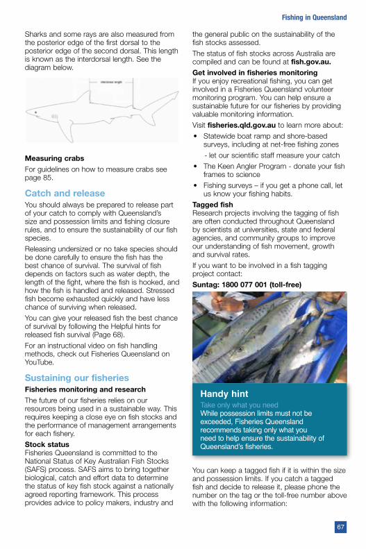
Sharks and some rays are also measured from the posterior edge of the first dorsal to the posterior edge of the second dorsal. This length is known as the interdorsal length. See the diagram below.
Measuring crabsFor guidelines on how to measure crabs see page 85.
Catch and releaseYou should always be prepared to release part of your catch to comply with Queensland’s size and possession limits and fishing closure rules, and to ensure the sustainability of our fish species.
Releasing undersized or no take species should be done carefully to ensure the fish has the best chance of survival. The survival of fish depends on factors such as water depth, the length of the fight, where the fish is hooked, and how the fish is handled and released. Stressed fish become exhausted quickly and have less chance of surviving when released.
You can give your released fish the best chance of survival by following the Helpful hints for released fish survival (Page 68).
For an instructional video on fish handling methods, check out Fisheries Queensland on YouTube.
Sustaining our fisheries Fisheries monitoring and researchThe future of our fisheries relies on our resources being used in a sustainable way. This requires keeping a close eye on fish stocks and the performance of management arrangements for each fishery.
Stock statusFisheries Queensland is committed to the National Status of Key Australian Fish Stocks (SAFS) process. SAFS aims to bring together biological, catch and effort data to determine the status of key fish stock against a nationally agreed reporting framework. This process provides advice to policy makers, industry and
the general public on the sustainability of the fish stocks assessed.
The status of fish stocks across Australia are compiled and can be found at fish.gov.au.Get involved in fisheries monitoringIf you enjoy recreational fishing, you can get involved in a Fisheries Queensland volunteer monitoring program. You can help ensure a sustainable future for our fisheries by providing valuable monitoring information.
Visit fisheries.qld.gov.au to learn more about:
• Statewide boat ramp and shore-based surveys, including at net-free fishing zones
- let our scientific staff measure your catch
• The Keen Angler Program - donate your fish frames to science
• Fishing surveys – if you get a phone call, let us know your fishing habits.
Tagged fishResearch projects involving the tagging of fish are often conducted throughout Queensland by scientists at universities, state and federal agencies, and community groups to improve our understanding of fish movement, growth and survival rates.
If you want to be involved in a fish tagging project contact:
Suntag: 1800 077 001 (toll-free)
Handy hintTake only what you needWhile possession limits must not be exceeded, Fisheries Queensland recommends taking only what you need to help ensure the sustainability of Queensland’s fisheries.
You can keep a tagged fish if it is within the size and possession limits. If you catch a tagged fish and decide to release it, please phone the number on the tag or the toll-free number above with the following information:
67
Fishing in Queensland
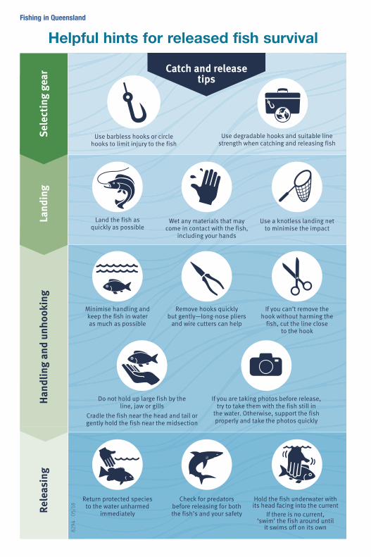
Helpful hints for released fish survivalSe
lect
ing
gear
829
4 0
5/18
Hand
ling
and
unho
okin
g
Land the fish as quickly as possible
Wet any materials that may come in contact with the fish,
including your hands
Use a knotless landing net to minimise the impact
If you can’t remove the hook without harming the
fish, cut the line close to the hook
Minimise handling and keep the fish in water as much as possible
Remove hooks quickly but gently—long-nose pliers
and wire cutters can help
Do not hold up large fish by the line, jaw or gills
Cradle the fish near the head and tail or gently hold the fish near the midsection
If you are taking photos before release, try to take them with the fish still in
the water. Otherwise, support the fish properly and take the photos quickly
Use barbless hooks or circle hooks to limit injury to the fish
Use degradable hooks and suitable line strength when catching and releasing fish
Hold the fish underwater with its head facing into the current
If there is no current, ‘swim’ the fish around until
it swims off on its own
Return protected species to the water unharmed
immediately
Check for predators before releasing for both the fish’s and your safety
Land
ing
Rele
asin
g
Catch and release tips
8294_Fish release flowchart – fishing guide A5.indd 1 13/7/18 2:45 pm
Fishing in Queensland
• tag number (if the fish has two tags, record both tag details)
• date and place of capture
• fork and/or total length
• details of where the fish was released
Alternatively, if you keep the fish you can phone the number on the tag with the information or post the tag and the information to the tagging coordinator.
If the tag has ‘Keep Frame’ on it, fisheries officers may wish to examine the fish skeleton. If you keep the fish (rather than releasing it), please freeze the fish frame and contact the tagging coordinator on the toll-free number or your local Queensland Boating and Fisheries Patrol office to arrange for collection.
ComplianceQueensland Boating and Fisheries Patrol (QBFP) is responsible for enforcing fishing and boating safety laws, surveillance and providing educational resources.
A list of QBFP offices is provided in the front of this guide.
Illegal salesRecreational fishing is for personal enjoyment and consumption. Taking fish to sell is illegal without an appropriate licence. Illegal marketing of fish poses a threat to the legitimate seafood market and can pose a threat to food safety and sustainability of fish stocks.
Reporting illegal fishing activitiesTo report suspected illegal fishing activities in Queensland call the 24-hour Fishwatch hotline on 1800 017 116 (free call within Queensland).
If you see, or have any information on fishing activities you suspect are unlawful:
• record the date, time and area where the activity occurs
• record any vehicle registration numbers and a description of any vehicles involved
• record any boat registration numbers and a description of any vessels involved
• if you know the person or persons involved, give their details as well
• give an accurate description of the activity involved, e.g. settling large numbers of crab pots, netting the local creek at low tides
• ring the Fishwatch hotline as soon as possible to pass on this information.
It is important you do not engage with the person/s, as this can compromise an investigation.
A Fishwatch form is also available from the Fisheries Queensland facebook page. Reports lodged via the form are processed during business hours only.
Reporting lost and found gearInterfering with fishing equipment that isn’t yours is illegal. If you find commercial fishing or shark control equipment on local beaches, report it so it can be returned to its owner. To report found shark control equipment, call the Shark Control Program hotline on 1800 806 891, and to report commercial fishing gear, call the Fishwatch hotline on 1800 017 116.
Handy hintShark Control Program hotlineIf you notice that an animal has been entangled in shark control equipment, contact the 24-hour Shark Control Program hotline on 1800 806 891 (free call within Queensland).
Miscellaneous prohibitionsThe following activities are illegal throughout Queensland:
• jagging or foul-hooking fish
• using explosives, poisons or electrical devices to take fish (divers may use a powerhead on a spear gun only in defence against sharks)
• interfering with authorised aquaculture activities
• obstructing lawful netting operations, damaging or interfering with fishing apparatus (including removing fish from the apparatus)
• possessing or carrying prohibited apparatus in closed waters unless the apparatus is dismantled, stowed and secured
• removing, damaging or interfering with markers or signs erected under the authority of fisheries legislation
• using underwater breathing apparatus (other than a snorkel) to take fish
• using fishing apparatus, including nets, across a waterway or navigation channel in a way that makes more than half of its width impassable to a boat or fish.
69
Fishing in Queensland
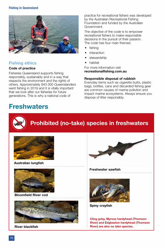
Fishing ethicsCode of practiceFisheries Queensland supports fishing responsibly, sustainably and in a way that respects the environment and the rights of others. Approximately 943 000 Queenslanders went fishing in 2019 and it is vitally important that we look after our fisheries for future generations. This is why a national code of
practice for recreational fishers was developed by the Australian Recreational Fishing Foundation and funded by the Australian Government.
The objective of the code is to empower recreational fishers to make responsible decisions in the pursuit of their passion. The code has four main themes:
• fishing
• interaction
• stewardship
• habitat
For more information visit recreationalfishing.com.au
Responsible disposal of rubbishEveryday items such as cigarette butts, plastic bags, bottles, cans and discarded fishing gear are common causes of marine pollution and impact marine ecosystems. Always ensure you dispose of litter responsibly.
Freshwaters
Cling goby, Myross hardyhead (Thomson River) and Edgbaston hardyhead (Thomson River) are also no take species.
Prohibited (no-take) species in freshwaters
Australian lungfish
Freshwater sawfish
Bloomfield River cod
River blackfish
Spiny crayfish
70
Fishing in Queensland
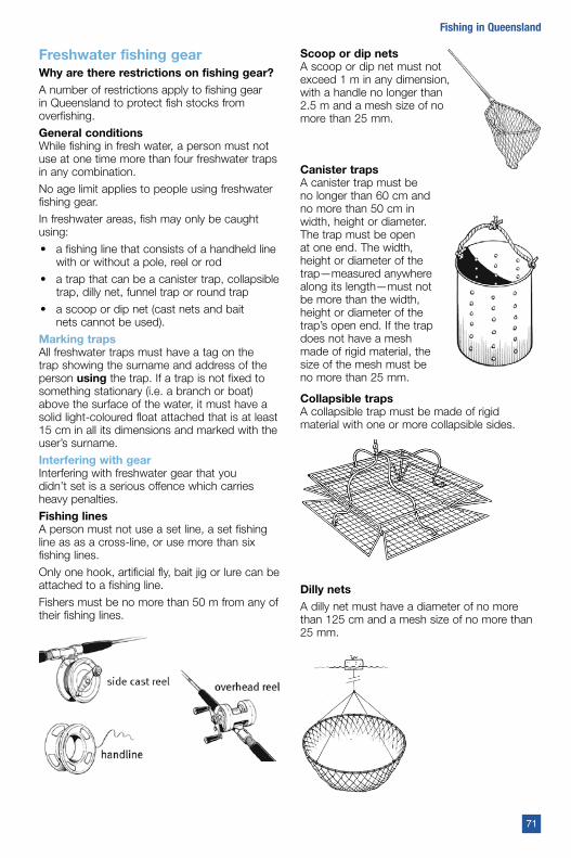
Freshwater fishing gearWhy are there restrictions on fishing gear?
A number of restrictions apply to fishing gear in Queensland to protect fish stocks from overfishing.
General conditions While fishing in fresh water, a person must not use at one time more than four freshwater traps in any combination.
No age limit applies to people using freshwater fishing gear.
In freshwater areas, fish may only be caught using:
• a fishing line that consists of a handheld line with or without a pole, reel or rod
• a trap that can be a canister trap, collapsible trap, dilly net, funnel trap or round trap
• a scoop or dip net (cast nets and bait nets cannot be used).
Marking trapsAll freshwater traps must have a tag on the trap showing the surname and address of the person using the trap. If a trap is not fixed to something stationary (i.e. a branch or boat) above the surface of the water, it must have a solid light-coloured float attached that is at least 15 cm in all its dimensions and marked with the user’s surname.
Interfering with gear Interfering with freshwater gear that you didn’t set is a serious offence which carries heavy penalties.
Fishing linesA person must not use a set line, a set fishing line as as a cross-line, or use more than six fishing lines.
Only one hook, artificial fly, bait jig or lure can be attached to a fishing line.
Fishers must be no more than 50 m from any of their fishing lines.
Scoop or dip netsA scoop or dip net must not exceed 1 m in any dimension, with a handle no longer than 2.5 m and a mesh size of no more than 25 mm.
Canister trapsA canister trap must be no longer than 60 cm and no more than 50 cm in width, height or diameter. The trap must be open at one end. The width, height or diameter of the trap—measured anywhere along its length—must not be more than the width, height or diameter of the trap’s open end. If the trap does not have a mesh made of rigid material, the size of the mesh must be no more than 25 mm.
Collapsible trapsA collapsible trap must be made of rigid material with one or more collapsible sides.
Dilly netsA dilly net must have a diameter of no more than 125 cm and a mesh size of no more than 25 mm.
71
Fishing in Queensland
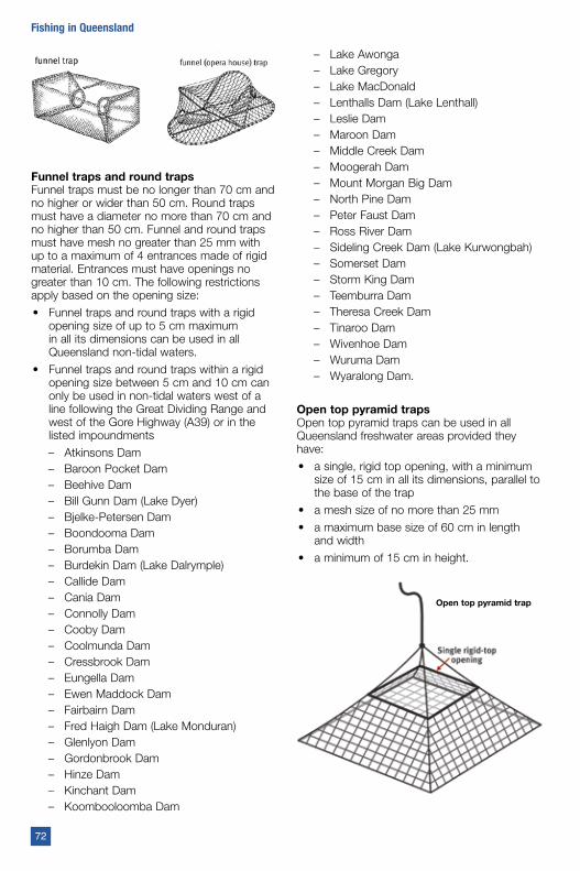
Funnel traps and round trapsFunnel traps must be no longer than 70 cm and no higher or wider than 50 cm. Round traps must have a diameter no more than 70 cm and no higher than 50 cm. Funnel and round traps must have mesh no greater than 25 mm with up to a maximum of 4 entrances made of rigid material. Entrances must have openings no greater than 10 cm. The following restrictions apply based on the opening size:
• Funnel traps and round traps with a rigid opening size of up to 5 cm maximum in all its dimensions can be used in all Queensland non-tidal waters.
• Funnel traps and round traps within a rigid opening size between 5 cm and 10 cm can only be used in non-tidal waters west of a line following the Great Dividing Range and west of the Gore Highway (A39) or in the listed impoundments
– Atkinsons Dam– Baroon Pocket Dam– Beehive Dam– Bill Gunn Dam (Lake Dyer)– Bjelke-Petersen Dam– Boondooma Dam– Borumba Dam– Burdekin Dam (Lake Dalrymple)– Callide Dam– Cania Dam– Connolly Dam– Cooby Dam– Coolmunda Dam– Cressbrook Dam– Eungella Dam– Ewen Maddock Dam– Fairbairn Dam– Fred Haigh Dam (Lake Monduran)– Glenlyon Dam– Gordonbrook Dam– Hinze Dam– Kinchant Dam– Koombooloomba Dam
– Lake Awonga– Lake Gregory– Lake MacDonald– Lenthalls Dam (Lake Lenthall)– Leslie Dam– Maroon Dam– Middle Creek Dam– Moogerah Dam– Mount Morgan Big Dam– North Pine Dam– Peter Faust Dam– Ross River Dam– Sideling Creek Dam (Lake Kurwongbah)– Somerset Dam– Storm King Dam– Teemburra Dam– Theresa Creek Dam– Tinaroo Dam– Wivenhoe Dam– Wuruma Dam– Wyaralong Dam.
Open top pyramid trapsOpen top pyramid traps can be used in all Queensland freshwater areas provided they have:
• a single, rigid top opening, with a minimum size of 15 cm in all its dimensions, parallel to the base of the trap
• a mesh size of no more than 25 mm
• a maximum base size of 60 cm in length and width
• a minimum of 15 cm in height.
Open top pyramid trap
72
Fishing in Queensland
Handy hintCheck your trapsTraps should be checked regularly to improve the quality of your catch and ensure any non-target species (such as freshwater turtles) that are accidentally caught can be released safely.
BaitAny fish caught to be used as bait must comply with all recreational fishing regulations (such as size and possession limits, and closed seasons). No take species cannot be used as bait. Any fish that are not native to the area (non-indigenous and noxious - see pages 77 and 78 of this guide) must not be put back in the water even as bait.
Also see page 99 for current bait restrictions due to white spot disease.
Handy hintCatch local baitThe easiest way to prevent movement of fish species is to catch your bait at the location where you are fishing. But remember, any noxious or non-indigenous fish are not to be put back into the water or used as bait, even if caught at that location.
Using marine baits in freshwatersThe use of baits from the marine (saltwater) environment is prohibited unless the bait has been frozen, cooked or preserved. This is to prevent the spread of disease and parasites in Queensland’s freshwater systems, and to protect native fish populations and the future viability of freshwater fish stocking programs.
Freshwater baitThe use of fish and crustaceans such as spangled perch, redclaw, yabbies (blueclaw) as bait (dead or alive) is prohibited outside their natural environment or range. This is to prevent species from becoming established in foreign habitats and causing environmental damage.
Natural ranges for some commonly used ‘live’ bait species are listed below:
• Redclaw (Cherax quadricarinatus) are native to the Gulf of Carpentaria Drainage Division and some river basins in the far northern portion of the East Coast Drainage Division. Redclaw can be used as bait only in these areas.
• Freshwater prawn or shrimp (Macrobrachium australiensis) are found throughout Queensland and can be used as bait in all areas of the state.
• Yabby or blueclaw crayfish (Cherax destructor) are found naturally in the Murray–Darling, Lake Eyre and Bulloo–Bancannia drainage divisions, and some river basins in the East Coast Drainage Division. Yabbies can be used as bait only in these areas.
Prohibited fishing gear in fresh waters
All other forms of fishing apparatus other than those mentioned in the table directly above are prohibited, including:
• setlines
• floatlines
• all forms of nets (except landing nets, scoop or dip nets, and dilly nets)
• fish traps
• drum nets
• cross lines
• spears and spear guns (spearfishing is prohibited in all freshwaters). A spear gun includes a bow for propelling a spear.
• cast nets.
73
Fishing in Queensland
Freshwater closed seasonsWhy do we have closed seasons?Closed seasons (regulated periods) prevent people from taking particular species at certain times of the year. This protects these species at vulnerable times in their life cycle, such as during spawning seasons.
The following closed seasons run from midnight to midnight – from 12.01am on the first day of the closure to 11.59pm on the last day of the closure.
BarramundiThroughout the Queensland east coast, a closed season applies to barramundi from 1 November to 31 January, except in and from waterways upstream of Aplins Weir (also includes Black Weir and Gleeson Weir), Awoonga, Ben Anderson Barrage (also includes Paradise Dam, Claude Wharton Weir and Jones Weir), Burdekin Falls, Callide, Eungella, Fairbairn, Fred Haigh (Lake Monduran), Kinchant, Koombooloomba, Lake Gregory (Isis Balancing Storage), Copperlode Falls (Lake Morris), Lenthalls, Peter Faust, Teemburra, Tinaroo and Wuruma Dams.
The dates for the Gulf of Carpentaria closed season for barramundi are 7 October to 31 January.
These closures do not apply in East Leichhart Dam and Belmore, Corella, Fred Tritton, Julius and Moondarra Lakes, and waterways upstream of these impoundments.
A possession limit of one barramundi applies during the closed season in all of the exempted waterways mentioned above. The barramundi may be greater than 120 cm. Recreational fishers may continue to fish in the exempted waterways once they have reached their limit of one barramundi.
Outside of the closed season, in the exempted waterways mentioned previously, a possession limit of five applies to barramundi (can include one greater than 120 cm).
It is prohibited to deliberately target barramundi outside of the dams listed above for catch and release during these closed seasons, as the stress of capture may prevent a fish from spawning. Barramundi caught accidentally during the closed season must be immediately returned to the water unharmed.
Murray codA spawning season closure applies to all Queensland waters contained in the Murray Darling Drainage Division from 1 August to 31 October. An exception to this closed season
applies to Beardmore Dam, BeehiveDam, Connolly Dam, Cooby Dam, Coolmunda Dam, Glenlyon Dam, Leslie Dam and Storm King Dam.
Freshwater closed watersWhy do we have closed waters?Closed waters (regulated waters) prevent people from fishing in certain areas and these may be:
• where a population of endangered or threatened species lives
• where fish congregate during or before spawning
• where fish may aggregate or get trapped near artificial barriers and be susceptible to overfishing
• to separate incompatible uses (e.g. fishing from a bathing area)
• to enable successful migration of fish through fishways.
Waters closed to line fishingA person must not possess or use a fishing line in the following area:
Obi Obi Creek: No fish can be taken from Obi Obi Creek all year round between the Baroon Pocket Dam wall and the shortest line across the creek at the downstream side of Obi Obi Creek crossing 4 (Manuel Hornibrook Bridge).
A person must not possess or use a fishing line from 1 August to 31 October in the following locations:
Albert River (upstream from the junction of Canungra Creek and Albert River - includes Canungra Creek)
Christmas CreekCoomera River (upstream from the junction of Guanaba Creek and Coomera River - includes Guanaba Creek)
Mary River and adjoining waterways (upstream of its junction with Six Mile Creek at the creek’s northern bank, other than waters up to the full supply level of Baroon Pocket Dam, Borumba Dam and Lake MacDonald.
Running CreekStanley River (above Neurum Creek and Stanley River junction).
Waters closed to all forms of fishingFishing, which includes collecting, is not allowed in the following areas:
Albert River: from 100 m upstream to 200 m downstream of Luscombe Weir.
74
Fishing in Queensland
Balonne River: from 100 m upstream to 200 m downstream of Surat Weir; Beadmore Dam wall and Jack Taylor Weir.
Barwon River: from Mungindi Weir to 100 m downstream of Mungindi Weir.
Boyne River (in the auburn river basin): from 100m upstream to 200 m downstream of the Boondooma Dam wall.
Brisbane River: from 100 m upstream to 200 m downstream of Old Mount Crosby Weir; from 100 m upstream to 200 m downstream of Mount Crosby Weir; and from 100 m upstream to 600 m downstream of the Wivenhoe Dam wall.
Burdekin River: from 100 m upstream to 200 m downstream of Clare Weir.
Burnett Creek: from 100 m upstream to 200 m downstream of the Maroon Dam wall.
Burnett River: from 400 m upstream to 400 m downstream of Burnett Barrage; from 100 m upstream to 200 m downstream of the Kirar Weir; Ned Churchward (Walla) Weir, Claude Wharton Weir and the Paradise Dam wall.
Condamine River: from 100 m upstream to 200 m downstream of Chinchilla Weir; Loudon Weir, Lemon Tree Weir, Yarramalong Weir, Cecil Plains Weir and from 27˚02’24” S 149˚57’12” E (approximately 14 km upstream of Reilly’s Weir) to 200 m downstream of Reilly’s Weir.
Dawson River: from 100 m upstream to 200 m downstream of the Glebe Weir; Gyranda Weir, Orange Creek Weir, Theodore Weir, Moura Weir and Neville Hewitt Weir
Dogwood Creek: from 100 m upstream to 200 m downstream of Gil Weir.
Dumaresq River: from Bonshaw Weir to 100 m downstream of Bonshaw Weir.
Fitzroy River: from 400 m upstream to 400 m downstream of the Fitzroy River Barrage; and from 100 m upstream to 200m downstream of Eden Bann Weir; and Wattlebank Control Weir.
Kolan River: from 400 m upstream to 400 m downstream of Kolan Barrage.
Logan River: from 100 m upstream to 200 m downstream of Cedar Grove Weir; and South Maclean Weir.
Macintyre Brook: from 100 m upstream to 200 m downstream of the Coolmunda Dam spillway wall, Whetstone Weir and Ben Dor Weir.
Macintyre River: from 150 m upstream to 150m downstream of Goondiwindi Weir.
Mary River: from 400 m upstream to 400 m downstream of Mary River Barrage.
Nerang River: from 100 m upstream to 600 m downstream of the Hinze Dam wall.
Nogo River: from 100 m upstream to 200 m downstream of the Wuruma Dam wall.
Nogoa River: from 100 m upstream to 200 m downstream of the Fairbairn Dam wall.
North Pine River: from 100 m upstream to 200 m downstream of the North Pine Dam wall.
Pike Creek: from 100 m upstream to 200 m downstream of the Glenlyon Dam wall.
Pioneer River: from 100 m upstream to 200 m downstream of Marian Weir; 100 m upstream to 200 m downstream of Mirani Weir; and 100 m upstream to 200 m downstream of Dumbleton Weir.
Quart Pot Creek: from 100 m upstream to 200 m downstream of the Storm King Dam wall.
Reynolds Creek: from 100 m upstream to 200 m downstream of the Moogerah Dam wall.
Sandy Creek: from 100 m upstream to 200 m downstream of the Leslie Dam wall.
Severn River: the part of the Severn River commonly known as Queen Mine waterhole, about 6km west of Ballandean.
Sideling Creek: from 100 m upstream to 200 m downstream of the Sideling Creek dam (Lake Kurwongbah).
Six Mile Creek: from 100 m upstream to 200 m downstream of the Lake MacDonald Dam wall.
Stuart River: from 750 m upstream to 200 m downstream of the Gordonbrook Dam wall.
Teviot Brook: from 100 m upstream to 200m downstream of Wyaralong Dam wall.
Three Moon Creek: from 100 m upstream to 200m downstream of Cania Dam wall.
Thomson River: from 100 m upstream to 200m downstream of Fairmount Weir.
Tinana Creek: from 400 m upstream to 400 m downstream of Tinana Creek Barrage.
Tinana Creek upstream: Tinana Creek and its tributaries upstream of Teddington Weir wall.
Yabba Creek: from 100 m upstream to 200 m downstream from Borumba Dam wall.
75
Fishing in Queensland
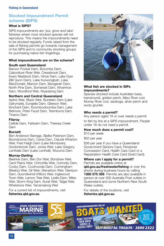
Stocked Impoundment Permit scheme (SIPS)What is SIPS?SIPS impoundments are ‘put, grow and take’ fisheries where most stocked species will not reproduce. This means the impoundments need to be stocked regularly. Funds raised from the sale of fishing permits go towards management of the SIPS and to community stocking groups for purchasing native fish fingerlings.
What impoundments are on the scheme?South east QueenslandBaroon Pocket Dam, Borumba Dam, Caboolture River Weir, Cressbrook Dam, Ewen Maddock Dam, Hinze Dam, Lake Dyer (Bill Gunn Dam), Lake Kurwongbah, Lake MacDonald, Maroon Dam, Moogerah Dam, North Pine Dam, Somerset Dam, Wivenhoe Dam, Woodford Weir, Wyaralong Dam
Northern and Central Queensland Aplins Weir, Black Weir, Burdekin Dam (Lake Dalrymple), Eungella Dam, Gleeson Weir, Kinchant Dam, Koombooloomba Dam, Lake Belmore, Peter Faust Dam, Teemburra Dam, Tinaroo Dam
Fitzroy Callide Dam, Fairbairn Dam, Theresa Creek Dam
BurnettBen Anderson Barrage, Bjelke Peterson Dam, Boondooma Dam, Cania Dam, Claude Wharton Weir, Fred Haigh Dam (Lake Monduran), Gordonbrook Dam, Jones Weir, Lake Gregory, Lenthalls Dam (Lake Lenthall), Wuruma Dam
Murray-DarlingBeehive Dam, Ben Dor Weir, Bonshaw Weir, Cecil Plains Weir, Chinchilla Weir, Connolly Dam, Cooby Dam, Coolmunda Dam, Cunningham (Beebo) Weir, Gil Weir, Glenarbon Weir, Glenlyon Dam, Goondiwindi (Hilton) Weir, Inglewood Town Weir, Lemon Tree Weir, Leslie Dam, Miles Weir, Storm King Dam, Surat Weir, Talgai Weir, Whetstone Weir, Yarramalong Weir
For a current list of impoundments, visit fisheries.qld.gov.au
What fish are stocked in SIPs impoundments?Species stocked include Australian bass, barramundi, golden perch, Mary River cod, Murray River cod, saratoga, silver perch and sooty grunter.
Who needs a permit?Any person aged 18 or over needs a permit
to fish by line at a SIPS impoundment. People under 18 do not need a permit.
How much does a permit cost?$10 per week
$50 per year
$36 per year if you have a Queensland Government Seniors Card, Pensioner Concession Card, Health Care Card or a Repatriation Health Care Card (Gold Card).
Where can I apply for a permit?Permits are available online at qld.gov.au/freshwaterfishing or over the phone during business hours by calling 1300 575 359. Permits are also available in person at over 500 Australia Post outlets in Queensland and some Northern New South Wales outlets.
For details of the locations, visit fisheries.qld.gov.au
76
Fishing in Queensland
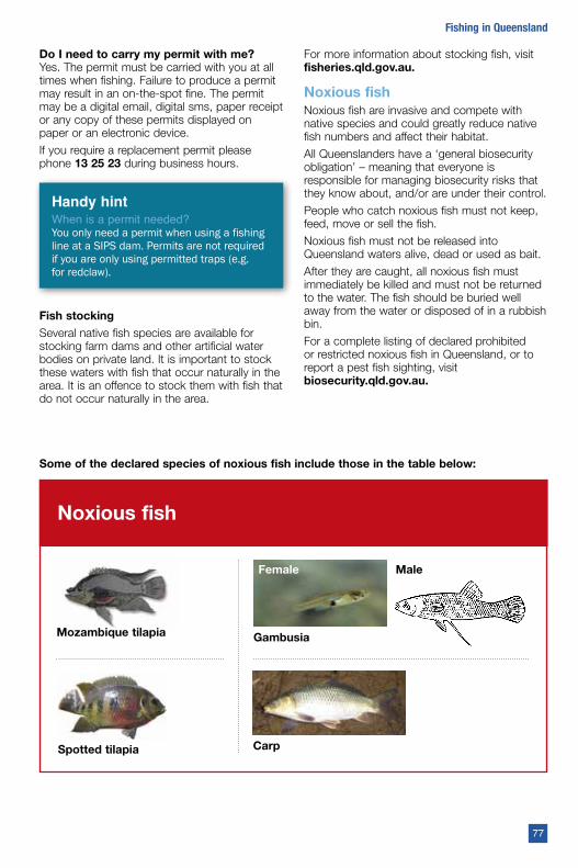
Do I need to carry my permit with me? Yes. The permit must be carried with you at all times when fishing. Failure to produce a permit may result in an on-the-spot fine. The permit may be a digital email, digital sms, paper receipt or any copy of these permits displayed on paper or an electronic device.
If you require a replacement permit please phone 13 25 23 during business hours.
Handy hintWhen is a permit needed?You only need a permit when using a fishing line at a SIPS dam. Permits are not required if you are only using permitted traps (e.g. for redclaw).
Fish stockingSeveral native fish species are available for stocking farm dams and other artificial water bodies on private land. It is important to stock these waters with fish that occur naturally in the area. It is an offence to stock them with fish that do not occur naturally in the area.
For more information about stocking fish, visit fisheries.qld.gov.au.
Noxious fishNoxious fish are invasive and compete with native species and could greatly reduce native fish numbers and affect their habitat.
All Queenslanders have a ‘general biosecurity obligation’ – meaning that everyone is responsible for managing biosecurity risks that they know about, and/or are under their control.
People who catch noxious fish must not keep, feed, move or sell the fish.
Noxious fish must not be released into Queensland waters alive, dead or used as bait.
After they are caught, all noxious fish must immediately be killed and must not be returned to the water. The fish should be buried well away from the water or disposed of in a rubbish bin.
For a complete listing of declared prohibited or restricted noxious fish in Queensland, or to report a pest fish sighting, visit biosecurity.qld.gov.au.
Spotted tilapia Carp
Noxious fish
Mozambique tilapia Gambusia
Female Male
Some of the declared species of noxious fish include those in the table below:
77
Fishing in Queensland
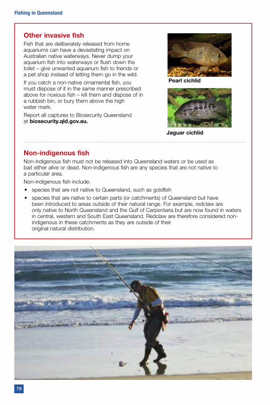
Other invasive fishFish that are deliberately released from home aquariums can have a devastating impact on Australian native waterways. Never dump your aquarium fish into waterways or flush down the toilet – give unwanted aquarium fish to friends or a pet shop instead of letting them go in the wild.
If you catch a non-native ornamental fish, you must dispose of it in the same manner prescribed above for noxious fish – kill them and dispose of in a rubbish bin, or bury them above the high water mark.
Report all captures to Biosecurity Queensland at biosecurity.qld.gov.au.
Non-indigenous fishNon-indigenous fish must not be released into Queensland waters or be used as bait either alive or dead. Non-indigenous fish are any species that are not native to a particular area.
Non-indigenous fish include:
• species that are not native to Queensland, such as goldfish
• species that are native to certain parts (or catchments) of Queensland but have been introduced to areas outside of their natural range. For example, redclaw are only native to North Queensland and the Gulf of Carpentaria but are now found in waters in central, western and South East Queensland. Redclaw are therefore considered non-indigenous in these catchments as they are outside of their original natural distribution.
Jaguar cichlid
Pearl cichlid
78
Fishing in Queensland
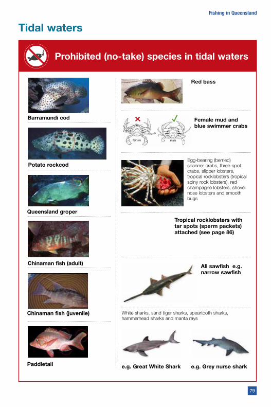
Tidal waters
Prohibited (no-take) species in tidal waters
Barramundi cod
Potato rockcod
Queensland groper
Chinaman fish (adult)
Chinaman fish (juvenile)
Paddletail
Red bass
Female mud and blue swimmer crabs
Egg-bearing (berried) spanner crabs, three-spot crabs, slipper lobsters, tropical rocklobsters (tropical spiny rock lobsters), red champagne lobsters, shovel nose lobsters and smooth bugs
Tropical rocklobsters with tar spots (sperm packets) attached (see page 86)
All sawfish e.g. narrow sawfish
e.g. Grey nurse shark
White sharks, sand tiger sharks, speartooth sharks, hammerhead sharks and manta rays
e.g. Great White Shark
79
Fishing in Queensland
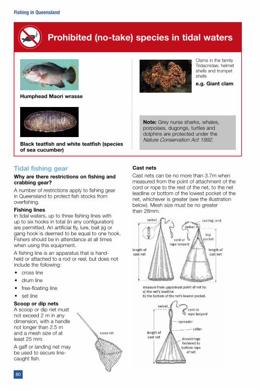
Tidal fishing gearWhy are there restrictions on fishing and crabbing gear? A number of restrictions apply to fishing gear in Queensland to protect fish stocks from overfishing.
Fishing linesIn tidal waters, up to three fishing lines with up to six hooks in total (in any configuration) are permitted. An artificial fly, lure, bait jig or gang hook is deemed to be equal to one hook. Fishers should be in attendance at all times when using this equipment.
A fishing line is an apparatus that is hand-held or attached to a rod or reel, but does not include the following:
• cross line
• drum line
• free-floating line
• set line
Scoop or dip netsA scoop or dip net must not exceed 2 m in any dimension, with a handle not longer than 2.5 m and a mesh size of at least 25 mm.
A gaff or landing net may be used to secure line- caught fish.
Cast netsCast nets can be no more than 3.7m when measured from the point of attachment of the cord or rope to the rest of the net, to the net leadline or bottom of the lowest pocket of the net, whichever is greater (see the illustration below). Mesh size must be no greater than 28mm.
Prohibited (no-take) species in tidal waters
Humphead Maori wrasse
Black teatfish and white teatfish (species of sea cucumber)
Clams in the family Tridacnidae, helmet shells and trumpet shells
e.g. Giant clam
Note: Grey nurse sharks, whales, porpoises, dugongs, turtles and dolphins are protected under the Nature Conservation Act 1992.
80
Fishing in Queensland
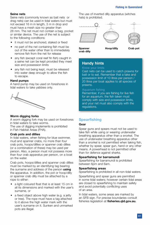
Seine nets Seine nets (commonly known as bait nets or drag nets) can be used in tidal waters but must not exceed 16 m in length, 3 m in drop and must have a mesh size no greater than 28 mm. The net must not contain a bag, pocket or similar device. The use of the net is subject to the following conditions:
• it must not be anchored, staked or fixed
• no part of the net containing fish must be out of the water other than to immediately remove fish from the net for release
• any fish (except coral reef fin fish) caught in a seine net can be kept provided they meet size and possession limits
• any fish not being kept, must be released into water deep enough to allow the fish to escape.
Hand pumps A hand pump may be used on foreshores in tidal waters to take yabbies only.
Worm digging forks A worm digging fork may be used on foreshores in tidal waters to take worms. The use of digging implements is prohibited in Fish Habitat Areas (FHA).
Crab pots and dillies In tidal waters, when fishing for blue swimmer, mud and spanner crabs, no more than four crab pots, hoops/dillies or spanner crab dillies (or a combination of these) may be used per person. Also, a person must not possess more than four crab apparatus per person, on a boat on the water.
Crab pots, hoops/dillies and spanner crab dillies must be marked by an identifying tag bearing the surname and address of the person using the apparatus. In addition, the pot or hoop/dilly or spanner crab dilly must be attached by a rope to either:
• a light coloured float that is at least 15 cm in all its dimensions and marked with the user’s surname, or
• a fixed object above high water (e.g. a jetty or tree). The rope must have a tag attached to it above the high water mark with the user’s surname on it. Sunken and unmarked pots are illegal.
The use of inverted dilly apparatus (witches hats) is prohibited.
Spanner crab dilly
Hoop/dilly Crab pot
Handy hintsKnow your limitsCast nets can be used to catch prawns for bait or to eat. Remember that a take and possession limit of 10 litres per person / 20 litres per boat applies to all species of prawns.
Aquarium fishingRemember, if you are fishing for live fish for an aquarium, the fish taken must comply with size and possession limits, and your net must also comply with the regulations.
SpearfishingGearSpear guns and spears must not be used to take fish while using or wearing underwater breathing apparatus other than a snorkel. The use of underwater breathing apparatus other than a snorkel is not permitted when taking fish, whether by spear, spear gun, hand or any other means. A powerhead is not permitted other than for defence against sharks.
Spearfishing for barramundi Spearfishing for barramundi is prohibited between 6pm and 6am.
Spearfishing areasSpearfishing is prohibited in all non-tidal waters.
Spearfishing and spear guns are permitted in some tidal waters; however certain tidal areas are closed to spearfishing to maintain safety and avoid potentially conflicting uses of an area.
In tidal waters, some areas are marked by an SFB sign. For precise boundaries consult fisheries legislation at fisheries.qld.gov.au.
81
Fishing in Queensland
For details of spearfishing areas managed by the Great Barrier Marine Park Authority visit gbrmpa.gov.au.
Other local, state and federal regulations may also apply—check with the relevant authority.
Closed waters to spearfishingSpearfishing is prohibited in the following tidal areas:
South East Queensland: within 100 m of all public jetties in and south of the Noosa River.
Tallebudgera Creek: upstream of a straight line between the eastern extremity of Burleigh Heads and the seaward end of the rock groyne near its southern bank of the creek end.
Southern Moreton Bay: Jumpinpin and the Southport Broadwater (including the seaway) Moreton Bay south of 27˚42’ S (Logan River).
Moreton Island: waters between Bulwer and Tangalooma Point out to the shipping beacons.
Pumicestone strait: between a line from Elimbah Creek to Gallagher Point, Bribie Island, and a line from Ningi Creek to Dux Creek, Bribie Island.
Pumicestone strait: north of a line from Bells Creek to the northern tip of the most northern island of a group of islands east of Bells Creek, to the western side of Bribie Island.
Mooloolah River: downstream of the Nicklin Way Bridge and Brisbane Road.
Maroochy River: waterways joining it downstream of, and including, the Cod Hole.
Lake Weyba (Noosa River) and waterway adjoining the lake and river downstream of Parkyns Jetty at Tewantin and the western tip of Goat Island.
Woodgate: in the vicinity of the artificial reef, Hervey Bay.
Woody Island: waters adjacent to the eastern side of Big Woody Island including the artificial reef, Hervey Bay.
Bargara Beach (Bundaberg): the Basin.
Great Keppel island: western foreshore waters and waters within 400m out to sea from the island’s shore at low water, between Little Peninsula on the island’s north-western foreshore and Monkey Point at the island’s south-western tip.
North Keppel Island: the western and southern sides.
Brampton and Carlisle islands: waters between the islands.
Seaforth Island.
Lindeman Island: the western and southern sides.
Long island: the western side.
South Molle Island: the northern side. West Molle Island (Daydream Island): surrounding waters.
Hook island: the eastern, south-eastern and southern sides.
Hayman Island: the southern and western sides.
Port dennison: waters under, or within 100 m of, the main wharf at Port Dennison, Bowen, and a structure attached to the wharf.
Cape edgecumbe: the foreshores and waters seaward 50m from low water mark from the boat ramp in Greys Bay around Cape Edgecumbe to the eastern headland of Horseshoe Bay.
Dungeness and Lucinda Point: within 100m of the public jetties.
Richards island (Bedarra island): the northwestern and northern sides.
Dunk island: the north-western and western sides.
Cooktown: within 100m of the main wharf and pontoons.
Worm diggingRecreational worm digging is banned on the foreshores between Lota Creek and the rock groyne near the northern end of Wynnum North Esplanade for a distance of 100m from the foreshore rock wall. Between Cedar Street and Charlotte Street the closure extends from the foreshore rock wall to the low water mark.
Skin and fillet removalIn relation to coral reef fin fish, a recreational fisher:
• must not possess on board a boat a fish other than in any of the following forms— whole, gilled, gutted or filleted.
• may possess on board a boat a fillet of a fish other than a blue spotted coral trout (Chinese footballer) as long as the length of the fillet is at least 40cm, and the skin and scales of the fillet are attached to the fillet.
• must not return fish to a boat that have been taken ashore from a boat and filleted, unless the length of the fillet is at least 40cm and the skin and scales of the fillet is attached to the fillet.
82
Fishing in Queensland

• must not possess a live coral reef fin fish unless the person or fisher intends to immediately return the fish to the sea.
In relation to fin fish (other than coral reef fin fish) a recreational fisher must not:
• remove the skin from a fish on a boat until the fish is brought to shore
• bring a fish ashore and remove its skin and return the fish to the boat
• divide a fish into portions other than in a way that allows an inspector to easily count the number of fish possessed by the fisher.
In addition to the above, a recreational fisher may fillet or process barred javelin (spotted grunter) as long as:
• the fillet is at least 26 cm in length and has the skin left on, or
• a whole fish or one that has been processed into a form other than fillets is at least 40 cm in length.
Note: For information applying to recreational fishers on commercial fishing tours, consult the fisheries legislation at fisheries.qld.gov.au
Tidal waters closed seasonsWhy do we have closed seasons? Closed seasons (regulated periods) prevent people from taking particular species at certain times of the year. This protects these species at vulnerable times in their life cycle, such as during spawning seasons.
The following closed seasons run from midnight to midnight – from 12.01am on the first day of the closure to 11.59pm on the last day of the closure.
Australian bassA closed season applies to Australian bass throughout Queensland tidal waters from 1 June to 31 August.
BarramundiThroughout the Queensland east coast, a closed season applies to barramundi from 1 November to 31 January.
Throughout the Gulf of Carpentaria, a closed season applies to barramundi from 7 October to 31 January.
It is also prohibited to deliberately target barramundi for catch and release during these closed seasons, as the stress of capture may prevent a fish from spawning.
See the freshwater ‘Closed seasons’ section on page 74 for information on taking barramundi from some fresh waters during the closure.
Coral reef fin fishTwo five-day periods have been implemented as closed seasons to the taking of coral reef fin fish in October and November.
The closure dates for 2019-20 are as follows:
• 25 to 29 October 2019, 24 to 28 November 2019.
• 14 to 18 October 2020, 12 to 16 November 2020.
The closures apply to the following tidal waters (Great Barrier Reef Marine Park):
• from the northern tip of Cape York along latitude 10°41’ south
• to longitude 145° east
• to latitude 13° south, longitude 145° east
• to latitude 15° south, longitude 146° east
• to latitude 17°30’ south, longitude 147° east
• to latitude 21° south, longitude 152°55’ east
• to latitude 24°30’ south, longitude 154° east
• to latitude 24°50’ south, longitude 154° east along latitude 24°50’ south to the mainland shore along the shore to the northern tip of Cape York at latitude 10°41’ south.
Snapper and pearl perchA closed season applies to snapper and pearl perch throughout Queensland tidal waters from 15 July to 15 August
Note: For information on closed seasons for spanner crabs and tropical rocklobsters see page 86.
Tidal waters closed watersWhy do we have closed waters?Closed waters (regulated waters) prevent people from fishing in certain areas, and these may be:
• where a population of endangered or threatened species lives
• where fish congregate during or before spawning
• where fish may aggregate or get trapped near artificial barriers and be susceptible to overfishing
• to separate incompatible uses (e.g. spearfishing in a bathing area).
83
Fishing in Queensland
Handy hintCheck closure information onlineVisit fisheries.qld.gov.au for all the latest closure information, including boundaries.
Waters closed to all forms of fishingNote: For precise boundaries consult fisheries legislation at fisheries.qld.gov.au or contact your local QBFP office. For marine park boundaries contact the Queensland Parks and Wildlife Service or the Great Barrier Reef Marine Park Authority.
Also see page 100 for closed waters due to white spot disease.
Fishing is totally prohibited in the following areas:
Certain areas within state and Commonwealth marine parks.Coombabah Lake and tidal waters of Coombabah Creek upstream from the lake.
Swan Bay and tidal waters of the unnamed creek joining the bay’s northern end.
Mary River: from 400 m upstream to 400 m downstream of the Mary River Barrage.
Tinana Creek: from 400 m upstream to 400 m downstream of the Tinana Creek Barrage.
Tinana Creek upstream: Tinana Creek and its tributaries upstream of Teddington Weir wall.
Fraser Island (Indian Head to Waddy Point): eastern foreshore waters and waters within 400 m out to sea from the eastern shore at low water, between 400 m north of Waddy Point and 400m south of Indian Head. Closed from midnight 1 August to midnight 29 September every year (fin fish only).
Burnett River: from 400m upstream to 400m downstream of the Burnett River Barrage.
Kolan river: from 400m upstream to 400m downstream of the Kolan Barrage.
Fitzroy river: from 400m upstream to 400 m downstream of the Fitzroy River Barrage.
Keppel Bay: within a 150m radius of the Middle Island Underwater Observatory.
Hook island observatory: waters within a 100m radius of the observatory.
Orpheus island: waters under or within 100m of Yanks Jetty.
Centenary Lakes: Saltwater Creek, Lily Creek and lakes joining the creeks, between Greenslopes Street and Collins Avenue, Cairns.
Barron River: at the place commonly known as Barron Waters, between F B signs on opposite sides of the river near its junction with Stony Creek and its junction with Camp Oven Creek.
Mission Bay: south of a line between Cape Grafton and False Cape and waters flowing into that part of the bay.
South Mitchell River (and waterways joining it): between F Bsigns near the mouth of the river and F B signs where it joins Surprise Creek.
Bizant River and German Bar Lagoon: from the road crossing commonly known as German Bar downstream for 2 km.
Torres Strait: waters within the following boundary—from Turtle Head, Hammond Island, to Hammond Rock; to 1 nautical mile east of Menmuir Point, Hammond Island; to the northern tip of Kapuda Island; to Bruce Point, Hammond Island; along the eastern shore of Hammond Island to Turtle Head.
Waters closed to taking fishIn Queensland there are a number of areas closed to taking some fish or all fish, or the use of certain fishing apparatus. For more information refer to fisheries legislation at fisheries.qld.gov.auGrey nurse shark protection areasThe grey nurse shark is now listed under Queensland’s Nature Conservation Act 1992 as an endangered animal. There are four grey nurse shark protection areas in Queensland: Wolf Rock, Flat Rock, Henderson Rock and Cherubs’ Cave. For more information visit fisheries.qld.gov.au or call 13 25 23.
Waters closed to taking all fishWaters within 200 m from the Hay Point and Dalrymple Bay coal terminals.
Waters closed to taking black jewfishNorth Cape York regulated waters.
Closed areas to taking gastropods or bivalve molluscs (e.g. mud whelks and cockles)Moreton Bay: Gastropods and bivalve molluscs (excluding pipi) are no-take in Moreton Bay. The closure applies to the waters of Moreton Bay Marine Park following the boundary coordinates of the northern, eastern and southern boundaries and all tidal waters that flow into the Marine Park.
84
Fishing in Queensland
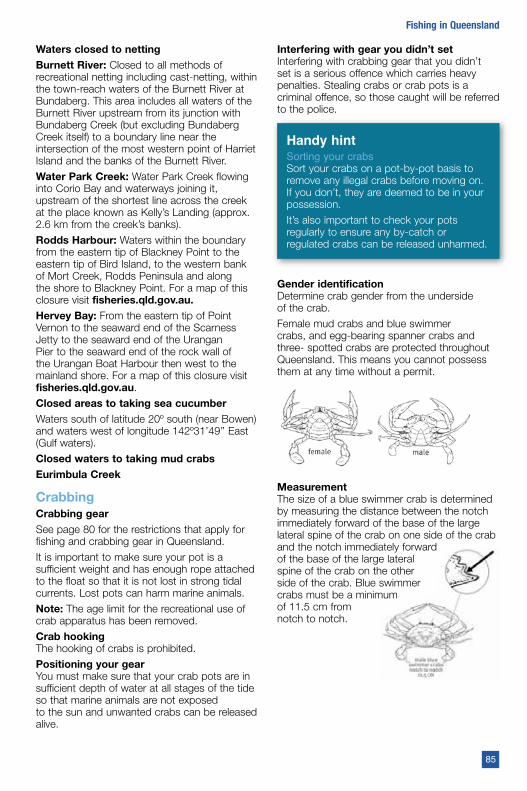
Waters closed to nettingBurnett River: Closed to all methods of recreational netting including cast-netting, within the town-reach waters of the Burnett River at Bundaberg. This area includes all waters of the Burnett River upstream from its junction with Bundaberg Creek (but excluding Bundaberg Creek itself) to a boundary line near the intersection of the most western point of Harriet Island and the banks of the Burnett River.
Water Park Creek: Water Park Creek flowing into Corio Bay and waterways joining it, upstream of the shortest line across the creek at the place known as Kelly’s Landing (approx. 2.6 km from the creek’s banks).
Rodds Harbour: Waters within the boundary from the eastern tip of Blackney Point to the eastern tip of Bird Island, to the western bank of Mort Creek, Rodds Peninsula and along the shore to Blackney Point. For a map of this closure visit fisheries.qld.gov.au.Hervey Bay: From the eastern tip of Point Vernon to the seaward end of the Scarness Jetty to the seaward end of the Urangan Pier to the seaward end of the rock wall of the Urangan Boat Harbour then west to the mainland shore. For a map of this closure visit fisheries.qld.gov.au.
Closed areas to taking sea cucumberWaters south of latitude 20º south (near Bowen) and waters west of longitude 142º31’49’’ East (Gulf waters).
Closed waters to taking mud crabsEurimbula Creek
CrabbingCrabbing gearSee page 80 for the restrictions that apply for fishing and crabbing gear in Queensland.
It is important to make sure your pot is a sufficient weight and has enough rope attached to the float so that it is not lost in strong tidal currents. Lost pots can harm marine animals.
Note: The age limit for the recreational use of crab apparatus has been removed.
Crab hookingThe hooking of crabs is prohibited.
Positioning your gearYou must make sure that your crab pots are in sufficient depth of water at all stages of the tide so that marine animals are not exposed to the sun and unwanted crabs can be released alive.
Interfering with gear you didn’t set Interfering with crabbing gear that you didn’t set is a serious offence which carries heavy penalties. Stealing crabs or crab pots is a criminal offence, so those caught will be referred to the police.
Handy hintSorting your crabsSort your crabs on a pot-by-pot basis to remove any illegal crabs before moving on. If you don’t, they are deemed to be in your possession.
It’s also important to check your pots regularly to ensure any by-catch or regulated crabs can be released unharmed.
Gender identificationDetermine crab gender from the underside of the crab.
Female mud crabs and blue swimmer crabs, and egg-bearing spanner crabs and three- spotted crabs are protected throughout Queensland. This means you cannot possess them at any time without a permit.
MeasurementThe size of a blue swimmer crab is determined by measuring the distance between the notch immediately forward of the base of the large lateral spine of the crab on one side of the crab and the notch immediately forward of the base of the large lateral spine of the crab on the other side of the crab. Blue swimmer crabs must be a minimum of 11.5 cm from notch to notch.
85
Fishing in Queensland
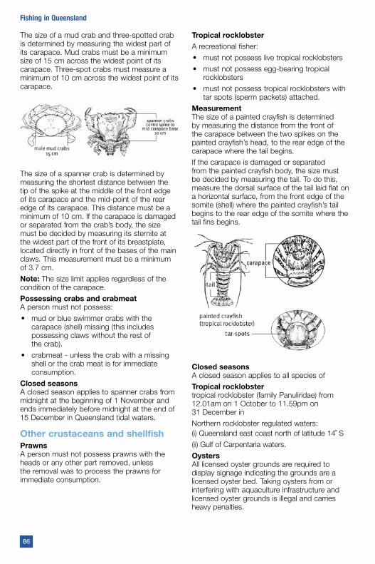
The size of a mud crab and three-spotted crab is determined by measuring the widest part of its carapace. Mud crabs must be a minimum size of 15 cm across the widest point of its carapace. Three-spot crabs must measure a minimum of 10 cm across the widest point of its carapace.
The size of a spanner crab is determined by measuring the shortest distance between the tip of the spike at the middle of the front edge of its carapace and the mid-point of the rear edge of its carapace. This distance must be a minimum of 10 cm. If the carapace is damaged or separated from the crab’s body, the size must be decided by measuring its sternite at the widest part of the front of its breastplate, located directly in front of the bases of the main claws. This measurement must be a minimum of 3.7 cm.
Note: The size limit applies regardless of the condition of the carapace.
Possessing crabs and crabmeatA person must not possess:
• mud or blue swimmer crabs with the carapace (shell) missing (this includes possessing claws without the rest of the crab).
• crabmeat - unless the crab with a missing shell or the crab meat is for immediate consumption.
Closed seasonsA closed season applies to spanner crabs from midnight at the beginning of 1 November and ends immediately before midnight at the end of 15 December in Queensland tidal waters.
Other crustaceans and shellfishPrawnsA person must not possess prawns with the heads or any other part removed, unless the removal was to process the prawns for immediate consumption.
Tropical rocklobsterA recreational fisher:
• must not possess live tropical rocklobsters
• must not possess egg-bearing tropical rocklobsters
• must not possess tropical rocklobsters with tar spots (sperm packets) attached.
MeasurementThe size of a painted crayfish is determined by measuring the distance from the front of the carapace between the two spikes on the painted crayfish’s head, to the rear edge of the carapace where the tail begins.
If the carapace is damaged or separated from the painted crayfish body, the size must be decided by measuring the tail. To do this, measure the dorsal surface of the tail laid flat on a horizontal surface, from the front edge of the somite (shell) where the painted crayfish’s tail begins to the rear edge of the somite where the tail fins begins.
Closed seasonsA closed season applies to all species of
Tropical rocklobstertropical rocklobster (family Panuliridae) from 12.01am on 1 October to 11.59pm on 31 December in
Northern rocklobster regulated waters:(i) Queensland east coast north of latitude 14˚ S
(ii) Gulf of Carpentaria waters.
OystersAll licensed oyster grounds are required to display signage indicating the grounds are a licensed oyster bed. Taking oysters from or interfering with aquaculture infrastructure and licensed oyster grounds is illegal and carries heavy penalties.
86
Fishing in Queensland
All oyster beds outside of marked licensed areas are classed as public. Oysters from public reserves cannot be collected and taken from the grounds. They must be consumed on-the-spot.
Pipis, mud whelks and cockles Possession limits apply to pipis, mud whelks and cockles in Queensland. Moreton Bay is closed to the taking of gastropods and bivalve molluscs (excluding pipis). Check fisheries.qld.gov.au for specific area details.
For more information, visit fisheries.qld.gov.au or call 13 25 23.
Marine plantsIn Queensland, mangroves and all other marine plants are completely protected under the Fisheries Act 1994.The protection extends to seagrasses, saltcouch and plants such as melaleuca that grow adjacent to tidal lands. Any disturbance (such as trimming, mowing or removal) of
marine plants requires an approval from Fisheries Queensland.
More informationFor more information about fisheries regulations and other fisheries issues or programs, call 13 25 23 or visit fisheries.qld.gov.au.
To access complete copies of the Fisheries Act 1994 and other fisheries legislation, visit legislation.qld.gov.au.
Information on other relevant legislation may be found at afma.gov.au (national), gbrmpa.gov.au (Great Barrier Reef Marine Park) and nprsr.qld.gov.au (Queensland marine parks).
You can protect Queensland’s fisheries resources by reporting any suspected illegal fishing activities to the 24-hour, toll- free Fishwatch hotline on 1800 017 116. (This number is not to be used for general enquiries.)
Handy hint: Room with a view could cost you a fine
Protection of marine plants, including mangroves, applies over all tenures, including privately owned land, leasehold and state lands. Fines apply for hedging, trimming, lopping or spraying with herbicide; removing marine plants for river
views or other aesthetic reasons; removing mangroves or saltcouch from a beach or foreshore; running machinery over marine plants; filling of tidal lands; or dumping garden waste (e.g. grass clippings and pruning) onto tidal areas.
Download our ‘Qld Fishing’ app from iTunes App Store and Google Play Store.
Stay up-to-date with all the latest fisheries news and developments as they happen. Follow us at:
@FisheriesQueensland
@FisheriesQld
@FisheriesQld
fisheriesqld
Love your fishing?
87
Fishing in Queensland
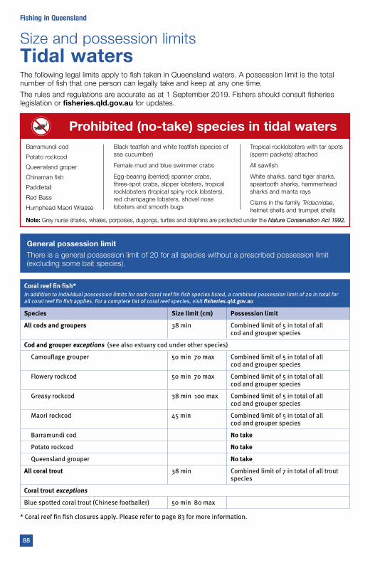
Size and possession limitsTidal watersThe following legal limits apply to fish taken in Queensland waters. A possession limit is the total number of fish that one person can legally take and keep at any one time.
The rules and regulations are accurate as at 1 September 2019. Fishers should consult fisheries legislation or fisheries.qld.gov.au for updates.
Prohibited (no-take) species in tidal waters
Note: Grey nurse sharks, whales, porpoises, dugongs, turtles and dolphins are protected under the Nature Conservation Act 1992.
Barramundi cod
Potato rockcod
Queensland groper
Chinaman fish
Paddletail
Red Bass
Humphead Maori Wrasse
Black teatfish and white teatfish (species of sea cucumber)
Female mud and blue swimmer crabs
Egg-bearing (berried) spanner crabs, three-spot crabs, slipper lobsters, tropical rocklobsters (tropical spiny rock lobsters), red champagne lobsters, shovel nose lobsters and smooth bugs
Tropical rocklobsters with tar spots (sperm packets) attached
All sawfish
White sharks, sand tiger sharks, speartooth sharks, hammerhead sharks and manta rays
Clams in the family Tridacnidae, helmet shells and trumpet shells
General possession limitThere is a general possession limit of 20 for all species without a prescribed possession limit (excluding some bait species).
Coral reef fin fish*In addition to individual possession limits for each coral reef fin fish species listed, a combined possession limit of 20 in total for all coral reef fin fish applies. For a complete list of coral reef species, visit fisheries.qld.gov.au
Species Size limit (cm) Possession limit
All cods and groupers 38 min Combined limit of 5 in total of all cod and grouper species
Cod and grouper exceptions (see also estuary cod under other species)
Camouflage grouper 50 min 70 max Combined limit of 5 in total of all cod and grouper species
Flowery rockcod 50 min 70 max Combined limit of 5 in total of all cod and grouper species
Greasy rockcod 38 min 100 max Combined limit of 5 in total of all cod and grouper species
Maori rockcod 45 min Combined limit of 5 in total of all cod and grouper species
Barramundi cod No take
Potato rockcod No take
Queensland grouper No take
All coral trout 38 min Combined limit of 7 in total of all trout species
Coral trout exceptions
Blue spotted coral trout (Chinese footballer) 50 min 80 max
* Coral reef fin fish closures apply. Please refer to page 83 for more information.
88
Fishing in Queensland
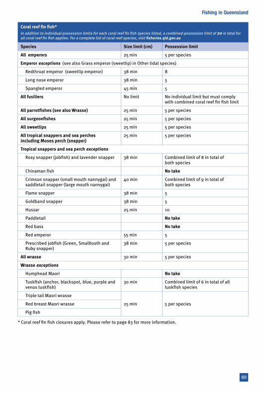
Coral reef fin fish*In addition to individual possession limits for each coral reef fin fish species listed, a combined possession limit of 20 in total for all coral reef fin fish applies. For a complete list of coral reef species, visit fisheries.qld.gov.au
Species Size limit (cm) Possession limit
All emperors 25 min 5 per species
Emperor exceptions (see also Grass emperor (sweetlip) in Other tidal species)
Redthroat emperor (sweetlip emperor) 38 min 8
Long nose emperor 38 min 5
Spangled emperor 45 min 5
All fusiliers No limit No individual limit but must comply with combined coral reef fin fish limit
All parrotfishes (see also Wrasse) 25 min 5 per species
All surgeonfishes 25 min 5 per species
All sweetlips 25 min 5 per species
All tropical snappers and sea perches including Moses perch (snapper)
25 min 5 per species
Tropical snappers and sea perch exceptions
Rosy snapper (jobfish) and lavender snapper 38 min Combined limit of 8 in total of both species
Chinaman fish No take
Crimson snapper (small mouth nannygai) and saddletail snapper (large mouth nannygai)
40 min Combined limit of 9 in total of both species
Flame snapper 38 min 5
Goldband snapper 38 min 5
Hussar 25 min 10
Paddletail No take
Red bass No take
Red emperor 55 min 5
Prescribed jobfish (Green, Smalltooth and Ruby snapper)
38 min 5 per species
All wrasse 30 min 5 per species
Wrasse exceptions
Humphead Maori No take
Tuskfish (anchor, blackspot, blue, purple and venus tuskfish)
30 min Combined limit of 6 in total of all tuskfish species
Triple tail Maori wrasse
25 min 5 per speciesRed breast Maori wrasse
Pig fish
* Coral reef fin fish closures apply. Please refer to page 83 for more information.
89
Fishing in Queensland
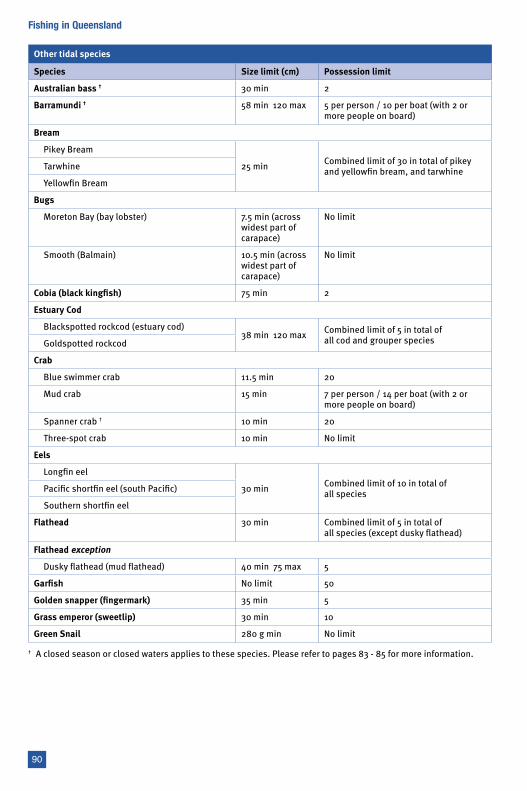
Other tidal species
Species Size limit (cm) Possession limit
Australian bass † 30 min 2
Barramundi † 58 min 120 max 5 per person / 10 per boat (with 2 or more people on board)
Bream
Pikey Bream
25 min Combined limit of 30 in total of pikey and yellowfin bream, and tarwhineTarwhine
Yellowfin Bream
Bugs
Moreton Bay (bay lobster) 7.5 min (across widest part of carapace)
No limit
Smooth (Balmain) 10.5 min (across widest part of carapace)
No limit
Cobia (black kingfish) 75 min 2
Estuary Cod
Blackspotted rockcod (estuary cod)38 min 120 max Combined limit of 5 in total of
all cod and grouper speciesGoldspotted rockcod
Crab
Blue swimmer crab 11.5 min 20
Mud crab 15 min 7 per person / 14 per boat (with 2 or more people on board)
Spanner crab † 10 min 20
Three-spot crab 10 min No limit
Eels
Longfin eel
30 min Combined limit of 10 in total of all speciesPacific shortfin eel (south Pacific)
Southern shortfin eel
Flathead 30 min Combined limit of 5 in total of all species (except dusky flathead)
Flathead exception
Dusky flathead (mud flathead) 40 min 75 max 5
Garfish No limit 50
Golden snapper (fingermark) 35 min 5
Grass emperor (sweetlip) 30 min 10
Green Snail 280 g min No limit
† A closed season or closed waters applies to these species. Please refer to pages 83 - 85 for more information.
90
Fishing in Queensland
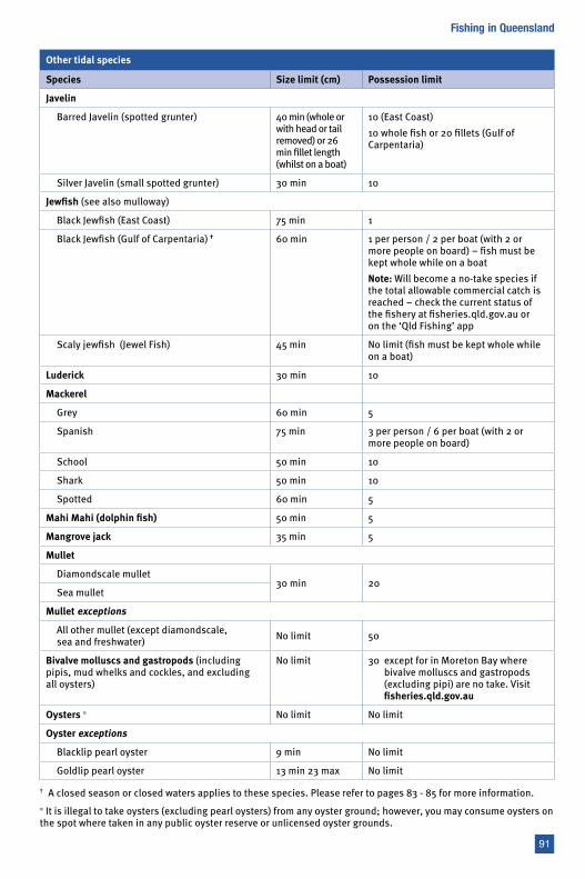
Other tidal species
Species Size limit (cm) Possession limit
Javelin
Barred Javelin (spotted grunter) 40 min (whole or with head or tail removed) or 26 min fillet length (whilst on a boat)
10 (East Coast)10 whole fish or 20 fillets (Gulf of Carpentaria)
Silver Javelin (small spotted grunter) 30 min 10
Jewfish (see also mulloway)
Black Jewfish (East Coast) 75 min 1
Black Jewfish (Gulf of Carpentaria) † 60 min 1 per person / 2 per boat (with 2 or more people on board) – fish must be kept whole while on a boatNote: Will become a no-take species if the total allowable commercial catch is reached – check the current status of the fishery at fisheries.qld.gov.au or on the ‘Qld Fishing’ app
Scaly jewfish (Jewel Fish) 45 min No limit (fish must be kept whole while on a boat)
Luderick 30 min 10
Mackerel
Grey 60 min 5
Spanish 75 min 3 per person / 6 per boat (with 2 or more people on board)
School 50 min 10
Shark 50 min 10
Spotted 60 min 5
Mahi Mahi (dolphin fish) 50 min 5
Mangrove jack 35 min 5
Mullet
Diamondscale mullet30 min 20
Sea mullet
Mullet exceptions
All other mullet (except diamondscale, sea and freshwater) No limit 50
Bivalve molluscs and gastropods (including pipis, mud whelks and cockles, and excluding all oysters)
No limit 30 except for in Moreton Bay where bivalve molluscs and gastropods (excluding pipi) are no take. Visit fisheries.qld.gov.au
Oysters ≈ No limit No limit
Oyster exceptions
Blacklip pearl oyster 9 min No limit
Goldlip pearl oyster 13 min 23 max No limit
† A closed season or closed waters applies to these species. Please refer to pages 83 - 85 for more information.≈ It is illegal to take oysters (excluding pearl oysters) from any oyster ground; however, you may consume oysters on the spot where taken in any public oyster reserve or unlicensed oyster grounds.
91
Fishing in Queensland
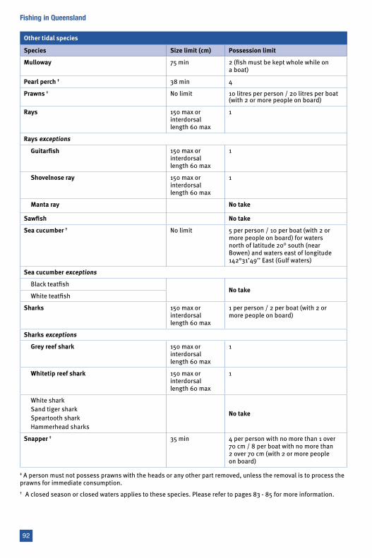
Other tidal species
Species Size limit (cm) Possession limit
Mulloway 75 min 2 (fish must be kept whole while on a boat)
Pearl perch † 38 min 4
Prawns ‡ No limit 10 litres per person / 20 litres per boat (with 2 or more people on board)
Rays 150 max or interdorsal length 60 max
1
Rays exceptions
Guitarfish 150 max or interdorsal length 60 max
1
Shovelnose ray 150 max or interdorsal length 60 max
1
Manta ray No take
Sawfish No take
Sea cucumber † No limit 5 per person / 10 per boat (with 2 or more people on board) for waters north of latitude 20° south (near Bowen) and waters east of longitude 142°31’49’’ East (Gulf waters)
Sea cucumber exceptions
Black teatfishNo take
White teatfish
Sharks 150 max or interdorsal length 60 max
1 per person / 2 per boat (with 2 or more people on board)
Sharks exceptions
Grey reef shark 150 max or interdorsal length 60 max
1
Whitetip reef shark 150 max or interdorsal length 60 max
1
White sharkSand tiger sharkSpeartooth sharkHammerhead sharks
No take
Snapper † 35 min 4 per person with no more than 1 over 70 cm / 8 per boat with no more than 2 over 70 cm (with 2 or more people on board)
‡ A person must not possess prawns with the heads or any other part removed, unless the removal is to process the prawns for immediate consumption.† A closed season or closed waters applies to these species. Please refer to pages 83 - 85 for more information.
92
Fishing in Queensland
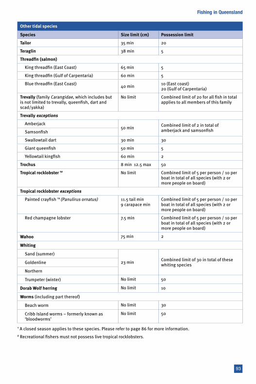
Other tidal species
Species Size limit (cm) Possession limit
Tailor 35 min 20
Teraglin 38 min 5
Threadfin (salmon)
King threadfin (East Coast) 65 min 5
King threadfin (Gulf of Carpentaria) 60 min 5
Blue threadfin (East Coast) 40 min 10 (East coast) 20 (Gulf of Carpentaria)
Trevally (family Carangidae, which includes but is not limited to trevally, queenfish, dart and scad/yakka)
No limit Combined limit of 20 for all fish in total applies to all members of this family
Trevally exceptions
Amberjack50 min Combined limit of 2 in total of
amberjack and samsonfishSamsonfish
Swallowtail dart 30 min 30
Giant queenfish 50 min 5
Yellowtail kingfish 60 min 2
Trochus 8 min 12.5 max 50
Tropical rocklobster †# No limit Combined limit of 5 per person / 10 per boat in total of all species (with 2 or more people on board)
Tropical rocklobster exceptions
Painted crayfish †# (Panulirus ornatus) 11.5 tail min 9 carapace min
Combined limit of 5 per person / 10 per boat in total of all species (with 2 or more people on board)
Red champagne lobster 7.5 min Combined limit of 5 per person / 10 per boat in total of all species (with 2 or more people on board)
Wahoo 75 min 2
Whiting
Sand (summer)
23 min Combined limit of 30 in total of these whiting speciesGoldenline
Northern
Trumpeter (winter) No limit 50
Dorab Wolf herring No limit 10
Worms (including part thereof)
Beach worm No limit 30
Cribb Island worms – formerly known as ‘bloodworms’
No limit 50
† A closed season applies to these species. Please refer to page 86 for more information.# Recreational fishers must not possess live tropical rocklobsters.
93
Fishing in Queensland
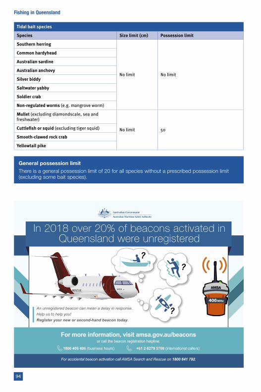
Tidal bait species
Species Size limit (cm) Possession limit
Southern herring
No limit No limit
Common hardyhead
Australian sardine
Australian anchovy
Silver biddy
Saltwater yabby
Soldier crab
Non-regulated worms (e.g. mangrove worm)
Mullet (excluding diamondscale, sea and freshwater)
No limit 50Cuttlefish or squid (excluding tiger squid)
Smooth-clawed rock crab
Yellowtail pike
General possession limitThere is a general possession limit of 20 for all species without a prescribed possession limit (excluding some bait species).
In 2018 over 20% of beacons activated in Queensland were unregistered
For more information, visit amsa.gov.au/beaconsor call the beacon registration helpline:
1800 406 406 (business hours) +61 2 6279 5766 (international callers)
For accidental beacon activation call AMSA Search and Rescue on 1800 641 792.
AMSA
An unregistered beacon can mean a delay in response.Help us to help you!Register your new or second-hand beacon today.
94
Fishing in Queensland
95
Fishing in Queensland
Experience the Tackle World difference.Local knowledge - Expert advice.
Queensland, we’ve got you covered!
SAFETY GEAR, LATEST UPDATESFISHING REPORTSBAIT & TACKLE
Tackle World WeipaShop 6 Commercial AvenueWeipa QLD 4874Ph: 07 4069 7235
The Lure Shop Tackle World Cooktown146 Charlotte St, Cooktown QLD 4895Ph: 07 4069 5396Ph: 07 4069 5396
Tackle World Cairns172 Aumuller St, Cairns QLD 4870Ph: 07 4031 4040 Erskine’s Tackle World51 Mulgrave Rd, Cairns QLD 4870Ph: 07 4051 6099Ph: 07 4051 6099
Tackle World Tully14 Butler St, Tully QLD 4854Ph: 07 4068 1604
Tackle World Townsville305 Ingham Rd, Garbutt QLD 4814Ph: 07 4725 1266
TTackle World Mackay 318 Shakespeare St, Mackay QLD 4740Ph: 07 4957 2145
Pat’s Tackle World Gladstone 23 Lord Street, Gladstone QLD 4680Ph: 07 4972 3692
Tackle World Bundaberg22 Quay Street, Bundaberg QLD 467022 Quay Street, Bundaberg QLD 4670Ph: 07 4153 4747
Fisho’s Tackle World Hervey Bay59 Torquay Road, Pialba QLD 4655Ph: 07 4128 1022
Davo’s Tackle World NoosaShop 6, Cnr Mary & Thomas St, Noosa QLD 4566Noosa QLD 4566Ph: 07 5449 8099 Tackle World Kawana8 Nicklin Way, Kawana Waters QLD 4575Ph: 07 5444 0714 TTackle World Lawnton640 Gympie Road, Lawnton QLD 4501Ph: 07 3205 7475 Doug Burt’s Tackle World Gold Coast11/8 Centre View DriveBiggera Waters QLD 4216Ph: 07 5563 8746Ph: 07 5563 8746
W
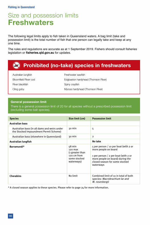
Size and possession limits Freshwaters
The following legal limits apply to fish taken in Queensland waters. A bag limit (take and possession limit) is the total number of fish that one person can legally take and keep at any one time.
The rules and regulations are accurate as at 1 September 2019. Fishers should consult fisheries legislation or fisheries.qld.gov.au for updates.
Prohibited (no-take) species in freshwaters
Australian lungfish
Bloomfield River cod
River blackfish
Cling goby
Freshwater sawfish
Edgbaston hardyhead (Thomson River)
Spiny crayfish
Myross hardyhead (Thomson River)
General possession limitThere is a general possession limit of 20 for all species without a prescribed possession limit (excluding some bait species).
Species Size limit (cm) Possession limit
Australian bass
Australian bass (in all dams and weirs under the Stocked Impoundment Permit Scheme)
30 min 5
Australian bass (elsewhere in Queensland) 30 min 2
Australian lungfish No take
Barramundi* 58 min 120 max (1 greater than 120 cm from some stocked waterways)
5 per person / 10 per boat (with 2 or more people on board
1 per person / 2 per boat (with 2 or more people on board) during the closed season for some stocked waterways
Cherabins No limit Combined limit of 10 in total of both species: Macrobrachium lar and M. rosenbergii
96
Fishing in Queensland
* A closed season applies to these species. Please refer to page 74 for more information.
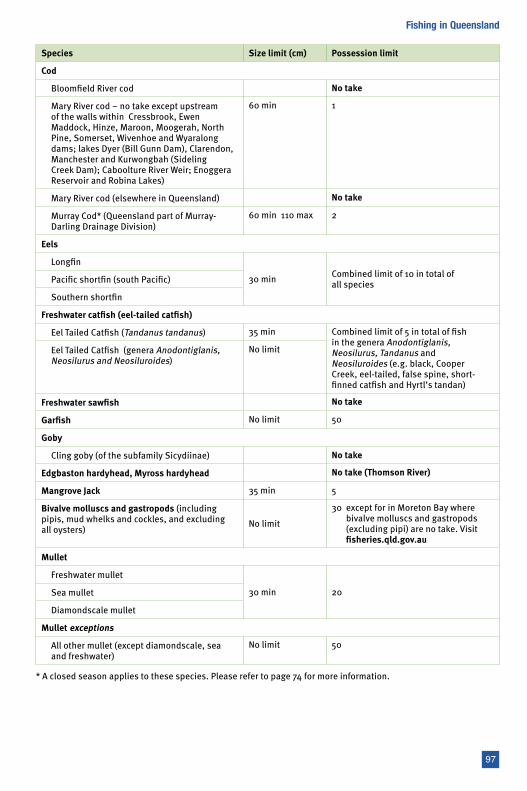
Species Size limit (cm) Possession limit
Cod
Bloomfield River cod No take
Mary River cod – no take except upstream of the walls within Cressbrook, Ewen Maddock, Hinze, Maroon, Moogerah, North Pine, Somerset, Wivenhoe and Wyaralong dams; lakes Dyer (Bill Gunn Dam), Clarendon, Manchester and Kurwongbah (Sideling Creek Dam); Caboolture River Weir; Enoggera Reservoir and Robina Lakes)
60 min 1
Mary River cod (elsewhere in Queensland) No take
Murray Cod* (Queensland part of Murray-Darling Drainage Division)
60 min 110 max 2
Eels
Longfin
30 min Combined limit of 10 in total of all speciesPacific shortfin (south Pacific)
Southern shortfin
Freshwater catfish (eel-tailed catfish)
Eel Tailed Catfish (Tandanus tandanus) 35 min Combined limit of 5 in total of fish in the genera Anodontiglanis, Neosilurus, Tandanus and Neosiluroides (e.g. black, Cooper Creek, eel-tailed, false spine, short-finned catfish and Hyrtl’s tandan)
Eel Tailed Catfish (genera Anodontiglanis, Neosilurus and Neosiluroides)
No limit
Freshwater sawfish No take
Garfish No limit 50
Goby
Cling goby (of the subfamily Sicydiinae) No take
Edgbaston hardyhead, Myross hardyhead No take (Thomson River)
Mangrove Jack 35 min 5
Bivalve molluscs and gastropods (including pipis, mud whelks and cockles, and excluding all oysters) No limit
30 except for in Moreton Bay where bivalve molluscs and gastropods (excluding pipi) are no take. Visit fisheries.qld.gov.au
Mullet
Freshwater mullet
30 min 20Sea mullet
Diamondscale mullet
Mullet exceptions
All other mullet (except diamondscale, sea and freshwater)
No limit 50
97
Fishing in Queensland
* A closed season applies to these species. Please refer to page 74 for more information.
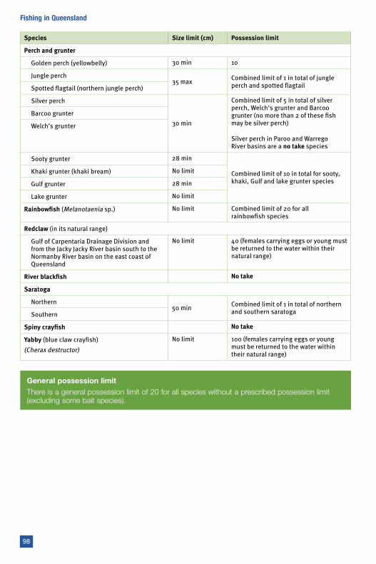
Species Size limit (cm) Possession limit
Perch and grunter
Golden perch (yellowbelly) 30 min 10
Jungle perch35 max Combined limit of 1 in total of jungle
perch and spotted flagtailSpotted flagtail (northern jungle perch)
Silver perch
30 min
Combined limit of 5 in total of silver perch, Welch’s grunter and Barcoo grunter (no more than 2 of these fish may be silver perch)
Silver perch in Paroo and Warrego River basins are a no take species
Barcoo grunter
Welch’s grunter
Sooty grunter 28 min
Combined limit of 10 in total for sooty, khaki, Gulf and lake grunter species
Khaki grunter (khaki bream) No limit
Gulf grunter 28 min
Lake grunter No limit
Rainbowfish (Melanotaenia sp.) No limit Combined limit of 20 for all rainbowfish species
Redclaw (in its natural range)
Gulf of Carpentaria Drainage Division and from the Jacky Jacky River basin south to the Normanby River basin on the east coast of Queensland
No limit 40 (females carrying eggs or young must be returned to the water within their natural range)
River blackfish No take
Saratoga
Northern50 min Combined limit of 1 in total of northern
and southern saratogaSouthern
Spiny crayfish No take
Yabby (blue claw crayfish)(Cherax destructor)
No limit 100 (females carrying eggs or young must be returned to the water within their natural range)
General possession limitThere is a general possession limit of 20 for all species without a prescribed possession limit (excluding some bait species).
98
Fishing in Queensland
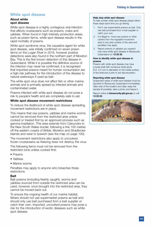
White spot diseaseAbout white spot diseaseWhite spot disease is a highly contagious viral infection that affects crustaceans such as prawns, crabs and yabbies. When found in high intensity production areas, such as prawn farms, white spot disease results in the rapid mortality of prawns.
White spot syndrome virus, the causative agent for white spot disease, was initially confirmed on seven prawn farms on the Logan River in 2016, however positive detections were also found in the northern part of Moreton Bay. This is the first known detection of this disease in Queensland. While it is possible the definitive source of the infection may never be confirmed, it is recognised that imported prawns meant for human consumption are a high-risk pathway for the introduction of the disease to natural waterways if used as bait.
The white spot virus does not affect fish or other marine animals and is primarily spread by infected animals and contaminated water.
Prawns infected with white spot disease do not pose a risk to people’s health and are completely safe to eat.
White spot disease movement restrictionsTo reduce the likelihood of white spot disease spreading, movement restrictions are in place.
This means that raw prawns, yabbies and marine worms cannot be removed from the restricted area unless cooked or treated first by an approved process such as gamma irradiation. This area extends from Caloundra to the New South Wales border, following a line 100 metres off the eastern coasts of Bribie, Moreton and Stradbroke Islands and west to Ipswich (see the map on page 100).
The movement restrictions also apply to uncooked, frozen crustaceans as freezing does not destroy the virus.
The following items must not be removed from the restricted zone unless cooked first:
• Prawns
• Yabbies
• Marine worms
Penalties may apply to anyone who breaches these restrictions.
BaitBait prawns (including freshly caught), worms and yabbies sourced from outside the restricted area can be used, however, once brought into the restricted area, they cannot be moved back out.
To ensure the ongoing health of our marine habitat, fishers should not use supermarket prawns as bait and should only use bait purchased from a bait supplier or catch their own. Imported, uncooked prawns may pose a risk for the introduction of exotic diseases such as white spot disease.
Help stop white spot diseaseTo help contain white spot disease please follow these steps each time you go fishing.
1. Don’t use supermarket prawns as bait. Only use bait purchased from a bait supplier or catch your own.
2. It is illegal to move raw prawns or other carriers from the regulated movement area to any area outside of this area and penalties may apply.
3. Report prawns or yabbies you suspect may have white spot disease to Biosecurity Queensland on 13 25 23.
How to identify white spot disease in prawnsPrawns with white spot disease may have a loose shell with numerous white spots (0.5- 2.0 mm in diameter) on the inside surface of the shell and a pink to red discolouration.
Reporting white spot diseaseSuspected cases of white spot disease must be reported to Biosecurity Queensland immediately. Take note of the location and date, keep the sample (if possible), take a photo and freeze it.
Report online at biosecurity.qld.gov.au or call 13 25 23.
99
Fishing in Queensland
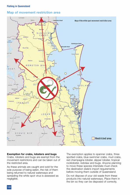
Exemption for crabs, lobsters and bugsCrabs, lobsters and bugs are exempt from the movement restrictions and can be taken out of the restricted area.
As these animals are caught and sold for the sole purpose of being eaten, the risk of them being returned to natural waterways and spreading the white spot virus is assessed as negligible.
The exemption applies to spanner crabs, three spotted crabs, blue swimmer crabs, mud crabs, red champagne lobster, slipper lobster, tropical rocklobster, redclaw and bugs. Anyone planning to move these species interstate must check the destination state’s import requirements before moving them outside of Queensland.
Do not dispose of your old waste from these products into natural waterways. Place them in the bin so they can be disposed of correctly.
Map of movement restriction area
100
Fishing in Queensland
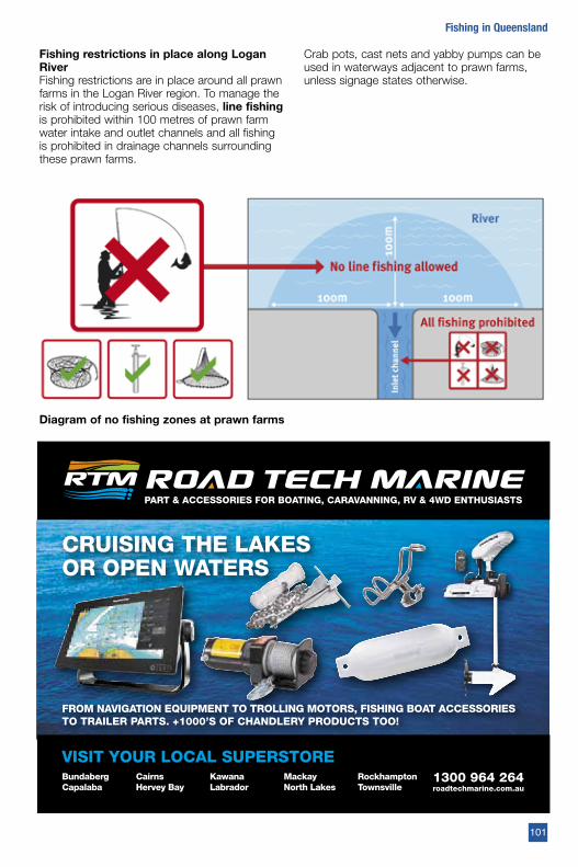
Diagram of no fishing zones at prawn farms
Fishing restrictions in place along Logan RiverFishing restrictions are in place around all prawn farms in the Logan River region. To manage the risk of introducing serious diseases, line fishing is prohibited within 100 metres of prawn farm water intake and outlet channels and all fishing is prohibited in drainage channels surrounding these prawn farms.
Crab pots, cast nets and yabby pumps can be used in waterways adjacent to prawn farms, unless signage states otherwise.
101
Fishing in Queensland
PART & ACCESSORIES FOR BOATING, CARAVANNING, RV & 4WD ENTHUSIASTS
VISIT YOUR LOCAL SUPERSTORE1300 964 264 roadtechmarine.com.au
CRUISING THE LAKESOR OPEN WATERS
Bundaberg Capalaba
CairnsHervey Bay
KawanaLabrador
MackayNorth Lakes
RockhamptonTownsville
FROM NAVIGATION EQUIPMENT TO TROLLING MOTORS, FISHING BOAT ACCESSORIES TO TRAILER PARTS. +1000’S OF CHANDLERY PRODUCTS TOO!
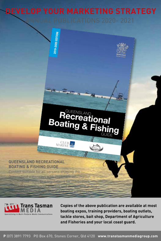
102
Fishing in QueenslandDEVELOP YOUR MARKETING STRATEGY
P (07) 3891 7793 PO Box 670, Stones Corner, Qld 4120 www.transtasmanmediagroup.com
ANNUAL PUBLICATIONS 2020- 2021
Copies of the above publication are available at most boating expos, training providers, boating outlets, tackle stores, bait shop, Department of Agriculture and Fisheries and your local coast guard.
QUEENSLAND RECREATIONAL BOATING & FISHING GUIDEContent suitable for all persons enjoying the Queensland waterways with important information, including the rules and regulations for the boaties, potential boaties, social anglers and the general public who want to enjoy Queensland beautiful waterways.
2019
-202
0 ED
ITIO
N
RecreationalBoating & FishingGUIDE
QUEENSLAND
“Life is better on OUR BOATS”
PONTOON BOATS
www.runawaybaypontoonboats.comCraig Winch: 0417 646 711
103
Fishing in Queensland
Boating Industry Association
Businesses throughout all segments of recreational boating can be found as members of the
Boating Industry Association.
These businesses have pledged to abide by the association’s Code of Practice.
Consider dealing with a BIA member first
Look for the BIA member logo or visit our website
www.bia.org.au
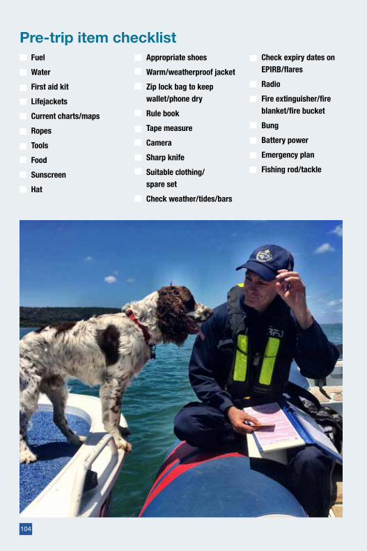
FuelWaterFirst aid kitLifejacketsCurrent charts/mapsRopesToolsFoodSunscreenHat
Appropriate shoesWarm/weatherproof jacketZip lock bag to keep wallet/phone dryRule bookTape measureCamera Sharp knifeSuitable clothing/ spare setCheck weather/tides/bars
Check expiry dates on EPIRB/flaresRadioFire extinguisher/fire blanket/fire bucketBungBattery powerEmergency planFishing rod/tackle
Pre-trip item checklist
104
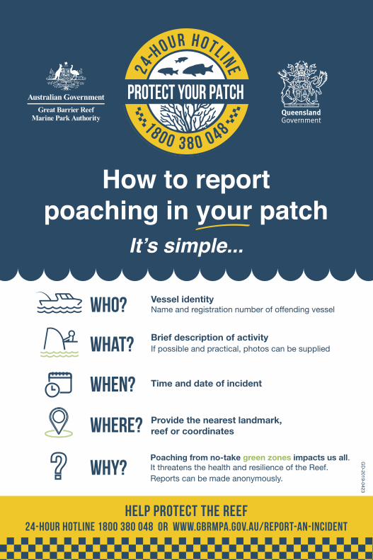
GD
-2019-0423
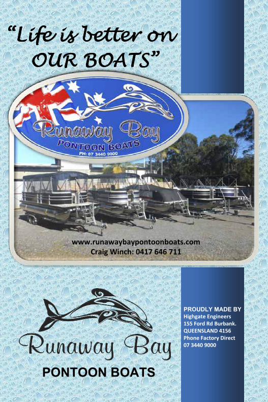
“Life is better on OUR BOATS”
PONTOON BOATS
www.runawaybaypontoonboats.comCraig Winch: 0417 646 711
PROUDLY MADE BY Highgate Engineers 155 Ford Rd Burbank. QUEENSLAND 4156 Phone Factory Direct 07 3440 9000


