Embed Size (px)
Citation preview

DNRGPS DocumentationRelease 6.0.0.8
February 15, 2012


CONTENTS
1 INSTALLATION 3
2 MENU OPTIONS 52.1 FILE MENU . . . . . . . . . . . . . . . . . . . . . . . . . . . . . . . . . . . . . . . . . . . . . . . 52.2 EDIT MENU . . . . . . . . . . . . . . . . . . . . . . . . . . . . . . . . . . . . . . . . . . . . . . . 162.3 GPS MENU . . . . . . . . . . . . . . . . . . . . . . . . . . . . . . . . . . . . . . . . . . . . . . . 212.4 WAYPOINT MENU . . . . . . . . . . . . . . . . . . . . . . . . . . . . . . . . . . . . . . . . . . . 232.5 TRACK MENU . . . . . . . . . . . . . . . . . . . . . . . . . . . . . . . . . . . . . . . . . . . . . 252.6 ROUTE MENU . . . . . . . . . . . . . . . . . . . . . . . . . . . . . . . . . . . . . . . . . . . . . 272.7 REAL TIME MENU . . . . . . . . . . . . . . . . . . . . . . . . . . . . . . . . . . . . . . . . . . . 292.8 HELP MENU . . . . . . . . . . . . . . . . . . . . . . . . . . . . . . . . . . . . . . . . . . . . . . 32
3 TROUBLESHOOT 33
4 TRANSITION FROM DNR GARMIN TO DNR GPS 35
5 APPENDIX 1 - DATA MANIPULATION 375.1 UPLOADING DATA . . . . . . . . . . . . . . . . . . . . . . . . . . . . . . . . . . . . . . . . . . . 375.2 DOWNLOADING DATA . . . . . . . . . . . . . . . . . . . . . . . . . . . . . . . . . . . . . . . . 385.3 GPS FILE STRUCTURES AND REQUIREMENTS . . . . . . . . . . . . . . . . . . . . . . . . . . 385.4 DATA TABLE . . . . . . . . . . . . . . . . . . . . . . . . . . . . . . . . . . . . . . . . . . . . . . 435.5 FILE TYPES . . . . . . . . . . . . . . . . . . . . . . . . . . . . . . . . . . . . . . . . . . . . . . . 44
6 APPENDIX 2 456.1 CONTRIBUTORS . . . . . . . . . . . . . . . . . . . . . . . . . . . . . . . . . . . . . . . . . . . . 456.2 KNOWN ISSUES . . . . . . . . . . . . . . . . . . . . . . . . . . . . . . . . . . . . . . . . . . . . 456.3 LICENSE . . . . . . . . . . . . . . . . . . . . . . . . . . . . . . . . . . . . . . . . . . . . . . . . . 456.4 RELEASE LOG . . . . . . . . . . . . . . . . . . . . . . . . . . . . . . . . . . . . . . . . . . . . . 46
7 SYSTEM ADMINISTRATOR GUIDE 477.1 Installation . . . . . . . . . . . . . . . . . . . . . . . . . . . . . . . . . . . . . . . . . . . . . . . . 477.2 User Properties . . . . . . . . . . . . . . . . . . . . . . . . . . . . . . . . . . . . . . . . . . . . . . 477.3 dnrgps_properties.xml File Structure . . . . . . . . . . . . . . . . . . . . . . . . . . . . . . . . . . 48
8 PROGRAMMER GUIDE 53
i

ii

DNRGPS Documentation, Release 6.0.0.8
DNRGPS is an Open Source update to the popular DNRGarmin application. It provides users the ability to transferdata between handheld GPS receivers and GIS software. Users will be familiar with most of the functions in DNRGPSbecause they were also found in DNRGarmin.
DNRGPS:
• accomodates newer GPS models
• works with ArcGIS 10, and
• is available for the Open Source community to modify and share
Download DNRGPS
Functionality DetailUpload/Download waypoints,tracks,routes supported FILE TYPESConvert between points, lines and areasCalculate Circular Error ProbabilityImage hotlinkingReal-time trackingSet projectionsUSB connectivity
This program integrates GIS Software (ESRI’s ArcMap, Google Earth) with GPS units. It uses a C# program thatinteracts with the GPS via a serial/USB port allowing GIS users to transfer Waypoints, Tracks, and Routes from aGPS to ArcMap or Google Earth and store them as points, lines or polygons. Information can also be uploaded fromvarious FILE TYPES to the GPS and used as waypoints, tracks, or routes.
DNR GPS can also be used to perform real-time tracking with your GPS and GIS. Connected to a laptop computerwith ArcMap, a Garmin GPS can be a valuable tool for locating oneself and for interactive data collection.
CONTENTS 1

DNRGPS Documentation, Release 6.0.0.8
2 CONTENTS

CHAPTER
ONE
INSTALLATION
DNRGPS is a self-contained program which means it can be run from anywhere – your hard drive, a thumb drive, anetwork location. Simply unzip the DNRGPS folder and place in the location of your choice.
Users:
• ArcGIS
– Compatible with versions 10.0 and above.
– There is no longer a Toolbar within ArcMap. All communication is instigated from DNRGPS
• Google Earth
– Best with version 3.0.0762 and above
Support discontinued for:
• Arcview 3.x
• ArcGIS 9.x
• ArcExplorer
Installation issues: None reported (Report an issue)
Note: You do NOT need to uninstall the previous version of DNRGarmin to run DNRGPS. If you do haveDNRGarmin installed, the first time you open DNRGPS, it will ask if you want to import properties from the previousversion (DNRGarmin).
Administrators: Check out the SYSTEM ADMINISTRATOR GUIDE for more details on customizing the applicationfor your users.
3

DNRGPS Documentation, Release 6.0.0.8
4 Chapter 1. INSTALLATION
CHAPTER
TWO
MENU OPTIONS
Most of the functionality contained within the DNRGPS program can be found within the menus.
2.1 FILE MENU
2.1.1 LOAD FROM
Used to load data from a file, database, or GIS (ArcMap, Google Maps) into the Data Table.
When loading data, DNRGPS looks for information vital to loading into the GPS. Information such as Lat, Long,Ident, and Comment.
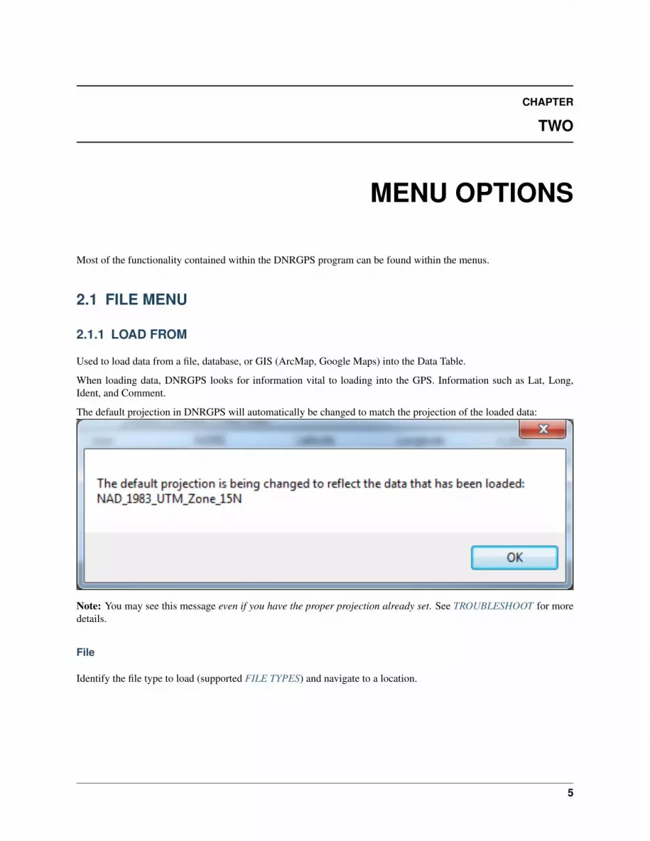
The default projection in DNRGPS will automatically be changed to match the projection of the loaded data:
Note: You may see this message even if you have the proper projection already set. See TROUBLESHOOT for moredetails.
File
Identify the file type to load (supported FILE TYPES) and navigate to a location.
5

DNRGPS Documentation, Release 6.0.0.8
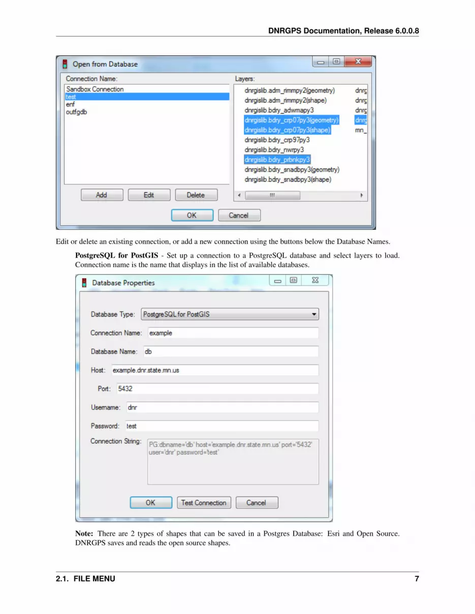
Database
Load from an existing database connection by selecting a database under Database Name, and all the available layersappear in the Layers list box.
6 Chapter 2. MENU OPTIONS
DNRGPS Documentation, Release 6.0.0.8
Edit or delete an existing connection, or add a new connection using the buttons below the Database Names.
PostgreSQL for PostGIS - Set up a connection to a PostgreSQL database and select layers to load.Connection name is the name that displays in the list of available databases.
Note: There are 2 types of shapes that can be saved in a Postgres Database: Esri and Open Source.DNRGPS saves and reads the open source shapes.
2.1. FILE MENU 7

DNRGPS Documentation, Release 6.0.0.8
ESRI File Geodatabase (v10.x) - Navigate to an ESRI File Geodatabase and select feature classes toload. Note: The open source File Geodatabase reader/writer that DNRGPS uses does not work withfeature datasets.
Google Keyhole Markup Language - For a KML file with more than one layer, navigate to it and selectwhich layers you want to load. A layer is reflected as a folder in Google Earth.
ArcMap
Only works if ArcMap is open.
Layer - Load data from a layer in the active data frame. If a layer is selected it will load from it, otherwiseyou’ll be prompted to select the proper layer. Will grab the selection set or all if no records selected.
Selected Graphics - Load data from ArcMap Graphics in the active data frame. Selected graphics do notall need to be of the same shape type. Points will be loaded as waypoints; lines and polygons are loadedas tracks.
Google Earth
Only works if Google Earth is installed (doesn’t need to be open).
8 Chapter 2. MENU OPTIONS

DNRGPS Documentation, Release 6.0.0.8
My Places - Loads data from Google Earth’s “My Places”. User is prompted to identify the layers to loadfrom my places. Layere are represented as folders in Google Earth.
See Also
• DOWNLOADING DATA
• SAVE TO
2.1.2 SAVE TO
Save data to a file, database, or GIS graphic after downloading from the GPS. Except for GPX or KML files, savesdata only from the active tab (waypoints, tracks, or routes) in the data table. For tracks or routes, will prompt for theshape type (point, line, or polygon).
Note: Multi-shape options retain the shape characteristics of tracks.
File
Identify the file type to save to (supported FILE TYPES) and navigate to a location.
2.1. FILE MENU 9

DNRGPS Documentation, Release 6.0.0.8
For file types that support multiple GPS data types being stored together, you will see the following prompt:
For file types that do not support multiple data types, it will save data from the active table.
10 Chapter 2. MENU OPTIONS

DNRGPS Documentation, Release 6.0.0.8
Database
Save to an existing database connection by selecting a database under Database Name, and all the existing layersappear in Layers.
Edit or delete an existing connection, or add a new connection using the buttons below the Database Names.
PostgreSQL for PostGIS - Set up a connection to a PostgreSQL database and select/specify target layer.
2.1. FILE MENU 11

DNRGPS Documentation, Release 6.0.0.8
Note: There are 2 types of shapes that can be saved in a Postgres Database: Esri and Open Source.DNRGPS saves and reads the open source shapes.
ESRI File Geodatabase (v10.x) - Navigate to an ESRI File Geodatabase and select/specify target featureclass.
Google Keyhole Markup Language - To add to an existing KML file, navigate to it and select/specifytarget layer.
Web Service
Not yet implemented
ArcMap
Only works if ArcMap 10.x is open.
File - Saves data as a file and adds as a layer to the active data frame
Database - Saves data to an EXISTING database.
Graphics - Saves data as projected graphics. Requires that a projection be set on the dataframe.
12 Chapter 2. MENU OPTIONS
DNRGPS Documentation, Release 6.0.0.8
Google Earth
Not yet implemented!
Only works if Google Earth is installed (doesn’t need to be open).
My Places - Saves to Google Earth’s My Places folder. If saving tracks or routes you are prompted toidentify the type of data to save (Point, Line, Polygon).
See Also
• UPLOADING DATA
• LOAD FROM
2.1.3 FILE PROPERTIES
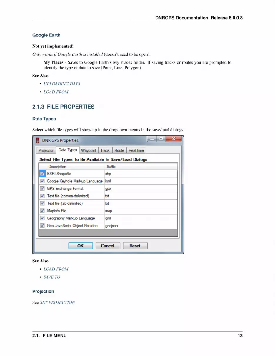
Data Types
Select which file types will show up in the dropdown menus in the save/load dialogs.
See Also
• LOAD FROM
• SAVE TO
Projection
See SET PROJECTION
2.1. FILE MENU 13
DNRGPS Documentation, Release 6.0.0.8
Waypoint
See WAYPOINT PROPERTIES
Track
See TRACK PROPERTIES
Route
See ROUTE PROPERTIES
Real Time
See REAL TIME PROPERTIES
2.1.4 SET PROJECTION
The DNRGPS program has an integrated projection utility that allows users to save and load projected data withoutthe need for external GIS programs such as ArcMap. The projection utility used is called Proj.4. Proj.4 was originallywritten by Gerald Evenden of the USGS and has since been managed by Frank Warmerdam as open source code athttp://www.remotesensing.org/proj/. PROJ.4 is in active use by GRASS, MapServer, PostGIS, Thuban, OGDI andOGRCoordinateTransformation as well as various other projects.
14 Chapter 2. MENU OPTIONS

DNRGPS Documentation, Release 6.0.0.8
Interface:
• POSC (Petrotechnical Open Standards Consortium) Codes are unique codes assigned to specific projections.These codes are a standard that most projection engines (including ESRI’s) can use. If you know the POSCcode of your projection you can simply select it from this list of codes.
• Datums - A list of Datums that are available. When you select a Datum a number of Projections will appear inthe Projections listbox associated with your selection.
• View Only Favorites - This checkbox filters the lengthy list of projections into just a list of the projections youactually use. To view all projections, uncheck this option. Selecting a new projection automatically adds thatprojection to your favorites. Alternatively, to add or remove a projection from your list of favorites, right clickon that projection in the Projections list and select Add To Favorites.
• Projections - List of projections that exist for the selected datum.
• Projection Description - This box contains parameters for the selected projection that will be used in theprojection process.
• - This will select the “No Projection” option which is: POSC Code: 4326, Datum: WGS 84, Projection:No Projection (Lat/Long)
2.1. FILE MENU 15

DNRGPS Documentation, Release 6.0.0.8
• - This will select the Minnesota DNR default projection which is: POSC Code: 26915, Datum: NAD83,Projection: UTM Zone 15N
• - Can’t find the projection you’re looking for? This will import an existing projection from an Esri PRJ fileor a Well Known Text (wkt) file for a specific projection. This projection will be saved in your list of favoriteprojections.
Note: Each time you set a projection, that projection is added to your favorites if it wasn’t already in them. You canstill remove that projection from your favorites by right-clicking.
2.1.5 LAUNCH GPS BABEL
GPS Babel is the open source software that DNRGPS uses to communicate with GPS units. It also has its own userinterface. For more information, go to http://www.gpsbabel.org/
2.2 EDIT MENU
Used to manage the information within the GPS data table. For more info on editing the table go to Data Table.
2.2.1 COPY
(Ctrl+C)
Copy the selected cells to the clipboard. You can copy and paste to and from MS Excel or from other cells in DNRGPS.
See Also: PASTE
2.2.2 PASTE
(Ctrl+V)
Paste information from clipboard into cells. You can paste information copied from MS Excel or from other cells inDNRGPS.
See Also: COPY
2.2.3 DELETE SELECTION
Delete selected cells. If a whole record is selected then deletes the record.
2.2.4 EMPTY TABLE
Removes all the contents of the Data Table.
16 Chapter 2. MENU OPTIONS

DNRGPS Documentation, Release 6.0.0.8
2.2.5 CONVERT TABLE TO
Convert Table To =>
• Waypoints
• Tracks
• Routes
• Realtime
Converts data from the active table to another GPS data type.
2.2.6 PROJECT COORDINATES
Takes values from Lat/Long fields and projects to the user-specified projection. Places the projected coordinates inx_proj and y_proj.
See Also
• UNPROJECT COORDINATES
• SET PROJECTION
2.2.7 UNPROJECT COORDINATES
Takes values from Y_proj and X_proj fields and unprojects from the user-specified projection. Places the unprojectedcoordinates in the lat and long fields.
See Also
• PROJECT COORDINATES
• SET PROJECTION
2.2.8 CALCULATE LOCAL TIME
Looks in COMMENT, TIME, and DATE fields for valid UTC date information, converts it to the computer’s localtime, and stores it in the LTIME field.
See Also: CALCULATE UTC TIME
2.2.9 CALCULATE UTC TIME
Looks in the LTIME field for valid local times, converts them to UTC time, and stores them in the TIME field.
See Also: CALCULATE LOCAL TIME
2.2.10 CALCULATE CEP
Allows user to calculate the Circular Error of Probability for the current records in the Data Table. This functionalitycan help determine the accuracy of your GPS Unit at a given location and a given time. Because of a variety of factors(multi-path, satellite configuration changes, atmospheric conditions, etc.), points collected in the same location willnot be recorded at the exact same coordinates, they will wander a bit. The CEP option uses a reference point, either
2.2. EDIT MENU 17

DNRGPS Documentation, Release 6.0.0.8
supplied by the user or by calculating the average of all the points, to generate a series of circles that represent the50%, 90%, 95% and 98% circular error of probability.
1. Load the points into the data table. All points in the table should reference the same location. (To create thesepoints, collect track points every 5 seconds for 30 minutes with your GPS sitting in one location. Then downloadthe track file to DNRGPS.)
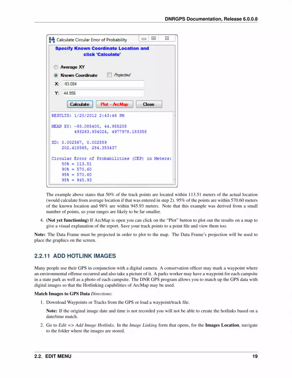
2. Go to Edit => Calculate CEP. A Calculate CEP window will appear.
If you know the exact coordinates of the location where the data was collected, select the “Known Coordinate”option and enter in the coordinates. If these coordinates are not known, select the “Average XY” option. Theaverage point location will be used in lieu of a known point.
3. Click on the “Calculate” button. A report is generated that gives various statistics of the scattered points,including the Circular Error Probability measurements.
18 Chapter 2. MENU OPTIONS
DNRGPS Documentation, Release 6.0.0.8
The example above states that 50% of the track points are located within 113.51 meters of the actual location(would calculate from average location if that was entered in step 2). 95% of the points are within 570.60 metersof the known location and 98% are within 945.93 meters. Note that this example was derived from a smallnumber of points, so your ranges are likely to be far smaller.
4. (Not yet functioning) If ArcMap is open you can click on the “Plot” button to plot out the results on a map togive a visual explanation of the report. Save your track points to a point file and view them too.
Note: The Data Frame must be projected in order to plot to the map. The Data Frame’s projection will be used toplace the graphics on the screen.
2.2.11 ADD HOTLINK IMAGES
Many people use their GPS in conjunction with a digital camera. A conservation officer may mark a waypoint wherean environmental offense occurred and also take a picture of it. A parks worker may have a waypoint for each campsitein a state park as well as a photo of each campsite. The DNR GPS program allows you to match up the GPS data withdigital images so that the Hotlinking capabilities of ArcMap may be used.
Match Images to GPS Data Directions:
1. Download Waypoints or Tracks from the GPS or load a waypoint/track file.
Note: If the original image date and time is not recorded you will not be able to create the hotlinks based on adate/time match.
2. Go to Edit => Add Image Hotlinks. In the Image Linking form that opens, for the Images Location, navigateto the folder where the images are stored.
2.2. EDIT MENU 19

DNRGPS Documentation, Release 6.0.0.8
3. Specify a Time Calibration (Optional). If you know the clock time difference between the GPS and Camerayou may enter that into the Calibration section. Alternatively, if for one of the images, you know which waypointit matches, click the Set button to open up the GPS/Image Time Calibration dialog box. Click on the image inthe Image Linking dialog box and the corresponding waypoint in the data table to compare the timestamps ofthe image and point. The Calibration value will automatically populate; then click OK. Most of the time, yourGPS clock and your Digital Camera clock will not match exactly. By setting a calibration value you identify thetime offset between the two.
4. Specify a Time-Match Threshold in hh:mm:ss. This threshold identifies the maximum time differential thatmay exist between a waypoint and a matching image. For example, if the threshold is set to 5 minutes, awaypoint will not match to any image that has a date/time greater than 5 minutes from its own date/time.
5. Click Match Image to GPS Data. Each waypoint date will be compared to each image date and the image withthe best match will be added to the FILENAME field in the waypoint table.
20 Chapter 2. MENU OPTIONS

DNRGPS Documentation, Release 6.0.0.8
6. Save the Waypoint table to a shapefile in ArcMap. Make the new layer active and use the hotlink tool to analyzethe results. Note: You may save as a shapefile outside of ArcMap as well and then later open it in ArcMap touse its hotlinking capabilities.
Convert Images to Waypoints Directions:
If your photos already have spatial information tagged, you can use this option to create waypoints that can link tothese photos in ArcMap.
1. Go to Edit => Add Image Hotlinks. In the new Image Linking form that opens, for the Images Location,navigate to the folder where the images are stored.
2. Click Convert Images to Waypoints. For each georeferenced image in the specified folder, a new waypointwill be created. All fields available in the tags of the jpg file will be populated for the waypoints, includingLat/Long, y_proj/x_proj, filename, time, ltime, altitude, etc.
2.3 GPS MENU
2.3.1 CONNECT TO DEFAULT GPS PORT
When DNRGPS is first opened, it will automatically search the default port for a GPS unit. If it finds one, it willattempt to connect to it.
Connect to Default GPS will retry connecting to the default port. If this doesn’t work, use Find GPS to search all ports.
2.3. GPS MENU 21
DNRGPS Documentation, Release 6.0.0.8
2.3.2 FIND GPS
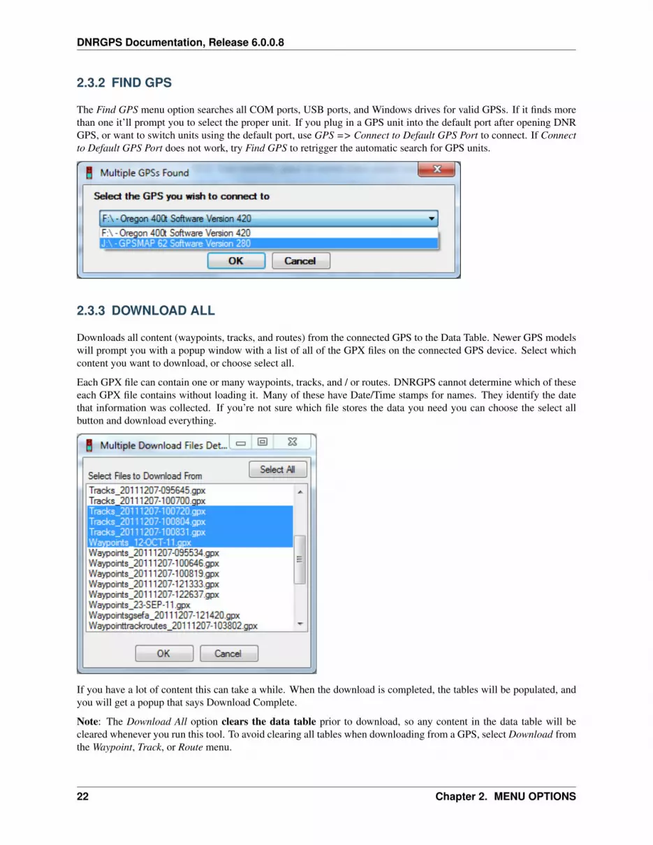
The Find GPS menu option searches all COM ports, USB ports, and Windows drives for valid GPSs. If it finds morethan one it’ll prompt you to select the proper unit. If you plug in a GPS unit into the default port after opening DNRGPS, or want to switch units using the default port, use GPS => Connect to Default GPS Port to connect. If Connectto Default GPS Port does not work, try Find GPS to retrigger the automatic search for GPS units.
2.3.3 DOWNLOAD ALL
Downloads all content (waypoints, tracks, and routes) from the connected GPS to the Data Table. Newer GPS modelswill prompt you with a popup window with a list of all of the GPX files on the connected GPS device. Select whichcontent you want to download, or choose select all.
Each GPX file can contain one or many waypoints, tracks, and / or routes. DNRGPS cannot determine which of theseeach GPX file contains without loading it. Many of these have Date/Time stamps for names. They identify the datethat information was collected. If you’re not sure which file stores the data you need you can choose the select allbutton and download everything.
If you have a lot of content this can take a while. When the download is completed, the tables will be populated, andyou will get a popup that says Download Complete.
Note: The Download All option clears the data table prior to download, so any content in the data table will becleared whenever you run this tool. To avoid clearing all tables when downloading from a GPS, select Download fromthe Waypoint, Track, or Route menu.
22 Chapter 2. MENU OPTIONS

DNRGPS Documentation, Release 6.0.0.8
See Also:
• CONNECT TO DEFAULT GPS PORT
• UPLOAD ALL
2.3.4 UPLOAD ALL
Uploads all GPS data (waypoints, tracks, and routes) from the Data Tables to the connected GPS device. Newer GPSmodels prompt the user for a name for the new gpx file to be created (a timestamp is automatically appended).
To only upload waypoints, tracks, or routes instead of all three, select Upload from the Waypoint, Track, or Routemenu.
Depending on your GPS Model the IDENT field may contain anywhere from 6-many characters. Waypoints uploadedwith IDENT values longer than the model allows will have the IDs automatically concatenated. If two waypoints havethe same concatenated ID they will overwrite each other.
One of the things that you have to watch out for is the overwriting of waypoints in the GPS. Each waypoint in the GPShas an ID. When you upload waypoints, any waypoint in the gps that has the same ID as an uploading waypointwill be overwritten. This is especially dangerous when you upload graphics as waypoints. Because graphics don’thave any attributes the extension gives each waypoint a sequential ID 1 - n number of graphic points. It is really easyto overwrite waypoints this way so make sure you have planned accordingly.
See Also:
• CONNECT TO DEFAULT GPS PORT
• DOWNLOAD ALL
2.4 WAYPOINT MENU
Used to pass Waypoints between the GPS and the DNRGPS data table.
2.4.1 DOWNLOAD
Downloads all waypoints from the GPS to the Data Table.
Newer GPS models pull up a popup window with a list of all of the gpx files on the connected GPS device. Selectwhich content you want to download, or choose select all.
See Also:
• CONNECT TO DEFAULT GPS PORT
• DOWNLOAD ALL
• UPLOAD
• WAYPOINT PROPERTIES
2.4.2 UPLOAD
Uploads all waypoints from the Data Table to the connected GPS device. Newer GPS models prompt the user for aname for the new gpx file to be created.
2.4. WAYPOINT MENU 23

DNRGPS Documentation, Release 6.0.0.8
Depending on your GPS Model the IDENT field may contain anywhere from 6-many characters. Waypoints uploadedwith IDENT values longer than the model allows will have the IDs automatically concatenated. If two waypoints havethe same concatenated ID they will overwrite each other.
One of the things that you have to watch out for is the overwriting of waypoints in the GPS. Each waypoint in theGPS has an ID. WHEN YOU UPLOAD WAYPOINTS - ANY WAYPOINT IN THE GPS THAT HAS THE SAMEID AS AN UPLOADING WAYPOINT, WILL BE OVERWRITTEN. This is especially dangerous when you uploadgraphics as waypoints. Because graphics don’t have any attributes the extension gives each waypoint a sequentialID 1 - n number of graphic points. It is really easy to overwrite waypoints this way so make sure you have plannedaccordingly.
See Also:
• CONNECT TO DEFAULT GPS PORT
• UPLOAD ALL
• DOWNLOAD
• WAYPOINT PROPERTIES
2.4.3 WAYPOINT PROPERTIES
24 Chapter 2. MENU OPTIONS

DNRGPS Documentation, Release 6.0.0.8
When downloading data from the GPS, you may have noticed that many fields with no value get created for eachrecord. You have the ability to customize the visible fields by going to the Properties menu item under each of thefollowing menus: Waypoint, Track, Route, or Real-Time.
Uncheck the fields you do not want to see and click ‘OK’. Next time you download data, only the fields that arechecked will be visible. Note: There are some required fields that will not allow you to uncheck them.
You also have the ability to customize field names by setting field aliases. The alias is what will show up in the datatable as well as what will appear in the saved file.
Note: You can now also modify the field Type, Length, and Precision.
See Also:
• UPLOAD
• DOWNLOAD
2.5 TRACK MENU
Used to pass Tracks between the GPS and the DNRGPS data table.
2.5.1 DOWNLOAD
Downloads all tracks from the GPS to the Data Table.
Newer GPS models pull up a popup window with a list of all of the gpx files on the connected GPS device. Selectwhich content you want to download, or choose select all.
Notes:
• The IDENT field displays the saved track name. If it is in the active log it may say ACTIVE LOG (dependingon your GPS Model).
• Saved tracks (on the GPS) may not retain all information for each point. To retain the maximum of informationpossible, leave tracks in the Active Log.
• After downloading, save to a point shapefile to retain attributes for each individual point (timestamp, depth, etc).
• If saving to a line, a track line (from gray record to gray record) must contain at least 2 valid points. If not, thatrecord will be discarded.
• If saving to a polygon, a track line (from gray record to gray record) must contain at least 3 valid points. If not,that record will be discarded.
See Also:
• CONNECT TO DEFAULT GPS PORT
• DOWNLOAD ALL
• UPLOAD
• TRACK PROPERTIES
2.5.2 UPLOAD
Uploads all tracks from the Data Table to the connected GPS device. Newer GPS models prompts the user for a namefor the new gpx file to be created.
2.5. TRACK MENU 25

DNRGPS Documentation, Release 6.0.0.8
Saves to named tracks.
Note: If saving to an old GPS model, you will be prompted to save to the active log.
See Also:
• CONNECT TO DEFAULT GPS PORT
• UPLOAD ALL
• DOWNLOAD
• WAYPOINT PROPERTIES
2.5.3 TRACK PROPERTIES
When downloading data from the GPS, you may have noticed that many fields with no value get created for eachrecord. You have the ability to customize the visible fields by going to the Properties menu item under each of thefollowing menus: Waypoint, Track, Route, or Real-Time.
Uncheck the fields you do not want to see and click ‘OK’. Next time you download data, only the fields that arechecked will be visible. Note: There are some required fields that will not allow you to uncheck them.
You also have the ability to customize field names by setting field aliases. The alias is what will show up in the datatable as well as what will appear in the saved file.
26 Chapter 2. MENU OPTIONS

DNRGPS Documentation, Release 6.0.0.8
Note: You can now also modify the field Type, Length, and Precision.
See Also:
• UPLOAD
• DOWNLOAD
2.6 ROUTE MENU
Used to pass Routes between the GPS and the DNRGPS data table
2.6.1 DOWNLOAD
Downloads all routes from the GPS to the Data Table.
Newer models pull up a popup window with a list of all of the gpx files on the connected GPS device. Select whichcontent you want to download, or choose select all.
A route is a collection of waypoints.
Note: The IDENT field contains the Waypoint ID. The RIDENT field contains the Route Name.
See Also:
• CONNECT TO DEFAULT GPS PORT
• DOWNLOAD ALL
• UPLOAD
• TRACK PROPERTIES
2.6.2 UPLOAD
Uploads all tracks from the Data Table to the connected GPS device. Newer GPS models prompt the user for a namefor the new gpx file to be created.
Note: Routes appear in the Route List on the GPS. Individual points are stored in the Waypoint list.
See Also:
• CONNECT TO DEFAULT GPS PORT
• UPLOAD ALL
• DOWNLOAD
• WAYPOINT PROPERTIES
2.6. ROUTE MENU 27

DNRGPS Documentation, Release 6.0.0.8
2.6.3 ROUTE PROPERTIES
When downloading data from the GPS, you may have noticed that many fields with no value get created for eachrecord. You have the ability to customize the visible fields by going to the Properties menu item under each of thefollowing menus: Waypoint, Track, Route, or Real-Time.
Uncheck the fields you do not want to see and click ‘OK’. Next time you download data, only the fields that arechecked will be visible. Note: There are some required fields that will not allow you to uncheck them.
You also have the ability to customize field names by setting field aliases. The alias is what will show up in the datatable as well as what will appear in the saved file.
Note: You can now also modify the field Type, Length, and Precision.
See Also:
• UPLOAD
• DOWNLOAD
28 Chapter 2. MENU OPTIONS

DNRGPS Documentation, Release 6.0.0.8
2.7 REAL TIME MENU
Used to interact with ArcMap in Real-Time mode. Coordinates are sent directly from the GPS to ArcMap (if ArcMap10.x is open) and can be recorded to a file. Data is also recorded in the Data Table.
Colorado, NUVI, Oregon, and other models with a mass storage mode - These units have a differentcommunication protocol with the computer and, therefore, have a bit different technique for using Real-Time.To connect to the GPS to do real-time tracking you’ll need to install the Garmin Spanner software found athttp://www8.garmin.com/support/download_details.jsp?id=1627
2.7.1 START REAL TIME TRACKING
Turns on the Real-Time tracking mode of the application. A Real-Time form (shown below) will open with variousoptions for real-time data collection. This form has the following options:
A: Select Output Data Types - You can choose to collect data directly into a Point, Line, or Polygon file. These radiodials toggle between the different shape types.
B: Load Layer - Load a new or existing layer to be used for real-time data collection
C: Time Tolerance - Minimum time between collected points (in seconds)
D: Distance Tolerance - Minimum distance between collected points (in meters)
E: Record Buttons - Used to control data collection in the active layer (A). There are 4 buttons available. They are:
Mark Point - Add most current location to a point layer.
Start Recording - This starts the collection of GPS data for the active layer. If you are recording to apoint layer you’ll notice that the Count (F) will begin incrementing for each point recorded. Each point issaved to the layer when it is created. If you are recording to a line or polygon the count will not increment(and will not be saved to the layer) until you stop recording.
Stop Recording - Stops recording and closes the current shape (line or polygon)
2.7. REAL TIME MENU 29

DNRGPS Documentation, Release 6.0.0.8
Pause Recording - Stops recording of GPS points but does not close the current shape being recorded(line or polygon).
F: Count - Keeps a tally of the number of shapes collected per layer.
G: Show Graphics - If ArcMap is open this option determines whether a “bread crumb trail” will appear in the activemapping window.
H: Pan Window % - Automatically pans if your current location gets too close to the edge of the screen. The PanZone % allows you to define how close to the edge of the screen you can get before re-centering the map display. Thispercentage defines a box as a percentage of the map window for which, if you move outside of it, the map displayautomatically recenters.
I: Track Up - In ArcMap the Data Frame will display with the track direction up rather than north up.
Default Fields: Click here to get a list of all the information that may be collected in real-time mode and a list of thefields that will be added to your attribute table if they don’t already exist.
Note: All Real-Time points will automatically be added to the GPS data table (one per second) unless a Distanceand/or Time tolerance are set. To record directly into a layer you’ll need to follow steps B-E above.
2.7.2 STOP REAL TIME TRACKING
Stops Real Time Tracking
30 Chapter 2. MENU OPTIONS

DNRGPS Documentation, Release 6.0.0.8
2.7.3 REAL TIME PROPERTIES
When downloading data from the GPS, you may have noticed that many fields with no value get created for eachrecord. You have the ability to customize the visible fields by going to the Properties menu item under each of thefollowing menus: Waypoint, Track, Route, or Real-Time.
Uncheck the fields you do not want to see and click ‘OK’. Next time you download data, only the fields that arechecked will be visible. Note: There are some required fields that will not allow you to uncheck them.
You also have the ability to customize field names by setting field aliases. The alias is what will show up in the datatable as well as what will appear in the saved file.
Note: You can now also modify the field Type, Length, and Precision.
Collect NMEA Strings - If checked when in real time mode, every NMEA string of the selected types is written outto a file
• Path - Location of the file to populate
• $GPGGA, $GPGLL, etc. - List of NMEA strings. If checked, it will be recorded. If not, it will be ignored.
See Also: START REAL TIME TRACKING
2.7. REAL TIME MENU 31
DNRGPS Documentation, Release 6.0.0.8
2.8 HELP MENU
2.8.1 Report a Bug
Pulls up a form to report software bugs or suggest enhancements for DNRGPS.
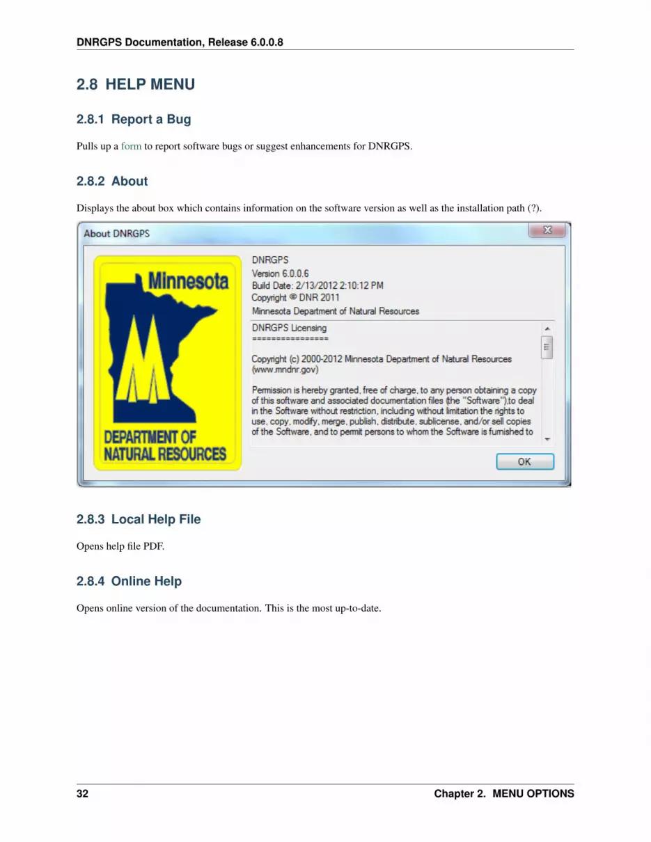
2.8.2 About
Displays the about box which contains information on the software version as well as the installation path (?).
2.8.3 Local Help File
Opens help file PDF.
2.8.4 Online Help
Opens online version of the documentation. This is the most up-to-date.
32 Chapter 2. MENU OPTIONS

CHAPTER
THREE
TROUBLESHOOT
• My data is not projecting correctly: Try using File -> Set Projection to correct the x_proj and y_proj values.
• I already have the correct projection set, and yet DNRGPS adds a duplicate projection definition when I load ashapefile: There are many ways to specify the exact same projection and sometimes it is hard to tell that twodifferent descriptions in fact refer to the same projection. This will only happen at most once for each uniquenew projection definition.
33
DNRGPS Documentation, Release 6.0.0.8
34 Chapter 3. TROUBLESHOOT
CHAPTER
FOUR
TRANSITION FROM DNR GARMIN TODNR GPS
• DATA TABLE changes
– Easier field editing
– Greater user control over data
– Ability to modify more field properties (Type, Length, and Precision)
• LOAD FROM / SAVE TO: PostgreSQL databases, ESRI v10 File Geodatabases
• : DATA TABLE
35

DNRGPS Documentation, Release 6.0.0.8
36 Chapter 4. TRANSITION FROM DNR GARMIN TO DNR GPS

CHAPTER
FIVE
APPENDIX 1 - DATA MANIPULATION
5.1 UPLOADING DATA
There are basically 2 steps to uploading data from your PC into the GPS:
1. Load data from a file or GIS graphic into the DNRGPS Data Table
• Go to File => Load From and choose a source (File, Database, Arcmap, Google Earth). Note: To loadfrom Arcmap it must be running.
– NOTE: For track logs, each GPS Unit has a different amount of memory to store coordinates. If yourupload is too large you may get an error: *TBD*
• Once the data is loaded to the data tables, you may edit it prior to upload. Edits include modifying cellvalues or converting between waypoints/tracks/routes. To see more options for data manipulation see thedata table page.
2. Upload data to the GPS
• To upload your entire Data Table (waypoints/tracks/routes), go to GPS => Upload All.
• To upload only waypoints, tracks, or routes, go to that GPS data type’s menu and select Upload (Waypoint=> Upload, Track => Upload, or Route => Upload).
• Note: Uploading into the newer GPS devices, you will be prompted to specify a the name of the GPX filethat gets created.
– To change the name of an individual track you would change the IDENT value for the track header(the dark gray record).
– To combine two tracks into a single saved track you would need to make the second track be a subsetof the first. To do this, find the first row of the second track (dark gray) and change the NEW_TRKvalue to False.
– To change the name of a route you would change the rident value for the route header.
Garmin Colorado, NUVI, Oregon models - These units have a different communication protocol with the computerand, therefore, have a bit different technique for Uploading/Downloading data. When the GPS is connected to thecomputer it shows up as a mass storage device (a Drive in Windows Explorer). When you Upload data in DNRGPSa GPX file with a timestamp for a name gets placed on the Mass Storage Device into the upload folder (usuallyGARMIN/GPX). The next time the GPS is turned on this data will be incorporated into the main memory of the GPS.
See Also: DOWNLOADING DATA
37

DNRGPS Documentation, Release 6.0.0.8
5.2 DOWNLOADING DATA
There are basically 2 steps to downloading data from your PC into the GPS:
1. Download data from the GPS
• To download all GPS data types (waypoints/tracks/routes), go to GPS => Download All and select whatyou want to download.
• To download only waypoints, tracks, or routes, go to that GPD data type’s menu and select Download(Waypoint => Download, Track => Download, or Route => Download).
• Once the data is downloaded you may edit it prior to saving. Edits include modifying cell values or fieldproperties or converting between waypoints/tracks/routes. To see more options for data manipulation seethe data table page.
2. Save data to a file, database, or GIS graphic from the DNRGPS Data Table
• Go to File => Save To and choose a destination (File, Database, Web Service, Arcmap, Google Earth).Note: To load from Arcmap it must be running.
• For more on saving data see Saving Data
General Information
Each waypoint, track point, and route point has one or more attributes associated with it depending on thetype of GPS receiver you have. You can choose to turn off extra columns if you don’t need them. You caneven delete individual records if you want. For more on editing the table, go to Data Table.
Data is downloaded in Lat/Long WGS84 coordinates. When the download is complete this spatial infor-mation is projected to the user specified projection. The projected Y and X coordinates are stored in theY_Proj and X_Proj fields. For more on projections go to the Projection Utility.
Once you have the GPS information in the Data Table you can save it as a Text file, Shapefile, GPX file,KML file, Mapinfo file, Arcmap Graphic, ArcMap Geodatabase Feature Class, a PostgreSQL databasefeature class, or a Web Service. For more on this go to the SAVE TO page.
Garmin Colorado, NUVI, Oregon models - These units have a different communication protocol with the computerand, therefore, have a bit different technique for Uploading/Downloading data. When the GPS is connected to the com-puter it shows up as a mass storage device (a Drive in Windows Explorer). When you Download data using DNRGPSit is pulling data from a GPX file on the storage device called CURRENT.GPX (possibly located at GARMIN/GPX orGARMIN/GPX/CURRENT).
See Also: UPLOADING DATA
5.3 GPS FILE STRUCTURES AND REQUIREMENTS
The DNR GPS program looks for specific fields when loading GPS data from a file. Below are lists of fields associatedwith each GPS data type. The required fields are in bold. If these fields are not found, you may be prompted to supplythe proper field for these values.
5.3.1 Waypoints
Name Description Type Length Precisiontype WAYPOINT string 10 0
Continued on next page
38 Chapter 5. APPENDIX 1 - DATA MANIPULATION

DNRGPS Documentation, Release 6.0.0.8
Table 5.1 – continued from previous pageName Description Type Length Precisionident Identifier string 24 0lat Latitude number 18 8long Longitude number 18 8y_proj Projected Y Coordinate number 18 8x_proj Projected X Coordinate number 18 8comment User Comment string 254 0display Display Options string 10 0symbol Waypoint Symbol string 10 0dist Proximity Distance number 12 2proximity Proximity Index string 10 0color Color string 10 0altitude Altitude number 12 2depth Depth number 12 2temp Temperature number 12 2time Time/Date string 20 0wpt_class Waypoint Class string 10 0sub_class Subclass string 10 0attrib Attributes string 10 0link Link to Additional Info string 254 0state State string 15 0country Country Code string 15 0city City Name string 15 0address Address Number string 15 0zip Zip Code string 15 0facility Facility Code string 15 0crossroad Intersecting Road Label string 15 0ete Estimate Time Enroute string 10 0dtype string 10 0model GPS Model string 20 0filename Hotlink Filename string 254 0ltime Local Time string 20 0magvar Magnetic Variation number 10 2geoidheight Height Above WGS84 number 10 2desc Text Description string 254 0fix Type of GPX Fix string 5 0sat Number of Satellites number 5 0hdop Horizontal DOP number 5 2vdop Vertical DOP number 5 2pdop Dilution of Precision number 5 2ageofdgpsdata Age (in seconds) number 10 0dgpsid ID of DGPS Station number 4 0
5.3. GPS FILE STRUCTURES AND REQUIREMENTS 39
DNRGPS Documentation, Release 6.0.0.8
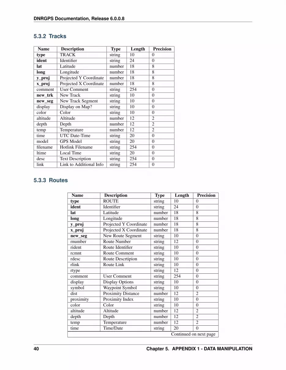
5.3.2 Tracks
Name Description Type Length Precisiontype TRACK string 10 0ident Identifier string 24 0lat Latitude number 18 8long Longitude number 18 8y_proj Projected Y Coordinate number 18 8x_proj Projected X Coordinate number 18 8comment User Comment string 254 0new_trk New Track string 10 0new_seg New Track Segment string 10 0display Display on Map? string 10 0color Color string 10 0altitude Altitude number 12 2depth Depth number 12 2temp Temperature number 12 2time UTC Date-Time string 20 0model GPS Model string 20 0filename Hotlink Filename string 254 0ltime Local Time string 20 0desc Text Description string 254 0link Link to Additional Info string 254 0
5.3.3 Routes
Name Description Type Length Precisiontype ROUTE string 10 0ident Identifier string 24 0lat Latitude number 18 8long Longitude number 18 8y_proj Projected Y Coordinate number 18 8x_proj Projected X Coordinate number 18 8new_seg New Route Segment string 10 0rnumber Route Number string 12 0rident Route Identifier string 10 0rcmnt Route Comment string 10 0rdesc Route Descrtipion string 10 0rlink Route Link string 10 0rtype string 12 0comment User Comment string 254 0display Display Options string 10 0symbol Waypoint Symbol string 10 0dist Proximity Distance number 12 2proximity Proximity Index string 10 0color Color string 10 0altitude Altitude number 12 2depth Depth number 12 2temp Temperature number 12 2time Time/Date string 20 0
Continued on next page
40 Chapter 5. APPENDIX 1 - DATA MANIPULATION

DNRGPS Documentation, Release 6.0.0.8
Table 5.2 – continued from previous pageName Description Type Length Precisionwpt_class Waypoint Class string 10 0sub_class Subclass string 10 0attrib Attributes string 10 0state State string 15 0country Country Code string 15 0city City Name string 15 0address Address Number string 15 0zip Zip Code string 15 0facility Facility Code string 15 0crossroad Intersecting Road Label string 15 0ete Estimate Time Enroute string 10 0dtype string 10 0filename Hotlink Filename string 254 0ltime Local Time string 20 0magvar Magnetic Variation number 10 2geoidheight Height Above WGS84 number 10 2desc Text Description string 254 0model GPS Model string 20 0fix Type of GPX Fix string 5 0sat Number of Satellites number 5 0hdop Horizontal DOP number 5 2vdop Vertical DOP number 5 2pdop Dilution of Precision number 5 2ageofdgpsdata Age (in seconds) number 10 0dgpsid ID of DGPS Station number 4 0
5.3. GPS FILE STRUCTURES AND REQUIREMENTS 41

DNRGPS Documentation, Release 6.0.0.8
5.3.4 Real Time
Name Description Type Length Precisiontype ROUTE string 10 0ident Identifier string 24 0lat Latitude number 18 8long Longitude number 18 8y_proj Projected Y Coordi-
natenumber 18 8
x_proj Projected X Coordi-nate
number 18 8
comment string 254 0altitude Altitude number 12 2epe Estimated Position Er-
ror - 2 sigmanumber 10 2
eph EPE, but horizontalonly
number 10 2
epv EPE, but vertical only number 10 2hdop Horizontal DOP number 5 2vdop Vertical DOP number 5 2pdop Dilution of Precision number 5 2speed Speed Over Ground
(knots)number 10 2
course Course Over Ground(degrees)
number 10 2
mvar Magnetic Variation(degrees)
number 10 2
mdir Magnetic Variation(E/W)
number 10 2
datum Datum of coordinates string 20 0pfix Type of position fix
• 0 = Unusable• 1 = Invalid• 2 = 2D• 3 = 3D• 4 = 2D_diff• 5 = 3D_diff
number 10 0
east Velocity East string 10 0north Velocity North string 10 0up Velocity Up number 10 2depth Depth Below Trans-
ducernumber 12 2
temp Temperature (Celcius) number 12 2time UTC Time string 20 0filename Hotlink filename string 255 0ltime Local Time string 20 0
42 Chapter 5. APPENDIX 1 - DATA MANIPULATION

DNRGPS Documentation, Release 6.0.0.8
5.4 DATA TABLE
The Data Table can be used as a tool to manage waypoints, tracks, routes, and real-time data.
5.4.1 Editing Table Information
Editing the data table in DNRGPS is much simplified and improved from DNRGarmin. Editing cells now operatesmuch the same as any spreadsheet program (such as Excel).
Modifying Cell Values Click on a cell once to select. Click again or press F2 to modify the cell content.
Adding Records The last row in the data table is always a new record. Start typing into one of the cells of that rowto create the new record.
Deleting Records Select an entire row by clicking the row header to the left of each record. To select multiple rows,
click and drag, ctrl-click, or shift-click. Once the desired rows are selected. Click the delete button: . To
clear the entire data table, use the (Clear Table) button.
Deleting (hiding) Columns You can toggle columns on or off through the properties menu for Way-point/Track/Route. Uncheck the checkbox to the left of the field to turn off the column.
Saving Data When you save your data, if you have a selection of whole rows, only those records that are selected aresaved to a shapefile, graphic or text file. If you have no records selected then all records will be saved. To clearthe selection, click in any single cell in the table.
Copying and Pasting Data You can copy and paste data to and from Excel and within the data table using the
(Copy from cells) and (Paste into table) buttons. The selection for the copy can be individual cell(s) or fullrow(s).
5.4. DATA TABLE 43

DNRGPS Documentation, Release 6.0.0.8
Roll up Tracks If a track record has a “-” in the row header, it is the start of a track. You can double-click on it tohide all records within that track.
Sorting To sort a wapoint table based on a specific field click on the field header. Note: You are unable to sort trackand route tables because they rely on a specific record order.
Note: There is no longer a limit to the number of records in the data table.
5.5 FILE TYPES
DNRGPS supports loading data from or saving data to the following file types:
ESRI Shapefile - Only contains one data type (points, lines, or polygons). If the shapefile does not have a prj file, thenit assumes data is projected in the projection specified at File => Set Projection. Loading from or saving to shapefilesdoes not require ArcMap.
Google Keyhole Markup Language (KML File) - Can store waypoints, tracks, and routes together. For morecontrol over which layers you import, load the KML by connecting to it as a database. Also, save to a databaseconnection instead of a file for more control over the name of the target layer. For more on this file format go tohttp://earth.google.com/kml/
GPS Exchange Format (GPX File) - Can store waypoints, tracks, and routes together. For more on this file formatgo to http://www.topografix.com/gpx.asp
Text File (comma-delimited) or Text File (tab-delimited) - Can be used to load data or save out data.
Mapinfo File (.map) - This functionality does not yet work. If no projection information is associated with this file,then it assumes data is projected in the projection specified at File => Set Projection.
Geography Markup Language (GML) - For more on this file format go tohttp://www.opengeospatial.org/standards/gml
Geo JavaScript Object Notation (GeoJSON) - For more on this file format go to http://geojson.org/
See Also
• LOAD FROM
• SAVE TO
44 Chapter 5. APPENDIX 1 - DATA MANIPULATION

CHAPTER
SIX
APPENDIX 2
6.1 CONTRIBUTORS
Authors – the people behind DNRGPS
Lead Programmer:
• Chris Pouliot
Code Contributors:
• Regan Sarwas
• Greg Massaro
Project Manager:
• Shelly Sentyrz
Other contributors and helpers:
• Zeb Thomas
• Mike Tronrud
• Jackie Brost
• Hundreds of alpha and beta testers
6.2 KNOWN ISSUES
DNRGPS Known Functionality Gaps and Issues
For the most current list, go toftp://ftp.dnr.state.mn.us/pub/gisftp/DNRGPS/DNRGPS_KNOWN_ISSUES.TXT
6.3 LICENSE
6.3.1 DNRGPS Licensing
Copyright (c) 2000-2012 Minnesota Department of Natural Resources (www.mndnr.gov)
45

DNRGPS Documentation, Release 6.0.0.8
Permission is hereby granted, free of charge, to any person obtaining a copy of this software and associated documen-tation files (the “Software”),to deal in the Software without restriction, including without limitation the rights to use,copy, modify, merge, publish, distribute, sublicense, and/or sell copies of the Software, and to permit persons to whomthe Software is furnished to do so, subject to the following conditions:
The above copyright notice and this permission notice shall be included in all copies or substantial portions of theSoftware.
THE SOFTWARE IS PROVIDED “AS IS”, WITHOUT WARRANTY OF ANY KIND, EXPRESS OR IMPLIED,INCLUDING BUT NOT LIMITED TO THE WARRANTIES OF MERCHANTABILITY, FITNESS FOR A PAR-TICULAR PURPOSE AND NONINFRINGEMENT. IN NO EVENT SHALL THE AUTHORS OR COPYRIGHTHOLDERS BE LIABLE FOR ANY CLAIM, DAMAGES OR OTHER LIABILITY, WHETHER IN AN ACTIONOF CONTRACT, TORT OR OTHERWISE, ARISING FROM, OUT OF OR IN CONNECTION WITH THE SOFT-WARE OR THE USE OR OTHER DEALINGS IN THE SOFTWARE.
6.3.2 Component Licensing
DNRGPS contains several component packages that are provided under their own licensing terms.
GDAL – Refer to the GDAL license found at /DOCUMENTS/GDAL_LICENSE.TXT
GPSBABEL – Refer to the GPSBABEL license found at /DOCUMENTS/GPSBABEL_LICENSE.TXT
PROJ4 –Refer to the PROJ4 license found at /DOCUMENTS/PROJ4_LICENSE.TXT
ESRI FILE GDB API – Refer to the ESRI FILE GDB API license found at /DOCU-MENTS/FILEGDBAPI_LICENSE.TXT
6.4 RELEASE LOG
Release log can be found at:ftp://ftp.dnr.state.mn.us/pub/gisftp/DNRGPS/DNRGPS_RELEASE_LOG.TXT
46 Chapter 6. APPENDIX 2

CHAPTER
SEVEN
SYSTEM ADMINISTRATOR GUIDE
System Administrators are responsible for installing and managing DNRGPS on enterprise computers.
This section is meant to give tips on smooth roll outs to many computers.
7.1 Installation
Since DNRGPS is a self-contained program, it can be deployed anywhere. At the Minnesota DNR, we have deployedto a central server that all users can see. A shortcut to dnrgps.exe is placed on the desktop. The advantage of this isthat new versions can be integrated by simply replacing the one copy of the application on the server instead of dozensor hundreds of individual copies on users’ PCs.
7.2 User Properties
The first time DNRGPS is run on a PC, it tries to create a DNRGRPS folder at:
• Windows XP: C:Documents and Settings<username>AppDataDNRGPS
• Windows 7: C:Users<username>AppDataRoamingDNRGPS
If users are restricted from writing to this location, then it tries writing to:
• Windows XP: C:Documents and Settings<username>My DocumentsDNRGPS
• Windows 7: C:Users<username>My DocumentsDNRGPS
The DNRGPS folder may contain these files:
• dnrgps_temp.gpx - A scratch space that DNRGPS uses for processing
• dnrgps_properties.xml - User customizations. This file is first generated from a master copy located in DNRG-PSdocuments. For more go to the description of the dnrgps_properties.xml
• DNRGPS_log.txt - Error log file
When deploying, modify the main dnrgps_properties.xml file to include customizations of your choice such as fieldaliases, visible file types, favorite projections, etc. These customizations will then be used by the end user. Note: Ifthe end user has previously opened DNRGPS they will already have a local copy of dnrgps_properties.xml. This filewill need to be deleted or replaced for them to see the updated customizations.
47

DNRGPS Documentation, Release 6.0.0.8
7.3 dnrgps_properties.xml File Structure
Below is a list of the properties that can be modified within the dnrgps_properties.xml prior to deployment:
• time - Timestamp from the last time DNRGPS modified this xml file.
• checkVersion - Boolean that determines whether, each time DNRGPS opens, it checks whether there is a newerversion available for download. Set this to false to prevent your users from seeing this message for each update.
<CheckVersion>true</CheckVersion>
• GpsBabelExecutable - Path to GPD Babel application used by DNR GPS
<GpsBabelExecutable>C:\dnrgps\gpsbabel\gpsbabel.exe</GpsBabelExecutable>
• xImageExecutable - Path to xImage application used by DNR GPS
<xImageExecutable>C:\Program Files (x86)\Garmin\xImage\xImage.exe</xImageExecutable>
• GPS Model and Connections - gpsMake, gpsPort, gpsBaudRate, gpsNoAck
<!--Items below relate to GPS Model and Connections--><gpsMake></gpsMake><gpsPort></gpsPort><gpsBaudRate>9600</gpsBaudRate><gpsNoAck>True</gpsNoAck>
• Field Definitions - Field definitions for each field are similar across the different data types (waypointFields, trackFields, routeFields, realtimeFields). Possible field tags include:
– gpxtag - The tag used for a gpx file (if applicable)
– required - Whether the field is required for that data type
– visible - Whether the field defaults to being displayed for that data type
– precision - For numerical fields, the precision of the value, the 0 is ignored for other values.
– length - Field length
– type - Field data type
– name - Field name
– alias - Field alias (if applicable)
Note: If a tag is missing, it is not applicable to that field. Example field definitions (these default definitionscan be changed by the user in DNRGPS properties)
<field gpxtag="name" required="true" visible="true" precision="0" length="24" type="string" name="ident" /><field gpxtag="lat" required="true" visible="true" precision="8" length="18" type="number" alias="Latitude" name="lat" /><field gpxtag="DisplayMode" visible="true" precision="0" length="10" type="string" name="display" />
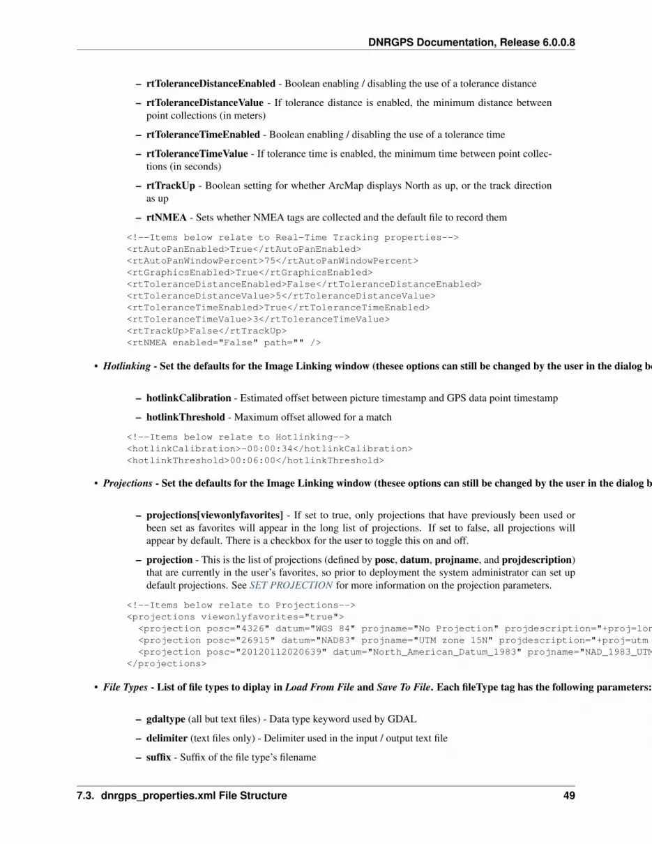
• Real-Time Tracking properties - Set the defaults for the Real Time Window (all of these options can still bechanged by the user in the dialog box)
– rtAutoPanEnabled - Boolean enabling / disabling pan capability
– rtAutoPanWindowPercent - Sets default percentage for how close to the edge of the screenyou can get before re-centering the map display. This percentage defines a box as a percentageof the map window for which, if you move outside of it, the map display automatically recenters.
– rtGraphicsEnabled - Boolean enabling / disabling marking the trail in the active mapping win-dow if ArcMap is open
48 Chapter 7. SYSTEM ADMINISTRATOR GUIDE
DNRGPS Documentation, Release 6.0.0.8
– rtToleranceDistanceEnabled - Boolean enabling / disabling the use of a tolerance distance
– rtToleranceDistanceValue - If tolerance distance is enabled, the minimum distance betweenpoint collections (in meters)
– rtToleranceTimeEnabled - Boolean enabling / disabling the use of a tolerance time
– rtToleranceTimeValue - If tolerance time is enabled, the minimum time between point collec-tions (in seconds)
– rtTrackUp - Boolean setting for whether ArcMap displays North as up, or the track directionas up
– rtNMEA - Sets whether NMEA tags are collected and the default file to record them
<!--Items below relate to Real-Time Tracking properties--><rtAutoPanEnabled>True</rtAutoPanEnabled><rtAutoPanWindowPercent>75</rtAutoPanWindowPercent><rtGraphicsEnabled>True</rtGraphicsEnabled><rtToleranceDistanceEnabled>False</rtToleranceDistanceEnabled><rtToleranceDistanceValue>5</rtToleranceDistanceValue><rtToleranceTimeEnabled>True</rtToleranceTimeEnabled><rtToleranceTimeValue>3</rtToleranceTimeValue><rtTrackUp>False</rtTrackUp><rtNMEA enabled="False" path="" />
• Hotlinking - Set the defaults for the Image Linking window (thesee options can still be changed by the user in the dialog box)
– hotlinkCalibration - Estimated offset between picture timestamp and GPS data point timestamp
– hotlinkThreshold - Maximum offset allowed for a match
<!--Items below relate to Hotlinking--><hotlinkCalibration>-00:00:34</hotlinkCalibration><hotlinkThreshold>00:06:00</hotlinkThreshold>
• Projections - Set the defaults for the Image Linking window (thesee options can still be changed by the user in the dialog box)
– projections[viewonlyfavorites] - If set to true, only projections that have previously been used orbeen set as favorites will appear in the long list of projections. If set to false, all projections willappear by default. There is a checkbox for the user to toggle this on and off.
– projection - This is the list of projections (defined by posc, datum, projname, and projdescription)that are currently in the user’s favorites, so prior to deployment the system administrator can set updefault projections. See SET PROJECTION for more information on the projection parameters.
<!--Items below relate to Projections--><projections viewonlyfavorites="true">
<projection posc="4326" datum="WGS 84" projname="No Projection" projdescription="+proj=longlat +ellps=WGS84 +datum=WGS84 +no_defs <>" default="false" /><projection posc="26915" datum="NAD83" projname="UTM zone 15N" projdescription="+proj=utm +zone=15 +ellps=GRS80 +datum=NAD83 +units=m +towgs84=-0.991,1.9072,0.5129,0.02579,0.00965,0.01166,0 +no_defs no_defs <>" default="false" /><projection posc="20120112020639" datum="North_American_Datum_1983" projname="NAD_1983_UTM_Zone_15N" projdescription="+proj=utm +zone=15 +datum=NAD83 +units=m +no_defs " default="true" />
</projections>
• File Types - List of file types to diplay in Load From File and Save To File. Each fileType tag has the following parameters:
– gdaltype (all but text files) - Data type keyword used by GDAL
– delimiter (text files only) - Delimiter used in the input / output text file
– suffix - Suffix of the file type’s filename
7.3. dnrgps_properties.xml File Structure 49

DNRGPS Documentation, Release 6.0.0.8
– description - Description used in the Load From File and Save To File file navigation dialog boxes
– visible - Boolean determining whether the checkbox in File Properties is checked (“true” = checked).Set to “false” to hide by default the file types that your users will not be using.
– default - The default option in the Load From and Save To menus. Only one type can be set to default.
<!--Items below relate to File Types to save to.--><fileTypes>
<fileType gdaltype="ESRI Shapefile" suffix="shp" description="ESRI Shapefile" filter="*.shp" visible="true" default="true" /><fileType gdaltype="KML" suffix="kml" description="Google Keyhole Markup Language" filter="*.kml" visible="true" default="false" /><fileType gdaltype="GPX" suffix="gpx" description="GPS Exchange Format" filter="*.gpx" visible="true" default="false" /><fileType delimiter="," suffix="txt" description="Text file (comma-delimited)" filter="*.txt" visible="true" default="false" /><fileType delimiter="\t" suffix="txt" description="Text file (tab-delimited)" filter="*.txt" visible="true" default="false" /><fileType gdaltype="MapInfo File" suffix="map" description="Mapinfo File" filter="*.map" visible="true" default="false" /><fileType gdaltype="GML" suffix="gml" description="Geography Markup Language" filter="*.gml" visible="true" default="false" /><fileType gdaltype="GeoJSON" suffix="geojson" description="Geo JavaScript Object Notation" filter="*.geojson" visible="true" default="false" />
</fileTypes>
• Database Types - Each database fileType tag has the following parameters (actual databases have more parameters than the psuedo-databases, i.e. file geodatabases and KML files):
– gdaltype - Database type keyword for GDAL
– prefix (databases only) - Connection string prefix for the given database
– dbname (databases only) - Boolean determining whether DB Name is visible in the connection dialogbox
– host (databases only) - Boolean determining whether Host is visible in the connection dialog box
– port (databases only) - Boolean determining whether Port is visible in the connection dialog box
– user (databases only) - Boolean determining whether User is visible in the connection dialog box
– password (databases only) - Boolean determining whether Password is visible in the connectiondialog box
– description - Text description to be shown in the dropdown menu for selecting the type of databaseconnection to be used
– visible - Boolean determining whether the desciption shows up as an option in the dropdown menu
– folderPath (Esri File Geodatabases only) - Boolean determining whether Folder Path is visible in theconnection dialog box
– filePath (KML only) - Boolean determining whether File Path is visible in the connection dialog box
<!--Items below relate to Database Types to save to.--><databaseTypes>
<fileType gdaltype="PostgreSQL" prefix="PG:" dbname="true" host="true" port="true" user="true" password="true" description="PostgreSQL for PostGIS" visible="true" /><fileType gdaltype="FileGDB" folderPath="true" description="ESRI File Geodatabase (v10.x)" visible="true" /><fileType gdaltype="KML" filePath="true" description="Google Keyhole Markup Language" visible="true" />
</databaseTypes>
• Database Connections - Stores the database connections set up by the user. The system administrator can set these up before deployment so they are available to all users. databaseConnection tags include:
– gdaltype - Database type keyword for GDAL
– connectionName - Name for the geodatabase that will show up in the list of connections
– connectionString - Connection string used to connect to the database
50 Chapter 7. SYSTEM ADMINISTRATOR GUIDE

DNRGPS Documentation, Release 6.0.0.8
– default - Boolean indicating which database is highlighted when the list of connections is opened.Only one connection can be set as the default.
<!--Items below are saved database connections--><databaseConnections>
<databaseConnection gdaltype="FileGDB" connectionName="test GDB" connectionString="D:\gistemp\MyProjects\test.gdb" default="true" /></databaseConnections>
7.3. dnrgps_properties.xml File Structure 51

DNRGPS Documentation, Release 6.0.0.8
52 Chapter 7. SYSTEM ADMINISTRATOR GUIDE
CHAPTER
EIGHT
PROGRAMMER GUIDE
DNRGPS is Open Source code written in C#. Programmers are encouraged to modify DNRGPS code by checking itout from http://www.assembla.com/spaces/DNRGPS.
Check code out and in here: http://www.assembla.com/spaces/DNRGPS
53


