Embed Size (px)
Citation preview
CRITICAL METALS LTD
VANADIUM RECOVERY PLANT, PORI
ENVIRONMENTAL IMPACT ASSESSMENT (EIA) PROGRAMME
6.4.2021
ENVIRONMENTAL IMPACT ASSESSMENT PROGRAMME
6.4.2021
PUBLIC DISPLAY AND CONTACT INFORMATION Contact information
Project Developer: Critical Metals Ltd Executive Director Damian Hicks Tel. +46 703 225 133 e-mail: [email protected] website: www.criticalmetals.eu Local representative of the Project Developer in the EIA and permit procedures: LandPro Oy Managing Director Tore Granskog Tel. +358 (0) 40 8350341 [email protected] Coordinating authority: ELY Centre for Southwest Finland Senior Inspector Elinor Slotte Tel. +358 (0) 295 023021 [email protected] https://www.ely-keskus.fi/ely-varsinais-suomi EIA Consultant: Sweco Industry Ltd Project Manager Sirpa Torkkeli Tel. +358 (0) 40 5947864 [email protected] Assistant Project Manager Vilma Skinnari Tel. +358 (0) 50 3589326 [email protected]
The EIA programme is on display:
Service Point Porina
Yrjönkatu 6b, 28100 Pori
ENVIRONMENTAL IMPACT ASSESSMENT PROGRAMME
6.4.2021
Contents
ABSTRACT I
TERMS AND ABBREVIATIONS VI
1 Project and alternatives to be assessed 1
1.1 Project developer 1
1.2 Aim and background of the project 1
1.3 Timeline of the project 2
1.4 Alternatives to be assessed 3
1.5 Connections to other projects 3
2 Alternative 1 4
2.1 Location and land use 4
2.2 Process description 6
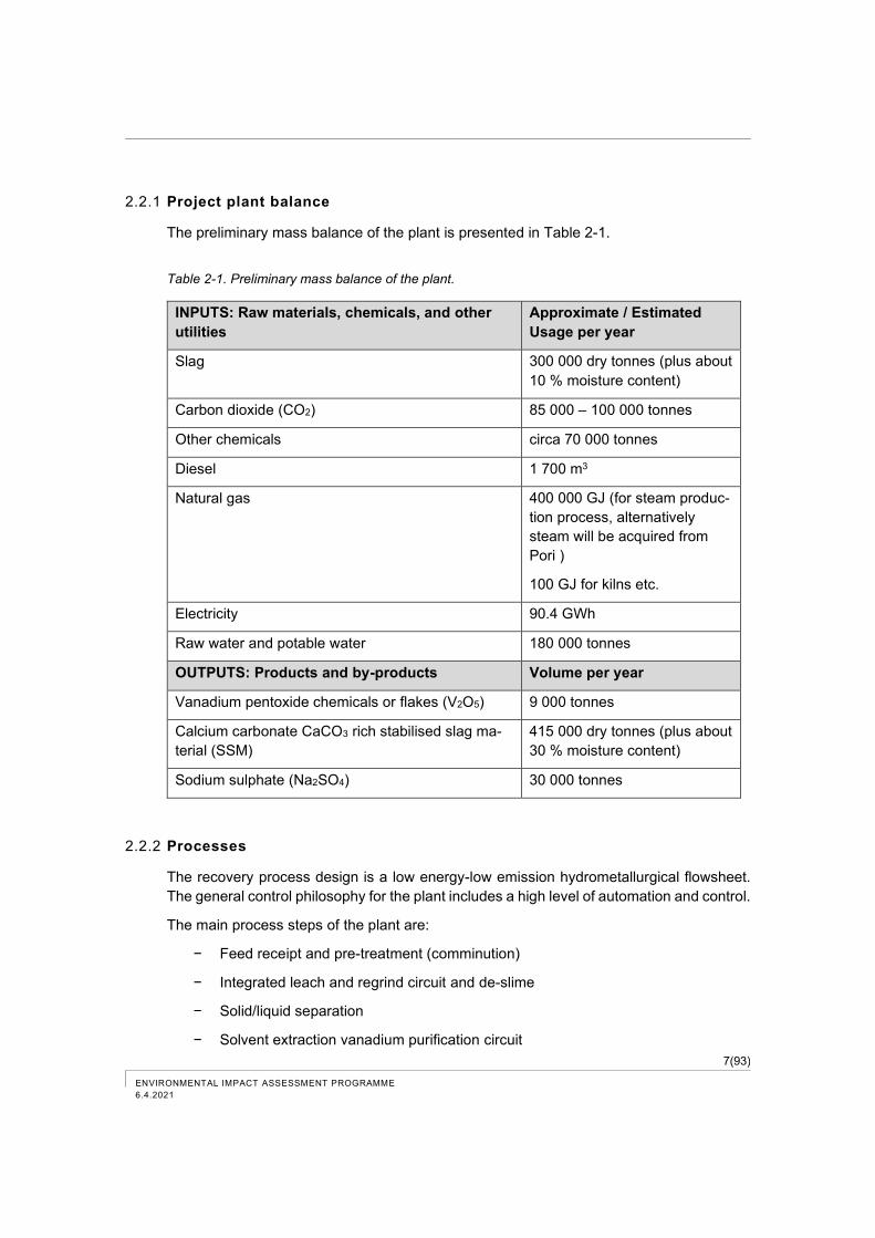
2.2.1 Project plant balance 7
2.2.2 Processes 7
2.2.3 Raw materials 11
2.2.4 Chemicals and other utilities 12
2.2.5 Primary products and secondary products 13
2.2.6 Water supply 14
2.2.7 Emissions to the environment and wastes 15
2.2.8 Traffic 16
2.2.9 Connections 17
2.2.10 Energy Use 17
3 Alternative 0 18
4 EIA procedure 19
4.1 Objectives and content of the EIA Procedure 19
4.1.1 EIA programme 21
4.1.2 EIA report 22
4.1.3 Reasoned Conclusion 23
4.2 Timetable of the EIA procedure 24
5 Participation and interaction plan 25
5.1 Public hearings and discussions 25
5.2 Follow-up group 25
5.3 Public display of the EIA programme and the EIA report 26
ENVIRONMENTAL IMPACT ASSESSMENT PROGRAMME
6.4.2021
5.4 Resident survey 26
5.5 Other communication 26
6 Permits, plans and decisions required by the project 27
6.1 Environmental impact assessment 27
6.2 Environmental permit 27
6.3 Building permit 28
6.4 Chemical permit 28
6.5 Other permits and obligations 28
7 Environmental Baseline Description 30
7.1 Land use and built environment 30
7.1.1 Activities in the area 30
7.1.2 Residential areas and sensitive sites 33
7.1.3 Recreational use 34
7.1.4 Land use planning 35
7.1.5 Other plans and programmes 43
7.2 Current status of the water system 43
7.2.1 Environmental load and water quality 43
7.2.2 Fish stock and fishing and the use of the water system and shores 45
7.3 Air quality and climate 47
7.3.1 Air quality 47
7.3.2 Climate 48
7.4 Vegetation, animals and nature reserves 50
7.4.1 Vegetation and animals 50
7.4.2 Conservation areas and nature reserves 53
7.4.2.1 Natura areas 53
7.4.2.2 Nature conservation areas 56
7.4.2.3 Sites of nature conservation programmes 57
7.4.2.4 Valuable bird areas 58
7.5 Landscape and cultural environment 59
7.6 Soil, bedrock and groundwater basins 64
7.6.1 Soil and bedrock 64
7.6.2 Groundwater areas 69
7.7 Traffic 70
7.7.1 Existing traffic volumes 70
ENVIRONMENTAL IMPACT ASSESSMENT PROGRAMME
6.4.2021
7.7.2 The most significant transport plans and projects in the area 73
7.8 Noise 74
8 Plan for the environmental impact assessment 77
8.1 Starting point for the EIA and outline of the assessment 77
8.2 Impact assessment area 80
8.3 Assessed impacts and used methods 81
8.4 Impacts during construction 83
8.5 Impacts during operation 83
8.5.1 Impacts related to waste water and cooling water 83
8.5.2 Impacts related to air emissions 83
8.5.3 Impacts related to greenhouse gas emissions 84
8.5.4 Impacts related to traffic 84
8.5.5 Noise impacts 84
8.5.6 Vibration impacts 85
8.5.7 Impacts related to the handling of secondary products and waste 85
8.5.8 Impacts related to the use of natural resources 85
8.5.9 Impacts related to community structure and land use 85
8.5.10 Impacts related to landscape and cultural environment 85
8.5.11 Impacts on vegetation, fauna and protected sites 86
8.5.12 Impacts related to soil, bedrock and groundwater 87
8.5.13 Impacts related to human health, living conditions and comfort 87
8.5.14 Transboundary environmental impacts 88
8.5.15 Impacts related to accidents and disturbances 88
8.5.16 Cumulative impacts 89
8.6 Impacts related to decommissioning 89
8.7 Summary of impacts 89
8.8 Prepared and planned studies 90
8.9 Assessment of uncertainties 90
9 Prevention and mitigation of harmful impacts 90
10 Monitoring of impacts 90
11 References 91
ENVIRONMENTAL IMPACT ASSESSMENT PROGRAMME
6.4.2021
List of Figures
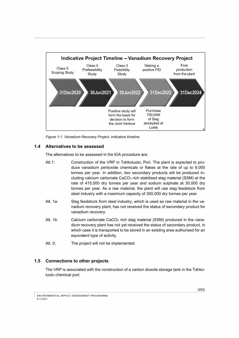
Figure 1-1. Vanadium Recovery Project, indicative timeline. ........................................................ 3
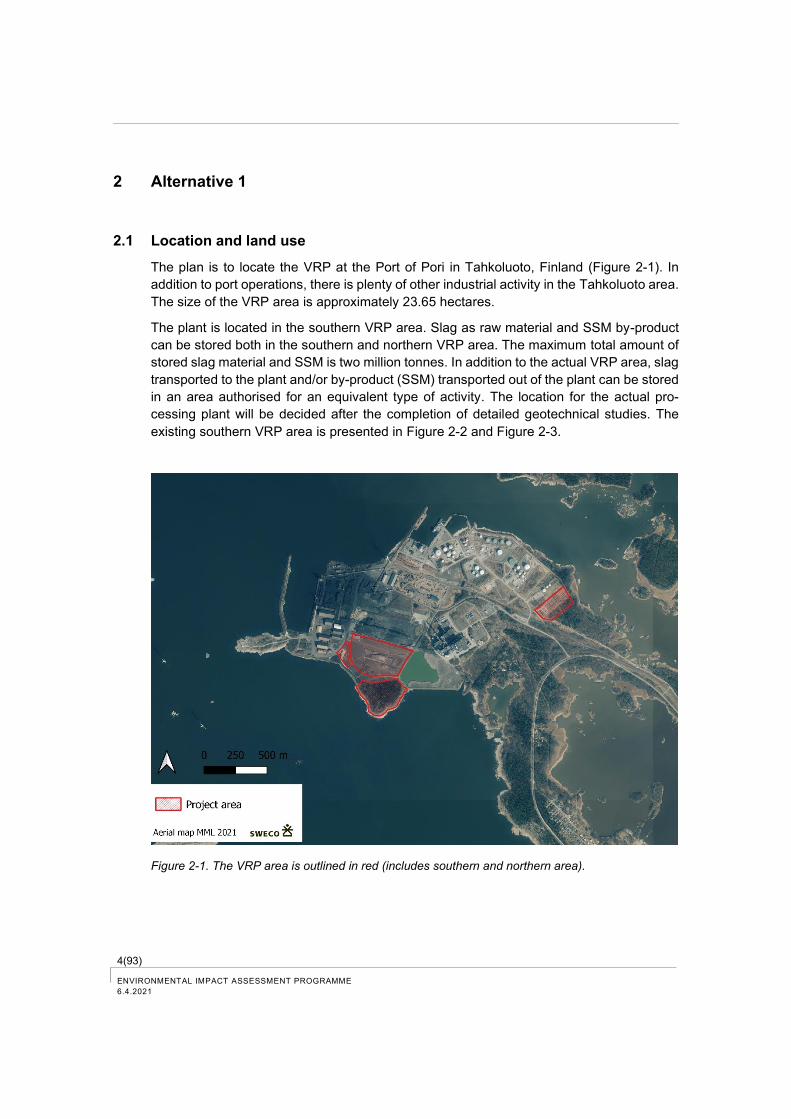
Figure 2-1. The VRP area is outlined in red (includes southern and northern area). ................... 4
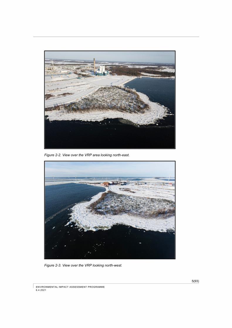
Figure 2-2. View over the VRP area looking north-east. ............................................................... 5
Figure 2-3. View over the VRP looking north-west. ...................................................................... 5
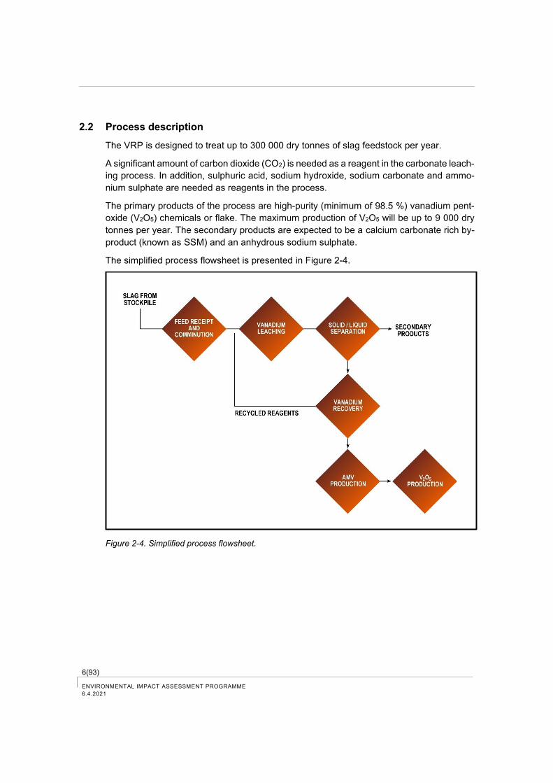
Figure 2-4. Simplified process flowsheet. ..................................................................................... 6
Figure 2-5. Main process steps, material flows and products. ...................................................... 8
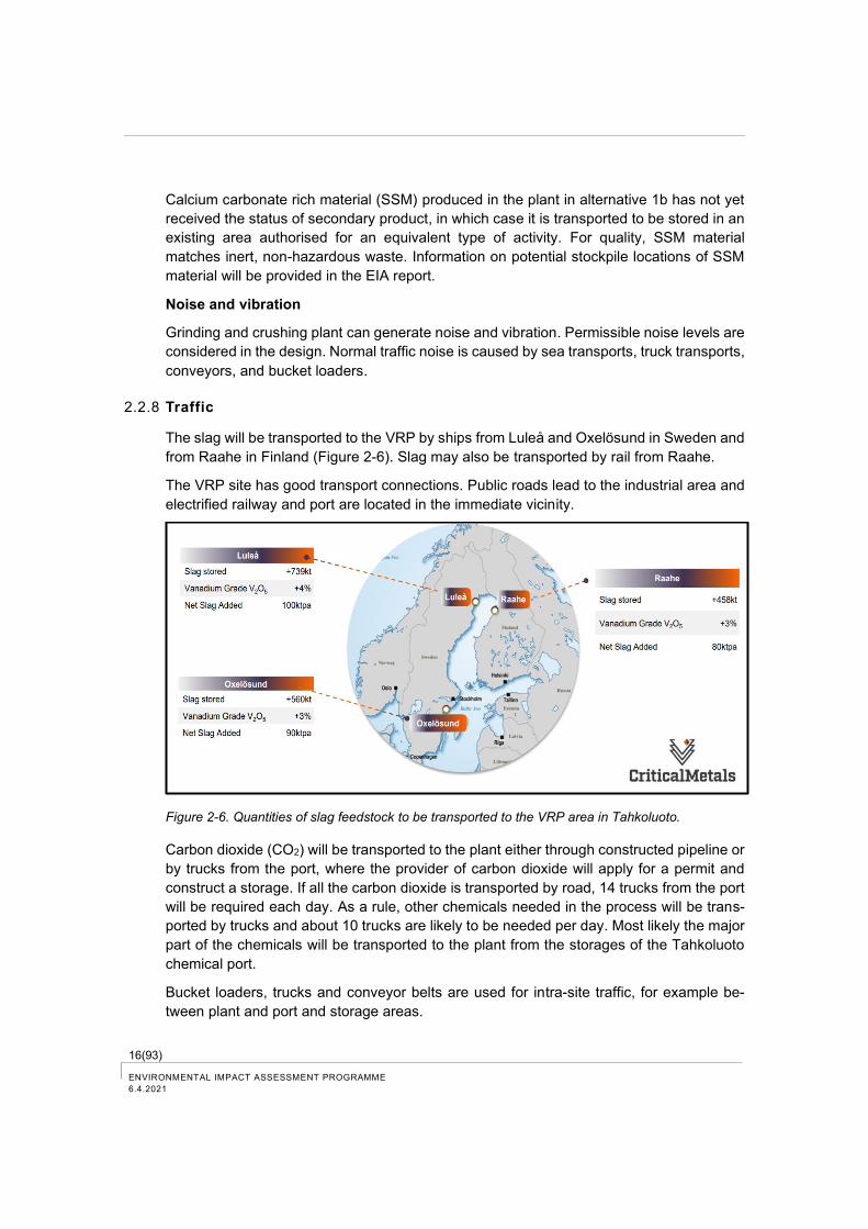
Figure 2-6. Quantities of slag feedstock to be transported to the VRP area in Tahkoluoto. ....... 16
Figure 4-1. Phases of the EIA procedure. ................................................................................... 20
Figure 4-2. Planned timetable of the EIA procedure. .................................................................. 24
Figure 7-1. Tahkoluoto port site map (Port of Pori 2021). ........................................................... 31
Figure 7-2. Water basin and filling on the eastern edge of the VRP area. The Meri-Pori power station can be seen in the background. Photo taken towards northeast. Point B in Figure 7-4. .................................................................................................................... 32
Figure 7-3. Road and the end of rail line in the planned VRP area. Wind farms of Suomen Hyötytuuli Oy can be seen in the background. Photo taken towards west. Point A in Figure 7-4. .................................................................................................................... 32
Figure 7-4. Points, where Figure 7-2 and Figure 7-3 were taken (Critical Metals Ltd). .............. 33
Figure 7-5. Residential areas and sensitive sites in the vicinity of the VRP area. ...................... 34
Figure 7-6. An extract from the Satakunta regional plan, 2009.. ................................................ 36
Figure 7-7. An extract from the Satakunta phase regional plan 2, 2019..................................... 37
Figure 7-8. An extract from the Reposaari-Tahkoluoto-Lampaluoto-Ämttöö component master plan (Pori Map Service). .............................................................................................. 38
Figure 7-9. Tahkoluoto-Paakarit draft component master plan (City of Pori 2021). ................... 39
Figure 7-10. An extract from the land use planning review 2021-2023 by the City of Pori. ........ 40
Figure 7-11. An extract from the Tahkoluoto detailed plan (Pori Map Service).. ........................ 42
Figure 7-12. Sites of fishery monitoring (mod. Väisänen 2018b). (The VRP area is located in site 3). ................................................................................................................................. 46
Figure 7-13. Wind direction distribution diagram for Pori in 2020 (City of Pori Environmental and Health Surveillance Department 2021). ....................................................................... 49
Figure 7-14. Area of the nature study prepared in connection with the Tahkoluoto-Paakarit component master plan (City of Pori 2020). ................................................................ 51
Figure 7-15. Valuable areas for birds in the area of the 2020 study (red colour). ...................... 52
Figure 7-16. Supplementary areas of the nature study to be prepared in 2021 in Tahkoluoto. . 52
Figure 7-17. Natura areas in the vicinity of the VRP area. .......................................................... 56
Figure 7-18. Nature conservation areas in the vicinity of the VRP area. .................................... 57
Figure 7-19. Sites included in the nature conservation programmes located near the VRP area and nationally valuable wind and riparian deposits. .................................................... 58
ENVIRONMENTAL IMPACT ASSESSMENT PROGRAMME
6.4.2021
Figure 7-20. Regionally important bird areas (MAALI), nationally important bird areas (FINIBA) and internationally important bird areas (IBA) located in the vicinity of the VRP area. 59
Figure 7-21. Nationally valuable landscape areas near the VRP area. ...................................... 60
Figure 7-22. Objects in the building inventory of Tahkoluoto.) .................................................... 61
Figure 7-23. Village of Tahkoluoto (Satakunta Museum 2014). .................................................. 62
Figure 7-24. Archaeological cultural heritage sites in Tahkoluoto area based on inventory of the year 2020 (City of Pori 2020). ...................................................................................... 63
Figure 7-25. The Reposaari community is shown with blue grid in the figure (Finnish Heritage Agency, map service). ................................................................................................. 64
Figure 7-26. Soil types in the VRP area and the surrounding area. ........................................... 65
Figure 7-27. Bedrock in the VRP area and in the surrounding area. .......................................... 66
Figure 7-28. MATTI sites near the VRP area. ............................................................................. 67
Figure 7-29. Base map from 1987 ©Maanmittauslaitos. ............................................................. 68
Figure 7-30. Implemented ash disposal in the Törnikari filling area (environmental permit application ylupa.avi.fi, submitted by the Port of Pori on February 18, 2020). ............ 69
Figure 7-31. Groundwater areas in the vicinity of the VRP area. ................................................ 70
Figure 7-32. Traffic volumes in 2019 on the Reposaari main road leading to Tahkoluoto (Finnish Transport Infrastructure Agency). ................................................................................ 71
Figure 7-33. Fairways and depth zones in the Tahkoluoto area (Paikkatietoikkuna). ................ 72
Figure 7-34. Sites where noise levels were monitored in the Tahkoluoto noise study. .............. 74
Figure 7-35. Tahkoluoto port and industrial area, busy 24 hours, all noise sources, equivalent continuous sound levels (Lahti & Gouatarbès 2016). .................................................. 76
Figure 8-1. Approach to the assessment of the impact significance (Marttunen et. al. 2015). ... 78
Figure 8-2. Impact assessment area of the VRP. ....................................................................... 81
ENVIRONMENTAL IMPACT ASSESSMENT PROGRAMME
6.4.2021
List of Tables
Table 2-1. Preliminary mass balance of the plant. ........................................................................ 7
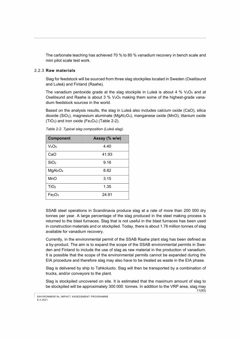
Table 2-2. Typical slag composition (Luleå slag). ....................................................................... 11
Table 2-3. Used and produced chemicals, estimated consumptions and maximum storages in the plant. ...................................................................................................................... 12
Table 2-4. Preliminary estimates of vessel traffic. The moisture content of materials is considered in transport volumes. ................................................................................. 17
Table 7-1. Results of the stormwater survey in the Tahkoluoto deep-water port on June 28, 2007 (Decision on the environmental permit for the Tahkoluoto port, Regional State Administrative Agency for Southern Finland 2018). .................................................... 44
Table 7-2. Monitoring results of the load directed to the sea during 2017–2019 from the Törnikari sedimentation basin of the Port of Pori Ltd. .................................................. 45
Table 7-3. Natural habitats, which constitute the protection objectives of the Natura areas. ..... 54
Table 7-4. Species, which constitute the protection objectives of the Natura areas. .................. 54
Table 7-5. Freight transport volumes in tonnes and the number of trains to Tahkoluoto in Pori during 2017-2020 (Finnish Transport Infrastructure Agency 2021, Fintraffic 2021). ... 72
Table 7-6. Number of vessels directed to the Tahkoluoto deep-water port during 2018–2020 (Fintraffic 2021). ........................................................................................................... 73
Table 7-7. Noise study of Tahkoluoto, total noise levels of all operators .................................... 75
Table 8-1. Assessment of impacts. ............................................................................................. 79
Table 8-2. Persons involved in the preparation of the EIA programme. ..................................... 80
Table 8-3. Assessed impacts and assessment methods. ........................................................... 82
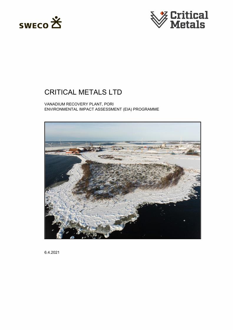
Appendices Appendix. Natura Screening Assessment Cover photo: Location for the Vanadium Recovery Project, Tahkoluoto Port, Pori, Finland
I(XI)
ENVIRONMENTAL IMPACT ASSESSMENT PROGRAMME
6.4.2021
ABSTRACT
Project and project developer
The Australian registered company Criticals Metals Ltd (CMS) is planning a vanadium re-
covery plant in the Tahkoluoto port and industrial area located in Pori, Finland. The plant is
expected to produce vanadium pentoxide chemicals or flakes at the rate of up to 9,000
tonnes per year. In addition, two secondary products will be produced including stabilised
slag material (SSM) at the rate of 415,000 dry tonnes per year and sodium sulphate at
30,000 dry tonnes per year. As a raw material, the plant will use slag feedstock with a
maximum capacity of 300,000 dry tonnes per year.
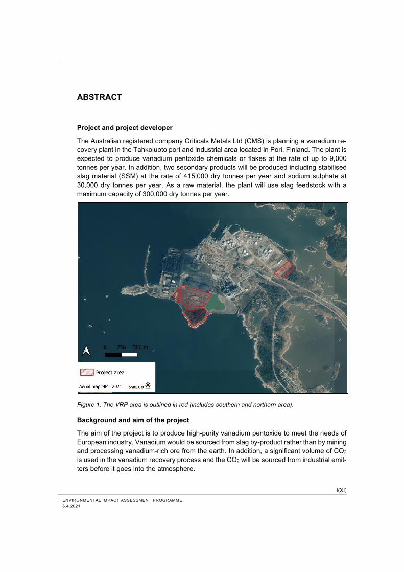
Figure 1. The VRP area is outlined in red (includes southern and northern area).
Background and aim of the project
The aim of the project is to produce high-purity vanadium pentoxide to meet the needs of
European industry. Vanadium would be sourced from slag by-product rather than by mining
and processing vanadium-rich ore from the earth. In addition, a significant volume of CO2
is used in the vanadium recovery process and the CO2 will be sourced from industrial emit-
ters before it goes into the atmosphere.
II(XI) ENVIRONMENTAL IMPACT ASSESSMENT PROGRAMME
6.4.2021
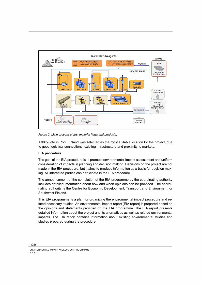
Figure 2. Main process steps, material flows and products.
Tahkoluoto in Pori, Finland was selected as the most suitable location for the project, due
to good logistical connections, existing infrastructure and proximity to markets.
EIA procedure
The goal of the EIA procedure is to promote environmental impact assessment and uniform
consideration of impacts in planning and decision making. Decisions on the project are not
made in the EIA procedure, but it aims to produce information as a basis for decision mak-
ing. All interested parties can participate in the EIA procedure.
The announcement of the completion of the EIA programme by the coordinating authority
includes detailed information about how and when opinions can be provided. The coordi-
nating authority is the Centre for Economic Development, Transport and Environment for
Southwest Finland.
This EIA programme is a plan for organizing the environmental impact procedure and re-
lated necessary studies. An environmental impact report (EIA report) is prepared based on
the opinions and statements provided on the EIA programme. The EIA report presents
detailed information about the project and its alternatives as well as related environmental
impacts. The EIA report contains information about existing environmental studies and
studies prepared during the procedure.
III(XI)
ENVIRONMENTAL IMPACT ASSESSMENT PROGRAMME
6.4.2021
Alternatives to be assessed
The alternatives to be assessed in the EIA procedure are:
Alternative 1: Construction of the VRP in Tahkoluoto, Pori. The plant is expected to pro-
duce vanadium pentoxide chemicals or flakes at the rate of up to 9,000
tonnes per year. In addition, two secondary products will be produced in-
cluding stabilised slag material (SSM) at the rate of 415,000 dry tonnes per
year and sodium sulphate at 30,000 dry tonnes per year. As a raw material,
the plant will use slag feedstock with a maximum capacity of 300,000 dry
tonnes per year.
Alt. 1a: Slag feedstock from steel industry, which is used as raw material in the va-
nadium recovery plant, has not received the status of secondary product for
vanadium recovery.
Alt. 1b: Calcium carbonate CaCO3 rich slag material (SSM) produced in the vana-
dium recovery plant has not yet received the status of secondary product, in
which case it is transported to be stored in an existing area authorised for an
equivalent type of activity.
Alternative 0: The project will not be implemented.
Location of project area
The planned area for the VRP is located in the Tahkoluoto port area in Pori, Finland. In
addition to port operations, the area has plenty of industrial activity. The VRP area consists
of southern and northern areas and the size of the area is approximately 23.65 hectares.
In addition to the actual VRP area, slag transported to the plant or stabilized slag trans-
ported out of the plant can be stored in an area authorised for an equivalent type of activity.
Environmental conditions
In addition to the ports, plenty of industrial activity is located in the VRP area and in its
vicinity in the Tahkoluoto area. The Meri-Pori power plant owned by Fortum Power and
Heat Oy, which currently operates as a power reserve plant, and the reserve power station
owned by Fingrid Ltd are located on the eastern side to the VRP area. In addition, other
industrial companies operate in the Tahkoluoto area and the Tahkoluoto offshore wind farm
owned by Suomen Hyötytuuli Ltd is located on the western side of the deep-water port.
The nearest area of single-family houses is located about 600 m to the east of the border
of the southern VRP area, The nearest residences to the border of the northern VRP area
are located about 350 m to the southwest and a leisure home is located about 400 m to the
east. The nearest school, kindergarten and camping site are located about 2 km southeast
of the VRP area in Reposaari.
In the regional plan, Tahkoluoto is designated as a port area and an area for industrial and
warehousing activities, most of which is reserved for the manufacture, storage, and
transport of hazardous chemicals, and an area for energy supply. The area has a compo-
nent master plan, which has no legal force, and in which both the southern and northern
IV(XI) ENVIRONMENTAL IMPACT ASSESSMENT PROGRAMME
6.4.2021
VRP area are designated as an industrial area (T). In the detailed plan from the year 1986,
the southern VRP area is designated as a block area of industrial and warehouse buildings.
The northern VRP area is designated by the plan symbol TV-1 as a block area of ware-
house buildings. An alteration of the detailed plan for the port area is planned for the
Tahkoluoto area in a time span of 1–3 years. The detailed plan will consider the changing
needs of port and industrial activities.
River waters cause turbidity in the surface water and affect the nutrient concentrations in
the marine areas outside of Pori. The waste water discharge from the Pori pigment factory
has previously caused an environmental load on the marine area. For example, storm-
water, seepage and runoff waters from the filling areas are directed to the sea in the Tahkol-
uoto area.
Air quality in Pori has mainly been at good level. Dust from streets occasionally deteriorates
air quality in the city centre area. In the Tahkoluoto area emissions to the air are caused by
road and ship traffic. Dust emissions are caused by industrial operations.
The Bothnian Sea National Park is located on the western side of the VRP area, which is
part of the National Conservation Programme of state-owned areas and which also in-
cludes the Natura areas of Gummandoora and Pooskeri Archipelagos. The archipelagos
are located at a distance of about 2–10 km to the north and northeast from the VRP area.
On average, 250-350 vessels visit the Tahkoluoto port every year. In addition, ship traffic,
truck and passenger car traffic as well as train traffic are directed to the Tahkoluoto area.
According to the environmental noise study of the Tahkoluoto port and industrial area, the
average sound level generated by the facilities in the area does not exceed the noise limits
for environmental permits in nearby residential and recreational areas.
Environmental impacts to be assessed
In accordance with the EIA Act and the EIA Decree, the environmental impact assessment
procedure includes the assessment of impacts of the VRP on human beings, natural envi-
ronment and built environment. The assessment includes e.g. direct and indirect impacts
on human health and living conditions, vegetation and organisms, environmental quality
and protected sites, natural resources, land use and community structure and their mutual
interaction.
According to the preliminary estimate, the most significant environmental impacts of the
VRP are related to the transport of raw materials and products as well as noise generated
by the operations. Essential environmental aspects also include dust emissions and poten-
tial accidents and disturbances. The significance of environmental impacts is assessed,
among other things, by comparing certain environmental load to the environmental toler-
ance taking the existing environmental load of the industrial area into consideration. In the
assessment of environmental tolerance, the provided guideline values, such as air quality
and noise level guideline values as well as available research information are used. A sur-
vey to the permanent residents and leisure-time residents in the nearby area will be per-
formed during the EIA procedure.
V(XI)
ENVIRONMENTAL IMPACT ASSESSMENT PROGRAMME
6.4.2021
Participation and communication plan
Residents and other concerned parties can participate in the project by submitting official
feedback to the Centre for Economic Development, Transport and Environment for South-
west Finland, which acts as the coordinating authority, as well as to the project developer
or the EIA consultant.
After the publication of the EIA programme, a public hearing will be organized on 21.4.2021
in TEAMS, The project and the plan regarding the environmental impact assessment will
be presented in the public hearing. In this hearing participants have an opportunity to ask
questions and present opinions on the project and on the implementation of the assess-
ment procedure. A second public hearing will be organized after the completion of the EIA
report.
Schedule
The environmental impact procedure of the VRP has started in spring 2021 by the prepa-
ration of the EIA programme. The EIA procedure will officially start when the EIA pro-
gramme has been submitted to the coordinating authority in early April 2021. The environ-
mental impact assessment report will be prepared during spring and summer 2021. Ac-
cording to the preliminary schedule, the EIA report will be submitted to the coordinating
authority in early September 2021. Thus, the environmental impact procedure will end
when the coordinating authority provides its reasoned conclusion approximately in early
January 2022. The goal is that the operation of the vanadium recovery plant can be started
in 2024.
VI(XI) ENVIRONMENTAL IMPACT ASSESSMENT PROGRAMME
6.4.2021
TERMS AND ABBREVIATIONS
Abbreviation Description
a Year (1 year = 365 days), time unit
AMV Ammonium metavanadate, secondary product
Alt.0 Alternative 0, non-implementation of the project
Alt.1 Alternative 1, implementation of the pro-ject,.construction of a vanadium recovery plant in Tahkoluoto, Pori which uses slag feedstock with a maximum capacity of 300,000 dry tonnes per year.
BAT Best Available Technology
°C Celcius-degree, temperature unit
CaO Calcium oxide
CaCO3 Calcium carbonate
C6H6 Benzene
CLP Regulation EC No 1272/2008 on the clas-sification, labelling, and packaging of substances and mixtures (CLP Regula-tion)
CMS Critical Metals Ltd
CO2 Carbon dioxide
CO Carbon monoxide
COD Chemical Oxygen Demand, quality pa-rameter for waste water
Coagulant A substance which causes particles in a liquid to curdle and clot together.
VII(XI)
ENVIRONMENTAL IMPACT ASSESSMENT PROGRAMME
6.4.2021
Abbreviation Description
Colloid Type of mixture that can be considered as an intermediate between a homogene-ous and heterogeneous mixture. In a col-loidal solution, the particles are so finely divided that the mixture cannot be con-sidered heterogeneous, but still larger than the molecular-level particles of a ho-mogeneous mixture.
Condensate Product of the condensation process. In condensation, the gaseous substance becomes a liquid.
Contactor A device, in which a solution impregnated with vanadium is treated.
d Day (1 day = 24 hours), time unit
dB Decibel, sound level unit of measurement
EC European Commission
EIA Environmental impact assessment ELY Centre for Economic Development,
Transport and the Environment
EMMA Ecologically significant underwater area of marine environment in Finland
EU European Union
Extraction Way to separate a desired substance from its mixture by selective solubility.
FINIBA-areas Important Bird Areas in Finland (IBA-areas, internationally important bird ar-eas)
Flocculant Chemical that promotes flocculation by causing colloids and other suspended particles in liquids to aggregate.
g Unit of mass: 1 000 mg 0,001 kg
GTK Geological Survey of Finland

VIII(XI) ENVIRONMENTAL IMPACT ASSESSMENT PROGRAMME
6.4.2021
Abbreviation Description
GWh Gigawatt hour, energy unit
Hydrocyclone A device to classify, separate or sort parti-cles in a liquid suspension based on the ratio of their centripetal force to fluid re-sistance. Hydrocyclones can also be used for separating liquids of different densities.
Hydrometallurgy One of the manufacturing techniques of metal. It includes the use of aqueous solu-tions for the recovery of metals from ores, concentrates and recycled or residual ma-terials.
IBA-areas Important Bird and Biodiversity Areas, IBA
Ion exchange Process, in which ions, cations and ani-ons in solution are exchanged to anions and cations in solid matrix.
kg Unit of mass, 1 000 g
KPU National park, code for the National Con-servation Programme of state-owned ar-eas.
kWh Kilowatt hour, energy unit
LAeq Equivalent continuous sound level, unit decibel (dB)
LD-slag Converter slag, slag product used as raw material in the process
Lipasto Calculation system for traffic exhaust emissions and energy use in Finland (maintained by the Technical Research Centre of Finland, VTT)
MAALI-areas Regionally important bird areas
MAO Nationally valuable landscape area
MATTI Soil condition data base
mg Unit of mass: 1 000 μg, 0,001 g
IX(XI)
ENVIRONMENTAL IMPACT ASSESSMENT PROGRAMME
6.4.2021
Abbreviation Description
μg Unit of mass: 0,000001 g
μm Unit of length: 0,000001 m MJ Megajoule, energy unit
MML National Land Survey of Finland
MRL Land Use and Building Act
MWh megawatt hours, energy unit
mS/m Unit of electrical conductivity, 1 Siemens
= 1 A/V
m/s Unit of speed, for example wind speed or flow speed
N2000 Height system
Na2SO4 Sodium sulphate
Natura area Natura 2000 area network protects im-portant habitats and species in the Euro-pean Union.
NH3 Ammonia
NO2 Dinitrogen oxide
Organic Biogenic, biotic, of natural origin
pH Degree of acidity
Phase State of matter, distinct form in which mat-ter can exist, which is separated by an in-terface from another phase. Generally, three types of phases can be defined: gas phase, liquid phase and solid phase.
PM10 PLS
Inhaled particles, size max. 10 μm Vanadium-bearing Pregnant Leach Solu-tion
X(XI) ENVIRONMENTAL IMPACT ASSESSMENT PROGRAMME
6.4.2021
Abbreviation Description
POP
Persistent Organic Pollutant
Pulpering Mass decomposition
Raffinate Solution, which has had a component or components removed
REACH Regulation Regulation of the European Union for reg-ulation, evaluation, authorisation and re-striction of chemicals (2006/1907/EC).
reagent Substance or compound added to a sys-tem to cause a chemical reaction forming a part or whole of the end product. Sol-vents and catalysts are not classified as reagents.
RISAB Recycling Industries Scandinavia AB, Swedish subsidiary of Critical Metals Ltd
RSO Code for the coast protection programme
SAC Special Area of Conservation
SO2 Sulphur dioxide
SPA Special Protection Area pursuant to the Bird Directive
SSAB Steel producer, provides slag used as raw material in the process
SSM Calcium carbonate rich Stabilised Slag Material, secondary product from the pro-cess
Stripping Physical separation process where one or more components are removed from a liq-uid phase by a gas or vapor stream.
t Unit of mass, tonne (1000 kg)
TRS Total Reduced Sulfur compounds
XI(XI)
ENVIRONMENTAL IMPACT ASSESSMENT PROGRAMME
6.4.2021
Abbreviation Description
TSP Total Suspended Particles
TUKES Finnish Safety and Chemical Agency
V2O5 Vanadium pentoxide, end product from the process
VELMU Inventory programme for underwater ma-rine biodiversity
WHO World Health Organization
YSA Environmental Protection Decree or pri-vate nature conservation area
YSL Environmental Protection Act

1(93)
ENVIRONMENTAL IMPACT ASSESSMENT PROGRAMME
6.4.2021
1 Project and alternatives to be assessed
The aim of the Vanadium Recovery Project (VRP) is to produce high-purity vanadium pent-
oxide for European industry. The vanadium will be recovered from slag, a by-product of the
steel industry via a low energy, low emission, carbon negative, hydrometallurgical process.
The VRP will also produce two secondary products, calcium carbonate and sodium sulp-
hate.
1.1 Project developer
Australian registered company Critical Metals Ltd (CMS) is responsible for the VRP
(www.criticalmetals.eu). CMS and its wholly owned subsidiary company Recycling Indus-
tries Scandinavia AB (RISAB) are the counterparties to an agreement with steel producer
SSAB whereby CMS will purchase slag from SSAB in Finland and Sweden. The slag is the
raw material input for the VRP.
Australian registered company Neometals Ltd (NMT) is the largest shareholder in CMS
(holding 17.96%) (www.neometals.com.au). NMT and its wholly owned subsidiary com-
pany Avanti Materials Ltd are CMS’ financial and technology partners for the VRP.
Subject to the parties making a final investment decision (FID), CMS will transfer a 50 %
equity interest in RISAB to NMT.
1.2 Aim and background of the project
Vanadium is a critical raw material, according to the European Commission. Critical raw
materials refer to raw materials that are of great economic importance to industry in the EU
region, but with high risk to availability (Ministry of Employment and Economy 2019).
Vanadium consumption worldwide increased from 40,000 tonnes to over 100,000 tonnes
per year during the period 2001–2019. In 2019, 100,000 tonnes of vanadium was produced,
59 % in China, 9 % in South Africa and 8 % in Russia. There is currently no mining of
vanadium ore in Europe.
Vanadium is primarily used in the manufacture of high-grade steel and stainless steel, and
additionally in the manufacture of vanadium chemicals used in titanium alloys and energy
storage (batteries).
The worldwide demand for vanadium is estimated to grow further, as e.g. the production of
lithium-vanadium phosphate batteries increases. Battery types already on the market, pos-
sibly becoming more common in the future, include different flow batteries including vana-
dium batteries, which are specifically used to store energy on a large scale. (Pirkanmaa
Regional Council 2018). Research is also being conducted into the use of lithium vanadium
(Li-V) battery chemistries in electric vehicles.
According to the National Battery Strategy 2025 published by the Finnish Ministry of Em-
ployment and Economy in 2021, the Working Group sets out seven objectives for the 2021-
2025 strategy period: growth and renewal of the battery and electrification cluster, growth
of investment, promotion of competitiveness, increase notoriety in the world, accountability,
2(93) ENVIRONMENTAL IMPACT ASSESSMENT PROGRAMME
6.4.2021
key roles in new value chains in the industry, and the promotion of circular economics and
digital solutions. The change requires large quantities of critical raw materials, in which
Finland must provide not only mineral reserves and raw material processing, but also tech-
nology solutions and know-how in production technologies (Ministry of Employment and
Economy 2021).
CMS entered into an agreement with the steel producer, SSAB, to purchase slag by-prod-
uct from SSAB steel production plants in Oxelösund and Luleå, Sweden, and from Raahe,
Finland. Vanadium-rich slag from steel industry constitutes the highest class raw material
source for vanadium in the world. CMS aims to extract vanadium from the slag and produce
high-purity vanadium pentoxide to meet the needs of European industry.
Vanadium would therefore be sourced from slag by-product rather than by mining and pro-
cessing vanadium-rich ore from the earth. The VRP will contribute to the decreasing reli-
ance of European industry for the supply of vanadium produced elsewhere. In addition, a
significant volume of CO2 is used in the VRP and the CO2 will be sourced from industrial
emitters before it goes into the atmosphere. The VRP is an example of the circular economy
in action and is therefore an important project within the European region. The VRP will
bring along research and development, cooperation, investments and employment effects
also in the future.
Several potential locations in England, Sweden and Finland were considered for the VRP.
Tahkoluoto in Pori, Finland was selected as the most suitable location for the project, due
to good logistical connections to international markets, existing infrastructure and proximity
to markets.
1.3 Timeline of the project
Technical feasibility and scoping studies for the VRP have been conducted and further
investigations, project planning and engineering are ongoing. The operation of the pilot
plant will be commissioned in Perth, Australia in May 2021. A final investment decision will
be made in late 2022 and if positive, construction is scheduled to commence in the first half
of 2023 with commissioning scheduled for late 2024 (Figure 1-1).
3(93)
ENVIRONMENTAL IMPACT ASSESSMENT PROGRAMME
6.4.2021
Figure 1-1. Vanadium Recovery Project, indicative timeline.
1.4 Alternatives to be assessed
The alternatives to be assessed in the EIA procedure are:
Alt.1: Construction of the VRP in Tahkoluoto, Pori. The plant is expected to pro-
duce vanadium pentoxide chemicals or flakes at the rate of up to 9,000
tonnes per year. In addition, two secondary products will be produced in-
cluding calcium carbonate CaCO3 rich stabilised slag material (SSM) at the
rate of 415,000 dry tonnes per year and sodium sulphate at 30,000 dry
tonnes per year. As a raw material, the plant will use slag feedstock from
steel industry with a maximum capacity of 300,000 dry tonnes per year.
Alt. 1a: Slag feedstock from steel industry, which is used as raw material in the va-
nadium recovery plant, has not received the status of secondary product for
vanadium recovery.
Alt. 1b: Calcium carbonate CaCO3 rich slag material (SSM) produced in the vana-
dium recovery plant has not yet received the status of secondary product, in
which case it is transported to be stored in an existing area authorised for an
equivalent type of activity.
Alt. 0: The project will not be implemented.
1.5 Connections to other projects
The VRP is associated with the construction of a carbon dioxide storage tank in the Tahko-
luoto chemical port.
4(93) ENVIRONMENTAL IMPACT ASSESSMENT PROGRAMME
6.4.2021
2 Alternative 1
2.1 Location and land use
The plan is to locate the VRP at the Port of Pori in Tahkoluoto, Finland (Figure 2-1). In
addition to port operations, there is plenty of other industrial activity in the Tahkoluoto area.
The size of the VRP area is approximately 23.65 hectares.
The plant is located in the southern VRP area. Slag as raw material and SSM by-product
can be stored both in the southern and northern VRP area. The maximum total amount of
stored slag material and SSM is two million tonnes. In addition to the actual VRP area, slag
transported to the plant and/or by-product (SSM) transported out of the plant can be stored
in an area authorised for an equivalent type of activity. The location for the actual pro-
cessing plant will be decided after the completion of detailed geotechnical studies. The
existing southern VRP area is presented in Figure 2-2 and Figure 2-3.
Figure 2-1. The VRP area is outlined in red (includes southern and northern area).
5(93)
ENVIRONMENTAL IMPACT ASSESSMENT PROGRAMME
6.4.2021
Figure 2-2. View over the VRP area looking north-east.
Figure 2-3. View over the VRP looking north-west.
6(93) ENVIRONMENTAL IMPACT ASSESSMENT PROGRAMME
6.4.2021
2.2 Process description
The VRP is designed to treat up to 300 000 dry tonnes of slag feedstock per year.
A significant amount of carbon dioxide (CO2) is needed as a reagent in the carbonate leach-
ing process. In addition, sulphuric acid, sodium hydroxide, sodium carbonate and ammo-
nium sulphate are needed as reagents in the process.
The primary products of the process are high-purity (minimum of 98.5 %) vanadium pent-
oxide (V2O5) chemicals or flake. The maximum production of V2O5 will be up to 9 000 dry
tonnes per year. The secondary products are expected to be a calcium carbonate rich by-
product (known as SSM) and an anhydrous sodium sulphate.
The simplified process flowsheet is presented in Figure 2-4.
Figure 2-4. Simplified process flowsheet.
7(93)
ENVIRONMENTAL IMPACT ASSESSMENT PROGRAMME
6.4.2021
2.2.1 Project plant balance
The preliminary mass balance of the plant is presented in Table 2-1.
Table 2-1. Preliminary mass balance of the plant.
INPUTS: Raw materials, chemicals, and other
utilities
Approximate / Estimated
Usage per year
Slag 300 000 dry tonnes (plus about
10 % moisture content)
Carbon dioxide (CO2) 85 000 – 100 000 tonnes
Other chemicals circa 70 000 tonnes
Diesel 1 700 m3
Natural gas 400 000 GJ (for steam produc-
tion process, alternatively
steam will be acquired from
Pori )
100 GJ for kilns etc.
Electricity 90.4 GWh
Raw water and potable water 180 000 tonnes
OUTPUTS: Products and by-products Volume per year
Vanadium pentoxide chemicals or flakes (V2O5) 9 000 tonnes
Calcium carbonate CaCO3 rich stabilised slag ma-
terial (SSM)
415 000 dry tonnes (plus about
30 % moisture content)
Sodium sulphate (Na2SO4) 30 000 tonnes
2.2.2 Processes
The recovery process design is a low energy-low emission hydrometallurgical flowsheet.
The general control philosophy for the plant includes a high level of automation and control.
The main process steps of the plant are:
− Feed receipt and pre-treatment (comminution)
− Integrated leach and regrind circuit and de-slime
− Solid/liquid separation
− Solvent extraction vanadium purification circuit
8(93) ENVIRONMENTAL IMPACT ASSESSMENT PROGRAMME
6.4.2021
− Vanadium pentoxide (V2O5) production
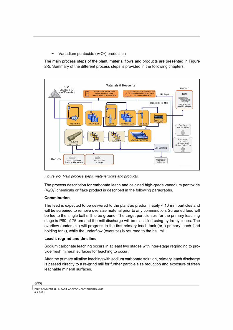
The main process steps of the plant, material flows and products are presented in Figure
2-5. Summary of the different process steps is provided in the following chapters.
Figure 2-5. Main process steps, material flows and products.
The process description for carbonate leach and calcined high-grade vanadium pentoxide
(V2O5) chemicals or flake product is described in the following paragraphs.
Comminution
The feed is expected to be delivered to the plant as predominately < 10 mm particles and
will be screened to remove oversize material prior to any comminution. Screened feed will
be fed to the single ball mill to be ground. The target particle size for the primary leaching
stage is P80 of 75 µm and the mill discharge will be classified using hydro-cyclones. The
overflow (undersize) will progress to the first primary leach tank (or a primary leach feed
holding tank), while the underflow (oversize) is returned to the ball mill.
Leach, regrind and de-slime
Sodium carbonate leaching occurs in at least two stages with inter-stage regrinding to pro-
vide fresh mineral surfaces for leaching to occur.
After the primary alkaline leaching with sodium carbonate solution, primary leach discharge
is passed directly to a re-grind mill for further particle size reduction and exposure of fresh
leachable mineral surfaces.
9(93)
ENVIRONMENTAL IMPACT ASSESSMENT PROGRAMME
6.4.2021
This is followed by secondary leaching with a sodium carbonate solution under similar mod-
erate temperature and atmospheric pressure leaching.
Through the leaching process the calcium in the slag (excess lime from the steel mill) reacts
with the carbonate to produce calcite (calcium carbonate). During this process the vana-
dium is made available for leaching and deports into the leach solution.
Carbon dioxide gas is sparged into the leach reactors to maintain the required pH by re-
generating carbonate ions (carbonate ions are consumed in the calcite precipitation) and
ensure selective leaching of the vanadium. Additional regrind and leach stages could be
added if needed to ensure an optimum portion of the vanadium is recovered from the slag
feed.
Solid/liquid separation
During the above leaching process carbon dioxide is sequestered and calcium carbonate
is formed causing an increase in the mass of solids in the leach slurry. The repeated com-
minution causes a decrease in the particle size distribution. Consequently, post-secondary
(or final) leaching it is important to separate the leach residue from the vanadium-bearing
Pregnant Leach Solution (PLS). A combination of thickener and pressure filter (with multi-
ple stages of counter current washing) is used to separate the PLS from the leach residue.
The well washed leach residue contains a calcium carbonate rich fine material and insolu-
ble and weakly soluble minerals. The leach residue is the secondary product called SSM.
The counter current wash waters (containing low levels of vanadium and reagents) are re-
used in the circuit to ensure optimal retention of any remaining soluble vanadium and any
sodium reagents.
The SSM is repulped in hot water at a high liquid to solid ratio to further remove any residual
soluble vanadium and sodium containing ions. The repulped SSM is again filtered and
washed in three stage counter current manner with hot water to ensure minimal soluble
species remain in the SSM. The SSM is squeezed in the pressure filter to reduce residual
moisture and transferred to temporary storage before subsequent applications.
SSM repulp water and primary wash water may be processed through an ion exchange
system to recover vanadium and reused in the SSM wash stage. A bleed stream of SSM
repulp and wash water is taken directly or through the evaporator (to increase sodium con-
centration) prior to recycle to the leach circuit manage sodium increases and ensure the
water balance is maintained in the wash circuit. Condensate is used as hot water in the
SSM wash circuit.
When the ion exchange (IX) columns are loaded they are stripped with sodium hydroxide
solution and the small volume is used to make up strip liquor for use in the solvent exchange
(SX) system.
Vanadium purification
The PLS is treated with CO2 to adjust the pH to the optimal value for solvent extraction
(SX) and a small quantity of coagulant is added. The PLS is then passed through a polish-
ing filter to remove any colloidal silica and the SX feed is ready for purification.
10(93) ENVIRONMENTAL IMPACT ASSESSMENT PROGRAMME
6.4.2021
Solvent extraction uses an organic phase to selectively extract vanadium from the PLS and
leave the sodium and other ions in the raffinate. The raffinate is returned to the process
water tank and reused in the comminution and leaching circuit.
The organic loaded with vanadium is cleaned up in a scrubber contactor to ensure en-
trained PLS is removed from the organic phase. The scrubbed organic is then contacted
with a strip solution to recover the vanadium in a clean strip solution for onward processing.
The stripped organic is recycled to the extraction stage and used continuously in the SX
circuit.
The organic reagents used in the process are circulated several times until they degrade
in the process. As organic chemicals degrade, they are likely to transfer to fine aggregates,
which are removed from the organic phase in filtering and binded to the SSM secondary
product. Soluble organic degradation product is transferred to process water circulation
until it is removed by organic filters.
Desilication, ammonium metavanadate precipitation and V2O5 production
Desilication of the PLS (strip liquid) is achieved by reduction in the PLS pH through the
controlled addition of sulphuric acid and aluminium sulphate. The combined aluminium/sil-
icon precipitate is removed by filtration.
The filtrate is further treated with a combination of sulphuric acid and ammonium sulphate
to precipitate ammonium metavanadate (AMV) and leave a sodium sulphate solution. The
AMV is collected by filtration and thoroughly washed with dilute ammonium sulphate solu-
tion to be free of sodium salts to improve the quality of the AMV cake. The barren sodium
sulphate solution is transferred to a sodium sulphate crystallisation circuit whereby the so-
dium sulphate secondary product can be obtained, and any residual crystalliser liquor is
recycled back to the AMV precipitation circuit. Filtrate from the AMV product filter is heated
using steam in a crystallisation circuit and reaches super saturation with respect to sodium
sulphate and crystallises to produce Glaubers salt. This is then dried to produce anhydrous
sodium sulphate for sale. Alternatively, a direct anhydrous sodium sulphate crystalliser may
be considered.
Steam from the evaporator/crystalliser is passed through a heat exchanger to transfer en-
ergy to other process solutions and the condensate is captured at 50 – 70 °C to be reused
as SSM wash water.
AMV feed material (containing up to 25 % moisture) is heated to its drying temperature in
a flash dryer. Next, feed material is heated to its process temperature in a calciner (deam-
moniator), and the temperature maintained for the required time, to obtain vanadium pent-
oxide. Vanadium pentoxide chemicals (powder) are potential final products. Alternatively,
dried vanadium pentoxide powder is sent to a fusion furnace and flaking wheel for final
product formation. V2O5 product is packaged for sale and stored in a product shed until
shipment.
Off gas from the kiln will contain ammonia and sulphur gases which will be scrubbed by
sulphuric acid to form ammonium sulphate which can be recycled back to the AMV reactor
thus recovering valuable reagents and reducing emissions.
11(93)
ENVIRONMENTAL IMPACT ASSESSMENT PROGRAMME
6.4.2021
The carbonate leaching has achieved 70 % to 80 % vanadium recovery in bench scale and
mini pilot scale test work.
2.2.3 Raw materials
Slag for feedstock will be sourced from three slag stockpiles located in Sweden (Oxelösund
and Luleå) and Finland (Raahe).
The vanadium pentoxide grade at the slag stockpile in Luleå is about 4 % V2O5 and at
Oxelösund and Raahe is about 3 % V2O5 making them some of the highest-grade vana-
dium feedstock sources in the world.
Based on the analysis results, the slag in Luleå also includes calcium oxide (CaO), silica
dioxide (SiO2), magnesium aluminate (MgAI2O4), manganese oxide (MnO), titanium oxide
(TiO2) and iron oxide (Fe3O4) (Table 2-2).
Table 2-2. Typical slag composition (Luleå slag).
Component Assay (% w/w)
V2O5 4.40
CaO 41.93
SiO2 9.16
MgAl2O4 8.82
MnO 3.15
TiO2 1.35
Fe2O3 24.91
SSAB steel operations in Scandinavia produce slag at a rate of more than 200 000 dry
tonnes per year. A large percentage of the slag produced in the steel making process is
returned to the blast furnaces. Slag that is not useful in the blast furnaces has been used
in construction materials and or stockpiled. Today, there is about 1.76 million tonnes of slag
available for vanadium recovery.
Currently, in the environmental permit of the SSAB Raahe plant slag has been defined as
a by-product. The aim is to expand the scope of the SSAB environmental permits in Swe-
den and Finland to include the use of slag as raw material in the production of vanadium.
It is possible that the scope of the environmental permits cannot be expanded during the
EIA procedure and therefore slag may also have to be treated as waste in the EIA phase.
Slag is delivered by ship to Tahkoluoto. Slag will then be transported by a combination of
trucks, and/or conveyors to the plant.
Slag is stockpiled uncovered on site. It is estimated that the maximum amount of slag to
be stockpiled will be approximately 300 000 tonnes. In addition to the VRP area, slag may
12(93) ENVIRONMENTAL IMPACT ASSESSMENT PROGRAMME
6.4.2021
be stored in nearby industrial areas authorized for an equivalent type of activity. The max-
imum height of the stockpiles is 15 metres. In accordance with the environmental permit,
slag has been stockpiled uncovered in the steel plants of Luleå, Oxelösund and Raahe for
several years.
2.2.4 Chemicals and other utilities
A significant amount of carbon dioxide (CO2) is needed as a reagent in the carbonate leach-
ing process in leach circuit and production of carbonate to the process. CO2 will be captured
from an industrial emission source nearby and utilised at the processing plant.
Other reagents used in the process include:
− sulphuric acid (H2SO4) reactant in AMV precipitation, for adjusting pH and for gas
scrubber for ammonium rich exhaust gas;
− sodium carbonate (Na2CO3) as a make-up in leaching;
− sodium hydroxide (NaOH) used in the CO2 scrubber, in the vanadium strip solution
and as needed in leach solution make-up;
− ammonium sulphate ((NH4)2SO4) precipitant to form AMV, coagulant used in desi-
lication and flocculant used in thickeners.
The chemical consumptions and maximum storages are presented in the next table (Table
2-3). Chemicals will be stored in closed tanks in the plant.
Table 2-3. Used and produced chemicals, estimated consumptions and maximum storages in the
plant.
Chemical Estimated used / pro-
duced volume (t/a)
Maximum storage
(t)
Used chemicals
Carbon dioxide (CO2) 100 000 1 350
Sulphuric acid (H2SO4, 94 %) 18 000 1 500
Sodium hydroxide (NaOH 50 %) 32 500 2 700
Sodium carbonate (NaCO3) 12 000 1 000
Ammonium sulphate ((NH4)2SO4) 5 300 450
Aluminium sulphate (Al2(SO4)3) 450 40
Organic diluent 71 10
Organic extractant 22 5
Organic modifier 18 5
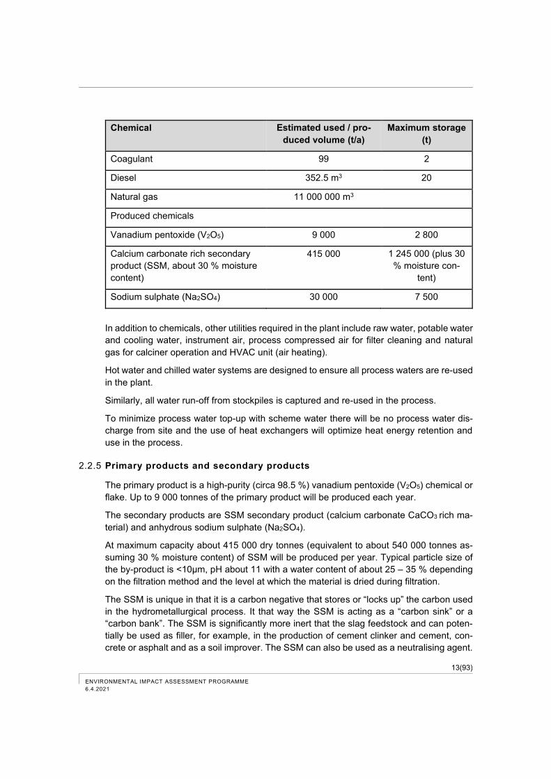
13(93)
ENVIRONMENTAL IMPACT ASSESSMENT PROGRAMME
6.4.2021
Chemical Estimated used / pro-
duced volume (t/a)
Maximum storage
(t)
Coagulant 99 2
Diesel 352.5 m3 20
Natural gas 11 000 000 m3
Produced chemicals
Vanadium pentoxide (V2O5) 9 000 2 800
Calcium carbonate rich secondary
product (SSM, about 30 % moisture
content)
415 000 1 245 000 (plus 30
% moisture con-
tent)
Sodium sulphate (Na2SO4) 30 000 7 500
In addition to chemicals, other utilities required in the plant include raw water, potable water
and cooling water, instrument air, process compressed air for filter cleaning and natural
gas for calciner operation and HVAC unit (air heating).
Hot water and chilled water systems are designed to ensure all process waters are re-used
in the plant.
Similarly, all water run-off from stockpiles is captured and re-used in the process.
To minimize process water top-up with scheme water there will be no process water dis-
charge from site and the use of heat exchangers will optimize heat energy retention and
use in the process.
2.2.5 Primary products and secondary products
The primary product is a high-purity (circa 98.5 %) vanadium pentoxide (V2O5) chemical or
flake. Up to 9 000 tonnes of the primary product will be produced each year.
The secondary products are SSM secondary product (calcium carbonate CaCO3 rich ma-
terial) and anhydrous sodium sulphate (Na2SO4).
At maximum capacity about 415 000 dry tonnes (equivalent to about 540 000 tonnes as-
suming 30 % moisture content) of SSM will be produced per year. Typical particle size of
the by-product is <10μm, pH about 11 with a water content of about 25 – 35 % depending
on the filtration method and the level at which the material is dried during filtration.
The SSM is unique in that it is a carbon negative that stores or “locks up” the carbon used
in the hydrometallurgical process. It that way the SSM is acting as a “carbon sink” or a
“carbon bank”. The SSM is significantly more inert that the slag feedstock and can poten-
tially be used as filler, for example, in the production of cement clinker and cement, con-
crete or asphalt and as a soil improver. The SSM can also be used as a neutralising agent.
14(93) ENVIRONMENTAL IMPACT ASSESSMENT PROGRAMME
6.4.2021
The metal content of the SSM is like the slag feedstock, but diluted by the increase in
volume and the removal of most of the vanadium. Solubility tests for SSM are performed
in the EIA report phase.
SSM characterization and market research into the many potential uses of the SSM is on-
going. Cooperation has been prepared in the project with several universities and research
institutes e.g. the Technical Research Centre of Finland (VTT Oy), the University of Oulu
as well as the Universities of Luleå and Umeå, which have know-how for recycling industrial
materials and construction materials for developing industrial recovery targets. Cooperation
and testing have also been performed in the project with companies that are interested in
the use of the SSM secondary product.
The market for the SSM is being developed. It is a new product and is gaining market
acceptance via the provision of data, samples and customer test work. This process takes
time, but we are confident the SSM will be highly sought after. We have therefore requested
3 years of intermediate storage to provide the time to develop the market and move the
SSM to customers. As the market develops the quantities of SSM stored on site will de-
crease.
At maximum capacity about 30 000 tonnes of anhydrous sodium sulphate (Na2SO4) will be
produced each year. Options exist to produce the anhydrous sodium sulphate or the dec-
ahydrate sodium sulphate (Glaubers salt). Sodium sulphate can be used in the paper man-
ufacturing process, in glass production and as a filler in detergent powders.
Product and secondary product storage and handling
Vanadium pentoxide may be produced as either a chemical or flake and stored in bulk bags
and or sealed 44-gallon (200kg) drums in a packaging shed before transportation. The form
and packaging of the primary product will depend on the customers’ requirements. The
maximum storage of the primary product will be approximately 4 500 tonnes (Table 2-3).
Secondary product SSM will be transported by conveyor and / or trucks to a storage area.
The maximum storage of the SSM will be about 1 245 000 dry tonnes (plus about 30 %
moisture content), which covers three (3) years of intermediate storage. The maximum
height of stockpiles is 15 metres.
Sodium sulphate (Na2SO4) will be stored in bags in a lockable shed. The maximum storage
is three (3) months capacity, 7 500 tonnes.
2.2.6 Water supply
Raw water will be sourced from the public water utility provider and stored in raw water
storage tanks. The amount of raw water used in the process each year is estimated to be
about 180 000 tonnes.
Potable water will be sourced from the public water utility provider. The amount of potable
expected to be used each year is about 4 500 tonnes. This includes, for example, water for
safety showers, laboratory use, drinking water and ablutions.
15(93)
ENVIRONMENTAL IMPACT ASSESSMENT PROGRAMME
6.4.2021
2.2.7 Emissions to the environment and wastes
Dust and gas emissions
Dust from the stockpiles (slag and SSM) will likely be suppressed via a water reticulation
system. The moisture content of SSM is about 30 % so dust emissions are not very high,
but the surface of stockpiles can dry up especially in summertime when water reticulation
can be necessary. The product bagging facility will be equipped with baghouses for dust
collection. Milling will be done wet or within an enclosed system to contain all potential dust
from the operation.
Separate gas scrubber systems are allowed for the alkaline leach circuit to capture any
unused CO2 and return it to the process, and the calcine circuit to capture NH3 emissions
and return them as ammonium sulphate to the AMV circuit, respectively. Emissions to air
from the plant will be minor. The estimated sulphur dioxide emissions are less than 1 tonne
/year and the estimated nitrogen oxide emissions are about 10 tonnes/year.
Transport and handling of the slag, primary product and secondary products with, among
other things, crushers and conveyor belts can cause dusting and emissions to air. The
project will reduce dusting by using covered trucks and covering conveyor belts and crush-
ers, where possible.
The Best Available Technologies (BAT) are used in the VRP to manage dust emissions
from storing, handling and transporting materials.
Process water discharge
The only water leaving the process will be sequestered into the SSM (assumed moisture
content about 30 %). Excess process water will be evaporated, and condensate is used in
the process. All heating and cooling water is added to process water tanks for reuse in the
process.
Rain and snow melt from the stockpiles and paved areas will be captured in wells and
collecting basins and will be re-used in the process to reduce the demand for raw water.
Stormwater basins will have sufficient capacity to manage stormwaters based on regional
statistics on precipitation and snow fall. The small amount of suspended matter in storm-
waters released from slag and SSM stockpiles will be removed from collecting basins by
excavators and transferred to the process.
Preparations will be made for heavy rain by inclinations to direct water flows to the largest
collecting basins. As a result of only rarely occurring heavy rainfall, stormwaters can flow
to the sea.
Firefighting waste water will be collected into basins and delivered to treatment plants which
have a permit for equivalent waste water treatment.
Wastes
No waste is produced in the process in alternative 1 and 1a. Only conventional municipal
waste is formed in the plant, such as organic waste, energy waste, paper and cardboard
waste.
16(93) ENVIRONMENTAL IMPACT ASSESSMENT PROGRAMME
6.4.2021
Calcium carbonate rich material (SSM) produced in the plant in alternative 1b has not yet
received the status of secondary product, in which case it is transported to be stored in an
existing area authorised for an equivalent type of activity. For quality, SSM material
matches inert, non-hazardous waste. Information on potential stockpile locations of SSM
material will be provided in the EIA report.
Noise and vibration
Grinding and crushing plant can generate noise and vibration. Permissible noise levels are
considered in the design. Normal traffic noise is caused by sea transports, truck transports,
conveyors, and bucket loaders.
2.2.8 Traffic
The slag will be transported to the VRP by ships from Luleå and Oxelösund in Sweden and
from Raahe in Finland (Figure 2-6). Slag may also be transported by rail from Raahe.
The VRP site has good transport connections. Public roads lead to the industrial area and
electrified railway and port are located in the immediate vicinity.
Figure 2-6. Quantities of slag feedstock to be transported to the VRP area in Tahkoluoto.
Carbon dioxide (CO2) will be transported to the plant either through constructed pipeline or
by trucks from the port, where the provider of carbon dioxide will apply for a permit and
construct a storage. If all the carbon dioxide is transported by road, 14 trucks from the port
will be required each day. As a rule, other chemicals needed in the process will be trans-
ported by trucks and about 10 trucks are likely to be needed per day. Most likely the major
part of the chemicals will be transported to the plant from the storages of the Tahkoluoto
chemical port.
Bucket loaders, trucks and conveyor belts are used for intra-site traffic, for example be-
tween plant and port and storage areas.
17(93)
ENVIRONMENTAL IMPACT ASSESSMENT PROGRAMME
6.4.2021
The initial estimate is that a total of four shiploads of slag in 2023 and eight shiploads in
2024 will be transported only from Luleå (Table 2-4). After that, a maximum total of 25
vessels with the size of 15 000 or 25 000 tonnes will depart from Luleå, Oxelösund and
Raahe each year. In addition, smaller freighters can be used for transporting about five
shiploads of products each year.
Table 2-4. Preliminary estimates of vessel traffic. The moisture content of materials is considered in
transport volumes.
Number of vessels per year, transport of LD slag 25 000-tonne vessels from Luleå, 15 000-tonne vessels from Oxelösund and Raahe
2023 2024 2025 2026 2027 2028 2029 2030 2031 2032 2033 2034 Total
Luleå 4 8 13 13 8 8 8 8 8 8 8 8 102
Oxelösund 3 6 7 7 7 7 7 7 2 53
Raahe 3 6 7 7 7 7 7 7 51
Total 4 8 19 25 22 22 22 22 22 22 10 8 206
Final products are transported to the customers either by trucks, trains or ship or by a
combination of these. More detailed information on transport volumes are presented in the
EIA report.
2.2.9 Connections
Electricity needed at the plant will be obtained from local power grid.
The VRP will be connected to the local water and sewer network. Raw water (process
water) will be supplied from local supplier and stored in tanks located in the industrial area
and directly fed into the process. Potable water will be supplied from the water supply sys-
tem of the City of Pori.
In addition, services in the industrial area such as fire brigade and security may be associ-
ated.
2.2.10 Energy Use
Electricity consumption of the plant is estimated to be approximately 90.4 GWh per year.
Most of the electricity is utilised in the production process.
A total of about 168 000 GJ of natural gas is used for steam production, which is needed
in the process. Alternatively, the steam needed in the process and heat needed for heating
buildings can possibly be acquired from Pori. In addition, kilns are heated with natural gas
and diesel fuel is used in machinery.
18(93) ENVIRONMENTAL IMPACT ASSESSMENT PROGRAMME
6.4.2021
3 Alternative 0
If the VRP is not implemented, the slag stockpiles in Luleå, Oxelösund and Raahe will
continue to grow and up to 80 000–100 000 tonnes of carbon dioxide (CO2) per year, which
will potentially be used in the recovery plant, will continue to emit to the atmosphere.
New mines will be required to produce vanadium for the European needs. The CO2 emis-
sions from ore processing in mines through traditional mining and processing techniques
are significant. The production of vanadium in a vanadium recovery plant has a reduced
impact on carbon dioxide emissions, as a significant amount of carbon dioxide produced
and captured in other industrial facilities is used in the process.
Other vanadium recovery processes, for example, the energy consumption and emissions
of pyrometallurgical processes are significantly higher than the designed hydrometallurgi-
cal process in the plant.
If the VRP is not implemented, traffic volumes will not increase in the area, and there will
be no environmental impacts caused by the VRP.
It is possible that some other industrial activity will be planned for the particular area with
its own specific environmental impacts depending on the industry.
19(93)
ENVIRONMENTAL IMPACT ASSESSMENT PROGRAMME
6.4.2021
4 EIA procedure
Initially, the Environmental Impact Assessment (EIA) Directive (85/337/EEC) adopted by
the Council of the European Communities (EC) was implemented in Finland in 1994. The
regulations governing the EIA procedure have since been reformed. The current Act on
Environmental Impact Assessment 252/2017 (EIA Act) and Decree 277/2017 pursuant to
it (EIA Decree) came into force in May 2017.
So-called Espoo Convention (Convention on Environmental Impact Assessment in a
Transboundary Context) regulates the transboundary environmental impact assessment.
The nations as parties of the convention have a right to participate in an ongoing EIA pro-
cedure or SIA procedure in another nation, if the environmental impacts of the assessed
project, plan or programme will be extended to the particular nation. With regard to the
vanadium recovery project, this issue has been tentatively discussed with the Ministry of
the Environment, and based on preliminary view it is not assumed that the environmental
impacts of the project would extend outside of Finland.
Parties in the EIA procedure
CMS is the project developer in the EIA procedure. The project developer is an actor, who
is responsible for the preparation and implementation of the planned project. CMS is also
responsible for the implementation of the EIA procedure. The EIA consultant is Sweco In-
dustry Ltd.
The coordinating authority for the EIA procedure is the Centre for Economic Development,
Transport and Environment for Southwest Finland (ELY Centre). The coordinating authority
refers to the authority that ensures that the environmental impact assessment procedure
for a project is managed as required by the EIA Act. The coordinating authority is respon-
sible for publishing the environmental impact assessment programme and report and for
the compiling statements and opinions. The coordinating authority provides an opinion on
the environmental impact assessment programme (EIA programme) taking a position on
the scope and accuracy of the programme. The coordinating authority will review the ade-
quacy and quality of the environmental impact assessment report and then will prepare its
reasoned conclusion on the significant environmental impacts of the project.
4.1 Objectives and content of the EIA Procedure
The goal of the EIA procedure is to promote the environmental impact assessment and
uniform consideration of impacts in planning and decision making.
All interested parties can participate in the EIA procedure. Citizens’ access to information
and participation are the cornerstones of the EIA procedure. The environmental impacts of
20(93) ENVIRONMENTAL IMPACT ASSESSMENT PROGRAMME
6.4.2021
the project must be examined in a legal assessment procedure before taking essential
actions considering environmental impacts.
The authority cannot grant a permit for the implementation of the project or make any other
coordinated decision until it has received the EIA report and the reasoned conclusion pre-
pared by the coordinating authority. Decisions on the project are not made in the EIA pro-
cedure, but it aims to produce information as a basis for decision making.
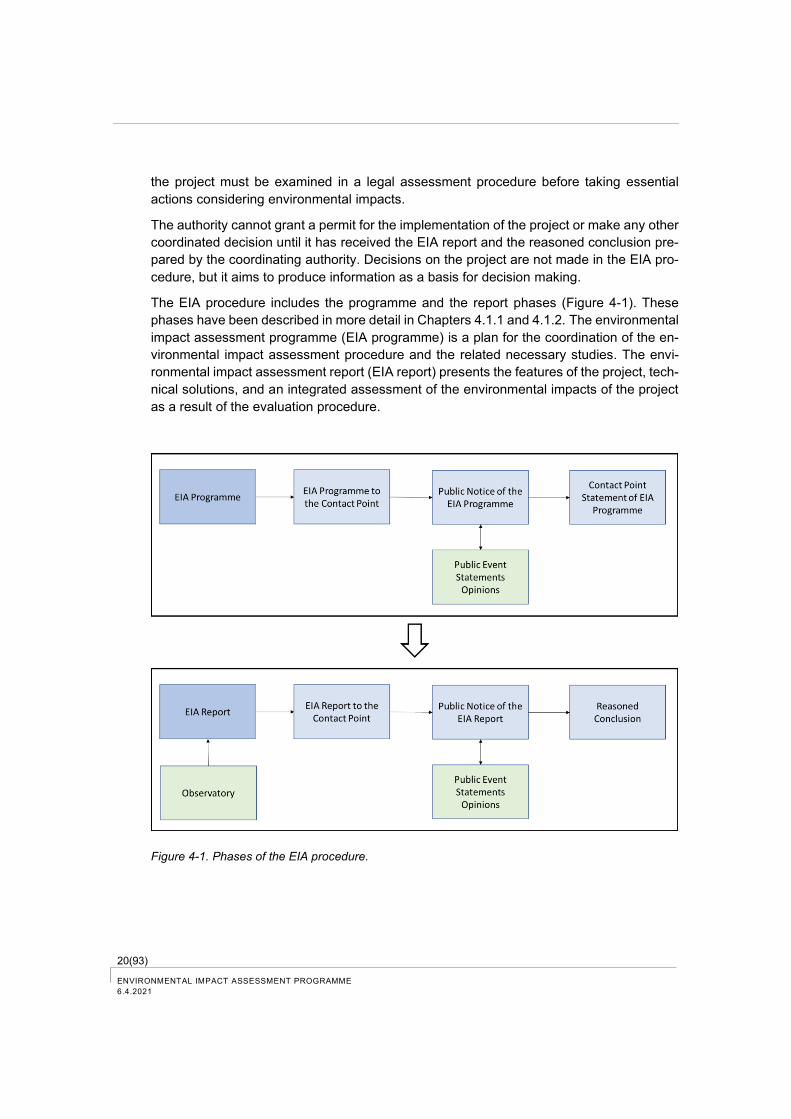
The EIA procedure includes the programme and the report phases (Figure 4-1). These
phases have been described in more detail in Chapters 4.1.1 and 4.1.2. The environmental
impact assessment programme (EIA programme) is a plan for the coordination of the en-
vironmental impact assessment procedure and the related necessary studies. The envi-
ronmental impact assessment report (EIA report) presents the features of the project, tech-
nical solutions, and an integrated assessment of the environmental impacts of the project
as a result of the evaluation procedure.
Figure 4-1. Phases of the EIA procedure.
21(93)
ENVIRONMENTAL IMPACT ASSESSMENT PROGRAMME
6.4.2021
4.1.1 EIA programme
The EIA programme provides a description of the environmental baseline conditions in the
project area as well as a plan, which impacts will be assessed and how the assessments
will be carried out. The programme provides, among other things, basic information on the
project, alternatives to be evaluated, a communication plan during the project and an esti-
mated project timetable.
The assessment programme must contain, on a sufficient scale:
1) information on the project, its purpose, planning stage, location, land use needs
and connections with other projects, and information on the project developer and
an estimate of the planning and implementation schedule of the project;
2) alternatives to carry out the project, which are respectable for the project or its spe-
cial features and one of which is the non-implementation alternative, unless for
specific reasons this alternative is unnecessary;
3) information about the plans and permits required for implementation of the project;
4) description of the current state of environment and its development in the likely im-
pact area,
5) proposal for the identified environmental impacts to be assessed including trans-
boundary environmental impacts and cumulative impacts with other projects to
the necessary extent for preparing the reasoned conclusion, and arguments for
the selection of environmental impacts to be assessed;
6) information on the studies, in which environmental impacts have already been
studied and planned, and information on the methods to be used in the acquisi-
tion and assessment of the material and on the assumptions related to the meth-
ods;
7) information on the qualifications of the persons preparing the assessment pro-
gramme; and
8) plan for arranging the assessment procedure and the related participation and how
they are related to the project planning and estimate of the date when the as-
sessment report will be completed.
The EIA procedure officially starts when the EIA programme is submitted to the coordinat-
ing authority. In this project the coordinating authority is the ELY Centre for Southwest
Finland.
The coordinating authority will announce the assessment programme by posting a public
notice in the notice boards of the municipalities in the likely impact area of the project, in

22(93) ENVIRONMENTAL IMPACT ASSESSMENT PROGRAMME
6.4.2021
electronic format and at least in one common newspaper in general circulation in the impact
area of the project.
The assessment program will be put on public display. Citizens can present their opinions
on the EIA programme to the coordinating authority. The coordinating authority requests
necessary statements on the programme from the authorities. The time period for providing
opinions and statements is a minimum of 30 days starting from the publication date of the
public notice.
The coordinating authority compiles the opinions and statements provided on the EIA pro-
gramme and based on them, provides its own statement to the project developer within
one month after the deadline for providing statements and presenting opinions.
4.1.2 EIA report
The EIA report must contain, on a sufficient scale, the following information, which is nec-
essary for the preparation of the reasoned conclusion, considering the knowledge and as-
sessment methods available at each time:
1) description of the project, its purpose, location, size, land use needs, major char-
acteristics including the acquisition and consumption of energy, materials and nat-
ural resources, likely emissions and residues, such as noise, vibration, light, heat
and radiation, and such emissions and residues, which may cause contamination
of water, air, soil or subsoil, as well as the quantity and quality of the amount of
waste, taking into account the construction and operation phases of the project,
including potential dismantling and exceptional situations;
2) information on the project developer, the planning and implementation schedule of
the project, the plans, permits and coordinated decisions required for implementa-
tion, and the project's affiliation with other projects;
3) report on the relation of the project and its alternatives to land use plans and on
plans and programmes regarding the use of natural resources and environmental
protection, which are relevant to the project;
4) description of the current state of the environment in the impact area and its likely
development, if the project is not implemented;
5) assessment of potential accidents and their consequences considering the sus-
ceptibility of the project to major accident and natural disaster risks, related emer-
gency situations and measures of preparedness for these situations including pre-
vention and mitigation measures;
6) assessment and description of the likely significant environmental impacts of the
project and its reasonable alternatives;
7) where applicable, an assessment and description of transboundary environmental
impacts;
8) comparison of the environmental impacts of the alternatives;
23(93)
ENVIRONMENTAL IMPACT ASSESSMENT PROGRAMME
6.4.2021
9) information on the main reasons leading to the selection of the selected alternative
or alternatives, including environmental impacts;
10) proposal for measures to avoid, prevent, limit, or eliminate significant identified
harmful environmental impacts;
11) where applicable, a proposal for monitoring arrangements related to significant po-
tential harmful environmental impacts;
12) study on the phases of the evaluation procedure including the participation proce-
dures and connection to project planning;
13) list of sources used for compiling descriptions and assessments included in the
report, a description of the methods used for identifying, predicting, and assessing
significant environmental impacts, and information on the identified shortcomings
when compiling the required data, and the main uncertainties;
14) information on the qualifications of the persons preparing the assessment report;
15) explanation of how the coordinating authority's statement on the EIA programme
has been considered; and
16) general and illustrative summary of the information described in items 1 to 15.
The assessment and description of likely significant environmental impacts must include
the direct and indirect, cumulative, short-term, medium-term and long-term permanent and
temporary, positive and negative impacts of the project as well as the cumulative impacts
with other existing and approved projects.
The coordinating authority will announce of the completed EIA report, request the neces-
sary statements and provide an opportunity to present opinions. The EIA report will be put
on public display and the deadline for submitting opinions and statements is at least 30
days from publication date of the public notice.
4.1.3 Reasoned Conclusion
The coordinating authority will review the adequacy and quality of the EIA report and then
will prepare its reasoned conclusion on the significant environmental impacts of the project.
The reasoned conclusion must be submitted to the project developer within two months
after the deadline for submitting statements and presenting opinions. The reasoned con-
clusion must include a summary of other opinions and statements on the EIA report.
The coordinating authority must deliver the reasoned conclusion and other statements and
opinions to the project developer. At the same time, the reasoned conclusion must be de-
livered for information to the authorities involved in the project, the municipalities in the
impact area of the project and, if necessary, to the Regional Councils and other relevant
authorities, and must be published on the website of the coordinating authority.
The permit authorities and the project developer use the EIA report and the statement of
the coordinating authority as basic material for their decision making. It must be described
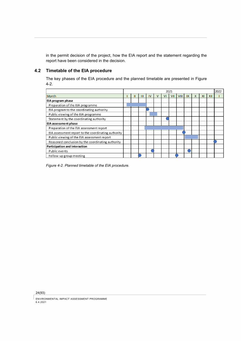
24(93) ENVIRONMENTAL IMPACT ASSESSMENT PROGRAMME
6.4.2021
in the permit decision of the project, how the EIA report and the statement regarding the
report have been considered in the decision.
4.2 Timetable of the EIA procedure
The key phases of the EIA procedure and the planned timetable are presented in Figure
4-2.
Figure 4-2. Planned timetable of the EIA procedure.
25(93)
ENVIRONMENTAL IMPACT ASSESSMENT PROGRAMME
6.4.2021
5 Participation and interaction plan
The EIA procedure is an open process, in which various interest groups and the public can
participate.
Residents of the local area and other interested parties may participate in the project by
submitting official feedback to the Southwest Finland ELY Centre, which acts as the coor-
dinating authority, and also directly to the project developer.
5.1 Public hearings and discussions
Following the announcement of the EIA programme, an open event will be organized for
the public to present the project and the plan for the environmental impact assessment.
The public will have the opportunity to ask questions and express their views on the project
and the implementation of the assessment procedure. The representatives of the project
developer, the coordinating authority and the experts involved in the preparation of the EIA
programme will attend the public event.
After the publication of the EIA report, another open event will be held to present the results
of the environmental impact assessment. The public will have access to additional infor-
mation, and they can provide feedback on the performed assessment work and its ade-
quacy.
The EIA programme and EIA report, public notice and statements of the coordinating au-
thority can be viewed on the coordinating authority's website www.ymparisto.fi > Asiointi,
luvat ja ympäristövaikutusten arviointi > YVA-hankkeet
5.2 Follow-up group
A follow-up group will be assembled to monitor the EIA procedure of the vanadium recovery
plant. The aim is to promote the flow and exchange of information with the project devel-
oper, the authorities and other stakeholders. The representatives of the follow-up group will
monitor the progress of the environmental impact assessment and submit their opinions on
the preparation of the EIA programme, the EIA report and the supporting studies.
Invited parties to the follow-up group include the representatives of the City of Pori, the
ELY-Centre and other authorities and local stakeholders. The representatives of the project
developer and the EIA consultant will also participate in the work of the follow-up group.
The follow-up group convenes in the program phase and in the assessment phase. The
following organizations were invited to the follow-up group:
− Southwest Finland ELY Centre
− Regional State Administrative Agency for Southern Finland
− City of Pori (environmental services, land use planning)
− Finnish Safety and Chemical Agency (TUKES)
− Satakunta Rescue Department
26(93) ENVIRONMENTAL IMPACT ASSESSMENT PROGRAMME
6.4.2021
− Finnish Transport and Communications Agency (Traficom)
− Satakunta Regional Council
− Finnish Association for Nature Conservation/Satakunta District
− Pori Ornithological Association
− Reposaari Association ry
− Reposaari School Parents’ Association
− Port of Pori Oy
− Fortum Power and Heat Oy
− Oy M. Rauanheimo Ab
− Metsähallitus
− Finnish Heritage Agency
− Bothnian Sea Professional Fishermen ry
− Puhtaan meren puolesta ry
The first meeting of the follow-up group was organized on March 9, 2021.
5.3 Public display of the EIA programme and the EIA report
After the EIA programme is completed, the Southwest Finland ELY Centre will make an
announcement by posting a public notice. The public notice describes, where the EIA pro-
gramme is displayed and how opinions and statements should be submitted. The deadline
for submitting opinions and statements will begin from the publication date of the public
notice and the duration of this period is at least 30 days according to the EIA Act.
In the later phase of the EIA procedure, the EIA report will also be on public display and
statements and opinions can be provided in a similar way.
5.4 Resident survey
A resident survey will be performed during the EIA procedure, which aims at promoting
participation and interaction. The survey will provide information to the project developer
regarding the attitude and opinions of residents on the project and at the same time it will
provide information to the residents about the project and related impacts on their living
environment. The survey will provide information for the social impact assessment of the
project.
5.5 Other communication
The project and its environmental impact assessment are also notified in the context of
general information, such as press releases, newspaper articles and through the own web-
site of the project developer (www.criticalmetals.eu).
27(93)
ENVIRONMENTAL IMPACT ASSESSMENT PROGRAMME
6.4.2021
6 Permits, plans and decisions required by the project
6.1 Environmental impact assessment
In accordance with the EIA Act (252/2017), the construction of the vanadium recovery plant
requires an environmental impact assessment procedure.
The project requires the application of an assessment procedure in accordance with Sec-
tion 4b of the project list in Annex 1 to the EIA Act, which states that the assessment pro-
cedure is applied to installations, where other than ferrous metals are produced from ores,
concentrates and other secondary raw materials by using metallurgical, chemical or elec-
trolytic methods. If the slag from the steel plant is determined as waste, the project would
require the application of the EIA procedure in accordance with Section 11b of the project
list in Annex 1 to the EIA Act, which concerns other than physical-chemical treatment plants
of hazardous waste.
Among others, granting of the environmental permit requires a completed EIA procedure.
The project developer has initiated the EIA procedure by preparing this EIA programme.
The EIA report and the reasoned conclusion from the coordinating authority are the pre-
requisites for granting the required permits for the project (among others, the environmental
permit and the chemical permit).
6.2 Environmental permit
The VRP is a time-critical project and the aim is to coordinate the public hearing of the EIA
report and the environmental permit application. No construction in the water system is
included in the project and so there is no need for a permit according to the Water Act.
The operations requiring a permit are based on the Environmental Protection Act (YSL
527/2014), and pursuant to it, on the Environmental Protection Decree (YSA 713/2014).
The environmental permit covers all issues related to environmental impacts, such as emis-
sions to air and water, waste issues, noise issues and other issues related to environmental
impacts.
According to the Environmental Protection Act (527/2014), permit provisions must be
based on the BAT-level (Best Available Technology) in accordance with the EU Industrial
Emissions Directive, and emission threshold values, monitoring and other permit provisions
must be based on so-called BAT-conclusions. Depending on the status of slag, BAT-
conclusions regarding “metal industry using other than ferrous metals” or BAT-conclusions
regarding waste treatment will be applied to the operation of the plant.
The environmental permit authority for the project is the Regional State Administrative
Agency of Southern Finland. The permit authority will grant the environmental permit, if the
operation meets the requirements set by the Environmental Protection Act and other legis-
lation. A reasoned conclusion on the environmental impact assessment procedure must be
provided by the coordinating authority before the permit can be granted.
28(93) ENVIRONMENTAL IMPACT ASSESSMENT PROGRAMME
6.4.2021
6.3 Building permit
According to the Land Use and Building Act, a building permit is applied from the city build-
ing permit authority, which when granting the permit, verifies that the plan complies with
the ratified city plan and building regulations. The building permit is required prior to starting
the construction.
6.4 Chemical permit
The VRP includes extensive chemical processing and the plant requires a permit according
to the Act on Chemical Safety (390/2005). The permit is applied from the Finnish Safety
and Chemical Agency (TUKES) and it contains the requirements of the Seveso Directive.
The permit must be applied well before detailed implementation solutions prior to starting
the construction work of the production plant.
Among others, the following laws and regulations related to chemicals concern the project:
− Decree on the control of handling and storage of hazardous chemicals 685/2015;
− Act on safety in handling hazardous chemicals and explosives 390/2005;
− Decree on the industrial treatment and storage of hazardous chemicals 856/2012;
− Chemicals Act 599/2013;
− REACH Regulation EC 1907/2006;
− CLP Regulation EC 1272/2008; and
− Act on the Transport of Dangerous Goods 719/1994.
TUKES will inspect the production plant prior to commissioning.
TUKES shall also be notified of used products and chemicals in accordance with the
REACH Regulation (2006/1907/EC).
6.5 Other permits and obligations
Obligations to operations according to the REACH Regulation (EC/1907/2006) will be ful-
filled based on the REACH action plan, which will be prepared later. The necessary REACH
registrations will be prepared for manufactured products and the other obligations of the
REACH Regulation will be complied with.
The secondary product (SSM=stabilized slag material), which is produced along with va-
nadium pentoxide products, is intended to be registered as a by-product according to the
REACH Regulation.
Slag raw material, which is transported from the SSAB plant in Raahe, is intended to be
registered and defined as a by-product to be used for vanadium recovery in the environ-
ment permits of the plants. The required permit process will be clarified with regard to the
slag stockpile in the SSAB Swedish plants.
29(93)
ENVIRONMENTAL IMPACT ASSESSMENT PROGRAMME
6.4.2021
According to preliminary view, an amendment is not needed for the existing detailed plan
for implementing the project pursuant to the Land Use and Building Act.
Other permits and procedures related to environmental issues are mainly technical, such
as, for example, the inspections of pressure vessels.
30(93) ENVIRONMENTAL IMPACT ASSESSMENT PROGRAMME
6.4.2021
7 Environmental Baseline Description
7.1 Land use and built environment
7.1.1 Activities in the area
The VRP area is planned to be located on the southern side of the Tahkoluoto Port as well
as in the eastern/north-eastern part of Tahkoluoto (Figure 2-1, Chapter 2.1).
The Tahkoluoto Port consists of two operational parts, Tahkoluoto deep-water port and oil
and chemical port, which includes the LNG terminal (Gasum Ltd) and storage area for li-
quefied natural gas (Skangas Ltd). The annual freight traffic volume to the oil and chemical
port is about 800 000 tonnes (City of Pori 2020, City of Pori 2018).
Plenty of industrial activity is located in the Tahkoluoto port area (Figure 7-1). The Meri-
Pori power plant owned by Fortum Power and Heat Oy, which currently operates as a
power reserve plant, and reserve power station owned by Fingrid Ltd are located on the
eastern side to the VRP area. In addition, other companies that operate in the Tahkoluoto
Port area include Teboil Oy (oil tanks), Boliden Harjavalta Oy (sulphur acid tanks), LSPÖ
Ltd (storage and handling of bitumen and other bulk products), Kemira Chemicals Oy (so-
dium hydroxide tank and NEOT Oy (liquid fuels). The Tahkoluoto offshore wind farm owned
by Suomen Hyötytuuli Ltd is located on the western side of the deep-water port.
Bulk-terminal operations by Oy Rauanheimo Ab and stowage, storage and shipping oper-
ations of Hacklin Port Service Ltd are located in the port area. The processing and storage
area for recycled metal of Stena Recycling is located on the northern side of the coal stor-
age areas of the deep-water port. Ahtauskone Oy handles peat and recycled metals of
Stena.
PVO Lämpövoima Oy (office and storage spaces), Finland Tank Storage Oy, FTS (under-
ground storage for oil products), Nordic Bulk Oy (ammonium sulphate storage) and
Gaudium Oy (storage tanks for hazardous and inflammable liquids) also operate in the port
area.
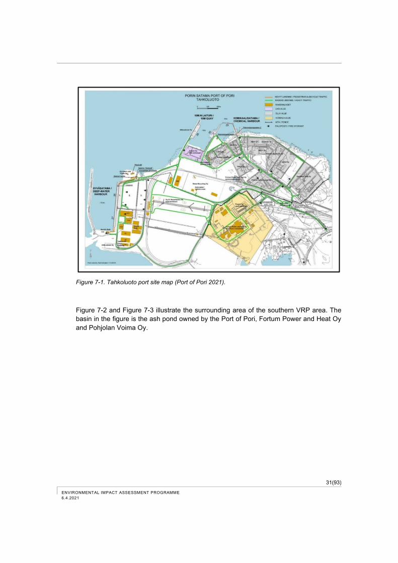
31(93)
ENVIRONMENTAL IMPACT ASSESSMENT PROGRAMME
6.4.2021
Figure 7-1. Tahkoluoto port site map (Port of Pori 2021).
Figure 7-2 and Figure 7-3 illustrate the surrounding area of the southern VRP area. The
basin in the figure is the ash pond owned by the Port of Pori, Fortum Power and Heat Oy
and Pohjolan Voima Oy.
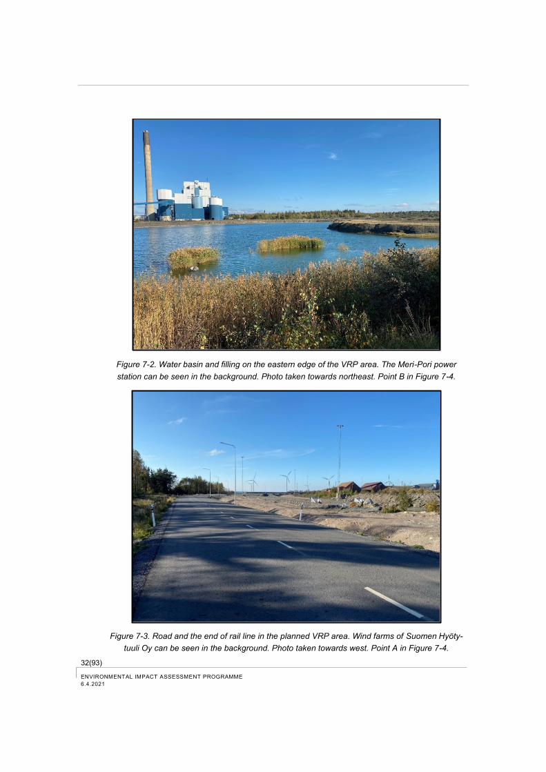
32(93) ENVIRONMENTAL IMPACT ASSESSMENT PROGRAMME
6.4.2021
Figure 7-2. Water basin and filling on the eastern edge of the VRP area. The Meri-Pori power
station can be seen in the background. Photo taken towards northeast. Point B in Figure 7-4.
Figure 7-3. Road and the end of rail line in the planned VRP area. Wind farms of Suomen Hyöty-
tuuli Oy can be seen in the background. Photo taken towards west. Point A in Figure 7-4.
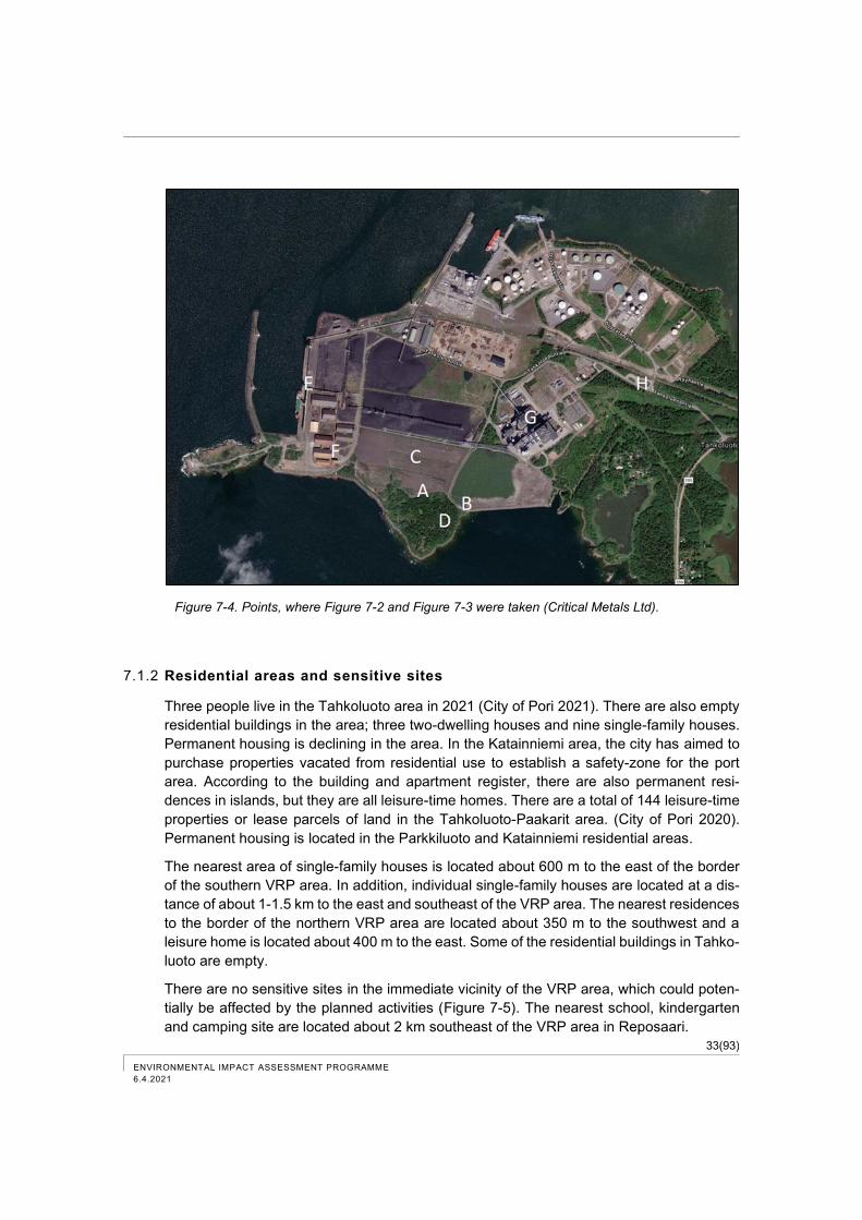
33(93)
ENVIRONMENTAL IMPACT ASSESSMENT PROGRAMME
6.4.2021
Figure 7-4. Points, where Figure 7-2 and Figure 7-3 were taken (Critical Metals Ltd).
7.1.2 Residential areas and sensitive sites
Three people live in the Tahkoluoto area in 2021 (City of Pori 2021). There are also empty
residential buildings in the area; three two-dwelling houses and nine single-family houses.
Permanent housing is declining in the area. In the Katainniemi area, the city has aimed to
purchase properties vacated from residential use to establish a safety-zone for the port
area. According to the building and apartment register, there are also permanent resi-
dences in islands, but they are all leisure-time homes. There are a total of 144 leisure-time
properties or lease parcels of land in the Tahkoluoto-Paakarit area. (City of Pori 2020).
Permanent housing is located in the Parkkiluoto and Katainniemi residential areas.
The nearest area of single-family houses is located about 600 m to the east of the border
of the southern VRP area. In addition, individual single-family houses are located at a dis-
tance of about 1-1.5 km to the east and southeast of the VRP area. The nearest residences
to the border of the northern VRP area are located about 350 m to the southwest and a
leisure home is located about 400 m to the east. Some of the residential buildings in Tahko-
luoto are empty.
There are no sensitive sites in the immediate vicinity of the VRP area, which could poten-
tially be affected by the planned activities (Figure 7-5). The nearest school, kindergarten
and camping site are located about 2 km southeast of the VRP area in Reposaari.
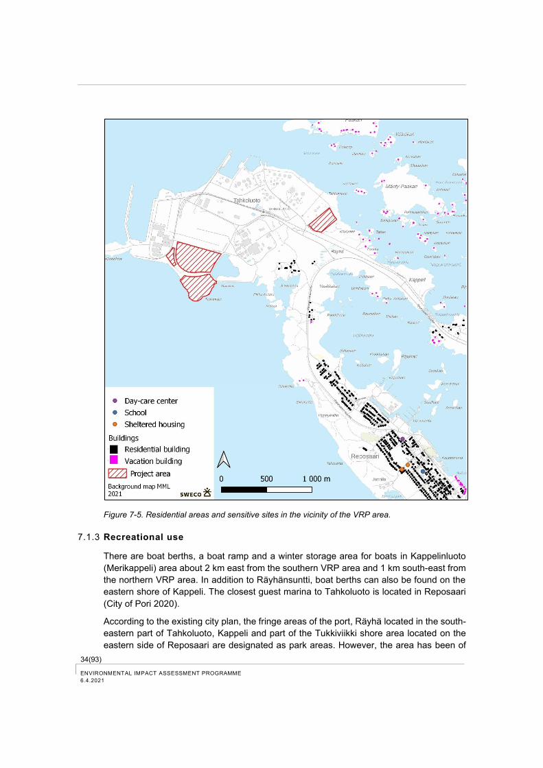
34(93) ENVIRONMENTAL IMPACT ASSESSMENT PROGRAMME
6.4.2021
Figure 7-5. Residential areas and sensitive sites in the vicinity of the VRP area.
7.1.3 Recreational use
There are boat berths, a boat ramp and a winter storage area for boats in Kappelinluoto
(Merikappeli) area about 2 km east from the southern VRP area and 1 km south-east from
the northern VRP area. In addition to Räyhänsuntti, boat berths can also be found on the
eastern shore of Kappeli. The closest guest marina to Tahkoluoto is located in Reposaari
(City of Pori 2020).
According to the existing city plan, the fringe areas of the port, Räyhä located in the south-
eastern part of Tahkoluoto, Kappeli and part of the Tukkiviikki shore area located on the
eastern side of Reposaari are designated as park areas. However, the area has been of
35(93)
ENVIRONMENTAL IMPACT ASSESSMENT PROGRAMME
6.4.2021
less recreational use due to the expanding port and associated industrial activities. There
are some trails created by outdoor use in the coastal zone between Ketaranlahti located in
the northeastern part of Tahkoluoto and Siikaranta in Reposaari. The Siikaranta
campground can increase the pressure for recreational use in the area. The site of a relic
in Kappeli has previously been, among other things, a site for open air worships and ex-
cursions (City of Pori 2020).
Recreational fishing is practiced in the marine areas outside of Pori.
7.1.4 Land use planning
According to the Land Use and Building Act, the land use planning system is based on a
statutory plan system, which proceeds from general plans to more detailed plans (so-called
hierarchical plan system). The principle is that more extensive and general land use plans
or other plans guide more detailed land use planning and different plans cannot be in con-
flict with each other. The national land use objectives and regional plans are implemented
at more general level. Master plans and city plans are more detailed, while city plans are
the most accurate and binding forms of land use planning.
Regional plan
The Satakunta Regional Plan, which was adopted on December 17, 2009 and ratified by
the Ministry of the Environment on November 30, 2011, is valid in Pori (Figure 7-6). In the
regional plan, Tahkoluoto is designated as a port area (LS), an area of industrial and ware-
housing activities (T), most of which is reserved for the manufacture, storage, and transport
of hazardous chemicals (T-1), and an area for energy supply (EN). A regional road (thick
black line) leads to the area, and there is an electrified interconnecting/branch rail line
(black cross line) and fairways (black dotted line, open dotted line), a power line (thin black
line) or a recommended, indicative power line route (400 kV + 110 kV and a reserve for
400 kV) and a natural gas network connection from land and sea (purple dashed line). The
entire system is included in the development area of port operations (ls, red/black line with
brackets inwards) and additionally in the nationally significant development zone of multi-
centric regional structure (kk1, bright red line with brackets inwards)) of the Kokemäenjoki
River valley. The SV 1 plan symbol designates the safety zone (so-called consulting zone,
black dashed dotted line) of the hazardous chemicals in the Tahkoluoto Port. According to
the plan provision, the potential risks to nearby environment and activities caused by facil-
ities in the area or manufacture, storage and transport of hazardous chemicals must be
considered in the planning of the area. When planning to locate risky operations in the
safety zone, the fire and rescue authority and the Finnish Safety and Chemicals Agency
(TUKES), if needed, must be reserved an opportunity to provide a statement.

36(93) ENVIRONMENTAL IMPACT ASSESSMENT PROGRAMME
6.4.2021
Figure 7-6. An extract from the Satakunta regional plan, 2009. Regional road (thick black line), railway
(black cross line), fairway (black dotted line, open dotted line), power line (thin black line), indicative
power line route (thin red line), natural gas network connection from land and sea (purple dashed
line), development area of port operations (red/black line with brackets inwards), nationally significant
development zone of multi-centric regional structure of the Kokemäenjoki River valley (bright red line
with brackets inwards), safety zone of hazardous chemicals (consulting zone, black dashed dotted
line).
In the Satakunta Regional plan, the southern side of the road in the southern VRP area
and small western part are designated for port operations (LS), southern part of the VRP
area in Törnikari is located in white area (no area reservation). The plan symbol LS-m
indicates the warehouse and terminal areas immediately associated with the port and port
operations. The area has a building restriction under Section 33 of the Land Use and Build-
ing Act. When preparing plans for the area, the Transport Infrastructure Agency, the Port
Authority and the Finnish Heritage Agency must be reserved an opportunity to provide a
statement. The port area is surrounded by an area with the plan symbol sv-1 designated
as the safety zone for a facility manufacturing or storing hazardous chemicals (consulting
zone).
The southern VRP area is also partly located in energy supply and industrial expansion
area (EN). The plan symbol designates energy supply areas. The area has a building re-
striction under Section 33 of the Land Use and Building Act, according to which a building
permit may not be granted, if it hinders the implementation of the regional plan.
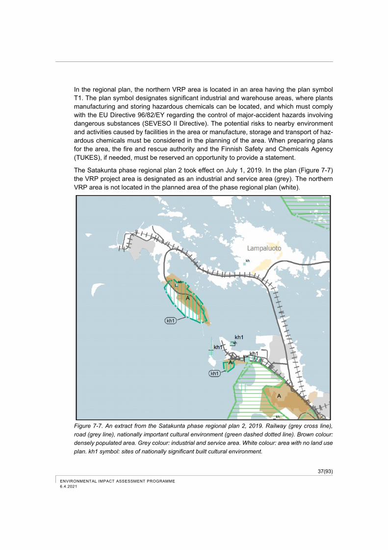
37(93)
ENVIRONMENTAL IMPACT ASSESSMENT PROGRAMME
6.4.2021
In the regional plan, the northern VRP area is located in an area having the plan symbol
T1. The plan symbol designates significant industrial and warehouse areas, where plants
manufacturing and storing hazardous chemicals can be located, and which must comply
with the EU Directive 96/82/EY regarding the control of major-accident hazards involving
dangerous substances (SEVESO II Directive). The potential risks to nearby environment
and activities caused by facilities in the area or manufacture, storage and transport of haz-
ardous chemicals must be considered in the planning of the area. When preparing plans
for the area, the fire and rescue authority and the Finnish Safety and Chemicals Agency
(TUKES), if needed, must be reserved an opportunity to provide a statement.
The Satakunta phase regional plan 2 took effect on July 1, 2019. In the plan (Figure 7-7)
the VRP project area is designated as an industrial and service area (grey). The northern
VRP area is not located in the planned area of the phase regional plan (white).
Figure 7-7. An extract from the Satakunta phase regional plan 2, 2019. Railway (grey cross line),
road (grey line), nationally important cultural environment (green dashed dotted line). Brown colour:
densely populated area. Grey colour: industrial and service area. White colour: area with no land use
plan. kh1 symbol: sites of nationally significant built cultural environment.
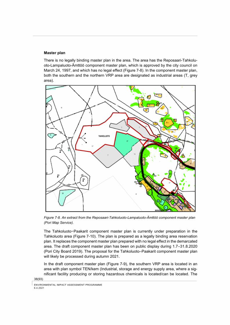
38(93) ENVIRONMENTAL IMPACT ASSESSMENT PROGRAMME
6.4.2021
Master plan
There is no legally binding master plan in the area. The area has the Reposaari-Tahkolu-
oto-Lampaluoto-Ämttöö component master plan, which is approved by the city council on
March 24, 1997, and which has no legal effect (Figure 7-8). In the component master plan,
both the southern and the northern VRP area are designated as industrial areas (T, grey
area).
Figure 7-8. An extract from the Reposaari-Tahkoluoto-Lampaluoto-Ämttöö component master plan
(Pori Map Service).
The Tahkoluoto−Paakarit component master plan is currently under preparation in the
Tahkoluoto area (Figure 7-10). The plan is prepared as a legally binding area reservation
plan. It replaces the component master plan prepared with no legal effect in the demarcated
area. The draft component master plan has been on public display during 1.7–31.8.2020
(Pori City Board 2019). The proposal for the Tahkoluoto–Paakarit component master plan
will likely be processed during autumn 2021.
In the draft component master plan (Figure 7-9), the southern VRP area is located in an
area with plan symbol TEN/kem (Industrial, storage and energy supply area, where a sig-
nificant facility producing or storing hazardous chemicals is located/can be located. The
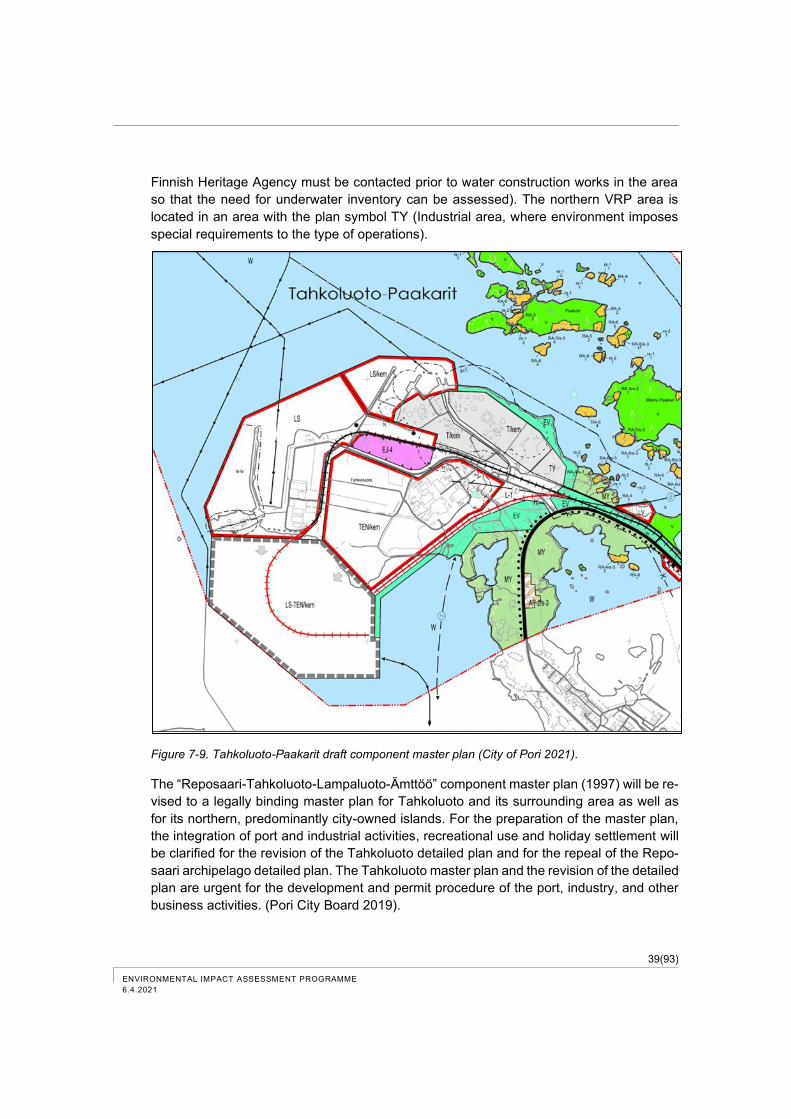
39(93)
ENVIRONMENTAL IMPACT ASSESSMENT PROGRAMME
6.4.2021
Finnish Heritage Agency must be contacted prior to water construction works in the area
so that the need for underwater inventory can be assessed). The northern VRP area is
located in an area with the plan symbol TY (Industrial area, where environment imposes
special requirements to the type of operations).
Figure 7-9. Tahkoluoto-Paakarit draft component master plan (City of Pori 2021).
The “Reposaari-Tahkoluoto-Lampaluoto-Ämttöö” component master plan (1997) will be re-
vised to a legally binding master plan for Tahkoluoto and its surrounding area as well as
for its northern, predominantly city-owned islands. For the preparation of the master plan,
the integration of port and industrial activities, recreational use and holiday settlement will
be clarified for the revision of the Tahkoluoto detailed plan and for the repeal of the Repo-
saari archipelago detailed plan. The Tahkoluoto master plan and the revision of the detailed
plan are urgent for the development and permit procedure of the port, industry, and other
business activities. (Pori City Board 2019).
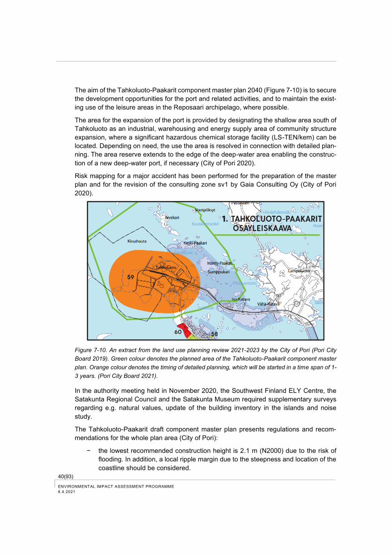
40(93) ENVIRONMENTAL IMPACT ASSESSMENT PROGRAMME
6.4.2021
The aim of the Tahkoluoto-Paakarit component master plan 2040 (Figure 7-10) is to secure
the development opportunities for the port and related activities, and to maintain the exist-
ing use of the leisure areas in the Reposaari archipelago, where possible.
The area for the expansion of the port is provided by designating the shallow area south of
Tahkoluoto as an industrial, warehousing and energy supply area of community structure
expansion, where a significant hazardous chemical storage facility (LS-TEN/kem) can be
located. Depending on need, the use the area is resolved in connection with detailed plan-
ning. The area reserve extends to the edge of the deep-water area enabling the construc-
tion of a new deep-water port, if necessary (City of Pori 2020).
Risk mapping for a major accident has been performed for the preparation of the master
plan and for the revision of the consulting zone sv1 by Gaia Consulting Oy (City of Pori
2020).
Figure 7-10. An extract from the land use planning review 2021-2023 by the City of Pori (Pori City
Board 2019). Green colour denotes the planned area of the Tahkoluoto-Paakarit component master
plan. Orange colour denotes the timing of detailed planning, which will be started in a time span of 1-
3 years. (Pori City Board 2021).
In the authority meeting held in November 2020, the Southwest Finland ELY Centre, the
Satakunta Regional Council and the Satakunta Museum required supplementary surveys
regarding e.g. natural values, update of the building inventory in the islands and noise
study.
The Tahkoluoto-Paakarit draft component master plan presents regulations and recom-
mendations for the whole plan area (City of Pori):
− the lowest recommended construction height is 2.1 m (N2000) due to the risk of
flooding. In addition, a local ripple margin due to the steepness and location of the
coastline should be considered.
41(93)
ENVIRONMENTAL IMPACT ASSESSMENT PROGRAMME
6.4.2021
− forests in the area should be managed considering the landscape values of the
area. The shoreline tree stand should be preserved.
− the compiler of a more detailed plan or the developer of a construction project shall
determine the effects of noise and vibration caused by rail and road traffic prior to
project implementation.
Significant plans and measures in the LS/kem, LS-TEN/kem, T/kem and TEN/kem-areas
involving chemical hazards should be notified to TUKES.
Detailed plan
Tahkoluoto 73. detailed plan is valid in Tahkoluoto area (Figure 7-11, gained legal force on
21.8.1986). Although the plan is relatively old, it is, however, in line with the existing re-
gional plan and the new proposal for master plan and it will provide for the planned opera-
tions.
In the detailed plan, the VRP area is designated by the plan symbol T-9 “Block area of
Industrial and Warehouse Buildings” (grey area in the map). Power plants, buildings and
structures related to power generation, distribution and transfer, as well as buildings serv-
ing the storage of inflammable liquids up to 5 000 m3 can be built in the block area. Activities
in the block area must not generate a noise level greater than 45 LAeq dB (A) for the
residences in the detailed plan. The project area has the plan symbol of t+42 indicating the
maximum permitted approximate height position for open storage allowed in the area. In
addition, the VRP area has plan symbols +50.0 and +130.0 indicating the height position
of the rooftop of the building. However, buildings may be built for up to four hectares in the
construction sector with a maximum height position of the rooftop of +100.0 m. In addition,
60 parking spaces must be assigned to the area.
In the detailed plan, the northern VRP area is designated by the plan symbol TV-1 “Block
area of Warehouse Buildings” (grey area in the map). Buildings serving the storage of in-
flammable liquids and related necessary office, social service and other service buildings
as well as related residences for emergency and service personnel can be built in the block
area. The area has the plan symbol +30.0, which indicates the height position of the rooftop
of the building.
An alteration of the detailed plan M15 in the port area is planned for the Tahkoluoto area
in a time span of 1–3 years (see Figure 7-10). It will consider the changing needs of port
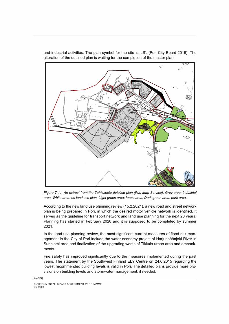
42(93) ENVIRONMENTAL IMPACT ASSESSMENT PROGRAMME
6.4.2021
and industrial activities. The plan symbol for the site is ‘LS’. (Pori City Board 2019). The
alteration of the detailed plan is waiting for the completion of the master plan.
Figure 7-11. An extract from the Tahkoluoto detailed plan (Pori Map Service). Grey area: industrial
area, White area: no land use plan, Light green area: forest area, Dark green area: park area.
According to the new land use planning review (15.2.2021), a new road and street network
plan is being prepared in Pori, in which the desired motor vehicle network is identified. It
serves as the guideline for transport network and land use planning for the next 20 years.
Planning has started in February 2020 and it is supposed to be completed by summer
2021.
In the land use planning review, the most significant current measures of flood risk man-
agement in the City of Pori include the water economy project of Harjunpäänjoki River in
Sunniemi area and finalization of the upgrading works of Tikkula urban area and embank-
ments.
Fire safety has improved significantly due to the measures implemented during the past
years. The statement by the Southwest Finland ELY Centre on 24.6.2015 regarding the
lowest recommended building levels is valid in Pori. The detailed plans provide more pro-
visions on building levels and stormwater management, if needed.
43(93)
ENVIRONMENTAL IMPACT ASSESSMENT PROGRAMME
6.4.2021
A stormwater programme is also being prepared in Pori, which guides stormwater man-
agement. Stormwater management must be addressed and, if needed, a reservation must
be made for stormwater treatment in detailed planning and other projects. In the context of
applying the building permit, a stormwater system implementation plan and stormwater
management plan during construction should be prepared.
7.1.5 Other plans and programmes
There are no other forthcoming land use plans in the VRP area.
7.2 Current status of the water system
The VRP area is bounded by waters, which are located in the marine area outside of Pori,
in the coastal region of the Bothnian Sea and in the Reposaari-Outoori water body area.
The seabed and water layers near the seabed in the Bothnian Sea are clearly in better
condition than the average conditions in the Baltic Sea due to the mixing of water masses
during autumn and winter. Oxygen-rich water is flowing to the seabed also in deep areas
and anoxic conditions do not develop in deep basins (Environmental Management Web
Service 2020).
Eutrophication generates problems also in the Bothnian Sea and the strongest signs of
eutrophication can be seen in front of river estuaries and cities. The nutrients that end up
in the Bothnian Sea mainly originate from diffuse source input of agriculture and forestry,
but also from other sources, such as waste water from communities, scattered settlements
and industry as well as fish farming that pollutes the Bothnian Sea. Significant amount of
nitrogen is also drifted into the Bothnian Sea through air (Environmental Administration
Web service 2020).
7.2.1 Environmental load and water quality
The marine area outside of Pori receives a load from the river basin via Kokemäenjoki
River. So-called point source waste water load is directed into the water system of
Kokemäenjoki River and the Pori marine area from the municipal sewage treatment plants,
industrial sector and thermal power plants located in Pori. In addition to the point source
load, Kokemäenjoki River is loaded by diffuse load. Currently, waste waters from the Kaa-
naa industrial area, e.g. small amount of waste water from the pigment factory, are directed
to the sea area on the southern side of Mäntyluoto outside of Pori at a distance of about 7
km from the VRP area. Waste waters from the ash treatment plant of Fortum Waste Solu-
tions Oy are also directed to the same water outlet. In addition, waste waters from the
designed bioconversion plant in the Kaanaa industrial area are planned to be directed to
the same water outlet.
Comprehensive baseline monitoring information is available from the marine area outside
of Pori. Joint monitoring of the Kokemäenjoki River and the Pori marine area is used to
track the load being directed to the Kokemäenjoki River and the Pori marine area and its
effects on the state of the water system (KVVY Research Oy 2020).

44(93) ENVIRONMENTAL IMPACT ASSESSMENT PROGRAMME
6.4.2021
The river water brought by Kokemäenjoki River, which discharges off to Pihlava Bay, flows
partly to the north through the Ahlainen archipelago and partly to the south under the Re-
posaari road bridge and through Mäntykallio mainly to the northern open sea between Kai-
jakari and Reposaari islands. (Alajoki 2017). In marine areas outside of Pori, river waters
cause turbidity in the surface water and affect the nutrient concentrations. In the surround-
ing waters of the Reposaari Island, eutrophication has occasionally been stronger than in
the rest of the surrounding area, and the area has more clearly belonged to slightly eu-
trophic waters (Väisänen 2018a.)
The water quality in the marine area outside of Pori has improved over the long term. As
early as in the 1970s, the reduction in phosphorus load significantly reduced the eutrophi-
cation. In the mid-1980s, oxygen conditions started to improve both in river and marine
areas. Outside of the old waste water discharge site of the Pori pigment factory, iron con-
centrations were still remarkably high in the 1980s and the pH-value was low. All pigment
plant monitoring stations had an average iron concentration of less than 50 µg/L for the first
time in 2006. Today, concentrations have mainly increased from time to time by river waters
flowing to the southern marine area of Pori (KVY Research Oy 2020).
In accordance with the environmental permit, Port of Pori Ltd monitors stormwater from the
port area to the sea. As a rule, stormwater quality is studied every third year starting from
2018 and more frequently, if necessary. (Regional State Administrative Agency for South-
ern Finland, March 23, 2018, Decision on amending the environmental permit for the
Tahkoluoto port). Stormwater survey results from the deep-water port in 2007 are pre-
sented in Table 7-1.
Table 7-1. Results of the stormwater survey in the Tahkoluoto deep-water port on June 28, 2007
(Decision on the environmental permit for the Tahkoluoto port, Regional State Administrative Agency
for Southern Finland 2018).
Survey-point
Fe mg/l
Nitrogen mg/l
Solid mat-ter mg/l
Conductivity mS/m
pH Ptot µg/l
Mineral oil µg/l
V1 190 6,9 29 139 3,3 21 270
V2 840 5,4 40 293 2,8 25 200
V3 11 000 14 000 550 7 650 3,2 19 640
V4 57 20 85 259 4,4 34 120
V5 5,4 17 150 83 6,9 1 900 770
V6 4,9 27 84 178 6,9 49 390
Flow rate at point V5: 0.2 l/s
Based on the information presented in the application for the environmental permit regard-
ing the Törnikari filling area of the Port of Pori (Monitoring programme, November 22,
2016), the seepage and runoff waters from the Törnikari filling area and the southern
Tahkoluoto filling area are directed into a rainwater drain constructed on the western side
of the Törnikari filling area. From the drain waters are directed to a concrete sedimentation
basin constructed facing the open sea on the south embankment, and from there further
on to the sea. The sedimentation basin (30 m2) is located on the southernmost side of the
rock berm at the end facing Törnikari. Waters from the ash pond of the power plants of
Fortum Power and Heat Oy, Meri-Pori and PVO Lämpövoima Oy are also directed to the
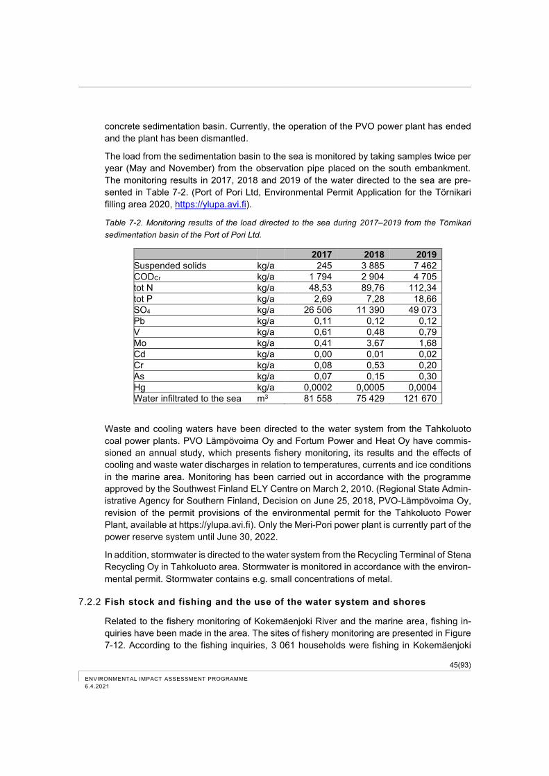
45(93)
ENVIRONMENTAL IMPACT ASSESSMENT PROGRAMME
6.4.2021
concrete sedimentation basin. Currently, the operation of the PVO power plant has ended
and the plant has been dismantled.
The load from the sedimentation basin to the sea is monitored by taking samples twice per
year (May and November) from the observation pipe placed on the south embankment.
The monitoring results in 2017, 2018 and 2019 of the water directed to the sea are pre-
sented in Table 7-2. (Port of Pori Ltd, Environmental Permit Application for the Törnikari
filling area 2020, https://ylupa.avi.fi).
Table 7-2. Monitoring results of the load directed to the sea during 2017–2019 from the Törnikari
sedimentation basin of the Port of Pori Ltd.
2017 2018 2019
Suspended solids kg/a 245 3 885 7 462
CODCr kg/a 1 794 2 904 4 705
tot N kg/a 48,53 89,76 112,34
tot P kg/a 2,69 7,28 18,66
SO4 kg/a 26 506 11 390 49 073
Pb kg/a 0,11 0,12 0,12
V kg/a 0,61 0,48 0,79
Mo kg/a 0,41 3,67 1,68
Cd kg/a 0,00 0,01 0,02
Cr kg/a 0,08 0,53 0,20
As kg/a 0,07 0,15 0,30
Hg kg/a 0,0002 0,0005 0,0004
Water infiltrated to the sea m3 81 558 75 429 121 670
Waste and cooling waters have been directed to the water system from the Tahkoluoto
coal power plants. PVO Lämpövoima Oy and Fortum Power and Heat Oy have commis-
sioned an annual study, which presents fishery monitoring, its results and the effects of
cooling and waste water discharges in relation to temperatures, currents and ice conditions
in the marine area. Monitoring has been carried out in accordance with the programme
approved by the Southwest Finland ELY Centre on March 2, 2010. (Regional State Admin-
istrative Agency for Southern Finland, Decision on June 25, 2018, PVO-Lämpövoima Oy,
revision of the permit provisions of the environmental permit for the Tahkoluoto Power
Plant, available at https://ylupa.avi.fi). Only the Meri-Pori power plant is currently part of the
power reserve system until June 30, 2022.
In addition, stormwater is directed to the water system from the Recycling Terminal of Stena
Recycling Oy in Tahkoluoto area. Stormwater is monitored in accordance with the environ-
mental permit. Stormwater contains e.g. small concentrations of metal.
7.2.2 Fish stock and fishing and the use of the water system and shores
Related to the fishery monitoring of Kokemäenjoki River and the marine area, fishing in-
quiries have been made in the area. The sites of fishery monitoring are presented in Figure
7-12. According to the fishing inquiries, 3 061 households were fishing in Kokemäenjoki
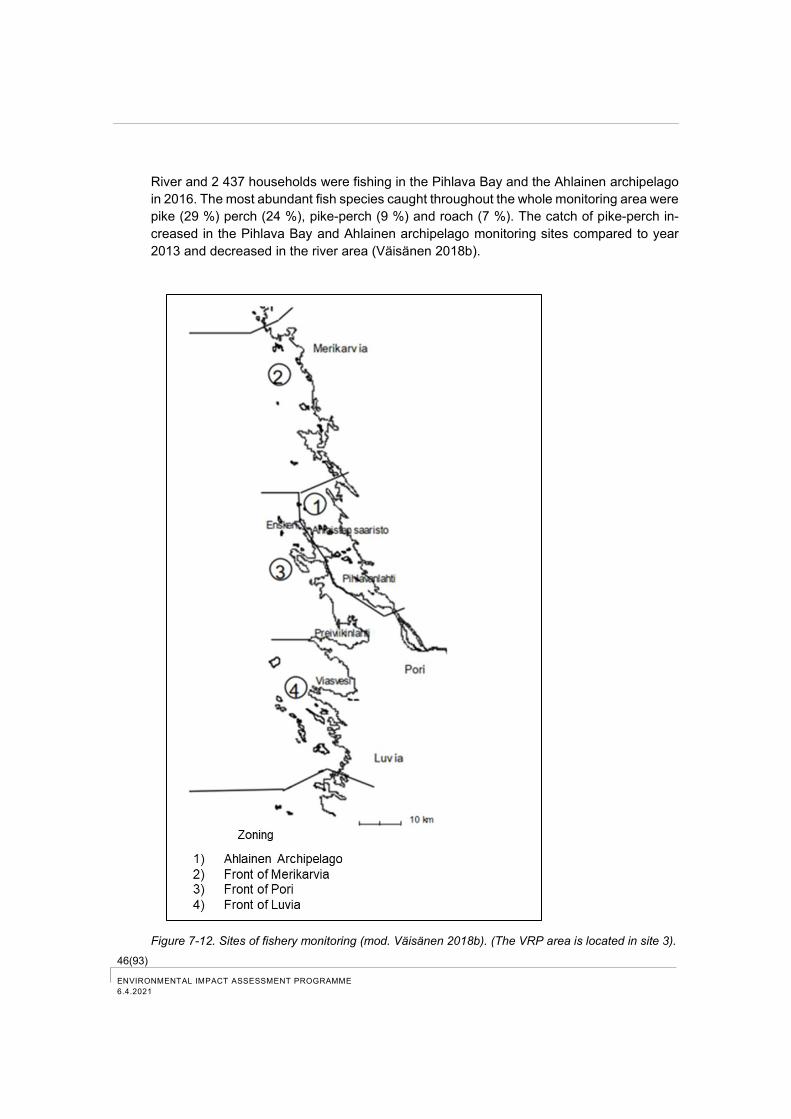
46(93) ENVIRONMENTAL IMPACT ASSESSMENT PROGRAMME
6.4.2021
River and 2 437 households were fishing in the Pihlava Bay and the Ahlainen archipelago
in 2016. The most abundant fish species caught throughout the whole monitoring area were
pike (29 %) perch (24 %), pike-perch (9 %) and roach (7 %). The catch of pike-perch in-
creased in the Pihlava Bay and Ahlainen archipelago monitoring sites compared to year
2013 and decreased in the river area (Väisänen 2018b).
Figure 7-12. Sites of fishery monitoring (mod. Väisänen 2018b). (The VRP area is located in site 3).
47(93)
ENVIRONMENTAL IMPACT ASSESSMENT PROGRAMME
6.4.2021
The most important catch sites of Baltic herring in the surrounding area of Tahkoluoto in-
clude the surroundings of Ketaranlahti and Kaijakari (City of Pori 2020).
Among other things, recreational fishing and fishing for household needs as well as boating
are practised in the marine area outside of Pori. Reposaari has a swimming beach.
Plenty of areas have been reserved for recreational use in the coastal area of Pori. Yyteri
is well known for its sand dune area and extensive sandy beaches.
Merikappeli in Räyhänsuntti has boat berths, a boat ramp and a winter storage area for
boats. In addition to Räyhänsuntti, boat berths are also located on the eastern shore of
Kappeli. The nearest guest marina to Tahkoluoto is in Reposaari (City of Pori 2020).
7.3 Air quality and climate
7.3.1 Air quality
Decrees on air quality
The Government Decree on Air Quality (79/2017) lays down provisions on air quality and
improvement of air quality, which are complementary to the Environmental Protection Act
(527/2014) that are necessary for the implementation of the Directive 2008/50/EC of the
European Parliament and of the European Council.
For the protection of health and prevention of environmental acidification and eutrophica-
tion, threshold values have been defined for the concentrations of sulphur dioxide (SO2),
nitrogen dioxide (NO2), inhaled particles (PM10), fine particles (PM2.5), lead (Pb), carbon
monoxide (CO) and benzene (C6H6) in open air.
Stricter annual threshold values have been defined for sulphur dioxide and nitrogen oxide
for protecting ecosystems and vegetation.
In addition to threshold values, various air quality target and guideline values have been
defined. Annual target values have been set for arsenic, cadmium, nickel and benzo (a)
pyrene.
In addition to threshold values, guideline values have been defined for carbon monoxide,
nitrogen dioxide, sulphur dioxide, total suspended particles (TSP), inhaled particles and
compounds from thermal sulfate reduction (TSR). A target value has been defined for sul-
phur fallout to prevent acidification.
The World Health Organization WHO has made recommendations for the maximum con-
centrations of aromatic hydrocarbons, for example toluene and styrene, as well as for for-
maldehyde in the air.
Air quality in Pori
The environment and permit services in the City of Pori measure air quality in cooperation
with the cities of Harjavalta and Rauma, as well as with major industry and energy produc-
tion facilities in the region. (City of Pori Environmental and Health Surveillance Department
2021). The environmental and health surveillance department of the City of Pori prepares

48(93) ENVIRONMENTAL IMPACT ASSESSMENT PROGRAMME
6.4.2021
an annual report each year on the air quality measurement results of the cities of Pori and
Harjavalta. In addition, since 1990 vegetation impact studies or bioindicator studies and
heavy metal dispersal studies have been carried out in the Harjavalta–Pori area together
with major industry in the region. The next bioindicator study will be conducted in the South
Satakunta and Pori region during the period 2022-2023 (Pori 2021).
A total of five measurement stations are included in the Harjavalta-Pori measurement net-
work. In the centre of Pori, air pollutants are measured at Paanakedonkatu station and
weather conditions are measured at the rooftop weather station of the environmental
agency in Valtakatu. The Pastuskeri station is located in Meri-Pori and sulphur dioxide
background levels as well as weather conditions are measured at this station (City of Pori
Environmental and Health Surveillance Department 2021).
The threshold values pursuant to the Government Decree (79/2017) were not exceeded in
2020 for any measured component in Pori. The air quality guideline values in accordance
with the Government Decision (480/96) were exceeded once, the daily quideline value for
inhaled particles PM10 (70 µg/m3) was exceeded on Paanaketo street in Pori, as the value
was 79 µg/m3 in February.
The Government Decree on Airborne Arsenic, Cadmium, Mercury, Nickel and Polycyclic
Aromatic Hydrocarbons (113/2017) defines target values for arsenic, cadmium and nickel
for the calendar year calculated as annual averages. The target value was slightly ex-
ceeded for arsenic and nickel at the Harjavalta Kaleva measurement station and for arsenic
in Pirkkala, Harjavalta. In Pori the target values were not reached (City of Pori Environmen-
tal and Health Surveillance Department 2021).
Tahkoluoto area
In Tahkoluoto area emissions to the air are caused by road and ship traffic. Dust emissions
are caused by the operation of the Tahkoluoto recycling terminal, e.g. from crushing and
granulation of metal. Dust emissions are managed and monitored in accordance with the
environmental permit. (Regional State Administrative Agency for Southern Finland on Au-
gust 22, 2019, decision on the environmental permit for the operation of the Tahkoluoto
Recycling Plant). Dust emissions have been caused by, among other things, coal storage
and handling. Dust emissions have been managed according to the environmental permit.
7.3.2 Climate
In addition to air quality monitoring, the measurement stations in Pori also monitor sea
water level (Mäntyluoto Kallo), temperature (Kaijakari) and weather conditions (Tahkoluoto
port, railway station and airport).
The Pori region belongs to the South Boreal Climate Class. In Satakunta, the average an-
nual temperature typically varies from about +5 degrees (°C) on the coast between Rauma
and Pori to about +3 degrees (°C) towards the northeast. February is usually the coldest
month, when the average temperature normally varies between about -5 -7.5 degrees (°C)
on the southwestern coast. The warmest month is usually July (average temperature +15.5
to +17 degrees (°C). On average, there are 10-14 very hot days per summer in inland areas
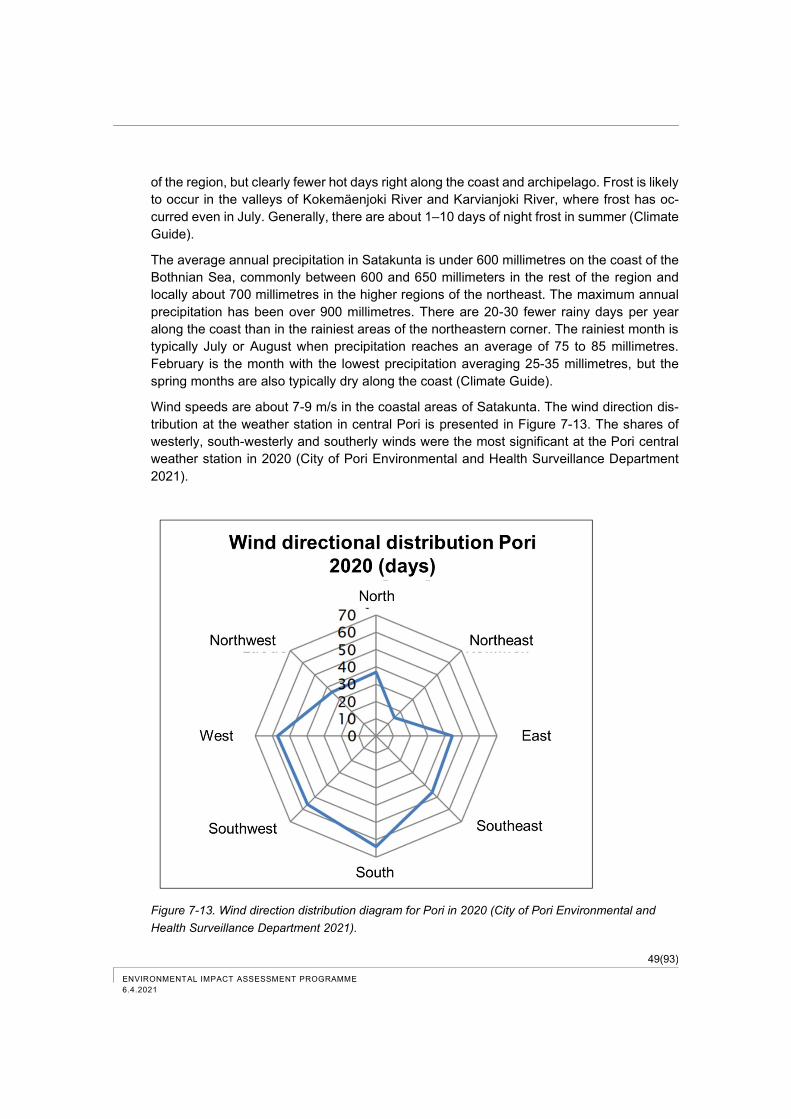
49(93)
ENVIRONMENTAL IMPACT ASSESSMENT PROGRAMME
6.4.2021
of the region, but clearly fewer hot days right along the coast and archipelago. Frost is likely
to occur in the valleys of Kokemäenjoki River and Karvianjoki River, where frost has oc-
curred even in July. Generally, there are about 1–10 days of night frost in summer (Climate
Guide).
The average annual precipitation in Satakunta is under 600 millimetres on the coast of the
Bothnian Sea, commonly between 600 and 650 millimeters in the rest of the region and
locally about 700 millimetres in the higher regions of the northeast. The maximum annual
precipitation has been over 900 millimetres. There are 20-30 fewer rainy days per year
along the coast than in the rainiest areas of the northeastern corner. The rainiest month is
typically July or August when precipitation reaches an average of 75 to 85 millimetres.
February is the month with the lowest precipitation averaging 25-35 millimetres, but the
spring months are also typically dry along the coast (Climate Guide).
Wind speeds are about 7-9 m/s in the coastal areas of Satakunta. The wind direction dis-
tribution at the weather station in central Pori is presented in Figure 7-13. The shares of
westerly, south-westerly and southerly winds were the most significant at the Pori central
weather station in 2020 (City of Pori Environmental and Health Surveillance Department
2021).
Figure 7-13. Wind direction distribution diagram for Pori in 2020 (City of Pori Environmental and
Health Surveillance Department 2021).
50(93) ENVIRONMENTAL IMPACT ASSESSMENT PROGRAMME
6.4.2021
7.4 Vegetation, animals and nature reserves
7.4.1 Vegetation and animals
The VRP area is located in port and industrial area. In the surrounding area of Tahkoluoto,
the most significant natural values include the natural beach areas of Ketaranlahti, Tukkiv-
iikki, Räyhä and Kappeli, as well as the unbuilt parts of the islands (City of Pori 2020).
Based on the study prepared in 1996 in connection with the valid component master plan,
the Tahkoluoto area has beach groves with common alder in the shore areas of Ketaran-
lahti and Tukkiviikki, in the area of Räyhä (Köylynen) and on the southern shore of the
Mänty-Paakari island to the northeast of Tahkoluoto. The study area of the 1996 nature
study is shown with green colour in figure below (Figure 7-14). The shores of Ketaranlahti
are surrounded by a broad common alder – bird cherry – rowan tree grove with very lush
vegetation. The bush floor contains, among other things, red currant, mountain currant, red
elderberry and European cranberry bush. The undergrowth contains wood millet, red cam-
pion, herb bennet, wood stitchwort, common figwort, herb Robert, valerian, wood sorrel,
and woody nightshade. A particularly representative grove was the area extending from
the bay bottom to the former swimming beach, as well as the rowan grove on the Pikku-
ketara cape. Overgrowth, grassing and stooling have occurred in the area after the study.
(City of Pori 2020). Part of the beaches include coastal vegetation of stony beaches with
sea buckthorn bushes.
Törnikari, where the VRP area locates, is mentioned in the 1996 study as a very rocky low-
growth and outer archipelago type of juniper grove surrounded by a narrow common alder
belt. For example, insect species of sunny and warm habitats may be found in the fringe
areas of Törnikari (City of Pori 2020).
The point of the outermost cape in the western part of Tahkoluoto (Kallioholma) was char-
acterised as a representative area for seaside grasses. The swampy depression with grow-
ing crowberry left in the centre of the cape was found to provide a distinct moor-like im-
pression. (City of Pori 2020). The Tahkoluoto meadow is located on the eastern side of the
power plant area (see location in Figure 7-19, Chapter 7.4.4).
A comprehensive nature study has been prepared for the key natural areas of the compo-
nent master plan in 2020 (Figure 7-14) (Ahlman 2020).
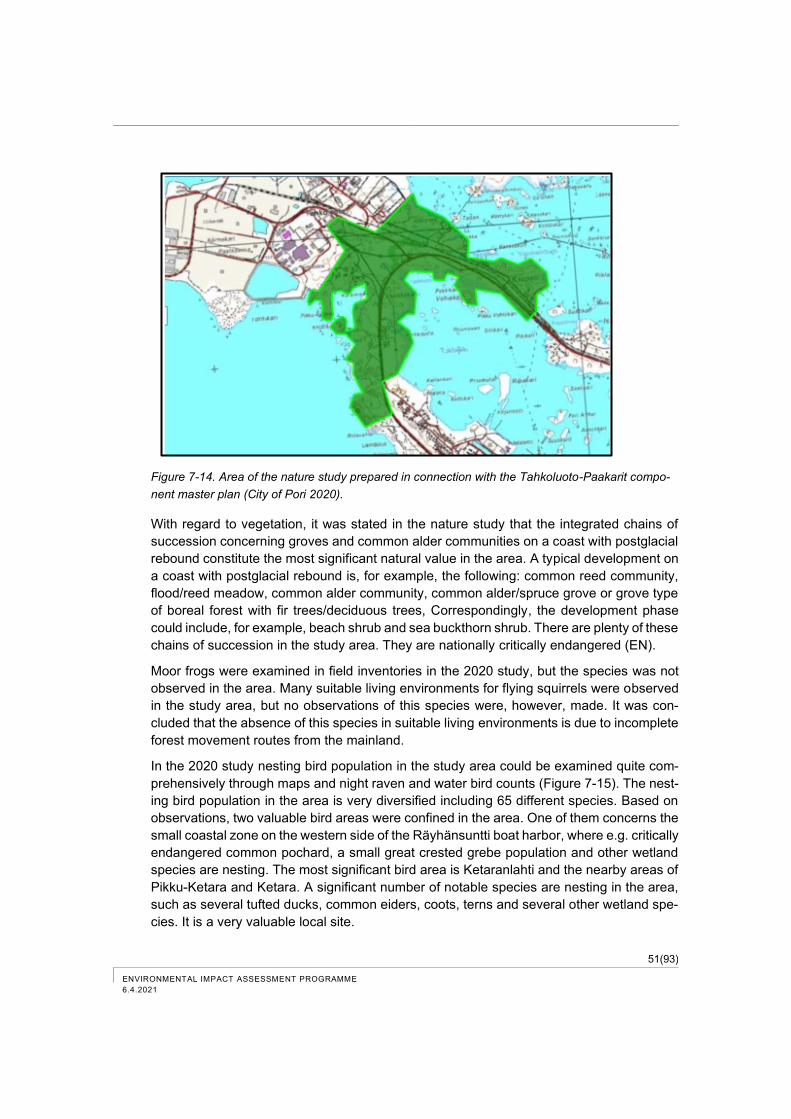
51(93)
ENVIRONMENTAL IMPACT ASSESSMENT PROGRAMME
6.4.2021
Figure 7-14. Area of the nature study prepared in connection with the Tahkoluoto-Paakarit compo-
nent master plan (City of Pori 2020).
With regard to vegetation, it was stated in the nature study that the integrated chains of
succession concerning groves and common alder communities on a coast with postglacial
rebound constitute the most significant natural value in the area. A typical development on
a coast with postglacial rebound is, for example, the following: common reed community,
flood/reed meadow, common alder community, common alder/spruce grove or grove type
of boreal forest with fir trees/deciduous trees, Correspondingly, the development phase
could include, for example, beach shrub and sea buckthorn shrub. There are plenty of these
chains of succession in the study area. They are nationally critically endangered (EN).
Moor frogs were examined in field inventories in the 2020 study, but the species was not
observed in the area. Many suitable living environments for flying squirrels were observed
in the study area, but no observations of this species were, however, made. It was con-
cluded that the absence of this species in suitable living environments is due to incomplete
forest movement routes from the mainland.
In the 2020 study nesting bird population in the study area could be examined quite com-
prehensively through maps and night raven and water bird counts (Figure 7-15). The nest-
ing bird population in the area is very diversified including 65 different species. Based on
observations, two valuable bird areas were confined in the area. One of them concerns the
small coastal zone on the western side of the Räyhänsuntti boat harbor, where e.g. critically
endangered common pochard, a small great crested grebe population and other wetland
species are nesting. The most significant bird area is Ketaranlahti and the nearby areas of
Pikku-Ketara and Ketara. A significant number of notable species are nesting in the area,
such as several tufted ducks, common eiders, coots, terns and several other wetland spe-
cies. It is a very valuable local site.
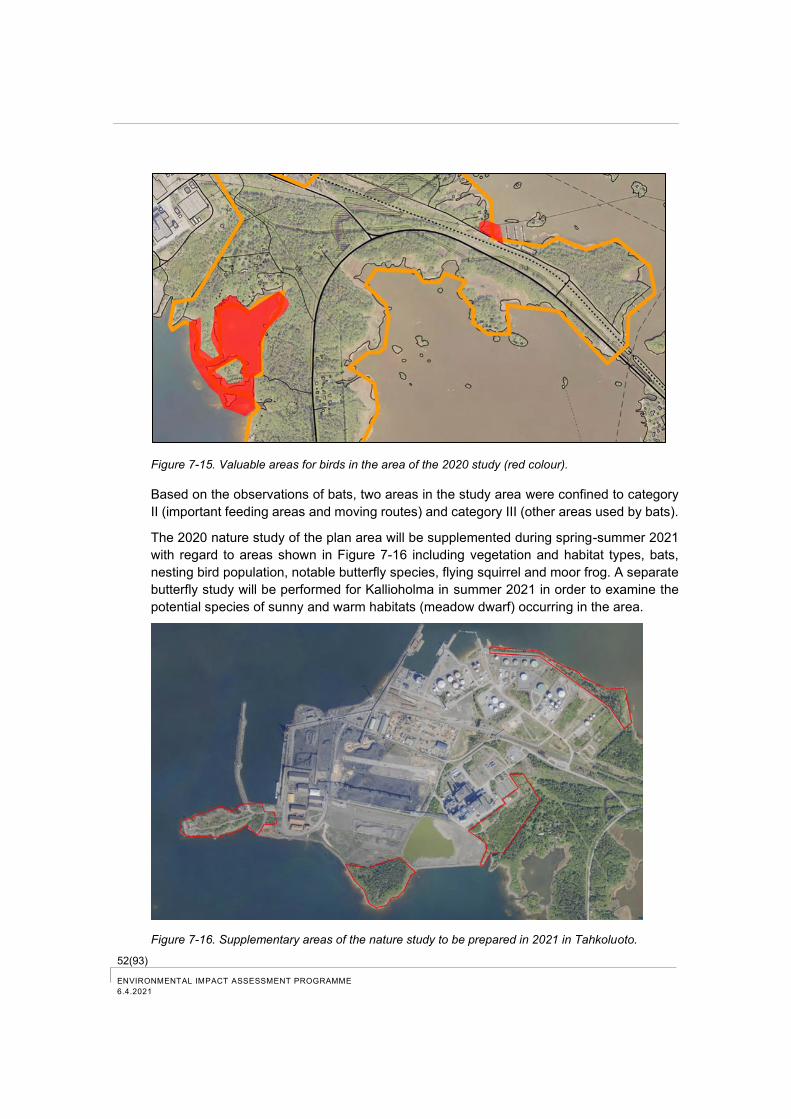
52(93) ENVIRONMENTAL IMPACT ASSESSMENT PROGRAMME
6.4.2021
Figure 7-15. Valuable areas for birds in the area of the 2020 study (red colour).
Based on the observations of bats, two areas in the study area were confined to category
II (important feeding areas and moving routes) and category III (other areas used by bats).
The 2020 nature study of the plan area will be supplemented during spring-summer 2021
with regard to areas shown in Figure 7-16 including vegetation and habitat types, bats,
nesting bird population, notable butterfly species, flying squirrel and moor frog. A separate
butterfly study will be performed for Kallioholma in summer 2021 in order to examine the
potential species of sunny and warm habitats (meadow dwarf) occurring in the area.
Figure 7-16. Supplementary areas of the nature study to be prepared in 2021 in Tahkoluoto.
53(93)
ENVIRONMENTAL IMPACT ASSESSMENT PROGRAMME
6.4.2021
The marine environment outside of Tahkoluoto has been studied in the context of the wind
farm planning by Suomen Hyötytuuli Oy. The nearest valuable nesting area for birds is in
Kaijakari on the southwestern side of the plan area, where e.g. lesser black-backed gulls
and Arctic terns nest. The nearest important catch sites of Baltic herring are located outside
of the Ketaranlahti Bay and in the vicinity of Kaijakari (City of Pori 2020).
Values of seabed were also studied in the 2014 wind farm project. Areas included in the
natural value categories 1 and 2 are located outside of Tahkoluoto. According to the
VELMU data base regarding underwater biodiversity, underwater reefs are located on the
southern side of Tahkoluoto. A significant EMMA-area (ecologically significant underwater
area of marine environment in Finland) regarding the fish stock in the Kokemäenjoki River
delta extends out to the southeastern archipelago area of the plan area (City of Pori 2020).
Significant migration routes of birds can be found on the eastern and western side of
Tahkoluoto (Ahlman & Luoma 2013). The most abundant water bird species in the outer
archipelago of Satakunta include eider, goldeneye and mute swan. One of the most signif-
icant congregation areas of water birds in the outer archipelago is located outside of
Tahkoluoto (Ijäs et. al. 2013). Supplementary information on the bird population in the area
is provided in the EIA report.
7.4.2 Conservation areas and nature reserves
7.4.2.1 Natura areas
Three Natura areas are located less than 10 km from the VRP area: Gummandoora Archi-
pelago, Kokemäenjoki River Delta and Preiviikinlahti. The Natura area “Pooskeri Archipel-
ago” is located at a distance of about 11 km to the north-east of Tahkoluoto. Natura areas
are presented in Figure 7-17.
Gummandoora Archipelago (FI 0200074, SAC/SPA)
The Gummandoora Archipelago Natura area is located 2.3 km to the north of the VRP area.
The Gummandoora Archipelago Natura area is part of the Bothnian Sea National Park and
the internationally valuable bird area (IBA) of the Oura-Enskeri Archipelago. There are sev-
eral small nature reserves on private land in the islands of the Natura area. The site is
almost entirely included in the coast protection programme. The area is protected by the
Environmetal Protection Act and the Water Act. The Natura area is also part of the Luvia
archipelago, which is one of the sites in the coast protection programme. The natural hab-
itats and species, which constitute the protection objectives, are presented in Table 7-3
and
Table 7-4.
54(93) ENVIRONMENTAL IMPACT ASSESSMENT PROGRAMME
6.4.2021
Table 7-3. Natural habitats, which constitute the protection objectives of the Natura areas.
Code Name Area (hectares)
1150 Flads, gloes and coastal lagoons 0.42
1170 Reefs 123.2
1210 Annual vegetation of drift lines 0.12
1220 Perennial vegetation of stony banks 27
1230 Vegetated sea cliffs of the Atlantic and Baltic coasts 1
1610 Baltic esker islands with sandy, rocky and shingle beach veg-
etation and sublittoral vegetation
2.3
1620 Boreal Baltic islets and islands in outer archipelago and open
sea zones
42.2
1630 Boreal Baltic coastal meadows 3.1
1640 Boreal Baltic sandy beaches with perennial vegetation 0.43
9010 Boreal natural forests 3.38
9030 Natural forests of primary succession stages of landupheaval
coast
60
9050 Boreal herb-rich forests 6.38
9080 Fennoscandian deciduous swamp woods 0.07
Table 7-4. Species, which constitute the protection objectives of the Natura areas.
Species Scientific name
razorbill Alca torda
northern shoveller Anas clypeata
gadwall Anas strepera
ruddy turnstone Arenaria interpres
tufted duck Aythya fuligula
greater scaup Aythya marila
barnacle goose Branta leucopsis
black woodpecker Dryocopus martius
kestrel Falco tinnunculus
black-throated diver Gavia arctica
red-throated diver Gavia stellata
lesser black-backed gull Larus fuscus fuscus
black-headed gull Larus ridibundus
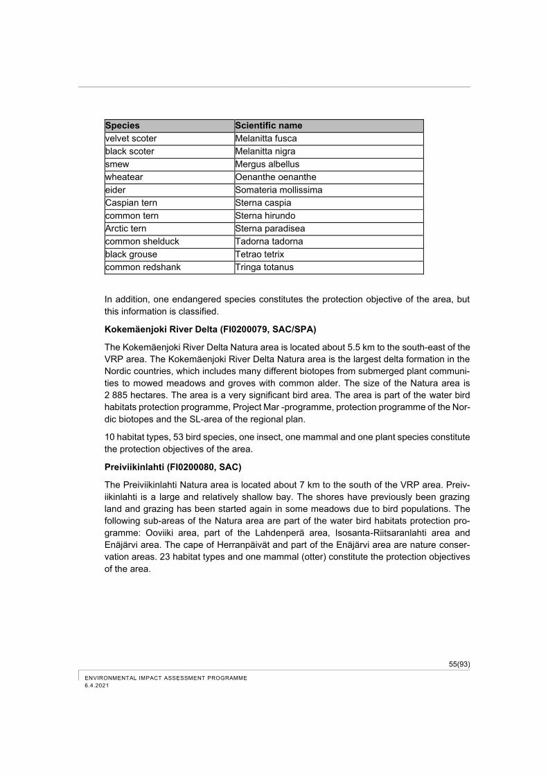
55(93)
ENVIRONMENTAL IMPACT ASSESSMENT PROGRAMME
6.4.2021
Species Scientific name
velvet scoter Melanitta fusca
black scoter Melanitta nigra
smew Mergus albellus
wheatear Oenanthe oenanthe
eider Somateria mollissima
Caspian tern Sterna caspia
common tern Sterna hirundo
Arctic tern Sterna paradisea
common shelduck Tadorna tadorna
black grouse Tetrao tetrix
common redshank Tringa totanus
In addition, one endangered species constitutes the protection objective of the area, but
this information is classified.
Kokemäenjoki River Delta (FI0200079, SAC/SPA)
The Kokemäenjoki River Delta Natura area is located about 5.5 km to the south-east of the
VRP area. The Kokemäenjoki River Delta Natura area is the largest delta formation in the
Nordic countries, which includes many different biotopes from submerged plant communi-
ties to mowed meadows and groves with common alder. The size of the Natura area is
2 885 hectares. The area is a very significant bird area. The area is part of the water bird
habitats protection programme, Project Mar -programme, protection programme of the Nor-
dic biotopes and the SL-area of the regional plan.
10 habitat types, 53 bird species, one insect, one mammal and one plant species constitute
the protection objectives of the area.
Preiviikinlahti (FI0200080, SAC)
The Preiviikinlahti Natura area is located about 7 km to the south of the VRP area. Preiv-
iikinlahti is a large and relatively shallow bay. The shores have previously been grazing
land and grazing has been started again in some meadows due to bird populations. The
following sub-areas of the Natura area are part of the water bird habitats protection pro-
gramme: Ooviiki area, part of the Lahdenperä area, Isosanta-Riitsaranlahti area and
Enäjärvi area. The cape of Herranpäivät and part of the Enäjärvi area are nature conser-
vation areas. 23 habitat types and one mammal (otter) constitute the protection objectives
of the area.
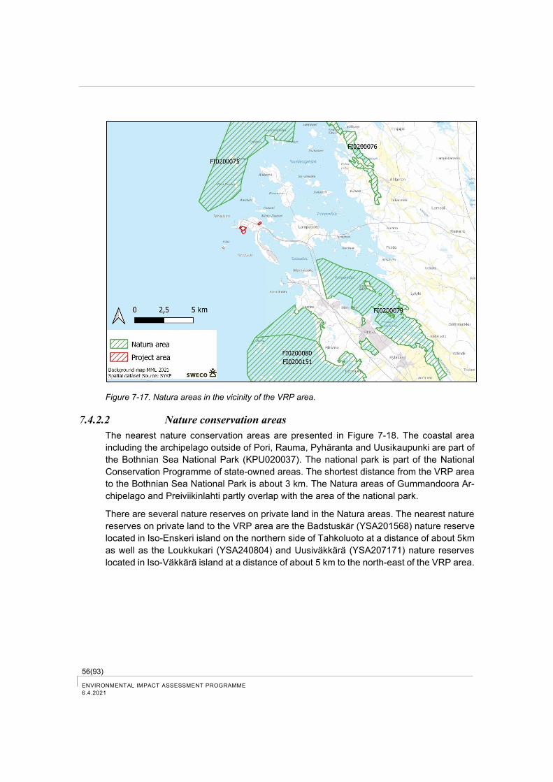
56(93) ENVIRONMENTAL IMPACT ASSESSMENT PROGRAMME
6.4.2021
Figure 7-17. Natura areas in the vicinity of the VRP area.
7.4.2.2 Nature conservation areas
The nearest nature conservation areas are presented in Figure 7-18. The coastal area
including the archipelago outside of Pori, Rauma, Pyhäranta and Uusikaupunki are part of
the Bothnian Sea National Park (KPU020037). The national park is part of the National
Conservation Programme of state-owned areas. The shortest distance from the VRP area
to the Bothnian Sea National Park is about 3 km. The Natura areas of Gummandoora Ar-
chipelago and Preiviikinlahti partly overlap with the area of the national park.
There are several nature reserves on private land in the Natura areas. The nearest nature
reserves on private land to the VRP area are the Badstuskär (YSA201568) nature reserve
located in Iso-Enskeri island on the northern side of Tahkoluoto at a distance of about 5km
as well as the Loukkukari (YSA240804) and Uusiväkkärä (YSA207171) nature reserves
located in Iso-Väkkärä island at a distance of about 5 km to the north-east of the VRP area.
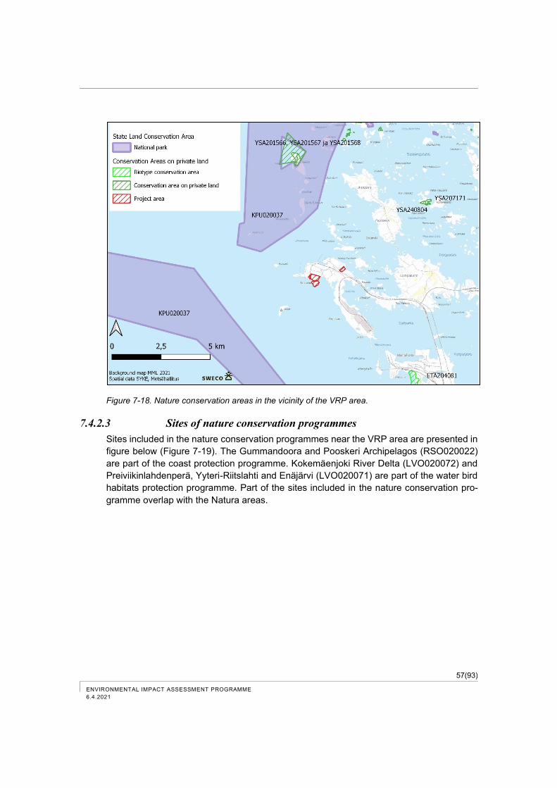
57(93)
ENVIRONMENTAL IMPACT ASSESSMENT PROGRAMME
6.4.2021
Figure 7-18. Nature conservation areas in the vicinity of the VRP area.
7.4.2.3 Sites of nature conservation programmes
Sites included in the nature conservation programmes near the VRP area are presented in
figure below (Figure 7-19). The Gummandoora and Pooskeri Archipelagos (RSO020022)
are part of the coast protection programme. Kokemäenjoki River Delta (LVO020072) and
Preiviikinlahdenperä, Yyteri-Riitslahti and Enäjärvi (LVO020071) are part of the water bird
habitats protection programme. Part of the sites included in the nature conservation pro-
gramme overlap with the Natura areas.
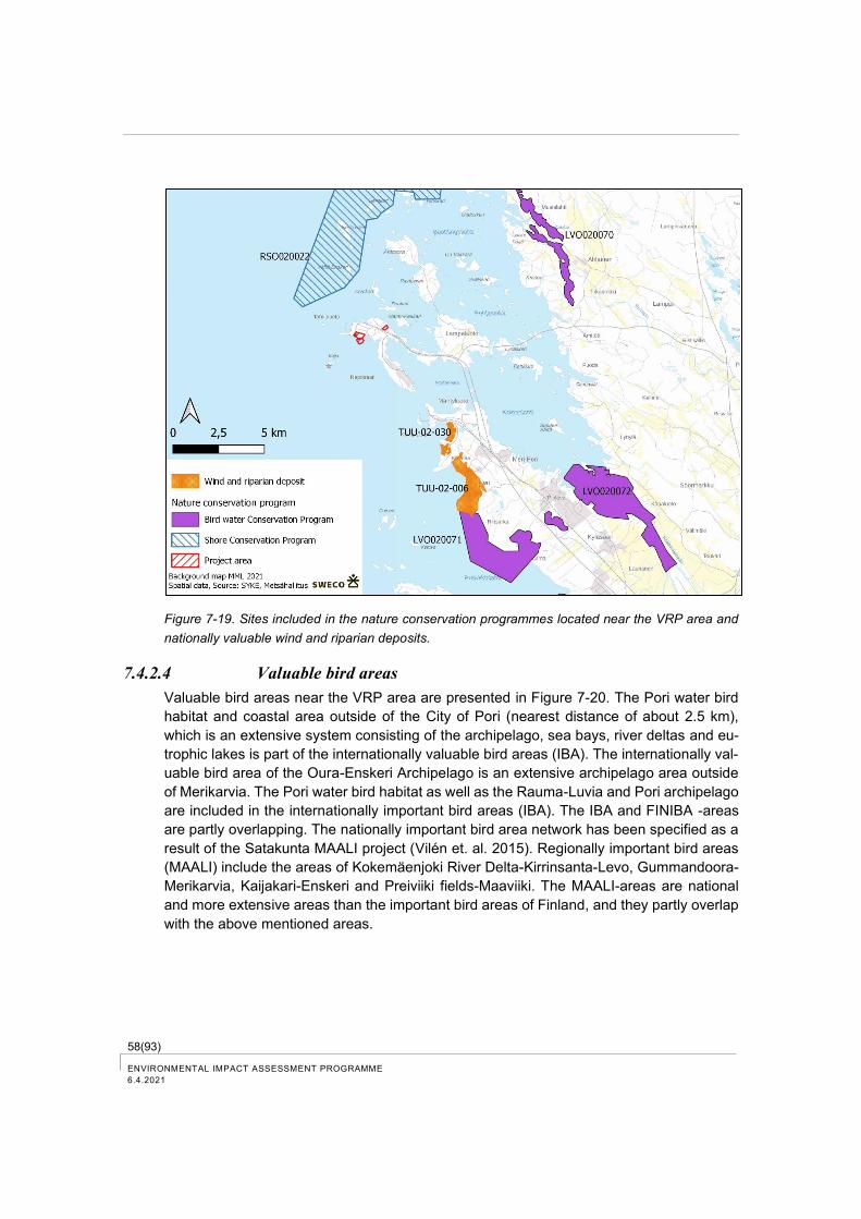
58(93) ENVIRONMENTAL IMPACT ASSESSMENT PROGRAMME
6.4.2021
Figure 7-19. Sites included in the nature conservation programmes located near the VRP area and
nationally valuable wind and riparian deposits.
7.4.2.4 Valuable bird areas
Valuable bird areas near the VRP area are presented in Figure 7-20. The Pori water bird
habitat and coastal area outside of the City of Pori (nearest distance of about 2.5 km),
which is an extensive system consisting of the archipelago, sea bays, river deltas and eu-
trophic lakes is part of the internationally valuable bird areas (IBA). The internationally val-
uable bird area of the Oura-Enskeri Archipelago is an extensive archipelago area outside
of Merikarvia. The Pori water bird habitat as well as the Rauma-Luvia and Pori archipelago
are included in the internationally important bird areas (IBA). The IBA and FINIBA -areas
are partly overlapping. The nationally important bird area network has been specified as a
result of the Satakunta MAALI project (Vilén et. al. 2015). Regionally important bird areas
(MAALI) include the areas of Kokemäenjoki River Delta-Kirrinsanta-Levo, Gummandoora-
Merikarvia, Kaijakari-Enskeri and Preiviiki fields-Maaviiki. The MAALI-areas are national
and more extensive areas than the important bird areas of Finland, and they partly overlap
with the above mentioned areas.
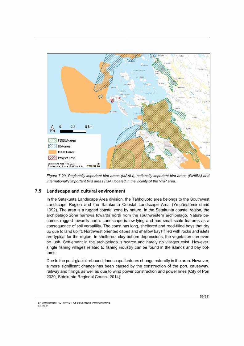
59(93)
ENVIRONMENTAL IMPACT ASSESSMENT PROGRAMME
6.4.2021
Figure 7-20. Regionally important bird areas (MAALI), nationally important bird areas (FINIBA) and
internationally important bird areas (IBA) located in the vicinity of the VRP area.
7.5 Landscape and cultural environment
In the Satakunta Landscape Area division, the Tahkoluoto area belongs to the Southwest
Landscape Region and the Satakunta Coastal Landscape Area (Ympäristöministeriö
1992). The area is a rugged coastal zone by nature. In the Satakunta coastal region, the
archipelago zone narrows towards north from the southwestern archipelago. Nature be-
comes rugged towards north. Landscape is low-lying and has small-scale features as a
consequence of soil versatility. The coast has long, sheltered and reed-filled bays that dry
up due to land uplift. Northwest oriented capes and shallow bays filled with rocks and islets
are typical for the region. In sheltered, clay-bottom depressions, the vegetation can even
be lush. Settlement in the archipelago is scarce and hardly no villages exist. However,
single fishing villages related to fishing industry can be found in the islands and bay bot-
toms.
Due to the post-glacial rebound, landscape features change naturally in the area. However,
a more significant change has been caused by the construction of the port, causeway,
railway and fillings as well as due to wind power construction and power lines (City of Pori
2020, Satakunta Regional Council 2014).
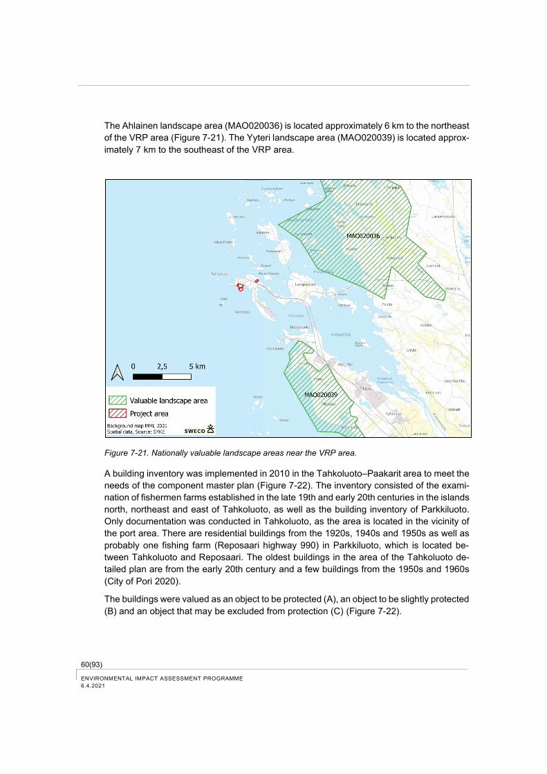
60(93) ENVIRONMENTAL IMPACT ASSESSMENT PROGRAMME
6.4.2021
The Ahlainen landscape area (MAO020036) is located approximately 6 km to the northeast
of the VRP area (Figure 7-21). The Yyteri landscape area (MAO020039) is located approx-
imately 7 km to the southeast of the VRP area.
Figure 7-21. Nationally valuable landscape areas near the VRP area.
A building inventory was implemented in 2010 in the Tahkoluoto–Paakarit area to meet the
needs of the component master plan (Figure 7-22). The inventory consisted of the exami-
nation of fishermen farms established in the late 19th and early 20th centuries in the islands
north, northeast and east of Tahkoluoto, as well as the building inventory of Parkkiluoto.
Only documentation was conducted in Tahkoluoto, as the area is located in the vicinity of
the port area. There are residential buildings from the 1920s, 1940s and 1950s as well as
probably one fishing farm (Reposaari highway 990) in Parkkiluoto, which is located be-
tween Tahkoluoto and Reposaari. The oldest buildings in the area of the Tahkoluoto de-
tailed plan are from the early 20th century and a few buildings from the 1950s and 1960s
(City of Pori 2020).
The buildings were valued as an object to be protected (A), an object to be slightly protected
(B) and an object that may be excluded from protection (C) (Figure 7-22).
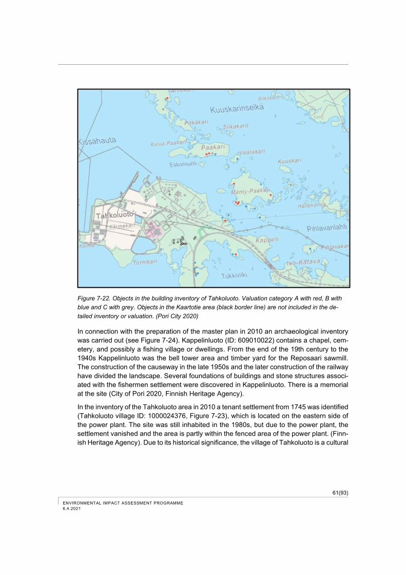
61(93)
ENVIRONMENTAL IMPACT ASSESSMENT PROGRAMME
6.4.2021
Figure 7-22. Objects in the building inventory of Tahkoluoto. Valuation category A with red, B with
blue and C with grey. Objects in the Kaartotie area (black border line) are not included in the de-
tailed inventory or valuation. (Pori City 2020)
In connection with the preparation of the master plan in 2010 an archaeological inventory
was carried out (see Figure 7-24). Kappelinluoto (ID: 609010022) contains a chapel, cem-
etery, and possibly a fishing village or dwellings. From the end of the 19th century to the
1940s Kappelinluoto was the bell tower area and timber yard for the Reposaari sawmill.
The construction of the causeway in the late 1950s and the later construction of the railway
have divided the landscape. Several foundations of buildings and stone structures associ-
ated with the fishermen settlement were discovered in Kappelinluoto. There is a memorial
at the site (City of Pori 2020, Finnish Heritage Agency).
In the inventory of the Tahkoluoto area in 2010 a tenant settlement from 1745 was identified
(Tahkoluoto village ID: 1000024376, Figure 7-23), which is located on the eastern side of
the power plant. The site was still inhabited in the 1980s, but due to the power plant, the
settlement vanished and the area is partly within the fenced area of the power plant. (Finn-
ish Heritage Agency). Due to its historical significance, the village of Tahkoluoto is a cultural

62(93) ENVIRONMENTAL IMPACT ASSESSMENT PROGRAMME
6.4.2021
heritage site. There is also the Tahkoluoto meadow which is classified as a regionally sig-
nificant natural site. (Satakunta Museum 2014). The village of Tahkoluoto is located at a
minimum distance of 300 m to the southwest from the northern VRP area.
Figure 7-23. Village of Tahkoluoto (Satakunta Museum 2014).
Fortifications were built to protect the port of Pori during the World War I. The islands con-
tain remnants of structures that have been included in inventories, for example cellars and
stone heaps of different age and some of them are stone fences created by the cultivation
of new land, storm shelters and apparently also wartime shelters (City of Pori 2020).
Vasikkarinkari in Parkkiluoto area is apparently the site of a Second World War artillery
battery (ID: 1000024377). In Tahkoluoto along Kylänmäentie, there are basements and
foundations of buildings as remnants of the original settlement in the area (City of Pori
2020, Finnish Heritage Agency).
Several underwater remains are identified in Tahkoluoto and Parkkiluoto area and in its
vicinity, and potential relics are identified in Tukkiviikki. (City of Pori 2020). At a distance of
about 1 km west from the VRP area lies a solid relic, the metal wreck 'Lightning' (ID: 1734).
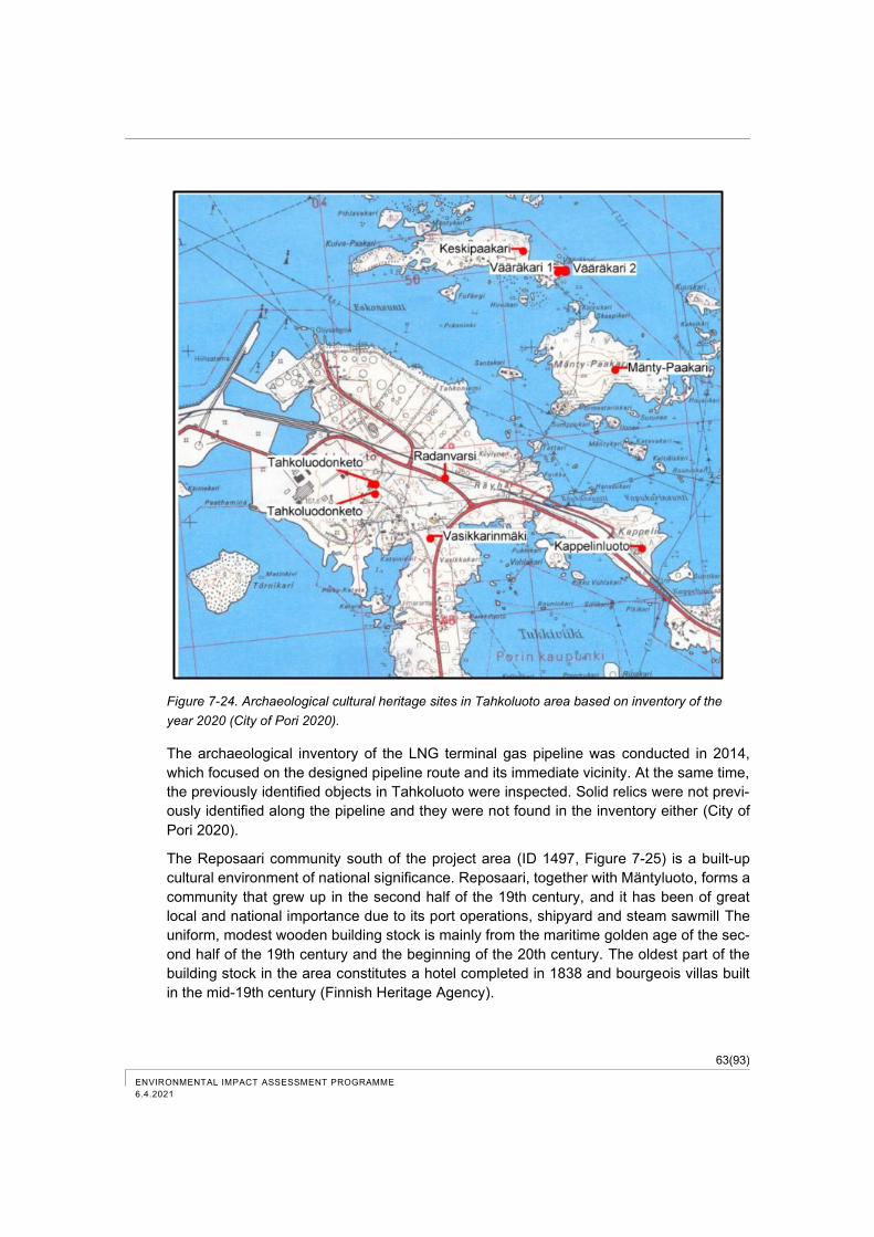
63(93)
ENVIRONMENTAL IMPACT ASSESSMENT PROGRAMME
6.4.2021
Figure 7-24. Archaeological cultural heritage sites in Tahkoluoto area based on inventory of the
year 2020 (City of Pori 2020).
The archaeological inventory of the LNG terminal gas pipeline was conducted in 2014,
which focused on the designed pipeline route and its immediate vicinity. At the same time,
the previously identified objects in Tahkoluoto were inspected. Solid relics were not previ-
ously identified along the pipeline and they were not found in the inventory either (City of
Pori 2020).
The Reposaari community south of the project area (ID 1497, Figure 7-25) is a built-up
cultural environment of national significance. Reposaari, together with Mäntyluoto, forms a
community that grew up in the second half of the 19th century, and it has been of great
local and national importance due to its port operations, shipyard and steam sawmill The
uniform, modest wooden building stock is mainly from the maritime golden age of the sec-
ond half of the 19th century and the beginning of the 20th century. The oldest part of the
building stock in the area constitutes a hotel completed in 1838 and bourgeois villas built
in the mid-19th century (Finnish Heritage Agency).
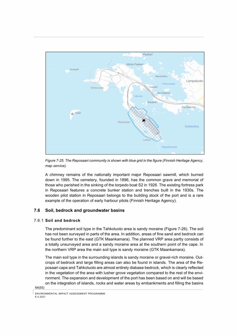
64(93) ENVIRONMENTAL IMPACT ASSESSMENT PROGRAMME
6.4.2021
Figure 7-25. The Reposaari community is shown with blue grid in the figure (Finnish Heritage Agency,
map service).
A chimney remains of the nationally important major Reposaari sawmill, which burned
down in 1995. The cemetery, founded in 1896, has the common grave and memorial of
those who perished in the sinking of the torpedo boat S2 in 1926. The existing fortress park
in Reposaari features a concrete bunker station and trenches built in the 1930s. The
wooden pilot station in Reposaari belongs to the building stock of the port and is a rare
example of the operation of early harbour pilots (Finnish Heritage Agency).
7.6 Soil, bedrock and groundwater basins
7.6.1 Soil and bedrock
The predominant soil type in the Tahkoluoto area is sandy moraine (Figure 7-26). The soil
has not been surveyed in parts of the area. In addition, areas of fine sand and bedrock can
be found further to the east (GTK Maankamara). The planned VRP area partly consists of
a totally unsurveyed area and a sandy moraine area at the southern point of the cape. In
the northern VRP area the main soil type is sandy moraine (GTK Maankamara).
The main soil type in the surrounding islands is sandy moraine or gravel-rich moraine. Out-
crops of bedrock and large filling areas can also be found in islands. The area of the Re-
posaari cape and Tahkoluoto are almost entirely diabase bedrock, which is clearly reflected
in the vegetation of the area with lusher grove vegetation compared to the rest of the envi-
ronment. The expansion and development of the port has been based on and will be based
on the integration of islands, rocks and water areas by embankments and filling the basins
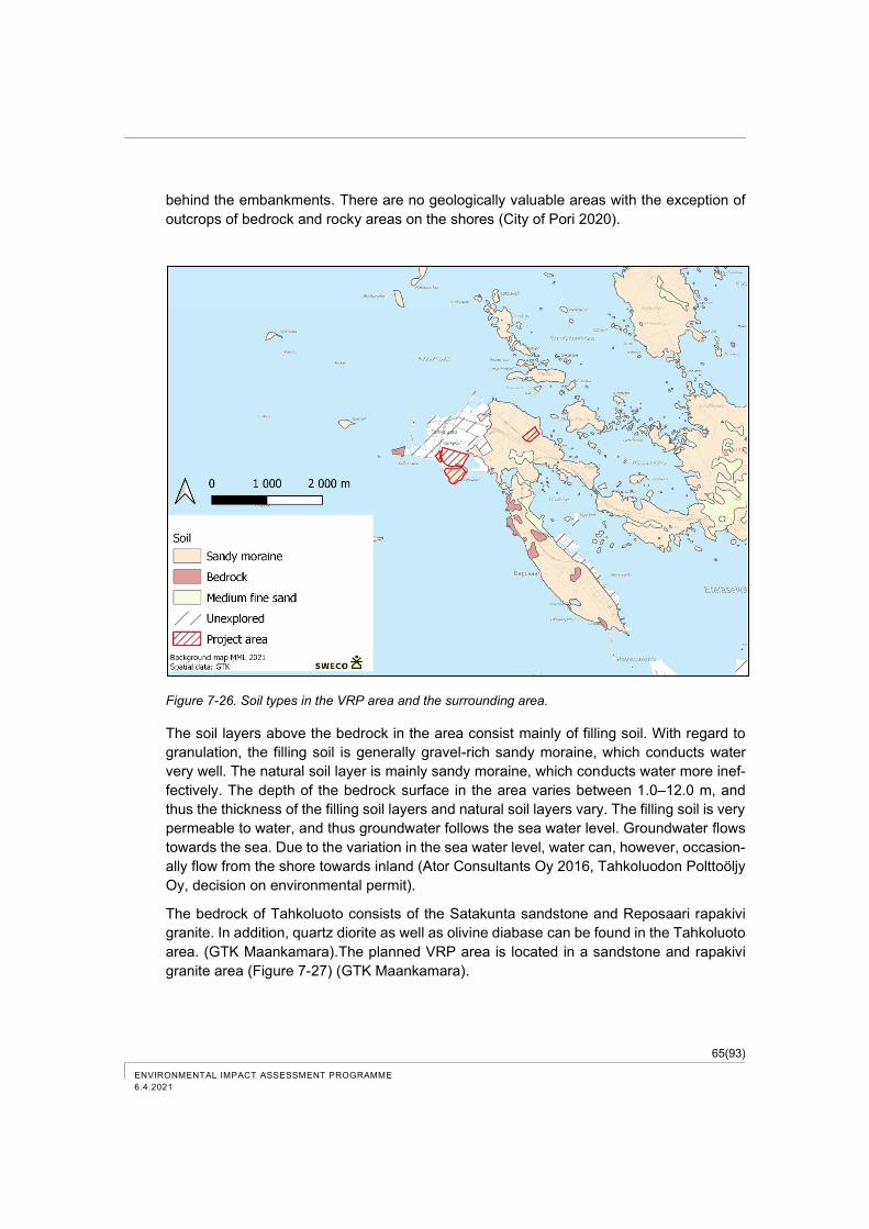
65(93)
ENVIRONMENTAL IMPACT ASSESSMENT PROGRAMME
6.4.2021
behind the embankments. There are no geologically valuable areas with the exception of
outcrops of bedrock and rocky areas on the shores (City of Pori 2020).
Figure 7-26. Soil types in the VRP area and the surrounding area.
The soil layers above the bedrock in the area consist mainly of filling soil. With regard to
granulation, the filling soil is generally gravel-rich sandy moraine, which conducts water
very well. The natural soil layer is mainly sandy moraine, which conducts water more inef-
fectively. The depth of the bedrock surface in the area varies between 1.0–12.0 m, and
thus the thickness of the filling soil layers and natural soil layers vary. The filling soil is very
permeable to water, and thus groundwater follows the sea water level. Groundwater flows
towards the sea. Due to the variation in the sea water level, water can, however, occasion-
ally flow from the shore towards inland (Ator Consultants Oy 2016, Tahkoluodon Polttoöljy
Oy, decision on environmental permit).
The bedrock of Tahkoluoto consists of the Satakunta sandstone and Reposaari rapakivi
granite. In addition, quartz diorite as well as olivine diabase can be found in the Tahkoluoto
area. (GTK Maankamara).The planned VRP area is located in a sandstone and rapakivi
granite area (Figure 7-27) (GTK Maankamara).
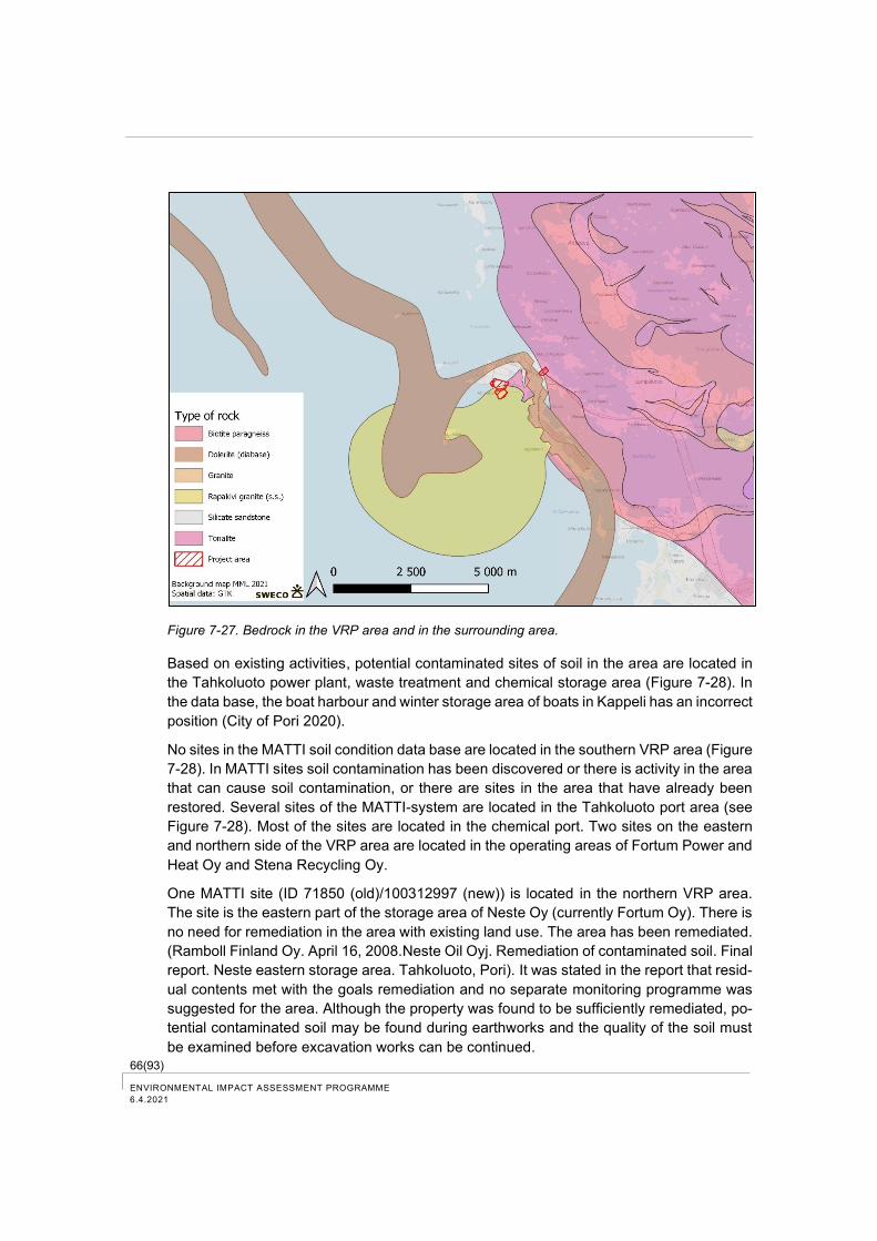
66(93) ENVIRONMENTAL IMPACT ASSESSMENT PROGRAMME
6.4.2021
Figure 7-27. Bedrock in the VRP area and in the surrounding area.
Based on existing activities, potential contaminated sites of soil in the area are located in
the Tahkoluoto power plant, waste treatment and chemical storage area (Figure 7-28). In
the data base, the boat harbour and winter storage area of boats in Kappeli has an incorrect
position (City of Pori 2020).
No sites in the MATTI soil condition data base are located in the southern VRP area (Figure
7-28). In MATTI sites soil contamination has been discovered or there is activity in the area
that can cause soil contamination, or there are sites in the area that have already been
restored. Several sites of the MATTI-system are located in the Tahkoluoto port area (see
Figure 7-28). Most of the sites are located in the chemical port. Two sites on the eastern
and northern side of the VRP area are located in the operating areas of Fortum Power and
Heat Oy and Stena Recycling Oy.
One MATTI site (ID 71850 (old)/100312997 (new)) is located in the northern VRP area.
The site is the eastern part of the storage area of Neste Oy (currently Fortum Oy). There is
no need for remediation in the area with existing land use. The area has been remediated.
(Ramboll Finland Oy. April 16, 2008.Neste Oil Oyj. Remediation of contaminated soil. Final
report. Neste eastern storage area. Tahkoluoto, Pori). It was stated in the report that resid-
ual contents met with the goals remediation and no separate monitoring programme was
suggested for the area. Although the property was found to be sufficiently remediated, po-
tential contaminated soil may be found during earthworks and the quality of the soil must
be examined before excavation works can be continued.
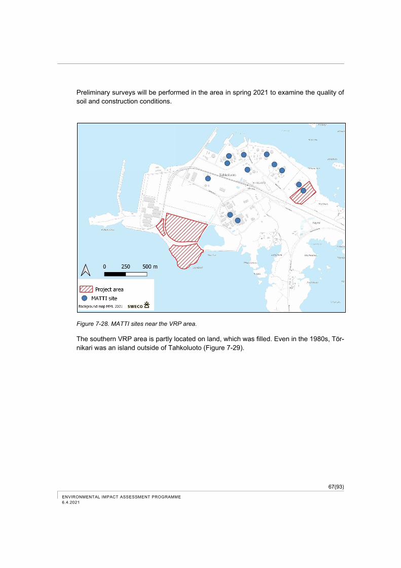
67(93)
ENVIRONMENTAL IMPACT ASSESSMENT PROGRAMME
6.4.2021
Preliminary surveys will be performed in the area in spring 2021 to examine the quality of
soil and construction conditions.
Figure 7-28. MATTI sites near the VRP area.
The southern VRP area is partly located on land, which was filled. Even in the 1980s, Tör-
nikari was an island outside of Tahkoluoto (Figure 7-29).
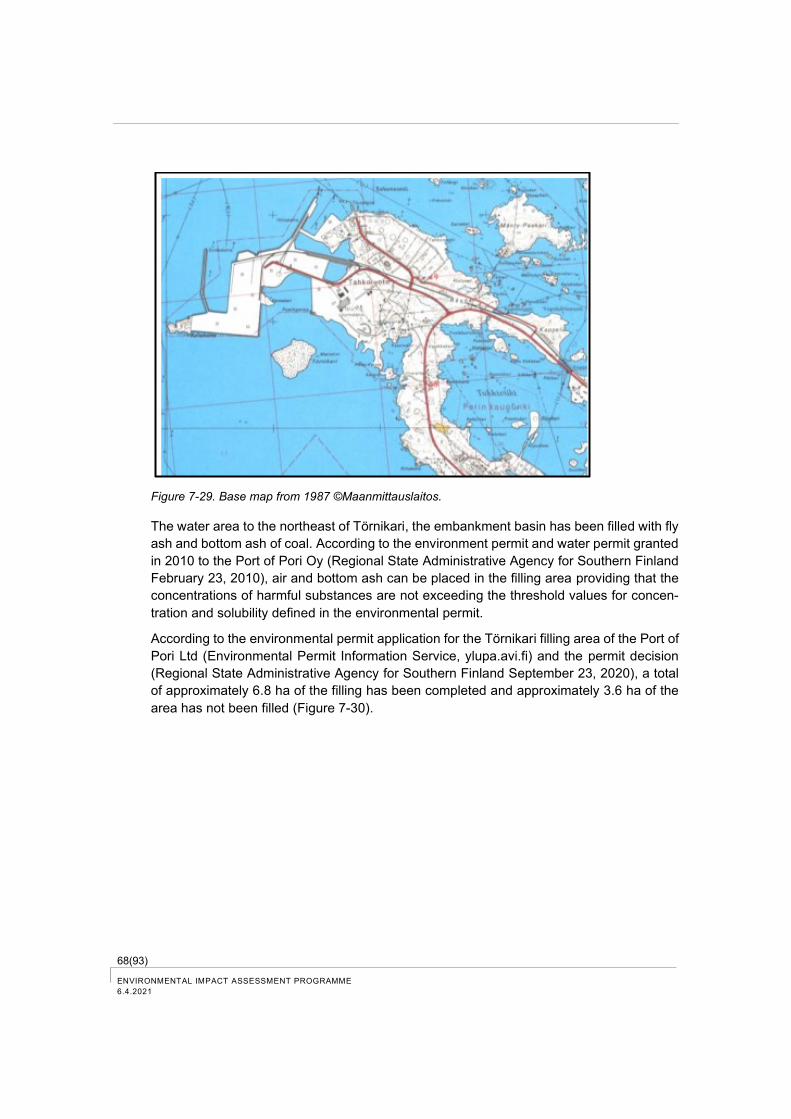
68(93) ENVIRONMENTAL IMPACT ASSESSMENT PROGRAMME
6.4.2021
Figure 7-29. Base map from 1987 ©Maanmittauslaitos.
The water area to the northeast of Törnikari, the embankment basin has been filled with fly
ash and bottom ash of coal. According to the environment permit and water permit granted
in 2010 to the Port of Pori Oy (Regional State Administrative Agency for Southern Finland
February 23, 2010), air and bottom ash can be placed in the filling area providing that the
concentrations of harmful substances are not exceeding the threshold values for concen-
tration and solubility defined in the environmental permit.
According to the environmental permit application for the Törnikari filling area of the Port of
Pori Ltd (Environmental Permit Information Service, ylupa.avi.fi) and the permit decision
(Regional State Administrative Agency for Southern Finland September 23, 2020), a total
of approximately 6.8 ha of the filling has been completed and approximately 3.6 ha of the
area has not been filled (Figure 7-30).
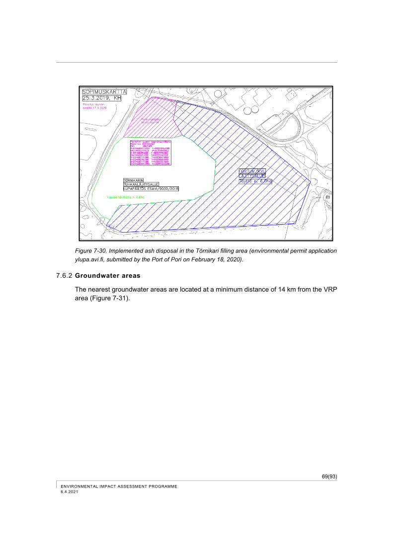
69(93)
ENVIRONMENTAL IMPACT ASSESSMENT PROGRAMME
6.4.2021
Figure 7-30. Implemented ash disposal in the Törnikari filling area (environmental permit application
ylupa.avi.fi, submitted by the Port of Pori on February 18, 2020).
7.6.2 Groundwater areas
The nearest groundwater areas are located at a minimum distance of 14 km from the VRP
area (Figure 7-31).
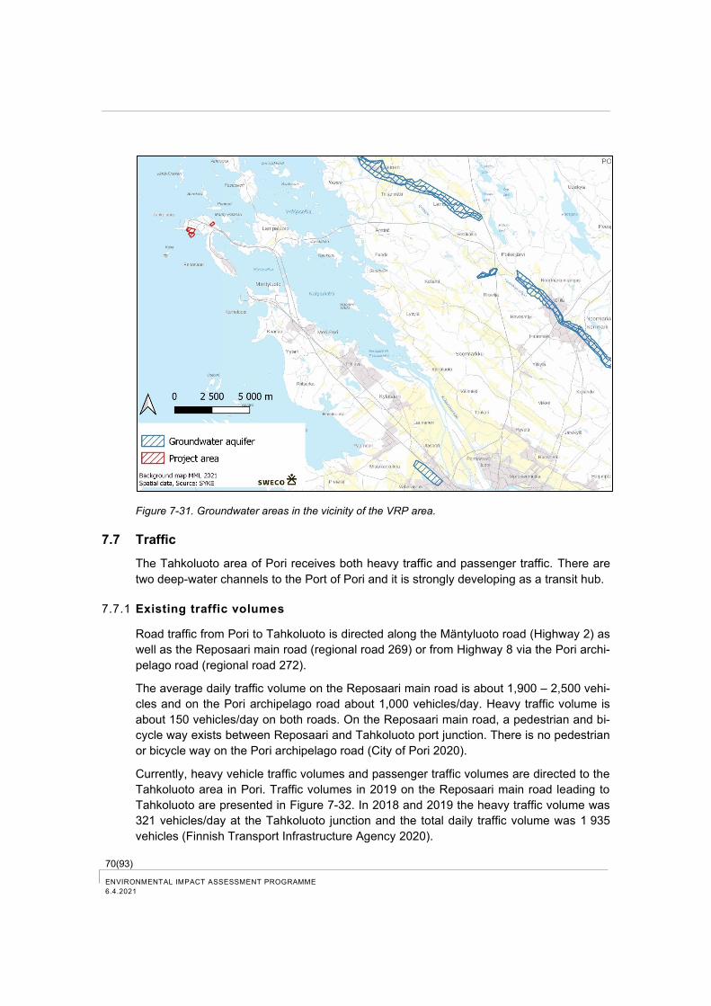
70(93) ENVIRONMENTAL IMPACT ASSESSMENT PROGRAMME
6.4.2021
Figure 7-31. Groundwater areas in the vicinity of the VRP area.
7.7 Traffic
The Tahkoluoto area of Pori receives both heavy traffic and passenger traffic. There are
two deep-water channels to the Port of Pori and it is strongly developing as a transit hub.
7.7.1 Existing traffic volumes
Road traffic from Pori to Tahkoluoto is directed along the Mäntyluoto road (Highway 2) as
well as the Reposaari main road (regional road 269) or from Highway 8 via the Pori archi-
pelago road (regional road 272).
The average daily traffic volume on the Reposaari main road is about 1,900 – 2,500 vehi-
cles and on the Pori archipelago road about 1,000 vehicles/day. Heavy traffic volume is
about 150 vehicles/day on both roads. On the Reposaari main road, a pedestrian and bi-
cycle way exists between Reposaari and Tahkoluoto port junction. There is no pedestrian
or bicycle way on the Pori archipelago road (City of Pori 2020).
Currently, heavy vehicle traffic volumes and passenger traffic volumes are directed to the
Tahkoluoto area in Pori. Traffic volumes in 2019 on the Reposaari main road leading to
Tahkoluoto are presented in Figure 7-32. In 2018 and 2019 the heavy traffic volume was
321 vehicles/day at the Tahkoluoto junction and the total daily traffic volume was 1 935
vehicles (Finnish Transport Infrastructure Agency 2020).
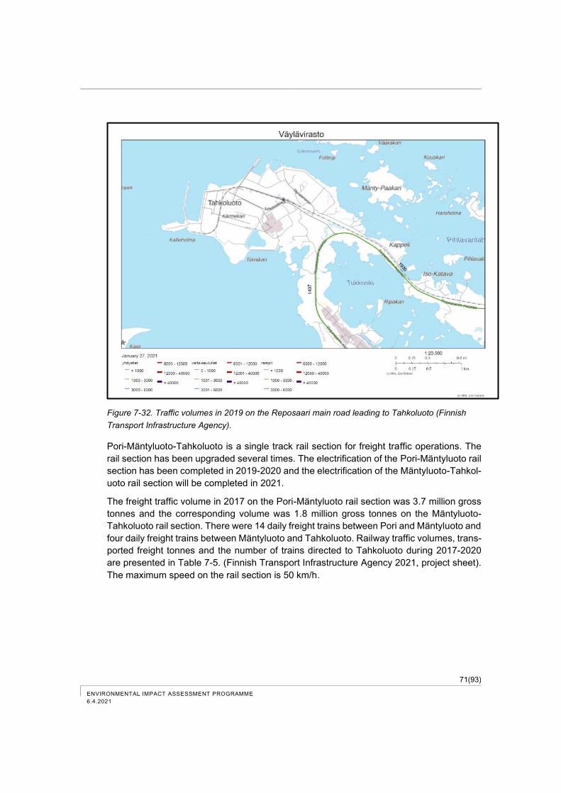
71(93)
ENVIRONMENTAL IMPACT ASSESSMENT PROGRAMME
6.4.2021
Figure 7-32. Traffic volumes in 2019 on the Reposaari main road leading to Tahkoluoto (Finnish
Transport Infrastructure Agency).
Pori-Mäntyluoto-Tahkoluoto is a single track rail section for freight traffic operations. The
rail section has been upgraded several times. The electrification of the Pori-Mäntyluoto rail
section has been completed in 2019-2020 and the electrification of the Mäntyluoto-Tahkol-
uoto rail section will be completed in 2021.
The freight traffic volume in 2017 on the Pori-Mäntyluoto rail section was 3.7 million gross
tonnes and the corresponding volume was 1.8 million gross tonnes on the Mäntyluoto-
Tahkoluoto rail section. There were 14 daily freight trains between Pori and Mäntyluoto and
four daily freight trains between Mäntyluoto and Tahkoluoto. Railway traffic volumes, trans-
ported freight tonnes and the number of trains directed to Tahkoluoto during 2017-2020
are presented in Table 7-5. (Finnish Transport Infrastructure Agency 2021, project sheet).
The maximum speed on the rail section is 50 km/h.
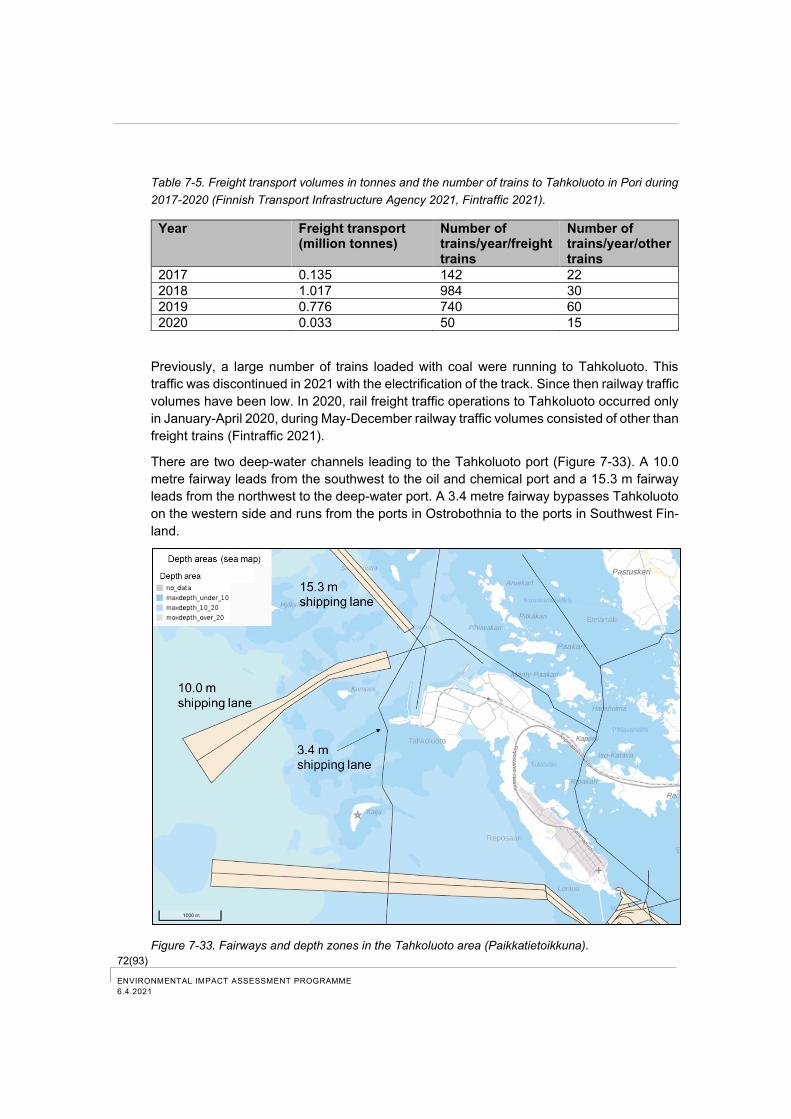
72(93) ENVIRONMENTAL IMPACT ASSESSMENT PROGRAMME
6.4.2021
Table 7-5. Freight transport volumes in tonnes and the number of trains to Tahkoluoto in Pori during
2017-2020 (Finnish Transport Infrastructure Agency 2021, Fintraffic 2021).
Year Freight transport (million tonnes)
Number of trains/year/freight trains
Number of trains/year/other trains
2017 0.135 142 22
2018 1.017 984 30
2019 0.776 740 60
2020 0.033 50 15
Previously, a large number of trains loaded with coal were running to Tahkoluoto. This
traffic was discontinued in 2021 with the electrification of the track. Since then railway traffic
volumes have been low. In 2020, rail freight traffic operations to Tahkoluoto occurred only
in January-April 2020, during May-December railway traffic volumes consisted of other than
freight trains (Fintraffic 2021).
There are two deep-water channels leading to the Tahkoluoto port (Figure 7-33). A 10.0
metre fairway leads from the southwest to the oil and chemical port and a 15.3 m fairway
leads from the northwest to the deep-water port. A 3.4 metre fairway bypasses Tahkoluoto
on the western side and runs from the ports in Ostrobothnia to the ports in Southwest Fin-
land.
Figure 7-33. Fairways and depth zones in the Tahkoluoto area (Paikkatietoikkuna).
73(93)
ENVIRONMENTAL IMPACT ASSESSMENT PROGRAMME
6.4.2021
The fairway coming from the northwest passes through the Natura area of Gummandoora
Archipelago (FI0200075). On average, 250-350 vessels visit the Tahkoluoto port every
year. Based on the statistics of import freight traffic in the port of Pori (City of Pori 2018),
the share of the traffic volume in the deep-water port of Tahkoluoto is estimated to be about
70 – 80 % of the total traffic volume (250-350 vessels/year) in the Tahkoluoto port. The
operation of the deep-water port has previously been linked to the import of coal to two
power plants in Tahkoluoto. One of the plants has already been closed and the remaining
plant is only used as a reserve power station and it will possibly be completely shut down
by 2029. Along with coal, the port has handled e.g. ores and concentrates as well as salt
for the needs of the chemical industry (City of Pori 2020).
The Tahkoluoto port is strongly developing into a transit port. Coal is transported by rail
wagons from Russia to be shipped to China and India. The maximum freight volumes have
been about 120 wagons/day, but the goal is to increase the freight volume to 180 wag-
ons/day (City of Pori 2020).
The number of vessels and freight volumes to the Tahkoluoto deep-water port (quays 26
and 27) during 2018–2020 are presented in Table 7-6. The number of vessels and freight
volumes have significantly decreased during the past 10 years (year 2019: 376 vessels
and 2 134 667 tonnes).
Table 7-6. Number of vessels directed to the Tahkoluoto deep-water port during 2018–2020 (Fintraffic
2021).
Year Number of vessels /year Tonnes/year
2018 119 1 637 691
2019 119 1 228 933
2020 * 62 291 306
* Transit traffic of coal from Russia was discontinued for the whole year
7.7.2 The most significant transport plans and projects in the area
There are no ongoing road traffic development projects in the area. In connection with the
preparation of the existing master plan (no legal effect), the need for a bicycle and pedes-
trian way was introduced between Mäntyluoto and Reposaari. This connection is also rec-
orded as a needed connection for the cycling network in the Walking and Cycling Develop-
ment Programme for the Pori urban area (City of Pori 2020).
Funding has been granted for the Pori-Tampere rail section for the removal of level cross-
ings. In addition, there is a decision for funding the upgrading of the Pori-Mäntyluoto-
Tahkoluoto rail section. The development needs are partly related to the objective to in-
crease e.g. transit traffic of coal transports and shipping of coal for export from the Tahko-
luoto port (City of Pori 2020).
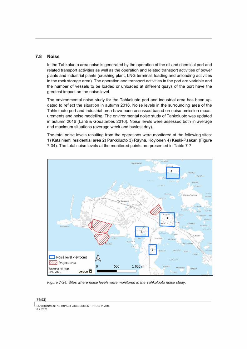
74(93) ENVIRONMENTAL IMPACT ASSESSMENT PROGRAMME
6.4.2021
7.8 Noise
In the Tahkoluoto area noise is generated by the operation of the oil and chemical port and
related transport activities as well as the operation and related transport activities of power
plants and industrial plants (crushing plant, LNG terminal, loading and unloading activities
in the rock storage area). The operation and transport activities in the port are variable and
the number of vessels to be loaded or unloaded at different quays of the port have the
greatest impact on the noise level.
The environmental noise study for the Tahkoluoto port and industrial area has been up-
dated to reflect the situation in autumn 2016. Noise levels in the surrounding area of the
Tahkoluoto port and industrial area have been assessed based on noise emission meas-
urements and noise modelling. The environmental noise study of Tahkoluoto was updated
in autumn 2016 (Lahti & Gouatarbès 2016). Noise levels were assessed both in average
and maximum situations (average week and busiest day).
The total noise levels resulting from the operations were monitored at the following sites:
1) Katainiemi residential area 2) Parkkiluoto 3) Räyhä, Köylönen 4) Keski-Paakari (Figure
7-34). The total noise levels at the monitored points are presented in Table 7-7.
Figure 7-34. Sites where noise levels were monitored in the Tahkoluoto noise study.
75(93)
ENVIRONMENTAL IMPACT ASSESSMENT PROGRAMME
6.4.2021
During the study there were permanent residences in Katainiemi (1) and Parkkiluoto (1)
and leisure homes in the Räyhä (3), Köylönen (3) and Keski-Paakari (4) area. According to
the information from the City of Pori, there are currently three permanent residents in the
Tahkoluoto area.
Table 7-7. Noise study of Tahkoluoto, total noise levels of all operators (A-medium sound level LAeq,
DB) at four monitoring sites) (Lahti & Gouatarbès 2016).
Calculation V1 average week V2 busiest day
Site day night day night
1 Katainiemi 49 41 51 46
2 Parkkiluoto 43 35 46 39
3 Räyhä, Köylynen 43 35 44 36
4 Keski-Paakari 46 38 49 44
The most significant source of noise in the Tahkoluoto area is the Stena Recycling crushing
facility. The port and vessels at the quays of the chemical port are major sources of noise
towards the islands on the northeastern side (Figure 7-35). The operation of the Fortum
power plant is audible in Katainiemi, but it is only rarely in operation. Other activities and
traffic operations are practically irrelevant sources of noise.
Based on studies, the equivalent continuous sound level generated by the facilities in the
area does not exceed the threshold values defined the environmental permits even in the
busiest day calculations in the nearby residential and recreational areas.
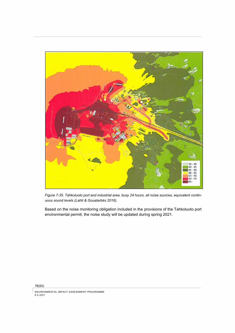
76(93) ENVIRONMENTAL IMPACT ASSESSMENT PROGRAMME
6.4.2021
Figure 7-35. Tahkoluoto port and industrial area, busy 24 hours, all noise sources, equivalent contin-
uous sound levels (Lahti & Gouatarbès 2016).
Based on the noise monitoring obligation included in the provisions of the Tahkoluoto port
environmental permit, the noise study will be updated during spring 2021.
77(93)
ENVIRONMENTAL IMPACT ASSESSMENT PROGRAMME
6.4.2021
8 Plan for the environmental impact assessment
8.1 Starting point for the EIA and outline of the assessment
According to the EIA Act, the assessment will address the environmental impacts caused
by the VRP on:
− soil and bedrock, water, air, climate, vegetation, organisms and biodiversity;
− use of natural resources;
− community structure, buildings, landscape, cityscape and cultural heritage;
− population and human health, living conditions and comfort;
− interaction between these factors.
Potential transboundary environmental impacts will also be considered.
The assessment is based on information about the current state of environment and the
expected changes to the environment caused by the VRP. Environmental impact assess-
ment will consider the effects of construction, operation and decommissioning. The focus
of the assessment is the examination of impacts during operation.
The EIA report examines the environmental impacts of activities in the VRP area and out-
side of it. Activities outside of the VRP area include e.g. traffic flows during the construction
and operation of the vanadium recovery plant. The outline of the assessment by impact is
presented in the following chapters.
The environmental impacts of the VRP are assessed by comparing the volume of a certain
load factor to the environmental tolerance taking e.g. the existing environmental load of the
impact area into consideration. When assessing the environmental tolerance, provided
guideline values, such as air quality and noise level guideline values as well as available
research information are utilised.
The sensitivity of the target and the magnitude of change are taken into account in as-
sessing the impact significance (Figure 8-1). Impact significance is assessed by using the
approach developed in the Imperia -project (Improving Environmental Assessment by
Adopting Good Practices and Tools of Multi-criteria Decision Analysis, LIFE11
ENV/FI/905).
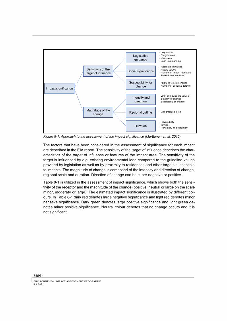
78(93) ENVIRONMENTAL IMPACT ASSESSMENT PROGRAMME
6.4.2021
Figure 8-1. Approach to the assessment of the impact significance (Marttunen et. al. 2015).
The factors that have been considered in the assessment of significance for each impact
are described in the EIA report. The sensitivity of the target of influence describes the char-
acteristics of the target of influence or features of the impact area. The sensitivity of the
target is influenced by e.g. existing environmental load compared to the guideline values
provided by legislation as well as by proximity to residences and other targets susceptible
to impacts. The magnitude of change is composed of the intensity and direction of change,
regional scale and duration. Direction of change can be either negative or positive.
Table 8-1 is utilized in the assessment of impact significance, which shows both the sensi-
tivity of the receptor and the magnitude of the change (positive, neutral or large on the scale
minor, moderate or large). The estimated impact significance is illustrated by different col-
ours. In Table 8-1 dark red denotes large negative significance and light red denotes minor
negative significance. Dark green denotes large positive significance and light green de-
notes minor positive significance. Neutral colour denotes that no change occurs and it is
not significant.
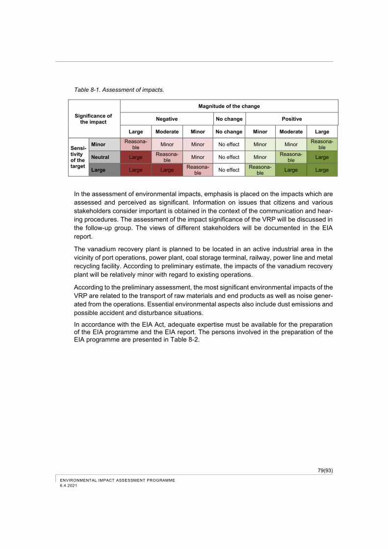
79(93)
ENVIRONMENTAL IMPACT ASSESSMENT PROGRAMME
6.4.2021
Table 8-1. Assessment of impacts.
Significance of the impact
Magnitude of the change
Negative No change Positive
Large Moderate Minor No change Minor Moderate Large
Sensi-tivity of the target
Minor Reasona-
ble Minor Minor No effect Minor Minor
Reasona-ble
Neutral Large Reasona-
ble Minor No effect Minor
Reasona-ble
Large
Large Large Large Reasona-
ble No effect
Reasona-ble
Large Large
In the assessment of environmental impacts, emphasis is placed on the impacts which are
assessed and perceived as significant. Information on issues that citizens and various
stakeholders consider important is obtained in the context of the communication and hear-
ing procedures. The assessment of the impact significance of the VRP will be discussed in
the follow-up group. The views of different stakeholders will be documented in the EIA
report.
The vanadium recovery plant is planned to be located in an active industrial area in the
vicinity of port operations, power plant, coal storage terminal, railway, power line and metal
recycling facility. According to preliminary estimate, the impacts of the vanadium recovery
plant will be relatively minor with regard to existing operations.
According to the preliminary assessment, the most significant environmental impacts of the
VRP are related to the transport of raw materials and end products as well as noise gener-
ated from the operations. Essential environmental aspects also include dust emissions and
possible accident and disturbance situations.
In accordance with the EIA Act, adequate expertise must be available for the preparation of the EIA programme and the EIA report. The persons involved in the preparation of the EIA programme are presented in Table 8-2.
80(93) ENVIRONMENTAL IMPACT ASSESSMENT PROGRAMME
6.4.2021
Table 8-2. Persons involved in the preparation of the EIA programme.
Name Education Role Qualification
Sirpa Torkkeli M.Sc. (industrial engineering) 1993
Project Man-ager
Over 20 years of experience for working in the environmental and energy industry sector. Participated in several EIA Pro-cedures both as a project man-ager/coordinator and a special-ist.
Vilma Skinnari M.Sc. Assistant Pro-ject Manager
Over 12 years of experience in industrial environmental tasks, including 8 years as an environ-mental expert in the metal pro-duction industry. Specific areas of expertise are environmental permitting processes and BAT.
Sanna Jaatinen D.Sc. (environ-mental technol-ogy) 2016
Specialist Over 9 years of experience in the environmental sector. Par-ticipation in EIA Procedures. Special expertise in soil and groundwater impact assess-ment.
Aija Degerman M.A. Biology Natura screening as-sessment
More than 10 years of experi-ence in the environmental field of nature and impact studies. Participated in several EIA pro-cedures.
8.2 Impact assessment area
Assessment area can be defined as a specific area for a particular type of impact, where
the particular environmental impact is examined and assessed (Figure 8-2). Traffic impacts
are assessed in the surroundings of the transport routes leading to the area to a distance
of about 10 km from the VRP area.
− The assessment area of noise impacts is the nearby area of the plant within a
radius of about 2-3 km.
− The assessment area of the impacts of air emissions is the vicinity of the VRP area
within a distance of about 5 km, significantly shorter distance regarding dust emis-
sions.
− Natura areas, nature conservation areas and sites of conservation programmes
are presented in the EIA programme within a distance of about 10 km.
− Impacts on landscape are assessed in more detail within a radius of about 2 km
and more generally within a radius of 5 km.
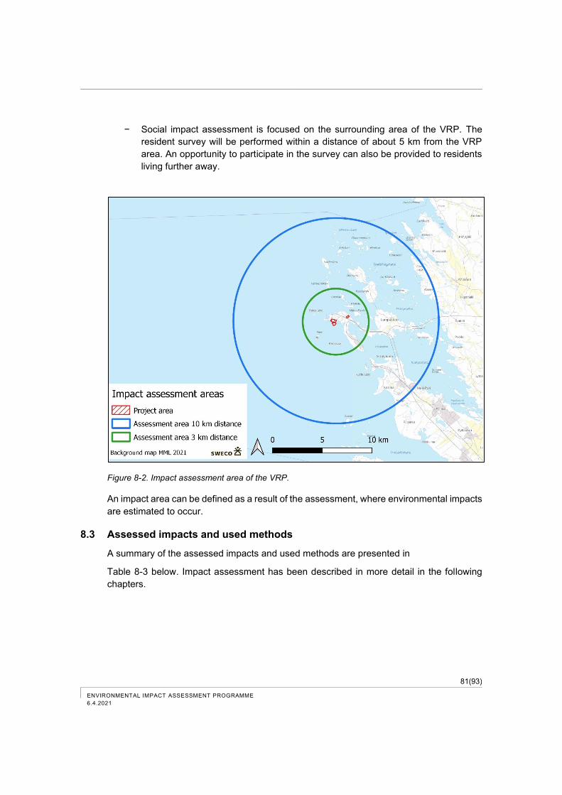
81(93)
ENVIRONMENTAL IMPACT ASSESSMENT PROGRAMME
6.4.2021
− Social impact assessment is focused on the surrounding area of the VRP. The
resident survey will be performed within a distance of about 5 km from the VRP
area. An opportunity to participate in the survey can also be provided to residents
living further away.
Figure 8-2. Impact assessment area of the VRP.
An impact area can be defined as a result of the assessment, where environmental impacts
are estimated to occur.
8.3 Assessed impacts and used methods
A summary of the assessed impacts and used methods are presented in
Table 8-3 below. Impact assessment has been described in more detail in the following
chapters.
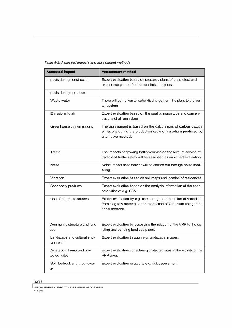
82(93) ENVIRONMENTAL IMPACT ASSESSMENT PROGRAMME
6.4.2021
Table 8-3. Assessed impacts and assessment methods.
Assessed impact Assessment method
Impacts during construction Expert evaluation based on prepared plans of the project and
experience gained from other similar projects
Impacts during operation
Waste water There will be no waste water discharge from the plant to the wa-
ter system
Emissions to air Expert evaluation based on the quality, magnitude and concen-
trations of air emissions.
Greenhouse gas emissions The assessment is based on the calculations of carbon dioxide
emissions during the production cycle of vanadium produced by
alternative methods.
Traffic The impacts of growing traffic volumes on the level of service of
traffic and traffic safety will be assessed as an expert evaluation.
Noise Noise impact assessment will be carried out through noise mod-
elling.
Vibration Expert evaluation based on soil maps and location of residences.
Secondary products Expert evaluation based on the analysis information of the char-
acteristics of e.g. SSM.
Use of natural resources Expert evaluation by e.g. comparing the production of vanadium
from slag raw material to the production of vanadium using tradi-
tional methods.
Community structure and land
use
Expert evaluation by assessing the relation of the VRP to the ex-
isting and pending land use plans.
Landscape and cultural envi-
ronment
Expert evaluation through e.g. landscape images.
Vegetation, fauna and pro-
tected sites
Expert evaluation considering protected sites in the vicinity of the
VRP area.
Soil, bedrock and groundwa-
ter
Expert evaluation related to e.g. risk assessment.
83(93)
ENVIRONMENTAL IMPACT ASSESSMENT PROGRAMME
6.4.2021
Assessed impact Assessment method
Human health, living condi-
tions and comfort
Expert evaluation using e.g. the impact assessment related to traf-
fic, noise and air quality and feedback obtained during the EIA
procedure especially considering sensitive sites.
A survey to residents will be performed for the assessment.
Accidents and disturbances Expert evaluation using e.g. information about project planning.
Decommissioning The preliminary environmental impacts of decommissioning will
be described based on available facility information.
8.4 Impacts during construction
Impacts during construction are examined separately for different types of impacts, as they
differ from impacts during the operation of the plant with regard to duration and also other
aspects.
During the assessment, the construction works of the plant and traffic arrangements and
traffic volumes are described and the used transport modes and routes are presented.
Impacts on soil and bedrock, vegetation and animals, employment and human comfort will
be assessed in the construction phase.
Impacts will be assessed as an expert evaluation based on prepared plans of the project
and experience gained from other similar projects.
8.5 Impacts during operation
8.5.1 Impacts related to waste water and cooling water
The water leaving the process will be sequestered into the secondary product (SSM).
Stormwater from the stockpiles and paved areas will be captured in run-off ponds and re-
used in the process.
8.5.2 Impacts related to air emissions
Dust emissions from operations are managed e.g. by closed systems as well as watering
and collection systems, and gas emissions are managed by gas scrubbers. Impacts on air
quality are estimated to be minor.
Dust emissions from the transport and handling of slag material and secondary products
(SSM and sodium sulphate) will probably be the most significant emissions to air from op-
erations.
The impacts of air emissions will be assessed as an expert evaluation based on the quality,
magnitude and concentration of air emissions.
The magnitude and significance of the air emissions from traffic operations (sulphur diox-
ide, nitrogen dioxide and particulate matter) related to the plant will be assessed based on
84(93) ENVIRONMENTAL IMPACT ASSESSMENT PROGRAMME
6.4.2021
traffic volumes and in proportion to, for example, the existing load of air emissions in the
Pori region. Air emissions from traffic will be estimated by using the traffic emission coeffi-
cients published on VTT's Lipasto — Traffic Emissions website.
8.5.3 Impacts related to greenhouse gas emissions
Carbon dioxide emissions will decrease with the implementation of the vanadium recovery
plant, as carbon dioxide is used in the process. Carbon dioxide is purchased from a com-
mercial provider and the aim is that it would consist of carbon dioxide sequestered from an
industrial site located in Finland, which would otherwise be emitted in the air. Traditionally,
vanadium production in mines causes a significant amount of carbon dioxide.
The impacts of the VRP on greenhouse gas emissions can also be evaluated by comparing
the carbon dioxide emissions between vanadium production in the recovery plant and va-
nadium production from ore in the mines. The comparison is based on the calculations of
carbon dioxide emissions during the production cycle of vanadium produced by alternative
methods.
8.5.4 Impacts related to traffic
As a result of the VRP, sea traffic volumes as well as railway traffic and road traffic volumes
will increase.
The EIA report will provide a detailed description of the existing conditions of road traffic,
railway traffic and sea traffic. The transport network, transport connections, traffic volumes
and general growth forecasts will be described and available accident statistics will be pre-
sented.
The impacts of growing traffic volumes on the level of service of traffic and traffic safety will
be assessed as an expert evaluation. Transport routes and changes in traffic volumes will
be presented as illustrative maps.
8.5.5 Noise impacts
Noise impact assessment will be based on the design information of the plant, transport
volumes, experiences of other similar activities and information on existing noise levels in
the impact area of the VRP.
Noise impact assessment will be carried out through noise modelling. The sound levels
generated by industrial operations and traffic will be estimated by using the environmental
noise calculation software CadnaA, which includes the Nordic calculation models for road
and industrial noise. Noise generated by the operations of the plant and related transport
volumes are examined in modelling. The models include noise generated by various activ-
ities of the VRP and noise generated by related traffic volumes.
The nearby area of the plant with facilities and shape of terrain are included in the three-
dimensional terrain model. Noise propagation is illustrated by maps produced by the mod-
elling software.
85(93)
ENVIRONMENTAL IMPACT ASSESSMENT PROGRAMME
6.4.2021
Impact assessment based on modelling focuses particularly on sensitive targets, such as
residences, schools, kindergartens, recreation areas and disturbed natural sites.
8.5.6 Vibration impacts
The probability of potential vibration impacts from growing railway traffic are assessed by
expert evaluation based on soil maps and location of residences in relation to the railway.
8.5.7 Impacts related to the handling of secondary products and waste
The characteristics of the secondary product will be described in detail.
The environmental impacts of the utilization and disposal of materials produced in the pro-
cess will be assessed as an expert evaluation in the industrial site and outside of the in-
dustrial site at general level.
8.5.8 Impacts related to the use of natural resources
It is estimated that the VRP will have positive impacts on the use of natural resources. The
impacts of the implementation alternatives and the non-implementation alternative of the
project on the use of natural resources will be assessed as an expert evaluation based on
available information.
The assessment is based on information about the production and availability of vanadium.
The production of vanadium from slag raw material is compared to the production of vana-
dium using traditional methods.
8.5.9 Impacts related to community structure and land use
The assessment will examine the relation of the VRP to the existing regional and commu-
nity structure, as well as to valid land use plans in the surrounding areas and pending land
use planning projects and other known land use plans. It will be examined, whether the
construction and impacts of the VRP have been addressed in the valid plans in the area,
whether the designated land use in the valid plans has a fundamental effect on the feasi-
bility of the VRP, whether the implementation of the VRP requires an alteration to the valid
plans or preparation of new plans, and how the project has been or can be considered in
land use plans in the area. The assessment will take account the nearest residential and
recreational areas, sites of cultural historical value and other potentially disturbed sites.
The impacts of the VRP on the implementation of national land use objectives will also be
assessed.
8.5.10 Impacts related to landscape and cultural environment
The impacts on landscape consist of changes in the structure, nature and quality of land-
scape. Visual effects are one of the components of landscape effects.
86(93) ENVIRONMENTAL IMPACT ASSESSMENT PROGRAMME
6.4.2021
Impacts on landscape and cultural environment will be assessed as an expert evaluation
through landscape image analysis, elements of landscape structure and illustrations visu-
alising the project plans. Impacts on landscape will be described considering the other
buildings and structures in the area, the shapes of the terrain and the designed size of new
structures. Valuable areas and objects located in and near the area will be considered.
The VRP area already has industrial activities and the nature of the site will not significantly
change with the project. Impacts on landscape will be examined more thoroughly in the
surrounding landscape zone, tentatively within a radius of about 2 kilometres. In addition,
impacts on landscape will be examined more extensively in a remote landscape zone,
within a radius of about 5 kilometres. Regarding cultural environment, the impact area ex-
tends out to approximately 2 kilometres from the VRP area.
8.5.11 Impacts on vegetation, fauna and protected sites
The existing port and industrial area does not likely have significant natural values which
would be directly affected by the project construction. Indirect impacts on the natural envi-
ronment can be caused by e.g. noise during construction and operation and by emissions
to air and water.
The impact assessment will be conducted as an expert evaluation and it will take into ac-
count known nature conservation areas, sites of conservation programmes and Natura ar-
eas located in the VRP impact area. Furthermore, the important bird areas (IBA, FINIBA
and MAALI), legally protected habitats, endangered habitats and other notable sites with
regard to vegetation or habitats as well as sites of national and regionally endangered and
legally protected species including the breeding and resting sites for species listed in Annex
IVa to the Habitat Directive will be considered in the assessment.
Natura areas, nature conservation areas and sites of conservation programmes are pre-
sented within a distance of about 10 kilometres in the EIA programme. The size of this area
can be extended, if necessary.
The impact assessment regarding nature sites and species will be carried out as an expert
evaluation in accordance with the guidelines of the Environmental Administration on nature
surveys, using the study “Nature surveys and wildlife impact assessment in zoning, EIA
procedure and Nature assessment” (Söderman 2003).
The Natura screening assessment
A separate Natura screening assessment under Section 65 of the Nature Conservation Act
has been prepared for the project (Sweco 2020).
With regard to Natura areas, it has been assessed, whether the project individually or in
combination with other projects could result in such impacts to the Natura sites that are
justified in the protection of the Natura areas that it is necessary to carry out a Natura
assessment under Section 65 of the Nature Conservation Act.
The growing freight traffic by sea caused by the project will probably partly use the 15.3-
metre deep-water channel through the Natura 2000 area of Gummandoora depending on
87(93)
ENVIRONMENTAL IMPACT ASSESSMENT PROGRAMME
6.4.2021
e.g. the size class of the vessels and timing of transport operations. When using vessels
with the maximum size of 25 000 tonnes, the 10-metre fairway could be used for part of the
transports. Only the final section of the route to the deep-water port would run along the
15.3-metre deep-water channel, in which case vessel traffic through the Natura area could
be avoided.
Due to the project, ship traffic volume on the deep-water channel will grow about 20 - 30 %
from the existing volume. This increase can be smaller, if the 10-metre fairway could partly
be used for transports. Even after this growth the total number of vessels on the fairway is
significantly lower when compared to the number of vessels during the busiest years.
As traffic volumes grow, the amount of emissions from ship traffic will also increase, but it
is estimated that the emissions will not have noticeable impacts on the natural values in
the Natura area. In offshore areas the impact of ship traffic generating waves will be minor,
and it is estimated that the growing traffic volumes due to the project will not have impacts
on the natural habitats, which constitute the protection objectives of the Natura area. The
distance between the deep-water channel and bird islets is 400 metres or more, and there
is existing ship traffic on the fairway, and therefore the growing ship traffic volumes due to
the project are not estimated to cause more significant disturbance to the bird population,
which constitutes the protection objective of the Natura area. It is estimated that the VRP
will not have an impact on the integrity of the Natura area.
It is estimated that the ship traffic caused by the vanadium recovery project and the Tahko-
luoto wind farm project will not have noticeable cumulative impacts on the natural values
of the Gummandoora Archipelago Natura area.
Based on the Natura screening assessment, the VRP will not cause such impacts on the
Gummandoora Archipelago Natura area which would require the preparation of an actual
Natura assessment pursuant to Section 65 of the Nature Conservation Act.
8.5.12 Impacts related to soil, bedrock and groundwater
The VRP is located in a port and industrial area and is partly built on an area that has been
filled. It is estimated that the normal operation of the plant will not have impacts on soil and
bedrock or geologically significant sites, so there is a minor need for an impact assessment
in this respect. Impacts on soil can be caused by potential accidents, such as chemical
leaks, which will be considered in the context of risk assessment. There are no groundwater
areas in the immediate vicinity of the port and the industrial area (see chapter 7.5.2, Figure
7-31). The impact assessment will be conducted as an expert evaluation.
8.5.13 Impacts related to human health, living conditions and comfort
The impacts of the VRP on people and their living conditions are called social impacts.
They refer to the impacts on people, community or society resulting in changes in the hu-
man well-being or the distribution of well-being (Finnish Institute for Health and Welfare,
www.thl.fi). In this EIA procedure, the social impact assessment refers to the identification
and assessment of the impacts on the human living conditions and comfort caused by the
VRP and future activities.
88(93) ENVIRONMENTAL IMPACT ASSESSMENT PROGRAMME
6.4.2021
Among others, the following social impacts will be assessed:
− impacts on human health and safety;
− impacts on living conditions and housing, leisure time and access to recreational
services;
− employment effects;
− community impacts (e.g. community, social problems);
− perceived impacts (how people perceive the project, what impacts are expected
from the project).
Noise and air quality impact assessments will be used to assess the impacts on health and
comfort. Changes in traffic volumes and other potential impacts of the VRP on residential
and recreational areas will be considered in the assessment.
The impact assessment will be conducted as an expert evaluation and it will consider the
nearby residential areas, recreational areas and other key activities and sites, if they are
deemed sensitive to harmful impacts.
A survey will be performed to the permanent residents and leisure-time residents in the
nearby area. The survey to residents will be implemented in the Internet and an opportunity
to reply on paper form is also provided. Special attention is paid to the formulation of the
survey questionnaire so that the questions are unambiguous and essential issues with re-
gard to the VRP can be clarified.
In addition, themes and comments raised in the public hearing of the EIA programme and
in other presentations of the project will be considered in the assessment. The follow-up
group of the project has an important cooperative role in the assessment. In addition, the
opinions on the EIA programme and the information and discussion on the VRP presented
in the media will be used. The public hearing will also provide information on the existing
use and importance of the area to residents in the local area.
The guide “Environmental Impact Assessment — Health and Social Impact on Humans”
prepared by the Ministry of Social Affairs and Health will be used to assist in the impact
assessment related to human beings. An open communication on the progress of the pro-
ject is particularly important in various phases of the project.
8.5.14 Transboundary environmental impacts
Based on preliminary view, no transboundary environmental impacts will be caused by the
VRP. This will be confirmed in the assessment phase.
8.5.15 Impacts related to accidents and disturbances
The environmental risk assessment of the VRP will identify the most significant risks and
describe the related potential environmental impacts. Measures needed to mitigate risks
and impacts will also be identified during the assessment.
89(93)
ENVIRONMENTAL IMPACT ASSESSMENT PROGRAMME
6.4.2021
The impact assessment will be conducted as an expert evaluation and available information
from the technical supplier and other projects will be used. Potential disturbances and ac-
cident situations include, for example, accidental emissions, chemical leaks and fires. The
report “Environmental Risk Analysis of Accidental Emissions” (Finnish Environment Insti-
tute 2006) will be used to assist in the impact assessment. Also, flood risk and increasing
extreme weather conditions will also be considered in the assessment.
8.5.16 Cumulative impacts
Other known projects in the vicinity of the VRP area are:
− Tahkoluoto offshore wind farm expansion project by Suomen Hyötytuuli Oy. Based
on preliminary estimates, the significant impacts of the project include the impacts
on water environment as well as the impacts on birds and landscape (Statement
of the coordinating authority on the EIA programme June 26, 2020). Based on the
preliminary timetable presented in the EIA report, which will be on public display in
March 2021, the construction of the wind farm could start not earlier than in 2023
and operation could start not earlier than 2025.
− Construction of a new oil quay in the Tahkoluoto chemical port, dredging and filling
of the water area. The project has impacts on water environment.
Potential cumulative impacts with the wind farm project could be related to the noise gen-
erated from the operation of the wind power plant and vanadium recovery plant as well as
from the lighting of facilities and impacts during construction, e.g. growing traffic volumes.
Potential cumulative impacts will be assessed in the EIA report phase.
The VRP will not have significant cumulative impacts with the aforementioned known pro-
jects that should be assessed separately.
8.6 Impacts related to decommissioning
Impacts related to the demolition of the plant are of similar type to those related to con-
struction, and they will be assessed using the same methods as impacts during construc-
tion (see Chapter 8.4). Demolition works include, for example, the effects of the disposal of
demolition waste. The quality assurance of the environmental eligibility of demolition waste
will be described in the EIA report. The preliminary long-term environmental impacts of
decommissioning will be described based on facility information.
8.7 Summary of impacts
The impacts of the implementation alternative and the sub-alternatives of the project as
compared to the non-implementation alternative (Alternative 0) as well as the significance
of impacts will be described in a summary table. Positive, negative and neutral environ-
mental impacts will be presented in the table in an illustrative and consistent way.
The significance of the project impacts will be discussed in the follow-up group. The views
of the follow-up group, residents and operators will be recorded in the EIA report.
90(93) ENVIRONMENTAL IMPACT ASSESSMENT PROGRAMME
6.4.2021
Based on the results of the environmental impact assessment, the environmental feasibility
of the alternatives will be assessed.
8.8 Prepared and planned studies
The following studies will be prepared in the EIA procedure:
− The need for the Natura assessment pursuant to the Nature Conservation Act
has been evaluated in the context of the EIA programme.
− Preliminary surveys will be performed in spring 2021 for evaluating the quality of
soil in the VRP area.
− A survey will be performed in spring 2021 for the permanent residents and leisure
time residents in the nearby area of the project for the purpose of the social im-
pact assessment.
8.9 Assessment of uncertainties
There are always assumptions and generalisations related to the background materials
and evaluation methods used in the assessment. The available technical specifications are
still preliminary. Lack of information and inaccuracy cause uncertainties in the assessment.
Uncertainties related to the project and assessment methods are identified during the as-
sessment work. The most essential uncertainties, their significance and the reliability of the
assessment will be described in the EIA report.
9 Prevention and mitigation of harmful impacts
In the context of the assessment work and project planning, measures for preventing and
mitigating potential, future harmful environmental impacts related to the project will be ex-
amined. Mitigation measures will be presented in the EIA report.
10 Monitoring of impacts
The EIA report will provide a proposal for the content of environmental impact monitoring. The objective of monitoring is to:
− produce information on the impacts of the project;
− identify changes, which are the consequences of the project implementation;
− compare the results of the impact assessment with the actual development;
− evaluate the adequacy of the mitigation measures for harmful impacts;
− take necessary measures, if unexpected significant harmful impacts are detected.
91(93)
ENVIRONMENTAL IMPACT ASSESSMENT PROGRAMME
6.4.2021
11 References
Ahlman, S. & Luoma, S. 2013. Isojen lintujen muuttoreitit Satakunnassa – havaintokat-
saus. University of Turku, Centre for Maritime Studies. 117 pages.
Ahlman, S. 2020. Porin Tahkoluodon luontoselvitys 2020. Ahlman Group Oy.
Alajoki, H. 2017. Kokemäenjoen ja Porin merialueen edustan yhteistarkkailu vuonna 2016.
Water Protection Association of Kokemäenjoki River ry. Publication number 783.
https://www.ymparisto.fi/download/noname/%7BCD983096-7523-49F5-A96D-
334D63BAC588%7D/123738
Ator Consultants Oy. 2016. Finland Tank Storage Oy. Ympäristövaikutusten arviointiselos-
tus.
City of Pori 2018. Statistics of Pori.
City of Pori Environmental and Health Surveillance Department. 2020. Air quality in Harja-
valta and Pori 2019. Air quality working group Harjavalta-Pori. 20.3.2020. Available at:
www.pori.fi/ilmanlaatu
City of Pori. 2020. Tahkoluoto−Paakarit osayleiskaava 2040. Kaavaselostus. Osayleiskaa-
valuonnos. 22.6.2020.
ELY Centre for Southwestern Finland. 2020. Tienpidon ja liikenteen suunnitelma 2020-
2023. April 2020.
Environmental Administration, Map Service Karpalo 2.1 available at: https://wwwp2.ympar-
isto.fi/KarpaloSilverlight/
Environmental Administration, Permit Service available at https://ylupa.avi.fi/
Finnish Heritage Agency, Map Service. Available at: https://kartta.museoverkko.fi/
Finnish Heritage Agency. Service window for cultural environment. Available at:
www.kyppi.fi
Finnish Transport Infrastructure Agency. 2021. Traffic volume maps. Available at:
https://vayla.fi/vaylista/aineistot/kartat/liikennemaarakartat
Finnish Transport Infrastructure Agency. 2021. E-mail notice on 3.3.2021. Railway
transport volume to the Tahkoluoto port (Pori).
Finnish Transport Infrastructure Agency. 2021. Hankekortti. Pori-Mäntyluoto-radan perus-
parannus.
Fintraffic. 2021. E-mail notice on 9.3.2021. Train volume, Tahkoluoto operating point.
Ijäs, A., Nuotio, K., Sjöholm, J. Merilintujen lentokonelaskennat Selkämeren rannikkoalu-
eella 2012 – 2013. University of Turku, Publications of the Centre for Maritime Studies.
B199, Turku 2013.
92(93) ENVIRONMENTAL IMPACT ASSESSMENT PROGRAMME
6.4.2021
Ilmasto-opas. Satakunta – merellistä ja mantereista ilmastoa. Referred on 15.2.2021. Avail-
able at: https://ilmasto-opas.fi/fi/ilmastonmuutos/suomen-muuttuva-ilmasto/-/artik-
keli/8cf1f204-5ff0-423d-beb4-6237dd74b60d/satakunta-merellista-ja-mantereista-ilmas-
toa.html
Iso-Tuisku, J. 2016. Huntsman Pigments and Additives Oy, Pori. Porin edustan merialueen
pohjaeläimistö vuonna 2015. Water Protection Association of Kokemäenjoki River ry. Pub-
lication number 755.
Kohti hiilineutraalia Poria. Referred on 4.2.2021. Available at: https://www.pori.fi/kohti-
hiilineutraalia-poria
KVVY. 2020. Kokemäenjoki, vedenlaatu vesistöalueella. Water Protection Association of
Kokemäenjoki River ry. Referred on 12.6.2020. Available at: https://kvvy.fi/kvvy/jarvet-ja-
joet/vedenlaatu-vesistoalueella/
Lahti, T., Gouatarbès, B. 2016. Tahkoluodon satama ja teollisuusalue. Ympäristömelusel-
vitys, päivitys 2016. TL akustiikka. Helsinki 2016-12.
Ministry of Economic Affairs and Employment. 2019. Sector report on the mining industry.
Publications of the Ministry of Economic Affairs and Employment 2019:57. Available at:
https://julkaisut.valtioneuvosto.fi/bitstream/handle/10024/161860/TEM_2019_57.pdf
Ministry of Economic Affairs and Employment. 2021. National Battery Strategy 2025. Pub-
lications of the Ministry of Economic Affairs and Employment 2021:2. Available at:
https://julkaisut.valtioneuvosto.fi/bitstream/handle/10024/162684/TEM_2021_2.pdf
Ministry of the Environment 2006. Tuulivoimalat ja maisema. Suomen ympäristö 5/2006.
National Land Survey of Finland. Map Service.
Pirkanmaa Regional Council. 2018. Akkuekosysteemi - nykytilaselvitys. Available at:
https://media.sitra.fi/2018/06/28164111/tulevaisuuden-akkuekosysteemi-nykytilaselvitys-
150618.pdf
Pori. 2021. Air quality. Available at: https://www.pori.fi/ilmanlaatu
Pori City Board 2021. Land Use Planning Review 2021-2023. Land Use Planning
Programme of the City of Pori. 15.2.2021. Available at:
https://www.pori.fi/kaupunkisuunnittelu/kaavat/kaavoituskatsaus-ja-ohjelma
Port of Pori. 2021. Maps. https://portofpori.fi/fi/palvelut/kartat/
Satakunta Museum. 2014. Ed. Vasko, T. Pori. Tahkoluoto – Mäntyluoto. LNG-terminaalin
kaasuputkilinjan arkeologinen inventointi 2014. Available at: https://www.kyppi.fi/palveluik-
kuna/raportti/read/asp/hae_liite.aspx?id=119778&ttyyppi=pdf&kansio_id=609
Satakunta Regional Council. 2014. Satakunnan maisemaselvitys. Selvitys Satakunnan
maisemamaakunta- ja maisemaseutujaon tarkistamiseksi.
Suomen Hyötytuuli Oy. 2020. Tahkoluodon merituulipuiston laajennus. Ympäristövaikutus-
ten arviointiohjelma.
93(93)
ENVIRONMENTAL IMPACT ASSESSMENT PROGRAMME
6.4.2021
Söderman, T. 2003. Luontoselvitykset ja luontovaikutusten arviointi: kaavoituksessa, YVA-
menettelyssä ja Natura-arvioinnissa. Finnish Environment Institute. Ympäristöopas 109.
196 pages.
Tahkoluodon Polttoöljy Oy. Ympäristölupapäätös LOS-2007-Y-1340-111. Päätös ympäris-
tönsuojelulain 90 §:n mukaisesta hakemuksesta, joka koskee Tahkoluodon Polttoöljy Oy:n
kalliovaraston toiminnan lopettamisen jälkeisiä velvoitteita Porin kaupungin Tahkoluodon
satamassa.
Väisänen, A. 2018a. Kokemäenjoen ja sen edustan merialueen kalataloudellinen velvoite-
tarkkailu vuonna 2016. Water Protection Association of Kokemäenjoki River ry. Publication
778.
Väisänen, A. 2018b. Venator Oy. Kalataloudellinen velvoitetarkkailu porin edustan meri-
alueella vuosina 2014–16. Water Protection Association of Kokemäenjoki River ry. Publi-
cation 792.
EXTRACT FROM THE NATURA SCREENING ASSESSMENT
WORK NUMBER: 10903772
CRITICAL METALS
VANADIUM RECOVERY PROJECT
6.4.2021 SWECO INFRA & RAIL OY OULU
Kansikuva: selkameri.fi, Iso-Enskeri
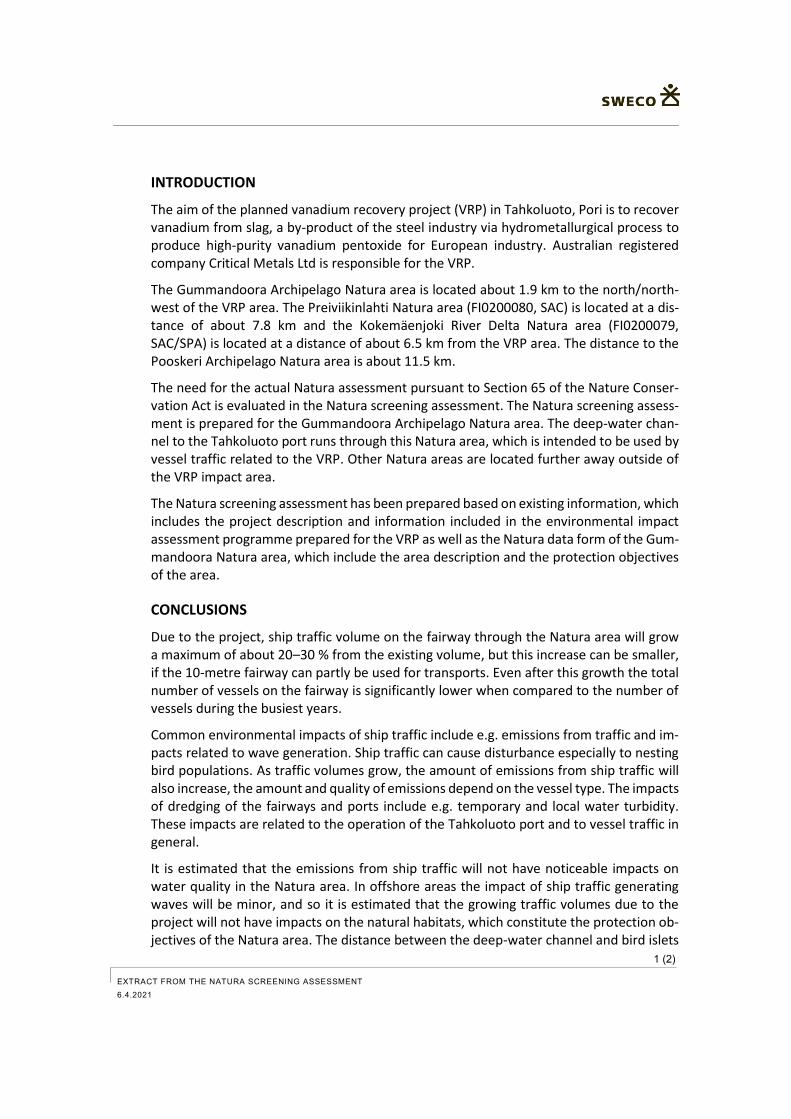
1 (2)
EXTRACT FROM THE NATURA SCREENING ASSESSMENT
6.4.2021
INTRODUCTION
The aim of the planned vanadium recovery project (VRP) in Tahkoluoto, Pori is to recover vanadium from slag, a by-product of the steel industry via hydrometallurgical process to produce high-purity vanadium pentoxide for European industry. Australian registered company Critical Metals Ltd is responsible for the VRP.
The Gummandoora Archipelago Natura area is located about 1.9 km to the north/north-west of the VRP area. The Preiviikinlahti Natura area (FI0200080, SAC) is located at a dis-tance of about 7.8 km and the Kokemäenjoki River Delta Natura area (FI0200079, SAC/SPA) is located at a distance of about 6.5 km from the VRP area. The distance to the Pooskeri Archipelago Natura area is about 11.5 km.
The need for the actual Natura assessment pursuant to Section 65 of the Nature Conser-vation Act is evaluated in the Natura screening assessment. The Natura screening assess-ment is prepared for the Gummandoora Archipelago Natura area. The deep-water chan-nel to the Tahkoluoto port runs through this Natura area, which is intended to be used by vessel traffic related to the VRP. Other Natura areas are located further away outside of the VRP impact area.
The Natura screening assessment has been prepared based on existing information, which includes the project description and information included in the environmental impact assessment programme prepared for the VRP as well as the Natura data form of the Gum-mandoora Natura area, which include the area description and the protection objectives of the area.
CONCLUSIONS
Due to the project, ship traffic volume on the fairway through the Natura area will grow a maximum of about 20–30 % from the existing volume, but this increase can be smaller, if the 10-metre fairway can partly be used for transports. Even after this growth the total number of vessels on the fairway is significantly lower when compared to the number of vessels during the busiest years.
Common environmental impacts of ship traffic include e.g. emissions from traffic and im-pacts related to wave generation. Ship traffic can cause disturbance especially to nesting bird populations. As traffic volumes grow, the amount of emissions from ship traffic will also increase, the amount and quality of emissions depend on the vessel type. The impacts of dredging of the fairways and ports include e.g. temporary and local water turbidity. These impacts are related to the operation of the Tahkoluoto port and to vessel traffic in general.
It is estimated that the emissions from ship traffic will not have noticeable impacts on water quality in the Natura area. In offshore areas the impact of ship traffic generating waves will be minor, and so it is estimated that the growing traffic volumes due to the project will not have impacts on the natural habitats, which constitute the protection ob-jectives of the Natura area. The distance between the deep-water channel and bird islets
2 (2) EXTRACT FROM THE NATURA SCREENING ASSESSMENT
6.4.2021
is 400 m or more, and there is existing ship traffic on the fairway, and therefore the grow-ing ship traffic volumes due to the project are not estimated to cause more significant disturbance to the bird population, which constitutes the protection objective of the Natura area. It is estimated that the VRP will not have an impact on the integrity of the Natura area.
Based on the screening assessment, the VRP will not cause such impacts on the Gumman-doora Archipelago Natura area, which would require the preparation of an actual Natura assessment pursuant to Section 65 of the Nature Conservation Act.