Embed Size (px)
Citation preview

Ocean Sci., 18, 761–795, 2022https://doi.org/10.5194/os-18-761-2022© Author(s) 2022. This work is distributed underthe Creative Commons Attribution 4.0 License.
Coastal high-frequency radars in the Mediterranean – Part 1:Status of operations and a framework for future developmentPablo Lorente1,2, Eva Aguiar3, Michele Bendoni4, Maristella Berta5, Carlo Brandini4,6, Alejandro Cáceres-Euse7,Fulvio Capodici8, Daniela Cianelli9,10, Giuseppe Ciraolo8, Lorenzo Corgnati5, Vlado Dadic11, Bartolomeo Doronzo4,6,Aldo Drago12, Dylan Dumas7, Pierpaolo Falco13, Maria Fattorini4,6, Adam Gauci12, Roberto Gómez14,Annalisa Griffa5, Charles-Antoine Guérin7, Ismael Hernández-Carrasco15, Jaime Hernández-Lasheras3,Matjaž Licer16,17, Marcello G. Magaldi5, Carlo Mantovani5, Hrvoje Mihanovic11, Anne Molcard7, Baptiste Mourre3,Alejandro Orfila15, Adèle Révelard3, Emma Reyes3, Jorge Sánchez18, Simona Saviano9,10, Roberta Sciascia5,Stefano Taddei4, Joaquín Tintoré3,15, Yaron Toledo19, Laura Ursella20, Marco Uttieri9,10, Ivica Vilibic11,21,Enrico Zambianchi10,22, and Vanessa Cardin20
1Puertos del Estado, Área de Medio Físico, Madrid, 28042, Spain2NOLOGIN CONSULTING SL, Zaragoza, 50018, Spain3SOCIB, Balearic Islands Coastal Observing and Forecasting System, Palma, 07122, Spain4Consorzio LaMMA, Sesto Fiorentino, 50019, Italy5Consiglio Nazionale delle Ricerche (CNR), Istituto di Scienze Marine (ISMAR), Lerici, 19032, Italy6Consiglio Nazionale delle Ricerche (CNR), Istituto per la Bioeconomia (IBE), Sesto Fiorentino, 50019, Italy7Mediterranean Institute of Oceanography, Université de Toulon, Aix Marseille Univ,CNRS, IRD, MIO, Toulon, France8Università degli Studi di Palermo, Dipartimento di Ingegneria, 90128, Palermo, Italy9Stazione Zoologica Anton Dohrn, Naples, 80121, Italy10Consorzio Nazionale Interuniversitario per le Scienze del Mare (CoNISMa), Rome, 00196, Italy11Institute of Oceanography and Fisheries, Split, 21000, Croatia12Physical Oceanography Research Group, University of Malta, Msida, MSD 2080, Malta13Universita’ Politecnica delle Marche, DISVA, Ancona, 60121, Italy14Helzel Messtechnik GmbH, 24568 Kaltenkirchen, Germany15Mediterranean Institute for Advanced Studies – IMEDEA – (CSIC-UIB), Esporles, 07190, Spain16National Institute of Biology, Marine Biology Station, Piran, 6330, Slovenia17Slovenian Environment Agency, Ljubljana, 1000, Slovenia18Qualitas Instruments S.A., Madrid, 28043, Spain19School of Mechanical Engineering, Tel-Aviv University, Tel-Aviv, 6905904, Israel20Istituto Nazionale di Oceanografia e di Geofisica Sperimentale, OGS, Sgonico TS, 34010, Italy21Ruder Boškovic Institute, Division for Marine and Environmental Research, Zagreb, 10000, Croatia22Dipartimento di Scienze e Tecnologie (DiST), Parthenope University of Naples, Naples, 80143, Italy
Correspondence: Pablo Lorente ([email protected])
Received: 2 December 2021 – Discussion started: 14 December 2021Revised: 9 March 2022 – Accepted: 14 March 2022 – Published: 1 June 2022
Published by Copernicus Publications on behalf of the European Geosciences Union.

762 P. Lorente et al.: Coastal HF radars in the Mediterranean
Abstract. Due to the semi-enclosed nature of the Mediter-ranean Sea, natural disasters and anthropogenic activities im-pose stronger pressures on its coastal ecosystems than in anyother sea of the world. With the aim of responding adequatelyto science priorities and societal challenges, littoral watersmust be effectively monitored with high-frequency radar(HFR) systems. This land-based remote sensing technologycan provide, in near-real time, fine-resolution maps of thesurface circulation over broad coastal areas, along with reli-able directional wave and wind information. The main goalof this work is to showcase the current status of the Mediter-ranean HFR network and the future roadmap for orchestratedactions. Ongoing collaborative efforts and recent progress ofthis regional alliance are not only described but also con-nected with other European initiatives and global frame-works, highlighting the advantages of this cost-effective in-strument for the multi-parameter monitoring of the sea state.Coordinated endeavors between HFR operators from differ-ent multi-disciplinary institutions are mandatory to reach amature stage at both national and regional levels, striving todo the following: (i) harmonize deployment and maintenancepractices; (ii) standardize data, metadata, and quality controlprocedures; (iii) centralize data management, visualization,and access platforms; and (iv) develop practical applicationsof societal benefit that can be used for strategic planning andinformed decision-making in the Mediterranean marine en-vironment. Such fit-for-purpose applications can serve forsearch and rescue operations, safe vessel navigation, track-ing of marine pollutants, the monitoring of extreme events,the investigation of transport processes, and the connectivitybetween offshore waters and coastal ecosystems. Finally, fu-ture prospects within the Mediterranean framework are dis-cussed along with a wealth of socioeconomic, technical, andscientific challenges to be faced during the implementationof this integrated HFR regional network.
1 The Mediterranean Sea coastal regions: sciencepriorities and societal needs
1.1 The oceanographic landscape
The Mediterranean Sea is located at the crossroads of threecontinents (Africa, Europe, and Asia), thereby playing an im-portant geopolitical role in the world chessboard since an-cient times as a busy navigable route for maritime trans-port, commerce, and cultural exchange (Gaiser and Hribar,2012). It is a semi-enclosed, microtidal basin connected tothe Atlantic Ocean, the Black Sea, and the Red Sea bythree geostrategic choke points: the Strait of Gibraltar (in thewest), the Dardanelles (in the northeast), and the Suez Canal(in the southeast), respectively (Fig. 1). It is also an olig-otrophic well-oxygenated system characterized by complexphysical and biological dynamics (Christaki et al., 2011).
Offshore waters exhibit extremely low biological productiv-ity, with the concentration of nutrients decreasing from NWto SE. The panoramic picture of the Mediterranean circula-tion, which exhibits a strong seasonal and interannual vari-ability, is composed of a variety of relevant processes inter-acting at diverse timescales, namely water mass formation,overturning circulation, boundary currents, and frontal insta-bilities (Pinardi et al., 2019; Tintoré et al., 2019). The large-scale thermohaline circulation is interconnected with recur-rent sub-basin gyres and energetic mesoscale eddies, whichare in turn bounded by current meanders and bifurcating jets(Millot and Taupier-Letage, 2005). The rugged configurationof narrow shelf areas, with steep continental breaks, entailsthe intrusion and direct impact of the large-scale open-oceanflow on the coastal dynamics. For further details about gen-eral oceanographic conditions in the entire basin, the readeris referred to Pinardi et al. (2006) and Malanotte-Rizzoli etal. (2014).
1.2 Science priorities
The Mediterranean Sea is one of the biggest reservoirs ofmarine life in the world, contributing to more than 7 % ofworld’s marine biodiversity including a high percentage ofendemic species (Coll et al., 2010), while only covering0.7 % of the ocean’s surface area. Since natural disasters, an-thropogenic activities, and climate change might impose sig-nificant and long-lasting pressures (Juza and Tintoré, 2021;Tuel and Eltahir, 2020; Spalding et al., 2014), diverse sci-ence priorities have been identified to promote healthy andsustainable marine ecosystems in the Mediterranean Sea, in-cluding the following three among others.
The first is the detailed investigation of transport processesand the connectivity between offshore waters and coastalecosystems. The cross-shelf exchange of nutrients, organicmatter, pollutants, and other passive tracers might have rel-evant implications in terms of intense biogeochemical activ-ity, eutrophication, proliferation of harmful algal blooms, andfisheries production. Equally, a deeper understanding of theocean circulation can lead to more accurate model predic-tions of Lagrangian trajectories, which in turn can be used togain insight into particle tracking, dispersion processes, resi-dence times, and water renewal mechanisms.
The second is the impact assessment of coastal hazardsand extreme sea states, ranging from storm surges, erosion,and flash floods to rogue waves and Mediterranean hurri-canes, also named “Medicanes” (Von Schuckmann et al.,2020; Milglietta and Rotunno, 2019; Wolff et al., 2018; Cav-aleri et al., 2012). In this context, impact assessment shouldbe understood as the analysis of the primary met-ocean fac-tors that give rise to severe coastal disasters and the com-prehensive evaluation of the environmental effects on marineresources along with other inherent societal and economicconsequences with the final aim of implementing strategic
Ocean Sci., 18, 761–795, 2022 https://doi.org/10.5194/os-18-761-2022

P. Lorente et al.: Coastal HF radars in the Mediterranean 763
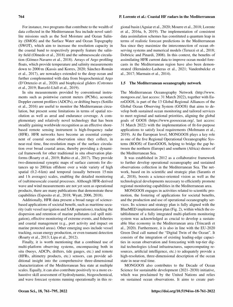
Figure 1. Bathymetric map of the Mediterranean Sea, depicting some local seas and geographical features. The location and spatial coverageof ongoing high-frequency radar (HFR) systems deployed in the basin are represented with red contours. Ongoing, old, and future HFR sitesare represented with green, blue, and yellow dots, respectively.
preparedness policies that could reduce both exposure andcoastal vulnerability.
The third is a thorough analysis of climate-driven varia-tions such as sea level rise, steady acidification, the increasein ocean heat content, recurrent marine heat waves, or po-tential alterations in the thermohaline circulation (Juza andTintoré, 2021; Garrabou et al., 2019).
1.3 Societal challenges
The aforementioned science priorities are particularly moti-vated by the semi-enclosed nature of the Mediterranean Sea,where anthropogenic pressures are likely more intense thanin any other sea of the world (Lejeusne et al., 2010). Anincreasingly high density of inhabitants (above 470 million)gravitate toward littoral regions for their living needs (Wolffet al., 2020), which are not only impacted by local humanactivities but also further altered by massive internationaltourism, including passenger ferries, cruises, and recreationalboating. Apart from the shortage of water resources (tied tothe population growth and the intensification of coastal ur-banization, agricultural development, and industrial activi-ties), other interconnected societal challenges in the Mediter-ranean Sea have been documented (Tintoré et al., 2019;López-Jurado et al., 2015) and include the following.
Enhanced maritime safety. Efficient ship routing is re-quired to minimize both fuel consumption and the risk ofaccidental oil spills. Furthermore, search and rescue (SAR)operations constitute a major humanitarian emergency inthe Mediterranean basin and thereby demand science-basedmanagement protocols for a timely response.
Improved ecological decision support systems. The preser-vation of local marine fauna (seriously jeopardized by in-tense overfishing), habitat modification, the transfer of alienspecies, and the ingestion of litter demand tailored tools for
informed decision-making (Campanale et al., 2019). Equally,the monitoring of water quality in the Mediterranean Searemains a priority, since it is negatively impacted by thedischarge of land-based toxic pollutants from local riversinto coastal sea waters (Nikolaidis et al., 2014) and also byepisodic marine pollution episodes (Soussi et al., 2020).
1.4 Multi-platform observing systems: high-frequencyradar as a key component
To adequately respond to those science priorities and soci-etal challenges previously enumerated, a sustainable multi-platform observing infrastructure should be implementedand integrated. The accurate monitoring and deep under-standing of the Mediterranean marine environment are notonly crucial to prompt a wealth of anticipatory adaptationstrategies but also of great economic value for the maritimesector (Melet et al., 2020). Such preventive approaches canhelp to bridge the gap between marine citizen science andcoastal management (Turicchia et al., 2021), which wouldstrengthen community resilience at multiple scales (Sum-mers et al., 2018; Linnenluecke et al., 2012).
With the advent of new technologies and ships supportinginterdisciplinary suites of sensors (Mahadevan et al., 2020), agrowing wealth of observational data are nowadays availableto properly characterize the Mediterranean Sea (Le Traon etal., 2013). Most of these data are regularly ingested by theCopernicus Marine Environment Monitoring Service In SituThematic Center, hereinafter CMEMS-INSTAC (Le Traonet al., 2017), the EMODnet program (Martín Miguez et al.,2019), and the SeaDataCloud (Fichaut and Schaap, 2016),promoting an ocean observing value chain that links obser-vations and data discovery to downstream applications forsocietal benefit.
https://doi.org/10.5194/os-18-761-2022 Ocean Sci., 18, 761–795, 2022
764 P. Lorente et al.: Coastal HF radars in the Mediterranean
For instance, two programs that contribute to the wealth ofdata collected in the Mediterranean Sea include novel satel-lite missions such as the Soil Moisture and Ocean Salin-ity (SMOS) and the Surface Water and Ocean Topography(SWOT), which aim to increase the resolution capacity inthe coastal band to respectively properly feature the salin-ity field (Olmedo et al., 2018) and the submesoscale circula-tion (Gómez-Navarro et al., 2018). Arrays of Argo profilingfloats, which provide temperature and salinity measurementsdown to 2000 m (Kassis and Korres, 2020; Sánchez-Románet al., 2017), are nowadays extended to the deep ocean andfurther complemented with data from biogeochemical Argo(D’Ortenzio et al., 2020) and biophysical gliders (Cotroneoet al., 2019; Barceló-Llull et al., 2019).
In situ measurements provided by conventional instru-ments such as pointwise current meters (PCMs), acousticDoppler current profilers (ADCPs), or drifting buoys (Sotilloet al., 2016) are useful to monitor the Mediterranean circu-lation, but present some limitations in terms of spatial res-olution as well as areal and endurance coverage. A com-plementary and relatively novel technology that has beensteadily gaining worldwide recognition as an effective shore-based remote sensing instrument is high-frequency radar(HFR). HFR networks have become an essential compo-nent of coastal ocean observation since they collect, innear-real time, fine-resolution maps of the surface circula-tion over broad coastal areas, thereby providing a dynami-cal framework for other traditional in situ observation plat-forms (Roarty et al., 2019; Rubio et al., 2017). They providetwo-dimensional synoptic maps of surface currents for dis-tances up to 200 km offshore over a wide variety of highspatial (0.2–6 km) and temporal (usually between 15 minand 1 h averages) scales, enabling the detailed monitoringof (sub)mesoscale coastal processes. Although HFR-derivedwave and wind measurements are not yet seen as operationalproducts, there are many publications that demonstrate thesecapabilities (Esposito et al., 2018; Wyatt, 2006, 2018).
Additionally, HFR data present a broad range of science-based applications of societal benefit, such as maritime secu-rity (safe vessel navigation and SAR operations), tracking thedispersion and retention of marine pollutants (oil spill miti-gation), effective monitoring of extreme events, and fisheriesand coastal management (e.g., port activity and impact onmarine protected areas). Other emerging uses include vesseltracking, ocean energy production, or even tsunami detection(Roarty et al., 2013; Lipa et al., 2012).
Finally, it is worth mentioning that a combined use ofmulti-platform observing systems, encompassing both insitu (buoys, ADCPs, drifters, tide gauges, etc.) and remote(HFRs, altimetry products, etc.) sensors, can provide ad-ditional insight into the comprehensive three-dimensionalcharacterization of the Mediterranean Sea state at multiplescales. Equally, it can also contribute positively to a more ex-haustive skill assessment of hydrodynamic, biogeochemical,and wave forecast systems running operationally in this re-
gional basin (Aguiar et al., 2020; Mourre et al., 2018; Lorenteet al., 2016a, b, 2019). The implementation of consistentdata assimilation schemes has constituted a quantum leap interms of realistic forecast predictions in the MediterraneanSea since they maximize the interconnection of ocean ob-serving systems and numerical models (Teruzzi et al., 2018;Dobricic and Pinardi, 2008). In this context, the benefits ofassimilating HFR current data to improve ocean model fore-casts in the Mediterranean region have also been demon-strated (Hernández-Lasheras et al., 2021; Vandenbulcke etal., 2017; Marmain et al., 2014).
1.5 The Mediterranean oceanography network
The Mediterranean Oceanography Network (http://www.mongoos.eu/, last access: 31 March 2022), together with Eu-roGOOS, is part of the 13 Global Regional Alliances of theGlobal Ocean Observing System (GOOS) that aims to de-velop both sustained ocean monitoring and tailored servicesto meet regional and national priorities, aligning the globalgoals of GOOS (https://www.goosocean.org/, last access:31 March 2022) with the implementation of fit-for-purposeapplications to satisfy local requirements (Moltmann et al.,2019). At the European level, MONGOOS plays a key roleas one of the five Regional Operational Oceanographic Sys-tems (ROOS) of EuroGOOS, helping to bridge the gap be-tween the northern (Europe) and southern (Africa) shores ofthe Mediterranean Sea.
It was established in 2012 as a collaborative frameworkto further develop operational oceanography and sustainedobservations collection in the Mediterranean Sea. The net-work, based on its scientific and strategic plan (Sarantis etal., 2018), boosts a science-oriented vision as well as thetechnological developments necessary to efficiently promoteregional monitoring capabilities in the Mediterranean area.
MONGOOS engages in activities related to scientific pro-motion, the fostering of applications for societal benefits,and the production and use of operational oceanography ser-vices. Its science and strategy plan is fully aligned with theBlueMED implementation plan (Fig. 2), within which the es-tablishment of a fully integrated multi-platform monitoringsystem was acknowledged as crucial to develop a sustain-able blue economy in the Mediterranean area (Trincardi etal., 2020). Furthermore, it is also in line with the EU-2020Green Deal call named the “Digital Twin of the Ocean”. Itconsists of the integration of existing leading-edge capaci-ties in ocean observation and forecasting with top-tier dig-ital technologies (cloud infrastructures, supercomputing re-sources, artificial intelligence, etc.) to adequately provide ahigh-resolution, three-dimensional description of the oceanstate in near-real time.
MONGOOS also contributes to the Decade of OceanScience for sustainable development (2021–2030) initiative,which was proclaimed by the United Nations and relieson sustained ocean observations. It aims to create part-
Ocean Sci., 18, 761–795, 2022 https://doi.org/10.5194/os-18-761-2022

P. Lorente et al.: Coastal HF radars in the Mediterranean 765
nerships, strengthen international cooperation, mobilize re-sources, engage governments (and targeted stakeholders),and support high-stakes decision-making in the marine en-vironment (Ryabinin et al., 2019). The network plays an im-portant role in “The Science We Need for the MediterraneanSea We Want” program (SciNMeet) recently endorsed in thefirst call for decade action and which encompasses a broadscope and high ambition to tackle all major environmentaland social challenges in the Mediterranean basin (Fig. 2).
The MONGOOS network is formed by three workinggroups in charge of fostering the activity in specific areas,namely the observation, modeling, and application workinggroups. The Mediterranean HFR network, with participationby seven countries (Israel, Croatia, Slovenia, Malta, Italy,France, and Spain), has become an essential component ofthe Mediterranean oceanography network. These infrastruc-tures are key elements for coastal observing systems pro-viding near-real-time ocean currents with direct implicationsfor monitoring large (regional) areas. Present applications in-clude (i) maritime safety, (ii) extreme hazards, and (iii) envi-ronmental transport processes, which will be reviewed in acompanion paper.
1.6 Objectives of the work
Motivated by the increasing relevance of the consolidatedHFR technology, this work pursues several interrelated goals.
i. Showcase the current status of the Mediterranean HFRnetwork, providing a succinct description of each HFRsystem. Ongoing work plans, recent progress in ba-sic products, and applications are enumerated, therebyhighlighting the benefits of this cost-effective technol-ogy for the multi-parameter monitoring of coastal wa-ters.
ii. Show the links of this HFR network with diverse multi-institutional initiatives and alliances at regional andglobal level, emphasizing the bidirectional interactionswith the global HFR network (Roarty et al., 2019), theEuroGOOS HFR task team (Rubio et al., 2017), GOOS,and EuroGOOS (Fig. 2). Equally, the connections withother European initiatives such as the Copernicus Ma-rine Environment Monitoring Service – CMEMS (LeTraon et al., 2017) and cross-border projects (e.g.,EuroSea, JERICO-NEXT, IMPACT, SICOMAR plus,SINAPSI, CALYPSO) are also presented.
iii. Delineate future prospects within the Mediterraneanframework along with the various challenges to befaced, encompassing economic, technical, and scientificaspects. In this context, the Mediterranean frameworkshould be understood as the ocean observational infras-tructure already implemented together with a range ofthematic areas (gaps, resources, dilemmas, strategic is-sues, etc.) that inherently shape coordinated efforts andthe future roadmap of the MONGOOS HFR team.
This paper, which constitutes the first part of a double contri-bution, aims to provide a panoramic overview of the roadmapto transform individual HFR systems into a fully integrated,mature network operated permanently in the MediterraneanSea. The second part focuses on the latest scientific break-throughs and diverse research-based applications of HFRdata, fully aligned with predefined science priorities, in or-der to meet both societal needs and stakeholder demands inan innovative way (Reyes et al., 2022).
The paper is organized as follows. Section 2 describesthe fundamentals of HFR technology and basic HFR-derivedproducts, encompassing the retrieval of surface currents,wave parameters, and directional wind estimations. Sec-tions 3 and 4 outline fundamental technical aspects of eachHFR system within this regional network and a number ofcollaborative projects, respectively. Ongoing and future chal-lenges to be faced over the next decade are discussed inSect. 5. Finally, main conclusions are drawn in Sect. 6.
2 HFR systems in MONGOOS: valuable assets foroperational coastal oceanography
2.1 Fundamentals of HFR technology
HFR technology, founded on the principle of Bragg scat-tering of the electromagnetic radiation over the rough con-ductive sea surface (Crombie, 1955), infers the radial currentcomponent from the Doppler shift of radio waves backscat-tered by surface gravity waves of half their electromagneticwavelength. Each single radar site is configured to estimateradial currents moving toward or away from the receive an-tenna. Since the speed of the wave is easily derived from lin-ear wave theory, the velocity of the underlying ocean surfacecurrents can be computed by subtraction. The distance to thebackscattered signal is determined by range-gating the re-turns. Although all HFR systems rely on fundamentally sim-ilar physics and Doppler processing algorithms to infer therange and radial velocity of the scattering surface, they differin the reception and interpretation of the incoming directionof the backscattered signal.
According to the methodology used to determine the in-coming direction of the scattered signal (also named “bear-ing determination”), commercial HFR systems can be differ-entiated into two major types: beam forming (BF) and di-rection finding (DF). BF radars use linear phased arrays ofreceive antennas (typically between 8 and 16 antennas in alinear array) to electronically point towards a sector of oceansurface, which amplifies signal strength from that directionand attenuates the signal from other directions. The WEllenRAdar (WERA), developed by the University of Hamburgand manufactured by Helzel Messtechnik GmbH (Gurgel etal., 1999), is one example of a BF radar. DF radars, such asthe Coastal Ocean Dynamics Application Radar (CODAR)SeaSonde (Barrick et al., 1985), measure the return signal
https://doi.org/10.5194/os-18-761-2022 Ocean Sci., 18, 761–795, 2022

766 P. Lorente et al.: Coastal HF radars in the Mediterranean
Figure 2. Conceptual framework for ocean observing systems, alliances, and initiatives ranging from global to regional scales. OceanOPS,which depends on both the UNESCO Intergovernmental Oceanographic Commission and the World Meteorological Organization, repre-sents the operational center of GOOS where meteo-oceanographic observing systems are centralized. The double-sided arrow betweenMONGOOS and the Mediterranean HFR task team intends to highlight the two-way interaction between the two entities: the former setsspecific tasks and the general strategy, while the latter provides data and support to update the predefined roadmap.
continuously over all angles, exploiting the directional prop-erties of a three-element antenna system (two directionallydependent orthogonal crossed loops and a single omnidirec-tional monopole) and use the Multiple Signal Characteriza-tion (MUSIC) DF algorithm (Schmidt, 1986) in order to de-termine the direction of the incoming signals.
A large number of HFR systems are active worldwide op-erating at specific frequencies within the 3–30 MHz band andproviding radial measurements which are representative ofcurrent velocities in the upper 0.5–4 m of the water column(further details can be found in Rubio et al., 2017). In re-gions of overlapping coverage from two or more sites, radialcurrent estimations are geometrically combined to estimatetotal current vectors on a predefined Cartesian regular grid.
The specific geometry of the HFR domain and, hence, theintersection angles of radial vectors influence the accuracyof the total current vectors resolved at each grid point. Sucha source of uncertainty is quantified by a dimensionless pa-rameter denominated as the geometrical dilution of precisionor GDOP (Chapman and Graber, 1997), which typically in-creases with distance from the HFR sites.
Another relevant difference among HFR systems is theway the signal is transmitted and received. Typically, HFRstransmit a using frequency-modulated continuous wave(FMCW), which consists of a signal whose frequency is lin-early swept (also called chirp signal). Using pure FMCW,the transmitter and receiver antennas are constantly transmit-ting and receiving. This means that the receiver antenna has
Ocean Sci., 18, 761–795, 2022 https://doi.org/10.5194/os-18-761-2022
P. Lorente et al.: Coastal HF radars in the Mediterranean 767
to be physically separated from the transmitter to reduce di-rect leak of the transmitted signal into the receivers, whichmay saturate the electronics. Compact versions of HFR im-plement interrupted FMCW (iFMCW or FMiCW) in whichthe transmit signal is switched off and on repetitively. Un-der this scheme, the receivers process backscattered infor-mation from the off-state of transmission only. This improvesthe isolation of direct leakage of transmitted signal into thereceivers, enabling compact antenna configurations whereinthe transmit and receive antennas are collocated with usageof the same antenna as both a transmitter and receiver. Somephased-array versions of HFR also implement FMiCW toavoid saturation of the receiver’s analog-to-digital converter(ADC) from the strong transmitted signal, which could dete-riorate the correct measurement of the signals coming fromthe ocean if the adequate separation between the transmitterand receiver is not taken into account.
Due to the lack of interruption on the receiver, pureFMCW harnesses more backscatter energy from the ocean,improving the range performance of the HFRs (Heron et al.,2015). Also, the type of processing impacts the integrationtime, which is usually higher with DF than BF. The reasonis that DF processing requires a sufficient number of sampleDoppler spectra (hence a longer integration time) to estimatethe covariance matrix, which is at the heart of the method.Less integration time can be advantageous for extremely dy-namic seas or for specific applications such as tsunami de-tection and ship tracking. However, for both FMCW andFMiCW (either BF or DF), reducing the integration timeresults in less accurate surface current outputs as averagingmeasurements at different levels might get rid of (i) chaoticchanges due to turbulence, (ii) subgrid-scale variability of thesurface current, and (iii) random fluctuations of the sea echoitself due to the Gaussian nature of the Bragg ocean wavesand the linear transformation represented by the scatteringfrom them (Barrick, 1980; Wang et al., 2014).
Phased-array systems can also employ DF techniques. TheWERA system is also available in a configuration using asquared receive array of four antennas (not collocated) whichemploys DF techniques, although this option is not widelyused. The only example in the Mediterranean Sea with sucha configuration is given in Zervakis (2017). DF techniqueshave also been applied to linear arrays, further improving theazimuth resolution (Barbin et al., 2009; Barbin, 2011). Morerecently, some operational applications have been developedin the Mediterranean Sea by using a hybrid approach thatapplies both BF (antenna grouping) and DF techniques tophased-array HFR systems (Dumas et al., 2020).
Robust surface current measurements can be derived fromthe Doppler shift of the dominant first-order peak in the radarecho spectrum (Stewart and Joy, 1974). The use of first-orderpeaks to measure wind direction, albeit less explored, hasbeen previously reported in the literature (Heron, 2002; Lipaet al., 2014; Kirincich, 2016; Hisaki, 2017; Shen and Gurgel,2018; Wyatt, 2018; Saviano, 2021). The directional wave
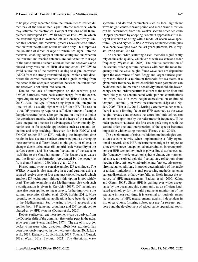
spectrum and derived parameters such as local significantwave height, centroid wave period and mean wave directioncan be determined from the weaker second-order sea-echoDoppler spectrum by adopting two main approaches: full in-tegral inversion or fitting with a model of ocean wave spec-trum (Lipa and Nyden, 2005). A variety of inverse techniqueshave been developed over the last years (Barrick, 1977; Wy-att, 1990; Hisaki, 2006).
The second-order scattering-based methods significantlyrely on the echo quality, which varies with sea state and radarfrequency (Wyatt et al., 2005). The relative contribution ofthe second-order spectrum increases with both the radar fre-quency and the wave height. Since wave data are dependentupon the occurrence of both Bragg and larger surface grav-ity waves, there is a minimum threshold for sea states at agiven radar frequency in which reliable wave parameters canbe determined. Below such a sensitivity threshold, the lower-energy second-order spectrum is closer to the noise floor andmore likely to be contaminated with spurious contributionsthat might result in wave height overestimation or limitedtemporal continuity in wave measurements (Lipa and Ny-den, 2005; Tian et al., 2017). During extreme weather events,there is also a limiting factor for HFR accuracy as the waveheight increases and exceeds the saturation limit defined (onan inverse proportion) by the radar transmit frequency. If theradar spectrum saturates, the first-order peak merges with thesecond-order one and interpretation of the spectra becomesimpossible with existing methods (Forney et al., 2015).
The development of robust validation methodologies con-stitutes a core activity when implementing a fully opera-tional network since HFR measurements might be subject tosome error sources and potential uncertainties. Inherent prob-lems of HFR technology, such as power-line disturbances, ra-dio frequency interference, ionospheric clutter, environmen-tal noise, unresolved velocity fluctuations, reflections frommoving ships, offshore wind turbine interference, adverse en-vironmental conditions, improper determination of the angleof arrival, limitations in signal processing methods, antennapattern distortions, or hardware failures, likely impact the ac-curacy of HFR measurements (Paduan et al., 2006; Kohutand Glenn, 2003). Since HFR is gaining ever-wider accep-tance by the oceanographic community as an efficient land-based technology for the multi-parameter monitoring of thesea state in near-real time, it is essential to routinely assessthe accuracy of HFR measurements against independent insitu observations, fostering subsequent use for research pur-poses and the development of added-value operational tools.
https://doi.org/10.5194/os-18-761-2022 Ocean Sci., 18, 761–795, 2022
768 P. Lorente et al.: Coastal HF radars in the Mediterranean
2.2 Basic HFR products
2.2.1 High-Frequency radar surface currentmonitoring, improvement, and validation
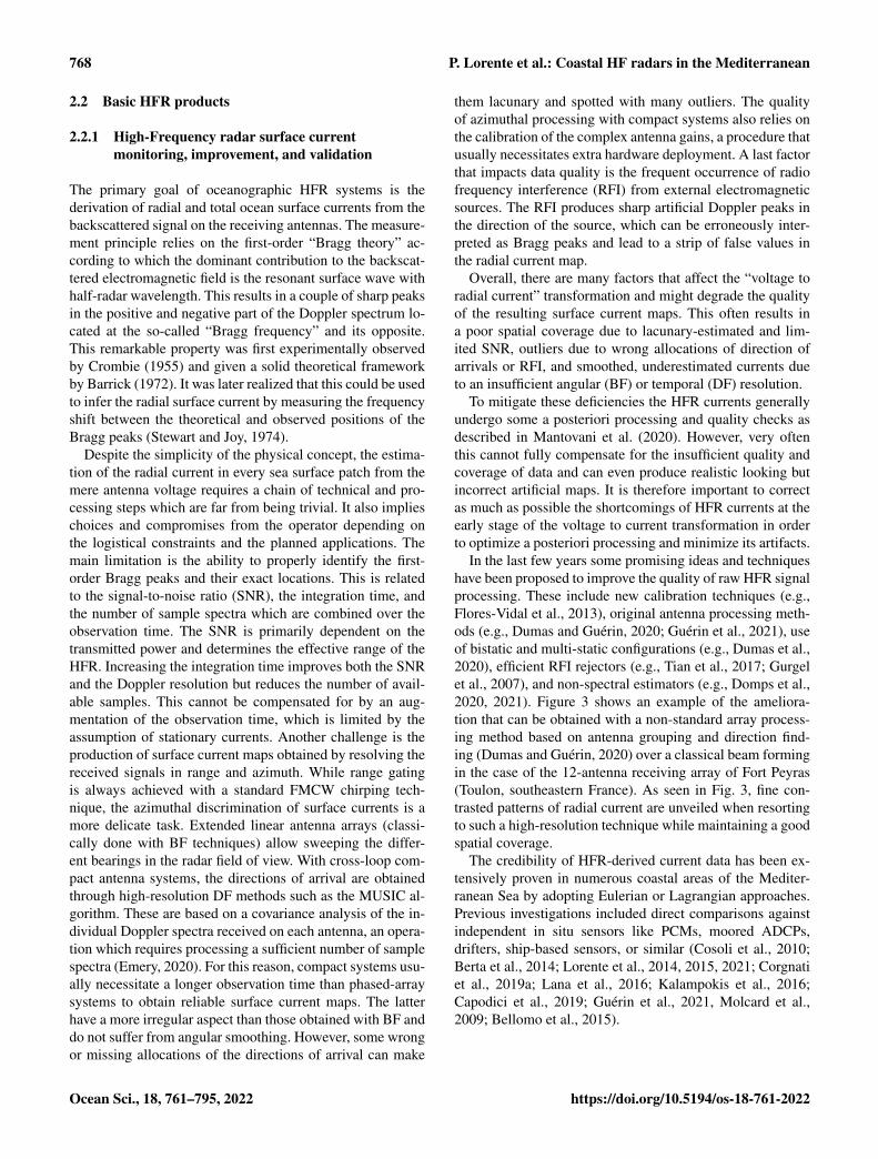
The primary goal of oceanographic HFR systems is thederivation of radial and total ocean surface currents from thebackscattered signal on the receiving antennas. The measure-ment principle relies on the first-order “Bragg theory” ac-cording to which the dominant contribution to the backscat-tered electromagnetic field is the resonant surface wave withhalf-radar wavelength. This results in a couple of sharp peaksin the positive and negative part of the Doppler spectrum lo-cated at the so-called “Bragg frequency” and its opposite.This remarkable property was first experimentally observedby Crombie (1955) and given a solid theoretical frameworkby Barrick (1972). It was later realized that this could be usedto infer the radial surface current by measuring the frequencyshift between the theoretical and observed positions of theBragg peaks (Stewart and Joy, 1974).
Despite the simplicity of the physical concept, the estima-tion of the radial current in every sea surface patch from themere antenna voltage requires a chain of technical and pro-cessing steps which are far from being trivial. It also implieschoices and compromises from the operator depending onthe logistical constraints and the planned applications. Themain limitation is the ability to properly identify the first-order Bragg peaks and their exact locations. This is relatedto the signal-to-noise ratio (SNR), the integration time, andthe number of sample spectra which are combined over theobservation time. The SNR is primarily dependent on thetransmitted power and determines the effective range of theHFR. Increasing the integration time improves both the SNRand the Doppler resolution but reduces the number of avail-able samples. This cannot be compensated for by an aug-mentation of the observation time, which is limited by theassumption of stationary currents. Another challenge is theproduction of surface current maps obtained by resolving thereceived signals in range and azimuth. While range gatingis always achieved with a standard FMCW chirping tech-nique, the azimuthal discrimination of surface currents is amore delicate task. Extended linear antenna arrays (classi-cally done with BF techniques) allow sweeping the differ-ent bearings in the radar field of view. With cross-loop com-pact antenna systems, the directions of arrival are obtainedthrough high-resolution DF methods such as the MUSIC al-gorithm. These are based on a covariance analysis of the in-dividual Doppler spectra received on each antenna, an opera-tion which requires processing a sufficient number of samplespectra (Emery, 2020). For this reason, compact systems usu-ally necessitate a longer observation time than phased-arraysystems to obtain reliable surface current maps. The latterhave a more irregular aspect than those obtained with BF anddo not suffer from angular smoothing. However, some wrongor missing allocations of the directions of arrival can make
them lacunary and spotted with many outliers. The qualityof azimuthal processing with compact systems also relies onthe calibration of the complex antenna gains, a procedure thatusually necessitates extra hardware deployment. A last factorthat impacts data quality is the frequent occurrence of radiofrequency interference (RFI) from external electromagneticsources. The RFI produces sharp artificial Doppler peaks inthe direction of the source, which can be erroneously inter-preted as Bragg peaks and lead to a strip of false values inthe radial current map.
Overall, there are many factors that affect the “voltage toradial current” transformation and might degrade the qualityof the resulting surface current maps. This often results ina poor spatial coverage due to lacunary-estimated and lim-ited SNR, outliers due to wrong allocations of direction ofarrivals or RFI, and smoothed, underestimated currents dueto an insufficient angular (BF) or temporal (DF) resolution.
To mitigate these deficiencies the HFR currents generallyundergo some a posteriori processing and quality checks asdescribed in Mantovani et al. (2020). However, very oftenthis cannot fully compensate for the insufficient quality andcoverage of data and can even produce realistic looking butincorrect artificial maps. It is therefore important to correctas much as possible the shortcomings of HFR currents at theearly stage of the voltage to current transformation in orderto optimize a posteriori processing and minimize its artifacts.
In the last few years some promising ideas and techniqueshave been proposed to improve the quality of raw HFR signalprocessing. These include new calibration techniques (e.g.,Flores-Vidal et al., 2013), original antenna processing meth-ods (e.g., Dumas and Guérin, 2020; Guérin et al., 2021), useof bistatic and multi-static configurations (e.g., Dumas et al.,2020), efficient RFI rejectors (e.g., Tian et al., 2017; Gurgelet al., 2007), and non-spectral estimators (e.g., Domps et al.,2020, 2021). Figure 3 shows an example of the ameliora-tion that can be obtained with a non-standard array process-ing method based on antenna grouping and direction find-ing (Dumas and Guérin, 2020) over a classical beam formingin the case of the 12-antenna receiving array of Fort Peyras(Toulon, southeastern France). As seen in Fig. 3, fine con-trasted patterns of radial current are unveiled when resortingto such a high-resolution technique while maintaining a goodspatial coverage.
The credibility of HFR-derived current data has been ex-tensively proven in numerous coastal areas of the Mediter-ranean Sea by adopting Eulerian or Lagrangian approaches.Previous investigations included direct comparisons againstindependent in situ sensors like PCMs, moored ADCPs,drifters, ship-based sensors, or similar (Cosoli et al., 2010;Berta et al., 2014; Lorente et al., 2014, 2015, 2021; Corgnatiet al., 2019a; Lana et al., 2016; Kalampokis et al., 2016;Capodici et al., 2019; Guérin et al., 2021, Molcard et al.,2009; Bellomo et al., 2015).
Ocean Sci., 18, 761–795, 2022 https://doi.org/10.5194/os-18-761-2022

P. Lorente et al.: Coastal HF radars in the Mediterranean 769
Figure 3. Hourly radial surface current maps obtained on 1 September 2020 at 06:00 TU with the HFR station deployed in Fort Peyras (PEY)in Toulon (SE France) with a 12-antenna receiving array operating at 16.15 MHz. The range resolution is 1.5 km and the maximum range isabout 80 km. (a) Radial map obtained by using antenna grouping and self-calibration: fine and contrasted structures are unveiled. (b) Radialmap obtained using the classical beam forming azimuthal processing: small patterns are smoothed and contrast is reduced.
When the HFR footprint overlooks a moored instrumentwithin its spatial coverage (Fig. 4a), an accuracy assessmentof HFR surface currents can be performed with radial or to-tal vectors. In the first case, the HFR radial arc geographi-cally closest to the in situ instrument location is selected foreach HFR site, and radial current vectors estimated at eacharc point are compared with the radial projection of PCMvelocities (Cosoli et al., 2010; Lorente et al., 2014, 2015).This comparative analysis allows the computation of statisti-cal parameters (e.g., the correlation – CORR – and the rootmean squared error – RMSE) as a function of the angle be-tween the buoy and the arc grid point position. In the absenceof direction-finding (DF) errors, maximum CORR and mini-mum RMSE values should be found over the arc point closestto the buoy location. In the presence of DF, the bearing off-set is thus expressed as the angular difference between thearc point with maximum correlation and the buoy location(Fig. 4b). In the second case, HFR total vector hourly estima-tions at the grid point closest to the buoy location are com-pared against in situ current data to provide upper boundson the HFR accuracy. Comparisons are commonly under-taken using zonal (U) and meridional (V) components in or-der to evaluate the agreement between the two instruments(Fig. 4c).
Supplementary validation works with radial measure-ments were carried out in the Mediterranean Sea when thegeometry of the emplacement gave the chance to performa self-consistency analysis of the radar-to-radar overwaterbaselines in order to evaluate intrinsic velocity uncertaintiesin HFR radial velocities (Lorente et al., 2014). This method-ology, previously applied in other parts of the world (Pad-uan et al., 2006; Atwater and Heron, 2010; Gómez et al.,2020), states that in the absence of errors two facing HFRsites should provide the same estimates of radial velocities(differing only in the sign) at the midpoint of the baselinethat joins them, since the range and the angular distributionare similar. This self-consistency test presents some benefits
like the nonexistence of horizontal-scale or depth mismatch,as the two involved sites are operating in the same frequency,providing two current datasets with, in principle, identicalorigin and nature.
In terms of Lagrangian assessment, it is worth mentioningthat the Tracking Oil Spill and Coastal Awareness (TOSCA)project experience (Bellomo et al., 2015) constituted one ofthe first coordinated initiatives at the Mediterranean levelto test the precision of a core of 12 HFRs and identify aset of good practices for pollution mitigation. Among othervaluable goals, the five-country TOSCA experiment aimedat comparing HFR-derived measurements against the tra-jectories provided by 20 Coastal Ocean Dynamics Experi-ment (CODE) drifters (Davis, 1985), which were drogued inthe upper 1 m of the oceanic layer and acted as proxies forsubstances passively advected by currents. In all cases, theRMSE of the radial velocity difference between HFR anddrifters was in the range of 5–10 cm s−1, which is in line withprevious literature given the expected variability at the HFRsubgrid level.
As an overall summary of the validation works, RMSEand CORR values have been typically reported to fall in theranges 5–20 cm s−1 and 0.32–0.92, respectively (Cosoli etal., 2010; Berta et al., 2014; Lorente et al., 2014, 2015, 2021;Corgnati et al., 2019a; Lana et al., 2016; Kalampokis et al.,2016; Capodici et al., 2019; Guérin et al., 2021; Molcard etal., 2009; Bellomo et al., 2015). Relative HFR velocity er-rors can vary widely depending on the characteristics of thesite, the radar transmission frequency, the sensor type, andlocation within the sampled domain, as well as the data pro-cessing scheme used (Rypina et al., 2014; Kirincich et al.,2012).
These validation studies acknowledged that observed dis-crepancies between HFR in situ estimations might be par-tially attributable to the combined contribution of severalfactors such as the mismatch in time sampling and averag-ing, distinct horizontal averaging scales, contributions from
https://doi.org/10.5194/os-18-761-2022 Ocean Sci., 18, 761–795, 2022

770 P. Lorente et al.: Coastal HF radars in the Mediterranean
Figure 4. Validation of hourly surface currents provided by the HFR deployed in Ebro Delta (NW Mediterranean Sea), shown in Fig. 1,against a buoy for May–October 2014 (Lorente et al., 2015). (a) Example of an hourly map of surface current circulation. The pink dot andpurple squares represent the buoy and HFR site locations, respectively. (b) Validation of radial currents. Correlation (solid line) and RMSE(dashed line) between radial currents estimated by the buoy and those measured by the SALO HFR site. The vertical dotted line representsthe angular position of the moored buoy. The vertical red solid line denotes the angular position of maximum correlation, which is gatheredwith the associated RMSE and bearing offset (in red) values. (c) Low-pass-filtered time series of zonal and meridional currents measured bythe buoy (blue line) and HFR at the closest grid point (red line).
Stokes drift likely included in HFR-derived estimates, or theinfluence of Ekman stratification in the current profile, sub-sequently leading to potential velocity differences in the up-per water column (Laws et al., 2003; Ohlmann et al., 2007;Chapman et al., 1997; Kohut et al., 2006). In this frame, theinstrumental noise and subgrid-scale current variability havealso been documented to yield noise levels of 4–6 cm s−1
(Emery et al., 2004; Ohlmann et al., 2007; de Paolo et al.,2015).
Once HFR has proven to be a valid instrument to accu-rately monitor surface currents with high spatiotemporal res-olution over wide coastal areas, the ability of this remotesensing technology to measure waves and wind directionmust also be assessed, as detailed in the next two sections.
2.2.2 Wave measurement retrieval from HFRs
In addition to surface ocean currents, HFR directional wavespectrum and derived parameters such as local significantwave height, centroid wave period, and mean wave direc-tion can be determined from the weaker second-order sea-echo Doppler spectrum by adopting two main approaches:full integral inversion or fitting with a model of ocean wavespectrum (Lipa and Nyden, 2005). A variety of inverse tech-niques have been developed over the last decades (Barrick,1977; Wyatt, 1990; Hisaki, 2006).
Wave measurements derived from HFR have a broad rangeof potential applications and can be used as input data fornumerical model validation (Saviano et al., 2020a), assimi-lation into wave models (Siddons et al., 2009; Waters et al.,2013), wave energy harvesting (Ramos e al., 2009), or theanalysis of extreme wave height events (Lorente et al., 2021).HFR wave data can provide assistance to maritime naviga-
Ocean Sci., 18, 761–795, 2022 https://doi.org/10.5194/os-18-761-2022

P. Lorente et al.: Coastal HF radars in the Mediterranean 771
tion and wise decision-making, from both commercial andrecreational perspectives, by identifying severe sea states indensely operated maritime areas where fixed in situ moor-ings may be compromised (e.g., at the entrance of congestedharbors, first-order spots in terms of activity and trade vol-ume). Furthermore, HFRs can help detect the interaction be-tween high incoming waves, intense river outflow currents,and wind-forced flow over the inner continental shelf, ashighlighted by Lorente et al. (2021).
In order to infer how much confidence can be placed inwave parameters retrieved by HFR systems, their accuracymust be evaluated under different sea states and coastal con-figurations (Fig. 5). Previous validation experiments, someof them listed in Table 1, included comparisons against inde-pendent in situ observations, remotely sensed wave estima-tions, or numerical outcomes over a variety of regions in theMediterranean Sea such as the Gulf of Naples (Falco et al.,2016; Saviano et al., 2019, 2020a, b, 2022), Sicily (Orasi etal., 2018), and the Ebro Delta (Lorente et al., 2021). Regard-less of the manufacturer, the operational frequency, and themethodology used to determine wave parameters, the posi-tive contribution of commercial HFR systems to characterizethe main wave patterns (and the related spatiotemporal vari-ability) has been unequivocally proven under both standardmet-ocean conditions and severe sea states.
A widely accepted approach with DF systems consistsof comparing HFR wave estimations, extracted along sev-eral annular rings (circular concentric range arcs) centered ineach of the HFR sites, against in situ observations to quan-tify the degree of accuracy as a function of the distance tothe shoreline. As shown by Saviano et al. (2019) and Lorenteet al. (2021), wave estimations are often averaged among theintermediate range arcs to improve data quality and avail-ability. This constitutes an optimal operational trade-off, asit guarantees the highest number of recordings. While closeenough to the shoreline (so the sea-echo intensity is suffi-ciently high to ensure good data quality), the range arcs arealso deep enough to avoid shallow-water effects on radar seaecho: wave breaking and the decrease in saturation limit onwave height as ocean depth decreases (Lipa et al., 2008).
In the case of linear phased-array BF systems consisting ofat least 12 antennas, they can provide maps of wave parame-ters with the same spatiotemporal resolution as with surfacecurrents (Gómez et al., 2015).
According to the skill metrics presented in Table 1, whichare in accordance with previous validation exercises reportedin other European waters (Basañez et al., 2019; López andConley, 2019; Lópezet al., 2016; Gómez et al., 2015), it canbe concluded that properly treated HFR-derived wave esti-mations can be potentially employed for operational coastalmonitoring across a wide range of sea states. Ad hoc qualitycontrol methodologies, based on the particular local environ-ment, are required to ensure robust HFR wave measurements.Although the precision and availability of HFR-derived waveestimations have been documented to be lower during calm
sea states (as the second-order spectrum is closer to the noisefloor), HFR might act as an effective coastal monitoring as-set, especially in locations where in situ devices cannot bedeployed (such as harbor entrances) or when in situ waveobservations are temporarily unavailable due to instrumentoutages or breakdowns.
Particularly for the Mediterranean coastal waters, the per-formance of the HFR system installed in the Gulf of Naples(GoN hereinafter) in the retrieval of wave parameters hasbeen tested in different works, aimed at providing, on the onehand, an assessment of the accuracy of HFR measurementsand on the other a reconstruction of the wave climatology ofthe basin. The validation of HFR wave data has been accom-plished using two alternative data sources, namely an in situbuoy and two wave models. In the first case (Saviano et al.,2019), recordings from an offshore directional buoy (locatedoutside the areal coverage of the HFR system) were used toevaluate the agreement with the patterns depicted by the threeHFR sites building the GoN network (Fig. 1) over a 1-yearreference period. As reflected in Fig. 5a, the comparison indi-cated that both platforms returned collimating descriptions ofthe wave field under both calm and stormy periods and thatthe HFRs could also retrieve realistic measurements abovethe theoretical maximum recordable wave height (Lipa andNyden, 2005). Additional insight into the validity of HFRdata has been gained by the comparison against wave mea-surements provided by two models, WAVEWATCH III andSWAN (Simulating WAves Nearshore), over a 3-year period(Saviano et al., 2020a). Overall, the HFR and model datawere consistent, although discrepancies in lower sea statesand in extreme conditions could be reported. The valida-tion of HFR measurements was a fundamental prerequisiteto extract long-term information on the characteristics of thewave field in the GoN and exploit them to build a waveclimatology of the basin. To this aim, wave measurementsfrom the HFR network over 4.5 years were complementedwith records from an ADCP interlocked with a Monit-Med(MEDA) elastic beacon collected over almost 3 years (Sa-viano et al., 2020b).
The integration of the results gathered through these worksallows depicting some peculiarities of the wave field in theGoN, namely (i) a predominantly wind-driven wave fieldwith specific seasonal recurrent patterns, (ii) the occurrenceof more energetic conditions in autumn–winter, particularlyin association with low-pressure systems acting over the re-gion, (iii) the establishment of a stable calm state driven bythe spring–summer breeze regime, and (iv) the directionaldistribution of approaching waves depending on the sub-basin of the GoN considered, corresponding to the differentsectors covered by each HFR site.
These patterns are comparable over the years (Falco et al.,2016; Saviano et al., 2019, 2020a, b) but at the same timeare coherent with the typical climate of the southern Tyrrhe-nian Sea and with previous studies carried out in the GoN.In addition to insights strictly focusing on the basin dynam-
https://doi.org/10.5194/os-18-761-2022 Ocean Sci., 18, 761–795, 2022

772 P. Lorente et al.: Coastal HF radars in the Mediterranean
Table 1. Review of the most recent studies about validation of wave parameters derived from high-frequency radar (HFR) against independentwave observations. Skill metrics obtained for the significant wave height (SWH) during the studied period included the mean squared error(MSE), the root mean square error (RMSE), the normalized RMSE (RMSEN), the Pearson’s correlation coefficient (CORR), and the skillscore (SS) proposed by Wilmott (1981). The metric intervals denote the range of results obtained for several sites composing each HFRsystem.
Reference Orasi et al. (2018) Saviano et al. (2019) Lorente et al. (2021)
Frequency (MHz) 13.5 25 13.5Study area Malta–Sicily Channel Gulf of Naples Ebro River DeltaTime period winter 2016–2017 all of 2010 19–24 January 2020Validation against satellite altimeter buoy buoyParameter SWH SWH SWH, TM, and directionMetric for SHW CORR= [0.86–0.98] CORR= [0.50–0.75] RMSEN= 0.12
MSE= [0.04–0.29] RMSE= [0.20–0.66] skill score= 0.93
ics, the outcomes collected in the GoN demonstrate that theHFRs provide reliable measurements of waves, particularlyin terms of significant wave height. With reference to waveperiod, the DF system returns a centroid period which fallsbetween the mean and peak periods typically retrieved byother platforms (Saviano et al., 2019, 2020b). As such, thecentroid period can be used as a robust estimator in line withwhat is discussed in Long et al. (2011). In a more generalframework, the positive experience in the GoN demonstratesthat HFRs should be considered an integral part of the designand implementation of coastal monitoring systems thanks totheir ability to reconstruct not only the surface current field,but also wave dynamics and wind. The performance of HFRsystems, however, still needs to be improved as discussed inSaviano et al. (2019), for example by standardizing QA–QCprotocols and/or optimizing inversion methods and wave re-trieval algorithms.
In the Malta–Sicily Channel, Orasi et al. (2018) comparedsignificant wave height measurements from four HFR sitesagainst both satellite altimeter data (i.e., Jason2, Jason3, andSAR SARAL/AltiKa missions) and numerical simulations.Sea state forecasts over the Mediterranean Sea were pro-vided by the Mc-WAF system based on the WAM modelwith a 1/60◦ horizontal resolution and operated by ISPRAsince 2012. As shown in Fig. 5b, better agreement is achievedin the intermediate range rings, particularly when comparedagainst altimeter data. Intermediate rings are those placed atintermediate distances from the coast, not the first one (clos-est to the HFR site location) nor the outermost range ring.WAM slightly underestimates the SWH during a storm eventoccurring along the analyzed time series with a return periodof 4 years.
In terms of extreme events, record-breaking storm Gloria(19–24 January 2020) hit the NW Mediterranean Sea withheavy rainfall, strong easterly winds, and very high waves(Lorente et al., 2021). Although the low-lying Ebro Deltaregion (Fig. 4a) was severely inundated, the HFR deployedthere was able to effectively monitor Gloria’s striking fea-tures. As shown in Fig. 5c, the visual resemblance between in
situ data and HFR-derived estimations of SWH (from ALFAsite) is remarkably high. The peak, which was well capturedin terms of intensity (7.28 m) and timing, fairly exceeded thepercentile 99 derived from the buoy estimations for a 15-yearperiod (2004–2019) established at 2.87 m.
For phased-array HFR, the reconstruction of the wave fieldfrom the backscattered signal can be attempted by usinga single station (Fig. 5d). Depending on the method used,this can provide different estimations of the wave frequencyspectrum, from which integrated parameters can be esti-mated such as significant wave height and wave period. Nev-ertheless, approaches inverting the nonlinear integral equa-tion of radar cross-section and more simplified empirical ap-proaches both result in an ambiguity of the directional spec-trum solution (Hisaki, 1996; Gurgel et al., 2006). Therefore,to solve this ambiguity and to be able to provide directionalwave information, a second HFR site overlooking the sameocean patch from a different direction is required.
An evaluation of wave parameters measured by a singleHFR station concluded that significant wave height estimatesare not robust when the waves propagate roughly perpendicu-lar to the radar beam. In such cases, which were not presentedoften, a different algorithm can be used, which improves theestimations. Since there is no directional information pro-vided by a single HFR, there is no way to select betweenthe two algorithms solely by using the measured data. It wasshown that dual-radar estimates are more accurate than usingsingle-radar site estimations (Wyatt, 2002).
In order to solve the above discrepancy, de Valk etal. (1999) took into account additional physics. Their recon-struction method inverts the Doppler backscatter integral to-gether with a reconstruction of the wave field using the waveaction equation while neglecting ambient currents and var-ious source functions. Hisaki (2006) extended the de Valket al. (1999) approach to also include the wind input, dissi-pation, and nonlinear interaction source terms. Both requiresolving an iterative and location-specific model. A more re-cent work (Alattabi et al., 2019) provides a model whichtreats swell and wind waves separately, combining former
Ocean Sci., 18, 761–795, 2022 https://doi.org/10.5194/os-18-761-2022

P. Lorente et al.: Coastal HF radars in the Mediterranean 773
Figure 5. (a) Time series of SWH provided by HFR-GoN (SORRsite) and a buoy deployed in the GoN (Fig. 1). Timelines of dataavailability provided at the top. Dotted lines represent the theoreti-cal upper and lower detectability thresholds of this HFR. (b) Timeseries of SWH (averaged in time and space) provided by HFR-Calypso (arc 3 of Barkat site), the WAM model, and an altime-ter during a storm in the Malta–Sicily Channel. (c) Time seriesof SWH provided by HFR-DeltaEbro (arcs 4–9 of ALFA site) andthe B1 buoy during storm Gloria in the NW Mediterranean Sea.(d) Time series of SWH (∼ 20 km offshore of Israel) as measured byHFR-Israel (Fig. 1). Preliminary uncalibrated data using Gurgel andSchlick (2006) were compared with ERA5 wave reanalysis (fromthe ECMWF).
works into a single empirical hybrid model. Its results usinga single very high-frequency (VHF) station provided goodcorrelation with various in situ measurements. This applica-tion has some limitations for nearshore swells, but its accu-racy and simplicity show good perspectives for a large-scaleadaptation after confirmations using radar systems of differ-ent frequencies.
A portion of the detected discrepancies in wave measure-ments could be attributed to the following: (i) the math-ematical inversion process of the second order is unsta-ble and diverges rapidly from the true solution in pres-ence of noisy data; (ii) the assumptions made in the in-version method (the Pierson–Moskowitz fit-to-spectrum uni-modal model used has previously proven its validity to prop-erly describe wind-dominated seas and also swell-dominatedseas, whereas this might be different under some combi-nation of multi-modal sea states under complex met-oceanconditions); and/or (iii) the different sampling techniques.Whereas DF HFR systems provide wave data averaged overrange rings (assuming homogeneity over the whole of eachcircular range cell), buoys give point measurements. In thiscontext, coastal effects can also lead to locally varying wavefields and make absolute comparisons between in situ andremote sensing instruments even harder.
2.2.3 Wind measurement retrieval from HFRs
While the analysis of surface currents and the retrieval ofwave parameters are well established, the worldwide use offirst-order peaks to measure wind direction still remains lessexplored (Heron and Rose, 1986; Heron, 2002; Kirincich,2016; Hisaki, 2017; Wyatt, 2018). Also, additional effortsshould be devoted in the short-term future to the develop-ment of robust algorithms for a reliable measurement of windspeed (Shen et al., 2012; Vesecki et al., 2002).
To the best of our knowledge, Saviano et al. (2021) con-stitutes the first attempt to analyze HFR-derived wind direc-tion in the Mediterranean Sea using a 25 MHz DF system.HFR measurements were compared with in situ recordingsfrom a weather station in the GoN, revealing (i) the poten-tialities of this remote sensing technology as a monitoringplatform when the wind speed exceeds a 5 m s−1 thresholdand (ii) the relevance of the operational frequency in the ac-curacy of HFR wind measurements, with higher frequenciesleading to estimations that are in better agreement with in situmeasurements, as previously indicated by Shen and Gurgel(2018). This is due to the fact that resonant Bragg waves havea shorter wavelength and are thus more sensitive to changesin the wind direction field.
The first model to extract the wind direction from HFRbackscatter was suggested by Long and Trizna (1972). In re-cent decades, different research groups developed algorithmsfor the extraction of wind direction (Zeng et al., 2018; Chuet al., 2018; Hisaki, 2017; Kirincich, 2016; Shen et al., 2012;Heron, 2002; Huang et al., 2004; Gurgel et al., 2006), andmore recently a neural network method was applied for windfield inversion (Zeng et al., 2016).
Although works and publications dealing with HFR windmeasurements are still scarce compared to those analyzingHFR currents or waves, several examples presenting and val-idating HFR wind direction data can be found in the litera-ture (Heron, 2002; Lipa et al., 2014; Kirincich, 2016; Hisaki,2017; Shen and Gurgel, 2018; Wyatt et al., 2001; Wyatt,2018; Saviano, 2021).
Some of these previous studies affirm that the accuracyof HFR wind direction measurements is related to manyfactors (Lipa et al., 2014). Diverse studies on the compari-son with in situ measurements acknowledged that with windspeeds lower than 5 m s−1 the reversal of the wind directionand hence HFR-derived wind direction is not reliable (Lipaet al., 2014; Wyatt, 2018; Shen and Gurgel, 2018). This ismainly due to the fact that at high wind speeds, the direc-tion of the Bragg resonant waves (i.e., the HFR-derived winddirection) agrees better with the wind direction (Shen andGurgel, 2018). Another important factor is the frequency ofthe HFR, since HFR systems operating at higher frequencieslead to wind direction measurements that are in better agree-ment with in situ ones. This is due to the fact that the corre-sponding resonant waves (i.e., half the radio wavelength) arerelatively shorter ones, being more sensitive to a change in
https://doi.org/10.5194/os-18-761-2022 Ocean Sci., 18, 761–795, 2022
774 P. Lorente et al.: Coastal HF radars in the Mediterranean
wind direction, rapidly responding to local wind excitationand variability (Shen and Gurgel, 2018). In addition, accu-rate knowledge of the seasonal wind field of the study area isfundamental to assess the correct investigation.
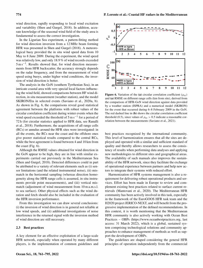
In the Ligurian Sea experiment, a pattern-fitting methodfor wind direction inversion from a 12 MHz beam formingHFR was presented in Shen and Gurgel (2018). A meteoro-logical buoy provided the in situ wind speed data from 10May to 8 June 2009. During the experiment, the wind speedwas relatively low, and only 18.9 % of wind records exceeded5 m s−1. Results showed that, for wind direction measure-ments from HFR backscatter, the accuracy strongly dependson the radar frequency, and from the measurement of windspeed using buoys, under higher wind conditions, the inver-sion of wind direction is better.
The analysis in the GoN (southern Tyrrhenian Sea), in anintricate coastal area with very special local factors influenc-ing the wind field, showed comparisons between HF wind di-rection, in situ measurement (weather station), and the modelSKIRON/Eta in selected events (Saviano et al., 2020a, b).As shown in Fig. 6, the comparisons reveal good statisticalagreement between the platforms with robust values of thecircular correlation coefficient during winter events when thewind speed exceeded the threshold of 5 m s−1 for a period of72 h (for circular statistics applied to HFR data, see Ranalliet al., 2018). Furthermore, the acquisitions of all range cells(RCs) or annulus around the HFR sites were investigated: inall the events, the RCs near the coast and the offshore onesgive poorer statistical results compared to the central RCs,while the best agreement is found between 4 and 10 km fromthe coast (Fig. 6).
Although the RMSE values obtained for wind direction inthe GoN appear to be high, they are in line with similar ex-periments carried out previously in the Mediterranean Sea(Shen and Gurgel, 2018). Detected differences could in partbe attributed to a variety of relevant elements such as (i) sen-sor limitations (and the related instrumental noise), (ii) mis-match in the horizontal sampling (whereas direction homo-geneity along the HFR range cells is assumed, in situ instru-ments provide point measurements), and (iii) vertical mis-match (adjustment of wind measurement from 10 m a.m.s.l.to sea surface). Other physical effects such as the wind du-ration and fetch should also be included in the evaluation ofthe HFR inversion performance.
From this investigation we can draw several conclusions:(i) the inversion of wind direction is in general not reliable atlow wind speeds, and (ii) additional investigations of noiseinterference in the returned signal with the inversion methodof wind direction are still necessary.
2.3 Best practices
A key element for an effective exploitation of a large-scaleHFR network, especially when operated by many differentplayers, is the implementation of common guidelines and
Figure 6. Variation of the (a) circular correlation coefficient (ρcc)and (a) RMSE on different range cells (km from site), derived fromthe comparison of HFR-GoN wind direction against data providedby a weather station (ISPRA) and a numerical model (SKIRON)for the event that occurred during 6–8 February 2009 in the GoN.The red dashed line in (b) shows the circular correlation coefficientthreshold (0.5), since values of ρcc > 0.5 indicate a reasonable cor-relation between the measurements (Saviano et al., 2021).
best practices recognized by the international community.This level of harmonization ensures that all the sites are de-ployed and operated with a similar and sufficient standard ofquality and thereby allows researchers to assess the consis-tency of results when performing data analyses and applyingnew methodologies to different sites and geographical areas.The availability of such manuals also improves the sustain-ability of the HFR network, since they facilitate the exchangeof operational experience between partners and help new ac-tors to integrate their systems with reduced effort.
Harmonization of HFR systems management is also a re-quirement for delivering robust operational products and ser-vices. Effort has been made in Europe to review and com-plement existing best practices related to surface current re-trievals (Mantovani et al., 2020). The Mediterranean HFRcommunity has been actively involved in this task, especiallyin the framework of the EuroGOOS HFR task team and theH2020 project JERICO-NEXT, and will benefit from the pro-gressive implementation of the defined recommendations. Inthis context, it is worth mentioning that the MediterraneanHFR community is also actively working with Ocean BestPractices – OBPs (https://www.oceanbestpractices.org, lastaccess: 31 March 2022), which is a global, sustained sys-tem comprising technological solutions and community ap-proaches to enhance management of methods as well as sup-port the development of OBPs.
The guidelines are shaped considering the general HFRprinciples of operation independently from the commercial
Ocean Sci., 18, 761–795, 2022 https://doi.org/10.5194/os-18-761-2022

P. Lorente et al.: Coastal HF radars in the Mediterranean 775
manufacturer or antenna design and setup, and they includethe following:
– site requirements for optimal HFR performance;
– typical authorizations needed for installing and operat-ing an HFR station;
– list of basic accessories for ensuring protection of theequipment, remote management, and reliable data trans-fer;
– items to be evaluated for estimation of deployment andoperating costs;
– key elements for a correct setup of HFR systems andsuggestions for monitoring their performances;
– scalable data management encompassing a commonprotocol for data processing and the standardization of asingle HFR interoperable data format with a unified listof metadata descriptors; and
– unified procedures for quality assurance–quality control(QA-QC) of HFR data in real time.
2.4 Data flow: from providers to distribution via theEU HFR Node
In 2014, EuroGOOS launched the HFR task team (Fig. 2)with the aim of promoting the implementation of an op-erational HFR network in Europe based on coordinateddata management and integration of basic products intothe major platforms for marine data distribution technology(Corgnati et al., 2021). In 2015, a pilot action coordinatedby EMODnet Physics began to develop a strategy for as-sembling HFR metadata and data products within Europein a uniform way to make them easily accessible and moreinteroperable (Fig. 2). The European Union (EU) projectJERICO-NEXT (https://www.jerico-ri.eu/previous-project/jerico-next/, last access: 31 March 2022), launched in 2015,aimed to provide procedures and methodologies to enableHFR data to comply with the international standards regard-ing their quality and metadata, with the overall goal of in-tegrating the European coastal observatories. In parallel, theSeaDataCloud EU project, launched in 2016, contributed tothe integration and long-term preservation of historical timeseries from HFR into the SeaDataNet infrastructure (Fig. 2)by defining standard interoperable data and Common DataIndex (CDI) metadata formats as well as quality control (QC)standard procedures for historical data. In 2016 as well, theCMEMS Service Evolution Call supported the INCREASEproject, which set the basis for the integration of existing Eu-ropean HFR operational systems into the CMEMS-INSTAC.More recently, the EU projects JERICO-S3 and EuroSeahave been continuing these efforts to further expand the stan-dardization and interoperability of HFR data in order to pro-mote the distribution of high-quality HFR data and improve
their impact in scientific, operational, and societal applica-tions.
The results of these integrated efforts are significant andallowed the harmonization of system requirements as well asdesign, data quality, and standardization of HFR data accessand tools (Mantovani et al., 2020). Thanks to these achieve-ments, the inclusion of HFR data into CMEMS-INSTAC,EMODnet Physics, and SDC Data Access was decided to en-sure the improved management of several related key issuessuch as marine safety, marine resources, coastal and marineenvironment, and weather, climate, and seasonal forecast.
The EU HFR Node (Fig. 7) was established in 2018 byAZTI, CNR-ISMAR, and SOCIB under the coordination ofthe EuroGOOS HFR task team (Rubio et al., 2017) as thefocal point and operational asset in Europe for HFR datamanagement and dissemination (https://thredds.hfrnode.eu,last access: 31 March 2022) by promoting networking be-tween EU infrastructures, marine data portals, and the globalHFR network. The EU HFR Node has been fully opera-tional since December 2018 to distribute tools and supportfor standardization to HFR providers as well as standard-ized near-real-time (NRT) and delayed-mode HFR radial andtotal current data to CMEMS-INSTAC, EMODnet Physics,and SDC Data Access. Within the European framework, theEU HFR Node is currently managing data from 16 systems(https://thredds.hfrnode.eu, last access: 31 March 2022). Inparticular, 5 of these 16 systems (31 %) are deployed inthe Mediterranean coastline and belong to the MONGOOSnetwork: HFR-Gibraltar, HFR-Ibiza, HFR-DeltaEbro, HFR-TirLig, and HFR-NAdr (Fig. 1). Furthermore, the EU HFRNode integrates and delivers US HFR network data to theaforementioned data portals. In particular, the EU HFR Nodeimplements the operational chain, which encompasses dataacquisition and harvesting, harmonization, formatting, QC,validation and assessment, NRT data delivery, and historicaldata distribution with different reprocessing levels.
The core of this service consists of the continuous develop-ment of the data model and the processing standards throughdiscussion with operators, providers, distributors, and inter-national experts. Based on this, the EU HFR Node main-tains and updates manuals, procedure guidelines, and soft-ware tools, and it pushes them towards the HFR operators,providers, and managers via repositories and training work-shops. In particular, the software tools for processing nativeHFR data for QC and converting them to the standard for-mat for distribution are continuously made available to HFRoperators via public GitHub repositories and releases with aDOI assigned (https://doi.org/10.5281/zenodo.2639555).
The data processing and distribution service is founded ona simple and very effective rule (that applies only to HFRobservations): if the data provider can set up the data flowaccording to the defined standards, the node only checks anddistributes the datasets. If the data center cannot set up thedata flow, the EU HFR Node directly harvests the raw datafrom the provider, harmonizes, quality controls, and formats
https://doi.org/10.5194/os-18-761-2022 Ocean Sci., 18, 761–795, 2022

776 P. Lorente et al.: Coastal HF radars in the Mediterranean
Figure 7. Basic roadmap for the homogenization and distribution of HFR data from the data providers to end users.
these data, and makes them available to the marine data por-tals. The strength and flexibility of this solution reside inthe architecture of the European HFR Node, which is basedon a centralized database fed and updated by the opera-tors via a webform (http://webform.hfrnode.eu, last access:31 March 2022). The database contains updated metadatafrom the HFR networks as well as the needed informationfor processing and archiving the data. Finally, the guidelineson how to set the data flow from HFR providers to the EUHFR Node are thoroughly described in Reyes et al. (2019).
2.5 The European common data and metadata modelfor real-time high-frequency radar surface currentdata
An appropriate file description (i.e., “comprehensive meta-data”), complying with accepted standards, is crucial for en-forcing data discovery and access. The detailed metadata de-scription is a prerequisite for the fully operational implemen-tation, providing an inventory of the continuously availabledata for operational models. It is also necessary for providinga detailed overview of marine monitoring programs relevantfor the Marine Strategy Framework Directive (MSFD) im-plementation.
In the framework of the aforementioned initiatives andprojects, in particular within the JERICO-NEXT and IN-CREASE projects, a model for HFR-derived data and meta-data was defined and later implemented to be the official Eu-ropean standard for HFR real-time data in order to ensureefficient and automated HFR data discovery and interoper-ability with tools and services across distributed and hetero-geneous Earth science data systems.
The European HFR data format and metadata model havebeen defined and implemented according to the standards ofthe Open Geospatial Consortium (OGC) for access and deliv-
ery of geospatial data and are compliant with (i) the Climateand Forecast Metadata Convention CF-1.6, (ii) the UnidataNetCDF Attribute Convention for Data Discovery (ACDD),(iii) the OceanSITES convention, (iv) the CMEMS-INSTACand supplemental digital content (SDC) requirements, (v) therecommendations given by the Radiowave Operators Work-ing Group (US ROWG), and (vi) the INSPIRE (Infrastruc-ture for spatial information in Europe) directive.
The model specifies the file format, the global attributescheme, the dimensions, the coordinates, the data and QCvariables as well as their syntax, the QC procedures, andthe flagging policy. The file format is the NetCDF-4 classicmodel with the recommended implementation based on thecommunity-supported CF-1.6.
Global attributes from Unidata’s NetCDF Attribute Con-vention for Data Discovery (ACDD) are implemented, andthey are divided in three categories: (i) mandatory attributesfor compliance with CF-1.6 and OceanSITES conventions;(ii) recommended attributes for compliance with INSPIREdirective; and (iii) suggested attributes that can be relevant indescribing the data. Attributes also have to be organized byfunction: discovery and identification, geospatial–temporal,conventions used, publication information, and provenance.
Variables are divided in three categories: (i) coordinatevariables orienting the data in time and space (they maybe dimension variables or auxiliary coordinates); (ii) datavariables containing the actual measurements and informa-tion about how they were obtained; and (iii) QC variablescontaining the quality control flag values resulting from theQC tests performed on the data. Variable short names fromSeaDataNet (SDN) P09 controlled vocabulary are recom-mended. CF-1.6 standard_names are required when avail-able. The European common data and metadata model forreal-time HFR surface current data are comprehensively de-
Ocean Sci., 18, 761–795, 2022 https://doi.org/10.5194/os-18-761-2022

P. Lorente et al.: Coastal HF radars in the Mediterranean 777
scribed in the JERICO-NEXT Deliverable D5.14 (Corgnatiet al., 2018).
In order to fulfill the specific requirements of CMEMS-INSTAC, EMODnet Physics, and SDC Data Access that havebeen operationally distributing NRT and historical HFR datasince 2019, the standard data and metadata model were de-clined for those specific applications: the manual for the stan-dard data and metadata model adopted in CMEMS-INSTACand EMODnet Physics is described in Carval et al. (2020),and the one for SDC Data Access is described in Corgnati etal. (2019b).
2.6 Quality control procedures
The European common data and metadata model for real-time HFR data require a battery of QC tests in order to ensurethe delivery of high-quality data and to describe in a quanti-tative way the accuracy of the physical information as wellas to detect occasional non-realistic current vectors or arti-facts (defined as spikes, spurious values, or unreliable data),generally detected at the outer edges of the HFR domain andflagged in accordance with a predefined protocol.
A battery of QC tests is consistently applied to HFR dataas defined by the EuroGOOS Data Management, Exchangeand Quality Work Group (DATAMEQ) recommendations onreal-time QC and building on the Quality Assurance/QualityControl of Real-Time Oceanographic Data (QARTOD) man-ual produced by the US Integrated Ocean Observing Sys-tem (IOOS). These mandatory QC tests have been selectedin strict collaboration with most of the European HFR opera-tors and data providers. While they are meant as a minimumset of QC needed for data distribution, any further QC pro-cessing of HFR data is strongly encouraged.
These standard sets of tests, which are manufacturer-independent, have been defined for both radial and totalvelocity data. The battery of mandatory QC tests and theflagging scheme are thoroughly described in Corgnati etal. (2018). Each QC test results in a flag related to eachdata vector: the flag is contained in the specific test variable.These variables can be matrices with the same dimensionsof the evaluated data variable, containing, for each cell, theflag related to the vector lying in that cell in the case thatthe QC test evaluates each cell of the gridded data. Or theycan be scalars in the case that the QC test assesses an overallproperty of the data file. An overall QC variable reports thequality flags related to the results of all the QC tests: it is cat-egorized as a “good data” flag if and only if all QC tests aresuccessfully passed by the data.
The mandatory QC tests for HFR radial velocity data aresyntax, over water, variance threshold, velocity threshold,median filter, temporal derivative, average radial bearing, andradial count.
The mandatory QC tests for HFR total velocity data aredata density threshold, GDOP threshold, variance threshold,velocity threshold, and temporal derivative.
However, the main drawback lies with the potential re-moval of accurate data when the discriminating algorithmis based on tight thresholds. Therefore, HFR operators willneed to select, and keep updated, the most suitable thresh-olds for some of these tests. Since a successful QC effortis highly dependent upon selection of the proper thresh-olds, this choice cannot be done arbitrarily. Some fine-tuning,based on the specific historical conditions of the system, isthus required to have the right trade-off between confirmedoutlier identification and false alarm rate, maximizing thebenefit of the applications of these methods.
3 HFR systems in the Mediterranean Sea
The Mediterranean HFR network includes 15 different sys-tems, which cover a small portion of the entire coastal do-main (Fig. 1). The limited spatial coverage is not only dueto the reduced number of HFRs deployed but also to the pre-dominant use of medium-range (13.5 MHz) and short-range(above 20 MHz) systems, whose basic technical aspects aregathered in Table 2. While these HFRs present a maximumrange of 80 km, long-range systems (which operate below5 MHz and are typically deployed in the Atlantic Europeanwaters) can map the surface circulation over broader areasfor distances up to 200 km offshore (Mantovani et al., 2020).Long-range HFR systems are not deployed in the Mediter-ranean since they present some technical limitations in thissemi-enclosed sea. On one hand, they provide surface cir-culation maps with coarser horizontal grid resolution (above5 km), which are not convenient to adequately resolve some(sub)mesoscale ocean processes (i.e., eddies, instabilities)that commonly characterize the Mediterranean dynamics. Onthe other hand, they cannot accurately monitor the wave fieldunder low sea states as the second-order spectrum is closer tothe noise floor (and more likely to be contaminated with spu-rious contributions) than in the case of short- and medium-range HFR systems. Since the Mediterranean wave climate isnot as intense as the Atlantic one, the use of long-range sys-tems would result in limited precision and reduced temporalcontinuity in wave measurements (Lipa and Nyden, 2005).Finally, it is worth mentioning that a cross-border agreementwas signed in 2018 (by Spain, France and Italy) to establishthe 13–16 MHz band as the one to be used for oceanographicradars in the western Mediterranean Sea (Roarty et al., 2019).
The monitoring capabilities appear to be spatially asym-metric, with the concentration of HFR installations gener-ally decreasing from NW to SE due to a wealth of politicaland socioeconomic factors. Diverse interlinked aspects influ-ence the selection of the place to deploy such HFR systems,namely the following: (i) gaining access to suitable and un-obtrusive emplacements, where electromagnetic interference(from the surrounding environment or the nearby presenceof metal items, buildings, or orographic obstacles) is nonex-istent or at least minimized; (ii) in the case of academia, the
https://doi.org/10.5194/os-18-761-2022 Ocean Sci., 18, 761–795, 2022

778 P. Lorente et al.: Coastal HF radars in the Mediterranean
Figure 8. Pie charts showing the number and percentages of HFR systems in MONGOOS in terms of status, permanence, and type.
proximity to the research laboratory in charge of the main-tenance and scientific exploitation of an HFR system (whichhelps to mitigate the costs of prompt recovery in the case oftemporal outage); (iii) the oceanographic interest of the se-lected coastal area (i.e., marine protected areas, biodiversityhot spots), where ocean processes of paramount importancetake place at multiple spatiotemporal scales; and (iv) the soci-etal concern tied to the HFR location. For example, the Straitof Gibraltar (Fig. 1) constitutes a target for potential oil spillaccidents due to both the extremely intense maritime traffic(as the only entrance gate to the Mediterranean Sea from theAtlantic Ocean) and the significant trade volume related tothe activity of the port of the Bay of Algeciras.
In terms of current status, the Mediterranean HFR networkis characterized by the presence of a considerable number ofexisting sites (47), 31 of them working operationally and 16sites out of order permanently for a variety of reasons rangingfrom technical to financial issues. In the short-term future,13 new sites will be incorporated (Fig. 8a). Broadly speak-ing, up to 82 % of the deployments have been permanent,while a small portion of them were temporarily implementedin the framework of specific time-delimited research projects(Fig. 8b). Finally, DF HFRs are more abundant than BF sys-tems in this regional domain (Fig. 8c).
In comparison with other regional alliances like theIberia–Biscay–Ireland Regional Ocean Observing System(IBIROOS), MONGOOS fairly represents 55 % of the to-tal HFR sites in Europe (Fig. 9a). Several of those MON-GOOS networks (about the 23 %) are already integrated inthe EU HFR Node data flow, thus providing standardized andinteroperable near-real-time (NRT) datasets to the CMEMS-INSTAC, EMODnet Physics, and SDC distribution platforms(Fig. 9b). However, a smaller fraction of them (15 %) are al-ready delivering reprocessed (REP) data (Fig. 9c). Notwith-standing, new connections are foreseen to the EU HFR Nodein the coming months of 2022.
4 Multi-institutional collaborative projects with HFRsin the Mediterranean Sea
The extension and consolidation of a cross-border networkof HFRs in the Mediterranean Sea, which is nowadays in-tegrated with other existing oceanic observation infrastruc-
tures, constitute an essential process that has been supportedand is still undertaken within the framework of a num-ber of relevant cooperation projects. Some of these multi-institutional projects, which are described below, aim atbuilding synergies among academia, management agencies,state government offices, and end users to guarantee the co-ordinated development of tailored products that meet soci-etal needs, serve the marine industry with dedicated smartinnovative services, and promote strategic planning and in-formed decision-making in the marine environment. The of-ficial logo, web link, and timeline of each project are shownin a Gantt diagram (Fig. 10).
4.1 TRADE (2010–2013)
TRADE (Trans-regional RADars for Environmental applica-tions) was a cooperative program between Spain and Portu-gal (POCTEP) supported by European FEDER funding. Theproject’s main goal was to prevent the risks associated withnavigation and port operations in the SW Iberian Peninsulaand the Strait of Gibraltar since this corridor has some of themost intense maritime traffic from oil and chemical tankers.To this end, an HFR system was deployed to monitor cur-rents and waves (Lorente et al., 2014). Complementarily, aborder interoperability platform was created for the manage-ment and distribution of HFR data.
4.2 TOSCA (2010–2013)
The five-country TOSCA (Tracking Oil Spills and CoastalAwareness network) pilot project was part of the MED pro-gram and supported by European Regional Development(ERD) funding. It aimed at improving the quality, speed, andeffectiveness of the decision-making process in the case ofmarine accidents in the Mediterranean concerning oil spillpollution and SAR operations (Berta et al., 2014; Bellomo etal., 2015). Among other valuable goals, Lagrangian compar-isons of HFR-derived measurements were conducted againstthe trajectories provided by drifters previously released inhigh-traffic coastal areas to provide critical information tosupport policy makers.
Ocean Sci., 18, 761–795, 2022 https://doi.org/10.5194/os-18-761-2022

P. Lorente et al.: Coastal HF radars in the Mediterranean 779
Table 2. Description of the HFR systems deployed in the Mediterranean Sea, which are currently working in an operational way. The list isordered by frequency.
Name Frequency (MHz) Institution Country Region
HFR-Israel 8.30 Tel-Aviv University Israel SE Mediterranean Sea
HFR-DeltaEbro 13.5 Puertos del Estado (PdE) Spain Ebro River Delta
HFR-Ibiza 13.5 Balearic Islands Coastal Ocean Observingand Forecasting System (SOCIB)
Spain Ibiza Channel
HFR-SIC 13.5 Istituto Nazionale di Oceanografia e diGeofisica Sperimentale (OGS)
Italy SW of Sicily island
National Research Council of Italy (CNR)
HFR-LaMMA 13.5 Consorzio LaMMA Italy Tuscany Archipelago in theTyrrhenian Sea
HFR-TirLig 13.5 and 26.28 Institute of Marine Sciences (ISMAR) ofthe National Research Council of Italy(CNR)
Italy Northern Tyrrhenian Seaand the Ligurian Sea
HFR-Calypso 13.5 University of Palermo Italy Malta–Sicily Channel
University of Malta Malta
HFR-Calypso- South 13.5 University of Malta Malta South of Malta island
HFR-MedNice 13.5 Mediterranean Institute of Oceanography(MIO) and University of Toulon
France Western Ligurian Sea
HFR-Dardanos 16.10 University of the Aegean and HellenicCentre for Marine Research
Greece Eastern coast of Lemnosisland
HFR-MedTln 16.15 Mediterranean Institute of Oceanography(MIO) and University of Toulon
France Western Ligurian Sea
HFR-NAdr 24.53 Istituto Nazionale di Oceanografia e diGeofisica Sperimentale (OGS)
Italy Northern Adriatic Sea andthe Gulf of Trieste
National Institute of Biology (NIB) Slovenia
HFR-GoN 25 University Parthenope of Naples Italy GoN in the Tyrrhenian Sea
HFR-Split 26.28 Institute of Oceanography and Fisheries Croatia Middle Adriatic Sea
HFR-Gibraltar 27 Puertos del Estado (PdE) Spain Strait of Gibraltar
Figure 9. Pie charts showing the number and percentages of HFR systems in MONGOOS in terms of Regional Operational OceanographicSystems (ROOS) alliances and integration of near-real-time (NRT) and reprocessed (REP) HFR data into the European HFR Node (Fig. 7).
https://doi.org/10.5194/os-18-761-2022 Ocean Sci., 18, 761–795, 2022

780 P. Lorente et al.: Coastal HF radars in the Mediterranean
4.3 RITMARE (2012–2016)
The Italian flagship project RITMARE, funded by the Ital-ian Ministry of University and Research, was a national re-search program focused on (i) the integration of the exist-ing local observing systems toward a unified operational Ital-ian framework and (ii) the harmonization of data collectionand data management procedures (Carrara et al., 2014). Aspecific action was conducted for the establishment of a na-tional coastal radar network that included both HFR and X-band radar technologies (Corgnati et al., 2014). Furthermore,a dedicated action was undertaken to foster interoperabilityamong different data providers.
4.4 HAZADR (2013–2015)
This project, funded by the IPA Adriatic Cross-border Coop-eration Programme, aimed to upgrade the knowledge frame-work about the estimated environmental and socioeconomicrisks in the most vulnerable areas of the Adriatic Sea due toboth natural and human-induced factors. Furthermore, a de-cision support system was implemented to track the spread-ing of oil spilled during hazards. The usage of six HFR sys-tems in different applications was part of the project, withsome of them (like HFR-Split, shown in Fig. 1) being in-stalled during the project, while sharing the data in a com-mon database.
4.5 NEURAL (2013–2015)
The main objective of NEURAL project, which was sup-ported by the Unity Through Knowledge (UKF) Fund, wasto build an efficient, reliable, and innovative prototype oceansurface current forecasting system in coastal areas of thenorthern Adriatic Sea by using neural network algorithms.The self-organizing map (SOM) neural network was trainedjointly by the multi-year surface current fields measuredby HFR and mesoscale surface winds simulated by high-resolution numerical weather prediction models. Then, basedon the weather forecast and the trained SOM solutions, theprediction of surface currents was issued for the following3 d, for which mesoscale atmospheric models have signifi-cant reliability. The SOM-based forecast was verified againstan independent dataset, showing slightly higher reliabilitythan the classical ocean forecasting system based on numer-ical modeling.
4.6 JERICO-NEXT (2015–2019)
The JERICO-NEXT (Joint European Research Infrastructurenetwork for Coastal Observatory – Novel European eXper-tise for coastal observaTories) initiative was developed underthe Horizon 2020 (H2020) program INFRAIA. It was carriedout by 33 institutions from 15 countries and emphasized thatthe complexity of the coastal ocean cannot be well under-stood if interconnection between physics, biogeochemistry,
and biology is not guaranteed. Such integration required newtechnological developments allowing continuous monitoringof a larger set of parameters. JERICO-NEXT consisted ofstrengthening and enlarging a solid and transparent Europeannetwork to provide operational services for a timely, contin-uous, and sustainable delivery of high-quality environmentaldata and products related to the marine environment in Euro-pean coastal seas. In terms of HFR technology, the main aimwas not only to harmonize data formats and best practicesbut also to improve current estimates (by means of advancedquality controls) to study ocean transport and connectivitybetween coastal and deep open-sea waters.
In this context, it is worth mentioning the ongoingJERICO-S3 and JERICO Design Study (DS) projects (2020–2023) as part of the JERICO Research Infrastructure (RI) ini-tiative. JERICO-RI, which is a long-term integrated frame-work providing high-quality marine data, expertise, andmulti-platform infrastructures for Europe’s coastal seas,might have a significant impact in terms of integration ofHFR among key coastal observing technologies.
4.7 IMPACT (2017–2020)
The IMPACT project was supported by the Interreg Italy–France maritime program. Interreg is a European terri-torial cooperation program designed to promote cooper-ation between member states on shared challenges andopportunities (https://www.interregeurope.eu/, last access:31 March 2022). In this context, the IMPACT project aimedto establish the first transboundary HFR network betweenItaly and France, covering 200 km of coastline. The maingoal was to define cross-border sustainable managementplans to preserve marine protected areas that take into ac-count the development needs of ports, which are both funda-mental elements of the so-called blue growth. IMPACT alsopromoted shared best practices to improve the interoperabil-ity and usability of the entire system. IMPACT capitalizedinvestments on HFR technology and constituted the startingpoint for a further expansion of the network thanks to theSICOMAR plus and SINAPSI projects, also described be-low.
4.8 IBISAR (2018–2020)
The IBISAR (Iberia–Biscay–Ireland Search and Rescue) ser-vice, implemented within the context of CMEMS user up-take programs, aimed at facilitating decision-making to SARoperators and emergency responders (Révelard et al., 2021;Reyes et al., 2020). IBISAR is a coastal downstream servicethat provides a user-friendly ocean data quality assessmentwith easily interpretable metrics to guide users to select themost accurate ocean forecast in the IBI region, including thewestern Mediterranean Sea, and facilitate decision-making.To this aim, nine ocean forecast models (four CMEMS mod-els, two regional models, and three coastal models), six HFR
Ocean Sci., 18, 761–795, 2022 https://doi.org/10.5194/os-18-761-2022

P. Lorente et al.: Coastal HF radars in the Mediterranean 781
Figure 10. Gantt diagram showing the timeline of past and ongoing projects dealing with HFR technology in the Mediterranean Sea. Theofficial logo and the web link (if available) for each project are provided.
systems, and all drifters available in the CMEMS catalogwere integrated.
4.9 SICOMAR plus (2018–2021)
The SICOMAR plus cross-border project was supported bythe Interreg Italy–France maritime program. It addressed thecommon challenge of navigation safety and quality of thetransboundary marine environment. The project’s overall ob-jective was to reduce the risks associated with navigation ac-cidents and their consequences for human life, goods, andthe environment. It will create a coordinated system of gov-ernance tools, highly technologically innovative surveillancemethods, and new safety services at sea. The project intends
to launch shared strategic planning activities which will iden-tify navigation safety solutions in high-risk marine zones ofthe cooperation area by setting up two joint monitoring plansfor navigation and pilotage safety. The project aims to im-prove the coverage of monitoring networks, increase the ef-fectiveness of risk reduction forecasting systems, enhanceenvironmental protection services, and establish interopera-ble data sharing. To this end, several new HFR systems havebeen installed and some others upgraded along the Italian andFrench coastlines, respectively (Guérin et al., 2019).
https://doi.org/10.5194/os-18-761-2022 Ocean Sci., 18, 761–795, 2022

782 P. Lorente et al.: Coastal HF radars in the Mediterranean
4.10 CALYPSO (2011–2013), CALYPSO-FollowOn(2015), and CALYPSO-South (2018–2021)
Through the CALYPSO, CALYPSO-FollowOn, andCALYPSO-South projects (Interreg Italy–Malta maritimeprogram), a permanent and fully operational HFR systemfor the real-time measurement of sea surface currents andwaves in the strip of sea between Malta and Sicily was setup (Orassi et al., 2018). Data applications are opened tomany different sectors, reaching out beyond research andmonitoring, targeting downstream services in support ofkey national and regional stakeholders. The objective of the2-year CALYPSO project (2011–2013) was the deploymentof an HFR system for the permanent monitoring of the seastate. CALYPSO-FollowOn (2015) was a 6-month intensiveproject which built on the achievements of the CALYPSOproject. It delivered a more robust HFR monitoring ofsea surface currents in the Malta–Sicily Channel with theinstallation of an additional HFR site on the Sicilian side.CALYPSO-South (2018–2021) currently addresses thechallenges of safer marine transportation, protection ofhuman lives at sea, and safeguarding of marine and coastalresources from irreversible damage. It is a commitment toputting technological advancement and scientific endeavorat the service of humanitarian responses, reducing risks inseafaring, and protecting the marine environment. To thisend, the CALYPSO HFR network coverage was expandedto the western part of the Malta–Sicily Channel and thesouthern approaches to the Maltese archipelago, developingnew monitoring and forecasting tools as well as deliveringtailored operational downstream services to assist nationalresponsible entities in their maritime security, rescue, andemergency response commitments.
4.11 SINAPSI (2020–2022)
The SINAPSI project (Assistance to Navigation for Accessto Safe Ports) is supported by the Interreg Italy–France mar-itime program. It aims to develop real-time tools to monitorthe sea state for safe navigation and wise decision-making inport-approach areas, thereby reducing the risk of accidents.The objective will be pursued by expanding and integratingthe cross-border monitoring network of traditional instru-ments (ADCPs, drifters, etc.) with innovative tools such ascoastal HFRs. Additionally, the network will then be used tovalidate a series of numerical models required for the predic-tion of the hydrodynamic conditions in port-approach areas.
4.12 PANORAMED (2017–2022)
PANORAMED, developed under the Interreg MED pro-gram, is a governance platform that supports the processof strengthening and developing multilateral cooperationframeworks in the Mediterranean region for joint responsesto common challenges. The whole Mediterranean space is
represented by the 12 member states included in the partner-ship. Within this timeframe, PANORAMED will provide op-portunities to (i) organize high-level events aiming at improv-ing the Mediterranean area’s governance covering the wholeterritory and (ii) promote the preparation of strategic projectsthrough dissemination events in each country as well as thepreparation and launch of the so-called “terms of reference”.During the first 2 years, PANORAMED will work on twostrategic themes (coastal and maritime sustainable tourism,maritime surveillance), with a future extension of innovationas a third strategic theme.
4.13 SHAREMED (2019–2022)
SHAREMED (SHARing and Enhancing capabilities to ad-dress environmental threats in the MEDiterranean sea) issupported by the Interreg MED program. It focuses on in-creasing the capabilities to assess hazards related to pol-lution and environmental threats in Mediterranean transna-tional waters. This goal will be achieved by sharing knowl-edge, observations, and technologies as well as buildingcommon frameworks, tools, and services to evaluate the im-pact of environmental threats on marine ecosystems. TheSHAREMED HFR group aims to enhance the quality anduse of HFR observations by merging them with other obser-vational and modeling data sources.
4.14 EuroSea (2019–2023)
The project “EuroSea: Improving and Integrating EuropeanOcean Observing and Forecasting Systems for Sustainableuse of the Oceans” is supported by the H2020 programBG2019-1. It works to enhance the European ocean observ-ing and forecasting system in a global context by deliveringocean observations and forecasts to advance scientific knowl-edge about ocean climate, marine ecosystems, and their vul-nerability to human impacts, thereby demonstrating the im-portance of the ocean for an economically viable and healthysociety. It aims at advancing research and innovation towardsa user-focused, truly interdisciplinary, and responsive Eu-ropean ocean observing and forecasting system that deliv-ers the essential information needed for human well-beingand safety, sustainable development, and a blue economyin a changing world. With regards to HFR technology, Eu-roSea aims to establish the governance structure (Rubio etal., 2021) and the implementation of best practices of opera-tions, including an outage online reporting database, a stan-dardized quality assessment, and effective data management.
4.15 iWaveNET (2020–2023)
The iWaveNET project is carried out under the Interreg Italy–Malta maritime program. It aims to implement an innova-tive network to monitor the sea state along the southwest-ern coast of Sicily in a cross-border area through the integra-tion of different technologies encompassing HFR, directional
Ocean Sci., 18, 761–795, 2022 https://doi.org/10.5194/os-18-761-2022

P. Lorente et al.: Coastal HF radars in the Mediterranean 783
wave buoys, high-sensitivity seismographs, tidal gauges, andnumerical models. The final scope is to develop a decisionsupport system to be transferred to interested parties (localand national authorities) for the mitigation of the coastal risklinked to extreme events (i.e., storm surges) that are poten-tially catastrophic in the Sicilian channel.
In conclusion, the last 10–15 years have witnessed a sig-nificant increase in national and cross-border projects in theMediterranean Sea (Fig. 10) whose main scope was (and stillis) to consolidate the HFR as an efficient coastal ocean mon-itoring technology. Most of the projects are funded by theEuropean Commission in the framework of different Inter-reg programs, by the EU H2020 Research and Innovation,and by national research programs. In particular, 2020 hasbeen a key year in terms of the wealth of initiatives car-ried out simultaneously (10). A relevant number of new HFRsites have been recently deployed and integrated into multi-platform observatories, providing quality-controlled data thatare routinely delivered to a broad audience and subsequentlyused for diverse marine applications, including, among oth-ers, maritime safety, oil spill accidents or SAR operations(TOSCA, HAZADR, IBISAR, SICOMAR plus, CALYPSO,PANORAMED, SHAREMED, iWaveNET), port and harborsecurity (SINAPSI), risk prevention, and coastal manage-ment (TRADE), as well as marine spatial planning and in-tegrated coastal zone management (RITMARE, IMPACT).
While the implementation of a fully operational HFR re-gional network in the Mediterranean Sea is still in progress,other observational networks have reached a very maturestage in terms of the number of permanent devices, length ofrecorded time series, and consistency of the quality controlprotocols adopted. According to Tintoré et al. (2019), thereare 58 buoys capable of measuring waves (most of whichare directional), 100 sea level stations, 37 operational currentmeters, 113 stations monitoring the seawater temperature,50 salinity stations, and 78 Argo floats in the MediterraneanSea. In terms of priority and significance, the HFR networkmight be considered a useful ancillary tool that complementsin situ platforms, which nowadays constitute a sound moni-toring core in this region. Special emphasis has been recentlyplaced on other emerging technologies, such as glider facili-ties and biogeochemical Argo floats, thanks to their ability tomonitor the three-dimensional water column. However, theyare not as broadly used as HFRs, and the level of operationalimplementation still remains in a preliminary research phase.
5 Future challenges and prospects
5.1 General challenges
Equal to other operational ocean observing systems existingin the Mediterranean Sea (for an extensive review, see Tin-toré et al., 2019), there are diverse socioeconomic and techni-cal challenges to be tackled during the implementation of an
integrated HFR regional network. A strengths–weaknesses–opportunities–threats (SWOT) analysis was performed as asituational framework to assess the current status and futureprospects of this coastal network but also to evaluate the risksassociated with this implementation process that could even-tually help to foster long-term strategic planning and wisedecision-making (Fig. 11). Among others, the top priority is-sue is not only the maintenance of continued financial sup-port to preserve the infrastructure core service already im-plemented that is subject to costly repairs, but also the pur-suit of permanent funding (thanks to Interreg programs likeSICOMAR plus and CALYPSO) to extend the network atboth national and regional scales for better cross-border cov-erage. Since local networks are frequently supported by na-tional research funds, their long-term sustainability is oftenjeopardized. As a quantitative long-term objective, it wouldbe recommended to maintain the rate reported in Rubio etal. (2017) of six new HFR sites installed per year in Europe.That might imply the installation of two to three new HFRsites per year in geostrategic coastal regions of the Mediter-ranean Sea such as marine protected areas, straits, or port-approach areas. To better define priority installation areasat regional level, methodological guidelines were developedin the context of the JERICO-NEXT project (Griffa et al.,2019), for which societal needs (maritime traffic density, his-torical SAR incidents, location of bunkering areas, biolog-ical resources, etc.) and HFR technology limitations werejointly considered. Similarly, the Mediterranean HFR net-work should be further implemented following these sharedguidelines.
Furthermore, the monitoring capabilities are variable, witha clear north–south unbalance in the Mediterranean regionfor a variety of reasons. In addition to the existence of fragileand volatile political systems in southern shore countries thatseverely handicap sustained research programs (Fig. 11), pre-carious socioeconomic conditions also impact political prior-ities. Intermittent and uncoordinated initiatives might resultin underdeveloped marine policies (at both national and re-gional level), significant resource dispersion, and the ineffi-cient management of the coastal environment. In this con-text, the implementation of lower-cost HFRs would greatlyenhance developing countries’ capability to monitor coastalwaters and to establish new alliances and regional partner-ships. The link between MONGOOS and GOOS Africa mustbe strengthened in order to define common roles and sharedactivities in the Mediterranean Sea.
A network extension should fulfill a number of interlinkedrequirements: (i) simplification of bureaucratic processes forobtaining licenses such as source site permissions, site ac-cess, transmit licenses, and use of the data (Mantovani et al.,2020); (ii) finding and gaining access to suitable and unob-trusive emplacements; (iii) training of new technicians to op-erate the network, which would include the dissemination ofthe latest available methodologies to ensure that the most up-to-date best practices are followed; and (iv) streamlining the
https://doi.org/10.5194/os-18-761-2022 Ocean Sci., 18, 761–795, 2022
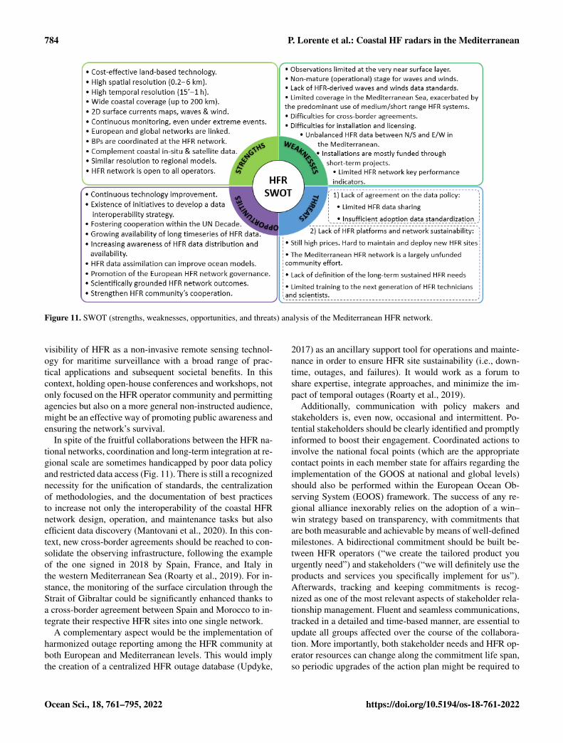
784 P. Lorente et al.: Coastal HF radars in the Mediterranean
Figure 11. SWOT (strengths, weaknesses, opportunities, and threats) analysis of the Mediterranean HFR network.
visibility of HFR as a non-invasive remote sensing technol-ogy for maritime surveillance with a broad range of prac-tical applications and subsequent societal benefits. In thiscontext, holding open-house conferences and workshops, notonly focused on the HFR operator community and permittingagencies but also on a more general non-instructed audience,might be an effective way of promoting public awareness andensuring the network’s survival.
In spite of the fruitful collaborations between the HFR na-tional networks, coordination and long-term integration at re-gional scale are sometimes handicapped by poor data policyand restricted data access (Fig. 11). There is still a recognizednecessity for the unification of standards, the centralizationof methodologies, and the documentation of best practicesto increase not only the interoperability of the coastal HFRnetwork design, operation, and maintenance tasks but alsoefficient data discovery (Mantovani et al., 2020). In this con-text, new cross-border agreements should be reached to con-solidate the observing infrastructure, following the exampleof the one signed in 2018 by Spain, France, and Italy inthe western Mediterranean Sea (Roarty et al., 2019). For in-stance, the monitoring of the surface circulation through theStrait of Gibraltar could be significantly enhanced thanks toa cross-border agreement between Spain and Morocco to in-tegrate their respective HFR sites into one single network.
A complementary aspect would be the implementation ofharmonized outage reporting among the HFR community atboth European and Mediterranean levels. This would implythe creation of a centralized HFR outage database (Updyke,
2017) as an ancillary support tool for operations and mainte-nance in order to ensure HFR site sustainability (i.e., down-time, outages, and failures). It would work as a forum toshare expertise, integrate approaches, and minimize the im-pact of temporal outages (Roarty et al., 2019).
Additionally, communication with policy makers andstakeholders is, even now, occasional and intermittent. Po-tential stakeholders should be clearly identified and promptlyinformed to boost their engagement. Coordinated actions toinvolve the national focal points (which are the appropriatecontact points in each member state for affairs regarding theimplementation of the GOOS at national and global levels)should also be performed within the European Ocean Ob-serving System (EOOS) framework. The success of any re-gional alliance inexorably relies on the adoption of a win–win strategy based on transparency, with commitments thatare both measurable and achievable by means of well-definedmilestones. A bidirectional commitment should be built be-tween HFR operators (“we create the tailored product youurgently need”) and stakeholders (“we will definitely use theproducts and services you specifically implement for us”).Afterwards, tracking and keeping commitments is recog-nized as one of the most relevant aspects of stakeholder rela-tionship management. Fluent and seamless communications,tracked in a detailed and time-based manner, are essential toupdate all groups affected over the course of the collabora-tion. More importantly, both stakeholder needs and HFR op-erator resources can change along the commitment life span,so periodic upgrades of the action plan might be required to
Ocean Sci., 18, 761–795, 2022 https://doi.org/10.5194/os-18-761-2022

P. Lorente et al.: Coastal HF radars in the Mediterranean 785
satisfactorily match each other. In this context, the promo-tion of positive synergies and success stories might consti-tute an effective way to attract and mobilize new stakeholders(pre-existing or new) by means of the foundational sequence“tell, sell, negotiate, enlist”. The EU HFR Node and IBISARproject (Révelard et al., 2021) constitute successful examplesof this bidirectional long-term engagement between HFR op-erators and end users such as SASEMAR (the Spanish Ma-rine Safety Agency). SASEMAR oversees maritime trafficcontrol, SAR operations, marine environmental protection,and training in Spain. In this context, HFR estimations arereadily ingested by the Environmental Data Server (EDS)managed by SASEMAR to enhance the emergency planningprocess for a prompt response.
Given the broadly accepted credibility of HFRs, this tech-nology must be integrated into robust analysis frameworksfor improved marine governance over coastal resources cov-ering a range of dimensions, such as legislative, planning,infrastructure, technical, scientific, and institutional partner-ships at the Mediterranean level. HFRs can positively con-tribute to the proper establishment of environmental policiesand strategies, bridging the gap between research and soci-etal challenges.
5.2 Technical challenges
The last 2 decades have witnessed the evolution of oceano-graphic HFR systems from a collection of local and regionalinstruments operated by research-oriented groups to a back-bone element in emerging national coastal ocean observato-ries. The practical applications already developed have un-equivocally demonstrated that HFR-derived surface currentsare a reliable resource for SAR operations, oil spill track-ing, and harmful algal bloom monitoring, among others. Ad-ditionally, pilot programs have been undertaken by nationalagencies to evaluate the potential ingestion of other HFR ba-sic products such as directional wave and wind information,together with the implementation of ad hoc alert systems fortsunami detection and vessel tracking. All these scientificand operational developments have been key drivers for thesteady evolution of HFR technology, which aims to respondadequately to both societal priorities and growing end-userdemands.
A relevant technical challenge that must be faced and suc-cessfully overcome over the upcoming years is the resilienceof HFR coastal networks, which is seriously handicapped byharsh met-ocean conditions (i.e., heat, strong wind gusts, salt,heavy rain, and moisture) and the periodic passage of stormsthat give rise to severe sea states (Medicanes, storm surges,and tsunamis). Serving as a recent example, the HFR sys-tem deployed in the Ebro Delta (NE Spain) was able to pro-vide accurate and sustained observations during the record-breaking storm Gloria, which hit the NW Mediterranean Seain January 2020, thereby proving to be resilient to extremeevents (Lorente et al., 2021).
Notwithstanding, resiliency is a broad concept that appliesnot only to hardware, but also to software. The HF band hasbeen described as a clutter-rich environment. HFR manufac-turers have implemented and keep developing robust soft-ware in order to mitigate noise and clutter from both environ-mental and anthropogenic sources, including lightning, radiotransmissions, ionospheric echoes, and wind turbine echoes,to name a few.
In addition to resiliency, automation in the management ofHFR systems is a key element to minimize operating costsat both national and regional scales and to ensure the long-term sustainability of the network. To meet this need, HFRmanufacturers include a variety of dedicated tools and soft-ware packages developed to operationally monitor radar sys-tem health in real time so abrupt anomalies in some variables(i.e., temperatures, voltage supply levels, forward and back-ward transmitted power, among others) or gradual degra-dation and failure problems can easily be detected, trigger-ing alerts for troubleshooting. Furthermore, newly developedsoftware, used together with information provided by the Au-tomatic Identification System (AIS) antenna on the radar site,allows using the position of “ships of opportunity” to con-stantly monitor and automatically upgrade the performanceof both DF and BF algorithms (Whelan et al., 2013). Despiteall these available tools, HFRs do occasionally require main-tenance and/or a corrective response, similar to any otherobservational network. However, radar operators are oftenpurely scientifically driven and have limited capabilities andresources to cope with this, often affecting the availabilityand/or quality of the data obtained.
In addition, weather radar operators’ footsteps should befollowed since there is increasing competition for operatingbandwidth. As HFR broadcast licenses were traditionally is-sued as secondary, obtaining dedicated frequency allocationshas remained a priority for a long time. In 2012, the Interna-tional Telecommunications Union (ITU) officially allocatedfrequency bands between 3 and 50 MHz to support HFR op-erations (Roarty et al., 2019). Notwithstanding, this alloca-tion is not exclusive, especially in the Mediterranean Sea,and such bands are nowadays used by other official and non-official radio services. As previously pointed out by Bellomoet al. (2015) in the framework of the TOSCA project, acquir-ing a frequency allocation that allows HFR as a primary userconstitutes a key objective for the Mediterranean communityin order to mitigate the presence of radio frequency interfer-ence that significantly impacts HFR performance. With ITUregulations becoming increasingly adopted around the world,more and more HFR stations have to share limited, fixed fre-quency bands. The expansion of HFR systems in the Mediter-ranean makes frequency sharing and coordination among dif-ferent networks of vital importance.
As a general technical challenge, HFR systems are perma-nently ameliorated. On one side, the hardware is steadily im-proved to minimize space, maintenance tasks, and inherentcosts. Such improvements include (i) for DF systems, the re-
https://doi.org/10.5194/os-18-761-2022 Ocean Sci., 18, 761–795, 2022

786 P. Lorente et al.: Coastal HF radars in the Mediterranean
cent development of long-range crossed-loop monopole sys-tems on a single mast; and (ii) for phased-array BF sys-tems, the availability of small low-cost measurement devicesthat allow for measuring and calibrating cable phases at theelectronics rack (no fieldwork required) and the implementa-tion of multiple input/multiple output receive antenna arraysthat reduce the antenna footprint without sacrificing perfor-mance. On the other side, novel software processing strate-gies are constantly being developed and updated to improvethe quality of the measured data. Such developments encom-pass the following: (i) for DF systems, new-wave processingsoftware that considers antenna pattern measurement; and(ii) for phased-array BF systems, software upgrades to ap-ply DF techniques to this type of HFR to improve azimuthprecision on far ranges.
As a summary, the main technological challenges for theupcoming future would encompass the following: (i) im-proving resilience and automation to reduce operating costs,(ii) eliminating (or at least reducing) the impact of radio noiseand interference through better enforcement of ITU band uti-lization and further development of digital filters, and (iii) in-creasing the technical readiness level of additional data prod-ucts (beyond surface currents) via a more direct engagementwith stakeholders.
5.3 Research challenges
Among the research challenges, integration must be achievedby building reinforced synergies between commercial de-velopers, academic institutions, management agencies, andstate government offices for the coordinated creation of tai-lored products to support end-user communities. In this con-text, HFR-derived products should evolve towards finer spa-tiotemporal scales to improve the coastal ocean monitor-ing, in line with the announced CMEMS coastal extension(Sánchez-Arcilla et al., 2021), and thereby adequately re-solve littoral (sub)mesoscale processes of paramount rele-vance. The accurate retrieval of HFR surface currents re-mains as a top priority since it is a prerequisite for the ex-isting applications of this shore-based technology. The mainchallenges, which are already being addressed to properlyestimate radial velocities at increased spatial coverage, arerelated to the correct identification of the first-order Braggpeaks and their exact locations as well as the resolution ofthe received signals in range and azimuth. This would helpto fulfill the recommended level of data provision: 80 % ofthe spatial region over 80 % of the time (Roarty et al., 2012).
Complementarily, the accurate monitoring of transportprocesses also remains as a prime concern due to its in-fluence on SAR operations and oil spill emergencies. La-grangian time-dependent approaches with HFR data, such asLyapunov exponents (Nolan et al., 2020) and Lagrangian co-herent structures (Haller, 2015), provide a robust frameworkto resolve coherent flow patterns. However, they are oftentime-consuming and computationally more expensive as they
require trajectory integrations over a complete spatiotempo-ral velocity dataset. Since hardware or software failures inthe HFR system occasionally compromise the availabilityof data, diverse methodologies have been proposed to fillspatiotemporal gaps in HFR measurements, encompassingself-organizing maps (SOMs), open-boundary modal analy-sis (OMA), and data interpolating empirical orthogonal func-tions (DINEOFs), among others. Despite the growing rele-vance of such approaches, there is still an active debate on thelimits of applicability of each gap-filling method for the La-grangian assessment of coastal ocean dynamics (Hérnandez-Carrasco et al., 2018). Nonetheless, there seems to be con-sensus about the convenience of combining HFR data withboth Eulerian and Lagrangian approaches, when possible,to properly explore transport processes at (sub)mesoscaleranges. A halfway approach, denominated as Eulerian coher-ent structures, has been recently developed to connect Eule-rian quantities to short-term Lagrangian transport (Serra etat., 2020), with substantial benefits in SAR operations.
HFR-derived wave parameters are receiving growing at-tention, but mainly within academia and research environ-ments. In terms of operational oceanography, HFR-derivedwave data are still far from being used on a near-real-timebasis, in contrast to surface currents, which have reached amature stage. In order to assess the accuracy of HFR-derivedwave data, several validation studies have been carried out inthe Mediterranean Sea (Table 1). Results suggest that HFRcan efficiently monitor the wave field, even during extremeevents when wave heights exceed the predefined saturationlimit of the HFR, which depends on the frequency (Lorenteet al., 2021). There are diverse challenges associated withthe retrieval of wave parameters that must still be addressedto foster the operational use of this basic product, encom-passing the appropriate application of a common battery ofautomatic checks performed in real time (to flag and subse-quently filter inconsistent values or spike-like fluctuations)as well as the standardization of data and metadata struc-ture. Additional efforts should be focused on the improve-ment of multiscale wave height estimation for highly variablesea states by using dual-frequency HFR systems (Wyatt andGreen, 2009; Helzel et al., 2017) or by extracting wave infor-mation directly from the first-order Bragg peaks (Zhou andWen, 2015) in order to overcome the wave height limitationat a single frequency and to better measure low and moderatewaves, respectively.
Future research endeavors should also include the devel-opment of robust algorithms for a reliable measurement ofwind speed, which remains less developed, that could com-plement the ongoing HFR multi-parameter monitoring. Thelimited number of studies existing in the Mediterranean ar-eas (i.e., Ligurian Sea, Gulf of Naples) about the extrac-tion of ocean surface wind from HFR systems seem to sug-gest that the accuracy of wind field inversion algorithms incoastal areas improves for higher-frequency systems understrong wind conditions. They also recommend prior knowl-
Ocean Sci., 18, 761–795, 2022 https://doi.org/10.5194/os-18-761-2022
P. Lorente et al.: Coastal HF radars in the Mediterranean 787
edge about the wind field variability and climatology in thestudy area to better design the investigation and assess thewind field measurements.
On the other hand, the implementation of data assimilationschemes could provide an integrative framework for maxi-mizing the joint utility of HFR-derived observations and nu-merical models with the aim of improving model predictiveskills in coastal areas. Although a few valuable initiativeshave already been carried out in the Mediterranean with pos-itive results in the modeling of the upper-layer circulation(Hernández-Lasheras et al., 2021; Vandenbulcke et al., 2017;Marmain et al., 2014), we should further strive to developrobust, fully operational assimilation schemes for HFR dataencompassing both radial and total current vectors. Equally,some previous works outside the Mediterranean study areahave reported the benefits of assimilating HFR-derived waveparameters into SWAN wave models (Siddons et al., 2009) orthe high-resolution coastal WAVEWATCH III model (Waterset al., 2013).
Although data assimilation is a powerful technique, ad-vances in coastal ocean monitoring should also include animproved understanding of underlying physical processes.For instance, wave–current interactions can contribute to thegeneration of large-amplitude waves, which are triggerednaturally when a stable wave train encounters an acceleratingopposing current (Onorato et al., 2011). Ràfols et al. (2019)drew a similar conclusion via numerical simulations withcoupled (hydrodynamic–wave) models in the NW Mediter-ranean Sea. Viitak et al. (2016) reported an increase in thewave height of up to 100 cm in nearshore waters of the east-ern Baltic Sea during the St. Jude storm due to the combinedeffect of surface currents and sea level on the wave field evo-lution. In this context, HFR technology should thereby beused to effectively monitor extreme events in near-real timeand unveil hydrodynamic aspects such as the aforementionedwave–current interactions (Zeng et al., 2019), which are stillpoorly resolved or even misrepresented by current state-of-the-art regional ocean models (Lorente et al., 2021).
6 Summary and conclusions
Over recent decades, HFR has become commonplace inmonitoring the sea state in coastal areas, once its techni-cal capabilities and potential applications were clearly show-cased. With the maturing of this technology, attention hasturned to what the scientific community and other end userscan learn and utilize from HFR data.
Since the Mediterranean Sea constitutes a significantgeostrategic region from both commercial and oceano-graphic perspectives, the use of HFR has been steadilygaining recognition as an effective land-based remote sens-ing technology for the multi-parameter monitoring of so-cioeconomically vital and often environmentally stressedcoastal waters. The present work is intended as a panoramic
overview of the main achievements, ongoing activities, andfuture challenges to be faced by the Mediterranean HFRcommunity in order to transition several stand-alone HFRsystems into an integrated monitoring network operated per-manently at basin scale. While the implementation of a fullyoperational HFR regional network in the Mediterranean Seais still in progress and far from complete, the pragmaticlessons already learned and application examples illustratedhere might be useful to similar programs under developmentelsewhere, such as the HFR network operating in Asia, pre-sented at the first Ocean Radar Conference for Asia (Fujii etal., 2013). A detailed description of the roadmap adopted totransform individual radars into an integrated HFR networkhas been provided. To assess the maturation process into afully operational status, the system must evolve via an im-plementation of phased approaches, including harmonizationof HFR systems architecture, homogenization of deploymentand good practices for preventive maintenance, data formatconvergence (i.e., standardization of file structure, metadata,and automatic quality control tests), regular validation ex-ercises against independent in situ observations, centraliza-tion of data management and access platforms, and eventu-ally the development of customized visualization tools andadded-value products to facilitate data discovery.
The Mediterranean HFR network must face a variety ofchallenges for future development, most of which are sharedwith the European and global HFR communities. However,a few other aspects are specific to the Mediterranean Sea dueto the intrinsic peculiarities of this regional semi-enclosedbasin. For instance, the presence of reflections from mov-ing ships or radio frequency interference from (non-)officialradio services is more pronounced as maritime traffic is sig-nificantly intense in coastal Mediterranean areas (Bellomoet al., 2015). In this context, obtaining dedicated frequencyallocation for HFR technology remains the top priority is-sue. A network extension to cover a substantial portion ofthe Mediterranean coastline also constitutes a prime concern,especially in the southern shore countries where the monitor-ing capabilities are extremely limited. This process is hand-icapped by the prominent use of medium- and short-rangeHFR systems which map smaller spatial domains. Moreover,the Strait of Gibraltar, the Dardanelles, and the Suez Canal(Fig. 1) act as physical constraints, leading to slow water re-newal cycles and high residence times at basin scale. Conse-quently, global warming and the chronic degree of pollutionrelated to anthropogenic activities impose higher pressuresthan in any other sea in the world, turning the MediterraneanSea into a more vulnerable hot spot for climate change (Tueland Eltahir, 2020).
While this paper constitutes the introductory part of a dou-ble contribution wherein the current state of the art is thor-oughly presented, the second part addresses the latest sci-entific breakthroughs with HFR technology achieved in theMediterranean region to fulfill stakeholder demands (Reyeset al., 2022). In particular, the second paper is built over three
https://doi.org/10.5194/os-18-761-2022 Ocean Sci., 18, 761–795, 2022

788 P. Lorente et al.: Coastal HF radars in the Mediterranean
main cornerstones (maritime safety, extreme event monitor-ing, and ecological decision support) to showcase emergingresearch-based downstream applications of societal benefitfounded on the operational use of quality-controlled HFR-derived data.
Code availability. The code implemented to develop the EU HFRNode tools is available in Corgnati (2019, 2020). Equally, the codefor HFR data visualization within the framework of the CopernicusMarine Service is also available in Rotllán-García (2021).
Data availability. MIO’s HFRToulon data, used in Sect. 2(Fig. 3), are available at http://hfradar.univ-tln.fr/HFRADAR/squel.php?content=accueil (last access: 21 April 2022, Dumaset al., 2022a), and real-time total currents (hourly data) areavailable for 2020 and 2021 at https://erddap.osupytheas.fr/erddap/files/cmems_nc_cf0e_c84a_8ead/ (last access: 21 April 2022,Dumas et al., 2022b). In situ observations provided by a mooredbuoy (from Stazione Zoologica Anton Dohrn Napoli), used inSect. 2 (Fig. 5), are available at https://www.szn.it/index.php/en/research/research-infrastructure-for-marine-biological-resources/access-to-marine-ecosystems-and-environmental-analysis/infrastructure-for-marine-research-irm/meda-b-napoli (lastaccess: 21 April 2022, Zambianchi et al., 2022). In situ ob-servations provided by a moored buoy (from Puertos delEstado), used in Sect. 2 (Figs. 4 and 5), are available athttps://www.puertos.es/es-es/oceanografia/Paginas/portus.aspx(last access: 21 April 2022, de Alfonso et al., 2022).
Author contributions. PL and ER conceived the idea of this paperand fostered the collaboration as MONGOOS-HFR co-chairs, be-ing in charge of overall direction and planning. All authors providedinputs for Sects. 3 and 4 and contributed to the writing of other sec-tions, as follows. PL took the lead in writing the abstract and prepar-ing the first draft of the document. RG and JS contributed signifi-cantly to Sects. 2 and 5. CAG, AM, MB, MBen, MM, AG, RS, DD,EZ, PF, ACE, IHC, JHL, ST, EA, CB, BD, MF, HM, VD, ML, LU,BM, and AR contributed to Sect. 2.2. YT, FC, GC, AD, and AGaucontributed to Sect. 2.2.2. EZ, DC, SS, PF, and MU contributed toSect. 2.2.2 and 2.2.3. LC and CM contributed to Sect. 2.3, 2.4, 2.5,and 2.6. Finally, JT, IV, CAG, AM, AO, LU, and VC conducted adetailed revision of the entire paper to gain cohesion.
Competing interests. At least one of the (co-)authors is a memberof the editorial board of Ocean Science. The peer-review processwas guided by an independent editor, and the authors also have noother competing interests to declare. AO and VC are guest membersof the editorial board of the Special Issue from the journal. AuthorJS is currently employed at Qualitas Instruments Lda. Author RGcurrently is employed at HELZEL Messtechnik GmbH. Author PLcurrently is employed at NOLOGIN Consulting SL. However, thesethree authors have not advertised commercial products and the re-search has not been sponsored by any of the companies.
Disclaimer. Publisher’s note: Copernicus Publications remainsneutral with regard to jurisdictional claims in published maps andinstitutional affiliations.
Special issue statement. This article is part of the special issue “Ad-vances in interdisciplinary studies at multiple scales in the Mediter-ranean Sea”. It is a result of the 8th MONGOOS Meeting & Work-shop, Trieste, Italy, 3–5 December 2019.
Acknowledgements. This study has been partially developed in theframework of the Interreg MED Strategic Project SHAREMED,co-financed by the European Regional Development Fund underthe funding program Interreg MED 2014–2020. Website: https://sharemed.interreg-med.eu/ (last access: 31 March 2022). We arealso grateful for the partial support of the (i) the project PO FEAMP2014/2020 (Misura 2.51) funded by Regione Campania (Italy),(ii) the 2017 PRIN project EMME (Exploring the fate of Mediter-ranean microplastic: from distribution pathways to biological ef-fects) funded by the Italian Ministry for Research (grant agreementno. 2017WERYZP), and (iii) the CMEMS-INSTAC phase II, whichprovides the context of the activities for HFR data harmonization,standardization, and distribution. Collaborative discussion on datamanagement harmonization at the European level has also beencarried out thanks to the contribution of the projects INCREASE(CMEMS Service Evolution Call for Tenders 21-SE-CALL1) andSeaDataCloud (EU-H2020 GA no. 730960). It is also worth men-tioning that the present work has been possible thanks to the MON-GOOS collaborative network, aimed toward long-term synergiesbetween multi-disciplinary working groups in the MediterraneanSea in order to launch strategic initiatives and pursue funding forinnovative research projects. Data were obtained from the EuropeanHigh-Frequency Radar Node (EU HFR NODE) Thredds Server(2022), including high-frequency radar surface current data fromEuropean and US radial sites, at https://thredds.hfrnode.eu/catalog/catalog.html (last access: 1 May 2022). Finally, the authors wouldlike to express their gratitude to the internal reviewers, Anne Mol-card, Ivica Vilibic, Charles-Antoine Guérin, and Joaquín Tintoré,as well as to the MONGOOS co-chairs, Vanessa Cardin and Ale-jandro Orfila, for their careful and meticulous reading of the paper.Their detailed and comprehensive reviews have been very helpfulto improve the structure, reading, and finalization of the paper.
Financial support. This study has been developed in the frame-work of the Interreg MED Strategic Project SHAREMED, co-financed by the European Regional Development Fund under thefunding program Interreg MED 2014–2020 (grant agreement 6184).Website: https://sharemed.interreg-med.eu/ (last access: 21 April2022).
Review statement. This paper was edited by Anna Rubio and re-viewed by Julien Mader and one anonymous referee.
Ocean Sci., 18, 761–795, 2022 https://doi.org/10.5194/os-18-761-2022

P. Lorente et al.: Coastal HF radars in the Mediterranean 789
References
Aguiar, E., Mourre, B., Juza, M., Reyes, M., Hernández-Lasheras,J., Cutolo, E., Mason, E., and Tintoré, J.: Multi-platformmodel assessment in the Western Mediterranean Sea: Impact ofdownscaling on the surface circulation and mesoscale activity,Ocean Dynam., 70, 273–288, https://doi.org/10.1007/s10236-019-01317-8, 2020.
Alattabi, Z. R., Cahl, D., and Voulgaris, G.: Swell andwind wave inversion using a single very high frequency(VHF) radar, J. Atmos. Ocean. Tech., 36, 987–1013,https://doi.org/10.1175/JTECH-D-18-0166.1, 2019.
Atwater, D. P. and Heron, M. L.: HF radar two-station baseline bi-sector comparisons of radial components, Proceedings of IEEEOceans 2010, Sydney, Australia, 1–4, 2010.
Barbin, Y.: High Resolution Surface Currents Mapping using Di-rection Finding Method in Bistatic Radar Configuration, in ThirdConference on Remote Ocean Sensing, La Spezia, Italy, 2011.
Barbin, Y., Broche P., and Forget, P.: High Resolution AzimutalRadial Current Mapping with Multisource Capability, in RadioOceanography Workshop, Split, Croatia, 2009.
Barceló-Llull, B., Pascual, A., Ruiz, S., Escudier, R., Torner, M.,and Tintoré, J.: Temporal and spatial hydrodynamic variabilityin the Mallorca channel (western Mediterranean Sea) from eightyears of underwater glider data, J. Geophys. Res.-Oceans, 124,2769–2786, https://doi.org/10.1029/2018JC014636, 2019.
Barrick, D. E.: First-Order Theory and Analysis of MF/HF/VHFScatter from the Sea, IEEE T. Ant. Prop., 20, 2–10, 1972.
Barrick, D. E.: Extraction of Wave Parameters Form MeasuredHF Radar Sea Echoes Spectra, Radio Sci., 12, 415–424,https://doi.org/10.1029/RS012i003p00415, 1977.
Barrick, D. E.: Accuracy of parameter extraction from sample av-eraged sea-echo Doppler spectra, IEEE T. Ant. Prop., 28, 1–11,1980.
Barrick, D. E., Lipa, B. J., and Crissman, R. D.: Mapping surfacecurrents with CODAR, Sea Technol., 43–48, 1985.
Basañez, A., Lorente, P., Montero, P., Álvarez-Fanjul, E., and Pérez-Muñuzuri, V.: Quality assessment and practical interpretationof the wave parameters estimated by HF Radars in NW Spain,Remote Sens., 12, 4, 598, https://doi.org/10.3390/rs12040598,2019.
Bellomo, L., Griffa, A., Cosoli, S., Falco, P., Gerin, R., Iermano,I., Kalampokis, A., Kokkini, Z., Lana, A., Magaldi, M. G.,Mamoutos, I., Mantovani, C., Marmain, J., Potiris, E., Sayol, J.M., Barbin, Y., Berta, M., Borghini, M., Bussani, A., Corgnati,L., Dagneaux, Q., Gaggelli, J., Guterman, P., Mallarino, D., Maz-zoldi, A., Molcard, A., Orfila, A., Poulain, P.-M., Quentin, C.,Tintoré, J., Uttieri, M., Vetrano, A., Zambianchi, E., and Zer-vakis, V.: Toward an integrated HF radar network in the Mediter-ranean Sea to improve search and rescue and oil spill response:the TOSCA project experience, J. Oper. Oceanogr., 8, 95–107,2015.
Berta, M., Bellomo, L., Magaldi, M. G., Griffa, A., Molcard, A.,Marmain, J., Borghini, M., and Taillandier, V.: Estimating La-grangian transport blending drifters with HF radar data and mod-els: Results from the TOSCA experiment in the Ligurian Current(North Western Mediterranean Sea), Prog. Oceanogr., 128, 15–29, https://doi.org/10.1016/j.pocean.2014.08.004, 2014.
Campanale, C., Suaria, G., Bagnuolo, G., Baini, M., Galli, M.,de Rysky, E., Ballini, M., Aliani, S., Fossi, M., and Uricchio,
V.: Visual observations of floating macro litter around Italy(Mediterranean Sea), Mediterranean Mar. Sci., 20, 271–281,https://doi.org/10.12681/mms.19054, 2019.
Capodici, F., Cosoli, S., Ciraolo, G., Nasello, C., Maltese,A., Poulain, P.-M., Drago, A., Azzopardi, J., and Gauci,A.: Validation of HF radar sea surface currents in theMalta-Sicily Channel, Remote Sens. Environ., 225, 65–76,https://doi.org/10.1016/j.rse.2019.02.026, 2019.
Carrara, P., Corgnati, L., Cosoli, S., Griffa, A., Kalampokis, A.,Mantovani, C., Oggioni, A., Pepe, M., Raffa, F., Serafino, F.,Uttieri, M., and Zambianchi, E.: The RITMARE coastal radarnetwork and applications to monitor marine transport infrastruc-tures, EGU General Assembly, Wien (Austria), 16, EGU2014-14149-1, 2014.
Carval, T., Chalkiopoulos, A., Perivoliotis, L., De AlfonsoAlonso-Muñoyerro, M., Manzano Munoz, F., Ringheim, L.S., Hammarklint, T., Sotiropoulou, M., Guyot C., Rottlan, P.,Corgnati, L., Marinova, V., and Jandt, S.: Copernicus Ma-rine In Situ NetCDF format manual, Copernicus in situ TAC,https://doi.org/10.13155/59938, 2020.
Cavaleri, L., Bertotti, L., Torrisi, L., Bitner-Gregersen, E., Se-rio, M., and Onorato, M.: Rogue waves in crossing seas:The Louis Majesty accident, J. Geophys. Res., 117, C00J10,https://doi.org/10.1029/2012JC007923, 2012.
Chapman, R. D. and Graber, H. C.: Validation of HF radar measure-ments, Oceanography, 10, 76–79, 1997.
Chapman, R. D., Shay, L. K., Graber, H. C., Edson, J. B., Karach-intsev, A., Trump, C. L., and Ross, D. B.: On the accuracy of HFradar surface current measurements: intercomparison with ship-based sensors, J. Geophys. Res., 102, 18737–18748, 1997.
Christaki, U., Van Wambeke, F., Lefevre, D., Lagaria, A., Prieur,L., Pujo-Pay, M., Grattepanche, J.-D., Colombet, J., Psarra, S.,Dolan, J. R., Sime-Ngando, T., Conan, P., Weinbauer, M. G., andMoutin, T.: Microbial food webs and metabolic state across olig-otrophic waters of the Mediterranean Sea during summer, Bio-geosciences, 8, 1839–1852, https://doi.org/10.5194/bg-8-1839-2011, 2011.
Chu, X., Zhang, J., Ji, Y., Wang, Y., and Yang, L.: Extraction of winddirection from the hf hybrid sky-surface wave radar sea echoes,IEEE Aerosp. Electron. Syst. Mag., 33, 42–47, 2018.
Coll, M., Piroddi, C., Steenbeek, J., Kaschner, K., Ben Rais Las-ram, F., Aguzzi, J., et al.: The biodiversity of the MediterraneanSea: estimates, patterns, and threats, PLoS ONE, 5, e11842,https://doi.org/10.1371/journal.pone.0011842, 2010.
Corgnati, L.: LorenzoCorgnati/HFR_Node_Historical_Data_Processing:EU_HFR_NODE_Historical_Data_Processing(Version v2.1.1.6). Zenodo [code],https://doi.org/10.5281/zenodo.3569519, 2019.
Corgnati, L.: LorenzoCorgnati/HFR_Node_tools:EU_HFR_NODE_Tools (Version v2.1.2), Zenodo [code],https://doi.org/10.5281/zenodo.3855461, 2020.
Corgnati, L., Mantovani, C., Griffa, A., Berta, M., Penna, P.,Celentano, P., Bellomo, L., Carlson, D.F. and D’Adamo,R.: Implementation and Validation of the ISMAR High-Frequency Coastal Radar Network in the Gulf of Manfredo-nia (Mediterranean Sea), IEEE J. Ocean. Eng., 44, 424–445,https://doi.org/10.1109/JOE.2018.2822518, 2019a.
Corgnati, L., Mantovani, C., Novellino, A., Jousset, S., Cramer,R. N., and Thijsse, P.: SeaDataNet data management protocols
https://doi.org/10.5194/os-18-761-2022 Ocean Sci., 18, 761–795, 2022

790 P. Lorente et al.: Coastal HF radars in the Mediterranean
for HF Radar data, WP9 – Deliverable D9.12. Version 1.6. Sea-DataNet, 83, https://doi.org/10.25607/OBP-1011, 2019b.
Corgnati, L., Carrara, P. Cosoli, S. Forneris, V. Griffa, A. Kalam-pokis, A. Mantovani, C., Oggioni, M. Pepe, F. Raffa, R., Santo-leri, F., Serafino, S., Tronconi, Uttieri, M., and Zambianchi, E.:The RITMARE Italian coastal radar network: operational systemand data interoperability framework, Proceedings of the 7th Eu-roGOOS Conference, Lisbon, ISBN 978-2-9601883-1-8, 2014.
Corgnati, L., Mantovani, C., Novellino, A., Rubio, A., Mader, J.,Reyes, E., Griffa, A., Asensio, J. L.., Gorringe, P., Quentin,C., Breitbach, G., and Widera, J.: Recommendation Report2 on improved common procedures for HFR QC analysis,http://www.jerico-ri.eu/download/jerico-next-deliverables/JERICO-NEXT-Deliverable_5.14_V1.pdf (last access:31 March 2022), 2018.
Corgnati, L., Mantovani, C., Rubio, A., Reyes, E., Rotllán, P.,Novellino, A., Gorringe, P., Solabarrieta, L., Griffa, A. and andMader, J: The EuroGOOS High Frequency Radar Task Team: asuccess story of collaboration to be kept alive and made growing,9th EuroGOOS International conference, Shom; Ifremer; Euro-GOOS AISBL, May 2021, Brest, France, 467–474, 2021.
Cosoli, S., Mazzoldi, A., and Gacic, M.: Validation of surface cur-rent measurements in the Northern Adriatic Sea from High Fre-quency radars, J. Atmos. Ocean. Tech., 27, 908–919, 2010.
Cotroneo, Y., Aulicino, G., Ruiz, S., Sánchez Román, A., TornerTomàs, M., Pascual, A., Fusco, G., Heslop, E., Tintoré, J., andBudillon, G.: Glider data collected during the Algerian Basin Cir-culation Unmanned Survey, Earth Syst. Sci. Data, 11, 147–161,https://doi.org/10.5194/essd-11-147-2019, 2019.
Crombie, D. D.: Doppler Spectrum of Sea Echo at 13.56 Mc./s.,Nature, 175, 681–682, 1955.
Davis, R. E.: Drifter observations of coastal surface currents duringCODE: The method and descriptive view, J. Geophys. Res., 90,4741–4755, https://doi.org/10.1029/JC090iC03p04741, 1985.
de Alfonso, M., Ruiz Gil-de la Serna, M. I., and Pérez, S.: Banco dedatos oceanográficos, conjunto de datos REDEXT, Puertos delEstado, [data set], https://www.puertos.es/es-es/oceanografia/Paginas/portus.aspx, last access: 21 April 2022
de Paolo, T., Terril, E., and Kirincich, A.: Improving SeaSonde ra-dial velocity accuracy and variance using radial metrics, IEEEOceans, Genova, 1–9, 2015.
de Valk, C., Reniers, A., Atanga, J., Vizinho, A., and Vogelzang, J.:Monitoring surface waves in coastal waters by integrating HFradar measurement and modelling, Coast. Eng., 37, 431–453,https://doi.org/10.1016/S0378-3839(99)00037-X, 1999.
Dobricic, S. and Pinardi, N.: An oceanographic three-dimensionalvariational data assimilation scheme, Ocean Model, 22, 89–105,2008.
Domps, B., Marmain, J. and Guérin, C.-A.: A Reanalysisof the October 2016 “Meteotsunami” in British Columbiawith Help of High-Frequency Radars and Autoregres-sive Modeling, IEEE T. Geosci. Remote, 19, 3505105https://doi.org/10.1109/LGRS.2021.3066849, 2020.
Domps, B., Dumas, D. Guérin, C.-A., and Marmain, J.: High-Frequency Radar Ocean Current Mapping at Rapid Scale withAuto-Regressive Modeling, IEEE J. Ocean Eng., 46, 891–899,https://doi.org/10.1109/JOE.2020.3048507, 2021.
D’Ortenzio, F., Taillandier, V., Claustre, H., Prieur, L. M.,Leymarie, E., Mignot, A., Poteau, A., Penkerc’h, C., and
Schmechtig, C. M.: Biogeochemical Argo: The Test Caseof the NAOS Mediterranean Array, Front. Mar. Sci., 24,https://doi.org/10.3389/fmars.2020.00120, 2020.
Dumas, D. and Guérin, C.-A.: Self-calibration and antenna group-ing for bistatic oceanographic High-Frequency Radars, Electr.Eng. Sys. Sci., 1–16, https://doi.org/10.48550/arXiv.2005.10528,2020.
Dumas, D., Gramoullé, A., Guérin, C.-A., Molcard, A., Ourmiëres,Y., and Zakardjian, B.: Multistatic estimation of high-frequencyradar surface currents in the region of Toulon, Ocean Dynam., 70,1485–1503, https://doi.org/10.1007/s10236-020-01406-z, 2020.
Dumas, D., Guérin, C.-A., Quentin, C., and Molcard, A.:MIO’s HFRToulon data, Mediterranean Institute of Oceanogra-phy, [data set], http://hfradar.univ-tln.fr/HFRADAR/squel.php?content=accueil, last access: 21 April 2022a.
Dumas, D., Quentin, C., and Guérin, C.-A.: Real time total cur-rents foe 2020 and 2021, Mediterranean Institute of Oceanogra-phy, [data set], https://erddap.osupytheas.fr/erddap/files/cmems_nc_cf0e_c84a_8ead/, last access: 21 April 2022b.
Emery, B. M.: Evaluation of alternative direction-of-arrival meth-ods for oceanographic HF radars, IEEE J. Ocean. Eng., 45, 990–1003, https://doi.org/10.1109/JOE.2019.2914537, 2020.
Emery, B. M., Washburn, M. L., and Harlan, J. A.: Evaluating radialcurrent measurements from CODAR high frequency radars withmoored current meters, J. Atmos. Ocean. Tech., 21, 1259–1271,2004.
Esposito, G., Saviano S., Di Lemma, R., Buonocore, B., de Rug-giero, P., Pierini, S., and Zambianchi, E.: An analysis of the sea-sonal wind regime in the Gulf of Naples using observational dataand model outputs, Geophys. Res. Abstr., 18, 13421, 2018.
Falco, P., Buonocore, B., Cianelli, D., De Luca, L., Giordano,A., Iermano, I., Kalampokis, A., Saviano, S., Uttieri, M., Zam-bardino, G., and Zambianchi, E.: Dynamics and sea state in theGulf of Naples: potential use of high-frequency radar data in anoperational oceanographic context, J. Oper. Oceanogr., 9, 33–45,https://doi.org/10.1080/1755876X.2015.1115633, 2016.
Fichaut, M. and Schaap, D.: From SeaDataNet II to SeaDataCloud,in International conference on Marine Data and Information sys-tems (IMDIS), Gdansk, Poland, 57, 11–13, 2016.
Flores-Vidal, X., Flament, P., Durazo, R., Chavanne, C., and Gurgel,K.-W.: High-frequency radars: Beamforming calibrations usingships as reflectors, J. Atmos. Ocean. Tech., 30, 638–648, 2013.
Forney, R., Roarty, H., and Glenn, S.: Measuring Waves with aCompact HF Radar, Paper presented at OCEANS 2015 – MT-S/IEEE, Washington, 19–22 October 2015.
Fujii, S., Heron, M. L., Kim, K., Lai, J. W., Lee, S. H., Wu, X.,Wyatt, L. R., and Yang, W. C: An overview of developments andapplications of oceanographic radar networks in Asia and ocea-nia countries, Ocean Sci. J., 48, 69–97, 2013.
Gaiser, L. and Hribar, D.: Euro-Mediterranean Region: ResurgedGeopolitical Importance, Int. J. Euro-Mediter. Stud., 5, 57–69,https://doi.org/10.1007/s40321-012-0002-8, 2012.
Garrabou, J., Gómez-Gras, D., Ledoux, J.-B., Linares, C.,et al.: Collaborative Database to Track Mass MortalityEvents in the Mediterranean Sea, Front. Mar. Sci., 6, 707,https://doi.org/10.3389/fmars.2019.00707, 2019.
Gómez, R., Helzel, T., Wyatt, L., López, G., Conley, D., Thomas,N., Smet, S., and Sicot, G.: Estimation of Wave Parameters fromHF Radar Using Different Methodologies and Compared with
Ocean Sci., 18, 761–795, 2022 https://doi.org/10.5194/os-18-761-2022

P. Lorente et al.: Coastal HF radars in the Mediterranean 791
Wave Buoy Measurements at the Wave Hub, Conference paperpresented at OCEANS 2015 – MTS/IEEE, Genova, 18–21 May2015.
Gómez, R., Tran, T. H., Ramdhani, A., and Triyono, R.: HFRadar Validation and Accuracy Analysis using Baseline Com-parison Approach in the Sunda Strait, Technical Report,https://doi.org/10.13140/RG.2.2.11110.96322, 2020.
Gómez-Navarro, L., Fablet, R., Mason, E., Pascual, A., Mourre,B., Cosme, E., and Le Sommer, J.: SWOT Spatial Scalesin the Western Mediterranean Sea Derived from Pseudo-Observations and an Ad Hoc Filtering, Remote Sens., 10, 599,https://doi.org/10.3390/rs10040599, 2018.
Griffa, A., Horstmann, J., Mader, J., Rubio, A., Berta, M., Orfila,A., and Axell, L.: Report on final assessment of methodologi-cal improvements and testing, JERICO-NEXT WP3 Innovationsin Technology and Methodology, Deliverable D3.4, Version 2,Brest, France, IFREMER, 56 pp., (JERICO-NEXT-WP3-D3.4-180719-V2), https://doi.org/10.25607/OBP-948, 2019.
Guérin, C.-A., Dumas, S., Gramoulle, A., Quentin, C.,Saillard, M., and Molcard, A.: The multistatic oceano-graphic HF radar network in Toulon. 2019 InternationalRadar Conference (RADAR), Toulon, France, 2019, 1–5,https://doi.org/10.1109/RADAR41533.2019.171401, 2019.
Guérin, C.-A., Dumas, D., Molcard, A., Quentin, C., Zakardjian,B., Gramoullé, A., and Berta, M.: High-Frequency radar mea-surements with CODARs in the region of Nice: improved cali-bration and performances, accepted, J. Atmos. Ocean. Tech., 38,2003–2016, https://doi.org/10.1175/JTECH-D-21-0058.1, 2021.
Gurgel, K. W., Antonischski, G., Essen, H. H., and Schlick, T.:Wellen radar (WERA): A new ground wave radar for remotesensing, Coast. Eng., 37, 219–234, 1999.
Gurgel, K. W., Essen, H. H., and Schlick, T.: An empirical methodto derive ocean waves from second-order Bragg scattering:Prospects and limitations, IEEE J. Ocean. Eng., 31, 804–811,2006.
Gurgel, K.-W., Barbin, Y., and Schlick, T.: Radio Fre-quency Interference Suppression Techniques in FMCWModulated HF Radars, in Oceans 2007 Europe, 1–4,https://doi.org/10.1109/OCEANSE.2007.4302289, 2007.
Haller, G.: Lagrangian coherent structures, Annu. Rev. Fluid Mech,47, 137–162, https://doi.org/10.1146/annurev-fluid-010313-141322, 2015.
Hernández-Carrasco, I., Solabarrieta, L., Rubio, A., Esnaola, G.,Reyes, E., and Orfila, A.: Impact of HF radar current gap-fillingmethodologies on the Lagrangian assessment of coastal dynam-ics, Ocean Sci., 14, 827–847, https://doi.org/10.5194/os-14-827-2018, 2018.
Hernandez-Lasheras, J., Mourre, B., Orfila, A., Santana, A., Reyes,E., and Tintoré, J.: Evaluating high-frequency radar data assimi-lation impact in coastal ocean operational modelling, Ocean Sci.,17, 1157–1175, https://doi.org/10.5194/os-17-1157-2021, 2021.
Helzel, T., Petersen, L., Widera, J., Bennis, A., Benoit, L., andBarbin, Y.: Dual frequency ocean radar concept to measure oceancurrents and waves at the Raz Blanchard, OCEANS 2017, Ab-erdeen, 1–4, https://doi.org/10.1109/OCEANSE.2017.8084761,2017.
Heron, M. L., and Rose, R.: On the application of HF oceanradar to the observation of temporal and spatial changes
in wind direction, IEEE J. Ocean. Eng., 11, 210–218,https://doi.org/10.1109/JOE.1986.1145173, 1986.
Heron, M. L.: Applying a unified directional wave spectrum to theremote sensing of wind wave directional spreading, Can. J. Re-mote. Sens, 28, 346–353, 2002.
Heron, M. L., Dzvonkovskaya, A., and Helzel, T.: HF radar opti-mised for tsunami monitoring, Proc. OCEANS 2015 – Genova,1–5, 2015.
Hisaki, Y.: Nonlinear inversion of the integral equation to esti-mate ocean wave spectra from HF radar, Radio Sci., 31, 25–39,https://doi.org/10.1029/95RS02439, 1996.
Hisaki, Y.: Ocean Wave Directional Spectra Estimationfrom an HF Ocean Radar with a Single Antenna Ar-ray: Methodology, J. Atmos. Ocean. Tech., 23, 268–286,https://doi.org/10.1175/JTECH1836.1., 2006.
Hisaki, Y.: Sea Surface Wind Correction Using HF Ocean Radarand Its Impact on Coastal Wave Prediction, J. Atmos. Ocean.Technol., 34, 2001–2020, 2017.
Huang, W., Gill, E., Wu, S., Wen, B., Yang, Z., and Hou, J.: Measur-ing surface wind direction by monostatic HF ground-wave radarat the eastern China sea, IEEE J. Ocean. Eng., 29, 1032–1037,2004.
Juza, M. and Tintoré, J.: Multivariate Sub-Regional Ocean In-dicators in the Mediterranean Sea: From Event Detection toClimate Change Estimations, Front. Mar. Sci., 8, 610589,https://doi.org/10.3389/fmars.2021.610589, 2021.
Kalampokis, A., Uttieri, M., Poulain, P., and Zambianchi, E.: Vali-dation of HF Radar-Derived Currents in the Gulf of Naples WithLagrangian Data, IEEE Geosci. Remote Sens. Lett., 13, 1452–1456, https://doi.org/10.1109/LGRS.2016.2591258, 2016.
Kassis, D. and Korres, G.: Hydrography of the Eastern Mediter-ranean basin derived from argo floats profile data, Deep Sea Res.Pt. II, 171, 104712, https://doi.org/10.1016/j.dsr2.2019.104712,2020.
Kirincich, A.: Remote Sensing of the Surface Wind Field over theCoastal Ocean via Direct Calibration of HF radar BackscatterPower, J. Atmos. Ocean. Technol., 33, 1377–1392, 2016.
Kirincich, A. R., de Paolo, T., and Terrill, E.: Improving HF RadarEstimates of Surface Currents Using Signal Quality Metrics, withApplication to the MVCO High-Resolution Radar System, J. At-mos. Ocean. Tech., 29, 1377–1390, 2012.
Kohut, J. T. and Glenn, S. M.: Improving HF radar surface currentmeasurements with measured antenna beam patterns, J. Atmos.Ocean. Tech., 20, 1303–1316, 2003.
Kohut, J. T., Roarty, H. J., and Glenn, S.: Characterizing ObservedEnvironmental variability with HF Doppler radar surface map-pers and Acoustic Doppler Current Profilers: Environmental vari-ability in the Coastal Ocean, J. Ocean. Eng., 31, 876–884, 2006.
Lana, A., Marmain, J., Fernández, V., Tintoré, J., and Orfilia, A.:Wind influence on surface current variability in the Ibiza Channelfrom HF Radar, Ocean Dynam., 66, 483–497, 2016.
Laws, K. E., Paduan, J. D., and Fernández, D. M.: Effect of Stokesdrift on HF radar measurements, Radiowave Oceanography theFirst International Workshop, University of Miami, RosentielSchool of Marine and Atmospheric Science, 49–55, 2003.
Lejeusne, C., Chevaldonne, P., Pergent-Martini, C., Boudouresque,C. F., and Perez, T.: Climate change effects on aminiature ocean: the highly diverse, highly impacted
https://doi.org/10.5194/os-18-761-2022 Ocean Sci., 18, 761–795, 2022

792 P. Lorente et al.: Coastal HF radars in the Mediterranean
Mediterranean Sea, Trends Ecol. Evol., 25, 250–260,https://doi.org/10.1016/j.tree.2009.10.009, 2010.
Le Traon, P. Y.: From satellite altimetry to Argo and operationaloceanography: three revolutions in oceanography, Ocean Sci., 9,901–915, https://doi.org/10.5194/os-9-901-2013, 2013.
Le Traon, P.-Y., Ali, A., Álvarez Fanjul, E., Behrens, A., Stanev,E., Staneva, J., et al.: The Copernicus Marine Environmen-tal Monitoring Service: Main Scientific Achievements and Fu-ture Prospects, Special Issue Mercator Oceìan Journal, 56,https://doi.org/10.25575/56, 2017.
Linnenluecke, M. K., Griffiths, A., and Winn, M.: ExtremeWeather Events and the Critical Importance of AnticipatoryAdaptation and Organizational Resilience in Responding toImpacts, Business Strategy and the Environment, 21, 17–32,https://doi.org/10.1002/bse.708, 2012.
Lipa, B. J. and Nyden, B.: Directional wave information from theSeaSonde, IEEE J. Ocean. Eng., 30, 221–231, 2005.
Lipa, B. J., Nyden, B., Barrick, D., and Kohut, J.: HF Radar Sea-Echo from Shallow Water, Sensors, 8, 4611–4635, 2008.
Lipa, B. J., Isaccson, J., Nyden, B., and Barrick, D.: Tsunami Ar-rival Detection with High Frequency (HF) Radar, Remote Sens.,4, 1448–1461, 2012.
Lipa, B. J., Barrick, D., Alonso-Martirena, A., Fernandes,M., Ferrer, M. I., and Nyden, B.: Brahan Project HighFrequency Radar Ocean Measurements: Currents, Winds,Waves and Their Interactions, Remote Sens, 6, 12094–12117,https://doi.org/10.3390/rs61212094, 2014.
Long, A. E. and Trizna, D. B.: Measurements and preliminary in-terpretation of hf radar Doppler spectra from the sea-echo of anatlantic storm, NRL Rep., 21, 680–685, 1972.
Long, R. M., Barrick, D., Largier, J. L., and Garfield, N.:Wave Observations from Central California: SeaSonde Systemsand in Situ Wave Measurements, J. Sensors, 2011, 728936,https://doi.org/10.1155/2011/728936, 2011.
López, G., Conley, D., and Greaves, D.: Calibration, Validation andAnalysis if an Empirical Algorithm for the Retrieval of WaveSpectra from HF Radar Sea Echo, J. Atmos. Ocean. Tech., 33,245–261, https://doi.org/10.1175/JTECH-D-15-0159.1, 2016.
López, G. and Conley, D. C.: Comparison of HF RadarFields of Directional Wave Spectra Against In Situ Mea-surements at Multiple Locations, J. Mar. Sci. Eng., 7, 271,https://doi.org/10.3390/jmse7080271, 2019.
Lorente, P., Piedracoba, S., Soto-Navarro, J., and Álvarez-Fanjul,E.: Accuracy assessment of High Frequency radar current mea-surements in the Strait of Gibraltar, J. Operat. Oceanogr., 7, 59–73, 2014.
Lorente, P., Piedracoba, S., Soto-Navarro, J., and Alvarez-Fanjul,E.: Evaluating the surface circulation in the Ebro delta (north-eastern Spain) with quality-controlled high-frequency radar mea-surements, Ocean Sci., 11, 921–935, https://doi.org/10.5194/os-11-921-2015, 2015.
Lorente, P., Piedracoba, S., Soto-Navarro, J., and Álvarez-Fanjul,E.: Characterizing the surface circulation in Ebro Delta (NWMediterranean) with HF radar and modeled current data, J. Mar.Syst., 163, 61–79, 2016a.
Lorente, P., Piedracoba, S., Sotillo M. G., Aznar, R., Amo-Baladrón, A., Pascual, A., Soto-Navarro, J., and Álvarez-Fanjul, E.: Ocean model skill assessment in the NW Mediter-
ranean using multi-sensor data, J. Oper. Oceanogr., 9, 75–92,https://doi.org/10.1080/1755876X.2016.1215224, 2016b.
Lorente, P., García-Sotillo, M., Amo-Baladrón, A., Aznar, R.,Levier, B., Sánchez-Garrido, J. C., Sammartino, S., de Pascual-Collar, Á., Reffray, G., Toledano, C., and Álvarez-Fanjul, E.:Skill assessment of global, regional, and coastal circulation fore-cast models: evaluating the benefits of dynamical downscaling inIBI (Iberia–Biscay–Ireland) surface waters, Ocean Sci., 15, 967–996, https://doi.org/10.5194/os-15-967-2019, 2019.
Lorente, P., Lin-Ye, J., García-León, M., Reyes, E., Fernandes, M.,Sotillo, M.G., Espino, M., Ruiz, M. I., Gracia, V., Pérez, S., Az-nar, R., Alonso-Martirena, A., and Álvarez-Fanjul, E.: On thePerformance of High Frequency Radar in the Western Mediter-ranean During the Record-Breaking Storm Gloria, Front. Mar.Sci., 8, 645762, https://doi.org/10.3389/fmars.2021.645762,2021.
Mahadevan, A., D’Asaro, E., Allen, J., et al.: CALYPSO2019 Cruise Report: Field Campaign in the Mediterranean,Technical Report, Woods Hole Oceanographic Institution,https://doi.org/10.1575/1912/25266, 2020.
Malanotte-Rizzoli, P., Artale, V., Borzelli-Eusebi, G. L., Brenner,S., Crise, A., Gacic, M., Kress, N., Marullo, S., Ribera d’Alcalà,M., Sofianos, S., Tanhua, T., Theocharis, A., Alvarez, M., Ashke-nazy, Y., Bergamasco, A., Cardin, V., Carniel, S., Civitarese, G.,D’Ortenzio, F., Font, J., Garcia-Ladona, E., Garcia-Lafuente, J.M., Gogou, A., Gregoire, M., Hainbucher, D., Kontoyannis, H.,Kovacevic, V., Kraskapoulou, E., Kroskos, G., Incarbona, A.,Mazzocchi, M. G., Orlic, M., Ozsoy, E., Pascual, A., Poulain,P.-M., Roether, W., Rubino, A., Schroeder, K., Siokou-Frangou,J., Souvermezoglou, E., Sprovieri, M., Tintoré, J., and Tri-antafyllou, G.: Physical forcing and physical/biochemical vari-ability of the Mediterranean Sea: a review of unresolved is-sues and directions for future research, Ocean Sci., 10, 281–322,https://doi.org/10.5194/os-10-281-2014, 2014.
Mantovani, C., Corgnati, L., Horstmann, J., Rubio, A., Reyes, E.,Quentin, C., Cosoli, S., Asensio, J. L., Mader, J., and Griffa, A.:Best Practices on High Frequency Radar Deployment and Oper-ation for Ocean Current Measurement, Front. Mar. Sci., 7, 210,https://doi.org/10.3389/fmars.2020.00210, 2020.
Marmain, J., Molcard, A., Forget, P., Barth, A., and Ourmières, Y.:Assimilation of HF radar surface currents to optimize forcingin the northwestern Mediterranean Sea, Nonlin. Processes Geo-phys., 21, 659–675, https://doi.org/10.5194/npg-21-659-2014,2014.
Martín Miguez, B., Novelino, A., Vinci, M., Claus, S., Cale-waert, J.-B., Valius, H., et al.: The European Marine Observa-tion and Data Network (EMODnet): visions and roles of thegateway to marine data in Europe, Front. Mar. Sci., 6, 313,https://doi.org/10.3389/fmars.2019.00313, 2019.
Melet, A., Teatini, P., Le Cozannet, G., Jamet, C., Conversi, A.,Benveniste, J., and Almar, R.: Earth Observations for Monitor-ing Marine Coastal Hazards and their drivers, Surv. Geophys.,41, 1489–1534, 2020.
Milglietta, M. M. and Rotunno, R.: Development mechanisms forMediterranean tropical-like cyclones (medicanes), Q. J. Roy.Meteorol. Soc., 145, 1444–1460, 2019.
Millot, C. and Taupier-Letage, I.: Circulation in the MediterraneanSea, edited by: Saliot, A., The Mediterranean Sea, Handbook
Ocean Sci., 18, 761–795, 2022 https://doi.org/10.5194/os-18-761-2022

P. Lorente et al.: Coastal HF radars in the Mediterranean 793
of Environmental Chemistry, 5K, Springer, Berlin, Heidelberg,https://doi.org/10.1007/b107143, 2005.
Molcard, A., Poulain, P., Forget, P., Griffa, A., Barbin, Y., Gaggelli,J., Maistre, J. D., and Rixen, M.: Comparison between vhfradar observations and data from drifter clusters in the Gulfof la Spezia (Mediterranean Sea), J. Mar. Sys., 78, 79–89,https://doi.org/10.1016/j.jmarsys.2009.01.012, 2009.
Moltmann, T., Turton, J., Zhang, H-M., Nolan, G., Gouldman,C., Griesbauer, L., Willis, Z., Piniella, Á.M., Barrell, S.,Andersson, E., Gallage, C., Charpentier, E., Belbeoch, M.,Poli, P., Rea, A., Burger, E.F., Legler, D.M., Lumpkin, R.,Meinig, C., O’Brien, K., Saha, K., Sutton, A., Zhang, D., andZhang, Y.: A Global Ocean Observing System (GOOS), de-livered through enhanced collaboration across regions, com-munities, and new technologies, Front. Mar. Sci., 6, 291,https://doi.org/10.3389/fmars.2019.00291, 2019.
Mourre, B., Aguiar, E., Juza, M., Hernández-Lasheras, J., Reyes,E., Heslop, E., Escudier, R., Cutolo, E., Ruiz, S., Mason, E., Pas-cual, A., and Tintoré, J.: Assessment of high-resolution regionalocean prediction systems using muli-platform observations: il-lustrations in the Western Mediterranean Sea, in: “New Frontiersin Operational Oceanography”, edited by: Chassignet, E., Pas-cual, A., Tintoré, J., and Verron, J., GODAE Ocean View, 663–694, https://doi.org/10.17125/gov2018.ch24, 2018.
Nikolaidis, N. P., Bidoglio, G., Bouraoui, F., and Car-doso, A. C.: Water Quality of the Mediterranean, Com-prehensive Water Quality and Purification, 4, 230–250,https://doi.org/10.1016/B978-0-12-382182-9.00076-1, 2014.
Nolan, P. J., Serra, M., and Ross, S. D.: Finite-time Lyapunov expo-nents in the instantaneous limit and material transport, Nonlin-ear Dyn., 100, 3825–3852, https://doi.org/10.1007/s11071-020-05713-4, 2020.
Ohlmann, C., White, P., Washburn, L., Terril, E., Emery, B., andOtero, M.: Interpretation of coastal HF radar-derived currentswith high-resolution drifter data, J. Atmos. Ocean. Tech., 24,666–680, 2007.
Olmedo, E., Taupier-Letage, I., Turiel, A., and Alvera-Azcárate, A.:Improving SMOS Sea Surface Salinity in the Western Mediter-ranean Sea through Multivariate and Multifractal Analysis, Re-mote Sens., 10, 485, https://doi.org/10.3390/rs10030485, 2018.
Onorato, M., Proment, D., and Toffoli, A.: Triggering RogueWaves in Opposing Currents, Phys. Rev. Lett. 107, 184502,https://doi.org/10.1103/PhysRevLett.107.184502, 2011.
Orasi, A., Picone, M., Drago, A., Capodici, F., Gauci, A., Nar-done, G., Inghilesi, R., Azzopardi, J., Galea, A., Ciraolo, G., andMusulin, J. S.; Alonso-Martirena, A.: HF Radar for Wind WavesMeasurements in the Malta-Sicily Channel, Measurements, 128,446–454, 2018.
Paduan, J. D., Kim, K. C., Cook, M. S., and Chavez, F. P.: Cali-bration and validation of direction-finding High-Frequency radarocean surface current observations, IEEE J. Ocean. Eng., 31,862–875, 2006.
Pinardi, N., Arneri, E., Crise, A., Ravaioli, M., and Zavatarelli, M.:The physical, sedimentary and ecological structure and variabil-ity of shelf areas in the Mediterranean Sea, in: The Sea, 14, editedby: Robinson, A. R. and Brink, K., Cambridge, Harvard Univer-sity Press, 1243–1330, 2006.
Pinardi, N., Cessi, P., Borile, F., and Wolfe, W. C.: The Mediter-ranean Sea overturning circulation, J. Phys. Oceanogr., 49, 1699–1721, https://doi.org/10.1175/JPO-D-18-0254.1, 2019.
Ràfols, L., Grifoll, M., and Espino, M.: Wave–current in-teractions in a wind-jet region, Ocean Sci., 15, 1–20,https://doi.org/10.5194/os-15-1-2019, 2019.
Ramos, R. J., Graber, H. C., and Haus, B. K: Obser-vation of Wave Energy Evolution in Coastal Areas Us-ing HF Radar, J. Atmos. Ocean. Tech., 26, 1891–1909,https://doi.org/10.1175/2009JTECHO631.1, 2009.
Ranalli, M., Lagona, F., Picone, M., and Zambianchi, E.: Segmen-tation of sea current fields by cylindrical hidden Markov models:a composite likelihood approach, J. Roy. Statist. Soc., 67, 575–598, 2018.
Révelard, A., Reyes, E., Mourre, B., Hernández-Carrasco, I., Ru-bio, A., Lorente, P., Fernández, C. D., Mader, J., Álvarez-Fanjul, E., and Tintoré, J.: Sensitivity of Skill Score metric tovalidate Lagrangian simulations in coastal areas: recommen-dations for Search and Rescue applications, Front. Mar. Sci.,https://doi.org/10.3389/fmars.2021.630388, 2021.
Reyes, E., Rotllán-García, P., Rubio, A., Corgnati, L., Mader, J., andMantovani, C.: Guidelines on how to sync your High Frequency(HF) radar data with the European HF Radar node (Version 1.2),Balearic Islands Coastal Observing and Forecasting System, SO-CIB, https://doi.org/10.25704/9XPF-76G7, 2019.
Reyes, E., Hernández-Carrasco, I., Révelard, A., Mourre, B., Rotl-lán, P., Comerma, E., Bakhsh, T. T., Rubio, A., Mader, J., Ferrer,L., De Lera Fernández, C., Álvarez-Fanjul, E., and Tintoré, J.:IBISAR service for real-time data ranking in the IBI area foremergency responders and SAR operators, in: Copernicus Ma-rine Service Ocean State Report, Issue 4, J. Oper. Oceanogr., 13,92–99, https://doi.org/10.1080/1755876X.2020.1785097, 2020.
Reyes, E., Aguiar, E., Bendoni, M., Berta, M., Brandini, C.,Cáceres-Euse, A., Capodici, F., Cardin, V., Cianelli, D., Ciraolo,G., Corgnati, L., Dadic, V., Doronzo, B., Drago, A., Dumas, D.,Falco, P., Fattorini, M., Fernández, M. J., Gauci, A., Gómez, R.,Griffa, A., Guérin, C.-A., Hernández-Carrasco, I., Hernández-Lasheras, J., Licer, M., Lorente, P., Magaldi, M. G., Manto-vani, C., Mihanovic, H., Molcard, A., Mourre, B., Révelard, A.,Reyes-Suárez, C., Saviano, S., Sciascia, R., Taddei, S., Tintoré,J., Toledo, Y., Uttieri, M., Vilibic, I., Zambianchi, E., and Or-fila, A.: Coastal high-frequency radars in the Mediterranean –Part 2: Applications in support of science priorities and societalneeds, Ocean Sci., 18, 797–837, https://doi.org/10.5194/os-18-797-2022, 2022.
Roarty, H., Smith, M., Kerfoot, J., Kohut, J., and Glenn, S.: Auto-mated quality control of high frequency radar data, IEEE Oceans,2012, 1–7, 2012.
Roarty, H., Smith, M., Glenn, S. M., Barrick, D. E., Page, E.,Statscewich, H., and Weingartner, T.: Expanding Maritime Do-main Awareness Capabilities in the Arctic: High FrequencyRadar Vessel-tracking, IEEE Radar Conference, 1–5, 2013.
Roarty, H., Cook, T., Hazard, L., Harlan, J., Cosoli, S., Wyatt, L.,Fanjul, E. A., Terrill, E., Otero, M., Largier, J., Glenn, S., Ebuchi,N., Whitehouse, B., Bartlett, K., Mader, J., Rubio, A., Corgnati,L. P., Mantovani, C., Griffa, A., Reyes, E., Lorente, P., Flores-Vidal, X., Rogowski, P., Prukpitikul, S., Lee, S. H., Lai, J. W.,Guerin, C., Sanchez, J., Hansen, B., Grilli, S. and Matta, K. S.:
https://doi.org/10.5194/os-18-761-2022 Ocean Sci., 18, 761–795, 2022
794 P. Lorente et al.: Coastal HF radars in the Mediterranean
The Global High Frequency Radar Network, Front. Mar. Sci., 6,164, https://doi.org/10.3389/fmars.2019.00164, 2019.
Rotllán-García, P.: High Frequency Radar data visualization Coper-nicus Marine Service [code], https://doi.org/10.17882/80874,2021.
Rubio, A., Mader, J., Corgnati, L., Mantovani, C., Griffa, A.,Novellino, A., Quentin, C., Wyatt, L., Schulz-Stellenfleth, J.,Horstmann, J., Lorente, P., Zambianchi, E., Hartnett, M., Fer-nandes, C., Zervakis, V., Gorringe, P., Melet, A., and Puillat,I.: HF radar activity in European coastal seas: next steps to-wards a pan-European HF radar network, Front. Mar. Sci., 20,8, https://doi.org/10.3389/fmars.2017.00008, 2017.
Rubio, A., Reyes, E., Mantovani, C., Corgnati, L., Lorente, P.,Solabarrieta, L., Mader, J., Fernandez, V., Pouliquen, S., Nov-ellino, A., Karstensen, J., and Petihakis, G.: European High Fre-quency Radar network governance, EuroSea Deliverable, D3.4,EuroSea, 41 pp., https://doi.org/10.3289/eurosea_d3.4, 2021.
Ryabinin, V., Barbière, J., Haugan, P., Kullenberg, G., Smith,N., McLean, C., Troisi, A., Fischer, A., Aricò, S., Aarup,T., Pissierssens, P., Visbeck, M., Oksfeldt Enevoldsen,H., and Rigaud, J.: The UN Decade of Ocean Sciencefor Sustainable Development, Front. Mar. Sci., 6, 470,https://doi.org/10.3389/fmars.2019.00470, 2019.
Rypina, I. I., Kirincich, A. R., Limeburner, R., and Udovyd-chenkov, I. A.: Eulerian and Lagrangian Correspondence ofHigh-Frequency Radar and Surface Drifter Data: Effects ofRadar Resolution and Flow Components, J. Atmos. Ocean.Tech., 31, 945–966, 2014.
Sánchez-Arcilla, A., Staneva, J., Cavaleri, L., Badger, M., Bidlot, J.,Sorensen, J. T., Hansen, L. B., Martin, A, Saulter, A., Espino, M.,Miglietta, M. M., Mestres, M., Bonaldo, D., Pezzutto, P., Schulz-Stellenfleth, J., Wiese, A., Larsen, X., Carniel, S., Bolaños, R.,Abdalla, S., and Tiesi, A.: CMEMS-Based Coastal Analyses:Conditioning, Coupling and Limits for Applications, Front. Mar.Sci., 8, 604741, https://doi.org/10.3389/fmars.2021.604741,2021.
Sánchez-Román, A., Ruiz, S., Pascual, A., Mourre, B., andGuinehut, S.: On the mesoscale monitoring capability of Argofloats in the Mediterranean Sea, Ocean Sci., 13, 223–234,https://doi.org/10.5194/os-13-223-2017, 2017.
Sarantis, S., Alvarez-Fanjul, E., and Coppini, G.: MONGOOS sci-ence and strategy plan, Edt: Puertos del Estado, Avenida delPartenón, 10, 28042, Madrid, Spain, ISBN 978-84-88740-08-3,2018.
Saviano, S., Kalampokis, A., Zambianchi, E., and Uttieri, M.:A year-long assessment of wave measurements retrieved froman HF radar network in the Gulf of Naples (Tyrrhenian Sea,Western Mediterranean Sea), J. Oper. Oceanogr., 12, 1–15,https://doi.org/10.1080/1755876X.2019.1565853, 2019.
Saviano, S., De Leo, F., Besio, G., Zambianchi, E., and Ut-tieri, M.: HF Radar Measurements of Surface Waves in theGulf of Naples (Southeastern Tyrrhenian Sea): Comparison withHindcast Results at Different Scales, Front. Mar. Sci., 7, 492,https://doi.org/10.3389/fmars.2020.00492, 2020a.
Saviano, S., Cianelli, D., Zambianchi, E., Conversano, F., andUttieri, M.: An integrated reconstruction of the multiannualwave pattern in the Gulf of Naples (South-Eastern TyrrhenianSea, Western Mediterranean Sea), J. Mar. Sci. Eng., 8, 372,https://doi.org/10.3390/jmse8050372, 2020b.
Saviano, S., Esposito, G., Di Lemma, R., de Ruggiero, P., Zam-bianchi, E., Pierini, S., Falco, P., Buonocore, B., Cianelli, D., andUttieri, M.: Wind Direction Data from a Coastal HF Radar Sys-tem in the Gulf of Naples (Central Mediterranean Sea), RemoteSens., 13, 1333, https://doi.org/10.3390/rs13071333, 2021.
Saviano, S., Biancardi, A. A., Uttieri, M., Zambianchi, E., Cusati,L.A., Pedroncini, A., Contento, G., and Cianelli, D.: Sea StormAnalysis: Evaluation of Multiannual Wave Parameters Retrievedfrom HF Radar and Wave Model. Remote Sens. 2022, 14, 1696,https://doi.org/10.3390/rs14071696, 2022.
Schmidt, R.: Multiple emitter location and signal parameter estima-tion, IEEE Trans. Antennas Propag., 3, 276–280, 1986.
Serra, M., Sathe, P., Rypina, I., Kirincich, A., Ross, S.H., Lermusi-aux, P., Allen, A., Peacock, T., and Haller, G.: Search and rescueat sea aided by hidden flow structures, Nat. Commun., 11, 2525,https://doi.org/10.1038/s41467-020-16281-x, 2020.
Shen,W., Gurgel, K. W., Voulgaris, G., and Schlick, T., andStammer, D.: Wind-speed inversion from HF radar first-orderbackscatter signal, Ocean. Dyn., 62, 105–121, 2012.
Shen, W. and Gurgel, K.-W.: Wind direction inversion from narrow-beam HF Radar backscatter signals in low and high wind con-ditions at different radar frequencies, Remote. Sens, 10, 1480,https://doi.org/10.3390/rs10091480, 2018.
Siddons, L. A., Wyatt, L. R., and Wolf, J.: Assimilation of HF radardata into the SWAN wave model, J. Mar. Syst., 77, 312–324,2009.
Sotillo, M. G., Garcia-Ladona, E., Orfila, A., Rodríguez-Rubio, P.,Maraver, J. C., Conti, D., Padorno, E., Jiménez, J. A., Capó, E.,Pérez, F., Sayol, J. M., de los Santos, F. J., Amo, A., Rietz, A.,Troupin, C., Tintore, J., and Álvarez-Fanjul, E.: The MEDESS-GIB database: tracking the Atlantic water inflow, Earth Syst.Sci. Data, 8, 141–149, https://doi.org/10.5194/essd-8-141-2016,2016.
Soussi, A., Bersani, C., Sacile, R., Bouchta, D., El Amarti, A.,Seghiouer, H., Nachite, D., and Al Miys, J.: Coastal Risk Mod-elling for Oil Spill in The Mediterranean Sea, Advances in Sci-ence, Technol. Eng. Syst. J., 5, 273–286, 2020.
Spalding, M. D., Ruffo, S., Lacambra, C., Meliane, I., Hale, L. Z.,Shepard, C. C., and Beck, M. W.: The role of ecosystems incoastal protection: Adapting to climate change and coastal haz-ards, Ocean Coast. Manage., 90, 50–57, 2014.
Stewart, R. H. and Joy, J. W.: HF radio measurements of surfacecurrents, Deep Sea Res.-Ocean., 21, 1039–1049, 1974.
Summers, J. K., Harwell, L. C., Smith, L. M., and Buck, K. D.:Measuring Community Resilience to Natural Hazards: The Nat-ural Hazard Resilience Screening Index (NaHRSI)-Developmentand Application to the United States, Geohealth, 2, 372–394,2018.
Teruzzi, A., Bolzon, G., Salon, S., Lazzari, P., Solidoro,C., and Cossarini, G.: Assimilation of coastal and opensea biogeochemical data to improve phytoplankton simula-tion in the Mediterranean Sea, Ocean Modell., 132, 46–60,https://doi.org/10.1016/j.ocemod.2018.09.007, 2018.
Tian, Z., Wen, B., Jin, L., and Tian, Y.: Radio frequency interfer-ence suppression algorithm in spatial domain for compact high-frequency radar, IEEE Geosci. Remote Sens. Lett., 15, 102–106,2017.
Tintoré, J., Pinardi, N., Álvarez-Fanjul, E., et al.: Chal-lenges for Sustained Observing and Forecasting Sys-
Ocean Sci., 18, 761–795, 2022 https://doi.org/10.5194/os-18-761-2022

P. Lorente et al.: Coastal HF radars in the Mediterranean 795
tems in the Mediterranean Sea, Front. Mar. Sci., 6, 568,https://doi.org/10.3389/fmars.2019.00568, 2019.
Trincardi, F., Cappelletto, M., Barvanti, A., Cadiou, J.-F., Bataille,A., Campillos Llanos, M., Chacón Campollo, E., and TrujilloQuintela, A.: BlueMED preliminary implementation plan D2.9(Core Document), European Union’s Horizon 2020, 2020.
Tuel, A. and Eltahir, E. A. B.: Why Is the Mediterraneana Climate Change Hot Spot?, J. Climate, 33, 5829–5843,https://doi.org/10.1175/JCLI-D-19-0910.1, 2020.
Turicchia, E., Cerrano, C., Ghetta, M., Abbiati, M., and Ponti,M.: MedSens index: The bridge between marine citizenscience and coastal management, Ecol. Ind., 122, 107296,https://doi.org/10.1016/j.ecolind.2020.107296, 2021.
Updyke, T.: A study of HF Radar Outages in the Mid-Atlanti,.Galveston: Radiowave Operators Working Group (ROWG),2017.
Vandenbulcke, L., Beckers, J. M., and Barth, A.: Correctionof inertial oscillations by assimilation of HF radar data ina model of the Ligurian Sea, Ocean Dynam., 67, 117–135,https://doi.org/10.1007/s10236-016-1012-5, 2017.
Vesecky, J. F., Drake, J., Teague, C. C., Ludwig, F. L., Davidson,K., and Paduan, J.: Measurement of wind speed and direction us-ing multifrequency HF radar, IEEE T. Geosci. Remote, 3, 1899–1901, https://doi.org/10.1109/IGARSS.2002.1026293, 2002.
Viitak, M., Maljutenko, I., Alari, V., Suursaar, U., Rikka, S., andLagemaa, P.: The impact of surface currents and sea level on thewave field evolution during St. Jude storm in the eastern BalticSea, Oceanologia, 58, 176–186, 2016.
Von Schuckmann, K. et al.: Copernicus Marine Service OceanState Report, Issue 4, J. Oper. Oceanogr., 13, 1–172,https://doi.org/10.1080/1755876X.2020.1785097, 2020.
Wang, W., Forget, P., and Guan, C.: Inversion of swellfrequency from a 1-year HF radar dataset collectedin Brittany (France), Ocean Dynam., 116, 1447–1456,https://doi.org/10.1007/s10236-014-0759-9, 2014.
Waters, J., Wyatt L. R., Wolf, J., and Hines, A.: Data assimilationof partitioned HF radar wave data into Wavewatch III, OceanModell., 72, 17–31, 2013.
Whelan, C., Teague, C., Barrick, D., Emery, B., and Washburn,L.: HF Radar Calibration with Automatic Identification SystemShips of Opportunity, Phase II Final Report, NOAA SBIR, SilverSpring, MD, USA, 2013.
Wolff, C., Vafeidis, A. T., Muis, S., Lincke, D., Satta, A., Li-onello, P., Jimenez, J. A., Conte, D., and Hinkel, J. A.:Mediterranean coastal database for assessing the impacts ofsea-level rise and associated hazards, Sci. Data, 5, 180044,https://doi.org/10.1038/sdata.2018.44, 2018.
Wolff, C., Nikoletopoulos, T., Hinkel, J., and Vafeidis, A. T.: Futureurban development exacerbates coastal exposure in the Mediter-ranean, Sci. Rep., 10, 14420, https://doi.org/10.1038/s41598-020-70928-9, 2020.
Wyatt, L. R.: A Relaxation Method for Integral Inversion Ap-plied to HF Radar Measurement of the Ocean Wave Di-rectional Spectrum, Int. J. Remote Sens., 11, 1481–1494,https://doi.org/10.1080/01431169008955106, 1990.
Wyatt, L. R.: An evaluation of wave parameters measured usinga single HF radar system, Can. J. Remote Sens., 28, 205–218,https://doi.org/10.5589/m02-018, 2002.
Wyatt, L. R., Liakhovetski, G., Graber, H. C., and Haus, B.K.: Factors Affecting the Accuracy of SHOWEX HD RadarWave Measurements, J. Atmos. Ocean. Tech., 22, 847–859,https://doi.org/10.1175/JTECH1728.1, 2005.
Wyatt, L. R., Green, J. J., Middleditch, A., Moorhead, M. D.,Howarth, J., Holt M., and Keogh, S.: Operational Wave, Current,and Wind Measurements with the Pisces HF Radar, J. Ocean.Eng., 31, 819–834, 2006.
Wyatt, L. R. and Green, J. J.: Measuring High andLow Waves with HF Radar, in: Proceedings ofOCEAN_EUROPE, 1–5, Bremen, Germany, 11–14 May,https://doi.org/10.1109/OCEANSE.2009.5278328, 2009.
Wyatt, L. R.: A comparison of scatterometer and HF radarwind direction measurements, J. Oper. Oceanogr., 11, 54–63,https://doi.org/10.1080/1755876X.2018.1443625, 2018.
Zambianchi, E., Uttieri, M., Cianelli, D., and Saviano, S.: HFradar data from the Gulf of Naples (Central Tyrrhenian Sea,Western Mediterranean Sea), Stazione Zoologica Anton DohrnNapoli, [data set], https://meteo.uniparthenope.it/it/instruments/codar, last access: 21 April 2022.
Zeng, Y., Zhou, H., Roarty, H., and Wen, B.: Wind Speed Inver-sion in High Frequency Radar Based on Neural Network, Int. J.Antenn. Propag., 2016, 8, https://doi.org/10.1155/2016/2706521,2016.
Zeng, Y., Zhou, H., Lai, Y., and Wen, B.: Wind-direction mappingwith a modified wind spreading function by broad-beam high-frequency radar, IEEE Geosci. Remote Sens. Lett., 15, 679–683,2018.
Zeng, Y., Zhou, H., Huang, W., and Wen, B.: Study-ing wave-current interaction by HF radar, IEEE con-ference paper: OCEANS 2019, Marseille, France,https://doi.org/10.1109/OCEANSE.2019.8867053, 17–20June 2019.
Zervakis, V., Kokkini, Z., and Potiris, E.: Estimating Mixed LayerDepth with the use of a Coastal High-Frequency Radar, Cont.Shelf Res., 149, 4–16, https://doi.org/10.1016/j.csr.2016.07.008,2017.
Zhou, H. and Wen, B.: Wave Height Extraction fromthe First-Order Bragg Peaks in High-FrequencyRadars, IEEE T. Geosci. Remote, 12, 2296–2300,https://doi.org/10.1109/LGRS.2015.2472976, 2015.
https://doi.org/10.5194/os-18-761-2022 Ocean Sci., 18, 761–795, 2022


