Embed Size (px)
Citation preview
Counterpoint: Essays in Archaeology and
Heritage Studies in Honour of Professor Kristian Kristiansen
Edited by
Sophie Bergerbrant Serena Sabatini
BAR International Series 2508 2013
Published by
ArchaeopressPublishers of British Archaeological ReportsGordon House276 Banbury RoadOxford OX2 [email protected]
BAR S2508
Counterpoint: Essays in Archaeology and Heritage Studies in Honour of Professor Kristian Kristiansen
© Archaeopress and the individual authors 2013
ISBN 978 1 4073 1126 5
Cover illustration: Gilded hilt of sword from Hallegård, Bornholm, Denmark. Published with kind permission from the National Museum of Denmark
Printed in England by Information Press, Oxford
All BAR titles are available from:
Hadrian Books Ltd122 Banbury RoadOxfordOX2 7BPEnglandwww.hadrianbooks.co.uk
The current BAR catalogue with details of all titles in print, prices and means of payment is available free from Hadrian Books or may be downloaded from www.archaeopress.com
531
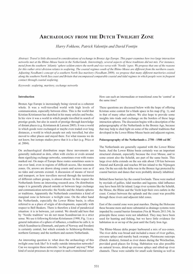
arChaeoloGy from The duTCh TwiliGhT zone
Harry Fokkens, Patrick Valentijn and David Fontijn
Abstract: Travel is little discussed in considerations of exchange in Bronze Age Europe. This paper examines how two large interaction networks met at the Rhine-Meuse basin in the Netherlands. Interestingly, several aspects of these traditions did not mix. For instance, metal from the southern ‘Atlantic’ sphere seldom enters the north and vice versa with ‘Nordic’ types. We propose that one of the reasons for this rather strict division relates to seafaring. The coastal regimes south of the Rhine-Meuse are different from the northern coasts. Adjusting Needham’s concept of a southern North Sea maritory (Needham 2009), we propose that many different maritories existed along the southern North Sea coast and Britain that encompassed comparable coastal and tidal regimes in which people were in frequent contact through coastal seafaring.
Keywords: seafaring, maritory, exchange networks
Introduction
Bronze Age Europe is increasingly being viewed as a coherent whole. It was a well-travelled world with high levels of communication, especially between elites. This is the world that Kristian Kristiansen has sketched in his many articles and books. In his view it was a world in which people travelled in search of prestige goods, but also in search of prestige through knowledge of distant places (e.g. Kristiansen & Larsson 2005). It was a world in which goods were exchanged or maybe even traded over long distances, a world in which people not only travelled, but also moved to other places and stayed there. For what reasons we do not know, but isotope studies prove that it is a fact (e.g. Price et al. 2004).
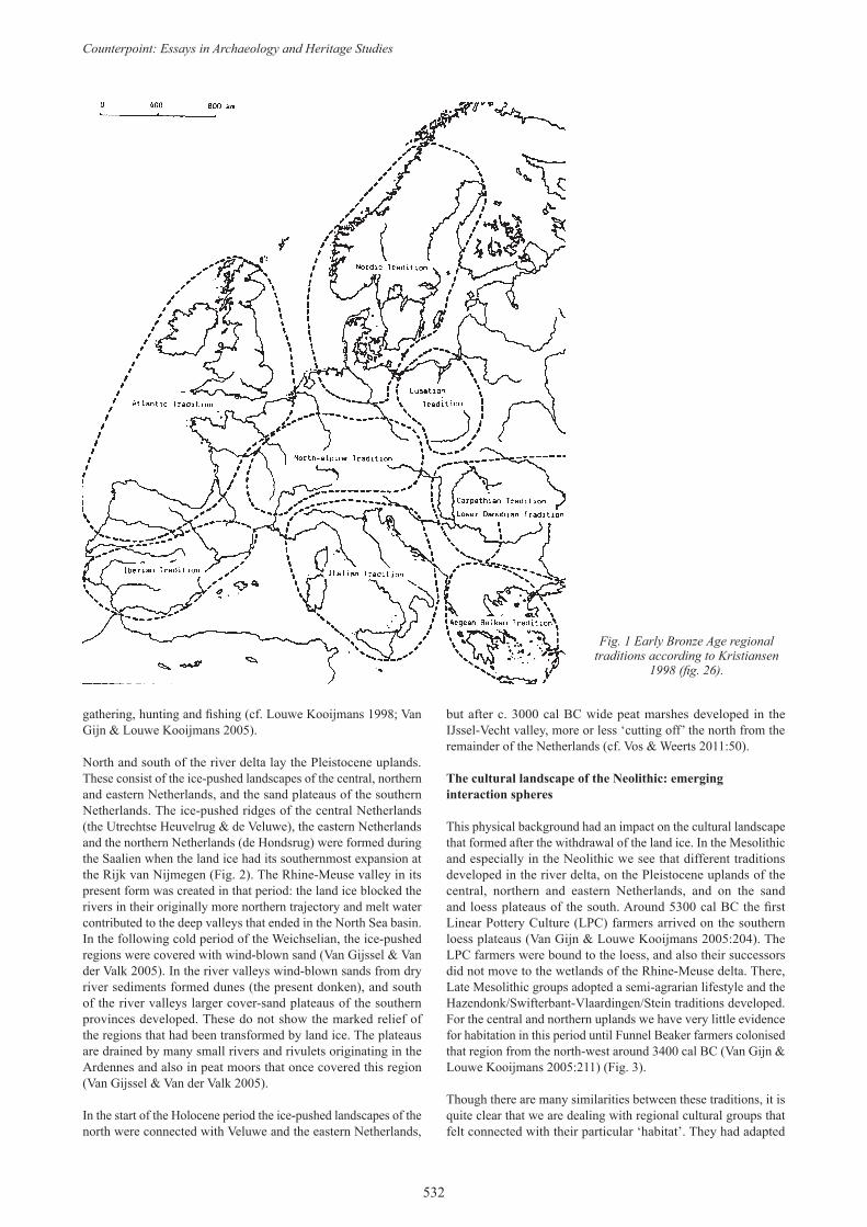
On archaeological distribution maps these movements are generally indicated as dots, often with circles or ovals around them signifying exchange networks, sometimes even with routes marked out. On maps of Europe these routes sometimes seem to run over land, even in regions of difficult access, like mountain zones. Or, arrows are drawn along coasts and across seas as if no tides and currents existed. A discussion of means of travel and transport, or how travellers moved through the territories of different culture groups, is almost absent. In this respect the Netherlands forms an interesting research area. On distribution maps it is generally placed outside or between large exchange and communication networks: the Nordic and the Atlantic spheres or traditions. Apparently the Netherlands constitutes a kind of marginal zone in between: a twilight zone. On the other hand the Netherlands, especially the Lower Rhine basin, is often referred to as a place of origin of developments, especially with respect to Bell Beakers. There is therefore a kind of paradoxical situation: it is in between, yet central. We should add here that by ‘Nordic tradition’ we do not mean Scandinavian in a strict sense. We use it following Kristian Kristiansen (1998; Fig. 1) as a general indication of a sphere of influence, a tradition he calls it, in which Scandinavia (Denmark, and parts of Norway and Sweden) is certainly central, but which extends to Schleswig-Holstein, northern Germany and the northern and eastern Netherlands.
An interesting question is: what does the archaeology of this twilight zone look like? Is it really outside interaction networks? Can we recognize these networks ‘on the ground’ anyway? What kind of social processes do we expect in such a transitional zone?
How can such an intermediate or transitional zone be ‘central’ at the same time?
These questions are discussed below with the hope of offering Kristian some content for a blank space in his map (Fig. 1), and in that of many other authors. We also hope to provide some insights into trade and exchange on the borders of these large interaction spheres. The discussion begins with a description of the palaeogeography of the Netherlands in the Bronze Age, because that may help to shed light on some of the cultural traditions that developed in the Lower Rhine-Meuse basin and adjacent regions.
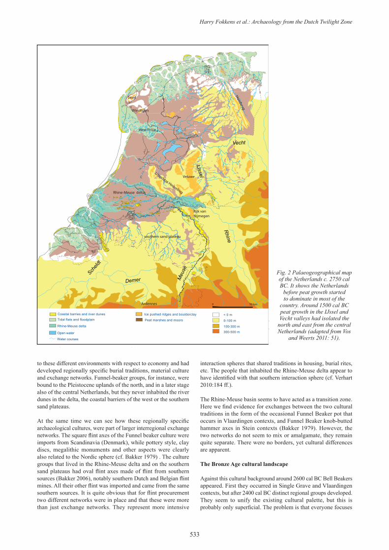
Palaeogeography of the Netherlands c. 2750 - 1500 cal BC
The Netherlands are generally equated with the Lower Rhine basin. And the Lower Rhine basin certainly was an important structural element, especially because the river Meuse, and to some extent also the Scheldt, are part of the same basin. This large river delta extends on the sea side about 130 km between Ostend and Katwijk and reaches 80 km inland to the Nijmegen area. On the sea side the delta was in the Bronze Age protected by coastal barriers and dunes that were probably densely inhabited.
Behind those barriers lay the coastal lowlands. These were marked by myriads of gullies, tidal marshes and lagoons; tidal influence may have been felt far inland. Large river systems like the Scheldt, the Meuse, the Rhine and the Vecht kept their own outlets in the coast. Contact between the uplands and the coast was possible through these rivers and adjacent tidal zones.
East of the coastal zone were peat marshes. During the Holocene these became more and more substantial as drainage systems were impeded by coastal barrier formation (Vos & Weerts 2011:54). In principle these zones were not inhabited. They may have been used for hunting and fishing, but we have little evidence for habitation in or on top of the peat until the Early Iron Age.
The Rhine-Meuse delta proper harboured a mix of eco-zones. The river delta was broad and included a maze of river gullies, crevasse splays and marshy back swamps. Pleistocene outcrops (Dutch: donken), formed as river dunes during the Weichselian, provided good places for living. Habitation was also possible on natural levees, dried-up crevasse splays and silted-up river channels. These were suitable for small scale farming as well as
Counterpoint: Essays in Archaeology and Heritage Studies
532
gathering, hunting and fishing (cf. Louwe Kooijmans 1998; Van Gijn & Louwe Kooijmans 2005).
North and south of the river delta lay the Pleistocene uplands. These consist of the ice-pushed landscapes of the central, northern and eastern Netherlands, and the sand plateaus of the southern Netherlands. The ice-pushed ridges of the central Netherlands (the Utrechtse Heuvelrug & de Veluwe), the eastern Netherlands and the northern Netherlands (de Hondsrug) were formed during the Saalien when the land ice had its southernmost expansion at the Rijk van Nijmegen (Fig. 2). The Rhine-Meuse valley in its present form was created in that period: the land ice blocked the rivers in their originally more northern trajectory and melt water contributed to the deep valleys that ended in the North Sea basin. In the following cold period of the Weichselian, the ice-pushed regions were covered with wind-blown sand (Van Gijssel & Van der Valk 2005). In the river valleys wind-blown sands from dry river sediments formed dunes (the present donken), and south of the river valleys larger cover-sand plateaus of the southern provinces developed. These do not show the marked relief of the regions that had been transformed by land ice. The plateaus are drained by many small rivers and rivulets originating in the Ardennes and also in peat moors that once covered this region (Van Gijssel & Van der Valk 2005).
In the start of the Holocene period the ice-pushed landscapes of the north were connected with Veluwe and the eastern Netherlands,
but after c. 3000 cal BC wide peat marshes developed in the IJssel-Vecht valley, more or less ‘cutting off’ the north from the remainder of the Netherlands (cf. Vos & Weerts 2011:50).
The cultural landscape of the Neolithic: emerging interaction spheres
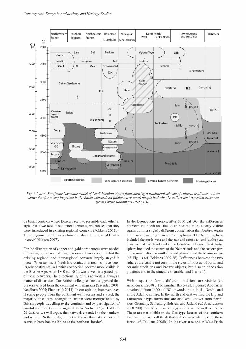
This physical background had an impact on the cultural landscape that formed after the withdrawal of the land ice. In the Mesolithic and especially in the Neolithic we see that different traditions developed in the river delta, on the Pleistocene uplands of the central, northern and eastern Netherlands, and on the sand and loess plateaus of the south. Around 5300 cal BC the first Linear Pottery Culture (LPC) farmers arrived on the southern loess plateaus (Van Gijn & Louwe Kooijmans 2005:204). The LPC farmers were bound to the loess, and also their successors did not move to the wetlands of the Rhine-Meuse delta. There, Late Mesolithic groups adopted a semi-agrarian lifestyle and the Hazendonk/Swifterbant-Vlaardingen/Stein traditions developed. For the central and northern uplands we have very little evidence for habitation in this period until Funnel Beaker farmers colonised that region from the north-west around 3400 cal BC (Van Gijn & Louwe Kooijmans 2005:211) (Fig. 3).
Though there are many similarities between these traditions, it is quite clear that we are dealing with regional cultural groups that felt connected with their particular ‘habitat’. They had adapted
Fig. 1 Early Bronze Age regional traditions according to Kristiansen
1998 (fig. 26).
Harry Fokkens et al.: Archaeology from the Dutch Twilight Zone
533
to these different environments with respect to economy and had developed regionally specific burial traditions, material culture and exchange networks. Funnel-beaker groups, for instance, were bound to the Pleistocene uplands of the north, and in a later stage also of the central Netherlands, but they never inhabited the river dunes in the delta, the coastal barriers of the west or the southern sand plateaus.
At the same time we can see how these regionally specific archaeological cultures, were part of larger interregional exchange networks. The square flint axes of the Funnel beaker culture were imports from Scandinavia (Denmark), while pottery style, clay discs, megalithic monuments and other aspects were clearly also related to the Nordic sphere (cf. Bakker 1979) . The culture groups that lived in the Rhine-Meuse delta and on the southern sand plateaus had oval flint axes made of flint from southern sources (Bakker 2006), notably southern Dutch and Belgian flint mines. All their other flint was imported and came from the same southern sources. It is quite obvious that for flint procurement two different networks were in place and that these were more than just exchange networks. They represent more intensive
interaction spheres that shared traditions in housing, burial rites, etc. The people that inhabited the Rhine-Meuse delta appear to have identified with that southern interaction sphere (cf. Verhart 2010:184 ff.).
The Rhine-Meuse basin seems to have acted as a transition zone. Here we find evidence for exchanges between the two cultural traditions in the form of the occasional Funnel Beaker pot that occurs in Vlaardingen contexts, and Funnel Beaker knob-butted hammer axes in Stein contexts (Bakker 1979). However, the two networks do not seem to mix or amalgamate, they remain quite separate. There were no borders, yet cultural differences are apparent.
The Bronze Age cultural landscape
Against this cultural background around 2600 cal BC Bell Beakers appeared. First they occurred in Single Grave and Vlaardingen contexts, but after 2400 cal BC distinct regional groups developed. They seem to unify the existing cultural palette, but this is probably only superficial. The problem is that everyone focuses
Demer
Scheld
t
Meu
se
Rhine
IJssel
Vecht
Weser
< 0m
Coastal barries and river dunesTidal flats and floodplain
Rhine-Meuse delta
B
Water courses
0 50 km
Peat marshes and moors
Ice pushed ridges and boulderclay
100-300 m
0-100 m
300-500 m
< 0 m
Open water
Hondsrug
VeluweUtrechtse Heuvelrug
Rijk vanNijmegen
Ardennes
West Frisia
Rhine-Meuse delta
southern sand plateau
Texel
Wieringen
Fig. 2 Palaeogeographical map of the Netherlands c. 2750 cal BC. It shows the Netherlands
before peat growth started to dominate in most of the
country. Around 1500 cal BC peat growth in the IJssel and Vecht valleys had isolated the
north and east from the central Netherlands (adapted from Vos
and Weerts 2011: 51).
Counterpoint: Essays in Archaeology and Heritage Studies
534
on burial contexts where Beakers seem to resemble each other in style, but if we look at settlement contexts, we can see that they were introduced in existing regional contexts (Fokkens 2012b). These regional traditions continued under a thin layer of Beaker ‘veneer’ (Gibson 2007).
For the distribution of copper and gold new sources were needed of course, but as we will see, the overall impression is that the existing regional and inter-regional contacts largely stayed in place. Whereas most Neolithic contacts appear to have been largely continental, a British connection became more visible in the Bronze Age. After 1800 cal BC it was a well integrated part of those networks. The directionality of this network is always a matter of discussion. Our British colleagues have suggested that beakers arrived from the continent with migrants (Sheridan 2008; Needham 2005; Fitzpatrick 2011). In our opinion, however, even if some people from the continent went across and stayed, the majority of cultural changes in Britain were brought about by British people travelling to the continent and by participation of coastal communities in a larger Atlantic ‘network’ (cf. Fokkens 2012a). As we will argue, that network extended to the southern and western Netherlands, but not to the north-west and north. It seems to have had the Rhine as the northern ‘border’.
In the Bronze Age proper, after 2000 cal BC, the differences between the north and the south became more clearly visible again, but in a slightly different constellation than before. Again there were two larger interaction spheres. The Nordic sphere included the north-west and the east and seems to ‘end’ at the peat marshes that had developed in the IJssel-Vecht basin. The Atlantic sphere included the centre of the Netherlands and the eastern part of the river delta, the southern sand plateaus and the Meuse valley (cf. Fig. 1) (cf. Fokkens 2009:86). Differences between the two spheres are visible not only in the styles of houses, of burial and ceramic traditions and bronze objects, but also in deposition practices and in the structure of arable land (Table 1).
With respect to farms, different traditions are visible (cf. Arnoldussen 2008). The familiar three-aisled Bronze Age farms developed from 1500 cal BC onwards, both in the Nordic and in the Atlantic sphere. In the north and east we find the Elp and Emmerhout-type farms that are also well known from north-west Germany, Schleswig-Holstein and Jutland (cf. Arnoldussen 2008:200). Stable partitions are generally visible in these farms. These are not visible in the Oss type houses of the southern tradition, but we still think that stables were also part of these farms (cf. Fokkens 2005b). In the river area and in West-Frisia
Fig. 3 Louwe Kooijmans’ dynamic model of Neolithisation. Apart from showing a traditional scheme of cultural traditions, it also shows that for a very long time in the Rhine-Meuse delta (indicated as west) people had what he calls a semi-agrarian existence
(from Louwe Kooijmans 1998: 420).
Harry Fokkens et al.: Archaeology from the Dutch Twilight Zone
535
farms were surrounded by ditches to catch water running from the roof. Apart from that, a fundamental difference is the place of the entrance. Elp, Emmerhout and Oss farms have entrances located on the long sides, dividing between the stable and ‘living’ quarters. In West-Frisia and in the river delta houses have entrances on each short side, one for livestock and one for people, perhaps. This may indicate that the types were experienced differently, maybe even had different cosmological connotations. Round houses do not occur in the Netherlands (cf. Theunissen 1999; Arnoldussen & Fokkens 2008). These are part of the tradition in the British Isles (e.g. Bewley 1994), and possibly also in northern France, though these reconstructions are not very convincing (cf. Bourgeois & Talon 2009:46).
One of the cultural elements that make differences most visible to us are the burial traditions. The Nordic tradition is well known: in the earlier part of the Middle Bronze Age burials included swords, arrowheads and palstaves. The dead were buried in a stretched-out position on the back. If pottery was present in those burials (which was rare), it was a container for food or drink (cf. Lohof 1991). This tradition is common in large parts of north-west Europe (cf. Harding 2000, 76). South and west of the IJssel-Vecht basin, however, inhumation burials are much more infrequent (Theunissen 1990) and cremations are the most common burial type from 1850 cal BC onwards. In the south and central Netherlands, pottery in the distinct Hilversum/Drakenstein/Éramecourt style (cf. Fokkens 2005a; Needham 2009) is present in the graves as containers for the dead rather than for food and drink. There is very little evidence for grave goods: bronze weapons, like swords, were not deposited in graves but in rivers (Theunissen 1999; Fontijn 2002).
Regional traditions also show up in ceramic styles. We distinguish between a poorly known Elp style in the north and east, a Hilversum style in the centre and south, and a Hoogkarspel style in the north-west. The Hoogkarspel style is regional only, but the Hilversum style is clearly affiliated with the Atlantic tradition, with comparable pottery in Wessex and northern France (cf. Fokkens 2005a).
The distribution of types of metal objects by and large shows regional differences (Fontijn 2002:116; 2009), but these traditions developed within the ‘borders’ of the two larger networks. In the south most imported axes are of western European types, though a few have been imported from the northern Netherlands (Fontijn 2002:118). This is also true for other categories of metal objects like swords and spearheads. In the south these are
predominantly of northern French and British (‘Atlantic’) types (Fontijn 2002:131). In the north-western and northern parts of the Netherlands types of rapiers and swords that circulate in the Nordic sphere are predominant.
Networks and identity
To sum up, the Dutch twilight zone appears to have been a transitional zone between two large interaction networks that ‘on the ground’ can be surprisingly easily distinguished; not only in regional cultural traditions, but also in the distribution of metal, house styles and burial traditions. The Rhine-Meuse delta appears to have been a border zone. It is as if people in the southern Netherlands felt part of a different world, travelled more frequently to the south and the west, and preferred to interact with the ‘Atlantic’ world. Over land the Meuse valley was probably one of the connecting routes, but coastal travel and cross channel travel probably was also ‘normal’. People from the northern uplands, on the other hand, looked more to the east and the north. Their burial and housing traditions were part of the Northern world and they probably ‘recognized’ more in the regionally different cultural traditions of the north than they did in the south.
Did people really identify with these two traditions or are they just our archaeological constructs? One of the authors (Valentijn) is studying the place of West Frisia in larger social networks in more detail. His research shows that archaeologists are far too ‘simple’ in their thinking about issues of social and cultural identity. No archaeologist today would speak of a monolithic, bounded archaeological culture reflecting ‘a people’. Nonetheless, in practice many still appear to maintain the notion that ethnicity has something to do with a totality of differences in ‘objective’ cultural traits (but see Jones 1997; Shennan 1989). This is true despite an already established tradition of anthropological and sociological theory stressing that ethnicity is about situational self-definition based on perceived cultural differences (Eriksen 2002). So, to state that these traditions were realities people identified with is far beyond what we can say now, but this is a topic of research for the ongoing Farmers of the Coast project.
Nevertheless, we think that in this case we can speak of two real networks. Of course, these networks did not stop at the Rhine-Meuse delta, as the appearance of several similar object types and traditions on both sides of the delta show. Still, the social relations of people on each side of the delta were significantly different from the relations people had across the delta. For instance, across the delta people shared certain traditions in house building and
Table 1. Global model of traits and cultural associations in different regions of the Netherlands
traitsNordic sphere Atlantic sphere
northwest north, east centre/in between Meuse delta, south
Farmsthree aisled longhouses Andijk/ Zijderveld type, no stable visible
three aisled longhouses Elp/Emmerhout type with visible stable
uplands unknown; river area: Andijk/ Zijderveld type, no stable visible
three aisled longhouses Oss type, no stable visible
burialinhumation burials, swords and axes; after 1500 BC unknown
inhumation burials, swords and axes
inhumation burials, cremation burials, swords and axes
barrows, cremation burials, pottery as urns
pottery Hoogkarspel pottery Elp-pottery Hilversum pottery Hilversum potterymetal Nordic types Nordic types Atlantic types Atlantic typesarable unknown Celtic fields Celtic fields Celtic fields??
deposition unknown peat bogs, rivers, small lakes rivers, small lakes rivers, small lakes
Counterpoint: Essays in Archaeology and Heritage Studies
536
Fig. 4 Lines of the same average high water differences in hours. This shows three tidal hubs (amfidromes) with almost no difference between high and low tide. The isolines predict the
direction of tidal streams, not their strength (after Sager 1963).
pottery making, whereas the exchange of metals or the sharing in burial traditions was restricted to only one side of the delta.
This illustrates a few important aspects of identity: i.e., that it is contextual (e.g. Eriksen 1992); that it is a process better called ‘identifying’ (cf. Brubaker 2004); and that it is related to action (cf. Somers 1994:615-6). Apparently people did not have a cultural identity, but given the social context they identified more or less with their neighbours across the delta. And, depending on how they identified, they actually acted differently towards each other: certain traditions and items were shared while others were not.
This, of course, need not be true just for social relations across the delta, but also for social relations on each side of it. That people shared in, e.g. Nordic traditions and consumed Nordic style objects does not mean that they had a Nordic identity. Rather they identified in such a way that, for instance, exchange of Northern metals was deemed possible. It does not mean that people identified fully: cultural differences between them still existed and might have been expressed, affecting the social relationship and consequently actions. And we should not only think of identities as a system of Chinese boxes (cf. Eriksen 1992:172; Jones 1997:100), as is often done (e.g. Kristiansen 1998, fig. 28). It is important to gain more insights into these processes of identification within networks, as they affected peoples’ activities and as such the dynamics of a network.
It appears that the Rhine-Meuse delta presented a social boundary to the spread of southern and Nordic traditions and objects. Cultural traditions dating back to the Neolithic probably contributed to the fact that people had distinct identities on each side of the delta, with the result that certain traditions and objects almost never crossed the rivers.
The roles of travel and seafaring
In the introductory paragraph, we noted that the Rhine-Meuse delta was probably not only a ‘border’ zone, but is also seen as a central region in terms of travel and for the transmission of ideas. The Rhine and Meuse must have always constituted important routes of communication with central Germany and central France. This is expressed most clearly in the Hallstatt C period, around 700 cal BC, when we see these connections materialize in the distribution of rich Hallstatt burials in central Germany, central France and in the Rhine-Meuse delta. These really appear to represent direct contacts (cf. Pare 1991).
From the mouths of these rivers, coastal and cross channel navigation was possible. But this is not as self evident as it is generally depicted. For instance, there is the question whether river boats were suitable for coastal travel or even sea crossings (cf. Van de Noort 2006). Did people use the canoes that we know they had, or should we think in terms of large plank-built vessels of the kind found in Dover or Ferreby (cf. Clark 2004; Van de Noort 2006), or vessels of the Scandinavian type as depicted on rock art (Kristiansen 2004; Ling 2010). Where did these travels start? Was that a specialty of coastal communities like in Jutland and along the coastal barriers of the Low Countries, the French and British coasts? (cf. Samson 2006; Needham 2009; Van de Noort 2012). Questions like that are not asked very often (but see Rowlands & Ling, this volume), but they are essential for understanding how seafaring and travel in the Bronze Age were embedded in the social system, and how they transformed the Bronze Age world.
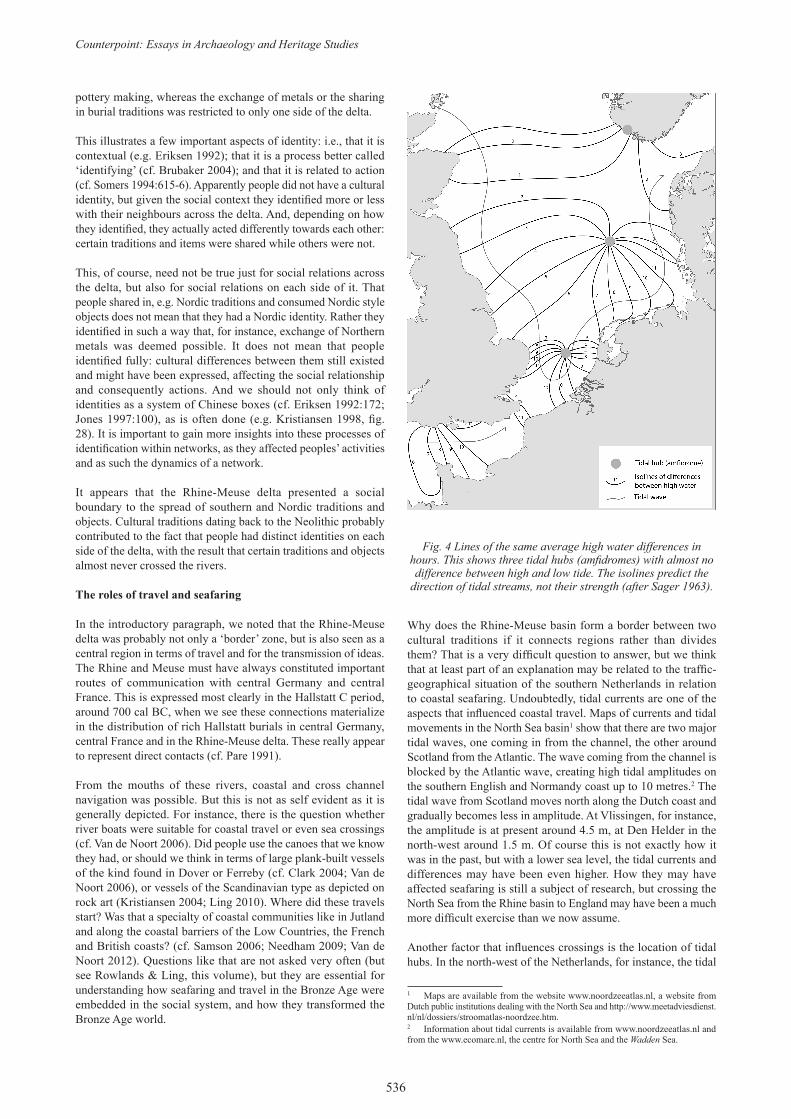
Why does the Rhine-Meuse basin form a border between two cultural traditions if it connects regions rather than divides them? That is a very difficult question to answer, but we think that at least part of an explanation may be related to the traffic-geographical situation of the southern Netherlands in relation to coastal seafaring. Undoubtedly, tidal currents are one of the aspects that influenced coastal travel. Maps of currents and tidal movements in the North Sea basin1 show that there are two major tidal waves, one coming in from the channel, the other around Scotland from the Atlantic. The wave coming from the channel is blocked by the Atlantic wave, creating high tidal amplitudes on the southern English and Normandy coast up to 10 metres.2 The tidal wave from Scotland moves north along the Dutch coast and gradually becomes less in amplitude. At Vlissingen, for instance, the amplitude is at present around 4.5 m, at Den Helder in the north-west around 1.5 m. Of course this is not exactly how it was in the past, but with a lower sea level, the tidal currents and differences may have been even higher. How they may have affected seafaring is still a subject of research, but crossing the North Sea from the Rhine basin to England may have been a much more difficult exercise than we now assume.
Another factor that influences crossings is the location of tidal hubs. In the north-west of the Netherlands, for instance, the tidal
1 Maps are available from the website www.noordzeeatlas.nl, a website from Dutch public institutions dealing with the North Sea and http://www.meetadviesdienst.nl/nl/dossiers/stroomatlas-noordzee.htm.2 Information about tidal currents is available from www.noordzeeatlas.nl and from the www.ecomare.nl, the centre for North Sea and the Wadden Sea.
Harry Fokkens et al.: Archaeology from the Dutch Twilight Zone
537
amplitude is lowest because one of two North Sea ‘amphidromes’ (tidal hubs) is situated near the north-west part of the Dutch coast (Fig. 4). An amphidrome is an area where there is virtually no tidal amplitude, which is caused by the anti-clockwise movement of tidal streams due to the Coriolis force (Sager 1963). It is more or less a centre around which the tidal waves circulate. There is a tidal current here, but it is minimal. Therefore, that might be part of a favourable route for navigation. To the north the amplitudes rise again. There is also a large disturbing effect around the river deltas and on the Dutch-German wadden coast: due to shallow waters it is ebb for a much a longer time in these basins than it is flood.
What the impact of these currents and coastal formations was on the possibilities for seafaring is still under study in the context of the Farmers of the Coast project of Leiden University (see note). The question we would like to test is whether the configuration of tidal currents and tidal hubs may be one of the reasons that the areas south of the Rhine established regular contacts and exchange with Britain and the French coast, while the northern regions did not. The Rhine, we propose, was a logical region to end voyages down the coast from Jutland. Seafaring further down the coast and to England and the southern Channel coast involved different
knowledge; it involved experience with sailing on open sea and with the high tidal amplitudes and strong currents in that region.
There will have been many other aspects involved, of course, such as the otherness of the coastal landscape. Coming from Jutland, rounding Texel, one leaves the wadden coast with its tidal flats and shallow basins. So, coastal travel from north to south meets a natural border when the Dutch coast is rounded. The coastal landscape changes, and beyond that one enters a different sea regime, more dominated by the Channel. Of course that may have been no problem for seafarers who really wanted to go south. But for regular travel and interregional communication, trade and exchange, the north-western Dutch coast may have been a ‘natural’ unit, both for travel along the coast and over land.
Final remarks
It is apparent that the Dutch twilight zone is in fact a very interesting research area where two cultural traditions met. Yet they did not meet as clearly defined ‘traditions’ or ‘cultures’ or ‘networks’ as the circles on maps tend to suggest (cf. Fig. 1). These circles are constituted by many different regional groups which developed their own cultural traditions and material culture. One would expect physical borders not to make any difference for
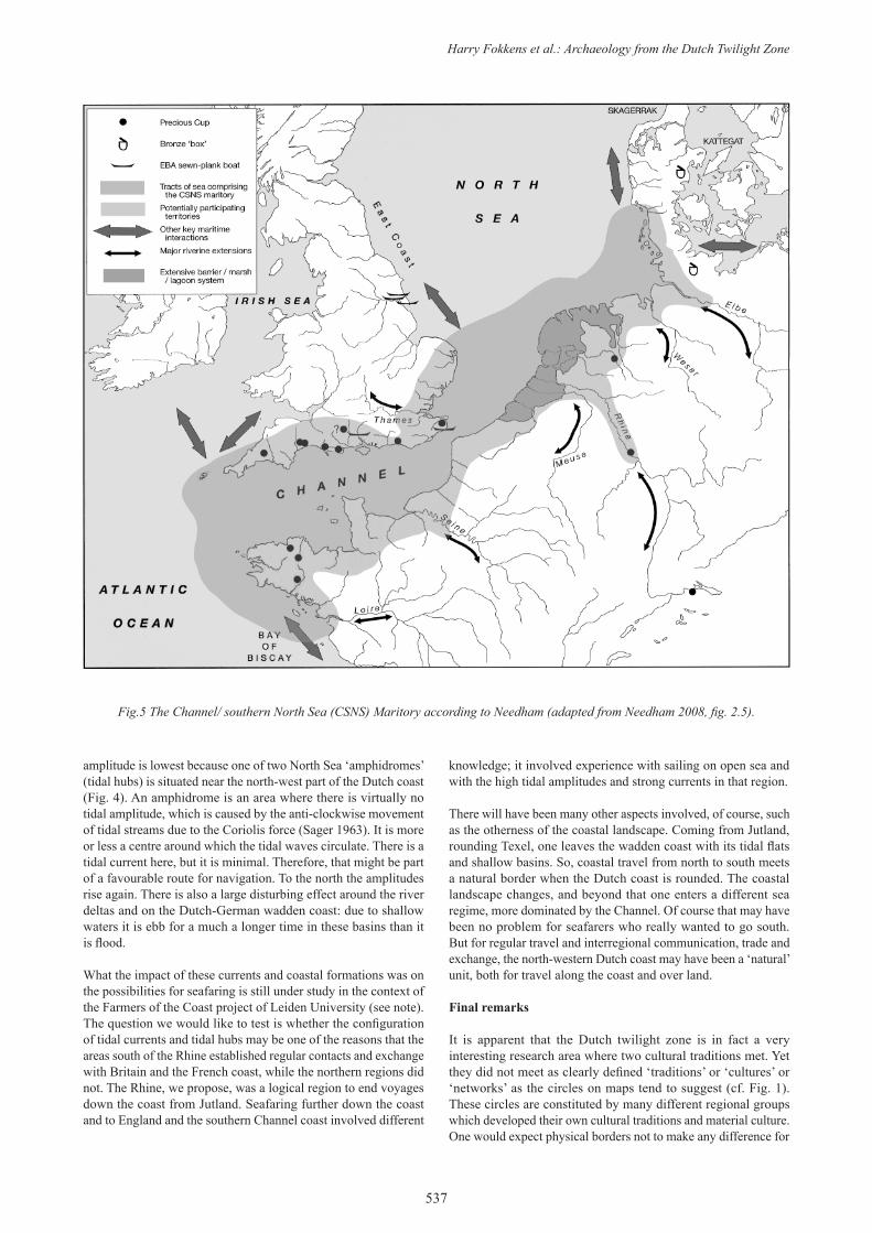
Fig.5 The Channel/ southern North Sea (CSNS) Maritory according to Needham (adapted from Needham 2008, fig. 2.5).
Counterpoint: Essays in Archaeology and Heritage Studies
538
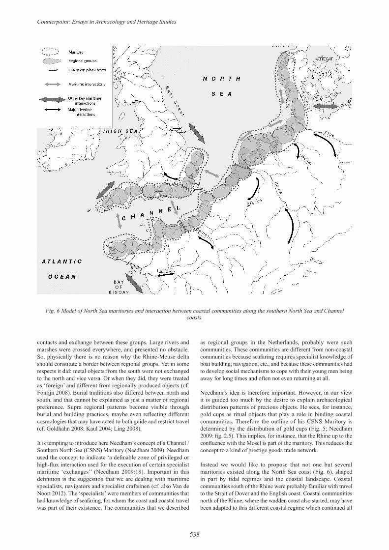
Fig. 6 Model of North Sea maritories and interaction between coastal communities along the southern North Sea and Channel coasts.
contacts and exchange between these groups. Large rivers and marshes were crossed everywhere, and presented no obstacle. So, physically there is no reason why the Rhine-Meuse delta should constitute a border between regional groups. Yet in some respects it did: metal objects from the south were not exchanged to the north and vice versa. Or when they did, they were treated as ‘foreign’ and different from regionally produced objects (cf. Fontijn 2008). Burial traditions also differed between north and south, and that cannot be explained as just a matter of regional preference. Supra regional patterns become visible through burial and building practices, maybe even reflecting different cosmologies that may have acted to both guide and restrict travel (cf. Goldhahn 2008; Kaul 2004; Ling 2008).
It is tempting to introduce here Needham’s concept of a Channel / Southern North Sea (CSNS) Maritory (Needham 2009). Needham used the concept to indicate ‘a definable zone of privileged or high-flux interaction used for the execution of certain specialist maritime ‘exchanges’’ (Needham 2009:18). Important in this definition is the suggestion that we are dealing with maritime specialists, navigators and specialist craftsmen (cf. also Van de Noort 2012). The ‘specialists’ were members of communities that had knowledge of seafaring, for whom the coast and coastal travel was part of their existence. The communities that we described
as regional groups in the Netherlands, probably were such communities. These communities are different from non-coastal communities because seafaring requires specialist knowledge of boat building, navigation, etc., and because these communities had to develop social mechanisms to cope with their young men being away for long times and often not even returning at all.
Needham’s idea is therefore important. However, in our view it is guided too much by the desire to explain archaeological distribution patterns of precious objects. He sees, for instance, gold cups as ritual objects that play a role in binding coastal communities. Therefore the outline of his CSNS Maritory is determined by the distribution of gold cups (Fig. 5; Needham 2009: fig. 2.5). This implies, for instance, that the Rhine up to the confluence with the Mosel is part of the maritory. This reduces the concept to a kind of prestige goods trade network.
Instead we would like to propose that not one but several maritories existed along the North Sea coast (Fig. 6), shaped in part by tidal regimes and the coastal landscape. Coastal communities south of the Rhine were probably familiar with travel to the Strait of Dover and the English coast. Coastal communities north of the Rhine, where the wadden coast also started, may have been adapted to this different coastal regime which continued all
Harry Fokkens et al.: Archaeology from the Dutch Twilight Zone
539
the way up to Denmark. In terms of coastal regimes, that of the Rhine-Meuse delta thus constituted a kind of ‘natural’ (permeable) border between two the Atlantic and the Nordic spheres.
We argued that it is not realistic to suggest that there was one maritory that united both Channel coasts with the southern North Sea, as Needham’s model suggests. At the Rhine-Meuse delta two kinds of ‘borders’ seem to have coincided: a cultural border creating a social barrier and a traffic-geographical border creating a physical barrier. Neither was impenetrable, and indeed they were traversed in certain situations. In interplay, however, these borders meant that the majority of social contacts and cultural traits did not cross the delta. As such, they made the Rhine-Meuse delta the place where two maritories came to an end. Maybe they also met, but that is not visible in the data.
Dear Kristian, we hope to have offered you some food for thought. Something to incorporate in the many inspiring ideas you undoubtedly are going to present to us in the future.
Note:
Research for this paper has been carried out in the framework of the NWO multiple projects ‘Farmers of the Coast’ (www.westfrisia.com) and the ‘Ancestral Barrows Project’ (www.grafheuvels.nl), funded by the Dutch National Foundation for Scientific Research.
Harry Fokkens: [email protected] (corresponding author)
References
ARNOLDUSSEN, S., 2008. A Living Landscape. Bronze Age settlement sites in the Dutch river area (c. 2000-800 BC). Leiden: Sidestone Press.
ARNOLDUSSEN, S. and H. FOKKENS, (eds.) 2008. Bronze Age settlements in the Low Countries. Oxford: Oxbow books.
BAKKER, J. A., 1979. The TRB West Group: Studies in the chronology and geography of the makers of hunebeds and Tiefstich Pottery. Amsterdam: Subfaculteit der Prae- en Protohistorie, University of Amsterdam (Cingula 5).
BAKKER, J. A., 2006. The Buren Axe and the Cigar Chisel: striking export products from the West European flint mines - associations and distribution along their northern fringe. In G. Körlin and G. Weisgerber (eds.), Proceedings of the VIII International flint symposium, Bochum 1999. Stone Age - Mining Age - Der Anschnitt 247-275. Bochum: Deutsches Bergbau Museum (Beiheft 19).
BEWLEY, R., 1994.Prehistoric settlements. London: Batsford/English Heritage.
BOURGEOIS, J. and M. TALON, 2009. From Picardy to Flanders: Transmanche connections in the Bronze Age. In P. Clark (ed.), Bronze Age Connections: Cultural Contact in Prehistoric Europe: 38-59. Oxford: Oxbow books.
BRUBAKERS, R., 2004. Beyond identity. In R. Brubakers (ed.), Ethnicity without Groups: 28-63. Cambridge/Massachusetts/London: Harvard University Press.
CLARK, P. (ed.), 2004. The Dover Bronze Age Boat in Context: Society and water transport in prehistoric Europe. London: English Heritage.
ERIKSEN, T. H., 1992. Us and Them in Modern Societies: Ethnicity and Nationalism in Mauritius, Trinidad and Beyond. London: Scandinavian University Press.
ERIKSEN, T. H., 2002. Ethnicity and Nationalism. Anthropological Perspectives. London/Sterling: Pluto Press.
FITZPATRICK, A. P., 2011. The Amesbury Archer and the Boscombe Bowmen. Bell Beaker burials at Boscombe Down, Amesbury, Wiltshire. Salisbury: Wessex Archaeology (Wessex Archaeological Report 27).
FOKKENS, H., 2005a. Le début de l’Âge du Bronze aux Pays-Bas et l’horizon de Hilversum Ancien. In J. Bourgeois and M. Talon (eds.),
L’Âge du Bronze du Nord de la France dans son contexte européen: 11-33. Paris: CTHS.
FOKKENS, H., 2005b. Longhouses in unsettled settlements in Beaker period and Bronze Age. In L. P. L. Kooijmans, P. W. V. D. Broeke, H. Fokkens and A. L. Van Gijn (eds.), The Prehistory of the Netherlands: 407-428. Amsterdam: Amsterdam University Press.
FOKKENS, H., 2009. Die Wirtschaft der Nordische Bronzezeit: mehr als Getreide sähen und Vieh süchten. In M. Bartelheim and H. Staüble (eds.), Die wirschaftlichen Grundlagen der Bronzezeit Europas: 85-104. Rahden: Verlag marie Leidorf GmbH.
FOKKENS, H., 2012a. Dutchmen on the move? A discussion of the adoption of the Beaker package. In M. J. Allen, J. P. Gardiner and J. A. Sheridan (eds.), Is there a British Chalcolithic? People, Place and Polity in the Later 3rd Millennium: 113-123. Oxford: Oxbow books (Prehistoric Society Research Papers 4).
FOKKENS, H., 2012b. Background to Dutch Beakers. A critical review of the Dutch model. In H. Fokkens and F. Nicolis (eds.), Background to Beakers: 1-27. Leiden: Sidestone Press.
FONTIJN, D. R., 2002. Sacrificial Landscapes. Cultural biographies of persons, objects and ‘natural’ places in the Bronze Age of the southern Netherlands, c. 2300-600BC. Leiden: Faculty of Archaeology, Leiden University (Analecta Praehistorica Leidensia 33/34).
FONTIJN, D. R., 2008. Everything in it’s right place? On selective deposition, landscape and the construction of identity in later prehistory. In A. Jones (ed.), Prehistoric Europe, Theory and Practice: 86-106. Oxford: Blackwell.
FONTIJN, D. R. 2009. Land at the other end of the sea? Metalwork circulation, geographical knowledge and the significance of British/ Irish imports in the Bronze Age of the Low Countries. In Clark, P. (ed.), Bronze Age Connections: Cultural Contact in Prehistoric Europe: 129-148. Oxford: Oxbow books.
GIBSON, A., 2007. A Beaker Veneer? Some Evidence from the Burial Record. In M. Larsson and M. Parker Pearson (eds.), From Stonehenge to the Baltic: Living with Cultural Diversity in the Third Millennium BC: 47-64. Oxford: Archaeopress (British Archaeological Reports International Series 1692).
GOLDHAHN, J., 2008. From monuments in landscape to landscape in monuments: monuments, death and landscape in early Bronze Age Scandinavia. In A. Jones (ed.), Prehistoric Europe. theory and practice: 56-85. Malden/Oxford: Willey-Blackwell (Blackwell studies in global Archaeology).
HARDING, A. F., 2000. European Societies in the Bronze Age. Cambridge: Cambridge University Press.
JONES, S., 1997. The Archaeology of Ethnicity. Constructing Identities in the Past and Present. London and New York: Routledge.
KAUL, F., 2004. Social and religious perceptions of the ship in Bronze Age Northern Europe. In P. Clark (ed.), The Dover Bronze Age boat in context: Society and water transport in prehistoric Europe: 122-137. Oxford: Oxbow books.
KRISTIANSEN, K., 1998. Europe before history. Cambridge: Cambridge University Press.
KRISTIANSEN, K., 2004. Sea faring voyages and rock art ships. In P. Clark (ed.), The Dover Bronze Age boat in context: Society and water transport in prehistoric Europe: 111-121. Oxford: Oxbow books.
KRISTIANSEN, K., and T.B. LARSSON, 2005. The rise of Bronze Age societies. Travels, transmission and transformations. Cambridge: Cambridge University Press.
LING, J., 2008. Elevated rock art: towards a maritime understanding of Bronze Age rock art in northern Bohuslän, Sweden. Gothenburg: University of Gothenburg (GOTARC Series B. Gothenburg archaeological Theses 49).
LING, J., 2010. Elevated Rock Art. Maritime images and situations. In Å. C. Fredell, K. Kristiansen and F. Criado Boado (eds.), Representations and communications: creating an archaeological matrix of late prehistoric rock art: 31-51. Oxford: Oxbow Books.
LOHOF, E., 1991. Grafritueel en sociale verandering in de bronstijd van Noordoost-Nederland, Amsterdam: Albert Egges van Giffen Instituut voor Prae-en Protohistorie, University of Amsterdam.
LOUWE KOOIJMANS, L. P., 1998. Understanding the Meso/Neolithic Frontier in the Lower Rhine Basin, 5300-4300 cal BC. In M. R.
Counterpoint: Essays in Archaeology and Heritage Studies
540
Edmonds and C. C. Richards (eds.), Understanding the Neolithic of North-Western Europe: 407-427. Glasgow: Cruithne Press.
NEEDHAM, S., 2005. Transforming Beaker Culture in North-West Europe; Processes of Fusion and Fission. Proceedings of the Prehistoric Society 71:171-217.
NEEDHAM, S. P., 2009. Encompassing the Sea: ‘Maritories’ and Bronze Age Maritime Interactions. In P. Clark (ed.), Bronze Age Connections: Cultural Contact in Prehistoric Europe: 12-37. Oxford: Oxbow books.
PARE, C. F. E., 1991. Swords and Wagon graves of the Early Iron Age in Central Europe. Oxford: Oxbow books.
PRICE, T. D., C. KNIPPER, G. GRUPE and V. SMRCKA, 2004. Strontium isotopes and prehistoric human migration: the Bell Beaker period in central Europe. European Journal of Archaeology 7:9-40.
SAGER, G., 1963. Atlas der Elemente des Tidenhubes und der Gezeitenströme für Nordsee, Kanal und Irische See. Rostock: Deutsche Akademie der Wissenschaften zu Berlin, Institut für Meereskunde.
SAMSON, A. V., 2006. Offshore finds from the Bronze Age in north-west Europe: The shipwreck scenario revisited. Oxford Journal of Archaeology 25(4):371-388.
SHENNAN, S. J., 1989. Introduction. In S. J. Shennan (ed.), Archaeological approaches to cultural identity: 1-32. London: Unwinn & Hyman.
SHERIDAN, J. A., 2008. Upper Largie and Dutch - Scottish connections during the Beaker Period. In H. Fokkens, B. J. Coles, A. L. Van Gijn, J. P. Kleijne, H. H. Ponjee and C. G. Slappendel (eds.), Between Foraging and Farming: An extended broad spectrum of papers presented to Leendert Louwe Kooijmans: 247-260. Leiden: Faculty of Archaeology, Leiden (Analecta Praehistorica Leidensia).
SOMERS, M. R., 1994. The narrative constitution of identity: a relational and network approach. Theory and Society 23:605-649.
THEUNISSEN, E. M., 1999. Midden-bronstijdsamenlevingen in het Zuiden van de Lage Landen; een evaluatie van het begrip ‘Hilversum-cultuur’. Leiden: Faculty of Archaeology.
VAN GIJSSEL, K. & B. VAN DER VALK, 2005. Shaped by water, ice and wind: the genesis of the Netherlands. In L. P. Louwe Kooijmans, P. W. Van den Broeke, H. Fokkens and A. L. Van Gijn (eds.), The Prehistory of the Netherlands: 45-74. Amsterdam: Amsterdam University Press.
VAN DE NOORT, R. 2006. Argonauts of the North Sea - a social Maritime Archaeology for the 2nd Millennium BC. Proceedings of the Prehistoric Society 72:267-287.
VAN DE NOORT, R. 2012. Exploring agency behind the Beaker phenomenon. The navigator’s tale. In H. Fokkens and F. Nicolis (eds.), Background to Beakers. Inquiries into the regional cultural background to the Bell Beaker complex: 52-70. Leiden: Sidestone Press.
VAN GIJN, A.L. & L. P. LOUWE KOOIJMANS, 2005. Early and Middle Neolithic 5300-2900 BC: an introduction. In L. P. Louwe Kooijmans, P. W. Van den Broeke, H. Fokkens and A. L. Van Gijn (eds.), The Prehistory of the Netherlands: 203-218. Amsterdam: Amsterdam University Press.
VERHART, L.M.B., 2010. De geur van Veen. Vlaardingen en de ontdekking van de Vlaardingencultuur. Utrecht: Matrijs.
VOS, P. and H. J. T. WEERTS, 2011. Atlas van Nederland in het Holoceen. Landschap en bewoning vanaf de laatste ijstijd tot nu. Amsterdam: Bert Bakker.


![[Dutch] Godsdienst of Levensbeschouwing?](https://img.dokumen.tips/doc/110x75/634cc13e1f34f32f730d51ee/dutch-godsdienst-of-levensbeschouwing.jpg)

