Embed Size (px)
Citation preview
Appendix A Victoria’s North and Murray Water Quality Management Plan
Department of Environment, Land, Water and Planning
566 | Appendix A Victoria’s North and Murray Water Resource Plan
Appendix A Water Quality Management Plan
Contents1. Water quality and the Murray-Darling Basin Plan 570
1.1 Water quality management under the Basin Plan 570
1.2 Water quality objectives in the Basin Plan 571
2. Victoria’s water quality management framework 573
2.2 National Water Quality Management strategy and guidance 575
2.3 Environment Protection Act 1970 and 2017 and the State Environment Protection Policy (Waters) 575
2.3.1 Water quality segments and beneficial uses 576
2.3.1.1 Surface water 576
2.3.1.2 Groundwater 577
2.3.2 Managing discharges 577
2.3.2.1 Point source 577
2.3.2.2 Diffuse source 578
2.4 Safe Drinking Water Act 2003 578
2.5 Victorian Water Act and the Victorian Waterway Management Strategy 579
2.5.1 Regional water strategies 579
2.6 Planning and Environment Act 1987 579
2.7 Catchment and Land Protection Act 1994 580
2.7.1 Regional Catchment Strategies 580
2.7.2 Land and water management plans 581
2.8 Schedule B of the Murray-Darling Basin Agreement – River Murray salinity 581
3. How Victoria’s water quality management aligns with the Basin Plan 582
4. Surface water - Victoria’s North and Murray water resource plan area 584
4.1 Surface water quality 585
4.2 River Murray water quality management 587
4.3 Water quality degradation 588
Department of Environment, Land, Water and Planning
Appendix A | 567Victoria’s North and Murray Water Resource Plan
4.4 Risks to the condition of surface water in the water resource plan area 590
4.4.1 Medium to high risks to condition of water resources in the Northern Victoria water resource plan area 590
4.4.2 Medium to high risks to condition of water resources of the Victorian Murray water resource plan area 592
4.4.3 Measures addressing risks 593
4.5 Measures contributing to the achievement of water quality objectives 594
4.5.1 Measure 1: Implementation of the State Environment Protection Policy (Waters), or future equivalent 595
4.5.1.1 Contribution to achieving the objective for water-dependent ecosystems 596
4.5.1.2 Contribution to achieving the objective for raw water for treatment for human consumption 596
4.5.1.3 Contribution to achieving the objective for irrigation water 597
4.5.1.4 Contribution to achieving the objective for recreational water quality 597
4.5.1.5 Contribution to achieving the objective of maintaining good levels of water quality 597
4.5.2 Measure 2: Implementation of Victoria’s obligations under Basin Salinity Management 2030 (BSM2030) 597
4.5.2.1 Contribution to achieving the objective for fresh water-dependent ecosystems 598
4.5.2.2 Contribution to achieving the objective for raw water for treatment for human consumption 598
4.5.2.3 Contribution to achieving the objective for Recreational Water 598
4.5.2.4 Contribution to achieving the objective of maintaining good levels of water quality 598
4.5.3 Having regard to causes, or likely causes of degradation in the development of measures 599
4.5.4 Having regard to water quality targets in the development of measures 599
4.5.5 Having regard to the impact on another state when developing measures 599
4.5.5.1 Victorian Murray water resource plan area 599
4.5.5.2 Northern Victoria water resource plan area 601
4.6 Water quality targets for the Victorian Murray and Northern Victoria water resource plan areas 601
4.6.1 Water quality targets for fresh water-dependent ecosystems 602
4.6.1.1 Discussion of alternative targets 606
4.6.2 Water quality target for irrigation water 609
4.6.2.1 Discussion of alternative target 610
4.6.3 Water quality targets for recreational water 612
4.6.3.1 Discussion of alternative targets 612
4.6.4 End-of-valley salinity targets 613
4.6.5 Alternative targets developed in consultation with other states 614
5. Groundwater – Goulburn-Murray water resource plan area 616
5.1 Groundwater quality 617
5.1.1 Groundwater quality and management plans 618
5.2 Causes, or likely causes, of groundwater quality degradation 619
Department of Environment, Land, Water and Planning
568 | Appendix A Victoria’s North and Murray Water Resource Plan
5.3 Risks to the quality of groundwater resources 620
5.3.1 Summary of regard to the Basin Plan 620
5.3.1.1 Elevated levels of salinity 620
5.3.1.2 Elevated levels of pesticides and other contaminants 620
5.3.2 Summary of risk assessment 621
5.4 Water quality target values for groundwater 622
5.5 Rules or measures for groundwater that support the maintenance of water quality 623
5.5.1 Meeting Basin Plan requirements 626
6. Monitoring, data management and reporting 630
6.1 Data management and reporting 630
7. References 633
S.1 Comparison of Chapter 9 Basin Plan targets for fresh water-dependent ecosystems with alternative targets adopted by Victoria 634
S.2 Comparison of geographic boundaries for fresh water-dependent ecosystems 642
Department of Environment, Land, Water and Planning
Appendix A | 569Victoria’s North and Murray Water Resource Plan
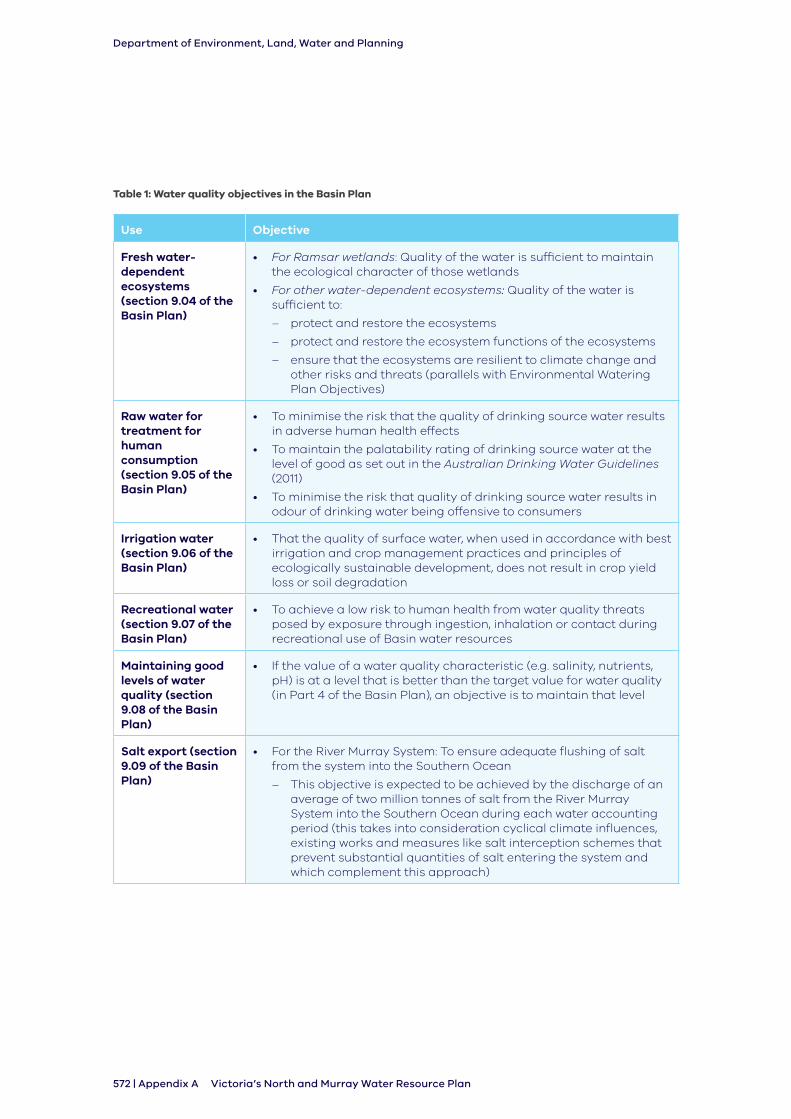
List of tablesTable 1: Water quality objectives in the Basin Plan 572
Table 2: Groundwater segments listed in SEPP (Waters) 577
Table 3: Cause or likely causes of surface water quality degradation in both the Victorian Murray and Northern Victoria water resource plan areas 588
Table 4: Medium to high risks to condition of water resources in the Northern Victoria water resource plan area 591
Table 5: Medium to high risks to condition of resources of the Victorian Murray water resource plan area 592
Table 6: Measures contributing to water quality objectives 594
Table 7: Fresh Water-Dependent Ecosystem Targets for Victorian Murray and Northern Victoria WRP Areas 603
Table 8: Environmental quality objectives for physical and chemical indicators for wetlands 606
Table 9: Location of targets for irrigation water 611
Table 10: Victoria’s end of valley salinity targets 614
List of figuresFigure 1: Victoria’s water quality management framework 574
Figure 2: Alignment between Basin Plan water quality requirements and Victoria’s water quality management arrangements in the water resource plan areas 583
Figure 3: Average daily salinity along the River Murray over the 1975-2000 Benchmark Period with 2013 levels of development and salt interception 585
Figure 4: River Murray salinity at Morgan and impact of management strategies 586
Figure 5: Victorian groundwater salinity 618
Department of Environment, Land, Water and Planning
570 | Appendix A Victoria’s North and Murray Water Resource Plan
1. Water quality and the Murray-Darling Basin Plan
This Appendix provides the Water Quality Management Plan for Victoria’s North and Murray Water Resource Plan.
Victoria’s North and Murray Water Quality Management Plan applies the State Environment Protection Policy (Waters) as relevant.
1.1 Water quality management under the Basin Plan
Chapter 10 of the Basin Plan sets out the requirements for water resource plans. Part 7 of Chapter 10 requires a water resource plan to include a water quality management plan.
Victoria’s North and Murray Water Quality Management Plan applies to the following water resource plan areas:
• Victorian Murray water resource plan area (SW2)
• Northern Victoria water resource plan area (SW3)
• Goulburn-Murray water resource plan area (GW2)
Water quality management plans must:
• identify causes or likely causes of water quality degradation having regard to the key causes outlined in Schedule 10 of the Basin Plan for surface water (section 10.30) and groundwater (section 10.35A)
• set targets for fresh water-dependent ecosystems, irrigation water and recreational water, for surface water (section 10.32 of the Basin Plan) and groundwater (section 10.35B of the Basin Plan)
• for surface water, specify measures that contribute to the achievement of the Basin Plan’s water quality objectives in Chapter 9 having regard to the causes or likely causes of water quality degradation, the salinity targets for long-term salinity planning and management of water quality target values identified for the water resource plan area (section 10.33)
• have regard to the impact of measures (or absence of measures) on another Basin State and any adverse impacts of measures on Basin water resources of another state (section 10.35 of the Basin Plan)
• for groundwater, consider and specify rules or measures that support the maintenance of water quality within groundwater SDL resource units against the effects of elevated levels of salinity and other types of water quality degradation (section 10.35C and 10.35D of the Basin Plan)
Department of Environment, Land, Water and Planning
Appendix A | 571Victoria’s North and Murray Water Resource Plan
Also in relation to water quality:
• water resource plans must be prepared having regard to current and future risks to the condition and continued availability of the water resources in the WRP area (section 10.41 of the Basin Plan)
• a water resource plan must specify the monitoring of the water resources of the water resource plan area that will be done to meet obligations of section 13.14 to report on matters listed in Schedule 12 (section 10.46 of the Basin Plan). For water quality:
- annual reporting is required for how Basin States have regard to the water quality targets for flow management as set out in Chapter 9 of the Basin Plan
- every five years Basin States must report on their progress in implementing their measures to contribute to the achievement of water quality objectives that have been specified in water quality management plans
Water quality management plans are not required to outline how Victoria will respond to extreme water quality events such as an outbreak of blue-green algae. This matter is considered in response to Part 13 of Chapter 10 of the Basin Plan and discussed further in Chapter 10 of Victoria’s North and Murray Water Resource Plan Comprehensive Report.
A working group was established to comment on and assist in the preparation of the Water Quality Management Plan. See Part 3.2.2 of Appendix D.
1.2 Water quality objectives in the Basin Plan
The Basin Plan’s overall objective for water quality and salinity is to maintain appropriate water quality, including salinity levels, for environmental, social, cultural and economic activity in the Murray-Darling Basin.
The outcome is that Basin water resources remain fit-for-purpose (section 5.04) and reproduces the water quality objectives for Basin resources set out in Chapter 9 of the Basin Plan.
The Basin Plan sets out six qualitative water quality objectives for maintaining and minimising impact on water quality. These objectives are listed in Table 1.
Basin States are required to identify measures that will contribute to the achievement of these objectives while having regard to the cause or likely causes of water quality degradation and identified water quality target values.
Department of Environment, Land, Water and Planning
572 | Appendix A Victoria’s North and Murray Water Resource Plan
Table 1: Water quality objectives in the Basin Plan
Use Objective
Fresh water-dependent ecosystems (section 9.04 of the Basin Plan)
• For Ramsar wetlands: Quality of the water is sufficient to maintain the ecological character of those wetlands
• For other water-dependent ecosystems: Quality of the water is sufficient to:
– protect and restore the ecosystems
– protect and restore the ecosystem functions of the ecosystems
– ensure that the ecosystems are resilient to climate change and other risks and threats (parallels with Environmental Watering Plan Objectives)
Raw water for treatment for human consumption (section 9.05 of the Basin Plan)
• To minimise the risk that the quality of drinking source water results in adverse human health effects
• To maintain the palatability rating of drinking source water at the level of good as set out in the Australian Drinking Water Guidelines (2011)
• To minimise the risk that quality of drinking source water results in odour of drinking water being offensive to consumers
Irrigation water (section 9.06 of the Basin Plan)
• That the quality of surface water, when used in accordance with best irrigation and crop management practices and principles of ecologically sustainable development, does not result in crop yield loss or soil degradation
Recreational water (section 9.07 of the Basin Plan)
• To achieve a low risk to human health from water quality threats posed by exposure through ingestion, inhalation or contact during recreational use of Basin water resources
Maintaining good levels of water quality (section 9.08 of the Basin Plan)
• If the value of a water quality characteristic (e.g. salinity, nutrients, pH) is at a level that is better than the target value for water quality (in Part 4 of the Basin Plan), an objective is to maintain that level
Salt export (section 9.09 of the Basin Plan)
• For the River Murray System: To ensure adequate flushing of salt from the system into the Southern Ocean
– This objective is expected to be achieved by the discharge of an average of two million tonnes of salt from the River Murray System into the Southern Ocean during each water accounting period (this takes into consideration cyclical climate influences, existing works and measures like salt interception schemes that prevent substantial quantities of salt entering the system and which complement this approach)
Department of Environment, Land, Water and Planning
Appendix A | 573Victoria’s North and Murray Water Resource Plan
2. Victoria’s water quality management framework
Surface water and groundwater quality and salinity is affected by many processes and sources including:
• natural catchment processes such as runoff from uncleared catchments and groundwater discharges to waterways
• licensed point source wastewater discharges
• small dispersed point source discharges such as septic tanks
• diffuse sources including runoff from dryland farms, drainage from irrigated land and stormwater from roads and towns
• changes in catchment water balances such as dryland salinity
• naturally occurring minerals present in aquifers that dissolve in groundwater
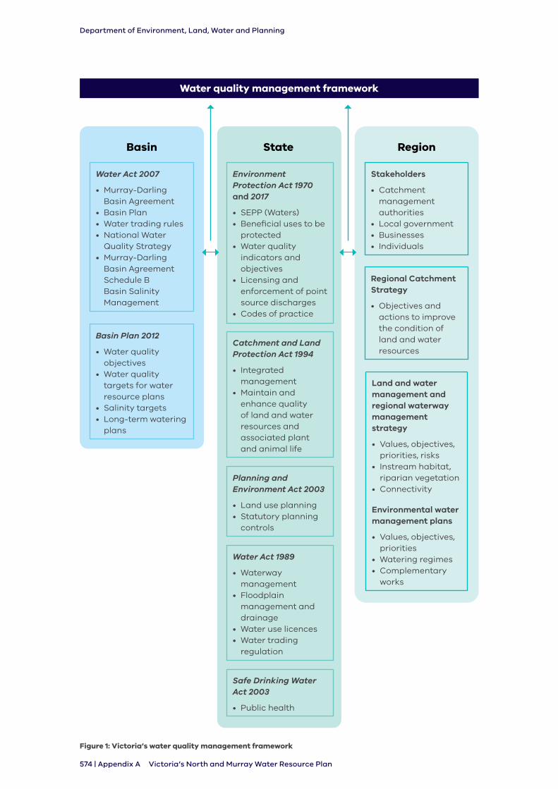
Victoria has a well established water quality management framework to address these issues. This framework will be used to deliver on the water quality and salinity requirements of the Basin Plan.
The Victorian water quality management framework includes a multifaceted arrangement of regulation, policy and strategy to protect water quality.
Important elements of the framework are discussed in this section. Figure 1 provides a more detailed description of Victoria’s water quality management framework.
2.1 Key entities in water quality management
In Victoria the Department of Health and Human Services (DHHS), Department of Environment, Land, Water and Planning (DELWP), Environment Protection Authority (EPA), municipal councils, water corporations and catchment management authorities all have a role to play in managing water quality.
DHHS, DELWP and the EPA all play a role in regulating water quality requirements and responding to impacts on water quality. In regulating water quality, the Department of Health and Human Services sets standards for drinking water quality and matters of public health.
The Environment Protection Authority implements State Environment Protection Policies, regulates discharges into, and pollution of, the environment. The State Environment Protection Policy (Waters), also referred to as SEPP (Waters), provides a framework for the protection and management of water quality in Victoria, covering surface waters, estuarine and marine waters and groundwaters across the State. SEPP (Waters) also influences planning schemes which are administered by municipal councils.
DELWP administers the Victorian Water Act and the Catchment and Land Protection Act 1994 and supports water corporations and catchment management authorities to carry out of their obligations and functions.
Water corporations play a key role in managing Victoria’s water resources to support meeting water quality targets and objectives and responding to water quality events.
Catchment management authorities support this role through land management activities.
Department of Environment, Land, Water and Planning
574 | Appendix A Victoria’s North and Murray Water Resource Plan
Water quality management framework
Environment Protection Act 1970 and 2017
• SEPP (Waters)• Beneficial uses to be
protected• Water quality
indicators and objectives
• Licensing and enforcement of point source discharges
• Codes of practice
Stakeholders
• Catchment management authorities
• Local government• Businesses• Individuals
Regional Catchment Strategy
• Objectives and actions to improve the condition of land and water resources
Land and water management and regional waterway management strategy
• Values, objectives, priorities, risks
• Instream habitat, riparian vegetation
• Connectivity
Environmental water management plans
• Values, objectives, priorities
• Watering regimes• Complementary
works
Water Act 2007
• Murray-Darling Basin Agreement
• Basin Plan• Water trading rules• National Water
Quality Strategy• Murray-Darling
Basin Agreement Schedule B Basin Salinity Management
Basin Plan 2012
• Water quality objectives
• Water quality targets for water resource plans
• Salinity targets• Long-term watering
plans
Catchment and Land Protection Act 1994
• Integrated management
• Maintain and enhance quality of land and water resources and associated plant and animal life
Planning and Environment Act 2003
• Land use planning• Statutory planning
controls
Safe Drinking Water Act 2003
• Public health
Water Act 1989
• Waterway management
• Floodplain management and drainage
• Water use licences• Water trading
regulation
State RegionBasin
Figure 1: Victoria’s water quality management framework

Department of Environment, Land, Water and Planning
Appendix A | 575Victoria’s North and Murray Water Resource Plan
2.2 National Water Quality Management strategy and guidance
The National Water Quality Management Strategy (Australian Government, 2018) developed by the Australian Government in conjunction with the Australian and New Zealand Guidelines for Fresh and Marine Water Quality 2018 and 2000 collectively provide a national strategic direction for the management of Australia’s surface, groundwater and coastal waters.
The strategy includes nationally agreed policies and principles for water quality management. It recognises the importance of understanding and protecting water quality by maintaining or improving it so that it is ‘fit for purpose’ and suitable for the desired values and uses and the specific local conditions.
Victoria was an active participant in strategy and guideline renewal process. This is consistent with the state’s approach as well as the defined community values for aquatic ecosystem, cultural and spiritual values, drinking water, industrial water, primary industries and recreation and aesthetics.
2.3 Environment Protection Act 1970 and 2017 and the State Environment Protection Policy (Waters)
Victoria’s water quality protection framework was first established by the Environment Protection Act 1970 (the EP Act). The EP Act was updated in 2017 and states that the objective of the Environment Protection Authority (EPA) is to protect human health and the environment by reducing the harmful effects of pollution and waste.
The EP Act establishes the powers, duties and functions of the Environment Protection Authority. These include the administration of the EP Act and any regulations and orders made according to it, administering State Environment Protection Policies (SEPPs) and industrial waste management policies, issuing works approvals, licences, permits, pollution abatement notices and implementing National Environment Protection Measures.
The EP Act has a basic philosophy of preventing pollution and environmental damage by setting environmental quality objectives and establishing programs to meet them in SEPPs. These policies aim to safeguard the environmental values and human activities (beneficial uses) that need protection from the effect of pollution and waste in the State of Victoria.
State Environment Protection Policy (Waters) 2018 is the instrument that formally defines the beneficial uses and environmental quality (water quality) objectives for the whole of Victoria, including Victoria’s North and Murray water resource plan area. The SEPP (Waters) identifies legally enforceable rules for decision makers and obligations on industry to protect our water environments.
Obligations in the SEPP (Waters) include the requirements for the management of risks to beneficial uses, for example how municipal councils must manage their assets, and how water corporations and other industries manage waste and wastewater. Obligations to protect groundwater beneficial uses are also listed.
The SEPP (Waters) is also used to inform a range of strategies and plans that are prepared at varying scales.
Department of Environment, Land, Water and Planning
576 | Appendix A Victoria’s North and Murray Water Resource Plan
Victoria’s SEPP (Waters) defines segments1 for Victorian waters, beneficial uses and the water quality indicators and objectives necessary to protect those beneficial uses.
These three elements align with the Basin Plan’s target application zones, water quality objectives and water quality targets.
2.3.1 Water quality segments and beneficial uses
2.3.1.1 Surface water
State Environment Protection Policy (Waters) defines the beneficial uses and the water quality objectives required to protect them in defined segments.
The surface water segments that apply to Victoria’s North and Murray water resource plan area are:
• Highlands
• Uplands A
• Uplands B
• Central Foothills and Coastal Plains
• Murray and Western Plains
For a comparison of how these surface water segments relate to the Victoria’s North and Murray water resource plan areas (surface water) see Figure S.1, in Schedule 1 to this Appendix. The beneficial uses to be protected for all waters are:
• Water dependent ecosystems and species
- largely unmodified
- slightly to moderately modified
- highly modified
• Traditional Owner cultural values
• Agriculture and irrigation
• Industrial and commercial
• Human consumption of aquatic foods
• Water based recreation
- primary contact
- secondary contact
- aesthetic enjoyment
• Cultural and spiritual values
• Aquaculture
• Human consumption after appropriate treatment
• Navigation and shipping
• Groundwater specific
- potable water supply
- potable mineral water supply
- buildings and structures
- geothermal properties
1 Segment is a term used to identify parts of the policy area that have common features in terms of environmental condition, aquatic ecosystem type and a range of current and future beneficial uses.
Department of Environment, Land, Water and Planning
Appendix A | 577Victoria’s North and Murray Water Resource Plan
Water quality indicators and environmental quality objectives are defined for each of the beneficial use listed in each segment.
The SEPP (Waters) beneficial uses are consistent with the Basin Plan uses, being: fresh water-dependent ecosystems, raw water for treatment of human consumption, irrigation water, recreational water, maintaining good levels of water quality and salt export (Part II, Division 1 of SEPP (Waters)).
2.3.1.2 Groundwater
Groundwater quality is considered in both the Victorian Water Act and SEPP (Waters).
SEPP (Waters) contains seven groundwater segments and the protected beneficial uses within those segments.
The beneficial uses are assigned to each segment based on the suitability of the environmental quality to support that use or value. The segments are classified based on the background level of total dissolved solids (TDS). The segments are shown in Table 2.
Table 2: Groundwater segments listed in SEPP (Waters)
Segment A1 A2 B C D E F
TDS range (mg/L)
0 – 600 601 – 1,200 1,201 – 3,100
3,101– 5,400
5,401 – 7,100
7,101 – 10,000
>10,001
Part 5 of this water quality management plan addresses groundwater quality and in particular groundwater salinity.
Clause 7 of schedule 3 of SEPP (Waters) sets out the environmental quality indicators and objectives for groundwater in Victoria.
2.3.2 Managing discharges
2.3.2.1 Point source
The Environment Protection Authority regulates point source wastewater discharges to surface water from ‘scheduled premises’2 through a licensing and works approval regime. Direct disposal of waste to groundwater via a bore is prohibited, with few exceptions.
Industrial wastewater is either retained on site or discharged to wastewater treatment systems operated by Victoria’s water corporations. Wastewater treatment systems require ‘works approvals’ issued by the EPA and a wastewater discharge licence if wastewater is discharged off site. The SEPP (Waters) objectives are one of the considerations in the Environment Protection Authority’s regulatory decision making about point source wastewater discharges, as well as the existing environmental quality of the receiving environment and the results of a receiving water risk assessment.
SEPP (Waters) contains rules for decision makers and obligations on water corporations and industry in Part 3 Division 1 on waste and wastewater management and Division 3 on protecting groundwater beneficial uses.
The Environment Protection Authority requires water corporations to report compliance with wastewater discharge licences through annual performance statements. The statements are publicly available on the EPA’s website. The EPA undertakes audits of declarations made through the annual performance statements. Other licence conditions require water corporations to notify the EPA if they determine a non-compliance with a discharge limit or licence condition.
2 Environment Protection (Scheduled Premises) Regulations 2017
Department of Environment, Land, Water and Planning
578 | Appendix A Victoria’s North and Murray Water Resource Plan
The EPA inspects licensed premises and can issue remedial notices or directions where a non-compliance or likely non-compliance has occurred. This includes pollution abatement notices and clean up notices. Further sanctioning tools such as licence suspension or prosecution can be used where required.
Similar tools and inspections are used by the EPA to follow up pollution events from non-licensed point source discharges. For example, pollution from emergencies and accidental spills.
2.3.2.2 Diffuse source
Diffuse source discharges such as from septic tanks, stormwater runoff and agricultural runoff cannot be efficiently and effectively controlled by licensing regimes. SEPP (Waters) contains rules for decision makers and obligations on industry in Division 2’s management of risks to beneficial uses in all waters. For example, SEPP (Waters) places obligations on industry to manage construction activities, forestry activities and urban stormwater in a way that minimises risks to the environment. The Environment Protection Authority can use the EP Act provisions to enforce SEPP (Waters).
In summary, implementation and enforcement of the State Environment Protection Policy (Waters) and the use of instruments/processes from the Environment Protection Act 2017 will help to protect beneficial uses by managing risks and imposing processes, and protect the Basin Plan values at the same time.
2.4 Safe Drinking Water Act 2003
Victoria’s safe drinking water regulatory framework ensures a consistent, reliable supply of safe, good quality drinking water. This regulatory framework is overseen by the Department of Health and Human Services and implemented by water suppliers.
It will be used to protect the Basin Plan ‘drinking water value’ and informs the requirements for raw water when it is treated and used to supply drinking water to communities.
Victoria’s Safe Drinking Water Act 2003 and the Safe Drinking Water Regulations 2015 require all drinking water suppliers to implement, develop and review risk management plans to manage risks to drinking water. This includes the treatment and sampling of water. These risk management plans are subject to an independent audit at intervals determined by the DHHS.
Specifically the Safe Drinking Water Act 2003 provides a regulatory framework that includes:
• a risk management framework ‘from catchment to tap’
• a set of standards for key water quality criteria
• information disclosure requirements for water businesses
• community consultation processes
The Safe Drinking Water Act 2003 applies to a range of designated water businesses like water suppliers and water storage managers and other statutory authorities supplying drinking water to the public, including water corporations, Parks Victoria and alpine resort management boards. The Department of Health and Human Services supports and works with the key stakeholders to make sure the Safe Drinking Water Act 2003 is upheld across Victoria.
The drinking water provided by water suppliers must meet the objectives of the Australian Drinking Water Guidelines and be safe to drink. The water corporation is responsible for the main water infrastructure and quality of drinking water before it reaches the property meter. The property owner is responsible for maintaining internal plumbing from the property meter.
To protect the quality of Victoria’s drinking water supply, water corporations may require property owners to install a backflow prevention device to limit the risk of contaminated water flowing back into a town’s reticulated drinking water supply.
Department of Environment, Land, Water and Planning
Appendix A | 579Victoria’s North and Murray Water Resource Plan
2.5 Victorian Water Act and the Victorian Waterway Management Strategy
The Victorian Water Act requires catchment management authorities (CMAs) to prepare regional waterway strategies. The Department of Environment, Land, Water and Planning (DELWP) makes sure the CMAs prepare and implement these strategies.
2.5.1 Regional water strategies
Catchment management authorities’ regional waterway strategies identify priority waterways where environmental, social, cultural or economic values are threatened by poor water quality, and result in high or very high risk to these values. These are identified as ‘regional hotspots’.
Where the sources of water quality issues for regional hotspots are known, high-level management activities to address these risks are included in the regional waterway strategies and this is aligned with the broad actions in the State Environment Protection Policy (Waters). If the sources are unknown or uncertain, risk assessments or other investigations need to be carried out to help guide further action planning.
Catchment-scale water quality plans are developed in special cases when risk assessments or other investigations indicate they are required.
Management activities typically require partnership and negotiation between agencies such as waterway managers, the Department of Jobs, Precincts and Regions, the Environment Protection Authority, public land managers and local government. These are negotiated during development of the regional waterway strategies.
Decisions on the type and quantity of water quality management activities consider the scale of the problem and the resources available to remedy the issue.
The Victorian Environmental Water Holder (VEWH) is appointed under the Victorian Water Act to manage Victoria’s environmental water entitlements. The VEWH works with the waterway managers and the Commonwealth Environmental Water Holder to make sure environmental water entitlements are used to achieve the most efficient and effective environmental outcomes.
The VEWH also has regard to water quality objectives in SEPP (Waters) when implementing the Seasonal Watering Plan for stream reaches that can be supplied from the Water Holdings. In particular, the VEWH may supply water to improve water quality at priority sites, such as to increase dissolved oxygen levels, and reduce temperature, salinity and nutrient levels.
Victoria’s environmental water planning and management framework management framework, as overseen by DELWP and implemented by CMAs, the Victorian Environmental Water Holder and other agencies, and will be used to protects the Basin Plan’s values.
2.6 Planning and Environment Act 1987
The purpose of the Planning and Environment Act 1987 is to establish a framework for planning the use, development and protection of land in Victoria in the present and long-term interests of all Victorians. DELWP manages the legislation for planning, environmental assessment and land subdivision.
The Planning and Environment Act 1987 sets out procedures for preparing and amending the Victorian Planning Provisions and planning schemes. It also sets out the process for obtaining permits under schemes, enforcing compliance with planning schemes and permits and other administrative procedures.
Department of Environment, Land, Water and Planning
580 | Appendix A Victoria’s North and Murray Water Resource Plan
The main functions of the Act are to:
• set the broad objectives for planning in Victoria
• set the main rules and principles for how the Victorian planning system works
• set up the key planning procedures and legal instruments in the Victorian planning system
• define the roles and responsibilities of the Minister, councils, government departments, the community and other stakeholders in the planning system
• give local councils responsibility for preparing and administering planning schemes
In summary, the planning framework overseen by DELWP and implemented by local councils will be used to protect the Basin Plans values.
2.7 Catchment and Land Protection Act 1994
2.7.1 Regional Catchment Strategies
The Catchment and Land Protection Act 1994 requires Victoria’s catchment management authorities (CMAs) to prepare regional catchment strategies. These strategies provide an overarching framework for land, water and biodiversity management in each of the 10 catchment management regions in Victoria. The regional catchment strategies (VCMC, 2011):
• assess the land and water resources of the catchments in the region and how they are used
• assess the nature, causes, extent and severity of land degradation of the catchments in the region and identify areas for priority attention
• identify objectives for the quality of the land and water resources of the catchments in the region
• set a program of measures to promote improved use of land and water resources and to treat land degradation
• state the action necessary to implement the strategy and who should take it
• specify procedures for monitoring the implementation of the strategy, achieving the land and water resource quality objectives and assessing the effectiveness of the program of measures to prompt improved use of land and water resources
The regional catchment strategies must have regard to SEPP (Waters) and end-of-valley salinity targets. The CMAs consider water quality and salinity issues and identify these as priority issues for the region where relevant.
CMAs regularly update the strategies after extensive community and stakeholder consultation.
The strategies covering Victoria’s North and Murray water resource plan area are the:
• Northeast Regional Catchment Strategy 2013-19
• Goulburn Regional Catchment Strategy 2013-19
• North Central Regional Catchment Strategy 2013-19
• Mallee Regional Catchment Strategy 2013-19
The regional catchment strategies provide the overarching strategic framework and priorities for catchment management. More detailed sub-strategies and plans such as waterway management strategies and land and water management plans sit under the regional strategies.
Department of Environment, Land, Water and Planning
Appendix A | 581Victoria’s North and Murray Water Resource Plan
2.7.2 Land and water management plans
CMAs, with the assistance of key delivery partners, prepare land and water management plans for high priority issues and areas identified in the regional catchment strategies. The plans have been prepared for irrigation areas with significant water quality and salinity risks. They have not been prepared to address the water quality and salinity issues in dryland catchments where those issues are more dispersed, not as significant and where there are no available cost-effective management actions.
Land and water management plans have been prepared for the irrigation areas of the Sunraysia Irrigation District and the Goulburn-Murray Irrigation District.
2.8 Schedule B of the Murray-Darling Basin Agreement – River Murray salinity
Victoria supports and complies with Schedule B to the Murray-Darling Basin Agreement (Schedule 1 to the Commonwealth Water Act). Schedule B sets out the formal accountability framework for managing salinity in the Basin. Management arrangements in the Basin are periodically reviewed and updated. The BSM2030 (MDBA, 2017) reflects the outcomes of the most recent review. Schedule B of the Agreement and its associated operational protocols continue to apply.
The water-use licensing and trading provisions of the Victoria Water Act are used to implement the salinity accountability requirements of Schedule B.
Department of Environment, Land, Water and Planning
582 | Appendix A Victoria’s North and Murray Water Resource Plan
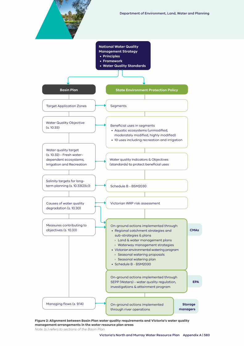
3. How Victoria’s water quality management aligns with the Basin Plan
Figure 2 shows how the Basin Plan requirements are linked to and inform water quality and salinity management in Victoria. The left-hand side of the figure shows the requirements of a water quality management plan as specified in the Basin Plan. The right-hand side of the figure shows the Victorian framework and how the two are connected.
Victoria’s water quality framework and the National Water Quality Management Strategy are consistent. The Basin Plan water quality and salinity management plan has been developed using this nationally-agreed framework for water quality planning and management. As a result, Victoria can meet the requirements of the Basin Plan through its existing water quality management arrangements.
Department of Environment, Land, Water and Planning
Appendix A | 583Victoria’s North and Murray Water Resource Plan
Measures contributing to
objectives (s. 10.33) CMAs
EPA
Storage managers
State Environment Protection PolicyBasin Plan
National Water Quality Management Strategy• Principles• Framework• Water Quality Standards
Target Application Zones
Managing flows (s. 9.14)
Segments
On-ground actions implemented
through river operations
Water Quality Objective
(s. 10.33)Beneficial uses in segments
• Aquatic ecosystems (unmodified,
moderately modified, highly modified)
• 10 uses including recreation and irrigation
Salinity targets for long-
term planning (s. 10.33(2)(c)) Schedule B - BSM2030
On-ground actions implemented through:
• Regional catchment strategies and
sub-strategies & plans
› Land & water management plans
› Waterway management strategies
• Victorian environmental watering program
› Seasonal watering proposals
› Seasonal watering plan
• Schedule B - BSM2030
On-ground actions implemented through
SEPP (Waters) - water quality regulation,
investigations & attainment program
Causes of water quality
degradation (s. 10.30)
Victorian WRP risk assessment
Water quality target
(s. 10.32) - Fresh water-
dependent ecosystems,
Irrigation and Recreation
Water quality Indicators & Objectives
(standards) to protect beneficial uses
Figure 2: Alignment between Basin Plan water quality requirements and Victoria’s water quality management arrangements in the water resource plan areasNote: (s.) refers to sections of the Basin Plan
Department of Environment, Land, Water and Planning
584 | Appendix A Victoria’s North and Murray Water Resource Plan
4. Surface water - Victoria’s North and Murray water resource plan area
This section presents information about the surface water of the Victorian Murray and Northern Victoria water resource plan areas. It includes general information about the resources and their quality, risks to the condition of these resources, a statement on degradation, causes or likely causes of this degradation, measures to contribute to the achievement of water quality objectives of the Basin Plan and water resource plan water quality targets to inform the development of the measures.
The Northern Victorian water resource plan area includes:
• the Ovens, Broken, Goulburn, Campaspe and Loddon tributary catchments of the River Murray
- this excludes areas which are supplied by River Murray water. For example, the Murray Valley and Torrumbarry Irrigation Districts and private diverters along the River Murray
The Victorian Murray water resource plan area includes:
• the Victorian section of the Upper Murray catchment of the River Murray
• the Mitta Mitta and Kiewa catchments
• irrigation use in the Murray Valley, Torrumbarry irrigation areas and Nyah and Tresco irrigation districts managed by Goulburn-Murray Water (GMW)
• irrigation use in the Merbein, Mildura, Red Cliffs, Robinvale irrigation areas and Woorinen irrigation districts managed by Lower Murray Water (LMW)
• Northern Mallee Pipeline use for supplies to rural customers around Ouyen and urban customers in Chillingollah, Chinkapook, Ouyen, Manangatang, Nandaly, Nullawil, Patchewollock, Speed, Tempy, Underbool, Waitchie and Walpeup managed by Grampians Wimmera Mallee Water (GWMW)
• irrigation use by the private diverters along the length of the River Murray managed by GMW and LMW
• urban use along the length of the River Murray managed by North East Water, Goulburn Valley Water, Coliban Water and Lower Murray Water, and stock and domestic use along the length of the River Murray
The River Murray itself is not included in Victoria’s water resource plan areas as its bed and banks lie within the borders of New South Wales and South Australia. However, Victoria’s use of the River Murray resources and the areas this water is used in are included in the Victorian Murray water resource plan area.
Victoria’s North and Murray water quality management plan addresses the surface water and groundwater resources located within the four catchment management authority regions of the North East CMA, Goulburn Broken CMA, North Central CMA and Mallee CMA.
Department of Environment, Land, Water and Planning
Appendix A | 585Victoria’s North and Murray Water Resource Plan
4.1 Surface water quality
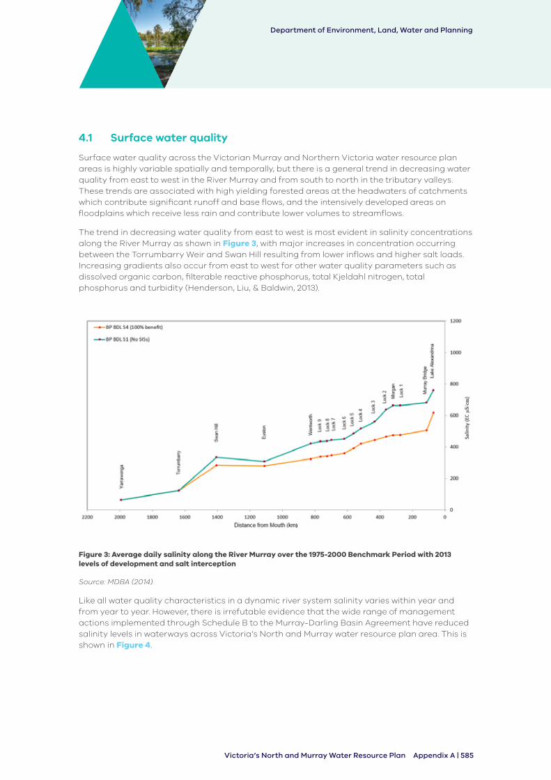
Surface water quality across the Victorian Murray and Northern Victoria water resource plan areas is highly variable spatially and temporally, but there is a general trend in decreasing water quality from east to west in the River Murray and from south to north in the tributary valleys. These trends are associated with high yielding forested areas at the headwaters of catchments which contribute significant runoff and base flows, and the intensively developed areas on floodplains which receive less rain and contribute lower volumes to streamflows.
The trend in decreasing water quality from east to west is most evident in salinity concentrations along the River Murray as shown in Figure 3, with major increases in concentration occurring between the Torrumbarry Weir and Swan Hill resulting from lower inflows and higher salt loads. Increasing gradients also occur from east to west for other water quality parameters such as dissolved organic carbon, filterable reactive phosphorus, total Kjeldahl nitrogen, total phosphorus and turbidity (Henderson, Liu, & Baldwin, 2013).
Figure 3: Average daily salinity along the River Murray over the 1975-2000 Benchmark Period with 2013 levels of development and salt interception
Source: MDBA (2014)
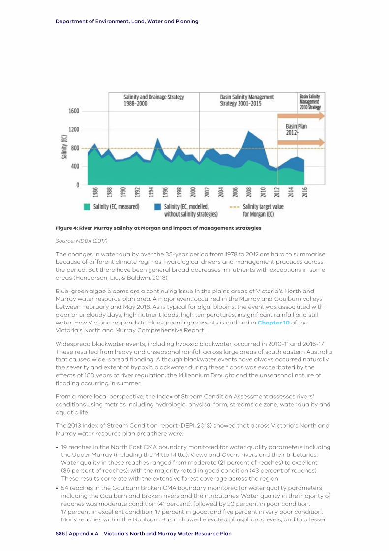
Like all water quality characteristics in a dynamic river system salinity varies within year and from year to year. However, there is irrefutable evidence that the wide range of management actions implemented through Schedule B to the Murray-Darling Basin Agreement have reduced salinity levels in waterways across Victoria’s North and Murray water resource plan area. This is shown in Figure 4.
Department of Environment, Land, Water and Planning
586 | Appendix A Victoria’s North and Murray Water Resource Plan
Figure 4: River Murray salinity at Morgan and impact of management strategies
Source: MDBA (2017)
The changes in water quality over the 35-year period from 1978 to 2012 are hard to summarise because of different climate regimes, hydrological drivers and management practices across the period. But there have been general broad decreases in nutrients with exceptions in some areas (Henderson, Liu, & Baldwin, 2013).
Blue-green algae blooms are a continuing issue in the plains areas of Victoria’s North and Murray water resource plan area. A major event occurred in the Murray and Goulburn valleys between February and May 2016. As is typical for algal blooms, the event was associated with clear or uncloudy days, high nutrient loads, high temperatures, insignificant rainfall and still water. How Victoria responds to blue-green algae events is outlined in Chapter 10 of the Victoria’s North and Murray Comprehensive Report.
Widespread blackwater events, including hypoxic blackwater, occurred in 2010-11 and 2016-17. These resulted from heavy and unseasonal rainfall across large areas of south eastern Australia that caused wide-spread flooding. Although blackwater events have always occurred naturally, the severity and extent of hypoxic blackwater during these floods was exacerbated by the effects of 100 years of river regulation, the Millennium Drought and the unseasonal nature of flooding occurring in summer.
From a more local perspective, the Index of Stream Condition Assessment assesses rivers’ conditions using metrics including hydrologic, physical form, streamside zone, water quality and aquatic life.
The 2013 Index of Stream Condition report (DEPI, 2013) showed that across Victoria’s North and Murray water resource plan area there were:
• 19 reaches in the North East CMA boundary monitored for water quality parameters including the Upper Murray (including the Mitta Mitta), Kiewa and Ovens rivers and their tributaries. Water quality in these reaches ranged from moderate (21 percent of reaches) to excellent (36 percent of reaches), with the majority rated in good condition (43 percent of reaches). These results correlate with the extensive forest coverage across the region
• 54 reaches in the Goulburn Broken CMA boundary monitored for water quality parameters including the Goulburn and Broken rivers and their tributaries. Water quality in the majority of reaches was moderate condition (41 percent), followed by 20 percent in poor condition, 17 percent in excellent condition, 17 percent in good, and five percent in very poor condition. Many reaches within the Goulburn Basin showed elevated phosphorus levels, and to a lesser
Department of Environment, Land, Water and Planning
Appendix A | 587Victoria’s North and Murray Water Resource Plan
extent, turbidity. Again, these results are associated with reaches located in areas of cleared agricultural land
• 28 reaches in the North Central CMA boundary monitored for water quality parameters including the Campaspe and Loddon rivers and their tributaries. Water quality results ranged from excellent to very poor. The majority of reaches were assessed to be in moderate (43 percent) and poor condition (32 percent), followed by good condition (17 percent), and excellent and very poor condition (both four percent). One reach in the Campaspe Basin located on a cleared tract of the McIvor Creek scored very poorly, with elevated phosphorus, salinity and turbidity levels. In contrast, one reach located on the Campaspe River downstream of Lake Eppalock in an area of patchy forest cover, was the only reach across the entire region to show close to unmodified water quality. The majority of sites showed elevated levels of phosphorus and salinity, which is attributed to dryland and irrigation farming practices
4.2 River Murray water quality management
The River Murray is a part of New South Wales. Therefore, Victoria is not directly responsible for managing the water quality within the Murray River.
Schedule B of the Basin Plan – Basin Salinity Management is the major initiative in the Murray-Darling Basin Agreement designed to manage water quality. It sets out the formal accountability framework for managing salinity in the Basin. The Basin Salinity Management 2030 strategy (MDBA, 2017) reflects the outcomes of the most recent review. The Murray-Darling Basin Authority is required to formulate water quality objectives for the River Murray which are set out in the Murray-Darling Basin Agreement and describe a range of operational rules designed to maintain or improve water quality.
The River Murray water quality monitoring program is also a requirement of the Murray-Darling Basin Agreement. The MDBA manages this program on behalf of Basin governments, maintaining a uniform system for measuring, analysing and presenting data to create a picture of current and long-term river health within the River Murray system. An interjurisdictional Water Quality Advisory Panel provides governance and expert advice with regard to the MDBA’s role in managing the water quality of the River Murray, its tributaries and storages.
Detailed operational arrangements have been in place to manage blue-green algal blooms in the River Murray for many years and the management of algal blooms is now part of ‘business as usual’ operations.
The Murray Regional Algal Coordinating Committee is in place for monitoring and managing blue-green algae outbreaks along the River Murray. The committee includes all the relevant managing authorities in New South Wales, Victoria and South Australia. The committee develops and implements strategies for managing blue-green algal blooms to minimise their impact. The committee is responsible for coordinating public communications and issuing public alerts to make sure all water users are aware of problems and know to avoid direct contact with the water (MDBA, unknown).
Water quality in the River Murray is critical to Victorians because of the environmental, social and economic values it supports. Victoria works with other states to manage salinity in the Murray through Schedule B to the Murray-Darling Basin Agreement and less formally on other water quality matters through the Water Quality Advisory Panel.
The Basin Plan requirements relating directly to water quality in the River Murray will be addressed in the water quality management plan for the New South Wales Murray and Lower Darling water resource plan area.
The major types and causes of water quality degradation in the River Murray that Victoria will discuss with New South Wales will include blue-green algae blooms, hypoxic blackwater events and salinity.
Department of Environment, Land, Water and Planning
588 | Appendix A Victoria’s North and Murray Water Resource Plan
4.3 Water quality degradation
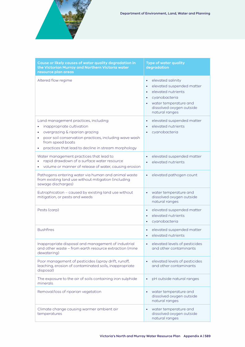
Section 10.30 of the Basin Plan requires Victoria’s North and Murray Water Quality Management Plan to identify the causes, or likely causes, of water quality degradation of water resources in the water resource plan area. In identifying the causes or likely causes of degradation, regard must be had to the key causes identified in Chapter 9 of the Basin Plan. The Basin Plan identifies nine types of water quality degradation and their causes, including elevated salinity, suspended matter, and nutrients (details are in the Basin Plan Schedule 10).
The quality of the surface water of the Victoria’s North and Murray water resource plan area have been affected by significant changes to the waterways across the region over time. These include regulation and the construction of dams, as well as significant changes to the land use in the catchment. Further impacts have been experienced from active and accidental discharges over the last few hundred years.
Degradation or decline in water quality, whether from natural causes like drought or fire or human-induced causes such as land clearing and land use change, can have significant impacts on beneficial uses. Sections of the catchments which retain a large amount of native vegetation like mountains and highlands have been less affected by water quality degradation than the highly modified flat lands. Some of this degradation in the northern sections that has occurred through a significant shift in catchment land and water use has led to a ‘step change’ in water quality. While action is taken to alleviate or reduce these impacts, water quality cannot be returned to that experienced before European settlement.
Many risks and causes of water quality degradation occur at a local level and do not affect the overall condition at a water resource plan scale. Victoria’s North and Murray Water Quality Management Plan considers both system-wide and local risks and causes of water quality degradation.
Table 3 presents the types of water quality degradation in Northern Victoria and Victorian Murray water resource plan areas. Column one presents the causes, or likely causes, of water quality degradation. In identifying the list, the Risk Assessment (Appendix B) was considered, and regard was had to the list of causes of water quality degradation in the Murray-Darling Basin (provided in Schedule 10 to the Basin Plan). Also, Victoria reviewed its strategies and plans and consulted with regional agencies.
Table 3: Cause or likely causes of surface water quality degradation in both the Victorian Murray and Northern Victoria water resource plan areas
Cause or likely causes of water quality degradation in the Victorian Murray and Northern Victoria water resource plan areas
Type of water quality degradation
Saline groundwater and surface water discharges into surface water systems
• elevated salinity
Reduction in streamflows • elevated salinity
• elevated nutrients
• cyanobacteria
• water temperature and dissolved oxygen outside natural ranges
Basin Plan s10.30
Department of Environment, Land, Water and Planning
Appendix A | 589Victoria’s North and Murray Water Resource Plan
Cause or likely causes of water quality degradation in the Victorian Murray and Northern Victoria water resource plan areas
Type of water quality degradation
Altered flow regime • elevated salinity
• elevated suspended matter
• elevated nutrients
• cyanobacteria
• water temperature and dissolved oxygen outside natural ranges
Land management practices, including:
• inappropriate cultivation
• overgrazing & riparian grazing
• poor soil conservation practices, including wave wash from speed boats
• practices that lead to decline in stream morphology
• elevated suspended matter
• elevated nutrients
• cyanobacteria
Water management practices that lead to: • rapid drawdown of a surface water resource
• volume or manner of release of water, causing erosion
• elevated suspended matter
• elevated nutrients
Pathogens entering water via human and animal waste from existing land use without mitigation (including sewage discharges)
• elevated pathogen count
Eutrophication – caused by existing land use without mitigation, or pests and weeds
• water temperature and dissolved oxygen outside natural ranges
Pests (carp) • elevated suspended matter
• elevated nutrients
• cyanobacteria
Bushfires • elevated suspended matter
• elevated nutrients
Inappropriate disposal and management of industrial and other waste – from earth resource extraction (mine dewatering)
• elevated levels of pesticides and other contaminants
Poor management of pesticides (spray drift, runoff, leaching, erosion of contaminated soils, inappropriate disposal)
• elevated levels of pesticides and other contaminants
The exposure to the air of soils containing iron sulphide minerals
• pH outside natural ranges
Removal/loss of riparian vegetation • water temperature and dissolved oxygen outside natural ranges
Climate change causing warmer ambient air temperatures
• water temperature and dissolved oxygen outside natural ranges
Department of Environment, Land, Water and Planning
590 | Appendix A Victoria’s North and Murray Water Resource Plan
Cause or likely causes of water quality degradation in the Victorian Murray and Northern Victoria water resource plan areas
Type of water quality degradation
Micro-organisms consuming organic matter • water temperature and dissolved oxygen outside natural ranges
Extreme drought causing warmer ambient air temperatures
• water temperature and dissolved oxygen outside natural ranges
4.4 Risks to the condition of surface water in the water resource plan area
Section 10.31 of the Basin plan requires Victoria’s North and Murray water quality management plan to identify measures to address the risks, as referred to in section 10.41(2)(d) of the Basin Plan, identified as a result of the risk assessment (see Appendix B). To support meeting this requirement, the Basin Plan requires a water resource plan to be prepared having regard to the current and future risks to the condition and availability of the water resources of a water resource plan area (section 10.41 of the Basin Plan).
Victoria has assessed current and future risks to the availability and condition of the water resources in the water resource plan area. Water quality (condition) related risks are discussed in Appendix B of the Comprehensive Report which outlines:
• the risks
• the level of risk
• description of medium to high risks
• strategies to address each medium to high risk as required in sections 10.41-10.43 of the Basin Plan
The risks to Northern Victoria and Victorian Murray water resource plan areas are addressed by a range of measures and strategies. Measures contributing to the achievement of water quality objectives are presented in Part 4.5. Strategies identified through Victoria’s risk assessment process are summarised in Appendix B of the water resource plan. In addition, human consumptive use is protected through the Safe Drinking Water Act 2003, which specifically regulates water distributed by urban water corporations for consumption and domestic use.
4.4.1 Medium to high risks to condition of water resources in the Northern Victoria water resource plan area
The risk assessment of the Northern Victoria water resource plan area identified risks to the condition of surface waters. These are summarised in Table 4.
Department of Environment, Land, Water and Planning
Appendix A | 591Victoria’s North and Murray Water Resource Plan
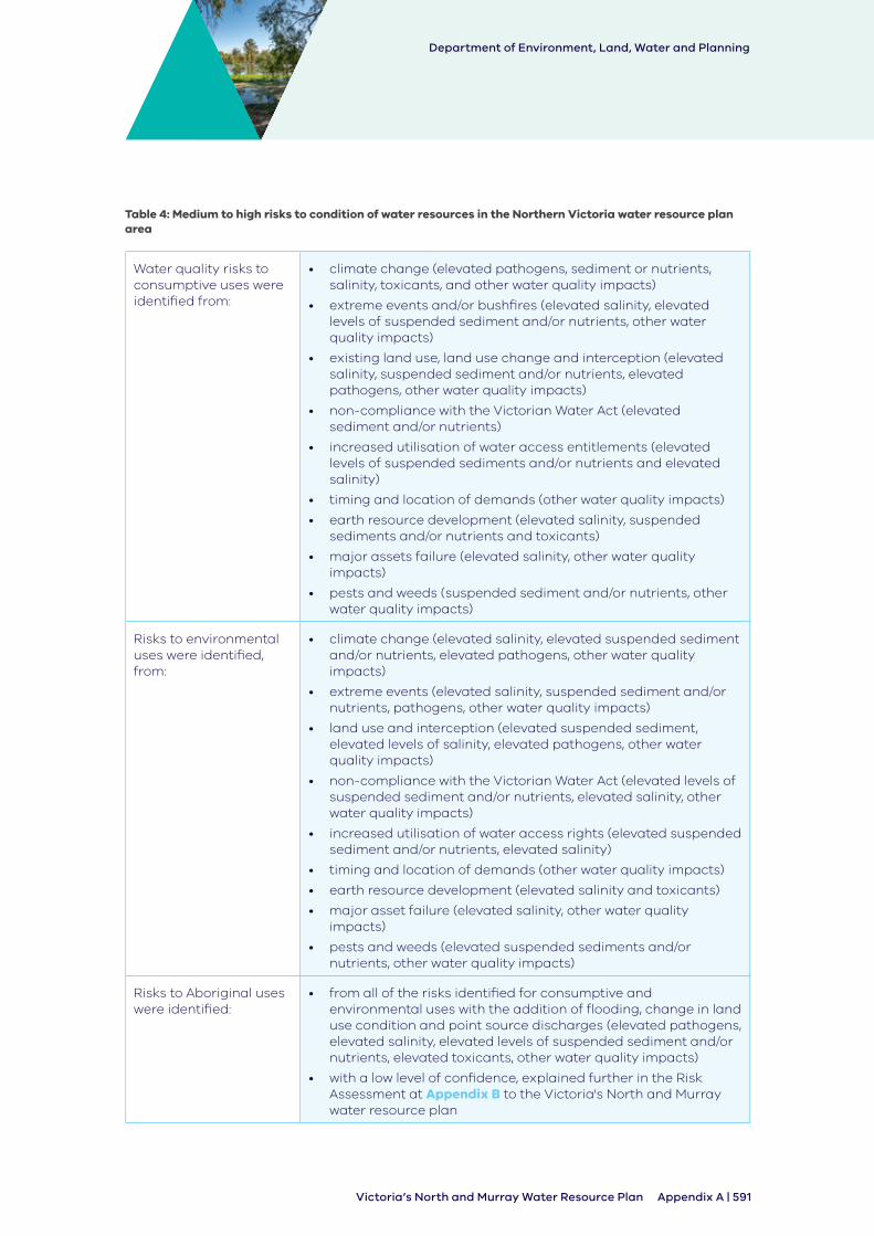
Table 4: Medium to high risks to condition of water resources in the Northern Victoria water resource plan area
Water quality risks to consumptive uses were identified from:
• climate change (elevated pathogens, sediment or nutrients, salinity, toxicants, and other water quality impacts)
• extreme events and/or bushfires (elevated salinity, elevated levels of suspended sediment and/or nutrients, other water quality impacts)
• existing land use, land use change and interception (elevated salinity, suspended sediment and/or nutrients, elevated pathogens, other water quality impacts)
• non-compliance with the Victorian Water Act (elevated sediment and/or nutrients)
• increased utilisation of water access entitlements (elevated levels of suspended sediments and/or nutrients and elevated salinity)
• timing and location of demands (other water quality impacts)
• earth resource development (elevated salinity, suspended sediments and/or nutrients and toxicants)
• major assets failure (elevated salinity, other water quality impacts)
• pests and weeds (suspended sediment and/or nutrients, other water quality impacts)
Risks to environmental uses were identified, from:
• climate change (elevated salinity, elevated suspended sediment and/or nutrients, elevated pathogens, other water quality impacts)
• extreme events (elevated salinity, suspended sediment and/or nutrients, pathogens, other water quality impacts)
• land use and interception (elevated suspended sediment, elevated levels of salinity, elevated pathogens, other water quality impacts)
• non-compliance with the Victorian Water Act (elevated levels of suspended sediment and/or nutrients, elevated salinity, other water quality impacts)
• increased utilisation of water access rights (elevated suspended sediment and/or nutrients, elevated salinity)
• timing and location of demands (other water quality impacts)
• earth resource development (elevated salinity and toxicants)
• major asset failure (elevated salinity, other water quality impacts)
• pests and weeds (elevated suspended sediments and/or nutrients, other water quality impacts)
Risks to Aboriginal uses were identified:
• from all of the risks identified for consumptive and environmental uses with the addition of flooding, change in land use condition and point source discharges (elevated pathogens, elevated salinity, elevated levels of suspended sediment and/or nutrients, elevated toxicants, other water quality impacts)
• with a low level of confidence, explained further in the Risk Assessment at Appendix B to the Victoria's North and Murray water resource plan
Department of Environment, Land, Water and Planning
592 | Appendix A Victoria’s North and Murray Water Resource Plan
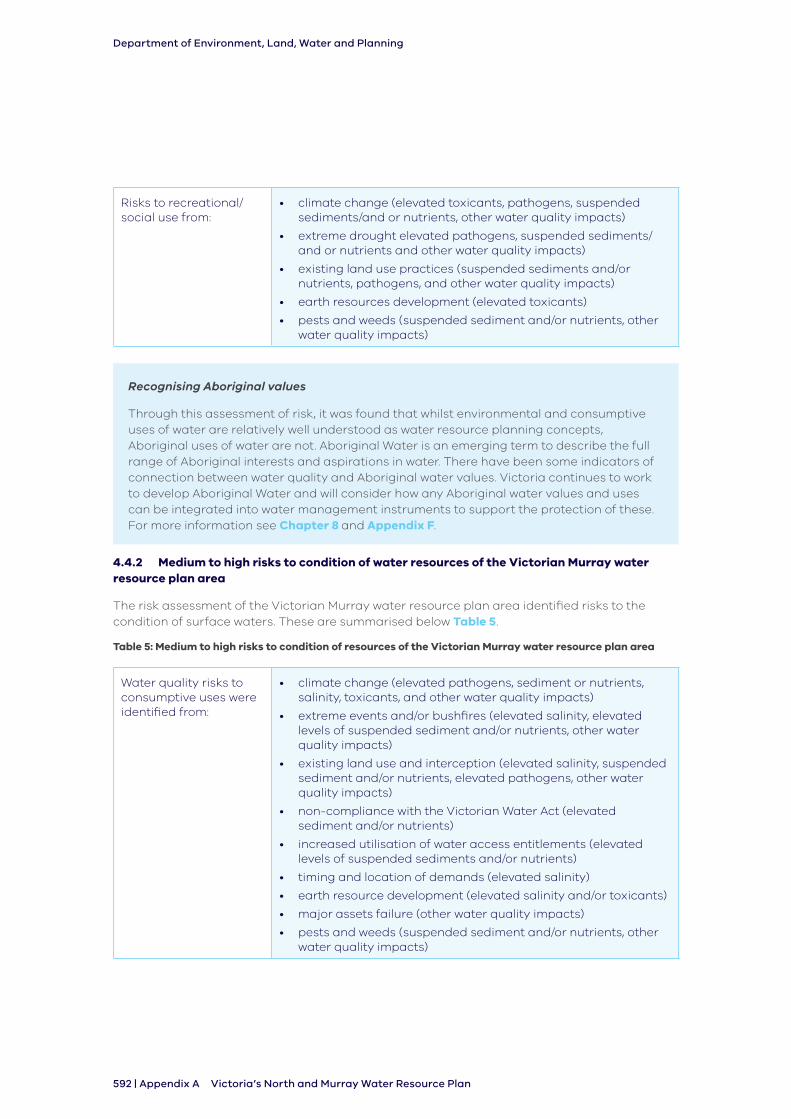
Risks to recreational/social use from:
• climate change (elevated toxicants, pathogens, suspended sediments/and or nutrients, other water quality impacts)
• extreme drought elevated pathogens, suspended sediments/ and or nutrients and other water quality impacts)
• existing land use practices (suspended sediments and/or nutrients, pathogens, and other water quality impacts)
• earth resources development (elevated toxicants)
• pests and weeds (suspended sediment and/or nutrients, other water quality impacts)
Recognising Aboriginal values
Through this assessment of risk, it was found that whilst environmental and consumptive uses of water are relatively well understood as water resource planning concepts, Aboriginal uses of water are not. Aboriginal Water is an emerging term to describe the full range of Aboriginal interests and aspirations in water. There have been some indicators of connection between water quality and Aboriginal water values. Victoria continues to work to develop Aboriginal Water and will consider how any Aboriginal water values and uses can be integrated into water management instruments to support the protection of these. For more information see Chapter 8 and Appendix F.
4.4.2 Medium to high risks to condition of water resources of the Victorian Murray water resource plan area
The risk assessment of the Victorian Murray water resource plan area identified risks to the condition of surface waters. These are summarised below Table 5.
Table 5: Medium to high risks to condition of resources of the Victorian Murray water resource plan area
Water quality risks to consumptive uses were identified from:
• climate change (elevated pathogens, sediment or nutrients, salinity, toxicants, and other water quality impacts)
• extreme events and/or bushfires (elevated salinity, elevated levels of suspended sediment and/or nutrients, other water quality impacts)
• existing land use and interception (elevated salinity, suspended sediment and/or nutrients, elevated pathogens, other water quality impacts)
• non-compliance with the Victorian Water Act (elevated sediment and/or nutrients)
• increased utilisation of water access entitlements (elevated levels of suspended sediments and/or nutrients)
• timing and location of demands (elevated salinity)
• earth resource development (elevated salinity and/or toxicants)
• major assets failure (other water quality impacts)
• pests and weeds (suspended sediment and/or nutrients, other water quality impacts)
Department of Environment, Land, Water and Planning
Appendix A | 593Victoria’s North and Murray Water Resource Plan
Risks to environmental uses were identified, from:
• climate change (elevated salinity, elevated pathogens, other water quality impacts)
• extreme events (elevated salinity, suspended sediment and/or nutrients, pathogens, other water quality impacts)
• land use and interception (elevated suspended sediment, elevated levels of salinity, elevated pathogens, other water quality impacts)
• non-compliance with the Water Act 1989 (elevated levels of suspended sediment and/or nutrients)
• timing and location of demands (elevated salinity)
• earth resources development (elevated salinity)
• major asset failure (other water quality impacts)
• pests and weeds (other water quality impacts)
Risks to Aboriginal uses were identified from:
• all of the risks identified for consumptive and environmental uses with the addition of flooding, change in land use condition and/or availability, increased utilisation of water access rights and point source discharges (elevated pathogens, elevated salinity, elevated levels of suspended sediment and/or nutrients, elevated toxicants, other water quality impacts)
Risks to recreational/social use were identified from:
• climate change (elevated toxicants, pathogens, other water quality impacts)
• extreme drought (elevated pathogens, and other water quality impacts)
• existing land use practices (suspended sediments and/or nutrients, pathogens, and other water quality impacts)
• earth resources development (elevated toxicants)
• pests and weeds (suspended sediment and/or nutrients, other water quality impacts)
4.4.3 Measures addressing risks
Section 10.31 of the Basin Plan requires measures to be identified for risks arising from elevated levels of salinity or other types of water quality degradation.
The measures to address these risks are:
• BSM2030 which protects the waters of the Murray River and its tributaries
• the implementation of SEPP (Waters)
It is not considered any other measures are necessary on the basis that the above highlighted risks are addressed in Victoria’s North and Murray water resource plan area through:
• strategies identified in the Risk Assessment as outlined in Appendix B
• the measures contributing to the achievement of water quality objectives as outlined in Part 4.5 below
Department of Environment, Land, Water and Planning
594 | Appendix A Victoria’s North and Murray Water Resource Plan
4.5 Measures contributing to the achievement of water quality objectives
Victoria has a comprehensive and active water quality management framework that has parallels to many aspects of the Basin Plan’s clauses on water quality management. The strategies to address medium to high risks to the condition of water resources identified as part of the risk assessments for Victoria’s North and Murray Water Resource Plan show this is an active and continuously improving framework for addressing water quality.
Beyond these strategies, Victoria has done a detailed review to identify and specify measures for each of the Northern Victoria and Victorian Murray water resource plan areas that will contribute to the achievement of the Basin Plan’s water quality objectives. Their identification and development have had regard to the causes, or likely causes, of water quality degradation and the water quality targets of these water resource plan areas, and the salinity targets for the purposes of long-term salinity planning and management set out in Chapter 9 of the Basin Plan.
Two significant measures that will contribute to the achievement of water quality objectives under section 10.33 of the Basin Plan for the Northern Victorian and Victorian Murray water resource plan areas are:
1. implementation of the State Environment Protection Policy (Waters)
2. implementation of Victoria’s commitments under the Basin Salinity Management Strategy 2030
As outlined in Part 2 there are other measures that will also contribute to achieving the water quality objectives. SEPP (Waters) and BSM2030 have been identified as the relevant measures for addressing section 10.33 of the Basin Plan as they form the overarching response to water quality management. Other strategies that form part of the framework must be based on the requirements and obligations under these measures.
Table 6: Measures contributing to water quality objectives
Water Quality Objective
Measures contributing to the achievement of each water quality objective in the Northern Victoria and Victorian Murray water resource plan areas
Implementation of SEPP (Waters), or future equivalent
Implementation of Victoria’s commitments under BSM2030 (the Basin Salinity Management Strategy)
Northern Victoria WRP Area
Victorian Murray WRP Area
Northern Victoria WRP Area
Victorian Murray WRP Area
Fresh water- dependent ecosystems
Raw water for treatment for human consumption
Irrigation water
Recreational water
Department of Environment, Land, Water and Planning
Appendix A | 595Victoria’s North and Murray Water Resource Plan
Water Quality Objective
Measures contributing to the achievement of each water quality objective in the Northern Victoria and Victorian Murray water resource plan areas
Maintaining good levels of water quality
Salt export NA
4.5.1 Measure 1: Implementation of the State Environment Protection Policy (Waters), or future equivalent
The primary regulatory mechanism for protecting Victoria’s water environments from pollution and waste is the Environment Protection Act 1970 and 2017 (the EP Act). The EP Act defines high level objectives for protection of Victoria’s water environments and gives the Environment Protection Authority and other duty holders roles, responsibilities and powers for environmental protection.
SEPP (Waters) ensures that Victoria has a contemporary statutory policy for the protection and management of surface water and groundwater in Victoria. This is achieved by establishing in law the uses and environmental values to be protected, defining the level of environmental quality required for their protection and setting rules and obligations to make sure management actions are taken to protect water quality.
The SEPP (Waters) objective is to protect and improve the quality of Victoria’s waters while providing for economic and social development.
SEPP (Waters) works in parallel with a number of tools used by Victoria’s environment and resource managers, industry groups, and the broader community to protect our water environments and the health of Victoria’s waters. The most prominent of these are the Water Act 1989 and associated regional waterway strategies.
In seeking to improve the health of Victorian waters, SEPP (Waters) is enhancing the quality of shared waters and has regard to the impacts it may have on the ability of another Basin state to meet water quality targets.
SEPP (Waters) is consistent with the National Water Quality Management Strategy and so will not have adverse impacts on other states.
State Environment Protection Policies (SEPPs) are subordinate legislation under the EP Act. SEPP (Waters) supports the protection of Victoria’s waters in two key ways:
• it outlines the beneficial uses or public values to be protected in different water bodies (segments), and associated environmental quality indicators and objectives required to support these beneficial uses
• it provides the rules for the regulator (EPA) and obligations on industry to protect and improve water quality which typically include:
- obligations on duty holders — detailed expectations and requirements for a range of activities that impact on water quality (e.g. setting the standards for sewerage infrastructure containing flows)
- decision rules for, and processes to be followed by, the regulator when managing scheduled premises, such as there must not be any direct discharge of waste to any aquifer except for specific purposes and where specified conditions are met, and in issuing a licence, the EPA may approve a mixing zone
Department of Environment, Land, Water and Planning
596 | Appendix A Victoria’s North and Murray Water Resource Plan
The environmental quality indicators and objectives in SEPP (Waters) have been developed in line with, and to complement, the nationally-agreed approach outlined in the Australian and New Zealand Environment Conservation Council (ANZECC) Guidelines.
SEPP (Waters) rules and obligations clauses collectively make up a program of actions through which environmental quality objectives are to be achieved or attained to protect beneficial uses.
By highlighting these obligations in SEPP (Waters), duty holders can understand their legal requirements to manage water quality. SEPP (Waters) has an implementation plan that outlines the Government’s priorities which will drive work priorities and budgeting.
The SEPP (Waters) is also used to inform regional and local strategies and plans that aim to improvement environmental quality objectives.
4.5.1.1 Contribution to achieving the objective for water-dependent ecosystems
The Basin Plan (under section 9.04) objective for water-dependent ecosystems for Ramsar wetlands is that the quality of water is sufficient to maintain the ecological character of those wetlands. The water quality objective for water-dependent ecosystems other than declared Ramsar wetlands is that the quality of water is sufficient to protect and restore ecosystems and their function and to ensure that the ecosystems are resilient to climate change and other risks and threats.
SEPP (Waters) includes water-dependent ecosystems and species as a beneficial use to be protected in Victoria’s surface waters. This beneficial use is consistent with the Basin Plan fresh water-dependent ecosystem. Therefore, implementation of SEPP (Waters) will protect the Basin Plan water-dependent ecosystems.
Water-dependent ecosystems and species are protected in all rivers and streams. Numerical environmental quality objectives have been set for rivers and streams to guide water managers on the appropriate levels of relevant indicators to protect the ecosystems. If these objectives are not attained, further investigation is required to understand if a threat is real, and what action needs to be taken.
4.5.1.2 Contribution to achieving the objective for raw water for treatment for human consumption
The Basin Plan (section 9.05) objectives are to:
• minimise the risk that the quality of raw water taken for treatment for human consumption results in adverse human health effects
• maintain the palatability rating of water taken for treatment for human consumption at the level set out in the Australian Drinking Water Guidelines
• minimise the risk that the quality of raw water taken for treatment for human consumption results in the odour of drinking water being offensive to consumers
SEPP (Waters) identifies ‘water suitable for human consumption after appropriate treatment’ as a beneficial use of Victoria’s surface waters. It is protected where water is sourced for supply in accordance with the special water supply catchments area set out in Schedule 5 of the Catchment and Land Protection Act 1994 or the Safe Drinking Water Act 2003.
SEPP (Waters) beneficial use is consistent with the intent of the Basin Plan raw water for treatment for human consumption. Therefore, implementation of SEPP (Waters) will protect the Basin Plan raw water for treatment for human consumption.
SEPP (Waters) does not establish specific numerical environmental quality objectives for raw or treated water for human consumption for surface waters. However because the protection of water-dependent ecosystems and species, which has the most stringent environmental quality
Department of Environment, Land, Water and Planning
Appendix A | 597Victoria’s North and Murray Water Resource Plan
objectives, is identified in all segments, the measures/activities to protect water-dependent ecosystems and species will provide protection for raw water for human consumption.
4.5.1.3 Contribution to achieving the objective for irrigation water
The Basin Plan (under section 9.06) outlines that the quality of surface water, when used in accordance with best irrigation and crop management practices and principles of ecologically sustainable development, does not result in crop yield loss or soil degradation. As explained in section 4.6.2 , the quality of source water for irrigation is maintained through Victoria’s water quality framework which includes the implementation of SEPP (Waters).
4.5.1.4 Contribution to achieving the objective for recreational water quality
The Basin Plan (under section 9.07) water quality objective for recreational water quality is to achieve a low risk to human health from water quality threats posed by exposure through ingestion, inhalation or contact from recreational use of Basin water resources.
Recreational use of water is recognised as a beneficial use in SEPP (Waters), which is categorised as primary and secondary contact recreation and aesthetic enjoyment of the waters. The three uses are protected across all rivers and streams in Victoria, except where public access is legally restricted or has specifically been exempted by the policy. SEPP (Waters) provides comprehensive environmental quality objectives for primary and secondary contact, with E.coli as the freshwater indicator of pathogenic bacterial contamination.
SEPP (Waters) beneficial use is consistent with the intent of the Basin Plan recreational water consumption. As a result, implementation of SEPP (Waters) will protect the Basin Plan recreational water.
4.5.1.5 Contribution to achieving the objective of maintaining good levels of water quality
The Basin Plan (section 9.08) outlines the objective to maintain good levels of water quality as being the maintenance of water quality characteristics at a level that is better than the target value set out in Part 4 of Chapter 9 of the Basin Plan.
SEPP (Waters) identifies environmental quality objectives of beneficial uses that are appropriate to the segment in which they are applied. The objectives define the level of water quality necessary to protect beneficial uses. Environmental quality objectives describe the concentration, level, state or biological condition of an indicator for different segments that would not cause harm or pose a significant risk to beneficial uses.
4.5.2 Measure 2: Implementation of Victoria’s obligations under Basin Salinity Management 2030 (BSM2030)
The salinity levels of the River Murray have historically been the highest priority water quality issue.
BSM2030 protects the waters of the River Murray and its tributaries by requiring Basin states, including Victoria, to monitor and report on any action taken after 1988 that changes the salinity concentration of the River Murray at Morgan in South Australia by 0.1 EC3 or greater, and to maintain the balance of their actions as a net credit. Implementation of this strategy monitors and manages any causes of salinity related water quality degradation.
Each year Victoria monitors and reports on the end-of-valley salinity targets recorded in Division 4 of Part 4 of Chapter 9 of the Basin Plan and Appendix 1 of Schedule B of Schedule 1 of the Commonwealth Water Act to provide a valley-scale context to the identification and management of salinity risk to the shared water resources and within-valley assets. Each Basin state is to review the end-of-valley targets before the BSM2030 mid-term review in 2026 to make
3 EC is an electrical conductivity unit commonly used to indicate salt concentration or the salinity of water (1 EC = 1 μS/cm)
Department of Environment, Land, Water and Planning
598 | Appendix A Victoria’s North and Murray Water Resource Plan
sure that the target values represent the contemporary understanding of valley catchments.
The Salinity and Drainage Strategy (1988) provided an interstate management agreement between Victoria, South Australia and New South Wales to reduce river salinity and protect irrigated land. It was a pollutant-trading framework based on a register of actions that earned salinity ‘credits’ and ‘debits’, overseen by the Murray-Darling Basin Ministerial Council and administered by the Murray-Darling Basin Authority.
The Salinity and Drainage Strategy was formalised as Schedule B of the Murray-Darling Basin Agreement which enabled the construction of salt interception schemes.
Victoria planned its salinity management activities to comply with this agreement and on the understanding that salinity credits were scarce and needed to be carefully rationed.
In 2000, all Basin states became signatories to the Basin Salinity Management Strategy 2000- 2015 (BSMS). BSMS continued the good work of the Salinity and Drainage Strategy and focused on managing the impact of irrigation development before 1988 and still had an increasing impact on the river’s salinity issues after 2000.
The register of salinity credits and debits is subject to regular reviews and independent audits. These audits have confirmed that Victoria has consistently complied with the requirements of Schedule B.
Salinity management activities in Victoria will continue to comply with the requirements of Schedule B, and as such have positive effects on South Australia and New South Wales.
Victoria’s activities will have no effect on Queensland and the Australian Capital Territory. BSM2030 contributes to the achievement of the Basin Plan water quality objectives in these ways.
4.5.2.1 Contribution to achieving the objective for fresh water-dependent ecosystems
Managing salinity concentrations in the River Murray maintains the water quality of this waterway at a level suitable for the ecosystems and species within it. Under BSM2030 Victoria has committed to the objective of maintaining the quality of the shared water resources of the River Murray and Darling River for all beneficial uses such as agricultural, environmental, urban, industrial and recreational.
4.5.2.2 Contribution to achieving the objective for raw water for treatment for human consumption
BSM2030 makes use of the salinity targets in Schedule B and in the Basin Plan. Many communities in Victoria, New South Wales and South Australia depend on the waters of the River Murray. Maintaining the BSM2030 target, which is the Basin Plan target, of 800 EC at Morgan plays a critical role in ensuring that the salinity levels of the river are suitable for treatment for drinking.
4.5.2.3 Contribution to achieving the objective for Recreational Water
The recreational water quality objective is least affected by salinity, as primary and secondary contact recreation can occur in waters up to very high levels of salt (marine water concentrations and beyond). Under BSM2030 Victoria has committed to the objective of maintaining the quality of the shared water resources of the Murray and Darling Rivers for all beneficial uses such as agricultural, environmental, urban, industrial and recreational.
4.5.2.4 Contribution to achieving the objective of maintaining good levels of water quality
BSM2030 has an explicit and dedicated role in maintaining the good levels of salinity of the River Murray in a clear and audited manner over the long term.
Department of Environment, Land, Water and Planning
Appendix A | 599Victoria’s North and Murray Water Resource Plan
4.5.3 Having regard to causes, or likely causes of degradation in the development of measures
Section 10.33(2) of the Basin Plan requires the measures to be prepared having regard to causes or likely causes of degradation. The causes, or likely causes of water quality degradation identified in Table 3 were determined based on the Risk Assessment (Appendix B). Part 4.3 explains how the risk assessment had regard to potential causes of degradation. The risk assessment also considered Victoria’s current water management framework, which includes adherence to the State Environment Protection Policy (Waters) and Basin Salinity Management 2030 strategy. Therefore, these measures have been developed having regard to the causes, or likely causes of water quality degradation identified in accordance with section 10.30 of the Basin Plan.
4.5.4 Having regard to water quality targets in the development of measures
Water quality targets - section 10.32 of the Basin Plan
Section 10.33(2) of the Basin Plan requires the measures to be developed having regard to the targets in Division 4 of Part 4 of Chapter 9 of the Basin Plan. The measures were developed having regard to the Basin Plan water quality targets and alternative targets identified by Victoria. Part 4.6 of this Appendix outlines how alternative targets have been adopted that are consistent with water quality targets in the Basin Plan. As the alternative targets have been developed in relation to Victoria’s adherence to SEPP (Waters) and BSM2030, Basin Plan targets have been considered.
Salinity targets - section 9.19 of the Basin Plan
The obligations under BSM2030, to which Victoria is a signatory, are consistent and complementary to achieving the salinity targets in the Basin Plan. Together, BSM 2030 and the Basin Plan link Victoria’s catchment-based arrangements for salinity management with Victoria’s water resource plan obligations. See Part 4.5.2 for more detail.
Victoria’s end of valley salinity targets outlined in Part 4.5.5 are a key component of the Basin Salinity Management 2030 strategy, and its predecessor Basin Salinity Management Strategy 2000-2015, delivered across Basin jurisdictions. Through monitoring of these targets and through associated modelling, it has been determined that catchments deliver less salt into the River Murray than was previously considered in the establishment of the Basin Salinity Management approach.
4.5.5 Having regard to the impact on another state when developing measures
4.5.5.1 Victorian Murray water resource plan area
Section 10.35 of the Basin Plan requires that the measures in the water quality management plan must be developed having regard to the impact on the ability of another Basin state to meet water quality targets and any adverse impacts the measures may have on other Basin states’ water resources.
The Victorian Murray water resource plan area is connected to the New South Wales Murray and Lower Darling water resource plan area and the South Australian River Murray water resource plan area. For more information on connectivity see Chapter 4 of Victoria’s North and Murray Water Resource Plan Comprehensive Report.
Victoria is contributing to the water quality objectives of the Commonwealth Water Act and the Basin Plan 2012 as a signatory to the Murray-Darling Basin Agreement and the Basin Salinity Management 2030 strategy.
Additionally, SEPP (Waters) is consistent with the National Water Quality Management Strategy
Department of Environment, Land, Water and Planning
600 | Appendix A Victoria’s North and Murray Water Resource Plan
and will not have any adverse impact on New South Wales or South Australia to meet water quality targets. The environmental quality indicators and objectives in SEPP (Waters) have been developed in line with, and to complement, the nationally-agreed approach outlined in the Australian and New Zealand Environment Conservation Council Guidelines.
SEPP (Waters) environmental quality objectives and load-based reduction targets applied in Victoria are similar to, or more stringent than, those listed in the Basin Plan. Therefore the implementation of Victoria’s environmental protection policy will have positive outcomes for the water quality of the shared waters of the River Murray and ultimately on South Australia and New South Wales. Victoria’s activities will have no effect on Queensland and the Australian Capital Territory.
Further discussion of water quality indicators and objectives in SEPP (Waters) can be found in Part 4.6.5. Adopting alternative water quality targets in line with SEPP (Waters) and their consistency with the Basin Plan water quality targets is explained in Part 4.6. These discussions further highlight how this measure will not impact on another Basin State’s ability to meet its water quality targets.
Victoria’s North and Murray Water Quality Management Plan submitted by Victoria has identified measures that address risks arising from water quality degradation (section 10.31) and measures to be carried out that contribute to the achievement of the objectives set out in the Basin Plan (section 10.33). In developing these measures, Victoria has had regard to the impact that each measure might have on the ability of New South Wales and South Australia to meet their own water quality targets (Part 4 of Chapter 9 of the Basin Plan).
The water quality targets that were considered in the course of this process include water resource plan salinity targets for water-dependent ecosystems (section 9.16 of the Basin Plan), irrigation water (section 9.17 of the Basin Plan) and long-term salinity targets (Chapter 9, Part 4, Division 4 of the Basin Plan and the Murray-Darling Basin Agreement, Schedule B, Appendix 1).
In developing these measures, Victoria has consulted with New South Wales and South Australia under the Murray-Darling Basin Agreement through the Basin Salinity Management Advisory Panel. This satisfies the consultation requirement under subsection 63(2) of the Commonwealth Water Act.
The following Commonwealth instruments are particularly relevant for the Basin States in the context of section 10.35 of the Basin Plan.
• Water Act 2007 (Cth), Schedule 1—The Murray-Darling Basin Agreement:
Clause 1 provides for the purpose of the Agreement being:
“to promote and co-ordinate effective planning and management for the equitable, efficient and sustainable use of the water and other natural resources of the Murray Darling Basin, including by implementing arrangements agreed between the Contracting Governments to give effect to the Basin Plan, the Water Act and State water entitlements”.
Clause 45 of the Commonwealth Water Act requires the Authority must establish, maintain and operate an effective and uniform system for measuring and monitoring the quality of the River Murray, water tributaries of the River Murray and stored water.
Clause 98 identifies that when the Authority is giving directions it may have regard to the improvement or maintenance of water quality in the River Murray (including the upper River Murray).
• Water Act 2007 (Cth), Schedule 1, Schedule B—Basin Salinity Management

Department of Environment, Land, Water and Planning
Appendix A | 601Victoria’s North and Murray Water Resource Plan
Clause 1 of Schedule B provides for the purpose of the Agreement to be: “to implement certain aspects of the Basin Salinity Management Strategy 2001-2015, or any subsequent strategy approved by the Ministerial Council to manage salinity: - by promoting joint works, measures and other action to reduce or limit the rate at which salinity increases within the Murray-Darling Basin;
- by providing for the adoption of salinity targets;
- by establishing Registers to record salinity impacts and to allocate salinity credits and salinity debits to Contracting Governments; and
- by providing for monitoring, assessing, auditing and reporting on matters set out in this Schedule and on progress in implementing the Strategy”.
4.5.5.2 Northern Victoria water resource plan area
The Northern Victoria water resource plan area is not considered to be connected to the water resource plan areas of other Basin states. The rivers from the Northern Victoria water resource plan area flow into the River Murray, which is considered to be connected to the Victorian Murray water resource plan area. For more information on connectivity see Chapter 4 of Victoria’s North and Murray Water Resource Plan Comprehensive Report.
4.6 Water quality targets for the Victorian Murray and Northern Victoria water resource plan areas
To help maintain appropriate water quality for environmental, social, cultural and economic activities, the water quality management plan identifies water quality target values for fresh water-dependent ecosystems, irrigation water and recreational water for the water resource plan area. Setting these target values provides the framework for addressing the causes of water quality degradation and maintaining or improving water quality in the water resource plan area.
The Basin Plan presents water quality target values for water resource plans which are to be considered in the development of measures for each water resource plan area.
They are identified as:
• water quality targets for fresh water-dependent ecosystems (section 9.16 of the Basin Plan)
• water quality targets for irrigation water (section 9.17 of the Basin Plan)
• water quality targets for recreational water (section 9.18 of the Basin Plan)
These targets must be identified for each water resource plan area, or alternative targets may be identified (section 10.32(4) of the Basin Plan).
For the purposes of section 10.32 of the Basin Plan, for the Northern Victoria and Victorian Murray water resource plan areas, Victoria identifies here:
• alternative targets for fresh water-dependent ecosystems
• alternative targets for irrigation water
• alternative targets for recreational water
The next sections provide more detail on the water quality targets for fresh water-dependent ecosystems, irrigation water and water used for recreation and how the alternative target meet the requirements of section 10.32(4) of the Basin Plan.
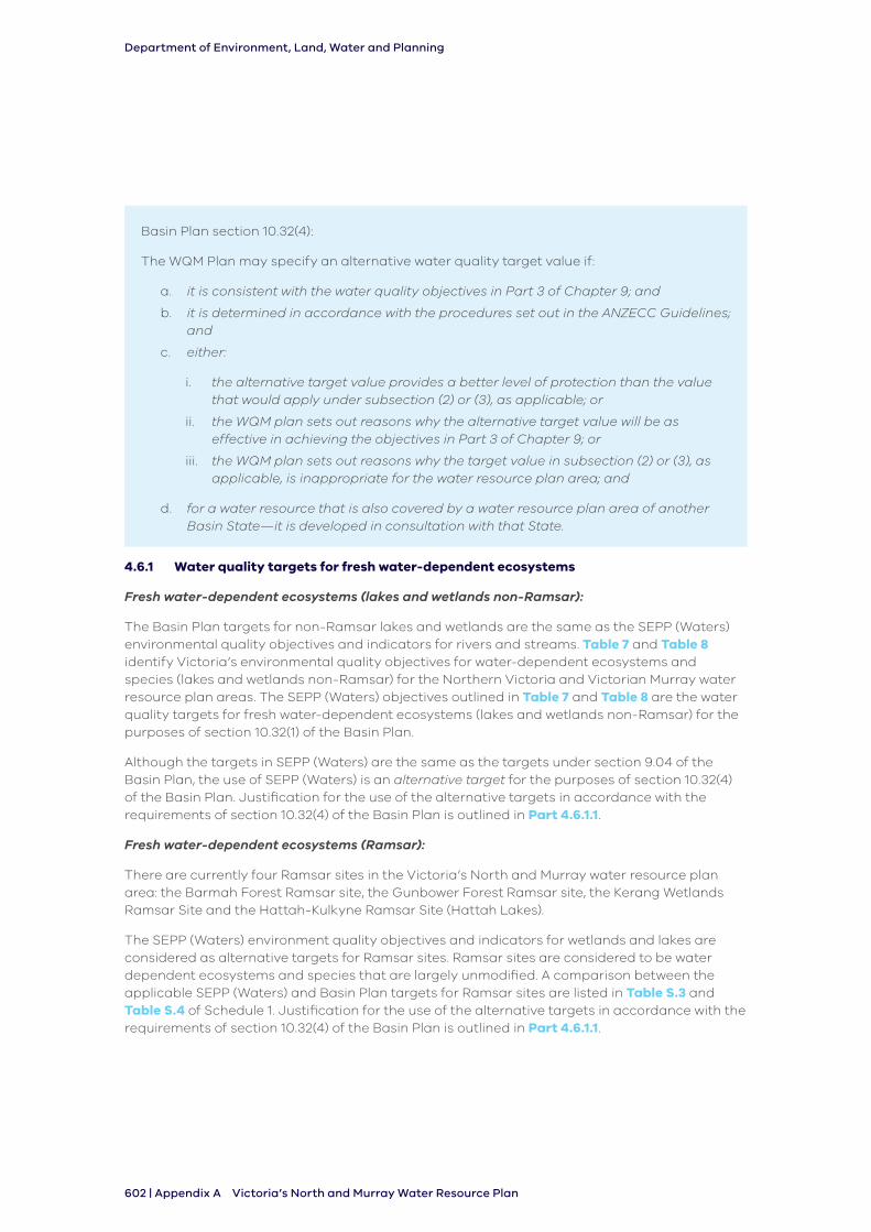
Department of Environment, Land, Water and Planning
602 | Appendix A Victoria’s North and Murray Water Resource Plan
Basin Plan section 10.32(4):
The WQM Plan may specify an alternative water quality target value if:
a. it is consistent with the water quality objectives in Part 3 of Chapter 9; and
b. it is determined in accordance with the procedures set out in the ANZECC Guidelines; and
c. either:
i. the alternative target value provides a better level of protection than the value that would apply under subsection (2) or (3), as applicable; or
ii. the WQM plan sets out reasons why the alternative target value will be as effective in achieving the objectives in Part 3 of Chapter 9; or
iii. the WQM plan sets out reasons why the target value in subsection (2) or (3), as applicable, is inappropriate for the water resource plan area; and
d. for a water resource that is also covered by a water resource plan area of another Basin State—it is developed in consultation with that State.
4.6.1 Water quality targets for fresh water-dependent ecosystems
Fresh water-dependent ecosystems (lakes and wetlands non-Ramsar):
The Basin Plan targets for non-Ramsar lakes and wetlands are the same as the SEPP (Waters) environmental quality objectives and indicators for rivers and streams. Table 7 and Table 8 identify Victoria’s environmental quality objectives for water-dependent ecosystems and species (lakes and wetlands non-Ramsar) for the Northern Victoria and Victorian Murray water resource plan areas. The SEPP (Waters) objectives outlined in Table 7 and Table 8 are the water quality targets for fresh water-dependent ecosystems (lakes and wetlands non-Ramsar) for the purposes of section 10.32(1) of the Basin Plan.
Although the targets in SEPP (Waters) are the same as the targets under section 9.04 of the Basin Plan, the use of SEPP (Waters) is an alternative target for the purposes of section 10.32(4) of the Basin Plan. Justification for the use of the alternative targets in accordance with the requirements of section 10.32(4) of the Basin Plan is outlined in Part 4.6.1.1.
Fresh water-dependent ecosystems (Ramsar):
There are currently four Ramsar sites in the Victoria’s North and Murray water resource plan area: the Barmah Forest Ramsar site, the Gunbower Forest Ramsar site, the Kerang Wetlands Ramsar Site and the Hattah-Kulkyne Ramsar Site (Hattah Lakes).
The SEPP (Waters) environment quality objectives and indicators for wetlands and lakes are considered as alternative targets for Ramsar sites. Ramsar sites are considered to be water dependent ecosystems and species that are largely unmodified. A comparison between the applicable SEPP (Waters) and Basin Plan targets for Ramsar sites are listed in Table S.3 and Table S.4 of Schedule 1. Justification for the use of the alternative targets in accordance with the requirements of section 10.32(4) of the Basin Plan is outlined in Part 4.6.1.1.
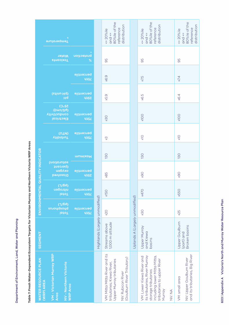
De
pa
rtm
en
t o
f E
nvi
ron
me
nt,
La
nd
, Wa
ter
an
d P
lan
nin
g
60
3 |
Ap
pe
nd
ix A
Vic
tori
a’s
No
rth
an
d M
urr
ay
Wa
ter
Re
sou
rce
Pla
n
Tab
le 7
: Fre
sh W
ate
r-D
epen
den
t E
cosy
stem
Ta
rget
s fo
r V
icto
ria
n M
urr
ay
an
d N
ort
her
n V
icto
ria
WR
P A
rea
s
WA
TE
R R
ES
OU
RC
E P
LA
N
(WR
P)
AR
EA
VM
- V
icto
ria
n M
urr
ay
WR
P
Are
a
NV
- N
ort
her
n V
icto
ria
W
RP
Are
a
SE
GM
EN
TE
NV
IRO
NM
EN
TAL
QU
AL
ITY
IND
ICA
TO
R
Total phosphorus (µg/L)
Total nitrogen (µg/L)
Dissolved oxygen (percent saturation)
Turbidity (NTU)
Electrical conductivity (µS/cm@ 25°C)
pH (pH units)
Toxicants Water
Temperature b
75th percentile
75th percentile
25th percentile
Maximum
75th percentile
75th percentile
25th percentile
75th percentile
% protection a
Hig
hla
nd
s (L
arg
ely
un
mo
difi
ed
)
VM
: Mit
ta M
itta
Riv
er
an
d it
s tr
ibu
tari
es;
Kie
wa
Riv
er,
Up
pe
r M
urr
ay
trib
uta
rie
s
NV
: Ru
bic
on
Riv
er
(Go
ulb
urn
Riv
er
Trib
uta
ry)
Str
ea
ms
ab
ove
1,0
00
m a
ltit
ud
e≤2
0≤1
50≥8
513
0≤3
≤30
≥5.9
≤6.9
95
<= 2
0%
ile
an
d <
=
80
%ile
of
the
re
fere
nce
d
istr
ibu
tio
n
Up
lan
ds
A (
La
rge
ly u
nm
od
ifie
d)
VM
: Lo
we
r K
iew
a R
ive
r a
nd
it
s tr
ibu
tari
es,
Riv
er
Mu
rra
y st
ora
ge
tri
bu
tari
es
incl
ud
ing
low
er
Mit
ta M
itta
, tr
ibu
tari
es
to u
pp
er
Riv
er
Mu
rra
y
NV
: NA
Up
pe
r M
urr
ay
an
d K
iew
a
ba
sin
s
≤30
≤470
≥90
13
0≤1
0≤1
00
≥6.5
≤7.5
95
<= 2
0%
ile
an
d <
=
80
%ile
of
the
re
fere
nce
d
istr
ibu
tio
n
VM
: sm
all
are
a
NV
: Up
pe
r G
ou
lbu
rn R
ive
r a
nd
its
trib
uta
rie
s, B
ig R
ive
r
Up
pe
r G
ou
lbu
rn
(pa
rt)
an
d
Bro
ken
ba
sin
s
≤25
≤550
≥90
13
0≤1
0≤1
00
≥6.4
≤7.4
95
<= 2
0%
ile
an
d <
=
80
%ile
of
the
re
fere
nce
d
istr
ibu
tio
n
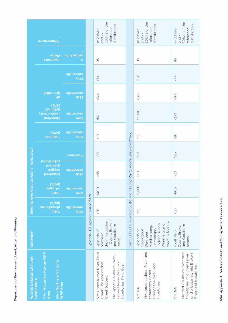
De
pa
rtm
en
t o
f E
nvi
ron
me
nt,
La
nd
, Wa
ter
an
d P
lan
nin
g
60
4 |
Ap
pe
nd
ix A
Vic
tori
a’s
No
rth
an
d M
urr
ay
Wa
ter
Re
sou
rce
Pla
n
WA
TE
R R
ES
OU
RC
E P
LA
N
(WR
P)
AR
EA
VM
- V
icto
ria
n M
urr
ay
WR
P
Are
a
NV
- N
ort
her
n V
icto
ria
W
RP
Are
a
SE
GM
EN
TE
NV
IRO
NM
EN
TAL
QU
AL
ITY
IND
ICA
TO
R
Total phosphorus (µg/L)
Total nitrogen (µg/L)
Dissolved oxygen (percent saturation)
Turbidity (NTU)
Electrical conductivity (µS/cm@ 25°C)
pH (pH units)
Toxicants Water
Temperature b
75th percentile
75th percentile
25th percentile
Maximum
75th percentile
75th percentile
25th percentile
75th percentile
% protection a
Up
lan
ds
B (
La
rge
ly u
nm
od
ifie
d)
VM
: Up
pe
r K
iew
a R
ive
r, B
ack
C
ree
k, Y
ack
an
da
nd
ah
C
ree
k (u
pp
er)
NV
: Up
pe
r G
ou
lbu
rn R
ive
r, u
pp
er
Ove
ns
Riv
er
an
d
trib
uta
rie
s, K
ing
Riv
er
Up
lan
ds
of
no
rth
ern
d
rain
ing
ba
sin
s –
Ove
ns,
Bro
ken
a
nd
Go
ulb
urn
(p
art
)
≤25
≤40
0≥8
5 13
0≤1
0≤5
0≥6
.4≤7
.49
5<=
20
%ile
a
nd
<=
8
0%
ile o
f th
e
refe
ren
ce
dis
trib
uti
on
Ce
ntr
al F
oo
thill
s a
nd
Co
ast
al P
lain
s (S
ligh
tly
to m
od
era
tely
mo
difi
ed
)
VM
: NA
NV
: up
pe
r L
od
do
n R
ive
r a
nd
tr
ibu
tari
es,
up
pe
r C
am
pa
spe
Riv
er
an
d
trib
uta
rie
s
Up
lan
ds
of
Mo
ora
bo
ol,
We
rrib
ee,
M
ari
byr
no
ng
, C
am
pa
spe,
L
od
do
n A
voca
, W
imm
era
an
d
Ho
pki
ns
ba
sin
s.
≤55
≤1,0
50≥7
013
0≤1
5≤2
,00
0≥6
.8≤8
.09
5<=
20
%ile
a
nd
<=
8
0%
ile o
f th
e
refe
ren
ce
dis
trib
uti
on
VM
: NA
NV
: mid
Go
ulb
urn
Riv
er
an
d
trib
uta
rie
s, m
id O
ven
s ri
ver
an
d t
rib
uta
rie
s, m
id B
roke
n
Riv
er
an
d t
rib
uta
rie
s
Foo
thill
s o
f O
ven
s, B
roke
n
an
d G
ou
lbu
rn
ba
sin
s
≤50
≤80
0≥7
013
0≤2
0≤2
50≥6
.4≤7
.49
5<=
20
%ile
a
nd
<=
8
0%
ile o
f th
e
refe
ren
ce
dis
trib
uti
on
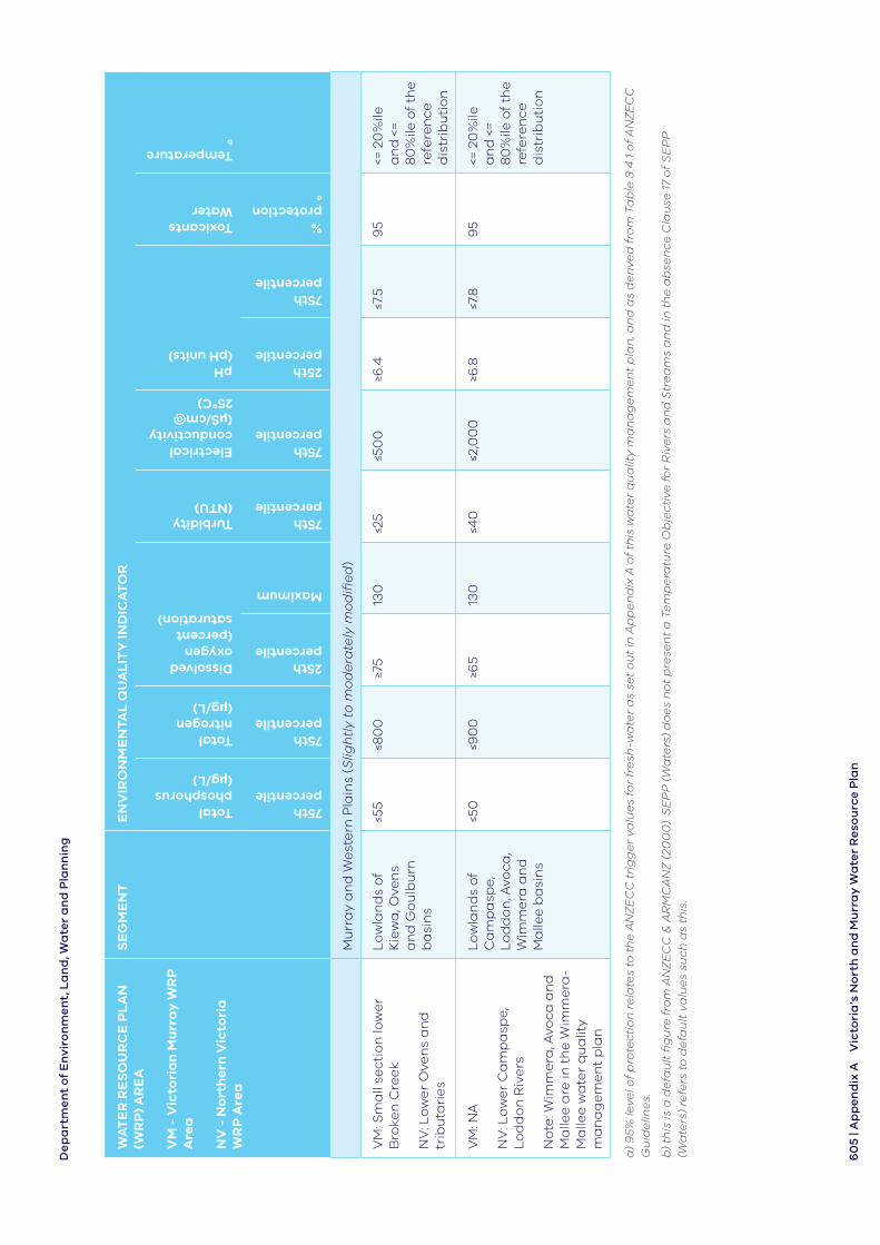
De
pa
rtm
en
t o
f E
nvi
ron
me
nt,
La
nd
, Wa
ter
an
d P
lan
nin
g
60
5 | A
pp
en
dix
AV
icto
ria
’s N
ort
h a
nd
Mu
rra
y W
ate
r R
eso
urc
e P
lan
WA
TE
R R
ES
OU
RC
E P
LA
N
(WR
P)
AR
EA
VM
- V
icto
ria
n M
urr
ay
WR
P
Are
a
NV
- N
ort
her
n V
icto
ria
W
RP
Are
a
SE
GM
EN
TE
NV
IRO
NM
EN
TAL
QU
AL
ITY
IND
ICA
TO
R
Total phosphorus (µg/L)
Total nitrogen (µg/L)
Dissolved oxygen (percent saturation)
Turbidity (NTU)
Electrical conductivity (µS/cm@ 25°C)
pH (pH units)
Toxicants Water
Temperature b
75th percentile
75th percentile
25th percentile
Maximum
75th percentile
75th percentile
25th percentile
75th percentile
% protection a
Mu
rra
y a
nd
We
ste
rn P
lain
s (S
ligh
tly
to m
od
era
tely
mo
difi
ed
)
VM
: Sm
all
sect
ion
low
er
Bro
ken
Cre
ek
NV
: Lo
we
r O
ven
s a
nd
tr
ibu
tari
es
Lo
wla
nd
s o
f K
iew
a, O
ven
s a
nd
Go
ulb
urn
b
asi
ns
≤55
≤80
0≥7
513
0≤2
5≤5
00
≥6.4
≤7.5
95
<= 2
0%
ile
an
d <
=
80
%ile
of
the
re
fere
nce
d
istr
ibu
tio
n
VM
: NA
NV
: Lo
we
r C
am
pa
spe,
L
od
do
n R
ive
rs
No
te: W
imm
era
, Avo
ca a
nd
M
alle
e a
re in
th
e W
imm
era
-M
alle
e w
ate
r q
ua
lity
ma
na
ge
me
nt
pla
n
Lo
wla
nd
s o
f C
am
pa
spe,
L
od
do
n, A
voca
, W
imm
era
an
d
Ma
llee
ba
sin
s
≤50
≤90
0≥6
513
0≤4
0≤2
,00
0≥6
.8≤7
.89
5<=
20
%ile
a
nd
<=
8
0%
ile o
f th
e
refe
ren
ce
dis
trib
uti
on
a)
95%
leve
l of
pro
tec
tio
n r
ela
tes
to t
he
AN
ZE
CC
tri
gg
er
valu
es
for
fre
sh-w
ate
r a
s se
t o
ut
in A
pp
en
dix
A o
f th
is w
ate
r q
ua
lity
ma
na
ge
me
nt
pla
n, a
nd
as
de
rive
d f
rom
Ta
ble
3.4
.1 o
f A
NZ
EC
C
Gu
ide
line
s.
b)
this
is a
de
fau
lt fi
gu
re f
rom
AN
ZE
CC
& A
RM
CA
NZ
(20
00
). S
EP
P (
Wa
ters
) d
oe
s n
ot
pre
sen
t a
Te
mp
era
ture
Ob
jec
tive
fo
r R
ive
rs a
nd
Str
ea
ms
an
d in
th
e a
bse
nc
e C
lau
se 1
7 o
f S
EP
P
(Wa
ters
) re
fers
to
de
fau
lt v
alu
es
suc
h a
s th
is.
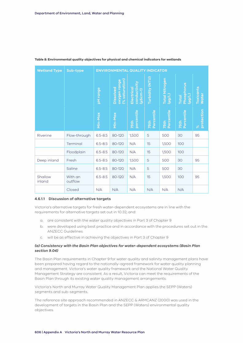
Department of Environment, Land, Water and Planning
606 | Appendix A Victoria’s North and Murray Water Resource Plan
Table 8: Environmental quality objectives for physical and chemical indicators for wetlands
Wetland Type Sub-type ENVIRONMENTAL QUALITY INDICATOR
pH
ra
ng
e
Dis
solv
ed
o
xyg
en r
an
ge
(%
sa
tura
tio
n)
Ele
ctr
ica
l co
nd
uc
tivi
ty
(µS
cm-1
)
Turb
idit
y (
NT
U)
Tota
l Nit
rog
en
(µg
/L)
Tota
l P
ho
sph
oru
s (µ
g/L
)
Tox
ica
nts
W
ate
r
Min
-Ma
x
Min
-Ma
x
75th
p
erce
nti
le
75th
P
erce
nti
le
75th
P
erce
nti
le
75th
P
erce
nti
le
%
pro
tec
tio
n
Riverine Flow-through 6.5-8.5 80-120 1,500 5 500 30 95
Terminal 6.5-8.5 80-120 N/A 15 1,500 100
Floodplain 6.5-8.5 80-120 N/A 15 1,500 100
Deep inland Fresh 6.5-8.5 80-120 1,500 5 500 30 95
Saline 6.5-8.5 80-120 N/A 5 500 30
Shallow inland
With an outflow
6.5-8.5 80-120 N/A 15 1,500 100 95
Closed N/A N/A N/A N/A N/A N/A
4.6.1.1 Discussion of alternative targets
Victoria’s alternative targets for fresh water-dependent ecosystems are in line with the requirements for alternative targets set out in 10.32, and:
a. are consistent with the water quality objectives in Part 3 of Chapter 9
b. were developed using best practice and in accordance with the procedures set out in the ANZECC Guidelines
c. will be as effective in achieving the objectives in Part 3 of Chapter 9
(a) Consistency with the Basin Plan objectives for water-dependent ecosystems (Basin Plan section 9.04)
The Basin Plan requirements in Chapter 9 for water quality and salinity management plans have been prepared having regard to the nationally-agreed framework for water quality planning and management. Victoria’s water quality framework and the National Water Quality Management Strategy are consistent. As a result, Victoria can meet the requirements of the Basin Plan through its existing water quality management arrangements.
Victoria’s North and Murray Water Quality Management Plan applies the SEPP (Waters) segments and sub-segments.
The reference site approach recommended in ANZECC & ARMCANZ (2000) was used in the development of targets in the Basin Plan and the SEPP (Waters) environmental quality objectives.
Department of Environment, Land, Water and Planning
Appendix A | 607Victoria’s North and Murray Water Resource Plan
The advantages of using SEPP (Waters) environmental quality objectives are:
• they are based on larger and more up-to-date water quality and biological data sets
• with more data available, SEPP (Waters) environmental quality objectives used more reference site data sets and relied less heavily on expert opinion for objective setting
• SEPP (Waters) used greater acknowledgement of the importance of levels of ecosystem modification within the environmental quality objective setting process, resulting in less stringent (i.e. more realistic) environmental quality objectives for more modified ecosystems
• the Basin Plan assessment method uses the median of the assessment data rather than the 75th percentile used by SEPP (Waters), resulting in a less stringent outcome than for SEPP (Waters). That is, under the Basin Plan targets, sites only needed to meet the target half the time, instead of three-quarters of the time as required by SEPP (Waters)
The recent assessment of SEPP (Waters) environmental quality objectives with the Basin Plan targets found that across the Murray-Darling Basin catchments in Victoria, the proportion of the time the Basin Plan targets have been met is slightly greater than the SEPP (Waters) environmental quality objectives (less than 10 percent difference) except for pH where the differences were greater than 30 percent. The SEPP (Waters) objectives, therefore, are generally slightly more stringent than the Basin Plan targets. It is important to note that greater stringency does not necessarily equate to `better protection’. Through provision of more realistic targets, the lower stringency identified for the third dot point, above, is likely to enhance uptake of the alternative targets, supporting a system of regulation and management that improves water quality in a substantially modified region.
Water-dependent ecosystems (lakes and wetlands non-Ramsar):
Using the indicator and objective values of water-dependent ecosystems and species and segments from SEPP (Waters), as distinct from the Basin Plan targets for fresh water-dependent ecosystems, means the environmental quality objectives are more relevant to the local Victorian conditions.
The application of each target value to the Northern Victoria water resource plan area and the Victorian Murray water resource plan area are provided in column 1 of Table 7.
These targets will not only provide a more targeted level of protection than the Basin Plan water quality targets, they also provide effective management because they integrate seamlessly into Victoria’s current water quality management framework.
These targets are therefore consistent with the Basin Plan objectives for water-dependent ecosystems which seek that water quality is sufficient to maintain, protect and restore ecosystems.
Table S.1 and Table S.2 of Schedule 1 of this Appendix provides a comparison of values between the Basin Plan targets and Victoria’s alternative targets for water-dependent ecosystems (lakes and wetlands non-Ramsar) presented in this plan. The small levels of variance in values are likely to be because of Victoria’s use of extensive local data sets and the updated data available since the Basin Plan targets were developed before 2012.
The SEPP (Waters) objectives for lakes and wetlands are based on detailed studies of Victorian lakes and wetlands (EPA 2010), following the ANZECC & ARMCANZ (2000) approach. The SEPP (Waters) environmental quality objectives are based on lake types, not geographic location (EPA 2010). Therefore, the Basin Plan targets and the SEPP (Waters) objectives cannot be directly compared, as the SEPP (Waters) environmental quality objectives cannot be assigned to any individual target application zone (TAZ) (i.e. all lake types potentially apply to each TAZ). A comparison of the SEPP (Waters) geographic boundaries and the Basin Plan target application zones is provided in Section S.2 of Schedule 1 to this Appendix.
Department of Environment, Land, Water and Planning
608 | Appendix A Victoria’s North and Murray Water Resource Plan
Water-dependent ecosystems (Ramsar):
Table S.3 and Table S.4 of Schedule 1 to this Appendix provides a comparison of values between the Basin Plan targets and Victoria’s alternative targets for water-dependent ecosystems (Ramsar) presented in this plan. Under SEPP (Waters) Ramsar wetlands are categorised as
l̀argely unmodified’ which is the most stringent set of targets. The l̀argely unmodified’ targets allow for the water quality to be protected to a level that will maintain the ecological character of the Ramsar sites.
The Ecological Character Description is a fundamental management tool for site managers, forming the basis of management planning and action as well as including guidance on site monitoring requirements to detect changes in the ecological character of the site.
Ecological Character Descriptions for the Barmah Forest Ramsar site and the Gunbower Forest Ramsar site do not provide water quality targets (Hale and Butcher 2011a, b).
The Kerang Wetlands Ramsar site has Limits of Acceptable Change provided for salinity concentration (as measured by electrical conductivity) in many wetlands at the site. Salinity concentration is assessed as a critical component, a high priority risk and the greatest threat to fish species in the Kerang region (Kellogg, Brown & Root Pty Ltd 2011). However, the Limits of Acceptable Change are all based on electrical conductivities at or above 4000 µS/cm. Ramsar sites’ listing criteria and Limits of Acceptable Change are generally based on presence of biological populations and communities, in particular threatened water-dependent species and communities; water quality is not always an issue compared to water quantity and habitat availability and quality.
Therefore, although Limits of Acceptable Change specifying water quality requirements for individual wetlands could be considered as alternative targets within a Ramsar site, they are rarely provided in the Ramsar process, limited in number and are typically applicable to a single water body. This greatly restricts their applicability for regional application.
The Basin Plan has separate targets for Ramsar wetlands as set out in Schedule 11 of the Basin Plan (see Table S.3 and Table S.4 in Schedule 1 of this Appendix). Although SEPP (Waters) has no environmental quality objectives for Ramsar sites, the SEPP (Waters) environmental quality objectives for l̀akes and wetlands’ are specifically derived for the protection of lakes and wetland types identified in Victoria and therefore are likely to be more representative of these ecosystems in Victoria, despite not being aimed at any specific Ramsar plan requirement. This includes the species protection levels for toxicants which incorporates a recent decision by EPA Victoria’s external Scientific Advisory Panel that 95 percent species protection was more appropriate than 99 percent for Victoria (EPA unpublished, released May 2017). The SEPP (Waters) Scientific Advisory Panel agreed that 99 percent protection was too stringent in Victoria and the 95 percent was more appropriate.
Therefore, the use of the SEPP (Waters) lakes and wetlands environmental quality objectives for the protection of ecosystems would represent an improvement over the use of the default Basin Plan Ramsar wetland targets. It is recommended that the SEPP (Waters) environmental quality objectives are applied to these Ramsar sites.
(b) Developed using best practice and in accordance with the procedures set out in the ANZECC Guidelines
In October 2018 Victoria gazetted the State Environment Protection Policy (Waters). The review process involved considerable scientific analysis of water quality data and stakeholder consultation to revise the environmental quality objectives.
Victoria’s alternative values are developed using best practice and in line with the ANZECC Guidelines. SEPP (Waters) is consistent with the National Water Quality Management Strategy
Department of Environment, Land, Water and Planning
Appendix A | 609Victoria’s North and Murray Water Resource Plan
charter, policies and procedures, in particular the approach of the Australian and New Zealand Guidelines for Fresh and Marine Quality (ANZECC Guidelines).
Victoria’s alternative values (environmental quality objectives) for fresh water-dependent ecosystems are based on best practice for setting environmental values. They present values that indicate where a direct toxic effect or adverse effect on environmental values may occur, as a trigger for further investigation, while recognising community values and feasibility for waterway protection. They are drawn from SEPP (Waters) and are therefore consistent with the water quality management framework in the state, reinforcing their role for water quality protection.
SEPP (Waters) targets provide a value that indicates where a direct toxic effect, or adverse effect on environmental values may occur or has occurred, and therefore they act as a `trigger’ to prompt a management response, such as further investigation.
At the same time as these values are in line with the ANZECC Guidelines’ recognition of three levels of protection for aquatic ecosystems, based on the condition of the ecosystem, the SEPP (Waters) values are based on three levels of protection of largely unmodified, slightly to moderately unmodified and highly modified water environments for surface waters. By recognising the condition of the ecosystems in this way, the values presented are feasible and in line with community values for protection.
SEPP (Waters) draws on local water quality data from 1990-2013 and were used to derive these environmental quality objectives.
The process outlined in the ANZECC Guidelines involves identifying the most appropriate indicator relevant to the environmental threat. Reference sites were used to derive local values for indicators. Reference sites are those that were considered to be near natural or minimally- disturbed versions of that environment, such as where there are no intensive agriculture, mining or wastewater discharges. Water quality data from as many reference sites as practicable was then used to derive the local values for these indicators.
Further information on the process for developing Victoria’s SEPP (Waters) values which are drawn on here is available in the Environment Protection Authority (2018) Publication 1688: Development of environmental quality indicators and objectives for the SEPP (Waters). https://www.epa.vic.gov.au/~/media/Publications/1688.pdf
(c) Values will be as effective, as Basin Plan targets, in achieving the Basin Plan objectives for water-dependent ecosystems (Basin Plan section 9.04)
Victoria’s alternative targets will be as effective as the Basin Plan targets in achieving the Basin Plan objectives for water-dependent ecosystems because they:
• have been developed using extensive local data in their development
• take into consideration the level of protection relevant to their condition and use
• are in line with Victoria’s water quality management framework and policies
The alternative values more accurately represent condition, and through alignment with state policy will enable policies and management responses that will achieve water quality outcomes.
As the targets are consistent with the water quality objectives (see discussion in part (a) above) they are therefore as effective in achieving the objectives for water-dependent ecosystems.
4.6.2 Water quality target for irrigation water
Victoria’s water quality target for irrigation water for the Northern Victorian water resource plan area and the Victorian Murray water resource plan area is:
Department of Environment, Land, Water and Planning
610 | Appendix A Victoria’s North and Murray Water Resource Plan
That the quality of water distributed by Rural Water Corporations for the primary purpose of irrigation is representative of the quality of source water which is managed for quality through intergovernmental agreements, and Victoria’s water quality management framework.
The sites for which this target applies are the sites at which water is extracted by an irrigation infrastructure operator for the purpose of irrigation. In the Northern Victoria water resource plan area and the Victorian Murray water resource plan area these are described in Table 9.
4.6.2.1 Discussion of alternative target
(a) Consistency with the Basin Plan objectives for irrigation water
For full details on Victoria’s water quality management framework and how it is consistent with the Basin Plan objectives see Figure 2. This target is an alternative to the Basin Plan target and recognises Victoria’s commitment to water quality protection for irrigation through protection of source water quality in both the shared waters of the River Murray and in Victorian waterways through the state’s water quality management framework. Specifically, the water quality protection is achieved through Victoria’s requirements under SEPP (Waters) as explained in Part 4.6.1.1 above and adherence to salinity targets through the Basin Salinity Management 2030 Strategy (see Part 4.6.4). The Basin Plan’s objective for irrigation waters is that the quality of surface water, when used in accordance with the best irrigation and crop management practices and principles of ecologically sustainable development, does not result in crop yield loss or soil degradation. This objective acknowledges the integration between water quality and irrigation and crop management practices in determining whether there will be an impact on crop yield and soil sustainability. That is, the quality of the water cannot be separated from how the water is used, and how crops are managed, when determining its suitability for irrigation. The Basin Plan provides a descriptive target for sodium adsorption ratio for irrigation waters which is the value which, if exceeded, would cause soil degradation when that water is applied to land.
Victoria’s alternative salinity water quality target for irrigation water is similarly descriptive. Recognising that appropriateness of different salinity levels of water used in irrigation is highly dependent on a range of individual factors – rather than having an absolute value.
(b) Developed using best practice and in accordance with the procedures set out in the ANZECC Guidelines
Victoria recognises that a single numerical figure to protect all irrigation in multiple districts is not an approach recognised by the ANZECC guidelines, nor are indicators and environmental quality objectives for irrigation included in Victoria’s SEPP (Waters). For example, the National Water Quality Management Strategy Implementation Guide (ANZECC 1998) notes that the effects of salinity are site specific, and salinity targets for irrigation cannot be generalised for different locations across the Basin. There are many factors relevant to whether water of a particular quality is suitable for irrigation, including business factors such as crop selection, irrigation method,soil type and soil properties, including sodium adsorption rates. At the same time Victoria’s statewide water quality management framework, and participation in interjurisdictional agreements ensures efforts are made to protect the water quality in source rivers as possible. As SEPP (Waters) was developed using best practice and in accordance with the procedures set out in the ANZECC guidelines, this target is also considered to be developed in the same way and the discussion provided in section 4.6.1.1 applies here.
(c) Values will be as effective, as Basin Plan targets, in achieving the Basin Plan objectives for irrigation water
Rather than stating what quality of water in a waterway is suitable for irrigation, Victoria’s water quality target encourages the need for crop selection and irrigation practices to consider the quality of the available water, and likely quality of that water in changing conditions. Therefore,
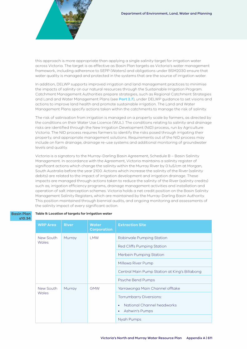
Department of Environment, Land, Water and Planning
Appendix A | 611Victoria’s North and Murray Water Resource Plan
this approach is more appropriate than applying a single salinity target for irrigation water across Victoria. The target is as effective as Basin Plan targets as Victoria’s water management framework, including adherence to SEPP (Waters) and obligations under BSM2030 ensure that water quality is managed and protected in the systems that are the source of irrigation water.
In addition, DELWP supports improved irrigation and land management practices to minimise the impacts of salinity on our natural resources through the Sustainable Irrigation Program. Catchment Management Authorities prepare strategies, such as Regional Catchment Strategies and Land and Water Management Plans (see Part 2.7), under DELWP guidance to set visions and actions to improve land health and promote sustainable irrigation. The Land and Water Management Plans specify actions taken within the catchments to manage the risk of salinity.
The risk of salinisation from irrigation is managed on a property scale by farmers, as directed by the conditions on their Water Use Licence (WUL). The conditions relating to salinity and drainage risks are identified through the New Irrigation Development (NID) process, run by Agriculture Victoria. The NID process requires farmers to identify the risks posed through irrigating their property, and appropriate management solutions. Requirements out of the NID process may include on farm drainage, drainage re-use systems and additional monitoring of groundwater levels and quality.
Victoria is a signatory to the Murray-Darling Basin Agreement, Schedule B – Basin Salinity Management. In accordance with the Agreement, Victoria maintains a salinity register of significant actions which change the salinity within the Murray River by 0.1uS/cm at Morgan, South Australia before the year 2100. Actions which increase the salinity of the River (salinity debits) are related to the impact of irrigation development and irrigation drainage. These impacts are managed through actions taken to reduce the salinity of the River (salinity credits) such as; irrigation efficiency programs, drainage management activities and installation and operation of salt interception schemes. Victoria holds a net credit position on the Basin Salinity Management Salinity Registers, which are maintained by the Murray-Darling Basin Authority. This position maintained through biennial audits, and ongoing monitoring and assessments of the salinity impact of every significant action.
Table 9: Location of targets for irrigation water
WRP Area River Water Corporation
Extraction Site
New South Wales
Murray LMW Robinvale Pumping Station
Red Cliffs Pumping Station
Merbein Pumping Station
Millewa River Pump
Central Main Pump Station at King’s Billabong
Psyche Bend Pumps
New South Wales
Murray GMW Yarrawonga Main Channel offtake
Torrumbarry Diversions:
• National Channel headworks
• Ashwin’s Pumps
Nyah Pumps
Basin Plan s10.34
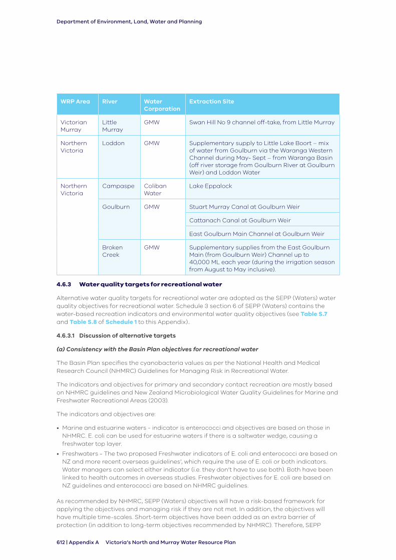
Department of Environment, Land, Water and Planning
612 | Appendix A Victoria’s North and Murray Water Resource Plan
WRP Area River Water Corporation
Extraction Site
Victorian Murray
Little Murray
GMW Swan Hill No 9 channel off-take, from Little Murray
Northern Victoria
Loddon GMW Supplementary supply to Little Lake Boort – mix of water from Goulburn via the Waranga Western Channel during May- Sept – from Waranga Basin (off river storage from Goulburn River at Goulburn Weir) and Loddon Water
Northern Victoria
Campaspe Coliban Water
Lake Eppalock
Goulburn GMW Stuart Murray Canal at Goulburn Weir
Cattanach Canal at Goulburn Weir
East Goulburn Main Channel at Goulburn Weir
Broken Creek
GMW Supplementary supplies from the East Goulburn Main (from Goulburn Weir) Channel up to 40,000 ML each year (during the irrigation season from August to May inclusive).
4.6.3 Water quality targets for recreational water
Alternative water quality targets for recreational water are adopted as the SEPP (Waters) water quality objectives for recreational water. Schedule 3 section 6 of SEPP (Waters) contains the water-based recreation indicators and environmental water quality objectives (see Table S.7 and Table S.8 of Schedule 1 to this Appendix)..
4.6.3.1 Discussion of alternative targets
(a) Consistency with the Basin Plan objectives for recreational water
The Basin Plan specifies the cyanobacteria values as per the National Health and Medical Research Council (NHMRC) Guidelines for Managing Risk in Recreational Water.
The Indicators and objectives for primary and secondary contact recreation are mostly based on NHMRC guidelines and New Zealand Microbiological Water Quality Guidelines for Marine and Freshwater Recreational Areas (2003).
The indicators and objectives are:
• Marine and estuarine waters - indicator is enterococci and objectives are based on those in NHMRC. E. coli can be used for estuarine waters if there is a saltwater wedge, causing a freshwater top layer.
• Freshwaters - The two proposed Freshwater indicators of E. coli and enterococci are based on NZ and more recent overseas guidelines’, which require the use of E. coli or both indicators. Water managers can select either indicator (i.e. they don’t have to use both). Both have been linked to health outcomes in overseas studies. Freshwater objectives for E. coli are based on NZ guidelines and enterococci are based on NHMRC guidelines.
As recommended by NHMRC, SEPP (Waters) objectives will have a risk-based framework for applying the objectives and managing risk if they are not met. In addition, the objectives will have multiple time-scales. Short-term objectives have been added as an extra barrier of protection (in addition to long-term objectives recommended by NHMRC). Therefore, SEPP
Department of Environment, Land, Water and Planning
Appendix A | 613Victoria’s North and Murray Water Resource Plan
(Waters) objectives are consistent with the water quality objectives in Part 3 of Chapter 9 of the Basin Plan, because when implemented they achieve a low risk to human health.
(b) Developed in accordance with the procedures set out in the ANZECC Guidelines
The ANZECC guidelines allow States to adopt their own values by taking into account factors such as the variability of the particular ecosystem or environment, rainfall and local water quality data. Victoria did this in accordance with the procedures in the ANZECC guidance. For recreational water, the NHMRC guidelines are directly linked to preventing human health impacts and as such were also used to develop the primary and secondary contact recreation objectives for Victorian waters.
SEPP (Waters) includes indicators and objectives for primary and secondary contact recreation that are mostly based on the NHMRC guidelines.
• E. coli or enterococci can be used for freshwaters. Water managers can select either indicator but are recommended to use E. coli if they have been doing this previously, to maintain a historical dataset.
As the NHMRC guidelines do not provide objective values for E.coli, values from the New Zealand Government Microbiological Water Quality Guidelines for Marine and Freshwater Recreational Areas 14 were used for SEPP (Waters).
(c) Values will be as effective, as Basin Plan targets, in achieving the Basin Plan objectives for water-dependent ecosystems (Basin Plan section 9.04)
SEPP (Waters) also includes objectives for secondary contact recreation, which are not provided for in the NHMRC guidelines. SEPP (Waters), were largely based on the NHMRC guidelines, departed from these guidelines in some aspects. To provide confidence about this, three international experts were invited to peer review the work done to develop the draft SEPP (Waters).
These experts were Graham McBride from the National Institute of Water and Atmosphere Research in New Zealand, Timothy Wade from the US Environmental Protection Authority and Professor Charles Gerba from the University of Arizona. The reviewers’ feedback supported the Victorian EPA’s work and the reviewers considered it was sound in substance, rational and scientifically defensible.
The Basin Plan water quality targets for water used for recreational purposes are the values for cyanobacteria cell counts or biovolume in the Guidelines for Managing Risks in Recreational Water (Chapter 6 in NH&MRC 2008).
The water quality management plan will apply the SEPP (Waters) water quality objectives for recreational water, noting that these are based on a rigorous scientific review process.
4.6.4 End-of-valley salinity targets
There are six end-of-valley Basin salinity target sites in the Northern Victoria and Victorian Murray water resource plan areas used for long-term planning purposes, consistent with clause 10.33(2)(c) of the Basin Plan. These targets are not included in SEPP (Waters). The six end-of- valley targets are shown in Table 10.
Victoria reports annually on these targets. The most recent report, Victoria’s Annual Status Report 2015/16 Basin Salinity Management 2030, is available at https://www.water.vic.gov.au/murray-darling-basin/basin-salinity-management.
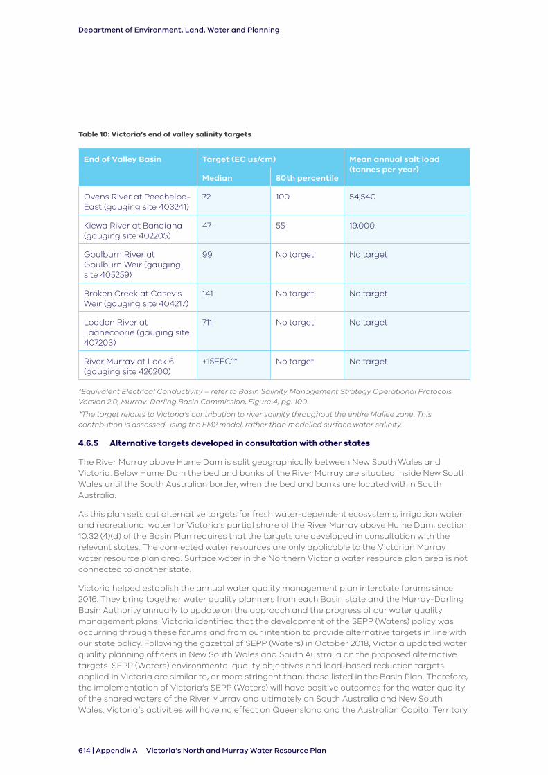
Department of Environment, Land, Water and Planning
614 | Appendix A Victoria’s North and Murray Water Resource Plan
Table 10: Victoria’s end of valley salinity targets
End of Valley Basin Target (EC us/cm) Mean annual salt load (tonnes per year)
Median 80th percentile
Ovens River at Peechelba-East (gauging site 403241)
72 100 54,540
Kiewa River at Bandiana (gauging site 402205)
47 55 19,000
Goulburn River at Goulburn Weir (gauging site 405259)
99 No target No target
Broken Creek at Casey’s Weir (gauging site 404217)
141 No target No target
Loddon River at Laanecoorie (gauging site 407203)
711 No target No target
River Murray at Lock 6 (gauging site 426200)
+15EEC^* No target No target
^Equivalent Electrical Conductivity – refer to Basin Salinity Management Strategy Operational Protocols Version 2.0, Murray-Darling Basin Commission, Figure 4, pg. 100.
*The target relates to Victoria’s contribution to river salinity throughout the entire Mallee zone. This contribution is assessed using the EM2 model, rather than modelled surface water salinity.
4.6.5 Alternative targets developed in consultation with other states
The River Murray above Hume Dam is split geographically between New South Wales and Victoria. Below Hume Dam the bed and banks of the River Murray are situated inside New South Wales until the South Australian border, when the bed and banks are located within South Australia.
As this plan sets out alternative targets for fresh water-dependent ecosystems, irrigation water and recreational water for Victoria’s partial share of the River Murray above Hume Dam, section 10.32 (4)(d) of the Basin Plan requires that the targets are developed in consultation with the relevant states. The connected water resources are only applicable to the Victorian Murray water resource plan area. Surface water in the Northern Victoria water resource plan area is not connected to another state.
Victoria helped establish the annual water quality management plan interstate forums since 2016. They bring together water quality planners from each Basin state and the Murray-Darling Basin Authority annually to update on the approach and the progress of our water quality management plans. Victoria identified that the development of the SEPP (Waters) policy was occurring through these forums and from our intention to provide alternative targets in line with our state policy. Following the gazettal of SEPP (Waters) in October 2018, Victoria updated water quality planning officers in New South Wales and South Australia on the proposed alternative targets. SEPP (Waters) environmental quality objectives and load-based reduction targets applied in Victoria are similar to, or more stringent than, those listed in the Basin Plan. Therefore, the implementation of Victoria’s SEPP (Waters) will have positive outcomes for the water quality of the shared waters of the River Murray and ultimately on South Australia and New South Wales. Victoria’s activities will have no effect on Queensland and the Australian Capital Territory.
Department of Environment, Land, Water and Planning
Appendix A | 615Victoria’s North and Murray Water Resource Plan
As well as direct engagement with water quality planning officers, Victoria participates in the Water Resource Planners Forum hosted by the MDBA.
Victoria’s water quality framework and the National Water Quality Management Strategy are consistent. The Basin Plan water quality and salinity management plan has been developed using this nationally-agreed framework for water quality planning and management. As a result, Victoria can meet the requirements of the Basin Plan through its existing water quality management arrangements.
Department of Environment, Land, Water and Planning
616 | Appendix A Victoria’s North and Murray Water Resource Plan
5. Groundwater – Goulburn-Murray water resource plan area
This section presents information about the groundwaters of the Goulburn-Murray water resource plan areas. It includes general information about the resources and their quality, risks to the condition of these resources, a statement on degradation, causes or likely causes of this degradation.
The groundwater resources in Victoria’s North and Murray water resource plan area are almost all contained within the Goulburn–Murray groundwater basin. The exception is in the thin strip that runs along the south bank of the River Murray from Swan Hill to the South Australian border. In Victoria groundwater basins are divided into groundwater catchments which contain groundwater management units (either water supply protection areas or groundwater management areas).
The hydrogeology of the region can be broadly subdivided into two distinct geological regions:
• southern highlands of bedrock with sedimentary valleys
• northern plains with layers of sedimentary aquifers with underlying bedrock
In the south the highlands feature exposed bedrock and eroded material that form the Quaternary Aquifer. This thin shallow aquifer is comprised of sand, colluvium, fluvial sands, gravels, clay and silts. It is found in upland valleys of the river systems. There are fractured basalts of the New Volcanics formation overlying both bedrock and upland sedimentary valleys in the Loddon, Coliban and Campaspe Rivers. Water is also held in the Mesozoic and Palaeozoic basement rock, which is comprised of sedimentary fractured rock. Basement rock is close to the surface or exposed along the Great Dividing Range forming the headwaters of all the rivers in the Victoria’s North and Murray Water Quality Management Plan and is increasingly buried deeper to the north and east. These water resources are generally low yielding.
In the north, the Goulburn–Murray sedimentary plain gradually thickens into several geological layers:
• the Upper Tertiary Quaternary Aquifer (UTQA) of the Shepparton formation is made of layered clay, sands and silt and covers much of the plain. Usable groundwater yield is generally found in shoe string sand of buried paleo-channels
• the Upper Tertiary Quaternary Aquifer overlies the Upper Tertiary Aquifer comprising Calivil formation, containing fluvial sand, gravel and clay and is a significant source for groundwater users
• the Lower Tertiary Aquifers of the Renmark formation underlies the Calivil in the deeper parts of the basin. They comprise sand, gravel, clay and silt and minor coal
• Cretaceous Permian sediments made of fractured rock, sand and minor coal
• Mesozoic and Palaeozoic basement rock, which comprises sedimentary fractured rock
Victorian groundwater management units are geographically based, while Basin Plan groundwater management units (SDL resource unit) are laterally based. Therefore, within each Victorian groundwater management unit there will be more than one Basin Plan SDL resource unit.
Department of Environment, Land, Water and Planning
Appendix A | 617Victoria’s North and Murray Water Resource Plan
The Basin Plan splits resources in the Goulburn-Murray water resource plan area into four SDL resource units, these are:
• Goulburn-Murray: Shepparton Irrigation Region (GS8a) - All groundwater in the Shepparton Irrigation Region Water Supply Protection Area to a depth of 25 metres below the land surface
• Goulburn-Murray: Highlands (GS8b) - All groundwater in the outcropping Palaeozoic rocks (or the in situ weathered horizon where it is within 5 metres of the surface) from the land surface to 200 metres below the surface
• Goulburn-Murray: Sedimentary Plain (GS8c) - All groundwater from the land surface to 200 metres below the surface or 50 metres below the base of the Tertiary sediments, whichever is the deeper, excluding groundwater in GS8a
• Goulburn-Murray: deep (GS8d) - All groundwater, excluding groundwater in items GS8a, GS8b and GS8c
Therefore, the Goulburn-Murray: Highlands (GS8b) SDL resource unit runs across all groundwater catchments, surface water SDL resource units and multiple groundwater management units. The Goulburn-Murray: Shepparton Irrigation Region SDL resource unit is the section of the sedimentary plain which is located under the GMID where due to the irrigation district groundwater is managed to promote usage to reduce the impact of rising water tables and salinity on land. The Goulburn-Murray: Highlands SDL resource unit is situated in the south of Goulburn-Murray water resource plan area and is recharged from rainfall into the fractured rock aquifers. The Goulburn-Murray: Sedimentary Plain SDL resource unit, includes (from oldest to most recent) the Renmark formation, the Calivil formation, the Shepparton Formation and Coonambidgal Formation aquifer. The most recent units overlie and confine the older deeper units, however, the depth and thickness of each formation also reflects the shape of the basin. For more information on the Goulburn-Murray water resource plan area see Section 2.3 of Chapter 2 and Section 4.4 of Chapter 4 of Victoria’s North and Murray Comprehensive Report.
5.1 Groundwater quality
Like surface water, good quality low salinity groundwater is generally found in the upland areas of the north east and ranges to the south. Water quality declines to the west and north (see Figure 5) especially in the shallow (water table) resources. Groundwater salinity in these areas is naturally very high where the water table is shallow, and evaporation is much higher than recharge. Saline groundwater may occur above and beside aquifers containing relatively much fresher groundwaters. The areas of elevated salinity are considered natural and do not reflect degradation of the resource. For example, in the Goulburn-Murray: Shepparton Irrigation Region SDL resource unit, elevated salinity has occurred due to rising water tables that has mobilised salt naturally stored in the soil profile. In other areas saline groundwater may occur where evaporation exceeds rainfall recharge; from seawater incorporated into sediments when the sea extended upstream along the Murray Basin as far as the Loddon River; or from dissolution of aquifer minerals.
Where saline groundwater is recognised, groundwater management areas and water supply protection areas consider the effects of naturally occurring high salt levels to land and usable groundwater and implement monitoring and actions if impacts to water quality are identified.
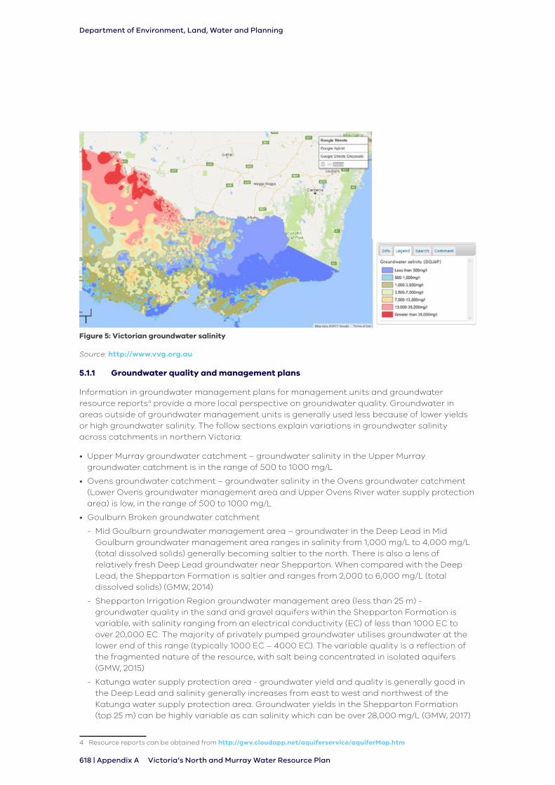
Department of Environment, Land, Water and Planning
618 | Appendix A Victoria’s North and Murray Water Resource Plan
Figure 5: Victorian groundwater salinity
Source: http://www.vvg.org.au
5.1.1 Groundwater quality and management plans
Information in groundwater management plans for management units and groundwater resource reports4 provide a more local perspective on groundwater quality. Groundwater in areas outside of groundwater management units is generally used less because of lower yields or high groundwater salinity. The follow sections explain variations in groundwater salinity across catchments in northern Victoria:
• Upper Murray groundwater catchment – groundwater salinity in the Upper Murray groundwater catchment is in the range of 500 to 1000 mg/L
• Ovens groundwater catchment – groundwater salinity in the Ovens groundwater catchment (Lower Ovens groundwater management area and Upper Ovens River water supply protection area) is low, in the range of 500 to 1000 mg/L
• Goulburn Broken groundwater catchment
- Mid Goulburn groundwater management area – groundwater in the Deep Lead in Mid Goulburn groundwater management area ranges in salinity from 1,000 mg/L to 4,000 mg/L (total dissolved solids) generally becoming saltier to the north. There is also a lens of relatively fresh Deep Lead groundwater near Shepparton. When compared with the Deep Lead, the Shepparton Formation is saltier and ranges from 2,000 to 6,000 mg/L (total dissolved solids) (GMW, 2014)
- Shepparton Irrigation Region groundwater management area (less than 25 m) - groundwater quality in the sand and gravel aquifers within the Shepparton Formation is variable, with salinity ranging from an electrical conductivity (EC) of less than 1000 EC to over 20,000 EC. The majority of privately pumped groundwater utilises groundwater at the lower end of this range (typically 1000 EC – 4000 EC). The variable quality is a reflection of the fragmented nature of the resource, with salt being concentrated in isolated aquifers (GMW, 2015)
- Katunga water supply protection area - groundwater yield and quality is generally good in the Deep Lead and salinity generally increases from east to west and northwest of the Katunga water supply protection area. Groundwater yields in the Shepparton Formation (top 25 m) can be highly variable as can salinity which can be over 28,000 mg/L (GMW, 2017)
4 Resource reports can be obtained from http://gwv.cloudapp.net/aquiferservice/aquiferMap.htm
Department of Environment, Land, Water and Planning
Appendix A | 619Victoria’s North and Murray Water Resource Plan
• Campaspe groundwater catchment
- Groundwater in the Central Victorian Mineral Springs groundwater management area is generally of good quality, with salinity levels typically being less than 1000 mg/L total dissolved solids or 1600 EC. Highest recorded groundwater salinities are in the north in the bedrock and granite aquifers. Groundwater salinity is lowest around areas of high rainfall and recharge, particularly along the Great Dividing Range and around volcanic cones of the basalt aquifer. Groundwater chemistry of mineral springs in the Daylesford-Hepburn Springs region are naturally elevated in iron, sulphur, copper and other minerals
- Groundwater in the Lower Campaspe Valley water supply protection area is generally of good quality. While there are some anomalies, groundwater salinity in the Deep Lead generally increases to the north. Water quality in the main trunk of the aquifer is generally between 550 to 1,550 EC south of the Waranga Western Channel, to between 1,550 to 2,500 EC to the north. Water quality in the overlying Shepparton Formation aquifer is fresh in the south but also deteriorates to be generally more brackish further north in the water supply protection area
• Loddon groundwater catchment
- Groundwater in the Loddon Highlands water supply protection area is generally of good quality. The freshest groundwater is located in the basalt aquifers in the south where high rainfall and permeable soils associated with the volcanic cones results in greater recharge. Groundwater salinity generally increases northwards along the groundwater flow path (GMW, 2012). Groundwater chemistry of mineral springs in the Daylesford-Hepburn Springs region are naturally elevated in iron, sulphur, copper and other minerals
- Groundwater salinity in the Mid Loddon groundwater management area is generally in the range of 1,000 to 3,500 mg/L
- Groundwater salinity in the north of the catchment around Kerang is above 35,000 mg/L
5.2 Causes, or likely causes, of groundwater quality degradation
Section 10.35A of the Basin Plan requires Victoria’s North and Murray water quality management plan to identify the causes, or likely causes, of water quality degradation of water resources in the water resource plan area. Victoria undertook an assessment of groundwater quality and identified that there has been no degradation of groundwater. The groundwaters in the Goulburn-Murray water resource plan area have not experienced significant degradation.
Because there has been no degradation of water quality of groundwater in the Goulburn-Murray water resource plan area there are no causes, or likely causes, of water quality degradation of groundwater. In assessing degradation regard was had to causes identified in Part 2 of Chapter 9 of the Basin Plan (see Part 5.3.2). Potential causes of water quality degradation of groundwater were considered in the Risk Assessment (see Part 3.3 of Appendix B).
As previously described (see Part 5.1.1) the chemical composition of Victoria’s groundwater varies in relation to salinity levels. Areas of high groundwater salinity in and around the Shepparton Irrigation District and in the west of the state are not a matter of degradation, but rather the natural state of the system.
Although there has been no measured degradation in the Goulburn-Murray water resource plan area to date, there are current processes which could potentially lead to some level of decline in the quality of groundwater during the life of Victoria’s North and Murray Water Resource Plan (see Part 5.3.1.1). Based on the future risk of degradation occurring (outlined in Part 5.3.1), two possible causes of degradation in the Goulburn-Murray: Sedimentary Plain SDL resource unit are identified:
• the use of groundwater for irrigation purposes at locations where highly saline upper aquifer water drains to the lower aquifer
Department of Environment, Land, Water and Planning
620 | Appendix A Victoria’s North and Murray Water Resource Plan
• changes in hydraulic gradients inducing saline groundwater into areas of fresher groundwater
These possible causes of future groundwater degradation are due to drawdown of groundwater levels or pressures inducing saline groundwater from connected areas that are naturally saline moving either laterally or vertically into areas of fresher groundwater. The measures outlined in Part 5.5.1 in response to section 10.35D of the Basin Plan will address these likely causes.
5.3 Risks to the quality of groundwater resources
5.3.1 Summary of regard to the Basin Plan
Part 2 of Chapter 9 of the Basin Plan and Schedule 10 of the Basin Plan identifies the type of water quality degradation and their causes. These are:
• elevated levels of salinity
- the process of mobilisation of salt stores in the landscape and geological predisposition to salinity development by irrigation at high salinity risk locations without adequate drainage management. Example: Locations where there is a high risk of recharge to groundwater resulting in saline discharges to surface waters
- the use of groundwater for irrigation purposes at locations where highly saline upper aquifer water drains to the lower aquifer
• Elevated levels of pesticides and other contaminants
- allowing pesticides or other contaminants to leach into groundwater
5.3.1.1 Elevated levels of salinity
In areas where salt stores in the landscape have shifted due to the application of irrigation water without adequate drainage this has an impact on land and surface water, and there is no impact on groundwater as it is naturally saline.
The areas where groundwater use occurs in the Goulburn-Murray water resource plan area, where highly saline upper aquifer water is found overlying a higher quality lower aquifer, is in an area where the Shepparton Irrigation Region overlies the Katunga water supply protection area and Lower Campaspe water supply protection area. Management plans for these areas have identified the potential for this to occur and provide for salinity monitoring as part of the requirements of the plan. Due to these measures, this has not caused, nor it is likely to cause a degradation of groundwater by elevating the levels of salinity in the groundwater.
There are significant low transmissivity clays and silts that underlie the Shepparton Irrigation Region, which limits drainage of saline groundwater into the deeper aquifer. In the central area of the Lower Campaspe water supply protection area, monitoring of the water quality has found a trend towards increasing salinity in some extraction bores in the Calivil formation, but a trend has not been observed in nearby monitoring bores.
The salinity levels of groundwater are considered with regard to the suitability of the resource for its intended purpose. As described in Part 5.2 there has been no water quality degradation of groundwater. Salinity is naturally occurring and is not considered to be water quality degradation. Groundwater management has generally been addressed in issues of extraction, yield and recharge.
5.3.1.2 Elevated levels of pesticides and other contaminants
Victoria undertakes monitoring of groundwater quality in areas where potential degradation of groundwater may occur. Specifically, these are the Lower Campaspe and Katunga water supply protection areas and Mid-Loddon groundwater management area where sampling for water quality occurs at both State Observation Bores and groundwater users’ bores. Results are
Department of Environment, Land, Water and Planning
Appendix A | 621Victoria’s North and Murray Water Resource Plan
reported annually and in Victoria’s Water Information Management System. Monitoring indicates there has been no degradation of groundwater. Because there has been no detected degradation of water quality of groundwater in the Goulburn-Murray water resource plan area there has thus been no causes or likely causes of water quality degradation of groundwater.
5.3.2 Summary of risk assessment
The Risk Assessment (Appendix B) for the Goulburn-Murray water resource plan area assessed risks to the condition of groundwater. It outlined the risks, the level of risk, description of medium to high risks, and strategies to address each medium to high risk as required in sections 10.41- 10.43 of the Basin Plan. (see Table 2.2.1 in Appendix B)
Risk of impacts on consumptive uses were identified from:
• climate change (elevated salinity)
• land use changes which affect water condition (elevated salinity and toxicants)
• earth resources development (elevated salinity and toxicants)
• point source discharges (elevated salinity and toxicants)
These risks were identified with a low level of confidence. No risks to environmental uses were identified.
Risk of impacts on Aboriginal uses of water were identified from climate change, bushfires, extreme drought, extreme wet, flooding and overbank inundation, point source discharges, major asset failure, increase in farm dams, earth resources development, failure to continue to invest in best practice land use initiatives, land use change which affects water condition, non-compliance with the Victorian Water Act, increase in the number of entitlements leading to increased take, increased utilisation of water access rights (elevated salinity and toxicants, and other water quality impacts).
It is recognised that in Victoria there is limited confidence about understanding of Aboriginal values of groundwater and the ability to manage for those values. For this reason, high risks were identified for Aboriginal use of water across all potential causes until there is greater understanding of local values and the ability to assess these more accurately. A range of strategies is being employed to manage and minimise these risks. Importantly, Water for Victoria (DELWP 2016) commits to a process of information gathering and understanding of Aboriginal water values and uses to better inform the strategies and measures around water quality.
The risks to consumptive and Aboriginal uses of groundwater are addressed by a range of strategies described in the Risk Assessment (Appendix B). A risk does not constitute a cause or likely cause, and as there has been no degradation of groundwater quality observed it is clear that these risks have not eventuated.
Department of Environment, Land, Water and Planning
622 | Appendix A Victoria’s North and Murray Water Resource Plan
5.4 Water quality target values for groundwater
The following water quality target approach for fresh water-dependent ecosystems have been considered in line with State Environment Protection Policy (Waters).
Fresh water-dependent ecosystems
Under SEPP (Waters) the quality of groundwater must be prevented from degradation so that:
a. groundwater does not cause receiving waters to be affected to the extent that the level of any environmental quality indicator is greater than the level of that indicator specified for surface waters in Victoria’s North and Murray Water Quality Management Plan. The water quality target values for groundwater are the alternative water quality target values for freshwater dependent ecosystems explained in Part 4.6.1 and specified in Table 7 and Table 8 of Appendix A , that are consistent with Victoria’s SEPP (Waters) targets for surface water
b. groundwater quality must not adversely affect the maintenance of environmental values that depend on groundwater
Under SEPP (Waters) the target ensures that the quality of groundwater is managed to ensure that groundwater discharge to surface water, does not result in the surface water quality indicators in Victoria’s North and Murray Water Quality Management Plan not being met.
The effect of this is that for the purposes of Basin Plan the target values specified in Table 7 and Table 8 above for fresh water-dependent ecosystems are surface water target values and groundwater target values for the purposes of section 10.35B of the Basin Plan. Victoria will monitor its groundwater quality in accordance with SEPP (Waters) and the monitoring outlined below in Part 6 below and will report in accordance with Schedule 12 of Basin Plan.
A key parameter for which groundwater quality may impact on surface water is salinity (EC/TDS) and so this is the focus of rules and measures to protect groundwater from degradation.
Irrigation water
Water quality targets do not apply as no groundwater is distributed by an irrigation infrastructure operator for irrigation.
Recreational water
Water quality targets to not apply as no groundwater is used for recreational purposes.

Department of Environment, Land, Water and Planning
Appendix A | 623Victoria’s North and Murray Water Resource Plan
5.5 Rules or measures for groundwater that support the maintenance of water quality
Much of the Goulburn-Murray water resource plan area contains saline shallow groundwater, generally as a result of salt concentration through long groundwater residence times as it travels through the clays, silts and sand aquifers. Extensive areas of the Goulburn-Murray: Sedimentary Plain SDL resource unit and Goulburn-Murray: Shepparton Irrigation Region SDL resource unit are underlain by saline watertables, especially towards the north and west. Saline shallow groundwater is also found within the Goulburn-Murray: Highlands SDL resource unit, and this is a function of the rainfall recharge, evapotranspiration rates at each site.
The statutory plans and local management plans across the area have been developed to protect existing users and the environment from water quantity and water quality degradation, with trigger levels and other restrictions established to afford protection and early warning of emerging issues.
The Lower Campaspe Valley water supply protection area plan has established a salinity monitoring program that includes:
• sampling of private licensed bores operated by groundwater user/bore owner and encouraging all groundwater users to take part
• targeted sampling of private licensed bores to provide a consistent, regular dataset
• sampling of State observation bores to provide consistent, regular groundwater quality data, away from direct pumping impacts, across the Deep Lead and Shepparton Formation aquifers in the area
This information feeds into the analysis and adaptive management approach to assess water quality changes and to evaluate whether any restrictions or other management interventions are required to protect water quality.
Department of Environment, Land, Water and Planning
624 | Appendix A Victoria’s North and Murray Water Resource Plan
Case study – Lower Campaspe Valley water supply protection area
The Lower Campaspe Valley water supply protection area was declared in 2010 and incorporated the former Campaspe deep lead water supply protection area and the southern Campaspe groundwater management area and additional areas north to the River Murray and west of Lockington. The Lower Campaspe Valley Water Supply Protection Area Groundwater Management Plan was developed to balance economic, environmental and social values through protecting existing users and the environment including base flow and groundwater dependent ecosystems by managing groundwater levels and the potential for change to groundwater salinity (DSE, 2012).
Intensive development and pumping of the deep lead aquifer in this region from the mid-1980s resulted in an observed decline of around 10m in the potentiometric surface of this aquifer. As well as declining water availability and the potential for bores to run dry, excessive groundwater pumping can lead to increased salinity through induced inter-aquifer flow and aquifer matrix compaction, affecting its structural integrity.
The Lower Campaspe Valley water supply protection area groundwater management plan was developed to manage and control the risks that excessive groundwater development could have on the available water and its quality and the overall condition of the aquifer itself. A permissible consumptive volume (PCV) of 56.3GL/year is set for the water supply protection area which is a cap on the total licensed volume that can be issued for the area.
The plan includes rules or ‘prescriptions’ that control the amount of take, or which describe the monitoring or management activities to sustain the resource.
Department of Environment, Land, Water and Planning
Appendix A | 625Victoria’s North and Murray Water Resource Plan
These prescriptions include:
• Prescription 1: Restrictions on taking groundwater, based on review of groundwater levels within State Government groundwater observation bores. Trigger levels are set and varying groundwater allocation percentages are announced based on these levels in two zones, ranging from 40 percent to 100 percent allocation
• Prescription 2: Rules that limit the maximum volume that can be issued in sub-zones in the area up to a total volume of the permissible consumptive volume
• Prescription 3: Rules governing the transfer of licences to reduce the intensity of groundwater development in specific management zones
• Prescription 4: Regular groundwater level monitoring to understand the impacts of high intensity groundwater pumping on water levels
• Prescription 5: Regular groundwater salinity monitoring, to understand and manage any impacts that may reduce the water quality, from over-pumping or leakage of saline groundwater from adjacent aquifers
• Prescription 6: Metering of licensed take, to provide accurate information on the extent to which entitlements are accessed
• Prescription 7: Annual reporting to make sure that the ongoing resource management for this area is completely transparent and made publicly available and a comprehensive review after five years
These prescriptions have been developed to protect the resource from declining water availability and quality.
In terms of prioritising risks, the risk to aquifer integrity is ranked much lower than the risk of groundwater shortage or of increasing groundwater salinity. This is purely due to the effect that more prominent risks have themselves become indicators that aquifer integrity could be compromised.
The Lower Campaspe Valley water supply protection area groundwater management plan includes prescriptions to protect water quantity and water quality. The monitoring systems put in place and the associated triggers and rules apply to protect the groundwater resource form these quantity and quality impacts. It would take an intensive and prolonged decline in water levels to lead to impacts in the structural integrity of the aquifer, which the currently-prescribed rules and procedures will detect at a very early stage.
Owing to the high levels of development in the area, and the prominence of this plan among the community, actions such as reduced allocations to respond to deteriorations in water levels and quality will also provide protection from any risk to the structural integrity of the aquifer.
From a protection of groundwater-dependent priority environmental assets standpoint, long-term management of these assets may involve the maintenance of groundwater of a sufficient quantity and quality at the right times to sustain the groundwater-dependent ecosystems present. On the other hand, it may also involve protecting these ecosystems from receiving too much saline groundwater.
The Shepparton Irrigation Region groundwater management area plan, which has many priority environmental assets, has been established to provide land and environmental protection from high watertables, saline groundwater discharge and waterlogging. Users are encouraged to pump and use groundwater from the shallow Shepparton and Coonambidgal Formations to lower saline groundwater levels across the region. The priority environmental assets are subject to regular and frequent condition monitoring, coinciding with regular and extensive monitoring
Department of Environment, Land, Water and Planning
626 | Appendix A Victoria’s North and Murray Water Resource Plan
of watertable levels and quality across the Goulburn-Murray: Shepparton Irrigation Region SDL resource unit.
5.5.1 Meeting Basin Plan requirements
Section 10.35C of the Basin Plan requires regard to be had as to whether rules are required that support the maintenance of water quality in the Goulburn-Murray water resource plan area. Victoria’s North and Murray Water Quality Management Plan provides a rule that requires the Minister, when developing guidelines under section 31 of the Victorian Water Act, to identify certain matters that must be considered when developing a statutory management plan. The purpose of this rule is to clarify how Victoria proposes to meet the requirements of Basin Plan given the considerations are fundamental to the Victorian water resource management framework.
The following is proposed accredited text for section 10.35C of the Basin Plan:
1. The Minister may prepare guidelines under section 30 of the Water Act 1989 (Vic) for the preparation of a draft management plan for an area declared under section 27 of the Water Act 1989 (Vic) to require the consultative committee to consider the matters in paragraph (2) below when developing a draft statutory management under section 31 of the Water Act 1989 (Vic).
2. The guidelines may require the consultative committee to consider whether the draft statutory management plan should include prescriptions for groundwater monitoring having regard to measured or potential elevated (increased above a base line) levels of salinity or other types of water quality degradation within the area.
3. Prescriptions identified in accordance with paragraph (2) above may include:
a. a requirement to undertake monitoring;
b. the period and frequency over which the monitoring should occur;
c. the locations at which monitoring should occur;
d. restrictions that may be applied to the extraction of groundwater under a take and use licence and how the restrictions will be applied;
e. a limit on the level of take within the declared water supply protection area.
4. In considering a draft statutory management plan under section 32A of the Water Act 1989 (Vic), the Minister must consider whether the prescriptions included in the draft plan address the types of risks referred in paragraph (2) above if identified for the water supply protection area relevant to the draft plan.
5. In addition to the above rule, the following measure applies to Victoria’s North and Murray water resource plan area:
• the implementation of State Environmental Protection Policy - SEPP (Waters) - particularly relating to the protection of groundwater beneficial uses under Part 3 of Division 3 of that policy.
6. References to sections of the Water Act 1989 (Vic) do not have the effect of importing the sections referenced into the accredited material but are included for reference only.
<<end of accredited text for s10.35C of the Basin Plan>>
Basin Plan s10.35C
Department of Environment, Land, Water and Planning
Appendix A | 627Victoria’s North and Murray Water Resource Plan
Section 10.35D of the Basin Plan requires that there is a rule or measure to ensure that water quality is maintained against the effects of elevated levels of salinity and other types of water quality degradation in the Goulburn-Murray: Sedimentary Plain SDL resource unit.
1. Victoria’s North and Murray Water Resource Plan ensure the objectives set out in section 10.35C of the Basin Plan are met through:
a. the rule contained in Victoria’s North and Murray Water Resource Plan in response to section 10.35C of the Basin Plan that applies to all water resources in the Goulburn-Murray water resource plan area; and
b. the measures as identified in paragraph (2) in response to section 10.35D of the Basin Plan.
2. The measures to ensure the objectives in section 10.35C of the Basin Plan are met for the Goulburn-Murray: Sedimentary Plain SDL resource unit are:
a. the implementation of State Environmental Protection Policy - SEPP (Waters) - particularly relating to the protection of groundwater beneficial uses under Part 3 of Division 3 of that policy;
b. the Minister will impose conditions relating to the time, place and rate of take for groundwater extraction in conditions on a take and use licence under section 56 of the Water Act 1989 (Vic) or under a works licence under section 67 of the Water Act 1989 (Vic) as relevant;
c. in response to changes in risks to the maintenance of groundwater quality and the impacts of groundwater extraction on groundwater dependent environmental assets, the application of the rules under Victoria’s North and Murray Water Resource Plan in response to Part 4 of Chapter 10 of the Basin Plan;
d. maintenance of a register of State observation bores;
e. scheduled groundwater level readings from identified bores;
f. establishment of targeted groundwater salinity monitoring program, including requirements for the collection of samples and recording of salinity levels, under statutory management plans approved under section 32A of the Water Act 1989 (Vic) were risks to groundwater quality are identified;
g. where there is a decline in water quality, the Minister must investigate the cause of the decline in water quality and determine whether:
i. a targeted groundwater salinity monitoring program is required, or additional monitoring is required;
ii. restrictions on the take of groundwater from that area should be applied to prevent the continued deterioration of groundwater quality; or
iii. a water supply protection area should be declared in accordance with section 27 of the Water Act 1989 (Vic), to cause a statutory management plan to be prepared.
h. restrictions on taking groundwater and the issuing or transfer of licences for the taking of groundwater in the Goulburn-Murray: Sedimentary Plain SDL resource unit must be informed by any resource condition limit specified under a permissible consumptive volume declaration under section 22A of the Water Act
Basin Plan s10.35D
Department of Environment, Land, Water and Planning
628 | Appendix A Victoria’s North and Murray Water Resource Plan
1989 (Vic) or in a statutory management plan approved under section 32A of the Water Act 1989 (Vic) for a water supply protection area declared under section 27 of the Water Act 1989 (Vic).
3. The operation of the response to section 10.08(2), 10.11(1), and, where groundwater is traded, Part 8 of Chapter 10 of the Basin Plan in Victoria’s North and Murray Water Resource Plan has the effect of ensuring that resource conditions limits are not exceeded.
4. References to sections of the Water Act 1989 (Vic) do not have the effect of importing the sections referenced into the accredited material but are included for reference only.
Note: the measure under (2)(h) above reflects the rule included in Victoria’s North and Murray Water Resource Plan in response to section 10.21 of the Basin Plan.
<<end of accredited text for s10.35D of the Basin Plan>>
The measures identified in response to section 10.35D of the Basin Plan meet the requirements as they identify how Victoria will ensure that the objectives in section 10.35C of the Basin Plan are met. The measures align with the objectives of section 10.35C as follows:
• setting conditions relating to the time, place and rate of extraction from an aquifer on water access rights or associated authorisations support the management of potential impacts of extraction on the structural integrity of an aquifer and the condition of groundwater resources. Conditions are imposed either on the take and use licence that authorises the take of groundwater or on the works licence which authorises the construction and operation of the bore through which the extraction occurs. Management of the place and rate of extraction also mitigates risks to neighbouring impacts on environmental assets and other water users which can mitigate possible causes of groundwater quality degradation (see Section 7.4 of Victoria’s North and Murray Comprehensive Report for more information on neighbouring impacts)
• maintenance of a register of State observation bores (for more information of State observation bores see below)
• scheduled monitoring requirements to ensure water resource managers have up to date information about groundwater levels in order to respond to impacts on structural integrity or groundwater levels that may have effects on elevated levels of salinity or other types of water quality degradation. Under statutory management plans, groundwater monitoring can occur either quarterly, monthly or more frequently as required to respond to risks
• establishment of targeted groundwater salinity monitoring programs under statutory management plans, including the collection of samples
Victoria already provides for a register of sites monitored by State observation bores. The primary purpose of the State Observation Bores Network (SOBN) is to collect groundwater data for observational purposes. This data can be used for research and other informative measures, to improve the access and management of groundwater. A list of sites within the SOBN can be found at http://data.water.vic.gov.au/static.htm. For more information see Part 6.1.
The measures outlined in response to section 10.35D of the Basin Plan are reflected in:
• Lower Campaspe Valley water supply protection area groundwater management plan (Prescription 4)
• Loddon Highlands water supply protection area groundwater management plan (Prescription 5)

Department of Environment, Land, Water and Planning
Appendix A | 629Victoria’s North and Murray Water Resource Plan
• Katunga water supply protection area groundwater management plan (prescriptions 5 and 6)
• Upper Ovens River Water Supply Protection Area water management plan (prescription 49 with prescriptions 2-11 reflecting the Water Supply Protection Area under the rules relating to statutory management plans in response to Part 4 of Chapter 10 of Basin Plan
Department of Environment, Land, Water and Planning
630 | Appendix A Victoria’s North and Murray Water Resource Plan
6. Monitoring, data management and reporting
Victoria manages its freshwater and groundwater systems through a range of long-term monitoring programs. Various water quality indicators are monitored, depending on the objectives of the monitoring program. The Department of Environment, Land, Water and Planning (DELWP), with the help of catchment management authorities (CMAs) and water corporations, carry out monitoring programs across the state using a range of physio-chemical, bacteriological and biological indicators.
DELWP is responsible for carrying out long-term assessment of the state’s water resources under the Victorian Water Act. It monitors Victoria’s environmental water quality through its Victorian Water Quality Monitoring Network, largely through regional water monitoring partnerships and biological monitoring in partnership with the Environment Protection Authority.
Monitoring in the Northern Victorian water quality management plan applies the general principles for monitoring set out in section 13.04 of the Basin Plan.
There is a range of strategies which all assist in the management of water quality across the state. These include, but are not limited to:
• State Environment Protection Policy (Waters of Victoria)
• regional sustainable water strategies
• the Victorian Environmental Water Holder’s seasonal watering plan
• strategies and plans delivered by other stakeholders including regional catchment strategies and regional waterway strategies
• water corporation annual reports
Victoria’s Waterway Management Strategy provides the key policy direction for managing waterways. It is intended to provide a single framework to address community expectations and obligations for waterways. This strategy is supported by regional waterway management strategies, consistent with the Victorian Water Act.
The State Environment Protection Policy (Waters) sets out indicators and quantitative objectives to protect the uses of the state’s water resources of public importance. The policy identifies beneficial uses and sets environmental quality objectives and indicators to measure whether these uses are being protected.
For more information on monitoring and reporting under Basin Plan see Chapter 15 of Victoria’s North and Murray Comprehensive Report.
6.1 Data management and reporting
Schedule 12 of the Basin Plan requires the Basin states to report on water quality targets on a five-yearly basis. The relevant matters in Schedule 12 of the Basin Plan are:
• Matter 12 Progress towards the water quality targets in Chapter 9 of the Basin Plan
• Matter 13 The implementation, where necessary of the emergency response process for critical human water needs
• Matter 14 The implementation of the water quality and salinity management plan, including

Department of Environment, Land, Water and Planning
Appendix A | 631Victoria’s North and Murray Water Resource Plan
the extent to which regard is had to the targets in Chapter 9 of the Basin Plan when making flow management decisions
The Basin Plan water quality objectives in Chapter 9 of the Basin Plan are consistent with the state’s beneficial uses for protecting drinking, industrial and aquatic ecosystems that a waterway and waterbody can support.
Implementing the State Environment Protection Policy (Waters) protects beneficial uses. It makes sure that actions in the catchments do not have a detrimental impact on the quality of freshwater and that different uses and values of water, including drinking, agricultural, recreational and aquatic ecosystem, are fit-for-purpose consistent with section 5.04 of the Basin Plan.
The Regional Water Monitoring Partnerships and State Observation Bore Network have been established to collect data on water quality and water quantity for surface water and groundwater respectively. They work to satisfy needs including legislative and regulatory compliance, performance monitoring, policy development and operational decision-making as set out in the Victorian Water Act.
Victoria has a range of reporting initiatives being implemented to improve water quality monitoring. Data collected primarily through the Regional Water Monitoring Partnerships, State Observation Bore Network and salinity management program is made available for a variety of data sources and reports.
These include:
• Water Management Information System data collected on water quality and quantity is held in this system, which is made available on the DELWP website
• Annual Victorian Water Accounts documents key water management data for Victoria and provides a summary of water availability, water allocation and use of bulk water for surface water and groundwater
• Victorian Environmental Water Holder publishes its annual report and various other reports about outcomes of the use of environmental water allocations
• Basin Salinity Management 2030 (BSM2030) monitors and documents salinity management including analysing and modelling to quantify, validate and review accountable actions to delayed salinity impacts. BSM2030 supports river managers, environmental holders and other water managers
Victoria also reports annually on streamflow and salinity for end-of-valley target sites. Every second year, a comprehensive report is provided to the Ministerial Council on the progress against BSM2030 objectives. Every other year, a status report is provided for the Basin Officials Committee along with a summary report for the Ministerial Council.
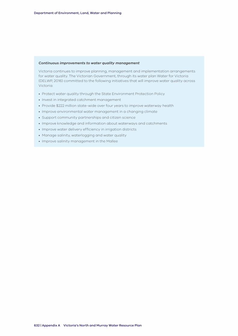
Department of Environment, Land, Water and Planning
632 | Appendix A Victoria’s North and Murray Water Resource Plan
Continuous improvements to water quality management
Victoria continues to improve planning, management and implementation arrangements for water quality. The Victorian Government, through its water plan Water for Victoria (DELWP, 2016) committed to the following initiatives that will improve water quality across Victoria:
• Protect water quality through the State Environment Protection Policy
• Invest in integrated catchment management
• Provide $222 million state-wide over four years to improve waterway health
• Improve environmental water management in a changing climate
• Support community partnerships and citizen science
• Improve knowledge and information about waterways and catchments
• Improve water delivery efficiency in irrigation districts
• Manage salinity, waterlogging and water quality
• Improve salinity management in the Mallee
Department of Environment, Land, Water and Planning
Appendix A | 633Victoria’s North and Murray Water Resource Plan
7. ReferencesAustralian Government. (2018). Chapter: National Water Quality Management Strategy.
Canberra: Department of Agriculture and Water Resources.
DEPI. (2013). Index of Stream Condition - The Third Benchmark of Victorian River Condition ISC3. Melbourne: The State of Victoria Department of Environment and Primary Industries .
DELWP. (2015). Long-term Watering Plan Northern Victoria. Melbourne: Department of Environment, Land, Water and Planning.
DELWP. (2016). Victorian Water Accounts 2014-15: A statement of Victorian Water Resources. Melbourne: Department of Environment, Land, Water and Planning.
DELWP. (2016). Water for Victoria. Melbourne: Department of Environment, Land, Water and Planning.
DSE. (2009) Lower Campaspe Water Supply Protection Area Groundwater Management Plan.
EPA. (1997). State Environment Protection Policy (Groundwaters of Victoria). Melbourne: Victorian Government Gazette No. S 160 Wednesday 17 December 1997.
EPA. (2003). State Environment Protection Policy (Waters of Victoria). Melbourne: Victorian Government Gazette No. S 107 Wesdnesday 4 June 2003.
GMW. (2012). Loddon Highlands Water Supply Protection Area Groundwater Management Plan. Tatura: Goulburn-Murray Water.
GMW. (2014). Mid Goulburn Groundwater Management Area Local Management Plan. Tatura: Goulburn-Murray Water.
GMW. (2015). Shepparton Irrigation Region Groundwater Management Area Local Management Plan. Tatura: Goulburn-Murray Water.
GMW. (2017). Groundwater Management Plan for the Katunga Water Supply Protection Area (Amendments). Tatura: Goulburn-Murray Water.
Henderson, B., Liu, Y., & Baldwin, D. (2013). Trends in phyiscal and chemical aspects of water quality in the Murray-Darling Basin 1978-2012. Canberra: CSIRO Water for a Healthy Country Flagship.
MDBA. (2014). General review of salinity management in the Murray-Darling Basin . Canberra : Murray-Darling Basin Authority.
MDBA. (2017). Objectives and outcomes for river operations in the River Murray System. Canberra: Murray-Darling Basin Authority.
MDBA. (unknown). How blue green-algae blooms are handled. Retrieved December 3, 2017, from Murray-Darling Basin Authority: https://www.mdba.gov.au/managing-water/water-quality/how-blue-green-algae-blooms-are-handled
MDBMC (1989). Salinity and Drainage Strategy, Murray-Darling Basin Commission, Canberra.
NHMRC, NRMMC (2011) Australian Drinking Water Guidelines Paper 6 National Water Quality Management Strategy. National Health and Medical Research Council, National Resource Management Ministerial Council, Commonwealth of Australia, Canberra.
VCMC. (2011). Regional Catchment Management Strategy Guidelines . Melbourne: Victorian Catchment Management Council.
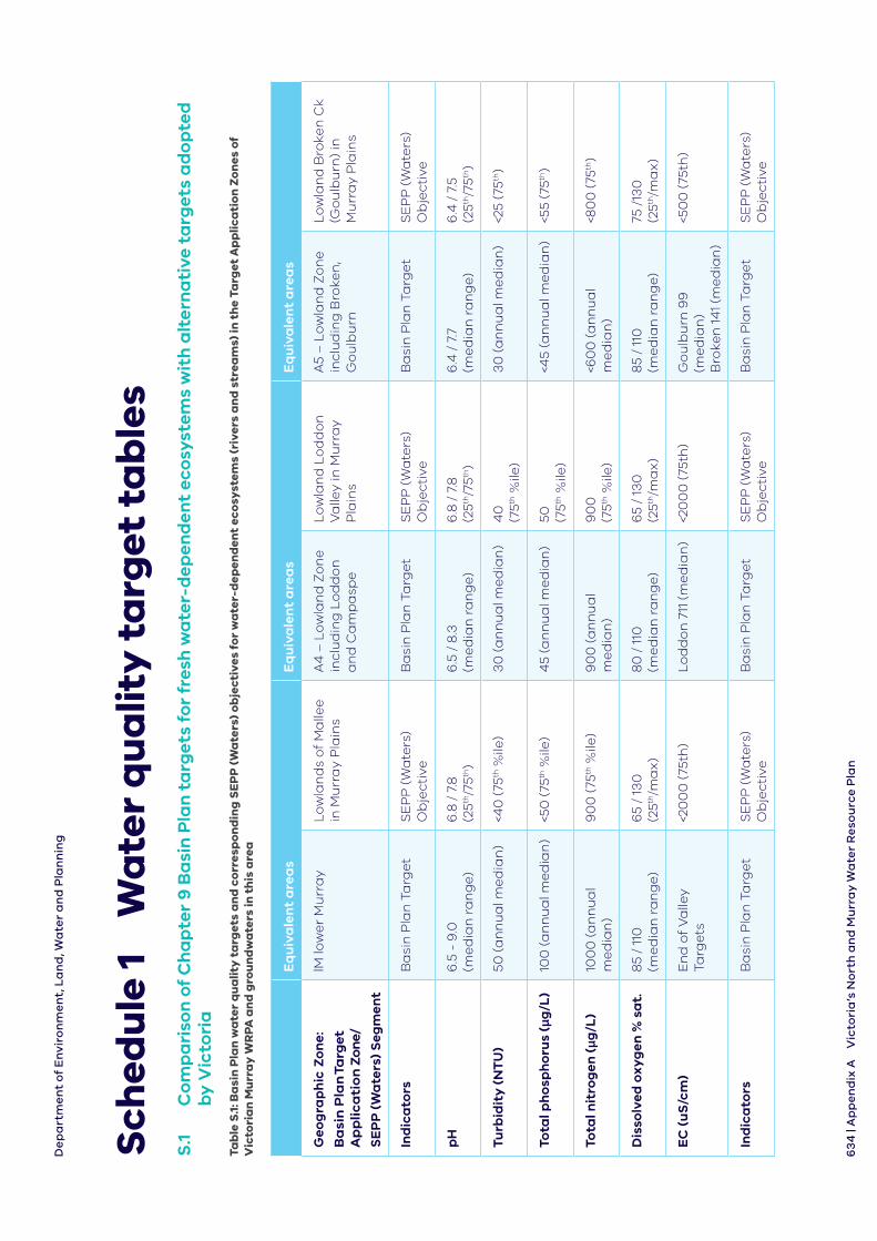
De
pa
rtm
en
t o
f E
nvi
ron
me
nt,
La
nd
, Wa
ter
an
d P
lan
nin
g
63
4 |
Ap
pe
nd
ix A
Vic
tori
a’s
No
rth
an
d M
urr
ay
Wa
ter
Re
sou
rce
Pla
n
Sch
edu
le 1
W
ate
r q
ua
lity
ta
rget
ta
ble
sS
.1
Co
mp
ari
son
of
Ch
ap
ter
9 B
asi
n P
lan
ta
rget
s fo
r fr
esh
wa
ter-
dep
end
ent
eco
syst
ems
wit
h a
lter
na
tive
ta
rget
s a
do
pte
d
by
Vic
tori
a
Tab
le S
.1: B
asi
n P
lan
wa
ter
qu
alit
y t
arg
ets
an
d c
orr
esp
on
din
g S
EP
P (
Wa
ters
) o
bje
ctiv
es f
or
wa
ter-
dep
end
ent
eco
syst
ems
(riv
ers
an
d s
trea
ms)
in t
he
Targ
et A
pp
lica
tio
n Z
on
es o
f V
icto
ria
n M
urr
ay
WR
PA a
nd
gro
un
dw
ate
rs in
th
is a
rea
Eq
uiv
ale
nt
are
as
Eq
uiv
ale
nt
are
as
Eq
uiv
ale
nt
are
as
Geo
gra
ph
ic Z
on
e:
Ba
sin
Pla
n T
arg
et
Ap
pli
ca
tio
n Z
on
e/
SE
PP
(W
ate
rs)
Seg
men
t
lM lo
we
r M
urr
ay
Lo
wla
nd
s o
f M
alle
e
in M
urr
ay
Pla
ins
A4
– L
ow
lan
d Z
on
e
incl
ud
ing
Lo
dd
on
a
nd
Ca
mp
asp
e
Lo
wla
nd
Lo
dd
on
V
alle
y in
Mu
rra
y P
lain
s
A5
– L
ow
lan
d Z
on
e
incl
ud
ing
Bro
ken
, G
ou
lbu
rn
Lo
wla
nd
Bro
ken
Ck
(Go
ulb
urn
) in
M
urr
ay
Pla
ins
Ind
ica
tors
Ba
sin
Pla
n T
arg
et
SE
PP
(W
ate
rs)
Ob
ject
ive
Ba
sin
Pla
n T
arg
et
SE
PP
(W
ate
rs)
Ob
ject
ive
Ba
sin
Pla
n T
arg
et
SE
PP
(W
ate
rs)
Ob
ject
ive
pH
6.5
- 9
.0
(me
dia
n r
an
ge
)6
.8 /
7.8
(2
5th/7
5th)
6.5
/ 8
.3
(me
dia
n r
an
ge
)6
.8 /
7.8
(2
5th/7
5th)
6.4
/ 7
.7
(me
dia
n r
an
ge
)6
.4 /
7.5
(2
5th/7
5th)
Turb
idit
y (
NT
U)
50 (
an
nu
al m
ed
ian
)<4
0 (
75th
%ile
)3
0 (
an
nu
al m
ed
ian
)4
0
(75th
%ile
)3
0 (
an
nu
al m
ed
ian
)<2
5 (7
5th)
Tota
l ph
osp
ho
rus
(μg
/L)
100
(a
nn
ua
l me
dia
n)
<50
(75
th %
ile)
45
(an
nu
al m
ed
ian
)50
(7
5th %
ile)
<45
(an
nu
al m
ed
ian
)<5
5 (7
5th)
Tota
l nit
rog
en (μg
/L)
100
0 (
an
nu
al
me
dia
n)
90
0 (
75th
%ile
)9
00
(a
nn
ua
l m
ed
ian
)9
00
(7
5th %
ile)
<60
0 (
an
nu
al
me
dia
n)
<80
0 (
75th
)
Dis
solv
ed o
xyg
en %
sa
t.8
5 /
110
(m
ed
ian
ra
ng
e)
65
/ 13
0
(25th
/ma
x)
80
/ 1
10
(me
dia
n r
an
ge
)6
5 /
130
(2
5th/m
ax
)8
5 /
110
(m
ed
ian
ra
ng
e)
75 /
130
(2
5th/m
ax
)
EC
(u
S/c
m)
En
d o
f V
alle
y Ta
rge
ts<2
00
0 (
75th
)L
od
do
n 7
11 (
me
dia
n)
<20
00
(75
th)
Go
ulb
urn
99
(m
ed
ian
) B
roke
n 1
41
(me
dia
n)
<50
0 (
75th
)
Ind
ica
tors
Ba
sin
Pla
n T
arg
et
SE
PP
(W
ate
rs)
Ob
ject
ive
Ba
sin
Pla
n T
arg
et
SE
PP
(W
ate
rs)
Ob
ject
ive
Ba
sin
Pla
n T
arg
et
SE
PP
(W
ate
rs)
Ob
ject
ive
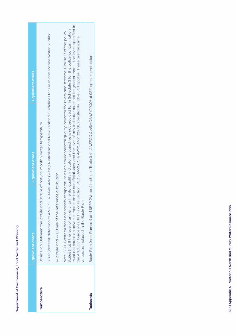
De
pa
rtm
en
t o
f E
nvi
ron
me
nt,
La
nd
, Wa
ter
an
d P
lan
nin
g
63
5 | A
pp
en
dix
AV
icto
ria
’s N
ort
h a
nd
Mu
rra
y W
ate
r R
eso
urc
e P
lan
Eq
uiv
ale
nt
are
as
Eq
uiv
ale
nt
are
as
Eq
uiv
ale
nt
are
as
Tem
per
atu
reB
asi
n P
lan
: Be
twe
en
th
e 2
0%
ile a
nd
80
%ile
of
na
tura
l mo
nth
ly w
ate
r te
mp
era
ture
SE
PP
(W
ate
rs):
de
ferr
ing
to
AN
ZE
CC
& A
RM
CA
NZ
(20
00
) A
ust
ralia
n a
nd
Ne
w Z
ea
lan
d G
uid
elin
es
for
Fre
sh a
nd
Ma
rin
e W
ate
r Q
ua
lity:
<= 2
0%
ile a
nd
<=
80
%ile
of
the
re
fere
nce
dis
trib
uti
on
.
No
te: S
EP
P (
Wa
ters
) d
oe
s n
ot
spe
cify
te
mp
era
ture
as
an
en
viro
nm
en
tal q
ua
lity
ind
ica
tor
for
rive
rs a
nd
str
ea
ms.
Cla
use
17
of
the
po
licy
sta
tes
tha
t If
th
e le
vel o
f a
ny
en
viro
nm
en
tal q
ua
lity
ind
ica
tor
or
ob
ject
ive
is n
ot
pro
vid
ed
fo
r in
Sch
ed
ule
3 f
or
the
po
licy,
co
nta
min
ati
on
m
ust
no
t ca
use
an
ad
vers
e im
pa
ct o
n t
he
be
ne
fici
al u
ses,
an
d t
he
leve
l of
an
y in
dic
ato
r m
ust
no
t b
e g
rea
ter
tha
n—
th
e le
vels
sp
eci
fie
d in
th
e A
NZ
EC
C G
uid
elin
es.
In t
his
ca
se S
ect
ion
3.3
.2.5
AN
ZE
CC
& A
RM
CA
NZ
(20
00
), sp
eci
fica
lly T
ab
le 3
.3.1
ap
plie
s. T
he
se a
re t
he
sa
me
va
lue
s a
s in
clu
de
d in
th
e B
asi
n P
lan
.
Tox
ica
nts
Ba
sin
Pla
n (
no
n-R
am
sar)
an
d S
EP
P (
Wa
ters
) b
oth
use
Ta
ble
3.4
.1, A
NZ
EC
C &
AR
MC
AN
Z (
200
0)
at
95%
sp
eci
es
pro
tect
ion
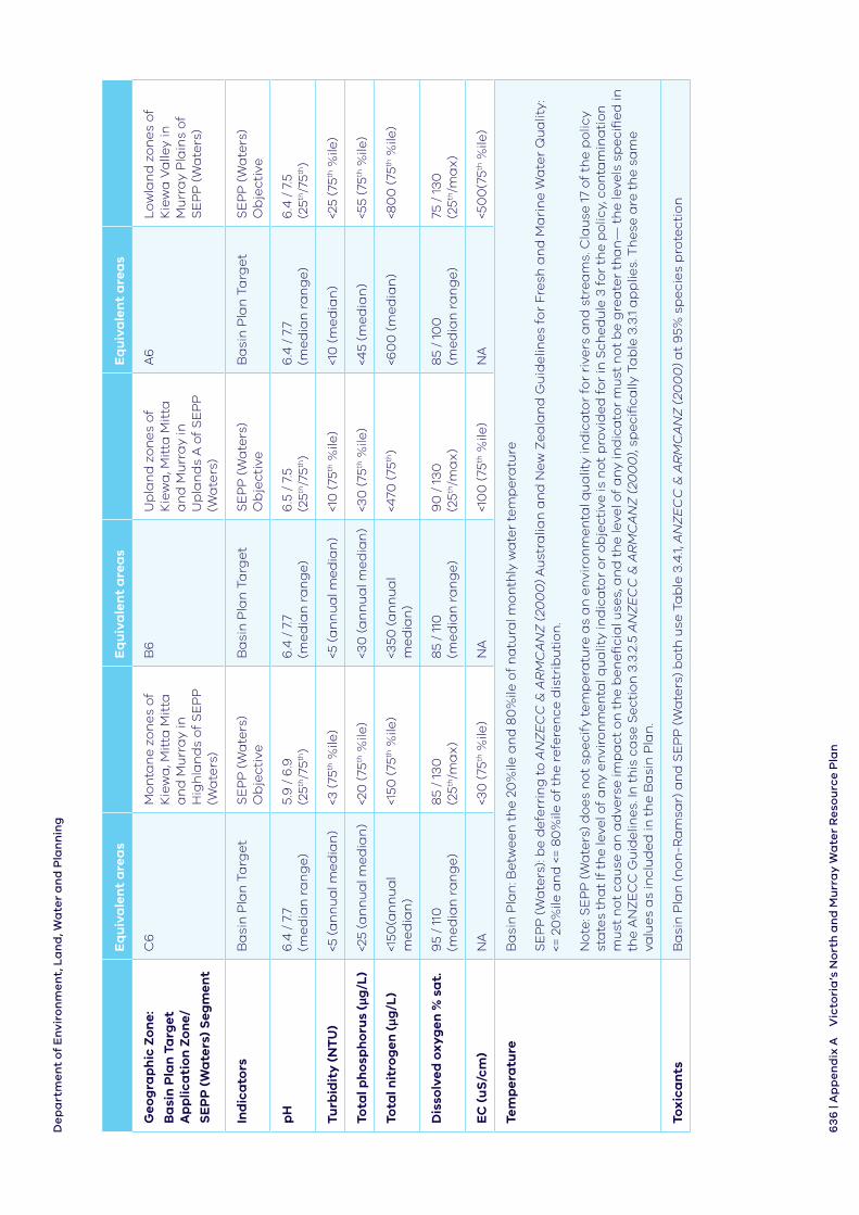
De
pa
rtm
en
t o
f E
nvi
ron
me
nt,
La
nd
, Wa
ter
an
d P
lan
nin
g
63
6 |
Ap
pe
nd
ix A
Vic
tori
a’s
No
rth
an
d M
urr
ay
Wa
ter
Re
sou
rce
Pla
n
Eq
uiv
ale
nt
are
as
Eq
uiv
ale
nt
are
as
Eq
uiv
ale
nt
are
as
Geo
gra
ph
ic Z
on
e:
Ba
sin
Pla
n T
arg
et
Ap
plic
ati
on
Zo
ne/
SE
PP
(W
ate
rs)
Seg
men
t
C6
Mo
nta
ne
zo
ne
s o
f K
iew
a, M
itta
Mit
ta
an
d M
urr
ay
in
Hig
hla
nd
s o
f S
EP
P
(Wa
ters
)
B6
Up
lan
d z
on
es
of
Kie
wa
, Mit
ta M
itta
a
nd
Mu
rra
y in
U
pla
nd
s A
of
SE
PP
(W
ate
rs)
A6
Lo
wla
nd
zo
ne
s o
f K
iew
a V
alle
y in
M
urr
ay
Pla
ins
of
SE
PP
(W
ate
rs)
Ind
ica
tors
Ba
sin
Pla
n T
arg
et
SE
PP
(W
ate
rs)
Ob
ject
ive
Ba
sin
Pla
n T
arg
et
SE
PP
(W
ate
rs)
Ob
ject
ive
Ba
sin
Pla
n T
arg
et
SE
PP
(W
ate
rs)
Ob
ject
ive
pH
6.4
/ 7
.7
(me
dia
n r
an
ge
)5.
9 /
6.9
(2
5th/7
5th)
6.4
/ 7
.7
(me
dia
n r
an
ge
)6
.5 /
7.5
(2
5th/7
5th)
6.4
/ 7
.7
(me
dia
n r
an
ge
)6
.4 /
7.5
(2
5th/7
5th)
Turb
idit
y (
NT
U)
<5 (
an
nu
al m
ed
ian
)<3
(75
th %
ile)
<5 (
an
nu
al m
ed
ian
)<1
0 (
75th
%ile
)<1
0 (
me
dia
n)
<25
(75th
%ile
)
Tota
l ph
osp
ho
rus
(μg
/L)
<25
(an
nu
al m
ed
ian
)<2
0 (
75th
%ile
)<3
0 (
an
nu
al m
ed
ian
)<3
0 (
75th
%ile
)<4
5 (m
ed
ian
)<5
5 (7
5th %
ile)
Tota
l nit
rog
en (μg
/L)
<150
(an
nu
al
me
dia
n)
<150
(75
th %
ile)
<350
(a
nn
ua
l m
ed
ian
)<4
70 (
75th
)<6
00
(m
ed
ian
)<8
00
(75
th %
ile)
Dis
solv
ed o
xyg
en %
sa
t.9
5 /
110
(m
ed
ian
ra
ng
e)
85
/ 13
0
(25th
/ma
x)
85
/ 11
0
(me
dia
n r
an
ge
)9
0 /
13
0
(25th
/ma
x)
85
/ 10
0
(me
dia
n r
an
ge
)75
/ 1
30
(2
5th/m
ax
)
EC
(u
S/c
m)
NA
<30
(75
th %
ile)
NA
<10
0 (
75th
%ile
)N
A<5
00
(75th
%ile
)
Tem
per
atu
reB
asi
n P
lan
: Be
twe
en
th
e 2
0%
ile a
nd
80
%ile
of
na
tura
l mo
nth
ly w
ate
r te
mp
era
ture
SE
PP
(W
ate
rs):
be
de
ferr
ing
to
AN
ZE
CC
& A
RM
CA
NZ
(20
00
) A
ust
ralia
n a
nd
Ne
w Z
ea
lan
d G
uid
elin
es
for
Fre
sh a
nd
Ma
rin
e W
ate
r Q
ua
lity:
<=
20
%ile
an
d <
= 8
0%
ile o
f th
e r
efe
ren
ce d
istr
ibu
tio
n.
No
te: S
EP
P (
Wa
ters
) d
oe
s n
ot
spe
cify
te
mp
era
ture
as
an
en
viro
nm
en
tal q
ua
lity
ind
ica
tor
for
rive
rs a
nd
str
ea
ms.
Cla
use
17
of
the
po
licy
sta
tes
tha
t If
th
e le
vel o
f a
ny
en
viro
nm
en
tal q
ua
lity
ind
ica
tor
or
ob
ject
ive
is n
ot
pro
vid
ed
fo
r in
Sch
ed
ule
3 f
or
the
po
licy,
co
nta
min
ati
on
m
ust
no
t ca
use
an
ad
vers
e im
pa
ct o
n t
he
be
ne
fici
al u
ses,
an
d t
he
leve
l of
an
y in
dic
ato
r m
ust
no
t b
e g
rea
ter
tha
n—
th
e le
vels
sp
eci
fie
d in
th
e A
NZ
EC
C G
uid
elin
es.
In t
his
ca
se S
ect
ion
3.3
.2.5
AN
ZE
CC
& A
RM
CA
NZ
(20
00
), sp
eci
fica
lly T
ab
le 3
.3.1
ap
plie
s. T
he
se a
re t
he
sa
me
va
lue
s a
s in
clu
de
d in
th
e B
asi
n P
lan
.
Tox
ica
nts
Ba
sin
Pla
n (
no
n-R
am
sar)
an
d S
EP
P (
Wa
ters
) b
oth
use
Ta
ble
3.4
.1, A
NZ
EC
C &
AR
MC
AN
Z (
200
0)
at
95%
sp
eci
es
pro
tect
ion
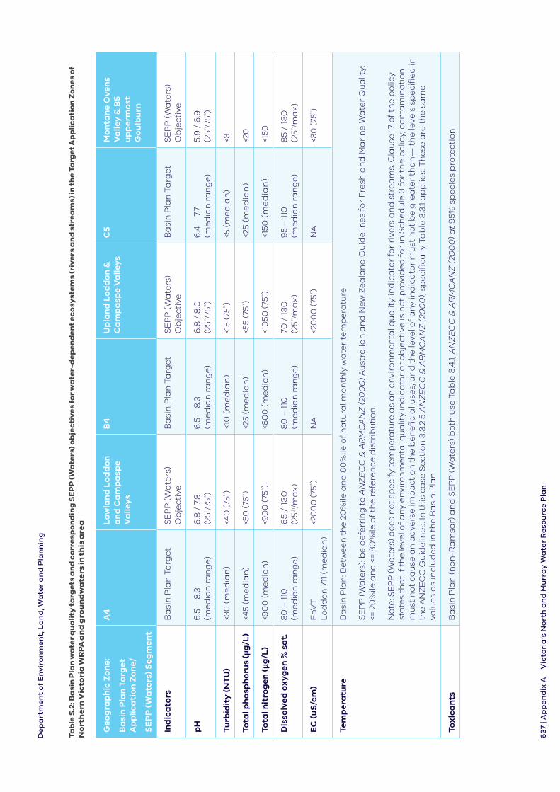
De
pa
rtm
en
t o
f E
nvi
ron
me
nt,
La
nd
, Wa
ter
an
d P
lan
nin
g
63
7 | A
pp
en
dix
AV
icto
ria
’s N
ort
h a
nd
Mu
rra
y W
ate
r R
eso
urc
e P
lan
Tab
le S
.2: B
asi
n P
lan
wa
ter
qu
ali
ty t
arg
ets
an
d c
orr
esp
on
din
g S
EP
P (W
ate
rs) o
bje
cti
ve
s fo
r w
ate
r-d
ep
en
de
nt
ec
osy
ste
ms
(riv
ers
an
d s
tre
am
s) in
th
e T
arg
et A
pp
lic
ati
on
Zo
ne
s o
f N
ort
he
rn V
icto
ria
WR
PA
an
d g
rou
nd
wa
ters
in t
his
are
a
Ge
og
rap
hic
Zo
ne:
Ba
sin
Pla
n T
arg
et
Ap
plic
ati
on
Zo
ne/
SE
PP
(W
ate
rs)
Se
gm
ent
A4
Lo
wla
nd
Lo
dd
on
a
nd
Ca
mp
asp
e V
alle
ys
B4
Up
lan
d L
od
do
n &
C
am
pa
spe
Va
lleys
C5
Mo
nta
ne
Ove
ns
Va
lley
& B
5 u
pp
erm
ost
G
ou
lbu
rn
Ind
ica
tors
Ba
sin
Pla
n T
arg
et
SE
PP
(W
ate
rs)
Ob
ject
ive
Ba
sin
Pla
n T
arg
et
SE
PP
(W
ate
rs)
Ob
ject
ive
Ba
sin
Pla
n T
arg
et
SE
PP
(W
ate
rs)
Ob
ject
ive
pH
6.5
– 8
.3
(me
dia
n r
an
ge
)6
.8 /
7.8
(2
5th
/75th
)6
.5 –
8.3
(m
ed
ian
ra
ng
e)
6.8
/ 8
.0
(25th
/75th
)6
.4 –
7.7
(m
ed
ian
ra
ng
e)
5.9
/ 6
.9
(25th
/75th
)
Turb
idit
y (
NT
U)
<30
(m
ed
ian
)<4
0 (
75th
)<1
0 (
me
dia
n)
<15
(75th
)<5
(m
ed
ian
)<3
Tota
l ph
osp
ho
rus
(μg
/L)
<45
(me
dia
n)
<50
(75
th
)<2
5 (m
ed
ian
)<5
5 (7
5th
)<2
5 (
me
dia
n)
<20
Tota
l nit
rog
en (μg
/L)
<90
0 (
me
dia
n)
<90
0 (
75th
)<6
00
(m
ed
ian
)<1
050
(75
th
)<1
50
(m
ed
ian
)<1
50
Dis
solv
ed o
xyg
en %
sa
t.8
0 –
110
(m
ed
ian
ra
ng
e)
65
/ 1
30
(2
5th/m
ax
)8
0 –
110
(m
ed
ian
ra
ng
e)
70 /
13
0
(25th
/ma
x)
95
– 1
10
(me
dia
n r
an
ge
)8
5 /
13
0
(25th
/ma
x)
EC
(u
S/c
m)
EoV
T
Lo
dd
on
711
(m
ed
ian
)<2
00
0 (
75th
)N
A<2
00
0 (
75th
)N
A<3
0 (
75th
)
Tem
per
atu
reB
asi
n P
lan
: Be
twe
en
th
e 2
0%
ile a
nd
80
%ile
of
na
tura
l mo
nth
ly w
ate
r te
mp
era
ture
SE
PP
(W
ate
rs):
be
de
ferr
ing
to
AN
ZE
CC
& A
RM
CA
NZ
(20
00
) A
ust
ralia
n a
nd
Ne
w Z
ea
lan
d G
uid
elin
es
for
Fre
sh a
nd
Ma
rin
e W
ate
r Q
ua
lity:
<=
20
%ile
an
d <
= 8
0%
ile o
f th
e r
efe
ren
ce d
istr
ibu
tio
n.
No
te: S
EP
P (
Wa
ters
) d
oe
s n
ot
spe
cify
te
mp
era
ture
as
an
en
viro
nm
en
tal q
ua
lity
ind
ica
tor
for
rive
rs a
nd
str
ea
ms.
Cla
use
17
of
the
po
licy
sta
tes
tha
t If
th
e le
vel o
f a
ny
en
viro
nm
en
tal q
ua
lity
ind
ica
tor
or
ob
ject
ive
is n
ot
pro
vid
ed
fo
r in
Sch
ed
ule
3 f
or
the
po
licy,
co
nta
min
ati
on
m
ust
no
t ca
use
an
ad
vers
e im
pa
ct o
n t
he
be
ne
fici
al u
ses,
an
d t
he
leve
l of
an
y in
dic
ato
r m
ust
no
t b
e g
rea
ter
tha
n—
th
e le
vels
sp
eci
fie
d in
th
e A
NZ
EC
C G
uid
elin
es.
In t
his
ca
se S
ect
ion
3.3
.2.5
AN
ZE
CC
& A
RM
CA
NZ
(20
00
), sp
eci
fica
lly T
ab
le 3
.3.1
ap
plie
s. T
he
se a
re t
he
sa
me
va
lue
s a
s in
clu
de
d in
th
e B
asi
n P
lan
.
Tox
ica
nts
Ba
sin
Pla
n (
no
n-R
am
sar)
an
d S
EP
P (
Wa
ters
) b
oth
use
Ta
ble
3.4
.1, A
NZ
EC
C &
AR
MC
AN
Z (
200
0)
at
95%
sp
eci
es
pro
tect
ion
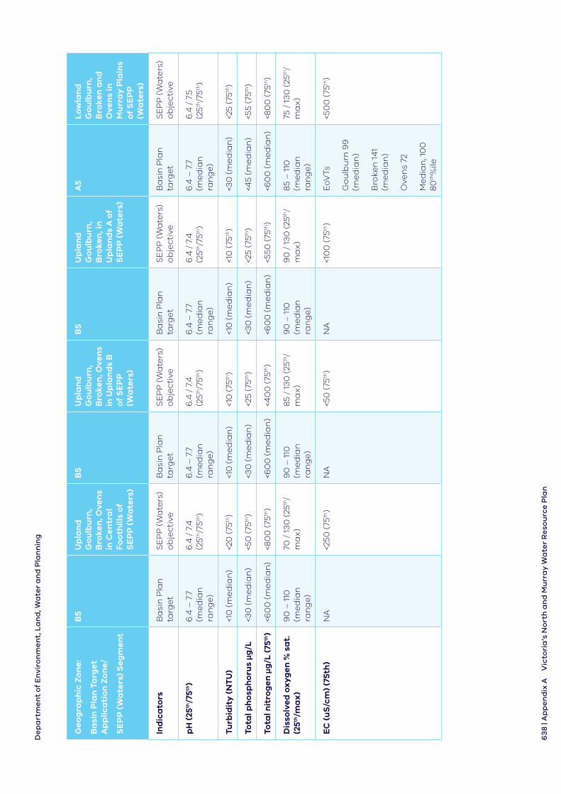
De
pa
rtm
en
t o
f E
nvi
ron
me
nt,
La
nd
, Wa
ter
an
d P
lan
nin
g
63
8 | A
pp
en
dix
AV
icto
ria
’s N
ort
h a
nd
Mu
rra
y W
ate
r R
eso
urc
e P
lan
Ge
og
rap
hic
Zo
ne:
Ba
sin
Pla
n T
arg
et
Ap
plic
ati
on
Zo
ne/
SE
PP
(W
ate
rs)
Se
gm
ent
B5
Up
lan
d
Go
ulb
urn
, B
roke
n, O
ven
s in
Cen
tra
l F
oo
thill
s o
f S
EP
P (
Wa
ters
)
B5
Up
lan
d
Go
ulb
urn
, B
roke
n, O
ven
s in
Up
lan
ds
B
of
SE
PP
(W
ate
rs)
B5
Up
lan
d
Go
ulb
urn
, B
roke
n, i
n
Up
lan
ds
A o
f S
EP
P (
Wa
ters
)
A5
Lo
wla
nd
G
ou
lbu
rn,
Bro
ken
an
d
Ove
ns
in
Mu
rra
y P
lain
s o
f S
EP
P
(Wa
ters
)
Ind
ica
tors
Ba
sin
Pla
n
targ
et
SE
PP
(W
ate
rs)
ob
ject
ive
Ba
sin
Pla
n
targ
et
SE
PP
(W
ate
rs)
ob
ject
ive
Ba
sin
Pla
n
targ
et
SE
PP
(W
ate
rs)
ob
ject
ive
Ba
sin
Pla
n
targ
et
SE
PP
(W
ate
rs)
ob
ject
ive
pH
(25
th/7
5th)
6.4
– 7
.7
(me
dia
n
ran
ge
)
6.4
/ 7
.4
(25th
/75th
)6
.4 –
7.7
(m
ed
ian
ra
ng
e)
6.4
/ 7
.4
(25th
/75th
)6
.4 –
7.7
(m
ed
ian
ra
ng
e)
6.4
/ 7
.4
(25th
/75th
)6
.4 –
7.7
(m
ed
ian
ra
ng
e)
6.4
/ 7
.5
(25th
/75th
)
Turb
idit
y (
NT
U)
<10
(m
ed
ian
)<2
0 (
75th
)<1
0 (
me
dia
n)
<10
(75
th)
<10
(m
ed
ian
)<1
0 (
75th
)<3
0 (
me
dia
n)
<25
(75th
)
Tota
l ph
osp
ho
rus μg
/L<3
0 (
me
dia
n)
<50
(75
th)
<30
(m
ed
ian
)<2
5 (7
5th)
<30
(m
ed
ian
)<2
5 (7
5th)
<45
(me
dia
n)
<55
(75th
)
Tota
l nit
rog
en μ
g/L
(75
th)
<60
0 (
me
dia
n)
<80
0 (
75th
)<6
00
(m
ed
ian
)<4
00
(75
th)
<60
0 (
me
dia
n)
<550
(75
th)
<60
0 (
me
dia
n)
<80
0 (
75th
)
Dis
solv
ed o
xyg
en %
sa
t.
(25th
/ma
x)
90
– 1
10
(me
dia
n
ran
ge
)
70 /
13
0 (
25th
/ m
ax
)9
0 –
110
(m
ed
ian
ra
ng
e)
85
/ 13
0 (
25th
/ m
ax
)9
0 –
110
(m
ed
ian
ra
ng
e)
90
/ 1
30
(25
th/
ma
x)
85
– 1
10
(me
dia
n
ran
ge
)
75 /
13
0 (
25th
/ m
ax
)
EC
(u
S/c
m)
(75t
h)
NA
<250
(75
th)
NA
<50
(75
th)
NA
<10
0 (
75th
)E
oVTs
Go
ulb
urn
99
(m
ed
ian
)
Bro
ken
14
1 (m
ed
ian
)
Ove
ns
72
Me
dia
n, 1
00
8
0th
%ile
<50
0 (
75th
)
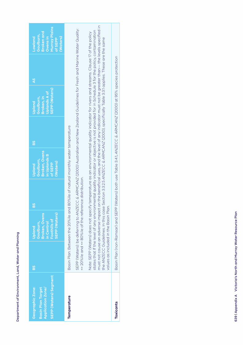
De
pa
rtm
en
t o
f E
nvi
ron
me
nt,
La
nd
, Wa
ter
an
d P
lan
nin
g
63
9 |
Ap
pe
nd
ix A
Vic
tori
a’s
No
rth
an
d M
urr
ay
Wa
ter
Re
sou
rce
Pla
n
Ge
og
rap
hic
Zo
ne:
Ba
sin
Pla
n T
arg
et
Ap
plic
ati
on
Zo
ne/
SE
PP
(W
ate
rs)
Se
gm
ent
B5
Up
lan
d
Go
ulb
urn
, B
roke
n, O
ven
s in
Cen
tra
l F
oo
thill
s o
f S
EP
P (
Wa
ters
)
B5
Up
lan
d
Go
ulb
urn
, B
roke
n, O
ven
s in
Up
lan
ds
B
of
SE
PP
(W
ate
rs)
B5
Up
lan
d
Go
ulb
urn
, B
roke
n, i
n
Up
lan
ds
A o
f S
EP
P (
Wa
ters
)
A5
Lo
wla
nd
G
ou
lbu
rn,
Bro
ken
an
d
Ove
ns
in
Mu
rra
y P
lain
s o
f S
EP
P
(Wa
ters
)
Tem
per
atu
reB
asi
n P
lan
: Be
twe
en
th
e 2
0%
ile a
nd
80
%ile
of
na
tura
l mo
nth
ly w
ate
r te
mp
era
ture
SE
PP
(W
ate
rs):
be
de
ferr
ing
to
AN
ZE
CC
& A
RM
CA
NZ
(20
00
) A
ust
ralia
n a
nd
Ne
w Z
ea
lan
d G
uid
elin
es
for
Fre
sh a
nd
Ma
rin
e W
ate
r Q
ua
lity:
<=
20
%ile
an
d <
= 8
0%
ile o
f th
e r
efe
ren
ce d
istr
ibu
tio
n.
No
te: S
EP
P (
Wa
ters
) d
oe
s n
ot
spe
cify
te
mp
era
ture
as
an
en
viro
nm
en
tal q
ua
lity
ind
ica
tor
for
rive
rs a
nd
str
ea
ms.
Cla
use
17
of
the
po
licy
sta
tes
tha
t If
th
e le
vel o
f a
ny
en
viro
nm
en
tal q
ua
lity
ind
ica
tor
or
ob
ject
ive
is n
ot
pro
vid
ed
fo
r in
Sch
ed
ule
3 f
or
the
po
licy,
co
nta
min
ati
on
m
ust
no
t ca
use
an
ad
vers
e im
pa
ct o
n t
he
be
ne
fici
al u
ses,
an
d t
he
leve
l of
an
y in
dic
ato
r m
ust
no
t b
e g
rea
ter
tha
n—
th
e le
vels
sp
eci
fie
d in
th
e A
NZ
EC
C G
uid
elin
es.
In t
his
ca
se S
ect
ion
3.3
.2.5
AN
ZE
CC
& A
RM
CA
NZ
(20
00
), sp
eci
fica
lly T
ab
le 3
.3.1
ap
plie
s. T
he
se a
re t
he
sa
me
va
lue
s a
s in
clu
de
d in
th
e B
asi
n P
lan
.
Tox
ica
nts
Ba
sin
Pla
n (
no
n-R
am
sar)
an
d S
EP
P (
Wa
ters
) b
oth
use
Ta
ble
3.4
.1, A
NZ
EC
C &
AR
MC
AN
Z (
200
0)
at
95%
sp
eci
es
pro
tect
ion
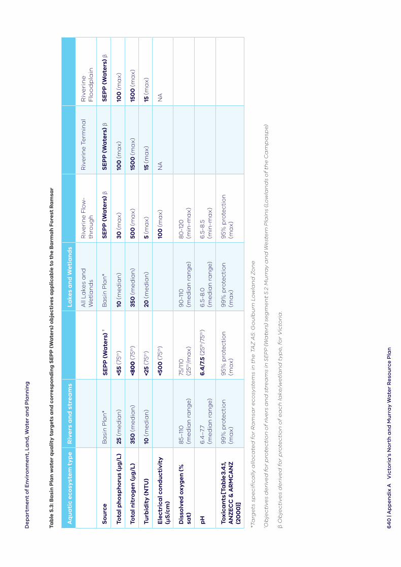
De
pa
rtm
en
t o
f E
nvi
ron
me
nt,
La
nd
, Wa
ter
an
d P
lan
nin
g
64
0 |
Ap
pe
nd
ix A
Vic
tori
a’s
No
rth
an
d M
urr
ay
Wa
ter
Re
sou
rce
Pla
n
Tab
le S
.3: B
asi
n P
lan
wa
ter
qu
alit
y t
arg
ets
an
d c
orr
esp
on
din
g S
EP
P (
Wa
ters
) o
bje
ctiv
es a
pp
lica
ble
to
th
e B
arm
ah
Fo
rest
Ra
msa
r
Aq
ua
tic
eco
syst
em t
yp
eR
ive
rs a
nd
str
ea
ms
La
kes
an
d W
etl
an
ds
All
La
kes
an
d
We
tla
nd
sR
ive
rin
e F
low
- th
rou
gh
Riv
eri
ne
Te
rmin
al
Riv
eri
ne
F
loo
dp
lain
So
urc
eB
asi
n P
lan
*S
EP
P (
Wa
ters
) †
Ba
sin
Pla
n*
SE
PP
(W
ate
rs) β
SE
PP
(W
ate
rs) β
SE
PP
(W
ate
rs) β
Tota
l ph
osp
ho
rus
(μg
/L)
25 (m
ed
ian
)<5
5 (7
5th)
10 (m
ed
ian
)30
(ma
x)
100
(ma
x)
100
(ma
x)
Tota
l nit
rog
en (μg
/L)
350
(me
dia
n)
<80
0 (7
5th)
350
(me
dia
n)
500
(ma
x)
150
0 (m
ax
)15
00
(ma
x)
Turb
idit
y (
NT
U)
10 (m
ed
ian
)<2
5 (7
5th)
20 (m
ed
ian
)5
(ma
x)
15 (m
ax
)15
(ma
x)
Ele
ctri
cal c
on
du
ctiv
ity
(μ
S/c
m)
<50
0 (7
5th)
100
(ma
x)
NA
NA
Dis
solv
ed o
xyg
en (
%
sat)
85–
110
(m
ed
ian
ra
ng
e)
75/1
10
(25th
/ma
x)
90
-110
(m
ed
ian
ra
ng
e)
80
-120
(m
in-m
ax
)
pH
6.4
–7.
7 (m
ed
ian
ra
ng
e)
6.4
/7.5
(25th
/75th
)6
.5-8
.0
(me
dia
n r
an
ge
)6
.5-8
.5
(min
-ma
x)
Tox
ica
nts
[Ta
ble
3.4
.1,
AN
ZE
CC
& A
RM
CA
NZ
(2
00
0)]
99
% p
rote
ctio
n
(ma
x)
95%
pro
tect
ion
(m
ax
)9
9%
pro
tect
ion
(m
ax
)9
5% p
rote
ctio
n
(ma
x)
*Ta
rge
ts s
pe
cifi
ca
lly a
lloc
ate
d f
or
Ra
msa
r e
co
syst
em
s in
th
e T
AZ
A5
: Go
ulb
urn
Lo
wla
nd
Zo
ne
†Ob
jecti
ve
s d
eri
ve
d f
or
pro
tecti
on
of
riv
ers
an
d s
tre
am
s in
SE
PP
(W
ate
rs)
seg
me
nt
5.2
: Mu
rra
y a
nd
We
ste
rn P
lain
s (L
ow
lan
ds
of th
e C
am
pa
spe)
β O
bje
cti
ve
s d
eri
ve
d f
or
pro
tec
tio
n o
f e
ac
h la
ke
/we
tla
nd
ty
pe
, fo
r V
icto
ria
.
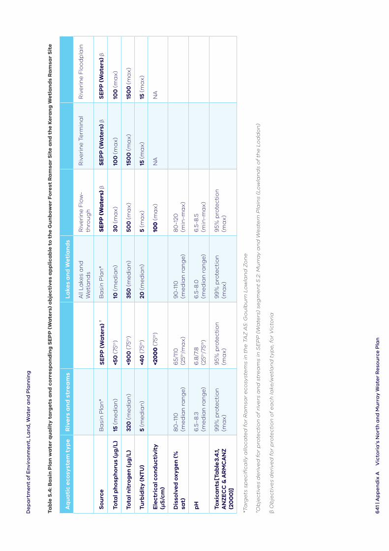
De
pa
rtm
en
t o
f E
nvi
ron
me
nt,
La
nd
, Wa
ter
an
d P
lan
nin
g
64
1 | A
pp
en
dix
AV
icto
ria
’s N
ort
h a
nd
Mu
rra
y W
ate
r R
eso
urc
e P
lan
Tab
le S
.4: B
asi
n P
lan
wa
ter
qu
ali
ty t
arg
ets
an
d c
orr
esp
on
din
g S
EP
P (
Wa
ters
) o
bje
cti
ve
s a
pp
lic
ab
le t
o t
he
Gu
nb
ow
er
Fo
rest
Ra
msa
r S
ite
an
d t
he
Ke
ran
g W
etl
an
ds
Ra
msa
r S
ite
Aq
ua
tic
eco
syst
em t
yp
eR
ive
rs a
nd
str
ea
ms
La
kes
an
d W
etl
an
ds
All
La
kes
an
d
We
tla
nd
sR
ive
rin
e F
low
- th
rou
gh
Riv
eri
ne
Te
rmin
al
Riv
eri
ne
Flo
od
pla
in
So
urc
eB
asi
n P
lan
*S
EP
P (
Wa
ters
) †
Ba
sin
Pla
n*
SE
PP
(W
ate
rs) β
SE
PP
(W
ate
rs) β
SE
PP
(W
ate
rs) β
Tota
l ph
osp
ho
rus
(μg
/L)
15 (m
ed
ian
)<5
0 (7
5th)
10 (m
ed
ian
)30
(ma
x)
100
(ma
x)
100
(ma
x)
Tota
l nit
rog
en (μg
/L)
320
(me
dia
n)
<90
0 (7
5th)
350
(me
dia
n)
500
(ma
x)
150
0 (m
ax
)15
00
(ma
x)
Turb
idit
y (
NT
U)
5 (m
ed
ian
)<4
0 (7
5th)
20 (m
ed
ian
)5
(ma
x)
15 (m
ax
)15
(ma
x)
Ele
ctri
cal c
on
du
ctiv
ity
(μ
S/c
m)
<20
00
(75th
)10
0 (m
ax
)N
AN
A
Dis
solv
ed o
xyg
en (
%
sat)
80
–11
0
(me
dia
n r
an
ge
)6
5/11
0
(25th
/ma
x)
90
-110
(m
ed
ian
ra
ng
e)
80
-120
(m
in-m
ax
)
pH
6.5
–8
.3
(me
dia
n r
an
ge
)6
.8/7
.8
(25th
/75th
)6
.5-8
.0
(me
dia
n r
an
ge
)6
.5-8
.5
(min
-ma
x)
Tox
ica
nts
[Ta
ble
3.4
.1,
AN
ZE
CC
& A
RM
CA
NZ
(2
00
0)]
99
% p
rote
ctio
n
(ma
x)
95%
pro
tect
ion
(m
ax
)9
9%
pro
tect
ion
(m
ax
)9
5% p
rote
ctio
n
(ma
x)
*Ta
rge
ts s
pe
cifi
ca
lly a
lloc
ate
d f
or
Ra
msa
r e
co
syst
em
s in
th
e T
AZ
A5
: Go
ulb
urn
Lo
wla
nd
Zo
ne
†Ob
jec
tiv
es
de
riv
ed
fo
r p
rote
cti
on
of
riv
ers
an
d s
tre
am
s in
SE
PP
(W
ate
rs)
seg
me
nt
5.2
: Mu
rra
y a
nd
We
ste
rn P
lain
s (L
ow
lan
ds
of
the
Lo
dd
on
)
β O
bje
cti
ve
s d
eri
ve
d f
or
pro
tec
tio
n o
f e
ac
h la
ke
/we
tla
nd
ty
pe
, fo
r V
icto
ria
Department of Environment, Land, Water and Planning
642 | Appendix A Victoria’s North and Murray Water Resource Plan
S.2 Comparison of geographic boundaries for fresh water-dependent ecosystems
A comparison of geographical boundaries between the Basin Plan and State Environment Protection Policy (Waters) is complicated not only by boundary differences between the two documents, but also by differences between target application zone (TAZ) boundaries and water resource plan area boundaries, within the Basin Plan (see Figure S.1).
Table S.5 lists the five target application zone boundaries for the Northern Victoria water resource plan area and the valley zones within the water resource plan area that these boundaries cover. Also displays the corresponding SEPP (Waters) segments and sub-segments for the valley zones within each TAZ.
Almost all of the lowland reaches in the Northern Victoria water resource plan are (SW3) catchments are in the Murray and Western Plains Segment of SEPP (Waters). The middle upland reaches of the Goulburn, Broken and Ovens Rivers are divided between the Uplands B Segment in the south-east and the Central Foothills and Coastal Plains Segment towards the north-west.
The headwater streams of the Loddon and Campaspe Rivers are also within the Central Foothills and Coastal Plains Segment. Headwater streams above 1000 m in the Goulburn, Broken and Ovens catchments are in the Highlands segment of SEPP (Waters).
Table S.6 lists the six target application zone boundaries applicable to the Victorian Murray water resource plan area (SW2), covering the:
• Kiewa, Murray and Mitta Mitta Rivers upstream of Albury (TAZs A6, B6 and C6)
• area between lower Broken Creek (north of Shepparton), east to approximately Yarrawonga (TAZ A5)
• area below Kerang, from approximately Swan Hill in the west and Torrumbarry in the east (TAZ A4)
• isolated areas, up to 10 km south of the River Murray covering the Robinvale, Nangiloc, Red Cliffs, Mildura and Merbein Irrigation Districts (lM TAZ)
The A6 TAZ is a small area of land covering the lowermost areas of the Kiewa River and the lowland areas of the Victorian Murray around Albury. This area is covered by the Murray and Western Plains Segment of State Environment Protection Policy (Waters). The majority of the B6 TAZ is within the Uplands A Segment of State Environment Protection Policy (Waters) and the TAZ C6 largely overlaps with the Highlands Segment.
The areas of the Victorian Murray water resource plan area located in the lM, A4 and A5 TAZs are within the Murray and Western Plains segment of SEPP (Waters).
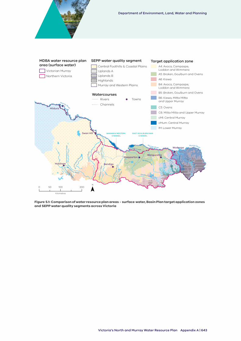
Department of Environment, Land, Water and Planning
Appendix A | 643Victoria’s North and Murray Water Resource Plan
Figure S.1:
WatercoursesTownsRivers
Channels
Target application zoneA4: Avoca, Campaspe, Loddon and Wimmera
A5: Broken, Goulburn and Ovens
A6: Kiewa
B4: Avoca, Campaspe, Loddon and Wimmera
B5: Broken, Goulburn and Ovens
B6: Kiewa, Mitta Mitta and Upper Murray
C5: Ovens
C6: Mitta Mitta and Upper Murray
cMl: Central Murray
cMum: Central Murray
lM: Lower Murray
SEPP water quality segment
Highlands
Uplands B
Central Foothills & Coastal Plains
Uplands A
Murray and Western Plains
MDBA water resource plan area (surface water)
Victorian Murray
Northern Victoria
0 100 20050
Kilometres
Murray River
Lo
dd
on
Riv
er
Goulburn River
Ovens RiverBroken River
Ca
mpasp
e R
iver
Broken Creek
Kin
g R
iver
Mitta Mitta Rive
r
Bu
ffalo
River
Murray River
Ma
ckenzie River
Avo
ca R
iver
Wim
mera River
Ya
rria
mb
iack
Cre
ek
Tu
llaro
op
Cre
ekRicha
rdso
n Riv
er K
iew
a R
iver
Co
liba
n R
iver
Murray River
Mildura
SheppartonWangaratta
Wodonga
BendigoHorsham
Swan Hill EAST GOULBURN MAIN CHANNEL
WARANGA WESTERN CHANNEL
Comparison of water resource plan areas - surface water, Basin Plan target application zones and SEPP water quality segments across Victoria
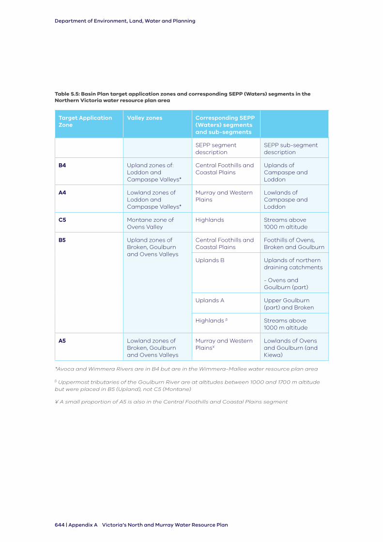
Department of Environment, Land, Water and Planning
644 | Appendix A Victoria’s North and Murray Water Resource Plan
Table S.5: Basin Plan target application zones and corresponding SEPP (Waters) segments in the Northern Victoria water resource plan area
Target Application Zone
Valley zones Corresponding SEPP (Waters) segments and sub-segments
SEPP segment description
SEPP sub-segment description
B4 Upland zones of: Loddon and Campaspe Valleys*
Central Foothills and Coastal Plains
Uplands of Campaspe and Loddon
A4 Lowland zones of Loddon and Campaspe Valleys*
Murray and Western Plains
Lowlands of Campaspe and Loddon
C5 Montane zone of Ovens Valley
Highlands Streams above 1000 m altitude
B5 Upland zones of Broken, Goulburn and Ovens Valleys
Central Foothills and Coastal Plains
Foothills of Ovens, Broken and Goulburn
Uplands B Uplands of northern draining catchments
- Ovens and Goulburn (part)
Uplands A Upper Goulburn (part) and Broken
Highlands β Streams above 1000 m altitude
A5 Lowland zones of Broken, Goulburn and Ovens Valleys
Murray and Western Plains¥
Lowlands of Ovens and Goulburn (and Kiewa)
*Avoca and Wimmera Rivers are in B4 but are in the Wimmera-Mallee water resource plan area
β Uppermost tributaries of the Goulburn River are at altitudes between 1000 and 1700 m altitude but were placed in B5 (Upland), not C5 (Montane)
¥ A small proportion of A5 is also in the Central Foothills and Coastal Plains segment
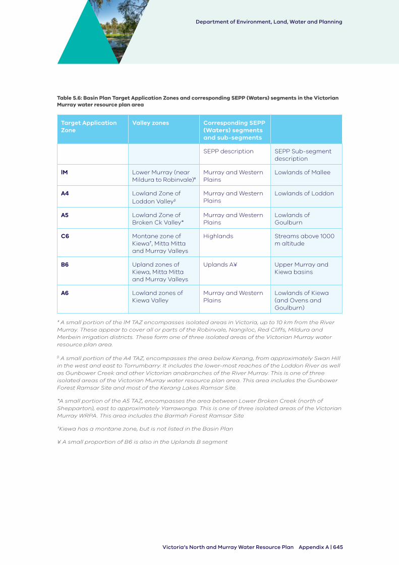
Department of Environment, Land, Water and Planning
Appendix A | 645Victoria’s North and Murray Water Resource Plan
Table S.6: Basin Plan Target Application Zones and corresponding SEPP (Waters) segments in the Victorian Murray water resource plan area
Target Application Zone
Valley zones Corresponding SEPP (Waters) segments and sub-segments
SEPP description SEPP Sub-segment description
lM Lower Murray (near Mildura to Robinvale)‡
Murray and Western Plains
Lowlands of Mallee
A4 Lowland Zone of Loddon Valleyβ
Murray and Western Plains
Lowlands of Loddon
A5 Lowland Zone of Broken Ck Valley*
Murray and Western Plains
Lowlands of Goulburn
C6 Montane zone of Kiewa†, Mitta Mitta and Murray Valleys
Highlands Streams above 1000 m altitude
B6 Upland zones of Kiewa, Mitta Mitta and Murray Valleys
Uplands A¥ Upper Murray and Kiewa basins
A6 Lowland zones of Kiewa Valley
Murray and Western Plains
Lowlands of Kiewa (and Ovens and Goulburn)
‡ A small portion of the lM TAZ encompasses isolated areas in Victoria, up to 10 km from the River Murray. These appear to cover all or parts of the Robinvale, Nangiloc, Red Cliffs, Mildura and Merbein irrigation districts. These form one of three isolated areas of the Victorian Murray water resource plan area.
β A small portion of the A4 TAZ, encompasses the area below Kerang, from approximately Swan Hill in the west and east to Torrumbarry. It includes the lower-most reaches of the Loddon River as well as Gunbower Creek and other Victorian anabranches of the River Murray. This is one of three isolated areas of the Victorian Murray water resource plan area. This area includes the Gunbower Forest Ramsar Site and most of the Kerang Lakes Ramsar Site.
*A small portion of the A5 TAZ, encompasses the area between Lower Broken Creek (north of Shepparton), east to approximately Yarrawonga. This is one of three isolated areas of the Victorian Murray WRPA. This area includes the Barmah Forest Ramsar Site
†Kiewa has a montane zone, but is not listed in the Basin Plan
¥ A small proportion of B6 is also in the Uplands B segment
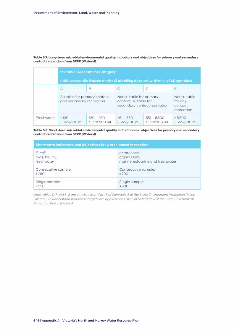
Department of Environment, Land, Water and Planning
646 | Appendix A Victoria’s North and Murray Water Resource Plan
Table S.7: Long-term microbial environmental quality indicators and objectives for primary and secondary contact recreation (from SEPP (Waters))
Microbial Assessment Category
(95th percentile (Hazen method) of rolling data set with min. of 60 samples)
A B C D E
Suitable for primary contact and secondary recreation
Not suitable for primary contact; suitable for secondary contact recreation
Not suitable for any contact recreation
Freshwater < 130 E. coli/100 mL
130 – 260 E. coli/100 mL
261 – 550 E. coli/100 mL
551 – 5,500 E. coli/100 mL
> 5,500 E. coli/100 mL
Table S.8: Short-term microbial environmental quality indicators and objectives for primary and secondary contact recreation (from SEPP (Waters))
Short term indicators and objectives for water-based recreation
E. coli orgs/100 mL freshwater
enterococci orgs/100 mL marine, estuarine and freshwater
Consecutive sample: ≤ 260
Consecutive sample: ≤ 200
Single sample: ≤ 550
Single sample: ≤ 500
Note tables S-7 and S-8 are extracts from Part 6 of Schedule 3 of the State Environment Protection Policy (Waters). To understand how these targets are applied see Part 6 of Schedule 3 of the State Environment Protection Policy (Waters).
Department of Environment, Land, Water and Planning
Appendix A | 647Victoria’s North and Murray Water Resource Plan


