Embed Size (px)
Citation preview
375 West El Pintado Road Residential Project
Draft Environmental Impact Report SCH #2016012045
prepared by Town of Danville
Development Services Department 510 La Gonda Way
Danville, California 94526 Contact: David Crompton, Principal Planner
July 2018
375 West El Pintado Road Residential Project
Draft Environmental Impact Report SCH #2016012045
prepared by Town of Danville
Development Services Department 510 La Gonda Way
Danville, California 94526 Contact: David Crompton, Principal Planner
prepared with the assistance of Rincon Consultants, Inc.
449 15th Street, Suite 303 Oakland, California 94610
July 2018

This report prepared on 50% recycled paper with 50% post-consumer content.
Table of Contents
Draft Environmental Impact Report i
Table of Contents
Acronyms and Abbreviations................................................................................................................. vii
Executive Summary ................................................................................................................................ 1 Project Synopsis .............................................................................................................................. 1 Project Description ......................................................................................................................... 1 Summary of Impacts and Mitigation Measures ............................................................................. 2
1 Introduction .................................................................................................................................. 15 1.1 Environmental Impact Report Background....................................................................... 15 1.2 Purpose and Legal Authority ............................................................................................. 15 1.3 Scope and Content ............................................................................................................ 16 1.4 Lead, Responsible, and Trustee Agencies ......................................................................... 16 1.5 Environmental Review Process ......................................................................................... 17
2 Project Description ....................................................................................................................... 21 2.1 Project Applicant ............................................................................................................... 21 2.2 Lead Agency and Contact Person ...................................................................................... 21 2.3 Project Location ................................................................................................................ 21 2.4 Surrounding Land Uses ..................................................................................................... 21 2.5 Existing Site Characteristics .............................................................................................. 22
2.5.1 Land Use Regulatory Setting ............................................................................. 26 2.6 Project Characteristics ...................................................................................................... 27
2.6.1 Site Access and Parking .................................................................................... 30 2.6.2 Infrastructure .................................................................................................... 40
2.7 Grading and Construction ................................................................................................. 42 2.8 Project Objectives ............................................................................................................. 42 2.9 Required Approvals ........................................................................................................... 42
3 Environmental Setting .................................................................................................................. 45 3.1 Regional Setting ................................................................................................................ 45 3.2 Project Site Setting ............................................................................................................ 45 3.3 Cumulative Development ................................................................................................. 46
4 Environmental Impact Analysis .................................................................................................... 49 4.1 Aesthetics .......................................................................................................................... 51
4.1.1 Setting ............................................................................................................... 51 4.1.2 Impact Analysis ................................................................................................. 59
4.2 Air Quality ......................................................................................................................... 65 4.2.1 Setting ............................................................................................................... 65 4.2.2 Impact Analysis ................................................................................................. 71
4.3 Biological Resources .......................................................................................................... 81 4.3.1 Setting ............................................................................................................... 81 4.3.2 Impact Analysis ................................................................................................. 94
Town of Danville 375 West El Pintado Road Residential Project
ii
4.4 Greenhouse Gas Emissions ............................................................................................. 103 4.4.1 Environmental Setting .................................................................................... 103 4.4.2 Impact Analysis ............................................................................................... 108
4.5 Hydrology and Water Quality ......................................................................................... 115 4.5.1 Setting ............................................................................................................. 115 4.5.2 Impact Analysis ............................................................................................... 122
4.6 Land Use and Planning .................................................................................................... 129 4.6.1 Setting ............................................................................................................. 129 4.6.2 Impact Analysis ............................................................................................... 134
4.7 Noise ............................................................................................................................... 141 4.7.1 Setting ............................................................................................................. 141 4.7.2 Impact Analysis ............................................................................................... 150
4.8 Traffic and Circulation ..................................................................................................... 163 4.8.1 Setting ............................................................................................................. 163 4.8.2 Impact Analysis ............................................................................................... 175
5 Other CEQA Required Discussions .............................................................................................. 189
6 Alternatives ................................................................................................................................. 193
7 References .................................................................................................................................. 207 7.1 Bibliography .................................................................................................................... 207 7.2 List of Preparers .............................................................................................................. 213
Tables Table 1 Summary of Significant Environmental Impacts, Mitigation Measures, and
Residual Impacts ................................................................................................................... 3
Table 2 NOP Comments and EIR Response ..................................................................................... 15
Table 3 Characteristics of the Project Site and Vicinity ................................................................... 26
Table 4 Project Characteristics ........................................................................................................ 31
Table 5 Cumulative Projects List ..................................................................................................... 47
Table 6 Ambient Air Quality Standards & Basin Attainment Status ............................................... 68
Table 7 Ambient Air Quality Data .................................................................................................... 69
Table 8 Air Quality Thresholds of Significance ................................................................................ 73
Table 9 Proposed Project Construction Air Pollutant Emissions ..................................................... 75
Table 10 Proposed Project Operational Average Daily Emissions .................................................... 76
Table 11 Proposed Project Operational Maximum Annual Emissions .............................................. 76
Table 12 Screening Data: Existing Highways and Major Roadways .................................................. 77
Table 13 Screening Data for Existing Highways and Major Roadways after Mitigation ................... 79
Table 14 Special-Status Species Known or with Potential to Occur Within Five Miles of the Project Site .......................................................................................................................... 83
Table 15 Town of Danville GHG Emissions ...................................................................................... 107
Table of Contents
Draft Environmental Impact Report iii
Table 16 Consistency with Town of Danville Sustainability Action Plan ......................................... 111
Table 17 Combined Annual Emissions of Greenhouse Gases ......................................................... 113
Table 18 Existing Land Uses and Zoning of Surrounding Properties ............................................... 130
Table 19 Existing Land Uses and Zoning of Project Site .................................................................. 132
Table 20 Consistency with Goals and Policies in the Danville 2030 General Plan .......................... 136
Table 21 Representative Environmental Noise Levels .................................................................... 142
Table 22 Human Response to Different Levels of Groundborne Vibration .................................... 143
Table 23 Land Use Compatibility Guidelines for Exterior Noise Levels (2012) Town of Danville ............................................................................................................................. 145
Table 24 Sound Level Measurement Results (dBA) ........................................................................ 150
Table 25 Significance of Changes in Operational Roadway Noise Exposure................................... 152
Table 26 Comparison Between Measured Ambient Sound and Modeled Traffic Noise Levels ................................................................................................................................ 153
Table 27 Vibration Levels for Construction Equipment .................................................................. 155
Table 28 Comparison of Pre-Project and Post-Project Traffic Noise On Local Roadways .............. 158
Table 29 Typical Noise Levels from Construction Equipment ......................................................... 159
Table 30 CCTA Level of Service Definitions ..................................................................................... 172
Table 31 HCM Level of Service Definitions for Signalized Intersections ......................................... 173
Table 32 HCM Level of Service Definitions for Stop‐controlled Intersections ................................ 174
Table 33 Intersection Level of Service – Existing Conditions .......................................................... 174
Table 34 Intersection Level of Service –Cumulative (Year 2035) Conditions .................................. 175
Table 35 Intersection Level of Service –Existing plus Project Conditions ....................................... 182
Table 36 Intersection Level of Service –Cumulative (Year 2035) Plus Project Conditions .............. 186
Table 37 Comparison of Project Alternatives Buildout Characteristics .......................................... 194
Table 38 Alternative 2 Characteristics............................................................................................. 196
Table 39 Alternative 3 Characteristics............................................................................................. 199
Table 40 Summary Comparison of Project Alternatives ................................................................. 206
Figures Figure 1 Environmental Review Process ....................................................................................... 19
Figure 2 Regional Location ............................................................................................................ 23
Figure 3 Project Site Location ........................................................................................................ 24
Figure 4 Site Photos ....................................................................................................................... 25
Figure 5 Zoning .............................................................................................................................. 28
Town of Danville 375 West El Pintado Road Residential Project
iv
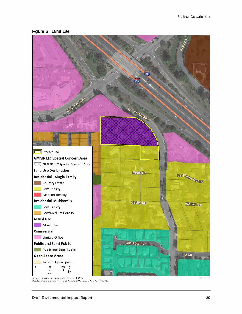
Figure 6 Land Use .......................................................................................................................... 29
Figure 7 Proposed Site Plan ........................................................................................................... 32
Figure 8a Project Elevations – Building A ........................................................................................ 33
Figure 8b Project Elevations–Building B .......................................................................................... 34
Figure 8c Project Elevations–Building C .......................................................................................... 35
Figure 8d Project Elevations–Building D and E ................................................................................ 36
Figure 8e Project Elevations – Building F ........................................................................................ 37
Figure 8f Project Elevations –Building G ........................................................................................ 38
Figure 8g Project Elevations – Building H ........................................................................................ 39
Figure 9 Preliminary Stormwater Control Plan ............................................................................. 41
Figure 10 Visual Character of Project Site – Photos 1 and 2 ........................................................... 52
Figure 11 Visual Character of Project Site – Photos 3 and 4 ........................................................... 53
Figure 12 Visual Character of Project Site – Photos 5 and 6 ........................................................... 54
Figure 13 Visual Character of the Surrounding Area – Photos 1 and 2 ........................................... 55
Figure 14 Visual Character of the Surrounding Area – Photos 3 and 4 ........................................... 56
Figure 15 Major Drainages ............................................................................................................ 118
Figure 16 Flood Hazard Areas ....................................................................................................... 119
Figure 17 Modeled Noise Locations and Roadway Segments ...................................................... 149
Figure 18 Existing Transit Services ................................................................................................ 165
Figure 19 Existing Bicycle Network ............................................................................................... 166
Figure 20 Existing Conditions Lane Geometry and Controls ......................................................... 170
Figure 21 Existing Conditions Traffic Volumes .............................................................................. 171
Figure 22 Future (2035) Conditions Traffic Volumes .................................................................... 176
Figure 23 Project Trips Assignment and Distribution .................................................................... 178
Figure 24 Existing Plus Project Conditions .................................................................................... 183
Figure 25 Figure (2035) Plus Project Conditions ........................................................................... 185
Appendices Appendix A Initial Study, Notice of Preparation (NOP), and NOP Responses
Appendix B Air Quality Modeling Results
Appendix C Biological Resources Analysis
Appendix D Arborist Report
Appendix E Greenhouse Gas Emissions Modeling Results
Appendix F Preliminary Stormwater Control Plan
Table of Contents
Draft Environmental Impact Report v
Appendix G Noise Measurement Data and Noise Modeling Results
Appendix H Traffic Impact Study

Town of Danville 375 West El Pintado Road Residential Project
vi
This page intentionally left blank.
Acronyms and Abbreviations
Draft Environmental Impact Report vii
Acronyms and Abbreviations
ABAG Association of Bay Area Governments
ANSI American National Standard Institute
APN Assessor Parcel Numbers
BAAQMD Bay Area Air Quality Management District
BMP Best Management Practices
CalEPA California Environmental Protection Agency
Caltrans California Department of Transportation
CAP Climate Action Plan
CDFW California Department of Fish and Wildlife
CEQA California Environmental Quality Act
CESA California Endangered Species Act
CGS California Geological Survey
CH4 Methane
CNDDB California Natural Diversity Database
CNPS California Native Plant Society
CO Carbon monoxide
CO2 Carbon dioxide
CO2e Carbon dioxide equivalent
CRPR California Rare Plant Rank
CWA Clean Water Act
DMC Danville Municipal Code
DWR (California) Department of Water Resources
EIR Environmental Report
EPA (United States) Environmental Protection Agency
FE Federally Endangered
FEMA Federal Emergency Management Agency
FESA Federal Endangered Species Act
FGC Fish and Game Code
FP Fully Protected
Town of Danville 375 West El Pintado Road Residential Project
viii
FT Federally Threatened
GHG Greenhouse Gas
GPA General Plan Amendment
GWP Global warming potential
HCFC Hydrochlorofluorocarbons
HFC Hydrofluorocarbons
HVAC Heating, Ventilation, and Air Conditioning
I Interstate
MBTA Migratory Bird Treaty Act
MERV Minimum Efficiency Rating Value
MTC Metropolitan Transportation Commission
NO Nitric oxide
N2O Nitrous oxides
NO2 Nitrogen dioxide
NOX Nitrogen oxides
NOP Notice of Preparation
NPDES National Pollutant Discharge Elimination System
PFC Perfluorocarbons
ROG Reactive organic gases
ROW Right-of-way
RWQCB Regional Water Quality Control Board
SDWA Safe Drinking Water Act
SE State Endangered
SF6 Sulfur hexafluoride
SO2 Sulfur dioxide
SR State Rare
SR State Route
SSC Species of Special Concern
ST State Threatened
SWPPP Stormwater Pollution Prevention Plan
SWRCB State Water Resources Control Board
TMDL Total Maximum Daily Loads
USACE United States Army Corps of Engineers
Acronyms and Abbreviations
Draft Environmental Impact Report ix
USC United States Code
USFWS United States Fish and Wildlife Service
USGS United States Geologic Service
VOC Volatile Organic Compound

Town of Danville 375 West El Pintado Road Residential Project
x
This page intentionally left blank.
Executive Summary
Draft Environmental Impact Report 1
Executive Summary
This section summarizes the characteristics of the project as well as the environmental impacts, mitigation measures, and residual impacts associated with implementation of the project.
Project Synopsis
Project Proponent GMMR, LLC 230 Piedmont Lane Danville, California 94526
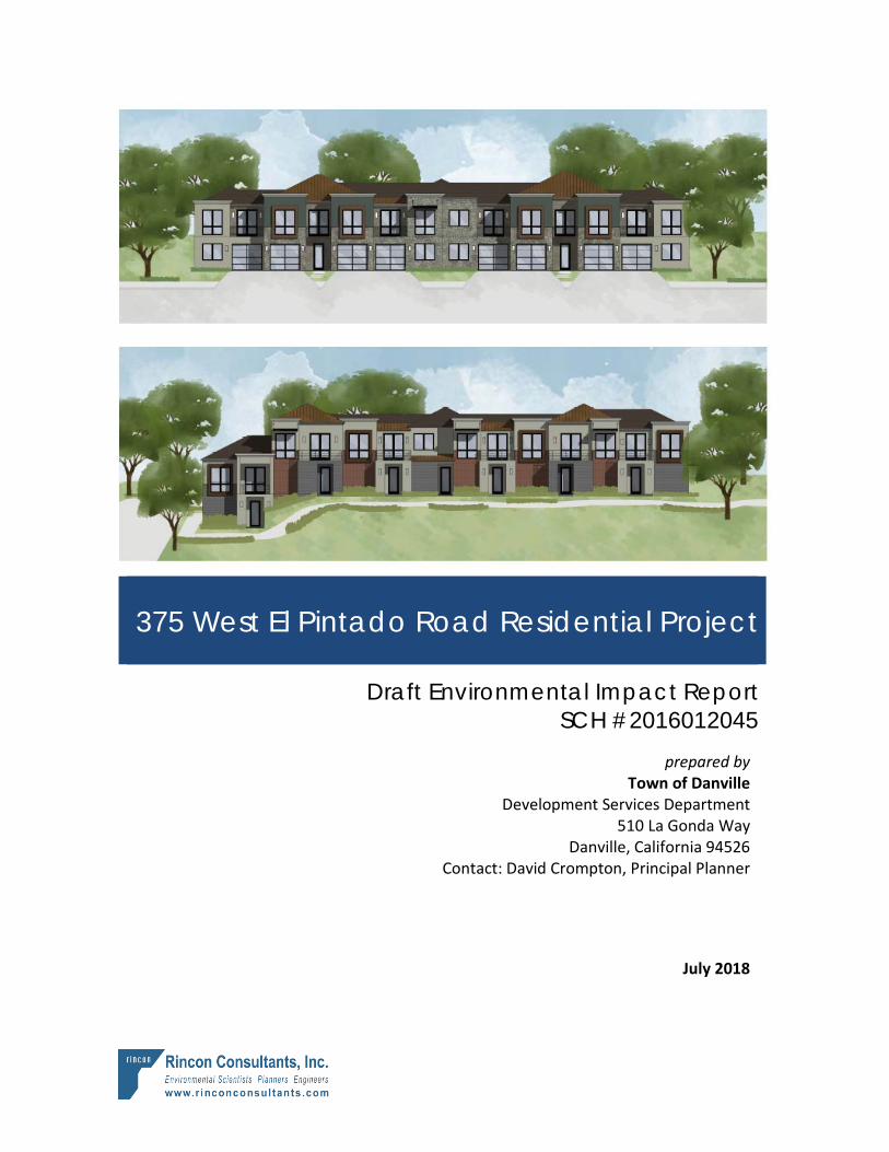
Project Description The project involves a request for a General Plan Amendment (GPA2015-0001), Preliminary Development Plan – Rezoning (PUD2015-0001), Major Subdivision (SD 9399), and Final Development Plan (DP2015-0065) to allow for the development of a 37-unit townhouse development. The General Plan Amendment request pertains to the 0.29-acre lot only, and would amend the Town’s 2030 General Plan land use designation from Residential – Single Family – Low Density (one to three units per acre) to a Mixed Use land use designation. The Preliminary Development Plan – Rezoning request would rezone the project site to a new P-l, Planned Unit Development District. The Major Subdivision would subdivide the site, creating 37 multifamily townhome units. The Final Development Plan would provide for the approval of project architecture, site design, and landscape design. A Tree Removal permit (TR2015-0039) is also required to allow for the removal of Town-protected trees.
The project would involve demolition of the existing on-site residence, site preparation (including grading and tree removal), and construction of eight new multifamily townhome buildings. The 37 townhome units would include one-, two-, and three-bedroom units in buildings with partially below-grade and at-grade garages. Six of the units (15 percent of the total) would be affordable housing units in accordance with the Town’s inclusionary housing requirements. Proposed site amenities include landscaping, off-street parking, a play structure, as well as a lawn, walking path, outdoor seating area on the northeast corner of the site. Six larger two-story buildings would be constructed on the northern portion of the project site, each with a mix of one-, two-, and three-bedroom units. These six buildings (Buildings A-F) would range from 28 to 35 feet in height (2-2.5 stories) and include partially below-grade garages. Two smaller two-story buildings (buildings G and H) would be constructed on the southeastern portion of the project site, each with two three-bedroom, 2.5-bathroom units. These two buildings with at-grade garages would each be approximately 25 feet in height.
Additional information about the project is provided in Section 2, Project Description.
Alternatives Four alternatives to the project were chosen for analysis as follows:
Town of Danville 375 West El Pintado Road Residential Project
2
Alternative 1: No Project/No Development Alternative 2: Existing Zoning Alternative 3: M-25 Zoning Alternative 4: Single-Family Residential
Refer to Section 6, Alternatives, for descriptions and analyses of these four alternatives. Among the development options, Alternative 4 (Single-Family Residential) would be environmentally superior to the project as it would involve fewer emissions of air pollutants and GHGs, decreased construction and operational noise levels, and reduced traffic. However, Alternative 4 would not meet objectives 1 through 3 regarding land use designation of the project site (Objective 1), the provision of affordable housing (Objective 2), providing housing to accommodate households of varying size, type, and income (Objective 3), and the provision of on-site parks and pedestrian paths (Objective 6). Alternative 4 would meet objectives 4 and 5. In addition, Alternative 4 would not be consistent with General Plan Policy 1.05. This policy discourages General Plan amendments which result in the loss of lands designated for multiple family housing.
Summary of Impacts and Mitigation Measures Table 1 includes a brief description of the environmental issues relative to the project, the identified environmental impacts, proposed mitigation measures, and residual impacts. Impacts are categorized by significance. Significant and unavoidable adverse impacts (Class I) require a statement of overriding considerations to be issued per Section 15093 of the State CEQA Guidelines if the project is approved. Significant but mitigatable impacts (Class II) are adverse impacts that can be feasibly mitigated to less than significant levels and that require findings to be made under Section 15091 of the State CEQA Guidelines. Less than significant impacts (Class III) would not exceed significance thresholds and therefore would not require mitigation.
Executive Summary
Draft Environmental Impact Report 3
Table 1 Summary of Significant Environmental Impacts, Mitigation Measures, and Residual Impacts Impact Mitigation Measure(s) Residual Impact
Aesthetics
Impact AES-1. Due to the surrounding topography and the intervening presence of existing mature trees, the project would not have a substantial adverse effect on a scenic vista as seen from a public location such as West El Pintado Road. This is a Class III, less than significant, impact.
None. Less than significant without mitigation.
Impact AES-2. The project would involve tree removal and construction of residential buildings on a site that is visible from I-680, a designated state scenic highway. However, the project would be only partially visible from I-680 and would require a tree permit for removal of protected trees, which would include protection of off-site and on-site trees and trees, and replacement of trees on- and off-site. The impact would be Class III, less than significant.
None. Less than significant without mitigation.
Impact AES-3. The project would introduce eight new residential buildings to a mostly vacant site with trees and rolling topography. Although this would alter the visual character and quality of the site, the project would be visually compatible with surrounding development and would not conflict with adopted visual resources policies of the Town of Danville. The impact to the existing visual character of the site would be Class III, less than significant.
None. Less than significant without mitigation.
Impact AES-4. The project would add new sources of light and glare on and around the project site, which is primarily vacant. However, with adherence to town policies regarding outdoor lighting and the proposed use of non-reflective materials, impacts related light glare would be Class III, less than significant.
None. Less than significant without mitigation.
Air Quality
Impact AQ-1. Project construction and operation would generate increases in localized air pollutant emissions. Such emissions may result in adverse impacts to local air quality, but are below BAAQMD thresholds. Therefore, air quality impacts associated with the proposed project would be Class III, less than significant.
None. Less than significant without mitigation.
Town of Danville 375 West El Pintado Road Residential Project
4
Impact Mitigation Measure(s) Residual Impact
Impact AQ-2. The project site is located within 500 feet of I-680. New residents on the project site would be exposed to toxic air contaminants from freeway vehicle emissions at levels that exceed BAAQMD screening thresholds and therefore may create health risks. Impacts would be Class II, significant but mitigable.
Mitigation Measure AQ-1 Toxic Air Contaminants Emissions Reductions. In order to reduce exposure of proposed residences to toxic air contaminants emissions from vehicles on I-680, the applicant shall submit to the Town of Danville for review and approval a ventilation proposal prepared by a licensed design professional for all on-site buildings that describes the ventilation design and how that design ensures all dwelling units would be below the excess cancer risk level of 10 in one million established by the Bay Area Air Quality Management District. The ventilation proposal shall include, but is not limited to, the following measures: a) If the proposed buildings would use operable windows or other
sources of infiltration of ambient air, the development shall install a central HVAC system that includes high efficiency particulate filters (a MERV rating of 13 or higher). These types of filters are capable of removing approximately 90 percent of the DPM emissions from air introduced into the HVAC system. The system may also include a carbon filter to remove other chemical matter. Filtration systems must operate to maintain positive pressure within the building interior to prevent entrainment of outdoor air indoors.
b) If the development limits infiltration through non-operable windows, a suitable ventilation system shall include a ventilation system with filtration specifications equivalent to or better than the following: (1) American Society of Heating, Refrigerating and Air-Conditioning Engineers MERV-13 supply air filters, (2) greater than or equal to one air exchanges per hour of fresh outside filtered air, (3) greater than or equal to four air exchanges per hour recirculation, and (4) less than or equal to 0.25 air exchanges per hour in unfiltered infiltration. These types of filtration methods are capable of removing approximately 90 percent of the DPM emissions from air introduced into the HVAC system.
c) Windows and doors shall be fully weatherproofed with caulking and weather-stripping that is rated to last at least 20 years. Weatherproof should be maintained and replaced by the property owner, as necessary, to ensure functionality for the lifetime of the project
d) Where appropriate, install passive (drop-in) electrostatic filtering systems, especially those with low air velocities (i.e., 1 mph)
e) Ensure an ongoing maintenance plan for the HVAC and filtration
Less than significant.
Executive Summary
Draft Environmental Impact Report 5
Impact Mitigation Measure(s) Residual Impact systems. Manufacturers of these types of filters recommend that they be replaced after two to three months of use.
f) The applicant shall inform occupants regarding the proper use of any installed air filtration system.
Biological Resources
Impact BIO-1. Construction of the project could directly impact special-status species including nesting raptors and other avian species protected under existing regulations by causing injury, death, or nest failure. Potential impacts to nesting birds would be Class II, significant but mitigable.
Mitigation Measure BIO-1 Pre-construction Surveys for Nesting Birds and Raptors. For construction activities occurring outside of the nesting season (September 1 to January 31), no mitigation is necessary. For construction activities occurring during the nesting season (February 1 to August 31), surveys for nesting birds and raptors covered by the CFC and the MBTA shall be conducted by a qualified biologist no more than 14 days prior to initiation of any construction activities, including construction staging and vegetation or tree removal, or tree trimming. The surveys shall include the entire disturbance areas plus a 200-foot buffer (where accessible) around any disturbance areas for passerine species, and 500-foot buffer (where accessible) for raptors. If active nests are located, all construction work shall be conducted outside a buffer zone from the nest to be determined by the qualified biologist. The nest avoidance buffer shall be determined by the qualified biologist and be commensurate with species and location of the nest in relation to proposed work activity. Raptor avoidance buffers shall be a minimum of 150 feet, but may be larger depending on species, nest location and observed behavior. The qualified biologist shall have full discretion for establishing a suitable buffer. The buffer area(s) shall be closed to all construction personnel and equipment until the adults and young are no longer reliant on the nest, or the nest has otherwise become inactive through natural processes (E.G., depredation). A qualified biologist shall confirm that breeding/nesting is completed and young have fledged the nest prior to removal of the buffer.
Less than significant.
Impact BIO-2. Implementation of the project would not result in impacts to riparian habitat. Impacts would be Class III, less than significant.
None. Less than significant without mitigation.
Town of Danville 375 West El Pintado Road Residential Project
6
Impact Mitigation Measure(s) Residual Impact
Impact BIO-3. Implementation of the project would directly impact wetlands/waterways. Potential impacts to federally protected wetlands and waterways as defined by Sections 404 and 401 of the Clean Water Act and Section 1602 of the California Fish and Game Code would be Class II, significant but mitigable.
Mitigation Measure BIO-2 Formal Jurisdictional Delineation. The applicant shall contract a qualified jurisdictional waters expert to conduct a formal jurisdictional delineation and prepare a Jurisdictional Delineation Report to support Jurisdictional Waters permitting with USACE, RWQCB and CDFW. The jurisdictional delineation shall determine the extent of the jurisdiction for each of these agencies and shall be conducted in accordance with the requirement set forth by each agency. The result shall be a preliminary jurisdictional delineation report that shall be submitted to the implementing agency, USACE, RWQCB, and CDFW, as appropriate, for review and approval. Impacts to jurisdictional features shall be minimized to the extent feasible based on the findings of the Jurisdictional Delineation and the agency verification of limits of jurisdiction within the project site. Mitigation Measure BIO-3 Regulatory Permitting. Jurisdictional areas that would be impacted would require one or more of the following permits: 1) a RWQCB Waste Discharge Requirements permit and/or Section 401 Water Quality Certification (depending upon whether or not the feature falls under federal jurisdiction), 2) a CDFW Streambed Alteration Agreement pursuant to Section 1600 et seq. of the California Fish and Game Code for impacts within the areas of CDFW jurisdiction, and 3) a USACE permit pursuant to Section 404 of the Clean Water Act. The applicant shall acquire any required permits from the USACE, RWQCB, and CDFW prior to conducting construction activity (including grading, vegetation removal, and site preparation) within any and all Waters of the State or Waters of the U.S. under the jurisdictions of USACE, RWQCB or CDFW. Mitigation Measure BIO-4 Wetland/Drainage Compensation. Mitigation for impacts to drainages/linear wetlands that may be required by the USACE, RWQCB and CDFW in permits issued/authorized for the project and shall be implemented by the applicant as required. This mitigation compensation may include either creation of mitigation wetlands at an off-site location or the purchase of credits from an agency-approved mitigation bank. Purchase of mitigation credits or creation of mitigation wetlands to mitigate for permanent impacts to wetland features shall be at a minimum ratio of 1:1 for man-made features, and 2:1 for natural wetland features and associated riparian habitat (that is, for each acre of impact it would be necessary to set aside one acre of wetland/riparian habitat for man-
Less than significant.
Executive Summary
Draft Environmental Impact Report 7
Impact Mitigation Measure(s) Residual Impact made features and two acres of wetland/riparian habitat for natural features as compensation). Mitigation to offset temporary impacts to wetland features shall be required at a 1:1 ratio through restoration of areas with temporary impacts. The agencies may require higher mitigation ratios in permit documents, and, if so, agency permit mitigation ratios would supersede the 1:1 ratio required here. Minimum requirements for mitigating impacts to wetlands include: Replacement of impacted wetlands at a minimum 1:1 ratio. For
permanent wetland impacts, wetlands can be replaced at a minimum ratio of one acre created for each acre, or fraction thereof, permanently impacted.
Creation of in perpetuity preservation. The USACE, RWQCB and CDFW generally require that Waters of the U.S. not impacted by the project and any new wetlands created to mitigate project impacts be set aside in perpetuity, either through deed restrictions or conservation easements.
For restoration or creation of mitigation wetlands it shall be necessary to establish a five-year monitoring program to monitor the progress of the wetland mitigation toward an established goal. At the end of each monitoring year, an annual report would be submitted to the Town of Danville, USACE, RWQCB, and/or CDFW depending on permitting requirements for each agency. This report would document the hydrological and vegetative condition of the mitigation wetlands, and would recommend remedial measures as necessary to correct deficiencies.
If purchasing credits from an approved mitigation bank is an option, then wetland creation off-site with subsequent monitoring requirements may not be necessary. This would be determined at the time permits are applied for/issued by the USACE, RWQCB and CDFW.
Aside from the minimum replacement ratio and in-perpetuity protection, various regulatory agencies may provide additional conditions and stipulations for permits. Additional conditions that are stipulated for wetland impacts by the USACE, RWQCB and/or CDFW shall also become conditions of project approval.
Town of Danville 375 West El Pintado Road Residential Project
8
Impact Mitigation Measure(s) Residual Impact
Impact BIO-4. Implementation of the project would not result in impacts to movement of native resident or migratory fish or wildlife species nor would it impact migratory wildlife corridors or impede the use of native nursey sites. This impact would be Class III, less than significant.
None. Less than significant without mitigation.
Impact BIO-5. Implementation of the project would require removal of trees protected under the Danville Municipal Code. This impact would be Class II, significant but mitigable.
Mitigation Measure BIO-5 Tree Replacement. The applicant shall comply with Town requirements (DMC Section 32-79), as applicable, to plant on-site or off-site replacement trees for removed protected trees which are of a cumulative diameter necessary to equal the diameter of trees approved for removal as determined by the Town’s Planning Division. For the non-Town protected trees that would be removed as part of the project, the applicant shall plant new minimum 15 gallon trees either on-site or off-site, as determined by the Town, at a 1:1 ratio. The exact locations and tree species shall be subject to review and approval by the Town’s Planning Division. Mitigation Measure BIO-6 Tree Protection. The following measures shall be implemented prior to the start of construction for all trees not designated for removal. Trees to be retained on site shall be temporarily fenced with chain-
link or other substantial, highly visible material while all grading and construction activities occur, including landscaping activities that require substantial ground disturbance (more than the use of hand tools). The fencing shall be five feet from the dripline of the canopy, at least six-feet high, staked to prevent collapse, and shall contain signs identifying the protection area.
When construction activities occur within five feet of the dripline, a certified arborist shall be on site to monitor and make recommendations.
All roots shall be cut cleanly, if possible back to a lateral branching root. Cuts should be made at right angles to the roots.
If canopy trimming is needed it shall be done under the supervision of an International Society of Arboriculture (ISA) Certified Arborist and by an ISA Certified Tree Worker. Trees shall be pruned according to American National Standards Institute (ANSI) 300 standards. ANSI 300 provides guidelines for pruning trees and other woody plants.
Less than significant.
Executive Summary
Draft Environmental Impact Report 9
Impact Mitigation Measure(s) Residual Impact
Geology and Soils
The combination of site topography and on-site soil characteristics results in the potential for landslide, lateral spreading, subsidence, liquefaction, and collapse. Impacts would be Class II, significant but mitigable. (See Initial Study, Appendix A).
Mitigation Measure GEO-1: Design-Level Geotechnical Investigation. In accordance with the recommendations of the preliminary geotechnical investigation, the applicant shall conduct a design-level geotechnical investigation. The design-level geotechnical investigation shall include additional field exploration and laboratory testing. Soil borings and/or cone penetration tests (CPT) soundings shall be conducted to evaluate the potential for liquefaction in the area of the preliminary geotechnical investigation Boring 2. The recommendations of the design-level geotechnical investigation shall be incorporated into the proposed project grading and building plans after review and approval by the Town’s Building Services Division. These recommendations may include the removal of expansive soils, replacing expansive soils with non-expansive engineered fill, deepening foundations to develop support below the zone of significant seasonal moisture change, designing foundation/slab systems to resist uplift pressures generated by swelling soils, providing drainage and landscaping to minimize seasonal moisture fluctuations in the near-surface soils, compacting soils to the appropriate relative compaction, and designing foundations to resist the adverse effects of liquefaction and corrosive soils.
With the implementation of Mitigation Measure GEO-1, potential impacts would be reduced to a less than significant level.
Greenhouse Gas Emissions
Impact GHG-1. The project would generate GHG emissions during construction and operation. These emissions would incrementally contribute to climate change. However, project emissions would not hinder or delay achievement of state GHG reduction targets established by AB 32 and the project would be consistent with the Town’s Sustainability Action Plan. Impacts would therefore be Class III, less than significant.
None. Less than significant without mitigation.
Town of Danville 375 West El Pintado Road Residential Project
10
Impact Mitigation Measure(s) Residual Impact
Hydrology and Water Quality
Impact HWQ-1. Construction and operation of the project could potentially result in an increase in pollutant discharges to Waters of the State, but compliance with Danville General Plan policies and actions, as well as existing regulatory requirements, would avoid such impacts. The project would therefore not violate water quality standards or waste discharge requirements or otherwise substantially degrade water quality, and this impact would be Class II, significant but mitigable.
Mitigation measures BIO-2, BIO-3, and BIO-4 listed above under Impact BIO-3.
Less than significant.
Impact HWQ-2. The project would alter the existing drainage pattern of the site. Improperly designed drainage modifications could result in an increase of stormwater runoff from the project area. However, the proposed drainage plan for the project would ensure that impacts would be Class III, less than significant.
None. Less than significant without mitigation.
Land Use and Planning
Impact LU-1. Under the proposed project, the 0.29-acre portion of the project site would involve construction of a multi-family (townhouse) residential development that is not included within the permitted uses under the current zoning and land use designations for that parcel. However, the proposed project includes a General Plan Amendment and preliminary development plan – rezoning request to provide consistency with applicable Town policies, regulations, and standards. Upon approval of discretionary actions, the proposed project would not conflict with applicable plans and policies. This impact would be Class III, less than significant.
None. Less than significant without mitigation.
Noise
Impact N-1. The proposed project would introduce residents to the project site that would be exposed to ambient noise levels in the Town’s “conditionally acceptable” range. Impacts would be Class II, significant but mitigable.
Mitigation Measure N-1: Interior Noise. At a minimum, all on-site structures shall include the following to achieve an acceptable interior noise level: Air conditioning or a mechanical forced–air ventilation system so
that windows and doors may remain closed Double-paned windows and sliding glass doors mounted in low air
infiltration rate frames (0.5 cubic feet per minute, per ANSI specifications)
Solid core exterior doors with perimeter weather stripping and threshold seals
Roof and attic vents facing away from I-680
Less than significant.
Executive Summary
Draft Environmental Impact Report 11
Impact Mitigation Measure(s) Residual Impact
Impact N-2. Temporary groundborne vibration from construction of the project, including demolition of the existing on-site residence, may be perceptible at nearby sensitive receptors. However, vibration would not exceed FTA thresholds during normal sleeping hours or damage buildings. Therefore, impacts would be Class III, less than significant.
None. Less than significant without mitigation.
Impact N-3. The proposed townhomes would generate on-site noise operational noise typical of residential uses and consistent with existing noise at surrounding residential uses. Project-generated vehicle trips would incrementally increase traffic-related noise heard by local residents under existing plus project and future cumulative plus project conditions. However, the change in noise levels would not exceed FTA thresholds. Therefore, the effect of increased traffic noise on existing sensitive receptors would be Class III, less than significant.
None. Less than significant without mitigation.
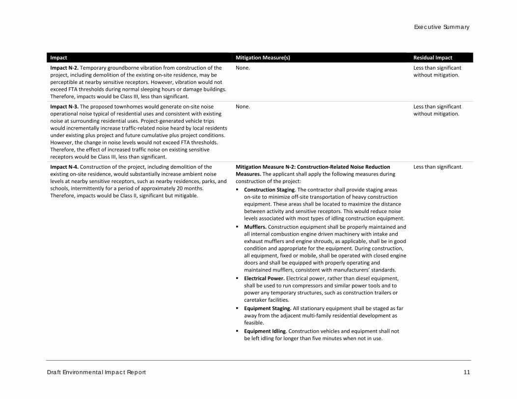
Impact N-4. Construction of the project, including demolition of the existing on-site residence, would substantially increase ambient noise levels at nearby sensitive receptors, such as nearby residences, parks, and schools, intermittently for a period of approximately 20 months. Therefore, impacts would be Class II, significant but mitigable.
Mitigation Measure N-2: Construction-Related Noise Reduction Measures. The applicant shall apply the following measures during construction of the project: Construction Staging. The contractor shall provide staging areas
on-site to minimize off-site transportation of heavy construction equipment. These areas shall be located to maximize the distance between activity and sensitive receptors. This would reduce noise levels associated with most types of idling construction equipment.
Mufflers. Construction equipment shall be properly maintained and all internal combustion engine driven machinery with intake and exhaust mufflers and engine shrouds, as applicable, shall be in good condition and appropriate for the equipment. During construction, all equipment, fixed or mobile, shall be operated with closed engine doors and shall be equipped with properly operating and maintained mufflers, consistent with manufacturers’ standards.
Electrical Power. Electrical power, rather than diesel equipment, shall be used to run compressors and similar power tools and to power any temporary structures, such as construction trailers or caretaker facilities.
Equipment Staging. All stationary equipment shall be staged as far away from the adjacent multi-family residential development as feasible.
Equipment Idling. Construction vehicles and equipment shall not be left idling for longer than five minutes when not in use.
Less than significant.
Town of Danville 375 West El Pintado Road Residential Project
12
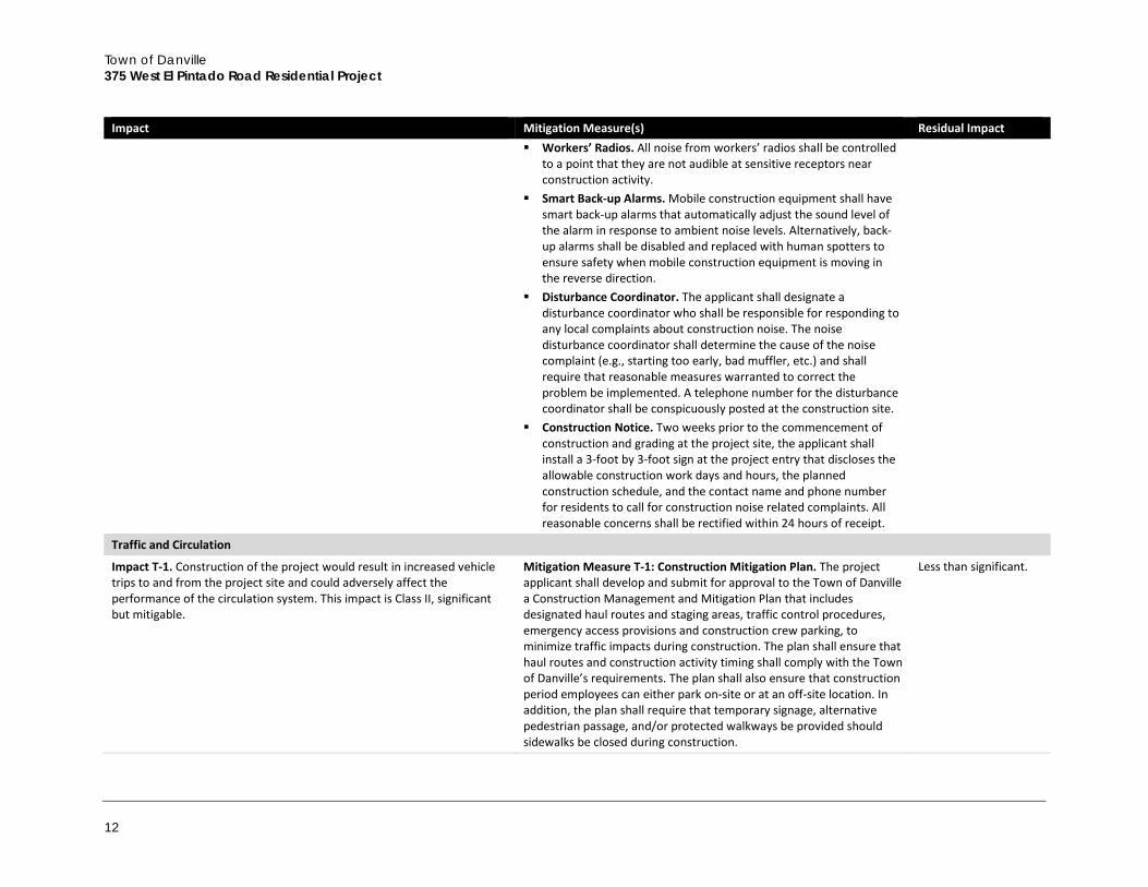
Impact Mitigation Measure(s) Residual Impact Workers’ Radios. All noise from workers’ radios shall be controlled
to a point that they are not audible at sensitive receptors near construction activity.
Smart Back-up Alarms. Mobile construction equipment shall have smart back-up alarms that automatically adjust the sound level of the alarm in response to ambient noise levels. Alternatively, back-up alarms shall be disabled and replaced with human spotters to ensure safety when mobile construction equipment is moving in the reverse direction.
Disturbance Coordinator. The applicant shall designate a disturbance coordinator who shall be responsible for responding to any local complaints about construction noise. The noise disturbance coordinator shall determine the cause of the noise complaint (e.g., starting too early, bad muffler, etc.) and shall require that reasonable measures warranted to correct the problem be implemented. A telephone number for the disturbance coordinator shall be conspicuously posted at the construction site.
Construction Notice. Two weeks prior to the commencement of construction and grading at the project site, the applicant shall install a 3-foot by 3-foot sign at the project entry that discloses the allowable construction work days and hours, the planned construction schedule, and the contact name and phone number for residents to call for construction noise related complaints. All reasonable concerns shall be rectified within 24 hours of receipt.
Traffic and Circulation Impact T-1. Construction of the project would result in increased vehicle trips to and from the project site and could adversely affect the performance of the circulation system. This impact is Class II, significant but mitigable.
Mitigation Measure T-1: Construction Mitigation Plan. The project applicant shall develop and submit for approval to the Town of Danville a Construction Management and Mitigation Plan that includes designated haul routes and staging areas, traffic control procedures, emergency access provisions and construction crew parking, to minimize traffic impacts during construction. The plan shall ensure that haul routes and construction activity timing shall comply with the Town of Danville’s requirements. The plan shall also ensure that construction period employees can either park on-site or at an off-site location. In addition, the plan shall require that temporary signage, alternative pedestrian passage, and/or protected walkways be provided should sidewalks be closed during construction.
Less than significant.
Executive Summary
Draft Environmental Impact Report 13
Impact Mitigation Measure(s) Residual Impact
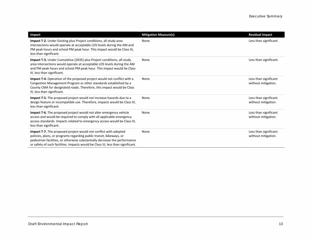
Impact T-2. Under Existing plus Project conditions, all study area intersections would operate at acceptable LOS levels during the AM and PM peak hours and school PM peak hour. This impact would be Class III, less than significant.
None. Less than significant.
Impact T-3. Under Cumulative (2035) plus Project conditions, all study area intersections would operate at acceptable LOS levels during the AM and PM peak hours and school PM peak hour. This impact would be Class III, less than significant.
None. Less than significant.
Impact T-4. Operation of the proposed project would not conflict with a Congestion Management Program or other standards established by a County CMA for designated roads. Therefore, this impact would be Class III, less than significant.
None. Less than significant without mitigation.
Impact T-5. The proposed project would not increase hazards due to a design feature or incompatible use. Therefore, impacts would be Class III, less than significant.
None. Less than significant without mitigation.
Impact T-6. The proposed project would not alter emergency vehicle access and would be required to comply with all applicable emergency access standards. Impacts related to emergency access would be Class III, less than significant.
None. Less than significant without mitigation.
Impact T-7. The proposed project would not conflict with adopted policies, plans, or programs regarding public transit, bikeways, or pedestrian facilities, or otherwise substantially decrease the performance or safety of such facilities. Impacts would be Class III, less than significant.
None. Less than significant without mitigation.

Town of Danville 375 West El Pintado Road Residential Project
14
This page intentionally left blank.
Introduction
Draft Environmental Impact Report 15
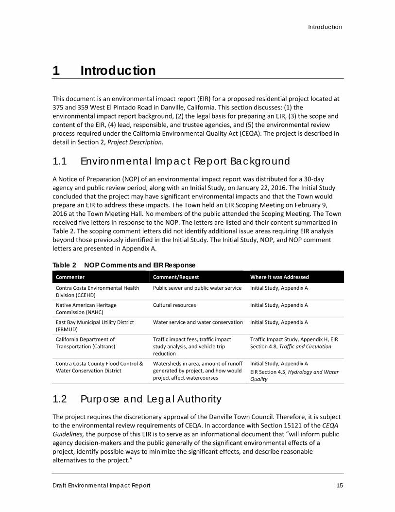
1 Introduction
This document is an environmental impact report (EIR) for a proposed residential project located at 375 and 359 West El Pintado Road in Danville, California. This section discusses: (1) the environmental impact report background, (2) the legal basis for preparing an EIR, (3) the scope and content of the EIR, (4) lead, responsible, and trustee agencies, and (5) the environmental review process required under the California Environmental Quality Act (CEQA). The project is described in detail in Section 2, Project Description.
1.1 Environmental Impact Report Background A Notice of Preparation (NOP) of an environmental impact report was distributed for a 30-day agency and public review period, along with an Initial Study, on January 22, 2016. The Initial Study concluded that the project may have significant environmental impacts and that the Town would prepare an EIR to address these impacts. The Town held an EIR Scoping Meeting on February 9, 2016 at the Town Meeting Hall. No members of the public attended the Scoping Meeting. The Town received five letters in response to the NOP. The letters are listed and their content summarized in Table 2. The scoping comment letters did not identify additional issue areas requiring EIR analysis beyond those previously identified in the Initial Study. The Initial Study, NOP, and NOP comment letters are presented in Appendix A.
Table 2 NOP Comments and EIR Response Commenter Comment/Request Where it was Addressed
Contra Costa Environmental Health Division (CCEHD)
Public sewer and public water service Initial Study, Appendix A
Native American Heritage Commission (NAHC)
Cultural resources Initial Study, Appendix A
East Bay Municipal Utility District (EBMUD)
Water service and water conservation Initial Study, Appendix A
California Department of Transportation (Caltrans)
Traffic impact fees, traffic impact study analysis, and vehicle trip reduction
Traffic Impact Study, Appendix H, EIR Section 4.8, Traffic and Circulation
Contra Costa County Flood Control & Water Conservation District
Watersheds in area, amount of runoff generated by project, and how would project affect watercourses
Initial Study, Appendix A EIR Section 4.5, Hydrology and Water Quality
1.2 Purpose and Legal Authority The project requires the discretionary approval of the Danville Town Council. Therefore, it is subject to the environmental review requirements of CEQA. In accordance with Section 15121 of the CEQA Guidelines, the purpose of this EIR is to serve as an informational document that “will inform public agency decision-makers and the public generally of the significant environmental effects of a project, identify possible ways to minimize the significant effects, and describe reasonable alternatives to the project.”
Town of Danville 375 West El Pintado Road Residential Project
16
This Project-level EIR has been prepared pursuant to Section 15161 of the CEQA Guidelines and is appropriate for a specific development project. It is to serve as an informational document for the public and Town of Danville decision makers. As stated in the CEQA Guidelines: “This type of EIR should focus primarily on the changes in the environment that would result from the development project. The EIR shall examine all phases of the project, including planning, construction, and operation” (Section 15161).
The process will culminate with a Town Council hearing to consider certification of a Final EIR and approval of the project.
1.3 Scope and Content This EIR addresses impacts identified by in the Initial Study to be potentially significant. The following issues were found to include potentially significant impacts and have been studied in the EIR:
Aesthetics Air Quality Biological Resources Greenhouse Gas Emissions
Hydrology and Water Quality Land Use and Planning Noise Traffic and Circulation
Issue areas found to be less than significant include Hazards and Hazardous Materials, Population and Housing, Public Services, and Utility and Service Systems and are not studied in this EIR, but are discussed in the Initial Study (Appendix A).
In preparing the EIR, use was made of pertinent Town policies and guidelines, certified EIRs and adopted CEQA documents, and background documents prepared by the Town. A full reference list is contained in Section 7.0, References and Report Preparers.
The level of detail contained throughout this EIR conforms to the requirements of CEQA and applicable court decisions. The CEQA Guidelines provide the standard of adequacy on which this document is based. The Guidelines state:
An EIR should be prepared with a sufficient degree of analysis to provide decision-makers with information which enables them to make a decision which intelligently takes account of environmental consequences. An evaluation of the environmental effects of the proposed project need not be exhaustive, but the sufficiency of an EIR is to be reviewed in light of what is reasonably feasible. Disagreement among experts does not make an EIR inadequate, but the EIR should summarize the main points of disagreement among the experts. The courts have looked not for perfection, but for adequacy, completeness, and a good faith effort at full disclosure (Section 15151).
1.4 Lead, Responsible, and Trustee Agencies The CEQA Guidelines define lead, responsible and trustee agencies. The Town of Danville holds principal responsibility for approving the project and is, therefore, the lead agency for the project.
A responsible agency refers to a public agency other than the lead agency that has discretionary approval over the project. A trustee agency refers to a state agency having jurisdiction by law over natural resources affected by a project.
Introduction
Draft Environmental Impact Report 17
The U.S. Army Corps of Engineers (USACE) and the California Department of Fish and Wildlife (CDFW) may be either responsible or trustee agencies in the event that the project is found to be located within the jurisdictions of these agencies.
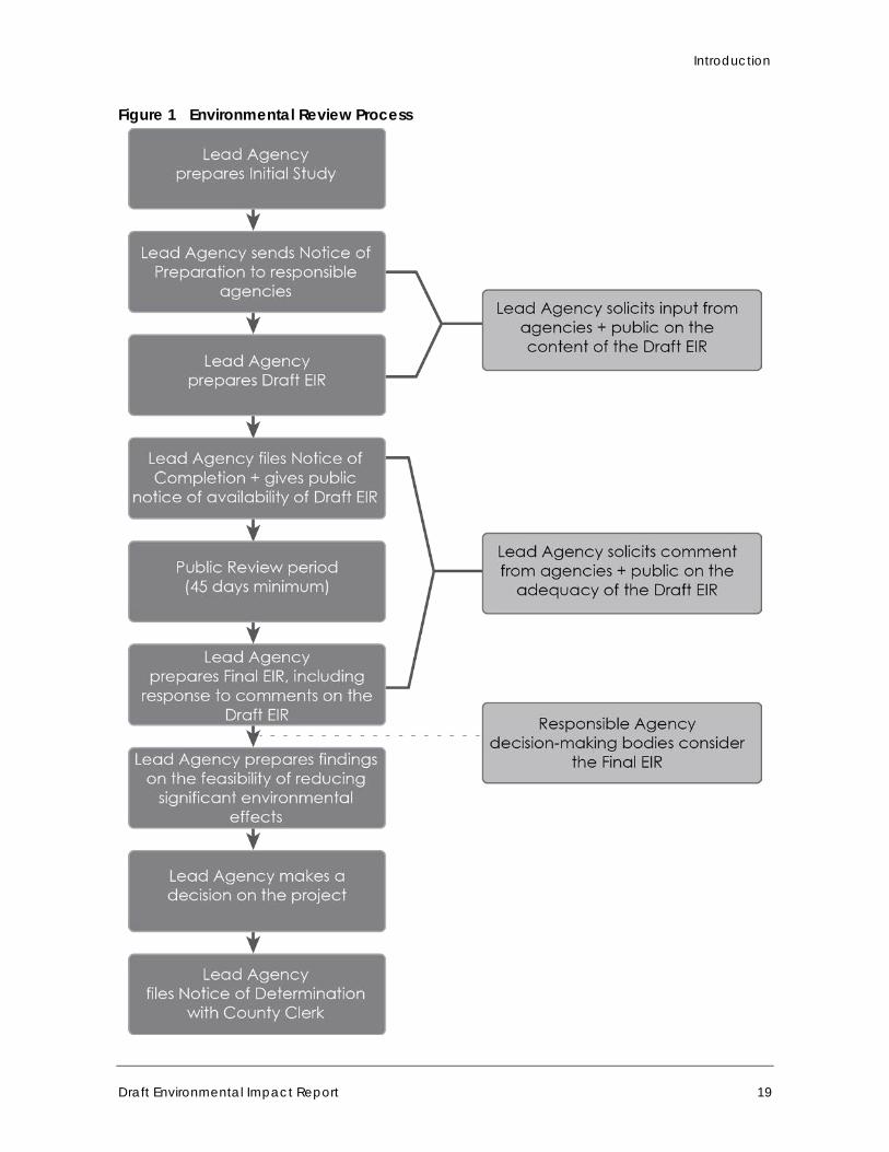
1.5 Environmental Review Process The environmental impact review process required under CEQA is summarized below and illustrated in Figure 1. The steps appear in sequential order.
1. Notice of Preparation (NOP) Distributed. Immediately after deciding that an EIR is required, the lead agency must file a NOP soliciting input on the EIR scope to "responsible," "trustee," and involved federal agencies; to the State Clearinghouse, if one or more state agencies is a responsible or trustee agency; and to parties previously requesting notice in writing. The NOP must be posted in the County Clerk's office for 30 days. A scoping meeting to solicit public input on the issues to be assessed in the EIR is not required, but may be conducted by the lead agency.
2. Draft EIR Prepared. The Draft EIR must contain: a) table of contents or index, b) summary, c) project description, d) environmental setting, e) significant impacts (direct, indirect, cumulative, growth-inducing, and unavoidable impacts), f) alternatives, g) mitigation measures, and h) irreversible changes.
3. Public Notice and Review. A lead agency must prepare a Public Notice of Availability of an EIR. The Notice must be placed in the County Clerk's office for 30 days (Public Resources Code Section 21092) and sent to anyone requesting it. Additionally, public notice of Draft EIR availability must be given through at least one of the following procedures: a) publication in a newspaper of general circulation, b) posting on and off the project site, and c) direct mailing to owners and occupants of contiguous properties. The lead agency must consult with and request comments on the Draft EIR from responsible and trustee agencies, and adjacent cities and counties. The minimum public review period for a Draft EIR is 30 days. When a Draft EIR is sent to the State Clearinghouse for review, the public review period must be 45 days, unless a shorter period is approved by the Clearinghouse (Public Resources Code 21091). Distribution of the Draft EIR may be required through the State Clearinghouse.
4. Notice of Completion. A lead agency must file a Notice of Completion with the State Clearinghouse as soon as it completes a Draft EIR.
5. Final EIR. A Final EIR must include: a) the Draft EIR, b) copies of comments received during public review, c) list of persons and entities commenting, and d) responses to comments.
6. Certification of Final EIR. The lead agency shall certify: a) the Final EIR has been completed in compliance with CEQA, b) the Final EIR was presented to the decision-making body of the lead agency, and c) the decision-making body reviewed and considered the information in the Final EIR prior to approving a project.
7. Lead Agency Project Decision. A lead agency may: a) disapprove a project because of its significant environmental effects, b) require changes to a project to reduce or avoid significant environmental effects, or c) approve a project despite its significant environmental effects, if the proper findings and statement of overriding considerations are adopted.
8. Findings/Statement of Overriding Considerations. For each significant impact of the project identified in the EIR, the lead or responsible agency must find, based on substantial evidence,
Town of Danville 375 West El Pintado Road Residential Project
18
that either: a) the project has been changed to avoid or substantially reduce the magnitude of the impact; b) changes to the project are within another agency's jurisdiction and such changes have or should be adopted; or c) specific economic, social, or other considerations make the mitigation measures or project alternatives infeasible. If an agency approves a project with unavoidable significant environmental effects, it must prepare a written Statement of Overriding Considerations that sets forth the specific social, economic, or other reasons supporting the agency's decision.
9. Mitigation Monitoring/Reporting Program. When an agency makes findings on significant effects identified in the EIR, it must adopt a reporting or monitoring program for mitigation measures that were adopted or made conditions of project approval to mitigate significant effects.
10. Notice of Determination. An agency must file a Notice of Determination after deciding to approve a project for which an EIR is prepared. A local agency must file the Notice with the County Clerk. The Notice must be posted for 30 days and sent to anyone previously requesting notice. Posting of the Notice starts a 30-day statute of limitations on CEQA challenges.
Introduction
Draft Environmental Impact Report 19
Figure 1 Environmental Review Process

Town of Danville 375 West El Pintado Road Residential Project
20
This page intentionally left blank.
Project Description
Draft Environmental Impact Report 21
2 Project Description
This section describes the project, including the project applicant, project location, major project characteristics, project objectives, and discretionary approvals needed for project approval.
2.1 Project Applicant GMMR, LLC 230 Piedmont Lane Danville, California 94526
2.2 Lead Agency and Contact Person Town of Danville Development Services Department, Planning Division 510 La Gonda Way Danville, California 94526 Contact: David T. Crompton, Principal Planner, (925) 314-3349
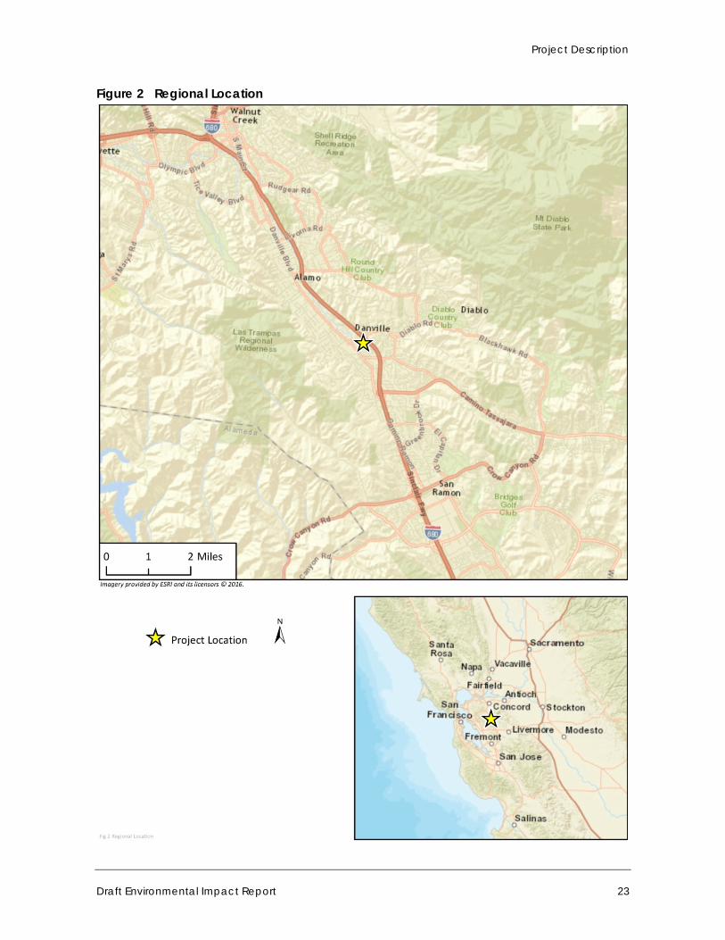
2.3 Project Location The project site is located north of downtown Danville, at the northwest portion of the Town at 375 and 359 West El Pintado Road, approximately 200 feet south of West El Pintado Road’s intersection with El Cerro Boulevard and immediately across West El Pintado Road from the southbound on-ramp to Interstate 680 (I-680, Donald D. Doyle Highway). The site, also referred to as the GMMR LLC Property, is composed of two legal parcels: a larger 1.59-acre parcel (375 West El Pintado Road, APN 200-140-011) and a smaller 0.29-acre parcel (359 West El Pintado Road, APN 200-140-012).
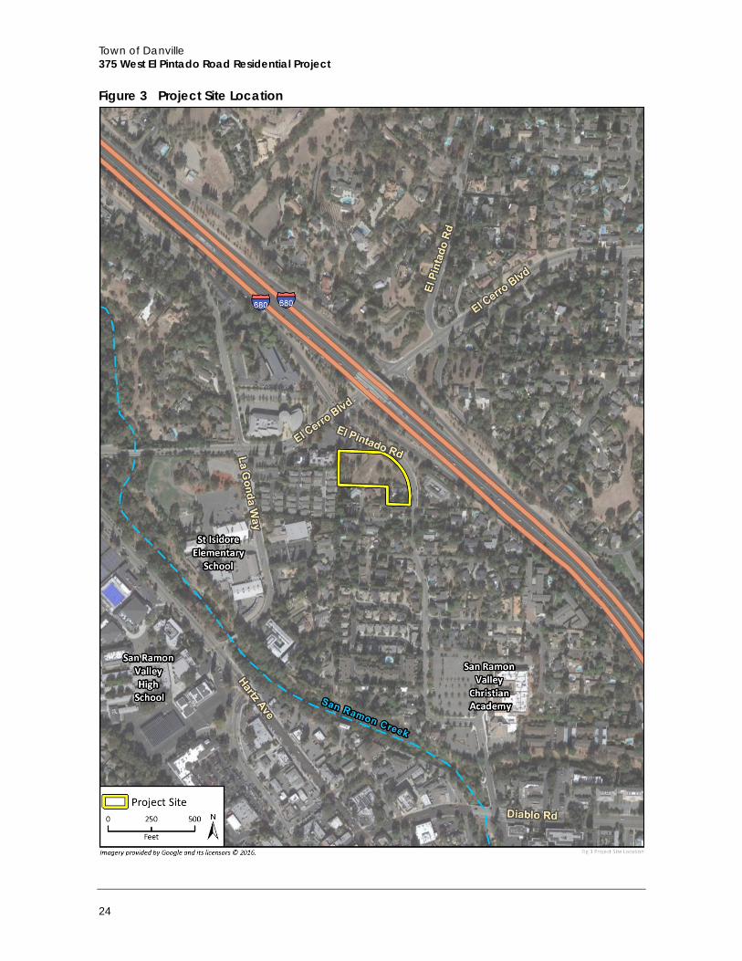
2.4 Surrounding Land Uses The project site is located in a neighborhood characterized by a mix of residential, professional, public, and institutional uses. The dominant land use type is low-density, single-family residential development. I-680 is located directly northeast of the project site. An assisted living facility is located east of the project site, across West El Pintado Road. Single-family residences that front Elsie Drive are located to the south. Multi-family residences and professional office buildings are located to the west, and a paved parking lot serving professional office uses is located to the northwest. The Danville Police Department and other Town of Danville administrative buildings are located farther northwest across El Cerro Boulevard. San Ramon Creek runs south to north, approximately 0.25 mile west of the project site. St. Isidore Catholic Church and School are located approximately 0.1 mile west-southwest of the project site, across La Gonda Way. The Community Presbyterian Church is located approximately 0.2 mile south of the project site. Commercial development is concentrated approximately 0.5 mile south of the project site, along Diablo Road,
Town of Danville 375 West El Pintado Road Residential Project
22
Hartz Avenue, Front Street, and Railroad Avenue. Figure 2 Illustrates the project’s regional location and Figure 3 shows the project site location.
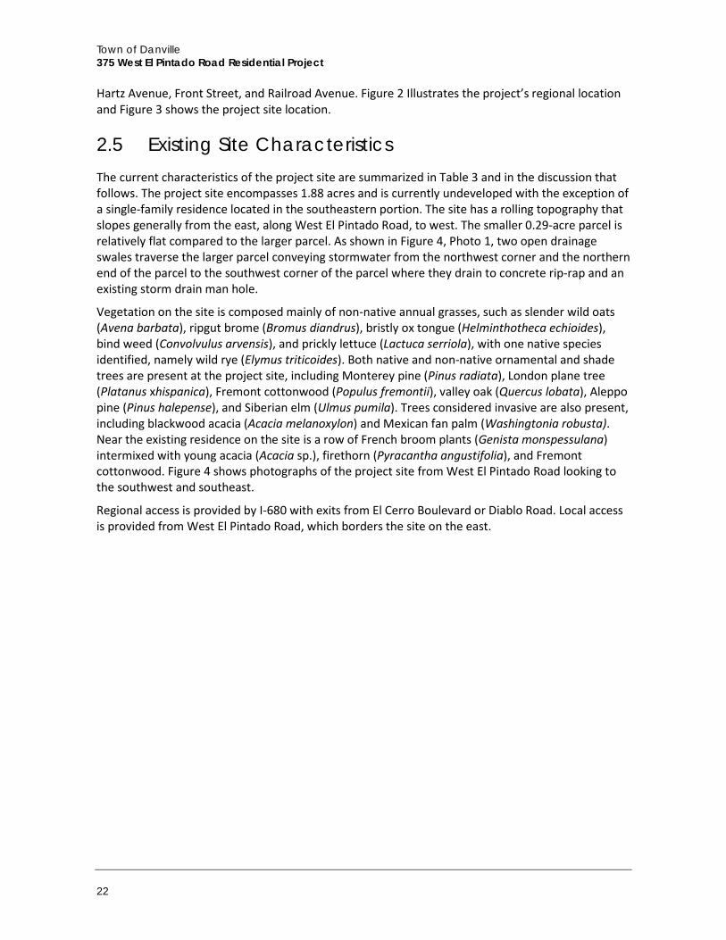
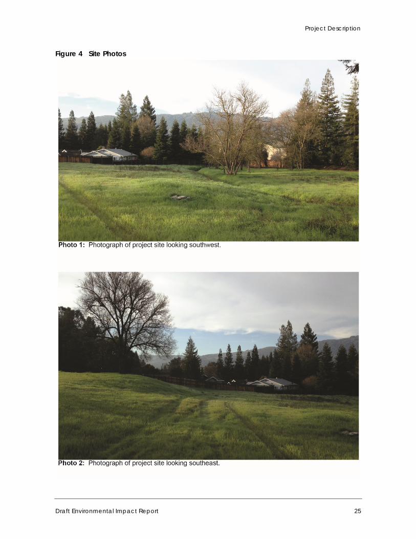
2.5 Existing Site Characteristics The current characteristics of the project site are summarized in Table 3 and in the discussion that follows. The project site encompasses 1.88 acres and is currently undeveloped with the exception of a single-family residence located in the southeastern portion. The site has a rolling topography that slopes generally from the east, along West El Pintado Road, to west. The smaller 0.29-acre parcel is relatively flat compared to the larger parcel. As shown in Figure 4, Photo 1, two open drainage swales traverse the larger parcel conveying stormwater from the northwest corner and the northern end of the parcel to the southwest corner of the parcel where they drain to concrete rip-rap and an existing storm drain man hole.
Vegetation on the site is composed mainly of non-native annual grasses, such as slender wild oats (Avena barbata), ripgut brome (Bromus diandrus), bristly ox tongue (Helminthotheca echioides), bind weed (Convolvulus arvensis), and prickly lettuce (Lactuca serriola), with one native species identified, namely wild rye (Elymus triticoides). Both native and non-native ornamental and shade trees are present at the project site, including Monterey pine (Pinus radiata), London plane tree (Platanus xhispanica), Fremont cottonwood (Populus fremontii), valley oak (Quercus lobata), Aleppo pine (Pinus halepense), and Siberian elm (Ulmus pumila). Trees considered invasive are also present, including blackwood acacia (Acacia melanoxylon) and Mexican fan palm (Washingtonia robusta). Near the existing residence on the site is a row of French broom plants (Genista monspessulana) intermixed with young acacia (Acacia sp.), firethorn (Pyracantha angustifolia), and Fremont cottonwood. Figure 4 shows photographs of the project site from West El Pintado Road looking to the southwest and southeast.
Regional access is provided by I-680 with exits from El Cerro Boulevard or Diablo Road. Local access is provided from West El Pintado Road, which borders the site on the east.
Project Description
Draft Environmental Impact Report 23
Figure 2 Regional Location
Town of Danville 375 West El Pintado Road Residential Project
24
Figure 3 Project Site Location
Project Description
Draft Environmental Impact Report 25
Figure 4 Site Photos
Town of Danville 375 West El Pintado Road Residential Project
26
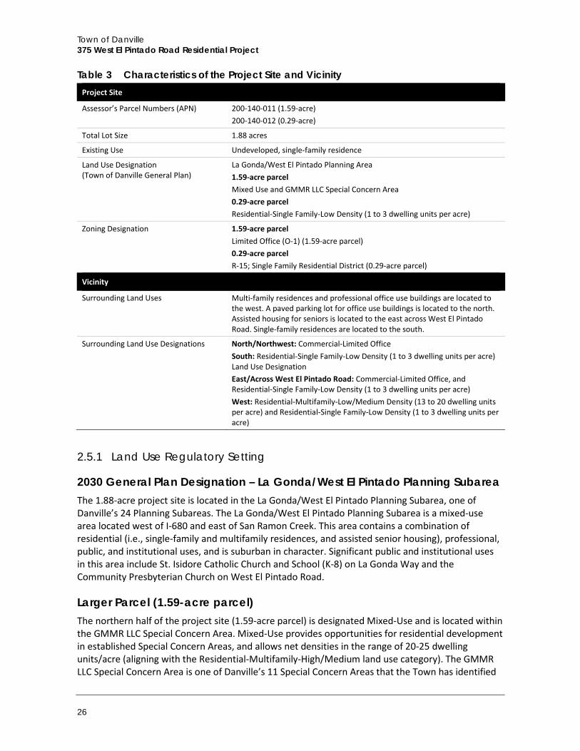
Table 3 Characteristics of the Project Site and Vicinity Project Site
Assessor’s Parcel Numbers (APN) 200-140-011 (1.59-acre) 200-140-012 (0.29-acre)
Total Lot Size 1.88 acres
Existing Use Undeveloped, single-family residence
Land Use Designation (Town of Danville General Plan)
La Gonda/West El Pintado Planning Area 1.59-acre parcel Mixed Use and GMMR LLC Special Concern Area 0.29-acre parcel Residential-Single Family-Low Density (1 to 3 dwelling units per acre)
Zoning Designation 1.59-acre parcel Limited Office (O-1) (1.59-acre parcel) 0.29-acre parcel R-15; Single Family Residential District (0.29-acre parcel)
Vicinity
Surrounding Land Uses Multi-family residences and professional office use buildings are located to the west. A paved parking lot for office use buildings is located to the north. Assisted housing for seniors is located to the east across West El Pintado Road. Single-family residences are located to the south.
Surrounding Land Use Designations North/Northwest: Commercial-Limited Office South: Residential-Single Family-Low Density (1 to 3 dwelling units per acre) Land Use Designation East/Across West El Pintado Road: Commercial-Limited Office, and Residential-Single Family-Low Density (1 to 3 dwelling units per acre) West: Residential-Multifamily-Low/Medium Density (13 to 20 dwelling units per acre) and Residential-Single Family-Low Density (1 to 3 dwelling units per acre)
2.5.1 Land Use Regulatory Setting
2030 General Plan Designation – La Gonda/West El Pintado Planning Subarea The 1.88-acre project site is located in the La Gonda/West El Pintado Planning Subarea, one of Danville’s 24 Planning Subareas. The La Gonda/West El Pintado Planning Subarea is a mixed-use area located west of I-680 and east of San Ramon Creek. This area contains a combination of residential (i.e., single-family and multifamily residences, and assisted senior housing), professional, public, and institutional uses, and is suburban in character. Significant public and institutional uses in this area include St. Isidore Catholic Church and School (K-8) on La Gonda Way and the Community Presbyterian Church on West El Pintado Road.
Larger Parcel (1.59-acre parcel) The northern half of the project site (1.59-acre parcel) is designated Mixed-Use and is located within the GMMR LLC Special Concern Area. Mixed-Use provides opportunities for residential development in established Special Concern Areas, and allows net densities in the range of 20-25 dwelling units/acre (aligning with the Residential-Multifamily-High/Medium land use category). The GMMR LLC Special Concern Area is one of Danville’s 11 Special Concern Areas that the Town has identified
Project Description
Draft Environmental Impact Report 27
as a tool for supplementing the community-wide recommendations of the 2030 General Plan with more focused, place-based recommendations. The GMMR LLC Special Concern Area is one of the last remaining vacant sites in the El Cerro Study Area, a 68-acre area of mixed office and multifamily residential development that was the subject of a 1986 General Plan Amendment. The GMMR LLC Special Concern Area specifies that any residential use developed on the site shall be in the 20-25 dwelling units/acre net density range (aligning with the Residential – Multifamily – High/Medium land use category). Development in the GMMR LLC Property Special Concern Area should incorporate design measures to provide an appropriate transition to the single-family uses to the south, be no more than two stories in height, and maintain a 20-foot minimum setback from the southern property line.
Smaller Parcel (0.29-acre parcel) This land use designation as Residential – Single Family – Low Density allows a range of one to three dwelling units per acre.
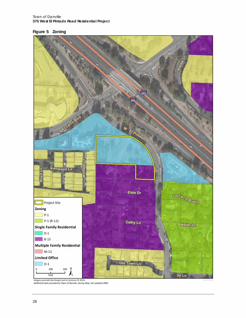
Zoning Designations The property has two zoning designations. The larger parcel (1.59-acre parcel) is zoned Limited Office (O-1), and the smaller parcel (0.29-acre parcel) is zoned Single Family Residential (R-15). Table 19 in Section 4.6, Land Use and Planning, shows the Zoning Ordinance and 2030 General Plan requirements. Refer the zoning map and land use designation map on Figure 5 and Figure 6, respectively.
2.6 Project Characteristics The project involves a request for a General Plan Amendment (GPA2015-0001), Preliminary Development Plan – Rezoning (PUD2015-0001), Major Subdivision (SD 9399), and Final Development Plan (DP2015-0065) to allow for the development of a 37-unit townhouse development. The General Plan Amendment request pertains to the 0.29-acre lot only, and would amend the Town’s 2030 General Plan land use designation from Residential – Single Family – Low Density (one to three units per acre) to a Mixed Use land use designation. The Preliminary Development Plan – Rezoning request would rezone the project site to a new P-l, Planned Unit Development District. The Major Subdivision would subdivide the site, creating 37 multifamily townhome units. The Final Development Plan would provide for the approval of project architecture, site design, and landscape design. A Tree Removal permit (TR2015-0039) is also required to allow for the removal of Town-protected trees.
The project would involve demolition of the existing on-site residence, site preparation (including grading and tree removal), and construction of eight new multifamily townhome buildings. The 37 townhome units would include one-, two-, and three-bedroom units in buildings with partially below-grade and at-grade garages. Six of the units (15 percent of the total) would be affordable housing units in accordance with the Town’s inclusionary housing requirements. Proposed site amenities include landscaping, off-street parking, and play structure, as well as a lawn, walking path, outdoor seating area on the northeast corner of the site.
Town of Danville 375 West El Pintado Road Residential Project
28
Figure 5 Zoning
Project Description
Draft Environmental Impact Report 29
Figure 6 Land Use
Town of Danville 375 West El Pintado Road Residential Project
30
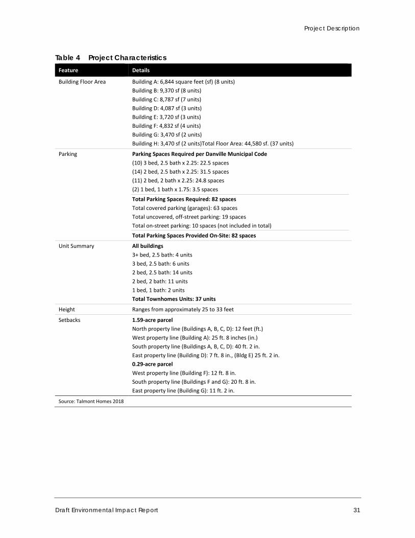
Six larger two-story buildings would be constructed on the northern portion of the project site, each with a mix of one-, two-, and three-bedroom units. These six buildings (Buildings A-F) would range from 28 to 35 feet in height (2-2.5 stories) and include partially below-grade garages. Two smaller two-story buildings (buildings G and H) would be constructed on the southeastern portion of the project site, each with two three-bedroom, 2.5-bathroom units. These two buildings with at-grade garages would each be approximately 25 feet in height. Table 4 summarizes the major characteristics of the project. The Proposed Site Plan and Project Elevations are shown in Figure 7 and Figure 8a-g, respectively.
2.6.1 Site Access and Parking Vehicular site access would be provided by a single driveway on West El Pintado Road, approximately 500 feet southeast of the El Cerro Boulevard intersection, at the midpoint of the project site’s eastern boundary. The driveway entrance would be 28 feet wide (15-foot-wide entrance-only lane and a 13-foot-wide exit lane) and would serve both inbound and outbound traffic. Outbound movements would be controlled by a proposed stop sign and would allow both right and left turns. The entrance driveway would transition to an internal road network of 22-foot driveways that provide access to each building, including a driveway along the south property line with nine feet for parking and driveways between Buildings A and B, Buildings C and D, and Buildings F and G that provide access to the townhome garages.
The project calls for 82 total on-site parking spaces, including 63 covered spaces to be provided by partially at-grade garages and 19 off-street parking spaces located throughout the site. The proposed off-street parking spaces would be standard spaces. The project would also provide approximately 10 additional on-street parking spaces for guests.
Project Description
Draft Environmental Impact Report 31
Table 4 Project Characteristics Feature Details
Building Floor Area Building A: 6,844 square feet (sf) (8 units) Building B: 9,370 sf (8 units) Building C: 8,787 sf (7 units) Building D: 4,087 sf (3 units) Building E: 3,720 sf (3 units) Building F: 4,832 sf (4 units) Building G: 3,470 sf (2 units) Building H: 3,470 sf (2 units)Total Floor Area: 44,580 sf. (37 units)
Parking Parking Spaces Required per Danville Municipal Code (10) 3 bed, 2.5 bath x 2.25: 22.5 spaces (14) 2 bed, 2.5 bath x 2.25: 31.5 spaces (11) 2 bed, 2 bath x 2.25: 24.8 spaces (2) 1 bed, 1 bath x 1.75: 3.5 spaces
Total Parking Spaces Required: 82 spaces Total covered parking (garages): 63 spaces Total uncovered, off-street parking: 19 spaces Total on-street parking: 10 spaces (not included in total)
Total Parking Spaces Provided On-Site: 82 spaces
Unit Summary All buildings 3+ bed, 2.5 bath: 4 units 3 bed, 2.5 bath: 6 units 2 bed, 2.5 bath: 14 units 2 bed, 2 bath: 11 units 1 bed, 1 bath: 2 units Total Townhomes Units: 37 units
Height Ranges from approximately 25 to 33 feet
Setbacks 1.59-acre parcel North property line (Buildings A, B, C, D): 12 feet (ft.) West property line (Building A): 25 ft. 8 inches (in.) South property line (Buildings A, B, C, D): 40 ft. 2 in. East property line (Building D): 7 ft. 8 in., (Bldg E) 25 ft. 2 in. 0.29-acre parcel West property line (Building F): 12 ft. 8 in. South property line (Buildings F and G): 20 ft. 8 in. East property line (Building G): 11 ft. 2 in.
Source: Talmont Homes 2018
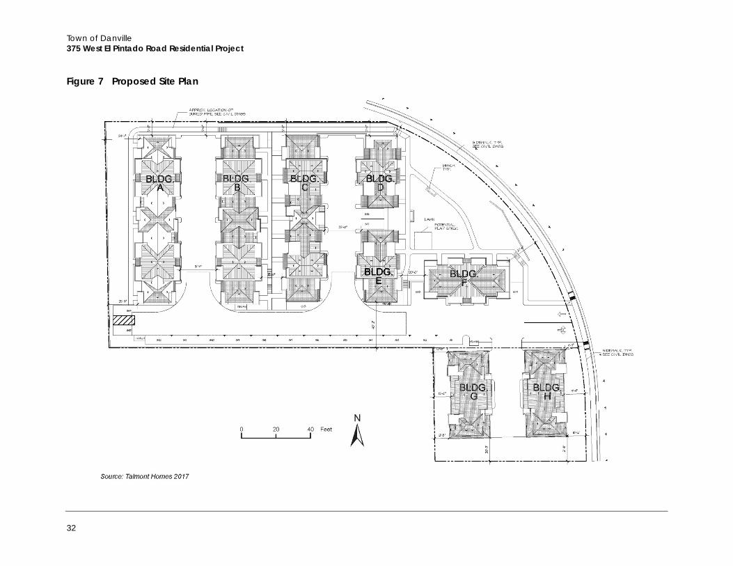
Town of Danville 375 West El Pintado Road Residential Project
32
Figure 7 Proposed Site Plan
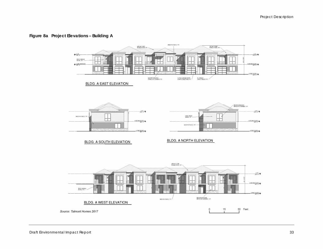
Project Description
Draft Environmental Impact Report 33
Figure 8a Project Elevations – Building A
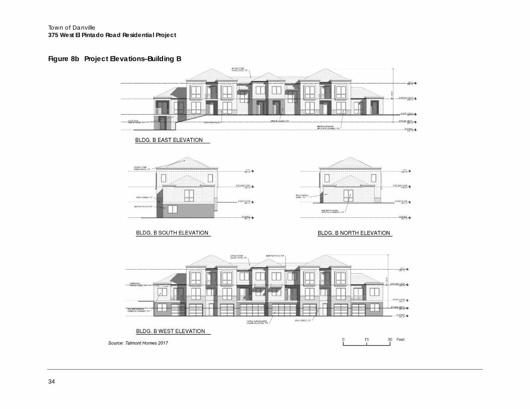
Town of Danville 375 West El Pintado Road Residential Project
34
Figure 8b Project Elevations–Building B
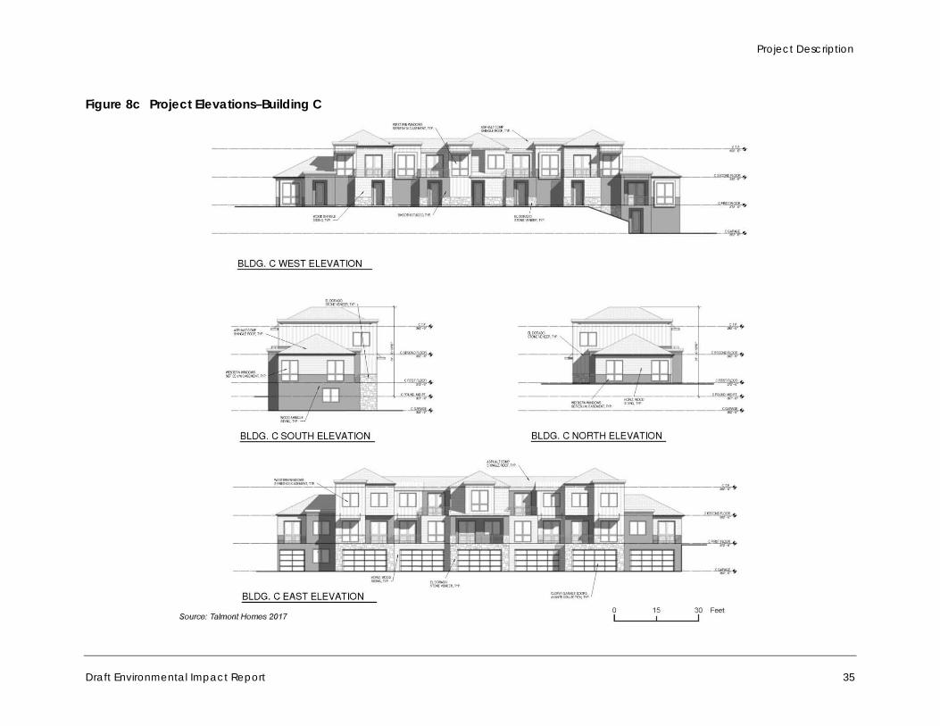
Project Description
Draft Environmental Impact Report 35
Figure 8c Project Elevations–Building C
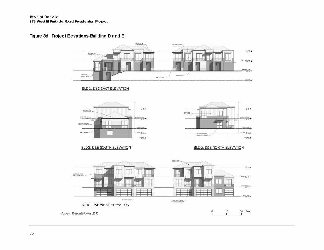
Town of Danville 375 West El Pintado Road Residential Project
36
Figure 8d Project Elevations–Building D and E
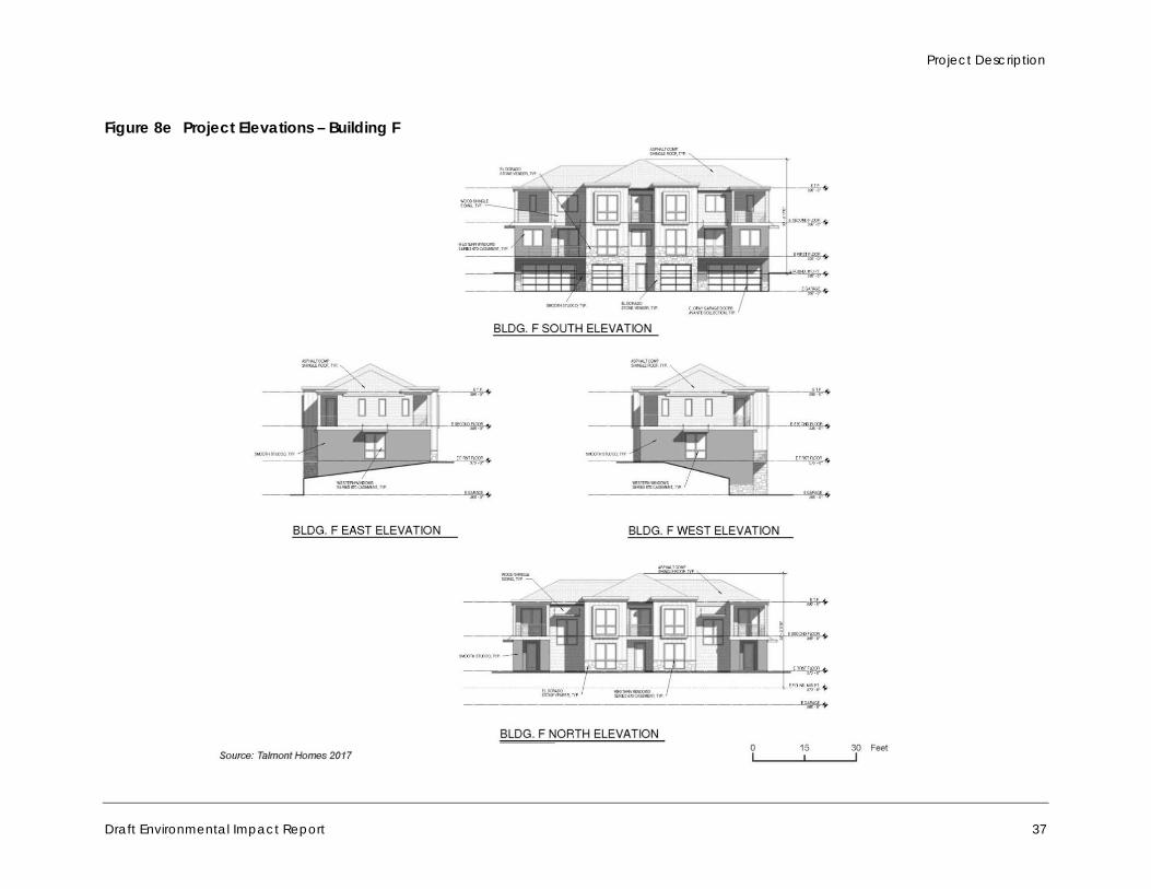
Project Description
Draft Environmental Impact Report 37
Figure 8e Project Elevations – Building F
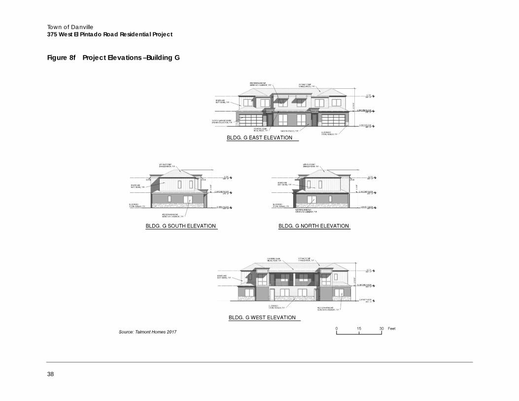
Town of Danville 375 West El Pintado Road Residential Project
38
Figure 8f Project Elevations –Building G
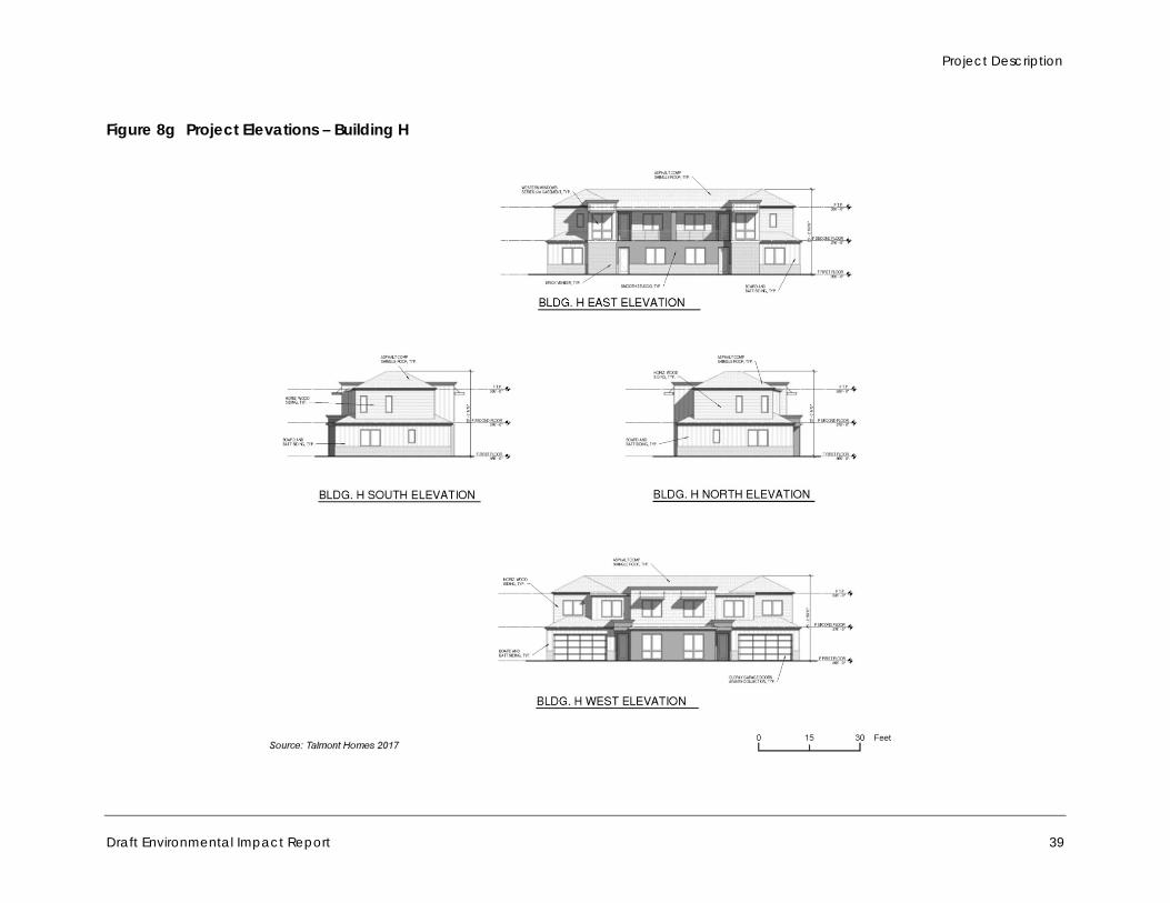
Project Description
Draft Environmental Impact Report 39
Figure 8g Project Elevations – Building H
Town of Danville 375 West El Pintado Road Residential Project
40
2.6.2 Infrastructure The project includes infrastructure improvements including stormwater drainage, water, and sewer improvements. Refer to Figure 9 for the stormwater control plan.
a. Water Supply. The East Bay Municipal Water District (EBMUD) provides water service for the project site through an existing 8-inch water main located along the property’s easterly boundary under West El Pintado Road. Individual service connections, meters, and backflow prevention devices would be provided for domestic and irrigation service to the site. Fire service and backflow prevention would be provided separately from the domestic and irrigation water services.
b. Sanitary Sewer. Central Contra Costa Sanitary District would provide sanitary sewer services. Wastewater generated by the project site would be collected and conveyed through a shared sewer main, consisting of 6-inch sanitary sewer pipes, located underneath each driveway. The wastewater collected on-site would be conveyed to an existing 8-inch Central Contra Costa Sanitary District sanitary sewer main located just outside the southwest corner of the property within an 18 to 20-foot sewer easement that lies adjacent to the entire western boundary of the project.
c. Stormwater Management. The majority of the project site slopes from its frontage along West El Pintado Road, the project’s eastern boundary, towards an existing 48-inch culvert at the southwest corner of the property. An existing 60-inch public storm drain pipe and an adjacent 18-inch storm drain pipe discharges onto the property from the north and drains through an earthen swale southwesterly towards the existing 48-inch culvert. A portion of the site along the southern boundary (south of Building G and Building H) drains southerly to a swale that discharges through an existing 24-inch corrugated metal pipe located on the adjacent property.
Design of the new project would include extension of the existing 48-inch storm drain culvert through the project site, connecting to the existing culvert entering the site from the north. Roof and surface drainage would be collected through underground pipes and directed to stormwater treatment devices in accordance with state and local requirements. These treatment devices would be sized to accommodate both treatment and detention. A 336-square-foot bioretention area would be located on the east side of Buildings D and E, a 155-square-foot bioretention area would be located on the west side of Building G, and 165-square-foot bioretention area would be located on the east side of Building H. A 2,250-square-foot flow through planter would be located along the project site’s western boundary near Building A. Pervious pavement would be located on the driveways between Buildings C, D, and E and between Buildings G and H. See Figure 9 for the locations of the bioretention areas, flow-through planters, and pervious pavement. Once leaving the site, stormwater would be conveyed south and west through existing culverts, ultimately discharging into San Ramon Creek.
d. Gas and Electricity. Pacific Gas and Electric Company (PG&E) would provide gas and electricity to the site.
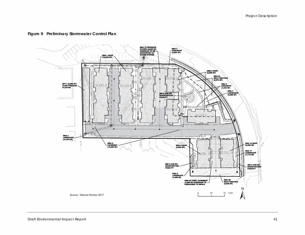
Project Description
Draft Environmental Impact Report 41
Figure 9 Preliminary Stormwater Control Plan
Town of Danville 375 West El Pintado Road Residential Project
42
2.7 Grading and Construction Project construction would last approximately 20 months. The estimated construction schedule would be as follows:
Excavation and shoring – three months Underground utilities and waterproofing – two months Retaining walls and lower floor – two months Upper-level framing – three months Façade and tenant improvements – six months Finish and site work – four months
The project would result in 6,340 cubic yards of cut and 470 cubic yards of fill, requiring the export of approximately 5,870 cubic yards of earth material. Assuming an average truck load of 9-14 cubic yards, approximately 419 to 650 round-trip truckloads would be needed to export the material. Hauling would occur over a period of approximately three to five months. I-680 would be the main hauling and export route.
2.8 Project Objectives The objectives of the project are as follows:
Develop a well-designed project that facilitates achievement of the Town’s land use vision for the project site as set forth in the Town’s 2030 General Plan
Construct a financially feasible 37-unit townhome development on the project site that includes 15 percent units available in order to comply with the requirements of the Town’s Inclusionary Housing Ordinance 31-7.5 and Danville Municipal Code Section 32-74
Provide new housing to accommodate households of varying size, type, and income Incorporate stormwater best management practices into the projects design to increase on-site
permeability, infiltration, and stormwater treatment per the San Francisco Regional Water Quality Control Board (SFRWQCB) C.3. regulations
Provide infill development in close proximity to commercial and employment activities that are accessible by foot, bicycle, or transit
Provide on-site park facilities and pedestrian paths, which will enhance the neighborhood and integrate with the surrounding community
2.9 Required Approvals The development application and EIR would require public hearings and a recommendation of approval by the Town’s Planning Commission, and a final public hearing and certification of the EIR by the Town Council.
Specifically, the following approvals would be required:
Certification of the Final EIR General Plan Amendment (GPA 2015-0001)

Project Description
Draft Environmental Impact Report 43
Preliminary Development Plan – Rezoning (PUD 2015-0001) Major Subdivision (SD 9399) Final Development Plan (DP 2015-0065) Demolition Permits Tree Removal Permit (TR15-0039) Building Permits Any other approvals or permits that would be necessary for construction and
operation of the project
In addition, the following discretionary approvals from other agencies may be required for the project:
Formal Jurisdictional Delineation to support Jurisdictional Waters permitting with USACE, Regional Water Quality Control Board (RWQCB), and the CDFW
Jurisdictional Areas that will be impacted would require one or more of the following permits: An RWQCB Waste Discharge Requirement permit and/or Section 401 Water Quality Certification
(depending upon whether or not the feature falls under federal jurisdiction) A CDFW Streambed Alteration Agreement pursuant to Section 1600 et seq. of the California Fish
and Game Code (CFGC) for impacts in the areas of CDFW jurisdiction A USACE permit pursuant to Section 404 of the Clean Water Act

Town of Danville 375 West El Pintado Road Residential Project
44
This page intentionally left blank.
Environmental Setting
Draft Environmental Impact Report 45
3 Environmental Setting
This section provides a general overview of the environmental setting for the project. More detailed descriptions for each environmental issue area can be found in Section 4.0, Environmental Impact Analysis.
3.1 Regional Setting The project site is located in the town of Danville in southwestern Contra Costa County (Figure 2, Regional Location, and Figure 3, Project Location, in Section 2, Project Description). Incorporated in 1982, Danville encompasses approximately 18.1 square miles and is bisected by I-680. Danville is characterized by suburban and rural density residential neighborhoods. Commercial development is located primarily in the downtown area, with a limited number of additional locations east of I-680. Much of the town is already developed with a few small scattered undeveloped or vacant parcels (Town of Danville 2013).
The estimated (2017) population of the town is 43,355 persons. The town’s current housing stock consists of an estimated 16,171 units. The average household size in the town is about 2.80 persons per unit (California Department of Finance 2017).
The most prevalent mode of travel in Danville is driving. The predominant roadway corridor is I-680, which bisects the town in a north to south direction. Within the Town, Danville is accessed by freeway interchanges at Sycamore Valley Road, Diablo Road, El Cerro Boulevard, and El Pintado Road. The Crow Canyon interchange in San Ramon also provides a major point of access to Danville neighborhoods. A series of east-west and north-south arterial roadways also provide vehicular access within the town. Major east-west thoroughfares include Sycamore Valley Road, Camino Tassajara, Crow Canyon Road, and Diablo Road. The major north-south thoroughfare is San Ramon Valley Boulevard (Town of Danville 2013).
Danville enjoys a classic California Mediterranean climate with warm to hot, dry summers and mild to cool, wet winters. August and September are usually the warmest months of the year with an average high of 76 degrees Fahrenheit and December the coolest with an average low of 41 degrees Fahrenheit. The average amount of yearly rain is approximately 26 inches, with the wettest month being February (Intellicast 2018).
3.2 Project Site Setting The project site is located within the La Gonda/West El Pintado Planning Subarea, according to the Town’s 2030 General Plan. The La Gonda/West El Pintado Area is a mixed-use area located west of I-680 and east of San Ramon Creek. This area contains a combination of residential, professional, public, and institutional uses. During the past 30 years, portions of the area have undergone a transition from semi-rural to more suburban in character.
The project site is located in a neighborhood characterized by a mix of residential, professional, public, and institutional uses. The dominant land use type is low-density, single-family residential development. I-680 is located directly northeast of the project site. A skilled nursing facility is
Town of Danville 375 West El Pintado Road Residential Project
46
located east of the project site, across West El Pintado Road. Single-family residences are located to the south. Multifamily residences and office buildings are located to the west, and a paved parking lot is located to the northwest. The Danville Police Department and other Town of Danville administrative buildings are located further to the northwest across El Cerro Boulevard. San Ramon Creek runs south to north, approximately 0.25 mile west of the project site. St. Isidore Catholic Church and Saint Isidore School are located approximately 0.1 mile west-southwest of the project site, across La Gonda Way. The Community Presbyterian Church is located approximately 0.2 mile south of the project site. Commercial development is concentrated approximately 0.5 mile south of the project site, along Diablo Road, Hartz Avenue, Front Street, and Railroad Avenue.
The project site encompasses approximately 1.88 acres and is composed of two parcels, including a 1.59-acre parcel (zoned O-1 Limited Office) and a smaller 0.29-acre parcel (zoned R-15 Single Family Residential). The site is undeveloped with the exception of one single-family residence located on the smaller parcel in the southeastern portion. The site has rolling topography that slopes overall to the west, and includes a small knoll adjacent to West El Pintado Road. Two drainage swales traverse the site, one bisecting the site from east to west and the other running from north to south along its western boundary. Vegetation on the site is composed mainly of grasses with a number of scattered mature trees. Photographs of the project site are shown on Figure 4 in Section 2, Project Description.
3.3 Cumulative Development In addition to the specific impacts of individual projects, CEQA requires EIRs to consider potential cumulative impacts. CEQA defines “cumulative impacts” as two or more individual impacts that, when considered together, are considerable or will compound other environmental impacts. Cumulative impacts are the combined changes in the environment that result from the incremental impact of development of the project and other nearby projects. For example, traffic impacts of two nearby projects may be insignificant when analyzed separately, but could have a significant impact when analyzed together. Cumulative impact analysis allows the EIR to provide a reasonable forecast of future environmental conditions and can more accurately gauge the effects of a series of projects.
CEQA requires cumulative impact analysis in EIRs to consider either a list of planned and pending projects that may contribute to cumulative effects or a forecast of future development potential. Pending and approved developments within a two-mile radius of the project site include two single-family residential developments (Podva Property and Magee Ranch Property) and a multi-family residential development (373-379 Diablo Road). Currently planned and pending projects in Danville and surrounding areas are listed in Table 5. Projects included in this list are within 1.5 miles of the project site. These projects are considered in the cumulative analyses in Section 4, Environmental Impact Analysis.
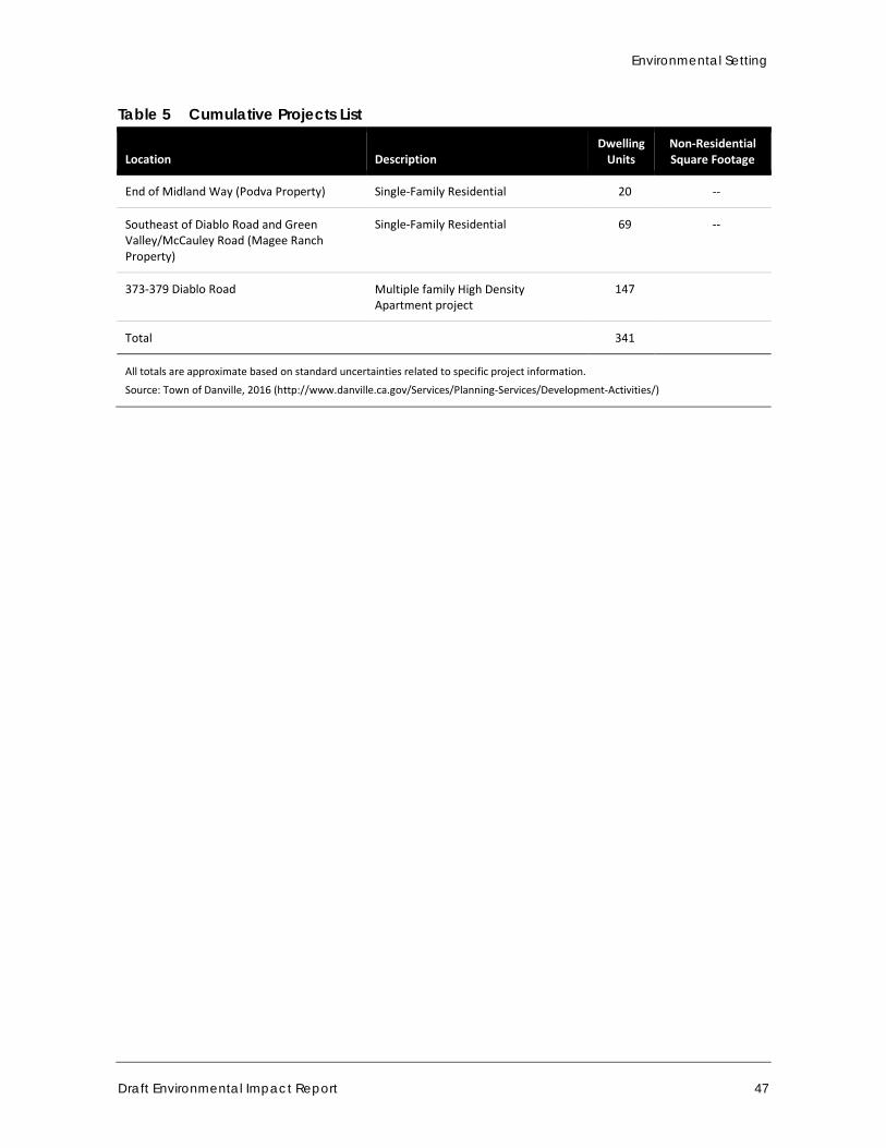
Environmental Setting
Draft Environmental Impact Report 47
Table 5 Cumulative Projects List
Location Description Dwelling
Units Non-Residential Square Footage
End of Midland Way (Podva Property) Single-Family Residential 20 --
Southeast of Diablo Road and Green Valley/McCauley Road (Magee Ranch Property)
Single-Family Residential 69 --
373-379 Diablo Road Multiple family High Density Apartment project
147
Total 341
All totals are approximate based on standard uncertainties related to specific project information.
Source: Town of Danville, 2016 (http://www.danville.ca.gov/Services/Planning-Services/Development-Activities/)

Town of Danville 375 West El Pintado Road Residential Project
48
This page intentionally left blank.
Environmental Impact Analysis
Draft Environmental Impact Report 49
4 Environmental Impact Analysis
This section discusses the possible environmental effects of the project for the issue areas that were identified through the Initial Study and NOP process as having the potential to experience significant impacts. “Significant effect” is defined by the State CEQA Guidelines §15382 as “a substantial, or potentially substantial, adverse change in any of the physical conditions in the area affected by the project including land, air, water, minerals, flora, fauna, ambient noise, and objects of historic or aesthetic significance. An economic or social change by itself shall not be considered a significant effect on the environment, but may be considered in determining whether the physical change is significant.”
The assessment of environmental effects contained in each issue area begins with a discussion of the setting. Following the setting is a discussion of the project’s impacts. In the impact analysis, the first subsection identifies the methodologies used and the “significance thresholds,” which are those criteria used for this analysis to determine whether potential impacts are significant. The next subsection describes the impact of the project, mitigation measures for significant impacts, and the level of significance after mitigation. The significance of the project’s environmental impacts was identified based on the following classifications:
Class I, Significant and Unavoidable: An impact that cannot be reduced to below the threshold level given reasonably available and feasible mitigation measures. Such an impact requires a Statement of Overriding Considerations to be issued if the project is approved.
Class II, Significant but Mitigatable: An impact that can be reduced to below the threshold level given reasonably available and feasible mitigation measures. Such an impact requires findings to be made.
Class III, Less than Significant: An impact that may be adverse, but does not exceed the threshold levels and does not require mitigation measures. However, mitigation measures that could further lessen the environmental effect may be suggested if readily available and easily achievable.
Class IV, Beneficial: No impact or an impact that would reduce existing environmental problems or hazards.
Following each environmental impact discussion is a listing of mitigation measures (if recommended or required) and the residual effects or level of significance remaining after the implementation of the measures. The impact analysis concludes with a discussion of cumulative effects, which evaluates the impacts associated with the project in conjunction with other future development in the area.
Please see the Executive Summary of this EIR for a summary of all impacts and mitigation measures that apply to the project.

Town of Danville 375 West El Pintado Road Residential Project
50
This page intentionally left blank.
Environmental Impact Analysis Aesthetics
Draft Environmental Impact Report 51
4.1 Aesthetics This section analyzes the project’s impacts on aesthetics, including the existing visual character of the project site and surrounding area and whether the project would adversely affect surrounding land uses due to light and glare created by the project.
4.1.1 Setting
a. Existing Conditions
The project site is located in a suburban area of the town of Danville that supports a mix of land uses, including single- and multifamily residential, commercial, public, and institutional uses. The project site is undeveloped, with the exception of one single-family residence located on the southeastern portion. The site has rolling topography that slopes overall to the west, and includes a small knoll adjacent to West El Pintado Road. Two drainage swales traverse the site, one bisecting the site from east to west and the other running from north to south along the western boundary. Vegetation on the site is primarily composed of grasses with a number of scattered mature native and non-native trees. There are no other significant natural features, such as prominent rock outcroppings, bodies of water, or substantial stands of native vegetation on the project site. Figure 4 in Section 2, Project Description, provides photos of the project site. Figure 10, Figure 11, and Figure 12 provide additional photos that illustrate the visual character of the project site. Figure 13 and Figure 14 include photos that depict the visual character of the surrounding area.
The dominant land use in the area surrounding the project site is medium-density, single-family residential development. I-680 is located directly northeast of the project site. A skilled nursing facility is located east of the project site, across West El Pintado Road. Single-family residences are located to the south, which are mostly one-story homes. Multifamily residences and office buildings are located to the west and northwest, and a paved parking lot is located to the northwest. The residences and buildings in the site vicinity are primarily two-story structures. The Danville Police Department and other Town of Danville administrative buildings are located farther to the northwest across El Cerro Boulevard. San Ramon Creek runs south to north, approximately 0.25 mile west of the project site. St. Isidore Catholic Church and School are located approximately 0.1 mile west-southwest of the project site, across La Gonda Way. The Community Presbyterian Church is located approximately 0.2 mile south of the project site. Commercial development is concentrated approximately 0.5 mile south of the project site, along Diablo Road, Hartz Avenue, Front Street, and Railroad Avenue.
The 2030 General Plan divides the town into 24 Planning Subareas. The project site is in the La Gonda/West Pintado Planning Area, an area that is characterized by a mix of uses. As such, the visual character is diverse and the buildings have varying architectural styles, massing, and heights. Portions of this area have undergone a transition from semi-rural to more suburban in character. Most of the new construction since the mid-1980s has consisted of single-family residences built at low and medium densities, and older multifamily housing exists in the area. Assisted senior housing was more recently developed along West El Pintado Road. Portions of the West El Pintado area retain a rural character, with remnants of former orchards, large lots, single-family homes, and street sections without curb, gutter, or sidewalks (Town of Danville 2013).
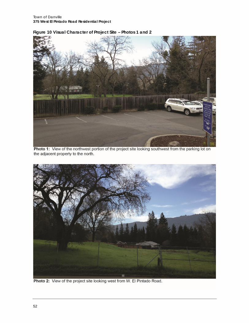
Town of Danville 375 West El Pintado Road Residential Project
52
Figure 10 Visual Character of Project Site – Photos 1 and 2
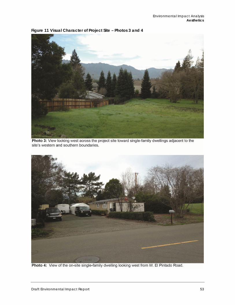
Environmental Impact Analysis Aesthetics
Draft Environmental Impact Report 53
Figure 11 Visual Character of Project Site – Photos 3 and 4
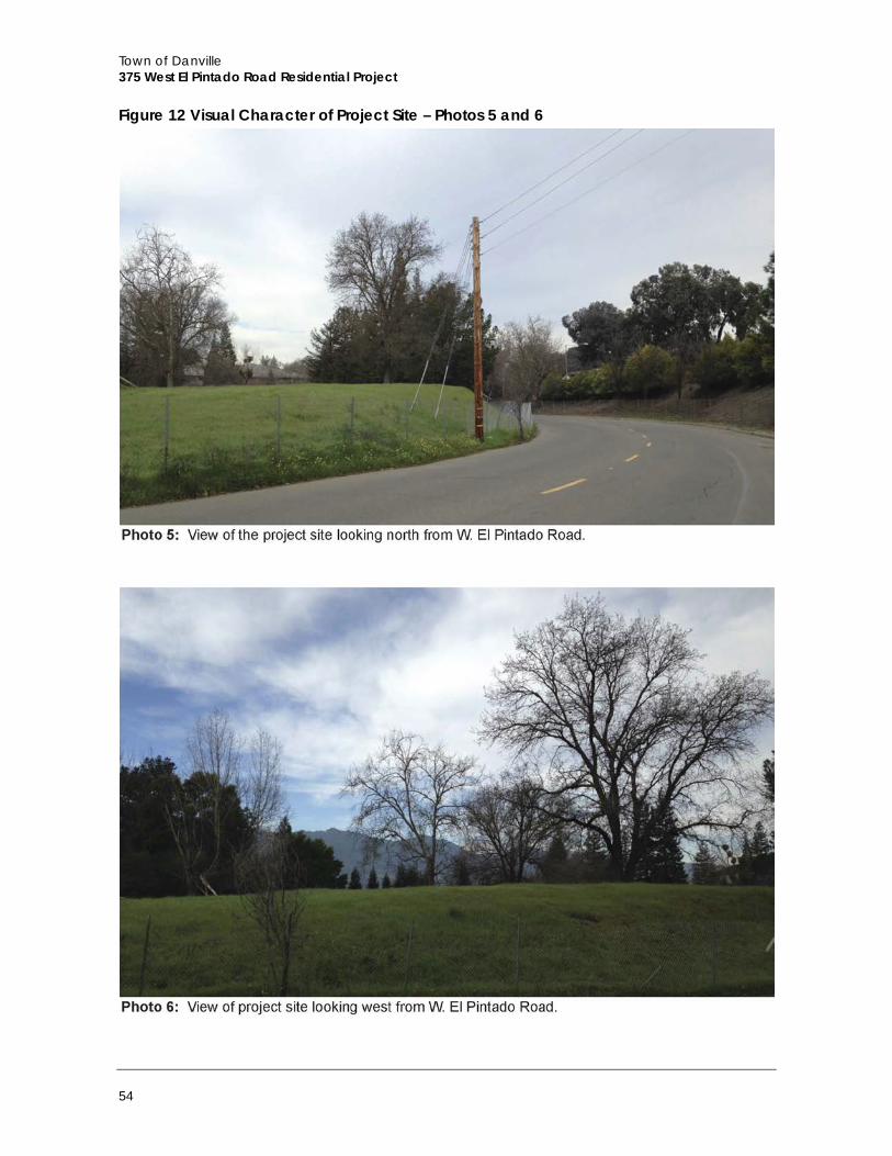
Town of Danville 375 West El Pintado Road Residential Project
54
Figure 12 Visual Character of Project Site – Photos 5 and 6
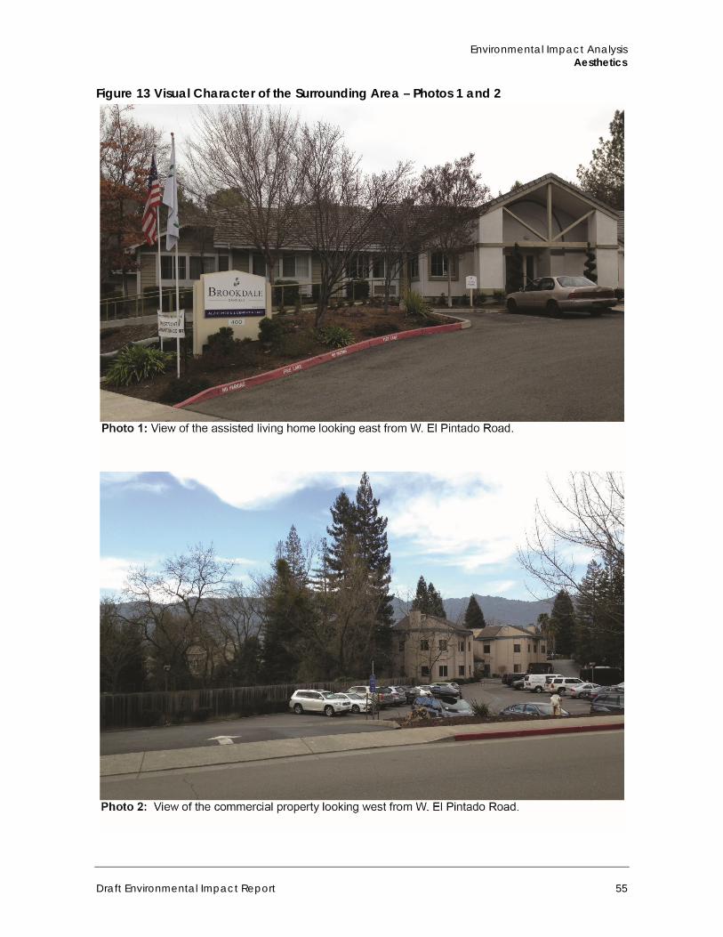
Environmental Impact Analysis Aesthetics
Draft Environmental Impact Report 55
Figure 13 Visual Character of the Surrounding Area – Photos 1 and 2
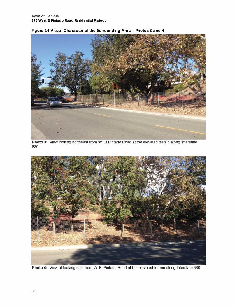
Town of Danville 375 West El Pintado Road Residential Project
56
Figure 14 Visual Character of the Surrounding Area – Photos 3 and 4
Environmental Impact Analysis Aesthetics
Draft Environmental Impact Report 57
b. Viewsheds of the Project Site and Surrounding Area
The eastern boundary of the project site, including the single-family residence, is visible from West El Pintado Road. However, full views of the site are disrupted by trees and the higher elevations of the topography on the east side. The interior portions are visible from the parking lot of the office development at the northern boundary of the site. The most prominent views of the south and western portions are visible from the adjacent single-family residences. In the surrounding area, scenic views of the Las Trampas Regional Wilderness ridgelines to the west and Mt. Diablo to the east are visible. There are no public views of Mt. Diablo through the project site, and public views of the Las Trampas ridgelines are intermittent and limited due to intervening trees and topography.
c. Light and Glare
The primary sources of night lighting on the site and in the surrounding area are lighting from exterior sources (street lighting, signage, and security lighting) and vehicle headlights along West El Pintado Road, as well as light emanating through windows of nearby building interiors. Land uses in the vicinity that would be most sensitive to night lighting would be the residences that surround the southern and western boundaries of the project site.
Low to moderate levels of glare are produced during the daytime by the light-colored exterior of the office building adjacent to the northwest boundary of the site as well as cars parked in the parking lot. Other glare sources in the vicinity include motor vehicle surfaces parked on streets and in driveways. The glare condition is typical of suburban California locations and no extraordinary glare sources are present.
d. Regulatory Setting
The Town’s 2030 General Plan and Municipal Code included policies and regulations related to aesthetics and visual resources.
2030 General Plan The Town of Danville 2030 General Plan includes a number of goals and policies intended to protect and enhance the aesthetic resources and visual character of the town. The project site is located in the La Gonda/West Pintado Planning Area. The following are the selected policies that apply to the project’s potential aesthetic impacts.
Chapter 3, Planning and Development, discusses issues associated with Community Development, Growth Management, Historic Preservation, and Economic Development. According to this chapter, designated scenic routes in Danville include Danville Boulevard, San Ramon Valley Boulevard, Green Valley Road, Diablo Road between I-680 and its transition to Blackhawk Road, Sycamore Valley Road, Camino Tassajara, Crow Canyon Road, and I-680. The following excerpts from the Community Development section provide the Goals and Policies associated with aesthetics and visual resources that are applicable to the project site and the project.
Quality Development Goals and Policies Goal 1: Assure that future development complements Danville’s existing small town character and established quality of life.
Town of Danville 375 West El Pintado Road Residential Project
58
Policy 1.02: Require that new development be generally consistent with the scale, appearance, and small town character of Danville.
Community Design Goals and Policies Goal 2: Integrate new development in a manner that is visually and functionally compatible with the physical character of the surrounding community.
Policy 2.02: Recognize Preserve Danville’s visual qualities and the identity of its neighborhoods by restricting development on visible ridges and hillsides, protecting trees and riparian areas, and maintaining open space in the community.
Policy 2.07: Improve the appearance of the community by encouraging aesthetically designed buildings, screening, adequate setbacks, and landscaping.
Policy 2.08: Protect the visual qualities of designated scenic routes by reviewing projects with respect to their visual impacts.
Housing Design Goals and Policies Goal 5: Protect the quality and character of Danville’s residential neighborhoods while providing opportunities for new housing that meets community needs.
Policy 5.02: Ensure that residential alterations and additions are sensitive to architectural character, complementary to surrounding properties, and designed to minimize off-site impacts (on privacy, shadows, parking, etc.).
GMMR LLC Special Concern Area Development on the site will need to incorporate design measures to provide an appropriate transition to the single-family uses to the south. Development on the southern 50 feet of the parcel should be no more than two stories in height and a 20-foot minimum setback from the southern property line should be maintained.
Chapter 6 – Resources and Hazards This Chapter of the 2030 General Plan provides the setting, goals, and policies for natural resources in the town that have dedicated Scenic Hillside and Major Ridgeline Development Areas. Portions of the Las Trampas Regional Wilderness Area are inside these designated areas, which are visible intermittently from some locations of the project site along West El Pintado Road. However, the Town’s Scenic Hillside or Major Ridgeline Development Ordinance regulates development in the designated areas, but does not regulate development for projects outside of these areas. Therefore, the project would not be subject to the 2030 General Plan guidelines or Town ordinance for development in these areas.
Danville Municipal Code The Subdivision and Planning and Land Use Chapters of DMC (Chapter XXXI and XXXII, respectively) provide the following regulations associated with aesthetics and visual resources that are applicable to the project site and the project.
Environmental Impact Analysis Aesthetics
Draft Environmental Impact Report 59
32-1.14 Off-Street Parking 7. Lighting, if provided, shall be directed downward and away from residential areas and public streets so as not to produce a glare as seen from such areas in order to insure the general safety of other vehicular traffic and the privacy and well-being of the residential areas, and the lighting intensity shall be no greater than reasonably required to light the parking area.
32-79 Tree Preservation 4a. Permit. Except as provided in 32-79 (4a) of this subsection, no person may destroy or remove a protected tree on any property in Danville without obtaining a Tree Removal Permit from the Planning Division pursuant to subsection 32-79.6.
4.1.2 Impact Analysis
a. Methodology and Significance Thresholds
Individuals react differently to views and aesthetic conditions. Consequently, the assessment of aesthetic impacts is inherently subjective in nature. This evaluation measures the existing visual resource against the proposed actions, analyzing the nature of the anticipated change.
In accordance with Appendix G of the CEQA Guidelines, an aesthetic impact could be significant if the project would result in any of the following:
A. Have a substantial adverse effect on a scenic vista B. Substantially damage scenic resources, including, but not limited to, trees, rock
outcroppings, and historic buildings within a state scenic highway C. Substantially degrade the existing visual character or quality of the site or its surroundings D. Create a new source of substantial light or glare that would adversely affect day or
nighttime views in the area.
Based on the analysis in the Initial Study, all checklist questions were determined to warrant discussion in this EIR.
b. Project Impacts
Threshold A: Would the project have a substantial adverse effect on a scenic vista?
Impact AES-1 DUE TO THE SURROUNDING TOPOGRAPHY AND THE INTERVENING PRESENCE OF EXISTING MATURE TREES, THE PROJECT WOULD NOT HAVE A SUBSTANTIAL ADVERSE EFFECT ON A SCENIC VISTA AS SEEN FROM A PUBLIC LOCATION SUCH AS WEST EL PINTADO ROAD. THIS IS A CLASS III, LESS THAN SIGNIFICANT IMPACT.
The project would involve construction of eight two-story townhome residential buildings on a site that is vacant except for a single-family residence in the southeast portion of the site that would be demolished.
Public Views The policies and goals of the Town’s 2030 General Plan, as described above under Subsection 4.1.1(d), Regulatory Setting, are designed to preserve the scenic qualities of the hillsides surrounding Danville. The general project area includes scenic vistas of Mt. Diablo to the east and
Town of Danville 375 West El Pintado Road Residential Project
60
the Las Trampas Regional Wilderness ridgelines to the west from some public viewpoints. The project would be located on the west side of West El Pintado Road, so construction and operation of the project would not alter the public view of Mt. Diablo to the east from West El Pintado Road.
The ridgelines of the Las Trampas Regional Wilderness area to the west of the project site are visible intermittently from some locations along West El Pintado Road, but as shown in Figure 10, public views are limited due to the topography of the area and existing on-site and surrounding mature trees. The proposed project involves construction of two-story residential buildings. Therefore, some of these limited views of the ridgelines from West El Pintado Road adjacent to the project site would be blocked. However, West El Pintado Road is not identified by the Town as a sensitive view corridor. Also, because existing views are partial and intermittent, impacts to public views would be less than significant.
The project site is visible from I-680, which is identified as a scenic route in the 2030 General Plan. Potential impacts related to scenic views from I-680 are discussed below under Threshold B.
Private Views Impacts to private views are not typically treated as significant under CEQA. However, as noted by the California Court of Appeal in Ocean View Homeowners Assn., Inc. v. Montecito Water District (116 Cal. App. 4th 396), “[t]hat a project affects only a few private views may be a factor in determining whether the impact is significant.” Potential impacts associated with private views would occur if the proposed project would obstruct scenic views of the Las Trampas Regional Wilderness or the Mt. Diablo mountain range from the residences surrounding the project site. The western and southern boundaries of the project site are adjacent to single-family residences. Views of the Las Trampas Regional Wilderness ridgelines to the west are available from the surrounding residences, but the project would be constructed to the east and north of these residences so would not interfere with private views of the ridgelines.
The foothills of Mt. Diablo are approximately three miles east of the project site. Mt. Diablo may be visible from the surrounding residences, particularly from the second story of the two-story residences along Winfield Lane that are adjacent to the western boundary of the project site. The project site is mostly vacant, which allows for views of open space and vegetation from these residences until the elevated terrain of I-680 appears approximately 500 feet to the east. As such, due to the distance, the existing terrain, and the vegetation on the project site, the proposed project would not interfere with private views of Mt. Diablo.
Mitigation Measures Impacts would be less than significant, no mitigation is required.
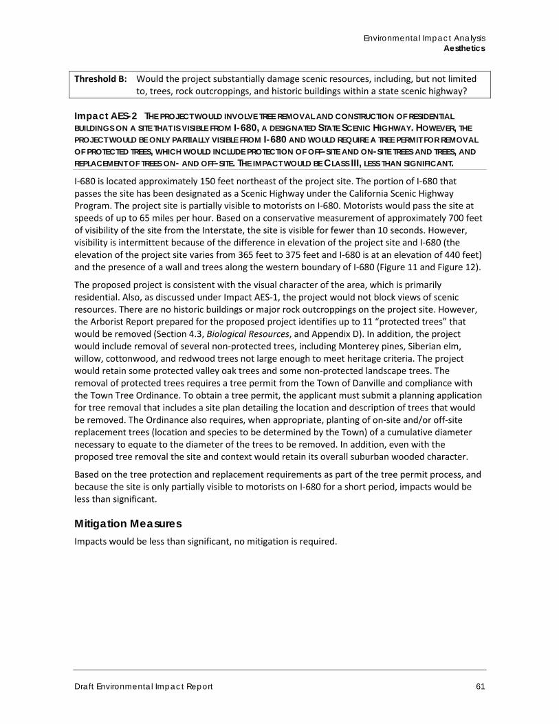
Environmental Impact Analysis Aesthetics
Draft Environmental Impact Report 61
Threshold B: Would the project substantially damage scenic resources, including, but not limited to, trees, rock outcroppings, and historic buildings within a state scenic highway?
Impact AES-2 THE PROJECT WOULD INVOLVE TREE REMOVAL AND CONSTRUCTION OF RESIDENTIAL BUILDINGS ON A SITE THAT IS VISIBLE FROM I-680, A DESIGNATED STATE SCENIC HIGHWAY. HOWEVER, THE PROJECT WOULD BE ONLY PARTIALLY VISIBLE FROM I-680 AND WOULD REQUIRE A TREE PERMIT FOR REMOVAL OF PROTECTED TREES, WHICH WOULD INCLUDE PROTECTION OF OFF-SITE AND ON-SITE TREES AND TREES, AND REPLACEMENT OF TREES ON- AND OFF-SITE. THE IMPACT WOULD BE CLASS III, LESS THAN SIGNIFICANT.
I-680 is located approximately 150 feet northeast of the project site. The portion of I-680 that passes the site has been designated as a Scenic Highway under the California Scenic Highway Program. The project site is partially visible to motorists on I-680. Motorists would pass the site at speeds of up to 65 miles per hour. Based on a conservative measurement of approximately 700 feet of visibility of the site from the Interstate, the site is visible for fewer than 10 seconds. However, visibility is intermittent because of the difference in elevation of the project site and I-680 (the elevation of the project site varies from 365 feet to 375 feet and I-680 is at an elevation of 440 feet) and the presence of a wall and trees along the western boundary of I-680 (Figure 11 and Figure 12).
The proposed project is consistent with the visual character of the area, which is primarily residential. Also, as discussed under Impact AES-1, the project would not block views of scenic resources. There are no historic buildings or major rock outcroppings on the project site. However, the Arborist Report prepared for the proposed project identifies up to 11 “protected trees” that would be removed (Section 4.3, Biological Resources, and Appendix D). In addition, the project would include removal of several non-protected trees, including Monterey pines, Siberian elm, willow, cottonwood, and redwood trees not large enough to meet heritage criteria. The project would retain some protected valley oak trees and some non-protected landscape trees. The removal of protected trees requires a tree permit from the Town of Danville and compliance with the Town Tree Ordinance. To obtain a tree permit, the applicant must submit a planning application for tree removal that includes a site plan detailing the location and description of trees that would be removed. The Ordinance also requires, when appropriate, planting of on-site and/or off-site replacement trees (location and species to be determined by the Town) of a cumulative diameter necessary to equate to the diameter of the trees to be removed. In addition, even with the proposed tree removal the site and context would retain its overall suburban wooded character.
Based on the tree protection and replacement requirements as part of the tree permit process, and because the site is only partially visible to motorists on I-680 for a short period, impacts would be less than significant.
Mitigation Measures Impacts would be less than significant, no mitigation is required.
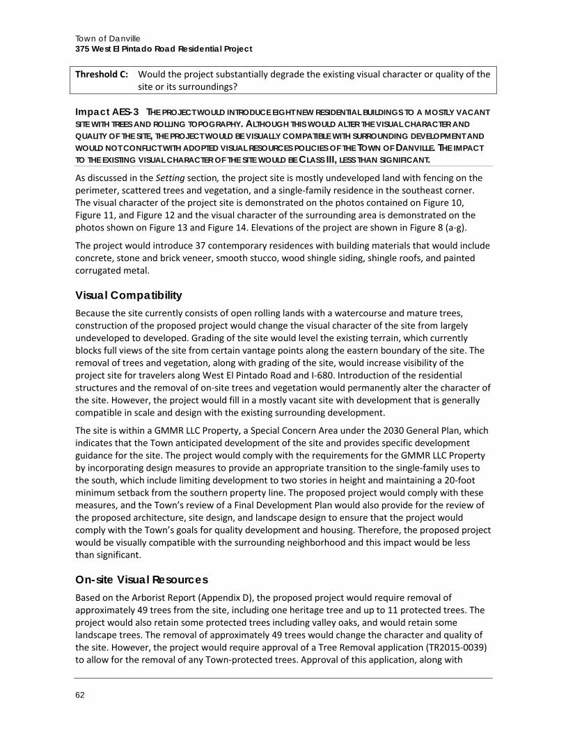
Town of Danville 375 West El Pintado Road Residential Project
62
Threshold C: Would the project substantially degrade the existing visual character or quality of the site or its surroundings?
Impact AES-3 THE PROJECT WOULD INTRODUCE EIGHT NEW RESIDENTIAL BUILDINGS TO A MOSTLY VACANT SITE WITH TREES AND ROLLING TOPOGRAPHY. ALTHOUGH THIS WOULD ALTER THE VISUAL CHARACTER AND QUALITY OF THE SITE, THE PROJECT WOULD BE VISUALLY COMPATIBLE WITH SURROUNDING DEVELOPMENT AND WOULD NOT CONFLICT WITH ADOPTED VISUAL RESOURCES POLICIES OF THE TOWN OF DANVILLE. THE IMPACT TO THE EXISTING VISUAL CHARACTER OF THE SITE WOULD BE CLASS III, LESS THAN SIGNIFICANT.
As discussed in the Setting section, the project site is mostly undeveloped land with fencing on the perimeter, scattered trees and vegetation, and a single-family residence in the southeast corner. The visual character of the project site is demonstrated on the photos contained on Figure 10, Figure 11, and Figure 12 and the visual character of the surrounding area is demonstrated on the photos shown on Figure 13 and Figure 14. Elevations of the project are shown in Figure 8 (a-g).
The project would introduce 37 contemporary residences with building materials that would include concrete, stone and brick veneer, smooth stucco, wood shingle siding, shingle roofs, and painted corrugated metal.
Visual Compatibility Because the site currently consists of open rolling lands with a watercourse and mature trees, construction of the proposed project would change the visual character of the site from largely undeveloped to developed. Grading of the site would level the existing terrain, which currently blocks full views of the site from certain vantage points along the eastern boundary of the site. The removal of trees and vegetation, along with grading of the site, would increase visibility of the project site for travelers along West El Pintado Road and I-680. Introduction of the residential structures and the removal of on-site trees and vegetation would permanently alter the character of the site. However, the project would fill in a mostly vacant site with development that is generally compatible in scale and design with the existing surrounding development.
The site is within a GMMR LLC Property, a Special Concern Area under the 2030 General Plan, which indicates that the Town anticipated development of the site and provides specific development guidance for the site. The project would comply with the requirements for the GMMR LLC Property by incorporating design measures to provide an appropriate transition to the single-family uses to the south, which include limiting development to two stories in height and maintaining a 20-foot minimum setback from the southern property line. The proposed project would comply with these measures, and the Town’s review of a Final Development Plan would also provide for the review of the proposed architecture, site design, and landscape design to ensure that the project would comply with the Town’s goals for quality development and housing. Therefore, the proposed project would be visually compatible with the surrounding neighborhood and this impact would be less than significant.
On-site Visual Resources Based on the Arborist Report (Appendix D), the proposed project would require removal of approximately 49 trees from the site, including one heritage tree and up to 11 protected trees. The project would also retain some protected trees including valley oaks, and would retain some landscape trees. The removal of approximately 49 trees would change the character and quality of the site. However, the project would require approval of a Tree Removal application (TR2015-0039) to allow for the removal of any Town-protected trees. Approval of this application, along with
Environmental Impact Analysis Aesthetics
Draft Environmental Impact Report 63
implementation of mitigation measures BIO-5 and BIO-6, which require tree replacement and additional tree protection measures, would ensure compliance with the Town’s tree removal regulations by minimizing the removal of natural visual resources and implementing the tree protection and replacement requirements. Impacts would be less than significant.
Mitigation Measures Impacts would be less than significant, no mitigation is required.
Threshold D: Would the project create a new source of substantial light or glare that would adversely affect day or nighttime views in the area?
Impact AES-4 THE PROJECT WOULD ADD NEW SOURCES OF LIGHT AND GLARE ON AND AROUND THE PROJECT SITE, WHICH IS PRIMARILY VACANT. HOWEVER, WITH ADHERENCE TO TOWN POLICIES REGARDING OUTDOOR LIGHTING AND THE PROPOSED USE OF NON-REFLECTIVE MATERIALS, IMPACTS RELATED LIGHT GLARE WOULD BE CLASS III, LESS THAN SIGNIFICANT.
Although the project site is undeveloped, the vicinity of the site is suburban in character with moderate levels of existing lighting. As discussed in the Setting, the nearest sensitive receptors are the residences adjacent to the southern and western boundaries of the project site, and the assisted living home across West El Pintado Road at the eastern boundary of the site.
The project would introduce new sources of light and glare to a largely vacant site. The eight two-story residential buildings would include building-mounted and outdoor security and accent lighting that could be visible from and spill over to surrounding properties. Potential new sources of glare that would be visible from public and private viewers include glazing, glass paneling and other reflective building materials on the façade of the building. In addition, headlights of vehicles entering and exiting the project site at night would cast light onto roadways and surrounding properties.
Because of the ambient lighting levels from the existing residential and commercial development in the vicinity of the project site, project development would not substantially alter lighting conditions. In addition, the project would be required to comply with DMC Section 32-1.14, Off-Street Parking, which limits the intensity and impacts of night lighting by requiring that the design of the lighting must prevent glare and light trespass as much as possible and must be directed away from adjacent properties and public rights-of-way. This code also states that the lighting intensity shall be no greater than reasonably required to light a parking area.
The project site is in a suburban environment with numerous existing sources of light or glare. The project would not substantially alter this condition and would be required to adhere to DMC requirements regarding lighting. Therefore, impacts related to project lighting and glare would be less than significant.
Mitigation Measures Impacts would be less than significant, no mitigation is required.
c. Cumulative Impacts
The planned and pending projects in the vicinity of the project site listed in Table 5 of this EIR consist of two single-family residential developments (Podva Property and Magee Ranch Property) and a multi-family residential development (373-379 Diablo Road) located within a 1.6-mile radius
Town of Danville 375 West El Pintado Road Residential Project
64
of the project site. Planned cumulative development would incrementally increase overall development intensity in the area, while incrementally reducing the amount of vacant land. However, these projects are not visible from the project site. In addition, future projects in Danville will be required to adhere to specific development standards in the Town’s Zoning Ordinance and 2030 General Plan designed to protect and enhance the area’s aesthetic and visual resources. Although cumulative development may, over time, alter the visual character of the town, the proposed project and the cumulative projects are not within sight of each of other and therefore would not result in cumulative visual impacts. As discussed in the impact analysis above, the proposed project would not have a significant negative impact on the aesthetics of the project site or its surroundings and cumulative impacts related to aesthetics would be less than significant.
Environmental Impact Analysis Air Quality
Draft Environmental Impact Report 65
4.2 Air Quality This section discusses the project’s potential impacts to air quality. Both temporary impacts related to construction and long-term impacts associated with the proposed project are discussed. Traffic projections used in emissions estimates are based on a traffic study prepared by TJKM Transportation Consultants (TJKM) and included as Appendix H to this EIR. All other air quality model results and calculations are included as Appendix B.
4.2.1 Setting
a. Climate and Topography
California’s weather is heavily influenced by a semi-permanent high-pressure system west of the Pacific. The project site is located in the San Francisco Bay Area Air Basin (SFBAAB), which includes Alameda County, Contra Costa County, Napa County, Southern Sonoma County, Western Solano County, Marin County, San Francisco County, San Mateo County, and Santa Clara County. Air quality in the SFBAAB is affected by the emission sources located in the region, as well as by natural factors. Atmospheric conditions such as wind speed and direction, air temperature gradients, and local and regional topography influence air quality. The SFBAAB is affected by a Mediterranean climate of warm, dry summers and cool, damp winters. Topographical features, the location of the Pacific high-pressure system, and varying circulation patterns resulting from temperature gradients affect the speed and direction of local winds. The winds play a major role in the dispersion of pollutants. Strong winds can carry pollutants far from their source while a lack of wind will allow pollutants to concentrate in an area.
Air dispersion also affects pollutant concentrations. As altitude increases, air temperature normally decreases. Inversions occur when colder air becomes trapped below warmer air, restricting the air masses’ ability to mix. Pollutants also become trapped, which promotes the production of secondary pollutants. Subsidence inversions, which can occur during the summer in the SFBAAB, result from high-pressure cells that cause the local air mass to sink, compress, and become warmer than the air closer to the earth. Pollutants accumulate as this stagnating air mass remains in place for one or more days.
b. Air Pollutants of Primary Concern
State and federal clean air acts mandate the control and reduction of certain air pollutants. Under these acts, the U.S. Environmental Protection Agency (EPA) and the California Air Resources Board (CARB) have established ambient air quality standards for certain “criteria” pollutants. Ambient air pollutant concentrations are affected by the rates and distributions of corresponding air pollutant emissions, as well as by the climactic and topographic influences discussed above. The primary determinant of concentrations of non-reactive pollutants (such as CO and PM10) is proximity to major sources. In most cases, ambient CO levels in particular closely follow the spatial and temporal distributions of vehicular traffic. A discussion of primary criteria pollutants is provided below.
Ozone Ozone is produced by a photochemical reaction (triggered by sunlight) between nitrogen oxides (NOX) and reactive organic gases (ROG). Nitrogen oxides are formed during the combustion of fuels, while reactive organic compounds are formed during combustion and evaporation of organic
Town of Danville 375 West El Pintado Road Residential Project
66
solvents. Because ozone requires sunlight to form, it mostly occurs in concentrations considered serious between the months of April and October. Ozone is a pungent, colorless, toxic gas with direct health effects on humans including respiratory and eye irritation and possible changes in lung functions. Groups most sensitive to ozone include children, the elderly, people with respiratory disorders, and people who exercise strenuously outdoors.
Carbon Monoxide CO is a local pollutant that is found in high concentrations only near the source. The major source of carbon monoxide — a colorless, odorless, poisonous gas — is automobile traffic. Elevated concentrations, therefore, are usually only found near areas of high traffic volumes. CO’s health effects are related to its affinity for hemoglobin in the blood. At high concentrations, carbon monoxide reduces the amount of oxygen in the blood causing heart difficulties in people with chronic diseases, reduces lung capacity, and impairs mental abilities.
Nitrogen Dioxide Nitrogen dioxide (NO2) is a by-product of fuel combustion, with the primary source being motor vehicles and industrial boilers and furnaces. The principal form of nitrogen oxide produced by combustion is nitric oxide (NO), but NO reacts rapidly to form NO2, creating the mixture of NO and NO2 commonly called nitrogen oxides (NOX). NO2 is an acute irritant. A relationship between NO2 and chronic pulmonary fibrosis may exist, and an increase in bronchitis in young children at concentrations below 0.3 parts per million (ppm) may occur. NO2 absorbs blue light and causes a reddish brown cast to the atmosphere and reduced visibility. It can also contribute to the formation of PM10 and acid rain.
Particulate Matter PM10 is particulate matter measuring no more than 10 microns in diameter, while PM2.5 is fine particulate matter measuring no more than 2.5 microns in diameter. Suspended particulates are mostly dust particles, nitrates, and sulfates. Both PM10 and PM2.5 are by-products of fuel combustion and wind erosion of soil and unpaved roads, and are directly emitted into the atmosphere through these processes. Suspended particulates are also created in the atmosphere through chemical reactions. The characteristics, sources, and potential health effects associated with PM10 and PM2.5 can be very different. The small particulates generally come from windblown dust and dust kicked up from mobile sources. The fine particulates are generally associated with combustion processes as well as being formed in the atmosphere as a secondary pollutant through chemical reactions. Fine particulate matter is more likely to penetrate deeply into the lungs and poses a health threat to all groups, but particularly to the elderly, children, and those with respiratory problems. More than half of the small and fine particulate matter that is inhaled into the lungs remains there. These materials can damage health by interfering with the body’s mechanisms for clearing the respiratory tract or by acting as carriers of an absorbed toxic substance.
Sulfur Dioxide Sulfur dioxide (SO2) is one of a group of highly reactive gasses known as “oxides of sulfur (SOX).” SO2 is a colorless, irritating gas with a pungent smell. The largest sources of SO2 emissions are from fossil fuel combustion at power plants (73 percent) and other industrial facilities (20 percent). Smaller sources of SO2 emissions include industrial processes such as extracting metal from ore and the burning of high-sulfur containing fuels by locomotives, large ships, and non-road equipment.
Environmental Impact Analysis Air Quality
Draft Environmental Impact Report 67
Lead Lead is a metal found naturally in the environment as well as in manufactured products. The major sources of lead emissions have historically been motor vehicles such as cars and trucks and industrial sources. As a result of the EPA’s regulatory efforts to remove lead from gasoline, emissions of lead from the transportation sector dramatically declined by 95 percent between 1980 and 1999, and levels of lead in the air decreased by 94 percent over the same period. Today, the highest levels of lead in air are usually found near lead smelters. Other stationary sources are waste incinerators, utilities, and lead-acid battery manufacturers.
c. Current Ambient Air Quality
The Bay Area Air Quality Management District (BAAQMD) is the public agency responsible for air quality management in areas under its jurisdiction. BAAQMD operates air monitoring stations in each of these nine counties. BAAQMD began measuring air quality in the San Francisco Bay Area in 1957. In 2014 there were 32 air monitoring stations in operation within the District (BAAQMD 2015a).
Local air districts and CARB monitor ambient air quality to assure that air quality standards are met, and if they are not met, to also develop strategies to meet the standards. Air quality monitoring stations measure pollutant ground-level concentrations (typically, 10 feet above ground level). Depending on whether the standards are met or exceeded, the local air basin is classified as in “attainment” or “non-attainment.” Some areas are unclassified, which means no monitoring data are available. Unclassified areas are considered to be in attainment.
Table 6 summarizes the California Ambient Air Quality Standards (CAAQS) and the National Ambient Air Quality Standards (NAAQS) as well as the attainment status of the SFBAAB.
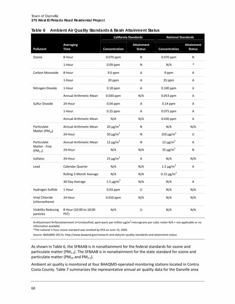
Town of Danville 375 West El Pintado Road Residential Project
68
Table 6 Ambient Air Quality Standards & Basin Attainment Status
Pollutant Averaging Time
California Standards National Standards
Concentration Attainment
Status Concentration Attainment
Status
Ozone 8-Hour 0.070 ppm N 0.070 ppm N
1-Hour 0.09 ppm N N/A *
Carbon Monoxide 8-Hour 9.0 ppm A 9 ppm A
1-Hour 20 ppm A 35 ppm A
Nitrogen Dioxide 1-Hour 0.18 ppm A 0.100 ppm U
Annual Arithmetic Mean 0.030 ppm N/A 0.053 ppm A
Sulfur Dioxide
24-Hour 0.04 ppm A 0.14 ppm A
1-Hour 0.25 ppm A 0.075 ppm A
Annual Arithmetic Mean N/A N/A 0.030 ppm A
Particulate Matter (PM10)
Annual Arithmetic Mean 20 µg/m3 N N/A N/A
24-Hour 50 µg/m3 N 150 µg/m3 U
Particulate Matter - Fine (PM2.5)
Annual Arithmetic Mean 12 µg/m3 N 12 µg/m3 A
24-Hour N/A N/A 35 µg/m3 N
Sulfates 24-Hour 25 µg/m3 A N/A N/A
Lead Calendar Quarter N/A N/A 1.5 µg/m3 A
Rolling 3-Month Average N/A N/A 0.15 µg/m3
30-Day Average 1.5 µg/m3 N/A N/A A
Hydrogen Sulfide 1-Hour 0.03 ppm U N/A N/A
Vinyl Chloride (chloroethene)
24 Hour 0.010 ppm N/A N/A N/A
Visibility Reducing particles
8 Hour (10:00 to 18:00 PST)
N/A U N/A N/A
A=Attainment N=Nonattainment U=Unclassified, ppm=parts per million µg/m3=micrograms per cubic meter N/A = not applicable or no information available *The national 1-hour ozone standard was revoked by EPA on June 15, 2005.
Source: BAAQMD 2017a: http://www.baaqmd.gov/research-and-data/air-quality-standards-and-attainment-status
As shown in Table 6, the SFBAAB is in nonattainment for the federal standards for ozone and particulate matter (PM2.5). The SFBAAB is in nonattainment for the state standard for ozone and particulate matter (PM10 and PM2.5).
Ambient air quality is monitored at four BAAQMD-operated monitoring stations located in Contra Costa County. Table 7 summarizes the representative annual air quality data for the Danville area
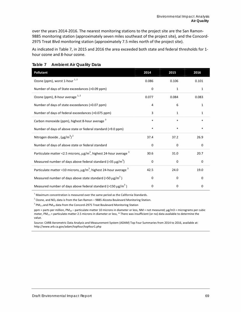
Environmental Impact Analysis Air Quality
Draft Environmental Impact Report 69
over the years 2014-2016. The nearest monitoring stations to the project site are the San Ramon-9885 monitoring station (approximately seven miles southeast of the project site), and the Concord-2975 Treat Blvd monitoring station (approximately 7.5 miles north of the project site).
As indicated in Table 7, in 2015 and 2016 the area exceeded both state and federal thresholds for 1-hour ozone and 8-hour ozone.
Table 7 Ambient Air Quality Data
Pollutant 2014 2015 2016
Ozone (ppm), worst 1-hour 1, 2 0.086 0.106 0.101
Number of days of State exceedances (>0.09 ppm) 0 1 1
Ozone (ppm), 8-hour average 1, 2 0.077 0.084 0.083
Number of days of state exceedances (>0.07 ppm) 4 6 1
Number of days of federal exceedances (>0.075 ppm) 3 1 1
Carbon monoxide (ppm), highest 8-hour average 3 * * *
Number of days of above state or federal standard (>9.0 ppm) * * *
Nitrogen dioxide , (µg/m3) 2 37.4 37.2 26.9
Number of days of above state or federal standard 0 0 0
Particulate matter <2.5 microns, µg/m3, highest 24-hour average 3 30.6 31.0 20.7
Measured number of days above federal standard (>35 µg/m3) 0 0 0
Particulate matter <10 microns, µg/m3, highest 24-hour average 3 42.5 24.0 19.0
Measured number of days above state standard (>50 µg/m3 ) 0 0 0
Measured number of days above federal standard (>150 µg/m3 ) 0 0 0
1 Maximum concentration is measured over the same period as the California Standards. 2 Ozone, and NO2 data is from the San Ramon – 9885 Alcosta Boulevard Monitoring Station. 3 PM2.5 and PM10 data from the Concord-2975 Treat Boulevard Monitoring Station
ppm = parts per million, PM10 – particulate matter 10 microns in diameter or less, NM = not measured; µg/m3 = micrograms per cubic meter, PM2.5 = particulate matter 2.5 microns in diameter or less, * There was insufficient (or no) data available to determine the value.
Source: CARB Aerometric Data Analysis and Measurement System (ADAM) Top Four Summaries from 2014 to 2016, available at: http://www.arb.ca.gov/adam/topfour/topfour1.php
Town of Danville 375 West El Pintado Road Residential Project
70
d. Regulatory Setting
The Federal Clean Air Act (CAA) governs air quality in the United States. In addition to being subject to federal requirements, air quality in California is also governed by more stringent regulations under the California CAA. At the federal level, the EPA administers the CAA. The California CAA is administered by CARB at the state level and by the Air Quality Management Districts at the regional and local levels. The BAAQMD regulates air quality at the regional level, which includes the nine-county Bay Area region.
Federal The EPA is responsible for enforcing the federal CAA. The EPA is also responsible for establishing the NAAQS. The NAAQS are required under the 1977 CAA and subsequent amendments. The EPA regulates emission sources that are under the exclusive authority of the federal government, such as aircraft, ships, and certain types of locomotives. The agency has jurisdiction over emission sources outside state waters (i.e., beyond the outer continental shelf) and establishes various emission standards, including those for vehicles sold in states other than California. Automobiles sold in California must meet the stricter emission standards established by the CARB.
State In California, CARB, which became part of the California Environmental Protection Agency in 1991, is responsible for meeting the State requirements of the federal CAA, administering the California CAA, and establishing the CAAQS. The California CAA, as amended in 1992, requires all air districts in the state to endeavor to achieve and maintain the CAAQS. The CAAQS are generally more stringent than the corresponding federal standards and incorporate additional standards for sulfates, hydrogen sulfide, vinyl chloride and visibility reducing particles. CARB regulates mobile air pollution sources, such as motor vehicles. The agency is responsible for setting emission standards for vehicles sold in California and for other emission sources, such as consumer products and certain off-road equipment. CARB established passenger vehicle fuel specifications, which became effective on March 1996. CARB oversees the functions of local air pollution control districts and air quality management districts, which in turn administer air quality activities at the regional and county level.
Regional The BAAQMD is primarily responsible for assuring that the national and state ambient air quality standards are attained and maintained in the Bay Area. The BAAQMD is also responsible for adopting and enforcing rules and regulations concerning air pollutant sources, issuing permits for stationary sources of air pollutants, inspecting stationary sources of air pollutants, responding to citizen complaints, monitoring ambient air quality and meteorological conditions, awarding grants to reduce motor vehicle emissions, conducting public education campaigns, as well as many other activities. The BAAQMD has jurisdiction over much of the nine-county Bay Area, including Contra Costa County.
The BAAQMD, along with the other regional agencies (such as the Association of Bay Area Governments [ABAG] and the Metropolitan Transportation Commission [MTC]), has prepared the Ozone Attainment Plan to address the federal standard for ozone. The 2017 Bay Area Clean Air Plan, called “Spare the Air-Cool the Climate: A Blueprint for Clean Air and Climate Protection in the Bay Area," (2017 Plan) was adopted on April 19, 2017. The 2017 Plan is the most recently approved regional clean air plan. The plan describes how BAAQMD will “continue progress towards attaining
Environmental Impact Analysis Air Quality
Draft Environmental Impact Report 71
all state and federal air quality standards and eliminating health risk disparities from exposure to air pollution among Bay Area communities” and “includes a variety of control measures designed to decrease emissions of the air pollutants that are most harmful to Bay Area residents, such as particulate matter, ozone, and toxic air contaminants” (BAAQMD 2017b). The 2017 Clean Air Plan is based on population and employment forecasts from ABAG (BAAQMD 2017b).
Local The Town of Danville has adopted a Climate Action Plan (CAP) in May of 2009 and a Sustainability Action Plan in March of 2013 (Town of Danville 2009a, Town of Danville 2013b). These two plans are designed mainly to reduce the amount of GHG emissions, highlight current inventories, and showcase a variety of mitigation measures to bring down emissions. However, many measures included in the plan to reduce GHG emissions would also improve air quality.
e. Sensitive Receptors
Certain population groups are more sensitive to air pollution than the general population. In particular, children, the elderly, and acutely ill and chronically ill persons, especially those with cardio-respiratory diseases, are considered sensitive receptors. Sensitive receptors that are in proximity to localized sources of particulate matter, toxics, and CO are of particular concern. Locations that may contain a high concentration of these sensitive population groups include residential areas, hospitals, daycare facilities, elder care facilities, elementary schools, and parks. The sensitive receptors closest to the project site include the single and multi-family residences that border the project site to the west and south.
The BAAQMD recommends that general plans include buffer zones to separate sensitive receptors from sources of air toxic contaminants and odors. In April 2005, the CARB released the final version of the Air Quality and Land Use Handbook, which is intended to encourage local land use agencies to consider the risks from air pollution prior to making decisions that approve the siting of new sensitive receptors (e.g. homes or daycare centers) near sources of air pollution (CARB 2005). Unlike industrial or stationary sources of air pollution, siting of new sensitive receptors does not require air quality permits, but could create air quality problems. The primary purpose of the handbook is to highlight the potential health impacts associated with proximity to common air pollution sources so that those issues are considered in the planning process. CARB makes recommendations regarding the siting of new sensitive land uses near freeways, truck distribution centers, dry cleaners, gasoline dispensing stations, and other air pollution sources. These recommendations are based primarily on modeling information and may not be entirely reflective of conditions in the Plan Area. The Air Quality and Land Use Handbook notes that siting of new sensitive land uses within these distances may be possible, but recommends that site-specific studies be conducted to identify actual health risks. CARB acknowledges that land use agencies have to balance other siting considerations such as housing and transportation needs, economic development priorities, and other quality of life issues.
4.2.2 Impact Analysis
a. Methodology and Significance Thresholds
This analysis uses the BAAQMD’s May 2017 CEQA Air Quality Guidelines to evaluate air quality. The May 2017 CEQA Air Quality Guidelines include revisions made to the 2010 Guidelines, addressing the California Supreme Court’s 2015 opinion in the Cal. Bldg. Indus. Ass’n vs. Bay Area Air Quality Mgmt. Dist., 62 Cal. 4th 369 (BAAQMD 2017c).
Town of Danville 375 West El Pintado Road Residential Project
72
Significance Thresholds Air quality impacts of the project would be considered significant if they would exceed the following thresholds of significance, which are based on Appendix G of the State CEQA Guidelines and the May 2017 BAAQMD CEQA Air Quality Guidelines. According to Appendix G of the State CEQA Guidelines, a project would have a significant impact on local or regional air quality if it would do any of the following:
A. Conflict with or obstruct implementation of the applicable air quality plan B. Violate any air quality standard or contribute substantially to an existing or projected air
quality violation C. Result in a cumulatively considerable net increase of any criteria pollutant for which the
project region is in non-attainment under an applicable federal or state ambient air quality standard (including releasing emissions that exceed quantitative thresholds for ozone precursors)
D. Expose sensitive receptors to substantial pollutant concentrations E. Create objectionable odors affecting a substantial number of people
Based on the analysis from the Initial Study, checklist questions B, C, and D were determined to have a potentially significant impact, and will be discussed in this EIR. Impacts related to checklist items A and E were determined to be less than significant in the Initial Study and are not discussed in this EIR.
Emissions Thresholds The BAAQMD has developed screening criteria to provide lead agencies and project applicants with a conservative indication of whether a project could result in potentially significant air quality impacts. If all of the screening criteria are met by a project, then the lead agency or applicant would not need to perform a detailed air quality assessment of their project’s air pollutant emissions. These screening levels are generally representative of new development on greenfield sites without any form of mitigation measures taken into consideration. For projects that are infill, such as the proposed project, emissions would be less than the greenfield-type project on which the screening criteria are based (BAAQMD 2017b). For mid-rise apartments, the BAAQMD’s operational criteria pollutant screening size is 494 dwelling units and the construction-related screening size is 240 units. The proposed project involves 37 units and is well below the screening criteria. Nonetheless, this analysis quantifies emissions associated with the project and compares them to BAAQMD’s numeric significance thresholds.
The BAAQMD CEQA Air Quality Guidelines quantify project-level air quality thresholds with defined numeric values and evaluation criteria for pollutant emissions. These project-level thresholds, shown in Table 8, represent the levels at which a project’s individual emissions of criteria air pollutants or precursors would result in a cumulatively considerable contribution to the SFBAAB’s existing air quality conditions. For the purposes of this analysis, the project would result in a significant impact if emissions would exceed any of the thresholds shown in Table 8.
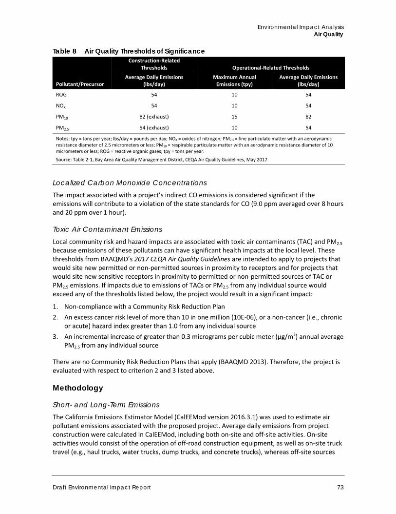
Environmental Impact Analysis Air Quality
Draft Environmental Impact Report 73
Table 8 Air Quality Thresholds of Significance
Pollutant/Precursor
Construction-Related Thresholds Operational-Related Thresholds
Average Daily Emissions (lbs/day)
Maximum Annual Emissions (tpy)
Average Daily Emissions (lbs/day)
ROG 54 10 54
NOX 54 10 54
PM10 82 (exhaust) 15 82
PM2.5 54 (exhaust) 10 54
Notes: tpy = tons per year; lbs/day = pounds per day; NOX = oxides of nitrogen; PM2.5 = fine particulate matter with an aerodynamic resistance diameter of 2.5 micrometers or less; PM10 = respirable particulate matter with an aerodynamic resistance diameter of 10 micrometers or less; ROG = reactive organic gases; tpy = tons per year.
Source: Table 2-1, Bay Area Air Quality Management District, CEQA Air Quality Guidelines, May 2017
Localized Carbon Monoxide Concentrations The impact associated with a project’s indirect CO emissions is considered significant if the emissions will contribute to a violation of the state standards for CO (9.0 ppm averaged over 8 hours and 20 ppm over 1 hour).
Toxic Air Contaminant Emissions Local community risk and hazard impacts are associated with toxic air contaminants (TAC) and PM2.5 because emissions of these pollutants can have significant health impacts at the local level. These thresholds from BAAQMD’s 2017 CEQA Air Quality Guidelines are intended to apply to projects that would site new permitted or non-permitted sources in proximity to receptors and for projects that would site new sensitive receptors in proximity to permitted or non-permitted sources of TAC or PM2.5 emissions. If impacts due to emissions of TACs or PM2.5 from any individual source would exceed any of the thresholds listed below, the project would result in a significant impact:
1. Non-compliance with a Community Risk Reduction Plan 2. An excess cancer risk level of more than 10 in one million (10E-06), or a non-cancer (i.e., chronic
or acute) hazard index greater than 1.0 from any individual source 3. An incremental increase of greater than 0.3 micrograms per cubic meter (µg/m3) annual average
PM2.5 from any individual source
There are no Community Risk Reduction Plans that apply (BAAQMD 2013). Therefore, the project is evaluated with respect to criterion 2 and 3 listed above.
Methodology
Short- and Long-Term Emissions The California Emissions Estimator Model (CalEEMod version 2016.3.1) was used to estimate air pollutant emissions associated with the proposed project. Average daily emissions from project construction were calculated in CalEEMod, including both on-site and off-site activities. On-site activities would consist of the operation of off-road construction equipment, as well as on-site truck travel (e.g., haul trucks, water trucks, dump trucks, and concrete trucks), whereas off-site sources
Town of Danville 375 West El Pintado Road Residential Project
74
would be emissions from construction vehicle trips. Demolition of the existing structure on the project site has been included in CalEEMod calculations.
CalEEMod was also used to estimate emissions from the operation of the project. To provide a conservative analysis of the project’s operational air quality impacts, the operational emissions from existing uses on the project site have not been deducted from the total project emissions. Operational emissions include mobile source emissions, area source emissions, and emissions from energy use. Mobile source emissions would be generated by the increase in motor vehicle trips to and from the project site associated with operation of the project. This analysis used daily project traffic generation rates from the Draft Transportation Impact Study prepared by TJKM included in Appendix H (TJKM 2018). Area source emissions are generated by landscape maintenance equipment, consumer products, and architectural coating. Emissions attributed to energy use include natural gas consumption for space and water heating.
Localized Carbon Monoxide Concentrations The BAAQMD recommends CO “hotspot” analysis for a project if the addition of project traffic would increase traffic volumes at affected intersections to more than 44,000 vehicles per hour. As shown in Figure 24 in Section 4.8, Transportation and Traffic, no intersections affected by the project would handle more than 44,000 vehicles per hour, and so no intersection-specific CO modeling is required (bulk CO emissions are quantified consistent with standard methodologies for the BAAQMD as described in the above paragraphs).
BAAQMD Risk and Hazard Screening Analysis The BAAQMD provides community risk and hazards screening tools for agencies to use in deciding whether there should be further environmental review of a project. According to the BAAQMD, the screening tools provide conservative estimates. A more refined analysis, including site-specific dispersion modeling, should be conducted for more accurate (and usually lower) risk and hazard estimates (BAAQMD 2017c).
Rincon identified emission sources within 1,000 feet of the project’s fence line, per BAAQMD screening guidance. The Contra Costa County Stationary Source Screening Analysis Tool provided by the BAAQMD identifies and includes permitted sources within 1,000 feet of the project site.
To analyze sources that have permits to operate and that emit one or more TACs, BAAQMD has developed a stationary source screening tool that is based on reasonable worst-case assumption scenarios to determine whether a refined modeling analysis is required. The BAAQMD screening tool indicated that there were no stationary sources that had zero cancer and PM2.5 risk.
The nearest highway is I-680, which is approximately 150 feet northwest of the project site. I-680 has annual average daily traffic (AADT) of 170,000 (Caltrans 2014). The BAAQMD’s Highway Screening Analysis Tool was used to determine cancer risk and PM2.5 annual average concentration based on I-680’s AADT, distance from the project site, and orientation (BAAQMD 2012). Major roadways were identified as those within 1,000 feet of the project site that have at least 10,000 AADT. There were no major roadways associated with the project, therefore only the Highway Screening Analysis was used in this study.
The risk and hazard impacts in the BAAQMD’s screening tools do not necessarily represent actual CEQA environmental impacts. The values are based on reasonable worst case assumption scenarios to determine whether or not a refined modeling analysis is required. Calculations used in the screening analysis do not include source-specific exhaust information such as stack height, exhaust
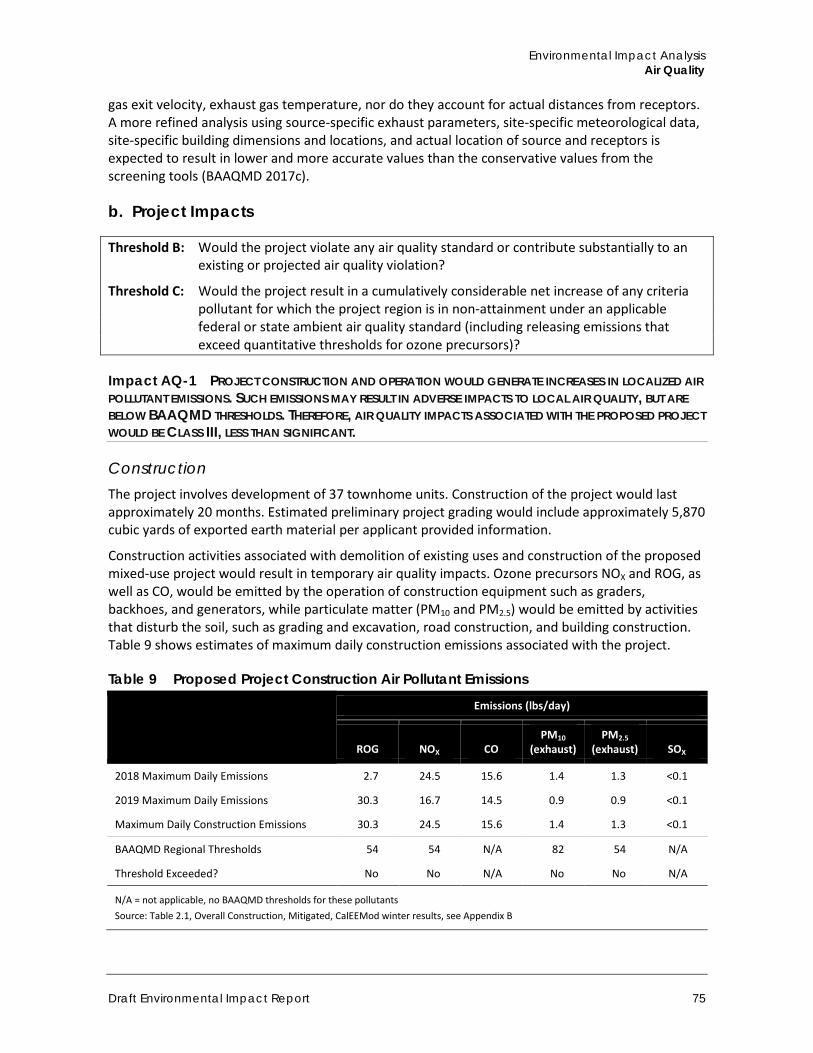
Environmental Impact Analysis Air Quality
Draft Environmental Impact Report 75
gas exit velocity, exhaust gas temperature, nor do they account for actual distances from receptors. A more refined analysis using source-specific exhaust parameters, site-specific meteorological data, site-specific building dimensions and locations, and actual location of source and receptors is expected to result in lower and more accurate values than the conservative values from the screening tools (BAAQMD 2017c).
b. Project Impacts
Threshold B: Would the project violate any air quality standard or contribute substantially to an existing or projected air quality violation?
Threshold C: Would the project result in a cumulatively considerable net increase of any criteria pollutant for which the project region is in non-attainment under an applicable federal or state ambient air quality standard (including releasing emissions that exceed quantitative thresholds for ozone precursors)?
Impact AQ-1 PROJECT CONSTRUCTION AND OPERATION WOULD GENERATE INCREASES IN LOCALIZED AIR POLLUTANT EMISSIONS. SUCH EMISSIONS MAY RESULT IN ADVERSE IMPACTS TO LOCAL AIR QUALITY, BUT ARE BELOW BAAQMD THRESHOLDS. THEREFORE, AIR QUALITY IMPACTS ASSOCIATED WITH THE PROPOSED PROJECT WOULD BE CLASS III, LESS THAN SIGNIFICANT.
Construction The project involves development of 37 townhome units. Construction of the project would last approximately 20 months. Estimated preliminary project grading would include approximately 5,870 cubic yards of exported earth material per applicant provided information.
Construction activities associated with demolition of existing uses and construction of the proposed mixed-use project would result in temporary air quality impacts. Ozone precursors NOX and ROG, as well as CO, would be emitted by the operation of construction equipment such as graders, backhoes, and generators, while particulate matter (PM10 and PM2.5) would be emitted by activities that disturb the soil, such as grading and excavation, road construction, and building construction. Table 9 shows estimates of maximum daily construction emissions associated with the project.
Table 9 Proposed Project Construction Air Pollutant Emissions
Emissions (lbs/day)
ROG NOX CO PM10
(exhaust) PM2.5
(exhaust) SOX
2018 Maximum Daily Emissions 2.7 24.5 15.6 1.4 1.3 <0.1
2019 Maximum Daily Emissions 30.3 16.7 14.5 0.9 0.9 <0.1
Maximum Daily Construction Emissions 30.3 24.5 15.6 1.4 1.3 <0.1
BAAQMD Regional Thresholds 54 54 N/A 82 54 N/A
Threshold Exceeded? No No N/A No No N/A
N/A = not applicable, no BAAQMD thresholds for these pollutants Source: Table 2.1, Overall Construction, Mitigated, CalEEMod winter results, see Appendix B
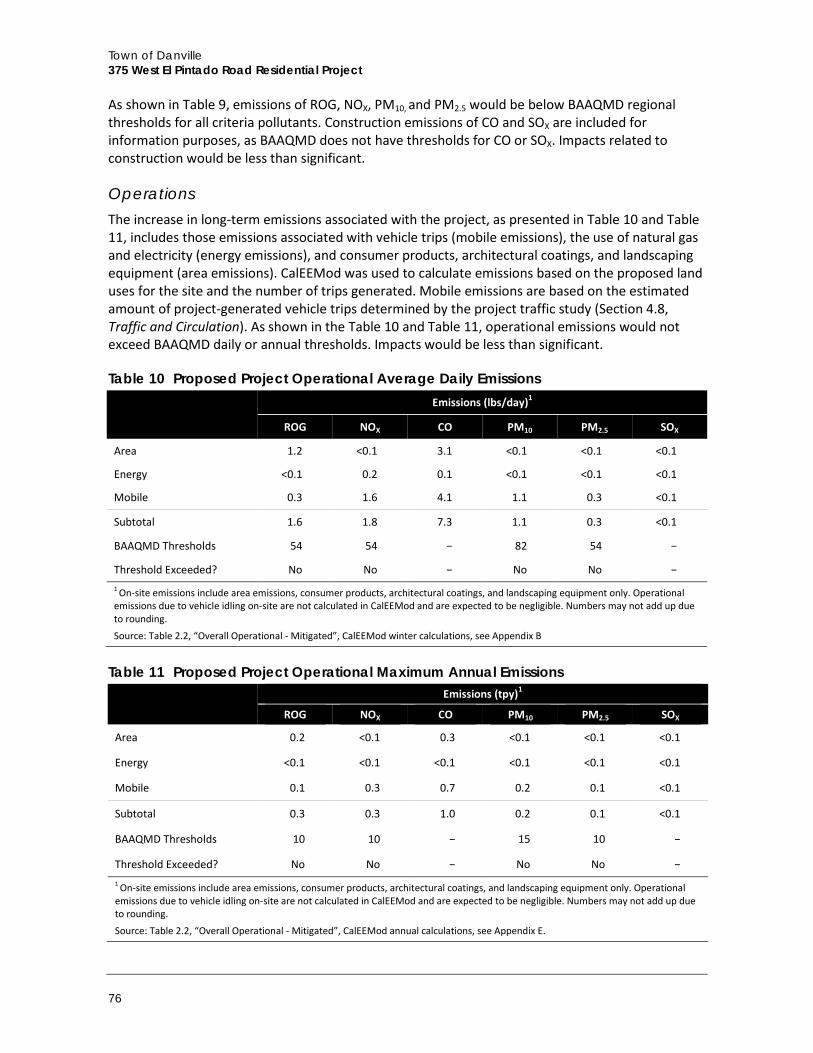
Town of Danville 375 West El Pintado Road Residential Project
76
As shown in Table 9, emissions of ROG, NOX, PM10, and PM2.5 would be below BAAQMD regional thresholds for all criteria pollutants. Construction emissions of CO and SOX are included for information purposes, as BAAQMD does not have thresholds for CO or SOX. Impacts related to construction would be less than significant.
Operations The increase in long-term emissions associated with the project, as presented in Table 10 and Table 11, includes those emissions associated with vehicle trips (mobile emissions), the use of natural gas and electricity (energy emissions), and consumer products, architectural coatings, and landscaping equipment (area emissions). CalEEMod was used to calculate emissions based on the proposed land uses for the site and the number of trips generated. Mobile emissions are based on the estimated amount of project-generated vehicle trips determined by the project traffic study (Section 4.8, Traffic and Circulation). As shown in the Table 10 and Table 11, operational emissions would not exceed BAAQMD daily or annual thresholds. Impacts would be less than significant.
Table 10 Proposed Project Operational Average Daily Emissions
Emissions (lbs/day)1
ROG NOX CO PM10 PM2.5 SOX
Area 1.2 <0.1 3.1 <0.1 <0.1 <0.1
Energy <0.1 0.2 0.1 <0.1 <0.1 <0.1
Mobile 0.3 1.6 4.1 1.1 0.3 <0.1
Subtotal 1.6 1.8 7.3 1.1 0.3 <0.1
BAAQMD Thresholds 54 54 − 82 54 −
Threshold Exceeded? No No − No No − 1 On-site emissions include area emissions, consumer products, architectural coatings, and landscaping equipment only. Operational emissions due to vehicle idling on-site are not calculated in CalEEMod and are expected to be negligible. Numbers may not add up due to rounding.
Source: Table 2.2, “Overall Operational - Mitigated”, CalEEMod winter calculations, see Appendix B
Table 11 Proposed Project Operational Maximum Annual Emissions
Emissions (tpy)1
ROG NOX CO PM10 PM2.5 SOX
Area 0.2 <0.1 0.3 <0.1 <0.1 <0.1
Energy <0.1 <0.1 <0.1 <0.1 <0.1 <0.1
Mobile 0.1 0.3 0.7 0.2 0.1 <0.1
Subtotal 0.3 0.3 1.0 0.2 0.1 <0.1
BAAQMD Thresholds 10 10 − 15 10 −
Threshold Exceeded? No No − No No − 1 On-site emissions include area emissions, consumer products, architectural coatings, and landscaping equipment only. Operational emissions due to vehicle idling on-site are not calculated in CalEEMod and are expected to be negligible. Numbers may not add up due to rounding.
Source: Table 2.2, “Overall Operational - Mitigated”, CalEEMod annual calculations, see Appendix E.
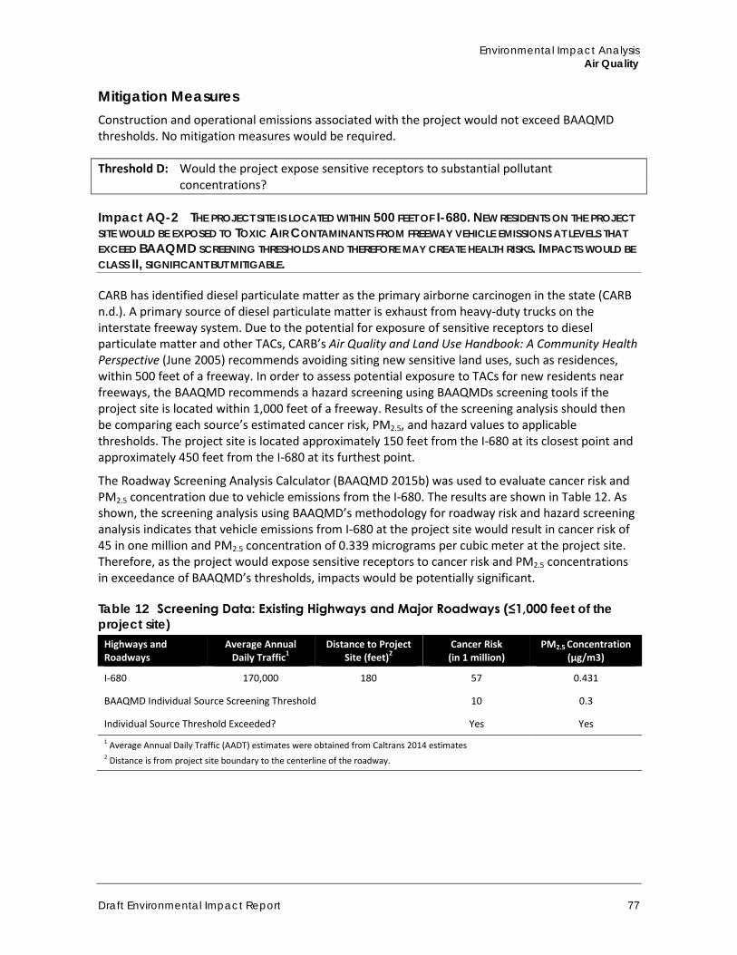
Environmental Impact Analysis Air Quality
Draft Environmental Impact Report 77
Mitigation Measures Construction and operational emissions associated with the project would not exceed BAAQMD thresholds. No mitigation measures would be required.
Threshold D: Would the project expose sensitive receptors to substantial pollutant concentrations?
Impact AQ-2 THE PROJECT SITE IS LOCATED WITHIN 500 FEET OF I-680. NEW RESIDENTS ON THE PROJECT SITE WOULD BE EXPOSED TO TOXIC AIR CONTAMINANTS FROM FREEWAY VEHICLE EMISSIONS AT LEVELS THAT EXCEED BAAQMD SCREENING THRESHOLDS AND THEREFORE MAY CREATE HEALTH RISKS. IMPACTS WOULD BE CLASS II, SIGNIFICANT BUT MITIGABLE.
CARB has identified diesel particulate matter as the primary airborne carcinogen in the state (CARB n.d.). A primary source of diesel particulate matter is exhaust from heavy-duty trucks on the interstate freeway system. Due to the potential for exposure of sensitive receptors to diesel particulate matter and other TACs, CARB’s Air Quality and Land Use Handbook: A Community Health Perspective (June 2005) recommends avoiding siting new sensitive land uses, such as residences, within 500 feet of a freeway. In order to assess potential exposure to TACs for new residents near freeways, the BAAQMD recommends a hazard screening using BAAQMDs screening tools if the project site is located within 1,000 feet of a freeway. Results of the screening analysis should then be comparing each source’s estimated cancer risk, PM2.5, and hazard values to applicable thresholds. The project site is located approximately 150 feet from the I-680 at its closest point and approximately 450 feet from the I-680 at its furthest point.
The Roadway Screening Analysis Calculator (BAAQMD 2015b) was used to evaluate cancer risk and PM2.5 concentration due to vehicle emissions from the I-680. The results are shown in Table 12. As shown, the screening analysis using BAAQMD’s methodology for roadway risk and hazard screening analysis indicates that vehicle emissions from I-680 at the project site would result in cancer risk of 45 in one million and PM2.5 concentration of 0.339 micrograms per cubic meter at the project site. Therefore, as the project would expose sensitive receptors to cancer risk and PM2.5 concentrations in exceedance of BAAQMD’s thresholds, impacts would be potentially significant.
Table 12 Screening Data: Existing Highways and Major Roadways (≤1,000 feet of the project site)
Highways and Roadways
Average Annual Daily Traffic1
Distance to Project Site (feet)2
Cancer Risk (in 1 million)
PM2.5 Concentration (µg/m3)
I-680 170,000 180 57 0.431
BAAQMD Individual Source Screening Threshold 10 0.3
Individual Source Threshold Exceeded? Yes Yes 1 Average Annual Daily Traffic (AADT) estimates were obtained from Caltrans 2014 estimates 2 Distance is from project site boundary to the centerline of the roadway.
Town of Danville 375 West El Pintado Road Residential Project
78
Mitigation Measures The following mitigation measure would be required to reduce exposure of new residents on the project site to toxic air contaminants to less than significant levels.
AQ-1 Toxic Air Contaminants Emissions Reductions In order to reduce exposure of proposed residences to toxic air contaminants emissions from vehicles on I-680, the applicant shall submit to the Town of Danville for review and approval a ventilation proposal prepared by a licensed design professional for all on-site buildings that describes the ventilation design and how that design ensures all dwelling units would be below the excess cancer risk level of 10 in one million established by the Bay Area Air Quality Management District. The ventilation proposal shall include, but is not limited to, the following measures:
a) If the proposed buildings would use operable windows or other sources of infiltration of ambient air, the development shall install a central HVAC system that includes high efficiency particulate filters (a MERV rating of 13 or higher). These types of filters are capable of removing approximately 90 percent of the DPM emissions from air introduced into the HVAC system. The system may also include a carbon filter to remove other chemical matter. Filtration systems must operate to maintain positive pressure within the building interior to prevent entrainment of outdoor air indoors.
b) If the development limits infiltration through non-operable windows, a suitable ventilation system shall include a ventilation system with filtration specifications equivalent to or better than the following: (1) American Society of Heating, Refrigerating and Air-Conditioning Engineers MERV-13 supply air filters, (2) greater than or equal to one air exchanges per hour of fresh outside filtered air, (3) greater than or equal to four air exchanges per hour recirculation, and (4) less than or equal to 0.25 air exchanges per hour in unfiltered infiltration. These types of filtration methods are capable of removing approximately 90 percent of the DPM emissions from air introduced into the HVAC system.
c) Windows and doors shall be fully weatherproofed with caulking and weather-stripping that is rated to last at least 20 years. Weatherproof should be maintained and replaced by the property owner, as necessary, to ensure functionality for the lifetime of the project
d) Where appropriate, install passive (drop-in) electrostatic filtering systems, especially those with low air velocities (i.e., 1 mph)
e) Ensure an ongoing maintenance plan for the HVAC and filtration systems. Manufacturers of these types of filters recommend that they be replaced after two to three months of use.
f) The applicant shall inform occupants regarding the proper use of any installed air filtration system.
Significance After Mitigation These actions would provide for the removal of particulates prior to entering into the indoor environment, thereby reducing the overall exposure of individual residents. The MERV-13 filter system would reduce the carcinogenic health risk associated with vehicle traffic along I-680 from 57 in one million to nine in one million, which is lower than BAAQMD thresholds. The filters would also lower PM2.5 concentrations from 0.431 to 0.1 µg/m3, which is lower than the BAAQMD threshold for PM2.5 (Appendix B). This calculation is based on the assumption that residents are exposed to outdoor air (100 percent of the particulates) at the residence for approximately two hours per day and that they are exposed to indoor air at the residence approximately 16.4 hours per (EPA 2011).
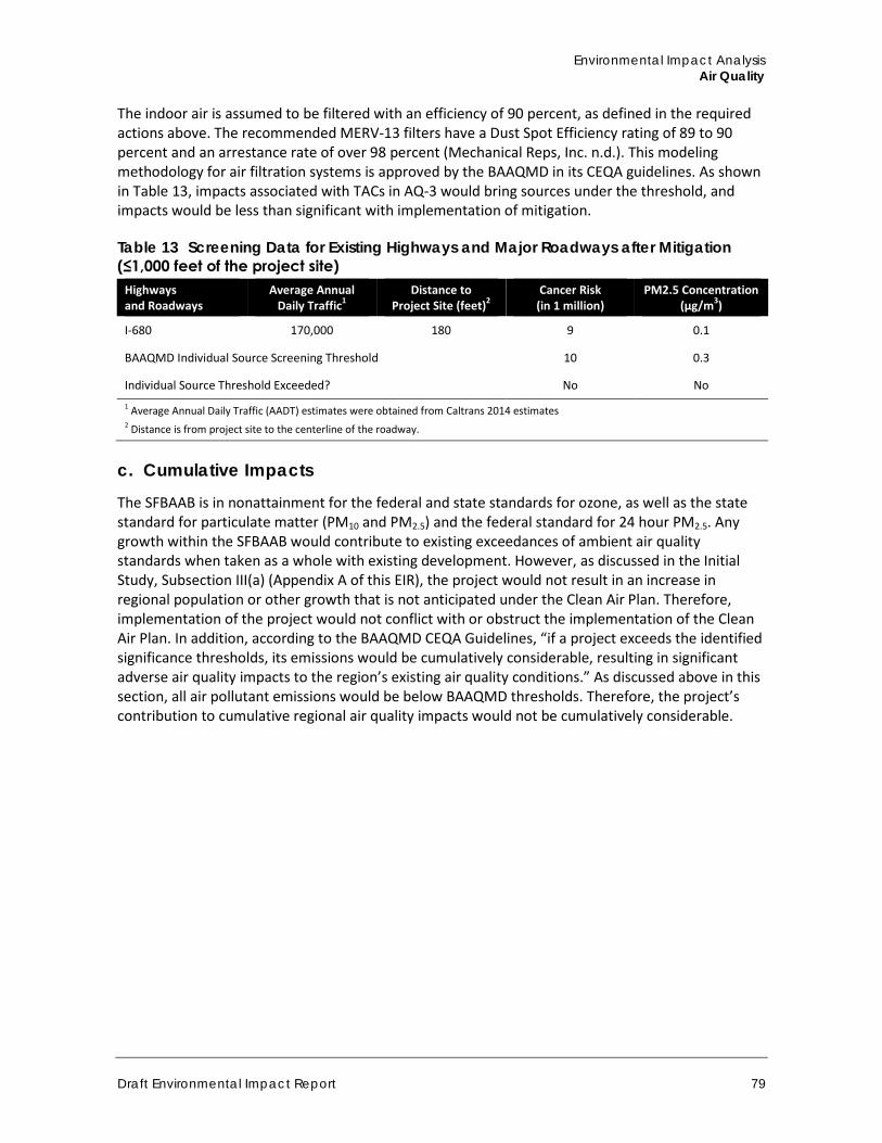
Environmental Impact Analysis Air Quality
Draft Environmental Impact Report 79
The indoor air is assumed to be filtered with an efficiency of 90 percent, as defined in the required actions above. The recommended MERV-13 filters have a Dust Spot Efficiency rating of 89 to 90 percent and an arrestance rate of over 98 percent (Mechanical Reps, Inc. n.d.). This modeling methodology for air filtration systems is approved by the BAAQMD in its CEQA guidelines. As shown in Table 13, impacts associated with TACs in AQ-3 would bring sources under the threshold, and impacts would be less than significant with implementation of mitigation.
Table 13 Screening Data for Existing Highways and Major Roadways after Mitigation (≤1,000 feet of the project site)
Highways and Roadways
Average Annual Daily Traffic1
Distance to Project Site (feet)2
Cancer Risk (in 1 million)
PM2.5 Concentration (µg/m3)
I-680 170,000 180 9 0.1
BAAQMD Individual Source Screening Threshold 10 0.3
Individual Source Threshold Exceeded? No No 1 Average Annual Daily Traffic (AADT) estimates were obtained from Caltrans 2014 estimates 2 Distance is from project site to the centerline of the roadway.
c. Cumulative Impacts
The SFBAAB is in nonattainment for the federal and state standards for ozone, as well as the state standard for particulate matter (PM10 and PM2.5) and the federal standard for 24 hour PM2.5. Any growth within the SFBAAB would contribute to existing exceedances of ambient air quality standards when taken as a whole with existing development. However, as discussed in the Initial Study, Subsection III(a) (Appendix A of this EIR), the project would not result in an increase in regional population or other growth that is not anticipated under the Clean Air Plan. Therefore, implementation of the project would not conflict with or obstruct the implementation of the Clean Air Plan. In addition, according to the BAAQMD CEQA Guidelines, “if a project exceeds the identified significance thresholds, its emissions would be cumulatively considerable, resulting in significant adverse air quality impacts to the region’s existing air quality conditions.” As discussed above in this section, all air pollutant emissions would be below BAAQMD thresholds. Therefore, the project’s contribution to cumulative regional air quality impacts would not be cumulatively considerable.

Town of Danville 375 West El Pintado Road Residential Project
80
This page left intentionally blank.
Environmental Impact Analysis Biological Resources
Draft Environmental Impact Report 81
4.3 Biological Resources This section describes the existing biological resources at the project site, the potential impacts on those resources that could result from project implementation and mitigation measures that would reduce identified impacts to less than significant levels. This section summarizes information from the Biological Resources Assessment prepared by Monk & Associates, Inc. (M&A) (Appendix C) and the Arborist Report for 359 & 375 El Pintado Road, Danville prepared by Traverso Tree Services in 2016 and updated in 2018 (Appendix D).
4.3.1 Setting
a. Project Site Setting The project site encompasses 1.88 acres and is currently undeveloped with the exception of a single-family residence located on the southeastern portion of the site. The site has a rolling topography that slopes generally from the east, along West El Pintado Road, to west. Elevation ranges on the larger 1.59-acre parcel from approximately 355 at the northwest corner, to 351 feet along the drainage swale running southwesterly from the northern to southern end of the parcel, to approximately 374 feet at a small knoll located at the southeast corner of the larger parcel. The smaller 0.29-acre parcel is relatively flat and lies at an elevation of approximately 367 feet. Two drainage swales traverse the site, one bisecting the site from east to west and the other running from north to south near the project’s western boundary. Vegetation on the site is composed mainly of grasses with a number of scattered mature trees, predominantly oaks. Figure 4 provides photographs of the project site and Figure 11 (a-b) illustrates the visual character of the project site.
b. Vegetation Communities Based on review of the California Natural Diversity Database (Appendix C, CNDDB 2016) and field biological survey (Appendix C), no sensitive vegetation communities are present on the project site. The project site consists primarily of non-native annual grasses such as slender wild oats (Avena barbata), ripgut brome (Bromus diandrus), bristly ox tongue (Helminthotheca echioides), bind weed (Convolvulus arvensis), prickly lettuce (Lactuca serriola), and rip-gut brome (Bromus diandrus), with one native species identified, namely wild rye (Elymus triticoides). Ground beneath the herbaceous layer is hard-packed and covered in a layer of gravel. Both native and non-native ornamental and shade trees are present at the project site (Appendix C) including Monterey pine (Pinus radiata), London plane tree (Platanus xhispanica), Fremont cottonwood (Populus fremontii), valley oak (Quercus lobata), Aleppo pine (Pinus halepense), and Siberian elm (Ulmus pumila). Trees considered invasive are also present, including blackwood acacia (Acacia melanoxylon), which is rated Limited by the California Invasive Plant Council (Cal-IPC 2016). Near the existing home is a row of French broom plants (Genista monspessulana) intermixed with young acacia (Acacia sp.), firethorn (Pyracantha angustifolia), and Fremont cottonwood.
The project site is bisected by a naturally occurring drainage that has been artificially routed and reinforced and two constructed drainages (see also Section 4.5, Hydrology and Water Quality). Drainage ditches support only ruderal vegetation. No emergent vegetation or tree canopy is present over the drainages, although red willows (Salix laevigata) occur close by the constructed drainage along the western property line. The second constructed channel occurs along the southern parcel’s southern property line. This channel enters the project site via a 24-inch reinforced concrete pipe installed underneath El Pintado Road. Vegetation along this drainage is dense, but is not consistent
Town of Danville 375 West El Pintado Road Residential Project
82
with riparian vegetation community. The central and largest drainage contains vegetation that is consistent with riparian vegetation, but no intact riparian vegetation community is present.
c. Special-Status Species For the purpose of this EIR, special-status species are those plants and animals listed, proposed for listing, or candidates for listing as threatened or endangered by the USFWS or National Marine Fisheries Service (NMFS) under the federal Endangered Species Act (ESA); those listed or proposed for listing as rare, threatened, or endangered by the CDFW under the California Endangered Species Act (CESA); animals designated as “Species of Special Concern” by the CDFW; migratory nongame birds of management concern listed by UFSWS (USFWS 1995); animal species that are “fully protected” in California (Fish and Game Codes 3511, 4700, 5050, and 5515); and plants with a California Rare Plant Rank (CRPR) of 1 or 2, which are defined as follows:
List 1A = Plants presumed extinct in California List 1B.1 = Rare or endangered in California and elsewhere, seriously endangered in California
(over 80 percent of occurrences threatened/high degree and immediacy of threat) List 1B.2 = Rare or endangered in California and elsewhere, fairly endangered in California (20-
80 percent occurrences threatened) List 1B.3 = Rare or endangered in California and elsewhere, not very endangered in California
(<20 percent of occurrences threatened or no current threats known) List 2 = Rare, threatened, or endangered in California, but more common elsewhere
The CNDDB RareFind 3.2 application version was queried by M&A (Appendix C) and the most recent CNDDB RareFind 5 application version was queried here (CDFW 2016) for historic and recent records of special-status plant and animal species (threatened, endangered, rare) known to occur within five miles of the project site. The California Native Plant Society (CNPS) Online Inventory of Rare and Endangered Plants of California (Appendix C, CNPS 2016) was also queried for records of special-status plants known to occur within five miles of the project site. In addition, M&A’s principal biologist, Mr. Geoff Monk, and associate biologist, Ms. Sarah Lynch, conducted a general survey of the project site on July 7, 2014 to assess the likelihood of agency-regulated areas on the project site and to document the existing site conditions including the plant communities and wildlife habitats found on site.
Sensitive Communities and Critical Habitat No sensitive natural communities recognized the CDFW and tracked in the CNDDB occur within five miles of the project site (Appendix C). Federally designated critical habitat for the California red-legged frog, Critical Habitat Unit CCS-2A, is located approximately 2.8 miles southwest of the project site (Federal Register dated March 17, 2010,Volume 75, Number 51:12815-12864). The California red-legged frog is also a state “species of special concern.”
Special-Status Plants and Animals Database queries (CDFW 2016, CNPS 2016, USFWS 2016a) revealed that no special-status species have been mapped on or adjacent to the project site. Eighteen special-status plant species and nine special-status animal species are known to occur within five miles of the project site (Table 14). Most of the special-status plants occur in specialized habitats such as alkaline soils, vernal pools, or serpentine grassland, which are not present on the project site. Historical aerial imagery shows the
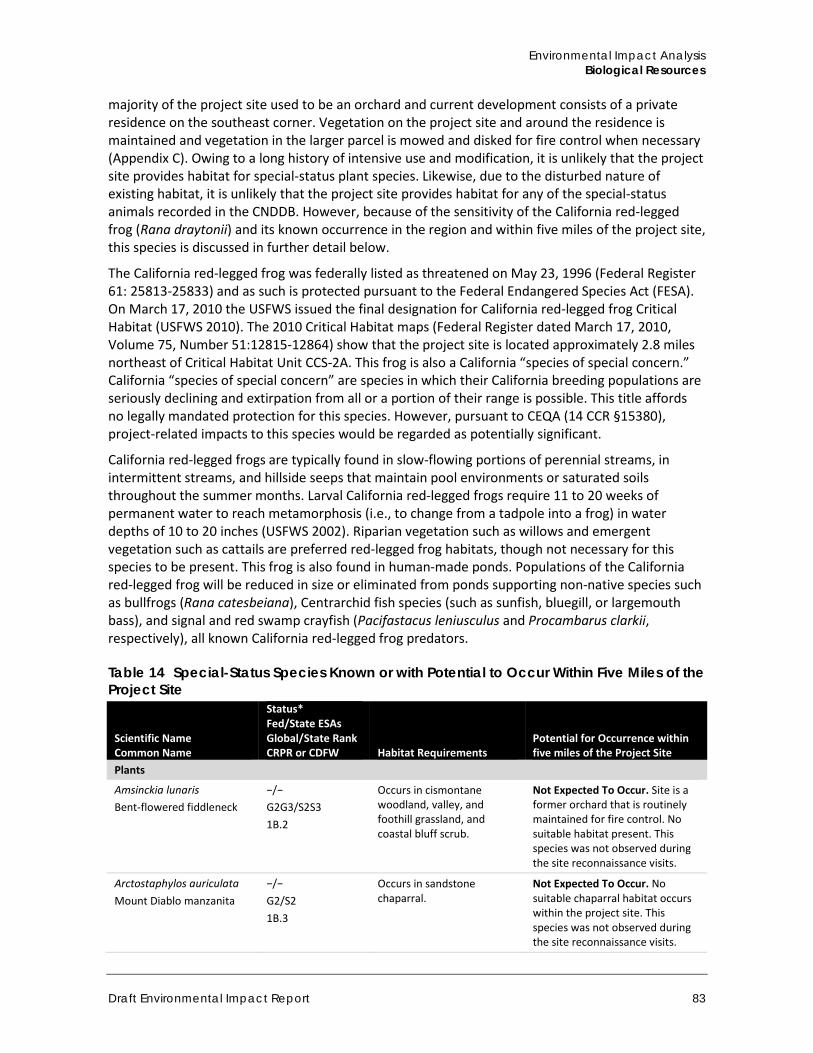
Environmental Impact Analysis Biological Resources
Draft Environmental Impact Report 83
majority of the project site used to be an orchard and current development consists of a private residence on the southeast corner. Vegetation on the project site and around the residence is maintained and vegetation in the larger parcel is mowed and disked for fire control when necessary (Appendix C). Owing to a long history of intensive use and modification, it is unlikely that the project site provides habitat for special-status plant species. Likewise, due to the disturbed nature of existing habitat, it is unlikely that the project site provides habitat for any of the special-status animals recorded in the CNDDB. However, because of the sensitivity of the California red-legged frog (Rana draytonii) and its known occurrence in the region and within five miles of the project site, this species is discussed in further detail below.
The California red-legged frog was federally listed as threatened on May 23, 1996 (Federal Register 61: 25813-25833) and as such is protected pursuant to the Federal Endangered Species Act (FESA). On March 17, 2010 the USFWS issued the final designation for California red-legged frog Critical Habitat (USFWS 2010). The 2010 Critical Habitat maps (Federal Register dated March 17, 2010, Volume 75, Number 51:12815-12864) show that the project site is located approximately 2.8 miles northeast of Critical Habitat Unit CCS-2A. This frog is also a California “species of special concern.” California “species of special concern” are species in which their California breeding populations are seriously declining and extirpation from all or a portion of their range is possible. This title affords no legally mandated protection for this species. However, pursuant to CEQA (14 CCR §15380), project-related impacts to this species would be regarded as potentially significant.
California red-legged frogs are typically found in slow-flowing portions of perennial streams, in intermittent streams, and hillside seeps that maintain pool environments or saturated soils throughout the summer months. Larval California red-legged frogs require 11 to 20 weeks of permanent water to reach metamorphosis (i.e., to change from a tadpole into a frog) in water depths of 10 to 20 inches (USFWS 2002). Riparian vegetation such as willows and emergent vegetation such as cattails are preferred red-legged frog habitats, though not necessary for this species to be present. This frog is also found in human-made ponds. Populations of the California red-legged frog will be reduced in size or eliminated from ponds supporting non-native species such as bullfrogs (Rana catesbeiana), Centrarchid fish species (such as sunfish, bluegill, or largemouth bass), and signal and red swamp crayfish (Pacifastacus leniusculus and Procambarus clarkii, respectively), all known California red-legged frog predators.
Table 14 Special-Status Species Known or with Potential to Occur Within Five Miles of the Project Site
Scientific Name Common Name
Status* Fed/State ESAs Global/State Rank CRPR or CDFW Habitat Requirements
Potential for Occurrence within five miles of the Project Site
Plants
Amsinckia lunaris Bent-flowered fiddleneck
−/− G2G3/S2S3 1B.2
Occurs in cismontane woodland, valley, and foothill grassland, and coastal bluff scrub.
Not Expected To Occur. Site is a former orchard that is routinely maintained for fire control. No suitable habitat present. This species was not observed during the site reconnaissance visits.
Arctostaphylos auriculata Mount Diablo manzanita
−/− G2/S2 1B.3
Occurs in sandstone chaparral.
Not Expected To Occur. No suitable chaparral habitat occurs within the project site. This species was not observed during the site reconnaissance visits.
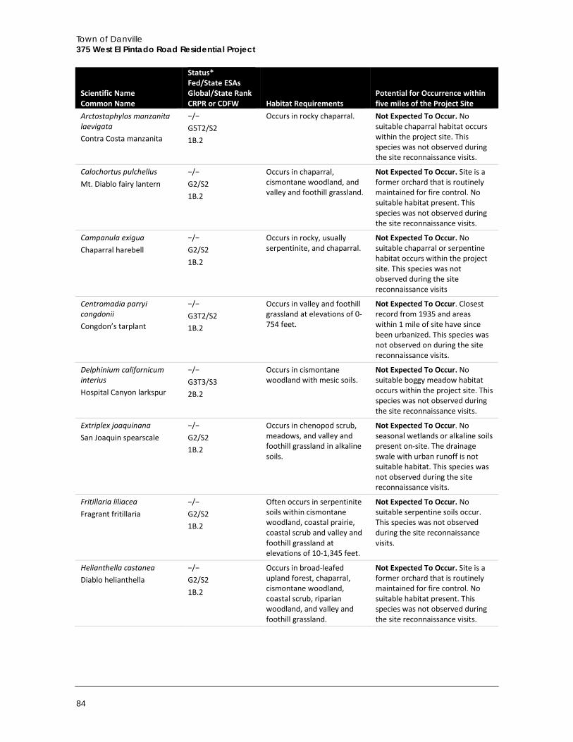
Town of Danville 375 West El Pintado Road Residential Project
84
Scientific Name Common Name
Status* Fed/State ESAs Global/State Rank CRPR or CDFW Habitat Requirements
Potential for Occurrence within five miles of the Project Site
Arctostaphylos manzanita laevigata Contra Costa manzanita
−/− G5T2/S2 1B.2
Occurs in rocky chaparral. Not Expected To Occur. No suitable chaparral habitat occurs within the project site. This species was not observed during the site reconnaissance visits.
Calochortus pulchellus Mt. Diablo fairy lantern
−/− G2/S2 1B.2
Occurs in chaparral, cismontane woodland, and valley and foothill grassland.
Not Expected To Occur. Site is a former orchard that is routinely maintained for fire control. No suitable habitat present. This species was not observed during the site reconnaissance visits.
Campanula exigua Chaparral harebell
−/− G2/S2 1B.2
Occurs in rocky, usually serpentinite, and chaparral.
Not Expected To Occur. No suitable chaparral or serpentine habitat occurs within the project site. This species was not observed during the site reconnaissance visits
Centromadia parryi congdonii Congdon’s tarplant
−/− G3T2/S2 1B.2
Occurs in valley and foothill grassland at elevations of 0-754 feet.
Not Expected To Occur. Closest record from 1935 and areas within 1 mile of site have since been urbanized. This species was not observed on during the site reconnaissance visits.
Delphinium californicum interius Hospital Canyon larkspur
−/− G3T3/S3 2B.2
Occurs in cismontane woodland with mesic soils.
Not Expected To Occur. No suitable boggy meadow habitat occurs within the project site. This species was not observed during the site reconnaissance visits.
Extriplex joaquinana San Joaquin spearscale
−/− G2/S2 1B.2
Occurs in chenopod scrub, meadows, and valley and foothill grassland in alkaline soils.
Not Expected To Occur. No seasonal wetlands or alkaline soils present on-site. The drainage swale with urban runoff is not suitable habitat. This species was not observed during the site reconnaissance visits.
Fritillaria liliacea Fragrant fritillaria
−/− G2/S2 1B.2
Often occurs in serpentinite soils within cismontane woodland, coastal prairie, coastal scrub and valley and foothill grassland at elevations of 10-1,345 feet.
Not Expected To Occur. No suitable serpentine soils occur. This species was not observed during the site reconnaissance visits.
Helianthella castanea Diablo helianthella
−/− G2/S2 1B.2
Occurs in broad-leafed upland forest, chaparral, cismontane woodland, coastal scrub, riparian woodland, and valley and foothill grassland.
Not Expected To Occur. Site is a former orchard that is routinely maintained for fire control. No suitable habitat present. This species was not observed during the site reconnaissance visits.
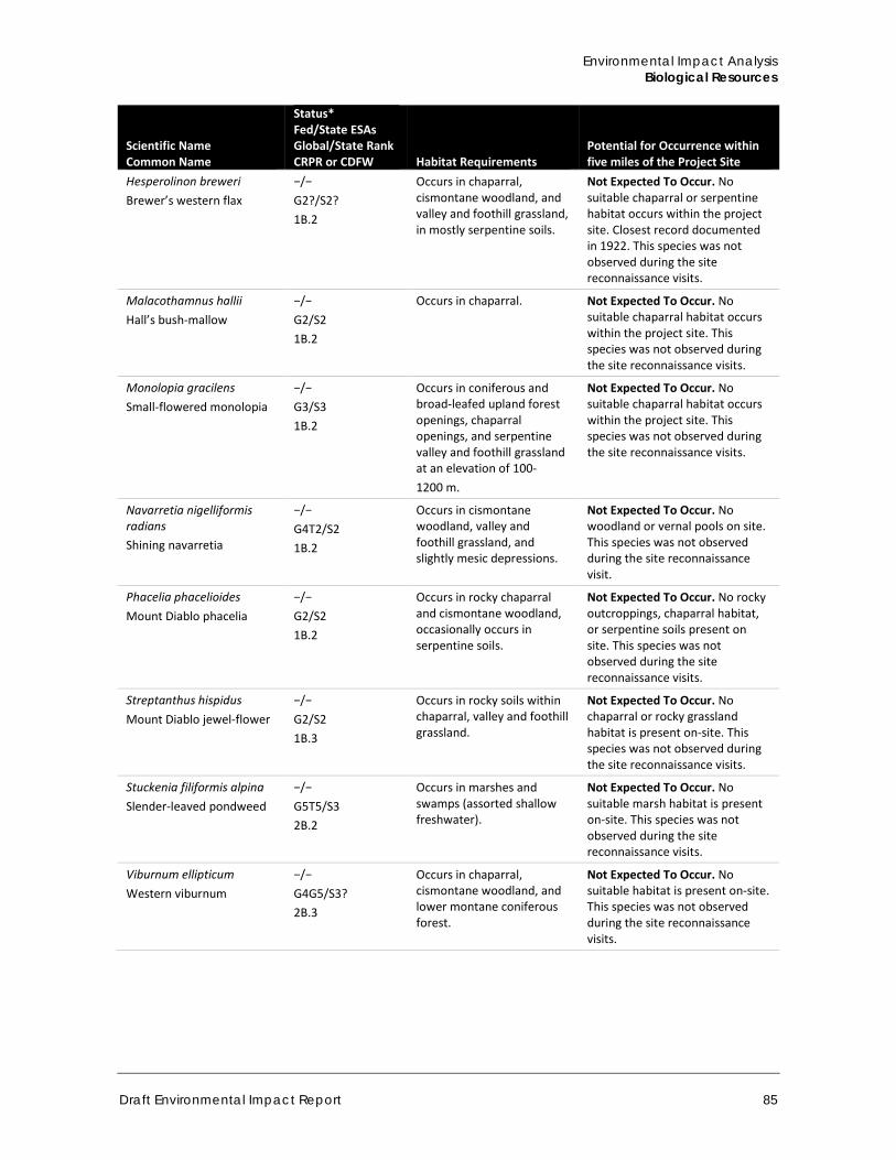
Environmental Impact Analysis Biological Resources
Draft Environmental Impact Report 85
Scientific Name Common Name
Status* Fed/State ESAs Global/State Rank CRPR or CDFW Habitat Requirements
Potential for Occurrence within five miles of the Project Site
Hesperolinon breweri Brewer’s western flax
−/− G2?/S2? 1B.2
Occurs in chaparral, cismontane woodland, and valley and foothill grassland, in mostly serpentine soils.
Not Expected To Occur. No suitable chaparral or serpentine habitat occurs within the project site. Closest record documented in 1922. This species was not observed during the site reconnaissance visits.
Malacothamnus hallii Hall’s bush-mallow
−/− G2/S2 1B.2
Occurs in chaparral. Not Expected To Occur. No suitable chaparral habitat occurs within the project site. This species was not observed during the site reconnaissance visits.
Monolopia gracilens Small-flowered monolopia
−/− G3/S3 1B.2
Occurs in coniferous and broad-leafed upland forest openings, chaparral openings, and serpentine valley and foothill grassland at an elevation of 100- 1200 m.
Not Expected To Occur. No suitable chaparral habitat occurs within the project site. This species was not observed during the site reconnaissance visits.
Navarretia nigelliformis radians Shining navarretia
−/− G4T2/S2 1B.2
Occurs in cismontane woodland, valley and foothill grassland, and slightly mesic depressions.
Not Expected To Occur. No woodland or vernal pools on site. This species was not observed during the site reconnaissance visit.
Phacelia phacelioides Mount Diablo phacelia
−/− G2/S2 1B.2
Occurs in rocky chaparral and cismontane woodland, occasionally occurs in serpentine soils.
Not Expected To Occur. No rocky outcroppings, chaparral habitat, or serpentine soils present on site. This species was not observed during the site reconnaissance visits.
Streptanthus hispidus Mount Diablo jewel-flower
−/− G2/S2 1B.3
Occurs in rocky soils within chaparral, valley and foothill grassland.
Not Expected To Occur. No chaparral or rocky grassland habitat is present on-site. This species was not observed during the site reconnaissance visits.
Stuckenia filiformis alpina Slender-leaved pondweed
−/− G5T5/S3 2B.2
Occurs in marshes and swamps (assorted shallow freshwater).
Not Expected To Occur. No suitable marsh habitat is present on-site. This species was not observed during the site reconnaissance visits.
Viburnum ellipticum Western viburnum
−/− G4G5/S3? 2B.3
Occurs in chaparral, cismontane woodland, and lower montane coniferous forest.
Not Expected To Occur. No suitable habitat is present on-site. This species was not observed during the site reconnaissance visits.
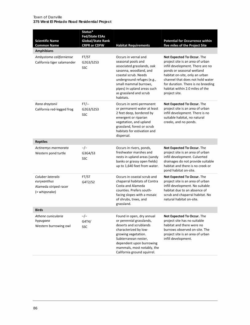
Town of Danville 375 West El Pintado Road Residential Project
86
Scientific Name Common Name
Status* Fed/State ESAs Global/State Rank CRPR or CDFW Habitat Requirements
Potential for Occurrence within five miles of the Project Site
Amphibians
Ambystoma californiense California tiger salamander
FT/ST G2G3/S2S3 SSC
Occurs in vernal and seasonal pools and associated grasslands, oak savanna, woodland, and coastal scrub. Needs underground refuges (e.g., small mammal burrows, pipes) in upland areas such as grassland and scrub habitats.
Not Expected To Occur. The project site is an area of urban infill development. There are no ponds or seasonal wetland habitat on-site, only an urban channel that does not hold water for duration. There is no breeding habitat within 2.0 miles of the project site.
Rana draytonii California red-legged frog
FT/-- G2G3/S2S3 SSC
Occurs in semi-permanent or permanent water at least 2 feet deep, bordered by emergent or riparian vegetation, and upland grassland, forest or scrub habitats for estivation and dispersal.
Not Expected To Occur. The project site is an area of urban infill development. There is no suitable habitat, no natural creeks, and no ponds.
Reptiles
Actinemys marmorata Western pond turtle
−/− G3G4/S3 SSC
Occurs in rivers, ponds, freshwater marshes and nests in upland areas (sandy banks or grassy open fields) up to 1,640 feet from water.
Not Expected To Occur. The project site is an area of urban infill development. Culverted drainages do not provide suitable habitat and there is no creek or pond habitat on-site.
Coluber lateralis euryxanthus Alameda striped racer (= whipsnake)
FT/ST G4T2/S2
Occurs in coastal scrub and chaparral habitats of Contra Costa and Alameda counties. Prefers south-facing slopes with a mosaic of shrubs, trees, and grassland.
Not Expected To Occur. The project site is an area of urban infill development. No suitable habitat due to an absence of scrub and chaparral habitat. No natural habitat on-site.
Birds
Athene cunicularia hypugaea Western burrowing owl
−/− G4T4/ SSC
Found in open, dry annual or perennial grasslands, deserts and scrublands characterized by low-growing vegetation. Subterranean nester, dependent upon burrowing mammals, most notably, the California ground squirrel.
Not Expected To Occur. The project site has no suitable habitat and there were no burrows observed on-site. The project site is an area of urban infill development.
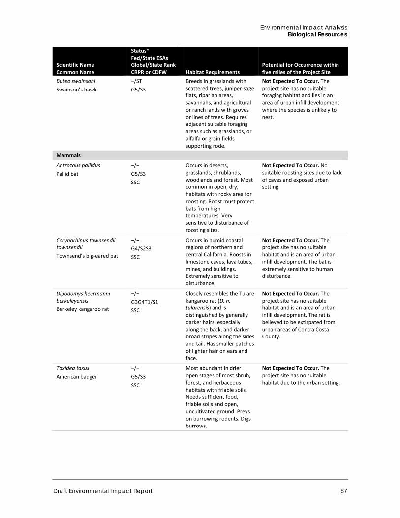
Environmental Impact Analysis Biological Resources
Draft Environmental Impact Report 87
Scientific Name Common Name
Status* Fed/State ESAs Global/State Rank CRPR or CDFW Habitat Requirements
Potential for Occurrence within five miles of the Project Site
Buteo swainsoni Swainson’s hawk
−/ST G5/S3
Breeds in grasslands with scattered trees, juniper-sage flats, riparian areas, savannahs, and agricultural or ranch lands with groves or lines of trees. Requires adjacent suitable foraging areas such as grasslands, or alfalfa or grain fields supporting rode.
Not Expected To Occur. The project site has no suitable foraging habitat and lies in an area of urban infill development where the species is unlikely to nest.
Mammals
Antrozous pallidus Pallid bat
−/− G5/S3 SSC
Occurs in deserts, grasslands, shrublands, woodlands and forest. Most common in open, dry, habitats with rocky area for roosting. Roost must protect bats from high temperatures. Very sensitive to disturbance of roosting sites.
Not Expected To Occur. No suitable roosting sites due to lack of caves and exposed urban setting.
Corynorhinus townsendii townsendii Townsend’s big-eared bat
−/− G4/S2S3 SSC
Occurs in humid coastal regions of northern and central California. Roosts in limestone caves, lava tubes, mines, and buildings. Extremely sensitive to disturbance.
Not Expected To Occur. The project site has no suitable habitat and is an area of urban infill development. The bat is extremely sensitive to human disturbance.
Dipodomys heermanni berkeleyensis Berkeley kangaroo rat
−/− G3G4T1/S1 SSC
Closely resembles the Tulare kangaroo rat (D. h. tularensis) and is distinguished by generally darker hairs, especially along the back, and darker broad stripes along the sides and tail. Has smaller patches of lighter hair on ears and face.
Not Expected To Occur. The project site has no suitable habitat and is an area of urban infill development. The rat is believed to be extirpated from urban areas of Contra Costa County.
Taxidea taxus American badger
−/− G5/S3 SSC
Most abundant in drier open stages of most shrub, forest, and herbaceous habitats with friable soils. Needs sufficient food, friable soils and open, uncultivated ground. Preys on burrowing rodents. Digs burrows.
Not Expected To Occur. The project site has no suitable habitat due to the urban setting.
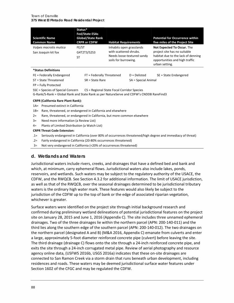
Town of Danville 375 West El Pintado Road Residential Project
88
Scientific Name Common Name
Status* Fed/State ESAs Global/State Rank CRPR or CDFW Habitat Requirements
Potential for Occurrence within five miles of the Project Site
Vulpes macrotis mutica San Joaquin kit fox
FE/ST G4T2T3/S2S3 ST
Inhabits open grasslands with scattered shrubs. Needs loose-textured sandy soils for burrowing.
Not Expected To Occur. The project site has no suitable habitat due to the lack of denning opportunities and high traffic urban setting.
*Status Definitions FE = Federally Endangered FT = Federally Threatened D = Delisted SE = State Endangered ST = State Threatened SR = State Rare SA = Special Animal FP = Fully Protected SSC = Species of Special Concern CS = Regional State Focal Corridor Species G-Rank/S-Rank = Global Rank and State Rank as per NatureServe and CDFW’s CNDDB RareFind3
CRPR (California Rare Plant Rank): 1A= Presumed extinct in California 1B= Rare, threatened, or endangered in California and elsewhere 2= Rare, threatened, or endangered in California, but more common elsewhere 3= Need more information (a Review List) 4= Plants of Limited Distribution (a Watch List) CRPR Threat Code Extension: .1= Seriously endangered in California (over 80% of occurrences threatened/high degree and immediacy of threat) .2= Fairly endangered in California (20-80% occurrences threatened) 3= Not very endangered in California (<20% of occurrences threatened)
d. Wetlands and Waters Jurisdictional waters include rivers, creeks, and drainages that have a defined bed and bank and which, at minimum, carry ephemeral flows. Jurisdictional waters also include lakes, ponds, reservoirs, and wetlands. Such waters may be subject to the regulatory authority of the USACE, the CDFW, and the RWQCB. See Section 4.3.2 for additional information. The limit of USACE jurisdiction, as well as that of the RWQCB, over the seasonal drainages determined to be jurisdictional tributary waters is the ordinary high water mark. These features would also likely be subject to the jurisdiction of the CDFW up to the top of bank or the edge of associated riparian vegetation, whichever is greater.
Surface waters were identified on the project site through initial background research and confirmed during preliminary wetland delineations of potential jurisdictional features on the project site on January 28, 2015 and June 1, 2016 (Appendix C). The site includes three unnamed ephemeral drainages. Two of the three drainages lie within the northern parcel (APN: 200-140-011) and the third lies along the southern edge of the southern parcel (APN: 200-140-012). The two drainages on the northern parcel (designated A and B) (M&A 2016, Appendix C) emanate from culverts and enter a large, approximately 5-foot diameter reinforced concrete pipe (culvert) before leaving the site. The third drainage (drainage C) flows onto the site through a 24-inch reinforced concrete pipe, and exits the site through a 24-inch corrugated metal pipe. Review of aerial photography and resource agency online data, (USFWS 2016b, USGS 2016a) indicates that these on-site drainages are connected to San Ramon Creek via a storm drain that runs beneath urban development, including residences and roads. These waters may be deemed jurisdictional surface water features under Section 1602 of the CFGC and may be regulated the CDFW.
Environmental Impact Analysis Biological Resources
Draft Environmental Impact Report 89
e. Wildlife Movement Corridors Wildlife movement corridors, or habitat linkages, are generally defined as connections between habitat patches that allow for physical and genetic exchange between otherwise isolated animal populations. Such linkages may serve a local purpose, such as providing a linkage between foraging and denning areas, or they may be regional in nature. Some habitat linkages may serve as migration corridors wherein animals periodically move away from an area and then subsequently return. Others may be important as dispersal corridors for young animals. A group of habitat linkages in an area can form a wildlife corridor network.
The habitats within the link do not necessarily need to be the same as the habitats that are being linked. Rather, the link merely needs to contain sufficient cover and forage to allow temporary inhabitation by ground-dwelling species. Typically habitat linkages are contiguous strips of natural areas, though dense plantings of landscape vegetation can be used by certain disturbance-tolerant species. Depending upon the species using a corridor, specific physical resources (such as rock outcroppings, vernal pools, or oak trees) may need to be located within the habitat link at certain intervals to allow slower-moving species to traverse the link. For highly mobile or aerial species, habitat linkages may be discontinuous patches of suitable resources spaced sufficiently close together to permit travel along a route in a short period of time. Wildlife movement corridors can be both large and small in scale, and many wildlife corridors have been officially identified as important or critical areas for wildlife conservations (e.g., Essential Connectivity Areas).
The project area is not located in an Essential Connectivity Area (ECA) or in a California Essential Habitat Connectivity (CEHC) area as mapped in the report, California Essential Habitat Connectivity Project: A Strategy for Conserving a Connected California (Spencer et al. 2010). ECAs represent principle connections between Natural Landscape Blocks, and are regions in which land conservation and management actions should be prioritized to maintain and enhance ecological connectivity. ECAs are mapped based on coarse ecological condition indicators, rather than the needs of particular species and thus serve the majority of species in each region. The project site itself is surrounded by existing residential development and occurs immediately adjacent to I-680, a significant wildlife movement barrier.
f. Regulatory Setting Federal, state, and local authorities under a variety of statutes and guidelines share regulatory authority over biological resources. The primary authority for general biological resources lies within the land use control and planning authority of a local jurisdiction, which in this instance is the Town of Danville. The CDFW is a trustee agency for biological resources throughout the state as defined in CEQA and also has direct jurisdiction under the California Fish and Game (CFG) Code, which includes, but is not limited to, resources protected by the State of California under the CESA, as discussed more fully below
Federal and State
United States Fish and Wildlife Service The USFWS implements the Migratory Bird Treaty Act (MBTA) (16 United States Code [USC] Section 703-711) and the Bald and Golden Eagle Protection Act (16 USC Section 668). The USFWS and NMFS share responsibility for implementing FESA (16 USC § 153 et seq.). The USFWS generally implements FESA for terrestrial and freshwater species, while the NMFS implements FESA for marine and anadromous species. Projects that would result in “take” of any federally listed threatened or
Town of Danville 375 West El Pintado Road Residential Project
90
endangered species are required to obtain permits from the USFWS or NMFS through either Section 7 (interagency consultation with a federal nexus) or Section 10 (Habitat Conservation Plan) of FESA, depending on the involvement by the federal government in permitting and/or funding of the project. The permitting process is used to determine if a project would jeopardize the continued existence of a listed species and what measures would be required to avoid jeopardizing the species. “Take” under the federal definition means to harass, harm, pursue, hunt, shoot, wound, kill, trap, capture, or collect, or to attempt to engage in any such conduct. “Harm” is further defined by the USFWS to include the killing or harming special-status species due to significant obstruction of essential behavior patterns (i.e., breeding, feeding, or sheltering) through significant habitat modifications or degradation. Proposed or candidate species do not have the full protection of FESA. However, the USFWS and NMFS advise project applicants that they could be elevated to listed status at any time.
United States Army Corps of Engineers Under Section 404 of the Clean Water Act (CWA), the USACE has authority to regulate activities that result in discharge of dredged or fill material into wetlands or other “Waters of the United States.” Perennial and intermittent creeks are considered Waters of the United States if they are hydrologically connected to other jurisdictional waters. Although definitions vary to some degree, wetlands are generally considered to be areas that are periodically or permanently inundated by surface or groundwater and support vegetation adapted to life in saturated soil. Wetlands are recognized as important features on a regional and national level due to their high inherent value to fish and wildlife, use as storage areas for storm and flood waters, and water recharge, filtration and purification functions. Technical standards for delineating wetlands have been developed by USACE and the USFWS, which generally define wetlands through consideration of three criteria: hydrology, soils, and vegetation. The term “Waters of the United States” includes wetlands and non-wetland bodies of water that meet specified criteria as defined under applicable regulations. All three of the identified technical criteria discussed above must be met for an area to be identified as a wetland under USACE jurisdiction, unless the area has been modified by human activity. In general, a permit must be obtained before fill can be placed in wetlands or other Waters of the United States. The USACE also implements the federal policy embodied in Executive Order 11990, which is intended to result in no net loss of wetlands. In achieving the goals of the CWA, the USACE seeks to avoid adverse impacts and offset unavoidable adverse impacts on existing aquatic resources. Any discharge into wetlands or other “Waters of the United States” that are hydrologically connected and/or demonstrate a significant nexus to jurisdictional waters would require a permit from the USACE prior to the start of work. Typically, when a project involves impacts to Waters of the United States, the goal of no net loss of wetlands is met through compensatory mitigation involving creation or enhancement of similar habitats.
California Department of Fish and Wildlife The CDFW derives its authority from the CFGC. CESA (Fish and Game Code Section 2050 et seq.) prohibits take of state listed species. Take under CESA is restricted to direct mortality of a listed species and does not expressly prohibit indirect harm by way of habitat modification. The CDFW prohibits take for species designated as Fully Protected under the CFGC.
The CFGC sections 3503, 3503.5, and 3511 describe unlawful take, possession, or destruction of birds, nests, and eggs. Fully protected birds (Section 3511) may not be taken or possessed except under specific permit. Section 3503.5 of the CFGC protects all birds-of-prey and their eggs and nests against take, possession, or destruction of nests or eggs. Species of Special Concern (SSC) is a
Environmental Impact Analysis Biological Resources
Draft Environmental Impact Report 91
category used by the CDFW for those species that are considered to be indicators of regional habitat changes or are considered to be potential future protected species. Species of Special Concern do not have any special legal status except that which may be afforded by the CFGC as noted above. The SSC category is intended by the CDFW for use as a management tool to include these species into special consideration when decisions are made concerning the development of natural lands. The CDFW also has authority to administer the Native Plant Protection Act (NPPA) (Fish and Game Code Section 1900 et seq.). The NPPA requires the CDFW to establish criteria for determining if a species, subspecies, or variety of native plant is endangered or rare. Under Section 1913(c) of the NPPA, the owner of land where a rare or endangered native plant is growing is required to notify the department at least 10 days in advance of changing the land use to allow for salvage of the plant(s).
Perennial and intermittent streams and associated riparian vegetation, when present, also fall under the jurisdiction of the CDFW. Section 1600 et seq. of the CFGC (Lake and Streambed Alteration Agreements) gives the CDFW regulatory authority over work within the stream zone (which could extend to the 100-year flood plain) consisting of, but not limited to, the diversion or obstruction of the natural flow or changes in the channel, bed, or bank of any river, stream or lake.
Regional Water Quality Control Board In addition, the State Water Resources Control Board (SWRCB) and each of nine local RWQCBs are responsible for upholding state water quality standards. Pursuant to Section 401 of the CWA, projects that apply for a USACE permit for discharge of dredge or fill material, and projects that qualify for a Nationwide Permit must obtain water quality certification under Section 401 from the RWQCB.
The SWRCB and each of the RWQCBs also have jurisdiction over “Waters of the State” pursuant to the Porter-Cologne Water Quality Control Act that are defined as any surface water or groundwater, including saline waters, within the boundaries of the state. The SWRCB has issued general Waste Discharge Requirements regarding discharges to “isolated” Waters of the State (Water Quality Order No. 2004-0004-DWQ, Statewide General Waste Discharge Requirements for Dredged or Fill Discharges to Waters Deemed by the USACE to be Outside of Federal Jurisdiction). The local RWQCB enforces actions under this general order for isolated waters not subject to federal jurisdiction, and is also responsible for the issuance of water quality certifications pursuant to Section 401 of the CWA for waters subject to federal jurisdiction.
The CWA and associated federal regulations (Title 40 of the Code of Federal Regulations [CFR] 123.25{a][9], 122.26[a], 122.26[b][14][x] and 122.26[b][15]) require nearly all construction site operators engaged in clearing, grading, and excavating activities that disturb one acre or more, including smaller sites in a larger common plan of development or sale, to obtain coverage under a National Pollutant Discharge Elimination System (NPDES) permit for their stormwater discharges, and develop a Storm Water Pollution Prevention Plan (SWPPP). The NPDES Program is a federal program that has been delegated to the State of California for implementation through the State Water Resources Control Board and the Regional Water Quality Control Boards.
Local General Plans are created by cities and counties to guide the growth and land development of their communities. As such, General Plans typically contain elements that address protection of biological resources. Typically these elements are made up of goals, policies, and actions that protect natural
Town of Danville 375 West El Pintado Road Residential Project
92
resources such as environmentally sensitive habitats, special-status species, native trees, creeks, wetland, and riparian habitats.
2030 General Plan The Resources and Hazards Element of the Town’s 2030 General Plan provides the following environmental quality goals and policies pertaining to biological resources applicable to this project:
Goal 21: Protect and enhance Danville’s natural features, including its hillsides, ridgelines, creeks, vegetation, and wildlife.
Goal 22: Improve water quality in Danville and the water bodies that receive runoff from Danville, including San Francisco Bay.
Policy 21.01: Preserve and enhance natural habitat areas that support wildlife, including large continuous areas of open space and wetland and riparian habitat.
Policy 21.02: Maintain open space in appropriate areas, including areas of scenic beauty, areas of economically viable agriculture, and areas where natural hazards such as flooding and land instability preclude safe development.
Policy 21.06: Discourage activities that would harm the health of existing trees. Prevent the unnecessary removal and alteration of such trees, including “protected” trees as defined by the Town’s Tree Preservation Ordinance and other trees that contribute to the scenic beauty of the town. Public and private improvements should be designed to minimize the removal of mature trees, regardless of species. If removal is necessary, trees should be replaced with an appropriate number and species.
Policy 21.07: Ensure that local planning and development decisions do not damage the habitat of rare and endangered plant and animal species, consistent with state and federal law.
Policy 21.08: Where appropriate, encourage the retention and reestablishment of native vegetation in private development and public facility projects.
Policy 21.10: Require a biological assessment for development proposed on sites that are determined to have the potential to contain special-status species, sensitive natural communities, or wetland resources.
Policy 21.11: Protect the nests of raptors and other birds when in active use, as required by state Fish and Game Code and the federal Migratory Bird Treaty Act.
Policy 22.01: Maintain and enhance the natural quality of Danville’s creeks, including the riparian vegetation along the banks. Setbacks should be maintained along creeks to maintain their natural appearance, reduce erosion and flood hazards, and protect their ecological functions.
Policy 22.04: Manage the Town’s storm drainage facilities in a manner that minimizes pollution of local streams and waterways. Storm drains and other drainage facilities should be regularly maintained.
Policy 23.02: Work with other communities and agencies to protect and enhance the significant ecological communities of the Tri-Valley area, including wetlands, riparian areas, and oak woodlands.
Policy 23.03: Promote a regional approach to protecting sustainable habitat in the Danville Planning Area through mitigation banking and other means.
Environmental Impact Analysis Biological Resources
Draft Environmental Impact Report 93
Policy 23.07: Recognize the state and federal regulations that serve to protect wetlands and require full compliance with these regulations as part of development review. This would include detailed wetland delineations and assessments where waters under the jurisdiction of the USACE may be affected.
Local Ordinances Some resources are afforded protection through local ordinances such as those that protect trees, riparian corridors, and environmentally sensitive habitats. The DMC includes provisions that protect natural resources and address compliance with environmental regulations. On July 7, 2009 the Town Council adopted an amended Tree Preservation Ordinance, Section 32-79 of the DMC, which requires a Tree Removal permit to be obtained before certain trees are removed. In accordance with this ordinance, a protected tree is defined as “a tree of a specific species or size that cannot be disfigured, damaged, or removed in the Town of Danville without obtaining a Tree Removal Permit from the Town.”
Danville Municipal Code, Section 32-79. The purpose of this chapter is to do the following:
“Enact regulations controlling the removal of and preservation of trees within the Town. One of the purposes of this chapter is to provide financial incentives and security to protect and replace damaged or destroyed trees to the maximum extent possible.”
The tree ordinance specifies protected trees to include specific species of native trees when they have a trunk or main stem that measures 10 inches or greater in diameter measured 4.5 feet above natural grade, or, for a multiple trunked tree, a combination of trunks totaling 20 inches or greater in diameter measured 4.5 feet above natural grade, on any type of lot or property. These species are:
Coast live oak (Quercus agrifolia) Valley oak (Quercus lobata) Canyon live oak (Quercus chrysolepis) Blue oak (Quercus douglasii) California black oak (Quercus kelloggii) Interior live oak (Quercus wislizenii) White alder (Alnus rhombifolia) California bay (Umbellularia californica) California buckeye (Aesculus californica) California sycamore (Platanus racemosa) Madrone (Arbutus menziesii)
The ordinance also identifies London plane tree (Platanus x hispanica, formerly P. acerifolia) meeting the specified size thresholds as protected. Additionally, any heritage tree, memorial tree, tree shown to be preserved on an approved Development Plan or specifically required by the Planning Commission to be retained, and any tree previously planted as mitigation for removal of a protected tree are also considered protected. Removal of protected trees requires a permit. Heritage trees are defined in the ordinance as any tree regardless of species, whose diameter measures 36 inches or greater measured 4.5 feet above the ground. Memorial trees are defined as trees planted on public property in memory of or commemoration of an individual or individuals.
Town of Danville 375 West El Pintado Road Residential Project
94
4.3.2 Impact Analysis
a. Methodology and Significance Thresholds The evaluation of biological resources is based on the Biological Resources Assessment prepared by M&A in 2016 (Appendix C), the Arborist Report for 359 and 375 El Pintado Road, Danville prepared by Traverso Tree Services in 2016 and updated in 2018 (Appendix D), and the review of several other sources of data and information. Data on biological resources were collected and reviewed from multiple sources, including relevant literature, aerial imagery, natural resources mapping (e.g., USFWS Critical Habitat mapper), and data on special-status species and sensitive habitat information obtained from the CNDDB (CDFW, 2016), CNPS Inventory of Rare and Endangered Plants of California (CNPS 2016). M&A conducted a general survey of the project site on July 7, 2014 to evaluate the project site for the presence of agency regulated areas, and to document the existing site conditions including the plant communities and wildlife habitats found on-site.
Evaluation Criteria The following thresholds are based on Appendix G of the State CEQA Guidelines. Impacts would be significant if the project would result in any of the following:
A. Have a substantial adverse effect, either directly or through habitat modifications, on any species identified as a candidate, sensitive, or special-status species in local or regional plans, policies, or regulations, or by the CDFW or USFWS
B. Have a substantial adverse effect on any riparian habitat or other sensitive natural community identified in local or regional plans, policies, regulations or by the CDFW or USFWS
C. Have a substantial adverse effect on federally protected wetlands as defined by Section 404 of the CWA (including, but not limited to, marsh, vernal pool, coastal, etc.) through direct removal, filling, hydrological interruption, or other means
D. Interfere substantially with the movement of any native resident or migratory fish or wildlife species or with established native resident or migratory wildlife corridors, or impede the use of native wildlife nursery sites
E. Conflict with any local policies or ordinances protecting biological resources, such as a tree preservation policy or ordinance
F. Conflict with the provisions of an adopted Habitat Conservation Plan, Natural Community Conservation Plan, or other approved local, regional, or state habitat conservation plan
As discussed in the Initial Study (Appendix A), impacts related to Threshold F would be less than significant. Therefore, only the topics covered under thresholds A through E are discussed below.
Environmental Impact Analysis Biological Resources
Draft Environmental Impact Report 95
b. Project Impacts
Threshold A: Would the project have a substantial adverse effect, either directly or through habitat modifications, on any species identified as a candidate, sensitive, or special-status species in local or regional plans, policies, or regulations, or by the CDFW or USFWS?
Impact BIO-1 CONSTRUCTION OF THE PROJECT COULD DIRECTLY IMPACT SPECIAL-STATUS SPECIES INCLUDING NESTING RAPTORS AND OTHER AVIAN SPECIES PROTECTED UNDER EXISTING REGULATIONS BY CAUSING INJURY, DEATH, OR NEST FAILURE. POTENTIAL IMPACTS TO NESTING BIRDS WOULD BE CLASS II, SIGNIFICANT BUT MITIGABLE.
As discussed in the Environmental Setting above (Section 4.3.1), no habitat is present on the project site that could support special-status species, with the exception of nesting birds. Therefore, no impacts are identified to special-status species listed under FESA or CESA. The closest known record for an ESA- or CESA-listed species is the California red-legged frog, which is 2.5 miles to the east, in the East Branch of Green Valley Creek near Diablo (four larvae were found) (CNDDB Occurrence No. 817). This sighting is on the east side of I-680. There is no hydrologic connection between Green Valley Creek and the project site and I-680 is a major barrier to any frog migration. The project site has two unnamed ephemeral drainages that emanate from reinforced concrete pipes installed underneath a medical center parking lot and a third ephemeral drainage on the project site located in the project site’s southeastern corner next to an existing residence. All three drainages enter the property via culverts and exit the property via culverts. The open portions of the drainages on-site do not provide the deep water, undercut banks, or plunge pools that would protect the California red-legged frog from terrestrial predators such as raccoons, cats, and foxes. As such, this native frog species would not be found along these ephemeral drainages. The absence of plunge pools and long-term inundation also eliminates these drainages from consideration as a California red-legged frog breeding habitat. Finally, due to the absence of connectivity to natural drainages in the area and the site’s close proximity in an urban/residential area, these drainages can be considered isolated and do not provide a migration corridor for dispersing frogs. Therefore, California red-legged frog would not be found on the project site. No significant impacts to California red-legged frog would occur from implementation of the project.
The MBTA and CFGC (§§ 3503, 3503.5, 3511, 3513, and 3800) protect most native birds. In addition, FESA and CESA protect some bird species listed as threatened or endangered. CFGC Code § 3513 relies on the MBTA by prohibiting any take or possession of birds that are designated by the MBTA as migratory nongame birds, except as allowed by federal rules and regulations promulgated pursuant to the MBTA. In addition, Fish and Game Code §§ 3503, 3503.5, 3511, and 3800 further protect nesting birds, including song birds (passerine), raptors, and state “fully protected” birds. Project-related impacts to birds protected by these regulations could occur during the breeding season if active nests are present, because eggs and chicks would be unable to escape if nests are directly or indirectly impacts by project activity.
The trees and non-native grassland present on the project site and in proximity to the project site provide potentially suitable nesting habitat for protected passerine species such as black phoebe (Sayornis nigrican), California towhee (Melozone crissalis), California scrub jay (Aphelocoma californica), Anna’s hummingbird, and house finch. Urban-nesting raptors such as the red shouldered hawk (Buteo lineatus) and Cooper’s hawk (Accipiter cooperii) could nest in several of the larger trees present on site. All of these birds are protected under the MBTA (50 CFR 10.13) and
Town of Danville 375 West El Pintado Road Residential Project
96
their eggs and young are also protected under CFGC Sections 3503, 3503.5. If land clearing, construction, and grading of the project site occurs within the nesting bird season (February 1 through August 31), the project could potentially impact nesting birds protected under MBTA and CFG Code.
Nesting birds present within the grading footprint during grading activities could be directly and indirectly impacted by the project. Removal of, or damage to, a nest could result in injury or death of individual birds. Noise, human presence, lighting, or grading/construction activities associated with the project could disturb birds on and immediately adjacent to the project site. Nest failure and the loss of eggs or nestlings as a result of construction activity or noise would be a significant impact to nesting birds. Mitigation measures to protect nesting birds and reduce potential impacts to less than significant levels are described further below.
Mitigation Measure The following measure is required.
BIO-1 Pre-construction Surveys for Nesting Birds and Raptors For construction activities occurring outside of the nesting season (September 1 to January 31), no mitigation is necessary. For construction activities occurring during the nesting season (February 1 to August 31), surveys for nesting birds and raptors covered by the CFC and the MBTA shall be conducted by a qualified biologist no more than 14 days prior to initiation of any construction activities, including construction staging and vegetation or tree removal, or tree trimming. The surveys shall include the entire disturbance areas plus a 200-foot buffer (where accessible) around any disturbance areas for passerine species, and 500-foot buffer (where accessible) for raptors. If active nests are located, all construction work shall be conducted outside a buffer zone from the nest to be determined by the qualified biologist. The nest avoidance buffer shall be determined by the qualified biologist and be commensurate with species and location of the nest in relation to proposed work activity. Raptor avoidance buffers shall be a minimum of 150 feet, but may be larger depending on species, nest location, and observed behavior. The qualified biologist shall have full discretion for establishing a suitable buffer. The buffer area(s) shall be closed to all construction personnel and equipment until the adults and young are no longer reliant on the nest, or the nest has otherwise become inactive through natural processes (e.g., depredation). A qualified biologist shall confirm that breeding/nesting is completed and young have fledged the nest prior to removal of the buffer.
Significance After Mitigation With implementation of the above mitigation measure, potential impacts to nesting bird species would be reduced to a less than significant level.
Environmental Impact Analysis Biological Resources
Draft Environmental Impact Report 97
Threshold B: Would the project have a substantial adverse effect on any riparian habitat or other sensitive natural community identified in local or regional plans, policies, regulations, or by the CDFW or USFWS?
Impact BIO-2 IMPLEMENTATION OF THE PROJECT WOULD NOT RESULT IN IMPACTS TO RIPARIAN HABITAT. IMPACTS WOULD BE CLASS III, LESS THAN SIGNIFICANT.
As discussed above in the Environmental Setting (Section 4.3.1c), field investigations revealed that no riparian habitat is present on the project site. Riparian-associated trees were identified, but no intact vegetation community that provide riparian habitat occurs. Potential impacts to riparian habitat would be less than significant.
Mitigation Measures Impacts would be less than significant; no mitigation is required.
Threshold C: Would the project have a substantial adverse effect on federally protected wetlands as defined by Section 404 of the Clean Water Act (including, but not limited to, marsh, vernal pool, coastal, etc.) through direct removal, filling, hydrological interruption, or other means?
Impact BIO-3 IMPLEMENTATION OF THE PROJECT WOULD DIRECTLY IMPACT WETLANDS/WATERWAYS. POTENTIAL IMPACTS TO FEDERALLY PROTECTED WETLANDS AND WATERWAYS AS DEFINED BY SECTIONS 404 AND 401 OF THE CLEAN WATER ACT AND SECTION 1602 OF THE CALIFORNIA FISH AND GAME CODE WOULD BE CLASS II, SIGNIFICANT BUT MITIGABLE.
The proposed project would require filling two drainages located on the project site. One feature, designated Drainage A (Monk & Associates 2016), is a man-made feature and occurs along the western edge of the northern parcel. This feature is approximately 177 feet in length and one foot wide and drains from north to south. The second feature, designated Drainage B, (Monk & Associates 2016) is a natural, linear feature that crosses through the approximate middle of the project site. This second feature is approximately 263 feet in length and three feet wide and drains from northeast toward southwest. Both drainages were identified in a preliminary jurisdictional waters assessment. The preliminary assessment identified impacts to approximately 177 square feet of potential “other waters” and 789 square feet of potential “linear wetlands,” respectively.
The drainage on the southern parcel (designated Drainage C in Monk & Associates 2016) was also identified as “other waters.” This feature occurs along the southern edge of the southern parcel, is 175 feet in length and two feet wide, and drains from east to west. Two bioretention basins will be installed to the north of the drainage on both east and west sides of the parcels to collect and filter water draining from the project site. Outflow culverts will be installed from the bioretention basins leading into the drainage on the southern side of the parcel. Installation of these outflow culvers will result in minor cut and fill activity within the drainage and will be subject to jurisdictional review by USACE, RWQCB, and CDFW.
Impacts to all three drainage features regulated by federal and state agencies pursuant to Sections 404 and 401 of the CWA and Section 1602 of the CFGC. Ground disturbance, cut and fill, discharge into, and vegetation removal or trimming within associated riparian habitat is a potentially significant impact. Mitigation subject to consultation with CDFW is required.
Town of Danville 375 West El Pintado Road Residential Project
98
Mitigation Measures The following measures are required.
BIO-2 Formal Jurisdictional Delineation The applicant shall contract a qualified jurisdictional waters expert to conduct a formal jurisdictional delineation and prepare a Jurisdictional Delineation Report to support Jurisdictional Waters permitting with USACE, RWQCB and CDFW. The jurisdictional delineation shall determine the extent of the jurisdiction for each of these agencies and shall be conducted in accordance with the requirement set forth by each agency. The result shall be a preliminary jurisdictional delineation report that shall be submitted to the implementing agency, USACE, RWQCB, and CDFW, as appropriate, for review and approval. Impacts to jurisdictional features shall be minimized to the extent feasible based on the findings of the Jurisdictional Delineation and the agency verification of limits of jurisdiction within the project site.
BIO-3 Regulatory Permitting Jurisdictional areas that would be impacted would require one or more of the following permits: 1) a RWQCB Waste Discharge Requirements permit and/or Section 401 Water Quality Certification (depending upon whether or not the feature falls under federal jurisdiction), 2) a CDFW Streambed Alteration Agreement pursuant to Section 1600 et seq. of the California Fish and Game Code for impacts within the areas of CDFW jurisdiction, and 3) a USACE permit pursuant to Section 404 of the CWA. The applicant shall acquire any required permits from the USACE, RWQCB, and CDFW prior to conducting construction activity (including grading, vegetation removal, and site preparation) within any and all Waters of the State or Waters of the U.S. under the jurisdictions of USACE, RWQCB, or CDFW.
BIO-4 Wetland/Drainage Compensation Mitigation for impacts to drainages/linear wetlands that may be required by the USACE, RWQCB and CDFW in permits issued/authorized for the project shall be implemented by the applicant as required. This mitigation compensation may include either creation of mitigation wetlands at an off-site location or the purchase of credits from an agency-approved mitigation bank. Purchase of mitigation credits or creation of mitigation wetlands to mitigate for permanent impacts to wetland features shall be at a minimum ratio of 1:1 for man-made features, and 2:1 for natural wetland features and associated riparian habitat (that is, for each acre of impact it would be necessary to set aside one acre of wetland/riparian habitat for man-made features and two acres of wetland/riparian habitat for natural features as compensation). Mitigation to offset temporary impacts to wetland features shall be required at a 1:1 ratio through restoration of areas with temporary impacts. The agencies may require higher mitigation ratios in permit documents, and, if so, agency permit mitigation ratios would supersede the 1:1 ratio required here.
Minimum requirements for mitigating impacts to wetlands include the following:
Replacement of impacted wetlands at a minimum 1:1 ratio. For permanent wetland impacts, wetlands can be replaced at a minimum ratio of one acre created for each acre, or fraction thereof, permanently impacted.
Creation of in perpetuity preservation. The USACE, RWQCB and CDFW generally require that Waters of the U.S. not impacted by the project and any new wetlands created to mitigate
Environmental Impact Analysis Biological Resources
Draft Environmental Impact Report 99
project impacts be set aside in perpetuity, either through deed restrictions or conservation easements.
For restoration or creation of mitigation wetlands it shall be necessary to establish a five-year monitoring program to monitor the progress of the wetland mitigation toward an established goal. At the end of each monitoring year, an annual report would be submitted to the Town of Danville, USACE, RWQCB, and/or CDFW depending on permitting requirements for each agency. This report would document the hydrological and vegetative condition of the mitigation wetlands, and would recommend remedial measures as necessary to correct deficiencies.
If purchasing credits from an approved mitigation bank is an option, then wetland creation off-site with subsequent monitoring requirements may not be necessary. This would be determined at the time permits are applied for/issued by the USACE, RWQCB and CDFW.
Aside from the minimum replacement ratio and in-perpetuity protection, various regulatory agencies may provide additional conditions and stipulations for permits. Additional conditions that are stipulated for wetland impacts by the USACE, RWQCB, and/or CDFW shall also become conditions of project approval.
Significance After Mitigation With implementation of the above mitigation measures, direct impacts to sensitive and federally protected wetland and waterways would be reduced to a less than significant level.
Threshold D: Would the project interfere substantially with the movement of any native resident or migratory fish or wildlife species or with established native resident or migratory wildlife corridors, or impede the use of native wildlife nursery sites?
Impact BIO-4 IMPLEMENTATION OF THE PROJECT WOULD NOT RESULT IN IMPACTS TO MOVEMENT OF NATIVE RESIDENT OR MIGRATORY FISH OR WILDLIFE SPECIES NOR WOULD IT IMPACT MIGRATORY WILDLIFE CORRIDORS OR IMPEDE THE USE OF NATIVE NURSEY SITES. THIS IMPACT WOULD BE CLASS III, LESS THAN SIGNIFICANT.
As discussed above in the Environmental Setting (Section 4.3.1e), the project site is not in a known migratory wildlife corridor or connectivity area. Implementation of the project would not contribute significantly to the loss of wildlife connectivity or nursery sites. Potential impacts to movement of any native resident or migratory fish or wildlife species or impacts to migratory wildlife corridors or impediment to the use of native nursey sites would be less than significant.
Mitigation Measures Impacts would be less than significant, no mitigation is required.
Threshold E: Would the project conflict with any local policies or ordinances protecting biological resources, such as a tree preservation policy or ordinance?
Impact BIO-5 IMPLEMENTATION OF THE PROJECT WOULD REQUIRE REMOVAL OF TREES PROTECTED UNDER THE DANVILLE MUNICIPAL CODE. THIS IMPACT WOULD BE CLASS II, SIGNIFICANT BUT MITIGABLE.
The proposed project includes removal of up to 11 “protected trees” (Appendix D). These consist of 10 valley oaks ranging in size between a multi trunk tree with five three-inch stems and 21 inches at 4.5 feet above the ground (tree numbers 1, 9, 11, 13, 26, 29, 32, 35, 37, 38), and one Aleppo pine 36
Town of Danville 375 West El Pintado Road Residential Project
100
inches in diameter at 4.5 feet above the ground (tree number 88), a heritage tree. The project would also involve removal of several non-protected trees, including Monterey pines, Siberian elm, willow, cottonwood, and redwood trees not large enough to meet heritage criteria. Some protected valley oak trees and non-protected landscape trees would remain.
The removal of protected trees requires a tree permit from the Town of Danville. To obtain a tree permit, the applicant must submit a planning application for tree removal that includes a site plan detailing location of trees to be removed. The Town’s Tree Ordinance requires that “When combined with a larger development project, a preliminary development plan, and preliminary grading plan, showing the number, size, type, and location of trees to be removed and trees to be preserved, and the location of all existing and proposed improvements on the property” must accompany the tree removal permit application. The plan must include the approximate drip line(s) of all trees on the site. The application must be accompanied by a final arborist report that provides locations of all protected trees proposed for removal and to be retained on-site.
The ordinance also requires that, when appropriate, planting of on-site and/or off-site replacement trees (location and species to be determined by the Town) of a cumulative diameter necessary to equal the diameter of the trees approved for removal will be a condition of the tree permit. Any protected tree to be preserved on-site that would have its dripline encroached requires posting a security bond to the Chief of Planning on a per tree basis as discussed in DMC Section 32-79.9b. To ensure adherence to the Tree Ordinance mitigation is required.
The project would also include retention of some protected trees, including valley oaks, and some landscape trees. To ensure the trees retained on-site are kept in healthy condition and not damaged unnecessarily, the following additional mitigation measure is required.
Implementation of the mitigation measures BIO-5 and BIO-6 would address tree removal impacts in the context of adherence to the Town’s ordinances.
Mitigation Measure The following mitigation measures are required.
BIO-5 Tree Replacement The applicant shall comply with Town requirements (DMC Section 32-79), as applicable, to plant on-site or off-site replacement trees for removed protected trees which are of a cumulative diameter necessary to equal the diameter of trees approved for removal as determined by the Town’s Planning Division. For the non-Town protected trees that would be removed as part of the project, the applicant shall plant new minimum 15 gallon trees either on-site or off-site, as determined by the Town, at a 1:1 ratio. The exact locations and tree species shall be subject to review and approval by the Town’s Planning Division.
BIO-6 Tree Protection The following measures shall be implemented prior to the start of construction for all trees not designated for removal.
Trees to be retained on-site shall be temporarily fenced with chain-link or other substantial, highly visible material while all grading and construction activities occur, including landscaping activities that require substantial ground disturbance (more than the use of hand tools). The
Environmental Impact Analysis Biological Resources
Draft Environmental Impact Report 101
fencing shall be five feet from the dripline of the canopy, at least six-feet high, staked to prevent collapse, and shall contain signs identifying the protection area.
When construction activities occur within five feet of the dripline, a certified arborist shall be on site to monitor and make recommendations.
All roots shall be cut cleanly, if possible back to a lateral branching root. Cuts should be made at right angles to the roots.
If canopy trimming is needed it shall be done under the supervision of an International Society of Arboriculture (ISA) Certified Arborist and by an ISA Certified Tree Worker. Trees shall be pruned according to American National Standards Institute (ANSI) 300 standards. ANSI 300 provides guidelines for pruning trees and other woody plants.
Significance After Mitigation With implementation of the above mitigation measures, potential impacts to protected trees would be reduced to a less than significant level and the project would not conflict the Town’s tree protection ordinance.
c. Cumulative Impacts A cumulative effect is a change in the environment resulting from the incremental effect of the project when added to other closely related past, present, and reasonably foreseeable future projects. Past and foreseeable future actions within the Danville area include, but are not limited to, grazing, agriculture, and the construction of residential, commercial, industrial, and infrastructural projects. A number of projects are ongoing, in the planning stages, or will be implemented in the near future in the town related to housing developments and various commercial developments.
Pending and approved projects within a two-mile radius of the project site include two single-family residential developments (Podva Property and Magee Ranch Property) and a multi-family residential development (373-379 Diablo Road). The proposed project, in light of past projects and levels of development in the vicinity of the project site, would have a negligible effect on special-status plants and wildlife, their habitats, and other sensitive biological resources. Implementation of the above discussed mitigation measures along with consultation with the resource agencies would reduce impacts that would be considerable or significant to less than significant levels. The project applicant would be required to obtain regulatory approvals and implement the mitigation measures previously described to address direct and indirect effects of the project prior to conducting ground-disturbing activities at the project site.

Town of Danville 375 West El Pintado Road Residential Project
102
This page intentionally left blank.
Environmental Impact Analysis Greenhouse Gas Emissions
Draft Environmental Impact Report 103
4.4 Greenhouse Gas Emissions This section discusses the project’s potential impacts related to emissions of greenhouse gases (GHG) and climate change. Traffic projections used in emissions estimates are based on the Transportation Impact Study Draft Report traffic study done by TJKM, which is included in Appendix H to this EIR.
4.4.1 Environmental Setting
a. Climate Change and Greenhouse Gases
Gases that absorb and re-emit infrared radiation in the atmosphere are called greenhouse gases (GHG). The gases that are widely seen as the principal contributors to human-induced climate change include carbon dioxide (CO2), methane (CH4), nitrous oxides (N2O), fluorinated gases such as hydrofluorocarbons (HFC) and perfluorocarbons (PFCs), and sulfur hexafluoride (SF6). Water vapor is excluded from the list of GHGs because it is short-lived in the atmosphere and its atmospheric concentrations are largely determined by natural processes, such as oceanic evaporation.
GHGs are emitted by both natural processes and human activities. Of these gases, CO2 and CH4 are emitted in the greatest quantities from human activities. Emissions of CO2 are largely by-products of fossil fuel combustion, whereas CH4 results from off-gassing associated with agricultural practices and landfills.
Man-made GHGs, many of which have greater heat-absorption potential than CO2, include fluorinated gases and SF6 (California Environmental Protection Agency [CalEPA] 2006). Different types of GHGs have varying global warming potentials (GWP). The GWP of a GHG is the potential of a gas or aerosol to trap heat in the atmosphere over a specified timescale (generally, 100 years). Because GHGs absorb different amounts of heat, a common reference gas (CO2) is used to relate the amount of heat absorbed to the amount of the gas emissions, referred to as “carbon dioxide equivalent” (CO2e), and is the amount of a GHG emitted multiplied by its GWP. Carbon dioxide has a 100-year GWP of one. By contrast, methane CH4 has a GWP of 25, meaning its global warming effect is 25 times greater than carbon dioxide on a molecule per molecule basis (IPCC 2007).
b. Greenhouse Gas Emissions Inventories
Federal Emissions Inventory Total U.S. GHG emissions were 6,586.7 million metric tons (MMT or gigatonne) CO2e in 2015 (EPA 2017). Total U.S. emissions have increased by 3.5 percent since 1990; emissions decreased by 2.3 percent from 2014 to 2015 (EPA 2017). The decrease from 2014 to 2015 was a result of multiple factors, including (1) substitution from coal to natural gas consumption in the electric power sector, (2) warmer winter conditions in 2015 resulting in a decreased demand for heating fuel in the residential and commercial sectors, and (3) a slight decrease in electricity demand (EPA 2017). Since 1990, U.S. emissions have increased at an average annual rate of 0.2 percent. In 2015, the industrial and transportation end-use sectors accounted for 29 percent and 27 percent of CO2 emissions (with electricity-related emissions distributed), respectively. Meanwhile, the residential and commercial end-use sectors accounted for 16 percent and 17 percent of CO2 emissions, respectively (EPA 2017).
Town of Danville 375 West El Pintado Road Residential Project
104
California Emissions Inventory Based on the California Air Resources Board (CARB) California Greenhouse Gas Inventory for 2000-2014, California produced 440.4 MMT CO2e in 2015 (CARB 2017a). The largest single source of GHG in California is transportation, contributing 39 percent of the state’s total GHG emissions. Industrial sources are the second largest source of the State’s GHG emissions, contributing 23 percent of the state’s GHG emissions (CARB 2017a). California emissions are due in part to its large size and large population compared to other states. However, the state’s mild climate reduces California’s per capita fuel use and GHG emissions as compared to other states. CARB has projected statewide unregulated GHG emissions for the year 2020 will be 509.4 MMT CO2e (CARB 2017b). These projections represent the emissions that would be expected to occur in the absence of any GHG reduction actions.
c. Regulatory Setting
Federal Regulations The U.S. Supreme Court in Massachusetts et al. v. Environmental Protection Agency et al. ([2007] 549 U.S. 05-1120) held that the EPA has the authority to regulate motor-vehicle GHG emissions under the federal Clean Air Act. The EPA issued a Final Rule for mandatory reporting of GHG emissions in October 2009. This Final Rule applies to fossil fuel suppliers, industrial gas suppliers, direct GHG emitters, and manufacturers of heavy-duty and off-road vehicles and vehicle engines, and requires annual reporting of emissions. In 2012 the EPA issued a Final Rule that establishes the GHG permitting thresholds that determine when Clean Air Act permits under the New Source Review Prevention of Significant Deterioration (PSD) and Title V Operating Permit programs are required for new and existing industrial facilities.
In 2014, the U.S. Supreme Court in Utility Air Regulatory Group v. EPA (134 S. Ct. 2427 [2014]) held that EPA may not treat GHGs as an air pollutant for purposes of determining whether a source is a major source required to obtain a PSD or Title V permit. The Court also held that PSD permits that are otherwise required (based on emissions of other pollutants) may continue to require limitations on GHG emissions based on the application of Best Available Control Technology (BACT).
California Regulations CARB is responsible for the coordination and oversight of State and local air pollution control programs in California. California has a several regulations aimed at reducing the State’s GHG emissions. These initiatives are summarized below.
California Advanced Clean Car Program Assembly Bill (AB) 1493 (2002), California’s Advanced Clean Cars program (referred to as “Pavley”), requires CARB to develop and adopt regulations to achieve “the maximum feasible and cost-effective reduction of GHG emissions from motor vehicles.” On June 30, 2009, EPA granted the waiver of Clean Air Act preemption to California for its greenhouse gas emission standards for motor vehicles beginning with the 2009 model year. Pavley I regulates model years from 2009 to 2016 and Pavley II, which is now referred to as “LEV (Low Emission Vehicle) III GHG” regulates model years from 2017 to 2025. The Advanced Clean Cars program coordinates the goals of the Low Emissions Vehicles (LEV), Zero Emissions Vehicles (ZEV), and Clean Fuels Outlet programs, and would provide major reductions in GHG emissions. By 2025, when the rules will be fully implemented, new
Environmental Impact Analysis Greenhouse Gas Emissions
Draft Environmental Impact Report 105
automobiles will emit 34 percent fewer GHGs and 75 percent fewer smog-forming emissions from their model year 2016 levels (CARB 2011).
Assembly Bill 32 California’s major initiative for reducing GHG emissions is outlined in Assembly Bill 32 (AB 32), the “California Global Warming Solutions Act of 2006,” signed into law in 2006. AB 32 codifies the statewide goal of reducing GHG emissions to 1990 levels by 2020, and requires CARB to prepare a Scoping Plan that outlines the main State strategies for reducing GHGs to meet the 2020 deadline. In addition, AB 32 requires CARB to adopt regulations to require reporting and verification of statewide GHG emissions. Based on this guidance, CARB approved a 1990 statewide GHG level and 2020 limit of 427 MMT CO2e. The Scoping Plan was approved by CARB on December 11, 2008, and included measures to address GHG emission reduction strategies related to energy efficiency, water use, and recycling and solid waste, among other measures. Many of the GHG reduction measures included in the Scoping Plan (e.g., Low Carbon Fuel Standard, Advanced Clean Car standards, and Cap-and-Trade) have been adopted since approval of the Scoping Plan.
In May 2014, CARB approved the first update to the AB 32 Scoping Plan. The 2013 Scoping Plan update defines CARB’s climate change priorities for the next five years and sets the groundwork to reach post-2020 statewide goals. The update highlights California’s progress toward meeting the “near-term” 2020 GHG emission reduction goals defined in the original Scoping Plan. It also evaluates how to align the State’s longer-term GHG reduction strategies with other State policy priorities, such as for water, waste, natural resources, clean energy and transportation, and land use (CARB 2014).
Senate Bill 97 Senate Bill (SB) 97, signed in August 2007, acknowledges that climate change is an environmental issue that requires analysis in CEQA documents. In March 2010, the California Resources Agency (Resources Agency) adopted amendments to the State CEQA Guidelines for the feasible mitigation of GHG emissions or the effects of GHG emissions. The adopted guidelines give lead agencies the discretion to set quantitative or qualitative thresholds for the assessment and mitigation of GHG and climate change impacts.
Senate Bill 32 On September 8, 2016, the governor signed Senate Bill 32 (SB 32) into law, extending AB 32 by requiring the State to further reduce GHGs to 40 percent below 1990 levels by 2030 (the other provisions of AB 32 remain unchanged). On December 14, 2017, CARB adopted the 2017 Scoping Plan, which provides a framework for achieving the 2030 target. The 2017 Scoping Plan relies on the continuation and expansion of existing policies and regulations, such as the Cap-and-Trade Program, as well as implementation of recently adopted policies and policies, such as SB 350 and SB 1383 (see below). The 2017 Scoping Plan also puts an increased emphasis on innovation, adoption of existing technology, and strategic investment to support its strategies. As with the 2013 Scoping Plan Update, the 2017 Scoping Plan does not provide project-level thresholds for land use development. Instead, it recommends that local governments adopt policies and locally-appropriate quantitative thresholds consistent with a statewide per capita goal of six metric tons (MT) CO2e by 2030 and two MT CO2e by 2050 (CARB 2017c). As stated in the 2017 Scoping Plan, these goals may be appropriate for plan-level analyses (city, county, subregional, or regional level), but not for specific individual projects because they include all emissions sectors in the State.
Town of Danville 375 West El Pintado Road Residential Project
106
Senate Bill 350 Adopted on October 7, 2015, SB 350 supports the reduction of GHG emissions from the electricity sector through a number of measures, including requiring electricity providers to achieve a 50 percent renewables portfolio standard by 2030, a cumulative doubling of statewide energy efficiency savings in electricity and natural gas by retail customers by 2030.
Senate Bill 1383 Adopted in September 2016, SB 1383 requires the CARB to approve and begin implementing a comprehensive strategy to reduce emissions of short-lived climate pollutants. The bill requires the strategy to achieve the following reduction targets by 2030:
Methane – 40 percent below 2013 levels Hydrofluorocarbons – 40 percent below 2013 levels Anthropogenic black carbon – 50 percent below 2013 levels
The bill also requires the California Department of Resources Recycling and Recovery (CalRecycle), in consultation with the State board, to adopt regulations that achieve specified targets for reducing organic waste in landfills
For more information on the Senate and Assembly Bills, Executive Orders, and reports discussed above, and to view reports and research referenced above, please refer to the following websites: www.climatechange.ca.gov and www.arb.ca.gov/cc/cc.htm.
California Environmental Quality Act Pursuant to the requirements of SB 97, the Resources Agency has adopted amendments to the State CEQA Guidelines for the feasible mitigation of GHG emissions or the effects of GHG emissions. The adopted State CEQA Guidelines provide general regulatory guidance on the analysis and mitigation of GHG emissions in CEQA documents, while giving lead agencies the discretion to set quantitative or qualitative thresholds for the assessment and mitigation of GHGs and climate change impacts. To date, a variety of air districts have adopted quantitative significance thresholds for GHGs. Many significance thresholds have been developed to reflect a 90 percent capture rate tied to the 2020 reduction target established in AB 32. These targets have been identified by numerous lead agencies as appropriate significance screening tools for residential, commercial, industrial, and public land uses and facilities projects with horizon years before 2020.
Local Regulations The Town of Danville adopted a Climate Action Plan (CAP) in May 2009. The CAP outlines a course of action to reduce municipal and communitywide GHG emissions that contribute to climate change. It includes ten emission reduction strategies: 1) Energy Efficiency and Conservation, 2) Water and Wastewater Systems, 3) Green Building, 4) Water Reduction and Recycling, 5) Climate-Friendly Purchasing, 6) Renewable Energy and Low-Carbon Fuels, 7) Efficient Transportation, 8) Land Use and Community Design, 9) Storing and Offsetting Carbon Emissions, and 10) Promoting Community and Individual Actions (Town of Danville 2009a).
Danville also adopted a Sustainability Action Plan (SAP) in 2013, concurrently with the Danville 2030 General Plan. The SAP presents the GHG emissions reduction measures to help achieve the emissions reduction target for the year 2020. These measures were developed with community involvement, including four Joint Town Council and Planning Commission Study Sessions. Each
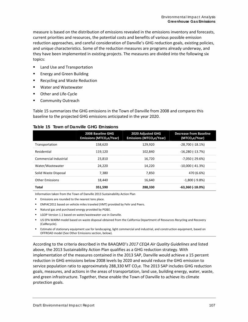
Environmental Impact Analysis Greenhouse Gas Emissions
Draft Environmental Impact Report 107
measure is based on the distribution of emissions revealed in the emissions inventory and forecasts, current priorities and resources, the potential costs and benefits of various possible emission reduction approaches, and careful consideration of Danville’s GHG reduction goals, existing policies, and unique characteristics. Some of the reduction measures are programs already underway, and they have been implemented in existing projects. The measures are divided into the following six topics:
Land Use and Transportation Energy and Green Building Recycling and Waste Reduction Water and Wastewater Other and Life-Cycle Community Outreach
Table 15 summarizes the GHG emissions in the Town of Danville from 2008 and compares this baseline to the projected GHG emissions anticipated in the year 2020.
Table 15 Town of Danville GHG Emissions
2008 Baseline GHG Emissions (MTCO2e/Year)
2020 Adjusted GHG Emissions (MTCO2e/Year)
Decrease from Baseline (MTCO2e/Year)
Transportation 158,620 129,920 -28,700 (-18.1%)
Residential 119,120 102,840 -16,280 (-13.7%)
Commercial Industrial 23,810 16,720 -7,050 (-29.6%)
Water/Wastewater 24,220 14,220 -10,000 (-41.3%)
Solid Waste Disposal 7,380 7,850 470 (6.6%)
Other Emissions 18,440 16,640 -1,800 (-9.8%)
Total 351,590 288,330 -63,360 (-18.0%)
Information taken from the Town of Danville 2013 Sustainability Action Plan
Emissions are rounded to the nearest tens place.
EMFAC2011 based on vehicle miles traveled (VMT) provided by Fehr and Peers.
Natural gas and purchased energy provided by PG&E.
LGOP Version 1.1 based on water/wastewater use in Danville.
US EPA WARM model based on waste disposal obtained from the California Department of Resources Recycling and Recovery (CalRecycle).
Estimate of stationary equipment use for landscaping, light commercial and industrial, and construction equipment, based on OFFROAD model (See Other Emissions section, below).
According to the criteria described in the BAAQMD’s 2017 CEQA Air Quality Guidelines and listed above, the 2013 Sustainability Action Plan qualifies as a GHG reduction strategy. With implementation of the measures contained in the 2013 SAP, Danville would achieve a 15 percent reduction in GHG emissions below 2008 levels by 2020 and would reduce the GHG emission to service population ratio to approximately 288,330 MT CO2e. The 2013 SAP includes GHG reduction goals, measures, and actions in the areas of transportation, land use, building energy, water, waste, and green infrastructure. Together, these enable the Town of Danville to achieve its climate protection goals.
Town of Danville 375 West El Pintado Road Residential Project
108
4.4.2 Impact Analysis
a. Methodology and Significance Thresholds
Based on Appendix G of the State CEQA Guidelines, impacts related to GHG emissions from the project would be significant if the project would:
A. Generate greenhouse gas emissions, either directly or indirectly, that may have a significant impact on the environment
B. Conflict with an applicable plan, policy or regulation adopted for the purpose of reducing the emissions of greenhouse gases
Based on the analysis from the Initial Study, checklist questions A and B warranted additional study in this EIR.
The project is consistent with applicable plans and policies for the reduction of GHG emissions. Project emissions would occur during construction and operation of the project however, would not hinder or delay achievement of state GHG reduction targets established by AB 32, SB 32, nor conflict with the BAAQMD thresholds (Threshold A, less than significant; Threshold B, no impact).
The majority of individual projects do not generate sufficient GHG emissions to, in isolation, create a direct impact on climate change. Rather, it is the increased accumulation of GHGs from more than one project and many sources in the atmosphere that may result in climate change, which can cause the adverse environmental effects previously discussed. Accordingly, the threshold of significance for GHG emissions determines whether a project’s contribution to climate change is “cumulatively considerable.” “Cumulatively considerable” means that the incremental effects of an individual project are significant when viewed in connection with the effects of past projects, other current projects, and probable future projects (CEQA Guidelines, § 15355).
Because the 2013 SAP underwent environmental review under CEQA, is intended to reduce the Town’s impact on climate change, and is consistent with BAAQMD qualification standards described in their 2017 CEQA Air Quality Guidelines, projects that are consistent with the 2013 SAP would not have a significant climate change impact. Therefore, the project’s contribution to cumulative impacts related to GHG emissions and climate change would not be cumulatively considerable if the project would not conflict with the 2013 SAP.
BAAQMD adopted significance thresholds for GHGs in May 2017 as part of their CEQA Air Quality Guidelines. The May 2017 CEQA Air Quality Guidelines identified operational emissions of over 1,100 metric tons (MT) CO2e/year as potentially significant. The BAAQMD annual emissions threshold was designed to capture 90 percent of all emissions associated with projects in the SFBAAB and require implementation of mitigation so that a considerable reduction in emissions from new projects would be achieved. According to the California Air Pollution Control Officers Association (CAPCOA) white paper, CEQA & Climate Change (2008), a quantitative threshold based on a 90 percent market capture rate is generally consistent with AB 32 (CAPCOA 2008). Because the previously established threshold of 1,100 MT CO2e was not developed to meet the targets established by SB 32, it must be adjusted to meet the new, more conservative, emission reduction target of 40 percent below the 1990 level by 2030. As such, to be consistent with SB 32, the project would need to emit no more than 1,034 MT CO2e in an estimated project opening year of 2021 to be on trajectory to meet the 2040 reduction established by SB 32. Therefore, the threshold for this project is 1,034 MT of CO2e per year
Environmental Impact Analysis Greenhouse Gas Emissions
Draft Environmental Impact Report 109
For the purpose of this report, the BAAQMD thresholds will be applied for a quantitative analysis as discussed above, and checked for qualitative consistency with the Town of Danville’s Clean Action Plan and Sustainability Action Plan. The project’s contribution to cumulative impacts related to GHG emissions and climate change would be cumulatively considerable if the project conflicts with either the BAAQMD thresholds, or is not consistent with the CAP and SAP.
Study Methodology Calculations of CO2, CH4, and N2O emissions are provided to identify the magnitude of potential project effects. The analysis focuses on CO2, CH4, and N2O because these make up 98.9 percent of all GHG emissions by volume (IPCC 2007) and are the GHG emissions that the project would emit in the largest quantities. Fluorinated gases, such as HFCs, PFCs, and SF6, were also considered for the analysis. However, because the project is a residential development, the quantity of fluorinated gases would not be significant since fluorinated gases are primarily associated with industrial processes. Emissions of all GHGs are converted into their equivalent GWP in terms of CO2 (CO2e). Minimal amounts of other GHGs (such as chlorofluorocarbons [CFCs]) would be emitted. However, these other GHG emissions would not substantially add to the total calculated CO2e amounts. Calculations are based on the methodologies discussed in CAPCOA’s CEQA and Climate Change white paper (CAPCOA 2008) and included the use of the California Climate Action Registry (CCAR) General Reporting Protocol (CCAR, 2009).
GHG emissions associated with the project were calculated using the California Emissions Estimator Model (CalEEMod) version 2016.3.1 (Appendix E).
Operational Emissions CalEEMod provides operational emissions of CO2, N2O, and CH4. Emissions from energy use include electricity and natural gas use. The emissions factors for natural gas combustion are based on EPA’s AP-42, (Compilation of Air Pollutant Emissions Factors) and CCAR. Electricity emissions are calculated by multiplying the energy use times the carbon intensity of the utility district per kilowatt hour (CalEEMod 2013). The default electricity consumption values in CalEEMod include the CEC-sponsored California Commercial End Use Survey (CEUS) and Residential Appliance Saturation Survey (RASS) studies.
Emissions associated with area sources, including consumer products, landscape maintenance, and architectural coating were calculated in CalEEMod and utilize standard emission rates from CARB, the EPA, and emission factor values provided by the local air district (CAPCOA 2017).
Emissions from waste generation were also calculated in CalEEMod and are based on the IPCC’s methods for quantifying GHG emissions from solid waste using the degradable organic content of waste (CAPCOA 2017). Waste disposal rates by land use and overall composition of municipal solid waste in California was primarily based on data provided by CalRecycle.
Emissions from water and wastewater usage calculated in CalEEMod were based on the default electricity intensity from the CEC’s 2006 Refining Estimates of Water-Related Energy Use in California using the average values for Northern and Southern California.
For mobile sources, CO2 and CH4 emissions were quantified in CalEEMod. Because CalEEMod does not calculate N2O emissions from mobile sources, N2O emissions were quantified using the California Climate Action Registry General Reporting Protocol (CAPCOA 2009) direct emissions factors for mobile combustion (see Appendix E of this EIR for calculations). The estimate of total daily trips associated with the project was based on the traffic study done by TJKM (Appendix H) and
Town of Danville 375 West El Pintado Road Residential Project
110
was calculated and extrapolated to derive total annual mileage in CalEEMod. Emission rates for N2O emissions were based on the vehicle mix output generated by CalEEMod and the emission factors found in the California Climate Action Registry General Reporting Protocol.
A limitation of the quantitative analysis of emissions from mobile combustion is that emission models, such as CalEEMod, evaluate aggregate emissions, meaning that all vehicle trips and related emissions assigned to a project are assumed to be new trips and emissions generated by the project itself. Such models do not demonstrate, with respect to a regional air quality impact, what proportion of these emissions are actually “new” emissions, specifically attributable to the project in question. For most projects, the main contributor to regional air quality emissions is from motor vehicles. However, the quantity of vehicle trips appropriately characterized as “new” is usually uncertain as traffic associated with a project may be relocated trips from other locales. In other words, vehicle trips associated with the project may include trips relocated from other existing locations, as people begin to live at the project instead. Therefore, because the proportion of “new” versus relocated trips is unknown, the VMT estimate generated by CalEEMod is used as a conservative, “worst-case” estimate.
Construction Emissions Construction of the proposed project would generate GHG emissions on a temporary basis primarily due to the operation of construction equipment on-site as well as from vehicles transporting construction workers to and from the project site and heavy trucks to export earth materials offsite. Site preparation and grading typically generate the greatest amount of emissions due to the use of grading equipment and soil hauling. CalEEMod was used to estimate emissions resulting from project construction, however the May 2017 CEQA Air Quality Guidelines do not include any quantitative thresholds for GHG construction emissions and construction activity is not included in the total emissions calculations (BAAQMD 2017b).
b. Project Impacts
Threshold A: Would the project generate greenhouse gas emissions, either directly or indirectly, that may have a significant impact on the environment?
Threshold B: Would the project conflict with an applicable plan, policy or regulation adopted for the purpose of reducing the emissions of greenhouse gases?
Impact GHG-1 THE PROJECT WOULD GENERATE GHG EMISSIONS DURING CONSTRUCTION AND OPERATION. THESE EMISSIONS WOULD INCREMENTALLY CONTRIBUTE TO CLIMATE CHANGE. HOWEVER, PROJECT EMISSIONS WOULD NOT HINDER OR DELAY ACHIEVEMENT OF STATE GHG REDUCTION TARGETS ESTABLISHED BY AB 32 AND THE PROJECT WOULD BE CONSISTENT WITH THE TOWN’S SUSTAINABILITY ACTION PLAN. IMPACTS WOULD THEREFORE BE CLASS III, LESS THAN SIGNIFICANT.
Consistency with Applicable GHG Reduction Plans Consistent with recommendations contained in the December 2008 AB 32 Scoping Plan adopted by CARB, the Town of Danville established a Climate Action Plan, which set forth a goal of reducing the Town’ current level of Greenhouse Gas Emissions by 15 percent by the year 2020. In order to achieve this goal, the Town employed preliminary Best Practices in the Town’s day to day operations to encourage and assist residents and business owners within the Town to meet the State’s goal of reducing GHG emissions. The preliminary actions identified in the CAP were further explored and
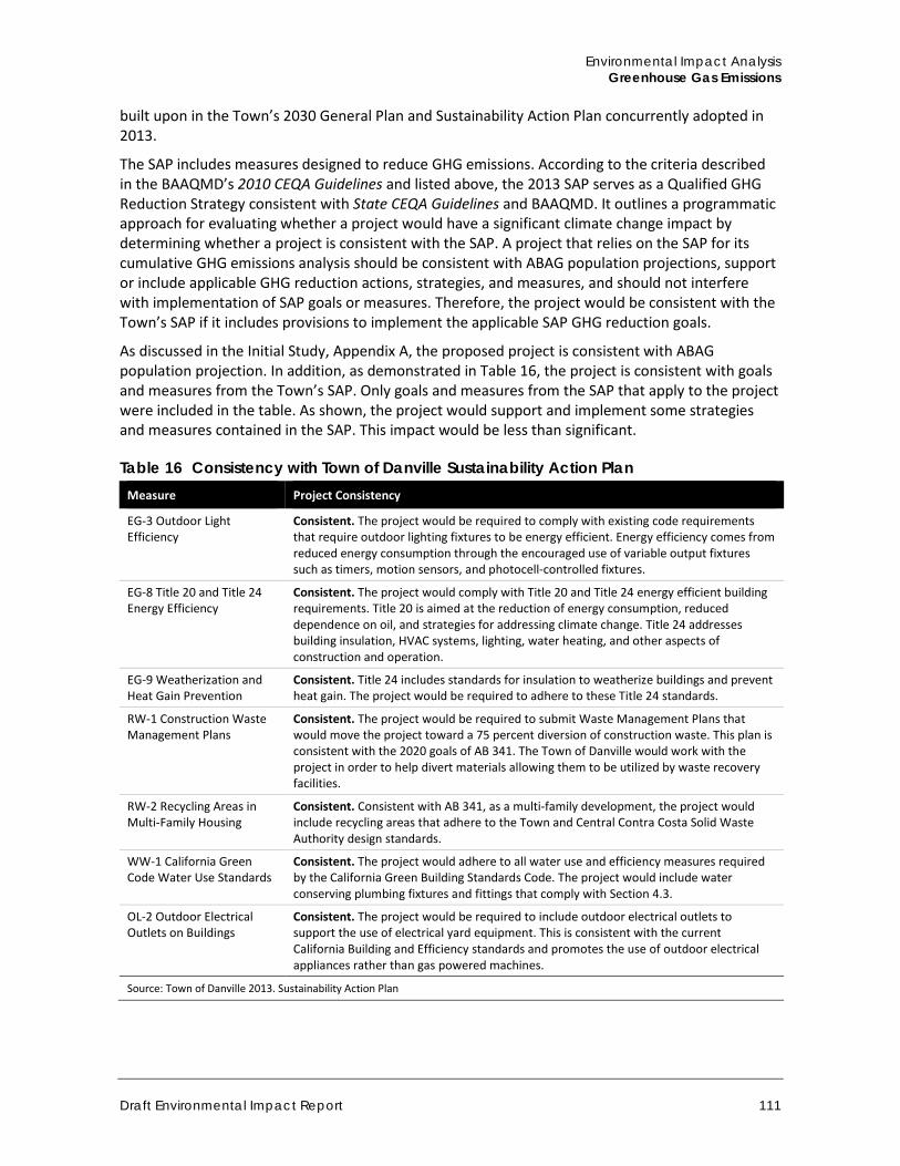
Environmental Impact Analysis Greenhouse Gas Emissions
Draft Environmental Impact Report 111
built upon in the Town’s 2030 General Plan and Sustainability Action Plan concurrently adopted in 2013.
The SAP includes measures designed to reduce GHG emissions. According to the criteria described in the BAAQMD’s 2010 CEQA Guidelines and listed above, the 2013 SAP serves as a Qualified GHG Reduction Strategy consistent with State CEQA Guidelines and BAAQMD. It outlines a programmatic approach for evaluating whether a project would have a significant climate change impact by determining whether a project is consistent with the SAP. A project that relies on the SAP for its cumulative GHG emissions analysis should be consistent with ABAG population projections, support or include applicable GHG reduction actions, strategies, and measures, and should not interfere with implementation of SAP goals or measures. Therefore, the project would be consistent with the Town’s SAP if it includes provisions to implement the applicable SAP GHG reduction goals.
As discussed in the Initial Study, Appendix A, the proposed project is consistent with ABAG population projection. In addition, as demonstrated in Table 16, the project is consistent with goals and measures from the Town’s SAP. Only goals and measures from the SAP that apply to the project were included in the table. As shown, the project would support and implement some strategies and measures contained in the SAP. This impact would be less than significant.
Table 16 Consistency with Town of Danville Sustainability Action Plan Measure Project Consistency
EG-3 Outdoor Light Efficiency
Consistent. The project would be required to comply with existing code requirements that require outdoor lighting fixtures to be energy efficient. Energy efficiency comes from reduced energy consumption through the encouraged use of variable output fixtures such as timers, motion sensors, and photocell-controlled fixtures.
EG-8 Title 20 and Title 24 Energy Efficiency
Consistent. The project would comply with Title 20 and Title 24 energy efficient building requirements. Title 20 is aimed at the reduction of energy consumption, reduced dependence on oil, and strategies for addressing climate change. Title 24 addresses building insulation, HVAC systems, lighting, water heating, and other aspects of construction and operation.
EG-9 Weatherization and Heat Gain Prevention
Consistent. Title 24 includes standards for insulation to weatherize buildings and prevent heat gain. The project would be required to adhere to these Title 24 standards.
RW-1 Construction Waste Management Plans
Consistent. The project would be required to submit Waste Management Plans that would move the project toward a 75 percent diversion of construction waste. This plan is consistent with the 2020 goals of AB 341. The Town of Danville would work with the project in order to help divert materials allowing them to be utilized by waste recovery facilities.
RW-2 Recycling Areas in Multi-Family Housing
Consistent. Consistent with AB 341, as a multi-family development, the project would include recycling areas that adhere to the Town and Central Contra Costa Solid Waste Authority design standards.
WW-1 California Green Code Water Use Standards
Consistent. The project would adhere to all water use and efficiency measures required by the California Green Building Standards Code. The project would include water conserving plumbing fixtures and fittings that comply with Section 4.3.
OL-2 Outdoor Electrical Outlets on Buildings
Consistent. The project would be required to include outdoor electrical outlets to support the use of electrical yard equipment. This is consistent with the current California Building and Efficiency standards and promotes the use of outdoor electrical appliances rather than gas powered machines.
Source: Town of Danville 2013. Sustainability Action Plan
Town of Danville 375 West El Pintado Road Residential Project
112
Estimated Project GHG Emissions
GHG emissions associated with the project were estimated using CalEEMod. Full results are shown in Appendix E.
Construction Emissions Construction of the project would generate temporary GHG emissions primarily due to the operation of construction equipment and truck trips. Construction activity for the project would generate an estimated 418 metric tons of CO2e. Neither BAAQMD nor the Town has an adopted threshold of significance for construction-related GHG emissions. Therefore, construction related GHG emissions are not included in the total emissions calculations.
Area Source Emissions CalEEMod was used to calculate direct sources of air emissions located at the project site including consumer product use and landscape maintenance equipment. Area emissions are estimated at 1 metric ton of CO2e per year.
Energy Use Operation of on-site development would consume both electricity and natural gas. The generation of electricity through combustion of fossil fuels emits CO2, and to a smaller extent, N2O and CH4. As discussed above, annual electricity emissions can be calculated using default values from the CEC sponsored CEUS and RASS studies that are built into CalEEMod. Energy consumption associated with the project would generate approximately 94 metric tons of CO2e per year.
Solid Waste Emissions In accordance with AB 939, it was assumed that the project would achieve at least a 50 percent diversion rate. Based on this estimate, solid waste associated with the project would generate an estimated 9 metric tons of CO2e per year.
Water Use Emissions Based on the amount of electricity generated in order to supply and convey water for the project, the project would generate an estimated 9 metric tons of CO2e per year.
Transportation Emissions Mobile source GHG emissions were estimated using the average daily trips for the project according to the project traffic study (Appendix H) and based on the total VMT estimated in CalEEMod. The project would generate about 495,642 million annual VMT. As noted above, CalEEMod does not calculate N2O emissions related to mobile sources. As such, N2O emissions were calculated based on the project’s VMT using calculation methods provided by the California Climate Action Registry General Reporting Protocol (January 2009). The project would emit an estimated 216 metric tons of CO2e per year from mobile sources.
Combined Emissions Table 17 combines the construction, operational, and mobile GHG emissions associated with development of the project.
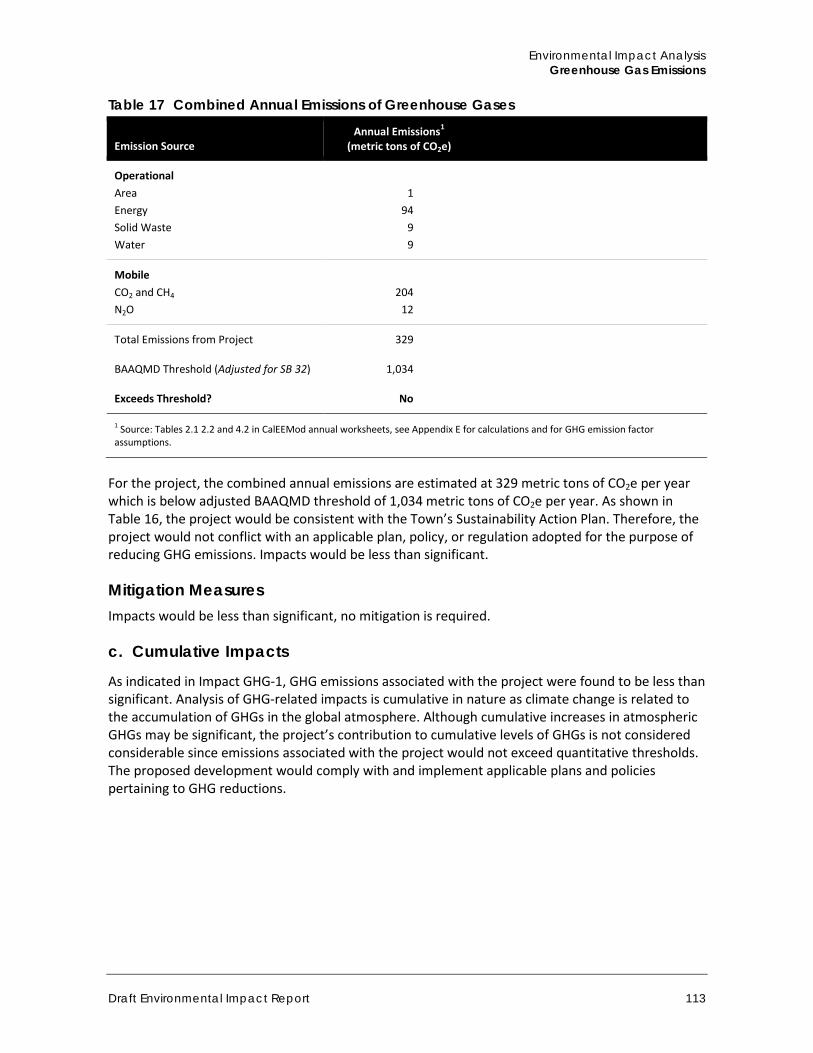
Environmental Impact Analysis Greenhouse Gas Emissions
Draft Environmental Impact Report 113
Table 17 Combined Annual Emissions of Greenhouse Gases
Emission Source Annual Emissions1
(metric tons of CO2e)
Operational Area Energy Solid Waste Water
1
94 9 9
Mobile CO2 and CH4 N2O
204
12
Total Emissions from Project 329
BAAQMD Threshold (Adjusted for SB 32) 1,034
Exceeds Threshold? No
1 Source: Tables 2.1 2.2 and 4.2 in CalEEMod annual worksheets, see Appendix E for calculations and for GHG emission factor assumptions.
For the project, the combined annual emissions are estimated at 329 metric tons of CO2e per year which is below adjusted BAAQMD threshold of 1,034 metric tons of CO2e per year. As shown in Table 16, the project would be consistent with the Town’s Sustainability Action Plan. Therefore, the project would not conflict with an applicable plan, policy, or regulation adopted for the purpose of reducing GHG emissions. Impacts would be less than significant.
Mitigation Measures Impacts would be less than significant, no mitigation is required.
c. Cumulative Impacts
As indicated in Impact GHG-1, GHG emissions associated with the project were found to be less than significant. Analysis of GHG-related impacts is cumulative in nature as climate change is related to the accumulation of GHGs in the global atmosphere. Although cumulative increases in atmospheric GHGs may be significant, the project’s contribution to cumulative levels of GHGs is not considered considerable since emissions associated with the project would not exceed quantitative thresholds. The proposed development would comply with and implement applicable plans and policies pertaining to GHG reductions.

Town of Danville 375 West El Pintado Road Residential Project
114
This page intentionally left blank.
Environmental Impact Analysis Hydrology and Water Quality
Draft Environmental Impact Report 115
4.5 Hydrology and Water Quality This section evaluates the potential environmental effects related to hydrology and water quality associated with implementation of the project. It discusses the regional and local watershed characteristics, including water quality, drainage and infiltration patterns, and flood hazards. This section is based on the Preliminary Stormwater Control Plan prepared by Talus Engineering in December 2017, included in Appendix F, among other sources.
4.5.1 Setting
a. Regional Setting
The Town of Danville is located in the San Ramon Valley in Contra Costa County. The project site is located in the Coast Ranges geomorphic province. This geomorphic province includes northwest-trending mountain ranges and valleys that run subparallel to the San Andreas Fault. The province is bounded on the west by the Pacific Ocean. The northern and southern ranges are separated by a topographic depression that forms the San Francisco Bay (California Geological Survey [CGS] 2002).
The topography within the Town of Danville is dominated by the northwest-trending San Ramon and Sycamore valleys and the Sherburne Hills. Mount Diablo and its associated foothills rise to the northeast. The Town of Danville is characterized by a typical Mediterranean climate, generally dry in the summer with mild, wet winters. Average summer temperatures in degrees Fahrenheit are in the 70s, with highs in the mid-80s and lows in the upper 50s (Idcide.com 2016). Average winter temperatures are in the upper 40s, with highs in the mid to upper 50s and lows in the upper 30s (Idcide.com 2016). Most rainfall occurs between November and March, with an average annual rainfall of approximately 24 inches. The wettest months of the year are January and February, with an average rainfall of 4.76 and 4.49 inches, respectively (Idcide.com 2016).
Watersheds The California Department of Water Resources (DWR) divides surface watersheds in California into 10 hydrologic regions. The Town of Danville and the project site lie within the San Francisco Bay Hydrologic Region. The San Francisco Bay Hydrologic Region encompasses approximately 4,500 square miles and includes all of San Francisco County and portions of Alameda, Contra Costa, Marin, Napa, San Mateo, Santa Clara, Solano, and Sonoma counties (DWR 2003). Major topographic features include the Livermore, Napa, Petaluma, Santa Clara, Sonoma, and Suisun-Fairfield valleys; the Marin and San Francisco peninsulas; the San Francisco, San Pablo, and Suisun bays; and the Bolinas Ridge, Diablo Range, Santa Cruz Mountains, and Vaca Mountains of the Coast Range (DWR 2003). The DWR subdivides Hydrologic Regions into hydrologic units, and further into hydrologic areas and hydrologic subareas. Within the San Francisco Bay Hydrologic Region, the project site is located in the Suisun Bay hydrologic unit (CalFish 2004). The San Francisco Bay Regional Water Quality Control Board (SFBRWQCB) governs basin planning and water quality within the Suisun Bay hydrologic unit (SFBRWQCB 2015). Within the Suisun Bay hydrologic unit, the project site is located within the Concord hydrologic area and the Walnut Creek hydrologic subarea (CalFish 2004).
Surface Water Resources The Town of Danville includes both undeveloped open space with natural drainage features and urban development with highly altered drainage systems, such as concrete lined washes and
Town of Danville 375 West El Pintado Road Residential Project
116
underground stormwater systems. The six National Hydrography Dataset named streams that flow within the town’s boundaries include Alamo Creek, East Branch Green Valley Creek, Green Valley Creek, San Ramon Creek, Sycamore Creek, and West Branch Alamo Creek (USGS 2016a). Alamo Creek and West Branch Alamo Creek cross the eastern portion of the town and flow towards the south before joining South San Ramon Creek. San Ramon Creek flows south to north through the western portion of the Town. East Branch Green Valley Creek, Green Valley Creek, and Sycamore Creek generally originate in the northern and eastern portion of the Town and join San Ramon Creek before flowing north.
Surface Water Quality The SFBRWQCB sets water quality standards in the San Francisco Bay Basin Water Quality Control Plan (Basin Plan). The Basin Plan identifies beneficial uses for surface water and groundwater and establishes water quality objectives to attain those beneficial uses. The identified beneficial uses and the water quality objectives to maintain or achieve those uses are together known as water quality standards. Within the town of Danville, the SFBRWQCB Basin Plan identifies beneficial uses for San Ramon Creek (SFBRWQCB 2015). Existing beneficial uses include warm freshwater habitat (WARM), wildlife habitat (WILD), water contact recreation (REC-1), and non-contact water recreation (REC-2).
As mandated by Section 303(d) of the federal Clean Water Act, the SWRCB maintains and updates a list of “impaired water bodies” (i.e., water bodies that do not meet state and federal water quality standards). This list is known as the Section 303(d) list of impaired waters. The state is then required to prioritize waters/watersheds for development of Total Maximum Daily Load (TMDL) regulations. This information is compiled in a list and submitted to the EPA for review and approval. The SWRCB and RWQCBs monitor and assess water quality on an ongoing basis. According to the 2012 Integrated Report [CWA Section 303(d) List/305(b) Report], none of the named waterbodies in the town are listed as impaired (SWRCB 2012). The nearest impaired waterbody is Pine Creek, which is located north of the town in the foothills of Mount Diablo. Pine Creek is listed as impaired by diazinon, and this impairment is being addressed by a TMDL (SWRCB 2012).
Groundwater Resources The Town of Danville is underlain by the San Ramon Valley Groundwater Basin. The groundwater basin occupies a structural trough in the central Coast Range east of San Francisco Bay (DWR 2004). The basin is bounded by Stone Valley on the north, Las Trampas Ridge on the west, the foothills of Mt. Diablo on the east, and the Livermore Valley Groundwater Basin on the south (DWR 2004). The geographic extent of the groundwater basin generally follows the valleys associated with the named streams in the Town, including East Branch Green Valley Creek, Green Valley Creek, San Ramon Creek, and Sycamore Creek. No published data on the San Ramon Valley Groundwater Basin is available for groundwater storage capacity, the amount of groundwater in storage, groundwater level trends, or extraction and recharge amounts (DWR 2004). Similarly, no published data is available to characterize groundwater constituents, such as minerals, salinity, and total dissolved solids (DWR 2004). No groundwater quality impairments have been documented (DWR 2004). A small number of wells (approximately 70) have been completed within the basin to an average depth of approximately 240 feet (DWR 2004). The Basin Plan lists existing Beneficial Uses for the San Ramon Valley Groundwater Basin as Agricultural Supply (AGR) and Municipal and Domestic Supply (MUN).
Environmental Impact Analysis Hydrology and Water Quality
Draft Environmental Impact Report 117
Flooding Areas that are subject to flood risk are identified by the Federal Emergency Management Agency (FEMA) on the National Flood Hazard Layer. These flood prone areas are called Flood Hazard Areas and have a one-in-100 chance of being inundated during any year, more commonly referred to as the one percent flood zone or 100-year flood zone. In addition, FEMA identifies the flood-way, or the channel of a stream that must be kept free from encroachment in order that a 100-year flood can be accommodated without substantial increase in flood height. Most of the town is not subject to flooding from either a 100-year or 500-year storm. A few small areas that are associated with drainage channels, including East Branch Green Valley Creek, Green Valley Creek, San Ramon Creek, and Sycamore Creek, are subject to flooding from a 100-year storm (FEMA 2016). These areas are classified as Flood Zone A and Flood Zone AE. The town of Danville is not subject to inundation from dam failure or levee failure. The town is located approximately 14 miles from the San Francisco Bay and would not be inundated by a tsunami (ABAG 2016).
b. Project Site Setting
The project site generally slopes from the east to the west. Elevation on the project site ranges from approximately 351 feet above mean sea level on the western portion of the site to approximately 374 feet above mean sea level on the eastern portion of the site (USGS 2016b). The majority of the project site consists of bare ground with scattered trees, including mature oak trees. A single-family residence is located on the project site’s southern parcel.
The project site generally slopes from its frontage along West El Pintado Road, the project’s eastern boundary, towards an existing 48-inch stormwater culvert at the southwest corner of the property. An existing 60-inch public storm drain pipe and an adjacent 18-inch storm drain pipe discharges onto the property from the north and drains through an earthen swale southwesterly towards the existing 48-inch culvert. A portion of the site along the southern boundary drains southerly to a swale that discharges through an existing 24-inch corrugated metal pipe located on the adjacent property.
Three drainage swales traverse the project site. Two of these drainages enter the project site along the northern boundary and flow towards the south and southwest before entering an existing box culvert structure in the southwest corner of the project site’s northern parcel. The third drainage flows east to west along the southern boundary of the project site’s southern parcel. Major drainages in the vicinity of the project site are shown on Figure 15.
As described in the Initial Study (Appendix A), water supply for the project site would be sourced from the East Bay Municipal Utilities District, which supplies potable water mainly from the Mokelumne River watershed. The project site is not underlain by a groundwater aquifer, and no groundwater resources would be required for the project’s potable water supply.
As shown in on Figure 16, the project site is not in a flood hazard area. The nearest flood hazard area is a 100-year flood zone associated with San Ramon Creek, located approximately 950 feet to the southwest.
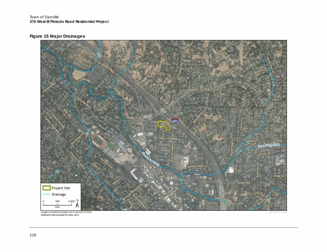
Town of Danville 375 West El Pintado Road Residential Project
118
Figure 15 Major Drainages
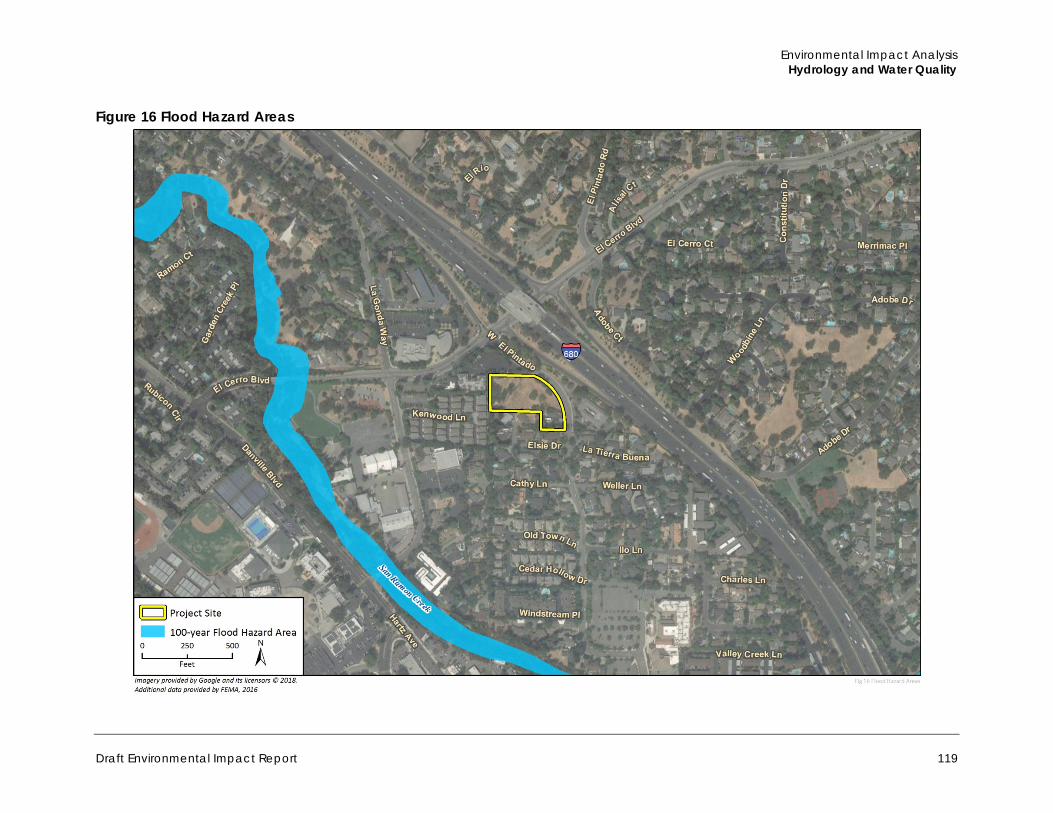
Environmental Impact Analysis Hydrology and Water Quality
Draft Environmental Impact Report 119
Figure 16 Flood Hazard Areas
Town of Danville 375 West El Pintado Road Residential Project
120
c. Regulatory Setting
Federal
Clean Water Act Congress enacted the CWA, formerly the Federal Water Pollution Control Act of 1972, with the intent of restoring and maintaining the chemical, physical, and biological integrity of the Waters of the United States. The CWA requires states to set standards to protect, maintain, and restore water quality through the regulation of point source and non-point source discharges to surface water. Those discharges are regulated by the National Pollutant Discharge Elimination System (NPDES) permit process (CWA Section 402). NPDES permitting authority is administered by the SWRCB and its’ nine Regional Water Quality Control Boards (RWQCB). The town is within a watershed administered by the SFBRWQCB.
Individual projects within the town that disturb more than one acre would be required to obtain NPDES coverage under the California General Permit for Storm Water Discharges Associated with Construction and Land Disturbance Activities (Construction General Permit). The Construction General Permit requires the development and implementation of a Storm Water Pollution Prevention Plan (SWPPP) describing Best Management Practices (BMP) the discharger would use to prevent and retain stormwater runoff. The SWPPP must contain a visual monitoring program, a chemical monitoring program for “non-visible” pollutants to be implemented if there is a failure of BMPs, and a sediment monitoring plan if the site discharges directly to a waterbody listed on the 303(d) list for sediment.
In addition to the NPDES Construction General Permit, the SFBRWQCB administers the Municipal Regional Stormwater NPDES Permit (Order R2-2009-0074, NPDES Permit No. CAS612008). The Municipal Regional Stormwater Permit consolidates six Phase I municipal stormwater NPDES permits into one consistent permit that is regional in scope. The Municipal Regional Stormwater Permit prohibits the discharge of non-stormwater effluent into storm drain systems and watercourses and requires appropriate source control, site design, and stormwater treatment measures in new development and redevelopment projects to address both soluble and insoluble stormwater runoff pollutant discharges and prevent increases in runoff flows from new development and redevelopment projects. Those requirements are accomplished primarily through the implementation of low impact development (LID) techniques.
Section 401 of the CWA requires that any activity that would result in a discharge into Waters of the U.S. be certified by the RWQCB. This certification ensures that the proposed activity does not violate State and/or federal water quality standards. Section 404 of the CWA authorizes the USACE to regulate the discharge of dredged or fill material to the Waters of the U.S. and adjacent wetlands. Discharges to Waters of the U.S. must be avoided where possible, and minimized and mitigated where avoidance is not possible. See Section 4.3, Biological Resources, for a description of jurisdictional waters within the project site. Section 303(d) of the CWA requires states to establish TMDL programs for streams, lakes and coastal waters that do not meet certain water quality standards.
Environmental Impact Analysis Hydrology and Water Quality
Draft Environmental Impact Report 121
State
California Porter Cologne Water Quality Control Act The Porter Cologne Water Quality Control Act of 1967 requires the SWRCB and the nine RWQCBs to adopt water quality criteria to protect state waters. These criteria include the identification of beneficial uses, narrative and numerical water quality standards, and implementation procedures. The criteria for State waters within the Town are contained in the San Francisco Bay Basin Water Quality Control Plan (SFBRWQCB 2015). The Water Quality Control Plan, or Basin Plan, protects designated beneficial uses of state waters through the issuance of Waste Discharge Requirements and through the development of TMDLs. Anyone proposing to discharge waste that could affect the quality of the Waters of the State must make a report of the waste discharge to the RWQCB or SWRCB as appropriate, in compliance with Porter Cologne.
California Streambed Alteration Agreement Sections 1600–1616 of the CFGC require that any entity that proposes an activity that would substantially divert or obstruct the natural flow of any river, stream, or lake; substantially change or use any material from the bed, channel, or bank of, any river, stream, or lake; or deposit or dispose of debris, waste, or other material containing crumbled, flaked, or ground pavement where it may pass into any river, stream, or lake, must notify the CDFW. The CDFW would require a Lake or Streambed Alteration Agreement if the Department determines that the alteration may adversely affect fish and wildlife resources. The agreement includes conditions necessary to protect those resources. The agreement applies to any stream, including ephemeral streams and desert washes.
Local
Danville Municipal Code DMC Chapter 19, Grading Ordinance, establishes controls on the earthwork permitted by the Town in the course of, or in conjunction with, construction. In addition to a grading permit, Chapter 19 requires an erosion-control permit and a paving permit (if any paving is included in the project). The grading permit and erosion control permit together require structural design elements and BMPs to control erosion and maintain proper drainage on- and off-site. DMC Chapter 20 describes the Town’s Stormwater Management and Discharge Control Ordinance, which is intended to protect and enhance the water quality in the Town’s watercourses pursuant to, and consistent with, the Porter Cologne Water Quality Control Act and the Federal Clean Water Act. The ordinance implements the Town’s NPDES permit by requiring appropriate source control and site design measures and stormwater treatment measures for development projects.
2030 General Plan The Town’s 2030 General Plan contains goals, policies, and implementation measures to protect water resources and water quality. These goals, policies, and implementation measures are contained within the Chapter 5, Public Facilities and Chapter 6, Resources and Hazards. The relevant goals, policies, and implementation measures from each of these chapters are listed below.
Town of Danville 375 West El Pintado Road Residential Project
122
PUBLIC FACILITIES ELEMENT
Infrastructure Goals and Policies
Goal 20: Ensure that local water supply, storm drainage, sewerage, streets, and similar facilities are well maintained, improvements meet existing and future needs, and land use decisions are contingent on the adequacy and maintenance of such facilities.
Policy 20.05: Continue to provide for flood control, protection from erosion and siltation, and improvements to urban runoff as required by federal law. Continue to explore the recreational potential of flood control facilities and waterways, consistent with public safety and security, and stress aesthetic treatment of needed facilities.
Policy 20.08: Protect surface water from pollution by ensuring that stormwater discharges comply with Regional Water Quality Control Board San Francisco Bay Municipal Regional Permit (RWQCB-SF Bay MRP) requirements. The Town will enforce nonpoint source pollution control measures as required by federal and state law. These measures include steps to control erosion and sedimentation, require stormwater containment facilities and other measures that reduce or contain development-related runoff.
RESOURCES AND HAZARDS ELEMENT
Environmental Quality Goals and Policies
Goal 21: Protect and enhance Danville’s natural features, including its hillsides, ridgelines, creeks, vegetation, and wildlife.
Goal 22: Improve water quality in Danville and the water bodies that receive runoff from Danville, including San Francisco Bay.
Policy 22.01: Maintain and enhance the natural quality of Danville’s creeks, including the riparian vegetation along the banks. Setbacks should be maintained along creeks to maintain their natural appearance, reduce erosion and flood hazards, and protect their ecological functions.
Policy 22.02: Require qualifying new development projects and redevelopment projects to comply with the Municipal Regional Permit for stormwater control and treatment.
Policy 22.04: Manage the Town’s storm drainage facilities in a manner that minimizes pollution of local streams and waterways. Storm drains and other drainage facilities should be regularly maintained.
Policy 23.05: Continue cooperative planning and implementation efforts at the countywide level to ensure that qualifying new development projects and redevelopment projects comply with the hydro-modification plan/program requirements imposed through the Municipal Regional Permit.
4.5.2 Impact Analysis
a. Methodology and Significance Thresholds
This section describes the potential environmental impacts of the project relevant to hydrology and water quality. The impact analysis is based on an assessment of baseline conditions for the project area, including climate, topography, watersheds and surface waters, groundwater, and floodplains,
Environmental Impact Analysis Hydrology and Water Quality
Draft Environmental Impact Report 123
as described in Section 4.5.1, Setting. This analysis identifies potential impacts based on the predicted interaction between the affected environment and construction, operation, and maintenance of the project. This section recommends mitigation measures, when necessary, to avoid or minimize impacts.
According to Appendix G of the State CEQA Guidelines, hydrology and water quality impacts related to the project would be considered significant if the project would do any of the following:
A. Violate any water quality standards or waste discharge requirements B. Substantially deplete groundwater supplies or interfere substantially with groundwater
recharge such that there would be a net deficit in aquifer volume or a lowering of the local groundwater table level (e.g., the production rate of pre-existing nearby wells would drop to a level that would not support existing land uses or planned uses for which permits have been granted)
C. Substantially alter the existing drainage pattern of the site or area, including through the alteration of the course of a stream or river, in a manner that would result in substantial erosion or siltation on- or off-site
D. Substantially alter the existing drainage pattern of the site or area, including through the alteration of the course of a stream or river, or substantially increase the rate or amount of surface runoff in a manner that would result in flooding on- or off-site
E. Create or contribute runoff water that would exceed the capacity of existing or planned stormwater drainage systems or provide substantial additional sources of polluted runoff
F. Otherwise substantially degrade water quality G. Place housing within a 100-year flood hazard area as mapped on a federal Flood Hazard
Boundary or Flood Insurance Rate Map or other flood hazard delineation map H. Place within a 100-year flood hazard area structures that would impede or redirect flood
flows I. Expose people or structures to a significant risk of loss, injury or death involving flooding,
including flooding as a result of the failure of a levee or dam J. Be subject to inundation by seiche, tsunami, or mudflow
Based on the analysis from the Initial Study, checklist questions A, C, D, E, and F were determined to have a potentially significant impact, and will be discussed in this EIR. Checklist item B was less than significant and is discussed in the Initial Study and therefore not studied in this section. Checklist items G, H, I, and J had no impact in the Initial Study.
Town of Danville 375 West El Pintado Road Residential Project
124
b. Project Impacts
Threshold A: Would the project violate any water quality standards or waste discharge requirements?
Threshold F: Would the project otherwise substantially degrade water quality?
Impact HWQ-1 CONSTRUCTION AND OPERATION OF THE PROJECT COULD POTENTIALLY RESULT IN AN INCREASE IN POLLUTANT DISCHARGES TO WATERS OF THE STATE, BUT COMPLIANCE WITH DANVILLE GENERAL PLAN POLICIES AND ACTIONS, AS WELL AS EXISTING REGULATORY REQUIREMENTS, WOULD AVOID SUCH IMPACTS. THE PROJECT WOULD THEREFORE NOT VIOLATE WATER QUALITY STANDARDS OR WASTE DISCHARGE REQUIREMENTS OR OTHERWISE SUBSTANTIALLY DEGRADE WATER QUALITY, AND THIS IMPACT WOULD BE CLASS II, SIGNIFICANT BUT MITIGABLE.
Construction Temporary soil disturbance would occur during construction of the project as a result of earth-moving activities, such as excavation and trenching for foundations and utilities, soil compaction and moving, cut and fill activities, and grading. If not managed properly, disturbed soils would be susceptible to high rates of erosion from wind and rain, resulting in sediment transport via stormwater runoff from the project site. The types of pollutants contained in runoff from construction sites would be typical of urban areas, and may include sediments and contaminants such as oils, fuels, paints, and solvents. Additionally, other pollutants, such as nutrients, trace metals, and hydrocarbons, can attach to sediment and be transported to downstream drainages and ultimately into collecting waterways, contributing to degradation of water quality.
Because the project would involve disturbance of one or more acres of land surface, it would be subject to the NPDES General Permit for Storm Water Discharges Associated with Construction and Land Disturbance Activities (Order No. 2012-0006-DWQ) adopted by the SWRCB. Compliance with the permit would require the applicant to file a Notice of Intent with the SWRCB. Permit conditions require development of a SWPPP, which must describe the site, the facility, erosion and sediment controls, runoff water quality monitoring, means of waste disposal, implementation of approved local plans, control of construction sediment and erosion control measures, maintenance responsibilities, and non-stormwater management controls. Inspection of construction sites before and after storms is also required to identify stormwater discharge from the construction activity and to identify and implement erosion controls, where necessary. Prior to construction, the existing on-site drainage swales would be formally delineated, and required permits and off-site mitigation agreements would be obtained from the appropriate resource agency, per mitigation measures BIO-2 through BIO-4. Placement of the existing on-site drainage swales in underground culverts during construction would be regulated by the appropriate resource agency (such as CDFW and the RWQCB), ensuring that water quality impacts to the existing on-site drainages would be less than significant (see discussion in Section 4.3, Biological Resources).
In addition, DMC chapters 19 and 20 regulate grading, drainage, and erosion and contain requirements regarding stormwater discharge and construction site stormwater runoff control. Compliance with existing regulations would limit erosion, which would reduce temporary impacts to surface water quality. As such, with implementation of applicable laws and regulations, the project would not violate water quality standards or contribute additional sources of polluted runoff. Construction impacts to water quality would be less than significant.
Environmental Impact Analysis Hydrology and Water Quality
Draft Environmental Impact Report 125
Operation Operation of the project could potentially result in the addition of contaminants into both the stormwater runoff entering the Town’s stormwater drainage system and the wastewater stream entering the local wastewater collection and treatment system. If stormwater controls are not designed or managed properly, runoff from the project site could contain contaminants such as oil, grease, metals, and landscaping chemicals (e.g., pesticides, herbicides, fertilizers) that could enter the Town’s stormwater drainage system and ultimately degrade surface water and groundwater quality.
Rooftop and surface drainage would be collected through underground pipes and directed to stormwater treatment devices including bioretention areas, a flow-through planter, and pervious pavers. The bioretention areas and flow-through planter would provide stormwater treatment as well as detention. All runoff from the impervious surfaces would be directed to treatment areas. After leaving the site, stormwater would be conveyed south and west through existing culverts, and would ultimately be discharged into San Ramon Creek (Talus 2017).
Illicit discharges to the municipal stormwater system are prohibited by the DMC, and any entity found to be engaging in illicit discharges may be held liable for the cost of clean-up and remediation. The DMC also contains requirements for new development and redevelopment projects to minimize pollutants in stormwater runoff. These requirements are described above and are detailed in the Town’s stormwater management program. The DMC’s stormwater discharge requirements are designed to achieve compliance with the SFBRWQCB’s Municipal Regional Stormwater NPDES Permit (Order R2-2009-0074, NPDES Permit No. CAS612008). Compliance with the DMC and adherence to 2030 General Plan policies would maximize permeable surface and infiltration on the project site, minimize stormwater runoff, and prevent or remediate illicit discharges of pollutants to the municipal stormwater conveyance system. Compliance with the Municipal Regional Stormwater Permit requirements, the Danville Municipal Code, and 2030 General Plan policies would reduce the risk of water contamination from operation of the project to the maximum extent practicable. Therefore, this impact would be less than significant.
Mitigation Measures Mitigation Measures BIO-2 (Formal Jurisdictional Delineation), BIO-3 (Regulatory Permitting), and BIO-4 (Wetland/Drainage Compensation) listed in Section 4.3, Biological Resources, are required.
Significance After Mitigation With implementation of the above mitigation measures, water quality impacts to the existing on-site drainage swales would be reduced to a less than significant level.
Town of Danville 375 West El Pintado Road Residential Project
126
Threshold C: Would the project substantially alter the existing drainage pattern of the site or area, including through the alteration of the course of a stream or river, in a manner that would result in substantial erosion or siltation on- or off-site?
Threshold D: Would the project substantially alter the existing drainage pattern of the site or area, including through the alteration of the course of a stream or river, or substantially increase the rate or amount of surface runoff in a manner that would result in flooding on- or off-site?
Threshold E: Would the project create or contribute runoff water that would exceed the capacity of existing or planned stormwater drainage systems or provide substantial additional sources of polluted runoff?
Impact HWQ-2 THE PROJECT WOULD ALTER THE EXISTING DRAINAGE PATTERN OF THE SITE. IMPROPERLY DESIGNED DRAINAGE MODIFICATIONS COULD RESULT IN AN INCREASE OF STORMWATER RUNOFF FROM THE PROJECT AREA. HOWEVER, THE PROPOSED STORMWATER CONTROL AND DRAINAGE PLANS FOR THE PROJECT AND COMPLIANCE WITH EXISTING REGULATIONS WOULD ENSURE THAT IMPACTS WOULD BE CLASS III, LESS THAN SIGNIFICANT.
Development associated with the project would result in alterations to site drainage, such as extending existing culverts beneath the project site, changes in ground surface permeability from the introduction of impervious surfaces (rooftops), and changes in topography from grading and excavation.
Currently, two storm drain pipes (a 60-inch and an 18-inch storm drain pipe) discharge onto the project site from the north and drain through earthen swales southerly and southwesterly towards an existing 48-inch culvert at the southwestern corner of the project site. Off-site runoff that currently flows through the project site would be routed through the project site through the extension of the existing 48-inch storm drain culvert through the project site, connecting to the two existing culverts entering the site from the north. The new 48-inch culvert would be adequately sized to accommodate flow from the off-site locations to the north without causing on- or off-site flooding (Talus 2017).
In addition, the project site has approximately 2,926 square feet of impervious surface area. The proposed project would add approximately 45,902 square feet of impervious surface area. Total impervious surface area following construction of the proposed project would be 49,828 square feet. This would result in potential increases in surface runoff. Increased runoff could impact water quality down-gradient of the project site by increasing erosion or sedimentation and the quantity of flood water. Increased runoff could also impact stormwater drainage facilities such that new or expanded facilities would be required.
As shown in Figure 9 in Section 2, Project Description, the project would involve on-site stormwater treatment and detention devices to manage stormwater, which would ensure that the capacity of existing stormwater drainage systems would not be significantly impacted by the project. Specifically, a 336-square-foot bioretention area would be located on the east side of Buildings D and E, a 165-square-foot bioretention area would be located on the west side of Building G, and 165-square-foot bioretention area would be located on the east side of Building H. A 2,250-square-foot flow through planter would be located along the project site’s western boundary near Building A. Pervious pavement would be located on the driveways between Buildings C, D, and E and between Buildings G and H. The treatment and detention devices would be sized to accommodate
Environmental Impact Analysis Hydrology and Water Quality
Draft Environmental Impact Report 127
both treatment and detention and peak flows would be maintained at or below existing conditions (Talus 2017).
Compliance with the Danville Municipal Code and the SFBRWQCB Municipal Regional Stormwater Permit would ensure that post-development off-site runoff amounts would not exceed pre-development conditions. The Danville Grading Ordinance establishes controls on the earthwork permitted by the Town in the course of, or in conjunction with, construction and requires that an erosion-control permit be obtained prior to the start of construction activities. The grading permit and erosion control permit together require structural design elements and Best Management Practices to control erosion and maintain proper drainage on- and off-site. Danville’s Stormwater Management and Discharge Control Ordinance implements the Town’s NPDES permit by requiring appropriate source control and site design measures and stormwater treatment measures for development projects. The SFBRWQCB Municipal Regional Stormwater Permit prohibits the discharge of non-stormwater effluent into storm drain systems and watercourses and requires appropriate source control, site design, and stormwater treatment measures in new development and redevelopment projects to address both soluble and insoluble stormwater runoff pollutant discharges and prevent increases in runoff flows from new development and redevelopment projects. Those requirements are accomplished primarily through the implementation of low-impact development (LID) techniques. These existing regulations would be implemented through the structural stormwater improvements described above, including the installation of pervious pavers and a detention and bio-filtration planter to detain runoff from impervious rooftops. As such, the project would not result in substantial erosion, siltation, or flooding on- or off-site and would not create or contribute runoff water that would exceed the capacity of existing or planned stormwater systems. Impacts would be less than significant.
Mitigation Measures Impacts would be less than significant, no mitigation is required.
c. Cumulative Impacts
The geographic extent for this cumulative impact analysis is the Walnut Creek Hydrologic Sub-area (Watershed) that includes the project site. This watershed, located in central Contra Costa County, is approximately 52,700 acres and contains most of the town of Danville, all of the unincorporated community of Alamo and the City of Lafayette, and most of the City of Walnut Creek. This geographic extent is appropriate for the issue area of hydrology and water quality because the watershed is hydrologically connected, and any surface water quality impacts in one part of the watershed could potentially affect downstream surface water quality elsewhere in the watershed. The project site is not underlain by a groundwater basin and therefore the geographic extent for this cumulative impact analysis does not consider the geographic extent of nearby groundwater basins.
Water Quality – Waste Discharge Construction activity associated with cumulative development would increase erosion and sedimentation resulting from grading and construction. In addition, new development would increase the generation of urban pollutants that may adversely affect water quality in the long term. However, future construction activity on projects that disturb one or more acres of soil would be required to comply with the NPDES program through preparation of a SWPPP that outlines BMPs that would address post-construction runoff. In addition, future development would be required to comply with the SFBRWQCB Municipal Regional Stormwater Permit, which sets forth post-
Town of Danville 375 West El Pintado Road Residential Project
128
construction stormwater management requirements for development projects in the region. These requirements include specific performance requirements with the objective to ensure reduction of pollutant discharges to the maximum extent practical and prevent stormwater discharges from causing or contributing to a violation of receiving water quality standards. Compliance with such requirements would reduce cumulative impacts associated with contaminants from sources originating in the Walnut Creek watershed, thus resulting in less than significant cumulative impacts. In addition, as discussed above, the project would result in less than significant impacts to water quality, with implementation of required mitigation measures BIO-2 through BIO-4 and the applicable requirements and standards as part of the project’s design. For these reasons, the project’s contribution to cumulative impacts would be less than significant.
Stormwater Runoff Cumulative development throughout the Walnut Creek Watershed (including past, present, and reasonably foreseeable future development), along with the project, would generally increase impermeable surface area, thereby potentially increasing peak flood flows and overall runoff volumes. However, the SFBRWQCB Municipal Regional Stormwater Permit requires all new development and redevelopment projects to accommodate runoff in a manner so as not to increase post-development flows above pre-development levels. Cumulative development would be subject to the applicable runoff regulations, thereby ensuring that a cumulative impact would not result. In addition, as discussed above, the project would result in less than significant impacts to stormwater runoff as it would be constructed in accordance with all applicable requirements and standards to address stormwater runoff. For these reasons, the project’s cumulative impacts related to increases in stormwater runoff and associated downstream flooding and water quality concerns would be less than significant, and the project’s contribution to such effects would not be considerable in any event.
While cumulative development may place additional demand on groundwater or potentially interfere with groundwater recharge by increasing the area covered by impervious surfaces, compliance with applicable laws and regulations would ensure that runoff from cumulative development is captured on each project site, which would facilitate continued recharge of the groundwater basin. Also, the project would not utilized groundwater resources and is not underlain by a groundwater basin that could be negatively affected by the project site’s increase in impervious surface. Thus, cumulative impacts related to groundwater recharge would be less than significant, and the project’s contribution to this cumulative effect would not be considerable in any event.
Cumulative development may potentially increase runoff volumes that could contribute to increased flood volumes. However, the project, along with other cumulative development in Danville, would be required to comply with existing Town, state and FEMA floodplain management and stormwater discharge regulations, if such development is located in a flood zone. As discussed above, the project would result in no impacts related to placing habitable structures or other structures in a flood zone, given that no portions of the proposed development would be located in these areas. Therefore, cumulative impacts would be less than significant and the project’s contribution to cumulative impacts would be less than significant.
Environmental Impact Analysis Land Use and Planning
Draft Environmental Impact Report 129
4.6 Land Use and Planning This section analyzes the project’s consistency with relevant policies of applicable local land use plans, including the Town of Danville’s 2030 General Plan and Municipal Code.
4.6.1 Setting
a. Project Site
The project site is located at the northwest portion of the town at 375 and 359 West El Pintado Road, approximately 183 feet south of the intersection of El Cerro Boulevard and immediately across West El Pintado Road from the southbound on-ramp to I-680. The 1.88-acre site, also referred to as the GMMR LLC Property, is composed of two legal parcels: a larger 1.59- acre parcel (375 West El Pintado, APN: 200-140-011) and a smaller 0.29-acre parcel (359 West El Pintado, APN: 200-140-012). Figure 3 in Section 2, Project Description, shows the existing project site and surrounding uses, and Figure 4 provides photographs of the project site from West El Pintado Road facing to the southwest and southeast.
The project site is located in the La Gonda/West El Pintado Planning Subarea, one of Danville’s 24 Planning Subareas. The La Gonda/West El Pintado Planning Subarea is a mixed-use area that consists of a combination of residential (i.e. single-family, multi-family residences, and assisted senior housing), professional, public, and institutional uses. According to the Town’s 2030 General Plan, the northern half of the project site (1.59-acre parcel) is also designated as the GMMR LLC Special Concern Area, which is one of Danville’s 11 Special Concern Areas that the Town has identified as a tool for supplementing the community-wide recommendations of the 2030 General Plan with more focused, place-based recommendations. The specific recommendations for the GMMR LLC Special Concern Area are listed under the Regulatory Setting (Town of Danville 2013a).
The 2030 General Plan also designates the larger 1.59-acre parcel as Mixed Use, which provides opportunities for residential development within established Special Concern Areas, and allows net densities in the range of 20 to 25 dwelling units per acre. The 2030 General Plan designates the smaller 0.29-acre parcel, or the southeastern portion of the project site, as Residential – Single Family – Low Density that allows one to three dwelling units per acre. This parcel is located outside of the GMMR LLC Special Concern Area (Town of Danville 2013a).
The property has two zoning designations, Limited Office (O-1) for the larger parcel, and Single Family Residential (R-15) for the smaller parcel. Figure 5 in Section 2, Project Description, shows the zoning for the project site and surrounding uses, and Figure 6 shows the 2030 General Plan land use designations for the project site and surrounding uses.
b. Surrounding Land Uses
The project site is located in a neighborhood characterized by a mix of residential, professional, public, and institutional uses. Surrounding uses and corresponding zoning designations are listed in Table 18.

Town of Danville 375 West El Pintado Road Residential Project
130
Table 18 Existing Land Uses and Zoning of Surrounding Properties
Direction Existing Land Use(s) Existing Zoning Permitted Use(s)
North Medical offices located at 300-400 El Cerro Boulevard
Limited Office (O-1)
Professional offices such as those pertaining to, but not limited to, the practice of law architecture, dentistry, medicine, engineering and accounting; administrative, executive, and editorial offices; business offices for insurance, real estate, and investment brokers or representatives Northwest Medical offices
located at 300-400 El Cerro Boulevard
East Senior nursing facility at 400 West El Pintado Road (Brookdale Senior Living Solutions)
West Multi-family residences
Planned Unit District (P-1)
Any land uses permitted by an approved final development plan and are consistent with the General Plan, a detached single-family dwelling and accessory structures on each legally established lot, a second unit if land use permit is first obtained
South Single-family residences
Single Family Residential (R-15)
Includes single-family dwellings and accessory structures on each lot, publicly or privately owned parks and playgrounds, residential care facilities, day care homes, and residential greenhouses
Source: Town of Danville Municipal Code, 2009.
c. Regulatory Setting
The Town of Danville’s 2030 General Plan and Municipal Code serve as the primary land use planning tools for the Town. These regulatory documents establish policies that apply Town-wide and specific subareas in the Town.
2030 General Plan Pursuant to California Government Code §65300, each city/town is required to adopt a comprehensive General Plan to guide the physical development of the community. The 2030 General Plan (adopted in March 2013) is the primary means for guiding future change in Danville and provides a guide for land use decision-making. The 2030 General Plan consists of goals, policies, and implementation measures for the physical development of the Town. The 2030 General Plan includes the following chapters: Introduction (Chapter 1), Planning Context (Chapter 2), Planning and Development (Chapter 3), Mobility (Chapter 4), Public Facilities (Chapter 5) and Resources and Hazards (Chapter 6). The Planning and Development Chapter addresses the type and distribution of urban development within the Town, as well as the compatibility of different uses.
Community Development The Community Development section, under Chapter 3: Planning and Development, establishes a vision for the Town’s built environment by establishing goals and policies for the Town’s land use
Environmental Impact Analysis Land Use and Planning
Draft Environmental Impact Report 131
patterns and setting guidelines for land use designations. Guidelines include permitted uses, density, design standards, and height, for each land use designation.
GMMR LLC Special Concern Area Although the 1.6-acre GMMR LLC property was approved for offices in 1989, and again in 1999, all previous entitlements have lapsed and it was designated a Special Concern Area under the Town’s 2010 General Plan approved in 1999. This provided the option to develop housing at densities of up to 22 units per acre, or office uses up to 0.6 FAR. The 2030 General Plan retains the Mixed Use designation and specifies that any residential use developed on the site shall be in the 20-25 dwelling unit/acre net density range (aligning the Residential – Multifamily – High/Medium land use category). Development on the property will need to incorporate design measures to provide an appropriate transition to the single-family uses to the south. Additionally, development on the southern 50 feet of the parcel should be no more than two stories in height and a 20-foot minimum setback from the southern property line should be maintained (Town of Danville 2013a).
Housing Element The Housing Element is one of seven State-mandated elements of the Town’s General Plan. Danville’s current 2014-2022 Housing Element was adopted by the Town Council on April 7, 2015. The Housing Element contains policies and programs that encourage housing development for a variety of affordability levels by providing an adequate number of housing sites zoned at appropriate densities to accommodate projected housing needs and affordability levels established by the State Department of Housing and Community Development (HCD) for each region. The Council of Governments (COG) for each California region then assigns each city/town and county their “fair share” of these housing units through the Regional Housing Need Allocation (RHNA) Process. Danville’s “fair share” of the Bay Area region’s housing need for the 2014-2022 planning cycle is 557 units. According to the Housing Element, the Town has sufficient acreage of appropriately zoned sites to accommodate all units among the state-mandated affordability levels for this planning cycle.
Danville Municipal Code The Town of Danville Municipal Code contains the zoning requirements and ordinances for the Town. The following is a summary of the applicable sections of the municipal code as they relate to the project.
Zoning Ordinance The goal of a zoning ordinance is to define the different categories of land within a community into "zones" (residential, commercial, agricultural, office, etc.) as well as to establish the range of uses and regulations applicable to each of those zones. Zoning districts for all lands within the Town of Danville are identified in the Town’s Zoning Ordinance and shown on the Town’s Zoning Map. In Danville, the primary purpose of zoning is to preserve the character of the community by segregating uses that may be incompatible and regulating the kinds of activities that would be acceptable on particular parcels, height of buildings, location of building(s) on the lot (setbacks), amount of space structures may occupy, and parking requirements, among other things. Table 19 lists the existing land use and zoning designations that apply to the project site, along with the permitted uses for each zoning designation.
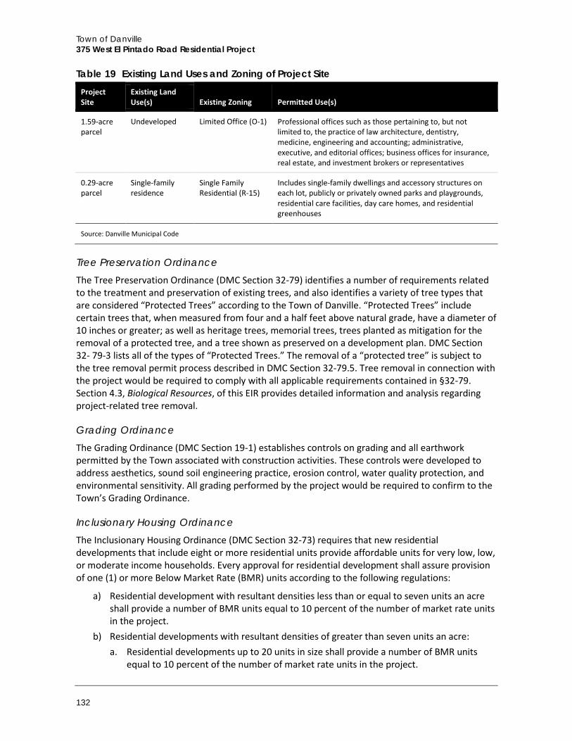
Town of Danville 375 West El Pintado Road Residential Project
132
Table 19 Existing Land Uses and Zoning of Project Site Project Site
Existing Land Use(s) Existing Zoning Permitted Use(s)
1.59-acre parcel
Undeveloped Limited Office (O-1) Professional offices such as those pertaining to, but not limited to, the practice of law architecture, dentistry, medicine, engineering and accounting; administrative, executive, and editorial offices; business offices for insurance, real estate, and investment brokers or representatives
0.29-acre parcel
Single-family residence
Single Family Residential (R-15)
Includes single-family dwellings and accessory structures on each lot, publicly or privately owned parks and playgrounds, residential care facilities, day care homes, and residential greenhouses
Source: Danville Municipal Code
Tree Preservation Ordinance The Tree Preservation Ordinance (DMC Section 32-79) identifies a number of requirements related to the treatment and preservation of existing trees, and also identifies a variety of tree types that are considered “Protected Trees” according to the Town of Danville. “Protected Trees” include certain trees that, when measured from four and a half feet above natural grade, have a diameter of 10 inches or greater; as well as heritage trees, memorial trees, trees planted as mitigation for the removal of a protected tree, and a tree shown as preserved on a development plan. DMC Section 32- 79-3 lists all of the types of “Protected Trees.” The removal of a “protected tree” is subject to the tree removal permit process described in DMC Section 32-79.5. Tree removal in connection with the project would be required to comply with all applicable requirements contained in §32-79. Section 4.3, Biological Resources, of this EIR provides detailed information and analysis regarding project-related tree removal.
Grading Ordinance The Grading Ordinance (DMC Section 19-1) establishes controls on grading and all earthwork permitted by the Town associated with construction activities. These controls were developed to address aesthetics, sound soil engineering practice, erosion control, water quality protection, and environmental sensitivity. All grading performed by the project would be required to confirm to the Town’s Grading Ordinance.
Inclusionary Housing Ordinance The Inclusionary Housing Ordinance (DMC Section 32-73) requires that new residential developments that include eight or more residential units provide affordable units for very low, low, or moderate income households. Every approval for residential development shall assure provision of one (1) or more Below Market Rate (BMR) units according to the following regulations:
a) Residential development with resultant densities less than or equal to seven units an acre shall provide a number of BMR units equal to 10 percent of the number of market rate units in the project.
b) Residential developments with resultant densities of greater than seven units an acre: a. Residential developments up to 20 units in size shall provide a number of BMR units
equal to 10 percent of the number of market rate units in the project.
Environmental Impact Analysis Land Use and Planning
Draft Environmental Impact Report 133
b. Residential developments containing 21 or more units shall provide a number of BMR units equal to 15 percent of the number of market rate units in the project.
c. All residential developments with densities of 13 units or more per acre shall construct the affordable units as a part of the residential development.
c) At the discretion of the Town Council, affordable units required pursuant to this section may be provided at a location within the Town other than the residential development that creates the requirement for the affordable units.
d) If the BMR units produced in a project with a resultant density of greater than seven units an acre are of a physical design (i.e., the overall project density, the BMR unit type and/or the BMR unit size) such that they will remain affordable to qualifying moderate income households even if sold or rented at market rate levels, the number of BMR units required to be supplied in the project may be reduced to 10 percent of the overall project count. The determination to reduce the number of affordable units required to be supplied in the project shall be made by the Town Council.
General Plan Amendment A General Plan Amendment (DMC Section 32-3.4) is a request to change the land use designation of a parcel to a different land use (i.e. office to commercial, low density residential to higher density residential). According to the DMC, approval of a General Plan Amendment application is required to allow for any modification to the text or any figure contained within the Danville General Plan. Aside from applicable fiscal fees, an application for a General Plan Amendment shall include:
a) A completed application form b) A description of the justification for the request c) Any other information found to be necessary by the Town to allow for the thorough review
of the merits of application
Preliminary Development Plan –Rezoning Approval of a Preliminary Development Plan (DMC Section 32-3.8) is required in conjunction with a Planned Unit Development (P-1) rezoning. According to DMC Section 32-63, the Planned Unit Development District (P-1) zone is intended for both large scale development where there is to be a mixture of land uses or types of housing products, or on smaller parcels where special characteristics of the site merit and would benefit from flexible zoning considerations. The P-1 District is intended to:
a) Allow diversification in the relationship of various uses, buildings, structures, lot sizes and open spaces
b) Ensure compatibility with surrounding land uses c) Ensure substantial compliance with the General Plan and the intent of the Town Municipal
Code in requiring adequate standards necessary to satisfy the requirements of the public health, safety and general welfare
To achieve design an aesthetic quality for large-scale integrated developments, infill developments, and/or General Plan special areas of concern, all design objectives specified in the Municipal Code shall be met for a P-1 District zone. The proposed multi-family residential development shall be subject to the design objectives as follows:
Town of Danville 375 West El Pintado Road Residential Project
134
a) Building bulk, height, land coverage, visual appearance from adjacent land, and design compatibility with existing adjoining development and land that will remain, shall be considered and controlled.
b) A development’s design should successfully integrate individual buildings and the building groups with the surrounding development, other physical features in the area, and existing development that will remain.
c) The design of structures should provide for harmonious composition of mass, scale, color, and textures, with special emphasis on the transition from one (1) building type to another, termination of groups of structures, relationships to streets, exploitation of views, and integration of spaces and building forms with the topography of the site and the urban or suburban character of the area.
d) Provisions are to be made for an efficient, direct and convenient system of pedestrian circulation, together with landscaping and appropriate treatment of any public areas or lobbies.
e) Off-street parking and loading areas should be integrated into the overall vehicular circulation system.
4.6.2 Impact Analysis
a. Methodology and Significance Thresholds
According to Appendix G of the CEQA Guidelines, the effects of the project on land use are considered to be significant if the project would:
A. Physically divide an established community B. Conflict with any applicable land use plan, policy, or regulation of an agency with jurisdiction
over the project (including but not limited to the general plan, specific plan, local coastal program, or zoning ordinance) adopted for the purpose of avoiding or mitigating an environmental effect
C. Conflict with any applicable habitat conservation plan or natural community
Based on the analysis in the Initial Study (Appendix A), impacts related to Checklist item A would be less than significant impact and there would be no impact related to Checklist item C. Therefore, neither is discussed further in this EIR.
Environmental Impact Analysis Land Use and Planning
Draft Environmental Impact Report 135
b. Project Impacts
Threshold B: Would the project conflict with any applicable land use plan, policy, or regulation of an agency with jurisdiction over the project (including but not limited to the general plan, specific plan, local coastal program, or zoning ordinance) adopted for the purpose of avoiding or mitigating an environmental effect?
Impact LU-1 UNDER THE PROPOSED PROJECT, THE 0.29-ACRE PORTION OF THE PROJECT SITE WOULD INVOLVE CONSTRUCTION OF A MULTI-FAMILY (TOWNHOUSE) RESIDENTIAL DEVELOPMENT THAT IS NOT INCLUDED WITHIN THE PERMITTED USES UNDER THE CURRENT ZONING AND LAND USE DESIGNATIONS FOR THAT PARCEL. HOWEVER, THE PROPOSED PROJECT INCLUDES A GENERAL PLAN AMENDMENT AND PRELIMINARY DEVELOPMENT PLAN – REZONING REQUEST TO PROVIDE CONSISTENCY WITH APPLICABLE TOWN POLICIES, REGULATIONS, AND STANDARDS. UPON APPROVAL OF DISCRETIONARY ACTIONS, THE PROPOSED PROJECT WOULD NOT CONFLICT WITH APPLICABLE PLANS AND POLICIES. THIS IMPACT WOULD BE CLASS III, LESS THAN SIGNIFICANT.
As discussed above in Subsection 4.6.1, Setting, the approximately 1.88-acre project site consists of two existing lots located in the La Gonda/West El Pintado Planning Subarea. The larger 1.59-acre lot at 375 West El Pintado Road is zoned Limited Office (O-1) and has a General Plan land use designation of Mixed Use. That parcel is also located with the GMMR LLC General Plan Special Concern Area. The smaller 0.29-acre lot at 359 West El Pintado Road is zoned Single Family Residential (R-15) and has a General Plan land use designation of Residential – Single Family – Low Density (Town of Danville 2013a). This parcel is located outside of the GMRR LLC Special Concern Area. Figure 5 and Figure 6 in Section 2, Project Description, show the Zoning Map and Land Use Designation Map for the project site.
The majority of the project site is located on the 1.59-acre parcel zoned O-1 Limited Office Zone, which allows a wide range of professional offices provided that no merchandise is stored, handled, displayed, or sold on the premises. According to the Town’s 2030 General Plan, this parcel was last approved for offices in 1999, but all previous entitlements have lapsed. Additionally, it was designated as the GMMR LLC Special Concern Area by the General Plan as well as Mixed Use on the Land Use map. The General Plan also retains the Mixed Use designation and specifies that any residential use developed on the site shall range between 20 to 25 units per acre net density, consistent with the Residential – Multifamily – High/Medium land use category. Also, site development would require design measures to transition to single family uses to the south (2030 General Plan for the GMMR LLC Special Concern Area). Furthermore, the Town’s General Plan would require that development on the southern 50 feet of the parcel would not exceed two stories in height and would provide a 20-foot minimum setback from the southern property line (Town of Danville 2013a).
The 0.29-acre portion of the site located in the R-15 Single Family Residential Zone allows for low density residential use that complements Danville’s existing small town character and established quality of life such as, but not limited to, detached single family dwellings, publicly or privately owned parks and playgrounds, group homes, and family day care facilities (DMC Section 32-22). According to the General Plan, the R-15 zoning is consistent with the Residential – Single Family – Low Density land use designation of this portion of the site. The General Plan specifies that any residential use developed on the site shall range between one to three units per acre. As such, the current R-15 zoning and land use designation for this parcel would not provide for the proposed multi-family housing project use proposed by the project.
Town of Danville 375 West El Pintado Road Residential Project
136
In order to comply with the General Plan and Zoning Ordinance, the project would require the following:
General Plan Amendment (GPA2015-0001) for the 0.29-acre lot Land Use Designation from Residential – Single Family – Low Density (1–3 units per acre) to the Mixed Use Land Use Designation, including development standards and additional specific criteria to accommodate the project
Rezone the project site to a new P-l, Planned Unit Development District (PUD2015-0001) and include development standards and additional specific criteria to accommodate the project
The Tree Removal permit (TR2015-0039) for the removal of any Town-Protected trees
The following analysis discusses the project’s consistency with applicable land use policies and regulations on a policy-by-policy basis. Approval of the General Plan Amendment and Preliminary Development Plan – Rezoning request would be required for this project to be consistent with the applicable policies. Therefore, the finding of “potentially consistent” is appropriate when a General Plan Amendment and Rezoning are required.
General Plan Consistency The 2030 General Plan includes specific goals and policies directed toward avoiding or mitigating environmental effects. The proposed project, in order to maintain internal consistency with the 2030 General Plan, is required to be consistent with those goals and policies. In accordance with the scope and purpose of this EIR, the policy consistency discussion contained herein focuses on those General Plan goals and policies that relate to avoiding or mitigating environmental impacts, and an assessment of whether inconsistency with these goals and policies would result in a significant physical impact on the environment. These goals, objectives, recommendations, and programs are general in nature and subject to interpretation. The ultimate determination of whether the proposed project is consistent with the General Plan rests with the Town Council, therefore the goals and policies in Table 20 are determined to be either “potentially consistent” or “potentially inconsistent.” Only goals and policies directly relevant and applicable to the proposed project are included. The final authority for interpretation of these components rests with the Town Council. Table 20 outlines the applicable policies and discusses the project’s consistency with each of these policies.
Table 20 Consistency with Goals and Policies in the Danville 2030 General Plan Policy Discussion
Chapter 3: Planning and Development
Goal 1. Quality Development. Assure that future development complements Danville’s existing small town character and established quality of life.
Policy 1.02. Require that new development be generally consistent with the scale, appearance, and small town character of Danville.
Potentially Consistent. As discussed under Impact AES-3 in Section 4.1, Aesthetics, the proposed project would be visually compatible with surrounding development and consistent with adopted visual resources policies of the Town of Danville. In addition, the site design, architecture, and landscaping would be reviewed and approved by the Town’s Design Review Board. Review and approval of the Final Development Plan would ensure that the architecture, site design, and landscape design comply with these policies.
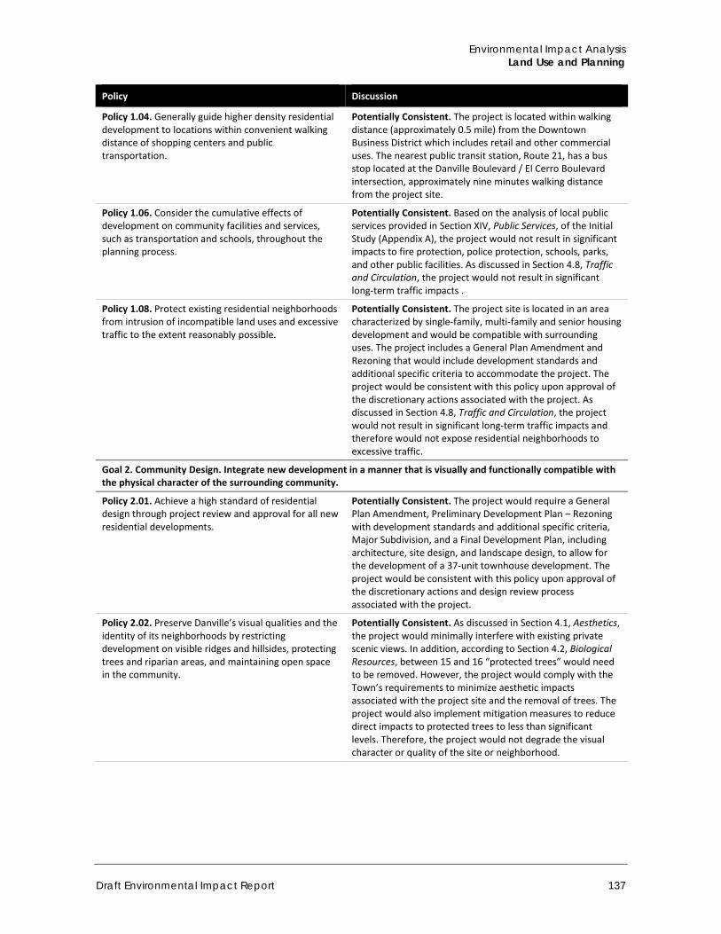
Environmental Impact Analysis Land Use and Planning
Draft Environmental Impact Report 137
Policy Discussion
Policy 1.04. Generally guide higher density residential development to locations within convenient walking distance of shopping centers and public transportation.
Potentially Consistent. The project is located within walking distance (approximately 0.5 mile) from the Downtown Business District which includes retail and other commercial uses. The nearest public transit station, Route 21, has a bus stop located at the Danville Boulevard / El Cerro Boulevard intersection, approximately nine minutes walking distance from the project site.
Policy 1.06. Consider the cumulative effects of development on community facilities and services, such as transportation and schools, throughout the planning process.
Potentially Consistent. Based on the analysis of local public services provided in Section XIV, Public Services, of the Initial Study (Appendix A), the project would not result in significant impacts to fire protection, police protection, schools, parks, and other public facilities. As discussed in Section 4.8, Traffic and Circulation, the project would not result in significant long-term traffic impacts .
Policy 1.08. Protect existing residential neighborhoods from intrusion of incompatible land uses and excessive traffic to the extent reasonably possible.
Potentially Consistent. The project site is located in an area characterized by single-family, multi-family and senior housing development and would be compatible with surrounding uses. The project includes a General Plan Amendment and Rezoning that would include development standards and additional specific criteria to accommodate the project. The project would be consistent with this policy upon approval of the discretionary actions associated with the project. As discussed in Section 4.8, Traffic and Circulation, the project would not result in significant long-term traffic impacts and therefore would not expose residential neighborhoods to excessive traffic.
Goal 2. Community Design. Integrate new development in a manner that is visually and functionally compatible with the physical character of the surrounding community.
Policy 2.01. Achieve a high standard of residential design through project review and approval for all new residential developments.
Potentially Consistent. The project would require a General Plan Amendment, Preliminary Development Plan – Rezoning with development standards and additional specific criteria, Major Subdivision, and a Final Development Plan, including architecture, site design, and landscape design, to allow for the development of a 37-unit townhouse development. The project would be consistent with this policy upon approval of the discretionary actions and design review process associated with the project.
Policy 2.02. Preserve Danville’s visual qualities and the identity of its neighborhoods by restricting development on visible ridges and hillsides, protecting trees and riparian areas, and maintaining open space in the community.
Potentially Consistent. As discussed in Section 4.1, Aesthetics, the project would minimally interfere with existing private scenic views. In addition, according to Section 4.2, Biological Resources, between 15 and 16 “protected trees” would need to be removed. However, the project would comply with the Town’s requirements to minimize aesthetic impacts associated with the project site and the removal of trees. The project would also implement mitigation measures to reduce direct impacts to protected trees to less than significant levels. Therefore, the project would not degrade the visual character or quality of the site or neighborhood.
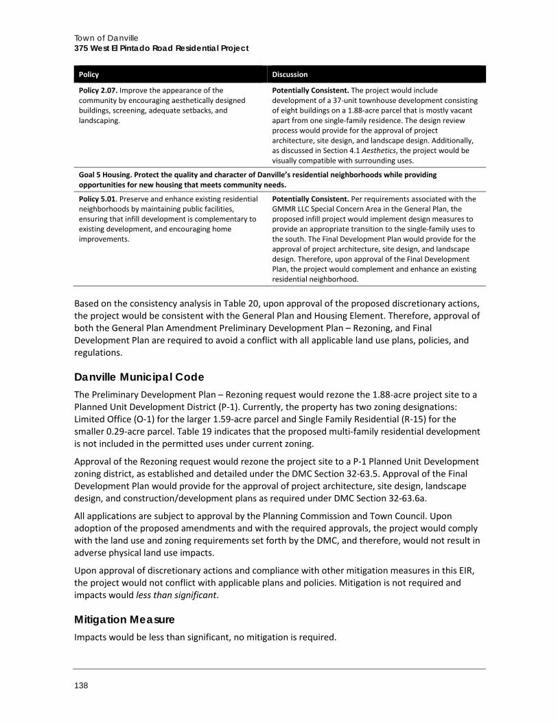
Town of Danville 375 West El Pintado Road Residential Project
138
Policy Discussion
Policy 2.07. Improve the appearance of the community by encouraging aesthetically designed buildings, screening, adequate setbacks, and landscaping.
Potentially Consistent. The project would include development of a 37-unit townhouse development consisting of eight buildings on a 1.88-acre parcel that is mostly vacant apart from one single-family residence. The design review process would provide for the approval of project architecture, site design, and landscape design. Additionally, as discussed in Section 4.1 Aesthetics, the project would be visually compatible with surrounding uses.
Goal 5 Housing. Protect the quality and character of Danville’s residential neighborhoods while providing opportunities for new housing that meets community needs.
Policy 5.01. Preserve and enhance existing residential neighborhoods by maintaining public facilities, ensuring that infill development is complementary to existing development, and encouraging home improvements.
Potentially Consistent. Per requirements associated with the GMMR LLC Special Concern Area in the General Plan, the proposed infill project would implement design measures to provide an appropriate transition to the single-family uses to the south. The Final Development Plan would provide for the approval of project architecture, site design, and landscape design. Therefore, upon approval of the Final Development Plan, the project would complement and enhance an existing residential neighborhood.
Based on the consistency analysis in Table 20, upon approval of the proposed discretionary actions, the project would be consistent with the General Plan and Housing Element. Therefore, approval of both the General Plan Amendment Preliminary Development Plan – Rezoning, and Final Development Plan are required to avoid a conflict with all applicable land use plans, policies, and regulations.
Danville Municipal Code The Preliminary Development Plan – Rezoning request would rezone the 1.88-acre project site to a Planned Unit Development District (P-1). Currently, the property has two zoning designations: Limited Office (O-1) for the larger 1.59-acre parcel and Single Family Residential (R-15) for the smaller 0.29-acre parcel. Table 19 indicates that the proposed multi-family residential development is not included in the permitted uses under current zoning.
Approval of the Rezoning request would rezone the project site to a P-1 Planned Unit Development zoning district, as established and detailed under the DMC Section 32-63.5. Approval of the Final Development Plan would provide for the approval of project architecture, site design, landscape design, and construction/development plans as required under DMC Section 32-63.6a.
All applications are subject to approval by the Planning Commission and Town Council. Upon adoption of the proposed amendments and with the required approvals, the project would comply with the land use and zoning requirements set forth by the DMC, and therefore, would not result in adverse physical land use impacts.
Upon approval of discretionary actions and compliance with other mitigation measures in this EIR, the project would not conflict with applicable plans and policies. Mitigation is not required and impacts would less than significant.
Mitigation Measure Impacts would be less than significant, no mitigation is required.
Environmental Impact Analysis Land Use and Planning
Draft Environmental Impact Report 139
c. Cumulative Impacts
Cumulative development in accordance with the Town’s General Plan would incrementally modify land use patterns and the general setting of the area. Pending and approved development in the Town of Danville includes two single-family residential developments (Podva Property and Magee Ranch) and a multi-family residential development (373-379 Diablo Road) within a two-mile radius of the project site. Planned cumulative development would incrementally increase overall development intensity throughout the area, while incrementally reducing the amount of undeveloped land. However, similar to the project, land use, and policy consistency impacts associated with individual projects would be addressed on a case-by-case basis to determine consistency with applicable plans and policies. Because projects are required to be consistent with Town plans and policies, significant cumulative land use impacts are not anticipated. Moreover, because the project’s impacts related to land use compatibility and consistency with local plans and goals would be less than significant without mitigation, the project’s contribution to cumulative land use impacts would also be less than significant.

Town of Danville 375 West El Pintado Road Residential Project
140
This page intentionally left blank.
Environmental Impact Analysis Noise
Draft Environmental Impact Report 141
4.7 Noise This section evaluates the project’s potential impact to local noise conditions. Both temporary construction noise and long-term noise generated by the project are evaluated.
4.7.1 Setting
a. Fundamentals of Sound, Environmental Noise, and Sound Measurement
Noise is unwanted sound that disturbs human activity. Environmental noise levels typically fluctuate over time, and different types of noise descriptors are used to account for this variability. Noise level (or volume) is generally measured in decibels (dB) using the A-weighted sound pressure level (dBA). The A-weighting scale is an adjustment to the actual sound power levels to be consistent with that of human hearing response, which is most sensitive to frequencies around 4,000 Hertz (about the highest note on a piano) and less sensitive to low frequencies (below 100 Hertz).
Sound pressure level is measured on a logarithmic scale with the 0 dBA level based on the lowest detectable sound pressure level that people can perceive (an audible sound that is not zero sound pressure level). Based on the logarithmic scale, a doubling of sound energy is equivalent to an increase of 3 dBA, and a sound that is 10 dBA less than the ambient sound level has no effect on ambient noise. Because of the nature of the human ear, a sound must be about 10 dBA greater than the reference sound to be judged as twice as loud. In general, a 3 dBA change in community noise levels is noticeable, while 1 to 2 dBA changes generally are not perceived. Quiet suburban areas typically have noise levels in the range of 40 to 50 dBA, while those along arterial streets are in the 50 to 60+ dBA range. Normal conversational levels are in the 60 to 65 dBA range, and ambient noise levels greater than 65 dBA can interrupt conversations. Table 21 illustrates representative noise levels for common outdoor and indoor activities.
Noise levels typically attenuate (or drop off) at a rate of 6 dBA per doubling of distance from point sources such as industrial machinery. Noise from lightly traveled roads typically attenuates at a rate of about 4.5 dBA per doubling of distance. Noise from heavily traveled roads typically attenuates at about 3 dBA per doubling of distance.
In addition to the actual instantaneous measurement of sound levels, the duration of sound is important since sounds that occur over a long period of time are more likely to be an annoyance or cause direct physical damage or environmental stress. One of the most frequently used noise metrics that considers both duration and sound power level is the equivalent noise level (Leq). The Leq is defined as the single steady A-weighted level that is equivalent to the same amount of energy as that contained in the actual fluctuating levels over a period of time (essentially, the average noise level). Typically, Leq is summed over a one-hour period.
The actual time period in which noise occurs is also important since noise that occurs at night tends to be more disturbing than that which occurs during the daytime. Two commonly used noise metrics – the Day-Night average level (Ldn) and the Community Noise Equivalent Level (CNEL) - recognize this fact by weighting hourly Leqs over a 24-hour period. The Ldn is a 24-hour average noise level that adds 10 dBA to actual nighttime (10:00 p.m. to 7:00 a.m.) noise levels to account for the greater sensitivity to noise during that time period. The CNEL is identical to the Ldn, except it also adds a 5 dBA penalty for noise occurring during the evening (7:00 p.m. to 10:00 p.m.). Noise levels described by Ldn and CNEL usually do not differ by more than 1 dBA.
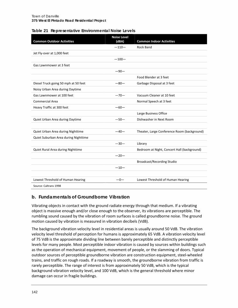
Town of Danville 375 West El Pintado Road Residential Project
142
Table 21 Representative Environmental Noise Levels
Common Outdoor Activities Noise Level
(dBA) Common Indoor Activities
—110— Rock Band
Jet Fly-over at 1,000 feet
—100—
Gas Lawnmower at 3 feet
—90—
Food Blender at 3 feet
Diesel Truck going 50 mph at 50 feet —80— Garbage Disposal at 3 feet
Noisy Urban Area during Daytime
Gas Lawnmower at 100 feet —70— Vacuum Cleaner at 10 feet
Commercial Area Normal Speech at 3 feet
Heavy Traffic at 300 feet —60—
Large Business Office
Quiet Urban Area during Daytime —50— Dishwasher in Next Room
Quiet Urban Area during Nighttime —40— Theater, Large Conference Room (background)
Quiet Suburban Area during Nighttime
—30— Library
Quiet Rural Area during Nighttime Bedroom at Night, Concert Hall (background)
—20—
Broadcast/Recording Studio
—10—
Lowest Threshold of Human Hearing —0— Lowest Threshold of Human Hearing
Source: Caltrans 1998
b. Fundamentals of Groundborne Vibration
Vibrating objects in contact with the ground radiate energy through that medium. If a vibrating object is massive enough and/or close enough to the observer, its vibrations are perceptible. The rumbling sound caused by the vibration of room surfaces is called groundborne noise. The ground motion caused by vibration is measured in vibration decibels (VdB).
The background vibration velocity level in residential areas is usually around 50 VdB. The vibration velocity level threshold of perception for humans is approximately 65 VdB. A vibration velocity level of 75 VdB is the approximate dividing line between barely perceptible and distinctly perceptible levels for many people. Most perceptible indoor vibration is caused by sources within buildings such as the operation of mechanical equipment, movement of people, or the slamming of doors. Typical outdoor sources of perceptible groundborne vibration are construction equipment, steel-wheeled trains, and traffic on rough roads. If a roadway is smooth, the groundborne vibration from traffic is rarely perceptible. The range of interest is from approximately 50 VdB, which is the typical background vibration velocity level, and 100 VdB, which is the general threshold where minor damage can occur in fragile buildings.
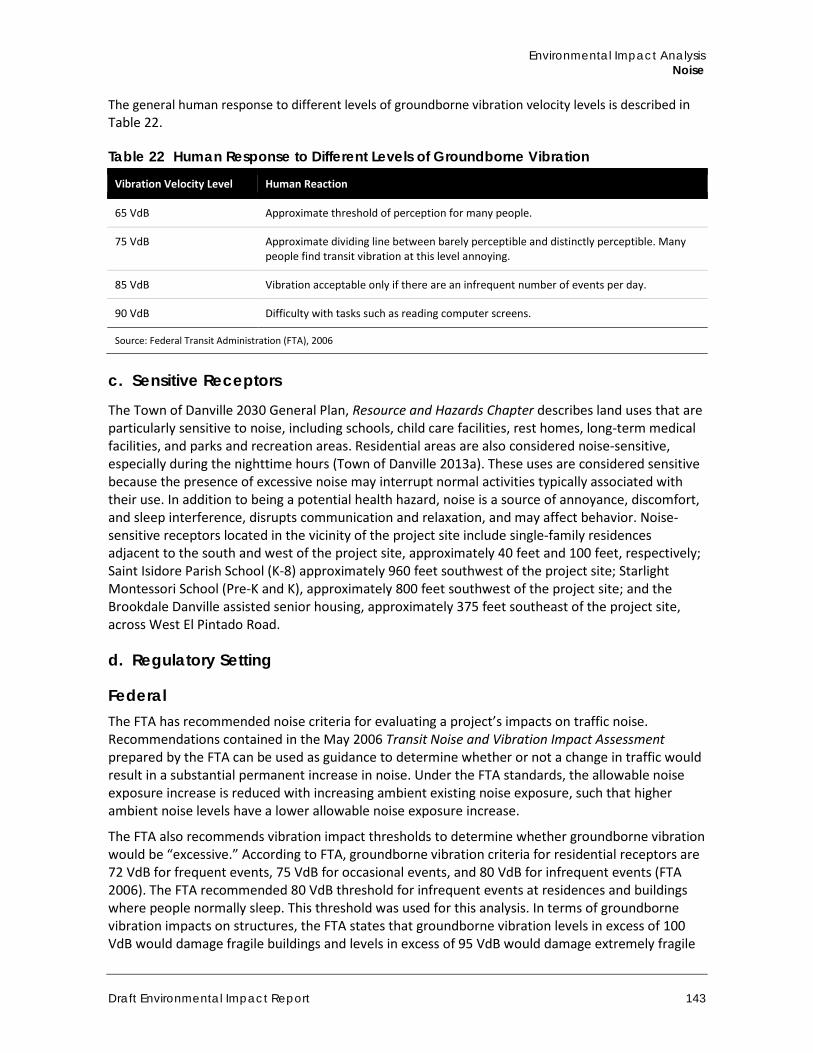
Environmental Impact Analysis Noise
Draft Environmental Impact Report 143
The general human response to different levels of groundborne vibration velocity levels is described in Table 22.
Table 22 Human Response to Different Levels of Groundborne Vibration
Vibration Velocity Level Human Reaction
65 VdB Approximate threshold of perception for many people.
75 VdB Approximate dividing line between barely perceptible and distinctly perceptible. Many people find transit vibration at this level annoying.
85 VdB Vibration acceptable only if there are an infrequent number of events per day.
90 VdB Difficulty with tasks such as reading computer screens.
Source: Federal Transit Administration (FTA), 2006
c. Sensitive Receptors
The Town of Danville 2030 General Plan, Resource and Hazards Chapter describes land uses that are particularly sensitive to noise, including schools, child care facilities, rest homes, long-term medical facilities, and parks and recreation areas. Residential areas are also considered noise-sensitive, especially during the nighttime hours (Town of Danville 2013a). These uses are considered sensitive because the presence of excessive noise may interrupt normal activities typically associated with their use. In addition to being a potential health hazard, noise is a source of annoyance, discomfort, and sleep interference, disrupts communication and relaxation, and may affect behavior. Noise-sensitive receptors located in the vicinity of the project site include single-family residences adjacent to the south and west of the project site, approximately 40 feet and 100 feet, respectively; Saint Isidore Parish School (K-8) approximately 960 feet southwest of the project site; Starlight Montessori School (Pre-K and K), approximately 800 feet southwest of the project site; and the Brookdale Danville assisted senior housing, approximately 375 feet southeast of the project site, across West El Pintado Road.
d. Regulatory Setting
Federal The FTA has recommended noise criteria for evaluating a project’s impacts on traffic noise. Recommendations contained in the May 2006 Transit Noise and Vibration Impact Assessment prepared by the FTA can be used as guidance to determine whether or not a change in traffic would result in a substantial permanent increase in noise. Under the FTA standards, the allowable noise exposure increase is reduced with increasing ambient existing noise exposure, such that higher ambient noise levels have a lower allowable noise exposure increase.
The FTA also recommends vibration impact thresholds to determine whether groundborne vibration would be “excessive.” According to FTA, groundborne vibration criteria for residential receptors are 72 VdB for frequent events, 75 VdB for occasional events, and 80 VdB for infrequent events (FTA 2006). The FTA recommended 80 VdB threshold for infrequent events at residences and buildings where people normally sleep. This threshold was used for this analysis. In terms of groundborne vibration impacts on structures, the FTA states that groundborne vibration levels in excess of 100 VdB would damage fragile buildings and levels in excess of 95 VdB would damage extremely fragile
Town of Danville 375 West El Pintado Road Residential Project
144
historic buildings. The threshold for this project is 80 VdB for infrequent events at residences and buildings where people normally sleep (e.g., existing single family residences located to the south and west, and an assisted living facility for seniors to the east).
State California Government Code §65302 encourages each local government entity to implement a noise element as part of its general plan. In addition, the California Governor’s Office of Planning and Research has developed Noise Element Guidelines (2017). The guidelines include recommendations for evaluating the compatibility of various land uses as a function of community noise exposure. These are the same standards adopted in the 2030 General Plan Resource and Hazards Element, as described below and shown in Table 23.
California Government Code §3501 requires interior noise levels from exterior noise sources be 45 dBA or less in any habitable room of a multi-residential use facility (e.g., hotels, motels, dormitories, long-term care facilities, and apartment houses and other dwellings, except detached single-family dwellings) with doors and windows closed. Measurements are based on CNEL or Ldn, whichever is consistent with the local general plan. Where exterior noise levels exceed 60 dBA CNEL or Ldn, an acoustical analysis for new development is required to show that the proposed construction will reduce interior noise levels to 45 dBA CNEL or Ldn. If the interior 45 dBA CNEL or Ldn limit can be achieved only with the windows closed, the building design must include mechanical ventilation that meets applicable Uniform Building Code requirements.
Town of Danville Noise Policies and Regulations
2030 General Plan The Town of Danville adopted the 2030 General Plan on March 19, 2013 (Town of Danville 2013a). The Resource and Hazards Chapter, is divided into four parts: Natural Resources, Hazards, Sustainability and Greenhouse Gas Reduction, and Implementation. Within the hazards part, there is a description of noise sources, depiction of existing (2011) and future (2030) traffic noise level contours, a land use compatibility guideline for exterior noise levels, and incorporates comprehensive goals, policies, and implementing measures. The Resource and Hazards Chapter includes several policies on noise that address acceptable noise level guidelines for new residential development projects and existing residential uses, construction activity, outdoor concerts and community events; and recommend locating noise-sensitive land uses away from noise sources, or require appropriate screening. Figure 26 of the Resource and Hazards Chapter establishes land use compatibility categories for community exterior noise exposure, as replicated in Table 23. The “normally acceptable” noise level range for low density, single-family, duplex, and mobile home residential land uses is between 50-60 dBA Ldn; 50-65 dBA Ldn for multi-family residential land uses; 50-70 dBA Ldn for schools, libraries, churches, hospitals, and nursing homes; and 50-70 dBA Ldn for office buildings, commercial and professional uses. These guidelines are applicable to new development proposed under the project and to the existing uses in the surrounding area. See Subsection 4.7.2(a) Methodology and Significance Thresholds, for a discussion of the applicability of these guidelines as thresholds of significance.
The 2030 General Plan, Resource and Hazards Chapter (Figure 24, Noise Contours 2012) shows the project site located within the 65-75 Leq dBA contour of major thoroughfares (namely I-680), and adjacent to the 75-85 Leq dBA contour along the northeast boundary of the site, along West El Pintado Road. Figure 25, Noise Contours (2030), of the 2030 General Plan, Resource and Hazards
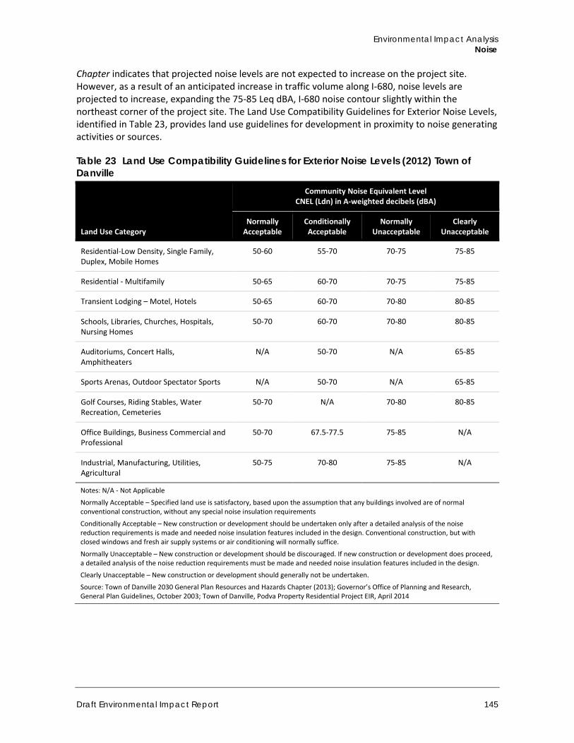
Environmental Impact Analysis Noise
Draft Environmental Impact Report 145
Chapter indicates that projected noise levels are not expected to increase on the project site. However, as a result of an anticipated increase in traffic volume along I-680, noise levels are projected to increase, expanding the 75-85 Leq dBA, I-680 noise contour slightly within the northeast corner of the project site. The Land Use Compatibility Guidelines for Exterior Noise Levels, identified in Table 23, provides land use guidelines for development in proximity to noise generating activities or sources.
Table 23 Land Use Compatibility Guidelines for Exterior Noise Levels (2012) Town of Danville
Land Use Category
Community Noise Equivalent Level CNEL (Ldn) in A-weighted decibels (dBA)
Normally Acceptable
Conditionally Acceptable
Normally Unacceptable
Clearly Unacceptable
Residential-Low Density, Single Family, Duplex, Mobile Homes
50-60 55-70 70-75 75-85
Residential - Multifamily 50-65 60-70 70-75 75-85
Transient Lodging – Motel, Hotels 50-65 60-70 70-80 80-85
Schools, Libraries, Churches, Hospitals, Nursing Homes
50-70 60-70 70-80 80-85
Auditoriums, Concert Halls, Amphitheaters
N/A 50-70 N/A 65-85
Sports Arenas, Outdoor Spectator Sports N/A 50-70 N/A 65-85
Golf Courses, Riding Stables, Water Recreation, Cemeteries
50-70 N/A 70-80 80-85
Office Buildings, Business Commercial and Professional
50-70 67.5-77.5 75-85 N/A
Industrial, Manufacturing, Utilities, Agricultural
50-75 70-80 75-85 N/A
Notes: N/A - Not Applicable
Normally Acceptable – Specified land use is satisfactory, based upon the assumption that any buildings involved are of normal conventional construction, without any special noise insulation requirements
Conditionally Acceptable – New construction or development should be undertaken only after a detailed analysis of the noise reduction requirements is made and needed noise insulation features included in the design. Conventional construction, but with closed windows and fresh air supply systems or air conditioning will normally suffice.
Normally Unacceptable – New construction or development should be discouraged. If new construction or development does proceed, a detailed analysis of the noise reduction requirements must be made and needed noise insulation features included in the design.
Clearly Unacceptable – New construction or development should generally not be undertaken.
Source: Town of Danville 2030 General Plan Resources and Hazards Chapter (2013); Governor’s Office of Planning and Research, General Plan Guidelines, October 2003; Town of Danville, Podva Property Residential Project EIR, April 2014
Town of Danville 375 West El Pintado Road Residential Project
146
In addition, the 2030 General Plan Resources and Hazards Chapter provides the following goal and policies pertaining to noise that are applicable to the project (Town of Danville 2013a):
Goal 27: Protect existing and future residents of Danville from hazards and nuisance associated with excessive levels of noise by maintaining or reducing noise intrusion levels in all areas of the Town to acceptable levels.
Policy 27.01: Ensure that new residential development projects meet acceptable noise level guidelines, as shown in Figure 26. (Figure 26 is Table 23 in this EIR.)
If an area currently meets desired noise standards, an increase up to the maximum acceptable noise level should not necessarily be allowed. The potential for a project to have adverse noise impacts should be evaluated based on the potential for adverse community response, regardless of the compatibility guidelines.
Policy 27.02: Require acoustical studies for major residential and other development projects, as appropriate, and impose noise mitigation measures accordingly.
Policy 27.03: Protect the noise environment in existing residential areas. Where acceptable noise levels in residential areas (as shown in Figure 5and Figure 6, Land Use) would be exceeded or further impacted as a result of new development or transportation improvements, require the use of noise mitigation measures, such as wall barriers, berms, mufflers, sound traps, and baffles to reduce noise intrusion.
Policy 27.04: Encourage the location of noise-sensitive land uses away from noise sources or require appropriate noise screening.
Policy 27.09: Generally maintain exterior noise levels below 60 Ldn in areas where outdoor use is a major consideration, such as in residential backyards. Where the Town determines that this level cannot be achieved after reasonable mitigation has been applied, higher standards may be permitted at the discretion of the Town Council. In such cases, indoor noise levels should not exceed an Ldn of 45 dB.
Development sites exposed to noise levels exceeding 60 Ldn shall be analyzed following protocols in Appendix Chapter 12, Section 1207 Sound Transmission of the 2010 California Building Code (or the latest revision).
Policy 27.11: Ensure the design of new development near major noise sources (such as I-680) reduces the potential for future occupants to be exposed to high levels of noise. Development on such properties should incorporate appropriate noise mitigation measures.
Policy 27.12: Require the preparation of groundborne vibration studies by qualified professionals in accordance with industry-accepted methodology where heavy construction activities involving significant site grading, underground, or foundation work will occur within 50 feet of residential or other vibration sensitive uses.
Vibration studies may also be required for projects involving significant increases in the operation of heavy vehicles such as trucks and buses. Applicable and feasible vibration reduction measures shall be incorporated into project plans.
Environmental Impact Analysis Noise
Draft Environmental Impact Report 147
Policy 27.13: Utilize noise reduction measures during all phases of construction activity to minimize the exposure of neighboring properties to excessive noise levels.
Construction activities are required to comply with the Town’s noise ordinance limitations on hours and days of operations.
Danville Municipal Code To implement the Town’s noise policies, the Town adopted a Noise Ordinance within the DMC. The Noise Ordinance is within Chapter IV, Police Regulations, Section 4-2, Noise Control. The Town of Danville Noise Ordinance within Subsection 4-2.1, Findings and Declaration of Intent, the Town Council finds that, “…the citizens of Danville require protection from excessive, unnecessary, annoying and unreasonable noises from any and all controllable noise sources.”
The Noise Ordinance has no quantitative standards for noise levels, but restricts loud, unnecessary or unusual noise within the town limits, which disturbs the peace or quiet of a neighborhood or that causes discomfort or annoyance to a reasonable person of normal sensitiveness residing in the area (DMC Section 4-2.3). As described in Section 4-2.3 General Noise Regulations, standards that should be considered when determining whether a violation of the Noise Ordinance exists include, but are not limited, to the following:
1. The volume of the noise 2. Whether the nature of the noise is usual or unusual 3. The proximity of the noise to residential sleeping facilities 4. The nature and zoning of the area within which the noise emanates 5. The time of day or night the noise occurs 6. The duration of the noise 7. Whether the noise is continuous, recurrent or intermittent 8. Whether the noise is produced by a commercial or non-commercial activity 9. The number of persons in the neighborhood who have complained of the noise
In addition, Subsection 4-2.4 Prohibitions explains that it is unlawful for a person to do any of the following acts:
a. Operate or play a radio, television set, stereo, phonograph, receiving set, tape or compact disk player, jukebox, musical instrument or similar device between 10:00 p.m. and 8:00 a.m. in such a manner as to be plainly audible at a distance of 50 feet from the building, structure or vehicle from which it is located or a distance of 50 feet from the device if outside
b. Create noise on a street, sidewalk or public place adjacent to a school or church while in use or to a hospital if the noise unreasonably interferes with the working of the institution or the peace or quiet of a hospital patient
c. Operate machinery, equipment, or a pump, fan, air-conditioner, spa or pool equipment, power tool, lawn mower or leaf blower or engine in a manner which causes excessive noise to nearby residents between the hours of 10:00 p.m. and 8:00 a.m.
d. Operate or perform construction or repair work (which creates noise) within or adjacent to a residential land use district except during the following hours: Monday through Friday: 7:30 a.m. to 7:00 p.m. Saturdays, Sundays and holidays: 9:00 a.m. to 7:00 p.m.
Town of Danville 375 West El Pintado Road Residential Project
148
e. Install, use or operate a loudspeaker or sound-amplifying equipment in a fixed or movable position or mounted on a sound truck for the purpose of transmitting sound to a person in or on a street, sidewalk, park or public property without a permit obtained under subsection 4-2.5 [Exception Permits, Permit for Sound-Amplifying Equipment]
e. Existing Noise Conditions and Sources
Town of Danville The predominant noise sources in the Town originate from automobile traffic on the I-680 freeway and major thoroughfares (Town of Danville 2013a). Motor vehicle noise is of concern because it is characterized by a high number of individual events that often create a sustained noise level. I-680 is the most significant source of traffic noise and due to its size and traffic levels, also affects more distant receptors. Major arterials, including Sycamore Valley Road, Crow Canyon Road, Camino Tassajara, Diablo Road, El Cerro Boulevard, Danville Boulevard, and others are the major noise sources for land uses adjacent to these roadways (Town of Danville 2012). The closest roadways to the project site include I-680, with the centerline approximately 370 feet from the project site; El Cerro Boulevard, with the centerline approximately 370 feet from the project site; and West El Pintado Road along the eastern project boundary.
There are no known stationary noise sources that make a significant contribution to Danville’s noise environment. The majority of commercial and retail land-uses within Danville are located in the Downtown area along Danville Boulevard, west of I-680. These may be a minor contributor to the noise environment, but I-680 and major arterial roadways constitute a much more significant contribution (Town of Danville 2012).
The nearest airport to the project site is Little Hands Airport, located at 18320 Bolinger Canyon Road, approximately 2.3 miles west-southwest of the project site, within Contra Costa County. The Little Hands Airport is a privately-owned airport that operates using a 1,320-foot by 50-foot dirt airstrip, located south of the ridgelines of Las Trampas Regional Wilderness (Airport-Data.com). Due to the high terrain of the ridgelines and the small, private aircrafts taking off and landing from the site, noise from these occurrences would likely not be audible from the project site.
Project Site and Vicinity The main noise sources in the project vicinity are motor vehicles on adjacent and nearby roadways, including I-680 and West El Pintado Road. The primary sources of roadway noise near the project site are automobiles traveling the I-680 northeast of the project site, El Cerro Boulevard north and in the vicinity of the project site, as well as West El Pintado Road adjacent to the site along the eastern boundary.
On-Site Noise Level Readings In order to establish the existing noise conditions, sound level readings were taken by Rincon Consultants, Inc. staff at three locations on or near the project site using an ANSI Type II integrating sound level meter in accordance with standard protocols on February 10, 2016. Three 15-minute noise level measurements were collected during morning peak traffic conditions (between 8:00 a.m. and 9:30 a.m.), and provide an estimate of the general noise environment in the project vicinity. The measurement locations are shown in Figure 17 and noise measurement data can be found in Appendix G. Locations were selected along the most heavily traveled roadways to represent the highest noise levels associated with the roadways adjacent to the project site. Table 24 identifies
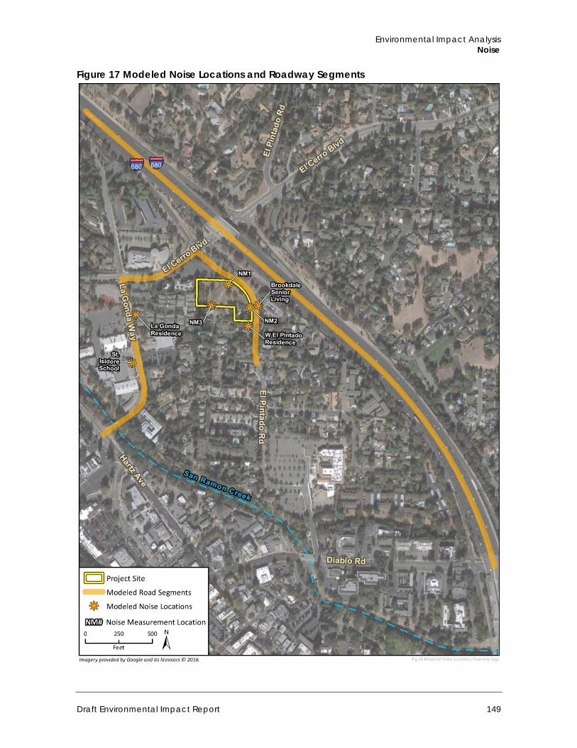
Environmental Impact Analysis Noise
Draft Environmental Impact Report 149
Figure 17 Modeled Noise Locations and Roadway Segments
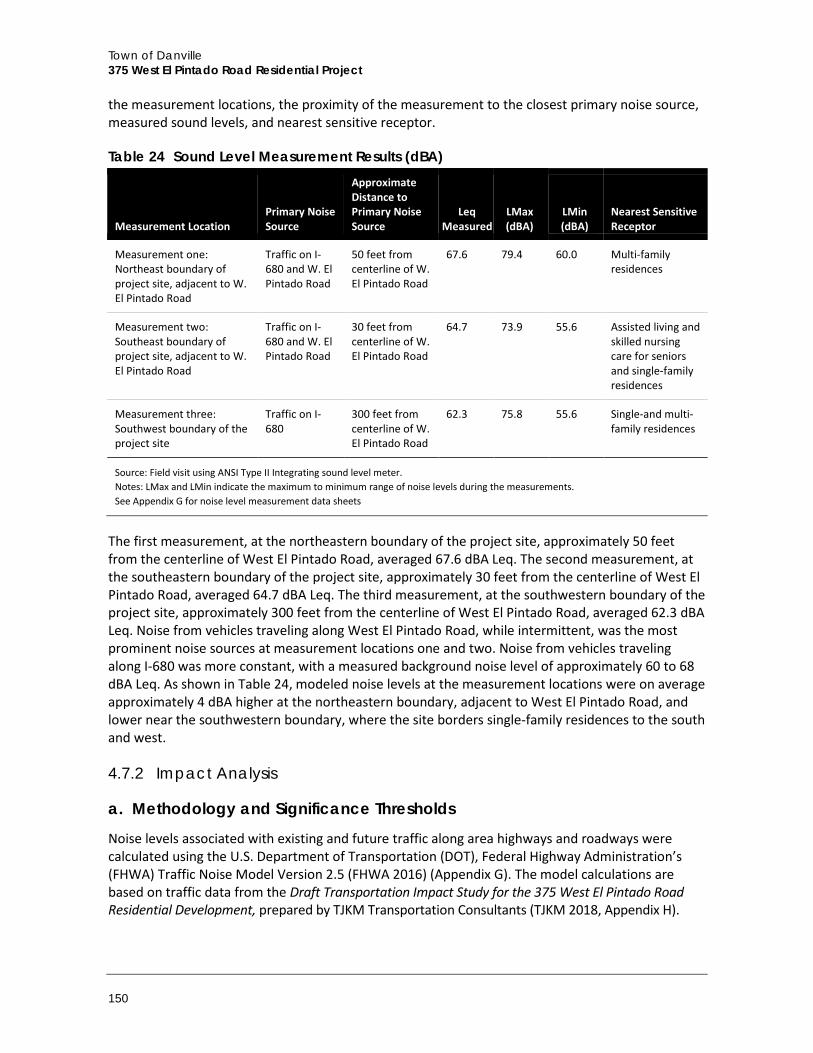
Town of Danville 375 West El Pintado Road Residential Project
150
the measurement locations, the proximity of the measurement to the closest primary noise source, measured sound levels, and nearest sensitive receptor.
Table 24 Sound Level Measurement Results (dBA)
Measurement Location Primary Noise Source
Approximate Distance to Primary Noise Source
Leq Measured
LMax (dBA)
LMin (dBA)
Nearest Sensitive Receptor
Measurement one: Northeast boundary of project site, adjacent to W. El Pintado Road
Traffic on I-680 and W. El Pintado Road
50 feet from centerline of W. El Pintado Road
67.6 79.4 60.0 Multi-family residences
Measurement two: Southeast boundary of project site, adjacent to W. El Pintado Road
Traffic on I-680 and W. El Pintado Road
30 feet from centerline of W. El Pintado Road
64.7 73.9 55.6 Assisted living and skilled nursing care for seniors and single-family residences
Measurement three: Southwest boundary of the project site
Traffic on I-680
300 feet from centerline of W. El Pintado Road
62.3 75.8 55.6 Single-and multi-family residences
Source: Field visit using ANSI Type II Integrating sound level meter. Notes: LMax and LMin indicate the maximum to minimum range of noise levels during the measurements. See Appendix G for noise level measurement data sheets
The first measurement, at the northeastern boundary of the project site, approximately 50 feet from the centerline of West El Pintado Road, averaged 67.6 dBA Leq. The second measurement, at the southeastern boundary of the project site, approximately 30 feet from the centerline of West El Pintado Road, averaged 64.7 dBA Leq. The third measurement, at the southwestern boundary of the project site, approximately 300 feet from the centerline of West El Pintado Road, averaged 62.3 dBA Leq. Noise from vehicles traveling along West El Pintado Road, while intermittent, was the most prominent noise sources at measurement locations one and two. Noise from vehicles traveling along I-680 was more constant, with a measured background noise level of approximately 60 to 68 dBA Leq. As shown in Table 24, modeled noise levels at the measurement locations were on average approximately 4 dBA higher at the northeastern boundary, adjacent to West El Pintado Road, and lower near the southwestern boundary, where the site borders single-family residences to the south and west.
4.7.2 Impact Analysis
a. Methodology and Significance Thresholds
Noise levels associated with existing and future traffic along area highways and roadways were calculated using the U.S. Department of Transportation (DOT), Federal Highway Administration’s (FHWA) Traffic Noise Model Version 2.5 (FHWA 2016) (Appendix G). The model calculations are based on traffic data from the Draft Transportation Impact Study for the 375 West El Pintado Road Residential Development, prepared by TJKM Transportation Consultants (TJKM 2018, Appendix H).
Environmental Impact Analysis Noise
Draft Environmental Impact Report 151
Significance Thresholds Pursuant to Appendix G of the CEQA Guidelines, significant noise impacts would occur if the project would result in any of the following conditions:
A. Exposure of persons to or generation of noise levels in excess of standards established in the local general plan or noise ordinance, or applicable standards of other agencies
B. Exposure of persons to or generation of excessive ground-borne vibration or ground-borne noise levels
C. A substantial permanent increase in ambient noise levels in the project vicinity above levels existing without the project
D. A substantial temporary or periodic increase in ambient noise levels in the project vicinity above levels existing without the project
E. For a project located within an airport land use plan or, where such a plan has not been adopted, within two miles of a public airport or public use airport, expose people residing or working in the project area to excessive noise levels
F. For a project within the vicinity of a private airstrip, expose people residing or working in the project area to excessive noise levels
Based on the analysis from the Initial Study (Appendix A), checklist questions A, B, C, and D were determined to have a potential impact, and will be discussed in this EIR. Checklist items E and F were found to have no impact because the project site is not located within two miles of a public or private airport, and would therefore not expose residents or workers to excessive noise levels from airport or private airstrip operations. Therefore, checklist items E and F are not discussed further in this EIR.
The quantitative standards used are as follows:
The standards identified in Table 23 and the General Plan, Resources and Hazards Policies 27.01 and 27.09, shown above, require that low-density residential uses not be exposed to exterior noise levels exceeding 60 dBA Ldn to be considered “normally acceptable”. However, the construction of residences that would be exposed to noise ranging from 55-70 dBA Ldn is considered “conditionally acceptable” with a detailed analysis of the noise reduction requirements and noise mitigation included in the design to ensure that indoor noise levels not exceed 45 dBA Ldn.
Recommendations contained in the Transit Noise and Vibration Impact Assessment (FTA 2006) are used to determine whether increases in noise generated by this project would be unacceptable. With these standards, the allowable noise exposure increase is reduced with increasing ambient existing noise exposure, such that higher ambient noise levels have a lower allowable noise exposure increase. Table 25 below shows the significance thresholds for increases in traffic-related noise levels caused by the project.
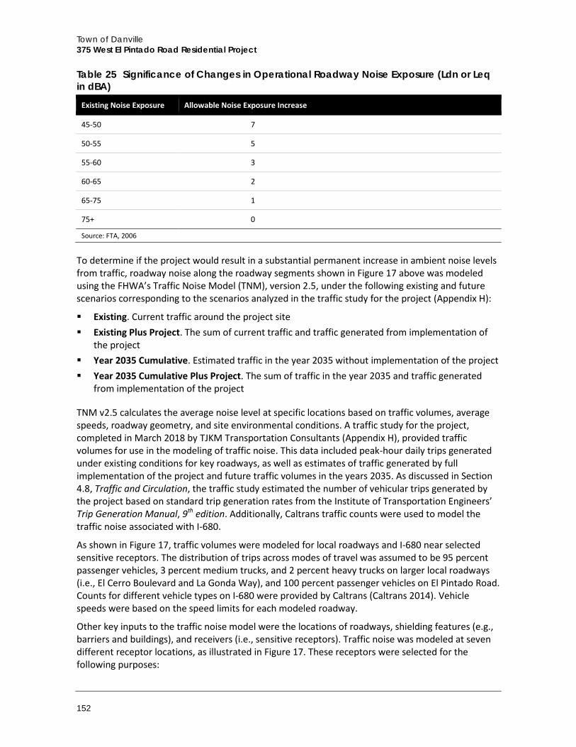
Town of Danville 375 West El Pintado Road Residential Project
152
Table 25 Significance of Changes in Operational Roadway Noise Exposure (Ldn or Leq in dBA)
Existing Noise Exposure Allowable Noise Exposure Increase
45-50 7
50-55 5
55-60 3
60-65 2
65-75 1
75+ 0
Source: FTA, 2006
To determine if the project would result in a substantial permanent increase in ambient noise levels from traffic, roadway noise along the roadway segments shown in Figure 17 above was modeled using the FHWA’s Traffic Noise Model (TNM), version 2.5, under the following existing and future scenarios corresponding to the scenarios analyzed in the traffic study for the project (Appendix H):
Existing. Current traffic around the project site Existing Plus Project. The sum of current traffic and traffic generated from implementation of
the project Year 2035 Cumulative. Estimated traffic in the year 2035 without implementation of the project Year 2035 Cumulative Plus Project. The sum of traffic in the year 2035 and traffic generated
from implementation of the project
TNM v2.5 calculates the average noise level at specific locations based on traffic volumes, average speeds, roadway geometry, and site environmental conditions. A traffic study for the project, completed in March 2018 by TJKM Transportation Consultants (Appendix H), provided traffic volumes for use in the modeling of traffic noise. This data included peak-hour daily trips generated under existing conditions for key roadways, as well as estimates of traffic generated by full implementation of the project and future traffic volumes in the years 2035. As discussed in Section 4.8, Traffic and Circulation, the traffic study estimated the number of vehicular trips generated by the project based on standard trip generation rates from the Institute of Transportation Engineers’ Trip Generation Manual, 9th edition. Additionally, Caltrans traffic counts were used to model the traffic noise associated with I-680.
As shown in Figure 17, traffic volumes were modeled for local roadways and I-680 near selected sensitive receptors. The distribution of trips across modes of travel was assumed to be 95 percent passenger vehicles, 3 percent medium trucks, and 2 percent heavy trucks on larger local roadways (i.e., El Cerro Boulevard and La Gonda Way), and 100 percent passenger vehicles on El Pintado Road. Counts for different vehicle types on I-680 were provided by Caltrans (Caltrans 2014). Vehicle speeds were based on the speed limits for each modeled roadway.
Other key inputs to the traffic noise model were the locations of roadways, shielding features (e.g., barriers and buildings), and receivers (i.e., sensitive receptors). Traffic noise was modeled at seven different receptor locations, as illustrated in Figure 17. These receptors were selected for the following purposes:
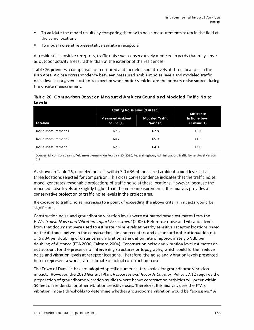
Environmental Impact Analysis Noise
Draft Environmental Impact Report 153
To validate the model results by comparing them with noise measurements taken in the field at the same locations
To model noise at representative sensitive receptors
At residential sensitive receptors, traffic noise was conservatively modeled in yards that may serve as outdoor activity areas, rather than at the exterior of the residences.
Table 26 provides a comparison of measured and modeled sound levels at three locations in the Plan Area. A close correspondence between measured ambient noise levels and modeled traffic noise levels at a given location is expected when motor vehicles are the primary noise source during the on-site measurement.
Table 26 Comparison Between Measured Ambient Sound and Modeled Traffic Noise Levels
Location
Existing Noise Level (dBA Leq) Difference
in Noise Level (2 minus 1)
Measured Ambient Sound (1)
Modeled Traffic Noise (2)
Noise Measurement 1 67.6 67.8 +0.2
Noise Measurement 2 64.7 65.9 +1.2
Noise Measurement 3 62.3 64.9 +2.6
Sources: Rincon Consultants, field measurements on February 10, 2016; Federal Highway Administration, Traffic Noise Model Version 2.5
As shown in Table 26, modeled noise is within 3.0 dBA of measured ambient sound levels at all three locations selected for comparison. This close correspondence indicates that the traffic noise model generates reasonable projections of traffic noise at these locations. However, because the modeled noise levels are slightly higher than the noise measurements, this analysis provides a conservative projection of traffic noise levels in the project area.
If exposure to traffic noise increases to a point of exceeding the above criteria, impacts would be significant.
Construction noise and groundborne vibration levels were estimated based estimates from the FTA’s Transit Noise and Vibration Impact Assessment (2006). Reference noise and vibration levels from that document were used to estimate noise levels at nearby sensitive receptor locations based on the distance between the construction site and receptors and a standard noise attenuation rate of 6 dBA per doubling of distance and vibration attenuation rate of approximately 6 VdB per doubling of distance (FTA 2006, Caltrans 2004). Construction noise and vibration level estimates do not account for the presence of intervening structures or topography, which could further reduce noise and vibration levels at receptor locations. Therefore, the noise and vibration levels presented herein represent a worst-case estimate of actual construction noise.
The Town of Danville has not adopted specific numerical thresholds for groundborne vibration impacts. However, the 2030 General Plan, Resources and Hazards Chapter, Policy 27.12 requires the preparation of groundborne vibration studies where heavy construction activities will occur within 50 feet of residential or other vibration sensitive uses. Therefore, this analysis uses the FTA’s vibration impact thresholds to determine whether groundborne vibration would be “excessive.” A
Town of Danville 375 West El Pintado Road Residential Project
154
vibration velocity level of 75 VdB is the approximate dividing line between barely perceptible and distinctly perceptible levels, where many people find transit vibration at this level annoying.
Consequently, the FTA recommends a 72 VdB threshold for frequent events at residences and buildings where people normally sleep (e.g., the residences 40 to 100 feet south and west of the project site). The FTA does not consider most commercial and industrial uses to be noise-sensitive (except for those that depend on quiet as an important part of operations, such as sound recording studios) and therefore does not recommend thresholds for groundborne vibration impacts to such uses. In terms of groundborne vibration impacts on structures, the FTA states that groundborne vibration levels in excess of 100 VdB would damage fragile buildings and levels in excess of 95 VdB would damage extremely fragile historic buildings.
b. Project Impacts
Threshold A: Would the project expose persons to or generation of noise levels in excess of standards established in the local general plan or noise ordinance, or applicable standards of other agencies?
Impact N-1 THE PROPOSED PROJECT WOULD INTRODUCE RESIDENTS TO THE PROJECT SITE THAT WOULD BE EXPOSED TO AMBIENT NOISE LEVELS IN THE TOWN’S “CONDITIONALLY ACCEPTABLE” RANGE. IMPACTS WOULD BE CLASS II, SIGNIFICANT BUT MITIGABLE.
Proposed residences on the project site would be exposed to traffic noise from nearby roadways including I-680 and West El Pintado Road to the northeast and El Cerro Boulevard to the north. As shown in on Table 24, existing noise on West El Pintado Road at the northeast boundary of the project site (Noise Measurement One) was measured at 67.6 dBA Leq and modeled at 67.8 dBA Leq. At the southeastern boundary of the project site (Noise Measurement Two), along West El Pintado Road, noise was measured at 64.7 dBA Leq and modeled at 65.9 dBA Leq. Existing noise at the southwestern boundary of the project site (Noise Measurement Three) was measured at 62.3 dBA Leq and modeled at 64.9 dBA Leq. Based on these existing noise levels, the proposed townhomes would be exposed to the Town’s “conditionally acceptable” range of exterior noise between 55 and 70 dBA Ldn for low-density residential uses. This category requires that new construction or development be undertaken after a detailed analysis of the noise reduction requirements is made and needed noise insulation features are included in the design. It then states that conventional construction, but with closed windows and fresh air supply systems or air conditioning, would normally suffice. For interior noise, standard modern building materials would reduce exterior-to-interior noise by approximately 25 dBA with windows closed. Therefore, traffic noise impacts to proposed residences would be less than significant with mitigation to provide adequate air ventilation with closed windows.
Mitigation Measure Mitigation Measure N-1 is required to reduce interior noise levels at the proposed townhomes while ensuring adequate air ventilation.
N-1 Interior Noise At a minimum, all on-site structures shall include the following to achieve an acceptable interior noise level:
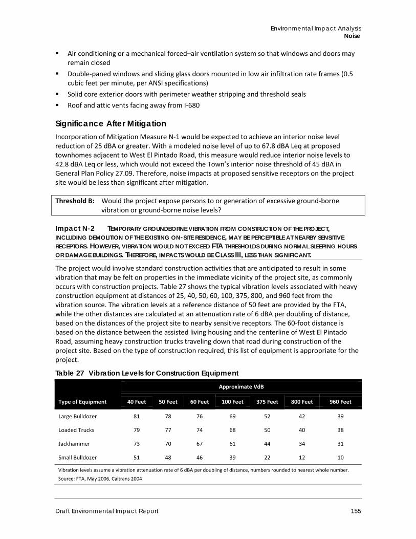
Environmental Impact Analysis Noise
Draft Environmental Impact Report 155
Air conditioning or a mechanical forced–air ventilation system so that windows and doors may remain closed
Double-paned windows and sliding glass doors mounted in low air infiltration rate frames (0.5 cubic feet per minute, per ANSI specifications)
Solid core exterior doors with perimeter weather stripping and threshold seals Roof and attic vents facing away from I-680
Significance After Mitigation Incorporation of Mitigation Measure N-1 would be expected to achieve an interior noise level reduction of 25 dBA or greater. With a modeled noise level of up to 67.8 dBA Leq at proposed townhomes adjacent to West El Pintado Road, this measure would reduce interior noise levels to 42.8 dBA Leq or less, which would not exceed the Town’s interior noise threshold of 45 dBA in General Plan Policy 27.09. Therefore, noise impacts at proposed sensitive receptors on the project site would be less than significant after mitigation.
Threshold B: Would the project expose persons to or generation of excessive ground-borne vibration or ground-borne noise levels?
Impact N-2 TEMPORARY GROUNDBORNE VIBRATION FROM CONSTRUCTION OF THE PROJECT, INCLUDING DEMOLITION OF THE EXISTING ON-SITE RESIDENCE, MAY BE PERCEPTIBLE AT NEARBY SENSITIVE RECEPTORS. HOWEVER, VIBRATION WOULD NOT EXCEED FTA THRESHOLDS DURING NORMAL SLEEPING HOURS OR DAMAGE BUILDINGS. THEREFORE, IMPACTS WOULD BE CLASS III, LESS THAN SIGNIFICANT.
The project would involve standard construction activities that are anticipated to result in some vibration that may be felt on properties in the immediate vicinity of the project site, as commonly occurs with construction projects. Table 27 shows the typical vibration levels associated with heavy construction equipment at distances of 25, 40, 50, 60, 100, 375, 800, and 960 feet from the vibration source. The vibration levels at a reference distance of 50 feet are provided by the FTA, while the other distances are calculated at an attenuation rate of 6 dBA per doubling of distance, based on the distances of the project site to nearby sensitive receptors. The 60-foot distance is based on the distance between the assisted living housing and the centerline of West El Pintado Road, assuming heavy construction trucks traveling down that road during construction of the project site. Based on the type of construction required, this list of equipment is appropriate for the project.
Table 27 Vibration Levels for Construction Equipment
Type of Equipment
Approximate VdB
40 Feet 50 Feet 60 Feet 100 Feet 375 Feet 800 Feet 960 Feet
Large Bulldozer 81 78 76 69 52 42 39
Loaded Trucks 79 77 74 68 50 40 38
Jackhammer 73 70 67 61 44 34 31
Small Bulldozer 51 48 46 39 22 12 10
Vibration levels assume a vibration attenuation rate of 6 dBA per doubling of distance, numbers rounded to nearest whole number.
Source: FTA, May 2006, Caltrans 2004
Town of Danville 375 West El Pintado Road Residential Project
156
The primary sources of man-made vibration are blasting, grading, pavement breaking, and demolition. The primary vibratory source during construction within the project area would likely be large bulldozers and loaded trucks. As shown in Table 27, typical large bulldozer or loaded truck activities generate an approximate vibration level of 79-81 VdB at a distance of 40 feet. Vibration levels in excess of 80 VdB typically result in annoyance. As such, existing residences and other sensitive receptors in close proximity to construction activities may intermittently be disturbed by nuisance vibration noise levels.
Based on the information presented in Table 27, temporary groundborne vibration could affect sensitive noise receptors near the project site, particularly the single-family residences west and south of the project site at approximately 40 to 100 feet distance and senior assisted living facility east of the project site at approximately 60 feet distance from the centerline of West El Pintado Road. Vibration levels could temporarily and intermittently reach up to approximately 81 VdB at the nearest sensitive receptors, which would exceed the standard perceivable threshold of 75 VdB shown in Table 22 above. However, compliance with Subsection 4-2.4(d) of the Town’s Noise Ordinance would prohibit construction activities during recognized hours of sleep, limiting construction between the hours of 7:30 a.m. to 7:00 p.m., Monday through Friday, and 9:00 a.m. to 7:00 p.m. Saturday, Sunday, and holidays. Therefore, sensitive receptors would not be exposed to groundborne vibration exceeding the FTA’s velocity threshold level of 72 VdB for residences during normal sleep hours. Furthermore, vibration levels would not exceed 100 VdB, which is the general threshold where minor damage can occur in fragile buildings. Therefore, vibration impacts would be less than significant.
Mitigation Measures Impacts would be less than significant, no mitigation is required.
Threshold C: Would the project create a substantial permanent increase in ambient noise levels in the project vicinity above levels existing without the project?
Impact N-3 THE PROPOSED TOWNHOMES WOULD GENERATE ON-SITE NOISE OPERATIONAL NOISE TYPICAL OF RESIDENTIAL USES AND CONSISTENT WITH EXISTING NOISE AT SURROUNDING RESIDENTIAL USES. PROJECT-GENERATED VEHICLE TRIPS WOULD INCREMENTALLY INCREASE TRAFFIC-RELATED NOISE HEARD BY LOCAL RESIDENTS UNDER EXISTING PLUS PROJECT AND FUTURE CUMULATIVE PLUS PROJECT CONDITIONS. HOWEVER, THE CHANGE IN NOISE LEVELS WOULD NOT EXCEED FTA THRESHOLDS. THEREFORE, THE EFFECT OF INCREASED TRAFFIC NOISE ON EXISTING SENSITIVE RECEPTORS WOULD BE CLASS III, LESS THAN SIGNIFICANT.
On-Site Operational Noise The project would generate non-mobile operational noise that would be typical of residential uses, including periodic instantaneous sounds such as conversations, music, general vehicular movement, and doors slamming. These noises produced by the project would be similar in character to the existing noise environment associated with surrounding residential uses. The noise associated with the operation of the proposed residential uses would not substantially impact the existing sensitive receptors in the vicinity of the project.
The level of noise at nearby residences from music on balconies and patios at nearby residences would depend on the volume the music is being played. Residents living in units with balconies and patios facing adjacent residences would be subject to the Town of Danville’s noise ordinance requirements, specifically Section 4-2.4 (a), which prohibits the operation of amplified sound (i.e.,
Environmental Impact Analysis Noise
Draft Environmental Impact Report 157
radio, television set, stereo, phonograph, receiving set, tape or compact disk player, jukebox, musical instrument or similar device) between 10:00 p.m. and 8:00 a.m. in such a manner as to be plainly audible at a distance of 50 feet from the building, structure or vehicle from which it is located or a distance of 50 feet from the device if outside. The level of noise from the operation of machinery would be subject to noise ordinance requirements in Section 4-2.4 (c), which prohibits the operation of equipment (i.e., machinery, equipment, or a pump, fan, air-conditioner, spa or pool equipment, power tool, lawn mower or leaf blower or engine in a manner that causes excessive noise to nearby residents between the hours of 10:00 p.m. and 8:00 a.m. Assuming compliance with Town of Danville noise regulations, impacts related to operational noise as heard by existing sensitive receptors near the site would be less than significant.
Traffic-Related Noise The project would increase the number of vehicle trips to and from the site, which would incrementally increase traffic noise on nearby roadways. The project could therefore incrementally increase noise at neighboring uses.
Table 28 compares noise levels at existing sensitive receptor locations near the project site under the existing and existing plus project traffic scenarios (TJKM 2018). As shown the table, noise levels would substantially decrease under the existing plus project scenario at Noise Measurement Three in the southwest part of the site , incrementally decrease at two locations (West El Pintado Residence and La Gonda Residence), stay the same at three locations (the northeast boundary of the project site [Noise Measurement One], the southeastern boundary of the project site [Noise Measurement Two], and St. Isidore School), and minimally increase at one location (Brookdale Senior Living). The greatest modeled decrease –would be 8.9 dBA at the existing receptor location at the southwest corner of the project site (Noise Measurement Three). Noise levels are expected to decrease at certain locations, despite the addition of project-generated vehicle trips to nearby roadways, because the proposed buildings would obstruct roadway noise for sensitive receptors farther from I-680 and West El Pintado Road. Generally, a single row of buildings between the sensitive receptor and the noise source reduces the noise level by about 5 dBA. The proposed townhomes would add at least two building rows on-site between the loudest roadways and sensitive receptors to the southwest, as shown in the proposed site plan (Figure 7), and could provide greater noise attenuation. Project-generated increases in traffic noise at Brookdale Senior Living would not exceed FTA thresholds.
Table 28 also compares the future 2035 Cumulative and future cumulative plus project (2035 Cumulative plus Project) traffic scenarios to the existing traffic scenario. Under the 2035 Cumulative plus Project scenario, noise levels would substantially decrease at Noise Measurement Three, incrementally decrease at four locations (Noise Measurement One, Noise Measurement Two, the West El Pintado Residence, and the La Gonda Residence) and have no change at two locations (Brookdale Senior Living and St. Isidore School). The greatest decrease associated with 2035 Cumulative plus Project traffic noise would be the receptor location at the southwest corner boundary of the project site (Noise Measurement Three). Similar to the reductions identified above, these reductions are expected due to attenuation of traffic noise from I-680 and West El Pintado Road provided by the proposed townhome buildings. Because project-generated traffic would not exceed FTA thresholds for cumulative scenario, the project’s roadway noise impact would not be cumulatively considerable. Therefore, the project would have a less than significant impact related to traffic noise on existing sensitive receptors.
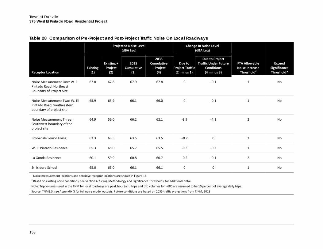
Town of Danville 375 West El Pintado Road Residential Project
158
Table 28 Comparison of Pre-Project and Post-Project Traffic Noise On Local Roadways
Receptor Location
Projected Noise Level (dBA Leq)
Change In Noise Level (dBA Leq)
FTA Allowable Noise Increase
Threshold2
Exceed Significance Threshold?
Existing (1)
Existing + Project
(2)
2035 Cumulative
(3)
2035 Cumulative
+ Project (4)
Due to Project Traffic
(2 minus 1)
Due to Project Traffic Under Future
Conditions (4 minus 3)
Noise Measurement One: W. El Pintado Road, Northeast Boundary of Project Site
67.8 67.8 67.9 67.8 0 -0.1 1 No
Noise Measurement Two: W. El Pintado Road, Southeastern boundary of project site
65.9 65.9 66.1 66.0 0 -0.1 1 No
Noise Measurement Three: Southwest boundary of the project site
64.9 56.0 66.2 62.1 -8.9 -4.1 2 No
Brookdale Senior Living 63.3 63.5 63.5 63.5 +0.2 0 2 No
W. El Pintado Residence 65.3 65.0 65.7 65.5 -0.3 -0.2 1 No
La Gonda Residence 60.1 59.9 60.8 60.7 -0.2 -0.1 2 No
St. Isidore School 65.0 65.0 66.1 66.1 0 0 1 No
1 Noise measurement locations and sensitive receptor locations are shown in Figure 16. 2 Based on existing noise conditions, see Section 4.7.2 (a), Methodology and Significance Thresholds, for additional detail.
Note: Trip volumes used in the TNM for local roadways are peak hour (am) trips and trip volumes for I-680 are assumed to be 10 percent of average daily trips.
Source: TNM2.5, see Appendix G for full noise model outputs. Future conditions are based on 2035 traffic projections from TJKM, 2018
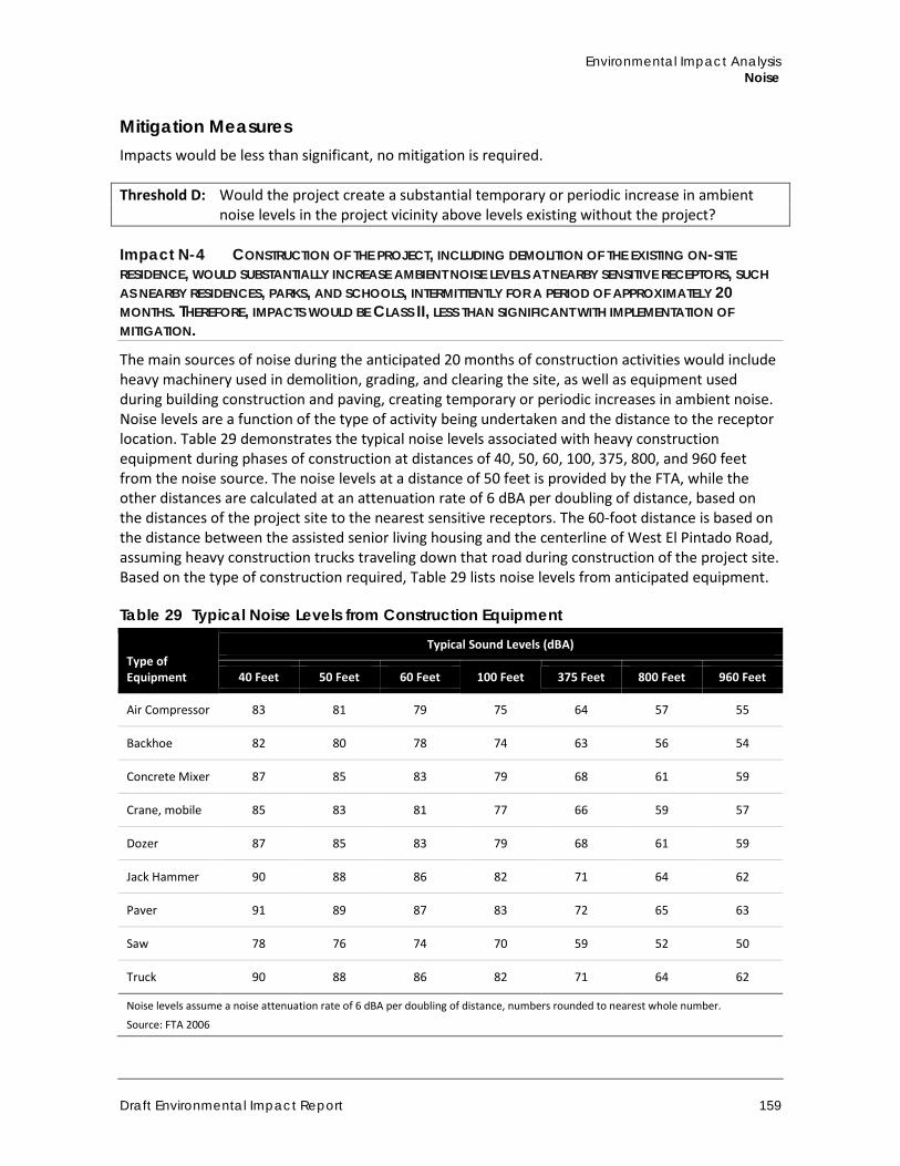
Environmental Impact Analysis Noise
Draft Environmental Impact Report 159
Mitigation Measures Impacts would be less than significant, no mitigation is required.
Threshold D: Would the project create a substantial temporary or periodic increase in ambient noise levels in the project vicinity above levels existing without the project?
Impact N-4 CONSTRUCTION OF THE PROJECT, INCLUDING DEMOLITION OF THE EXISTING ON-SITE RESIDENCE, WOULD SUBSTANTIALLY INCREASE AMBIENT NOISE LEVELS AT NEARBY SENSITIVE RECEPTORS, SUCH AS NEARBY RESIDENCES, PARKS, AND SCHOOLS, INTERMITTENTLY FOR A PERIOD OF APPROXIMATELY 20 MONTHS. THEREFORE, IMPACTS WOULD BE CLASS II, LESS THAN SIGNIFICANT WITH IMPLEMENTATION OF MITIGATION.
The main sources of noise during the anticipated 20 months of construction activities would include heavy machinery used in demolition, grading, and clearing the site, as well as equipment used during building construction and paving, creating temporary or periodic increases in ambient noise. Noise levels are a function of the type of activity being undertaken and the distance to the receptor location. Table 29 demonstrates the typical noise levels associated with heavy construction equipment during phases of construction at distances of 40, 50, 60, 100, 375, 800, and 960 feet from the noise source. The noise levels at a distance of 50 feet is provided by the FTA, while the other distances are calculated at an attenuation rate of 6 dBA per doubling of distance, based on the distances of the project site to the nearest sensitive receptors. The 60-foot distance is based on the distance between the assisted senior living housing and the centerline of West El Pintado Road, assuming heavy construction trucks traveling down that road during construction of the project site. Based on the type of construction required, Table 29 lists noise levels from anticipated equipment.
Table 29 Typical Noise Levels from Construction Equipment
Type of Equipment
Typical Sound Levels (dBA)
40 Feet 50 Feet 60 Feet 100 Feet 375 Feet 800 Feet 960 Feet
Air Compressor 83 81 79 75 64 57 55
Backhoe 82 80 78 74 63 56 54
Concrete Mixer 87 85 83 79 68 61 59
Crane, mobile 85 83 81 77 66 59 57
Dozer 87 85 83 79 68 61 59
Jack Hammer 90 88 86 82 71 64 62
Paver 91 89 87 83 72 65 63
Saw 78 76 74 70 59 52 50
Truck 90 88 86 82 71 64 62
Noise levels assume a noise attenuation rate of 6 dBA per doubling of distance, numbers rounded to nearest whole number.
Source: FTA 2006
Town of Danville 375 West El Pintado Road Residential Project
160
The heaviest equipment use would occur during construction of the proposed on-site roadways, including placement of sewer and other utilities within the right-of-way. As described in Section 2, Project Description, construction activity is expected to occur over a period of 20 months and would result in 6,340 cubic yards of cut and 470 cubic yards of fill, requiring the export of approximately 5,870 cubic yards of earth material. Assuming an average truck load of 9–14 cubic yards, approximately 419 to 650 round trip truckloads would be needed to export the material. Hauling is estimated to occur over a period of approximately three to five months. I-680 would be the main hauling and export route.
As shown in Table 29, typical construction noise levels range from about 78 to 91 dBA at 40 feet from the source, 76 to 89 dBA at 50 feet, 74 to 87 dBA at 60 feet, 70 to 83 dBA at 100 feet, 59 to 72 dBA at 375 feet, 52 to 65 dBA at 800 feet, and 50 to 63 dBA at 960 feet. Nearby noise-sensitive land uses include the single-family residences approximately 40 to 100 feet west and south of the project site, the schools located approximately 800 and 960 feet to the southwest of the project site, and the assisted senior housing approximately 375 feet east of the project site, across West El Pintado Road. The grading/excavation phase of project construction tends to create the highest construction noise levels because of the operation of heavy equipment, although only a limited amount of equipment can operate near a given location at a particular time. In addition, construction vehicles traveling on local roadways can generate intermittent noise levels that affect adjacent receptors.
Based on the information presented in Table 29, temporary construction noise could reach up to 91 dBA at the nearest sensitive receptors, such as the single-family homes adjacent to the project site. Temporary construction noise would reach up to 63 dBA approximately 960 feet away, or at the furthest sensitive receptor, Saint Isidore Parish School (K-8). At the nearest sensitive receptor to the project site (Noise Measurement 3 in Table 24, it is expected that construction activity would temporarily increase noise levels by more than 25 dBA from the existing measured level of 62.3 dBA Leq.
Compliance with Subsection 4-2.4(d) of the Town’s Noise Ordinance, which limits construction to daytime hours (7:30 a.m. to 7:00 p.m.), would ensure that construction noise would not occur during recognized sleep hours for residences. However, the substantial temporary increase in daytime exterior ambient noise levels at nearby sensitive receptors during construction of the project could irritate or disturb local residents. Impacts would be less than significant with mitigation measures to reduce construction-related noise to the extent feasible.
Mitigation Measure The following are required as mitigation measures to reduce construction-related noise impacts to nearby sensitive receptors, consistent with General Plan Policy 27.13.
N-2 Construction-Related Noise Reduction Measures The applicant shall apply the following measures during construction of the project:
Construction Staging. The contractor shall provide staging areas on-site to minimize off-site transportation of heavy construction equipment. These areas shall be located to maximize the distance between activity and sensitive receptors. This would reduce noise levels associated with most types of idling construction equipment.
Mufflers. Construction equipment shall be properly maintained and all internal combustion engine driven machinery with intake and exhaust mufflers and engine shrouds, as applicable, shall be in good condition and appropriate for the equipment. During construction, all
Environmental Impact Analysis Noise
Draft Environmental Impact Report 161
equipment, fixed or mobile, shall be operated with closed engine doors and shall be equipped with properly operating and maintained mufflers, consistent with manufacturers’ standards.
Electrical Power. Electrical power, rather than diesel equipment, shall be used to run compressors and similar power tools and to power any temporary structures, such as construction trailers or caretaker facilities.
Equipment Staging. All stationary equipment shall be staged as far away from the adjacent multi-family residential development as feasible.
Equipment Idling. Construction vehicles and equipment shall not be left idling for longer than five minutes when not in use.
Workers’ Radios. All noise from workers’ radios shall be controlled to a point that they are not audible at sensitive receptors near construction activity.
Smart Back-up Alarms. Mobile construction equipment shall have smart back-up alarms that automatically adjust the sound level of the alarm in response to ambient noise levels. Alternatively, back-up alarms shall be disabled and replaced with human spotters to ensure safety when mobile construction equipment is moving in the reverse direction.
Disturbance Coordinator. The applicant shall designate a disturbance coordinator who shall be responsible for responding to any local complaints about construction noise. The noise disturbance coordinator shall determine the cause of the noise complaint (e.g., starting too early, bad muffler, etc.) and shall require that reasonable measures warranted to correct the problem be implemented. A telephone number for the disturbance coordinator shall be conspicuously posted at the construction site.
Construction Notice. Two weeks prior to the commencement of construction and grading at the project site, the applicant shall install a 3-foot by 3-foot sign at the project entry that discloses the allowable construction work days and hours, the planned construction schedule, and the contact name and phone number for residents to call for construction noise related complaints. All reasonable concerns shall be rectified within 24 hours of receipt.
Significance After Mitigation Implementation of Mitigation Measure N-2 would reduce the exterior ambient noise impacts associated with temporary construction activities to a less than significant level.
c. Cumulative Impacts
Cumulative development in the Town of Danville would increase traffic-related noise as new projects generate additional vehicle trips. The Draft Transportation Impact Study for the 375 West El Pintado Road Residential Development (Appendix H) projects cumulative traffic conditions on studied roadways for the year 2035, assuming a 1.5 percent per year growth rate for background traffic under buildout of the Town’s General Plan. As discussed above in Section 4.7.2(a), Methodology and Significance Thresholds, the modeling of cumulative traffic noise in TNM is based on the Year 2035 Cumulative Year and 2035 Cumulative Plus Project scenarios in the traffic study. Impact N-3 analyzes cumulative traffic noise impacts. As shown in Table 28, the project would not generate increases in traffic noise that exceed FTA criteria, relative to projected cumulative traffic noise. Therefore, cumulative traffic noise impacts would be less than significant. Other noise impacts associated with implementation of the project would be more localized in nature, and would not significantly contribute to noise levels in areas outside the project site and its immediate vicinity.

Town of Danville 375 West El Pintado Road Residential Project
162
This page intentionally left blank.
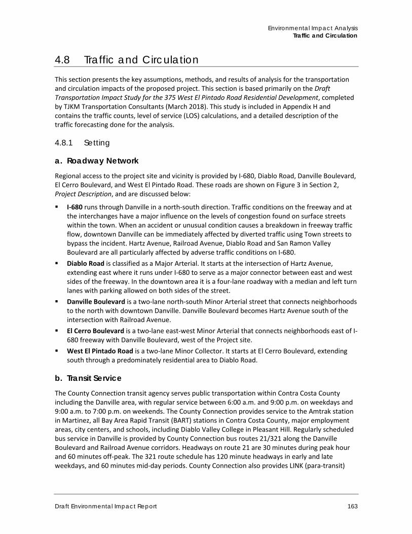
Environmental Impact Analysis Traffic and Circulation
Draft Environmental Impact Report 163
4.8 Traffic and Circulation This section presents the key assumptions, methods, and results of analysis for the transportation and circulation impacts of the proposed project. This section is based primarily on the Draft Transportation Impact Study for the 375 West El Pintado Road Residential Development, completed by TJKM Transportation Consultants (March 2018). This study is included in Appendix H and contains the traffic counts, level of service (LOS) calculations, and a detailed description of the traffic forecasting done for the analysis.
4.8.1 Setting
a. Roadway Network
Regional access to the project site and vicinity is provided by I-680, Diablo Road, Danville Boulevard, El Cerro Boulevard, and West El Pintado Road. These roads are shown on Figure 3 in Section 2, Project Description, and are discussed below:
I-680 runs through Danville in a north-south direction. Traffic conditions on the freeway and at the interchanges have a major influence on the levels of congestion found on surface streets within the town. When an accident or unusual condition causes a breakdown in freeway traffic flow, downtown Danville can be immediately affected by diverted traffic using Town streets to bypass the incident. Hartz Avenue, Railroad Avenue, Diablo Road and San Ramon Valley Boulevard are all particularly affected by adverse traffic conditions on I-680.
Diablo Road is classified as a Major Arterial. It starts at the intersection of Hartz Avenue, extending east where it runs under I-680 to serve as a major connector between east and west sides of the freeway. In the downtown area it is a four-lane roadway with a median and left turn lanes with parking allowed on both sides of the street.
Danville Boulevard is a two-lane north-south Minor Arterial street that connects neighborhoods to the north with downtown Danville. Danville Boulevard becomes Hartz Avenue south of the intersection with Railroad Avenue.
El Cerro Boulevard is a two-lane east-west Minor Arterial that connects neighborhoods east of I-680 freeway with Danville Boulevard, west of the Project site.
West El Pintado Road is a two-lane Minor Collector. It starts at El Cerro Boulevard, extending south through a predominately residential area to Diablo Road.
b. Transit Service
The County Connection transit agency serves public transportation within Contra Costa County including the Danville area, with regular service between 6:00 a.m. and 9:00 p.m. on weekdays and 9:00 a.m. to 7:00 p.m. on weekends. The County Connection provides service to the Amtrak station in Martinez, all Bay Area Rapid Transit (BART) stations in Contra Costa County, major employment areas, city centers, and schools, including Diablo Valley College in Pleasant Hill. Regularly scheduled bus service in Danville is provided by County Connection bus routes 21/321 along the Danville Boulevard and Railroad Avenue corridors. Headways on route 21 are 30 minutes during peak hour and 60 minutes off-peak. The 321 route schedule has 120 minute headways in early and late weekdays, and 60 minutes mid-day periods. County Connection also provides LINK (para-transit)
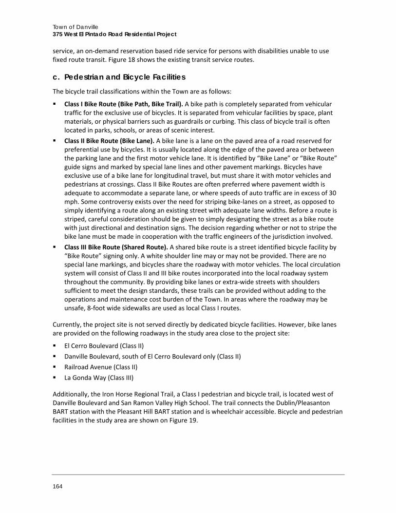
Town of Danville 375 West El Pintado Road Residential Project
164
service, an on-demand reservation based ride service for persons with disabilities unable to use fixed route transit. Figure 18 shows the existing transit service routes.
c. Pedestrian and Bicycle Facilities
The bicycle trail classifications within the Town are as follows:
Class I Bike Route (Bike Path, Bike Trail). A bike path is completely separated from vehicular traffic for the exclusive use of bicycles. It is separated from vehicular facilities by space, plant materials, or physical barriers such as guardrails or curbing. This class of bicycle trail is often located in parks, schools, or areas of scenic interest.
Class II Bike Route (Bike Lane). A bike lane is a lane on the paved area of a road reserved for preferential use by bicycles. It is usually located along the edge of the paved area or between the parking lane and the first motor vehicle lane. It is identified by “Bike Lane” or “Bike Route” guide signs and marked by special lane lines and other pavement markings. Bicycles have exclusive use of a bike lane for longitudinal travel, but must share it with motor vehicles and pedestrians at crossings. Class II Bike Routes are often preferred where pavement width is adequate to accommodate a separate lane, or where speeds of auto traffic are in excess of 30 mph. Some controversy exists over the need for striping bike-lanes on a street, as opposed to simply identifying a route along an existing street with adequate lane widths. Before a route is striped, careful consideration should be given to simply designating the street as a bike route with just directional and destination signs. The decision regarding whether or not to stripe the bike lane must be made in cooperation with the traffic engineers of the jurisdiction involved.
Class III Bike Route (Shared Route). A shared bike route is a street identified bicycle facility by “Bike Route” signing only. A white shoulder line may or may not be provided. There are no special lane markings, and bicycles share the roadway with motor vehicles. The local circulation system will consist of Class II and III bike routes incorporated into the local roadway system throughout the community. By providing bike lanes or extra-wide streets with shoulders sufficient to meet the design standards, these trails can be provided without adding to the operations and maintenance cost burden of the Town. In areas where the roadway may be unsafe, 8-foot wide sidewalks are used as local Class I routes.
Currently, the project site is not served directly by dedicated bicycle facilities. However, bike lanes are provided on the following roadways in the study area close to the project site:
El Cerro Boulevard (Class II) Danville Boulevard, south of El Cerro Boulevard only (Class II) Railroad Avenue (Class II) La Gonda Way (Class III)
Additionally, the Iron Horse Regional Trail, a Class I pedestrian and bicycle trail, is located west of Danville Boulevard and San Ramon Valley High School. The trail connects the Dublin/Pleasanton BART station with the Pleasant Hill BART station and is wheelchair accessible. Bicycle and pedestrian facilities in the study area are shown on Figure 19.
Environmental Impact Analysis Traffic and Circulation
Draft Environmental Impact Report 165
Figure 18 Existing Transit Services
Town of Danville 375 West El Pintado Road Residential Project
166
Figure 19 Existing Bicycle Network
Environmental Impact Analysis Traffic and Circulation
Draft Environmental Impact Report 167
d. Regulatory Setting
State Framework
California Department of Transportation (Caltrans) Caltrans is responsible for the planning, design, construction, and maintenance of interstate freeways and state highways. Within the project study area, I-680 is within Caltrans’ jurisdiction. Caltrans’ Guide for the Preparation of Traffic Impact Studies (Caltrans 2002) identifies Caltrans requirements for evaluating the effect of local development and land use changes on state highway facilities.
Regional Framework
Metropolitan Transportation Commission (MTC) The MTC is the transportation planning, coordinating, and financing agency for the San Francisco Bay Area. The MTC functions as both the state-mandated regional transportation planning agency and the federally-mandated metropolitan planning organization for the region. As such, it is responsible for regularly updating the Regional Transportation Plan (RTP), a comprehensive blueprint for the development of transportation facilities within the region.
The MTC also screens requests from local agencies for state and federal grants for transportation projects to determine their compatibility with the plan. Transportation 2035, the most recent version of the long-range plan, was adopted on April 22, 2009. MTC is also responsible for updating and prioritizing projects within the Regional Transportation Improvement Program.
Contra Costa Transportation Authority (CCTA) The CCTA was originally formed in 1988 to manage the funds generated by the transportation sales tax established by Measure C and later renewed by Measure J in 2004. As Contra Costa's transportation sales tax agency, the CCTA oversees the design and construction of the transportation projects contained in the Measure C and J expenditure plans, carries out the programs included in the expenditure plans, and provides the financial structure that ensures the optimum use of the sales tax dollars. In 1990 the CCTA took on the role of Contra Costa County's Congestion Management Agency (CMA). In that capacity, the CCTA is the primary transportation planning agency for Contra Costa County. As the CMA, the CCTA prepares the county's Congestion Management Program, monitors levels of service on the county's roadways and works with other CMAs and agencies to address regional issues. The CCTA also established the level of service (LOS) standard for intersections along Routes of Regional Significance as LOS E or better, with a volume-to-capacity ratio of 0.90 to 0.91 depending on the intersection.
In the CCTA 2009 Contra Costa Countywide Bicycle and Pedestrian Plan establishes goals, objectives, and policies for the region that seeks to expand opportunities and improve conditions of the bicycle, sidewalk and trail network. Policy 5.1 provides for bicycle and pedestrian friendly developments. The Plan is coordinated with the Town of Danville local trail connections while providing a variety of trail experiences.
Town of Danville 375 West El Pintado Road Residential Project
168
Tri-Valley Transportation Council (TVTC) The TVTC includes the cities of San Ramon, Dublin, Pleasanton, Livermore, the Town of Danville, and unincorporated areas of Alameda and Contra Costa counties. The TVTC develops and implements the Tri-Valley Transportation Plan/Action Plan for Routes of Regional Significance. As with the CCTA, the LOS standard for intersections along Routes of Regional Significance is LOS E or better, with a volume-to-capacity ratio of 0.90 to 0.91 depending on the intersection. This plan also establishes shared traffic service objectives and presents a list of 11 high-priority transportation improvement projects to ease regional traffic congestion. The Tri-Valley Transportation Development Fee on new developments was developed to fund these transportation improvements. The most recent Tri-Valley Transportation Plan/Action Plan was updated in July of 2008.
Town of Danville
2030 General Plan Chapter Four, Mobility, of the Town’s 2030 General Plan outlines goals and policies regarding pedestrian, bicycle, and roadway infrastructure and establishes traffic operation standards through minimum LOS standards. The General Plan identifies LOS D to be acceptable except in locations where the Town determines that LOS D cannot be maintained due traffic originating outside of Danville.
In addition, goals and policies designed to encourage walking and bicycling as a mode choice by increasing and improving facilities are reflected in the General Plan. There are no established measures of effectiveness or operational standards regarding pedestrian and bicycle facilities. Relevant goals and policies include:
Goal 14: Integrating Transportation and Land Use. Integrate land use and transportation planning to increase the viability of alternative transportation modes, minimize vehicle trips, reduce trip lengths, and make more efficient use of the transportation system.
Policy 14.01. Coordinate development planning with the capacity of the transportation system and coordinate the planning of the transportation system with existing and planned land uses.
Policy 14.02. Require site specific studies for development that is likely to generate significant volumes of traffic. If such studies indicate that the development could cause the Town’s transportation standards to be exceeded, require modifications to the project and/or impose transportation improvement requirements which ensure that these standards are maintained.
Policy 14.03. Maintain LOS standards for Danville streets which balance vehicle speed and travel time objectives with other considerations, such as the safety and comfort of pedestrians, bicyclists and transit users. Standards may vary according to roadway function and the character of surrounding uses.
Policy 14.04. Promote pedestrian-oriented mixed-use development in appropriate locations, including residential, commercial and employment activities that are easily accessible by foot, bicycle, or transit.
Goal 15: Mobility and Neighborhood Quality. Reduce the adverse effects of vehicle traffic on Danville’s neighborhoods and natural environment.
Policy 15.03. Require the design of streets in new development areas to incorporate traffic calming features.
Environmental Impact Analysis Traffic and Circulation
Draft Environmental Impact Report 169
Policy 15.05: Minimize impacts of large public transportation vehicles in neighborhoods while maintaining or improving levels of transit service.
Policy 15.06: Maintain and enforce regulations on construction traffic, which ensures vehicle safety, limit the potential for nuisance conditions, and reduce conflicts with adjacent uses and traffic patterns.
The policies in the 2030 General Plan are aligned with the direction provided in the Parks, Recreation, and Arts Strategic Plan, which the Town adopted in 2006. The Strategic Plan adopted by reference the Countywide Bicycle and Pedestrian Plan, which had been previously adopted by the CCTA. The goals established by the Parks, Recreation, and Arts Strategic Plan include the countywide bicycle and pedestrian plan goals including the following:
Expand, improve, and maintain facilities for walking and bicycling Improve safety for pedestrians and bicycles Encourage more people to walk and bicycle Support local efforts to improve conditions for walking and bicycling Consider and plan for the needs of pedestrians and bicycles
Danville Municipal Code DMC Section 8-23 is the Transportation Systems Management (TSM) Ordinance with the goal to ensure the continuation of a proactive TSM program effort aimed at reducing vehicle trips, vehicle emissions and traffic congestion in the most efficient and cost effective manner (Ord. #97-10, §4). Key policies from Section 8-23 include:
a. To participate in conjunction with other jurisdictions and the Southwest Area Transportation Planning Committee, in a proactive effort to support and develop projects which will achieve the Measure C TSM/TDM goals as described in the Southwest Area Transportation Planning Committee’s Action Plan, the Countywide Comprehensive Transportation Plan, the Measure C Strategic Plan, the Congestion Management Plan and/or the Bay Area Clean Air Plan. Such participation may include, but need not be limited to: Promotion and encouragement of the use of transit, ridesharing, bicycling, walking,
flexible work hours, telecommuting, or other alternatives to solo driving. Projects incorporating appropriate technology designed to facilitate traffic flow, provide
transit and highway information and related technology. b. To incorporate these goals into its land use review and planning process.
e. Existing Traffic Conditions
TJKM Transportation Consultants evaluated existing traffic conditions at selected study intersections during both the AM and PM peak hour on a typical weekday. Intersection turning movement counts of vehicles, bicycles, and pedestrians were collected during the AM peak period (7:00 a.m. to 9:00 a.m.) and PM peak period (4:00 p.m. to 6:00 p.m.) on Tuesday, January 12, 2016. Detailed data sheets showing the results of the intersection counts are provided in the Appendix H. The existing motor vehicle turning movement volumes, lane geometry, and traffic controls at each of the study intersections are illustrated in Figure 20. The existing traffic volumes are shown in Figure 21.
The following six study intersections were selected based on the project location, local travel patterns, and review by Town of Danville staff:
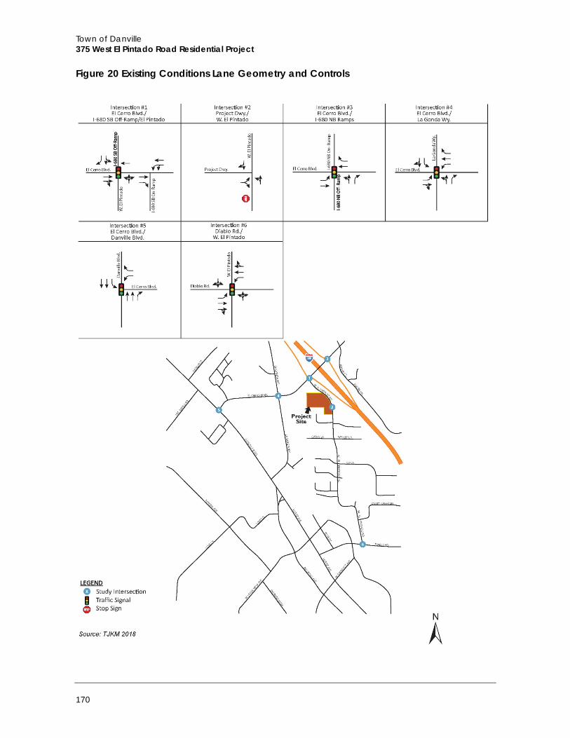
Town of Danville 375 West El Pintado Road Residential Project
170
Figure 20 Existing Conditions Lane Geometry and Controls
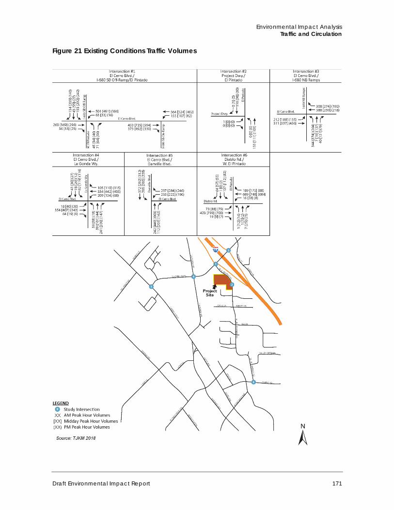
Environmental Impact Analysis Traffic and Circulation
Draft Environmental Impact Report 171
Figure 21 Existing Conditions Traffic Volumes
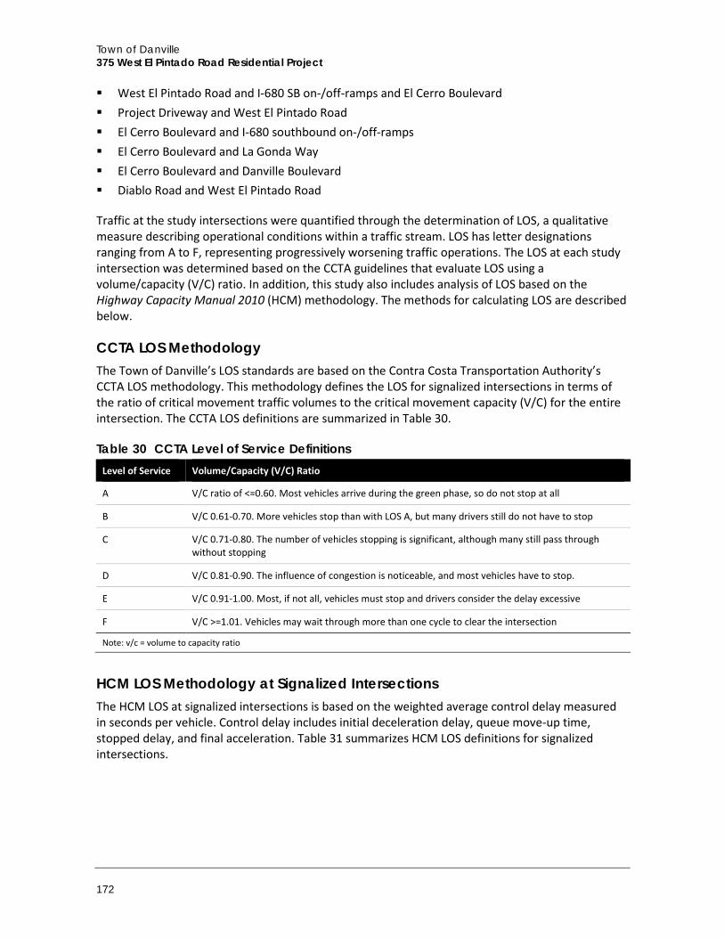
Town of Danville 375 West El Pintado Road Residential Project
172
West El Pintado Road and I-680 SB on-/off-ramps and El Cerro Boulevard Project Driveway and West El Pintado Road El Cerro Boulevard and I-680 southbound on-/off-ramps El Cerro Boulevard and La Gonda Way El Cerro Boulevard and Danville Boulevard Diablo Road and West El Pintado Road
Traffic at the study intersections were quantified through the determination of LOS, a qualitative measure describing operational conditions within a traffic stream. LOS has letter designations ranging from A to F, representing progressively worsening traffic operations. The LOS at each study intersection was determined based on the CCTA guidelines that evaluate LOS using a volume/capacity (V/C) ratio. In addition, this study also includes analysis of LOS based on the Highway Capacity Manual 2010 (HCM) methodology. The methods for calculating LOS are described below.
CCTA LOS Methodology The Town of Danville’s LOS standards are based on the Contra Costa Transportation Authority’s CCTA LOS methodology. This methodology defines the LOS for signalized intersections in terms of the ratio of critical movement traffic volumes to the critical movement capacity (V/C) for the entire intersection. The CCTA LOS definitions are summarized in Table 30.
Table 30 CCTA Level of Service Definitions Level of Service Volume/Capacity (V/C) Ratio
A V/C ratio of <=0.60. Most vehicles arrive during the green phase, so do not stop at all
B V/C 0.61-0.70. More vehicles stop than with LOS A, but many drivers still do not have to stop
C V/C 0.71-0.80. The number of vehicles stopping is significant, although many still pass through without stopping
D V/C 0.81-0.90. The influence of congestion is noticeable, and most vehicles have to stop.
E V/C 0.91-1.00. Most, if not all, vehicles must stop and drivers consider the delay excessive
F V/C >=1.01. Vehicles may wait through more than one cycle to clear the intersection
Note: v/c = volume to capacity ratio
HCM LOS Methodology at Signalized Intersections The HCM LOS at signalized intersections is based on the weighted average control delay measured in seconds per vehicle. Control delay includes initial deceleration delay, queue move-up time, stopped delay, and final acceleration. Table 31 summarizes HCM LOS definitions for signalized intersections.

Environmental Impact Analysis Traffic and Circulation
Draft Environmental Impact Report 173
Table 31 HCM Level of Service Definitions for Signalized Intersections Level of Service Description
A Very low control delay, up to 10 seconds per vehicle. Progression is extremely favorable, and most vehicles arrive during the green phase. Many vehicles do not stop at all. Short cycle lengths may tend to contribute to low delay values.
B Control delay greater than 10 and up to 20 seconds per vehicle. There is good progression or short cycle lengths or both. More vehicles stop causing higher levels of delay.
C Control delay greater than 20 and up to 35 seconds per vehicle. Higher delays are caused by fair progression or longer cycle lengths or both. Individual cycle failures may begin to appear. Cycle failure occurs when a given green phase does not serve queued vehicles, and overflow occurs. The number of vehicles stopping is significant, though many still pass through the intersection without stopping.
D Control delay greater than 35 and up to 55 seconds per vehicle. The influence of congestions becomes more noticeable. Longer delays may result from some combination of unfavorable progression, long cycle lengths, or high volumes. Many vehicles stop, the proportion of vehicles not stopping declines. Individual cycle failures are noticeable.
E Control delay greater than 55 and up to 80 seconds per vehicle. The limit of acceptable delay. High delays usually indicate poor progression, long cycle lengths, and high volumes. Individual cycle failures are frequent.
F Control delay in excess of 80 seconds per vehicle. Unacceptable to most drivers. Oversaturation, arrival flow rates exceed the capacity of the intersection. Many individual cycle failures. Poor progression and long cycle lengths may also be contributing factors to higher delay.
Source: Highway Capacity Manual 2010
The HCM LOS analysis was conducted at each of the study intersections using Synchro Version 9 software and HCM 2010 methodology. The LOS assessment under all scenarios is based on current traffic controls and signal timing. Signal timing sheets were provided by the Town of Danville.
HCM LOS Methodology at Unsignalized Intersections The HCM LOS methodology for unsignalized intersections (side-street or all-way stop controlled intersections) is also defined by the average control delay per vehicle, measured in seconds. The control delay incorporates delay associated with deceleration, acceleration, stopping, and moving up in the queue. For side-street stop-controlled intersections, delay is calculated for each stop controlled movement and for the uncontrolled left turns, if any, from the main street. The delay and LOS for the intersection as a whole and for the worst movement are reported for side-street stop intersections. The intersection average delay is reported for all-way stop intersections.
Table 32 summarizes the relationship between delay and LOS for unsignalized intersections. The delay ranges for unsignalized intersections are lower than for signalized intersections as drivers expect less delay at unsignalized intersections.
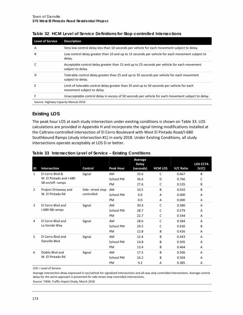
Town of Danville 375 West El Pintado Road Residential Project
174
Table 32 HCM Level of Service Definitions for Stop‐controlled Intersections Level of Service Description
A Very low control delay less than 10 seconds per vehicle for each movement subject to delay.
B Low control delay greater than 10 and up to 15 seconds per vehicle for each movement subject to delay.
C Acceptable control delay greater than 15 and up to 25 seconds per vehicle for each movement subject to delay.
D Tolerable control delay greater than 25 and up to 35 seconds per vehicle for each movement subject to delay.
E Limit of tolerable control delay greater than 35 and up to 50 seconds per vehicle for each movement subject to delay.
F Unacceptable control delay in excess of 50 seconds per vehicle for each movement subject to delay.
Source: Highway Capacity Manual 2010
Existing LOS The peak hour LOS at each study intersection under existing conditions is shown on Table 33. LOS calculations are provided in Appendix H and incorporate the signal timing modifications installed at the Caltrans-controlled intersection of El Cerro Boulevard with West El Pintado Road/I-680 Southbound Ramps (study intersection #1) in early 2018. Under Existing Conditions, all study intersections operate acceptably at LOS D or better.
Table 33 Intersection Level of Service – Existing Conditions
ID Intersection Control Peak Hour
Average Delay
(seconds) HCM LOS V/C Ratio LOS CCTA
(V/C) 1 El Cerro Blvd &
W. El Pintado and I-680 SB on/off- ramps
Signal AM 33.6 C 0.667 B School PM 36.6 D 0.766 C PM 27.6 C 0.535 B
2 Project Driveway and W. El Pintado Rd
Side- street stop controlled
AM 10.5 B 0.010 B School PM 0.0 A 0.000 A PM 0.0 A 0.000 A
3 El Cerro Blvd and I-680 NB ramps
Signal AM 30.4 C 0.586 A School PM 28.7 C 0.579 A PM 22.7 C 0.544 A
4 El Cerro Blvd and La Gonda Way
Signal AM 28.6 C 0.584 A School PM 29.5 C 0.630 B PM 12.8 B 0.426 A
5 El Cerro Blvd and Danville Blvd
Signal AM 12.4 B 0.443 A School PM 14.8 B 0.505 A PM 13.4 B 0.464 A
6 Diablo Blvd and W. El Pintado Rd
Signal AM 17.5 B 0.506 A School PM 16.2 B 0.504 A PM 9.2 A 0.385 A
LOS = Level of Service Average intersection delay expressed in sec/vehicle for signalized intersections and all-way stop controlled intersections. Average control delay for the worst approach is presented for side-street stop controlled intersections. Source: TJKM, Traffic Impact Study, March 2018
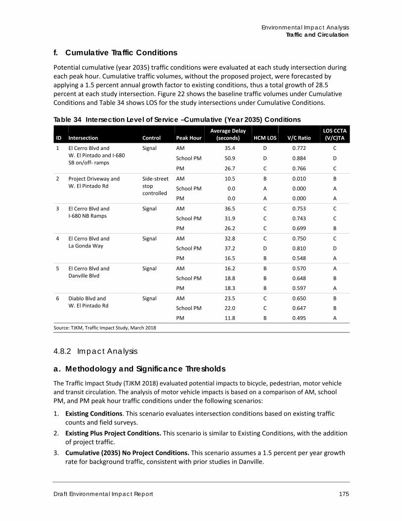
Environmental Impact Analysis Traffic and Circulation
Draft Environmental Impact Report 175
f. Cumulative Traffic Conditions
Potential cumulative (year 2035) traffic conditions were evaluated at each study intersection during each peak hour. Cumulative traffic volumes, without the proposed project, were forecasted by applying a 1.5 percent annual growth factor to existing conditions, thus a total growth of 28.5 percent at each study intersection. Figure 22 shows the baseline traffic volumes under Cumulative Conditions and Table 34 shows LOS for the study intersections under Cumulative Conditions.
Table 34 Intersection Level of Service –Cumulative (Year 2035) Conditions
ID Intersection Control Peak Hour Average Delay
(seconds) HCM LOS V/C Ratio LOS CCTA (V/C)TA
1 El Cerro Blvd and W. El Pintado and I-680 SB on/off- ramps
Signal AM 35.4 D 0.772 C
School PM 50.9 D 0.884 D
PM 26.7 C 0.766 C
2 Project Driveway and W. El Pintado Rd
Side-street stop controlled
AM 10.5 B 0.010 B
School PM 0.0 A 0.000 A
PM 0.0 A 0.000 A
3 El Cerro Blvd and I-680 NB Ramps
Signal AM 36.5 C 0.753 C
School PM 31.9 C 0.743 C
PM 26.2 C 0.699 B
4 El Cerro Blvd and La Gonda Way
Signal AM 32.8 C 0.750 C
School PM 37.2 D 0.810 D
PM 16.5 B 0.548 A
5 El Cerro Blvd and Danville Blvd
Signal AM 16.2 B 0.570 A
School PM 18.8 B 0.648 B
PM 18.3 B 0.597 A
6 Diablo Blvd and W. El Pintado Rd
Signal AM 23.5 C 0.650 B
School PM 22.0 C 0.647 B
PM 11.8 B 0.495 A
Source: TJKM, Traffic Impact Study, March 2018
4.8.2 Impact Analysis
a. Methodology and Significance Thresholds The Traffic Impact Study (TJKM 2018) evaluated potential impacts to bicycle, pedestrian, motor vehicle and transit circulation. The analysis of motor vehicle impacts is based on a comparison of AM, school PM, and PM peak hour traffic conditions under the following scenarios:
1. Existing Conditions. This scenario evaluates intersection conditions based on existing traffic counts and field surveys.
2. Existing Plus Project Conditions. This scenario is similar to Existing Conditions, with the addition of project traffic.
3. Cumulative (2035) No Project Conditions. This scenario assumes a 1.5 percent per year growth rate for background traffic, consistent with prior studies in Danville.
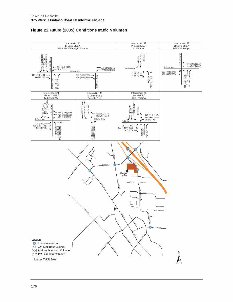
Town of Danville 375 West El Pintado Road Residential Project
176
Figure 22 Future (2035) Conditions Traffic Volumes
Environmental Impact Analysis Traffic and Circulation
Draft Environmental Impact Report 177
4. Cumulative (2035) Plus Project Conditions. This scenario added trips from the project traffic to the Cumulative 2035 No Project.
Project Trip Generation
Net Peak Hour Vehicle Trips The assessment of project impacts on study intersections is based on the net increase in vehicle trips that would be generated by the project, taking into account trips generated by existing land uses on the site that would be removed to accommodate the project. Institute of Transportation Engineers (ITE) trip generation data for residential condominium/ townhouses (ITE land use code 230) would be most applicable to the project. Based on the ITE vehicle trip rates, the proposed 37 multi‐family dwellings are estimated to generate 16 vehicle trips during the AM peak hour and 20 vehicle trips during the PM peak hour. Based on the January 2016 counts, the existing single‐family dwelling generates one vehicle trip during the AM peak hour, and no vehicle trips during the PM peak hour. Therefore, the net vehicle trip generation would be 16 during the AM peak hour and 20 vehicle trips during the PM peak hour.
ITE does not provide data on the afternoon school park hour. Therefore the PM peak hour rate was used to evaluate afternoon school PM peak conditions with the project. Existing driveway counts indicate the existing use generated one vehicle trip during the afternoon school peak hour. Therefore the project would generate 19 net vehicle trips during the afternoon school peak hour, based on the PM peak hour trip rate.
Net Daily Vehicle Trips Based on the ITE rate for residential condominium/townhouses, the proposed 37 multi-family dwelling units will generate 221 daily vehicle trips. Net daily vehicle trips, after subtracting trips that would be generated by the existing single-family dwelling, would be 212 daily vehicle trips.
Project Trip Distribution and Assignment Trip distribution is a process that determines in what proportion vehicles would travel between a project site and various destinations outside the project study area. The process of trip assignment determines the various routes that vehicles would take from the project site to each destination using the calculated trip distribution.
The project trips were assigned to the study area roadway network based on existing turning movements at each study intersection. The resulting net increase in trips assigned to the study intersections are illustrated in Figure 23.
Significance Thresholds According to Appendix G of the State CEQA Guidelines, impacts related to transportation and traffic of the project would be considered significant if the project would:
A. Conflict with an applicable plan, ordinance or policy establishing a measure of effectiveness for the performance of the circulation system, taking into account all modes of transportation, including mass transit and non-motorized travel and relevant components of the circulation system, including but not limited to intersections, streets, highways, and freeways, pedestrian and bicycle paths, and mass transit
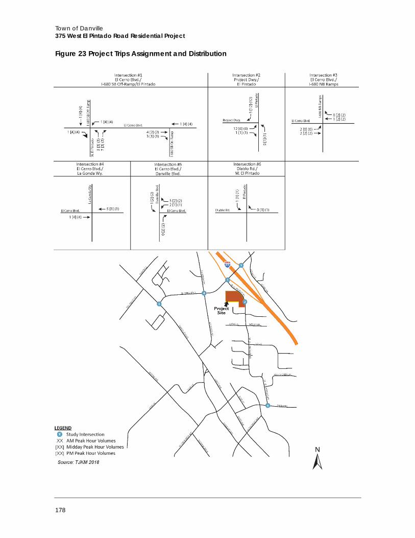
Town of Danville 375 West El Pintado Road Residential Project
178
Figure 23 Project Trips Assignment and Distribution
Environmental Impact Analysis Traffic and Circulation
Draft Environmental Impact Report 179
B. Conflict with an applicable congestion management program, including, but not limited to LOS standards and travel demand measures, or other standards established by the county congestion management agency for designated roads or highways
C. Result in a change in air traffic patterns, including either an increase in traffic levels or a change in location that results in substantial safety risks
D. Substantially increase hazards due to a design feature (e.g., sharp curves or dangerous intersections) or incompatible use (e.g., farm equipment)
E. Result in inadequate emergency access F. Conflict with adopted policies, plans, or programs regarding public transit, bikeways, or
pedestrian facilities, or otherwise substantially decrease the performance or safety of such facilities
The analysis from the Initial Study (Appendix A to this EIR) identified potential impacts related to checklist questions A, B, D, E, and F. These topics are discussed in this EIR. Checklist item C was found to have no impact in the Initial Study because the project site is not located within two miles of a public or private airport, and would therefore not result in a change of air traffic patterns, an increase in traffic levels, or a change in location that results in substantial safety risks. Therefore, checklist item C is not discussed in this EIR.
The Town of Danville 2030 General Plan identifies LOS D to be acceptable except in locations (to be specifically identified by the Town through CEQA processes) where the Town determines that LOS D cannot be maintained due traffic originating outside of Danville. Based on the General Plan criteria, any study intersection will be considered potentially impacted if service level exceeds LOS D under the Existing plus Project or Cumulative (Year 2035) plus Project scenarios.
Impacts to bicycle, pedestrian or transit circulation would be considered potentially significant if the Project were to conflict with an adopted bicycle, pedestrian or transit plan, or result in unsafe conditions for bicyclists or pedestrians, significant unserved transit demand, or significant delay to transit service.
b. Project Impacts
Threshold A: Would the project conflict with an applicable plan, ordinance or policy establishing a measure of effectiveness for the performance of the circulation system, taking into account all modes of transportation, including mass transit and non-motorized travel and relevant components of the circulation system, including but not limited to intersections, streets, highways, and freeways, pedestrian and bicycle paths, and mass transit?
Threshold F: Would the project conflict with adopted policies, plans, or programs regarding public transit, bikeways, or pedestrian facilities, or otherwise substantially decrease the performance or safety of such facilities?
Impact T-1 CONSTRUCTION OF THE PROJECT WOULD RESULT IN INCREASED VEHICLE TRIPS TO AND FROM THE PROJECT SITE AND COULD ADVERSELY AFFECT THE PERFORMANCE OF THE CIRCULATION SYSTEM. THIS IMPACT IS CLASS II, SIGNIFICANT BUT MITIGABLE.
Construction activities would require the use of haul equipment and delivery trucks during demolition and construction. Additionally, construction worker traffic would temporarily add trips
Town of Danville 375 West El Pintado Road Residential Project
180
to the roadway infrastructure and require parking. Additional trips generated by the truck deliveries and construction employees could affect traffic flow in the study area along West El Pintado Road, El Cerro Boulevard, and La Gonda Way. Pedestrian traffic flow near the project site could also be altered as a result of construction, and the availability of parking, especially on-street parking, could be impacted if on-site parking for construction employees were not provided.
Delivery and export haul routes would be developed to use the freeway system, exiting to major arterials, and ending at the project site by traveling on El Cerro Boulevard to West El Pintado Road. The project would require approximately 297 round-trip haul trips over approximately three months in order to export an estimated 5,940 cubic yards of earth material (assuming 20 cubic yards per truck). This would equate to approximately nine trips per day, assuming a five-day workweek. Locally, the haul and export route available for construction truck trips is east and west on El Cerro Boulevard to I-680.
Although no street closures are anticipated to occur during construction of the project, it is anticipated that construction of the project may temporarily displace on-street parking located along West El Pintado Road near the project site. Lane closure requests or requests to displace on-street parking must be submitted to the Town for prior approval in accordance with Town policies and procedures. The applicant would be responsible for all costs associated with signage and lane closure equipment and for providing flagging as necessary or requested by the Town to ensure the safe operation and movement of traffic during periods of lane closures or on-street parking displacement. The applicant would be required to provide temporary sidewalks or alternative pedestrian passage for pedestrians should existing sidewalks be closed during construction.
Project construction would be required to comply with the Town of Danville’s development permit conditions, which restrict grading and other construction activities to the hours of 7: 30 a.m. to 7:00 p.m., Monday through Friday. On weekends and holidays construction is permitted between the hours of 9:00 a.m. to 7:00 p.m. These hours coincide with peak traffic hours in both the morning and the evening. Because construction traffic would interfere or impede pedestrian modes of transportation, potentially during peak traffic hours, it would conflict with General Plan policies intended to promote pedestrian and bicycle travel. This would be a potentially significant impact.
Mitigation Measure The following mitigation measure is required to reduce impacts to less than significant resulting from construction traffic activity.
T-1 Construction Mitigation Plan The project applicant shall develop and submit for approval to the Town of Danville a Construction Management and Mitigation Plan that includes designated haul routes and staging areas, traffic control procedures, emergency access provisions and construction crew parking, to minimize traffic impacts during construction. The plan shall ensure that haul routes and construction activity timing shall comply with the Town of Danville’s requirements. The plan shall also ensure that construction period employees can either park on-site or at an off-site location. In addition, the plan shall require that temporary signage, alternative pedestrian passage, and/or protected walkways be provided should sidewalks be closed during construction.
Environmental Impact Analysis Traffic and Circulation
Draft Environmental Impact Report 181
Significance After Mitigation With implementation of Mitigation Measure T-1 and adherence to the Town’s policies and procedures, this impact would be reduced to Class III, Less Than Significant because the plan would identify construction-related traffic issues and procedures to follow in order to minimize or avoid impacts resulting from construction traffic.
Threshold A: Would the project conflict with an applicable plan, ordinance or policy establishing a measure of effectiveness for the performance of the circulation system, taking into account all modes of transportation, including mass transit and non-motorized travel and relevant components of the circulation system, including but not limited to intersections, streets, highways, and freeways, pedestrian and bicycle paths, and mass transit?
Impact T-2 UNDER EXISTING PLUS PROJECT CONDITIONS, ALL STUDY AREA INTERSECTIONS WOULD OPERATE AT ACCEPTABLE LOS LEVELS DURING THE AM AND PM PEAK HOURS AND THE SCHOOL PM PEAK HOUR. THIS IMPACT WOULD BE CLASS IIII, LESS THAN SIGNIFICANT.
The proposed project traffic volumes were added to the existing traffic volumes to obtain Existing plus Project traffic volumes. Intersection levels of service changes are summarized in Table 35 and shown on Figure 24. As shown in Table 35, all study intersections would operate acceptably at LOS D with the addition of the project traffic using the CCTA LOS (V/C) methodology and the delay‐based HCM LOS methodology. Therefore, under Existing plus Project conditions, intersection impacts would be less than significant.
Mitigation Measure Impacts would be less than significant, no mitigation is required.
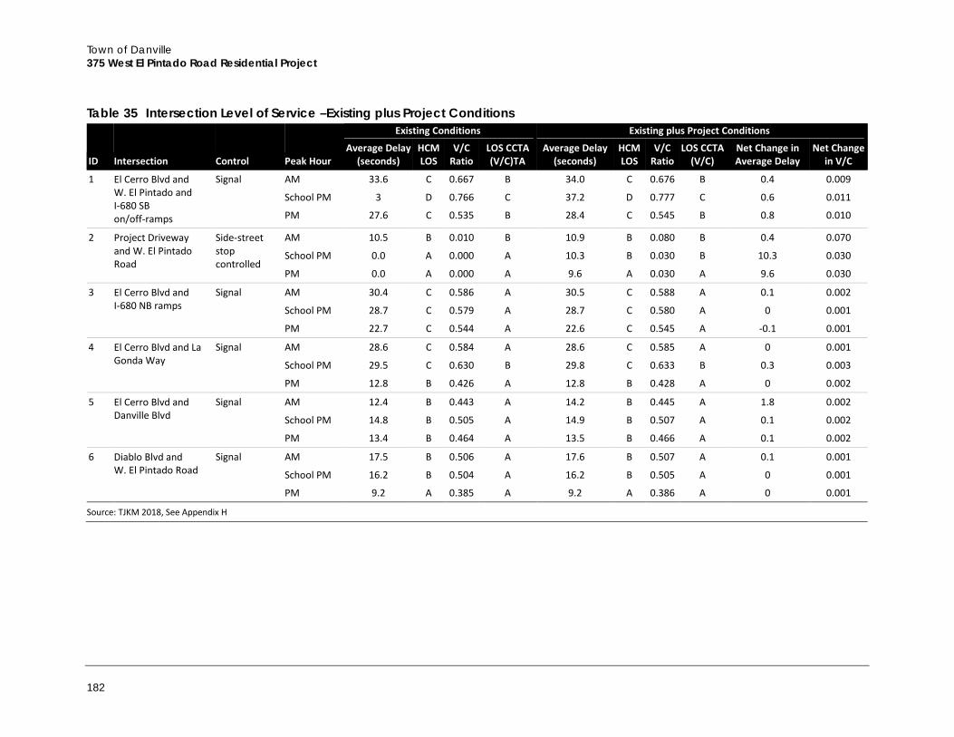
Town of Danville 375 West El Pintado Road Residential Project
182
Table 35 Intersection Level of Service –Existing plus Project Conditions
ID Intersection Control Peak Hour
Existing Conditions Existing plus Project Conditions
Average Delay (seconds)
HCM LOS
V/C Ratio
LOS CCTA (V/C)TA
Average Delay (seconds)
HCM LOS
V/C Ratio
LOS CCTA (V/C)
Net Change in Average Delay
Net Change in V/C
1 El Cerro Blvd and W. El Pintado and I-680 SB on/off-ramps
Signal AM 33.6 C 0.667 B 34.0 C 0.676 B 0.4 0.009
School PM 3 D 0.766 C 37.2 D 0.777 C 0.6 0.011
PM 27.6 C 0.535 B 28.4 C 0.545 B 0.8 0.010
2 Project Driveway and W. El Pintado Road
Side-street stop controlled
AM 10.5 B 0.010 B 10.9 B 0.080 B 0.4 0.070
School PM 0.0 A 0.000 A 10.3 B 0.030 B 10.3 0.030
PM 0.0 A 0.000 A 9.6 A 0.030 A 9.6 0.030
3 El Cerro Blvd and I-680 NB ramps
Signal AM 30.4 C 0.586 A 30.5 C 0.588 A 0.1 0.002
School PM 28.7 C 0.579 A 28.7 C 0.580 A 0 0.001
PM 22.7 C 0.544 A 22.6 C 0.545 A -0.1 0.001
4 El Cerro Blvd and La Gonda Way
Signal AM 28.6 C 0.584 A 28.6 C 0.585 A 0 0.001
School PM 29.5 C 0.630 B 29.8 C 0.633 B 0.3 0.003
PM 12.8 B 0.426 A 12.8 B 0.428 A 0 0.002
5 El Cerro Blvd and Danville Blvd
Signal AM 12.4 B 0.443 A 14.2 B 0.445 A 1.8 0.002
School PM 14.8 B 0.505 A 14.9 B 0.507 A 0.1 0.002
PM 13.4 B 0.464 A 13.5 B 0.466 A 0.1 0.002
6 Diablo Blvd and W. El Pintado Road
Signal AM 17.5 B 0.506 A 17.6 B 0.507 A 0.1 0.001
School PM 16.2 B 0.504 A 16.2 B 0.505 A 0 0.001
PM 9.2 A 0.385 A 9.2 A 0.386 A 0 0.001
Source: TJKM 2018, See Appendix H
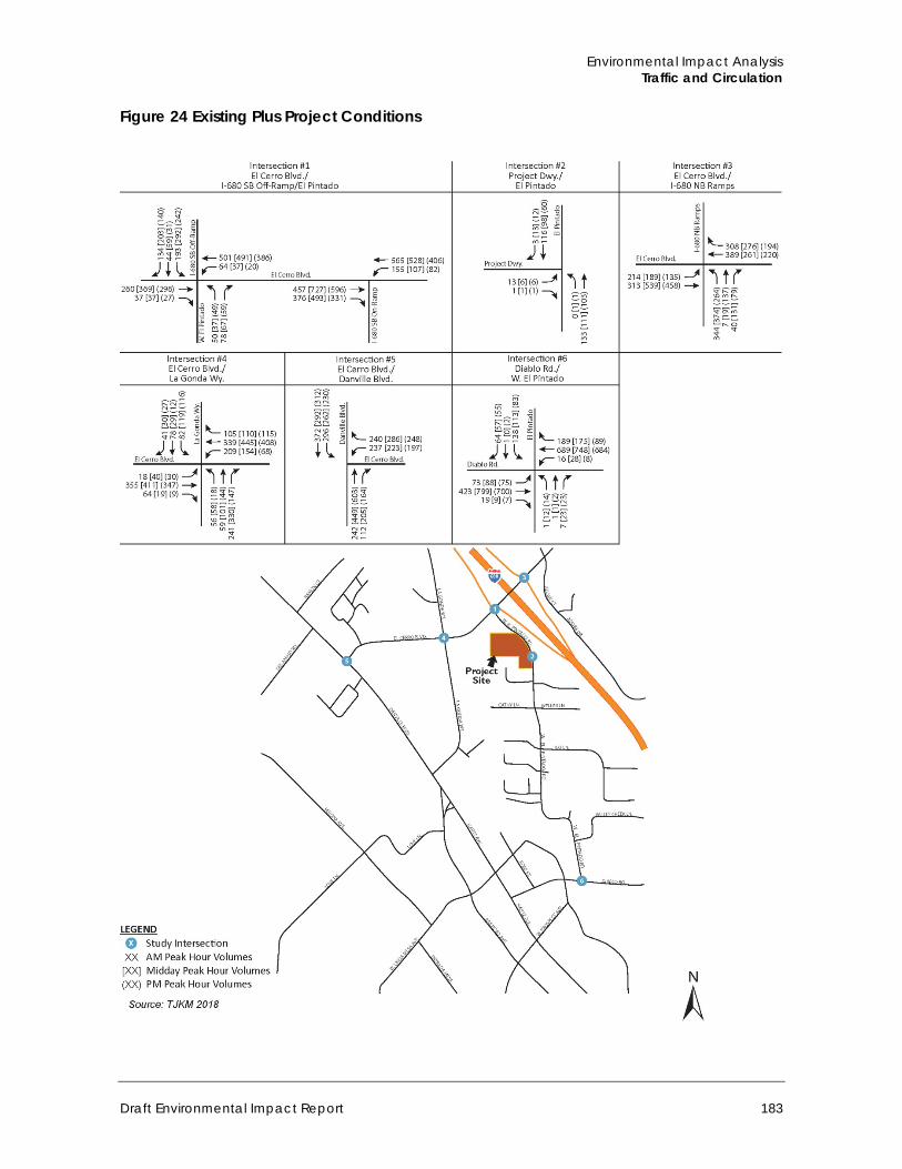
Environmental Impact Analysis Traffic and Circulation
Draft Environmental Impact Report 183
Figure 24 Existing Plus Project Conditions
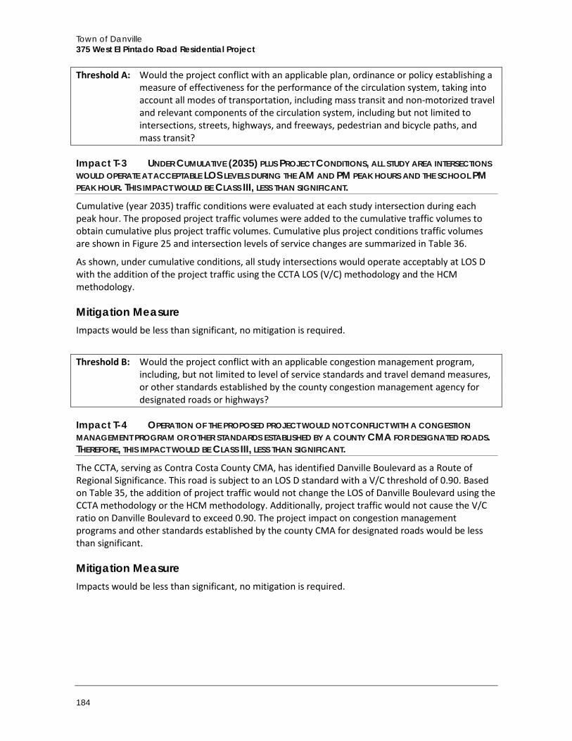
Town of Danville 375 West El Pintado Road Residential Project
184
Threshold A: Would the project conflict with an applicable plan, ordinance or policy establishing a measure of effectiveness for the performance of the circulation system, taking into account all modes of transportation, including mass transit and non-motorized travel and relevant components of the circulation system, including but not limited to intersections, streets, highways, and freeways, pedestrian and bicycle paths, and mass transit?
Impact T-3 UNDER CUMULATIVE (2035) PLUS PROJECT CONDITIONS, ALL STUDY AREA INTERSECTIONS WOULD OPERATE AT ACCEPTABLE LOS LEVELS DURING THE AM AND PM PEAK HOURS AND THE SCHOOL PM PEAK HOUR. THIS IMPACT WOULD BE CLASS III, LESS THAN SIGNIFICANT.
Cumulative (year 2035) traffic conditions were evaluated at each study intersection during each peak hour. The proposed project traffic volumes were added to the cumulative traffic volumes to obtain cumulative plus project traffic volumes. Cumulative plus project conditions traffic volumes are shown in Figure 25 and intersection levels of service changes are summarized in Table 36.
As shown, under cumulative conditions, all study intersections would operate acceptably at LOS D with the addition of the project traffic using the CCTA LOS (V/C) methodology and the HCM methodology.
Mitigation Measure Impacts would be less than significant, no mitigation is required.
Threshold B: Would the project conflict with an applicable congestion management program, including, but not limited to level of service standards and travel demand measures, or other standards established by the county congestion management agency for designated roads or highways?
Impact T-4 OPERATION OF THE PROPOSED PROJECT WOULD NOT CONFLICT WITH A CONGESTION MANAGEMENT PROGRAM OR OTHER STANDARDS ESTABLISHED BY A COUNTY CMA FOR DESIGNATED ROADS. THEREFORE, THIS IMPACT WOULD BE CLASS III, LESS THAN SIGNIFICANT.
The CCTA, serving as Contra Costa County CMA, has identified Danville Boulevard as a Route of Regional Significance. This road is subject to an LOS D standard with a V/C threshold of 0.90. Based on Table 35, the addition of project traffic would not change the LOS of Danville Boulevard using the CCTA methodology or the HCM methodology. Additionally, project traffic would not cause the V/C ratio on Danville Boulevard to exceed 0.90. The project impact on congestion management programs and other standards established by the county CMA for designated roads would be less than significant.
Mitigation Measure Impacts would be less than significant, no mitigation is required.
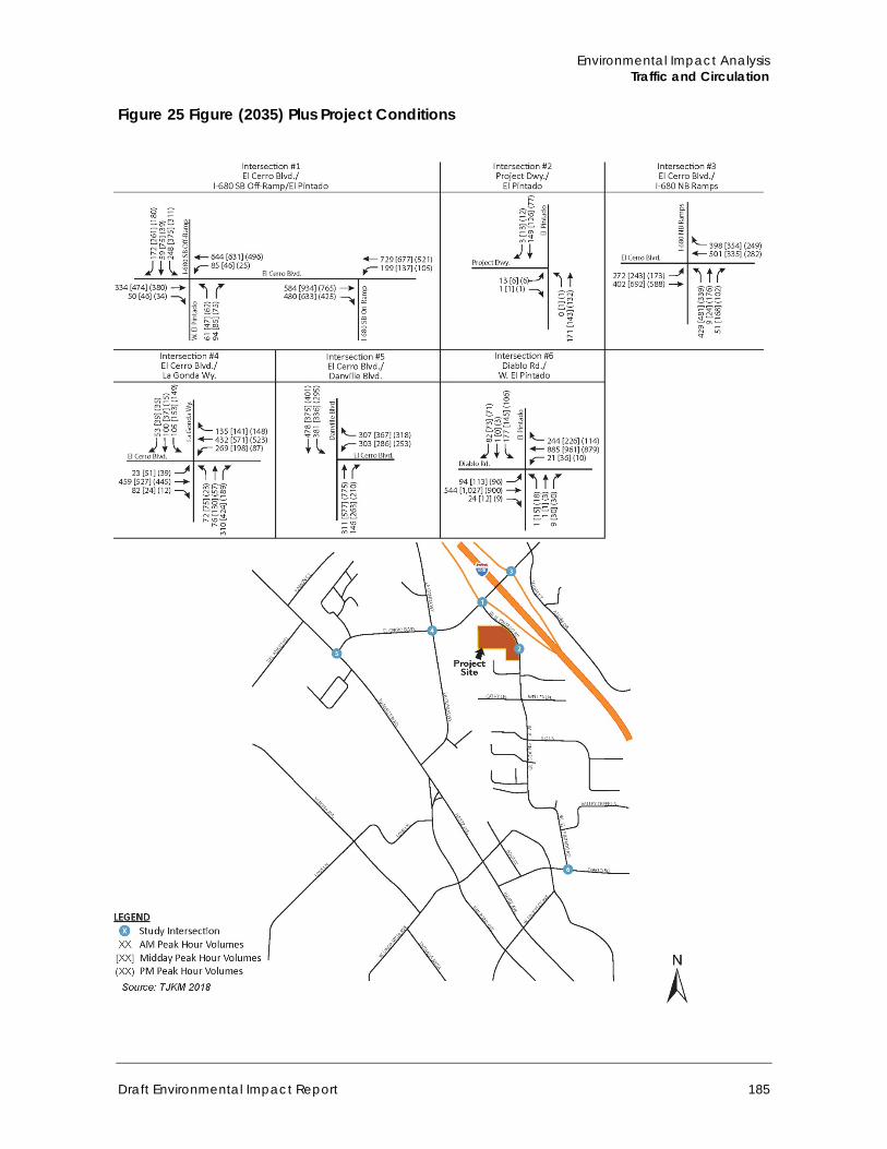
Environmental Impact Analysis Traffic and Circulation
Draft Environmental Impact Report 185
Figure 25 Figure (2035) Plus Project Conditions
Town of Danville 375 West El Pintado Road Residential Project
186
Table 36 Intersection Level of Service –Cumulative (Year 2035) Plus Project Conditions
ID Intersection Control Peak Hour
Cumulative (2035) No Project Conditions Cumulative (2035) Plus Project Conditions
Average Delay (seconds)
HCM LOS
V/C Ratio
LOS CCTA (V/C)TA
Average Delay (seconds)
HCM LOS
V/C Ratio
LOS CCTA (V/C)
Net Change in Average Delay
Net Change in V/C
1 El Cerro Blvd and W. El Pintado and I-680 SB on-/off-ramps
Signal AM 35.4 D 0.772 C 35.6 D 0.780 C 0.2 0.006
School PM 50.9 D 0.884 D 51.7 D 0.891 D 0.8 0.007
PM 26.7 C 0.766 C 27.4 D 0.777 C 0.7 0.011
2 Project Driveway and W. El Pintado Road
Side-street stop controlled
AM 10.5 B 0.010 B 11.4 B 0.050 B 0.9 0.040
School PM 0.0 A 0.000 A 10.9 B 0.040 B 10.9 0.040
PM 0.0 A 0.000 A 9.9 A 0.030 A 9.9 0.030
3 El Cerro Blvd and I-680 NB ramps
Signal AM 36.5 C 0.753 C 36.5 D 0.754 C 0.0 0.001
School PM 31.9 C 0.743 C 32.0 C 0.745 C 0.1 0.002
PM 26.2 C 0.699 B 24.2 C 0.700 C 0.0 0.001
4 El Cerro Blvd and La Gonda Way
Signal AM 32.8 C 0.750 C 33.1 C 0.753 D 0.3 0.003
School PM 37.2 D 0.810 D 37.6 D 0.813 D 0.4 0.003
PM 16.5 B 0.548 A 16.6 B 0.549 A 0.1 0.001
5 El Cerro Blvd and Danville Blvd
Signal AM 16.2 B 0.570 A 16.2 B 0.572 A 0.0 0.002
School PM 18.8 B 0.648 B 18.9 B 0.651 B 0.1 0.003
PM 18.3 B 0.597 A 18.5 B 0.599 A 0.2 0.002
6 Diablo Blvd and W. El Pintado Road
Signal AM 23.5 C 0.650 B 23.6 C 0.651 B 0.1 0.001
School PM 22.0 C 0.647 B 22.1 C 0.648 B 0.1 0.001
PM 11.8 B 0.495 A 11.9 A 0.496 A 0.1 0.001
Source: TJKM 2018, See Appendix H
Environmental Impact Analysis Traffic and Circulation
Draft Environmental Impact Report 187
Threshold D: Would the project substantially increase hazards due to a design feature (e.g., sharp curves or dangerous intersections) or incompatible use (e.g., farm equipment)?
Impact T-5 THE PROPOSED PROJECT WOULD NOT INCREASE HAZARDS DUE TO A DESIGN FEATURE OR INCOMPATIBLE USE. THEREFORE, IMPACTS WOULD BE CLASS III, LESS THAN SIGNIFICANT.
The proposed project involves residential uses in an area surrounded by residential and commercial uses. As discussed in Section 4.6, Land Use and Planning, the project would be compatible with surrounding uses. Therefore, the project would not increase traffic hazards by introducing an incompatible use.
With respect to the project’s circulation design features, access to the project site would be provided by a single driveway on West El Pintado Road. Residents would enter the project site at roughly the midpoint of the project site’s eastern boundary. The vehicular portion of the driveway entrance would be a total of 28 feet wide and would serve both inbound and outbound traffic, with an adjacent pedestrian path that would connect with internal pedestrian paths. Outbound movements are proposed to be controlled by a stop sign and would allow both right and left‐turns. The entrance driveway would transition to an internal road network of 22‐foot driveways that provide access to each building. The project would include construction of a new five‐foot wide sidewalk along West El Pintado Road, immediately bordering the project site.
Based on a speed survey conducted by TJKM adjacent to the project driveway (Appendix H), the average (50th percentile) speed is 26 miles per hour (mph), while the eighty-fifth percentile speed is 29 mph. Based on the eighty-fifth percentile speed, the recommended stopping sight distance for exiting motorists to view oncoming traffic is 200 feet. The project would include grading to lower the existing on‐site berm in order to provide a clear line‐of‐sign to/from the north, to ensure stopping sight distance within 200 feet of vehicles exiting the driveway. In addition, on-street motor vehicle parking would be prohibited on the west (southbound) side of West El Pintado Road, within the public right-of-way, where West El Pintado Road immediately borders the project site. This would avoid the potential for cars to interfere with motorists’ visibility entering and exiting the driveway. Therefore, the proposed site access and driveway sight distance provisions would be adequate and the project is would not result in significant impacts to safety. This impact would be less than significant.
Mitigation Measure Impacts would be less than significant, no mitigation is required.
Threshold E: Would the project result in inadequate emergency access?
Impact T-6 THE PROPOSED PROJECT WOULD NOT ALTER EMERGENCY VEHICLE ACCESS AND WOULD BE REQUIRED TO COMPLY WITH ALL APPLICABLE EMERGENCY ACCESS STANDARDS. IMPACTS RELATED TO EMERGENCY ACCESS WOULD BE CLASS III, LESS THAN SIGNIFICANT.
Emergency vehicle access to the proposed project would be provided from I-680, El Cerro Boulevard and La Gonda Way into the project site driveway on West El Pintado Road. The project would not involve major modifications to the roadway network, circulation patterns or design features that would alter emergency vehicle access. The project design is required to comply with all Town access standards as well as requirements in the California Fire Code regarding access for emergency response vehicles. With compliance with these requirements, the driveway and internal vehicle
Town of Danville 375 West El Pintado Road Residential Project
188
access lanes would be adequate for emergency response. Adherence to existing local and state regulations would reduce potential impacts. Impacts would be less than significant.
Mitigation Measure Impacts would be less than significant, no mitigation is required.
Threshold F: Would the project conflict with adopted policies, plans, or programs regarding public transit, bikeways, or pedestrian facilities, or otherwise substantially decrease the performance or safety of such facilities?
Impact T-7 THE PROPOSED PROJECT WOULD NOT CONFLICT WITH ADOPTED POLICIES, PLANS, OR PROGRAMS REGARDING PUBLIC TRANSIT, BIKEWAYS, OR PEDESTRIAN FACILITIES, OR OTHERWISE SUBSTANTIALLY DECREASE THE PERFORMANCE OR SAFETY OF SUCH FACILITIES. IMPACTS WOULD BE CLASS III, LESS THAN SIGNIFICANT.
As described above under subsections 4.8.1b and 4.8.1c, bicycle, pedestrian, and transit facilities are located in the vicinity of the site. Class II bicycle lanes are provided near the project site on El Cerro Boulevard, Danville Boulevard and Railroad Avenue (Figure 19). Sidewalks are intermittent along El Cerro Boulevard. No sidewalks are currently provided on the project frontage, but sidewalks are provided along the west side of West El Pintado Road to the north of the project site, and on the east side to the south of the project site. Transit service is provided by CCTA near the project site as shown on Figure 18.
The TIS for the project prepared by TJKM included an assessment of potential multi-modal (pedestrian, bicycle, and transit) impacts. The TIS concluded that the project would not conflict with an adopted bicycle, pedestrian or transit plan, and would not result in unsafe conditions for bicyclists or pedestrians. In addition, the TIS concluded that the project would not generate transit demand that exceeds the capacity of existing transit services (TJKM 2018). Therefore, impacts would be less than significant.
Mitigation Measure Impacts would be less than significant, no mitigation is required.
d. Cumulative Impacts
Cumulative (year 2035) traffic impacts are addressed under Impact T-3. As discussed, under cumulative conditions, impacts would be less than significant.
Other CEQA Required Discussions
Draft Environmental Impact Report 189
5 Other CEQA Required Discussions
This section covers other topics required to be addressed under the CEQA Guidelines that are not covered in other parts of this EIR, including growth-inducing effects, significant irreversible changes, significant unavoidable impacts, and energy effects as set forth in CEQA Guidelines Appendix F.
5.1 Growth Inducing Effects Section 15126.2(d) of the CEQA Guidelines requires a discussion of a project’s potential to induce growth by, for example, fostering economic or population growth, or removing an obstacle to growth. Growth does not necessarily create significant physical changes to the environment. However, depending upon the type, magnitude, and location of growth, it can result in significant adverse environmental effects. The project’s growth-inducing potential is therefore considered significant if growth induced by the project could result in significant physical effects in one or more environmental issue areas.
Economic and Population Growth The project would increase the available housing in the town of Danville. The Town of Danville General Plan 2030 EIR estimated that total housing units within the Town of Danville Planning Area (incorporated area and sphere of influence) would increase from 17,240 in 2010 to 19,490 in 2030. This projection represents a growth in housing of 2,250 units or approximately 13 percent. For the incorporated area of the Town of Danville, the Plan Bay Area Forecast of Jobs, Population, and Housing projects a nine percent growth in housing (1,510 units) from 15,930 units in 2010 to 17,440 units in 2040 (ABAG and MTC 2013). The project would add 37 housing units within the incorporated town of Danville. This amount of new housing units represents approximately 1.7 percent of the Town of Danville General Plan 2030 EIR housing unit growth estimate and approximately 2.5 percent of the Plan Bay Area 2040 housing unit growth estimate. Therefore, the project would not induce population growth beyond the forecasts.
As discussed in Sections 4.2, Air Quality, and 4.3, Greenhouse Gas Emissions, of this EIR, the project would generally be consistent with the Bay Area Air Quality Management District’s (BAAQMD) regional goals and their updated CEQA Air Quality Guidelines. Moreover, as discussed in the Initial Study (Appendix A), the project involves infill development on a mostly vacant site in a suburban/semi-rural area that would not significantly affect scenic resources, native biological habitats, known cultural resource remains, hydrology, or other environmental resources with implementation of mitigation measures discussed in this EIR. Therefore, population growth would not be expected to result in significant long-term physical environmental effects.
The project includes residential development rather than commercial development. As such, the project would not directly contribute to economic growth by providing additional space for business. The project would generate short-term employment opportunities during construction activities, which would be expected to draw workers primarily from the existing regional work force. Under the project, 37 new residential units would be developed, which may indirectly contribute to economic growth. As development occurs under the project, the additional population would likely contribute to the local economy as demand for general goods increases, which in turn could result
Town of Danville 375 West El Pintado Road Residential Project
190
in economic growth for various sectors. Residents on the project site would be expected to primarily use existing Town commercial services, creating only a relatively minor need for expanded services. However, the project would not be expected to induce economic expansion to the extent that significant environmental impacts directly associated with the project’s contribution would occur.
5.2 Removal of Obstacles to Growth The project involves infill development on a site located within a fully suburban/ semi-rural area that would require connections to the surrounding infrastructure network. As discussed in Section XVII, Utilities and Service Systems, of the Initial Study (Appendix A), the project site is already served by full municipal services and utilities including water, sewer, and other infrastructure. According to Section 4.5, Hydrology and Water Quality, of this EIR, improvements to water and drainage connection infrastructure would be needed, but would be sized to specifically serve the project and comply with the Town’s standards. The project would not involve roadway extensions or other changes that would induce growth or remove obstacles to growth. Subsequent projects in the area would also be subject to a separate CEQA review for analysis. Therefore, the proposed project would not have a significant effect from removing obstacles to growth.
5.3 Irreversible Environmental Effects The CEQA Guidelines require that EIRs evaluating projects involving amendments to public plans, ordinances, or policies contain a discussion of significant irreversible environmental changes. This section addresses non-renewable resources, the commitment of future generations to the proposed uses, and irreversible impacts associated with the project.
The project involves infill development on a predominately vacant lot within suburban/ semi-rural Danville. Construction and operation of the project would involve an irreversible commitment of construction materials and non-renewable energy resources. The project would involve the use of building materials and energy, some of which are non-renewable resources, to construct the overall building floor area of 44,580 square feet. Consumption of these resources would occur with any development in the region, and are not unique to the project.
The project would also irreversibly increase local demand for non-renewable energy resources such as petroleum products and natural gas. However, increasingly efficient building design and automobile engines would offset this demand to some degree. As mentioned in Section 4.4, Greenhouse Gas Emissions, the project would be subject to the energy conservation requirements of the California Energy Code (Title 24, Part 6, of the California Code of Regulations, California’s Energy Efficiency Standards for Residential and Nonresidential Buildings) and the California Green Building Standards Code (Title 24, Part 11 of the California Code of Regulations). The California Energy Code provides energy conservation standards for all new and renovated commercial and residential buildings constructed in California, and the Green Building Standards Code requires solar access, natural ventilation, and stormwater capture. Consequently, the project would not use unusual amounts of energy or construction materials and impacts related to consumption of non-renewable and slowly renewable resources would be less than significant. Again, consumption of these resources would occur with any development in the region, and is not unique to the project.
Additional vehicle trips associated with the project would incrementally increase local traffic and regional air pollutant and GHG emissions. However, as discussed in Sections 4.2, Air Quality, and Section 4.4, Greenhouse Gas Emissions, and Section 4.8, Traffic and Circulation, impacts associated
Other CEQA Required Discussions
Draft Environmental Impact Report 191
with pollutants and emissions would be less than significant (only Impact AQ-3 would be less than significant with mitigation incorporated).
The project would also require a commitment of law enforcement, fire protection, water supply, wastewater treatment, and solid waste disposal services. However, as discussed in Section XIV, Public Services, and Section XVII, Utilities and Service Systems, of the Initial Study in Appendix A, impacts to these service systems would not be significant.
CEQA requires decision makers to balance the benefits of a project against its unavoidable environmental risks in determining whether to approve a project. The analysis contained in this EIR concludes that the project would not result in any significant and unavoidable impacts.
5.4 Energy Effects The CEQA Guidelines Appendix F requires that EIRs include a discussion of the potential energy consumption and/or conservation impacts of projects, with particular emphasis on avoiding or reducing inefficient, wasteful or unnecessary consumption of energy.
The project would involve the use of energy during the construction and operational phases of the project. Energy use during the construction phase would be in the form of fuel consumption (e.g. gasoline and diesel fuel) to operate heavy equipment, light-duty vehicles, machinery, and generators for lighting. In addition, temporary grid power may also be provided to any temporary construction trailers or electric construction equipment. Long-term operation of the project would require permanent grid connections for electricity and natural gas service to power internal and exterior building lighting, and heating and cooling systems. In addition, the increase in vehicle trips associated with the project would increase fuel consumption within the Town.
Residents and businesses in the Town of Danville receive electrical service from PG&E. During the past decade, PG&E has generated a growing share of the region’s electricity from renewable, non-polluting energy sources. The utility continues to pursue alternatives to fossil fuels, such as solar and wind power. The Town works with PG&E to encourage substantial reductions in energy usage, and to support energy audits which indicate ways to improve energy efficiency (Town of Danville 2013b).
As previously discussed, the project would be subject to the energy conservation requirements of the California Energy Code (Title 24, Part 6, of the California Code of Regulations, California’s Energy Efficiency Standards for Residential and Nonresidential Buildings) and the California Green Building Standards Code (Title 24, Part 11, of the California Code of Regulations). California requires applicable projects to meet the mandatory provisions included in the California Green Building Standards Code (CALGreen). The CALGreen Code includes green building thresholds in the areas of site development, water efficiency, energy efficiency, green materials, and indoor air quality. Plans for new or altered buildings are to ensure that they comply with State energy efficiency standards and CALGreen Code standards. The standards ensure that windows, doors, lighting, and other building components are designed to minimize energy waste (Town of Danville 2013b).
The Town also has a Sustainability Action Plan (SAP), as discussed in Section 4.4, Greenhouse Gas Emissions, of this EIR, which was adopted concurrently with the Danville 2030 General Plan. The SAP includes incentives for solar power, adoption of green building requirements, encouraging energy conservation, various partnerships with PG&E, and other programs to reduce non-renewable energy consumption. Additionally, on March 17, 2015, the Danville Town Council authorized the CaliforniaFIRST, Figtree, HERO, and Ygrene PACE Clean Energy Financing Programs to operate inside

Town of Danville 375 West El Pintado Road Residential Project
192
the town limits. PACE Programs help finance a variety of products, including: solar panels; electric vehicle charging stations; wall, attic and roof energy efficiency projects; central air conditioners, lighting controls, and other improvements (Town of Danville 2016b). Adherence to the Town’s green building and energy conservation requirements and available programs would ensure that energy is not used in an inefficient or wasteful manner.
Alternatives
Draft Environmental Impact Report 193
6 Alternatives
The CEQA Guidelines require that EIRs identify and evaluate a reasonable range of alternatives that are designed to reduce the significant environmental impacts of the project while still satisfying most of the basic project objectives. The CEQA Guidelines also set forth the intent and extent of alternatives analysis to be provided in an EIR.
The following discussion evaluates alternatives to the project and examines the potential environmental impacts associated with each alternative. Through comparison of these alternatives to the project, the relative environmental advantages and disadvantages of each are weighed and analyzed. The CEQA Guidelines require that the range of alternatives addressed in an EIR should be governed by a rule of reason. Not every conceivable alternative must be addressed, nor do infeasible alternatives need to be considered (CEQA Guidelines Section 15126.6[a]). Section 15126.6 of the CEQA Guidelines states that the factors that may be taken into account when addressing the feasibility of alternatives are site suitability, economic viability, availability of infrastructure, general plan consistency or other plans or regulatory limitations, and jurisdictional boundaries. Section 15126.6(b) of the CEQA Guidelines states that the discussion of alternatives must focus on alternatives capable of either avoiding or substantially lessening any significant environmental effects of the project, even if the alternative would impede, to some degree, the attainment of the project objectives or would be more costly. The alternatives discussion should not consider alternatives whose implementation is remote or speculative, and the analysis of alternatives need not be presented in the same level of detail as the assessment of the project.
Based on the CEQA Guidelines, several factors need to be considered in determining the range of alternatives to be analyzed in the EIR and the level of analytical detail that should be provided for each alternative. These factors include (1) the nature of the significant impacts of the project, (2) the ability of alternatives to avoid or lessen the significant impacts associated with the project, (3) the ability of the alternatives to meet the objectives of the project, and (4) the feasibility of the alternatives.
The alternatives examined herein represent alternatives that could potentially reduce or avoid the potentially significant and less than significant impacts associated with implementation of the project. No unavoidably significant impacts were identified in this EIR.
As required by Section 15126.6 of the CEQA Guidelines, this section of the EIR examines a range of reasonable alternatives to the project. The following alternatives are evaluated in this EIR:
Alternative 1: No Project/No Development Alternative 2: Existing Zoning Alternative 3: M-25 Zoning Alternative 4: Single-Family Residential
This section also includes a discussion of the “environmentally superior alternative” among the alternatives analyzed.
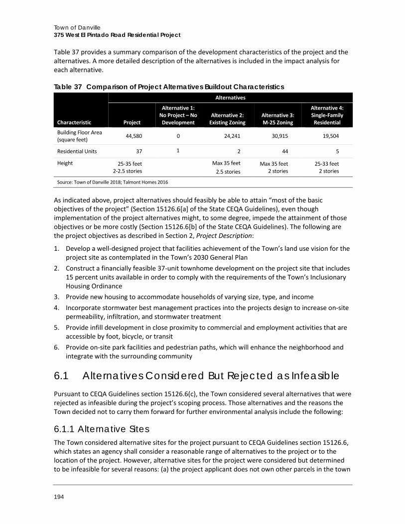
Town of Danville 375 West El Pintado Road Residential Project
194
Table 37 provides a summary comparison of the development characteristics of the project and the alternatives. A more detailed description of the alternatives is included in the impact analysis for each alternative.
Table 37 Comparison of Project Alternatives Buildout Characteristics
Characteristic
Alternatives
Project
Alternative 1: No Project – No Development
Alternative 2: Existing Zoning
Alternative 3: M-25 Zoning
Alternative 4: Single-Family Residential
Building Floor Area (square feet) 44,580 0 24,241 30,915 19,504
Residential Units 37 1 2 44 5
Height 25-35 feet 2-2.5 stories
Max 35 feet 2.5 stories
Max 35 feet 2 stories
25-33 feet 2 stories
Source: Town of Danville 2018; Talmont Homes 2016
As indicated above, project alternatives should feasibly be able to attain “most of the basic objectives of the project” (Section 15126.6[a] of the State CEQA Guidelines), even though implementation of the project alternatives might, to some degree, impede the attainment of those objectives or be more costly (Section 15126.6[b] of the State CEQA Guidelines). The following are the project objectives as described in Section 2, Project Description:
1. Develop a well-designed project that facilities achievement of the Town’s land use vision for theproject site as contemplated in the Town’s 2030 General Plan
2. Construct a financially feasible 37-unit townhome development on the project site that includes15 percent units available in order to comply with the requirements of the Town’s InclusionaryHousing Ordinance
3. Provide new housing to accommodate households of varying size, type, and income4. Incorporate stormwater best management practices into the projects design to increase on-site
permeability, infiltration, and stormwater treatment5. Provide infill development in close proximity to commercial and employment activities that are
accessible by foot, bicycle, or transit6. Provide on-site park facilities and pedestrian paths, which will enhance the neighborhood and
integrate with the surrounding community
6.1 Alternatives Considered But Rejected as Infeasible Pursuant to CEQA Guidelines section 15126.6(c), the Town considered several alternatives that were rejected as infeasible during the project’s scoping process. Those alternatives and the reasons the Town decided not to carry them forward for further environmental analysis include the following:
6.1.1 Alternative Sites The Town considered alternative sites for the project pursuant to CEQA Guidelines section 15126.6, which states an agency shall consider a reasonable range of alternatives to the project or to the location of the project. However, alternative sites for the project were considered but determined to be infeasible for several reasons: (a) the project applicant does not own other parcels in the town
Alternatives
Draft Environmental Impact Report 195
that could accommodate this project, and Guidelines section 15126.6(f)(1) only requires consideration of alternative sites if the project applicant can reasonably acquire or gain access alternative locations; (b) to achieve Objectives 1, 5, and 6, the project must be located near existing alternative means of transportation; (c) other sites along El Pintado Road would not easily accommodate a mixed-use project of this size. Further, given the Town’s current level of urban development, an alternative site location would not likely avoid or substantially lessen the identified impacts of the project (aesthetics, air quality, biology, noise, and traffic).
6.2 Alternative 1: No Project / No Development
6.2.1 Alternative Description This alternative assumes that the project is not implemented and the project site remains in its current condition.
6.2.2 Impact Analysis The No Project/No Development alternative would involve no changes to the physical environment and thus would have no environmental effects. As such, this alternative would have generally reduced impacts with respect to aesthetics, air quality, biological resources, GHG emissions, hydrology and water quality, traffic, and noise. Construction impacts associated with the project would be avoided because no development would occur on the project site. The existing single-family residence would not be demolished. No mitigation measures would be required for the No Project/No Development alternative. Overall impacts would be lower than those of the project since no change to environmental conditions would occur.
The No Project/No Development Alternative would not meet any of the objectives of the project. This alternative would not: develop a well-designed project that facilitates achievement of the Town’s land use vision for the project site, as contemplated in the 2030 General Plan (Objective 1), would not provide housing including low-income housing (Objective 2), would not provide new housing to accommodate households varying in size, type, and income (Objective 3), incorporate stormwater best management practices to increase on-site permeability, infiltration, and stormwater treatment (Objective 4), would not provide infill development in close proximity to commercial and employment activities that are accessible by foot, bicycle, or transit (Objective 5), and would not provide on-site park facilities and pedestrian paths, which will enhance the neighborhood and integrate with the surrounding community (Objective 6). Further, this alternative would not preclude future development of the site. Development consistent with the project site zoning is described and analyzed under Alternative 2.
6.3 Alternative 2: Existing Zoning
6.3.1 Alternative Description The 1.88-acre site is composed of two legal parcels: a 1.59-acre undeveloped parcel and a smaller 0.29-acre parcel developed with a single-family residence. This alternative would involve development consistent with the existing zoning designations and therefore would not include a request to change the site’s zoning. Figure 5 in Section 2, Project Description, shows the zoning for the project site and surrounding uses, and Figure 6 shows the General Plan land use designations for the project site and surrounding uses. The larger 1.59-acre parcel is zoned Limited Office (O-1),
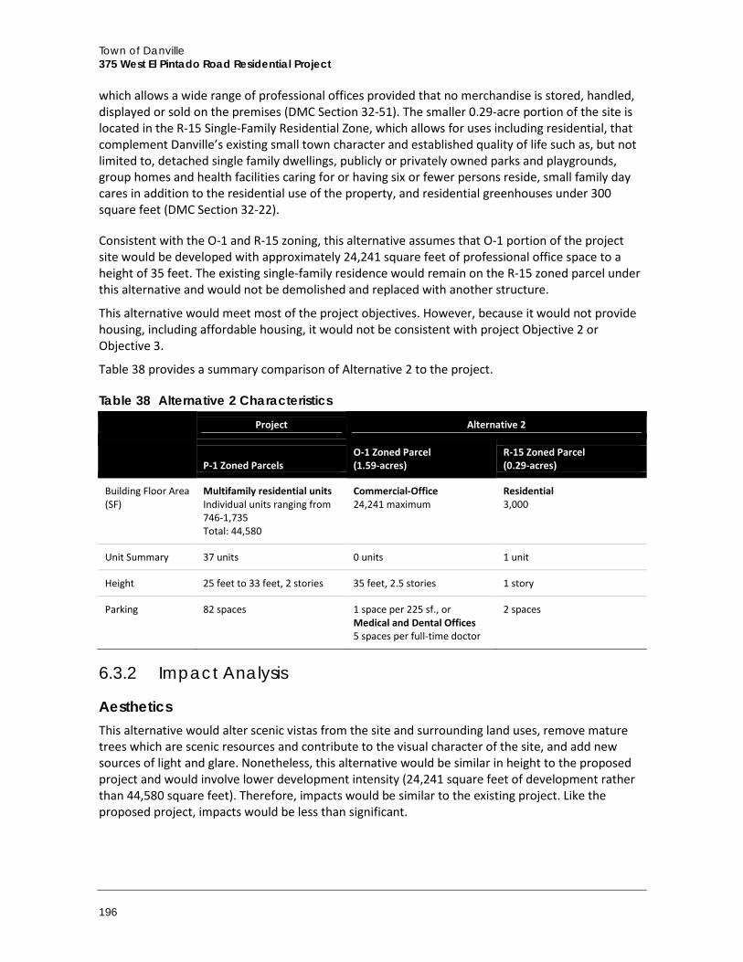
Town of Danville 375 West El Pintado Road Residential Project
196
which allows a wide range of professional offices provided that no merchandise is stored, handled, displayed or sold on the premises (DMC Section 32-51). The smaller 0.29-acre portion of the site is located in the R-15 Single-Family Residential Zone, which allows for uses including residential, that complement Danville’s existing small town character and established quality of life such as, but not limited to, detached single family dwellings, publicly or privately owned parks and playgrounds, group homes and health facilities caring for or having six or fewer persons reside, small family day cares in addition to the residential use of the property, and residential greenhouses under 300 square feet (DMC Section 32-22).
Consistent with the O-1 and R-15 zoning, this alternative assumes that O-1 portion of the project site would be developed with approximately 24,241 square feet of professional office space to a height of 35 feet. The existing single-family residence would remain on the R-15 zoned parcel under this alternative and would not be demolished and replaced with another structure.
This alternative would meet most of the project objectives. However, because it would not provide housing, including affordable housing, it would not be consistent with project Objective 2 or Objective 3.
Table 38 provides a summary comparison of Alternative 2 to the project.
Table 38 Alternative 2 Characteristics
Project Alternative 2
P-1 Zoned Parcels
O-1 Zoned Parcel (1.59-acres)
R-15 Zoned Parcel (0.29-acres)
Building Floor Area (SF)
Multifamily residential units Individual units ranging from 746-1,735 Total: 44,580
Commercial-Office 24,241 maximum
Residential 3,000
Unit Summary 37 units 0 units 1 unit
Height 25 feet to 33 feet, 2 stories 35 feet, 2.5 stories 1 story
Parking 82 spaces 1 space per 225 sf., or Medical and Dental Offices 5 spaces per full-time doctor
2 spaces
6.3.2 Impact Analysis
Aesthetics This alternative would alter scenic vistas from the site and surrounding land uses, remove mature trees which are scenic resources and contribute to the visual character of the site, and add new sources of light and glare. Nonetheless, this alternative would be similar in height to the proposed project and would involve lower development intensity (24,241 square feet of development rather than 44,580 square feet). Therefore, impacts would be similar to the existing project. Like the proposed project, impacts would be less than significant.
Alternatives
Draft Environmental Impact Report 197
Air Quality This alternative would involve construction of office buildings. Ozone precursors NOX and VOC, as well as CO, would be still emitted by the operation of construction equipment such as graders, backhoes, and generators, while fugitive dust (PM10) would still be emitted by activities that disturb the soil, such as grading and excavation and building construction. Similar to the project, standard emission control measures required by the BAAQMD and the Town would still apply. Impacts would be less than significant, similar to the project.
Operational emissions associated with Alternative 2 would be slightly increased compared to the proposed project as the number of trips would incrementally increase (277 average daily trips compared to 212 as described below under “Traffic and Circulation”). Nonetheless, emissions would remain below BAAQMD thresholds. Further, although the increase of vehicle trips associated with this alternative would result in higher CO levels at intersection hotspots, no CO hotspots would be generated. As with the project, operational and CO impacts would be less than significant.
Since this alternative would not involve development of new sensitive receptors (residences) near I-680, it would not expose new residents to toxic air contaminants from freeway vehicle emissions. Therefore, this impact would be reduced compared to the proposed project and would be less than significant. Mitigation Measure AQ-1 would not apply.
Biological Resources This alternative would involve development of a project site that includes mature trees and drainage features. Therefore, impacts to biological resources would be similar under this alternative to those under the proposed project. Development on the site could potentially impact nesting birds, due to removal of mature trees; alter a man-made drainage and natural linear wetland; and remove valley oaks, protected trees, from the site. Implementation of mitigation measures BIO-1 through BIO-6 would be required for this alternative and, similar to the project, impacts would be less than significant with mitigation incorporated.
Greenhouse Gases GHG emissions associated with Alternative 2 would be higher than those associated with the proposed project as it would result in a higher number of vehicle trips (see “Traffic and Circulation” below). Nonetheless, emissions associated with Alternative 2 would be below BAAQMD thresholds and would be consistent with applicable plans and policies adopted for the purposes of reducing GHG emissions, including SB 375, the Town of Danville’s Climate Action Plan and the Town of Danville’s Sustainability Action Plan. Impacts would remain less than significant.
Hydrology and Water Quality Because this alternative would involve approximately half of the building floor area, it would likely involve development of fewer square feet of impervious surfaces compared to the proposed project. Therefore, potential adverse effects related to stormwater runoff and water quality caused by construction and operation of the alternative would be reduced compared to impacts associated with the project. Like the project, this alternative would be subject to NPDES General Permit Storm Water Discharges associated with construction and land disturbance activities. Overall, impacts would be reduced compared to the proposed project but would remain significant but mitigable, the same as the project.
Town of Danville 375 West El Pintado Road Residential Project
198
Land Use and Planning This alternative is designed to involve development consistent with the existing zoning for the project site. Based on maximum allowable build out under the existing zoning classifications, Alternative 2 would include approximately 24,000 square feet of commercial space in a 35-foot high, 2.5 story building on the O-1 zoned portion of the site and a single family residence on the R-15 zoned parcel. This alternative would be consistent with zoning ordinance requirements. Although this alternative would not implement some of the Town’s General Plan policies that encourage increased housing opportunities, this alternative would not conflict with applicable land use plans adopted to reduce environmental impacts. Impacts associated with this alternative would be less than significant and would be the same as those under the proposed project.
Noise
Construction-related noise and vibration impacts would be similar to those of the project. The duration of construction activities would be similar to, but slightly reduced compared to that of the project because the scale of development and length of construction would be reduced. As with the project, construction noise impacts would be less than significant with mitigation incorporated and less than significant for construction vibration impacts. Similar mitigation measures would still be required for construction noise impacts.
The increase of vehicle trips under Alternative 2 would incrementally increase off-site operational traffic noise when compared to the project due to the commercial use of the site, rather than residential. Therefore, the increase in vehicle trips associated with this alternative would result in incrementally higher noise levels on study area roadways. However, the incremental increase of vehicle trips compared to the proposed project would not increase traffic noise levels such that a significant noise impact would occur. As with the project, traffic-related noise impacts to existing sensitive receptors would be less than significant.
Alternative 2 would include office buildings built on the O-I zoned lot. As discussed in Section 4.7, Noise, existing noise on West El Pintado Road was measured between 64.7 to 67.6 dBA Leq and modeled at 65.9 to 67.8 dBA Leq. As a result, future office buildings on the project site may be exposed to a “conditionally acceptable” noise level according to the Town of Danville General Plan Resources and Hazards Chapter. As such, Mitigation Measure N-1 would still be required to reduce impacts associated with exposure of future office buildings to roadway noise. As with the project, impacts would be less than significant with mitigation.
Operation of Alternative 2 would result in noise from on-site sources such as rooftop ventilation and heating systems, trash hauling, conversations and other noises associated with office activities. Noise levels would be similar to those of the project and would be less than significant.
Traffic and Circulation As with the project, construction activities and associated truck trips and worker trips could temporarily disrupt the local roadway system. The overall duration of construction activities and associated traffic disruptions would be similar those of the project. Mitigation Measure T-1 would apply and, as with the project, would reduce construction-related impacts to a less than significant level.
As discussed in Section 4.8, Traffic and Circulation, the project would generate an estimated net new 212 average daily weekday trips, including 16 AM peak hour and 20 PM peak hour trips along
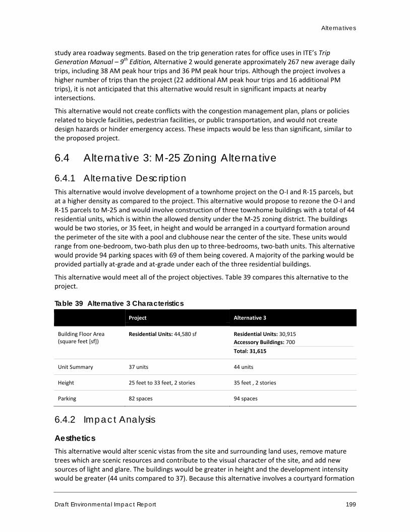
Alternatives
Draft Environmental Impact Report 199
study area roadway segments. Based on the trip generation rates for office uses in ITE’s Trip Generation Manual – 9th Edition, Alternative 2 would generate approximately 267 new average daily trips, including 38 AM peak hour trips and 36 PM peak hour trips. Although the project involves a higher number of trips than the project (22 additional AM peak hour trips and 16 additional PM trips), it is not anticipated that this alternative would result in significant impacts at nearby intersections.
This alternative would not create conflicts with the congestion management plan, plans or policies related to bicycle facilities, pedestrian facilities, or public transportation, and would not create design hazards or hinder emergency access. These impacts would be less than significant, similar to the proposed project.
6.4 Alternative 3: M-25 Zoning Alternative
6.4.1 Alternative Description This alternative would involve development of a townhome project on the O-I and R-15 parcels, but at a higher density as compared to the project. This alternative would propose to rezone the O-I and R-15 parcels to M-25 and would involve construction of three townhome buildings with a total of 44 residential units, which is within the allowed density under the M-25 zoning district. The buildings would be two stories, or 35 feet, in height and would be arranged in a courtyard formation around the perimeter of the site with a pool and clubhouse near the center of the site. These units would range from one-bedroom, two-bath plus den up to three-bedrooms, two-bath units. This alternative would provide 94 parking spaces with 69 of them being covered. A majority of the parking would be provided partially at-grade and at-grade under each of the three residential buildings.
This alternative would meet all of the project objectives. Table 39 compares this alternative to the project.
Table 39 Alternative 3 Characteristics
Project Alternative 3
Building Floor Area (square feet [sf])
Residential Units: 44,580 sf
Residential Units: 30,915 Accessory Buildings: 700 Total: 31,615
Unit Summary 37 units 44 units
Height 25 feet to 33 feet, 2 stories 35 feet , 2 stories
Parking 82 spaces 94 spaces
6.4.2 Impact Analysis
Aesthetics This alternative would alter scenic vistas from the site and surrounding land uses, remove mature trees which are scenic resources and contribute to the visual character of the site, and add new sources of light and glare. The buildings would be greater in height and the development intensity would be greater (44 units compared to 37). Because this alternative involves a courtyard formation
Town of Danville 375 West El Pintado Road Residential Project
200
with buildings on the outside of the site and a pool and clubhouse in the center, this alternative would not include the walking path, playground, and open space area on the northeast corner of the site. This alternative would not retain the mature trees on the corner of the site. Therefore, this alternative would alter the visual character of the site to a greater degree than the proposed project. With compliance with DMC requirements and design review, this project would not substantially degrade the visual quality of the site such that a significant impact would occur. However, mitigation to increase screening trees or include other visual buffers may be warranted. Impacts associated with this alternative would be slightly greater than the proposed project but would remain less than significant.
Air Quality As with the project, this alternative would include demolition of the existing residential structure and construction of residential uses. Ozone precursors NOX and VOC, as well as CO, would be still emitted by the operation of construction equipment such as graders, backhoes, and generators, while fugitive dust (PM10) would still be emitted by activities that disturb the soil, such as grading and excavation and building construction. Impacts would be less than significant, similar to the project. Similar to the project, standard emission control measures required by the SCAQMD and the Town of Danville would apply.
This alternative would have greater operational emissions for all pollutants compared to the project as it would involve more residential units and greater associated trips. Nonetheless, operational emissions are anticipated to be below BAAQMD thresholds. Further, although the increase of vehicle trips associated with this alternative would result in higher CO levels at intersection hotspots, no CO hotspots would be generated. As with the project, operational and CO impacts would be less than significant.
Since this alternative would involve development of new sensitive receptors (residences) near I-680, it would expose new residents to toxic air contaminants from freeway vehicle emissions. This alternative would involve more residential units therefore more residents would be exposed to freeway-related emissions. Therefore, this impact would be increased compared to the proposed project, but would remain significant but mitigable. Mitigation Measure AQ-1 would continue to apply.
Biological Resources This alternative would involve development of a project site that includes mature trees and drainage features. Therefore, impacts to biological resources would be similar under this alternative to those under the proposed project. Development on the site could potentially impact nesting birds, due to removal of mature trees; alter a man-made drainage and natural linear wetland; and remove valley oaks, protected trees, from the site. Implementation of mitigation measures BIO-1 through BIO-6 would be required for this alternative and, similar to the project, impacts would be less than significant with mitigation incorporated.
Greenhouse Gases Alternative 3 would result in incrementally higher GHG emissions than the project due to the increased number of vehicle trips and increased energy demand for natural gas and electricity. Nonetheless, emissions would be below BAAQMD thresholds. Alternative 3 would be consistent with applicable plans and policies adopted for the purpose of reducing GHG emissions, including SB
Alternatives
Draft Environmental Impact Report 201
375 and the Town of Danville Climate Action Plan. Impacts would remain less than significant, the same as the proposed project.
Hydrology and Water Quality Although this alternative would involve additional units compared to the proposed project, it would involve a similar amount of impervious surface area and would be subject to the same potential hydrological and water quality impacts as the project. Therefore, the potential for adverse effects caused by construction and operation of the site would be approximately the same as those of the project. Like the project, this alternative would also disturb soil and potentially result in an increase of soil erosion and stormwater runoff. The project would also be subject to NPDES General Permit Storm Water Discharges associated with construction and land disturbance activities. Overall, impacts would be reduced compared to the proposed project but would remain significant but mitigable, the same as the project.
Land Use and Planning This alternative would involve rezoning the project site to M-25. However, this alternative would not involve density bonuses allowed by the Town’s inclusionary housing ordinance and SB 1818. The M-25 zone has an allowed density range of 20 to 25 units per acre, or one unit per 1,742 to 2,178 square feet (DMC Section 32-25.2). This alternative involves 44 units, or one unit per 1,861 square feet, which is within the allowed density range. The maximum height for any multi-family structure in the M-25 zone is 35 feet (DMC Section 32-25.2). This alternative involves buildings with a maximum height of 35 feet and is consistent with this requirement. Therefore, this alternative would be consistent with the density and building height requirements of the Town’s Zoning Ordinance, assuming the rezoning of M-25 is approved. Like the proposed project, impacts would be significant.
Noise
Construction-related noise and vibration impacts would be similar to the project because project would construction would require the same types of construction equipment. The duration of construction activities would be similar to that of the project because the scale of development and length of construction would be approximately the same. As with the project, construction noise impacts would be less than significant with mitigation incorporated and less than significant for construction vibration impacts. Similar mitigation measures would still be required for construction noise impacts.
The increase of vehicle trips under Alternative 3 would incrementally increase off-site operational traffic noise when compared to the project. Alternative 3 would generate approximately 19 percent additional vehicle trips than would be generated by the project, due to the unit density difference. Therefore, the increase in vehicle trips associated with this alternative would result in incrementally higher noise levels on study area roadways. Nonetheless, as with the project, traffic-related noise impacts to existing sensitive receptors would be less than significant.
Alternative 3 would include 44 townhome units. As discussed in Section 4.7, Noise, existing noise on West El Pintado Road was measured between 64.7 to 67.6 dBA Leq and modeled at 65.9 to 67.8 dBA Leq. As a result, future residences on the project site may be exposed to a “conditionally acceptable” noise level according to the Town of Danville General Plan Resources and Hazards Chapter. As such, Mitigation Measure N-4 would still be required to reduce impacts associated with
Town of Danville 375 West El Pintado Road Residential Project
202
exposure of future residences to roadway noise. As with the project, impacts would be less than significant with mitigation.
Operation of Alternative 3 would result in noise from on-site sources such as stationary equipment, rooftop ventilation and heating systems, trash hauling, conversations and other noises associated with residential activities. Noise levels would be similar to those of the project and would be less than significant.
Traffic and Circulation As with the project, construction activities and associated truck trips and worker trips could temporarily disrupt the local roadway system. The overall duration of construction activities and associated traffic disruptions would be similar those of the project. Mitigation Measure T-1 would apply and, as with the project, would reduce construction-related impacts to a less than significant level.
As discussed in Section 4.8, Traffic and Circulation, the project would generate an estimated 212 new average daily weekday trips, including 16 AM peak hour and 20 PM peak hour trips along study area roadway segments. Alternative 3 would involve a 19 percent increase in residential units compared to the proposed project. Therefore, it would generate a 19 percent increase in trips compared to the proposed project, or approximately 252 average daily weekday trips, including 19 AM peak hour and 24 PM peak hour trips. Although the project involves a higher number of trips than the project (3 additional AM peak hour trips and 4 additional PM trips), it is not anticipated that this alternative would result in significant impacts at nearby intersections.
This alternative would not create conflicts with the congestion management plan, plans or policies related to bicycle facilities, pedestrian facilities, or public transportation, and would not create design hazards or hinder emergency access. These impacts would be less than significant, similar to the proposed project.
6.5 Alternative 4: Single-Family Residential
6.5.1 Alternative Description This alternative involves rezoning the O-1 portion of the project site to R-15, the same zoning as the existing single-family lot on the southeast corner of the project site, and developing the site with single-family residences. This alternative assumes that the existing single-family residence in the 0.29-acre lot on the southeast corner of the project site would be demolished and replaced. In the R-15 zone, the minimum lot size is 15,000 square feet. Therefore, approximately five lots (or five new units) could be accommodated in the 1.88-acre (81,893-square-foot) site. The residences would be two stories, or approximately 25 feet, in height.
This alternative would also involve preserving the natural features of the existing on-site drainages to a greater extent than the proposed project, though some portions of the drainages would need to be covered to accommodate vehicular driveways and pedestrian walkways as needed. This alternative would include on-site pedestrian walkways and open space areas, though these would be developed to a lesser extent than the proposed project and would be for private use.
This alternative would not meet project objectives 1, 2, 3, or 6 as it would not implement the Town’s land use vision for the site, would not develop townhomes or affordable housing units,
Alternatives
Draft Environmental Impact Report 203
would not provide households of varying size, type, and income, and would not provide on-site park facilities and pedestrian paths. This alternative would meet project objectives 4 and 5.
6.5.2 Impact Analysis
Aesthetics Similar to the proposed project, this alternative would alter scenic vistas from the site and surrounding land uses, remove mature trees which are scenic resources and contribute to the visual character of the site, and add new sources of light and glare. However, the residences would be lower in height compared to the proposed project, allowing for more views through the site. The development intensity would be lower (eight new detached single-family residences rather than 37 townhomes) and fewer trees would be removed, so that the overall change to the site’s visual character would be incrementally reduced. This alternative would also introduce fewer new sources of light and glare. Impacts associated with this alternative would be reduced compared to those associated with the proposed project and would be less than significant.
Air Quality Under this alternative, ozone precursors NOX and VOC, as well as CO, would be still emitted by the operation of construction equipment such as graders, backhoes, and generators, while fugitive dust (PM10) would still be emitted by activities that disturb the soil, such as grading and excavation and building construction. Impacts would be less than significant, similar to the project. Just as for the project, standard emission control measures required by the SCAQMD and the Town of Danville would apply.
This alternative would have reduced operational emissions for all pollutants compared to the project as it would involve fewer residential units and fewer associated trips. Further, no CO hotspots would be generated. As with the project, operational and CO impacts would be less than significant.
Since this alternative would involve development of new sensitive receptors (residences) near I-680, it would expose new residents to toxic air contaminants from freeway vehicle emissions. This alternative would involve fewer residential units therefore fewer residents would be exposed to freeway-related emissions. Therefore, this impact would be reduced compared to the proposed project, but would remain significant but mitigable. Mitigation Measure AQ-1 would continue to apply.
Biological Resources This alternative would involve development of a project site that includes mature trees and drainage features. However, this alternative would remove fewer trees and have fewer effects to the natural on-site drainage than the proposed project. Therefore, impacts to biological resources would be reduced under this alternative. Nonetheless, development on the site could potentially impact nesting birds, due to removal of mature trees; alter a man-made drainage and natural linear wetland; and remove valley oaks, protected trees, from the site. Implementation of mitigation measures BIO-1 through BIO-6 would be required for this alternative and, similar to the project, impacts would be less than significant with mitigation incorporated.
Town of Danville 375 West El Pintado Road Residential Project
204
Greenhouse Gases Alternative 4 would result in fewer GHG emissions than the project due to the decreased number of vehicle trips and decreased energy demand for natural gas and electricity. Emissions related to construction activities would be reduced due to the decreased amount of built structures and reduced amount of time of construction. Alternative 4 would be consistent with applicable plans and policies adopted for the purpose of reducing GHG emissions, including SB 375 and the Town of Danville Climate Action Plan. Impacts would remain less than significant.
Hydrology and Water Quality Because this alternative would involve construction of fewer units than the proposed project, it would likely involve development of fewer square feet of impervious surfaces. In addition, this alternative would involve retaining the natural drainage features on the site, although some impacts to the drainages may occur to construction vehicular driveways and pedestrian paths on the site. Potential adverse effects related to stormwater runoff and water quality caused by construction and operation of the alternative would be reduced compared to impacts associated with the project. Like the project, this alternative would be subject to NPDES General Permit Storm Water Discharges associated with construction and land disturbance activities. Overall, impacts would be reduced compared to the proposed project, but would remain significant but mitigable, the same as the project.
Land Use and Planning This alternative would involve rezoning the project site to R-15. The R-15 zone has a minimum lot size of 15,000 square feet. This alternative involves five lots, or one lot per 16,379 square feet. The maximum height for any structure in the R-15 zone is 2.5 stories or 35 feet (DMC Section 32-25.2). This alternative involves residences with a maximum height of 25 feet and is consistent with this requirement. Therefore, this alternative would be consistent with the density and building height requirements of the Town’s Zoning Ordinance, assuming the rezoning of R-15 is approved. Like the proposed project, impacts would be less than significant.
Noise
The duration of construction activities would be reduced compared to that of the project because the scale of development and length of construction would be reduced. As with the project, construction noise impacts would be less than significant with mitigation incorporated and less than significant for construction vibration impacts. Similar mitigation measures would still be required for construction noise impacts.
The decrease of vehicle trips under Alternative 4 would incrementally decrease off-site operational traffic noise when compared to the project. Therefore, the decrease in vehicle trips associated with this alternative would result in incrementally lower noise levels on study area roadways. As with the project, traffic-related noise impacts to existing sensitive receptors would be less than significant.
Alternative 4 would include eight single-family residential units. As discussed in Section 4.7, Noise, existing noise on West El Pintado Road was measured between 64.7 to 67.6 dBA Leq and modeled at 65.9 to 67.8 dBA Leq. As a result, future residences on the project site may be exposed to a “conditionally acceptable” noise level according to the Town of Danville General Plan Resources and Hazards Chapter. As such, Mitigation Measure N-1 would still be required to reduce impacts
Alternatives
Draft Environmental Impact Report 205
associated with exposure of future residences to roadway noise. As with the project, impacts would be less than significant with mitigation.
Operation of Alternative 4 would result in noise from on-site sources such as rooftop ventilation and heating systems, trash hauling, conversations and other noises associated with residential activities. Noise levels would be similar to those of the project and would be less than significant.
Traffic and Circulation As with the project, construction activities and associated truck trips and worker trips could temporarily interrupt the local roadway system. The overall duration of construction activities and associated traffic interruptions would be similar those of the project. Mitigation Measure T-1 would apply and, as with the project, would reduce construction-related impacts to a less than significant level.
As discussed in Section 4.8, Traffic and Circulation, the project would generate an estimated net new 212 average daily weekday trips, including 16 AM peak hour and 20 PM peak hour trips along study area roadway segments. Based on the trip generation rates for single-family residential uses in ITE’s Trip Generation Manual – 9th Edition, Alternative 4 would generate approximately 48 average daily trips, including 4 AM peak hour trips and 5 PM peak hour trips. Because this alternative would reduce trips compared to the proposed project, traffic impacts at nearby intersections would also be reduced. No significant traffic impacts at nearby intersections were identified under the proposed project. Under this alternative, impacts would remain less than significant, the same as the proposed project.
This alternative would not create conflicts with the congestion management plan, plans or policies related to bicycle facilities, pedestrian facilities, or public transportation, and would not create design hazards or hinder emergency access. These impacts would be less than significant, similar to the proposed project.
6.6 Environmentally Superior Alternative Table 40 compares the physical impacts for each of the alternatives to the physical impacts of the project. Alternative 1, No Project, would be the overall environmentally superior alternative since it would avoid all project impacts. However, the No Project Alternative would not achieve the basic project objectives as stated in Section 2, Project Description.
Among the development options, Alternative 4 (Single-Family Residential) would be environmentally superior to the project as it would involve fewer emissions of air pollutants and GHGs, decreased construction and operational noise levels, and reduced traffic. However, Alternative 4 would not meet objectives regarding land use designation of the project site (Objective 1), the provision of affordable housing (Objective 2), providing housing to accommodate households of varying size, type, and income (Objective 3), and the provision of on-site parks and pedestrian paths (Objective 6). Alternative 4 would meet objectives 4 and 5. In addition, Alternative 4 would not be consistent with General Plan Policy 1.05. This policy discourages General Plan amendments which result in the loss of lands designated for multiple family housing.
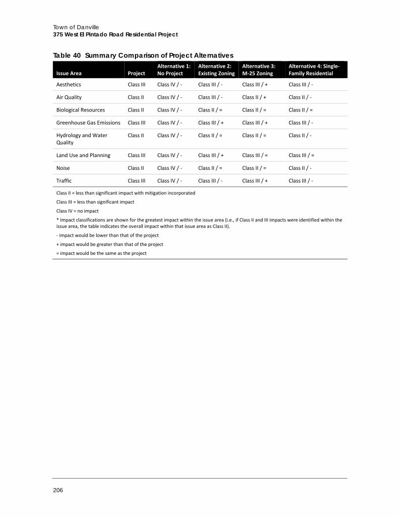
Town of Danville 375 West El Pintado Road Residential Project
206
Table 40 Summary Comparison of Project Alternatives
Issue Area Project Alternative 1: No Project
Alternative 2: Existing Zoning
Alternative 3: M-25 Zoning
Alternative 4: Single-Family Residential
Aesthetics Class III Class IV / - Class III / - Class III / + Class III / -
Air Quality Class II Class IV / - Class III / - Class II / + Class II / -
Biological Resources Class II Class IV / - Class II / = Class II / = Class II / =
Greenhouse Gas Emissions Class III Class IV / - Class III / + Class III / + Class III / -
Hydrology and Water Quality
Class II Class IV / - Class II / = Class II / = Class II / -
Land Use and Planning Class III Class IV / - Class III / + Class III / = Class III / =
Noise Class II Class IV / - Class II / = Class II / = Class II / -
Traffic Class III Class IV / - Class III / - Class III / + Class III / -
Class II = less than significant impact with mitigation incorporated
Class III = less than significant impact
Class IV = no impact
* Impact classifications are shown for the greatest impact within the issue area (i.e., if Class II and III impacts were identified within the issue area, the table indicates the overall impact within that issue area as Class II).
- impact would be lower than that of the project
+ impact would be greater than that of the project
= impact would be the same as the project
References
Draft Environmental Impact Report 207
7 References
7.1 Bibliography Association of Bay Area Governments (ABAG). 2016. Resilience Program – Tsunami Inundation Area
for Emergency Planning. [online]: http://gis.abag.ca.gov/website/Hazards/?hlyr=tsunami.
Association of Environmental Professionals (AEP). 2016. Final White Paper, Beyond 2020 and Newhall: A Field Guide to New CEQA Greenhouse Gas Thresholds and Climate Action Plan Targets for California. [online]: https://www.califaep.org/images/climate-change/AEP-2016_Final_White_Paper.pdf
ABAG and MTC (Metropolitan Transportation Commission). 2013. Plan Bay Area. [online]: http://files.mtc.ca.gov.s3.amazonaws.com/pdf/Plan_Bay_Area_FINAL/pbafinal/index.html.
Airport-Data.com. “Little Hands Airport (59CA) Information.” Airport-Data.com. [online]: http://www.airport-data.com/airport/59CA/.
Association of Environmental Professionals (AEP). 2016. California Environmental Quality Act (CEQA) Statute and Guidelines.
Bay Area Air Quality Management District (BAAQMD). 2012. Risk and Hazard Screening Analysis Process Flow Chart. [online]: http://www.baaqmd.gov/~/media/files/planning-and-research/ceqa/updated-screening-approach-flow-chart_may-2012.pdf?la=en
_____. 2013. Community Air Risk Evaluation (CARE) Program website, Impacted Communities Map. [online]: http://www.baaqmd.gov/research-and-data/interactive-data-maps
_____. 2015a. 2014 Air Monitoring Network Plan. July 1, 2015. [online]: http://www.baaqmd.gov/~/media/files/technical-services/2014_network_plan.pdf?la=en
_____. 2015b. Roadway Screening Analysis Calculator. April 16, 2015. [online]: ttp://www.baaqmd.gov/plans-and-climate/california-environmental-quality-act-ceqa/ceqa-tools
_____. 2017a. Air Quality Standards and Attainment Status. [online]: http://www.baaqmd.gov/research-and-data/air-quality-standards-and-attainment-status
_____. 2017b. 2017 Clean Air Plan. [online]: http://www.baaqmd.gov/~/media/files/planning-and-research/plans/2017-clean-air-plan/attachment-a_-proposed-final-cap-vol-1-pdf.pdf?la=en
_____. 2017c. California Environmental Quality Act Air Quality Guidelines. [online]: http://www.baaqmd.gov/~/media/files/planning-and-research/ceqa/ceqa_guidelines_may2017-pdf.pdf?la=en
California Air Pollution Control Officers Association (CAPCOA). 2008. CEQA and Climate Change: Addressing Climate Change through California Environmental Quality Act (CEQA).
_____. 2010. Quantifying Greenhouse Gas Mitigation Measures. August 2010. [online]: http://www.capcoa.org/wp-content/uploads/2010/11/CAPCOA-Quantification-Report-9-14-Final.pdf
Town of Danville 375 West El Pintado Road Residential Project
208
_____. 2017. California Emissions Estimator Model (CalEEMod) User’s Guide. Version 2016.3.2. Prepared by BREEZE Software. November 2017. [online]: http://www.aqmd.gov/docs/default-source/caleemod/01_user-39-s-guide2016-3-2_15november2017.pdf?sfvrsn=4
California Air Resources Board (CARB). 2005. Air Quality and Land Use Handbook: A Community Health Perspective.
______. 2011. Staff Report: Initial Statement of Reasons for Proposed Rulemaking, Public Hearing to Consider the “LEV III” Amendments to the California Greenhouse Gas and Criteria Pollutant Exhaust and Evaporative Emission Standards and Test Procedures and to the On-Board Diagnostic System Requirements for Passenger Cars, Light-Duty Trucks, and Medium-Duty Vehicles, and to the Evaporative Emission Requirements for Heavy-Duty Vehicles. [online]: http://www.arb.ca.gov/regact/2012/leviiighg2012/levisor.pdf
______. 2014. AB 32 Scoping Plan Website. [online]: http://www.arb.ca.gov/cc/scopingplan/scopingplan.htm
______. May 2016. Ambient Air Quality Standards. [online]: http://www.arb.ca.gov/research/aaqs/aaqs2.pdf
______. 2011, 2012, and 2013 Annual Air Quality Data Summaries. [online]: http://www.arb.ca.gov/adam/topfour/topfour1.php
______. February 14, 2013. Quality Assurance Air Monitoring Sites by County. [online]: http://www.arb.ca.gov/qaweb/basinselect.php?b_airs_code=02
______. 2017a. California Greenhouse Gas Emission Inventory – 2017 Edition. June 2017a. [online]: Available at: http://www.arb.ca.gov/cc/inventory/data/data.htm.
______. 2017b. 2020 Business-as-Usual (BAU) Emissions Projection – 2014 Edition. [online]: https://www.arb.ca.gov/cc/inventory/data/bau.htm
______. 2017c. California’s 2017 Climate Change Scoping Plan. [online]: https://www.arb.ca.gov/cc/scopingplan/scoping_plan_2017.pdf.
California Climate Action Registry (CCAR) General Reporting Protocol, Reporting Entity-Wide Greenhouse Gas Emissions, Version 3.1, January 2009.
California Climate Change Center (CCCC). 2006. Climate Scenarios for California. 2006.
______. 2009. The Impacts of Sea-Level Rise on the California Coast. May 2009.
California Department of Fish and Game (CDFG) and U.S. Fish and Wildlife Service (USFWS). March 2004. Final South Bay Salt Ponds Initial Stewardship Plan EIR/EIS. Prepared by Life Science!, Inc. [online]: http://www.southbayrestoration.org/pdf_files/Init%20Stewardship%20EIR-EIS/Final%20C1%20to%20C5.pdf
California Department of Fish and Wildlife (CDFW). 2016. California Natural Diversity Database. RareFind 5. [online]: https://www.wildlife.ca.gov/Data/CNDDB.
California Department of Transportation (Caltrans). 1998. Technical Noise Supplement: TENS, A Technical Supplement to the Traffic Noise Analysis Protocol. Sacramento, CA. [online]: http://www.dot.ca.gov/hq/env/noise/pub/Technical%20Noise%20Supplement.pdf.
______. 2004. Transportation- and Construction-Induced Vibration Guidance Manual. Sacramento, CA. June 2004. [online]: http://www.dot.ca.gov/hq/env/noise/pub/vibrationmanFINAL.pdf.
References
Draft Environmental Impact Report 209
______. 2014. Annual Average Daily Truck Traffic on the California State Highway System. Sacramento, CA. [online]: http://www.dot.ca.gov/trafficops/census/docs/2014_aadt_truck.pdf.
California Department of Water Resources (DWR). October 2008. Managing an Uncertain Future: Climate Change Adaption Strategies for California’s Water.
California Energy Commission (CEC). March 2009. Environmental Health and Equity Impacts from Climate Change and Mitigation Policies in California: A Review of the Literature.
California Environmental Protection Agency (CalEPA). April 2010. Climate Action Team Biennial Report. Final Report. [online]: http://www.energy.ca.gov/2010publications/CAT-1000-2010-004/CAT-1000-2010-004.PDF
____. 2006. Climate Action Team Report to Governor Schwarzenegger and the Legislature. [online]: http://www.climatechange.ca.gov/climate_action_team/reports/2006-04-03_FINAL_CAT_REPORT_EXECSUMMARY.PDF
California Invasive Plant Council (Cal-IPC). 2016. [online]: http://www.cal-ipc.org/ip/management/plant_profiles/Acacia_melanoxylon.php
California Geological Survey (CGS). 2002. Note 36 – California Geomorphic Provinces. [online]: http://www.conservation.ca.gov/cgs/information/publications/cgs_notes/note_36/Documents/note_36.pdf.
California Native Plant Society (CNPS) 2016. Inventory of Rare and Endangered Plants(online edition v8-02). California Native Plant Society, Sacramento, California. [online]: http://rarplants.cnps.org.
CalFish. 2004. California Interagency Watershed Map of 1999 (CalWater 2.2.1). [online]: http://www.calfish.org/ProgramsData/ReferenceLayersHydrography/CaliforniaInteragencyWatershedMapof1999.aspx.
Danville, Town of. 2009a. Climate Action Plan (CAP).
______. 2009b. Town of Danville 2007-2014 Housing Element. Danville, CA. December 15, 2009. [online]: http://www.danville.ca.gov/Services/Planning-Services/General-Plan/Housing-Element-2007-2014/.
______. 2012. Town of Danville General Plan 2030 Draft EIR, Section 4.11 Noise. Danville, CA. October 12, 2012. [online]: www.danville.ca.gov/WorkArea/DownloadAsset.aspx?id=7967.
______. 2013a. The Town of Danville 2030 General Plan: Danville, CA. March 19, 2013. [online]: http://www.danville.ca.gov/Services/Planning-Services/General-Plan/.
______. 2013b. Town of Danville Sustainability Action Plan (SAP). Danville, CA. March 19, 2013.
______. 2014. Podva Property Residential Project Draft EIR. Danville, CA. April 1, 2014.
______. 2016. Town of Danville PACE Clean Energy Financing (PACE Programs). Danville, CA. October 10, 2016. [online]: http://www.danville.ca.gov/PACE-Clean-Energy-Programs.aspx.
______. 2017. “Danville, California Municipal Code.” American Legal Publishing Corporation. Last modified: October 17, 2017. [online]: http://library.amlegal.com/nxt/gateway.dll/California/danville_ca/danvillecaliforniamunicipalcode?f=templates$fn=default.htm$3.0$vid=amlegal:danville_ca
Town of Danville 375 West El Pintado Road Residential Project
210
Department of Water Resources (DWR). 2003. San Francisco Bay Hydrologic Region. 2003 Bulletin 118 Update. [online]: http://www.water.ca.gov/pubs/groundwater/bulletin_118/california's_groundwater__bulletin_118_-_update_2003_/bulletin118_2-sf.pdf.
_____. 2004. California’s Groundwater Bulletin 118 – San Ramon Valley Groundwater Basin. [online]: http://www.water.ca.gov/pubs/groundwater/bulletin_118/basindescriptions/2-7.pdf.
Federal Emergency Management Agency (FEMA). 2016. National Flood Hazard Layer (NFHL). [online]: https://www.fema.gov/national-flood-hazard-layer-nfhl.
Federal Highway Administration (FHWA). “Traffic Noise Model: FHWA Traffic Noise Model Version 2.5.”United States Department of Transportation. Last modified: May 19, 2016. [online]: https://www.fhwa.dot.gov/environment/noise/traffic_noise_model/tnm_v25/.
Federal Transit Administration (FTA). 2006. Transit Noise and Vibration Impact Assessment, FTA-VA-90-1003-06. Washington, DC. May 2006. [online]: https://www.transit.dot.gov/sites/fta.dot.gov/files/docs/FTA_Noise_and_Vibration_Manual.pdf.
Gordon Bricken & Associates, Parking Lot Noise Estimates, 1996.
Governor’s Office of Planning and Research. 2017. General Plan Guidelines, Appendix D, Noise Element Guidelines. [online]: http://www.opr.ca.gov/docs/OPR_Appendix_D_final.pdf
Idcide.com. 2016. Danville, CA Weather. [online]: http://www.idcide.com/weather/ca/danville.htm.
Intellicast. 2018. Historic Average Danville, California. [online]: http://www.intellicast.com/Local/History.aspx?location=USCA0280
Intergovernmental Panel on Climate Change (IPCC). Revised 1996 IPCC Guidelines for National Greenhouse Gas Inventories. (Kroeze, C.; Mosier, A.; Nevison, C.; Oenema, O.; Seitzinger, S.; Cleemput, O. van; Conrad, R.; Mitra, A.P.; H.U., Neue; Sass, R.). Paris: OECD, 1997.
_____. 2007: Summary for Policymakers. In: Climate Change 2007: The Physical Science Basis. Contribution of Working Group I to the Fourth Assessment Report of the Intergovernmental Panel on Climate Change [Solomon, S., D. Qin, M. Manning, Z. Chen, M. Marquis, K.B. Averyt, M. Tignor and H.L. Miller (eds.)]. Cambridge University Press, Cambridge, United Kingdom and New York, NY, USA.
_____. 2014: Summary for Policymakers. In: Climate Change 2014, Mitigation of Climate Change. Contribution of Working Group III to the Fifth Assessment Report of the Intergovernmental Panel on Climate Change [Edenhofer, O., R. Pichs-Madruga, Y. Sokona, E. Farahani, S. Kadner, K. Seyboth, A. Adler, I. Baum, S. Brunner, P. Eickemeier, B. Kriemann, J. Savolainen, S. Schlömer, C. von Stechow, T. Zwickel and J.C. Minx (eds.)]. Cambridge University Press, Cambridge, United Kingdom and New York, NY, USA.
Parmesan, C. 2004. Ecological and Evolutionary Responses to Recent Climate Change.
Santa Clara Valley Urban Runoff Pollution Prevention Program, C.3 Stormwater Handbook, April 2012. [online]: http://www.scvurppp-w2k.com/pdfs/1112/C3_Handbook_Chapters-042012-Web.pdf
References
Draft Environmental Impact Report 211
San Francisco Bay Regional Water Quality Control Board (SFBRWQCB). 2015. San Francisco Bay Basin Water Quality Control Plan (Basin Plan). [online]: http://www.waterboards.ca.gov/sanfranciscobay/water_issues/programs/planningtmdls/basinplan/web/docs/BP_all_chapters.pdf.
Santa Clara Valley Urban Runoff Pollution Prevention Program, C.3 Stormwater Handbook, April 2012. [online]: http://www.scvurppp-w2k.com/pdfs/1112/C3_Handbook_Chapters-042012-Web.pdf
State Water Resources Control Board. 2012. Final 2012 California Integrated Report, Clean Water Act Section 303(d) List/305(b) Report. [online]: http://www.waterboards.ca.gov/water_issues/programs/tmdl/integrated2012.shtml.
Spencer, W.D., P. Beier, K. Penrod, K. Winters, C. Paulman, H. Rustigian-Romsos, J. Strittholt, M. Parisi, and A. Pettler. 2010. California Essential Habitat Connectivity Project: A Strategy for Conserving a Connected California. Prepared for California Department of Transportation, California Department of Fish and Game, and Federal Highways Administration.
TALUS Engineering. March 8, 2017. Preliminary Stormwater Control Plan for 375 W El Pintado Rd.
TJKM Transportation Consultants. March 2018. Draft Transportation Impact Study: 375 West El Pintado Road Residential Development. Danville, CA.
U.S. Army Corps of Engineers (USACE). 1987. Corps of Engineers Wetlands Delineation Manual. (on-line edition). Environmental Laboratory. Vicksburg, MS: U.S. Army Engineer Research and Development Center. January 1987.
____. 2008. Regional Supplement to the U.S. Army Corps of Engineers Wetland Delineation Manual: Arid West Region (Version 2). Ed. J. S. Wakeley, R. W. Lichvar, and C. V. Noble. ERDC/EL TR-06-16. Vicksburg, MS: U.S. Army Engineer Research and Development Center. September 2008.
United States Department of Energy, Energy Information Administration. 2010. Annual Energy Review 2009. August 2010. [online]: http://www.eia.gov/aer/envir.html.
United States Environmental Protection Agency (EPA). 2011. Exposure Factors Handbook 2011 Edition. [online]: https://cfpub.epa.gov/ncea/risk/recordisplay.cfm?deid=236252.
____. 2013. Policy Assessment for the Review of the Lead National Ambient Air Quality Standard. U. S. EPA #452/P-12-001. January 2013. [online]: https://www3.epa.gov/ttn/naaqs/standards/pb/data/010913_pb-draft-pa.pdf
____. 2016. Inventory of U.S. Greenhouse Gas Emissions and Sinks: 1990-2014. U. S. EPA #430-R-16-002. April 2016. [online]: http://www.epa.gov/climatechange/emissions/usinventoryreport.html
U.S. Fish and Wildlife Service (USFWS). 1995. Office of Migratory Bird Management. Migratory Nongame Birds of Management Concern in the United States: The list. September 1995. Washington D.C.
____. 2002. Recovery Plan for the California Red-legged Frog (Rana aurora draytonii). U.S. Fish and Wildlife Service, Portland, Oregon. viii + 173 pp.
____. 2010. Endangered and Threatened Wildlife and Plants: Revised Designation of Critical Habitat for California Red-Legged Frog, Final Rule. March 17, 2010.
Town of Danville 375 West El Pintado Road Residential Project
212
____. 2016a. Information for Planning and Conservation (IPaC). [online]: http://www.cal-ipc.org/ip/management/plant_profiles/Acacia_melanoxylon.php.
____. 2016b. National Wetlands Inventory. (NWI) Mapper. [online]: https://www.fws.gov/wetlands/.
United States Geological Survey (USGS). 2016a. The National Map – National Hydrography Dataset. [online]: http://viewer.nationalmap.gov/viewer/.
_____. 2016b. The National Map – National Elevation Dataset. [online]: http://viewer.nationalmap.gov/viewer/.
Walnut Creek Watershed Council. 2013. Walnut Creek Watershed Inventory. [online]: http://www.ccrcd.org/wc/WalnutCr_Watershed_Inventory_web.pdf.
Worland, J. December 12, 2015. What to Know About the Historic ‘Paris Agreement’ on Climate Change. [online]: http://time.com/4146764/paris-agreement-climate-cop-21/
World Meteorological Organization. March 2013. A summary of current and climate change findings and figures.
References
Draft Environmental Impact Report 213
7.2 List of Preparers RINCON CONSULTANTS, INC. This EIR was prepared by Rincon Consultants, Inc. under contract with the Town of Danville. Consultant staff involved in the preparation of the EIR are listed below.
Abe Leider, Principal Joe Power, Principal Karly Kaufman, Project Manager Christy Sabdo, Senior Environmental Project Manager Susanne Huerta, Senior Environmental Planner Matthew Long, Senior Environmental Scientist Abagale Taylor, Associate Planner Nik Kilpelainen, Associate Planner Vanessa Villanueva, Associate Planner Wade Sherman, Graphics Technician Chris Jackson, Technical Editor Debra Jane Seltzer, Document Production Specialist

Town of Danville 375 West El Pintado Road Residential Project
214
This page intentionally left blank.