Embed Size (px)
Citation preview
June 9, 2003 Source Water Assessment and Protection Report Page 1
Introduction We are all concerned about the quality of the water we drink. Drinking water sources may be threatened by many potential contaminant sources, including storm runoff, road salting, and improper disposal of hazardous materials. Citizens and local officials can work together to better protect these drinking water sources. Purpose of this report: This report is a planning tool to support local and state efforts to improve water supply protection. By identifying land uses within water supply protection areas that may be potential sources of contamination, the assessment helps focus protection efforts on appropriate best management practices (BMPs) and drinking water source protection measures. Refer to Table 3 for Recommendations to address potential sources of contamination. Department of Environmental Protection (DEP) staff are available to provide information about funding and other resources that may be available to your community. This report includes the following sections:
1. Description of the Water System 2. Land Uses within Protection Areas 3. Emergency Planning Recommendations for Class B River Intakes 4. Source Water Protection 5. Appendices
Massachusetts Department of Environmental Protection Source Water Assessment and Protection (SWAP) Report
for
Peabody Water Department
What is SWAP?
The Source Water Assessment Program (SWAP), established under the federal Safe Drinking Water Act, requires every state to:
• inventory land uses within the recharge areas of all public water supply sources;
• assess the susceptibility of drinking water sources to contamination from these land uses; and
• publicize the results to provide support for improved protection.
Susceptibility and Water Quality
Susceptibility is a measure of a water supply’s potential to become contaminated due to land uses and activities within its recharge area.
A source’s susceptibility to contamination does not imply poor water quality.
Water suppliers protect drinking water by monitoring for more than 100 chemicals, disinfecting, filtering, or treating water supplies, and using source protection measures to ensure that safe water is delivered to the tap.
Actual water quality is best reflected by the results of regular water tests. To learn more about your water quality, refer to your water supplier’s annual Consumer Confidence Reports.
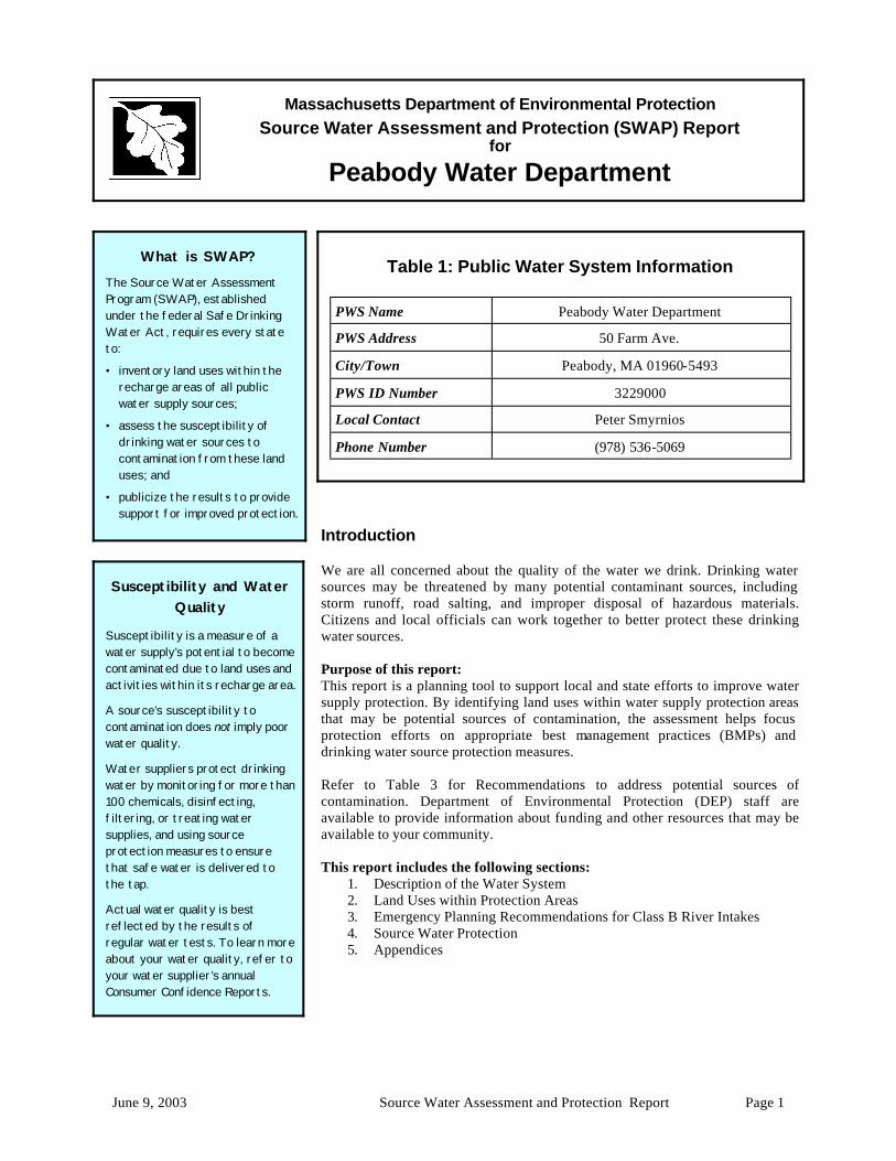
Table 1: Public Water System Information
PWS Name Peabody Water Department
PWS Address 50 Farm Ave.
City/Town Peabody, MA 01960-5493
PWS ID Number 3229000
Local Contact Peter Smyrnios
Phone Number (978) 536-5069
June 9, 2003 Source Water Assessment and Protection Report Page 2
Section 1: Description of the Water System
Class B Drinking Water Sources There are twelve Class B drinking water sources on rivers in Massachusetts, eleven in the urbanized northeast and one in the western part of the State. Three of these sources are located on the Ipswich River.
The Peabody Water Department (Peabody) maintains and operates six public water supply sources. Peabody’s water supplies are located within the North Coastal and Ipswich River basins. The reservoirs for Peabody are located within three separate water supply protection areas, with Spring Pond Reservoir (01S) being in Peabody, Salem, and a small portion in Lynn; Suntaug Reservoir (02S) being in Peabody and Lynnfield; and, Winona Pond Reservoir (04S) being entirely in Peabody. The intake for the Ipswich River (04S) is in Peabody. The Pine Street Well (01G) and Johnson Street Well (02G) are both in Peabody. For current information on monitoring results and treatment, please contact the Public Water System contact person listed above in Table 1 for a copy of the most recent Consumer Confidence Report. Drinking water monitoring reporting data is also available on the web at http://www.epa.gov/safewater/ccr1.html
Glossary Aquifer: An underground water-bearing layer of permeable material that will yield water in a usable quantity to a well.
Hydrogeologic Barrier: An underground layer of impermeable material (i.e. clay) that resists penetration by water.
Recharge Area: The surface area that contributes water to a well.
Zone I: The area closest to a well; a 100 to 400 foot radius proportional to the well’s pumping rate. This area should be owned or controlled by the water supplier and limited to water supply activities.
Zone II: The primary recharge area for the aquifer. This area is defined by hydrogeologic studies that must be approved by DEP. Refer to the attached map to determine the land within your Zone II.
Zone A: is the most critical for protection efforts. It is the area 400 feet from the edge of the reservoir and 200 feet from the edge of the tributaries (rivers and/or streams) draini ng into it.
Zone B: is the area one-half mile from the edge of the reservoir but does not go beyond the outer edge of the watershed.
Zone C: is the remaining area in the watershed not designated as Zones A or B.
The attached map shows Zone A and your watershed boundary.
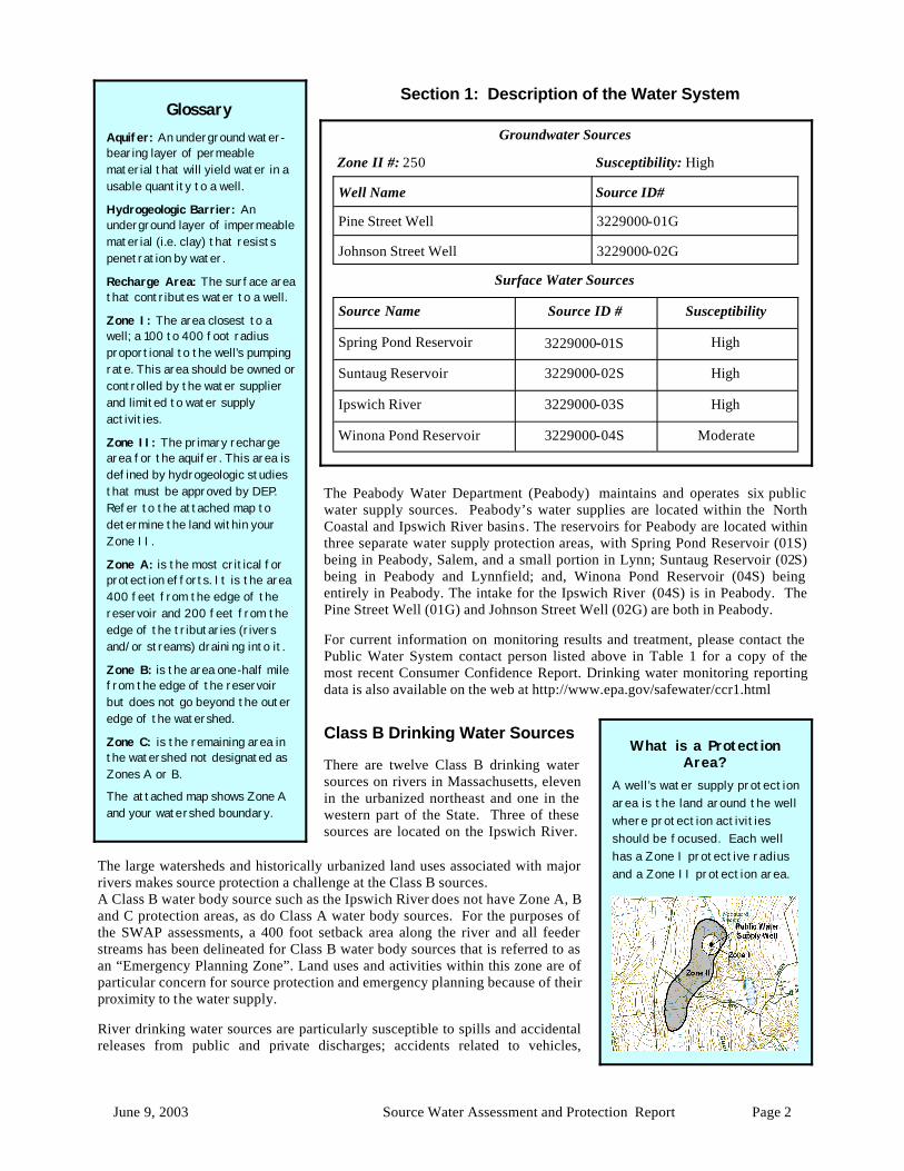
Groundwater Sources
Zone II #: 250 Susceptibility: High
Well Name Source ID#
Pine Street Well 3229000-01G
Johnson Street Well 3229000-02G
Surface Water Sources
Source Name Source ID # Susceptibility
Spring Pond Reservoir 3229000-01S High
Suntaug Reservoir 3229000-02S High
Ipswich River 3229000-03S High
Winona Pond Reservoir 3229000-04S Moderate
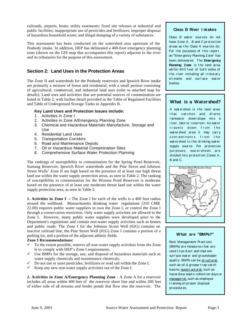
What is a Protection Area?
A well’s water supply protection area is the land around the well where protection activities should be focused. Each well has a Zone I protective radius and a Zone II protection area. The large watersheds and historically urbanized land uses associated with major
rivers makes source protection a challenge at the Class B sources. A Class B water body source such as the Ipswich River does not have Zone A, B and C protection areas, as do Class A water body sources. For the purposes of the SWAP assessments, a 400 foot setback area along the river and all feeder streams has been delineated for Class B water body sources that is referred to as an “Emergency Planning Zone”. Land uses and activities within this zone are of particular concern for source protection and emergency planning because of their proximity to the water supply. River drinking water sources are particularly susceptible to spills and accidental releases from public and private discharges; accidents related to vehicles,
June 9, 2003 Source Water Assessment and Protection Report Page 3
railroads, airports, boats; utility easements; fixed site releases at industrial and public facilities; inappropriate use of pesticides and fertilizers; improper disposal of hazardous household waste; and illegal dumping of a variety of substances. This assessment has been conducted on the watershed area upstream of the Peabody intake. In addition, DEP has delineated a 400-foot emergency planning zone (shown on the GIS map that accompanies this report) adjacent to the river and its tributaries for the purpose of this assessment. Section 2: Land Uses in the Protection Areas The Zone II and watersheds for the Peabody reservoirs and Ipswich River intake are primarily a mixture of forest and residential, with a small portion consisting of agricultural, commercial, and industrial land uses (refer to attached map for details). Land uses and activities that are potential sources of contamination are listed in Table 2, with further detail provided in the Table of Regulated Facilities and Table of Underground Storage Tanks in Appendix B.
Key Land Uses and Protection Issues include: 1. Activities in Zone I 2. Activities in Zone A/Emergency Planning Zone 3. Chemical and Hazardous Materials Manufacture, Storage and
Use 4. Residential Land Uses 5. Transportation Corridors 6. Road and Maintenance Depots 7. Oil or Hazardous Material Contamination Sites 8. Comprehensive Surface Water Protection Planning
The rankings of susceptibility to contamination for the Spring Pond Reservoir, Suntaug Reservoir, Ipswich River watersheds and the Pine Street and Johnson Street Wells’ Zone II are high based on the presence of at least one high threat land use within the water supply protection areas, as seen in Table 2. The ranking of susceptibility to contamination for the Winona Pond Reservoir is moderate based on the presence of at least one moderate threat land use within the water supply protection area, as seen in Table 2. 1. Activities in Zone I – The Zone I for each of the wells is a 400 foot radius around the wellhead. Massachusetts drinking water regulations (310 CMR 22.00) requires public water suppliers to own the Zone I, or control the Zone I through a conservation restriction. Only water supply activities are allowed in the Zone I. However, many public water supplies were developed prior to the Department's regulations and contain non-water supply activities such as homes and public roads. The Zone I for the Johnson Street Well (02G) contains an inactive railroad line; the Pine Street Well (01G) Zone I contains a portion of a parking lot, and a portion of the adjacent athletic fields. Zone I Recommendations: ü To the extent possible, remove all non-water supply activities from the Zone
Is to comply with DEP’s Zone I requirements. ü Use BMPs for the storage, use, and disposal of hazardous materials such as
water supply chemicals and maintenance chemicals. ü Do not use or store pesticides, fertilizers or road salt within the Zone I. ü Keep any new non-water supply activities out of the Zone I. 2. Activities in Zone A/Emergency Planning Zone - A Zone A for a reservoir includes all areas within 400 feet of the reservoir shore line and within 200 feet of either side of all streams and feeder ponds that flow into the reservoir. The
Class B River Intakes
Class B water sources do not have Zone A , B and C protection areas as the Class A sources do. For the purposes of this report, an “Emergency Planning Zone” has been delineated. The Emergency Planning Zone is the land area within 400 feet of both sides of the river including all tributary streams and surface water bodies.
What is a Watershed? A watershed is the land area that catches and drains rainwater down-slope into a river, lake or reservoir. As water travels down from the watershed area it may carry contam inants from the watershed to the drinking water supply source. For protection purposes, watersheds are divided into protection Zones A, B and C.
What are "BMPs?"
Best Management Practices (BMPs) are measures that are used to protect and improve surface water and groundwater quality. BMPs can be structural, such as oil & grease trap catch basins, nonstructural, such as hazardous waste collection days or managerial, such as employee training on proper disposal procedures.
June 9, 2003 Source Water Assessment and Protection Report Page 4
Emergency Planning Zone is a 400 foot setback on either side of the river and all tributaries to a Class B river intake. Land use activities within a Zone A or Emergency Planning Zone may have an impact on surface water sources. Existing and future land use activities which may have an impact on surface water sources include: on-site septic systems; public and private recreational activities; untreated stormwater runoff; domestic animals; new construction; spills along roads; above ground and underground storage tanks; erosion; and, un-permitted and unauthorized activities. Also, wild animals and domestic pets can be carriers of waterborne diseases such as Giardia, Cryptosporidium, Salmonella, etc. Zone A Recommendations: Work with communities within the combined watersheds to: ü To the extent possible, remove all activities from the Zone As to comply with DEP’s Zone A requirements. ü Use BMPs for the storage, use, and disposal of hazardous materials. ü Storage of pesticides, fertilizers or road salt within the Zone A and Emergency Planning Zone should be covered
and contained. ü Keep any new prohibited activities out of the Zone A. ü Identify stormwater drains and the drainage system along transportation corridors. Work to better manage
stormwater by pre-t reating contaminated stormwater and/or redirecting stormwater outside of the Zone A and Emergency Planning Zone.
ü Continue your efforts to protect these areas and to monitor and review activities within the Zone A and Emergency Planning Zone.
3. Chemical and Hazardous Materials Manufacture, Storage and Use – Many large and small businesses use hazardous materials, produce hazardous waste products, and/or store large quantities of hazardous materials in Underground Storage Tanks (UST)/Aboveground Storage Taks (AST). Although many facilities within the watershed use best management practices (BMPs), hazardous materials and waste can be unexpectedly released through spills,
leaks or improper handling or storage, and become potential sources of contamination. Hazardous materials should never be disposed of to a septic system or floor drain leading directly to the ground. Hazardous Materials Storage and Use Recommendations: Work with communities within the combined watersheds to: ü Educate local businesses on BMPs for
protecting water supplies, and encourage them to use BMPs for handling, storing and disposing of hazardous waste. Distribute the fact sheet “Businesses Protect Drinking Water” available in Appendix A and on www.mass.gov/dep/brp/dws/protect.htm, which provides BMPs for common business issues.
ü Work with local businesses to register those facilities that are unregistered generators of hazardous waste or waste oil. Partnerships between businesses, water suppliers, and communities enhance successful public drinking water protection practices.
ü Educate loca l bus inesses on Massachusetts floor drain requirements. See brochure “Industrial Floor Drains” for more information.
ü Continue monitoring water quality in the Ipswich River.
(Continued on page 8)
June 9, 2003 Source Water Assessment and Protection Report Page 5
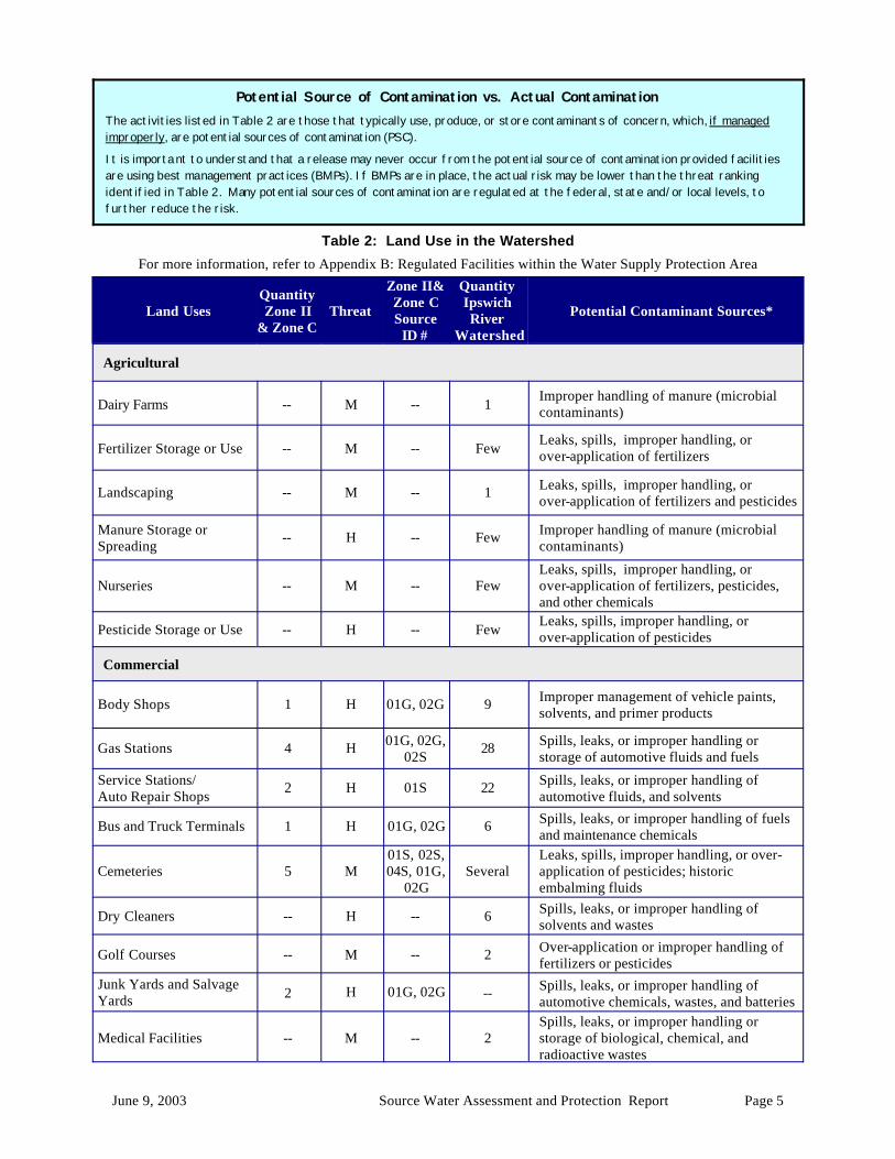
Potential Source of Contamination vs. Actual Contamination The activities listed in Table 2 are those that typically use, produce, or store contaminants of concern, which, if managed improperly, are potential sources of contamination (PSC).
It is importa nt to understand that a release may never occur from the potential source of contamination provided facilities are using best management practices (BMPs). If BMPs are in place, the actual risk may be lower than the threat ranking identified in Table 2. Many potential sources of contamination are regulated at the federal, state and/or local levels, to further reduce the risk.
Table 2: Land Use in the Watershed
For more information, refer to Appendix B: Regulated Facilities within the Water Supply Protection Area
Land Uses Quantity Zone II
& Zone C Threat
Zone II& Zone C Source
ID #
Quantity Ipswich River
Watershed
Potential Contaminant Sources*
Agricultural
Dairy Farms -- M -- 1 Improper handling of manure (microbial contaminants)
Fertilizer Storage or Use -- M -- Few Leaks, spills, improper handling, or over-application of fertilizers
Landscaping -- M -- 1 Leaks, spills, improper handling, or over-application of fertilizers and pesticides
Manure Storage or Spreading
-- H -- Few Improper handling of manure (microbial contaminants)
Nurseries -- M -- Few Leaks, spills, improper handling, or over-application of fertilizers, pesticides, and other chemicals
Pesticide Storage or Use -- H -- Few Leaks, spills, improper handling, or over-application of pesticides
Commercial
Body Shops 1 H 01G, 02G 9 Improper management of vehicle paints, solvents, and primer products
Gas Stations 4 H 01G, 02G, 02S
28 Spills, leaks, or improper handling or storage of automotive fluids and fuels
Service Stations/ Auto Repair Shops
2 H 01S 22 Spills, leaks, or improper handling of automotive fluids, and solvents
Bus and Truck Terminals 1 H 01G, 02G 6 Spills, leaks, or improper handling of fuels and maintenance chemicals
Cemeteries 5 M 01S, 02S, 04S, 01G,
02G Several
Leaks, spills, improper handling, or over-application of pesticides; historic embalming fluids
Dry Cleaners -- H -- 6 Spills, leaks, or improper handling of solvents and wastes
Golf Courses -- M -- 2 Over-application or improper handling of fertilizers or pesticides
Medical Facilities -- M -- 2 Spills, leaks, or improper handling or storage of biological, chemical, and radioactive wastes
Junk Yards and Salvage Yards 2 H 01G, 02G -- Spills, leaks, or improper handling of
automotive chemicals, wastes, and batteries
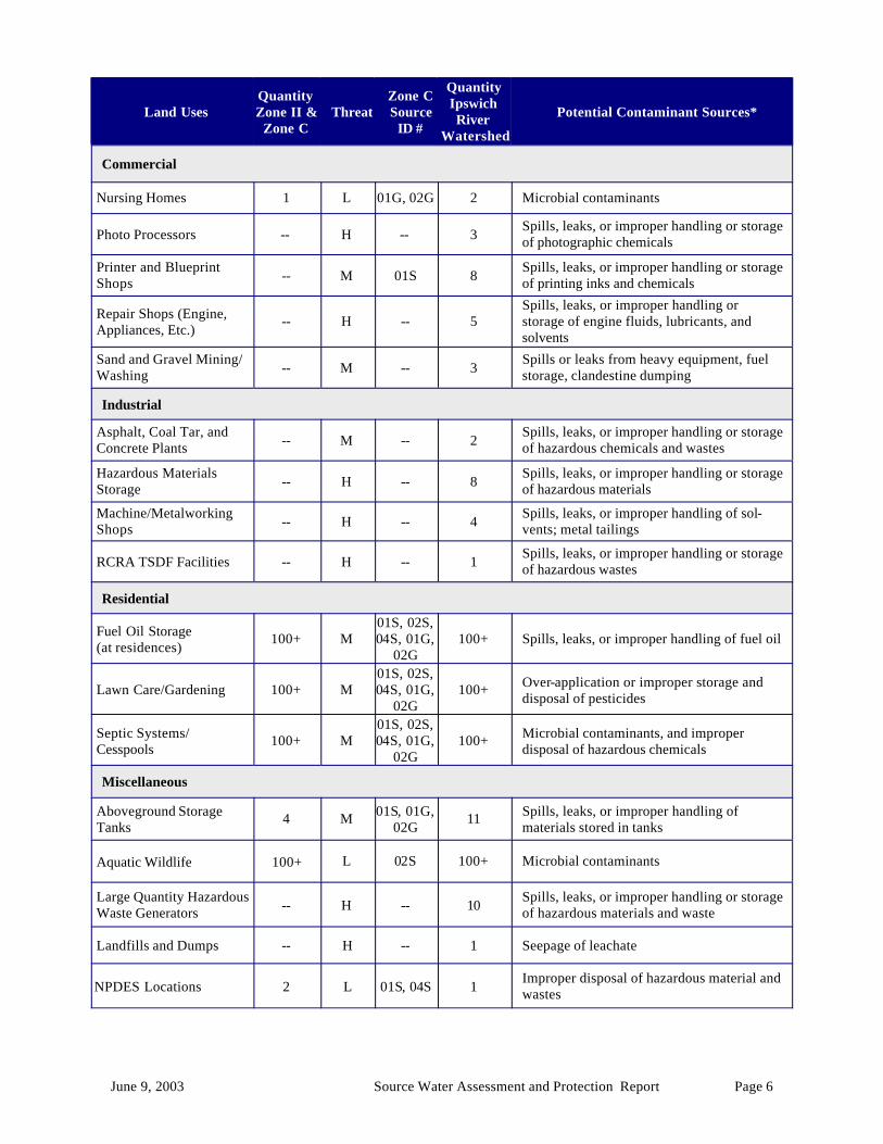
June 9, 2003 Source Water Assessment and Protection Report Page 6
Land Uses Quantity Zone II &
Zone C Threat
Zone C Source
ID #
Quantity Ipswich River
Watershed
Potential Contaminant Sources*
Commercial
Nursing Homes 1 L 01G, 02G 2 Microbial contaminants
Photo Processors -- H -- 3 Spills, leaks, or improper handling or storage of photographic chemicals
Printer and Blueprint Shops -- M 01S 8
Spills, leaks, or improper handling or storage of printing inks and chemicals
Repair Shops (Engine, Appliances, Etc.)
-- H -- 5 Spills, leaks, or improper handling or storage of engine fluids, lubricants, and solvents
Sand and Gravel Mining/Washing -- M -- 3
Spills or leaks from heavy equipment, fuel storage, clandestine dumping
Industrial
Asphalt, Coal Tar, and Concrete Plants -- M -- 2
Spills, leaks, or improper handling or storage of hazardous chemicals and wastes
Hazardous Materials Storage -- H -- 8
Spills, leaks, or improper handling or storage of hazardous materials
Machine/Metalworking Shops -- H -- 4
Spills, leaks, or improper handling of sol-vents; metal tailings
RCRA TSDF Facilities -- H -- 1 Spills, leaks, or improper handling or storage of hazardous wastes
Residential
Fuel Oil Storage (at residences)
100+ M 01S, 02S, 04S, 01G,
02G 100+ Spills, leaks, or improper handling of fuel oil
Lawn Care/Gardening 100+ M 01S, 02S, 04S, 01G,
02G 100+ Over-application or improper storage and
disposal of pesticides
Septic Systems/ Cesspools
100+ M 01S, 02S, 04S, 01G,
02G 100+ Microbial contaminants, and improper
disposal of hazardous chemicals
Miscellaneous
Aboveground Storage Tanks
4 M 01S, 01G, 02G
11 Spills, leaks, or improper handling of materials stored in tanks
Aquatic Wildlife 100+ L 02S 100+ Microbial contaminants
Large Quantity Hazardous Waste Generators -- H -- 10
Spills, leaks, or improper handling or storage of hazardous materials and waste
Landfills and Dumps -- H -- 1 Seepage of leachate
NPDES Locations 2 L 01S, 04S 1 Improper disposal of hazardous material and wastes
June 9, 2003 Source Water Assessment and Protection Report Page 7
Land Uses Quantity Zone II &
Zone C Threat
Zone C Source
ID #
Quantity Ipswich River
Watershed
Potential Contaminant Sources*
Miscellaneous
Oil or Hazardous Material Sites 4 -- 01G, 02G 50
Tier Classified Oil or Hazardous Materials Sites are not ranked due to their site-specific character. Individual sites are identified in Appendix B.
Road and Maintenance Depots
1 M 01G, 02G 6 Spills, leaks, or improper handling or storage of deicing materials, automotive fluids, fuel storage, and other chemicals
Schools, Colleges, and Universities -- M -- 4
Spills, leaks, or improper handling or storage of fuel oil, laboratory, art, photographic, machine shop, and other chemicals
Small Quantity Hazardous Waste Generators 1 M 02S 28
Spills, leaks, or improper handling or storage of hazardous materials and waste
Stormwater Drains 100+ L 01S, 02S,
04S, 01G, 02G
100+ Debris, pet waste, and chemicals in stormwater from roads, parking lots, and lawns
Tire Dumps 1 M -- -- Improper handling or management of tires
Transportation Corridors
1 M 02S, 01G, 02G
Several Accidental leaks or spills of fuels and other hazardous materials, over-application or improper handling of pesticides
Underground Storage Tanks 7 H
02S, 01G, 02G 191
Spills, leaks, or improper handling of stored materials
Utility Substation Transformers 1 L 01G, 02G --
Spills, leaks, or improper handling of chemicals and other materials including PCBs
Very Small Quantity Hazardous Waste Generators
7 L 01S, 02S,
04S, 01G, 02G
73 Spills, leaks, or improper handling or storage of hazardous materials and waste
Waste Transfer/ Recycling Station
-- M -- 1 Improper management, seepage, and runoff of water contacting waste materials
Wastewater Treatment Plant/Collection Facility/ Lagoon
-- M -- 1
Improper handling or storage of treatment chemicals or equipment maintenance materials; improper management of wastewater
Water Treatment Sludge Lagoon 2 M 01S, 04S 1
Improper management of sludge and wastewater
Notes: 1. When specific potential contaminants are not known, typical potential contaminants or activities for that type of
land use are listed. Facilities within the watershed may not contain all of these potential contaminant sources, may contain other potential contaminant sources, or may use Best Management Practices to prevent contaminants from reaching drinking water supplies.
2. For more information on regulated facilities, refer to Appendix B: Regulated Facilities within the Water Supply Protection Area information about these potential sources of contamination.
3. For information about Oil or Hazardous Materials Sites in your protection areas, refer to Appendix C: Tier Classified Oil and/or Hazardous Material Sites.
* THREAT RANKING - The rankings (high, moderate or low) represent the relative threat of each land use compared to other PSCs. The ranking of a particular PSC is based on a number of factors, including: the type and quantity of chemicals typically used or generated by the PSC; the characteristics of the contaminants (such as toxicity, environmental fate and transport); and the behavior and mo bility of the pollutants in soils and groundwater.
June 9, 2003 Source Water Assessment and Protection Report Page 8
(Continued from page 4) ü Continue to plan and prepare for spills by communicating with municipalities and facilities in the Ipswich River
watershed, and by conducting drills. 4. Residential Land Uses – Approximately 80% of the combined watersheds consist of residential areas, of which a large portion is served by private septic systems, with the remainder being served by municipal sewering. If managed improperly, activities associated with residential areas can contribute to drinking water contamination. Common potential sources of contamination include: • Septic Systems – Improper disposal of household hazardous chemicals to septic systems is a potential source of
contamination to the groundwater because septic systems lead to the ground. If septic systems fail or are not properly maintained, they can be a potential source of microbial contamination.
• Household Hazardous Materials - Hazardous materials may include automotive wastes, paints, solvents, pesticides, fertilizers, and other substances. Improper use, storage, and disposal of chemical products used in homes are potential sources of contamination.
• Heating Oil Storage - If managed improperly, Underground and Aboveground Storage Tanks (USTs and ASTs) can be potential sources of contamination due to leaks or spills of the fuel oil they store.
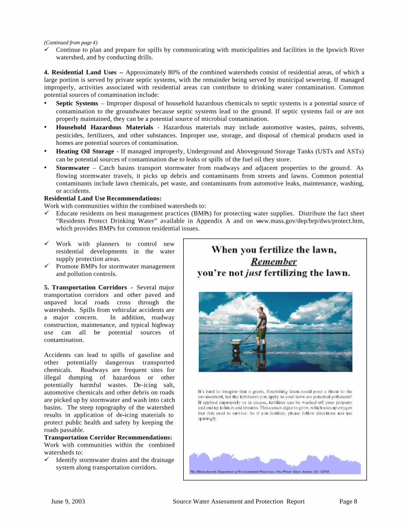
• Stormwater – Catch basins transport stormwater from roadways and adjacent properties to the ground. As flowing stormwater travels, it picks up debris and contaminants from streets and lawns. Common potential contaminants include lawn chemicals, pet waste, and contaminants from automotive leaks, maintenance, washing, or accidents.
Residential Land Use Recommendations: Work with communities within the combined watersheds to: ü Educate residents on best management practices (BMPs) for protecting water supplies. Distribute the fact sheet
“Residents Protect Drinking Water” available in Appendix A and on www.mass.gov/dep/brp/dws/protect.htm, which provides BMPs for common residential issues.
ü Work with planners to control new residential developments in the water supply protection areas.
ü Promote BMPs for stormwater management and pollution controls.
5. Transportation Corridors - Several major transportation corridors and other paved and unpaved local roads cross through the watersheds. Spills from vehicular accidents are a major concern. In addition, roadway construction, maintenance, and typical highway use can all be potential sources of contamination. Accidents can lead to spills of gasoline and other potentially dangerous transported chemicals. Roadways are frequent sites for illegal dumping of hazardous or other potentially harmful wastes. De-icing salt, automotive chemicals and other debris on roads are picked up by stormwater and wash into catch basins. The steep topography of the watershed results in application of de-icing materials to protect public health and safety by keeping the roads passable. Transportation Corridor Recommendations: Work with communities within the combined watersheds to: ü Identify stormwater drains and the drainage
system along transportation corridors.
June 9, 2003 Source Water Assessment and Protection Report Page 9
ü Work with the Towns and State to have catch basins inspected, maintained, and cleaned on a regular schedule.
ü Work with local emergency response teams to ensure that any spills can be effectively contained.
ü If storm drainage maps are available, review the maps with emergency response teams. If maps aren’t yet available, work with town officials to investigate mapping options such as the upcoming Phase II Stormwater Rule requiring some communities to complete stormwater mapping.
ü Establish vegetated buffers along roads and parking areas to provide some filtration of contaminants.
ü Encourage regular street sweeping. Appendix A contains a fact sheet titled DPWs Protect Drinking Water.
ü Conduct emergency drills to be ready for spills. ü Regularly inspect the watersheds for illegal dumping and spills. ü Work with local emergency response teams to ensure that any spills can be
effectively contained. 6. Road and Maintenance Depots - Potential sources of contamination in state and municipal facilities can result from accidental dumping, spills, leaks, vehicle washing operations, or from wastewater treatment. Waste management and product storage pose the greatest threats with a wide variety of potentially harmful contaminants. Road and Maintenance Depots Recommendations: Work with communities within the combined watersheds to: ü Institute Best Management Practices - The New England Environmental
Assistance Team provides municipalities in New England with information on how to comply with environmental requirements, and how to prevent pollution. For more information about this EPA sponsored program visit their website at http://www.epa.gov/region1/steward/neeat/muni/index.html. Encourage road and maintenance depots to develop best management practices to insure proper salt storage, proper maintenance of facilities and good housekeeping practices.
ü Adequately size salt pile structure to allow for the loading and unloading of salt within the structure. Review the Department of Environmental Protection’s Drinking Water Program Guidelines On Deicing Chemical (Road Salt) Storage at http://www.state.ma.us/dep/brp/dws/files/saltgui.doc.
ü Encourage proper storage of materials at these facilities. Appendix A contains a fact sheet titled DPWs Protect Drinking Water.
7. Presence of Oil or Hazardous Material Contamination Sites – The Zone II and watersheds for Peabody and the Ipswich River contain DEP Tier Classified Oil and/or Hazardous Material Release Sites indicated on the maps as Release Tracking Numbers 3-0004161, 3-0012406, 3-0001565, 3-0016711, 3-0019019, 3-0001813, 3-0000784, 3-0011228, 3-0001494, 3-0006026, 3-0019687, 3-0000692, 3-0002276, 3-0002363, 3-0002584, 3-0002804, 3-0003167, 3-0003925, 3-0004007, 3-0004466, 3-0004468, 3-0004481, 3-0004583, 3-0014465, 3-0017390, 3-0001587, 3-0013565, 3-0017659, 3-0000471, 3-0000518, 3-0000625, 3-0000776, 3-0000904, 3-0001268, 3-0001728, 3-0001916, 3-0001973, 3-0002549, 3-0002889, 3-0003548,
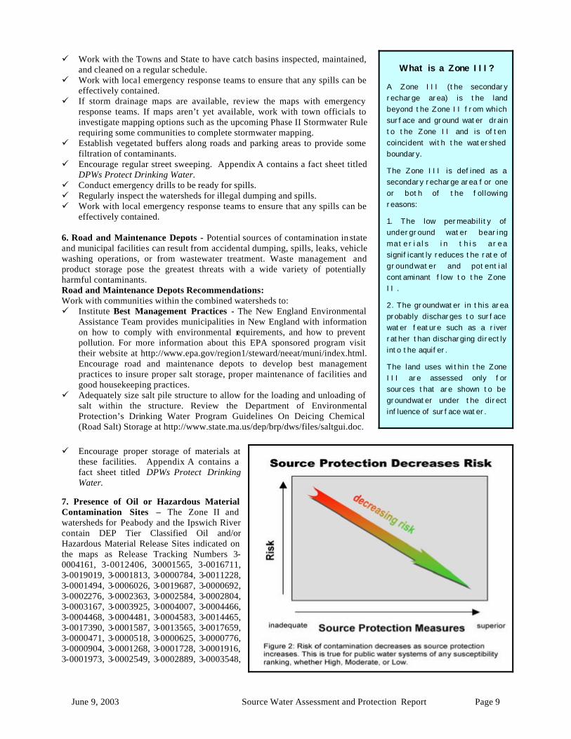
What is a Zone III?
A Zone III (the secondary recharge area) is the land beyond the Zone II from which surface and ground water drain to the Zone II and is often coincident with the watershed boundary.
The Zone III is defined as a secondary recharge area for one or both of the following reasons:
1. The low permeability of underground water bearing mater ia l s i n th i s area significantly reduces the rate of groundwater and potential contaminant flow to the Zone II .
2. The groundwater in this area probably discharges to surface water feature such as a river rather than discharging directly into the aquifer.
The land uses within the Zone III are assessed only for sources that are shown to be groundwater under the direct influence of surface water.
June 9, 2003 Source Water Assessment and Protection Report Page 10
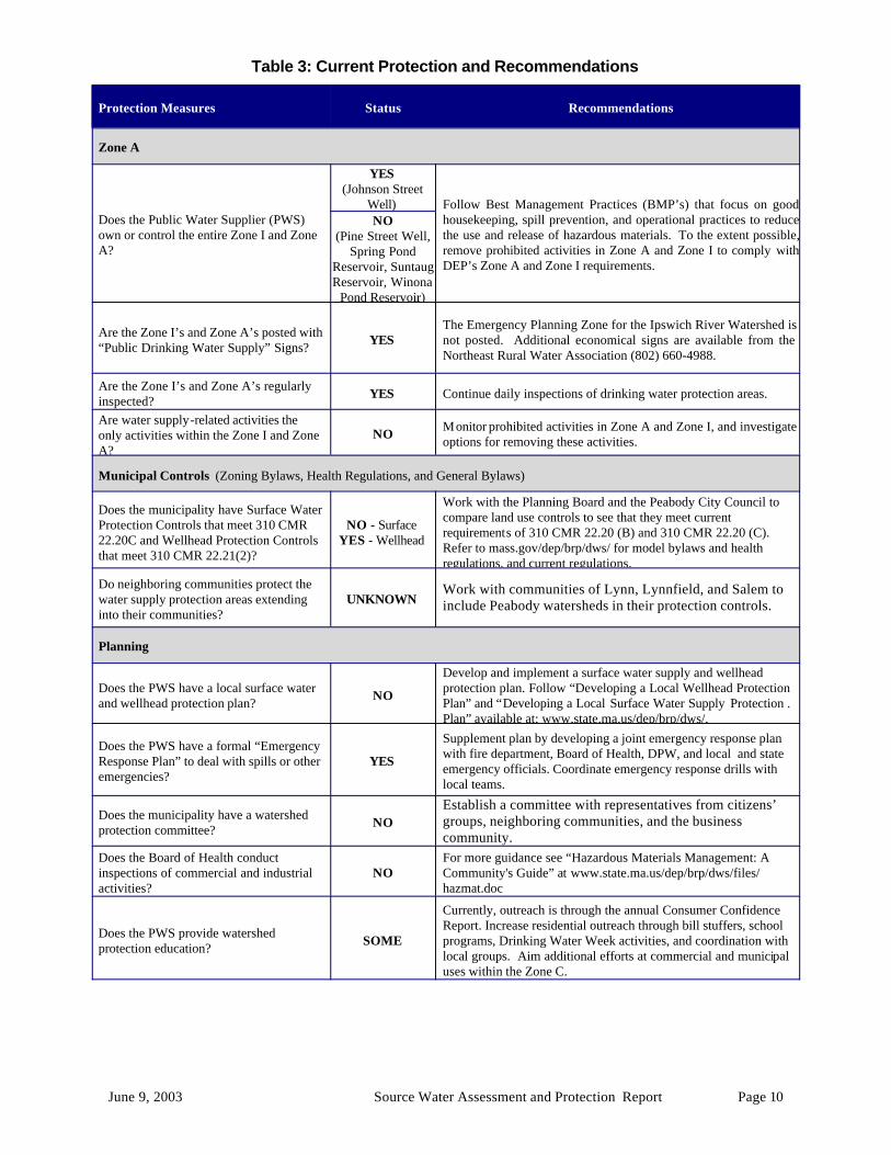
Table 3: Current Protection and Recommendations
Protection Measures Status Recommendations
Zone A
Does the Public Water Supplier (PWS) own or control the entire Zone I and Zone A?
YES (Johnson Street
Well) Follow Best Management Practices (BMP’s) that focus on good housekeeping, spill prevention, and operational practices to reduce the use and release of hazardous materials. To the extent possible, remove prohibited activities in Zone A and Zone I to comply with DEP’s Zone A and Zone I requirements.
NO (Pine Street Well,
Spring Pond Reservoir, Suntaug Reservoir, Winona
Pond Reservoir)
Are the Zone I’s and Zone A’s posted with “Public Drinking Water Supply” Signs? YES
The Emergency Planning Zone for the Ipswich River Watershed is not posted. Additional economical signs are available from the Northeast Rural Water Association (802) 660-4988.
Are the Zone I’s and Zone A’s regularly inspected? YES Continue daily inspections of drinking water protection areas.
Are water supply-related activities the only activities within the Zone I and Zone A?
NO Monitor prohibited activities in Zone A and Zone I, and investigate options for removing these activities.
Municipal Controls (Zoning Bylaws, Health Regulations, and General Bylaws)
Does the municipality have Surface Water Protection Controls that meet 310 CMR 22.20C and Wellhead Protection Controls that meet 310 CMR 22.21(2)?
NO - Surface YES - Wellhead
Work with the Planning Board and the Peabody City Council to compare land use controls to see that they meet current requirements of 310 CMR 22.20 (B) and 310 CMR 22.20 (C). Refer to mass.gov/dep/brp/dws/ for model bylaws and health regulations, and current regulations.
Do neighboring communities protect the water supply protection areas extending into their communities?
UNKNOWN Work with communities of Lynn, Lynnfield, and Salem to include Peabody watersheds in their protection controls.
Planning
Does the PWS have a local surface water and wellhead protection plan? NO
Develop and implement a surface water supply and wellhead protection plan. Follow “Developing a Local Wellhead Protection Plan” and “Developing a Local Surface Water Supply Protection .Plan” available at: www.state.ma.us/dep/brp/dws/.
Does the PWS have a formal “Emergency Response Plan” to deal with spills or other emergencies?
YES
Supplement plan by developing a joint emergency response plan with fire department, Board of Health, DPW, and local and state emergency officials. Coordinate emergency response drills with local teams.
Does the municipality have a watershed protection committee? NO
Establish a committee with representatives from citizens’ groups, neighboring communities, and the business community.
Does the Board of Health conduct inspections of commercial and industrial activities?
NO For more guidance see “Hazardous Materials Management: A Community's Guide” at www.state.ma.us/dep/brp/dws/files/hazmat.doc
Does the PWS provide watershed protection education? SOME
Currently, outreach is through the annual Consumer Confidence Report. Increase residential outreach through bill stuffers, school programs, Drinking Water Week activities, and coordination with local groups. Aim additional efforts at commercial and municipal uses within the Zone C.
June 9, 2003 Source Water Assessment and Protection Report Page 11
3-0003766, 3-0003958, 3-0004022, 3-0004168, 3-0004170, 3-0012586, 3-0013922, 3-0014811, 3-0014814, 3-0015247, 3-0017097, 3-0019289, 3-0019380, 3-0019519, and 3-0019651. Refer to the attached map and Appendix 3 for more information. Oil or Hazardous Material Contamination Sites Recommendation: ü Monitor progress on any ongoing remedial action conducted for the known
oil or contamination sites. 8. Protection Planning – Protection planning protects drinking water by managing the land area that supplies water to a reservoir. Currently, the City of Peabody has a groundwater protection bylaw that meets DEP’s Groundwater Protection regulations 310 CMR 22.21; however, local controls do not meet DEP’s Surface Water Protection regulations 310 CMR 22.20 (b) and (c). A Groundwater and Surface Water Supply Protection Plan coordinates community efforts, identifies protection strategies, establis hes a timeframe for implementation, and provides a forum for public participation. There are resources available to help communities develop a plan for protecting drinking water supply reservoirs. Protection Planning Recommendations: Work with communities within the combined watersheds to: ü Develop a Wellhead Protection Plan. Establish a protection team, and refer
them to http://mass.gov/dep/brp/dws/protect.htm for a copy of DEP’s guidance, “Developing a Local Wellhead Protection Plan”.
ü Encourage watershed towns to adopt controls that meet 310 CMR 22.20 (b) and (c). For more information on DEP land use controls see http://mass.gov/dep/brp/dws/protect.htm.
ü Continue to work with town boards to review and provide recommendations on proposed development within your water supply protection areas. To obtain information on build-out analyses for the towns, see the Executive Office of Environmental Affairs' community preservation web site, http://commpres.env.state.ma.us/.
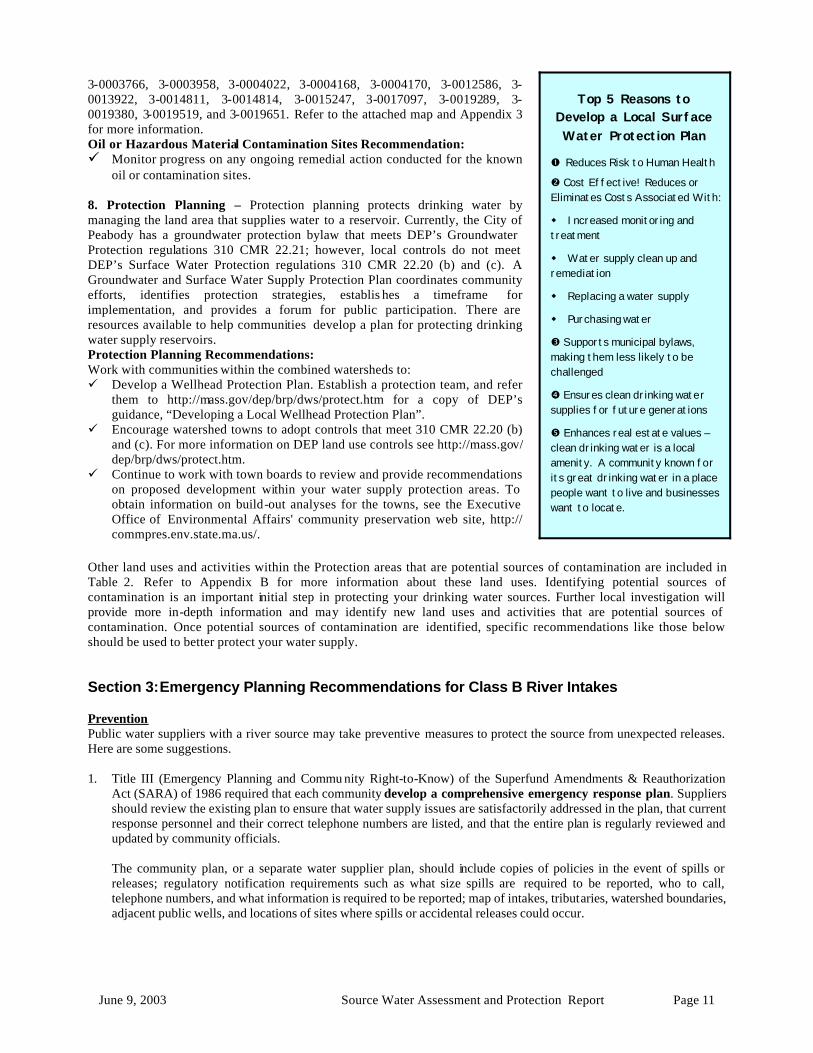
Top 5 Reasons to Develop a Local Surface Water Protection Plan
� Reduces Risk to Human Health
� Cost Effective! Reduces or Eliminates Costs Associated With:
w Increased monitoring and treatment
w Water supply clean up and remediation
w Replacing a water supply
w Purchasing water
� Supports municipal bylaws, making them less likely to be challenged
� Ensures clean drinking water supplies for future generations
� Enhances real estate values – clean drinking water is a local amenity. A community known for its great drinking water in a place people want to live and businesses want to locate.
Other land uses and activities within the Protection areas that are potential sources of contamination are included in Table 2. Refer to Appendix B for more information about these land uses. Identifying potential sources of contamination is an important initial step in protecting your drinking water sources. Further local investigation will provide more in-depth information and may identify new land uses and activities that are potential sources of contamination. Once potential sources of contamination are identified, specific recommendations like those below should be used to better protect your water supply. Section 3: Emergency Planning Recommendations for Class B River Intakes Prevention Public water suppliers with a river source may take preventive measures to protect the source from unexpected releases. Here are some suggestions. 1. Title III (Emergency Planning and Commu nity Right-to-Know) of the Superfund Amendments & Reauthorization
Act (SARA) of 1986 required that each community develop a comprehensive emergency response plan. Suppliers should review the existing plan to ensure that water supply issues are satisfactorily addressed in the plan, that current response personnel and their correct telephone numbers are listed, and that the entire plan is regularly reviewed and updated by community officials.
The community plan, or a separate water supplier plan, should include copies of policies in the event of spills or
releases; regulatory notification requirements such as what size spills are required to be reported, who to call, telephone numbers, and what information is required to be reported; map of intakes, tributaries, watershed boundaries, adjacent public wells, and locations of sites where spills or accidental releases could occur.
June 9, 2003 Source Water Assessment and Protection Report Page 12
2. Identify, map and distribute information to local emergency responders regarding the locations of intakes on the river, tributaries, watershed boundaries, public wells adjacent to river; chemical use at municipal, state, and industrial facilities in watershed (contact Fire Dept., DEP); locations of stormwater drains and the locations of known dams in the event that they can be manipulated by authorized individuals for contaminant control.
The Fire Dept., Board of Health, Planning Board, Local Emergency Planning Committee (LEPC), DEP and others may have existing information to help with your work. SARA requires companies to work with the community's LEPC if they handle extremely hazardous chemicals in quantities above established thresholds.
3. Develop a communication list of contacts at upstream and downstream facilities, dams, as well as other public water
suppliers on, or adjacent to, rivers. Notify owners and operators of these facilities about the location of your intake and request, in writing, that you be notified immediately in the event of a chemical spill or unexpected discharge. Take this opportunity to educate others about water supply protection.
4. Provide comments to municipal boards in other cities/towns in the watershed about proposed development, land use
controls, Best Management Practices (BMPs) for stormwater flow into tributaries, and other issues to avoid future problems.
5. Post signs along major roads in watershed which direct the public to call "911" or other appropriate local number in
case of spills. Be aware of accident-prone areas and transport routes of chemicals if possible. 6. Educate the public, local officials, Civil Defense, local emergency response team, and others about water supply
protection issues. Educate b usinesses about toxic use reduction. 7. Conduct household hazardous waste collection days and establish permanent collection sites, away from sensitive
watershed areas, for used batteries, paints, motor oil, etc. 8. Conduct drills, in coordination with local/regional response teams, to test policies and procedures and to practice
responding to various situations. Including businesses, local officials and staff, Fire Departments, Boards of Health, Civil Defense, school administration, and others in planning and implementing the drills will allow for several town or region-wide concerns to be addressed and tested at the same time, including: issuing health advisories, conducting neighborhood and/or school evacuations, and evaluating the town's communication system (both making responders aware of the emergency and issuing advisories to the public when necessary via television, radio, and other news media), equipment and emergency plan in general.
9. Critique the drills and modify components of the emergency response system as needed.
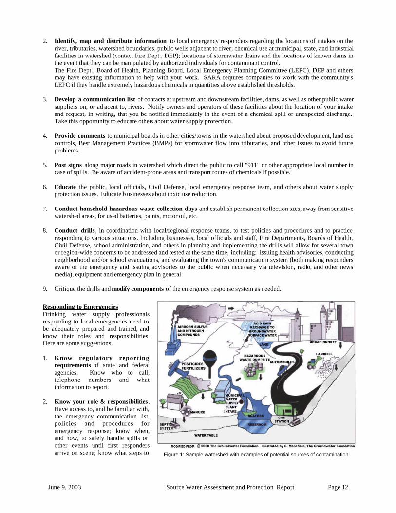
Figure 1: Sample watershed with examples of potential sources of contamination
Responding to Emergencies Drinking water supply professionals responding to local emergencies need to be adequately prepared and trained, and know their roles and responsibilities. Here are some suggestions. 1. Know regulatory reporting
requirements of state and federal agencies. Know who to call, telephone numbers and what information to report.
2. Know your role & responsibilities .
Have access to, and be familiar with, the emergency communication list, policies and procedures for emergency response; know when, and how, to safely handle spills or other events until first responders arrive on scene; know what steps to
June 9, 2003 Source Water Assessment and Protection Report Page 13
take to avoid drawing contaminants into the water supply system; be familiar enough with local watershed characteristics to provide incident commander with information and advice.
3. Provide training and materials to responding staff . Water supply staff, including new employees, should be
adequately trained, have access to appropriate materials (storm drain covers, absorbent pads, booms, etc.), up-to-date policies, procedures, and communication lists to perform tasks for which they are responsible.
Follow-up Steps can be taken to ensure better preparedness in the event of future emergency situations. Here are some suggestions. 1. Provide follow-up reports to the public on the resolution of the situation. 2. Share the information learned from drills and real situations with others in order to better protect all public drinking
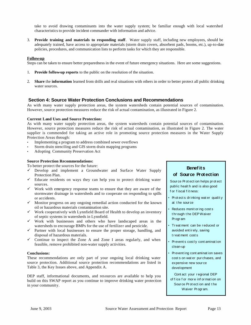
water sources. Section 4: Source Water Protection Conclusions and Recommendations As with many water supply protection areas, the system watersheds contain potential sources of contamination. However, source protection measures reduce the risk of actual contamination, as illustrated in Figure 2. Current Land Uses and Source Protection: As with many water supply protection areas, the system watersheds contain potential sources of contamination. However, source protection measures reduce the risk of actual contamination, as illustrated in Figure 2. The water supplier is commended for taking an active role in promoting source protection measures in the Water Supply Protection Areas through: • Implementing a program to address combined sewer overflows • Storm drain stenciling and GIS storm drain mapping programs • Adopting Community Preservation Act
Benefits of Source Protection
Source Protection helps protect public health and is also good for fiscal fitness:
• Protects drinking water quality at the source
• Reduces monitoring costs through the DEP Waiver Program
• Treatment can be reduced or avoided entirely, saving treatment costs
• Prevents costly contamination clean-up
• Preventing contamination saves costs on water purchases, and expensive new source development
Contact your regional DEP office for more information on
Source Protection and the Waiver Program.
Source Protection Recommendations: To better protect the sources for the future: ü Develop and implement a Groundwater and Surface Water Supply
Protection Plan. ü Educate residents on ways they can help you to protect drinking water
sources. ü Work with emergency response teams to ensure that they are aware of the
stormwater drainage in watersheds and to cooperate on responding to spills or accidents.
ü Monitor progress on any ongoing remedial action conducted for the known oil or hazardous materials contamination site.
ü Work cooperatively with Lynnfield Board of Health to develop an inventory of septic systems in watersheds in Lynnfield.
ü Work with businesses and others who have landscaped areas in the watersheds to encourage BMPs for the use of fertilizer and pesticide.
ü Partner with local businesses to ensure the proper storage, handling, and disposal of hazardous materials.
ü Continue to inspect the Zone A and Zone I areas regularly, and when feasible, remove prohibited non-water supply activities.
Conclusions: These recommendations are only part of your ongoing local drinking water source protection. Additional source protection recommendations are listed in Table 3, the Key Issues above, and Appendix A. DEP staff, informational documents, and resources are available to help you build on this SWAP report as you continue to improve drinking water protection in your community.
June 9, 2003 Source Water Assessment and Protection Report Page 14
Grants and loans are available through the Drinking Water State Revolving Loan Fund, the Clean Water State Revolving Fund, and other sources. For more information on grants and loans, visit the Bureau of Resource Protection’s Municipal Services web site at: http://mass.gov/dep/brp/mf/mfpubs.htm. The assessment and protection recommendations in this SWAP report are provided as a tool to encourage community discussion, support ongoing source protection efforts, and help set local drinking water protection priorities. Citizens and community officials should use this SWAP report to spur discussion of local drinking water protection measures. The water supplier should supplement this SWAP report with local information on potential sources of contamination and land uses. Local information should be maintained and updated periodically to reflect land use changes in the Zone II. Use this information to set priorities, target inspections, focus education efforts, and to develop a long-term drinking water source protection plan. Section 5: Appendices A. Protection Recommendations B. Regulated Facilities within the Water Supply Protection Area C. Table of Tier Classified Oil and/or Hazardous Material Sites within the
Water Supply Protection Areas D. Additional Documents on Source Protection
Additional Documents:
To help with source protection efforts, more information is available by request or online at www.state.ma.us/dep/brp/dws including:
1. Water Supply Protection Guidance Materials such as model regulations, Best Management Practice information, and general water supply protection information.
2. MA DEP SWAP Strategy
3. Land Use Pollution Potential Matrix
4. Draft Land/Associated Contaminants Matrix
For More Information
Contact Anita Wolovick in DEP’s Wilmington Office at (978) 661-7768 for more information and assistance on improving current protection measures.
Copies of this report have been provided to the public water supplier, town boards, and the local media.
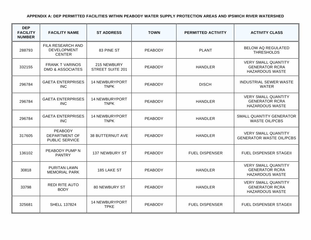
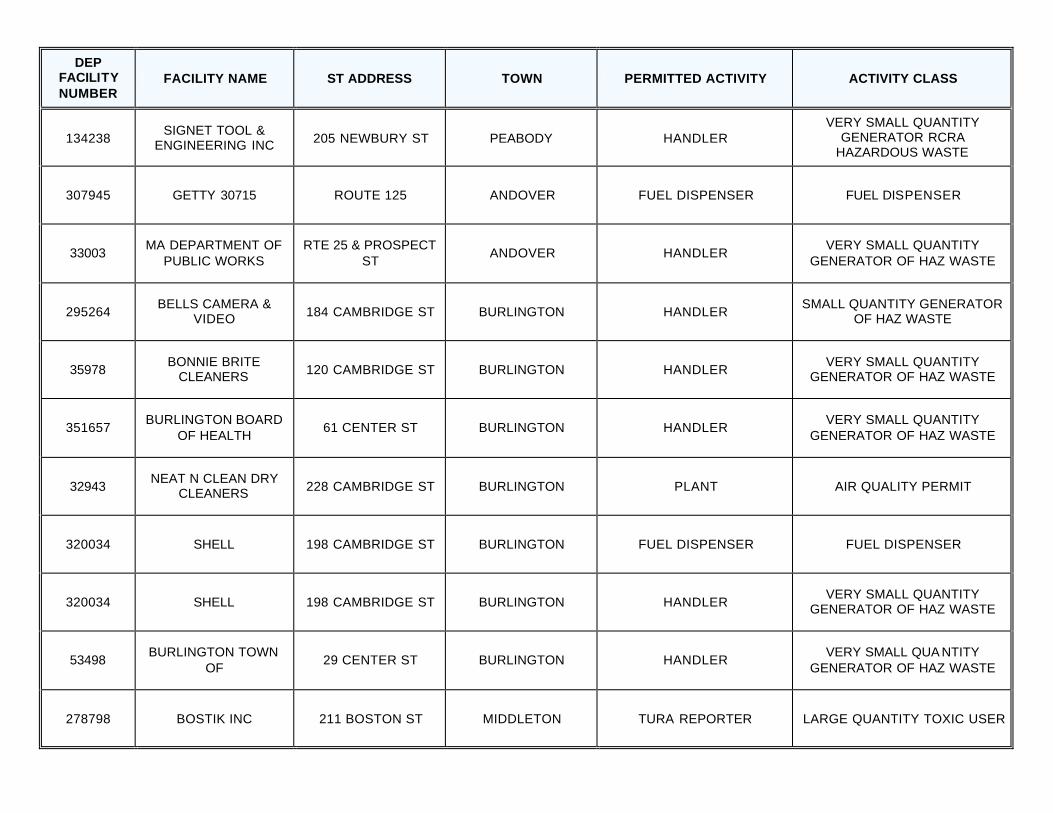
APPENDIX A: DEP PERMITTED FACILITIES WITHIN PEABODY WATER SUPPLY PROTECTION AREAS AND IPSWICH RIVER WATERSHED
DEP FACILITY NUMBER
FACILITY NAME ST ADDRESS TOWN PERMITTED ACTIVITY ACTIVITY CLASS
288793 FILA RESEARCH AND
DEVELOPMENT CENTER
83 PINE ST PEABODY PLANT BELOW AQ REGULATED
THRESHOLDS
332155 FRANK T VARINOS
DMD & ASSOCIATES 215 NEWBURY
STREET SUITE 201 PEABODY HANDLER
VERY SMALL QUANTITY GENERATOR RCRA
HAZARDOUS WASTE
296784 GAETA ENTERPRISES
INC 14 NEWBURYPORT
TNPK PEABODY DISCH INDUSTRIAL SEWER WASTE
WATER
296784 GAETA ENTERPRISES
INC 14 NEWBURYPORT
TNPK PEABODY HANDLER VERY SMALL QUANTITY
GENERATOR RCRA HAZARDOUS WASTE
296784 GAETA ENTERPRISES
INC 14 NEWBURYPORT
TNPK PEABODY HANDLER
SMALL QUANTITY GENERATOR WASTE OIL/PCBS
317605 PEABODY
DEPARTMENT OF PUBLIC SERVICE
38 BUTTERNUT AVE PEABODY HANDLER VERY SMALL QUANTITY
GENERATOR WASTE OIL/PCBS
136102 PEABODY PUMP N
PANTRY 137 NEWBURY ST PEABODY FUEL DISPENSER FUEL DISPENSER STAGEII
30818 PURITAN LAWN
MEMORIAL PARK 185 LAKE ST PEABODY HANDLER VERY SMALL QUANTITY
GENERATOR RCRA HAZARDOUS WASTE
33798 REDI RITE AUTO
BODY 80 NEWBURY ST PEABODY HANDLER
VERY SMALL QUANTITY GENERATOR RCRA
HAZARDOUS WASTE
325681 SHELL 137824 14 NEWBURYPORT
TPKE PEABODY FUEL DISPENSER FUEL DISPENSER STAGEII
DEP FACILITY NUMBER
FACILITY NAME ST ADDRESS TOWN PERMITTED ACTIVITY ACTIVITY CLASS
134238 SIGNET TOOL &
ENGINEERING INC 205 NEWBURY ST PEABODY HANDLER VERY SMALL QUANTITY
GENERATOR RCRA HAZARDOUS WASTE
307945 GETTY 30715 ROUTE 125 ANDOVER FUEL DISPENSER FUEL DISPENSER
33003 MA DEPARTMENT OF
PUBLIC WORKS RTE 25 & PROSPECT
ST ANDOVER HANDLER
VERY SMALL QUANTITY GENERATOR OF HAZ WASTE
295264 BELLS CAMERA &
VIDEO 184 CAMBRIDGE ST BURLINGTON HANDLER SMALL QUANTITY GENERATOR
OF HAZ WASTE
35978 BONNIE BRITE
CLEANERS 120 CAMBRIDGE ST BURLINGTON HANDLER VERY SMALL QUANTITY
GENERATOR OF HAZ WASTE
351657 BURLINGTON BOARD
OF HEALTH 61 CENTER ST BURLINGTON HANDLER
VERY SMALL QUANTITY GENERATOR OF HAZ WASTE
32943 NEAT N CLEAN DRY
CLEANERS 228 CAMBRIDGE ST BURLINGTON PLANT AIR QUALITY PERMIT
320034 SHELL 198 CAMBRIDGE ST BURLINGTON FUEL DISPENSER FUEL DISPENSER
320034 SHELL 198 CAMBRIDGE ST BURLINGTON HANDLER VERY SMALL QUANTITY
GENERATOR OF HAZ WASTE
53498 BURLINGTON TOWN
OF 29 CENTER ST BURLINGTON HANDLER
VERY SMALL QUA NTITY GENERATOR OF HAZ WASTE
278798 BOSTIK INC 211 BOSTON ST MIDDLETON TURA REPORTER LARGE QUANTITY TOXIC USER
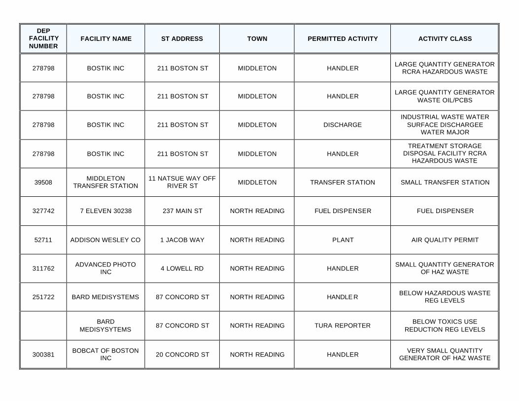
DEP FACILITY NUMBER
FACILITY NAME ST ADDRESS TOWN PERMITTED ACTIVITY ACTIVITY CLASS
278798 BOSTIK INC 211 BOSTON ST MIDDLETON HANDLER LARGE QUANTITY GENERATOR
RCRA HAZARDOUS WASTE
278798 BOSTIK INC 211 BOSTON ST MIDDLETON HANDLER LARGE QUANTITY GENERATOR
WASTE OIL/PCBS
278798 BOSTIK INC 211 BOSTON ST MIDDLETON DISCHARGE INDUSTRIAL WASTE WATER
SURFACE DISCHARGEE WATER MAJOR
278798 BOSTIK INC 211 BOSTON ST MIDDLETON HANDLER TREATMENT STORAGE
DISPOSAL FACILITY RCRA HAZARDOUS WASTE
39508 MIDDLETON
TRANSFER STATION 11 NATSUE WAY OFF
RIVER ST MIDDLETON TRANSFER STATION SMALL TRANSFER STATION
327742 7 ELEVEN 30238 237 MAIN ST NORTH READING FUEL DISPENSER FUEL DISPENSER
52711 ADDISON WESLEY CO 1 JACOB WAY NORTH READING PLANT AIR QUALITY PERMIT
311762 ADVANCED PHOTO
INC 4 LOWELL RD NORTH READING HANDLER SMALL QUANTITY GENERATOR
OF HAZ WASTE
251722 BARD MEDISYSTEMS 87 CONCORD ST NORTH READING HANDLE R BELOW HAZARDOUS WASTE
REG LEVELS
BARD
MEDISYSYTEMS 87 CONCORD ST NORTH READING TURA REPORTER
BELOW TOXICS USE REDUCTION REG LEVELS
300381 BOBCAT OF BOSTON
INC 20 CONCORD ST NORTH READING HANDLER VERY SMALL QUANTITY
GENERATOR OF HAZ WASTE
DEP FACILITY NUMBER
FACILITY NAME ST ADDRESS TOWN PERMITTED ACTIVITY ACTIVITY CLASS
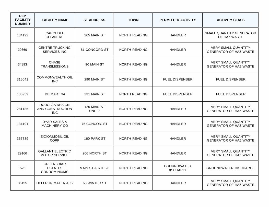
134192 CAROUSEL CLEANERS 265 MAIN ST NORTH READING HANDLER
SMALL QUANTITY GENERATOR OF HAZ WASTE
29369 CENTRE TRUCKING
SERVICES INC 81 CONCORD ST NORTH READING HANDLER
VERY SMALL QUA NTITY GENERATOR OF HAZ WASTE
34893 CHASE
TRANSMISSIONS 90 MAIN ST NORTH READING HANDLER
VERY SMALL QUANTITY GENERATOR OF HAZ WASTE
315041 COMMONWEALTH OIL
INC 290 MAIN ST NORTH READING FUEL DISPENSER FUEL DISPENSER
135959 DB MART 34 231 MAIN ST NORTH READING FUEL DISPENSER FUEL DISPENSER
281186 DOUGLAS DESIGN
AND CONSTRUCTION INC
126 MAIN ST UNIT 7
NORTH READING HANDLER VERY SMALL QUANTITY
GENERATOR OF HAZ WASTE
134191 DYAR SALES &
MACHINERY CO 75 CONCOR. ST NORTH READING HANDLER VERY SMALL QUANTITY
GENERATOR OF HAZ WASTE
367739 EXXONMOBIL OIL
CORP 160 PARK ST NORTH READING HANDLER VERY SMALL QUANTITY
GENERATOR OF HAZ WASTE
29166 GALLANT ELECTRIC
MOTOR SERVICE 206 NORTH ST NORTH READING HANDLER VERY SMALL QUANTITY
GENERATOR OF HAZ WASTE
525 GREENBRIAR
ESTATES CONDOMINIUMS
MAIN ST & RTE 28 NORTH READING GROUNDWATER
DISCHARGE GROUNDWATER DISCHARGE
35155 HEFFRON MATERIALS 68 WINTER ST NORTH READING HANDLER VERY SMALL QUANTITY
GENERATOR OF HAZ WASTE
DEP FACILITY NUMBER
FACILITY NAME ST ADDRESS TOWN PERMITTED ACTIVITY ACTIVITY CLASS
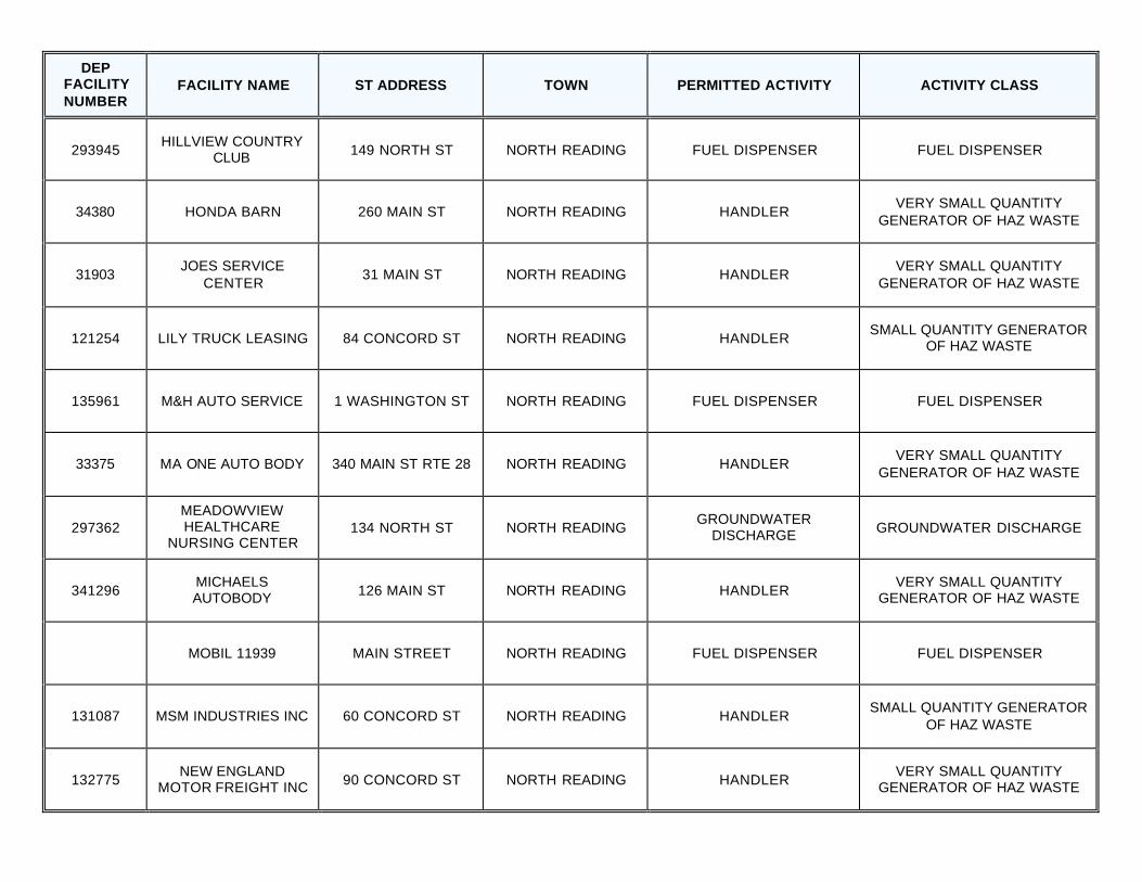
293945 HILLVIEW COUNTRY
CLUB 149 NORTH ST NORTH READING FUEL DISPENSER FUEL DISPENSER
34380 HONDA BARN 260 MAIN ST NORTH READING HANDLER VERY SMALL QUANTITY
GENERATOR OF HAZ WASTE
31903 JOES SERVICE
CENTER 31 MAIN ST NORTH READING HANDLER
VERY SMALL QUANTITY GENERATOR OF HAZ WASTE
121254 LILY TRUCK LEASING 84 CONCORD ST NORTH READING HANDLER SMALL QUANTITY GENERATOR
OF HAZ WASTE
135961 M&H AUTO SERVICE 1 WASHINGTON ST NORTH READING FUEL DISPENSER FUEL DISPENSER
33375 MA ONE AUTO BODY 340 MAIN ST RTE 28 NORTH READING HANDLER VERY SMALL QUANTITY
GENERATOR OF HAZ WASTE
297362 MEADOWVIEW HEALTHCARE
NURSING CENTER 134 NORTH ST NORTH READING
GROUNDWATER DISCHARGE GROUNDWATER DISCHARGE
341296 MICHAELS AUTOBODY 126 MAIN ST NORTH READING HANDLER
VERY SMALL QUANTITY GENERATOR OF HAZ WASTE
MOBIL 11939 MAIN STREET NORTH READING FUEL DISPENSER FUEL DISPENSER
131087 MSM INDUSTRIES INC 60 CONCORD ST NORTH READING HANDLER SMALL QUANTITY GENERATOR
OF HAZ WASTE
132775 NEW ENGLAND
MOTOR FREIGHT INC 90 CONCORD ST NORTH READING HANDLER VERY SMALL QUANTITY
GENERATOR OF HAZ WASTE
DEP FACILITY NUMBER
FACILITY NAME ST ADDRESS TOWN PERMITTED ACTIVITY ACTIVITY CLASS
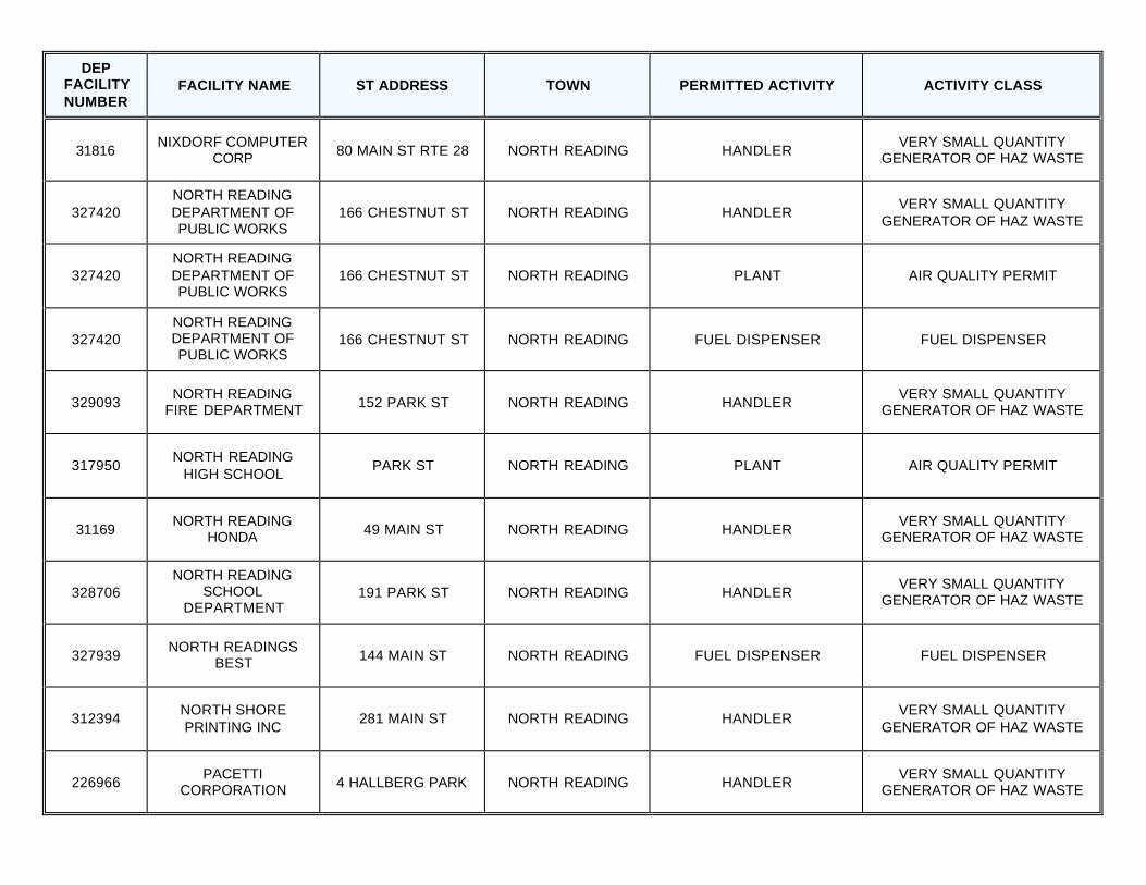
31816 NIXDORF COMPUTER
CORP 80 MAIN ST RTE 28 NORTH READING HANDLER VERY SMALL QUANTITY
GENERATOR OF HAZ WASTE
327420 NORTH READING DEPARTMENT OF PUBLIC WORKS
166 CHESTNUT ST NORTH READING HANDLER VERY SMALL QUANTITY
GENERATOR OF HAZ WASTE
327420 NORTH READING DEPARTMENT OF PUBLIC WORKS
166 CHESTNUT ST NORTH READING PLANT AIR QUALITY PERMIT
327420 NORTH READING DEPARTMENT OF PUBLIC WORKS
166 CHESTNUT ST NORTH READING FUEL DISPENSER FUEL DISPENSER
329093 NORTH READING
FIRE DEPARTMENT 152 PARK ST NORTH READING HANDLER VERY SMALL QUANTITY
GENERATOR OF HAZ WASTE
317950 NORTH READING
HIGH SCHOOL PARK ST NORTH READING PLANT AIR QUALITY PERMIT
31169 NORTH READING
HONDA 49 MAIN ST NORTH READING HANDLER VERY SMALL QUANTITY
GENERATOR OF HAZ WASTE
328706 NORTH READING
SCHOOL DEPARTMENT
191 PARK ST NORTH READING HANDLER VERY SMALL QUANTITY
GENERATOR OF HAZ WASTE
327939 NORTH READINGS
BEST 144 MAIN ST NORTH READING FUEL DISPENSER FUEL DISPENSER
312394 NORTH SHORE PRINTING INC
281 MAIN ST NORTH READING HANDLER VERY SMALL QUANTITY
GENERATOR OF HAZ WASTE
226966 PACETTI
CORPORATION 4 HALLBERG PARK NORTH READING HANDLER VERY SMALL QUANTITY
GENERATOR OF HAZ WASTE
DEP FACILITY NUMBER
FACILITY NAME ST ADDRESS TOWN PERMITTED ACTIVITY ACTIVITY CLASS
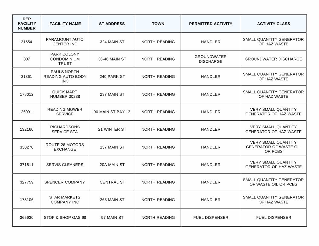
31554 PARAMOUNT AUTO
CENTER INC 324 MAIN ST NORTH READING HANDLER SMALL QUANTITY GENERATOR
OF HAZ WASTE
887 PARK COLONY CONDOMINIUM
TRUST 36-46 MAIN ST NORTH READING
GROUNDWATER DISCHARGE
GROUNDWATER DISCHARGE
31861 PAULS NORTH
READING AUTO BODY INC
240 PARK ST NORTH READING HANDLER SMALL QUANTITY GENERATOR
OF HAZ WASTE
178012 QUICK MART
NUMBER 30238 237 MAIN ST NORTH READING HANDLER SMALL QUANTITY GENERATOR
OF HAZ WASTE
36091 READING MOWER
SERVICE 90 MAIN ST BAY 13 NORTH READING HANDLER VERY SMALL QUANTITY
GENERATOR OF HAZ WASTE
132160 RICHARDSONS SERVICE STA
21 WINTER ST NORTH READING HANDLER VERY SMALL QUANTITY
GENERATOR OF HAZ WASTE
330270 ROUTE 28 MOTORS
EXCHANGE 137 MAIN ST NORTH READING HANDLER VERY SMALL QUANTITY
GENERATOR OF WASTE OIL OR PCBS
371811 SERVIS CLEANERS 20A MAIN ST NORTH READING HANDLER VERY SMALL QUANTITY
GENERATOR OF HAZ WASTE
327759 SPENCER COMPANY CENTRAL ST NORTH READING HANDLER SMALL QUANTITY GENERATOR
OF WASTE OIL OR PCBS
178106 STAR MARKETS COMPANY INC
265 MAIN ST NORTH READING HANDLER SMALL QUANTITY GENERATOR
OF HAZ WASTE
365930 STOP & SHOP GAS 68 97 MAIN ST NORTH READING FUEL DISPENSER FUEL DISPENSER
DEP FACILITY NUMBER
FACILITY NAME ST ADDRESS TOWN PERMITTED ACTIVITY ACTIVITY CLASS
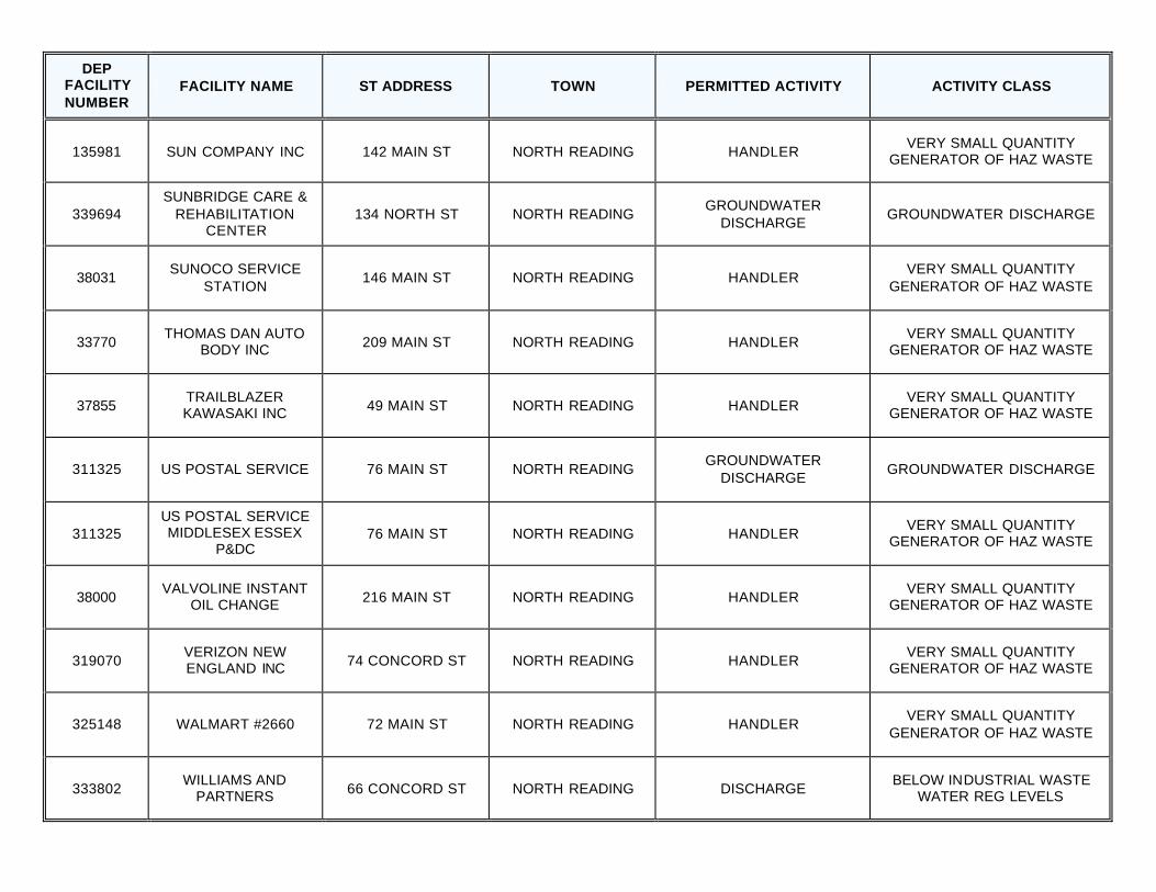
135981 SUN COMPANY INC 142 MAIN ST NORTH READING HANDLER VERY SMALL QUANTITY
GENERATOR OF HAZ WASTE
339694 SUNBRIDGE CARE &
REHABILITATION CENTER
134 NORTH ST NORTH READING GROUNDWATER
DISCHARGE GROUNDWATER DISCHARGE
38031 SUNOCO SERVICE
STATION 146 MAIN ST NORTH READING HANDLER
VERY SMALL QUANTITY GENERATOR OF HAZ WASTE
33770 THOMAS DAN AUTO
BODY INC 209 MAIN ST NORTH READING HANDLER VERY SMALL QUANTITY
GENERATOR OF HAZ WASTE
37855 TRAILBLAZER KAWASAKI INC 49 MAIN ST NORTH READING HANDLER
VERY SMALL QUANTITY GENERATOR OF HAZ WASTE
311325 US POSTAL SERVICE 76 MAIN ST NORTH READING GROUNDWATER
DISCHARGE GROUNDWATER DISCHARGE
311325 US POSTAL SERVICE MIDDLESEX ESSEX
P&DC 76 MAIN ST NORTH READING HANDLER
VERY SMALL QUANTITY GENERATOR OF HAZ WASTE
38000 VALVOLINE INSTANT
OIL CHANGE 216 MAIN ST NORTH READING HANDLER VERY SMALL QUANTITY
GENERATOR OF HAZ WASTE
319070 VERIZON NEW ENGLAND INC 74 CONCORD ST NORTH READING HANDLER
VERY SMALL QUANTITY GENERATOR OF HAZ WASTE
325148 WALMART #2660 72 MAIN ST NORTH READING HANDLER VERY SMALL QUANTITY
GENERATOR OF HAZ WASTE
333802 WILLIAMS AND
PARTNERS 66 CONCORD ST NORTH READING DISCHARGE BELOW INDUSTRIAL WASTE
WATER REG LEVELS
DEP FACILITY NUMBER
FACILITY NAME ST ADDRESS TOWN PERMITTED ACTIVITY ACTIVITY CLASS
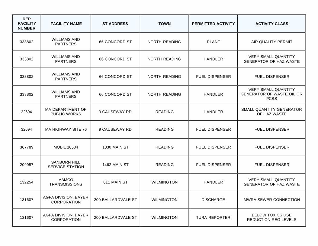
333802 WILLIAMS AND
PARTNERS 66 CONCORD ST NORTH READING PLANT AIR QUALITY PERMIT
333802 WILLIAMS AND
PARTNERS 66 CONCORD ST NORTH READING HANDLER
VERY SMALL QUANTITY GENERATOR OF HAZ WASTE
333802 WILLIAMS AND
PARTNERS 66 CONCORD ST NORTH READING FUEL DISPENSER FUEL DISPENSER
333802 WILLIAMS AND
PARTNERS 66 CONCORD ST NORTH READING HANDLER VERY SMALL QUANTITY
GENERATOR OF WASTE OIL OR PCBS
32694 MA DEPARTMENT OF
PUBLIC WORKS 9 CAUSEWAY RD READING HANDLER SMALL QUANTITY GENERATOR
OF HAZ WASTE
32694 MA HIGHWAY SITE 76 9 CAUSEWAY RD READING FUEL DISPENSER FUEL DISPENSER
367789 MOBIL 10534 1330 MAIN ST READING FUEL DISPENSER FUEL DISPENSER
209957 SANBORN HILL
SERVICE STATION 1462 MAIN ST READING FUEL DISPENSER FUEL DISPENSER
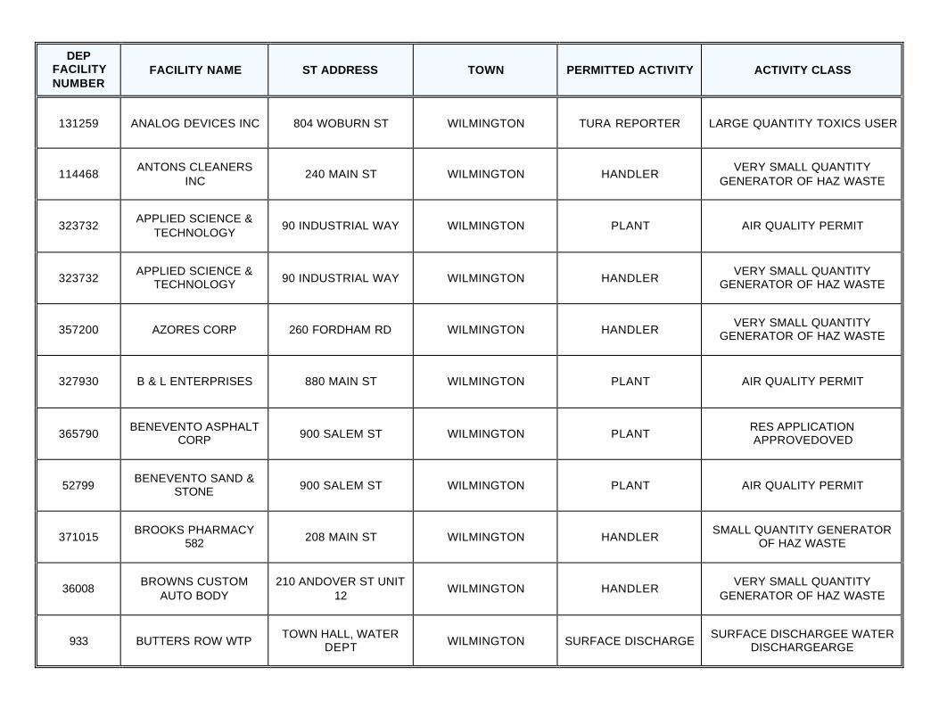
132254 AAMCO
TRANSMISSIONS 611 MAIN ST WILMINGTON HANDLER VERY SMALL QUANTITY
GENERATOR OF HAZ WASTE
131607 AGFA DIVISION, BAYER
CORPORATION 200 BALLARDVALE ST WILMINGTON DISCHARGE MWRA SEWER CONNECTION
131607 AGFA DIVISION, BAYER
CORPORATION 200 BALLARDVALE ST WILMINGTON TURA REPORTER BELOW TOXICS USE
REDUCTION REG LEVELS
DEP FACILITY NUMBER
FACILITY NAME ST ADDRESS TOWN PERMITTED ACTIVITY ACTIVITY CLASS
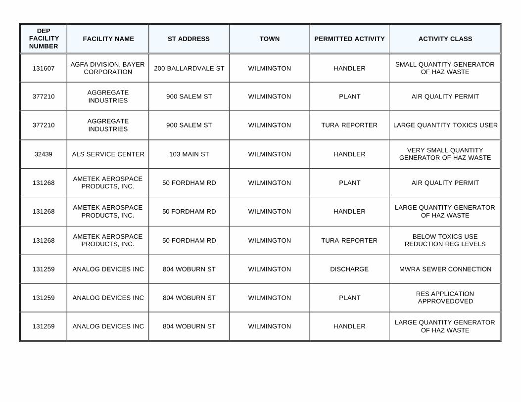
131607 AGFA DIVISION, BAYER
CORPORATION 200 BALLARDVALE ST WILMINGTON HANDLER SMALL QUANTITY GENERATOR
OF HAZ WASTE
377210 AGGREGATE INDUSTRIES
900 SALEM ST WILMINGTON PLANT AIR QUALITY PERMIT
377210 AGGREGATE INDUSTRIES
900 SALEM ST WILMINGTON TURA REPORTER LARGE QUANTITY TOXICS USER
32439 ALS SERVICE CENTER 103 MAIN ST WILMINGTON HANDLER VERY SMALL QUANTITY
GENERATOR OF HAZ WASTE
131268 AMETEK AEROSPACE
PRODUCTS, INC. 50 FORDHAM RD WILMINGTON PLANT AIR QUALITY PERMIT
131268 AMETEK AEROSPACE
PRODUCTS, INC. 50 FORDHAM RD WILMINGTON HANDLER
LARGE QUANTITY GENERATOR OF HAZ WASTE
131268 AMETEK AEROSPACE
PRODUCTS, INC. 50 FORDHAM RD WILMINGTON TURA REPORTER BELOW TOXICS USE
REDUCTION REG LEVELS
131259 ANALOG DEVICES INC 804 WOBURN ST WILMINGTON DISCHARGE MWRA SEWER CONNECTION
131259 ANALOG DEVICES INC 804 WOBURN ST WILMINGTON PLANT RES APPLICATION APPROVEDOVED
131259 ANALOG DEVICES INC 804 WOBURN ST WILMINGTON HANDLER LARGE QUANTITY GENERATOR
OF HAZ WASTE
DEP FACILITY NUMBER
FACILITY NAME ST ADDRESS TOWN PERMITTED ACTIVITY ACTIVITY CLASS
131259 ANALOG DEVICES INC 804 WOBURN ST WILMINGTON TURA REPORTER LARGE QUANTITY TOXICS USER
114468 ANTONS CLEANERS
INC 240 MAIN ST WILMINGTON HANDLER
VERY SMALL QUANTITY GENERATOR OF HAZ WASTE
323732 APPLIED SCIENCE &
TECHNOLOGY 90 INDUSTRIAL WAY WILMINGTON PLANT AIR QUALITY PERMIT
323732 APPLIED SCIENCE &
TECHNOLOGY 90 INDUSTRIAL WAY WILMINGTON HANDLER VERY SMALL QUANTITY
GENERATOR OF HAZ WASTE
357200 AZORES CORP 260 FORDHAM RD WILMINGTON HANDLER VERY SMALL QUANTITY
GENERATOR OF HAZ WASTE
327930 B & L ENTERPRISES 880 MAIN ST WILMINGTON PLANT AIR QUALITY PERMIT
365790 BENEVENTO ASPHALT
CORP 900 SALEM ST WILMINGTON PLANT RES APPLICATION APPROVEDOVED
52799 BENEVENTO SAND &
STONE 900 SALEM ST WILMINGTON PLANT AIR QUALITY PERMIT
371015 BROOKS PHARMACY
582 208 MAIN ST WILMINGTON HANDLER SMALL QUANTITY GENERATOR
OF HAZ WASTE
36008 BROWNS CUSTOM
AUTO BODY 210 ANDOVER ST UNIT
12 WILMINGTON HANDLER
VERY SMALL QUANTITY GENERATOR OF HAZ WASTE
933 BUTTERS ROW WTP TOWN HALL, WATER
DEPT WILMINGTON SURFACE DISCHARGE SURFACE DISCHARGEE WATER
DISCHARGEARGE
DEP FACILITY NUMBER
FACILITY NAME ST ADDRESS TOWN PERMITTED ACTIVITY ACTIVITY CLASS
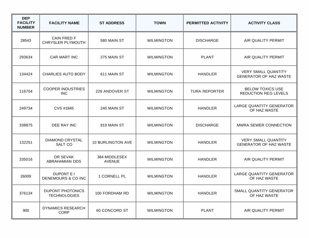
28543 CAIN FRED F
CHRYSLER PLYMOUTH 580 MAIN ST WILMINGTON DISCHARGE AIR QUALITY PERMIT
293634 CAR MART INC 275 MAIN ST WILMINGTON PLANT AIR QUALITY PERMIT
134424 CHARLIES AUTO BODY 611 MAIN ST WILMINGTON HANDLER VERY SMALL QUANTITY
GENERATOR OF HAZ WASTE
116704 COOPER INDUSTRIES
INC 226 ANDOVER ST WILMINGTON TURA REPORTER BELOW TOXICS USE
REDUCTION REG LEVELS
249734 CVS #1845 240 MAIN ST WILMINGTON HANDLER LARGE QUANTITY GENERATOR
OF HAZ WASTE
338875 DEE RAY INC 919 MAIN ST WILMINGTON DISCHARGE MWRA SEWER CONNECTION
132251 DIAMOND CRYSTAL
SALT CO 10 BURLINGTON AVE WILMINGTON HANDLER VERY SMALL QUANTITY
GENERATOR OF HAZ WASTE
335016 DR SEVAK
ABRAHAMIAN DDS 384 MIDDLESEX
AVENUE WILMINGTON HANDLER AIR QUALITY PERMIT
26009 DUPONT E I
DENEMOURS & CO INC 1 CORNELL PL WILMINGTON HANDLER LARGE QUANTITY GENERATOR
OF HAZ WASTE
376134 DUPONT PHOTONICS
TECHNOLOGIES 100 FORDHAM RD WILMINGTON HANDLER
SMALL QUANTITY GENERATOR OF HAZ WASTE
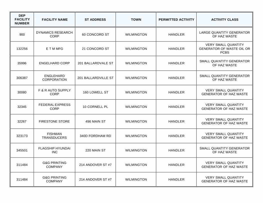
900 DYNAMICS RESEARCH
CORP 60 CONCORD ST WILMINGTON PLANT AIR QUALITY PERMIT
DEP FACILITY NUMBER
FACILITY NAME ST ADDRESS TOWN PERMITTED ACTIVITY ACTIVITY CLASS
900 DYNAMICS RESEARCH
CORP 60 CONCORD ST WILMINGTON HANDLER LARGE QUANTITY GENERATOR
OF HAZ WASTE
132256 E T M MFG 21 CONCORD ST WILMINGTON HANDLER VERY SMALL QUANTITY
GENERATOR OF WASTE OIL OR PCBS
35996 ENGELHARD CORP 201 BALLARDVALE ST WILMINGTON HANDLER SMALL QUA NTITY GENERATOR
OF HAZ WASTE
306387 ENGLEHARD
CORPORATION 201 BALLARDVILLE ST WILMINGTON HANDLER SMALL QUANTITY GENERATOR
OF HAZ WASTE
30080 F & R AUTO SUPPLY
CORP 160 LOWELL ST WILMINGTON HANDLER VERY SMALL QUANTITY
GENERATOR OF HAZ WASTE
32345 FEDERAL EXPRESS
CORP 10 CORNELL PL WILMINGTON HANDLER
VERY SMALL QUANTITY GENERATOR OF HAZ WASTE
32267 FIRESTONE STORE 496 MAIN ST WILMINGTON HANDLER VERY SMALL QUANTITY
GENERATOR OF HAZ WASTE
323173 FISHMAN
TRANSDUCERS 340D FORDHAM RD WILMINGTON HANDLER VERY SMALL QUANTITY
GENERATOR OF HAZ WASTE
345501 FLAGSHIP HYUNDAI
INC 220 MAIN ST WILMINGTON HANDLER SMALL QUANTITY GENERATOR
OF HAZ WASTE
311484 G&G PRINTING
COMPANY 214 ANDOVER ST #7 WILMINGTON HANDLER
VERY SMALL QUANTITY GENERATOR OF HAZ WASTE
311484 G&G PRINTING
COMPANY 214 ANDOVER ST #7 WILMINGTON HANDLER VERY SMALL QUANTITY
GENERATOR OF HAZ WASTE

DEP FACILITY NUMBER
FACILITY NAME ST ADDRESS TOWN PERMITTED ACTIVITY ACTIVITY CLASS
191962 GETOV MACHINE INC 150 WEST ST WILMINGTON HANDLER SMALL QUANTITY GENERATOR
OF HAZ WASTE
335097 GFI BIG JOE LLC 1 BURLINGTON
AVENUE WILMINGTON PLANT AIR QUALITY PERMIT
126548 GIBBS OIL 1595 342 MAIN ST WILMINGTON FUEL DISPENSER FUEL DISPENSER
319131 GLENS FALLS LEHIGH CEMENT COMPANY 90 EAMES ST WILMINGTON PLANT AIR QUALITY PERMIT
134423 HAMPSHIRE PRESS
INC THE 900 MAIN ST WILMINGTON HANDLER SMALL QUANTITY GENERATOR
OF HAZ WASTE
336596 HEFFRONS
AUTOMOTIVE 603 MAIN ST WILMINGTON HANDLER
SMALL QUANTITY GENERATOR OF WASTE OIL OR PCBS
126538 HESS 21206 273 MAIN ST WILMINGTON FUEL DISPENSER FUEL DISPENSER
307025 HESS STATION 21206 273 MAIN ST WILMINGTON HANDLER VERY SMALL QUANTITY
GENERATOR OF HAZ WASTE
31409 HIGH TECH MACHINE &
TOOL INC 218 ANDOVER ST WILMINGTON HANDLER VERY SMALL QUANTITY
GENERATOR OF HAZ WASTE
36358 IDEAL SERVICE RD 210 ANDOVER ST BAY
20 WILMINGTON HANDLER
VERY SMALL QUANTITY GENERATOR OF HAZ WASTE
334924 INDUSTRIAL TOOL
REPAIR CORPORATION
382 MIDDLESEX AVENUE WILMINGTON HANDLER
VERY SMALL QUANTITY GENERATOR OF HAZ WASTE
DEP FACILITY NUMBER
FACILITY NAME ST ADDRESS TOWN PERMITTED ACTIVITY ACTIVITY CLASS
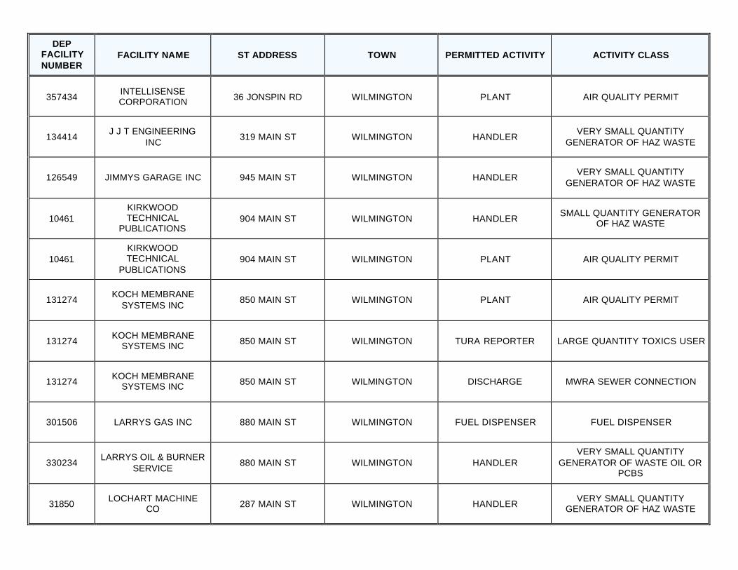
357434 INTELLISENSE CORPORATION 36 JONSPIN RD WILMINGTON PLANT AIR QUALITY PERMIT
134414 J J T ENGINEERING
INC 319 MAIN ST WILMINGTON HANDLER
VERY SMALL QUANTITY GENERATOR OF HAZ WASTE
126549 JIMMYS GARAGE INC 945 MAIN ST WILMINGTON HANDLER VERY SMALL QUANTITY
GENERATOR OF HAZ WASTE
10461 KIRKWOOD TECHNICAL
PUBLICATIONS 904 MAIN ST WILMINGTON HANDLER
SMALL QUANTITY GENERATOR OF HAZ WASTE
10461 KIRKWOOD TECHNICAL
PUBLICATIONS 904 MAIN ST WILMINGTON PLANT AIR QUALITY PERMIT
131274 KOCH MEMBRANE
SYSTEMS INC 850 MAIN ST WILMINGTON PLANT AIR QUALITY PERMIT
131274 KOCH MEMBRANE
SYSTEMS INC 850 MAIN ST WILMINGTON TURA REPORTER LARGE QUANTITY TOXICS USER
131274 KOCH MEMBRANE
SYSTEMS INC 850 MAIN ST WILMINGTON DISCHARGE MWRA SEWER CONNECTION
301506 LARRYS GAS INC 880 MAIN ST WILMINGTON FUEL DISPENSER FUEL DISPENSER
330234 LARRYS OIL & BURNER
SERVICE 880 MAIN ST WILMINGTON HANDLER
VERY SMALL QUANTITY GENERATOR OF WASTE OIL OR
PCBS
31850 LOCHART MACHINE
CO 287 MAIN ST WILMINGTON HANDLER VERY SMALL QUANTITY
GENERATOR OF HAZ WASTE
DEP FACILITY NUMBER
FACILITY NAME ST ADDRESS TOWN PERMITTED ACTIVITY ACTIVITY CLASS
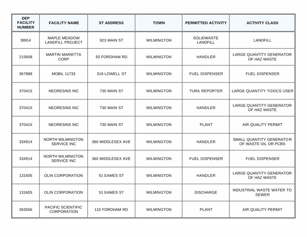
39914 MAPLE MEADOW
LANDFILL PROJECT 923 MAIN ST WILMINGTON SOLIDWASTE
LANDFILL LANDFILL
215608 MARTIN MARIETTA
CORP 50 FORDHAM RD WILMINGTON HANDLER
LARGE QUANTITY GENERATOR OF HAZ WASTE
367888 MOBIL 11733 318 LOWELL ST WILMINGTON FUEL DISPENSER FUEL DISPENSER
370415 NEORESINS INC 730 MAIN ST WILMINGTON TURA REPORTER LARGE QUANTITY TOXICS USER
370415 NEORESINS INC 730 MAIN ST WILMINGTON HANDLER LARGE QUANTITY GENERATOR
OF HAZ WASTE
370415 NEORESINS INC 730 MAIN ST WILMINGTON PLANT AIR QUALITY PERMIT
334914 NORTH WILMINGTON
SERVICE INC 360 MIDDLESEX AVE WILMINGTON HANDLER SMALL QUANTITY GENERATO R
OF WASTE OIL OR PCBS
334914 NORTH WILMINGTON
SERVICE INC 360 MIDDLESEX AVE WILMINGTON FUEL DISPENSER FUEL DISPENSER
131605 OLIN CORPORATION 51 EAMES ST WILMINGTON HANDLER LARGE QUANTITY GENERATOR
OF HAZ WASTE
131605 OLIN CORPORATION 51 EAMES ST WILMINGTON DISCHARGE INDUSTRIAL WASTE WATER TO
SEWER
363566 PACIFIC SCIENTIFIC
CORPORATION 110 FORDHAM RD WILMINGTON PLANT AIR QUALITY PERMIT
DEP FACILITY NUMBER
FACILITY NAME ST ADDRESS TOWN PERMITTED ACTIVITY ACTIVITY CLASS
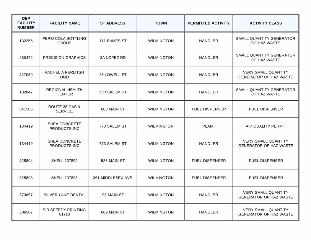
132255 PEPSI COLA BOTTLING
GROUP 111 EAMES ST WILMINGTON HANDLER SMALL QUANTITY GENERATOR
OF HAZ WASTE
280472 PRECISION GRAPHICS 3A LOPEZ RD WILMINGTON HANDLER SMALL QUANTITY GENERATOR
OF HAZ WASTE
327059 RACHEL A PERLITSH
DMD 25 LOWELL ST WILMINGTON HANDLER
VERY SMALL QUANTITY GENERATOR OF HAZ WASTE
132847 REGIONAL HEALTH
CENTER 500 SALEM ST WILMINGTON HANDLER SMALL QUANTITY GENERATOR
OF HAZ WASTE
341505 ROUTE 38 GAS &
SERVICE 603 MAIN ST WILMINGTON FUEL DISPENSER FUEL DISPENSER
134419 SHEA CONCRETE PRODUCTS INC
773 SALEM ST WILMINGTON PLANT AIR QUALITY PERMIT
134419 SHEA CONCRETE PRODUCTS INC 773 SALEM ST WILMINGTON HANDLER
VERY SMALL QUANTITY GENERATOR OF HAZ WASTE
325894 SHELL 137892 586 MAIN ST WILMINGTON FUEL DISPENSER FUEL DISPENSER
325893 SHELL 137893 361 MIDDLESEX AVE WILMINGTON FUEL DISPENSER FUEL DISPENSER
373667 SILVER LAKE DENTAL 96 MAIN ST WILMINGTON HANDLER VERY SMALL QUANTITY
GENERATOR OF HAZ WASTE
306507 SIR SPEEDY PRINTING
81710 609 MAIN ST WILMINGTON HANDLER VERY SMALL QUANTITY
GENERATOR OF HAZ WASTE
DEP FACILITY NUMBER
FACILITY NAME ST ADDRESS TOWN PERMITTED ACTIVITY ACTIVITY CLASS
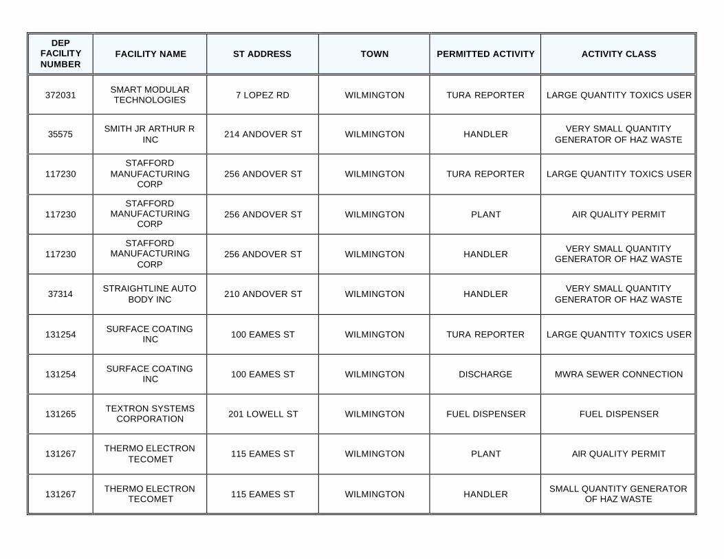
372031 SMART MODULAR TECHNOLOGIES 7 LOPEZ RD WILMINGTON TURA REPORTER LARGE QUANTITY TOXICS USER
35575 SMITH JR ARTHUR R
INC 214 ANDOVER ST WILMINGTON HANDLER
VERY SMALL QUANTITY GENERATOR OF HAZ WASTE
117230 STAFFORD
MANUFACTURING CORP
256 ANDOVER ST WILMINGTON TURA REPORTER LARGE QUANTITY TOXICS USER
117230 STAFFORD
MANUFACTURING CORP
256 ANDOVER ST WILMINGTON PLANT AIR QUALITY PERMIT
117230 STAFFORD
MANUFACTURING CORP
256 ANDOVER ST WILMINGTON HANDLER VERY SMALL QUANTITY
GENERATOR OF HAZ WASTE
37314 STRAIGHTLINE AUTO
BODY INC 210 ANDOVER ST WILMINGTON HANDLER
VERY SMALL QUANTITY GENERATOR OF HAZ WASTE
131254 SURFACE COATING
INC 100 EAMES ST WILMINGTON TURA REPORTER LARGE QUANTITY TOXICS USER
131254 SURFACE COATING
INC 100 EAMES ST WILMINGTON DISCHARGE MWRA SEWER CONNECTION
131265 TEXTRON SYSTEMS
CORPORATION 201 LOWELL ST WILMINGTON FUEL DISPENSER FUEL DISPENSER
131267 THERMO ELECTRON
TECOMET 115 EAMES ST WILMINGTON PLANT AIR QUALITY PERMIT
131267 THERMO ELECTRON
TECOMET 115 EAMES ST WILMINGTON HANDLER SMALL QUANTITY GENERATOR
OF HAZ WASTE
DEP FACILITY NUMBER
FACILITY NAME ST ADDRESS TOWN PERMITTED ACTIVITY ACTIVITY CLASS
131267 THERMO ELECTRON
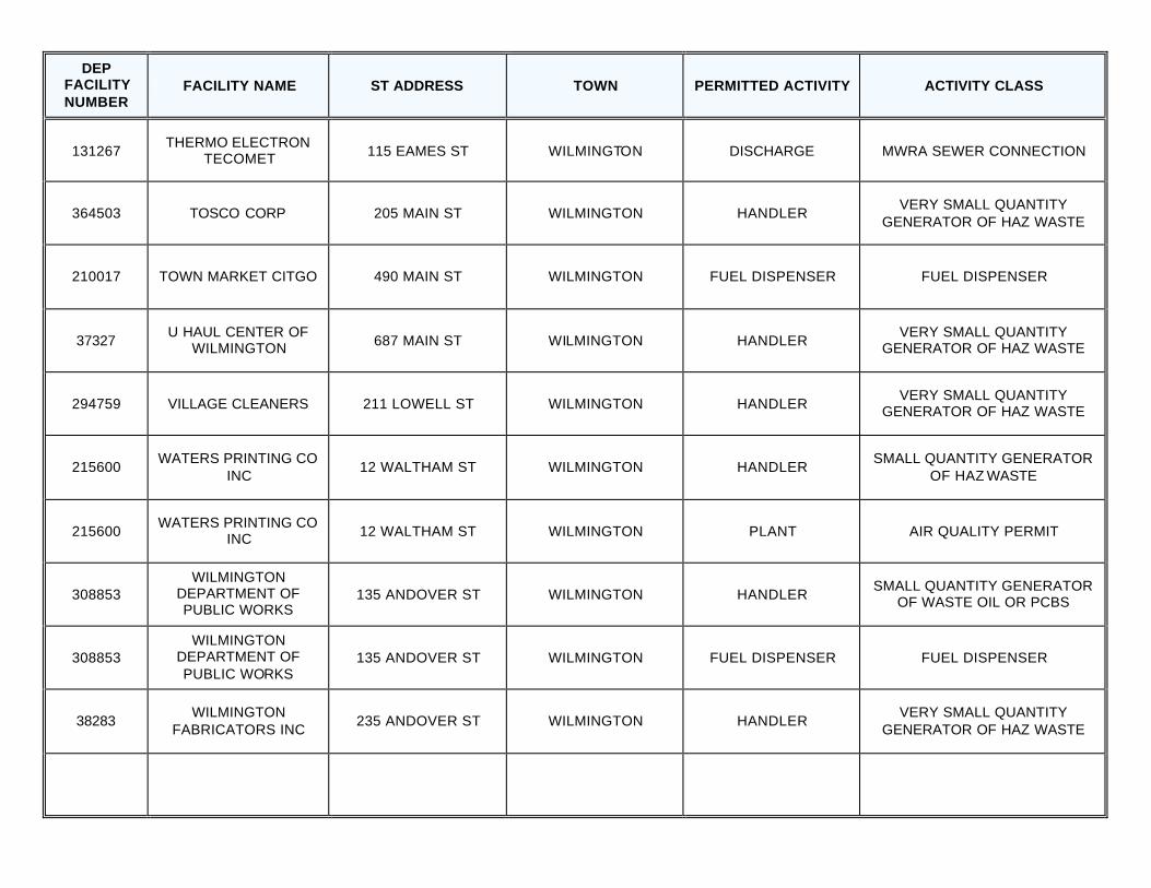
TECOMET 115 EAMES ST WILMINGTON DISCHARGE MWRA SEWER CONNECTION
364503 TOSCO CORP 205 MAIN ST WILMINGTON HANDLER VERY SMALL QUANTITY
GENERATOR OF HAZ WASTE
210017 TOWN MARKET CITGO 490 MAIN ST WILMINGTON FUEL DISPENSER FUEL DISPENSER
37327 U HAUL CENTER OF
WILMINGTON 687 MAIN ST WILMINGTON HANDLER VERY SMALL QUANTITY
GENERATOR OF HAZ WASTE
294759 VILLAGE CLEANERS 211 LOWELL ST WILMINGTON HANDLER VERY SMALL QUANTITY
GENERATOR OF HAZ WASTE
215600 WATERS PRINTING CO
INC 12 WALTHAM ST WILMINGTON HANDLER
SMALL QUANTITY GENERATOR OF HAZ WASTE
215600 WATERS PRINTING CO
INC 12 WALTHAM ST WILMINGTON PLANT AIR QUALITY PERMIT
308853 WILMINGTON
DEPARTMENT OF PUBLIC WORKS
135 ANDOVER ST WILMINGTON HANDLER SMALL QUANTITY GENERATOR
OF WASTE OIL OR PCBS
308853 WILMINGTON
DEPARTMENT OF PUBLIC WORKS
135 ANDOVER ST WILMINGTON FUEL DISPENSER FUEL DISPENSER
38283 WILMINGTON
FABRICATORS INC 235 ANDOVER ST WILMINGTON HANDLER
VERY SMALL QUANTITY GENERATOR OF HAZ WASTE
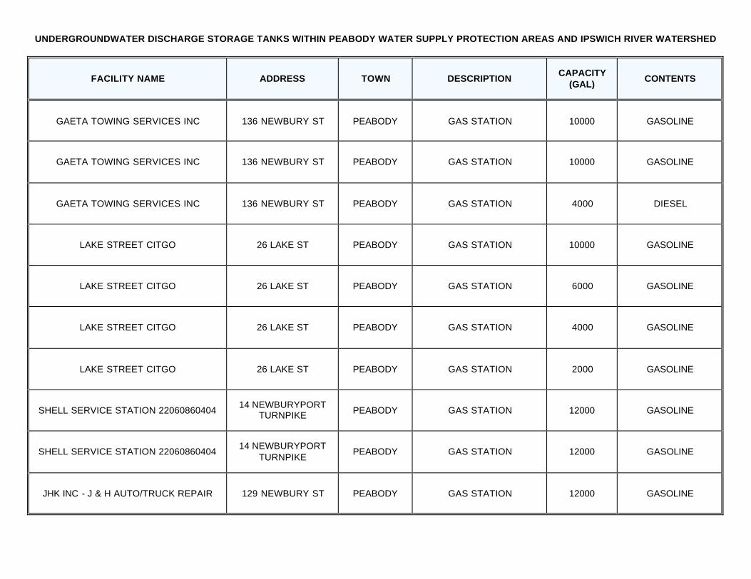
UNDERGROUNDWATER DISCHARGE STORAGE TANKS WITHIN PEABODY WATER SUPPLY PROTECTION AREAS AND IPSWICH RIVER WATERSHED
FACILITY NAME ADDRESS TOWN DESCRIPTION CAPACITY
(GAL) CONTENTS
GAETA TOWING SERVICES INC 136 NEWBURY ST PEABODY GAS STATION 10000 GASOLINE
GAETA TOWING SERVICES INC 136 NEWBURY ST PEABODY GAS STATION 10000 GASOLINE
GAETA TOWING SERVICES INC 136 NEWBURY ST PEABODY GAS STATION 4000 DIESEL
LAKE STREET CITGO 26 LAKE ST PEABODY GAS STATION 10000 GASOLINE
LAKE STREET CITGO 26 LAKE ST PEABODY GAS STATION 6000 GASOLINE
LAKE STREET CITGO 26 LAKE ST PEABODY GAS STATION 4000 GASOLINE
LAKE STREET CITGO 26 LAKE ST PEABODY GAS STATION 2000 GASOLINE
SHELL SERVICE STATION 22060860404 14 NEWBURYPORT
TURNPIKE PEABODY GAS STATION 12000 GASOLINE
SHELL SERVICE STATION 22060860404 14 NEWBURYPORT
TURNPIKE PEABODY GAS STATION 12000 GASOLINE
JHK INC - J & H AUTO/TRUCK REPAIR 129 NEWBURY ST PEABODY GAS STATION 12000 GASOLINE
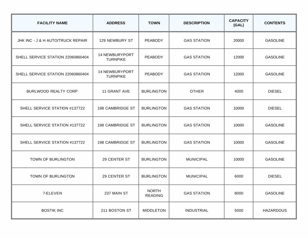
FACILITY NAME ADDRESS TOWN DESCRIPTION CAPACITY
(GAL) CONTENTS
JHK INC - J & H AUTO/TRUCK REPAIR 129 NEWBURY ST PEABODY GAS STATION 20000 GASOLINE
SHELL SERVICE STATION 22060860404 14 NEWBURYPORT
TURNPIKE PEABODY GAS STATION 12000 GASOLINE
SHELL SERVICE STATION 22060860404 14 NEWBURYPORT
TURNPIKE PEABODY GAS STATION 12000 GASOLINE
BURLWOOD REALTY CORP 11 GRANT AVE BURLINGTON OTHER 4000 DIESEL
SHELL SERVICE STATION #137722 198 CAMBRIDGE ST BURLINGTON GAS STATION 10000 DIESEL
SHELL SERVICE STATION #137722 198 CAMBRIDGE ST BURLINGTON GAS STATION 10000 GASOLINE
SHELL SERVICE STATION #137722 198 CAMBRIDGE ST BURLINGTON GAS STATION 10000 GASOLINE
TOWN OF BURLINGTON 29 CENTER ST BURLINGTON MUNICIPAL 10000 GASOLINE
TOWN OF BURLINGTON 29 CENTER ST BURLINGTON MUNICIPAL 6000 DIESEL
7-ELEVEN 237 MAIN ST NORTH
READING GAS STATION 8000 GASOLINE
BOSTIK INC 211 BOSTON ST MIDDLETON INDUSTRIAL 5000 HAZARDOUS
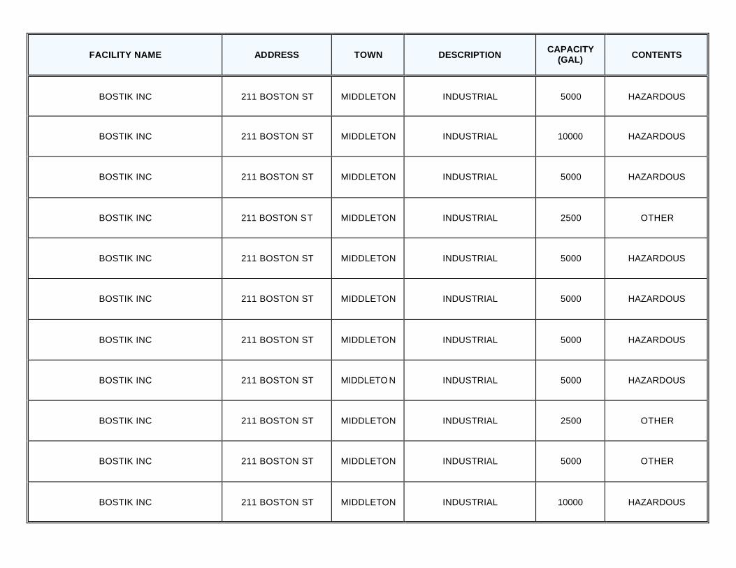
FACILITY NAME ADDRESS TOWN DESCRIPTION CAPACITY
(GAL) CONTENTS
BOSTIK INC 211 BOSTON ST MIDDLETON INDUSTRIAL 5000 HAZARDOUS
BOSTIK INC 211 BOSTON ST MIDDLETON INDUSTRIAL 10000 HAZARDOUS
BOSTIK INC 211 BOSTON ST MIDDLETON INDUSTRIAL 5000 HAZARDOUS
BOSTIK INC 211 BOSTON ST MIDDLETON INDUSTRIAL 2500 OTHER
BOSTIK INC 211 BOSTON ST MIDDLETON INDUSTRIAL 5000 HAZARDOUS
BOSTIK INC 211 BOSTON ST MIDDLETON INDUSTRIAL 5000 HAZARDOUS
BOSTIK INC 211 BOSTON ST MIDDLETON INDUSTRIAL 5000 HAZARDOUS
BOSTIK INC 211 BOSTON ST MIDDLETO N INDUSTRIAL 5000 HAZARDOUS
BOSTIK INC 211 BOSTON ST MIDDLETON INDUSTRIAL 2500 OTHER
BOSTIK INC 211 BOSTON ST MIDDLETON INDUSTRIAL 5000 OTHER
BOSTIK INC 211 BOSTON ST MIDDLETON INDUSTRIAL 10000 HAZARDOUS
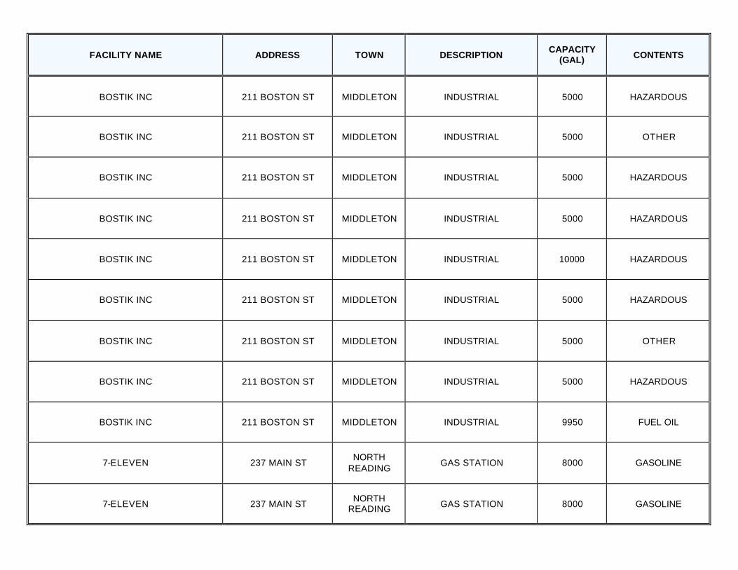
FACILITY NAME ADDRESS TOWN DESCRIPTION CAPACITY
(GAL) CONTENTS
BOSTIK INC 211 BOSTON ST MIDDLETON INDUSTRIAL 5000 HAZARDOUS
BOSTIK INC 211 BOSTON ST MIDDLETON INDUSTRIAL 5000 OTHER
BOSTIK INC 211 BOSTON ST MIDDLETON INDUSTRIAL 5000 HAZARDOUS
BOSTIK INC 211 BOSTON ST MIDDLETON INDUSTRIAL 5000 HAZARDOUS
BOSTIK INC 211 BOSTON ST MIDDLETON INDUSTRIAL 10000 HAZARDOUS
BOSTIK INC 211 BOSTON ST MIDDLETON INDUSTRIAL 5000 HAZARDOUS
BOSTIK INC 211 BOSTON ST MIDDLETON INDUSTRIAL 5000 OTHER
BOSTIK INC 211 BOSTON ST MIDDLETON INDUSTRIAL 5000 HAZARDOUS
BOSTIK INC 211 BOSTON ST MIDDLETON INDUSTRIAL 9950 FUEL OIL
7-ELEVEN 237 MAIN ST NORTH
READING GAS STATION 8000 GASOLINE
7-ELEVEN 237 MAIN ST NORTH
READING GAS STATION 8000 GASOLINE
FACILITY NAME ADDRESS TOWN DESCRIPTION CAPACITY
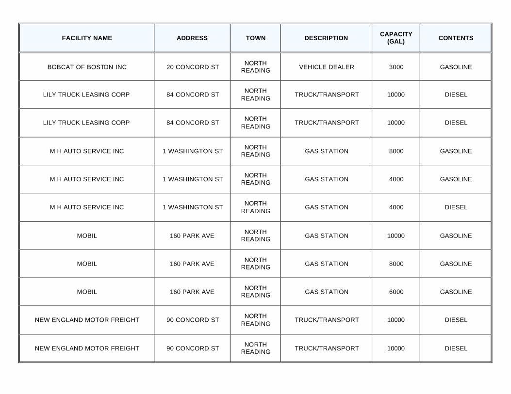
(GAL) CONTENTS
BOBCAT OF BOSTON INC 20 CONCORD ST NORTH
READING VEHICLE DEALER 3000 GASOLINE
LILY TRUCK LEASING CORP 84 CONCORD ST NORTH
READING TRUCK/TRANSPORT 10000 DIESEL
LILY TRUCK LEASING CORP 84 CONCORD ST NORTH
READING TRUCK/TRANSPORT 10000 DIESEL
M H AUTO SERVICE INC 1 WASHINGTON ST NORTH
READING GAS STATION 8000 GASOLINE
M H AUTO SERVICE INC 1 WASHINGTON ST NORTH
READING GAS STATION 4000 GASOLINE
M H AUTO SERVICE INC 1 WASHINGTON ST NORTH
READING GAS STATION 4000 DIESEL
MOBIL 160 PARK AVE NORTH
READING GAS STATION 10000 GASOLINE
MOBIL 160 PARK AVE NORTH
READING GAS STATION 8000 GASOLINE
MOBIL 160 PARK AVE NORTH
READING GAS STATION 6000 GASOLINE
NEW ENGLAND MOTOR FREIGHT 90 CONCORD ST NORTH
READING TRUCK/TRANSPORT 10000 DIESEL
NEW ENGLAND MOTOR FREIGHT 90 CONCORD ST NORTH
READING TRUCK/TRANSPORT 10000 DIESEL
FACILITY NAME ADDRESS TOWN DESCRIPTION CAPACITY
(GAL) CONTENTS
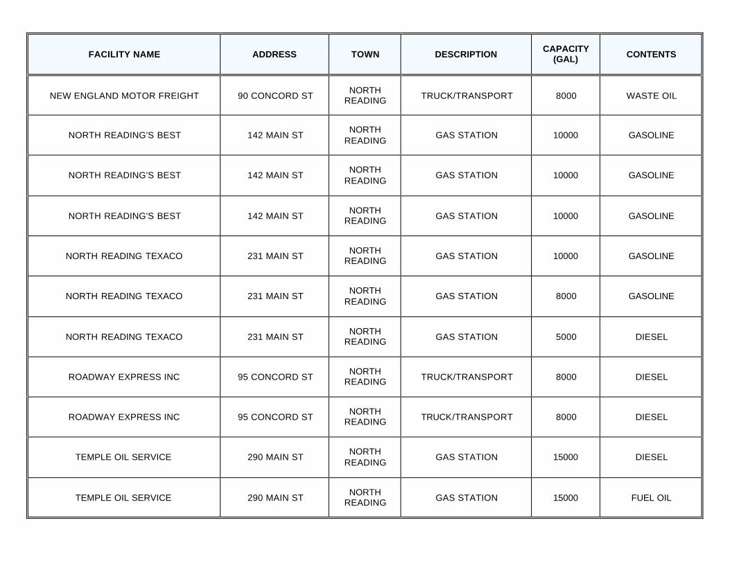
NEW ENGLAND MOTOR FREIGHT 90 CONCORD ST NORTH
READING TRUCK/TRANSPORT 8000 WASTE OIL
NORTH READING'S BEST 142 MAIN ST NORTH
READING GAS STATION 10000 GASOLINE
NORTH READING'S BEST 142 MAIN ST NORTH
READING GAS STATION 10000 GASOLINE
NORTH READING'S BEST 142 MAIN ST NORTH
READING GAS STATION 10000 GASOLINE
NORTH READING TEXACO 231 MAIN ST NORTH
READING GAS STATION 10000 GASOLINE
NORTH READING TEXACO 231 MAIN ST NORTH
READING GAS STATION 8000 GASOLINE
NORTH READING TEXACO 231 MAIN ST NORTH
READING GAS STATION 5000 DIESEL
ROADWAY EXPRESS INC 95 CONCORD ST NORTH
READING TRUCK/TRANSPORT 8000 DIESEL
ROADWAY EXPRESS INC 95 CONCORD ST NORTH
READING TRUCK/TRANSPORT 8000 DIESEL
TEMPLE OIL SERVICE 290 MAIN ST NORTH
READING GAS STATION 15000 DIESEL
TEMPLE OIL SERVICE 290 MAIN ST NORTH
READING GAS STATION 15000 FUEL OIL
FACILITY NAME ADDRESS TOWN DESCRIPTION CAPACITY
(GAL) CONTENTS
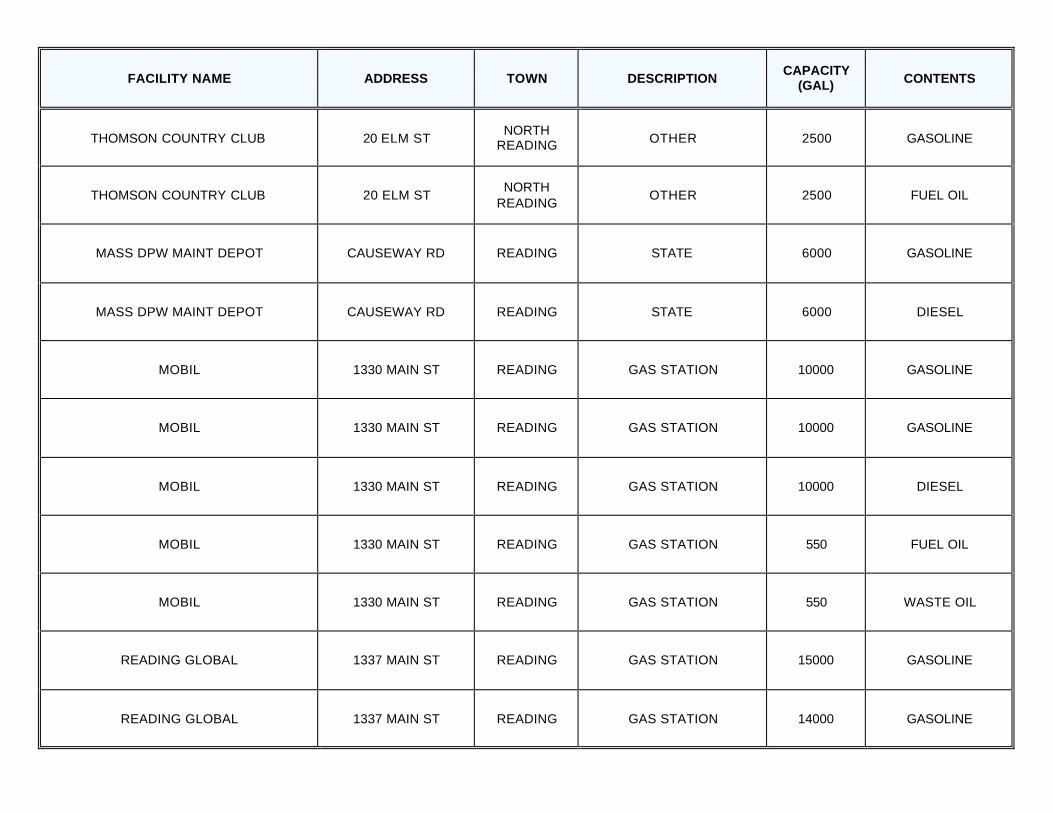
THOMSON COUNTRY CLUB 20 ELM ST NORTH
READING OTHER 2500 GASOLINE
THOMSON COUNTRY CLUB 20 ELM ST NORTH
READING OTHER 2500 FUEL OIL
MASS DPW MAINT DEPOT CAUSEWAY RD READING STATE 6000 GASOLINE
MASS DPW MAINT DEPOT CAUSEWAY RD READING STATE 6000 DIESEL
MOBIL 1330 MAIN ST READING GAS STATION 10000 GASOLINE
MOBIL 1330 MAIN ST READING GAS STATION 10000 GASOLINE
MOBIL 1330 MAIN ST READING GAS STATION 10000 DIESEL
MOBIL 1330 MAIN ST READING GAS STATION 550 FUEL OIL
MOBIL 1330 MAIN ST READING GAS STATION 550 WASTE OIL
READING GLOBAL 1337 MAIN ST READING GAS STATION 15000 GASOLINE
READING GLOBAL 1337 MAIN ST READING GAS STATION 14000 GASOLINE
FACILITY NAME ADDRESS TOWN DESCRIPTION CAPACITY
(GAL) CONTENTS
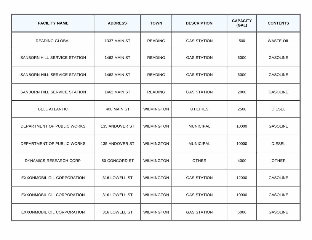
READING GLOBAL 1337 MAIN ST READING GAS STATION 500 WASTE OIL
SANBORN HILL SERVICE STATION 1462 MAIN ST READING GAS STATION 6000 GASOLINE
SANBORN HILL SERVICE STATION 1462 MAIN ST READING GAS STATION 6000 GASOLINE
SANBORN HILL SERVICE STATION 1462 MAIN ST READING GAS STATION 2000 GASOLINE
BELL ATLANTIC 408 MAIN ST WILMINGTON UTILITIES 2500 DIESEL
DEPARTMENT OF PUBLIC WORKS 135 ANDOVER ST WILMINGTON MUNICIPAL 10000 GASOLINE
DEPARTMENT OF PUBLIC WORKS 135 ANDOVER ST WILMINGTON MUNICIPAL 10000 DIESEL
DYNAMICS RESEARCH CORP 50 CONCORD ST WILMINGTON OTHER 4000 OTHER
EXXONMOBIL OIL CORPORATION 316 LOWELL ST WILMINGTON GAS STATION 12000 GASOLINE
EXXONMOBIL OIL CORPORATION 316 LOWELL ST WILMINGTON GAS STATION 10000 GASOLINE
EXXONMOBIL OIL CORPORATION 316 LOWELL ST WILMINGTON GAS STATION 6000 GASOLINE
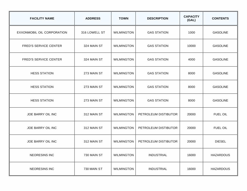
FACILITY NAME ADDRESS TOWN DESCRIPTION CAPACITY
(GAL) CONTENTS
EXXONMOBIL OIL CORPORATION 316 LOWELL ST WILMINGTON GAS STATION 1000 GASOLINE
FRED'S SERVICE CENTER 324 MAIN ST WILMINGTON GAS STATION 10000 GASOLINE
FRED'S SERVICE CENTER 324 MAIN ST WILMINGTON GAS STATION 4000 GASOLINE
HESS STATION 273 MAIN ST WILMINGTON GAS STATION 8000 GASOLINE
HESS STATION 273 MAIN ST WILMINGTON GAS STATION 8000 GASOLINE
HESS STATION 273 MAIN ST WILMINGTON GAS STATION 8000 GASOLINE
JOE BARRY OIL INC 312 MAIN ST WILMINGTON PETROLEUM DISTIBUTOR 20000 FUEL OIL
JOE BARRY OIL INC 312 MAIN ST WILMINGTON PETROLEUM DISTIBUTOR 20000 FUEL OIL
JOE BARRY OIL INC 312 MAIN ST WILMINGTON PETROLEUM DISTIBUTOR 20000 DIESEL
NEORESINS INC 730 MAIN ST WILMINGTON INDUSTRIAL 16000 HAZARDOUS
NEORESINS INC 730 MAIN ST WILMINGTON INDUSTRIAL 16000 HAZARDOUS
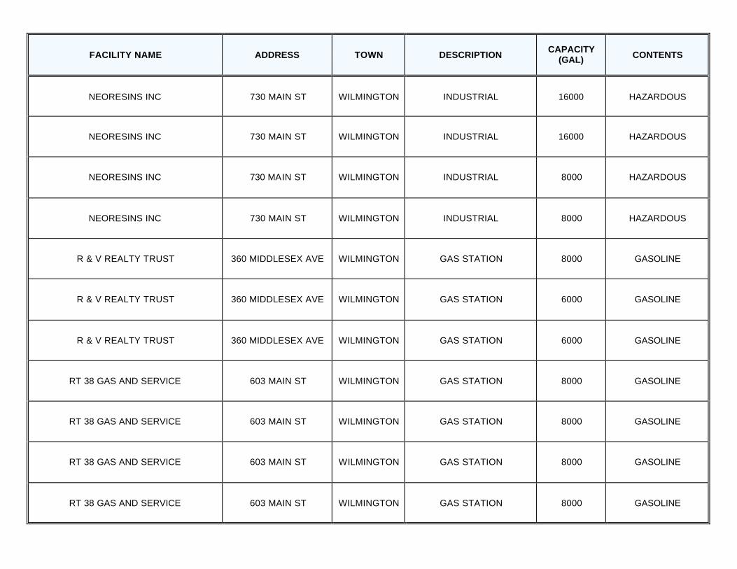
FACILITY NAME ADDRESS TOWN DESCRIPTION CAPACITY
(GAL) CONTENTS
NEORESINS INC 730 MAIN ST WILMINGTON INDUSTRIAL 16000 HAZARDOUS
NEORESINS INC 730 MAIN ST WILMINGTON INDUSTRIAL 16000 HAZARDOUS
NEORESINS INC 730 MAIN ST WILMINGTON INDUSTRIAL 8000 HAZARDOUS
NEORESINS INC 730 MAIN ST WILMINGTON INDUSTRIAL 8000 HAZARDOUS
R & V REALTY TRUST 360 MIDDLESEX AVE WILMINGTON GAS STATION 8000 GASOLINE
R & V REALTY TRUST 360 MIDDLESEX AVE WILMINGTON GAS STATION 6000 GASOLINE
R & V REALTY TRUST 360 MIDDLESEX AVE WILMINGTON GAS STATION 6000 GASOLINE
RT 38 GAS AND SERVICE 603 MAIN ST WILMINGTON GAS STATION 8000 GASOLINE
RT 38 GAS AND SERVICE 603 MAIN ST WILMINGTON GAS STATION 8000 GASOLINE
RT 38 GAS AND SERVICE 603 MAIN ST WILMINGTON GAS STATION 8000 GASOLINE
RT 38 GAS AND SERVICE 603 MAIN ST WILMINGTON GAS STATION 8000 GASOLINE
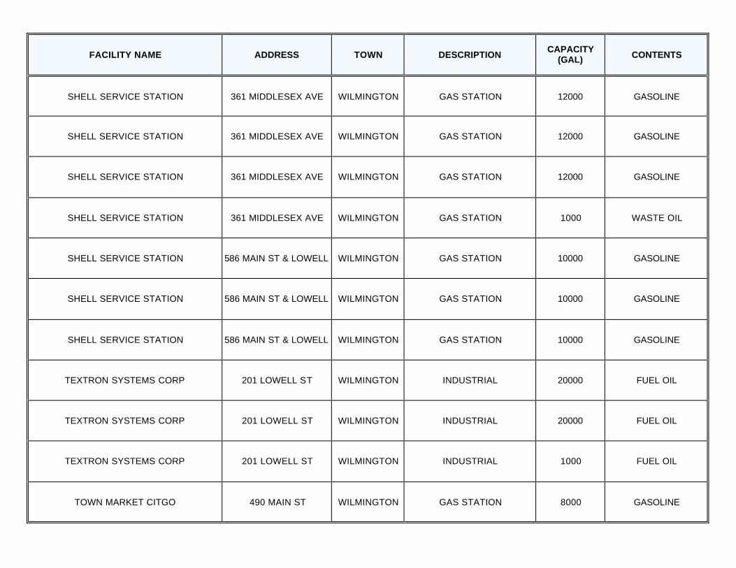
FACILITY NAME ADDRESS TOWN DESCRIPTION CAPACITY
(GAL) CONTENTS
SHELL SERVICE STATION 361 MIDDLESEX AVE WILMINGTON GAS STATION 12000 GASOLINE
SHELL SERVICE STATION 361 MIDDLESEX AVE WILMINGTON GAS STATION 12000 GASOLINE
SHELL SERVICE STATION 361 MIDDLESEX AVE WILMINGTON GAS STATION 12000 GASOLINE
SHELL SERVICE STATION 361 MIDDLESEX AVE WILMINGTON GAS STATION 1000 WASTE OIL
SHELL SERVICE STATION 586 MAIN ST & LOWELL WILMINGTON GAS STATION 10000 GASOLINE
SHELL SERVICE STATION 586 MAIN ST & LOWELL WILMINGTON GAS STATION 10000 GASOLINE
SHELL SERVICE STATION 586 MAIN ST & LOWELL WILMINGTON GAS STATION 10000 GASOLINE
TEXTRON SYSTEMS CORP 201 LOWELL ST WILMINGTON INDUSTRIAL 20000 FUEL OIL
TEXTRON SYSTEMS CORP 201 LOWELL ST WILMINGTON INDUSTRIAL 20000 FUEL OIL
TEXTRON SYSTEMS CORP 201 LOWELL ST WILMINGTON INDUSTRIAL 1000 FUEL OIL
TOWN MARKET CITGO 490 MAIN ST WILMINGTON GAS STATION 8000 GASOLINE
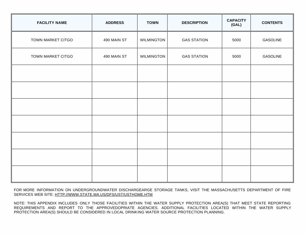
FACILITY NAME ADDRESS TOWN DESCRIPTION CAPACITY
(GAL) CONTENTS
TOWN MARKET CITGO 490 MAIN ST WILMINGTON GAS STATION 5000 GASOLINE
TOWN MARKET CITGO 490 MAIN ST WILMINGTON GAS STATION 5000 GASOLINE
FOR MORE INFORMATION ON UNDERGROUNDWATER DISCHARGEARGE STORAGE TANKS, VISIT THE MASSACHUSETTS DEPARTMENT OF FIRE SERVICES WEB SITE: HTTP://WWW.STATE.MA.US/DFS/UST/USTHOME.HTM NOTE: THIS APPENDIX INCLUDES ONLY THOSE FACILITIES WITHIN THE WATER SUPPLY PROTECTION AREA(S) THAT MEET STATE REPORTING REQUIREMENTS AND REPORT TO THE APPROVEDOPRIATE AGENCIES. ADDITIONAL FACILITIES LOCATED WITHIN THE WATER SUPPLY PROTECTION AREA(S) SHOULD BE CONSIDERED IN LOCAL DRINKING WATER SOURCE PROTECTION PLANNING.

APPENDIX B – Table of Tier Classified Oil and/or Hazardous Material Sites within Peabody Water Supply Protection Areas and Ipswich River Watershed
DEP’s datalayer depicting oil and/or hazardous material (OHM) sites is a statewide point data set that contains the approximate location of known sources of contamination that have been both reported and classified under Chapter 21E of the Massachusetts General Laws. Location types presented in the layer include the approximate center of the site, the center of the building on the property where the release occurred, the source of contamination, or the location of an on-site monitoring well. Although this assessment identifies OHM sites near the source of your drinking water, the risks to the source posed by each site may be different. The kind of contaminant and the local geology may have an effect on whether the site poses an actual or potential threat to the source. The DEP’s Chapter 21E program relies on licensed site professionals (LSPs) to oversee cleanups at most sites, while the DEP’s Bureau of Waste Site Cleanup (BWSC) program retains oversight at the most serious sites. This privatized program obliges potentially responsible parties and LSPs to comply with DEP regulations (the Massachusetts Contingency Plan – MCP), which require that sites within drinking water source protection areas be cleaned up to drinking water standards. For more information about the state’s OHM site cleanup process to which these sites are subject and how this complements the drinking water protection program, please visit the BWSC web page at http://www.state.ma.us/dep/bwsc. You may obtain site -specific information two ways: by using the BWSC Searchable Sites database at http://:www.state.ma.us/dep/bwsc/sitellst.htm, or you may visit the DEP regional office and review the site file. These files contain more detailed information, including cleanup status, site history, contamination levels, maps, correspondence and investigation reports, however you must call the regional office in order to schedule an appointment to view the file. The table below contains the list of Tier Classified oil and/or Hazardous Material Release Sites that are located within your drinking water source protection area. Table 1: Bureau of Waste Site Cleanup Tier Classified Oil and/or Hazardous Material Release Sites (Chapter 21E Sites) - Listed by Release Tracking Number (RTN).
RTN Release Site Address Town Contaminant Type
3-0001813 Route 125 North Andover Bypass Andover Oil
3-0011228 4 Brookfield Rd Burlington Oil
3-0001494 Boston St Middleton Oil
3-0006026 24 Hilldale Ave Middleton Oil
3-0000692 60 Concord St North Reading --
3-0002363 95 Concord St North Reading Oil
3-0002584 70 Concord St North Reading --
3-0002804 5 Hallberg Park North Reading --
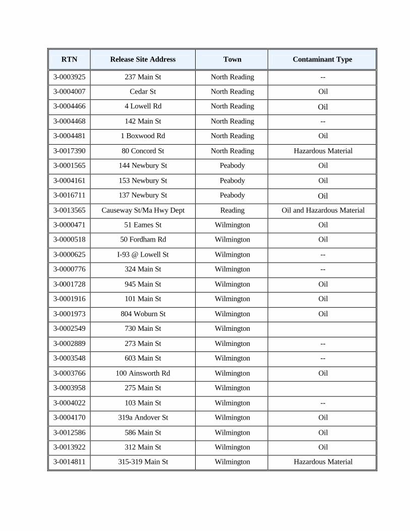
RTN Release Site Address Town Contaminant Type
3-0003925 237 Main St North Reading --
3-0004007 Cedar St North Reading Oil
3-0004466 4 Lowell Rd North Reading Oil
3-0004468 142 Main St North Reading --
3-0004481 1 Boxwood Rd North Reading Oil
3-0017390 80 Concord St North Reading Hazardous Material
3-0001565 144 Newbury St Peabody Oil
3-0004161 153 Newbury St Peabody Oil
3-0016711 137 Newbury St Peabody Oil
3-0013565 Causeway St/Ma Hwy Dept Reading Oil and Hazardous Material
3-0000471 51 Eames St Wilmington Oil
3-0000518 50 Fordham Rd Wilmington Oil
3-0000625 I-93 @ Lowell St Wilmington --
3-0000776 324 Main St Wilmington --
3-0001728 945 Main St Wilmington Oil
3-0001916 101 Main St Wilmington Oil
3-0001973 804 Woburn St Wilmington Oil
3-0002549 730 Main St Wilmington
3-0002889 273 Main St Wilmington --
3-0003548 603 Main St Wilmington --
3-0003766 100 Ainsworth Rd Wilmington Oil
3-0003958 275 Main St Wilmington
3-0004022 103 Main St Wilmington --
3-0004170 319a Andover St Wilmington Oil
3-0012586 586 Main St Wilmington Oil
3-0013922 312 Main St Wilmington Oil
3-0014811 315-319 Main St Wilmington Hazardous Material
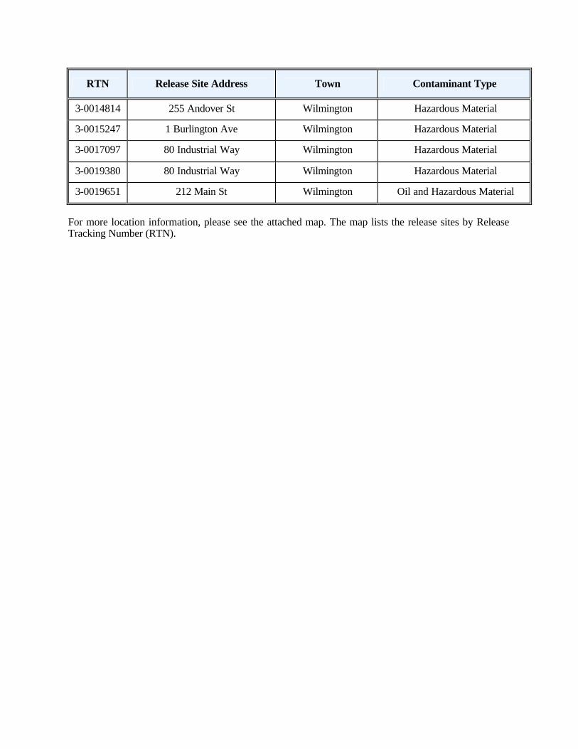
RTN Release Site Address Town Contaminant Type
3-0014814 255 Andover St Wilmington Hazardous Material
3-0015247 1 Burlington Ave Wilmington Hazardous Material
3-0017097 80 Industrial Way Wilmington Hazardous Material
3-0019380 80 Industrial Way Wilmington Hazardous Material
3-0019651 212 Main St Wilmington Oil and Hazardous Material
For more location information, please see the attached map. The map lists the release sites by Release Tracking Number (RTN).


