Embed Size (px)
Citation preview

CHARACTERISTICS OF WATERSHED
(WATERSHED MANAGEMENT)
UNIT – II
Rambabu Palaka, Assistant ProfessorBVRIT

Learning Objectives1. Climatic Characteristics
Rainfall & its movement, Intensity, Duration, Temperature, Wind Velocity, Humidity, Transpiration, and Evaporation
2. Physiographic CharacteristicsSize, Shape, Slope, Drainage Density, Elevation, Land use, Vegetation Cover, Soil, Geology, Hydrology, Hydrogeology
3. Socio-economics Characteristics Statistics on people and their health, wants & wishes, Cattle and Farming Practices, People Participation
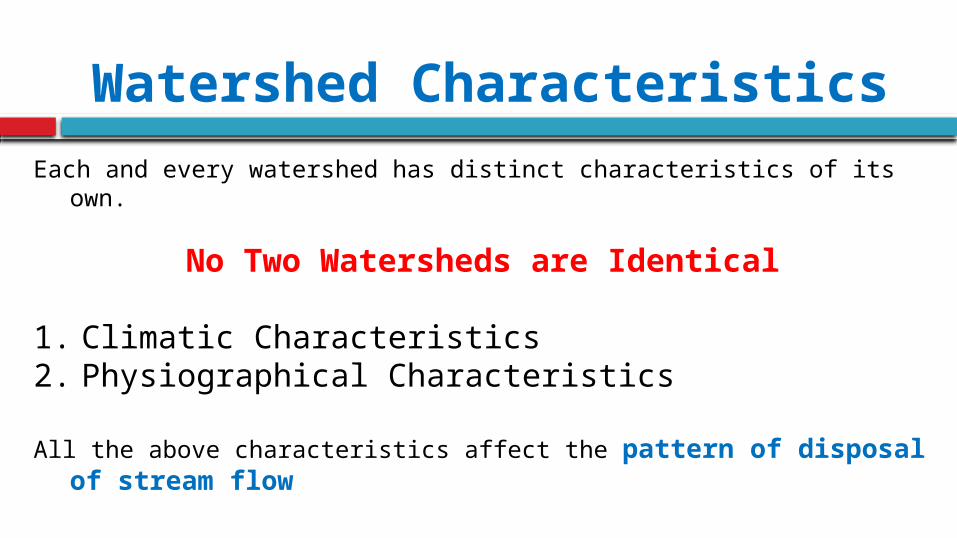
Watershed CharacteristicsEach and every watershed has distinct characteristics of its own.
No Two Watersheds are Identical
1. Climatic Characteristics2. Physiographical Characteristics
All the above characteristics affect the pattern of disposal of stream flow

Micro-Watershed near Moosapet Village, Narsapur Mandal, Medak District, Telanagana State
Case Study


Moosapet Tank

Moosapet Tank

Common Point
(Tank Outlet)

Climatic Characteristics If the climatic condition is dry before the rainfall, loss of runoff is more
due to infiltration and evapotranspiration.
Climatic condition depends on Temperature, Wind Velocity, and HumidityTranspiration, Evaporation, and Evapotranspiration depends on Climatic Condition
The more the intensity of rainfall in the watershed, the more is the peak flow disposal from the area.
If the duration is less, time taken to dispose with lower peak flow is also less

If the rain moves downstream, the peak stream flow of watershed occurs quickly
If rain moves upstream, the peak flow occurs late


Climatic CharacteristicsFor the correct design of hydraulic structures like
Dams Weirs Barrage Reservoirs Spillways Retaining walls Embankments
a peak flow assessment of run-off or flood should be accurately worked out

Physiographic CharacteristicsShape:
Watersheds differ in their shape based on morphometric parameters like geology and structure.
The shape of watershed has a dominant effect on the characteristics of the hydrograph of the watershed such as peak flow, overland flow, and base of hydrograph (run-off time).


Physiographic CharacteristicsSize:
The size of watershed is governed by the size of stream or river and the development and management works taken.
For minor irrigation project, size may be few hundred square kilometers For Tank or Pond Irrigation, size is just few square kilometers In Watershed management works in hilly or undulating topography, the size of watershed may be even much smaller .
Measurement of precipitation as well as water retention, drainage from the watershed complex for a bigger size of watershed
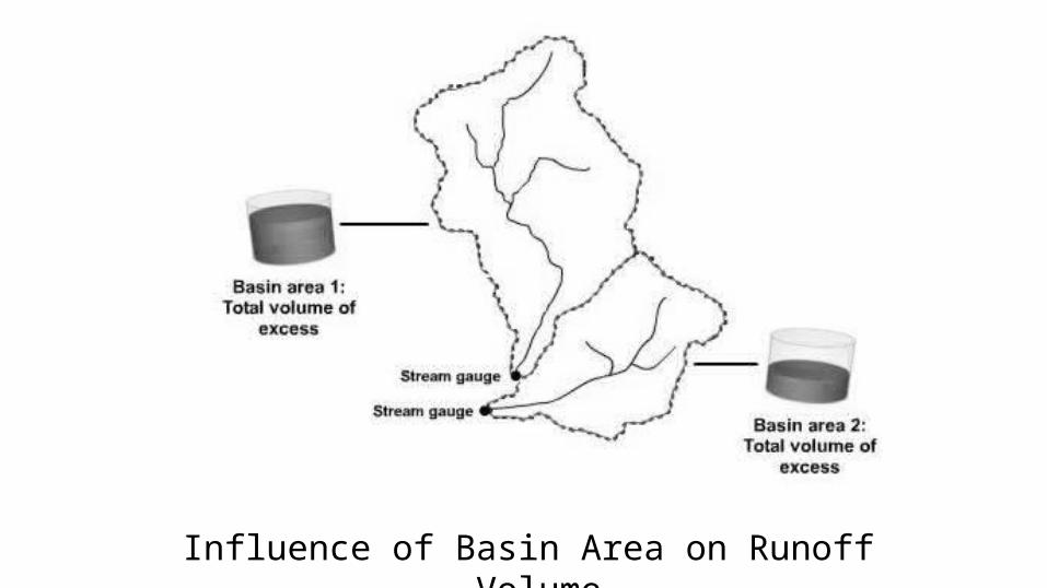
Influence of Basin Area on Runoff Volume
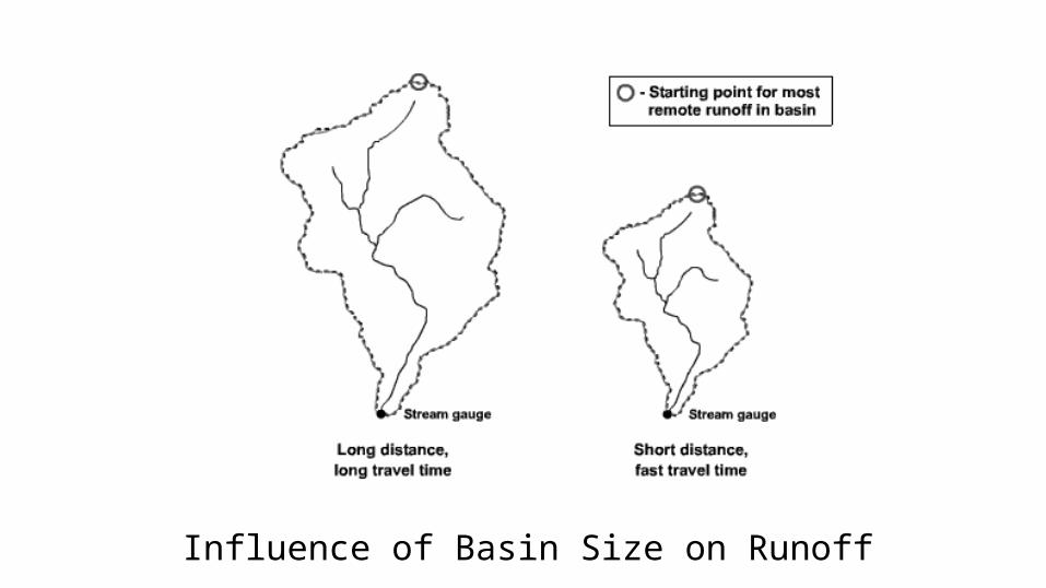
Influence of Basin Size on Runoff

Physiographic CharacteristicsSlope:
It controls the rainfall distribution and movement, land utilization and watershed behavior.
If slope is more, the velocity is more, and hence flood water drains quickly results in higher peak discharge reduces infiltration increases the soil transportation

Influence of Basin Sloe of Runoff
Gentle slope indicates lesser runoff and Steeper slope indicates higher runoff

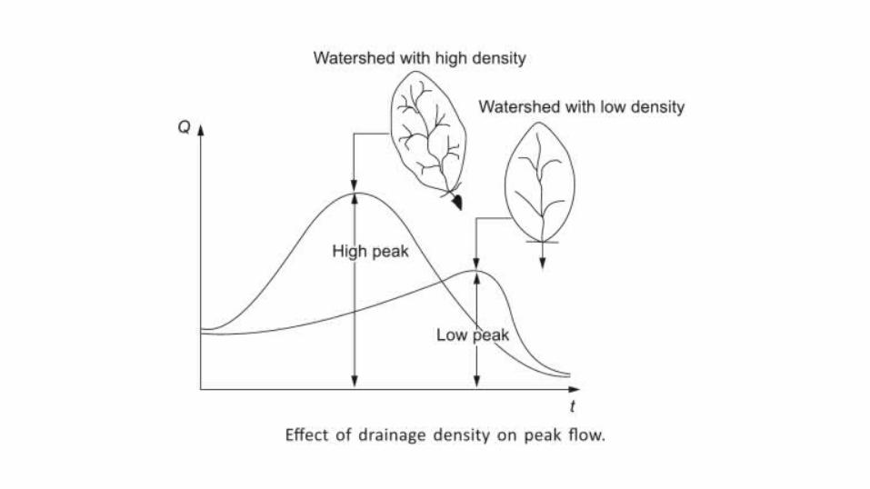
Physiographic CharacteristicsDrainage:
The Stream Order, Drainage Pattern, and Drainage Density have a profound influence on watershed as to runoff, infiltration, land management etc.
It determines the flow characteristics and erosional behavior. If drainage density is more, peak runoff is more.

Stream Order (Strahler)
First and Second order streams generally form on steep slopes and flow quickly until they slow down and meet the next order waterway.
First to Third Order Streams generally found in upper reaches of watershed Streams that are classified through 4th to 6th are called as medium streams
If Stream order is larger than 6th is considered as river.

Drainage Pattern

Pattern Description Controlling influences
Dendritic random, tree-like branching pattern
flat-lying sedimentary rock, thick sediment, or homogeneous rock uninterrupted by fractures
Trellis
long (subsequent) streams follow strike valleys fed by short tributaries descending from adjacent obsequent and dip slopes
developed in differentially eroded fold belts containing Lithology of varying strengths
Radial tributaries radiate away from a central region
central highland such as a volcano or eroding pluton surrounded by sedimentary rock
Rectangular tributaries make right angle bends jointed or faulted bedrock
Drainage Patterns

Physiographic CharacteristicsPhysiography:
Type of land, its altitude and physical disposition immensely speak about a watershed as to the climate and planning the activities in greening.
Hilly tract could be useful mainly for Forestry Plains of populated areas could be utilized for Crops

Physiographic CharacteristicsLand Use:
The land in watershed is used for numerous purposes such as dwelling houses cultivation livestock water harvesting roads and railways
Land use affects the run-off rates.

Physiographic CharacteristicsVegetation Cover: Vegetation cover retard the flow and increases the infiltration and interception, there by reducing the peak flow.
Vegetation cover protects the soil erosion.
Detailed information on vegetation helps in choosing type, mode and manner of greening the watershed

Physiographic CharacteristicsSoil: The soil such as sand absorbs a larger part of run-off water, so the rate of flow is less. Clay soil produces more flow as its absorption is less.
Soil parameters such as depth, nature, moisture and fertility determines crops.

Physiographic CharacteristicsGeology:
Rocks and their structure control formation of a watershed itself because their nature determines size, shape, physiography, drainage, and groundwater conditions.
Geological conditions affects the run-off of watershed. If there are some cracks in rocks joining surface water and groundwater, a part of water flows quickly underground.
Lakes, Storages, Swamp hold a part of excess rainfall

Physiographic CharacteristicsHydrology:
The availability, quality and distribution of surface water is basic to the final goal of growing greenery in a watershed.
Hydrological parameters such as intensity and duration of rainfall help in quantification of water available in watershed.
If rainfall continues for longer period with low intensity, evaporation and percolation increases but run-off is less. Further it may cause landslide in sloping hillside areas.

Physiographic CharacteristicsHydrogeology:
The groundwater demand for irrigation, farm plantation, drinking water , domestic use and industrial use is more as it is relatively less polluted and pure.
The information about aquifer such as nature, thickness and characteristics should be known for betting planning of watersheds.

Socio-economic CharacteristicsA survey of people living in the watershed should be made regarding their needs and wants, economic conditions, health & hygiene, cattle, farming practices and participation in watershed management.
Demographic profile, sociological stratification, attitude and behavior of community will affect the watershed management to a great extent.

Benchmark SurveyBenchmark Survey of a watershed is the survey of basic resources. It is essential for a master plan and future evaluation and monitoring of the watershed.
The basic points considered in Benchmark Survey are as follows: Physiography (Name, Elevation, Boundaries, Transportation etc.) Climate (Temperature, Wind, Humidity etc.) Soil (Type, Depth, Permeability etc.) Hydrological Survey (Rainfall, Infiltration, Evaporation, Evapotranspiration) Topographical Survey (Size, Slope, Shape etc.) Land Use and Vegetation Survey Socio-economic Survey

Reference
Watershed Management by
Madan Mohan DasMimi Das Saikia
PHI Learning Private Limited


![Runoff Characteristics of Nutrients From an Agricultural Watershed With Intensive Livestock Production [Electronic Resource]](https://img.dokumen.tips/doc/110x75/546931b2b4af9f0e518b4b1c/runoff-characteristics-of-nutrients-from-an-agricultural-watershed-with-intensive-livestock-production-electronic-resource.jpg)