Embed Size (px)
Citation preview

Watershed Protection and Management Plan
for the Ballston Lake Watershed
June 2001
Capital District Regional Planning Commission
5 Computer Drive West, 2nd Floor, Albany, New York 12205
Phone # 518 / 453-0850 Fax # 518 / 453-0856
Web Site: http://www.cdrpc.org E-Mail: [email protected]

Watershed Protection and
Management Plan for the
Ballston Lake Watershed
June 2001
Capital District Regional Planning Commission 5 Computer Drive West, 2nd Floor, Albany, New York 12205
Phone: 518 / 453-0850 Fax: 518 / 453-0856
Web Site: http://www.cdrpc.org E-Mail: [email protected]

1
Watershed Protection and Management Plan for Ballston Lake Table of Contents Introduction………………………………………………………………………..……..2 I - Project Scope…………………………………………………………………….……4
Includes the methodology and investigative process for this study. II - An Overview of Watershed Systems………………………………………….…….6
Introduces the concept of watersheds and details the factors that can adversely effect the watershed and its water quality.
III - History…………………………………………….………………………………..11
Gives a brief history of Ballston Lake, the local community, and watershed development patterns.
IV - Existing Environmental Conditions……………………………………………...13
Describes a variety of existing environmental conditions relating to specific soil and water conditions within the watershed area.
V - Watershed Land Use……………………………………………………………….18
Discusses past development and future growth trends; the location of major incentives to growth (i.e. sewer district and major highways; the location of areas most vulnerable to future development impacts, including recreational use of the lake.
VI - Water Quality Related Regulations……………………………………………....23
Describes the existing development, septic, water quality and infrastructure regulations that serve to protect the Ballston Lake watershed.
VII - Assessment of the Threats to Ballston Lake Water Quality…………………...30
Examines the water quality factors detailed in Chapter I with respect to the Ballston Lake Watershed.
VIII - Recommendations for Watershed Protection Strategies………………….…..32
Concludes this report by recommending appropriate water quality protection strategies and techniques for the watershed area. Sequoia
APPENDIX A - Figures and Maps APPENDIX B - Bibliography APPENDIX C – Model Legislation

2
Introduction
Regardless of whether our water resources are intended for consumption or for a combination of drinking use and general recreational activities, these resources are increasingly being threatened by the nature of current land uses. This study examines the land use impacts to the Ballston Lake watershed. The watershed is located in Saratoga County and entirely within the towns of Ballston and Clifton Park (Figure 1).
The first step of this study was to meet with the Saratoga County Water Quality Coordinating Committee (WQCC), and the Saratoga County Soil and Water Conservation District (SWCD) representative to gather insight in defining the study area. Based on their input, the Ballston Lake area was chosen due to the possible development impacts of the new water line along Route 50, steady lakeside construction activity, some Lake level and water quality concerns, and the overall growth of southern Saratoga County.
During the past 20 years, Saratoga County was the fastest growing county in Upstate New York with a total population growth of 30.5%. During the next twenty years, the County’s population is projecteded to grow an additional 20% to approximately 220,000 persons. The Ballston Lake watershed did not undergo the level of growth experienced by much of Saratoga County. Between 1980 and 2000, the population of the Town of Ballston increased by 13.2%, far behind the County’s growth rate. Clifton Park’s population, on the other hand, has increased by 37.5% since 1980. However, the watershed only covers a small portion of Clifton Park. Census Block Group data indicate that the watershed did not experience much of Clifton Park’s growth. While the Ballston Lake watershed has not experienced large-scale growth, the extension of water lines along Route 50 has raised concerns about impending development. Development related activities have degraded fishery resources in many areas of Saratoga County and are expanding to areas with greater potential for environmental damage including steeper slopes, wetlands, aquifer resources, and flood plains. A majority of the stream segments listed on the 1993 Saratoga County Priority Water Problem List identified construction activity as the primary cause of non-point source pollution. Many of the communities experiencing the greatest growth pressures have not implemented appropriate sediment and erosion control and/or storm water management programs to protect water resources. Communities under development pressure can do much to protect and preserve water resources before irreversible damage occurs. While there is a general perception that the Lake’s water quality is good, NYSDEC’s analysis of the Ballston Lake Citizen Statewide Lake Assessment Program (CSLAP) data indicates that the nutrient levels (primarily nitrogen and phosphorus) consistently exceed the State swimming guidance value and that the water transparency regularly approaches the lowest acceptable level for swimming. Additional stress from prospective development has the potential to cause significant damage to the Lake’s recreational usage and lakeside property values.
The ultimate intent of this study is to identify existing and future land use related impacts to the Ballston Lake watershed and to offer a range of options that the Ballston Lake community can employ to protect Ballston Lake’s natural water resources. The study was conducted by examining the possible non-point sources of water pollution, studying the characteristics of the watershed, and determining which non-point sources are realistic threats to the watershed’s water quality. The study concludes by

3
recommending methods for mitigation of Ballston Lake’s current and future non-point sources of water pollution.
……………………………………………………
Funding for this project was provided by a grant from the New York State Department of Environmental Conservation (NYSDEC) originating from a federal allocation from the Environmental Protection Agency (EPA) under Section 604(b) of the National Water Quality Act. In designing this project, the Capital District Regional Planning Commission (CDRPC) met with the county Water Quality Coordinating Committees, county Soil and Water Conservation District (SWCD) agents, and regional NYSDEC representatives to identify areas in our region where the development of watershed protection measures would be critical to preserve and protect water resources for the future. Based on these discussions, the Ballston Lake watershed was chosen and the project was designed to address the characteristics and needs of the area. The watershed boundaries were derived from a digital elevation model using a GIS program (Figure 1). The watershed is relatively small, measuring approximately six miles long and three miles wide. The land is made up of rolling hills that were shaped by receding glaciers and the ancient path of the Mohawk River. Ballston Lake is primarily used for recreation although it does serve as a drinking water source for some of the lakeside properties. The study area includes the wetlands at the Lake’s outlet (Figure 2). The wetland’s watershed was included because the wetlands have a significant impact on Ballston Lake’s water level. The Lake drains slowly through the wetlands and heavy rains can cause the Lake’s water level to rise rapidly and retreat slowly. Concerns about the water levels are significant and justify the inclusion of the wetland’s watershed in the study area. The Saratoga County Water Quality Coordinating Committee (WQCC), Saratoga SWCD agents, and Saratoga County planners identified the Ballston Lake watershed as having the possibility for increased development. The primary expressed concern is that new, unguided development could damage the water quality and recreational opportunities in the Lake and surrounding watershed.
It is CDRPC’s hope that this study’s findings and recommendations will assist the affected communities in implementing measures to protect the watershed’s natural resources. …………………………………………………… ACKNOWLEDGEMENTS In the process of developing this study, CDRPC gathered input and information from numerous people, organizations, and community groups. CDRPC would like to thank the Region 5 officials of NYSDEC, the Saratoga County SWCD, the Saratoga County WQCC, the Saratoga County Planning Board, the Ballston Lake Improvement Association (BLIA), Diane Perley- NYS Environmental Facilities Corporation, Glen Bruso- NYS Department of Health, Ray Callanan- Town of Ballston Supervisor, Tom Johnston- Town of Ballston Building Inspector, Katherine Briaddy- Town of Ballston Historian, Jason Kemper- Town of Clifton Park Planner, Jim DiPasquale- Saratoga County Sewer District #1, and the Union College Department of Geology.

4
CHAPTER I Project Scope Study Area Definition Once the study area was selected, work began on delineating the actual watershed boundaries. Because of concerns about rising water levels, the decision was made that the watershed would be determined from the northern tip of the wetland at the outlet (north) end of the Lake. The watershed boundaries were derived by analyzing a ten-meter digital elevation model (DEM) from USGS using a GIS watershed-modeling algorithm. Review of the Most Common Sources of Nonpoint Source Water Pollution The list of the most common sources of nonpoint pollution was organized for analysis with respect to the Ballston Lake watershed. Outlined in Chapter II, the list was derived from the NYSDEC Watershed Planning Handbook for the Control of Nonpoint Source Pollution and other watershed resource protection guides. Chapter VII evaluates what realistic threat these pollution sources pose to the Ballston Lake watershed. Ballston Lake History The first step in investigating the existing and potential stresses on the watershed is an examination of the watershed’s past. The Lake’s geologic history has been studied in detail by professors and students at Union College. Their findings were the primary source for this study’s examination of the lake’s ancient history. The Lake’s historical development was also examined. The Town of Ballston historian, the Town Building Inspector, and Union College research papers provided a summary of the past development patterns around the Lake. Ballston Lake’s history is detailed in Chapter III. Existing Environmental Conditions The next step of this project was to analyze the environmental conditions that currently exist within the Ballston Lake watershed. These conditions have a major impact on the opportunity for future development and water quality in the study area. Information and data was collected about soils, wetlands, flood zones, water bodies, stream banks, and steep slopes. This information was used to assess the existing environmental stresses and some of the factors limiting development. Existing Land and Water Use Existing land use activities, from the Saratoga County Real Property Tax Services Department were mapped as tax parcels for the property within the watershed (Figure 6). The tax parcels were then classified based on the New York State Office of Real Property

5
Service (NYSORPS) uniform land use activity classification system to illustrate the watershed’s different land uses, their locations, lot sizes, and those areas where development may occur. Past, current, and potential development pressures were also investigated. Information about construction activity, the real estate market, water and sewer districts, wastewater disposal, and development plans was compared with the environmental conditions to determine the watershed’s development potential. Additionally, information about the Lake’s usage was collected to assess the impact of the Lake’s water resources on development pressures and property values. Water Quality Related Regulations Meetings were conducted with the building inspectors and environmental planners for the towns of Ballston and Clifton Park. These discussions proved invaluable in gaining an understanding how the existing federal, state and local regulations are utilized in each town. Adopted zoning, subdivision and site plan regulations were researched and evaluated in terms of their control over water quality impacts from septic systems, soil erosion, sedimentation and storm water runoff. Additional regulatory measures designed to protect the watershed such as public health law provisions, county legislative measures, and State and federal requirements were also investigated and are summarized in Chapter VI. Assessment of the Threats to Ballston Lake Water Quality The threats posed by the most common sources of nonpoint water pollution from Chapter II were analyzed in light of the Ballston Lake watershed information provided in Chapters III – VI. Chapter VII determines the threat that each listed source of pollution poses to the Ballston Lake watershed. Some threats were eliminated as unrealistic while others were highlighted as serious issues that need to be addressed. Recommendations for Watershed Protection Strategies Once the primary water quality threats were determined, methods for mitigating these threats were investigated. Numerous resources including the NYS Environmental Facilities Corporation, the SWCD, the local sewer and water districts, watershed planning guides and NYSDEC guides to funding and grants were consulted to find viable and effective strategies for the protection of the Ballston Lake water resources.

6
CHAPTER II An Overview of Watershed Systems WATERSHEDS
All land areas on the earth are part of a watershed. Precipitation falling on land feeds streams and replenishes groundwater. Precipitation onto water surfaces also enters into watershed flow. As water moves in surface and subsurface flows, it combines into progressively larger streams and rivers, local water tables, and regional aquifers. Watersheds may be as small as several acres or some may encompass thousands of acres of land. Furthermore, smaller sub-watersheds aggregate to form larger watersheds. Watershed boundaries are defined by the highest and lowest elevations from which water drains toward a single channel. The highest elevations are the divides that separate one watershed from another and therefore define water drainage. This boundary line will intersect at the lowest elevation of the watershed planning area, typically the mouth of a stream or the outlet of a lake. Figure 1 shows the Ballston Lake watershed boundaries and its location relative to each of the communities within the study area. The watershed encompasses 8537 acres in the Towns of Ballston and Clifton Park. NONPOINT SOURCE POLLUTION
There are many potential sources of water quality contamination. This study focuses on nonpoint source pollution or pollution that enters a water body from diffuse origins rather than from discernible and discrete conveyances (such as a pipe). According to the NYS Department of Environmental Conservation, nonpoint source pollution is the primary source of contamination for more than 90% of the impaired water bodies in New York State.
COMMON NONPOINT SOURCES OF POLLUTION Listed below are nonpoint sources as found in the Watershed Planning Handbook
for the Control of Nonpoint Source Pollution prepared by the NYSDEC and the NYS Soil and Water Conservation Committee.
Agricultural Uses Land that is used for agricultural purposes such as croplands and land treaded upon by farm animals is affected by storm water runoff. Agricultural lands are often cleared of natural vegetation that would ordinarily help to impede the rate of water flow thereby making these lands exposed and more vulnerable to erosion and sedimentation from surface runoff. Croplands are also tilled and cultivated, exposing more surface soil, and allowing for faster water runoff along planting rows. Land devoted to barnyard activities and animal enclosures is subject to greater soil displacement due to the movement of farm animals. These lands may also contain accumulated animal wastes. Furthermore, the intensive use of pesticides and fertilizers on these croplands introduce yet additional pollutants that may runoff into water resources. As rainwater

7
impacts and travels over the land, pesticides, fertilizers, animal wastes, and sediments are carried along as the water travels across the land and is deposited into water bodies.
Anti-skid Components and Chemicals In the northeast, urban areas employ large amounts of substances designed to melt ice in the winter. Salts, sand, and ash are the most commonly used agents. A variety of other chemicals may be used as fertilizers, pesticides, and herbicides. Many of these substances become a larger than necessary part of the runoff when improperly stored or applied. The most common anti-skid agent in this area is road salt, which results in abnormally high chloride levels in the surface and groundwater. Atmospheric Fallout Air pollutants include dust, contaminants, and particles from stacks and vents, from automobiles and planes, and from exposed land. The airborne matter will settle on the land surface and wash off as contaminated runoff.
Infiltration & Inflow and Combined Sewer Overflow Wet-weather loading in faulty sewer systems or combined stormwater/sewage systems may be many times larger than the loads sewage treatment plants can handle. This results in the discharge of untreated sewage into the water bodies. Erosion and Sedimentation Surface runoff, as a result of excess rainfall, is a natural process and one that has helped to form much of the visual landscape. This natural process involves the erosion of upland areas and the subsequent formation of wetlands and flood plains. Without man’s interference, this process is usually slow. However, as man alters the natural landscape, the natural processes become unbalanced and the erosion process becomes accelerated.
Erosion and sedimentation from urban development occurs when a construction site is cleared of its natural vegetative cover. Exposed soil becomes detached by the impact of raindrops and by the force of water flowing over the land surface. As runoff gains more volume and velocity, more soil particles become detached, rills and gullies are cut into the surface, and eventually some of these soil particles end up being deposited as silt and sediment downhill in nearby water bodies. This condition becomes especially severe when critical areas such as steep slopes, highly erodible soils, and surface water banks are disturbed.
Soil erosion from land disturbed by construction is a highly visible source of solids in urban runoff. Important sites include large-scale projects such as highway construction, large-scale residential subdivisions, commercial and industrial development and urban renewal.
Home Septic Systems Poorly designed, maintained, and/or located septic systems are more likely to overflow during wet weather periods. Improperly treated waste water may then be carried into lakes and streams. Septic systems can also release contaminants into the groundwater if they are installed in soils that do not adequately filter the wastewater. Contamination from malfunctioning septic systems can include excess nutrients, oxygen-demanding organics, and pathogens such as e-coli.
8
Litter This consists of various kinds of discarded refuse items, packing materials, and animal droppings. Although the quantities may be small, the pollutant sources can be significant and may be the most visible form of urban runoff. Motor Vehicles Fuel and lubricant spills or leaks, particles worn off from tires or brake linings, exhaust emissions collecting on the road surface, and corrosion products or broken parts falling from vehicles are potential nonpoint source pollutants. While the quantity of material deposited from individual vehicles may be small, the combined impact from numerous vehicles is significant. Automotive service stations tend to have high concentrations of the above contaminants. Spills Producers and manufacturers must store and use large quantities of hazardous substances to supply the goods we demand. Sometimes - through accidents, mismanagement, or neglect - leaks or spills of these substances introduce them into the air, land and water. Consumer products such as paint thinner, lacquers, wax resins, and detergents also find their way into storm drainage systems. Street Pavement The components of road surfaces, including breakup and degradation of asphalt, tar, and other oil-based substances are sources of contamination on urban runoff. Storm Water Runoff and Impervious Surfaces On undeveloped land, rainfall has greater opportunity to slowly filter into the ground water. Trees, shrubs and grasses all help to slow rainfall as it travels along the ground thus allowing a higher degree of percolation into the soil and groundwater. Vegetative cover also helps decrease the rate of surface water flow and, therefore, reduces the amount of soil, sediment and other particles carried off site and deposited in streams, rivers and lakes. On developed land, however, both the volume and rate of surface runoff is substantially increased due to the clearing of vegetation, soil compaction by heavy equipment, and the construction of impervious surfaces and structures. Roadways are built, fields are paved over for parking lots and buildings are constructed on previously undeveloped land thereby reducing the amount of natural ground cover for the filtering of rainwater. Since rain cannot filter through impermeable surfaces, it accumulates on these surfaces and creates larger volumes of water to run over the land surface. As surface runoff volumes increase, the rate of flow also increases. This higher volume and faster rate of water runoff accelerates the erosion of stream channels, alters runoff patterns, increases downstream flooding, and carries more sediment and surface pollutants to be deposited in streams, rivers and lakes. This increase in direct runoff also reduces the amount of water left for groundwater recharge, soil moisture replenishment, and the base flow of water available to streams during dry periods, therefore, potentially impacting human water supplies and plant and animal habitats.

9
Storm Sewers These tend to accumulate deposits of materials that will eventually be dislodged and transported by storm flows. Vegetation Leaves, grass clippings, and other plant materials that fall or are deposited on urban land may become part of the runoff problem. Quantities depend on the geographic location, seasonal landscaping practices, and disposal methods.
COMMON POLLUTANTS FROM NONPOINT SOURCES
Regardless of whether nonpoint source pollution is due to the disturbance of soil, the introduction of litter and petroleum-based elements caused by urban development or consists of sediment, pesticides and nutrients as the result of agricultural practices, all of these materials negatively affect the water quality within the watershed. The primary nonpoint pollutants are illustrated below as described in the Watershed Planning Handbook for the Control of Nonpoint Source Pollution prepared by the NYSDEC and the NYS Soil and Water Conservation Committee.
Turbidity (sand, silt, clay in colloidal suspension)
Suspended sediment decreases recreational values and reduces fishery habitat by directly impacting fish through gill abrasion and fin rot. It further reduces habitat by reducing sunlight penetration, thereby impairing photosynthesis of aquatic plants. Turbidity adds to the mechanical wear of water supply pumps and distribution systems, and adds treatment costs for water supplies. Nutrients and toxic substances attached to sediment particles are transported to water bodies and may enter aquatic food chains, cause fish toxicity problems, impair recreational uses, or degrade drinking water sources.
Sedimentation (gravel, sand, silt and clay deposited on the bed of a waterbody)
Sediment may destroy fish habitat through blanketing of fish spawning and feeding areas and elimination of certain food organisms. Sedimentation may also increase turbidity during storm events.
Thermal Stress (sunlight) Direct exposure of sunlight to urban streams that lack shade may elevate stream temperatures exceeding fish tolerance limits, reduce survival and lower resistance to disease. Urban street surfaces and other impervious surface areas that have been heated by sunlight may transport thermal energy to a stream during a storm event adding stress to living organisms. Cold water fish (such as trout) may be eliminated, or the habitat may become marginally supportive of the fishery.
Nutrients (phosphorus, nitrogen) Nutrient enrichment of surface waters may cause excessive algae and aquatic plant growth, choking open water and consuming oxygen (mainly through plant die-off). Fish and aquatic organisms, fishing and boating, and the use of the resources for water supply are thereby impacted. Nitrogen contaminants in drinking water significantly above the drinking water standard may cause methoglobinemia (a blood disease) in infants, and have forced closure of several water supplies.

10
Oxygen-Demanding Organics (human, animal excreta; decaying plant, animal
matter/ discarded litter, food wastes) Organic materials (natural or synthetic) may enter surface waters dissolved or suspended in runoff. Natural decomposition of these materials may deplete dissolved oxygen supplies in the surface waters. Dissolved oxygen may be reduced below the threshold necessary to maintain aquatic life, impairing or killing fish and other aquatic plants and animals.
Toxic Substances (heavy metals, pesticides, oil and other petroleum products) Toxic chemicals may enter surface waters either dissolved in runoff or attached to sediment of organic materials, and may enter ground water through soil infiltration. The principal concerns in surface water are their entry into the food chain, bioaccumulation, toxic effects on fish, wildlife and microorganisms, habitat degradation, and potential degradation of public water supply sources. The ground water impacts are primarily related to water supply sources.
Pathogens (bacteria, viruses) Bacteria and viruses include infectious agents and disease-producing organisms and are normally associated with human and animal wastes. The principal concerns are the survival and transmission of such organisms and their impacts on drinking water supplies, contact recreation waters, and fish and wildlife or domestic animals.
OVERALL IMPACTS OF NONPOINT POLLUTION
The effects of nonpoint pollution may gradually accumulate until the quality of the water is dramatically reduced and overall health of the whole resource is endangered. Streams become polluted and sediment filled to the point where they can no longer provide a healthy habitat for fish and other wildlife. Lakes and Rivers, swollen with the increasing water volume that can no longer filter into the ground water, flood and cause damage in areas where the river had never flooded in the past. High nutrient levels cause lakes to become covered with algae and clogged with weeds discouraging recreational uses that may have occurred in the past. In each of these instances, the water resource itself has been damaged and the overall quality of life associated with these water bodies has been seriously diminished if not outright curtailed.
Although only a few Saratoga County water bodies have experienced this level of degradation, there have been numerous examples of preventable nonpoint pollution. Many new developments have left soil surfaces exposed and unprotected. In these cases, the construction activity ended up leaving a trail of silt and sediment on a neighboring property, on the street, or deposited in a nearby water body following storm events. Inadequate septic systems near water bodies have been allowed to discharge wastewater into the surface and ground water. Construction related problems can be avoided through the use of accepted soil erosion and sediment control practices during and following construction. Solutions for troubled septic systems are more complex and will be addressed in Chapter VII.
The remainder of this report will focus on the Ballston Lake watershed. The primary intent will be to assess the land use and development related threats to the watershed. Critical environmental areas will be identified along with the location of
11
areas where there is a particular concern about non-point pollution. As the previous discussion identified, sources and impacts of water quality degradation are extensive. This report focuses on the current and future sources of non-point pollution the Ballston Lake watershed. Chapter III Ballston Lake History GEOLOGIC HISTORY OF BALLSTON LAKE
Ballston Lake and the lake basin are underlain with glacial till and impervious bedrock. The soils were mixed by retreating glaciers and have a wide variety of characteristics. The bedrock is dominated by sandstone and shale of the Ordovician Schenectady Formation. Today, the lake is approximately 3.5 miles in length and 750 feet in width. The surface is at an elevation of 251 feet. The depth of Ballston Lake varies greatly between the north basin and south basin. The south basin has a depth of 120 feet and the north basin has a depth of 10 feet.
The Ballston Channel, which is thought to be the former Paleomohawk River (Figure 3), was formed as the result of the retreating Laurentide Ice Sheet during the Holocene Period. It is believed that glacial meltwater flowed through the Paleomohawk River into glacial Lake Albany creating the Ballston Channel. A tributary began draining water from the Paleomohawk and eventually captured its flow. The path of this tributary is now the Mohawk River channel. As a result, the Ballston Channel was abandoned. Ballston Lake was formed in this abandoned channel as water filled the low portions. The long, narrow shape of Ballston Lake is reflective of the former river channel. SETTLEMENT HISTORY OF BALLSTON LAKE
Throughout its history, Ballston Lake has witnessed many changes in settlement patterns. Initially, the Mohawk Indians were among the first to settle on the banks of what was then called Long Lake. This name is in reference to the long, narrow shape of the lake. Ballston Lake, with plentiful fish and freshwater springs, was a prime choice for the Mohawk Indian’s summer camp. In the mid 1700’s, the western side of the lake was starting to become colonized by Europeans. The McDonalds and Rev. Eliphalet Ball, for whom the Town of Ballston was named, were among the first European settlers on Ballston Lake (Sylvester, 1878).
The establishment of the railroad from Saratoga to Schenectady in 1831 – the second railroad in the United States at that time – had a significant impact on the Ballston Lake area. The village was referred to as “The Branch” because three railroads converged nearby. The railroad brought growth to a primarily agricultural area. Farmers were able to transport their products, such as apples, to larger markets and people were able to travel more easily. The outcome was a population boom around 1850. (Personal communication with Katherine Briaddy.)
In 1902, the property surrounding Ballston Lake was purchased by the Schenectady Railroad Company. An electric trolley was put in place to transport

12
residents from Schenectady to Ballston Lake. The trolley replaced the horse drawn transport that had previously provided service to residents. There were several trolley stops along the way including Ballston Spa, Forest Park and a stop near White’s Beach on the west side of the Lake. Forest Park, during this time, was becoming a point of interest. Forest Park is located in the southwest area of the lake. Tourists were attracted to the dance pavilion, merry-go-round, and other activities found there. As a result, Ballston Lake grew in popularity and camps along the shore were rented out. General Electric (GE) employees, for example, took advantage of the short trolley commute to Schenectady and often rented these camps. This signifies a change from a primarily agricultural area to a more suburban settlement in the early 1900’s. The invention of the automobile furthered this trend.
In the early 1930’s, the Schenectady Railroad Company sold their property. Many camps continued to be built along the banks of Ballston Lake (Chaucer, 1999). The Great Depression quieted the activity in Forest Park and White’s Beach became the place to be. White’s Beach is located in the northwest area of Ballston Lake. There was an array of activities to engage in at White’s Beach including baseball and amusement rides. Development on the opposite side of Ballston Lake included the Lakeview Inn, which is more recently known as the Good Times Restaurant.
The variety of all-season activity on Ballston Lake, as well as the beautiful landscape, is an attraction for settlement. Boating, fishing, ice-skating, and cross-country skiing are among the activities enjoyed today. The resulting trend has been a shift from seasonal camps to permanent residences. According to Katherine Briaddy, the Town of Ballston Historian, Ballston Lake experienced this shift in the late 1950’s and early 1960’s. Many of the old summer camps were demolished and replaced with new homes. The majority of homes located around Ballston Lake today are permanent residences.
Additional development within the watershed has occurred in the form of subdivisions. Buell Heights subdivision, near the south end of Ballston Lake, was the first modern subdivision in the watershed. Its homes were constructed on small lots in the late 1940’s and early 1950’s. When Buell Heights was constructed, there were not as many wastewater requirements as today. Many of the Buell Heights septic systems are likely inadequate due to the small lots, the age of the systems, and the area’s poor septic soils.
Between the late 1950’s and the early 1980’s, four other subdivisions were developed in the watershed. These subdivisions are located in one area along Forrest Road and Goode Street. Because of the date of their construction and the generally poor septic soils in the watershed, the homes in these subdivisions may also have inadequate systems. However, these developments are less of a threat as they are further from Ballston Lake than Buell Heights, have larger lots, and were developed more recently.
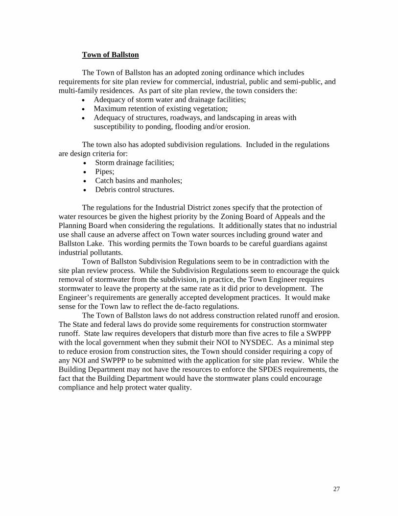
Figure 7 shows the age of construction for properties in the watershed. This figure shows that most of the small-lot residential construction occurred between 1940 and 1979. Most of the construction that has occurred since 1979 has been on larger lots or on existing lots along the lake.

13
Chapter IV Existing Environmental Conditions The following chapter describes several important environmental features that exist in the Ballston Lake watershed. These include:
• Water body information; • The location and function of NYS Department of Environmental Conservation
designated wetlands; • The location and concerns associated with slopes over 15%; • The location and concerns associated with flood plains; • Soils and their influence on erosion and sedimentation; • Tributary stream locations and concerns associated with their paths and
conditions. Figures 2 and 3 show the location of these important environmental features for
the Ballston Lake watershed. WATER BODIES Ballston Lake is the only lake or pond in the watershed. Ballston Lake is a 278 acre lake that has been sampled as part of the Citizens Statewide Lake Assessment Program (CSLAP) since 1991. NYSDEC has listed Ballston Lake as a class A lake. Class A water bodies are deemed as a suitable supply of drinking water. They are also suitable for primary and secondary contact recreation and fishing.
Seven primary tributaries and a number of underwater springs supply most of Ballston Lake’s water. Four of the tributaries enter the Lake through wetlands and all but one of the tributaries flows through a NYSDEC wetland before entering the Lake (Figure 2). No one has determined what percentage of the lake water comes from the springs and groundwater and what percentage comes from tributaries. The spring flow is significant, as can be seen in the following photo where the springs have melted spots in the North Basin winter ice. Through the CSLAP program, NYSDEC has categorized Ballston Lake as mesoeutrophic or moderately to highly productive. The total phosphorous and chlorophyll levels (which indicate the level of plant and algae growth) indicate that the lake is highly productive, but the water transparency indicates that the lake is moderately productive. The available data shows that Ballston Lake has almost undetectable levels of phosphate, nitrate, and ammonium (water-born nutrients) while it has high levels of total chlorophyll and total phosphorous. The lake has no water-born nutrients because they are absorbed very efficiently by the aquatic vegetation. The Lake’s phosphorous and
Ballston Lake springs visible through the ice

14
nitrogen are located in the plant life and not in the water. This indicates that Ballston Lake’s plant life is limited by the available nutrients and a reduction in nutrients should cause a reduction in algae and weeds. In support of this theory, the NYSDEC evaluation of the CSLAP testing data states that any lake management activities fostered to improve water clarity should focus on reducing algae growth, which in turn requires control or reduction of the Lake’s nutrient loading. The CSLAP data and NYSDEC analysis indicate that there have been no discernable trends in Ballston Lake’s water quality since testing began in 1991. The deep water in the south basin of Ballston Lake has some unique characteristics. It contains no oxygen and it has high levels of carbon dioxide, other gases, phosphate, and ammonium. This anoxic water is below what is called the “chemocline.” The chemocline occurs at a depth of 18 meters while the south basin has a maximum depth of 27 meters. Because of the lack of oxygen, organic materials that drop below the chemocline do not decompose or release their nutrients into the water. Researchers from Union College have found thousand-year-old leaves preserved in the Lake’s sediment. This phenomenon may have helped lower Lake’s nutrient levels and improved the water transparency because decomposing organic materials release a significant amount of nutrients. Water exits Ballston Lake through a large wetland at the north end of the Lake. This wetland is home to a group of beavers whose dams significantly slow the outflow from the lake. As a result, the water level rises significantly during heavy rains and recedes slowly through the wetland. The high water levels combined with powerboat wakes and natural waves have resulted in extensive erosion of the lakeshore. This erosion is thought to be a large contributor of sediment and nutrients to the lake water. Union College researchers confirmed that the wetlands flowing directly into the Lake provide measurable amounts of nutrients to the Lake. The functions of the wetlands are discussed in the next section of this chapter. Another source of nutrient-laden water is the out-of-date septic systems located in poor septic soils that are upstream from the Lake. These systems will be covered in the Existing Land Use chapter. WETLANDS A large portion of the surface water flow into Ballston Lake travels through wetlands on the north and south ends and west side of the Lake. These wetlands perform valuable water quality functions but are also a natural source of nutrients to the Lake (McCarthy, 1999). As a result, it is important that the wetlands not become overloaded with nutrients or clogged with sediment. Wetlands are those unique areas that exist at the transitional zones between land and water. Neither wet nor totally dry all year, wetlands are the swamps, marshes, or bogs in low spots and along waterways. Wetlands are areas that have three characteristics:
• standing water or water saturated to the surface at least two weeks during the growing season for most years;
• soils with a high water table (hydric); • hydric vegetation (water-loving plants).
15
Wetlands provide many beneficial functions. Surface water is filtered and purified as it passes through wetlands, thereby trapping and transforming pollutants and improving water quality. Wetlands serve as important wildlife and plant habitats. They also serve as natural storage basins for groundwater thereby aiding in groundwater recharge and helping to reduce downstream flooding. John McCarthy from Union College did a detailed study of the wetland at the south end of Ballston Lake. He confirmed that the wetland removes nitrate from the tributaries and produces ammonium and phosphate well below the surface. The removal of nitrate is important because high levels of nitrate in drinking water can lead to a fatal blood disorder in infants called “blue baby syndrome.”
According to his limited testing, the tributary streams entering the south-end wetland have moderate levels of nitrate. However, the wetlands and Ballston Lake have no detectable nitrates. Two meters below the wetland surface there are significant levels of ammonium. It appears that through the wetland’s biological processes, the nitrogen in the nitrate from the tributaries is being converted to ammonium. The water two meters below the surface of the south-end wetland has high levels of both phosphate and ammonium. The testing indicated that water moves relatively quickly through the south-end wetland and deposits measurable amounts of these nutrients into the Lake. Dr. Kurt Hollicher of Union College believes that these nutrients from the wetlands help feed the Lake’s plant life and supply the unique chemistry in the deep hole at the south end of the Lake. It is likely that the other wetlands that feed water directly into the Lake are also sources of phosphate and ammonium.
It should be noted that the wetland was only tested during the winter and early spring. During the summer growing season the wetland may not be a source of nutrients, as the growing plants may absorb the nutrients. Dr. Hollicher speculates that if the nutrient levels entering the wetlands bordering the Lake were reduced, the Lake might experience better transparency from less nutrient-related algae growth. Wetlands separated from the lake remove contaminants from the surface water and are not as likely to deposit them into the lake. The NYS Department of Environmental Conservation publishes maps of protected wetlands that are 12.4 acres or more in size. A special wetlands permit is required for any development or disturbance within 100 feet of these wetlands.
In addition to NY State regulated and mapped wetlands, there are also a number of undocumented wetlands in the watershed that are regulated by the U.S. Army Corps of Engineers. These wetlands have no minimum size. Their location can be approximated by identifying hydric soils from the Soil Survey for Saratoga County. Their existence and extent would have to be verified on a site-specific basis according to vegetation, soil, and hydrologic conditions. STEEP SLOPES Slope refers to the degree of inclination from the horizontal of an element of ground surface. Slope can be thought of as the degree of steepness of the land surface. The slope of the land surface is calculated by dividing the vertical difference between two points by the horizontal distance between the two points and then multiplying this number by 100.
Slopes of 15% or greater are typically considered “steep”. Development on steep slopes creates problems due to the increased risk of soil erosion and sedimentation,

16
increased construction and land excavation costs, and difficulty of access for vehicles during winter months.
Clearing and grading of land surfaces on steep slopes becomes especially troublesome when the land is left exposed without crop cover. A process of “accelerated erosion” begins to take place: in areas with little slope, overland flow starts to remove the soil in rather uniform layers, a process known as “sheet erosion”. However, where slopes are steep, runoff from heavy rainstorms produces a more intense activity known as “rill erosion” in which many closely spaced channels are scored into the soil. These rills can widen and form still larger, steep walled, canyon-like trenches called gullies. Ultimately, a barren, rugged landscape results from accelerated erosion that is allowed to go unchecked. Additionally, the threat of landslip and land slides, and the potential loss of life and property may result from the erosion of steep slopes. Therefore, it is generally recommended that development on steep slopes be avoided.
The Ballston Lake watershed, like most of southern and central Saratoga County, has few areas where steep slopes are a concern (Figure 2). Less than 5% of the watershed has greater than 15% slope. Aside from limiting new development adjacent to these few areas, steep slopes are not a significant development-limiting factor in the watershed.
FLOOD PLAINS A flood plain is a belt of low, flat ground bordering a stream channel or waterbody, on one or both sides. A 100-year floodplain has a 1% chance of getting inundated by stream waters every year. This flood usually occurs when an overabundance of surface water combines with the effects of a high water table to supply more runoff than can be contained by the stream channel or waterbody. Development in the 100-year flood zone is regulated locally through participation in the National Flood Insurance Program (NFIP). The NFIP is a federal program enabling property owners to purchase federally subsidized flood insurance if their community adopts and enforces flood plain management regulations that meet federal requirements. Both of the communities in the study area currently participate in the NFIP. The most significant floodplains in the Ballston Lake watershed are adjacent to the Lake. Serious concerns have been raised about high water levels in Ballston Lake. Heavy rains can raise the levels quickly and the water recedes slowly due to the extensive wetlands at the Lake’s outlet. Beaver dams have exacerbated this situation. High water levels combined with boat wakes and wind-created waves have eroded the shores significantly. Most lakefront properties on the south end have installed riprap to slow the erosion. Erosion has the additional impact that it causes increased sediment and nutrient levels in the Lake. Large tracts of deforested and developed land can cause more frequent and severe flooding. Land with forest cover or undisturbed vegetation slows the flow of water from heavy rains, allowing it to seep into the water table rather than flowing rapidly into the nearest water body. When land is covered with non-permeable surfaces (buildings, pavement) and groomed grass, rainwater travels quickly to vegetated areas, water bodies, or properly designed detention facilities.

17
Further obstruction of the outlet, extensive construction sites, poorly planned site designs, and increased powerboat usage could have serious consequences for the Lake’s water quality, recreational uses, and property values. SOILS Soil information for the lands in the Ballston Lake watershed can be found in the Soil Survey of Saratoga County published by the U.S. Department of Agriculture’s Natural Resources Conservation Service. Soil surveys are scientific inventories based on soil properties and include aerial photographs with the soils indicated for all the land areas within the county. In addition, the soil survey contains interpretive tables with information on soil properties and their suitability for many different uses including septic suitability, permeability, and hazard of erosion.
The movement of glaciers during the last ice age determined the soils of the Ballston Lake watershed. Ballston Lake and the watershed are underlain with glacial till and impervious bedrock. The bedrock is dominated by sandstone and shale. The glacial till has many different types of soil mixed together in a nearly random pattern. As a result, the watershed contains everything from highly permeable gravel soils to dense, impervious clay soils. The watershed’s hydrologic soil groupings are shown in Figure 4.
The degree that a given soil is prone to erosion is known as its erodibility. Soils that contain a high proportion of silt and very fine sand are the most erodible. Clay and/or organic matter act as a binder between soil particles and as the percentage of each increase, the degree of soil erodibility decreases. Clay soils, however, are vulnerable to erosion as well due to a high water holding capacity and therefore higher runoff rates compared to sands and gravels. Well-drained and well-graded (containing a range of particle sizes) gravels and gravel sand mixtures with little or no silt have low erodibility to sheet flow, but erode easily under concentrated flow. Course, granular soils have a high permeability and sufficiently good infiltration capacity to reduce runoff. Soil types and their characteristics relative to erosion hazard should be investigated before development activity and special precautions should be taken when development is considered on lands with a high propensity for erosion.
The Ballston lake watershed has only a small amount of soil that is suitable for standard septic systems. Figure 2 shows an overall view of the soils that are suitable for septic systems. Please note that this septic information is not accurate for individual parcels. There may be numerous suitable locations outside of the designated areas in Figure 2. There may also be locations shown as suitable that are not. Tests are required to determine septic suitability for each site. However, the USDA soil survey and the experiences of the State Health Department representatives indicate that the soils in the watershed are not generally suitable for standard septic systems.
Combined with the absence of sewer services in the watershed, the lack of good septic soils appears to be a serious impediment to large-scale development. This difficulty is highlighted by the lack of residential subdivision activity during the past 20 years as stronger septic requirements have been put into practice. The soils with high erosion potential are displayed on Figure 5. These soils are not widespread in the watershed, but they do overlap with many of the steep slope areas, making these locations even more susceptible to erosion. It is important to note that soils
18
with low and moderate erosion potential can experience dangerous levels of erosion under the right conditions.
Chapter V Watershed Land Use This chapter investigates land use activities currently taking place within the Ballston Lake watershed. This information is critical to the evaluation and planning of watershed protection strategies because it provides insight into the intensity of land use and the existence of potential nonpoint sources of pollution. Particular attention should be directed towards those land use activities with the most potential for contributing contaminants and sediment on tax parcels closest to the Lake and streams. The materials are more likely to settle out if the parcel is located farther from streams and lakes. The Ballston Lake watershed land uses are presented in Figure 6. It shows that agriculture, vacant land, and rural residential make up the vast majority of the watershed’s land use. There are numerous residential lots along Ballston Lake and in subdivisions in the southwest area of the watershed. While there is a significant number of these properties, they only account for 20% of the watershed’s acreage. For the purpose of evaluation, the land uses were categorized by similarity in land use and land use intensity. AGRICULTURE
• Orchards • Active Agricultural • Parks
The amount of land devoted to agricultural purposes within the watershed represents approximately 10% of the watershed. Land devoted to livestock farming represents 60% of this agricultural land subtotal and approximately 6% of the watershed. However, there is only one barnyard in the watershed and it straddles the watershed line. A number of active fields and pastures do exist in the watershed and manure is spread on a regular basis.
Since agricultural practices involving plowing and farm animals can result in sediment and farm wastes being transported by runoff, special attention should be devoted to those parcels located nearest the Lake and streams. There is particular concern about a series of fields that are the origin of the only Ballston Lake tributary that does not pass through a wetland before entering the Lake. RESIDENTIAL
• One- and Two-Family Residential • Multi-Family Residential
The total amount of land devoted to these residential purposes represents approximately 30% of the total watershed area. Note that the rural residential land use is not included in this category because a single home on greater than ten acres more closely resembles vacant land activities.

19
Residential land uses, while seemingly benign, create numerous threats to water quality. The creation of impermeable and less-permeable surfaces where the land was naturally vegetated increases the amount and velocity of stormwater runoff. Lawn and garden pesticides and fertilizers along with auto-related contaminants are frequent sources of contamination. Paint products and household cleaning products are frequently toxic and an additional source of water contamination. When these products are washed down the drain to the septic systems, they are often not separated from the water before they are released into the ground or surface waters. This is especially true when the septic systems are not working properly. When septic systems do not work properly, human excreta and pathogens may be introduced into the ground water or runoff in addition to other household hazardous wastes. Since, based on soil classifications, nearly all of the land within the watershed has severe septic tank absorption concerns, failing septic systems are a serious water quality and health threat.
As shown in Figure 7 the watershed includes numerous homes constructed before current septic technologies and regulations were in place. While Figure 7 may not be accurate for every parcel, it shows some important area-wide patterns. Figure 7 shows that a large segment of the structures along the lake were constructed before 1960. Given the area’s soils and the date of construction, it is likely that there are a number of under-performing septic systems along the Lake.
Buell Heights, near the south end of Ballston Lake, is also of concern. Its homes were constructed on small lots prior to the mid 1950’s. There are reports that septic odors in this area are noticeable in the spring. VACANT
• Rural Residential (10 or more acres) • Vacant • Conservation Land
The amount of land classified as “vacant” for the purposes of this evaluation
represents approximately 57% of the total watershed. These parcels are important because they are where future development may
occur. “Rural residences” was included in this grouping because that land offers the possibility of future development. Currently, the lands indicated in this group provide the undeveloped and wooded land where rainfall can filter into the ground unhindered by building or pavement, or without the effect of agricultural activity. Future development of these lands has the potential to increase both the volume and rate of runoff due to the increased impermeable nature of these developments. COMMERCIAL / INDUSTRIAL /PUBLIC & COMMUNITY SERVICES
• Commercial • Industrial • Community Services • Public Service
The total land devoted to these activities represents approximately 5% of the total
area of the Ballston Lake Watershed. These land uses represent areas with fairly
20
intensive activities such as industrial, commercial and public service establishments and buildings with the likelihood of paved parking surfaces. These types of uses diminish the permeable nature of the soils through the construction of buildings and parking lots. They also increase the potential for urban waste, including petroleum-based materials, chemical wastes, and other products, to runoff into the water system. Compounding the introduction of potentially polluting materials and sediment, development as represented by many of these land uses also increases the volume and rate of runoff that would otherwise filter into the ground. For these reasons, it is important for these site plans and construction methods to concentrate on stormwater runoff management.
Commercial development in the watershed is limited to local services and specialty goods and services. There are two industrial sites on the northern edge of the watershed. One, Curtis Industrial Park, borders on the northern wetland and is composed of small office and light industrial operations. The newer industrial park, the Corporate Technology Park, located along Route 50, is under development and currently holds one industrial operation. There are proposals to extend sewer service to the new industrial park.

21
LAKE USAGE On Saturday, September 2, 2000, the Ballston Lake Improvement Association conducted a boat survey on Ballston Lake. The objective was to analyze the lake usage with respect to the lake’s capacity. September 2 was an adequate, but not perfect day for counting the number of boats on the lake. The weather was overcast but pleasant until a thunderstorm hit around 6pm. The results are shown in the following table.
Ballston Lake Boating Count Saturday, September 2, 2000
7am 8am 9am 10am 11am 12am 1pm 2pm 3pm 4pm 5pm Small Fishing Boat 3 3 2 2 1 3 2 1 3 2
Power Fishing Boat 1 1 4 3 3 3 2 1 Ski/Power Boat 1 3 1 2 3 2 3 12 4
Pontoon Boat 1 Canoe/Kayak/Paddle 1 1 1 1 1 Jet Ski 1 1 3 5 1 Total Watercraft 1 2 3 6 3 6 6 7 5 17 5 Conditions were 70 degrees, calm and overcast until a heavy 6pm thunderstorm.
Varying studies, depending on lake shape, size and boat type, have shown that lake carrying capacities can range from 6 to 8 acres per boat to 15 to 40 acres per boat. Ballston Lake is long and narrow like the river that formed it. So while it may have 278 acres, the actual space for safe boat use is more limited than the acreage indicates. The September 2 boat count shows that, on a less-than-perfect Saturday, there were 16 acres per boat.
An additional boating concern is wake-related erosion from powerboats. The lake’s shape forces powerboats to travel close to the shore, exacerbating erosion from heavy wakes. LAND AND LAKE USE FINDINGS
Due to the lack of sewer service and adequate septic soils, the Ballston Lake watershed is primarily devoted to agricultural, and vacant lands. From a location and amenities perspective, the Ballston Lake watershed has a great amount of growth potential. The eastern portions of the watershed are convenient to the Northway while the western side of the Lake is convenient to Saratoga Springs and Schenectady. The Lake and countryside provide excellent recreational opportunities. The primary factor restricting population growth in the watershed is the drinking water and wastewater restrictions of the land.
Most of the watershed’s subdivision activity occurred before the current State septic requirements were adopted. The smaller-lot residential developments are located along the Lake and in the southwest portion of the watershed. A number of the lakefront lots have been redeveloped and include updated septic systems, but a vast majority of the
22
homes in the watershed were built prior to the 1970’s (Figure 7). A large number of the septic systems along the Lake were originally constructed for seasonal use. As these properties have become year-round residences, it is unknown how many of the old septic systems have been replaced with engineer-approved systems that minimize contamination of the Lake.
A shortage of potable water is also a significant concern. According to the 1993 Priority Water bodies List, 70% of the lakeside residents use the Lake as surface supply of water. This is primarily because it is difficult to drill for good quality wellwater in the watershed. The new waterline along Route 50 has eliminated this problem for some residents, but many still have problems with their well water. This has served as an additional disincentive for residential development.
The watershed’s commercial activity is limited and located along Route 50 and in the Hamlet of Ballston Lake. The only business in the watershed with a SPDES permit to release more than 1000 gallons of wastewater is Carneys in the hamlet of Ballston Lake. Lake Auto Salvage, the auto junkyard near the south end of Ballston Lake, poses concerns about auto-related contamination. Lake Auto Salvage also has a SPDES permit for stormwater runoff. Because it’s on sandy soils, the ground absorbs most of the junkyard’s stormwater.
The Ballston Lake watershed is not in a particularly attractive commercial location. It is not in close proximity to any population or business center. The commercial businesses in the watershed primarily serve the local community or provide a special good or service that customers are willing to seek out.
The industrial properties on the northern edge of the watershed are more attractive for a wide variety of industrial uses. They are within realistic reach of Saratoga County sewer lines, they do not rely on consumer convenience, and transportation corridors are within reasonable reach. Any industrial land-clearing should follow State and federal laws in filing plans and obtaining permits for stormwater runoff.
Industrial operations have numerous potential threats to water quality that vary between industries. Care should always be used in approving industrial operations. The current industrial operations do not appear to be significant threats to water quality.
23
CHAPTER VI Existing Regulations
One of the primary purposes of this report is to assess the level of protection in the form of existing regulations and requirements within the watershed. The regulation of development activities at the local level is typically done through the use of zoning ordinances, subdivision laws, site plan ordinances, and other specific local laws such as soil disturbance and storm water management ordinances. In addition, there are several federal and state laws and programs that directly and indirectly regulate development impacts from soil erosion and sedimentation and stormwater runoff. FEDERAL
The National Environmental Policy Act (NEPA) The National Environmental Policy Act (NEPA) was passed in 1969 and was revised by the Council on Environmental Quality in 1971. Under NEPA, federal agencies are required to prepare preliminary environmental assessments to determine if proposed federal actions will significantly affect the quality of the environment. A more comprehensive environmental impact statement (EIS) may then be required to mitigate the environmental impacts of the proposed action.
The Clean Water Act (CWA)
The Clean Water Act (CWA) is the primary statute for protecting the quality of ground and surface waters in the United States. Section 208 of the Federal Water Pollution Control Act of 1972 called for states to develop best management practices (BMP’s) to control non-point source pollution. Amendments to the CWA in 1987 formally listed reduction in non-point source pollution as a national goal and called for states to develop assessment reports and management programs to address non-point source pollution. The CWA requires permits for the discharge of wastewater from point sources to the surface waters of the United States. These permits are authorized under the National pollutant Discharge Elimination System (NPDES). The state of New York is a NPDES delegated state and issues these permits under the authority of their State Pollutant Discharge Elimination System (SPDES) program.
The NPDES jurisdiction for wastewater discharges from point sources also includes such non-traditional sources such as storm water discharges from certain industrial activities (including construction projects disturbing five or more acres of land) and concentrated animal feeding operations (CAFO’s). Certain provisions of Phase II of the federal storm water regulations will begin to take effect in 2003. This includes the requirement for permits to authorize the discharge of storm water from medium-sized municipal separate storm sewer systems and construction projects that will disturb more than one acre of land.

24
In addition to regulating wastewater discharges, CWA prohibits the discharges of dredged or fill material into federally designated wetlands (“Waters of the United States”) without first obtaining permit approval from the US Army Corps of Engineers. As the Ballston Lake Improvement Association has experienced in their efforts to clear a channel through the northern wetland, the Army Corps is quite active in their enforcement efforts.
Federal Mandates for Agriculture: The SWCS The Natural Resource Conservation Service (NRCS, formerly the Soil Conservation Service) and the Agricultural Stabilization and Conservation Service (ASCE) were established in 1935 and 1936, under the Department of Agriculture, to address soil erosion from agricultural practices. Soil and water conservation districts were established throughout the country to control soil erosion and to conserve water resources and protect water quality. The districts provide assistance to landowners in voluntary application of erosion protection measures. The U.S. Government frequently subsidizes these voluntary measures. For example, a farmer can be reimbursed for the loss of land if the farmer buffers the stream with an undisturbed strip of vegetation. NEW YORK STATE
The New York State Environmental Quality Review Act
The NY State Environmental Quality Review Act (SEQR) became law in New York State on August 1, 1975. Part 617 of 6 NYCRR are the statewide rules and regulations created to implement the act. SEQR is a process that introduces the consideration of environmental factors into the early planning stages of actions that are directly undertaken, funded or approved by local, regional, and state agencies. If it is determined that a proposed action may have a significant effect on the environment, then a Draft Environmental Impact Statement is prepared to explore alternative ways to minimize adverse impacts to the environment.
The New York State Pollution Discharge Elimination System General Permit for Storm Water Discharges from Construction Activity
The NYS DEC administers the SPDES program in New York State. This
includes the issuance of individual SPDES permits authorizing the discharge of pollutants to the waters of New York State from point sources as well as the surveillance, compliance inspections and enforcement activities that are associated with it. In addition, the NYS DEC has issued several general SPDES permits to specific categories of dischargers. Coverage under general permits is obtained by submitting a brief form rather than a traditional application.
The SPDES General Permit for Storm Water Discharges from Construction Activities, Permit No. GP-93-06, was issued on July 14, 1993. This permit authorizes the discharge of storm water to surface waters from construction activities disturbing more than five acres of land. Builders use this permit to comply with Phase 1 of the federal storm water regulations. This permit requires the development and implementation of a

25
Storm Water Pollution Prevention Plan (SWPPP) to prevent or minimize pollutants from entering storm water.
Enforcement of SPDES has been spotty at best. Since NYSDEC does not collect the information necessary for an adequate analysis of the program, it is impossible to determine how many of the sites required to file an NOI actually do file an NOI and obtain a permit. It is also impossible to determine how many permit holders are in violation of their erosion plans. Since 1993, New York State has issued 1700 General Storm Water Permits.
Donald Lake with the NYS Soil & Water Conservation Committee researched Monroe County and determined that in 1998 44 NOI’s were on file for Monroe County while Monroe County Planning reviewed 175 site plans that disturbed five or more acres.
Mr. Lake concludes that taking action against violators is time consuming and that the NYSDEC offices do not have the resources to take widespread action. He also concludes that the information provided on the NOI’s is inadequate for consistent tracking of the program.
The SPDES General Permit for Storm Water Discharges Associated With Industrial Activity except Construction Activity, Permit No. GP-98-03, was issued on October 29, 1998. This permit authorizes the discharge of storm water to surface waters from certain industrial facilities including, but not limited to, mines, landfills and junk yards. SWPPP’s are also required by this permit.
The SPDES General Permit for CAFO’s, Permit No. GP-99-01, was issued on June 19, 1999. Farms that meet the federal definition of a CAFO must obtain coverage under this permit which requires the development and implementation of an Agricultural Waste Management Plan (AWMP) to prevent or minimize the release of pollutants from the farm.”
The New York State Department of Environmental Conservation Protection of Waters Program
The NY State Department of Environmental Conservation Protection of Waters
Program was set fourth in the Environmental Conservation Law (ECL) Title 5 of Article 15. Under this program, the disturbance of the bed or banks of a “protected stream” or other watercourse is a regulated activity. The bank of a stream is considered to be the area within 50 feet horizontally of the mean high water line. Waters of the state are classified and protected based on their existing or expected best use. The highest classification, “AA” or “A” is assigned to protect waters for uses including drinking and cooking. The next category, “B”, are protected for uses including swimming and other contact recreation, but not for drinking water. Classification “C(t)” indicates waters protected at a level which will support trout populations. There are lower classifications of waters, but these streams are not regulated under this portion of the Protection of Waters program.
New York State Freshwater Wetlands Act Freshwater wetlands are regulated in New York State pursuant to ECL Article 24 and DEC’s implementing regulations. Freshwater wetlands are classified by the DEC according to their ability to perform wetland functions and provide wetland benefits. NYS DEC protected wetlands are a minimum of 12.4 acres in size, however, smaller

26
wetlands of unique environmental value may also be protected. State-wide minimum land use regulations provide for development on each class of freshwater wetlands. These regulations provide a list of activities which are designated with respect to each class of wetlands as either: exempt from regulation; compatible; usually compatible; usually incompatible; or incompatible. Activities designated as exempt do not require approval. Activities designated as compatible require merely a letter of permission. Other activities require a permit. Once it is determined that the proposed activity is regulated, the applicant must seek DEC approval by obtaining either a permit or a letter of permission.
The law also provided for the delegation of authority to local governments (concurrent with the state) for the permit program under Municipal Home Rule Law, so long as such regulations are at least as stringent as the state law.
The NYSDEC protected wetlands are shown on Figure 2. New York State Realty Subdivision Laws (Article 11, Title II Public Health Law & Art. 17, Title 15 Environmental Conservation Law) The State Health Department has statewide responsibility for approval of all
realty subdivisions with respect to water supply and sewage service requirements. Under these laws, a realty subdivision is defined as a tract of land that is divided into five or more parcels for sale or rent as residential building plots within a three-year period. A residential building plot is a lot of land that less than five acres that will be used for residential purposes.
The State Health Department frequently delegates these duties to the county health departments. Because Saratoga County does not have a separated health department, the State Health Department administers the water and sewer requirements for subdivisions in Saratoga County.
Developers must show that the soil of each lot in a subdivision without public sewer service is adequate for a standard septic system. If septic suitability cannot be demonstrated in front of the Health Department inspector, the lot cannot be used. A similar procedure is used for subdivision water supply. In many locations with unsuitable septic soils, including the Ballston Lake watershed, these requirements have effectively ended large-scale residential development. LOCAL REGULATIONS Town code enforcement will generally cite failing septic systems if gray water surfaces, constituting a health hazard. Other than this provision there is no local requirement to maintain or upgrade inadequate septic systems.
Laws regulating soil erosion and sedimentation and storm water runoff at the local level are found in zoning ordinances, subdivision laws, site plan regulations, or in separate laws pertaining to each process. The following discussion includes a more detailed description of the types of regulations each town enforces as well as the key requirements within these regulations for protecting the community from the impacts of erosion, sedimentation and storm water runoff.
27
Town of Ballston
The Town of Ballston has an adopted zoning ordinance which includes
requirements for site plan review for commercial, industrial, public and semi-public, and multi-family residences. As part of site plan review, the town considers the:
• Adequacy of storm water and drainage facilities; • Maximum retention of existing vegetation; • Adequacy of structures, roadways, and landscaping in areas with
susceptibility to ponding, flooding and/or erosion.
The town also has adopted subdivision regulations. Included in the regulations are design criteria for:
• Storm drainage facilities; • Pipes; • Catch basins and manholes; • Debris control structures.
The regulations for the Industrial District zones specify that the protection of
water resources be given the highest priority by the Zoning Board of Appeals and the Planning Board when considering the regulations. It additionally states that no industrial use shall cause an adverse affect on Town water sources including ground water and Ballston Lake. This wording permits the Town boards to be careful guardians against industrial pollutants.
Town of Ballston Subdivision Regulations seem to be in contradiction with the site plan review process. While the Subdivision Regulations seem to encourage the quick removal of stormwater from the subdivision, in practice, the Town Engineer requires stormwater to leave the property at the same rate as it did prior to development. The Engineer’s requirements are generally accepted development practices. It would make sense for the Town law to reflect the de-facto regulations.
The Town of Ballston laws do not address construction related runoff and erosion. The State and federal laws do provide some requirements for construction stormwater runoff. State law requires developers that disturb more than five acres to file a SWPPP with the local government when they submit their NOI to NYSDEC. As a minimal step to reduce erosion from construction sites, the Town should consider requiring a copy of any NOI and SWPPP to be submitted with the application for site plan review. While the Building Department may not have the resources to enforce the SPDES requirements, the fact that the Building Department would have the stormwater plans could encourage compliance and help protect water quality.

28
Town of Clifton Park
The Town of Clifton Park has adopted a Soil Conservation Law, a Freshwater Wetlands and Stream Protection Law and a Flood Damage Prevention Law. The Soil Conservation Law requires a building permit for any non-agricultural activity that directly or indirectly disturbs more than one acre of soil. Prior to the building inspectors issuance of a building permit, the applicant must submit and receive planning board approval of a soil conservation plan. The town’s Freshwater Wetlands and Stream Protection law is designed to protect the citizens of the town by preserving, protecting and conserving freshwater wetlands and the benefits derived there from. The town has empowered an Environmental Conservation Commission (ECC) to provide input to the NYS Department of Environmental Conservation, the Town of Clifton Park Planning Board, or any other appropriate governmental body in the review of wetlands permits (pursuant to Article 24 of the NYS Environmental Conservation Law) and any other projects which affect wetlands or streams to ensure that local concerns are addressed. The town’s Flood Damage Prevention Law is designed, in part, to: regulate uses which are dangerous to the health, safety and property due to water or erosion hazards, or which result in damaging increases in erosion or in flood heights or velocities and; to qualify and maintain participation in the National Flood Insurance Program. The town requires a flood plain development permit for all construction and other development to be undertaken in flood hazard areas as shown on the town’s Flood Insurance Rate Maps. The Town of Clifton Park also has an adopted zoning ordinance. Included in the ordinance is a special “Land Conservation District” designed to preserve, protect and conserve wetlands and classified streams and their respective buffer areas. The district includes a 100 foot buffer around state designated wetlands and certain streams. Uses other than a park, residential boat launch, game preserve, or other similar uses are not allowed in the L-C District. Each applicant for a building permit for a permitted use with in L-C District must demonstrate, among other things, that the use will not result in:
• Deterioration of water quality; • Alteration of water retention capabilities; • Increase in stream siltation; • Increase in the velocity of groundwater runoff; • Disturbance of natural vegetation communities.
The town’s zoning ordinance also contains requirements for site plan review. Site plan review is required for all non-residential construction and any residential dwellings containing more than two-family units or more than 6,000 square feet of gross interior floor space. When reviewing site plan applications the planning board considers several elements regarding erosion and sedimentation and stream protection such as:
• Adequacy of storm water and drainage facilities; • Maximum retention of existing vegetation; • Adequacy and amount of green open space; • Special attention to the adequacy of structures, roadways and landscaping in
areas with susceptibility to flooding, ponding and/or erosion.
The Town of Clifton Park has also adopted subdivision regulations. Included in the regulations are general provisions for the design of storm drainage facilities. Also,

29
the section pertaining to roadway construction includes the statement that: “The slopes of all embankments shall be stabilized by spreading and rolling topsoil and seeding to obtain a satisfactory stand of grass.”
Summary of Existing Regulations
New York State realty subdivision laws, which effectively limit new residential development in the watershed to larger than five-acre lots, have the greatest impact on Ballston Lake’s development. There is really no way to bypass these laws and develop a major subdivision without showing septic suitability for each lot. Doing this is almost impossible in the Ballston Lake watershed. Specially engineered septic systems are not permitted for new development, leaving residential developers with no alternatives for major subdivision development in the watershed. If actively implemented, the Clean Water Act’s SPDES program would help minimize construction runoff problems. The CWA requires soil erosion plans and SPDES permits for construction sites that disturb more than five acres of soil. This program is not vigorously enforced in much of the country, including the Town of Ballston. Clifton Park, on the other hand, requires a soil erosion plan for any construction that disturbs more than one acre. Clifton Park’s requirements match much of the Phase II SPDES requirements that will go into effect in 2004. Farmers in the Ballston Lake watershed have not yet taken advantage of the federal subsidies for voluntary agricultural soil conservation measures. While these programs are not regulations, they do provide the opportunity to make a positive difference for Ballston Lake’s water quality. The Town of Clifton Park, as a result of its long experience with suburban growth, has adopted some of the most progressive environmental development regulations in Saratoga County.
While the Town of Ballston does have subdivision regulations and zoning, they are out of date with the current development requirements and practices. Not having been faced with significant development since the early 1980’s, there has been little incentive for the Town to adopt updated, environmentally focused regulations. However, there is danger that if the Town does not update the regulations until there is a pressing need, the updates will come too late to protect the Town’s environment.

30
CHAPTER VII Assessment of the Threats to the Ballston Lake Watershed Figure 8 displays the Ballston Lake watershed’s main areas of concern. Included are the watershed’s most important environmental assets and the areas of greatest concern. The following categories cover the concerns about primary threats to water quality in the Ballston Lake watershed. New Development
While Ballston Lake is an appealing location, impending large-scale development along Route 50 is not currently a major threat to the watershed. The soils in the watershed are generally not suitable for septic systems and it would cost $20-30 million to install sewers. While this does not completely exclude major development, it does make other locations in the Region more attractive. Smaller developments with large lots are more likely to locate in the Ballston Lake watershed.
By improving the water supply, the waterline along Route 50 has improved the living conditions in parts of the watershed without attracting large-scale development. However, the Town of Ballston does not have laws or regulations necessary to mitigate the environmental threats associated with large-scale development if it were attracted to the watershed (through sewer extensions or land use activities that do not require sewers). Failing Septic Systems
Existing, inadequate septic systems appear to be a major threat to water quality. Older, failing systems along the Ballston Lake and in subdivisions near streams are providing excess nutrients to the lake and encouraging unnatural levels of algae and weed growth. Fortunately, most of the subdivisions are upstream from wetlands where toxins are reduced. However, the nutrients may slowly pass through the wetland sub-layers and into the Lake.
Failing lakeside septic systems are a serious concern. Redevelopment of these properties is helping the situation. When an existing dwelling is replaced, an engineer must certify the septic system. In this case, construction activities improve Ballston Lake’s long-term water quality.
Lakeshore Erosion
Lakeshore erosion has been identified as a major source of excess nutrients and sedimentation for Ballston Lake. High water levels that recede slowly and power boat wakes have accelerated the natural process of erosion. Evidence of this problem can be seen in the riprap that covers much of the lakeshore. The Ballston Lake Improvement Association and the Town of Ballston have attempted to mitigate the problem through a plan to dredge the stream channel through the northern wetland. The plan was effectively

31
terminated when the Army Corp of Engineers determined that the plan was a lake improvement plan and that it would alter the wetland.
Lakeshore erosion is exacerbated by powerboat wakes in combination with the lake’s long, narrow shape. At the narrow southern end of the lake, boats must operate near the lakeshore. When boats create wakes in this area, the wakes hit the shore with greater force than if the boat was further from shore. The stronger wakes result in more lakeshore erosion than would naturally occur. Commercial Activity
The gray water from the newly installed septic system at Carney’s Bar and
Restaurant should be monitored although it is not a current concern. The last septic system failed after five years of operation, violating Carney’s SPDES permit. Care should be taken in the maintenance of this facility so that it will last longer and do a better job of cleaning the water.
Runoff from the Lake Auto Salvage is another concern. Contamination from old, deteriorating cars can pose a serious threat to water quality. It is not known how much contamination comes from the junkyard and it is fortunate that any runoff flows through a wetland before entering the Lake. The junkyard has been in place for more than 40 years and there could be significant contamination of the site.
Lake Auto Salvage does have a SPDES permit for stormwater runoff and receives periodic inspections. The junkyard sits on sandy soil that absorbs most of the stormwater. This allows Lake Auto Salvage to have minimal retention facilities. According to the USDA soil survey, this soil is a poor filter of contaminants. However, studies have shown that other wetlands remove significant amounts of auto-related pollution. (Though it may not be very good for the wetland.) It is not known how much of the stormwater from Lake Auto Salvage flows through the wetland and how much enters the groundwater.
Agricultural Activity
It appears that farmers on the east side of the Lake are plowing through swales
that are the headwaters for a stream that enters the lake without the benefit of traveling through a wetland. This practice poses a threat to water quality and also increases the loss of productive topsoil. Sediment, nutrients, fertilizer, and animal waste may flow directly into the stream and Lake.
Anti-Skid Components
The Town of Ballston has outdated road-salting equipment. When the truck stops, the salt spreading does not. This leaves excess salt on the roads and raises the chloride levels in the Town’s streams and lakes.
32
CHAPTER VIII Recommendations for Watershed Protection Strategies The water quality of the lake is a great concern for the Clifton Park and Ballston households that use Ballston Lake as their water supply. The lake’s water quality also influences recreational uses, property values, and the profitability of area businesses.
Water quality concerns in the watershed go beyond lake water. They extend into groundwater, streams, and wetlands. The Ballston Lake watershed does not have good well water. With groundwater as the source of water for many of the watershed’s residents, it is important that the already marginal groundwater be protected from degradation. The following is a list of the water quality concerns raised in Chapter VII and recommended actions to be taken on each. Contamination from Problematic Septic Systems-
The most common solution to the septic problems would be the extension of sewer service to the watershed. This solution is cost-prohibitive in this watershed and could be a catalyst for large-scale development near Ballston Lake. This development could cause runoff and erosion problems that the Town of Ballston is not currently prepared to mitigate. The Town of Clifton Park, through its long experience with growth-related issues, is better prepared to mitigate development-related problems. A more feasible, though by no means easy solution would be to facilitate the repair and maintenance of individual septic systems.
Because New York State financing cannot be used to improve private property, the NYS Environmental Facilities Corporation has established a framework for public ownership of individual septic systems. This framework will allow a sewer district to take ownership of a septic system, replace, and maintain it using state financing, and bill the homeowner as a sewer service customer. A program of the type and scale that would be required for Ballston Lake has not yet been implemented in New York State. The Facilities Corporation is interested in finding a pilot project.
The Governor’s office recently proposed a public-private financing program to assist with the repair or replacement of failing septic systems. This program would help to update the septic systems but would not provide for continued maintenance needed in densely developed areas.
Recommendations: • Explore public ownership and management of individual septic systems in
affected areas. • Consider utilizing the new state public-private program for financing the
repair of failing septic systems.

33
Lakeshore and Stream Erosion- There is severe stream bank erosion along the stream that enters Ballston Lake near Sweet Road (Figure 8). A delta, that is not apparent in 1980 aerial photographs, has formed at the mouth of this stream. In heavy rains, this stream has washed over the road. The lack of a stream buffer in the upstream fields increases the stream’s water volume and turbidity while the steep terrain adds to the water’s velocity. The stream bank should be protected against further erosion and stream buffers should be used upstream. Strategies for slowing the erosion of the lakeshore have been difficult to implement. The Army Corps of Engineers has precluded any mechanical changes to the wetlands at the northern end of Ballston Lake. The Ballston Lake Improvement Association has actively cleared the outlet channel by hand. This activity should continue. While the clearing helps, the Lake still faces water level related erosion problems. A no wake zone close to shore, which would include the entire southern basin, would reduce the power of the waves hitting shore.
Recommendations: • Use stream bank stabilization to protect the Sweet Road stream from further
erosion. • Institute stream buffers. • Continue maintenance of the outlet channel. • Expand and enforce no wake zones.
Agricultural Activity-
Streams in and adjacent to agricultural fields should have planted buffers that would filter and slow stormwater runoff. Voluntary federal programs provide funds to reimburse farmers for the loss of use of the buffer zones. Options for implementing these practices should be presented to the farmers who might qualify for the program.
Recommendations: • Establish stream buffers and management practices to minimize erosion. • Work with the Saratoga County Soil and Water Conservation District to
utilize the state and federal programs that make these practices feasible. Anti-Skid Compounds- The Town of Ballston road salt equipment should be updated. The Town’s equipment wastes the salt and causes unnecessary damage to the waterways.
Recommendations: • Utilize NYSDOT programs to purchase new snow removal and de-icing
equipment.
Commercial and Industrial Activity- Carney’s has a good incentive to maintain their new septic system, as replacing the five-year-old system was expensive. NYSDEC and the Town building inspector should continue to periodically monitor the SPDES permitted discharges. Periodic monitoring of Lake Auto Salvage should also continue with particular attention to the draining and storage of fluids from junked cars.

34
The two industrial parks continue to see new industries. Different industries carry different threats to water quality. In its industrial zoning, the Town of Ballston has specified that the protection of water quality shall be given the highest priority. The zoning carries strong statements about limiting the adverse environmental effects of industry. The Town should continue to be vigilant in reviewing the plans and safety measures of the tenants of the industrial parks. Curtis Industrial Park is adjacent to the large wetland at the north end of the lake. By state law, any new construction or clearing in this area should not come within 100 feet of a state wetland. Recommendations:
• Continued close monitoring of SPDES permitted facilities. • Continue to closely review the plans and activities of new businesses. • Ensure that the 100-foot boundary is respected along the wetland at the north
end of the lake. New Development Concerns- There are a number of environmental assets and sensitive areas in the watershed that should be protected from development. State and federal law protect the extensive wetlands in the watershed, however the riparian zones do not share the same protection. Figure 8 displays a large area of undisturbed land between Goode Street and Route 50. This land contains extensive wetlands, woodlands and streams. It is a primary source of clean water for Ballston Lake and should be protected from development. In preparation for new, moderate levels of construction and potential large-scale development, the Town of Ballston should require developers planning to disturb more than five acres to submit the Storm Water Pollution Prevention Plan (SWPPP), as required by the state, with the Application for Site Review. It is also recommended that the Town enact a new set of performance standards for site plans. The performance standards would include stream buffers, limitations on non-permeable surfaces, requirements for vegetation coverage and for stormwater drainage and retention. The Town of Clifton Park has put a number of water quality oriented regulations into place. Many of Clifton Park’s regulations and zoning requirements would help protect water quality in the Town of Ballston. Model ordinances and regulations are included in Appendix C.
Recommendations: • Town of Ballston- Enact new legislation to codify current Town engineering
requirements and practices that require adequate stormwater facilities. (Appendix C- § 208-114, 115, § 86-7)
o For construction projects that are required by state law to submit a SWPPP to the Town: Expand the legislation to require the submission of the SWPPP with the Application for Site Review.
o Enforce adherence to SPDES requirements and the SWPPP’s. • Establish performance standards requiring vegetation coverage, stream buffers
and limiting non-permeable surfaces. • Protect the watershed assets displayed on Figure 8 through the creation of
stream buffers and utilizing state programs that facilitate and fund the purchase of development rights.

APPENDIX A Figures and Maps


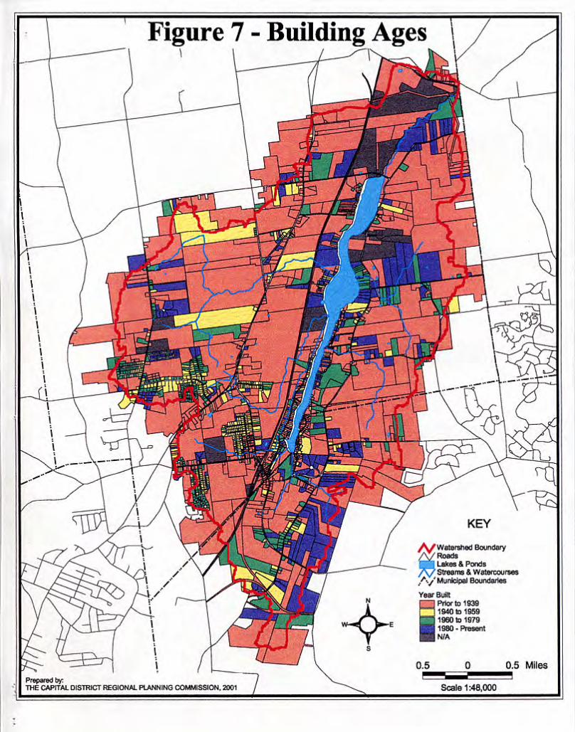
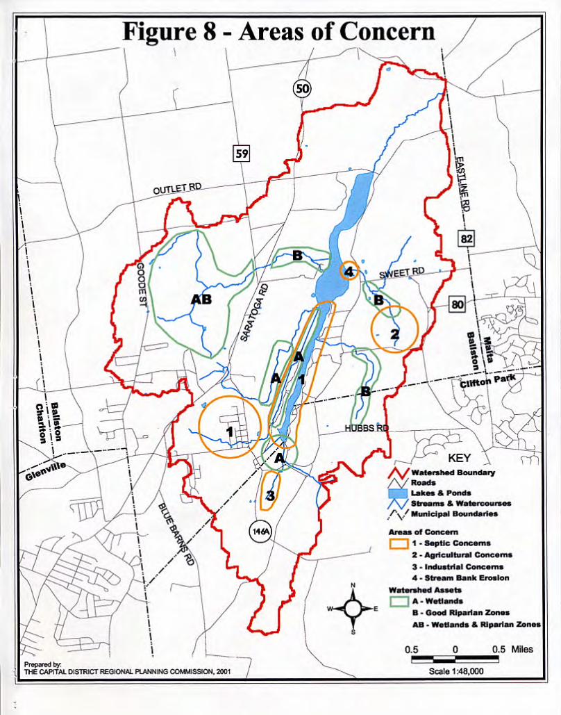
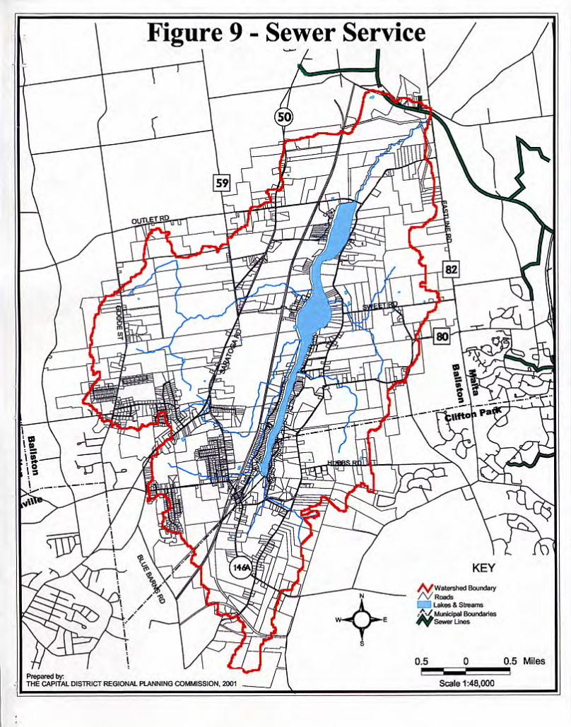
APPENDIX B Bibliography
New York State Department of Environmental Conservation:
Reducing the Impacts of Stormwater Runoff from New Development; second edition; Division of Water, Bureau of Water Quality Management; April 1993 Watershed Planning Handbook for the Control of Nonpoint Source Pollution; in cooperation with NYS Soil and Water Conservation Committee; November 1994 Controlling Agricultural Nonpoint Source Water pollution in New York State; Division of Water, Bureau of Technical Services and Research; 1991
Urban/Stormwater Runoff Management Practices Catalogue fro Nonpoint Source Pollution Prevention and Water Quality Protection in New York State; Division of Water, Bureau of Water Quality Management; April 1994 New York Citizens Statewide Lake Assessment Program (CSLAP) for Ballston Lake; Division of Water, Lake Services Section; 1991-1998 editions
U.S. Department of Agriculture, Natural Resources Conservation Service
Soil Survey of Saratoga County, New York- Interim Report; In cooperation with Cornell University Agricultural Experiment Station; May 1995 Clean Water – A Community Commitment to Protecting New York’s Watersheds; a brochure published by USDA SCS in cooperation with the NYS Dept of Environmental Conservation; December 1992
U.S. Environmental Protection Agency
A Watershed Assessment Primer; Euphrat, F.D. and Warkentin, B.P., Oregon Water Resources Research Institute, Oregon State University; EPA 910/B-94/005; 1994 Response to Congress on Use of Decentralized Wastewater Treatment Systems; EPA 832-R-97-001; April 1997
Capital District Regional Planning Commission Saratoga County Watershed Protection Study; August 1996 Village of Stillwater Aquifer Protection Study, November 1996

Capital District Regional Planning Commission- Cont’d A Profile of the Capital District; third edition, 1999 Schuler, T.R. 1987. Controlling Urban Runoff: A Practical Manual for Planning
and Designing Urban BMPs. Publication #87703 of the Washington Metropolitan Council of Governments.
Chaucer, A.P. 1999. The Use of Side Scan Sonar for Bottom Mapping of Artifacts and Natural Features, Ballston Lake, New York. undergraduate thesis, Union College Environmental Studies Program.
McCarthy, J.L. 1999. Variations in Hydraulic Gradient and Water Chemistry in the
Wetlands on the South Shore of Ballston Lake. undergraduate thesis, Union College Environmental Studies Program.
Jaffe, M. and DiNovo, F. 1987. Local Groundwater Protection. Chicago, American
Planning Association. The LA Group, P.C. 2000. Saratoga County Sewer District Land Use Study:
Projections of Land Use Change from the Years 2000 to 2030. Prepared for the Saratoga County Sewer District.
Saratoga County Planning Board. 2000. Town of Ballston Corridor Study: NYS Route
50 and 67. Town of Ballston Zoning Law Subdivision Regulations and Land Subdivision Standards Town of Clifton Park Zoning- Chapter 208 from the Code of the Town of Clifton Park Subdivision of Land- Chapter 179 from the Code of the Town of Clifton Park Town of Clifton Park Comprehensive Plan

APPENDIX C Sample Municipal Legislation
The following are some relevant sections of the Code of the Town of Clifton Park that were referenced in the Recommendations chapter. They cover the requirements for development and particularly the handling of stormwater both during and after construction. ARTICLE II- Definitions § 208-7. Definitions and word usage SOIL-DISTURBING ACTIVITY (SDA) – Any activity which directly or indirectly disturbs more than one acre of soil and, therefore, requires a building permit. This does not include soil disturbance for emergencies, household gardening, governmental activities, and customary agricultural or single lot, single family activities which are exempt. (See § 208-114C) ARTICLE XVI- Site Plan Review and Approval § 208-113. Purpose and applicability A. Purpose. The purpose of this article is to establish clear procedures for review of site plans, establish standardized and clear requirements for site plan applications, assure functional and attractive development and minimize adverse impacts on the natural and man-made environment. The Town of Clifton Park considers the site plan to be a form of contract between the owner and the public (represented by the town) in which the town agrees to permit certain development in return for commitments on the part of the owner to fulfill and maintain all of the requirements of the approved site plan. (1) In all cases where this chapter requires a special use permit and/or site plan approval by the Planning Board, no building permit shall be issued by the Building Inspector except upon approval of and in conformity with a site plan approved by the Planning Board. Generally, a site plan approval is required for all uses of land, new construction or expansion of existing uses for other than one- and two-family dwelling units and uses accessory thereto. This includes, but is not limited to, all Planned Unit Development Districts (except those containing only one- and two-family dwelling units which shall require subdivision approval), all applications for a soil disturbing activity (SDA), all changes of use in the Light Industrial District as required by § 208-66E of this chapter and all other telecommunication towers as required by § 208-95B of this chapter. [Amended 12-9-1996 by L.L. No. 11-1996] (2) In instances where the building exists, the site is in conformity with a previously approved site plan (as determined by the Building Inspector) and a change of occupancy is occurring without structural changes to the building, the following procedures shall be followed:
(a) If the new use is of the same type and intensity (i.e., office to office, sit-down restaurant to sit-down restaurant, etc.), no Planning Board action will be required prior to the issuance of a building permit and/or certificate of occupancy or tenancy. When issuing the building permit and/or certificate of occupancy or tenancy the Building Inspector shall provide the owner with a copy of the approved site plan for that location and obtain a signed receipt for same from the owner and/or his agent. (b) If the new use is not of the same type and intensity (i.e., office to retail, sit-down restaurant to fast-food restaurant, etc.), the new owner shall, if required by the Building Inspector,

appear before the Planning Department to arrange to appear before the Planning Board to determine if a revised site plan approval will be required prior to the issuance of a building permit and/or certificate of occupancy or tenancy.
(3) In instances where the building exists, the site is not in conformity with a previously approved site plan and a change of occupancy is occurring without exterior structural changes to the building, a revised site plan approval shall be required prior to the issuance of a building permit and/or certificate of occupancy.
(4) In instances where the building exists, a change of occupancy is occurring and exterior structural changes will be made to the building, a revised site plan approval shall be required prior to the issuance of a building permit and/or certificate of occupancy. (5) In instances where the building exists, no change of occupancy is occurring and structural changes will be made to the building, the new occupant shall appear before the Planning Board to determine if a revised site plan approval will be required prior to the issuance of a building permit and/or certificate of occupancy. (6) Site plan approval will be required for applications normally approved by the Building Inspector but where the Building Inspector has determined that, due to the nature of the action, the application requires review and approval by the Planning Board. C. Fees. (See also Chapter 103.) (1) (Reserved) (2) Should more than six months have elapsed from the date of preliminary approval before the applicant seeks final site plan approval, the Planning Board may, in its sole discretion, require the applicant to resubmit his preliminary site plan and pay an additional preliminary fee pursuant to the provisions of this section. (3) The Planning Board, in its discretion, may require a fee upon final submission of the site plan by the applicant in the same amount as required for preliminary submission. This final fee requirement may be waived by the Planning Board in the interest of justice if requiring such final fee will, in the opinion of the Board, create an undue hardship on the applicant.

§ 208-114. Conceptual plan Upon receipt of an application for site plan review, a sketch plan conference shall be held between the Planning Board and the applicant to review the basic site design concept and generally determine the information to be required on the preliminary site plan. At the sketch plan conference, the applicant shall provide the data discussed below, in addition to a statement or rough sketch describing what is proposed. A. An area map showing the parcel under consideration for site plan review and all properties, subdivisions, streets and easements within 200 feet of the boundaries thereof. B. A map of site topography at no more than five-foot contour intervals. If the general site grades exceed 5% or portions of the site have susceptibility to erosion, flooding or ponding, a soils overlay and a topographical map showing contour intervals of not more than two feet of elevation shall also be provided. C. For any soil disturbance activity not otherwise requiring site plan approval, a stormwater management and erosion control plan, together with an estimate of the cost thereof for the Planning Board to establish the amount of the soil disturbance security (bond, client fund account or letter of credit). (1) It shall be the responsibility of the Planning Board to determine the suitability of stormwater management and erosion control measures proposed for each individual site. Due to the uniqueness of each site, definitive measures will be approved for each application. (See also Chapter 86, Article II, § 86-7 of this Code.) (2) Prior to the commencement of any soil disturbing activity (SDA), a sketch plan shall be presented to the Planning Department. At a minimum, this plan shall include: (a) A general vicinity map (b) A description of all intended site work and soil disturbance activities
(c) A statement and/or simple mapping of any environmentally sensitive features on the site, including wetlands, stream and other drainage corridors, flood hazard areas (from FEMA flood insurance rate map), groundwater aquifers and/or recharge areas; Town Land Conservation Zones; ponds; reservoirs; habitat areas of rare, threatened or endangered species; significant forested areas; and any other important environmental features (NOTE: If mapped, features may be added to the site topography map described in § 208-114B.) (d) Identification of any temporary and/or permanent stormwater management and erosion control measures that will be used to mitigate any impacts, complete with existing and finish grades (NOTE: grading may be shown on the site topography map described in § 208-114B.)
(3) The Planning Board shall review the sketch plan and narrative to determine the suitability of the stormwater management and erosion control plan. A soil disturbance security, as approved by the Director of Planning, shall be established prior to the issuance of a building permit. This security shall cover the full cost of constructing and maintaining all stormwater management and erosion control measures and shall be kept in effect until the town determines that soil stabilization has occurred. Written acceptance of the plan by the Planning Board shall constitute permission for the owner to complete his building permit application. (4) For more complex soil disturbance activities and those involving disturbances of greater than five acres, the Planning Board shall require the submission of an application for preliminary site plan approval

§ 208-115. Application for preliminary site plan approval. An application for preliminary site plan approval shall be made in writing to the Planning Department and shall include the following: A. Description. All landscaping plans shall include a written narrative description of the proposed project addressing its scope of application, purpose, justification and impact on the immediate area of influence and the town in general (schools, traffic generation, population, utilities, aesthetics and land use compatibility). B. Site plan. A site plan, drawn to a scale of not smaller than one inch equals 30 feet, shall be submitted, which shall include the following information:
(1) All existing and proposed property lines, building setback lines, easements and right-of-way lines, with dimensions, azimuths or angle data and curve data.
(2) All existing zoning and Planned Development District boundary delineations (3) All monuments, iron pipes and bench marks (4) The names of owners of all adjacent property (5) Street names (6) A North arrow (7) A standard title block (8) A key map (9) Proposed use (10) Contour lines at two-foot intervals, minimum United States Geological Survey datum (11) Wetlands, stream and other drainage corridors, flood hazard areas (from FEMA Flood Insurance Rate Map); groundwater aquifers and/or recharge areas, Town Land Conservation Zones; ponds; reservoirs; habitat areas of rare; threatened or endangered species, significant forested areas; and any other important environmental features. Additionally, the boundaries of environmental areas to be left undisturbed and/or protected through deed restrictions, conservation easements or other agreements shall be shown. (These boundaries shall also be marked in the field prior to the start of soil disturbance activity, other than to install temporary soil erosion control measures, and left on-site until the Building and Development Department has made the final inspection.) (12) The location of outdoor storage, if any (13) Provision for pedestrian access. 14) The location, design and construction materials of all existing or proposed site improvements, including drains, culverts, retaining walls, berms and fences (15) The location of fire and other emergency zones, including location of fire hydrants (16) A description of the method of sewage disposal and location, design and construction materials for such facilities.

(17) A description of the method of securing water and the location, design and construction materials for such facilities. (18) Traffic circulation shown so as to provide for the safety and ease of vehicular movement (19) The location, design and construction materials of all parking and truck loading areas (20) Parking provisions (a) No on-street parking is permitted
(b) A parking plan shall delineate the number of parking spaces and the parking arrangement, including parking and pedestrian walkways for the handicapped
(21) All buildings, sidewalks and lighting, as well as the location of heating and air-conditioning units, trash bins and any other outdoor storage or machinery, shall be shown on the plans. (22) The location of all outdoor lighting facilities (23) A delineation of the arrangement, location, species and dimensions of all existing and proposed landscaping materials. All landscaping vegetation shall be labeled with both the common and botanical names. (24) A planting schedule listing each plant, shrub or tree, its approximate initial size and the quantity of each proposed. (25) Proposed site grading and erosion and sedimentation control measures including (a) Existing and proposed grade contours
(b) Temporary erosion and sedimentation control facilities to be implemented during construction and which must be in place before the commencement of construction activities (c) Permanent erosion control facilities, both structural and vegetative, with an implementation schedule for such facilities
(26) The location of all existing and proposed utilities and stormwater conveyance systems, including open channels and closed piping. The plan should include materials and details to be used to prevent erosion in channel sections and at culvert inlets and outlets (27) The location and proposed development of all buffer areas, including vegetative cover. (28) The final site plan shall contain the signature and seal of a professional engineer registered in New York State or a qualified land surveyor under § 7208, Subdivision n, of the Education Law.
C. Lighting plan. All site plans shall include a lighting plan, which shall delineate the type of fixture to be used and the subsequent lighting pattern, the height of the fixture and the wattage of the light systems utilized. D. Stormwater management and erosion control plan. For applications involving soil disturbance of more than five acres and for those with five acres or less of soil disturbance that, due to the nature of the disturbance, require additional detail, a stormwater management and erosion control plan shall be submitted

in accordance with Chapter 86, Article II, § 86-7, stormwater management and erosion control design standards, of the Code of the Town of Clifton Park. (1) At a minimum, a stormwater management and erosion control plan should: (a) Provide background information about the scope of the project. (b) Provide a statement of stormwater management objectives
(c) Compare postdevelopment stormwater runoff conditions with predevelopment conditions. (d) Describe proposed structural and vegetative stormwater measures to ensure that the quantity, temporal distribution and quality of stormwater runoff during and after development is not substantially altered from predevelopment conditions. (e) Identify the type and frequency of maintenance required by the stormwater management and erosion control facilities utilized.
(2) Within the above context, the following outline details the structure and content of a stormwater management and erosion control plan: (a) Background information [1] Project description
[a] Describe what is being proposed (i.e., residential lot subdivision, planned unit development, commercial/retail development or industrial development) [b] Describe project size (i.e., number of acres, number of dwelling units, other buildings and density) [c] Describe other improvements which will be made on project site, including streets and roads and utilities (water, sewer, etc.), and give particular attention to acreage of land that will become paved and covered with buildings. Lawn acreage should also be specified. [d] Provide a location map based on USGS mapping. [e] Provide a statement describing how this project will meet stormwater management objectives established by the municipality. [f] Provide a general description of the approaches which will be taken to control erosion and sedimentation and stormwater runoff.
[2] Existing (predevelopment) conditions
[a] Provide a map showing topography (contours) under existing conditions. On this same map, show drainage patterns, including ditches, culverts, permanent streams, intermittent/ephemeral streams and other drainage channels, wetlands or other waterbodies, and existing roads. Indicate sizes of existing culverts. Delineate watershed and subwatershed boundaries on the map.

[b] Show existing land use, open space, public facilities, utility lines, water supply wells on site and predominant vegetation cover types (forested, brushland, grassland, cropland, pasture, etc.). [c] Obtain soils survey information and, by sub-catchment, provide tabular information detailing the number of acres that are in each of the Soil Conservation Service (SCS) Hydrologic Soils Groups A,B,C, or D in Table 10 in Chapter III of the April 1992 NYS DEC publication entitled "Reducing the Impacts of Storm Water Runoff from New Development." Soils information should be considered by conducting a site-specific soil survey.
[3] Proposed future (development) conditions
[a] Provide a map showing, by subcatchment, the completed project, including typical lot layout, approximate location of buildings, streets and other paved surfaces, final contours, utility lines, water supply wells, individual sewage disposal systems and location and types of easements. [b] Provide tabular information, by subcatchment, showing the acres of impervious area created in the proposed development, as well as the extent of lawn and areas where the land will have been made more impervious than predevelopment conditions.
(b) Comparison of predevelopment with post-development runoff. [1] Methodologies
[a] Describe or identify the methodology used to compare and evaluate pre- with post-development runoff conditions in terms of volumes, peak rates of runoff, routing and hydrographs.
[i] Peak discharge rates and total runoff volumes from the project area for existing site conditions and postdevelopment conditions for the two-year and ten-year, twenty-four-hour storm events should be calculated. The relevant variables used in this determination, such as curve number and time of concentration, should be included. [ii] Downstream analysis of the one-hundred-year, twenty-four-hour event, including peak discharge rates, total runoff volumes and evaluation of impacts to receiving waters and/or wetlands, should be evaluated. [iii] If appropriate, storage volume and surface area requirements necessary to provide flood control for runoff generated during two-year, ten-year and one-hundred-year, twenty-four-hour storm events should be calculated. [iv] Discharge provisions for the proposed control measures, including peak discharge rates, outlet design, discharge capacity for each stage, outlet channel design and a description of the point of discharge, should be provided. [v] Water quality treatment facilities should be designed to capture the first 1/2 inch of runoff from all land areas for which the
perviousness has been changed over predevelopment conditions due to soil disturbance activity. [vi] The necessary storage volumes should be calculated and the proposed stormwater measure(s) should be described in detail. The plans should provide sufficient detail of the water quality control measures to ensure that the relevant design criteria will be met. [vii] Specific information should include surface area dimensions, depths, inlet designs, planting specifications for use of aquatic vegetation, discharge rates and outlet design.
[b] Sufficient detail should be provided to show that the stormwater facility(ies) is/are capable of withstanding the discharge from the one-hundred-year storm event.
[2] Calculations
[a] State any assumptions in making the calculations [b] Provide assumptions and coefficient values used in the hydrologic calculations to making above comparisons. Evaluate the postdevelopment effect of stormwater runoff on identified floodplains or designated flood hazard areas in the community.
(c) Stormwater management. [1] Stormwater management facilities
[a] Describe in a narrative and show on the map, by subcatchment, proposed stormwater management facilities. A soil profile below the stormwater management facility should be provided. [b] If appropriate, provide designs of proposed structural stormwater management facilities. [c] Calculations for sizing stormwater facilities should be provided. [d] Provide designs and calculations for siting and sizing such specialized measures and devices as filter strips, water quality inlets (oil/grit separator), forebays, etc., which will be used to remove sediment, oil-based products and other contaminants found in urban runoff. [e] Provide information on the design provisions that address safety considerations (e.g., gentle slopes and benches in ponds) and accommodate maintenance needs (including access to conduct maintenance operations).
[2] Stormwater conveyance system.
[a] Describe in a narrative the stormwater conveyance (drainage) system. Indicate which segments of the drainage system are open channels and which segments are piped (culverts). [b] Hydrologic calculations for siting and sizing the stormwater conveyance system should be provided.
(d) Erosion and sediment control [1] Erosion and sediment control facilities
[a] Describe temporary and permanent structural and vegetative practices which will be used to provide short-term (during construction) and long-term control of erosion and sedimentation when construction activities are completed and the project site is restored.
(e) Implementation schedule and maintenance.
[1] Provide an implementation schedule for staging of all stormwater management facilities. Describe how this schedule will be coordinated with the staging of erosion and sediment control facilities and construction activities. [2] Provide a description of the arrangements which will be made for ensuring long-term maintenance of stormwater management and erosion control facilities. Backup contingency plans should be provided and described. Those responsible for performing maintenance should be identified.
E. Architectural plan. Whenever a site plan is required pursuant to this article and new construction is proposed for the site or the exterior facade of an existing building is to be modified in any way, the applicant shall, in addition, submit architectural drawings which shall include building elevations drawn to a scale equal or greater than 1/16 inch equals one foot. The elevations submitted shall include at least the following: front view, rear view and side view. The elevations shall show doorways, windows, loading areas, foundations, landscape planting, etc., and shall indicate the materials and exterior finishes to be used in construction. Pedestrian walkways, entrances and exits for use by the handicapped shall be provided in accordance with the New York State Uniform Fire Prevention and Building Code F. Notification.
(1) At the time of submission of the application for preliminary site plan approval as provided for herein, the applicant shall submit, in addition to otherwise required documentation, the following:
(a) A reproduced copy of the Tax Map or extract of the Tax Map depicting the parcel(s) of land proposed for site plan approval and all lands within 500 feet distance from the perimeter thereof. (b) A schedule of the names and addresses of the property owners within 500 feet distance from the perimeter of the lands proposed for site plan approval as ascertained from the office of the Town Assessor. (c) Proof required.
[1] The applicant shall submit satisfactory proof that the property owners within 500 feet of the perimeter of the lands proposed for site plan approval have been notified in writing of the nature (include a brief narrative about the project and its location, including number of units, approximate commercial square footage) of the proposed site plan, and such notification shall also include the following written statement: "An application for site plan approval of lands within 500 feet of your property is being proposed. The site plan application will be filed with the Planning Department of the Town of Clifton Park and may be reviewed by you during normal business hours at Town Hall. Please call the Planning Department at 371-6651 if you have any questions about the
procedures to review this application and the process for consideration of the proposal." [2] Proof shall be deemed satisfactory for purposes hereof if the applicant provides evidence of mailing, by certified or registered mail, or certificate of mailing and files the receipts with the submission. Regular mail is not satisfactory notice
(2) In the event that the applicant or a related company or corporation owns lands adjacent to the lands proposed for site plan approval and within the 500 feet of the perimeter of the lands proposed for site plan approval, then, in such event, the notice required herein shall be provided to property owners within 500 feet of the parcel adjacent to the parcel proposed for site plan by the applicant. (3) For purposes of this subsection only, the term "applicant" shall include owner, agent or applicant.
§ 86-7. Storm drainage. [Amended 4-6-1998 by L.L. No. 2-1998] A. Design standards.
(1) Rainfall-intensity-duration-frequency curves of the United States Weather Bureau for the Albany area shall be used for design purposes. The design of storm sewer systems shall be as follows:
(a) Ten-year storm for marginal access, local and collector streets. (b) Safe conveyance of a one-hundred-year storm shall also be provided. If peak flow attenuation or stormwater quality facilities are included in a proposed development, the storm drain system shall be designed so that runoff generated along a one-hundred-year storm is routed through these facilities.
(2) Pipe. Required pipe sizes shall be determined by use of the Manning's Formula. Full pipe velocities shall not be less than three feet per second. Full pipe velocities greater than 10 feet per second shall be avoided whenever possible. If such velocities are unavoidable, measures shall be taken to protect pipe from scouring. The minimum size of pipe to be used shall be 12 inches. All pipe shall be installed with a minimum of two feet of cover. Pipe shall be designed for the overburden and live loads it will be subject to. Type and class of pipe and bedding conditions shall be specified. All pipe junctions shall be in manholes or catch basins. All storm drain inlets and outlets shall be provided with riprap aprons to prevent scouring. (3) Catch basins and manholes. Storm inlets shall be located to intercept runoff before it enters an intersection and at all low points. Catch basins and storm manholes shall be provided with sumps. All sump pump outlet pipes shall be equipped with some form of backflow prevention device or check valve. (4) Trash racks. Trash racks may be required where the intake of branches or debris to the storm system may clog the line. The design of the trash rack shall be based on conditions and requirements of each particular case as approved by the Highway Superintendent. (5) Grading. Lots shall be graded so that runoff from roofs, drives and other impervious surfaces flows toward a street, except that such runoff may flow to the rear where a watercourse abuts the rear of a lot or a rear yard storm drainage system exists or is proposed. A grading plan for the entire area to be developed shall be provided and approved by the Highway Superintendent. Such grading plan shall show that grading is designed to prevent ponding and to direct water away from all buildings. (6) Basement sump drains, foundation drains and sump pumps
(a) Basement drains, foundation drains or sump pump outlet pipes shall be provided for all residential lots, unless specifically approved by the Board and Highway Superintendent, and shall be connected directly into storm manholes, catch basins or junction boxes or daylighted to grade. In no instance shall these outlets be tied directly into a storm sewer (b) Sump pumps shall only be permitted when it can be shown that no other feasible alternative exists for gravity flow, including adjusting and finished floor elevation, elevation of proposed storm sewer and lot grading, and only with the approval of the Building Department (c) Footing drains shall be laid out so that invert elevations are two feet above the seasonal high-water level.

(d) All sump pump outlet pipes shall be equipped with some form of backflow prevention device or check valve.
B. Erosion and sediment control standards. The following standards provide minimum criteria to ensure that properly designed erosion and sediment control practices are factored into site development plans. While they are considered minimum requirements, the particular facts and circumstances of each project must be considered in reviewing the plans. Local conditions, such as the protection of a sensitive lake or drainage corridor from the influence of urbanization, may require a greater degree of control than suggested herein. In general, the goals for erosion and sediment control are first, to minimize the opportunity for the soil to be moved by the wind, precipitation and runoff and second, to contain sediment that does move close to its place of origin and thus, prevent it from reaching a waterbody or damaging other lands. The first goal is met by disturbing as little land as possible at any one time and leaving land that is disturbed unprotected for as short a time as possible. The second goal is met by installing appropriate control measures before construction activity begins and then maintaining those measures as long as they are needed. The erosion and sediment control standards that will help meet these goals are as follows:
(1) Existing vegetation on a project site should be retained and protected as much as possible to minimize soil loss from the project site. (2) Sediment control measures, where necessary, should be designed to protect the natural character and quality of waterbodies on-site as well as off-site. The practices shall be in place at the start of any construction activities and maintained until permanent soil stabilization is achieved.
(a) Water in drainage channels on-site and downstream of construction areas should not have substantial visible contrast relative to color, taste, odor, turbidity and sediment deposition from the water in drainage channels upstream of the construction area. (b) Sediment laden runoff should not be allowed to enter any waterbody in such quantity that would result in siltation, degradation of natural biological functions or be deleterious to the classified usage of the water. (c) All runoff from disturbed areas should be directed to erosion and sediment control devices. These devices should not be removed until the disturbed land areas are permanently stabilized.
(3) Specific guidance. (a) Grading. Perimeter grading should blend with adjoining properties.
(b) Vegetative protection. Where protection of trees or other vegetation is required, the location should be shown on the erosion control plan. (c) Drainage control.
[1] Concentrated surface runoff from areas undisturbed by construction activity should be diverted or otherwise prevented from flowing through areas of construction activity on the project site. [2] In general, natural drainage channels shall be preserved to the greatest extent practicable. Pursuant to Environmental Conservation Law, a protected stream and banks thereof should not be altered or relocated without the approval of the Department of Environmental Conservation.
[3] Runoff from any construction activity should not be discharged or have the potential to be discharged off-site into storm drains or into any waterbody unless such discharge is directed through a properly designed, installed and maintained erosion and sediment control structure, such as a sediment trap, to retain sediment on-site. All accumulated sediment should be removed when it takes up 50% of the storage capacity of the sediment retention structure and before final dedication to the town in the case of permanent facilities. [4] All swales or other points of concentrated water flow should be stabilized. Biotechnical approaches using certain types of grasses, such as reed canary grass, are preferable to using sod, gabions and riprap where water quality enhancement is a high priority and the swale design allows. However, sod, gabions or riprap may be used to stabilize swales where soils and gradient preclude the use of reed canary grass. Use of grasses may require an erosion control matting as required by the Town Engineer.
(d) Timing
[1] Except as noted below, all sites should be seeded and mulched with erosion control materials, such as straw mulch, jute or excelsior (wood shavings), within 15 days of final grading. If construction has been suspended or sections completed, areas should be seeded immediately and stabilized with erosion control materials. Maintenance should be performed as necessary to ensure continued stabilization.
[a] For active construction areas, such as borrow or stockpile areas, roadway improvements, and areas around a building under construction, a perimeter sediment control system consisting, for example, of silt fencing or hay bales should be installed and maintained to minimize soil erosion. [b] On cut sides of roads, ditches should be stabilized immediately with rock rip rap or other nonerodible liners or, where appropriate, vegetative measures, such as sod. [c] Permanent seeding should optimally be undertaken in the spring from March 21 through May 20 and in late summer from August 25 to October 15. During the peak summer months and in the fall after October 15 when seeding is found to be impracticable, an appropriate mulch and tackifier should be applied. Permanent seeding may be undertaken during summer if plans provide for adequate watering of the seedbed. [d] All slopes steeper than three to one (horizontal to vertical), as well as basin or trap embankments and perimeter dikes, should, upon completion, be stabilized with sod, seed and anchored straw mulch or other approved stabilization measures. Areas outside of the perimeter sediment control system should not be disturbed. Maintenance should be performed as necessary to ensure continued stabilization.
[2] Temporary sediment trapping devices should be removed within 30 calendar days following establishment of permanent stabilization in all contributory drainage areas. Stormwater management structures used temporarily for sediment control should be made permanent within this time period as well. Accumulated sediments removed from temporary sediment traps or permanent stormwater management facilities should be disposed of such that they will not erode and enter a waterbody.

(e) Drainage corridor management
[1] Existing drainage corridors should be delineated on a map for all drainage channels on the project site. An analysis of natural resource constraints and cultural features, such as floodplains, wetlands, slopes, soil erodibility, depth to bedrock, areas of ecological or geological significance, significant wildlife habitats and historic landmarks, shall be used to determine the appropriate width of the drainage corridors. [2] The delineated drainage corridor should serve as the minimum setback distance between areas to be developed on the project site and the drainage channel. [3] Care is to be exercised to ensure that vegetation on drainage channel banks, including grasses, shrubs and trees in the delineated drainage corridor, remain undisturbed during construction activities. The outer edge of the drainage corridor on the construction site should be clearly delineated. Heavy construction equipment should be prevented from entering the delineated drainage corridor. [4] Impervious surfaces, other than at planned crossings, consisting of asphalt, concrete or similar paving materials should not be installed or constructed within the delineated drainage corridor. [5] The bed and banks of all on-site and off-site drainage channels which may be impacted by construction activities should be protected to prevent sedimentation, bank erosion, channel enlargement or degradation or loss of fisheries habitat. Measures for protecting the bed and/or banks of a drainage channel may include gabion baskets, riprap and vegetative measures. Whenever possible, vegetative stabilization practices on the banks of the drainage channels are recommended over structural practices which may unnecessarily alter the existing drainage channel ecosystem. Native species of vegetation should be used to stabilize the drainage channel banks wherever practical. In undertaking streambank stabilization activities for protected streams, the permittee shall comply with appropriate protection of water provisions in Article 15 of the Environmental Conservation Law. [6] Where temporary work roads or haul roads cross drainage channels, adequate waterway openings must be constructed using spans, bridges or culverts. Backfill used in conjunction with spans, bridges or culverts should consist of washed rock or other acceptable, clean methods that will ensure that road construction and use do not result in turbidity and sediment downstream. All drainage channel crossing activities and appurtenances shall be in compliance with a permit issued pursuant to Article 15 of the Environmental Conservation Law, where applicable, and should be carried out in conformance with guidelines in the Department of Environmental Conservation (DEC's) Stream Corridor Management Manual.
(f) Maintenance
[1] An erosion control plan for a project site should identify maintenance requirements for erosion and sediment control practices utilized, and it should provide a maintenance schedule. All erosion and sediment control measures should be inspected at a minimum of once a week and after every heavy rainfall and maintained in conformance with the schedule so as to ensure they remain in effective operating condition until such times as they are removed.

[2] All points of construction ingress and egress should be protected to prevent the deposition of materials onto traversed public thoroughfare(s) either by installing and maintaining a stabilized construction entrance or by maintaining a vehicle wash area in a safe disposal area to wash vehicle wheels and undercarriage. All materials deposited onto public thoroughfare(s) should be removed immediately. Proper precaution should be taken to assure that the removal of materials deposited onto public thoroughfare(s) will not enter catch basins, storm sewers or waterbodies. [3] Accumulated sediment should be removed before 50% of the storage capacity of sediment retention structures is reached. All removed sediment should be disposed of in a spoil area where it can be graded, mulched and seeded to prevent erosion and sedimentation.
(g) Design specifications. The designs, standards and specifications for controlling erosion and sedimentation found in the publication New York Guidelines for Urban Erosion and Sediment Control (available through the County Soil and Water Conservation District) are acceptable for use and should be identified and shown in the erosion control plan. Standards and specifications found in other manuals that provide an equivalent or greater level of environmental protection will be considered by the town if justified by the applicant. Designs, standards and specifications taken from manuals other than the above also should be identified and shown in the erosion control plan.
C. Flood control standards. The flood control standards are intended to ensure that stormwater runoff is safely conveyed through a development site to minimize erosion of drainage channel banks and to reduce flooding related to land development and urbanization. The standards are as follows: (1) Peak flow attenuation.
(a) The discharge rate and runoff volume from the project site should not be substantially altered from predevelopment conditions. The number of points of release of stormwater runoff from any construction should be maximized. In no case should stormwater runoff be excessively concentrated. Stormwater runoff should be controlled so that during and after development no greater peak flow will be discharged from the project site than was discharged prior to development. The design basis for the control of peak discharge shall be a two-year, twenty-four-hour storm, a ten-year, twenty-four-hour storm and a one-hundred-year, twenty-four-hour storm, all considered individually. (b) Where drains are to be constructed for attenuating peak flows, approval may have to be obtained from DEC pursuant to § 15-0503 of the Environmental Conservation Law.
D. Stormwater quality management standards. These standards shall be used in conjunction with the erosion and sediment control standards and flood control standards to protect water quality from runoff associated with development projects. These standards apply to all land areas where the ground surface has been altered or soil perviousness has been changed as a result of construction activities.
(1) Control of first flush. The control of the first flush is important in stormwater management because most runoff-related water quality contaminants are transported from land, particularly impervious surfaces, during the initial stages of a storm event. The performance standards for protecting water quality from storm water runoff through the control of the first flush are as follows:
(a) Stormwater management facilities for capturing and treating the first flush shall include infiltration, retention, extended detention or equivalent or higher level of

treatment. Dry detention basins may not be used to treat the first flush. Supplemental stormwater management practices, including vegetated swales, forested filter strips and oil/grit/separators shall not be used as a substitute for infiltration, retention and extended detention in treating stormwater runoff unless specifically approved by the Town Engineer. However, these practices should be used in conjunction with infiltration, retention and extended detention wherever feasible. The first flush shall be considered to be the first 1/2 inch of runoff or the runoff generated from a one-year, twenty-four-hour storm event, whichever is greater. (b) When extended detention is used, the detention time for capturing and treating the first flush shall be at least 24 hours. (c) There should be no surface discharge to a waterbody when infiltration is used. If extended detention is built into a retention basin pond by providing additional free board and an outlet structure to an impoundment, the above extended detention time should be used.
(2) Control of thermal discharges. stormwater discharges should be consistent with the thermal criteria found in Part 704 of the Water Quality Regulations, Title 6, Chapter X, New York State Codes, Rules and Regulations. (3) Hierarchy of methods for managing stormwater quality. The following stormwater management systems, summarized in descending order of preference, should be used to capture and treat the first flush when designing stormwater facilities. The practices are infiltration, retention and extended detention. Under certain conditions, such as when a stream supporting a cold-water fishery is the object of protection or where elevated temperatures could result in a problem with designated use, it may be desirable to place extended detention ahead of retention in the hierarchy. A combination of these practices, including supplemental stormwater management practices, may be used to achieve first flush control objectives.
(a) Infiltration. Infiltration of runoff on-site by use of vegetated depressions and buffer areas, pervious surfaces, drywells, infiltration basins and trenches permit immediate recharge of groundwater and aids water quality treatment through soil filtration. This practice also eliminates or minimizes direct stormwater discharges to a waterbody and provides thermal benefits to cold-water fisheries. Retention shall be used when the postdevelopment runoff volume is expected to exceed the capabilities of infiltration. (b) Retention. Retention by use of wet ponds or constructed wetlands provides for the storage of collected runoff in a permanent pool with release via evaporation only, thus allowing water quality treatment by sedimentation, physical settling, biological uptake and flocculation. For design purposes, the total storage volume within the retention facility shall be assumed to be available for treating the first flush runoff volume. Extended detention may be incorporated into a retention facility if peak flow attenuation is required. Retention facilities having detention capabilities may adversely impact cold-water fisheries. If the receiving waterbody below the outlet is a trout stream, water temperatures in a retention facility may exceed temperatures required to sustain a cold-water fishery. Therefore, retention may not be appropriate where the stored (warm) water displaced by storm runoff will be discharged to a trout stream and result in a contravention of Part 704 standards. (c) Extended detention provides for the temporary storage of collected runoff prior to release in a waterway. Settling is the primary pollutant removal mechanism associated with extended detention. As such, the degree of removal is likely to be quite high if the pollutant is a particulate, but very limited removal can be expected for dissolved pollutants.

(d) Supplemental stormwater management practices. Flow attenuation and pollutant removal by use of water quality inlets, vegetated swales or forested filter strip provides water quality treatment by filtration, attenuation, sedimentation, biological removal and particle retention. While supplemental practices such as these are intended for relatively low volumes of runoff requiring stormwater quality treatment, these practices should be used whenever feasible to complete infiltration retention or extended detention.
(4) Design guidelines for stormwater quality management facilities. (a) Infiltration systems.
[1] Infiltration facilities shall be at least 100 feet from septic systems and water supply wells. [2] Soils with percolation rates slower than a one-inch drop in 30 minutes are unsuitable for infiltration measures. [3] Infiltration basins shall provide for a vertical separation distance of at least two feet between the bottom of the basin and the seasonably high groundwater table or bedrock. (The excavation of an inspection trench/pit or soil borings at the proposed site of the infiltration facilities to determine the elevation of bedrock and groundwater and the documentation of such tests must be conducted under the direction of a professional engineer, architect or landscape architect licensed to practice in New York State.) [4] Pretreatment facilities should be provided which trap excess loads of sediment before entering the infiltration system. [5] The stormwater runoff volume shall be evenly distributed over the floor of the basin to maximize exfiltration rates. [6] Infiltration systems should not receive runoff until the entire contribute drainage area to the infiltration system is permanently stabilized. [7] Placement of infiltration facilities in areas which have been filled is unacceptable. Compacted fill material loses permeability, and the in situ/fill material interface may cause slope failure due to slippage.
(b) Retention facilities
[1] Retention shall be the preferred method of stormwater management when the water table or bedrock is too high for infiltration and soils are poorly drained. [2] Retention facilities should not be constructed by impounding existing wetlands unless authorized by the DEC under Article 24 of the Environmental Conservation Law, Freshwater Wetlands Act. If existing wetlands are to be located in an anticipated permanent pool area, the maximum normal pool elevation should not increase mean water depth in the wetland area. [3] Retention ponds should be enhanced with areas of shallow water habitat for additional water quality benefits. [4] Retention ponds should be designed as follows:
[a] Pond geometry should provide for complete mixing of inflow before discharging. [b] In larger ponds, diversion barriers, such as small islands, should be used to increase effective length of flow and permit maximum mixing. [c] The pond contour should include an average pond depth of three feet to six feet, a shallow area 0.5 feet to two feet deep at the inlet, a littoral area or bench 10 feet in width along the perimeter to promote marsh habitat for filtering and nutrient removal and an area eight feet to 14 feet in depth to promote gravity settling and fish habitat. [d] Velocity dissipation devices should be placed at the outfall of all retention structures and along the length of any outfall channel as necessary to provide a nonerosive velocity of flow from the structure to watercourse.
(c) Extended detention systems
[1] The first flush runoff volume should be detailed for a minimum of 24 hours. [2] The outlet control device should be adjusted so that smaller runoff events (0.1 inches to 0.2 inches) are detained for at least a minimum of six hours. [3] Outfall velocities should not exceed four fps during two-year storm events. [4] Velocity dissipation devices should be placed at the outfall of all extended detention structures and along the length of any outfall length channel as necessary to provide a nonerosive velocity of flow from the structure to a watercourse.
(d) Supplemental stormwater management practices. Generally, relatively small volumes of stormwater (i.e., drainage from less than one acre or relatively small storms) can be managed entirely by supplemental practices, including vegetative swales, filter strips and water quality inlets. These practices shall be used to supplement the other practices described above. Where vegetative swales and filter strips will be used, stormwater should, to the extent possible, be managed as sheetflow and have velocities less than four fps during two-year storm events. The following design criteria should be considered when swales, filter strips and water quality inlets are used to control stormwater runoff. [1] Vegetative swales.
[a] Slopes in the flow of swales should be graded as close to zero as drainage will permit. Side slopes of swales should be no greater than three (horizontal) to one (vertical). [b] A dense cover of water-tolerant, erosion-resistant grass must be established. Reed canary grass is recommended for this purpose. Swale grasses should not be mowed close to the ground, as this impedes the filtering and hydraulic functions of the swale. Also, if a swale is adjacent to a roadway, sensitive species with a low salt tolerance (e.g., bluegrass) should be avoided.
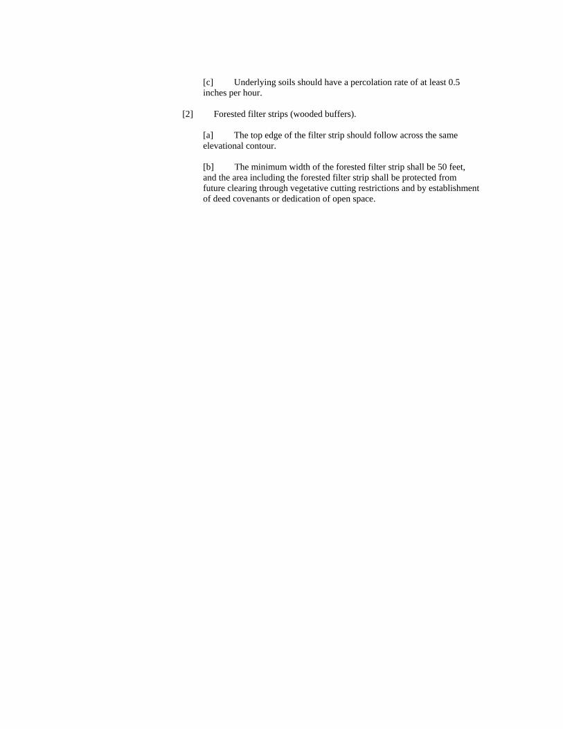
[c] Underlying soils should have a percolation rate of at least 0.5 inches per hour.
[2] Forested filter strips (wooded buffers).
[a] The top edge of the filter strip should follow across the same elevational contour. [b] The minimum width of the forested filter strip shall be 50 feet, and the area including the forested filter strip shall be protected from future clearing through vegetative cutting restrictions and by establishment of deed covenants or dedication of open space.

Capital District Regional Planning Commission
2001 Commissioners Albany County Saratoga County Betty J. Barnette, Chair Fred Acunto Henry E. Dennis, Jr. J. Christopher Callaghan, 1st Vice Chair Fred G. Field, Jr. Sally Herrick Lucille McKnight Kathleen A. Marchione Thomas M. Whalen, III Jean Raymond
Rensselaer County Schenectady County James T. Brearton Michael Iacobucci Stan Brownell Albert P. Jurczynski John L. Buono, Treasurer Peter Polsinelli Jayne Regan Harris Eli Taub Thomas J. McGrath, Jr. David Vincent, 2nd Vice Chair
Commission Staff Chungchin Chen Executive Director David Lang Wardle Principal Planner & Economist Todd M. Fabozzi Program Manager/GIS Leif C. Engstrom Assistant Planner Noelle Marie Office Manager David Gehrs Planning Intern
The Capital District Regional Planning Commission was established as a regional planning board in 1967, by and for the counties of Albany, Rensselaer, Saratoga, and Schenectady. It performs a wide range of activities, including comprehensive planning, aviation system planning, economic development planning, human resources planning, and technical assistance and information services for the Region. As part of its comprehensive planning mission, the Commission prepares a variety of projections, including population, household, and age cohort projections, employment projections, and school enrollment projections.