Creating Apps with Maps inApp Studio
@jonnordling
@geoodk
@BlueRaster

Jon Nordling

Blue Raster(Application Developer)

Founder of GeoODK(Geographical Open Data Kit)

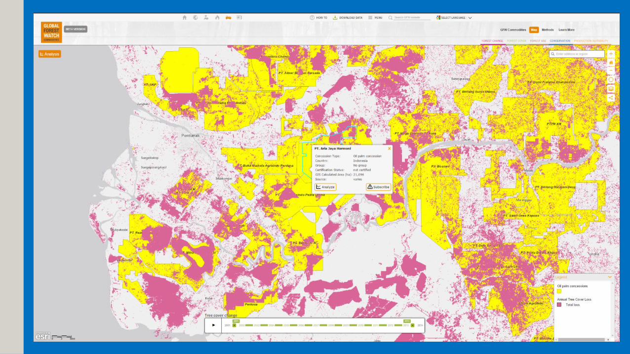
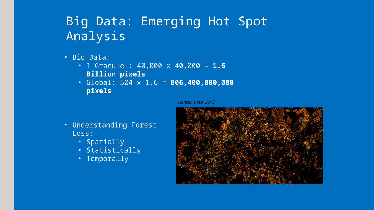
Big Data: Emerging Hot Spot Analysis
• Big Data:• 1 Granule : 40,000 x 40,000 = 1.6 Billion
pixels • Global: 504 x 1.6 = 806,400,000,000
pixels
• Understanding Forest Loss:• Spatially• Statistically• Temporally
Hansen Data, 2013


Apps with Maps&
Maps as Apps

Maps as Apps

MAP
Pages(HTML)
Other
Resources
ArcGISOnline/Server Data

Apps with Maps

API
Data
map
ORM
CMS
JS
App
HTML

Apps & Maps Evolve
Technology is mixed

Creating Apps with Maps inApp Studio
US National Arboretum


GoalsTo provide the essential information about the grounds to visitors:
ServicesParkingToursPoints of InterestHours of OperationSearching for Specific Plants/Species General Information

Application Development Process
DISCOVERY
DESIGN DEVELOP
DEPLOY

Application Development Process
DISCOVERY
DESIGN DEVELOP
DEPLOY

Requirements

Problem

Traditional Native Development
Start Finish
Android
IOS

Traditional Native Development
Start Finish
Android IOS


Android IOS
Cross Platform Solution
Start Finish
Cross Platform Solution

Hybrid Solutions

PhoneGap| JS Responsive Apps

NATIVE !!

Solution


What is App Studio


AO Slide

Why App Studio

Single Programming Language(QT/QML)

Feels like JavaScript

Works great with ArcGIS Online

No hassle compile builds(Cloud Make)

It’s native(no browser views)

Lessons Learned

ArcGIS Online uses a last one in model

Which limits collaborative Development

Which is really important for App Development
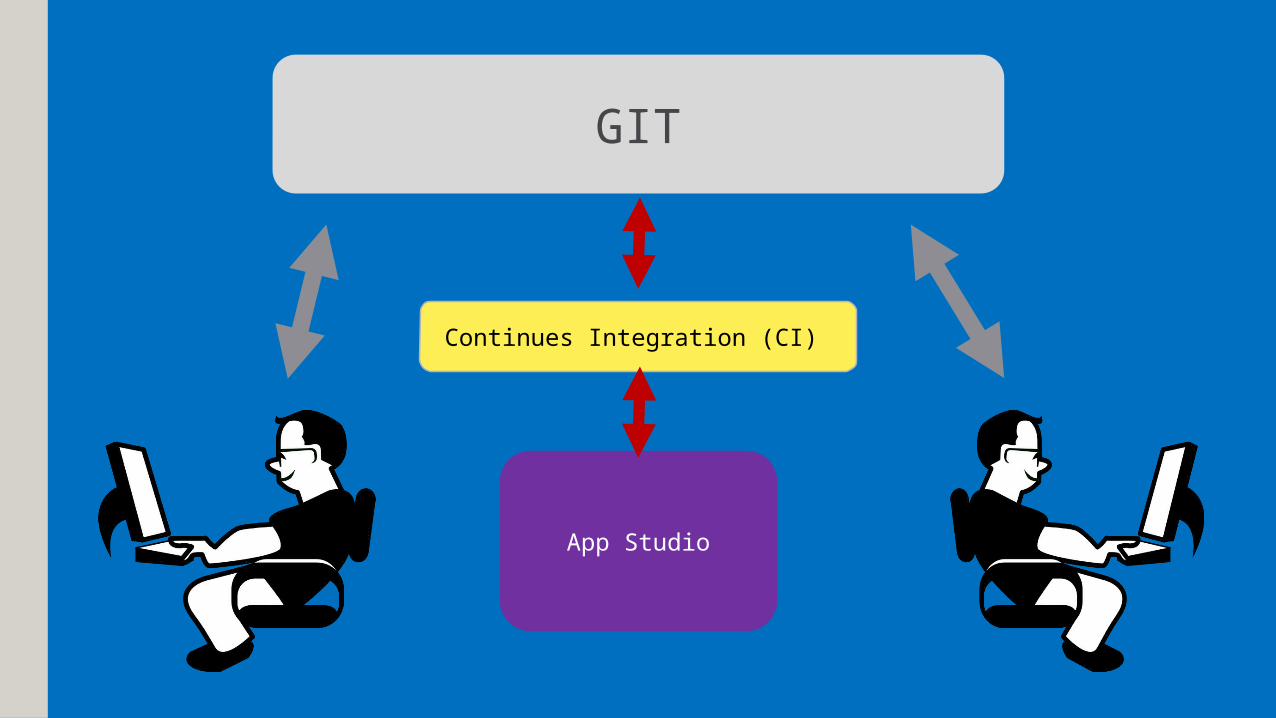
GIT
App Studio
Continues Integration (CI)

How we used App Studio

Whiteboard

Wire Frames

Design Comps

Design Comps

Develop

Develop

Develop

Develop

Special thanks
Blue Raster
Michael Lippmann |Stephen Ansari | Adrienne Allegretti |Robert Winterbottom | Mary O'Connor
National Arboretum
Kevin TunisonJoe Meny| Scott Aker | Stefanye Washington | Stefan Lura | Kathleen Emerson-Dell | Martin Scanlon| David Kidwell-Slak | Ramon Jordan
ESRI
Ismael Chivite| Sathya Prasad |Jared Grondin

Contact Us
Jon Nordling
@jnordling
Blue Raster LLC
2200 Wilson Blvd, Suite 210
Arlington, VA 22201
blueraster.com
Connect with Blue Raster
@blueraster
Facebook.com/blueraster

Demo & Questions
Recommended