Embed Size (px)
Citation preview

Sangwon Joo, Kwang-Deuk AhnNumerical Modeling Bureau/NIMS/KMA
GyuWon LeeKyungpook National University, Daegu, Korea(ROK)
WMO WWRP 4th International Symposium onNowcasting and Very-short-range Forecast 2016(WSN16)
25-29 July 2016, Hong Kong

1
Propose RDP at SSC/WWRP/WMO (Nov. 2014)
RDP/FDP Kick-off meeting (Oct. 2015.) Naming, structure WG
Participants: 6 countries, (7 institutions)
Submit Conceptual Paper to WWRP/WMO (Nov. 2015)
WMO endorse ICE-POP 2018 (Dec. 2015)
Present ICE-POP 2018 in NMRWG/WWRP (Dec. 2015)
Observation WG meeting (Mar. 2016) Participants: US NASA, UCLM(Spain), EC(Canada), US CSU
Observation Network(Field Campaign) with participants’ instruments
Build Korea Trust Fund for ICE-POP2018 at WMO(Jun 2016)
NWP physics/Verification meeting (Sep 2016) Participants(to be): EC, NCAR, KIAPS, NMB/NIMS, FMI
Special session at KMS conference (Oct 2016)
2nd ICE-POP 2018 Workshop (Nov 2016)
History of ICE-POP 2018
[ Paricipants by country ]Australia, Austria, Canada, China, Finland, Russia, Rep. Korea, Spain, Swiss, United States [ 10 ][ Paricipants by agency ]BOM, ZAMG, EC, CMA, CAMS, FMI, Roshydromet, KMA, NIMS, UCLM, EPFL, CIRA, CSU, NASA, NCAR, NOAA, SBU[ 17 ]

Nowcasting and Mesoscale Research Working Group/ WWRP/ WMO
ICE-POP 2018
Observation WG Evaluation WG
Advisory group
NWP WG
Organizing WG
•observation network •observation campaign
•Nowcasting & NWP model•To operate model for FDP
•Model verification & evaluation
•Administrative works•IT support & data sharing
Scientific advice(13 Korean scientists)
Organization of ICE-POP 2018
Chair: Stella Melo [EC]Chair: BC ChoiPaul Joe,Walter PetersenMatthew SchwallerFrancisco TapiadorAlexis Burne,Pavlos KolliasLiping Huang, GyuWon Lee
Chair: Zoltan Toth [NOAA]Chair: Sangwon JooYuanfu Xie,Jenny SunJian Sun,Gdaly S. RivinBenedikt Bica,Tsengdar LeeZhining Tao,Soyung HaSteve Albers, Hugh Morrison Jason Milbrandt, GultepeIsmail, Stephen Belair, Chris Kummerow,…
Chair: Pertti Nurmi [FMI] Chair: DongJoon KimDmitry KiktevPeter Steinle

PyeongChang 2018 Olympic Area & Venues
Workforce Services
MOC(Main Operation Centre)
Chief forecaster Weather Briefings to MOC, IOC,
WFC(Weather Forecast
Lead forecasterVenue forecasters
Venue weather forecastingCommunication with media24hours/7days operation
WIC(Weather Information
Centre)
Venue communicators(All outdoor venues1 or 2 forecasters each Volunteers
Weather counselling to managers and related to each competition venueWeather observation

Forecast name Forecast lead time Update Frequency
Nowcasting 2 hours (Site forecasts) 15mimVery-Short range 1 day (Site forecast) 1hour
Short-range 3 days (Site & Map) 3 hourMedium-range Up to 10 days 12hour
KMA plan for Forecast Services
•Main concern is wind(Gust), precipitation(type, amount), visibility, temperature.•40 forecasters for the test event (17) and Oympic games (18)
Alpensia Jeongseon
Yongpyeong Bokwang
Ice games (1): Snow games (12)Gangneung Olympic Park

Olympic period(Feb.9~25) Characteristics (Mountain)
0
20
40
60
80
100
120
140
160
-12
-10
-8
-6
-4
-2
0
1974 1977 1980 1983 1986 1989 1992 1995 1998 2001 2004 2007 2010 2013 2016
Precipitation
Snowfall
Temperature
Tem
per
atur
e (℃
)
Prec
ipitat
ion
(mm
) /
Snow
fall
(cm
)
Temp(℃ ): -9.6(1983)/-0.4(2004)/-2.7(2016), Precipitation(mm): 104.8(2005)/0.6(1980)/20.8(2016)Snowfall(cm): 150.2(1979)/0.1(2006)/7.0(2016)
Courtesy to Jang Ho Lim

Extreme records, Olympic period(Feb.9~25)
Elements Value Date
Ave. Temp.(℃)High 10.5 2009.02.13 Low -18.1 1991.02.23
Max. Temp.(℃)High 16.5 2004.02.20Low -13.4 1977.02.16
Min. Temp.(℃)High 3.6 2009.02.13Low -27.6 1978.02.15
Sea level Press.(hPa)High 1044.5 2008.02.18Low 989.1 2009.02.13
Humidity(%) Low 10.0 2004.02.19Wind speed(m/s) High 22.7 1990.02.20Gust speed(m/s) High 34.2 1991.02.21
Day precipitation(mm) High 68.3 1989.02.25Day max. snowfall(cm) High 87.0 1989.02.25
Courtesy to Jang Ho Lim

Heavy snowfall condition in PyeongChang Area Weather Pattern for Snow(Rank II) [ Weather Challenges]
- East Snow Storm(ESS) [22% in cases of 2003-2012 DJFM, > 10 mm]
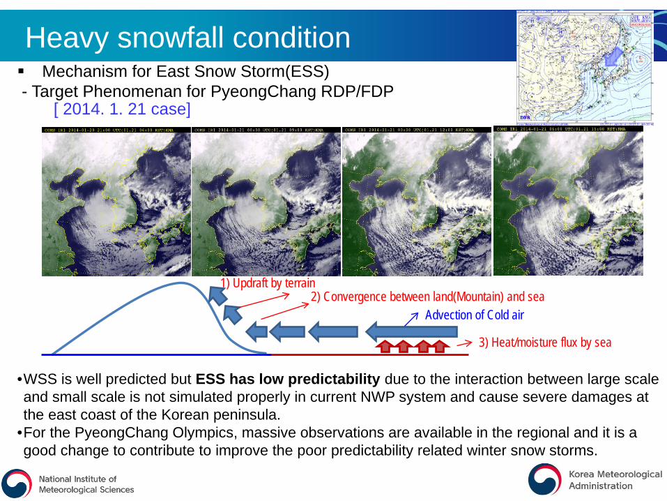
Heavy snowfall condition Mechanism for East Snow Storm(ESS)- Target Phenomenan for PyeongChang RDP/FDP
1) Updraft by terrain2) Convergence between land(Mountain) and sea
3) Heat/moisture flux by sea
Advection of Cold air
[ 2014. 1. 21 case]
•WSS is well predicted but ESS has low predictability due to the interaction between large scale and small scale is not simulated properly in current NWP system and cause severe damages at the east coast of the Korean peninsula.
•For the PyeongChang Olympics, massive observations are available in the regional and it is a good change to contribute to improve the poor predictability related winter snow storms.

• Venues are located in a small area with complex terrain (sub km scale) and steep in the coastal region• Heavy snow depends on the small scales flows, stability, and phase changes in a low level and
conventional observation is not designed for that• Snow weather is not captured well in the operation radar/surface observation network
Complex Topography over the area
9
Courtesy to Gyuwon Lee
YPCPO
CPOS
VENUES
20km

Operational observation at KMA
10
< Upper level>
RAOBs : 8Wind profiler : 12M. Radiometer : 12
< Cloud height>
Celiometer : 92
< Surface>
Buoy : 17Costal wave buoy : 48Lightning house AWS : 9
< Ocean>
Surface obs: 41725km resolution
KMA : 11M. of Defense : 9M. of Land & Trans : 7
+Weather sensor : 215Visibility : 76
Manned : 22Laser : 55CCTV : 169
< Visibility>< Snow depth>< Radar> < Others>

[ Issues ] Initiation of convection is not well understood- Difficult to capture updraft branches by observation Aircraft, Satellite(Surface Heat Flux) Low-level wind shear/ water vapor variability and convergence are important- Difficulty to observe over ocean X-band/Cloud radar reflectivity, Wind retrieval from radar
Understanding of HCR(Horizontal Convective Rolls)
[ Characteristics ] Vertical extent:1-2 km Wavelength: 2-20 km Aspect ratio: 2-15 Downstream extent:10-1000 km M. wind -20~+30 life time:1-72 h
(Brown, 1980)
[ Condition for Occurence ] Surface heat flux Low-level wind shear Thermal/dynamic Instability
Scientific Issue in ICE-POP 2018
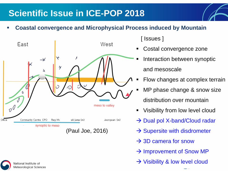
Scientific Issue in ICE-POP 2018 Coastal convergence and Microphysical Process induced by Mountain
(Paul Joe, 2016)
[ Issues ]
Costal convergence zone
Interaction between synoptic
and mesoscale
Flow changes at complex terrain
MP phase change & snow size
distribution over mountain
Visibility from low level cloud
Dual pol X-band/Cloud radar
Supersite with disdrometer
3D camera for snow
Improvement of Snow MP
Visibility & low level cloud

Goal & Work flow of ICE-POP 2018
IOP
•High resolution 3D structure
• Multi spectral Radar
• Microphysics
•Develop Nowcasting
•Develop high resolution NWP
•DA•Snow Physics•Evaluation
•Understand snow formation processes
Olympic forecasters
• Nowcasting
• NWP products
• Statistical gudiance
• Weather monitoring IOC, LOC
Public
•Contribute a science community in terms of winter weather
GOAL: Advancing seamless prediction from nowcasting to short-range forecast forwinter weathers over complex terrains with intensive observation campaign
13
RDP FDP

Air-sea flux from satellite • COMS, Himarwari8 & LEO(KMA with Brent Roberts [US NASA])
Observation network over the ocean
Aircraft measurements• CCNC200, CCP, SEA WCM2000• 16 drops per flight and 4 receivers• 3D structure can be captured
Sea surface condition & ASAP from ship• 6 hourly RAOBs • Move round the sea near Gangrung
Radar scan from the coast• S-band and C-band radar • RHI scan to the open sea

Supersite 1(MHOS)1
1
Supersite 2(YPOS)2
Supersite 3(CPOS)3
2
3
Supersite 4(EUOS)4
4
H.B.Mt
4
5
1
2
3
4
1
3
2
1 Sondesite 1(DGWO)
2 Sondesite 2(BKOS)
3
4 Sondesite 4(OBS Ship)
5 Sondesite 5(GWNU)
Sondesite 3(GWWO)
1 Radarsite 1(DGWO)
2 Radarsite 2(APOS)
3 Radarsite 3(GWWO)
4 Radarsite 4(HBOS)
O.D.Mt
GNG: Gangneung radar(S-band, Operational radar/KMA)KAN: Airforces Radar(C-band), GRS: S-band dual-pol
6 Sondesite 6(JSOS)
6
Supersite 5(GWNU)5
Supersite 6(SJOS)6
Supersite 7(IGOS)7
Supersite 8(ODOS)8
8
7
6
5
Venue
Observation network over the complex terrain
KRS

Cloud radar
Supersite
D3R
Scanning lidar
X-Pol
RADIOSONDE
RADAR in ICE-POP2018
NCU/ 9.6GHz
UCLM9.375GHz
EPFL9.41GHz
9.355GHzKMA,
NASAKa/Ku Full scan
ECCCScan Lider
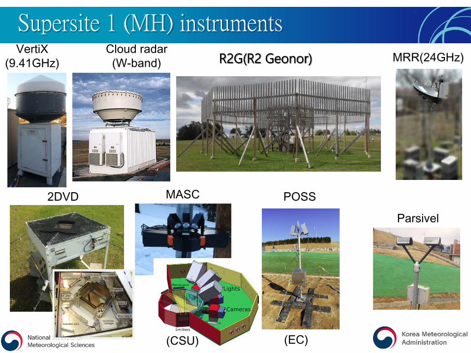
VertiX(9.41GHz) R2G(R2 Geonor) MRR(24GHz)
2DVD MASC POSS
Parsivel
(CSU) (EC)
Cloud radar(W-band)
Supersite 1 (MH) instruments

Nowcasting and NWP for ICE-POP 2018Country Agency Model
Austria ZAMG INCA(Winter Nowcasting over complex terrain)
Canada ECCCSurface near-surface model, INTW, IGEM-LAM 0.25KDevelop snow microphysics (P3 scheme)
China CMA GRAPES-??kmRussia Roshydromet COSMO – 0.17 K
UK MetOffice UM – 0.2K
US
NASA NU-WRF(NASA Unified WRF)
NOAA/CIRA Cloud Analysis Nowcasting (CAN)
NCARFINECAST(based on VDRAS)Develop snow microphysics (P3 scheme)MPAS-0.2K
Spain UCLM Size & density distribution of WRF microphysics
KoreaKMA UM 4dVar RUC-1.5K(VDAPS), UM downscaling -0.1K(HPS)
KIAPS Physical process tuning

• To coordinate comparison study of sub km scale NWP models in mesoscale winter weather condition over complex terrain with dense observation networks to understand predictability of NWP models
– GEM-LAM(0.2K), COSMO(0.17K), UM(0.2K), MPAS(0.2K), UM Downscaling(0.1K) is to join the comparison and wait a contribution from GRAPES.
• To evaluate the benefit of different nowcasting approaches to develop seamless prediction from nowcasting to short-range NWP prediction
– MAPLE, INCA, CAN, FINECAST, INTW will be operated to support forecasters– Analysis, prediction and blending method will be evaluated to understand the optimal way
seamless prediction with nowcating and NWP prdiction• To advance physical processes of snow microphysics, surface processes over land and
ocean, and fog/low level cloud processes– The Predicted Particle Properties(P3) scheme will be calibrated with the observation and
some of the RDP models– Fog/low level cloud physics in NWP– Land surface model and interaction with atmosphere will be compared
• To create valuable, reliable and accessible thermodynamical and hydrometeorologicalobservation data sets for winter weather over a complex terrain through IOP
– Ground validation of satellite (i.e. ADM Aeolus GPM snow retrieval)• To understand microphysical processes over complex terrain such as snow size, shape
vertical structure with multi-frequency radar and various microphysical observations Radarsite 1 and supersites) with better quality control
Scientific Challenges

Implementation Plan
Observation X band RCloud RSatellite(Geocloud,fluxHourly SST)
DC3Ka/Ku radar
RAOBShipMobil Vehicle
2015 2016 2017 2018
Model CANFINECASTINCAVDAPS
KMA NWP+GuidiaceVDAPS
Real timeService
Workshop Preliminary evaluation &progress report
Progress report ,Operation Check up
Wind liderParsivel
FinalReport
&
Paper inSpecialVolume
Test Event Test Event Olympic
X band Aircraft
GEM-LAMINTWCOSMONuWRFMPASGRAPESUM(Reading)

• ICE-POP2018 is endorsed as an official RDP/FDP by WMO at 27 November 2015 – Up to now 10 countries are joined the ICE-POP 2018 to advance seamless prediction from
nowcasting to short-range forecast for winter weathers over complex terrains by developing intensive observation network and numerical models.
• Intensive observation network was designed to produce reliable thermdynamic and hydrophysical observation
– 4 x-band rdar, 3 cloud radars, 2 wind liders, and ground instruments (8 supersites) are joined IOP together with operational observation at KMA
– Aircraft will cover oceans and upper level hydrometeor observations.– Sea condition will be observed by the ship and satellite.– The data sharing system is installed and will be available before 17 winter for the ICE-POP
participants and will be released later.
• Several nowcasting systems and high resolution NWP models joined to advance seamless prediction from nowcasting to very-short range prediction
– 5 nowcating systems and 7 sub km scale NWP models join the project – DA capability of assimilating the IOP data is under development– Forecast communication method tools are being develped.
Summary
21

22


![WMO WWRP 4th International Symposium on …wsn16.hk/doc/presentation/28Jul2016/H3B/[H3B]Introduction to _ICE...- Target Phenomenan for PyeongChang RDP/FDP. 1) ... Understanding of](https://img.dokumen.tips/doc/110x75/5acc448a7f8b9a93268c4950/wmo-wwrp-4th-international-symposium-on-wsn16hkdocpresentation28jul2016h3bh3bintroduction.jpg)