Embed Size (px)
Citation preview
WMO SCOPE-Nowcasting using new-generation satellite data:
Progress and Perspectives
Stephan Bojinski WMO Space Programme
8th Asia-Oceania Meteorological Satellite Users’ Conference
Vladivostok, Russia, 18-20 October 2017
2
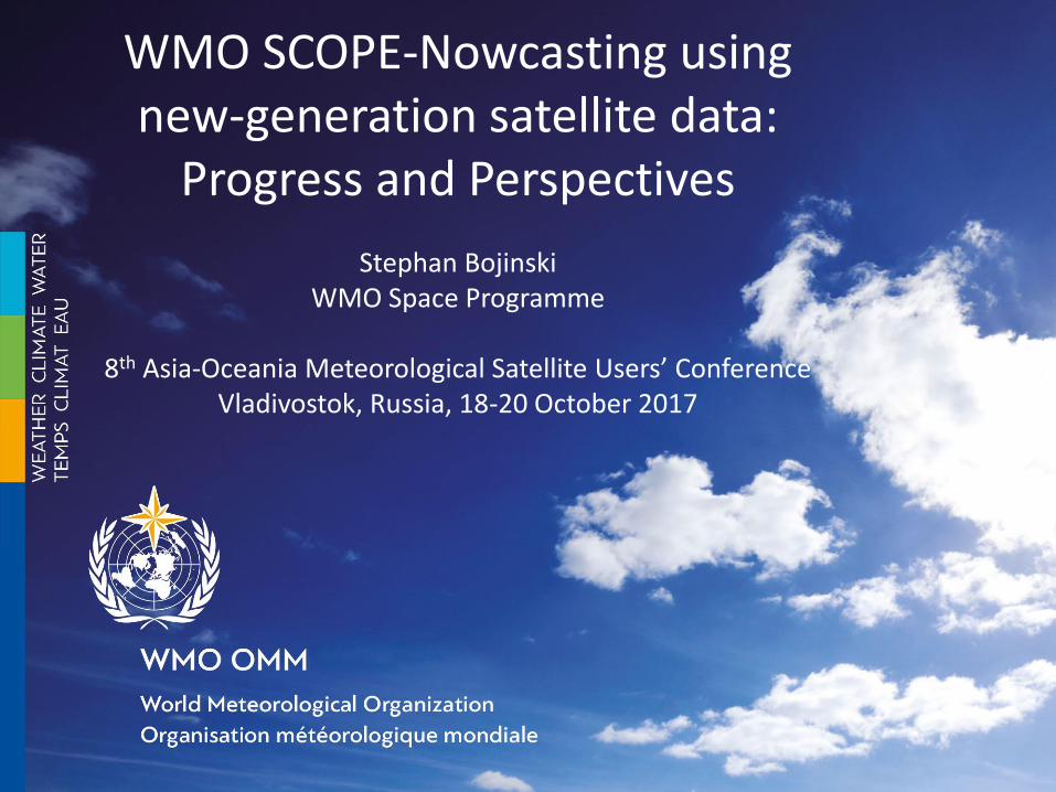
Satellite Operator Launch date Longitude Imager
Number of
spectral
channels
Spatial
resolution
Temporal
resolution
(full disk)
Sounder /
Lightning
Mapper
Himawari-8 JMA 7 Dec 2014 140E AHI 16 0.5-2km 10min - / -
Electro-L N2 ROSHYDRO-
MET 11 Dec 2015 78E MSU-GS 10 1-4km 15min - / -
INSAT-3DR ISRO 8 Sep 2016 74E IMAGER 6 1-8km 30min S / -
Himawari-9 JMA 2 Nov 2016 140E AHI 16 0.5-2km 10min - / -
GOES-16 NOAA 19 Nov 2016 89.5W
(final TBD) ABI 16 0.5-2km 15min - / L
FY-4A CMA 10 Dec 2016 86.5E AGRI 14 1-4km 15min S / L
Geo-KOMPSAT-
2A KMA 2018 128.2E AMI 16 0.5-2km 10min - / -
GOES-S NOAA 2018 75W ABI 16 0.5-2km 15min - / L
FY-4B CMA 2018 105E AGRI 14 0.5-4km 15min S / L
MTG-I/S EUMETSAT 2020-22 0° FCI 16 0.5-2km 10min S / L
…
Status: Sep 2017; Source: OSCAR/Space
New-Generation Meteorological Satellites
Geostationary orbit:
Satellite Operator Launch date Orbit Payload
JPSS-1 NOAA 2017 13:30 asc ATMS, CrIS, CERES, OMPS-nadir, VIIRS, SEM (EPS, HES, SSJ5)
FY-3E CMA 2018 06:00 desc HIRAS, ERM-2, GNOS, MERSI-2, MWHS-2, MWTS-3, OMS (limb, nadir), SIM-
2, WindRAD, SES (IPM, SEM, X-EUV)
EPS-SG EUMETSAT 2021-2022 09:30 desc MetImage, 3MI, IASI-NG, MWS, MWI, S-5, ICI, RO
Low-Earth orbit:

Overlap in Footprint ….

… in Spectral Coverage ….
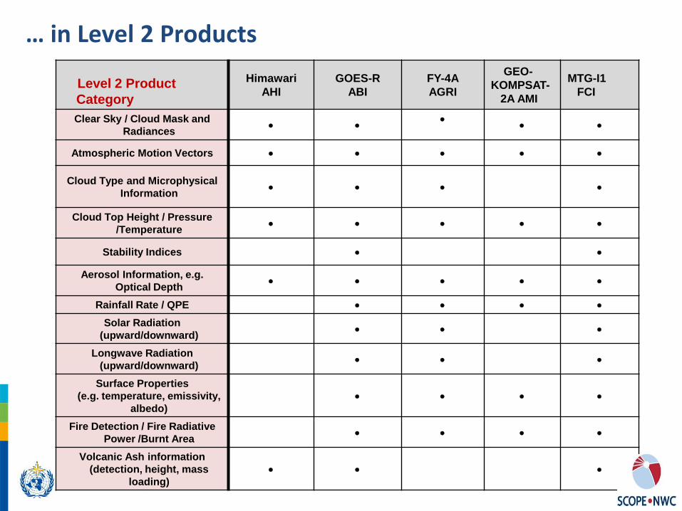
Level 2 Product
Category
Himawari
AHI
GOES-R
ABI
FY-4A
AGRI
GEO-
KOMPSAT-
2A AMI
MTG-I1
FCI
Clear Sky / Cloud Mask and
Radiances
Atmospheric Motion Vectors
Cloud Type and Microphysical
Information
Cloud Top Height / Pressure
/Temperature
Stability Indices
Aerosol Information, e.g.
Optical Depth
Rainfall Rate / QPE
Solar Radiation
(upward/downward)
Longwave Radiation
(upward/downward)
Surface Properties
(e.g. temperature, emissivity,
albedo)
Fire Detection / Fire Radiative
Power /Burnt Area
Volcanic Ash information
(detection, height, mass
loading)
… in Level 2 Products

Using next-generation GEO imagers and lightning
mappers
6
GOES-16 ABI and GLM CMA FY-4A AGRI and LMI

Motivation
Overlap in coverage, channels, products • offers opportunities for combined use and capacity building
but
• poses challenges for users in the area of data reception, data interpretation, and potential data redundancy
The WMO SCOPE-Nowcasting initiative addresses some of these challenges for nowcasting applications

What is Nowcasting?
Various definitions exist: 0-2 hours or 0-6 hours; usually 6-12 hours is called "Very Short Range Forecasting"
time 12 hours 6 hours 2 hours
Nowcasting ……. Nowcasting … Very Short Range Forecasting
From WMO website: • Nowcasting comprises the detailed description of the current
weather along with forecasts obtained by extrapolation for a period of 0 to 6 hours ahead.
• In this time range it is possible to forecast small features such as individual storms with reasonable accuracy.

WMO SCOPE-Nowcasting *SCOPE : Sustained Coordinated Processing of Environmental Satellite Data
Objectives
a. Using satellite data from multiple sources (>1 provider)
b. Demonstrating value of consistent, accessible, well-documented satellite-based products
c. Pilot phase sustained operation
Pilot Projects
• Simplify access and use of satellite data for nowcasting in smaller or developing nations, with limited expertise and infrastructure
• Gain efficiencies for more advanced nations through combining resources, expertise
Users • Severe weather forecasting demonstration projects (SWFDP)
• Aviation meteorology and Volcanic Ash Advisory Centres (VAAC), ICAO
• Sand and Dust Storm Warning Centres (SDS-WAS)

First Four Pilot Projects (2013-)
Category Product Region Provider User Gaps
Basic nowcasting
Imagery (VIS/IR, RGB composites),
basic products
WMO Region II (Asia) and
Region V (SW Pacific)
JMA, CMA, KMA
NMHSs in Region II and V
No standard products available; products limited
Advanced nowcasting
Volcanic Ash Products
Global CMA, JMA, KMA,
EUMETSAT, NOAA
NMHSs, VAACs No standard products available; products limited
Advanced nowcasting
Blended satellite global precipitation
product (GEO+LEO)
Global coverage
Hydro Estimator,
NASA TRMM (3B42), NOAA
(real-time MW)
Civil authorities,
NMHSs, Flash flood guidance
systems, general users
Rapid, facilitated access to
quantitative precipitation
estimates
Real-Time Atmospheric Composition
products
Dust Monitoring
and Prediction Products
WMO Region II (Asia) and V (South-West
Pacific)
CMA, JMA, KMA
SDS-WDCs, NMSs (to issue
results and warnings) in RA
II and RA V
Regional diversity of
aerosol-related products not harmonized
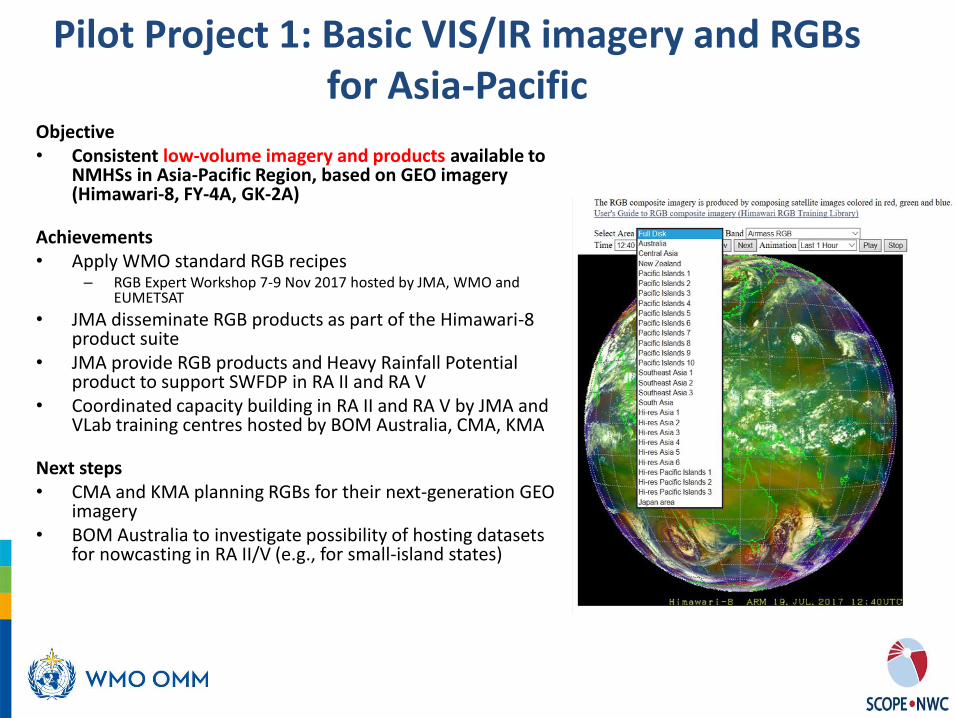
Pilot Project 1: Basic VIS/IR imagery and RGBs for Asia-Pacific
Objective • Consistent low-volume imagery and products available to
NMHSs in Asia-Pacific Region, based on GEO imagery (Himawari-8, FY-4A, GK-2A)
Achievements • Apply WMO standard RGB recipes
– RGB Expert Workshop 7-9 Nov 2017 hosted by JMA, WMO and EUMETSAT
• JMA disseminate RGB products as part of the Himawari-8 product suite
• JMA provide RGB products and Heavy Rainfall Potential product to support SWFDP in RA II and RA V
• Coordinated capacity building in RA II and RA V by JMA and VLab training centres hosted by BOM Australia, CMA, KMA
Next steps • CMA and KMA planning RGBs for their next-generation GEO
imagery • BOM Australia to investigate possibility of hosting datasets
for nowcasting in RA II/V (e.g., for small-island states)
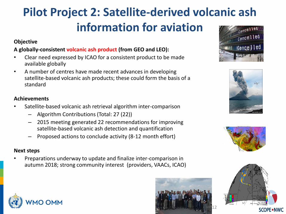
Pilot Project 2: Satellite-derived volcanic ash information for aviation
12
Objective
A globally-consistent volcanic ash product (from GEO and LEO):
• Clear need expressed by ICAO for a consistent product to be made available globally
• A number of centres have made recent advances in developing satellite-based volcanic ash products; these could form the basis of a standard
Achievements
• Satellite-based volcanic ash retrieval algorithm inter-comparison
– Algorithm Contributions (Total: 27 (22))
– 2015 meeting generated 22 recommendations for improving satellite-based volcanic ash detection and quantification
– Proposed actions to conclude activity (8-12 month effort)
Next steps
• Preparations underway to update and finalize inter-comparison in autumn 2018; strong community interest (providers, VAACs, ICAO)

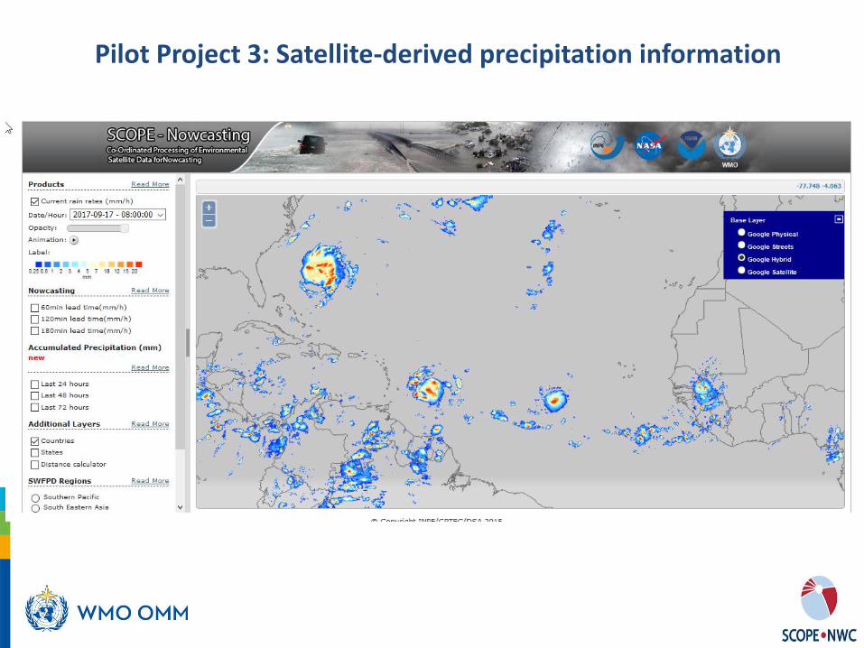
Pilot Project 3: Satellite-derived precipitation information
Objective (Quasi)Global rainfall nowcasting accumulation with low latency for Severe Rainfall Risk Reduction, with rapid and easy access
Achievements Satellite-based quasi-global low-latency precipitation products (60° N-60° S) for
• Nowcasting precipitation rate: 1h accumulation, 1-3h lead time using NOAA Global HydroEstimator (IR+NWP) and INPE Brazil short-term forecast software (ForTrACC) → less accurate, low latency
• Accumulated precipitation over past 24/48/72h, ~4 hours latency using
blended (GEO+LEO) precipitation product (NASA IMERG early product)
• INPE Brazil integrates those products on a GIS web-based platform (SIGMA, http://sigma.cptec.inpe.br/scope/), running as a prototype
• Regions of interest based on WMO SWFDP regions, other layers can be added
Next steps • Transition prototype into operational environment (software free and open)
• Establish validation procedure using IPWG sites, to allow users to assess uncertainty of the products through the SIGMA platform
• Reduce latency
13
SWFDDP South-West
Pacific Region of Interest
Pilot Project 3: Satellite-derived precipitation information

Pilot Project 4: Sand and Dust Monitoring in East Asia
Objective
• Regionally consistent Aeolian dust products based on a common algorithm, mainly based on GEO imagery (Himawari-8, FY-4A, GK-2A)
• Rationalize regional diversity of aerosol-related products that are mostly not harmonized, and not always sustained.
Achievements
• CMA, JMA and KMA are testing and validating present and next-generation dust products against case studies
• Sharing of in-situ datasets among CMA, JMA and KMA • Joint presentation of results at user conferences (AOMSUC) • Contact with Asian node of Sand and Dust Storm Warning Centre (SDS-
WAS) hosted by CMA Beijing
Next steps
• Further liaision with SDS-WAS Beijing to achieve availability of satellite-based products on SDS-WAS portal
• Use of satellite-based products in data assimilation • Inter-comparison of products from JMA, CMA, KMA to include JAXA • Further comparison of COMS, FY-4A, H-8 products with AERONET,
possibly through AEROSAT community • Report to AOMSUC
FY-3 dust products (CMA)
Himawari-8 Wild Fire Product (JMA)
Dust detection of COMS (KMA)

Category Activity Region Provider User
Nowcasting in a Big Data world
Multi-sensor feature-based nowcasting of convective development
Demonstration studies in area of interest (1 or more per agency)
Lead: NOAA, AuBOM Contributors: CMA, KMA, JMA, SIMEPAR, EUMETSAT (TBC)
NMHS
Advanced nowcasting Atmospheric structure with focus on water vapour using vertical weighting functions, low-level water vapour bands (TBC)
TBD EUMETSAT (TBC), CMA
TBD
Advanced nowcasting Incorporating satellite-based MW observations about column-condensed water into nowcasting applications
Global tropics Lead: NASA JPL; Contributors: OMP, U Castilla la Mancha, IMD, NOAA, CMA
NHMS, Commercial aviation weather departments
Proposals for new pilot activities (SCOPE-Nowcasting executive panel meeting, 18-20 Sep 2017)
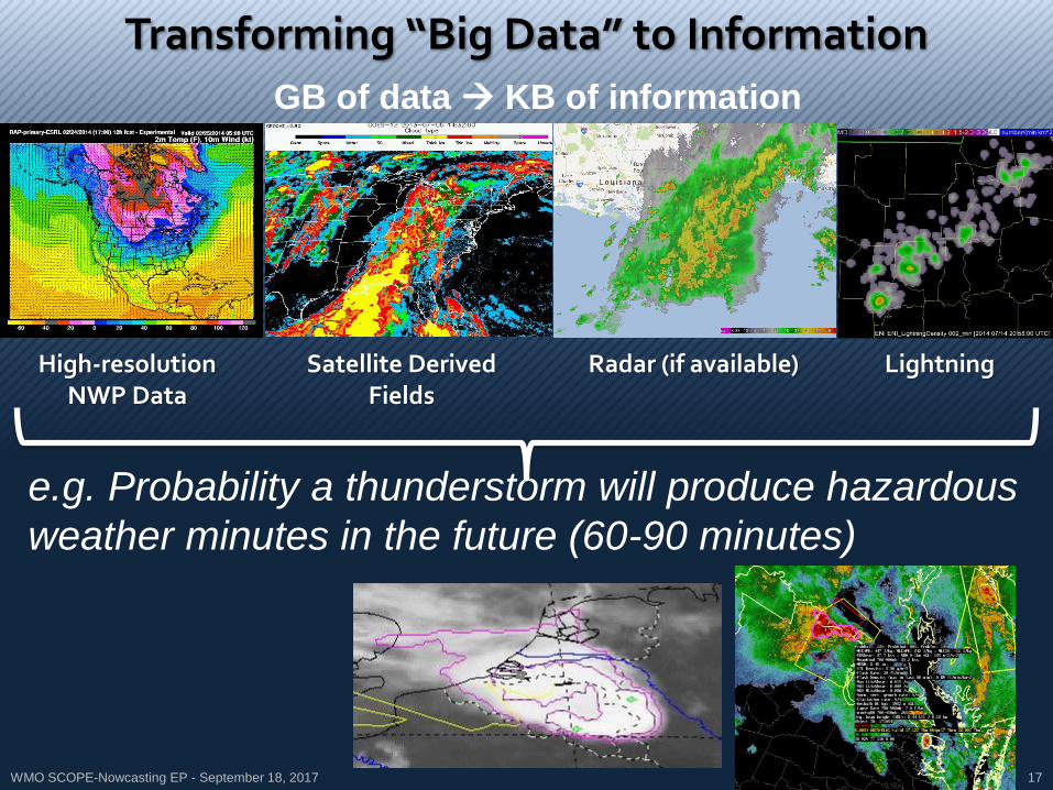
WMO SCOPE-Nowcasting EP - September 18, 2017 17
High-resolution NWP Data
Satellite Derived Fields
Radar (if available) Lightning
e.g. Probability a thunderstorm will produce hazardous
weather minutes in the future (60-90 minutes)
Transforming “Big Data” to Information
GB of data KB of information
WMO SCOPE-Nowcasting EP - September 18, 2017 18
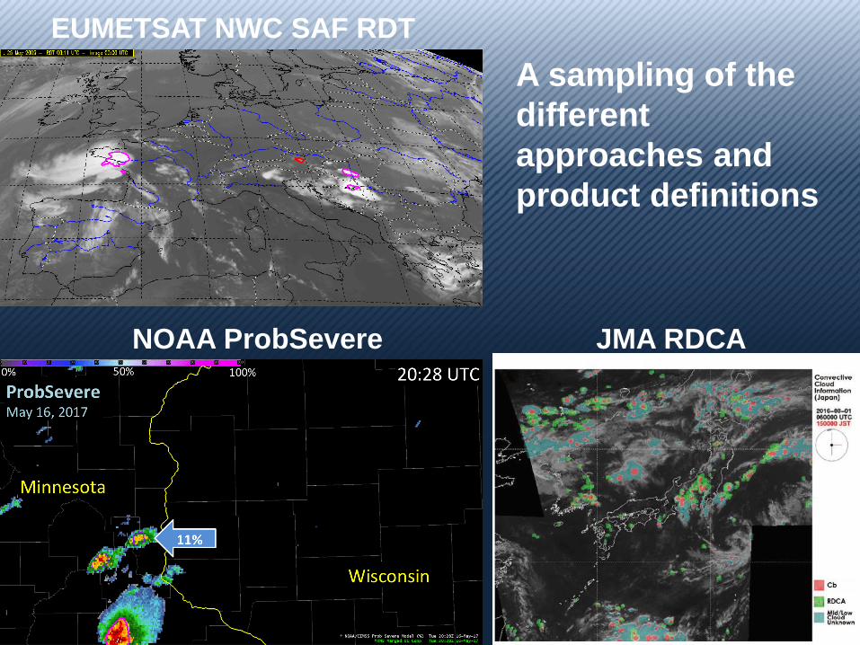
JMA RDCA NOAA ProbSevere
EUMETSAT NWC SAF RDT
A sampling of the
different
approaches and
product definitions

19
How could microwave information help? AF 447: Detection of convective cores
20
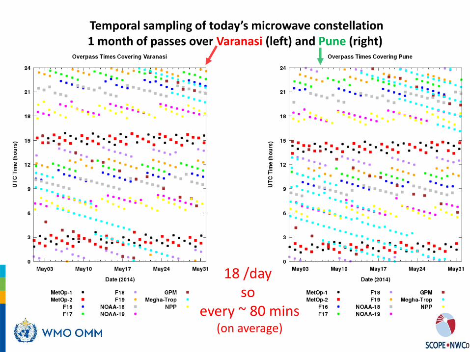
Temporal sampling of today’s microwave constellation 1 month of passes over Varanasi (left) and Pune (right)
18 /day so
every ~ 80 mins (on average)

Concluding remarks • WMO SCOPE-Nowcasting Pilot activities have been successful in many ways • Some “Pilots” await transitioning into operations • New Pilots about to start • Some expected benefits of SCOPE-Nowcasting have been realized:
1. Improved access to satellite data by WMO member states 2. Improved confidence in products generated through SCOPE-Nowcasting 3. Reduced operating costs associated with technological change and software upgrades 4. Reduced training overheads 5. Improved cooperation between NMHSs through access to shared products 6. Strong connections between scientists across agencies as a foundation for increased collaboration
• User community involvement and feedback critical to further success
• Proposals for new Pilots can be made to WMO Secretariat or the SCOPE-Nowcasting Executive Panel

Thank you Merci

SCOPE-Nowcasting reporting to WMO and Satellite Operators (CGMS)
SCOPE-Nowcasting Executive Panel
IPET-SUP
CGMS
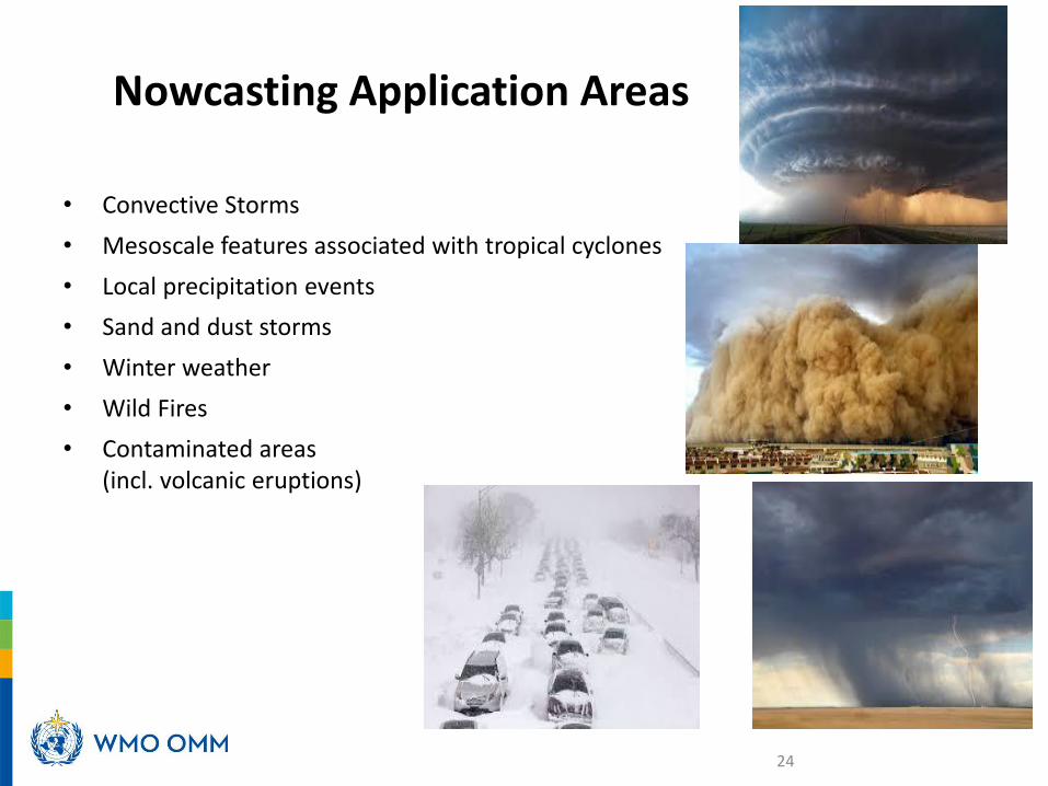
Nowcasting Application Areas
• Convective Storms
• Mesoscale features associated with tropical cyclones
• Local precipitation events
• Sand and dust storms
• Winter weather
• Wild Fires
• Contaminated areas (incl. volcanic eruptions)
24

SCOPE-Nowcasting Pilot Project Criteria
• Use of multi-satellite data
• Dataset formats can be read by standard tools
• Concise product documentation
• Open and easy access
• Available in near-real time (<6h)
• Availability of training information
• An official commitment from all agencies involved in the project
25