Embed Size (px)
Citation preview

O C T O B E R 2 0 0 5
Prepared By:
NORTHWEST ECOLOGICAL SERVICES, LLC
121 Park Ridge Road
Bellingham, WA 98225
360.734.9484
WETLAND DELINEATION FOR THE
FAIRHAVEN HIGHLANDS
BELLINGHAM, WA
Prepared For:
GREENBRIAR NORTHWEST ASSOCIATES, LLC
LANGABEER AND TULL
PO Box 1678
Bellingham, WA 98227

WETLAND DELINEATION FOR THE FAIRHAVEN H IGHLANDS PROJECT I
NORTHWEST ECOLOGICAL SERVICES , LLC
TABLE OF CONTENTS 1.0 BACKGROUND 1
1.1 BACKGROUND 1 1.2 SCOPE OF WORK 1
2.0 METHODS 2
3.0 ECOLOGICAL ASSESSMENT 3
3.1 EXISTING CONDITIONS 3 3.1.1 VEGETATION 3 3.1.2 SOILS 5 3.1.3 HYDROLOGY 6 3.1.4 WILDLIFE 7
3.2 WETLAND AND BUFFER FUNCTIONS AND WETLAND CATEGORIZATION 8 3.2.1 DEPARTMENT OF ECOLOGY CATEGORIZATION 8
3.2.2 CITY OF BELLINGHAM CATEGORIZATION 15
4.0 DETERMINATION AND REGULATTIONS 15
5.0 DISCLAIMER 17
APPENDICES
A: LITERATURE REVIEWED B: FIGURES C: DATA SHEETS D: PHOTOGRAPHS E: SPECIES LISTS

WETLAND DELINEATION FOR THE FAIRHAVEN H IGHLANDS PROJECT 1
NORTHWEST ECOLOGICAL SERVICES , LLC
1.0 BACKGROUND
1.1 Background
Northwest Ecological Services, LLC (NES) was retained to prepare a wetland delineation for a
proposed residential development on three parcels located on Chuckanut Drive in Bellingham,
Washington. Contracted work is intended to be included with Wetland/Stream Permit
application submissions to the U.S. Army Corps of Engineers (Corps), Washington State
Department of Ecology (DOE), Washington Department of Fish and Wildlife (WDFW) and the
City of Bellingham.
1.2 Scope of Work
The scope of work included field delineating a total of 77.9 (+/-) acres on three lots (Parcel
#370212359328, #370212364207, #370212478165) located on Chuckanut Drive in Bellingham,
Washington (Section 12, Township 37N, Range 02E, W.M.) (Figure 1). The site is currently
undeveloped and primarily vegetated with native forest. A delineation report was previously
prepared by Shapiro and Associates in September of 1992. Wetlands delineated by NES
included wetlands which were newly identified, wetlands which appeared to be a different size
or be in a slightly different location, and/or wetlands that were likely to be affected by the
proposed development. Two wetlands (Wetlands BB and FF) identified in the original report
(Shapiro 1992) are discussed in this report, but were not re-delineated in the field because they
did not meet the above criteria.
This report describes existing conditions, identifies critical areas and assesses existing wetland
and buffer functions, for City of Bellingham critical areas and other agencies with authority
over wetlands.
Responsible Party:
David Edelstein
Greenbriar Northwest Associates, LLC
2200 Division Street
Bellingham, WA 98226
Phone: 360.676.1799
Project Contact:
Bob Tull
Langabeer and Tull
PO Box 1678
Bellingham, WA 98227
Phone: 360.671.6460

WETLAND DELINEATION FOR THE FAIRHAVEN H IGHLANDS PROJECT 2
NORTHWEST ECOLOGICAL SERVICES , LLC
2.0 METHODS
Vikki Jackson, Michele Bodtke, and Molly Glynn of Northwest Ecological Services, LLC visited
the site on March 25th, March 29th, April 1st, October 10th and October 13th of 2005. Wetland
identification and delineation followed the “Routine Determination” (On-site Methodology)
described in the Corps of Engineers Wetlands Delineation Manual (Environmental Laboratory,
1987). This methodology requires evidence that at least one positive wetland indicator must be
found for each of three parameters (vegetation, soils, and hydrology) to make a positive
wetland determination. An area is not considered a regulatory wetland if indicators for any one
of these three parameters are not observed under normal environmental conditions. Methods
for each of these parameters are as follows:
• Vegetation: The plant community at each sample site is considered to be hydrophytic
(wetland) vegetation if more than 50 percent of the dominant species from all strata have
obligate wetland, facultative wetland, and/or facultative indicator status. Indicator status is
taken from U.S. Fish and Wildlife Service (Reed, 1988 and 1993). Dominant species are
considered to be the three most abundant species in each vegetation layer. When only one or
two vegetation layers are present, then up to five dominant species from each vegetation
layer are recorded and considered in the determination of hydrophytic vegetation. The
wetland indicator status for each dominant species is then used to determine whether the
plant community is dominated by hydrophytic vegetation.
• Soils: Soil test pits are hand dug to approximately 16 inches and soils are examined for
hydric soil indicators. These formal soil test pits are labeled with a data point number and
located on site delineation map. Colors of the soil matrix, and mottling or gleying, if present,
are measured immediately below the upper dark horizon using a Munsell color chart
(Kollmorgen 1975).
• Hydrology: Site specific hydrology is assessed by an inspection of each site. Depth to
shallow groundwater and/or saturation in each test pit is recorded, as are observations of
other indicators of hydrology including water marks, drift lines, sediment deposits, and
drainage patterns. These data provided information on timing and duration of ponding
and/or saturation in the study area. Upland/wetland boundaries are delineated by locating
the transition where soils, vegetation, or hydrology no longer indicate that wetland
parameters are met.
Data sheets for the delineation are located in Appendix C of this report. Wetlands were flagged
in the field with pink survey flags. A professional survey of the field delineation was prepared
by Ronald T. Jepson and Associates; and is included as Figure 2. Photographs taken during the
site visits are located in Appendix D of this report.
WETLAND DELINEATION FOR THE FAIRHAVEN H IGHLANDS PROJECT 3
NORTHWEST ECOLOGICAL SERVICES , LLC
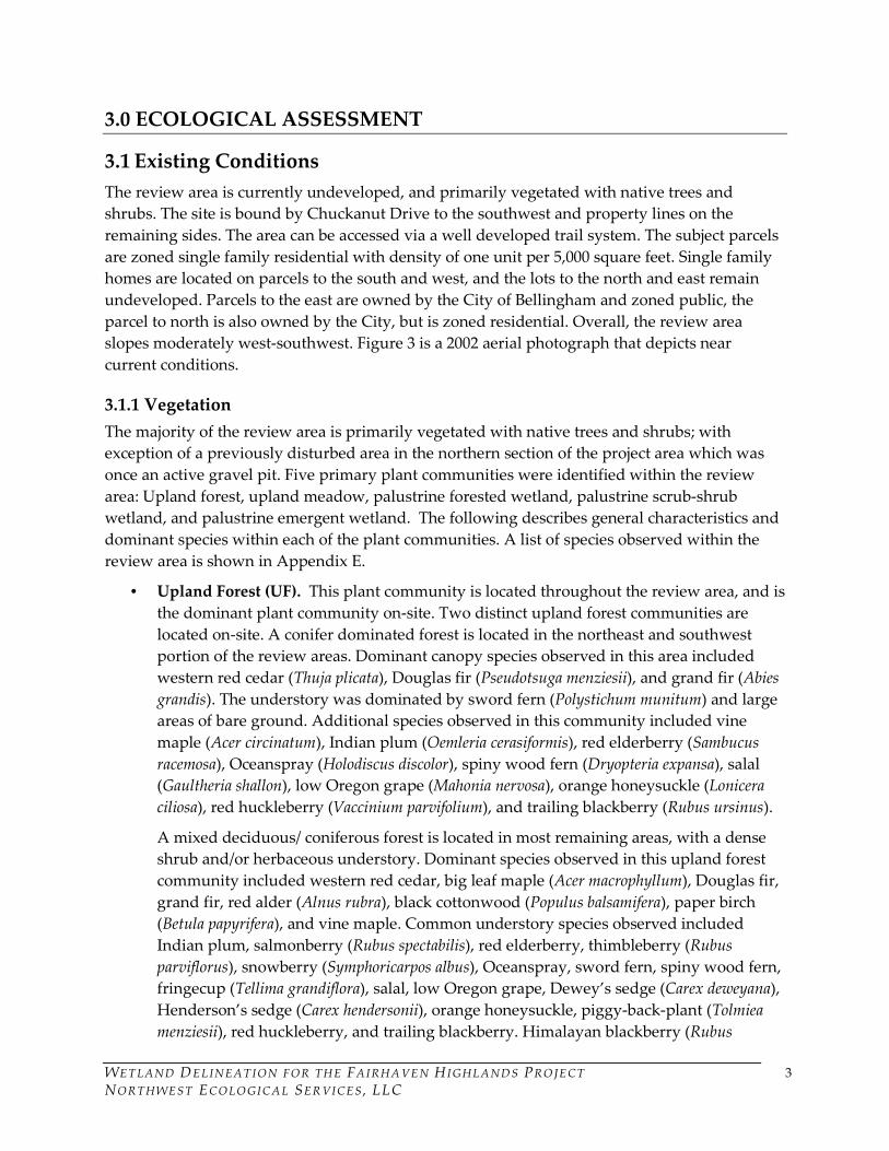
3.0 ECOLOGICAL ASSESSMENT
3.1 Existing Conditions
The review area is currently undeveloped, and primarily vegetated with native trees and
shrubs. The site is bound by Chuckanut Drive to the southwest and property lines on the
remaining sides. The area can be accessed via a well developed trail system. The subject parcels
are zoned single family residential with density of one unit per 5,000 square feet. Single family
homes are located on parcels to the south and west, and the lots to the north and east remain
undeveloped. Parcels to the east are owned by the City of Bellingham and zoned public, the
parcel to north is also owned by the City, but is zoned residential. Overall, the review area
slopes moderately west-southwest. Figure 3 is a 2002 aerial photograph that depicts near
current conditions.
3.1.1 Vegetation
The majority of the review area is primarily vegetated with native trees and shrubs; with
exception of a previously disturbed area in the northern section of the project area which was
once an active gravel pit. Five primary plant communities were identified within the review
area: Upland forest, upland meadow, palustrine forested wetland, palustrine scrub-shrub
wetland, and palustrine emergent wetland. The following describes general characteristics and
dominant species within each of the plant communities. A list of species observed within the
review area is shown in Appendix E.
• Upland Forest (UF). This plant community is located throughout the review area, and is
the dominant plant community on-site. Two distinct upland forest communities are
located on-site. A conifer dominated forest is located in the northeast and southwest
portion of the review areas. Dominant canopy species observed in this area included
western red cedar (Thuja plicata), Douglas fir (Pseudotsuga menziesii), and grand fir (Abies
grandis). The understory was dominated by sword fern (Polystichum munitum) and large
areas of bare ground. Additional species observed in this community included vine
maple (Acer circinatum), Indian plum (Oemleria cerasiformis), red elderberry (Sambucus
racemosa), Oceanspray (Holodiscus discolor), spiny wood fern (Dryopteria expansa), salal
(Gaultheria shallon), low Oregon grape (Mahonia nervosa), orange honeysuckle (Lonicera
ciliosa), red huckleberry (Vaccinium parvifolium), and trailing blackberry (Rubus ursinus).
A mixed deciduous/ coniferous forest is located in most remaining areas, with a dense
shrub and/or herbaceous understory. Dominant species observed in this upland forest
community included western red cedar, big leaf maple (Acer macrophyllum), Douglas fir,
grand fir, red alder (Alnus rubra), black cottonwood (Populus balsamifera), paper birch
(Betula papyrifera), and vine maple. Common understory species observed included
Indian plum, salmonberry (Rubus spectabilis), red elderberry, thimbleberry (Rubus
parviflorus), snowberry (Symphoricarpos albus), Oceanspray, sword fern, spiny wood fern,
fringecup (Tellima grandiflora), salal, low Oregon grape, Dewey’s sedge (Carex deweyana),
Henderson’s sedge (Carex hendersonii), orange honeysuckle, piggy-back-plant (Tolmiea
menziesii), red huckleberry, and trailing blackberry. Himalayan blackberry (Rubus

WETLAND DELINEATION FOR THE FAIRHAVEN H IGHLANDS PROJECT 4
NORTHWEST ECOLOGICAL SERVICES , LLC
discolor), Ivy (Hedra sp.), and Herb-Robert (Geranium robertianum) non-native, invasive
species were also observed within this community.
• Upland Meadow (UM). This plant community is located in the northern portion of the
review area where the gravel pit and access roads used to be. This community supports
a mix of predominately non-native grasses, weedy herbaceous species, and larg areas of
bare ground (60% in some places). Species observed included tall fescue (Festuca
arundinacea), orchard grass (Dactylis glomerata), velvet grass (Holcus lanatus), English
plantain (Plantago lanceolata), bentgrass (Agrostis sp.), hairy cats paw (Hypochaeris
radicata), common tansy (Tanacetum vulgare), reed canarygrass, Scotch broom (Cytisus
scoparius), sweet vernalgrass (Anthoxanthum odoratum) and creeping buttercup.
Himalayan blackberry and Canadian thistle (Cirsium arvense) both non-native, invasive
species were also observed within this community.
• Palustrine Forested Wetland (PFO). This plant community is located in Wetlands AA,
AY, BB, CC, JJ, and KK. Wetlands AA, AY, BB, and JJ have a deciduous canopies
dominated by red alder and black cottonwood. Wetlands CC and KK have a canopies
dominated by western red cedar and an understory dominated by slough sedge (Carex
obnupta), water parsley (Oenanthe sarmentosa) and areas of bare ground and/or standing
water. Additional species observed within the PFO wetlands included Pacific willow
(Salix lucida), salmonberry, skunk cabbage (Lysichiton americanum), and sword fern on
hummocks.
• Palustrine Scrub-Shrub Wetland (PSS). This plant community is located in Wetlands
AY, BB, DD, FF, JJ, and LL. Dominant species observed included salmonberry, hardhack
(Spiraea douglasii), black twinberry (Lonicera involucrata), and red osier-dogwood (Cornus
stolonifera). This plant community is interspersed with the PFO community in Wetland
BB, and interspersed with the PEM community in Wetlands DD, FF and JJ. The PSS
community is dominant in Wetlands AY and LL.
• Palustrine Emergent Wetland (PEM). This plant community is located in Wetlands AA,
AX, CC, DD, EE, FF, GG, HH, and KK. Wetlands AA and AX are located in a disturbed
area where the gravel pit used to be. The PEM community in this area is dominated by
grasses and weedy herbaceous species. Species observed included reed canarygrass
(Phalaris arundinacea), soft rush (Juncus effusus), tall horsetail (Equisetum arvense),
creeping buttercup (Ranunculus repens), bentgrass (Agrostis capillaries), hairy cats paw
(Hypochaeris radicata), tall fescue (Festuca arundinacea), slender rush (Juncus tenuis), velvet
grass (Holcus lanatus), and tall buttercup (Ranunculus acris). The PEM community
observed in Wetlands EE and GG had a mix of native and non-native species including
slough sedge, skunk cabbage, piggy-back-plant, large leaf avens (Geum macrophyllum),
creeping buttercup, lady fern (Athyrium filix-femina), American brooklime (Veronica
americana), stinging nettles, reed canarygrass, and tall mannagrass (Glyceria elata). The
PEM community in Wetland FF included species similar to those found in Wetlands EE
and GG, and was also interspersed with a PSS community dominated by salmonberry.
The PEM community in Wetlands CC, HH and KK was dominated by slough sedge,
water parsley and areas of bare ground and/or standing water.

WETLAND DELINEATION FOR THE FAIRHAVEN H IGHLANDS PROJECT 5
NORTHWEST ECOLOGICAL SERVICES , LLC
3.1.2 Soils
The SCS Soil Survey map indicates the presence of Chuckanut Loam, bedrock substratum (#26)
on 15 to 30% slopes, Everett- Urban Land Complex (#52) on 5 to 20% slopes, and Squalicum-
Urban Land Complex (#159) on 5 to 20% slopes in the vicinity of the review area (Figure 4).
Chuckanut loam is a deep, well drained soil located on toe slopes and slide slopes of foothills,
which formed in a mixture of volcanic ash and colluvium derived from glacial drift and
sandstone. Nati, Squalicum and Bellingham soils are also included in this soil series. The
Everett- Urban land complex is typically 50% Everett gravelly sandy loam and 30% urban land.
Urban land includes areas covered by streets, buildings and other structure that obscure soil, so
identification is not possible. Everett gravelly sandy loam is a deep, well drained soil located on
outwash terraces, which formed in a mixture of volcanic ash and alluvium over glacial outwash
and glacial till. Chuckanut, Squalicum Sehome, Whatcom and Labounty soils are also included
in this soil series. Squalicum- Urban land complex is typically 50% Squalicum gravelly loam and
30% urban land. Squalicum gravelly loam is deep, moderately well drained soil located on
foothills, which formed in a mixture of volcanic ash, loess, and slope alluvium over glacial till.
Chuckanut, Everett, Labounty, Sehome, and Whatcom soils are also included in this soils series.
Chuckanut loam, Everett and Squalicum soils are all listed as non-hydric on the Whatcom
County Area Hydric List (Whatcom County 1991); however mapped inclusions are listed as
hydric. Field observations appear to confirm this mapping, with wetlands soils being typical of
hydric soil inclusions.
The majority of observed upland soils were silt loams or gravelly silt loams, typically displaying
a matrix chroma of 3, 4 or 6, with no redoximorphic features within the upper 16 inches of the
soil column. Upland soils in the northeast portion of the review area had a loam top-soil which
displayed a matrix of 3 or 4, and a sandy loam sub-soil which displayed a matrix chroma of 3
with mottles (10YR 4/6) at eight inches.
Observed wetland soils were typically either mucky mineral, silt loam or clay loam soils. Mucky
mineral silt loam soils were observed in Wetlands CC, HH, and KK, which typically displayed a
matrix chroma of 10YR 2/1, with no redoximorphic features in the upper 16 inches of the soil
column. Soils observed in Wetlands FF, GG, JJ, and LL typically had a silt loam top-soil which
displayed a matrix chroma of 1 with no mottles, and a clayey silt loam sub-soil which displayed
a matrix chroma of 2, with mottles (10YR 5/6, 10YR 4/6, or 10YR 4/4). Wetlands DD and EE,
which appear to have been excavated, had gravelly silt loam soils more typical of the upland
soil plots. Soils in the wetlands displayed a matrix chroma of 2 with mottles (10YR 5/8)
throughout the soil profile. Wetlands AA, AX, and AY are all located in the area of the old
gravel pit. Wetland soils observed in this area typically had a sandy silt loam top-soil which
displayed a matrix chroma of 10YR 3/2 and a gravelly sandy loam sub-soil which displayed a
matrix chroma of Gley1 4/10Y; with no mottles.

WETLAND DELINEATION FOR THE FAIRHAVEN H IGHLANDS PROJECT 6
NORTHWEST ECOLOGICAL SERVICES , LLC
3.1.3 Hydrology
The site is located at the break between the Padden Creek and Chuckanut Bay Watersheds.
Hydrology supporting the site wetlands appears to be provided primarily by surface runoff
feeding seasonal perched high water tables and/or localized groundwater seeps in some areas.
Chuckanut soils have a water table at a depth of six feet or greater year round. While, Everett
and Squalicum soils have a perched, seasonal high water table at a depth of 3.5 to 5.0 feet from
December to April (NRCS 1991). At the time of the March and April site visits, soils in bore
holes in all wetlands were saturated and standing water was observed most wetlands. At the
time of the October site visit, soils in all boreholes were moist to saturated, but no standing
water was observed within any of the on-site wetlands.
Wetlands AA, AX, AY, BB, CC, DD, EE, FF, GG, and HH are located in the Padden Creek
Watershed. Wetland BB is part of a larger wetland system which is located on the parcel to the
north, with only a small portion of the wetland extending on-site. Water contained within
Wetland BB appears to flow off-site to the northwest following the topography; and eventually
into Padden Creek. Wetland FF is a slope wetland which appears to be supported by surface
run-off and groundwater seeps; water contained within the wetland flows west down slope and
into the roadside drainage system in the adjacent residential development. At the time of the
March/April site visit, soils in Wetland FF were saturated, small depressions containing one to
two inches of standing water were observed within the wetland, and two small channelized
areas, approximately six inches wide, were located in the middle of the wetland. Wetland CC is
a large depressional wetland. At the time of the March/April site visits, approximately one to
two feet of standing water was observed in numerous ponded areas within Wetland CC. Water
contained in Wetland CC appears to flow off-site to the west via a small channel and then a
ditch along Chuckanut Drive; the ditch is connected to a tributary of Padden Creek.
Wetlands AA, AX, AY, DD, EE, GG and HH are all smaller depressional wetlands, which
appear to only overflow into the surrounding upland area during storm events. Wetland AA
contains a small area which becomes seasonally ponded with standing water to a depth of
approximately one foot, but the majority of the wetland appears to be seasonally saturated to
surface. Water marks in Wetlands AX and AY indicate the wetlands appear to contain standing
water at a depth of a few inches to one foot. A ditch is located upslope of Wetland AY, which
appears to drain the surrounding upland area into the wetland. Wetland DD appears
excavated. The wetland is located in a deep depression, which appears to detain a significant
amount of surface run-off. During the March and April site visits, three to five feet of standing
water was observed in Wetland DD, and water marks were observed at the outlet (a ditch),
another foot above water level. Wetland EE also appears to have been excavated, but the
wetland is located in a shallower depression. At the time of the March/April site visits, water
was observed in Wetland EE at a depth of a few inches to one foot. Wetland EE appears to drain
across a trail and into Wetland DD. Wetland GG is located in a shallow depression. At the time
of the March/April site visits, soils were saturated to the surface in Wetland GG. Wetland HH
contained one foot of standing water, during the March/April site visits, and water marks were
observed which indicated the wetland regularly detains an additional two feet of water.

WETLAND DELINEATION FOR THE FAIRHAVEN H IGHLANDS PROJECT 7
NORTHWEST ECOLOGICAL SERVICES , LLC
Wetlands KK, LL and JJ are located in the Chuckanut Bay Watershed. Wetland KK is a
depressional wetland; water within the wetland appears to be detained within the wetland and
only overflows into the surrounding area during storm events. Water contained within Wetland
KK appears to flow from the wetland east and into Wetland JJ. It appears that the majority of
Wetland KK becomes ponded during the wet season. During the March/April site visits,
approximately one to two feet of water was observed Wetland KK. Wetland LL is a small
depressional wetland; water contained within the wetland appears to only overflow into the
surrounding upland area during storm events. There is a possible sub-surface connection
between Wetlands KK and LL; and water may drain sub-surface from Wetland KK south into to
Wetland LL. Wetland JJ is located off-site on a parcel to the east; only a portion of this wetland
was observed due to its proximity to proposed development. The portion of Wetland JJ within
the review area was a slope wetland which appears to drain east into a larger depressional area
at the toe of the slope. Two parallel drainage ditches have been dug in Wetland JJ, which appear
to be draining the wetland and surrounding upland area.
Primary indicators of hydrology included inundation or soil saturation during the growing
season in all wetlands. Secondary hydrology indicators observed at the site included drainage
patterns in all wetlands; water marks on surrounding trees and soils; and water stained leaves.
No positive hydrology indicators were observed elsewhere within the review area.
3.1.4 Wildlife
No State or Federal Threatened, Sensitive, or Endangered plant or animal species were
observed on the subject property. However, the property does provide suitable habitat for
mammals and suitable habitat, including nesting/breeding sites, for a variety of bird species and
amphibian species. During the March/April site visits, numerous Pacific tree frog (Pseudacris
regilla) and northern red legged frog (Rana aurora aurora) egg masses were observed, particularly
within Wetlands AA, CC and KK. California red legged frogs are listed as a federally
threatened species, but the listing does not include the sub-species of northern red legged frogs
located in this area. Additional wildlife species observed within the review area included:
golden-crowned kinglet (Regulus satrapa), black-capped chickadee (Parus atricapillus), chestnut-
backed chickadee (Parus rufescens), Steller’s jay (Cyanocitta stelleri), pileated woodpecker
(Dryocopus pileatus) excavations, Swainson’s thrush (Hylocichla ustulata), winter wren
(Troglodytes troglodytes), northern flicker (Colaptes cafer), song sparrows (Melospiza melodia), and
Douglas squirrel (Tamiasciurus douglasii). Evidence of pileated woodpecker foraging was also
observed on-site. Pileated woodpecker is listed by Washington State as a Candidate Species, but
is not federally listed.
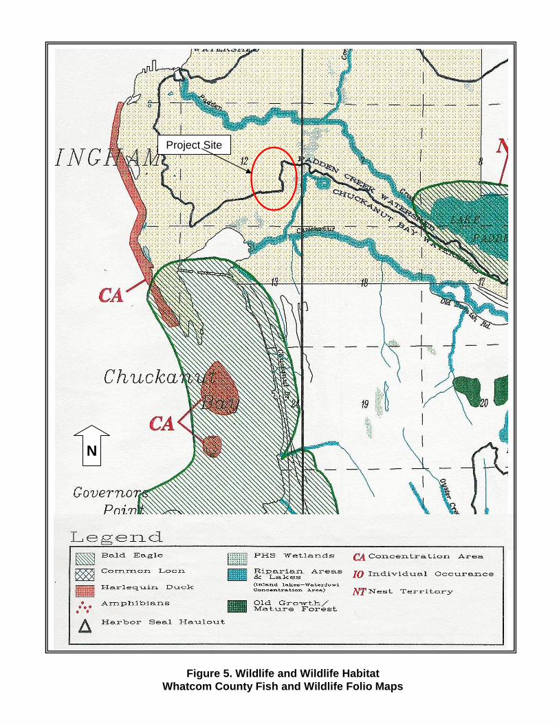
The Whatcom County Fish and Wildlife Folio (Whatcom County Planning 1994) does not indicate
the area is utilized by any priority, sensitive, threatened or endangered species (Figure 5 & 6).
However, the Whatcom County Fish and Wildlife Folio indicates Riparian areas along Chuckanut
and Padden Creek, within a mile of the subject site; Chum salmon (Oncorhynchus keta), Coho
salmon (Oncorhynchus kisutch) and cutthroat trout (Oncorhynchus clarki clarki) as mapped in

WETLAND DELINEATION FOR THE FAIRHAVEN H IGHLANDS PROJECT 8
NORTHWEST ECOLOGICAL SERVICES , LLC
Chuckanut Creek; and Coho salmon, Chum salmon, cutthroat trout, and steelhead
(Oncorhynchus mykiss) in Padden Creek (Figures 5 & 6). Coho salmon are federally listed as a
species of concern, but are not listed by Washington State. Populations of Chum salmon,
Cutthroat trout and steelhead salmon in this location, are not federally or state listed species.
The Folio also indicates a Bald Eagle (Haliaeetus leucocephalus) concentration area within a mile of
the property, but it is unlikely that this species utilizes the subject site (Figure 5). The Bald Eagle
is federally and state listed as a threatened species.
3.2 Existing Wetland and Buffer Functions and Wetland Categorization
3.2.1 Department of Ecology Categorization
The site wetlands were rated using the Washington State Department of Ecology’s (DOE)
Wetland Rating System for Western Washington revised 2004. Wetland functions were also
evaluated using this rating system. This methodology identifies and quantifies the potential of
various functions operating within a wetland. The determination is based on the physical
characteristics of water quality, hydrologic, and habitat functions in the wetland and buffers.
Using this system, wetlands are given a score based on the functions provided by the wetland,
and are placed in Category I through Category IV.
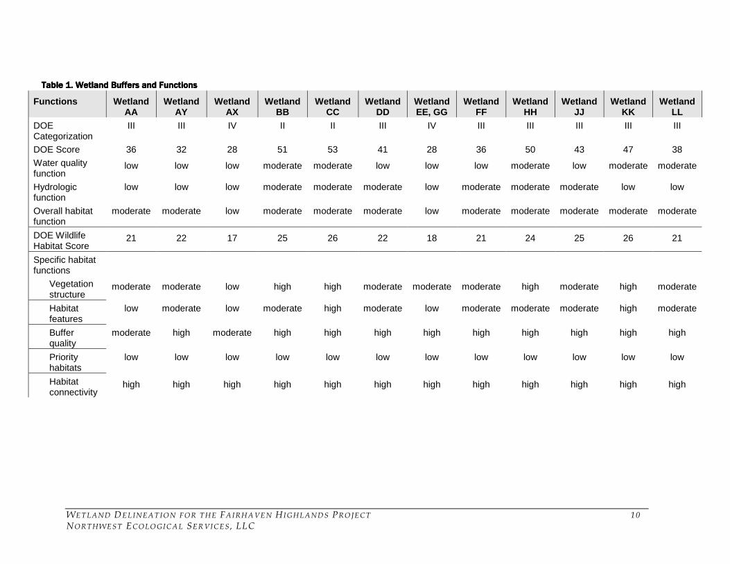
Table 1 summarizes the DOE category and rating score, as well as wetland and buffer functions,
for all wetlands assessed for this report. Under the DOE rating system, Wetlands BB and CC
are considered Category II wetlands, Wetlands AA, AY, DD, FF, HH, JJ, KK and LL are
considered Category III wetlands, and Wetland AX, EE and GG are considered Category IV
wetlands. Wetlands that score between 51 and 69 points are considered DOE Category II
wetlands. Wetlands that score between 30 and 50 points are considered DOE Category III
wetlands. Wetlands that score 29 points or less are considered DOE Category IV wetlands. The
wetland classification system is based on conditions as they exist at the point in time of the site
visit. Wetland functions and categorization may change overtime, particularly with increased
development in the area. Generally, as development occurs, the opportunity of the wetland to
provide water quality and hydrologic stormwater and base flow function increases; and wildlife
functions provided by the wetland and buffers decreased due to overall habitat area loss.
In general, the site wetlands provide water quality function at a low or moderate level due to
location of the wetlands in the upper portion of the watersheds, presence of persistent
vegetation, and retention and treatment of on-site surface run-off. The water quality function
for most wetlands within the review area is limited, primarily because they receive surface
water run-off from the surrounding un-disturbed forested area, which contain low levels of
most pollutants. Therefore the wetlands do not have the opportunity to provide a high water
quality treatment function, but the opportunity may increase as development in this area
increases. In general, the wetlands provide a low to moderate level of hydrologic stormwater
and base flow functions due to the hydrogeomorphic characteristics of the wetlands, location in
the watersheds, and the relative amount of water storage and retention within the wetlands.
Wetlands BB and CC appear to be connected to Padden Creek, which tends to exhibit flashy

WETLAND DELINEATION FOR THE FAIRHAVEN H IGHLANDS PROJECT 9
NORTHWEST ECOLOGICAL SERVICES , LLC
hydrology due to development in the surrounding basin. Hydrologic functions in Wetlands BB
and CC appears to be significant because they are able to detain and desynchronize surface run-
off and stormwater flows before entering Padden Creek. Wetland DD also provides a large
amount of water storage of on-site surface run-off within this basin.
Overall, wetlands within the review area provide moderate wildlife and habitat function. The
majority of on-site wetlands are vegetated with native species, have moderate to high native
species diversity and vegetation structure, have habitat features present, and are well connected
to quality upland buffers. The wetlands are located in an open space corridor which abuts
urban residential development to the north and west, and provides essential wildlife habitat in
a developing area. The project site is also well connected to a large tract of undisturbed forested
habitat which contains additional wetlands and priority habitats, and is connected to a larger
habitat corridor which extends to and includes Chuckanut Mountain.
WETLAND DELINEATION FOR THE FAIRHAVEN H IGHLANDS PROJECT 10
NORTHWEST ECOLOGICAL SERVICES , LLC
Table 1. Wetland Buffers and FunctionsTable 1. Wetland Buffers and FunctionsTable 1. Wetland Buffers and FunctionsTable 1. Wetland Buffers and Functions
Functions Wetland AA
Wetland AY
Wetland AX
Wetland BB
Wetland CC
Wetland DD
Wetland EE, GG
Wetland FF
Wetland HH
Wetland JJ
Wetland KK
Wetland LL
DOE Categorization
III III IV II II III IV III III III III III
DOE Score 36 32 28 51 53 41 28 36 50 43 47 38
Water quality function
low low low moderate moderate low low low moderate low moderate moderate
Hydrologic function
low low low moderate moderate moderate low moderate moderate moderate low low
Overall habitat function
moderate moderate low moderate moderate moderate low moderate moderate moderate moderate moderate
DOE Wildlife Habitat Score
21 22 17 25 26 22 18 21 24 25 26 21
Specific habitat functions
Vegetation structure
moderate moderate low high high moderate moderate moderate high moderate high moderate
Habitat features
low moderate low moderate high moderate low moderate moderate moderate high moderate
Buffer quality
moderate high moderate high high high high high high high high high
Priority habitats
low low low low low low low low low low low low
Habitat connectivity
high high high high high high high high high high high high
WETLAND DELINEATION FOR THE FAIRHAVEN H IGHLANDS PROJECT 11
NORTHWEST ECOLOGICAL SERVICES , LLC
The following section provides a summary of individual wetlands, and discusses functions
provided by the wetland and its buffers as identified using the DOE rating system.
Wetland AA
Wetland AA is located in an area that used to be a gravel pit. Approximately half of the wetland
is vegetated with deciduous trees and shrubs, and half is vegetated with grasses and weedy
herbaceous species. A small seasonally ponded area is located in the forested portion of the
wetland.
Wetland AA provides low water quality and hydrologic stormwater and base flow functions
due to the hydrogeomorphic characteristics of the wetland, presence of some persistent
vegetation present within the wetland, size and the limited amount of water storage. Overall
habitat function is moderate. The wetland has moderate vegetation structure and species
diversity, moderate habitat features, and is connected to moderate quality upland buffers.
Wetland AY
Wetland AY is a small depressional wetland. The wetland is vegetated primarily with native
trees and shrubs, and contains small localized depressional areas where water is seasonally
ponded.
Wetland AY provides low water quality function and hydrologic stormwater and base flow
function due to the hydrogeomorphic characteristics of the wetland, continuous vegetation
cover, and limited size and subsequent amount of water storage. Overall habitat function is
moderate. The wetland has moderate native vegetation structure and diversity, absence of
habitat features, and is well connected to high quality upland buffer.
Wetlands AX
Wetland AX is a small depressional wetland located in and area of disturbance associated with
the old gravel pit. The wetland area consists of mostly bare ground, which ponds during the
wet season, and a fringe of grasses and weedy herbaceous species.
Wetland AY provides low water quality function and hydrologic stormwater and base flow
function due to the hydrogeomorphic characteristics of the wetland, lack of continuous
vegetation cover, and limited size and subsequent amount of water storage. Wetland AY
provides low overall habitat function due to lack of vegetation structure and species diversity,
absence of habitat features, and connectivity to low quality upland buffer.
Wetland BB
Wetland BB is a relatively large depressional wetland, which is located on the northern edge of
the review area; the majority of the wetland area is located off-site. The wetland is vegetated
primary with native trees and shrubs, and has a surface water connection to Padden Creek.

WETLAND DELINEATION FOR THE FAIRHAVEN H IGHLANDS PROJECT 12
NORTHWEST ECOLOGICAL SERVICES , LLC
Wetland BB provides moderate water quality function mainly due to its location in the
watershed, presence of persistent vegetation, and because it receives run-off from developed
areas. The wetland provides moderate hydrologic stormwater and base flow function due to
hydrogeomorphic characteristics, continuous vegetation cover that is able to slow flood waters,
the relatively large area and subsequent amount of water storage, and because the wetland has
a surface water connection to Padden Creek. Wetland BB provides moderate to high overall
biological support primarily because of high vegetative structure and species diversity,
presence of habitat features, high interspersion of habitats within the wetland, connectivity to
quality upland buffer and a larger tract of undisturbed forested habitat. The edge of Wetland BB
is extensive, providing a higher degree of complexity in the wetland, and greater potential
habitat for species utilizing this site.
Wetland CC
Wetland CC is a large depressional wetland. The wetland is primarily vegetated with native
trees and herbaceous species; and contains numerous localized pockets which become
seasonally ponded and vegetated upland hummocks.
Wetland CC provides moderate water quality functions mainly due to the hydrogeomorphic
characteristics of the wetland, presence of persistent vegetation, and area of wetland that is
seasonally ponded. The wetland provides moderate hydrologic stormwater and base flow
function due to the hydrogeomorphic characteristics of the wetland and location in the
watershed, and the wetland is connected to a tributary of Padden Creek, and is therefore able to
detain surface run-off and detain stormwater before it enters the creek. Wetland CC provides
moderate to high overall biological support. The wetland is dominated mature trees; and it has
high vegetative structure, moderate species diversity, many habitat features, and is well
connected to high quality upland buffers. Habitat interspersion within Wetland CC is high,
with numerous localized pockets of standing water, upland hummocks, and areas of dense
shrubs. The edge of the wetland is extensive, providing a higher degree of complexity and more
niches for species utilizing this site.
Wetland DD
Wetland DD is located in a small depression, which appears to have been artificially created.
The wetland is deep; and becomes seasonally ponded and detains a significant amount of water
(three to six feet) during the wet season. The wetland is primarily open water/ bare ground,
with a fringe of moderate to dense trees and shrubs around the circumference.
Wetland DD provides low water quality functions primarily due to the hydrogeomorphic
characteristics of the wetland and lack of vegetation present within the wetland. The wetland
provides moderate hydrologic stormwater and base flow function due to the amount of water
that is retained in the wetland and the size of the contributing basin. Wetland DD provides
WETLAND DELINEATION FOR THE FAIRHAVEN H IGHLANDS PROJECT 13
NORTHWEST ECOLOGICAL SERVICES , LLC
moderate overall biological support primarily due to moderate vegetative structure and low
species diversity, some habitat features, and good connectivity to high quality upland buffer.
Wetlands EE, and GG
Wetlands EE and GG are shallow depressional wetlands vegetated primarily with herbaceous
species. Wetland EE appears to have been excavated.
Wetlands EE and GG provide low water quality function and hydrologic stormwater and base
flow function due to the hydrogeomorphic characteristics of the wetlands, continuous
vegetation cover, and limited size and subsequent amount of water storage. The wetlands
provide low overall biological support primarily due to low vegetative structure and species
diversity, presence of non-native species, and limited habitat features in the wetlands, and the
wetlands are both well connected to high quality upland buffers.
Wetland FF
Wetland FF is a slope wetland, which is vegetated primarily with native shrubs and herbaceous
material. The surrounding upland forest provides approximately 40 to 70% cover over the
wetland.
Wetland FF provides low water quality function. Although the wetland has continuous
vegetation cover by herbaceous and woody plants, the degree of the slope and subsequent
moderate movement of water through the wetland provides little detention time and therefore
lower water quality treatment. The wetland provides low to moderate hydrologic stormwater
and base flow function due hydrogeomorphic characteristics, vegetation present within the
wetland which is able to slow surface run-off, small depressional areas within the wetland
which area able to detain some surface run-off, and because the wetland detains water which
drains into Padden Creek. Overall habitat function is moderate. The wetland has moderate
vegetative structure and species diversity, some habitat features, and is well connected to high
quality upland buffers.
Wetland HH
Wetland HH is a depressional wetland, which is vegetated with trees, shrubs, and herbaceous
material. Dominant vegetation in the wetland is herbaceous, among large areas of standing
water and/or bare ground. The wetland fringe, which is less effected by standing water, is
characterized by trees and shrubs. A small island of native trees and shrubs is located within
the center of the wetland.
Wetland HH provides moderate water quality function and hydrologic stormwater and base
flow function due to the location in the watershed, hydrogeomorphic characteristics of the
wetland, percentage of the wetland which is seasonally ponded, size and subsequent amount of
water storage. Currently the wetland has limited opportunity to provide these functions, but
with increased development in the area the opportunity for this wetland to provide significant

WETLAND DELINEATION FOR THE FAIRHAVEN H IGHLANDS PROJECT 14
NORTHWEST ECOLOGICAL SERVICES , LLC
water storage and water quality functions is anticipated to increase. The wetland provides
moderate overall biological support primarily due to moderate vegetative structure and species
diversity, some habitat features, connectivity to high quality upland buffer, and greater degree
of habitat complexity within the wetland.
Wetland JJ
Wetland JJ is located off-site on a parcel to the east; only a portion of this wetland was observed
due to its proximity to proposed development. The portion of Wetland JJ within the review area
was a slope wetland which appears to drain east into a larger depressional area at the toe of the
slope. The wetland contains interspersion of areas that are vegetated with trees, shrubs, and/or
herbaceous species.
The subject portion of Wetland JJ provides low water quality function. Although the wetland
has continuous vegetation cover by herbaceous and woody plants, the degree of the slope and
subsequent moderate movement of water through the wetland provides little detention time
and therefore lower water quality treatment. Two drainage ditches are located in this portion of
the wetland, and during storm events water appears to move quickly through the wetland.
Wetland JJ provides low to moderate hydrologic stormwater and base flow function due to the
hydrogeomorphic characteristics of the wetland, continuous vegetation cover, and overall size
and subsequent amount of water storage it is able to provide. The wetland provides moderate
to high overall biological support primarily due to moderate vegetative structure and species
diversity, presence of habitat features, interspersion of habitats, and connectivity to high quality
upland buffers.
Wetland KK
Wetland KK is a large depressional wetland primarily vegetated with trees and herbaceous
species. The majority of the wetland is covered by bare ground or herbaceous species, and
becomes seasonally ponded. Trees growing on upland hummocks and in the surrounding
forested buffer provide approximately 40 to 80% canopy cover.
Wetland KK provides moderate water quality functions mainly due to the hydrogeomorphic
characteristics of the wetland, some persistent vegetation, and seasonal ponding. The wetland
provides low hydrologic stormwater and base flow function due to the hydrogeomorphic
characteristics of the wetland and location in the watershed, and it detains a relatively large
amount of surface run-off from on-site. Overall habitat function is moderate to high. The
wetland has moderate vegetative structure and species diversity, contains many habitat
features, and is well connected to high quality upland buffers and the larger habitat corridor.
Habitat interspersion within Wetland KK is high, with localized pockets of standing water,
upland hummocks, and the edge of the wetland is extensive, providing a higher degree of
complexity and greater potential for habitat for species utilizing this site.

WETLAND DELINEATION FOR THE FAIRHAVEN H IGHLANDS PROJECT 15
NORTHWEST ECOLOGICAL SERVICES , LLC
Wetland LL
Wetland LL is a shallow depression that is primarily vegetated with shrubs and herbaceous
species.
Wetland LL provides moderate water quality function due hydrogeomorphic characteristics in
the wetland, persistent vegetation within the wetland, and a relatively small area which is
seasonally ponded. The wetland provides low hydrologic stormwater and base flow function
due to the hydrogeomorphic characteristics of the wetland, location in the watershed, and
limited size and subsequent amount of water storage. Wetland LL provides moderate overall
biological support primarily due to moderate vegetative structure and species diversity,
absence of habitat features, and connectivity to quality upland buffer.
3.2.2 City of Bellingham Categorization
The site wetlands were rated using the City of Bellingham’s (COB, 1991) Wetland Category
system. The City utilizes a three tiered category system to classify wetlands. Category I
wetlands are considered the most valuable and irreplaceable while Category III wetlands are of
lower value and serve fewer functions. Wetlands BB, JJ and KK appear to meet the definition of
City Category II wetlands because they abut a greenway corridor and public open space.
Wetland CC appears to meet the definition of City Category II wetland because is connected to
a tributary of Padden Creek, which is a COB regulated stream. Wetland HH appears to meet the
definition of a City Category II wetland because it appears to serve significant and necessary
stormwater functions. The City defines Category II wetlands as wetlands that are contiguous
with a City regulated stream, contain habitat for any endangered, threatened, rare or sensitive
plant, fish or animal species or rare wetland types, contain three or more wetland classes, abut
public open space, park or greenways corridors and are over 10,000 sq. ft. in area, or provide a
significant and necessary storm water management function. Wetlands AA, AX, AY, DD, EE,
GG and LL appear to meet the definition of City Category III wetlands, but they are under the
regulatory size threshold of 10,000 square feet and therefore appear not to be regulated by the
City of Bellingham. However, these wetlands may still be under the authority of the U.S. Army
Corps of Engineers (Corps) and the Department of Ecology (DOE). Wetland FF appears to be a
category III wetland as well, but would be regulated because it is over 10,000 square feet in size.
4.0 DETERMINATION AND REGULATTIONS
Thirteen wetlands supporting predominately hydrophytic species were identified within the
review area. A summary for the characteristics of the wetlands assessed in this report is shown
in Table 2 below. Figure 2 depicts the extent of the wetland boundaries within the review area.
Wetlands BB and JJ are both part of larger wetland systems, the majority of which are off-site.
The actual sizes of these wetland systems are unknown. Wetland BB extends off-site to the
north, Wetland JJ extends off-site to the east, and Wetland FF extends off-site to the west. All
other wetlands assessed in this report are contained within the subject property.

WETLAND DELINEATION FOR THE FAIRHAVEN H IGHLANDS PROJECT 16
NORTHWEST ECOLOGICAL SERVICES , LLC
Overall, the wetlands and buffers provide most functions at moderate levels. Because the
wetlands are located in an undeveloped forested area the opportunity for providing water
quality and hydrologic stormwater/ base flow functions is limited at this time, but this function
is anticipated to increase with development in the area. Conversely, the site currently provides
moderate to high quality wildlife habitat and is part of an important habitat corridor which
extends to and includes Chuckanut Mountain, and this function is anticipated to decrease as
development increases in this area.
Table Table Table Table 2222. Su. Su. Su. Summary of Wetland Classificationsmmary of Wetland Classificationsmmary of Wetland Classificationsmmary of Wetland Classifications
Wetland Cowardin Classification
HGM Classification
DOE Category
COB Category
Size (square feet)
COB Regulated
AA PFO/PEM Depressional
Outflow III III 8,997.6 Not Regulated
AX PEM Depressional
Outflow IV III 130.2 Not Regulated
AY PFO/PSS Depressional
Outflow III III 499.1 Not Regulated
BB PFO/PSS Depressional
Outflow II II -- Regulated*
CC PFO/PEM Depressional
Outflow II II 109,538.0 Regulated
DD PSS/PEM Depressional
Outflow III III 5,919.2 Not Regulated
EE PEM Depressional
Outflow IV III 918.9 Not Regulated
FF PSS/PEM Slope
Outflow III III 65,340.0 Regulated*
GG PEM Depressional
Outflow IV III 329.6 Not Regulated
HH PEM Depressional
Outflow III II 8,764.0 Regulated
JJ PFO/PSS
Slope
Outflow III II
43,609.3 (surveyed portion
only)
Regulated*
KK PFO/PEM Depressional
Outflow III II 72,181.0 Regulated
LL PSS Depressional
Outflow III III 1,630.5 Not Regulated
* Wetlands extend off-site, total size unknown.
The existing City of Bellingham’s Wetland and Stream Ordinance requires a 50 foot minimum
buffer around all COB Category II wetlands, and a 25 foot minimum buffer around all COB
Category III wetlands. No regulated activity may be conducted within a regulated wetland,
stream or buffer without a Wetland and Stream Disturbance Permit. Mitigation for adverse
impacts to critical areas is required (COB 1991). The City code is currently being revised, and
we recommend contacting the City regarding their most current version of this code before plan
development.

WETLAND DELINEATION FOR THE FAIRHAVEN H IGHLANDS PROJECT 17
NORTHWEST ECOLOGICAL SERVICES , LLC
The U.S. Army Corps of Engineers (Corps) requires notification for all disturbances to
wetlands. It is incumbent upon the landowner to disclose all such disturbances. Isolated
wetlands, however, are not under the authorization of the Corps. Only the Corps has the
authority to make an “isolated” determination. A disturbance under one-half acre of non-
isolated wetland requires an application for a Nationwide Permit from the Corps. Fills
exceeding one-half acre require an Individual Permit from the Corps.
The Corps also has discretion to disallow disturbance to high quality wetlands. The Washington
Department of Ecology and Corps require certification that no listed or known endangered or
threatened animal species or National Historic Places are present on the parcel.
The Washington State Department of Ecology reviews all permits received by the Corps for
Water Quality Certification. DOE requires an individual review of all wetland disturbances
greater than one-half acre. Water Quality Certification is required for all Individual Permit
applications. DOE has authority over discharge into all wetlands and streams and can impose
buffers and compensatory mitigation for impacts.
The Washington Department of Fish and Wildlife (WDFW) requires notification for any
proposed construction activities which will use, divert, obstruct, or change the bed or flow of
state waters (RCW Chapter 77.55). If any construction within a stream channel is proposed on-
site, the landowner shall apply for a Hydraulic Project Approval (HPA) permit from the
WDFW.
5.0 DISCLAIMER
Wetland delineations and determination are based upon protocols defined in manuals and
publications produced by Federal, State and Local agencies. The methodology used in this
report is consistent with the routine on-site determination method described in the 1987 Corps
of Engineers Wetland Delineation Manual. No guarantees are given that delineations or
functional determinations will concur with those performed by regulatory agencies or other
qualified professionals. This report is provided for the use of the named recipient only and is
not intended for use by others parties for any other purpose.

APPENDIX A: LITERATURE REVIEWED
Literature Reviewed
Brinson, M. 1993. A Hydrogeomorphic Classification for Wetlands. U.S. Army Corps of
Engineers, Washington D.C. Tech. Report WRP-DE-4.
City of Bellingham. 1991. City of Bellingham Municipal Code: Title 16.50 Wetland and
Regulatory Stream Chapter, Bellingham, WA.
Environmental Laboratory. 1987. Corps of Engineers Wetland Delineation Manual. Technical
Report Y-87-1. Army Waterways Experiment Station, Vicksburg, Miss.
Goldin, A. 1992. Soil Survey of Whatcom County Area, Washington. United States Department
of Agriculture, Soil Conservation Service.
Hitchcock, C.L. and A Cronquist. 1973 Flora of the Pacific Northwest. University of
Washington Press. Seattle, WA.
Kollmorgen Corporation. 1975. Munsell soil color charts. Baltimore, MD.
Reed, R.B. Jr. 1988. National List of Plant Species that Occur in Wetlands: 1988 Northwest.
Biological Report 88 (26.9), U.S. Fish and Wildlife Service, St. Petersburg, Florida.
Washington Department of Fish and Wildlife. 2004. SalmonScape. Website:
http://wdfw.wa.gov/mapping/salmonscape/
Washington State Department of Ecology. March 1997. Washington State Wetlands
Identification and Delineation Manual. Washington Department of Ecology, Olympia WA.
Publ. #96-94.
Washington State Department of Ecology. 2004. Washington State Wetlands Rating System:
Western Washington. Washington Department of Ecology, Olympia WA. Publ. #04-06-025.
Whatcom County Planning and Development. 1994. Whatcom County Fish and Wildlife
Habitat: a map folio of fish and wildlife habitat. Whatcom County, WA.

APPENDIX B: FIGURES

Figure 1. Vicinity Map
Project Site
Detail
Project Site

Figure 2. Wetlands Map
Wetland FF
Wetland CC
Wetland HH
Wetland AY
Wetland AX
Wetland AA
Wetland KK
Wetland GG Wetland DD
Wetland EE Wetland JJ
Wetland LL
Wetland
Wetland BB

Figure 3. 2002 Aerial Photograph
N
Project Site

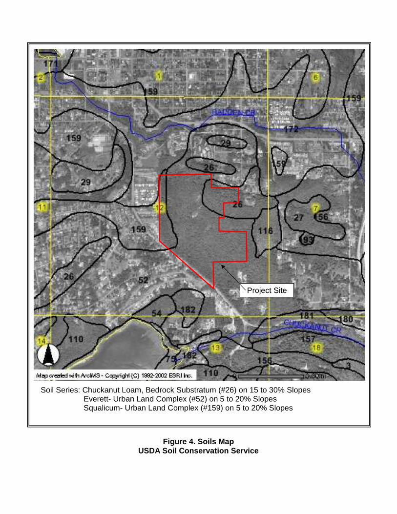
Soil Series: Chuckanut Loam, Bedrock Substratum (#26) on 15 to 30% Slopes Everett- Urban Land Complex (#52) on 5 to 20% Slopes
Squalicum- Urban Land Complex (#159) on 5 to 20% Slopes
Figure 4. Soils Map USDA Soil Conservation Service
Project Site
Project Site
N
Figure 5. Wildlife and Wildlife Habitat Whatcom County Fish and Wildlife Folio Maps
N
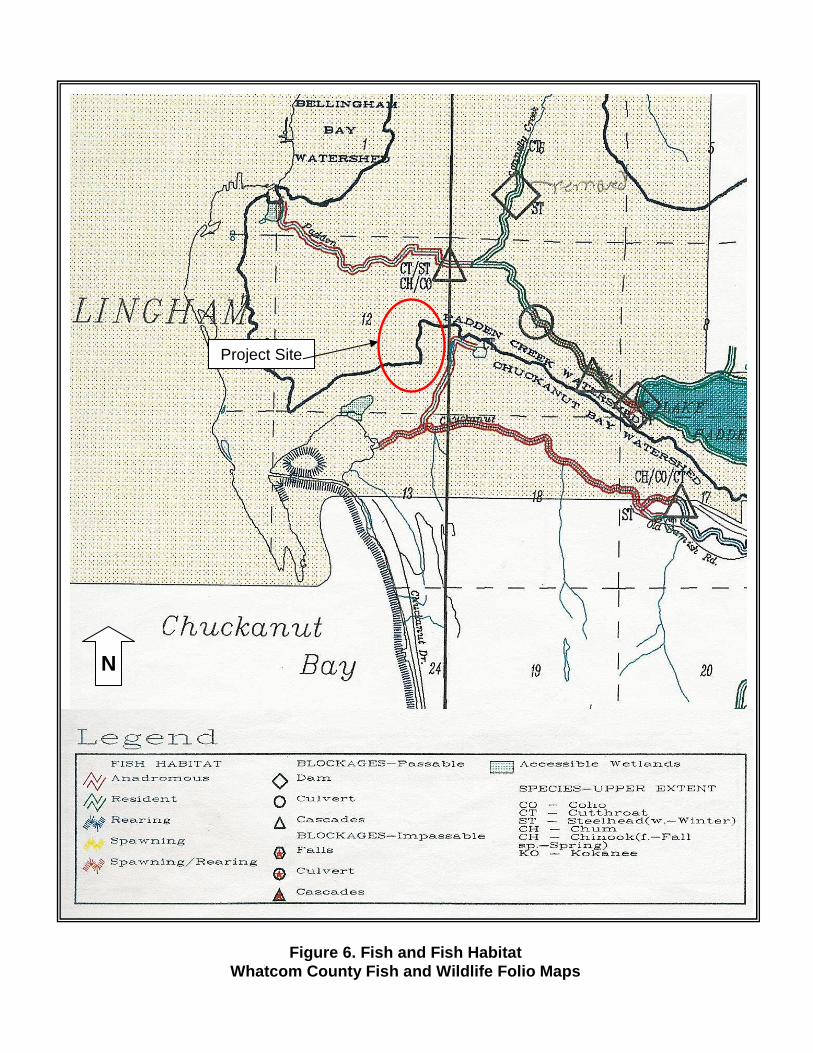
Figure 6. Fish and Fish Habitat
Whatcom County Fish and Wildlife Folio Maps
N
Project Site

APPENDIX C: DATA SHEETS