Embed Size (px)
Citation preview

F
Y09
October
WSE
r 1 – Sept
WEST VIECTION
tember 30
IRGINIA
319 N
0
0, 2009 |
A CONSENONPOI
www.wv
ERVATIO
NT SOU
vca.us/wv
ON AGEURCE PR
9
vwrc/
ENCY
ROGRAM
/30/2009
M
9

W20NPCOOc
TheimpSectqua
WVCcitizsouproj
TheConRosPlanCreeWV
WVCbuff120eighman248#’s Ntech
WEST V009 STPS CAONSTctobe
P
West Virgplementatiotion 319 N
ality impro
CA’s Conszens on norces, and jects on th
WVCA asnservation e and Autns. WVCA ek of the S Envirotho
CA Conserfers throug
08 acres ofht agricultunagement 8,491 #’s PN were mahnical and
VIRGITATEATEGORUCTr 1, 2
Pollutants:
ginia Conson of the W
Non Point Svement pr
servation Son point potake the le
he ground.
ssists in im Plans, Aptumn Olive provides cSouth Braon.
rvation Spgh CREP of karst withural conse plans for P managedanaged on d education
INIA CWIDEORY OTION 008 – All; admin
a
servation AWest VirgiSource Prorojects.
Specialistsollution isead for Pro.
mplementinppalachiane Programcoordinatinch increm
pecialists (Con nineteeh estimateervation pl3,401 acre
d, 97,133 # over 1839nal outrea
CONSE NPSOF AG
– Septnistrative, agriculture
Agency (WVnia Agricuogram and
s (CS) suppsues, idenoject Team
ng the folln Grazing C, Grazing on for the mental pro
CS) workinen farms ped sedimenlans were es were re#’s karst m9 acres. Tach suppor
1
ERVAS PROGRICU
tembe planning ae and cons
VCA) is thulture and d for coord
port volunntify local sms consisti
owing proConferencEvaluation Lost Riveojects, WV
ng with NRprotecting ont load redwritten onviewed or
managed oTwenty-twort.
ATIONGRAM
ULTUR
er 30and projec
struction
he primary Construcdinating an
nteer waterstakeholdeing of com
grams: Stae Planningn Contest r, Sleepy C
V Conserva
RCS and fover 70,46duction of n 6193.7 a written win 3,334 aco watershe
N AGEM RE AN
, 2009ct developm
y entity resction compnd implem
rshed assoers, partne
mmunity st
ate Lime Pg Committ CommitteCreek, Secation Farm
farmers as68 linear ff 56,266.5 acres and 3ith 20,681cres. Appred associa
ENCY
ND
9 ment for
sponsible fponents of menting wa
ociations, eers and futakeholder
Program, Ctee, WV Muee and Gracond Creek
m Award Pr
ssisted witfeet of stre tons/year35 nutrien1 #’s N maroximatelyations were
for the the ater
educate unding rs to place
CREP, ultiflora
azing k and Mill rogram,
h riparianam bank, r. Thirty-nt anaged, y 68,208 e provided
e
n
d

2
In construction assistance the WVCA reviewed 18 sediment and erosion control plans for construction sites less than one acre with an estimated 109.58 tons of soil saved and provided technical stormwater management assistance to 37 construction projects providing recommendations for BMPs to alleviate problem areas.
The WVCA held 57 nonpoint source educational programs attended by 4,268 students, 252 members of the general public and 957 producers, agency personnel and watershed association members. Fourteen agricultural field days were held with 1,393 attendees. Other outreach activities included sediment and erosion control training for 60 people, leading the WVSOS monitoring on 36 stations, and instructing a watershed management class at the WV Conservation Camp for 120 students.

3
The WVCA Watershed Resource Center (WRC) provides support for the WV Watershed Network and maintains the WVWN website. The staff also provides planning and outreach coordination to the WVWN. This year WV hosted the EPA Region 3 Water Conference. The WRC provided planning support, coordination and logistical support for the conference. The WRC hosted a Sediment and Erosion Control workshop at the 2009 Contractors EXPO with approximately 75 attendees and displayed / provided technical advice to nearly 6000 attendees. Over 1000 tree seedlings & protective covers, reusable grocery bags, “Losing Ground” post cards, Water Conservation Ideas books were distributed along with WV Conservation District / Conservation Specialist contact information for technical advice and available programs.

4
The WRC has also actively participated in educating the public through expositions and area youth through conservation education field days. A total of 105 students plus teachers were educated on nonpoint source pollution problems and solutions and composting in the backyard. Students enjoyed learning through interactive activities while exploring the Enviroscape model and building their own “worm farms” to begin composting with worms in their backyards. Instructions were given on how to compost at home and recipes for composting in a bag. Approximately 1500 rain chain, rain barrel, rain garden, and Water Conservation Ideas publications were distributed at the Lawn & Garden Expo and the Kanawha Valley Sustainability Fair. Recyclable grocery bags along with facts on their effect on the environment were promoted and 1000 were distributed along with tree seedlings.
PARTNERSHIPS Much of this work involves cooperation with a variety of other state, federal and local agencies as well as private sector citizens, and businesses. This cooperative approach provides benefits such as various funding sources for projects, technical expertise and citizen input helping our agency realize and target specific problems in specific areas. This

appcon
St
proach is acerns.
tream
and contin
m Mo
ues to be
onitor
a very effe
ring
5
ective meth
and
hod to add
Stud
dressing a
dents
variety of
s
f resource

6
“I hate having cold, wet feet” I think to myself as the water laps up and over the tops of my waterproof hikers, numbing my feet beyond feeling. Oh well, it’s for a good cause, I tell myself. I slowly climb back up the bank with a capped plastic container and make my way back to the school. The water sample will be used in the classroom of a local teacher interested in not only teaching her students about water quality but also giving them “hands on” experience with gathering data. Usually water sampling takes place during the warmer months of the year when officials are concerned with water contact during recreational sports like swimming, fishing and boating etc. However, this class of 5th graders was interested in seeing how the temperature of the stream changed throughout the year and if it affected other parameters within the stream. Therefore, the sample was gathered in mid-December, a week before Christmas break. Usually the majority of the students are lined up along the banks of the stream while a select few help grab water samples. However, this day was just too windy and cold for the students to be outside, therefore the stream had to be taken to them. The scenario of students monitoring streams is exhilarating to me. In my humble opinion, there is no better classroom setting than a stream. Monitoring streams gives educators the opportunity to present an immeasurable variety of educational experiences to their students. Math and science skills are honed when students are asked to calculate flow rates, average temperature readings and measure a variety of parameters including: pH, dissolved oxygen and turbidity to name just a few. Students then make inferences or predictions after the data is analyzed and summarize their findings by writing reports. Many times the reports lead to in class discussions about what the data suggests and what can be done within the watershed to mitigate the impacts on the stream. This type of activity promotes problem solving and critical thinking skills. During the process they start to formulate the concept of how interrelated the landscape is. In laymen’s terms they see “the big picture”.
I can’t claim or quote any statistical data that suggests an increase in test scores or a bump in the number of students suddenly interested in science. The bottom line is that the students get excited about the processes involved with gathering and discussing data. I can’t imagine anything other than a positive influence on the skills involved with similar-style projects. Additionally, these projects go beyond benefiting the academic endeavors of teachers and their students by promoting a sense of community involvement for young people. It allows them to see that they are part of a larger whole and that the decisions they make can and often do affect others.
Teachers who are interested in taking on such a project may shy away from the process as it can require a large investment of time and or money; two things that aren’t exactly abundant for most of us. However, teachers who are interested and have access to a local stream may be interested to know that there are a variety of opportunities available to them. Conservation districts, watershed associations, and a number of state agencies support a variety of similar activities. Teachers can start their search with a phone call to their local conservation district office or by visiting the website www.wvca.us .

TwPrThenatiloggnewimpchadeepwerand
ThewhiThis“blestab
MeamoplacTheon Afrom
welverojec Horseshoive trout sging job in w channel passable anannel progrp and a boe displace
d other aqu
e original sch had bes stream rew out” blobilized.
asuremenount of maces to be m pinning wAugust 25m the bank
emilet
oe Run Watream in a the mid-1being cut nd dewateressively inottom widtd and a ne
uatic organ
stream been destroy
reach woulocked to di
nts were taaterial thameasured awas done o, 2008 anks of the g
e Run
atershed Aa very rem1990s. Thedown the
ering approncised theth up to 7 early lineanisms form
d remaineyed by a cold need to ivert the fl
aken withinat had beenagain lateron Novembd approxim
gulley duri
n Str
Associationmote part o
e result of road, whicoximately e road resu feet wide.ar, unstabmed.
THIS WAS ONC
ed intact wombinatio be recrealow back i
n the gullen eroded wr to determber 9, 200mately 274ing that pe
7
ream
n undertoof their wat
f that activch previou1000 feet
ulting in a An estimle stream
CE UPON A TIM
with the exon of the loted, the junto the or
ey and calwere mademine the e07 and com4 tons of eriod.
Rest
ok the tasktershed thvity lead tously forded of native t gulley 33ated 1,500with a hab
ME A ROAD
xception ofogger’s actuncture of riginal cou
culations e and the bextent of ermparative m additiona
torat
k of restorihat had beo the stread the streatrout strea5 feet long0 tons of rbitat nearl
f approximtivity and o the road w
urse and th
made to dbanks werrosion withmeasurem
al earth an
tion
ing a segmen impact
am’s diversam, renderam. The neg, as muchroad bed mly worthles
mately 250 off-road vewhere the he disturbe
determine te pinned ihin that ti
ments takend rock ha
ment of a ted by a sion and aring it ew h as 7 feetmaterial ss for fish
feet ehicle use. stream ed areas
the in several ime frame.en again ad eroded
a
t
.
.

Funof thSchNatureprprop
All andDurcon
ConandThematwithrecodiffi
Addby fthe addvehisou
Theresu
nding washe WV Dep
hmidt, Basural Resouresentativeposal in th
agreed thd funding wrst of the Cstruction
nstructiond the proje new streaterials andh cereal ryonstruct thiculties an
ditional wofallen timb road to ke
ditional sedicles were rce.
e site will bulting from
s the issuepartment oin Coordinurces, Depes of the Che fall of 2
e project wwas approConservaticoordinati
n began in ct’s implemam was cud downed tye for quickhe road as
nd addition
ork was dober and deeep the strdiment to using was
be monitom the proje
T
e to attain of Environnator, theypartment oCanaan Va007.
was worthyved. The ion Agencyion for imp
Septembementation
ut and a betrees, thenk vegetativs well but inal cost, th
one on thebris accumream fromthe streams stabilized
ored and bect implem
THIS WAS ONCE
the goal onmental Pry invited aof Highwayalley Institu
y of considassociatioy to assistplementati
er with supn moved querm constrn the site wve cover anit was dechis goal wa
e stream cmulations
m entering tm. One higd and mad
iological amentation.
8
E UPON A TIME
of stream rrotection’sagency repys and theute to a si
deration, tn then ask
t them withion of the
pport of thuickly andructed to dwas stabilind mulcheided that, as one tha
corridor ab and a berthe road w
ghly erodedde impass
assessmen
E A STREAM
restorations AGO granresentativ
e WV Consite visit to
the proposked Lou Sh the techplan.
he Tygartsd was compdivert the ized with aed. Part of due to the
at could no
bove the sirm was conwhich was d stream bable, elimi
nts done to
n and whennt programves from Wservation A plan and
sal was wrchmidt of nical aspe
Valley Copleted in le stream floa native plf the origine site’s isoot be accom
ite removinnstructed eroding sbank area inating an
o measure
n the groum through WV DepartmAgency as formulate
ritten, sub WVDEP aects and
onservationess than 4ow to it uslant mix snal plan waolation, accmplished.
ng blockag along oneeverely an that off ro
nother sedi
the reach
up learned Lou ment of well as a
mitted and Brad
n District 4 days. ing nativeeeded as to cess
ges causede part of nd bringingoad iment
recovery
d
e
d
g

LoFuMr. Couthe
MrprovConAgeVirgto dstrerece
Thethe 200conweecha
SCPl Desvoluplanrestdem
ost Runkh Rodney F
unty had b stream ba
. Funkhouvide techn
nservationincy Field ginia Depadevelop a weam bank eived appr
concern o water wou
08 the desitractor, Je
eks. The deannel (the r
CWA Santinspite heavunteers fronted 140 ttored strea
monstration
River houseFunkhousebeen experank erosio
user appronical assistist referredOffice. At
artment of watershed erosion in
roval from
of the landuld rise, uign was coennings Exesign consriver had s
Succeng vy rain on om the Sletrees as a Ram bank on on prope
319 er Sier, a landoriencing tren was add
oached UStance, butd Mr. Funthat time Environm based pla
n the 319 PEPA and f
downer wap to a foot
ompleted axcavating,sisted of coseveral bra
stream
ThiWVCVallehandwithCREassisand Enviplayproje
ssful
Saturday,eepy CreekRiparian B
of Sleepy Cer tree pla
Streate
owner, in temendous
dressed us
DA-NRCSt not finankhouser tothe Conse
mental Protan. The woProject Profunding w
as the erost of streamand constr worked wonstructinaded areas
m bank.
s project hCA provideey Conservdled the fin
h USDA-NREP. This wistance for ensure thironmentaers in the ect propos
Tree
October 2k WatersheBuffer alonCreek afteranting tech
9
am P
the Lost Ris erosion asing natura
for assistcial assisto the Moo
ervation Sptection, Ca
orking grouoposal. Theas allotted
sion occurrm bank wouruction wawith WVCAng a flood-ps), constru
has been ced the desivation Disnances. MRCS and Uill provide purchasin
he buffer aral Protectio developmsal.
25, 20 ed Associang the newr a hniques by
Projec
iver Valleyalong a coral stream
tance. At thtance. Therefield Wepecialist wacapon Insup made ite Lost Rived for the Fu
ring after uld be ero
as schedulA Watersheplain bencucting six
collaboratiign and fintrict spon
Mr. FunkhoUSDA-FSA Mr. Funkng trees torea is maion and Caent of the
ation wly
y
ct
y located inrn field. Inrestoration
hat time Ne local NRCest Virginiawas workinstitute, ant a goal to er 319 Prounkhouse
large rainfoded away.ed to begined Divisionch, designastructures
ion for parnical assissored the ouser is cu
A to place thouser wi
o establishntained. Wcapon Ins watershed
n eastern n the fall on structur
NRCS was CS Districta Conservang with Wend local lan address toject Propoer site.
fall events. In the sun in Octobn inspectoating a strs, and slop
rtnering agstance. Theproject as
urrently wthe crop lath financia
h in the buWV Departtitute haved based pl
Hardy f 2008, res.
able to t ation est ndowners the severe osal
s. When ummer of ber. The ors for fourream ping the
gencies. e Potomac
s well as working and into al
uffer area, tment of e been keylan and
r
c
y

HerBB&cost
TrerestSleeeroseros
Thecomtechreacthatdecraqufallemidbanof thconpast
LiSt
The200thisassoand
b Peddicor&T Bank, at.
ees were pltoration prepy Creek sion with rsion cause
e restoratimpleted Ochnology wach to a stat allows foreased str
uatic habitaen trees, sddle of the nk to redirehe channestruction tures on t
ttle Gtream
residents04 broughts watercouociation w
d educate t
rd, Chesapand Creek
lanted to rroject was had dug sresulting led deterior
ion projectctober 24thas employeable patterr proper seam bankat. The resoil, and gr creek andect the creel. The projof a streamhe opposit
Grave m Re
s along Littt on by Hu
urse came was formedthe public
peake Baykside Crea
repair dist completedseparate choss of largration of th
t begun Auh. Naturaled to retur
rn, profile, sediment trk erosion, astoration travel depod sloped theek's force oject also inm crossingte side of t
Creekstora
tle Grave Curricane Ivtogether to
d to determ on the iss
y Program mery prov
turbed ared. Over mahannels age trees anhe stream
ugust 4th l stream rern the stre and dimeransport, and enhanteam remosits from t
he eroded s toward thncluded thg for accesthe creek.
k II ation
Creek werevan. As a ro form the
mine the prsues affect
10
Forester. vided prepa
eas of the bany years,s it flowed
nd sections bank and
and was estoration eam ension
nced oved the stream
he middle he ss to
Proj
e greatly a
result the re Little Graroblems afting their w
Water for ared sand
buffer afte, during rad along Cres of the str
d impacted
ject
affected byresidents aave Creek ffecting thwatershed
the workewich lunc
er a $30,00ain events eek Road. ream bank
d Creek Ro
y the widesand busin Watershed
he stream, d. Soon aft
ers was givhes at a re
00 natural and high This causk. Continuoad.
spread flooness ownerd Associat find resoluter formati
ven by educed
l stream water,
sed bank ued
oding in rs along tion. The utions, ion of the

11
Watershed Association, the group began working the West Virginia Department of Environmental Protection Basin Coordinator. While working with the WV DEP, it was determined that one of the main problems within the watershed was excessive stream bank erosion which was depositing large amounts of sediment in the water course. As a result, the Watershed Association worked with the WV DEP to develop a watershed based plan that would address a total of fourteen sites on the stream that were contributing the largest amounts of sediment to the watershed.
After completion of this plan, the LGCWA started working with the West Virginia Conservation Agency to secure the funding, permits, and designs necessary to restore these fourteen sites and reduce the amount of sediment entering their stream. The association worked with the WVCA to bid out and complete construction on the first ten sites of the plan over the summer of 2007. After the completion of these first ten sites, the watershed association immediately began to seek funding to complete the four remaining sites on their watershed based plan. Funding was secured and construction began on the remaining sites during the fall of 2008.
The first site to be restored under the second round of funding was the Huff /Peabody site. This site was on a sharp turn in the stream in which the water was cutting away at the outside of the turn and widening the creek at a rapid rate which was causing property damage, loss of yards, and considerable sediment loading to the stream. As a result, a design was drafted and implemented which used natural stream structures such as rock vanes and cross vanes to direct and steer the natural flow of water away from the outside bank and into the center of the channel thus reducing the amount of erosion and sediment entering the stream. By directing the flow of water to the center of the channel, it enables to the stream to keep sediment deposits cleaned out of the main channel and the stream flowing clear during high water events. After the natural structures were installed, the banks of the stream were sloped and re-vegetated with natural grasses and trees to help establish suitable ground cover on the banks to provide added protection during high water events.
After the completion of the Huff / Peabody site the crew then moved down stream to the Knight/Lawther/Hall site in which three land owners were losing considerable amounts of their backyards to erosion. This site was also contributing considerable amounts of sediment to the stream after each heavy rainfall or high water event. The site was between two sharp turns in the creek with the outer bank being a rock face. As a result of the sharp turns, the natural flow of the water was hitting the outside bank and bouncing across to the inside bank. This resulted in the erosion of the homeowner’s backyards. The home owners were losing between two to six feet of yard a year, contributing a substantial amount of sediment to the stream. As a result, a plan was designed that employed the use of log vanes to slow and direct the flow of water off the inside bank and back into the center of the channel. This was done to reduce the amount of erosion and to stabilize the banks along the inside of the channel. After the structures were installed the inside bank of the channel was reshaped and seeded with natural grasses and trees to provide additional protection against erosion. In addition, the outside bank of the stream channel was sloped and vegetated were it could be just upstream of the rock face.
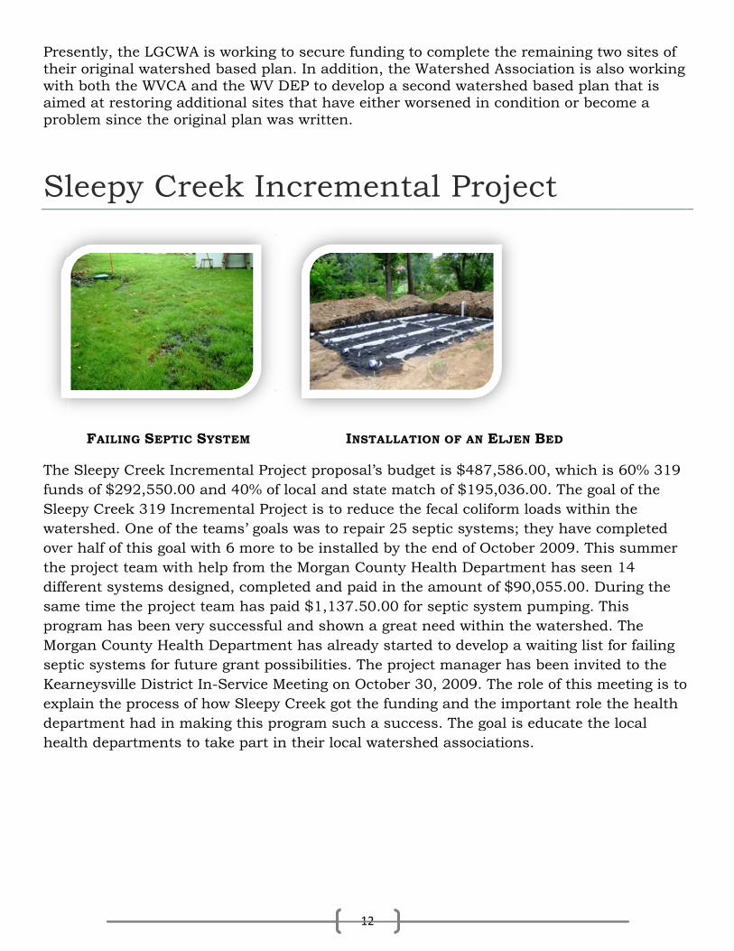
Prestheiwithaimprob
Sl
ThefundSleewatoverthe diffesamprogMorseptKeaexpldephea
sently, their original h both the
med at restoblem since
leepy
FAILING
Sleepy Crds of $292epy Creek ershed. Onr half of th project teaerent syste
me time thegram has rgan Countic system
arneysville lain the prartment h
alth depart
e LGCWA iwatershed WVCA anoring addie the origin
y Cre
G SEPTIC S
reek Increm2,550.00 a 319 Increne of the t
his goal wiam with hems designe project tbeen very
nty Health ms for futur
District Inrocess of h
had in maktments to t
is workingd based plnd the WV itional sitenal plan w
eek In
YSTEM
mental Proand 40% omental Prteams’ goath 6 more
help from tned, compeam has p successfu Departmere grant pon-Service Mhow Sleepyking this ptake part i
g to securean. In add DEP to de
es that havwas written
ncrem
oject propf local andoject is to
als was to to be inst
the Morganpleted and paid $1,13ul and shoent has alrossibilitiesMeeting ony Creek go
program suin their loc
12
e funding tdition, the evelop a seve either wn.
ment
INSTALLAT
osal’s budd state ma reduce threpair 25 talled by thn County H paid in th
37.50.00 fown a greaready starts. The projn October ot the funduch a succcal waters
to complet Watersheecond wat
worsened i
al Pr
TION OF AN
dget is $48atch of $19he fecal colseptic syshe end of OHealth De
he amountor septic syt need witted to deveject manag 30, 2009.ding and thcess. The gshed assoc
te the remad Associatershed ban conditio
roject
N ELJEN BE
87,586.00,95,036.00.liform loadtems; theyOctober 20partment t of $90,05ystem pum
thin the waelop a waiger has be. The role ohe importagoal is educiations.
aining twotion is also
ased plan ton or becom
t
ED
, which is . The goal ds within ty have com009. This has seen
55.00. Durmping. Thiatershed. Titing list foeen invitedof this meant role thucate the l
o sites of o working that is me a
60% 319 of the the mpleted summer 14 ring the is The
or failing d to the eting is to
he health local

GBoBe
poutroothe at aKento ththe elim
TeYoucomincrquainclconprod
uyanoy Sceech
unds of soiop and dire slope anda rate estabntucky 31 he slope to seedlings
minate an e
echnicu can see tmponents oremental eality issueslude Publicstruction ducer assi
n Concouts Fork
hill” recail were striected them
d created ablished byand Annuo hold the off to a goestimated
cal Suthe effort bof these baefforts press but are nc outreachsites less tistance in
nservs Addk Par
alls Matt Yipped fromm during ta smooth sy soil sampual Rye. Th seed in pl
ood start. E 2.92 tons
upporbehind thease grantssent. Theynot part ofh and educthan an ac the form o
vationdressrk
Yeager, them the hillsi
he course seedbed byple resultshe remainilace. AmplEstablishm of soil/yr
rt e incremen can be ap
y serve to sf any largecation, revcre, monitof conserv
13
n Diss Ero
On the voluntepart inBeechimporMatt his EThe the guidacrnuof jus
e park supide. Matt P of the proy filling in s, two voluing voluntele rain andment of ver from ente
ntal and bapplied in osupport thr effort. Th
viewing sedtoring assiation plan
strictosion
weekend oeers from Bn a sedimeh Fork Statrtant to on Peyton of Eagle Scou Guyan Coproject, anded Matt tre denudedumber of r the slope st never es
perintendenPeyton orgoject. Volu the rills a
unteers broeers securd mild temgetation oering Beec
ase grant pother waterhe 319 prohese are sdiment eroistance to nning, fora
t Heln Prob
of May 30 Boy Scoutent erosionte Park. Thne young m Huntingtout Badge wonservationd personthrough thd site has rills and gu for some tstablishednt. As a re
ganized meunteers “drnd gulliesoadcast a mred erosionmperaturesn the .2 a
ch Fork La
projects. Srsheds wh
ogram by ahort term osion contwatershed
age and so
ps Loblem
and 31st st Troop #1n control phe project man in paron, who wwith its comn District nel from t
he process been plagullies alontime. “Veg
d itself alonesult, thouembers froressed” the. After appmixture ofn control bs have helpcre site wi
ake.
Sometimeshere there addressing activities trol plans d associatiil testing,
ocal m at
several 2 took
project at was very rticular;
would earn mpletion. funded the WVCA s. The .2 gued by a ng the face getation ng the usands of om his e face of plying limef blankets ped get ill
s are no
g water that may for ions, and and
e

14
nutrient management planning. Many of these projects are carried out with help from partnering agencies like NRCS, FSA and DEP.
Additionally, these projects may take place in a watershed that may not have a TMDL but is carried out as a preventative measure.
Conservation District Roles The Conservation Districts have various programs that the conservation specialists play a role in delivering. The statewide Lime Program benefits from nutrient management planning provided by the Conservation Specialists. Implementation monitoring with the participating cooperators will provide information on program effectiveness and measure land use improvements such as soil erosion reductions and nutrient application effectiveness. Conservation Specialist assistance in helping farmers with management decisions regarding grasslands, Multiflora Rose and Autumn Olive, in eliminating these

15
non-native invasive and provide assistance on seeding these areas left exposed and vulnerable to soil erosion.

SoGSi
TheCreeto thfinefactremwas
Treepurpromto sbe p
Themattreethe utilislopconThesyst
oil Bireenite 1
first site iek was erohe Revised
e sandy loator (K) of .2
moving 50.3s placed in
e revetmenpose of a rmote sedimprout. It is
planted be
site is 17t (TRM) ane revetmen toe of the izing geosypes. This issist of uni unique shtem install
ioengbrier on A
is located oding an ad Universaam with a 24. Durin31 tons (3
n an uplan
nts are nonrevetment ment depos generally
ehind the r
0 feet longnd earth annt utilizing bank andynthetic ms known aiquely shahape allowled with ea
gineer VallAntho
on the Grarea of pasal Soil Losstolerable (
ng construc7.30 cubic
nd location
n-sproutin is to slow
osition at ty recommerevetment
g and was nchor systg on site md anchor thmaterials aas anchoreaped polypws the matarth ancho
ering ley Cony C
eenbrier asture land s Equation(T) soil losction, the c yards) of
n and stabi
ng trees inw stream vethe toe of tended tha to provide
stabilizedtem, comm
materials anhe TRM. Inand earth aed reinforcropylene ftrix to capors has a
16
ProjConseCreek
and Pocaho at a rate on. The soils rate of 3stream-baf unstable ilized from
nstalled aloelocity adjthe bank. t live willoe permane
d using a hmercially knd rock fron recent yeanchors toced vegetatfiber yarn wture and rfield tested
ects ervatk
ontas counof 30.6 tonl on this si3 tons per ank was sl soil from
m future er
ong the toeacent to aThe revetm
ows or otheent cover.
high perforknown as tom a localears techno stabilize tion systemwoven intoretain moid pull out
ion D
nty line. Ans of soil pite is a Potacre/yearloped to a the stream
rosion.
e of streaman eroding ment mateer quickly
rmance tuthe Armor-l quarry wnology has failing andms. Genero a turf resture, soil capacity o
Distr
At this site per year actomac veryr and an er 2:1 gradembank. Th
mbanks. T bank anderial does n sprouting
rf reinforc-Max syste
was used to been deved newly gr
rally these einforcemel, and seedof 500 lbs
ict
Anthony ccording y gravelly rodibility , his soil
The d to not need g species
cement em. A o stabilize eloped raded materials
ent mat. d. This with a

minEng
Seedover
Noteestarecoprojtalk
TreeWe locaequLossyear
Notethat
To aprojthisdetestayefficsquthe the
To aproj
nimum of 2gineers to s
dling treesr top and u
e: The comablish quicommend tojects like th
king to som
es plantedprovided t
ally. The toals $4.15 s Equationr (98.91%
e: The instt it can be f
achieve theject woulds would haermine theyed constaciency of thare foot. A site would soil loss fo
achieve theject would
24 inch destabilize th
s were planunderneat
mpost beingck ground co all consehis and for
me farmers
d were a rethe pottingotal site coper squarn, the new less than
tallation pr flipped ba
e same sod have beenave cost $4e effect of tant excludhe systemAccording d be 8.37 tor the site
e same sod have been
epth. This he levees b
nted into tth of the m
g used to scover is onrvation disr contracto
s about dev
esult of a pg soil and overed 2,22re foot or $w soil loss r before ini
ractice in tack overtop
il loss resun $11,0214.96 per sqthe TRM oing the TR
m would red to the Revtons per a
e to a tolera
il loss resun $11,021
system habreeched d
the TRM, cmat, grass
spark quicne of the mstricts, thaors to use fveloping th
partnershithey grew22 square
$37.37 perrate after tialization
the photo isp of itself to
HPTstarup tAncthe tree anchprespreseffecquick
ults for thi1.12. Utilizquare footon the overRM and incduce by 26vised Univ
acre per yeable level.
ults for thi1.12. Utiliz
17
as also beeduring hur
compost w was plant
k germinamost effectiat if you dofor erosionhis as a bu
p with thew the trees.e feet and cr square yathe install
n).
s the trenco prevent h
TRM shoulrting on thto prevent hors shoumats and revetmenhored withssure creassure. Thect as rip raker.
is project uzing 183 t. Anotherrall systemcluded hay6.35% andversal Soil ar. This w
is project uzing 183 t
en used byrricane Ka
was utilizedted
ation of graive practiceo not have n control onusiness in
e USDA NR. Seed for cost $9,22ard. Utilizilation of th
ching of thehigh water
ld be instahe down st water from
uld be plac straight a
nts are not h rock. Thating approe finished sap with mo
utilizing ritons of rocr comparism. If all fay mulch ad the cost Loss Equwould not
utilizing ritons of roc
y the US Aatarina in
d to cover
ass seed. Ues to comb a good soun other siteyour area.
RCS Plant the trees w
28.75. Thising the Rehese pract
e edge of tr from und
alled in a sream end m workingced in a diaalong the e used, thee anchor foximately system wilore vegetat
ip-rap, theck and twicson was alactors of that .5 tons pwould redation, the be enough
ip-rap, theck and twic
Army CorpNew Orlan
the TRM a
Using this pbat erosionurce of comes, that yo.
Materials was also cs cost brokevised Univtices is .33
the mat in dercutting.
shingling m of the siteg underneaamond paedge of thee bottom nforms a co500 lbs of ll provide ttion estab
e total cosce as mucso conduc
he installedper acre, thduce to $1. annual soh protectio
e total cosce as muc
ps of nd's.
and both
product to n. I would mpost for ou start
Center. collected ken down versal Soil3 tons per
a manner
manor e working ath.
attern over e mats. If needs to beone of f pull out the same lished
t of the ch labor, cted to d system he overall .69 per oil loss foron to bring
t of the ch labor,
l
r
e
r g
thisdetestayefficsquthe the
SiCoBa
Thestrewhi
s would haermine theyed constaciency of thare foot. A site would soil loss fo
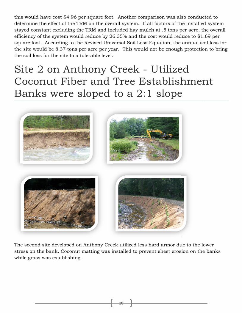
ite 2 oconanks
second siess on the le grass w
ave cost $4e effect of tant excludhe systemAccording d be 8.37 tor the site
on Anut Fis wer
ite develop bank. Coc
was establis
4.96 per sqthe TRM oing the TR
m would red to the Revtons per a
e to a tolera
Anthoiber
re slo
ped on Antconut matshing.
quare footon the overRM and incduce by 26vised Univ
acre per yeable level.
ony Cand T
oped
thony Creetting was in
18
. Anotherrall systemcluded hay6.35% andversal Soil ar. This w
CreekTree to a
ek utilizednstalled to
r comparism. If all fay mulch ad the cost Loss Equwould not
k - U Esta2:1 s
d less hardo prevent s
son was alactors of that .5 tons pwould redation, the be enough
tilizeablishslope
d armor dusheet eros
so conduche installedper acre, thduce to $1. annual soh protectio
ed hmene
ue to the losion on the
cted to d system he overall .69 per oil loss foron to bring
nt
ower e banks
r g
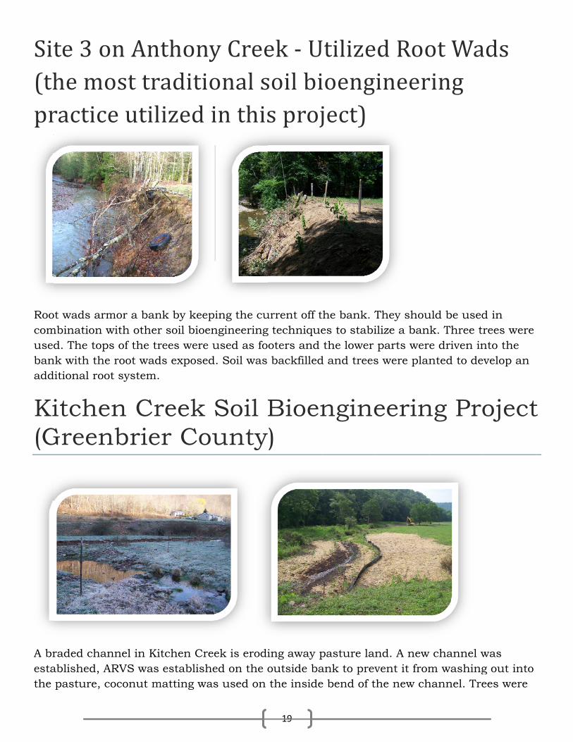
Sit(thpr
Roocomusedbanadd
Ki(G
A brestathe
te 3 ohe moractic
ot wads armmbination w
d. The topnk with theditional roo
itcheGreen
raded chanablished, A pasture, c
on Antost tre util
mor a banwith other
ps of the tre root wadot system.
en Crnbrie
nnel in KitARVS was coconut m
thonyaditioized i
nk by keepr soil bioenrees were uds exposed
reek r Cou
tchen Cree establishe
matting was
y Creeonal sin this
ing the cungineeringused as fo
d. Soil was
Soil Bunty
ek is erodied on the os used on
19
ek ‐ Usoil bis proj
urrent off tg techniqueoters and backfilled
Bioen)
ing away poutside ba the inside
Utilizeioengject)
the bank. Tes to stabi the lower d and trees
ngine
pasture lanank to preve bend of t
ed Rooineer
They shouilize a ban parts wers were plan
eerin
nd. A newvent it fromthe new ch
ot Waring
uld be usednk. Three tre driven innted to de
ng Pro
w channel wm washinghannel. Tre
ads
d in trees were nto the evelop an
oject
was g out into ees were
t

alsoenco
StCrPr
Thocomtonsquadestthe fillefloostrehom
Theagrithincaumanespe
Cowthe atteSupSch
o establishourage rap
treamreek rojec
ousands ofmmon - sevs of sedim
ality probletruction of direction d, trees upding can w
eam flows mes, buildi
e human aiculture, nngs such asing excesnner such ecially tree
w Creek is communitention to thpervisor wihultz is lea
hed to devepid herbac
m Ba Leadt
f streams averely erodent that c
em in the Uf a fish anof flow cauproot and worsen whare more oings, farm
activities tnatural resas lawn lanssive erosi as widenies and shr
s one of thty of Schuhe steam’sith the Up
ading an ef
elop the “ficeous grow
ank Eds to
and riversded banksreates eveUnited Sta
nd wildlife using mor dangerouhen the stroften out-o fields, law
hat causesource extrndscaping on are alteing, deeperubs, alon
ose many ultz have fos plight anper Ohio Cffort to brin
firewall” rowth.
Erosio Soil
in West V. This soil
en greater ates. The ihabitat, ste erosion, s undercuream fills wof-bank evwns, pipeli
much of traction (co can contrering the sning and m
ng and atop
streams iormed the nd work onConservating attentio
20
oot system
on M Bioe
Virginia anl erosion gproblems ncreased ctreams for our favori
uts are mawith earthvents and ines and r
the probleoal, timberribute to thstream chamoving thp the strea
mpacted b Cow Cree
n getting hion Districon to Cow
. A compo
Monitoengin
nd the natigenerates hand is concost of trerm islandsite swimm
ade atop thh reducing redirected
roads.
em includer, natural he erosionannels andem and tham banks.
by severe eek Watershhelp to repct and resi
w Creek by
ost blanket
oringneerin
ion have ohundreds nsidered thating drin
s and poinming and fihe banks. D water hol
d water oft
e road congas and oi
n issue. Thd streamb
he removal.
erosion anhed Associair problemident of th involving
t was also
g On ng
one problem of thousahe largest
nking watet bars thashing holeDamages fding capaen threate
struction, il) and eve
he two majbanks in anl of vegeta
nd the resiiation to bms. Paul J
he commun the Upper
used to
Cow
m in ands of water r, the
at change es are from city, high ens
railroads,en small jor factors ny tion,
dents of bring Janes, nity of r Ohio
w
,

21
Conservation District and West Virginia Conservation Agency as partners in resolving some of the problems.
Surveying the stream to evaluate the extent of the problems is the first step toward bringing project monies to the creek. Several sites were visited and measurements and physical assessments have been performed. Estimates of the amounts of soil erosion that has occurred have been calculated and some study of the stream’s biological qualities done all in an effort to prove the level of need by showing the damaging effects of the problem.
The results of the three segment survey, a total reach length of about 780 feet of stream, shows approximately 7,690 tons of soil have been lost and that is just a small sampling of the watershed. Each site was also “pinned” with steel rods that are driven horizontally into the bank at critical points and will serve as references to monitor additional streambank erosion as time passes.
The negative environmental effects must be documented and quantified before monies can be justified to fix any problem. The data collected so far, along with additional data to be collected, will be used to demonstrate the need for additional project monies in an attempt to remedy the problems of land loss facing property owners along the stream and improve the fish and wildlife habitat of Cow Creek.
In Pleasants County, Cow Creek was eroding an area of pasture land at a rate of 41 tons of soil per year according to the Revised Universal Soil Loss Equation (RUSLE). The soil on this site is a Gilpin-Upshur complex with a tolerable (T) soil loss rate of 3 tons per acre/year and an erodibility factor (K) of .32. On this site, the streambank was sloped to a 3:1 grade removing unstable soil from the streambank. 462 tons of soil was placed back into the bends of the stream to re-establish the original pattern of the channel. The total site length is 300 feet long and was stabilized using two types of erosion control devices.
A high performance turf reinforcement mat (TRM) and earth anchor system, commercially known as the Armor-Max system was used in the 90 foot section of the bank that receives the most stress from high water. The remaining 210 feet were covered with a straw rolled erosion control blanket. Coconut fiber logs were installed at the toe of the slopes to anchor the bottom of the mats and to prevent undercutting of the system. Grass was then seeded to establish permanent cover.
The total site covered 630 square feet and cost $4,552.35. This cost broken down equals $7.22 per square foot or $64.98 per square yard. Utilizing the Revised Universal Soil Loss Equation (RUSLE), the new soil loss rate after the installation of these practices is .71 tons per year (98.47% difference than before initialization).
To achieve the same soil loss results for this project utilizing Rip Rap, the total cost of the project would have been $6,144.65. Utilizing 51.97 tons of rock and twice as much labor, this would have cost $9.75 per square foot.

22