Embed Size (px)
Citation preview
1
Virjerab Expedition 2015 Contents Page 1 Objectives Page 1-2 Summary of climbing Page 2 Expedition members Page 2-3 Background information Page 3-4 Expedition diary Page 5 Budget Page 5 Conclusion Page 5-6 Maps Page 7-11 Photographs Page 12 Contact details Page 12 Acknowledgements
MEF reference: 15-15
Country and region visited: Pakistan, Shimshal, Karakoram. Stated objectives: To make the first ascents of peaks 6099m, 6140m, 6100m, 6310m (Khurdopin Sar) and 6083m by their northern aspects from the Spregh Yaz Glacier, south of the Virjerab Glacier. To make the first ascents of peaks 6009m, 6104m and 6020m (in the Chot Pert subgroup) by their southern aspects from a valley north of the Virjerab Glacier. We will attempt to climb one or more of these peaks with the main objective being Khurdopin Sar 6310m by the north spur and west ridge. Peaks may be climbed as separate objectives or as part of a traverse. All the attempts will be alpine style. To trek further up the Virjerab Glacier and photograph peaks. Google Earth coordinates of main objective or approximate base camp. Base camp 36.304154N 75.598044E Khurdopin Sar 36.257278N 75.558144E Peak 6104m 36.359936N 75.632656E (Note: all heights from the Soviet 1:100,000 military maps.) Duration (from-to): 26th May 2015 to 5th July 2015 Summary of actual climbing Pete Thompson and Phil De-Beger attempted peak 6140m (36.255998N 75.579313E) by the north face from the Spregh Yaz Valley but retreated due to steep ice and the lack of a rope. A second attempt was abandoned due to avalanche danger. Pete Thompson, Phil De-Beger and Aiden Laffey attempted peak 6020m (36.333729N 75.646283E) by the west face and ridge from the Chot Pert Nala but retreated from 5800m after starting an avalanche.
2
Pete Thompson, Phil De-Beger and Aiden Laffey made the first ascent of peak 6104m (36.359934N 75.632632E) by the south face and west ridge from the Chot Pert Nala on 19th June. Climbed alpine style, alpine PD. The locals suggested the name of Harjoldur Sar which means “the peak of the valley of the black and white yak”. After returning to the Hunza valley, Pete Thompson and Aiden Laffey made a trek up the Momhil Glacier to photograph the six 7000m peaks up this valley. None of them have been climbed from this valley. Expedition members Pete Thompson, 56, British, English teacher.
2011 First ascent of Black Dog, 960m TD, United Arab Emirates. 2008-2011 Many new rock routes in the UAE.
Routes in the Alps including Walker Spur , American Direct (Dru), Gervasutti Pillar (Tacul), North Face Courtes (solo), North Face Chardonnet (solo), Frendo Spur.
Expedition experience in Pakistan (9 expeditions), India, Nepal, China.
In Pakistan has climbed Diran 7266m and Batura 7785m alpine style.
First ascents in Pakistan of Faloling Chhish 6178m (solo, TD), Mayon Chhish, Pute Tower III, Gutum Talji, Haigutum East and Ghorhil Sar. Attempted the first ascent of Beka Brakai Chhok solo.
Ascents as guide of Muztagh Ata 7566m and Spantik 7027m.
UK rock climbing to E2 and Scottish winter climbing. Phil De-Beger, 28, British, outdoor activities instructor.
2014 First ascent of Chhochenphu 6260m and Ganglung Peak 5757m in eastern Nepal.
Has climbed Manaslu 8156m, Attempted Gasherbrum II.
Ascents of Mt Bokta 6143m (solo), Lobuche 6119m, Mera 6476m, Island Peak and Pisang (solo).
Ascents as guide of Huayna Potosi 6088m, Cotopaxi 5897m, Pequeno Alpamoyo, Volcan Tuzgle, and Elbruz 5642m.
Member of a 300 mile ski expedition in the Canadian Arctic.
UK rock climbing to E2 and Scottish winter climbing. First ascents of rock routes in Ethiopia and Kenya
Aiden Laffey, Irish, 42, engineer.
2005-2014 Many new single and multi-pitch rock routes in the UAE up to E3. Second ascent of Barun Wall 600m TD.
2013 Climbed Northwest Face of Half Dome, USA.
2011 Solo ascent of Ama Dablam 6812m, normal route. Climbed Lobuche East, Nepal.
2010 Second ascent of Mushnik, highest peak in Socotra, Yemen by a new rock route.
More than twenty 4000m peaks in the Alps, many repeated. Solo ascents of the Matterhorn, Zinalrothorn and Mont Blanc via the standard routes.
Many alpine rock climbs including the Cordier Pillar on the Grand Charmoz, the Cassin Route on the Badile, the South Face, Badile and the North Face, Badile.
UK rock climbing to E3 and Scottish winter climbing. Background information Pete Thompson had visited Shimshal three times before, climbing and trekking, although he had not been up the Virjerab Glacier.

3
The first western visitor to the Virjerab Glacier was George Cockerill in 1892. The Vissers, a Dutch couple, explored the Virjerab Glacier in 1925. They described the Virjerab Glacier as “The very worst glacier of the whole Kara-Korum... the whole valley was filled with stones and boulders often of a tremendous size.” Possibly due to this and the lack of any peaks above 6561m there has been very little mountaineering activity in the area. On the other hand there could about thirty unclimbed peaks above 6000m within the Virjerab watershed area according the 1:100,000 Soviet military map (subject to unrecorded ascents). I only found records of two peaks having been climbed. In 1991 a New Zealand expedition crossed the Khurdopin Pass from Snow Lake onto the East Khurdopin Glacier and climbed the highest peak above the Second West Virjerab Glacier which is marked as 6858m on the Swiss map. They considered this to be about 6500m and it is 6460m on the Soviet map. In 2012, a Polish expedition established their base camp at the junction of the Virjerab and Spregh Yaz Glaciers. They made the first ascent of a 5900m peak they named Khushrui Sar above the Spregh Yaz Glacier. This is a sub peak just to the west of one of our objectives, peak 6099m. They also attempted to climb peak 6104m in the Chot Pert group on the north side of the Virjerab glacier. This peak is given 6570m on the Swiss map. We planned to use the same base camp as the Polish expedition and climb in the same area they climbed in as all the 6000m peaks remained unclimbed. My planning was based on reports of the Polish Expedition in Japanese Alpine News and the American Alpine Journal. I selected routes from Google Earth. Due to the inaccuracy of the heights of small peaks on the commonly used Swiss Foundation for Alpine Research map, I relied on heights from the Soviet maps which are available on the internet. This has 40m contours. Where no spot height is given, I have given a height 20m above the last contour. Out of interest here are the Google Earth heights for our objectives given in brackets after the Soviet heights. 6099(6083), 6140(6146), 6100(6122), 6310(6263), 6083(6202), 6009(6035), 6104(6041), 6020(6113). Expedition Diary
26 May Left Manchester.
27 May Arrived in Islamabad. Met by Adventure Tours Pakistan (our agent) representative. Bought food and four blue barrels.
28 May Drove to Chilas on the Karakoram Highway in a hired van with a driver arranged by ATP. For much of the journey up the Karakoram Highway we had a succession of armed police men travelling in the van with us for security. 12 hours travel.
29 May Drove to Gilgit. Collected some tents and equipment which had been provided by ATP from Gilgit bus station. Drove to Aliabad in the Hunza Valley and met our guide Amin. Did some shopping in Aliabad. Drove to Attabad Lake. Crossed the lake and spent the night in Pasu. 13 hours travel.
30 May Drove to Shimshal village 3000m in a hired jeep. 3 hours. Stayed in the Mingling Guesthouse. Arranged our porters.
31 May Left Shimshal with 11 porters, 2 porters for the porters and one sirdar. Camped at Chair Chair 3250m. 6 hours walking.
1 June The walking continued to be fairly flat, apart from crossing the Khurdopin Glacier which cuts off the valley. The lake at Past Helga which is on the Swiss map no longer exists. Camped at Jui 3500m. 6 hours.
2 June Walked up the south side of the valley. The walking on the rubble of the Virjerab Glacier and crossing the Spregh Yaz Glacier (SYG) was difficult. Our base camp 4095m was just short of the Polish base camp next to the first lake at the junction of the Virjerab and Spregh Yaz Glaciers. 6 hours walking.
3 June Set up base camp and walked up the side of the SYG.
4 June Made a difficult 3 hour walk up the east side of the SYG and set up ABC at 4449m. Returned to BC.
5 June At BC.
4
6 June Up to ABC.
7 June Climbed up to a bivi at 5000m below the north face of peak 6140m.
8 June Setting off at 1am Phil and Pete attempted 6140m but lacking a rope turned back at a section of steep ice. We all returned to ABC. Phil went down to BC and returned with a rope and ice screws.
9 June Climbed back up to the bivi. Looking at the route we reluctantly decided to abandon the attempt due to avalanche danger and return to ABC.
10 June Heavy snow overnight. Packed up ABC and returned to BC.
11 June Phil and Aiden collected the remaining gear from ABC. Pete explored the next side valley east of BC from where he had a good view of the Chot Pert Nala opposite.
12 June Rested at BC.
13 June Made a carry across the Virjerab Glacier with difficulty to the Chot Pert Nala. Going up the nala involved three tricky rock climbing sections (unroped) in a narrow gorge. Bivied where the valley widened at 4750m. Snowed overnight.
14 June Continued up the valley to a bivi site at 5300m. Heavy snowfall, so we left gear and returned to BC.
15 June Rested at BC.
16 June Went back up to the Chot Pert Nala bivi.
17 June Pete, Aiden and Phil attempted peak 6020m by the west face. Setting off at 1.30am we climbed up to 60 degree slopes in deep snow in a snow storm. Joining the west ridge, conditions were better. At about 5800m Pete was ahead climbing unroped when the snow became deep on the ridge. In attempting to wade up this he triggered two avalanches simultaneously. Pete tumbled down with the avalanche for a short while before stopping himself with an ice axe brake. Phil and Aiden were unharmed on the ridge below with the avalanches falling either side of them. A slab a metre deep had slid and the fault lines extended 100m or so, on either side of the ridge. We abandoned the attempt and descended by a different route on the northwest face. Walking back to our bivi we crossed two large areas of avalanche debris.
18 June Made a recce up the glacier to the base of a couloir on the south face of the middle peak 6104m and returned to the bivi.
19 June Pete, Aiden and Phil set off at 1.30am. The couloir joined the west ridge which we followed in increasingly deep snow to the summit. Got back to the bivi at 8am.
20 June Returned to BC with gear.
21 June Rested at BC.
22 June We walked up Virjerab glacier to photograph the unclimbed peaks. We reluctantly abandoned a longer recce up the valley due to the fact that Aiden and Pete’s walking boots had fallen apart.
23 June Rested at BC and called for porters on the sat phone.
24 June Packed up at BC. Snowfall.
25 June Six porters arrived and we started the walk out.
26 June Reached Shimshal at 16.30.
27 June Jeep to Pasu. Stayed at the Pasu Inn.
28 June In Pasu.
29 June Pete and Aiden took a jeep to the start of the Momhil Valley on the road to Shimshal. I was interested in exploring this valley as there are six 7000m up this valley. None of them have been climbed from this valley and I had not heard of anyone trekking up this valley. 7 hours walking (without porters or guide) on the difficult rubble covered glacier.
30 June More difficult rubble, then an ablation valley on the west side of the glacier to reach a point beyond which trekking looked very difficult. 8 hours. We managed to get a good view of four of the 7000m peaks and unclimbed 6000m peaks.
1 July Trekked back to the Shimshal road. 9 hours. We managed to get a lift back to Pasu.
2 July Returned to Karimabd.
3 July Phil and Aiden left for Islamabad by bus and flew back to the UK.
5 July Pete flew from Gilgit to Islamabad and back to the UK.
5
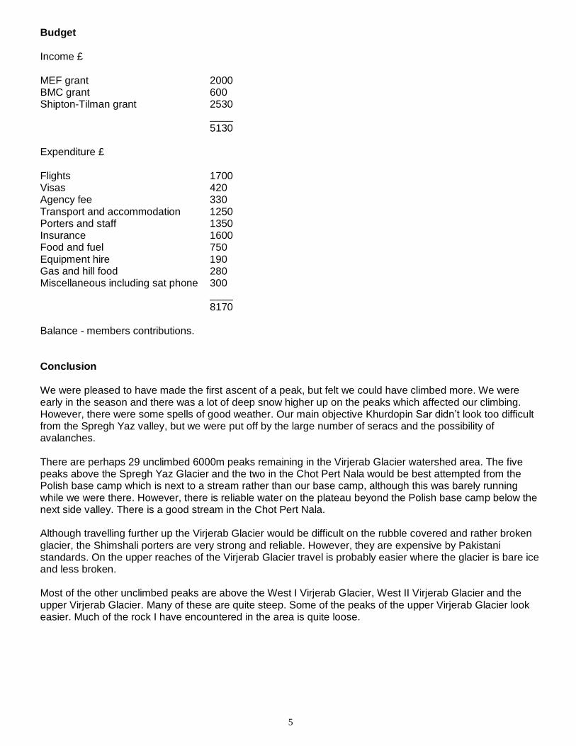
Budget Income £ MEF grant 2000 BMC grant 600 Shipton-Tilman grant 2530 ____ 5130 Expenditure £ Flights 1700 Visas 420 Agency fee 330 Transport and accommodation 1250 Porters and staff 1350 Insurance 1600 Food and fuel 750 Equipment hire 190 Gas and hill food 280 Miscellaneous including sat phone 300 ____ 8170 Balance - members contributions. Conclusion We were pleased to have made the first ascent of a peak, but felt we could have climbed more. We were early in the season and there was a lot of deep snow higher up on the peaks which affected our climbing. However, there were some spells of good weather. Our main objective Khurdopin Sar didn’t look too difficult from the Spregh Yaz valley, but we were put off by the large number of seracs and the possibility of avalanches. There are perhaps 29 unclimbed 6000m peaks remaining in the Virjerab Glacier watershed area. The five peaks above the Spregh Yaz Glacier and the two in the Chot Pert Nala would be best attempted from the Polish base camp which is next to a stream rather than our base camp, although this was barely running while we were there. However, there is reliable water on the plateau beyond the Polish base camp below the next side valley. There is a good stream in the Chot Pert Nala. Although travelling further up the Virjerab Glacier would be difficult on the rubble covered and rather broken glacier, the Shimshali porters are very strong and reliable. However, they are expensive by Pakistani standards. On the upper reaches of the Virjerab Glacier travel is probably easier where the glacier is bare ice and less broken. Most of the other unclimbed peaks are above the West I Virjerab Glacier, West II Virjerab Glacier and the upper Virjerab Glacier. Many of these are quite steep. Some of the peaks of the upper Virjerab Glacier look easier. Much of the rock I have encountered in the area is quite loose.
6
Maps
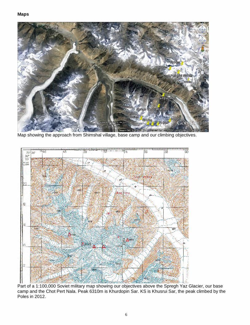
Map showing the approach from Shimshal village, base camp and our climbing objectives.
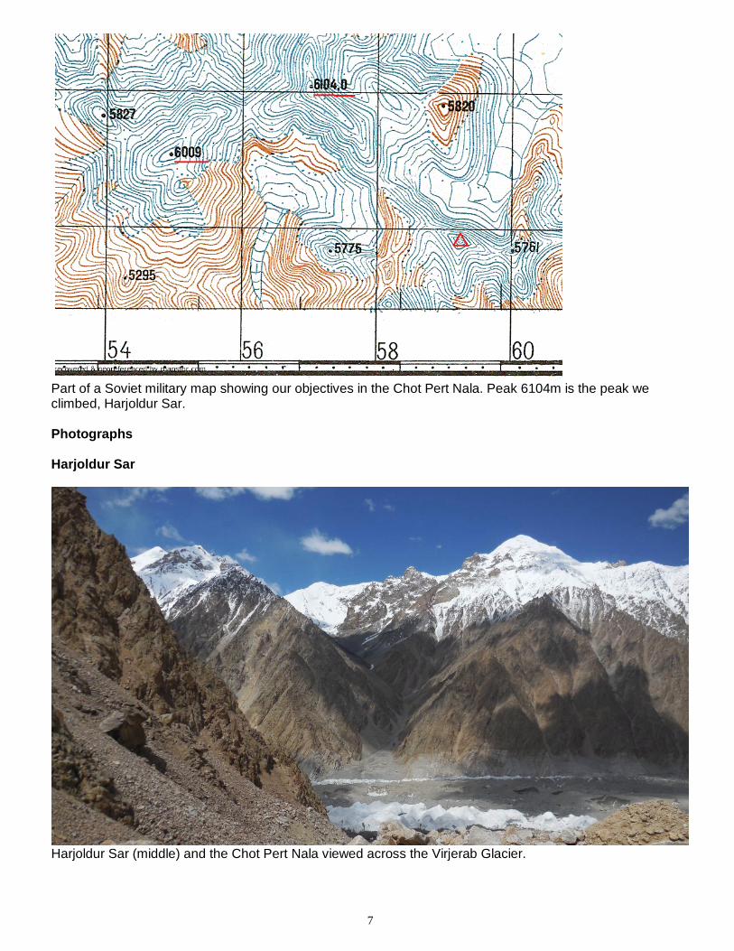
Part of a 1:100,000 Soviet military map showing our objectives above the Spregh Yaz Glacier, our base camp and the Chot Pert Nala. Peak 6310m is Khurdopin Sar. KS is Khusrui Sar, the peak climbed by the Poles in 2012.
7
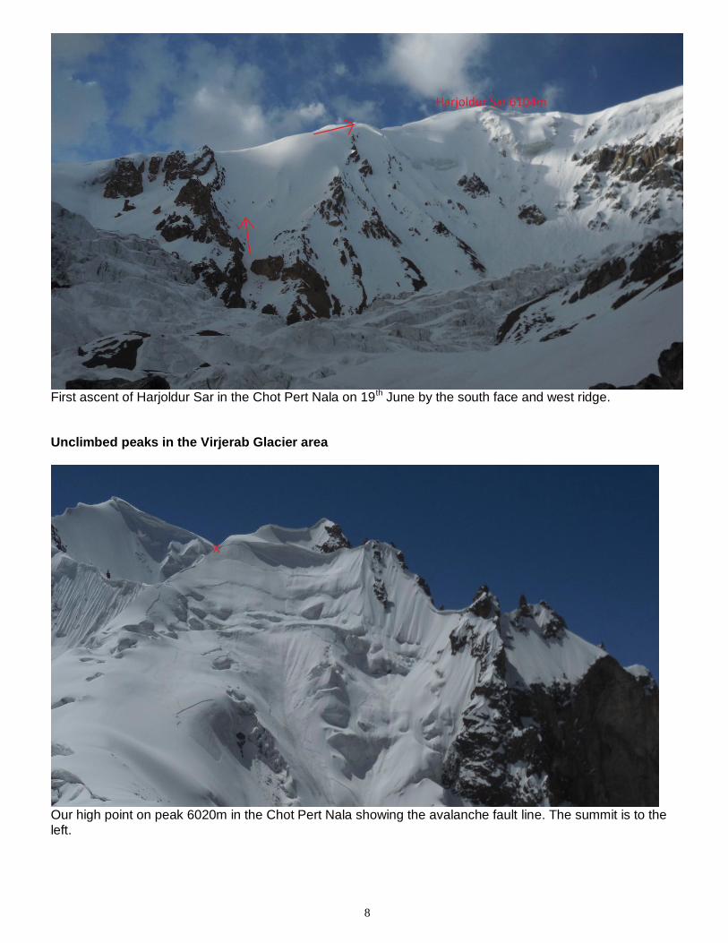
Part of a Soviet military map showing our objectives in the Chot Pert Nala. Peak 6104m is the peak we climbed, Harjoldur Sar. Photographs Harjoldur Sar
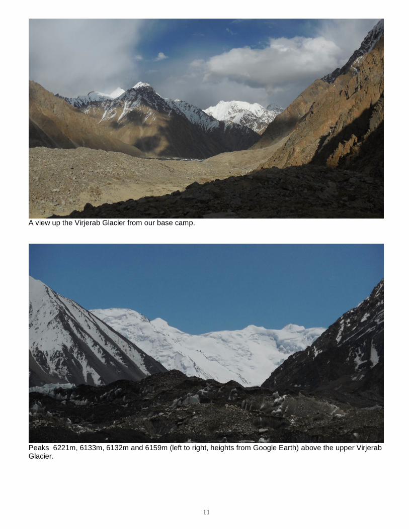
Harjoldur Sar (middle) and the Chot Pert Nala viewed across the Virjerab Glacier.
8
First ascent of Harjoldur Sar in the Chot Pert Nala on 19th June by the south face and west ridge.
Unclimbed peaks in the Virjerab Glacier area
Our high point on peak 6020m in the Chot Pert Nala showing the avalanche fault line. The summit is to the left.

9
Peak 6009m (foreground right) in the Chot Pert Nala from Harjoldur Sar.
Peaks 6172m, 6315m, 6099m and 6316m above the Virjerab West I Glacier and peaks 6140m (attempted), 6100m and 6310m (Khurdopin Sar) above the Spregh Yaz Glacier from Harjoldur Sar. Other Virjerab peaks are to the left.

10
Virjerab West I Glacier peaks: the north faces of 6315 (left) and 6099m (right) from the Chot Pert Nala.
The north face of Khurdopin Sar 6310m from the Spregh Yaz Valley.
11
A view up the Virjerab Glacier from our base camp.
Peaks 6221m, 6133m, 6132m and 6159m (left to right, heights from Google Earth) above the upper Virjerab Glacier.
12
Contact details Leader’s details: Name: Pete Thompson Address: 29 Cheetham Avenue Unstone
Dronfield Derbyshire S18 4DL Telephone number: 07999 865898 Email: [email protected] Acknowledgements Thanks to the Mount Everest Foundation, the British Mountaineering Council and the Gore-tex Shipton-Tilman Award for grants.