Embed Size (px)
Citation preview

US Army Corps of Engineers BUILDING STRONG®
USACE Inland Electronic Navigational Charts (IENC)
MAPPS Breakfast at ASPRS
Louisville, Kentucky
Denise R. LaDue USACE Inland ENC Production Manager
26 March 2014

BUILDING STRONG®
US Inland Navigation Statistics USACE Navigation Mission Benefits of Electronic Chart Data Chronology of USACE IENC Development Status of USACE IENC Coverage International Standards Development (IEHG) USACE Partnering:
► NOAA ► U.S. Coast Guard
IENC Data Download Services Future Projects
USACE Inland Electronic Navigational Charts (IENC)

BUILDING STRONG®
One 15 Barge Tow
U.S. Navigation Statistics*
• 8,200 miles of inland waterways
• 158 lock chambers
• 565 million tons of commodities
30% coal / coke
27% petroleum
15% other raw materials
13% food & farm products
9% chemicals
6% manufactured products
* from the Navigation Data Center “TRANSPORTATION FACTS”, Nov. 2013
Equivalent Units 22,500 Tons =
225 Railroad Cars
900 Large Semi Trucks

BUILDING STRONG®
USACE IENC
USACE Channel Framework
USACE Channel Framework
USACE Channel Framework
USACE Navigation Mission
7,000 Miles Completed
106 IENCs are updated and maintained monthly (46 in-‐house, 60 by contractor)
• 265 miles (White River) scheduled for release in April 2014

BUILDING STRONG®
15 Districts Involved with IENC Program
• Centrally Funded from HQUSACE thru Louisville District
• FY14 Budget $3M + $500K plus-‐up = $3.5M
• Approx. $1.9M in contracts awarded annually (54% of budget)
• 85% of Hydrographic & Feature Surveys Performed by Contract (15% in-‐house)
• Contracts awarded thru District contract vehicles or Na`onal Capability in St. Louis District

BUILDING STRONG®
• A towboat pushing six barges, lost in the fog, struck the Big Bayou Canot bridge near Mobile, AL causing the track to misalign by approximately 3 feet.
• Eight minutes later, AMTRAK Sunset Limited derailed on the railroad bridge and plunged into the waterway, killing 47 and injuring 103.
Disaster at Big Bayou Canot, 22 September 1993
An electronic chart system on the towboat may have prevented
the accident.
Electronic Chart Data for Safe and Efficient Navigation
BUILDING STRONG®
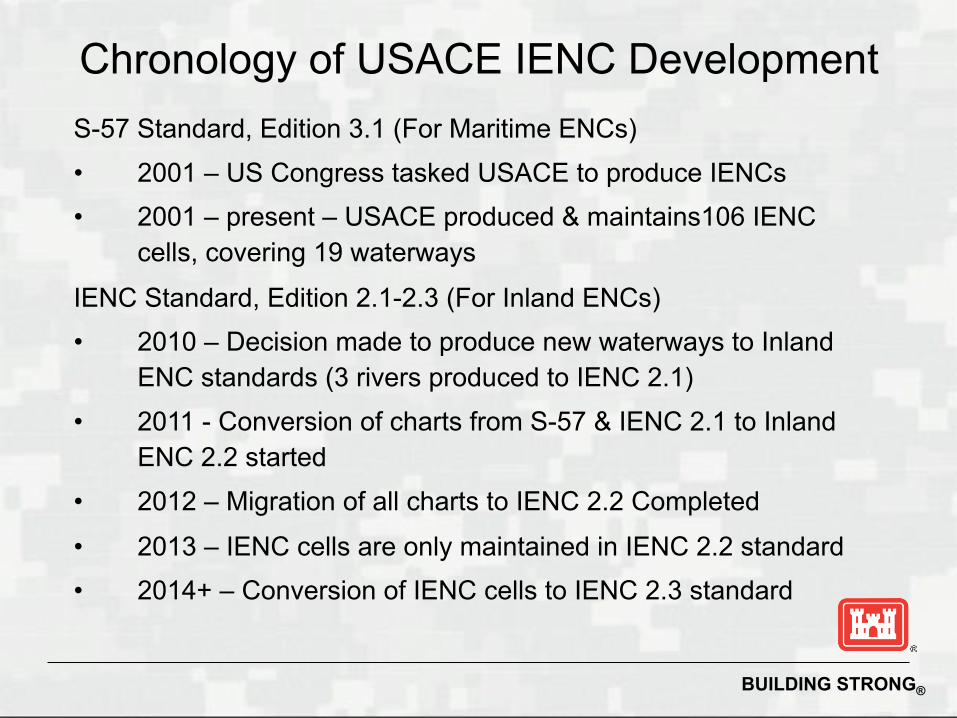
S-57 Standard, Edition 3.1 (For Maritime ENCs) • 2001 – US Congress tasked USACE to produce IENCs • 2001 – present – USACE produced & maintains106 IENC
cells, covering 19 waterways
IENC Standard, Edition 2.1-2.3 (For Inland ENCs) • 2010 – Decision made to produce new waterways to Inland
ENC standards (3 rivers produced to IENC 2.1) • 2011 - Conversion of charts from S-57 & IENC 2.1 to Inland
ENC 2.2 started • 2012 – Migration of all charts to IENC 2.2 Completed
• 2013 – IENC cells are only maintained in IENC 2.2 standard • 2014+ – Conversion of IENC cells to IENC 2.3 standard
Chronology of USACE IENC Development

BUILDING STRONG®
7,265 mi of inland waterways are scheduled for Inland ENC coverage
Inland ENC Coverage in USA
7,000 Miles Completed
106 IENCs are updated and maintained monthly (46 in-‐house, 60 by contractor)
• 265 miles (White River) scheduled for release in April 2014

BUILDING STRONG®
River / Waterway Miles Kilometers Inland ENC 2.2 (Inland ENC)
Alabama River (304) (489) Planned 20??
Allegheny River 30 24 Published
Arkansas River 445 716 Published
Atchafalaya River 118 190 Published
Black Warrior River 235 378 Published
Cumberland River 381 613 Published
Green River 108 174 Published
Illinois Waterway 337 542 Published
Kanawha River 91 146 Published
Kaskaskia River 36 58 Published
Lower Mississippi River 715 1,151 Published
Missouri River 733 1,180 Published
Mobile / Tombigbee Rivers 217 349 Published
Monongahela River 129 208 Published
Ohio River 981 1,579 Published
Ouachita River 351 565 Published
Red River 237 381 Published
Tennessee River 765 1,231 Published
Tenn-Tom Waterway 225 362 Published
Upper Mississippi River 866 1,394 Published
White River 245 394 April 2014
Total 7,245 mi 11,660 km
Implementation of IENC Standard

BUILDING STRONG®
Examples of unique features found in waterways which are not found in maritime waters
• Casino / Gaming Boats
• Fleeting Areas • Ice Breakers • Lock Guide Walls • Exceptional Navigation Structures
What is meant by an Inland Standard?
BUILDING STRONG®
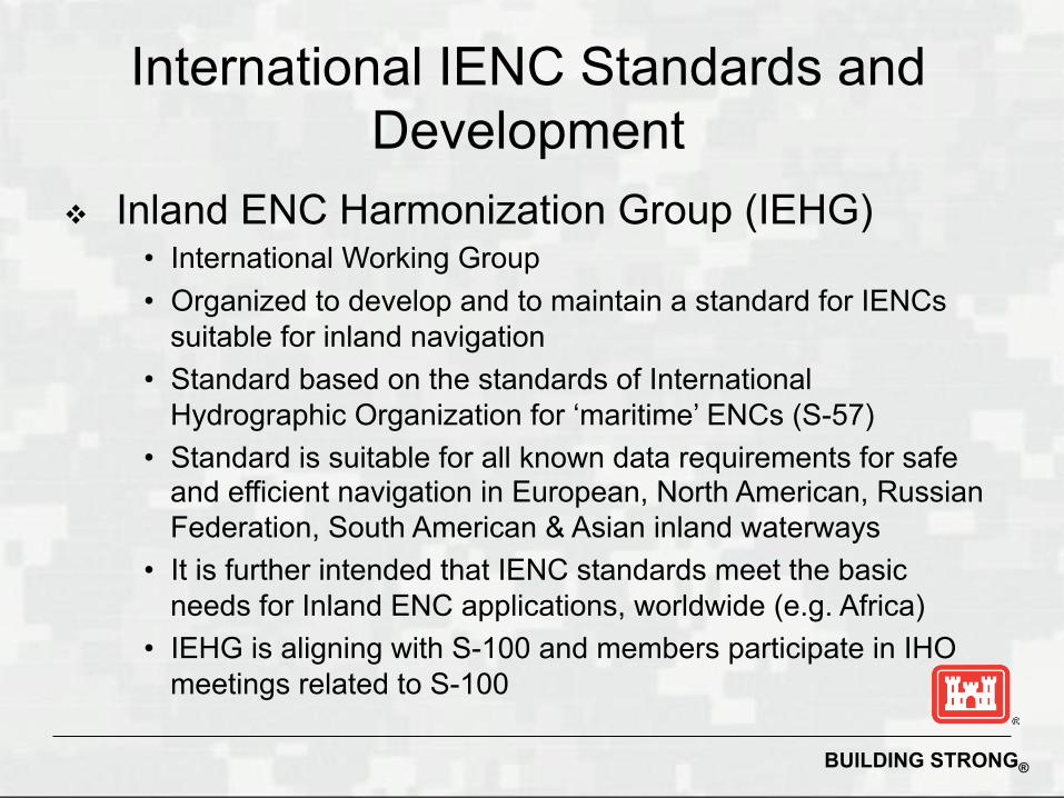
Inland ENC Harmonization Group (IEHG) • International Working Group • Organized to develop and to maintain a standard for IENCs
suitable for inland navigation • Standard based on the standards of International
Hydrographic Organization for ‘maritime’ ENCs (S-57) • Standard is suitable for all known data requirements for safe
and efficient navigation in European, North American, Russian Federation, South American & Asian inland waterways
• It is further intended that IENC standards meet the basic needs for Inland ENC applications, worldwide (e.g. Africa)
• IEHG is aligning with S-100 and members participate in IHO meetings related to S-100
International IENC Standards and Development
BUILDING STRONG®
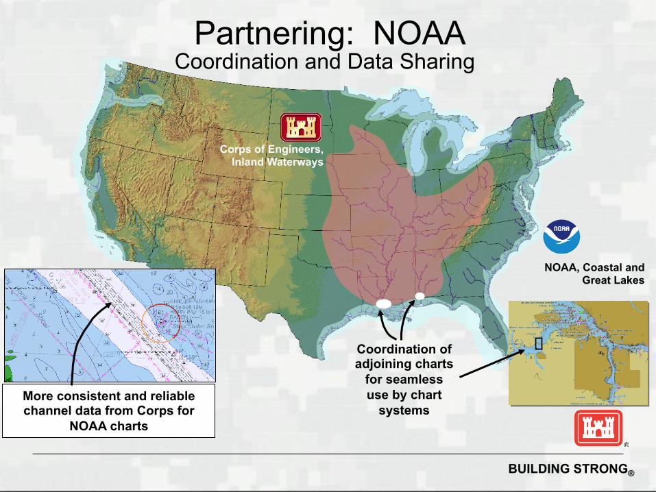
Corps of Engineers, Inland Waterways
NOAA, Coastal and Great Lakes
More consistent and reliable channel data from Corps for
NOAA charts
Coordination of adjoining charts
for seamless use by chart
systems
Partnering: NOAA Coordination and Data Sharing

BUILDING STRONG®
NOAA chart with channel embedded
NOAA’s data consists of 80% USACE data
Partnering: NOAA Coordination and Data Sharing

BUILDING STRONG®
• Weekly Publication by USACE containing Depth Contours and Soundings
• Use of “Scale Minimum” values enables the capability to view the shoalest soundings
• The overlay file, will overlay on NOAA ENCs and will provide timely depth information for a dynamic portion of the Lower Mississippi River
• Pilot project for future ports and dynamic waterways (e.g. Columbia River & Port of Los Angeles)
Partnering: NOAA IENC Overlay Data for Southwest Pass

BUILDING STRONG®
• A coastal data project • Contracted through Mobile District • Partnering Success with NOAA
Partnering: NOAA Channel Framework Data

BUILDING STRONG®
Waterway road map Beginning point for moving USACE into an enterprise
GIS program for managing the navigation business line Link between OMBIL projects and the spatial
representation of those features Foundation for organization of navigation and dredging
data across USACE. Basis for USACE data to update NOAA ENC Baseline feature for spatially updating the IWR waterway
network Tracks channel history through authorized, maintained,
and any changes in channel dimensions
Partnering: NOAA Channel Framework Data

BUILDING STRONG®
Partnering: USCG Buoy Placement
US Coast Guard, District 8
Corps of Engineers, Inland Waterways
Mississippi River System
USACE USCG Survey Data for “problem” areas.
USCG USACE Buoy Locations from USCG Cutters
BUILDING STRONG®
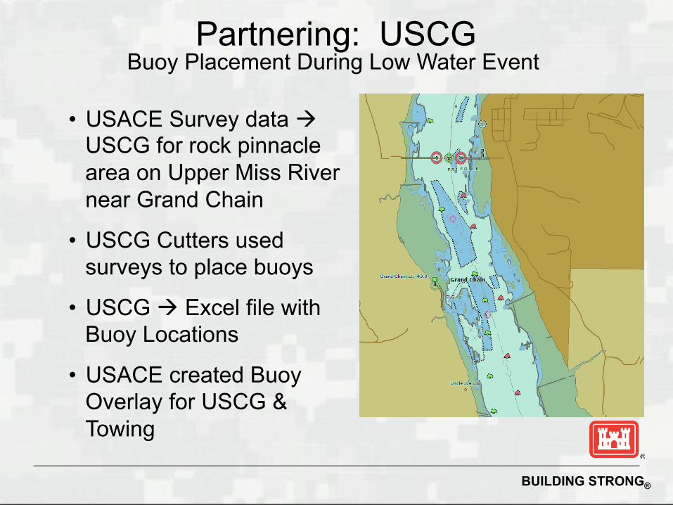
• USACE Survey data USCG for rock pinnacle area on Upper Miss River near Grand Chain
• USCG Cutters used surveys to place buoys
• USCG Excel file with Buoy Locations
• USACE created Buoy Overlay for USCG & Towing
Partnering: USCG Buoy Placement During Low Water Event

BUILDING STRONG®
• Buoy acquisition software installed on 15 USCG Cutters
• Server software installed on AGC server
• Ability to upload buoys (USCG) to server and download to files (USACE)
• Release of first Buoy Overlay file occurred in April 2013
• USACE updates and publishes Buoy Overlay files weekly (every Wednesday)
Partnering: USCG Buoy Placement

BUILDING STRONG®
• Many discrepancies between “real world” and USCG Light List
• USACE performed Vessel-born LiDAR surveys of bridges, overhead crossings & locks and dams
• Clearance information (vertical and horizontal) is provided to the USCG Bridge Department
Partnering: USCG Bridge Clearance Information
• USCG Updates the Light List to provide more accurate bridge clearance information
• USACE IENCs match USCG Light List

BUILDING STRONG®
http://www.agc.army.mil/Missions/Echarts/ProductDownloads.aspx
IENC Data Download Services

BUILDING STRONG®
Products Catalog
• XML based: universal and flexible
• Allows automated data updates
for software clients
• Allows automated querying of available products
• Expandable and scalable to accommodate future products and services
IENC Data Download Services
BUILDING STRONG®
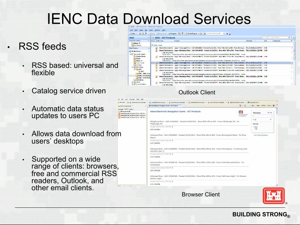
• RSS feeds
• RSS based: universal and flexible
• Catalog service driven
• Automatic data status updates to users PC
• Allows data download from users’ desktops
• Supported on a wide range of clients: browsers, free and commercial RSS readers, Outlook, and other email clients.
Outlook Client
Browser Client
IENC Data Download Services

BUILDING STRONG®
• Users provide feedback / report errors on IENCs • District POC, Production and QA Manager will
receive email that an error has been reported • District determines if error is legitimate and
makes correction to IENC
Chart Discrepancy Reports
BUILDING STRONG®
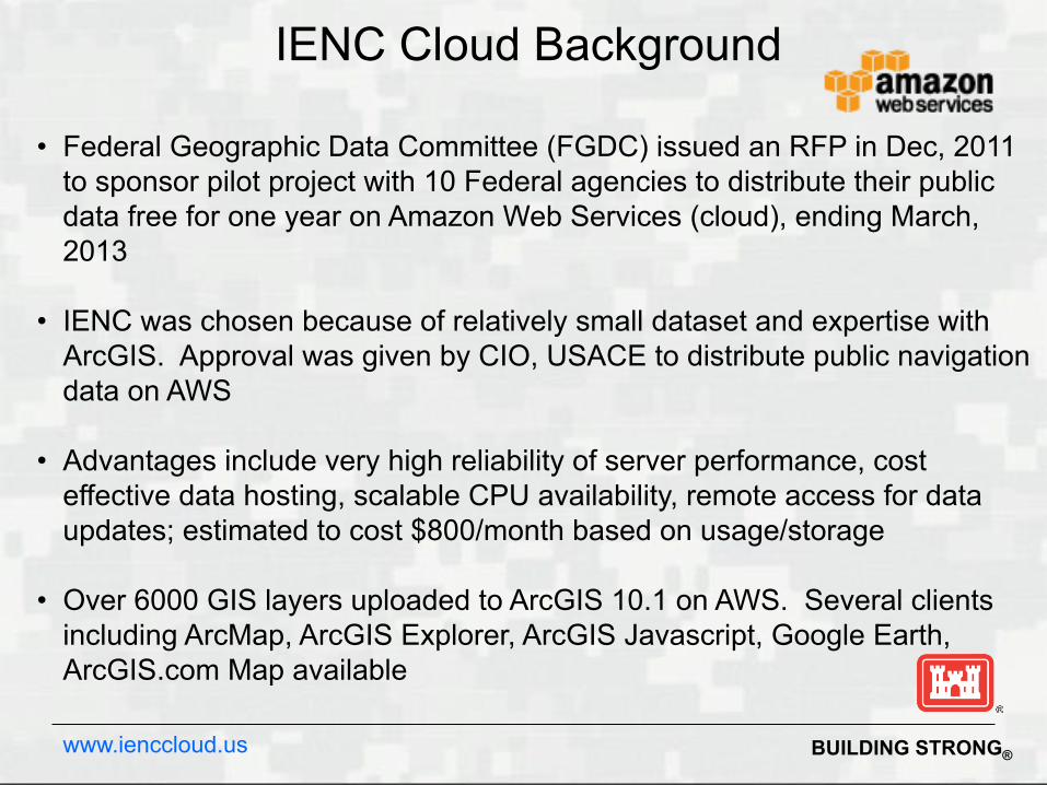
• Federal Geographic Data Committee (FGDC) issued an RFP in Dec, 2011 to sponsor pilot project with 10 Federal agencies to distribute their public data free for one year on Amazon Web Services (cloud), ending March, 2013
• IENC was chosen because of relatively small dataset and expertise with ArcGIS. Approval was given by CIO, USACE to distribute public navigation data on AWS
• Advantages include very high reliability of server performance, cost effective data hosting, scalable CPU availability, remote access for data updates; estimated to cost $800/month based on usage/storage
• Over 6000 GIS layers uploaded to ArcGIS 10.1 on AWS. Several clients including ArcMap, ArcGIS Explorer, ArcGIS Javascript, Google Earth, ArcGIS.com Map available
IENC Cloud Background
www.ienccloud.us
BUILDING STRONG®
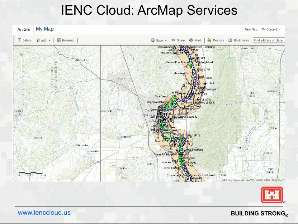
IENC Cloud: ArcMap Services
www.ienccloud.us

BUILDING STRONG®
IENC Cloud: WMS Services
www.ienccloud.us

BUILDING STRONG®
IENC Cloud: KML Services
www.ienccloud.us

BUILDING STRONG®
Mobile IENC Purpose: Provide a low-cost mobile platform for US inland water navigation and information management which traditionally require an expensive and dedicated ECS.
Products/Result(s): • Android-based mobile application • Back-end web services to support the mobile devices
• Geo-dataset and services provisioned for light-weight clients
Requirement : • Navigation data dissemination requirement from USACE Civil Works
• Cloud computing and mobile platforms initiatives
Transition Milestones:
• Distributed data services and mobile application products available to government agencies and the public.
BUILDING STRONG®
Questions?