Embed Size (px)
Citation preview
U f W th d Cli t F tU f W th d Cli t F tUse of Weather and Climate Forecast Use of Weather and Climate Forecast Information in the CaliforniaInformation in the California--Nevada Nevada
River Forecast CenterRiver Forecast Center
Rob HartmanRob HartmanHydrologist in ChargeHydrologist in ChargeHydrologist in ChargeHydrologist in Charge
NWS / CaliforniaNWS / California--Nevada River Forecast CenterNevada River Forecast Center
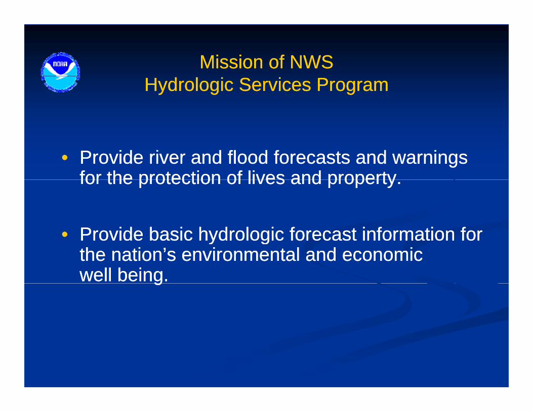
Mission of NWS Mission of NWS Hydrologic Services ProgramHydrologic Services Program
•• Provide river and flood forecasts and warnings Provide river and flood forecasts and warnings for the protection of lives and propertyfor the protection of lives and propertyfor the protection of lives and property.for the protection of lives and property.
Provide basic hydrologic forecast information forProvide basic hydrologic forecast information for•• Provide basic hydrologic forecast information for Provide basic hydrologic forecast information for the nation’s environmental and economic the nation’s environmental and economic well being.well being.gg
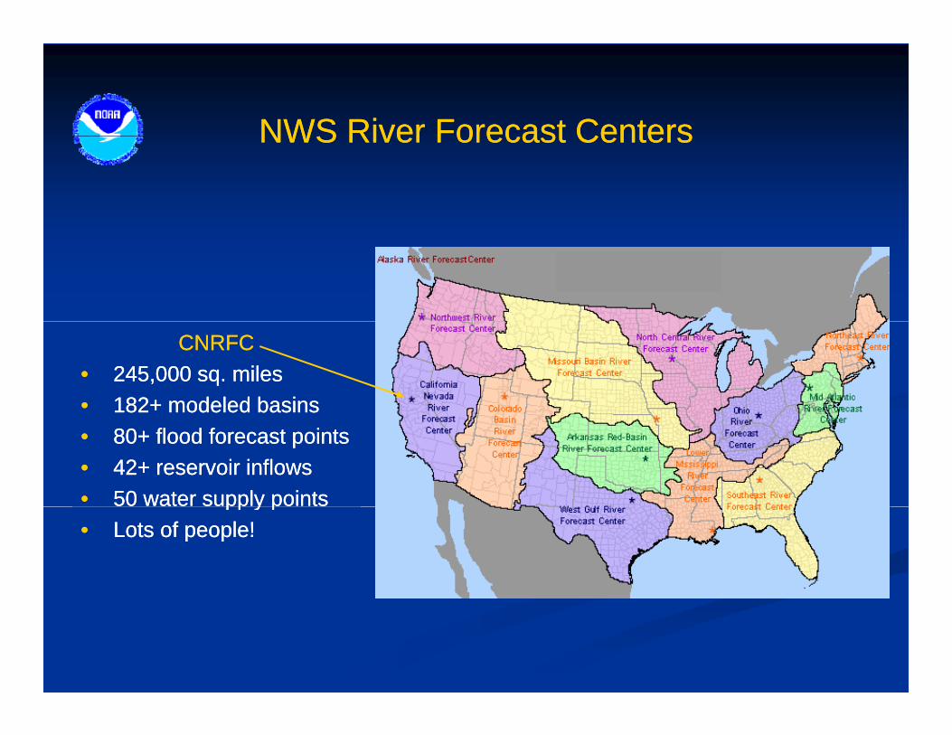
NWS River Forecast CentersNWS River Forecast CentersNWS River Forecast CentersNWS River Forecast Centers
CNRFCCNRFC•• 245,000 sq. miles245,000 sq. miles•• 182+ modeled basins182+ modeled basins•• 80+ flood forecast points80+ flood forecast points•• 42+ reservoir inflows42+ reservoir inflows•• 50 water supply points50 water supply pointspp y ppp y p•• Lots of people!Lots of people!
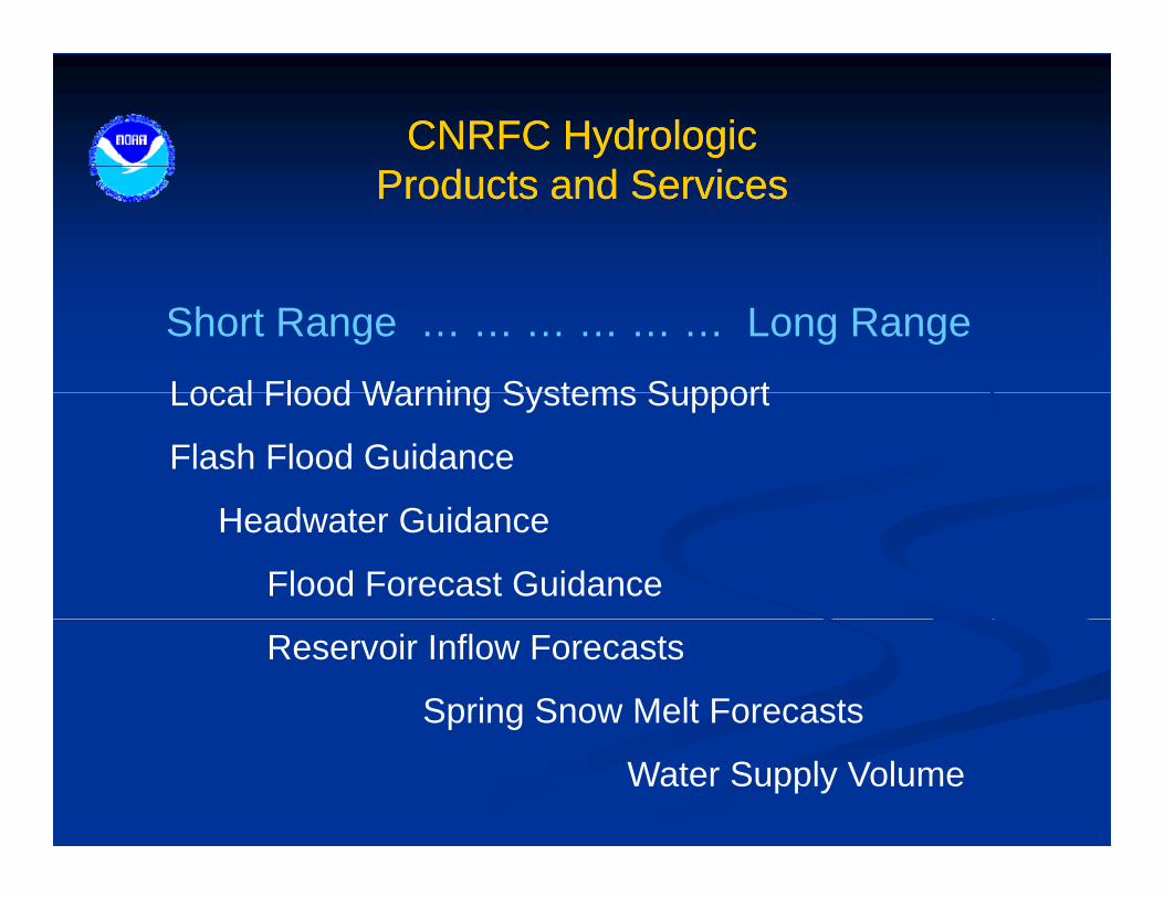
CNRFC HydrologicCNRFC HydrologicProducts and ServicesProducts and Services
Local Flood Warning Systems Support
Short Range … … … … … … Long Range
Local Flood Warning Systems Support
Flash Flood Guidance
Headwater Guidance
Flood Forecast Guidance
Reservoir Inflow Forecasts
Spring Snow Melt Forecasts
Water Supply Volume

CNRFC HydrologicCNRFC Hydrologic ModelingModelingCNRFC Hydrologic CNRFC Hydrologic ModelingModeling
NWSRFS OFS
Short Range … … … … … … Long Range
NWSRFS – OFS6 hour time step, 5 day duration
modular, deterministic
NWSRFS - ESP………………...
Statistical
6 hour time step, ~ 1 year duration, ensemble-based, probablistic
simple, efficient, inflexibleseasonal duration
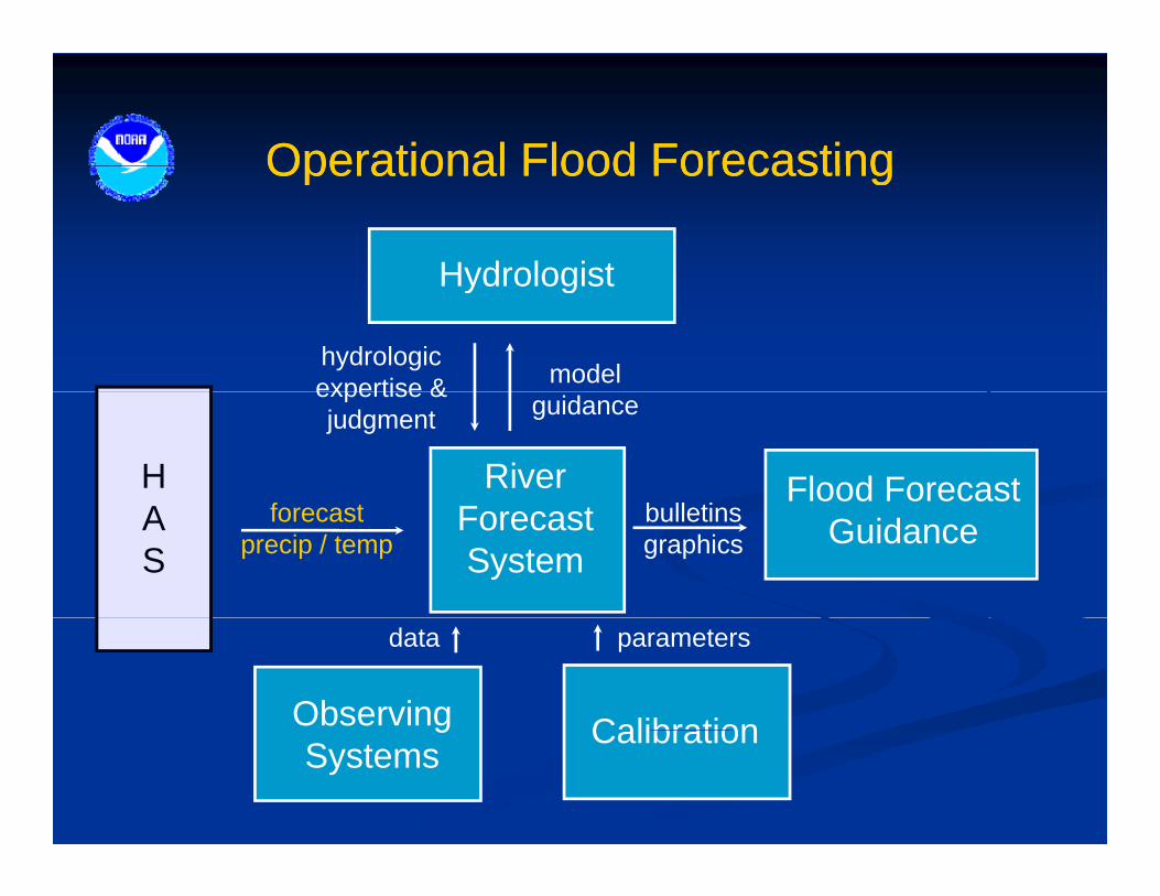
Operational Flood ForecastingOperational Flood ForecastingOperational Flood ForecastingOperational Flood Forecasting
Hydrologist
model
Hydrologist
hydrologicexpertise &
f tH River
guidanceexpertise &judgment
b ll tiFlood Forecast
forecastprecip / temp
AS
ForecastSystem
bulletinsgraphics Guidance
parameters
Observing
data
CalibrationgSystems
Calibration
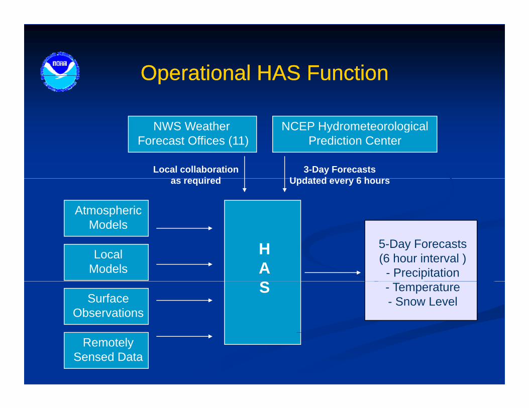
Operational HAS FunctionOperational HAS FunctionOperational HAS FunctionOperational HAS Function
NWS Weather NCEP HydrometeorologicalNWS Weather Forecast Offices (11)
NCEP HydrometeorologicalPrediction Center
3-Day ForecastsU d t d 6 h
Local collaborationi d
AtmosphericModels
Updated every 6 hoursas required
LocalModels
5-Day Forecasts(6 hour interval )
- Precipitation
HAS - Temperature
- Snow LevelSurfaceObservations
S
RemotelySensed Data

Day 1 QPF Error (Feb05)Day 1 QPF Error (Feb05)Day 1 QPF Error (Feb05)Day 1 QPF Error (Feb05)

Day 2 QPF Error (Feb05)Day 2 QPF Error (Feb05)Day 2 QPF Error (Feb05)Day 2 QPF Error (Feb05)
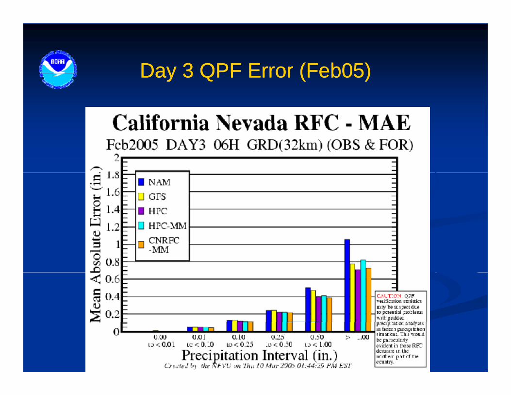
Day 3 QPF Error (Feb05)Day 3 QPF Error (Feb05)Day 3 QPF Error (Feb05)Day 3 QPF Error (Feb05)

Rhea Orographic Aid (Days 4Rhea Orographic Aid (Days 4--6)6)Rhea Orographic Aid (Days 4Rhea Orographic Aid (Days 4 6)6)
•• Objective toolObjective tooljj
•• Outputs 6Outputs 6--hour orographic QPFhour orographic QPF
•• Input Input -- NCEP gridded datasets NCEP gridded datasets from AWIPSfrom AWIPS
Eta and GFSEta and GFSS l t t •• Eta and GFSEta and GFS•• Performed well during largePerformed well during large--
scale rain events in California scale rain events in California (1986 1997)(1986 1997)
Sample output...
==< SHASTA ABOVE SHASTA DAM - SHDC1
>==================================== STRDA BEG-END QPF SLVL FRZGLVL 700DIR
6 19 16-22 .00 35 5.1 253-299 WIND&RH WK SSE-NNW PRDIF12 19 22- 4 .04 28 4.3 299-257 WIND&RH WK SSE-NNW PRDIF (1986, 1997)(1986, 1997)
•• Mesoscale resolutionMesoscale resolution
18 20 4-10 .13 26 4.1 257-228 RH ONLY NORMAL PGRAD 24 20 10-16 .17 27 4.3 228-210 RH ONLY NORMAL PGRAD 30 20 16-22 .09 28 4.4 210-109 WIND&RH WK SSE-NNW PRDIF36 20 22- 4 .00* 30 4.6 109- 49 WIND&RH WK SSE-NNW PRDIFMODIFIED TOTS 04-04 .38 MOD-FAC = .85 * = 700mbWD >344 or <155 DEG42 21 4-10 .00* 38 5.4 49- 15 WIND&RH WK SSE-NNW PRDIF48 21 10-16 .00* 51 6.6 15- 14 WIND&RH WK SSE-NNW PRDIF54 21 16-22 .00* 57 7.3 14- 7 WIND&RH WK SSE-NNW PRDIF60 21 22- 4 .00 56 7.1 7-303 WIND&RH WK SSE-NNW PRDIFMODIFIED TOTS 04-04 .00 MOD-FAC = .85 * = 700mbWD >344 or <155 DEG

Rhea Orographic Aid PerformanceRhea Orographic Aid PerformanceNew Year’s Flood 1997 New Year’s Flood 1997 –– Feather River BasinFeather River Basin
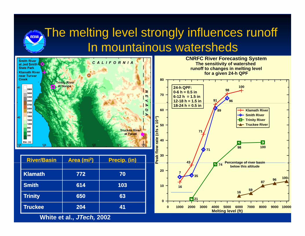
The melting level strongly influences runoff I t i t h d
CNRFC River Forecasting SystemThe sensitivity of watershed
runoff to changes in melting levelfor a given 24-h QPF
In mountainous watersheds
70
80
9691
98100
for a given 24-h QPF
24-h QPF:0-6 h = 0.5 in6-12 h = 1.5 in12-18 h = 1.5 in
50
60
cfs
x 10
-3)
Klamath RiverSmith RiverTrinity RiverTruckee River
89
71
18-24 h = 0.5 in
30
40
Peak
flow
rate
(c
71 98 100
43 Percentage of river basinRiver/BasinRiver/Basin Area (miArea (mi22)) Precip. (in)Precip. (in)
10
20
P
735
74
16
43
1659
8796 100
Percentage of river basinbelow this altitude
(( )) p ( )p ( )
KlamathKlamath 772772 7070
SmithSmith 614614 103103
0 1000 2000 3000 4000 5000 6000 7000 8000 9000 10000Melting level (ft)
0 21
16
White et al., JTech, 2002
TrinityTrinity 650650 6363
TruckeeTruckee 204204 4141
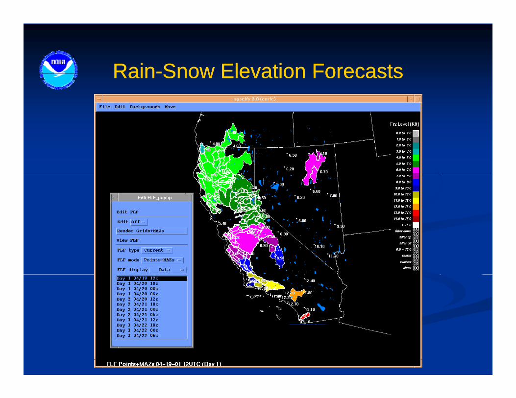
RainRain--Snow Elevation ForecastsSnow Elevation ForecastsRainRain Snow Elevation ForecastsSnow Elevation Forecasts

Flood Forecast GuidanceFlood Forecast GuidanceFlood Forecast GuidanceFlood Forecast Guidance
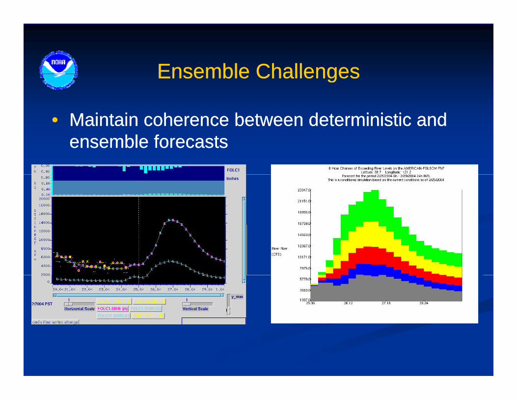
Ensemble ChallengesEnsemble ChallengesEnsemble ChallengesEnsemble Challenges
•• Maintain coherence between deterministic andMaintain coherence between deterministic andMaintain coherence between deterministic and Maintain coherence between deterministic and ensemble forecastsensemble forecasts
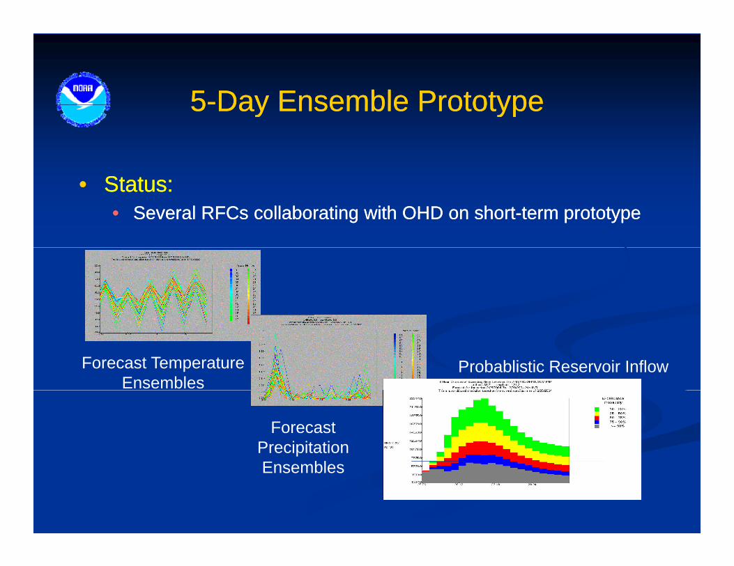
55--Day Ensemble PrototypeDay Ensemble Prototype55 Day Ensemble PrototypeDay Ensemble Prototype
St tSt t•• Status:Status:•• Several RFCs collaborating with OHD on shortSeveral RFCs collaborating with OHD on short--term prototypeterm prototype
Forecast TemperatureEnsembles
Probablistic Reservoir Inflow
Forecast PrecipitationE blEnsembles
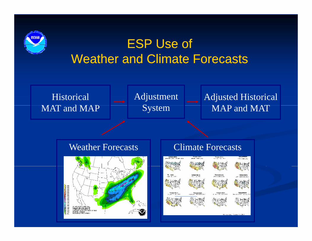
ESP Use ofESP Use ofESP Use of ESP Use of Weather and Climate ForecastsWeather and Climate Forecasts
HistoricalMAT d MAP
AdjustmentS t
Adjusted HistoricalMAP d MATMAT and MAP System MAP and MAT
Climate ForecastsWeather Forecasts
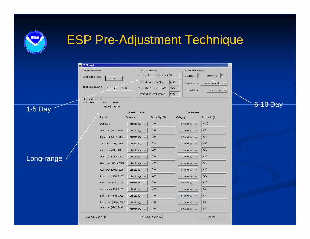
ESP PreESP Pre--Adjustment TechniqueAdjustment Techniquej qj q
6 10 Day1-5 Day
6-10 Day
Long-range

Ensemble Streamflow PredictionEnsemble Streamflow PredictionEnsemble Streamflow PredictionEnsemble Streamflow Prediction
Daily RFC C CClimateForecast
Adjustments
Daily RFCForecasting•Data Ingest•Data QC•Model Updating
Current Conditions•Soil•Reservoir Levels•Streamflow
April-July
HistoricalTime Series
April-July
Time Series
All Years ofRecord
Mean ArealTime Series NWSRFS ow
Forecast
Time Series
PrecipitationTemperature
NWSRFSHydrologic
Models
Stre
amflo
TimeSeries
Time

Thank YouThank You