Embed Size (px)
Citation preview

Transport and Topography Data Product Description September 2020

Transport and Topography Data Product Description Page 2
Standard This document is based on the AS/NZS ISO 19131:2008 Geographic information – Data product specifications standard.
Disclaimer Geoscape Australia believes this publication to be correct at the time of printing and does
not accept responsibility for any consequences arising from the use of the information herein. Readers should rely on their own skill and judgement to apply information to particular issues.
This work is copyright. Apart from any use as permitted under the Copyright Act 1968,
no part may be reproduced by any process without prior written permission of Geoscape Australia Limited.
Transport and Topography Data Product Description Page 3
Contents
1. Overview ......................................................................................................5
1.1 Data product specification title ....................................................................... 5
1.2 Reference date ........................................................................................... 5
1.3 Responsible party ........................................................................................ 5
1.4 Language................................................................................................... 5
1.5 Topic category ............................................................................................ 5
1.6 Distribution format ...................................................................................... 5
1.7 Glossary .................................................................................................... 5
1.8 Informal description of the data product .......................................................... 5
1.9 Copyright in Transport & Topography dataset.................................................... 6
1.10 Privacy .................................................................................................... 6
2. Specification Scope .......................................................................................7
2.1 Scope identification – dataset ........................................................................ 7
2.2 Scope identification – themes ........................................................................ 7
2.3 Scope identification – layers .......................................................................... 7
3. Data Product Identification............................................................................9
3.1 Title.......................................................................................................... 9
3.2 Alternate titles ............................................................................................ 9
3.3 Abstract .................................................................................................... 9
3.4 Purpose ..................................................................................................... 9
3.5 Topic category ............................................................................................ 9
3.6 Geographic description ................................................................................. 9
4. Data Content and Structure ......................................................................... 11
4.1 Feature-based data.................................................................................... 11
4.2 Feature-based application schema (data model) .............................................. 12
4.3 Data dictionary ......................................................................................... 12
Feature-based content scope ............................................................................. 13
5. Reference System ....................................................................................... 14
5.1 Spatial reference system ............................................................................ 14
5.2 Temporal reference system ......................................................................... 14
5.3 Reference system scope ............................................................................. 14
6. Data Quality ............................................................................................... 15
6.1 Positional accuracy .................................................................................... 15
6.2 Coordinates Referencing the GDA 2020 Datum ................................................ 15
6.3 Attribute accuracy ..................................................................................... 15
6.4 Logical consistency .................................................................................... 16
6.5 Topological consistency .............................................................................. 16
6.6 Completeness ........................................................................................... 16
7. Data Capture .............................................................................................. 18
7.1 Transport theme ....................................................................................... 18
7.2 Hydrology theme ....................................................................................... 18

Transport and Topography Data Product Description Page 4
7.3 Greenspace theme ..................................................................................... 18
7.4 Data capture scope .................................................................................... 18
8. Data Maintenance ....................................................................................... 19
8.1 Update frequency ...................................................................................... 20
8.2 Maintenance scope .................................................................................... 20
9. Data Product Delivery ................................................................................. 21
9.1 Delivery medium information ....................................................................... 21
9.2 Units of delivery ........................................................................................ 21
9.3 Medium name ........................................................................................... 21
9.4 Delivery format information ......................................................................... 22
10. GEOSCAPE Data ........................................................................................ 23
Appendix A – Transport & Topography Data Model Diagram ............................... 24
Appendix B – Data Dictionary .......................................................................... 28
TRANSPORT................................................................................................... 28

Transport and Topography Data Product Description Page 5
1. Overview
1.1 Data product specification title Transport and Topography Product Description
1.2 Reference date September 2020
1.3 Responsible party Geoscape Australia Limited Unit 6, 113 Canberra Avenue, GRIFFITH ACT 2603 Australia T: +61 2 6260 9000 | E: [email protected]
W: 13T U1 3TUhttp://www.geoscape.com.auU U13T 13T | ABN: 23 089 912 710
1.4 Language English
1.5 Topic category Spatial data and metadata for road, rail, airport networks as well as waterways and green areas within Australia.
1.6 Distribution format PDF
1.7 Glossary Geoscape maintains a glossary of common terms with their definitions and also includes acronyms and abbreviations that are commonly used in relation to Geoscape products and services. The glossary is available at the Geoscape website at
https://geoscape.com.au/documentation/glossary-and-terms/
1.8 Informal description of the data product The Transport and Topography dataset is comprised of three themes:
• Transport
• Hydrology
• Greenspace
The Transport and Topography dataset is used as a basis for the G-NAF dataset provided by Geoscape Australia. The Transport and Topography dataset is an important dataset in its own right.
Geoscape Australia is currently working to improve the data maintenance processes which have significantly enhanced its accuracy from previous releases. This improvement in

Transport and Topography Data Product Description Page 6
processes will be continually reviewed to produce the highest standards possible in accuracy and quality control.
1.9 Copyright Please see www.geoscape.com.au/legal/data-copyright-and-disclaimer/.
1.10 Privacy Geoscape products and services should not contain any personal names or other personal information. Geoscape undertakes reasonable data cleansing steps as part of its production processes to ensure that is the case. If you think that personal information may have inadvertently been included in Geoscape products or services, please contact [email protected]
Transport and Topography Data Product Description Page 7
2. Specification Scope
This dataset is divided into three themes.
2.1 Scope identification – dataset Transport and Topography Dataset
Level
Dataset
Level name
Transport and Topography
Extent
Spatial coverage of Australia’s landmass including External Territories and Coastal Islands (including Lord Howe Island). All data is supplied by the appropriate jurisdiction quarterly.
2.2 Scope identification – themes Transport and Topography Themes
Level
Theme
Level names
• Transport
• Hydrology
• Greenspace
Extent
Spatial coverage of Australia’s Transport Network, bodies of water (and islands) and ‘green’ spaces.
• Transport is a digital representation of all roads, airports and railways within Australia.
• Hydrology is a digital representation of oceans, lakes, rivers, islands and other bodies of water.
• Greenspace is a digital representation of parks, reserves, recreational areas and open
space.
2.3 Scope identification – layers Transport and Topography Theme Layers
Level
Dataset layers within each of the three themes.
Level name
Layers

Transport and Topography Data Product Description Page 8
Extent
Spatial coverage of Australia’s statistical, political, urban and regional subset areas.
• The Transport Theme has four layers: 1. Roads, 2. Railway Lines, 3. Railway Stations and 4. Airports.
• The Hydrology Theme has three layers: 1. Hydrology Polygons, 2. Hydrology Lines, and 3. Hydrology Points.
• The Greenspace Theme has three layers: 1. Greenspace Polygons, 2. Greenspace Lines and 3. Greenspace Points

Transport and Topography Data Product Description Page 9
3. Data Product Identification
3.1 Title Transport and Topography Dataset
3.2 Alternate titles Transport and Topography for Australia
T & T
T and T
3.3 Abstract The Transport and Topography Product Description (an ISO 19131 compliant description) provides an optimised quality geometric description and a set of basic attributes of the Australian transport networks as well as waterways and green areas. The Transport and Topography dataset is created from multiple sources including jurisdictional data which is revised regularly and supplied in varying formats and at different levels of quality.
3.4 Purpose Transport and Topography is designed to meet the needs of organisations that require a graphical representation of locations of the transport networks (roads, rail and airports), waterways (farm dams through to major rivers and oceans), and green spaces (local playing fields and parks, through to state and national parks) to integrate with other data in servicing their business needs.
Transport and Topography incorporates state boundaries and localities derived from the
Administrative Boundaries dataset. The common geometric base allows users to apply the spatial data to the full extent of coverage. This common infrastructure facilitates data integration with supplementary data supplied in the future.
3.5 Topic category Polygons, lines and points defined by coordinate spatial data (latitude and longitude) with associated textual metadata
3.6 Geographic description The Transport and Topography dataset covers the addresses within the complete national
geography of Australia (AUS). The Bounding Box for this data is as follows;
North bounding latitude: -9˚
South bounding latitude: -45˚
East bounding longitude: 168˚
West bounding longitude: 96˚
This area covers the land masses of Australia, including External Territories and offshore islands (Christmas Island, Cocos (Keeling) Islands, and Norfolk Island).
The spatial domain is described by the polygon:
Transport and Topography Data Product Description Page 10
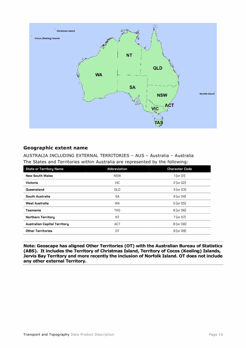
Geographic extent name
AUSTRALIA INCLUDING EXTERNAL TERRITORIES – AUS – Australia – Australia
The States and Territories within Australia are represented by the following:
State or Territory Name Abbreviation Character Code
New South Wales NSW 1 (or 01)
Victoria VIC 2 (or 02)
Queensland QLD 3 (or 03)
South Australia SA 4 (or 04)
West Australia WA 5 (or 05)
Tasmania TAS 6 (or 06)
Northern Territory NT 7 (or 07)
Australian Capital Territory ACT 8 (or 08)
Other Territories OT 9 (or 09)
Note: Geoscape has aligned Other Territories (OT) with the Australian Bureau of Statistics (ABS). It includes the Territory of Christmas Island, Territory of Cocos (Keeling) Islands, Jervis Bay Territory and more recently the inclusion of Norfolk Island. OT does not include any other external Territory.

Transport and Topography Data Product Description Page 11
4. Data Content and Structure
Transport and Topography is a feature-based product. A data model is included (Appendix A) with an associated data dictionary (Appendix B).
4.1 Feature-based data The feature type is spatial point, line and polygon for the various Transport and
Topography themes. The table below outlines the features and their integration into the datasets.
19T19TEntity 19T 19TDescription 19T 19TIntegration 19T19TRules
Street A Street represents a segment of road.
A Street will have 1 or many line segments
defining its spatial existence.
A Street can be related to 0 or more
localities.
If a Street is related to a gazetted locality (e.g. a locality with a polygon
representation), its lines in STREET_LOCALITY_LINE will be ‘cookie-
cut’ by the buffered locality polygon.
If a Street is related to an un-gazetted locality (e.g. a locality with only point
representation), its lines in STREET_LOCALITY_LINE will be ‘cookie-
cut’ by the buffered locality point.
A Street/Locality (gazetted or un-gazetted) pair will have 1 active point in
STREET_LOCALITY_POINT. This is the
centroid of the street line(s) in STREET_LOCALITY_LINE (centroid creation
in the same way G-NAF creates street
centroids).
All Street/Locality pairs may have many alias
records describing alternate names for the
Street within the Locality.
A Street /Locality pair has:
0 to many related G-NAF
Address records
No special rules
Railway Railway captures railway lines. A railway
may have multiple line segments defining its
spatial existence.
No integration to other
datasets (except State).
No special rules
Railway
Station
A railway station is a simple point dataset
capturing the location of railway stations.
A Railway Station has:
0 or 1 related gazetted
Locality record. Most of the time a Station will be related
to a Locality. Will only not be related to a locality where
the Railway Station falls within an unincorporated
area.
No special rules
Airport
Landing
Ground
This entity represents a place where aircraft
land. It may be either an official airport or an
unofficial airstrip. An airport can be represented as point, line or polygon and will
generally include the runway/landing strip.
An Airport has:
1 related gazetted Locality
record
Airport Landing Grounds
are represented by a
point, line or polygon feature. Multiple
geometries may be used to represent more
complex features.
Hydrology Hydrology is a collection of tables that
capture hydrology points, lines and polygons.
No integration to other
datasets (except State).
No special rules
Greenspace Greenspace is a collection of tables that
capture greenspace points, lines and
polygons of parks, reserves and open space.
No integration to other
datasets (except State).
No special rules.
State Every dataset references a state. All other datasets reference
a state persistent identifier.
No special rules.

Transport and Topography Data Product Description Page 12
The Transport Theme provides data that covers the following layers,
• Roads – A national coverage of network roads at all levels within Australia. Roads data covers everything from major highways to outback tracks.
• Airports – This layer covers all aspects of Airports within Australia, the layer shows all airports from International to local landing strips.
• Railway Lines – This layer contains the national railway line network, including light rail
• Railway Stations – This layer shows railway stations located along the railway line network.
The Hydrology Theme shows locations of waterways, everything from dams on a property
to major rivers and oceans.
The Greenspace Theme contains features such as Parks, Reserves, National Parks, Conservation Areas, Forest Reserves, Recreational Areas and other Open Space.
4.2 Feature-based application schema (data model) The Transport and Topography Data Model Diagram is set out in Appendix A.
4.3 Data dictionary
Feature-based feature catalogue
All tables for the data dictionary are provided in Appendix B. This section provides the feature catalogue in support to the application schema. Spatial attributes are added to the feature catalogue in the same manner as other attributes for completeness and
conformance to the application schema.
Note: All Persistent Identifiers that do not identify spatial geometry in the Integrated Data Model are unique nationally and are preceded by the state abbreviation e.g.
LGA_PID = NSW12345678.
All Persistent Identifiers for spatial geometry are only unique within the associated dataset and within the state they reside e.g. LGA_POLYGON_PID = 1234567.
The following table refers to all tables in the Feature Catalogue below.
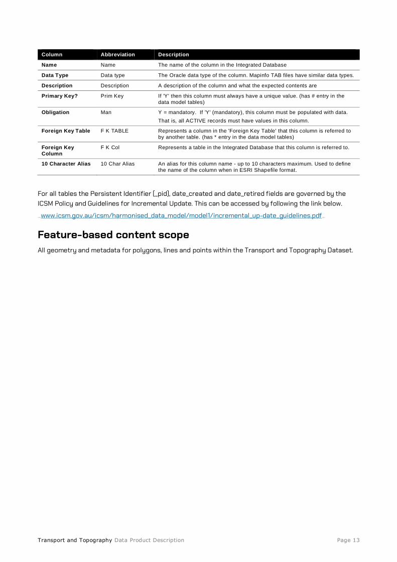
Transport and Topography Data Product Description Page 13
Column Abbreviation Description
Name Name The name of the column in the Integrated Database
Data Type Data type The Oracle data type of the column. Mapinfo TAB files have similar data types.
Description Description A description of the column and what the expected contents are
Primary Key? Prim Key If 'Y' then this column must always have a unique value. (has # entry in the
data model tables)
Obligation Man Y = mandatory. If 'Y' (mandatory), this column must be populated with data.
That is, all ACTIVE records must have values in this column.
Foreign Key Table F K TABLE Represents a column in the 'Foreign Key Table' that this column is referred to
by another table. (has * entry in the data model tables)
Foreign Key
Column
F K Col Represents a table in the Integrated Database that this column is referred to.
10 Character Alias 10 Char Alias An alias for this column name - up to 10 characters maximum. Used to define
the name of the column when in ESRI Shapefile format.
For all tables the Persistent Identifier (_pid), date_created and date_retired fields are governed by the ICSM Policy and Guidelines for Incremental Update. This can be accessed by following the link below.
13TU13TUwww.icsm.gov.au/icsm/harmonised_data_model/model1/incremental_up-date_guidelines.pdfUU13T13T
Feature-based content scope All geometry and metadata for polygons, lines and points within the Transport and Topography Dataset.

Transport and Topography Data Product Description Page 14
5. Reference System
5.1 Spatial reference system GDA 94 or GDA 2020
5.2 Temporal reference system Gregorian calendar
5.3 Reference system scope The spatial objects and temporal collection periods for the Transport and Topography Datasets
Transport and Topography Data Product Description Page 15
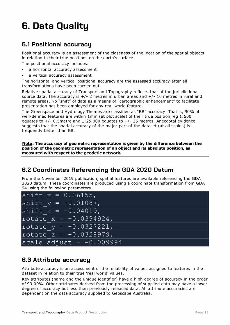
6. Data Quality
6.1 Positional accuracy Positional accuracy is an assessment of the closeness of the location of the spatial objects
in relation to their true positions on the earth’s surface.
The positional accuracy includes:
• a horizontal accuracy assessment
• a vertical accuracy assessment
The horizontal and vertical positional accuracy are the assessed accuracy after all transformations have been carried out.
Relative spatial accuracy of Transport and Topography reflects that of the jurisdictional source data. The accuracy is +/- 2 metres in urban areas and +/- 10 metres in rural and
remote areas. No “shift” of data as a means of “cartographic enhancement” to facilitate presentation has been employed for any real-world feature.
The Greenspace and Hydrology Themes are classified as “BB” accuracy. That is, 90% of well-defined features are within 1mm (at plot scale) of their true position, eg 1:500
equates to +/- 0.5metre and 1:25,000 equates to +/- 25 metres. Anecdotal evidence suggests that the spatial accuracy of the major part of the dataset (at all scales) is frequently better than BB.
UUNoteUU: The accuracy of geometric representation is given by the difference between the position of the geometric representation of an object and its absolute position, as measured with respect to the geodetic network.
6.2 Coordinates Referencing the GDA 2020 Datum From the November 2019 publication, spatial features are available referencing the GDA 2020 datum. These coordinates are produced using a coordinate transformation from GDA
94 using the following parameters.
shift_x = 0.06155,
shift_y = -0.01087,
shift_z = -0.04019,
rotate_x = -0.0394924,
rotate_y = -0.0327221,
rotate_z = -0.0328979,
scale_adjust = -0.009994
6.3 Attribute accuracy Attribute accuracy is an assessment of the reliability of values assigned to features in the
dataset in relation to their true ‘real world’ values.
Key attributes (name and the unique identifier) have a high degree of accuracy in the order of 99.09%. Other attributes derived from the processing of supplied data may have a lower degree of accuracy but less than previously released data. All attribute accuracies are dependent on the data accuracy supplied to Geoscape Australia.

Transport and Topography Data Product Description Page 16
For this product, feature and attribute accuracy is a measure of the degree to which the features and attribute values of spatial objects agree with the information on the source
material. The allowable error in attribute accuracy was previously up to 5%.
A precise attribute accuracy assessment may not always be possible. In these cases an intuitive estimate of the expected attribute accuracy or the likely maximum error based on previous experience is acceptable
6.4 Logical consistency Logical consistency is a measure of the degree to which data complies with the technical
specification. The allowable error in logical consistency previously ranged from 3% to 5%. The test procedures are a mixture of software scripts and onscreen, visual checks.
The data structure has been tested for conformance with the data model. The following have been tested and confirmed to conform:
• File names
• Attribute names
• Attribute lengths
• Attribute types
• Attribute domains
• Attribute order in file.
• Object type
• Compulsory attributes populated.
6.5 Topological consistency Topological consistency is the measure of how features spatially relate to other features within and across themes. Topological inconsistencies are identified using a combination of automated rules, and visual analysis. Where topological inconsistencies are identified they are notified back to the supplier organisation for remediation at source. Some minor topological inconsistencies are corrected during product processing using automated rules. The level of topological consistency is dependent on the data supplied to Geoscape.
During product processing there is some attempt to improve topological consistency across
state and territory borders within the Transport theme using both automated rules and onscreen analysis. Cross border topological consistency is a complex issue and Geoscape continues to engage the Federal, State, and Territory governments of Australia to improve the topological consistency of spatial datasets across these borders.
6.6 Completeness Completeness is an assessment of the extent and range of the dataset with regard to
completeness of coverage, completeness of classification and completeness of verification.
Dataset, theme and coverage
National for the Transport Networks, the Hydrology and Green Spaces.

Transport and Topography Data Product Description Page 17
Attribute completeness
All attributes for each object are populated according to the data model, noting that some attributes are not mandatory.
Temporal accuracy for each layer is applicable to its most current release.
Quality scope
Polygon, line and point geometry accuracy and attribute accuracy for all included areas.
Transport and Topography Data Product Description Page 18
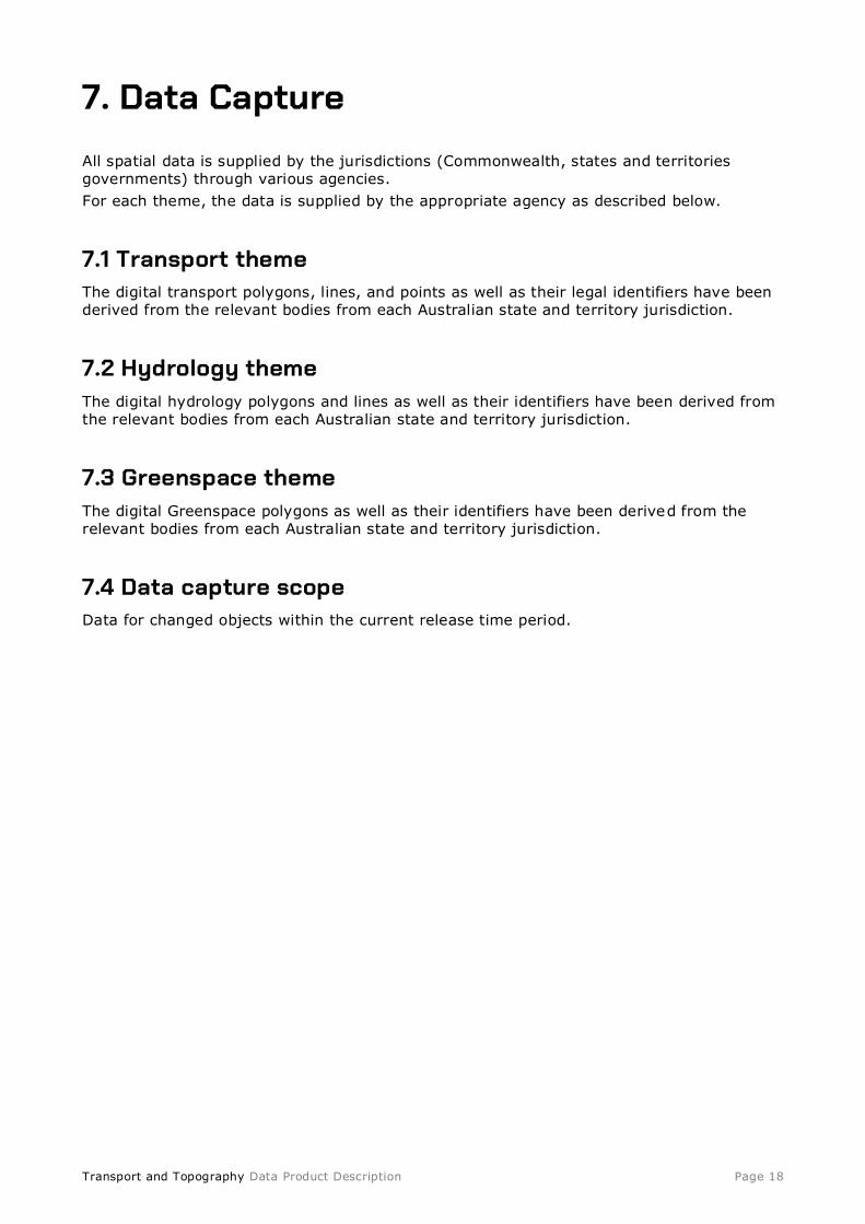
7. Data Capture
All spatial data is supplied by the jurisdictions (Commonwealth, states and territories governments) through various agencies.
For each theme, the data is supplied by the appropriate agency as described below.
7.1 Transport theme The digital transport polygons, lines, and points as well as their legal identifiers have been derived from the relevant bodies from each Australian state and territory jurisdiction.
7.2 Hydrology theme The digital hydrology polygons and lines as well as their identifiers have been derived from the relevant bodies from each Australian state and territory jurisdiction.
7.3 Greenspace theme The digital Greenspace polygons as well as their identifiers have been derived from the relevant bodies from each Australian state and territory jurisdiction.
7.4 Data capture scope Data for changed objects within the current release time period.

Transport and Topography Data Product Description Page 19
8. Data Maintenance
Maintenance of airports, railways, railway stations, hydrology and greenspace is carried out using GIS desktop applications.
Data maintenance – Manual Process
LYNXPSMA AustraliaContributors
YES NO
YES
NO
YES
NO
Data manually checked by data
manager
Dataset data
EXTRACT
Data accessed by data manager
Jurisdiction table(s) updated (if information supplied)
Pass ?
Contributor
Data
Provided
Dataset extracts prepared for distribution
Data join made between appropriate IDB data and
Contributor data
Pass ?
Can be
Used? ?
Table(s) uploaded into
LYNX
Dataset table(s) updated
Data Not Used,
Contributor contacted
Contributor data
checked against
relevant profile
QA checkReport generated
Raw
Table(s)
data
QA Report
Data manually modified if neccessary

Transport and Topography Data Product Description Page 20
8.1 Update frequency Geoscape Australia releases updates to all datasets every quarter in the months of February, May, August and November. The Transport and Topography dataset is updated as deemed necessary by the jurisdictions. Updates are inserted in the Transport and Topography dataset product as they are supplied by data contributors.
8.2 Maintenance scope Geoscape Australia’s data maintenance occurs for existing objects with changed geometry
and/or attributes, as well as data for new objects within the release time period.

Transport and Topography Data Product Description Page 21
9. Data Product Delivery
Geoscape Australia is the crucial link between the supply and demand sides of the market for the fundamental national spatial datasets that it offers under the banner of Geoscape Data. The organisation eliminates the difficulties of negotiating multiple license agreements
with Australian governments and the problems of integrating the data into a seamless consistent national dataset. Furthermore, the existence of Geoscape Australia minimises the duplication of effort within the market for organisations wishing to access national data.
Access to Geoscape Data is enabled through a network of value-added resellers who are licensed by, and work closely with Geoscape Distribution, the wholly owned subsidiary of Geoscape Australia. Value-added resellers create many powerful and varied applications that use Geoscape Data. Geoscape Distribution provides strategic support to value-added resellers to ensure that both the public and private sectors obtain the maximum benefit
from the use of Geoscape Data. Geoscape Australia’s website 1 3T U13T Uwww.geoscape.com.au U U13 T13T provides a value-added reseller directory to assist those interested in accessing Geoscape Data.
Current users of Geoscape Data should contact their value-added reseller for clarification or
guidance before contacting Geoscape Distribution.
For further information on accessing Geoscape Data, or becoming a value-added reseller contact:
Geoscape Data Distribution Unit 6, 113 Canberra Avenue, Griffith ACT 2603 T: 02 6260 9000 W: Uwww.geoscape.com.au
9.1 Delivery medium information Goescape Systems is a cutting-edge data platform that has been developed to hold, quality assure and distribute Geoscape Australia’s suite of national spatial datasets. It streamlines Geoscape Australia’s data delivery. The core of Geoscape Systems is the Integrated Database (IDB), which holds the suite of datasets in one location and within a single environment.
Geoscape Australia provides data updates to licensees through data download. This service
is supported by a detailed user guide.
9.2 Units of delivery Datasets as prescribed in the license agreement brokered by Geoscape Distribution.
9.3 Medium name Online.

Transport and Topography Data Product Description Page 22
9.4 Delivery format information
MapInfo
7 3 B7 3BFormat Name:
TAB – MapInfo Professional
7 4 B7 4BSpecification:
The MapInfo TAB format is a popular geospatial vector data format for geographic information systems software. It is developed and regulated by MapInfo as a proprietary
format. This format includes files with the following extensions: *.tab, *.dat, *.id, *.map
TAB files support geospatial standards such as Open GIS, the OGC, ISO, W3C and others.
7 5 B7 5BLanguage:
English
Shape
7 6 B7 6BFormat Name:
Shape – ESRI
7 7 B7 7BSpecification:
This format includes files with the following extensions: *.shp, *.shx, *.dbf
ESRI Shapefile Technical Description, an ESRI White Paper, July 1998
Follow this link: 13T U1 3TUwww.esri.com/library/whitepapers/pdfs/shapefile.pdf UU 13T 13T
7 8 B7 8BLanguage:
English
Oracle Data Pump
1 0 4BFormat Name:
Oracle 11g Data Pump Format
1 0 5BSpecification:
1 06BThe Data Pump (dump) file set is made up of one or more files that contain table data, database object metadata, and control information. More information is available from 1 2TUOracle U12 T
1 0 7BLanguage:
English
Transport and Topography Data Product Description Page 23
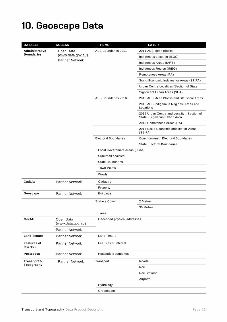
10. Geoscape Data
DATASET ACCESS THEME LAYER
Administrative
Boundaries Open Data (www.data.gov.au)
Partner Network
ABS Boundaries 2011 2011 ABS Mesh Blocks
Indigenous Location (ILOC)
Indigenous Areas (IARE)
Indigenous Region (IREG)
Remoteness Areas (RA)
Socio-Economic Indexes for Areas (SEIFA)
Urban Centre Localities /Section of State
Significant Urban Areas (SUA)
ABS Boundaries 2016 2016 ABS Mesh Blocks and Statistical Areas
2016 ABS Indigenous Regions, Areas and
Locations
2016 Urban Centre and Locality - Section of
State - Significant Urban Area
2016 Remoteness Areas (RA)
2016 Socio-Economic Indexes for Areas
(SEIFA)
Electoral Boundaries Commonwealth Electoral Boundaries
State Electoral Boundaries
Local Government Areas (LGAs)
Suburbs/Localities
State Boundaries
Town Points
Wards
CadLite Partner Network Cadastre
Property
Geoscape Partner Network Buildings
Surface Cover 2 Metres
30 Metres
Trees
G-NAF Open Data (www.data.gov.au)
Geocoded physical addresses
Partner Network
Land Tenure Partner Network Land Tenure
Features of
Interest Partner Network Features of Interest
Postcodes Partner Network Postcode Boundaries
Transport &
Topography Partner Network Transport Roads
Rail
Rail Stations
Airports Hydrology
Greenspace

Transport and Topography Data Product Description Page 24
Appendix A – Transport & Topography Data Model Diagram Transport and Topography DATA MODEL page 1

Transport and Topography Data Product Description Page 25
Transport and Topography DATA MODEL page 2

Transport and Topography Data Product Description Page 26
Transport and Topography DATA MODEL page 3
Note: the TEMP_STREET_LINE_TRACK table (where it exists for a jurisdiction) has the same fields and relationships with other tables as the STREET_LINE table.

Transport and Topography Data Product Description Page 27
Transport and Topography DATA MODEL page 4

Transport and Topography Data Product Description Page 28
Appendix B – Data Dictionary
TRANSPORT
Airports
Table 1: AIRPORT_LG
Name Data Type Description Prim
Key
Man F K TABLE F K Col 10 Char Alias
AIRPORT_LG_PID varchar2(15) The Persistent Identifier is unique to the real
world feature this record represents.
Y Y - - ALG_PID
DATE_CREATED date Date this record was created. N Y - - DT_CREATE
DATE_RETIRED date Date this record was retired. N N - - DT_RETIRE
AIRPORT_NAME varchar2(200) The name of the airport. N Y - - NAME
LOCALITY_PID varchar2(15) Locality persistent identifier. Not mandatory because an airport does not have to exist in a
gazetted locality.
N N - - LOC_PID
TRANSPORT_HIERARCHY_CODE number(5) Transport Hierarchy Code (currently always 700
- any identified landing ground)
N Y TRANSPORT_HIERARCHY_AUT CODE THIER_CODE
STATE_PID varchar2(15) State or territory persistent identifier N Y STATE STATE_PID STATE_PID
Table 2: AIRPORT_LG_LINE
Name Data Type Description Prim Key Man F K TABLE F K Col 10 Char Alias
AIRPORT_LG_LINE_PID varchar2(15) The Persistent Identifier is unique
to the real world feature this record
represents.
Y Y - - AL_LNE_PID
DATE_CREATED date Date this record
was created.
N Y - - DT_CREATE
DATE_RETIRED date Date this record
was retired.
N N - - DT_RETIRE
AIRPORT_LG_PID varchar2(15) Airport persistent
identifier.
N Y AIRPORT_LG AIRPORT_LG_PID ALG_PID
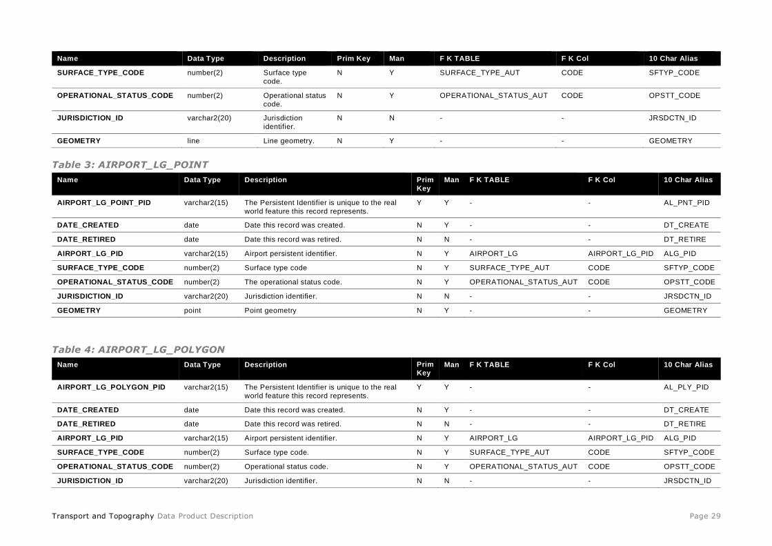
Transport and Topography Data Product Description Page 29
Name Data Type Description Prim Key Man F K TABLE F K Col 10 Char Alias
SURFACE_TYPE_CODE number(2) Surface type
code.
N Y SURFACE_TYPE_AUT CODE SFTYP_CODE
OPERATIONAL_STATUS_CODE number(2) Operational status
code.
N Y OPERATIONAL_STATUS_AUT CODE OPSTT_CODE
JURISDICTION_ID varchar2(20) Jurisdiction
identifier.
N N - - JRSDCTN_ID
GEOMETRY line Line geometry. N Y - - GEOMETRY
Table 3: AIRPORT_LG_POINT
Name Data Type Description Prim
Key
Man F K TABLE F K Col 10 Char Alias
AIRPORT_LG_POINT_PID varchar2(15) The Persistent Identifier is unique to the real
world feature this record represents.
Y Y - - AL_PNT_PID
DATE_CREATED date Date this record was created. N Y - - DT_CREATE
DATE_RETIRED date Date this record was retired. N N - - DT_RETIRE
AIRPORT_LG_PID varchar2(15) Airport persistent identifier. N Y AIRPORT_LG AIRPORT_LG_PID ALG_PID
SURFACE_TYPE_CODE number(2) Surface type code N Y SURFACE_TYPE_AUT CODE SFTYP_CODE
OPERATIONAL_STATUS_CODE number(2) The operational status code. N Y OPERATIONAL_STATUS_AUT CODE OPSTT_CODE
JURISDICTION_ID varchar2(20) Jurisdiction identifier. N N - - JRSDCTN_ID
GEOMETRY point Point geometry N Y - - GEOMETRY
Table 4: AIRPORT_LG_POLYGON
Name Data Type Description Prim
Key Man F K TABLE F K Col 10 Char Alias
AIRPORT_LG_POLYGON_PID varchar2(15) The Persistent Identifier is unique to the real
world feature this record represents.
Y Y - - AL_PLY_PID
DATE_CREATED date Date this record was created. N Y - - DT_CREATE
DATE_RETIRED date Date this record was retired. N N - - DT_RETIRE
AIRPORT_LG_PID varchar2(15) Airport persistent identifier. N Y AIRPORT_LG AIRPORT_LG_PID ALG_PID
SURFACE_TYPE_CODE number(2) Surface type code. N Y SURFACE_TYPE_AUT CODE SFTYP_CODE
OPERATIONAL_STATUS_CODE number(2) Operational status code. N Y OPERATIONAL_STATUS_AUT CODE OPSTT_CODE
JURISDICTION_ID varchar2(20) Jurisdiction identifier. N N - - JRSDCTN_ID
Transport and Topography Data Product Description Page 30
Name Data Type Description Prim
Key
Man F K TABLE F K Col 10 Char Alias
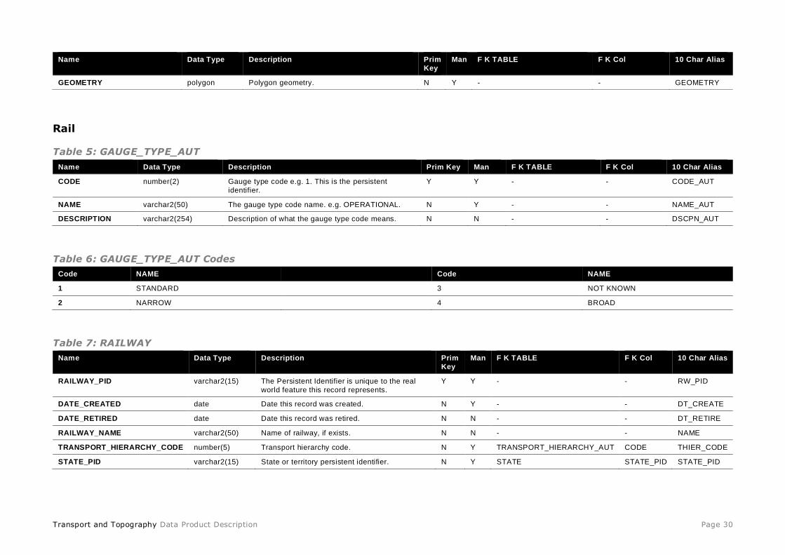
GEOMETRY polygon Polygon geometry. N Y - - GEOMETRY
Rail
Table 5: GAUGE_TYPE_AUT
Name Data Type Description Prim Key Man F K TABLE F K Col 10 Char Alias
CODE number(2) Gauge type code e.g. 1. This is the persistent
identifier.
Y Y - - CODE_AUT
NAME varchar2(50) The gauge type code name. e.g. OPERATIONAL. N Y - - NAME_AUT
DESCRIPTION varchar2(254) Description of what the gauge type code means. N N - - DSCPN_AUT
Table 6: GAUGE_TYPE_AUT Codes
Code NAME Code NAME
1 STANDARD 3 NOT KNOWN
2 NARROW 4 BROAD
Table 7: RAILWAY
Name Data Type Description Prim
Key
Man F K TABLE F K Col 10 Char Alias
RAILWAY_PID varchar2(15) The Persistent Identifier is unique to the real
world feature this record represents.
Y Y - - RW_PID
DATE_CREATED date Date this record was created. N Y - - DT_CREATE
DATE_RETIRED date Date this record was retired. N N - - DT_RETIRE
RAILWAY_NAME varchar2(50) Name of railway, if exists. N N - - NAME
TRANSPORT_HIERARCHY_CODE number(5) Transport hierarchy code. N Y TRANSPORT_HIERARCHY_AUT CODE THIER_CODE
STATE_PID varchar2(15) State or territory persistent identifier. N Y STATE STATE_PID STATE_PID
Transport and Topography Data Product Description Page 31
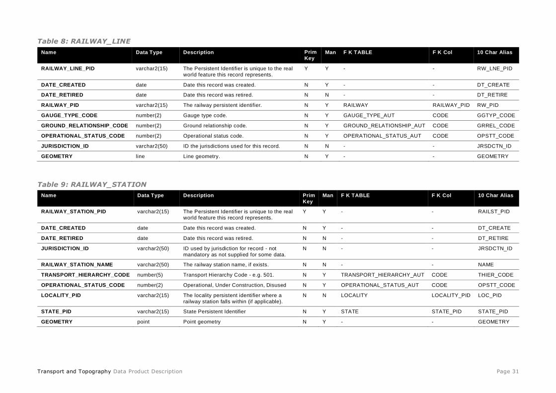
Table 8: RAILWAY_LINE
Name Data Type Description Prim
Key Man F K TABLE F K Col 10 Char Alias
RAILWAY_LINE_PID varchar2(15) The Persistent Identifier is unique to the real
world feature this record represents.
Y Y - - RW_LNE_PID
DATE_CREATED date Date this record was created. N Y - - DT_CREATE
DATE_RETIRED date Date this record was retired. N N - - DT_RETIRE
RAILWAY_PID varchar2(15) The railway persistent identifier. N Y RAILWAY RAILWAY_PID RW_PID
GAUGE_TYPE_CODE number(2) Gauge type code. N Y GAUGE_TYPE_AUT CODE GGTYP_CODE
GROUND_RELATIONSHIP_CODE number(2) Ground relationship code. N Y GROUND_RELATIONSHIP_AUT CODE GRREL_CODE
OPERATIONAL_STATUS_CODE number(2) Operational status code. N Y OPERATIONAL_STATUS_AUT CODE OPSTT_CODE
JURISDICTION_ID varchar2(50) ID the jurisdictions used for this record. N N - - JRSDCTN_ID
GEOMETRY line Line geometry. N Y - - GEOMETRY
Table 9: RAILWAY_STATION
Name Data Type Description Prim
Key
Man F K TABLE F K Col 10 Char Alias
RAILWAY_STATION_PID varchar2(15) The Persistent Identifier is unique to the real
world feature this record represents.
Y Y - - RAILST_PID
DATE_CREATED date Date this record was created. N Y - - DT_CREATE
DATE_RETIRED date Date this record was retired. N N - - DT_RETIRE
JURISDICTION_ID varchar2(50) ID used by jurisdiction for record - not
mandatory as not supplied for some data.
N N - - JRSDCTN_ID
RAILWAY_STATION_NAME varchar2(50) The railway station name, if exists. N N - - NAME
TRANSPORT_HIERARCHY_CODE number(5) Transport Hierarchy Code - e.g. 501. N Y TRANSPORT_HIERARCHY_AUT CODE THIER_CODE
OPERATIONAL_STATUS_CODE number(2) Operational, Under Construction, Disused N Y OPERATIONAL_STATUS_AUT CODE OPSTT_CODE
LOCALITY_PID varchar2(15) The locality persistent identifier where a
railway station falls within (if applicable).
N N LOCALITY LOCALITY_PID LOC_PID
STATE_PID varchar2(15) State Persistent Identifier N Y STATE STATE_PID STATE_PID
GEOMETRY point Point geometry N Y - - GEOMETRY

Transport and Topography Data Product Description Page 32
Roads
Note: the difference between STREET_TYPE_CODE and STREET_SUBTYPE_CODE: • STREET_TYPE_CODE refers to the part of an aggregated road name, i.e. the ‘ROAD’ in ‘SMITH ROAD’. It may not be populated for
all roads, in particular unnamed or access roads. • STREET_SUBTYPE_CODE refers to the structural classification of the road, i.e. whether it is constructed as a motorway, dual
carriageway, vehicle track, roundabout etc. It is a number field and will always have a value (which may be 0, see table 13).
Table 10: OPERATIONAL_STATUS_AUT
Name Data Type Description Prim Key Man F K TABLE F K Col 10 Char Alias
CODE number(2) The operational status code. This is the persistent
identifier.
Y Y - - CODE_AUT
NAME varchar2(50) The name of the operational status code e.g.
Operational.
N Y - - NAME_AUT
DESCRIPTION varchar2(254) Description of what the operational status code
means.
N N - - DSCPN_AUT
Table 10: OPERATIONAL_STATUS_AUT Codes
Code NAME Code NAME
1 Operational 5 Closed
2 Under Construction 6 Proposed
3 Disused 7 Notional
4 Unknown
Table 11: ROUTE_CLASS_AUT
Name Data Type Description Prim Key Man F K TABLE F K Col 10 Char Alias
CODE number(2) The Persistent Identifier is unique to the real world
feature this record represents.
Y Y - - CODE
NAME varchar2(500) Name of the route class code. N Y - - NAME
DESCRIPTION varchar2(500) Description of what the route class code means. N Y - - DESC
Transport and Topography Data Product Description Page 33
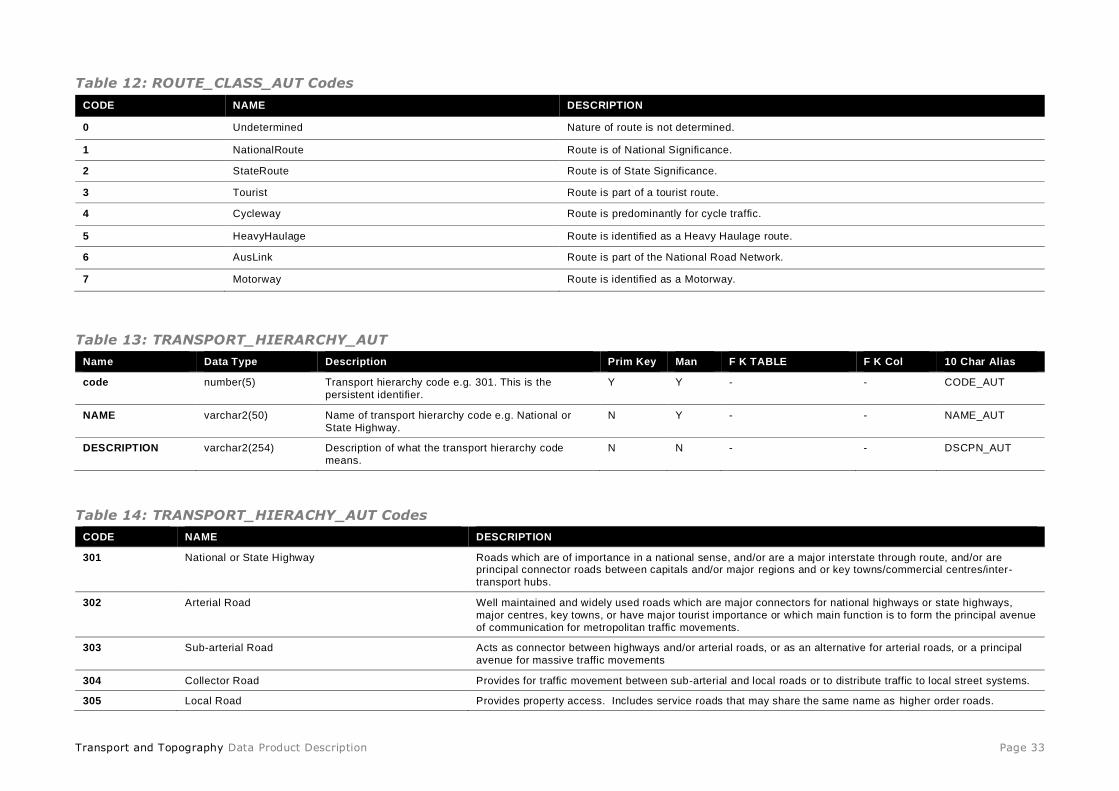
Table 12: ROUTE_CLASS_AUT Codes
CODE NAME DESCRIPTION
0 Undetermined Nature of route is not determined.
1 NationalRoute Route is of National Significance.
2 StateRoute Route is of State Significance.
3 Tourist Route is part of a tourist route.
4 Cycleway Route is predominantly for cycle traffic.
5 HeavyHaulage Route is identified as a Heavy Haulage route.
6 AusLink Route is part of the National Road Network.
7 Motorway Route is identified as a Motorway.
Table 13: TRANSPORT_HIERARCHY_AUT
Name Data Type Description Prim Key Man F K TABLE F K Col 10 Char Alias
code number(5) Transport hierarchy code e.g. 301. This is the
persistent identifier.
Y Y - - CODE_AUT
NAME varchar2(50) Name of transport hierarchy code e.g. National or
State Highway.
N Y - - NAME_AUT
DESCRIPTION varchar2(254) Description of what the transport hierarchy code
means.
N N - - DSCPN_AUT
Table 14: TRANSPORT_HIERACHY_AUT Codes
CODE NAME DESCRIPTION
301 National or State Highway Roads which are of importance in a national sense, and/or are a major interstate through route, and/or are principal connector roads between capitals and/or major regions and or key towns/commercial centres/inter-
transport hubs.
302 Arterial Road Well maintained and widely used roads which are major connectors for national highways or state highways,
major centres, key towns, or have major tourist importance or which main function is to form the principal avenue
of communication for metropolitan traffic movements.
303 Sub-arterial Road Acts as connector between highways and/or arterial roads, or as an alternative for arterial roads, or a principal
avenue for massive traffic movements
304 Collector Road Provides for traffic movement between sub-arterial and local roads or to distribute traffic to local street systems.
305 Local Road Provides property access. Includes service roads that may share the same name as higher order roads.

Transport and Topography Data Product Description Page 34
CODE NAME DESCRIPTION
308 Undetermined Classification undetermined.
309 Access road Road designed to provide access to the rear of, into or within a property but may not necessarily be part of the
public road network. They generally do not have addresses. Would be applied to urban service lanes,
driveways, and other tracks on private property.
400 Pedestrian Thoroughfare A road or passage whose main purpose is to provide non-vehicular access for pedestrians but may allow some
vehicular access (eg malls). Also includes arcades, cycle tracks and foot tracks.
500 Railway Line 1 Public Railway Lines
501 Railway Station Railway Station
503 Railway Line 2 Railway Lines which are Privately owned.
600 Busway A road which has been dedicated as a rapid bus-only transit way. This does not include roads which have bus-
only lanes.
700 Any Identified aircraft landing ground Any Identified aircraft landing ground
701 Helipad Helipad
Table 15: GROUND_RELATIONSHIP_AUT
Name Data Type Description Prim Key Man F K TABLE F K Col 10 Char Alias
CODE number(2) Ground relationship code e.g. 1. This is the persistent
identifier.
Y Y - - CODE_AUT
NAME varchar2(50) Name of the ground relationship code e.g. In Tunnel N Y - - NAME_AUT
DESCRIPTION varchar2(254) Description of what the ground relationship code
means.
N N - - DSCPN_AUT
Table 16: GROUND_RELATIONSHIP_AUT Codes Code NAME DESCRIPTION
0 Unknown
1 Above Ground or On Bridge Road passes over a bridge, and is therefore above the ground or water.
2 In Tunnel Road passes through a tunnel, and is therefore below the ground or water.
3 On Ground Road is on the ground. Default value.
4 Other This may include causeways, dam walls, fords or other crossings.
5 On Water This includes ferry routes or other On Water transportation.
Transport and Topography Data Product Description Page 35
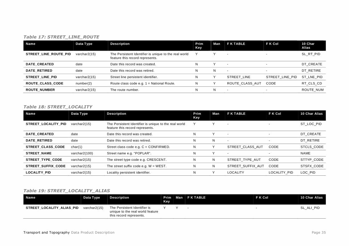
Table 17: STREET_LINE_ROUTE
Name Data Type Description Prim
Key
Man F K TABLE F K Col 10 Char
Alias
STREET_LINE_ROUTE_PID varchar2(15) The Persistent Identifier is unique to the real world
feature this record represents.
Y Y - - SL_RT_PID
DATE_CREATED date Date this record was created. N Y - - DT_CREATE
DATE_RETIRED date Date this record was retired. N N - - DT_RETIRE
STREET_LINE_PID varchar2(15) Street line persistent identifier. N Y STREET_LINE STREET_LINE_PID ST_LNE_PID
ROUTE_CLASS_CODE number(2) Route class code e.g. 1 = National Route. N Y ROUTE_CLASS_AUT CODE RT_CLS_CD
ROUTE_NUMBER varchar2(15) The route number. N N - - ROUTE_NUM
Table 18: STREET_LOCALITY
Name Data Type Description Prim
Key
Man F K TABLE F K Col 10 Char Alias
STREET_LOCALITY_PID varchar2(15) The Persistent Identifier is unique to the real world
feature this record represents.
Y Y - - ST_LOC_PID
DATE_CREATED date Date this record was created. N Y - - DT_CREATE
DATE_RETIRED date Date this record was retired. N N - - DT_RETIRE
STREET_CLASS_CODE char(1) Street class code e.g. C = CONFIRMED. N Y STREET_CLASS_AUT CODE STCLS_CODE
STREET_NAME varchar2(100) Street name e.g. "POPLAR". N Y - - NAME
STREET_TYPE_CODE varchar2(15) The street type code e.g. CRESCENT. N N STREET_TYPE_AUT CODE STTYP_CODE
STREET_SUFFIX_CODE varchar2(15) The street suffix code e.g. W = WEST. N N STREET_SUFFIX_AUT CODE STSFX_CODE
LOCALITY_PID varchar2(15) Locality persistent identifier. N Y LOCALITY LOCALITY_PID LOC_PID
Table 19: STREET_LOCALITY_ALIAS
Name Data Type Description Prim
Key
Man F K TABLE F K Col 10 Char Alias
STREET_LOCALITY_ALIAS_PID varchar2(15) The Persistent Identifier is
unique to the real world feature
this record represents.
Y Y - - SL_ALI_PID
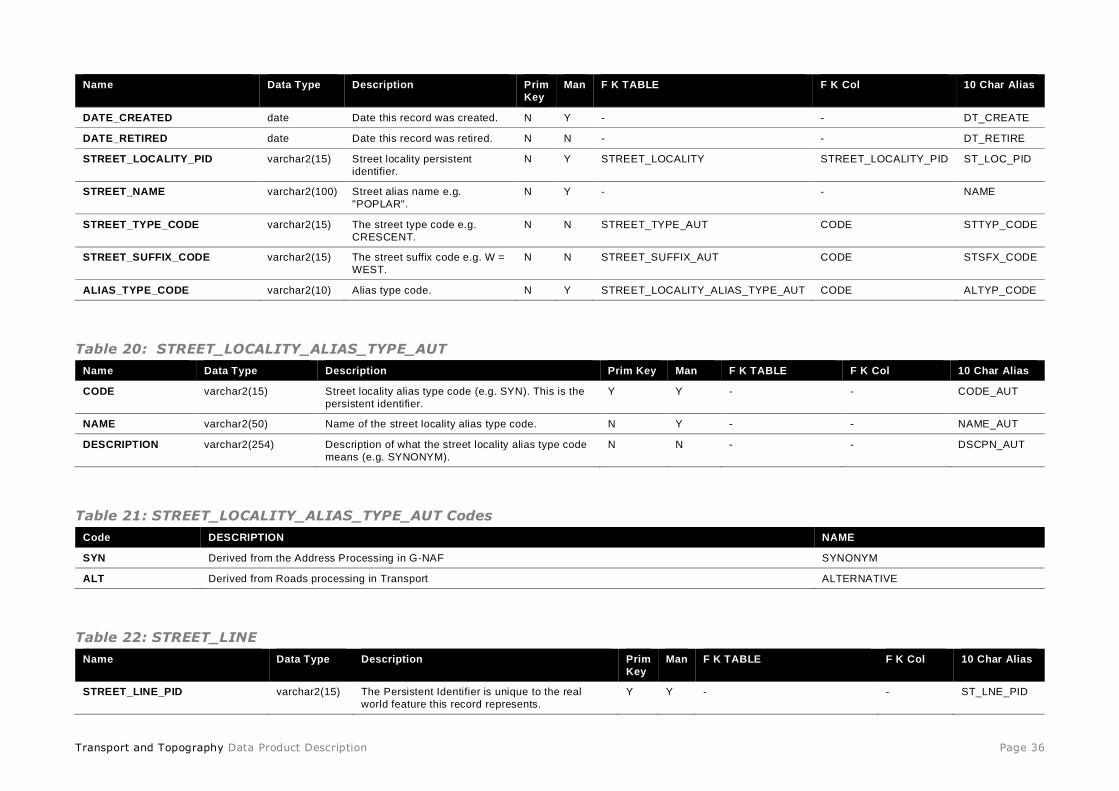
Transport and Topography Data Product Description Page 36
Name Data Type Description Prim
Key
Man F K TABLE F K Col 10 Char Alias
DATE_CREATED date Date this record was created. N Y - - DT_CREATE
DATE_RETIRED date Date this record was retired. N N - - DT_RETIRE
STREET_LOCALITY_PID varchar2(15) Street locality persistent
identifier.
N Y STREET_LOCALITY STREET_LOCALITY_PID ST_LOC_PID
STREET_NAME varchar2(100) Street alias name e.g.
"POPLAR".
N Y - - NAME
STREET_TYPE_CODE varchar2(15) The street type code e.g.
CRESCENT.
N N STREET_TYPE_AUT CODE STTYP_CODE
STREET_SUFFIX_CODE varchar2(15) The street suffix code e.g. W =
WEST.
N N STREET_SUFFIX_AUT CODE STSFX_CODE
ALIAS_TYPE_CODE varchar2(10) Alias type code. N Y STREET_LOCALITY_ALIAS_TYPE_AUT CODE ALTYP_CODE
Table 20: STREET_LOCALITY_ALIAS_TYPE_AUT
Name Data Type Description Prim Key Man F K TABLE F K Col 10 Char Alias
CODE varchar2(15) Street locality alias type code (e.g. SYN). This is the
persistent identifier.
Y Y - - CODE_AUT
NAME varchar2(50) Name of the street locality alias type code. N Y - - NAME_AUT
DESCRIPTION varchar2(254) Description of what the street locality alias type code
means (e.g. SYNONYM).
N N - - DSCPN_AUT
Table 21: STREET_LOCALITY_ALIAS_TYPE_AUT Codes
Code DESCRIPTION NAME
SYN Derived from the Address Processing in G-NAF SYNONYM
ALT Derived from Roads processing in Transport ALTERNATIVE
Table 22: STREET_LINE
Name Data Type Description Prim
Key
Man F K TABLE F K Col 10 Char Alias
STREET_LINE_PID varchar2(15) The Persistent Identifier is unique to the real
world feature this record represents.
Y Y - - ST_LNE_PID

Transport and Topography Data Product Description Page 37
Name Data Type Description Prim
Key
Man F K TABLE F K Col 10 Char Alias
DATE_CREATED date Date this record was created. N Y - - DT_CREATE
DATE_RETIRED date Date this record was retired. N N - - DT_RETIRE
CAPTURE_DATE date Date this record was captured. N N - - DT_CAPTURE
STREET_NAME varchar2(100) Street name. e.g. "POPLAR". N Y - - NAME
STREET_TYPE_CODE varchar2(15) Street type code e.g. CRESCENT. N N STREET_TYPE_AUT CODE STTYP_CODE
STREET_SUBTYPE_CODE number(5) Street subtype code e.g. 2 = Dual Carriageway. N Y STREET_SUBTYPE_AUT CODE SUBTYPE_CD
STREET_SUFFIX_CODE varchar2(15) Street suffix code e.g. W = WEST. N N STREET_SUFFIX_AUT CODE STSFX_CODE
STREET_DIRECTION_CODE number(5) Street direction code e.g.1 = One way. N N STREET_DIRECTION_AUT CODE DIRN_CD
AUTHORITY_CODE number(5) Authority code e.g.1 = State Authority. N N AUTHORITY_AUT CODE AUTHRTY_CD
CAPTURE_SOURCE_CODE number(5) Capture source code e.g. 10 = State/Territory
Topographic Mapping program.
N N CAPTURE_SOURCE_AUT CODE SOURCE_CD
CAPTURE_METHOD_CODE number(5) Capture method code e.g. 11 = Derived from
cadastre.
N N CAPTURE_METHOD_AUT CODE METHOD_CD
NUMBER_OF_LANES_CODE number(5) Number of lanes code e.g. 1 = One. N N NUMBER_OF_LANES_AUT CODE LANES_CD
OPERATIONAL_STATUS_CODE number(2) Operational status code e.g.2 = Under
Construction.
N N OPERATIONAL_STATUS_AUT CODE STATUS_CD
SEASONALITY_CODE number(1) Seasonality code e.g. 1 - Subject to Seasonal
Closure. N N SEASONALITY_AUT CODE SEASONL_CD
TRANSPORT_HIERARCHY_CODE number(5) Transport hierarchy code e.g.302 = Arterial Road. N Y TRANSPORT_HIERARCHY_AUT CODE THIER_CODE
SURFACE_TYPE_CODE number(2) Surface type code e.g.1 = Sealed. N Y SURFACE_TYPE_AUT CODE SFTYP_CODE
GROUND_RELATIONSHIP_CODE number(2) Ground relationship code e.g.1 = Above Ground
or On Bridge.
N Y GROUND_RELATIONSHIP_AUT CODE GRREL_CODE
TRAFFICABILITY_CODE number(5) Trafficability code e.g. 2 = Pedestrian traffic only. N N TRAFFICABILITY_AUT CODE TRFFCBL_CD
USER_ACCESS_CODE number(5) User access code e.g. 2 = Authorised. N N USER_ACCESS_AUT CODE ACCESS_CD
HEIGHT_LIMIT_METRES number(3,1) The height limit of vehicles in metres. N N - - HGHT_LMT_M
SPEED_LIMIT_KMPH number(3) Speed limit in kilometres per hour. N N - - SPD_LMT_KM
WEIGHT_LIMIT_TONNES number(4) The weight limit of vehicles in tonnes allowed on
the structure.
N N - - WGHT_LMT_T
POSITIONAL_ACCURACY number(8) Positional accuracy in metres. N N - - POS_ACC
JURISDICTION_ID varchar2(16) The jurisdiction identifier used for this street. Note
that NSW sourced roads within the ACT dataset have a ‘NSW’ prefix for the JURISTICTION_ID
attribute.
N N - - JRSDCTN_ID

Transport and Topography Data Product Description Page 38
Name Data Type Description Prim
Key
Man F K TABLE F K Col 10 Char Alias
STATE_PID varchar2(15) State or territory persistent identifier. N Y STATE STATE_PID STATE_PID
GEOMETRY line Line geometry. N Y - - GEOMETRY
Table 23: AUTHORITY_AUT
Name Data Type Description Prim Key Man F K TABLE F K Col 10 Char Alias
CODE number(5) Authority code (e.g. 1). This is the persistent
identifier.
Y Y - - CODE
NAME varchar2(50) Name of the authority code. N Y - - NAME
DESCRIPTION varchar2(500) Description of what the authority code means. N Y - - DESCRIPTIO
Table 24: AUTHORITY_AUT Codes
CODE NAME DESCRIPTION
0 Undetermined
1 State authority Road is vested in a state government authority or agency, usually as a result of being declared under relevant jurisdictional legislation, registration processes, gazettal or proclamation; the state government authority is overall responsible for the
upkeep of the road. Roads funded federally would still have AUTHORITY = "State"
2 Local authority Road is vested in a local government authority, as a result of relevant legislation etc. The LGA is overall responsible for the
upkeep of the road.
3 Other government entity Road is vested in another government authority.
4 Undetermined government authority Road is vested in either a state or local government authority.
8 Private Road on privately-owned property which has not been given to a government entity for management.
9 Other
14 State Government - Transport Authority Road is vested in, and is the responsibility of, the relevant state or territory transport authority.
16 State Government – Forestry Authority Road is vested in, and is the responsibility of, the relevant state or territory forestry or primary industries authority.
17 State Government – National Parks Authority Road is vested in, and is the responsibility of, the relevant state or territory national parks and wildlife authority.
98 Road crosses cadastre Road crosses the boundary of cadastral parcels and may or may not be part of the public road network.
99 Likely non-public road Road falls completely within a cadastral parcel and is therefore not likely to be part of the public road network.
Transport and Topography Data Product Description Page 39
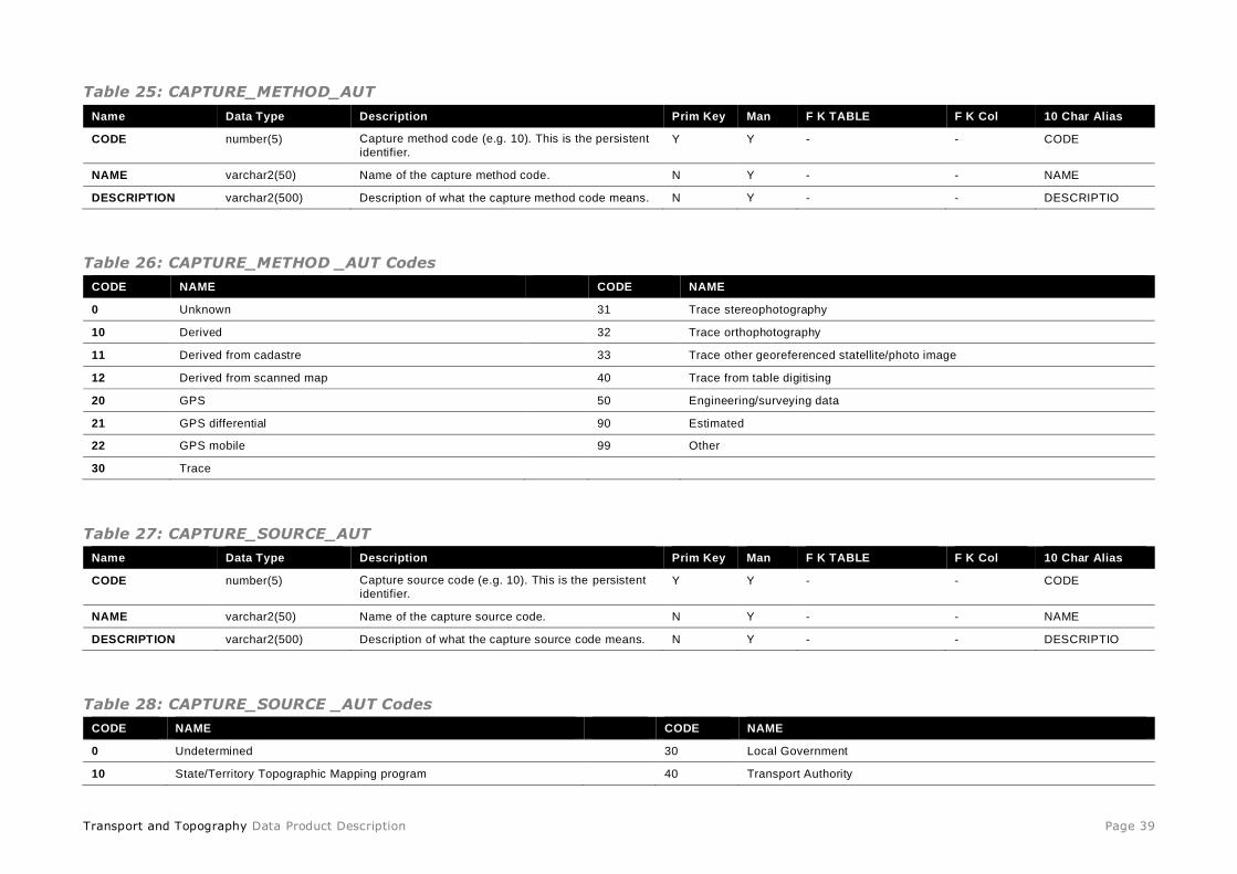
Table 25: CAPTURE_METHOD_AUT
Name Data Type Description Prim Key Man F K TABLE F K Col 10 Char Alias
CODE number(5) Capture method code (e.g. 10). This is the persistent
identifier. Y Y - - CODE
NAME varchar2(50) Name of the capture method code. N Y - - NAME
DESCRIPTION varchar2(500) Description of what the capture method code means. N Y - - DESCRIPTIO
Table 26: CAPTURE_METHOD _AUT Codes
CODE NAME CODE NAME
0 Unknown 31 Trace stereophotography
10 Derived 32 Trace orthophotography
11 Derived from cadastre 33 Trace other georeferenced statellite/photo image
12 Derived from scanned map 40 Trace from table digitising
20 GPS 50 Engineering/surveying data
21 GPS differential 90 Estimated
22 GPS mobile 99 Other
30 Trace
Table 27: CAPTURE_SOURCE_AUT
Name Data Type Description Prim Key Man F K TABLE F K Col 10 Char Alias
CODE number(5) Capture source code (e.g. 10). This is the persistent
identifier. Y Y - - CODE
NAME varchar2(50) Name of the capture source code. N Y - - NAME
DESCRIPTION varchar2(500) Description of what the capture source code means. N Y - - DESCRIPTIO
Table 28: CAPTURE_SOURCE _AUT Codes
CODE NAME CODE NAME
0 Undetermined 30 Local Government
10 State/Territory Topographic Mapping program 40 Transport Authority

Transport and Topography Data Product Description Page 40
CODE NAME CODE NAME
11 Jurisdiction tourism mapping program 50 Emergency Services
12 Other Lands Program: Pastoral, Cadastral, Indigenous 60 Forestry
20 Collaborative topographic mapping program 70 National Parks & Wildlife
21 Commonwealth topographic mapping program (non-Defence) 80 Water Authority
22 Defence topographic mapping program 90 Power Authority
23 Other Commonwealth mapping program 99 Other
Table 29: NUMBER_OF_LANES_AUT
Name Data Type Description Prim Key Man F K TABLE F K Col 10 Char Alias
CODE number(5) Number of lanes code (e.g. 1). This is the persistent
identifier.
Y Y - - CODE
NAME varchar2(50) Name of the number of lanes code. N Y - - NAME
DESCRIPTION varchar2(500) Description of what the number of lanes code means. N Y - - DESCRIPTIO
Table 30: NUMBER_OF_LANES_AUT Codes
CODE NAME DESCRIPTION
0 Undetermined
1 One Road only has one lane.
2 More than one Road has two or more lanes.
Table 31: SEASONALITY_AUT
Name Data Type Description Prim Key Man F K TABLE F K Col 10 Char Alias
CODE number(5) Seasonality code (e.g. 1). This is the persistent
identifier.
Y Y - - CODE
NAME varchar2(50) Name of seasonality code. N Y - - NAME
DESCRIPTION varchar2(500) Description of what the seasonality code means. N Y - - DESCRIPTIO
Table 32: SEASONALITY_AUT Codes
CODE NAME DESCRIPTION
0 Undetermined Default value. Includes all other roads which may still be closed due to adverse but unlikely weather conditions.
1 Subject to Seasonal
Closure
Road is subject to closure at certain times of year depending upon weather conditions. For example, during wet weather or sn ow. Victoria currently
populates from CFA feedback.

Transport and Topography Data Product Description Page 41
Table 33: STREET_DIRECTION_AUT
Name Data Type Description Prim Key Man F K TABLE F K Col 10 Char Alias
CODE number(5) Street direction code (e.g. 1). This is the persistent
identifier.
Y Y - - CODE
NAME varchar2(50) Name of the street direction code. N Y - - NAME
DESCRIPTION varchar2(500) Description of what the street direction code means. N Y - - DESCRIPTIO
Table 34: STREET_DIRECTION_AUT Codes
CODE NAME DESCRIPTION
0 Undetermined
1 One way Traffic is restricted to travel in one direction only at all times.
2 Both ways Traffic can travel in either direction.
3 Alternating Traffic is restricted to travel in one direction only, but the direction can change.
Table 35: STREET_SUBTYPE_AUT
Name Data Type Description Prim Key Man F K TABLE F K Col 10 Char Alias
CODE number(5) Street subtype code (e.g. 1). This is the persistent
identifier.
Y Y - - CODE
NAME varchar2(50) Name of the street subtype code. N Y - - NAME
DESCRIPTION varchar2(500) Description of what the street subtype code means. N Y - - DESCRIPTIO
Table 36: STREET_SUBTYPE_AUT Codes
CODE NAME DESCRIPTION
0 Undetermined
1 Standard
Road/Single
Carriageway
Single carriageway road with ability to be addressed if required. Default value. Would include emergency crossovers.
2 Dual
Carriageway
Two road segments with opposing flows of traffic, with a physical impediment to crossing from one side to another, and carry ing the same name and
other common attributes. Can have property access and crossings.
3 Motorway A high traffic volume, high speed road, generally comprising dual carriageway and also having full access control and grade s eparated intersections, with no direct access from adjoining properties or side roads and all crossings are by means of overpass and underpass bridges wit h traffic entering or
leaving by means of ramps.

Transport and Topography Data Product Description Page 42
CODE NAME DESCRIPTION
4 Roundabout Road segment part of an intersection designed to allow smooth integration but also slow traffic. It must be circular or elliptical in design, have one-way
flow, and would generally not have addresses on it. Roundabouts larger than 20m will be captured as lines with this sub -type.
5 Entry/Exit Ramp An access ramp to or from one road to another to allow smooth integration of traffic, and is associated with a road of ROADTYPE = "freeway" o r
"motorway". Travel flow is in one direction only, they are always sealed and mostly have a single lane.
6 Vehicular Track A road of minimal or no construction, whose surface may vary from poorly surfaced to tracks beaten by the passage of vehicles. Th ey are generally
passable by 2WD vehicles in fair weather only. Vehicular tracks generally do not form part of the public communic ation system, but provide access to
individual properties or areas used for pastoral or industrial purposes. May include driveways in properties.
7 Pathway A road or track designed to carry pedestrian or cycle traffic only (but may have restricted vehicular access).
8 Connector A data management feature used to connect other road features to allow network analysis of transportation systems.
9 Ferry Route A ferry route.
Table 37: TRAFFICABILITY_AUT
Name Data Type Description Prim Key Man F K TABLE F K Col 10 Char Alias
CODE number(5) Trafficability code (e.g. 1). This is the persistent
identifier.
Y Y - - CODE
NAME varchar2(50) Name of the trafficability code. N Y - - NAME
DESCRIPTION varchar2(500) Description of what the trafficability code means. N Y - - DESCRIPTIO
Table 38: TRAFFICABILITY_AUT Codes
CODE NAME DESCRIPTION
0 Undetermined
1 All Vehicles Open to use by any vehicle.
2 Pedestrian traffic only Pedestrian traffic only.
3 Limited Capacity Limited capacity.
4 4WD only Unimproved road generally only passable in a 4WD vehicle.
Table 39: USER_ACCESS_AUT
Name Data Type Description Prim Key Man F K TABLE F K Col 10 Char Alias
CODE number(5) User access code (e.g. 1). This is the persistent
identifier.
Y Y - - CODE
NAME varchar2(50) Name of the user access code. N Y - - NAME
DESCRIPTION varchar2(500) Description of what the user access code
means.
N Y - - DESCRIPTIO

Transport and Topography Data Product Description Page 43
Table 40: USER_ACCESS_AUT Codes
CODE NAME DESCRIPTION
0 Undetermined
1 Inclusive Road is usually open at all times to the general public.
2 Authorised Access to road may require authorisation from responsible authority. Includes but not limited to state and local authority roads such as some roads
in national parks and state forests, cemeteries, sports grounds, hospitals, shopping centres, schools, and roads only accessi ble by buses; and private roads such as (but not necessarily limited to) caravan parks, retirement villages, universities, private schools, gated communi ties or other
residential complexes. Also includes emergency crossovers.
3 Exclusive / Restricted Road is restricted to the use of the responsible authority only. Includes roads on private land that do not have a USER ACCESS value of
"AUTHORISED". Default value where AUTHORITY = "Private".
4 Tollway Road is usually open at all times to the general public but will require payment for access.
98 Either Private or
Authorised
Road is known to be not part of the public road network and is therefore likely to have restricted access.
99 Either Open or
Authorised
Road is vested in a state, territory or local government authority, but its user access is unknown.
Table 41: STREET_LOCALITY_LINE
Name Data Type Description Prim
Key
Man F K TABLE F K Col 10 Char
Alias
STREET_LOCALITY_LINE_PID varchar2(15) The Persistent Identifier is unique to the real
world feature this record represents.
Y Y - - SL_LNE_PID
DATE_CREATED date Date this record was created. N Y - - DT_CREATE
DATE_RETIRED date Date this record was retired. N N - - DT_RETIRE
STREET_LOCALITY_PID varchar2(15) Street locality persistent identifier. N Y STREET_LOCALITY STREET_LOCALITY_PID ST_LOC_PID
STREET_LINE_PID varchar2(15) The STREET_LINE record this record was
derived from.
N Y STREET_LINE STREET_LINE_PID ST_LNE_PID
GEOMETRY line Line geometry. N Y - - GEOMETRY
Table 42: STREET_CLASS_AUT
Name Data Type Description Prim Key Man F K TABLE F K Col 10 Char Alias
CODE varchar (1) Street class code (e.g. C). This is the persistent
identifier.
Y Y - - CODE_AUT
NAME varchar2(50) Name of the street class code. N Y - - NAME_AUT
DESCRIPTION varchar2(200) Description of what this street class code represents
(e.g. Confirmed Street, Unconfirmed Street).
N N - - DSCPN_AUT

Transport and Topography Data Product Description Page 44
Table 43: STREET_CLASS_AUT Codes
Street Class Code Name Description
C CONFIRMED A confirmed street is present in the roads data of the Geoscape Transport and Topography product for the
same release.
U UNCONFIRMED An unconfirmed street is NOT present in the roads data of the Geoscape Transport and Topography product for
the same release and will not have a street locality geocode.
Table 44: STREET_SUFFIX_AUT
Name Data Type Description Prim Key Man F K TABLE F K Col 10 Char Alias
code varchar2(15) Street suffix code (e.g. W).(AS4590.8.8). This
is the persistent identifier.
Y Y - - CODE_AUT
name varchar2(50) Name of the street suffix code. N Y - - NAME_AUT
description varchar2(254) Description of the street suffix code. N N - - DSCPN_AUT
Table 45: STREET_SUFFIX_AUT Codes
Suffix Type Description / Name Suffix Type Description / Name
CN CENTRAL SE SOUTH EAST
DE DEVIATION SW SOUTH WEST
E EAST UP UPPER
EX EXTENSION W WEST
LR LOWER IN INNER
ML MALL OF OFF
N NORTH ON ON
NE NORTH EAST OP OVERPASS
NW NORTH WEST OT OUTER
S SOUTH
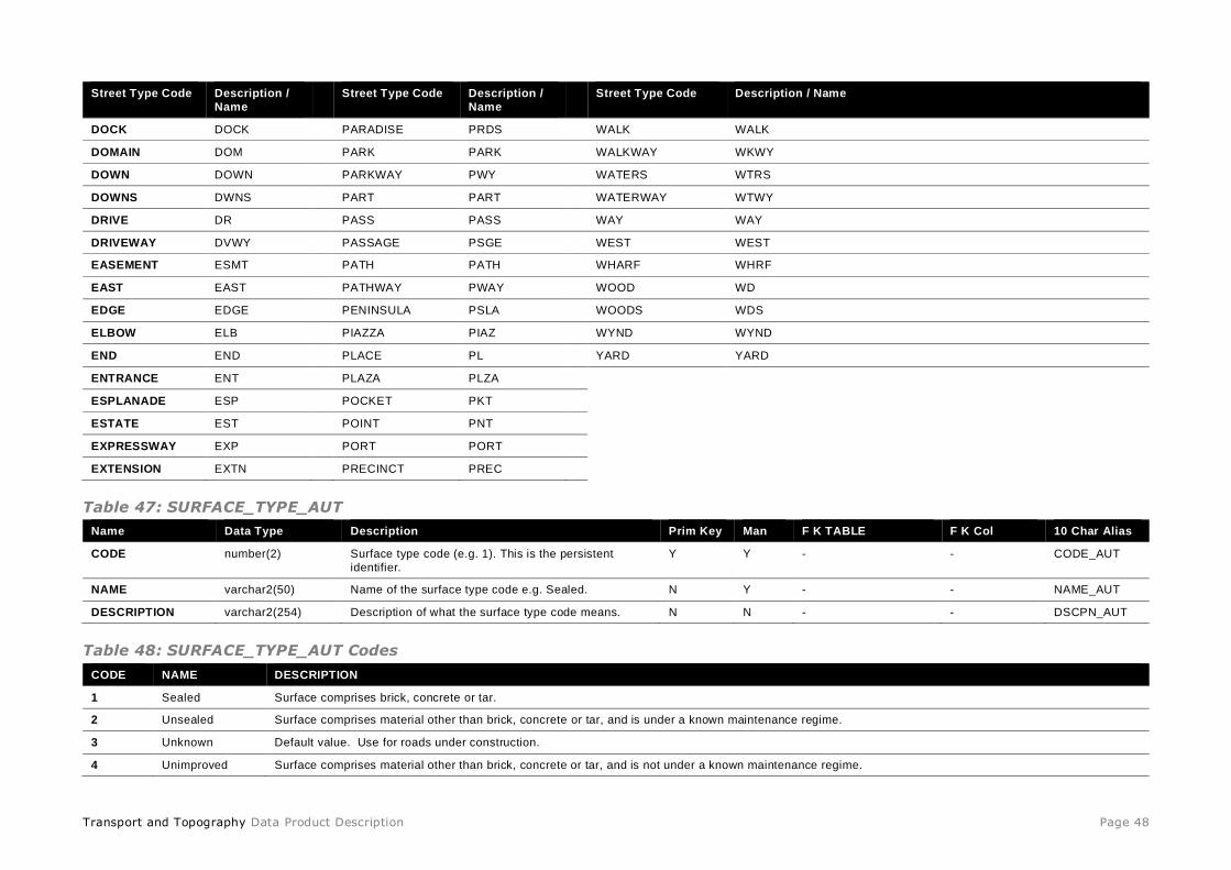
Table 46: STREET_TYPE_AUT
Name Data Type Description Prim Key Man F K TABLE F K Col 10 Char Alias
CODE varchar2(15) Street type in full text (eg. AVENUE, PARADE,
STREET) This is the persistent identifier.
Y Y - - CODE_AUT
NAME varchar2(50) Street type as an abbreviation (e.g. AV, PDE,
ST), based on AS4590 road types, where
applicable.
N Y - - NAME_AUT

Transport and Topography Data Product Description Page 45
Name Data Type Description Prim Key Man F K TABLE F K Col 10 Char Alias
DESCRIPTION varchar2(15) Street type as an abbreviation (e.g. AV, PDE,
ST), based on AS4590 road types, where
applicable.
N N - - DSCPN_AUT
Note: the usage of the code, name and description is intentional (i.e. full text street type is used for the code) due to the initial
development of the model and the dependencies at the time of developing the integrated data model. Ideally this table should be changed, but there are no current plans to change due to the impact for users on changing the model.
Table 48: STREET_TYPE_AUT Codes
Note: the list of street types may not necessarily have roads in the T&T product. There are some additional street types not listed in the AS4590 (road abbreviations) that are due to the street types provided by the contributors.
Street Type Code Description /
Name
Street Type Code Description /
Name
Street Type Code Description / Name
ACCESS ACCS
FAIRWAY FAWY
PROMENADE PROM
ACRE ACRE
FIREBREAK FBRK
PURSUIT PRST
AIRWALK AWLK
FIRELINE FLNE
QUAD QUAD
ALLEY ALLY
FIRETRACK FTRK
QUADRANT QDRT
ALLEYWAY ALWY
FIRETRAIL FITR
QUAY QY
AMBLE AMBL
FLAT FLAT
QUAYS QYS
APPROACH APP
FLATS FLTS
RAMBLE RMBL
ARCADE ARC
FOLLOW FOLW
RAMP RAMP
ARTERIAL ARTL
FOOTWAY FTWY
RANGE RNGE
ARTERY ARTY
FORD FORD
REACH RCH
AVENUE AV
FORESHORE FSHR
REEF REEF
BANAN BA
FORK FORK
RESERVE RES
BANK BANK
FORMATION FORM
REST REST
BAY BAY
FREEWAY FWY
RETREAT RTT
BEACH BCH
FRONT FRNT
RETURN RTN
BEND BEND
FRONTAGE FRTG
RIDE RIDE
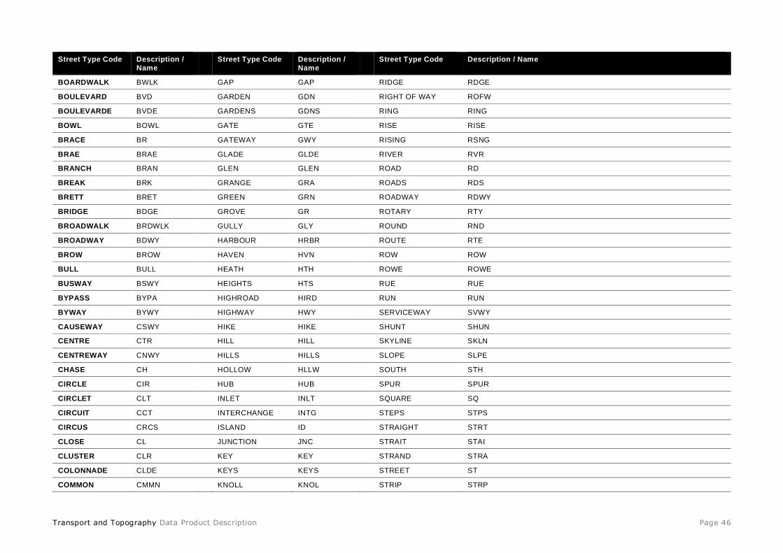
Transport and Topography Data Product Description Page 46
Street Type Code Description /
Name
Street Type Code Description /
Name
Street Type Code Description / Name
BOARDWALK BWLK
GAP GAP
RIDGE RDGE
BOULEVARD BVD
GARDEN GDN
RIGHT OF WAY ROFW
BOULEVARDE BVDE
GARDENS GDNS
RING RING
BOWL BOWL
GATE GTE
RISE RISE
BRACE BR
GATEWAY GWY
RISING RSNG
BRAE BRAE
GLADE GLDE
RIVER RVR
BRANCH BRAN
GLEN GLEN
ROAD RD
BREAK BRK
GRANGE GRA
ROADS RDS
BRETT BRET
GREEN GRN
ROADWAY RDWY
BRIDGE BDGE
GROVE GR
ROTARY RTY
BROADWALK BRDWLK
GULLY GLY
ROUND RND
BROADWAY BDWY
HARBOUR HRBR
ROUTE RTE
BROW BROW
HAVEN HVN
ROW ROW
BULL BULL
HEATH HTH
ROWE ROWE
BUSWAY BSWY
HEIGHTS HTS
RUE RUE
BYPASS BYPA
HIGHROAD HIRD
RUN RUN
BYWAY BYWY
HIGHWAY HWY
SERVICEWAY SVWY
CAUSEWAY CSWY
HIKE HIKE
SHUNT SHUN
CENTRE CTR
HILL HILL
SKYLINE SKLN
CENTREWAY CNWY
HILLS HILLS
SLOPE SLPE
CHASE CH
HOLLOW HLLW
SOUTH STH
CIRCLE CIR
HUB HUB
SPUR SPUR
CIRCLET CLT
INLET INLT
SQUARE SQ
CIRCUIT CCT
INTERCHANGE INTG
STEPS STPS
CIRCUS CRCS
ISLAND ID
STRAIGHT STRT
CLOSE CL
JUNCTION JNC
STRAIT STAI
CLUSTER CLR
KEY KEY
STRAND STRA
COLONNADE CLDE
KEYS KEYS
STREET ST
COMMON CMMN
KNOLL KNOL
STRIP STRP

Transport and Topography Data Product Description Page 47
Street Type Code Description /
Name
Street Type Code Description /
Name
Street Type Code Description / Name
COMMONS CMMNS
LADDER LADR
SUBWAY SBWY
CONCORD CNCD
LANDING LDG
TARN TARN
CONCOURSE CON
LANE LANE
TERRACE TCE
CONNECTION CNTN
LANEWAY LNWY
THOROUGHFARE THFR
COPSE CPS
LEAD LEAD
THROUGHWAY THRU
CORNER CNR
LEADER LEDR
TOLLWAY TLWY
CORSO CSO
LINE LINE
TOP TOP
COURSE CRSE
LINK LINK
TOR TOR
COURT CT
LOOKOUT LKT
TRACK TRK
COURTYARD CTYD
LOOP LOOP
TRAIL TRL
COVE COVE
LYNNE LYNN
TRAMWAY TMWY
CRESCENT CR
MALL MALL
TRAVERSE TVSE
CREST CRST
MANOR MANR
TRUNKWAY TKWY
CRIEF CRF
MART MART
TUNNEL TUNL
CROOK CRK
MAZE MAZE
TURN TURN
CROSS CRSS
MEAD MEAD
TWIST TWIST
CROSSING CRSG
MEANDER MNDR
UNDERPASS UPAS
CRUISEWAY CUWY
MEW MEW
VALE VALE
CUL-DE-SAC CSAC
MEWS MEWS
VALLEY VLLY
CUT CUT
MILE MILE
VERGE VERGE
CUTTING CUTT
MOTORWAY MTWY
VIADUCT VIAD
DALE DALE
NOOK NOOK
VIEW VIEW
DASH DASH
NORTH NTH
VIEWS VWS
DELL DELL
NULL NULL
VILLA VLLA
DENE DENE
OUTLET OTLT
VILLAGE VLGE
DEVIATION DE
OUTLOOK OTLK
VILLAS VLLS
DIP DIP
OVAL OVAL
VISTA VSTA
DISTRIBUTOR DSTR
PALMS PLMS
VUE VUE
DIVIDE DIV
PARADE PDE
WADE WADE
Transport and Topography Data Product Description Page 48
Street Type Code Description /
Name
Street Type Code Description /
Name
Street Type Code Description / Name
DOCK DOCK
PARADISE PRDS
WALK WALK
DOMAIN DOM
PARK PARK
WALKWAY WKWY
DOWN DOWN PARKWAY PWY WATERS WTRS
DOWNS DWNS PART PART WATERWAY WTWY
DRIVE DR PASS PASS WAY WAY
DRIVEWAY DVWY PASSAGE PSGE WEST WEST
EASEMENT ESMT PATH PATH WHARF WHRF
EAST EAST PATHWAY PWAY WOOD WD
EDGE EDGE PENINSULA PSLA WOODS WDS
ELBOW ELB PIAZZA PIAZ WYND WYND
END END PLACE PL YARD YARD
ENTRANCE ENT PLAZA PLZA
ESPLANADE ESP POCKET PKT
ESTATE EST POINT PNT
EXPRESSWAY EXP PORT PORT
EXTENSION EXTN PRECINCT PREC
Table 47: SURFACE_TYPE_AUT
Name Data Type Description Prim Key Man F K TABLE F K Col 10 Char Alias
CODE number(2) Surface type code (e.g. 1). This is the persistent
identifier.
Y Y - - CODE_AUT
NAME varchar2(50) Name of the surface type code e.g. Sealed. N Y - - NAME_AUT
DESCRIPTION varchar2(254) Description of what the surface type code means. N N - - DSCPN_AUT
Table 48: SURFACE_TYPE_AUT Codes
CODE NAME DESCRIPTION
1 Sealed Surface comprises brick, concrete or tar.
2 Unsealed Surface comprises material other than brick, concrete or tar, and is under a known maintenance regime.
3 Unknown Default value. Use for roads under construction.
4 Unimproved Surface comprises material other than brick, concrete or tar, and is not under a known maintenance regime.
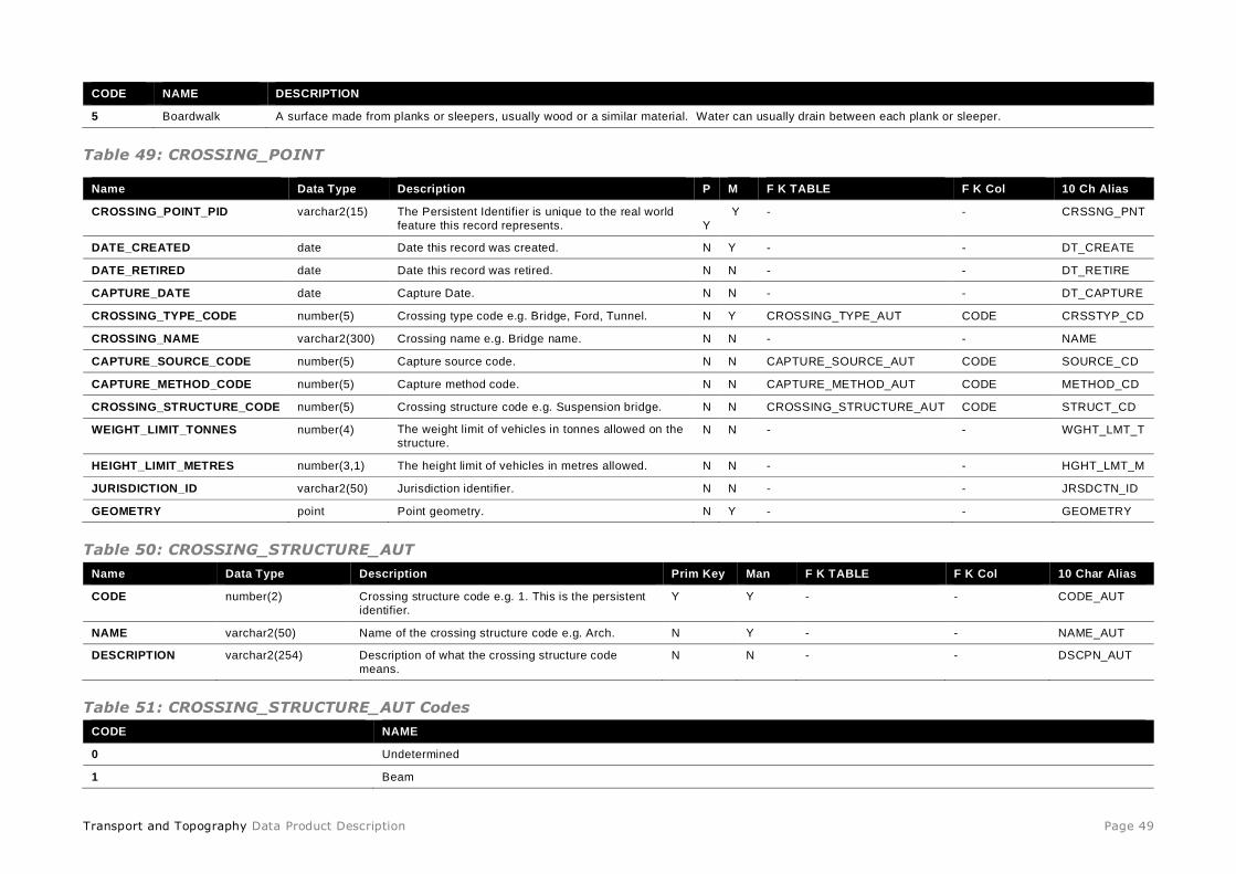
Transport and Topography Data Product Description Page 49
CODE NAME DESCRIPTION
5 Boardwalk A surface made from planks or sleepers, usually wood or a similar material. Water can usually drain between each plank or sleeper.
Table 49: CROSSING_POINT
Table 50: CROSSING_STRUCTURE_AUT
Name Data Type Description Prim Key Man F K TABLE F K Col 10 Char Alias
CODE number(2) Crossing structure code e.g. 1. This is the persistent
identifier.
Y Y - - CODE_AUT
NAME varchar2(50) Name of the crossing structure code e.g. Arch. N Y - - NAME_AUT
DESCRIPTION varchar2(254) Description of what the crossing structure code
means.
N N - - DSCPN_AUT
Table 51: CROSSING_STRUCTURE_AUT Codes
CODE NAME
0 Undetermined
1 Beam
Name Data Type Description P M F K TABLE F K Col 10 Ch Alias
CROSSING_POINT_PID varchar2(15) The Persistent Identifier is unique to the real world
feature this record represents.
Y
Y - - CRSSNG_PNT
DATE_CREATED date Date this record was created. N Y - - DT_CREATE
DATE_RETIRED date Date this record was retired. N N - - DT_RETIRE
CAPTURE_DATE date Capture Date. N N - - DT_CAPTURE
CROSSING_TYPE_CODE number(5) Crossing type code e.g. Bridge, Ford, Tunnel. N Y CROSSING_TYPE_AUT CODE CRSSTYP_CD
CROSSING_NAME varchar2(300) Crossing name e.g. Bridge name. N N - - NAME
CAPTURE_SOURCE_CODE number(5) Capture source code. N N CAPTURE_SOURCE_AUT CODE SOURCE_CD
CAPTURE_METHOD_CODE number(5) Capture method code. N N CAPTURE_METHOD_AUT CODE METHOD_CD
CROSSING_STRUCTURE_CODE number(5) Crossing structure code e.g. Suspension bridge. N N CROSSING_STRUCTURE_AUT CODE STRUCT_CD
WEIGHT_LIMIT_TONNES number(4) The weight limit of vehicles in tonnes allowed on the
structure. N N - - WGHT_LMT_T
HEIGHT_LIMIT_METRES number(3,1) The height limit of vehicles in metres allowed. N N - - HGHT_LMT_M
JURISDICTION_ID varchar2(50) Jurisdiction identifier. N N - - JRSDCTN_ID
GEOMETRY point Point geometry. N Y - - GEOMETRY

Transport and Topography Data Product Description Page 50
CODE NAME
2 Cantilever
3 Arch
4 Suspension
5 Cable-stayed
6 Truss
7 Drawbridge
Table 52: CROSSING_TYPE_AUT
Name Data Type Description Prim Key Man F K TABLE F K Col 10 Char Alias
CODE number(2) Crossing type code e.g. 1. This is the persistent
identifier.
Y Y - - CODE_AUT
NAME varchar2(50) Name of the crossing type code e.g. Bridge. N Y - - NAME_AUT
DESCRIPTION varchar2(254) Description of what the crossing type code means. N N - - DSCPN_AUT
Table 53: CROSSING_TYPE_AUT Codes
CODE NAME DESCRIPTION
1 Bridge Structure erected over a depression or obstacle to carry traffic. Must be connected to the transport network.
2 Tunnel An underground or underwater passage for a road connected to the transport network.
3 Ford A shallow or flat portion of the bed of a watercourse or lake where crossing may be affected. Must be connected to the trans port network.
4 Other
5 Floodway A section of road specifically designed to allow periodic or permanent inundation by water
6 Culvert A masonry conduit which serves as a channel crossing for water or a transport network beneath a road or railway.
Table 54: TRAFFIC_CONTROL_DEVICE_POINT
Column Datatype Description P M F K TABLE F K Col 10 Ch Alias
TCD_POINT_PID varchar2(15) The Persistent Identifier is unique to the
real world feature this record represents.
Y Y - - TCD_PT_PID
DATE_CREATED date Date this record was created. N Y - - DT_CREATE
DATE_RETIRED date Date this record was retired. N N - - DT_RETIRE
CAPTURE_DATE date Capture date. N N - - DT_CAPTURE
TRAFFIC_CTL_TYPE_CODE number(5) Traffic control type code. N Y TRAFFIC_CTL_TYPE_AUT CODE TCDTYP_CD

Transport and Topography Data Product Description Page 51
Column Datatype Description P M F K TABLE F K Col 10 Ch Alias
CAPTURE_SOURCE_CODE number(5) Capture source code. N N CAPTURE_SOURCE_AUT CODE SOURCE_CD
CAPTURE_METHOD_CODE number(5) Capture method code. N N CAPTURE_METHOD_AUT CODE METHOD_CD
JURISDICTION_ID varchar2(50) Jurisdiction identifier. N N - - JRSDCTN_ID
GEOMETRY point Point geometry. N Y - - GEOMETRY
Table 55: TRAFFIC_CTL_TYPE_AUT
Name Data Type Description Prim Key Man F K TABLE F K Col 10 Char Alias
CODE number(2) Traffic control type code e.g. 1. This is the
persistent identifier.
Y Y - - CODE_AUT
NAME varchar2(50) Name of the traffic control type code e.g. Traffic
Light.
N Y - - NAME_AUT
DESCRIPTION varchar2(254) Description of what the traffic control type code
means.
N N - - DSCPN_AUT
Table 56: TRAFFIC_CTL_TYPE_AUT Codes
CODE NAME DESCRIPTION
0 Other traffic
control device
Any other traffic control device not covered by the above classifications.
1 Level Crossing Intersection of a road and railway (compare BRIDGE). Possible link to RTA.
2 Traffic Light Light mounted on or beside a road to control traffic flow. Captured as a single point at an intersection of two road segment s. Link to RTA.
3 Permanent
Barrier
A structure which cannot be temporarily modified by the general public to allow traffic to pass.
4 Roundabout Road segment part of an intersection designed to allow smooth integration but also slow traffic. It must be circular or elli ptical in design, have one-
way flow, and in most cases not be uniquely named or have addresses on it. All roundabouts will be captured as points.
5 Toll A structure used to facilitate the collection of money from traffic using the road.
6 Gate A structure that may be swung, drawn or lowered to block an entrance or passageway. Can include bollards.
7 Stock Grid Structure to prevent entrance or passageway of animals - does not generally stop vehicular traffic.
8 Fixed Speed
Camera
A fixed speed camera used to monitor the speed of traffic on a road. Link to RTA.
9 Pedestrian
Crossing Markings or signals to help pedestrians cross a road, requiring traffic to slow.
10 Weighbridge A facility for the weighing of loads on vehicles.

Transport and Topography Data Product Description Page 52
Table 57: ST_LN_XING_LNK
Column Datatype Description P M F K TABLE F K Col 10 Ch Alias
ST_LN_XING_LNK varchar2(15) The Persistent Identifier is unique
to the real world feature this
record represents.
Y Y - - ST_LN_XNG_
DATE_CREATED date Date this record was created. N Y - - DT_CREATE
DATE_RETIRED date Date this record was retired. N N - - DT_RETIRE
STREET_LINE_PID varchar2(15) Street line persistent identifier. N Y STREET_LINE STREET_LINE_PID ST_LNE_PID
CROSSING_POINT_PID varchar2(15) Crossing point persistent
identifier.
N Y TRAFFIC_CONTROL_DEVICE_POINT TCD_POINT_PID CRSSNG_PNT
Table 58: ST_LN_TCD_LNK
Column Datatype Description P M F K TABLE F K Col 10 Ch Alias
ST_LN_TCD_LNK varchar2(15) The Persistent Identifier is unique
to the real world feature this record
represents.
Y Y - - ST_LN_TCD_
DATE_CREATED date Date this record was created. N Y - - DT_CREATE
DATE_RETIRED date Date this record was retired. N N - - DT_RETIRE
STREET_LINE_PID varchar2(15) Street line persistent identifier. N Y STREET_LINE STREET_LINE_PID ST_LNE_PID
TCD_POINT_PID varchar2(15) Crossing point persistent identifier. N Y CROSSING_POINT CROSSING_POINT_PID CRSSNG_PNT
Table 59: TEMP_STREET_LINE_TRACK
Name Data Type Description Prim Key Man F K TABLE F K Col 10 Char Alias
STREET_LINE_PID varchar2(15
)
The Persistent Identifier is unique to the
real world feature this record represents.
Y Y - - ST_LNE_PID
DATE_CREATED date Date this record was created. N Y - - DT_CREATE
DATE_RETIRED date Date this record was retired. N N - - DT_RETIRE
CAPTURE_DATE date Date this record was captured. N N - - DT_CAPTURE
STREET_NAME varchar2(10
0)
Street name. e.g. "POPLAR". N Y - - NAME
STREET_TYPE_CODE varchar2(15
)
Street type code e.g. CRESCENT. N N STREET_TYPE_AUT CODE STTYP_CODE
STREET_SUBTYPE_CODE number(5) Street subtype code e.g. 2 = Dual
Carriageway.
N Y STREET_SUBTYPE_AUT CODE SUBTYPE_CD

Transport and Topography Data Product Description Page 53
Name Data Type Description Prim Key Man F K TABLE F K Col 10 Char Alias
STREET_SUFFIX_CODE varchar2(15
)
Street suffix code e.g. W = WEST. N N STREET_SUFFIX_AUT CODE STSFX_CODE
STREET_DIRECTION_CODE number(5) Street direction code e.g.1 = One way. N N STREET_DIRECTION_AU
T
CODE DIRN_CD
AUTHORITY_CODE number(5) Authority code e.g.1 = State Authority. N N AUTHORITY_AUT CODE AUTHRTY_CD
CAPTURE_SOURCE_CODE number(5) Capture source code e.g. 10 =
State/Territory Topographic Mapping
program.
N N CAPTURE_SOURCE_AUT CODE SOURCE_CD
CAPTURE_METHOD_CODE number(5) Capture method code e.g. 11 = Derived
from cadastre.
N N CAPTURE_METHOD_AUT CODE METHOD_CD
NUMBER_OF_LANES_CODE number(5) Number of lanes code e.g. 1 = One. N N NUMBER_OF_LANES_AU
T
CODE LANES_CD
OPERATIONAL_STATUS_CODE number(2) Operational status code e.g.2 = Under
Construction.
N N OPERATIONAL_STATUS_
AUT
CODE STATUS_CD
SEASONALITY_CODE number(1) Seasonality code e.g. 1 - Subject to
Seasonal Closure.
N N SEASONALITY_AUT CODE SEASONL_CD
TRANSPORT_HIERARCHY_CODE number(5) Transport hierarchy code e.g.302 =
Arterial Road.
N Y TRANSPORT_HIERARCH
Y_AUT
CODE THIER_CODE
SURFACE_TYPE_CODE number(2) Surface type code e.g.1 = Sealed. N Y SURFACE_TYPE_AUT CODE SFTYP_CODE
GROUND_RELATIONSHIP_CODE number(2) Ground relationship code e.g.1 = Above
Ground or On Bridge. N Y GROUND_RELATIONSHI
P_AUT CODE GRREL_CODE
TRAFFICABILITY_CODE number(5) Trafficability code e.g. 2 = Pedestrian
traffic only.
N N TRAFFICABILITY_AUT CODE TRFFCBL_CD
USER_ACCESS_CODE number(5) User access code e.g. 2 = Authorised. N N USER_ACCESS_AUT CODE ACCESS_CD
HEIGHT_LIMIT_METRES number(3,1
)
The height limit of vehicles in metres. N N - - HGHT_LMT_M
SPEED_LIMIT_KMPH number(3) Speed limit in kilometres per hour. N N - - SPD_LMT_KM
WEIGHT_LIMIT_TONNES number(4) The weight limit of vehicles in tonnes
allowed on the structure.
N N - - WGHT_LMT_T
POSITIONAL_ACCURACY number(8) Positional accuracy in metres. N N - - POS_ACC
JURISDICTION_ID varchar2(16
)
The jurisdiction identifier used for this
street.
N N - - JRSDCTN_ID
STATE_PID varchar2(15
)
State or territory persistent identifier. N Y STATE STATE_PID STATE_PID
GEOMETRY line Line geometry. N Y - - GEOMETRY
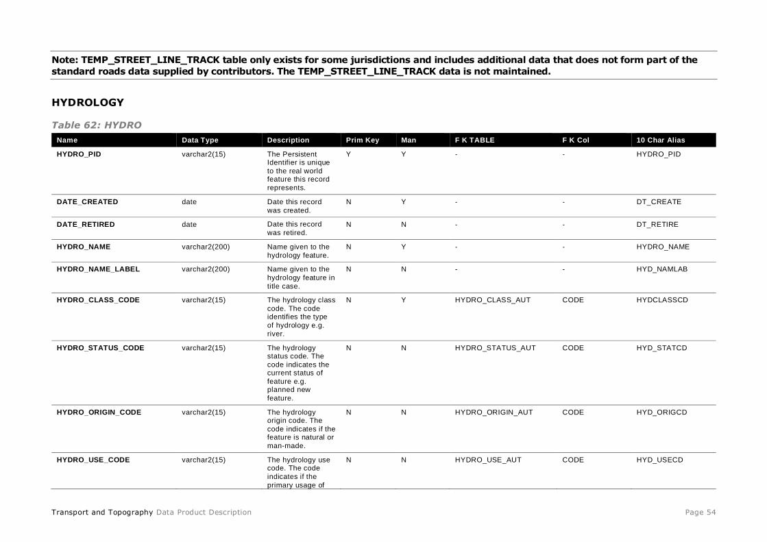
Transport and Topography Data Product Description Page 54
Note: TEMP_STREET_LINE_TRACK table only exists for some jurisdictions and includes additional data that does not form part of the
standard roads data supplied by contributors. The TEMP_STREET_LINE_TRACK data is not maintained.
HYDROLOGY
Table 62: HYDRO
Name Data Type Description Prim Key Man F K TABLE F K Col 10 Char Alias
HYDRO_PID varchar2(15) The Persistent Identifier is unique
to the real world feature this record
represents.
Y Y - - HYDRO_PID
DATE_CREATED date Date this record
was created.
N Y - - DT_CREATE
DATE_RETIRED date Date this record
was retired. N N - - DT_RETIRE
HYDRO_NAME varchar2(200) Name given to the
hydrology feature.
N Y - - HYDRO_NAME
HYDRO_NAME_LABEL varchar2(200) Name given to the
hydrology feature in
title case.
N N - - HYD_NAMLAB
HYDRO_CLASS_CODE varchar2(15) The hydrology class
code. The code identifies the type
of hydrology e.g.
river.
N Y HYDRO_CLASS_AUT CODE HYDCLASSCD
HYDRO_STATUS_CODE varchar2(15) The hydrology status code. The
code indicates the current status of
feature e.g. planned new
feature.
N N HYDRO_STATUS_AUT CODE HYD_STATCD
HYDRO_ORIGIN_CODE varchar2(15) The hydrology origin code. The
code indicates if the feature is natural or
man-made.
N N HYDRO_ORIGIN_AUT CODE HYD_ORIGCD
HYDRO_USE_CODE varchar2(15) The hydrology use code. The code
indicates if the
primary usage of
N N HYDRO_USE_AUT CODE HYD_USECD

Transport and Topography Data Product Description Page 55
Name Data Type Description Prim Key Man F K TABLE F K Col 10 Char Alias
the feature e.g.
water supply.
PERENNIALITY_CODE varchar2(15) The perenniality
code. The code indicates the
perenniality of the
feature.
N N PERENNIALITY_AUT CODE PERE_CODE
SOURCE_DATE_CREATED date Date this record
was created by the
data contributor.
N N - - SDT_CREATE
SOURCE_DATE_MODIFIED date Date this record
was modified by the
data contributor.
N N - - SDT_MODIFY
STATE_PID varchar2(15) The persistent
identifier for the
state or territory.
N Y STATE STATE_PID STATE_PID
Table 60: HYDRO_POINT
Name Data Type Description Prim
Key
Man F K TABLE F K Col 10 Char Alias
HYDRO_POINT_PID varchar2(15) The Persistent Identifier is unique to the real world
feature this record represents.
Y Y - - HYD_PNTPID
DATE_CREATED date Date this record was created. N Y - - DT_CREATE
DATE_RETIRED date Date this record was retired. N N - - DT_RETIRE
HYDRO_PID varchar2(15) The Persistent Identifier is unique to the real world
feature this record represents.
Y Y HYDRO HYDRO_PID HYDRO_PID
GEOMETRY point Point geometry. N Y - - GEOMETRY
Table 61: HYDRO_LINE
Name Data Type Description Prim Key Man F K TABLE F K Col 10 Char Alias
HYDRO_LINE_PID varchar2(15) The Persistent Identifier is unique to the real world
feature this record represents.
Y Y - - HYD_LNEPID
DATE_CREATED date Date this record was created. N Y - - DT_CREATE
DATE_RETIRED date Date this record was retired. N N - - DT_RETIRE
HYDRO_PID varchar2(15) The Persistent Identifier is unique to the real world
feature this record represents.
Y Y HYDRO HYDRO_PID HYDRO_PID
GEOMETRY line Line geometry. N Y - - GEOMETRY

Transport and Topography Data Product Description Page 56
Table 62: HYDRO_POLYGON
Name Data Type Description Prim
Key Man F K TABLE F K Col 10 Char Alias
HYDRO_POLYGON_PID varchar2(15) The Persistent Identifier is unique to the real world
feature this record represents.
Y Y - - HYD_PLYPID
DATE_CREATED date Date this record was created. N Y - - DT_CREATE
DATE_RETIRED date Date this record was retired. N N - - DT_RETIRE
HYDRO_PID varchar2(15) The Persistent Identifier is unique to the real world
feature this record represents.
Y Y HYDRO HYDRO_PID HYDRO_PID
GEOMETRY polygon Polygon geometry. N Y - - GEOMETRY
Table 63: HYDRO_ALIAS
Name Data Type Description Prim
Key
Man F K TABLE F K Col 10 Char Alias
HYDRO_ALIAS_PID varchar2(15) The Persistent Identifier is unique to the real
world feature this record represents.
Y Y - - HYD_ALPID
DATE_CREATED date Date this record was created. N Y - - DT_CREATE
DATE_RETIRED date Date this record was retired. N N - - DT_RETIRE
HYDRO_PID varchar2(15) The persistent identifier from the HYDRO table. N Y HYDRO HYDRO_PID HYDRO_PID
HYDRO_ALIAS_NAME varchar2(200) The hydrology alias name. N Y - - HYD_ALNAM
HYDRO_ALIAS_TYPE_CODE varchar2(15) The persistent identifier for the state or territory. N Y HYDRO_ALIAS_TYPE_AUT CODE HYD_ALTCD
Table 64: HYDRO_ALIAS_TYPE_AUT
Name Data Type Description Prim Key Man F K TABLE F K Col 10 Char Alias
CODE varchar2(15) Hydro alias type code e.g. ALT. This is the persistent
identifier.
Y Y - - CODE_AUT
NAME varchar2(100) Name of the hydro alias type code e.g.
ALTERNATIVE.
N Y - - NAME_AUT
DESCRIPTION varchar2(200) Description of what the hydro alias type code means. N N - - DESC_AUT
Table 65: HYDRO_ALIAS_TYPE_AUT codes

Transport and Topography Data Product Description Page 57
Code NAME DESCRIPTION
ALT ALTERNATIVE ALTERNATIVE NAME TO THE PRIMARY NAME.
SYN SYNONYM DIFFERENT NAME WITH ALMOST IDENTICAL OR SIMILAR MEANINGS.
Table 66: HYDRO_CLASS_AUT
Name Data Type Description Prim Key Man F K
TABLE
F K Col 10 Char Alias
CODE varchar2(15) Hydro class code e.g. HYD001001. This is
the persistent identifier.
Y Y - - CODE_AUT
NAME varchar2(100) Name of the hydro class code e.g.
ALTERNATIVE. N Y - - NAME_AUT
DESCRIPTION varchar2(200) Description of what the hydro class code
means.
N N - - DESC_AUT
DATE_CREATED date Date this record was created. N Y - - DT_CREATE
DATE_RETIRED date Date this record was retired. N N - - DT_RETIRE
DATE_MODIFIED date Date this record was modified. N N - - DT_MODIFY
PARENT_HYDRO_CLASS varchar2(15) Parent hydro class code e.g. HYD001. N N - - PARCL_CD
Table 70: HYDRO_CLASS_AUT codes
Note: There is some duplication in codes, these will be either removed or changed in a future release.
Code NAME DESCRIPTION
HYD001 MARINE FEATURES APPLICABLE TO THE SEA OR OCEAN.
HYD001001 OCEAN MAJOR BODY OF SALINE WATER THAT IS A MAJOR DIVISION OF THE HYDROSPHERE.
HYD001002 SEA MAJOR BODY OF SALINE WATER THAT IS A MINOR DIVISION OF THE HYDROSPHERE THAT IS MORE LIKELY TO BE
NEARER TO LAND MASS. SMALLER DIVISION THAN OCEAN.
HYD001003 GULF LARGE BAY THAT IS AN ARM OF AN OCEAN OR SEA.
HYD001004 STRAIT NARROW PASSAGE CONNECTING TWO LARGER BODIES OF WATER. INCLUDES PASSAGE.
HYD001005 BAY BODY OF SALINE WATER THAT IS SURROUNDED BY LAND ON THREE SIDES. INCLUDES INLET, SOUND, COVE.
HYD001006 ESTUARY PARTLY ENCLOSED BODY OF WATER WITH ONE OR MORE RIVERS OR STREAMS FLOWING INTO IT AND A FREE
CONNECTION TO OPEN SEA OR OCEAN.
HYD001007 LAGOON SHALLOW BODY OF WATER SEPARATED FROM LARGER BODY OF WATER BY NARROW STRIP OF LAND, SAND BANKS,
BARRIER ISLANDS OR REEFS. SOMETIMES REFERRED TO A SMALL FRESHWATER OR SALTWATER LAKE.

Transport and Topography Data Product Description Page 58
Code NAME DESCRIPTION
HYD002 COASTLINE THE LINE WHERE LAND AND WATER MEET. INCLUDES SHORELINE, SEASHORE, TIDAL LINE.
HYD002001 COASTLINE JUNCTION ARTIFICIAL LINEAR FEATURE USED TO SEPARATE ADJACENT WATER FEATURES THAT MEET. INCLUDES SHORELINE
JUNCTION.
HYD002002 ISLAND LAND MASS SURROUNDED BY WATER. INCLUDES ISLE OR ISLET.
HYD002002001 ISLAND MARINE LAND MASS OFFSHORE AND SURROUNDED BY WATER SUCH AS A SEA OR OCEAN.
HYD002002002 ISLAND TERRESTRIAL INLAND LAND MASS SURROUNDED BY WATER SUCH AS A LAKE OR RIVER. INCLUDES EYOT.
HYD003 WATER POINT GENERALLY A SMALL WATER FEATURE THAT IS REPRESENTED AS A POINT.
HYD003001 SPRING FLOW OF WATER ISSUING NATURALLY OUT OF THE GROUND, EITHER CONTINOUSLY OR INTERMITTENTLY. INCLUDES
POOL SPRING, SEEP.
HYD003001001 HOT SPRING SPRING WITH HOT WATER FROM GROUND. INCLUDES THERMAL SPRING.
HYD003001002 MINERAL SPRING SPRING WHICH CONTAINS A NOTICEABLE QUANTITY OF MINERAL MATTER IN SOLUTION.
HYD003002 WATERFALL SUDDEN DESCENT OF WATER OVER A STEP IN THE BED OF A WATERCOURSE. INCLUDES FALLS, CATARACT, CASCADE.
HYD003003 RAPIDS PORTION OF WATERCOURSE WITH ACCELERATED CURRENT WHERE IT DESCENDS RAPIDLY WITHOUT A BREAK IN THE
SLOPE OF THE BED.
HYD003004 SOAK DAMP OR SWAMPY SPOTS USUALLY AROUND THE BASE OF GRANITE ROCKS OR BY DRY WATERCOURSE.
HYD004 WATER AREA AREA SUBJECT TO WATER PERMANENTLY OR INTERMITTENTLY.
HYD004001 WATERBODY A STANDARD BODY OF INLAND WATER. ANY BODY OF INLAND WATER OF WHICH THE FLOW IS MINOR.
HYD004001001 LAKE BODY OF FRESH OR SALT WATER, NATURAL OR ARTIFICAL, ENCLOSED OR NEARLY ENCLOSED BY LAND. INCLUDES
LOUGH, LOCH.
HYD004001002 DAM BODY OF WATER CREATED BY STRUCTURE MADE OF EARTH, MASONRY ETC. BUILT ACROSS A WATERCOURSE TO
IMPOUND WATER FOR ANY PURPOSE.
HYD004001003 BILLABONG GENERALLY A RIVER BRANCH THAT FORMS A BACKWATER OR STAGNANT POOL.
HYD004001004 OXBOW LAKE LAKE FORMS WHEN MEANDERING RIVER ALMOST FORMS A COMPLETE CIRCLE, CUTS ACROSS NECK OF LAND
BETWEEN TWO STRETCHES AND LEAVES BACKWATER THAT SILTS UP OVER TIME TO FORM LAKE.
HYD004001005 POOL SMALL BODY OF STILL OR STANDING WATER. OFTEN IN BED OF INTERMITTENT RIVER OR STREAM AND SOMETIMES
SPRING FED, CHIEFLY ONE OF NATURAL FORMATION.
HYD004001006 WATERHOLE NATURAL HOLE OR HOLLOW CONTAINING WATER, OFTEN IN DRY BED OF AN INTERMITTENT RIVER OR SPRING IN
DESERT. INCLUDES HOLE.
HYD004001007 NATIVE WELL NATURAL SPRING OR SMALL POOL FED FROM SPRING OR SOAK AND SOMETIMES IMPROVED BY ABORIGINES.
HYD004001008 POND NATURAL OR ARTIFICIAL SMALL BODY OF STILL WATER.
HYD004001009 RESERVOIR ARTIFICIAL LAKE FOR STORAGE, REGULATION AND CONTROL OF WATER FOR DOMESTIC OR OTHER USE. INCLUDES
SERVICE BASIN.
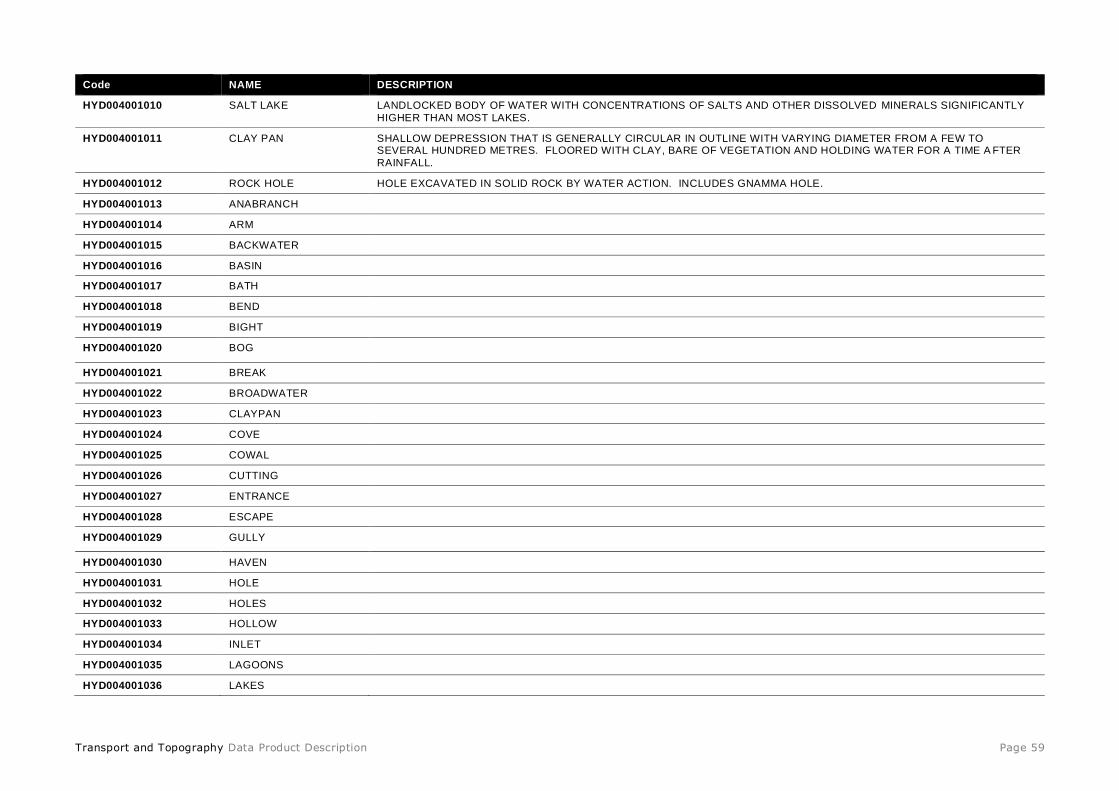
Transport and Topography Data Product Description Page 59
Code NAME DESCRIPTION
HYD004001010 SALT LAKE LANDLOCKED BODY OF WATER WITH CONCENTRATIONS OF SALTS AND OTHER DISSOLVED MINERALS SIGNIFICANTLY
HIGHER THAN MOST LAKES.
HYD004001011 CLAY PAN SHALLOW DEPRESSION THAT IS GENERALLY CIRCULAR IN OUTLINE WITH VARYING DIAMETER FROM A FEW TO SEVERAL HUNDRED METRES. FLOORED WITH CLAY, BARE OF VEGETATION AND HOLDING WATER FOR A TIME A FTER
RAINFALL.
HYD004001012 ROCK HOLE HOLE EXCAVATED IN SOLID ROCK BY WATER ACTION. INCLUDES GNAMMA HOLE.
HYD004001013 ANABRANCH
HYD004001014 ARM
HYD004001015 BACKWATER
HYD004001016 BASIN
HYD004001017 BATH
HYD004001018 BEND
HYD004001019 BIGHT
HYD004001020 BOG
HYD004001021 BREAK
HYD004001022 BROADWATER
HYD004001023 CLAYPAN
HYD004001024 COVE
HYD004001025 COWAL
HYD004001026 CUTTING
HYD004001027 ENTRANCE
HYD004001028 ESCAPE
HYD004001029 GULLY
HYD004001030 HAVEN
HYD004001031 HOLE
HYD004001032 HOLES
HYD004001033 HOLLOW
HYD004001034 INLET
HYD004001035 LAGOONS
HYD004001036 LAKES
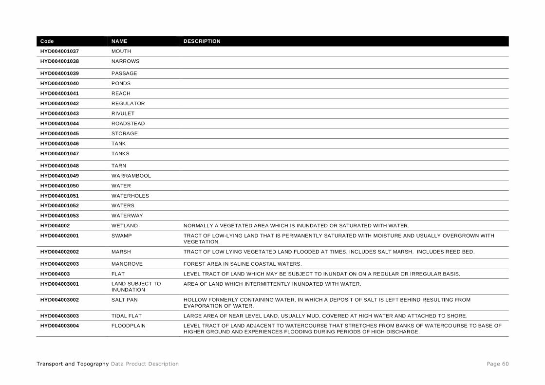
Transport and Topography Data Product Description Page 60
Code NAME DESCRIPTION
HYD004001037 MOUTH
HYD004001038 NARROWS
HYD004001039 PASSAGE
HYD004001040 PONDS
HYD004001041 REACH
HYD004001042 REGULATOR
HYD004001043 RIVULET
HYD004001044 ROADSTEAD
HYD004001045 STORAGE
HYD004001046 TANK
HYD004001047 TANKS
HYD004001048 TARN
HYD004001049 WARRAMBOOL
HYD004001050 WATER
HYD004001051 WATERHOLES
HYD004001052 WATERS
HYD004001053 WATERWAY
HYD004002 WETLAND NORMALLY A VEGETATED AREA WHICH IS INUNDATED OR SATURATED WITH WATER.
HYD004002001 SWAMP TRACT OF LOW-LYING LAND THAT IS PERMANENTLY SATURATED WITH MOISTURE AND USUALLY OVERGROWN WITH
VEGETATION.
HYD004002002 MARSH TRACT OF LOW LYING VEGETATED LAND FLOODED AT TIMES. INCLUDES SALT MARSH. INCLUDES REED BED.
HYD004002003 MANGROVE FOREST AREA IN SALINE COASTAL WATERS.
HYD004003 FLAT LEVEL TRACT OF LAND WHICH MAY BE SUBJECT TO INUNDATION ON A REGULAR OR IRREGULAR BASIS.
HYD004003001 LAND SUBJECT TO
INUNDATION AREA OF LAND WHICH INTERMITTENTLY INUNDATED WITH WATER.
HYD004003002 SALT PAN HOLLOW FORMERLY CONTAINING WATER, IN WHICH A DEPOSIT OF SALT IS LEFT BEHIND RESULTING FROM
EVAPORATION OF WATER.
HYD004003003 TIDAL FLAT LARGE AREA OF NEAR LEVEL LAND, USUALLY MUD, COVERED AT HIGH WATER AND ATTACHED TO SHORE.
HYD004003004 FLOODPLAIN LEVEL TRACT OF LAND ADJACENT TO WATERCOURSE THAT STRETCHES FROM BANKS OF WATERCOURSE TO BASE OF
HIGHER GROUND AND EXPERIENCES FLOODING DURING PERIODS OF HIGH DISCHARGE.
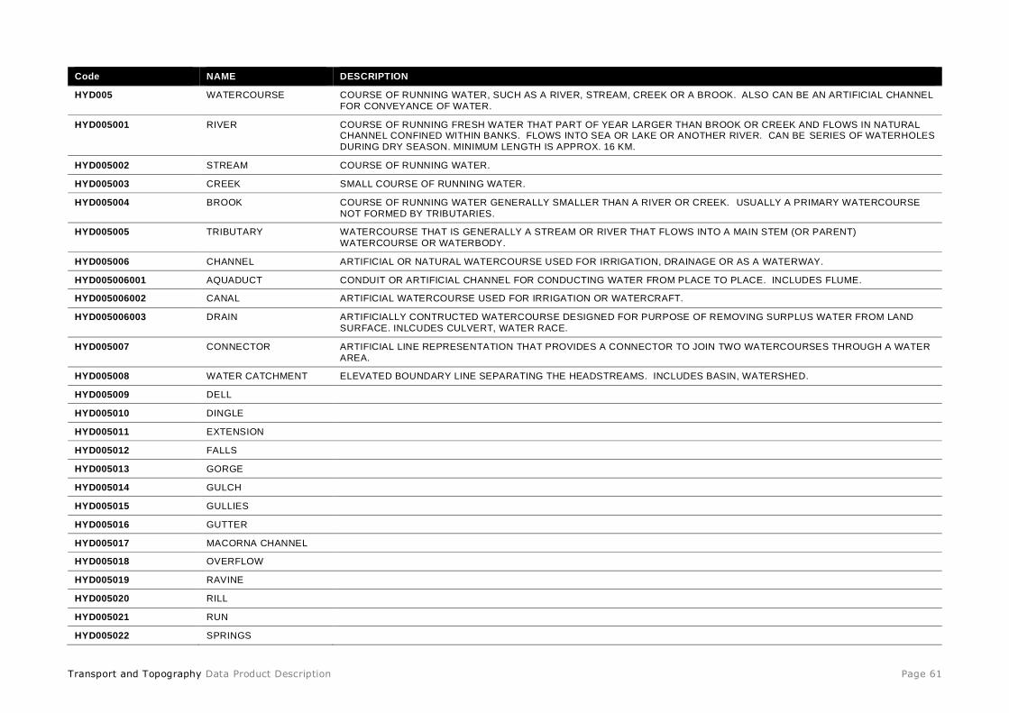
Transport and Topography Data Product Description Page 61
Code NAME DESCRIPTION
HYD005 WATERCOURSE COURSE OF RUNNING WATER, SUCH AS A RIVER, STREAM, CREEK OR A BROOK. ALSO CAN BE AN ARTIFICIAL CHANNEL
FOR CONVEYANCE OF WATER.
HYD005001 RIVER COURSE OF RUNNING FRESH WATER THAT PART OF YEAR LARGER THAN BROOK OR CREEK AND FLOWS IN NATURAL CHANNEL CONFINED WITHIN BANKS. FLOWS INTO SEA OR LAKE OR ANOTHER RIVER. CAN BE SERIES OF WATERHOLES
DURING DRY SEASON. MINIMUM LENGTH IS APPROX. 16 KM.
HYD005002 STREAM COURSE OF RUNNING WATER.
HYD005003 CREEK SMALL COURSE OF RUNNING WATER.
HYD005004 BROOK COURSE OF RUNNING WATER GENERALLY SMALLER THAN A RIVER OR CREEK. USUALLY A PRIMARY WATERCOURSE
NOT FORMED BY TRIBUTARIES.
HYD005005 TRIBUTARY WATERCOURSE THAT IS GENERALLY A STREAM OR RIVER THAT FLOWS INTO A MAIN STEM (OR PARENT)
WATERCOURSE OR WATERBODY.
HYD005006 CHANNEL ARTIFICIAL OR NATURAL WATERCOURSE USED FOR IRRIGATION, DRAINAGE OR AS A WATERWAY.
HYD005006001 AQUADUCT CONDUIT OR ARTIFICIAL CHANNEL FOR CONDUCTING WATER FROM PLACE TO PLACE. INCLUDES FLUME.
HYD005006002 CANAL ARTIFICIAL WATERCOURSE USED FOR IRRIGATION OR WATERCRAFT.
HYD005006003 DRAIN ARTIFICIALLY CONTRUCTED WATERCOURSE DESIGNED FOR PURPOSE OF REMOVING SURPLUS WATER FROM LAND
SURFACE. INLCUDES CULVERT, WATER RACE.
HYD005007 CONNECTOR ARTIFICIAL LINE REPRESENTATION THAT PROVIDES A CONNECTOR TO JOIN TWO WATERCOURSES THROUGH A WATER
AREA.
HYD005008 WATER CATCHMENT ELEVATED BOUNDARY LINE SEPARATING THE HEADSTREAMS. INCLUDES BASIN, WATERSHED.
HYD005009 DELL
HYD005010 DINGLE
HYD005011 EXTENSION
HYD005012 FALLS
HYD005013 GORGE
HYD005014 GULCH
HYD005015 GULLIES
HYD005016 GUTTER
HYD005017 MACORNA CHANNEL
HYD005018 OVERFLOW
HYD005019 RAVINE
HYD005020 RILL
HYD005021 RUN
HYD005022 SPRINGS
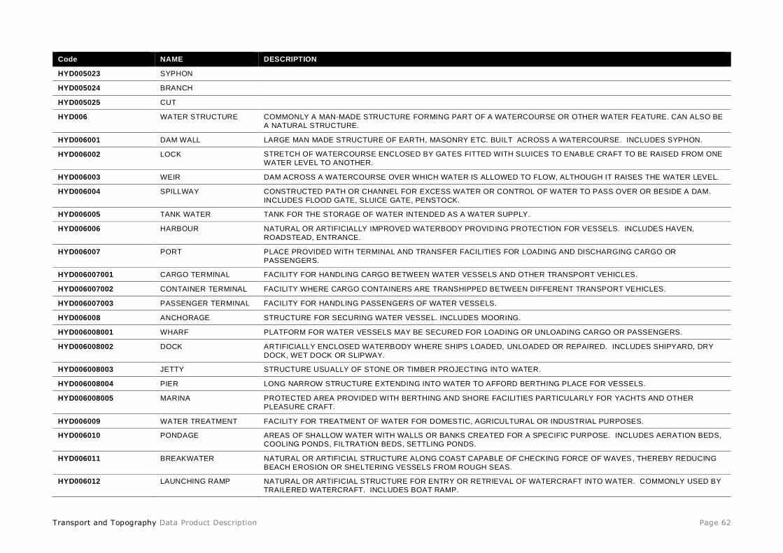
Transport and Topography Data Product Description Page 62
Code NAME DESCRIPTION
HYD005023 SYPHON
HYD005024 BRANCH
HYD005025 CUT
HYD006 WATER STRUCTURE COMMONLY A MAN-MADE STRUCTURE FORMING PART OF A WATERCOURSE OR OTHER WATER FEATURE. CAN ALSO BE
A NATURAL STRUCTURE.
HYD006001 DAM WALL LARGE MAN MADE STRUCTURE OF EARTH, MASONRY ETC. BUILT ACROSS A WATERCOURSE. INCLUDES SYPHON.
HYD006002 LOCK STRETCH OF WATERCOURSE ENCLOSED BY GATES FITTED WITH SLUICES TO ENABLE CRAFT TO BE RAISED FROM ONE
WATER LEVEL TO ANOTHER.
HYD006003 WEIR DAM ACROSS A WATERCOURSE OVER WHICH WATER IS ALLOWED TO FLOW, ALTHOUGH IT RAISES THE WATER LEVEL.
HYD006004 SPILLWAY CONSTRUCTED PATH OR CHANNEL FOR EXCESS WATER OR CONTROL OF WATER TO PASS OVER OR BESIDE A DAM.
INCLUDES FLOOD GATE, SLUICE GATE, PENSTOCK.
HYD006005 TANK WATER TANK FOR THE STORAGE OF WATER INTENDED AS A WATER SUPPLY.
HYD006006 HARBOUR NATURAL OR ARTIFICIALLY IMPROVED WATERBODY PROVIDING PROTECTION FOR VESSELS. INCLUDES HAVEN,
ROADSTEAD, ENTRANCE.
HYD006007 PORT PLACE PROVIDED WITH TERMINAL AND TRANSFER FACILITIES FOR LOADING AND DISCHARGING CARGO OR
PASSENGERS.
HYD006007001 CARGO TERMINAL FACILITY FOR HANDLING CARGO BETWEEN WATER VESSELS AND OTHER TRANSPORT VEHICLES.
HYD006007002 CONTAINER TERMINAL FACILITY WHERE CARGO CONTAINERS ARE TRANSHIPPED BETWEEN DIFFERENT TRANSPORT VEHICLES.
HYD006007003 PASSENGER TERMINAL FACILITY FOR HANDLING PASSENGERS OF WATER VESSELS.
HYD006008 ANCHORAGE STRUCTURE FOR SECURING WATER VESSEL. INCLUDES MOORING.
HYD006008001 WHARF PLATFORM FOR WATER VESSELS MAY BE SECURED FOR LOADING OR UNLOADING CARGO OR PASSENGERS.
HYD006008002 DOCK ARTIFICIALLY ENCLOSED WATERBODY WHERE SHIPS LOADED, UNLOADED OR REPAIRED. INCLUDES SHIPYARD, DRY
DOCK, WET DOCK OR SLIPWAY.
HYD006008003 JETTY STRUCTURE USUALLY OF STONE OR TIMBER PROJECTING INTO WATER.
HYD006008004 PIER LONG NARROW STRUCTURE EXTENDING INTO WATER TO AFFORD BERTHING PLACE FOR VESSELS.
HYD006008005 MARINA PROTECTED AREA PROVIDED WITH BERTHING AND SHORE FACILITIES PARTICULARLY FOR YACHTS AND OTHER
PLEASURE CRAFT.
HYD006009 WATER TREATMENT FACILITY FOR TREATMENT OF WATER FOR DOMESTIC, AGRICULTURAL OR INDUSTRIAL PURPOSES.
HYD006010 PONDAGE AREAS OF SHALLOW WATER WITH WALLS OR BANKS CREATED FOR A SPECIFIC PURPOSE. INCLUDES AERATION BEDS,
COOLING PONDS, FILTRATION BEDS, SETTLING PONDS.
HYD006011 BREAKWATER NATURAL OR ARTIFICIAL STRUCTURE ALONG COAST CAPABLE OF CHECKING FORCE OF WAVES , THEREBY REDUCING
BEACH EROSION OR SHELTERING VESSELS FROM ROUGH SEAS.
HYD006012 LAUNCHING RAMP NATURAL OR ARTIFICIAL STRUCTURE FOR ENTRY OR RETRIEVAL OF WATERCRAFT INTO WATER. COMMONLY USED BY
TRAILERED WATERCRAFT. INCLUDES BOAT RAMP.

Transport and Topography Data Product Description Page 63
Code NAME DESCRIPTION
HYD006013 WELL HOLE OR PIT DUG IN GROUND TO OBTAIN WATER.
HYD006014 BORE DEEP VERTICAL HOLE OF SMALL DIAMETER MADE TO OBTAIN WATER OR ASCERTAIN NATURE OF UNDERLAYING
STRATA.
HYD006015 LEVEE EMBANKMENT BUILT TO CONFINE A WATERCOURSE WITHIN ITS BED. ALSO CAN BE A BROAD LOW RIDGE OF ALLUVIUM
FORMED AT TIME OF FLOOD ON SIDE OF RIVER OR STREAM.
HYD006016 RIVER GAUGE PORTION OF WATERCOURSE WITH ACCELERATED CURRENT WHERE IT DESCENDS RAPIDLY WITHOU T A BREAK IN THE
SLOPE OF THE BED.
HYD006017 WATERING PLACE LOCATION TO ACCESS WATER NORMALLY FOR CONSUMPTION BY HUMANS OR ANIMALS.
HYD006018 PIPELINE TUBE OF WOOD, METAL, CONCRETE ETC. FOR THE CONVEYANCE OF WATER. INCLUDES SIPHON, CONDUIT.
HYD006018001 PIPELINE - ABOVE
GROUND PIPE FOR CONVEYANCE OF WATER THAT IS POSITIONED ABOVE GROUND LEVEL.
HYD006018002 PIPELINE - BELOW
GROUND
PIPE FOR CONVEYANCE OF WATER THAT IS POSITIONED BELOW GROUND LEVEL.
HYD007 WATER NAVIGATION FEATURE IMPORTANT IN NAVIGATING WATER SAFELY.
HYD007001 REEF RIDGE OF ROCKS OR CORAL LYING NEAR THE SURFACE OF WATERBODY. MAY BE VISIBLE AT LOW TIDE, BUT USUALLY
COVERED BY WATER.
HYD007002 BEACON A FIXED SIGNAL, MARK OR LIGHT AND ASSOCIATED FACILITIES ERECTED FOR THE GUIDANCE OF MARINERS OR
AIRPLANE PILOTS.
HYD007002001 AERONAUTICAL
BEACON
BEACON SPECIFICALLY FOR PROVIDING NAVIGATION TO AIRCRAFT.
HYD007002002 CHANNEL LIGHT LIGHT BEACON FOR NAVIGATING WITHIN A CHANNEL.
HYD007002003 CHANNEL MARKER MARKER OR SIGNAL FOR NAVIGATING WITHIN A CHANNEL.
HYD007002004 LIGHTHOUSE DISTINCTIVE STRUCTURE ON OR OFF COAST, EXHIBITING A MAJOR LIGHT DESIGNED TO SERVE AS AN AID IN
NAVIGATION.
HYD007002005 NAVIGATION LIGHT LIGHTED AID FOR NAVIGATION.
HYD007002006 RADIO BEACON RADIO NAVIGATION BEACON. INCLUDES VOR BEACON.
HYD007003 BUOY A FLOAT MOORED OR ANCHORED IN WATER.
HYD007004 ROCK AN ISOLATED ROCK FORMATION OR MONOLITH PROTRUDING THROUGH WATER.
HYD007005 WRECK A WRECKED VESSEL, EITHER SUBMERGED OR VISIBLE, WHICH IS ATTACHED TO OR FOUL OF THE BOTTOM OR CAST UP
ON THE SHORE.
HYD007006 SHOAL RIDGE OF SAND OR ROCKS JUST BELOW SURFACE OF WATER THAT IS DANGEROUS TO WATER VESSELS.

Transport and Topography Data Product Description Page 64
Table 67: HYDRO_ORIGIN_AUT
Name Data Type Description Prim Key Man F K TABLE F K Col 10 Char Alias
CODE varchar2(15) Hydro origin code e.g. N. This is the persistent
identifier. Y Y - - CODE_AUT
NAME varchar2(100) Name of the hydro origin code e.g. NATURAL. N Y - - NAME_AUT
DESCRIPTION varchar2(200) Description of what the hydro origin code means. N N - - DESC_AUT
Table 68: HYDRO_ORIGIN_AUT Codes
Code NAME DESCRIPTION
U UNKNOWN ORIGIN OF FEATURE UNKNOWN OR NOT PROVIDED.
N NATURAL A FEATURE THAT IS MOSTLY OR WHOLLY OF NATURAL ORIGIN.
M MAN-MADE A FEATURE THAT IS MOSTLY OR WHOLLY OF MAN-MADE ORIGIN.
Table 69: HYDRO_USE_AUT
Name Data Type Description Prim Key Man F K TABLE F K Col 10 Char Alias
CODE varchar2(15) Hydro use code e.g. 3. This is the persistent
identifier.
Y Y - - CODE_AUT
NAME varchar2(100) Name of the hydro use code e.g. WATER SUPPLY. N Y - - NAME_AUT
DESCRIPTION varchar2(200) Description of what the hydro use code means. N N - - DESC_AUT
Table 70: HYDRO_USE_AUT Codes
Code NAME DESCRIPTION
0 UNKNOWN PRIMARY USE OF FEATURE IS NOT KNOWN.
1 DRAINAGE PRIMARY USE OF FEATURE IS FOR DRAINAGE.
2 IRRIGATION PRIMARY USE OF FEATURE IS FOR IRRIGATION.
3 WATER SUPPLY PRIMARY USE OF FEATURE IS AS A WATER SUPPLY.
4 FLOOD CONTROL PRIMARY USE OF FEATURE IS FOR FLOOD CONTROL.
5 SALT EVAPORATION PRIMARY USE OF FEATURE IS FOR SALT EVAPORATION.
6 SEWERAGE PRIMARY USE OF FEATURE IS FOR SEWERAGE.
7 TAILING DAM PRIMARY USE OF FEATURE IS FOR TAILING DAM.
8 COOLING PONDS PRIMARY USE OF FEATURE IS FOR COOLING PONDS.
9 RECREATION PRIMARY USE OF FEATURE IS FOR RECREATION.
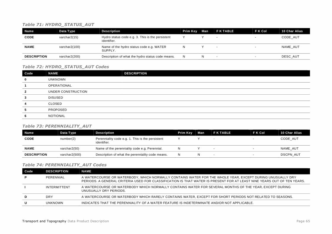
Transport and Topography Data Product Description Page 65
Table 71: HYDRO_STATUS_AUT
Name Data Type Description Prim Key Man F K TABLE F K Col 10 Char Alias
CODE varchar2(15) Hydro status code e.g. 3. This is the persistent
identifier. Y Y - - CODE_AUT
NAME varchar2(100) Name of the hydro status code e.g. WATER
SUPPLY.
N Y - - NAME_AUT
DESCRIPTION varchar2(200) Description of what the hydro status code means. N N - - DESC_AUT
Table 72: HYDRO_STATUS_AUT Codes
Code NAME DESCRIPTION
0 UNKNOWN
1 OPERATIONAL
2 UNDER CONSTRUCTION
3 DISUSED
4 CLOSED
5 PROPOSED
6 NOTIONAL
Table 73: PERENNIALITY_AUT
Name Data Type Description Prim Key Man F K TABLE F K Col 10 Char Alias
CODE number(2) Perenniality code e.g. 1. This is the persistent
identifier.
Y Y - - CODE_AUT
NAME varchar2(50) Name of the perenniality code e.g. Perennial. N Y - - NAME_AUT
DESCRIPTION varchar2(500) Description of what the perenniality code means. N N - - DSCPN_AUT
Table 74: PERENNIALITY_AUT Codes
Code DESCRIPTION NAME
P PERENNIAL A WATERCOURSE OR WATERBODY, WHICH NORMALLY CONTAINS WATER FOR THE WHOLE YEAR, EXCEPT DURING UNUSUALLY DRY
PERIODS. A GENERAL CRITERIA USED FOR CLASSIFICATION IS THAT WATER IS PRESENT FOR AT LEAST NINE YEARS OUT OF TEN YEARS.
I INTERMITTENT A WATERCOURSE OR WATERBODY WHICH NORMALLY CONTAINS WATER FOR SEVERAL MONTHS OF THE YEAR, EXCEPT DURING
UNUSUALLY DRY PERIODS.
D DRY A WATERCOURSE OR WATERBODY WHICH RARELY CONTAINS WATER, EXCEPT FOR SHORT PERIODS NOT RELATED TO SEASONS.
U UNKNOWN INDICATES THAT THE PERENNIALITY OF A WATER FEATURE IS INDETERMINATE AND/OR NOT APPLICABLE.
Transport and Topography Data Product Description Page 66
GREENSPACE
Table 79: GREENSPACE
Name Data Type Description Prim Key Man F K TABLE F K Col 10 Char Alias
GREENSPACE_PID varchar2(15) The Persistent Identifier is unique
to the real world
feature this record
represents.
Y Y - - GS_PID
DATE_CREATED date Date this record
was created.
N Y - - DT_CREATE
DATE_RETIRED date Date this record
was retired. N N - - DT_RETIRE
GREENSPACE_NAME varchar2(200) The name of the
greenspace.
N Y - - GS_NAME
GREENSPACE_NAME_LABEL varchar2(200) Name given to the
greenspace feature
in title case.
N Y - - GS_NAMLAB
GREENSPACE_CLASS_CODE varchar2(15) The greenspace
class code. eg.
OPS007.
N Y GREENSPACE_CLASS_AUT CODE GSCLASSCD
SOURCE_DATE_CREATED date Date this record
was created by the
data contributor.
N N - - SDT_CREATE
SOURCE_DATE_MODIFIED date Date this record
was modified by
the data
contributor.
N N - - SDT_MODIFY
STATE_PID varchar2(15) State or territory
persistent identifier.
N Y - - STATE_PID
Table 75: GREENSPACE_POINT
Name Data Type Description Prim
Key
Man F K TABLE F K Col 10 Char Alias
GREENSPACE_POINT_PID varchar2(15) The Persistent Identifier is unique to the
real world feature this record represents. Y Y - - GS_PNTPID
DATE_CREATED date Date this record was created. N Y - - DT_CREATE
DATE_RETIRED date Date this record was retired. N N - - DT_RETIRE
GREENSPACE_PID varchar2(15) Greenspace persistent identifier. N Y GREENSPACE GREENSPACE_PID GS_PID
Transport and Topography Data Product Description Page 67
Name Data Type Description Prim
Key
Man F K TABLE F K Col 10 Char Alias
PROCESS_TYPE_CODE varchar2(15) Process type code. N N GREENSPACE_PROCESS_TYPE_AUT CODE PRC_TYP_CD
GEOMETRY point Point geometry. N Y - - GEOMETRY
Table 76: GREENSPACE_LINE
Name Data Type Description Prim
Key
Man F K TABLE F K Col 10 Char Alias
GREENSPACE_LINE_PID varchar2(15) The Persistent Identifier is unique to the
real world feature this record represents.
Y Y - - GS_LNEPID
DATE_CREATED date Date this record was created. N Y - - DT_CREATE
DATE_RETIRED date Date this record was retired. N N - - DT_RETIRE
GREENSPACE_PID varchar2(15) Greenspace persistent identifier. N Y GREENSPACE GREENSPACE_PID GS_PID
PROCESS_TYPE_CODE varchar2(15) Process type code. N N GREENSPACE_PROCESS_TYPE_AUT CODE PRC_TYP_CD
GEOMETRY line Line geometry. N Y - - GEOMETRY
Table 77: GREENSPACE_POLYGON
Name Data Type Description Prim
Key
Man F K TABLE F K Col 10 Char Alias
GREENSPACE_POLYGON_PID varchar2(15) The Persistent Identifier is unique to the real world feature this record
represents.
Y Y - - GS_PLYPID
DATE_CREATED date Date this record was created. N Y - - DT_CREATE
DATE_RETIRED date Date this record was retired. N N - - DT_RETIRE
GREENSPACE_PID varchar2(15) Greenspace persistent identifier. N Y GREENSPACE GREENSPACE_PID GS_PID
PROCESS_TYPE_CODE varchar2(15) Process type code. N N GREENSPACE_PROCESS_TYPE_AUT CODE PRC_TYP_CD
GEOMETRY polygon Polygon geometry. N Y - - GEOMETRY
Table 78: GREENSPACE_ALIAS
Name Data Type Description Prim
Key
Man F K TABLE F K Col 10 Char
Alias
GREENSPACE_ALIAS_PID varchar2(15) The Persistent Identifier is unique to
the real world feature this record
represents.
Y Y - - GS_ALPID
DATE_CREATED date Date this record was created. N Y - - DT_CREATE

Transport and Topography Data Product Description Page 68
Name Data Type Description Prim
Key
Man F K TABLE F K Col 10 Char
Alias
DATE_RETIRED date Date this record was retired. N N - - DT_RETIRE
GREENSPACE_PID varchar2(15) Greenspace persistent identifier. N Y GREENSPACE GREENSPACE_PID GS_PID
GREENSPACE_ALIAS_NAME varchar2(200) The greenspace alias name. N N - - GS_ALNAME
GREENSPACE_ALIAS_TYPE_CODE varchar2(15) The code for the type of alias. N Y GREENSPACE_ALIAS_TYPE_AUT CODE GS_ALTCD
Table 79: GREENSPACE_ALIAS_TYPE_AUT
Name Data Type Description Prim
Key
Man F K TABLE F K Col 10 Char Alias
CODE number(4) Greenspace alias type code. This is the persistent
identifier. Y Y - - CODE_AUT
NAME varchar2(50) Name of the greenspace alias type code e.g.
PARK.
N Y - - NAME_AUT
DESCRIPTION varchar2(254) Description of what the greenspace alias type code
means.
N N - - DSCPN_AUT
Table 80: GREENSPACE_ALIAS_TYPE_AUT Codes
Code NAME DESCRIPTION
ALT ALTERNATIVE ALTERNATIVE NAME FOR THE FEATURE
HIS HISTORICAL PREVIOUSLY USED COMMON NAME FOR FEATURE
Table 81: GREENSPACE_CLASS_AUT
Name Data Type Description Prim Key Man F K TABLE F K Col 10 Char Alias
CODE number(4) Greenspace class code. This is the persistent
identifier.
Y Y - - CODE_AUT
NAME varchar2(50) Name of the greenspace class code e.g.
ALTERNATIVE
N Y - - NAME_AUT
DESCRIPTION varchar2(254) Description of what the greenspace class code
means.
N N - - DSCPN_AUT
Table 82: GREENSPACE_CLASS_AUT Codes
Code NAME DESCRIPTION
BDG007002 ARBORETUM
LMU001003 ORCHARD

Transport and Topography Data Product Description Page 69
Code NAME DESCRIPTION
LMU001004 PLANTATION
LMU001005 VINEYARD
LMU001006 NURSERY PLANT, GARDEN OR HORTICULTURE FACILITY
LMU002001 CAMP GROUND
LMU002002 CARAVAN PARK
LMU006 RECREATIONAL RESOURCE
LMU006001 OUTDOOR THEATRE INCLUDES AMPHITHEATRE, OUTDOOR THEATRE, DRIVE-IN THEATRE
LMU006008 GRANDSTAND
LMU006009 GROUP CAMP
LMU006011 OFF ROAD VEHICLE AREA
LMU006012 PICNIC AREA PICNIC SITE OR AREA
LMU006013 PLAYGROUND
LMU006016 SKATE PARK
LMU007 RESERVE
LMU007002 BIOSPHERE RESERVE
LMU007003 CEMETERY
LMU007005 COASTAL RESERVE
LMU007006 CONSERVATION PARK
LMU007007 GAME RESERVE
LMU007008 GARDENS GARDENS OR BOTANIC GARDEN
LMU007009 HISTORIC RESERVE
LMU007010 INDIGENOUS PROTECTED AREA
LMU007011 KARST CONSERVATION RESERVE
LMU007012 AQUATIC RESERVE MARINE PARK OR AQUATIC RESERVE
LMU007013 NATIONAL PARK
LMU007014 PARK
LMU007015 PROTECTED AREA
LMU007016 RAMSAR WETLANDS AREA
LMU007017 FOREST RESERVE STATE FOREST OR FOREST RESERVE
LMU007018 WILDERNESS AREA WILDERNESS PARK OR AREA

Transport and Topography Data Product Description Page 70
Code NAME DESCRIPTION
LMU007019 ZOO ZOO OR ZOOLOGICAL GARDEN
LMU007021 WILDLIFE SANCTUARY
LMU007022 OPEN SPACE
LMU008002 ATHLETIC FIELD ATHLETIC FIELD OR TRACK
LMU008005 BOWLING GREEN
LMU008006 CROQUET GREEN
LMU008007 DOG TRACK DOG OR GREYHOUND TRACK
LMU008009 GOLF COURSE
LMU008010 GOLF DRIVING RANGE
LMU008012 HOCKEY GROUND
LMU008013 HORSE TRACK
LMU008014 MOTOR TRACK RACETRACK
LMU008015 NETBALL COURT
LMU008016 OVAL INCLUDES CRICKET GROUND
LMU008017 RACECOURSE
LMU008020 SOCCER FIELD
LMU008023 SPORTS GROUND SPORTS GROUND OR FIELD, PLAYING FIELD
LMU008027 TENNIS COURT
LMU008028 TRAINING TRACK
LMU008029 CYCLING TRACK VELODROME OR CYCLING TRACK
LSI003004 GRAVE