Embed Size (px)
Citation preview
TRANSCONTINENTAL GAS PIPE LINE
COMPANY, LLC
NORTHEAST SUPPLY LINK PROJECT
LWCF SECTION 6(f) CONVERSION PROPOSAL
Prepared for: New Jersey Department of Environmental Protection
Prepared by:
Ecology and Environment, Inc. 368 Pleasant View Drive
Lancaster, NY 14086 Phone: (716) 684-8060
Fax: (716) 684-0844
Watson, Stevens, Rutter & Roy, LLP 390 George Street, P.O. Box 1185
New Brunswick, New Jersey 08903 Phone: (732) 462-1990
Fax: (732) 492-1993
And
Michael E. Heenehan Environmental Consultant
4 Azalea Way Hamilton Square, New Jersey 08690
Phone: (609) 658-2257
August 2012
i
LWCF Section 6(f) Conversion Proposal
New Jersey Department of Environmental Protection Transcontinental Gas Pipe Line Company, LLC
Northeast Supply Link Project
TABLE OF CONTENTS Organization corresponds to the steps outlined in the LWCF Proposal Description and
Environmental Screening Form Page LWCF PROPOSAL DESCRIPTION AND ENVIRONMENTAL SCREENING FORM 1a STEP 3B – PROJECT AMENDMENT 1 Step 3B-1 – State Liaison Officer Recommendation 5 Step 3B-2 – Need for Conversion of Section 6(f) Parkland, Practical Alternatives to Conversion, How They Were Evaluated, and Reasons Why They Were Not Pursued
6
a. Description of Conversion Area 6 b. NESL Project Description 6 c. Purpose and Need for NESL Project 7 d. Alternatives Analysis 8 1. Alternative 1 - No Action Alternative 9 2. Alternative 2 – Pipeline Replacement 10 3. Alternative 3 – Alternative Location for the Stanton Loop 11 4. Alternative 4 – Horizontal Directional Drill 11 5. Alternative 5 – Parallel Existing Right-of-Way 12 6. Alternative 6 – Route Variations 12 7. Identification of the Preferred Alternative 18 Step 3B-3 – Conversion is in Accordance with State Comprehensive Outdoor Recreation Plan (SCORP)
20
Step 3B-4 – State Appraisal/Waiver Valuation Review 22 Step 3B-5 – Description of Conversion Areas 23 Step 3B-5a – Specific Geographic Description On a Map, 9- Digit Zip Code, Name of Park or Recreation Area Proposed for Conversion
23 Step 3B-5b – Description of Area Proposed for Conversion Including the Acreage to be Converted and Any Acreage Remaining
23
Step 3B-5c – Description of Community and Population Served by the Park, Including Users of the Park and Uses
24
Step 3B-5d – For Partial Conversions, a Revised Section 6(f) Map Showing the Portion Being Converted and the Portion Remaining Intact Under Section 6(f)
24 Step 3B-6 – Replacement Land Description 24 Step 3B-7 – NEPA Review 24
ii
LWCF Section 6(f) Conversion Proposal New Jersey Department of Environmental Protection
Transcontinental Gas Pipe Line Company, LLC Northeast Supply Link Project
TABLE OF CONTENTS
Organization corresponds to the steps outlined in the LWCF Proposal Description and Environmental Screening Form
STEP 5 – SUMMARY OF PREVIOIUS ENVIRONMENTAL REVIEW 26 Step 5-1 – Date of Environmental Review(s), Purpose of Environmental Review(s) and for Whom They Were Conducted
26
Step 5-2 – Description of Proposed Action and Alternatives 27 Step 5-3 – Who Was Involved In Identifying Resource Impact Issues and Developing Proposal Including Interested and Affected Public, Governmental Agencies and Indian Tribes
28 Step 5-4 – Environmental Resources Analyzed and Determination of Impacts for Proposed Actions and Alternatives
28
Step 5-5 – Any Mitigation Measures To Be Part Of The Proposed Action 28 Step 5-6 – Intergovernmental Review Process 29 Step 5-7 – Public Comment Periods 29 Step 5-8 – Any Formal Decision and Supporting Reasons Regarding Degree of Potential Impacts to the Human Environment
31
Step 5-9 – Was this Proposed LWCF Federal Action and/or Other Federal Actions Analyzed/Reviewed In Any of the Previous Environmental Reviews?
31
STEP 6 – ENVIRONMENTAL SCREENING FORM (ESF) 32 Part A – Environmental Resources (Conversion Site: Block 1101, Lot 5) 32 Step 6A-1 – Geological Resources 32 Step 6A-2 – Air Quality 34 Step 6A-3 – Sound 34 Step 6A-4 – Water Quality/Quantity 35 Step 6A-5 – Stream Flow Characteristics 35 Step 6A-6 – Marine/Estuarine 35 Step 6A-7 – Floodplains/Wetlands 36 Step 6A-8 – Land Use 38 Step 6A-9 – Circulation, Transportation 38 Step 6A-10 – T&E Species 38 Step 6A-11 – Unique Ecosystems 40 Step 6A-12 – Unique or Important Wildlife/Wildlife Habitat 41 Step 6A-13 – Unique or Important Fish/Fish Habitat 41 Step 6A-14 – Invasive Species 41 Step 6A-15 – Recreational Resources 42 Step 6A-16 – Accessibility 42 Step 6A-17 – Aesthetics 42
iii
LWCF Section 6(f) Conversion Proposal New Jersey Department of Environmental Protection
Transcontinental Gas Pipe Line Company, LLC Northeast Supply Link Project
TABLE OF CONTENTS
Organization corresponds to the steps outlined in the LWCF Proposal Description and Environmental Screening Form
Step 6A-18 – Historic/Cultural Resources 43 Step 6A-19 – Socioeconomics 43 Step 6A-20 – Minority and Low Income Populations 43 Step 6A-21 – Energy Resources 44 Step 6A-22 – Other Agency Land Use Plans or Policies 44 Step 6A-23 – Contamination/Hazardous Materials 44 Step 6A-24 – Other Important Environmental Resources 44 LIST OF FIGURES LIST OF ATTACHMENTS REFERENCES (ALL)

Page 1a
LWCF PROPOSAL DESCRIPTION AND ENVIRONMENTAL SCREENING FORM (PD/ESF) Following this page is the Land and Water Conservation Fund (“LWCF”) Proposal Description and Environmental Screening Form (“PD/ESF”) for the conversion of a portion of Block 82.13, Lot 57.01 located within the Section 6(f) land known as the Melick’s Bridge Section of the South Branch of the Raritan River in Clinton Township, Hunterdon County, New Jersey. Supporting information and narratives are provided in subsequent sections of this Conversion Proposal. Please note that there are portions of pages 11 and 12 of the PD/ESF form that require input from the New Jersey Department of Environmental Protection (“NJDEP”) Green Acres Program and/or the National Park Service (“NPS”). It is anticipated that, following review of this Conversion Proposal by NJDEP and NPS, copies of the completed PD/ESF will be provided to the Transcontinental Gas Pipe Line Company, LLC.
Cover Page 10/01/2008
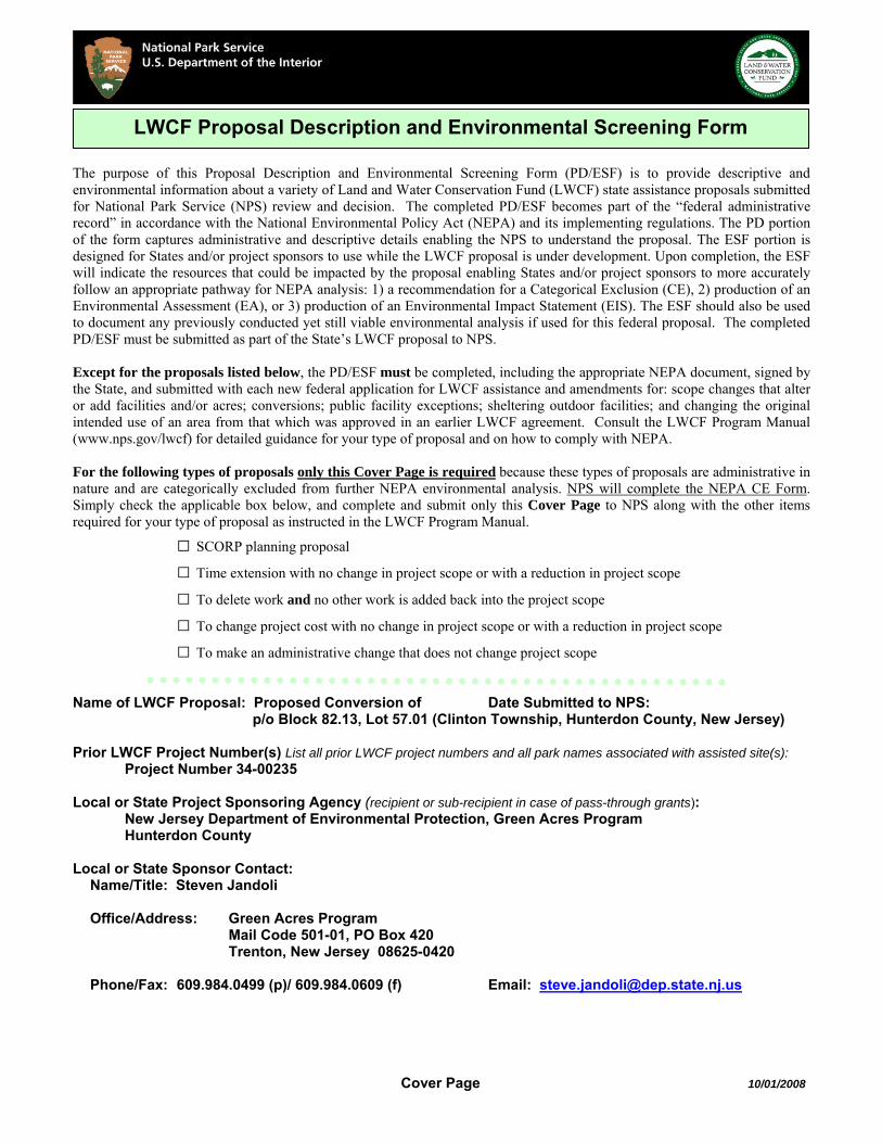
The purpose of this Proposal Description and Environmental Screening Form (PD/ESF) is to provide descriptive and environmental information about a variety of Land and Water Conservation Fund (LWCF) state assistance proposals submitted for National Park Service (NPS) review and decision. The completed PD/ESF becomes part of the “federal administrative record” in accordance with the National Environmental Policy Act (NEPA) and its implementing regulations. The PD portion of the form captures administrative and descriptive details enabling the NPS to understand the proposal. The ESF portion is designed for States and/or project sponsors to use while the LWCF proposal is under development. Upon completion, the ESF will indicate the resources that could be impacted by the proposal enabling States and/or project sponsors to more accurately follow an appropriate pathway for NEPA analysis: 1) a recommendation for a Categorical Exclusion (CE), 2) production of an Environmental Assessment (EA), or 3) production of an Environmental Impact Statement (EIS). The ESF should also be used to document any previously conducted yet still viable environmental analysis if used for this federal proposal. The completed PD/ESF must be submitted as part of the State’s LWCF proposal to NPS. Except for the proposals listed below, the PD/ESF must be completed, including the appropriate NEPA document, signed by the State, and submitted with each new federal application for LWCF assistance and amendments for: scope changes that alter or add facilities and/or acres; conversions; public facility exceptions; sheltering outdoor facilities; and changing the original intended use of an area from that which was approved in an earlier LWCF agreement. Consult the LWCF Program Manual (www.nps.gov/lwcf) for detailed guidance for your type of proposal and on how to comply with NEPA. For the following types of proposals only this Cover Page is required because these types of proposals are administrative in nature and are categorically excluded from further NEPA environmental analysis. NPS will complete the NEPA CE Form. Simply check the applicable box below, and complete and submit only this Cover Page to NPS along with the other items required for your type of proposal as instructed in the LWCF Program Manual.
□ SCORP planning proposal
□ Time extension with no change in project scope or with a reduction in project scope
□ To delete work and no other work is added back into the project scope
□ To change project cost with no change in project scope or with a reduction in project scope
□ To make an administrative change that does not change project scope Name of LWCF Proposal: Proposed Conversion of Date Submitted to NPS: p/o Block 82.13, Lot 57.01 (Clinton Township, Hunterdon County, New Jersey) Prior LWCF Project Number(s) List all prior LWCF project numbers and all park names associated with assisted site(s):
Project Number 34-00235 Local or State Project Sponsoring Agency (recipient or sub-recipient in case of pass-through grants): New Jersey Department of Environmental Protection, Green Acres Program Hunterdon County Local or State Sponsor Contact:
Name/Title: Steven Jandoli Office/Address: Green Acres Program Mail Code 501-01, PO Box 420 Trenton, New Jersey 08625-0420 Phone/Fax: 609.984.0499 (p)/ 609.984.0609 (f) Email: [email protected]
LWCF Proposal Description and Environmental Screening Form
2
10/01/2008
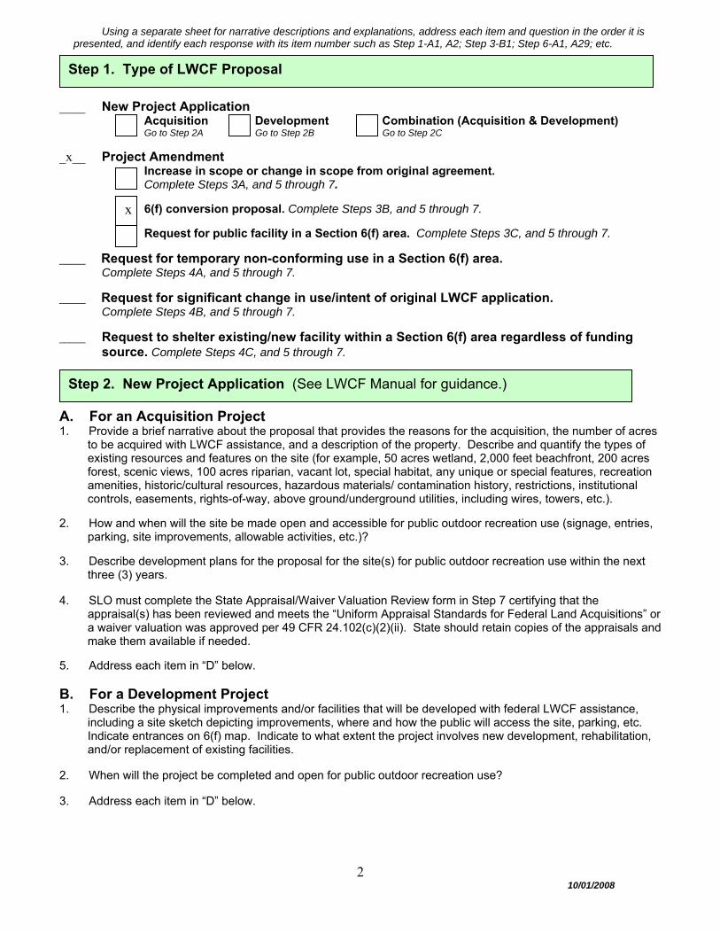
Using a separate sheet for narrative descriptions and explanations, address each item and question in the order it is presented, and identify each response with its item number such as Step 1-A1, A2; Step 3-B1; Step 6-A1, A29; etc.
____ New Project Application
Acquisition Development Combination (Acquisition & Development) Go to Step 2A Go to Step 2B Go to Step 2C
_x__ Project Amendment Increase in scope or change in scope from original agreement. Complete Steps 3A, and 5 through 7.
6(f) conversion proposal. Complete Steps 3B, and 5 through 7.
Request for public facility in a Section 6(f) area. Complete Steps 3C, and 5 through 7.
_____ Request for temporary non-conforming use in a Section 6(f) area. Complete Steps 4A, and 5 through 7.
_____ Request for significant change in use/intent of original LWCF application. Complete Steps 4B, and 5 through 7.
_____ Request to shelter existing/new facility within a Section 6(f) area regardless of funding source. Complete Steps 4C, and 5 through 7.
A. For an Acquisition Project 1. Provide a brief narrative about the proposal that provides the reasons for the acquisition, the number of acres
to be acquired with LWCF assistance, and a description of the property. Describe and quantify the types of existing resources and features on the site (for example, 50 acres wetland, 2,000 feet beachfront, 200 acres forest, scenic views, 100 acres riparian, vacant lot, special habitat, any unique or special features, recreation amenities, historic/cultural resources, hazardous materials/ contamination history, restrictions, institutional controls, easements, rights-of-way, above ground/underground utilities, including wires, towers, etc.).
2. How and when will the site be made open and accessible for public outdoor recreation use (signage, entries,
parking, site improvements, allowable activities, etc.)? 3. Describe development plans for the proposal for the site(s) for public outdoor recreation use within the next
three (3) years. 4. SLO must complete the State Appraisal/Waiver Valuation Review form in Step 7 certifying that the
appraisal(s) has been reviewed and meets the “Uniform Appraisal Standards for Federal Land Acquisitions” or a waiver valuation was approved per 49 CFR 24.102(c)(2)(ii). State should retain copies of the appraisals and make them available if needed.
5. Address each item in “D” below. B. For a Development Project 1. Describe the physical improvements and/or facilities that will be developed with federal LWCF assistance,
including a site sketch depicting improvements, where and how the public will access the site, parking, etc. Indicate entrances on 6(f) map. Indicate to what extent the project involves new development, rehabilitation, and/or replacement of existing facilities.
2. When will the project be completed and open for public outdoor recreation use? 3. Address each item in “D” below.
Step 2. New Project Application (See LWCF Manual for guidance.)
Step 1. Type of LWCF Proposal
x

3
10/01/2008
C. For a Combination Project 1. For the acquisition part of the proposal:
a. Provide a brief narrative about the proposal that provides the reasons for the acquisition, number of acres to be acquired with LWCF assistance, and describes the property. Describe and quantify the types of existing resources and features on the site (for example, 50 acres wetland, 2,000 feet beachfront, 200 acres forest, scenic views, 100 acres riparian, vacant lot, special habitat, any unique or special features, recreation amenities, historic/cultural resources, hazardous materials/ contamination history, restrictions, institutional controls, easements, rights-of-way, above ground/underground utilities, including wires, towers, etc.)
b. How and when will the site be made open and accessible for public outdoor recreation use (signage,
entries, parking, site improvements, allowable activities, etc.)?
c. Describe development plans for the proposed for the site(s) for public outdoor recreation use within the next three (3) years.
d. SLO must complete the State Appraisal/Waiver Valuation Review form in Step 7 certifying that the
appraisal(s) has been reviewed and meets the “Uniform Appraisal Standards for Federal Land Acquisitions” or a waiver valuation was approved per 49 CFR 24.102(c)(2)(ii). State should retain copies of the appraisals and make them available if needed.
2. For the development part of the proposal:
a. Describe the physical improvements and/or facilities that will be developed with federal LWCF assistance, including a site sketch depicting improvements, where and how the public will access the site, parking, etc. Indicate entrances on 6(f) map. Indicate to what extent the project involves new development, rehabilitation, and/or replacement of existing facilities.
b. When will the project be completed and open for public outdoor recreation use?
3. Address each item in “D” below. D. Additional items to address for a new application and amendments 1. Will this proposal create a new public park/recreation area where none previously existed and is not an
addition to an existing public park/recreation area? Yes ____ (go to #3) No ____ (go to #2) 2. a. What is the name of the pre-existing public area that this new site will be added to?
b. Is the pre-existing public park/recreation area already protected under Section 6(f)? Yes ___ No ___ If no, will it now be included in the 6(f) boundary? Yes ___ No ___
3. What will be the name of this new public park/recreation area? 4. a. Who will hold title to the property assisted by LWCF? Who will manage and operate the site(s)?
b. What is the sponsor’s type of ownership and control of the property? ____ Fee simple ownership ____ Less than fee simple. Explain: ____ Lease. Describe lease terms including renewable clauses, # of years remaining on lease, etc.
Who will lease area? Submit copy of lease with this PD/ESF. (See LWCF Manual for program restrictions for leases and further guidance.)
5. Describe the nature of any rights-of-way, easements, reversionary interests, etc. to the Section 6(f) park
area? Indicate the location on 6(f) map. Do parties understand that a Section 6(f) conversion may occur if private or non-recreation activities occur on any pre-existing right-of-way, easement, leased area?
6. Are overhead utility lines present, and if so, explain how they will be treated per LWCF Manual. 7. As a result of this project, describe new types of outdoor recreation opportunities and capacities, and short
and long term public benefits.
4
10/01/2008
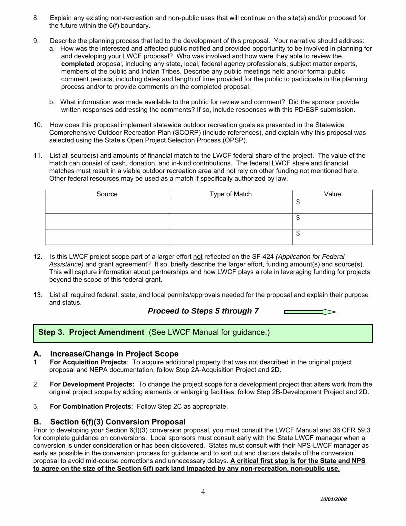
8. Explain any existing non-recreation and non-public uses that will continue on the site(s) and/or proposed for the future within the 6(f) boundary.
9. Describe the planning process that led to the development of this proposal. Your narrative should address:
a. How was the interested and affected public notified and provided opportunity to be involved in planning for and developing your LWCF proposal? Who was involved and how were they able to review the completed proposal, including any state, local, federal agency professionals, subject matter experts, members of the public and Indian Tribes. Describe any public meetings held and/or formal public comment periods, including dates and length of time provided for the public to participate in the planning process and/or to provide comments on the completed proposal.
b. What information was made available to the public for review and comment? Did the sponsor provide
written responses addressing the comments? If so, include responses with this PD/ESF submission.
10. How does this proposal implement statewide outdoor recreation goals as presented in the Statewide Comprehensive Outdoor Recreation Plan (SCORP) (include references), and explain why this proposal was selected using the State’s Open Project Selection Process (OPSP).
11. List all source(s) and amounts of financial match to the LWCF federal share of the project. The value of the
match can consist of cash, donation, and in-kind contributions. The federal LWCF share and financial matches must result in a viable outdoor recreation area and not rely on other funding not mentioned here. Other federal resources may be used as a match if specifically authorized by law.
Source Type of Match Value
$
$
$
12. Is this LWCF project scope part of a larger effort not reflected on the SF-424 (Application for Federal
Assistance) and grant agreement? If so, briefly describe the larger effort, funding amount(s) and source(s). This will capture information about partnerships and how LWCF plays a role in leveraging funding for projects beyond the scope of this federal grant.
13. List all required federal, state, and local permits/approvals needed for the proposal and explain their purpose
and status. Proceed to Steps 5 through 7
A. Increase/Change in Project Scope 1. For Acquisition Projects: To acquire additional property that was not described in the original project
proposal and NEPA documentation, follow Step 2A-Acquisition Project and 2D. 2. For Development Projects: To change the project scope for a development project that alters work from the
original project scope by adding elements or enlarging facilities, follow Step 2B-Development Project and 2D. 3. For Combination Projects: Follow Step 2C as appropriate.
B. Section 6(f)(3) Conversion Proposal Prior to developing your Section 6(f)(3) conversion proposal, you must consult the LWCF Manual and 36 CFR 59.3 for complete guidance on conversions. Local sponsors must consult early with the State LWCF manager when a conversion is under consideration or has been discovered. States must consult with their NPS-LWCF manager as early as possible in the conversion process for guidance and to sort out and discuss details of the conversion proposal to avoid mid-course corrections and unnecessary delays. A critical first step is for the State and NPS to agree on the size of the Section 6(f) park land impacted by any non-recreation, non-public use,
Step 3. Project Amendment (See LWCF Manual for guidance.)
5
10/01/2008
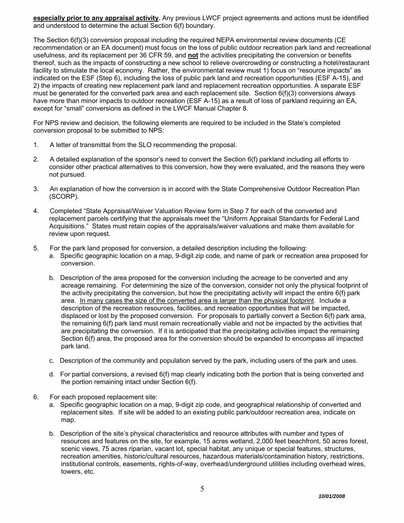
especially prior to any appraisal activity. Any previous LWCF project agreements and actions must be identified and understood to determine the actual Section 6(f) boundary. The Section 6(f)(3) conversion proposal including the required NEPA environmental review documents (CE recommendation or an EA document) must focus on the loss of public outdoor recreation park land and recreational usefulness, and its replacement per 36 CFR 59, and not the activities precipitating the conversion or benefits thereof, such as the impacts of constructing a new school to relieve overcrowding or constructing a hotel/restaurant facility to stimulate the local economy. Rather, the environmental review must 1) focus on “resource impacts” as indicated on the ESF (Step 6), including the loss of public park land and recreation opportunities (ESF A-15), and 2) the impacts of creating new replacement park land and replacement recreation opportunities. A separate ESF must be generated for the converted park area and each replacement site. Section 6(f)(3) conversions always have more than minor impacts to outdoor recreation (ESF A-15) as a result of loss of parkland requiring an EA, except for “small” conversions as defined in the LWCF Manual Chapter 8. For NPS review and decision, the following elements are required to be included in the State’s completed conversion proposal to be submitted to NPS: 1. A letter of transmittal from the SLO recommending the proposal. 2. A detailed explanation of the sponsor’s need to convert the Section 6(f) parkland including all efforts to
consider other practical alternatives to this conversion, how they were evaluated, and the reasons they were not pursued.
3. An explanation of how the conversion is in accord with the State Comprehensive Outdoor Recreation Plan
(SCORP). 4. Completed “State Appraisal/Waiver Valuation Review form in Step 7 for each of the converted and
replacement parcels certifying that the appraisals meet the “Uniform Appraisal Standards for Federal Land Acquisitions.” States must retain copies of the appraisals/waiver valuations and make them available for review upon request.
5. For the park land proposed for conversion, a detailed description including the following:
a. Specific geographic location on a map, 9-digit zip code, and name of park or recreation area proposed for conversion.
b. Description of the area proposed for the conversion including the acreage to be converted and any
acreage remaining. For determining the size of the conversion, consider not only the physical footprint of the activity precipitating the conversion, but how the precipitating activity will impact the entire 6(f) park area. In many cases the size of the converted area is larger than the physical footprint. Include a description of the recreation resources, facilities, and recreation opportunities that will be impacted, displaced or lost by the proposed conversion. For proposals to partially convert a Section 6(f) park area, the remaining 6(f) park land must remain recreationally viable and not be impacted by the activities that are precipitating the conversion. If it is anticipated that the precipitating activities impact the remaining Section 6(f) area, the proposed area for the conversion should be expanded to encompass all impacted park land.
c. Description of the community and population served by the park, including users of the park and uses.
d. For partial conversions, a revised 6(f) map clearly indicating both the portion that is being converted and
the portion remaining intact under Section 6(f).
6. For each proposed replacement site: a. Specific geographic location on a map, 9-digit zip code, and geographical relationship of converted and
replacement sites. If site will be added to an existing public park/outdoor recreation area, indicate on map.
b. Description of the site’s physical characteristics and resource attributes with number and types of
resources and features on the site, for example, 15 acres wetland, 2,000 feet beachfront, 50 acres forest, scenic views, 75 acres riparian, vacant lot, special habitat, any unique or special features, structures, recreation amenities, historic/cultural resources, hazardous materials/contamination history, restrictions, institutional controls, easements, rights-of-way, overhead/underground utilities including overhead wires, towers, etc.
6
10/01/2008
c. Identification of the owner of the replacement site and its recent history of use/function up to the present.
d. Detailed explanation of how the proposed replacement site is of reasonably equivalent usefulness and
location as the property being converted, including a description of the recreation needs that will be met by the new replacement parks, populations to be served, and new outdoor recreation resources, facilities, and opportunities to be provided.
e. Identification of owner and manager of the new replacement park?
f. Name of the new replacement park. If the replacement park is added to an existing public park
area, will the existing area be included within the 6(f) boundary? What is the name of the existing public park area?
g. Timeframe for completing the new outdoor recreation area(s) to replace the recreation
opportunity lost per the terms of conversion approval and the date replacement park(s) will be open to the public.
h. New Section 6(f) map for the new replacement park.
7. NEPA environmental review, including NHPA Section 106 review, for both the converted and
replacement sites in the same document to analyze how the converted park land and recreational usefulness will be replaced. Except for “small” conversions (see LWCF Manual Chapter 8), conversions usually require an EA.
Proceed to Steps 5 through 7
C. Proposal for a Public Facility in a Section 6(f) Area Prior to developing this proposal, you must consult the LWCF Manual for complete guidance. In summary, NPS must review and decide on requests to construct a public indoor and/or non-recreation facility within a Section 6(f) area. In certain cases NPS may approve the construction of public facilities within a Section 6(f) area where it can be shown that there will be a net gain in outdoor recreation benefits and enhancements for the entire park. In most cases, development of a non-recreation public facility within a Section 6(f) area constitutes a conversion. For NPS review, the State/sponsor must submit a proposal to NPS under a letter of transmittal from the SLO that: 1. Describes the purpose and all proposed uses of the public facility such as types of programming, recreation
activities, and special events including intended users of the new facility and any agency, organization, or other party to occupy the facility. Describe the interior and exterior of the facility, such as office space, meeting rooms, food/beverage area, residential/lodging area, classrooms, gyms, etc. Explain how the facility will be compatible with the outdoor recreation area. Explain how the facility and associated uses will significantly support and enhance existing and planned outdoor recreation resources and uses of the site, and how outdoor recreation use will remain the primary function of the site. (The public’s outdoor recreation use must continue to be greater than that expected for any indoor use, unless the site is a single facility, such as a swimming pool, which virtually occupies the entire site.)
2. Indicates the exact location of the proposed public facility and associated activities on the site’s Section 6(f)
map. Explain the design and location alternatives considered for the public facility and why they were not pursued.
3. Explains who will own and/or operate and maintain the facility? Attach any 3rd party leases and operation and
management agreements. When will the facility be open to the public? Will the facility ever be used for private functions and closed to the public? Explain any user or other fees that will be instituted, including the fee structure.
4. Includes required documents as a result of a completed NEPA process (Steps 5 – 7).
Proceed to Steps 5 through 7
7
10/01/2008
A. Proposal for Temporary Non-Conforming Use Prior to developing this proposal, you must consult the LWCF Manual for complete guidance. NPS must review and decided on requests for temporary uses that do not meet the requirements of allowable activities within a Section 6(f) area. A temporary non-conforming use is limited to a period of six months (180 days) or less. Continued use beyond six-months will not be considered temporary, and may result in a Section 6(f)(3) conversion of use requiring the replacement of converted parkland. For NPS review, describe the temporary non-conforming use (activities other than public outdoor recreation) in detail including the following information: 1. A letter of transmittal from the SLO recommending the proposal. 2. Describe in detail the proposed temporary non-conforming use and all associated activities, why it is needed,
and alternative locations that were considered and why they were not pursued. 3. Explain length of time needed for the temporary non-conforming use and why. 4. Describe the size of the Section 6(f) area affected by the temporary non-conforming use activities and
expected impacts to public outdoor recreation areas, facilities and opportunities. Explain efforts to keep the size of the area impacted to a minimum. Indicate the location of the non-conforming use on the site’s 6(f) map.
5. Describe any anticipated temporary/permanent impacts to the Section 6(f) area and how the sponsor will
mitigate them during and after the non-conforming use ceases. 6. Consult the LWCF Manual for additional requirements and guidelines before developing the proposal.
Proceed to Steps 5 through 7
B. Proposal for Significant Change in Use Prior to developing the proposal, you must consult the LWCF Manual for complete guidance. NPS approval must be obtained prior to any change from one eligible use to another when the proposed use would significantly contravene the original plans or intent for the area outlined in the original LWCF application for federal assistance. Consult with NPS for early determination on the need for a formal review. NPS approval is only required for proposals that will significantly change the use of a LWCF-assisted site (e.g., from passive to active recreation). The proposal must include and address the following items: 1. A letter of transmittal from the SLO recommending the proposal. 2. Description of the proposed changes and how they significantly contravene the original plans or intent of
LWCF agreements. 3. Explanation of the need for change in use and how the change is consistent with local plans and the SCORP. 4. Consult the LWCF Manual for additional requirements and guidelines before developing the proposal.
Proceed to Steps 5 through 7
C. Proposal for Sheltering Facilities Prior to developing this proposal, you must consult the LWCF Manual for complete guidance. NPS must review and decide on all proposals to shelter an existing outdoor recreation facility or construct a new sheltered recreation facility within a Section 6(f) area regardless of funding source. The proposal must demonstrate that there is an increased benefit to public recreation opportunity. Describe the sheltering proposal in detail, including the following: 1. A letter of transmittal from the SLO recommending the proposal. 2. Describe the proposed sheltered facility, how it would operate, how the sheltered facility will include recreation
uses that could typically occur outdoors, and how the primary purpose of the sheltered facility is recreation.
Step 4. Proposals for Temporary Non-Conforming Use, Significant Change in Use, and Sheltering Facilities (See LWCF Manual for guidance.)
8
10/01/2008
3. Explain how the sheltered facility would not substantially diminish the outdoor recreation values of the site including how the sheltered facility will be compatible and significantly supportive of the outdoor recreation resources present and/or planned.
4. Explain how the sheltered facility will benefit the total park’s outdoor recreation use. 5. Describe efforts provided to the public to review the proposal to shelter the facility and has local support. 6. Document that the sheltered facility will be under the control and tenure of the public agency which sponsors
and administers the original park area. 7. Consult the LWCF Manual for additional requirements and guidelines before developing the proposal.
Proceed to Steps 5 through 7
To avoid duplication of effort and unnecessary delays, describe any prior environmental review undertaken at any time and still viable for this proposal or related efforts that could be useful for understanding potential environmental impacts. Consider previous local, state, federal (e.g. HUD, EPA, USFWS, FHWA, DOT) and any other environmental reviews. At a minimum, address the following:
1. Date of environmental review(s), purpose for the environmental review(s) and for whom they were conducted. 2. Description of the proposed action and alternatives. 3. Who was involved in identifying resource impact issues and developing the proposal including the interested
and affected public, government agencies, and Indian tribes. 4. Environmental resources analyzed and determination of impacts for proposed actions and alternatives. 5. Any mitigation measures to be part of the proposed action. 6. Intergovernmental Review Process (Executive Order 12372): Does the State have an Intergovernmental
Review Process? Yes ___x__ No _____. If yes, has the LWCF Program been selected for review under the State Intergovernmental Review Process? Yes _____ No __x___. If yes, was this proposal reviewed by the appropriate State, metropolitan, regional and local agencies, and if so, attach any information and comments received about this proposal. If proposal was not reviewed, explain why not.
7. Public comment periods (how long, when in the process, who was invited to comment) and agency response. 8. Any formal decision and supporting reasons regarding degree of potential impacts to the human environment. 9. Was this proposed LWCF federal action and/or any other federal actions analyzed/reviewed in any of the
previous environmental reviews? If so, what was analyzed and what impacts were identified? Provide specific environmental review document references.
Use resource impact information generated during previous environmental reviews described above and from recently conducted site inspections to complete the Environmental Screening Form (ESF) portion of this PD/ESF under Step 6. Your ESF responses should indicate your proposal’s potential for impacting each resource as determined in the previous environmental review(s), and include a reference to where the analysis can be found in an earlier environmental review document. If the previous environmental review documents contain proposed actions to mitigate impacts, briefly summarize the mitigation for each resource as appropriate. The appropriate references for previous environmental review document(s) must be documented on the ESF, and the actual document(s) along with this PD/ESF must be included in the submission for NPS review.
Proceed to Steps 6 through 7
Step 5. Summary of Previous Environmental Review (including E.O. 12372 - Intergovernmental Review)

9
10/01/2008
This portion of the PD/ESF is a working tool used to identify the level of environmental documentation which must accompany the proposal submission to the NPS. By completing the ESF, the project sponsor is providing support for its recommendation in Step 7 that the proposal either:
1. meets criteria to be categorically excluded (CE) from further NEPA review and no additional environmental documentation is necessary; or
2. requires further analysis through an environmental assessment (EA) or an environmental
impact statement (EIS). An ESF alone does not constitute adequate environmental documentation unless a CE is recommended. If an EA is required, the EA process and resulting documents must be included in the proposal submission to the NPS. If an EIS may be required, the State must request NPS guidance on how to proceed. The scope of the required environmental analysis will vary according to the type of LWCF proposal. For example, the scope for a new LWCF project will differ from the scope for a conversion. Consult the LWCF Manual for guidance on defining the scope or extent of environmental analysis needed for your LWCF proposal. As early as possible in your planning process, consider how your proposal/project may have direct, indirect and cumulative impacts on the human environment for your type of LWCF action so planners have an opportunity to design alternatives to lessen impacts on resources, if appropriate. When used as a planning tool in this way, the ESF responses may change as the proposal is revised until it is ready for submission for federal review. Initiating or completing environmental analysis after a decision has been made is contrary to both the spirit and letter of the law of the NEPA. The ESF should be completed with input from resource experts and in consultation with relevant local, state, tribal and federal governments, as applicable. The interested and affected public should be notified of the proposal and be invited to participate in scoping out the proposal (see LWCF Manual Chapter 4). At a minimum, a site inspection of the affected area must be conducted by individuals who are familiar with the type of affected resources, possess the ability to identify potential resource impacts, and to know when to seek additional data when needed. At the time of proposal submission to NPS for federal review, the completed ESF must justify the NEPA pathway that was followed: CE recommendation, production of an EA, or production of an EIS. The resource topics and issues identified on the ESF for this proposal must be presented and analyzed in an attached EA/EIS. Consult the LWCF Manual for further guidance on LWCF and NEPA. The ESF contains two parts that must be completed: Part A. Environmental Resources Part B. Mandatory Criteria Part A: For each environmental resource topic, choose an impact estimate level (none, negligible, minor, exceeds minor) that describes the degree of potential negative impact for each listed resource that may occur directly, indirectly and cumulatively as a result of federal approval of your proposal. For each impacted resource provide a brief explanation of how the resource might be affected, how the impact level was determined, and why the chosen impact level is appropriate. If an environmental review has already been conducted on your proposal and is still viable, include the citation including any planned mitigation for each applicable resource, and choose an impact level as mitigated. If the resource does not apply to your proposal, mark NA in the first column. Add any relevant resources (see A.24 on the ESF) if not included in the list. Use a separate sheet to briefly clarify how each resource could be adversely impacted; any direct, indirect, and cumulative impacts that may occur; and any additional data that still needs to be determined. Also explain any planned mitigation already addressed in previous environmental reviews. Part B: This is a list of mandatory impact criteria that preclude the use of categorical exclusions. If you answer “yes” or “maybe” for any of the mandatory criteria, you must develop an EA or EIS regardless of your answers in Part A. Explain all “yes” and “maybe” answers on a separate sheet.
Step 6. Environmental Screening Form (ESF)
10
10/01/2008
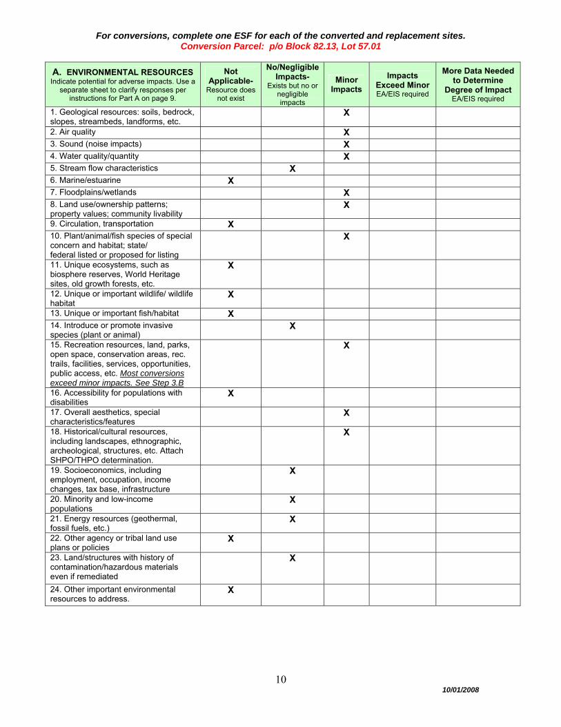
For conversions, complete one ESF for each of the converted and replacement sites.
Conversion Parcel: p/o Block 82.13, Lot 57.01
A. ENVIRONMENTAL RESOURCES Indicate potential for adverse impacts. Use a
separate sheet to clarify responses per instructions for Part A on page 9.
Not Applicable-
Resource does not exist
No/NegligibleImpacts-
Exists but no or negligible impacts
Minor Impacts
Impacts Exceed Minor EA/EIS required
More Data Needed to Determine
Degree of Impact EA/EIS required
1. Geological resources: soils, bedrock, slopes, streambeds, landforms, etc.
X
2. Air quality X 3. Sound (noise impacts) X 4. Water quality/quantity X 5. Stream flow characteristics X 6. Marine/estuarine X 7. Floodplains/wetlands X 8. Land use/ownership patterns; property values; community livability
X
9. Circulation, transportation X 10. Plant/animal/fish species of special concern and habitat; state/ federal listed or proposed for listing
X
11. Unique ecosystems, such as biosphere reserves, World Heritage sites, old growth forests, etc.
X
12. Unique or important wildlife/ wildlife habitat
X
13. Unique or important fish/habitat X 14. Introduce or promote invasive species (plant or animal)
X
15. Recreation resources, land, parks, open space, conservation areas, rec. trails, facilities, services, opportunities, public access, etc. Most conversions exceed minor impacts. See Step 3.B
X
16. Accessibility for populations with disabilities
X
17. Overall aesthetics, special characteristics/features
X
18. Historical/cultural resources, including landscapes, ethnographic, archeological, structures, etc. Attach SHPO/THPO determination.
X
19. Socioeconomics, including employment, occupation, income changes, tax base, infrastructure
X
20. Minority and low-income populations
X
21. Energy resources (geothermal, fossil fuels, etc.)
X
22. Other agency or tribal land use plans or policies
X
23. Land/structures with history of contamination/hazardous materials even if remediated
X
24. Other important environmental resources to address.
X
11
10/01/2008
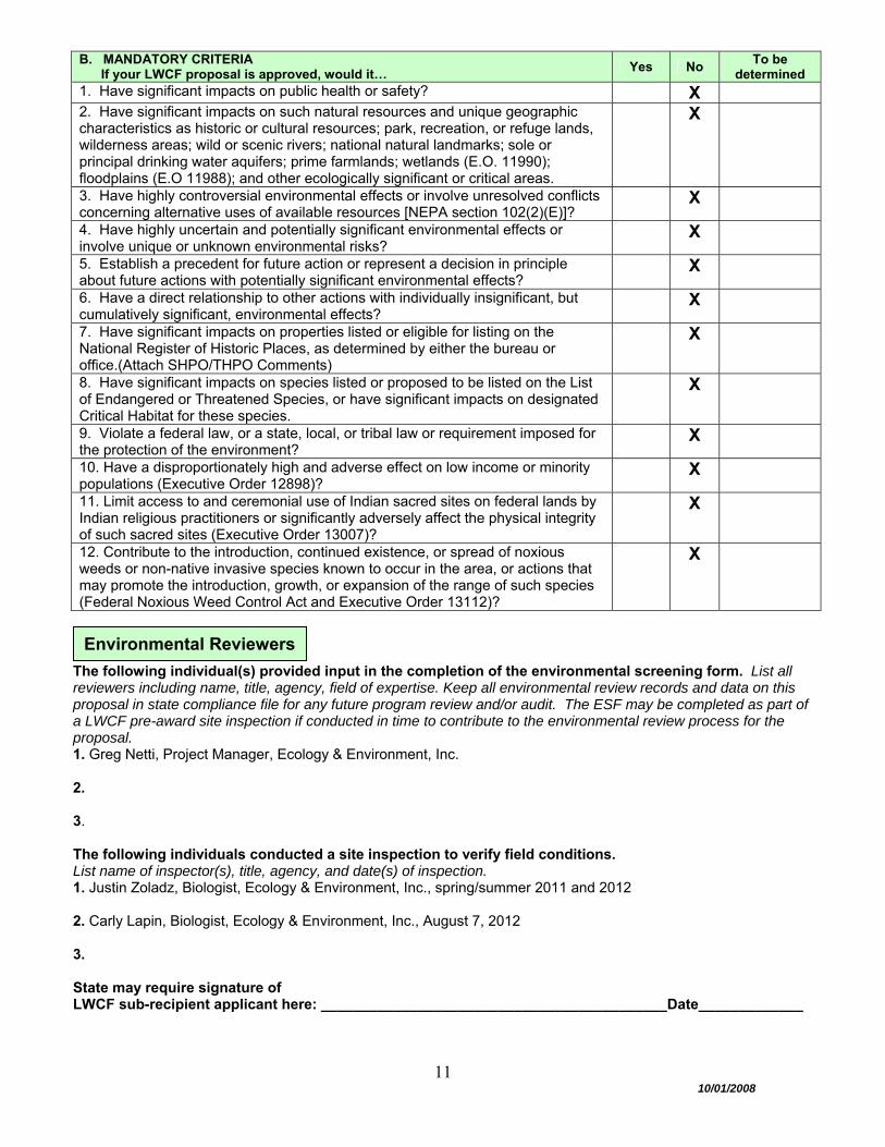
B. MANDATORY CRITERIA If your LWCF proposal is approved, would it…
Yes No To be
determined1. Have significant impacts on public health or safety? X 2. Have significant impacts on such natural resources and unique geographic characteristics as historic or cultural resources; park, recreation, or refuge lands, wilderness areas; wild or scenic rivers; national natural landmarks; sole or principal drinking water aquifers; prime farmlands; wetlands (E.O. 11990); floodplains (E.O 11988); and other ecologically significant or critical areas.
X
3. Have highly controversial environmental effects or involve unresolved conflicts concerning alternative uses of available resources [NEPA section 102(2)(E)]?
X
4. Have highly uncertain and potentially significant environmental effects or involve unique or unknown environmental risks?
X
5. Establish a precedent for future action or represent a decision in principle about future actions with potentially significant environmental effects?
X
6. Have a direct relationship to other actions with individually insignificant, but cumulatively significant, environmental effects?
X
7. Have significant impacts on properties listed or eligible for listing on the National Register of Historic Places, as determined by either the bureau or office.(Attach SHPO/THPO Comments)
X
8. Have significant impacts on species listed or proposed to be listed on the List of Endangered or Threatened Species, or have significant impacts on designated Critical Habitat for these species.
X
9. Violate a federal law, or a state, local, or tribal law or requirement imposed for the protection of the environment?
X
10. Have a disproportionately high and adverse effect on low income or minority populations (Executive Order 12898)?
X
11. Limit access to and ceremonial use of Indian sacred sites on federal lands by Indian religious practitioners or significantly adversely affect the physical integrity of such sacred sites (Executive Order 13007)?
X
12. Contribute to the introduction, continued existence, or spread of noxious weeds or non-native invasive species known to occur in the area, or actions that may promote the introduction, growth, or expansion of the range of such species (Federal Noxious Weed Control Act and Executive Order 13112)?
X
The following individual(s) provided input in the completion of the environmental screening form. List all reviewers including name, title, agency, field of expertise. Keep all environmental review records and data on this proposal in state compliance file for any future program review and/or audit. The ESF may be completed as part of a LWCF pre-award site inspection if conducted in time to contribute to the environmental review process for the proposal. 1. Greg Netti, Project Manager, Ecology & Environment, Inc. 2. 3. The following individuals conducted a site inspection to verify field conditions. List name of inspector(s), title, agency, and date(s) of inspection. 1. Justin Zoladz, Biologist, Ecology & Environment, Inc., spring/summer 2011 and 2012 2. Carly Lapin, Biologist, Ecology & Environment, Inc., August 7, 2012 3. State may require signature of LWCF sub-recipient applicant here: ___________________________________________Date_____________
Environmental Reviewers
12
10/01/2008
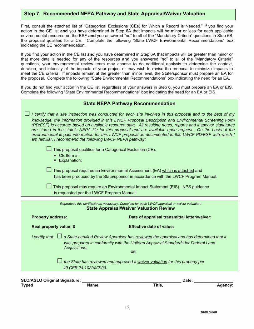
First, consult the attached list of “Categorical Exclusions (CEs) for Which a Record is Needed.” If you find your action in the CE list and you have determined in Step 6A that impacts will be minor or less for each applicable environmental resource on the ESF and you answered “no” to all of the “Mandatory Criteria” questions in Step 6B, the proposal qualifies for a CE. Complete the following “State LWCF Environmental Recommendations” box indicating the CE recommendation. If you find your action in the CE list and you have determined in Step 6A that impacts will be greater than minor or that more data is needed for any of the resources and you answered “no” to all of the “Mandatory Criteria” questions, your environmental review team may choose to do additional analysis to determine the context, duration, and intensity of the impacts of your project or may wish to revise the proposal to minimize impacts to meet the CE criteria. If impacts remain at the greater than minor level, the State/sponsor must prepare an EA for the proposal. Complete the following “State Environmental Recommendations” box indicating the need for an EA. If you do not find your action in the CE list, regardless of your answers in Step 6, you must prepare an EA or EIS. Complete the following “State Environmental Recommendations” box indicating the need for an EA or EIS.
SLO/ASLO Original Signature: ___________________________________________ Date: _________________
Typed Name, Title, Agency:
Step 7. Recommended NEPA Pathway and State Appraisal/Waiver Valuation
State NEPA Pathway Recommendation
□ I certify that a site inspection was conducted for each site involved in this proposal and to the best of my
knowledge, the information provided in this LWCF Proposal Description and Environmental Screening Form (PD/ESF) is accurate based on available resource data. All resulting notes, reports and inspector signatures are stored in the state’s NEPA file for this proposal and are available upon request. On the basis of the environmental impact information for this LWCF proposal as documented in this LWCF PD/ESF with which I am familiar, I recommend the following LWCF NEPA pathway:
□ This proposal qualifies for a Categorical Exclusion (CE).
CE Item #: Explanation:
□ This proposal requires an Environmental Assessment (EA) which is attached and
has been produced by the State/sponsor in accordance with the LWCF Program Manual.
□ This proposal may require an Environmental Impact Statement (EIS). NPS guidance
is requested per the LWCF Program Manual.
Reproduce this certificate as necessary. Complete for each LWCF appraisal or waiver valuation.
State Appraisal/Waiver Valuation Review
Property address: Date of appraisal transmittal letter/waiver: Real property value: $ Effective date of value:
I certify that: □ a State-certified Review Appraiser has reviewed the appraisal and has determined that it
was prepared in conformity with the Uniform Appraisal Standards for Federal Land Acquisitions.
OR
□ the State has reviewed and approved a waiver valuation for this property per
49 CFR 24.102(c)(2)(ii).
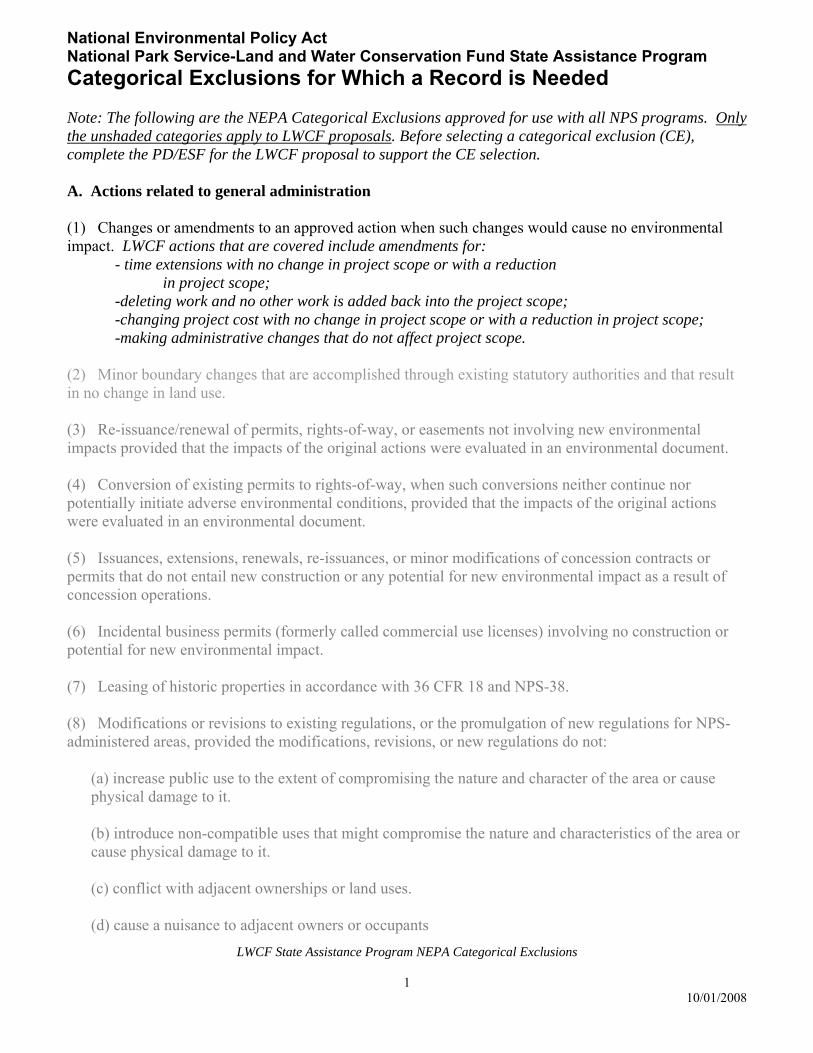
LWCF State Assistance Program NEPA Categorical Exclusions
1 10/01/2008
National Environmental Policy Act National Park Service-Land and Water Conservation Fund State Assistance Program
Categorical Exclusions for Which a Record is Needed Note: The following are the NEPA Categorical Exclusions approved for use with all NPS programs. Only the unshaded categories apply to LWCF proposals. Before selecting a categorical exclusion (CE), complete the PD/ESF for the LWCF proposal to support the CE selection. A. Actions related to general administration (1) Changes or amendments to an approved action when such changes would cause no environmental impact. LWCF actions that are covered include amendments for:
- time extensions with no change in project scope or with a reduction in project scope;
-deleting work and no other work is added back into the project scope; -changing project cost with no change in project scope or with a reduction in project scope; -making administrative changes that do not affect project scope.
(2) Minor boundary changes that are accomplished through existing statutory authorities and that result in no change in land use. (3) Re-issuance/renewal of permits, rights-of-way, or easements not involving new environmental impacts provided that the impacts of the original actions were evaluated in an environmental document. (4) Conversion of existing permits to rights-of-way, when such conversions neither continue nor potentially initiate adverse environmental conditions, provided that the impacts of the original actions were evaluated in an environmental document. (5) Issuances, extensions, renewals, re-issuances, or minor modifications of concession contracts or permits that do not entail new construction or any potential for new environmental impact as a result of concession operations. (6) Incidental business permits (formerly called commercial use licenses) involving no construction or potential for new environmental impact. (7) Leasing of historic properties in accordance with 36 CFR 18 and NPS-38. (8) Modifications or revisions to existing regulations, or the promulgation of new regulations for NPS-administered areas, provided the modifications, revisions, or new regulations do not:
(a) increase public use to the extent of compromising the nature and character of the area or cause physical damage to it. (b) introduce non-compatible uses that might compromise the nature and characteristics of the area or cause physical damage to it. (c) conflict with adjacent ownerships or land uses. (d) cause a nuisance to adjacent owners or occupants
LWCF State Assistance Program NEPA Categorical Exclusions
2 10/01/2008
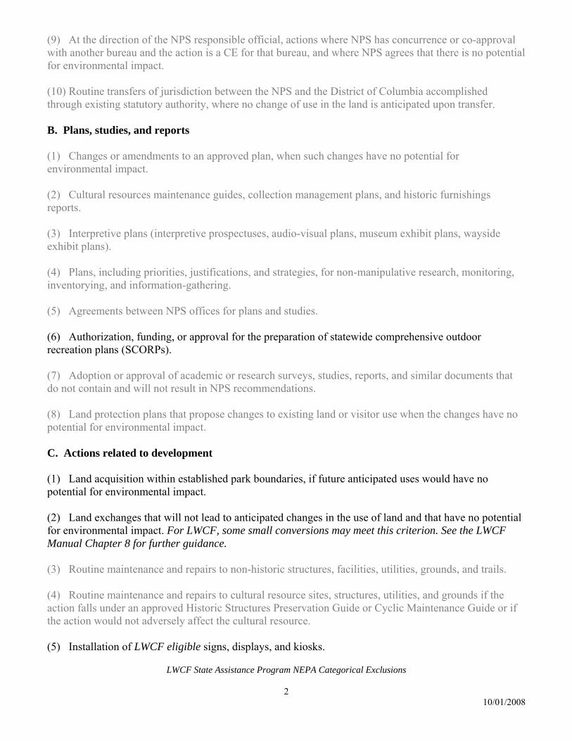
(9) At the direction of the NPS responsible official, actions where NPS has concurrence or co-approval with another bureau and the action is a CE for that bureau, and where NPS agrees that there is no potential for environmental impact. (10) Routine transfers of jurisdiction between the NPS and the District of Columbia accomplished through existing statutory authority, where no change of use in the land is anticipated upon transfer. B. Plans, studies, and reports (1) Changes or amendments to an approved plan, when such changes have no potential for environmental impact. (2) Cultural resources maintenance guides, collection management plans, and historic furnishings reports. (3) Interpretive plans (interpretive prospectuses, audio-visual plans, museum exhibit plans, wayside exhibit plans). (4) Plans, including priorities, justifications, and strategies, for non-manipulative research, monitoring, inventorying, and information-gathering. (5) Agreements between NPS offices for plans and studies. (6) Authorization, funding, or approval for the preparation of statewide comprehensive outdoor recreation plans (SCORPs). (7) Adoption or approval of academic or research surveys, studies, reports, and similar documents that do not contain and will not result in NPS recommendations. (8) Land protection plans that propose changes to existing land or visitor use when the changes have no potential for environmental impact. C. Actions related to development (1) Land acquisition within established park boundaries, if future anticipated uses would have no potential for environmental impact. (2) Land exchanges that will not lead to anticipated changes in the use of land and that have no potential for environmental impact. For LWCF, some small conversions may meet this criterion. See the LWCF Manual Chapter 8 for further guidance. (3) Routine maintenance and repairs to non-historic structures, facilities, utilities, grounds, and trails. (4) Routine maintenance and repairs to cultural resource sites, structures, utilities, and grounds if the action falls under an approved Historic Structures Preservation Guide or Cyclic Maintenance Guide or if the action would not adversely affect the cultural resource. (5) Installation of LWCF eligible signs, displays, and kiosks.
LWCF State Assistance Program NEPA Categorical Exclusions
3 10/01/2008
(6) Installation of navigation aids. (7) Experimental testing of short duration (no more than one season) of mass transit systems, and changes in operation of existing systems, that have no potential for environmental impact. (8) Replacement in kind of minor structures and facilities with little or no change in location, capacity, or appearance--for example, comfort stations, pit toilets, fences, kiosks, signs and campfire circles. (9) Repair, resurfacing, striping, installation of traffic control devices, and repair/replacement of guardrails, culverts, signs, and other minor existing features on existing roads when no potential for environmental impact exists. (10) Changes in sanitary facilities operation resulting in no new environmental effects. (11) Installation of wells, comfort stations, and pit or vault toilets in areas of existing use and in developed areas. (12) Minor trail relocation or development of compatible trail networks on logging roads or other established routes. (13) Upgrading or adding new overhead utility facilities on existing poles, or on replacement poles that do not change existing pole line configurations. (14) Issuance of rights-of-way for overhead utility lines to an individual building or well from an existing line where installation will not result in visual intrusion and will involve no clearance of vegetation other than for placement of poles. (15) Issuance of rights-of-way for minor overhead utility lines not involving placement of poles or towers and not involving vegetation management or visual intrusion in an area administered by NPS. (16) Installation of underground utilities in areas showing clear evidence of recent human disturbance or areas within an existing road prism or within an existing overhead utility right-of-way. (17) Minor landscaping in areas showing clear evidence of recent human disturbance. (18) Installation of fencing enclosures, exclosures, or boundary fencing posing no effect on wildlife migrations. D. Actions related to visitor use (1) Minor changes in amounts or types of visitor use for the purpose of ensuring visitor safety or resource protection in accordance with existing regulations. (2) Minor changes in programs and regulations pertaining to visitor activities. (3) Issuance of permits for demonstrations, gatherings, ceremonies, concerts, arts and crafts shows, and so forth, entailing only short-term or readily remediable environmental disturbance.
LWCF State Assistance Program NEPA Categorical Exclusions
4 10/01/2008
(4) Designation of trailside camping zones with minimal or no improvements. E. Actions related to resource management and protection (1) Archeological surveys and permits involving only surface collection or small-scale test excavations. (2) Restoration of non-controversial (based on internal scoping requirements in section 2.6) native species into suitable habitats within their historic range. (3) Removal of individual members of a non-threatened/endangered species or populations of pests and exotic plants that pose an imminent danger to visitors or an immediate threat to park resources. (4) Removal of non-historic materials and structures in order to restore natural conditions when the removal has no potential for environmental impacts, including impacts to cultural landscapes or archeological resources. (5) Development of standards for, and identification, nomination, certification, and determination of, eligibility of properties for listing in the National Register of Historic Places, the National Historic Landmark and National Natural Landmark Programs, and biosphere reserves. (6) Non-destructive data collection, inventory (including field, aerial, and satellite surveying and mapping), study, research, and monitoring activities (this is also a Departmental CE). (7) Designation if environmental study areas and research natural areas, including those closed temporarily or permanently to the public, unless the potential for environmental (including socioeconomic) impact exists. F. Actions related to grant programs (1) Proposed actions essentially the same as those listed in paragraphs A-E above not shaded in gray. (2) Grants for acquisition to areas that will continue in the same use or lower density use with no additional disturbance to the natural setting or type of use. (3) Grants for replacement or renovation of facilities at their same location without altering the kind and amount of recreational, historical, or cultural resources of the area or the integrity of the existing setting. (4) Grants for construction of facilities on lands acquired under a previous NPS or other federal grant, provided that the development is in accord with plans submitted with the acquisition grant, and that environmental documents have been completed on the impacts of the proposal funded by the original grant. (5) Grants for the construction of new facilities within an existing park or recreation area, provided that the facilities will not:
(a) conflict with adjacent ownerships or land use, or cause a nuisance to adjacent owners or occupants, such as would happen if use were extended beyond daylight hours.
LWCF State Assistance Program NEPA Categorical Exclusions
5 10/01/2008
(b) introduce motorized recreation vehicles, including off-road vehicles, personal water craft, and snowmobiles. (c) introduce active recreation pursuits into a passive recreation area. (d) increase public use or introduce non-compatible uses to the extent of compromising the nature
and character of the property or causing physical damage to it. (e) add or alter access to the park from the surrounding area.
(6) Grants for the restoration, rehabilitation, stabilization, preservation, and reconstruction (or the authorization thereof) of properties listed on or eligible for listing on the National Register of Historic Places, at their same location, and provided that such actions:
(a) will not alter the integrity of the property or its setting
(b) will not increase public use of the area to the extent of compromising the nature and character o the property.
Page 1 of 44
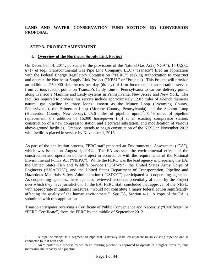
LAND AND WATER CONSERVATION FUND SECTION 6(f) CONVERSION PROPOSAL STEP 3. PROJECT AMENDMENT
I. Overview of the Northeast Supply Link Project
On December 14, 2011, pursuant to the provisions of the Natural Gas Act (“NGA”), 15 U.S.C. §717 et seq., Transcontinental Gas Pipe Line Company, LLC (“Transco”) filed an application with the Federal Energy Regulatory Commission (“FERC”) seeking authorization to construct and operate the Northeast Supply Link Project (“NESL” or “Project”). This Project will provide an additional 250,000 dekatherms per day (dt/day) of firm incremental transportation service from various receipt points on Transco’s Leidy Line in Pennsylvania to various delivery points along Transco’s Mainline and Leidy systems in Pennsylvania, New Jersey and New York. The facilities required to provide this service include approximately 12.03 miles of 42-inch diameter natural gas pipeline in three loops1 known as the Muncy Loop (Lycoming County, Pennsylvania), the Palmerton Loop (Monroe County, Pennsylvania) and the Stanton Loop (Hunterdon County, New Jersey), 25.6 miles of pipeline uprate2, 0.46 miles of pipeline replacement, the addition of 16,000 horsepower (hp) at an existing compressor station, construction of a new compressor station and electrical substation, and modification of various above-ground facilities. Transco intends to begin construction of the NESL in November 2012 with facilities placed in service by November 1, 2013.
As part of the application process, FERC staff prepared an Environmental Assessment (“EA”), which was issued on August 1, 2012. The EA assessed the environmental effects of the construction and operation of the Project in accordance with the requirements of the National Environmental Policy Act (“NEPA”). While the FERC was the lead agency in preparing the EA, the United States Fish and Wildlife Service (“USFWS”), the United States Army Corps of Engineers (“USACOE”), and the United States Department of Transportation, Pipeline and Hazardous Materials Safety Administration (“USDOT”) participated as cooperating agencies. As cooperating agencies, these agencies reviewed resources potentially affected by the Project over which they have jurisdiction. In the EA, FERC staff concluded that approval of the NESL, with appropriate mitigating measures, “would not constitute a major federal action significantly affecting the quality of the human environment.” See EA, Section 4-1. A copy of the EA is submitted with this application.
Transco anticipates receiving a Certificate of Public Convenience and Necessity (“Certificate” or “FERC Certificate”) from the FERC by the middle of September 2012.
1 A pipeline “loop” is a segment of pipe that is usually installed adjacent to an existing pipeline and is connected to it at both ends. 2 An “uprate” is a process by which an existing pipeline is approved to operate at a higher pressure, thus increasing the capacity of a pipeline.
Page 2 of 44
II. Overview of Project Amendment (Conversion)
On February 6, 1974, the United States Department of Interior, Bureau of Outdoor Recreation, provided federal funding to the State of New Jersey pursuant to Section 6(f) of the Land and Water Conservation Fund (“LWCF”) Act for the Hunterdon County South Branch Linear Park. See 16 U.S.C. 460l-8(f); Project #34-00235. Pursuant to the Project Agreement, the State of New Jersey transferred these funds to Hunterdon County, which used this funding towards the acquisition of approximately 770.36 acres of land along the South Branch of the Raritan River (“South Branch Reservation” or “South Branch Raritan River”). Among the properties acquired with the LWCF Act monies was a 45.833-acre3 parcel, formerly known as Block 82, Lot 57, and now a part of Block 82.13, Lot 57.01 on the official tax map of Clinton Township, Hunterdon County, New Jersey.4 This parcel will be referred to as the “Section 6(f) land.” A copy of the Project Agreement and survey map is attached hereto as Attachment A. The Section 6(f) land is shown on Figure 1, “6(f) Boundary,” prepared by Williams Gas Pipeline, dated August 22, 2012, and attached hereto.
It should be noted that the survey map attached to the Project Agreement only shows one thirty (30) foot wide easement on Block 82.13, Lot 57.01. However, Transco presently holds a sixty (60) foot wide easement within which there are two pipelines known as the Leidy Lines (A and B). By way of background, on July 15, 1958, George E. and Helen A. Melick granted Transcontinental Gas Pipe Line Corporation (as it was then known) a thirty (30) foot wide easement with the right to construct and maintain (among other things) one or more pipelines on the property. Transco’s first pipeline was built when the property was owned by a private landowner. On June 10, 1985, Hunterdon County granted Transco an expanded thirty (30) foot right-of-way and easement, again with the right to build one or more additional pipelines. Because the property had a Green Acres restriction, a diversion was necessary. On February 28, 1985, NJDEP recommended that the State House Commission approve the diversion of 2.69 acres of the South Branch Nature Preserve (as it was then called) to allow Transco to construct a second pipeline within its expanded easement that is parallel to and adjacent to its original easement. The diversion was approved, and the State of New Jersey released the Green Acres restriction on the Section 6(f) land on April 18, 1985. At the time NJDEP approved the diversion, it determined that the underground utility easement was not a conversion of lands encumbered by Section 6(f) of the LWCF Act. Accordingly, a sixty (60) foot wide easement now traverses the Section 6(f) land, which is not encumbered by the LWCF Act. See February 28, 1985 letter from Commissioner Robert E. Hughey to Governor Thomas H. Kean requesting approval of diversion, and the Release from Green Acres Contract, dated April 18, 1985, both attached hereto as Attachment C. 3 According to the survey map attached to Project #34-00235, the acreage for former Block 82, Lot 57 is shown as 45.65 acres. However, with today’s more sophisticated techniques for calculating acreage, the actual acreage for this parcel is 45.833 acres. 4 Research on this parcel shows that Block 82.13, Lot 57.01 is a +/- 49.76-acre parcel that is comprised of former Block 82, Lots 57 and 61. Former Block 82, Lot 57 was acquired with LWCF money, however, Lot 61 was not. Research including (1) a letter dated November 12, 1982, including the Revised Acquisition Schedule for LWCF Project #00235, from NPS to NJDEP, and (2) a deed from Paul C. Wirtz to the Hunterdon County Board of Recreation Commissioners dated January 28, 1985 (and recorded April 2, 1985) is attached hereto as Attachment B.
Page 3 of 44
In New Jersey, the Stanton Loop will cross the Section 6(f) land in Clinton Township, Hunterdon County. On or about April 27, 2012, the National Park Service (“NPS”) determined that the permanent and temporary impacts that will result from Transco’s Project constitute a conversion under 16 U.S.C. 460l-8(f)(3). Accordingly, the New Jersey Department of Environmental Protection (“NJDEP”) is now seeking to amend the Project Agreement. The area sought to be converted is a permanent thirty (30) foot wide right-of-way (“ROW”) that begins in the northwest corner of the Section 6(f) land and runs in a southeastern direction. The proposed area of permanent conversion is 1.228 acres, and is located on the northern side of the existing permanent ROW. The temporary workspace (“TWS”) is 0.991 acres, and will be located to the north of the new permanent ROW. Together, the permanent and temporary easements total 2.219 acres (“Conversion Area”). The Conversion Area is 4.8% of the Section 6(f) land.
III. Compensation to be Offered for the Conversion
Block 82.13, Lot 57.01 is owned in fee simple by Hunterdon County. In addition to being restricted by Section 6(f) of the LWCF Act, this parcel is restricted parkland by NJDEP’s Green Acres Program.
NJDEP’s Green Acres’ regulations provide a regulatory process that allows a local government unit to dispose of or divert funded or unfunded parkland to a non-recreation or conservation purpose if it submits an application in accordance with the Green Acres’ regulations at N.J.A.C. 7:36-26 et seq., and obtains approval from the NJDEP Commissioner and the New Jersey State House Commission. From October 2010 through the present time, Transco has had numerous communications and meetings with Hunterdon County officials5 about the County participating in the diversion process. Despite Transco’s efforts to try to reach agreement with Hunterdon County, the County has decided that it would not participate in a diversion pursuant to N.J.A.C. 7:36-26 et seq.
Generally, in a Conversion Proposal, replacement land is identified and evaluated, and is immediately acquired once the conversion is approved by NPS. See LWCF Manual, Chapter 8.E.8. However, Chapter 8.E.11 provides an exception to the immediate replacement requirement when “it is not possible for replacement property to be identified prior to the State’s request for a conversion.” Since the County would have been the ultimate recipient of the replacement land, NJDEP wanted to give the County adequate opportunity to identify the replacement land for this conversion.
In situations where replacement land is not able to be identified, the State must provide an “express commitment” to satisfy the land replacement requirements “within a specified period normally not to exceed one year following conversion approval.” See LWCF Manual, Chapter 8.E.11. Accordingly, in submitting this Conversion Proposal, NJDEP hereby commits to identifying replacement land within one year of the approval of the Conversion Proposal, and further commits to completing the Proposal Description and Environmental Screening Form 5 Specifically, Transco met on several occasions with Hunterdon County’s Open Space Trust Fund Program Coordinator, representatives from the Division of Parks and Recreation, and the County’s Board of Chosen Freeholders. See Chronology of Contacts with Hunterdon County, which is attached hereto as Attachment D.
Page 4 of 44
(“PD/ESF”) for the replacement land once the replacement land has been identified, as described in an e-mail from Jack W. Howard, Manager, State and Local Assistance Programs, NPS, to Steven Jandoli, NJDEP’s Green Acres Program, dated July 27, 2012.
As compensation for the release of this restriction, Transco will compensate NJDEP with a sufficient amount of money to be used towards the acquisition of replacement land (1:1 ratio) as required by Chapter 8.E. of the LWCF Manual. The replacement land will be of at least equal fair market value and of reasonably equivalent usefulness and location to that being converted, as required by Section 6(f)(3) of the LWCF Act.
Use of the exception in the LWCF Manual is of critical importance to Transco because its schedule requires that tree clearing to avoid impacts to threatened and endangered species must be conducted and completed within the federally mandated tree clearing windows in order to meet the November 1, 2013 in-service date. See Section IV below.
IV. Timing of Conversion Request It is recommended that the NPS complete its review and make a determination concerning this Conversion Proposal by no later than November 1, 2012. The reason for this request is that Transco must begin to conduct selective tree clearing within the required tree clearing windows that were established by the federal Migratory Bird Treaty Act, 16 U.S.C. §703 et seq., (“MBTA”) and the federal Indiana Bat regulations. See Endangered Species Act, 16 U.S.C. §1531 et seq. Under the MBTA, seasonal vegetative clearing in New Jersey may occur only between August 1 and March 14. Under the Indiana Bat regulations, tree clearing is allowed only between October 1 and March 31. In practical terms, the federally approved window for selective tree clearing for the NESL is between October 1 and March 14. Accordingly, in order to give NPS time to review this Conversion Proposal and to provide Transco with enough time to conduct the necessary tree clearing activities within the permitted windows, construct the Project, and meet its in-service date of November 1, 2013, NJDEP recommends that NPS complete its review by November 1, 2012.

Page 5 of 44
STEP 3B. SECTION 6(f)(3) CONVERSION PROPOSAL
Step 3B-1, State Liaison Officer Recommendation. It is expected that, following the review and approval of this Conversion Proposal by the NJDEP Green Acres Program, the State Liaison Office (“SLO”) will provide Transco copies of the letter of transmittal to the NPS recommending the approval of the proposal.

Page 6 of 44
Step 3B-2, Need for Conversion of Section 6(f) Parkland, Practical Alternatives to Conversion, How They Were Evaluated, and Reasons Why They Were Not Pursued.
a. Description of Conversion Area.
This application seeks to convert a portion of the Section 6(f) land on Block 82.13, Lot 57.01 in Clinton Township, Hunterdon County, New Jersey. This parcel is part of what is known as the Melick’s Bridge Section of the South Branch Reservation. An overview map is shown on Figure 2, “Overview Map of Area of Conversion Crossing the Property of County of Hunterdon, Block 82.13, Lot 57.01, Clinton Township, Hunterdon County, State of New Jersey” prepared by Williams Gas Pipeline, dated August 22, 2012, which is attached hereto. The Conversion Area is a thirty (30) foot wide ROW north of an existing Transco ROW on this parcel. The area of permanent conversion is 1.228 acres. In order to construct the Stanton Loop portion of the Project across the Section 6(f) land, Transco will also need to acquire temporary workspace containing 0.991 acres. The conversion of the temporary workspace will allow Transco to access the area needed for construction, use the area for machinery access and storage, stockpile soil, and form and maintain slopes. The temporary conversion will be in effect during construction of the Project and subsequent restoration, and will end once the Project is completed, which is estimated to be approximately thirty (30) to sixty (60) days. The Conversion Area is depicted on a map entitled, “Detail – Area of Conversion and 6(f) Boundary Conversion Area Map Crossing the Property of County of Hunterdon, Block 82.13, Lot 57.01, Clinton Township, Hunterdon County, State of New Jersey” prepared by Williams Gas Pipeline, dated August 22, 2012, which is attached hereto and referred to as Figure 3.
b. NESL Project Description. On December 14, 2011, pursuant to provisions of the Natural Gas Act, Transco filed an application in Docket No. CP12-30-000 requesting a FERC Certificate to construct and operate the NESL Project. Specifically, the NESL Project consists of:
Construction of approximately 12 miles of 42-inch-diameter natural gas pipeline in three loop segments in New Jersey and Pennsylvania. The loop segments are known as the Muncy Loop (Lycoming County, Pennsylvania), Palmerton Loop (Monroe County, Pennsylvania) and Stanton Loop (Hunterdon County, New Jersey). The Stanton Loop in New Jersey is 6.64 miles;
Replacement of approximately 0.5 miles of 36-inch-diameter natural gas pipeline in the existing Caldwell B Loop (Essex County, New Jersey);
Uprating of approximately 25.6 miles of existing 36-inch-diameter natural gas pipeline in Essex, Passaic, Bergen and Hudson Counties, New Jersey and approximately 1.4 miles of
Page 7 of 44
existing 26-inch-diameter natural gas pipeline in Richmond and Kings Counties, New York);
Construction of new Compressor Station 303 and an associated electrical substation in Essex County, New Jersey;
Modifications at existing Compressor Stations 505 and 515 in Somerset County, New Jersey and Luzerne County, Pennsylvania, respectively;
Modifications to other existing aboveground facilities in New York (three facilities), New Jersey (six facilities), and Pennsylvania (one facility);
Removal of existing mainline valves (“MLVs”);
Installation of associated appurtenant above facilities, including MLVs and pig6 launchers and receivers; and
Use of access roads and pipe/contractor yards in New York, New Jersey and Pennsylvania.
The proposed conversion on Block 82.13, Lot 57.01 is required because a portion of the proposed Stanton Loop will cross this parcel in Clinton Township, Hunterdon County. The Stanton Loop will be installed at a typical offset of 25 feet from the nearest existing pipeline (Leidy Line B), which is adjacent to the existing 60 foot wide ROW on this parcel. Such collocation is generally preferred by FERC and NJDEP, since it will result in the least amount of environmental impacts and has engineering, operations and maintenance advantages. See Alternatives Analysis below, specifically Alternative 6 -- Route Variations.
c. Purpose and Need for the NESL Project.
Transco currently transports about half the natural gas consumed in New Jersey and New York City, and about a third of the gas consumed in Pennsylvania. Transco’s existing pipeline is 100% fully committed to existing customers. If certificated, the NESL Project will provide an additional 250,000 dt/day of firm transportation capacity to delivery points that would be accessible by customers in New Jersey, New York, and Pennsylvania. As the demand for natural gas continues to increase, particularly for electric power generation, the proposed NESL Project will provide access to new sources of domestic natural gas supply, and will support the overall reliability of the energy infrastructure. It offers Transco’s customers in Pennsylvania, New Jersey, and New York access to natural gas supplies that are located geographically close to their markets, which may reduce overall transportation costs. The NESL project is fully contracted for and is consistent with the FERC’s Statement of Policy on the Certification of New Interstate
6 A “pig” is a tool that a pipeline company inserts into and pushes through a pipeline for cleaning the pipeline, conducting internal inspections, or other purposes.
Page 8 of 44
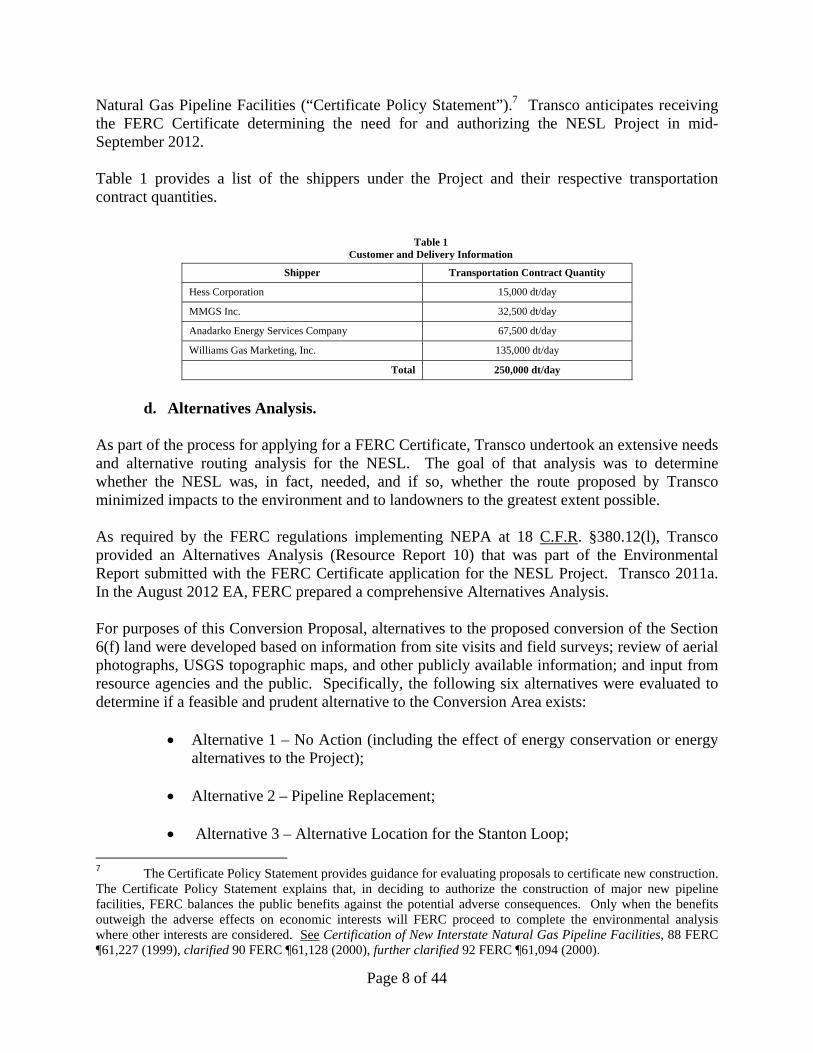
Natural Gas Pipeline Facilities (“Certificate Policy Statement”).7 Transco anticipates receiving the FERC Certificate determining the need for and authorizing the NESL Project in mid-September 2012. Table 1 provides a list of the shippers under the Project and their respective transportation contract quantities.
Table 1 Customer and Delivery Information
Shipper Transportation Contract Quantity
Hess Corporation 15,000 dt/day
MMGS Inc. 32,500 dt/day
Anadarko Energy Services Company 67,500 dt/day
Williams Gas Marketing, Inc. 135,000 dt/day
Total 250,000 dt/day
d. Alternatives Analysis.
As part of the process for applying for a FERC Certificate, Transco undertook an extensive needs and alternative routing analysis for the NESL. The goal of that analysis was to determine whether the NESL was, in fact, needed, and if so, whether the route proposed by Transco minimized impacts to the environment and to landowners to the greatest extent possible. As required by the FERC regulations implementing NEPA at 18 C.F.R. §380.12(l), Transco provided an Alternatives Analysis (Resource Report 10) that was part of the Environmental Report submitted with the FERC Certificate application for the NESL Project. Transco 2011a. In the August 2012 EA, FERC prepared a comprehensive Alternatives Analysis. For purposes of this Conversion Proposal, alternatives to the proposed conversion of the Section 6(f) land were developed based on information from site visits and field surveys; review of aerial photographs, USGS topographic maps, and other publicly available information; and input from resource agencies and the public. Specifically, the following six alternatives were evaluated to determine if a feasible and prudent alternative to the Conversion Area exists:
Alternative 1 – No Action (including the effect of energy conservation or energy alternatives to the Project);
Alternative 2 – Pipeline Replacement;
Alternative 3 – Alternative Location for the Stanton Loop;
7 The Certificate Policy Statement provides guidance for evaluating proposals to certificate new construction. The Certificate Policy Statement explains that, in deciding to authorize the construction of major new pipeline facilities, FERC balances the public benefits against the potential adverse consequences. Only when the benefits outweigh the adverse effects on economic interests will FERC proceed to complete the environmental analysis where other interests are considered. See Certification of New Interstate Natural Gas Pipeline Facilities, 88 FERC ¶61,227 (1999), clarified 90 FERC ¶61,128 (2000), further clarified 92 FERC ¶61,094 (2000).
Page 9 of 44
Alternative 4 – Horizontal Direction Drill;
Alternative 5 – Parallel Existing Right-of-Way; and
Alternative 6 – Route Variations
Each of these alternatives is described and evaluated below. The criteria used to evaluate potential alternatives included whether they:
offer a significant environmental advantage over the proposed conversion of Section 6(f) land;
are technically and/or economically feasible and practical;
are permittable within the same general timeframe of the Project; and
meet Transco’s stated Project objectives, which are to:
o provide an additional 250,000 Dth/d of firm natural gas transportation capacity to customers in New Jersey, New York, and Pennsylvania; and
o provide its customers with access to new sources of natural gas. 1. Alternative 1 -- No-Action Alternative.
Under the No-Action Alternative, Transco would not construct the Project. If the proposed facilities are not constructed, the benefits of the Project would not occur, including securing the energy needs of the consuming public with a clean burning fuel, as well as increased employment, income, and tax revenues. Further, Transco would not be able to supply the additional pipeline capacity in the timeframe requested by the Project’s customers, as contracted for in the binding precedent agreements. Since the FERC concluded that there are no other existing pipeline systems in the region that could provide the capacity to be provided by the NESL Project, construction of new natural gas facilities (as opposed to the proposed NESL Project) would likely result in similar or greater environmental impacts than those associated with the Project. Accordingly, FERC concluded that the No-Action Alternative was not considered to be reasonable. Transco also evaluated whether alternative forms of energy, including other fossil fuels, nuclear energy, renewable sources (such as wind, solar, and geothermal energy), and energy conservation could meet the equivalent energy that would be provided by the Project. Due to environmental, safety, regulatory and technological limitations, FERC concluded that other energy sources and conservation programs would be unable to provide the equivalent energy to be supplied by the Project in the same timeframe or would not offer an environmental advantage over the Project. As such, FERC determined that alternative forms of energy and energy
Page 10 of 44
conservation were not viable alternatives to the Project. See EA, Sections 3.1 and 3.2; Transco 2011a at pages 10-4 to 10-9.
2. Alternative 2 -- Pipeline Replacement.
Transco evaluated whether replacement of the existing pipelines with larger diameter pipelines within the limits of Transco’s existing ROW through the Section 6(f) land was a feasible alternative to the proposed parkland conversion. In the EA, FERC concluded that the Pipeline Replacement Alternative would substantially affect Transco’s ability to serve its existing customers (by causing significant service outages), would reduce system reliability, and would affect more landowners during construction than the proposed alternative. Therefore, FERC concluded that the Pipeline Replacement Alternative is not preferable to the proposed Project. See EA, Section 3.3.2. The reasons for FERC’s conclusion follow. To accommodate both existing capacity and incremental capacity requirements, existing pipelines can be removed and replaced with larger pipelines. Compared with looping, replacing a well-functioning existing pipeline requires installing a longer and larger pipeline segment to obtain equivalent incremental capacity. Therefore, this method results in greater short-term land use impacts than looping. Land use impacts are typically increased because of the longer replacement pipeline length and because the existing pipeline must be removed in addition to installing the new pipeline. In the long-term, land use impacts are reduced since the resulting pipeline corridor has fewer pipelines. However, this benefit is offset by the fact that the ultimate capacity of the replaced pipeline is reduced compared with a looped system. While a longer replacement section would provide commensurate space to accommodate the incremental volume, installing a replacement instead of adding a loop would decrease the efficiency of the system in this region. Transco’s system with the replacement in place would be unable to hold as much linepack as its system with the loop in place, which would diminish Transco’s capacity to handle system transients such as power plants that may withdraw their maximum daily quantity in a few hours. The loss in efficiency would require Transco to install longer loops and/or replacements in future expansions. The ultimate capacity of the system in this region, which includes the pipes’ ability to pack and draft gas volumes, would be diminished if replacement only were implemented, thus necessitating the installation of more facilities to accommodate future growth. Therefore, in the long-term, further capacity expansion requires further looping or additional replacement with larger diameter pipelines. Eventually, the available replacement length is limited to the length between Transco’s existing compressor stations. Other concerns about replacement versus looping include the fact that existing capacity is usually taken out of service during the time in which the old pipeline is removed and the new pipeline is installed. This situation results in difficult and sometimes impossible construction scheduling. The short-term loss of existing capacity can be avoided if the replacement pipeline is installed in a parallel but different ditch. However, in that case, the advantage of the replacement alternative, which would be to minimize the width of the ROW, is lost. Therefore, pipeline replacement is generally not the best method to expand the capacity of a multi-line pipeline system.
Page 11 of 44
Replacement of the existing lines (as opposed to construction of the proposed Stanton Loop) with 42-inch lines would also result in significant service outages during the replacement period. Replacement of the existing pipeline with larger diameter pipeline would also result in significantly larger land disturbance and number of affected landowners, as the replacement section would have to be much longer to both carry existing volumes and add the incremental capacity. For instance, Transco engineers estimate that a replacement section of 9.8 miles affecting 33 more landowners would be equal in capacity to the proposed 6.64 mile Stanton Loop. There is not sufficient supply through other lines to provide service to the existing customers.
3. Alternative 3 – Alternative Location for the Stanton Loop. Transco considered whether the Stanton Loop could be located elsewhere along Transco’s existing Leidy Line, thereby avoiding the proposed conversion of the Section 6(f) land. The Leidy Line extends from the Leidy Interchange Hub in Clinton County, Pennsylvania to Compressor Station 505 in Somerset County, New Jersey. The Leidy Line consists of at least three pipelines, Leidy Lines A, B, and C, except for the eastern 13.4 miles of the system in Hunterdon and Somerset Counties, where the Leidy Line consists of only Leidy Lines A and B. Based on hydraulic modeling, Transco determined that Leidy Line C must be extended 6.6 miles further east in order to deliver the incremental gas volume of the Project at the minimum pressure required by its customers in New Jersey and New York. Thus, a viable alternative location for the Stanton Loop along the Leidy Line that would meet the Project objectives was not identified. See EA, Section 3.3.2.
4. Alternative 4 – Horizontal Direction Drill. Transco considered using a horizontal directional drill (HDD) to install the proposed pipeline beneath the Section 6(f) land, thereby avoiding surface disturbance and eliminating or minimizing the parkland conversion. A team of technical experts comprised of engineers and staff from operations, land, and environmental divisions assessed crossing the portion of the Stanton Loop from mileposts 10.85 to 11.30, which includes the Section 6(f) land. The primary considerations for the use of HDD at this location were the land and technical requirements needed for drilling with a 42-inch pipe, which is the size required for the Stanton Loop. For a 42-inch pipe, a 2,100-foot minimum segment of pipeline is needed, with an additional 2,100 feet required for pullback string. Because of these pullback strings, the land area required to place the pullback often precludes its use in areas of environmental sensitivity or where stringing of the pipe would result in road closures that would inconvenience the local landowners. The pipeline segments require straight tangents for installation. Additionally, each HDD site requires a 200-foot by 200-foot drill pad at each end.
Page 12 of 44
An HDD installation along the segment of the proposed Stanton Loop between mileposts 10.85 and 11.3 was determined to be infeasible because the site precludes the stringing of pipe to the east due to the turn in the pipeline alignment and the presence of apartments along the string path. Stringing of pipe to the west is also precluded due to the presence of the South Branch Raritan River. FERC evaluated this determination, reviewed the NESL Project mapping, and considered information obtained from site visits, and concluded that an HDD at this location was technically infeasible, impractical, or would not result in a clear environmental advantage over the conventional construction method. See EA, Section 3.8.
5. Alternative 5 – Parallel Existing Right-of-Way. This alternative involves installation (or collocation) of the proposed Stanton Loop 42-inch natural gas pipeline parallel to the portion of Transco’s existing 60 foot wide ROW which traverses the Section 6(f) land. The northern edge of the existing ROW would be permanently expanded by 30 feet and an additional 25 feet of temporary construction workspace beyond the new ROW would be used during construction. Transco would also use an additional 20-35 feet of adjacent construction workspace within its existing multiline rights permanent easement. This alternative requires a 2.219 acre conversion of Section 6(f) land within the Melick’s Bridge Section of the South Branch Reservation. A comparison of environmental impacts of this alternative with other routes designed to avoid or minimize impacts to the Section 6(f) land is described under Alternative 6.
6. Alternative 6 – Route Variations. Transco evaluated three route variations to avoid or minimize impacts to the Section 6(f) land. These route variations include two northern routes (Route Variations A and A1) and a southern route (Route Variation B). These route variations are shown in Figure 4, “Route Variations,” prepared by Ecology and Environment, Inc., dated August 23, 2012, which is attached hereto. Each of the route variations was compared to the alignment within the proposed Conversion Area (as shown in Figure 3) based on the following factors:
Pipeline length; Collocation with existing ROW; Construction and operation ROW area; Construction and operation ROW within Section 6(f) land; Construction and operation impacts on forest; Construction and operation impacts on NJDEP-mapped wetlands; Waterbody crossings; and Residences within 50 feet of construction area
Route Variation A
Route Variation A (RV-A) diverges from the proposed alignment at milepost 10.88 and follows an existing natural gas pipeline ROW for approximately 0.16 mile. RV-A diverges from the ROW at a point south of Wellington Drive in order to avoid the Section 6(f) land. From this point, RV-A runs west to Hamden Road adjacent to the northern boundary of the Section 6(f)
Page 13 of 44
land. The route variation then crosses Hamden Road and continues in a southwest direction through private property before joining with the proposed alignment at milepost 11.39. Figure 5, “Route Variation A,” prepared by Ecology and Environment, Inc., dated August 23, 2012, which is attached hereto, shows the construction workspace and permanent ROW that would be associated with RV-A. Referring to Table 1-1, RV-A would be 0.25 mile longer than the alignment within the proposed Conversion Area. Although RV-A follows an existing ROW for a portion of the route, it will still require establishment of a new ROW for 0.42 mile on properties that are currently unencumbered by a natural gas pipeline. In contrast, the alignment within the proposed Conversion Area would incrementally expand Transco’s existing easement. The construction footprint of RV-A would also be 3.72 acres greater, and the variation would permanently impact 2.27 acres more land during operation. The variation would not result in any conversion of Section 6(f) land, compared to the 2.219-acre conversion associated with the alignment within the proposed Conversion Area. RV-A would have greater impact on forest and wetlands: construction of the variation would impact 0.15 acre more forest and 2.07 acres more NJDEP-mapped wetlands, and operation of the variation would impact 0.19 acre more forest and 1.33 acres more NJDEP-mapped wetlands than the alignment within the proposed Conversion Area. Three homes would be within 50 feet of the construction workspace of RV-A, whereas no homes would be in close proximity to the alignment within the proposed Conversion Area. In conclusion, RV-A would avoid impacts to Section 6(f) land but would have greater construction and operational land use requirements, permanently impact more forest and wetlands, establish a new, permanent ROW on properties that are currently unaffected by a pipeline easement, and be located in close proximity to three residences. Transco determined that the greater land use requirements, increased environmental impacts, and new operational ROW in previously unaffected areas associated with the variation outweigh the avoidance of Section 6(f) land. As documented in Step 6 below, impacts to the Section 6(f) land will largely be temporary and all impacted areas will be restored in accordance with various site-specific plans. No long-term loss of public access to or recreational activities on the Section 6(f) land will occur from the proposed Project. Therefore, Transco did not find RV-A environmentally preferable to the alignment within the proposed Conversion Area.
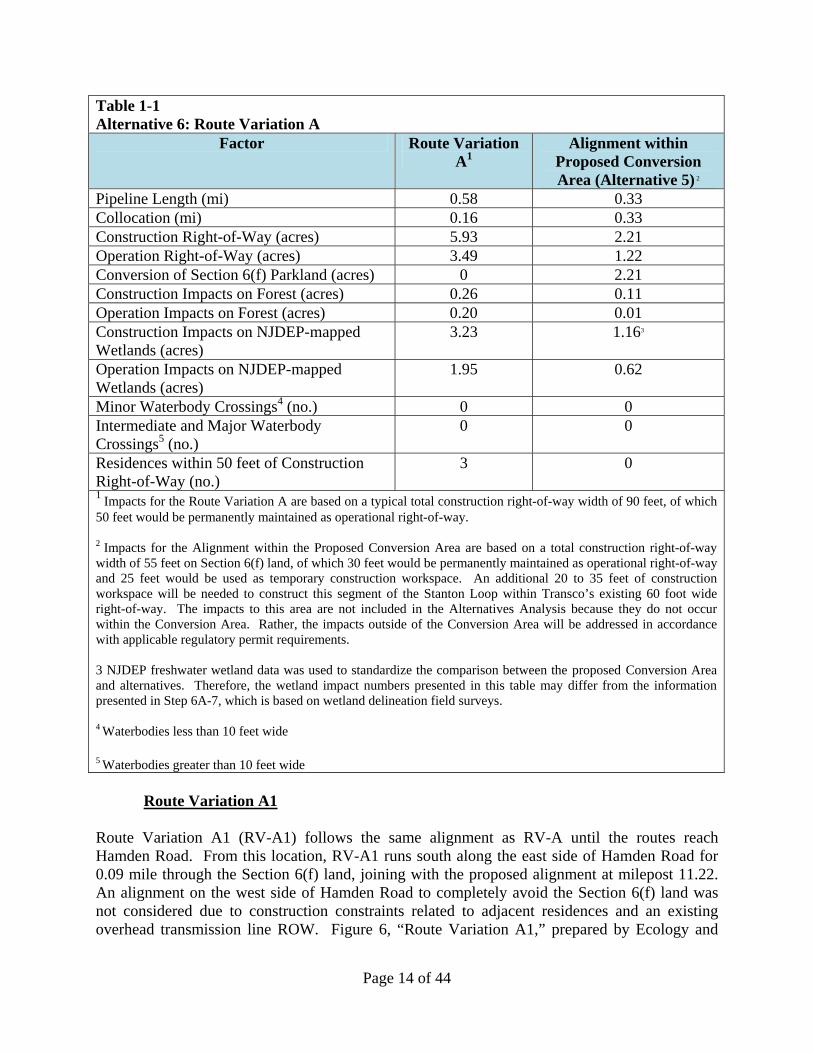
Page 14 of 44
Table 1-1 Alternative 6: Route Variation A
Factor Route Variation A1
Alignment within Proposed Conversion Area (Alternative 5) 2
Pipeline Length (mi) 0.58 0.33 Collocation (mi) 0.16 0.33 Construction Right-of-Way (acres) 5.93 2.21 Operation Right-of-Way (acres) 3.49 1.22 Conversion of Section 6(f) Parkland (acres) 0 2.21 Construction Impacts on Forest (acres) 0.26 0.11 Operation Impacts on Forest (acres) 0.20 0.01 Construction Impacts on NJDEP-mapped Wetlands (acres)
3.23 1.163
Operation Impacts on NJDEP-mapped Wetlands (acres)
1.95 0.62
Minor Waterbody Crossings4 (no.) 0 0 Intermediate and Major Waterbody Crossings5 (no.)
0 0
Residences within 50 feet of Construction Right-of-Way (no.)
3 0
1 Impacts for the Route Variation A are based on a typical total construction right-of-way width of 90 feet, of which 50 feet would be permanently maintained as operational right-of-way. 2 Impacts for the Alignment within the Proposed Conversion Area are based on a total construction right-of-way width of 55 feet on Section 6(f) land, of which 30 feet would be permanently maintained as operational right-of-way and 25 feet would be used as temporary construction workspace. An additional 20 to 35 feet of construction workspace will be needed to construct this segment of the Stanton Loop within Transco’s existing 60 foot wide right-of-way. The impacts to this area are not included in the Alternatives Analysis because they do not occur within the Conversion Area. Rather, the impacts outside of the Conversion Area will be addressed in accordance with applicable regulatory permit requirements. 3 NJDEP freshwater wetland data was used to standardize the comparison between the proposed Conversion Area and alternatives. Therefore, the wetland impact numbers presented in this table may differ from the information presented in Step 6A-7, which is based on wetland delineation field surveys. 4 Waterbodies less than 10 feet wide 5 Waterbodies greater than 10 feet wide
Route Variation A1 Route Variation A1 (RV-A1) follows the same alignment as RV-A until the routes reach Hamden Road. From this location, RV-A1 runs south along the east side of Hamden Road for 0.09 mile through the Section 6(f) land, joining with the proposed alignment at milepost 11.22. An alignment on the west side of Hamden Road to completely avoid the Section 6(f) land was not considered due to construction constraints related to adjacent residences and an existing overhead transmission line ROW. Figure 6, “Route Variation A1,” prepared by Ecology and

Page 15 of 44
Environment, Inc., dated August 23, 2012, which is attached hereto, shows the construction workspace and permanent ROW that would be associated with RV-A1. Referring to Table 1-2, RV-A1 would be 0.15 mile longer than the alignment within the proposed Conversion Area. Although RV-A1 follows an existing ROW for a portion of the route, it will still require establishment of a new ROW for 0.32 mile on properties that are currently unencumbered by a natural gas pipeline. In contrast, the alignment within the proposed Conversion Area would incrementally expand Transco’s existing easement. The construction footprint of RV-A1 would also be 2.78 acres greater, and the variation would permanently impact 1.71 acres more land during operation. The variation would result in a reduced amount of Section 6(f) land conversion: 0.88 acre compared to the 2.21 acre conversion associated with the corresponding segment of the Stanton Loop. RV-A1 would have greater impact on forest and wetlands: construction of the variation would impact 0.09 acre more forest and 1.31 acres more NJDEP-mapped wetlands, and operation of the variation would impact 0.16 acre more forest and 0.96 acre more NJDEP-mapped wetlands than the alignment within the proposed Conversion Area. Five homes would be within 50 feet of the construction workspace of RV-A, whereas no homes would be in close proximity to the alignment within the proposed Conversion Area. In conclusion, RV-A1 would minimize impacts to Section 6(f) land but would have greater construction and operational land use requirements, permanently impact more forest and wetlands, establish a new, permanent ROW on properties that are currently unaffected by a pipeline easement, and be located in close proximity to five residences. Transco determined that the greater land use requirements, increased environmental impacts, and new operational ROW in previously unaffected areas associated with the variation outweigh the minimization of impacts to Section 6(f) land. As documented in Step 6 below, impacts to the Section 6(f) land on the alignment within the proposed Conversion Area will largely be temporary and all impacted areas will be restored in accordance with various site-specific plans. No long-term loss of public access to or recreational activities on the Section 6(f) land will occur from the proposed Project. Therefore, Transco did not find RV-A1 environmentally preferable to the alignment within the proposed Conversion Area. Table 1-2 Alternative 6: Route Variation A1
Factor Route Variation A11
Alignment within Proposed Conversion Area (Alternative 5)2
Pipeline Length (mi) 0.48 0.33 Collocation (mi) 0.16 0.33 Construction Right-of-Way (acres) 4.99 2.21 Operation Right-of-Way (acres) 2.93 1.22 Conversion of Section 6(f) Parkland (acres) 0.88 2.21 Construction Impacts on Forest (acres) 0.20 0.11 Operation Impacts on Forest (acres) 0.17 0.01 Construction Impacts on NJDEP-mapped Wetlands (acres)
2.47 1.163
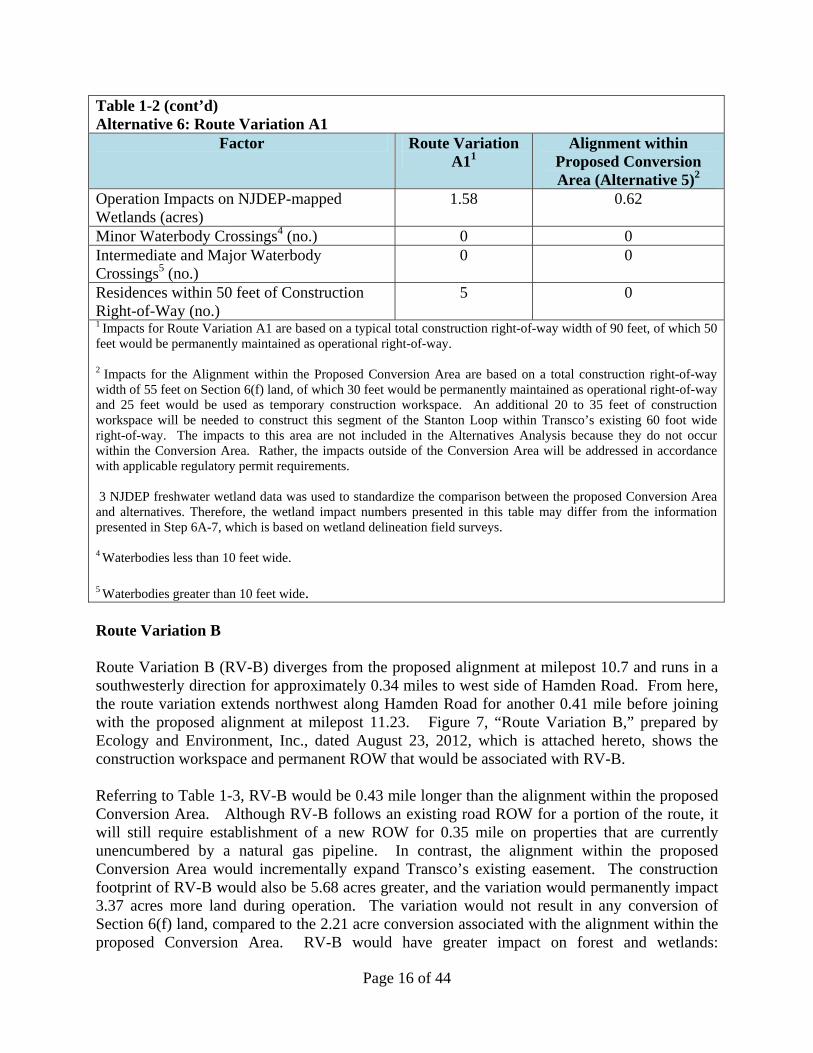
Page 16 of 44
Table 1-2 (cont’d) Alternative 6: Route Variation A1
Factor Route Variation A11
Alignment within Proposed Conversion Area (Alternative 5)2
Operation Impacts on NJDEP-mapped Wetlands (acres)
1.58 0.62
Minor Waterbody Crossings4 (no.) 0 0 Intermediate and Major Waterbody Crossings5 (no.)
0 0
Residences within 50 feet of Construction Right-of-Way (no.)
5 0
1 Impacts for Route Variation A1 are based on a typical total construction right-of-way width of 90 feet, of which 50 feet would be permanently maintained as operational right-of-way. 2 Impacts for the Alignment within the Proposed Conversion Area are based on a total construction right-of-way width of 55 feet on Section 6(f) land, of which 30 feet would be permanently maintained as operational right-of-way and 25 feet would be used as temporary construction workspace. An additional 20 to 35 feet of construction workspace will be needed to construct this segment of the Stanton Loop within Transco’s existing 60 foot wide right-of-way. The impacts to this area are not included in the Alternatives Analysis because they do not occur within the Conversion Area. Rather, the impacts outside of the Conversion Area will be addressed in accordance with applicable regulatory permit requirements. 3 NJDEP freshwater wetland data was used to standardize the comparison between the proposed Conversion Area and alternatives. Therefore, the wetland impact numbers presented in this table may differ from the information presented in Step 6A-7, which is based on wetland delineation field surveys. 4 Waterbodies less than 10 feet wide. 5 Waterbodies greater than 10 feet wide. Route Variation B Route Variation B (RV-B) diverges from the proposed alignment at milepost 10.7 and runs in a southwesterly direction for approximately 0.34 miles to west side of Hamden Road. From here, the route variation extends northwest along Hamden Road for another 0.41 mile before joining with the proposed alignment at milepost 11.23. Figure 7, “Route Variation B,” prepared by Ecology and Environment, Inc., dated August 23, 2012, which is attached hereto, shows the construction workspace and permanent ROW that would be associated with RV-B. Referring to Table 1-3, RV-B would be 0.43 mile longer than the alignment within the proposed Conversion Area. Although RV-B follows an existing road ROW for a portion of the route, it will still require establishment of a new ROW for 0.35 mile on properties that are currently unencumbered by a natural gas pipeline. In contrast, the alignment within the proposed Conversion Area would incrementally expand Transco’s existing easement. The construction footprint of RV-B would also be 5.68 acres greater, and the variation would permanently impact 3.37 acres more land during operation. The variation would not result in any conversion of Section 6(f) land, compared to the 2.21 acre conversion associated with the alignment within the proposed Conversion Area. RV-B would have greater impact on forest and wetlands:
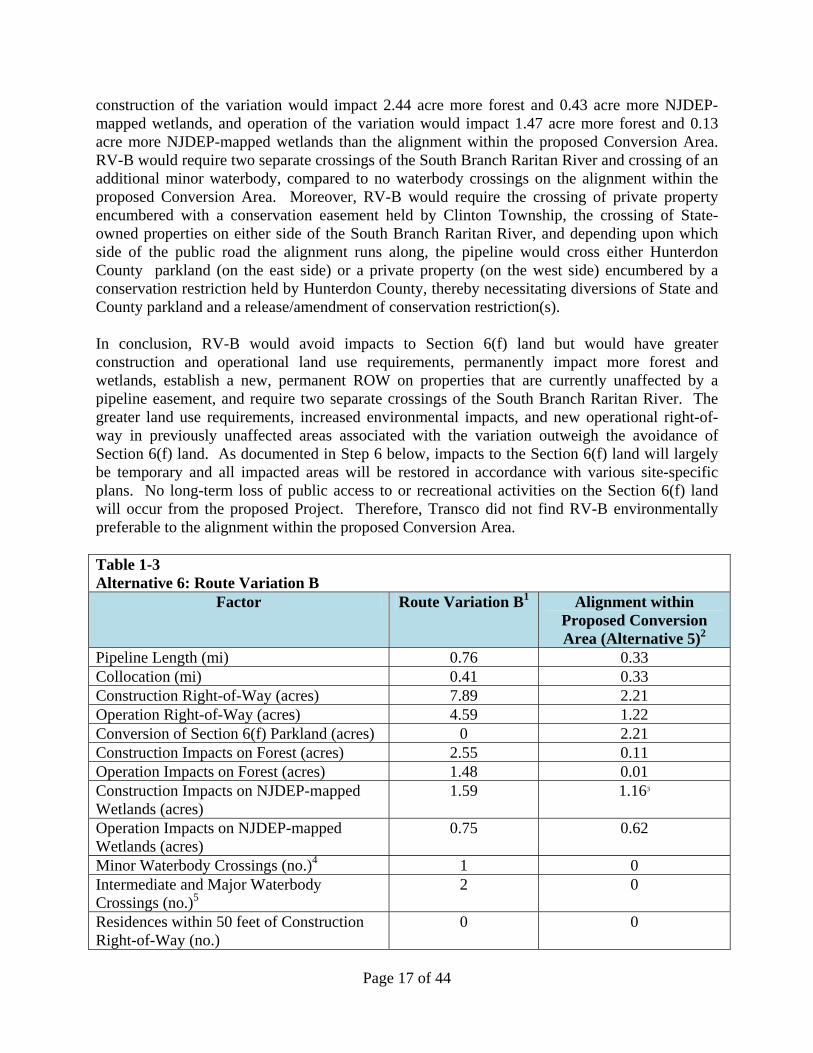
Page 17 of 44
construction of the variation would impact 2.44 acre more forest and 0.43 acre more NJDEP-mapped wetlands, and operation of the variation would impact 1.47 acre more forest and 0.13 acre more NJDEP-mapped wetlands than the alignment within the proposed Conversion Area. RV-B would require two separate crossings of the South Branch Raritan River and crossing of an additional minor waterbody, compared to no waterbody crossings on the alignment within the proposed Conversion Area. Moreover, RV-B would require the crossing of private property encumbered with a conservation easement held by Clinton Township, the crossing of State-owned properties on either side of the South Branch Raritan River, and depending upon which side of the public road the alignment runs along, the pipeline would cross either Hunterdon County parkland (on the east side) or a private property (on the west side) encumbered by a conservation restriction held by Hunterdon County, thereby necessitating diversions of State and County parkland and a release/amendment of conservation restriction(s). In conclusion, RV-B would avoid impacts to Section 6(f) land but would have greater construction and operational land use requirements, permanently impact more forest and wetlands, establish a new, permanent ROW on properties that are currently unaffected by a pipeline easement, and require two separate crossings of the South Branch Raritan River. The greater land use requirements, increased environmental impacts, and new operational right-of-way in previously unaffected areas associated with the variation outweigh the avoidance of Section 6(f) land. As documented in Step 6 below, impacts to the Section 6(f) land will largely be temporary and all impacted areas will be restored in accordance with various site-specific plans. No long-term loss of public access to or recreational activities on the Section 6(f) land will occur from the proposed Project. Therefore, Transco did not find RV-B environmentally preferable to the alignment within the proposed Conversion Area. Table 1-3 Alternative 6: Route Variation B
Factor Route Variation B1 Alignment within Proposed Conversion Area (Alternative 5)2
Pipeline Length (mi) 0.76 0.33 Collocation (mi) 0.41 0.33 Construction Right-of-Way (acres) 7.89 2.21 Operation Right-of-Way (acres) 4.59 1.22 Conversion of Section 6(f) Parkland (acres) 0 2.21 Construction Impacts on Forest (acres) 2.55 0.11 Operation Impacts on Forest (acres) 1.48 0.01 Construction Impacts on NJDEP-mapped Wetlands (acres)
1.59 1.163
Operation Impacts on NJDEP-mapped Wetlands (acres)
0.75 0.62
Minor Waterbody Crossings (no.)4 1 0 Intermediate and Major Waterbody Crossings (no.)5
2 0
Residences within 50 feet of Construction Right-of-Way (no.)
0 0
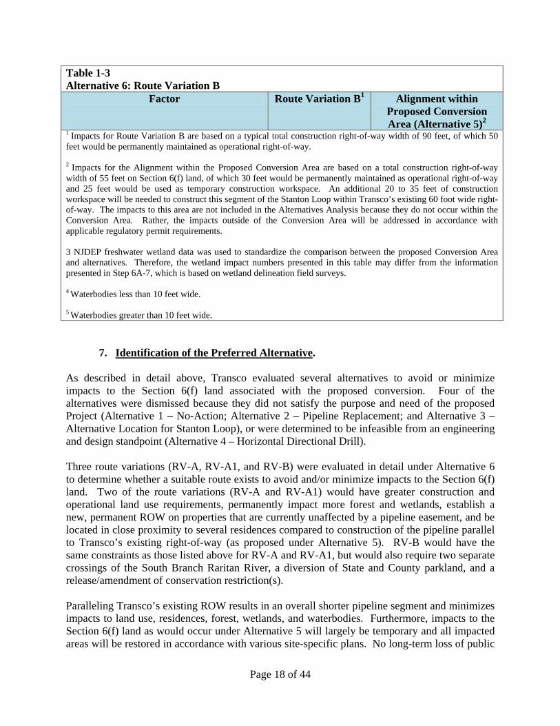
Page 18 of 44
Table 1-3 Alternative 6: Route Variation B
Factor Route Variation B1 Alignment within Proposed Conversion Area (Alternative 5)2
1 Impacts for Route Variation B are based on a typical total construction right-of-way width of 90 feet, of which 50 feet would be permanently maintained as operational right-of-way. 2 Impacts for the Alignment within the Proposed Conversion Area are based on a total construction right-of-way width of 55 feet on Section 6(f) land, of which 30 feet would be permanently maintained as operational right-of-way and 25 feet would be used as temporary construction workspace. An additional 20 to 35 feet of construction workspace will be needed to construct this segment of the Stanton Loop within Transco’s existing 60 foot wide right-of-way. The impacts to this area are not included in the Alternatives Analysis because they do not occur within the Conversion Area. Rather, the impacts outside of the Conversion Area will be addressed in accordance with applicable regulatory permit requirements. 3 NJDEP freshwater wetland data was used to standardize the comparison between the proposed Conversion Area and alternatives. Therefore, the wetland impact numbers presented in this table may differ from the information presented in Step 6A-7, which is based on wetland delineation field surveys. 4 Waterbodies less than 10 feet wide. 5 Waterbodies greater than 10 feet wide.
7. Identification of the Preferred Alternative. As described in detail above, Transco evaluated several alternatives to avoid or minimize impacts to the Section 6(f) land associated with the proposed conversion. Four of the alternatives were dismissed because they did not satisfy the purpose and need of the proposed Project (Alternative 1 – No-Action; Alternative 2 – Pipeline Replacement; and Alternative 3 – Alternative Location for Stanton Loop), or were determined to be infeasible from an engineering and design standpoint (Alternative 4 – Horizontal Directional Drill). Three route variations (RV-A, RV-A1, and RV-B) were evaluated in detail under Alternative 6 to determine whether a suitable route exists to avoid and/or minimize impacts to the Section 6(f) land. Two of the route variations (RV-A and RV-A1) would have greater construction and operational land use requirements, permanently impact more forest and wetlands, establish a new, permanent ROW on properties that are currently unaffected by a pipeline easement, and be located in close proximity to several residences compared to construction of the pipeline parallel to Transco’s existing right-of-way (as proposed under Alternative 5). RV-B would have the same constraints as those listed above for RV-A and RV-A1, but would also require two separate crossings of the South Branch Raritan River, a diversion of State and County parkland, and a release/amendment of conservation restriction(s). Paralleling Transco’s existing ROW results in an overall shorter pipeline segment and minimizes impacts to land use, residences, forest, wetlands, and waterbodies. Furthermore, impacts to the Section 6(f) land as would occur under Alternative 5 will largely be temporary and all impacted areas will be restored in accordance with various site-specific plans. No long-term loss of public
Page 19 of 44
access to or recreational activities on the Section 6(f) land will occur from implementation of Alternative 5. Consequently, Alternative 5 was chosen as the Preferred Alternative because it satisfies the Project purpose and need, and minimizes impacts to land use and environmental resources. Collocation in the manner provided in Alternative 5 is generally preferred by FERC and NJDEP. As discussed in the EA, deviations from an existing ROW typically result in additional construction impacts, environmental impacts, additional installation costs, and additional operating costs (two separate ROWs to maintain instead of one). Looping, in particular, minimizes environmental impacts by using a portion of the existing maintained ROW for construction, and expanding the existing ROW for operation of the pipeline. See EA, Section 3.4.
Page 20 of 44
Step 3B-3, Conversion is in Accordance with State Comprehensive Outdoor Recreation Plan (SCORP).
The New Jersey State Comprehensive Outdoor Recreation Plan (“SCORP”) is a plan prepared by the NJDEP’s Green Acres Program to provide guidance to State and local governments and conservation organizations involved in open space preservation and public recreational opportunities. The SCORP is prepared every five years in order to maintain New Jersey’s eligibility to receive funding from the LWCF, a program administered by the NPS. The SCORP, which was last prepared in 2008, is a status report and guide for open space and recreation planning. In pertinent part, the goals of the SCORP are to:
1. Preserve a sufficient amount of open space for current and future public recreational use and for the conservation of natural resources important to protecting New Jersey’s bio-diversity and the quality of life in New Jersey.
2. Implement open space and recreation planning policies and projects that are consistent with the New Jersey State Development and Redevelopment Plan (“State Plan”).
The compensation to be offered for the proposed conversion on the Section 6(f) land is consistent with these goals. The proposed area of permanent conversion is 1.228 acres, and the area to be temporarily converted for TWS is 0.991 acres. The total area of the conversion is 2.219 acres. As compensation, NJDEP will receive a sufficient amount of cash compensation to be used to acquire replacement land that is “of reasonably equivalent usefulness and location as that being converted.” See LWCF Manual, Chapter 8.E.3(c). The LWCF Act Manual generally requires replacement land to be acquired immediately once the NPS approves a Conversion Proposal. However, there is an exception to the immediate land replacement requirement, which provides:
Exceptions to the immediate replacement requirement (see Section 8 above) will be allowed only when it is not possible for replacement property to be identified prior to the State’s request for the conversion. An express commitment must be received from the State to satisfy Section 6(f)(3) substitution requirements within a specified period normally not to exceed one year following conversion approval. [Emphasis added.] [LWCF Manual, Chapter 8.E, specifically Chapter 8.E.11.]
For the reasons discussed above, the NJDEP has been unable to identify suitable replacement land for this proposed conversion. Therefore, consistent with the LWCF Manual, NJDEP hereby commits to identify such replacement land that will satisfy the Section 6(f) requirements within one year of NPS’ approval of this Conversion Proposal. The money received from Transco for
Page 21 of 44
the conversion will be used towards the acquisition of the replacement land. The replacement land identified and ultimately acquired by NJDEP will satisfy the SCORP, in that it will more than compensate for the loss of open space by providing future public recreational use and/or conservation of natural resources that are important to protecting New Jersey’s bio-diversity and the quality of life in New Jersey. In addition, the TWS will revert back to its natural state. Finally, after construction and restoration has been completed, the surface use of the permanent and temporary easements can be used for passive recreation. In addition, the Public Recreation and Open Space Lands section of the State Plan references the SCORP, and expresses the importance of preserving open space in New Jersey.8 The replacement land to be acquired by the NJDEP will add to the thousands of acres of open space already preserved in this State.
8 In 1998, the Governor’s Council on New Jersey Outdoors issued a report recommending the preservation of one million acres of open space in addition to the area already preserved within the next ten years. See New Jersey State Development and Redevelopment Plan, Environment and Health, pp. 58-59.
Page 22 of 44
Step 3B-4, State Appraisal/Waiver Valuation Review.
Attached to this application is the State Appraisal/Waiver Valuation Review form that will certify that a State-certified Review Appraiser has reviewed the appraisal for the Conversion Area (which has been submitted under separate cover), and has determined that it was prepared in conformity with the Uniform Appraisal Standards for Federal Land Acquisitions.
Page 23 of 44
Step 3B-5, Description of Conversion Areas.
Step 3B-5a. Specific Geographic Description On a Map, 9-Digit Zip Code, Name of Park or Recreation Area Proposed for Conversion.
The Conversion Area is located within parkland known as the Melick’s Bridge Section of the South Branch Reservation in Clinton Township, Hunterdon County, New Jersey, between mileposts 10.7 and 11.3. This park is owned by Hunterdon County. The address for this park is 245 Hamden Road, Clinton Township, New Jersey, zipcode 08801. This parcel is not assigned a nine-digit zip code as required by Step 3-B5a, therefore, only the five-digit zip code is provided. An overview map of the Conversion Area is shown in Figure 2; a detail map of the Conversion Area is shown in Figure 3.
Step 3B-5b. Description of Area Proposed for Conversion Including the Acreage to be Converted and Any Acreage Remaining. Include a Description of the Recreation Resources, Facilities and Recreation Opportunities that Will Be Impacted, Displaced or Lost by the Proposed Conversion.
The Conversion Area is comprised of a thirty (30) foot wide ROW that starts in the northwest corner of the Section 6(f) land and runs in a southeastern direction, immediately adjacent to Transco’s existing 60 foot wide ROW. The Section 6(f) land in the Melick’s Bridge Section is approximately 45.833 acres. The total area of conversion, including temporary workspace and permanent ROW, is 2.219 acres. Thus, the total acreage remaining on the Section 6(f) land after the conversion would be 43.614 acres. The Conversion Area is shown in Figure 3. Following construction of the NESL Project, the temporary work space (0.991 acres) will be restored and will be allowed to revegetate to pre-existing conditions. The area of permanent ROW (1.228 acres) will be permanently maintained in an herbaceous condition for operation of the ROW. No permanent aboveground structures will be placed on the Section 6(f) land. During construction, one existing unnamed trail that provides access to the north side of the South Branch Raritan River will be crossed. This trail is a mowed turf trail that provides access for fishing and horseback riding, access for hunting and removal of deer, access to the river and the park for sightseeing and bird watching by the public and naturalists. Due to safety concerns, public use of this trial will be prohibited during construction. Transco will post signs at the trailhead (at Hamden Road) noting the closure, and will install orange safety fencing across the trail to prevent trail users from crossing the construction ROW. Once construction is completed, the trail will be reseeded and will be reopened, and there will be no permanent impacts to this trail as a result of the NESL Project. Transco expects the construction within the Melick’s Bridge Section to be conducted over an approximately 30 to 60 day period, which will take place in spring-summer 2013. There are two other trails located on the south side of the South Branch Raritan River within the Melick’s Bridge Section. Public access to these trails will be unaffected by construction of the NESL. During construction of the NESL, the public will continue to have access to the river for
Page 24 of 44
canoeing, hiking and bird watching. A map of the three trails within the Melick’s Bridge Section of the South Branch Reservation is attached hereto as Figure 8, “Public Use Trails with the Section 6(f) Parkland,” prepared by Ecology and Environment, Inc., dated August 24, 2012.
Step 3B-5c. Description of Community and Population Served by the Park, Including Users of the Park and Uses.
As noted above, the Conversion Parcel is located within the Melick’s Bridge Section of the South Branch Reservation. George Melick purchased this property from his parents in 1930, and established a dairy farm on it. In 1958, Mr. Melick conveyed a thirty (30) foot wide easement to Transco for the Leidy Line A. In 1971, Mr. Melick passed away, and his widow began selling off parcels of the farm. Hunterdon County acquired the old farmstead (with the assistance of LWCF Act monies), which became part of the South Branch Reservation. The South Branch Reservation is over 1,200 acres. It provides recreational opportunities, such as fishing, hunting (limited to certain sections of the park), canoeing in the South Branch Raritan River, and hiking. The park also helps preserve the South Branch Raritan River Watershed, and provides habitat for waterfowl and aquatic reptiles, including painted turtles. As a county park, the Melick’s Bridge Section of the South Branch Reservation is primarily used by residents of Hunterdon County, but it is open to all residents of New Jersey.
Step 3B-5d. For Partial Conversions, a Revised Section 6(f) Map Showing the Portion Being Converted and the Portion Remaining Intact under Section 6(f).
A map showing the portion of the Property being converted and the portion remaining intact under Section 6(f) is provided in Figure 3.
Step 3B-6. Proposed Replacement Site. (Reserved.) For the reasons described above and as allowed by Chapter 8.E.11 of the LWCF Manual, NJDEP has not yet identified replacement land. Accordingly, NJDEP is hereby committing to identify replacement land within one year of the approval of the Conversion Proposal. Once NJDEP identifies the replacement land, NJDEP will complete the Proposal Description and Environmental Screening Form for the replacement land, and will comply with all other applicable requirements of the Section 6(f)(3) of the LWCF Act.
Step 3B-7. NEPA review, including National Historic Preservation Act (Section 106) Review for Converted Parcel, to Analyze How Converted Parkland and Recreational Usefulness Will Be Replaced.
As described above, on December 14, 2011, Transco filed an application in Docket No. CP12-30-000 under sections 7(b) and 7(c) of the NGA and the certificate procedures of Part 157, Subpart F of the FERC’s regulations for a FERC Certificate. FERC used the information provided in the application and other information collected during the Project evaluation to prepare an EA. The EA was prepared in compliance with the requirements of NEPA at 40
Page 25 of 44
C.F.R. 1500-1508 and FERC’s implementing regulations at 18 C.F.R. 380. FERC issued the EA on August 1, 2012. While FERC served as the lead agency in preparing the EA, USFWS, USACOE, and USDOT, Pipeline and Hazardous Materials Safety Administration, served as federal cooperating agencies. In the EA, FERC acknowledged that the alignment of the NESL Project would cross Section 6(f) land within the Melick’s Bridge Section of the South Branch Reservation, and thus would require a conversion determination from NPS. See EA, Section 1.11, Table 1.11-1. Accordingly, the Section 6(f) land that is the subject of the instant Conversion Proposal has been evaluated by FERC as part of the NEPA process. In accordance with NEPA, Transco initiated Section 106 Review with the New Jersey State Historic Preservation Officer (NJSHPO) for the proposed Stanton Loop component of the NESL Project. A Phase 1 cultural resources survey report for the Stanton Loop was received by the NJSHPO on May 21, 2012. Transco received concurrence on the findings in the Phase 1 report from the NJSHPO in a letter dated July 6, 2012, a copy of which is attached hereto as Attachment E. Specifically, NJSHPO concluded that the properties evaluated, including the property at 250 Hamden Road (in the vicinity of the Conversion Area), were not eligible for inclusion on the National Register of Historic Places. On August 1, 2012, NJSHPO provided additional consultation comments to FERC on the Phase II archaeological survey for the Boss Farm Site that is located along the Stanton Loop. Specifically, NJSHPO concluded that the Boss Farm Site is eligible for inclusion on the National Register of Historic Places, and that Transco will be required to develop ways to avoid, minimize and/or mitigate effects to that property. Section 106 review is ongoing with respect to three other properties, including 28HU561, 28HU562 and 28HU563. However, none of these properties is located within the Section 6(f) land or the Conversion Area. A copy of the August 1, 2012 consultation letter is attached hereto as Attachment F. A cultural resources field survey of the Section 6(f) land has been completed and the results are summarized in Step 6A-18.
Page 26 of 44
STEP 5. SUMMARY OF PREVIOUS ENVIRONMENTAL REVIEW
Step 5-1. Date of Environmental Review(s), Purpose for the Environmental Review(s) and For Whom They Were Conducted.
As part of the FERC Certificate application process, FERC assessed the environmental impacts of the NESL Project in accordance with the requirements of NEPA at 42 U.S.C.A. §4321, NEPA’s implementing regulations at 40 C.F.R. Parts 1500-1508, and the FERC’s implementing regulations at 18 C.F.R. Part 380.
On August 1, 2012, FERC completed a detailed EA for the Project. The EA assessed the potential environmental impacts of the Project, including geology and soils, water resources, fisheries and wetlands, vegetation and wildlife, land use, recreation and visual resources, socioeconomics, cultural resources, air quality and noise, reliability and safety, cumulative impacts and alternatives. FERC determined that an EA was appropriate because it concluded that, with mitigation, the NESL would not constitute a major federal action significantly affecting the human environment. The Section 6(f) land was evaluated as part of the EA. While FERC acted as the lead federal agency in preparing the EA, the USACOE, USFWS and USDOT also participated in the preparation of the EA as federal cooperating agencies for those resources over which those agencies had jurisdiction or special expertise. Because of the presence of bog turtles and Indiana bat within the Conversion Area, FERC consulted with the USFWS. In a letter dated July 11, 2012, the New Jersey Field Office of the USFWS concluded that, based on Transco’s proposed mitigation measures and information provided to the USFWS, the Project was “not likely to adversely affect the bog turtle in New Jersey.” FERC concurred with this finding, and concluded that the consultation concerning bog turtle was completed. See EA, Section 2.3.3 (page 2-50). A copy of the July 11, 2012 letter is attached hereto as Attachment G. With respect to the Indiana bat, based on Transco’s commitment to restore 8.7 acres of forest under various programs in New Jersey, including replacement of Indiana bat roost trees as part of its forest mitigation plans for New Jersey, and Transco’s agreement to complete tree clearing within the appropriate windows (October 1 to March 31), the New Jersey Field Office of the USFWS concluded, in a July 11, 2012 letter, that the Project was “not likely to adversely affect the Indiana bat in New Jersey.” Accordingly, FERC concurred with this finding, and concluded that the consultation concerning Indiana bat was completed. See EA, Section 2.3.3 (page 2-52). See Attachment G. Concerning migratory birds, the New Jersey Field Office of the USFWS recommended that Transco conduct vegetative clearing between August 1 and March 14. Based on Transco’s commitment to conduct vegetation clearing within the USFWS-recommended timeframes, implementation of Transco’s restoration measures as set forth in its Project-specific Plan and Procedures, and the fact that the Project would involve an incremental expansion of an existing ROW, FERC concluded the impact of the Project on migratory birds would be minimal and the effects on their habitat would be minimized. See EA, Section 2.3.3 (pages 2-44 to 2-46).
Page 27 of 44
With respect to State-listed rare plants and wildlife identified within the Stanton Loop, consultations took place with NJDEP and the New Jersey Natural Heritage Program to identify State-threatened, endangered and rare species under their jurisdiction. As part of these consultations, a summary of surveys and proposed mitigation is provided in the EA. For certain species, further consultations with State agencies will continue to develop appropriate avoidance and mitigation measures, including timing restrictions, as necessary, to avoid adverse impacts to these species. Prior to construction, all surveys will be completed and any additional mitigation measures will be developed in consultation with the State agencies. See EA, Section 2.2.3 (pages 2-55 to 2-59). On June 23, 2010, Transco filed a data request with the New Jersey Natural Heritage Program for rare species information for the Stanton Loop portion of the NESL Project, a copy of which is attached hereto as Attachment H. NJDEP will also conduct extensive environmental reviews in connection with evaluating Land Use Regulation Program permits, specifically Flood Hazard Area and freshwater wetlands permits. Transco submitted a joint permit application to NJDEP for Individual Flood Hazard Area and Freshwater Wetland permits for the Stanton Loop in February 2012. A permit decision from NJDEP is anticipated in September 2012.
Step 5-2. Description of Proposed Action and Alternatives.
As described above, the NESL Project consists of installing approximately 12 miles of 42-inch diameter natural gas pipeline in three loop segments in Hunterdon County, New Jersey and in Monroe and Lycoming Counties, Pennsylvania; replacing approximately 0.5 miles of 36-inch-diameter pipeline in Essex County, New Jersey; uprating approximately 25.6 miles of existing 36-inch-diameter pipeline in Essex, Passaic, Bergen and Hudson Counties, New Jersey and approximately 1.4 miles of existing 26-inch-diameter pipeline in Richmond and Kings Counties, New York; constructing new Compressor Station 303 and associated electrical substation in Essex County, New Jersey; modifying existing Compressor Stations 505 and 515 in Somerset County, New Jersey and Luzerne County, Pennsylvania; and modification of existing aboveground facilities in New York (three), New Jersey (six) and Pennsylvania (one). The part of the NESL Project that will affect the Section 6(f) land in the Melick’s Bridge Section of the South Branch Reservation is a portion of the 6.64-mile Stanton Loop, which will be constructed in Hunterdon County, New Jersey. The proposed alignment of the Stanton Loop is adjacent to the ROW that is associated with Transco’s existing Leidy Lines A and B, which have been in existence since 1958 and 1985, respectively. This alignment minimizes adverse environmental impacts on landowners and is consistent with FERC’s and NJDEP’s current policy to construct linear infrastructure projects within or adjacent to an existing ROW to the maximum extent practicable.
An Alternatives Analysis was done by the FERC as part of the EA required under NEPA. Relevant portions of this analysis are provided in Step 3B-2 above. In addition, Step 3B-2 provides information specific to the Section 6(f) land and why there are no practicable alternatives to avoiding this parcel.
Page 28 of 44
Step 5-3. Who Was Involved in Identifying Resource Impact Issues and Developing Proposal Including Interested and Affected Public, Governmental Agencies and Indian Tribes.
The FERC was the lead federal agency responsible for identifying resource impact issues for the proposed NESL Project. As noted above under Step 3B-7, FERC’s impact analysis is documented in its EA for the Project, dated August 2012. The USFWS, USACOE, and USDOT’s Pipeline and Hazardous Material Safety Administration were cooperating agencies who assisted FERC in preparing the EA because they have jurisdiction by law or special expertise with regards to the Project. The NJDEP, Division of Land Use Regulation (DLUR), is reviewing the proposed Stanton Loop for authorization under Individual Freshwater Wetlands and Flood Hazard permits. During the review process for the NESL Project, FERC participated in meetings (either in person or via conference calls) with representatives of the USFWS and USACOE on March 31, April 6, April 20, June 8 and November 21, 2011, and February 6, March 28 and May 16, 2012. FERC also met with representatives of NJDEP on March 30, 2011. FERC attended public meetings at the request of NJDEP (June 8, 2011); Nutley Township, New Jersey (September 19, 2011); Clinton Township, New Jersey (September 21, 2011); and Union Township, New Jersey (December 5, 2011). To identify resources impacted by the Stanton Loop, FERC held On-site Environmental Reviews on September 21 and December 5, 2011. Resource impact issues were also identified by members of the public through various Project comment forums. Please refer to Step 5-7 for a description of the public review and comment process.
Step 5-4. Environmental resources analyzed and determination of impacts for proposed actions and alternatives.
Environmental resources in the proposed Conversion Area were surveyed and impacts were analyzed: (1) as part of Transco’s FERC application; (2) in connection with the Freshwater Wetlands and Flood Hazard Area applications submitted to NJDEP; (3) by the FERC in its EA; and (4) in connection with this Conversion Proposal. A summary of environmental resources and impacts by resource area is provided in Step 6A below.
Step 5-5. Any mitigation measures to be part of the proposed action. The expansion of Transco’s ROW within the Melick’s Bridge Section of the South Branch Reservation constitutes a 2.219-acre conversion of Section 6(f) encumbered land. Transco will provide to the NJDEP a sufficient amount of cash compensation to be used to acquire replacement land that will satisfy the requirements of Section 6(f)(3) of the LWCF Act. NJDEP has committed to identify suitable replacement land within one year of the approval of this Conversion Proposal, as permitted by Chapter 8.E.11 of the LWCF Manual. Transco has submitted a joint Freshwater Wetlands and Flood Hazard Area application to the NJDEP, DLUR for the Stanton Loop, including impacts to wetlands, riparian zones, and
Page 29 of 44
floodplain within the Section 6(f) land. Mitigation for impacts to these areas will be completed pursuant to all applicable NJDEP rules, regulations, and permit conditions. Additional mitigation measures by resource area are described in Step 6A below.
Step 5-6. Intergovernmental review process: Does the State have an Intergovernmental Review Process (Executive Order 12372)? If yes, has the LWCF Program been selected for review under the State Intergovernmental Review Process? If yes, was this proposal reviewed by the appropriate State, metropolitan, regional and local agencies, and if so, attach any information and comments received about this proposal. If proposal was not reviewed, explain why not.
Executive Order 12372 (Intergovernmental Review of Federal Programs) was issued in 1982 to foster an intergovernmental partnership and a strengthened federalism by relying on State and local processes for the coordination and review of proposed federal financial assistance and direct federal development. New Jersey does not have a Single Point of Contact (SPOC) who is assigned to coordinate the review of federal projects; however, this proposed conversion has been or will be reviewed by several levels of government. Specifically, the NJDEP has reviewed the Project and has issued or is in the process of reviewing environmental permits for the Project.
Step 5-7. Public Comment Periods (How Long, When in the Process, Who Was Invited to Comment) and Agency Response.
The Project has undergone significant public comment during the FERC pre-application and application process. The public has had several opportunities and venues to present public comments about the Project at four open houses and at four FERC scoping meetings held in Pennsylvania and in New Jersey, which are described below. The following is an overview of the public process associated with the NESL.
Federal Public Process.
Transco requested the voluntary Pre-Filing process to facilitate the identification of significant issues requiring evaluation, in order to ensure that the resource reports would be as complete as possible when Transco filed its FERC Certificate application. On February 17, 2011, Transco filed its request to initiate the NEPA Pre-Filing Process, and FERC approved the request on March 2, 2011. The NESL was assigned Pre-Filing Docket No. PF11-4-000.
During the Pre-Filing period, Transco sponsored four public open houses on the following dates and locations:
March 29, 2011 – Hughesville, Pennsylvania (Muncy Loop)
March 31, 2011 – Saylorsburg, Pennsylvania (Palmerton Loop)
June 8, 2011 – Clinton, New Jersey (Stanton Loop)
June 9, 2011 – West Orange, New Jersey (Compressor Station 303)
Page 30 of 44
Over 525 invitations for the open houses were mailed to recognized stakeholders, including affected landowners, nearby residents, public officials, and media. To further encourage participation, Transco ran a series of advertisements in various local newspapers inviting the public to attend (Pocono Record, Williamsport Sun Gazette, Hunterdon County Democrat, and The Independent Press in Essex County). Approximately 80 people attended the four NESL open houses. The open houses were designed to provide the public with important Project information such as the need for the Project, detailed maps of the pipeline routes, federal and state regulatory processes, pipeline design and construction, pipeline operations and safety, and the public consultation and comment process. In addition, the open houses allowed the Project team to learn about stakeholder issues and concerns and take them into consideration for Project planning. Informational materials about the Project were distributed to all participants during each open house. On July 1, 2011, FERC issued a public Notice of Intent (NOI) to Prepare an Environmental Assessment for the Planned Northeast Supply Link Project, Request for Comments on Environmental Issues, and Notice of Public Scoping Meetings, which outlined the scoping process used to gather input from stakeholders, agencies and others interested in the Project. The NOI was published in the Federal Register at 76 FR 40,717 (July 11, 2011), and was sent to over 3,200 parties including federal, state and local officials; agency representatives; conservation organizations; local libraries and newspapers; Native American groups; and property owners affected by the Project. The purpose of the scoping process was to provide an opportunity for agencies and the general public to learn more about the Project and to participate in the environmental analysis by helping to identify and refine issues to be addressed in the EA. The public scoping meetings were held on the following dates and locations:
July 18, 2011 – Hughesville, Pennsylvania (Muncy Loop)
July 19, 2011 – Bartonsville, Pennsylvania (Palmerton Loop)
July 20, 2011 – Clinton, New Jersey (Stanton Loop)
July 21, 2011 – East Hanover, New Jersey (Compressor Station 303) Approximately 93 people attended the public scoping meetings, 34 of whom provided verbal comments. Transcripts of the public scoping meetings and all written scoping comments are part of the public record for the Project and are available for review at http://www.ferc.gov. During the formal scoping process and throughout the preparation of the EA, FERC received 174 written comment letters from: five federal agencies; four state agencies; 16 local government bodies; one United States Representative from New Jersey; two New Jersey Assemblymen; one Native American tribe; four non-governmental organizations; 23 affected landowners; and 32 concerned citizens.
Page 31 of 44
Of the 174 comment letters filed, 82 were received from 17 affected landowners along the proposed Stanton Loop. Several individuals commented on potential impacts to land use and recreation from the proposed Stanton Loop, including impacts to Green Acres properties. No comments specifically pertaining to proposed impacts at Melick’s Bridge Section were submitted. Transco’s responses to the scoping comments have been incorporated into the RRs submitted with the FERC Certificate application. FERC received 30 motions to intervene in response to the NOI. The intervenors include: the NJDEP; the public utility commissions of New Jersey, New York and North Carolina; Clinton Township, New Jersey; two non-governmental organizations; three affected landowners; one concerned citizen; one Project shipper; and 17 existing Transco customers or other energy companies.
Step 5-8. Any Formal Decision and Supporting Reasons Regarding Degree of Potential Impacts to the Human Environment.
FERC issued an EA for the NESL Project on August 1, 2012, in which it concluded that, with mitigation, the Project would not constitute a major federal action significantly affecting the quality of the human environment. It is anticipated that the FERC Certificate will be approved by mid-September 2012.
Step 5-9. Was this Proposed LWCF Federal Action and/or Other Federal Actions Analyzed/Reviewed in Any of the Previous Environmental Reviews? If so, What Was Analyzed and What Impacts Were Identified? Provide Specific Environmental Review Document References.
Yes, pursuant to NEPA and as part of the FERC Certificate application filed by Transco, FERC evaluated the potential environmental effects of the construction and operation of NESL Project in an EA that was published in August 2012. See EA. The EA evaluated the three new loops, including the Stanton Loop that will cross the Section 6(f) land in the South Branch Reservation that is the subject of this Conversion Proposal. As a result of its lengthy and detailed analysis, FERC determined that, “if Transco constructs and operates the proposed facilities in accordance with its application, supplements, and staff’s mitigation measures ... , approval of this Project would not constitute a major federal action significantly affecting the quality of the human environment.” See EA, Section 4.0. The EA concludes with a recommendation that any forthcoming FERC Certificate should include a “finding of no significant impact,” as well as nineteen recommended conditions governing, among other things, construction procedures, timing, and mitigation measures. Ibid.
Page 32 of 44
STEP 6. ENVIRONMENTAL SCREENING FORM (ESF)
Part 6A – Environmental Resources (Conversion Area: Block 82.13, Lot 57.01) Step 6A-1 – Geological Resources The Stanton Loop is located in both the Highlands and Piedmont Physiographic Provinces. The Highlands Physiographic Province consists of rugged topography with a series of discontinuous rounded ridges separated by deep, narrow valleys. The Piedmont Physiographic Province is chiefly a low, rolling plain divided by a series of ridges of moderate altitude and relief. Bedrock in the vicinity of the Stanton Loop consists of igneous, sedimentary and metamorphic rock, which occurs at depths of approximately 1 to 10 feet. Based on existing information about subsurface geologic formations present in the Conversion Area and recent construction experience in the vicinity of the Stanton Loop, the lithologic units associated with the Stanton Loop are generally softer and can be ripped with construction equipment. For these reasons, Transco does not anticipate blasting will be required within the Conversion Area. The presence of near-surface carbonate bedrock units can result in localized ground subsidence and collapse features, such as sinkholes, also known as karst terrain. Large-scale United States Geological Survey (USGS) mapping indicates that the Conversion Area would not cross shallow sedimentary bedrock units that exhibit karst terrain in the region. In addition, there is no evidence of any karst features or subsidence along Transco’s existing pipeline system in Hunterdon County, New Jersey. Information regarding the existing soil resources underlying the Conversion Area is based on review of the United States Department of Agriculture (USDA) Natural Resource Conservation Service (NRCS) data found within published County Soil Surveys and the publicly accessible USDA-NRCS Web-based Soil Survey Geographic (SSURGO) database. According to these data sources, soils within the Conversion Area are mapped as Pattenburg gravelly loam (PdTe), Raritan silt loam (RarAr), and Rowland silt loam (RorAt). Each of these soil types is described below. Pattenburg gravelly loam (PdtE) 18 to 40% slopes: The Pattenburg series consists of deep and very deep, well-drained soils on rolling to hilly uplands in the Triassic section of the Northern Piedmont at the base of the scarp between the Piedmont and the highlands within uplands. They formed in residuum weathered from reddish quartzose conglomerate or fanglomerate. Depth to bedrock averages more than 6 feet and ranges from 3.5 to 8 or more feet. Rock fragment content ranges from 10 to 45% in solum and from 35 to 75% in the substratum. Rock fragments consist of dominantly quartzite, some high in hematite, and lesser amounts of red sandstone and sandy red shale. Rock fragment size is dominantly gravel but includes cobbles. The soil is strongly or very strongly acid throughout, unless limed. The erosion hazard is severe.
Page 33 of 44
Raritan silt loam (RarAr) 0 to 3% slopes: The Raritan series consists of very deep, moderately well or somewhat poorly drained soils located on nearly level to strongly sloping stream terraces, usually above present overflow. This soil formed in alluvium sediments from reddish, noncalcareous shale, siltstone and sandstone uplands. Depth to the fragipan ranges from 20 to 30 inches. Depth to bedrock ranges from 5 to 20 feet. The amount of water rounded gravel in the solum ranges from 0 to 15% in the upper horizons and from 0 to 50% in the C horizon. Soil reaction ranges from very strongly acid through moderately acid, unless limed. The erosion hazard is slight. Rowland silt loam (RorAt) 0 to 2% slopes, frequently flooded: The Rowland series consists of very deep, moderately well and somewhat poorly drained soils that formed on relatively narrow, nearly level floodplains in alluvial sediments washed from nearby gently sloping to sloping uplands underlain mainly with red and brown shale, sandstone, and conglomerate. The water table fluctuates between 2 and 6 feet. These soils are flooded by streams during wet periods. Depth to stratified sand and gravel is more than 40 inches. Water worn gravel constitutes 0 to 10% of the solum, 0 to 25% of the C horizon, and 30 to 90% of the 2C horizon. Stratified sand, silt, clay or gravel is in some pedons at depths less than 40 inches. Reaction ranges from very strongly to slightly acid throughout. The erosion hazard is slight. Movement along the ROW and in construction workspaces by heavy equipment could result in soil compaction and/or rutting. These impacts are more likely to occur when soils are saturated or moist. Additionally, soils that are wet or poorly drained can experience structural damage from the travel of heavy equipment. In general, rutting and compaction of soils in the Conversion Area will be avoided or minimized through the use of timber mats across minor tributaries, adjacent wetlands, and as deemed necessary during construction; other methods may be used as conditions dictate. Transco will also minimize rutting and compaction by scheduling the majority of the construction activities for the dry season, to the extent practical. Clearing, grading, and equipment movement can accelerate the erosion process and, without adequate protection, can result in erosion of soils into adjacent wetlands and water bodies. In addition, soil fertility and revegetation potentials also can be adversely affected by accelerated erosion. To minimize or avoid impacts due to potential soil erosion and sedimentation hazards, Transco will utilize erosion and sedimentation control devices in accordance with its Project-specific Erosion and Sediment Control Plan (E&SCP). The E&SCP for the Stanton Loop was approved by the Hunterdon County Conservation District on February 15, 2012. (A copy of the letter certifying Transco’s E&SCP is attached hereto as Attachment I.) As specified in the E&SCP, temporary erosion controls, including interceptor diversions and sediment filter devices (e.g., straw bales, silt fence, or sediment basins) will be installed immediately following initial ground disturbance. Implementation of topsoil segregation will help ensure post-construction revegetation success, thereby minimizing the potential for long-term erosion due to lack of vegetative cover. In soils with more than 12 inches of topsoil, topsoil will be segregated to a
Page 34 of 44
depth of at least 12 inches. In soils with less than 12 inches of topsoil, the entire topsoil layer will be segregated. Transco will implement measures described in its Upland Erosion Control, Revegetation, and Maintenance Plan (Plan), Wetland and Waterbody Construction and Mitigation Procedures (Procedures), and E&SCPs to promote revegetation of all disturbed areas. Some of these measures include the removal of stones from shallow soils; contouring the construction ROW to match the surrounding landscape; installing permanent erosion control devices, as necessary, to preserve soil on the ROW; adding amendments and seeding the construction ROW; implementing an Invasive Species Management Plan (ISMP) to avoid and control invasive species; and inspecting all disturbed areas after the first and second growing seasons and continuing revegetation efforts as necessary until successful. Considering the proposed mitigation measures that Transco will implement to control erosion and sedimentation, as well as planned measures to revegetate disturbed areas, the proposed Project is expected to have only minor impacts to geological resources. Step 6A-2 – Air Quality The proposed Project does not include the construction of buildings and/or other stationary sources of air pollution on or in proximity to the Section 6(f) land. Emissions associated with construction of the Project would generally include: 1) exhaust emissions from construction equipment; 2) fugitive dust emissions associated with construction vehicle movement; and 3) fugitive dust associated with trenching, backfilling, and other earth-moving activities. Air pollutants from construction equipment generally would be limited to the immediate vicinity of the construction area and would be temporary. Transco will implement measures included in its Fugitive Dust Control Plan to minimize any nuisance for nearby residences and park users from fugitive dust emissions. Such measures will include watering construction areas and use of stabilized access roads for movement of equipment and vehicles. Once construction activities in the Section 6(f) land are completed, fugitive dust and construction equipment emissions would subside and impacts on air quality would terminate. Therefore, an impact level of minor was chosen for this resource. Step 6A-3 – Sound The proposed Project does not include the construction of buildings and/or other stationary sources of noise on or in proximity to the Section 6(f) land. Noise will affect the local environment during the construction period. The construction activities will be performed with standard heavy equipment, such as track-excavator, backhoe, bulldozer, dump trucks, and loaders; however, not all of the equipment will be used in each phase of construction. Construction is currently planned to occur during normal daytime working hours. Individuals using the portion of the Section 6(f) land that will remain accessible during construction would hear construction noise during the daytime, but the overall impact would be limited to the approximately 30 to 60 day construction period. Consequently, an impact level of minor was chosen for this resource.

Page 35 of 44
Step 6A-4 – Water Quality/Quantity The proposed Conversion Area does not cross any waterbodies; therefore, no direct impacts to water quality/quantity will occur. Construction activities in the Conversion Area will result in clearing of vegetation within the riparian zone of the South Branch Raritan River (S-ST-11-001). Riparian zone impacts in the Conversion Area include 0.17 acres of temporary herbaceous vegetation disturbance. (Any impacts to the riparian zone outside of the Conversion Area will be addressed in the anticipated NJDEP Flood Hazard Permit authorization.) Clearing and grading of vegetative cover could increase erosion along the river bank. To prevent this, Transco will restore all temporarily disturbed herbaceous in riparian zones in accordance with its E&SCP, Wetland and Riparian Zone Restoration and Mitigation Plan (Restoration Plan), and the anticipated NJDEP Flood Hazard Permit authorization. Implementation of Transco’s E&SCP will maximize the potential for regrowth of riparian vegetation, thereby minimizing the potential for any long-term impacts associated with lack of shade and cover. Transco will monitor for successful restoration of these riparian areas for three growing seasons. Riparian restoration sites would be monitored for effectiveness of bank stabilization, establishment of native ground cover, and survival of planted live states and tree/shrub species. Transco has developed a Spill Prevention, Control, and Countermeasures (SPCC) Plan that describes measures to prevent and, if necessary, control any inadvertent spill of hazardous materials that could impact water quality. As stated in the SPCC Plan, hazardous material, chemicals, lubricating oils, and fuels used during construction would be stored in upland areas at least 100 feet from waterbodies, unless otherwise noted. Refueling of construction equipment would also be conducted at least 100 feet from waterbodies. Considering the proposed mitigation measures that Transco will implement to control erosion and sedimentation, as well as planned measures to revegetate disturbed areas, the proposed Project is expected to have only minor impacts to water quality/quantity. Step 6A-5 – Stream Flow Characteristics As stated above, the proposed Conversion Area does not cross any waterbodies. Therefore, an impact level of no/negligible was chosen for this environmental resource. Step 6A-6 – Marine/Estuarine The proposed Project on the Section 6(f) land involves a non-tidal reach of the South Branch Raritan River. Therefore, impacts to marine or estuarine resources are not applicable.
Page 36 of 44
Step 6A-7 – Floodplains/Wetlands The portion of the proposed Stanton Loop within the Section 6(f) land crosses the NJDEP regulated flood hazard area of the South Branch Raritan River. Transco has submitted a Flood Hazard Area Individual permit application to NJDEP for proposed work within the regulated flood hazard area. The pipeline to be constructed within the Conversion Area crosses two wetlands, designated by Transco as wetlands W-ST-10-004 and W-ST-11-001. W-ST-10-004 is an emergent wetland located within a wide valley containing a man-made channel with no defined bed or banks flowing to the south into the South Branch Raritan River. The wetland is bounded by mature upland forests to the northwest and south and receives drainage from a utility ROW to the north and from a condominium complex to the east. Reed canary grass (Phalaris arudicea) and hairy sedge (Carex lacustris) are the dominant vegetation. W-ST-11-001 is a forested floodplain to the north of the South Branch Raritan River. The existing ROW has been converted to an emergent wetland with reed canary grass and fox sedges dominating. The overstory in undisturbed areas of the wetland consists mainly of green ash and pin oak. While the canopy is nearly closed, understory vegetation, including multiflora rose and reed canary grass, have become established. Another man-made channel flows along the eastern side of the wetland, likely allowing for floodwaters from the river to reach the forested area to the north of the ROW. The wetland extends along a drainage ditch near Hamden Road into the river east of the Hamden Road Bridge. Construction within the Conversion Area will impact 1.18 acres of these wetlands as follows: W-ST-10-004: Temporary emergent wetland disturbance: 0.43 acre Temporary forested wetland conversion to emergent wetland: 0.04 acre Permanent forested wetland conversion to emergent wetland: 0.01 acre Total wetland disturbance: 0.48 acre W-ST-11-001: Temporary emergent wetland disturbance: 0.56 acre Temporary forested wetland conversion to emergent wetland: 0.14 acre Total wetland disturbance: 0.70 acre Transco will implement the following measures as outlined in its Plan, Procedures, and E&SCP to minimize wetland impacts in the Conversion Area:
The construction ROW within wetlands will be used for access only when the wetland soil is firm enough to avoid rutting or the ROW has been properly stabilized. If the wetlands cannot be appropriately stabilized, only equipment required for installation of the wetland crossing shall enter the wetland; all other equipment shall use access roads in
Page 37 of 44
upland areas. In areas where there is not reasonable upland access, all other construction equipment is allowed one pass through the wetland.
Machinery and techniques will be used that are designed to minimize drainage and soil
impacts to wetlands.
Sediment barriers will be installed across the entire construction ROW at the wetland crossings, where necessary to prevent the flow of sediments into the wetland.
Diversion terraces will be installed on both sides of the wetland boundaries to prevent sediment from entering the wetlands.
Trench plugs will be used, as necessary, to prevent diversion of water into upland portions of the pipeline trench and to keep any accumulated trench water out of the wetlands.
Vegetation will be cut just above ground level, leaving existing root systems in place, and trimmings will be removed from the wetlands for disposal.
The top one foot of topsoil will be segregated from the area disturbed by trenching, except in areas where standing water is present or soils are saturated or frozen. Immediately after backfilling is complete, the segregated topsoil will be restored to its original location.
The trench will be dewatered (either on or off the construction ROW) in a manner that does not cause erosion and does not result in heavily silt-laden water flowing into the wetlands. The dewatering structures will be removed as soon as possible after the completion of dewatering activities.
Transco has submitted a Freshwater Wetlands Individual permit application to NJDEP for proposed wetland impacts. Transco will restore all temporarily impacted emergent and forested wetlands in accordance with its E&SCP, Restoration Plan, and the NJDEP Freshwater Wetlands Permit authorization. The 0.01 acre of permanent forested wetland conversion to emergent wetland will be mitigated off-site. The majority of the wetland impacts on the Section 6(f) land would be short-term and would cease when or shortly after the wetlands are restored and vegetated. Following revegetation, the wetlands would eventually transition back into a community with functionality similar to that of the pre-construction state. In emergent wetlands, the herbaceous vegetation would regenerate quickly (typically within 1 to 3 years). Following revegetation, there would be no permanent impact on emergent wetland vegetation in the maintained pipeline ROW because these areas naturally consist of and would remain as open and herbaceous communities. Re-establishment of forest vegetation in forested wetlands will be performed by planting native tree and/or shrub species similar to those present in the wetland prior to construction or adjacent wetlands, in accordance with Transco’s Restoration Plan. Transco will conduct annual post-
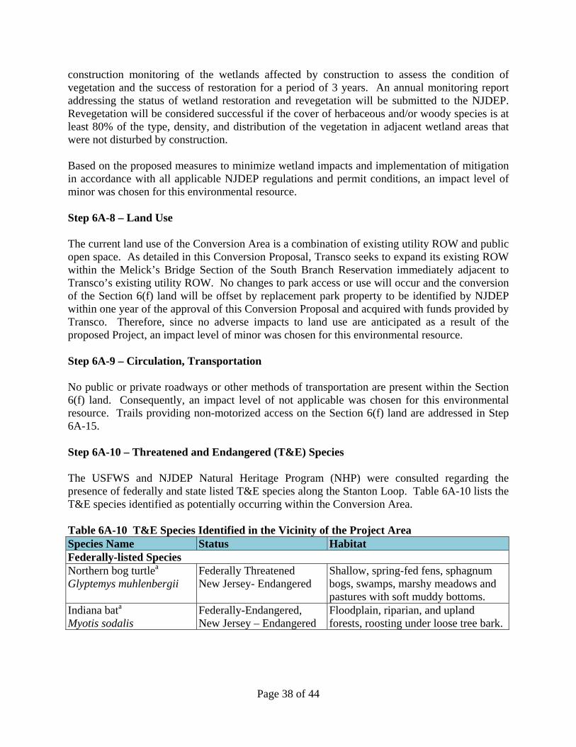
Page 38 of 44
construction monitoring of the wetlands affected by construction to assess the condition of vegetation and the success of restoration for a period of 3 years. An annual monitoring report addressing the status of wetland restoration and revegetation will be submitted to the NJDEP. Revegetation will be considered successful if the cover of herbaceous and/or woody species is at least 80% of the type, density, and distribution of the vegetation in adjacent wetland areas that were not disturbed by construction. Based on the proposed measures to minimize wetland impacts and implementation of mitigation in accordance with all applicable NJDEP regulations and permit conditions, an impact level of minor was chosen for this environmental resource. Step 6A-8 – Land Use The current land use of the Conversion Area is a combination of existing utility ROW and public open space. As detailed in this Conversion Proposal, Transco seeks to expand its existing ROW within the Melick’s Bridge Section of the South Branch Reservation immediately adjacent to Transco’s existing utility ROW. No changes to park access or use will occur and the conversion of the Section 6(f) land will be offset by replacement park property to be identified by NJDEP within one year of the approval of this Conversion Proposal and acquired with funds provided by Transco. Therefore, since no adverse impacts to land use are anticipated as a result of the proposed Project, an impact level of minor was chosen for this environmental resource. Step 6A-9 – Circulation, Transportation No public or private roadways or other methods of transportation are present within the Section 6(f) land. Consequently, an impact level of not applicable was chosen for this environmental resource. Trails providing non-motorized access on the Section 6(f) land are addressed in Step 6A-15. Step 6A-10 – Threatened and Endangered (T&E) Species The USFWS and NJDEP Natural Heritage Program (NHP) were consulted regarding the presence of federally and state listed T&E species along the Stanton Loop. Table 6A-10 lists the T&E species identified as potentially occurring within the Conversion Area. Table 6A-10 T&E Species Identified in the Vicinity of the Project Area Species Name Status Habitat Federally-listed Species Northern bog turtlea Glyptemys muhlenbergii
Federally Threatened New Jersey- Endangered
Shallow, spring-fed fens, sphagnum bogs, swamps, marshy meadows and pastures with soft muddy bottoms.
Indiana bata Myotis sodalis
Federally-Endangered, New Jersey – Endangered
Floodplain, riparian, and upland forests, roosting under loose tree bark.
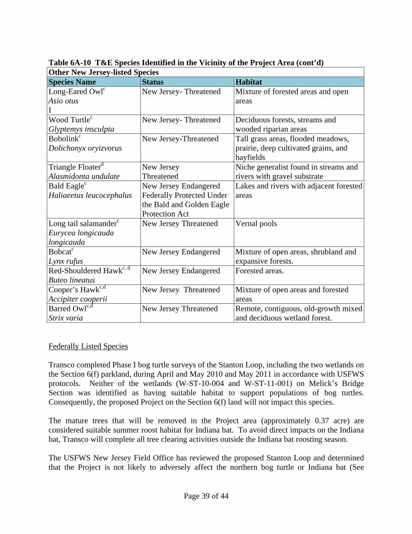
Page 39 of 44
Table 6A-10 T&E Species Identified in the Vicinity of the Project Area (cont’d) Other New Jersey-listed Species Species Name Status Habitat Long-Eared Owlc Asio otus I
New Jersey- Threatened Mixture of forested areas and open areas
Wood Turtlec Glyptemys insculpta
New Jersey- Threatened Deciduous forests, streams and wooded riparian areas
Bobolinkc Dolichonyx oryizvorus
New Jersey-Threatened Tall grass areas, flooded meadows, prairie, deep cultivated grains, and hayfields
Triangle Floaterd
Alasmidonta undulate New Jersey Threatened
Niche generalist found in streams and rivers with gravel substrate
Bald Eaglec
Haliaeetus leucocephalus New Jersey Endangered Federally Protected Under the Bald and Golden Eagle Protection Act
Lakes and rivers with adjacent forested areas
Long tail salamanderc
Eurycea longicauda longicauda
New Jersey Threatened Vernal pools
Bobcatc
Lynx rufus New Jersey Endangered Mixture of open areas, shrubland and
expansive forests. Red-Shouldered Hawkc, d
Buteo lineatus New Jersey Endangered Forested areas.
Cooper’s Hawkc,d
Accipiter cooperii New Jersey Threatened Mixture of open areas and forested
areas Barred Owlc,d
Strix varia New Jersey Threatened Remote, contiguous, old-growth mixed
and deciduous wetland forest. Federally Listed Species Transco completed Phase I bog turtle surveys of the Stanton Loop, including the two wetlands on the Section 6(f) parkland, during April and May 2010 and May 2011 in accordance with USFWS protocols. Neither of the wetlands (W-ST-10-004 and W-ST-11-001) on Melick’s Bridge Section was identified as having suitable habitat to support populations of bog turtles. Consequently, the proposed Project on the Section 6(f) land will not impact this species. The mature trees that will be removed in the Project area (approximately 0.37 acre) are considered suitable summer roost habitat for Indiana bat. To avoid direct impacts on the Indiana bat, Transco will complete all tree clearing activities outside the Indiana bat roosting season. The USFWS New Jersey Field Office has reviewed the proposed Stanton Loop and determined that the Project is not likely to adversely affect the northern bog turtle or Indiana bat (See
Page 40 of 44
Attachment G). FERC concurred, and concluded that consultation regarding bog turtle and Indiana bat was completed. See EA, Section 2.3.3. State-listed Species The Long-eared owl was identified as a potential winter resident in the vicinity of the Stanton Loop. The Conversion Area does not contain any dense conifer stands that would provide suitable roosting habitat during the winter months for long-eared owl; therefore, this species is considered to be absent from the Conversion Area. The Conversion Area does not cross any aquatic habitats, such as freshwater streams, brooks, creeks, or rivers that would support populations of wood turtles or triangle floater. In addition, no vernal pools are crossed by the Project that would support populations of long tail salamanders. Consequently, these species are considered to be absent from the Conversion Area. No evidence of bobolink breeding activity was observed in the Conversion Area during breeding bird surveys conducted along the Stanton Loop in June 2011. Consequently, this species is considered to be absent from the Conversion Area. The Project area does not cross large tracts of uninterrupted forested and agricultural land that would indicate potential presence of bobcat. Therefore, this species is considered to be absent from the Conversion Area. At the request of NJDEP, Transco completed field surveys for red-shouldered hawk, Cooper’s hawk, and barred owl on the portion of the Stanton Loop between mileposts 7.06 and 7.56. Surveys were not requested along the Stanton Loop in proximity to the Section 6(f) land due to the lack of suitable habitat and documented occurrences of the species at this location. Consequently, these species are considered to be absent from the Conversion Area. Transco continues to consult with the NJDEP DLUR regarding impacts to state-listed T&E species on the Stanton Loop as part of the Freshwater Wetlands and Flood Hazard Area Individual Permit applications. Transco will comply with all permit conditions related to T&E species included in the permits. Based on the absence of bog turtle and other state-listed species from the Project area and Transco’s proposed seasonal clearing period to avoid potential direct impacts to Indiana bat, an impact level of “minor” was chosen for this environmental resource. Step 6A-11 – Unique Ecosystems The above-referenced consultations with the USFWS and NJDEP did not reveal any unique ecosystems, such as biosphere reserves, Important Bird Areas, World Heritage sites, old growth forests, etc. in the Conversion Area. Consequently, an impact level of not-applicable was chosen for this environmental resource.

Page 41 of 44
Step 6A-12 – Unique or Important Wildlife/Wildlife Habitat Based on the findings stated above in Steps 6A-10 and 6A-11, no unique or important wildlife/wildlife habitat is present within the Conversion Area; therefore, an impact level of not applicable was chosen for this environmental resource. Step 6A-13 – Unique or Important Fish/Fish Habitat The portion of the South Branch Raritan River located outside of, but within 100 feet of, the Conversion Area is classified by the NJDEP as a FW2-TM (freshwater, trout maintenance) waterbody. The South Branch Raritan River at this location is non-tidal and does not contain essential fish habitat. Therefore, an impact level of not applicable was chosen for this environmental resource. Step 6A-14 – Invasive Species Vegetated areas disturbed in the Conversion Area will be seeded and/or replanted with native species as soon as practicable in accordance with Transco’s E&SCP. Transco will also implement its ISMP in order to prevent the establishment and introduction of invasive plant species into the Conversion Area. The following steps to control invasive species are documented in the ISMP:
Prior to the start of construction, all equipment used along the pipeline spread will be cleaned at the contractor yard before it is brought to the ROW. This will ensure that no invasive species from foreign locations are introduced onto the ROW via construction equipment.
During ROW clearing and site grading, construction equipment will be cleaned and
inspected before leaving the exit locations of areas of extensive infestation. Extensive infestation areas are considered any area along the ROW where an invasive plant species has dominated the native vegetation or cover over 50% of the area. Water or air-pressure washing equipment will be used to ensure that all plant material is removed from construction vehicles and equipment prior to moving to a new area along the pipeline route.
Vehicle tires and undercarriages will be checked thoroughly before leaving infested
areas. Mud will be washed off and weeds, soil, seeds, and vegetation material will be removed from vehicles and equipment. Cleaning will not be conducted in areas that have not yet been infested with the exotic species.
The Project will not create migratory pathways for, or result in the introduction or promotion of, invasive animal species. Based on implementation of the above mitigation measures, an impact level of no/negligible is chosen for this environmental resource.
Page 42 of 44
Step 6A-15 – Recreational Resources The proposed Project entails a 2.219-acre conversion of Section 6(f) parkland at Melick’s Bridge Section of the South Branch Reservation. The proposed 2.219-acre conversion represents 4.8% of the 45.833-acre Section 6(f) land. The Conversion Area is comprised of a thirty (30) foot wide ROW that starts in the northwest corner of the Section 6(f) land and runs in a southeastern direction, immediately adjacent to Transco’s existing 60-foot-wide ROW. One of the three existing trails on the parkland will be crossed by the Conversion Area. The trail that is crossed by the Project is a mowed turf trail that provides public access to the South Branch Raritan River and is also used by the public and naturalists for hiking, sightseeing, and bird watching. Public use of the trial will be prohibited during construction. Access to the remaining two trails on the parkland providing access to the south side of the South Branch Raritan River will be unhindered by the Project. See Figure 8. Construction within the Section 6(f) land will be completed over an approximately 30 to 60 day period in spring to summer 2013. Appropriate mitigation measures will be implemented to restore all areas of temporary disturbance. Following construction, 1.228 acres of the Conversion Area will be permanently maintained in an herbaceous condition for operation of the ROW. The remaining 0.991 acre of the Conversion Area will be restored to pre-construction conditions. No permanent aboveground structures will be placed on Section 6(f) land. The public will have full access to the Section 6(f) land on Melick’s Bridge Section along the existing trail network once construction is completed. Given that impacts to recreation will be short-term and limited to the portion of the parkland on the north side of the South Branch Raritan River, the impacts to this environmental resource are considered minor. Step 6A-16 – Accessibility for Populations with Disabilities The proposed Project will not affect any portions of the parkland with handicap accessible features. Therefore, an impact level of “not applicable” was chosen for this resource. Step 6A-17 – Aesthetics Visual impacts associated with construction of the Project will include the removal of existing vegetation and the exposure of bare soils, as well as earthwork and grading scars associated with heavy equipment tracks, trenching, and machinery and tool storage. These impacts will be temporary and primarily limited to the approximately 30 to 60 day period of construction through the parkland. Transco will implement measures described in its Plan, Procedures, and E&SCP to promote revegetation of all disturbed areas. The existing Transco ROW through Melick’s Bridge Section will be widened by 30 feet, resulting in permanent removal of approximately 0.01 acre of forested vegetation. The permanently removed forested vegetation will be maintained in an herbaceous condition. No new structures will be placed on the parkland as part of the Project.

Page 43 of 44
Based on the short-term nature of visual impacts related to construction activities, planned restoration measures, and relatively small area of permanently removed forested area along an existing ROW, an impact level of minor was chosen for this environmental resource. Step 6A-18 – Historic/Cultural Resources Transco completed a Phase I archaeological survey of the Project area as part of the overall survey for the proposed Stanton Loop. Initially, a geomorphologist examined the soils to determine their age and the depth to which archaeological testing should be conducted. Shovel test pits were excavated at 15-meter intervals. Shovel tests on the T-1 terrace of the South Branch Raritan River encountered water at 16 to 30 inches below the surface, but reached the Bw horizon, the maximum depth to which cultural material could be expected to occur. Shovel tests on the floodplain of the South Branch Raritan River encountered water at 16 to 28 inches, all but three reaching the required depth of testing. No cultural material was identified as a result of the archaeological testing. As part of the Phase 1 survey, Transco confirmed that no National Register-eligible aboveground resources are present within or near the Conversion Area. Transco submitted a Phase 1 report for the Stanton Loop to the NJSHPO. In a letter dated July 6, 2012, the NJSHPO issued concurrence with the findings of the Phase 1 report (see Attachment E). On August 1, 2012, NJSHPO provided additional consultation comments to FERC on the Phase II archaeological survey for the Boss Farm Site (28HU492) that is located along the Stanton Loop (see Attachment F). NJSHPO concluded that the Boss Farm Site is eligible for inclusion on the National Register of Historic Places, however, this site is not within the Section 6(f) land or the Conversion Area. Likewise, three additional properties, 28HU561, 28HU562 and 28HU563, are the subject of ongoing review, but none of these sites is located within the Section 6(f) land or the Conversion Area. Based on the absence of archaeological and historic resources within the Conversion Area, an impact level of minor was chosen for this environmental resource. Step 6A-19 – Socioeconomics Project construction would result in short-term, beneficial impacts in terms of increased payroll and local material purchases. Construction of the Project would also result in increased state and local sales tax revenues associated with the purchase of construction materials. No adverse socioeconomic impacts to the Project area related to population, economy, or employment will occur. Therefore, an impact level of no/negligible was chosen for this environmental resource. Step 6A-20 – Minority and Low-Income Populations As stated in the EA, no disproportionately high and adverse human health or environmental effects on minority and/or low-income communities have been identified for the Project. Therefore, an impact level of no/negligible was chosen for this environmental resource.
Page 44 of 44
Step 6A-21 – Energy Resources The purpose of Transco’s NSL Project is to provide an additional 250,000 dekatherms per day (Dth/d) of firm natural gas transportation capacity to delivery points that would be accessible by customers in New York, New Jersey, and Pennsylvania, and to provide its customers with access to new sources of natural gas in north-central Pennsylvania, primarily from the Marcellus Shale. Transco has entered into binding agreements with shippers for the entire capacity of the Project. Transco believes that increased natural gas production in north-central Pennsylvania may enhance the nation’s energy security and would alleviate the possibility of shortages by providing more gas to market. Transco also asserts that the proximity of the natural gas reserves in north-central Pennsylvania may benefit its customers in New York, New Jersey, and Pennsylvania by reducing overall natural gas transportation costs. No adverse impacts to the Conversion Area directly related to energy resources have been identified; therefore, an impact level of no/negligible was chosen for this environmental resource. Step 6A-22 – Other Agency or Tribal Land Use Plans or Policies Not applicable. Step 6A-23 – Contamination/Hazardous Materials Transco reviewed federal and state regulatory databases including the EPA’s Regulated Facility dataset, the EPA’s Enviromapper for Envirofacts, and data layers available through New Jersey’s GeoWeb program, to identify known and potential contamination within 0.25 mile of the Conversion Area. Transco also completed an environmental database review to identify known and potential hazardous waste sites within 0.25 mile of the proposed Conversion Area. The results of these database reviews indicate that no contaminated soil or groundwater is expected to be encountered on the Section 6(f) land. Consequently, an impact level of no/negligible was chosen for this environmental resource. Step 6A-24 – Other Important Environmental Resources Not applicable.
FIGURES
Figure 1, “6(f) Boundary,” prepared by Williams Gas Pipeline, dated August 22, 2012 Figure 2, “Overview Map of Area of Conversion Crossing the Property of County of Hunterdon,
Block 82.13, Lot 57.01, Clinton Township, Hunterdon County, State of New Jersey” prepared by Williams Gas Pipeline, dated August 22, 2012.
Figure 3, “Detail – Area of Conversion and 6(f) Boundary Conversion Area Map Crossing the
Property of County of Hunterdon, Block 82.13, Lot 57.01, Clinton Township, Hunterdon County, State of New Jersey” prepared by Williams Gas Pipeline, dated August 22, 2012.
Figure 4, “Route Variations,” prepared by Ecology and Environment, Inc., dated August 23,
2012. Figure 5, “Route Variation A,” prepared by Ecology and Environment, Inc., dated August 23,
2012. Figure 6, “Route Variation A1,” prepared by Ecology and Environment, Inc., dated August 23,
2012. Figure 7, “Route Variation B,” prepared by Ecology and Environment, Inc., dated August 23,
2012. Figure 8, “Public Use Trails within the Section 6(f) Parkland,” Prepared by Ecology and
Environment, Inc., dated August 24, 2012.
ATTACHMENTS Attachment A, United States Department of the Interior, Bureau of Outdoor Recreation, Land
and Water Conservation Fund Project Agreement, Project No. 34-00235, Hunterdon County South Branch Linear Park, dated February 6, 1974.
Attachment B consisting of: (1) Letter from United States Department of Interior, National Park
Service to Helen C. Fenske, State Liaison Office, New Jersey Department Environmental Protection verifying the completion of the South Branch Linear Park, Project #00235, dated November 12, 1982, and (2) Deed from Paul C. Wirtz conveying Block 82, Lot 61 in Clinton Township, Hunterdon County, New Jersey, to Hunterdon County Board of Recreation Commissioners, dated January 28, 1985.
Attachment C consisting of: (1) Letter from New Jersey Department of Environmental
Protection Commissioner Robert E. Hughey to Governor Thomas H. Kean requesting approval of diversion, dated February 28, 1985, and (2) Release from Green Acres Contract, dated April 18, 1985.
Attachment D, Chronology of Contacts with the County of Hunterdon, Williams-Transco,
Northeast Supply Link Project—Stanton Loop, undated. Attachment E, Consultation Comments of the New Jersey State Historic Preservation Office
(NJSHPO) to James D. Bloemker, Staff Archaeologist, Williams/Transco Pipeline, dated July 6, 2012.
Attachment F, Consultation Comments of the NJSHPO to Kimberly D. Bose, Secretary, Federal
Energy Regulatory Commission, dated August 1, 2012. Attachment G, Letter of Concurrence from United States Fish and Wildlife Service (USFWS),
New Jersey Field Office, to Greg Netti, Ecology and Environment, Inc., dated July 11, 2012.
Attachment H, Letter from New Jersey Office of Natural Lands Management, Natural Heritage
Program, to Sara Mochrie, Ecology and Environment, Inc., dated June 23, 2010. Attachment I, Letter of Certification of Soil Erosion and Sediment Control Plan of
Transcontinental Gas Pipe Line Co., LLC by Hunterdon County Soil Conservation District, dated February 15, 2012.
REFERENCES
Environmental Assessment (EA) for the Northeast Supply Link Project, Transcontinental Gas
Pipe Line Company, Docket No. CP12-30-000. August 2012. E-mail from Jack W. Howard, Manager, State and Local Assistance Programs, NPS, to Steve
Jandoli, NJDEP’s Green Acres Program, dated July 27, 2012. Federal Energy Regulatory Commission (FERC) Docket No. CP12-30-000. Transcontinental Gas Pipe Line Company (Transco), LLC. 2011a. Northeast Supply Link
Project. Resource Report No. 10, Alternatives. December 2011. U.S. Department of Interior, National Park Service, Land and Water Conservation Fund State
Assistance Program, Federal Financial Assistance Manual, Volume 69. Effective Date: October 1, 2008.