Embed Size (px)
Citation preview

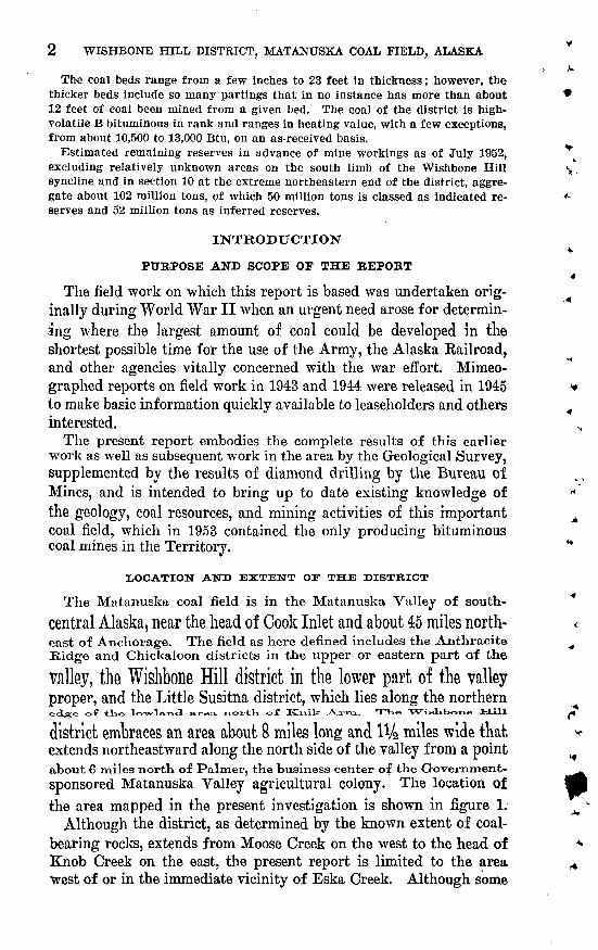
The Wishbone Hill District, Matanuska Coal Field, Alaska
GEOLOGICAL SURVEY BULLETIN 1016


THE WISHBONE HILL DISTRICT, MATANUSKA COAL FIELD, ALASKA
By FARRELL F. BABNES and THOMAS G. PAYNB
ABSTRACT
- The Wishbone Hill district, 45 miles northeast of Anchorage in south-central Alaska, lies on the north side of the Matanuska Valley near its lower end. The district takes its name from the prominent conglomerate-capped hill that oc cupies its central part. Coal was first mined in the district in 1916 and produc- tion has been continuous with one to four mines in operation at one time. In an effort to stimulate production of coal to meet the increased demands resulting from World War II, a core-drilling program and geological investigation of the Wishbone Hill district, which includes the only known workable deposits of bituminous coal in the Alaska Railroad belt, was undertaken in 1943 and 1944 by field units of the Geological Survey and Bureau of Mines, cooperating agencies of the U. S. Department of the Interior.
The coal-bearing rocks of the district are Tertiary in age and include all grada- tlons from coarse sandstone and conglomerate to claystone; they are mostly concealed by a mantle of Quaternary deposits or by a capping of younger Ter tiary conglomerate. On the basis of both regional and detailed geologic studies two significant changes in the stratigraphic section of the lower Matanuska Valley are proposed. A series cf arkosic shales and conglomerates that are ex- posed on the north side of the Matanuska Valley and have heretofore been con sidered to be Tertiary in age and at least in part equivalent to the coal-bearing Chickaloon formation, are believed by the present writers to lie at the base of the underlying Matanuska formation and to be Late Cretaceous in age. The second change proposed is the division of the Eska conglomerate, which overlies the coal- bearing Chickaloon formation, into an upper Tsadaka formation and a lower Wishbone formation on the basis of lithologic difference and the presence of an unconformity between them.
The dominant structural feature of the district is the Wishbone Hill syncline, a canoe-shaped fold that extends the full length of the district and is cut into segments by several major transverse faults. Mining has been restricted largely to the ends and to the moderately dipping north limb of the fold, as the outcrop of the south limb of the coal-bearing formation is deeply buried beneath slide rock and glacial deposits.
The coal-bearing Chickaloon formation is at least 3,000 feet thick, but the coal beds are confined largely to the upper 1,400 feet, where they occur mainly in four groups of three or more beds, which have been named, in descending order, the Jonesville, Premier, Eska, and Burning Bed coal groups. Principal production to date has been from the Premier group in both the eastern and western parts of the district, and from the Eska group in the eastern part.
2 WISHBONE HILL DISTRICT, MATANUSKA COAL FIELD, ALASKA
The coal beds range from a few inches to 23 feet in thickness; however, the thicker beds include so many partings that in no instance has more than about * 12 feet of coal been mined from a given bed. The coal of the district is high- volatile B bituminous in rank and ranges in heating value, with a few exceptions, from about 10,500 to 13,000 Btu, on an as-received basis.
Estimated remaining reserves in advance of mine workings as of July 1952, excluding relatively unknown areas on the south limb of the Wishbone Hill ^' syncline and in section 10 at the extreme northeastern end of the district, aggre gate about 102 million tons, of which 50 million tons is classed as indicated re- -f serves and 52 million tons as inferred reserves.
INTRODUCTION4.
PURPOSE AND SCOPE OF THE REPORT-4
The field work on which this report is based was undertaken orig inally during World War II when an urgent need arose for determin ing where the largest amount of coal could be developed in the shortest possible time for the use of the Army, the Alaska Railroad, and other agencies vitally concerned with the war effort. Mimeo graphed reports on field work in 1943 and 1944 were released in 1945 * to make basic information quickly available to leaseholders and others 4 interested.
The present report embodies the complete results of this earlier work as well as subsequent work in the area by the Geological Survey, supplemented by the results of diamond drilling by the Bureau of Mines, and is intended to bring up to date existing knowledge of * the geology, coal resources, and mining activities of this important A coal field, which in 1953 contained the only producing bituminous coal mines in the Territory. H
LOCATION AND EXTENT OF THE DISTBICT
The Matanuska coal field is in the Matanuska Valley of south- Central Alaska, near the head of Cook Inlet and about 45 miles north- <east of Anchorage. The field as here defined includes the Anthracite ^ Ridge and Chickaloon districts in the upper or eastern part of the
valley, the Wishbone Hill district in the lower part of the valleyproper, and the Little Susitna district, which lies along the northerneclge of tl-ie lo-wla/nol area. nortK of Kjaik .A_x-m- THe "VVislibono Hill ,»
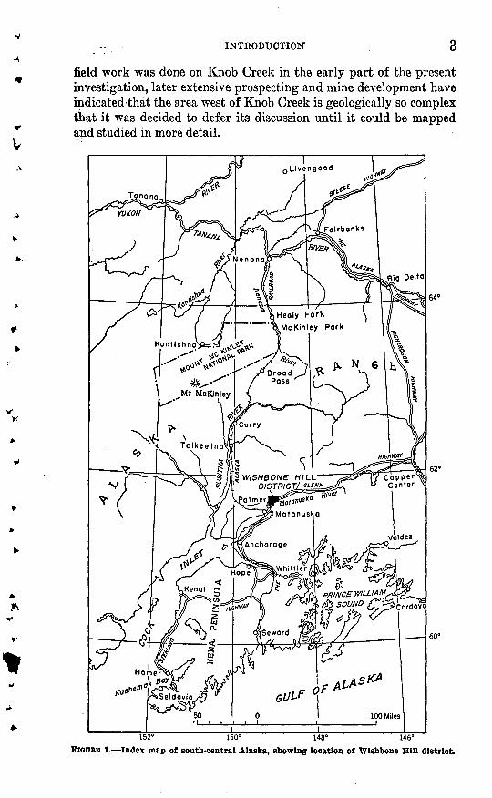
district embraces an area about 8 miles long and 1V2 miles wide that «< extends northeastward along the north side of the valley from a point ^about 6 miles nortn of Palmer, the business center of the Government- ^^sponsored Matanuska Valley agricultural colony. The location of the area mapped in the present investigation is shown in figure 1. ^
Although the district, as determined by the known extent of coal- bearing rocks, extends from Moose Creek on the west to the head of * Knob Creek on the east, the present report is limited to the area ^ west of or in the immediate vicinity of Eska Creek. Although some
V
-\
t
V
INTRODUCTION
field work was done on Knob Creek in the early part of the present investigation, later extensive prospecting and mine development have indicated that the area west of Knob Creek is geologically so complex that it was decided to defer its discussion until it could be mapped and studied in more detail.
152° 150° 148° 146° PIGOBB 1. Index map of south-central Alaska, showing location of Wishbone Hill district

-wooaic BY THE BUREAU OF MINES
In 1942 the Bureau of Mines began a program of drilling and
trenching along Moose Creek to extend the knOWn ftM Ofcoal deposits and prove additional tonnage as a stimulus todevelopment ana coal production to meet the increased demands
created by World War II (Apell, 1944). The drilling program! onMoose Creek was carried on from November 1942 to August 194£ andfrom June tO December 1944. During this time 11 holes were drilled and several trenches were completed. In 1945 operations WQFQ fillJfifld to the eastern part of the field, where 3 holes were drilled on the Eska
- 4
4 WISHBONE HILL DISTRICT, MATANUSKA. COAL FIELD, ALASKA
PREVIOUS INVESTIGATIONS !..::.'. ' . ' . . '.. .''.'".' ''.,.!
The first study of the coal in the Matanuska field was made in 1905 by Martin (1906), who took detailed measurements and samples-of " many coal beds. In 1906 the Matanuska Valley was mapped tppo- v graphically and geologically on a reconnaissance scale of 1 : 250,000, V and an approximately complete section of the Mesozoic and Tertiary rocks; was described for the first time (Paige and Knopf, 1907). :In 1909 a topographic survey of the lower Matanuska Valley was made by E.; H. Sargent, and the resulting map, on a scale of 1 : 62,500, was published in 1912. In 1910 a more detailed geologic survey, using "*" Sargent's map as a base, was made by Martin and Katz ( 191)2) j 4 Progress reports on mining developments in the Matanuska Valley were made in 1917 by Martin (1919) and in 1918 and 1919 by. Chapin (1920, 1921). In 1932, a diamond-drilling project, part of a Gbv- ment program to stimulate the development of mineral resources in the Alaska Railroad belt, was carried out in an attempt to locate minable coal beds west of Moose Creek, at the extreme southwest end df the Wishbone Hill district (Waring, 1934). Five holes weredrilled about 1%. miles southwest of the Premier mine (pi. 2), but no minable coal beds were found. ;
The most recent study prior to the present investigation was that of Tuck ( 1937) , who in 1934 and 1935 made a topographic and geologic survey of the eastern part of the district.
FIELD WORK , !
The present report is based on surface and underground mapping by the Geological Survey, supplemented by data from diamond drilling and trenching by the Bureau of Mines, during the period 1943-
1951. In addition the senior author, as geologist for the Alaska Railroad from 1939 to 1944, mapped the underground workings ^nd geology of the Eska mine and did considerable surface prospecting on the Eska reserve in the eastern part of the district. ;

' " x INTRODUCTION 5u
% reserve, in the NW% sec. 16, T. 19 N., R. 3 E. (Barnes, 1951; Jolley1, Toenges, and Turnbull, 1952, p. 6-18). No drilling was done in 1946; but in 1947 and 1948 the Bureau completed 9 holes in the extreme
^ northeastern part of the district to test for additional coul reserves beyond the limits of the old Eska East mine workings (Jolley,
* ** Toenges, and Turnbull, 1952, p. 19-27). In 1949 drilling operationsj, "were shifted to the southern margin of the district west of Jonesville,
where the problem was to test for minable coal beds to the west alongthe strike from old mine workings. There the outcrop belt of th$
^ coal-bearing formation is completely buried by glacial deposits, talus,and landslide debris. In 1950, 1951, and 1952 drilling was extended
v to the north and west into areas where the coal-bearing formation** is overlain by a thick cap of conglomerate that forms the central
part of "Wishbone Hill. :
FIELD WORK BY THE GEOLOGICAL SURVEY>
In 1943 the Geological Survey undertook the completion of large-* scale mapping and detailed study of the coal deposits of the Wishbone
», Hill district, where drilling by the Bureau of Mines was already, inprogress. T. G. Payne, chief, D. M. Hopkins, Jacob Freedman, andE. R. Larson began mapping the northwest margin of the districtbetween the Premier mine on Moose Creek and the west boundary of
s the'E van Jones lease (Anchorage 05476). In 1944 Payne and Hopkinsy completed the mapping of the western part of the district, and F. F,^ Barnes and F. M. Byers, Jr., completed the mapping of the eastern,
part. Work in the eastern part of the district included the detailedtracing of coal beds in areas where isolated exposures had been mappeotby Tuck (1937). In this work a small pesthole auger was used tplocate and trace coal beds and determine the character of bedrock
? under several feet of overburden. By this means it was possible not> only to expose coal sections at critical localities with a minimum of
trenching, but also to trace quickly certain concealed coal beds forconsiderable distances where the amount of time and labor involvedin trenching would have been prohibitive.
In 1945 the district was visited by Barnes at frequent intervals be- ^ tween June 7 and October 17 for the purpose of checking on mining v developments, collecting additional field data, and furnishing geo
logical guidance for the diamond-drilling project of the Bureau of Mines on the Eska reserve. In 1946 no field work was done, and in
<jj 1947 and 1948 only a few days were spent in the district each season by Barnes to check the results of diamond drilling east of Eska Creek by the Bureau of Mines and to assist in the correlation of coal beds.
+ In 1949 Payne spent a month in the district studying the complicated structure indicated by drill records in the area west of Jonesville.
6 WISHBONE HILL DISTRICT, MATANUSKA COAL FIELD, ALASKAx.
In 1950 Barnes, assisted by D. M. Ford, spent the season furnishing geological assistance for the drilling project and collecting additional geologic data in various parts of the district; in 1951 the same work was continued by Ford.
ACKNOWLEDGMENTS t
Officials of all the operating mines in the district, which included at <*- various times the Buffalo and Premier mines on Moose Creek and the Evan Jones, Eska, and Knob Creek mines in the eastern part of the district, cooperated fully in furnishing mine maps and other data, in -4. permitting access to underground workings, and in extending every courtesy and hospitality to the field personnel. G. O. Gates, under whose general supervision most of the field work was done, has given -+ many helpful suggestions both in the field and in the office.
GEOGRAPHY <
TOPOGRAPHY *
A prominent topographic feature of the lower Matanuska Valley is * Wishbone Hill, a conglomerate-capped synclinal ridge that extends from the Premier mine on Moose Creek northeastward about 6 miles to Eska Creek, occupying the greater part of the area described in this report (pis. 1, 2). The main ridge rises gradually northeastward, v from an altitude of 900 feet near the Premier mine to 2,333 feet at its highest point northwest of Jonesville. Bold conglomerate cliffs cap the northern and southeastern slopes of Wishbone Hill, converging v to the northeast around the summit peak to form the "wishbone" pat tern from which the hill takes its name (Tuck, 1937, p. 196). The cliffs on the southeast have a sheer drop of more than 300 feet, forminga prominent landmark that can be seen for many miles up and down the Matanuska Valley. Within these outer cliffs several concentric lines of hogback ridges, ledges, and dip slopes clearly reflect the south- * westward-plunging synclinal structure of the eastern part of Wish bone Hill.
On the north Wishbone Hill is separated from the rugged Talkeetna *
Mountains by a broad valley drained by tributaries of Eska and Moose ^Creeks; on the east and west it terminates at the sharply incised val leys of Eska and Moose Creeks, respectively; and on the south it is * flanked by a broad relatively flat surface with a general altitude of _.about 800 feet that is broken by many deep irregular depressions, some J containing lakes. This surface, which extends southward l1/^ to 2 ,< miles to the Matanuska River, is underlain by a mixture of terrace gravels and glacial deposits, such as cover the greater part of the lower Matanuska Valley. *

GEOGRAPHY 7
DRAINAGE
Most of the north slope of Wishbone Hill and the basin occupied by Wishbone Lake drain southwestward into Moose Creek. All the district east of Jonesville drains into Eska Creek. Most of the south- era slope of Wishbone Hill is drained by several small streams that enter morainic swamps and lakes with no surface outlet.
Both Eska and Moose Creeks head in the rugged Talkeetna Moun tains, whose southern front is about a mile north of Wishbone Hill, and flow southward to join the Matanuska Eiver. The character of Eska Creek was described by Tuck (1937, p. 187) as follows:
The headwaters of the creek, although small in area, are often subject to torrential rainfalls, whose destructive influence is usually most severe in the portion of Eska Creek * * * [adjacent to Wishbone Hill]. Here the flood plain of Eska Creek is only about 200 feet wide, with steep walls on both sides. During early mining operations some of the camp and mine buildings were constructed on this flood plain, but high water has destroyed most of those so situated. The greater part of the high water comes from the west fork of Eska Creek [since named Gloryhole Creek], which drains a part of the area on the north side of Wishbone Hill but has its source in a large spring on the south side of the Talkeetna Mountains. Generally, August is the period of high water, although destructive floods usually occur only every 3 or 4 years.
Severe damage to the old Eska mine surface plant by a flood in 1932 prompted the abandonment of the old mine opening and the driving of a new tunnel farther west and well above creek level.
Moose Creek also has had a history marked by disastrous floods in which the chief damage has been to the railroad spur serving the coal mines that have operated at various times along its course. In 1941, after several years of inactivity, a revival of interest in mining on Moose Creek led the Alaska Kailroad to rehabilitate the track to the Premier mine. The following year a particularly violent flood so severely damaged the track and road bed that all plans for keeping the line in operation were abandoned.
CLIMATE
The Matanuska Valley, although adjacent to tidewater, lies sp far from the open ocean that its climate is more like that of the interior than that of the coast. The summers are mild, and the winters are severe, low temperatures often being accompanied by strong down- valley winds. The temperature may rise well above 80° F in summer and drop below 30° F in winter, but these extreme temperatures are exceptional. In the following table temperature and precipita tion data are given for the Weather Bureau station with the longest record in the Matanuska Valley, situated near the village of Matanuska about 10 miles southwest of the Wishbone Hill district. Although
8 WISHBONE HILL DISTRICT, MATANUSKA COAL FIELD, ALASKA
this station is a few hundred feet lower and several miles closer to the coast than the Wishbone Hill district, the climatic conditions probably ire riot very different.' Although the average annual precipitation is less than 16 inches, the density and rapid growth of vegetation is comparable with areas with much heavier rainfall in the United States. Factors which contribute to the humid aspect of the lower Matanuska Valley probably include the comparatively low mean temperatures of the summer months with consequent small loss of moisture through evaporation, long hours of sunlight resulting in accelerated plant growth, and the concentration of heaviest precipitation in the summer months.
TABLE 1. Mean temperature and precipitation in the lower Matanuska Valley,Alaska
[Computed from records of U. S. Weather Bureau station Matanuska Valley No. 14, in Cllmatologlcal data, Alaska Annual Summary 1948: U. S. Weather Bureau, 1950]
April. .......... ... ..... ...
July........ .............. .
Temper ature <°F)
13.419.224.236.346.9ee o
57.5
Prerlpl- tat Ion
(Inches)
0.87.73.56.41.70
1.151.96
August. _ __ .. ........
November ....................
Years of record. _ ____ .
Temper ature (°F)
65.347.536.421.713.6
35.6
29
Precipi tation
(inches)
2.872.651.77.95
Qft
15.60
28 ,
VEGETATION
Timberline in the Cook Inlet region is at a general elevation of2,000 to 2,500 feet; consequently all the area of this report except thehighest part of Wishbone Hill is theoretically below timberline.I fowever, although a. few scattered patches of timber are present onthe lower slopes of Wishbone Hill, the greater part of the district is
devoid of all except scattered trees and smaller growth, either as aresult of (ires or because of unfavorable soil conditions. The trees include spruce, birch, and cotton wood. Few of the spruce trees exceed 1 foot in diameter, but cottonwood trees 3 or 4 feet in diameter are notuncommon. Very little mine timber is obtained locally, most of that USeCl being Shipped in Irom Oilier parts OI tlie valley, particular^ from
the agricultural area around Palmer where it is a byproduct of land-
clearmg operations. Smaller growth includes alder and red birch,generally occuring In dense thickets, high-bush cranberry,-wild rasp-
berry, blueberry, wild rose, and devilsclub. Otherwise bare areas arecovered with a dense growth of native grasses and fire weed, which by midsummer locally attains a height of 6 feet or more.
* ,.. . . . GEOLOGY .. T . .,, r ,... , v 9
ACCESSIBILITY-, .... .m .... ^ - , ' ' '
The lower Matanuska Valley is served by the Alaska Railroad, abranch of' which extends 22 miles from Matanuska station through
v Palmer to Eska and Jonesville, in the eastern part of the Wishbone Hill* district (pi. 1). A spur line formerly served mines along Moose
* Creek, at the west end of the district, but was abandoned in 1942 be-j, ca.use of recurring destructive floods. The Glenn Highway, a year-
round li!J,rd-surf aced road connecting the Anchorage-Palmer Highwaywith the Richardson Highway and the interior of Alaska, passes about
j, 2 miles south of Wishbone Hill. Branch roads connect Eska, Jonesville, arid the Premier and Buffalo mines on Moose Creek with the' t
* main highway. After abandonment of the Moose Creek spur, coal*. from the Premier and Buffalo mines was hauled by truck, either
directly to markets in Palmer and Anchorage or to a loading chute atthe mouth of Moose Creek where it was transferred to railroad carsi
*.. on the branch line.| GEOLOGY
%GENERAL FEATURES
The Wishbone Hill district lies in an area of moderately deformed clastic.rocks of Tertiary age, ranging from claystone to conglomerate, which, together with the surrounding and presumably underlying Uppef Cretaceous rocks, have been depressed between parallel zones of major faulting that border the Matanuska Valley and separate the Cretaceous and Tertiary rocks from the older and more highly de- formed metamorphic and intrusive rocks of the mountains on either
inside. -The great fault that extends for many miles along the north side of the valley has been best described north of Castle Mountain, in the upper Matanuska Valley (Martin and Katz, 1912, p. 72-73), and is herein named the Castle Mountain fault. The Talkeetna Moun- tains to the north are composed of granitic and gneissic rocks, in- eluding granite, quartz diorite, and quartz monzonite; the Chugach Mountains to the south consist of greenstone, diorite, and interbedded slate and graywacke. To the east of the Wishbone Hill district the Cretaceous and Tertiary rocks of the Matanuska Valley have been extensively intruded by masses of diorite porphyry, andesite, gabbro, and diabase. The only known igneous rocks within the Wishbone Hill district are a few small basic dikes. To the west of the district a mantle of glacial deposits covers all but a few small scattered areas of Tertiary rocks. Within the district bedrock is largely concealed by Quaternary glacial and alluvial deposits, which cover all but the steeper slopes. The lower slopes of Wishbone Hill are covered with a mantle of loose debris, mainly conglomerate blocks, that has either

10 WISHBONE HILL DISTRICT, MATANUSKA COAL FIELD, ALASKA
accumulated as talus or, as in the area around Jonesville, resulted from extensive landslides.
The general succession of rocks in the Wishbone Hill district is given in the following chart:
Stratigraphic sequence of rocks in the Wishbone Hill district
Age
Quaternary.
Tertiary-
Upper Cretaceous.
Upper Creta ceous (?).
Formation
Unconformity. Tsadaka formation.
Wishbone formation.
Chickaloon formation.
Matanuska formation.
Arkose Kidge formation.
Character
Alluvium, terrace gravels, and moraine deposits.
Coarse conglomerate, sandstone, silt- stone.
Medium- to fine-grained conglomerate, sandstone, and minor claystone.
Interbedded claystone, silt-stone, sand stone, and coal.
Shale and sandstone.
Arkose, conglomerate, and shale.
Thickness (Feet)
700+
1,850+
3,000-5,000
4,000+
2,000+
STRATIGRAPHY
CRETACEOUS SYSTEM
ARKOSE RIDGE FORMATION
An assemblage of arkose, conglomerate, and shale more than 2,000 feet thick lies in a belt extending along the northern border of theMatanuska Valley west of the Chickaloon River. In the vicinity of Moose Creek the formation is somewhat more than 1,500 feet thick.These rocks were described by Martin and Katz (1912, p. 39-40) asfollows:
The arkose, conglomerate, and shale are highly indurated, in this respect, as
in other lithologic characteristics, differing from the other Tertiary rocks * * *. The rocks exposed on the ridge north of Moose Creek are principally arkose,
with a few beds of shale. The arkose is fine grained and conglomeratic in places, but the conglomeratic feature nowhere predominates. The rocks have a dark-brown to gray ColoT and Contain all the essential constituents Of granite. Qxiartz, feldspar, hornblende, biotite, and chlorite can be easily recognizied. Locally the feldspar is much kaolinized. The chlorite gives the whole rock inplaces a greenish tinge. Much of the arkose somewhat resembles an igneous rock. Some of it is so much like granite in appearance mat ita eeaimenvtviry Character is reco'gnizable only by a few rounded pebbles and carbonized plant remains. On the other hand, the arkose grades into conglomerate SO that no definite line can be drawn between them.
As these rocks are distinct from all other rocks in the region and are typically exposed on Arkose Ridge, northwest of Wishbone Hill, they are considered as a separate unit and here named the Arkose Ridge formation.

GEOLOGY 11
On the north side of Arkose Ridge the Arkose Ridge formation is believed to rest with sedimentary contact on an even surface of granite of the Talkeetna batholith. The evidence for this conclusion, as given by Martin and Katz (1912, p. 41) includes the uniform parallelism of the contact with the bedding in the arkose and the lack of any indica tion that the granite was intruded into the arkose. On the south side of Arkose Ridge the formation is in fault contact with the Chickaloon formation of Tertiary age and the Matanuska formation of Late Cretaceous age. On the basis of a few plant fossils in two collections examined by Knowlton and Hollick, the arkosic rocks were determined to be probably Eocene in age (Martin and Katz, 1912, p. 42). Martin and Katz, and later Capps (1927, p. 40), expressed the belief that these rocks include the basal beds of the Tertiary system and are at least in part equivalent to the Chickaloon formation and possibly the Eska conglomerate of the Wishbone Hill district.
After making detailed studies of the Chickaloon and overlying formations and comparing them with the arkosic rocks, the present writers are inclined to question any equivalence in age, particularly in view of the fact that Roland W. Brown of the Geological Survey has recently reexamined the fossil collections and concluded that they could be either Cretaceous or Tertiary in age. Consequently there is no compelling reason for considering the Arkose Ridge formation to be Tertiary in age. In fact, the following several lines of evidence, in the opinion of the writers, point to its being not only older than the Chickaloon formation but possibly, at least in part, older than the Matanuska formation.
1. The rocks of the Arkose Ridge formation are much more highly indurated than those of the Chickaloon formation. As the arkosic rocks are not strongly deformed or otherwise metamorphosed, the greater degree of induration strongly suggests greater age.
2. In gross lithologic characteristics the Arkose Ridge formation differs greatly from the Chickaloon formation. As the two formations are in juxtaposition along the Castle Mountain fault it is difficult to believe that the differences represent a lithic facies change. It seems more likely that they represent different periods of sedimenta tion.
3. On the north side of Arkose Ridge the Arkose Ridge formation is in sedimentary contact with granite of the Talkeetna batholith, which was intruded probably in Middle and early Late Jurassic time. The Matanuska formation therefore must either be younger than the arkosic rocks, o'r have been eroded from the area before deposition of the arkose. In view of the fact that the Matanuska formation is present in great thickness only a few miles away in the Matanuska Valley, the first interpretation seems more plausible.
368567 56 2
12 WISHBONE HILL DISTRICT, MATANUSKA COAL FIELD, ALASKA
4. During investigations in 1952 in the northeastern headwaters of the Matanuska River and adjoining parts of the Nelchina area, Arthur Grantz of the Geological Survey mapped a laterally persistent unit consisting of 50 to 650 feet of arkosic sandstone, conglomerate, and shale. This unit was found to underlie or form the basal part of the Matanuska formation, and to lie on an erosion surface that trun cates formations ranging from Early Cretaceous to Early Jurassic in age. The similarity of this unconformity to the one at the base of the Arkose Ridge formation on Arkose Ridge, as to character, age of the underlying rocks, and lithology of the overlying rocks, strongly suggests that the erosion surfaces in the two areas are the same and that the Arkose Ridge formation is correlative with the arkosic unit of the Nelchina area, which is of undoubted Late Cretaceous age.
5. Along the southern boundary of the Wishbone Hill district, both in the Eska area and in the north bluff of the Matanuska River below Moose Creek, the Chickaloon formation appears to rest directly on the Matanuska formation. The nature of the contact is not known, as it is not exposed, but the presence of outcrops of the two forma tions within short distances of each other indicates that the Arkose Ridge formation is either absent in this area or underlies at least the upper part of the Matanuska formation. As its absence would require the presence of a fault of considerable magnitude or a major unconformity, for either of which evidence is completely lacking, it seems logical to conclude that the Arkose Ridge formation lies lower in the section.
In view of these interpretations which, although not conclusive, seem best to accord with available information, the Arkose Ridge forma tion is tentatively assumed by the writers to underlie the Matanuska formation and to be Late Cretaceous in age.
MATANUSKA FORMATION
An Upper Cretaceous unit of shale and sandstone, named theMatanuska formation by Martin (1926, p. 317), is widely distributedin the Matanuska Valley. Rocks of tins formation are exposed tothe south, east, and probably to the north of the Wishbone Mill dis-tl'ict and presumably underlie the entire area of the Tertiary coal- bearing rocks. The contact between the Cretaceous and Tertiary rocks has not been observed in this district, but its approximate posi tion has been determined within fairly narrow limits from scattered outcrops and is shown on plate 1.
The most complete section of the Matanuska formation is exposedin the gorge of Granite Creek about 2 miles east of Eska, where it has an aggregate thickness of at least 4,000 feet (Martin and Katz,
GEOLOGY 13
1912, p. 34). The lower half is practically all shale and the upper half is interbedded sandstone and shale, the sandstone predominating. A few thiri conglomerate beds are included.
The Late Cretaceous age and marine origin of the Matanuska for- mation has been established from fossils, among which Inoceramus is the most widespread and abundant genus. The Upper Cretaceous rocks differ lithologically from the Tertiary rocks: the shales of the Matanuska formation are readily distinguished by their darker color, greater hardness, and platy fracture, and the Upper Cretaceous sand stones are in general darker, harder, and more evenly bedded; never theless great care must be taken in field mapping to distinguish certain isolated outcrops of exceptionally hard Tertiary sandstone from those of Cretaceous age. Other criteria for distinguishing the Upper Cre taceous rocks are the absence of coal and the presence of marine fossils.
TERTIARY SYSTEM
The Tertiary rocks of the lower Matanuska Valley were described by Martin and Katz (1912, p. 39-54) as including three nonmarine sedimentary formations an unnamed assemblage of arkose, con glomerate, and shale; the Chickaloon formation; and the Eska con glomerate. The arkosic sequence, named the Arkose Ridge formation and believed by the present writers to be Cretaceous in age, has been described in the preceding section.
The Chickaloon formation in the Wishbone Hill district comprises at least 3,000 feet, and possibly as much as 5,000 feet, of interbedded claystone, siltstone, and sandstone and includes several groups of valuable coal beds in its upper part.
The Eska conglomerate of Martin and Katz has been found in the present investigation to be divisible, at least in the Wishbone Hill district, into two formations. The division is based on lithologic dis- similarity and evidence of a distinct angular unconformity. To the lower unit, which is well consolidated and consists of about 1,850 feet of pebble conglomerate with many beds and lenses of sandstone and finer elastics, the name Wishbone formation is here applied. The less indurated upper unit, of undetermined thickness but including several hundred feet of boulder-cobble conglomerate, sandstone, and siltstone, is best exposed in Tsadaka Canyon on lower Moose Creek, and is herein named the Tsadaka formation.
The Chickaloon and Wishbone formations probably are Paleocene, or possibly early Eocene in age, and the Tsadaka formation, Eocene or younger. The older formations have undergone essentially the same deformation as the underlying Cretaceous rocks, whereas the Tsadaka formation is only mildly folded. The unconformity at the
14 WISHBONE HILL DISTRICT, MATANUSKA COAL FIELD, ALASKA
base of the Tsadaka formation is believed to represent the Laramide orogeny.
It has been generally assumed by earlier writers that the coal- bearing rocks throughout the Cook Inlet-Susitna lowland are all of essentially the same age, the difference in rank of the included coal being related to degree of deformation. For example, the rela tively flat lying coals of the Little Susitna and Homer districts are subbituminous, whereas the more highly deformed beds in the Wish bone Hill and Chickaloon districts are bituminous or higher in rank. Recent studies, however, have suggested the possibility that the dif ference in rank may be due to a difference in age rather than degree of deformation. Detailed studies of beds in all parts of the Wish bone Hill district have revealed no significant difference in rank be^ tween highly folded and faulted coal beds and those that have been only moderately folded. Furthermore, although present evidence is not conclusive, the structure of beds exposed at the east end of the Little Susitna district 1 suggests that the subbituminous coal-bearing beds of that area overlie a thick conglomerate series that appears to- be identical with the Wishbone formation of the Wishbone Hill dis trict, which in turn overlies the bituminous coal-bearing Chickaloon formation. The possibility is therefore suggested that coal series of two different ages, the younger possibly correlative with the Tsadaka formation, are present in the Cook Inlet-Susitna lowland, and that higher-rank coal, correlative with the Chickaloon, may unlerlie the subbituminous coal-bearing beds of the Little Susitna, Homer, and other districts.
CHICKALOON FORMATION
The Chickaloon formation in the Wishbone Hill district comprises between 3,000 and 5,000 feet of claystone, siltstone, sandstone, a few thin beds of fine-grained conglomerate, and many beds of coal. The
formation is of continental origin and contains an abundant flora thatmay be either Paleocene or Eocene in age. Although the Chickaloon formation probably underlies the entire district, it crops out mainly in peripheral areas around the great mass of conglomerate tKat covers the central part of Wishbone Hill. It is also exposed at scattered points along Moose Creek and some of its tributaries from the north west, and along Eska, Gloryhole, and Knob Creeks.
Minable coal beds are confined largely to the upper 1,400 feet of the formation, where they occur in several more or less well-defined groups separated by comparatively thick sections of strata containing little 01 no COal. A few scattered thin coal beds are present in the
^Barnes, F, P., 1953, Preliminary report on the Little Susitna district, Matanuska coal field, Alaska: U. S. Geol. Surrey open-file report, p. 4-5.
GEOLOGY 15* 1
* lower part of the formation. Concretionary iron carbonate, or iron stone, in thin layers and nodules or irregularly distributed masses panging from a few inches to several feet in diameter, is widespread
*, in all the strata, including the coal. Petrified wood occurs locally,> particularly near the Eska and Chapin coal beds. Impressions of
fossil leaves are especially abundant in the roof rock of the coal seams.A
AREA NOKTH OP WISHBONE HILL
*"
The lower part of the Chickaloon formation, below the coal-bearing section, is exposed north of Wishbone Hill, along Eska and Gloryhole Creeks. Scarcity of outcrops and complex structure prevented ac curate determination of thickness ; however, unless faulting and f old- ing have caused a large amount of duplication, at least 3,000 feet of strata are represented by outcrops along Gloryhole Creek. There the formation consists of dark purplish-gray claystone and silty claystone, with minor interbedded siltstone and sandstone. Locally the sand- stone grades into fine conglomerate.
In the western part of the district the lower part of the Chickaloon formation is exposed along Moose Creek between the Castle Mountain fault and Wishbone Hill, along Premier Creek, and along other creeks between Moose and Premier Creeks. In this area the minimum thick ness of Chickaloon strata below the coal-bearing section is about 3,500 feet, and the rocks are coarser grained in gross aspect than those ex posed along Eska and Gloryhole Creeks. Sandstone and conglomerate constitute more than half of the exposed section. A coaly unit about 20 feet thick, consisting of coaly claystone, bone, and thin beds of coal, lies at the base of the exposed section just south of the Castle Moun tain fault. The coal-bearing part of the Chickaloon formation ap parently has been entirely eroded from the area northwest of Moose Creek.' ; WISHBONE HILL ABEA
The upper, or coal-bearing, part of the Chickaloon formation, about 1,000 feet in minimum thickness, is exposed on the flanks of Wishbone Hill. It consists in general of poorly stratified claystone, siltstone, light-gray to buff sandstone including local lenses of conglomerate and conglomeratic sandstone, and coal. The clastic rocks intergrade both laterally and across the bedding. The claystone of the upper part of the formation is generally lighter in color than that of the lower part and commonly contains scattered thin coal streaks and irregular fragments of carbonaceous matter. Locally, by in crease in coaly material, claystone grades progressively into coaly claystone, bone, and coal. The sandstone in general is feldspathic and poorly indurated, but locally contains large resistant masses ce-
16 WISHBONE HILL DISTRICT, MATANTJSKA COAL FIELD, ALASKAi.;
mented by iron and calcium carbonates. The conglomerate lenses con-? f sist of a sandy matrix in which are embedded cobbles, pebbles, and granules of vein quartz, chert, volcanic and metamorphic rocks, and fragments of clay rocks of local origin. -
Individual beds in the Chickaloon formation, including the coalj are not notably persistent, tending to thin or intergrade within rela- * tively short distances. For example, the Eska bed, one of the princi- A pal coal beds in the Eska mine (pi. 3), is locally as much as 6 feet thick in the south-limb workings but thins to about 2 feet at the west end of the north-limb workings. The Eska sandstone, a medium- to coarse grained feldspathic sandstone that overlies the Eska seam, is 75 feet thick near the portal of the old Eska West mine workings on Eska * Creek, nearly 90 feet thick in the Eska crosscut tunnel, but is lacking * in the Evan Jones tunnel (pi. 4), where the corresponding strati- graphic position is occupied by fine siltstone.
Marked changes in thickness are not confined to individual beds * but characterize larger stratigraphic units as well. For example, the total thickness of the coal-bearing part of the Chickaloon formation, v measured upward from the base of the Eska coal group, decreases west- * ward from about 1,000 feet at the Eska mine to 600 feet at the town ship line on the north side of Wishbone Hill, 2 miles to the west (pi. 5) t The thinning is most pronounced in the interval between beds 5 and 8 of the Evan Jones mine, which decreases from 250 feet at the main crosscut tunnel to less than 100 feet at locality 17, less than a mile to v the west (pi. 4). .*.
Although individual coal beds, including most of those within the
well-defined coal groups, tend to thin or grade laterally into clastic sediments within relatively short4i.stanc.es,- the coal groups themselves are much more persistent. The tipper (Jonesville) group has been traced intermittently from the south-limb workings of the Evan Jones mine near Eska Creek to the Premier mine on Moose Creek (pis. 1, 2, 5). The middle (Premier) group has been identified at severalpoints between the Premier mine and the east side of Eska Creek above Eska. The lower (Eska) group has been identified in mine-workings and drill Koles east of Eska Creek and traced westwardthrough the Eska and Evan Jones mines. West of the Evan Jones .iTcrosscut tunnel the coal beds of this group were traced in decreasing ^thickness to locality 16, but are either absent or unexposed between ^localities 11 and 16 (pi. 5). West of locality 11, coal beds found at a corresponding stratigraphic position in outcrops, mine tunnels, and ^ drill holes at several points along Moose Creek may represent a ^ westerly continuation of the Eska group. A still lower but eco nomically unimportant coal group was traced from the Eska mine >: westward to locality 20. These beds appear to be at the same strati^ ^

\ . GEOLOGY 17
graphic position as, and are therefore correlated with, the Burning Bed coal group on Moose Creek. Coal beds were also found at a corresponding stratigraphic position in several drill holes east of Eska Creek.
Certain thin layers of clay or claystone in the Chickaloon formation are exceptionally persistent over considerable areas and have proved of value in the correlation of coal beds. One of the best known and most persistent of these so-called marker beds is the "Eska marker", which appears just below the roof of the Eska coal bed. This marker consists of at least one, and in many places two, thin light-colored hard clay bands, generally less than an inch thick, that contrast sharply with the enclosing coal and roof rock. The Eska marker is present throughout both the old and new workings of the Eska mine and was noted in outcrops as far west as locality 22; it thus has a known extent of nearly l 1/^ miles.
A second distinctive claystone marker was traced between localities 15 and 21, along the north slope of Wishbone Hill, for a total distance of 3,000 feet. Although this layer was not seen in an unweathered state, it apparently consists of a few inches of light-colored claystone that weathers and swells to a foot or more of orange-yellow plastic clay. This clay was found at several localities a few inches above one of the lower coal beds of the Premier group and was helpful in cor relating sections at the different localities. The clay in this and several other similar layers exposed in the Eska and Evan Jones mines has some of the properties of bentonite and may represent a decomposed volcanic ash. It swells greatly on exposure to air and moisture and becomes soft and plastic, which causes it to ooze out of the enclosing strata in tunnel walls. Other less persistent claystone partings in coal beds aided in correlation over short distances.
TSADAKA CANYON AND MATANUSKA BIVEE BLUFFS
Chickaloon strata are exposed in the lower part of Tsadaka Canyon and in the bluffs on the north side of the Matanuska River (pi. 2). They consist of claystone, siltstone, sandstone, and a few coaly beds composed mostly of bony coal, bone, and coaly claystone. Only a few coal beds 3 feet or more thick are present. A generalized composite section of the part of the Chickaloon formation exposed in this area, totaling about 1,500 feet in thickness, is shown in plate 6.
In the Matanuska River bluffs below the mouth of Moose Creek a covered interval of 6,700 feet, measured along the railroad track, sepa rates the lowest exposure of Chickaloon formation from the nearest exposure of Matanuska formation, about 2 miles below the mouth of Moose Creek. The Matanuska strata, in the river bluffs both above and below Moose Creek, have approximately the same attitude as the
18 WISHBONE HILL DISTRICT, MATANUSKA COAL FIELD, ALASKA
Tertiary strata, both lying on the south limb of the Glenn syncline (pi. 2). Assuming an absence of large faults, the covered interval is estimated to represent about 1,500 feet of section. Because the Mata- nuska formation is more highly indurated and tends to form promi nent clifi's along the river, it seems most likely that the covered section consists of Chickaloon formation. If this is correct, the total thick ness of the Chickaloon in this area is at least 3,000 feet, including 1,500 feet of measured and 1,500 feet of inferred section. The top of the Chickaloon formation is not exposed in this area.
The stratigraphic relationship of the Chickaloon strata near the mouth of Moose Creek to those in the Wishbone Hill area has not been definitely established. The beds exposed in Tsadaka Canyon probably underlie the coal-bearing part of the Chickaloon formation exposed around Wishbone Hill and thus are equivalent to beds exposed between Wishbone Hill and Arkose Ridge. It is possible, however, that the upper part of the Tsadaka Canyon section, including several thin coal beds, is equivalent to the lower part of the Wishbone Hill section, in cluding the Burning Bed and possibly the Eska coal groups.
WISHBONE FORMATION
The Wishbone formation, here named for exposures on Wishbone Hill, is considered to be probably Paleocene, or possibly early Eocene in age. The upper contact of the Wishbone formation was seen atonly one point on the southwest side of Wishbone Hill where it is overlain with distinct angular unconformity by the Tsadakaformation.
No sharp boundary separates the Wishbone formation from theunderlying Chickaloon formation, the contact being gradationalthrough several feet, in which there is a gradual increase upward in the proportion of conglomerate and sandstone. Because the contact is so indefinite, for convenience in mapping, the base of the Wishbone
formation was arbitrarily taken as the top of coal bed no, 4, the upper most coal in the Chickaloon formation.
The Wishbone formation consists predominantly of conglomeratecomposed of pebbles, cobbles, and a. fe-w boulders in a sandy matrix,
but it also includes numerous lenticular beds of sandstone, generally crossbedded and ranging in thickness from a few inches to 40 feet, and a few small lenses of silty claystone. The finer sediments are more abundant in the lower part of the formation, which in fact grades imperceptibly into the underlying Chickaloon formation. Thecoarser constituents are composed predominantly of fine-grained ig neous and metamorphic rocks, chert, vein quartz, and jasper; pebbles and boulders of granitic rocks are relatively scarce. The formation as a whole is well indurated, but the conglomeratic layers are more

GEOLOGY 19
resistant to erosion than the sandy and silty layers and tend to stand out as a series of concentric hogback ridges and ledges reflecting the synclinal structure of Wishbone Hill.
The outcrop area of the Wishbone formation includes most of Wish- bone Hill between Jonesville and the Premier mine, except for a belt about three quarters of a mile wide extending south westward from- Wishbone Lake (pis. 1,2). The maximum thickness of the Wishbone formation, as determined from outcrops and drill holes, is at least 1,850 feet.
TSADAKA FORMATION
The uppermost of the conglomeratic beds on Wishbone Hill, mapped as Eska conglomerate by Martin and Katz (1912, pi. 5), consists of poorly indurated coarse conglomerate characterized by boulders and cobbles of granite and diorite in a matrix of granitic debris. As these beds are not only lithologically distinct from the underlying conglomerate unit but rest unconformably upon it, they have been mapped separately as the Tsadaka formation. The Tsadaka is con- sidered to be Eocene or younger in age. Because of its soft, friable matrix it is poorly exposed on Wishbone Hill, but its general distri bution was determined from many patches of disaggregated cobbles and boulders, supplemented by several shallow test pits.
Although a lack of good outcrops prevented the direct determina tion of the attitude of the Tsadaka formation on Wishbone Hill, its distribution and surface expression indicate that it dips gently south- westward, truncating strata of the Wishbone formation that have been folded into the Wishbone Hill syncline and disappearing to the southwest beneath glacial deposits. The Tsadaka formation reap pears in Tsadaka Canyon on Moose Creek below the Premier mine (pi. 2), where it consists of at least 700 feet of interbedded silty sand stone, siltstone, pebbly sandstone, and fine to coarse conglomerate. The sandstone beds are arkosic; some of the conglomerate beds con- sist largely of granite and diorite, others contain mostly volcanic and metamorphic rock debris, and still others contain both types of mate rial. These beds have been only slightly folded, showing low dips in various directions but prevailingly to the southwest.
About a mile west of the head of Tsadaka Canyon are five diamond- drill holes that were drilled by the Geological Survey in 1932 (pi. 2). The results of the drilling were reported by Waring (1934), who assumed that the approximately 1,000 feet of beds penetrated were correlative with the Chickaloon formation. The present writers be- lieve that the section penetrated is in the Tsadaka formation, for the following reasons: the cores showed nearly horizontal bedding; the beds penetrated, including the sandstone, were poorly consolidated; several beds of conglomeratic sandstone were found, which are more
20 WISHBONE HILL DISTRICT, MATANUSKA COAL FIELD, ALASKA
typical of the Tsadaka formation than of the Chickaloon formation; no coal beds were found, only scattered coal lenses and beds of car bonaceous shale; and projection of Tsadaka strata a short distance westward down the gentle dip measured in the canyon would carry them into the range of the drill holes.
' The Tsadaka formation is the youngest bedrock formation in the Wishbone Hill district. It is overlain by a relatively thin veneer of unconsolidated material in the area immediately south of Wishbone Lake, but to the southwest it is believed to extend beneath a deep mantle of moraine deposits that extends along the south base of Wish bone Hill. In Tsadaka Canyon moraine and terrace deposits lie directly on an even surface of gently dipping conglomeratic beds of the Tsadaka formation.
The base of the Tsadaka formation was observed at two points. About 1,000 feet south of the northwest corner of sec. 25, T. 19 N., R. 2 E., coarse granitic boulder conglomerate overlies typical Wish bone pebble conglomerate with distinct angular unconformity. Al though the coarse conglomerate was not visibly bedded, its base as exposed in the outcrop has an apparent dip of 18° W., truncating the gently northward-dipping bedding of the underlying pebble con glomerate. The second basal exposure is on the east wall of Tsadaka Canyon, 1,200 feet north of the south quarter corner of sec. 34, T. 19 N., R. 2 E. At this point nearly flat beds of granite cobble con glomerate rest unconformably on deformed beds of the Chickaloon
, formation,The relations of the Tsadaka formation to the underlying rocks show
that its deposition followed the greater part of the deformation that has affected the older Tertiary rocks, and probably also the erosion of the Wishbone formation from the area traversed by lower Moose Creek.
QUATERNARY SYSTEM
The Quaternary deposits of the Wishbone Hill district includeglacial deposits, terrace gravel, talus and lanasli<le <lebris referred
to collectively as slide rock, and the alluvial deposits on the presentflOOd Plains. These deposits cover most of the surface of the district,
except cliffs, the steeper valley sides, and the higher parts of WisllboilflHill. They are represented on me geologic maps omj ^*«~ «~7 -~Very thick or conceal the underlying bedrock over large areas.
GLACIAL DEPOSITS
Glacial deposits of various types and thicknesses cover nearly the entire district. At most points on Wishbone Hill bedrock is concealed by a mantle, ranging from a few inches to 10 feet or more in thickness, consisting of a poorly sorted mixture of clay, sand, gravel, and

GEOLOGY 21
boulders. Along much of the ridge crest east of the highest point of Wishbone Hill, the surface is underlain by several feet of silty clay that closely resembles weathered Chickaloon bedrock except for the fact that it contains scattered well-rounded pebbles of granitic rocks. This material, found in many auger holes, is believed to be a glacial deposit, derived mainly from the Chickaloon formation and trans ported only a short distance.
Thick morainic deposits are present along the south base of Wish bone Hill, where some of the depressions in the typical knob-and- kettle topography are more than 150 feet deep. Exposures in road cuts show that much of the material in this area consists mainly of very coarse gravel and boulders.
TEREACE GRAVEL
Terrace-gravel deposits are present at many places along the Mata- miska River and its tributaries, including a few places in the Wishbone Hill district (pis. 1, 2). Martin and Katz (1912, p. 69) observed six gravel terraces in the valley of Moose Creek at altitudes ranging from 400 to 1,000 feet. They also noted well-developed benches on Eska Creek at altitudes of about 940 and 1,000 feet, and recorded seven benches between Eska and Granite Creeks at altitudes ranging from 660 to 1,150 feet. The terraces along Eska and Moose Creeks are preserved only as isolated remnants of small extent. The various ter races mark successive stages in the downcutting of the Matanuska River to its present level in postglacial time.
SLIDE HOCK
Talus slides resulting from normal weathering of the conglomerate cliffs of Wishbone Hill and accumulations of a somewhat different character that have resulted from landslides are included under this heading. In places the two types of deposits are intermingled or super posed, and no attempt has been made to map them separately, although the toes of the larger landslides are shown on the maps by a distinctive symbol (pis. 1,2).
The largest landslide mass in the district lies just west of Jonesville, where it appears as a prominent lobe of chaotic material, with steep sides and a generally flat but hummocky upper surface that stands out from the south flank of the highest part of Wishbone Hill. This slide is composed in large part of huge blocks of conglomerate, some several tens of feet in largest dimension and many projecting above its generally soil-covered surface. Above this lobe the face of the hill is indented by a large pocket or amphitheater, flanked on the west by a sheer conglomerate cliff more than 300 feet high, which evidently was the source of the landslide. The trace of the Jonesville fault, one
22 WISHBONE HILL DISTRICT, MATANUSKA COAL FIELD, ALASKA
of the principal faults of the district, extends across the slope directly below the landslide pocket, and the zone of weakness along this fault may have caused the landslide.
To the northeast and almost continguous with the landslide just described is another area that is believed to have undergone large- scale slumping. On the extreme west side of the Eska reserve the area between the railroad and the 1,400-foot contour is characterized by hummocky topography, marked by many irregular ridges and depressions and many large blocks of conglomerate. Above the 1,400-foot contour is a roughly conical hill, consisting of a tilted wedge of conglomerate dipping 30° S., whose south face is a dip slope and whose north face drops off abruptly to a low saddle separating it from the main ridge to the north. Although a close accordance in attitude of this conglomerate block with the main mass forming the peak of Wishbone Hill suggests a normal relationship, other evidence indicates that the smaller block has slid southward down the dip of the bedding. The irregular topogaphy down the slope from this block is typical of either glacial deposition or landslides, but as the material consists mainly of conglomerate blocks and includes no glacial gravel or erratic boulders the evidence for landslide origin seems conclusive. Furthermore, several large gaping fractures across the dip-slope surface itself are unmistakable evidence of mass movement.
It is postulated that the south slope of Wishbone Hill became over- steepened by glacial erosion in Pleistocene time, and that mass move ment of the small conglomerate-capped block was favored by zones of weakness along faults particularly the Jonesville fault on the northwest, and possibly the Eska fault zone to the southeast and by the southerly dip of the bedding. This movement involved the con glomerate, and possibly the upper part of the underlying Chickaloon formation. The records of diamond-drill holes 14 and 15, just eastof the conglomerate block, revealed that the entire Jonesville coal group is missing in this locality, its stratigraphic position being markedby highly sheared and contorted rocks containing many coal fragments(BameS, 1951, p. 198-200). Whether this disturbance of the Chicka
loon strata resulted from the landsliding or from earlier faulting ISnot certain ; in either case, shearing along planes at small angles tothe bedding destroyed the identity of the coal beds of the Jonesville
group. Observations at many points in the mlnfiS of the district liaVB shown that a surprisingly small amount of movement along a faultClOSely paralleling the beclclimgj is requArecl to reduce a, coal bed Several
feet thick to a mass of sheared rock containing only scattered lensesof coal.
A smaller landslide lies a little farther northeast, in the E^NW^4 sec. 16 (pi. 1). There the abrupt termination of three small sandstone

GEOLOGY 23
ridges, which suggested to Tuck (1937, p. 198) a possible fault, is due to the slumping of a mass of Chickaloon strata that now forms a hummocky bench on the slope below.
Another extensive landslide was found about 2 miles west of Jones- ville, in the NE% sec. 24, T. 19 N., R. 2 E. (pi. 1,2). This slide orig inated a short distance southeast of Wishbone Lake, moved southward nearly half a mile, partly filling the valley behind a prominent hog back ridge and forming the small lake near the center of section 24. This slide, which is more apparent on aerial photographs than in the field, is recognized chiefly from the semicircular amphitheater filled with irregular knolls and depressions at its head, and from the hum mocky surface and lobate character of its lower part. The huge blocks of conglomerate that characterize the slides near Jonesville are notably lacking, probably because this slide involved mainly the poorly indurated Tsadaka formation.
ALLUVIUM
Alluvial deposits in the Wishbone Hill district are confined largely to the flood plains of Moose and Eska Creeks. Both of these streams have steep gradients and are subject to violent floods, so that the flood-plain deposits consist mainly of coarse gravel and boulders. Flood plains are narrow or lacking on both streams except near their mouths, where the valleys widen to several hundred feet, and in the vicinity of the Premier mine, where the valley of Moose Creek widens to more than 1,500 feet for a short distance.
IGNEOUS BOCKS
Although intrusive rocks of several types are of widespread occur rence farther east in the Matanuska Valley, the only igneous rocks known in the Wishbone Hill district are three small basic dikes. At locality 16, on the north side of Wishbone Hill a 20-foot diabase dike was traced for several hundred feet across coal-bearing strata (pi. 1). It has a strike of about N. 45° W. and a vertical dip. The intrusion of this dike apparently had little effect on the enclosing strata, as coal within a few inches of the dike walls showed very little change in character. A dike of similar composition, thickness, and trend was found in the bed 3 workings of the Evan Jones mine, about 4,000 feet west of the main crosscut tunnel. Where examined by the writers the only effect of the intrusion appears to have been a hardening and in cipient coking of the coal for a few inches from the dike walls. The position and trend of this dike indicate that it is the same as the one at locality 16. According to mine officials, later mine development has revealed more dikes and a sill that has so highly "coked" a large block of coal in bed 3 that the coal had to be discarded.
24 WISHBONE HILL DISTRICT, MATANUSKA COAL FIELD, ALASKA
Indications of another basic dike were found on the ridge south of the small pond east of Wishbone Lake (pi. 2). Fine-grained basic igneous rock was found essentially in place in two small flush outcrops about 700 feet apart on a line trending N. 30° E. Float of similar rock was found on the same general trend about half a mile to the south west. Although no contacts of the igneous rock with the enclosing conglomerate are exposed, the three points are probably on the same northeastward-trending dike. ;
A third small basic dike, with a strike, of N. 30° W. and a steep northeast dip, cuts massive sandstone of the Chickaloon formation on the west side of Knob Creek northeast of the Knob Creek mine, in the SE% sec. 10, T. 19 N., E. 3 E. (pi. 1).
STRUCTURE
GENERAL FEATURES
The structure of the Wishbone Hill district is dominated by the Wishbone Hill syncline, a northeastward-trending canoe-shaped fold, which has an exposed length of 7- miles between the Premier mine, on Moose Creek and the Eska mine on Eska Creek (pis. 1, 2, 7). The syncline is cut into segments by several major transverse faults. It is further modified locally by many smaller faults and complex sub sidiary folds in the relatively incompetent Chickaloon formation. Few of the smaller faults and none of the tight subsidiary folds extend into the massive conglomerate of the overlying Wishbone formatioiii, A few small exposures of horizontal to gently northwestward-dipping conglomerate on the north side of; Wishbone Lake indicate the presence of a shallow syncline or structural terrace on the north limb of theWishbone Hill syncline (pi. 2).
Folding and faulting in the Wishbone Hill district appear to have progressed simultaneously, probably in response to the same compres- sional stresses, which evidently included a large element of shearing. Some evidence was found to indicate that at least part of the folding was later than the major faulting, although offsets of the synclinal axis at the faults show that a considerable part of the folding preceded the major faulting.
The structure of the Wishbone Hill district has had a strong in-
fluenco on mining operations. As the most readily available coal is onthe moderately dipping limbs of the syncline, practically all mining to date has been done by "pitch-mining" methods, in which coal brokenfrom the working faces mores toy graYitj down sneet"metal-lx)ttome(lchutes to the haulageways. Major faults have greatly affected the direction and extent of mining, as may be noted from the relation of gangway faces to principal faults. (See pis. 3, 4, 8.) These faults have not always proved to be impassable barriers to further mining,

GEOLOGY 25
however, as shown by the fact that the Northeast fault was success fully crossed in the old Eska East workings, the Eska fault zone was crossed twice on the north limb in the Eska mine, and the Jonesville fault was crossed twice in the Evan Jones mine. The minor faults and shear zones in general do not prevent mining of the coal, but they do greatly increase the labor and cost of mining and impair the quality of the product.
AREA NORTH OF WISHBONE HILL,
Wishbone Hill is separated from the Talkeetna Mountains to the north by a mile-wide open trough drained by tributaries of Eska and Moose Creeks. This trough is underlain by Tertiary rocks, which are exposed at intervals along the main streams and some of the tributaries.
ESKA AND GLORYHOLE CREEKS
According to Martin (1919, p. 269-270) the north side of the Wish bone Hill syncline on Eska Creeklies south of and merges into or is separated by a fault from a belt of intensely deformed coal measures that probably is practically barren of workable coal and that extends northward into the great zone of faulting on the southern border of the high mountains.
Along Eska Creek the present writers found only scattered outcrops, but these indicated that the entire belt from Wishbone Hill to the mountain front is uriderlain by Chickaloon strata with a general south to southeast dip of 30° to 60°. Along Gloryhole Creek outcrops aremore abundant and show the belt to be underlain by the Chickaloon *»with a fairly uniform strike of N. 50°-80° E. and a southeast dip generally ranging from 50° to 65°. In a 500-foot zone near the moun tain front the rocks have undergone more intense deformation, as shown by sheared and faulted beds and abnormally steep dips. A section of nearly vertical strata in this zone includes a 5-foot bed of coal, the only coal of workable thickness observed on Gloryhole Creek. The more intense deformation of this zone may have resulted from part of the same stresses that culminated in the Castle Mountain fault, which crosses Gloryhole Creek about a mile to the north.
In the southern half of the belt exposures along Gloryhole Creek are scarce. Outcrops at points about half a mile and a quarter of a mile above the creek mouth show beds that dip 70° S. to vertical but are not highly sheared or faulted. Further downstream a small south- westward plunging anticline, with limbs dipping about 60°, is well exposed in the creek bank (pi. 1).
MOOSE CREEK AND TRIBUTARIES
A general idea of the structure of the area northwest of Wishbone Hill is obtained from scattered exposures along Moose Creek and its
26 WISHBONE HILL DISTRICT, MATANUSKA COAL FIELD, ALASKA
larger tributaries that drain the south slope of Arkose Ridge. Above the Castle Mountain fault, the mountain side is essentially a dip slope; the arkose beds strike about N. 70° E. and dip about 25° SE. The Castle Mountain fault is marked by a crushed zone about 1,000 feet wide in which rocks of the Arkose Ridge and Chickaloon formations have been mylonitized. Upthrow on the north side of the fault zone is indicated by the fact that granite of Jurassic age and arkose, be lieved by the present writers to be basal Upper Cretaceous, are in juxtaposition with Chickaloon strata of Tertiary age on the south side of the fault. Elsewhere in the Matanuska Valley there is evidence that the Castle Mountain fault zone dips northward and represents high-angle thrusting (Martin and Katz, 1912, pis. 15, 16). North of Wishbone Hill the vertical displacement along the fault probably is on the order of 4,000 feet, as the entire Matanuska formation has apparently been uplifted and eroded from the north side of the fault.
Between the Castle Mountain fault and the axis of the Wishbone Hill syncline the structure is dominated by southerly dips ranging from 30° to 75° (pi. 2). Superimposed on this regional dip, however, is at least one prominent reversal, which forms the northeastward- trending Walker syncline and the adjoining anticline. In the bluffs of Moose Creek opposite the Buffalo mine the dips on the southeast limb of the Walker syncline are 35° to 60° NW.
WISHBONE HILL
WISHBONE HIM, SYNCLINE
The general outline of the Wishbone Hill syncline is well shown by the outcrops of the coal beds along the north side of Wishbone Hill (pis. 1, 2) and by the pattern of gangways driven along coal beds in
the mines of the district (pis. 3, 4, 8). The plunge of the synclinalaxis at opposite ends of the field is clearly reflected by the curving
gangways in the Eska and Premier mines.Dips of the coal beds in the eastern part of the district as revealed
both in outcrops and in mine workings range for the most part from 30° to 40°, although dips as low as 12° near the synclinal axis in the Eska mine and as high as 45° on the south limb in the same mine, were recorded. A progressive steepening of the dip to the west was noted on both limbs in the Eska mine and on the north limb in the EvanJones mine. On the south limb in the Evan Jones mine the dip decreases westward from 30° east of the main crosscut tunnel to 18° west of the tunnel. The flatter dips to the west may be in part the result of drag along the Jonesville fault, but probably in larger part reflect a marked broadening of the syncline west of the Evan Jones crosscut tunnel.
In the western part of the district dips in the Wishbone formation range from 20° to 50° SE. Dips in the underlying Chickaloon forma-

GEOLOGY 27
tion are much steeper, particularly in the vicinity of the Baxter and Matanuska Center mines, where these beds have been complexly folded and faulted.
The plunge of the synclinal axis where crossed by the Eska mine workings is about 12° W. Farther west no direct evidence of the amount of plunge is available, but the approximate parallelism of the north^and south limbs between the Eska and Evan Jones crosscut tun nels indicates that the synclinal axis in this area is nearly flat. Tuck (1937, p. 196) inferred a plunge of as much as 25 a SW. in this area, ap parently to account for the relatively lower position of the coal-bearing sequence in the Evan Jones mine. Further study of the structure, based on new data made available by subsequent underground develop ment, indicates that the lower position of beds in the Evan Jones mine is due to downthrow along the Eska fault zone, not to plunge of the synclinal axis. For at least 2 miles west of the Evan Jones mine a gen eral south westward plungs of 5° to 10° is indicated by the successively higher zones of conglomerate that swing across the axis. In the west ern half of the district little evidence is available on which to judge the amount or direction of plunge of the synclinal axis. At the Premier mine, which is at the southwestern extremity of the exposed part of the Wishbone Hill syncline, underground workings indicate a northeastward plunge of at least 20°.
FAULTS
The Wishbone Hill syncline is cut into a series of displaced segments and otherwise deformed by several major transverse faults, one major thrust fault along Moose Creek, and many minor faults and shear zones (pis. 1-5). Most of the large transverse faults and many of the smaller ones are tear faults, in which a large element of the displace ment is horizontal. The amount of horizontal displacement ranges from a few feet in the smaller faults to possibly as much as 2,000 feet in some of the larger ones. The principal faults in the eastern part of the district are essentially parallel, trending about N. 25° E. Those in the western part strike northwestward at various angles, tending to converge to the southeast (pi. 2). At all the major faults east of the Buffalo mine, the west side was displaced to the south, whereas at two major faults between the Buffalo and Premier mines the relative direc tion of movement was the reverse; that is, the northeast side moved southeastward.
The easternmost major fault on Eska Creek, referred to by Tuck (1937, p. 198) as the "northeast fault", differs from those to the west in that it appears to be a normal fault, without recognizable horizontal displacement, in which the southeast side was downthrown at least 400 feet.

28 WISHBONE HILL DISTRICT, MATANTTSKA COAL FIELD, ALASKA
Many of the smaller faults, exposed for the most part in under ground workings, accord closely both in strike and in relative direction of displacement with neighboring major faults. A notable exception to this rule is found between the Eska and Northeast faults, where most of the minor faults found underground strike north to northwest (pi. 3). A few of the minor faults in the district appear to be reverse faults, and a major thrust fault is believed to account for missing strata and to have caused the extreme crumpling and complex folding in sev eral areas along Moose Creek (pp. 35,37,38-41).
The dip of the major transverse faults is generally close to vertical and is rarely less than 65°; that of the Moose Creek thrust fault is about 40°. The smaller faults range in dip from 25° to vertical, but steep dips predominate. Most of the faults found underground are characterized by abrupt changes in both strike and dip, so that great care must be used in projecting the position of a fault into unexplored ground.
In the following sections the principal faults are described in order from east to west.
NORTHEAST FAULT
The Northeast fault was discovered in the old Eska East workings,, where it has brought together coal beds that are stratigraphically about 350 feet apart. Offset of the outcrop of the Eska bed on the- south limb of the Wishbone Hill syncline west of Eska Creek (pi. 3) indicates that the southeast side of the fault was downthrown at least 400 feet and possibly as much as 600 feet. This agrees with the findings of earlier writers (Chapin, 1920, p. 162; Tuck, 1937, p. 198) who, without the benefit of more recent development work, concluded that it was a normal fault in which the southeast side had been down- thrown 300 to 400 feet. Although the Northeast fault is closely parallel to the Eska and Jonesville tear faults, no evidence is known to indicate that it involved horizontal displacement. On the contrary, the fact that the outcrop of the Eska bed was offset in opposite direc tions on the two limbs of tiie syncline shows that movement down the dip of the fault must have been dominant. Old mine maps of the Eska East workings show this fault striking about N. 40° E., and according to Tuck (1937, p. 198) the dip is 72° SE. The probable southwest extension Of thiS fault iS exposed in the gully just east of the portalof the new Eska crosscut tunnel, where it cuts off the outcrop of the* Eska bed.
ESTCA FAXJT,T ZONE
The term "Eska fault zone" has been applied to a noriheastward- trending belt of highly sheared and otherwise disturbed Strata bounded on the southeast by the Eska fault and on the northwest by a second prominent fault that is herein referred to as the Northwest

GEOLOGY 29.
fault (pi. 3). The strata between the two major faults, as exposed in the Eska crosscut tunnel and on the south side of Eska Creek valley, are cut by many smaller faults and shear zones and deformed by several irregular minor folds.
The Eska fault is exposed on both sides of Eska Creek north of the mine, and was first discovered underground in the old Eska West workings. It was subsequently reached in the new Eska mine work ings at the 800 level on both limbs of the syncline, at the 950 level on the south limb, and was crossed near the axis of the syncline by the new Eska crosscut tunnel to the north-limb workings (pi. 3). All but the southernmost of these exposures of the fault lie in a vertical plane striking about N. 28° E. The fault faces that terminate the south-limb workings all strike due north, and probably represent a branch of the main Eska fault (pis. 2, 4). At all underground exposures in the new Eska mine the fault surface is strongly marked with grooves and striations. These markings are either essentially horizontal or dip toward the synclinal axis at an angle considerably le;ss than the dip of the bedding. The attitude of the'grooves and markings is interpreted as indicating that movement along the fault was essentially horizontal, but that some folding occurred after the displacement, causing the grooves to dip toward the synclinal axis. The Northwest fault was mapped at the surface by Tuck on the south side of Eska Creek and was crossed by both levels of the north-limb workings of the Eska mine, where it has a strike of about N. 40° E. and a vertical dip. Slickenside grooves on the sides of this fault show that movement along it also was largely horizontal. This fault strikes southwestward almost in line with the fault that cuts off the coal beds on the east side of the old south-limb workings of the Evan Jones mine (pis. 3, 4). Although little is known of this now-inaccessible fault except that it has a northwest strike and dips 65° SE., it seems probable that it is the southwest extension of the Northwest fault.
Although little can be learned of the relative direction and amount of displacement along each of the two major faults that bound the Eska fault zone, because of the structural complexity and scarcity of exposures of the intervening strata, it is possible to draw some fairly definite conclusions regarding the relative displacement of the blocks on opposite sides of the fault zone. It is readily apparent, from the relative position of coal beds on both limbs of the syncline, and of the synclinal axis on opposite sides of the fault zone, that the west block has been displaced southwestward. It can also be demon strated with reasonable certainty that the west block moved down ward with respect to the east block. Although the amount of displacement can be determined with much less certainty than its direction, it seems probable that the horizontal component was at
30 WISHBONE HILL DISTRICT, MATANUSKA COAL FIELD, ALASKA
least 1,000 feet and possibly as much as 1,500 feet, and the vertical component was at least 500 feet.
JONESVILLB FAULT
The Jonesville fault, which traverses the Evan Jones mine, was described by Tuck (1937, p. 199-200) as follows:
The Jonesville fault is * * * well exposed in the crosscut tunnel of the Evan Jones mine about 150 feet south of bed 5. Here it dips 80° S. 60°E. and has about 3 feet of gouge and crushed rock between the walls. The drag of the beds indicates that at this location the fault is normal, Old mine maps show that beds 5 and 8, east of the crosscut tunnel, and beds 3 and 4, on the west, were cut off by the same fault; all these workings, however, are now abandoned and caved.
At the surface the Jonesville fault is expressed by a well-defined valley in the SE^NE 1/! sec. 17. * * * On account of the slide rock, which obscures all exposures, the fault has no further surface expression to the southwest. The ridge to the northeast, in the southern part of the NE^4NE% sec. 17, does not show any topographic expression of the fault except on the north side, where the course of a small creek may be determined by it. * * *
So far as can be learned, no records have been kept regarding formations encountered at the fault in the extreme west end of the gangways of beds 3 and 4. Reports that conglomerate occurs west of the fault would seem to be true, to .ludge from the projected position of the base of the conglomerate at the surface in the northern part of sec. 20. * * * If this is true, the southeast side of the Jonesville fault must have moved northeastward relative to the block on the northwest side, so that the horizontal component was much greater than the vertical.
The evidence cited by Tuck together with later information obtained in a branch tunnel, driven in 1946 from the main crosscut tunnel west ward along the synclinal axis through the Jonesville fault, leaves
little doubt that the displacement was mainly horizontal. East of the fault the branch tunnel passed through essentially horizontal strata, indicating that it was on or near the axis, but west of thefault it entered strata dipping 30° S., showing that the axis had been
offset a considerable distance to the south. If the movement is assumed to have been entirely horizontal, the offset of coal beds ex
posed on the nortli limb indicates that it amounted to about 400 feet. The absence of bed 3 in the Evan Jones crosscut tunnel north of thesyncline axis shows that it has been offset at least 500 feet (pi. 4). The drag of the beds that Tuck interpreted as indication of normal
faulting could have been produced as well by horizontal movement,whereby the block that moved in the direction of dip appears to bexiptlaro-wn. N"o positive eviclence of -vertical movement along tl-i©
Jonesville fault is known, and if any occurred it probably was slight. Tuck inferred that the conglomerate block east of the Jonesville fault had been dropped 300 feet by faulting, but the results of later field
GEOLOGY 31
work and drilling strongly suggest that the lower position of the con glomerate block to the east is due to landsliding rather than faulting.
Where it is crossed by the branch tunnel the Jonesville fault con sists of several faults separated by sheared and broken rock in a zone about 50 feet thick (pi. 5). The position of the fault at this point with respect to its intersection with the main tunnel and to the linear valley marking its trace at the surface shows that it strikes N. 30° E.and dips steeply to the southeast. (See pi. 4.)
« FAULTS BETWEEN JONESVILLE AND WISHBONE LAKE
A fault with a strike of about N. 15° E. is visible at the surface and on aerial photographs in the western part of sees. 17 and 20, T. 19 N., R. 3 E. (pi. 1). Its trace is marked by prominent notches in the north and south rims of the conglomerate capping of "Wishbone Hill, and by a persistent low westward-facing escarpment across the back slope between. It may also determine the course of a small gully on the lower part of the north slope. In the high cliff forming the south rim the fault is visible as a sharp fracture dipping about 58° SE., but no indication of the direction or amount of displacement is apparent in the massive conglomerate. This fault is probably represented by one of the faults that cut beds 5 and 8 in the Evan Jones mine, the most prominent of which strikes N. 15° E., dips 70° SE., and has displaced bed 5 about 100 feet horizontally to the south on the west side (pi. 4).
A prominent transverse fault, with a general trend of about N. 15° E., is bslieved to extend all the way across Wishbone Hill in the W% sees. 18 and 19, T. 19 N., R. 3 E. (pi. 1). Two branches of the fault displace coal beds of the Premier and Jonesville groups in two small gullies on the north slope of the hill near locality 14, and offset con glomerate ledges near the crest of the main ridge; from the crest the main fault extends south west ward down an open valley to the south base of the hill, where it cuts across several hogback ridges of con glomerate, apparently offsetting their western segments about 100 feet to the southwest.
Although the horizontal and vertical components of the displace? ment along this fault are unknown, dominantly horizontal movement is indicated by the fact that beds of opposite dip were displaced in the same direction; that is, beds on both limbs west of the fault are offset to the southwest.
Another prominent transverse fault has been traced, with the aid of aerial photographs, from the eastern part of sec. 13, T. 19 N., R. 2 E., where it offsets beds of the Premier and Jonesville coal groups, southwestward along the eastern margin of the Tsadaka formation
32 WISHBONE HILL DISTRICT, MATAJSTQSKA COAL FIELD, ALASKA
to the south base of Wishbone Hill in sec. 25, where it truncates at least three prominent ridges of conglomerate of the Wishbone for mation. (See pi. 2.) Along this fault also the dominant movement was horizontal, the west side moving south.
BUFFALO FAULT
The Buffalo fault (pi. 2) strikes N. 15° W. and crosses the Wishbone Hill syncline; like the transverse faults in the eastern part of the dis trict, the west side has moved southward. The trace of the fault, quite apparent on aerial photographs, is indicated by the alinement of offsets of hogback ridges and bluffs and by the presence and trend of gullies. Horizontal slickensides were found on the west wall of a gully on the south limb of the Wishbone Hill syncline; here the dip of the fault is vertical, and offsets of conglomerate units indicate that the west side has moved southward 200 to 300 feet.
On the north limb of the Wishbone Hill syncline the Buffalo fault is not exposed. It evidently lies across Moose Creek about 3,000 feet up stream from the Buffalo mine and trends into the mouth of a gully on the north side of Moose Creek. Drag on the east side of the fault is suggested by the analogous attitude of beds of conglomerate of the Wishbone formation exposed on Buffalo Creek just upstream from the fault. These beds strike N. 10° E., which differs about 35° from the strike of similar beds of the Wishbone formation farther upstream on Buffalo Creek and on the hogback north of the creek.
BAXTER FAULT
The Baxter fault (pi. 2), which strikes about N. 45° W., is the cause Of a major discontinuity in geologic units along Moose Creek.On the southwest side of the fault, conglomerate of the WisllboilO formation overlies the coal-bearing part of the Chickaloon and forms
a bluff on the south side of Moose Creek, This bluff of conglomerateIS terminated at the fault 5 judging from the trend of the Premier
coal group shown in the Buffalo mine and drill holes, the beds across the fault from the conglomerate probably are in the lower part of the
Chickaloon formation, far below the Premier coal group. At the ter mination of the bluff the conglomerate strikes about N. 50° W., at righta/ngies to tKe ipi-ovallln^ strike of the conglomerate a few hundred
feet downstream. The disparity in strike is believed to represent dragalong the Baxter fault,
The axis of tKe WisKbone Hill syncline is estimated to have beendisplaced on the order of 2,000 feet horizontally by the Baxter fault, the northeast side moving southeastward. This displacement is op posite to that along the Buffalo fault and other major transverse faults farther east.
GEOLOGY 33
PREMIER FAULT
The major transverse fault at the Premier mine is almost vertical and strikes N. 70° W. At the surface the fault is marked by a gouge zone 9 feet wide on the southeast bank'of Moose Creek and by the termination to the northeast of the bluff of conglomerate of the Wish bone formation across Moose Creek from the portal of the Premier mine. The Premier fault cuts off the Premier coal group at the north eastern end of the Premier mine workings. The drag of bed 3 on both limbs of the syncline (pi. 8) indicates that the Premier coal group on the northeast side of the fault has been displaced horizontally to the southeast. Thus the displacement is similar in direction to that of the Baxter fault and opposite to that of the Buffalo and other transverse faults to the east.
A horizontal slip along the Premier fault of at least 250 feet is indicated by a tunnel, driven southeastward along the fault from bed 3, that failed to intersect the Premier coal group on the northeast side of the fault. Even greater displacement is indicated by the dif ference in age and structural complexity of the beds on either side of the Premier fault. The strata on the upstream side are considerably lower in the Chickaloon formation and have been folded into a series of tight anticlines and synclines (pi. 8). The stratigraphic and struc tural discordance indicates a displacement of more than 1,000 feet, and presumably the dominant component of the movement was horizontal.
MOOSE CREEK THRUST FAULT
The southward-dipping fault designated the Moose Creek fault (pi. 8) by the present writers was recognized by Martin and Katz (1912), as indicated by their cross section E-E', plate 15, and by the following quotation from their description of the Wishbone Hill syncline (p. 75) :The west end is likewise synclinal, but the northern limb of the syncline has been cut by a fault in the west end of the hill and in the valley of Moose Creek * * *.
Their section E-E' presumably crosses the northern limb of the Wish bone Hill syncline at about the position of the Rawson mine. It shows a sharp anticline in the Chickaloon formation in fault contact with southeastward-dipping conglomerate of the Wishbone formation. The fault probably is not as steep as shown by Martin and Katz. Above the mine the main fault is covered by talus, but minor faults in the Wishbone formation, probably parallel and subsidiary to the main fault, dip 40°-45° SE.
The Moose Creek thrust fault is believed to extend from the vicinity of the Premier mine northeastward along the southeast side of Moose
34 WISHBONE HILL DISTRICT, MATANUSKA COAL FIELD, ALASKA
Creek to the Baxter fault, and from the Buffalo fault to and beyond the transverse fault .east of the Matanuska Center mine. The Moose Creek fault apparently leaves the north slope of Wishbone Hill in the northeastern part of sec. 13 and heads into the swampy area to the north, as the Chickaloon strata farther east have not been dis turbed from their normal relationship to the overlying Wishbone formation. The structural complexity along Moose Creek is believed to be related genetically to the thrust fault. Just what happened to the Moose Creek fault between the Baxter and Buffalo faults is not clear. No trace of it is apparent in the Buffalo mine workings or in a line of diamond-drill holes that extends about 1,500 feet southeast of a line connecting the segments of the fault on either side, Two possibilities exist: the block bounded by the Baxter and Buffalo faults has been offset horizontally more than 1,500 feet to the south east, moving the thrust fault beyond the range of the drill holes, or the thrust.fault was not developed in the Buffalo block, the hori zontal displacement that it represents being taken up by lateral movement along the Buffalo and Baxter faults. According to the first .interpretation, the thrust fault is older than, and consequently displaced by the transverse tear faults; according to the second, the thrust and tear faults would have been developed almost simulta neously. In the light of present evidence the writers favor the second interpretation.
The dip of the Moose Creek fault, averaging about 40° SE., is less than the prevailing dip of the strata, so that part of the strati- graphic section has been eliminated. At several places, described on the following pages, coal beds that normally occur 300 to 400 feetbelow the Wishbone formation are faulted against it in complex folds.
-A^long most of its extent tlie fault coxistitiates the co«ta.ot between
ridge-forming conglomerate of the Wishbone formation that dips30° 50° SE. and strata of the Chickaloon formation, that have been
compressed into tight and locally overturned folds, The fault thusrepresents a boundary of structural discordance between resistant Wishbone and relatively incompetent Chickaloon strata. The part of the fault that appears to have the greatest displacement borders an area of exceptionally tight folding and complex faulting in the
Chickaloon formation, which suggests that the folding and thrusting were at least in part concomitant.
The Moose Creek fault was found in the Baxter mine, where it marks the eastern limit of the workings (pi. 8).. According to mine records, the fault dips 42° SE. and brings conglomerate of the Wish bone formation in the hanging wall opposite beds of the Premier coal group in the footwall. About 1,400 feet upstream from the Baxter mine the fault, dipping 40° SE., is exposed in the bluff. Here, as in the Baxter mine, coal beds of the Premier coal group are faulted
GEOLOGY 35
against conglomerate of the Wishbone formation (pi. 9, section G-C'}. Although direct evidence of the continuity of the Moose Creek fault
throughout its inferred length is lacking because it is mostly concealed by slide rock from the overlying conglomerate cliffs, the assumption of continuity, at least within the segments separated by the Buffalo block, offers the most reasonable explanation of various strati graphic and structural anomalies.
STRUCTURE ALONG MOOSE CREEK
In the western part of the district, information on the structure of the Chickaloon formation is limited to outcrops, mine workings, and drill holes along Moose Creek. There the Chickaloon has been com pressed into a series of folds, in which the horizontal distances from crest to trough average 300 to 400 feet. The southeast limbs of the anticlines are steeper than the northwest limbs and in places the beds have been overturned. Thus the folds are asymmetric, with the axial planes dipping northwestward. Most of them have a steep north eastward plunge.
Faults having displacements ranging from a few inches to a hundred feet or more cut the Chickaloon formation and are numerous and closely spaced in the tightly folded areas, especially at the axes of folds. They are of three types: normal faults of diverse attitudes; both high- and low-angle thrust faults, which are approximately parallel to the strike of the beds and generally dip southeastward; and steeply dipping horizontal-slip faults that cut obliquely across the beds and in part parallel the major transverse or tear faults.
The structure of the Chickaloon formation along Moose Creek can best be described by subdividing this part of the district into areas separated by the major transverse faults.
liAWSON AREA
The Rawson mine lies near the center of a structurally complex belt that extends from the U. S. Bureau of Mines trenches east of the Matanuska Center mine southwestward to the Buffalo fault (pi. 8). The major structural features of this area are the Rawson anticline, the Matanuska Center syncline, and the Moose Creek thrust fault. Although abandoned, the Rawson mine and the small workings 300 feet to the southwest were accessible and were studied and mapped by the writers. The workings of the Wishbone Hill mine on the Rawson anticline were inaccessible, as were those of the Matanuska Center mine. Maps of these two mines and a log of coal beds in the Matanuska Center mine by J. J. Corey, former mining supervisor, were available to the writers. Chickaloon strata studied in the mines, in surface exposures, and in cores from diamond-drill holes are badly

36 WISHBONE HILL DISTRICT, MATANTJSKA COAL FIELD, ALASKA
broken by many faults, only a few of which could be shown on the map.
In the Rawson and Wishbone Hill mines coal beds of the Premier coal group were worked on both limbs of the Rawson anticline, whose axis strikes approximately N. 80° E. and plunges 30° E. Several faults cut the anticline; one nearly parallel to the axis brings bed 1 in the north limb workings of the Wishbone Hill mine almost into contact with the same bed on the south limb.
Records of the attitude of the beds in the Matanuska Center mine are lacking, and the only evidence of the structure is the trend of gang ways and airways shown on the mine map. Outcrops and workings at the Wishbone Hill mine, a few hundred feet to the southwest, show northerly dips away from the axis of the Rawson anticline; beds ex posed in outcrops and trenches northeast of the Matanuska Center mine and in part directly over the rock tunnel at the northeast end of the workings show steep dips to the southeast or, where overturned, to the northwest. These dips suggest that a synclinal axis passes
through the Matanuska Center mine. This inference is supported by the two airways shown on the map (pi. 8), which, being driven for most of their length on coal and rising to the northwest and southeast, respectively, indicate that a northeastward-trending synclinal axis passes between them. The axial plane probably intersects the cross cut tunnel immediately south of the gangway, as Corey's log of the beds in the crosscut tunnel suggests repetition southeast of this point. This synclinal structure is here termed the Matanuska Center syncline.
The U. S. Bureau of Mines has done considerable trenching in three gullies on th$ slope northeast of the Matanuska Center mine (pi. 8).Although the coal beds exposed have been highly crushed, crumpled,
and faulted, the strikes are fairly consistent in all the trenches. In the lower parts of the gullies the dips are 30°-45° SE., but in the upper parts the dips veer from steep southeast through vertical to steepnorthwest ^ovei-tumed beds} .
The Structure Of the Chickaloon lormation in the area between the Kawson mine and the Buffalo fault is problematical. In this area alarge bedrock terrace, capped by glacial deposits, lies between Moose
CreeK ana me Conglomerate hogback to the southeast. The only di rect evidence of the attitude of the beds was obtained from diamond- drill holes 10 and 11 and a bulldozer trench north of these holes (pi. 8). in both driii holes and the trench the beds strike northeastward and are vertical. If the beds of the Premier coal group exposed under ground at locality 6 are assumed to extend southwestward on the same strike they would pass below the bottom of drill hole 10, The thick ness of beds penetrated by the drill, corrected for dip, is about 600 feet. Elsewhere in the district the Premier coal group is known to lie only, about 200 feet below the base of the Wishbone formation; therefore

GEOLOGY 37
the apparent interval indicated by the drill hole is at least 400 feet too great. The most reasonable explanation is that the Chickaloon strata revealed by drill hole 10 are duplicated by isoclinal folding. This interpretation is supported by the log of the drill hole, which shows a repetition, in reverse order, of a sequence including a single coal bed, a cla.ystone and siltstone member, a group of coal beds, a siltstone member, and a sandstone member (pi. 9, section H-H'}. Further more, such tight folding is in harmony with conditions found at the nearby Rawson and Matanuska Center mines.
The group of coal beds that appears to be repeated in drill hole 10 is believed to be the Eska coal group, with which it agrees in thickness and sequence. In the lower part of the hole, part of the group prob ably has been cut out by faulting, as suggested by shattered core. Ac cepting the above correlation, the single coal bed found near the top and also near the bottom of the hole probably is the Midway bed, the only sizable coal bed known to occur apart from the coal groups. Such correlation would in turn mean that the isoclinal fold crossed by drill hole 10 is an anticline, separated from the Rawson anticline to the northwest by a corresponding syncline (pi. 9, section H-H'}. This anticline probably plunges northeastward, like the Rawson anticline, and the Premier coal group presumably has been removed by erosion between a point about opposite drill hole 10 and the Buffalo fault to the southwest (pi. 8).. The structural effects of the Moose Creek fault are apparent in the vicinity of the Rawson mine, where southeastward-dipping conglom erate of the Wishbone formation has been thrust over tightly folded Chickaloon strata, with elimination of about 700 feet of strata. Beds of the Premier coal group, normally about 200 feet stratigraphically below the base of the Wishbone formation, are present on the south east limb of the Rawson anticline only 300 feet below a distinctive bed of resistant conglomerate that farther east, away from the fault, lies about 800 feet above the base of the Wishbone formation (pi. 9, sec tions 7-/',Z-Z').
Similar elimination of strata is indicated to the southwest at drill holes 10 and 11, where nearly vertical Chickaloon strata lie in the foot- wall of the Moose Creek fault and conglomerate of the Wishbone for mation lies in the hanging wall (pi. 9, section H-H'}. Here also several hundred feet of Chickaloon and Wishbone strata have been eliminated by the fault. Drill hole 11, directed southeastward at a dip of 45°, was in the Chickaloon formation to a depth of about 96 feet and then entered a zone of gouge that extended to a depth of 140 feet. From that depth to the bottom of the hole, beds of conglomerate and greenish-gray sandstone and siltstone, characteristic of the Wishbone formation, were found. The gouge zone represents either the Moose Creek fault or a subsidiary parallel fault.

38 WISHBONE HILL DISTRICT, MATANUSKA COAL FIELD, ALASKA
BTTFFALO AEEA
The Buffalo area is bounded on the northeast by the Buffalo fault, and on the southwest by the Baxter fault. Available information, indicates that the structure of this area is much simpler, and conse quently much more favorable for mining operations, than the adjoin ing Baxter and Kawson areas. As Chickaloon strata crop out at only two points in the area, most of the structural information has been ob tained from mine workings and drill holes. Beds exposed northwest of Moose Creek opposite the Buffalo mine dip 35°-60° NW.; those exposed in the southeast bank of the creek below the mine dip 55°-65° SE. (pi. 8). If these dips are representative a northeastward-trend ing anticline must underlie Moose Creek valley opposite the mine. Southeastward dips ranging from 42° to 72° were measured in the mine workings and inferred in several drill holes. The position of poal beds in drill hole 1, southeast of the mine workings, indicates that the strike swings gradually to the north in that direction. Drill holes 9, MC-1, MC-2, and MC-3 were put down to test the coal beds down dip from the Buffalo mine workings, and are interpreted as showing that the southeasterly dip continues beyond drill hole MC-3. This interpretation is based on the correlation of the upper and lower groups of coal beds in drill holes MC-1 and MC-2 as the Jonesville and Premier coal groups, respectively (pi. 9, section F-F'). . Three types of faults of small displacement have been recognized in the Buffalo mine. A normal fault, striking N. 40°-50° E. and dipping 42°-60° £TW. was traced through part of the northeast work ings above the 800 level; the northwest side is downthrown only a fewfeet. A. thrust fault, striking about parallel to the beds and ranging in dip from a few degrees to 48° SE., cuts out the lower part of Buffalo bed 2 for some distance along the northeast gangway at the 800 level. It also has displaced the beds only a few feet. A horizontal-slip fault,striking N. 40° E. and dipping 55° NW., offsets bed 2 at the 1,000 level, where the northwest side was displaced southwestward about 30 feet.Evidence of faults was found in several of the diamond-drill holes inthe area. A. thick shattered, zone below tKe Premier coal group in drill
hole 3 probably represents a fault that cut out bed 1, In drill hole 0below the Eska coal group, shattered zones and disturbed stratification
indicate the presence of many faults.The Moose Creek thrust fault probably does not extend across the
Buffalo area, unless it has been offset to the southeast beyond drillhole MC-3 by the Buffalo and Baxter transverse faults, which does
not seem likely.BAXTER AREA
The structure of the Baxter area, which lies along the southeast side of Moose Creek between the Baxter and Premier faults, is very similar
GEOLOGY 39
to that of the Kawson area, being characterized by a series of rather tight northeastward-plunging folds. Most of the folds have been well exposed in outcrops, mine workings, and drill holes. The principal structural features of the area are the Moose Creek thrust fault, the Baxter syncline, and the Burning Bed anticline. Two other synclines and an anticline are inferred to lie north of and parallel to the Burning Bed anticline. The general trend of the fold axes is N. 60° E. The dips on the limbs are predominantly steep, ranging from 20° to vertical, with local overturning to the southeast. ,
The Baxter mine, which was opened on beds of the Premier coal group, was inaccessible at the time of this survey, but reports of earlier investigators were available. The portals of both main tunnel and airway are on the northwest limb of the northeastward-plunging Burning Bed anticline, but the main workings, on the so-called "Big bed", are on the southeast limb. Mining extended southward to the axis of the Baxter syncline, where the coal was cut off by a fault. Conditions in the Baxter mine were described by Chapin (1920, p. 166) as follows:* * * the bed is considerably broken and is cut off on both the northeast and southwest by faults, beyond which it has not been explored. The most promi nent fault is exposed at the southwest end of the drift from the lower level. At this place it strikes N. 40° E. and dips 42° SE. and has faulted black slate against massive conglomerate.
Chapin concluded that the prominent fault that cut off the coal was a normal fault that had dropped overlying conglomerate to mine level. The writers believe a more plausible interpretation is that it is a thrust fault, probably the Moose Creek fault, which has thrust conglomerate of the Wishbone formation northwestward over the tightly folded strata of the Chickaloon formation.
The Burning Bed anticline is well exposed at locality 3, in the bluff southeast of Moose Creek, both in outcrops and in an old tunnel that cuts beds of the Eska coal group on both limbs (pi. 8). At this point the anticline plunges about 30° NE. and the axial plane dips northwestward; the southeast limb is very steep and is locally overturned.
Diamond-drill hole 7 was inclined 45° to the southeast with the expectation of intersecting at depth the coal beds exposed near the crest of the anticline. Not only did the hole fail to intersect the coal, but it revealed that stratification at depth is nearly parallel to the hole, which was taken to indicate a southeastward dip and the presence of a synclinal axis between the Burning Bed anticline and the collar of the drill hole (pi. 9, section B-B'). Changes in strike of beds exposed in the creek bluff agree with this interpretation.
Faults are abundant and closely spaced in the Baxter area, especially near the axes of folds. Thrust faults are the commonest type and
40 WISHBONE HILL DISTRICT, MATANUSKA COAL FIELD, ALASKA
tend to parallel the strike of the beds, causing both elimination and repetition of strata. In the tunnel that crosses the Burning Bed anticline complex faulting was evident at the axis.
PREMIER AREA
The dominant structural feature of the Premier area is a northeast ward-plunging segment of what is believed to be the Wishbone Hill syncline. The segment and the Premier mine workings are bounded on the northeast by the transverse Premier fault, so that the mine gangways are U-shaped in plan (pi. 8). The synclinal axis strikes N. 50° E. and plunges about 25° NE. The syncline itself is.asym metrical, with the northwest limb dipping as much as 70° SE. and the southeast limb averaging about 45° NW. At the time of this investi gation only the main crosscut tunnel and the upper part of the slope Workings on the northwest limb were accessible, the lower workings, including all on the southeast limb, having been accidentally flooded in 1933.
The Chickaloon formation in the Premier area is cut by many faults. Several were seen by the writers in the mine workings on the northwest limb, and mine maps show four radiating faults near the synclinal axis. Another fault of considerable displacement dips 70° NW., Oil the southeast limb. On the east side of Moose Creek between localities 1 and 2 a normal fault, with the west side downthrown, has displacedthe base of the Wishbone formation (pi. 8). In the small mine in the JOneSVllle COal group just south of drill hole 6 what is probably theSame fault marks the eastern limit of the coal. Drill hfllfi 6 PrObablj
passed through several faults, judging from the abundance of gouge and shattered rock in the cores.
Attempts to prepare a Structure section Of the Premier area revealed
two anomalies. The first is the absence of the Premier coal group in drill hole 6, although the hole was continued far below the maximumdepth to which the beds could be projected from the southeast-limb mine workings. The second is the excessive interval between theJonesville ana Premier coal groups on the northwest limb of the
syndme, which is about three times the interval between the bed *gangway On the Southeast limb and the probable position on the same limb of tKe Jonesville group projected across the inferred Synclinalaxis from exposures in the bluff near arm hole e. <;see Pi. 9, sectionA-A'.}
The absence of the Premier coal group in drill hole 6 probably can be best explained by faulting, for which there was abundant evidencein the core. The reason for the excessive interval between the twocoal groups on the northwest limb is less apparent. Duplication of beds by undetected folds or faults would seem to be ruled out by the fact that no evidence of structures of sufficient magnitude appears
GEOLOGY 41
in nearby mine workings. However, in view of the absence of any other explanation, the possibility is suggested that one or more hinge faults, which die out southwestward before reaching the mine work ings, pass between the known positions of the Jonesville and Premier beds on the northwest limb and involved enough downthrow on the northwest to produce the necessary thickening of the section.
The group of coal beds penetrated near the bottom of drill hole 6 is believed to be the Burning Bed coal group, which in the Baxter and Buffalo areas lies 350 to 400 feet stratigraphically below the Premier coal group.
TSADAKA CANYON
Two bedrock formations are exposed in the walls of Tsadaka Canyon (pi. 2). The Tsadaka formation is present in the northern half of the canyon and rests with marked angular unconformity on the Chicka loon formation, which occupies the southern half of the canyon and adjoining bluffs along the Matanuska River. The unconformity be tween these two formations is well exposed in the middle part of the canyon, in the SE^SW^ sec. 34, T. 19 N., R. 2 E. The two forma tions differ markedly in degree of folding, but a prominent set of faults was found in both. These faults, found at various points throughout the canyon, vary in strike from N. 10° E. to N. 15° W. and are approximately vertical; horizontal slickenside grooves were seen on several fault faces, but at two points the grooves plunged 45° S. and at another point, 70° S. Other faults were found that cut only the Chickaloon formation; they strike approximately east and are either vertical or dip steeply southward.
Dips in the Tsadaka formation range from 4° to 12°. A dip of 42° S. was measured in strata of uncertain age exposed on the west side of Moose Creek at the entrance to the canyon below Premier. These strata may be in the Chickaloon formation, in which case the Tsadaka-Chickaloon contact, and consequently the fault that was inferred as forming the contact at this locality, should be moved south of the 42° dip symbol on the geologic maps (pis. 2, 8). If, on the other hand, the strata are Tsadaka, their abnormally steep dip may represent drag along the inferred fault. Farther south the Tsadaka formation is folded into a broad, gentle southwestward plunging syncline, here termed the Tsadaka syncline (pi. 2). The underlying Chickaloon formation is much more strongly folded, with dips as high as 55° and averaging 30°-35°; nevertheless its structure appears to be simpler than that of the Baxter and Rawson areas. The limited extent of the several small mines opened in the lower part of the canyon seems to reflect more the poor quality of the coal than the structural complexity that hindered development of mines farther upstream.
Two major fold axes, both striking about N. 75° E. approximately parallel to the Wishbone Hill syncline, are present in the Chickaloon

42 WISHBONE HILL DISTRICT, MATANTJSKA COAL FIELD, ALASKA.
formation in Tsadaka Canyon. The Doherty anticline extends across the canyon in the NE% sec. 3, T. 18 N., K. 2 E. In the S% sec. 34, T. 19 N., E. 2 E, a coal bed exposed in a small tunnel strikes N. 70° E. and dips 55° NW. The bed lies on the north limb of the anticline and is in unconf ormable contact with gently dipping boulder conglomerate at the base of the overlying Tsadaka formation. Farther south the Chickaloon strata near the axis of the anticline are faulted and show diverse attitudes, but southward from the axis a succession of southeast dips, ranging from 40°-50°, were recorded in both walls of the canyon almost to the axis of the Glenn syncline, which extends across Moose Creek just below the highway bridge (pi. 2). The dip of the beds at the Doherty mine on the west side of the creek and at other small workings east of the creek is 45°-50° SE.
Chickaloon strata exposed at the mouth of Tsadaka Canyon and in the river bluffs to the southwest lie on the south limb of the Glenn syncline. Dips range from 15° NW. near the axis to 50° NW. in the river bluffs.
GEOLOGIC HISTORY
The geologic history of the Wishbone Hill district is best under stood when considered in conjunction with the history of the inter- montane belt of which it is a part. This belt, generally knownas the Cook Inlet-Susitna lowland, is bounded on the north, north west, and west by the Talkeetna Mountains, the Alaska Range, and the Aleutian Kange; and on the south and southeast by the Chugach and Kenai Mountains. Although the history of different parts of this lowland differs in detail, the general sequence of events in Mesozoic and Cenozoic time seems to have been similar.
The following chronological description is based on the history of the belt as a whole, but details pertaining specifically to the WishboneHill district and adjacent areas are woven into the broader picture.The sequence of events, beginning in Early Jurassic time, is believedto have been approximately as follows:
(1) Extensive volcanism in southern Alaska in Early Jurassic time that resulted in accumulation of a few thousands of feetof tuff breccias, tuffs, and tuffaceous sandstones, with inter- bedded lava flows and flow breccias. These beds, which con stitute the Talkeetna formation, were laid down, at least inpart, in marine waters. They have been eroded from thepart of the Talkeetna Mountains adjacent to the WishboneHill district, but may be present beneath younger formations in the Matanuska Valley. Volcanic detritus derived fromthis formation, particularly andesite and dacite, is common in the Tertiary system and is predominant in the Wishbone formation.
GEOLOQY 43
(2) Deposition of the Middle Jurassic Tuxedni formation, which comprises marine sandstones and shales more than 1,000 feet thick in the upper Matanuska Valley. This formation, also eroded from the Talkeetna area north of Wishbone Hill, may nevertheless underlie the district. It is present both to the east in the Nelchina area, and to the southwest in the Cook Inlet region.
(3) Deposition of the early Upper Jurassic Chinitna formation, which in the upper Matanuska Valley consists of 1,000 feet or more of marine shale and sandstone.
(4) Intrusion of the Talkeetna batholith and of igneous bodies south of the Matanuska Valley in the Chugach region. This probably began in Middle Jurassic time and continued in early Upper Jurassic time. Granitic rocks of this age are exposed in the Talkeetna Mountains north of the Wishbone Hill dis trict, quartz diorite being the predominant rock type. . .
(5) Folding of the Chinitna and older Jurassic formations in early Upper Jurassic time, and widespread erosion.
(6) Deposition of the marine Upper Jurassic Naknek formation, which to the east in the Nelchina area is at least 2,000 feet thick and consists of shale, siltstone, and sandstone, with local basal conglomerate. This formation was deposited on the eroded surface of older Jurassic formations. The arkosic composition of some of the sandstones and the presence of granitic detritus in the conglomerates suggest that the Jurassic granitic rocks were undergoing erosion. This formation may underlie the Wishbone Hill district.
(7) Deposition, disconformably on the Naknek formation, of basal Lower Cretaceous marine beds of conglomerate} arkose, quartz- ose sandstone, and calcarenite, which have been named the Nelchina limestone. These beds are exposed in the upper Matanuska Valley, and, according to Arthur Grantz (oral communication), differ considerably in thickness, ranging from 120 feet to about 500 feet. The disconformity at the base of the Nelchina clastic unit is widespread; latest Jurassic (Portlandian) and earliest Cretaceous (Berriasian) units are absent.
(8) Early Cretaceous regional deformation, resulting in folding and erosional truncation of lowest Cretaceous and Jurassic formations. That the Talkeetna Mountains area north of the Wishbone Hill district was emergent at this time is in dicated by the fact that, in Arkose Kidge, strata no older than Upper Cretaceous rest on an eroded surface of Jurassic gran ite, the Lower Cretaceous series and the Naknek, Chinitna,
44
Tuxedni, and Talkeetna formations of Jurassic age being absent. The absence of pre-Naknek rocks may be accounted for by the lower Upper Jurassic unconformity mentioned above, or the entire hiatus may represent the Early Cretaceous unconformity.
(9) Deposition of the Upper Cretaceous (?) Arkose Eidge forma tion, the granitic source of which was to the north in the heart of the Talkeetna Mountains area. This formation, of non- marine proximal facies at its type locality on Arkose Ridge, probably was deposited within the area of the Matanuska Valley, where it may now underlie the Matanuska formation. As mentioned in the description of the Arkose Ridge forma tion, a clastic unit exposed at the base of the Matanuska formation in the upper Matanuska Valley is believed to be equivalent to the Arkose Ridge formation.
(10) Deposition of the marine Matanuska formation of Upper Cre taceous age, which is about 4,000 feet thick. Matanuska sedi ments were derived from the Talkeetna Mountains area and probably were laid down in the southern part of this area as well as throughout the Matanuska Valley.
(11) Regional emergence and withdrawal of the sea, with the pos sibility of some folding at the close of Cretaceous time. Sedi ments of the uppermost part of the Cretaceous system have not been recognized anywhere in Alaska.
(12) Deposition of the nonmarine Chickaloon formation of Paleo- cene( ?) age, about 4,000 feet thick in the district. It was laid down on the Matanuska formation, which may have undergone some minor folding and beveling by erosion. Chickaloon depo sition may have been greatest in the present lowland areas but probably extended a few miles north into the area of thepresent Tallceetna Mountains, The SOUFCe of Chickaloon
sediments is believed to have been farther to the north. The climate was of a humid temperate type. Much of southern Alaska was a low fluvial plain with coal-forming marshes standing but slightly above sea level.
(13) Deposition of the Wishbone formation of Paleocene(?) age
Conformably on the Chickaloon formation. The rather suddencoarsening represented by the Wishbone reflects the beginning of emergence of the Chugach Mountains area. The ftne-gramea igneous detritus that comprises half or more of theconglomerate probably was derived mOStlj frOHl a belt Of Talkeetna formation and intrusive rocks that was elevated
along the south side of the Matanuska Valley.(14) Strong folding and faulting in the Matanuska Valley at the

GEOLOGY 45
close of Paleocene (?) time (Laramide) and intense deforma tion in the Chugach area. Most of the present structure of the Wishbone, Chickaloon, and Cretaceous formations origi nated at this time, and the deformed strata, including the rocks in the Wishbone Hill syncline, were beveled by erosion. The Chickaloon and Matanuska formations were eroded from the rising Talkeetna Mountains area, where a broad erosion surface was developed that is represented today by flat-topped ridge crests on the west side of the Talkeetna Mountains and by the generally accordant summits.
(15) Emergence of the Talkeetna area in Eocene time, the southern margin of the rising area being defined by movement along the Castle Mountain thrust fault. The Matanuska Valley originated at this time as a structural trench between the rising Talkeetna and Chugach areas. Concurrently with this eleva tion, alluvial fans of coarse granitic debris were built out southward into the valley to form the coarse conglomerate of the Tsadaka formation. The conglomerate and interbedded arkosic sandstone and siltstone were deposited on the folded and eroded Chickaloon and Wishbone formations. The Tsa- daka formation probably is equivalent to the extensive con glomerate and sandstone unit north of Boulder and Chitna Creeks in the upper Matanuska Valley, which rests on several different formations including the Lower Jurassic (Capps, 1927, p. 45-46). It may also be equivalent to the coal-bearing formations in the Little Susitna and Homer districts.
(16) Further rise of the Talkeetna and Chugach areas in later (post-Tsadaka) Tertiary time and change from a temperate to a relatively cold climate. Further deformation is indicated by gentle folding of the Tsadaka formation and by faulting. Faults observed in this formation in Tsadaka Canyon are transverse to the fold axes, as are transverse faults that cut the Chickaloon and Wishbone formations in Wishbone Hill. Thus it seems that at least part of the movement along the transverse faults is relatively late and postdates the folding.
(17) Erosional beveling of the folded Tsadaka and older forma tions.
(18) Extrusion in late Tertiary time of basaltic lavas, which are the youngest Tertiary rocks of the region. At the same time dikes and sills were intruded into Tertiary and. older sedimentary formations. Three basaltic dikes are known in the Wishbone Hill district, but whether or not flows occurred in this district is conjectural. Basaltic lavas and tuffs are widely distributed throughout the eastern part of the Talkeetna Mountains and
46 WISHBONE HILL DISTRICT, MATANUSKA COAL FIELD, ALASKA
are found in isolated areas in the upper part of the Matanuska Valley. The nearest occurrence is on top of Castle Mountain, ' where lava flows unconformably overlie conglomerate believed <~i to be equivalent to the Wishbone formation. I
(19) Continued erosion, with removal of the lavas from most of theMatanuska Valley. Development of the modern streams, in- f\ eluding Moose, Eska, and Granite Creeks. 1
(20) Extensive glaciation, which at its maximum filled the lowerMatanuska Valley with ice to a depth of more than 3,000 feet, |)rv and on recession left all but the steepest slopes covered with j morainic deposits ranging from a few feet to a few hundred feet in thickness. During or shortly after the last stages of glaciation terrace gravels were deposited along the major streams, and several landslides occurred on Wishbone Hill, probably on slopes that had been oversteepened by glacial ^ sapping.
(21) Postglacial erosion, with reestablishment of drainage, includ ing the cutting of Tsadaka Canyon by Moose Creek. «
COAX. k
GENERAL DESCRIPTION OF COAL UNITS
The coal beds of the Wishbone Hill district occur in four groups of three or more beds, in addition to which there is one exceptionally persistent bed that is not part of a group, These coal units are sep arated by relatively thick sections of strata containing only a fewcoal beds tKat are eitKer too tKin or too local in extent to be of value.
The following names have been applied to the coal units, in order fromoldest to youngest: Burning Bed coal group, Eska coal group, Midway
coal bed, Premier coal group, and Jonesville coal group. In addition, local group and bed names or numbers have been used at the various mines in the district. This investigation established for the first timetne fact that the coal beds that had been mined for many years atopposite ends of the district are in the same coal groups,
BURNING BED COAL GROUP
(Southwest Of the Baxter mine on Moose Creek a prominent cliffaffords excellent exposures of the Chickaloon formation. At a point
in the cliff opposite drill hole 7 the Burning Bed coal group, the lowestcoal unit in the Wishbone Hill district, is completely exposed on both limbs of the Burning Bed anticline. Both the anticline and the coal group take their name from a coal bed that has been burning in the face of the cliff for many years. The coal group consists of several relatively thin beds of coal scattered through a coaly section about 125
COAL 47
feet thick. Coal has been mined at this locality in small workings shown on plate 8.
The coaly section penetrated near the bottom of drill hole 6 in the Premier area is believed to be equivalent to the Burning Bed coal group. In the Buffalo area drill holes 1, 2, and 5 pass through this coal group, which is about TO feet thick at this place, contains four beds of coal more than 3 feet thick, and lies about 200 feet stratigraph- ically below the base of the Eska coal group (pi. 5). Bed 1 near the portal of the Matanuska Center mine probably is part of the Burning Bed group.
In the eastern part of the district a coal group probably not more than 35 feet thick occupies a stratigraphic position similar to that of the Burning Bed group and is correlated with it. The group is ex posed in the Eska crosscut tunnel near the portal and was traced along the north slope of Wishbone Hill as far west as locality 20 (pi. 5). None of the coal beds of the group are minable under present conditions.
ESKA COAL GROUP
The Eska coal group, 60 to 75 feet thick, includes the Eska, Shaw, and Martin beds, which have been mined on both sides of Eska Creek in the old Eska mine workings and on the west side of the creek in the more recent workings (pis. 5, 10). This group was traced west ward along the north slope of Wishbone Hill to locality 16. In the Eska mine area the top of the group is 270 feet below the base of the Premier coal group. This interval decreases westward to 150 feet at locality 16. In the Evan Jones crosscut tunnel the Eska coal group includes bed 10 and adjacent unnumbered beds. In outcrops on the north slope of Wishbone Hill west of the Evan Jones crosscut tunnel, the group consists only of a carbonaceous zone including several coal layers too thin to be of economic importance. The group was found in drill holes west of Jonesville on the south limb and near the axis of the Wishbone Hill syncline.
In the western part of the district the Eska coal group is exposed in several outcrops along Moose Creek, was found in drill holes 1, 2, and 4 in the Buffalo mine area, probably in drill hole 10, and is exposed in the crosscut tunnel of the Matanuska Center mine and the powder-house tunnel at the Buffalo mine (pi. 8). In the Moose Creek area the group is 45 to 60 feet thick, lies about 175 feet below the base of the Premier coal group, and includes three or more beds. No coal has been produced from this group on Moose Creek.
MIDWAY COAL BED
At several localities in the Moose Creek area an isolated coal bed of minable thickness was found below the Premier coal group (pi. 5).
48 WISHBONE HILL DISTRICT, MATANUSKA COAL FIELD, ALASKA
Its strati graphic distance from the base of the group differs consid erably from place to place, probably due in part to faulting, but aver ages about 75 feet. In the mines on Moose Creek the bed is repre sented by bed 5 at Premier, bed 1 at Buffalo, and bed 2 at Matanuska Center. The bed was found in drill holes 1, 2, and 4 in the Buffalo area, probably in drill hole 10, and was seen in outcrops near the Baxter mine and east of the Matanuska Center mine. Because the bed is locally of minable thickness and quality, and lies roughly midway between the Eska and Premier coal groups, it has been named the Midway bed.
In the eastern part of the district bed 9 of the Evan Jones mine and an equivalent bed in the Eska area occupy the same stratigraphic position as the Midway bed and are believed to be correlative with it. A bed at this position also was found in drill holes on the south limb of the Wishbone Hill syncline west of Jonesville (pi. 10). The Mid way coal bed is missing at only two of the localities where the section between the Premier and Eska coal groups is exposed. One is the Eska crosscut tunnel, where it probably is cut out by faulting, and the other is the prominent bluff back of the Kawson mine on Moose Creek,, where it appears to have been replaced by a sandstone lens. Thus this bed, although isolated stratigraphically from the coal groups, appears to be one of the most persistent coal units of the district.
PREMIER COAL GROUP
The largest amount of minable coal in the western part of the dis trict is in the Premier coal group, which has been worked in the Premier, Baxter, Buffalo, Rawson, Wishbone Hill, and Matanuska Center mines. In this area the group has a total thickness of 90 to 100 feet, about one third of which is coal. On the north slope of Wish-bone Hill the top of the Premier coal group is 170 to 220 feet strati-graphically below the base of the Jonesville group.
The Premier coal group extends with little change in thickness andcharacter for a distance of about 5 miles, from the Premier mine On
Moose Creek to locality 15 on the north slope of Wishbone Hill (pi. 5).At lOCallty 10 bCCl 8 Of th.0 E^arl J"ones mine, ^kion apparently is
absent in the Moose Creek area, appears at the base of the group andis considered a part of it. The thickness of the Premier coal group increases eastward, from 100 feet at locality 15 to 260 feet in the Evan Jones crosscut tunnel, thereby more than doubling in thickness in about 1^4 miles. The thickening is due to an increase in the amount of siltstone and silty claystone rather than coal, so that the unit changes from a compact group of closely spaced coal beds in the west ern part of the district to an aggregation of rather widely spaced beds in the eastern part.
COAL 49
The original depositional thickness of the Premier coal group prob ably was about the same In the two parts of the district, the present stratigraphic difference being due largely to differential compaction. This possibility was checked by making rough computations of the original or precompaction thickness of the Premier group in the two areas. Each measured unit of coal, bony coal, bone, coaly claystone,, claystone, and siltstone was multiplied by a compaction factor. Ac cording to the equation derived by Athy (1930, p. 11) for the relation between specific gravity and amount of compaction of clay shale, a claystone of 2.5 gravity should have a compaction ratio of about 2: lr and accordingly a factor of 2 was applied to claystone units. Sand stone is believed to undergo only negligible compaction, so a factor of 1 was used; and for siltstone a factor of 1.5, intermediate between clay- stone and sandstone, was assumed. For the compaction of surficial peat to bituminous coal a factor of 15 was used, which accords with the conclusions of Ashley, Renault, and others. Factors for bony coal, bone, and coaly claystone were obtained by proration between those for coal (15) and claystone (2). The results of these com putations indicate that the eastward increase in thickness of the Pre mier coal group is due primarily to differential compaction of de posits of differing composition and not to eastward thickening into a depositional basin.
The Premier coal group extends eastward without additional thick ening from the Evan Jones crosscut tunnel into the Eska area, where beds 7, 7A, 7B, and 8 of the Evan Jones mine have been correlated with the Chapih, Maitland, David, and Emery beds, respectively (pi. 5). The group probably is represented also by beds in several diamond-drill holes west of Jonesville on the south limb and near the axis of the Wishbone Hill syncline (pis. 10,14).
JONESVILL.E COAL GROUP
The Jonesville coal group takes its name from the mine camp of Jonesville, where it was first exposed in the old south-limb workings of the Evan Jones mine. It includes the uppermost coal beds of the Chickaloon formation in the Wishbone Hill district, and the top of the group marks the top of the Chickaloon formation as defined in this report. The group is about 120 feet in total thickness and includes beds 1 to 4 of the Evan Jones mine (pi. 10). Coal beds of this group are exposed at several localities on the north side of Wishbone Hill (pi. 5), and bed 3, or a combination of beds 2 and 3, is currently being mined on the north limb of the Wishbone Hill syncline in the Evan Jones mine. Beds of this group have been identified in drill holes west of Jonesville (pis. 10, 14) on the south limb, and near the axis of the syncline.
50 WISHBONE HILL DISTRICT, MATANUSKA COAL FIELD, ALASKA
The Jonesville coal group is exposed in the east bank of Moose Creek at the Premier mine beneath a cliff of conglomerate of the Wishbone formation, and was found in nearby drill hole 6. A small amount of coal was mined from beds of this group in old workings just south of the drill hole (pi. 8). The coal beds here are of poorer quality than in the Evan Jones mine.
CONDITIONS OF DEPOSITION
The coal and associated clastic beds of the Chickaloon formation are interpreted as having accumulated under humid, temperate climatic conditions on an extensive interior plain standing but slightly above sea level and traversed by aggrading streams whose headwaters were far to the north and northeast in the Talkeetna Mountains area. The fossil flora, which includes 38 modern genera, indicates that the plain supported a redwood forest rather similar in composition to the modern California coastal redwood forest. Living on the plain were species of redwood (metasequoia), oak, alder, myrtle, walnut, willow, cottonwood, cypress, dogwood, magnolia, viburnum, and other genera* Perhaps this flora could thrive inland and away from the ocean fogs if the aggregate annual rainfall were sufficient and if the rainfall and temperature were regionally rather uniform throughout the year:
Sediments that accumulated on the plain were deposited in river flood plain and swamp environments. Clastic intervals represent times when river sedimentation held sway. Local bodies of conglomerate and coarse sandstone, generally lenticular, probably are channel or near-channel flood-plain deposits. Beds of fine sandstone, siltstone, and silty claystone were laid down during times of flood on the broad flood plains, The larger claystone beds probably were deposited in
stagnant flood-plain lakes and ponds. Although theSd Clastic depOSJtS abound in the remains of the forest that they supported, the coal beds show no megascopic woody structure or megascopically identifiable plant remains. Consequently, until thin-section studies of the coals are made, there is no information as to the identity of the coal-forming plants.
In contrast with the conditions represented by the clastic intervals, the coal-bearing units represent times when the gradient of the plain was almost nil, when streams were sluggish and drainage mostly choked off, and when the water table rose to the extent that the area was largely inundated and swamp conditions held sway. The rela tively pure foeas of 000.1 were formed in areas of the swamps that were not accessible to floodwaters, whereas the bony COal, bone, coaly clay- stone, and claystone layers (markers) in the coal beds represent condi tions under which the floodwaters had temporary and limited access to the swamps. The thickening and increase in elastic content of the
COAL 51
Premier coal group in the eastern part of the district suggests an eastward trend from a continuously sustained swamp condition to a condition under which the "Premier" swamp was periodically sub jected to influx of flood-plain silts from the east.
PHYSICAL AND CHEMICAL PROPERTIES
The coal of the Wishbone Hill district is of high-volatile B bitumi nous rank, and is generally considered to be noncoking, although tests of certain beds indicate poor to fair coking properties (Cooper and others, 1946, p. 48-56). It is a good steam coal and is used extensively for power generation and heating in the Anchorage area. It is the only coal in the Alaska Railroad belt that is suitable for use in locomotives.
In appearance the coal is generally black and lustrous, although locally it has alternating bright and dull laminae. It commonly has two well-developed cleats at right angles to each other and to the bed ding, which gives it a roughly cubic fracture and causes it to shatter readily to small sizes. Many observations in various parts of the Eska mine show that the cleats maintain fairly constant directions, which are independent of the dip of the beds. For example, the prom inent cleat that strikes northwest, approximately parallel to the dip of the beds on the south limb, maintains this strike as the beds swing around tp cross the axis of the plunging syncline.
The ash content of the coal ranges from 4.5 to 25 percent, but because of slabby roofs and many clay partings in some beds the amount of ash in the mine product may run as high as 40 percent. The coal in many beds does not break free from the included partings or the bony floor, so that both crushing and washing are essential steps in the preparation of a satisfactory shipping coal.
Analyses of coal from the Wishbone Hill district are given in the following table. The analyses represent a stratigraphic range of about 850 feet and a lateral extent of 7 miles. No significant changes in the character of the coal are apparent, either from bed to bed or from place to place, the principal differences being in the ash content.
The coal beds of the Wishbone Hill district include all gradations from relatively clean coal to clay stone, which for purposes of descrip tion have been divided into the following five types: coal, bony coal, bone, coaly claystone, and claystone. Detailed graphic sections of the principal coal beds of the district are shown on plates 11-13 and 15-18. In these sections the intermediate types of coaly material are repre sented as having the following average proportions of coal: slightly bony coal, 88 percent; bony coal, 75 percent; bone, 50 percent; and coaly claystone, 25 percent. Two types of material have been classed as bony coal; one, in which the impurities are rather evenly dissemi-

TABL
E 2
. A
naly
ses
of c
oal f
rom
the
Wis
hbon
e H
ill dis
tric
t, M
atan
uslc
a co
al fi
eld,
Ala
ska
Ana
lyse
s by
tlu
U.
S. B
urea
u of
Min
es.
X pr
eced
ing
labo
rato
ry n
umbe
r ind
icat
es a
naly
sis
mad
e at
Anc
hora
ge,
Ala
ska;
all
othe
rs m
ade
at P
ittsb
urgh
, Pa
. Q
uest
ion
mar
ks
indi
cate
lab
orat
ory
num
bers
not
ava
ilab
le.
Con
ditio
n 1,
sam
ple
as r
ecei
ved;
2, d
ried
at
1053
C; 3
, moi
stur
e- a
nd a
sh-f
ree]
Min
e
Mat
anus
ka C
ente
r.
Do
....
...
_....
Do
-. ..
....
Raw
son
(N
ew
Bla
ck D
iam
ond)
.D
O
.._
....
Do
....
...
....
Buf
falo
..... _
...
.
Do
....
..._
...
.
Do........
....
Do
....
...
....
Do..
....
._
....
D«....... _
_ ...
Bed
(n
o. o
r na
me)
3....
.
4....
_......._
.
5.... _
_ ..
....
..
3.... _
...
._.
3... _
_ ..
.... _
_
3... _
_
....
....
1..
. __ ..
....
.
2..
. __ ..
... _
2... _
_ ..
..
.
3... _
_ _
........
4..
. __ ..
... ...
6... ... .........
Loca
tion
In m
ine
39O
ft s
outh
of p
orta
l...
4OO
ft s
outh
of p
orta
l...
415
ft so
uth
of p
orta
l ...
Sto
ck pi
le. _
.-.
_-.
_
.do.
... _
..........
...
.do.
... _
....
.....
Up
per
leve
l ga
ng-w
ay,
65
ft so
uthw
est
of
mai
n tu
nnel
.
Mai
n
slop
e,
92
ft to
elow
upp
er le
vel.
Upp
er-l
evel
ga
ngw
ay
850
ft no
rthe
ast
of
mai
n tu
nnel
. U
pper
leve
l ga
ngw
ay
180
ft no
rthe
ast
of
mai
n tu
nnel
. N
ort
h w
all m
ain
tun
n
el.
..._
.do.......... _
....
Col
lect
or a
nd
date
J.
J.
Core
y,
1924
.
-. d
o.
..
d
o..
... .
...
B.
~W.
Dye
r, 19
21.
. --.
.do
......
.. _
_ d
o..
....
S.
C.
Bjor
k-
lund,
1943
.
....
.do
.. .
...
....
.do..
...
.
.....d
o. ..
..
...
.do... .
.....
-.d
o.
....
Labo
ra
tory
no.
^.-1
963.
.
^.
1964
. .
A.
1965
..
8291
9
82920
8292
1....
B98
926.
.
B98
928.
.
B98
927.
.
B98
929.
.
B98
931.
.
B98
933.
.
Condition 1 2 3 1 2 3 1 2 3 1 2 1 2 1 2 3 1 2 3 1 2 3 1 2 3 1 2 3 1 2 3 1 2 3
Pro
xim
ate
Z °3
% 5.5
~5~3
~5.~
8
Tfi 8.6
8 ?,
~~5~i
3.9
~4.~
7
~4.~
6
Ts
"i"2
05 £Jg
C3
*-*
> 39.4
41
. 7
46.4
38
.0
40.
1 47
.6
35.8
38
.0
47.5
37
fi
40 7
37.5
41
0
tg
£ 45.6
48.3
53.6
41.7
44.1
5
2.4
39.4
41.9
52.5
4
6 7
5O f
i46.3
fi
O.f
i37
. 5
46
. 4
40.9
44
.8
36.7
38
.7
44.4
40.0
41
.6
44.5
39
.8
41.8
44
.9
40.0
41
.9
44.0
39
.0
41.0
43
:5
38.6
40
." 2
43:5
5O.
5 55.2
4
5.9
4
8.3
55.6
49
.7
51.8
5
5.5
48.8
51.1
55.1
5
1.0
5
3.5
5
6.0
50.6
53.2
58.5
4
9.9
52.2
56.5
JO < 9.5
10.0
15"6
15
.8
19."6
20
.1~s
?i 8.7
7.6
8 4
7.9
8.6
12.3
13
.0
6.4
6.6
~6.~
7
7.1
~4.~4
4.6
~5.~6
5.8
~7.~3
7.6
Ulti
mat
e
2 "3 W 0.2 .2
.3
.2
.2
.3
1.0
1.1
1.4 4 5 .4 4 4 .5
.5
.5
.5
.5 .2
.3
.3
.4
.4
.4
.4
.4
.4
.3
.3
.4
.3
.3
.3
1 £ W 5.6
5.3
5.9
5.2
4.8
5.7
5.1
4.7
5.9
5,7
5.2
5.7
5.2
4.9
5.6
5.6
5.4
5.8
5.6
5.3
5.8
5.7
5.5
5.7
5.6
5.3
5.7
5.5
5.3
5.7
g JO £ 0 67.6
71
.5
79.5
62
.4
65.9
78
.2
59.4
63
.1
79.0
....
67 ?
,73
.3
80.1
65
.5
69.0
79
.4
72.2
75
.2
80.5
70
.9
74.3
80
.0
73.0
76
.6
80.3
71
.9
75.5
80
.2
71.0
74
.1
80.2
a ! i 1.0 1.1 1.2 .9
1.0
1.2
1.0
1.0
1.3
1 1
1.2
1.3
1.3
1.3
1.3
1.3
1.3
1.4
1.2
1.3
1.4
1.2
1.3
1.4
1.1
1.1
1.2
1.2
1.2
1.3
a <o S X
0 16.1
11
.9
13.1
16
.3
12.3
14
.6
14.5
10
.0
12.4
17 7
11.2
12
.4
15.2
11
.3
13.0
14.3
11
.2
12.0
15
.2
11.6
12
.4
15.3
11
.6
12.2
15
.5
12.0
12
.5
14.7
11
.5
12.5
<s
a "o3^
*p'
M«
5pq
& *
***
O W 11,9
60
12,6
60
14. 0
70
10, 9
30
11,5
40
13, 7
10
10, 5
90
11. 2
40
14, 0
70
11.9
70
12, 9
60
11,8
70
12, 9
80
11.9
1012
, 970
14
, 200
11
,670
12
. 300
14
, 140
12. 9
20
13, 4
40
14, 3
90
12, 6
70
13, 2
80
14. 2
90
13, 0
70
13, 7
00
14, 3
70
12,8
60
13, 5
10
14. 3
40
12,6
90
13, 2
40
14,3
20
Ash-softening temperatu
re (°F.)
2510
2580
2510
2450
2390
2800
2660
2800
2710
2340
2780
Thickness
of samp
le (ft-in
)
11
7
10
0
4 11
6 0
6 8
4 4
2 5
2 10
2 2
Rem
arks
4 in
sh
ale
and
sand
st
one
in
two
part
in
gs e
xclu
ded.
1 in
sha
le p
artin
g ex
cl
uded
.
Bed
3 a
vera
ges
8 ft
6
in th
ick
in m
ine.
Com
posi
te
of
8291
9 an
d 82
920.
Incl
udes
3 i
n of
sha
le
in fo
ur p
artin
gs, 5
in
of b
ony
coal
, an
d 8
In o
f dir
ty c
oal.
to
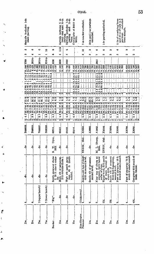
r-t.
Do .
....
....
.
Do ..
. ...
Do .
.... ..
...
Do .
... .
.. ..
.
Do...... ..
....
.
Do
-
Do
Do.... ..
... .
Do
Do .
.... -
Do
-
Do
Do.......... ..
.
Do
5 ..
....
.
6 _
__
__
-
7 (up
per b
ench
) .
7 (l
ower
ben
ch).
"B
ig"... ..
..... d
o
...
d
o .
......
d
o ...
I.. .
.... ..
......
2..
...
....
....
..
2..
....
.. ......
3..:.
... ..
.. ...
.
4......... ..
....
..... d
o..
....
.. .
_... .
,.
..... d
o...... ..
....
....
.
..... d
o... ..
....
d
o . _
....
....
..
Sou
th g
angw
ay c
hute
2,
20
ft a
bove
cou
n
ter.
H
igh
rib
of a
irco
urse
. 15
ft o
utsi
de c
hute
1.
Hig
h ri
b so
uth
gang
w
ay,
40
ft
insi
de
tunn
el.
Sou
thw
est f
ace
of s
hort
dr
ift o
n se
cond
leve
l.
Sou
th r
ib o
f cr
ossc
ut,
seco
nd le
vel.
Nea
r to
p of
chu
te a
t co
unte
r, 2
50 ft
bel
ow
colla
r of
slo
pe.
Upp
er le
vel,
10 ft
sou
th
of
mai
n tu
nnel
in
sh
ort
drif
t. So
uth
rib
of c
ross
cut
from
bed
2 g
angw
ay,
seco
nd le
vel.
Face
of
gang
way
10
ft
sout
h of
mai
n tu
nnel
.
Face
of
gang
way
75
ft
sout
h of
mai
n tu
nnel
.
Gan
gway
60
ft s
outh
of
mai
n tu
nnel
.
d
o... .
..... d
o..... .
-d
o..
...
.
....
.do .... .
B.
W.
Dye
r,
1922
.
d
o..
. .
. d
o.
...
US
BM
, 19
43- .
d
o
M.
L.
Sha
rp,
1924
.
US
BM
, 19
43..
d
o ..
...
d
o..
. .
....
.do
... .
....
.
d
o
B98
932.
.
B98
935.
.
B98
937-
.
B98
936-
.
8551
1 ....
85
51
2
85513
85514
X9991..
.
X9992
A1962..
.
X9702..
.
X9994
X9703
X9704
X9705
3 1 2 3 1 2 3 1 2 3 1 2 1 2 1 2 1 2 3 1 2 3 1 2 3 1 2 3 1 2 3 2 3 1 2 3 1 2 3 1 2 3
4.3
'37
.0'4
4.8
'13
.9
__
38.
7 4
6. 7
14.
6
.4
5.3
54
.7,
. 3.
9 3
0. 7
31.
4 3
4. 0
. 3
1.9
32.7
35.4
.... 4
9.4
50. 6
1
3. 2
34.
0 3
5. 6
27.
2
__
35.
1 36.8
28.1
.4
8.9
51
.11
.
3.8
39.9
43.9
12.4
_
_ 4
1.5
45.6
12.9
.4
7.7
,52.3
5.2
39.7
47.3
7.
8
4 8
4.6
4.9
3 3
3 5
5.8
~3~3 4
?,
3 5
3 5
3 4
41. 9
49.
8
39 6
41.6
40.6
42
5
40.1
42
.1
45.6
4?
04?
, ?,
43.f
i48
640
341
7
4fi
738
.8
41.2
44
.1
44.6
46.1
48.9
....
47 8
50.2
49.0
51
4
47.8
50
.3
54.4
53
,944
74f
i ?,
51
445
947
fi
53 3
49.1
52
.1
55.9
46
.648
.2
il
142
. 9 4
6. 7
44. 8
48.
747
. 9 5
2. 1
41
14
2.6
...
48 7
SO S
45. 8
54-
2
40 2
50 f
i41
. 7 5
2. 4
44. 3
55.
741.4
50.8
42. 8
52.
6
44.9
.55.
1
8 3
7.8
8.2 5.8
6 1
7.2
7.
6
9,8
10.?
10 3
10 7 6.3
6.7
"fi."
5
5.7
fi ?,
fi 5
fi 7
6,9
5.7
5 9
4 4
4.6
.3
.3 0 '.3
.3
.5
.2
.3
.4
.3
.3
.4 3 3 3 .3 .3 3 .3
.3
.3 fi 4 .4 .5 3 .3 .3 '.
3
.3
.3 3 .3 3 3 3 .3 4 ,4 .4 4 4 4 4 .4 4
5.2
'64
.71
.0'1
4.9
4.
9 6
7. 6
1. 1
11.
5
5. 8
79.
1 1
. 3 1
3. 5
4.
2 4
7. 3
, . 9
13.
3
3.94
9.31
.9
10
.2
6. 1
76.
2 1
. 4 1
5. 8
4.
7 5
4. 2
1. 1
12.
6
4. 5
56.
Oj 1
.1 1
0.6
6.2
77
.91
.61
3.9
5.
5 6
6. 4
1. 3
14.
1
5.3
69.1
1.3
11.1
6.
0 7
9. 3
1.5
12.
8
...
5.6
5.3
5.7
5.8
5.4
5.8
70.7
74
.3
80.3
70.9
75
.3
80.6
...
1.3
1.4
1.5
1.3
1.3
1.4
14.9
11
.1
12.2
15.4
11
.0
11.9
11.5
40
12, 0
60
14. 1
20
8.42
0 8.
770
13,5
60
9.76
0 10
. 080
14
,020
11
.940
12
. 410
14
.260
12
.450
13
, 120
12.5
00
13,1
40
12, 7
90
13. 4
10
12, 5
90
13,2
30
14,3
10
13, 5
10
12,3
60
12, 7
80
14,2
20
12, 3
4012
, 780
14
, 310
12
, 580
13
, 360
14
, 310
12
,880
13, 3
10
14,
110
12,5
2013
, 070
13
, 970
12
,830
13,2
90
14,2
90
13,0
3013
, 500
14
,340
13
,190
13, 6
50
14,3
10
2780
2910
+
2910
+
2910
+
2200
2200
2200
2910
3 6
4 6
1 6
1 10
6 0
5 11
VS
5 6
3 10
33
7 0
2 0
3 3
5 6
2 2
2 1
Sam
ple
Incl
udes
1-
ln
shal
e pa
rtin
g.
Sam
ple
incl
udes
6 i
nbo
ny c
oal
and
^i-i
npa
rtin
g.
Sam
ple
incl
udes
1-
inpa
rtin
g an
d >£
-inbo
ne.
Com
posi
te o
f 85
511
to85
513.
7-in
mar
ker
excl
uded
.
10-in
and
1-in
par
ting
s .
excl
uded
.
1-in
par
ting
exc
lude
d.
11 i
n of
ove
rlyi
ng b
one
and
16 in
of r
ock
in 5
pa
rtin
gs
excl
uded
fr
om s
ampl
e.
cn
CO
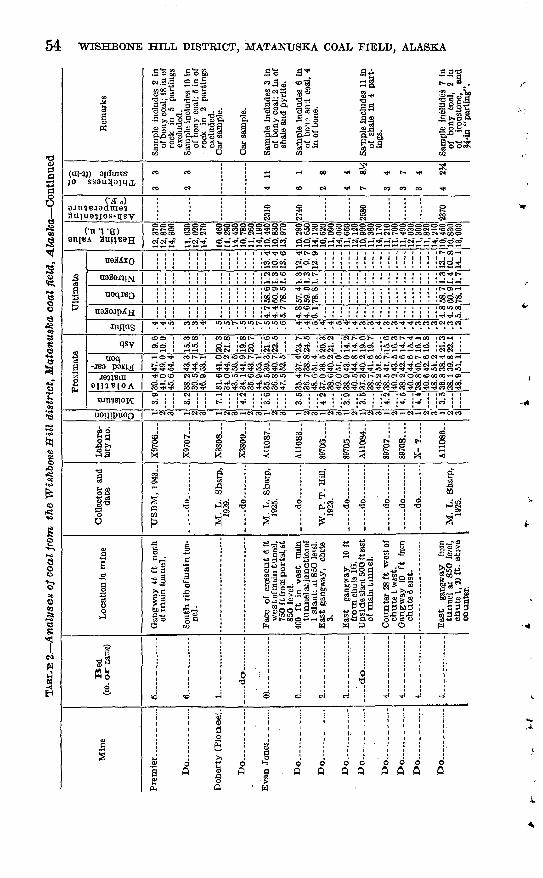
54 WISHBONE HILL DISTRICT, MATANUSKA COAL FIELD, ALASKA
.So 5'coSo <01
3-
joajdmes
CO M
& OO « ! t^ rft
Tf t- co co co
Jo)
S3oo< f-t^ecoooc ^HOSCOl-Hd11=
H rt"ci
qsy
uoqt-< -V (JD i-< CO » ry^fMiTfTCi
woo to O "3 i-> tO O5 U5 00 «O
oo T)< 10 d o o oo d to co t» >o co to t^ to N * oo i-i^ 00 * OO O -H CO -^ O ̂ ~« »M CO Cfl <* O d »-J OO O> *-?CO»OcOT)"OTI<^>"<liTi'iO Tf T«<_T»<_T)<ja< * IO CO CO >O_
N OOO tO CO 00 -H O>to O tO O O5 «O CO tOOOOCOOOOCOC
_________________ -^ co q' co 'i' *& co cIO I iC« I IO9 i«O i id l«5 IO< i i«O~
t- I ITJI i ICO i I CO I ! * I ICO ICO I l^< irt< ! ««« I ICO
i-l CM CO TH N CO r-l « CO i-i CN CO >-l d CO ,-1 CN rl N CO rt d »H CM i-l CM CO <-l N CO
ISss
\"o-sS g S S3s-^'S
,sis no o « os P O O
booA fl

Do
....
....
....
.
Do... .
...
._.
Do .
.. ..
..
Do .
Do....... .
....
Do.... ..
....
...
Do . . .
.
Do
Do
Do
Do
Do
Do .
... .
....
.
Do ..
...
6~.._
. ;..
.. .
8
8 ..
...
8- .
8 .. ...
10
Kel
ly
(Mal
t-la
nd),
upp
er
benc
h.
Kel
ly
(Mal
t-la
nd),
lo
wer
be
nch.
er b
ench
.
part
.
..
do
....
.. .
Eas
t ga
ngw
ay
from
tu
nnel
at
850
leve
l.
Sou
th r
ib w
est
gang
w
ay
20
ft
insi
de
chut
e 23
. R
oom
40
w
est,
11
cros
scut
.
Wes
t ga
ngw
ay
Inby
ch
ute
44.
Mai
n cr
ossc
ut t
unne
l at
850
lev
el.
Ext
ensi
on
of
mai
n cr
ossc
ut
tunn
el
at
850
leve
l. Sh
ort
tunn
el o
n ea
st
bank
of E
ska
Cre
ek.
Tun
nel
on w
est
bank
of
E
ska
Cre
ek,
chut
e 1.
....do ..
.. T
Tun
nel
on e
ast
bank
E
ska
Cre
ek.
Tun
nel
on w
est
bank
of
E
ska
Cre
ek,
chut
e 2.
T
unne
l on
wes
t ba
nk
of
Esk
a C
reek
, ch
ute
1.
Esk
a w
est
entr
y,
chut
e 1.
Fac
e of
sla
nt
at 9
60
leve
l, no
rth
limb,
30
0 ft
wes
t of
Sha
w
60 c
hute
. R
oom
19
w
est,
2d
cros
scut
ab
ove
950
leve
l, so
uth
lim
b.
....
.do .
M.
L.
Sha
rp,
1940
.
H.
B.
Hum
ph
rey,
193
7.
....
.do
... .
....
.
R.
Tuc
k, 1
935.
M.
L.
Sha
rp,
R.
Tuc
k, 1
935.
G. W
. E
vans
, 19
17.
. d
o.
.,
S.
S.
Sm
ith,
19
17.
G. W
. E
vans
, 19
17.
....
.do
.
....
. do
... .
....
.
L.
G.
And
er-
son
1945
.
M.
L.
Sha
rp,
1941
.
A11
085.
.
A98
201.
.
B25
076-
.
B25
077-
.
X-?
....
.
B56
287.
.
X-?
....
.
2873
1 ....
2873
2 _ .
2873
3....
28735
28734
X11
679.
.
B67
588-
.
1 2 3 1 2 3 1 2 3 1 a i 2 3 1 2 3 1 2 3 1 2 3 1 2 3 1 2 3 1 2 3 1 2 3 1 2 3 1 2 3 1 2 3
3.8
~5.~
2
'3.1 4.2
7.0
5.0
~6.~
7
4.8
"s'i
~S~i 4.9
T5."4 4.9
~'?
7
3.7
37.9
39
.4
46.6
34
.7
36.6
45
.7
38.7
40
.1
45.6
35.9
37
.5
47.2
35.1
37
.7
47 3
33.7
35
.4
45.9
37
.0
39.7
47
R41
.6
43.8
47
.2
42.0
44
.3
48.8
42
.0
44.3
47
941
.6
43.7
46
.4
39.1
41
.4
46.1
38.0
40
.0
49.0
34
135
.0
44.4
41.0
42
.6
48.0
43.3
45
.0
53.4
41
.4
43.6
54
.3
46.1
47
.7
54.4
40.2
42
.0
52.8
39.1
42
.0
52.7
39.6
41
.8
54.1
40
.5
43.4
55
? 2
46.7
48
.9
52.8
44
.1
46.4
61
.2
45.7
48
.1
ft? 1
48.0
50
.6
63.6
45
.8
48.3
53
.9
39.6
41
.6
51.0
42
.6
_15.0
15
.6
i8.~
7 19
.8
ii.'s
12.2
19.7
20
.5
18.8
20
.3
21.7
22
.8
is.~§
16.9 6.9
7.3
"O
9.3
7. 6
5.5
5.8
~9."7
10.3
17.5
18
.4?0
~6
43. 8
21.
2
55. 6
..
44.4
10.9
46
. 1 1
1. 3
52
. 0....
.3
.3
.3
.4
.5
.6
.5
.5
.6 .4
.4
.6 .3
.3
,3 .4
.4
.6
.3
3 .5
.6
.6
.4
.4
.5
.4
.6 .6
.6
.6
.3
.4
.4 .4 .4
.6 .5
.5
.6
5.3
5.0
5.9
5.2
4.9
6.1
5.4
5.2
5.9
5.0
4.8
6.0
5.1
4.8
6.2
-,
5.9
5.7
6.1
5.7
5.4
5,9
6.0
5.7
6.0
5.7
5.3
6.0
5.4
5.1
6, 3
5.7
5.5
6.2
64.4
66
.9
79.3
60
.6
64.0
79
.7
66.6
69
.0
78.6
61.0
63
.6
80.0
58.9
62
.0
80.3
71.2
74
.8
80.7
69
.0
72.7
80
-1
71.9
75
.fi
80. 3
68
.6
72.5
80
.7
62.0
65
.2
79.9
69.2
71
.8
81.0
1.5
1.6
1.8
1.3
1.3
1.7
1.2
1.3
1.5
1.2
1.2
1.5
1.3
1.3
1.7
-,-
1.6
1.7
1.9
1.5
1.6
1.8
1.6
1.7
1.8
1.5
1.6 " 1.5
1.8
1.5
1.5
1.7
13.5
10
.6
12.7
13
.8
9.5
11.9
14
.5
11.8
13
.4
12.7
9.
5 11
.9
12.6
8.
7 11
.2
13.9
9.
9 10
.7
14.6
10
.6
11.7
14.5
10
.6
11.3
14
.3
9.9
11.1
13.3
"9
.4
11.5
12.2
9.
4 10
.5
11,5
40
12,0
00
14,2
20
10,8
60
11,4
60
14,2
80
11,8
90
12,3
20
14, 0
30
10,8
50
11,3
20
14,2
50
10,3
90
11, 1
70
14,0
00
10,5
50
11, 1
10
14,4
00
11,0
6011
,860
14
, 270
12
,890
13
,550
14
, 610
12
.350
13
.020
13
,720
12
, 760
13
.440
14
, 640
13
, 030
13
, 710
14
.560
12
. 370
13
, 080
14
,580
11,1
50
11, 7
30
14, 3
70
11,0
2011
. 320
14
, 365
12, 4
10
12, 8
90
14,5
40
2740
2960
+
2680
2900
2910
+
--.-
.,
2570
o 7ti
5 5
4 3
5 3
4 11
H
5 9
2 9J
4
2 10
3 5^
2 4
2 8
2 8
3 10
Sam
ple
incl
udes
6 i
n of
bon
e an
d sh
ale
in
5 th
in p
arti
ngs.
Sa
mpl
e in
clud
es 7
in
of b
one,
sha
le,
and
rash
in
4 th
in p
art
in
gs.
Sam
ple
incl
udes
7 i
n bo
ne,
shal
e an
d ra
sh i
n 6
thin
par
t
ings
. Sa
mpl
e in
clud
es
5H
in o
f sh
ale
in 8
thi
n pa
rtin
gs.
2 ft
11
in c
oaly
sha
le
and
bone
in
3 pa
rt
ings
exc
lude
d.
-Sam
ple
incl
udes
VL
in
,sha
le n
ear
top.
ft
rSam
ple
incl
udes
^-i
n
' sh
ale
part
ing.
Thi
ckne
ss ra
nges
from
IV
i to
4 f
t av
erag
ing
abou
t 3 f
t- 1-
ln s
hale
par
ting
and
2
in
bony
co
al
at
roof
exc
lude
d.
Sam
ple
incl
r<bs
8 i
n bo
ny c
oal;
2 in
sha
le
and
12
in
bone
at
ba
se e
xclu
ded.
Und
erly
ing
14 in
bon
y co
al
and
clay
ston
e ex
clud
ed.
Sam
ple
incl
udes
2H
in
"iro
nsto
ne"
in
2 pa
rtin
gs.
Oi

TABL
E 2
. A
naly
ses
of
coal
fro
m th
e W
ishb
one
Hil
l di
stri
ct,
Mat
anus
ka c
oal f
ield
, Ala
ska
Con
tinue
d
Min
e
Esk
a m
ine-
- --
----
Do
-...
__ ..
...
Do
....
..
......
on K
nob
Cre
ek.
Bed
(no
. or
na
me)
Upp
er S
haw
....
McC
aule
y. .
Unn
amed
_ ..
Loc
atio
n, i
n m
ine
Cro
sscu
t tunnel
, sou
thlim
b.
. _ .d
o._
- .. .
.....d
o...
.... .
In s
ec. 1
0, T
. 19
N.r
R.
3E
.,rj
4 r
htle
s no
rth
ea
st o
f E
ska.
InS
EH
NIE
Hse
c. 1
0,T
.19N
.,
R.3
E.,
\Yi
mile
s nort
hea
st
ofE
ska.
Col
lect
or a
nd
dat
e
R.
Tuc
k, 1
935.
.....d
o- ..
.
. .d
o._
Q. W
. E
v,an
s,19
17.
T.
R..
Jolle
y,19
46.
Lab
ora
to
ry n
o.
X-?
....
.
X-?
.._._
X-?
.....
2883
6....
C617
84
.
a o o a 0 O
1
Pro
xim
ate
2 3 .2 o ^ 4.3
« = 2
>9
41.4
"s X h 41.8
2. .
..43.
3 43
. 63
. 4
9.8
1. 4
.64
0.3
ft().
243
82... .4
2.
3 45
. 93 _
_ 4
7.9
52.1
1 5.
6 3
9. 3
.
40 7
2 .
41. 7
43.
13
- _1 2 3
49. 1
50.
96.8
37.1
46.8
..
.
9 12.5
13.1
11
311
8
14 4
Ult
imat
e
en .4 .4 5 5 5 fi \15
.2
.3
9 3
__
139
.850
.2 1
0.0
-'4
4.2
55.8
....
122.4
35.9
. ..
..
.32
. 79
02
_ 46
. 2 4
2. 2
11.
fi3
52.3
,47.
7
4
a 2 a >* W
* s 0
.55.8
66.5
.6
.6 3 .4
5. 4
71.
3
6. 0
79.
2
a a>
ti *
a o
1. 2
16.
71
.31
1.4
1
.41
2.8
§ 00 S3
<£>
1 1,
940
12,
480
14,
540
12, 9
1014
, 65
011
.660
12, 3
4014
,580
11,8
9012
. 76
0 14
, 17
08
,51
01O
, 970
12,4
00
bfi
CDa
M
V
m«!T
<' 20
70
OB
a <D
X 0
,
aa
& 4 5
4 1J
S
4 4
9.
8
6 4
Rem
arks
Sam
ple
incl
udes
1-
insh
ale
part
ing.
1
6-in
cla
ysto
ne p
art
ings
exc
lude
d.
8
COAL 57
nated, has a dull luster and is dark brownish gray; the other consists of lustrous black coal containing laminae of carbonaceous claystone or dull bands of impure coaly material. Bone is commonly dark brownish gray, has a shaly parting, and is relatively heavy and tough compared with coal. Also classed as bone are layers consisting of alternating thin bands or lenses of relatively clean coal and carbona ceous claystone. This type of bone grades into coaly claystone by decrease in the number and thickness of coal lenses.
Many of the coal beds in this district, particularly in the eastern- part, contain unusually large amounts of bony material, which fact adversely affects the quality of coal that can be produced by washing. The results of a general coal-preparation study of coals from the Eska and Evan Jones mines by Geer and Yancey (1946, p. 17) led to the following conclusions regarding the beds that were being mined at the time of the study:
An important factor that must be considered in connection with the utilization; of coals from this district is that their specific-gravity composition imposes a lower limit for the ash content to which they can be washed with a reasonable yield of washed coal. This factor is inherent in the character of the coal and,, therefore, applies even when the coal is treated in modern, well operated, washing equipment. Washed coal having a minimum ash content of 14 percent can be produced, but only with a sharp sacrifice in yield. If coal of less than 18 percent ash is required, its enhanced value must justify the increased cost of preparing such a product.
Although no similar studies have been made of coal from the western part of the district, past experience at the Premier and Buffalo mines indicates that certain beds in the Moose Creek area are capable of yielding a much cleaner product than those of the Eska and Evan Jones mines.
DETAILED DESCRIPTION OP COAL BEDS
'Although the main coal groups were traced with reasonable certainty between the eastern and western parts of the district, the individual coal beds within the groups could not be so traced, owing to the scarcity of exposures and to lateral changes in character and thickness. For this reason the detailed descriptions of the coal beds of the two parts of the district are given separately.
EASTERN PART OF WISHBONE HILL DISTRICT
BURNING BED COAL GROUP
A series of thin but rather persistent coal and coaly claystone beds, not individually named, lies 200 to 300 feet stratigraphically below the Eska coal group. These beds are correlated with the Burning Bed coal group of the western part of the district on the basis of similarities in stratigraphic position and general character.
58 WISHBONE HILL DISTRICT, MATANUSKA COAL FIELD, ALASKA
About 300 feet inside the portal of the Eska crosscut tunnel the group consists of about 20 feet of coaly claystone, bone, and coal, including two coal beds about 2 feet thick and three thinner beds. On the north slope of Wishbone Hill at locality 25 the group has a total thickness of at least 35 feet and contains three coal beds 1 to 2 feet thick and several thinner beds and coaly zones. At locality 20 it is represented by a zone less than 15 feet thick containing one 12-inch coal bed and a few thinner ones; farther west the zone appears to pinch out.
ESKA COAL GROUP
The Eska coal group, comprising the Eska, Shaw, and Martin beds, has been mined extensively on both limbs of the Wishbone Hill syn- cline in the Eska mine. On the north limb it has been traced at the surface, by means of outcrops and auger borings, from the Eska fault zone westward to the Jonesville fault. Bed 10 and two adjacent un numbered beds in the Evan Jones tunnel are believed to be the con tinuation of the Eska coal group west of the Jonesville fault. This correlation was suggested by the general similarity of the beds, both as a group and individually, even to the presence of a hard clay part ing near the roof of the upper bed that closely resembles the. charac teristic Eska "marker". It is supported by comparison of complete stratigraphic sections of the Chickaloon strata exposed in the two areas, which reveals such striking similarity in the number, spacing, and character of coal beds as to leave little doubt of a general correla tion that matches bed 10 and the two adjacent coal beds -with the Eska coal group.
The Eska coal group is exposed at surface, localities 16, 17, 18, 20,21, ana 22,,on tne north slope of TFisnfeone Hill (pis, i, 0), Cor-relation of tKe coal. at tKese exposures xvitK tlie Eska coal group is
based on its gross resemblance to the group farther east, and on itsstratigraphic position- oelo-w oecl 8, -whose position is -well marked, by
many mine airways.
The lowest member of the Eska coal group is the Martin bed. which.as mined at Eska, generally consists of two benches of clean coal iy2 to 2 feet thick separated by 6 to 24 inches of coaly claystone. Thinner beds of coal and bone are commonly present in both the roof and floor.A coal bed locally as much as 2 feet thick closely underlies the lower
bench of the Martin but has never been mined. The main benches aswell as the partings range considerably in thickness, so that withinshort distances the bed may change from a minable coal bed with a relatively thin parting to two thin coal beds scarcely worth mining. In diamond-drill hole 13, northwest of Eska, which reached the Martin bed about 350 feet down the dip from the north-limb 960 level
COAL 5,9
of the Eska mine, the Martin consists of a single bed about Sy2 feet thick, of which the upper l 1/^ feet and the lower 3% feet are largely bone and the other 3^ feet is relatively clean coal (pi. 11, section 7).
The Martin bed was mined on both limbs of the syncline west of Eska Creek, but east of Eska Creek the only development was a short tunnel on the north-limb outcrop. It was identified in one, and possibly more, diamond-drill holes east of Eska Creek drilled in 1947 .(pis, 10, 12). In the NW^NW^ sec. 15, T. 19 N:, K. 3 E., the Martin bed in drill hole 1 includes two 3-foot benches, each containing two thin partings, separated by 1 foot of coaly claystone (pi. 11, sec tion 14); in drill hole 2 the bed contains a single bench of coal 1.6 feet thick underlain by several feet of interbedded claystone and bone; and in drill hole 3 it includes nearly 7 feet of slightly bony coal in three benches separated by 1-foot partings of claystone (pi. 12). In the SEi^SW1̂ sec. 10, the possible equivalent of the Martin bed in drill hole 7 is about 10 feet thick, including 6 feet of slightly bony coal, in three benches separated by 2-foot partings of coaly claystone(pl.12).I.In.the Evan Jones tunnel an unnumbered bed that lies about 20
feet below bed 10 has been correlated with the Martin bed (pi. 5). At this point it consists of an upper 2%-foot bench of relatively clean coal and two thinner benches containing 1 to 2 feet of clean coal(pi. 11, section 4). On the north slope of Wishbone Hill complete sections of the Martin bed were obtained only at localities 20 and 21. At both points the bed includes an upper bench containing less than 2 feet of coal and a lower bench composed of bone and a few thin coal layers. At locality 16 a section probably representing at least a part of the Martin bed includes a 1.7-foot.bed of clean coal (pi. 11, sections 1-3).
SHAW (NO. 10) BED
The Shaw bed of the Eska mine has been mined on the north limb of the Wishbone Hill syncline on both sides of Eska Creek and on the south limb west of the creek. In most places the Shaw bed consists of two distinct benches that are known locally as the upper and lower Shaw.
In the old East Shaw workings the upper Shaw is present only as a zone of coaly shale (Tuck, 1937, p. 206), but the lower Shaw consists of a 5-foot coal bed that includes 8 inches of shale in three partings and is somewhat bony at the base. The Shaw bed was found in several diamond-drill holes northeast of Eska. In drill hole 1 the upper Shaw (pi. 11, section 45) consists of 3.6 feet of clean coal, sep- a'rated by 2 feet of claystone and bone from the lower Shaw (pi. 11, sfection 30), which includes 5.8 feet of partly bony coal. In drill hole 2 the Shaw is essentially a single bed about. 12 feet thick, consisting
3.685.67^56, B
60 WISHBONE HILL DISTRICT, MATANTJSKA COAL FIELD, ALASKA
of partly bony coal and including two 1-foot shaly partings (pi. 12), In drill hole 3 the upper Shaw is about 6 feet thick, including a 1.7 foot coaly claystone parting, and the lower Shaw, beneath a 214-fbot claystone parting, contains a little more than 3 feet of clean coal grading into bone at both roof and floor (pi. 12).
In mine workings west of Eska Creek the upper Shaw ranges in thickness from 2% to 4 feet and commonly includes one to three hard claystone markers an inch or less in thickness. The lower Shaw has a total thickness of 3 to 5 feet but includes as many as five claystone partings 1 to 2 inches thick. The lower bed was mined to some extent on the north limb on both sides of Eska Creek; elsewhere it has not been mined, largely because it is too close to the upper Shaw to be mined separately and because the large amount of rock in the lower Shaw partings and in the thick parting between the two benches made the simultaneous mining of both benches impracticable.
In drill hole 13, northwest of Eska, the Shaw bed consists of two. 3-foot benches of bony coal and 1 foot of clean coal, separated by 3-foot claystone partings (pi. 11, sections 25, 40).
In the Evan Jones tunnel bed 10, the equivalent of the Shaw bed, consists of two benches, each about 2% feet thick, separated by 1 foot of coaly claystone (pi. ll, sections 18, 34). The upper bench is clean coal with a single siliceous claystone parting about inch thick. The lower bench includes only 1 foot of clean coal, the upper and lower parts being bony. This bed has not been developed in the Evan Jones mine.
At locality 21, Oil the north slope of Wishbone Hill, the Shaw bed consists of two benches of clean coal 14 to 18 inches thick separated by more than 2 feet Of coaly claystone. A similar section is exposed at locality 20, but farther west both benches become progressively thinner and grade into coaly claystone.
ESKA BED
The Eska bed, like the Shaw, was mined on the north limb on both sides of Eska Creek and on the south limb west of the creek. In the old Eska East Workings the bed ranges from 2y2 to 3i/2 feet in thick ness, including a few thin bony streaks and partings, In drill hole 1 east of Eska Creek the Eska bed Consists of a 3-foot bed of clean cod with a 3-inCll tone p»rting7 ^derlain by 6 feet of interbgdded COal and bone (pi. 11, section 62). In drill hol6 3 it consists o* ^i^t a feet of slightly bony coal, underlain by 3% feet Of dirty coal and bone (pi. 12). Possibly it is represented in drill hole 2 by about 4 feet of interbedded clean coal and bony coal, and in drill hole 7 by 8% feet of interbedded bony coal and claystone.
COAL 61
As typically exposed in the west Eska workings the Eska bed con tains 3 to 4 feet of coal, of which the lower 1 to 2 feet is bony and the upper part is relatively clean coal with no persistent partings. Lo cally this bed attains a total thickness of as much as 7 feet, but much of the added thickness consists of bony coal. The bed is thickest on the south limb and thinnest at the west end of the north-limb workings, where it contains little more than 2 feet of coal.
In the Evan Jones mine the Eska bed is represented by 2% feet of slightly bony coal that lies about 15 feet stratigraphically above bed 10 in the crosscut tunnel (pi. 11, section 50). At locality 21 it con sists of about 10 inches of coal, which grades downward through bone into coaly claystone. Between localities 17 and 21 the Eska bed in cludes 12 to 18 inches of coal underlain by bone, and at locality 16, it is represented only by a 10-inch layer of bony coal.
MIDWAY (NO. 9) COAL BED
When the Evan Jones crosscut tunnel was extended northward from bed 8 in search of underlying coal beds, a coaly zone was reached about 90 feet stratigraphically below bed 8 and was designated bed 9. A coal bed at a correspondingly stratigraphic position, roughly midway between the Eska and Emery beds, crops out in the west bank of Eska Creek in the SE!%NE% sec. 16, T. 19 N., B-. 3 E. At this point it includes two benches of clean coal 12 to 18 inches thick, separated by 3!/2 feet of coaly claystone. On the basis of its stratgraphic posi tion and general similarity this bed was correlated with bed 9 of the Evan Jones mine. Bed 9, in turn, occupies the same stratigraphic position as the persistent Midway coal bed in the western part of the district and is correlated with it.
The Midway bed was tentatively identified in three diamond-drill holes east of Eska Creek. In drill hole 1 it consists of two 1.3-foot benches of clean coal separated by 4 feet of claystone (pi. 11, section 71). In drill hole 3 it includes 2 benches of dirty coal, 1% and 2% feet thick, separated by 2^ feet of claystone and ironstone. In drill hole 7 the upper bench is 1% feet thick, including two 3-inch partings of pyritic iron carbonate, and is separated by 3 feet of coaly claystone from a lower bench containing 2y2 feet of clean coal (pi. 12).
In the Eska crosscut tunnel the Midway bed is not present in its expected position, apparently having been cut out by a fault. In an outcrop in the NE%NW% sec. 16, T. 19 N., R 3 E., it is represented by a coal bed consisting of two benches about iy2 feet thick separated by 3 feet of coaly claystone (pi. 11, section 68). This bed was previ ously identified by Chapin (1921, p. 198) as the Emery bed, and its nearness to the underlying Eska bed was cited by Tuck (1937, p. 192) as evidence of rapid thinning of the intervening strata, but its iden-
62 WISHBONE HILL DISTRICT, MATANUSKA COAL FIELD, ALASKA
tity as an intermediate bed was established during the present inves tigation by tracing the Emery and other beds of the Premier group, by means of trenches and auger borings, to positions more than 100 feet higher stratigraphically on the ridge to the south.
In drill hole 13, northwest of Eska, the'Midway bed consists* of three 1-foot coal layers separated by 2y2 to 3 feet of rock (pi. 11, section 69). In the Evan Jones tunnel bed 9 is represented by a 12-foot coal zone that includes three layers of coal 1 to 2 feet thick (section 67). On the north slope of Wishbone Hill the Midway bed is represented by a coaly zone of variable thickness, including one or two thin coal layers, at localities 16,17, and 20 (sections 63, 64, 66).
PREMIER COAL GROUP
Although some question exists as to what should properly be called the base of the Premier coal group in the eastern part of the Wishbone Hill district, in the present report it is assumed to be the base of the Emery (No. 8) bed.
EMEEY (NO. 8) BED
The Emery bed was first mined on the west side of Eska Creek, in the NE^NE^ sec. 16, T. 19 N., K. 3 E., where it has a total thickness of 7^2 feet, including 5*4 feet of clean coal (pi. 11, section 83). It was also mined in the old Emery East workings, where a typical Section measured 5y2 feet in total thickness, including 4 feetof coal (section 84). The Emery bed could be positively identified, in only two drill holes east of Eska Creek. In drill hole 1 it consists of a single 3^-foot bed of clean coal, (section 85) and in drill hole 3 it includes, from the top downward, 2.2 feet of bony coal, 3 feet ofcontorted siltstone, and 0.8 foot of bony coal. As this section differs markedly from that Of the old mine workings a few hundred feet
to the west, it seems probable that the bed, where crossed by drill hole3, was disturbed by faulting.
In the Eska tunnel the Emery bed includes a lower bench about 314feet tllick, nearly half Of Which IS bone, separated by about 5 feet of
coaly claystone from an upper bench, of which all but 1 fGot 01 dean
coal has been cut out by faulting (pi. 11, Section 82). In drill hole13 the Emery bed has a total thicuness 0* e *eot, «* WhiCK neE,riy 4.feet is clean coal (section 81). In the FP/4 S6C. 16 tllO J^W] 1)6(1
was traced at the surface between the Eska fault zone ana the jones-VJlle fault toy means of auger borings and a few trenches. The bed
as exposed In two trenches a short distance east of the Jonesville fault, is more than 5 feet thick, including several thin claystone partings (sectionSO)-. ' '.-.'.;.
COAL .... ; - 63
In the Evan Jones mine bed 8 has a total thickness of as much as 7 feet, including several claystone partings, but generally only the lower 5 feet, including several thin partings, was mined (pi. 11, sections 77, 79). In surface exposures at localities 15, 16, 17, 19, arid 21, bed 8 includes 3 to 4^ feet of fairly clean coal (sections 72-76). Bed 8 was not traced west of locality 15, but it may be represented by coal at the base of the Premier coal group on Moose Creek.
DAVID (NO. 7B) BED
The David bed was mined to a small extent on both sides of Eska Greek and has been traced at the surface on the north side of Wishbone Hill westward to the Jonesville fault. West of the fault, a coal bed in a corresponding position over the Emery (No. 8) bed was traced through several surface exposures to locality 15.
In the old David East tunnel the David bed contains less than 2 feet of clean coal, and in drill hole 1 it consists of 2^ feet of'bony coal (pi. 11, section 90). It is not-present in drill holes farther east, which lie beyond its line of outcrop. In the west bank of Eska Creek the David bed is about 3 feet thick, and in drill hole 13, northwest of Eska, it includes two benches of bone and bony coal, each less than 2 feet thick (section 88). West of the Evan Jones crosscut tunnel, where it is known as bed 72?, it is believed to be represented by a double bed with benches ranging in thickness from 1 to 3 feet. Sections that probably include bed IE were measured at localities 15,16,17, and'23 (sections 113, 114, 115, 120).
, MAITLAND (NO. 7A) BED
The Maitland bed was first opened by a tunnel on the west bank of Eska Creek, where it was known as the Kelly bed, and it was mined to some extent east of the creek, where it consists of upper and lower benches, 4 to 7 feet apart, ranging in thickness from iy2 to 2 feet and from 2% to 3% feet, respectively (Chapin, 1920, p. 159); In drill hole 1, northeast of Eska, it consists of an upper 2^-foot and a lower 2-foot bench of clean coal, separated by 8 feet of coaly claystone and bone (pi. 11, section 95). In an outcrop on the west bank of Eska Creek an upper 3-foot bench of clean coal in the Maitland bed is separated by 6 feet of coaly claystone and bone from a lower 3^-foot bench with a band of ironstone nodules near its center (section 94). The Maitland bed is not exposed in the Eska tunnel, which probably passes beneath it at the synclinal axis. In diamond-drill hole 13 northwest of Eska the Maitland bed includes two benches of partly bony coal about 2 feet thick separated by Sy2 feet of coaly shale and bone (section 93). At the western edge of the NW^NW^ sec. 16,
64 WISHBONE HILL DISTRICT, MATANTJSKA COAL FIELD, ALASKA
T. 19 N., R. 3 E., a bed identified by Tuck as bed 7J. includes an upper 2%-foot bench and a lower 2-foot bench separated by 6 feet of coaly shale (section 92).
In the Evan Jones tunnel bed 7A consists of an 8%-foot coaly zone that includes only 2 feet of clean coal, mainly in a single bed near the base (pi. 11, section 91). The exact position of bed 7A in coal sections measured farther west, in outcrops on the north side of Wishbone Hill, is not known, but it probably is included in sections measured between localities 15 and 21. (Sections 113-118.)
CHAPIN (NO. 7) BED
The Chapin bed has been exposed on both sides of Eska Creek in the NE^NE^ sec. 16 and was developed by a short tunnel on the east side. The bed east of Eska Creek contains at least 4=y2 feet of coal in two benches separated by about 2 feet of shale, (pi. 11, section 100) but a section by Chapin (1920, p. 154) on the west side of the creek shows only a single 2-foot bed in a corresponding position over the Maitland bed. In drill hole 13 northwest of Eska the Chapin bed contains 4 feet of coal, including a thin layer of bone (section 99). A 4-foot bed of coal and bone 18 feet above the Chapin in the drill hole may be a split from the Chapin as exposed on Eska Creek. In a trench across the Chapin bed north of drill hole 13 the bed appeared to contain 9 feet of coal in two benches separated by 1 foot of claystone, but this thickness is questionable because the bedding was poorly shown and locally disturbed. Farther west, in a trench just east of the Jones- ville fault, the Chapin bed consists of two benches of coal more than 3 feet thick separated by 5 feet of coaly shale (section 97).
In the Evan Jones tunnel bed 7 consists of an upper 1-foot bench of coal, a 3-foot parting of claystone and bone, and a lower 3-foot benchof partly bony coal (pi. 11, section 96). Coal sections that may include bed 7 were measured at localities 15, 16, 17, 19, and 2O (sections 113,
114, 115, llf, 118).BED 0
No GOal beds above the Chapin have been developed in the Eska, area,
but a bed corresponding in stratigraphic position to bed 6 of the EvanJOneS mine Was exposed by trenching in the NW^NWi/i sec. 16, T. 19 >r., n. 3 E. Th© ted at this point consists of two benches of cleancoal about 2% and 4 feet thick, separated by i foot of ooai7 d^one(pi, 11« Section 104). In drill hole 13, bed 6 contains 6 feet of coal in
three benches, including an upper 4-foot bench of partly bony Coal andtwo lower benches less than 1% feet thick (section 105).
In the Evan Jones tunnel bed 6 consists of an upper 3-foot bench containing 2 feet of clean coal and a lower 5i/£-foot bench that includes three partings of claystone and iron carbonate 3 to 5 inches thick (pi.
COAL 65
11, section 103). About 2,000 feet west of the main tunnel in bed 5 gangway, where a fault has thrown bed 6 opposite bed 5, bed 6 consists of an upper 2-foot bench of clean coal separated by Tl/2 feet of clay- stone from a lower 4-foot bench including a 6-inch zone of dirty coal (section 102).
On the north slope of Wishbone Hill, bed 6 is probably represented at locality 17 by a 7-foot bed including 6 feet of coal (section 115). Farther west it is probably present near the top of sections of the Pre mier group measured at localities 15 and 16, where poor exposures and minor faulting precluded positive identification of individual beds. < See sections 113,114).
BED 6
Bed 5 was first found in the Eska area by trenching about 5Q feet stratigraphically above bed 6 in the NW^NW^ sec. 16, T. 19 N., K. 3 E. A partial section of the bed, obtained by trenching and auger bor ing, revealed three benches of coal, 1 foot, 4 feet, and 6 plus feet thick, in a total thickness of about 17 feet (pi. 11, section 111). The upper and lower benches include a few ironstone nodules, and the base of the lower bench was not found. In drill hole 13 to the east, bed 5 has a total thickness of 21 feet, including an upper 11-foot bench of partly bony coal and a lower 2^-f oot bench of slightly bony coal, separated by 8 feet of interbedded bony coal and claystone (section 112).
In the Evan Jones crosscut tunnel bed 5 has a total thickness of 9 feet but is very dirty, including less than 4 feet of clean coal in several thin benches (pi. 11, section 109). In the gangway 1,500 feet west of the tunnel, bed 5 has an exposed thickness of 22 feet, including an upper 15-foot bench of partly bony coal with several thin rock part ings and a lower bench containing at least 3 feet of clean coal (section 107). West of the fault that brings beds 5 and 6 together 2,000 feet west of the main tunnel, bed 5 has a total thickness of 23 feet, but in cludes many thin partings and about 6 feet of bone (section 106).
Bed 5 may be represented on the south limb in the Evan Jones tunnel by one or both of two coal beds, designated beds 0 ond 00, that appear to lie in a corresponding stratigraphic position below the Jonesville coal group. (See pi. 7, section G-0''.) According to sections given by Tuck (1937), pi. 13, sections' 29, 30) each of these beds, which are less than 10 feet apart, contains more than 5 feet of coal with a few bone and shale partings.
Bed 5 is well exposed at localities 15, 17, and 21 on the north side of Wishbone Hill, where it contains 4 feet or more of clean coal and at least 8 feet of bone and bony coal. At locality 16 the upper part of the Premier coal group consists of a series of thin beds of coaly clay stone, bone, and bony coal in which neither bed 5 nor bed 6 could be positively identified. (See pi. 11, sections 113-115.)
66 WISHBONE HILL DISTRICT, MATANUSKA COAL FIELD, ALASKA
JONESVILLE COAL GROUP i
Beds of the Jonesville coal group were originally developed on the south limb of the Wishbone Hill syncline at Jonesville. The same series of beds was identified in surface exposures on the north liml? opposite Jonesville and at localities 14,15, and 16 (pi. 5). The Jones ville coal group has not been identified between the Jonesville and Eska fault zones on the north limb, either in outcrops or drill holes; east of the Eska fault zone it has been entirely removed by erosion.
BED 1
Bed 1 was discovered in the upper tunnel of the Evan Jones mine but was not developed, as it consisted only of a 7-foot bed of coaly shale. A similar bed at a corresponding stratigraphic position on the north limb, at locality 24, is 5 feet thick, including a few layers of coal. At locality 15 the same bed is 8 feet thick, including 3^ feet of partly1 bony coal in three benches, and at locality 14 it consists of a single 3-foot bed of bony coal.
BED 2
In the old south-limb workings of the Evan Jones mine bed 2 is reported to have had an average thickness of 2 feet 8 inches and apparently was rather dirty, as analyses show it contained more than 20 percent ash. On the north side of Wishbone Hill bed 2 probably is represented by the lower parts of the thickest coaly sections measured at localities 14, 15, and 24. (See pi. 11, sections 121, 122, 124.)
BED 3
Bed 3 was the most extensively mined coal bed in the old south-limb workings of the Evan Jones mine, where available sections indicatethat it ranged in thickness from ^1^ to 1Q feet, including a fevr thin
clay markers and a 6-inch shale parting. A coal bed that is believedto represent bed 3 on the north limb of the Wishbone Hill synclinewas developed by driving a branch tunnel from the main Evan Jonescrosscut tunnel westward through the Jonesville fault zone. Near the fault the bed has a total thickness of 12 feet, including several thin
claystone partings (pi. 11, section 130). Westward as far as chute 87, more than a mile from the crosscut tunnel, bed 3 ranges between13 and 16 feet in total thickness, including several rock partings fvnd
bony layers (sections 125-129). At locality 24, bed 3 is 13 feet thick, including T inches of bony
^oal a, 1-foot ola.ysto:ne parting-- ancl sever-a.1 tlim ola-ystono markers
(pl. 11, section 124). At locality 16 a coal bed at least 8 feet thick, including three claystone partings 2 to 5 inches thick, probably repre sents bed 3, although neither roof nor floor was exposed (section 123):

. , ::,:... COAL V67
The upper 7 feet of .a coal section exposed at locality. 15, including 4 tfeet of coal in three benches, probably represents the lower part of bed 3. A complete section of the same bed is exposed at locality 14, where it has a total thickness of at least 12 feet and includes three benches of relatively clean coal 2% to 3 feet thick, interbedded with bony coal and clay stone (section 121).
BED 4
Bed 4, the uppermost coal bed of the Jonesville group, has been .mined only in the old south-limb workings of the Evan Jones mine, where it lies about 35 feet above bed 3 and is reported to contain 3 to 4 feet of coal. Bed 4 has not been developed on the north limb, as the branch tunnel to bed 3 apparently crossed the Jonesville fault north of it. No attempt was made to explore bed 4 near the fault, but a diamond-drill hole in the roof of bed 3 about a mile west of the fault reached 1 foot of coal about 40 feet stratigraphically above bed 3, indicating that bed 4 thins westward.
No surface exposures of. bed 4 were found on the north slope of Wishbone Hill, where its inferred position is largely covered by talus from the overlying conglomerate. At locality 24 coal was found in an auger hole at the inferred position of bed 4, but its thickness, was not determined.
COAL, BEDS FOUND IN DRILL HOLES
The preceding descriptions included coal beds that have been corre lated with reasonable certainty with beds in the various mines : in'the ' district. The following descriptions are of coal beds found in diamond-drill holes, that for the most part could not be positively correlated with known beds, either because of lack of information orbecause they are previously unknown beds lower in the section.i;
DRILL HOLES NORTHEAST OF ESKA
Nine diamond-drill holes were completed by the U. S. Bureau of Mines in 1947 and 1948 in an area northeast of Eska. Drill holes .1-5 are in the NW% sec. 15, T. 19 N., R. 3 E.; drill holes 6-9 are in '.the Sy2 sec. 10, T. 19 N., E. 3 E. (pi. 1). True-thickness logs of the principal coal beds in these holes are shown in plate 12.
Drill hole 1. Drill hole 1 is close to the axis of the Wishbone Hill syncline and passed through all coal beds of the Premier and Eska coal groups, from the Maitland to the Martin, inclusive. As the section in the drill hole corresponded closely with that compiled from nearby mine workings and outcrops the coals beds were easily identified. -Detailed sections of the principal coal beds in drill hole 1 are included with other sections of the same beds on plate 11. . .
68 WISHBONE HILL DISTRICT, MATANUSKA COAL FIELD, ALASKA
Drill hole 2. Drill hole 2 reached bedrock below the Premier coal group and extended to the base of the Eska coal group. The Eska and Shaw beds were found to consist of 4 and 12 feet, respectively, of bony coal, and the Martin bed to be a dirty seam including less than 2 feet of coal.
Drill hole 3. Drill hole 3 apparently entered bedrock just below the David bed, as the top coal penetrated, judging from its position relative to nearby old mine workings, is the Emery bed. The bed in the drill hole contains only about 2 feet of coal, compared to 4 feet in the mine, which, together with the condition of the core, suggests that part of the bed in the drill hole had been cut out by faulting. The Midway (no. 9) coal bed, reached at 250 feet, consists of two thin benches of bony coal. The entire Eska coal group was found between depths of 518 and 602 feet.
Drill hole 4- Considerable uncertainty exists as to the identity of coal beds in drill hole 4 because of lack of information on the local structure and the considerable difference in the sequence of beds from the known section to the west. Detailed sections and tentative correlations of the coal beds are given in plate 12.
Drill hole 5. The sequence of beds in drill hole 5 bears little re semblance to the known section of the Chickaloon formation in the Eska mine area. This fact, together with the position of the hole with respect to the probable projection of the Eska coal group north eastward from known exposures near Eska Creek, indicates that the beds in drill hole 5 lie below the Eska coal group. On this basis all the coal beds penetrated with the possible exception of the top coal at 20 feet, which may be the Martin, and a group of thin beds between depths of 300 and 350 feet, which may represent the Burning Bed group are new beds not previously described.
Drill hole 6. The beds in drill hole 6, for the same reasons stated for hole 5, probably all lie below the Eska coal group. The coal beds below 583 feet in drill hole 6 are probably the same as those below 566 feet in hole 5, as both groups of beds immediately underlie morethan 10O feet of massive sandstone.
Drill hole 7, Although the position of the axis of the WishboneHill syncline has been established for only a short distance northeast of Eska Creek, drill hole 7 is believed to lie on the north limb not far from the axis, and to pass through the Premier and Bska coal groups. The beds at depths of 60 and 102 feet probably represent the Maitland and David beds. The bed at 212 feet could be the Emery, except thatit is mucn rartner MOW me David feed man it is in drill Hole 1. A comparison of the logs of several drill holes suggests the possibility that the Emery bed pinches out southwest of drill hole 7 and a new bed comes in at a lower position in the section and is represented by

COAL 59
the coal at 212 feet in hole Y. The Midway bed and the Eska coal group appear in their expected positions, but the coal of the Eska group is exceptionally dirty.
Drill holes 8 and 9. Drill holes 8 and 9 are so far from areas of known structure and stratigraphy that none of the coal beds found could be positively identified. The uppermost beds in drill hole 8 possibly represent the Eska coal group; all the coal in drill hole 9 probably underlies the Eska group.
DMLL HOLES NORTHWEST OF ESKA
Three core holes were drilled by the U. S. Bureau of Mines in 1945 northwest of Eska, in the NW% sec. 16, T. 19 N., R. 3 E. (pi. 1). The results of this drilling have been published (Barnes, 1951 p. 193- 201). A graphic log of drill hole 13 appears in plate 10, and detailed sections of the coal beds penetrated are included in plate 11. Detailed sections of coal beds penetrated in drill hole 15, believed to represent the Premier coal group, are included in plate 15, No coal was found in drill hole 14.
DRILL HOLES WEST OF JONESVILI.E
Core drilling to check the presence and character of coal beds on the south limb of the Wishbone Hill syncline west of Jonesville was started by the U. S. Bureau of Mines late in 1948 and continued through the 1949 season. Eight drill holes, ranging in depth from 411 to 1,358 feet, were completed along the south base of Wishbone Hill, in sees. 19 and 20, T. 19 N., E. 3 E. (pi. 1). In addition, one shallow hole was drilled by the Evan Jones Coal Company a short distance northeast of the easternmost hole of the Bureau of Mines.
The correlation of coal beds found in drill holes in this area was much more difficult than was anticipated. The nearest known coal beds, in the old south-limb workings of the Evan Jones mine, are of variable strike and dip and are separated from the drill holes by the Jonesville fault, so that they could not be projected into the drilled area with any confidence. Also, the sequence of beds in all but one of the drill holes differed too greatly from the Evan Jones mine sec tion to permit unquestioned correlation on stratigraphic evidence. Drill hole 1 is believed to include beds of all three coal groups (pi. 10), but the sections of the other drill holes differ so markedly from the mine section and from each other that no reliable correlations could be made. Detailed sections of the principal coal beds in these drill holes are given in plate 13. The top coal beds shown in drill holes 1 and 3 possibly represent the Jonesville group, and the bed at 899 feet in drill hole 7 may be one of the Eska coal group. The Eska group is probably also represented in hole 3, but the beds are too thin to be of

70 WISHBONE HILL DISTRICT, MATANTJSKA COAL FIELD, ALASKA
value. :Other coal beds shown on plate 13 most probably represent the Premier group.
The reason for the marked disparity in the sections of the several drill holes is not known, but it probably involves several factors, pos sibly including abrupt lensing of beds, local contortion of the weaker coal-bearing rocks beneath the stronger conglomerate during the fold ing that produced the Wishbone Hill syncline, and faulting, either tectonic or related to landslides. Evidence of faulting in the form of lost core, intensely sheared core, and extremely variable dip of bed ding, was especially abundant in drill hole 2, strongly suggesting that the drill hole is within the southwest extension of the Jonesville fault zone. (See pi. 1.)
In view of the conditions found in the drill holes along the south edge of the conglomerate mass that caps Wishbone Hill, it was de cided in 1950 to attempt to churn drill through the conglomerate cap ping to reach the coal-bearing strata near the syncline axis, and then continue through the coal measures with the core drill. In the four holes completed by the end of the 1952 field season this involved churn drilling to depths of 1,150 to nearly 1,300 feet, and continuing with the core drill to 2,100 feet, the practical limit of the equipment in use.
Reliable correlations are believed to have been made of the coal beds found beneath the conglomerate. (See pi. 14.) The uppermost group of coal beds in drill holes 10, 11, and 12 is thought to be the Jonesville group, to which it corresponds in general character and position relative to the overlying conglomerate. This group appar ently is lacking in the log of drill hole 9, having either been cut outby faulting or bypassed, through poor core recovery, in a highly sheared zone at about 1,500 feet. This interpretation is supported bythe striking similarity, of the sequence of coal beds in drill hole 9 tothe lower group of coal beds in drill hole 11, which almost certainly represents the Premier coal group. All four holes are believed to have passed through the entire Premier group, with the possible exceptionof hole 12, which may have stopped short of bed 8, The Eska groupapparently was readied only by drill hole 11, where it consists of a
few thin coal beds, confirming evidence obtained from outcrops onthe north limb that this group is not minable in the western part ol
the Evan Jones lease.Detailed Sections Of the principal coal beds in drill noles 9 to 12
appear on plate 15.
WESTERN PART OF WISHBONE HILL DISTRICT
The Burning Bed coal group is exposed in the western part of the district only on the limbs of the Burning Bed anticline, at locality 3 (pi. 8). On the northwest limb the entire group is exposed and

COAL
consists of eight'beds in a sequence about 125 feet thick (pi. 16, sec. 35). The lower five beds are exposed on the southeast limb. The eight beds aggregate about 25 feet in thickness and contain about 13.5 feet of clean coal and 3 feet of bony coal. The remainder is bone, coaly claystone, and claystorie in partings 2 to 19 inches thick. The rock intervals between beds ranges from 3.5 to 26 feet. The thickest bed, the second from the bottom, contains 2.5 to 3 feet of clean coal that is free of partings but contains a persistent zone of ironstone concretions 4 to 5 inches thick. A small amount of coal was taken from this bed in a tunnel, long abandoned, that was driven under the bluff at locality 3. The tunnel was opened and examined by the Geological Survey party. The beds were measured in a crosscut tunnel that entered both limbs of the anticline and were found to be similar to those exposed in the bluff above the mine. The beds are highly sheared and faulted at the axis of the anticline. In recent years there has been further prospecting, and a small amount of coal has been mined at this locality.
The Burning Bed coal group was reached by drill hole 6 near the Premier mine, where the sequence was found to be about 70 feet thick and to contain seven beds of coal. The beds are similar in general character and thickness to those at locality 3. The total thickness of the coal beds is about 20 feet, which includes 8.2 feet of clean coal and 5.5 feet of bony coal. The thickest bed of clean coal is 2.5 feet.
Diamond-drill holes 1, 2, and 5 in the Buffalo mine area passed through four well-defined beds of the Burning Bed coal group, which is here 50 to 60 feet thick. The coal beds are thicker and contain fewer partings than those at locality 3 and in hole 6. (See pi. 17.) The logs of the beds differ considerably from hole to hole, probably in part because of differences in core recovery, and possibly also because of faulting, evidence of which was seen in some cores. The log of drill hole 1 is probably the most representative, as core recovery was best and no faults were indicated. In this hole the group includes two 3^-foot beds and one 4%-foot bed of clean coal and one 5-foot bed of bony coal (pi. 17).
Beds believed to represent the upper part of the Burning Bed coal group were found in the crosscut tunnel of the Matanuska Center mine, where they occur just inside the overburden at the portal. Ac cording to a log by J. J. Corey, former district mining supervisor, the lower bed, which is adjacent to the overburden, contains 6.5 feet of clean coal and three partings of bone and claystone that are 2 to 4 inches thick (pi. 16, sec. 37). It was known as bed 1.
... ,': . ESKA COAL GROUP
Beds of the Eska coal group were found in drill holes 1, 2, and 4 in the Buffalo mine area. Parts of the group have been eliminated
72 WISHBONE HILL DISTRICT, MATANTJSKA COAL FIELD, ALASKA
by faulting in holes 1 and 4 (pi. 5), but in hole 2 four beds were found and are believed to represent the entire group. The beds con sist mostly of clean coal ranging from 2.3 to 2.7 feet in thickness. Beds of the Eska coal group do not crop out in the Buffalo area, but two of them have been exposed in the powder-house tunnel (pi. 16, sec. 30). One bed is thin but the other contains 3.5 feet of clean coal in which there are two zones of ironstone concretions less than 6 inches thick.
Diamond-drill hole 10 passed through a group of four coal beds, between depths of 103.5 feet and 183 feet, that are rather similar to the four beds of the Eska coal group in drill hole 2 (pi. 17). The thickest of the four beds contains 5.7 feet of coal, mostly clean, that occurs in two benches separated by 1.5 feet of coaly claystone. The group of coal beds found between depths of 551 and 595 feet is believed to lie on the opposite limb of an anticline and to be a repetition of the group found higher in the hole.
A bed of the Eska coal group is exposed on the southeast limb of the Eawson anticline at locality 8. It is 4.2 feet thick and consists of four layers of clean coal, totalling 3 feet, separated by three partings of coaly claystone and claystone (pi. 16, sec. 31). Three beds' of the group are exposed at locality 11 (sec. 33). The middle bed of the three is 5.8 feet thick and consists of clean coal except for two part ings, 7 and 2 inches thick. The lowest bed probably is equivalent to the bed at the base of the group in the crosscut tunnel of the Matanuska Center mine (sec. 32), which is 800 feet southwest of locality 11. J, J. Corey described most of the group in the crosscut as carbonaceous shale with seams of bony coal. The Eska coal group was not mined here.
A thick coal bed is poorly exposed near the top of the bluff on thesoutheast side of Moose Creek between localities 3 and 4. It is believed tO be part Of the Eska COal group because it lies on the southeast limb
and near the axis of the northeast-plunging Burning Bfid ailUClillG 9,fc
a point northeast of and down the plunge from exposures of the Burn ing Bed coal group. A. section of this bed (pi. 16, sec. 29) shows 5.6feet of clean coal containing three claystone partings 2 to 3 inchesthick, and a ZOne Of ironstone concretions. The reliability of the sec
tion is irrvpaln-ed by slumping in the OutcrOP, but tllG bfid Probably ISat l6aSt t> feet thick, A tunnel has been driven into the top of the biuff
about 1,800 feet southwest of this bluff exposure and also on the South east limb of the Burning Bed anticline, The tunnel, which is acrossthe Premier fault from locality 2, reached a bed of coal 5.7 feet thick.
It consists of fairly clean coal, except for several partings less than 2 inches thick and some ironstone concretions. As shown on plate 8, the bed evidently overlies the Burning Bed coal group and is believed to be part of the Eska coal group.
COAL 73
MIDWAY COAL BED
The Midway bed was identified in three drill holes, three mines, and two outcrops in the western part of the Wishbone Hill district. It averages 7.5 feet in thickness1, including 6.0 feet of clean coal and 0.6 foot of bony coal. The remainder, which averages 0.9 foot, is com monly in two or three partings of bone, coaly claystone, and claystone or layers of ironstone concretions. Although the bed appears to be of minable thickness and quality it has not been developed, probably because of the greater quantity of coal in the Premier coal group.
Sections of the Midway bed measured in outcrops and mine workings are shown in plate 16 (sec. 24^28), and those measured from cores are shown in plate 17. The bed is thickest in the Matanuska Center mine and at locality 11, where it measures 11.9 and 9.7 feet respectively. Cores from drill hole 2 near the Buffalo mine indicate 7.4 feet of coal that contains a 5-inch parting of bone, whereas only 400 feet away in hole 1 a bed at this stratigraphic position is 4.7 feet thick and is separated from a 1-foot bed by 4.3 feet of shale. The lesser thickness in hole 1 is probably due to faulting. Only the upper part of the Mid way bed in hole 10 is shown in plate 17; recovery of the lower part of the bed was poor.
PREMIER COAL GROUP
The Premier coal group is 90 to 100 feet thick and consists of a series of relatively closely spaced beds. Outcrop and mine sections of the group are shown in plate 18 and drill-hole sections in plate 17. Clean coal constitutes about one-third of the total thickness of the group, except in the Matanuska Center mine and at locality 11 northeast of the mine where coal makes up more than two-thirds of the exposed part of the group (pi. 18, sees. 15,16). The uppermost beds at these two localities are concealed.
The coal beds in the Premier and Buffalo mines as shown in sections 1 and 4 (pi. 18) may be correlated bed by bed. The correlation is indi cated in the following tabulation.
Correlation of coal beds in the Premier and Buftalo mines
Beds in Premier mine
1 ___ ......1A__________2 ____ ....2A... ..__._.2B_______.__
Beds in Buffalo mine
76543
Beds in Premier mine
3A__.- _3---..--...4__ ........4A__.._..__
Beds in Buffalo mine
Unnumbered2
UnnumberedUnnumbered
Diamond-drill holes 3 and 9 in the Buffalo area indicate that an additional coaly section about 13 feet thick overlies bed 7; part of this
74 WISHBONE HILL DISTRICT, MATANTTSKA COAL FIELD, ALASKA -
section is exposed in the Buffalo crosscut tunnel between bed 7 and the face. This uppermost part of the group is not exposed in the Premier mine, where the workings did not extend beyond bed 1.
The stratigraphic position of the coal beds shown in sections & through 12 (pi. 18), in and adjacent to the Eawson mine, is unknown^ The same is true of sections 17 through 20 in the area northeast of the Matanuska Center mine. The structure in this area is very com plex, and it is suspected that both duplication and elimination of beds or parts of beds has resulted from faulting. . ;
Premier bed 3. Most of the coal produced in the western part of the Wishbone Hill district has come from a bed in the lower part of the Premier coal group. This is bed 3 of the Premier mine, the "Big bed" of the Baxter mine, bed 2 of the Buffalo mine- and bed 4 of the Matanuska Center mine. This bed probably also yielded much of. the production from the Kawson and Wishbone Hill mines, but the numbers assigned it in these mines were not ascertained. The bed is third from the bottom in section 14 (pi. 18), which was measured at locality 10 above the Wishbone Hill mine. It may also be repre sented by the thick bed at the bottom of section 11, in the Eawson" mine. In the 13 mine, outcrop, and drill-hole sections in which its identity could be established this bed averages 9.3 feet thick, including 8.2 feet of coal. Bone, coaly claystone, claystone, and layers of iron stone concretions, with an average aggregate thickness of 1.1 feet,, occur usually as two to four partings less than 5 inches thick. As shown in the sections, the bed differs somewhat from place to place..; These differences are in part due to faults or differences in core- recovery.
Premier beds 4 and J^A. The lowermost two beds of the coal group average about 3 feet in thickness and are separated commonly by 2 to 3 feet of claystone or coaly claystone. In the Matanuska Center mine and at locality 11 northeast of the mine, however, these two bedsmox-s© into a single-bed 11 to 12 feet thick (pi. 18, sec. 15 and 16).
They are not known to have been mined,Beds above PremAer l>ed 3. In most of the mines along Moose Creek
some coal has been produced from beds of the upper part of the Premiercoal group. These beds tend to be somewhat HlOre bOnVY tO COntiJiin
more partings, and to differ more from place to place than Premierbed 3. Bed 2 of the Premier mine is considered to be the second bestof tKsxt mine; in tKo oi-osseut tx-T-rvnel ifc is 8 feet tUiolij including" ft
9-Inch parting Of bone, a 2-inch parting of claystone, and a 4-incKzone ol ironstone concretions (pi. 18, sec. 1). The equivalent bed5 of the Buffalo mine is 7 to 7.5 feet thick and is not quite as good in
quality (Sec. 4 and 5). Bed 1 of the Premier mine and bed 4 of the Buffalo mine are about 4 feet thick and consist mostly of clean coal... The other beds in this part of the group are either less than 3 feet.
COAL 75
thick or contain a considerable quantity of bone or claystone partings! This part of the Premier coal group in the area northeast of the Wishbone Hill mine (sees. 14-20) contains a very large tonnage of coal in beds 4 to 8 feet thick. The structure in this area, however, is very complex.
JONESVILLE COAL GROUP
The Jonesville coal group is known in the western part of the dis-1 trict only in the area of the Premier mine. It probably occurs else where in this part of the district, but in the bluffs along the southeast side of Moose Creek, to which most of the outcrops and mines are confined, it has been eliminated by the Moose Creek fault.
A complete section of the group is present only at locality 1 (pi. 16, sec. 21), where it is about 23 feet thick and consists of an upper bed separated by about 9 feet of claystone from a series of thin beds in the lower part. Only the lower part is represented in section 22, the upper part being concealed. The stratigraphic position within the group of beds at locality 2 (sec. 23) is unknown. The coal group was found just below the overburden in drill hole 6 near locality 1; part of the upper bed either has been eroded or was not recovered in the cores. At locality 1 the upper bed is 4.5 feet thick and contains two claystone partings, 4 and 5 inches thick; the lower part of the group contains a few thin beds of coal and much bone and claystone.
A small quantity of coal was mined from the coal group, probably the upper bed, in the small mine near locality 1 (pi. 8).
TSADAKA CANYON AND MATANITSKA RIVER BLUFFS
The Doherty mine on the northwest limb of the Glenn syncline (pL 2) produced some coal from the bed of bony coal shown in section 41 (pi. 16). The three beds of bone and bony coal represented by sections 42,43, and 44 are exposed on the northeast side of Moose Creek opposite the Doherty mine and are in a similar structural position and have a similar attitude. One of these beds probably is equivalent to the Doherty bed. Three prospect tunnels driven in these beds are shown in plate 2.
The thin bony beds represented by sections 39 and 40 (pi. 16) are exposed to the south, at the mouth of Tsadaka Canyon and along the Matanuska Eiver below the canyon, and lie on the opposite limb of the Glenn syncline from the Doherty mine. In addition to the beds shown by these two sections a few thinner beds are present in this area.
Other beds exposed in Tsadaka Canyon upstream from the Dohertjr mine are shown in sections 45,46, and 47 (pi. 16). These also are thin and bony. Two have been opened by prospect tunnels (pi. 2).
As indicated by the above description, the Chickaloon formation in Tsadaka Canyon and the Matanuska River bluffs appears to contain
56. 6
76 WISHBONE HILL DISTRICT, MATANTJSKA COAL FIELD, ALASKA
few if any coal beds of minable thickness and quality. The strati- graphic position of the exposed beds is unknown.
MINING
HISTORY OF DEVELOPMENT
The history of commercial coal mining in the Wishbone Hill coal dis trict began with the completion of the Chickaloon branch of the Alaska Railroad as far as Moose Creek in 1916. In that year a coal mine was opened near the mouth of Moose Creek by the Doherty Coal Mining Co., and for a time this was the only local source of coal for the Alaskan Engineering Commission (later the Alaska Railroad) and civilian consumers in the Anchorage area.
In 1917 the Baxter mine on Moose Creek and the Eska mine on Eska Creek were opened, and coal from both mines was sledded several miles to the railroad. Difficulties soon beset the private company operating the Eska mine, and in June the property was purchased by the Alaskan Engineering Commission, which began to develop the mine to provide a reliable and adequate fuel supply for the railroad. A spur line con necting the Eska mine with the Chickaloon branch was completed dur ing the year.
Between April 1918, when the Baxter mine closed, and October 1920, when the Evan Jones mine was opened, the Eska mine was the only operating mine in the district. In October 1921 the Evan Jones mine began productive mining, on completion of a railroad spur connecting it with the Eska spur. At the same time the Eska mine was closed, in accordance with a Government policy of leaving to private initiative the production of coal for the railroad as well as for private use, Latein 1921 the Baxter mine was reopened, and work was started at the Rawson mine on Moose Creek.
In 1922 four mines in the district were worked at various times dur ing the year. Development at the present Premier mine was started on beds east of Moose Creek, and a small amount of coal was produced at the Baxter mine. The Evan Jones mine was operated until late in November, when operations were suspended because of a fire. TheEska mine, which had been maintained in a standby condition, -was
immediately reopened to maintain a fuel Supply for the railroad,In 1923 the Eska mine was operated several months and then closed
when the Evan Jones mine resumed production in June. Developmentwort continued ai uio rromior mn», >r*v^ - -ti*t «* ^^t^^ ̂ te<ison the west side of Moose Creek. The Baxter mine Continued to PFO-
duce a small amount of coal, aided by the completion of a narrow-gage railroad from tne cnicKaiowi K * ^ *** »w«- °* **»<«. G^^.Development work was started at the Rawson mine, where a small amount of coal was produced and sledded to the railroad.
COAL 77
In 1924 the Evan Jones mine produced most of the coal used by the railroad and private consumers, but development work and incidental coal production continued at the Baxter, Premier, andJRawson mines on Moose Creek.
In 1925 the principal producers in the district were the Evan Jones and Premier mines. Development work at the Evan Jones mine in cluded the driving of a long tunnel to coal beds on the north limb of the syncline, from which all subsequent production has come. The Premier mine was in operation most of the year, but was closed tempo rarily because of legal difficulties. The Baxter mine ceased operations in May, and the Rawson mine produced no coal during the year. The narrow-gage branch of the Alaska Railroad was extended up Moose Creek to the Matanuska Center mine, where new equipment was in stalled and the mine put on a producing basis.
In 1926 the main production of the district came from the Evan Jones, Premier, and Matanuska Center mines. The Eawson mine pro duced a little coal late in the year. During the year the narrow-gage track up Moose Creek was replaced by a standard-gage spur of the Alaska Railroad as far as the Premier mine.
In 1927 the leading producers in the district were the Evan Jones and Premier mines. Small amounts of coal were produced in the first three months of the year at the Rawson and Matanuska Center mines.
In 1928 no mining was done at the Evan Jones mine during the first part of the year, but beginning in May a contract with the Alaska Railroad was filled and other customers were supplied. At the Premier mine production continued at normal rate for the first half of the year, but beginning in August production dwindled to a few tons derived from development work. The old Doherty property on lower Moose Creek, after 10 years of inactivity, was reopened as the Pioneer mine, and produced a few tons of coal in the course of de velopment work. The Rawson and Matanuska Center mines were both closed throughout the year.
In 1929 the Evan Jones mine supplied coal for the railroad and other customers during the first half of the year but was idle the second half. The Premier and Matanuska Center mines, which were under the same management, were practically idle the first part of the year but filled a contract for the greater part of the coal used by the Alaska Railroad the second half. A little work was in progress at the Pioneer mine.
In 1930 the Evan Jones and Premier mines were both in operation throughout the year, but the rate of production fluctuated greatly with the demand for coal. At the Pioneer mine development work continued but little coal was produced.
In 1931 the chief producer of the district was the Evan Jones mine,
"78 WISHBONE HILL DISTRICT, MATANUSKA COAL FIELD, ALASKA
which was'awarded a contract for supplying coal to .the Alaska Rail road. Production at the Premier mine was at.normal rate during the first part of the year, but after completion of a contract with the railroad mining gradually came to a standstill, and the company made an'arrangement whereby the Alaska Railroad agreed to keep the mine pumped out, in return for the privilege of mining enough coal to defray expenses. This arrangement was prompted by the desire of railroad officials to prevent damage to surrounding coal land that might result if the mine were allowed to fill with water. A small amount of productive work was done at the Pioneer mine, but the Rawson and Matanuska Center mines were idle.
In 1932 the principal production of the district came from the Evan Jones mine. The Premier mine, which had been virtually idle during much of the preceding year, resumed production under new manage ment in November. The Wishbone Hill mine, adj acent to the Rawson property, was opened and a small amount of coal produced.
In 1933 coal was produced at the Evan Jones, Premier, and Wish^ bone Hill mines. The Evan Jones mine operated at normal rate for 9 months of the year supplying the railroad and domestic markets. Difficulties for the new operators at the Premier mine early in the year resulted in the property reverting to the former owners. No produc-; tion was reported for a 3-month period, after which work was resumedby the old company in June and continued though November. Shortly thereafter, the drawing of pillars in a weakened area caused water to break into the mine, flooding the lower workings and ending mining operations. No attempt has been made to dewater the mine.
The newly opened Wishbone Hill mine produced a few thousand tons of coal during the year.
In 1934 the Evan Jones mine continued as the principal producerof the district, operating at full capacity most of the year. TheWishbone Hill mine produced a small amount of coal early in theyear and then closed. Later in the year the mine was reopened by a new company, which did development work and produced some coal.
AJCL event of 1934 tliat was to prove of importance in the later his-
tory of the district was the decision of the Alaska Railroad to drivea hew crosscut tunnel to tap coal beds on the Government-owned Eska
r>ror>erty_ This decision "-peas ba.secl on the fact that violent floods in1932 had washed out much of the railroad track to th& old mine anddone other aerious damage, thereby eliminating the mine as an emer-.
genicy source of fuel and leaving the railroad dependent on a single source, the Evan Jones mine, Accordingly a new location was chosenat a higher level, the track relocated, and a crosscut tunnel started toward beds of the Eska coal group..- -In-1935 all but a small part of the entire coal production of the district came from the Evan Jones mine; the only other production

" - . . . : CQAL. . 79
-was from the Rawson mine, where development work was resumed :and a small amount of coal mined and delivered to the Alaska Railroad. . At the Eska mine the new crosscut-tunnel was completed and de velopment started on coal beds of the Eska group.
In 1936 the Evan Jones mine was again virtually the only producer in the district. At the Rawson mine a small amount of coal was pro- ^duced in the course of prospecting and development work. At the Eska mine short entries were turned from the new crosscut tunnel on the coal beds of the Eska group and an airway was driven to the surface, thus placing the mine in condition to produce coal on short notice; .- . In 1937 the Evan Jones mine was again the main producer ̂ operating steadily until late in October. On October 26 a. violent explosion in the mine took the lives of 14 men and caused the immediate cessation-of operations. In this emergency the Eska mine was immediately placed in production to furnish the needs of the railroad. At the Raw- son mine prospecting and development work continued, but practically no coal was mined. " - .
In 1938 the Evan Jones mine was again the leading producer in the district, despite the fact that it was closed1 the first 3 months of the year as a result of the explosion in 1937. The Eska mine produced coal for railroad use until the Evan Jones mine resumed normal pro duction in April, after which it was placed in a standby condition. The Rawson mine produced a small amount of coal incidental to pros pecting and development.- In 1939 the Evan Jones mine produced all but a small part of the coal mined in the district, operating steadily except for several weeks in midsummer when repairs to the plant were in progress. No coal was mined at the Rawson property, production having stopped in .September 1938. At the Eska mine a few hundred tons of coal was mined in the course of maintenance work required to keep the mine in .standby condition.
In 1940 the Evan Jones mine produced practically all the coal minecj in the district. During the year, however, it became apparent to offi cials of the Alaska Railroad that additional production was needed to meet the increasing needs resulting from extensive Government con struction in the Anchorage area. 'Consequently the decision was made to put the Eska mine. into, production, and a small amount of coal, was iriined late in the year. " ~" " """
In 1941 the Evan Jones mine continued as the leading producer in the district but was closely followed by the Eska mine, which had been placed in full-time production. Development work at Eska included the starting of an extepsion of the crosscut tuiuielto coal beds on the north limb of the Wishbone Hill syncline and the sinking of a slope on the beds being mined on the south limb. ' " ----- . ' .-.
80 WISHBONE HILL DISTRICT, MATANUSKA COAL FIELD, ALASKA
In 1942 coal mining in the district was greatly stimulated by the demands resulting from World War II. The Evan Jones and Eska mines produced at increasing rates, and two mines on Moose Creek became producers. At the Premier mine a new company began ex tracting coal that remained above water level in the flooded workings,, and the newly opened Buffalo mine began producing on a small scale. In September heavy floods on Moose Creek damaged the railroad tracks beyond repair, making it necessary for both mines to resort to truck haulage.
As it was evident that the Alaska Railroad would be forced to operate the Eska mine at maximum capacity for an indefinite period in order to maintain an adequate coal supply, the decision was made in 1942 to increase the capacity of the mine by installing modern equip ment and facilities. Accordingly, construction was started on a large dormitory and mess hall, power plant, and washery.
In 1943 the main production of the district continued to come from the Evan Jones and Eska mines but was augmented to some extent by coal from the Premier and Buffalo mines.
In 1944 only the Evan Jones, Eska, and Buffalo mines were in pro duction, operations at the Premier mine having stopped in August 1943.
In 1945 the Evan Jones and Eska mines continued to produce most of the coal from the district. The Buffalo mine was operated duringf most of the year but production was greatly curtailed and finallyceased in November.
In 1946 the Evan Jones mine continued to produce at an increasing- rate and was by far the largest producer in the district. The Eska mine operated until the end of June and was then closed, railroadOfficials having decided that privately operated mines could meet their
coal requirements, which were being greatly reduced by COnVeiSiOll t<> diesel power.
During the period 1947-52 the Evan Jones mine furnished virtuallythe entire prOdllCtiOn Of the district, except for small amounts result
ing from desultory prospecting and development work at the Premier
Buffalo, and Knob Creek mines,PRODUCTION
The coal production of the wishbone nm cu^-iot is summ£,rizedin table 3. Although it was possible to determine tke approxiuiatG total production of the district prior to 1935, data W6I6 insufficient tO ShOW the annual production for the period 1916-1934. Duringthe period 1935-1940 production remained fairly constant, averaging about 55,000 tons per year, but beginning in 1941 production increased greatly under the stimulus of World War II, so that for the period

COAL 81
TABLE 3. Coal production In the Wishbone Hill district, Matanuska coal field,Alaska, through 1952
Year
1916-34.. . ...-....... ......1935... . ......................1936...- --.1937... ....................1938.. 1939.. 1940.... ......... ...1941.... ...... .............1942... . 1943
Num ber of mines
723332124
Short tons
918, 56148, 81960,99849, 78952, 49051, 08464,566
110, 732138, 527m ono
Year
1944..........................1945..........................1946..........................1947..........................1948....---......- -..---.1949. ................. ........1950.. .. ----........-----...1951. ...... ...... ..--......-..1952........----....--.--.....
TotuL.. ................
Num ber of mines
332123323
Short tons
210, 243166, 744164,873171, 799147, 436180,042153,010177, 867243,234
3, 284, 723
1941-50 the annual average was nearly 162,000 tons. The rapid in crease in population and industrial activity, especially military con struction, in the Anchorage area during and after the war created an increasing demand for coal from the Wishbone Hill district. The increased demand for fuel for heating and power production was met in part by conversion to oil, including the substitution of diesel for steam locomotives by the Alaska Railroad; nevertheless, production records to the end of 1952 indicate that the demand for coal was still increasing at that time.
Although coal was produced from nine different mines in the district during the period 1916-1952, no more than four were ever in operation at the same time. More than two thirds of the total output of the district has come from the Evan Jones mine, which during many years was virtually the sole producer.
Reserves of economically valuable coal in the Wishbone Hill district were calculated from data obtained from outcrops, mine workings, and drill holes. As these data are available for only part of the area believed to be underlain by coal, it was not possible to give reliable estimates for the entire district. Furthermore, because of uncertain ties in correlation it was necessary in some areas to compute reserves by entire coal groups rather than by individual beds. The figures given in the following table are therefore subject to revision and extension as more information becomes available from further drilling and mine development.
Although some information was available on coal deposits in section 10, T. 19 N., R. 3 E., from a few outcrops along Knob Creek and several diamond-drill holes in the southern part, the more complex structure indicated by the results of later prospecting and mine devel opment made it advisable to defer the evaluation of reserves in this .extreme-eastern part of the district until more detailed jmapping can
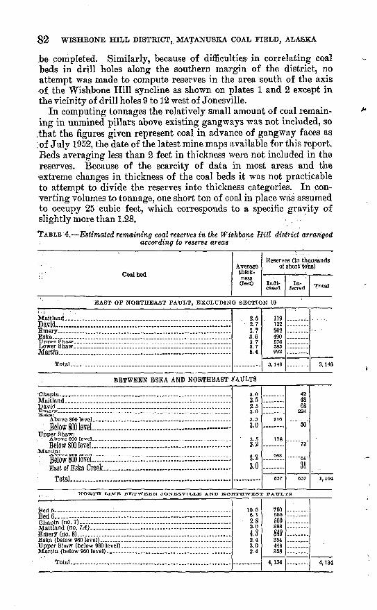
8:2 WISHBONE HILL DISTRICT, MATANTJSKA COAL FIELD, ALASKA
be completed. Similarly, because of difficulties in correlating coal beds in drill holes along the southern margin of the district, no attempt was made to compute reserves in the area south of the axis of the Wishbone Hill syncline as shown on plates 1 and 2 except in the vicinity of drill holes 9 to 12 west of Jonesville.
In computing tonnages the relatively small amount of coal remain ing in unmined pillars above existing gangways was not included, so
:that the figures given represent coal in advance of gangway faces as ; of July 1952, the date of the latest mine maps available for this report. Beds averaging less than 2 feet in thickness were not included in the reserves. Because of the scarcity of data in most areas and the extreme changes in thickness of the coal beds it was not practicable to attempt to divide the reserves into thickness categories. In con verting volumes to tonnage, one short ton of coal in place was assumed to occupy 25 cubic feet, which corresponds to a specific gravity of slightly more than 1.28.
TABLE 4. Estimated remaining coal reserves in the Wishbone Hill district arrangedaccording to reserve areas
; i Coal bedAverage thick ness (feet)
. Eeserves (in thousands of short tons)
Indi cated
In ferred Total
EAST OF NORTHEAST FAT7LT, EXCLUDING SECTION 10 .' !.->'.
Maitland _________ ____ __ . __ _ _ _ ._ __David......................................... .......................Emery. _________________________________Eska... ........................................... .................."Upper Shaw....
Martin.......................................... .....................Total ___________________________________
2.5 2.7 3.7 3.6 3.73.76.4
, 119 122 262 490 576585 992
3,146 3,U8
Eska:
Below 800 level...... ............................... ..............Upper Shaw:
Below 800 level...... ..............................................Martin:
. Befowfooievei... ...................... ................. TToof nf TFolrft frflolr
Tntal
3.02.52.53 ft
3.33.0
3.24. O
3.0
116
178
263
657
424868
66
73
31637 1,194
NORTH LIMB BETWEEN JONESVH_LE AND NOKTHWESX FATTLTS
feed 5. . .: Bed 6. JVTaitJand (no. 7A). ................ ..................... .............Em^Tj (no. B).... r ......... ..........................................
Total.. - . , - .. ....... ...... .._..... __ .
10.56.12.82.04.32.43.02.4
750500500388m354444358
4,134 4,134

COAL 83
TABLE 4. Estimated remaining coal reserves in the Wishbone Hill district arranged according to reserve areas Continued
Coal bedAverage thick ness (feet)
Reserves (in thousands of short tons)
Indi cated
In ferred Total
.NORTH LIMB BETWEEN JONESVILLE FAULT AND TOWNSHIP LINE
Above 860 level. Evan Jones mine
BedS................................................................ 8.8 2,600Bed 5..^...__...__.........._.-. ______........... .." 9.6 3,800Bed 6...._..__..............._............_........__..... 4.1 2,100Bed 7........._.........__..........__.__..............__.. 2.6 1,400Bed 7A......:........._......__........__..._.___....... 4.9 2,790Bed 7J3........._...........................................__.. 2;7 1,630Bed 8-..:..................... .................................... 2.9 796
Total.................................-................. .............. 14,916 ........ 14,916
__ Below 860 level, Evan Jones mine
Bed 3.................._................................___.... 11.3 4,440 ........Do ......................................................... 8.8 ........ 5,280
Bed5................................................................ 8.7 1,670 ........Do...___..............__..........._..__...__...__ 9.6 ._.... 7,470
Bed 6.................__......................__............_.. 6.1 918 ........Do...... ...................................................... 4.1 ........ 4,080
Bed 7................................................................ 2.5 ........ 3,300Bed7-4..._ ... .. . ... . 4.6 ........ 6,950Bed 7B__............................................................ 2.6 ........ 3,430Bed 8.........................__.___.__........_.....__... 3.7 977 ........
. Do............................................................... 3.2 ........ 2,340
Total.................................................................... 7,905 31,850 39,756
SOUTH LIMB WEST OF JONESVILLE WITHIN 1,000 FEET OF DRILL HOLES 9 TO 12
Bed3..._______._.......___......._.__.__.___ 4.6 1,600Bed 2.__......__.___..........._...._.__.............._ 2.2 765BedS...........................................'.. ................ 12.4 ' 4,320Bed 6._.__............._..........._.__.......__.___ 3.1 1,080
Total_.'.___.__.......__...__.___..._______ _.__. 7,765 ........ 7,765
NORTH LIMB BETWEEN TOWNSHIP LINE AND BUFFALO FAULT
Premier coal group______.._____ .......... 20.9 19,000 19,000
_____________NORTH LIMB BETWEEN BUFFALO AND BAXTER FAULTS
Buffalo bed 7. ..................................................... 4.7 1,880Buffalo bed 5. ._____......_.__..........___.......... 6.3 2,520Buffalo bed 4......................................................... 3.7 1,480Buffalo bed 3....._.__......._......____.._...__.__.. 2.9 1,160Buffalo bed 2......................................................... 7.7 2,910Midway....._._.___._._.__._._.__........__... 6.2 624Eska group'..__.1___________________________ 6.8 272Burning Bed group..__________________________ 9.2 368
Total...._____._______...________________ ..___- 11,214 ._.... 11,214
SOUTH OF PREMIER FAULT
Above 500 level. Premier mine
Premier beds 4,4#, 6. ____...._____ ____ ... 8.6 370
Below 500 level, Premier mine __ ____
Premier group. . ..._ ... ... 25 500
Total.......................................... -... ............ 370 500 870
Grand total..___......______._...___________ ____.. 50,007 51,987 101,994
84 WISHBONE HILL DISTRICT, MATANUSKA COAL FIELD, ALASKA
Calculations of reserves were made in general according to pro cedures adopted by the Geological Survey (Averitt and Berry hill, 1950, p. 8-11). In view of the scarcity of data and the differences in quality and thickness of the coal beds, none of the reserves were classed as measured. The distinction between indicated and inferred reserves was based in part on distance from points of measurement and in part on the reliability of data. For example, in a few places where the average thickness was based in part on measurements of beds of doubtful identity, the reserves were classed as inferred, regard less of the distance from the outcrop. It was also deemed advisable in this field to extend indicated reserves to a maximum of only 2,000 feet from points of observation, rather than the one-mile limit gener ally applied in larger areas of more uniform coal beds.
As the computed reserves lie in several relatively small areas and in several overlapping coal beds, they were not represented on a map. Instead, sufficient description was included in table 4 to permit the location of the areas by reference to the accompanying geologic maps and to plates 19 and 20 showing the mined-out areas on various coal beds in the Eska and Evan Jones mines, respectively.
In view of the folded condition of the coal beds and the considerable relief of the Wishbone Hill district, no attempt was made to divide the coal in the various reserve areas into categories based on thickness of overburden. A relative small tonnage probably lies beneath more than 2,000 feet of overburden. The deepest coal in drill hole 12, near the synclinal axis west of Jonesville, was reached at a depth of nearlv 2,100 feet. It is estimated that about half of the total reserves of the district lie beneath 1,000 to 2,000 feet of overburden, and half beneath less than 1,000 feet.
LITERATURE CITED
Apell, G. A., 1944, Moose Creek district of Matanuska coal fields, AlasKa: TL $ Bur. Mines Rept. Inv. 3784.
Athy, L. F., 1930, Density, porosity, and compaction of sedimentary rocks: Am.Assoc. Petroleum Geologists BUH., v. 14, p. 1-24.
Averitt, Paul, and Berryhill, L. R., 1950, COal reSOUrCeS Of the United States: U. S. Geol. Survey Circ. 94.
Barnes, F. F., 1951, Mining and exploration ID 1945 in the Wishbone urn coal district, Matanuska Valley, Alaska: U. S. Geol. Survey Bull. 96S-E, p. 193-201.
Oapps, S. R., 1927, Geology Of the Upper Matanuska Valley, Alaska: U. S. Qeol. Survey Bull. 791.
chapin, Theodore, 1920, Mining developments m tne Matanuska C0ai &&& : -o. s.Geol. Survey Bull. 712-E, p. isi-167.
, 1921, Mining developments in the Matanuska coal fields: U. S. Geol.Survey Bull. 714-D, p. 197-199.
Cooper, H. M., and others, 1946, Analyses of mine, tipple, and delivered samples,m Analyses of Alaska coals: U. S. Bur. Mines Tech. Papers 682, p. 19-110.
LITERATURE CITED 85
Geer, M. R., and Yancey, H. F., 1946, Washability characteristics and washing ofcoals from the Matanuska field of Alaska: U. S. Bur. Mines Kept. Inv. 3840.
Jolley, T. R., Toenges, A. L., and Turnbull, L. A., 1952, Bituminous-coal deposits inthe vicinity of Eska, Matanuska Valley coal field, Alaska: U. S. Bur. MinesRept. Inv. 4838.
Martin, G. C., 1906, A reconnaissance of the Matanuska coal field, Alaska, in1905: U. S. Geol. Survey Bull. 289.
, 1919, Geologic problems at the Matanuska coal mines: U. S. Geol. Survey Bull. 692-D, p. 269-282.
1926, The Mesozoic stratigraphy of Alaska: U. S. Geol. Survey Bull. 776.Martin, G. C., and Katz, F. J., 1912, Geology and coal fields of the lower Mata
nuska Valley, Alaska: U. S. Geol. Survey Bull. 500.Paige, Sidney, and Knopf, Adolph, 1907, Geologic reconnaissance in the Matanuska.
and Talkeetna basins, Alaska: U. S. Geol. Survey Bull. 327.'Tuck, Ralph, 1937, The Eska Creek coal deposits, Matanuska Valley, Alaska:
U. S. Geol. Survey Bull. 880-D, p. 185-214.Waring, G. A., 1934, Core drilling for coal in the Moose Creek area, Alaska: U. S.
Geol. Survey Bull. 857-E, p. 155-173.

INDEX
. . . . . . PageAbstract:.:..-...--.--.:..-".:.... ~. 1-2Accessibility of the area__.. . . 9 Acknowledgments .. 6 Alaskan Engineering Commission.....: 76Alaska Railroad..-....-...-... ..... 2,9,76/77-79,80Alluvium.........___.__ . 10, £3Analyses of coal....................... ... 52-56Arkose-Ridge formation; age of.: ... 11-12
deposition__-...... _:.'.." ' 44: description....::..:.....:. 10-12
Baxter fault.. ....._ . ..... - 32Baxter mine, analyses of coal from.....:...... 53
operations of....___..: ... 76-77structure In........-..............-...... 38-40
Baxter synclino . 39 Bed 1 ....... ............ 66Bed 2.:..... 66,83Bed 3.... .__.......___ _ 66-67,83Bed 4.:........:...:..__...._1........ 67,82,83Bed 5. .._...._.____'.. __.__ 65,82,83Bed 6................... ..... 64,82,83Bone_____.. 67 Buffalo fault.. ...__.V -... . . 32 Buffalo mine, analyses of coal from.._... 62-53
; operations of:......" .. " v 80 structure in:.._...... -.. '. - 38
Burning Bed anticline.._...__....... 39-40,46-47Burning Bed coal group...: 41,46-47,57-58,70-71,83
Castle Mountain fault.._ :.:: .. 9,26,45 hapin, Theodore, quoted.: " '...'. 39 Chapin coal bed..___:.:__ . 64,82Chemical analyses of coal.__ . . 52-56<5hickaloon formation, age of:. -. -.,.. 10,13-14
coal beds...__ ____. 14-17,18 See also names of coal units,
deposition of.:...... : : 44,50-51exposures along Matanuska River___.. 17-18 exposures in Tsadaka Canyon 17-18,41-42
. exposures In the Wishbone Hill area...... 15-17; exposures north of Wishbone Hill___.. 15
lithologic character.___... . 10,14-18stratigraphlc relations.- __._ . ' 18thickness .._ _ 10,13,14,16,18
<Dhugach Mountains_:_____._.. 9-10,44-45 Claystone marker beds.:__..:...___ 17,50-51 Climate.. _........... 7-8<Jpal, analyses..'__.... ....-.... . .. 52-56
beds found m drill holes.- _. 67-70' ' chemical properties.._:.:._::.::_.. 51-57' conditions of deposition_^_'._'____ 50-51
detailed-description of beds.__'.___.. 57-76^ general description ofcoarunlts:::._..V. 46-60'" physical properties..-_::..'-._:__.: 51-57
See also detailed descriptions of thecoal units.
Coal-Oontlnuedproduction_______.-.________ reserves. ___.....________._ 81-84
See also names of coal units. Coal-bearing beds, ages of. __________ 14 Cretaceous system; rocks of ___..____ 10^-13
David coal bed.._ .;_: __._. 63,82Differential compaction, effect on thickness
of Premier-coat group _________ 49 Dikes.- ..___.____.... 23-24,45-46Doherty anticline..___ ...___.__ 42 Doherty Coal Mining Co..-......... . :.... 76Doherty mine, analyses of coal from..!_.._. 64 Drainage of the area..-____ _ ____ 7 Drill holes, coal found In. _____.....__ 67-70
Emery coal bed.-.-.. ________.. 62-63,82 Eska, drill-holes near...__._.__...:__ 67-69 Eska coal bed............. __ 16,60-61,82Eska coal group.. 16,37,47,58-61,71-72,83 Eska conglomerate...______.. ...:__ 13
See also Tsadaka formation and Wishboneformation.
Eska Creek; character of..-.___....__... 6,7geologic history of.......____...___; 46structure along.. '.... ______. 25
Eska fault.___._______________ 29 Eska fault zone...._______________ 28-30Eska marker bed___...__________ 17Eska mine, analyses of coal from..:_____ 55-56
operations of:.-....___'.____ 76,78,79-80structure______:_.__.._;__ 26,27,29
Evan Jones mine, analyses of coal from.. _ _ 64-55operations of.. ____.._____.___ 76-80reserves-________.'_.______ 83structure.._____..:_____._ 26,27,30
Extent of the district............_______ 2-3
Faults, Baxter...._...__..__.____'... 32between Jonesvllle and Wishbone Lake... 31-32 Buffalo________._....."___.;.. 32Castle Mountain.-._ ..:.:.-._.'....'_ 9,26,45Eska. ......__ 29general-description.___ 12,27-28,35,38,39-41 Northeast;..:__.____.....___.._ 27,28Northwest.-. . :........ . 29Premier--...-.-._ .. ..... ..'______ 33
.Field work.__...._____________.2,4-6Floods:::. - . .. .. 7,80 Foldlng-.V..- ' ...._ . 24-26,36-37Fossils.....- -..- .. ..-. -.-. ..-._.:. n, is, is, 60
Qeer, M.'R;, and Yancey, H. F., quoted..... . 67Geography of the area'......'__ ............. &-QGeologic history of the district. 42-46'Geology____________________ 9-46 Glacial deposits__... 10,20-21,46
87
88 INDEX
PageOlenn Highway....__ _________ 9 Glenn syncline_____..._________ 42 Qloryhole Creek, outcrops showing structure. 25
Igneous rocks..._______________ 23-24 Introduction.......__.......____ 2-6
Jonesville, drill holes near..._____*>..._ 69-70 landslides near.___..._____...... 21-2
Jonesvllle'ooal'group--_....._ 16,49-50,66-67,75Jonesville fault....._......................... 30-31
Knob Creek mine, operation of.
Landslides................................ 21-23,46Literature cited.............................. 84-85Location of the district.... . _. 2-3
Maltland coal bed.... ..................... 63-64,82Martin, O. C., quoted..__............_ .. 25Martin, 0. C., and Katz, F. J., quoted....... 10,33Martin coal bed____. .............. 58-59,82Matanuska Center mhie, analyses of coal from. 52
operations of..___.. _______... 77-78structure In..___._________ .. 35-3JJ
Matanuska Center syncline.. ........... 35-36Matanuska formation, deposition____... 44
description of......... ..._...... 10,12-13fossils in____________....___ 13thickness.-._.___....*. ... ............ 10, la
Matanuska River bluffs, Chlckaloon forma tion In. ............. ..................... 17-18
coal bods In___...__..._._...._----- 75-7OMatanuska Valley, location.-_____.... 2
records'of temperature and precipitation
rocks of........................ 9-10,42-43,44-46Midway coal bed.............. 37,47-48,61-62,73,83Mining, history of................._........ 76-80
methods_-.-.----..-------------------.- 24-25
Moose Creek, floods of....................... 7,80geologic history of...-- ... 40structure along.___...-...-.-.-.. 25-26,35
Moose Creek thrust fault.. .............. 33-35,37Morainedeposlts ... .- 10,21,46
New Black Diamond mine. See Rawsonmixie.
Northeast fault-.._____.-........__-_.... 27,28
Northwest fault.............................. 29Pioneer mine, operations of................... 77-78
See also, Doherty Coal Mining Co.Precipitation-------_-_- _--___-____--__---- 8
Primer coal group............................ 1C,36-37,40,48-49,62-65.73-75,83
Premier fault................................. 33Premier mine, analyses of coal from..__ 53-54
operations of ... . ..... 76-78,80reserves in................................ sastructure ^-- 26-27
Previous Investigations..... .. - ..... 4Production of coal- ....................... 80-81
Purpose of the work ...._____..... 2
Quaternary system, deposits of._______ 20-24
Rawson anticline_..................__ 35-36,37Rawson mine analyses of coal from____.. 52
operations of.__ __...________ 76-79structure______.__________ 35-37
Reserves, of coal_______________ 81-84Rice Shearer'mlne, analysis of coal from__ "'" 53
Scope of the report_______......___ 2Shaw coal bed...... ................. 59-60,82Slide rock...... ........................... 21-^23Stratigraphlc sequence of rocks, chart of.. _ 10 Stratigraphy ......__.... .. 10-23Structure, anticlines....___..... 35-36,37,39-40,42
along Eska Creek_______......__ 25along Qloryhole Creek_______..__ 25 along Moose Creek___._ ___.. 25-26,35 faulting .......................... 24,26,44-45
See also Faults, folding...... . - 24-25,35-37,44-45Influence on mining operations.... ___ 24In the Baxter a^ea ... ............ 38-J)In trie Buffalo area.....__..........__ 38in the Premier area...........__...... 40-41In the Rawson area_____..._...__ 35-37 inTsadaka Canyon___.. ___. ___ 41-42 syncllnes...-... ....- 24,25,26-27,35-36,39,42
Talkeetna batholith. ............. 11,43Talkeetna Mountains, rocks of....... 9-10,42,43-40Temperature.----..-.- - 7-8
Terrace gravel............................. 1Q,21,46
TopQgrap'hic features......................... 6Tsadaka Canyon, Chlckaloon strata in....... 17^18
coal beds In........ . -.-. . 75-76erosion of--------------------------------- 46
structure in. ............................ 41-42Tsa'daka formation, age of--..--.... . . It), 19
drill holes In___.... ....... .. 19-20
lithologic character.................... 10,19-20stratigraphic relations ... 20
Tsaaaisasynciine. - ....... 41
Tuck, Ralph, "quoted......................... 7,-30'Tj. S. Bureau of Mines, field work by 4-5, 30, 07
V, S. Geological Survey, field work by....... 5-0Vegetation.
deposition of.............................. 44lithologic character.. ._........... 10,18-19outcrop area__ . . ... 19thickness .-. . -.- 10,10
Wishbone Hill.......... - 6,25,26Wisnbone Hill district, location........- . 2-3Wishbone Hill mine, operation of...... v ------ 78
structure In. .. ...... ... --- - 35-36Wishbone Hill syncline, description.... 24,2.%26-27