Embed Size (px)
Citation preview
41J11SEMI23 KAM38 NOUVEL 010
October 6, 1964
CROWNBRIDGE COPPER MINES LIMITED Summary Development Report on the
Iron Bridge Property
by Mineral Exploration R
Engineering Consultants

41Jl!SES)8a3 KAM38 NOUVEL
010C
TABLE OF CONTENTS
Page
Property, Location, Access l
History S. Former Development 2
General Geology 2
Current Development 3
Current Ore Reserve, Reconunendationsand Conclusions 4
Plans k Sections
Longitudinal Section Along Ore Zone {After Andover)
Plan of Diamond Drilling " "
Longitudinal Section Along 'ore Zone - Crownbridge Stage l
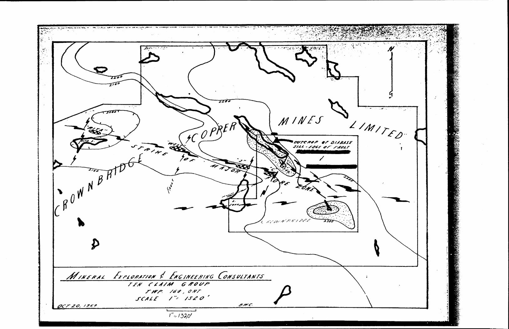
Claim group Plan
Rita Lake Showing - Plan
Section of Rita Lake Drill holes
Plan of Crownbridge Drilling
DUPLICATE COPY

TABLE OF CONTENTS
Page Property , Location , Access l
History A Former Development 2
General Geology 2
Current Development 3
Current Ore Reserve , heocoitnendationsand Conclusions 4
Plans & Sections
Longitudinal Section Along Ure Zone ( After Anflovei1 )
Plan of Diamond Drilling M "
Longitudinal Section Alonp ore fcone - Crownbridge Stage l
Claim proup Plan
alta Lake Showing - Plan
Section of Kita Lcke Drill holes
Plan of Crownbridpe J)

MINERAL EXPLORATION S,
ENGINEERING CONSULTANTS
Geologists - Engineers - Scientists
Box 244 - NORTH BAY - Ontario
TO THE PRESIDENT K, DIRECTORS OF Crownbridge Copper Mines Limited Suite 2510, Bank of Nova Scotia Bldg. 44 King Street, West Toronto l, Ontario.
Gentlemen:
The Summary Development Report on theCompany's Iron Bridge Property to the End of September, 1964 is as follows:
PROPERTY, LOCATION, ACCESS
The property consists of the following mineral claims recorded in the Sault Ste. Marie Mining division. All of the work requirements have been completed and it is planned to obtain a patent or lease for the entire group in the immediate future. These claims are listed as follows:
Township 168, P.O.
SSM 53814SSM 53820-25 Incl.SSM 53829-37 Incl.
Township 175, P.O.
SSM 53815SSM 53817-19 Incl.
SSM 53843-49 Incl. SSM 57539-43 Incl.
SSM 53826-28 Incl, SSM 53840-42 Incl
The holdings are located twenty five miles northeast by north of the town of Iron Bridge, Ontario and can readily be reached by way of the White River Road (Highway 546) and thence southeast along a former lumber road for a distance of about two and one half miles. This later portion, during dry weather or during the winter months may be travelled by Jeep. It is to be noted that the deposits are located along the southeast by easterly trending ridges toward the community of Elliot Lake eighteen miles to the east. Because of this road connection could be effected with a minimum construction cost,
DUPLICATE COPYPOORQUAlIJTYtORIGINAL
. ~* - l ' A^ 'V**^ -S*
FOLLOW
-~; tt;,! B B B A' L TSTX PLORASIOH A
S H O I H 'B B.R I H G CONSULTANTS
^ ' Geologists - Engineers - Scientists
. ' ' Boat 244 - NORTH BAY - Ontario
TO TEE PRESIDENT A DIRSCTOBS OP Crfevnbridge Copper Mines Limited Suite 2510, Bank of N OTE Scotia Bldg. 44 King Street , West TOHONTO l , Ontario
\ j
Gentlemen : ,
The Summary Development Report on theCompany*s Iron Bridge Property to the End of September , le as follows :
PROPERTY , LOCATION , ACCESS
The property consists of the following mineral claims recorded in, the Sault Ste. Marie Mining division . All of the
.work requirements hare been completed and it le planned to obtain -a patent or lease for the entire group in the immediate future . These claims are listed as follows:
Township 16.8, P.O.
SSM 53814SSM 53820-25 Inol.SSM 53829-3? Inol.
Township 175, P.O.
SSM 53815SSU 53817-19 Inol.
SSM 53843-49 Inol. SSM 57539-43 Inol.
SSM 53826-28 Inol* SSM 53840-42 Inol.
|he holdings are located twenty five miles northeast by north of the town of Iron Bridge , Ontario and can readily be reached by way of the White Kiver Koad ( Highway 546 ) and thence southeast along a foaner lunber road for a distance of about two and one half miles . i'his later portion , during dry weather or during the winter months mny be travelled by Jeep. It is to be noted that the deposits ere located along the southeast by easterly trending ridges toward the community of filliot bake eighteen miles to the east . Because of this road connection oould be effected with a minimi construction cost.

Page 2
HISTORY AND FORMER DEVELOPMENT
An extensive programme of surface exploration and diamond drilling was carried out by the previous owners during the period September, 1958 to March 1960.
Seventy five diamond drill holes were completed and | allocated as follows: l
"J" Zone (15000 E to 17000 E) - 12168 feet - 25 holes l
West Lens (13000 E to 15000 E) - 17965 feet - 50 holes
Total 30133 feet - 75 holes
In the West Lens a total of 412000 tons grading 2.11 copper were indicated while an additional 135000 tons in the "J" Zone averaged just under 2% copper. A high silica content (over 831) and a low gold-silver content is recorded.
GENERAL GEOLOGY
Huronian sediments, consisting of conglomerate, argillite and quartzite dip northeast to westerly at generally flat angles generally less than 15 degrees but locally as high as 40 degrees. Two systems of faulting are noted, a northeast to northerly one and a northwesterly trending series, the later of which are oftentimes tensional and are filled with copper bearing quartz veins.
The present showings occurr in shattered zones in veins of this later system. The copper mineralization consists mainly of chalcopyrite and minor bornite replacement of the quartz host-rock and included country rock. The deposits strike north 70 degrees west and dip northerly variably from 65 to 75 degrees. The ore shoots within .i.em rake westerly at an angle of 40 degrees. The west lens centres on the boundary of claims SSM 53834 and SSM 53835; the "J" Zone in the north central portion of claim SSM 57540.
Two other showings occurr within the claim group and on the same general strike as thac of the drilled portion. One of these the Rita Lake centres on claim SSM 53848 about one half to three quarters of a mile westerly from the west lens consists of quartz and conglomerate on the north side of the lake well mineralized with chalcopyrite and some bornite dipping southerly into the ike at a steep angle. Approximately three hundred and fifty feex. south thereof a second system of mineralized quartz veins dip northerly and iito Rita Lake. A second showing, the Beaver consists of quartz vein material mineralized with chalcopyrite about one and one half miles westerly from the West Lens exposed during the dry season on the edge of a creek. However, samples taken from the creek bed south thereof consisting of float rock assayed. 5.85* copper. DUPLICATE
TO FOLLOW

Page 2
HISTORY AND yOIMSR DEVELOPMENT
An extensive programme of surfaoe exploration and dianond drilling was carried out by the previous owners during the period September , 1958 to March I960 .
Seventy five diamond drill holca were completed end allocated as follows :
" J " Zone ( 15000 K to 1?000 K ) - 12168 feet - 25 holes
West Lens ( 13000 K to 15000 E ) - 17965 feet - 50 holee
Total 30133~~feet - 75 holes
In the West lens a total of 412000 tons grading 2.1JL copper were indicated while an additional 135000 tons in the n J * Zone averaged just under 2 ^ copper . A high silica content ( over 83 j. ) and a low gold-silver content is recorded .
GENERAL G30LOCY
Huronian sediments , consisting of conglomerate , argillite end quartzite dip northeast to westerly at generally flat angles generally less than 15 degrees but locally as high as 40 degrees . Two systems of faulting are noted , a northeast to northerly one end a northwesterly trending series , tho later
of which are oftentimes tensional and are filled with copper bearing quartz veins .
The present showings oocurr in shattered aones in veins of this later system . The copper mine ralization consists mainly of chalcopyrite and minor bornite replacement of the quartz host-rook and included country rock . The deposits strike north 70 degrees west snd dip northerly variably from 65 to 75 degrees . The ore. shoots within them rake westerly at an angle of 40 decrees . The west Lenp centres on the boundary of claims SSM 53834 and SSM 538.^5 ; the " J " Zone in the north central portion of claim F.SM 57540.
Two other showings ocourr within the claim group and on the ssrae general strike as that of the drilled portion . One of these the Rita: Lake centres on claim SSi 53848 about one half to three quarters of a mile westerly from the nest Lens consists of quartz and conglomerate on the north side of the lake well minerslized with chalcopyrite and some bornite dipping southerly into the lake at o steep arge . Approximately three hundred and fifty feet south thereof a second system of mineralized quartz.veins dip northerly end into Kita Lake . A second showing ,the Beaver , consists of quartz vein material mineralized with chalcopyrite about one and one half miles westerly from the west Lens exposed during the dry season on the edge of s c reek . Howsver , samples taken from the creek bed south thereof consisting of float rock assayed 5,85 1. c opper .

Page 3
CURRENT DEVELOPMENT
The present company, Crownbridge Copper Mines Limited, acquired the above property and began an immediate programme of diamond drilling in early December, 1963. The work has been divided into three stages as follows:
Stage l - fill-in and confirmatory drilling consisting of twelve holes in 4, 572 feet.
Stage 2 - deep probes to explore the ore zone to depth and test for favourable structures and formations conducive emplacement of large base metal deposits 7760 feet.
Stage 3 - current programme of drilling the Rita Lake showings which to date totalled 2134 feet of drilling.
The results have been most rewarding; stage l confirmed continuity of ore deposition and ready mineability of the deposit of increased tonnage and enabled us to confidently recommend immediate sinking of a 600 foot shaft to further test the property and bring it i'.ito production on a 200 ton per day scale (See our March Ib, 1964, Summary Development Report for detail drilling results and ore estimates).
Stage 2 led to an expanded ore reserve, indications of , a parallel ore zone at depth below the West Lens and led to the discovery of a deep sedimentary copper horizon resembling in many ways the world famed African deposits. This led to the staking of approximately fifty additional claims to cover the most favourable cross-folded synclinal positions interpreted from the geological and geophysical data available. Since the cherty bed occurrs below the Bruce limestone at a depth of about 2000 feet its exploration at this time is both costly and most time consuming in view of our immediate plans toward shaft sinking, It i s for this reason that stage 2 was suspended in favour of the Rita Lake programme but certainly leaves a burning exploration target to return to at a more appropriate time.
Under Stage 3 two holes have been completed (see Diamond Drill Sections) and indicate several parallel mineralized zones as shown. Intersected widths and grade have not been impressive but compare most favourbaly with the initial results obtained in the drilling of the West Lens. Here, it is to be noted, the first hole drilled under the best showing returned a mere .69% copper over 4.6 feet.
Hole Cr-21 is currently drilling below Cr-20 at an angle of 71 degrees and has encountered persistent but scattered mineralization from 340.0 to 450.0 feet. A well mineralized section was out from 341.0 to 343.0 feet.
DUPLICATE COPYPOORQlMIOORIGINAL
V ' i- '
- *V
CUKRENT.DBYsLOlMENT . ^t -
The present ounpany , Crownbridge Copper Mines Limited , acquired the above property and began an immediate programme of diamond drilling in early Beoember r 1963 . The work has been divided into three stages as follows :
Stage l - fill-in and confirmatory drilling consisting of twelve holes in 4, 572 feet .
Stage Z - d eep probes to explore the ore Bone to depth and test for favourable structures and formations conducive to emplacement of large base metal deposits r 77^0 feet .
stage 3 - current programme of drilling the Kita Lake showings which to date totalled 2134 feet of drilling .
The results have been most rewarding ; stage l confirmed continuity of ore deposition and ready mineabiljty of the deposit of increased tonnage end enabled us to confidently recommend immediate sinking of a 600 foot shaft to further test the property and bring it into production on a 200 ton per day soole (See our March 18 , 3964 .Summary Development rteport for detail drilling results and ore estimates .).
Stage 2 led to an expanded ore reserve , indications of a parallel ore zone at depth below the west Lens and led to the disoova-y of a deep sedimentary copper bearing horizon resembling in many ways the world femed African deposits . This led to the staking of approximately fifty additional claims to cover the most favourable cross-folded synclinal positions interpreted from the geological and geophysical data available . Since the cherty bod oopurrs below the Bruce limestone at a depth of ebout 2000 feet its exploration at this time is both costly and most time consuming in view of our immediate plans toward shaft sinkinp. It is for this reason that stage 2 was suspended in favour of the wits Lake programme but certainly leaves a bur/iiijg exploration target to return to at a more appropriate time .
Under Stage 3 two hules have been completed ( See Diamond Drill Sections ; and indicate several parallel mineralized zones as shown . Intersected widths and grade have not been impressive but compare most favourably with the initial results obtained in the drilling of the West Lens . Mere ,it is to be noted , the first hole drilled under the best showing returned a mere .69 l copper over 4.6 feet. .
Hole Cr-21 ie currently drilling below Gr-20 at an abgle Of ?1 degrees and has encountered persistent but scattered mineralisation from 340.0 to 450.0 feet . A well mineralized' section was out from 341.0 to 343.0 feet .

Page 4
A strong northerly trending cross-fault occurrs immediately east of thf* current hole and major widths of the intersected ore zones may be expected adjacent to this additional structural control. A series of shallow holes have been spotted to explore this promising looking sector.
CURRENT ORE RESERVE, RECOMMENDATIONS S, CONCLUSIONS
In view of the results obtained in Stage l and Stage 2 the former ore picture can be re-estimated as follows:
Zone Tons Width Grade Indicated Probablel Cu (In detail)
West 270,000 6.2 2.1Above 550 Level
West 210,000 6.0 2.0 Below 550 Level(Not in Detail)
"J" 135,000 5.0 2.0Above 550 Level
TOTAL 615,000 6.0 2.0 Indicated f, Probable
It is pointed out that this is far below the overall potential of the property in that a highly probable strike length of 1200 feet between the West and "J" ore zones has been inadequately explored by a series of widely spaced shallow holes all of which indicated continuity of t:he ore zones. The westward continuation of the upper "B" zone of the west lens is still open to the west and depth. And the Rita Lake Showings with its several indicated zones could be a major tonnage proposition.
It is therefore recommended that:
1- That shaft sinking etc. as set forth in our March 18th Report be started as soon as funds are available.
2- Continue the present test of the Rita Lake showings and thatan additional 5000 feet of drilling be alloted to this programme.
3- Lay plans to test the westward continuation of the upper "B" ore zone to the west and to depth with a minimum of 3000 feet of surface drilling.
Respectfully submitted
October 6, 1964 Ben W. Chechak B.Se. Geologistfor
MINERAL EXPLORATION S.ENGINEERING CONSULTANTS
DUPLICATE COPYPOOR QUA'illTYiORIGINAL
' TO'FOLLOW

".'-^.V*; . .' - T -
' -. V
Page 4
A strong northerly trending orose-fault ooourrs immediptely .east of the oarrent hole and major widths of the intersected ore zones may be expected adjacent to this additional structural control . A series of shallow holes have been spotted to explore this promising looking seoxor.
CURRENT RiOOuMiiiDA'.i!IOii3 ft OuriOLUSIufiS
In Y lew of the results obtained in btage l and Stage 2 the former ore picture can be re-estimated as follows :
Zone
nest
W9Bt
Tons
270,000
210,000
Width
6.2
6.0
Grade 7o C *
2.1
2.0
Indicated (In detail )
Probable
Above 550-Level Bo low 550 Level
135,000 5.0 2cOAbove 550
TOTA1 615,000 6,0 2.0 Indicated 4 Probable
It is poin.ted out that this is far below the overall potential of the property in that a highly probable strike length of 1200 feet between the West and " J " ore zones has been inadequately explored by a serieB of widely spaced shallow holes all of which indicated continuity of the ore zones. The westward
continuation of the upper M B " stone of the west l*ens is still open to the west unfl depth . And the Hita Loke showings with ite several indicated zones could be a ma.lor tonnage proposition .
It is therefore reoo.nmended that :
1- That shaft sinking etc. os set forth in our March 18 th Keport be started ae soon as funds are available .
2- Continue the present test of the Hita Lake Showings and thatan additional 5000 feet of drilling be alloted to this programme.
3- Lay plans to test the westward contSnuEtion of the upper a B " ore zone to the west end to depth with a minimum of 3000 feet of surface drilling . ;
October 6 , 1964 .
Respectfully itte
Hen W. CheohaJc B. So. Geologist for
MINERAL EXPLORATION 4 , -- , ;' - '.* - " ' -
SHOINKSRIHG CQNSULTAHT3 J'

J

^in*- M a MI—
w
WJv*- "'\ V
- '
iiir
SO
OD
Af
it"~"@.irf.'•';--,v,;
''"
fer
ft
•*fl
" tiSlis^
——
*1 '"iv
r y**.
''(I
- ,'\:- . '* 1
(/,'i'A1
. i\
- A '!
^i3sM''"Ji . ..
* /Tijr'^
i '-"fl
ii* H1
wsf
'V .r *^ "
., ' 'i
i i
'V . '
^j;
^V
'"*k
. ^tj i *
,,
,'JBO
h
rf
: ——
——
——
——
i i,
x ~m
-. i, j
'fii\vv j
wo\ !i i. j
•*.
•*-
- ^L ".V:..
. cjl'-. V'ri'vs,-.:..,
* i
. '
,
i ̂.vj-Si''1}-''
L ' ^
s
' ' ' v^
'Ov
(,"**
f*
.
x -^ . i!':'-v
: -••.^^
4.'•^^-:
r- '-. .*""
- - -,V4V--. .
V^i
-v^-
1; !;
-:-.- ivi'.-..-
, r-, ;''Nvv^v,
S ? ^i
^x^
l
; s i \X
;O
^V
I1^^K x is-
':'v'
"'- '
-' 'v
'1, *-'^''l'V
i-'',i ''".'
''i "
*ii^:'^-:^
!i^ii
f*2i

" f""':^
~v
i;-'-
•-'^
'

^v^-V;--':-
few
^M
41Jt1SEee23 KAM38 NOUVEL 020
SPECIAL REPORT OK COPPER ORE RESERVE
- O R O ff M B R I DOB POPPER M I H E S
l I M I TED
TownohipB 168 and 175 tSault sto. Marie illnlup Divieion Provinoe of Ontario
John A* Costa ,B.M. ,P. Eng.
Office!52-l8th Street KORAH&A , P.Q. Ph- 762-3484 June 10 , 1965

TO THE PRESIDENT AND DIRECTORS OF CROWNBRIDGE COPPER MINES LIMITED Suite 2510 ', Bank of K ova Scotia Bldg. 44 King Street , West TORONTO l , Ontario
Dear Sire:As requested , I am pleat''- . ; resent the following
11 Special Report on Copper Ore Reserve " v t i Company's Iron Bridge Property .PROPERTY : LOCATION :AOCESS
The property consists of one hundred and four mineral claims totalling approximately 4,160 aoros located along- the existing and potential mineral belt centering in Township 168 and extending westward into Township 175 , Province of Ontario . These claims are numbered ae follows :
SSM 68712-68715 inol. SSJM C 648,22-64861 inol. 'SfiM 63814-63815 inol. RSM 65240-65243 inol.SSM 68476-68491 inol. PBM 64358-64361 inol.PBM 57539-57543 inol. S8U * '71717-71736 inol.FSM 53840-53849 inol. SSM 70339-70352 inol.
53817-53037 inol. FSM 68494-68495 inol.
The holdings are approximately ?.? m iles north of Blind River and 16 miles northwest of Elliot Lake . Heady access is available by following highways 554 and 546 northeasterly from Iron Bridge and then proceeding southeasterly for two and three l quartern of a mile r.long a bad lumber road . However , a new truck j access road is currently under construction with completion date June 30 t 1965 and will replace the sbovo tote rood . '
HI8TORY l
Earliest work consisted of axteesive trenching l nnd a limited undieoloed footage of "E" core drilling \vhioh was reported to have intersected high prade copper values . This j work wos carried out by Great Lakes Copper prior to the p-malgamatlon t with i/ew Mindo Scotia Mines to form Andover Mining ft Exploration Ltd.
Andover , in turn, carried out 30,133 linear feet pf drilling between September 1958 and March 1960 spread over 75 holes in a strikn length of 4300 feet . 'ilvo ore shoots vis. the neot Ore Lens and tho "J" Zone showed an indicated total copper ore reserve of 547,000 tons of Juot under 2.1 ^ copper . At this point the overall ore potential looked impressive since the drilling wes confined to half or somewhat less than the known mineralized strike length of the oro cone and only a few holes penetrated below tho 500 foot horizon .

Page 2
The programme culminated in a strong recommendation bjr the Company'o geologist to proceed with an immediate underground test and t dependent thereon * bring the deposit into production * However t a dwindling copper prioe and a generally adverse mining market climate forced the property into dormancy through lack of funds.
The property was acquired in the fall of 1963 by the present company and to dote T diamond drill holes have been completed for a total linea ^ootage of 27,169 feet . The first eleven holes totalled 4,572 feet end were mainly "fill in " and confirmatory drilled on 25 foot sections fi-ora section 14,050 K to 14,475 K returning intersections on the approximate 300 foot horizon . A preliminary programme of 3,81? feet was carried out on the Rita Lake showing with results sufficient to warrant e continuation from the ice on Kita Lake during the winter months. On the "J" fcone 4,258 feet of drilling confirmed earlier widely spaced results ^extended the zone to greater depths "down rake M and gained datau which enabled iar. Cheohak to formulate the " Tensional Control U'heory " which became the basis of the current drill programme which accounts for the balance of the drill footage to date exclusive of deep probing of the west ore Lens,COPPER OKE KESERVE
The writer will reserve his description of the oro deposits to the following generally accepted categories :Blookecl-out - deliminated on four si .os
( Type A ) Indicated - outlined by a sufficient number of drill holes.
( Type B )Inferred - believed or indicated to exist beyond indiooted
boundary but inadequately drilled .C Type C )
Potential - by rtetistioal considerations ; extrapolation of local geology , isolated showings and/or drill holes with intersections of ore zone mate rial-which appear likely to develope into on orebody.
( Type D )
It is understood that the term M ore u as applied to outlying deposits viz. Rita Lake and Kast Xone assumes that , during the course of future development work , adequate tonnage would be indicated to justify en independent minjng operation ot these locations satellitic to a central mill.
Due to the paucity of information , even to the absence of raw prospecting of the existing strike continuation , class rt D H may appear grossly conservative . Any success as to ore grade intersections in the deep .bedded type copper deposition discovered in hole CR-15 could lead to rapidly expandable reserve that could totally eclipse everything heretofore considered .

ORE KESERVE a-ABUIAl'ICK2 CKE -OREBODY
Ore
TUNS
K 150,000
150,00030,00015,00035,000
W 8hoot"B" 145,000 15,00050,000
150,000"J" fcono
Zone
Rita Lake
Kast Sono
135,00050,000
75,000
100,000
50,000 150*000
WIDTH*
6,4
6,05.5 5.0 5.06.3 5.0 5.0 5
5.95.0
ORADE i O n
2.1
2.0 1.20 1.20 1,80
2.1 1.20 1.8 2
2.0 1.8
5.0
3-8
55
1.5
1.2-1.8
TYPE
B
B B BO
BB ' O - D
BO
B
D
B ;D - -'
Exceptionally close drilling -partially includes some of typo A. Above 550 foot level. Below 550 foot level Above 550 foot level Bolow 550 foot level Below 550 foot level
Above 550 foot level Above 550 foot level Bolow 550 foot level Bolow 550 foot level
Above 550 foot level , Above 550 foot level .
Above 550 foot level .
Shallow
Shallow At depth
1^^^^-^'
il-'*J-
w-
ORB,'-- . ,:,. :.. .
'20NE/OKBBODI TOHS WIDTH*
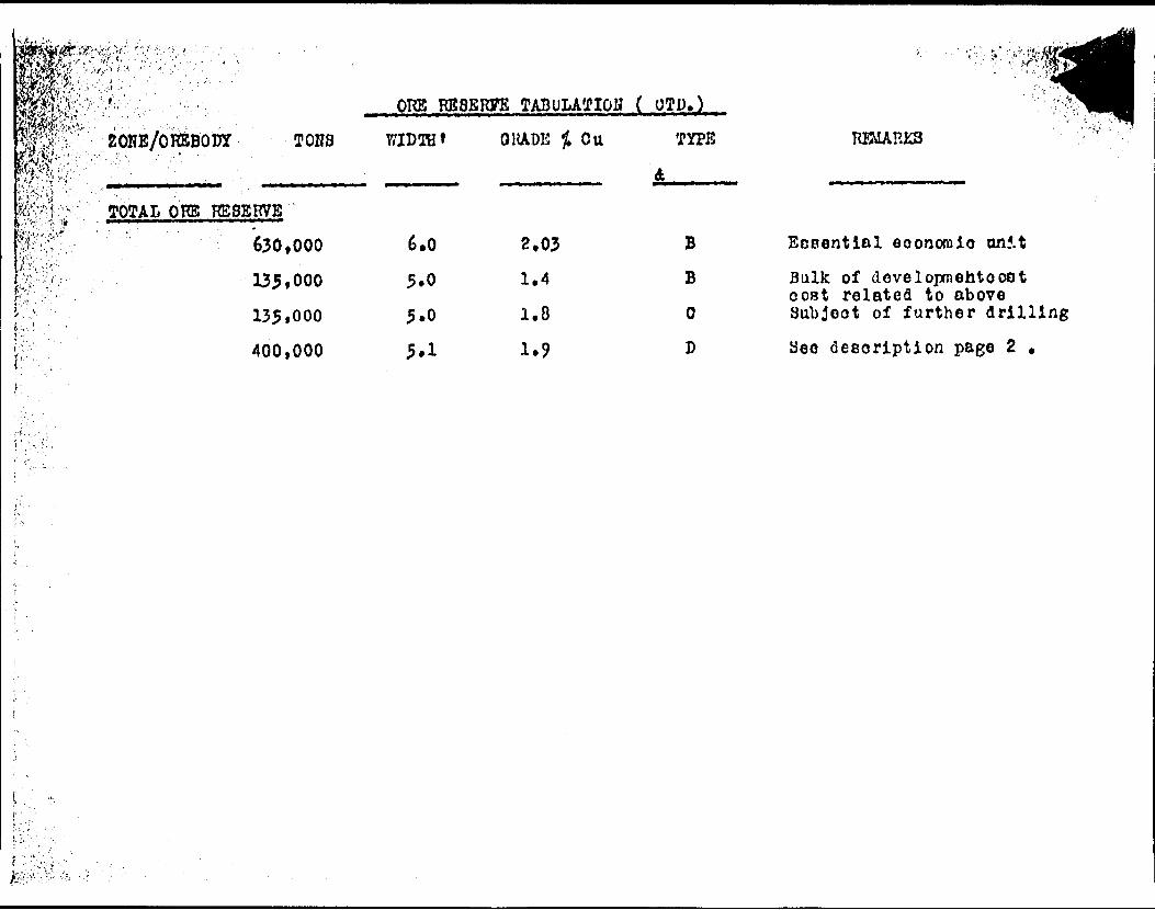
TOTAL QKBS KS9ERVE
630,000
135tOOO
135*000
400,000
6.0
5.0
5.0
.TABULATION ( OTl)).
OliADE Cu
2,031.4
1.8
TYPE
B BO
D
RBIARKS
Ecoentlal eoonoraio onf.tBulk of dovelopmehtooot ooBt related to above Subject of further drilling
desoription page 2 .

Page 5
RECOMMENDATIONS AND CONCLUSIONS
1- That on the basis of the "Essential Economic Unit" of630,000 tons of 2.03% copper in the indicated class alone the present Company plans as outlined in the May 10th, 1965 President's Report to Shareholders is fully justified.
2- That the current programme of surface drilling in the new "T" zone be continued to considerably greater depth since additional ore developed here strengthens greatly the economic link to development of the "J" and perhaps East ore zone.
3- Probe the West Ore Lens at some depth below the presently outlined ore zones and to the west thereof by a series of step back, relatively flat holes. It appears logical that, as has been suggested, tensional control may also be operative in the vertical plane and what appears as the bottom of the present ore shoots may indeed be merely that zone of compression which seperate them from a similar orebody below and habitually offset therefrom.
A minimum programme of 8,000 feet of drilling would be required under point 2 above and an additional 9,000 feet should be alloted to point 3 at a total cost of ^85,000.00 to run concurrent with the shaft sinking phase.
I further recommend that a deep drill hole be drilled somewhat centrally on the recently acquired 10 claim group (Claim SSM64359) at the point of incidence of the eastward continuation of line of strike of the West, "J" and East showings with an area of strong magnetic gradient in a generally elevated magnetic area. Similar to hole CR-15 the boring would probe the fissure system at depth and test the sedimentary copper bearing horizon below the Bruce limestone for ore concentrations in copper and possible uranium. In addition, the assessment work requirements on these claims which are due in the near future would be most usefully satisfied thereby. Assuming that the hole would be 2,SOO feet deep the total cost should not exceed $15,000.00. However, the area is considered to represent a local uplift in tho basement which would algebraically reduce the cost of the test.
Respectfully submitted
Noranda P.Q.June 10th, 1965 John A. Costa, E.M., P. Eng,
DUPLICATE COPYPOOR QUALITY ORIGINAL
TO FOLLOW

m- rr
CERTIFICATE OP QUALIFICATION
I, JOHN ALKXAirHER COSTA , of the City of H o rand a in the Provinoo of Quebec, hereby certify :
1- THAT I am an Engineer of liines and reside in the city of lloranda , yaebso , Canada .
2- THAT I am a graduate of The Colorado Sohool of Mines (1928 ) and have been practising my profession for the past 37 years, and that I am a member of Association of Professional Engineers of Quebec *
3- THAT I have no direct or indirect interest in the property of Crownbridge Copper Mines Limited in Townships 168 A 175 t in the Province of Ontario , and which property is the subject of this report dated Jane 10th , 1965 , nor do I expect to receive any interest either directly or indirectly in the securities of the Company holdinp the property .
4- THAT the aooompanyinp report on the property in Townships 168 ft 175 is based on a personal knov/1 edge of the property , and on an examination of representative split cores, drill lops, plans , sections , and assay results in the possession of the Oompony and its representatives . The property was examined from JeruvBry 19th t 19&4 to rebrusry 7 l h , 1964 and again f ran iAay 22nd, 19^4 to May ?9th ,
John A. Coste ,K.M. , P.Kng.
15? -18th Street Koranda , Quebec June 10th , 1965
r S S f * J/A* C

KAMSS NOUVEL 030
CROWNBRIDQB COPPER MINES LIMITED
TOWNSHIPS 168 and 175
SAULT STE. MARIE MINING DIVISION
ONTARIO
Willowdale, Ontario September 27, 1965.
H. Grant Harper, P.Eng., F.G.A.C,
5 l
CROWNBRIDGE COPPER MINES LIMITED
Townships 168 and 175
Sault Ste. Marie Mining Division
Ontario
INTRODUCTION
This is a report on the mining property owned by
Crownbridge Copper Mines Limited in Townships 168 and 175, Sault Ste.
Marie Mining Division, Ontario. This report comprises two distinct
and separate parts:
Part,. A ; A calculation of the copper ore reserves as
indicated by surface diamond drilling.
Part B; An interpretive and extrapolative analysis of
the geology of the general area made for the purpose of
trying to locate environments favourable for mineral
deposition and therefore worth exploring.
The following sources of information were used to prepare
this report:
PART A - Ore reserve calculations.
1. The logs of 134 diamond drill holes totalling about 60,000 linear feet of drilling together Vii-h the assay results recorded thereon as prepared for the Company by Mr. B. W. Chechak of Mineral Exploration and Engineering Consult ant o together with sundry drill plans, sections and private reports.
2. An examination of the property on September 19, 1965* Many of the surface trenches and pits were examined as
were several of the drill holes of the GR series. The remaining split core halves of several of the CR holes were checked against drill logs. In my opinion the core was well split. Also the material in the core boxes does, on visual inspection, check reasonably well as to reported grades. The core boxes are not tagged and most of the core markings are no longer legible.
3. No drill holes were put down under my direction and super vision, nor were any split core halves taken for check assay although the Company gave me permission to do so.
PAP"* B.- Geological Analysis and Extrapolation.
The principal sources of information are the several
reports and maps published over the past forty years by officers of
the Geological Survey of Canada and the Ontario Department of Mines
together with my own mining and exploration experience in the area
during the past decade. The following reports and maps were most
useful:
1. Townships 155, 156, 161, and 162 by J.A. Robertson, G.R. Number 13, Ontario Department of Mines, 1963. Also Townships 143 and 144'published in 1961.
2. North Shore of Lake Huron by W.H. Collins, Geological Survey of Canada, 1925.
3. Map 6-1961, Wakwekobi Lake Sheet by M.J. Frarey, Geological Survey of Canada.
4. Map 2032, Blind River - Elliot Lake Sheet by J.A. Robertson, O.D.M., 1962.
5. Aeromagnetic sheets numbers 32330, 2241G, 222?G, and 3237G, published by the Ontario Department of Mines.
6. Map P304, Blind River - Elliot Lake Sheet published by the Ontario Department of Mines.
7. Air photograph interpretations of the general areaincluding Township 168 by D.E. Philips, cartographer, Uxbridge, Ontario.
3, My own experience in the general area during thepast ten years. This includes mapping, logging drill cores, and the direction of prospecting and geophysical surveys.

LOCATION AND PROPERTY
The property is located in the west-central part of
Township 168 and the east-central part of Township 1751 Sault Ste.
Marie Mining Division, Ontario, approximately seventeen miles north
east of the hamlet of Iron Bridge which is located on Highway 17
about 80 miles east of Sault Ste. Marie.
The property consists bf 104 contiguous unpatented
mining claims numbered as follows:
SSM 70339 - SSM 57539 - SSM 64358 - SSM 65240 - SSM 68712 - SSM 68476 - SSM 53814, SSM 53817 - SSM 53840 - SSM 71717 -
70352 (14)57543 564361 f 465243687156849553815538375384971736
44
202
211020
104 claims
The claim titles were not searched but all the claims are
recorded on the following claim maps:
M 1612 - Township 175
M 1610 - Township 168
The property has a total area of about 4,000 acres.
ACCESS AND FACILITIES
Access to the property is via Highway 546 which leads
north and east from Iron Bridge, Ontario. At a point approximately
22.3 miles from Iron Bridge the Crownbrldge mine access road leads

for 3*2 miles to the core shack, diamond drill camp, and proposed
shaft collar. At present cars may pass on the road but unless the
steep hills are graded and the road ditched, heavy rains and snow
j! will cause a rapid deterioration.
jj The only facilities on the property at present are the
y access rotid, a 10 x 12 core shack, and temporary quarters for
i! diamond drill crews.
i
i HISTORY AND DEVELOPMENT
The early history of development is incompletely recorded.
Apparently exploration work, including EXT core drilling was done jj,
by Greatl&kes Copper Mines (Limited) and New Minda-Scotia Mines j
(Limited) which subsequently amalgamated to form Andover Mining and j'
Exploration Limited. ji
The Andover company explored the property between 1953 and ||
I960 drilling some 75 holes totalling about 30,133 linear feet. l!
These drill records are fairly complete and are incorporated as a l
part of the company records of Crownbridge Copper Mines Limited. !i'
From these records D.C. McKechnie, P.Eng., Sudbury, Ontario, (
estimated drill indicated ore reserves of 190,000 tons grading 2.01# j,i
copper across an average width of 6,1 feet above the 5uO foot horizon ||ji
in the Central, West, and J zones. These estimates were reported in :|i-M
the early spring of 1965.
Since then the Crownbridge company has drilled some ten
additional holes totalling about 6SOO linear feet. The drilling was
done to the east of the central zone. In June of 1965 John A. Costa,
; P.Eng., or Noranda, Quebec, made the following estimates of ore,i
reserves:

• Isr^ -"JIT-; .rmrmr:-rr.fr.r---at Tji's-^
630,000 tons of 2.03# copper - drill indicated
135*000 tone of 1.4 t copper - drill indicated
135*000 tons, of 1.8 Jf vopper - inferred but inadequately drilled
400,000 tons of 1.9255 copper - potential
At the time of writing, diamond drilling of tne CR seriesMj! of holes is continuing altb -igh this particular study is limited tol!jjthe drill holes preceding and including CR 45. Also, the companyi 1'
,is considering shaft sinking proposals, which being mining engineering
^considerations, are not a part of this report.
PART A - ORB RESERVE CALCULATIONS
\ fundamental Data - Origin and Nature
For all tonnage and grade calculations contained heroin the fundamental data is the diamond drill logs as supplied by Mr* Chechak. Data included on the logs and used aa factual in accordance with my instructions include, drill hole locations, bearings, elevations, dips, lengths, temple widths, and assay results. The width and grade of each computed intersection was check calculated wherever possible (roughly ninety percent of the intersections). Thus the calculated widths and grades used in this report do not always correapond iden tically with those calculated by Mr. Chechak, but any differences are eimply differences of opinion and not of fact.
Method of Calculation
Drill log information was plotted on 100 scale surface plans. 50 scale vertical cross sections, and 100 scale vertical long itudinal sections. In all, 57 drill sections were drawn.
The drill sections were used as follows:
(a) To establish visually the reasonableness of the vertical correlation of drill hole intersections.
{b) To assist in calculating the slant or true width of any intersection and, where necessary, to average the grade across minimum mining width.
(c) To serve as work sheets on which all projections and calculations are permanently recorded.
The vertical longitudinal sections were drawn on 100 scale and were used for the following purposes:
-J

CET3CrK^^ri23aC^3^X-15^SJTCS^--J^
(a) To establish reasonable correlation from section to section and to judge the lateral or length distance a drill hole intersection could be reasonably projected*
(b) To determine the plunge of the orebodies*
(c) To assess variations in the density of the drill inter section pattern and to search for areas warranting further exploration drilling.
Ore Volume Blocks were calculated by multiplying the slant
or true width of a drill hole intersection by the slant height the
hole intersection was projected and by the lateral or length distance
the intersection was projected. Because of variations in the drill
intersection density! the ore volume blocks are not of a uniform
size*
Factor
To convert from volume to tons the volume was divided by
12. This is assuming that the vein material is predominantly quartz
and that 12 cubic feet of unbroken quartz vein matter weighs one ton.
SUMMARY OF DRILL SECTION DATA
Horizon 0-^00 (Elev. 6000 to 5700)
Section
13100E13500E13600E
TOTALS
Volume cubic feet
97,65069,300
309,7503,600
Grade
1.761.922.342.31
True Width feet
3.13-34.23.6
Tons
8,1405,78025,800
300
40,020
t;
Tons ^C Grade '
14,326.411,270.4 'j60,372 i
693. i
86,661.8
Average Grade - 2.16J& Copper
n jn-. ____ . ... , i-. .. ... , -. . 2-.. ,-*T-tssS!3t!!.*.e;r.*** ^..;s.,

' , - i, - - . , - - - . - . ' - - J .. - - "' .V y ' ^ " , ' ' r
/''!:
SUMMARY OF DRILL SECTION DATA (Continued)
Horizon 0-300 (Elev. 6000 - 5700) (continued)
j i Section
14200E14300E
i;
14400El
' 14500Ei
;! 14600E
TOTALS
13100E, 13300E13500E13600E
i TOTALS
Volume cubic feet
34,10062,40052,60030,25054,60066,40029,250n2,20045,600
Horizon
120,900142,600153,450151,20027,550
Grade Z cu.
2,612.701.602.104.111.662.001.773.46
300-600
1.761.101.922.311.25
True Width feet
3.14.64.45.55.24.64.56.83.6
Average Grade
(Elev. 5700 to
3.12.33.33.62.9
Tona
2,6405,1904,4002,5304,5607,2002,4409,4003,800
42,360
~ 2.42#
5400)
10,08011,90012,80012,6002,290
49,670
Tons X Grade
7,960,414,013.7*920.5,313.
18., 741. 613,392.4,660.
16,636.13,224. i
102,102.0
Copperi 1
17,740.813,090.24,576.29,106.2.862.5
67,375.3i Average Grade - 1.76# Copper
14000S 64,000 2.07 2.0 5,340ii Average Grade - 2.07# Copper

.Oi . ;-
^^, . . ' .
SUMMARY OF DRILL SECTION DATA (Continued)
Horizon ?00-600 (Elev. 5700 to 5400) (continued)
Section
14150B 14200E
i 14250Ei
14300E
l TOTALS
i;i
13300Ei
13500E 13600E
TOTALS
Volume Grade True Width cubic feet Z cu. feet Tons Tons I Grade
51,150 4,65015,000 34,650
29,140
103,500 47,600 51,975 53,650 75,600
2.23 2.81
2,15 1.06
1 ? 80
Horizon 600-900
1.10 1.12 1.92 1.25 1.33
9.3 3,1 3.0 6.3
3,7
Average
(Elev.
2.3 2.83.3 2.9 6.3
Average
Horizon 900-1200 (Elev.
13300E
; 13600E
f TOTALS
173,600 129,150
1.12 1.83
2.3 6.3
Average
4,260 390
1,250 2,890
2,420
9,499,3 1,095,S2,687,5 3,063.44,356.0
11,210 20,702.6
Grade - 1.84# Copper
^400 to 5100)
8,650 3,980 4,320 4,470 6.300
19,515. 4,457.68,294.4 5, 53V. 5
11.529.
27,720 39,333.5i
Grade * 1.42# Copper ji
5100 to 4800)
14,450 10,790
16,184.0 19,745.7
25,240 35,929.7
Grade - 1.43# Copper

;t:
t
SUMMARY OP DRILL INDICATED RESERVES BT ZONES
A* West Zone
Horizon
0 - 300
300 - 600
600 - 900
900 - 1200
Totals 142,
(13050E - 13SOOE)
Tons
40,020
49,670
27,720
25,240
650 tons
Grade
2.16
1.76
1.42
1.43
grading 1.
Tons/Vert, Foot
133
166
92
100
75# Copper
Approx. True Width
3.5
3.0
3.94.5'
Approx. Kor. Width
4. B
3.6
4.1
5.2
(13950E - 14050E)
0-300 300 - 600 600 -
5,340
C. "Central" Zone
9 - 300 42,360 300 - 600 n,210
NIL
2.07 IB
UNTESTED
(14125E - 14650E)
2.42 1411.64 112
2.0
4. B
5.1
2.1
5.5
6.0Total: 53*570 tons averaging 2.29# Copper

r , .."' " " : " ; V;- - . \ "-'' '
l:-'*
.
*
SUMMARY OP
A. 0-300
2one
Vest
Central
TOTAL:i
B. 300 - 600'" "'" a f!i'WiiS,M-.' — LI
West
"14000 w
Central
TOTAL:
DRILL INDICATED
Tons,
40,020
42,360
82,380 tons
tons
49,670
5,340
11,210
66,220 tons
tons
RESERVES BI
Grade
2.16
2.42
averaging 2.
per Vertical
1.76
2.07
1.84
averaging 1.
per Vertical
HORIZONS
Tons X Grade
86,661.8
102,102.0
92# Copper
foot - 275
87,375.3
11,053.8
20,702.6
79# Copper
foot - 220
1
i
C. 600 - 900
West
y 900. "1200
West
GRAND TOTAL;
( O - 1200
27i720 tons averaging 1.42# Copper
tons per Vertical foot - 92
251240 tons averaging 1.43J& Copper
tons per Vertical foot - 100
201,560 tons averaging 1.90J5 Copper
l J
The calculation of ore reserves is a mechanical process
j and should include a minimum amount of personal opinion and prejudice
Where a potential ore zone has been drilled off at regular vertical
and horizontal intervals; where the angle of intersection between
j the drill hole and the ore zone is reasonable; and where the mineralli - '
; values are distributed uniformly through a defineable zone; then
drill indicated ore reserves can be calculated with maximum precision
and a minimum of personal opinion and prejudice. In the case of the
Crownbridge ore reserves, personal opinion and prejudice are un
avoidably included in the ore reserve calculations. Consequently,
my calculation of 201,560 tons of 1.90# copper may, on the basis of
' opinion, be justifiably revised upwards or downwards by more than
the usually acceptable 10# to 15#. The several factors involving
opinion and influencing to an abnormal degree the mechanical calcul- i
ation of ore reserves warrant discussion under separate headings.
I.- Drill pattern or density of intersections
The drill pattern or density of intersections is best seen j
in longitudinal section. Ideally, in the plane of the longitudinal
section, any two areas of identical size should be pierced by the
same number of drill holes. Furthermore, the drill holes should
; pierce the longitudinal section in roughly straight and parallel
horizontal and vertical lines. Such is not fully the case on the
i Crownbridge property. The West ore Zone, for example, has had far
less drilling than the Central Zone. In one place in the West Zone,
;t the drill holes are 400 ft* apart horizontally, while on the Centrali'P Zone some of the drill holes are only 25 ft. apart horizontally.i ;li Obviously, more drilling on the West Zone may drastically alter,
either upward or downward, the calculated ore reserves in respect
: . ,.v - - .. ........- ,-^,-, ; ,w

f 13
VIthin the individual ore jones, there is a wide variation
in the density of the drill hole intersections* For example, in the
central zone the ore reserve lying below the 5700 ft. horizon is more
firmly established than the ore reserve lying above the 5700 ft.
horizon. In most drill programs, the near-surface reserves are more
firmly established than the deeper reserves.
2.- Drill hole angle of intersection
The Crownbridge ore zones occur in an east-west trending
zone which dips northward at a very steep angle: the actual dip
angle probably varies between 650 and SO0 . All of the drill holes
have been collared on the north side of the vein system and where
the hole has a dip, the bearing is north. Ideally, a drill hole
should cut the plane of a vein at 90O but it is very seldom physical
ly possible to plan drill holes to make perfect vein intersections.
Therefore a compromise is necessary and with steeply dipping veins,
it is not customary to drill holes at dip angles of more than 600 or
700 . The reason for this is that drill holes wander, in fact they
tend to corkscrew as they go down and usually they flatten. Thus,
the true width calculation is subject to increasing error as the
acuteness of the angle of intersection increases, particularly when
the ore zone is not clearly defined. An example will illustrate the
point.
In his report o.f March 25th, 1965, D.C. McKechnie, P.Eng.,
assigns DDK 701 at 13600F a core length of 9.5 ft. (true width 4*0
ft.) grading 2.05/C coppor. Whereas I have assigned the same inter
section 12.6 ft. (true width 6.3 ft.) grading l.#3# copper. Such
differences of opinion can cause very large variations in tonnage
and grade calculations, and arc caused primarily by the acute nature
of the angle of intersection between the drill hole and the plane of
the vein*
The following list or table shows the angles of dip for
the 49 drill holes included in the ore reserve calculations. In
most holesi the core length of the intersection is 2 or 3 times the
true width and the necessary adjustments introduce an undesirable
measure of opinion.
Dip angle of drill hole 360 - 450
450 - 690
700 - 790
SO0 - S90
900
No* of Drill holes
7
O
13
15
14
3*- Vein character and correlation
The character of the ore deposit introduces into the ore
reserve calculation a factor of questionable ponderability. The
drill logs demonstrate clearly that the quartz vein system usually
has a much greater width than (a) that portion of the vein carrying
copper mineralization and (b) that portion of the vein carrying
copper mineralization in economically interesting amounts and widths.
The economically interesting copper zones occur on the hanging wall,
in the middle of the vein, and on the footwall, and in some instances
the whole vein appears to be economically mineralized. The acute
angle of drill hole-vein intersections have not simplified the task
of defining the vein walls, and it may be incorrect to correlate
vein intersections over distances of 100 ft. or more.

EXPLORATION ALONG THE MAIN VEIN
The main rein system on the Crownbridge property has been
traced intermittently for a strike length of about 6500 ft. Search
diamond drilling has disclosed several "zones" of potentially econ
omical copper values associated with the quartz vein* The several "zones" are described with respect to their confining "easting"
coordinates. The several zones are more precisely described as follows:
1. OPEN TO WEST Less than 10,000 E2. RITA LAKE ZONE 10,000 E to 10,700 E3. NO DRILLING 10,700 E to 13,000 E4. WEST ZONE 13,000 E to 13,600 E5. PARITALLI DRILLED 13,600 E to 14,125 E6. CENTRAL ZONE 14,125 E to 14,650 E7. PARTIALLY DRILLED 14,650 E to 16,950 E6. J ZONE 16,950 E to 17,050 E9. POORLY TESTED 17,050 E to 16,000 E
10. EAST ZONE 16,000 E to 16,500 E11. OPEN TO EAST Above 16,500 E.
Each of the above sections requires an individual summation) j. There are no picket lines crossing the main vein so far as I could
i
see and I am assuming that the zone has not been subjected to any igeophysical surveying. j|
li l* OPEN TO WEST - (Less than 10,000 E) |i li : No drilling has been done to the west of section 10,000 E.
li At this section line, the main vein seems to be broken up into 3 or
l 4 smaller veins, all of which carry appreciable copper values across
l; narrow widths. An electromagnetic survey of the Crone type, if
I carried on for another 1,000 ft. to the west, might discover con-
II duct ore warranting diamond drill exploration.

2, RITA LABS ZOKB (10,000 B to 10,700 B)
The Rita Lake section has been explored by six diamond
drill holes including one very short hole which did not advance far
enough to intersect the potential copper tone lying near the south
shore of Rita Lake. The six holes are spread at 175 ft. horizontal
intervals so the zone has been crudely tested for a strike length
i of 700 ft. The drilling done is insufficient to allow an estimate
of ore reserves.
There are two copper-bearing structures in the Rita Lake
zone. One lies near the north shore of Rita Lake and shows good
persistence for the known 700 ft. strike length although the widths
are narrow and the grades low. The best grade was 1.8?# copper
across a core length of 4.1 ft. in hole CR 24. The second zone of
copper mineralization lies near the south shore of Rita Lake and
was intersected in only three of the five holes which probed deep
enough to intersect the zone. Here, the widths and grades of the
copper mineralization are somewhat better. The best intersection
was 2.06# across 3*0 ft. of core length.
Further drilling is necessary for a proper evaluation of
the Rita Lake Zone.
3* 10.700 E to 13.000 E.
Apparently there has been no drill exploration in the
; 2300 ft. separating these two section lines. Philip's air photo
interpretation shows a marked linear trending through this section
along the general trend of the main vein. Certainly the area should
; be surveyed geophysically to search for diamond drill targets.
-ir
i; _.________._,__ ̂ ,^.^.._
4. HfEST ZOKB (13.000 E to 13.SOO E.)
Eight drill holes indicate that the west zone contains
142,650 tons of 1.7555 copper to a depth of 1200 ft. Obviously the
zone is not thoroughly drilled off. The zone requires fill-in
drilling, especially between surface and 300 ft. Furthermore, the
zone is wide open to the west. Two of the deep holes on this zone,
16#-704 and GR 16, may have been stopped short of their target. The zone provides an abundance of immediate drill targets whose explora
tion is thoroughly Justified.
5* l,?,300. B to 14.125 E. ji-
This section of the vein system includes the proposed \ shaft location. Drilling to date indicates the section to be "lean" i 1 with respect to copper mineralization but two or three more holes [ should be drilled before collaring a shaft. ;
\-l;
6. CENTRAL ZONE (14.125 E to 14,650 E.) j
Nineteen drill holes indicate that the central zone
contains 531570 tons grading 2.29# copper to a depth of 400 ft.
Between surface and 300 ft. drilling to the east and west has
reasonably well defined the limits of the zone, although there arei;
possibilities of finding a .small tonnage of additional ore immed- |
lately east of the zone. Beneath the 400 ft. horizon there are two i !
drill holes which mark the bottom of economic ore intersections and, |
this amount of drilling is scarcely proof that the zone does not |iI extend to greater vertical depths.
The central zone seems to plunge to the west at 400 , but
further drilling between the 300 and 600 ft. horizons may alter
this impression.

lei
7. 14*650 B to 16.950 S.
This 2300 ft. length of vein system has been explored by 4# drill holes of which 15 were blanks and l? produced assays in excess of 1# copper. Generally speaking, the area has been fairly
; | well explored and found wanting. Some further drilling is warranted,l;
l first, to more precisely delimit the east boundary of the Central
l Zone, and second, to outline some potential ore zones, particularly; near 15,600 E and 16,600 E.
S* J ZONS (16,950 E to 17.050 E)
i There is some confusion regarding the location of some of
i the drill holes in this zone and I have been unable to resolve a
reliable picture of the ore potential. In my opinion, the drill holes should be re-surveyed and the drill sections re-plotted* If
this were done, I suspect that further diamond drilling would be indicated.
9. 17.050 E to 18.000 E.
This 950 ft. length of main vain system has been explored ii
by one drill hole with negative results on line 17,200 E. The area |
should be surveyed geophysically. !ii'
10. EAST ZONK (18.000 E to lg.500 E) j
The East Zone has been explored by five drill holes of j;
which two encountered modest values in copper across narrow widths, i
The zone is wide open to the east. Geophysical surveying in advancei! of diamond drilling is the reconmended course of action.r h
!; H. OPEN TO THE EAST (Above 16,500E)ii ~" ~~"~The easternmost drill hole on the east zone, 16B-C-1,
returned 1.93/6 copper across a core length of 7*3 ft. The true

width of the mineralized section is probably over 6.0 ft. The
quarts vein is wider than the assayed section. The air-photo linear
which marks the main vein system continues eastward for another
1,000 ft. where it terminates near a stronger northwest trending
linear. The area requires geophysical exploration.
GENERAL DESCRIPTION OF THE MAIN VEIIC
The main vein is a quartz-filled fissure-stockwork-brecsia
zone which has been mineralized with chalcopyrite, bornite and
hematite. Very low gold and silver values are associated with the
richer copper sections. The vein is marked by a weak topographic
Hnear which strikes between N#OW and N85W. The linear is traceable
on the air photographs for a length of li miles. The main vein dips
steeply north and locally it attains horizontal widths in excess of
25 ft. Widths of 10 ft. seem fairly common. Very seldom is the
full width of the vein mineralized to a degree that is economically
intereoting. At any given location, that part of the vein carrying
potentially economic quantities of mineral may occur at the hanging
wall, in the centre of the vein, or against the footwall. This sug
gests that the ore shoots within the vein are lenses and it makes
questionable the correlation of widely spaced drill holes.
The vein intersections which I inspected were unusual for
this type of mineral deposit in that the sulphides were distributed
evenly throughout the vein matter as opposed to being concentrated
in blobs within barren vein matter; and I regard this as a very
favourable geological indicator.
Several of the drill holes have encountered minor veins
in the hanging wall of the main vein and a portion of these have
carried copper values of interest/. The drilling of steep-angled

:|;::r holes result in a less well explored hanging vail than one might
j usually expect. Few of the holes have been drilled well beyond
the Main Vein in order to explore the footwall.
* *

B - AK INTERPRSTIYB 6 EITRAPOLATIVE GEOLOGICAL ANALYSIS
General Geolopy
The general geology of the Crownbridge property lo summar ized in the following table of formations. The thicknesses foi the Gowganda ard Bruce Formations were taken from drill hole GR 15 and therefore can be regarded as precise. The thicknesses for the Mississagi Formations were derived from estimates made in adjacent townships by J. A. Robertson of the Ontario Department of Mines and these are probably the most accurate of the available estimates.
Keweenawan,
Table of Formations
,..diabase, gabbro.., sills fc dikes
INTRUSIVE CONTACT
HURONIAN SEDIMENTS
Cobalt Group
Gowganda F01 ......... siltstone, argillite
conglomerate, greywacke
Unconformity
Bruce Group
Bruce Limestone Fm ....siltstone, limestone(Espanola) greywacke ...............100*
Bruce Conglomerate F0....conglomerate, ............ SO fgreywacke
1500 - 2000*
Mississagi F10 ,
Upper......,
............(2100* - 3300')
quartzite .............. 1000 - 2000middle .................conglomerate, greywacke..
argillite ............... 600 - 700lower .........*........quartzite, uraniferous,
pbl. conglomerate........ 500 - 600Pre-Huronian .........,......granite fe greenstone

BASEMENT BOCKS
Pre-Huronian - Granite fe Greenstone
The basement rocks are nowhere exposed on the Crownbridge
property but they do underlie all of the property at a vertical
depth of between 4*000 and 5,200 ft. The basement rocks in the
general area are granite and greenstone and either one or both
must underlie the property. The uranium orebodies of the Elliot
Lake area overlie greenstone basement rocks and if greenstones
underlie the Crownbridge property, it could be regarded as a weak
sign encouraging to mineral exploratidn.
HURONIAN SEDIMENTS
The Mississafti Formation
The log of drill hole CR 15 demonstrates clearly that the
top of the Misftissagi formation underlies the Crownbridge property
at a vertical depth of about 2000 ft. CR 15 penetrated the upper
Kississagi for some 250 ft. encountering a thick bi.dded, pure white,
quartzite. The Mississagi formation is estimated, after Robertson's
figures, to be between 2,100 and 3,300 ft. thick and this assumes
that the beds are nowhere repeated by thrust faulting. The
Mississagi is divided into three components: the upper,,middle,
and lower facies,
lower Mississagi
This formation lies unconformably on the basement rocks.
Its lowest member is a heterogeneous fossil soil from zero to fifty
ft. in thickness which contains fragments of greenstone and granite
as well as fine grained oxidized material. In some localities it
is weakly radioactive. Most of the lower Mississagi is clean
arkosic quartaite, irregularly bedded and cross-bedded with no
particularly distinctive horizons other than the world famous uraniferoua quartz pebble conglomerates.
Quarts; pebble conglomerates are widespread in the lower Missiasagi quartzite both laterally and vertically* However, the economically important ones are found in a very specific and local ized environment and have quite a distinctive appearance. All of the known conglomerate beds of economic importance occur within a few feet of the bottom of the lower Mississagi formation where there is a large gentle depression in the Pre-Huronian surface. Depres sions in the Pre-Huronian surface usually occur in the greenstone
rather than in the granite areas.
The following characteristics give the economically
important quartz pebble conglomerates a distinctive appearance.
1. The beds are from 6 to 12 ft. thick and the quartz pebbles axe densely packed.
2. The pebbles are 99/* white to glassy, re-crystallized, well-rounded quartz pebbles about l inch in diameter. Jasper, brown, black, and banded quartz pebbles are infrequent but not rare.
3. The interstitial material is fine grained, uraniferous, and carries up to 25# of pyrite.
4. The entire quartz pebble conglomerate bed is strongly but not uniformly radioactive.
f-rj5. The upper and lower contacts are generally quite shapr.
The lower Mississagi ranges from 500 to 600 ft. in thick
ness with local increases up to 700 ft.
i Middle Mississagii 1i; The base of the Middle Mississagi is marked by a basal\'boulder conglomerate which, though not everywhere present, averages about twenty feet in thickness. The bulk of the Middle Misdissagi

'4*sni hsr.
consists of argillite and greywacke whose thickness in the western
part of the Quirke Syncline is estimated between 600 and 700 ft.
Upper
This formation consists of hard white quartzite and arkose
all of which is thick-bedded and in places steeply cross-bedded.
According to Robertson the maximum, thickness of the Upper
Mississagi is 1,600 ft. but at Copp Lake, near the south end of
Township 167, the writer logged an old drill hoJ.e which showed a
thickness of the Upper Minsissagi of over 2,000 ft.
The Upper Mississagi contains a number of poorly developed,
variable, quartz pebble conglomerates which are sometimes slightly
radioactive.
Drill hole GR 15 demonstrates that the top of the Mississ
agi formation lies 1,975 feet below the surface on L/ie Crownbridge
property.
.Bruce. Conglomerate Format i QJI
Drill Hole GR 15 intersected the Bruce Conglomerate Form
ation between elevations 4110 and 4030. The thickness of the form
ation is about BO ft. which is comparable to its usual thickness in
the Algoma area. Characteristically, the formation consists of
scattered cobbles and fragment a of granite and greenstone in a poorly
sorted dark grey, siliceous matrix. Introduced pyrite surrounding
and sometimes replacing quarts grains is a common feature in the
Bruce Conglomerate, but none of this was observed in the core of
CR 15.
jBruco Limestone Formation
Drill Hole CR 15 intersected the Bruce Limestone (Espanola) Formation between elevations 4,230 and 4,110. The thickness of the
!| formation is abov':. 120 ft. It consists of a relatively pure lime stone and an argillite horizon which is reported to carry low dis-i
|j seminated chalcopyrite. The limestone showed a marked lineationII|| which locally paralleled the core. This probably reflects plasticlli flow within the horizon and this is a common feature throughout the ' area.
Gowganda Formationl : rl"~ 1~ ^* T ' r -~-L-i^'L-J-^ruJ ' - "
Barring the intrusive rocks, the Gowganda Formation under- I lies all of the Crownbridge property at surface and all of the drill : holes have collared in this formation. CR 15 intersected Gowganda rocks from surface to elevation 4,230. Thus the thickness of the Gowganda, as recorded in CR 15, is about 1700 ft. Theoretically the amount of uneroded Gowganda should increase to the northwest and decrease to the southeast.
Lithologically, the formation is an heterogeneous conglom erate containing many greywacke phases, all of which are poorly
i bedded.
l Keweenawan Intrusiyes
The Keweenawan rocks are represented by dikes and sills of i diabase, diorite, and related rock types. These rocks are known to "occur on the property, but as the property has not been mapped, their j;location, attitude, character and influence are indeterminate.

STRUCTURAL GEOLOGY
|| A. Foldingl' The Crownbridge claims are located in the Blind River -iiij Elliot Lake Sedimentary Basin, the famous "Z" shaped open fold'i! structure consisting of the Quirke Lake Syncline and the Chiblow
j (Denman) Lake Anticline. The actual location of the claims is toii the west of the precisely defined portion of the Quirke Lake Synclinej
out where it is not possible to accurately locate the synclinal axis
because of the lack of nearby horizon markers.
l A number of things may happen to the Quirke Lake Synclinal
Axis in the general area of Townships 16S and 175. The Axis has
definitely been traced as far west as the east side of Township 162
and there most geologists simply stop projecting it. Assuming that
the pre-Huronian basement retains its peneplained surface to the
west, then I postulate the following behaviour for the Quirke Lake
Synclinal Axis.
As it moves westward through Township 162 into Township
168, the Synclinal Axis probably splits into two parts: the northern
part (the Qrasset Syncline) continuing westward through the northern
part of Township 175; the southern part {the Cross-fold Axis) should
trend southwest near the northwestern Crownbridge claims gradually
curving more to the south to join with the established Cross-fold
Synclinal Axis located near the Parkinson-Montgojaery Township
boundary.
From here the Crose-fold Axis should gradually curve south
eastward and then eastward joining up with the Pronto Synclinal Axis
l which terminates against the Murray Fault.
27'
If the above theory is valid, then the Crownbridge claims
lie on the south limb of the Quirke Lake Syncline and the distance
from surface to the pre-Huronian basement should be less at the
li southeast corner of the property than at the northwest corner of thel \j property. The sole reason for giving this theory a moment's consid
eration is that this postulated geological environment has similari
ties to the Nordic and Pecors Lakes uranium deposits which lie some
17 miles to the southwest; and if, at depths of 4,000 to 6,000 ft.
the Crownbridge claims can possess similar mining possibilities, then
the Crownbridge Board of Directors should be aware of the possibilities
Ve have no direct knowledge of minor fold structures on the ji
Crownbridge claims for the geology has not been mapped. Furthermore
it is not likely that either mapping or normal surface diamond drill- j|ijing will reveal foid structures of importance for the thick blanket ['
l; of Gowganda formation completely hides all useful horizon markers. J!
B. Faulting and Fracturing
Two major faults of the Blind River - Elliot Lake area,
the Quirke Lake Fault and the Koon Lake Fault, seem to bear a relation
ship to the Crownbridge property and thus warrant consideration.
The Quirke Lake Fault is an East-West trending low angle
thrust fault which has been traced from the east shore of Quirke
Lake to the northeast corner of Township 162, a distance of about
16 miles. The fault gently bevels the formation and causes local
gaps and repetitions in the stratigraphic sequence. The Government
maps terminate the fault less than one half mile before its continued
projection would show it crossing the axial plane of the Quirke Lake
Syncline. After a gap of li miles, another fault, Fault A, commences
w-.---on the same strike trend, and continues southwest roughly following
the drainage basin of the Blind River. It passes to the south and
east of the Crownbridge property and seems to continue on into
Montgomery Township. In Montgomery Township a deep hole penetrated
3,000 ft. of Gowganda Formation and failed to reach the Bruce Lime
stone Formation which was expected at 1800 ft. This suggests that
Fault A is a major overthrust and has caused a repetition of part
of the Gowganda Formation. Some geologists regard Fault A as a
continuation of the Quirke Lake Fault but I believe it is a separate
fault, perhaps complementary to the Quirke Lake Fault but separate,
for I do not think it natural for low angle thrust faults to cross
major synclinal axes. CR 15 proves that there is little or no
repetition of Gowganda rocks in the heart of the Crownbridge property
but the presence of Fault A to the southeast and the knowledge of the
deep hole in Montgomery Township indicates that there may be a repe-bo T* ' ,:-
tition of the Kississagi Formation at depths below the coHar-of
CR 15.
The Moon Lake Fault is a nearly vertical structure which
has been traced from the southwest corner of Township 155 to the northwest corner of Township 168, a distance of about 16 miles. It
crosses the northeast corner of the Crownbridge claims for a length
of about li miles. According to Robertson, between Moon Lake and
Tea Lake, the Moon Lake Fault, wherever it is exposed, is marked by
an abundance of pyrite and chalcopyrite bearing quartz veins. One
of the interesting features of the Moon Lake Fault is that it is
located at the crest of the Moon Lake Anticline, a secondary fold
viuperimposed on the south limb of the Quirke Lake Syncline. If, as i o ilx.il> in Township 168, the Moon Lake Fault bears the same
relationship to the Moon Lake Anticline, then the Crownbridge main
vein system lies on the southwest limb of the Moon Lake Anticline
and one would expsct the rein system to show a westerly plunge*
Philip's photo interpretation of Township 168 records a
jl number of geologically interesting linears that are very probably"\i reflections of fault and fracture structures. The two strongest
l,
j! structures are the Moon Lake Fault and a parallel un-named linear
: lying li miles to the southwest. The west end of the Crownbridge
Main Vein seems to terminate against this un-named linear while the
east end of the vein system seems to terminate against a secondary
linear which trends parallel to the Moon Lake Fault. Slightly over
i mile south of the Crownbridge Main Vein is a paralleling linear
which persists beyond the un-named northwest trending linear men
tioned above.
Philip's map shows numerous other linears, some of which
are certain to be fault and fracture structures, but not all of
which can be of potential economic value.
EXPLORATION POSSIBILITIES
The exploration of the main vein, havi.ig been discussedD
elsewhere, will be entirely omitted from this section.i!
The Crownbridge property is located in an area which is j|
producing two metals: uranium and copper. It is possible that both ji;
metals occur on the Crownbridge property in circumstances which j|
permit profitable mining.j'
! A. Uranium possibilitiesi,
;i There are no known concentrations of uranium minerals on the Crownbridge property. Mr. B.W. Chechak r&ported local radio-
ji active concentrations with readings up to twice background count in
|; the lower portions of drill hole CR 15* The writer geigered the i
j lower portions of CR 15 including the last 50 ft. of Gowganda form
ation, the Bruce Limestone and Bruce Conglomerate Formation) and the
top of the Mississagi Quartzite formation, without detecting any
above normal radioactivity. Howeveri three boxes of core represent
ing footages 1901 to 1977 were missing from their .place in the. core
i rack and consequently were not geigered.
li In the Blind River-Elliot Lake area all uraniferousi; i;ji deposits of economic value occur within a few tens of feet of the
l base of the Mississagi Quartzite and this horizon, which does exist on the Crownbridge claims, lies somewhere between 2,000 and 31000
feet below the bottom of hole CR 15. Thus, on the Crownbridge prop
erty the favourable uranium horizons lie from 4,000 to 5,000 ft.
below surface and are, from all practical considerations, beyond our
present exploration reach.
B. Copp e r p o s gj-bi li ti e s
Three types of copper deposits may be found on the Crown-
i bridge property but at present only the quart z-sulphide vein type
is known. The three types of copper deposits are:
i (a) quartz-sulphide veins,
(b) diabase contact deposits,
(c) "bedded" copper deposits.
(l) Quartz-Sulphide vein deposits
; Quartz-sulphide vein deposits on the Crownbridge property
i; may possess almost any strike or dip but there are two primaryi'Si strike directions which should be investigated first. These are the
3CVi
li
J .'i east-west direction which corresponds to the Main Vein strike and
ji the N60W strike which corresponds to the strike of the Moon Lake
Fault* Altogether there are twelve linears whose strikes lie within
ten degrees of the strike of the Main Vein and nine linears with
strikes similar to that of the Moon Lake Fault. The Moon Lake Fault
strike direction is regarded as favourable for quartz-sulphide vein
mineralization for Robertson notes an abundance of quartz veins in
association with the Moon Lake Fault in the vicinity of Moon and Tea
Lakes. j
There are many linears having other strike directions !
recorded on Philip's photo interpretation map and any of these may !i
represent valuable quartz-sulphide veins. However the two primary ji i
strike directions outlined above can be investigated by a single set j
of geophysical measurements.
(2) Diabase contact deposits
No deposits of this type are known on the Crownbridge '
property but they are fairly common throughout the area. The depos
its occur as disseminated copper sulphides distributed across narrow j
widths of diabase and country rock along the contacts of diabase
dikes and sills. The deposits seldom have quartz veins associated
in any appreciable amount and garnet, magnetite and other contact \
metamorphic minerals may or may not be present. These deposits are
difficult to find by geophysical methods as they seldom form con- i
tinuous conductors. iji
(3) Bedded deposits jt
|; In his report of March 1965, D.C. McKechnie, P.Eng. reportsi -//x'/Wyl! that between footagee 1904 and 1944 a thickly bedded siliceous
argillite showed very fine disseminated chalcopyrite which was well

below or* grade. A mineral dlscoyery of this nature, albeit well
below economic grade, is of the greatest interest. One of the largest
copper mines in the world is located at White Pine in the northwest
corner of Michigan State* Here, the low grade bedded copper deposits
were found by old time miners who mined short, narrow, near vertical,
fissure vein systems downward and chanced to intersect the horizontal
bedded copper deposits. Today, at a daily mining rate of about
13,OCX) tons, there is sufficient ore reserve to support mining for
many decades to come. The rocks at White Pine are similar in age,
character, and structure to those of the Blind River-Elliot Lake
area. In my opinion the disseminated copper found in CR 15 warrants
a most careful field and laboratory examination for it may be a lead
to an important mineral discovery.
There are no established "bedded copper" deposits in the
Algoma area although most geologists are aware that the area may
contain them.
* *

CONCLUSIONS AND RBCOMMENDATION3
1. l calculate that the tttin Vein on the Crownbridge property
[ ; contains the following drill, indicated ore reserves in the West,
l 14*000, and Central zones.\\
West Zone - 142,650 tons fe 1.75^ copper
; 14,000 Zone - 5*340 tons k 2.07S& copper
Central Zone - 53 1570 tons fc 2.29# copper
; Total - 201,560 tons t 1.90J& copper
On the basis of diamond drill information it is not
practical to classify ore reserves into proven, possible, and
potential, nor to assign tonnages and grades to each classification.i ne
Needless to say, the possibilities of drill indicated 'ore above the
tonnages listed are very great.
2. The Company has received recommendations for sinking a
shaft in the foot-wall of the vein near the general vicinity of
13,900E. The purpose of the shaft is to develop the central and
west orebodies at relatively shallow depth in order that the drill
indicated ore zones might be thoroughly sampled and appraised.
Fresh vein matter would also be available for extensive mill testing.
I concur with the purposes of the underground development for the ii character of the vein and its copper mineralization is such that the i
detailed data available from a "mining appraisal" is advisable in
order to confirm diamond drill core indications and interpretations.i'However, it may be possible to accomplish the purpose of the under-i
i;ground development by means of an adit entry and thus avoid the high
i' cost of shaft sinking, l estimate that it would cost less than

^1,OCX).00 to take the elevations required to determine if an adit
entry is feasible.
3* A base line-picket line grid system should be established*
The base line should be straight corresponding to the original base
line but it should avoid the Jog near 15,900E and continue in a
straight line. Picket lines at 100 foot intervals should be estab
lished over the main vein system while lines at 400 foot intervals
should be run to the north and south boundaries of the property.
The cost of the line cutting would be about #3,000.00.
4. The property should be surveyed geophysically using a
magnetometer and a Crone electromagnetic unit. In the vicinity of
the main vein system the survey should be done at 100 foot intervals
BO as to provide maximum information for continued diamond drill
evaluation of the main vein. The remainder of the lines should be
reconnaissance surveyed at 400 ft. line intervals. At the same time
a competent prospector should be hired to prospect as follows:
(a) The extremities of the Main Vein system;
(b) The several lineais striking parallel to the Main Vein and parallel to the Moon Lake Fault;
(c) To prospect the vicinity of any electromagnetic conductors found during the survey.
The estimated cost of this survey work is $10,000.00.
5. A limited drill programme of about 5*000 linear feet
should be expended to more precisely de-limit and evaluate the Centra!.
and West Zones between surface and 600 ft. None of these holes'i
|. should be drilled at angles steeper than 55 degrees. The estimated l
i; cost is #20,000.00.

6. TheCompany'e property has been developed to the point where, if the recommendations made herein are followed, a full-time
core-grabber-prospector-techrdcian resident on the property is
highly desirable* A light frame 16 x 24 cabin providing accommoda
tion, cooking, and office facilities for about four men should be
constructed and equipped at a cost of about $l,600.00. ,
7. The drill core from footage 1904 to 1944 in hole CR 15 which contained disseminated chalcopyri a in a siliceous argillite should be logged in minute detail. Character sections should be
sent to a qualified petrographer and mineralogist for detailed thin section and polished section studies. The estimated cost is $500.00.
8. Completion of the above recommendations will probably ;l.
locate more drill targets along the main vein and has an excellent | chance of locating drill targets in other sections of the property. | !
On the completion of the geophysical survey, the Company may anti
cipate further recommendations for extensive diamond drilling.
The total cost of the expenditures recommended above is $36,000. Contingencies, travel, and consulting services may raise the cost to about ^40,000.00.
My report is respectfully submitted,!
j: /V- ('l-\ rj. H. Grant Harper, P.Eng.y F.G.A.C.i| Economic Geologistl; Willowdale, Ontario,1 September 27, 1965. ,

CERTIFICATE
I, HUGH GRANT HARPER, of Metropolitan Toronto, in the Province of Ontario, certify as follows with reapect to my report entitled Crownbridge Copper Mines Limited, Townships log and 175i Sault Ste. Marie Mining Division, Ontario, September 27, 1965.
1.
2.
I am a practising economic geologist carrying on business as
H. Grant Harper, P.Eng., - 314 Hendon Avenue,Willowdale, Ontario.
I graduated from the University of Toronto with the degree of B.A.Se., 1950 and M.A.Sc., 1951 And have been engaged in my profession for over ten years. I am a Fellow of the j Geological Association of Canada, a Member of the Ontario i Association of Professional Engineers registered in the Mining Branch, a Member of the Canadian Institute of Mining and Metallurgy, and a Member of the Board of Trade of Metropolitan Toronto.
3. I have no interest, nor do I expect to receive any, either direct or indirect, in either the property or securities of Crownbridge Copper Mines limited.
4. This report is based on a personal examination of the property and some of the drill cores made on September 19* 1965 and on the Company data supplied by Mr. B.W. Chechak of Mineral Exploration and Engineering Consultants.
H. Grant Harper, F.G.A.'C., P.Eng., Economic Geologist
' Willowdale, Ontario, l! September 271 1965.

—l ""r/""^ d^^
*^r

77
ffi *
*
r*"
e 9
e #
x -
c C
t A
4. f
* e Cr
ownb
ridge
Cop
per
Mine
s Li
mite
dFo
rmer
ly
a r?
ci
y /,
x/^-
P
/?
?
S
l #
V
'f X
^ a
X ^
22
.e
Z e
s?
s
X y
c l /
J S
T
3 K
^
f A
e
ss.
ff-'
CJ
f c
* /
P/
c
lX
r
., -
- f
,,
. ^*
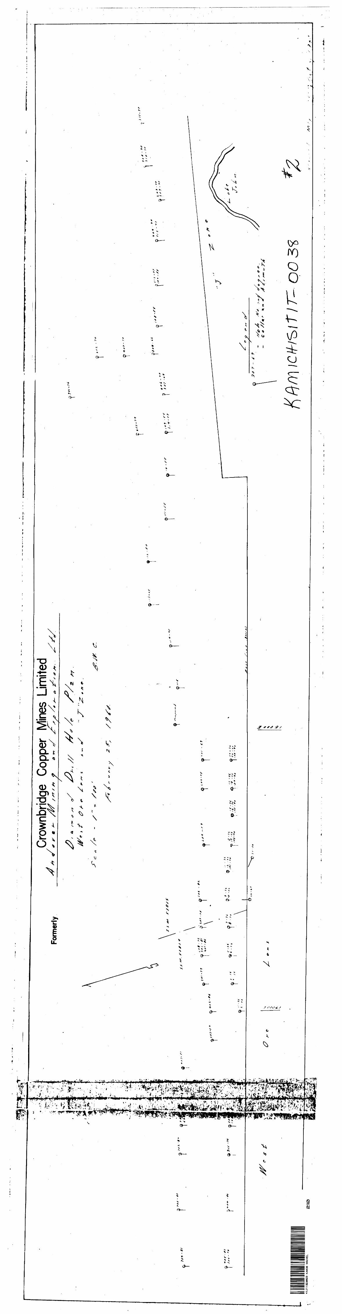
?f
- tt
f t
3** -
t
41J1
1S
EW
23
KA
M38
N
OU
VE
L2
10
•** ,
l.-l*
.,V
v;
-- -
l-sr-
l."
^v
Form
erly
Crow
nbrid
ge C
oppe
r Mi
nes
Lim
ited
^r
t*
*
* r m
s-
/W
s
ST s
*r
9
o *n
c/
jf~
^ #
s* s
- #
^s 0
/7*
4-
*#.
W *
>/
c:
rt /^
-•r-
1
T"r
-rt
Tf \
TJ f A
-
fi-
T-rf
- 7f
T- f f
9 '
'r'*
T? -
J t
8
-7
*
,,
- K
9
'S,
l*
J 'X
-'
' *A
ft
-r
j
OiA
-*T
*
S
0 /r
r
T*fft.7*
i if
- r?
i**
1 1;. f f
-rf
Q l
Ti*'
i *7
, r'
f ,v:
T "
'
^\
x^p
^*^
^" f/
o
*
C tf
//* *-
*
.~ *
A
z,
; "- r
v -
^