Embed Size (px)
Citation preview

David KnipeEngineering Service Center
Structure Level Floodplain Analysis

This presentation
• What is it? / Why do this?• Data sources needed• GIS analysis tools• Results and future uses
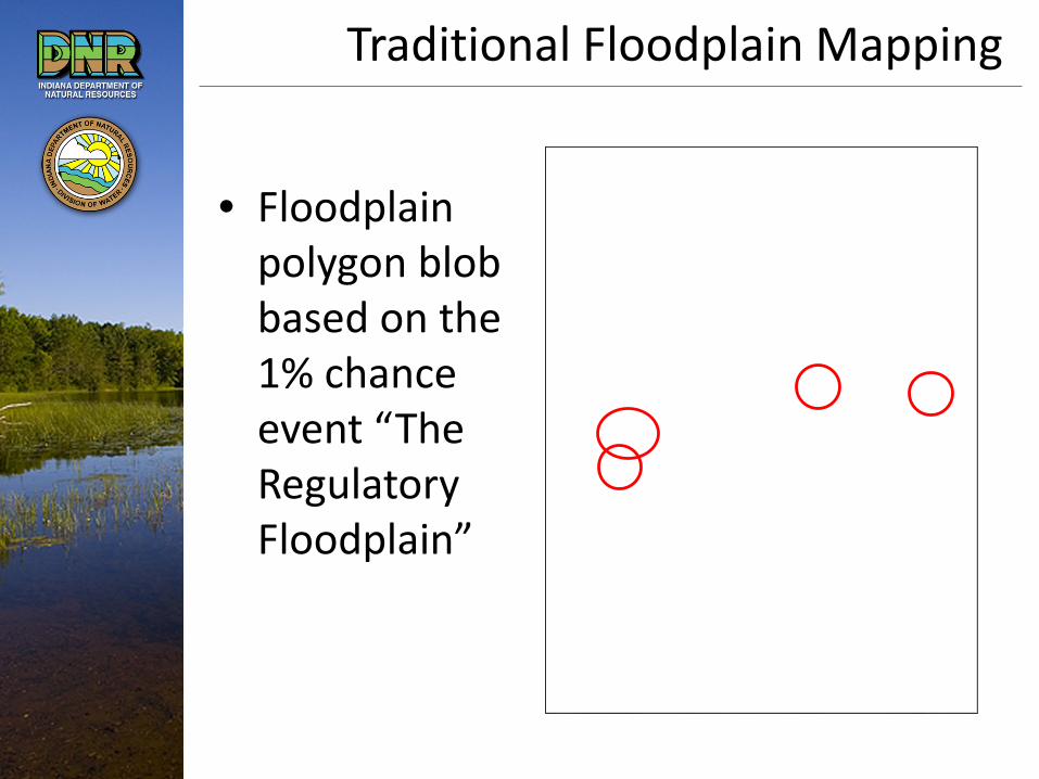
Traditional Floodplain Mapping
• Floodplain polygon blob based on the 1% chance event “The Regulatory Floodplain”
Marion
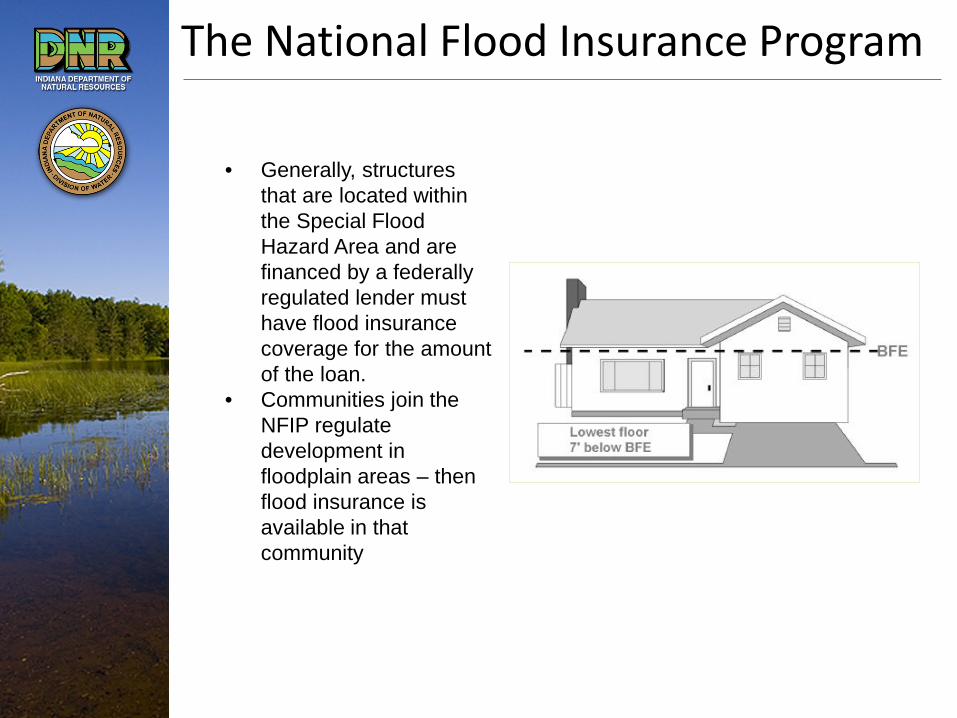
The National Flood Insurance Program
• Generally, structures that are located within the Special Flood Hazard Area and are financed by a federally regulated lender must have flood insurance coverage for the amount of the loan.
• Communities join the NFIP regulate development in floodplain areas – then flood insurance is available in that community
Letters of Map Amendment (LOMA)
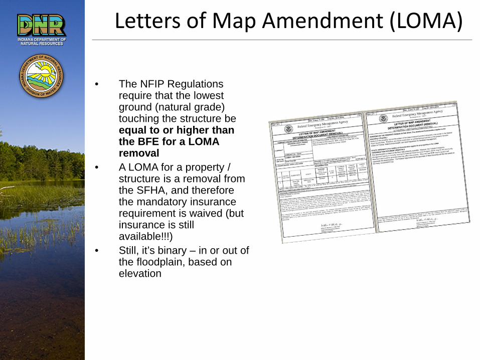
• The NFIP Regulations require that the lowest ground (natural grade) touching the structure be equal to or higher than the BFE for a LOMA removal
• A LOMA for a property / structure is a removal from the SFHA, and therefore the mandatory insurance requirement is waived (but insurance is still available!!!)
• Still, it’s binary – in or out of the floodplain, based on elevation

The Elevation Certificate
• Administrative tool of the NFIP
• Required to rate post-FIRM and some pre-FIRM buildings for flood insurance
• Used by communities to determine compliance with local floodplain management ordinances
• Required for an application for a LOMA.
• Summary of elevations at a structure, compared with the base flood elevations
• Must be filled out and stamped by a surveyor (common) or an engineer or architect (not-common)

The Elevation Certificate

Section C – Building Elevation Information (survey required)

• Section C should be completed if the building is located in any of Zones A1-A30, AE, AH, A (with BFE), or AR.
• C1. Must indicate whether elevations are based on construction drawings, a building under construction, or finished construction.
• Item C2. A field survey is required for Items C2. a-h. Most control networks will assign a unique identifier for each benchmark.
Elevation Certificate Section C

NFIP in summary
• Floodplain designation is based on a binary in / out determination
• Property owners fight this – with LOMA’s to get out of insurance requirements
• But a LOMA doesn’t change anything physically

LiDAR for LOMA’s(2017)
• Risk Map Standard 199 (proposed):
LOMC submittals must include certifications by a licensed professional authorized to certify the data under state law, except when LiDAR is provided to satisfy the lowest adjacent grade (LAG) requirements for LOMA’s.

TMAC Recommendations (2015)
• Recommendation 14: FEMA, and its mapping partners including the private sector, should transition to a flood risk assessment focus that is structure specific. Where data are available, FEMA and its partners should contribute information and expertise consistent with their interests, capabilities, and resources towards this new focus.

Structure Specific Risk Assessment
• Not binary – a more nuanced method for determining risk at a structure
• Based on a series of flood profiles, not just on the 1% (or regulatory) profile
• Can be expressed in a number of ways (AAL, flood risk rating)

What do you need to do this?
• Hydraulic Floodplain study (with multiple profiles)
• Replacement Costs (for AAL and cost-based evaluations)
• Elevation Certificate
But what if you don’t have an EC for a structure?????
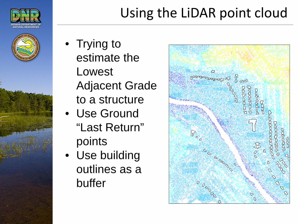
Using the LiDAR point cloud
• Trying to estimate the Lowest Adjacent Grade to a structure
• Use Ground “Last Return” points
• Use building outlines as a buffer

The Analysis
• Using Traditional Floodplain Analysis
• 5 “Risk MAP” profiles (10%, 4%, 2%, 1%, 0.2%)
The Analysis
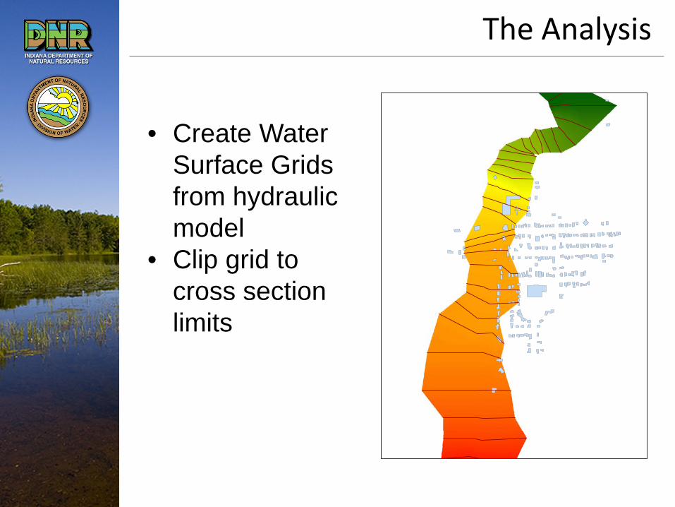
• Create Water Surface Grids from hydraulic model
• Clip grid to cross section limits

The Analysis
• If building outline intersects –interpolate values (use highest)
• If building outline doesn’t intersect – find nearest grid cell
• Attribute 5 elevations from 5 profiles

Estimated Lowest Adjacent Grade
• LiDAR point cloud “Bare Earth” or “Last Return”
• Buffer building outlines by .25 feet – find lowest point value in that buffer
• Move out .25 feet if nothing found
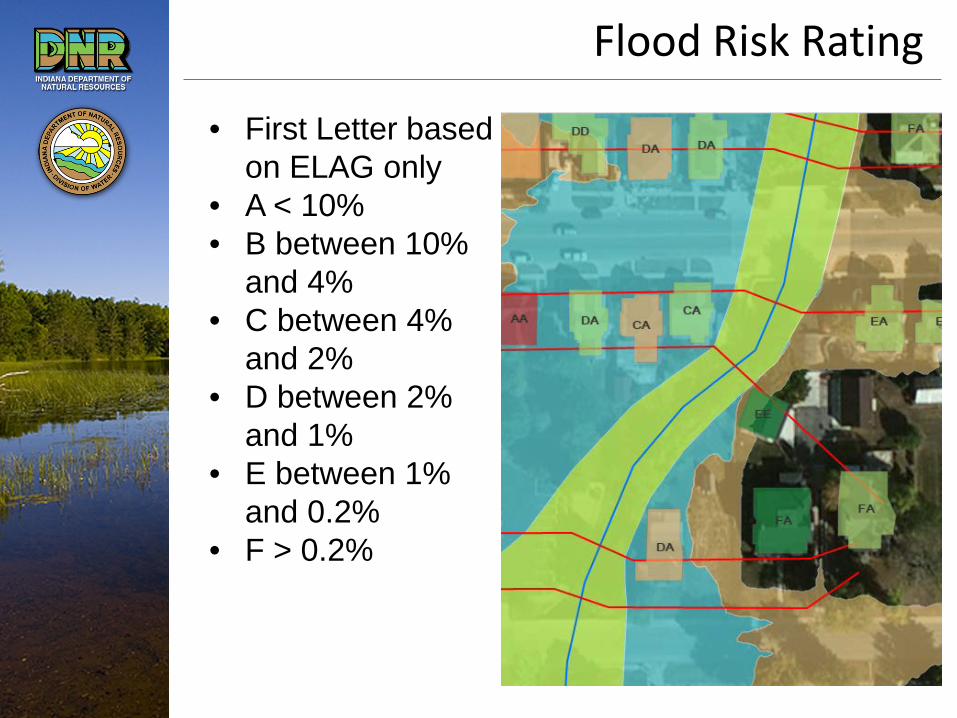
Flood Risk Rating
• First Letter based on ELAG only
• A < 10%• B between 10%
and 4%• C between 4%
and 2%• D between 2%
and 1%• E between 1%
and 0.2%• F > 0.2%

Flood Risk Rating
• Second Letter based on ELAG and foundation type
• Slab = ELAG• Crawl = ELAG –
3’• Basement =
ELAG – 8’• Letter grades
then as before

Average Annualized Loss Calculation
• Building Information from IDLGF data
• Replacement and Content replacement cost estimated from IDLGF
• Depth / Damage curves from Hazus / FEMA / USACE
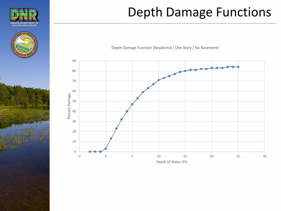
Depth Damage Functions
0
10
20
30
40
50
60
70
80
90
-5 0 5 10 15 20 25 30
Perc
ent D
amag
e
Depth of Water (Ft)
Depth Damage Function (Residental / One Story / No Basement)

Average Annualized Loss Calculation
• Sum of amount of damage multiplied by return interval
• For 5 profiles:• D10 * .1 + D25
* .04 + D50 * .02 + D100 * .01 + D500 * .002

Salt Creek / Sugar Creek in Winchester
link to AGOL map

Issues to consider
• Ground truthing with EC’s• Does ELAG = true first floor• Privacy Act Issues
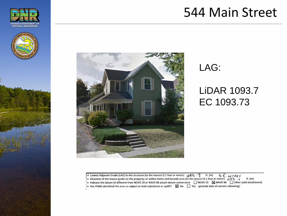
544 Main Street
LAG:
LiDAR 1093.7EC 1093.73

544 Main Street
DD
DD
DD
DD
DD
DD
DD
DD
D
DD
DD
DD
DD
DD
DD
DD
D
DD
DD
D
DD
DD
DD
DD
D
DD
DD
DD
DD
D
DD
D
D
D
D
DD
DD
DD
DD
D
D
D
DD
D
D
DD
DD
D
D
D
DD
DD
D
D
DD
D
DD
DD
DD
DD
D
DD
DD
DD
D
DD
D
DD
DD
DD
D
DD
DD
DD
D
DD
DD
DD
DD
DD
DD
DD
DD
DD
DD
DD
DD
DD
DD
D
DD
DD
DD
DD
DD
D
D
DD
DD
DD
D
DD
DD
DD
D
DD
D
1094
1094
1095.4 1093.7
1093.2
1093.3
1093.4
1094.2
1093.8
1094.7
1091.81091.3
1091.6
1096.011095.45 1095.37
1093.161093.311093.391093.611093.721093.79
1094.151094.831094.591094.671095.41
1095.641094.87 1094.85 1094.53 1094.24 1093.92
1093.71 1093.52 1093.46 1093.281093.32
1093.151093.231093.341093.471093.451093.591093.791094.051094.321094.691094.771094.831095.031095.121095.33
1095.35 1095.38 1095.21 1095.13 1095.11 1094.72
1093.35 1093.29 1093.271092.94
1093.191093.421094.15
1095.061095.111095.241095.161095.331095.48
1095.57 1095.33 1095.33 1095.38 1095.26 1095.25 1095.22
1093.38 1093.67 1093.25
1093.33
1095.771095.641095.841095.591095.331095.55
1095.66 1095.37 1095.711095.91 1095.86
1093.59 1093.29
1093.321093.85
1095.881095.711095.88
1096.03
1093.73 1093.37
1093.48
1096.44
1096.191095.97
1093.69 1093.41
1093.331093.73
1096.01
1096.02
1093.631093.24
1093.39
1095.161095.841096.03
1095.92 1095.58 1095.57 1095.35 1095.27 1095.211094.67
1093.41
1093.321093.42
1093.671093.661093.86
1094.251094.261094.461094.731094.921095.32
1095.08 1094.72 1094.53 1094.251093.69 1093.47 1093.43 1092.96
1092.51 1092.38 1092.19 1092.77 1092.94
1091.521091.721091.921091.951092.471092.541093.051093.251093.631093.981094.261094.55
1094.961093.98 1093.84 1093.32 1093.19 1093.13 1092.72 1092.48 1092.19 1091.94
1091.56
1091.471091.64
544 S MAIN ST
536 S MAIN ST
Randolph

135 Clem Street
LAG:
LiDAR 1094.89EC 1092.43

135 Clem StreetD
DD
DD
DD
D
DD
DD
DD
DD
D
D
DD
DD
DD
DD
D
D
DD
DD
DD
DD
D
D
DD
DD
D
DD
DD
DD
DD
DD
DD
DD
D
DD
DD
DD
DD
D
DD
D
DD
DD
D
D
DD
DD
D
DD
D
D
DD
DD
D
DD
DD
DD
D
D
DD
D
DD
DD
DD
D
DD
DD
DD
DD
DD
DD
DD
DD
DD
DD
DD
DD
DD
DD
DD
DD
DD
DD
DD
D
DD
DD
D
DD
DD
DD
DD
DD
DD
DD
D
DD
DD
DD
DD
1094.2
1093.9
1093.3
1094.7
1094.6
1089.11095.1
1093.2
1092.3 1094.7
1094.8
1094.7
1094.2
1092.98 1093.23 1093.39 1094.13 1094.851094.171093.881093.861093.841093.811093.631093.471093.22
1092.93 1092.93 1093.38 1093.73 1093.86 1093.95 1093.95 1094.09 1094.07 1093.941093.98
1094.46 1094.38
1094.46
1094.571094.451094.511094.391094.271094.341094.411094.571094.271094.131094.111093.391093.061092.73
1092.01 1092.48 1092.931093.88 1094.04 1094.18 1094.56 1094.41 1094.52 1094.57 1094.64 1094.63
1094.631094.63
1094.891094.891094.951094.761094.731094.651094.951094.311094.011093.61
1091.491091.19
1089.27 1089.01
1094.89 1094.87
1094.91
1095.13
1089.291089.041089.02
1088.84
1094.99
1094.84
1095.23
1089.121089.07
1088.96 1089.17
1094.85
1089.111088.91
1089.28
1095.24
1094.831095.05
1090.04
1091.331093.74 1094.09 1094.69
1094.85
1094.951094.95
1094.831095.131095.051094.391094.031093.631093.081092.57
1092.31 1092.96 1093.07 1093.81 1094.09 1094.67 1094.71 1094.82 1094.641094.85 1094.91 1095.25 1094.67
1094.79
1095.031094.761094.741094.931094.65
1092.88
1091.58 1092.75
1094.43 1094.19 1094.36 1094.31 1094.411094.43
1094.761094.53
1094.171094.33
1090.991093.76 1094.14 1094.02 1093.92 1093.97 1094.04 1094.24
1094.36
1094.51
1094.381094.44
135 N Clem ST
129 N Clem ST
Randolph