Embed Size (px)
Citation preview

CENE 476 Capstone Prep Mark Lamer
Duncan Floodplain Analysis
Jordan Rae Aguirre
Farraj Alharbi
James Huggins
Tyler Saganitso
May 2016

ii
Table of Contents
1. Project Understanding .......................................................................................................... 1
1.1. Project Purpose .............................................................................................................. 1
1.2. Project Background ....................................................................................................... 1
1.3. Technical Considerations .............................................................................................. 2
1.3.1. Flo-2D ....................................................................................................................... 3
1.3.1.1. Flow Impacts ......................................................................................................... 3
1.4. Potential Challenges ....................................................................................................... 3
1.4.1. Finances ................................................................... Error! Bookmark not defined.
1.4.2. Distance..................................................................................................................... 4
1.4.3. Unfamiliarity ............................................................................................................. 4
1.4.4. Communication ......................................................................................................... 4
1.5. Stakeholders .................................................................................................................... 4
2. Scope of Services .................................................................................................................... 4
Task 1 Data Collection .............................................................................................................. 5
Task 2 Hydraulics ..................................................................................................................... 5
Task 3 Model Parameters ......................................................................................................... 5
Task 3.1 Grid System .............................................................................................................. 6
Task 3.2 Manning’s Number ................................................................................................... 6
Task 3.3 Courant and DEPTOL Values .................................................................................. 6
Task 4 Two Dimensional Modeling ......................................................................................... 7
Task 4.1 Flo-2D ....................................................................................................................... 7
Task 4.2 RAS-2D .................................................................................................................... 7
Task 4.3 Model Conditions ..................................................................................................... 7
Task 4.4 Model Analysis ......................................................................................................... 8
Task 5 Flo-2D and RAS-2D Model Comparison .................................................................... 8
Task 5.1 Cost Analysis ............................................................................................................ 8
Task 5.2 Recommended Solutions .......................................................................................... 9
Task 5.3 Analyzation of Impacts ............................................................................................. 9
Task 6 Project Management .................................................................................................... 9
Task 6.1 Coordination ............................................................................................................. 9
Task 6.2 50% Design Report ................................................................................................... 9
Task 6.3 Final Presentation ..................................................................................................... 9
Task 6.4 Final Report ............................................................................................................ 10
Task 6.5 Website ................................................................................................................... 10
2.1. Exclusions ...................................................................................................................... 10
2.2. Impacts ............................................................................... Error! Bookmark not defined.
3. Schedule ................................................................................................................................ 10
3.1. Gantt Chart ................................................................................................................... 10

iii
4. Staffing and Cost of Engineering Services ........................................................................ 11
4.1. Staff Titles/Positions ..................................................................................................... 11
4.2. Task Matrix .................................................................................................................. 12
References .................................................................................................................................... 14
Appendix A: Schedule ................................................................................................................ 16
List of Figures Figure 1-1. Location of Greenlee county in Arizona ...................................................................... 1
Figure 1-2. Ariel view of town of Duncan, with area of interest .................................................... 2
Figure 1-3: Project Gantt chart…………………………………………………………………….7
List of Tables Table 1 Deliverables and due dates .............................................................................................. 10

1
1. Project Understanding Hydro Engineering is continuing a flood study completed by NAU Crown Engineering in the fall
of 2015. The previous study used a flood simulation with HEC-RAS. From these models, the
current flood prevention method and model containing a levee was analyzed. The HEC-RAS
simulation provided one dimensional analysis of the flow of the river was only done in one-
dimension. The client has asked for the study to be continued with a two dimensional simulation.
The two dimensional study analyzes flow in the lateral and horizontal directions, which will
provide more realistic results.
1.1. Project Purpose There is currently an issue with flooding in Duncan, Arizona. This flooding causes damage to
communities in the floodplain of the Gila River, destroys crops, and also damages homes and
infrastructure in the area. In order to solve or mitigate this issue, further study on a levee needs to
be completed. Previously a flow study was done using HEC-RAS and AutoCAD Civil 3D analysis.
The result from this study was then used to determine if a levee was the most appropriate solution
for the Duncan, Arizona flooding. By creating a two dimensional model using Flo-2D and RAS-
2D, a more enhanced levee analysis can be completed to better serve the town of Duncan, Arizona.
A two dimensional model is more accurate and
realistic than a HEC-RAS model because flow
is traveling in two dimensions.
1.2. Project Background Duncan, Arizona is located within Greenlee
County, in southeastern Arizona, as shown in
Figure 1-1. Greenlee County lies on the New
Mexico border. The town of Duncan is located
in the southern portion of the county. The Gila
River is a major river of the southwest, and it
runs directly through Duncan. This provides
the community with rich farmland because silt
and clay soils are located in floodplains, which
create fertile soil [1]. The fertile soil creates
agricultural opportunities in Duncan, Arizona.
According to Arizona Demographics, 783
residents comprise the town’s population [2]. With the town being reliant on the Gila River as a
main force driving the agricultural industry, it is also its biggest threat, due to the potential flooding
of the area.
The climate of Duncan area is the climate, which occurs primarily on outer limits of a low altitude,
true desert, with semiarid steppe regions. [3]. The result is cooler, wetter winter resulting from the
higher latitude frontal cyclone activity. The annual precipitation amounts vary fairly, but are not
as much as true desert regions. The average amount of yearly precipitation Duncan receives is
10.9” with August (2.1”) as the wettest month and April (0.2”) as the driest month [3]. Although
FIGURE 1. LOCATION OF GREENLEE COUNTY IN ARIZONA [14]

2
for this project, the team needs to analyze the climate of the entire watershed for this area, and not
just the town of Duncan.
The flood of December 1978 caused major damage to homes, businesses, and most public
buildings and facilities [4]. A study showed large holes developed in structure that was currently
in place at the time and allowed a wall of silt and water to rush through the community. The normal
level of the river is 2.5 feet (average), and during the flood event of 1978, the water level was 7
feet (maximum) in some locations. The estimated maximum discharge for this event was 60,000
cfs [4]. The flood of 1978 was greater than a 100-year flood event and the earth dike, which was
in place to mitigate the floods, was overwhelmed and provided little to no protection [5].
For this project, the engineering is going to be focusing on an approximately one mile section
along the banks of the Gila River in the middle of the town in the Figure 1-2. The area of interest
is shown by the yellow area, the area with the greatest risk of flooding. The blue line is an outline
of the Gila River, which dissects the town. The place marker in the Figure 1-2 shows the western
side of town, which is the location prone to flooding.
1.3. Technical Considerations Duncan, Arizona is susceptible to flooding of businesses, residences, and highway 70 from
overflow in the Gila River. Flo-2D will be used to analyze the floodplain and Gila River under
various conditions. The model will provide a greater understanding of the option of a levee to
protect Duncan, Arizona. The various conditions that could impact the flow are vegetation,
infrastructure, and Gila River dimensions. The current capacity of the Gila River is causing an
issue with flooding. The river has a smaller capacity in the past due to vegetation. The smaller
capacity is allowing the river to flood quicker and easier than before.
FIGURE 1-2. ARIEL VIEW OF TOWN OF DUNCAN, WITH AREA OF INTEREST [15].

3
1.3.1. Flo-2D The Flo-2D software is approved for FEMA studies. A main aspect that Flo-2D can analyze is
river overbank flooding. Rainfall/Runoff and flood routing can be modelled in the two
dimensional software because it is a hydrologic and hydraulic model [6]. Flo-2D provides
analysis in the lateral and horizontal directions of flow. The previous study analyzed the Gila
River using HEC-RAS, which only takes the lateral direction of flow into account. Considering
the flow in each direction creates a different impact on the floodplain than the previous one
dimension study.
1.3.2. RAS-2D HEC-RAS is a modeling system that allows for a deeper analysis of waterways or extensive
storms. NAU Crown Engineering created two models, effective and corrected effective, before
finalizing their proposed conditions model. The effective model consists of a mirrored model
created by FEMA in 2007, with information collected from 1975-1976. This had little impact
due to the old data; yet gave insight to the flooding trends in Duncan [7].
The corrected effected model used more recent data from 2012, allowing the proposed 100-
year storm of 48,000 cfs to bring light to a real issue in Duncan. Over a total of 3.4 miles of
Gila River, 24 cross sectional widths of allowable flow were analyzed. The total points were
no more than 500, to allow for a close, but not too intense, analysis of the projected flooding
[7].
The proposed model for Duncan, AZ, according to NAU Crown Engineering, was surprisingly
to find a different solution. The group claims Duncan, AZ does not have the funds or support
to create a levee system [7]. However, with the small amount of data and analysis, a conclusion
such as this can be faulty. Provided with more effective two- and three-dimensional analysis,
a levee system can be more productive and effective than originally though.
1.3.2.1. Flow Impacts In order to provide an area for Flo-2D to analyze, an aerial image and a digital topographic
map must be imported into the model. The hydrologic data is also essential when running a
Flo-2D model. The hydrologic data consists of rainfall and discharge hydrographs. The
infrastructure that needs to be considered in a Flo-2D model is bridges, culverts, buildings,
and roads. Cross sections of the floodplain and channel are to be used in the analysis [7].
Levees can be simulated in the model along with floodplain storage loss due to vegetation
and infrastructure. Flo-2D can provide a flood animation and assess the amount of damage
that can be done from the flood [6]. Hydro Engineering will use a Flo-2D model to analyze
the floodplain and Gila River under various conditions.
1.4. Potential Challenges This section discusses the challenges Hydro Engineering will face throughout this project. Hydro
Engineering will also provide solutions to overcome listed problems to ensure a quality project is
created. These challenges are pertinent and will influence steps taken in the process of this project.

4
1.4.1. Distance The distance between Northern Arizona University and the site of interest is about a 5 hour
drive in a vehicle. This distance poses a problem with communication, as there is no way to
meet face to face on a regular basis. The technical advisor is located in Phoenix, Arizona. This
challenge will be addressed by conducting constant communication through phone calls and
email with everyone involved. This would ensure Hydro Engineering understands what the
client is wanting, as well as the correct direction of the project. The site visits will need to be
efficient due to cost and time constraints. Hydro Engineering will ensure all information is
gathered during site visits by pre-task analyses, in-depth site research, and discussion with
client and advisor prior to site visits.
1.4.2. Unfamiliarity This potential challenge arises because Hydro Engineering has not used Flo-2D in any previous
course, therefore will be completely new to the company. Although we have done background
research on the program, as well as receiving input from our technical advisor, Hydro
Engineering will need to become familiar with the program before we proceed. Hydro
Engineering will become familiar with Flo-2D by obtaining further input from industry leaders,
completing any necessary tutorials, and conducting further research.
1.4.3. Communication As mentioned in previous sections, communication will be imperative with the client and the
technical advisor. Due to the busy schedules of the client and technical advisor, Hydro
Engineering will make every effort to contact the client and advisor in advance and set up
appointments for conference calls, video-chat, and face-to-face meetings
1.5. Stakeholders Stakeholders of a new levee in Duncan, AZ range from the local population to governmental
bodies. The US Army Corps of Engineers is a major stakeholder; USACE has a say in the
construction of a levee due to the connection to a navigable waterway, Gila River. Another
stakeholder is the general public and homeowners of Duncan, AZ. The people of Duncan can reject
or support the project; it is important the city agree with the team’s proposal. Greenlee County has
a say in the project, as well. The County, given the project is affordable and provides necessary
protection will help guide to implementation of a levee. FEMA has the ability to completely reject
and end the project; FEMA carries a large stake in a new levee. Ultimately, they are in charge of
the final accreditation of the project. Environmentalists are the last stakeholders to mention.
Environmentalists have shut down projects in the past if they do not support the local animals,
especially those in danger. Given the levee supports animal life, environmentalist will be on board
with a new levee.
2. Scope of Services Hydro Engineering will provide the following services for Duncan, Arizona after approval from
Phillip Ronnerud.

5
Task 1.0 Data Collection The study completed by NAU Crown Engineering using Civil 3D and HEC-RAS provides various
data that will be used by Hydro Engineering, which consists of hydraulics and hydrology,
surveying, and geotechnical analysis. Hydrologic data such as, largest precipitation event and river
flow, is a main component of two dimensional modeling because it is necessary for determining
the model parameters stated below. Hydrologic models provide the understanding of various
catchment processes for rainfall, runoff, evaporation, and flow in rivers [1]. Hydro Engineering
will also conduct further research to determine any necessary data needed not obtained from the
previous study.
Task 1.1 County The county of Greenlee provides the hydrologic data to run both the HEC-RAS and FLO 2D
models. This includes the largest precipitation event provided by the client, the river flow at this
precipitation event, and the process of rainfall, runoff, evaporation, and flow in the rivers, will not
be determined, but will be provided by the county of Greenlee. Greenlee County will provide
sufficient dimensions for the bridge that spans the Gila River in Duncan, AZ so Hydro Engineering
can simulate this condition in FLO 2D and HEC-RAS 2D.
Task 1.2 NAU Crown Engineering A working one-dimensional HEC-RAS model was completed by NAU crown engineering in a
previous project. All parameter information that can be extracted from this model will be extracted
and used as a starting point for both the FLO 2D and HEC-RAS 2D models. The survey data used
to create the AutoCAD civil 3D model will be used to create any surfaces needed for this project.
Geotechnical information was also collected by NAU Crown Engineering, and will be used as
needed by Hydro Engineering.
Task 1.3 FEMA Since this project will deal with comparing different environmental simulations, Hydro
Engineering will use the FEMA data such as floodplain limits, cross sections, township, section,
range, zones, etc. This will allow Hydro Engineering to re-create environmental models of client’s
wanted simulations.
Task 2.0 Hydraulics: 2D Modeling Hydraulics studies movement of liquids in relation to disciplines such as fluid mechanics and fluid
dynamics [2]. The hydraulic data of Gila River will be put into Flo-2D and RAS-2D in order to
create a simulation run. The watershed being analyzed is approximately 3,800 square miles, which
a 100-year storm will cover with 47,400 cfs [8].
Task 2.1 Model Parameters Hydro Engineering will produce four models in Flo-2D and RAS-2D. These four models are
existing conditions, existing without agricultural dike, proposed levee, and proposed Gila River
restoration. All models consists of the same parameters: hydrology, hydraulics, grid system,
manning’s number, and courant and DEPTOL values.

6
Task 2.1.1 Grid System A necessary component of the Flo-2D model is the grid system. Hydro Engineering will create
the grids in Flo-2D using the grid developer system (GDS) [9]. Hydro Engineering will also
determine infrastructure that can influence the grid elements. For example, bridges and culverts
will need rating curves or tables and streets will need curb height and width. Levees are placed
on boundaries of grid elements [9].
The grid sizes will be obtained based on the project area. Grid sizes will be at least twice the
size of the largest depth of flow determined from the previous HEC-RAS model. If the ratio of
peak discharge to area of grid elements is greater than 10 cfs, then the model will perform
slower simulations than if the ratio was less than 10 cfs [9].
Hydro Engineering will determine the number of grid elements based on the project area and
grid sizes. The number of grids will be kept under 100,000 to decrease the run time. If the run
times are too long it can become impractical. With a maximum of 100,000 grid elements, the
model will have a run time of no longer than an hour [9].
Hydro Engineering will use LiDAR data to determine the area details. With the LiDAR data
Flo-2D can visualize the project area and topography. The model domain will also be
determined with this data. Hydro Engineering will obtain average grid elevation for each grid
element. This will allow the model to visualize the project area as various contours for the grid
elements and change in slope along the river. Elevations can influence the velocity of flow by
slowing it down or speeding it up. This can also help determine where the main flooding will
occur.
Task 2.1.2 Manning’s Number The n-value can be influenced by vegetation, infrastructure, and variations in channel
geometry. It is important not to underestimate the n-value because this will cause the resulting
data to be too large [9]. For changes throughout the river, an n-value will be re-determined
when necessary. This ultimately means different cross sections in the channel can have several
different n-values. In order to find the correct n-value for given areas, a Manning’s n for
channels table will be used [10]. However, a default n-value of 0.06 and a shallow n-value of
0.20 will be used for the initial runs in Flo-2D and RAS-2D [11].
Task 2.1.3 Courant and DEPTOL Values The determination of both the depth tolerance (DEPTOL) and courant number are significant
to this project, due to the fact both control the magnitude of the time step of simulations Hydro
Engineering will be running. The recommended and initial value for the courant number is 0.6,
and can be modified to be from 0.0 to 1.0 with 1.0 being the largest time step FLO-2D can run
in a simulation [9]. The DEPTOL will be set initially at 0.1 feet for this project, as
recommended by the project technical advisor [11]. Any requests to decrease or increase the
DEPTOL are excluded and will not be considered unless processed through a formal work
order form.
7
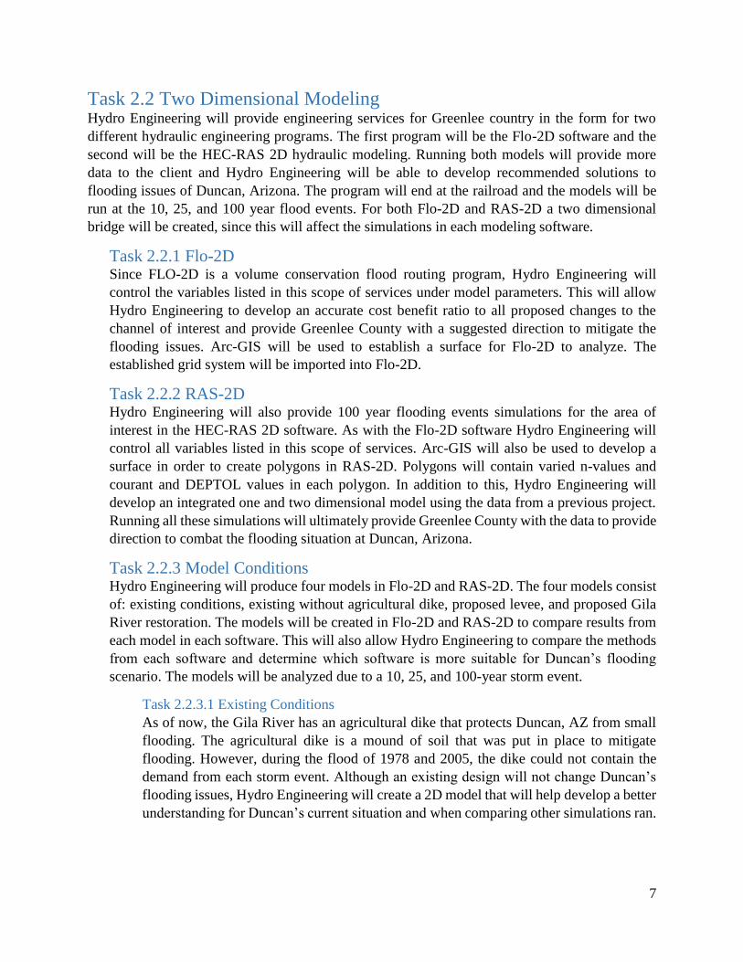
Task 2.2 Two Dimensional Modeling Hydro Engineering will provide engineering services for Greenlee country in the form for two
different hydraulic engineering programs. The first program will be the Flo-2D software and the
second will be the HEC-RAS 2D hydraulic modeling. Running both models will provide more
data to the client and Hydro Engineering will be able to develop recommended solutions to
flooding issues of Duncan, Arizona. The program will end at the railroad and the models will be
run at the 10, 25, and 100 year flood events. For both Flo-2D and RAS-2D a two dimensional
bridge will be created, since this will affect the simulations in each modeling software.
Task 2.2.1 Flo-2D Since FLO-2D is a volume conservation flood routing program, Hydro Engineering will
control the variables listed in this scope of services under model parameters. This will allow
Hydro Engineering to develop an accurate cost benefit ratio to all proposed changes to the
channel of interest and provide Greenlee County with a suggested direction to mitigate the
flooding issues. Arc-GIS will be used to establish a surface for Flo-2D to analyze. The
established grid system will be imported into Flo-2D.
Task 2.2.2 RAS-2D Hydro Engineering will also provide 100 year flooding events simulations for the area of
interest in the HEC-RAS 2D software. As with the Flo-2D software Hydro Engineering will
control all variables listed in this scope of services. Arc-GIS will also be used to develop a
surface in order to create polygons in RAS-2D. Polygons will contain varied n-values and
courant and DEPTOL values in each polygon. In addition to this, Hydro Engineering will
develop an integrated one and two dimensional model using the data from a previous project.
Running all these simulations will ultimately provide Greenlee County with the data to provide
direction to combat the flooding situation at Duncan, Arizona.
Task 2.2.3 Model Conditions Hydro Engineering will produce four models in Flo-2D and RAS-2D. The four models consist
of: existing conditions, existing without agricultural dike, proposed levee, and proposed Gila
River restoration. The models will be created in Flo-2D and RAS-2D to compare results from
each model in each software. This will also allow Hydro Engineering to compare the methods
from each software and determine which software is more suitable for Duncan’s flooding
scenario. The models will be analyzed due to a 10, 25, and 100-year storm event.
Task 2.2.3.1 Existing Conditions
As of now, the Gila River has an agricultural dike that protects Duncan, AZ from small
flooding. The agricultural dike is a mound of soil that was put in place to mitigate
flooding. However, during the flood of 1978 and 2005, the dike could not contain the
demand from each storm event. Although an existing design will not change Duncan’s
flooding issues, Hydro Engineering will create a 2D model that will help develop a better
understanding for Duncan’s current situation and when comparing other simulations ran.

8
Task 2.2.3.2 Existing Without Agricultural Dike
FEMA does not recognize the agricultural dike when running model simulations.
Therefore, Hydro Engineering will create a model without the agricultural dike to match
a FEMA analysis for the floodplain in Duncan. This design is not an alternative, but used
as a comparison model.
Task 2.2.3.3 Proposed Levee
One alternative is to replace the agricultural dike with a levee system remove Duncan
from a 100-year storm. The FEMA flood zone identification number for the area of
interest is 04011C0901D [12]. Hydro engineering will determine the height and location
of a levee based on the flows from a 100 year storm event and area of interest. After the
levee height and length are determined, break-lines will be input into Flo-2D and RAS-
2D in order to establish where the proposed levee will exist. A two dimensional model
of the proposed levee alternative will be created to analyze the outcome against the price
to implement a levee and compare with the other conditions.
Task 2.2.3.4 Proposed Gila River Restoration
Another alternative for Duncan is to establish thriving vegetation along the river and
improve channel morphology. The existing vegetation is overgrown and is not allowing
infiltration, which allows flooding to occur more often. The existing vegetation in
surrounding farm fields will be replaced with vegetation. The vegetation will assist with
infiltration and in return assist with flood prevention. Along with vegetation replacement,
Hydro Engineering will also restore the Gila River by returning it to more natural
conditions. Returning the river to more natural conditions will allow the river to have a
greater capacity. Areas of the Gila River that have not been impacted will be analyzed in
order to determine the river’s response to storm events and to determine if the original
form of the river would assist with flood prevention.
Task 3.0 Model Analysis Hydro Engineering will evaluate information of generated computer model to fulfill client’s
request. Hydro Engineering will apply knowledge gained through NAU coursework, as well as the
professional input to determine significance of retrieved data and simulations. After running
simulations with existing conditions, existing without a levee, proposed levee, and proposed
vegetation, Hydro Engineering will analyze each model in order to determine where the flooding
is or is not occurring. During the analysis Hydro Engineering will also determine why the flooding
is occurring. The findings and data will be reported to all necessary sources for input and feedback.
Task 4.0 Flo-2D and RAS-2D Model Comparison The four different models stated above produced in Flo-2D and RAS-2D will be compared. Hydro
Engineering will recommend the most appropriate solution considering environmental impacts and
cost analysis.
Task 4.1 Cost Analysis The suggested recommended solutions will be analyzed with the cost associated with the
implementation of each solution. The estimated cost of each solution will be determined and

9
analyzed. For the proposed levee alternative the cost for soil per cubic foot and construction
will be determined. For the proposed Gila River restoration alternative Hydro Engineering will
determine the cost for channel reconfiguration, vegetation removal, and planting native
vegetation.
Task 4.2 Recommended Solutions After getting approval from the client, Hydro Engineering will develop possible solutions to
mitigate the impact of river flooding in the area of interest. Hydro Engineering will determine
the best proposed solution based upon the client’s criteria, impacts, and cost analysis. Client’s
criteria has yet to be determined, and will commence once a face to face meeting has taken
place.
Task 4.3 Impacts As a responsibility of a practicing engineer, the Hydro Engineering design team will determine
appropriate regulatory, environmental, and economic impacts of each computer model. The
findings will then be presented in the final report and final presentation as to comprehensively
analyze each solution. This will convey a broader impact this project will possibly have if a
chosen solution is implemented.
Task 5.0 Project Management Project Management will be required to ensure clients requests are made at the times set by the
client. Hydro Engineering has estimated the milestones’ due sate on Table 1. These are taken from
the NAU academic calendar for the semester of Fall 2016.
Task 5.1 Coordination Hydro Engineering will remain in constant contact with both the client and technical advisor.
Due to the distance between the parties involved, meeting alternatives will be considered, such
as, but not limited to: video conferencing, teleconferencing, and emailing regularly.
Communication is a priority of Hydro engineering, and all messages will be replied to
promptly. Hydro Engineering will abide by the Schedule in Appendix A. This will ensure the
project is completed in a timely manner. The budget for staffing and engineering services will
also be followed throughout completion of this project.
Task 5.2 50% Design Report Hydro Engineering will develop a 50% design report at midterms of the Fall 2016 semester.
This Report is to ensure the client Hydro engineering is meeting all requests of the client and
that Hydro Engineering will complete all scoped work in a timely fashion.
Task 5.3 Impacts Report Hydro engineering will provide a report of the impacts from the recommended solution in order
to compare each recommended solution.
Task 5.4 Final Presentation Hydro Engineering will provide a presentation for all pertinent parties on reading week of the
Fall 2016 semester. The presentation will provide highlights of the project, including but not
limited to: methodology, simulations, comparisons, conclusions, and recommendations.

10
Task 5.5 Final Report Hydro Engineering will complete a Final Report detailing all findings about the projects. These
findings will include the working models of all scenarios proposed in this scope of services.
The final report is the culmination of all work completed by Hydro Engineering and will be of
a professional standard.
Task 5.6 Website The website will be running by September 1, 2016 and will be updated frequently throughout
the duration of the project until completion on December 16, 2016.
Deliverables Deliverable Date
50% Design Report November 1, 2016
Formal Presentation December 8, 2016
Project Website December 16, 2016
Final Report December 16, 2016
TABLE 1 DELIVERABLES AND DUE DATES
2.1. Exclusions The following is being excluded from the scope of work:
Surveying
Geotechnical Analysis
Levee width, slope, and soil type
New One Dimensional Model
Hydrological Data Collection
Future Development Analysis
Invasive Species Management
3. Schedule
3.1. Gantt Chart The following Gantt chart provides estimated dates of completion for all major and minor parts
of Hydro Engineering’s Duncan Floodplain project. Within the chart, there are many task that
overlap and occur during the same time frame. This overlapping has to do with the several
minor parts for a single major aspect. For example, the two dimensional model will undergo
work while hydrology and hydraulics will be inputted into the software. Another component
of the chart shown is the ending of a section before starting of the next. This occurs when a
section cannot be starting till the completion of the prior component. For example, the analysis
of all possible solutions cannot be compared until each are ran in the 2D software. The arrows
connecting tasks is the critical path; the most efficient and fastest way to complete the project.

11
4. Staffing and Cost of Engineering Services
4.1. Staff Titles/Positions The staffing required and duties for the completion of engineering services is located in Table 2
below.
TABLE 2: TYPICAL DUTIES FOR EACH POSITION

12
4.2. Task Matrix TABLE 3: STAFFING TASKS AND HOURS

13
TABLE 4: TOTAL STAFFING COST [13]

14
References
[1] "Floodplain," Science Clarified, 2016. [Online]. Available:
http://www.scienceclarified.com/landforms/Faults-to-Mountains/Floodplain.html.
[Accessed 7 March 2016].
[2] Cubit, "Duncan Demographics," Arizona Demographics, 2016. [Online]. Available:
http://www.arizona-demographics.com/duncan-demographics. [Accessed 2 March 2016].
[3] Canty Media, "Weatherbase," Canty Media, 2016. [Online]. Available:
http://www.weatherbase.com/weather/weather-
summary.php3?s=457220&cityname=Duncan%2C+Arizona%2C+United+States+of+Amer
ica&units. [Accessed 12 Feburary 2016].
[4] T. A. H. B. N. Aldridge, "Floods of November 1978 to March 1979 in Arizona nad West-
Central New Mexico," 1948. [Online]. Available: http://pubs.usgs.gov/wsp/2241/report.pdf.
[Accessed 12 Feburary 2016].
[5] E. Polasko, "Water Lecture Series," 2007. [Online]. Available:
http://aces.nmsu.edu/wls/documents/ed-polasko-part-b.pdf. [Accessed 12 Feburary 2016].
[6] Flo-2D Software, Inc., "Flo-2D Software," 2009. [Online]. Available: http://www.flo-
2d.com/flo-2d-basic/. [Accessed 25 February 2016].
[7] NAU Crown Engineering, Floodplain Analysis and Conceptual Levee, Flagstaff, 2015.
[8] N. C. Engineering, "Site Assessment," 22 October 2015. [Online]. Available:
http://www.cefns.nau.edu/capstone/projects/CENE/2016/GreenleeCty/Design%20Report%
2050_.pdf. [Accessed 2 march 2016].
[9] FLO-2D Software, Inc. , "Pocket Guide: Pro Model," 2009. [Online]. Available:
http://www.flo-2d.com/wp-content/uploads/2013/11/Pocket-GUIDE-PRO.pdf. [Accessed
25 February 2016].
[10] V.T Chow, "Manning's n for Channels," in Open-Channel Hydraulics, 1959.
[11] T. Loomis, NAU CENE 476 Capstone Team, 2016.
[12] "FEMA Floop Map Service Center: Search By Address," FEMA, 28 September 2007.
[Online]. Available: https://msc.fema.gov/portal/search#searchresultsanchor. [Accessed 27
April 2016].
[13] "Salary Genius," [Online]. Available: http://salarygenius.com/az/flagstaff/salary/senior-
civil-engineer-salary. [Accessed 20 4 2016].

15
[14] ePodunk Inc, "Profile for Greenlee County, Arizona," 2007. [Online]. Available:
http://www.epodunk.com/cgi-bin/genInfo.php?locIndex=11205.
[15] Google Maps, "Google Maps," Google, Inc, 2016. [Online]. Available:
https://www.google.com/maps/@32.7206621,-109.1018726,3890m/data=!3m1!1e3.
[Accessed 12 Feburary 2016].
[16] National Weather Service, "Flood Related Hazards," National Oceanic and Atmospheric
Administration, 2016. [Online]. Available: http://www.floodsafety.noaa.gov/hazards.shtml.
[Accessed 12 Feburary 2016].

16
Appendix A: Schedule


![2008 - 4th Ed. - Duncan - Power Systems Analysis and Design[1]](https://img.dokumen.tips/doc/110x75/577cd9e01a28ab9e78a455e2/2008-4th-ed-duncan-power-systems-analysis-and-design1.jpg)

