Embed Size (px)
Citation preview

STATE OF NORTH CAROLINA DEPARTMENT OF TRANSPORTATION
PAT L. MCCRORY ANTHONY J. TATA GOVERNOR SECRETARY
July 14, 2015
U.S. Army Corps of Engineers Regulatory Field Office 2407 West 5th Street Washington, NC 27889 ATTN: Ms. Tracey Wheeler NCDOT Coordinator SUBJECT: Application for Section 10 and Section 404 Nationwide Permit 6 for Field Investigations
for a Proposed Bridge for the Phase II B portion of the NC 12 long term improvements in Dare County; TIP Project B-2500 (Phase II B); Federal Aid Project BRNHF-0012 (56)
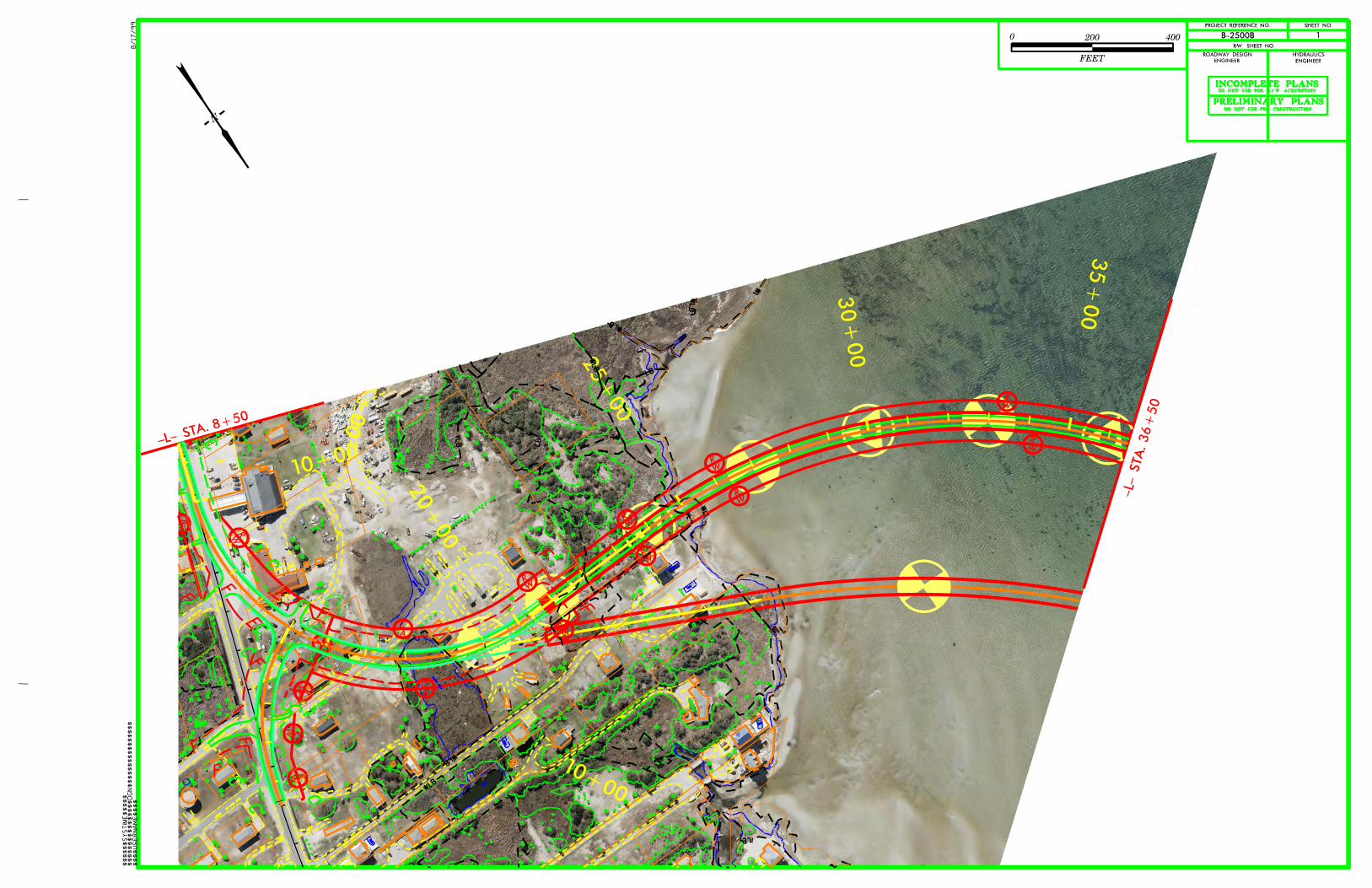
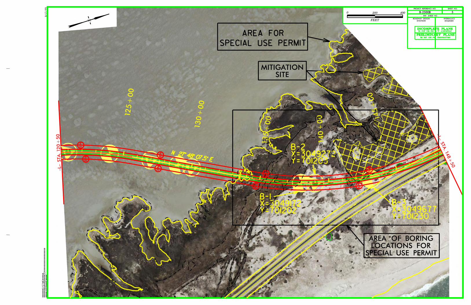
Dear Madam, As part of the NEPA process for the Phase II B section of the project, the North Carolina Department of Transportation (NCDOT) is planning a limited subsurface investigation to gather information for the foundation design of the above-referenced structure. The investigation will take place along the preferred alternatives -2014A- and -2014B- (Sound Alignments), as depicted on the attached figures. A private engineering firm will be selected to conduct the investigation with up to 25 Standard Penetration Test (SPT) borings and 20 Cone Penetration Tests (CPT) to be performed. These 45 borings will be performed in the corridor shown on the attached site map. Forty borings will be located in Pamlico Sound. The remaining 5 borings are located in uplands. The Department has shifted the boring locations so that no borings will occur in wetlands. The borings in the sound will be advanced from a jack-up barge, and will consist of turning or driving 3-inch to 8-inch diameter steel casing into the sound bottom creating minimal disturbance. Other drilling tools will be used to sample the sediments and advance the hole within the steel casing. The steel casing will be removed upon completing the boring. Any borings drilled on land or in shallow water in the sound will be performed with a rubber tired drill rig or low ground pressure tracked drill rig, respectively. These borings will also be 3-inch to 8-inch in diameter. Any disturbance from the borings should be limited to within a 2-foot radius of the boring location. MAILING ADDRESS: NC DEPARTMENT OF TRANSPORTATION PROJECT DEVELOPMENT & ENVIRONMENTAL ANALYSIS UNIT 1598 MAIL SERVICE CENTER RALEIGH NC 27699-1598
TELEPHONE: 919-707-6000 FAX: 919-212-5785
WEBSITE:NCDOT.GOV
LOCATION: CENTURY CENTER, BUILDING B
1020 BIRCH RIDGE DRIVE RALEIGH NC 27610


Office Use Only: Corps action ID no. _____________ DWQ project no. _______________ Form Version 1.4 January 2009
Pre-Construction Notification (PCN) Form A. Applicant Information 1. Processing
1a. Type(s) of approval sought from the Corps: Section 404 Permit Section 10 Permit
1b. Specify Nationwide Permit (NWP) number: 6 or General Permit (GP) number:
1c. Has the NWP or GP number been verified by the Corps? Yes No
1d. Type(s) of approval sought from the DWQ (check all that apply):
401 Water Quality Certification – Regular Non-404 Jurisdictional General Permit
401 Water Quality Certification – Express Riparian Buffer Authorization
1e. Is this notification solely for the record because written approval is not required?
For the record only for DWQ 401 Certification: Yes No
For the record only for Corps Permit: Yes No
1f. Is payment into a mitigation bank or in-lieu fee program proposed for mitigation of impacts? If so, attach the acceptance letter from mitigation bank or in-lieu fee program.
Yes No
1g. Is the project located in any of NC’s twenty coastal counties. If yes, answer 1h below.
Yes No
1h. Is the project located within a NC DCM Area of Environmental Concern (AEC)? Yes No
2. Project Information
2a. Name of project: B-2500 (Phase II B) - Geotechnical Investigations for the Long Term Improvements to NC 12.
2b. County: Dare
2c. Nearest municipality / town: Rodanthe
2d. Subdivision name: n/a 2e. NCDOT only, T.I.P. or state
project no: B-2500 (Phase II B)
3. Owner Information
3a. Name(s) on Recorded Deed: North Carolina Department of Transportation
3b. Deed Book and Page No. 3c. Responsible Party (for LLC if
applicable):
3d. Street address: 1598 Mail Service Center
3e. City, state, zip: Raleigh, NC 27699-1598
3f. Telephone no.: 919-707-6157
3g. Fax no.: 919-212-5785
3h. Email address: [email protected]
Page 1 of 10

4. Applicant Information (if different from owner)
4a. Applicant is: Agent Other, specify:
4b. Name: 4c. Business name (if applicable):
4d. Street address:
4e. City, state, zip:
4f. Telephone no.:
4g. Fax no.:
4h. Email address:
5. Agent/Consultant Information (if applicable)
5a. Name: 5b. Business name (if applicable):
5c. Street address:
5d. City, state, zip:
5e. Telephone no.:
5f. Fax no.:
5g. Email address:
Page 2 of 10

B. Project Information and Prior Project History
1. Property Identification
1a. Property identification no. (tax PIN or parcel ID):
1b. Site coordinates (in decimal degrees): Latitude: 35.61171 Longitude: - 75.46664 (DD.DDDDDD) (-DD.DDDDDD)
1c. Property size: Approximately 30 acres
2. Surface Waters
2a. Name of nearest body of water (stream, river, etc.) to proposed project: Pamlico Sound
2b. Water Quality Classification of nearest receiving water: SA HQW
2c. River basin: Pasquotank
3. Project Description 3a. Describe the existing conditions on the site and the general land use in the vicinity of the project at the time of this
application: Natural barrier island system, with recreation in Pea Island National Wildlife Refuge and Cape Hatteras National Seashore.
3b. List the total estimated acreage of all existing wetlands on the property:
Approximately 0.52 acre
3c. List the total estimated linear feet of all existing streams (intermittent and perennial) on the property: n/a
3d. Explain the purpose of the proposed project: To perform subsurface investigations to determine for foundation design for the above mentioned project.
3e. Describe the overall project in detail, including the type of equipment to be used: Equipment to be used will include rubber tired drill rigs or low ground pressure tracked rigs.
4. Jurisdictional Determinations 4a. Have jurisdictional wetland or stream determinations by the
Corps or State been requested or obtained for this property / project (including all prior phases) in the past? Comments:
Yes No Unknown
4b. If the Corps made the jurisdictional determination, what type of determination was made? Preliminary Final
4c. If yes, who delineated the jurisdictional areas? Name (if known): Sam Cooper
Agency/Consultant Company: CZR Inc. Other:
4d. If yes, list the dates of the Corps jurisdictional determinations or State determinations and attach documentation. May 4, 2012, Action ID SAW-2012-00715. The Division of Coastal Management concurred with CAMA mapping on May 30, 2012
5. Project History 5a. Have permits or certifications been requested or obtained for
this project (including all prior phases) in the past? Yes No Unknown
5b. If yes, explain in detail according to “help file” instructions. Please see attached cover letter. A NWP 6 (Action ID: SAW-2013-02353) on 12/10/2013. 6. Future Project Plans 6a. Is this a phased project? Yes No See Attached Cover Letter
6b. If yes, explain.
Page 3 of 10

C. Proposed Impacts Inventory 1. Impacts Summary 1a. Which sections were completed below for your project (check all that apply):
Wetlands Streams - tributaries Buffers Open Waters Pond Construction
2. Wetland Impacts If there are wetland impacts proposed on the site, then complete this question for each wetland area impacted. 2a.
Wetland impact number –
Permanent (P) or Temporary (T)
2b.
Type of impact
2c.
Type of wetland (if known)
2d.
Forested
2e. Type of jurisdiction
(Corps - 404, 10 DWQ – non-404, other)
2f. Area of impact
(acres)
W1 P T Yes No
Corps DWQ
W2 P T Yes No
Corps DWQ
W3 P T Yes No
Corps DWQ
W4 P T Yes No
Corps DWQ
W5 P T Yes No
Corps DWQ
W6 P T Yes No
Corps DWQ
2g. Total wetland impacts
2h. Comments: 3. Stream Impacts If there are perennial or intermittent stream impacts (including temporary impacts) proposed on the site, then complete this question for all stream sites impacted. 3a.
Stream impact number -
Permanent (P) or Temporary (T)
3b. Type of impact
3c. Stream name
3d. Perennial (PER) or
intermittent (INT)?
3e. Type of jurisdiction
(Corps - 404, 10 DWQ – non-404,
other)
3f. Average stream width (feet)
3g. Impact length (linear feet)
S1 P T PER INT
Corps DWQ
S2 P T PER INT
Corps DWQ
S3 P T PER INT
Corps DWQ
S4 P T PER INT
Corps DWQ
S5 P T PER INT
Corps DWQ
S6 P T PER INT
Corps DWQ
3h. Total stream and tributary impacts
3i. Comments:
Page 4 of 10

4. Open Water Impacts If there are proposed impacts to lakes, ponds, estuaries, tributaries, sounds, the Atlantic Ocean, or any other open water of the U.S. then individually list all open water impacts below. 4a.
Open water impact number – Permanent (P) or
Temporary (T)
4b. Name of waterbody
(if applicable)
4c.
Type of impact
4d.
Waterbody type
4e. Area of impact (acres)
O1 P T Pamlico Sound 8" maximum borings x 40 borings Open Water 0.05
O2 P T
O3 P T
O4 P T
4f. Total open water impacts 0.05 (temporary) 4g. Comments: Actual amount per boring is 50 square inches. 50 square inches x 40 borings = 2,000 square inches or 0.046 acre.
5. Pond or Lake Construction
If pond or lake construction proposed, then complete the chart below. 5a. Pond ID number
5b. Proposed use or purpose
of pond
5c. Wetland Impacts (acres)
5d. Stream Impacts (feet)
5e. Upland (acres)
Flooded Filled Excavated Flooded Filled Excavated Flooded
P1
P2
5f. Total 5g. Comments: 5h. Is a dam high hazard permit required?
Yes No If yes, permit ID no:
5i. Expected pond surface area (acres):
5j. Size of pond watershed (acres):
5k. Method of construction:
6. Buffer Impacts (for DWQ)
If project will impact a protected riparian buffer, then complete the chart below. If yes, then individually list all buffer impacts below. If any impacts require mitigation, then you MUST fill out Section D of this form.
6a. Project is in which protected basin?
Neuse Tar-Pamlico Other: Catawba Randleman
6b. Buffer impact
number – Permanent (P) or
Temporary (T)
6c. Reason
for impact
6d.
Stream name
6e. Buffer mitigation required?
6f.
Zone 1 impact (square feet)
6g.
Zone 2 impact (square feet)
B1 P T Yes No
B2 P T Yes No
B3 P T Yes No
6h. Total buffer impacts
6i. Comments:
Page 5 of 10

D. Impact Justification and Mitigation
1. Avoidance and Minimization 1a. Specifically describe measures taken to avoid or minimize the proposed impacts in designing project. Any borings drilled on land or in shallow water in the sound will be performed with a rubber tired drill rig or low ground pressure tracked drill rig respectively. All borings will be 3-inch to 8-inch in diameter. Borings were originally located in wetlands, but accommodations were made to shift borings outside of wetlands. 1b. Specifically describe measures taken to avoid or minimize the proposed impacts through construction techniques. NCDOT will implement "Guidelines for Avoiding Impacts to the West Indian Manatee, Precautionary Measures for Construction Activities in North Carolina Waters," during work for this project.
2. Compensatory Mitigation for Impacts to Waters of the U.S. or Waters of the State
2a. Does the project require Compensatory Mitigation for impacts to Waters of the U.S. or Waters of the State?
Yes No
2b. If yes, mitigation is required by (check all that apply): DWQ Corps
2c. If yes, which mitigation option will be used for this project?
Mitigation bank
Payment to in-lieu fee program
Permittee Responsible Mitigation
3. Complete if Using a Mitigation Bank
3a. Name of Mitigation Bank:
3b. Credits Purchased (attach receipt and letter) Type Quantity
3c. Comments:
4. Complete if Making a Payment to In-lieu Fee Program
4a. Approval letter from in-lieu fee program is attached. Yes
4b. Stream mitigation requested: linear feet
4c. If using stream mitigation, stream temperature: warm cool cold
4d. Buffer mitigation requested (DWQ only): square feet
4e. Riparian wetland mitigation requested: acres
4f. Non-riparian wetland mitigation requested: acres
4g. Coastal (tidal) wetland mitigation requested: acres
4h. Comments:
5. Complete if Using a Permittee Responsible Mitigation Plan
5a. If using a permittee responsible mitigation plan, provide a description of the proposed mitigation plan.
Page 6 of 10

6. Buffer Mitigation (State Regulated Riparian Buffer Rules) – required by DWQ
6a. Will the project result in an impact within a protected riparian buffer that requires buffer mitigation?
Yes No
6b. If yes, then identify the square feet of impact to each zone of the riparian buffer that requires mitigation. Calculate the amount of mitigation required.
Zone 6c.
Reason for impact 6d.
Total impact (square feet)
Multiplier
6e. Required mitigation
(square feet)
Zone 1 3 (2 for Catawba)
Zone 2 1.5
6f. Total buffer mitigation required:
6g. If buffer mitigation is required, discuss what type of mitigation is proposed (e.g., payment to private mitigation bank, permittee responsible riparian buffer restoration, payment into an approved in-lieu fee fund).
6h. Comments:
Page 7 of 10

E. Stormwater Management and Diffuse Flow Plan (required by DWQ)
1. Diffuse Flow Plan
1a. Does the project include or is it adjacent to protected riparian buffers identified within one of the NC Riparian Buffer Protection Rules? Yes No
1b. If yes, then is a diffuse flow plan included? If no, explain why.
Comments: Temporary subsurface activity only. Yes No
2. Stormwater Management Plan
2a. What is the overall percent imperviousness of this project? n/a %
2b. Does this project require a Stormwater Management Plan? Yes No
2c. If this project DOES NOT require a Stormwater Management Plan, explain why: subsurface exploration only
2d. If this project DOES require a Stormwater Management Plan, then provide a brief, narrative description of the plan:
n/a
2e. Who will be responsible for the review of the Stormwater Management Plan? Certified Local Government DWQ Stormwater Program DWQ 401 Unit
3. Certified Local Government Stormwater Review
3a. In which local government’s jurisdiction is this project? n/a
3b. Which of the following locally-implemented stormwater management programs apply (check all that apply):
Phase II NSW USMP Water Supply Watershed Other:
3c. Has the approved Stormwater Management Plan with proof of approval been attached?
Yes No
4. DWQ Stormwater Program Review
4a. Which of the following state-implemented stormwater management programs apply (check all that apply):
Coastal counties HQW ORW Session Law 2006-246 Other: N/A
4b. Has the approved Stormwater Management Plan with proof of approval been attached? Yes No n/a
5. DWQ 401 Unit Stormwater Review
5a. Does the Stormwater Management Plan meet the appropriate requirements? Yes No
5b. Have all of the 401 Unit submittal requirements been met? Yes No
Page 8 of 10

F. Supplementary Information
1. Environmental Documentation (DWQ Requirement)
1a. Does the project involve an expenditure of public (federal/state/local) funds or the use of public (federal/state) land? Yes No
1b. If you answered “yes” to the above, does the project require preparation of an environmental document pursuant to the requirements of the National or State (North Carolina) Environmental Policy Act (NEPA/SEPA)?
Yes No
1c. If you answered “yes” to the above, has the document review been finalized by the State Clearing House? (If so, attach a copy of the NEPA or SEPA final approval letter.)
Comments: NEPA FEIS/EA/ROD for TIP B-2500
Yes No
2. Violations (DWQ Requirement)
2a. Is the site in violation of DWQ Wetland Rules (15A NCAC 2H .0500), Isolated Wetland Rules (15A NCAC 2H .1300), DWQ Surface Water or Wetland Standards, or Riparian Buffer Rules (15A NCAC 2B .0200)?
Yes No
2b. Is this an after-the-fact permit application? Yes No
2c. If you answered “yes” to one or both of the above questions, provide an explanation of the violation(s):
3. Cumulative Impacts (DWQ Requirement)
3a. Will this project (based on past and reasonably anticipated future impacts) result in additional development, which could impact nearby downstream water quality? Yes No
3b. If you answered “yes” to the above, submit a qualitative or quantitative cumulative impact analysis in accordance with the most recent DWQ policy. If you answered “no,” provide a short narrative description.
This is a temporary subsurface geotechnical and design investigation. Cumulative effects of the overall project (B-2500) were thoroughly addressed in the EIS/EA/ROD.
4. Sewage Disposal (DWQ Requirement)
4a. Clearly detail the ultimate treatment methods and disposition (non-discharge or discharge) of wastewater generated from the proposed project, or available capacity of the subject facility.
Not applicable.
Page 9 of 10