Embed Size (px)
Citation preview

Edwards Blasche Group Pty Ltd ABN 54 085 829 250 Environmental Geoscience
Occupational Hygiene Technical Consultants
STAGE 1 PRELIMINARY SITE INVESTIGATION - PSI
(ENVIRONMENTAL)
Proposed Development: Sasanadhaja
Buddhist Temple 53 Dwyer Road
Bringelly NSW 2556
Lot 66 DP 27550
Prepared for: Sasanadhaja Buddhist
Association Incorporated
(Report ID : EBG-02552.Stage1.PSI.08.16)
August 2016
This document has been prepared by EBG for the specific use at the above address. This document or any part thereof shall
not be used at any other site, works or by any company or party not associated with the above works. © ALL RIGHTS RESERVED BY THE AUTHOR
UNAUTHORISED REPRODUCTION OR COPYING STRICTLY PROHIBITED
EBG Environmental Geoscience (Edwards Blasche Group Pty Ltd)
85 Rose St, PO Box 284, Annandale 2038 Ph: 9555 7892 http://www.ebgroup.com.au

ebgroup.com.au
Stage 1 PSI : 53 Dwyer Rd, Bringelly (EBG-02552.Stage1.PSI.08.16) Page 2
CONTENTS
EXECUTIVE SUMMARY .............................................................................................. 4 SECTION 1: INTRODUCTION .................................................................................... 6
1.1 Authorization .................................................................................................................. 6 1.2 Scope of Work - Consultants Brief ................................................................................. 6 1.3 Limitations of the Report ................................................................................................ 7
SECTION 2: DATA QUALITY OBJECTIVES (DQO) .................................................... 8 2.1 Outline of DQO Process ................................................................................................. 8 2.2 Step 1 - Define the Problem ........................................................................................... 8 2.3 Step 2 - Identify the Inputs to the Decision .................................................................... 9 2.4 Step 3 – Identify the Inputs to the Decision ................................................................... 9 2.5 Step 4 – Define the Study Boundaries ........................................................................... 9 2.6 Step 5 – Develop a Decision Rule ................................................................................ 10 2.7 Step 6 –Specify Acceptable Limits on Decision Errors – Data Quality Indicators (DQIs) ............................................................................................................................................ 11 2.8 Step 7 - Optimise the Design for Obtaining Data ......................................................... 11
SECTION 3: SITE INFORMATION ............................................................................ 12 3.1 Site Identification .......................................................................................................... 12 3.2 Soil Landscape & Geology ........................................................................................... 12 3.3 Topography and Hydrogeology .................................................................................... 13 3.4 Acid Sulfate Soil Risk ................................................................................................... 13 3.5 Zoned Land Use ........................................................................................................... 13 3.6 WorkCover NSW .......................................................................................................... 13 3.7 Site Title History ........................................................................................................... 14 3.8 Historical Air Photos & Maps with Discussion ............................................................. 15
3.8.1 Closeup 1947 Aerial Photo .................................................................................... 15 3.8.2 Closeup 1961 Aerial Photo .................................................................................... 16 3.8.3 Closeup 1986 Aerial Photo .................................................................................... 17 3.8.4 Closeup 2009 Aerial Photo .................................................................................... 18 3.8.5 Closeup Present Aerial Photo ................................................................................ 19
3.9 Title and Air Photo Discussion ..................................................................................... 20 3.10 EPA NSW Contaminated Land Database .................................................................. 20 3.11 Proposed Development .............................................................................................. 20 3.12 LGA (Liverpool City Council) Section 149 Certificate #1020 ...................................... 21
SECTION 4: SITE INSPECTION ................................................................................ 23 4.1 Building Condition, Current Occupier and Use ............................................................ 23 4.2 Surrounding Land Use ................................................................................................. 23 4.3 Surface Condition and Vegetation ............................................................................... 23 4.4 Underground Tanks and Chemical or Waste Storage Facilities ................................... 24 4.5 Fill Material ................................................................................................................... 24
SECTION 5: AREAS OF ENVIRONMENTAL CONCERN ........................................... 25 5.1 Potential Receptors ...................................................................................................... 25 5.2 Potential Sources and Contaminants of Concern ........................................................ 25

ebgroup.com.au
Stage 1 PSI : 53 Dwyer Rd, Bringelly (EBG-02552.Stage1.PSI.08.16) Page 3
SECTION 6: DISCUSSION & RECOMMENDATIONS ............................................... 26 6.1 Discussion .................................................................................................................... 26 6.2 Recommendation ......................................................................................................... 27
SECTION 7. REFERENCES AND LEGISLATION ...................................................... 28
ATTACHMENTS: APPENDIX A : LOCALITY PLANS AND PHOTOGRAPHS
• Figure 1 (02552-F01) – Site Location • Figure 2 (02552-F02) - Site Boundaries • Photographs
APPENDIX B: HISTORICAL TITLE INFORMATION AND OTHER DOCUMENTATION
Abbreviations As Arsenic B(a)P Benzo (a) pyrene (a component of PAHs) BTEX Benzene, Toluene, Ethylbenzene, Xylene BH Borehole Cd Cadmium Cr Chromium EPA (NSW) Environmental Protection Agency (NSW) DECCW(NSW) Dept. Environment, Climate Change & Water (NSW) Hg Mercury MAH Mono Aromatic Hydrocarbons NEHF National Environment Health Forum Ni Nickel OCPs Organochlorin pesticides OPPs Organophosphate Pesticides PCBs Poly Cyclic Biphenyls PAH Polycyclic Aromatic Hydrocarbons Pb Lead PID Photo Ionisation Detector QA/QC Quality Assurance and Quality Control RAP Remedial Action Plan RPD Relative Percentage Difference TCLP Toxicity Characteristics Leaching Procedure TRH Total Recoverable Hydrocarbons UST Underground storage tank VOCs Volatile Organic Compounds
Distribution: PDF Copies to:
• S.A.Sasanadhaja Buddhist Association Incorporated
Investigation & Reporting conducted by:
Michael Edwards MAppSc, MAIG, RPGeo No.10093 Registered Professional Geoscientist Environmental/Engineering Geoscientist
Signed:
Issued 29 August 2016

ebgroup.com.au
Stage 1 PSI : 53 Dwyer Rd, Bringelly (EBG-02552.Stage1.PSI.08.16) Page 4
EXECUTIVE SUMMARY ES-1. Investigations
This survey was authorized by VT Architects on behalf of the owners. The on-site inspection was conducted on 3 August 2016. The block of 28,900 square metres is currently a small acreage ‘hobby
farm’, with a main residence, cottage and associated sheds.
The subsurface geology is typical of the area with weathered shales at between 0.5m to 1.0m. Underlying the Bringelly/Ashfield shales is the Hawkesbury Sandstone. The site has an elevation of
between 105 mAHD (east boundary) to 92 mAHD (west boundary). The topography suggests that the surface water would flow west towards numerous dams and Duncans Creek.
Title & Air Photo Summary:
• The property was part of a larger pastureland and owned by graziers up until 1961.
• Suspected to be sub-divided into smaller lots (5-10 acres / 3-5 Ha) around 1961. Bought by a
salesman in 1961 and sold that same year.
• Privately owned as a small allotment since 1961.
• The residence and sheds suspected to be built around the 1970s or 80s.
ES-2. Discussion
Points taken into consideration to enable recommendations:
• The seven-step DQO process (defined in Section 2) as outlined in the Guidelines for the
National Environment Protection (Assessment of Site Contamination) Measure (NEPM), (1999 amended 2013) and EPA NSW Site Auditor Scheme (2nd Edition – April 2006 was employed
to assess the property in regard to contamination of the soil.
• The title search and historical aerial photos show no evidence the property has been used for any industrial activity that may have had an impact on the soil with respect to chemical
contamination.
• There was no evidence uncovered during the site visit / inspection that the land has been used for industrial use or any other significant contaminating activity.
• Chemical and/or waste storage tanks were not located or are suspected to be located on the site.
• No significant staining or odours were identified during the inspection.
• The Department of Water & Conservation Acid Sulphate Soils Risk Maps do not cover the area. It is our opinion that acid sulfate soils shall not be an issue affecting the site.

ebgroup.com.au
Stage 1 PSI : 53 Dwyer Rd, Bringelly (EBG-02552.Stage1.PSI.08.16) Page 5
• The site is not listed on the EPA NSW Contaminated Lands database.
• The exact nature of the sub-surface soil is not known, however considering the past landuse and the size of the property, it is considered unlikely that imported fill has been transported
onto the property.
• The majority of the surface is typical pasture grass with scattered trees. All vegetation appear
to be healthy with no signs of stress or discolouration.
• It is suspected that the small cottage and some associated buildings and sheds are clad in asbestos cement sheeting (See Recommendation #1 below). Broken pieces of asbestos
cement sheeting were not observed on the ground surface.
ES-3 Recommendation
Considering the above points it is the opinion of EBG that a Detailed Stage 2 Environmental Site
Assessment as defined in the EPA NSW Guidelines for Consultants Reporting on Contaminated Sites Nov 1997, is not considered necessary.
EBG considers the land shall be suitable for the proposed development providing the following recommendations are undertaken.
Recommendation #1: Hazardous Materials Report of Existing Building/s
It is a requirement of the NSW Occupational Health and Safety Act, 2000 and NSW Occupational Health and Safety Regulation, 2001 that a hazardous materials audit be conducted on any buildings prior to demolition.
The HMA shall report on the asbestos materials located, synthetic mineral fibre (SMF), PCBs in light fittings, lead
content in ceiling space dust and lead content paintwork
An assessment of the condition of the hazardous materials shall be included, with particular emphasis on the relevant Codes of Practice and WorkCover NSW requirements. Recommendation #2: Imported, Exported & Excavation Soils
a) Excavated Soil Removed From Site (exported):
All soils removed from the property must first be classified as per the EPA NSW Waste Classification Guidelines -
Part 1 : Classifying Waste (Nov 2014) prior to disposal.
b) Imported Soil:
Any imported fill shall be sampled prior to importation and shall conform to VENM (virgin excavated natural material) as per Waste Classification Guidelines (Part 1 : Classifying Waste – NSW EPA (November 2014)
c) General Excavations:
If during any development excavation, any visual staining or unidentified odour is encountered, work should cease within the area until is has been assessed by a qualified environmental professional.

ebgroup.com.au
Stage 1 PSI : 53 Dwyer Rd, Bringelly (EBG-02552.Stage1.PSI.08.16) Page 6
SECTION 1: INTRODUCTION
1.1 Authorization This survey was authorized by VT Architects on behalf of the owners. The on-site inspection was conducted on 3 August 2016.
1.2 Scope of Work - Consultants Brief EBG Environmental was requested to carry out a Stage 1 (Preliminary) Environmental Survey on the property. The scope of the survey entailed:
• Identify all past and present potentially contaminating activities where possible.
• Assessment of site history available within the records and available aerial photographs where applicable.
• Site visit to assess site activities past and present.
• A search of historical title information at the Land and Property Information, Macquarie Street, Sydney, to assess prior ownership and potential for contamination.
• A review of the available geological, topological maps and acid sulphate soils maps.
• A search for any notices relating to the potential for site contamination as issued by
the EPA NSW and WorkCover NSW.
To accomplish the above, the following bodies were contacted:
• Historical Property Title Searches - Land and Property Information via Environmental Legal Searches
• WorkCover NSW - Dangerous goods licences
• Dial Before You Dig - investigation of underground facilities
• Department of Lands (at Land and Property Information - Macquarie Street) - Air Photos
• Sydney Water - underground water facilities
• Department of Environment & Climate Change – Contaminated Land Database
ebgroup.com.au
Stage 1 PSI : 53 Dwyer Rd, Bringelly (EBG-02552.Stage1.PSI.08.16) Page 7
Following the research and site visit, recommendations were made regarding the potential for the surface or soil sub surface to have elevated contaminants and if so the need for remediation or further investigations.
1.3 Limitations of the Report Within the guidelines set down for this survey, every effort has been made to give an accurate assessment of the property identified in this document. EBG Environmental does not accept any responsibility for any contamination that may exist in the area now or in the future. EBG Environmental accepts no liability for the use of this document by any other person other than the client. This report must not be produced except in full and must not be amended in any way. This report is based on current and historical information available at the time of writing.

ebgroup.com.au
Stage 1 PSI : 53 Dwyer Rd, Bringelly (EBG-02552.Stage1.PSI.08.16) Page 8
SECTION 2: DATA QUALITY OBJECTIVES (DQO)
2.1 Outline of DQO Process The Guidelines for the National Environment Protection (Assessment of Site Contamination)
Measure (NEPM), (1999 amended 2013) and EPA NSW Site Auditor Scheme (2nd Edition – April 2006) describes the DQO process thus:
The process used to define the type, quantity and quality of data needed to support decisions relating to the environmental condition of the site. The DQOs provide a
systematic approach for defining the criteria that a data collection design should satisfy, including when, where and how to collect samples or measurements; determination of tolerable decision error rates; and the number of samples or
measurements that should be collected.
The DQOs are achieved by employing a seven-step process:
Step Section 1 Define the Problem Section 2.2
1.2 Scope of Work - Consultants Brief 2 Identify the Problem Section 2.3
3.3 Topography & Hydrogeology 3.7 Site Title History Sect. 4.0 Site Inspection
3 Identify the Inputs to the Decision Section 2.4 1.2 Scope of Work - Consultants Brief
4 Define the Study Boundaries Section 2.5 3.1 Site Identification 3.3 Topography & Hydrogeology 3.9 Title and Air Photo Discussion Sect. 4.0 Site Inspection
5 Develop a Decision Rule Section 2.6 Sect. 6: Discussion & Recommendations
6 Specify Limits of Decision Errors Section 2.7: Data Quality Indicators
7 Optimise the Design for Obtaining Data Section 2.8
2.2 Step 1 - Define the Problem The problem is the potential for the site to have been contaminated by historical activities.
These may be at levels in excess of those permissible for residential land use.
See also: 1.2 Consultants Brief

ebgroup.com.au
Stage 1 PSI : 53 Dwyer Rd, Bringelly (EBG-02552.Stage1.PSI.08.16) Page 9
2.3 Step 2 - Identify the Inputs to the Decision The primary decision statement that this RAP shall attempt to resolve is:
How can the contamination be identified in the report and as defined by EPA NSW
Guidelines for the NSW Site Auditor Scheme (2nd Edition – April 2006), be managed or remediated so that it does not pose an unacceptable risk for the proposed residential land use.
See also:
3.3 Topography & Hydrogeology 3.7 Site Title History Sect. 4.0 Site Inspection
2.4 Step 3 – Identify the Inputs to the Decision The primary inputs used to assess the potential contamination were:
• Define the site boundaries by the use of survey maps and site inspection.
• Review of the site history and site conditions, including the geology, hydrogeology and topography.
• Assessing contamination identified with the Stage 1 or 2 reports to facilitate the remediation procedures.
• Using appropriate soil sampling procedures to ensure correct representative data.
• Using correct analytical methods (NATA etc) with quantitation limits below the site assessment criteria.
See also:
1.2 Scope of Work - Consultants Brief
2.5 Step 4 – Define the Study Boundaries The boundaries of the site are documented in 3.1 Site Identification.
See also:
3.1 Site Identification 3.3 Topography & Hydrogeology Sect. 4.0 Site Inspection 3.9 Title and Air Photo Discussion

ebgroup.com.au
Stage 1 PSI : 53 Dwyer Rd, Bringelly (EBG-02552.Stage1.PSI.08.16) Page 10
2.6 Step 5 – Develop a Decision Rule The purpose of this step is to define the parameter of interest, specify the action level and combine the outputs of the previous steps into an “if …….., then…..” decision rule that defines the conditions that would cause the decision maker to choose alternative actions.
The following decisions rules may be applied:
• Comparison of the results of the validation samples to the criteria (ie: ‘If the results
are above criteria then extra remediation may be necessary’)
• If field QA/QC samples (blanks, spikes etc) are found to contain chemicals of
concern then further action extra sampling, investigation of procedure shall be
undertaken.
• If the laboratory QA/QC samples (matrix spikes, reagent blanks) fall outside the
acceptance criteria (See 2.7 - DQI) then the laboratory shall be contacted and/or the
samples shall be re-analysed.
See also: Section 6: Discussion & Recommendations
ebgroup.com.au
Stage 1 PSI : 53 Dwyer Rd, Bringelly (EBG-02552.Stage1.PSI.08.16) Page 11
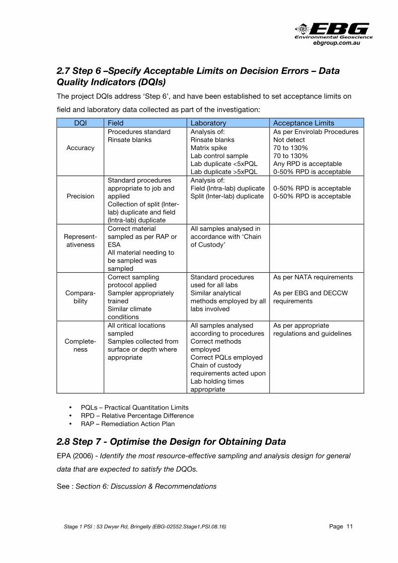
2.7 Step 6 –Specify Acceptable Limits on Decision Errors – Data Quality Indicators (DQIs) The project DQIs address ‘Step 6’, and have been established to set acceptance limits on
field and laboratory data collected as part of the investigation:
DQI Field Laboratory Acceptance Limits
Accuracy
Procedures standard Rinsate blanks
Analysis of: Rinsate blanks Matrix spike Lab control sample Lab duplicate <5xPQL Lab duplicate >5xPQL
As per Envirolab Procedures Not detect 70 to 130% 70 to 130% Any RPD is acceptable 0-50% RPD is acceptable
Precision
Standard procedures appropriate to job and applied Collection of split (Inter-lab) duplicate and field (Intra-lab) duplicate
Analysis of: Field (Intra-lab) duplicate Split (Inter-lab) duplicate
0-50% RPD is acceptable 0-50% RPD is acceptable
Represent- ativeness
Correct material sampled as per RAP or ESA All material needing to be sampled was sampled
All samples analysed in accordance with ‘Chain of Custody’
Compara- bility
Correct sampling protocol applied Sampler appropriately trained Similar climate conditions
Standard procedures used for all labs Similar analytical methods employed by all labs involved
As per NATA requirements As per EBG and DECCW requirements
Complete- ness
All critical locations sampled Samples collected from surface or depth where appropriate
All samples analysed according to procedures Correct methods employed Correct PQLs employed Chain of custody requirements acted upon Lab holding times appropriate
As per appropriate regulations and guidelines
• PQLs – Practical Quantitation Limits • RPD – Relative Percentage Difference • RAP – Remediation Action Plan
2.8 Step 7 - Optimise the Design for Obtaining Data EPA (2006) - Identify the most resource-effective sampling and analysis design for general
data that are expected to satisfy the DQOs.
See : Section 6: Discussion & Recommendations

ebgroup.com.au
Stage 1 PSI : 53 Dwyer Rd, Bringelly (EBG-02552.Stage1.PSI.08.16) Page 12
SECTION 3: SITE INFORMATION
3.1 Site Identification
Suburb/LGA Street Address Lot. No. Deposited Plan No. (DP) Area (m2)
Suburb: Bringelly LGA: Liverpool Parish: Bringelly County: Cumberland
53 Dwyer Road Bringelly NSW 66
27550 28,900
3.2 Soil Landscape & Geology Underlying the natural agricultural topsoils are the Bringelly / Ashfield Shale and the Hawkesbury Sandstone of the Middle Triassic Wianamatta Group. It is estimated that the lithological boundary of the shale and sandstone would be 80-100 metres beneath the surface.
The Bringelly/Ashfield Shale is a grey well-banded, laminated rock common to the south and west of Sydney Harbour. The strata is characterised by lacustrine deposits at the base grading up to prodelta and delta (marine) fronts.
The Hawkesbury Sandstone stratigraphically underlies the Bringelly/Ashfield Shale. The Hawkesbury Sandstone comprises medium to coarse- grained sandstone with minor shale and laminate lenses. This sandstone is of fluvial origin with limited lacustrine and wind
induced deposition, with numerous braided alluvial channel fills.
(Sydney, Geological Map of NSW, 1:100 000 Geological Series Sheet 9130, Edition 1, NSW Dept. of Mineral Resources, 1983).
The site is situated within the Cumberland Lowlands. The Cumberland Lowlands is an extensive low lying plain characterised by gently undulating ridges and low hills. It is mainly flat with occasional terranes and levees providing low relief. Slopes in the area are generally <5% (Bannerman & Hazelton. 1990).
The Luddenham Soil Landscape consists of undulating low hills on Wianamatta Group shales. Soils in this type of geology are typically shallow to moderately deep topsoils existing as a friable dark brown loam. These overlie medium reddish brown silty to heavy clay (Hazelton & Bannerman 1990: 64).

ebgroup.com.au
Stage 1 PSI : 53 Dwyer Rd, Bringelly (EBG-02552.Stage1.PSI.08.16) Page 13
Soils are generally deep and have a high clay content. The dominant shallow soils of this landscape consist of a dark brown sandy loam which occurs as topsoil and a brown apedal sandy clay loam which occurs below. This is generally underlain by a brown sandy clay with up to 20% ironstone nodules and a high chroma clay with up to 90% stones (Bannerman & Hazelton 1990: 82). Very little natural vegetation survives on this soil landscape, with most areas having been cleared and used for small farms. Topsoils have a low erodibility due to their flat grade and low organic content (Bannerman & Hazelton 1990: 82, 84).
3.3 Topography and Hydrogeology The Warragamba 9030-3S (2nd Edition) 1:25,000 Topographic Map was consulted. The property is located on Dwyer Road. This is a major rural road that connects Greendale Road at 120 metres AHD to The Northern Road at around 80 metres AHD. Dwyer Road generally runs along a low ridge with rural properties fanning out either side of its length.
The site has an elevation of 105 metres AHD at Dwyer Road and around 92 metres AHD at the rear of the property (west).
The land falls away to the west toward Duncans Creek that flows north / north west into a number of billabongs, the largest located one kilometre to the northwest of the site.
3.4 Acid Sulfate Soil Risk The Department of Water & Conservation Acid Sulphate Soils Risk Maps do not cover the
area. It is our opinion that acid sulfate soils shall not be an issue affecting the site.
3.5 Zoned Land Use The land is currently within the Liverpool Local Environmental Plan 2008 as:
• ‘R5 Large Lot Residential’.
It is understood that there shall not be an application to change this zoning.
3.6 WorkCover NSW A search of the Stored Chemical Information Database (SCID) and the microfiche records
held by WorkCover in August 2016, had NOT located records pertaining to the site located at 53 Dwyer Rd, Bringelly (See WorkCover NSW letter dated 18 August 2016 – Ref: D16/654224 in Appendix C).

ebgroup.com.au
Stage 1 PSI : 53 Dwyer Rd, Bringelly (EBG-02552.Stage1.PSI.08.16) Page 14
3.7 Site Title History SUMMARY OF PROPRIETORS Lot 66 DP 27550 Year Proprietor Source 2014-To Date
Sasanadhaja Buddhist Association Incorporated
Current Certificate of Title*,
Document AI414811
1980-2014 William John Hahn
(building foreman), Lynette
Maree Hahn (his wife)
Document AI414811, Vol. 9003
Fol. 162
1969-1980 Arthur Leslie Weeden
(taxi proprietor), Fleeta
Oskon Weeden (his wife)
Vol. 9003 Fol. 162
1961-1969 Ronald Victor Richardson (glass
merchant), Doreen Richardson (his
wife)
Vol. 9003 Fol. 162
1961 James Con Harris (salesman) Vol. 9003 Fol. 162, Vol. 7614 Fol. 159
1956-1961 William Francis Dwyer (grazier) Vol. 7614 Fol. 159,
Vol. 7258 Fol. 55, Vol. 6177 Fol. 176, Vol. 6177 Fol. 177
1949-1956
Clemment Keith Hill
(grazier), James
Clement Hill (grazier)
Vol. 6177 Fol. 176, Vol. 6177 Fol. 177,
Vol. 4437 Fol. 53
1932-1949 Dorothy Blanche Maiden
(widow), George Maiden
(stadium agent)
Vol. 4437 Fol. 53
1927-1932 George Maiden (grazier) Vol. 4437 Fol. 53 Book 1540 No. 14
1902-1927 John Thomas Colburn Mayne the elder (grazier)
Book 1540 No. 14 Book 715 No. 1

ebgroup.com.au
Stage 1 PSI : 53 Dwyer Rd, Bringelly (EBG-02552.Stage1.PSI.08.16) Page 15
3.8 Historical Air Photos & Maps with Discussion An inspection of available aerial photographs was undertaken.
3.8.1 Closeup 1947 Aerial Photo 1947 Aerial Photo: The property is part of a larger agricultural pastoral holding. Greendale
Road runs east to west at the bottom of the picture. A section of tilled land to the south of Greendale Road. No structures located on the land or within a one kilometres radius of the property in question.

ebgroup.com.au
Stage 1 PSI : 53 Dwyer Rd, Bringelly (EBG-02552.Stage1.PSI.08.16) Page 16
3.8.2 Closeup 1961 Aerial Photo 1961 Aerial Photo: Smaller allotments than in 1947 photo. No structures on the site. Some
residences and agricultural sheds within the surrounding properties. Findley Road runs east to west at the bottom of the picture.

ebgroup.com.au
Stage 1 PSI : 53 Dwyer Rd, Bringelly (EBG-02552.Stage1.PSI.08.16) Page 17
3.8.3 Closeup 1986 Aerial Photo 1986 Aerial Photo: Smaller allotments along Dwyer and Findley Roads clearly visible. A
residence, small sheds and two dams located on site. Numerous residences and agricultural sheds within the surrounding properties. Findley Road runs east to west at the bottom of the picture.

ebgroup.com.au
Stage 1 PSI : 53 Dwyer Rd, Bringelly (EBG-02552.Stage1.PSI.08.16) Page 18
3.8.4 Closeup 2009 Aerial Photo 2009 Aerial Photo: The residence, small sheds and two dams clearly located on site similar
to 1986. Numerous residences and agricultural sheds within the surrounding properties. Findley Road runs east to west at the bottom of the picture.

ebgroup.com.au
Stage 1 PSI : 53 Dwyer Rd, Bringelly (EBG-02552.Stage1.PSI.08.16) Page 19
3.8.5 Closeup Present Aerial Photo Closeup – Present day Near Map Aerial Photo.

ebgroup.com.au
Stage 1 PSI : 53 Dwyer Rd, Bringelly (EBG-02552.Stage1.PSI.08.16) Page 20
3.9 Title and Air Photo Discussion Summary:
• The property was part of a larger pastureland and owned by graziers up until 1961.
• Suspected to be sub-divided into smaller lots (5-10 acres / 3-5 Ha) around 1961.
Bought by a salesman in 1961 and sold that same year.
• Privately owned as a small allotment since 1961.
• The residence and sheds suspected to be built around the 1970s.
3.10 EPA NSW Contaminated Land Database A search of the OE&H contaminated land database was carried out via the internet for the LGA of Liverpool. The site in question was not listed.
Suburb Address Site Name Notices related to this site
CHIPPING NORTON
85-107 Alfred STREET Former ACR 3 current
MOOREBANK (a) 1 Bapaume ROAD ABB Australia Pty Ltd 1 current and 8 former
3.11 Proposed Development It is proposed to construct:
• A Buddhist temple;
• Community hall;
• Pagoda
• 5 retreat lodgings
• Associated car parking;
• Retention of the existing dwelling;
• Conversion of the existing dam to a feature pond.

ebgroup.com.au
Stage 1 PSI : 53 Dwyer Rd, Bringelly (EBG-02552.Stage1.PSI.08.16) Page 21
3.12 LGA (Liverpool City Council) Section 149 Certificate #1020 Subsidence
The land is not affected by a policy adopted by the Council, or any other public authority and
notified to the council for the express purpose of its adoption being referred to in a planning certificate that restricts the development of the land because of the likelihood of subsidence.
Acid Sulphate Soil
The land is not affected by a policy adopted by the Council, or any other public authority and
notified to the council for the express purpose of its adoption being referred to in a planning certificate that restricts the development of the land because of the likelihood of acid sulfate soil.
Other Risks
The land is not affected by a policy adopted by the Council, or any other public authority and notified to the council for the express purpose of its adoption being referred to in a planning certificate that restricts the development of the land because of the likelihood of any other
risk.
Coastal Protection Act 1979
There has been no notification from the Department of Public that the land is subject to the operation of Section 38 or 39 of the Coastal Protection Act, 1979.
Mine Subsidence The land is not within an area proclaimed to be a mine subsidence district within the meaning of the Mine Subsidence Compensation Act 1961.
Council & Public Authority Policies on Hazard Risk Restrictions
The land is not affected by a policy adopted by Council or any Public Authority that restricts
the land because of the likelihood of land slip, bushfire, flooding, tidal inundation, subsidence, acid sulfate soils or any other risk.
Flood Related Development Controls
Development on the site is not subject to flood related development controls.

ebgroup.com.au
Stage 1 PSI : 53 Dwyer Rd, Bringelly (EBG-02552.Stage1.PSI.08.16) Page 22
The following matters are prescribed by section 59 (2) of the Contaminated Land
Management Act 1997 as additional matters to be specified in a planning certificate:
(a) that the land to which the certificate relates is significantly contaminated land within the meaning of that Act-if the land (or part of the land) is significantly contaminated land at the
date when the certificate is issued,
Not Applicable
(b) that the land to which the certificate relates is subject to a management order within the
meaning of that Act- if it is subject to such an order at the date when the certificate is issued,
Not Applicable
(c) that the land to which the certificate relates is the subject of an approved voluntary management proposal within the meaning of that Act- if it is the subject of such an approved
proposal at the date when the certificate is issued,
Not Applicable
(d) that the land to which the certificate relates is subject to an ongoing maintenance order
within the meaning of that Act- if it is subject to such an order at the date when the certificate is issued,
Not Applicable
(e) that the land to which the certificate relates is the subject of a site audit statement within the meaning of that Act-if a copy of such a statement has been provided at any time to the local authority issuing the certificate.
Not Applicable

ebgroup.com.au
Stage 1 PSI : 53 Dwyer Rd, Bringelly (EBG-02552.Stage1.PSI.08.16) Page 23
SECTION 4: SITE INSPECTION A site inspection was carried out on 3 August 2016.
4.1 Building Condition, Current Occupier and Use
All buildings (except for small ‘chicken’ shed) are located at the top (east boundary) of the property facing Dwyer Road. The buildings include:
• Main residential home with associated sunrooms and annexes;
• Small ‘granny cottage’ on northern boundary;
• Numerous small garden and farm sheds located at the rear of the residence;
• (A small ‘chicken’ shed is located a quarter of the property length from the road, on the northern boundary)
The block is currently used for ‘hobby farm’ use. No animals were located on site at the present time. No indication the property has been used as a market garden (no old garden bed wind rows etc).
4.2 Surrounding Land Use
North: Small acreage with residence, sheds and dam.
East: Dwyer Road and small acreage on opposite side of road.
South: Adjacent small acreage with residence, sheds and dam. The property contains a
number of large sheds and a large tipper with trailer was located next to a large shed. It is suspected that the truck is garaged on the site. Two above ground (suspected) fuel tanks were located adjacent to one of the metal sheds. These were in good condition. No hydrocarbon impact along fence or within the investigation property (53 Dwyer Road).
West: Small acreage with a number of dams.
4.3 Surface Condition and Vegetation
The block slopes very gently to the west with an elevation of around 105 mAHD at Dwyer
Road to 92 mAHD along the rear western boundary. The site is predominately covered with pasture grass and scattered native (gum) trees. The house is surrounded with a number of native and introduced trees and scrubs. All vegetation appears to be in good condition with no stress (potentially caused by contamination impact) identified.

ebgroup.com.au
Stage 1 PSI : 53 Dwyer Rd, Bringelly (EBG-02552.Stage1.PSI.08.16) Page 24
The slope of the land forms a water catchment area with intermittent creeks and gullies clearly visible in the historical photos particularly 1961. The creek/gully can still be seen between the dam and residence in the recent air photos. These creeks and gullies fed dams located to the immediate west of the property which in turn supplied Duncans Creek.
Minor amounts of scattered building debris (timber and bricks etc) located along the northern boundary near the ‘chicken’ sheds. No asbestos pieces on the soil surface located during the site inspection.
4.4 Underground Tanks and Chemical or Waste Storage Facilities
Underground tanks were not located during the inspection and are not suspected.
4.5 Fill Material
The exact nature of the sub-surface material is not known, however considering the past landuse and the size of the property, it is considered unlikely that imported fill has been transported onto the property.

ebgroup.com.au
Stage 1 PSI : 53 Dwyer Rd, Bringelly (EBG-02552.Stage1.PSI.08.16) Page 25
SECTION 5: AREAS OF ENVIRONMENTAL CONCERN
5.1 Potential Receptors The site inspection revealed a number of potential receptors for off site migration of potential contamination:
• Adjacent properties.
• Adjacent dams.
• Duncans Creek
5.2 Potential Sources and Contaminants of Concern Historical Activity Contaminating
Activity
Contaminants of Concern
Likelihood
Vacant land agricultural
Illegal dumping Rubbish, asbestos Unlikely (no evidence in the history or site inspection)
Fill material
Imported fill Ash or building waste
Unlikely – not located during inspection and not suspected
on a property this size.
Industrial activity General works General industrial waste (metals,
hydrocarbons)
Unlikely (no indication the site has been used for this purpose)
Abbreviations
Heavy metals As (Arsenic), Cd (Cadmium), Co (Cobalt), Cu (Copper), Cr (Chromium), Pb (lead), Ni (Nickel), Hg (Mercury), Ti (Titanium), Zn (Zinc)
PAHs Polycyclic Aromatic Hydrocarbons
VOCs Volatile Organic Compounds
BTEX Benzene, Toluene, Ethylbenzene, Xylene
TRH Total Recoverable Hydrocarbons
PCBs Polychlorinated Biphenyls

ebgroup.com.au
Stage 1 PSI : 53 Dwyer Rd, Bringelly (EBG-02552.Stage1.PSI.08.16) Page 26
SECTION 6: DISCUSSION & RECOMMENDATIONS
6.1 Discussion Points taken into consideration to enable recommendations:
• The seven-step DQO process (defined in Section 2) as outlined in the Guidelines for the National Environment Protection (Assessment of Site Contamination) Measure (NEPM), (1999 amended 2013) and EPA NSW Site Auditor Scheme (2nd Edition –
April 2006 was employed to assess the property in regard to contamination of the soil.
• The title search and historical aerial photos show no evidence the property has been used for any industrial activity that may have had an impact on the soil with respect to chemical contamination.
• There was no evidence uncovered during the site visit / investigation that the land has been used for industrial use or any other significant contaminating activity.
• Chemical and/or waste storage tanks were not located or are suspected to be located on the site.
• No significant staining or odours were identified during the inspection.
• The Department of Water & Conservation Acid Sulphate Soils Risk Maps do not cover the area. It is our opinion that acid sulfate soils shall not be an issue affecting the site.
• The site is not listed on the EPA NSW Contaminated Lands database.
• The exact nature of the sub-surface soil is not known, however considering the past landuse and the size of the property, it is considered unlikely that imported fill has been transported onto the property.
• The majority of the surface is typical pasture grass with scattered trees. All vegetation appear to be healthy with no signs of stress or discolouration.
• It is suspected that the small cottage and some associated buildings and sheds are
clad in asbestos cement sheeting (See Recommendation #1 below). Broken pieces of asbestos cement sheeting were not observed on the ground surface.
ebgroup.com.au
Stage 1 PSI : 53 Dwyer Rd, Bringelly (EBG-02552.Stage1.PSI.08.16) Page 27
6.2 Recommendation Considering the above points it is the opinion of EBG that a Detailed Stage 2 Environmental Site Assessment as defined in the EPA NSW Guidelines for Consultants Reporting on Contaminated Sites Nov 1997, is not considered necessary.
EBG considers the land shall be suitable for the proposed development providing the following recommendations are undertaken.
Recommendation #1: Hazardous Materials Report of Existing Building/s
It is a requirement of the NSW Occupational Health and Safety Act, 2000 and NSW
Occupational Health and Safety Regulation, 2001 that a hazardous materials audit be conducted on any buildings prior to demolition.
The HMA shall report on the:
o asbestos materials located o synthetic mineral fibre (SMF) o PCBs in light fittings o lead content in ceiling space dust o lead content paintwork
An assessment of the condition of the hazardous materials shall be included, with particular emphasis on the relevant Codes of Practice and WorkCover NSW requirements.
Recommendation #2: Imported, Exported & Excavation Soils a) Excavated Soil to be Removed From Site (exported):
All soils removed from the property must first be classified as per the EPA NSW Waste Classification Guidelines - Part 1 : Classifying Waste (Nov 2014) prior to disposal.
b) Imported Soil:
Any imported fill shall be sampled prior to importation and shall conform to VENM (virgin excavated natural material) as per EPA NSW Waste Classification Guidelines - Part 1 :
Classifying Waste (Nov 2014)).
c) General Excavations:
If during any development excavation, any visual staining or unidentified odour is encountered, work should cease within the area until is has been assessed by a qualified environmental professional.
ebgroup.com.au
Stage 1 PSI : 53 Dwyer Rd, Bringelly (EBG-02552.Stage1.PSI.08.16) Page 28
SECTION 7. REFERENCES AND LEGISLATION • Warragamba 9030-3S (2nd Edition) 1:25,000 Topographic Map: Land & Property
Information 2001.
• Sydney, Geological Map of NSW, 1:100 000 Geological Series Sheet 9130, Edition 1, NSW Dept. of Mineral Resources, 1983.
• National Environment Protection (Assessment of Site Contamination) Measure (NEPM), (1999 amended 2013).
• EPA NSW Waste Classification Guidelines - Part 1 : Classifying Waste (Nov 2014)
• NSW Contaminated Land Management Act 2008 No.11.
• Managing Land Contamination – Planning Guidelines SEPP 55 – Remediation of Land – Dept. of Urban Affairs & Planning and EPA NSW 1998.
• Guideline on Investigation Levels for Soil & Groundwater : Schedule B1 – National
Environment Protection Measure (NEPM) (1999 amended 2013).
• Australian and New Zealand Guidelines from the Protection of Aquatic Organisms – 95% Protection of Species for Fresh and Marine Water (ANZECC 2000).
• Virgin excavated natural material and Waste Classification Guidelines (Part 1 :
Classifying Waste – Department of Environment & Climate Change NSW (December 2009).
• EPA NSW Sampling Design Guidelines September 1995.
• Virgin excavated natural material (DECC 2008/447) Fact Sheet 2008.
• DEC NSW Guidelines for Assessing Former Orchards & Market Gardens June 2005.
• EPA NSW Guidelines for Consultants Reporting on Contaminated Sites 1997 Reprinted August 2011
• Work Health and Safety Act 2011 (WHS Act)
• Work Health and Safety Regulation 2011 (WHS Regulation)
Stage 1 PSI : 53 Dwyer Rd, Bringelly (EBG-02552.Stage1.PSI.08.16)
APPENDIX A : LOCALITY PLANS AND PHOTOGRAPHS
• FIGURE 1 (02552-F01) – SITE LOCATION
• FIGURE 2 (02552-F02) - SITE BOUNDARIES
• PHOTOGRAPHS

LEGEND: – SITE LOCATION
FIG NO. FIGURE NO. 1 : 02552-F01 LOCATION PROPOSED DEVELOPMENT – BUDDHIST TEMPLE: 53 DWYER ROAD, BRINGELLY NSW 2556
SOURCE NEARMAP - IMAGERY 2016 CNES / ASTRIUM, DIGITALGLOBE
CLIENT S.S.SANADHAJA BUDDHIST ASSOC. INC.
DRAWN M.E PROJECT STAGE 1 – PRELIMINARY SITE INVESTIGATION
APPROVED M.E TITLE SITE LOCATION

LEGEND: – SITE LOCATION
FIG NO. FIGURE NO. 2 : 02552-F02 LOCATION PROPOSED DEVELOPMENT – BUDDHIST TEMPLE: 53 DWYER ROAD, BRINGELLY NSW 2556
SOURCE NEARMAP - IMAGERY 2016 CNES / ASTRIUM, DIGITALGLOBE
CLIENT S.S.SANADHAJA BUDDHIST ASSOC. INC.
DRAWN M.E PROJECT STAGE 1 – PRELIMINARY SITE INVESTIGATION
APPROVED M.E TITLE SITE BOUNDARIES

APPENDIX A - PHOTOGRAPHS : Stage 1 PSI : 53 Dwyer Rd, Bringelly (EBG-02552.Stage1.PSI.08.16)

Stage 1 PSI : 53 Dwyer Rd, Bringelly (EBG-02552.Stage1.PSI.08.16)
APPENDIX B: HISTORICAL TITLE INFORMATION
AND OTHER DOCUMENTATION


!
!"#$%&%'(%)%!
!
!
"#!$%&%'(!)*"#!
!
+,-./,'!012'345!6/7%8!9(:!;(,!!
9<!07=!)>?!
$@@.@,.15!ABC!)*D>!$EBFG$;H$!
!
!""#$"%&$'!()*(%+,-#.*/01-)02!*
3/'** 4&"*55*67*89::;<*:=*61>#)*3&-0<*?)%$@#..><*ABC*
D&E)*3#F'*
!
*
*
*
BG((!3D*HI*73H73J/KH3B*!4&"*55*67*89::;*
!
D#-)* 7)&L)%#"&)* B&E)+#*
)*"?IF7!J.(5! B.'.@.,4.K.!0%,,4L'(!$''73L.(L7@!H@37/87/.(5,! M%//5@(!M5/(LNL3.(5!7N!FL(15OP!
J73%Q5@(!$H?"?>""!
"R>*I)*"?! CL11L.Q!S74@!T.4@!UV%L1,L@&!N7/5Q.@WP!
;:@5((5!X./55!T.4@!U4L'!-LN5W!
J73%Q5@(!$H?"?>""P!
Y71Z!R**D![71Z!"#)!
"R#RI"R>*! $/(4%/!;5'1L5!C55,5@!U(.=L!8/78/L5(7/WP!
[155(.!<'\7@!C55,5@!U4L'!-LN5W!
Y71Z!R**D![71Z!"#)!
!
"R#"I"R#R! [email protected],!YL3(7/!GL34./,'7@!U&1.''!Q5/34.@(WP!
J7/55@!GL34./,'7@!U4L'!-LN5W!
Y71Z!R**D![71Z!"#)!
!
"R#"! S.Q5'!M7@!T.//L'!U'.15'Q.@W! Y71Z!R**D![71Z!"#)P!
Y71Z!]#"?![71Z!"^R!
"R^#I"R#"! CL11L.Q![/.@3L'!J-:5/!U&/._L5/W! Y71Z!]#"?![71Z!"^RP!
Y71Z!])^>![71Z!^^P!
Y71Z!#"]]![71Z!"]#P!
Y71Z!#"]]![71Z!"]]!
O!J73%Q5@(!'L&4(5,!V%(!@7(!8%/34.'5,!
!
! !

!
!"#$%*%'(%)%!
!
*
*
*
BG((!3D*HI*73H73J/KH3B*!4&"*55*67*89::;*M+&$"%$E#0N*
!
D#-)* 7)&L)%#"&)* B&E)+#*
"R?RI"R^#! M15QQ5@(!`5L(4!TL11!U&/._L5/WP!
S.Q5'!M15Q5@(!TL11!U&/._L5/W!
Y71Z!#"]]![71Z!"]#P!
Y71Z!#"]]![71Z!"]]P!
Y71Z!??D]![71Z!^D!
"RD)I"R?R! J7/7(4:!01.@345!X.L,5@!U-L,7-WP!
657/&5!X.L,5@!U'(.,L%Q!.&5@(W!
Y71Z!??D]![71Z!^D!
!
"R)]I"RD)! 657/&5!X.L,5@!U&/._L5/W! Y71Z!??D]![71Z!^D!
077\!"^?*!A7Z!"?!
"R*)I"R)]! S74@!F47Q.'!M71V%/@!X.:@5!(45!51,5/!U&/._L5/W! 077\!"^?*!A7Z!"?!
077\!]"^!A7Z!"!
!
!
! !

!
!"#$%+%'(%)%!
!
!
*
*
BG((!3D*HI*4/!B/*
*
4&"*55*67*89::;*
!
4#22##** B&E)+#*
;5.'5!MR]#?D]!
F7!O.%FF&)0*B%P#&$*C&&0,&E2#!7N!0/L@&511:P!&/._L5/!
J.(5,a!?b")b"R?*!
B%//5@,5/!7N!15.'5P!5@(5/5,a!)]b]b"R?D!
Y71Z!??D]![71Z!^D!
;5.'5!M#""*R>!
F7!O.%FF&)0*B%P#&$*C&&0,&E2#!7N!0/L@&511:P!&/._L5/!
J.(5,a!"b")b"RD]!
+=8L/5,!V:!5NN1%=L7@!7N!(LQ5P!5@(5/5,a!"?b"b"R?"!
Y71Z!??D]![71Z!^D!
;5.'5!M)R>*"?!
F7!O.%FF&)0*B%P#&$*C&&0,&E2#!7N!0/L@&511:P!&/._L5/!
J.(5,a!]b""b"RD?!
+=8L/5,!V:!5NN1%=L7@!7N!(LQ5P!5@(5/5,a!"?b"b"R?"!
Y71Z!??D]![71Z!^D!
;5.'5!M))#>#R!
F7!O.%FF&)0*B%P#&$*C&&0,&E2#!7N!0/L@&511:P!&/._L5/!
J.(5,a!)Rb")b"RDD!
+=8L/5,!V:!5NN1%=L7@!7N!(LQ5P!5@(5/5,a!]b"b"RD>!
Y71Z!??D]![71Z!^D!
;5.'5!MR?)]^!
F7!O.%FF&)0*B%P#&$*C&&0,&E2#!7N!0/L@&511:P!&/._L5/!
J.(5,a!"#b"*b"RD"!
+=8L/5,!V:!5NN1%=L7@!7N!(LQ5P!5@(5/5,a!)*b)b"RD?!
Y71Z!??D]
!
!"#$%)%'(%)%!
!
!
*
*
*
!"#$%&'(&)'*+,-,'*%&.&/,$,-0-,'*%&!1.! "#$!%&'$()!'*!+$*,-(*'.&$!/-+!,012$()!0**-%'0)$3!4')#!)#$!*$0+%#5!
!
2.! "#$!%&'$()! '*!06)#-+'*$3! )-!6*$!-6+!+$,-+)!*6.7$%)! )-!*$))&$2$()!-/!-6+!0%%-6()5!8()'&! )#$!0%%-6()! '*!*$))&$39! )#$!+$,-+)!
+$20'(*!)#$!,+-,$+)1!-/!:(;'+-(2$()0&!<$=0&!>$0+%#$*5!?/!)#$!0%%-6()!'*!(-)!*$))&$3!4')#'(!@A!301*!-/!)#$!'(;-'%$!30)$9!
)#$(!)#$!06)#-+')1!)-!6*$!)#$!+$,-+)!201!.$!+$;-B$35!C#$+$!06)#-+')1!)-!6*$!)#$!+$,-+)!'*!+$;-B$39!0&&!+$/$+$(%$*!)-!)#$!
+$,-+)!*#-6&3!.$!3$&$)$3!-+!+$(3$+$3!'(0%)';$!6()'&!)#$!0%%-6()!'*!*$))&$35!
!
3.! >$0+%#!40*! .0*$3!-(!"#$!%%!&'!()**+! ,+-;'3$3!.1!,-!,./0123!4561-578!"#$! *)+$$)! (62.$+! D'/! 0,,&'%0.&$E! '*! /-+!
+$/$+$(%$!-(&15!
!
"#$!0))0%#$3!%030*)+0&!,&0(!F8>"!.$!%#$%B$3!0=0'(*)!)#$!*6+;$1!,&0(!/-+!)#$!,+-,$+)1!/-+!%-++$%)($**5!
!
4.! G(1!3$)0'&*!-/!)#$!&$0*$D*E9!*6.H&$0*$D*E!0(3I-+!)+0(*/$+!-/!&$0*$D*E!4$+$!*-&$&1!$J)+0%)$3!/+-2!)#$!+$%-+3*!*#-4(!-(!)#$!
%6++$()! %$+)'/'%0)$D*E! -/! )')&$! D)')&$! *$0+%#E9! 3-%62$()*! -/! &$0*$D*EI! *6.H&$0*$D*EI)+0(*/$+! -/! &$0*$D*E9! )#$! %0(%$&&$3!
%$+)'/'%0)$D*E! -/! )')&$! 0(3I-+! )#$! -&3! *1*)$2! ;$(3-+I,6+%#0*$+! ;-&62$D*E5! "#$! FK>"! L:M:N"! +$%-+3! 201! (-)! .$!
0;0'&0.&$!-(!)#$!301!-/!)#$!*$0+%#'(=5!
!
5.! G&)#-6=#! )#$! *$0+%#! '*! ,$+/-+2$3! )-! 0! ,+-/$**'-(0&! 0(3! 3'&'=$()! *)0(30+39!4$! %0((-)!40++0()! 0(1! &-**! -+! 3020=$*!
4#'%#!201!.$!0**-%'0)$3!4')#!-6+!*$0+%#5!C$!)#$+$/-+$!&'2')!0(1!,-)$()'0&!&'0.'&')1!0**-%'0)$3!4')#!-6+!*$0+%#!)-!)#$!%-*)!
-/!-6+!*$+;'%$*5!
!
!
!

PLANNING CERTIFICATE UNDER SECTION 149
ENVIRONMENTAL PLANNING AND ASSESSMENT ACT 1979
Ref.: 857- 53 DWYER RD:37193 Ppty: 7517
Cert. No.: Page No.:
1020 1
Applicant: VT ARCHITECTS 26 BOLIVIA ST CABRAMATTA NSW 2166
Receipt No.: Receipt Amt.: Date:
3392487 133.00 24-Aug-2016
Property Desc: 53 DWYER ROAD, BRINGELLY NSW 2556 LOT 66 DP 27550
NOTE: The following information is provided pursuant to Section 149(2) of the Environmental Planning and Assessment Act (EP&A Act) 1979 as prescribed by Schedule 4 of the Environmental Planning and Assessment Regulation (EP&A Regulation) 2000 and is applicable to the subject land as of the date of this certificate. The Environmental Planning and Assessment Amendment Act 1997 commenced operation on the 1 July 1998. As a consequence of this Act the information contained in this certificate needs to be read in conjunction with the provisions of the Environmental Planning and Assessment (Amendment) Regulation 1998, Environmental Planning and Assessment (Further Amendment) Regulation 1998 and Environmental Planning and Assessment (Savings and Transitional) Regulation, 1998.
PRESCRIBED INFORMATION PROVIDED PURSUANT TO
SECTION 149(2) OF THE
ENVIRONMENTAL PLANNING AND ASSESSMENT ACT 1979

PLANNING CERTIFICATE UNDER SECTION 149 Cert. No.: 1020 ENVIRONMENTAL PLANNING AND ASSESSMENT ACT 1979 Page No.: 2
(1) Names of relevant planning instruments and DCPs
(1) The name of each environment planning instrument that applies to the carrying out of Development on
the land is/are listed below: -
Local Environmental Plans (LEPs) Liverpool Local Environmental Plan 2008
State Environmental Planning Policies (SEPPs)
State Environmental Planning Policy No. 1 – Development Standards State Environmental Planning Policy No. 19 – Bushland in Urban Areas State Environmental Planning Policy No. 21 – Caravan Parks State Environmental Planning Policy No. 30 – Intensive Agriculture State Environmental Planning Policy No. 33 – Hazardous and Offensive Development State Environmental Planning Policy No. 44 – Koala Habitat State Environmental Planning Policy No. 50 – Canal Estate Development State Environmental Planning Policy No. 55 – Remediation of Land State Environmental Planning Policy – (Exempt and Complying Development Codes) 2008 State Environmental Planning Policy No. 62 – Sustainable Aquaculture State Environmental Planning Policy No. 64 – Advertising and Signage State Environmental Planning Policy No. 65 – Design Quality of Residential Flat Development State Environmental Planning Policy – (Building Sustainability Index: BASIX) 2004 State Environmental Planning Policy No. 70 – Affordable Housing (Revised Schemes) State Environmental Planning Policy – (Infrastructure) 2007 State Environmental Planning Policy – (Mining, Petroleum Production and Extractive Industries) 2007 State Environmental Planning Policy – (Miscellaneous Consent Provisions) 2007 State Environmental Planning Policy – (Affordable Rental Housing) 2009 State Environmental Planning Policy – (State and Regional Development) 2011
Deemed State Environmental Planning Policies (Deemed SEPPs)
Sydney Regional Environmental Plan No. 20 – Hawkesbury – Nepean River (No. 2 – 1997) This plan applies to all the land within the Hawkesbury – Nepean River catchment. This plan aims to protect the environment of the Hawkesbury – Nepean River system by ensuring that the impacts of future land uses are considered in regional context. The plan provides specific planning policies and strategies and development controls for specific land use.
(2) The name of each proposed environmental planning instrument that will apply to the carrying out of
development on the land and that is or has been the subject of community consultation or on public exhibition under the Act (unless the Director-General has notified the council that the making of the proposed instrument has been deferred indefinitely or has not been approved).
Draft Local Environmental Plans (LEPs) Not Applicable

PLANNING CERTIFICATE UNDER SECTION 149 Cert. No.: 1020 ENVIRONMENTAL PLANNING AND ASSESSMENT ACT 1979 Page No.: 3
Draft State Environmental Planning Policies (SEPPs) Draft State Environmental Planning Policy (Competition) 2010
(3) The name of each development control plan that applies to the carrying out of development on the land.
Liverpool Development Control Plan 2008 (as amended). (4) In this clause, proposed environmental planning instrument includes a planning proposal for an LEP or a
draft environmental planning instrument. 2. ZONING AND LAND USE UNDER RELEVANT LOCAL ENVIRONMENTAL PLANS
For each environmental planning instrument or proposed instrument referred to in clause 1 (other than a SEPP or proposed SEPP) that includes the land in any zone (however described):
Liverpool Local Environmental Plan 2008
(a) Name of zone, and the EPI from which the land zoning information is derived. R5 Large Lot Residential - Liverpool LEP 2008
(b) The purposes for which development may be carried out within the zone without the need for development consent Home-based child care; Home occupations
(c) The purposes for which development may not be carried out within the zone except with development consent Bed and breakfast accommodation; Building identification signs; Business identification signs; Dual occupancies; Dwelling houses; Educational establishments; Environmental facilities; Environmental protection works; Extensive agriculture; Farm buildings; Flood mitigation works; Helipads; Home businesses; Home industries; Places of public worship; Public administration buildings; Recreation areas; Roads; Veterinary hospitals
(d) The purposes for which the instrument provides that development is prohibited within the zone. Any development not specified in item (b) or (c)
(e) Whether any development standards applying to the land fix minimum land dimensions for the erection
of a dwelling-house on the land and, if so, the minimum land dimensions so fixed
No development standards applying to the land fix minimum land dimensions for the erection of a dwelling house on the land.

PLANNING CERTIFICATE UNDER SECTION 149 Cert. No.: 1020 ENVIRONMENTAL PLANNING AND ASSESSMENT ACT 1979 Page No.: 4
(f) Whether the land includes or comprises critical habitat
The land does not include or comprise critical habitat.
(g) Whether the land is in a conservation area (however described)
The land is not located in a conservation area. (h) Whether an item of environmental heritage (however described) is situated on the land
Not item of environmental heritage is situation on the land. Note: Schedule 1 of the Liverpool Local Environmental Plan 2008 permits certain development which would otherwise be prohibited within a zone. In addition, Clause 7.18 of the Liverpool Local Environmental Plan 2008 may prohibit certain development due to potential for exposure to aircraft noise, despite the zone. Any additional information which may affect the permissibility of development on the land is provided below:
Additional Uses
Nil
2A. Zoning and land use under State Environmental Planning Policy (Sydney Region Growth Centres) 2006
Not Applicable 3. Complying development
(1) The extent to which the land is land on which complying development may be carried out under each of the codes for complying development because of the provisions of clauses 1.17A (1) (c) to (e), (2), (3) and (4), 1.18(1) (C3) and 1.19 of State Environmental Planning Policy (Exempt and Complying Development Codes) 2008.
Complying development under the General Housing Code may be carried out on this land. Complying development under the General Development Code may be carried out on this land. Complying development under the Rural Housing Code may be carried out on this land. Complying development under the Fire Safety Code may be carried out on this land. Complying development under the Housing Alterations Code may be carried out on this land. Complying Development under the Commercial and Industrial Alterations Code may be carried out on this land. Complying Development under the Commercial and Industrial (New Buildings and Additions) Code may be carried out on this land.

PLANNING CERTIFICATE UNDER SECTION 149 Cert. No.: 1020 ENVIRONMENTAL PLANNING AND ASSESSMENT ACT 1979 Page No.: 5
Complying Development under the Subdivisions Code may be carried out on this land. Complying Development under the Demolition Code may be carried out on this land.
(2) The extent to which complying development may not be carried out on that land because of the
provisions of clauses 1.17A (1) (c) to (e), (2), (3) and (4), 1.18 (1) (C3) and 1.19 of that Policy and the reasons why it may not be carried out under those clauses.
Not Applicable
(3) If the council does not have sufficient information to ascertain the extent to which complying
development may or may not be carried out on the land, a statement that a restriction applies to the land, but it may not apply to all of the land, and that council does not have sufficient information to ascertain the extent to which complying development may or may not be carried out on the land.
Not Applicable
4. Coastal Protection Act 1979
There has been no notification from the Department of Public Works that the land is subject to the operation of Section 38 or 39 of the Coastal Protection Act, 1979.
4A Information relating to beaches and coasts
(1) In relation to a coastal council—whether an order has been made under Part 4D of the Coastal Protection Act 1979 in relation to temporary coastal protection works (within the meaning of that Act) on the land (or on public land adjacent to that land), except where the council is satisfied that such an order has been fully complied with.
Not Applicable
(2) In relation to a coastal council:
(a) whether the council has been notified under section 55X of the Coastal Protection Act 1979 that temporary coastal protection works (within the meaning of that Act) have been placed on the land (or on public land adjacent to that land), and
(b) if works have been so placed, whether the council is satisfied that the works have been removed
and the land restored in accordance with that Act.
Not Applicable
4B Annual charges under Local Government Act 1993 for coastal protection services that relate to existing coastal protection works In relation to a coastal council—whether the owner (or any previous owner) of the land has consented in writing to the land being subject to annual charges under section 496B of the Local Government Act 1993 for coastal protection services that relate to existing coastal protection works (within the meaning of section 553B of that Act).

PLANNING CERTIFICATE UNDER SECTION 149 Cert. No.: 1020 ENVIRONMENTAL PLANNING AND ASSESSMENT ACT 1979 Page No.: 6
Not Applicable
5. Mine Subsidence Whether or not the land is proclaimed to be a mine subsidence district within the meaning of Section 15 of
the Mine Subsidence Compensation Act 1961. The land is not a mine subsidence district. 6. Road Widening and Road Realignment Whether or not the land is affected by any road widening or road realignment under:
(a) Division 2 of Part 3 of the Roads Act 1993, or (b) Any environmental planning instrument, or (c) Any resolution of the council.
The land is not affected by any road widening or road realignment.
7. Council and Other Public Authority Policies on Hazard Risk Restrictions
Whether or not the land is affected by a policy: (a) adopted by the council, or (b) adopted by any other public authority and notified to the council for the express purpose of its adoption
by that authority being referred to in planning certificates issued by the council, that restricts the development of the land because of the likelihood of land slip, bushfire, tidal inundation, subsidence, acid sulphate soils or any other risk (other than flooding).
Land Slip The land is not affected by a policy adopted by the Council, or any other public authority and notified to the council for the express purpose of its adoption being referred to in a planning certificate that restricts the development of the land because of the likelihood of land slip. Bushfire The land is not affected by a policy adopted by the Council, or any other public authority and notified to the council for the express purpose of its adoption being referred to in a planning certificate which restricts the development of the land because of the likelihood of bushfire. Tidal Inundation The land is not affected by a policy adopted by the Council, or any other public authority and notified to the council for the express purpose of its adoption being referred to in a planning certificate that restricts the development of the land because of the likelihood of tidal inundation.

PLANNING CERTIFICATE UNDER SECTION 149 Cert. No.: 1020 ENVIRONMENTAL PLANNING AND ASSESSMENT ACT 1979 Page No.: 7
Subsidence The land is not affected by a policy adopted by the Council, or any other public authority and notified to the council for the express purpose of its adoption being referred to in a planning certificate that restricts the development of the land because of the likelihood of subsidence. Acid Sulphate Soil The land is not affected by a policy adopted by the Council, or any other public authority and notified to the council for the express purpose of its adoption being referred to in a planning certificate that restricts the development of the land because of the likelihood of acid sulphate soil. Other Risks The land is not affected by a policy adopted by the Council, or any other public authority and notified to the council for the express purpose of its adoption being referred to in a planning certificate that restricts the development of the land because of the likelihood of any other risk.
7A. Flood Related Development Controls Information
Whether or not development on that land or part of the land for purposes of dwelling houses, dual occupancies, multi dwelling housing or residential flat buildings (not including development for the purposes of group homes or seniors housing) is subject to flood related development controls.
(1) Whether or not development on that land or part of the land for purposes of dwelling houses, dual occupancies, multi dwelling housing or residential flat buildings (not including development for the purposes of group homes or seniors housing) is subject to flood related development controls. Development on all of the land for the purposes of dwelling houses, dual occupancies, multi dwelling housing or residential flat buildings is not subject to flood related development controls.
(2) Whether or not development on that land or part of the land for any other purpose is subject to flood related development controls. Development on all of the land for any other purpose is not subject to flood related development controls.
(3) Words and expressions in this clause have the same meanings as in the instrument set out in the Schedule to the Standard Instrument (Local Environmental Plans) Order 2006.
8. Land Reserved for Acquisition
Whether or not any environmental planning instrument or proposed environmental planning instrument referred to in clause 1 makes provision in relation to the acquisition of the land by a public authority, as referred to in section 27 of the Act.
No environmental planning instrument or proposed environmental planning instrument applying to the land provides for the acquisition of the land by a public authority.

PLANNING CERTIFICATE UNDER SECTION 149 Cert. No.: 1020 ENVIRONMENTAL PLANNING AND ASSESSMENT ACT 1979 Page No.: 8
9. Contribution Plans
The name of each contribution plan applying to the land is/are outlined below: Liverpool Contributions Plan 2008
9A Biodiversity certified land
If the land is biodiversity certified land (within the meaning of Part 7AA of the Threatened Species Conservation Act 1995), a statement to that effect. The land is not biodiversity certified land within the meaning of Part 7AA of the Threatened Species Conservation Act (1995).
10. Biobanking agreements
If the land is land to which a bio-banking agreement under Part 7A of the Threatened Species Conservation Act 1995 relates, a statement to that effect (but only if the council has been notified of the existence of the agreement by the Director-General of the Department of Environment, Climate Change and Water).
The land is not land to which a bio-banking agreement under part 7A of the Threatened Species Conservation Act 1995 relates.
11. Bushfire Prone Land
None of the land is bush fire prone land as defined in the Environmental Planning and Assessment Act 1979. 12. Property Vegetation Plans
If the land is land to which a Property Vegetation Plan under the Native Vegetation Act 2003 applies, a statement to that effect (but only if the council has been notified of the existence of the plan by the person or body that approved the plan under that Act).
The land is not land to which a property vegetation plan relates, as all land in the Liverpool Local Government Area is excluded from the operation of the Native Vegetation Act 2003.
13. Orders under Trees (Disputes between Neighbours) Act 2006
Whether an order has been made under the Trees (Disputes Between Neighbours) Act 2006 to carry out work in relation to a tree on the land (but only if the council has been notified of the order).
Council has not been notified of an order made under the Trees (Disputes between Neighbours) Act 2006 to carry out work in relation to a tree on the land.
14. Directions under Part 3A
If there is a direction by the Minister in force under section 75P (2) (c1) of the Act that a provision of an environmental planning instrument prohibiting or restricting the carrying out of a project or a stage of a project on the land under Part 4 of the Act does not have effect, a statement to that effect identifying the provision that does not have effect. No such direction applies to the land.

PLANNING CERTIFICATE UNDER SECTION 149 Cert. No.: 1020 ENVIRONMENTAL PLANNING AND ASSESSMENT ACT 1979 Page No.: 9
15. Site Compatibility Certificates and Conditions for Seniors Housing
If the land is land to which State Environmental Planning Policy (Housing for Seniors or People with a Disability) 2004 applies:
(a) a statement of whether there is a current site compatibility certificate (seniors housing), of which the
council is aware, in respect of proposed development on the land and, if there is a certificate, the statement is to include:
(i) The period for which the certificate is current, and (ii) That a copy may be obtained from the head office of the Department of Planning
Council is not aware of a current site compatibility certificate (seniors housing) on the land
(b) a statement setting out any terms of a kind referred to in clause 18 (2) of that Policy that have been
imposed as a condition of consent to a development application granted after 11 October 2007 in respect of the land.
There have been no such terms imposed as a condition of consent to development on the land.
16. Site Compatibility Certificates for Infrastructure
A statement of whether there is a valid site compatibility certificate (infrastructure), of which the council is aware, in respect of proposed development on the land and, if there is a certificate, the statement is to include:
(a) The period for which the certificate is valid, and (b) That a copy may be obtained from the head office of the Department of Planning.
Council is not aware of a current site compatibility certificate (infrastructure) on the land.
17. Site compatibility certificates and conditions for affordable rental housing
(1) A statement of whether there is a current site compatibility certificate (affordable rental housing), of which the council is aware, in respect of proposed development on the land and, if there is a certificate, the statement is to include:
(a) the period for which the certificate is current, and (b) that a copy may be obtained from the head office of the Department of Planning.
Council is not aware of a current site compatibility certificate (affordable rental housing) on the land. (2) A statement setting out any terms of a kind referred to in clause 17 (1) or 38 (1) of State Environmental Planning Policy (Affordable Rental Housing) 2009 that have been imposed as a condition of consent to a development application in respect of the land. There have been no such terms imposed as a condition of consent to development on the land.

PLANNING CERTIFICATE UNDER SECTION 149 Cert. No.: 1020 ENVIRONMENTAL PLANNING AND ASSESSMENT ACT 1979 Page No.: 10
18. Paper subdivision information
(1) The name of any development plan adopted by a relevant authority that applies to the land or that is proposed to be subject to a consent ballot. No such plan applies to the land.
(2) The date of any subdivision order that applies to the land.
No subdivision order applies to the land
(3) Words and expressions used in this clause have the same meaning as they have in Part 16C of this Regulation.
19. Site verification certificates
A statement of whether there is a current site verification certificate, of which the council is aware, in respect of the land and, if there is a certificate, the statement is to include:
(a) The matter certified by the certificate
Council is not aware of a current site verification certificate on the land.
Note. A site verification certificate sets out the Director-General’s opinion as to whether the land concerned is or is not biophysical strategic agricultural land or critical industry cluster land — see Division 3 of Part 4AA of State Environmental Planning Policy (Mining, Petroleum Production and Extractive Industries) 2007.
(b) The date on which the certificate ceases to be current (if any), and Not Applicable
(c) That a copy may be obtained from the head office of the Department of Planning and Infrastructure.
Not Applicable
Note. The following matters are prescribed by section 59 (2) of the Contaminated Land Management Act 1997 as additional matters to be specified in a planning certificate:
(a) That the land to which the certificate relates is significantly contaminated land within the meaning of that Act—if the land (or part of the land) is significantly contaminated land at the date when the certificate is issued Not Applicable
(b) That the land to which the certificate relates is subject to a management order within the meaning of
that Act—if it is subject to such an order at the date when the certificate is issued Not Applicable

PLANNING CERTIFICATE UNDER SECTION 149 Cert. No.: 1020 ENVIRONMENTAL PLANNING AND ASSESSMENT ACT 1979 Page No.: 11
(c) That the land to which the certificate relates is the subject of an approved voluntary management
proposal within the meaning of that Act—if it is the subject of such an approved proposal at the date when the certificate is issued Not Applicable
(d) That the land to which the certificate relates is subject to an ongoing maintenance order within the
meaning of that Act—if it is subject to such an order at the date when the certificate is issued Not Applicable
(e) That the land to which the certificate relates is the subject of a site audit statement within the meaning of that Act—if a copy of such a statement has been provided at any time to the local authority issuing the certificate. Not Applicable
Note. Section 26 of the Nation Building and Jobs Plan (State Infrastructure Delivery) Act 2009 provides that a planning certificate must include advice about any exemption under section 23 or authorisation under section 24 of that Act if the council is provided with a copy of the exemption or authorisation by the Co-ordinator General under that Act. No such exemption or authorisation applies to the land.
20. Loose-fill Asbestos Insulation
Some residential homes located in the Liverpool may have been identified as containing loose-fill asbestos insulation, for example in the roof space. NSW Fair Trading maintains a Register of homes that are affected by loose-fill asbestos insulation. You should make your own enquiries as to the age of the buildings on the land to which this certificate relates and, if it contains a building constructed prior to 1980, the council strongly recommends that any potential purchaser obtain advice from a licensed asbestos assessor to determine whether loose-fill asbestos is present in any building on the land and, if so, the health risks (if any) this may pose for the building’s occupants. Contact NSW Fair Trading for further information.

PLANNING CERTIFICATE UNDER SECTION 149 Cert. No.: 1020 ENVIRONMENTAL PLANNING AND ASSESSMENT ACT 1979 Page No.: 12
1. Threatened Species Conservation Act It is advisable for any application intending to purchase and/or develop land within the Liverpool Local Government Area to approach Council to ascertain if the requirements of the Threatened Species Act, 1995 are likely to apply to their land. If the land has native vegetation of any sort (i.e. trees, shrubs, ground covers etc), has recently been cleared or is vacant land, it may have impediments to development under the Threatened Species Act, 1995.
Enquiries should be directed to Council’s Infrastructure and Environment Department on 1300 362 170.
2. Tree Preservation Provision
The land is subject to a tree preservation provision.
3. Controlled Access Road
The land does not have a boundary to a controlled access road.
4. Other Information in Relation to Water On-Site Sewerage Management System/s Council’s records indicate that the property may not be connected to Sydney Water’s sewerage system. If the property is not connected and emits any waste water (sewerage) it must have an On-Site Sewerage Management System/s (Septic Tank(s)) that is operating satisfactorily. It is the ongoing responsibility of the current owner(s) of the property (at any given time) to ensure that any On-Site Sewerage Management System/s (Septic Tank/s) continually operate in compliance with the relevant provisions of the Local Government Act 1993, and the Protection of the Environment Operations Act 1997 (including regulations made there under). It is recommended that any applicant intending to purchase the property make enquires to ascertain if the property has an On-Site Sewerage Management System/s (Septic Tank/s) and engage the services of a suitably qualified wastewater engineer or plumber to assess the condition and compliance status of those system/s.
5. Sydney Water Corporation Nil
ADDITIONAL INFORMATION PROVIDED PURSUANT TO
SECTION 149(5) OF THE
ENVIRONMENTAL PLANNING & ASSESSMENT ACT 1979

PLANNING CERTIFICATE UNDER SECTION 149 Cert. No.: 1020 ENVIRONMENTAL PLANNING AND ASSESSMENT ACT 1979 Page No.: 13
6. Foreshore Building Line
Nil
7. Contaminated Land Nil
8. Airport Noise Affectation Nil
9. Airport Acquisition Nil
10. Environmentally Significant Land Nil
11. Archaeological Management Plan Nil
12. Unhealthy Building Land Proclamation Nil
For further information, please contact CALL CENTRE – 1300 36 2170
Luke West Administration Services Coordinator
Liverpool City Council