Embed Size (px)
Citation preview

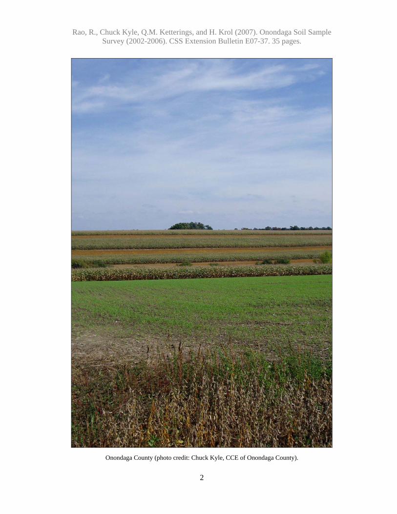
Rao, R., Chuck Kyle, Q.M. Ketterings, and H. Krol (2007). Onondaga Soil Sample Survey (2002-2006). CSS Extension Bulletin E07-37. 35 pages.
i
Soil Sample Survey
Onondaga County Samples analyzed by CNAL (2002-2006)
Onondaga County (photo credit: Chuck Kyle, CCE of Onondaga County).
Summary compiled by
Renuka Rao, Chuck Kyle, Quirine M. Ketterings, and Hettie Krol
Cornell Nutrient Analysis Laboratory http://www.css.cornell.edu/soiltest/newindex.asp
& Nutrient Management Spear Program
http://nmsp.css.cornell.edu/

Rao, R., Chuck Kyle, Q.M. Ketterings, and H. Krol (2007). Onondaga Soil Sample Survey (2002-2006). CSS Extension Bulletin E07-37. 35 pages.
ii
Soil Sample Survey
Onondaga County Samples analyzed by CNAL (2002-2006)
Summary compiled by
Renuka Rao Director
Cornell Nutrient Analysis Laboratory Department of Crop and Soil Sciences 804 Bradfield Hall, Cornell University
Ithaca NY 1485
Chuck Kyle Agriculture and Farm Business Management Educator Cornell Cooperative Extension of Onondaga County
Quirine M. Ketterings and Hettie Krol
Nutrient Management Spear Program Department of Crop and Soil Sciences
December 6, 2007
Correct Citation:
Rao, R., C. Kyle, Q.M. Ketterings, and H. Krol (2007). Soil sample survey of Onondaga County. Samples analyzed by the Cornell Nutrient Analysis Laboratory (2002-2006). CSS Extension Bulletin E07-37. 35 pages.

Rao, R., Chuck Kyle, Q.M. Ketterings, and H. Krol (2007). Onondaga Soil Sample Survey (2002-2006). CSS Extension Bulletin E07-37. 35 pages.
iii
Table of Content 1. County Introduction.........................................................................................................1 2. General Survey Summary................................................................................................3 3. Cropping Systems............................................................................................................7
3.1 Homeowner Samples .................................................................................................7 3.2 Commercial Samples .................................................................................................8
4. Soil Types ......................................................................................................................10 4.1 Homeowner Samples ...............................................................................................10 4.2 Commercial Samples ...............................................................................................11
5. Organic Matter...............................................................................................................13 5.1 Homeowner Samples ...............................................................................................13 5.2 Commercial Samples ...............................................................................................14
6. pH ..................................................................................................................................15 6.1 Homeowner Samples ...............................................................................................15 6.2 Commercial Samples ...............................................................................................16
7. Phosphorus.....................................................................................................................17 7.1 Homeowner Samples ...............................................................................................17 7.2 Commercial Samples ...............................................................................................18
8. Potassium.......................................................................................................................19 8.1 Homeowner Samples ...............................................................................................19 8.2 Commercial Samples ...............................................................................................22
9. Magnesium ....................................................................................................................25 9.1 Homeowner Samples ...............................................................................................25 9.2 Commercial Samples ...............................................................................................26
10. Iron...............................................................................................................................27 10.1 Homeowner Samples .............................................................................................27 10.2 Commercial Samples .............................................................................................28
11. Manganese ...................................................................................................................29 11.1 Homeowner Samples .............................................................................................29 11.2 Commercial Samples .............................................................................................30
12. Zinc ..............................................................................................................................31 12.1 Homeowner Samples .............................................................................................31 12.2 Commercial Samples .............................................................................................32
Appendix: Cornell Crop Codes .........................................................................................33

Rao, R., Chuck Kyle, Q.M. Ketterings, and H. Krol (2007). Onondaga Soil Sample Survey (2002-2006). CSS Extension Bulletin E07-37. 35 pages.
iv
Onondaga County (photo credit: Chuck Kyle, CCE of Onondaga County).

Rao, R., Chuck Kyle, Q.M. Ketterings, and H. Krol (2007). Onondaga Soil Sample Survey (2002-2006). CSS Extension Bulletin E07-37. 35 pages.
1
1. County Introduction
Onondaga County is located in the center of New York State, and covers 507,840 acres or 793.5 square miles. There are two physiographic regions in Onondaga County the Erie-
Onondaga Plain in the north, and the Allegheny Plateau in the south. The majority of all drainage in the county goes towards the north into Lake Ontario. Agriculture accounts for 156,284 acres of land in the county, or approximately 32 percent of land use. Of the agricultural land 98,000 acres is cropped with the
remaining land being forest and support land Dairy farming contributes over 50% of the gross farm receipts with much of the acreage in production used to support the dairy industry. Corn and hay crops comprise a significant share of all agricultural acreage in the county. However, productive soils in the north are also conducive to vegetable farming. Apple farming is a noteworthy component of Onondaga County agriculture, and the southern part of the county is home to well-known apple farms. Skaneateles Lake, located partially in the county is known as the Eastern Gateway to the Finger Lakes, and supplies the City of Syracuse with municipal drinking water. Since Skaneateles Lake water is not filtered by Syracuse, a watershed protection program is in place. A voluntary Whole Farm Planning program, the Skaneateles Watershed Agricultural Program, helps develop environmental plans for participating farmers. Comprehensive Nutrient Management Plans (CNMPs) are a key component in all Whole Farm Plans, and soil test analysis is a foundation on which CNMPs are constructed.
Chuck Kyle Agriculture and Farm Business Management Educator Cornell Cooperative Extension of Onondaga County
Rao, R., Chuck Kyle, Q.M. Ketterings, and H. Krol (2007). Onondaga Soil Sample Survey (2002-2006). CSS Extension Bulletin E07-37. 35 pages.
2
Onondaga County (photo credit: Chuck Kyle, CCE of Onondaga County).

Rao, R., Chuck Kyle, Q.M. Ketterings, and H. Krol (2007). Onondaga Soil Sample Survey (2002-2006). CSS Extension Bulletin E07-37. 35 pages.
3
2. General Survey Summary This survey summarizes the soil test results from grower (identified as “commercial samples”) and homeowner samples from Onondaga County submitted to the Cornell Nutrient Analysis Laboratory (CNAL) from 2002 to 2006. The total number of samples analyzed in these years amounted to 2919. Of these, 2447 samples (84%) were submitted by commercial growers while 472 samples (16%) were submitted by homeowners.
0
100
200
300
400
500
600
700
800
900
2002 2003 2004 2005 2006
Num
ber o
f sam
ples
Samples for commercial productionSamples for home and garden
Homeowners Commercial Total
2002 97 2002 323 420 2003 87 2003 434 521 2004 93 2004 659 752 2005 104 2005 469 573 2006 91 2006 562 653
Total 472 Total 2447 2919
Rao, R., Chuck Kyle, Q.M. Ketterings, and H. Krol (2007). Onondaga Soil Sample Survey (2002-2006). CSS Extension Bulletin E07-37. 35 pages.
4
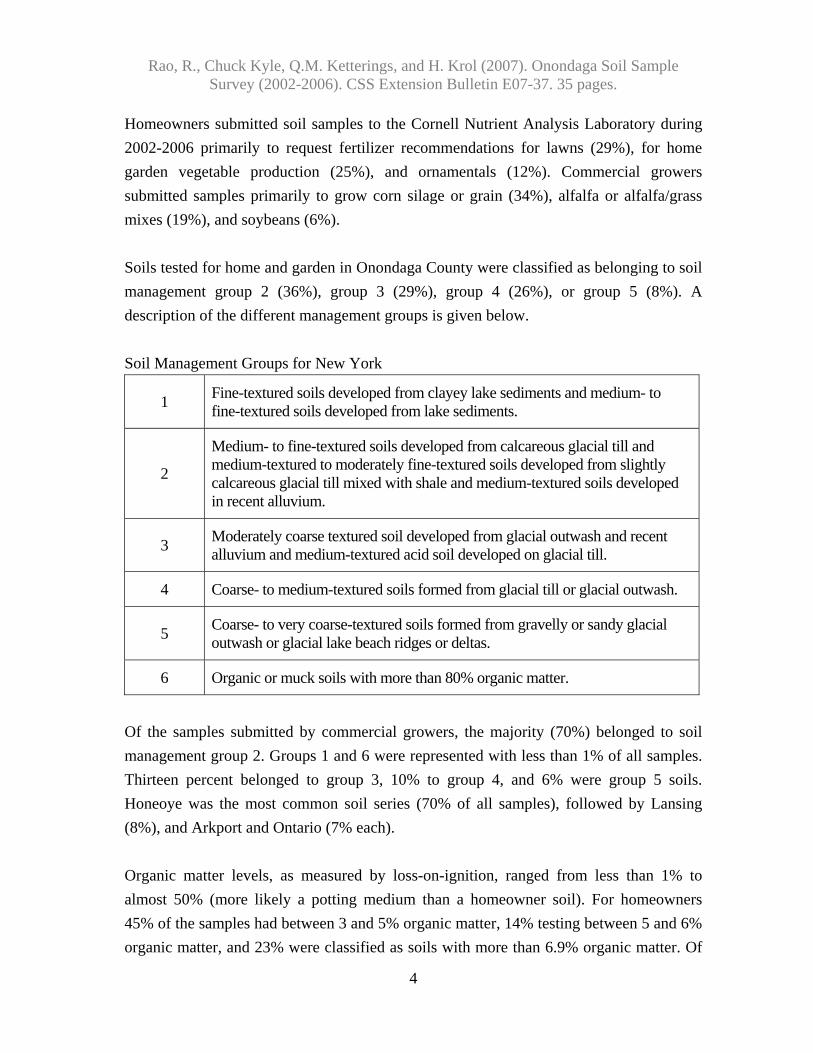
Homeowners submitted soil samples to the Cornell Nutrient Analysis Laboratory during 2002-2006 primarily to request fertilizer recommendations for lawns (29%), for home garden vegetable production (25%), and ornamentals (12%). Commercial growers submitted samples primarily to grow corn silage or grain (34%), alfalfa or alfalfa/grass mixes (19%), and soybeans (6%). Soils tested for home and garden in Onondaga County were classified as belonging to soil management group 2 (36%), group 3 (29%), group 4 (26%), or group 5 (8%). A description of the different management groups is given below. Soil Management Groups for New York
1 Fine-textured soils developed from clayey lake sediments and medium- to fine-textured soils developed from lake sediments.
2
Medium- to fine-textured soils developed from calcareous glacial till and medium-textured to moderately fine-textured soils developed from slightly calcareous glacial till mixed with shale and medium-textured soils developed in recent alluvium.
3 Moderately coarse textured soil developed from glacial outwash and recent alluvium and medium-textured acid soil developed on glacial till.
4 Coarse- to medium-textured soils formed from glacial till or glacial outwash.
5 Coarse- to very coarse-textured soils formed from gravelly or sandy glacial outwash or glacial lake beach ridges or deltas.
6 Organic or muck soils with more than 80% organic matter.
Of the samples submitted by commercial growers, the majority (70%) belonged to soil management group 2. Groups 1 and 6 were represented with less than 1% of all samples. Thirteen percent belonged to group 3, 10% to group 4, and 6% were group 5 soils. Honeoye was the most common soil series (70% of all samples), followed by Lansing (8%), and Arkport and Ontario (7% each). Organic matter levels, as measured by loss-on-ignition, ranged from less than 1% to almost 50% (more likely a potting medium than a homeowner soil). For homeowners 45% of the samples had between 3 and 5% organic matter, 14% testing between 5 and 6% organic matter, and 23% were classified as soils with more than 6.9% organic matter. Of

Rao, R., Chuck Kyle, Q.M. Ketterings, and H. Krol (2007). Onondaga Soil Sample Survey (2002-2006). CSS Extension Bulletin E07-37. 35 pages.
5
the samples submitted by commercial growers, 69% contained between 2 and 4% organic matter, 15% had 4 to 5 % organic matter and 6% tested greater than 5% in organic matter. Soil pH in water (1:1 soil:water extraction ratio) varied from less than 4.8 to 9.0 for home and garden samples with 57% testing between pH 6.0 and 7.4 for pH and 33% with a pH of 7.5 or greater. For the commercial samples, the highest pH was 8.1 and 82% tested between 6.0 and 7.4 while 6% were pH 7.5 or greater. Extractable nutrients such as phosphorus (P), potassium (K), magnesium (Mg), calcium (Ca), iron (Fe), manganese (Mn), and zinc (Zn) were measured using the Morgan method (Morgan, 1941). This solution contains sodium acetate buffered at pH of 4.8. Soil test P levels of <1 lb P/acre are classified as very low. Between 1-3 lbs P/acre is low. Medium is between 4-8 lbs P/acre. High testing soils have P levels between 9 and 39 lbs P/acre and anything higher is classified as very high. For homeowners, 13% of the soils tested low for P, 15% tested medium, a little over 31% tested high while slightly more than 40% tested very high. This meant that 72% tested high or very high in P. For commercial growers, 14% tested very high. In total 23% were low in P, 26% tested medium for P while 37% of the submitted samples were classified as high in soil test P. This means that 51% tested high or very high in P. Classifications for K depend on soil management group. The fine textured soils (soil management group 1) have a greater K supplying capacity than the coarse textured sandy soils (soil management group 5). Classification for each of the management groups in the above table represent very low, low, medium, high and very high. So for example for soil management group 5 and 6, <60 lbs K/acre means the soil is very low in K, between 60 and 114 lbs K/acre is medium, 115-164 lbs K/acre is medium, 165-269 lbs K/acre is high and >269 lbs K/acre is classified as very high (see Table on page 6). Potassium classifications for Onondaga County soils varied from very low (1% of the homeowner soils and 1% of the commercial growers’ soils) to very high (52% of the homeowner soils and 42% of the commercial growers’ soils). For homeowners, 8% tested low in K, 12% tested medium, and 27% tested high for potassium. For commercial growers’ soils, 7% tested low, 17% tested medium and 33% tested high in K.

Rao, R., Chuck Kyle, Q.M. Ketterings, and H. Krol (2007). Onondaga Soil Sample Survey (2002-2006). CSS Extension Bulletin E07-37. 35 pages.
6
Potassium Soil Test Value (Morgan extraction in lbs K/acre) Soil Management Group Very low Low Medium High Very High
1 <35 35-64 65-94 95-149 >149 2 <40 40-69 70-99 100-164 >164 3 <45 45-79 80-119 120-199 >199 4 <55 55-99 100-149 150-239 >239
5 and 6 <60 60-114 115-164 165-269 >269
Soils test very low for Mg if Morgan extractable Mg is less than 20 lbs Mg/acre. Low testing soils have 20-65 lbs Morgan Mg per acre. Soils with 66-100 lbs Mg/acre test medium for Mg. High testing soils have 101-199 lbs Mg/acre while soils with more than 200 lbs Mg/acre in the Morgan extraction are classified as very high in Mg. Magnesium levels ranged from 14 to almost 6000 lbs Mg/acre. There were only three commercial grower soils that tested very low for Mg. Most soils tested high or very high for Mg (98% of the homeowner soils and 94% of the soils of the commercial growers). Soils with more than 50 lbs Morgan extractable Fe per acre test excessive for Fe. Anything lower than 50 lbs Fe/acre is considered normal. Iron levels ranged from 98-99% in the normal range with only 2% of the homeowner soils and 1% of the commercial grower soils testing excessive for Fe. Similarly, most soils (97-99%) tested normal for manganese. Soils with more than 100 lbs Morgan extractable Mn per acre are classified as excessive in Mn. Anything less than 100 lbs Mn per acre is classified as normal. Soils with less than 0.5 lb Zn per acre in the Morgan extraction are classified as low in Zn. Medium testing soils have between 0.5 and 1 lb of Morgan extractable Zn per acre. If more than 1 lb of Zn/acre is extracted with the Morgan solution, the soil tests high in Zn. For the homeowner soils, 88% tested high for Zn while 10% tested medium and 3% were low in Zn. Of the commercial growers’ samples, 9% tested low, 29% tested medium while 63% were high in Zn. In the following sections, the summary tables for each of the soil fertility indicators described above are given. The appendix contains the crop codes used in section 3.

Rao, R., Chuck Kyle, Q.M. Ketterings, and H. Krol (2007). Onondaga Soil Sample Survey (2002-2006). CSS Extension Bulletin E07-37. 35 pages.
7
3. Cropping Systems
3.1 Homeowner Samples Crops for which recommendations are requested by homeowners:
2002
2003
2004
2005
2006
Total
%
ALG 1 2 2 2 1 8 2 APR 0 0 0 0 2 2 0 ATF 2 8 15 1 2 28 6 BLU 0 0 6 1 5 12 3 FAR 0 0 0 1 0 1 0 FLA 3 0 1 0 0 4 1 GEN 0 1 0 0 0 1 0 GRA 0 0 0 2 0 2 0 HRB 4 0 0 0 0 4 1 IDL 1 0 3 0 0 4 1 LAW 42 24 19 29 23 137 29 MIX 1 1 0 2 0 4 1 MVG 25 18 18 21 34 116 25 OTH 1 12 2 7 3 25 5 PER 6 1 9 7 7 30 6 PRK 0 1 0 0 0 1 0 PTO 0 1 1 0 0 2 0 ROS 2 1 0 5 3 11 2 RSP 1 1 2 1 0 5 1 SAG 7 7 12 21 8 55 12 SOD 0 0 2 0 0 2 0 SPB 0 0 0 1 0 1 0 STR 0 0 0 0 1 1 0 TRF 0 0 1 3 1 5 1 Unknown 1 9 0 0 1 11 2 Total 97 87 93 104 91 472 100
Note: See Appendix for Cornell crop codes.

Rao, R., Chuck Kyle, Q.M. Ketterings, and H. Krol (2007). Onondaga Soil Sample Survey (2002-2006). CSS Extension Bulletin E07-37. 35 pages.
8
3.2 Commercial Samples Crops for which recommendations are requested in commercial samples: Current year crop
2002
2003
2004
2005
2006
Total
%
AGE/AGT 27 77 94 78 28 344 14 ALE/ALT 30 26 35 29 9 129 5 APP 1 0 0 0 1 2 0 ASP 0 1 0 0 0 1 0 BCE 0 0 0 0 1 1 0 BGE/BGT 0 1 28 0 0 29 1 BKB 1 0 0 0 0 1 0 BLB 0 0 0 0 20 20 1 BNS 0 2 0 1 0 3 0 BRS 0 0 0 1 0 1 0 BSP 1 0 1 0 0 2 0 BSS 0 1 0 2 0 3 0 BUK 0 0 1 0 0 1 0 CBP 0 2 0 0 0 2 0 CGE/CGT 0 1 2 1 2 6 0 CHT 0 1 0 0 0 1 0 CKP 0 5 0 0 0 5 0 CLE/CLT 1 0 1 2 69 73 3 COG/COS 136 164 237 191 109 837 34 GIE/GIT 0 3 1 0 9 13 1 GPF 0 0 0 7 0 7 0 GPV 2 0 0 3 0 5 0 GRE/GRT 13 7 4 18 6 48 2 IDL 0 11 2 0 0 13 1 MIX 6 0 13 8 45 72 3 OAS 2 1 0 6 12 21 1 OAT 10 4 33 22 16 85 3 ONP 0 0 1 0 0 1 0 OTH 1 4 39 9 2 55 2 PEA 0 0 0 1 0 1 0 PGE/PGT 3 4 2 6 4 19 1 PIE/PIT 10 14 9 1 12 46 2 PLE/PLT 1 0 7 0 2 10 0 PLM 0 1 0 0 0 1 0 PNT 7 11 16 9 7 50 2 POP 0 0 0 1 0 1 0

Rao, R., Chuck Kyle, Q.M. Ketterings, and H. Krol (2007). Onondaga Soil Sample Survey (2002-2006). CSS Extension Bulletin E07-37. 35 pages.
9
Current year crop
2002
2003
2004
2005
2006
Total
%
POT 3 1 2 2 2 10 0 PUM 2 6 1 1 0 10 0 RSF 1 1 0 0 0 2 0 RSS 2 0 0 0 0 2 0 RYC 5 1 1 1 1 9 0 RYS 1 6 9 2 6 24 1 SOY 7 28 43 43 38 159 6 SQS 0 4 0 0 0 4 0 SQW 0 0 0 1 0 1 0 SSH 0 3 0 0 0 3 0 STS 0 4 0 0 2 6 0 SUN 0 0 0 1 0 1 0 SWC 26 17 14 13 10 80 3 TME 2 0 5 0 0 7 0 TOM 2 1 1 0 0 4 0 TRE 14 0 0 0 1 15 1 TRP 0 0 0 0 3 3 0 TRT 4 2 6 0 3 15 1 WHT 2 12 19 8 11 52 2 Unknown 0 7 32 1 91 131 5 Total 323 434 659 469 562 2447 100
Note: See Appendix for Cornell crop codes.

Rao, R., Chuck Kyle, Q.M. Ketterings, and H. Krol (2007). Onondaga Soil Sample Survey (2002-2006). CSS Extension Bulletin E07-37. 35 pages.
10
4. Soil Types
4.1 Homeowner Samples Soil types (soil management groups) for homeowner samples:
2002
2003
2004
2005
2006
Total
%
SMG 1 (clayey) 0 0 0 0 0 0 0 SMG2 (silty) 41 27 42 35 26 171 36 SMG 3 (silt loam) 20 30 19 44 26 139 29 SMG 4 (sandy loam) 27 20 22 21 33 123 26 SMG 5 (sandy) 9 10 10 4 6 39 8 SMG 6 (mucky) 0 0 0 0 0 0 0 Total 97 87 93 104 91 472 100

Rao, R., Chuck Kyle, Q.M. Ketterings, and H. Krol (2007). Onondaga Soil Sample Survey (2002-2006). CSS Extension Bulletin E07-37. 35 pages.
11
4.2 Commercial Samples Soil series for commercial samples: Name
SMG
2002
2003
2004
2005
2006
Total
%
Alton 5 20 22 8 20 29 99 4 Amboy 4 0 0 0 0 20 20 1 Angola 2 5 1 13 0 5 24 1 Appleton 2 3 0 8 3 0 14 1 Arkport 4 3 8 7 5 7 30 1 Aurora 2 10 21 104 15 19 169 7 Benson 4 3 2 1 0 0 6 0 Bombay 4 1 3 2 7 0 13 1 Camillus 3 16 1 0 8 2 27 1 Canandaigua 3 1 0 1 0 0 2 0 Cazenovia 2 4 6 17 9 6 42 2 Chagrin 3 0 0 0 1 0 1 0 Collamer 3 12 4 7 7 17 47 2 Colonie 5 3 6 8 3 7 27 1 Conesus 2 4 5 41 15 12 77 3 Croghan 5 0 0 4 0 0 4 0 Dunkirk 3 0 0 1 0 6 7 0 Fredon 4 1 2 1 2 1 7 0 Galen 4 1 4 3 3 2 13 1 Hamlin 2 0 0 3 0 0 3 0 Herkimer 3 0 0 0 0 1 1 0 Hilton 2 8 9 10 12 12 51 2 Homer 2 1 0 0 0 1 2 0 Honeoye 2 79 76 145 141 168 609 25 Howard 3 9 4 10 22 14 59 2 Kendaia 2 2 17 7 4 5 35 1 Lairdsville 2 0 0 5 0 1 6 0 Lakemont 1 0 1 0 0 0 1 0 Lamson 4 1 1 2 1 1 6 0 Lansing 2 19 52 51 36 38 196 8 Lima 2 10 43 35 16 28 132 5 Lordstown 3 0 0 0 5 0 5 0 Lyons 2 0 2 1 0 0 3 0 Madrid 4 14 19 25 7 21 86 4 Manheim 2 0 6 1 2 6 15 1 Manlius 3 0 1 1 1 2 5 0

Rao, R., Chuck Kyle, Q.M. Ketterings, and H. Krol (2007). Onondaga Soil Sample Survey (2002-2006). CSS Extension Bulletin E07-37. 35 pages.
12
Name
SMG
2002
2003
2004
2005
2006
Total
%
Mardin 3 0 0 3 1 0 4 0 Martisco 6 0 0 0 1 0 1 0 Minoa 4 3 2 5 3 4 17 1 Mohawk 2 41 24 10 15 14 104 4 Niagara 3 4 3 3 5 7 22 1 Odessa 2 0 2 4 0 0 6 0 Ontario 2 9 40 37 32 51 169 7 Otisville 4 4 0 0 3 0 7 0 Ovid 2 4 3 10 7 0 24 1 Palatine 2 1 0 1 3 0 5 0 Palmyra 3 19 29 17 13 28 106 4 Phelps 3 1 2 9 3 4 19 1 Rhinebeck 2 0 2 7 1 1 11 0 Romulus 2 0 0 0 0 2 2 0 Schoharie 1 0 0 0 1 6 7 0 Teel 2 0 1 12 1 1 15 1 Venango 3 0 0 0 0 1 1 0 Volusia 3 0 0 0 1 0 1 0 Wampsville 3 2 2 2 3 3 12 0 Wareham 5 1 1 1 3 1 7 0 Wassaic 4 2 1 0 9 3 15 1 Wayland 2 1 0 4 3 2 10 0 Weaver 3 0 0 0 7 0 7 0 Williamson 4 1 2 10 9 2 24 1 Worth 4 0 0 2 0 0 2 0 Unknown - 0 4 0 0 1 5 0 Total - 323 434 659 469 562 2447 100

Rao, R., Chuck Kyle, Q.M. Ketterings, and H. Krol (2007). Onondaga Soil Sample Survey (2002-2006). CSS Extension Bulletin E07-37. 35 pages.
13
5. Organic Matter
5.1 Homeowner Samples Organic matter (loss-on-ignition method) in homeowner samples (number):
<1
1.0-1.9
2.0-2.9
3.0-3.9
4.0-4.9
5.0-5.9
6.0-6.9
>6.9
Total
2002 3 3 11 26 22 15 6 11 97 2003 1 3 9 21 26 7 5 15 87 2004 1 2 8 16 21 16 10 19 93 2005 1 8 22 26 15 11 5 16 104 2006 1 4 14 21 14 15 6 16 91 Total 1 20 64 110 98 64 32 72 472
2002
2003
2004
2005
2006
Lowest: 0.1 0.4 0.9 0.8 0.8 Highest: 23.5 17.8 46.2 38.4 18.7 Mean: 4.7 5.0 5.8 5.0 5.4 Median: 4.2 4.2 4.9 3.9 4.4
Organic matter in homeowner samples (% of total number of samples):
<1
1.0-1.9
2.0-2.9
3.0-3.9
4.0-4.9
5.0-5.9
6.0-6.9
>6.9
Total
2002 3 3 11 27 23 15 6 11 100 2003 1 3 10 24 30 8 6 17 100 2004 1 2 9 17 23 17 11 20 100 2005 1 8 21 25 14 11 5 15 100 2006 1 4 15 23 15 16 7 18 100 Total 1 4 14 23 21 14 7 16 100

Rao, R., Chuck Kyle, Q.M. Ketterings, and H. Krol (2007). Onondaga Soil Sample Survey (2002-2006). CSS Extension Bulletin E07-37. 35 pages.
14
5.2 Commercial Samples Organic matter (loss-on-ignition method) in commercial samples (number):
<1
1.0-1.9
2.0-2.9
3.0-3.9
4.0-4.9
5.0-5.9
6.0-6.9
>6.9
Total
2002 4 33 105 128 41 7 4 1 323 2003 13 47 131 138 81 13 6 5 434 2004 6 30 193 285 102 31 6 6 659 2005 3 32 138 174 79 32 7 4 469 2006 11 71 199 203 56 20 2 0 562 Total 37 213 766 928 359 103 25 16 2447
2002
2003
2004
2005
2006
Lowest: 0.6 0.6 0.6 0.8 0.4 Highest: 15.0 9.5 11.3 10.1 6.4 Mean: 3.1 3.2 3.3 3.3 3.0 Median: 3.1 3.2 3.3 3.4 3.0
Organic matter in commercial samples (% of total number of samples):
<1
1.0-1.9
2.0-2.9
3.0-3.9
4.0-4.9
5.0-5.9
6.0-6.9
>6.9
Total
2002 1 10 33 40 13 2 1 1 100 2003 3 11 30 32 19 3 1 1 100 2004 1 5 29 43 15 5 1 1 100 2005 1 7 29 37 17 7 1 1 100 2006 2 13 35 36 10 4 0 0 100 Total 2 9 31 38 15 4 1 1 100

Rao, R., Chuck Kyle, Q.M. Ketterings, and H. Krol (2007). Onondaga Soil Sample Survey (2002-2006). CSS Extension Bulletin E07-37. 35 pages.
15
6. pH
6.1 Homeowner Samples pH of homeowner samples (numbers):
<4.5
4.5-4.9
5.0-5.4
5.5-5.9
6.0-6.4
6.5-6.9
7.0-7.4
7.5-7.9
8.0-8.4
>8.4
Total
2002 0 1 1 6 5 6 19 50 8 1 97 2003 0 2 4 4 8 9 40 16 3 1 87 2004 2 0 2 7 9 20 33 18 2 0 93 2005 0 0 0 6 6 12 37 40 3 0 104 2006 0 0 5 7 11 12 42 14 0 0 91 Total 2 2 12 30 39 59 171 138 16 2 472
2002
2003
2004
2005
2006
Lowest: 4.8 4.8 4.8 5.5 5.1 Highest: 8.5 9.0 8.2 8.3 7.9 Mean: - - - - - Median: 7.6 7.1 7.1 7.3 7.1
pH of homeowner of samples (% of total number of samples):
<4.5
4.5-4.9
5.0-5.4
5.5-5.9
6.0-6.4
6.5-6.9
7.0-7.4
7.5-7.9
8.0-8.4
>8.4
Total
2002 0 1 1 6 5 6 20 52 8 1 100 2003 0 2 5 5 9 10 46 18 3 1 100 2004 2 0 2 8 10 22 35 19 2 0 100 2005 0 0 0 6 6 12 36 38 3 0 100 2006 0 0 5 8 12 13 46 15 0 0 100 Total 0 1 3 6 8 13 36 29 3 0 100

Rao, R., Chuck Kyle, Q.M. Ketterings, and H. Krol (2007). Onondaga Soil Sample Survey (2002-2006). CSS Extension Bulletin E07-37. 35 pages.
16
6.2 Commercial Samples pH of commercial samples (number):
<4.5
4.5-4.9
5.0-5.4
5.5-5.9
6.0-6.4
6.5-6.9
7.0-7.4
7.5-7.9
8.0-8.4
>8.4
Total
2002 0 1 9 27 46 92 103 39 6 0 323 2003 0 2 5 42 120 156 87 22 0 0 434 2004 0 1 16 76 192 229 106 37 2 0 689 2005 0 4 5 41 141 153 109 13 3 0 469 2006 0 1 17 59 115 198 156 16 0 0 562 Total 0 9 52 245 614 828 561 127 11 0 2447
2002
2003
2004
2005
2006
Lowest: 4.9 4.6 4.8 4.8 4.6 Highest: 8.1 7.8 8.0 8.1 7.9 Mean: - - - - - Median: 6.9 6.6 6.6 6.6 6.7
pH of commercial samples (% of total number of samples):
<4.5
4.5-4.9
5.0-5.4
5.5-5.9
6.0-6.4
6.5-6.9
7.0-7.4
7.5-7.9
8.0-8.4
>8.4
Total
2002 0 0 3 8 14 28 32 12 2 0 100 2003 0 0 1 10 28 36 26 5 0 0 100 2004 0 0 2 12 29 35 16 6 0 0 100 2005 0 1 1 9 30 33 23 3 1 0 100 2006 0 0 3 10 20 35 28 3 0 0 100 Total 0 0 2 10 25 34 23 5 0 0 100

Rao, R., Chuck Kyle, Q.M. Ketterings, and H. Krol (2007). Onondaga Soil Sample Survey (2002-2006). CSS Extension Bulletin E07-37. 35 pages.
17
7. Phosphorus
7.1 Homeowner Samples
Phosphorus (lbs/acre Morgan P) in homeowner samples (numbers):
<1
1-3
4-8
9-39
40-60
61-80
81- 100
101-150
151-200
>200 Total
VL L M H VH VH VH VH VH VH 2002 0 10 18 33 10 6 2 4 5 9 97 2003 0 16 12 24 13 5 1 2 3 11 87 2004 0 11 12 31 12 5 3 6 2 11 93 2005 0 14 17 32 5 10 3 5 4 14 104 2006 0 11 13 28 2 8 3 6 11 9 91 Total 0 62 72 148 42 34 12 23 25 54 472
VL = very low, L = low, M = medium, H = high, VH = very high.
2002
2003
2004
2005
2006
Lowest: 2 1 1 1 1 Highest: 858 705 1637 718 678 Mean: 70 83 87 90 82 Median: 22 34 28 23 29
Phosphorus in homeowner samples (% of total number of samples):
<1
1-3
4-8
9-39
40-60
61-80
81- 100
101-150
151-200
>200 Total
VL L M H VH VH VH VH VH VH 2002 0 10 19 34 10 6 2 4 5 9 100 2003 0 18 14 38 15 6 1 2 3 13 100 2004 0 12 13 33 13 5 3 6 2 12 100 2005 0 13 16 31 5 10 3 5 4 13 100 2006 0 12 14 31 2 9 3 7 12 10 100 Total 0 13 15 31 9 7 3 5 5 11 100
VL = very low, L = low, M = medium, H = high, VH = very high.

Rao, R., Chuck Kyle, Q.M. Ketterings, and H. Krol (2007). Onondaga Soil Sample Survey (2002-2006). CSS Extension Bulletin E07-37. 35 pages.
18
7.2 Commercial Samples Phosphorus (lbs P/acre Morgan extraction) for commercial samples (number):
<1
1-3
4-8
9-39
40-60
61-80
81- 100
101-150
151-200
>200 Total
VL L M H VH VH VH VH VH VH 2002 0 90 101 120 4 2 1 2 0 3 323 2003 0 109 94 143 22 18 12 20 4 12 434 2004 0 135 170 272 18 16 15 22 8 3 659 2005 0 104 145 166 12 9 9 17 2 5 469 2006 0 135 115 199 36 24 14 16 9 14 562 Total 0 573 625 900 92 69 51 77 23 37 2447
VL = very low, L = low, M = medium, H = high, VH = very high.
2002
2003
2004
2005
2006
Lowest: 1 1 1 1 1 Highest: 431 479 249 537 375 Mean: 14 32 21 21 30 Median: 7 9 9 8 11
Phosphorus in commercial samples (% of total number of samples):
<1
1-3
4-8
9-39
40-60
61-80
81- 100
101-150
151-200
>200 Total
VL L M H VH VH VH VH VH VH 2002 0 28 31 37 1 1 0 1 0 1 100 2003 0 25 22 33 5 4 3 5 1 3 100 2004 0 20 26 41 3 2 2 3 1 0 100 2005 0 22 31 35 3 2 2 4 0 1 100 2006 0 24 20 35 6 4 2 3 2 2 100 Total 0 23 26 37 4 3 2 3 1 2 100
VL = very low, L = low, M = medium, H = high, VH = very high.

Rao, R., Chuck Kyle, Q.M. Ketterings, and H. Krol (2007). Onondaga Soil Sample Survey (2002-2006). CSS Extension Bulletin E07-37. 35 pages.
19
8. Potassium
8.1 Homeowner Samples Potassium (lbs K/acre Morgan extraction) in homeowner samples (number):
Soil Management Group 1
<35 35-64 65-94 95-149 >149 Total Very Low Low Medium High Very High 2002 0 0 0 0 0 0 2003 0 0 0 0 0 0 2004 0 0 0 0 0 0 2005 0 0 0 0 0 0 2006 0 0 0 0 0 0 Total (#) 0 0 0 0 0 0 Total (%) - - - - - -
Soil Management Group 2
<40 40-69 70-99 100-164 >164 Total Very Low Low Medium High Very High 2002 1 0 6 14 20 41 2003 0 1 2 6 18 27 2004 0 1 3 11 27 42 2005 0 2 3 8 22 35 2006 0 1 0 8 17 26 Total (#) 1 5 14 47 104 171 Total (%) 1 3 8 27 61 100
Soil Management Group 3
<45 45-79 80-119 120-199 >199 Total Very Low Low Medium High Very High 2002 0 1 1 6 12 20 2003 0 4 4 6 16 30 2004 0 0 1 4 14 19 2005 0 0 11 14 19 44 2006 0 2 3 9 12 26 Total (#) 0 7 20 39 73 139 Total (%) 0 5 14 28 53 100

Rao, R., Chuck Kyle, Q.M. Ketterings, and H. Krol (2007). Onondaga Soil Sample Survey (2002-2006). CSS Extension Bulletin E07-37. 35 pages.
20
Soil Management Group 4
<55 55-99 100-149 150-239 >239 Total Very Low Low Medium High Very High 2002 0 1 2 9 15 27 2003 0 5 3 3 9 20 2004 0 0 3 7 12 22 2005 0 3 3 4 11 21 2006 0 3 5 10 15 33 Total (#) 0 12 16 33 62 123 Total (%) 0 10 13 27 50 100
Soil Management Group 5
<60 60-114 115-164 165-269 >269 Total Very Low Low Medium High Very High 2002 1 1 1 4 2 9 2003 2 7 0 1 0 10 2004 0 1 3 2 4 10 2005 0 2 1 1 0 4 2006 0 2 1 1 2 6 Total (#) 3 13 6 9 8 39 Total (%) 8 33 15 23 21 100
Soil Management Group 6
<60 60-114 115-164 165-269 >269 Total Very Low Low Medium High Very High 2002 0 0 0 0 0 0 2003 0 0 0 0 0 0 2004 0 0 0 0 0 0 2005 0 0 0 0 0 0 2006 0 0 0 0 0 0 Total (#) 0 0 0 0 0 0 Total (%) - - - - - -

Rao, R., Chuck Kyle, Q.M. Ketterings, and H. Krol (2007). Onondaga Soil Sample Survey (2002-2006). CSS Extension Bulletin E07-37. 35 pages.
21
Potassium classification summary for homeowners: Summary (#)
Very Low
Low
Medium
High
Very High
Total
2002 2 3 10 33 49 97 2003 2 17 9 16 43 87 2004 0 2 10 24 57 93 2005 0 7 18 27 52 104 2006 0 8 9 28 46 91 Grand Total 4 37 56 128 247 472
Summary (%)
Very Low
Low
Medium
High
Very High
Total
2002 2 3 10 34 51 100 2003 2 20 10 18 49 100 2004 0 2 11 26 61 100 2005 0 7 17 26 50 100 2006 0 9 10 31 51 100 Grand Total 1 8 12 27 52 100
2002
2003
2004
2005
2006
Lowest: 3 37 65 63 60 Highest: 6772 3459 34298 4309 1143 Mean: 408 321 664 318 259 Median: 207 187 214 192 209

Rao, R., Chuck Kyle, Q.M. Ketterings, and H. Krol (2007). Onondaga Soil Sample Survey (2002-2006). CSS Extension Bulletin E07-37. 35 pages.
22
8.2 Commercial Samples Potassium (lbs K/acre Morgan extraction) in commercial samples (number):
Soil Management Group 1
<35 35-64 65-94 95-149 >149 Total Very Low Low Medium High Very High 2002 0 0 0 0 0 0 2003 0 0 0 1 0 1 2004 0 0 0 0 0 0 2005 0 0 0 0 1 1 2006 0 0 0 2 4 6 Total (#) 0 0 0 3 5 8 Total (%) 0 0 0 38 63 100
Soil Management Group 2
<40 40-69 70-99 100-164 >164 Total Very Low Low Medium High Very High 2002 0 10 41 59 91 201 2003 2 16 65 80 147 310 2004 4 24 64 177 257 526 2005 2 20 67 113 113 315 2006 0 11 61 153 147 372 Total (#) 8 81 298 582 755 1724 Total (%) 0 5 17 34 44 100
Soil Management Group 3
<45 45-79 80-119 120-199 >199 Total Very Low Low Medium High Very High 2002 0 3 10 26 25 64 2003 0 8 9 10 19 46 2004 1 5 13 12 23 54 2005 0 2 8 23 44 77 2006 0 6 10 26 43 85 Total (#) 1 24 50 97 154 326 Total (%) 0 7 15 30 47 100

Rao, R., Chuck Kyle, Q.M. Ketterings, and H. Krol (2007). Onondaga Soil Sample Survey (2002-2006). CSS Extension Bulletin E07-37. 35 pages.
23
Soil Management Group 4
<55 55-99 100-149 150-239 >239 Total Very Low Low Medium High Very High 2002 0 5 7 13 9 34 2003 0 1 5 13 25 44 2004 1 13 13 19 12 58 2005 0 5 7 19 18 49 2006 0 1 6 20 34 61 Total (#) 1 25 38 84 98 246 Total (%) 0 10 15 34 40 100
Soil Management Group 5
<60 60-114 115-164 165-269 >269 Total Very Low Low Medium High Very High 2002 0 6 4 11 3 24 2003 1 7 15 3 3 29 2004 2 5 4 7 3 21 2005 0 5 6 10 5 26 2006 1 10 6 11 9 37 Total (#) 4 33 35 42 23 137 Total (%) 3 24 26 321 17 100
Soil Management Group 6
<60 60-114 115-164 165-269 >269 Total Very Low Low Medium High Very High 2002 0 0 0 0 0 0 2003 0 0 0 0 0 0 2004 0 0 0 0 0 0 2005 0 0 0 0 1 1 2006 0 0 0 0 0 0 Total (#) 0 0 0 0 1 1 Total (%) 0 0 0 0 100 100

Rao, R., Chuck Kyle, Q.M. Ketterings, and H. Krol (2007). Onondaga Soil Sample Survey (2002-2006). CSS Extension Bulletin E07-37. 35 pages.
24
Potassium classification summary for commercial samples. Summary (#)
Very Low
Low
Medium
High
Very High
Un-
known
Total
2002 0 24 62 109 128 0 323 2003 3 32 94 107 194 4 434 2004 8 47 94 215 295 0 659 2005 2 32 88 165 182 0 469 2006 1 28 83 212 237 1 562 Grand Total 14 163 421 808 1036 5 2447
Summary (%)
Very Low
Low
Medium
High
Very High
Un-
known
Total
2002 0 7 19 34 40 0 100 2003 1 7 22 25 45 1 100 2004 1 7 14 33 45 0 100 2005 0 7 19 35 39 0 100 2006 0 5 15 38 42 0 100 Grand Total 1 7 17 33 42 0 100
2002
2003
2004
2005
2006
Lowest: 45 34 10 32 52 Highest: 1759 1093 1369 1303 980 Mean: 192 205 189 183 191 Median: 161 161 163 154 164

Rao, R., Chuck Kyle, Q.M. Ketterings, and H. Krol (2007). Onondaga Soil Sample Survey (2002-2006). CSS Extension Bulletin E07-37. 35 pages.
25
9. Magnesium
9.1 Homeowner Samples Magnesium (lbs Mg/acre Morgan extraction) in homeowner samples (numbers):
<20
20-65
66-100
101-199
>199
Total
Very Low Low Medium High Very High 2002 0 1 2 1 93 97 2003 0 1 3 8 75 87 2004 0 0 0 3 90 93 2005 0 0 2 7 95 104 2006 0 0 1 5 85 91 Total 0 2 8 24 438 472
2002
2003
2004
2005
2006
Lowest: 33 30 104 88 73 Highest: 3591 2812 5753 2314 2270 Mean: 650 614 740 637 594 Median: 574 564 648 570 543
Magnesium in homeowner samples (% of total number of samples):
<20
20-65
66-100
101-199
>199
Total
Very Low Low Medium High Very High 2002 0 1 2 1 96 100 2003 0 1 3 9 86 100 2004 0 0 0 3 97 100 2005 0 0 2 7 91 100 2006 0 0 1 5 93 100 Total 0 0 2 5 93 100

Rao, R., Chuck Kyle, Q.M. Ketterings, and H. Krol (2007). Onondaga Soil Sample Survey (2002-2006). CSS Extension Bulletin E07-37. 35 pages.
26
9.2 Commercial Samples Magnesium (lbs Mg/acre Morgan extraction) in commercial samples (number):
<20
20-65
66-100
101-199
>199
Total
Very Low Low Medium High Very High 2002 0 2 14 43 264 323 2003 0 4 19 69 342 434 2004 0 10 18 83 548 659 2005 0 9 17 68 375 469 2006 3 23 25 102 409 562 Total 3 48 93 365 1938 2447
2002
2003
2004
2005
2006
Lowest: 54 44 20 25 14 Highest: 1885 1373 1726 1102 1089 Mean: 423 353 354 382 342 Median: 425 333 331 401 337
Magnesium in commercial samples (% of total number of samples):
<20
20-65
66-100
101-199
>199
Total
Very Low Low Medium High Very High 2002 0 1 4 13 82 100 2003 0 1 4 16 79 100 2004 0 2 3 13 83 100 2005 0 2 4 14 80 100 2006 1 4 4 18 73 100 Total 0 2 4 15 79 100

Rao, R., Chuck Kyle, Q.M. Ketterings, and H. Krol (2007). Onondaga Soil Sample Survey (2002-2006). CSS Extension Bulletin E07-37. 35 pages.
27
10. Iron
10.1 Homeowner Samples Iron (lbs Fe/acre Morgan extraction) in homeowner samples: Total number of samples: Percentages:
0-49
>49
Total
0-49
>49
Total
Normal Excessive Normal Excessive 2002 94 3 97 97 3 100 2003 85 2 87 98 2 100 2004 92 1 93 99 1 100 2005 104 0 104 100 0 100 2006 89 2 91 98 2 100 Total 464 8 472 98 2 100
2002
2003
2004
2005
2006
Lowest: 1 1 1 1 1 Highest: 107 140 301 42 234 Mean: 10 11 13 8 13 Median: 5 5 7 6 7

Rao, R., Chuck Kyle, Q.M. Ketterings, and H. Krol (2007). Onondaga Soil Sample Survey (2002-2006). CSS Extension Bulletin E07-37. 35 pages.
28
10.2 Commercial Samples Iron (lbs Fe/acre Morgan extraction) in commercial samples: Total number of samples: Percentages:
0-49
>49
Total
0-49
>49
Total
Normal Excessive Normal Excessive 2002 322 1 323 100 0 100 2003 433 1 434 100 0 100 2004 646 13 659 98 2 100 2005 466 3 459 99 1 100 2006 554 8 562 99 1 100 Total 2421 26 2447 99 1 100
2002
2003
2004
2005
2006
Lowest: 1 1 1 1 1 Highest: 158 55 211 158 225 Mean: 5 6 9 6 7 Median: 3 4 5 4 3

Rao, R., Chuck Kyle, Q.M. Ketterings, and H. Krol (2007). Onondaga Soil Sample Survey (2002-2006). CSS Extension Bulletin E07-37. 35 pages.
29
11. Manganese
11.1 Homeowner Samples Manganese (lbs Mn/acre Morgan extraction) in homeowner samples: Total number of samples: Percentages:
0-99
>99
Total
0-99
>99
Total
Normal Excessive Normal Excessive 2002 88 9 97 91 9 100 2003 84 3 87 97 3 100 2004 84 9 93 90 10 100 2005 98 6 104 94 6 100 2006 88 3 91 97 3 100 Total 442 30 472 97 3 100
2002
2003
2004
2005
2006
Lowest: 12 3 15 4 8 Highest: 300 251 160 188 771 Mean: 52 48 52 51 52 Median: 42 40 43 47 39

Rao, R., Chuck Kyle, Q.M. Ketterings, and H. Krol (2007). Onondaga Soil Sample Survey (2002-2006). CSS Extension Bulletin E07-37. 35 pages.
30
11.2 Commercial Samples Manganese (lbs Mn/acre Morgan extraction) in commercial samples: Total number of samples: Percentages:
0-99
>99
Total
0-99
>99
Total
Normal Excessive Normal Excessive 2002 321 2 323 99 1 100 2003 432 2 434 100 0 100 2004 655 4 659 99 1 100 2005 468 1 469 100 0 100 2006 557 5 562 99 1 100 Total 2433 14 2447 99 1 100
2002
2003
2004
2005
2006
Lowest: 4 5 2 8 3 Highest: 180 294 174 133 157 Mean: 5 6 9 6 7 Median: 3 4 5 4 3

Rao, R., Chuck Kyle, Q.M. Ketterings, and H. Krol (2007). Onondaga Soil Sample Survey (2002-2006). CSS Extension Bulletin E07-37. 35 pages.
31
12. Zinc
12.1 Homeowner Samples Zinc (lbs Zn/acre Morgan extraction) in homeowner samples: Total number of samples: Percentages:
<0.5
0.5-1.0
>1
Total
<0.5
0.5-1.0
>1
Total
Low Medium High Low Medium High 2002 2 3 92 97 2 3 95 100 2003 1 6 80 87 1 7 92 100 2004 1 16 76 93 1 17 82 100 2005 5 14 85 104 5 13 82 100 2006 4 6 81 91 4 7 89 100 Total 13 45 414 472 3 10 88 100
2002
2003
2004
2005
2006
Lowest: 0.1 0.3 0.1 0.2 0.2 Highest: 149.8 99.9 185.3 45.3 110.7 Mean: 11.2 8.5 10.4 8.1 11.9 Median: 3.9 3.5 3.4 5.1 4.3

Rao, R., Chuck Kyle, Q.M. Ketterings, and H. Krol (2007). Onondaga Soil Sample Survey (2002-2006). CSS Extension Bulletin E07-37. 35 pages.
32
12.2 Commercial Samples Zinc (lbs Zn/acre Morgan extraction) in commercial samples: Total number of samples: Percentages:
<0.5
0.5-1.0
>1
Total
<0.5
0.5-1.0
>1
Total
Low Medium High Low Medium High 2002 4 93 226 323 1 29 70 100 2003 49 93 292 434 11 21 67 100 2004 87 214 358 659 13 32 54 100 2005 36 155 278 469 8 33 59 100 2006 40 146 376 562 7 26 67 100 Total 216 701 1530 2447 9 29 63 100
2002
2003
2004
2005
2006
Lowest: 0.2 0.1 0.1 0.1 0.1 Highest: 81.4 53.8 30.7 13.7 11.5 Mean: 2.3 2.9 1.8 1.8 2.0 Median: 1.4 1.3 1.1 1.2 1.4

Rao, R., Chuck Kyle, Q.M. Ketterings, and H. Krol (2007). Onondaga Soil Sample Survey (2002-2006). CSS Extension Bulletin E07-37. 35 pages.
33
Appendix: Cornell Crop Codes
Crop codes used in the Cornell Nutrient Analysis Laboratory.
Crop Code
Crop Description
Alfalfa
ABE Alfalfa trefoil grass, Establishment ABT Alfalfa trefoil grass, Established AGE Alfalfa grass, Establishment AGT Alfalfa grass, Established ALE Alfalfa, Establishment ALT Alfalfa, Established
Birdsfoot
BCE Birdsfoot trefoil clover, Establishment BCT Birdsfoot trefoil clover, Established BGE Birdsfoot trefoil grass, Establishment BGT Birdsfoot trefoil grass, Established BSE Birdsfoot trefoil seed, Establishment BST Birdsfoot trefoil seed, Established BTE Birdsfoot trefoil, Establishment BTT Birdsfoot trefoil, Established
Barley
BSP Spring barley BSS Spring barley with legumes BUK Buckwheat BWI Winter barley BWS Winter barley with legumes
Clover
CGE Clover grass, Establishment CGT Clover grass, Established CLE Clover, Establishment CLT Clover, Established CSE Clover seed production, Establishment CST Clover seed production, Established

Rao, R., Chuck Kyle, Q.M. Ketterings, and H. Krol (2007). Onondaga Soil Sample Survey (2002-2006). CSS Extension Bulletin E07-37. 35 pages.
34
Crop Code
Crop Description
Corn
COG Corn grain COS Corn silage
Grasses, pastures, covercrops
CVE Crownvetch, Establishment CVT Crownvetch, Established GIE Grasses intensively managed, Establishment GIT Grasses intensively managed, Established GRE Grasses, Establishment GRT Grasses, Established PGE Pasture, Establishment PGT Pasture improved grasses, Established PIE Pasture intensively grazed, Establishment PIT Pasture intensively grazed, Established PLE Pasture with legumes, Establishment PLT Pasture with legumes, Established PNT Pasture native grasses RYC Rye cover crop RYS Rye seed production TRP Triticale peas
Small grains
MIL Millet OAS Oats seeded with legume OAT Oats SOF Sorghum forage SOG Sorghum grain SOY Soybeans SSH Sorghum sudan hybrid SUD Sudangrass WHS Wheat with legume WHT Wheat
Others
ALG APP ATF
Azalea Apples Athletic field

Rao, R., Chuck Kyle, Q.M. Ketterings, and H. Krol (2007). Onondaga Soil Sample Survey (2002-2006). CSS Extension Bulletin E07-37. 35 pages.
35
Crop Code
Crop Description
BDR/DND BLU CEM FAR FLA GRA GEN HRB IDL LAW MIX/MVG PER PRK POT/PTO PUM ROD ROS RSF RSP RSS SAG SQW STE STR STS SUN SWC TOM TRE TRF TRT
Beans-dry Blueberries Cemetery Fairway Flowering annuals Grapes Green Herbs Idle land Lawn Mixed vegetables Perennials Park Potatoes Pumpkins Roadside Roses Raspberries, Fall Raspberries (homeowners) Raspberries, Summer Ornamentals adapted to pH 6.0 to 7.5 Squash, Winter Strawberries, Ever Strawberries (homeowners) Strawberries, Spring Sunflowers Sweet corn Tomatoes Christmas trees, Establishment Turf Christmas trees, Topdressing