Embed Size (px)
Citation preview
Onondaga Lake Watershed Progress Assessment and Action Strategies
A brief history of Onondaga Lake including remediation accomplishments, and the Onondaga Lake Partnership’s strategic plan for meeting lake management objectives
April 2010
Produced by:
Central New York Regional Planning & Development Board126 North Salina Street, Suite 200Syracuse, NY 13202
With support from the Onondaga Lake Partnership
Members:
Ms. Jo-Ellen Darcy - Assistant Secretary of the Army (Civil Works)Ms. Judith Enck - Regional Administrator, EPA Region IIMr. David Patterson - Governor, State of New YorkMr. Andrew Cuomo - Attorney General, State of New YorkMs. Joanne Mahoney - County Executive, Onondaga CountyMs. Stephanie Miner - Mayor, City of Syracuse
Representatives:
LTC Daniel B. Snead - District Commander, U.S. Army Engineer District, BuffaloMr. Seth Ausubel - Chief, Freshwater Protection Branch, U.S. EPA Region IIMr. Kenneth Lynch - Regional Director, NYSDEC Region 7Mr. Charles Silver - Environmental Scientist, NYS Attorney General’s OfficeMr. David Coburn - Director, Onondaga County Office of the EnvironmentMr. Andrew M. Maxwell - Director of Planning and Sustainability, City of Syracuse
Ex Officio:
Senator Charles SchumerSenator Kirsten GillibrandRepresentative Daniel Maffei
Funding for this report was provided by the U.S. Army Corps of Engineers, Buffalo District in cooperation with the OLP.
Cover photo sources: background - U.S. Army Corps of Engineers, top inset - Onondaga Lake Partnership, bottom inset - Patti Rusczyk, Onondaga Lake Partnership 2004 photo contest (2nd place, adult flora and fauna category)
Onondaga Lake Watershed Progress Assessment and Action Strategies
April 2010
This report was reviewed by the individual members of the Onondaga Lake Partnership (OLP) and approved for release to the public for purposes of providing general overview information. Approval for
release does not signify adoption or approval for purposes of regulatory, enforcement or other legal actions, of the factual, scientific or other
assertions, characterizations or conclusions contained herein.
Statement of Purpose
The Onondaga Lake Partnership (OLP) was formed to promote cooperation among government agencies and other parties involved in managing the environmental issues related to the rehabilitation of Onondaga Lake. The OLP is comprised of Federal, State, and local governments and not-for-profit representatives with a vested interest in the rehabilitation of Onondaga Lake. The six principal members of the OLP include:
United States Army Corps of Engineers••
United States Environmental Protection Agency••
New York State Department of Environmental Conservation••
Office of the New York State Attorney General••
Onondaga County••
City of Syracuse••
The Onondaga Lake Watershed Progress Assessment and Action Strategies (OLWPAAS) report sum-marizes the history, degradation, and recovery of Onondaga Lake. The report provides an assessment of the OLP’s progress toward achieving the objectives outlined in the 1993 “Onondaga Lake: A Plan for Action”, also known as the Onondaga Lake Management Plan (OLMP). The report recommends specific action strategies and identifies remaining actions to be taken by the OLP to complete the rehabilitation of Onondaga Lake in accordance with the OLMP. These recommendations were developed based on the OLMP progress assessment, and with consideration of new information and technologies available since the writing of the OLMP. Where possible and appropriate, potentially responsible parties are identified for completing planned restoration activities in the lake and its watershed. The action strategies are organized in eight Strategic Areas that address different aspects of lake rehabilitation. More information on the iden-tification and intended purpose of the action strategies can be found in the introduction to Chapter 3.
In addition to the OLP, there are many agencies, organizations, schools, and individuals that are taking an active role in the recovery of Onondaga Lake. While this document does not attempt to provide an account of all of these efforts, the OLP acknowledges that such initiatives also play an important role in the reha-bilitation of the lake.
Onondaga Lake Watershed Progress Assessment and Action Strategies i
Table of Contents
List of Acronyms.............................................................................................................................................ii
Chapter 1: Background ........................................................................................................1Historical Perspective ......................................................................................................................................2Water Management Problems ..........................................................................................................................2Onondaga Lake Management Conference .......................................................................................................4Onondaga Lake Partnership .............................................................................................................................4Restoration Efforts ...........................................................................................................................................7A Historical Perspective: Timeline...................................................................................................................8
Chapter 2: Onondaga Lake Management Plan Status Report ....................................... 11Introduction ....................................................................................................................................................12Strategic Areas 1&2: Municipal Sewer Discharge and Combined Sewer Overflows ...................................12Strategic Areas 3&4: Industrial Pollution (National Priorities List Site and Other Adjacent Areas of Con-cern) ...............................................................................................................................................................17Strategic Area 5: Hydrogeologic Investigations ............................................................................................26Strategic Area 6: Fish and Wildlife Habitat and Fisheries Management .......................................................29Strategic Area 7: Inner Harbor and Shoreline Use .........................................................................................34Strategic Area 8: Non-Point Source Pollution ...............................................................................................37
Chapter 3: Onondaga Lake Watershed Action Strategies ..............................................43Introduction ...................................................................................................................................................44Strategic Area 1: Municipal Sewer Discharge ...............................................................................................44Strategic Area 2: Combined Sewer Overflows .............................................................................................48Strategic Areas 3&4: Industrial Pollution (National Priorities List Site and Other Adjacent Areas of Con-cern) ...............................................................................................................................................................52Strategic Area 5: Hydrogeologic Investigations. .........................................................................................59Strategic Area 6: Fish and Wildlife Habitat and Fisheries Management .......................................................62Strategic Area 7: Inner Harbor and Shoreline ................................................................................................72Strategic Area 8: Non-Point Source Pollution ...............................................................................................77
Appendices ...........................................................................................................................85Appendix A. Key project sites and locations in the Onondaga Lake area. ....................................................86Appendix B. Preliminary budget needs to accomplish action strategies and recommendations. ..................87Appendix C. Glossary. ...................................................................................................................................93Appendix D. Literature cited. ........................................................................................................................97Appendix E. Status of Amended Consent Judgment projects. .....................................................................100
Onondaga Lake Watershed Progress Assessment and Action Strategiesii
List of Acronyms
ACJ Amended Consent Judgment
AEM Agricultural Environmental Management
AMP Ambient Monitoring Program
ASLF Atlantic States Legal Foundation
BERA Baseline Environmental Risk Assessment
BMP Best Management Practice
BTEX Benzene, Toluene, Ethylbenzene and Xylene
CCE Cornell Cooperative Extension
CSO Combined Sewer Overflow
EBP Environmental Benefit Project
EPA Environmental Protection Agency (US)
FCF Floatables Control Facility
FDA Food and Drug Administration
FS Feasibility Study
GIS Geographic Information Systems
GM General Motors
HHRA Human Health Risk Assessment
HSPF Hydrologic Simulation Program (Fortran)
IFG Inland Fisher Guide
IRM Interim Remedial Measures
LCP Linden Chemicals and Plastics
LDC Lakefront Development Corporation
MDA Mudboil Depression Area
METRO Onondaga County Metropolitan Syracuse Wastewater Treatment Plant
MGP Manufactured Gas Plant
Mg/L Milligrams per Liter
MS4 Municipal Separate Storm Sewer System
NDZ No Discharge Zone
NPL National Priority List
NPS Non-Point Source
NRCS Natural Resources Conservation Service
NYS New York State
NYSCC New York State Canal Corporation
NYSDEC New York State Department of Environmental Conservation
NYSDOH New York State Department of Health
NYSOAG New York State Office of the Attorney General
OCDOT Onondaga County Department of Transportation
OCDWEP Onondaga County Department of Water Environment Protection
OCCRP Onondaga Creek Conceptual Revitalization Plan
OCSWCD Onondaga County Soil and Water Conserva-tion District
OEI Onondaga Environmental Institute
OLCC Onondaga Lake Cleanup Corporation
OLMC Onondaga Lake Management Conference
OLMP Onondaga Lake Management Plan
OLP Onondaga Lake Partnership
OLWQM Onondaga Lake Water Quality Model
OM&M Operation, Maintenance and Monitoring
PAH Polycyclic Aromatic Hydrocarbon
PCB Polychlorinated Biphenyl
PDI Pre-Design Investigation
PPM Parts Per Million
PRP Potentially Responsible Party
RFP Request for Proposals
RI Remedial Investigation
RI/FS Remedial Investigation/ Feasibility Study
ROD Record of Decision
RTF Regional Treatment Facility
SCA Sediment Consolidation Area
SPDES State Pollutant Discharge Elimination System
SUNY-ESF State University of New York College of Environmental Science and Forestry
SWAMP Surface Water Ambient Monitoring Program
SWWM Surface Water Watershed Model
TMDL Total Maximum Daily Load
TRWQM Three Rivers Water Quality Model
UFI Upstate Freshwater Institute
USACE United States Army Corps of Engineers
USDA United State Department of Agriculture
USGS United States Geological Survey
VOCs Volatile Organic Compounds
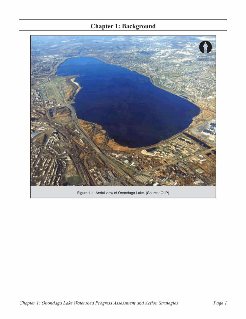
Chapter 1: Onondaga Lake Watershed Progress Assessment and Action Strategies Page 1
BackgroundChapter 1:
Figure 1-1. Aerial view of Onondaga Lake. (Source: OLP)
Chapter 1: Onondaga Lake Watershed Progress Assessment and Action StrategiesPage 2
Historical Perspective
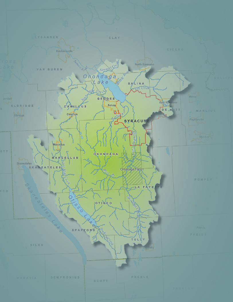
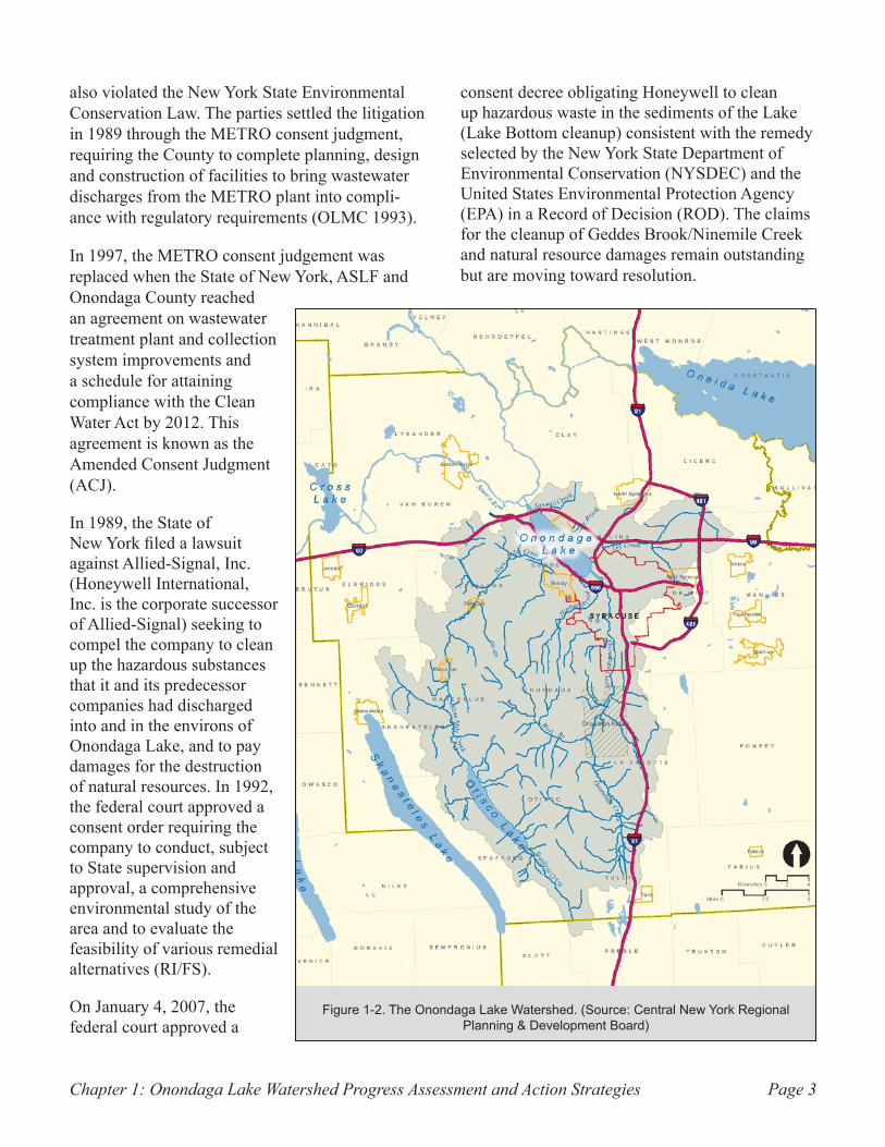
Approximately 285 square miles in area, the Onondaga Lake Watershed (Figure 1-2) lies almost entirely within Onondaga County. Onondaga Lake, located along the northern end of the city of Syracuse, is approximately one mile wide and 4.6 miles long and covers an area of 4.6 square miles. The lake has an average depth of 35 feet and a maximum depth of 63 feet (Onondaga Lake Cleanup Corporation (OLCC) 2001).
Before the American Revolution, the area surrounding Onondaga Lake was the center of the Iroquois Confederacy1. European immigrants settled the area throughout the 17th and 18th Centuries due in part to the presence of salty springs around Onondaga Lake. After the Erie Canal was built in the early 1800s, the booming salt industry in and around the city of Syracuse attracted many people (OLMC 1993).
In the 19th Century, Onondaga Lake served as a popular tourist attraction. The lake was populated with beaches, resorts and amusement parks. While there has been some debate over the variety of aquatic species found within the lake, there is documentation stating the lake supported a healthy fishery including Atlantic salmon and lake sturgeon. Onondaga Lake whitefish, known as ciscoes, were served in restaurants from Syracuse to New York City (Engineering World 2007). The fishing and resort industry began to decline in the early 20th century as the lake’s western shore became more industrialized. Over time, increased industrial development, a rising population and associated increases in sewage and industrial discharges took their toll on the water quality of
1. The Iroquois Confederacy, also known as the Haude-nosaunee Confederacy, is a union of six Nations (the Cayuga, Mohawk, Oneida, Onondaga, Seneca, and Tus-carora) that have inhabited upstate New York since before the arrival of Europeans. The Confederacy is traditionally believed to have been formed on the shores of Onondaga Lake.
Onondaga Lake. By 1940, swimming in the lake was banned, and in 1970, fishing was banned in the lake (OLCC 2001).
Water Management Problems
The water quality in Onondaga Lake has been impacted by a host of pollutants from a variety of sources. Ammonia and phosphorus from Onon-daga County’s Metropolitan Syracuse Wastewater Treatment Plant (METRO) contributed to aquatic species decline, poor water clarity and oxygen depletion. Industrial activities along the lake’s shoreline resulted in the release of numerous con-taminants to local surface water and ground water including mercury, chlorinated benzenes, ammonia and human-made mineral salts. Hydrogeologic features, such as the Tully Valley mudboils2, and landslides have contributed significant amounts of sediment to Onondaga Creek, impacting water clarity and aquatic habitat in the creek and in the lake.
The establishment of the Onondaga County Met-ropolitan Sewer District in the 1950s marked the start of efforts to address declining water quality. METRO was built in 1960. The County made improvements to METRO in 1979, upgrading to secondary treatment and then to tertiary treatment in 1981 (OLMC 1993).
In 1988, Atlantic States Legal Foundation (ASLF), a Syracuse-based organization providing legal and technical assistance to citizens and organizations dealing with environmental problems, filed a law-suit against Onondaga County. ASLF alleged that METRO and combined sewer overflow (CSO) dis-charges (see page 5) were violating federal water pollution standards established under the Clean Water Act of 1972. The State of New York joined as a plaintiff, alleging that Onondaga County
2. A mudboil is an artesian-pressured geologic fea-ture that discharges both ground water and fine-grained sediment at the land surface and can cause land-surface subsidence over time.
Chapter 1: Onondaga Lake Watershed Progress Assessment and Action Strategies Page 3
also violated the New York State Environmental Conservation Law. The parties settled the litigation in 1989 through the METRO consent judgment, requiring the County to complete planning, design and construction of facilities to bring wastewater discharges from the METRO plant into compli-ance with regulatory requirements (OLMC 1993).
In 1997, the METRO consent judgement was replaced when the State of New York, ASLF and Onondaga County reached an agreement on wastewater treatment plant and collection system improvements and a schedule for attaining compliance with the Clean Water Act by 2012. This agreement is known as the Amended Consent Judgment (ACJ).
In 1989, the State of New York filed a lawsuit against Allied-Signal, Inc. (Honeywell International, Inc. is the corporate successor of Allied-Signal) seeking to compel the company to clean up the hazardous substances that it and its predecessor companies had discharged into and in the environs of Onondaga Lake, and to pay damages for the destruction of natural resources. In 1992, the federal court approved a consent order requiring the company to conduct, subject to State supervision and approval, a comprehensive environmental study of the area and to evaluate the feasibility of various remedial alternatives (RI/FS).
On January 4, 2007, the federal court approved a
consent decree obligating Honeywell to clean up hazardous waste in the sediments of the Lake (Lake Bottom cleanup) consistent with the remedy selected by the New York State Department of Environmental Conservation (NYSDEC) and the United States Environmental Protection Agency (EPA) in a Record of Decision (ROD). The claims for the cleanup of Geddes Brook/Ninemile Creek and natural resource damages remain outstanding but are moving toward resolution.
Figure 1-2. The Onondaga Lake Watershed. (Source: Central New York Regional Planning & Development Board)
Chapter 1: Onondaga Lake Watershed Progress Assessment and Action StrategiesPage 4
Onondaga Lake Management Conference
In 1990 the Onondaga Lake Management Con-ference (OLMC) was established by an Act of Congress under the Great Lakes Critical Programs Act. The OLMC was charged with developing and coordinating the implementation of “a comprehen-sive restoration, conservation, and management plan for Onondaga Lake” (OLMC 1993). The OLMC consisted of six voting members:
Assistant Secretary of the Army for Civil •Works (USACE)Administrator of the U.S. Environmental •Protection Agency (EPA)Governor of the State of New York (repre-•sented by New York State Department of Environmental Conservation (NYSDEC))
The Attorney General of the State of New •York (NYSOAG)Onondaga County Executive•Mayor of the city of Syracuse, New York•
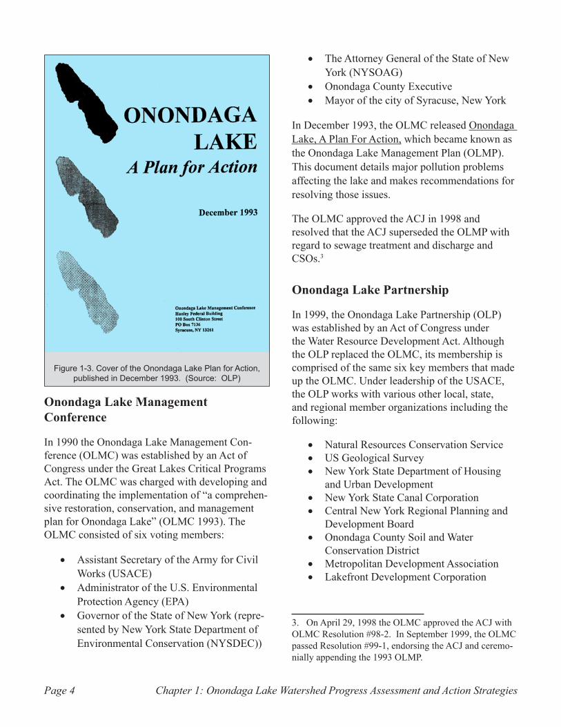
In December 1993, the OLMC released Onondaga Lake, A Plan For Action, which became known as the Onondaga Lake Management Plan (OLMP). This document details major pollution problems affecting the lake and makes recommendations for resolving those issues.
The OLMC approved the ACJ in 1998 and resolved that the ACJ superseded the OLMP with regard to sewage treatment and discharge and CSOs.3
Onondaga Lake Partnership
In 1999, the Onondaga Lake Partnership (OLP) was established by an Act of Congress under the Water Resource Development Act. Although the OLP replaced the OLMC, its membership is comprised of the same six key members that made up the OLMC. Under leadership of the USACE, the OLP works with various other local, state, and regional member organizations including the following:
Natural Resources Conservation Service•US Geological Survey •New York State Department of Housing •and Urban DevelopmentNew York State Canal Corporation•Central New York Regional Planning and •Development BoardOnondaga County Soil and Water •Conservation DistrictMetropolitan Development Association•Lakefront Development Corporation•
3. On April 29, 1998 the OLMC approved the ACJ with OLMC Resolution #98-2. In September 1999, the OLMC passed Resolution #99-1, endorsing the ACJ and ceremo-nially appending the 1993 OLMP.
Figure 1-3. Cover of the Onondaga Lake Plan for Action, published in December 1993. (Source: OLP)
Chapter 1: Onondaga Lake Watershed Progress Assessment and Action Strategies Page 5
Cornell Cooperative Extension of •Onondaga CountyState University of New York College of •Environmental Science and ForestryAtlantic States Legal Foundation•Onondaga Historical Association•League of Women Voters•Izaak Walton League•
The mission of the OLP is to facilitate and coordi-nate the development and implementation of lake and watershed improvement projects to restore and conserve water quality, natural resources and recreational uses to the benefit of the public. The actions and efforts of the OLP are to be consistent with the Onondaga Lake Management Plan and the Amended Consent Judgment.
Using the 1993 Onondaga Lake, A Plan for Action as its foundation, the OLP identified eight strategic planning areas to focus the restoration efforts. The following summarizes each of those strategic areas and major concerns:
Municipal Sewer Discharge1.
METRO is an advanced wastewater treatment facility serving the city of Syracuse and several surrounding municipalities. Treated domestic and industrial wastes discharge from a pipe at METRO directly into the lake, contributing up to 20% of the total annual inflow to Onondaga
Lake. METRO has been one of the most significant contributors of nutrient pollution to Onondaga Lake, historically contributing up to approximately 60% of the annual phosphorus load and over 90% of the ammonia load to the lake (OLMC 1993).
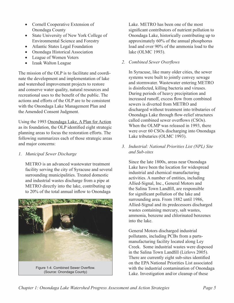
Combined Sewer Overflows2.
In Syracuse, like many older cities, the sewer systems were built to jointly convey sewage and stormwater. Wastewater entering METRO is disinfected, killing bacteria and viruses. During periods of heavy precipitation and increased runoff, excess flow from combined sewers is diverted from METRO and discharged without treatment into tributaries of Onondaga Lake through flow-relief structures called combined sewer overflows (CSOs). When the OLMP was released in 1993, there were over 60 CSOs discharging into Onondaga Lake tributaries (OLMC 1993).
Industrial: National Priorities List (NPL) Site 3. and Sub-sites
Since the late 1800s, areas near Onondaga Lake have been the location for widespread industrial and chemical manufacturing activities. A number of entities, including Allied-Signal, Inc., General Motors and the Salina Town Landfill, are responsible for significant pollution of the lake and surrounding area. From 1882 until 1986, Allied-Signal and its predecessors discharged wastes containing mercury, salt wastes, ammonia, benzene and chlorinated benzenes into the lake.
General Motors discharged industrial pollutants, including PCBs from a parts-manufacturing facility located along Ley Creek. Some industrial wastes were disposed in the Salina Town Landfill (Lizlovs 2005). There are currently eight sub-sites identified on the EPA National Priorities List associated with the industrial contamination of Onondaga Lake. Investigation and/or cleanup of these
Figure 1-4. Combined Sewer Overflow. (Source: Onondaga County)
Chapter 1: Onondaga Lake Watershed Progress Assessment and Action StrategiesPage 6
eight sub-sites is being performed under legal agreement with the NYSDEC.
Industrial: Non-NPL Sites4.
While the most significant industrial
contamination is associated with NPL sites described above, several other industrial contamination sites not currently associated with the Superfund sites are being addressed by the NYSDEC. These sites vary from former coal gasification facilities to industrial waste disposal areas located within the watershed.
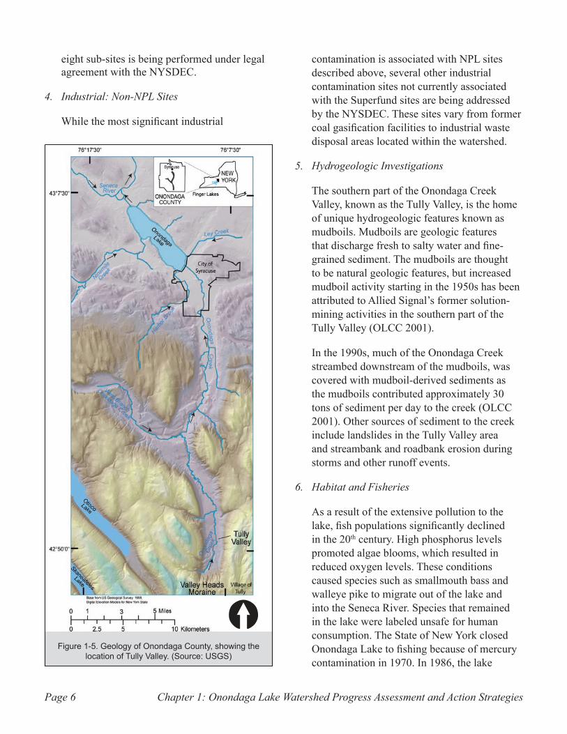
Hydrogeologic Investigations5.
The southern part of the Onondaga Creek Valley, known as the Tully Valley, is the home of unique hydrogeologic features known as mudboils. Mudboils are geologic features that discharge fresh to salty water and fine-grained sediment. The mudboils are thought to be natural geologic features, but increased mudboil activity starting in the 1950s has been attributed to Allied Signal’s former solution-mining activities in the southern part of the Tully Valley (OLCC 2001).
In the 1990s, much of the Onondaga Creek streambed downstream of the mudboils, was covered with mudboil-derived sediments as the mudboils contributed approximately 30 tons of sediment per day to the creek (OLCC 2001). Other sources of sediment to the creek include landslides in the Tully Valley area and streambank and roadbank erosion during storms and other runoff events.
Habitat and Fisheries6.
As a result of the extensive pollution to the lake, fish populations significantly declined in the 20th century. High phosphorus levels promoted algae blooms, which resulted in reduced oxygen levels. These conditions caused species such as smallmouth bass and walleye pike to migrate out of the lake and into the Seneca River. Species that remained in the lake were labeled unsafe for human consumption. The State of New York closed Onondaga Lake to fishing because of mercury contamination in 1970. In 1986, the lake
Figure 1-5. Geology of Onondaga County, showing the location of Tully Valley. (Source: USGS)
Chapter 1: Onondaga Lake Watershed Progress Assessment and Action Strategies Page 7
was reopened on a “catch and release” basis. The New York State Department of Health (NYSDOH) updated its prior advisory in 1999, allowing fish to be kept, but advised consumption of no more than one caught fish meal per month, with the exception of walleye, which were not to be eaten. In 2007, a new health advisory was issued banning the consumption of largemouth and smallmouth bass over 15 inches and all walleye (Onondaga County Department of Water Environment Protection (OCDWEP) 2006). It is recommended that anglers limit consumption of carp, channel catfish, white perch and all other species to no more than one meal per month. Women of childbearing age, children and infants are advised not to eat any fish from the lake (NYSDOH 2007).
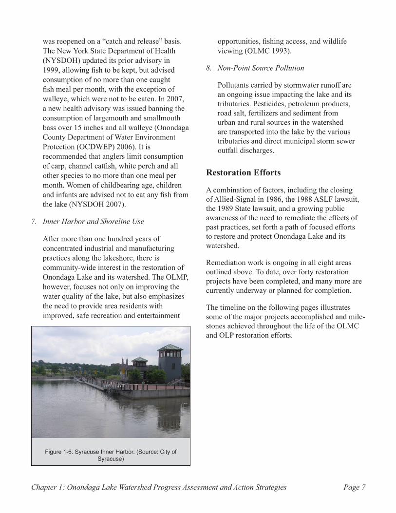
Inner Harbor and Shoreline Use7.
After more than one hundred years of concentrated industrial and manufacturing practices along the lakeshore, there is community-wide interest in the restoration of Onondaga Lake and its watershed. The OLMP, however, focuses not only on improving the water quality of the lake, but also emphasizes the need to provide area residents with improved, safe recreation and entertainment
opportunities, fishing access, and wildlife viewing (OLMC 1993).
Non-Point Source Pollution8.
Pollutants carried by stormwater runoff are an ongoing issue impacting the lake and its tributaries. Pesticides, petroleum products, road salt, fertilizers and sediment from urban and rural sources in the watershed are transported into the lake by the various tributaries and direct municipal storm sewer outfall discharges.
Restoration Efforts
A combination of factors, including the closing of Allied-Signal in 1986, the 1988 ASLF lawsuit, the 1989 State lawsuit, and a growing public awareness of the need to remediate the effects of past practices, set forth a path of focused efforts to restore and protect Onondaga Lake and its watershed.
Remediation work is ongoing in all eight areas outlined above. To date, over forty restoration projects have been completed, and many more are currently underway or planned for completion.
The timeline on the following pages illustrates some of the major projects accomplished and mile-stones achieved throughout the life of the OLMC and OLP restoration efforts.
Figure 1-6. Syracuse Inner Harbor. (Source: City of Syracuse)
A HistoricAl PersPective
1988Atlantic States Legal Foundation ►
initiates a lawsuit against Onondaga County, alleging violations of Federal water pollution standards.
1989State of New York initiates a lawsuit ►
against Allied-Signal, Inc. to compel cleanup of hazardous substances and obtain natural resource damages.
1990Senator Daniel Patrick Moynihan ►
initiates legislation in the Great Lakes Critical Programs Act of 1990 creating the Onondaga Lake Management Conference (OLMC) to develop a plan that recommends priority corrective actions for restoration, conservation, and management of Onondaga Lake.
1992A federal court approves a consent ►
order for study of industrial pollution and development of a cleanup plan.
1993The Onondaga Lake Management ►
Conference (OLMC) drafts A Plan for Action, on which the Onondaga Lake Management Plan (OLMP) is based.
1994The OLMC begins aquatic habitat ►
restoration projects in Onondaga Lake.Onondaga Lake is added to the ►
Federal Superfund National Priorities List (NPL).
1995The OLMC implements mudboil ►
remediation projects to reduce flow of sediment to Onondaga Creek.
1997New York State, Atlantic States Legal ►
Foundation and Onondaga County reach an agreement, the Amended Consent Judgment (ACJ), on municipal wastewater collection and treatment improvements and a schedule to attain compliance with the Clean Water Act.
1998A federal judge approves the ACJ ►
ordering municipal wastewater col-lection and treatment improvements. The ACJ is a multi-year program with projects extending until 2012.
1999The ACJ is incorporated into the ►
OLMP.The New York State Department of ►
Health (NYSDOH) lifts the advisory on eating certain species of fish (bass, white perch and catfish) from Onondaga Lake. The NYSDOH main-tains a health advisory recommending anglers limit consumption to one meal per month. The advisory to eat no walleye remains in effect. Women of childbearing age, infants and children under the age of 15 are advised not to eat any fish from the lake.Congressman James T. Walsh initi- ►
ates legislation in the Water Resource Development Act of 1999 that replaces the OLMC with the Onondaga Lake Partnership (OLP). The OLP, led by the U.S. Army Corp of Engineers, is tasked with implementing projects consistent with the OLMP.Allied-Signal, Inc. merges with ►
Honeywell, Inc. and changes its name to Honeywell International, Inc.
2000The OLP holds an inaugural ceremony ►
on the shore of Onondaga Lake on August 9, 2000.
2001The OLP holds its first Annual ►
Progress Meeting on October 29, 2001. Senior Partners update the community on the progress of the lake remedia-tion effort.The last oil tanks are removed from ►
the “Oil City” area near the Inner Harbor and remediation efforts begin.
2002The OLP announces a new mini- ►
grant program, awarding $25,000 in grant awards for community-based education and stewardship projects associated with the Onondaga Lake watershed.The first Annual Onondaga Lake Day ►
is held on June 8, 2002.The Onondaga County Department ►
of Water Environment Protection launches the Angler’s Diary program inviting anglers to help assess the improvements in the lake. The public assists in monitoring lake improve-ments by recording the numbers, spe-cies and locations of fish caught.The New York State Department of ►
Environmental Conservation (NYSDEC) issues a remedial investigation report detailing the extent of contamination within the lake and assessing the risk to humans and the environment based on an extensive 10-year remedial investigation performed by Honeywell International.
2003Construction is completed on the ►
Brighton Sewer Separation Project. 2004
Six streambank restoration projects ►are completed under the Rural Non-Point Source Pollution Best
A HistoricAl PersPective
Management Practices program. These projects help protect eroding stream-banks and slow water current in order to reduce sedimentation and improve water clarity within Onondaga Creek.
2005The U.S. Environmental Protection ►
Agency (EPA) issues a National Remedy Review Board decision encouraging an open dialogue and close coordination between NYSDEC and other parties, including the Onondaga Nation, con-cerning the proposed remediation plan for Onondaga Lake.NYSDEC and EPA issue a Record of ►
Decision outlining remediation plans for Onondaga Lake’s industrial pollu-tion concerns.Onondaga County’s Metropolitan ►
Syracuse Wastewater Treatment Plant (METRO) reaches Stage 3 Ammonia limit goal as set forth in ACJ eight years ahead of the scheduled deadline. Ammonia levels remain at safe levels for even the most sensitive aquatic organisms.OLP holds 5th Annual Progress ►
Meeting.Honeywell International, Inc. ►
removes over eight tons of mercury from the Linden Chemicals and Plastics property through soil washing, pre-venting mercury contamination from the site from entering the lake.
2006Honeywell International, Inc. ►
completes a groundwater treatment plant at the former Allied Chemical, Willis Avenue site. The groundwater collection system will be an under-ground barrier about one and one-half miles long that blocks contaminated
groundwater from reaching the lake.Phosphorus release from METRO ►
to Onondaga Lake is reduced from 200 pounds per day to 50 pounds per day (a 75 percent reduction) with completion of an upgraded phospho-rus removal facility.City of Syracuse completes Phase I of ►
Valley Drive Sewer Separation Project. 2007
Federal court approves consent ►decree obligating Honeywell to imple-ment the NYSDEC/EPA cleanup plan for the lake bottom’s industrial pollution.The 2007 Bassmasters Majors ►
Tournament, involving the world’s top 52 anglers, is hosted at Onondaga Lake, attracting bass fishermen from around the country and world.NYSDOH updates health advisory ►
banning the consumption of large-mouth and smallmouth bass and walleye. Other existing advisories are maintained.Wetlands restoration at former ►
Linden Chemical and Plastics (LCP) site is completed. Nearly 12,000 trees and plants are introduced to restore wetlands and habitat in the Onondaga Lake watershed.
State University of New York ►College of Environmental Science and Forestry (SUNY ESF) and Honeywell International, Inc. harvest one acre of shrub willows on Solvay Settling Basin #13 in Camillus. The shrub willows help filter contamination from the ground-water in the waste beds. Honeywell International, Inc. signs ►
a Consent Decree to perform the Remedial Design and Remedial Action for the Onondaga Lake Bottom Site.
2008Honeywell International, Inc. begins ►
second phase construction of the groundwater barrier wall along the Willis/Causeway section of the lake.North American Fishing Club ►
names Onondaga Lake one of the United States’ top ten bass fishing destinations.Working with ASLF, Onondaga ►
Nation, and NYSDEC, Onondaga County obtains a moratorium on construction of the proposed treatment facilities so that alternative methodologies, including green infrastructure, could be evaluated as part of the CSO abate-ment program.A Microbial Trackdown program ►
is implemented to identify sources of bacteria to Onondaga Creek and Harbor Brook.
2009The draft Onondaga Creek ►
Conceptual Revitalization Plan is released for public review.NYSDEC issues final Remedial Design ►
Work Plan for the Onondaga Lake Bottom NPL subsite. NYSDEC and EPA issue decision documents outlining remediation plans for the Geddes Brook/Ninemile Creek site.NYSDEC issues a Citizen Participation ►
Plan designed to enhance public input and involvement in the Onondaga Lake Bottom cleanup project.A Fourth Amendment to the ACJ is ►
adopted and approved by the federal court, incorporating green infrastruc-ture methodologies into the CSO abatement process.

Chapter 1: Onondaga Lake Watershed Progress Assessment and Action StrategiesPage 10
Chapter 2: Onondaga Lake Watershed Progress Assessment and Action Strategies Page 11
Onondaga Lake Management Plan Status ReportChapter 2:
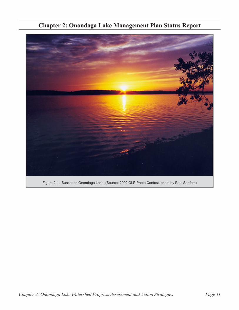
Sunset on Onondaga Lake. (Source: 2002 OLP Photo Contest, photo by Paul Sanford)Figure 2-1.
Chapter 2: Onondaga Lake Watershed Progress Assessment and Action StrategiesPage 12
Introduction
In December 1993, the Onondaga Lake Manage-ment Conference (OLMC) released the Onondaga Lake Management Plan (OLMP). The plan outlines the major environmental problems facing the lake and makes recommendations for its restoration. The Water Resources Development Act tasked the Onondaga Lake Partnership (OLP) with developing and implementing water quality improvement projects for the lake and surround-ing watershed. As stated in Chapter 1, the OLMC identified eight major strategic areas: Municipal Sewer Discharge, Combined Sewer Overflows (CSOs), Industrial National Priorities List (NPL) site and sub-sites, Industrial non-NPL sites, Hydro-geologic Investigations, Habitat and Fisheries, Inner Harbor and Shoreline Use, and Non-Point Source Pollution. Using these strategic areas, the OLP set major cleanup goals in its effort to restore the lake, its tributaries and the watershed. Over the past eight years, more than 40 restoration projects have been completed, and there are over 20 active projects being implemented.
This report presents the eight strategic areas by a general description of the pollution problems, the recommendations made by the OLMP, the strate-gies utilized for remediation, progress made, and the need for future remediation efforts. Additional requirements for Onondaga County’s Metropolitan Syracuse Wastewater Treatment Plant (METRO) sewer discharge and combined sewer overflows are outlined in the 1997 Amended Consent Judgment (ACJ). Remediation requirements for properties owned or affected by Honeywell International, General Motors, Niagara Mohawk/National Grid, and the town of Salina are discussed in the Records of Decision and various Consent Orders pertaining to those sites. These items are discussed within their corresponding strategic area. Since the requirements for correction of water quality problems related to Municipal Sewer Discharge and Combined Sewer Overflows are both impacted by the ACJ, these two strategic areas are combined for clarity purposes. Similarly, NPL and non-NPL
industrial sites are discussed together in one section concerning industrial pollution; all of the sites in both strategic areas are subject to consent orders that identify potentially responsible parties and outline the requirements to which those parties must adhere.
Strategic Areas 1&2: Municipal Sewer Discharge and Combined Sewer Overflows
History
METRO services the wastewater treatment needs of the city of Syracuse and several surrounding communities. Built in the 1960s, the plant was upgraded in 1979 and again in 1981 to provide more complete removal of pollutants. Follow-ing these upgrades, Onondaga Lake continued to show excessively high levels of ammonia and phosphorus, resulting in high toxicity, algae blooms, decreased oxygen, and poor water clarity. The 1997 ACJ addressed strategies for handling ammonia, which has been shown to interfere with the reproduction and migration of fish, and phos-phorus, which leads to algae growth and oxygen depletion.
In 1988, a lawsuit was filed by Atlantic States Legal Foundation against Onondaga County, alleging that METRO and CSO discharges violated Federal Water Pollution Standards. The State of New York joined as a plaintiff, and the parties endeavored to settle the litigation in 1989 through the METRO consent judgment. In 1997, the prior METRO consent judgment was superseded when the parties reached an agreement on wastewater treatment plant and collection system improve-ments and a schedule for attaining compliance with the Clean Water Act by 2012. This agreement is known as the ACJ.
Throughout the city of Syracuse, there are sewers that carry both sanitary sewage and stormwater from streets. During dry weather, these sewers
Chapter 2: Onondaga Lake Watershed Progress Assessment and Action Strategies Page 13
carry all sanitary sewage to METRO; however, during intense rainfalls, the amount of stormwater entering the combined sewer system exceeds the system’s capacity, resulting in overflow and dis-charges of untreated wastewater (stormwater and sanitary sewage) into the tributaries of Onondaga Lake. The frequency with which CSOs actually occur varies from one CSO discharge location to the next, but generally ranges from only a few times per year to as many as 60 times per year.
CSOs are a major contributor of bacteria, floating trash, organic material, solids and grit to the lake and its tributaries. Elevated bacteria concentrations in Onondaga Lake can occur for up to three days following a storm event.
Floating trash and debris is a concern in Onondaga Lake and its tributaries. Floating trash is not only an aesthetic problem, it can also have chemical and biological impacts including interference with the growth of aquatic plants, leaching of pollut-ants from trash, and hazards to wildlife through ingestion or entanglement. Debris often enters Onondaga Lake and its tributaries through CSOs and storm sewers, but also is blown by wind into the waterways.
Recommendations from the OLMP
The OLMC made the following recommendations concerning METRO and CSOs in 1993:
An out-of-lake discharge of wastewater currently •• treated at METRO is endorsed. At the present time, the most promising discharge alternatives include a diver-sion of some influent flow to an expanded Baldwins-ville-Seneca Knolls treatment facility, and a diversion of the remaining METRO effluent to the Seneca River below the Onondaga Lake Outlet. Effluent limitations for both discharges should be defined through the use of the Onondaga Lake and Seneca River water quality models. The diversion should be implemented as soon as possible.
Onondaga County and the city of Syracuse should •• coordinate any construction activity relating to the
renovation of METRO so as to minimize, to the extent possible, any negative impact on lakefront develop-ment and the surrounding community.
Onondaga County should implement a pilot •• project to test CSO control technology. The project should consist of the design and construction of two CSO storage and treatment facilities. Onondaga County should seek sources of funding including the Water Resources and Development Act of 1992 to the extent available to support this effort.
Using appropriate treatment methods, Onondaga •• County should provide additional storage and/or treatment facilities to control remaining CSOs. The remediation of the CSOs should be implemented as soon as possible.
The city of Syracuse and Onondaga County should •• work together to design and construct engineering solutions to eliminate floatables and silt in Onondaga Creek over the next several years. The U.S. Army Corps of Engineers should assist consistent with its authority.
Onondaga County and the city of Syracuse should •• coordinate to ensure, to the extent possible, that CSO treatment projects are compatible with plans by the city and the New York State Thruway Authority for development of the Inner Harbor.
Requirements of the ACJ
The purpose of the ACJ was to improve the water quality of Onondaga Lake and to assure the County’s compliance with all state and federal water quality regulations. Over 30 projects were scheduled for completion within a 15-year period. The ACJ set time schedules for specific tasks, such as completion of environmental review, begin-ning of construction, and start of operations. The various projects under the ACJ are divided into three main categories: Improvements to METRO; CSO Construction; Ambient Monitoring Program.
The OLMC passed a resolution in 1998 amending the OLMP to incorporate the ACJ and adopt its objectives as an integral part of the OLMP. There-
Chapter 2: Onondaga Lake Watershed Progress Assessment and Action StrategiesPage 14
fore, it is important to note that as amendments to the ACJ occur, the OLMP is likewise amended.
Improvements to METROSince METRO has been identified as the main contributor of phosphorus and ammonia in the lake, the ACJ requires Onondaga County to upgrade the ammonia and phosphorus treatment of the wastewater discharges from the METRO plant. The ACJ calls for a three-phase reduction of ammonia and phosphorus in the effluent.
METRO Phase I
Phase I called for “no net increase” on existing effluent limits for ammonia discharged from METRO through May 1, 2004, and “no net increase” on existing effluent limits for phosphorus discharged from METRO through April 1, 2006.
METRO Phase II
Phase II required that METRO meet a 30-day average interim ammonia effluent limit of 2 mil-ligrams per liter (mg/L) in the summer and 4 mg/L in the winter no later than May 1, 2004. To meet this limit, the County constructed an ammonia reduction facility.
METRO was required to meet a 12-month rolling average interim phosphorus limit of 0.12 mg/L, no later than April 1, 2006.
METRO Phase III
Phase III requires METRO to meet a final 30-day average effluent limit for ammonia of 1.2 mg/L in the summer and 2.4 mg/L in the winter, no later than December 1, 2012.
Under Phase III, Onondaga County is also required to demonstrate by December 31, 2011 that METRO will be able to meet a final effluent limit for phosphorus of 0.02 mg/L, measured as a 12-month rolling average, on or before December 31, 2015. (A 12-month rolling average means
that on any given day, the average level over the preceding 12 months cannot have exceeded the limit.) In the event that this capacity cannot be demonstrated, a diversion of flow from METRO to the Seneca River or implementation of other engineering alternative that results in compliance with water quality standards must be completed by December 31, 2015.
CSO ConstructionThe ACJ required the County to address 66 CSOs (this number was later revised to 70 CSOs) and to construct two Regional Treatment Facilities (RTFs) and multiple Floatables Control Facilities (FCFs). RTFs are designed to receive sewage flows from several CSOs during high flow events and remove floatables, nutrients, and other pol-lutants either by storage of the overflow volume itself or by passing the discharge through a water treatment unit within the facility. FCFs are struc-tures and/or equipment that remove floating debris (including trash, waste matter, and other objects) from sewer discharges using net bags, screens, or other devices.
Ambient Monitoring Program (AMP)The ACJ requires Onondaga County to monitor conditions of the lake, its tributaries and the Seneca River to evaluate how improvements to
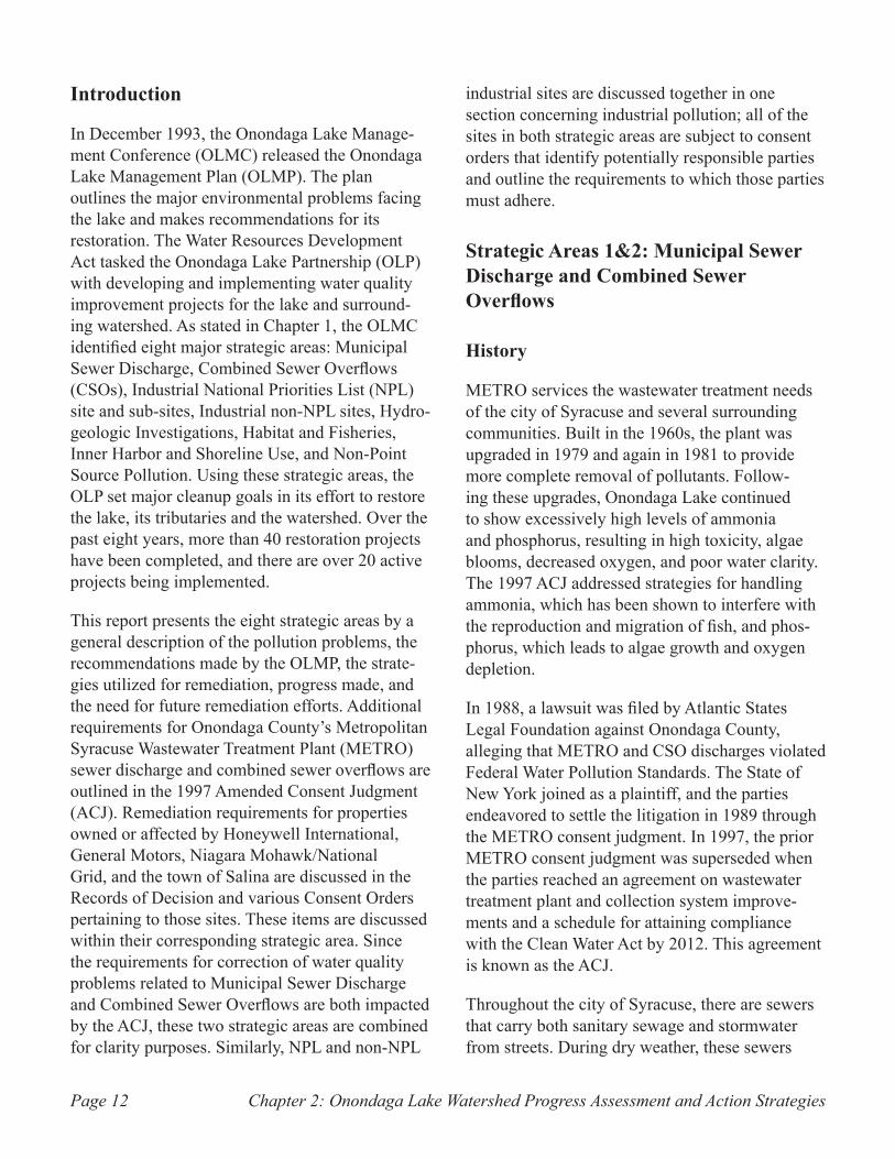
Aerial view of new facility at METRO. Figure 2-2. (Source: OCDWEP)
Chapter 2: Onondaga Lake Watershed Progress Assessment and Action Strategies Page 15
METRO and the CSOs effect the quality of water in the lake and river. The ACJ specifies the objec-tives of the program, the types of monitoring to be conducted and defines a schedule for the program.
Amendments to ACJAn amendment to the ACJ in December 2006 suspended a previously required oxygenation dem-onstration project for the lake. This decision was based on data from the AMP, which demonstrated that the lake’s oxygen levels had significantly improved. The 2006 amendment also included changes allowing for the consolidation of the ammonia and phosphorus removal facilities, use of a skimmer boat in the Inner Harbor rather than a boom in Onondaga Creek, and the design and construction of a CSO abatement plan for Harbor Brook that includes conveyances and regional treatment facilities.
An additional amendment to the ACJ in 2009
authorized the use of green infrastructure in combination with traditional engineering practices (grey infrastructure) to reduce CSO volume during wet weather. Green infrastructure involves the use of existing landscape features, soils, and vegeta-tion to capture or infiltrate stormwater runoff, thereby reducing the volume of flow contributing to CSOs. In recognition of the anticipated volume reduction that will be achieved through the use of green infrastructure, the 2009 ACJ amendment eliminated the requirement for Onondaga County to construct RTFs in Armory Square on Onondaga Creek, as well as on State Fair Boulevard adjacent to Harbor Brook. System-wide, on an average annual basis, CSO volume will be gradually reduced by 95 percent by December 31, 2018.
ACJ Progress and Effects on Lake Water Quality
METRO has improved its capacity to safely, effi-ciently and effectively treat wastewater over the past two decades. Treatment improvement projects included an odor control upgrade, aeration system upgrade, digital system improvements, increased capacity for chemical storage and feed facilities, digester modifications, and advanced ammonia and phosphorus removal.
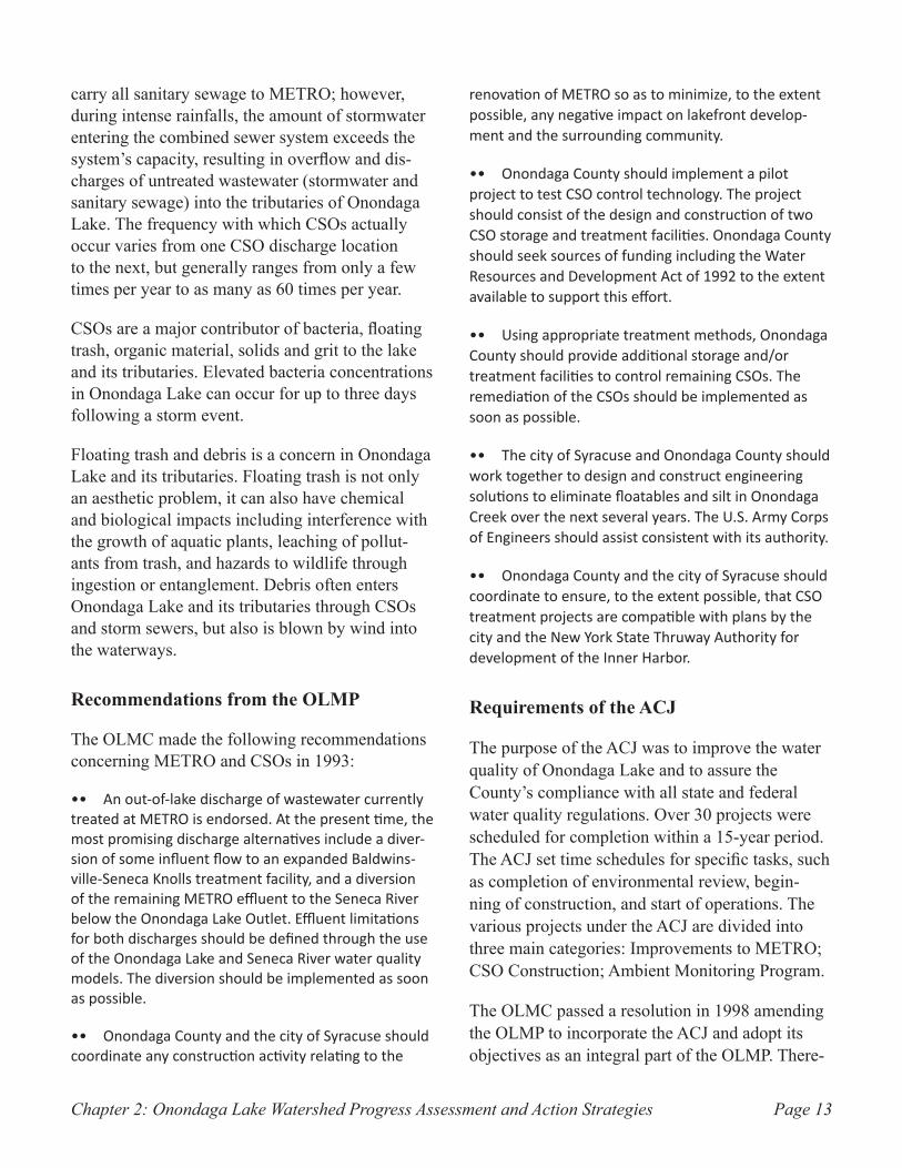
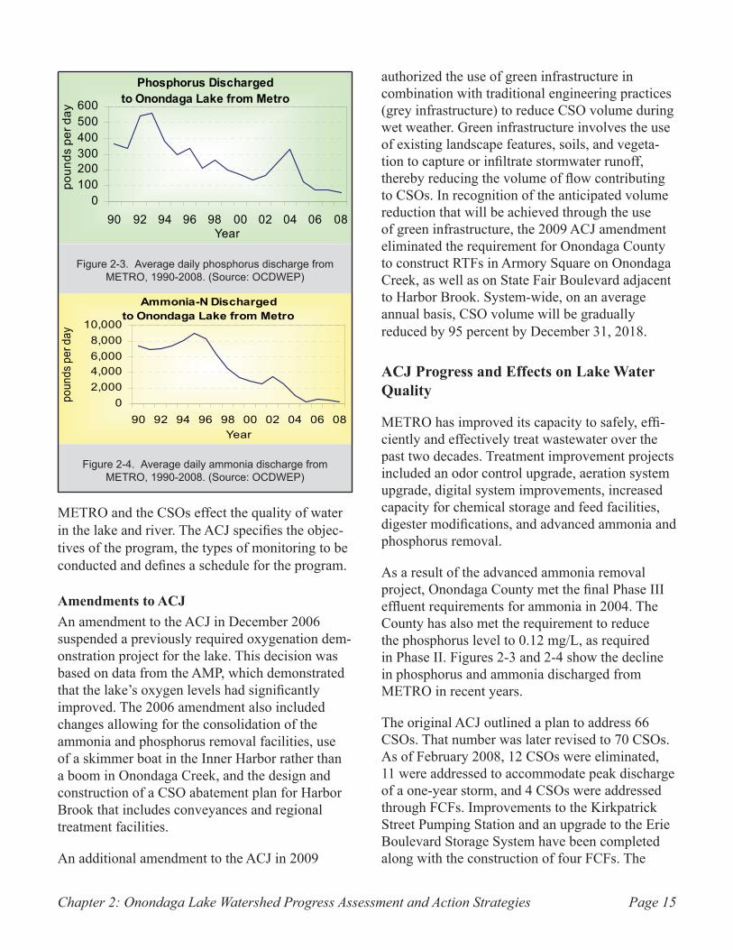
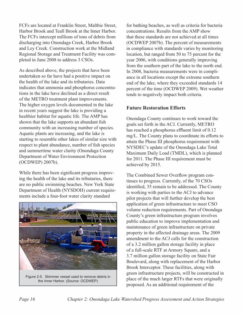
As a result of the advanced ammonia removal project, Onondaga County met the final Phase III effluent requirements for ammonia in 2004. The County has also met the requirement to reduce the phosphorus level to 0.12 mg/L, as required in Phase II. Figures 2-3 and 2-4 show the decline in phosphorus and ammonia discharged from METRO in recent years.
The original ACJ outlined a plan to address 66 CSOs. That number was later revised to 70 CSOs. As of February 2008, 12 CSOs were eliminated, 11 were addressed to accommodate peak discharge of a one-year storm, and 4 CSOs were addressed through FCFs. Improvements to the Kirkpatrick Street Pumping Station and an upgrade to the Erie Boulevard Storage System have been completed along with the construction of four FCFs. The
Page 2 Onondaga Lake Progress Repor t : Ju ly , 2009
How have improvements in wastewater collection and treatment affected phosphorus, algal blooms, and dissolved oxygen levels in Onondaga Lake?
Phosphorus is the key nutrient supporting algal growth. Too much phosphorus causes excessive algal growth, which turns the lake water green and cloudy and contributes to low oxygen levels.
Improvements at the Metro plant have reduced phos-phorus discharges to the lake from the treatment plant by more than 80%. Since the advanced treatment system was completed in 2005, loading has been less than 100 lbs per day.
Phosphorus Discharged to Onondaga Lake from Metro
0100200300400500600
90 92 94 96 98 00 02 04 06 08Year
poun
ds p
er d
ay
Reductions in phosphorus discharges from the Metro plant have resulted in substantially lower phosphorus concentrations in the lake water in recent years, down to 15 ppb in 2008, comparable to Oneida Lake.
Summer Phosphorus Levels inOnondaga Lake Upper Waters
020406080
100120140
90 92 94 96 98 00 02 04 06 08Year
parts
per
bill
ion
With the recent improvements at the Metro plant, runoff from the watershed contributes the majority of phosphorus to Onondaga Lake. Prior to 2005, the Metro plant contributed approximately 60% of the yearly phosphorus load.
Phosphorus Loading to Onondaga Lake:Metro and Watershed Sources
74%
26% MetroWatershed
20081990-2004
61%
39%
Until recently, low oxygen in October was one of the most significant water quality problems in Onondaga Lake. Recent improvements in oxygen mean better habitat for aquatic life. The NYSDEC Ambient Water Quality minimum standard is 4 ppm.
Minimum Oxygen Concentrationof Upper Waters in October
02468
10
90 92 94 96 98 00 02 04 06 08Year
parts
per
m
illio
n
Less phosphorus in the lake has resulted in fewer and less severe algal blooms. Less algae also means clearer water and more oxygen for aquatic life.
Summer Algal Bloom FrequencyMeasured as Chlorophyll-a
0%20%40%60%80%
100%
90 92 94 96 98 00 02 04 06 08Year
Minor bloom (>15 ppb) Major bloom (>30 ppb)
No blooms in 1995 or 2008
Average daily phosphorus discharge from Figure 2-3. METRO, 1990-2008. (Source: OCDWEP)
Onondaga Lake Page 3 Progress Repor t : Ju ly , 2009
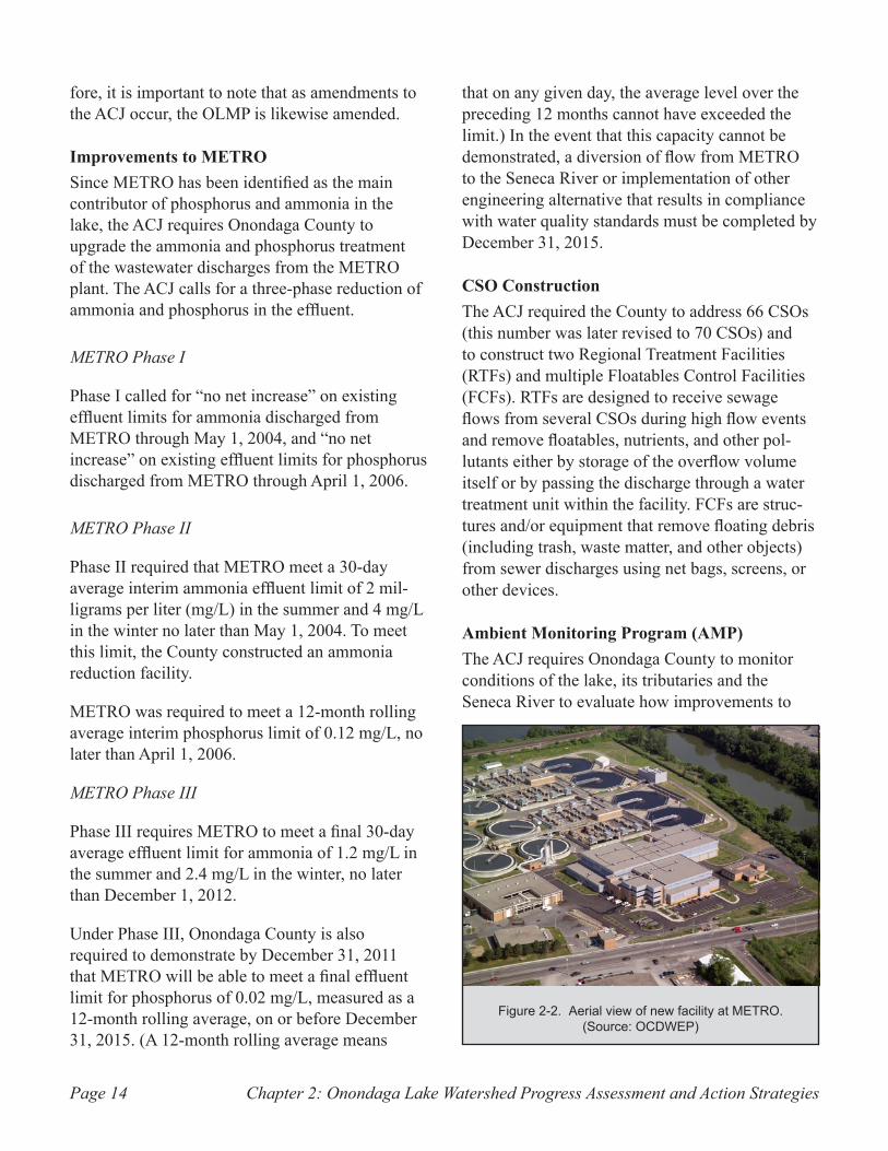
How have improvements in wastewater treatment affected ammonia levels in Onondaga Lake?
High concentrations of ammonia can be harmful to sensitive aquatic life, such as young fish. Onondaga County has completed major upgrades at the Metro plant that reduced the amount of ammonia-N discharged to the lake from the treatment plant. An advanced treatment system came on-line in 2004; as a result, ammonia-N concentrations in the lake have declined and meet state standards developed for protection of aquatic life.
How have improvements in wastewater collection and treatment affected bacteria levels in the lake?
Areas of Syracuse are served by combined sewer systems (CSOs) which carry both sewage and storm runoff. These pipes can overflow during periods of heavy rain and snowmelt, allowing a mixture of stormwater and raw sewage to flow into creeks and ultimately reach Onondaga Lake. Monitoring data document elevated bacteria levels during wet weather. Onondaga County continues to implement projects, including treatment facilities, to control storm runoff and combined sewer overflows. County officials recently have begun evaluating the potential use of “green” infrastructure to help manage urban storm runoff. Green infrastructure encourages infiltration, capture, and reuse of storm runoff before it enters the sewer system. Monitoring data have also identified elevated bacteria levels in streams during dry weather in certain areas. A cooperative program, funded by the Onondaga Lake Partnership and Onondaga County, is underway to identify and remediate these dry weather sources of bacteria, which may include leaky pipes and/or illicit connections.
Ammonia-N Dischargedto Onondaga Lake from Metro
02,0004,0006,0008,000
10,000
90 92 94 96 98 00 02 04 06 08Year
poun
ds p
er d
ay
Annual Ammonia-N Levels in Onondaga Lake Upper Waters
0.00.51.01.52.02.53.0
90 92 94 96 98 00 02 04 06 08Year
parts
per
m
illion
Fecal Coliform Bacteria, April-October 2008Percent of months in compliance with
200 cells/100 ml standard
North
Willow Bay, 100%Maple Bay, 100%
Ley Creek, 100%
Mid-south,86%
Onondaga Lake Park, 100%
Harbor Brook, 100%
Bloody Brook, 100%Ninemile,
100%
Westside Wastebeds,100%
Fecal Coliform Bacteria, April-October 2008Percent of months in compliance with
200 cells/100 ml standard
Fecal Coliform Bacteria, April-October 2008Percent of months in compliance with
200 cells/100 ml standard
NorthNorth
Willow Bay, 100%Maple Bay, 100%
Ley Creek, 100%
Mid-south,86%
Onondaga Lake Park, 100%
Harbor Brook, 100%
Bloody Brook, 100%Ninemile,
100%
Westside Wastebeds,100%
Willow Bay, 100%Maple Bay, 100%
Ley Creek, 100%
Mid-south,86%
Onondaga Lake Park, 100%
Harbor Brook, 100%
Bloody Brook, 100%Ninemile,
100%
Westside Wastebeds,100%
Willow Bay, 100%Maple Bay, 100%
Ley Creek, 100%
Mid-south,86%
Onondaga Lake Park, 100%
Harbor Brook, 100%
Bloody Brook, 100%Ninemile,
100%
Westside Wastebeds,100%
Bacteria levels are higher at the southern region of Onon-daga Lake, close to the major inflows, as compared to the northern regions. The good news is that bacteria levels at the northern stations and the lake outlet are consistently very low. The previous ten years of summer measurements, the period of major recreational use, are displayed above.
Bacteria levels in portions of the lake typically increase after significant storm events.
Fecal Coliform Bacteria SummerGeometric Average Concentration
050
100150200250
99 00 01 02 03 04 05 06 07 08Year
Conc
entra
tion
(cel
ls/10
0 m
l) South EndNorth End
This figure displays the 2008 data in detail. The fecal coliform bacteria standard of 200 cells per 100 ml of lake water, calcu-lated as a geometric average of at least five samples per month, is used by DEC to evaluate water quality and by DOH to evaluate suitability for swimming at designated beaches.
Average daily ammonia discharge from Figure 2-4. METRO, 1990-2008. (Source: OCDWEP)
Chapter 2: Onondaga Lake Watershed Progress Assessment and Action StrategiesPage 16
FCFs are located at Franklin Street, Maltbie Street, Harbor Brook and Teall Brook at the Inner Harbor. The FCFs intercept millions of tons of debris from discharging into Onondaga Creek, Harbor Brook and Ley Creek. Construction work at the Midland Regional Storage and Treatment Facility was com-pleted in June 2008 to address 3 CSOs.
As described above, the projects that have been undertaken so far have had a positive impact on the health of the lake and its tributaries. Data indicates that ammonia and phosphorus concentra-tions in the lake have declined as a direct result of the METRO treatment plant improvements. The higher oxygen levels documented in the lake in recent years suggest the lake is providing a healthier habitat for aquatic life. The AMP has shown that the lake supports an abundant fish community with an increasing number of species. Aquatic plants are increasing, and the lake is starting to resemble other lakes of similar size with respect to plant abundance, number of fish species and summertime water clarity (Onondaga County Department of Water Environment Protection (OCDWEP) 2007b).
While there has been significant progress improv-ing the health of the lake and its tributaries, there are no public swimming beaches. New York State Department of Health (NYSDOH) current require-ments include a four-foot water clarity standard
for bathing beaches, as well as criteria for bacteria concentrations. Results from the AMP show that these standards are not achieved at all times (OCDWEP 2007b). The percent of measurements in compliance with standards varies by monitoring location, but ranged from 50 to 75 percent for the year 2006, with conditions generally improving from the southern part of the lake to the north end. In 2008, bacteria measurements were in compli-ance in all locations except the extreme southern end of the lake, where they exceeded standards 14 percent of the time (OCDWEP 2009). Wet weather tends to negatively impact both criteria.
Future Restoration Efforts
Onondaga County continues to work toward the goals set forth in the ACJ. Currently, METRO has reached a phosphorus effluent limit of 0.12 mg/L. The County plans to coordinate its efforts to attain the Phase III phosphorus requirement with NYSDEC’s update of the Onondaga Lake Total Maximum Daily Load (TMDL), which is planned for 2011. The Phase III requirement must be achieved by 2015.
The Combined Sewer Overflow program con-tinues to progress. Currently, of the 70 CSOs identified, 35 remain to be addressed. The County is working with parties to the ACJ to advance pilot projects that will further develop the best application of green infrastructure to meet CSO volume reduction requirements. Part of Onondaga County’s green infrastructure program involves public education to improve implementation and maintenance of green infrastructure on private property in the affected drainage areas. The 2009 amendment to the ACJ calls for the construction of a 3.2 million gallon storage facility in place of a full-scale RTF at Armory Square, and a 3.7 million gallon storage facility on State Fair Boulevard, along with replacement of the Harbor Brook Interceptor. These facilities, along with green infrastructure projects, will be constructed in place of the much larger RTFs that were originally proposed. As an additional requirement of the
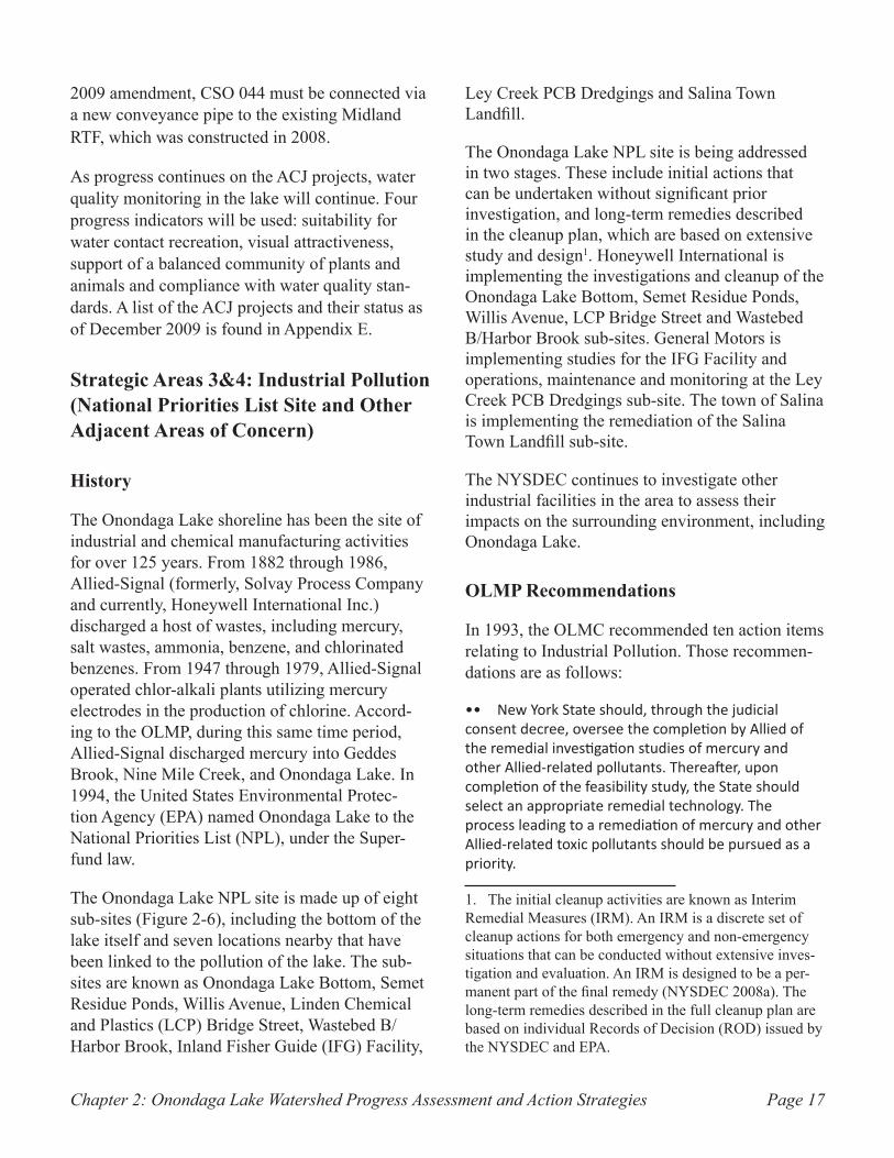
Skimmer vessel used to remove debris in Figure 2-5. the Inner Harbor. (Source: OCDWEP)
Chapter 2: Onondaga Lake Watershed Progress Assessment and Action Strategies Page 17
2009 amendment, CSO 044 must be connected via a new conveyance pipe to the existing Midland RTF, which was constructed in 2008.
As progress continues on the ACJ projects, water quality monitoring in the lake will continue. Four progress indicators will be used: suitability for water contact recreation, visual attractiveness, support of a balanced community of plants and animals and compliance with water quality stan-dards. A list of the ACJ projects and their status as of December 2009 is found in Appendix E.
Strategic Areas 3&4: Industrial Pollution (National Priorities List Site and Other Adjacent Areas of Concern)
History
The Onondaga Lake shoreline has been the site of industrial and chemical manufacturing activities for over 125 years. From 1882 through 1986, Allied-Signal (formerly, Solvay Process Company and currently, Honeywell International Inc.) discharged a host of wastes, including mercury, salt wastes, ammonia, benzene, and chlorinated benzenes. From 1947 through 1979, Allied-Signal operated chlor-alkali plants utilizing mercury electrodes in the production of chlorine. Accord-ing to the OLMP, during this same time period, Allied-Signal discharged mercury into Geddes Brook, Nine Mile Creek, and Onondaga Lake. In 1994, the United States Environmental Protec-tion Agency (EPA) named Onondaga Lake to the National Priorities List (NPL), under the Super-fund law.
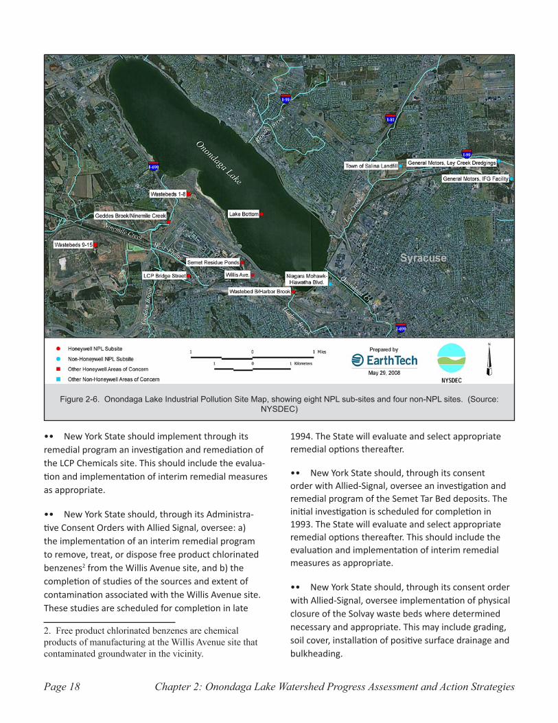
The Onondaga Lake NPL site is made up of eight sub-sites (Figure 2-6), including the bottom of the lake itself and seven locations nearby that have been linked to the pollution of the lake. The sub-sites are known as Onondaga Lake Bottom, Semet Residue Ponds, Willis Avenue, Linden Chemical and Plastics (LCP) Bridge Street, Wastebed B/Harbor Brook, Inland Fisher Guide (IFG) Facility,
Ley Creek PCB Dredgings and Salina Town Landfill.
The Onondaga Lake NPL site is being addressed in two stages. These include initial actions that can be undertaken without significant prior investigation, and long-term remedies described in the cleanup plan, which are based on extensive study and design1. Honeywell International is implementing the investigations and cleanup of the Onondaga Lake Bottom, Semet Residue Ponds, Willis Avenue, LCP Bridge Street and Wastebed B/Harbor Brook sub-sites. General Motors is implementing studies for the IFG Facility and operations, maintenance and monitoring at the Ley Creek PCB Dredgings sub-site. The town of Salina is implementing the remediation of the Salina Town Landfill sub-site.
The NYSDEC continues to investigate other industrial facilities in the area to assess their impacts on the surrounding environment, including Onondaga Lake.
OLMP Recommendations
In 1993, the OLMC recommended ten action items relating to Industrial Pollution. Those recommen-dations are as follows:
New York State should, through the judicial •• consent decree, oversee the completion by Allied of the remedial investigation studies of mercury and other Allied-related pollutants. Thereafter, upon completion of the feasibility study, the State should select an appropriate remedial technology. The process leading to a remediation of mercury and other Allied-related toxic pollutants should be pursued as a priority.
1. The initial cleanup activities are known as Interim Remedial Measures (IRM). An IRM is a discrete set of cleanup actions for both emergency and non-emergency situations that can be conducted without extensive inves-tigation and evaluation. An IRM is designed to be a per-manent part of the final remedy (NYSDEC 2008a). The long-term remedies described in the full cleanup plan are based on individual Records of Decision (ROD) issued by the NYSDEC and EPA.
Chapter 2: Onondaga Lake Watershed Progress Assessment and Action StrategiesPage 18
New York State should implement through its •• remedial program an investigation and remediation of the LCP Chemicals site. This should include the evalua-tion and implementation of interim remedial measures as appropriate.
New York State should, through its Administra-•• tive Consent Orders with Allied Signal, oversee: a) the implementation of an interim remedial program to remove, treat, or dispose free product chlorinated benzenes2 from the Willis Avenue site, and b) the completion of studies of the sources and extent of contamination associated with the Willis Avenue site. These studies are scheduled for completion in late
2. Free product chlorinated benzenes are chemical products of manufacturing at the Willis Avenue site that contaminated groundwater in the vicinity.
1994. The State will evaluate and select appropriate remedial options thereafter.
New York State should, through its consent •• order with Allied-Signal, oversee an investigation and remedial program of the Semet Tar Bed deposits. The initial investigation is scheduled for completion in 1993. The State will evaluate and select appropriate remedial options thereafter. This should include the evaluation and implementation of interim remedial measures as appropriate.
New York State should, through its consent order •• with Allied-Signal, oversee implementation of physical closure of the Solvay waste beds where determined necessary and appropriate. This may include grading, soil cover, installation of positive surface drainage and bulkheading.
Onondaga Lake Industrial Pollution Site Map, showing eight NPL sub-sites and four non-NPL sites. (Source: Figure 2-6. NYSDEC)
Chapter 2: Onondaga Lake Watershed Progress Assessment and Action Strategies Page 19
Onondaga County should require Allied-Signal •• to cease discharge of waste bed drainage to METRO within one year. Through its SPDES permit process, NYSDEC should determine the conditions for issuance of a permit for the drainage to be redirected, treated and released appropriately.
New York State should carry out the RI/FS•• 3 and NRD4 assessment processes to define further remedial needs and methods, and collect monetary damages for lake sediments, groundwater, lower Ninemile Creek, the Tar Beds site, the Willis Avenue site, and other Allied impacts.
New York State should prioritize and implement •• through responsible parties remediation of any other sites that are determined to pose a threat to the lake ecosystem and usage.
New York State should, through the appropriate •• responsible parties, implement a comprehensive investigation and appropriate remediation of Oil City petroleum product contamination. This should address contamination on-site, as well as any contamination moving off-site, if applicable. As the first step, NYSDEC should finalize and implement a consent order with appropriate parties to fully evaluate subsurface condi-tions at the site.
New York State should pursue a program to selec-•• tively remove near-shore deposits that due to their physical characteristics may impede construction of the proposed New York State boat launch site on the lake’s west shore.
3. A Remedial Investigation/Feasibility Study (RI/FS) can begin once the presence of hazardous contamination is confirmed at a site. The State, or a responsible party under State oversight, performs a detailed examination of the site to determine the nature and extent of contamination, and then evaluates possible remedies through a process that includes public involvement.
4. Liability for Natural Resource Damages (NRD) is provided by Federal statutes, whereby State and Federal officials may seek compensation from responsible parties for the injury to, loss of, loss of the use of, or destruction of natural resources, including land, biota, air, surface and ground waters.
National Priorities List Sub-Sites
Onondaga Lake BottomAllied-Signal and other industries in the area contributed to the contamination of the lake water and sediment. Mercury contamination is found throughout the lake; the entire lake exhibits varying degrees of mercury contamination within the sediment layer at its bottom. Other contaminants present in the lake sediments include benzene, toluene, xylenes, ethylbenzene, chlo-rinated benzenes and polychlorinated biphenyls (PCBs)5.
In early 2006, NYSDEC, New York State Office of the Attorney General (NYSOAG) and Honeywell International reached an agreement in the form of a Consent Decree requiring the company to conduct a cleanup of contaminated sediments in Onondaga Lake in accordance with the government-issued cleanup plan.
The cleanup plan for the Onondaga Lake Bottom sub-site includes dredging an estimated 2.65 million cubic yards of contaminated sediments, isolation capping of an estimated 425 acres in the littoral zone6, thin layer capping of an estimated 154 acres, monitored natural recovery, wetland and habitat restoration, and long-term maintenance and monitoring.
A workplan detailing the remedial design was issued in March 2009.
Status of Projects
Honeywell International is currently collecting
5. PCBs are human-made, organic chemicals that were used in hundreds of industrial and commercial applica-tions, such as electrical and hydraulic equipment, oil-based paints, plastics and rubber products. The manufac-turing of PCBs was banned in 1979.
6. The cleanup plan for the Onondaga Lake Bottom sub-site defines the littoral zone as the area of the lake where water depths range from 0 to 9 meters (approximately 30 feet).
Chapter 2: Onondaga Lake Watershed Progress Assessment and Action StrategiesPage 20
additional data to further support design detail specifications for the Onondaga Lake cleanup activities. These data will be used to refine dredging locations and design the sediment con-solidation area planned in Waste Bed 13.
In-lake monitoring was conducted from 2004 through 2007 to help assess the possibility of controlling methylmercury production through nitrate addition to the deep water areas of the lake during the summer stratified periods. In June 2007, a workplan to continue this assessment was approved by NYSDEC. Field trials of nitrate appli-cation were successfully completed in 2009.
Future Activities
Lake bottom dredging is expected to begin in 2012. A workplan detailing the remedial design activities has been developed and was issued in March 2009. A plan to monitor the lake before, during and after cleanup activities is also being developed.
Initial design documents submitted to NYSDEC in March 2009 included information regarding sediment consolidation area (SCA) construction, dredging, water treatment operations, sediment capping, and deep lake bottom remediation.
Semet Residue PondsAllied-Signal disposed 20 million gallons of acidic, tar-like wastes on approximately 40 acres of land in the village of Solvay. Located approxi-mately 400 feet south of Onondaga Lake, the sub-site includes five man-made ponds used from 1917 to 1970 as depositories for waste material, and two small areas that were built to contain leakage from the ponds. The Semet Residue Ponds cover approximately 11 acres and have an estimated depth of 5 to 6 feet. Monitoring-well data indicate that there is a plume of contaminated groundwater originating at the sub-site and migrating toward Onondaga Lake. The primary contaminants of concern are benzene, toluene, ethylbenzene, xylene and naphthalene.
In March 2002, NYSDEC and EPA issued a cleanup plan for the sub-site (NYSDEC and EPA 2002). The selected remedy includes the excavation and on-site processing of the Semet Pond residue into benzene, light oil, and a soft tar product. The remedy also includes groundwater collection and on-site treatment.
Following the finalization of the cleanup plan in 2002, Honeywell International presented informa-tion suggesting that the cleanup plan would no longer be feasible due to changes in market condi-tions. A modification of the remedy, which would allow for the residue to be converted to a material used in energy recovery, was being evaluated by Honeywell pursuant to a Consent Order negotiated by NYSDEC and Honeywell International, Inc. However, field activities conducted in 2009 and 2010 to determine the thickness of the residue in the Semet Residue Ponds indicate that the volume of material in the ponds is considerably less than previously estimated. As a result, other alternatives to address the pond material are being considered.
Status of Projects
Studies have been undertaken to identify and investigate seeps in and around the berms that enclose the Semet Ponds, and to evaluate the potential for human exposure to the residue as a result of the seeps. Engineering details are also being generated to ensure the structural integrity of the berms. This information is being developed in support of the revised cleanup plan.
An addendum to the remedial design work plan was submitted in September 2007. The addendum called for additional characterization of sediment and surface water in the upper reaches of Tributary 5A, and additional exploration and inspection of outfalls and culverts along the tributary.
Design and construction of the Semet groundwater collection trench system adjacent to Onondaga Lake have been completed. Design of the Semet groundwater collection trench adjacent to and under Tributary 5A (a tributary to Onondaga Lake
Chapter 2: Onondaga Lake Watershed Progress Assessment and Action Strategies Page 21
that flows south from Semet Pond then turning north to the lake) is nearly completed.
Future Activities
Removal of contaminated sediment in Tributary 5A and construction of the groundwater collection trench adjacent to and under Tributary 5A will take place in 2010.
Willis AvenueLocated on Willis Avenue in the town of Geddes, this sub-site is situated at a former chemical manufacturing plant that has been demolished. The plant specialized in chlor-alkali production of caustic soda and chlorine. The plant was also used to manufacture benzene and chlorinated benzenes. Currently, both groundwater and surface runoff transport contaminants to the lake via the East Flume.
Status of Projects
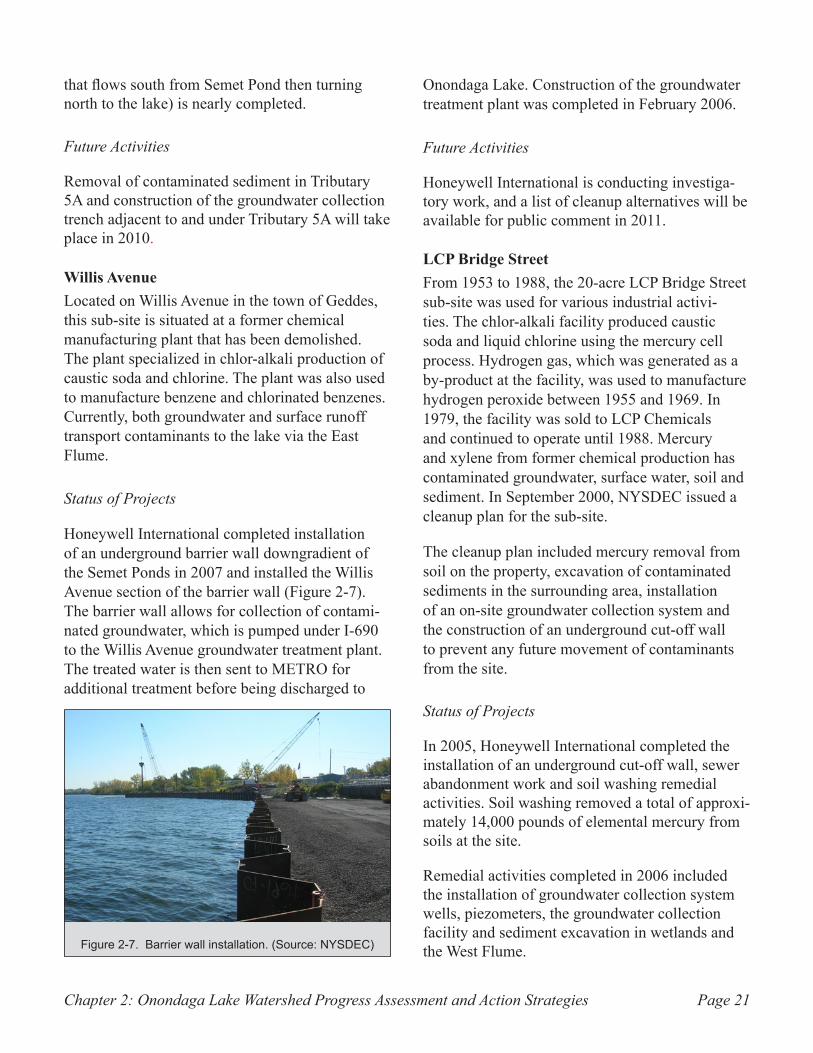
Honeywell International completed installation of an underground barrier wall downgradient of the Semet Ponds in 2007 and installed the Willis Avenue section of the barrier wall (Figure 2-7). The barrier wall allows for collection of contami-nated groundwater, which is pumped under I-690 to the Willis Avenue groundwater treatment plant. The treated water is then sent to METRO for additional treatment before being discharged to
Onondaga Lake. Construction of the groundwater treatment plant was completed in February 2006.
Future Activities
Honeywell International is conducting investiga-tory work, and a list of cleanup alternatives will be available for public comment in 2011.
LCP Bridge StreetFrom 1953 to 1988, the 20-acre LCP Bridge Street sub-site was used for various industrial activi-ties. The chlor-alkali facility produced caustic soda and liquid chlorine using the mercury cell process. Hydrogen gas, which was generated as a by-product at the facility, was used to manufacture hydrogen peroxide between 1955 and 1969. In 1979, the facility was sold to LCP Chemicals and continued to operate until 1988. Mercury and xylene from former chemical production has contaminated groundwater, surface water, soil and sediment. In September 2000, NYSDEC issued a cleanup plan for the sub-site.
The cleanup plan included mercury removal from soil on the property, excavation of contaminated sediments in the surrounding area, installation of an on-site groundwater collection system and the construction of an underground cut-off wall to prevent any future movement of contaminants from the site.
Status of Projects
In 2005, Honeywell International completed the installation of an underground cut-off wall, sewer abandonment work and soil washing remedial activities. Soil washing removed a total of approxi-mately 14,000 pounds of elemental mercury from soils at the site.
Remedial activities completed in 2006 included the installation of groundwater collection system wells, piezometers, the groundwater collection facility and sediment excavation in wetlands and the West Flume.Barrier wall installation. (Source: NYSDEC)Figure 2-7.
Chapter 2: Onondaga Lake Watershed Progress Assessment and Action StrategiesPage 22
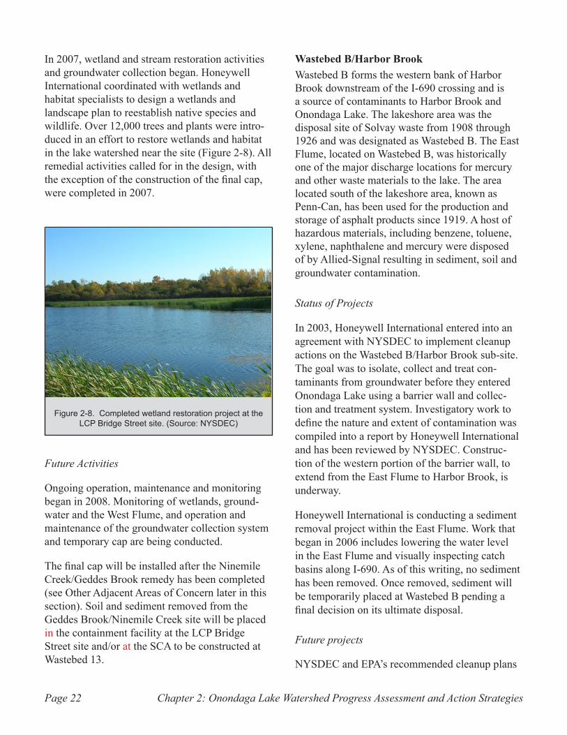
In 2007, wetland and stream restoration activities and groundwater collection began. Honeywell International coordinated with wetlands and habitat specialists to design a wetlands and landscape plan to reestablish native species and wildlife. Over 12,000 trees and plants were intro-duced in an effort to restore wetlands and habitat in the lake watershed near the site (Figure 2-8). All remedial activities called for in the design, with the exception of the construction of the final cap, were completed in 2007.
Future Activities
Ongoing operation, maintenance and monitoring began in 2008. Monitoring of wetlands, ground-water and the West Flume, and operation and maintenance of the groundwater collection system and temporary cap are being conducted.
The final cap will be installed after the Ninemile Creek/Geddes Brook remedy has been completed (see Other Adjacent Areas of Concern later in this section). Soil and sediment removed from the Geddes Brook/Ninemile Creek site will be placed in the containment facility at the LCP Bridge Street site and/or at the SCA to be constructed at Wastebed 13.
Wastebed B/Harbor BrookWastebed B forms the western bank of Harbor Brook downstream of the I-690 crossing and is a source of contaminants to Harbor Brook and Onondaga Lake. The lakeshore area was the disposal site of Solvay waste from 1908 through 1926 and was designated as Wastebed B. The East Flume, located on Wastebed B, was historically one of the major discharge locations for mercury and other waste materials to the lake. The area located south of the lakeshore area, known as Penn-Can, has been used for the production and storage of asphalt products since 1919. A host of hazardous materials, including benzene, toluene, xylene, naphthalene and mercury were disposed of by Allied-Signal resulting in sediment, soil and groundwater contamination.
Status of Projects
In 2003, Honeywell International entered into an agreement with NYSDEC to implement cleanup actions on the Wastebed B/Harbor Brook sub-site. The goal was to isolate, collect and treat con-taminants from groundwater before they entered Onondaga Lake using a barrier wall and collec-tion and treatment system. Investigatory work to define the nature and extent of contamination was compiled into a report by Honeywell International and has been reviewed by NYSDEC. Construc-tion of the western portion of the barrier wall, to extend from the East Flume to Harbor Brook, is underway.
Honeywell International is conducting a sediment removal project within the East Flume. Work that began in 2006 includes lowering the water level in the East Flume and visually inspecting catch basins along I-690. As of this writing, no sediment has been removed. Once removed, sediment will be temporarily placed at Wastebed B pending a final decision on its ultimate disposal.
Future projects
NYSDEC and EPA’s recommended cleanup plans
Completed wetland restoration project at the Figure 2-8. LCP Bridge Street site. (Source: NYSDEC)
Chapter 2: Onondaga Lake Watershed Progress Assessment and Action Strategies Page 23
for the lower Harbor Brook portion of the site and the area outboard (on the water side) of the barrier wall will be presented in 2010. A cleanup plan to address other areas of the site will be issued in 2011 or 2012.
Inland Fisher Guide FacilityFrom 1952 through 1993, the Inland Fisher Guide (IFG) facility operated as an automotive chrome plating facility and later, as a manufacturer of plastic automotive components. PCBs, chlorinated solvents and metals from the former General Motors auto parts plant contaminated groundwater, soils and Ley Creek sediments and floodplain soils. A number of cleanup activities to remove or contain contaminants were performed between 2000 and 2004. These included capping an on-site landfill, diverting storm water to an on-site treat-ment plant and removing 30,000 cubic yards of PCB-contaminated soil.
Status of Projects
In 2006, in accordance with a NYSDEC approved vapor intrusion investigation work plan, air samples were collected and tested. Results indi-cated elevated levels of solvents in both indoor and sub-surface air samples, leading to General Motors’ efforts to plug preferential pathways for soil vapors through floors. General Motors submitted a Vapor Intrusion Evaluation Report to NYSDEC in early 2008. Additional monitoring and remedial measures to address vapor intrusion are anticipated.
Field work was performed in 2008 to collect fish tissue samples for PCB analysis in support of a baseline environmental risk assessment (BERA) and human health risk assessment (HHRA).
Future Activities
Upon receipt and approval of the Supplemental Remedial Investigation Report, HHRA and BERA, an analysis of various remedial alternatives to address the remaining sub-site contamination
will be submitted to NYSDEC. NYSDEC plans to issue a final cleanup plan for addressing the remaining concerns at the sub-site in 2012.
Ley Creek PCB DredgingsGeneral Motors placed PCB-contaminated sediment along the banks of Ley Creek during the 1970s. In 1997 the NYSDEC approved a cleanup plan that included excavation and disposal of PCB-contaminated dredge material/soils at a permitted hazardous waste landfill, consolidation and covering of the remaining PCB-contaminated materials, removal of previously deposited dredged materials from the first 25 feet of the floodway to restore the area to an appropriate elevation, re-vegetating soil outside of the floodway, vegetating drainage swales, installation of a chain-link fence around the area of the vegetative cover to limit access, and implementation of deed restrictions to preclude activities that could potentially expose contaminated materials.
Status of Projects
Excavation of the PCB-contaminated dredged material/soil was conducted between 1999 and 2000. Approximately 3,750 cubic yards of material was transported to an off-site facility. Approxi-mately 920 cubic yards of material located on the north bank of Ley Creek was excavated and consolidated on-site.
A vegetative cover was installed over the consoli-dated dredged material. 1.5 acres of wetlands were created to replace wetlands that were eliminated during remedial construction.
Implementation of deed restrictions to preclude activities that could potentially expose contami-nated materials and to ensure that the integrity of the cover is maintained were put in place in early 2008. The Ley Creek PCB dredgings sub-site was
Chapter 2: Onondaga Lake Watershed Progress Assessment and Action StrategiesPage 24
re-classified in 20087; it is no longer considered an immediate threat to public health, and is properly closed, but requires continued management.
Future Activities
The cleanup plan has been fully implemented. The NYSDEC considers the site to be properly closed. Ongoing maintenance is required.
Salina Town Landfill
The Salina Town Landfill is approximately 55 acres and is located in an industrial area in the town of Salina. In addition to accepting municipal solid waste, the landfill also accepted hazardous wastes including paint sludge, paint thinner, PCB-contaminated materials and contaminated sediment dredged from Ley Creek. The landfill was closed in 1975 as mandated by NYSDEC.
In September 1981, the town covered the landfill with a clay soil and hydroseeded to establish a vegetative cover. Numerous investigations were performed on the landfill to determine whether the landfill was a threat to human health and the environment. In 1997, the landfill was designated a sub-site to the Onondaga Lake Superfund Site because it was determined that contamination from the landfill migrated to Ley Creek, which flows into Onondaga Lake.
In 1997, the town of Salina began investigatory work to evaluate the nature and extent of contami-nation. A resulting report identified alternative actions for addressing issues at the landfill site. The final cleanup plan was issued by the NYSDEC and EPA in 2007.
The cleanup plan includes excavation and consoli-dation of contaminated sediments, construction
7. The site was reclassified in 2008 from a Class 2 to a Class 4 New York State inactive hazardous waste site. NYSDEC defines Class 2 as a significant threat to the public health or environment and action is required. Class 4 inactive hazardous waste site is a site that has been properly closed and requires management.
of groundwater/leachate collection trenches north and south of Ley Creek and an on-site treatment plant, construction of caps over the landfill areas north and south of the creek, drainage controls and fencing, installation of an on-site 150,000-gallon storage tank to hold excess water from storm events, institutional controls to prohibit residential use of the property and long-term monitoring and maintenance.
Status of Projects
Remedial design of the leachate collection system is underway, and Onondaga County has agreed to accept treated leachate from the Salina Town Landfill.
Future Activities
Completion of the remedial design and commence-ment of the proposed work are both expected to occur in 2010. After that time, a suitable new use for the site will be determined.
Other Adjacent Areas of Concern
Geddes Brook/Ninemile CreekThe Geddes Brook/Ninemile Creek system has been impacted by mercury from the LCP Bridge Street NPL sub-site. Analysis of surface water, sediment and floodplain soils indicates that the West Flume, which leads from the LCP plant to Geddes Brook, has been the main channel of mercury contamination in the Ninemile Creek watershed. Other contaminants, such as arsenic, lead, hexachlorobenzene, phenol and PCBs have also been detected in the sediments and floodplain soils.
Status of Projects
Studies are underway to evaluate alternatives for the long-term cleanup of channel and floodplain sediments for Geddes Brook/Ninemile Creek as mandated by the NYSDEC. Cleanup plans for two portions of the Geddes Brook/Ninemile Creek
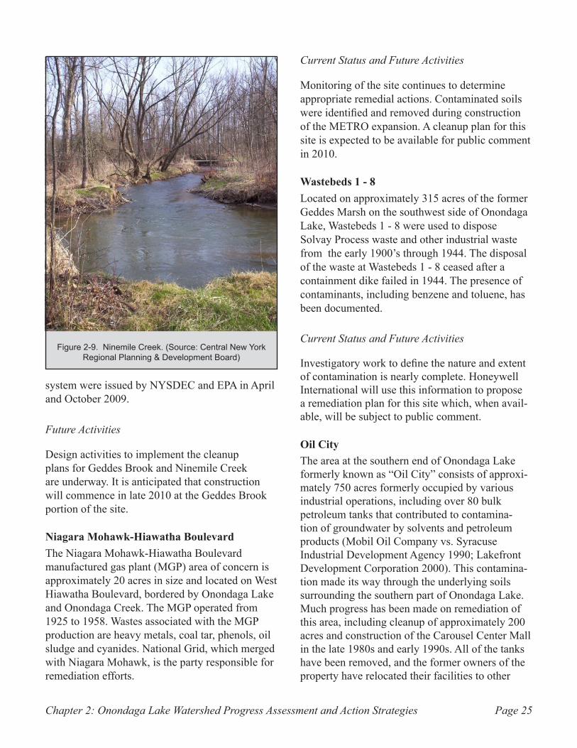
Chapter 2: Onondaga Lake Watershed Progress Assessment and Action Strategies Page 25
system were issued by NYSDEC and EPA in April and October 2009.
Future Activities
Design activities to implement the cleanup plans for Geddes Brook and Ninemile Creek are underway. It is anticipated that construction will commence in late 2010 at the Geddes Brook portion of the site.
Niagara Mohawk-Hiawatha BoulevardThe Niagara Mohawk-Hiawatha Boulevard manufactured gas plant (MGP) area of concern is approximately 20 acres in size and located on West Hiawatha Boulevard, bordered by Onondaga Lake and Onondaga Creek. The MGP operated from 1925 to 1958. Wastes associated with the MGP production are heavy metals, coal tar, phenols, oil sludge and cyanides. National Grid, which merged with Niagara Mohawk, is the party responsible for remediation efforts.
Current Status and Future Activities
Monitoring of the site continues to determine appropriate remedial actions. Contaminated soils were identified and removed during construction of the METRO expansion. A cleanup plan for this site is expected to be available for public comment in 2010.
Wastebeds 1 - 8Located on approximately 315 acres of the former Geddes Marsh on the southwest side of Onondaga Lake, Wastebeds 1 - 8 were used to dispose Solvay Process waste and other industrial waste from the early 1900’s through 1944. The disposal of the waste at Wastebeds 1 - 8 ceased after a containment dike failed in 1944. The presence of contaminants, including benzene and toluene, has been documented.
Current Status and Future Activities
Investigatory work to define the nature and extent of contamination is nearly complete. Honeywell International will use this information to propose a remediation plan for this site which, when avail-able, will be subject to public comment.
Oil CityThe area at the southern end of Onondaga Lake formerly known as “Oil City” consists of approxi-mately 750 acres formerly occupied by various industrial operations, including over 80 bulk petroleum tanks that contributed to contamina-tion of groundwater by solvents and petroleum products (Mobil Oil Company vs. Syracuse Industrial Development Agency 1990; Lakefront Development Corporation 2000). This contamina-tion made its way through the underlying soils surrounding the southern part of Onondaga Lake. Much progress has been made on remediation of this area, including cleanup of approximately 200 acres and construction of the Carousel Center Mall in the late 1980s and early 1990s. All of the tanks have been removed, and the former owners of the property have relocated their facilities to other
Ninemile Creek. (Source: Central New York Figure 2-9. Regional Planning & Development Board)
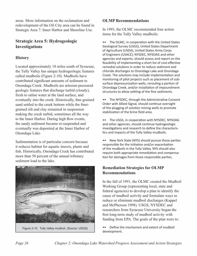
Chapter 2: Onondaga Lake Watershed Progress Assessment and Action StrategiesPage 26
areas. More information on the reclamation and redevelopment of the Oil City area can be found in Strategic Area 7: Inner Harbor and Shoreline Use.
Strategic Area 5: Hydrogeologic Investigations
History
Located approximately 18 miles south of Syracuse, the Tully Valley has unique hydrogeologic features called mudboils (Figure 2-10). Mudboils have contributed significant amounts of sediment to Onondaga Creek. Mudboils are artesian-pressured geologic features that discharge turbid (cloudy), fresh to saline water at the land surface, and eventually into the creek. Historically, fine-grained sand settled to the creek bottom while the finer-grained silt and clay remained in suspension making the creek turbid, sometimes all the way to the Inner Harbor. During high flow events, the sandy sediment became re-suspended and eventually was deposited at the Inner Harbor of Onondaga Lake.
Sedimentation is of particular concern because it reduces habitat for aquatic insects, plants and fish. Historically, Onondaga Creek has contributed more than 50 percent of the annual tributary sediment load to the lake.
OLMP Recommendations
In 1993, the OLMC recommended four action items for the Tully Valley mudboils:
The OLMC, in cooperation with the United States •• Geological Survey (USGS), United States Department of Agriculture (USDA), United States Army Corps of Engineers (USACE), NYSDEC, NYSOAG and other agencies and experts, should assess and report on the feasibility of implementing a short list of cost-effective remedial solutions in order to reduce sediment and chloride discharges to Onondaga Lake and Onondaga Creek. The solutions may include implementation and monitoring of pilot projects such as placement of sub-surface depressurization wells, rerouting a portion of Onondaga Creek, and/or installation of impoundment structures to allow settling of the fine sediments.
The NYSDEC, through the Administrative Consent •• Order with Allied-Signal, should continue oversight of the plugging of solution mining wells to promote stabilization of the brine field area.
The USGS, in cooperation with NYSDEC, NYSOAG •• and other agencies, should continue hydrogeologic investigations and research to define the characteris-tics and impacts of the Tully Valley mudboils.
New York State (NYS) should pursue those parties •• responsible for the initiation and/or exacerbation of the mudboils in the Tully Valley. NYS should also require both appropriate remediation and compensa-tion for damages from those responsible parties.
Remediation Strategies for OLMP Recommendations
In the fall of 1991, the OLMC created the Mudboil Working Group (representing local, state and federal agencies) to develop a plan to identify the cause of mudboil activity and formulate ways to reduce or eliminate mudboil discharges (Kappel and McPherson 1998). USGS, NYSDEC and researchers from Syracuse University began the first long-term study of mudboil activity with funding from EPA. The goals of the plan were to:
Define the mechanism and extent of mudboil •• development.
Tully Valley mudboil. (Source: USGS)Figure 2-10.
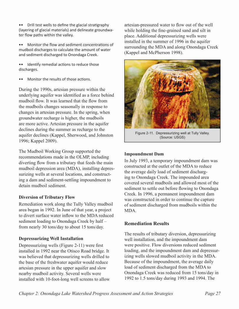
Chapter 2: Onondaga Lake Watershed Progress Assessment and Action Strategies Page 27
Drill test wells to define the glacial stratigraphy •• (layering of glacial materials) and delineate groundwa-ter flow paths within the valley.
Monitor the flow and sediment concentrations of •• mudboil discharges to calculate the amount of water and sediment discharged to Onondaga Creek.
Identify remedial actions to reduce those •• discharges.
Monitor the results of those actions.••
During the 1990s, artesian pressure within the underlying aquifer was identified as a force behind mudboil flow. It was learned that the flow from the mudboils changes seasonally in response to changes in artesian pressure. In the spring, when groundwater recharge is higher, the mudboils are more active. Artesian pressure in the aquifer declines during the summer as recharge to the aquifer declines (Kappel, Sherwood, and Johnston 1996; Kappel 2009).
The Mudboil Working Group supported the recommendations made in the OLMP, including diverting flow from a tributary that feeds the main mudboil depression area (MDA), installing depres-surizing wells at several locations, and construct-ing a dam and sediment-settling impoundment to detain mudboil sediment.
Diversion of Tributary FlowRemediation work along the Tully Valley mudboil area began in 1992. In June of that year, a project to divert surface water inflow to the MDA reduced sediment loading to Onondaga Creek by half – from nearly 30 tons/day to about 15 tons/day.
Depressurizing Well InstallationDepressurizing wells (Figure 2-11) were first installed in 1992 near the Otisco Road bridge. It was believed that depressurizing wells drilled to the base of the freshwater aquifer would reduce artesian pressure in the upper aquifer and slow nearby mudboil activity. Several wells were installed with 10-foot-long well screens to allow
artesian-pressured water to flow out of the well while holding the fine-grained sand and silt in place. Additional depressurizing wells were installed in the summer of 1996 in the aquifer surrounding the MDA and along Onondaga Creek (Kappel and McPherson 1998).
Impoundment DamIn July 1993, a temporary impoundment dam was constructed at the outlet of the MDA to reduce the average daily load of sediment discharg-ing to Onondaga Creek. The impounded area covered several mudboils and allowed most of the sediment to settle out before flowing to Onondaga Creek. In 1996, a permanent impoundment dam was constructed in order to continue the capture of sediment discharged from mudboils within the MDA.
Remediation Results
The results of tributary diversion, depressurizing well installation, and the impoundment dam were positive. Flow diversions reduced sediment loading, and the impoundment dam and depressur-izing wells slowed mudboil activity in the MDA. Because of the impoundment, the average daily load of sediment discharged from the MDA to Onondaga Creek was reduced from 15 tons/day in 1992 to 1.5 tons/day during 1993 and 1994. The
Depressurizing well at Tully Valley. Figure 2-11. (Source: USGS)
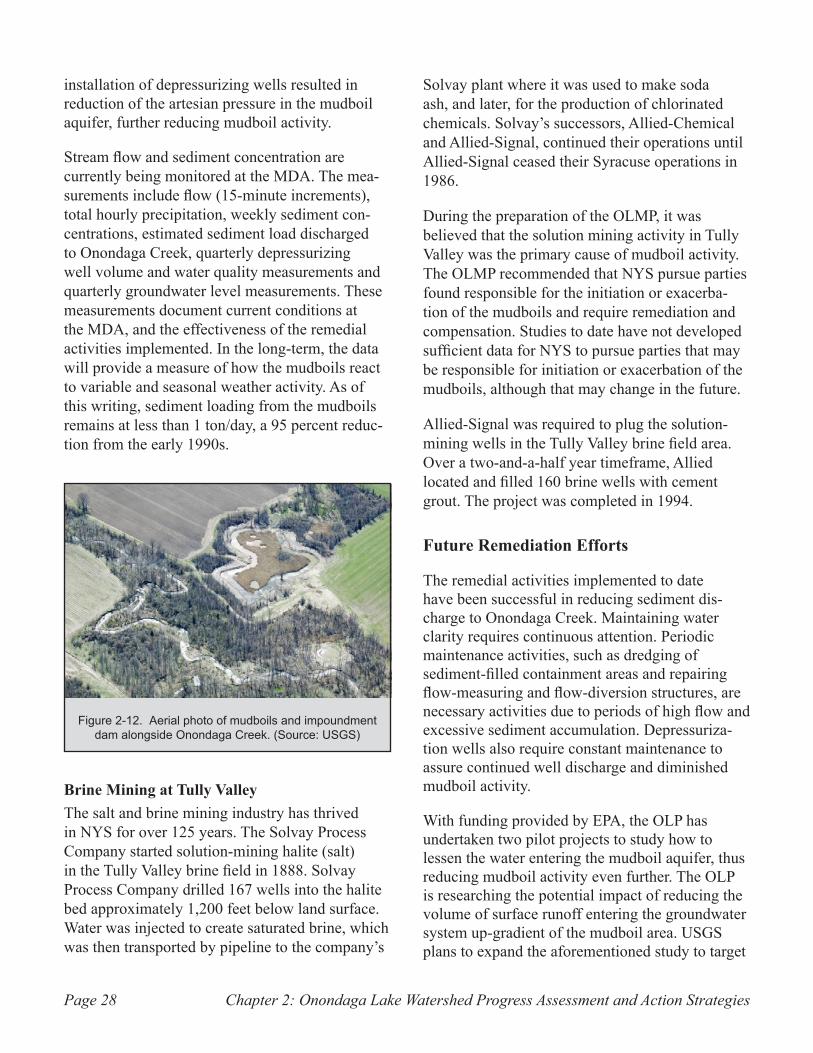
Chapter 2: Onondaga Lake Watershed Progress Assessment and Action StrategiesPage 28
installation of depressurizing wells resulted in reduction of the artesian pressure in the mudboil aquifer, further reducing mudboil activity.
Stream flow and sediment concentration are currently being monitored at the MDA. The mea-surements include flow (15-minute increments), total hourly precipitation, weekly sediment con-centrations, estimated sediment load discharged to Onondaga Creek, quarterly depressurizing well volume and water quality measurements and quarterly groundwater level measurements. These measurements document current conditions at the MDA, and the effectiveness of the remedial activities implemented. In the long-term, the data will provide a measure of how the mudboils react to variable and seasonal weather activity. As of this writing, sediment loading from the mudboils remains at less than 1 ton/day, a 95 percent reduc-tion from the early 1990s.
Brine Mining at Tully ValleyThe salt and brine mining industry has thrived in NYS for over 125 years. The Solvay Process Company started solution-mining halite (salt) in the Tully Valley brine field in 1888. Solvay Process Company drilled 167 wells into the halite bed approximately 1,200 feet below land surface. Water was injected to create saturated brine, which was then transported by pipeline to the company’s
Solvay plant where it was used to make soda ash, and later, for the production of chlorinated chemicals. Solvay’s successors, Allied-Chemical and Allied-Signal, continued their operations until Allied-Signal ceased their Syracuse operations in 1986.
During the preparation of the OLMP, it was believed that the solution mining activity in Tully Valley was the primary cause of mudboil activity. The OLMP recommended that NYS pursue parties found responsible for the initiation or exacerba-tion of the mudboils and require remediation and compensation. Studies to date have not developed sufficient data for NYS to pursue parties that may be responsible for initiation or exacerbation of the mudboils, although that may change in the future.
Allied-Signal was required to plug the solution-mining wells in the Tully Valley brine field area. Over a two-and-a-half year timeframe, Allied located and filled 160 brine wells with cement grout. The project was completed in 1994.
Future Remediation Efforts
The remedial activities implemented to date have been successful in reducing sediment dis-charge to Onondaga Creek. Maintaining water clarity requires continuous attention. Periodic maintenance activities, such as dredging of sediment-filled containment areas and repairing flow-measuring and flow-diversion structures, are necessary activities due to periods of high flow and excessive sediment accumulation. Depressuriza-tion wells also require constant maintenance to assure continued well discharge and diminished mudboil activity.
With funding provided by EPA, the OLP has undertaken two pilot projects to study how to lessen the water entering the mudboil aquifer, thus reducing mudboil activity even further. The OLP is researching the potential impact of reducing the volume of surface runoff entering the groundwater system up-gradient of the mudboil area. USGS plans to expand the aforementioned study to target
Aerial photo of mudboils and impoundment Figure 2-12. dam alongside Onondaga Creek. (Source: USGS)
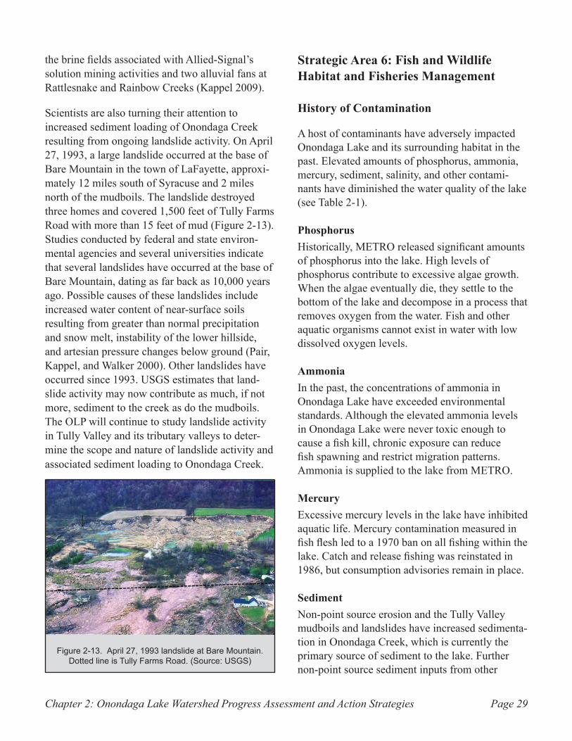
Chapter 2: Onondaga Lake Watershed Progress Assessment and Action Strategies Page 29
the brine fields associated with Allied-Signal’s solution mining activities and two alluvial fans at Rattlesnake and Rainbow Creeks (Kappel 2009).
Scientists are also turning their attention to increased sediment loading of Onondaga Creek resulting from ongoing landslide activity. On April 27, 1993, a large landslide occurred at the base of Bare Mountain in the town of LaFayette, approxi-mately 12 miles south of Syracuse and 2 miles north of the mudboils. The landslide destroyed three homes and covered 1,500 feet of Tully Farms Road with more than 15 feet of mud (Figure 2-13). Studies conducted by federal and state environ-mental agencies and several universities indicate that several landslides have occurred at the base of Bare Mountain, dating as far back as 10,000 years ago. Possible causes of these landslides include increased water content of near-surface soils resulting from greater than normal precipitation and snow melt, instability of the lower hillside, and artesian pressure changes below ground (Pair, Kappel, and Walker 2000). Other landslides have occurred since 1993. USGS estimates that land-slide activity may now contribute as much, if not more, sediment to the creek as do the mudboils. The OLP will continue to study landslide activity in Tully Valley and its tributary valleys to deter-mine the scope and nature of landslide activity and associated sediment loading to Onondaga Creek.
Strategic Area 6: Fish and Wildlife Habitat and Fisheries Management
History of Contamination
A host of contaminants have adversely impacted Onondaga Lake and its surrounding habitat in the past. Elevated amounts of phosphorus, ammonia, mercury, sediment, salinity, and other contami-nants have diminished the water quality of the lake (see Table 2-1).
PhosphorusHistorically, METRO released significant amounts of phosphorus into the lake. High levels of phosphorus contribute to excessive algae growth. When the algae eventually die, they settle to the bottom of the lake and decompose in a process that removes oxygen from the water. Fish and other aquatic organisms cannot exist in water with low dissolved oxygen levels.
Ammonia In the past, the concentrations of ammonia in Onondaga Lake have exceeded environmental standards. Although the elevated ammonia levels in Onondaga Lake were never toxic enough to cause a fish kill, chronic exposure can reduce fish spawning and restrict migration patterns. Ammonia is supplied to the lake from METRO.
MercuryExcessive mercury levels in the lake have inhibited aquatic life. Mercury contamination measured in fish flesh led to a 1970 ban on all fishing within the lake. Catch and release fishing was reinstated in 1986, but consumption advisories remain in place.
SedimentNon-point source erosion and the Tully Valley mudboils and landslides have increased sedimenta-tion in Onondaga Creek, which is currently the primary source of sediment to the lake. Further non-point source sediment inputs from other
April 27, 1993 landslide at Bare Mountain. Figure 2-13. Dotted line is Tully Farms Road. (Source: USGS)

Chapter 2: Onondaga Lake Watershed Progress Assessment and Action StrategiesPage 30
tributaries add to the problem. The increased sediment loading of the lake reduces water clarity and habitat for aquatic insects, plants and fish spawning.
Contaminant Sources Effects
Phosphorus Municipal wastewater discharge, non-point source runoff (e.g. fertilizer)
Excessive algal blooms, decreased water clarity, depletion of oxygen that is necessary for fish and other aquatic organisms to survive
Ammonia Municipal wastewater discharge and industrial wastebeds
Toxic to fish; disruptive to survival behaviors
Mercury Industrial activities along lake
Measured in fish flesh and is toxic to humans and wildlife
Sediment Tully Valley mudboils and landslides
Reduces aquatic habitat, fish spawning sites, sunlight penetra-tion and plant growth
Salinity Salt mining activities, soda ash pro-duction, salt springs
Reduces and/or eliminates suitable habitats
Table 2-1. Major Pollutants of Onondaga Lake.
SalinityElevated levels of salts, particularly sodium chloride and calcium chloride, occur in Onondaga Lake as a result of former soda ash production
activities along the west shore of the lake. Salt springs in the Tully Valley area also contribute to the elevated salinity. High salinity levels alter the stratification process of the lake, and contribute to the formation of anoxic zones. As a result, fish and other aquatic organisms cannot inhabit these zones due to a lack of dissolved oxygen in the water.
Other contaminantsA large portion of the lake and its near-shore area are covered with calcium carbonate stones called oncolites. Oncolites are a product of the Solvay Process conducted at the Allied-Signal soda ash facility. Oncolites inhibit the growth of rooted aquatic plants, which limits the variety and popula-tion of animal species found within the lake.
Other contaminants originate from non-point sources. These include pesticides, motor oil, metals, septic leachate, and several other pollutants that are harmful to fish and wildlife.
As a result of the contamination, fish populations decreased and the fishery that once flourished within the lake declined. Migratory salmon and non-migratory ciscoes (also known as Onondaga Lake whitefish), both coldwater fish, are men-tioned in anecdotal accounts from the 1800s and early 1900s. The historical presence of coldwater
Smallmouth bass caught in Onondaga Figure 2-14. Lake. (Source: OCDWEP)
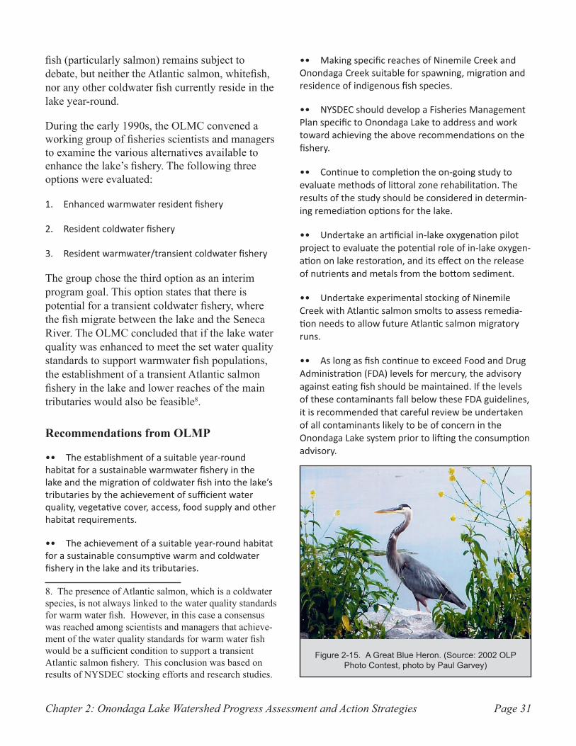
Chapter 2: Onondaga Lake Watershed Progress Assessment and Action Strategies Page 31
fish (particularly salmon) remains subject to debate, but neither the Atlantic salmon, whitefish, nor any other coldwater fish currently reside in the lake year-round.
During the early 1990s, the OLMC convened a working group of fisheries scientists and managers to examine the various alternatives available to enhance the lake’s fishery. The following three options were evaluated:
Enhanced warmwater resident fishery1.
Resident coldwater fishery2.
Resident warmwater/transient coldwater fishery3.
The group chose the third option as an interim program goal. This option states that there is potential for a transient coldwater fishery, where the fish migrate between the lake and the Seneca River. The OLMC concluded that if the lake water quality was enhanced to meet the set water quality standards to support warmwater fish populations, the establishment of a transient Atlantic salmon fishery in the lake and lower reaches of the main tributaries would also be feasible8.
Recommendations from OLMP
The establishment of a suitable year-round •• habitat for a sustainable warmwater fishery in the lake and the migration of coldwater fish into the lake’s tributaries by the achievement of sufficient water quality, vegetative cover, access, food supply and other habitat requirements.
The achievement of a suitable year-round habitat •• for a sustainable consumptive warm and coldwater fishery in the lake and its tributaries.
8. The presence of Atlantic salmon, which is a coldwater species, is not always linked to the water quality standards for warm water fish. However, in this case a consensus was reached among scientists and managers that achieve-ment of the water quality standards for warm water fish would be a sufficient condition to support a transient Atlantic salmon fishery. This conclusion was based on results of NYSDEC stocking efforts and research studies.
Making specific reaches of Ninemile Creek and •• Onondaga Creek suitable for spawning, migration and residence of indigenous fish species.
NYSDEC should develop a Fisheries Management •• Plan specific to Onondaga Lake to address and work toward achieving the above recommendations on the fishery.
Continue to completion the on-going study to •• evaluate methods of littoral zone rehabilitation. The results of the study should be considered in determin-ing remediation options for the lake.
Undertake an artificial in-lake oxygenation pilot •• project to evaluate the potential role of in-lake oxygen-ation on lake restoration, and its effect on the release of nutrients and metals from the bottom sediment.
Undertake experimental stocking of Ninemile •• Creek with Atlantic salmon smolts to assess remedia-tion needs to allow future Atlantic salmon migratory runs.
As long as fish continue to exceed Food and Drug •• Administration (FDA) levels for mercury, the advisory against eating fish should be maintained. If the levels of these contaminants fall below these FDA guidelines, it is recommended that careful review be undertaken of all contaminants likely to be of concern in the Onondaga Lake system prior to lifting the consumption advisory.
A Great Blue Heron. (Source: 2002 OLP Figure 2-15. Photo Contest, photo by Paul Garvey)
Chapter 2: Onondaga Lake Watershed Progress Assessment and Action StrategiesPage 32
Development of a comprehensive biological moni-•• toring program to demonstrate trends and to identify sources and causes of ecosystem-wide problems. Biological monitoring should be coordinated with other activities such as water quality studies, mercury studies and fishery investigations.
NYSDEC should undertake an annual fish-monitor-•• ing program of Onondaga Lake, associated tributaries and the lake outlet to identify all appropriate and likely contaminants that may be present in the lake system.
Implementation of a Natural History Information •• and Education Program to educate and inform the public on fish and wildlife species in and around the lake.
Development and implementation of a plan •• to hydrologically connect selected wetland areas to Onondaga Lake.
NYSDEC should identify environmentally sensitive •• areas and significant wildlife habitat around the lake’s shoreline. Incompatible development in these areas should be discouraged.
Strategies and Progress
FisheriesThe improvements at METRO and the control of CSOs have successfully reduced ammonia and phosphorus levels in the lake, thus providing a healthier habitat for a sustainable year-round warmwater fishery. The improved water quality in the lake has promoted spawning, migration and residence of native fish species in portions of Ninemile Creek and Onondaga Creek. Aquatic plant growth has also increased. Results from the biological component of the Ambient Monitoring Program (AMP) show dramatic increases in the areal coverage of aquatic plants throughout the littoral zone. The number of species of rooted aquatic plants has increased from five in 1991 to seventeen in 2005. The increasing aquatic plant growth is helping to stabilize the lake bottom and encourage fish habitat (OCDWEP 2007a).
Habitat conditions are improving to allow
establishment of a sustainable warmwater fishery in the lake and migration of fish into the tributar-ies. As of 2007, studies have identified 64 fish species in the lake, up from 9 to 12 species found in the lake during the 1970s, and have acknowl-edged that the lake supports a “very productive” warmwater fishery with abundant numbers of largemouth and smallmouth bass. The lake also supports cool water species, such as walleye and yellow perch. Brown trout, a coldwater species, have been caught during colder periods of the year, suggesting that the migration of coldwater fish into the lake’s tributaries has been successful (OCDWEP 2007a).
Progress is being made toward achievement of a consumptive warmwater fishery in the lake. Fish species and populations are increasing in the lake. The NYSDOH continues to re-assess the advisories it has issued on fish consumption, which are related to potentially harmful chemical levels. After more than 10 years of catch-and-release fishing, the NYSDOH issued a change in the fish advisory for Onondaga Lake in 1999, stating that anglers were to eat no walleye from the lake and no more than one meal per month of all other species. The advisory was updated in 2007, adding that largemouth and smallmouth bass were not to be eaten due to mercury contamination. Women of childbearing age, infants and children under the age of 15 are advised not to eat any fish from the lake (NYSDOH 2007).
An annual fish monitoring program to identify contaminants of concern presently exists only for the lake. Onondaga County, through the AMP, collects largemouth and smallmouth bass annually for mercury testing from the lake. The program has generally shown the persistence of elevated mercury concentrations in these fish species. A fish monitoring program does not currently exist for the outlet or the tributaries.
Researchers at SUNY ESF began experimental stocking of Ninemile Creek with Atlantic salmon in 1991 and continued in 1995 through 2002. The results of the experimental stocking were positive,
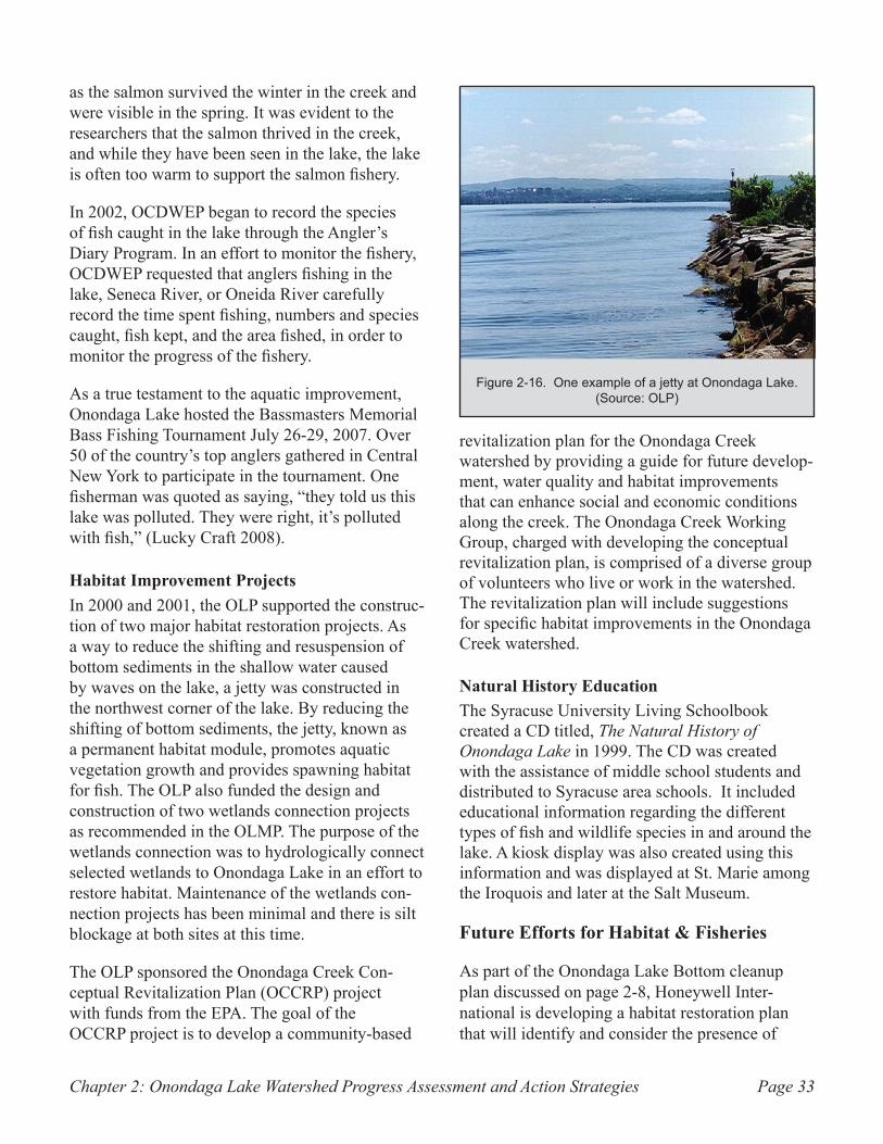
Chapter 2: Onondaga Lake Watershed Progress Assessment and Action Strategies Page 33
as the salmon survived the winter in the creek and were visible in the spring. It was evident to the researchers that the salmon thrived in the creek, and while they have been seen in the lake, the lake is often too warm to support the salmon fishery.
In 2002, OCDWEP began to record the species of fish caught in the lake through the Angler’s Diary Program. In an effort to monitor the fishery, OCDWEP requested that anglers fishing in the lake, Seneca River, or Oneida River carefully record the time spent fishing, numbers and species caught, fish kept, and the area fished, in order to monitor the progress of the fishery.
As a true testament to the aquatic improvement, Onondaga Lake hosted the Bassmasters Memorial Bass Fishing Tournament July 26-29, 2007. Over 50 of the country’s top anglers gathered in Central New York to participate in the tournament. One fisherman was quoted as saying, “they told us this lake was polluted. They were right, it’s polluted with fish,” (Lucky Craft 2008).
Habitat Improvement ProjectsIn 2000 and 2001, the OLP supported the construc-tion of two major habitat restoration projects. As a way to reduce the shifting and resuspension of bottom sediments in the shallow water caused by waves on the lake, a jetty was constructed in the northwest corner of the lake. By reducing the shifting of bottom sediments, the jetty, known as a permanent habitat module, promotes aquatic vegetation growth and provides spawning habitat for fish. The OLP also funded the design and construction of two wetlands connection projects as recommended in the OLMP. The purpose of the wetlands connection was to hydrologically connect selected wetlands to Onondaga Lake in an effort to restore habitat. Maintenance of the wetlands con-nection projects has been minimal and there is silt blockage at both sites at this time.
The OLP sponsored the Onondaga Creek Con-ceptual Revitalization Plan (OCCRP) project with funds from the EPA. The goal of the OCCRP project is to develop a community-based
revitalization plan for the Onondaga Creek watershed by providing a guide for future develop-ment, water quality and habitat improvements that can enhance social and economic conditions along the creek. The Onondaga Creek Working Group, charged with developing the conceptual revitalization plan, is comprised of a diverse group of volunteers who live or work in the watershed. The revitalization plan will include suggestions for specific habitat improvements in the Onondaga Creek watershed.
Natural History EducationThe Syracuse University Living Schoolbook created a CD titled, The Natural History of Onondaga Lake in 1999. The CD was created with the assistance of middle school students and distributed to Syracuse area schools. It included educational information regarding the different types of fish and wildlife species in and around the lake. A kiosk display was also created using this information and was displayed at St. Marie among the Iroquois and later at the Salt Museum.
Future Efforts for Habitat & Fisheries
As part of the Onondaga Lake Bottom cleanup plan discussed on page 2-8, Honeywell Inter-national is developing a habitat restoration plan that will identify and consider the presence of
One example of a jetty at Onondaga Lake. Figure 2-16. (Source: OLP)
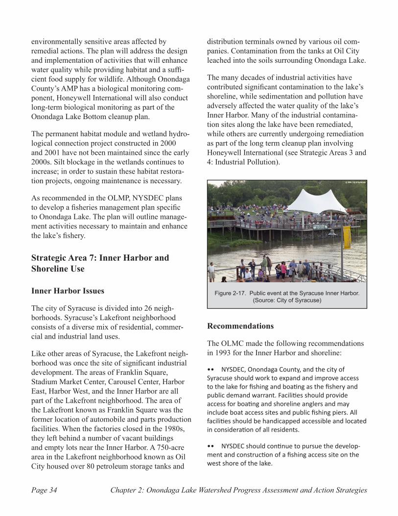
Chapter 2: Onondaga Lake Watershed Progress Assessment and Action StrategiesPage 34
environmentally sensitive areas affected by remedial actions. The plan will address the design and implementation of activities that will enhance water quality while providing habitat and a suffi-cient food supply for wildlife. Although Onondaga County’s AMP has a biological monitoring com-ponent, Honeywell International will also conduct long-term biological monitoring as part of the Onondaga Lake Bottom cleanup plan.
The permanent habitat module and wetland hydro-logical connection project constructed in 2000 and 2001 have not been maintained since the early 2000s. Silt blockage in the wetlands continues to increase; in order to sustain these habitat restora-tion projects, ongoing maintenance is necessary.
As recommended in the OLMP, NYSDEC plans to develop a fisheries management plan specific to Onondaga Lake. The plan will outline manage-ment activities necessary to maintain and enhance the lake’s fishery.
Strategic Area 7: Inner Harbor and Shoreline Use
Inner Harbor Issues
The city of Syracuse is divided into 26 neigh-borhoods. Syracuse’s Lakefront neighborhood consists of a diverse mix of residential, commer-cial and industrial land uses.
Like other areas of Syracuse, the Lakefront neigh-borhood was once the site of significant industrial development. The areas of Franklin Square, Stadium Market Center, Carousel Center, Harbor East, Harbor West, and the Inner Harbor are all part of the Lakefront neighborhood. The area of the Lakefront known as Franklin Square was the former location of automobile and parts production facilities. When the factories closed in the 1980s, they left behind a number of vacant buildings and empty lots near the Inner Harbor. A 750-acre area in the Lakefront neighborhood known as Oil City housed over 80 petroleum storage tanks and
distribution terminals owned by various oil com-panies. Contamination from the tanks at Oil City leached into the soils surrounding Onondaga Lake.
The many decades of industrial activities have contributed significant contamination to the lake’s shoreline, while sedimentation and pollution have adversely affected the water quality of the lake’s Inner Harbor. Many of the industrial contamina-tion sites along the lake have been remediated, while others are currently undergoing remediation as part of the long term cleanup plan involving Honeywell International (see Strategic Areas 3 and 4: Industrial Pollution).
Recommendations
The OLMC made the following recommendations in 1993 for the Inner Harbor and shoreline:
NYSDEC, Onondaga County, and the city of •• Syracuse should work to expand and improve access to the lake for fishing and boating as the fishery and public demand warrant. Facilities should provide access for boating and shoreline anglers and may include boat access sites and public fishing piers. All facilities should be handicapped accessible and located in consideration of all residents.
NYSDEC should continue to pursue the develop-•• ment and construction of a fishing access site on the west shore of the lake.
Public event at the Syracuse Inner Harbor. Figure 2-17. (Source: City of Syracuse)
Chapter 2: Onondaga Lake Watershed Progress Assessment and Action Strategies Page 35
USACE should design and prepare plans to dredge •• the Inner Harbor during 1993/1994. The planning process will determine the appropriate party to dredge the Inner Harbor; and the dredging should be con-ducted before 1996.
Local governments should seek public and private •• funds for the design and construction of projects which may include, but not be limited to: an outdoor performing arts facility, a year-round skating rink, a public art park, a lake education and research center, bike paths and pedestrian walkways.
Local governments should coordinate any •• construction activity relating to the development of wastewater treatment facilities so as to minimize to the extent possible any negative impacts on lakefront development and the surrounding community.
The city, the county and other local govern-•• ments should work with the NY State Department of Economic Development and NY State Canal Corpora-tion to design and circulate tourism focused promo-tional publications to promote the lake and the Inner Harbor.
Re-use of Allied waste beds, where appropriate, •• for public use purposes including the possibility of parks, golf courses, etc. Remedial efforts undertaken by responsible parties should be developed and implemented in consideration of future possible public usage.
Local governments should continue to improve •• public access to the lake by completing the lake-wide trail system and expanding the East Shore marina.
No land use should be permitted which would be •• deleterious to the lake’s water quality.
Strategies for OLMP Recommendations and Current Status
Inner HarborRemediation and redevelopment of the Lakefront neighborhood began in the early 1990s. Oil company operations were relocated from the area known as Oil City to a new location in the town of Van Buren. The last of the oil tanks were removed
from Oil City in 2001 (Lakefront Development Corporation 2000). The property owner removed contaminated soils from Oil City and prepared the land for redevelopment. Currently, much of the property is undeveloped with the notable exception of a large commercial shopping mall located on the southeast lake shore.
Redevelopment of the vacant factory buildings at Franklin Square began in the 1990s. These large, open-floored, brick buildings have been trans-formed into residential apartments, luxury condo-miniums, senior citizen apartments, commercial offices, and small businesses, including restaurants and cafes. Landscaping, ornamental lighting and tree-lined streets have converted this formerly underutilized and unattractive industrial site into a charming, mixed-use neighborhood.
The Onondaga Creekwalk is an attractive trail connecting the Franklin Square area to the Inner Harbor (see Appendix A for a map of the area). Extending north toward the lake from the Inner Harbor, the Creekwalk is a paved, ¾-mile path. The Creekwalk offers the community opportunities for recreation, including in-line skating, bicycling and fishing along the shoreline. It is envisioned that the Onondaga Creekwalk will eventually be extended to the Downtown Syracuse area and the planned Loop-the-Lake Trail. The Creekwalk will also connect to the Erie Canalway Trail. When completed, the Erie Canalway Trail will link canal communities from Albany to Buffalo along the New York State Canal System.
The 42-acre Inner Harbor is owned by the New York State Canal Corporation, but is maintained by the city of Syracuse’s Lakefront Development Corporation (LDC). The LDC was established in 1996 by the city of Syracuse and the Metropolitan Development Association to facilitate the rede-velopment of the Syracuse Lakefront. The LDC began renovations to the Inner Harbor in 1999. The New York State Canal Corporation dredged approximately 60,000 cubic yards of sediment and other materials from the Inner Harbor in 1999.
The renovation of the Inner Harbor was a three-
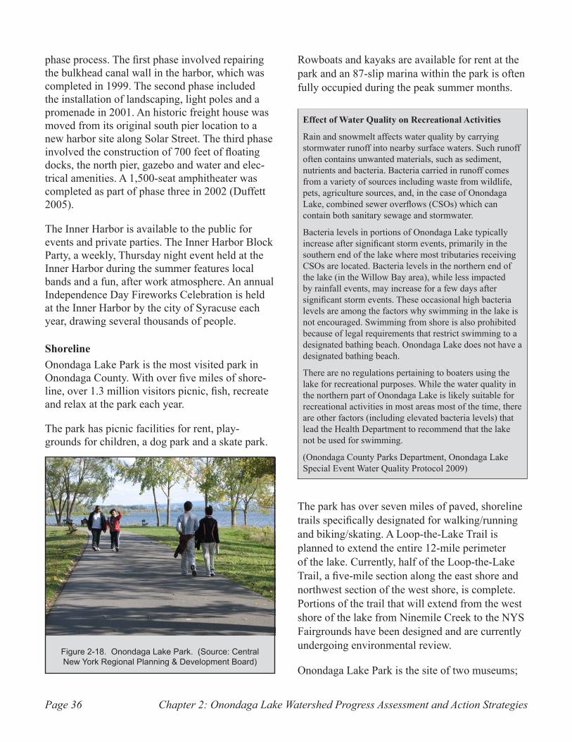
Chapter 2: Onondaga Lake Watershed Progress Assessment and Action StrategiesPage 36
phase process. The first phase involved repairing the bulkhead canal wall in the harbor, which was completed in 1999. The second phase included the installation of landscaping, light poles and a promenade in 2001. An historic freight house was moved from its original south pier location to a new harbor site along Solar Street. The third phase involved the construction of 700 feet of floating docks, the north pier, gazebo and water and elec-trical amenities. A 1,500-seat amphitheater was completed as part of phase three in 2002 (Duffett 2005).
The Inner Harbor is available to the public for events and private parties. The Inner Harbor Block Party, a weekly, Thursday night event held at the Inner Harbor during the summer features local bands and a fun, after work atmosphere. An annual Independence Day Fireworks Celebration is held at the Inner Harbor by the city of Syracuse each year, drawing several thousands of people.
ShorelineOnondaga Lake Park is the most visited park in Onondaga County. With over five miles of shore-line, over 1.3 million visitors picnic, fish, recreate and relax at the park each year.
The park has picnic facilities for rent, play-grounds for children, a dog park and a skate park.
Rowboats and kayaks are available for rent at the park and an 87-slip marina within the park is often fully occupied during the peak summer months.
Effect of Water Quality on Recreational Activities
Rain and snowmelt affects water quality by carrying stormwater runoff into nearby surface waters. Such runoff often contains unwanted materials, such as sediment, nutrients and bacteria. Bacteria carried in runoff comes from a variety of sources including waste from wildlife, pets, agriculture sources, and, in the case of Onondaga Lake, combined sewer overflows (CSOs) which can contain both sanitary sewage and stormwater.
Bacteria levels in portions of Onondaga Lake typically increase after significant storm events, primarily in the southern end of the lake where most tributaries receiving CSOs are located. Bacteria levels in the northern end of the lake (in the Willow Bay area), while less impacted by rainfall events, may increase for a few days after significant storm events. These occasional high bacteria levels are among the factors why swimming in the lake is not encouraged. Swimming from shore is also prohibited because of legal requirements that restrict swimming to a designated bathing beach. Onondaga Lake does not have a designated bathing beach.
There are no regulations pertaining to boaters using the lake for recreational purposes. While the water quality in the northern part of Onondaga Lake is likely suitable for recreational activities in most areas most of the time, there are other factors (including elevated bacteria levels) that lead the Health Department to recommend that the lake not be used for swimming.
(Onondaga County Parks Department, Onondaga Lake Special Event Water Quality Protocol 2009)
The park has over seven miles of paved, shoreline trails specifically designated for walking/running and biking/skating. A Loop-the-Lake Trail is planned to extend the entire 12-mile perimeter of the lake. Currently, half of the Loop-the-Lake Trail, a five-mile section along the east shore and northwest section of the west shore, is complete. Portions of the trail that will extend from the west shore of the lake from Ninemile Creek to the NYS Fairgrounds have been designed and are currently undergoing environmental review.
Onondaga Lake Park is the site of two museums;
Onondaga Lake Park. (Source: Central Figure 2-18. New York Regional Planning & Development Board)
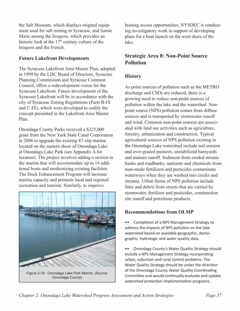
Chapter 2: Onondaga Lake Watershed Progress Assessment and Action Strategies Page 37
the Salt Museum, which displays original equip-ment used for salt mining in Syracuse, and Sainte Marie among the Iroquois, which provides an historic look at the 17th century culture of the Iroquois and the French.
Future Lakefront Developments
The Syracuse Lakefront Area Master Plan, adopted in 1999 by the LDC Board of Directors, Syracuse Planning Commission and Syracuse Common Council, offers a redevelopment vision for the Syracuse Lakefront. Future development of the Syracuse Lakefront will be in accordance with the city of Syracuse Zoning Regulations (Parts B-IX and C-IX), which were developed to codify the concept presented in the Lakefront Area Master Plan.
Onondaga County Parks received a $225,000 grant from the New York State Canal Corporation in 2006 to upgrade the existing 87-slip marina located on the eastern shore of Onondaga Lake at Onondaga Lake Park (see Appendix A for location). The project involves adding a section to the marina that will accommodate up to 14 addi-tional boats and modernizing existing facilities. The Dock Enhancement Program will increase marina capacity and promote local and regional recreation and tourism. Similarly, to improve
boating access opportunities, NYSDEC is conduct-ing investigatory work in support of developing plans for a boat launch on the west shore of the lake.
Strategic Area 8: Non-Point Source Pollution
History
As point sources of pollution such as the METRO discharge and CSOs are reduced, there is a growing need to reduce non-point sources of pollution within the lake and the watershed. Non-point source (NPS) pollution comes from diffuse sources and is transported by stormwater runoff and wind. Common non-point sources are associ-ated with land use activities such as agriculture, forestry, urbanization and construction. Typical agricultural sources of NPS pollution existing in the Onondaga Lake watershed include soil erosion and over-grazed pastures, unstabilized barnyards and manure runoff. Sediment from eroded stream-banks and roadbanks, nutrients and chemicals from man-made fertilizers and pesticides contaminate waterways when they are washed into creeks and streams. Urban forms of NPS pollution include litter and debris from streets that are carried by stormwater, fertilizer and pesticides, construction site runoff and petroleum products.
Recommendations from OLMP
Completion of a NPS Management Strategy to •• address the impacts of NPS pollution on the lake watershed based on available geographic, demo-graphic, hydrologic and water quality data.
Onondaga County’s Water Quality Strategy should •• include a NPS Management Strategy incorporating urban, suburban and rural control problems. The Water Quality Strategy should be under the direction of the Onondaga County Water Quality Coordinating Committee and would continually evaluate and update watershed protection implementation programs.
Onondaga Lake Park Marina. (Source: Figure 2-19. Onondaga County)
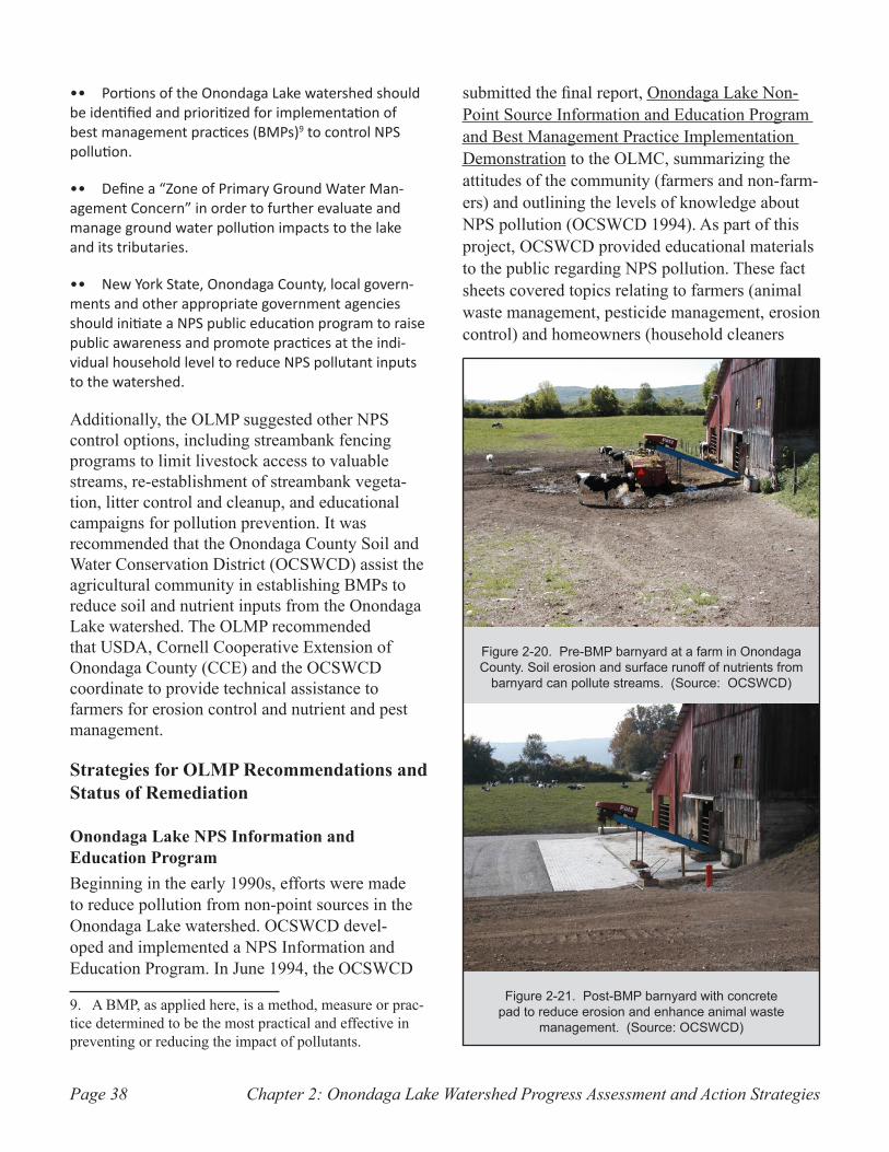
Chapter 2: Onondaga Lake Watershed Progress Assessment and Action StrategiesPage 38
Portions of the Onondaga Lake watershed should •• be identified and prioritized for implementation of best management practices (BMPs)9 to control NPS pollution.
Define a “Zone of Primary Ground Water Man-•• agement Concern” in order to further evaluate and manage ground water pollution impacts to the lake and its tributaries.
New York State, Onondaga County, local govern-•• ments and other appropriate government agencies should initiate a NPS public education program to raise public awareness and promote practices at the indi-vidual household level to reduce NPS pollutant inputs to the watershed.
Additionally, the OLMP suggested other NPS control options, including streambank fencing programs to limit livestock access to valuable streams, re-establishment of streambank vegeta-tion, litter control and cleanup, and educational campaigns for pollution prevention. It was recommended that the Onondaga County Soil and Water Conservation District (OCSWCD) assist the agricultural community in establishing BMPs to reduce soil and nutrient inputs from the Onondaga Lake watershed. The OLMP recommended that USDA, Cornell Cooperative Extension of Onondaga County (CCE) and the OCSWCD coordinate to provide technical assistance to farmers for erosion control and nutrient and pest management.
Strategies for OLMP Recommendations and Status of Remediation
Onondaga Lake NPS Information and Education ProgramBeginning in the early 1990s, efforts were made to reduce pollution from non-point sources in the Onondaga Lake watershed. OCSWCD devel-oped and implemented a NPS Information and Education Program. In June 1994, the OCSWCD
9. A BMP, as applied here, is a method, measure or prac-tice determined to be the most practical and effective in preventing or reducing the impact of pollutants.
submitted the final report, Onondaga Lake Non-Point Source Information and Education Program and Best Management Practice Implementation Demonstration to the OLMC, summarizing the attitudes of the community (farmers and non-farm-ers) and outlining the levels of knowledge about NPS pollution (OCSWCD 1994). As part of this project, OCSWCD provided educational materials to the public regarding NPS pollution. These fact sheets covered topics relating to farmers (animal waste management, pesticide management, erosion control) and homeowners (household cleaners
Pre-BMP barnyard at a farm in Onondaga Figure 2-20. County. Soil erosion and surface runoff of nutrients from
barnyard can pollute streams. (Source: OCSWCD)
Post-BMP barnyard with concrete Figure 2-21. pad to reduce erosion and enhance animal waste
management. (Source: OCSWCD)
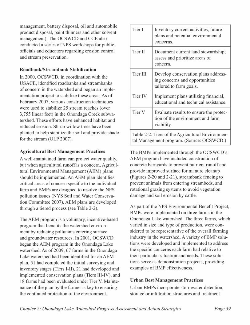
Chapter 2: Onondaga Lake Watershed Progress Assessment and Action Strategies Page 39
management, battery disposal, oil and automobile product disposal, paint thinners and other solvent management). The OCSWCD and CCE also conducted a series of NPS workshops for public officials and educators regarding erosion control and stream preservation.
Roadbank/Streambank StabilizationIn 2000, OCSWCD, in coordination with the USACE, identified roadbanks and streambanks of concern in the watershed and began an imple-mentation project to stabilize these areas. As of February 2007, various construction techniques were used to stabilize 25 stream reaches (over 3,755 linear feet) in the Onondaga Creek subwa-tershed. These efforts have enhanced habitat and reduced erosion. Shrub willow trees have been planted to help stabilize the soil and provide shade for the stream (OLP 2007).
Agricultural Best Management PracticesA well-maintained farm can protect water quality, but when agricultural runoff is a concern, Agricul-tural Environmental Management (AEM) plans should be implemented. An AEM plan identifies critical areas of concern specific to the individual farm and BMPs are designed to resolve the NPS pollution issues (NYS Soil and Water Conserva-tion Committee 2007). AEM plans are developed through a tiered process (see Table 2-2).
The AEM program is a voluntary, incentive-based program that benefits the watershed environ-ment by reducing pollutants entering surface and groundwater resources. In 2001, OCSWCD began the AEM program in the Onondaga Lake watershed. As of 2009, 67 farms in the Onondaga Lake watershed had been identified for an AEM plan, 51 had completed the initial surveying and inventory stages (Tiers I-II), 21 had developed and implemented conservation plans (Tiers III-IV), and 18 farms had been evaluated under Tier V. Mainte-nance of the plan by the farmer is key to ensuring the continued protection of the environment.
Tier I Inventory current activities, future plans and potential environmental concerns.
Tier II Document current land stewardship; assess and prioritize areas of concern.
Tier III Develop conservation plans address-ing concerns and opportunities tailored to farm goals.
Tier IV Implement plans utilizing financial, educational and technical assistance.
Tier V Evaluate results to ensure the protec-tion of the environment and farm viability.
Table 2-2. Tiers of the Agricultural Environmen-tal Management program. (Source: OCSWCD.)
The BMPs implemented through the OCSWCD’s AEM program have included construction of concrete barnyards to prevent nutrient runoff and provide improved surface for manure cleanup (Figures 2-20 and 2-21), streambank fencing to prevent animals from entering streambeds, and rotational grazing systems to avoid vegetation damage and soil erosion by cattle.
As part of the NPS Environmental Benefit Project, BMPs were implemented on three farms in the Onondaga Lake watershed. The three farms, which varied in size and type of production, were con-sidered to be representative of the overall farming industry in the watershed. A variety of BMP solu-tions were developed and implemented to address the specific concerns each farm had relative to their particular situation and needs. These solu-tions serve as demonstration projects, providing examples of BMP effectiveness.
Urban Best Management PracticesUrban BMPs incorporate stormwater detention, storage or infiltration structures and treatment
Chapter 2: Onondaga Lake Watershed Progress Assessment and Action StrategiesPage 40
devices to remove pollutants. While there are numerous urban BMP technologies available, it is imperative to identify those that will benefit the specific area of concern.
Onondaga County, the city of Syracuse and numerous organizations within the area have contributed to educating the public about urban BMPs. Public Service Announcements encourag-ing people to help reduce NPS pollution related to the urban environment were developed in the early 2000s. Press releases identifying ways to properly dispose of trash and debris were developed and distributed to the public by the city of Syracuse. Onondaga County purchased a litter vacuum truck for the city of Syracuse with a grant from the OLP and produced educational materials associated with proper litter disposal. As a way to capture the floating debris in the Inner Harbor, the County pur-chased a skimmer vessel that removes the floating trash from the water. Finally, the OLP previously sponsored annual cleanups of Onondaga Creek, in which local volunteers removed trash from the streambanks.
In addition to the agricultural BMPs implemented under the Environmental Benefit Project, two urban BMPs were constructed and implemented. A stormwater vortex unit, designed to capture and hold solids (grit and sand), floatables, oil and grease and nutrients during runoff events was constructed on East Seneca Turnpike in Syracuse. Captured solids were eventually removed from the unit for disposal. The stormwater vortex unit resulted in relatively low nutrient reduction, but successfully captured solids and floatables.
A vegetative filter strip10 was also constructed in a parking lot at the Burnet Park Zoo (see Appendix A for location) through the Environmental Benefit Project. The vegetative strip was designed to remove pollutants in stormwater runoff through filtration, deposition, infiltration and absorption.
10. Vegetative filter strips are areas of land with vegeta-tive cover that are designed to accept runoff as overland sheet flow from upstream development.
The strip consists of a mix of ground cover plants and larger, woody species. The vegetation was allowed to become established for one year before sampling began in June 2001. The results showed that the vegetative strip was effective at removing solids and absorbed much of the runoff from the parking lot (Moffa and Associates 2002).
Groundwater ManagementA “Zone of Primary Groundwater Management Concern” has not been defined. The remedial activities undertaken by Honeywell International along the lakeshore will manage groundwater concern as required in the cleanup plan. See Stra-tegic Areas 3 & 4: Industrial Pollution for further information.
Stormwater ManagementStormwater is water from rain or melting snow that does not soak into the ground, but runs into waterways. It flows from rooftops, over paved areas and bare soil, and through sloped lawns. Flowing stormwater collects and transports soil, animal waste, pesticides, fertilizers, oil and grease, debris and other potential pollutants.
Beginning in the early 1990s, the EPA developed a nationwide stormwater program focused on medium to large municipal separate storm sewer systems (MS4s). In 1999, the EPA expanded the regulation to cover certain smaller MS4s. The regulatory program, which aims to reduce urban nonpoint source pollution in stormwater runoff, requires the development and implementation of a stormwater management program. Stormwater management programs must contain appropri-ate management practices in the areas of public education and outreach, public involvement and participation, illicit discharge detection and elimination, construction site stormwater runoff control, post-construction site stormwater runoff control and municipal pollution prevention and good housekeeping (NYSDEC 2008c). Several municipalities in the Onondaga Lake watershed are subject to the stormwater regulations.
Chapter 2: Onondaga Lake Watershed Progress Assessment and Action Strategies Page 41
Water Quality StrategyThe Onondaga County Water Quality Strategy, developed by the Onondaga County Environmen-tal Health Council, identifies specific goals for major watersheds in Onondaga County. The goals include implementation of BMPs, AEM, stream-bank stabilization projects and the assessment of point and non-point source impacts on bodies of water. The strategy is periodically updated and is used to prioritize water quality needs.
Future Remediation Efforts
The OLMP recommended the completion of a NPS Management Strategy. While a NPS Management Strategy has not been completed, the OLP has focused attention on developing a model to identify specific areas within the watershed on which to focus NPS management efforts for maximum efficiency. Through the OLP, the USACE and Onondaga County funded the development of a watershed specific model for Onondaga Lake called the Surface Water Watershed Model, which is based on a computer program known as Hydrologic Simulation Program - Fortran (HSPF). The model simulates flow to and in the major tributaries of the lake in
order to project sediment, phosphorus and nitrogen loads to the lake (Coon and Reddy 2008). This model will be used to predict what effect certain projects might have on water quality in the lake. The OLP plans to use the Surface Water Watershed Model to identify areas of significant interest to focus future NPS management efforts.
The OCSWCD plans to continue providing AEM planning services to interested farmers in the Onondaga Lake watershed. The AEM program helps reduce pollution in the watershed and helps to maintain clean and healthy farms that provide the County and watershed an additional economic/tourist benefit.
Educating the public on the importance of urban BMPs is a priority for Onondaga County, the city of Syracuse, and the OLP. Past events such as Onondaga Lake Day, an annual event held at Onondaga Lake Park and hosted by the OLP, have offered activities for the public to learn about the history of the lake and surrounding area and opportunities for positive interaction with the lake. The OLP intends to continue to sponsor public education events and promote BMPs at events in the future.

Chapter 2: Onondaga Lake Watershed Progress Assessment and Action StrategiesPage 42
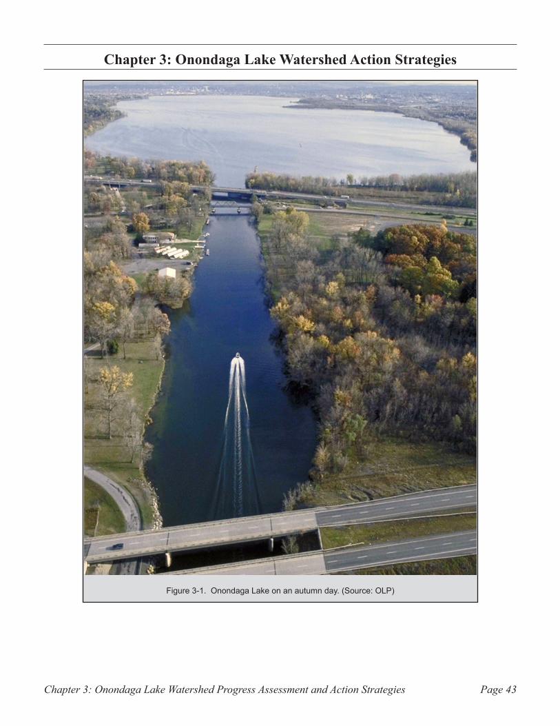
Chapter 3: Onondaga Lake Watershed Progress Assessment and Action Strategies Page 43
Onondaga Lake Watershed Action StrategiesChapter 3:
Onondaga Lake on an autumn day. (Source: OLP)Figure 3-1.
Chapter 3: Onondaga Lake Watershed Progress Assessment and Action StrategiesPage 44
Introduction
This chapter outlines the remaining actions to be taken, and information gaps to be filled, in order to fully accomplish the goals of the Onondaga Lake Partnership (OLP) for the rehabilitation of Onondaga Lake. The OLP’s cleanup goals are summarized and organized according to the eight Strategic Areas. Some of the original goals have been refined by the OLP to reflect new information about the Onondaga Lake ecosystem, advances in remediation technology, and changes in regulatory requirements. The OLP members identified and developed action strategies to fulfill the stated goals, with supporting action items and/or recom-mendations for their attainment. Action Items are required to be implemented by the identified parties as a result of legal decisions or enforce-ment actions. Recommendations are intended as suggested approaches for implementing the action strategies. The OLP may reassess and modify its approach if necessary due to changing needs.
The detailed action items and recommendations allow for more accurate assessment of funding needs for each action strategy. Estimates of the required cost along with identified or potential available funding sources are listed and discussed where possible. A timeline for completing each strategy is also provided to the extent possible, based on regulatory requirements and/or public interest. In many cases, the action strategies identi-fied will require continuous and ongoing effort.
Entities responsible for implementation of action items and recommendations are also identified, and their role in the process is defined where appropriate. The extent to which it is possible to designate the role of a given organization relative to a particular item varies. In some cases, the parties involved are specifically identified by a legal decision, consent agreement, or regulatory enforcement action; these instances are noted accordingly. In other cases, however, entities involved in implementation are identified based on past or current involvement. These entities are
noted to assist the OLP in identifying partners that may have the capacity to undertake particular projects. In these instances, it may be suitable for other parties, not specifically identified, to assume a role in accomplishment of a given recommenda-tion, depending on capabilities, funding, and future approval by the OLP.
As described in Section 573 of the Water Resources Development Act of 1999, comple-tion of the activities for which OLP is directly designated in this document must occur not later than August 17, 2014 (sometimes referred to as the OLP termination date).
Strategic Area 1: Municipal Sewer Discharge
The OLP has stated the following goals for addressing municipal sewer discharge:
Goal 1. Maintain a 30-day average ammonia effluent limit of 1.2 mg/L in summer and 2.4 mg/L in winter from METRO as mandated by the ACJ1.
Since 2004, the Syracuse Metropolitan Area Wastewater Treatment Plant (METRO) has consis-tently met this goal and anticipates continuing to achieve these levels of ammonia removal by utiliz-ing the present technology. However, Onondaga County will continue to monitor its discharge in accordance with the ACJ and its State Pollutant Discharge Elimination System (SPDES) permit to document compliance with effluent limits, and to address any exceedances of those limits or changes in data that suggest the facility is at risk of incur-ring exceedances.
1. Atlantic States Legal Foundation, State of New York and John P. Cahill, as Commissioner of the New York State Department of Environmental Conservation v. The Onondaga County Department of Drainage and Sanita-tion and Onondaga County, New York. 88-CV-0066.
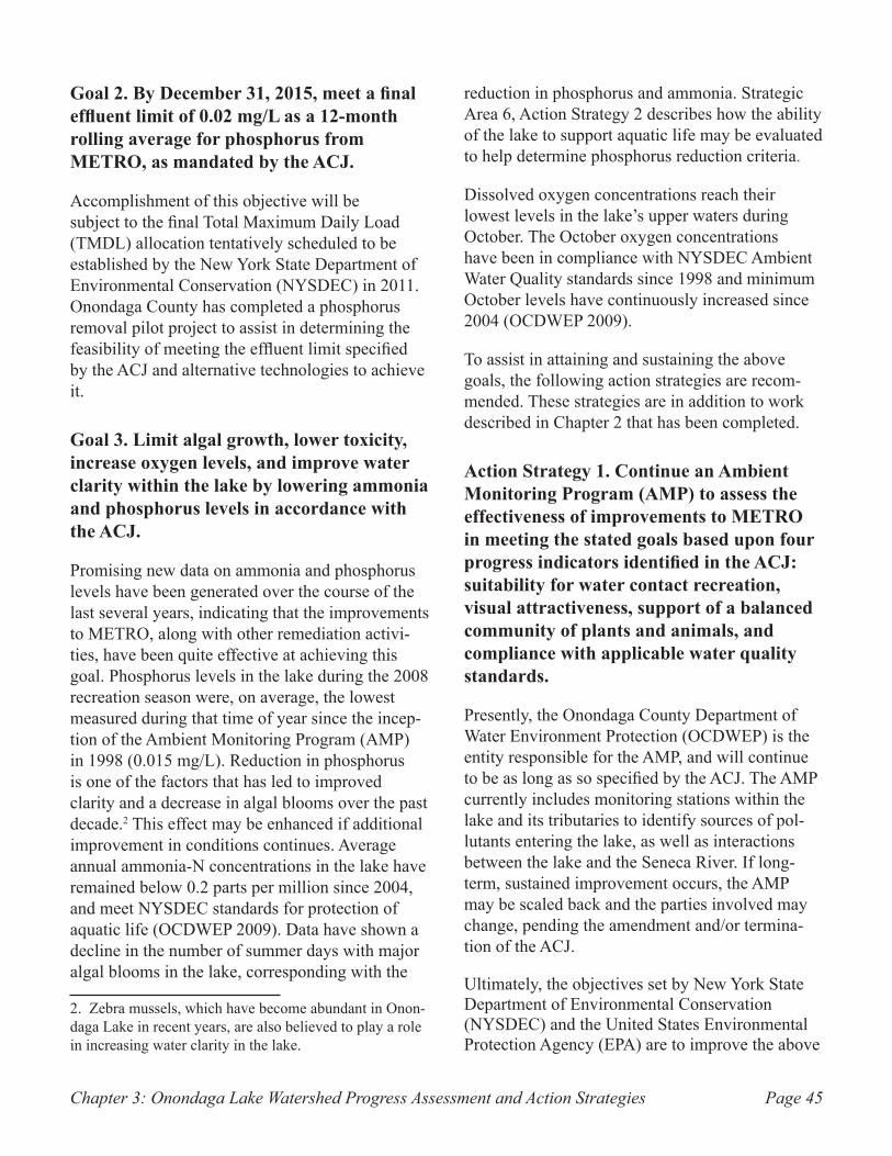
Chapter 3: Onondaga Lake Watershed Progress Assessment and Action Strategies Page 45
Goal 2. By December 31, 2015, meet a final effluent limit of 0.02 mg/L as a 12-month rolling average for phosphorus from METRO, as mandated by the ACJ.
Accomplishment of this objective will be subject to the final Total Maximum Daily Load (TMDL) allocation tentatively scheduled to be established by the New York State Department of Environmental Conservation (NYSDEC) in 2011. Onondaga County has completed a phosphorus removal pilot project to assist in determining the feasibility of meeting the effluent limit specified by the ACJ and alternative technologies to achieve it.
Goal 3. Limit algal growth, lower toxicity, increase oxygen levels, and improve water clarity within the lake by lowering ammonia and phosphorus levels in accordance with the ACJ.
Promising new data on ammonia and phosphorus levels have been generated over the course of the last several years, indicating that the improvements to METRO, along with other remediation activi-ties, have been quite effective at achieving this goal. Phosphorus levels in the lake during the 2008 recreation season were, on average, the lowest measured during that time of year since the incep-tion of the Ambient Monitoring Program (AMP) in 1998 (0.015 mg/L). Reduction in phosphorus is one of the factors that has led to improved clarity and a decrease in algal blooms over the past decade.2 This effect may be enhanced if additional improvement in conditions continues. Average annual ammonia-N concentrations in the lake have remained below 0.2 parts per million since 2004, and meet NYSDEC standards for protection of aquatic life (OCDWEP 2009). Data have shown a decline in the number of summer days with major algal blooms in the lake, corresponding with the
2. Zebra mussels, which have become abundant in Onon-daga Lake in recent years, are also believed to play a role in increasing water clarity in the lake.
reduction in phosphorus and ammonia. Strategic Area 6, Action Strategy 2 describes how the ability of the lake to support aquatic life may be evaluated to help determine phosphorus reduction criteria.
Dissolved oxygen concentrations reach their lowest levels in the lake’s upper waters during October. The October oxygen concentrations have been in compliance with NYSDEC Ambient Water Quality standards since 1998 and minimum October levels have continuously increased since 2004 (OCDWEP 2009).
To assist in attaining and sustaining the above goals, the following action strategies are recom-mended. These strategies are in addition to work described in Chapter 2 that has been completed.
Action Strategy 1. Continue an Ambient Monitoring Program (AMP) to assess the effectiveness of improvements to METRO in meeting the stated goals based upon four progress indicators identified in the ACJ: suitability for water contact recreation, visual attractiveness, support of a balanced community of plants and animals, and compliance with applicable water quality standards.
Presently, the Onondaga County Department of Water Environment Protection (OCDWEP) is the entity responsible for the AMP, and will continue to be as long as so specified by the ACJ. The AMP currently includes monitoring stations within the lake and its tributaries to identify sources of pol-lutants entering the lake, as well as interactions between the lake and the Seneca River. If long-term, sustained improvement occurs, the AMP may be scaled back and the parties involved may change, pending the amendment and/or termina-tion of the ACJ.
Ultimately, the objectives set by New York State Department of Environmental Conservation (NYSDEC) and the United States Environmental Protection Agency (EPA) are to improve the above
Chapter 3: Onondaga Lake Watershed Progress Assessment and Action StrategiesPage 46
progress indicators to levels capable of supporting the uses designated by water quality standards for the northern and southern parts of the lake. These include non-contact recreation (i.e. fishing and boating) (Class C) for the southern portion and contact recreation (Class B) for the northern part of the lake.3 (See “Effect of Water Quality on Recreational Activities,” page 36, which offers cautionary notes that apply to activities such as swimming, waterskiing, and kayaking.) A discus-sion of the water quality characteristics that affect suitability of the lake for swimming can be found on page 16 in Chapter 2.
Action Item:
1. Continue the Ambient Monitoring Program and adjust it as necessary on an annual basis in accordance with needs and available funds.
Monitoring data provide valuable information on environmental conditions, trends and data gaps. The AMP is presently designed with the primary purpose of documenting compliance with the ACJ. Modifications to the AMP can be made annually based on results and needed areas of evaluation, and any potential amendments to the ACJ will also impact the data that needs to be collected. The approximate annual cost of the program is $1.3 million. This figure is not expected to change sub-stantially in coming years while the ACJ remains in effect, but costs will reflect program needs relative to ACJ compliance. Annual cost may change substantially after the ACJ is terminated.
Action Strategy 2. Complete studies and models necessary to determine what improvements to METRO may be necessary to achieve the goals specified in the ACJ,
3. Classifications of water bodies are based on the most suitable usage designated for a given body of water or portion thereof. The designations are promulgated in Wa-ter Quality Regulations: Surface Water and Groundwater Classifications and Standards, 6NYCRR Parts 700-706, effective August 4, 1999, NYSDEC, Albany, New York.
and identify technologies to accomplish these improvements.
Action Items:
1. Complete modeling efforts to develop the Phos-phorus TMDL for the Onondaga Lake watershed.
On behalf of the OLP, Onondaga County has contracted with Anchor QEA, an environmental engineering firm, to complete the relevant modeling work. Assistance is being provided by a peer review committee currently coordinated by the Onondaga Environmental Institute (OEI). The work is funded by the EPA and U.S. Army Corps of Engineers (USACE).
The modeling effort in progress is the Onondaga Lake Water Quality Model (OLWQM), which is intended to provide a critical link between the Surface Water Watershed Model being developed by United States Geological Survey (USGS) and the existing Three Rivers Water Quality Model (TRWQM) completed by Anchor QEA on behalf of Onondaga County. The OLWQM is being developed in three phases: (1) development of the modeling work plan (complete), (2) development, calibration and initial application of the integrated lake/river model (complete), and (3) model valida-tion, integration with the watershed model, and application (expected to be complete in 2010).
The initial estimated expenditure approved by the OLP for the modeling effort was just over $1.3 million. This funding was later supplemented with an additional $490,000 for further work including Phase 3 of the modeling effort, and to allow Peer Review of the entire model. A bioavailability study and assessment of the effect of plunging inflows from tributaries are also required by the ACJ and will necessitate additional funds of approximately $400,000. These studies must be completed no later than December 31, 2010.

Chapter 3: Onondaga Lake Watershed Progress Assessment and Action Strategies Page 47
2. Re-evaluate the Stage III Phosphorus reduction criteria.
Under the terms of the ACJ, Onondaga County is required to demonstrate its ability to attain the phosphorus effluent limit of 0.02 mg/L by December 31, 2011. The County is also required, by August 31, 2011, to complete an analysis of its current facilities at METRO to determine if any improvement in phosphorus treatment is possible. The ACJ also requires feasibility analyses of the potential capacity of METRO to meet the effluent limit through additional engineering technologies, as well as through flow diversion to the Seneca River. In the event that the County is unable to demonstrate the ability to comply with this effluent limit, a flow diversion from METRO to the Seneca River (bypassing Onondaga Lake) must be com-pleted by December 31, 2015.
The solution for meeting the phosphorus effluent limits must not contribute to violation of water quality standards in the Seneca River. Before the NYSDEC can determine whether the flow diver-sion to the Seneca River is needed or appropriate, the allowable waste load that can be released
to Onondaga Lake (known as a TMDL) must be calculated. The TMDL will determine the maximum daily quantity of phosphorus allowed to enter the lake from METRO and all other sources. The results of the Advanced Phosphorus Removal Pilot Project report, completed June 28, 2007, may also be used to determine the technologies to be considered to achieve the final effluent limit. The phosphorus allocation for METRO, and its ability to meet this allocation, will help determine whether METRO’s discharge should be diverted to the Seneca River.
AMP data for the summer of 2008 demonstrated unprecedented improvement in lake water quality relative to phosphorus levels. Throughout the 2008 summer recreation season, total phosphorus main-tained an average level of 0.015 mg/L at Onondaga Lake South Station, the monitoring site closest to the METRO outfall. These data will be evaluated in conjunction with subsequent data to determine future actions and limits.
Action Strategy 3. In accordance with the 1993 OLMP, coordinate any construction activities that may occur relating to the potential renovation of METRO so as to minimize, to the extent possible, any negative impact on lakefront development and the surrounding community.
Recommendation:
1. If necessary, assess alternatives to METRO expansion activities to limit to the extent practical any additional impacts to lakefront access.
Because of METRO’s proximity to a potentially important redevelopment area, it will be beneficial to ensure close coordination between Onondaga County and city of Syracuse so that any expan-sion of METRO or the conveyance and treatment systems (if determined to be necessary) do not interfere with the city’s plans to develop the Inner Harbor or Lakefront areas. This process should also include coordination with the New York State
The frequency and severity of algal blooms Figure 3-2. such as this one in Onondaga Lake have declined significantly in recent years, due in part to major
improvements in METRO’s phosphorus removal pro-cesses. (Source: Central New York Regional Planning &
Development Board)
Chapter 3: Onondaga Lake Watershed Progress Assessment and Action StrategiesPage 48
Canal Corporation (NYSCC), which is presently involved in decisions regarding development in the Inner Harbor. More details on recommendations for the Inner Harbor are found under Strategic Area 7 in this chapter.
Strategic Area 2: Combined Sewer Overflows
Consistent with EPA policy, the ACJ states the fol-lowing goal to address combined sewer overflows:
Goal 1. In accordance with the ACJ, by December 31, 2018, eliminate or capture for treatment at least 95 percent of the volume of combined sewage collected during precipitation events in the pre-existing system, achieve water quality standards for bacteria in the lake and its tributaries, and eliminate or minimize the occurrence of floatable substances in the lake resulting from Combined Sewer Overflows (CSOs).
The above goal is to be accomplished by address-ing a total of 70 CSOs identified in the ACJ through use of green infrastructure, sewer separa-tion, Regional Treatment Facilities (RTFs), Float-ables Control Facilities (FCFs), or other practices as applicable so as to attain water quality standards within the lake. In order to achieve this, the action strategies identified below must be undertaken in addition to the completed work described in Chapter 2. Onondaga County is designated by the ACJ as the party responsible for completing the work described below in connection with CSO abatement, but will do so in coordination with the NYSDEC, EPA, the New York State Office of the Attorney General (NYSOAG), and the city of Syracuse.
Action Strategy 1. Implement the use of green infrastructure in combination with downsized engineered facilities to achieve
the CSO volume reduction benchmarks specified by the ACJ.
In 2007, the parties to the ACJ (Onondaga County, NYSDEC, and Atlantic States Legal Foundation (ASLF)) indicated an intention to assess the possible use of green infrastructure4 to address CSOs as the impetus for a possible modification to the ACJ. Green infrastructure is a term used to describe utilization of naturally occurring or human-made features, such as vegetated areas, to infiltrate stormwater or store it for gradual release. These actions can lower the volume of stormwater entering the city sewers, reducing CSOs and the associated discharge of untreated wastewater to Onondaga Lake and its tributaries. The parties to the ACJ are not convinced that sole reliance on conveyances, sewer separation, RTFs and FCFs (practices known as gray infrastructure) is the best approach to addressing CSOs in the Clinton Street, Midland, and Harbor Brook areas.
The parties to the ACJ presented a proposed fourth amendment to the ACJ in September 2009. The amendment, signed and approved on November 16, 2009, incorporates the use of green infrastructure into the CSO abatement program. A combination of gray and green infrastructure will be used to reduce the volume of flow ultimately released into combined sewers during precipitation events. An increased volume of stormwater will be captured onsite or close to the source, for reuse, plant uptake, or attenuation through infiltration into the soil, thereby reducing the stormwater volume entering CSOs.
4. The concept of green infrastructure includes many practices that have been shown to reduce runoff volume by capturing and retaining precipitation onsite, returning it directly to the atmosphere through evapotranspiration, or allowing it to infiltrate through the soil to the groundwater table. The use of green infrastructure has been shown to provide a number of ancillary benefits, including but not limited to aesthetic improvement, better air quality, miti-gation of heat absorbed by urban buildings (resulting in lower energy costs for cooling), increased property values, wildlife habitat, groundwater recharge, and treatment of runoff water to remove pollutants.
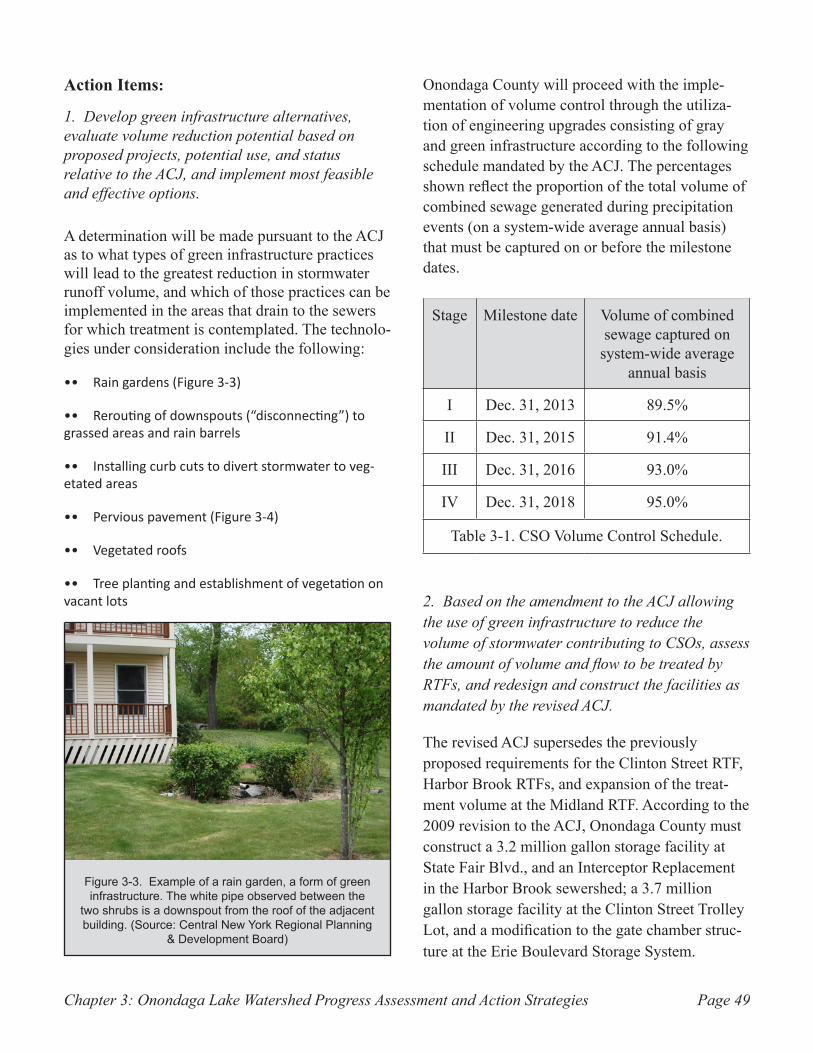
Chapter 3: Onondaga Lake Watershed Progress Assessment and Action Strategies Page 49
Action Items:
1. Develop green infrastructure alternatives, evaluate volume reduction potential based on proposed projects, potential use, and status relative to the ACJ, and implement most feasible and effective options.
A determination will be made pursuant to the ACJ as to what types of green infrastructure practices will lead to the greatest reduction in stormwater runoff volume, and which of those practices can be implemented in the areas that drain to the sewers for which treatment is contemplated. The technolo-gies under consideration include the following:
Rain gardens (Figure 3-3) ••
Rerouting of downspouts (“disconnecting”) to •• grassed areas and rain barrels
Installing curb cuts to divert stormwater to veg-•• etated areas
Pervious pavement (Figure 3-4)••
Vegetated roofs••
Tree planting and establishment of vegetation on •• vacant lots
Onondaga County will proceed with the imple-mentation of volume control through the utiliza-tion of engineering upgrades consisting of gray and green infrastructure according to the following schedule mandated by the ACJ. The percentages shown reflect the proportion of the total volume of combined sewage generated during precipitation events (on a system-wide average annual basis) that must be captured on or before the milestone dates.
Stage Milestone date Volume of combined sewage captured on
system-wide average annual basis
I Dec. 31, 2013 89.5%
II Dec. 31, 2015 91.4%
III Dec. 31, 2016 93.0%
IV Dec. 31, 2018 95.0%
Table 3-1. CSO Volume Control Schedule.
2. Based on the amendment to the ACJ allowing the use of green infrastructure to reduce the volume of stormwater contributing to CSOs, assess the amount of volume and flow to be treated by RTFs, and redesign and construct the facilities as mandated by the revised ACJ.
The revised ACJ supersedes the previously proposed requirements for the Clinton Street RTF, Harbor Brook RTFs, and expansion of the treat-ment volume at the Midland RTF. According to the 2009 revision to the ACJ, Onondaga County must construct a 3.2 million gallon storage facility at State Fair Blvd., and an Interceptor Replacement in the Harbor Brook sewershed; a 3.7 million gallon storage facility at the Clinton Street Trolley Lot, and a modification to the gate chamber struc-ture at the Erie Boulevard Storage System.
Example of a rain garden, a form of green Figure 3-3. infrastructure. The white pipe observed between the
two shrubs is a downspout from the roof of the adjacent building. (Source: Central New York Regional Planning
& Development Board)
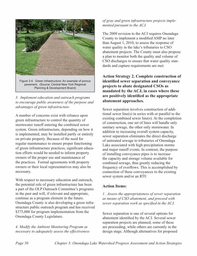
Chapter 3: Onondaga Lake Watershed Progress Assessment and Action StrategiesPage 50
3. Implement education and outreach programs to encourage public awareness of the purpose and advantages of green infrastructure.
A number of concerns exist with reliance upon green infrastructure to control the quantity of stormwater runoff entering the combined sewer system. Green infrastructure, depending on how it is implemented, may be installed partly or entirely on private property. Because of the need for regular maintenance to ensure proper functioning of green infrastructure practices, significant educa-tion efforts would be needed to inform property owners of the proper use and maintenance of the practices. Formal agreements with property owners or their local representatives may also be necessary.
With respect to necessary education and outreach, the potential role of green infrastructure has been a part of the OLP Outreach Committee’s programs in the past and will, if relevant and appropriate, continue as a program element in the future. Onondaga County is also developing a green infra-structure public outreach program and has received $375,000 for program implementation from the Onondaga County Legislature.
4. Modify the Ambient Monitoring Program as necessary to adequately assess the effectiveness
of gray and green infrastructure projects imple-mented pursuant to the ACJ.
The 2009 revision to the ACJ requires Onondaga County to implement a modified AMP no later than August 1, 2010, to assess the response of water quality in the lake’s tributaries to CSO abatement projects. The County must also propose a plan to monitor both the quality and volume of CSO discharges to ensure that water quality stan-dards and capture requirements are met.
Action Strategy 2. Complete construction of identified sewer separation and conveyance projects to abate designated CSOs as mandated by the ACJ, in cases where these are positively identified as the appropriate abatement approaches.
Sewer separation involves construction of addi-tional sewer line(s) in series with or parallel to the existing combined sewer line(s). At the completion of construction, one set of lines will handle only sanitary sewage, the other only stormwater. In addition to increasing overall system capacity, sewer separation eliminates the direct discharge of untreated sewage to tributaries of Onondaga Lake associated with high precipitation storms and major runoff events. In contrast, the purpose of installing conveyance pipes is to increase the capacity and storage volume available for combined sewage, thus greatly reducing the frequency of overflows. This is accomplished by connection of these conveyances to the existing sewer system and/or an RTF.
Action Items:
1. Assess the appropriateness of sewer separation as means of CSO abatement, and proceed with sewer separation work as specified in the ACJ.
Sewer separation is one of several options for abatement identified by the ACJ. Several sewer separation projects are planned; some of these are proceeding, while others are currently in the design stage. Although alternatives for proposed
Green infrastructure: An example of porous Figure 3-4. pavement. (Source: Central New York Regional
Planning & Development Board)
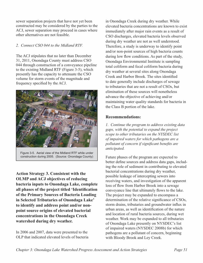
Chapter 3: Onondaga Lake Watershed Progress Assessment and Action Strategies Page 51
sewer separation projects that have not yet been constructed may be considered by the parties to the ACJ, sewer separation may proceed in cases where other alternatives are not feasible.
2. Connect CSO 044 to the Midland RTF.
The ACJ stipulates that no later than December 31, 2011, Onondaga County must address CSO 044 through construction of a conveyance pipeline to the existing Midland RTF (Figure 3-5), which presently has the capacity to attenuate the CSO volume for storm events of the magnitude and frequency specified by the ACJ.
Action Strategy 3. Consistent with the OLMP and ACJ objectives of reducing bacteria inputs to Onondaga Lake, complete all phases of the project titled ‘Identification of the Primary Sources of Bacteria Loading in Selected Tributaries of Onondaga Lake’ to identify and address point and/or non-point source origins of elevated bacterial concentrations in the Onondaga Creek watershed during dry weather.
In 2006 and 2007, data were presented to the OLP that indicated elevated levels of bacteria
in Onondaga Creek during dry weather. While elevated bacteria concentrations are known to exist immediately after major rain events as a result of CSO discharges, elevated bacteria levels observed during dry weather are not as well understood. Therefore, a study is underway to identify point and/or non-point sources of high bacteria counts during low flow conditions. As part of the study, Onondaga Environmental Institute is sampling total coliform and fecal coliform bacteria during dry weather at several sites along Onondaga Creek and Harbor Brook. The sites identified to date generally include discharges of sewage to tributaries that are not a result of CSOs, but elimination of these sources will nonetheless advance the objective of achieving and/or maintaining water quality standards for bacteria in the Class B portion of the lake.
Recommendations:
1. Continue the program to address existing data gaps, with the potential to expand the project scope to other tributaries on the NYSDEC list of impaired waters for which pathogens are a pollutant of concern if significant benefits are anticipated.
Future phases of the program are expected to better define sources and address data gaps, includ-ing the role of sediment in contributing to elevated bacterial concentrations during dry weather, possible leakage of intercepting sewers into receiving waters, and investigation of the apparent loss of flow from Harbor Brook into a sewage conveyance line that ultimately flows to the lake. The project may be expanded to encompass a determination of the relative significance of CSOs, storm drains, tributaries and groundwater influx in urban areas, as well as identification of the nature and location of rural bacteria sources, during wet weather. Work may be expanded to all tributaries of Onondaga Lake presently on NYSDEC’s list of impaired waters (NYSDEC 2008b) for which pathogens are a pollutant of concern, beginning with Bloody Brook and Ley Creek.
Aerial view of the Midland RTF while under Figure 3-5. construction during 2005. (Source: Onondaga County)
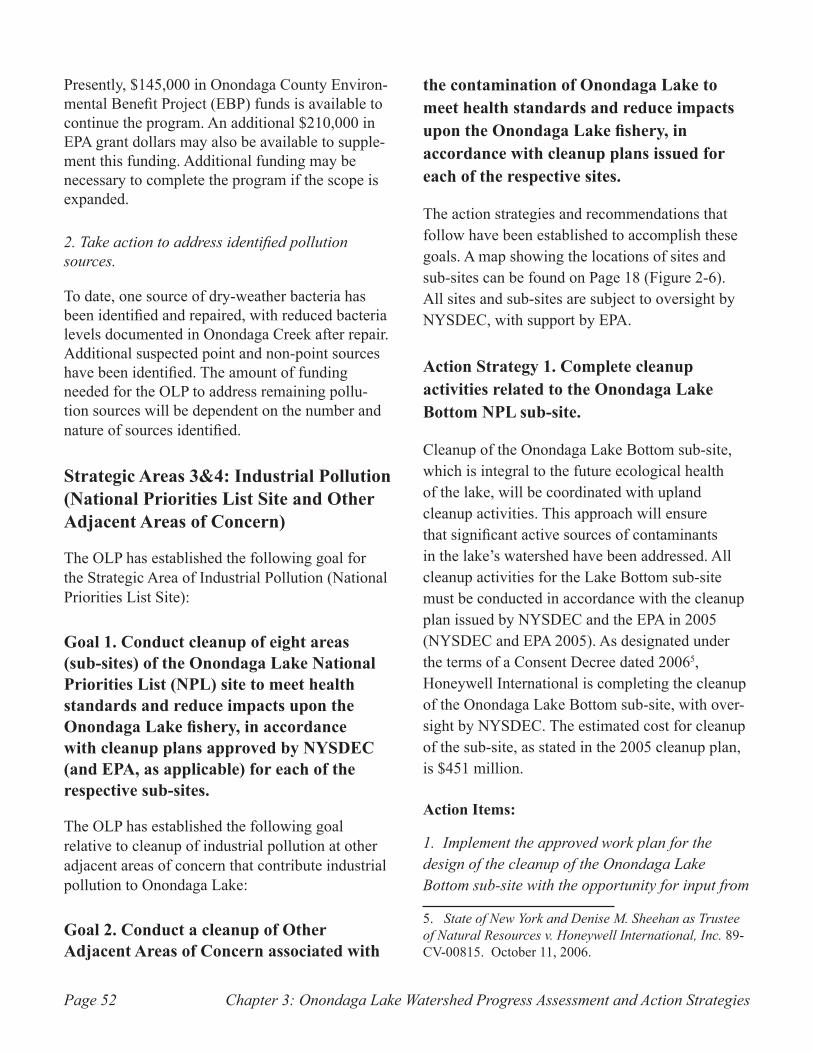
Chapter 3: Onondaga Lake Watershed Progress Assessment and Action StrategiesPage 52
Presently, $145,000 in Onondaga County Environ-mental Benefit Project (EBP) funds is available to continue the program. An additional $210,000 in EPA grant dollars may also be available to supple-ment this funding. Additional funding may be necessary to complete the program if the scope is expanded.
2. Take action to address identified pollution sources.
To date, one source of dry-weather bacteria has been identified and repaired, with reduced bacteria levels documented in Onondaga Creek after repair. Additional suspected point and non-point sources have been identified. The amount of funding needed for the OLP to address remaining pollu-tion sources will be dependent on the number and nature of sources identified.
Strategic Areas 3&4: Industrial Pollution (National Priorities List Site and Other Adjacent Areas of Concern)
The OLP has established the following goal for the Strategic Area of Industrial Pollution (National Priorities List Site):
Goal 1. Conduct cleanup of eight areas (sub-sites) of the Onondaga Lake National Priorities List (NPL) site to meet health standards and reduce impacts upon the Onondaga Lake fishery, in accordance with cleanup plans approved by NYSDEC (and EPA, as applicable) for each of the respective sub-sites.
The OLP has established the following goal relative to cleanup of industrial pollution at other adjacent areas of concern that contribute industrial pollution to Onondaga Lake:
Goal 2. Conduct a cleanup of Other Adjacent Areas of Concern associated with
the contamination of Onondaga Lake to meet health standards and reduce impacts upon the Onondaga Lake fishery, in accordance with cleanup plans issued for each of the respective sites.
The action strategies and recommendations that follow have been established to accomplish these goals. A map showing the locations of sites and sub-sites can be found on Page 18 (Figure 2-6). All sites and sub-sites are subject to oversight by NYSDEC, with support by EPA.
Action Strategy 1. Complete cleanup activities related to the Onondaga Lake Bottom NPL sub-site.
Cleanup of the Onondaga Lake Bottom sub-site, which is integral to the future ecological health of the lake, will be coordinated with upland cleanup activities. This approach will ensure that significant active sources of contaminants in the lake’s watershed have been addressed. All cleanup activities for the Lake Bottom sub-site must be conducted in accordance with the cleanup plan issued by NYSDEC and the EPA in 2005 (NYSDEC and EPA 2005). As designated under the terms of a Consent Decree dated 20065, Honeywell International is completing the cleanup of the Onondaga Lake Bottom sub-site, with over-sight by NYSDEC. The estimated cost for cleanup of the sub-site, as stated in the 2005 cleanup plan, is $451 million.
Action Items:
1. Implement the approved work plan for the design of the cleanup of the Onondaga Lake Bottom sub-site with the opportunity for input from
5. State of New York and Denise M. Sheehan as Trustee of Natural Resources v. Honeywell International, Inc. 89-CV-00815. October 11, 2006.
Chapter 3: Onondaga Lake Watershed Progress Assessment and Action Strategies Page 53
Citizen Participation working groups and other public involvement efforts.
Following the issuance of the cleanup plan, NYSDEC and Honeywell International formed several technical work groups to expedite the design process and adapt the design to new infor-mation that becomes available. The technical work groups are focused on the various design aspects of the project. The Work Plan for design and construction was finalized in March 2009 (Parsons 2009b).
NYSDEC is involving and informing the public throughout the course of the design and construc-tion process in accordance with the March 2009 Citizen Participation Plan (NYSDEC 2009). Public involvement is occurring through information meetings, stakeholder outreach, roundtable discus-sions with NYSDEC and Honeywell International representatives, and formal Citizen Participa-tion working groups. The Citizen Participation working groups will continue to meet throughout the cleanup efforts, providing a forum to inform, receive input, and discuss the lake bottom reme-diation and citizen participation programs.
2. Complete a comprehensive plan for habitat restoration of disturbed areas, including partial shoreline restoration.
The 2006 Consent Decree requires Honeywell International to restore all areas subject to dredging and capping activities following their completion. The draft Habitat Restoration Plan was released for public information in 2009 (Parsons 2009a) and will be completed in 2010. This plan will address issues such as thickness and composition of the lake bottom habitat layer, miti-gation of lake surface area, and wetland mitigation.
3. Finalize design documents for the sediment consolidation area (SCA).
The SCA, which will be constructed on Wastebed 13, will be the disposal area for most materials
dredged from the lake bottom. Required compo-nents include a cap, liner, and wastewater collec-tion and treatment system. Design of the SCA is anticipated to be complete in 2010 and construc-tion is to begin in 2011.
4. Design and construct water treatment facilities.
The design of water treatment measures, including selection of technologies for treatment and the development of an operation and maintenance plan for the water treatment plant, is expected to be completed by 2010. Construction of the water treatment facility must be completed by 2012. Once constructed, the water treatment facility will treat water removed from the SCA and stormwater runoff.
5. Complete a design and performance monitoring plan for dredging operations.
The design for dredging operations, which will specify the methods for dredging and the locations of lake bottom dredging activities, is anticipated to be completed in 2011. Dredging operations will focus on areas containing high concentrations of mercury and other contaminants. The performance monitoring plan for the dredging operations is due to be completed in 2012. The purpose of the performance monitoring plan is to ensure that dredging operations are conducted with due care and in conformance with all applicable envi-ronmental requirements, to minimize the risk of pollutant release to the lake. Dredging operations are scheduled to begin in May 2012, and conclude in 2016.
6. Complete a design for capping of lake bottom sediments by the end of 2011.
Two methods of capping will be used; isolation capping and thin-layer capping. Isolation capping is used to completely isolate the underlying material from the surrounding environment. Thin-layer capping is used over less polluted sediments where natural recovery may be possible through
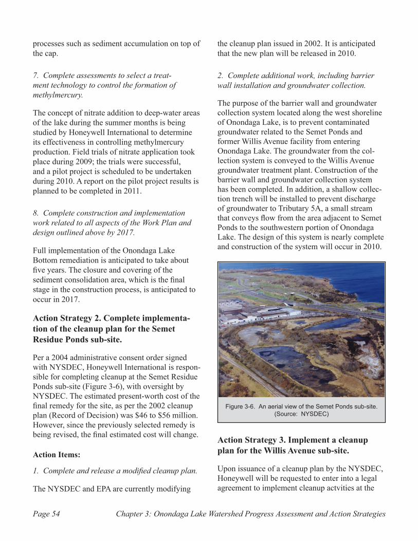
Chapter 3: Onondaga Lake Watershed Progress Assessment and Action StrategiesPage 54
processes such as sediment accumulation on top of the cap.
7. Complete assessments to select a treat-ment technology to control the formation of methylmercury.
The concept of nitrate addition to deep-water areas of the lake during the summer months is being studied by Honeywell International to determine its effectiveness in controlling methylmercury production. Field trials of nitrate application took place during 2009; the trials were successful, and a pilot project is scheduled to be undertaken during 2010. A report on the pilot project results is planned to be completed in 2011.
8. Complete construction and implementation work related to all aspects of the Work Plan and design outlined above by 2017.
Full implementation of the Onondaga Lake Bottom remediation is anticipated to take about five years. The closure and covering of the sediment consolidation area, which is the final stage in the construction process, is anticipated to occur in 2017.
Action Strategy 2. Complete implementa-tion of the cleanup plan for the Semet Residue Ponds sub-site.
Per a 2004 administrative consent order signed with NYSDEC, Honeywell International is respon-sible for completing cleanup at the Semet Residue Ponds sub-site (Figure 3-6), with oversight by NYSDEC. The estimated present-worth cost of the final remedy for the site, as per the 2002 cleanup plan (Record of Decision) was $46 to $56 million. However, since the previously selected remedy is being revised, the final estimated cost will change.
Action Items:
1. Complete and release a modified cleanup plan.
The NYSDEC and EPA are currently modifying
the cleanup plan issued in 2002. It is anticipated that the new plan will be released in 2010.
2. Complete additional work, including barrier wall installation and groundwater collection.
The purpose of the barrier wall and groundwater collection system located along the west shoreline of Onondaga Lake, is to prevent contaminated groundwater related to the Semet Ponds and former Willis Avenue facility from entering Onondaga Lake. The groundwater from the col-lection system is conveyed to the Willis Avenue groundwater treatment plant. Construction of the barrier wall and groundwater collection system has been completed. In addition, a shallow collec-tion trench will be installed to prevent discharge of groundwater to Tributary 5A, a small stream that conveys flow from the area adjacent to Semet Ponds to the southwestern portion of Onondaga Lake. The design of this system is nearly complete and construction of the system will occur in 2010.
Action Strategy 3. Implement a cleanup plan for the Willis Avenue sub-site.
Upon issuance of a cleanup plan by the NYSDEC, Honeywell will be requested to enter into a legal agreement to implement cleanup actvities at the
An aerial view of the Semet Ponds sub-site. Figure 3-6. (Source: NYSDEC)
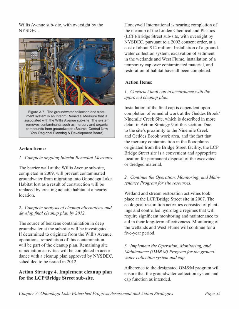
Chapter 3: Onondaga Lake Watershed Progress Assessment and Action Strategies Page 55
Willis Avenue sub-site, with oversight by the NYSDEC.
Action Items:
1. Complete ongoing Interim Remedial Measures.
The barrier wall at the Willis Avenue sub-site, completed in 2009, will prevent contaminated groundwater from migrating into Onondaga Lake. Habitat lost as a result of construction will be replaced by creating aquatic habitat at a nearby location.
2. Complete analysis of cleanup alternatives and develop final cleanup plan by 2012.
The source of benzene contamination in deep groundwater at the sub-site will be investigated. If determined to originate from the Willis Avenue operations, remediation of this contamination will be part of the cleanup plan. Remaining site remediation activities will be completed in accor-dance with a cleanup plan approved by NYSDEC, scheduled to be issued in 2012.
Action Strategy 4. Implement cleanup plan for the LCP/Bridge Street sub-site.
Honeywell International is nearing completion of the cleanup of the Linden Chemical and Plastics (LCP)/Bridge Street sub-site, with oversight by NYSDEC, pursuant to a 2002 consent order, at a cost of about $14 million. Installation of a ground-water collection system, excavation of sediment in the wetlands and West Flume, installation of a temporary cap over contaminated material, and restoration of habitat have all been completed.
Action Items:
1. Construct final cap in accordance with the approved cleanup plan.
Installation of the final cap is dependent upon completion of remedial work at the Geddes Brook/Ninemile Creek Site, which is described in more detail in Action Strategy 9 of this section. Due to the site’s proximity to the Ninemile Creek and Geddes Brook work area, and the fact that the mercury contamination in the floodplains originated from the Bridge Street facility, the LCP Bridge Street site is a convenient and appropriate location for permanent disposal of the excavated or dredged material.
2. Continue the Operation, Monitoring, and Main-tenance Program for site resources.
Wetland and stream restoration activities took place at the LCP/Bridge Street site in 2007. The ecological restoration activities consisted of plant-ings and controlled hydrologic regimes that will require significant monitoring and maintenance to aid in their long-term effectiveness. Monitoring of the wetlands and West Flume will continue for a five-year period.
3. Implement the Operation, Monitoring, and Maintenance (OM&M) Program for the ground-water collection system and cap.
Adherence to the designated OM&M program will ensure that the groundwater collection system and cap function as intended.
The groundwater collection and treat-Figure 3-7. ment system is an Interim Remedial Measure that is
associated with the Willis Avenue sub-site. The system removes contaminants such as mercury and organic compounds from groundwater. (Source: Central New
York Regional Planning & Development Board)
Chapter 3: Onondaga Lake Watershed Progress Assessment and Action StrategiesPage 56
Action Strategy 5. Implement cleanup plan for Wastebed B/ Harbor Brook sub-site.
Upon entering into a consent order with NYSDEC, Honeywell International will be responsible for cleanup of the Wastebed B/ Harbor Brook sub-site, with oversight by NYSDEC.
Action Items:
1. Complete analysis of cleanup alternatives and development of final cleanup plan.
A revised Remedial Investigation (RI) Report and draft Feasibility Study (FS) Report are scheduled to be submitted by 2010. NYSDEC and EPA will issue, and Honeywell will implement, the final cleanup plan for the site including commencement of any necessary habitat restoration work by 2012.
2. Complete installation of barrier wall and groundwater collection system.
The Wastebed B/Harbor Brook barrier wall and groundwater collection system project is underway. Construction of the western portion of the wall commenced in 2009. Construction of the eastern wall and upper Harbor Brook sections are anticipated to begin in 2010. It is expected that the construction will be completed in 2012.
Action Strategy 6. Implement cleanup plan for the Salina Town Landfill sub-site.
In accordance with a State Assistance Contract and a consent order with NYSDEC, the town of Salina has agreed to perform cleanup of the Salina Town Landfill sub-site, with financial assistance and oversight by NYSDEC. The total estimated cost of the Salina Town Landfill site cleanup is $23.5 million, according to the NYSDEC cleanup plan (NYSDEC and EPA 2007).
Action Items:
1. Design and construct a leachate and ground-
water collection trench system.
The leachate and groundwater collection system will remove contaminated groundwater from the landfill. Design of the system will be completed in 2010, and construction of the system will commence in the same year. This system will be accompanied by the design and construction of an onsite groundwater and leachate pre-treatment plant. Pre-treated leachate and groundwater will be routed to the Metropolitan Syracuse Wastewater Treatment Plant (METRO).
2. Implement remaining site cleanup activities.
Remaining remediation activities include excava-tion and consolidation of contaminated sediments, capping of landfill areas north and south of Ley Creek, construction of drainage controls and fencing, and construction of a 150,000 gallon storage tank for excess stormwater. These actions are due to be completed in 2011. Long-term monitoring and maintenance of the site will also commence at this time.
3. Implement institutional controls to prohibit residential use and other incompatible uses in accordance with the cleanup plan, and determine the best allowable use of the property.
Required actions to establish the ultimate use of the landfill site are due to be completed by 2012.
Action Strategy 7. Implement cleanup plan for the General Motors (GM) Inland Fisher Guide (IFG) Facility sub-site.
Upon entering into consent order with NYSDEC, GM will be responsible for cleanup of the IFG site, with oversight by NYSDEC.
Action Item:
1. Implement the cleanup plan for sediment and groundwater contamination, to be issued by
Chapter 3: Onondaga Lake Watershed Progress Assessment and Action Strategies Page 57
NYSDEC by 2012.
The remaining site impacts are to sediment and groundwater, which are contaminated with poly-chlorinated biphenyls (PCBs), volatile organic compounds (VOCs) from solvents, and metals. Effects of the groundwater contamination on adjacent wetlands are being evaluated.
Action Strategy 8. Ensure continued effectiveness of completed cleanup activities at the Ley Creek PCB Dredgings sub-site.
In accordance with a 1997 cleanup plan (NYSDEC 1997), and under the terms of a 1999 consent order signed with NYSDEC, GM is responsible for con-tinued maintenance of the Ley Creek contaminated sediment disposal sub-site. Oversight by NYSDEC will continue. Cleanup activities have been fully implemented at the site for a cost of approximately $6.7 million.
Action Item:
1. Continue maintenance and monitoring program at the site, and complete five-year review of the site activities by January 2012.
Ongoing activities include maintenance accom-panied by environmental monitoring at the site to ensure that the remedies continue to remain effective.
Action Strategy 9. Develop and implement a plan for the cleanup of the Geddes Brook/Ninemile Creek floodplain soils and sediments.
The Geddes Brook/Ninemile Creek site is consid-ered an extension of the Onondaga Lake Bottom NPL sub-site. Upon entering into a legal agree-ment with the NYSDEC, Honeywell International will implement the cleanup of the Geddes Brook and Ninemile Creek floodplain sediments, with oversight by NYSDEC. Sediments within the floodplains of Geddes Brook and Ninemile Creek
are contaminated with mercury and other toxic substances; these streams have been the major pathway of mercury contamination to Onondaga Lake. It is critical that the source and avenue of pollution be removed in order to prevent possible recontamination of the remediated lake bottom (as discussed under Strategic Area 3).
Action Items:
1. Complete the cleanup plan and remedial design, and implement cleanup activities.
A cleanup plan for the first phase of work (lower Geddes Brook and the “upstream” portion of Ninemile Creek) was finalized by NYSDEC in April 2009 (NYSDEC and EPA 2009a). This phase includes the lowermost segment of Geddes Brook and the “upstream” portion of Ninemile Creek, which is the section adjacent to Wastebeds 9 and 10. The document details plans for excavation, consolidation and capping of contaminated sedi-ments from the stream channel and floodplain. The cleanup plan includes dredging and excavation of 59,000 cubic yards of material with a total remediation area of 14.7 acres, and capping of some of the area. The channel and floodplain will be completely remediated under this option. Dredged sediment will be deposited and capped at the nearby LCP/Bridge Street sub-site or at the sediment consolidation area being constructed on Wastebed 13 as part of the remediation of Onondaga Lake. This cleanup is estimated to require a capital cost expenditure of $18.9 million, with an average annual maintenance cost of $105,000. Total construction time required for implementation would be approximately two years; construction will commence in 2010.
The final cleanup plan for the second phase of work (the “downstream” portion of Ninemile Creek) was issued by NYSDEC in October 2009 (NYSDEC and EPA 2009b). The second phase includes the reach of Ninemile Creek downstream of Route 690. Under the proposed cleanup plan, 58,000 cubic yards of contaminated sediment will be removed from an area of approximately 15
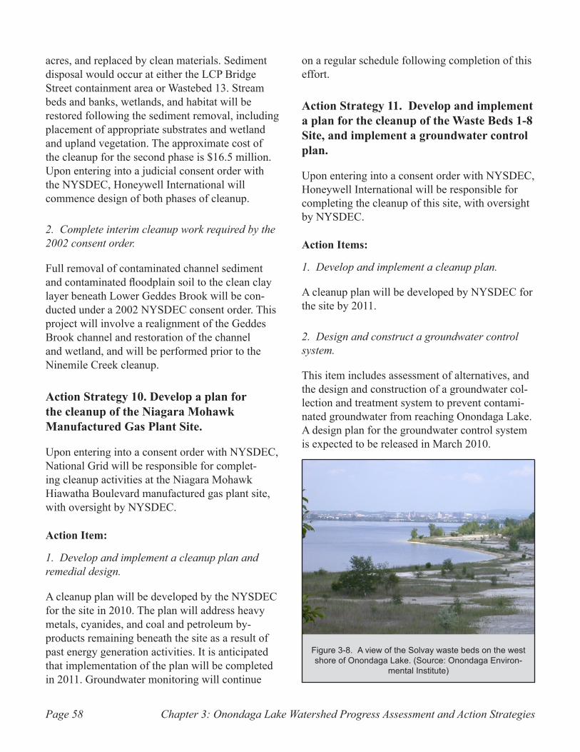
Chapter 3: Onondaga Lake Watershed Progress Assessment and Action StrategiesPage 58
acres, and replaced by clean materials. Sediment disposal would occur at either the LCP Bridge Street containment area or Wastebed 13. Stream beds and banks, wetlands, and habitat will be restored following the sediment removal, including placement of appropriate substrates and wetland and upland vegetation. The approximate cost of the cleanup for the second phase is $16.5 million. Upon entering into a judicial consent order with the NYSDEC, Honeywell International will commence design of both phases of cleanup.
2. Complete interim cleanup work required by the 2002 consent order.
Full removal of contaminated channel sediment and contaminated floodplain soil to the clean clay layer beneath Lower Geddes Brook will be con-ducted under a 2002 NYSDEC consent order. This project will involve a realignment of the Geddes Brook channel and restoration of the channel and wetland, and will be performed prior to the Ninemile Creek cleanup.
Action Strategy 10. Develop a plan for the cleanup of the Niagara Mohawk Manufactured Gas Plant Site.
Upon entering into a consent order with NYSDEC, National Grid will be responsible for complet-ing cleanup activities at the Niagara Mohawk Hiawatha Boulevard manufactured gas plant site, with oversight by NYSDEC.
Action Item:
1. Develop and implement a cleanup plan and remedial design.
A cleanup plan will be developed by the NYSDEC for the site in 2010. The plan will address heavy metals, cyanides, and coal and petroleum by-products remaining beneath the site as a result of past energy generation activities. It is anticipated that implementation of the plan will be completed in 2011. Groundwater monitoring will continue
on a regular schedule following completion of this effort.
Action Strategy 11. Develop and implement a plan for the cleanup of the Waste Beds 1-8 Site, and implement a groundwater control plan.
Upon entering into a consent order with NYSDEC, Honeywell International will be responsible for completing the cleanup of this site, with oversight by NYSDEC.
Action Items:
1. Develop and implement a cleanup plan.
A cleanup plan will be developed by NYSDEC for the site by 2011.
2. Design and construct a groundwater control system.
This item includes assessment of alternatives, and the design and construction of a groundwater col-lection and treatment system to prevent contami-nated groundwater from reaching Onondaga Lake. A design plan for the groundwater control system is expected to be released in March 2010.
A view of the Solvay waste beds on the west Figure 3-8. shore of Onondaga Lake. (Source: Onondaga Environ-
mental Institute)
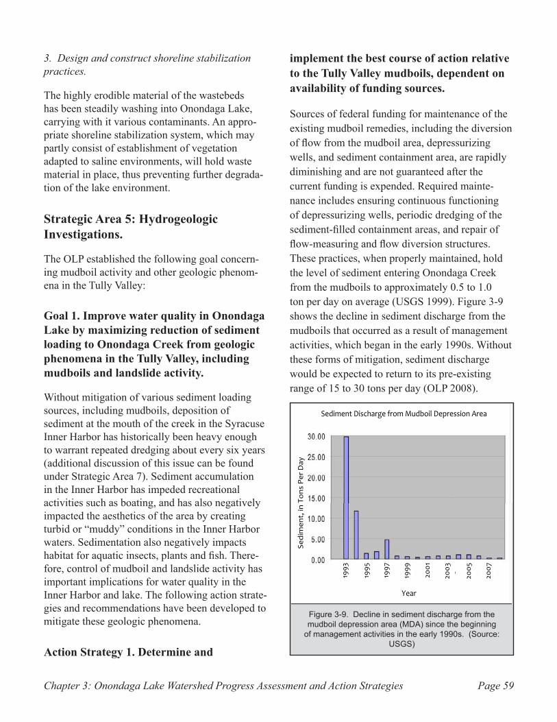
Chapter 3: Onondaga Lake Watershed Progress Assessment and Action Strategies Page 59
3. Design and construct shoreline stabilization practices.
The highly erodible material of the wastebeds has been steadily washing into Onondaga Lake, carrying with it various contaminants. An appro-priate shoreline stabilization system, which may partly consist of establishment of vegetation adapted to saline environments, will hold waste material in place, thus preventing further degrada-tion of the lake environment.
Strategic Area 5: Hydrogeologic Investigations.
The OLP established the following goal concern-ing mudboil activity and other geologic phenom-ena in the Tully Valley:
Goal 1. Improve water quality in Onondaga Lake by maximizing reduction of sediment loading to Onondaga Creek from geologic phenomena in the Tully Valley, including mudboils and landslide activity.
Without mitigation of various sediment loading sources, including mudboils, deposition of sediment at the mouth of the creek in the Syracuse Inner Harbor has historically been heavy enough to warrant repeated dredging about every six years (additional discussion of this issue can be found under Strategic Area 7). Sediment accumulation in the Inner Harbor has impeded recreational activities such as boating, and has also negatively impacted the aesthetics of the area by creating turbid or “muddy” conditions in the Inner Harbor waters. Sedimentation also negatively impacts habitat for aquatic insects, plants and fish. There-fore, control of mudboil and landslide activity has important implications for water quality in the Inner Harbor and lake. The following action strate-gies and recommendations have been developed to mitigate these geologic phenomena.
Action Strategy 1. Determine and
implement the best course of action relative to the Tully Valley mudboils, dependent on availability of funding sources.
Sources of federal funding for maintenance of the existing mudboil remedies, including the diversion of flow from the mudboil area, depressurizing wells, and sediment containment area, are rapidly diminishing and are not guaranteed after the current funding is expended. Required mainte-nance includes ensuring continuous functioning of depressurizing wells, periodic dredging of the sediment-filled containment areas, and repair of flow-measuring and flow diversion structures. These practices, when properly maintained, hold the level of sediment entering Onondaga Creek from the mudboils to approximately 0.5 to 1.0 ton per day on average (USGS 1999). Figure 3-9 shows the decline in sediment discharge from the mudboils that occurred as a result of management activities, which began in the early 1990s. Without these forms of mitigation, sediment discharge would be expected to return to its pre-existing range of 15 to 30 tons per day (OLP 2008).
Decline in sediment discharge from the Figure 3-9. mudboil depression area (MDA) since the beginning
of management activities in the early 1990s. (Source: USGS)
10
Strategic Area 5: Hydrogeologic Investigations
In Tully Valley, 18 miles south of Syracuse, hydrogeologic features called mudboils have contributed significant amounts of sediment to Onondaga Creek by discharging sediment‐filled water at the land surface. Heavier sand particles settle to the creek bottom while the finer‐grained silt and clay are carried by water in the creek, sometimes as far as the Inner Harbor of Onondaga Lake. During high flow events, the coarser sand becomes re‐suspended, and can eventually be deposited at the Inner Harbor. Sedimentation negatively impacts habitat for aquatic insects, plants, and fish.
In 1991, a Mudboil Working Group of local, State and Federal agencies was created by the Onondaga Lake Management Conference (OLMC) to study potential solutions to the problem. It was learned that flow from the mudboils varies seasonally in response to changes in artesian pressure. The mudboils are most active in the spring, when groundwater recharge is highest. In 1992, surface water flow to the mudboil depression area, or MDA (the main area of mudboil activity) was diverted to a tributary of Onondaga Creek, reducing flow into the MDA and causing sediment load from the area to Onondaga Creek to decrease by 50 percent. Installation of depressurizing wells, along with construction of an impoundment dam to capture sediment, further reduced sediment load from the mudboils to only 5 percent of its original level.
Continuation of these mitigation efforts requires maintenance and monitoring presently provided by the United States Geological Survey (USGS). Because available funding is limited, the Onondaga Lake Partnership (OLP) is examining several options for long‐term management of the mudboils. With assistance from the United States Environmental Protection Agency (EPA), the OLP has completed two pilot projects to study how to reduce water from entering the aquifer up‐gradient of the mudboil area in an attempt to develop a new control strategy.
Sediment loading to Onondaga Creek also results from erosion of stream banks and roadway embankments, as well as past and ongoing landslide activity. On April 27, 1993, a large landslide occurred at the base of Bare Mountain in the town of LaFayette, 2 miles north of the mudboils. This landslide was triggered by excessive amounts of water within the soils above the slide area, and slow deformation of the land surface prior to this slide. Other landslides in the Rattlesnake Gulf and Rainbow Creek valleys are ongoing and are related to fine‐grained glacial sediments on very steep hillsides which periodically slide into their respective streams. These slides contribute at least as much sediment to the Creek as do the mudboils with the current remedial measures in place in and near the MDA.
Since mudboil management began, sediment load to Onondaga Creek from the Tully Valley Mudboils has declined from 30 tons per day to less than 1 ton
per day. (Source: USGS)
Diagram showing the 1993 landslide in Tully Valley. The dotted line is the location of Tully Farms Road. (Source: USGS)
Sediment Discharge from Mudboil Depression Area
Sedimen
t, in Tons Per Day
Year
1993
1995
1997
1999
2001
2003
2005
2007
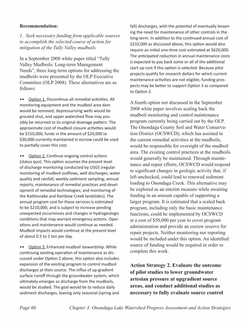
Chapter 3: Onondaga Lake Watershed Progress Assessment and Action StrategiesPage 60
Recommendation:
1. Seek necessary funding from applicable sources to accomplish the selected course of action for mitigation of the Tully Valley mudboils.
In a September 2008 white paper titled “Tully Valley Mudboils: Long-term Management Needs”, three long-term options for addressing the mudboils were presented by the OLP Executive Committee (OLP 2008). These alternatives are as follows:
Option 1.•• Discontinue all remedial activities. All monitoring equipment and the mudboil area dam would be removed, depressurizing wells would be grouted shut, and upper watershed flow may pos-sibly be returned to its original drainage pattern. The approximate cost of mudboil closure activities would be $150,000; funds in the amount of $20,000 to $30,000 currently maintained in escrow could be used to partially cover this cost.
Option 2.•• Continue ongoing control actions (status quo). This option assumes the present level of discharge monitoring conducted by USGS (regular monitoring of mudboil outflows, well discharges, water quality and rainfall; weekly sediment sampling; annual reports; maintenance of remedial practices and devel-opment of remedial technologies; and monitoring of the Rattlesnake and Rainbow Creek landslides). The annual program cost for these services is estimated to be $210,000, and is subject to increase pending unexpected occurrences and changes in hydrogeologic conditions that may warrant emergency actions. Oper-ations and maintenance would continue as needed. Mudboil impacts would continue at the present level of about 0.5 to 1 ton per day.
Option 3.•• Enhanced mudboil stewardship. While continuing existing operation of maintenance as dis-cussed under Option 2 above, this option also includes expansion of the existing program to control mudboil discharges at their source. The influx of up-gradient surface runoff through the groundwater system, which ultimately emerges as discharge from the mudboils, would be studied. The goal would be to reduce daily sediment discharges, leaving only seasonal (spring and
fall) discharges, with the potential of eventually lessen-ing the need for maintenance of other controls in the long-term. In addition to the continued annual cost of $210,000 as discussed above, this option would also require an initial one-time cost estimated at $620,000. The anticipated reduction in annual maintenance costs is expected to pay back some or all of the additional start up cost if this option is selected. Because pilot projects qualify for research dollars for which current maintenance activities are not eligible, funding pros-pects may be better to support Option 3 as compared to Option 2.
A fourth option not discussed in the September 2008 white paper involves scaling back the mudboil monitoring and control maintenance program currently being carried out by the OLP. The Onondaga County Soil and Water Conserva-tion District (OCSWCD), which has assisted in the current remedial activities at the mudboils, would be responsible for oversight of the mudboil area. The existing control practices at the mudboils would generally be maintained. Through mainte-nance and repair efforts, OCSWCD would respond to significant changes in geologic activity that, if left unchecked, could lead to renewed sediment loading to Onondaga Creek. This alternative may be explored as an interim measure while awaiting funding in an amount capable of supporting a larger program. It is estimated that a scaled back program, including only the basic maintenance functions, could be implemented by OCSWCD at a cost of $50,000 per year to cover program administration and provide an escrow reserve for repair projects. Neither monitoring nor reporting would be included under this option. An identified source of funding would be required in order to complete this work.
Action Strategy 2. Evaluate the outcome of pilot studies to lower groundwater artesian pressure at upgradient source areas, and conduct additional studies as necessary to fully evaluate source control
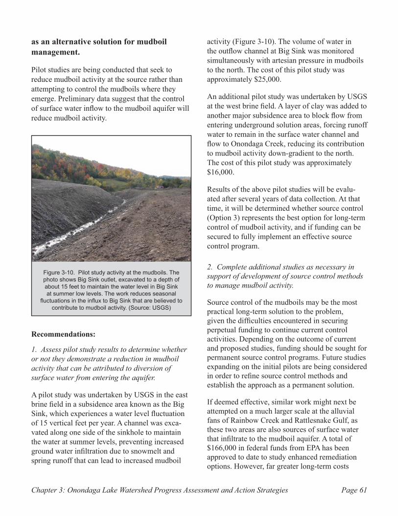
Chapter 3: Onondaga Lake Watershed Progress Assessment and Action Strategies Page 61
as an alternative solution for mudboil management.
Pilot studies are being conducted that seek to reduce mudboil activity at the source rather than attempting to control the mudboils where they emerge. Preliminary data suggest that the control of surface water inflow to the mudboil aquifer will reduce mudboil activity.
Recommendations:
1. Assess pilot study results to determine whether or not they demonstrate a reduction in mudboil activity that can be attributed to diversion of surface water from entering the aquifer.
A pilot study was undertaken by USGS in the east brine field in a subsidence area known as the Big Sink, which experiences a water level fluctuation of 15 vertical feet per year. A channel was exca-vated along one side of the sinkhole to maintain the water at summer levels, preventing increased ground water infiltration due to snowmelt and spring runoff that can lead to increased mudboil
activity (Figure 3-10). The volume of water in the outflow channel at Big Sink was monitored simultaneously with artesian pressure in mudboils to the north. The cost of this pilot study was approximately $25,000.
An additional pilot study was undertaken by USGS at the west brine field. A layer of clay was added to another major subsidence area to block flow from entering underground solution areas, forcing runoff water to remain in the surface water channel and flow to Onondaga Creek, reducing its contribution to mudboil activity down-gradient to the north. The cost of this pilot study was approximately $16,000.
Results of the above pilot studies will be evalu-ated after several years of data collection. At that time, it will be determined whether source control (Option 3) represents the best option for long-term control of mudboil activity, and if funding can be secured to fully implement an effective source control program.
2. Complete additional studies as necessary in support of development of source control methods to manage mudboil activity.
Source control of the mudboils may be the most practical long-term solution to the problem, given the difficulties encountered in securing perpetual funding to continue current control activities. Depending on the outcome of current and proposed studies, funding should be sought for permanent source control programs. Future studies expanding on the initial pilots are being considered in order to refine source control methods and establish the approach as a permanent solution.
If deemed effective, similar work might next be attempted on a much larger scale at the alluvial fans of Rainbow Creek and Rattlesnake Gulf, as these two areas are also sources of surface water that infiltrate to the mudboil aquifer. A total of $166,000 in federal funds from EPA has been approved to date to study enhanced remediation options. However, far greater long-term costs
Pilot study activity at the mudboils. The Figure 3-10. photo shows Big Sink outlet, excavated to a depth of about 15 feet to maintain the water level in Big Sink at summer low levels. The work reduces seasonal
fluctuations in the influx to Big Sink that are believed to contribute to mudboil activity. (Source: USGS)
Chapter 3: Onondaga Lake Watershed Progress Assessment and Action StrategiesPage 62
would be associated with full implementation of large-scale source control efforts.
Action Strategy 3. Complete studies to determine the contribution of sediment to Onondaga Creek and Lake from landslides in the Tully Valley, and determine if there are any remedial actions that could be taken to minimize damage to the water resource.
Two reports are being prepared outlining the contributing sediment load from the landslides to Onondaga Creek. However, no permanent remedy has been identified to stop landslide activity in the two tributary valleys (Rainbow Creek and Rattle-snake Gulf) due to difficult access and the steep, unstable nature of the slopes (Kappel 2009). The most critical course of action now is to continue regular maintenance of bridges, roadways, and culverts, excavating sediment within the limits allowed by NYSDEC to reduce the discharge of sediment that ultimately reaches Onondaga Creek.
Recommendation:
1. Provide financial and technical support for state, county, and town highway and transporta-tion departments to ensure that regular main-tenance of roadways in landslide-prone areas remains a priority.
Tully Farms Road, which is owned by Onondaga County, requires routine maintenance and removal of eroded sediment from roadside ditches and drainage systems by the Onondaga County Depart-ment of Transportation. Eroded sediment origi-nates from ongoing geologic activity on the slope of Dutch Hill, including spring emergence and continued slope instability. Sediment also is gener-ated by ongoing geologic activity on the south slope of Rainbow Creek west of I-81, consisting of spring discharge and continued slope instability. The removal of sediment and handling of drainage issues along Tully Farms Road is addressed through annual maintenance work comparable in cost and effort to that of neighboring roads.
The point at which New York State Route 11A crosses Rainbow Creek is subject to significant maintenance work requiring the commitment of equipment (i.e. an excavator or bulldozer) by New York State Department of Transportation for as much as one month per year. This work is neces-sary to prevent clogging of the culvert that carries Rainbow Creek beneath Route 11A.
Action Strategy 4. Continue education and outreach programs to foster awareness of the impact of the natural and anthropogenic sources of sedimentation (mudboils, landslides) on water quality in Onondaga Lake and its watershed.
Recommendation:
1. Obtain funding to continue and expand the existing USGS public outreach program.
Continued education and outreach are needed to raise public awareness of the impacts of mudboils and landslide activity on water quality in Onondaga Creek and ultimately, Onondaga Lake. On behalf of the OLP, USGS has taken the lead role in providing this outreach through talks at universities, schools, and to the general public. In addition to the distribution of fact sheets and other informational publications, occasional tours of the mudboils and landslides are conducted by USGS. Presently, no funding is available for USGS to conduct this work; an annual budget of $20,000 would support activities similar to what has been done in the past.
Strategic Area 6: Fish and Wildlife Habitat and Fisheries Management
The OLP has established three goals relative to fisheries and aquatic habitat in Onondaga Lake. Achieving these goals will require a coordinated and cooperative effort among entities such as NYSDEC, Honeywell International, Onondaga County, and other resource managers and scientists
Chapter 3: Onondaga Lake Watershed Progress Assessment and Action Strategies Page 63
in the community. It is likely that management decisions will change in response to new informa-tion and improved understanding of the lake’s ecosystem.
Goal 1. Maintain a healthy and diverse native fish community in Onondaga Lake, able to support a resident coolwater fishery and a transient coldwater fishery, by restoring and/or sustaining necessary lake and tributary habitats.
Management of Onondaga Lake must be based on sound ecological principles for multiple purposes and users. Future management decisions must consider the lake’s consumptive and recreational fishery and what is ecologically desirable for the native aquatic community.
This goal has been partly achieved. A recovering coolwater fishery exists in Onondaga Lake that includes several game species. Species such as lake sturgeon are returning to the lake, and fish populations are increasing.
The 1993 OLMP presented a long-term objec-tive of maximizing, to the degree attainable, the coldwater fishery in Onondaga Lake by providing suitable year-round habitat. However, it has been recognized that numerous factors play a role in determining the extent to which a coldwater fishery can be sustained in the lake.
Barriers to fish migration between the lake and other bodies of water are one factor to be addressed in consideration of establishing a resident coldwater fishery. Dams and habitat deg-radation are present both in tributaries to the lake and in downstream rivers that link Onondaga Lake to other regional lakes and to Lake Ontario.
The morphology of the lake is also a key factor that affects coldwater fish support. Onondaga Lake, like many lakes of comparable size in tem-perate climates, experiences seasonal layering, or stratification, in which temperatures and dissolved
oxygen conditions differ markedly between the epilimnion (upper layer) and hypolimnion (lower layer) of water in the lake. During summer, only the hypolimnion contains temperatures suitable for coldwater fish. However, anoxic conditions occur in the hypolimnion during the summer months, and these conditions cannot be tolerated by fish and many other forms of aquatic life.
Dissolved oxygen levels in the lake are affected by many factors, one of which is phosphorus loading. Current lake models under development will be used to predict the effect of phosphorus on oxygen demand. Oxygen demand is also affected by the introduction of organic matter to the lake. Strati-fication, while primarily caused by temperature differences, is exacerbated by the elevated salinity of the lake, which increases the density differences between the layers of water and the resulting seasonal oxygen deficits.
At the present time, it appears that Onondaga Lake can support a transient coldwater fishery. Coldwa-ter fishes have recently been documented in the lake during all seasons except summer. Although nearby Otisco Lake is significantly impacted by human activity, its present condition can be used as a benchmark for short-term recovery potential in Onondaga Lake. Otisco Lake, which is similar to Onondaga Lake in size, depth, latitude, ori-entation, and depth to surface area ratios, lacks historic record of coldwater fishes. Historic and current conditions in Otisco Lake suggest that in Onondaga Lake, summer oxygen levels in the hypolimnion are unlikely to reach a level capable of supporting resident coldwater fishes within the timeframe in which current management decisions must be made. There is evidence that at least one coldwater fish species (cisco or whitefish) once thrived in Onondaga Lake, but historic documenta-tion of native fish fauna in Onondaga Lake is incomplete. A transient coldwater fishery continues to be the most feasible short-term management framework for Onondaga Lake.
Goal 2. Reduce and/or mitigate the effects of wave erosion, past oncolite
Chapter 3: Onondaga Lake Watershed Progress Assessment and Action StrategiesPage 64
formation, sediment contamination, and other environmental issues in order to restore habitat throughout the lake and its surrounding area.
Formation of oncolites in the shoreline sediment of Onondaga Lake may be diminishing. Many areas occupied by oncolites have been colonized by zebra mussels or aquatic macrophytes. Reme-diation of these areas, including removal and/or capping of contaminated sediments as required, will improve substrate suitability for fish and desirable macrophytes. Initially, progress toward achieving this goal will be driven by habitat resto-ration performed by Honeywell International under NYSDEC oversight, as part of the Onondaga Lake remediation described in Strategic Area 3.
Goal 3. Complete restoration activities necessary to make Ninemile Creek, Onondaga Creek, and other tributaries suitable for spawning and rearing of native fishes.
Common sources of aquatic habitat degradation such as sewage, excess sediment, and contami-nants continue to negatively impact salmonid pro-duction in Onondaga Lake tributaries (Coghlan & Ringler 2005). Physical habitat characteristics are generally favorable and temperature regimes have improved to within the range of tolerance for sal-monids and other fishes. Through further control and reduction of pollutant sources, spawning and rearing of salmonids and other fishes in Onondaga Lake tributaries may again be possible. Restora-tion activities are being investigated on a number of fronts to restore native coldwater fish to the tributaries of Onondaga Lake.
The following action strategies are being pursued in an effort to accomplish the above goals.
Action Strategy 1. Complete a habitat restoration plan for Onondaga Lake that identifies sensitive aquatic habitats affected
by remedial actions and associated habitat improvements for lake fisheries.
This action item is being initially pursued through a cooperative effort by NYSDEC, EPA, and Honeywell International in association with the cleanup of the Onondaga Lake NPL site pursuant to the 2006 Consent Decree. Thus far, cooperat-ing entities have developed lists of representative species for fish, mammals, birds, amphibians, reptiles, and plants that are anticipated to use the remediated aquatic and upland habitats. These lists provide a basis for addressing substrate and habitat needs for all organisms expected to benefit from remediation.
Recommendation:
1. Identify specific habitat improvements that will support utilization of the lake and its shoreline by target species.
Habitat improvements selected for implementa-tion will likely support a range of species similar to the target species. The Onondaga Lake habitat restoration plan may provide the framework for an analogous plan extending to the entire watershed. As this effort is part of the remediation program for the Onondaga Lake Bottom NPL sub-site, associated costs are included in the estimated total for the activities discussed in Strategic Area 3&4, Industrial Pollution: National Priorities List (NPL) Site and Other Adjacent Areas of Concern. A draft plan outlining remedial design elements for habitat restoration was released for public comment in December 2009 (Parsons 2009a).
Action Strategy 2. Identify and implement habitat improvements (water quality, veg-etative cover, substrate, access, food supply, and other habitat requirements) that are necessary to improve the existing transient coldwater fishery in Onondaga Lake.
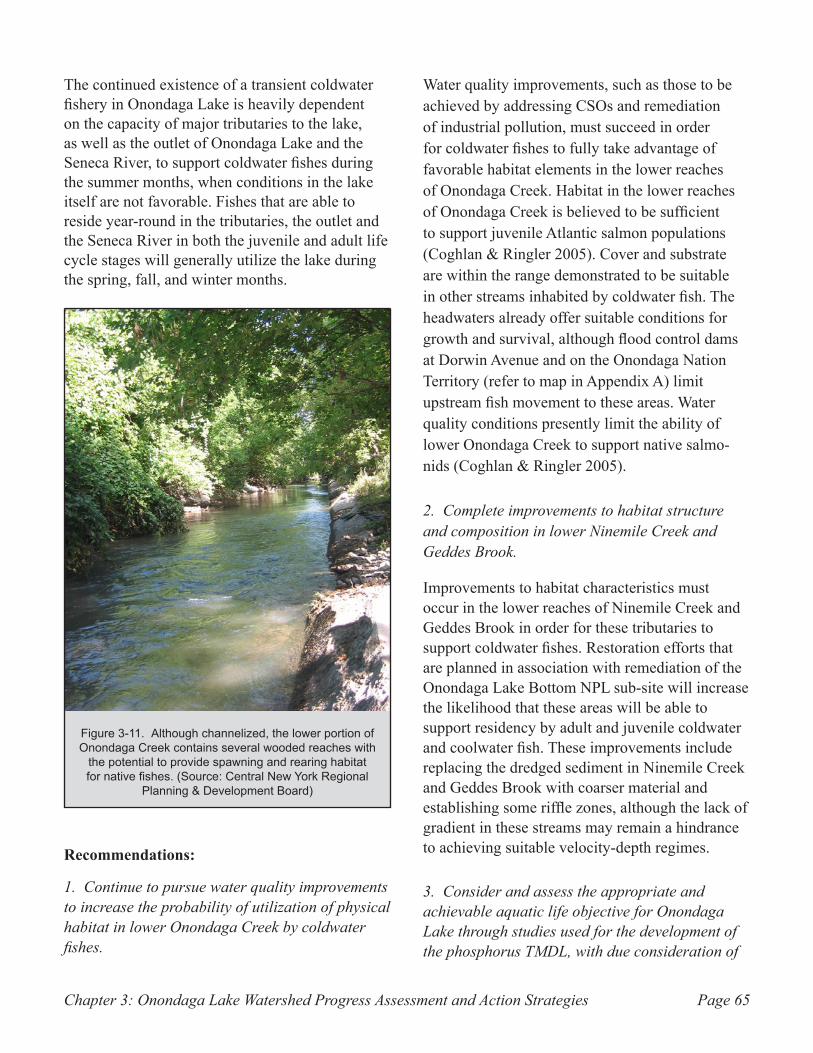
Chapter 3: Onondaga Lake Watershed Progress Assessment and Action Strategies Page 65
The continued existence of a transient coldwater fishery in Onondaga Lake is heavily dependent on the capacity of major tributaries to the lake, as well as the outlet of Onondaga Lake and the Seneca River, to support coldwater fishes during the summer months, when conditions in the lake itself are not favorable. Fishes that are able to reside year-round in the tributaries, the outlet and the Seneca River in both the juvenile and adult life cycle stages will generally utilize the lake during the spring, fall, and winter months.
Recommendations:
1. Continue to pursue water quality improvements to increase the probability of utilization of physical habitat in lower Onondaga Creek by coldwater fishes.
Water quality improvements, such as those to be achieved by addressing CSOs and remediation of industrial pollution, must succeed in order for coldwater fishes to fully take advantage of favorable habitat elements in the lower reaches of Onondaga Creek. Habitat in the lower reaches of Onondaga Creek is believed to be sufficient to support juvenile Atlantic salmon populations (Coghlan & Ringler 2005). Cover and substrate are within the range demonstrated to be suitable in other streams inhabited by coldwater fish. The headwaters already offer suitable conditions for growth and survival, although flood control dams at Dorwin Avenue and on the Onondaga Nation Territory (refer to map in Appendix A) limit upstream fish movement to these areas. Water quality conditions presently limit the ability of lower Onondaga Creek to support native salmo-nids (Coghlan & Ringler 2005).
2. Complete improvements to habitat structure and composition in lower Ninemile Creek and Geddes Brook.
Improvements to habitat characteristics must occur in the lower reaches of Ninemile Creek and Geddes Brook in order for these tributaries to support coldwater fishes. Restoration efforts that are planned in association with remediation of the Onondaga Lake Bottom NPL sub-site will increase the likelihood that these areas will be able to support residency by adult and juvenile coldwater and coolwater fish. These improvements include replacing the dredged sediment in Ninemile Creek and Geddes Brook with coarser material and establishing some riffle zones, although the lack of gradient in these streams may remain a hindrance to achieving suitable velocity-depth regimes.
3. Consider and assess the appropriate and achievable aquatic life objective for Onondaga Lake through studies used for the development of the phosphorus TMDL, with due consideration of
Although channelized, the lower portion of Figure 3-11. Onondaga Creek contains several wooded reaches with
the potential to provide spawning and rearing habitat for native fishes. (Source: Central New York Regional
Planning & Development Board)
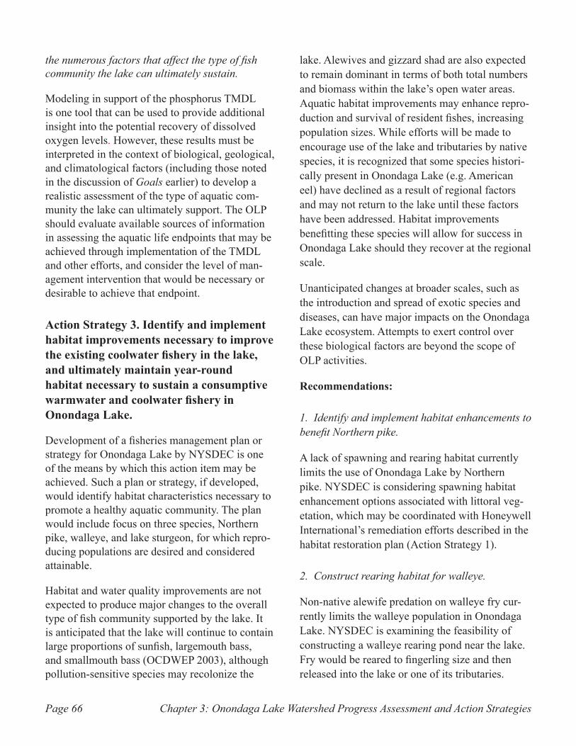
Chapter 3: Onondaga Lake Watershed Progress Assessment and Action StrategiesPage 66
the numerous factors that affect the type of fish community the lake can ultimately sustain.
Modeling in support of the phosphorus TMDL is one tool that can be used to provide additional insight into the potential recovery of dissolved oxygen levels. However, these results must be interpreted in the context of biological, geological, and climatological factors (including those noted in the discussion of Goals earlier) to develop a realistic assessment of the type of aquatic com-munity the lake can ultimately support. The OLP should evaluate available sources of information in assessing the aquatic life endpoints that may be achieved through implementation of the TMDL and other efforts, and consider the level of man-agement intervention that would be necessary or desirable to achieve that endpoint.
Action Strategy 3. Identify and implement habitat improvements necessary to improve the existing coolwater fishery in the lake, and ultimately maintain year-round habitat necessary to sustain a consumptive warmwater and coolwater fishery in Onondaga Lake.
Development of a fisheries management plan or strategy for Onondaga Lake by NYSDEC is one of the means by which this action item may be achieved. Such a plan or strategy, if developed, would identify habitat characteristics necessary to promote a healthy aquatic community. The plan would include focus on three species, Northern pike, walleye, and lake sturgeon, for which repro-ducing populations are desired and considered attainable.
Habitat and water quality improvements are not expected to produce major changes to the overall type of fish community supported by the lake. It is anticipated that the lake will continue to contain large proportions of sunfish, largemouth bass, and smallmouth bass (OCDWEP 2003), although pollution-sensitive species may recolonize the
lake. Alewives and gizzard shad are also expected to remain dominant in terms of both total numbers and biomass within the lake’s open water areas. Aquatic habitat improvements may enhance repro-duction and survival of resident fishes, increasing population sizes. While efforts will be made to encourage use of the lake and tributaries by native species, it is recognized that some species histori-cally present in Onondaga Lake (e.g. American eel) have declined as a result of regional factors and may not return to the lake until these factors have been addressed. Habitat improvements benefitting these species will allow for success in Onondaga Lake should they recover at the regional scale.
Unanticipated changes at broader scales, such as the introduction and spread of exotic species and diseases, can have major impacts on the Onondaga Lake ecosystem. Attempts to exert control over these biological factors are beyond the scope of OLP activities.
Recommendations:
1. Identify and implement habitat enhancements to benefit Northern pike.
A lack of spawning and rearing habitat currently limits the use of Onondaga Lake by Northern pike. NYSDEC is considering spawning habitat enhancement options associated with littoral veg-etation, which may be coordinated with Honeywell International’s remediation efforts described in the habitat restoration plan (Action Strategy 1).
2. Construct rearing habitat for walleye.
Non-native alewife predation on walleye fry cur-rently limits the walleye population in Onondaga Lake. NYSDEC is examining the feasibility of constructing a walleye rearing pond near the lake. Fry would be reared to fingerling size and then released into the lake or one of its tributaries.
Chapter 3: Onondaga Lake Watershed Progress Assessment and Action Strategies Page 67
3. Complete necessary steps to establish Onondaga Lake as a priority habitat for lake sturgeon.
Presently, NYSDEC believes that both Ninemile and Onondaga Creeks are large enough to provide spawning and juvenile rearing habitat for lake sturgeon. Once a statewide lake sturgeon hatchery program is reinstated, the objective is to have Onondaga Lake listed as a priority water body for the establishment of a lake sturgeon popula-tion. The chemical and physical conditions of Onondaga Lake’s epilimnion appear sufficient to support lake sturgeon throughout the year. Fur-thermore, research at Oneida Lake indicates that sub-adult and adult sturgeon extensively utilize zebra mussels, which are presently abundant in Onondaga Lake, as a primary food source. A sustainable coolwater fishery requires a healthy macrophyte community, suitable reproductive habitats and substrate, and an adequate forage base. Successful habitat restoration by Honeywell International, in coordination with NYSDEC and other regulatory agencies, is critical for fish survival, growth, and reproduction (see Action Strategy 1).
Action Strategy 4. Continue to implement a biological monitoring program to document trends and identify sources of ecosystem-
wide problems within the Onondaga Lake watershed.
Recommendation:
1. Continue current biological monitoring program to fulfill ACJ requirements, and tailor long-term biological monitoring program to meet ecological data needs.
Onondaga County continues to implement an annual biological monitoring program. The Ambient Monitoring Program (AMP) evaluates aquatic communities through an extensive series of sampling and studies. This program will continue at its current scope as long as the ACJ remains in effect, with protocol flexibility as information needs change. The biological component of the AMP (including the annual fisheries program and zebra mussel monitoring program) costs approximately $105,000 to $110,000, with an estimated additional $40,000 every five years for monitoring of macroinvertebrate populations in the lake. These figures are based on estimates from the most recent program information available. Cost varies significantly from year to year depending on the need to repair or replace various support equipment, sampling gear, and computer software and hardware. Costs for macrophyte surveys are discussed separately with Action Strategy 5 below.
The OLP may also develop a long-term biological monitoring program if necessary after the time period mandated by the ACJ.
Action Strategy 5. Document effects of restoration/remediation actions on desirable macrophytes and pursue additional enhancement actions as necessary.
Certain rooted and floating macrophytes are desir-able to support a variety of fish and invertebrate habitat functions. Macrophytes provide spawning and nursery habitat for several desirable fishes; however, excessive plant density reduces habitat quality for fish and invertebrates (OCDWEP
A walleye collected from Onondaga Figure 3-12. Lake as part of the Onondaga County fish monitoring
program. (Source: OCDWEP)
Chapter 3: Onondaga Lake Watershed Progress Assessment and Action StrategiesPage 68
2003). The ACJ sets 40 to 60 percent macrophyte cover within the littoral zone as the most favorable level, since this is the degree of cover considered optimal for reproduction of largemouth bass, a desirable warmwater fish.
Conversely, some macroalgae and aquatic nuisance species degrade aquatic habitat. One goal of the ACJ is to limit occurrence and impacts of filamentous algae. Undesirable algae control is being addressed through improvements to Metro, CSO abatement, and non-point source pollution control. Management for native macrophytes will be attempted only to the extent that they can be separated from non-native species. Because a mixture of different species is typical, the combined community must be assessed.
Recommendation:
1. Continue annual assessments of macrophyte cover in order to direct efforts toward maintaining optimum levels.
Annual comparisons of macrophyte cover, through aerial photography and/or ground-level observation, are needed to assess the degree of macrophyte cover throughout the lake. These studies are presently completed by Onondaga County as part of its Ambient Monitoring Program to assist in identifying parts of the lake that contain too much vegetative cover, as well as areas where cover consists primarily of non-native invasive species. Approximate cost of the annual flight survey is $22,000. The County also undertakes a more detailed macrophyte survey every five years that involves the sampling of submerged vegeta-tion in the littoral (near-shore) zone; this study should also be continued to fully characterize the composition of the macrophyte community. The cost of this survey is about $32,000 every five years. Estimates for both macrophyte survey programs are based on the most recent program information available, and may vary depending on the need to repair or replace various support
equipment, sampling gear, and computer software and hardware.
Areas where macrophyte growth is limited due to lack of suitable substrate are being evaluated in association with Honeywell’s restoration activities, which will address these substrate limitations.
Action Strategy 6. Implement species-specific fish monitoring programs for the outlet and tributaries of the lake as necessary to obtain needed information about fish movement and reproductive patterns.
Recommendation:
1. Evaluate the need for programs to monitor fish populations in the outlet and tributaries of Onondaga Lake as part of Fisheries Management planning efforts.
The OLP has identified the potential need for a program to monitor fish populations in the outlet and tributaries of Onondaga Lake. Such a program would initially focus on spawning and rearing in Onondaga Creek, Ninemile Creek, and Onondaga Lake Outlet. If developed, the program would be targeted toward monitoring seasonal migration patterns of species of interest to determine where breeding and/or spawning are occurring. The com-pletion of a Fisheries Management Plan or similar document must occur before a monitoring program for the outlet and tributaries is initiated, since the Plan would specify what species and areas are targeted, and provide the context for evaluation of improvement efforts.
Action Strategy 7. Continue to evaluate fish consumption advisories, with the ultimate goal of removal of consumption advisories by the New York State Department of
Chapter 3: Onondaga Lake Watershed Progress Assessment and Action Strategies Page 69
Health (NYSDOH).
Recommendation:
1. Reassess fish contaminant levels and advisories following completion of industrial pollution cleanup efforts.
In order for the NYSDOH species-specific fish advisories for Onondaga Lake to be lifted, NYSDOH would have to make such a determina-tion, based on:
an evaluation of fish contamination data indicat-•• ing that fish contaminant levels are sufficiently low to justify advisory removal; and
other factors (see section below on NYSDOH •• Criteria for Setting Fish Consumption Advisories).
As discussed in Section 2.6, NYSDOH has in effect extensive specific advisories on eating sport fish from Onondaga Lake (see section below, “NYSDOH Criteria for Setting Fish Consumption Advisories” for important factors for fish advisory determination.) To remove these specific adviso-ries, data would have to show significant declines in concentrations of mercury in all fish species and sizes in Onondaga Lake, as well as declines in PCBs and dioxin in some species of Onondaga Lake fish. After remediation is completed, exten-sive monitoring of contaminant levels and their accumulation in fish will be necessary before any consideration of relaxing or lifting the advisories.
Even if the specific advisories are removed, the statewide general advisory to eat no more than one meal per week of all fish presumably will still apply (as it does for all New York State fresh waters). NYSDOH issues this advice because:
Some chemicals are commonly found in New York •• State fish (e.g. mercury and PCBs),
Fish from all waters have not been tested, and••
Fish may contain unidentified contaminants. ••
NYSDOH Criteria for Setting Fish Consumption Advisories
NYSDOH uses considerable Judgment and weighs many factors when setting fish advisories. The balance between the benefits and risks of eating fish with mercury and other fish contaminants may be different for at risk popu-lations (women of childbearing age, infants and young children) versus the general population. NYSDOH takes these differences into account during the fish advisory setting process. The following are some important features of the NYSDOH advisories and advisory-setting process:
1. NYSDOH issues a general advisory to eat no more than one meal per week of fish from all New York State fresh waters because some chemicals are commonly found in New York State fish (e.g., mercury and PCBs), fish from all waters have not been tested, and fish may contain unidentified contaminants.
2. NYSDOH recommends that infants, children under the age of 15 and women of childbearing age EAT NO fish at all from waters with specific advisories (including Onondaga Lake).
3. When reviewing fish contaminant data to determine fish advisories for a specific water body or region, NYSDOH considers the following:
Fish contaminant levels, including fish sampling •• characteristics (e.g., number and type of samples, spe-cies, age, length, percent lipid, sample location, etc.) and patterns of contamination;
Health risks;••
Populations at greater potential risk;••
The FDA marketplace standard;••
Health benefits; and••
Risk communication issues.••
(Information provided by NYSDOH)
Action Strategy 8. Restore and maintain wetlands hydrologic connection and habitat module project completed in 2000-2001.
The habitat module project (Figure 3-13) was completed in 2001 with oversight by the Onondaga County Department of Environmental Health. The project included construction of a jetty-like structure near the northwest shoreline of the lake, intended to enhance littoral zone habitat in the area to promote use by waterfowl, wading birds,
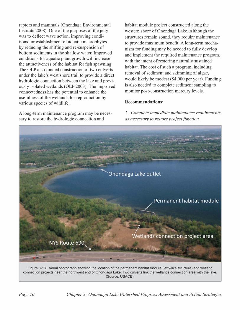
Chapter 3: Onondaga Lake Watershed Progress Assessment and Action StrategiesPage 70
raptors and mammals (Onondaga Environmental Institute 2008). One of the purposes of the jetty was to deflect wave action, improving condi-tions for establishment of aquatic macrophytes by reducing the shifting and re-suspension of bottom sediments in the shallow water. Improved conditions for aquatic plant growth will increase the attractiveness of the habitat for fish spawning. The OLP also funded construction of two culverts under the lake’s west shore trail to provide a direct hydrologic connection between the lake and previ-ously isolated wetlands (OLP 2003). The improved connectedness has the potential to enhance the usefulness of the wetlands for reproduction by various species of wildlife.
A long-term maintenance program may be neces-sary to restore the hydrologic connection and
habitat module project constructed along the western shore of Onondaga Lake. Although the structures remain sound, they require maintenance to provide maximum benefit. A long-term mecha-nism for funding may be needed to fully develop and implement the required maintenance program, with the intent of restoring naturally sustained habitat. The cost of such a program, including removal of sediment and skimming of algae, would likely be modest ($4,000 per year). Funding is also needed to complete sediment sampling to monitor post-construction mercury levels.
Recommendations:
1. Complete immediate maintenance requirements as necessary to restore project function.
Aerial photograph showing the location of the permanent habitat module (jetty-like structure) and wetland Figure 3-13. connection projects near the northwest end of Onondaga Lake. Two culverts link the wetlands connection area with the lake.
(Source: USACE).
Chapter 3: Onondaga Lake Watershed Progress Assessment and Action Strategies Page 71
To allow water movement, sediment removal is necessary at openings on both sides of the culvert connecting the wetland with the lake. It is estimated that the initial work to accomplish this would cost $3,000. Also, mats of floating algae regularly become trapped behind the jetty. The problem could be addressed by skimming, which if feasible, would be least expensive (about $2,000 per year). The re-establishment of appropriate native wetland and shoreline vegetation also is needed in parts of the project area to enhance its ecological function ($6,000 as a one-time cost expenditure).
2. Review the project proposal and design for expectations regarding the need and responsibil-ity for long-term maintenance, and redesign and reconstruct the project to reduce maintenance needs.
Culvert and jetty maintenance and/or modification is needed to maintain water flow and discourage growth of undesirable algae while promoting development of desirable vegetation. Operational modifications might also include the active use of stoplogs to more closely control water levels. As an alternative to periodic skimming for removal of algal mats, parts of the existing jetty could be removed to create openings, enhancing water flow through the system to prevent the stagnation that leads to algal growth.
As part of the original project, substrate improve-ment was attempted in areas where oncolites deterred the establishment of desirable vegetation. Geotextile pads covered with rock substrate were installed, but have not functioned as well as intended due to the size and distribution of substrate. Modifications to the restoration effort, expected to result in significant improvements to the quality of vegetation, would require approxi-mately $20,000.
In order to progress with any changes or additional work on the project, the OLP would need to review
the project and determine the entity or entities best equipped to undertake these activities.
Action Strategy 9. Support implementation of elements of the Onondaga Creek Conceptual Revitalization Plan (OCCRP) as desired and appropriate.
Recommendation:
1. Provide support and/or assistance with imple-mentation of appropriate and feasible OCCRP recommendations as pilot projects.
The OCCRP was developed through a visioning process enlisting participation of residents of the Onondaga Creek watershed. One of the purposes of the OCCRP is to present the public’s vision of a cleaner, more natural Onondaga Creek. The draft OCCRP (Onondaga Environmental Institute 2009), identifies a number of possible habitat restoration projects to help achieve this vision. The OLP will evaluate options presented by the OCCRP, and may support implementation of project concepts that are determined to be desirable, technically feasible, and affordable, pending regulatory and community acceptance. Adopted OCCRP concepts would initially be implemented as pilot or demon-stration projects if they meet these criteria.
Action Strategy 10. Implement a natural history information and education program to educate and inform the public on fish and wildlife species in and around the lake.
Recommendation:
1. Utilize a combination of existing and new outreach resources to educate the public about the natural history of Onondaga Lake.
The OLP Outreach Committee will determine the method by which public education concerning the Lake’s natural history is accomplished. Various media options have been proposed, such as document CDs, information kiosks, videos, printed materials, and a website. Existing materials, such
Chapter 3: Onondaga Lake Watershed Progress Assessment and Action StrategiesPage 72
as a video produced by the OLP Fisheries Working Group, may also be appropriate. Previous efforts, including printed media such as an insert in the local newspaper and publication of a newslet-ter, have discussed natural history and aquatic habitat. These efforts, combined with additional distribution of the existing video, would likely cost about $10,000 for each year in which they are implemented.
Action Strategy 11. Encourage communication and coordination between agencies, facility operators, and user groups within the Oswego River Basin to improve and facilitate management of Onondaga Lake in a manner protective of the lake’s ecology.
Onondaga Lake discharges north to the Seneca River, which joins the Oneida River to form the Oswego River near Phoenix, New York. Commu-nication amongst local and regional government entities and private industries in the Oswego River basin must be improved to ensure the long-term ecological integrity of Onondaga Lake. Issues such as water level management and detrimental effects of invasive species originate in the Erie Canal/Seneca/Oswego River system, and impact Onondaga Lake management. The OLP will encourage cooperation and information sharing amongst the relevant parties. Through education and outreach, the OLP will work to facilitate effective information exchange and agency coordination.
New York State Canal Corporation and multiple hydropower facility operators within the Oswego River system control water levels and affect Onondaga Lake. The Canal Corporation regulates Erie Canal water levels during the navigation season for commercial and recreational boat traffic. Habitat management, power generation, and navigation often require different water level regimes. Discussion among water users should inform and facilitate water level management decisions and are necessary to reconcile conflicts
between uses.
Recommendation:
1. Work with government and local agencies to educate the public about removal of non-native invasive species from watercraft to prevent their proliferation and range expansion.
Non-native invasive species reach Onondaga Lake from the Seneca River (Erie Canal) through the lake outlet, or attached to boat hulls. Education of boat operators on the importance of invasive species removal from their craft (e.g. by proper cleaning of watercraft prior to transport) is critical to limiting the spread of exotics. This can be accomplished by providing information or signage at marinas and points of lake access, or via OLP Outreach Committee efforts and programs. Another means for invasive species to enter non-native waters is via fishing equipment including waders. Anglers should be provided education materials and encouraged to properly clean equip-ment when going from one waterway to another.
Strategic Area 7: Inner Harbor and Shoreline
The OLP developed the following goals relative to utilization of the Onondaga Lake Inner Harbor and Shoreline areas:
Goal 1. Promote use of the Inner Harbor and its waterfront areas for tourism, rec-reation, and economic benefit, in order to optimize public appreciation and enjoyment of the natural features of the lake and its environs.
Goal 2. Promote the use of the lake’s shore-line areas for public access and recreation.
To assist in attaining the above goals, the follow-ing action strategies and recommendations have been developed.
Chapter 3: Onondaga Lake Watershed Progress Assessment and Action Strategies Page 73
Action Strategy 1. Complete trail construction to establish and/or maintain community connectivity with Onondaga Lake and its tributaries.
Key projects identified to enhance connectedness of the lake with its surrounding communities include the Loop-the-Lake Trail and the Onondaga Creekwalk.
Recommendations:
1. Complete a new section of trail that will continue across Ninemile Creek to provide access from Lakeland and Geddes.
The Onondaga County Department of Parks and Recreation, in cooperation with the Onondaga County Department of Transportation (OCDOT), is undertaking the completion of a new section of the Loop-the-Lake trail, which ultimately is planned to entirely encircle Onondaga Lake. The trail will be extended by approximately two miles to continue across Ninemile Creek via a steel bridge to the top of the hill known as the “Upper Bluff” overlooking Onondaga Lake from the west (see Appendix A for a map of the area). The trail will be located at the top edge of the ridge, as close as possible to the lake. New access will be provided from Lakeland and Geddes (immediately west of Onondaga Lake) via Exit 7 from Route 690. Access to the State Fairgrounds upper parking lots will be possible. At the entrance to the State Fairgrounds atop the hill, a cordoned parking lot will be created for users accessing the trail from this area. The proposed pathway will be 10 feet wide and hard surfaced to allow a variety of uses.
All necessary engineering and design work pertaining to the construction of this phase of the trail has been completed, and funding is in place for its construction. The total cost of the project is approximately $3.5 million. Funds are provided through OCDOT sources and environmental fine money dedicated to completion of an Environ-mental Benefit Project as a condition of consent
order between NYSDEC and parties responsible for pollution of the lake. Presently, construction is planned to commence in 2010, with an 18-month construction period. OCDOT is the lead agency in the construction and funding aspects of this project.
2. Design and complete remaining sections of the Loop-the-Lake Trail.
Two unfinished portions of the Loop-the-Lake trail will remain following the completion of the section described above; these parallel the southwest and southeast shores of the lake. The ultimate objective is to link the section on the east side, which presently ends in Onondaga Lake Park in Liverpool, with the portion on the west side outlined in Recommendation 1. The intent is to link these sections of trail to the Creekwalk near the mouth of Onondaga Creek at the Inner Harbor.
Several logistical challenges are associated with both of these remaining sections. The southwest section from the top of the bluffs to Onondaga Creek will need to cross lands owned by Honey-well International, where remediation activities are planned. Coordination with Honeywell’s activities must occur, and the ultimate suitability of the land for a trail following remediation must be ascertained. A set of active railroad tracks also hug the shoreline closely at the southwest corner of the lake, presenting another access challenge.
The southeast section connecting Onondaga Lake Park in Liverpool to Onondaga Creek is equally challenging. Currently, active railroad tracks and Onondaga Lake Parkway (located along the east side of the lake) both exist close to the lake shore-line in this area. Construction of a trail even closer to the shore would be difficult to accomplish. A previous conceptual design involved construction of a causeway built out slightly into the southeast corner of the lake, creating a backwater area that could contain valuable habitat. The objective was to carry the trail around the congested area via the causeway, linking to the shore near Carousel
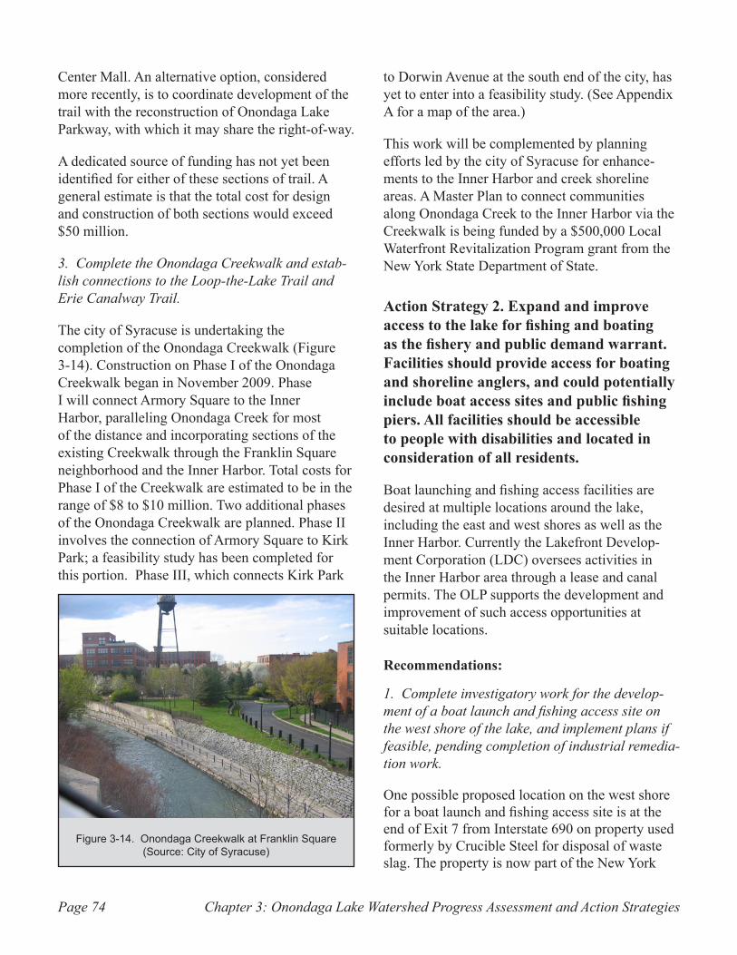
Chapter 3: Onondaga Lake Watershed Progress Assessment and Action StrategiesPage 74
Center Mall. An alternative option, considered more recently, is to coordinate development of the trail with the reconstruction of Onondaga Lake Parkway, with which it may share the right-of-way.
A dedicated source of funding has not yet been identified for either of these sections of trail. A general estimate is that the total cost for design and construction of both sections would exceed $50 million.
3. Complete the Onondaga Creekwalk and estab-lish connections to the Loop-the-Lake Trail and Erie Canalway Trail.
The city of Syracuse is undertaking the completion of the Onondaga Creekwalk (Figure 3-14). Construction on Phase I of the Onondaga Creekwalk began in November 2009. Phase I will connect Armory Square to the Inner Harbor, paralleling Onondaga Creek for most of the distance and incorporating sections of the existing Creekwalk through the Franklin Square neighborhood and the Inner Harbor. Total costs for Phase I of the Creekwalk are estimated to be in the range of $8 to $10 million. Two additional phases of the Onondaga Creekwalk are planned. Phase II involves the connection of Armory Square to Kirk Park; a feasibility study has been completed for this portion. Phase III, which connects Kirk Park
to Dorwin Avenue at the south end of the city, has yet to enter into a feasibility study. (See Appendix A for a map of the area.)
This work will be complemented by planning efforts led by the city of Syracuse for enhance-ments to the Inner Harbor and creek shoreline areas. A Master Plan to connect communities along Onondaga Creek to the Inner Harbor via the Creekwalk is being funded by a $500,000 Local Waterfront Revitalization Program grant from the New York State Department of State.
Action Strategy 2. Expand and improve access to the lake for fishing and boating as the fishery and public demand warrant. Facilities should provide access for boating and shoreline anglers, and could potentially include boat access sites and public fishing piers. All facilities should be accessible to people with disabilities and located in consideration of all residents.
Boat launching and fishing access facilities are desired at multiple locations around the lake, including the east and west shores as well as the Inner Harbor. Currently the Lakefront Develop-ment Corporation (LDC) oversees activities in the Inner Harbor area through a lease and canal permits. The OLP supports the development and improvement of such access opportunities at suitable locations.
Recommendations:
1. Complete investigatory work for the develop-ment of a boat launch and fishing access site on the west shore of the lake, and implement plans if feasible, pending completion of industrial remedia-tion work.
One possible proposed location on the west shore for a boat launch and fishing access site is at the end of Exit 7 from Interstate 690 on property used formerly by Crucible Steel for disposal of waste slag. The property is now part of the New York
Onondaga Creekwalk at Franklin Square Figure 3-14. (Source: City of Syracuse)
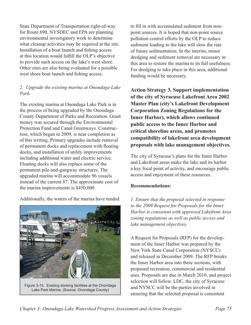
Chapter 3: Onondaga Lake Watershed Progress Assessment and Action Strategies Page 75
State Department of Transportation right-of-way for Route 690. NYSDEC and EPA are planning environmental investigatory work to determine what cleanup activities may be required at the site. Installation of a boat launch and fishing access at this location would fulfill the OLP’s objective to provide such access on the lake’s west shore. Other sites are also being evaluated for a possible west shore boat launch and fishing access.
2. Upgrade the existing marina at Onondaga Lake Park.
The existing marina at Onondaga Lake Park is in the process of being upgraded by the Onondaga County Department of Parks and Recreation. Grant money was secured through the Environmental Protection Fund and Canal Greenways. Construc-tion, which began in 2009, is near completion as of this writing. Primary upgrades include removal of permanent docks and replacement with floating docks, and installation of utility improvements including additional water and electric service. Floating docks will also replace some of the permanent pile-and-gangway structures. The upgraded marina will accommodate 96 vessels instead of the current 87. The approximate cost of the marina improvements is $450,000.
Additionally, the waters of the marina have tended
to fill in with accumulated sediment from non-point sources. It is hoped that non-point source pollution control efforts by the OLP to reduce sediment loading to the lake will slow the rate of future sedimentation. In the interim, minor dredging and sediment removal are necessary in this area to restore the marina to its full usefulness. For dredging to take place in this area, additional funding would be necessary.
Action Strategy 3. Support implementation of the city of Syracuse Lakefront Area 2002 Master Plan (city’s Lakefront Development Corporation Zoning Regulations for the Inner Harbor), which allows continued public access to the Inner Harbor and critical shoreline areas, and promotes compatibility of lakefront area development proposals with lake management objectives.
The city of Syracuse’s plans for the Inner Harbor and Lakefront areas make the lake and its harbor a key focal point of activity, and encourage public access and enjoyment of these resources.
Recommendations:
1. Ensure that the proposal selected in response to the 2009 Request for Proposals for the Inner Harbor is consistent with approved Lakefront Area zoning regulations as well as public access and lake management objectives.
A Request for Proposals (RFP) for the develop-ment of the Inner Harbor was prepared by the New York State Canal Corporation (NYSCC) and released in December 2009. The RFP breaks the Inner Harbor area into three sections, with proposed recreation, commercial and residential uses. Proposals are due in March 2010, and project selection will follow. LDC, the city of Syracuse and NYSCC will be the parties involved in ensuring that the selected proposal is consistent
Existing docking facilities at the Onondaga Figure 3-15. Lake Park Marina. (Source: Onondaga County)
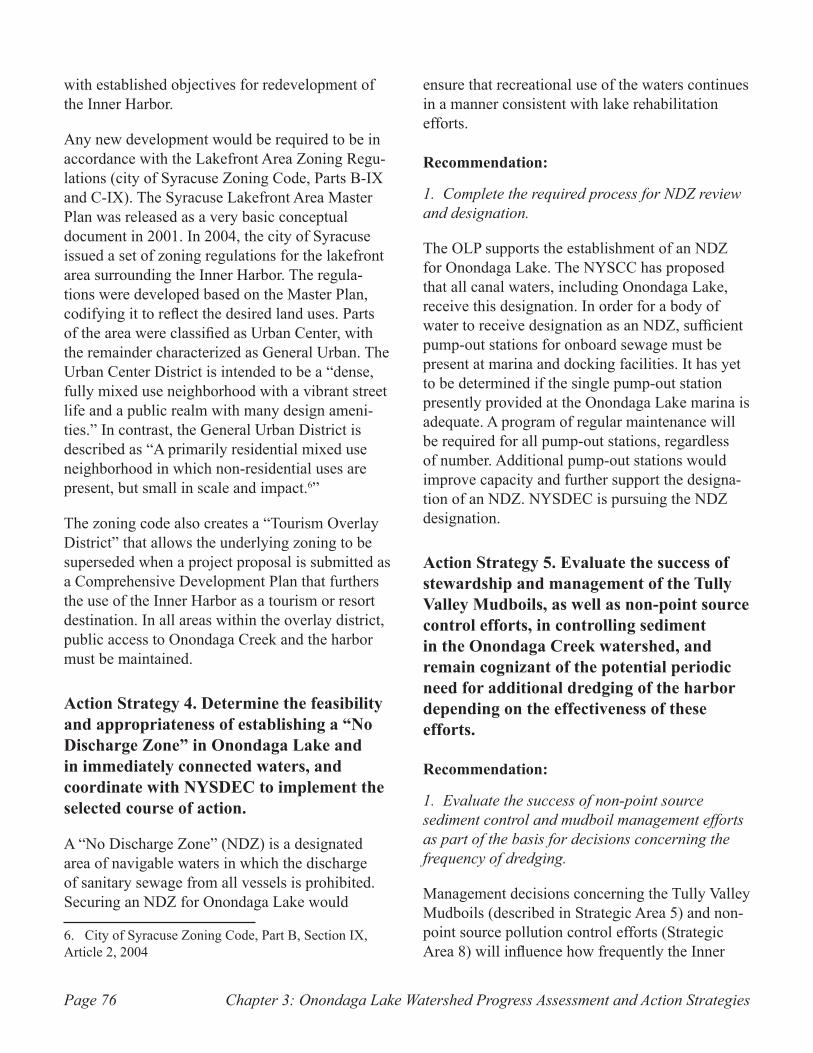
Chapter 3: Onondaga Lake Watershed Progress Assessment and Action StrategiesPage 76
with established objectives for redevelopment of the Inner Harbor.
Any new development would be required to be in accordance with the Lakefront Area Zoning Regu-lations (city of Syracuse Zoning Code, Parts B-IX and C-IX). The Syracuse Lakefront Area Master Plan was released as a very basic conceptual document in 2001. In 2004, the city of Syracuse issued a set of zoning regulations for the lakefront area surrounding the Inner Harbor. The regula-tions were developed based on the Master Plan, codifying it to reflect the desired land uses. Parts of the area were classified as Urban Center, with the remainder characterized as General Urban. The Urban Center District is intended to be a “dense, fully mixed use neighborhood with a vibrant street life and a public realm with many design ameni-ties.” In contrast, the General Urban District is described as “A primarily residential mixed use neighborhood in which non-residential uses are present, but small in scale and impact.6”
The zoning code also creates a “Tourism Overlay District” that allows the underlying zoning to be superseded when a project proposal is submitted as a Comprehensive Development Plan that furthers the use of the Inner Harbor as a tourism or resort destination. In all areas within the overlay district, public access to Onondaga Creek and the harbor must be maintained.
Action Strategy 4. Determine the feasibility and appropriateness of establishing a “No Discharge Zone” in Onondaga Lake and in immediately connected waters, and coordinate with NYSDEC to implement the selected course of action.
A “No Discharge Zone” (NDZ) is a designated area of navigable waters in which the discharge of sanitary sewage from all vessels is prohibited. Securing an NDZ for Onondaga Lake would
6. City of Syracuse Zoning Code, Part B, Section IX, Article 2, 2004
ensure that recreational use of the waters continues in a manner consistent with lake rehabilitation efforts.
Recommendation:
1. Complete the required process for NDZ review and designation.
The OLP supports the establishment of an NDZ for Onondaga Lake. The NYSCC has proposed that all canal waters, including Onondaga Lake, receive this designation. In order for a body of water to receive designation as an NDZ, sufficient pump-out stations for onboard sewage must be present at marina and docking facilities. It has yet to be determined if the single pump-out station presently provided at the Onondaga Lake marina is adequate. A program of regular maintenance will be required for all pump-out stations, regardless of number. Additional pump-out stations would improve capacity and further support the designa-tion of an NDZ. NYSDEC is pursuing the NDZ designation.
Action Strategy 5. Evaluate the success of stewardship and management of the Tully Valley Mudboils, as well as non-point source control efforts, in controlling sediment in the Onondaga Creek watershed, and remain cognizant of the potential periodic need for additional dredging of the harbor depending on the effectiveness of these efforts.
Recommendation:
1. Evaluate the success of non-point source sediment control and mudboil management efforts as part of the basis for decisions concerning the frequency of dredging.
Management decisions concerning the Tully Valley Mudboils (described in Strategic Area 5) and non-point source pollution control efforts (Strategic Area 8) will influence how frequently the Inner
Chapter 3: Onondaga Lake Watershed Progress Assessment and Action Strategies Page 77
Harbor must be dredged. Without mitigation of the mudboils, accumulation of sediment in the harbor via flow from Onondaga Creek will take place more rapidly; historically the harbor required dredging about once every six years. The harbor was last dredged ten years ago, having experienced a lesser rate of sedimentation since that time.
Dredging results in odor and aesthetic concerns, as well as restrictions to uses such as boating. Active control of the mudboils and non-point source pollution would lessen the need to dredge the harbor, thereby reducing these impacts. Pres-ently, the ability to store dredge spoils is a limiting factor on the quantity of material that could be removed; only one upland disposal area remains for sediment spoils removed from the harbor. The frequency at which dredging is necessary will depend on the availability of adequate funding to keep inputs from the mudboils and non-point source pollution at their present level.
Action Strategy 6. Promote the use of the Inner Harbor and Onondaga Lake shoreline for recreation and tourism through publications or other media as appropriate.
The OLP will continue to coordinate with member agencies, including the city of Syracuse, Onondaga County, and the NYSCC, to promote the use of the Inner Harbor and Onondaga Lake shoreline for recreation and tourism.
Recommendation:
1. Provide information for inclusion in design of tourism-focused promotional publications on the Lake and Inner Harbor, and encourage the contin-ued circulation of these publications.
The LDC and members of the OLP have periodi-cally circulated brochures and articles concerning progress on the redevelopment of the Inner Harbor, and the construction of the Onondaga Creekwalk. The OLP will provide necessary information to ensure that these publications capitalize on the
improving conditions within Onondaga Lake watershed and highlight new shoreline access and recreation opportunities.
Strategic Area 8: Non-Point Source Pollution
The OLP established the following goal relative to control of non-point source pollution of surface waters:
Goal 1. To achieve the designated best uses established by the water quality classification for Onondaga Lake, develop and implement a Non-Point Source (NPS) Management Strategy (consistent with the NYSDEC Onondaga Lake TMDL) incorporating appropriate Best Management Practices that address the impacts of NPS pollution and reduce pollutant inputs from rural and urban non-point sources throughout the watershed of the lake.
Recognizing the multifaceted nature of NPS pollution, the OLP considers the following to be important components of the developing NPS Management Strategy:
Reduction of agricultural NPS inputs through edu-•• cation and technical assistance to farmers within the watershed and implementation of best management practices (BMPs)
Reduction of urban NPS inputs through outreach •• to the general public and businesses
Monitoring of conditions in tributaries to Onon-•• daga Lake to locate and eliminate sources of sediment, bacteria, and other pollutants that can be pinpointed within the tributaries
Identification and stabilization of sediment •• sources throughout the watershed, including erosion of stream banks and channels, roadside ditches, and roadway embankments
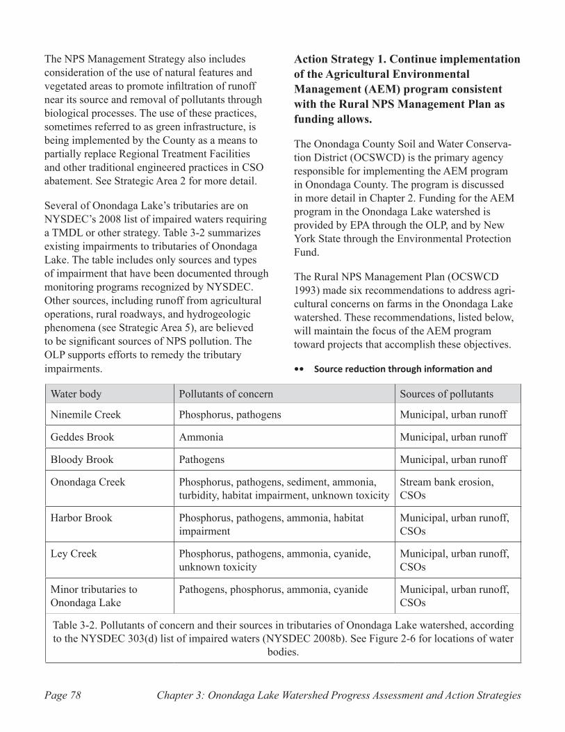
Chapter 3: Onondaga Lake Watershed Progress Assessment and Action StrategiesPage 78
The NPS Management Strategy also includes consideration of the use of natural features and vegetated areas to promote infiltration of runoff near its source and removal of pollutants through biological processes. The use of these practices, sometimes referred to as green infrastructure, is being implemented by the County as a means to partially replace Regional Treatment Facilities and other traditional engineered practices in CSO abatement. See Strategic Area 2 for more detail.
Several of Onondaga Lake’s tributaries are on NYSDEC’s 2008 list of impaired waters requiring a TMDL or other strategy. Table 3-2 summarizes existing impairments to tributaries of Onondaga Lake. The table includes only sources and types of impairment that have been documented through monitoring programs recognized by NYSDEC. Other sources, including runoff from agricultural operations, rural roadways, and hydrogeologic phenomena (see Strategic Area 5), are believed to be significant sources of NPS pollution. The OLP supports efforts to remedy the tributary impairments.
Action Strategy 1. Continue implementation of the Agricultural Environmental Management (AEM) program consistent with the Rural NPS Management Plan as funding allows.
The Onondaga County Soil and Water Conserva-tion District (OCSWCD) is the primary agency responsible for implementing the AEM program in Onondaga County. The program is discussed in more detail in Chapter 2. Funding for the AEM program in the Onondaga Lake watershed is provided by EPA through the OLP, and by New York State through the Environmental Protection Fund.
The Rural NPS Management Plan (OCSWCD 1993) made six recommendations to address agri-cultural concerns on farms in the Onondaga Lake watershed. These recommendations, listed below, will maintain the focus of the AEM program toward projects that accomplish these objectives.
Source reduction through information and ••
Water body Pollutants of concern Sources of pollutants
Ninemile Creek Phosphorus, pathogens Municipal, urban runoff
Geddes Brook Ammonia Municipal, urban runoff
Bloody Brook Pathogens Municipal, urban runoff
Onondaga Creek Phosphorus, pathogens, sediment, ammonia, turbidity, habitat impairment, unknown toxicity
Stream bank erosion, CSOs
Harbor Brook Phosphorus, pathogens, ammonia, habitat impairment
Municipal, urban runoff, CSOs
Ley Creek Phosphorus, pathogens, ammonia, cyanide, unknown toxicity
Municipal, urban runoff, CSOs
Minor tributaries to Onondaga Lake
Pathogens, phosphorus, ammonia, cyanide Municipal, urban runoff, CSOs
Table 3-2. Pollutants of concern and their sources in tributaries of Onondaga Lake watershed, according to the NYSDEC 303(d) list of impaired waters (NYSDEC 2008b). See Figure 2-6 for locations of water
bodies.
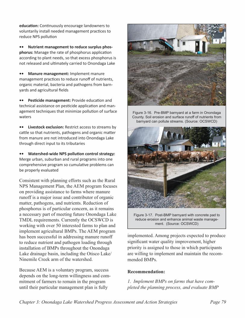
Chapter 3: Onondaga Lake Watershed Progress Assessment and Action Strategies Page 79
education: Continuously encourage landowners to voluntarily install needed management practices to reduce NPS pollution
Nutrient management to reduce surplus phos-•• phorus: Manage the rate of phosphorus application according to plant needs, so that excess phosphorus is not released and ultimately carried to Onondaga Lake
Manure management:•• Implement manure management practices to reduce runoff of nutrients, organic material, bacteria and pathogens from barn-yards and agricultural fields
Pesticide management:•• Provide education and technical assistance on pesticide application and man-agement techniques that minimize pollution of surface waters
Livestock exclusion:•• Restrict access to streams by cattle so that nutrients, pathogens and organic matter from manure are not introduced into Onondaga Lake through direct input to its tributaries
Watershed-wide NPS pollution control strategy:•• Merge urban, suburban and rural programs into one comprehensive program so cumulative problems can be properly evaluated
Consistent with planning efforts such as the Rural NPS Management Plan, the AEM program focuses on providing assistance to farms where manure runoff is a major issue and contributor of organic matter, pathogens, and nutrients. Reduction of phosphorus is of particular concern, as it remains a necessary part of meeting future Onondaga Lake TMDL requirements. Currently the OCSWCD is working with over 50 interested farms to plan and implement agricultural BMPs. The AEM program has been successful in addressing manure runoff to reduce nutrient and pathogen loading through installation of BMPs throughout the Onondaga Lake drainage basin, including the Otisco Lake/Ninemile Creek arm of the watershed.
Because AEM is a voluntary program, success depends on the long-term willingness and com-mitment of farmers to remain in the program until their particular management plan is fully
implemented. Among projects expected to produce significant water quality improvement, higher priority is assigned to those in which participants are willing to implement and maintain the recom-mended BMPs.
Recommendation:
1. Implement BMPs on farms that have com-pleted the planning process, and evaluate BMP
Pre-BMP barnyard at a farm in Onondaga Figure 3-16. County. Soil erosion and surface runoff of nutrients from
barnyard can pollute streams. (Source: OCSWCD)
Post-BMP barnyard with concrete pad to Figure 3-17. reduce erosion and enhance animal waste manage-
ment. (Source: OCSWCD)
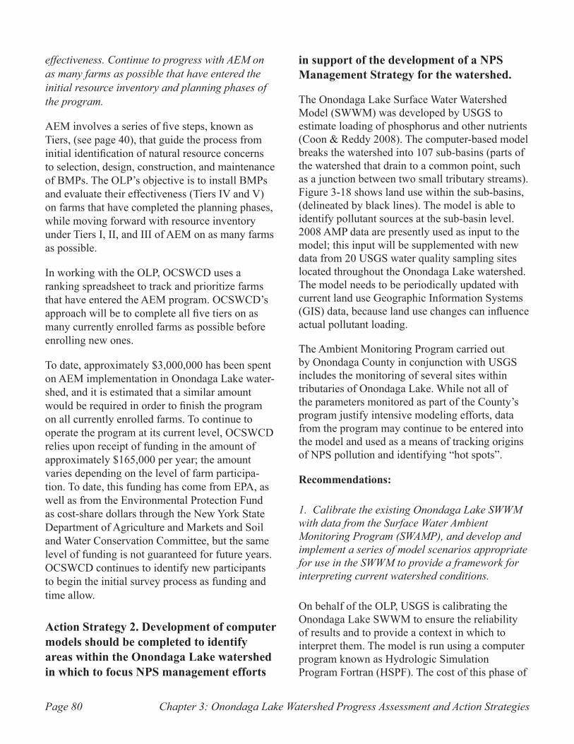
Chapter 3: Onondaga Lake Watershed Progress Assessment and Action StrategiesPage 80
effectiveness. Continue to progress with AEM on as many farms as possible that have entered the initial resource inventory and planning phases of the program.
AEM involves a series of five steps, known as Tiers, (see page 40), that guide the process from initial identification of natural resource concerns to selection, design, construction, and maintenance of BMPs. The OLP’s objective is to install BMPs and evaluate their effectiveness (Tiers IV and V) on farms that have completed the planning phases, while moving forward with resource inventory under Tiers I, II, and III of AEM on as many farms as possible.
In working with the OLP, OCSWCD uses a ranking spreadsheet to track and prioritize farms that have entered the AEM program. OCSWCD’s approach will be to complete all five tiers on as many currently enrolled farms as possible before enrolling new ones.
To date, approximately $3,000,000 has been spent on AEM implementation in Onondaga Lake water-shed, and it is estimated that a similar amount would be required in order to finish the program on all currently enrolled farms. To continue to operate the program at its current level, OCSWCD relies upon receipt of funding in the amount of approximately $165,000 per year; the amount varies depending on the level of farm participa-tion. To date, this funding has come from EPA, as well as from the Environmental Protection Fund as cost-share dollars through the New York State Department of Agriculture and Markets and Soil and Water Conservation Committee, but the same level of funding is not guaranteed for future years. OCSWCD continues to identify new participants to begin the initial survey process as funding and time allow.
Action Strategy 2. Development of computer models should be completed to identify areas within the Onondaga Lake watershed in which to focus NPS management efforts
in support of the development of a NPS Management Strategy for the watershed.
The Onondaga Lake Surface Water Watershed Model (SWWM) was developed by USGS to estimate loading of phosphorus and other nutrients (Coon & Reddy 2008). The computer-based model breaks the watershed into 107 sub-basins (parts of the watershed that drain to a common point, such as a junction between two small tributary streams). Figure 3-18 shows land use within the sub-basins, (delineated by black lines). The model is able to identify pollutant sources at the sub-basin level. 2008 AMP data are presently used as input to the model; this input will be supplemented with new data from 20 USGS water quality sampling sites located throughout the Onondaga Lake watershed. The model needs to be periodically updated with current land use Geographic Information Systems (GIS) data, because land use changes can influence actual pollutant loading.
The Ambient Monitoring Program carried out by Onondaga County in conjunction with USGS includes the monitoring of several sites within tributaries of Onondaga Lake. While not all of the parameters monitored as part of the County’s program justify intensive modeling efforts, data from the program may continue to be entered into the model and used as a means of tracking origins of NPS pollution and identifying “hot spots”.
Recommendations:
1. Calibrate the existing Onondaga Lake SWWM with data from the Surface Water Ambient Monitoring Program (SWAMP), and develop and implement a series of model scenarios appropriate for use in the SWWM to provide a framework for interpreting current watershed conditions.
On behalf of the OLP, USGS is calibrating the Onondaga Lake SWWM to ensure the reliability of results and to provide a context in which to interpret them. The model is run using a computer program known as Hydrologic Simulation Program Fortran (HSPF). The cost of this phase of
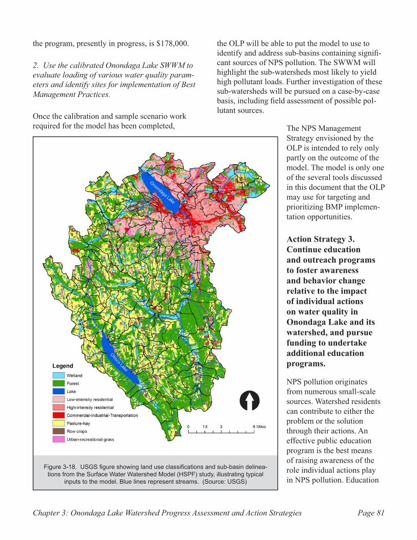
Chapter 3: Onondaga Lake Watershed Progress Assessment and Action Strategies Page 81
the program, presently in progress, is $178,000.
2. Use the calibrated Onondaga Lake SWWM to evaluate loading of various water quality param-eters and identify sites for implementation of Best Management Practices.
Once the calibration and sample scenario work required for the model has been completed,
the OLP will be able to put the model to use to identify and address sub-basins containing signifi-cant sources of NPS pollution. The SWWM will highlight the sub-watersheds most likely to yield high pollutant loads. Further investigation of these sub-watersheds will be pursued on a case-by-case basis, including field assessment of possible pol-lutant sources.
The NPS Management Strategy envisioned by the OLP is intended to rely only partly on the outcome of the model. The model is only one of the several tools discussed in this document that the OLP may use for targeting and prioritizing BMP implemen-tation opportunities.
Action Strategy 3. Continue education and outreach programs to foster awareness and behavior change relative to the impact of individual actions on water quality in Onondaga Lake and its watershed, and pursue funding to undertake additional education programs.
NPS pollution originates from numerous small-scale sources. Watershed residents can contribute to either the problem or the solution through their actions. An effective public education program is the best means of raising awareness of the role individual actions play in NPS pollution. Education
USGS figure showing land use classifications and sub-basin delinea-Figure 3-18. tions from the Surface Water Watershed Model (HSPF) study, illustrating typical
inputs to the model. Blue lines represent streams. (Source: USGS)
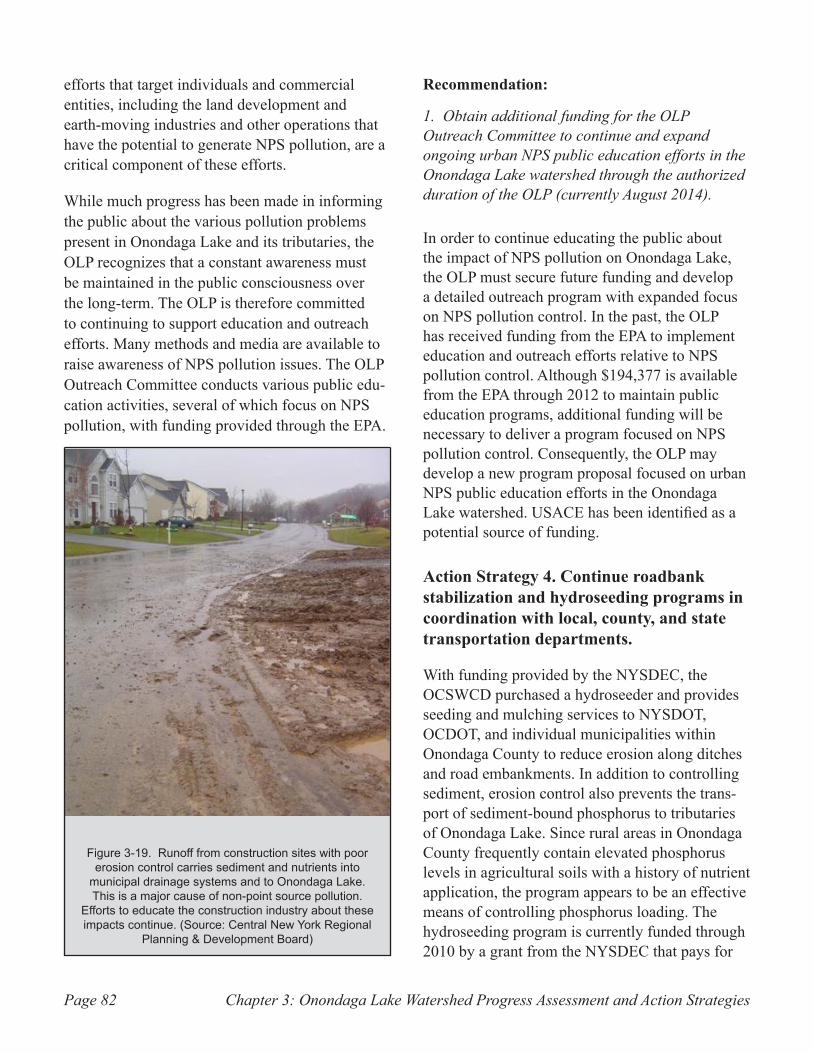
Chapter 3: Onondaga Lake Watershed Progress Assessment and Action StrategiesPage 82
efforts that target individuals and commercial entities, including the land development and earth-moving industries and other operations that have the potential to generate NPS pollution, are a critical component of these efforts.
While much progress has been made in informing the public about the various pollution problems present in Onondaga Lake and its tributaries, the OLP recognizes that a constant awareness must be maintained in the public consciousness over the long-term. The OLP is therefore committed to continuing to support education and outreach efforts. Many methods and media are available to raise awareness of NPS pollution issues. The OLP Outreach Committee conducts various public edu-cation activities, several of which focus on NPS pollution, with funding provided through the EPA.
Recommendation:
1. Obtain additional funding for the OLP Outreach Committee to continue and expand ongoing urban NPS public education efforts in the Onondaga Lake watershed through the authorized duration of the OLP (currently August 2014).
In order to continue educating the public about the impact of NPS pollution on Onondaga Lake, the OLP must secure future funding and develop a detailed outreach program with expanded focus on NPS pollution control. In the past, the OLP has received funding from the EPA to implement education and outreach efforts relative to NPS pollution control. Although $194,377 is available from the EPA through 2012 to maintain public education programs, additional funding will be necessary to deliver a program focused on NPS pollution control. Consequently, the OLP may develop a new program proposal focused on urban NPS public education efforts in the Onondaga Lake watershed. USACE has been identified as a potential source of funding.
Action Strategy 4. Continue roadbank stabilization and hydroseeding programs in coordination with local, county, and state transportation departments.
With funding provided by the NYSDEC, the OCSWCD purchased a hydroseeder and provides seeding and mulching services to NYSDOT, OCDOT, and individual municipalities within Onondaga County to reduce erosion along ditches and road embankments. In addition to controlling sediment, erosion control also prevents the trans-port of sediment-bound phosphorus to tributaries of Onondaga Lake. Since rural areas in Onondaga County frequently contain elevated phosphorus levels in agricultural soils with a history of nutrient application, the program appears to be an effective means of controlling phosphorus loading. The hydroseeding program is currently funded through 2010 by a grant from the NYSDEC that pays for
Runoff from construction sites with poor Figure 3-19. erosion control carries sediment and nutrients into
municipal drainage systems and to Onondaga Lake. This is a major cause of non-point source pollution.
Efforts to educate the construction industry about these impacts continue. (Source: Central New York Regional
Planning & Development Board)
Chapter 3: Onondaga Lake Watershed Progress Assessment and Action Strategies Page 83
50 percent of the cost. The remaining 50 percent must be covered by local match dollars. OCSWCD intends to seek additional funding to continue the program beyond this timeframe.
Recommendation:
1. Identify funding to continue the existing hydro-seeding program.
The cost per acre for operation of the hydroseeder at the standard application rate is about $1300; generally 25 to 30 acres are stabilized on an annual basis for a cost of $32,000 to $39,000. OCSWCD will continue to make its existing hydroseeding services available to municipalities through grant monies, if available. Other funding options include the use of a shared funding agreement paid for by participating municipalities, or implementation of a fee-for-service based program.
Action Strategy 5. Continue streambank stabilization program for sites identified through the USACE funding program.
In 2000, the OCSWCD completed an inventory of streambank and roadbank erosion in Onondaga Creek watershed, identifying and prioritizing current erosion and sedimentation problems. This inventory was used by USACE to complete engineering plans and specifications for 38 reaches along Onondaga Creek in 2003. Construction of 23 streambank stabilization projects, spanning a total of 3,755 linear feet, was funded by USACE and Onondaga County through a Rural Best Man-agement Practices grant in 2004, 2006 and 2007. OCSWCD worked with the landowners affected by these projects, and managed the construction contracts. Program funds totaling approximately 1 million dollars were exhausted before all identified problems could be addressed. Stabilization of the remaining 15 sites, which were considered lower in priority, was not feasible during the time the project was funded due to access restrictions and other practical matters.
Recommendations:
1. Update and prioritize the 2000 inventory of streambank and roadbank erosion sites.
Additional funding is needed in order to build upon previous streambank and roadbank erosion inventory and repair work undertaken by USACE and OCSWCD. A new inventory of roadbanks and streambanks is needed, since additional sites may now exist, and minor erosion problems may have become more severe than they were previously. The cost of the inventory would be dependent on its scope and the criteria evaluated, but it is estimated to be up to $10,000 to complete work throughout the entire Onondaga Creek sub-basin. Modeling efforts may help determine the sediment load contribution from various subwatersheds, in order to prioritize the stream reaches and areas inventoried.
2. Develop and implement remediation plans on priority sites.
Additional funding would be needed to complete actual design and construction work on the identi-fied priority sites, with the amount driven by the scope of the problems documented. Prioritization of projects would consider modeling results, in addition to the degree of property loss, damage to infrastructure, severity of erosion, and threat of flooding suffered. Once potential projects have been selected, acquisition of easements from private land owners is typically a necessary part of the process in order to allow access for construc-tion. Periodic maintenance may also be required for streambank stabilization projects, particularly where vegetation establishment is involved.
Action Strategy 6. Integrate the MS4 Stormwater program into the OLP’s overall strategy to address non-point problems throughout Onondaga Lake Watershed, with a watershed-level focus on the six Minimum Control Measures, to control
Chapter 3: Onondaga Lake Watershed Progress Assessment and Action StrategiesPage 84
urban stormwater runoff of phosphorus and other pollutants.
Under a federal mandate from the Clean Water Act, a number of urbanized municipalities and other government entities in the Onondaga Lake watershed are required to comply with State Pol-lutant Discharge Elimination System (SPDES) General Permit for Stormwater Discharges from Small Municipal Separate Storm Sewer Systems (MS4s) (NYSDEC 2008c). The permit requires these regulated MS4s to control stormwater runoff by implementing a management program that incorporates the following six categories of activi-ties, which are referred to as Minimum Control Measures:
Public Education and Outreach ••
Public Involvement and Participation ••
Illicit Discharge Detection and Elimination••
Construction Site Runoff Control ••
Post-Construction Stormwater Management••
Pollution Prevention and Good Housekeeping in •• Municipal Operations
In addition to general stipulations of the permit that apply to all MS4s, regulated entities within the Onondaga Lake watershed are subject to height-ened requirements specific to addressing the pol-lutant phosphorus. These requirements presently include the following:
Education and outreach efforts must be con-•• ducted specific to phosphorus
Development projects requiring construction ••
permits must implement enhanced phosphorus removal criteria in designs for stormwater treatment
A stormwater retrofit program, requiring •• municipalities to upgrade existing stormwater manage-ment practices and drainage systems for improved phosphorus removal, must be implemented through stakeholder-driven watershed planning efforts to reduce loading of the pollutant phosphorus to Onon-daga Lake
Municipalities are required to develop a turf man-•• agement program controlling the use of phosphorus in fertilizer applications, and encouraging planting of native vegetation
Because the MS4 Stormwater General Permit is periodically updated and modified by NYSDEC in compliance with EPA mandates, the above require-ments will be subject to change.
Recommendation:
1. Consider proposed MS4 compliance projects in determining allocation of funding to the extent that they support lake rehabilitation objectives.
Proposed projects and initiatives that address MS4 stormwater issues within the Onondaga Lake watershed should be eligible for consideration for federal funding if they contribute to the OLP’s goals and objectives. Although the MS4 Storm-water program had not been initiated at the time the original OLMP was approved, urban NPS pol-lution has since been recognized as an important contributor to the impairment of Onondaga Lake. Urban stormwater runoff is also one of the sources of phosphorus that will receive a specific alloca-tion relative to the lake’s TMDL.

Appendices: Onondaga Lake Watershed Progress Assessment and Action Strategies Page 85
Appendices
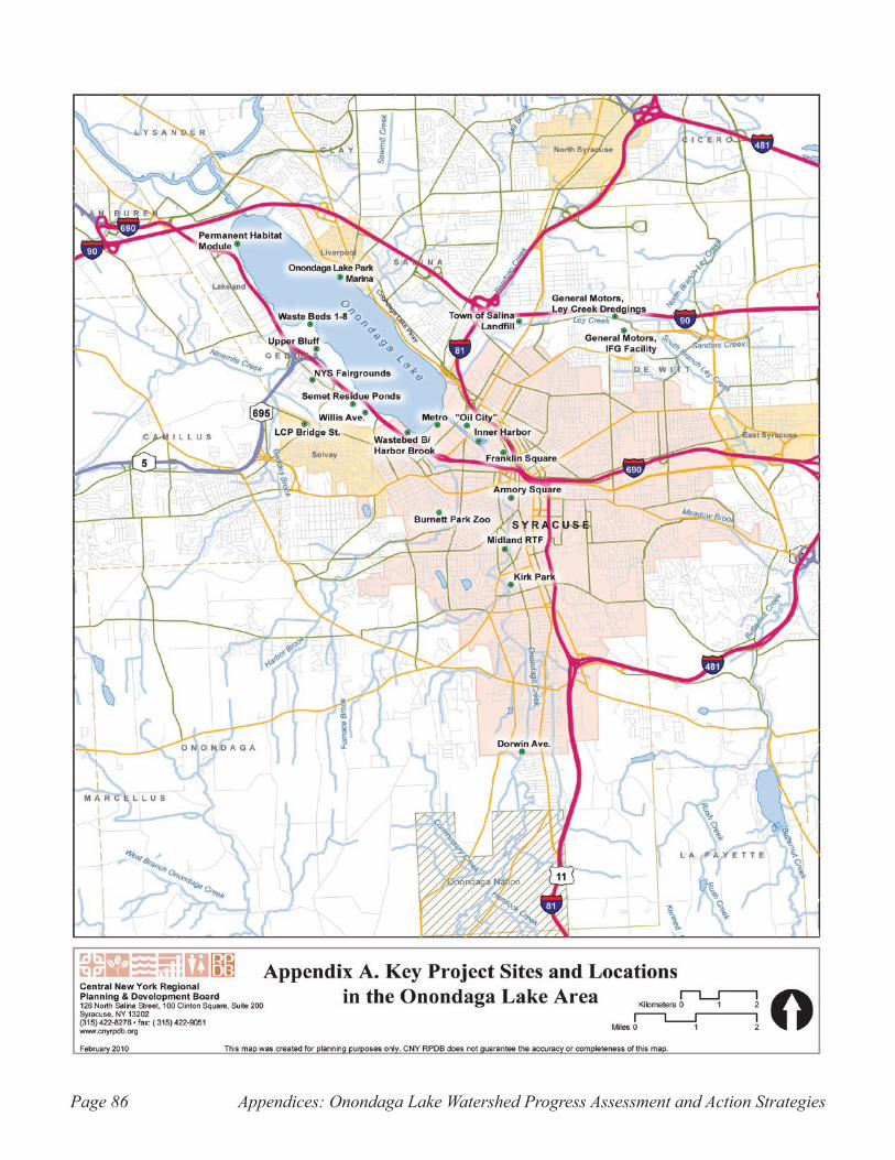
Appendices: Onondaga Lake Watershed Progress Assessment and Action StrategiesPage 86
Appendix A. Key project sites and locations in the Onondaga Lake area.
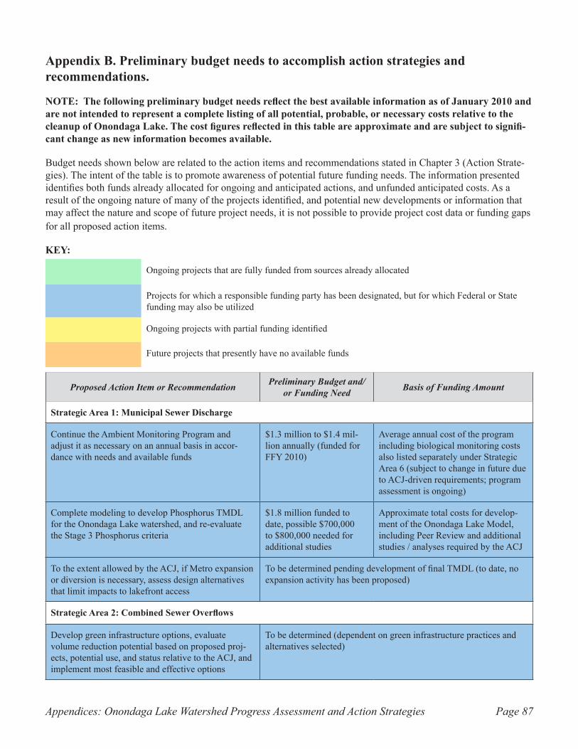
Appendices: Onondaga Lake Watershed Progress Assessment and Action Strategies Page 87
Proposed Action Item or Recommendation Preliminary Budget and/or Funding Need Basis of Funding Amount
Strategic Area 1: Municipal Sewer Discharge
Continue the Ambient Monitoring Program and adjust it as necessary on an annual basis in accor-dance with needs and available funds
$1.3 million to $1.4 mil-lion annually (funded for FFY 2010)
Average annual cost of the program including biological monitoring costs also listed separately under Strategic Area 6 (subject to change in future due to ACJ-driven requirements; program assessment is ongoing)
Complete modeling to develop Phosphorus TMDL for the Onondaga Lake watershed, and re-evaluate the Stage 3 Phosphorus criteria
$1.8 million funded to date, possible $700,000 to $800,000 needed for additional studies
Approximate total costs for develop-ment of the Onondaga Lake Model, including Peer Review and additional studies / analyses required by the ACJ
To the extent allowed by the ACJ, if Metro expansion or diversion is necessary, assess design alternatives that limit impacts to lakefront access
To be determined pending development of final TMDL (to date, no expansion activity has been proposed)
Strategic Area 2: Combined Sewer Overflows
Develop green infrastructure options, evaluate volume reduction potential based on proposed proj-ects, potential use, and status relative to the ACJ, and implement most feasible and effective options
To be determined (dependent on green infrastructure practices and alternatives selected)
Appendix B. Preliminary budget needs to accomplish action strategies and recommendations.
NOTE: The following preliminary budget needs reflect the best available information as of January 2010 and are not intended to represent a complete listing of all potential, probable, or necessary costs relative to the cleanup of Onondaga Lake. The cost figures reflected in this table are approximate and are subject to signifi-cant change as new information becomes available.
Budget needs shown below are related to the action items and recommendations stated in Chapter 3 (Action Strate-gies). The intent of the table is to promote awareness of potential future funding needs. The information presented identifies both funds already allocated for ongoing and anticipated actions, and unfunded anticipated costs. As a result of the ongoing nature of many of the projects identified, and potential new developments or information that may affect the nature and scope of future project needs, it is not possible to provide project cost data or funding gaps for all proposed action items.
KEY:
Ongoing projects that are fully funded from sources already allocated
Projects for which a responsible funding party has been designated, but for which Federal or State funding may also be utilized
Ongoing projects with partial funding identified
Future projects that presently have no available funds
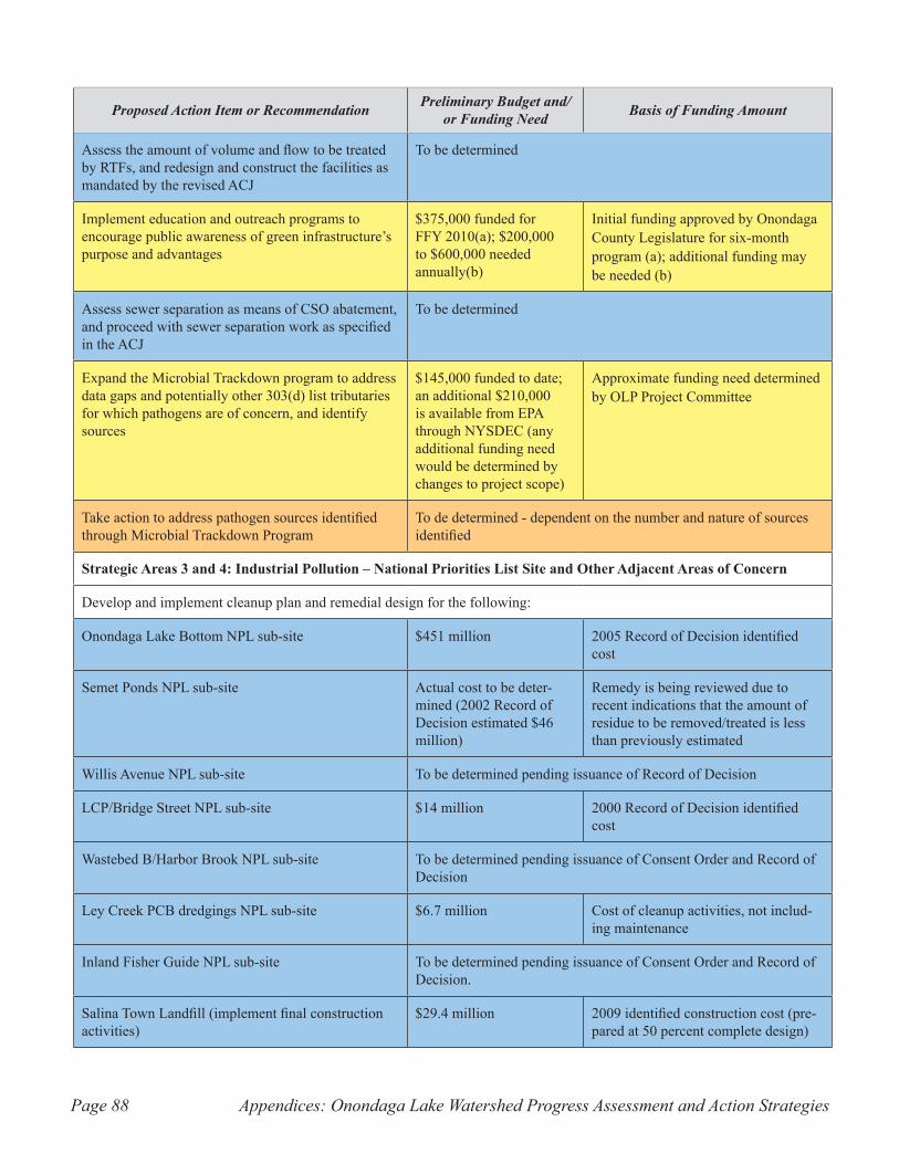
Appendices: Onondaga Lake Watershed Progress Assessment and Action StrategiesPage 88
Proposed Action Item or Recommendation Preliminary Budget and/or Funding Need Basis of Funding Amount
Assess the amount of volume and flow to be treated by RTFs, and redesign and construct the facilities as mandated by the revised ACJ
To be determined
Implement education and outreach programs to encourage public awareness of green infrastructure’s purpose and advantages
$375,000 funded for FFY 2010(a); $200,000 to $600,000 needed annually(b)
Initial funding approved by Onondaga County Legislature for six-month program (a); additional funding may be needed (b)
Assess sewer separation as means of CSO abatement, and proceed with sewer separation work as specified in the ACJ
To be determined
Expand the Microbial Trackdown program to address data gaps and potentially other 303(d) list tributaries for which pathogens are of concern, and identify sources
$145,000 funded to date; an additional $210,000 is available from EPA through NYSDEC (any additional funding need would be determined by changes to project scope)
Approximate funding need determined by OLP Project Committee
Take action to address pathogen sources identified through Microbial Trackdown Program
To de determined - dependent on the number and nature of sources identified
Strategic Areas 3 and 4: Industrial Pollution – National Priorities List Site and Other Adjacent Areas of Concern
Develop and implement cleanup plan and remedial design for the following:
Onondaga Lake Bottom NPL sub-site $451 million 2005 Record of Decision identified cost
Semet Ponds NPL sub-site Actual cost to be deter-mined (2002 Record of Decision estimated $46 million)
Remedy is being reviewed due to recent indications that the amount of residue to be removed/treated is less than previously estimated
Willis Avenue NPL sub-site To be determined pending issuance of Record of Decision
LCP/Bridge Street NPL sub-site $14 million 2000 Record of Decision identified cost
Wastebed B/Harbor Brook NPL sub-site To be determined pending issuance of Consent Order and Record of Decision
Ley Creek PCB dredgings NPL sub-site $6.7 million Cost of cleanup activities, not includ-ing maintenance
Inland Fisher Guide NPL sub-site To be determined pending issuance of Consent Order and Record of Decision.
Salina Town Landfill (implement final construction activities)
$29.4 million 2009 identified construction cost (pre-pared at 50 percent complete design)
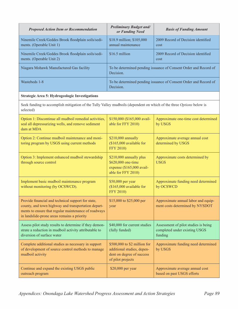
Appendices: Onondaga Lake Watershed Progress Assessment and Action Strategies Page 89
Proposed Action Item or Recommendation Preliminary Budget and/or Funding Need Basis of Funding Amount
Ninemile Creek/Geddes Brook floodplain soils/sedi-ments. (Operable Unit 1)
$18.9 million; $105,000 annual maintenance
2009 Record of Decision identified cost
Ninemile Creek/Geddes Brook floodplain soils/sedi-ments. (Operable Unit 2)
$16.5 million 2009 Record of Decision identified cost
Niagara Mohawk Manufactured Gas facility To be determined pending issuance of Consent Order and Record of Decision.
Wastebeds 1-8 To be determined pending issuance of Consent Order and Record of Decision.
Strategic Area 5: Hydrogeologic Investigations
Seek funding to accomplish mitigation of the Tully Valley mudboils (dependent on which of the three Options below is selected)
Option 1: Discontinue all mudboil remedial activities, seal all depressurizing wells, and remove sediment dam at MDA
$150,000 ($165,000 avail-able for FFY 2010)
Approximate one-time cost determined by USGS
Option 2: Continue mudboil maintenance and moni-toring program by USGS using current methods
$210,000 annually ($165,000 available for FFY 2010)
Approximate average annual cost determined by USGS
Option 3: Implement enhanced mudboil stewardship through source control
$210,000 annually plus $620,000 one-time expense ($165,000 avail-able for FFY 2010)
Approximate costs determined by USGS
Implement basic mudboil maintenance program without monitoring (by OCSWCD).
$50,000 per year ($165,000 available for FFY 2010)
Approximate funding need determined by OCSWCD
Provide financial and technical support for state, county, and town highway and transportation depart-ments to ensure that regular maintenance of roadways in landslide-prone areas remains a priority
$15,000 to $25,000 per year
Approximate annual labor and equip-ment costs determined by NYSDOT
Assess pilot study results to determine if they demon-strate a reduction in mudboil activity attributable to diversion of surface water
$40,000 for current studies (fully funded)
Assessment of pilot studies is being completed under existing USGS funding
Complete additional studies as necessary in support of development of source control methods to manage mudboil activity
$500,000 to $2 million for additional studies, depen-dent on degree of success of pilot projects
Approximate funding need determined by USGS
Continue and expand the existing USGS public outreach program
$20,000 per year Approximate average annual cost based on past USGS efforts
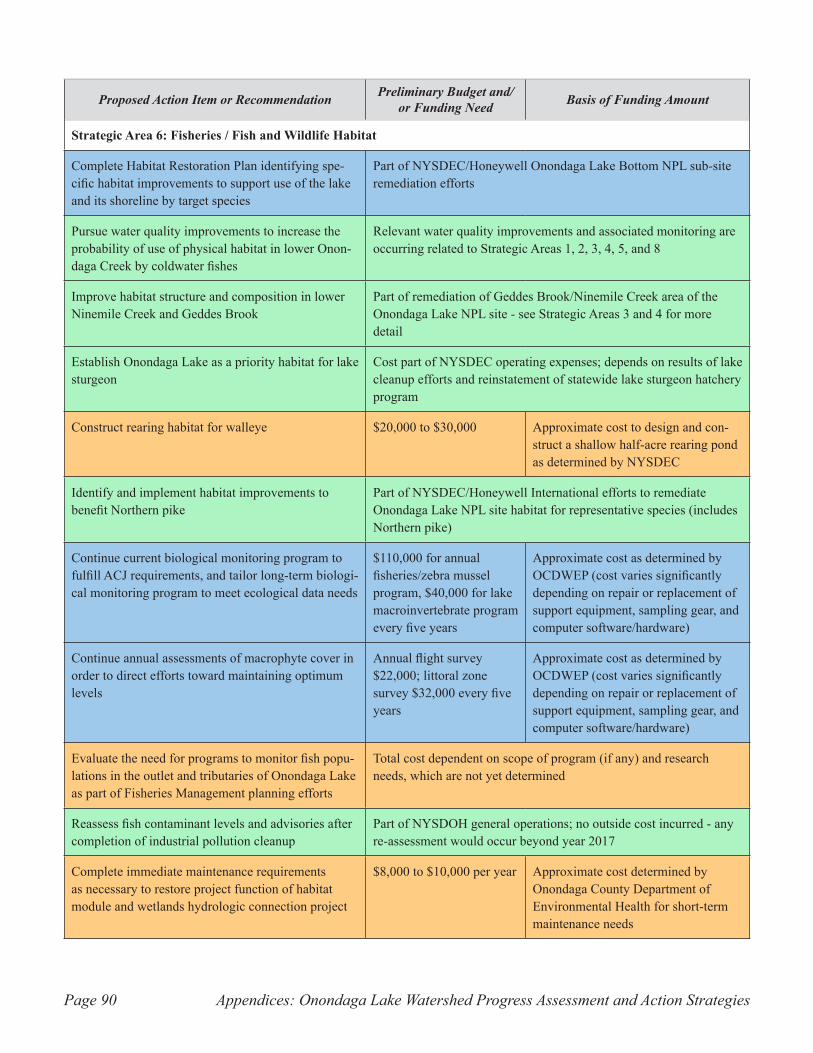
Appendices: Onondaga Lake Watershed Progress Assessment and Action StrategiesPage 90
Proposed Action Item or Recommendation Preliminary Budget and/or Funding Need Basis of Funding Amount
Strategic Area 6: Fisheries / Fish and Wildlife Habitat
Complete Habitat Restoration Plan identifying spe-cific habitat improvements to support use of the lake and its shoreline by target species
Part of NYSDEC/Honeywell Onondaga Lake Bottom NPL sub-site remediation efforts
Pursue water quality improvements to increase the probability of use of physical habitat in lower Onon-daga Creek by coldwater fishes
Relevant water quality improvements and associated monitoring are occurring related to Strategic Areas 1, 2, 3, 4, 5, and 8
Improve habitat structure and composition in lower Ninemile Creek and Geddes Brook
Part of remediation of Geddes Brook/Ninemile Creek area of the Onondaga Lake NPL site - see Strategic Areas 3 and 4 for more detail
Establish Onondaga Lake as a priority habitat for lake sturgeon
Cost part of NYSDEC operating expenses; depends on results of lake cleanup efforts and reinstatement of statewide lake sturgeon hatchery program
Construct rearing habitat for walleye $20,000 to $30,000 Approximate cost to design and con-struct a shallow half-acre rearing pond as determined by NYSDEC
Identify and implement habitat improvements to benefit Northern pike
Part of NYSDEC/Honeywell International efforts to remediate Onondaga Lake NPL site habitat for representative species (includes Northern pike)
Continue current biological monitoring program to fulfill ACJ requirements, and tailor long-term biologi-cal monitoring program to meet ecological data needs
$110,000 for annual fisheries/zebra mussel program, $40,000 for lake macroinvertebrate program every five years
Approximate cost as determined by OCDWEP (cost varies significantly depending on repair or replacement of support equipment, sampling gear, and computer software/hardware)
Continue annual assessments of macrophyte cover in order to direct efforts toward maintaining optimum levels
Annual flight survey $22,000; littoral zone survey $32,000 every five years
Approximate cost as determined by OCDWEP (cost varies significantly depending on repair or replacement of support equipment, sampling gear, and computer software/hardware)
Evaluate the need for programs to monitor fish popu-lations in the outlet and tributaries of Onondaga Lake as part of Fisheries Management planning efforts
Total cost dependent on scope of program (if any) and research needs, which are not yet determined
Reassess fish contaminant levels and advisories after completion of industrial pollution cleanup
Part of NYSDOH general operations; no outside cost incurred - any re-assessment would occur beyond year 2017
Complete immediate maintenance requirements as necessary to restore project function of habitat module and wetlands hydrologic connection project
$8,000 to $10,000 per year Approximate cost determined by Onondaga County Department of Environmental Health for short-term maintenance needs
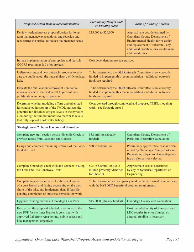
Appendices: Onondaga Lake Watershed Progress Assessment and Action Strategies Page 91
Proposed Action Item or Recommendation Preliminary Budget and/or Funding Need Basis of Funding Amount
Review wetland project proposal/design for long-term maintenance expectations, and redesign and reconstruct the project to reduce maintenance needs
$15,000 to $20,000 Approximate cost determined by Onondaga County Department of Environmental Health for re-design and replacement of substrate - any additional modifications would incur additional costs
Initiate implementation of appropriate and feasible OCCRP recommended pilot projects
Cost dependent on projects pursued
Utilize existing and new outreach resources to edu-cate the public about the natural history of Onondaga Lake
To be determined; the OLP Outreach Committee is not currently funded to implement this recommendation - additional outreach funds are required
Educate the public about removal of non-native invasive species from watercraft to prevent their proliferation and range expansion
To be determined; the OLP Outreach Committee is not currently funded to implement this recommendation - additional outreach funds are required
Determine whether modeling efforts and other stud-ies conducted in support of the TMDL indicate the potential for dissolved oxygen levels in the hypolim-nion during the summer months to recover to levels that fully support a coldwater fishery
Costs covered through completed and proposed TMDL modeling work - see Strategic Area 1
Strategic Area 7: Inner Harbor and Shoreline
Complete new trail section across Ninemile Creek to provide access from Lakeland and Geddes
$3.5 million (already funded)
Onondaga County Department of Parks and Recreation calculation
Design and complete remaining sections of the Loop-the-Lake Trail
$50 to $60 million Preliminary approximate cost as deter-mined by Onondaga County Parks and Recreation; subject to change depend-ing on alternatives selected
Complete Onondaga Creekwalk and connect to Loop-the-Lake and Erie Canalway Trails
$25 to $30 million ($6.5 million presently identified for Phase I)
Approximate cost as determined by city of Syracuse Department of Engineering
Complete investigatory work for the development of a boat launch and fishing access site on the west shore of the lake, and implement plans if feasible, pending completion of industrial remediation work
To be determined - investigatory work to be performed in accordance with the NYSDEC Superfund program requirements
Upgrade existing marina at Onondaga Lake Park $450,000 (already funded) Onondaga County cost calculation
Ensure that the proposal selected in response to the new RFP for the Inner Harbor is consistent with approved Lakefront Area zoning, public access and lake management objectives
None Cost included in city of Syracuse and LDC regular functions/duties; no external funding is necessary
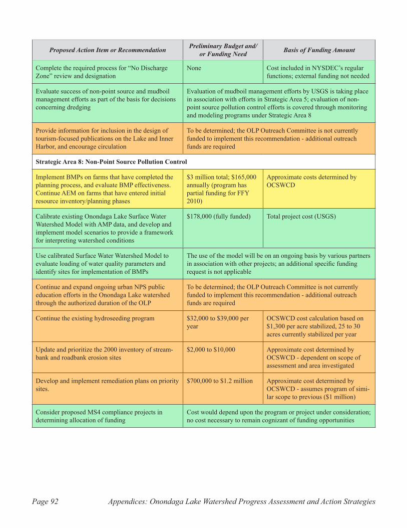
Appendices: Onondaga Lake Watershed Progress Assessment and Action StrategiesPage 92
Proposed Action Item or Recommendation Preliminary Budget and/or Funding Need Basis of Funding Amount
Complete the required process for “No Discharge Zone” review and designation
None Cost included in NYSDEC’s regular functions; external funding not needed
Evaluate success of non-point source and mudboil management efforts as part of the basis for decisions concerning dredging
Evaluation of mudboil management efforts by USGS is taking place in association with efforts in Strategic Area 5; evaluation of non-point source pollution control efforts is covered through monitoring and modeling programs under Strategic Area 8
Provide information for inclusion in the design of tourism-focused publications on the Lake and Inner Harbor, and encourage circulation
To be determined; the OLP Outreach Committee is not currently funded to implement this recommendation - additional outreach funds are required
Strategic Area 8: Non-Point Source Pollution Control
Implement BMPs on farms that have completed the planning process, and evaluate BMP effectiveness. Continue AEM on farms that have entered initial resource inventory/planning phases
$3 million total; $165,000 annually (program has partial funding for FFY 2010)
Approximate costs determined by OCSWCD
Calibrate existing Onondaga Lake Surface Water Watershed Model with AMP data, and develop and implement model scenarios to provide a framework for interpreting watershed conditions
$178,000 (fully funded) Total project cost (USGS)
Use calibrated Surface Water Watershed Model to evaluate loading of water quality parameters and identify sites for implementation of BMPs
The use of the model will be on an ongoing basis by various partners in association with other projects; an additional specific funding request is not applicable
Continue and expand ongoing urban NPS public education efforts in the Onondaga Lake watershed through the authorized duration of the OLP
To be determined; the OLP Outreach Committee is not currently funded to implement this recommendation - additional outreach funds are required
Continue the existing hydroseeding program $32,000 to $39,000 per year
OCSWCD cost calculation based on $1,300 per acre stabilized, 25 to 30 acres currently stabilized per year
Update and prioritize the 2000 inventory of stream-bank and roadbank erosion sites
$2,000 to $10,000 Approximate cost determined by OCSWCD - dependent on scope of assessment and area investigated
Develop and implement remediation plans on priority sites.
$700,000 to $1.2 million Approximate cost determined by OCSWCD - assumes program of simi-lar scope to previous ($1 million)
Consider proposed MS4 compliance projects in determining allocation of funding
Cost would depend upon the program or project under consideration; no cost necessary to remain cognizant of funding opportunities
Appendices: Onondaga Lake Watershed Progress Assessment and Action Strategies Page 93
Appendix C. Glossary.
Amended Consent Judgment (ACJ) – legal settlement between Atlantic States Legal Foundation (ASLF), New York State Department of Environmental Conservation (NYSDEC), and Onondaga County requir-ing the County to improve its systems for collection and treatment of sanitary sewage so that they do not contribute to a violation of water quality standards under the New York Environmental Conservation Law and the U.S. Clean Water Act.
Anoxic - containing no, or greatly depleted levels, of dissolved oxygen.
Best Management Practices (BMPs) – methods that have been determined to be the most effective, practi-cal means of preventing or reducing non-point source pollution.
Brine field – area in which injection wells for solution mining of salt minerals were installed in the past.
Capping – the placement of clean stone or sediment over areas of minor contamination to lessen exposure to the environment.
Coldwater fish – fish species that cannot survive in water temperatures above about 60 to 65 degrees Fahrenheit or higher (exact tolerance range varies by species) due to the depletion of dissolved oxygen that occurs with rising temperature; examples include Atlantic salmon, cisco (whitefish), and most species of trout.
Combined Sewer Overflow (CSO) – discharges of untreated wastewater consisting of a combination of stormwater and sanitary sewage into bodies of water, occurring during large precipitation events. These discharges occur when both stormwater and sanitary sewage are carried in a single network of pipes or conveyances known as a combined sewer.
Coolwater fish – fish species that tolerate warmer water conditions than the coldwater fish but avoid extremely warm conditions; examples include pike, perch, sturgeon, and smallmouth bass.
Depressurizing well – wells drilled in strategic locations to remove groundwater, lessening artesian pres-sure in the underlying aquifer (subsurface layer of material containing groundwater) thereby reducing discharge from hydrologically connected mudboils.
Dredging – removal of accumulated sediment from the bottom of a body of water using mechanical exca-vation, pumping of material in solution (hydraulic dredging), or other similar methods.
Effluent limit – highest acceptable level or concentration of a given pollutant in the discharge from a regu-lated point source facility, expressed relative to a specific time period or measurement frequency.
Epilimnion – the zone of relatively warm water in a thermally stratified (layered) lake that lies above the thermocline (depth at which temperature changes sharply), in which mixing occurs as a result of wind action and convection currents; contrast to hypolimnion.
Fishery – the populations and species of fish in a body of water from the perspective of management for recreational and/or consumptive use by humans.
Appendices: Onondaga Lake Watershed Progress Assessment and Action StrategiesPage 94
Fish community – the populations and species of fish in a body of water from the perspective of their intrinsic value to an aquatic ecosystem.
Floatables – trash and debris that are carried by stormwater and combined sewer overflows to Onondaga Lake as pollutants.
Floatables Control Facility (FCF) – engineered structures and/or equipment designed to capture and remove floating debris, including trash, waste matter, and other objects, from sewer discharges using net bags, screens, or other devices.
Gray infrastructure – term used to describe the use of conveyances, regional treatment facilities, and tradi-tional constructed or engineered structures for CSO abatement.
Green infrastructure – term used to describe the concept of utilizing naturally occurring or human-made features, such as vegetated areas, to reduce runoff volume by capturing and retaining precipitation onsite, returning it directly to the atmosphere through evapotranspiration, or allowing it to infiltrate through the soil to the groundwater table.
Hydroseeding – a method for establishing vegetation (typically grass cover) in which a mixture of seed and organic mulch, often combined with a bonding agent or tackifier and sometimes fertilizer, is broadcast in a liquid solution through a pressure hose and other specialized equipment.
Hypolimnion – the layer of water in a thermally stratified (layered) lake that lies below the thermocline (depth at which temperature changes sharply), is non-circulating, and remains perpetually cold; contrast to epilimnion.
Inner Harbor – basin at the south end of Onondaga Lake immediately north of the mouth of Onondaga Creek that previously operated as a commercial port for industrial trade and is now a focal point for water-front redevelopment in the city of Syracuse.
Isolation capping – type of capping that involves the use of a thicker layer of stone (contrast to thin-layer capping) to completely block exposure of the underlying material to the surrounding environment.
Leachate – a liquid product or solution created by the percolation of water through a layer of contaminated material, during which the water accumulates pollutants by interacting chemically with the material.
Littoral zone – portions of Onondaga Lake where the water depth ranges from 0 to 9 meters (0 to 30 feet).
Macrophyte – rooted, submerged, and floating aquatic vegetation, not including algae.
Mercury – a toxic, elemental heavy metal that is a component of many manufactured items and industrial processes, and is typically introduced to bodies of water by human activity.
Methylmercury – a compound of mercury that is formed from elemental mercury when dissolved oxygen in the lake is depleted through the action of anaerobic bacteria. Methylmercury is a much greater threat to living things since it is more toxic. It is also more mobile in the lake, and as such, can be ingested and absorbed into biological tissue.
Appendices: Onondaga Lake Watershed Progress Assessment and Action Strategies Page 95
Mudboil/Depression Area (MDA) – area that has in recent history contained the greatest degree of mudboil activity and land subsidence, at which numerous control practices have been installed.
Mudboils – geologic features that discharge turbid, fresh to saline groundwater at the land surface, typi-cally acquiring and transporting large loads of suspended sediment.
National Priorities List (NPL) – a list of industrial sites named by the U.S. Environmental Protection Agency as national priorities among the known releases or threatened releases of hazardous substances, pollutants, or contaminants throughout the United States and its territories that are subject to cleanup under the “Superfund” program established through the Comprehensive Environmental Response, Compensation and Liability Act of 1980 (CERCLA).
Nitrification – the biological transformation of ammonia into nitrites through reaction with oxygen, fol-lowed by further oxidation of nitrites into nitrates. A process is currently under study that may discourage the formation of methylmercury in Onondaga Lake by introducing nitrate to anoxic parts of the lake. Since bacteria that transform mercury to methylmercury can also use nitrate in respiration, the study will evaluate whether these bacteria prefer nitrate to mercury, and if so, determine whether the formation of methylmer-cury will decrease if a sufficient source of nitrate is available.
Non-point source (NPS) pollution – pollution that originates from diffuse sources dispersed across the landscape rather than from a single defined point such as an outflow pipe.
Oncolites – calcium carbonate stones lining parts of the shore and shallow-water areas of Onondaga Lake that are a by-product of carbonate-rich waste discharges associated with the soda ash production process.
Phosphorus – a chemical element commonly present in bodies of water in dissolved form and as organic and inorganic compounds, which at high levels can lead to poor water quality and severe algal blooms that upon decomposition produce conditions of low dissolved oxygen.
Polychlorinated Biphenyls (PCBs) – synthetic organic chemicals which, until being banned in 1979, were used in hundreds of industrial and commercial applications such as electrical and hydraulic equipment, oil-based paints, plastics and rubber products.
Regional Treatment Facility (RTF) – engineered structural facilities that capture flow from sewersheds subject to CSOs and remove floatables, nutrients, and other pollutants either by providing storage of the overflow volume itself or by passing the discharge through a treatment unit in the facility.
Sewer separation – the process of converting a combined sewer that transports both stormwater runoff and municipal sewage into two separate conveyances, one of which carries only sanitary sewage and the other of which carries solely stormwater runoff.
Sewershed – the geographic area from which flow is captured by a given network of sewers with a common outlet.
Smolts – salmon offspring that are in their second year of life.
Solution mining – the process of extracting salt or other minerals from bedrock by injecting water via wells into underground salt layers to dissolve the material, forming a void space in the salt deposit. The solution
Appendices: Onondaga Lake Watershed Progress Assessment and Action StrategiesPage 96
of salt brine filling the void is pumped to the surface and piped to a facility where water is evaporated, or other chemical processes are employed, to obtain desired mineral products.
Solvay waste beds – deposits of waste material from industrial processes, particularly the production of soda ash by the Solvay Process Company, that occupy hundreds of acres of land west of Onondaga Lake in the towns of Geddes and Camillus and the city of Syracuse. The waste is high in salinity and numerous other contaminants, and has caused increases in chloride, sodium, and calcium levels in the lake.
Stoplog – a board or similar device used to control the water level in an area of ponding.
Stormwater – rainwater and snowmelt that runs off the surface into sewers, drainage systems, and ulti-mately into bodies of water.
Stratification – a process in which lakes in temperate latitudes form distinct layers, marked by prominent temperature differences, during the summer and winter months.
Sub-site – a portion of a designated NPL site that contributes pollution to the larger site but can be treated as a single unit for the purposes of cleanup or remediation.
Substrate – mineral and organic materials occupying the bottom surface of a body of water that provide habitat for organisms.
Thin-layer capping – type of capping involving a relatively thin layer of material (contrast to isolation cap-ping) that is used over less polluted sediments where natural recovery may be possible through processes such as sediment accumulation atop the cap.
Total Maximum Daily Load (TMDL) – a calculation of the maximum amount of a pollutant that a body of water can receive and still maintain water quality standards, including an allocation of that load to the various sources of the pollutant.
Warmwater fish – fish species that are the most tolerant of high water temperatures, such as largemouth bass as well as most sunfish and catfish.
Appendices: Onondaga Lake Watershed Progress Assessment and Action Strategies Page 97
Appendix D. Literature cited.
Atlantic States Legal Foundation, State of New York and John P. Cahill, as Commissioner of the New York State Department of Environmental Conservation v. The Onondaga County Department of Drainage and Sanitation and Onondaga County, New York. 88-CV-0066. 1997.
City of Syracuse. 2008. “Creekwalk Trail.” http://www.syracuse.ny.us/Creekwalk_Trail.aspx. Accessed April 28, 2008.
City of Syracuse. 2004. Lakefront Zoning Districts. City of Syracuse Zoning Code Part B, Section IX, Articles 1 through 6.
City of Syracuse. 2002. Lakefront Area Master Plan.
Coghlan, S.M. Jr. and Ringler, N.H. 2005. Survival and bioenergetic responses of juvenile Atlantic salmon along a perturbation gradient in a natural stream. Ecology of Freshwater Fish 14: 111-124.
Coon, W. F. and Reddy, J. E. 2008. Hydrologic and Water-Quality Characterization and Modeling of the Onondaga Lake Basin, Onondaga County, New York. U.S. Geological Survey Scientific Investigations Report 2008-5013.
Duffett, C. 2005. “Inner Harbor Poised for Private Development.” CNY Business Journal, July 2005.
Kappel, W. M., 2009. Remediation of Mudboil Discharges in the Tully Valley of Central New York: U.S. Geological Survey Open File Report 2009-1173, 8p.
Kappel, W. M. and McPherson, W. S. 1998. Remediation of Mudboil Discharges in the Tully Valley of Central New York: U.S. Geological Survey Fact Sheet 143-97.
Kappel, W. M., Sherwood, D. A., and Johnston, W. H. 1996. Hydrogeology of the Tully Valley and Characterization of Mudboil Activity, Onondaga County, New York: U.S. Geological Survey Water-Resources Investigations Report 96-4043.
Lakefront Development Corporation. 2000. “Syracuse Skyline Changes as Oil Tanks Come Down.” Lakefront Today, Winter 2000.
Landers, J. 2007. “Cleaning-up the most polluted lake in the US.” Engineering World, February/March 2007: 2.
Lizlovs, S. 2005. “Industrial Waste Contamination: Past, Present, and Future.” Clearwaters, Volume 35, Issue 2.
Lucky Craft. 2008. “Team Luckycraft Tour Journal.”
Mobil Oil Corporation v. Syracuse Industrial Development Agency, 76 NY2d 428, 559 NE2d 641, 559 NYS2d 947. 1990.
Appendices: Onondaga Lake Watershed Progress Assessment and Action StrategiesPage 98
Moffa & Associates. 2002. Onondaga Lake Nonpoint Source Environmental Benefit Project. Submitted to Central New York Regional Planning and Development Board, November 2002.
New York State Department of Environmental Conservation (NYSDEC). 2009. Citizen Participation Plan for the Onondaga Lake Bottom Subsite Remedial Design Program.
NYSDEC. 2008a. “Interim Remedial Measures (IRM) Fact Sheet.” http://www.dec.ny.gov/chemical/8659.html (accessed June 2, 2008).
NYSDEC. 2008b. The Final New York State 2008 Section 303(d) List of Impaired Waters Requiring a TMDL/Other Strategy, May 26, 2008.
NYSDEC. 2008c. SPDES General Permit for Stormwater Discharges from Municipal Separate Storm Sewer Systems (MS4s). Permit No. GP-0-08-002. Effective May 1, 2008.
NYSDEC. 1997. Record of Decision. Ley Creek PCB Dredgings Inactive Hazardous Waste Site. Town of Salina, Onondaga County, NY. Site Number 7-34-044.
NYSDEC and U.S. Environmental Protection Agency (EPA). 2009a. Record of Decision. Operable Unit 1 of the Geddes Brook/Ninemile Creek Site Operable Unit of the Onondaga Lake Superfund Site. Onondaga County, New York.
NYSDEC and. EPA. 2009b. Record of Decision. Operable Unit 2 of the Geddes Brook/Ninemile Creek Site Operable Unit of the Onondaga Lake Superfund Site, Onondaga County, New York.
NYSDEC and EPA. 2007. Record of Decision. Town of Salina Landfill Site. Sub-site to the Onondaga Lake NPL Site. Town of Salina, Onondaga County. Site Number 7-34-036.
NYSDEC and EPA. 2005. Record of Decision. Onondaga Lake Bottom Subsite of the Onondaga Lake Superfund Site. Towns of Geddes and Salina, Villages of Solvay and Liverpool, and City of Syracuse, Onondaga County, New York. Superfund Site ID # NYD986913580.
NYSDEC and EPA. 2002. Record of Decision, Semet Residue Ponds Site Sub-site of the Onondaga Lake Superfund Site, Town of Geddes, Onondaga County. Superfund Site ID # NYD095586376.
New York State Department of Health (NYSDOH). 2007. Chemicals in Sportfish and Game 2007-2008 Health Advisories.
New York State Soil and Water Conservation Committee. 2007. Agricultural Environmental Management 2006-2007 Annual Report. Produced by Barbara Silvestri.
Onondaga County Parks Department. 2009. Onondaga Lake Special Event Water Quality Protocol.
Onondaga County Department of Water Environment Protection (OCDWEP). 2009. Onondaga Lake: Progress Report 2008.
OCDWEP. 2007(a). Onondaga Lake Fishery 2006 Fact Sheet.
OCDWEP. 2007 (b). Onondaga Lake: Progress Report 2006.
Appendices: Onondaga Lake Watershed Progress Assessment and Action Strategies Page 99
OCDWEP. 2006. Onondaga Lake Ambient Monitoring Program 1998-2012, Program Summary.
OCDWEP. 2003. Onondaga Lake Monitoring Program 2002 Annual Report.
Onondaga County Soil and Water Conservation District (OCSWCD). 1994. Onondaga Lake Non-Point Source Information and Education Program and Best Management Practices Implementation Demonstration.
OCSWCD. 1993. Onondaga Lake Watershed, Rural Nonpoint Source Management Plan.
Onondaga Environmental Institute. 2009. Onondaga Creek Conceptual Revitalization Plan. Draft 3, April 2009.
Onondaga Environmental Institute. 2008. Permanent Habitat Module: Littoral Zone Improvement Wetland Connection Projects. http://www.onondagaenvironmentalinstitute.org/OEIProgram_PermanentHabitatModule.html (accessed September 16, 2009).
Onondaga Lake Cleanup Corporation (OLCC). 2001. The State of Onondaga Lake.
Onondaga Lake Management Conference. 1993. Onondaga Lake, A Plan for Action.
Onondaga Lake Partnership (OLP). 2008. Tully Valley Mudboils: Long-Term Management Needs.
OLP. 2007. Rural Nonpoint Source Pollution Best Management Practices (BMP) Roadbank/Streambank Construction.
OLP. 2003. Restoring Onondaga Lake: Habitat Improvement. http://www.onlakepartners.org/ppdf/p1509c.pdf (accessed September 16, 2009).
Pair, D. L., Kappel, W. M., and Walker, M. S. 2000. History of Landslides at the Base of Bare Mountain, Tully Valley, Onondaga County, New York: U.S. Geological Survey Fact Sheet 190-99.
Parsons. 2009a. Onondaga Lake: Remedial Design Elements for Habitat Restoration (DRAFT). Pre-pared for Honeywell International.
Parsons. 2009b. Remedial Design Work Plan for the Onondaga Lake Bottom Subsite. Prepared for Hon-eywell International.
State of New York and Denise M. Sheehan as Trustee of Natural Resources v. Honeywell International, Inc. 89-CV-00815. October 11, 2006.
United States Geological Survey (USGS). 1999. Ecological Status of Onondaga Creek in Tully Valley, New York - Summer 1998. Fact Sheet FS 141-99.
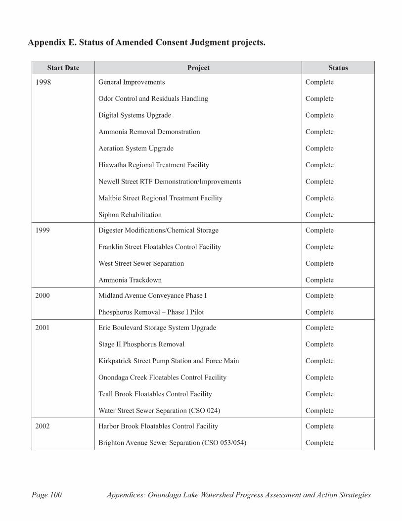
Appendices: Onondaga Lake Watershed Progress Assessment and Action StrategiesPage 100
Appendix E. Status of Amended Consent Judgment projects.
Start Date Project Status
1998 General Improvements
Odor Control and Residuals Handling
Digital Systems Upgrade
Ammonia Removal Demonstration
Aeration System Upgrade
Hiawatha Regional Treatment Facility
Newell Street RTF Demonstration/Improvements
Maltbie Street Regional Treatment Facility
Siphon Rehabilitation
Complete
Complete
Complete
Complete
Complete
Complete
Complete
Complete
Complete
1999 Digester Modifications/Chemical Storage
Franklin Street Floatables Control Facility
West Street Sewer Separation
Ammonia Trackdown
Complete
Complete
Complete
Complete
2000 Midland Avenue Conveyance Phase I
Phosphorus Removal – Phase I Pilot
Complete
Complete
2001 Erie Boulevard Storage System Upgrade
Stage II Phosphorus Removal
Kirkpatrick Street Pump Station and Force Main
Onondaga Creek Floatables Control Facility
Teall Brook Floatables Control Facility
Water Street Sewer Separation (CSO 024)
Complete
Complete
Complete
Complete
Complete
Complete
2002 Harbor Brook Floatables Control Facility
Brighton Avenue Sewer Separation (CSO 053/054)
Complete
Complete
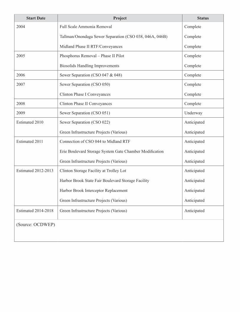
Start Date Project Status
2004 Full Scale Ammonia Removal
Tallman/Onondaga Sewer Separation (CSO 038, 046A, 046B)
Midland Phase II RTF/Conveyances
Complete
Complete
Complete
2005 Phosphorus Removal – Phase II Pilot
Biosolids Handling Improvements
Complete
Complete
2006 Sewer Separation (CSO 047 & 048) Complete
2007 Sewer Separation (CSO 050)
Clinton Phase I Conveyances
Complete
Complete
2008 Clinton Phase II Conveyances Complete
2009 Sewer Separation (CSO 051) Underway
Estimated 2010 Sewer Separation (CSO 022)
Green Infrastructure Projects (Various)
Anticipated
Anticipated
Estimated 2011 Connection of CSO 044 to Midland RTF
Erie Boulevard Storage System Gate Chamber Modification
Green Infrastructure Projects (Various)
Anticipated
Anticipated
Anticipated
Estimated 2012-2013 Clinton Storage Facility at Trolley Lot
Harbor Brook State Fair Boulevard Storage Facility
Harbor Brook Interceptor Replacement
Green Infrastructure Projects (Various)
Anticipated
Anticipated
Anticipated
Anticipated
Estimated 2014-2018 Green Infrastructure Projects (Various) Anticipated
(Source: OCDWEP)