Embed Size (px)
Citation preview

Petrosys 2018.2.1 Release Notes
SOFTWARE RELEASE NOTES
Version 2018.2.1
Petrosys valued-added agile development continues- the first update to Petrosys PRO 2018 is a significant functionality upgrade, not just a patch release.
Petrosys PRO now includes the Probabilistic Resource Calculator in Volumetrics allowing users to run Monte-Carlo simulation on volumes without needing to use another application. Algorithms and variables are available for conventional and unconventional resources to support many situations. Clients with a large portfolio of prospects may be interested in learning more about the underlying Prospects and Leads Database which the calculator is based upon.
Users in many disciplines will appreciate direct display of Excel spreadsheet tables on maps with clearly rendered text and live updates from the source data.
PRO 2018.2 is a big release for those who work with Petrel. The upcoming Petrel 2018.1 release is supported, including the new structural framework. Color bars are automatically imported and there are significant performance gains with displaying seismic data.
Automatic map generation is enhanced with the ability to loop over extents to create similar maps over multiple areas of interest such as fields or concessions.
Map templates have been enhanced further with custom location maps, including color bars in the template and adjusting the legend to fit in the box defined by the template.
Read on for more details on these options and more, or, for more information please contact your nearest support office or email [email protected].
Probabilistic Resource Calculator
Petrosys has added a new option to compute a range of outcomes for Oil and Gas volumes using Monte-Carlo simulation via the dbMap/Web Prospects & Leads Resource Calculator with input from two or three Volumetrics runs.
The option is available from Surface Modeling/Volumetrics/Probabilistic Resource Calculator.
In addition to most of the standard Volumetrics/Grid Based Slices options, you can:
• Choose one of the supported PRC compute methods - Depth-Volume Method, Depth-Area Top (Constant Thickness) and GRV Method
• Choose the desired distribution type - Normal, Lognormal, Triangular or Stretched Beta

Petrosys 2018.2.1 Release Notes
• Choose the hydrocarbon type - Oil, Gas or Oil & Gas
• Enter details for the Low & High Percentile, and Mode, depending on the distribution type selected
• Select either separate grids defining your low & high estimates, or select the same grid in both cases, and vary the contacts
• Contact level names are fixed and values mandatory, based on the PRC Compute method and Hydrocarbon type selected
When the task is run, it will run the standard Grid Based Slices volumetrics for each of the grids input in the Low/High Percentiles & Mode tabs.
Once complete, the data is securely sent to a read-only Petrosys-managed cloud dbMap/Web instance, which is restricted to only support PLDB Resource Calculator for the PRC. Some mandatory and other optional input distribution values can be set on the Geology, Oil, Gas and other tabs, such as Porosity, Net/Gross, Oil/Gas Bg and recovery factors, then pressing Compute will run a Monte-Carlo simulation for the set number of iterations. Resulting volumes are displayed in the Results tabs and can be exported to Excel for permanent storage.
Note: no data is stored or logged in the cloud beyond the current computation run. A Petrosys Connectivity license is needed.
Title Blocks Created in Excel
Title blocks can now be created and edited in Excel. Previously, title blocks could only be defined using a CGM file, however it is much easier to create and edit them in an Excel file. The Excel title block supports:
• Raster logos,
• Different line thicknesses to sub-divide the title block,
• Fonts, text sizing and alignment, cell fill
Title block contents are edited in the same way as existing title blocks. A panel to specify the contents will be generated automatically, with the option to override this and use a custom panel if required.

Petrosys 2018.2.1 Release Notes
Direct Display of Excel Spreadsheets on Maps
Excel spreadsheet store all sorts of useful information such as engineering data, production figures, volumetrics results, etc. They are also an easy way to view data in delimited text formats. Previously Excel spreadsheets were saved as a raster image and displayed in Petrosys PRO as a picture. The image was static and did not update with the spreadsheet and text could be pixelated when zoomed in.
Excel spreadsheets can now be displayed directly using the Display/Excel Table option. This option allows users to select which worksheet they want to display, and they can also restrict the display to a specific data range.
The display is live, so if the spreadsheet is updated, the data displayed on the map will update when it is refreshed. Text is properly rendered and will always be clear regardless of the zoom scale.
Dynamic Location Map Improvements – Custom Background
Dynamic location maps have been very popular since their introduction, however many users have requested a customizable background.
Base map types now include:
• Country outlines
• State/Province outlines
• Location map templates
• .dbm files
• Shapefiles
A shapefile can be selected and displayed directly. For dbm files, only shapefiles and WMS layers are supported so use this option if you want to use a WMS in the background.
Location map templates are dbms or shapefiles placed in standard locations to allow sharing between users.

Petrosys 2018.2.1 Release Notes
Histogram Color Bar Display and Editing
Displaying a data histogram shows spikes or extreme data variations which may not be obvious with a linear color bar. This is very useful when working with attribute data with an extreme Z-range, or with data where subtle color variations are hidden by a data spike. It can also help to identify where the spike is.
Once a grid or surface is displayed with a color bar, the data histogram can be displayed in the color bar editor and used to choose a knee point to highlight a value or range of data.
The user can choose to display the histogram over the current color bar, or as a separate color bar.
The gradient selector has a new "Equalization" checkbox. When this is enabled the gradient colors are distorted to spread the visible colors evenly on the map. This spreads out the most frequent intensity values making local areas of low contrast gain a higher contrast. This option is available in both Mapping and the 3D Viewer.
Seismic attribute grid
Seismic attribute grid - Equalized
Edit Third-Party Grids, Faults and Clipping Polygons
Petrosys PRO now allows the editing of grids and faults from both Petrel and OpenWorks and clipping polygons from Petrel only, from within the Grid Editor tool. The full suite of Grid Editor features is available, allowing Petrosys PRO’s intuitive editor to modify Petrel and OpenWorks grid data without the need for importing and exporting to and from Petrosys file formats.
Petrosys 2018.2.1 Release Notes
Color Bar Added to Map Templates
Map Template Styles now include the option to include one, or more, color bars. This enforces consistent color bar placement in company approved map styles.
The positioning options are the same as for the other map elements. When the template is selected with no grid displayed, a skeleton color bar with no fill will be displayed. This can be turned off in the display list if required. The next stage is to display a grid or surface. To populate the map style color bar, go to the display list and drag and drop the grid or surface item with the desired color bar to the color bar item in the Map Template group.
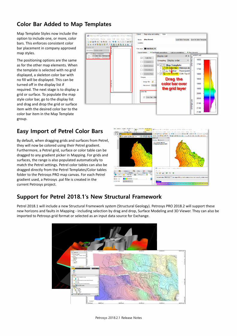
Easy Import of Petrel Color Bars
By default, when dragging grids and surfaces from Petrel, they will now be colored using their Petrel gradient. Furthermore, a Petrel grid, surface or color table can be dragged to any gradient picker in Mapping. For grids and surfaces, the range is also populated automatically to match the Petrel settings. Petrel color tables can also be dragged directly from the Petrel Templates/Color tables folder to the Petrosys PRO map canvas. For each Petrel gradient used, a Petrosys .pal file is created in the current Petrosys project.
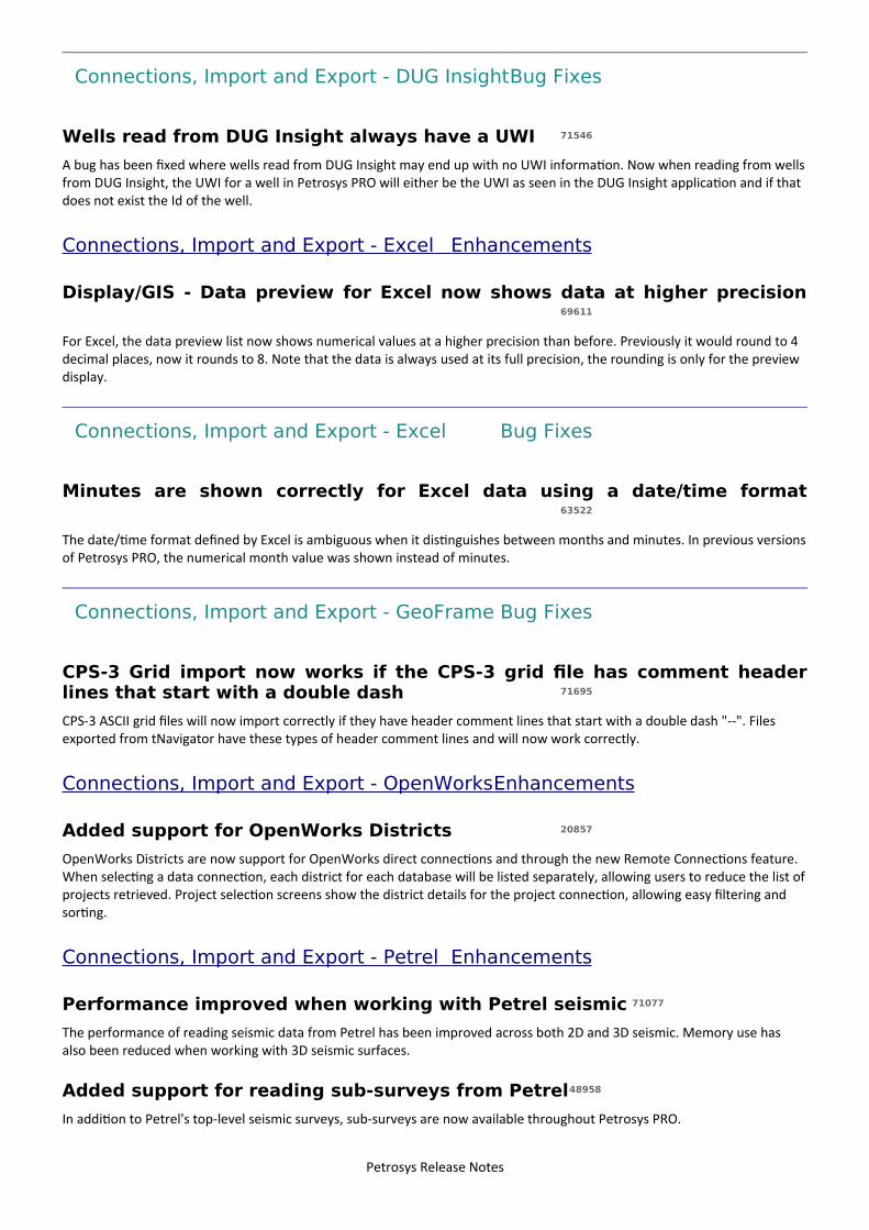
Support for Petrel 2018.1’s New Structural Framework
Petrel 2018.1 will include a new Structural Framework system (Structural Geology). Petrosys PRO 2018.2 will support these new horizons and faults in Mapping - including selection by drag and drop, Surface Modeling and 3D Viewer. They can also be imported to Petrosys grid format or selected as an input data source for Exchange.

Petrosys 2018.2.1 Release Notes
Quicker Display of Petrel Sub-Surveys
Petrosys PRO now supports Petrel sub-surveys wherever a survey can be selected. Including working with 3D seismic interpretation. We can now limit the horizon data to a sub-survey which can greatly improve performance when dealing with very large surveys. Other improvements have been made when working with sparse 3D seismic data.
Faster Petrel 2D Display
Several changes have been made to our Petrel plugin for PRO and to our generic seismic data handling which have resulted in vastly improved performance when working with Petrel seismic data:
• Petrel 2D navigation data – up to 6 times faster than previous versions
• Petrel 2D interpretation data – up to 25 times faster than previous versions
Batch Mapping of Data Over Multiple Extents
It is often necessary to map the same data types over multiple areas of interest. For example, periodic updates of maps showing a gold standard surface, available wells or seismic, or production pie charts may be required for areas defined by license blocks or field extents.
In Surface Modeling, the Workflow/Loop Over Highlighted Tasks option has a new option to loop over Map extents. In combination with
the Tools/Draw Map option, this makes it very easy to create consistent maps over multiple areas and periodically update them, outputting results to PDF, raster images or Petrosys dbm files.

Petrosys 2018.2.1 Release Notes
Third-Party Polygon Sources Available
in Surface Modeling
Third-party polygons are now available for use throughout gridding and volumetrics where polygons are used. For example, shapefiles can be used constraint the area for volume calculations, or as a source for clipping of grids. Supported polygon sources, include ArcSDE, WFS, shapefiles, OpenWorks polygons, Petrel and more.
OpenWorks Districts Now
Supported
OpenWorks Districts are now support for OpenWorks direct connections and through the new Remote Connections feature. When selecting a data connection, each district for each database will be listed separately, allowing users to reduce the list of projects retrieved. Project selection screens show the district details for the project connection, allowing easy filtering and sorting.
Better Formatted Legends
Map legends can now be set to a fixed size which is particularly useful with map templates. The option to size the legend based on the content remains, but now it is also possible to scale the contents to the legend box.
The number of columns is set in the new Layout tab and there are additional controls in the Style tab, including how any blank space is filled – this is most obvious when legend blocks have different background fills.
Batch Create Map Extents by
Scanning GIS Data
Map templates support fixed extents which are particularly useful when mapping specific fields or lease boundaries. Petrosys PRO has a script that batch creates extents from an input shapefile using a specified attribute as the name of the extents. The default restricts the extent to the minimum/maximum X and Y coordinate of the input data, but there is an option to add a buffer distance. Contact Support for help running this option.
This option complements extent looping also available in this release. For example, map extents created based on fields with a 1 km buffer.
Petrel 2018 Supported
Due to Petrosys’ and Schlumberger’s close working relationship, Petrosys is pleased to support the soon to be released Schlumberger Petrel 2018 in Petrosys PRO 2018.2. Petrel 2018 is supported in all the places you’ve come to expect, including grids, seismic and wells, along with the new structural framework.

Petrosys 2018.2.1 Release Notes
Paradigm 2018 Support Ready & Coming Soon
Support for Emerson’s Paradigm 2018 release has been developed for Petrosys PRO on Linux and Windows. Paradigm 2018 support will be released in a servicing update for Petrosys PRO 2018.2 shortly after Paradigm 2018 has been officially released, ensuring early adopters have continuing access to their data.
Connect to Remote Data Sources Without a Dispatch Server Daemon
Petrosys PRO has long supported cross platform connections to remote data sources through the Dispatch Server daemon. For example, accessing GeoFrame data hosted on a Linux system from a Windows PC. However, configuring and maintaining the Dispatch Server daemon can be a difficult task in some client environments. Petrosys PRO 2018.2 now supports a new remote data source connection method using SSH. Remote connections are initiated directly between the user’s Windows desktop and the remote Linux data source host without the need for a service or daemon running on the remote computer. Once the connection type is specified in the connections.xml file, configuration is simple, with all required settings available on the user’s desktop. Normal username/password prompts, along with RSA/DSA keyfiles, with and without passphrases, are supported, ensuring simple operation in a variety of environments. To learn how to setup these simplified cross-platform connections read the help topic “MULTIPLE CONNECTIVITY - CONFIGURATION – VIA SSH”
The Remote Connections feature will replace the Dispatch Server feature, which is now considered deprecated and may be removed in a future release.
Notes for Upgraders
Petrosys PRO 2018.2 includes an upgrade for the CRS database to EPSG 9.4. Client sites that use Petrosys PRO on an Oracle database will need to run the supplied database upgrade scripts.
There are no version incompatibilities between Petrosys PRO 2018.1 and Petrosys PRO 2018.2. Please see the Petrosys PRO 2018.1 release notes if upgrading from an earlier version of Petrosys PRO.

9 entries
Detailed Release Notes Summary PRO 2018.2.1Enhancements
Connections, Import and Export - Paradigm-Epos71664 Added support for Paradigm 18 on Linux and Windows71754 Added support for using Paradigm on Windows via Remote Connectons
dbMap - Client43504 Well RFT opton now brings up the dbMap/Web screen (Santos only)71673 Well links added to Santos WIS and Web GIS (Santos only)
Mapping - General71876 Added support to drag and drop Petrel, DecisionSpace and fleebased data to the display list
Spatial Editor71787 Grid Editor Save As.. Petrel automatcally sets Petrel project71786 Grid Editor: Save As... Petrel. Select existng now sets Petrel folder71791 Grid Editor: Thirdeparty grid style restored and fxed recent menu
Surface Modeling - Volumetrics72022 Probabilistc Resource Calculator now supports multple polygons for the GRV method
Petrosys Release Notes

18 entries
Detailed Release Notes Summary PRO 2018.2.1Bug Fixes
Connections, Import and Export72164 Petrel Plugin e Fixed an issue on certain confguratons of dualestack IPv4/IPv6 networks71986 Fixed Petra connectons getng mangled Names afer inital use between applicatons71792 Reduced the number of tmes SSH credentals are required within a session
Connections, Import and Export - OpenWorks72165 Fixed an issue where the DecisionSpace Geosciences Plugin would fail to launch
Connections, Import and Export - Petrel72019 Wells Import Wizard: Fixed issues when writng missing dates to Petrel well completons72059 Fixed crash when gridding sparse Petrel seismic surface
Mapping - General71858 Map Template are now loaded from pre 2017.1 dbm fle71597 Display/Excel: Colors are read correctly from .xlsx fles that use the default theme
Mapping - GIS, Spatial and Culture71911 Handle invalid polyline set in Petrel71845 Display/GIS does not show dbMap specifc data type fltering for Santos
Mapping - Grids, Surfaces and Sampled Data Files71762 Fixed minor user interface issues when exportng a grid from mapping (RMB/Export Grid)
Spatial Editor71941 Grid editor no longer causes Mapping to crash during exit71777 Grid Editor: Petrel no longer overwrite existng faults with polygon data if name and folder name are the same
Surface Modeling - Exchange72033 Fixed crash when convertng units between data sources during Seismic Surface Exchange71886 Grid Exchange: Fixed output grid atributes not being updated in the user interface
Surface Modeling - Gridding71881 Fixed some Surface Modeling tasks not upgrading Petrel seismic input selectons
Surface Modeling - Volumetrics71923 No longer crash when reading polygon data in legacy volumetrics optons72020 Probabilistc Resource Calculator now uses the correct inputs levels for GRV method
Petrosys Release Notes

27 entries
Petrosys Release PRO 2018.2.1Detailed Release Notes
Connections, Import and Export Bug Fixes
Petrel Plugin - Fixed an issue on certain confgurations of dual-stackIPv4/IPv6 networks 72164
An issue has been fxed where the Petrel Plugin would not connect on certain network confguratons involving dualestack IPv4/IPv6.
Fixed Petra connections getting mangled Names after initial use betweenapplications 71986
A bug has been fxed whereby Petra connectons added in one applicaton and then used in another during the same Launcher session were getng mangled Names or duplicate entries in the Connecton Manager.
Reduced the number of times SSH credentials are required within asession 71792
If you have chosen not to save your SSH username and password, you will no longer be prompted for it multple tmes within a single session. Additonally, the password manager will now store the locaton to your RSA/DSA key if you are using key authentcaton and choose to save your password.
Connections, Import and Export - OpenWorksBug Fixes
Fixed an issue where the DecisionSpace Geosciences Plugin would fail tolaunch 72165
An issue has been fxed which was stopping the Petrosys PRO DSG Plugin from successfully launching if a user does not have at least Browse privilege on the Master OpenWorks project of the Interpretaton project being used in DSG.
Connections, Import and Export - Paradigm-Epos Enhancements
Added support for Paradigm 18 on Linux and Windows 71664
Paradigm 18 is now supported as a data source in all features that previously supported a Paradigm connecton on both Linuxand Windows.
Paradigm 15.5 and Paradigm 17 contnue to be supported as data sources.
Added support for using Paradigm on Windows via Remote Connections71754
On Windows, Paradigm is now a supported data source for the Remote Connectons feature that was released in Petrosys PRO 2018.2. This allows Windows users to display data from a Linux installaton of Paradigm, without requiring Paradigm to be installed on the Windows PC.
Petrosys Release Notes

Connections, Import and Export - Petrel Bug Fixes
Wells Import Wizard: Fixed issues when writing missing dates to Petrelwell completions 72019
When writng completons (Casing, tubing, perforatons, fractures) to Petrel, missing dates were recorded as 01/01/001 which caused Petrel to raise warning messages. This has now been fxed.
Fixed crash when gridding sparse Petrel seismic surface 72059
When gridding 3D Seismic data from Petrel, Surface Modeling could crash if the data from Petrel was classifed as being sparse. Additonally, writng sparse 3D seismic surfaces from Petrel would fail. These issues have now been fxed.
dbMap - Client Enhancements
Well RFT option now brings up the dbMap/Web screen (Santos only)43504
For Santos the RFT Runs opton on the well menu now brings up the dbMap/Web screen for the current well.
Well links added to Santos WIS and Web GIS (Santos only) 71673
For Santos, the dbMap Well menu now has optons to launch the Santos WIS and Web GIS web pages for the current well, matching what is already available from the dbMap/Web well header dialog.
Mapping - General Enhancements
Added support to drag and drop Petrel, DecisionSpace and fle-based datato the display list 71876
Previously, data dragged from Petrel, DecisionSpace or external fle needed to be dropped on to the mapping canvas. The drop zone has now been extended to include the display list.
Mapping - General Bug Fixes
Map Template are now loaded from pre 2017.1 dbm fle 71858
All map template's elements (under the special Map Template group) in pre 2017.1 dbm fle will now be loaded.
Display/Excel: Colors are read correctly from .xlsx fles that use the defaulttheme 71597
Displaying an Excel .xlsx fle using the Display/Excel Table opton shows correct colours from the default theme.
Mapping - GIS, Spatial and Culture Bug Fixes
Handle invalid polyline set in Petrel 71911
Display/GIS now shows list of Petrel objects robustly. In previous version, Display/GIS may not show any Petrel items if Petrel Project has an invalid polygon set.
Petrosys Release Notes

Display/GIS does not show dbMap specifc data type fltering for Santos71845
Petrosys dbMap databases support a range of spatalized data types. These have previously been available for display under the "dbMap GIS" opton in Display/GIS, but were shown in a combined list, along with more generic Oracle data. Display/GIS now allows the dbMap data type to be selected to flter the list to only show layers for the relevant data type
Mapping - Grids, Surfaces and Sampled Data FilesBug Fixes
Fixed minor user interface issues when exporting a grid from mapping(RMB/Export Grid) 71762
Minor changes to the RMB/Export Grid user interface to improve compatbility with high DPI devices.
Spatial Editor Enhancements
Grid Editor Save As.. Petrel automatically sets Petrel project 71787
Grid Editor Save As dialog has been improved so the Petrel connecton is connected automatcally.
Grid Editor: Save As... Petrel. Select existing now sets Petrel folder 71786
Grid Editor Save As dialog has been improved so when selectng existng grid all relevant felds are populated.
Grid Editor: Third-party grid style restored and fxed recent menu 71791
Recent menu works for thirdeparty grids now and previously used styles are now remembered for thirdeparty grids.
Spatial Editor Bug Fixes
Grid editor no longer causes Mapping to crash during exit 71941
In previous version there was a bug where if the Grid Editor had been used then Mapping could crash when the applicaton was closed. This has now been fxed.
Grid Editor: Petrel no longer overwrite existing faults with polygon data ifname and folder name are the same 71777
Grid Editor now saves fault and polygon data to Petrel correctly. In previous version, Grid Editor might overwrite existng faultdata with polygon data if they have the same name.
Surface Modeling - Exchange Bug Fixes
Fixed crash when converting units between data sources during SeismicSurface Exchange 72033
A potental crash conditon has been fxed when translatng unit informaton between the input and output data sources during a Seismic Surface Exchange run.
Grid Exchange: Fixed output grid attributes not being updated in the userinterface 71886
In Grid Exchange, changes made to a grid's output atributes weren't refected in the grid list. This has now been fxed.
Petrosys Release Notes

Surface Modeling - Gridding Bug Fixes
Fixed some Surface Modeling tasks not upgrading Petrel seismic inputselections 71881
In some cases, Petrel seismic inputs to a Surface Modeling task were lost during the task upgrade from PRO 2018.1 to PRO 2018.2. This has now been fxed.
Surface Modeling - Volumetrics Enhancements
Probabilistic Resource Calculator now supports multiple polygons for theGRV method 72022
The Surface Modeling/Volumetrics/Probabilistc Resource Calculator opton now supports selecton of more than one polygon when using the GRV method.
Surface Modeling - Volumetrics Bug Fixes
No longer crash when reading polygon data in legacy volumetrics options71923
In previous version Surface Modeling may crash when running the legacy volumetrics optons e.g. Volumetrics/Grid Based/Top and Base Grids. This has now been fxed.
Probabilistic Resource Calculator now uses the correct inputs levels forGRV method 72020
The Surface Modeling/Volumetrics/Probabilistc Resource Calculator opton now uses the input Top and Oil Water or Gas Contact values to compute the volumes for input into the PLDB calculator. Previously it would ofen compute the volumes from a top depth of zero to the Oil Water or Gas Contact.
Petrosys Release Notes

45 entries
Detailed Release Notes Summary PRO 2018.2Enhancements
3D Viewer - General71357 3DViewer scaling/ofset felds allow up to 8 decimal places
Application - General63153 FaultRisk 4.4 now supported
Connections, Import and Export71235 Connect from Windows to Linux data sources without a Dispatch Server daemon71610 Text fle format defniton UI - Tooltp added to make it more obvious that the buton can be clicked65761 Support IC (ODM) connectons that use 'SQL Server LocalDB'
Connections, Import and Export - Excel69611 Display/GIS - Data preview for Excel now shows data at higher precision
Connections, Import and Export - OpenWorks20857 Added support for OpenWorks Districts
Connections, Import and Export - Petrel71077 Performance improved when working with Petrel seismic48958 Added support for reading sub- surveys from Petrel67581 Added support for reading Petrel 3D seismic cropped to a sub- survey23894 Added support for drag and drop of Petrel well saved searches69920 Added support for Petrel gradients66830 Petrel 2018.1 supported70054 Added support for the new Structural Framework made available in Petrel 2018.1
Coordinate Reference Systems65453 EPSG data base upgraded to version 9.4
Mapping - General68464 Display/Locaton Map allows customisaton of the base map69190 Map templates include support for color bars17916 Display Excel tables directly on a map67095 Map legends allows display within a fxed size and multple columns63639 Support added for ArcGIS token authentcaton method 69248 A new opton for fltering text and Excel data when displaying bubble maps71063 Display/Title Block allows display of ttle blocks defned in Excel fles58115 Display/Web Map Service allows management of the URL catalog70609 Display/Other Map Extent allows selecton of extents from a wider variety of sources
Mapping - GIS, Spatial and Culture70085 Display/GIS allows display of spatalized dbMap basins, facilites, felds, permits and prospects70089 Display/GIS includes dbMap specifc data type fltering70799 Performance of display of shapefles over network drives has been greatly improved
Mapping - Grids, Surfaces and Sampled Data Files11907 Grid layers allow optonal equalisaton of gradient colors55561 Automatcally display faults when a fault selecton is made71160 Added opton to export a displayed grid into another grid format
Mapping - Seismic71048 Added Seismic 3D Bin Grid corner point tolerance optons to the Confguraton and Setngs tool
Mapping - Wells68472 Formaton selector now shows the Basin, Interpreter and Type names instead of the Id (PPDM38 only)
Petrosys Release Notes

27731 Detailed well path checking can now be used to identfy wells crossing an extent
Spatial Data Translator71186 Added warning when no feature classes are read when clicking the Select buton
Spatial Editor58704 Editng of grids, faults and clipping polygons from Petrel and OpenWorks46239 Spatal editor "Unite" operaton allows overlapping polygons to be merged into a single polygon71516 Spatal Editor shows the data table by default
Surface Modeling - General27010 Deprecated Grid and Contour based volumetrics optons are now hidden by default21754 Grid processing and arithmetc support selecton of data using polygons from any vector data type
Surface Modeling - Gridding70876 Gridding input data item names can be edited
Surface Modeling - Volumetrics69250 Probabilistc Resource Calculator (PRC)21753 Volumetrics calculatons to allow selecton of data using polygons from any vector data type
Surface Modeling - Workflows/Scripting71707 Increased interactve scriptng 'text' feld to 256 characters70647 Allow Surface Modeling workfow task descripton to be scriptable70918 Support for looping Map Extents added
Petrosys Release Notes

29 entries
Detailed Release Notes Summary PRO 2018.2Bug Fixes
Confguration - Licensing71510 Tools/Flex Tools now uses correct platorm version
Connections, Import and Export - DUG Insight71546 Wells read from DUG Insight always have a UWI
Connections, Import and Export - Excel63522 Minutes are shown correctly for Excel data using a date/tme format
Connections, Import and Export - GeoFrame71695 CPS- 3 Grid import now works if the CPS- 3 grid fle has comment header lines that start with a double dash
Connections, Import and Export - Petrel70735 Added support to drag and drop 2D seismic horizon atributes from Petrel
Mapping - General71229 File resoluton dialog is no longer incorrectly shown for ttle blocks with two included images70768 Mapping allows all "map template" layers to be hidden, without hiding border annotaton70732 Canadian NTS landgrid map extents allow lower case leters when specifying subdivision70359 CRS errors are no longer shown during scanning of map extents or templates71378 Display/Raster correctly restores 'Map' coordinate types from dbm fles69315 Landgrid based map extents use the global landgrid by default70923 Map layers can no longer be positoned above the "Map Template" group
Mapping - GIS, Spatial and Culture38992 Display/GIS draws polygons that completely enclose the map extent71248 MapInfo polygons now appear in legend70477 Display/GIS no longer shows "linear range" twice under the Thematc/Symbol Style scaling optons69519 Display/GIS using a thematc series gradient containing spike colous draws correctly
Mapping - Grids, Surfaces and Sampled Data Files70831 Faults now remain selected when changing input grid for display
Spatial Editor71434 When editng grids, the "Compute grid within faults" setng is read from the corresponding Petrosys gri69742 Grid editng correctly handles multple "clip outside" polygons71514 Grid editor automatcally regenerates contours afer localised or full regridding71515 Grid editor generates contours correctly when contour increment is lef blank71794 Spatal Editor no longer crashes when selectng read only layers with the "Move" tool actve
Surface Modeling - General71447 Looping over SDF horizons no longer loop over horizon that was not selected
Surface Modeling - Gridding71404 Grid/Process/Arithmetcc AOI of output grid generated using GPA based on a map extent does match grid create
grid70746 Stacking velocity gridding now responds to cancel
Surface Modeling - Volumetrics71446 Volumetrics report have colored gradient charts rendered71386 Volumetrics reports correct 'volume above' when no polygons are used
Surface Modeling - Workflows/Scripting71702 Looping over fles no longer crashes when fles are created dynamically71032 Volumetrics/Grid Based Slices task retains its scriptng felds when task modifed
Petrosys Release Notes

74 entries
Petrosys Release PRO 2018.2Detailed Release Notes
3D Viewer - General Enhancements
3DViewer scaling/ofset fells allow up to 8 lecimal places 71357
Scaling and ofset felds in some display optons allow up to 8 decimal digits (previously only two).
Application - General Enhancements
FaultRisk 4.4 now supportel 63153
FaultRisk v 4.4 is now supported in Petrosys PRO. It can be started from Petrosys PRO Launcher, located under the Apps menu opton.
Configuration - Licensinig Buig Fixes
Tools/Flex Tools now uses correct platform version71510
On Windows the launcher opton Tools/Flex Tools now uses the correct platorm version of the FLEXlm tools program. This means that if this optons is run on a server confgured with the Petrosys license server then you will see the confgured license service correctly. Previously it would not show up.
Connections, Import and Export Enhancements
Connect from Winlows to Linux lata sources without a Dispatch Serverlaemon 71235
Petrosys PRO has long supported connecton to remote data source through the dispatch server daemon. For example, accessing GeoFrame data hosted on a Linux system from a Windows PC. However, confguring and maintaining the dispatch server daemon can be a difcult task in some client environments. Petrosys PRO 2018.2 now supports a new remote data source connecton method using SSH. Remote connectons are initated directly between the user’s desktop and the remote data source computer without the need for a service or daemon running on the remote computer. Once the connecton type is specifed in the connectons.xml fle, confguraton is simple, with all required setngs available on the user’s desktop. Normal username/password prompts, along with RSA/DSA keyfles, with and without passphrases, are supported, ensuring simple operaton in a variety of environments.
In Petrosys PRO 2018.2, SSH connectons are supported for GeoFrame and OpenWorks data sources.
The Remote Connectons feature will replace the Dispatch Server feature, which is now considered deprecated and may be removed in a future release.
Text fle format lefnition UI - Tooltip allel to make it more obvious thatthe button can be clickel 71610
A tooltp has been added to the buton that defnes the format for Text fles when they are used for display or gridding.
Support IC (ODM) connections that use 'SQL Server LocalDB' 65761
Petrosys now supports connectng to IC (ODM) projects that are stored using 'SQL Server LocalDB'. Petrosys contnues to also support projects stored in MS Access and SQL Server databases.
Petrosys Release Notes
Connections, Import and Export - DUG InsiightBuig Fixes
Wells real from DUG Insight always have a UWI 71546
A bug has been fxed where wells read from DUG Insight may end up with no UWI informaton. Now when reading from wellsfrom DUG Insight, the UWI for a well in Petrosys PRO will either be the UWI as seen in the DUG Insight applicaton and if that does not exist the Id of the well.
Connections, Import and Export - Excel Enhancements
Display/GIS - Data preview for Excel now shows lata at higher precision69611
For Excel, the data preview list now shows numerical values at a higher precision than before. Previously it would round to 4 decimal places, now it rounds to 8. Note that the data is always used at its full precision, the rounding is only for the preview display.
Connections, Import and Export - Excel Buig Fixes
Minutes are shown correctly for Excel lata using a late/time format63522
The date/tme format defned by Excel is ambiguous when it distnguishes between months and minutes. In previous versionsof Petrosys PRO, the numerical month value was shown instead of minutes.
Connections, Import and Export - GeoFrame Buig Fixes
CPS-3 Gril import now works if the CPS-3 gril fle has comment healerlines that start with a louble lash 71695
CPS- 3 ASCII grid fles will now import correctly if they have header comment lines that start with a double dash "- - ". Files exported from tNavigator have these types of header comment lines and will now work correctly.
Connections, Import and Export - OpenWorks Enhancements
Allel support for OpenWorks Districts 20857
OpenWorks Districts are now support for OpenWorks direct connectons and through the new Remote Connectons feature. When selectng a data connecton, each district for each database will be listed separately, allowing users to reduce the list ofprojects retrieved. Project selecton screens show the district details for the project connecton, allowing easy fltering and sortng.
Connections, Import and Export - Petrel Enhancements
Performance improvel when working with Petrel seismic 71077
The performance of reading seismic data from Petrel has been improved across both 2D and 3D seismic. Memory use has also been reduced when working with 3D seismic surfaces.
Allel support for realing sub-surveys from Petrel48958
In additon to Petrel's top- level seismic surveys, sub- surveys are now available throughout Petrosys PRO.
Petrosys Release Notes

Allel support for realing Petrel 3D seismic croppel to a sub-survey67581
When working with 3D seismic surfaces from Petrel, you can now select a sub- survey to crop the surface to your area of interest.
Allel support for lrag anl lrop of Petrel well savel searches 23894
Saved Searches can now be dragged from Petrel to Petrosys PRO Mapping and Surface Modeling in the same way as a Petrel well or well folder.
Allel support for Petrel gralients 69920
Petrel gradients can now be used directly within Petrosys PRO. The easiest way to use them is to drag and drop a Petrel grid, surface or horizon in to Mapping, and its associated gradient will automatcally be imported and selected. You can also drag aPetrel color table directly to a Petrosys PRO color picker or the Mapping canvas. Imported Petrel color tables are stored within the Petrosys PRO project.
Petrel 2018.1 supportel 66830
Petrosys connectvity to Schlumberger's Petrel now supports direct interacton with Petrel 2018.1.
Support for Petrel 2018.1 includes the ability toc
➢ Drag and drop data from Petrel into Petrosys PRO➢ Import Model grid horizons and 3D seismic interpretaton horizons to a Petrosys grid fle➢ Import faults from Model grids to a Petrosys fault fle➢ Import 2D and 3D seismic navigaton and horizon interpretaton data to a Petrosys SDF➢ Directly display Model grid horizons, Input surface grids and 3D seismic interpretaton horizons in Mapping➢ Directly contour Model grid horizon data and Input surface grids in Surface Modeling➢ Directly grid 2D and 3D seismic horizon interpretaton data in Surface Modeling➢ Directly display, grid and import well data.➢ Directly display 2D seismic navigaton and horizon interpretaton in Mapping➢ Directly display 3D seismic bin grids in Mapping➢ Directly display Structural Model fault surfaces in 3DViewer➢ Directly display fault stcks in 3DViewer➢ Export Petrosys and other third party grids to Petrel
The new Structural Framework Horizons and Faults added to Petrel 2018.1 are also supported.
Petrosys PRO contnues to maintain support for connectons to Petrel 2014.x, 2015.x, 2016.x and 2017.x.
Allel support for the new Structural Framework male available in Petrel2018.1 70054
A new set of structural framework objects have been introduced with Petrel 2018.1. Support to read and display these new structural framework horizons and faults has been added.
Connections, Import and Export - Petrel Buig Fixes
Allel support to lrag anl lrop 2D seismic horizon attributes from Petrel70735
Petrel 2D seismic atributes can now be dragged and dropped where 2D seismic interpretaton in accepted.
Petrosys Release Notes
Coordinate Reference Systems Enhancements
EPSG lata base upgralel to version 9.4 65453
The standard EPSG coordinate reference system data included with Petrosys PRO has been upgraded to version 9.4. Please refer to www.epsg.org for specifc details on the data changes included in this version.
Mappinig - General Enhancements
Display/Location Map allows customisation of the base map 68464
The Display/Locaton Map opton allows the "base map" for the locaton map to be customised. In previous versions of Petrosys PRO, this was fxed to country or state outlines, but the base map can now be based on shapefles or dbm fles, with a restricton on the layer types allowed in the dbm fle. This can be useful for displaying on- shore locaton maps (e.g. based on license blocks or permits), locaton maps using satellite imagery (using web map services), customising styles or for addingfltering to base map polygons.
Map templates inclule support for color bars 69190
Petrosys PRO map templates allow color bars to be included as part of the map template. When a map template with a color bar is applied, the color bar will not be drawn untl linked to a grid, or other gradient source. In additon, the layer linked to any color bar can now be modifed afer the color bar has been created, which previously was not possible.
Display Excel tables lirectly on a map 17916
The Mapping/Display/Excel Table allows Excel tables to be displayed directly on a map, using the style (fonts, colors, line styles) defned in the Excel table.
➢ Excel tables displayed using this opton are positoned relatvely within the map border - not spatally (i.e. not a partcular geographic or projected coordinate). Display/GIS can stll be used to display Excel data with a spatal component
➢ The style defned in the Excel fle will be honoured as closely as possible and generally the results will match quite well.Several 'advanced' Excel formatng optons are not supported (refer to the online help for specifc details)
Map legenls allows lisplay within a fxel size anl multiple columns67095
The legend in previous versions of Petrosys PRO would automatcally size itself according to the contents of the legend. Petrosys PRO 2018.2 stll supports this behaviour, but also allows a fxed rectangular size to be set for the legend, with the content sized to ft into the defned rectangle. This is useful when creatng map templates to ft the legend in between other map elements.
In additon, the legend supports multple top- level columns, which would typically be used to create a "horizontal" legend - toft into a horizontal ttle bar for example. The legend content (blocks) will automatcally wrap into the legend columns to maximise the space available.
Support allel for ArcGIS token authentication methol 63639
The ArcGIS token authentcaton method is supported when accessing image or vector data from ArcGIS server web services. If this authentcaton method is enabled in Petrosys PRO, a "token" - which is a short piece of encrypted text - must be obtained manually from the ArcGIS server and pasted into Petrosys PRO when prompted. The same token can be used for multple services accessed from the same ArcGIS server, and Petrosys PRO will re- prompt if a new token is required, for example when a previous token has expired.
A new option for fltering text anl Excel lata when lisplaying bubblemaps 69248
The Display/Bubble Maps opton includes a new "Atribute" fltering opton when the input source is a text or Excel fle. The "Atribute" fltering method is equivalent to the table fltering available elsewhere in Petrosys PRO and allows fltering based on text values.
Petrosys Release Notes

Display/Title Block allows lisplay of title blocks lefnel in Excel fles71063
The Display/Title Block opton now allows ttle blocks to be displayed from Excel fles, in additon to previously supported CGM based ttle blocks. Excel fles can be placed in the standard ttle block locatons - a "ttleeblocks" directory under project directories or under the pselocal Petrosys site directory - to make them available as ttle blocks. Specifcally the content from the frst worksheet in the Excel fle will be shown as the ttle block.
The advantage of using an Excel fle as a ttle block is that the style, e.g. borders, fonts and colors, can be defned in the Excel fle, which is easier than creatng a CGM fle. Excel ttle blocks support "hook text" and also pictures. Petrosys PRO will automatcally generate a dialog to allow entry of the ttle block contents, but a custom dialog can also be used.
Please refer to the online help in the ttle block panel for more details.
Display/Web Map Service allows management of the URL catalog 58115
The Display/Web Map Service opton has been enhanced to allow selected URLs to be added to the catalog, and to allow existng catalog entries to be modifed or deleted. In previous versions this required manual edits to the catalog fle.
Display/Other Map Extent allows selection of extents from a wiler varietyof sources 70609
Display/Other Map Extents supports the same methods for selecton as the MapTemplate/Extent/Select, including selecton of extents from other projects and dbm fles.
Mappinig - General Buig Fixes
File resolution lialog is no longer incorrectly shown for title blocks withtwo inclulel images 71229
If a ttle block was used with two images, previous versions of Petrosys PRO incorrectly displayed the fle resoluton dialog when this was not required.
Mapping allows all "map template" layers to be hillen, without hilingborler annotation 70768
In previous versions, hiding all of the "Map Template" child layers would also set the "Map Template" layer as not visible, which turns of the border annotaton and background style. This has been modifed so that the visibility of the "Map Template" layer is independent of its child layers.
Canalian NTS lanlgril map extents allow lower case letters whenspecifying sublivision 70732
In previous versions, lower- case leters for the sub- division were allowed to be entered, but the resultng extent did not workas expected.
CRS errors are no longer shown luring scanning of map extents ortemplates 70359
If a map extent or map template has a CRS related problem, such as a custom geographic CRS, an error will only be shown when the extent or template is selected. Previous versions of Petrosys PRO would display errors while these were scanned.
Display/Raster correctly restores 'Map' coorlinate types from lbm fles71378
The Mapping/Display/Picture/Raster opton was upgraded in PRO 2017.1 to allow raster images to be displayed relatve to the map border using the "Map" coordinate type. In previous versions, the "Map" coordinate setng was not correctly restored when these layers were loaded from a dbm fle.
Petrosys Release Notes

Lanlgril basel map extents use the global lanlgril by lefault 69315
If a global landgrid has been defned (Launcher/File/Landgrid), then this will now be used by default when landgrid based map extents are used.
Map layers can no longer be positionel above the "Map Template" group70923
The standard "Map Template" group is always the top most layer in Mapping layers. In previous versions it was incorrectly possible to add layers above this group using certain methods, for example, dragging and dropping layers from Petrel.
Mappinig - GIS, Spatial and Culture Enhancements
Display/GIS allows lisplay of spatializel lbMap basins, facilities, fells,permits anl prospects 70085
Petrosys dbMap databases support storage of spatalized versions of basin, facility, feld, permit and prospect data. Display/GIS allows display of this data - including data specifc annotaton, fltering and querying.
Display/GIS inclules lbMap specifc lata type fltering 70089
Petrosys dbMap databases support a range of spatalized data types. These have previously been available for display under the "dbMap GIS" opton in Display/GIS, but were shown in a combined list, along with more generic Oracle data. Display/GIS now allows the dbMap data type to be selected to flter the list to only show layers for the relevant data type.
Performance of lisplay of shapefles over network lrives has been greatlyimprovel 70799
The tme to display large shapefles from network locatons has been greatly improved. Petrosys has recorded improvements by a factor of 10 in some test cases.
Mappinig - GIS, Spatial and Culture Buig Fixes
Display/GIS lraws polygons that completely enclose the map extent38992
In previous versions of Petrosys, nothing would be drawn when the map extent ft completely within a polygon displayed using Display/GIS. From version 2018.2, this now works as expected with the polygon drawn and annotaton displayed at the appropriate positon within the map extent.
MapInfo polygons now appear in legenl 71248
Display/Legend now shows the correct legend for Display/GIS MapInfo fle. In previous version, it showed an extra empty legend
Display/GIS no longer shows "linear range" twice unler theThematic/Symbol Style scaling options 70477
A duplicate "linear range" opton was incorrectly added in PRO 2017.1.
Display/GIS using a thematic series gralient containing spike colous lrawscorrectly 69519
In previous versions of Petrosys PRO, this specifc combinaton of layer and display could sometmes crash, depending on the number of spikes present in the color gradient.
Petrosys Release Notes

Mappinig - Grids, Surfaces and Sampled Data Files Enhancements
Gril layers allow optional equalisation of gralient colors 11907
The gradient selecton for grid display (colorfll, values, sun- shaded) includes a new "Equalisaton" checkbox, which will dynamically spread the colors in the gradient across the distributon of data being shown for the grid. This opton is generally useful in practce for data with "spikes" - small horizontal areas with a relatvely large vertcal (() value. Without equalisaton, the colors in the gradient are used to color the spike and the rest of the surface will lack detail. Enabling automatc equalisaton will reduce the colors used for spikes - improving visibility in fat areas.
In additon, when the gradient editor is used from a grid layer, the distributon of the grid data can be optonally displayed in the gradient editor. The data distributon can be useful when setng control points for a gradient to highlight partcular features in the grid.
Automatically lisplay faults when a fault selection is male 55561
When a fault selecton is made in the Display/Grids panel, the check box to display faults is now automatcally checked.
Allel option to export a lisplayel gril into another gril format 71160
When a grid is displayed in Mapping, there is now an opton to export the grid to another data source using the right mouse buton menu of the grid. RMB/Export Grid...
Mappinig - Grids, Surfaces and Sampled Data FilesBuig Fixes
Faults now remain selectel when changing input gril for lisplay 70831
When changing the grid to be displayed, the previous faults selecton is now maintained.
Mappinig - Seismic Enhancements
Allel Seismic 3D Bin Gril corner point tolerance options to theConfguration anl Settings tool 71048
Several tolerance setngs, previously located in a confguraton fle, used when checking the corner points of Seismic 3D Bin Grids, have been moved into the Confguraton and Setngs Advanced secton under the Data Type menu.
Mappinig - Wells Enhancements
Formation selector now shows the Basin, Interpreter anl Type namesinsteal of the Il (PPDM38 only) 68472
The well formaton selector has been updated for the PPDM38 confguraton, to show the names rather than Ids of a Formatons Basin, Interpreter and Type.
Detailel well path checking can now be usel to ilentify wells crossing anextent 27731
An optonal check has been added when processing well data to allow for detailed well path checking to determine if a well should be considered when using an extent.
For a specifed extent, if a wells surface and botom hole locatons do not lie with in the AOI and the 'Detailed well path checking' opton is enabled, then for every well where the directonal survey lies within a "bufer zone" surrounding the extent, the well will be queried to see if its path crosses the specifed extent. If the path of a well crosses the extent, then it will be included for processing.
Petrosys Release Notes

The "bufer zone" is controlled through the Confguraton Tool, using the opton "Advanced > Data Type > Well > Distance to expand AOI searching for intersectng paths." The value is specifed in kilometres and will be converted as required based on the CRS units of the extent. The default value for the bufer zone is 6.0 kms.
This opton has been added to all places where well data can be used throughout Petrosys PROc
➢ Mapping➢ 3D Viewer➢ Surface Modeling
Spatial Data Translator Enhancements
Allel warning when no feature classes are real when clicking the Selectbutton 71186
A warning is now displayed when no data can be read from the input data source when a user has clicked the "Select Feature Class" buton.
Spatial Editor Enhancements
Eliting of grils, faults anl clipping polygons from Petrel anl OpenWorks58704
Petrosys PRO now supports to editng of grids from OpenWorks and Petrel, together with faults and clipping polygons selected from the same data source.
Additonally, Petrel and OpenWorks faults can be directly edited in the Spatal Editor.
Spatial elitor "Unite" operation allows overlapping polygons to be mergelinto a single polygon 46239
A new "Unite" operaton has been added to the spatal editor, which merges overlapping or abutng polygons into a single polygon. This opton is available when more than one polygon has been selected, using the RMB/Unite popup menu opton.
Spatial Elitor shows the lata table by lefault 71516
The spatal editor will show the data table view on startup by default.
Spatial Editor Buig Fixes
When eliting grils, the "Compute gril within faults" setting is real fromthe corresponling Petrosys gri 71434
In previous versions, this value had to be set manually to the desired value for each grid that was edited.
Gril eliting correctly hanlles multiple "clip outsile" polygons 69742
In previous versions, editng a grid with multple "clip outside" clipping polygons would incorrectly blank grid values that werenot inside both clipping polygons. This has been corrected to blank grid values that are outside all "clip outside" polygons.
Gril elitor automatically regenerates contours after localisel or fullregrilling 71514
When editng a grid in "Contours Mode", and changes to the input data are regridded (localised or full), the behavior has changed to always recreate the contours in the "Generated Contours" layer.
Petrosys Release Notes

Gril elitor generates contours correctly when contour increment is leftblank 71515
The increment for generated contours can be lef blank (to automatcally determine an appropriate increment). In previous versions, using a blank contour increment did not work correctly when editng grids - the contour style could not be modifed and contours would not be regenerated afer changes correctly.
Spatial Elitor no longer crashes when selecting real only layers with the"Move" tool active 71794
In previous versions, selectng a read only layer, such as the "Generated Contours" layer with the "Move" tool actve would cause a crash.
Surface Modelinig - General Enhancements
Deprecatel Gril anl Contour basel volumetrics options are now hillenby lefault 27010
The deprecated Volumetrics optons (Grid Based, Contour Based) have been removed from the Volumetrics menu. Any existng tasks that use these methods will contnue to functon as per normal. These optons can be returned to the Volumetrics menu via Tools/Confg if needed.
Gril processing anl arithmetic support selection of lata using polygonsfrom any vector lata type 21754
Following Surface Modeling tasks now can use polygons from any vector data type.
➢ Grid / Merge / Blend➢ Grid / Merge / Regrid➢ Grid / Merge / Overlay➢ Grid / Processes / Arithmetc➢ Grid / Processes / Clip To Polygon
Surface Modelinig - General Buig Fixes
Looping over SDF horizons no longer loop over horizon that was notselectel 71447
Looping over SDF horizons works correctly even if some horizon names start with the same prefx.
Surface Modelinig - Griddinig Enhancements
Grilling input lata item names can be elitel 70876
In Surface Modeling Grid/Create Grid the descriptons of input data sources can be changed by users interactvely.
Surface Modelinig - Griddinig Buig Fixes
Gril/Process/Arithmetic: AOI of output gril generatel using GPA basel ona map extent loes match gril create gril 71404
Grid/Process/Arithmetc output grid will have the same grid geometry as if the output grid was created by Grid/Create Grid with the same extent and cell sizes.
Petrosys Release Notes

Stacking velocity grilling now responls to cancel70746
In previous versions, Surface Modeling gridding stacking velocites task could not be cancelled by clicking the cancel buton once. This has now been fxed.
Surface Modelinig - Volumetrics Enhancements
Probabilistic Resource Calculator (PRC) 69250
Petrosys has added a new Probabilistc Resource Calculator (PRC) opton to compute a range of outcomes for Oil and Gas volumes using Monte- Carlo simulaton via the dbMap/Web Prospects & Leads (PLDB) Resource Calculator with input from two or three Volumetrics runs.The opton is available from Surface Modeling/Volumetrics/Probabilistc Resource Calculator.
In additon to most of the standard Volumetrics/Grid Based Slices optons, you need to do the followingc• Choose one of the supported PRC compute methods - GRV Method, Depth- Volume Method and Depth- Area Top (Constant Thickness)• Choose the desired distributon type - Lognormal, Normal, Stretched Beta or Triangular • Choose the hydrocarbon type - Oil, Gas or Oil & Gas• Enter details for the Low & High Percentle, and Mode, depending on the distributon type selected• Select either separate grids defning your low & high estmates, or select the same grid in both cases, and vary the contacts• The contact level names are fxed and values mandatory, based on the PRC Compute method and Hydrocarbon type selected
When the task is run, it will run the standard Grid Based Slices volumetrics for each of the grids input in the Low/High Percentles & Mode tabs, depending on the PRC Compute method and Hydrocarbon type selected.
Once complete, the data is securely sent to a read- only Petrosys- managed cloud dbMap/Web instance, which is restricted to only support PLDB Resource Calculator for the PRC. Some mandatory and other optonal input distributon values can be specifed on the Geology, Oil, Gas and other tabs, such as Porosity, Net/Gross, Oil/Gas Bg and recovery factors, then pressing Compute will run a Monte- Carlo simulaton for the set number of iteratons. Resultng volumes are displayed in the Results tabs and can be exported to Excel for permanent storage
Notec no data is stored or logged in the cloud beyond the current computaton run.
Volumetrics calculations to allow selection of lata using polygons fromany vector lata type 21753
Now polygons can be selected from any supported data sources in Surface Modeling volumetrics task.
Surface Modelinig - Volumetrics Buig Fixes
Volumetrics report have colorel gralient charts renlerel 71446
Volumetrics report have color gradient charts every tme the volumetrics task is run.
Volumetrics reports correct 'volume above' when no polygons are usel71386
The 'volume above' for each reference level reports the total volume to the 'Shallowest level' - the total volume of the structure.
Surface Modelinig - Workflows/Scriptinig Enhancements
Increasel interactive scripting 'text' fell to 256 characters 71707
Increased interactve scriptng text feld to 256 characters.
Petrosys Release Notes

Allow Surface Moleling workfow task lescription to be scriptable 70647
Workfow task descriptons can use simple scriptng felds. This is useful for looping workfows where task descriptons of looped tasks can be updated with looping values.
Support for looping Map Extents allel 70918
Surface Modeling now supports looping over map extents.
Surface Modelinig - Workflows/Scriptinig Buig Fixes
Looping over fles no longer crashes when fles are createl lynamically71702
In previous versions, when looping through fles Surface Modeling could crash if the fles were created on the fy. This has now been fxed.
Volumetrics/Gril Basel Slices task retains its scripting fells when taskmolifel 71032
Volumetrics/Grid Based Slices task retains its scriptng felds afer the task panel is re- opened and closed.
Petrosys Release Notes