Embed Size (px)
Citation preview
Petrosys 17.8sp11 Release Notes
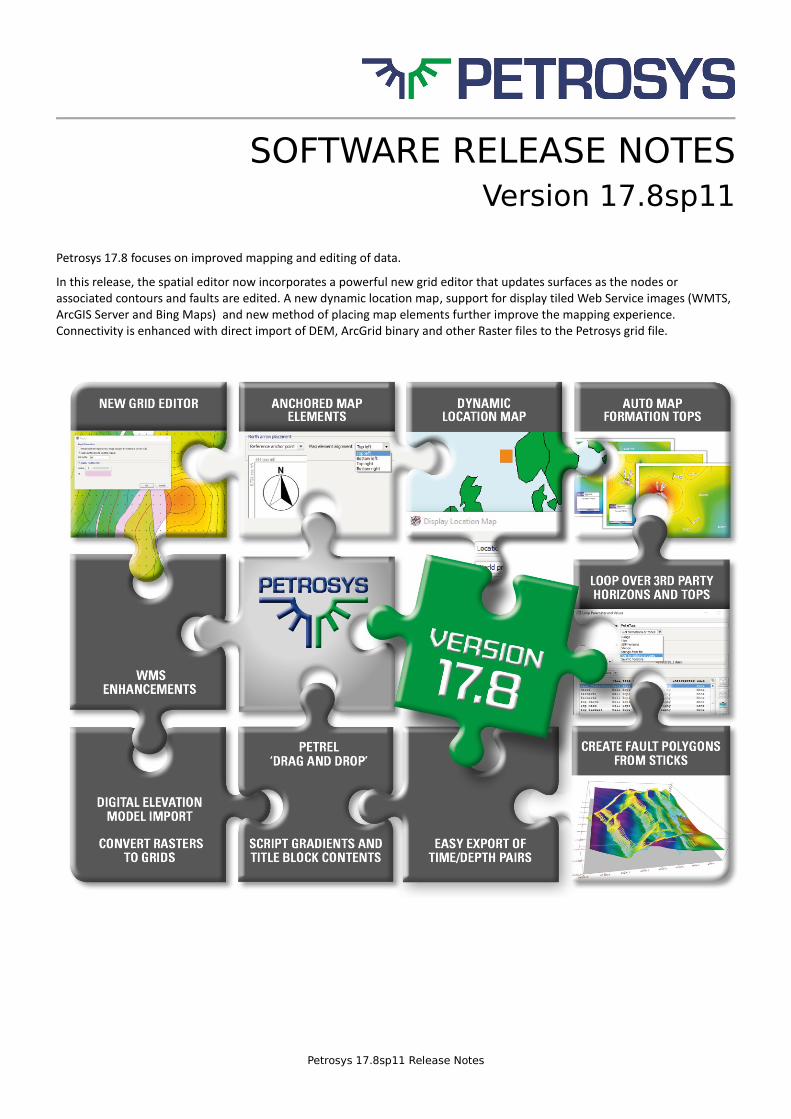
SOFTWARE RELEASE NOTES Version 17.8sp11
Petrosys 17.8 focuses on improved mapping and editing of data.
In this release, the spatial editor now incorporates a powerful new grid editor that updates surfaces as the nodes or associated contours and faults are edited. A new dynamic location map, support for display tiled Web Service images (WMTS, ArcGIS Server and Bing Maps) and new method of placing map elements further improve the mapping experience. Connectivity is enhanced with direct import of DEM, ArcGrid binary and other Raster files to the Petrosys grid file.
Petrosys 17.8sp11 Release Notes
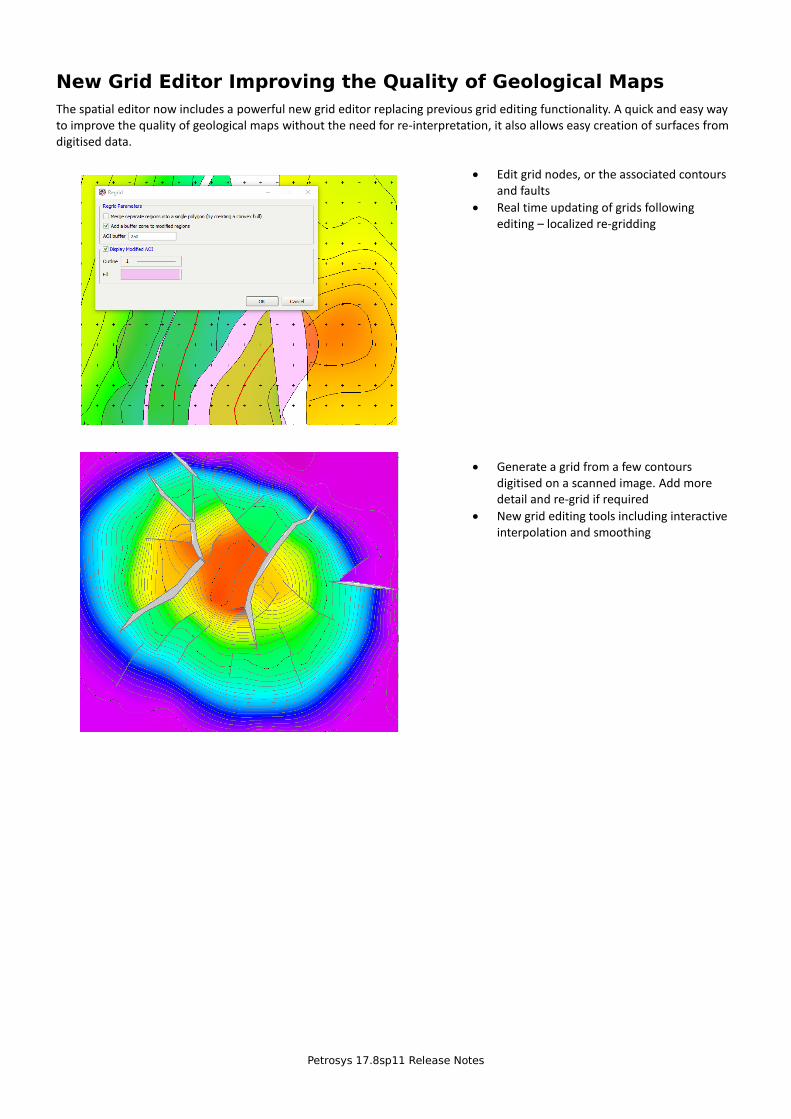
New Grid Editor Improving the Quality of Geological Maps
The spatial editor now includes a powerful new grid editor replacing previous grid editing functionality. A quick and easy way to improve the quality of geological maps without the need for re-interpretation, it also allows easy creation of surfaces from digitised data.
• Edit grid nodes, or the associated contours and faults
• Real time updating of grids following editing – localized re-gridding
• Generate a grid from a few contours digitised on a scanned image. Add more detail and re-grid if required
• New grid editing tools including interactive interpolation and smoothing
Petrosys 17.8sp11 Release Notes
Spatial Editor – New and Restored Functions
New tools have been added to the spatial editor to group/ungroup items of the same type and to move objects to the back – this is particularly useful for editing GIS files with shared boundaries such as licence blocks.
Several popular functions previously available in the contour/fault/polygon editor have been restored including:
• Interactively creating a polygon from hand-picked segments. The shape tracing functionality has been updated to automatically jump across shapes when appropriate (i.e. there is an intersection between two shapes)
• Joining line segments
• Export selected shapes to spatial data sources
• Icons to assign, swap and invert fault flags have been added
In addition, the usability of a number of the existing options have been improved considerably making the editor more powerful and easier to use than ever:
• Added new methods to join and close multiple line segments
• The ‘Cut’ tool displays end vertices of open lines, which gives a visual indication of what has happened when lines
are cut
• Attributes such a contour level are shown in the status bar for shapes under the mouse when “hovering” – this
makes it easier to select or join particular contours
• A new option has been added that allows export of the current selected shapes (similar to CFP editor)
• The Coordinate table allows control over how coordinates are displayed (different CRS, DMS versus decimal degrees)
• Status bar shows units for length and area of shapes
• Added support for storing and editing lines and polygons stored in Excel. The Spatial Data Translator also supports
this.
• Vertex mode improvements:
o Selecting a vertex in the Coordinates table also selects the corresponding vertex on the map
o Z-values are displayed as annotation on selected points
o Double-clicking on a vertex displays a popup editor for z-values
• Fault editing improvements:
o Polyline fault flags are set after editing operations (smooth, compress, cut, join, add vertex etc)
o Assign Flags, Swap and Invert are tool bar buttons which allows these to be run for multiple selected shapes
o The fault Coordinate table popup menu is also available as a RMB menu in vertex mode
o Vertex mode for faults includes z-value and flag display and editing
• The “Has Z Value” setting is disabled by default for Text and Excel files and this column is now treated as a standard
attribute for point data except for Gridding where a z-value is required
• The confirm close panel, shown for modified layers when a layer or the editor is closed, includes a “Save As” option
• The Generate Buffer operation populates attributes on the generated shape from the source shape, where this is
possible
Petrosys 17.8sp11 Release Notes
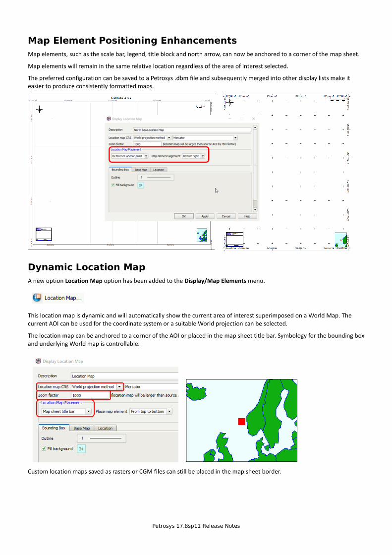
Map Element Positioning Enhancements
Map elements, such as the scale bar, legend, title block and north arrow, can now be anchored to a corner of the map sheet.
Map elements will remain in the same relative location regardless of the area of interest selected.
The preferred configuration can be saved to a Petrosys .dbm file and subsequently merged into other display lists make it easier to produce consistently formatted maps.
Dynamic Location Map
A new option Location Map option has been added to the Display/Map Elements menu.
This location map is dynamic and will automatically show the current area of interest superimposed on a World Map. The current AOI can be used for the coordinate system or a suitable World projection can be selected.
The location map can be anchored to a corner of the AOI or placed in the map sheet title bar. Symbology for the bounding box and underlying World map is controllable.
Custom location maps saved as rasters or CGM files can still be placed in the map sheet border.
Petrosys 17.8sp11 Release Notes
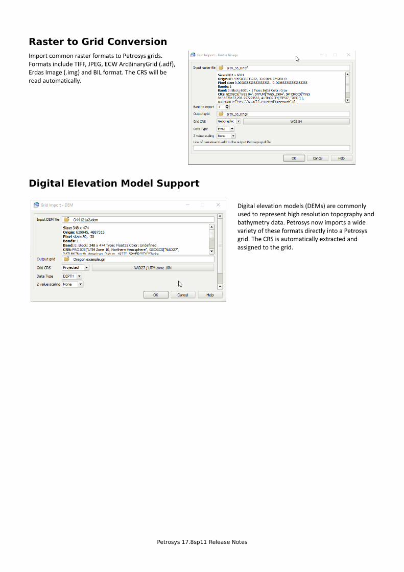
Raster to Grid Conversion
Import common raster formats to Petrosys grids. Formats include TIFF, JPEG, ECW ArcBinaryGrid (.adf), Erdas Image (.img) and BIL format. The CRS will be read automatically.
Digital Elevation Model Support
Digital elevation models (DEMs) are commonly used to represent high resolution topography and bathymetry data. Petrosys now imports a wide variety of these formats directly into a Petrosys grid. The CRS is automatically extracted and assigned to the grid.
Petrosys 17.8sp11 Release Notes
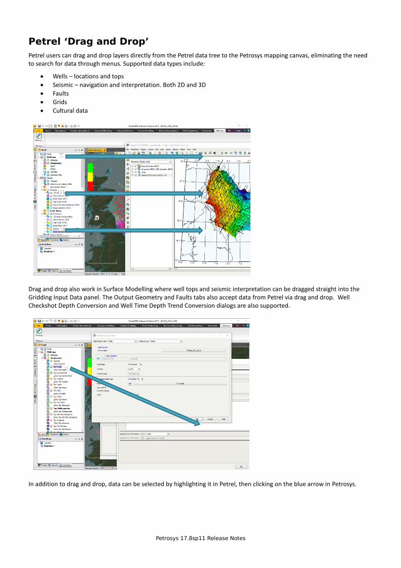
Petrel ‘Drag and Drop’
Petrel users can drag and drop layers directly from the Petrel data tree to the Petrosys mapping canvas, eliminating the need to search for data through menus. Supported data types include:
• Wells – locations and tops
• Seismic – navigation and interpretation. Both 2D and 3D
• Faults
• Grids
• Cultural data
Drag and drop also work in Surface Modelling where well tops and seismic interpretation can be dragged straight into the Gridding Input Data panel. The Output Geometry and Faults tabs also accept data from Petrel via drag and drop. Well Checkshot Depth Conversion and Well Time Depth Trend Conversion dialogs are also supported.
In addition to drag and drop, data can be selected by highlighting it in Petrel, then clicking on the blue arrow in Petrosys.
Petrosys 17.8sp11 Release Notes
Display Secure WMS over https Protocol
https secured web map services are required for many company internal WMS and also for vendors selling high value imagery data.
Display Web Map Tile Service (WMTS, ArcGIS Server, Bing Maps) WMTS serve tiled, georeferenced images rather than a single image. Tiles are pre-rendered on the server side and cached on the client side allowing quick display of high resolution data.
As an example, Esri® map tiles are served in the WMTS protocol
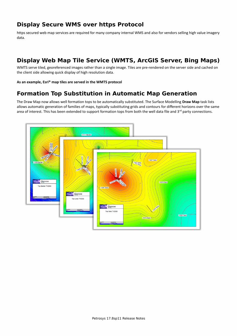
Formation Top Substitution in Automatic Map Generation
The Draw Map now allows well formation tops to be automatically substituted. The Surface Modelling Draw Map task lists allows automatic generation of families of maps, typically substituting grids and contours for different horizons over the same area of interest. This has been extended to support formation tops from both the well data file and 3rd party connections.
Petrosys 17.8sp11 Release Notes
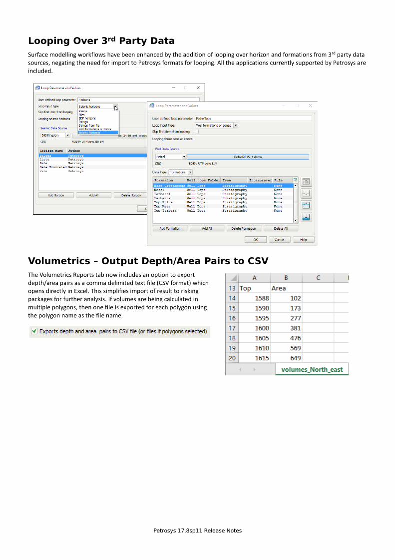
Looping Over 3rd Party Data
Surface modelling workflows have been enhanced by the addition of looping over horizon and formations from 3rd party data sources, negating the need for import to Petrosys formats for looping. All the applications currently supported by Petrosys are included.
Volumetrics – Output Depth/Area Pairs to CSV
The Volumetrics Reports tab now includes an option to export depth/area pairs as a comma delimited text file (CSV format) which opens directly in Excel. This simplifies import of result to risking packages for further analysis. If volumes are being calculated in multiple polygons, then one file is exported for each polygon using the polygon name as the file name.
Petrosys 17.8sp11 Release Notes
Version 17.7 Features
In case you missed them, below are some of the great features from the previous 17.7 release.
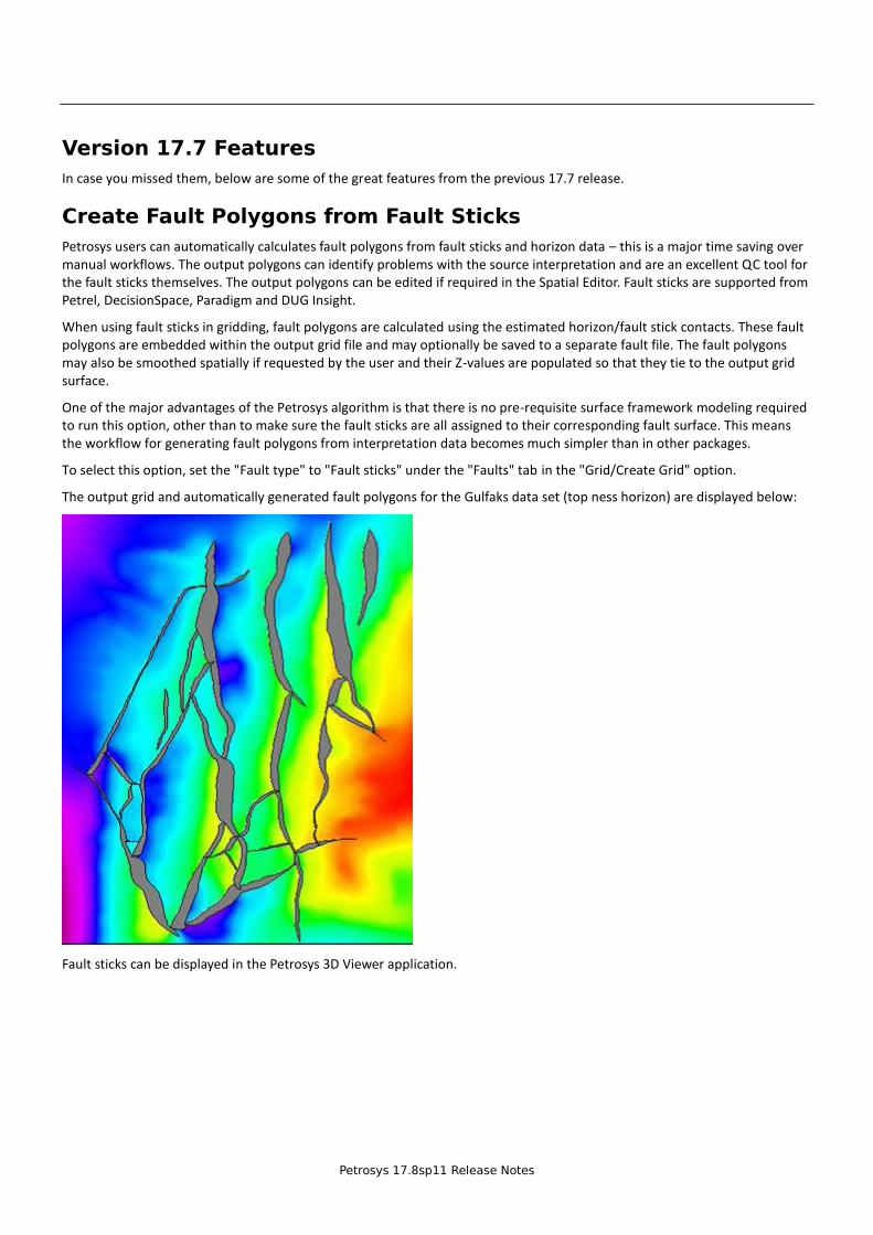
Create Fault Polygons from Fault Sticks
Petrosys users can automatically calculates fault polygons from fault sticks and horizon data – this is a major time saving over manual workflows. The output polygons can identify problems with the source interpretation and are an excellent QC tool for the fault sticks themselves. The output polygons can be edited if required in the Spatial Editor. Fault sticks are supported from Petrel, DecisionSpace, Paradigm and DUG Insight.
When using fault sticks in gridding, fault polygons are calculated using the estimated horizon/fault stick contacts. These fault polygons are embedded within the output grid file and may optionally be saved to a separate fault file. The fault polygons may also be smoothed spatially if requested by the user and their Z-values are populated so that they tie to the output grid surface.
One of the major advantages of the Petrosys algorithm is that there is no pre-requisite surface framework modeling required to run this option, other than to make sure the fault sticks are all assigned to their corresponding fault surface. This means the workflow for generating fault polygons from interpretation data becomes much simpler than in other packages.
To select this option, set the "Fault type" to "Fault sticks" under the "Faults" tab in the "Grid/Create Grid" option.
The output grid and automatically generated fault polygons for the Gulfaks data set (top ness horizon) are displayed below:
Fault sticks can be displayed in the Petrosys 3D Viewer application.
Petrosys 17.8sp11 Release Notes
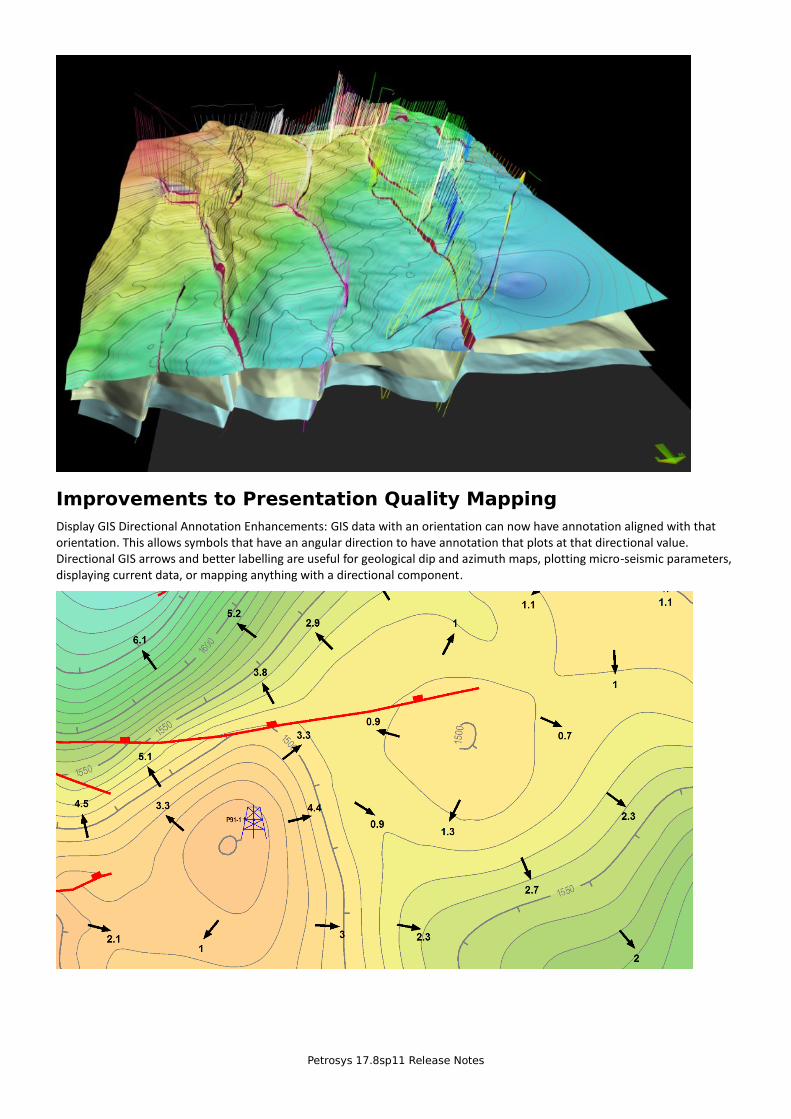
Improvements to Presentation Quality Mapping
Display GIS Directional Annotation Enhancements: GIS data with an orientation can now have annotation aligned with that orientation. This allows symbols that have an angular direction to have annotation that plots at that directional value. Directional GIS arrows and better labelling are useful for geological dip and azimuth maps, plotting micro-seismic parameters, displaying current data, or mapping anything with a directional component.
Petrosys 17.8sp11 Release Notes
Directly Connected Subsurface Data Footprint Continues to Grow
Building on the established footprint of subsurface data types supported by Petrosys direct connections across a wide spectrum of E&P applications, Petrosys 17.7 provides a stronger than ever tool for the exchange of data.
• Import seismic to SDF and dbMap from Trango, KDM, Finder and OpenWorks.
• Import 3D seismic surfaces from GeoFrame in the Surface Exchange tool.
• Export grids to OpenWorks and IHS Petra in the Grid Exchange tool.
• Import spatial data from MapInfo file into any GIS supported format in the Spatial Data Translator tool.
• Import Roxar Irap ASCII grid files directly to Petrosys grid files.
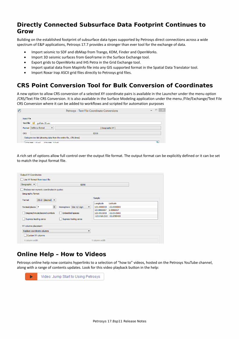
CRS Point Conversion Tool for Bulk Conversion of Coordinates
A new option to allow CRS conversion of a selected XY coordinate pairs is available in the Launcher under the menu option /CRS/Text File CRS Conversion. It is also available in the Surface Modeling application under the menu /File/Exchange/Text File CRS Conversion where it can be added to workflows and scripted for automation purposes
A rich set of options allow full control over the output file format. The output format can be explicitly defined or it can be set to match the input format file.
Online Help – How to Videos
Petrosys online help now contains hyperlinks to a selection of “how to” videos, hosted on the Petrosys YouTube channel, along with a range of contents updates. Look for this video playback button in the help:
3 entries
Detailed Release Notes Summary 17.8.11Enhancements
dbMap - Client69536 Added case-insensitie fltering changes69539 dbMap well header dialog rearranged and "Saie As" buton added (PPDM38 only)
Mapping - Wells69534 Added a confguraton opton to enable CGM caching for Well Symbol drawing
Petrosys Release Notes
1 entries
Detailed Release Notes Summary 17.8.11Bug Fixes
dbMap - Client69538 Added data selecton queries with multple column support for display of Petrosys-dbMap wells (PPDM38 only)
Petrosys Release Notes
4 entries
Petrosys Release 17.8.11Detailed Release Notes
dbMap - Client Enhancements
Added case-insensitive fiteeinn channes 69536
PPDM3.8 clients now haie the ability to do case insensitie fltering of Petrosys-dbMap wells iia the Match case feld on the Using-form dialog, which is aiailable in the Well list, Display, Well import wizard and other optons throughout the applicaton.
dbMap weii headee diaion eeaeeanned and "Save As" button added(PPDM38 oniy) 69539
The Petrosys-dbMap well header dialog for PPDM3.8 clients now has a "Saie As" buton to allow easy copying of well header informaton when creatng new wells.
As part of this the well header and New dialogs haie been rearranged so that they are more consistent.
dbMap - Client Bug Fixes
Added data seiection queeies with muitipie coiumn suppoet foe dispiay ofPeteosys-dbMap weiis (PPDM38 oniy) 69538
For Petrosys-dbMap PPDM3.8 clients, well data selecton queries that return multple rows now functon correctly to flter the wells to display on a map. Preiiously no wells would be displayed if such a query was used.
Mapping - Wells Enhancements
Added a confnueation option to enabie CGM cachinn foe Weii Symboideawinn 69534
A new confguraton opton under Adianced/Applicaton Internals has been added to control the use of the CGM fle cache tospeed up the display of Well Symbols on the map. By default this confguraton opton is false, disabling the use of the cache.
Petrosys Release Notes
2 entries
Detailed Release Notes Summary 17.8.10Enhancements
dbMap - Client68620 Added button to Well header dialog for Horizontal Drills web screen (PPDM3.8 only)68649 Added support for Formation Systems (PPDM3.8 only)
Petrosys Release Notes
1 entries
Detailed Release Notes Summary 17.8.10Bug Fixes
Connections, Import and Export - Petrel68776 Additional data validation when writing well logs to Petrel
Petrosys Release Notes
3 entries
Petrosys Release 17.8.10Detailed Release Notes
Connections, Import and Export - Petrel Bug Fixes
Additional data validation when writing well logs to Petrel 68776
When writing well log data from dbMap to Petrel with missing top and/or base depths, these values are now skipped and an appropriate warning is written to the exchange log.
dbMap - Client Enhancements
Added button to Well header dialog for Horizontal Drills web screen(PPDM3.8 only) 68620
A new button has been added to the Well header dialog for the Horizontal Drills web screen.
Added support for Formation Systems (PPDM3.8 only) 68649
The formation data model used within the desktop application has been enhanced to also support the use of Formation Systems.
Petrosys Release Notes
12 entries
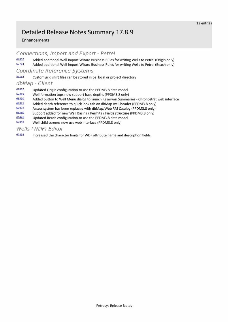
Detailed Release Notes Summary 17.8.9Enhancements
Connections, Import and Export - Petrel64807 Added additional Well Import Wizard Business Rules for writing Wells to Petrel (Origin only)67704 Added additional Well Import Wizard Business Rules for writing Wells to Petrel (Beach only)
Coordinate Reference Systems49154 Custom grid shift files can be stored in ps_local or project directory
dbMap - Client67087 Updated Origin configuration to use the PPDM3.8 data model52250 Well formation tops now support base depths (PPDM3.8 only)68550 Added button to Well Menu dialog to launch Reservoir Summaries - Chronostrat web interface64825 Added depth reference to quick look tab on dbMap well header (PPDM3.8 only)67092 Assets system has been replaced with dbMap/Web RM Catalog (PPDM3.8 only)66780 Support added for new Well Basins / Permits / Fields structure (PPDM3.8 only)68441 Updated Beach configuration to use the PPDM3.8 data model67848 Well child screens now use web interface (PPDM3.8 only)
Wells (WDF) Editor67898 Increased the character limits for WDF attribute name and description fields
Petrosys Release Notes
7 entries
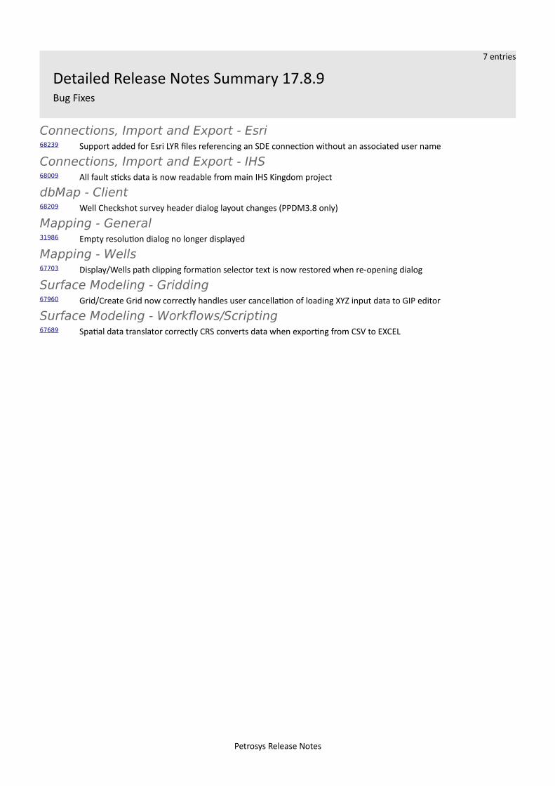
Detailed Release Notes Summary 17.8.9Bug Fixes
Connections, Import and Export - Esri68239 Support added for Esri LYR files referencing an SDE connection without an associated user name
Connections, Import and Export - IHS68009 All fault sticks data is now readable from main IHS Kingdom project
dbMap - Client68209 Well Checkshot survey header dialog layout changes (PPDM3.8 only)
Mapping - General31986 Empty resolution dialog no longer displayed
Mapping - Wells67703 Display/Wells path clipping formation selector text is now restored when re-opening dialog
Surface Modeling - Gridding67960 Grid/Create Grid now correctly handles user cancellation of loading XYZ input data to GIP editor
Surface Modeling - Workflows/Scripting67689 Spatial data translator correctly CRS converts data when exporting from CSV to EXCEL
Petrosys Release Notes
19 entries
Petrosys Release 17.8.9Detailed Release Notes
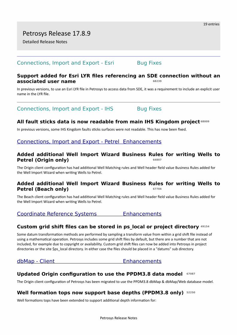
Connections, Import and Export - Esri Bug Fixes
Support added for Esri LYR files referencing an SDE connection without anassociated user name 68239
In previous versions, to use an Esri LYR file in Petrosys to access data from SDE, it was a requirement to include an explicit username in the LYR file.
Connections, Import and Export - IHS Bug Fixes
All fault sticks data is now readable from main IHS Kingdom project 68009
In previous versions, some IHS Kingdom faults sticks surfaces were not readable. This has now been fixed.
Connections, Import and Export - Petrel Enhancements
Added additional Well Import Wizard Business Rules for writing Wells toPetrel (Origin only) 64807
The Origin client configuration has had additional Well Matching rules and Well header field value Business Rules added for the Well Import Wizard when writing Wells to Petrel.
Added additional Well Import Wizard Business Rules for writing Wells toPetrel (Beach only) 67704
The Beach client configuration has had additional Well Matching rules and Well header field value Business Rules added for the Well Import Wizard when writing Wells to Petrel.
Coordinate Reference Systems Enhancements
Custom grid shift files can be stored in ps_local or project directory 49154
Some datum transformation methods are performed by sampling a transform value from within a grid shift file instead of using a mathematical operation. Petrosys includes some grid shift files by default, but there are a number that are not included, for example due to copyright or availability. Custom grid shift files can now be added into Petrosys in project directories or the site $ps_local directory. In either case the files should be placed in a "datums" sub directory.
dbMap - Client Enhancements
Updated Origin configuration to use the PPDM3.8 data model 67087
The Origin client configuration of Petrosys has been migrated to use the PPDM3.8 dbMap & dbMap/Web database model.
Well formation tops now support base depths (PPDM3.8 only) 52250
Well formations tops have been extended to support additional depth information for:
Petrosys Release Notes
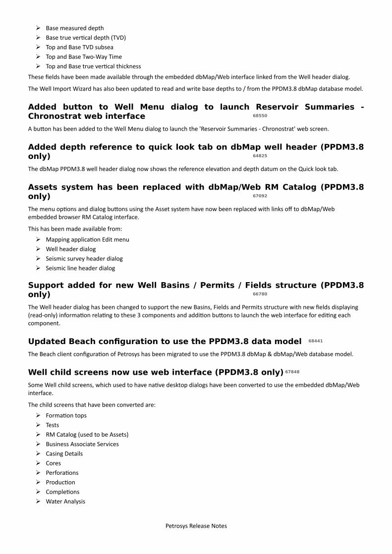
➢ Base measured depth➢ Base true vertical depth (TVD)➢ Top and Base TVD subsea➢ Top and Base Two-Way Time➢ Top and Base true vertical thickness
These fields have been made available through the embedded dbMap/Web interface linked from the Well header dialog.
The Well Import Wizard has also been updated to read and write base depths to / from the PPDM3.8 dbMap database model.
Added button to Well Menu dialog to launch Reservoir Summaries -Chronostrat web interface 68550
A button has been added to the Well Menu dialog to launch the 'Reservoir Summaries - Chronostrat' web screen.
Added depth reference to quick look tab on dbMap well header (PPDM3.8only) 64825
The dbMap PPDM3.8 well header dialog now shows the reference elevation and depth datum on the Quick look tab.
Assets system has been replaced with dbMap/Web RM Catalog (PPDM3.8only) 67092
The menu options and dialog buttons using the Asset system have now been replaced with links off to dbMap/Web embedded browser RM Catalog interface.
This has been made available from:
➢ Mapping application Edit menu➢ Well header dialog➢ Seismic survey header dialog➢ Seismic line header dialog
Support added for new Well Basins / Permits / Fields structure (PPDM3.8only) 66780
The Well header dialog has been changed to support the new Basins, Fields and Permits structure with new fields displaying (read-only) information relating to these 3 components and addition buttons to launch the web interface for editing each component.
Updated Beach configuration to use the PPDM3.8 data model 68441
The Beach client configuration of Petrosys has been migrated to use the PPDM3.8 dbMap & dbMap/Web database model.
Well child screens now use web interface (PPDM3.8 only) 67848
Some Well child screens, which used to have native desktop dialogs have been converted to use the embedded dbMap/Web interface.
The child screens that have been converted are:
➢ Formation tops➢ Tests➢ RM Catalog (used to be Assets)➢ Business Associate Services➢ Casing Details➢ Cores➢ Perforations➢ Production➢ Completions➢ Water Analysis
Petrosys Release Notes
➢ Shows➢ Sand Summaries➢ Logs➢ Remarks➢ Completions
dbMap - Client Bug Fixes
Well Checkshot survey header dialog layout changes (PPDM3.8 only)68209
The layout and information displayed in Well Checkshot Survey Header dialog has changed to now include Depth datum, Source azimuth, Source azimuth north type, Source offset, Gun pressure and Run number.
Mapping - General Bug Fixes
Empty resolution dialog no longer displayed 31986
In previous versions, when opening an existing DBM file it could prompt the file resolution dialog with an empty file list. This has now been fixed.
Mapping - Wells Bug Fixes
Display/Wells path clipping formation selector text is now restored whenre-opening dialog 67703
When re-opening a Wells display layer which had path clipping by formations enabled, the formation selector buttons were blank. The formation selection was retained, but was not visible. This has now been fixed and the selected formations can be seen when re-opening the panel.
Surface Modeling - Gridding Bug Fixes
Grid/Create Grid now correctly handles user cancellation of loading XYZinput data to GIP editor 67960
Grid/Create Grid no longer crash when loading XYZ input data into the GIP editor and the user cancels the operation before it has finished.
Surface Modeling - Workflows/Scripting Bug Fixes
Spatial data translator correctly CRS converts data when exporting fromCSV to EXCEL 67689
Spatial Data Translator now correctly CRS converts data from Text file to Excel when input data source CRS field is scripted.
Wells (WDF) Editor Enhancements
Increased the character limits for WDF attribute name and descriptionfields 67898
The character limits for WDF attributes have been increased to 50 characters for name and 100 characters for the description.
Petrosys Release Notes
9 entries
Detailed Release Notes Summary 17.8.8Enhancements
Application - General19071 Windows Installer packages are now digitally signed by Petrosys
Connections, Import and Export64860 Petrel 2017.1 supported
Connections, Import and Export - OpenWorks66815 OpenWorks Mapping Polygons now uses the name of the input geometry when writing polygon values66812 OpenWorks Mapping Polygons: Added support for reading and writing unclosed polygons
dbMap - Client67392 Import and editing of dbMap Seismic lines and surveys enabled for Santos Jakarta
Surface Modeling - General67290 Grid/Create Grid - Enabled interactive scripting of fault sticks selection64893 Task fields and values translation speed improved
Surface Modeling - Gridding67212 Saved fault polygons from gridding fault sticks can be assigned to surfaces/groups and fault file overwrite mode is
available
Surface Modeling - Workflows/Scripting66677 Looping task - file field is scriptable
Petrosys Release Notes
14 entries
Detailed Release Notes Summary 17.8.8Bug Fixes
Connections, Import and Export66940 Fixed some well symbols not being mapped in Wells Import Wizard
Connections, Import and Export - Esri67018 ArcSDE: Direct connections fixed on Windows (PostgreSQL, Oracle)
Connections, Import and Export - Excel66710 ArcSDE - Fixed crash when retrieving layers from Oracle 11.2.0.4 on Windows with specific privileges set
Connections, Import and Export - Paradigm-Epos61187 Fixed crash when reading 3D Seismic data from Paradigm
Connections, Import and Export - Petrel59298 Fixed crash when connecting to Petrel67233 Wells Import Wizard Well Grouping values are now based on the input data source when importing wells to Petrel66994 Wells Import Wizard: Fixed Petrel well symbols for existing wells being reset to default.
dbMap - Client67049 dbMap Well list Add and Select/Using Form dialogs now have Initial and Current Permit fields (Santos only)67312 dbMap 2D Seismic Data Import dialog now shows Survey Name (Santos only)
Mapping - General67178 Analyse data in chart now allows points that do not have Z-values67256 Legend title spacing parameter is now restored from DBM
Spatial Editor65678 Spatial editor fixes to prevent grid editing crashes
Surface Modeling - Exchange64996 Spatial Data Translator crash is fixed
Surface Modeling - Gridding64702 Gridding inside faults option is available to gridding with fault sticks
Petrosys Release Notes
23 entries
Petrosys Release 17.8.8Detailed Release Notes
Application - General Enhancements
Windows Installer packages are now digitally signed by Petrosys 19071
All Windows Installer packages delivered by Petrosys are now digitally signed to provide confidence that the installer packages are as-produced by Petrosys and have not been tampered with.
Connections, Import and Export Enhancements
Petrel 2017.1 supported 64860
Petrosys connectivity to Schlumberger's Petrel now supports direct interaction with Petrel 2017.1.
Support for Petrel 2017.1 includes the ability to:
➢ Drag and drop data from Petrel into Petrosys➢ Import Model grid horizons and 3D seismic interpretation horizons to a Petrosys grid file➢ Import faults from Model grids to a Petrosys fault file➢ Import 2D and 3D seismic navigation and horizon interpretation data to a Petrosys SDF➢ Directly display Model grid horizons, Input surface grids and 3D seismic interpretation horizons in Mapping➢ Directly contour Model grid horizon data and Input surface grids in Surface Modeling➢ Directly grid 2D and 3D seismic horizon interpretation data in Surface Modeling➢ Directly display, grid and import well data.➢ Directly display 2D seismic navigation and horizon interpretation in Mapping➢ Directly display 3D seismic bin grids in Mapping➢ Directly display Structural Model fault surfaces in 3DViewer➢ Directly display fault sticks in 3DViewer➢ Export Petrosys and other third party grids to Petrel
Petrosys continues to maintain support for connections to Petrel 2013.x, 2014.x, 2015.x and 2016.x.
Connections, Import and Export Bug Fixes
Fixed some well symbols not being mapped in Wells Import Wizard 66940
Some well symbols from third-party data sources which should have had a valid mapping were being exported using the default well symbol for the output data source. This issue has now been fixed.
Connections, Import and Export - Esri Bug Fixes
ArcSDE: Direct connections fixed on Windows (PostgreSQL, Oracle) 67018
Direct connections to ArcSDE for Oracle and PostgreSQL are fixed. An incorrect DLL version was shipped in 17.8sp7 which caused this type of connection to give errors.
Petrosys Release Notes
Connections, Import and Export - Excel Bug Fixes
ArcSDE - Fixed crash when retrieving layers from Oracle 11.2.0.4 onWindows with specific privileges set 66710
A crash when accessing SDE via Oracle direct connections that could occur with very specific Oracle specific privileges set has been fixed.
Connections, Import and Export - OpenWorks Enhancements
OpenWorks Mapping Polygons now uses the name of the input geometrywhen writing polygon values 66815
Writing polygon data to an OpenWorks Mapping Poly Sets now uses the name of the input geometry when creating the individual polygons within the set.
OpenWorks Mapping Polygons: Added support for reading and writingunclosed polygons 66812
The writing of OpenWorks Mapping Poly Sets, using the Spatial Data Translator, has added support for the writing of Line geometries in addition to already supported Polygon geometries.
Connections, Import and Export - Paradigm-EposBug Fixes
Fixed crash when reading 3D Seismic data from Paradigm 61187
A crash has been fixed where under some conditions a crash was happening when reading 3D Seismic data from Paradigm projects.
Connections, Import and Export - Petrel Bug Fixes
Fixed crash when connecting to Petrel 59298
Some users reported Petrosys would crash frequently when connecting to Petrel. This issue has now been fixed.
Wells Import Wizard Well Grouping values are now based on the inputdata source when importing wells to Petrel 67233
When importing wells to Petrel using the Wells Import Wizard, the values available for the Well Grouping option may not have made sense, or the information may not have been available, for some input data sources. The values allowed are now determined based on the capabilities of writing wells to Petrel and the information available from the input data source.
Wells Import Wizard: Fixed Petrel well symbols for existing wells beingreset to default. 66994
When using the Wells Import Wizard to update Petrel wells from a third-party data source, existing wells symbols were being reset to the Petrel default (Undefined). New wells were not affected. Existing wells in Petrel now have their well symbols set correctly.
Petrosys Release Notes
dbMap - Client Enhancements
Import and editing of dbMap Seismic lines and surveys enabled for SantosJakarta 67392
The ability to create and edit dbMap seismic lines and surveys, along with importing dbMap 2D seismic data has been enabled for Santos Jakarta.
dbMap - Client Bug Fixes
dbMap Well list Add and Select/Using Form dialogs now have Initial andCurrent Permit fields (Santos only) 67049
Initial and Current Permit fields have been added to the Santos Lists/Wells/dbMap/Add and Select/Using form dialogs, making them consistent with the well header dialog.
dbMap 2D Seismic Data Import dialog now shows Survey Name (Santosonly) 67312
The Admin/dbMap Data Transfer/Import/Seismic list now shows the survey name when assigned to selected lines for Santos.Previously the survey name column would appear blank, and only the survey code was visible.
Mapping - General Bug Fixes
Analyse data in chart now allows points that do not have Z-values 67178
In previous versions, on Chart Analysis panel, points without a valid Z-value were silently removed which caused a different best-fit formula to be generated. This has now been fixed.
Legend title spacing parameter is now restored from DBM 67256
Saving and loading a dbm file from Mapping will now correctly restore the "Title spacing" parameter
Spatial Editor Bug Fixes
Spatial editor fixes to prevent grid editing crashes65678
Several crashes have been fixed related to editing grids in the spatial editor. The following situations could cause a crash in previous versions:
➢ Clicking Apply in Adjust Grid Values (AOI) panel, without changing anything on the panel➢ Exiting the spatial editor with a map that took a relatively long time to draw (intermittent)➢ Deleting (certain) vertices of fault polygons embedded in grids.
Surface Modeling - Exchange Bug Fixes
Spatial Data Translator crash is fixed 64996
In previous versions Spatial Data Translator could crash when opening the task panel. Some code improvements have been done to avoid this crash.
Petrosys Release Notes
Surface Modeling - General Enhancements
Grid/Create Grid - Enabled interactive scripting of fault sticks selection67290
Grid/Create Grid - Fault sticks selection is enabled for interactive scripting.
Task fields and values translation speed improved64893
Surface modeling database is now cached in memory to reduce the user waiting time when working with the task list.
Surface Modeling - Gridding Enhancements
Saved fault polygons from gridding fault sticks can be assigned tosurfaces/groups and fault file overwrite mode is available 67212
Saved fault polygons from gridding fault sticks can be assigned to surfaces and groups. Also, the fault file overwrite mode is available with the ability to create, append and/or surface overwrite.
Surface Modeling - Gridding Bug Fixes
Gridding inside faults option is available to gridding with fault sticks64702
Gridding inside faults is available for fault sticks.
Surface Modeling - Workflows/Scripting Enhancements
Looping task - file field is scriptable 66677
Looping task file field is enabled for scripting.
Petrosys Release Notes
8 entries
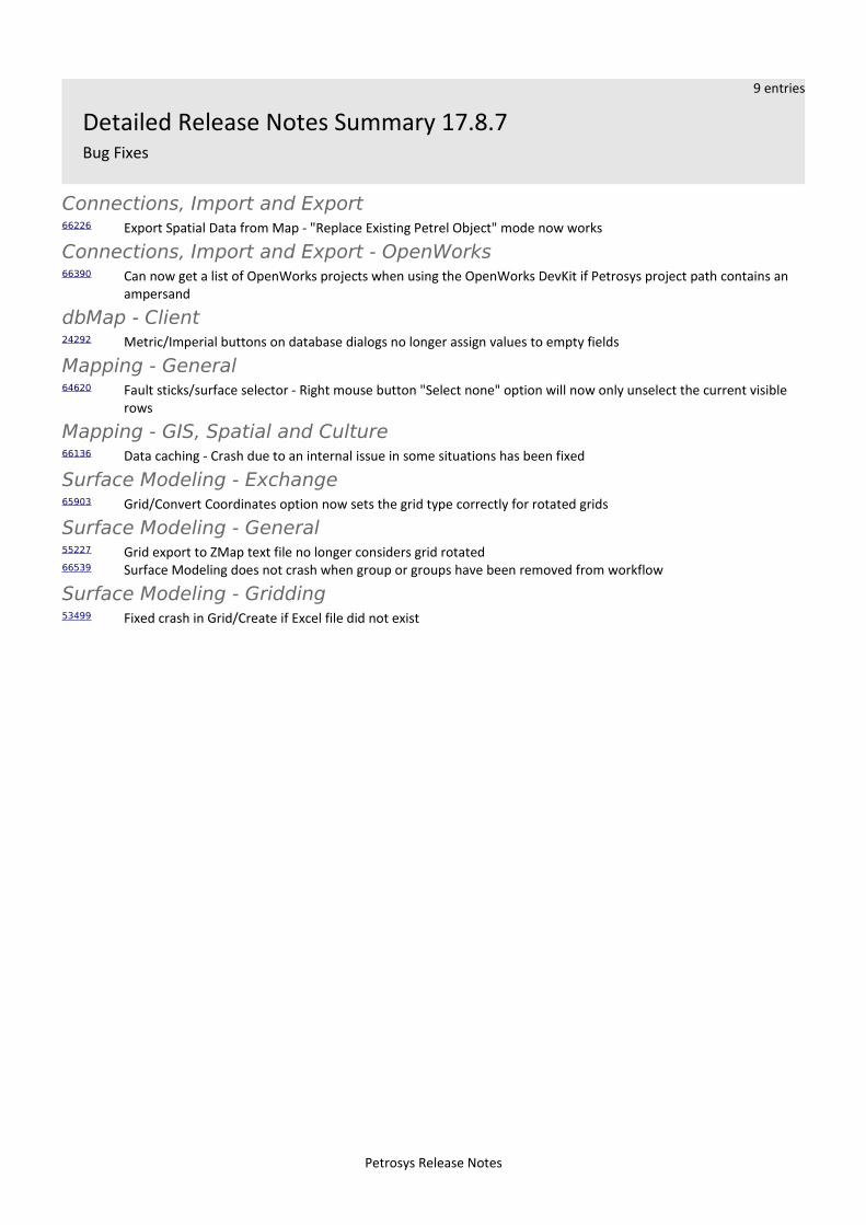
Detailed Release Notes Summary 17.8.7Enhancements
3D Viewer - General66180 Display/Fault Surface performance improved when bringing up the panel
Connections, Import and Export - Excel66229 Significantly improved performance when writing large amounts of data to Excel files on Windows
Connections, Import and Export - OpenWorks66388 Added support for Linux 64-bit versions of OpenWorks plugins66393 SeisWorks environment data and connection errors are now included in diagnostics on Windows
Coordinate Reference Systems66257 Improved support for "Sears Feet" linear units
Spatial Data Translator66064 Spatial Data Translator now uses current output Petrel project CRS
Surface Modeling - Workflows/Scripting66536 Looping over Excel table sheets for gridding tasks66135 Grid Create Grid from Excel and text file now supports scripting of the Z column
Petrosys Release Notes
9 entries
Detailed Release Notes Summary 17.8.7Bug Fixes
Connections, Import and Export66226 Export Spatial Data from Map - "Replace Existing Petrel Object" mode now works
Connections, Import and Export - OpenWorks66390 Can now get a list of OpenWorks projects when using the OpenWorks DevKit if Petrosys project path contains an
ampersand
dbMap - Client24292 Metric/Imperial buttons on database dialogs no longer assign values to empty fields
Mapping - General64620 Fault sticks/surface selector - Right mouse button "Select none" option will now only unselect the current visible
rows
Mapping - GIS, Spatial and Culture66136 Data caching - Crash due to an internal issue in some situations has been fixed
Surface Modeling - Exchange65903 Grid/Convert Coordinates option now sets the grid type correctly for rotated grids
Surface Modeling - General55227 Grid export to ZMap text file no longer considers grid rotated66539 Surface Modeling does not crash when group or groups have been removed from workflow
Surface Modeling - Gridding53499 Fixed crash in Grid/Create if Excel file did not exist
Petrosys Release Notes
17 entries
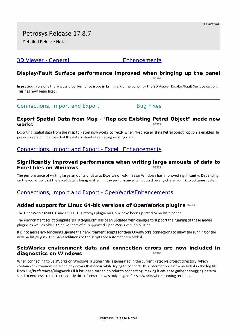
Petrosys Release 17.8.7Detailed Release Notes
3D Viewer - General Enhancements
Display/Fault Surface performance improved when bringing up the panel66180
In previous versions there wass a performance issue in bringing up the panel for the 3D Viewer Display/Fault Surface option. This has now been fixed.
Connections, Import and Export Bug Fixes
Export Spatial Data from Map - "Replace Existing Petrel Object" mode nowworks 66226
Exporting spatial data from the map to Petrel now works correctly when "Replace existing Petrel object" option is enabled. Inprevious version, it appended the data instead of replacing existing data.
Connections, Import and Export - Excel Enhancements
Significantly improved performance when writing large amounts of data toExcel files on Windows 66229
The performance of writing large amounts of data to Excel xls or xslx files on Windows has improved significantly. Depending on the workflow that the Excel data is being written in, the performance gains could be anywhere from 2 to 50 times faster.
Connections, Import and Export - OpenWorks Enhancements
Added support for Linux 64-bit versions of OpenWorks plugins 66388
The OpenWorks R5000.8 and R5000.10 Petrosys plugin on LInux have been updated to 64-bit binaries.
The environment script template 'ps_lgclogin.csh' has been updated with changes to support the running of these newer plugins as well as older 32-bit variants of all supported OpenWorks version plugins.
It is not necessary for clients update their environment scripts for their OpenWorks connections to allow the running of the new 64-bit plugins. The 64bit additions to the scripts are automatically added.
SeisWorks environment data and connection errors are now included indiagnostics on Windows 66393
When connecting to SeisWorks on Windows, a .stderr file is generated in the current Petrosys project directory, which contains environment data and any errors that occur while trying to connect. This information is now included in the log file from File/Preferences/Diagnostics if it has been turned on prior to connecting, making it easier to gather debugging data to send to Petrosys support. Previously this information was only logged for SeisWorks when running on Linux.
Petrosys Release Notes
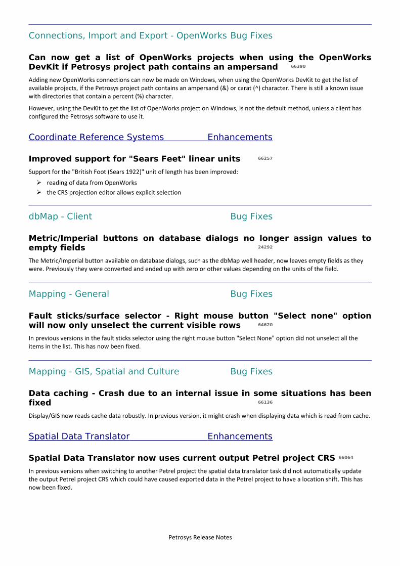
Connections, Import and Export - OpenWorks Bug Fixes
Can now get a list of OpenWorks projects when using the OpenWorksDevKit if Petrosys project path contains an ampersand 66390
Adding new OpenWorks connections can now be made on Windows, when using the OpenWorks DevKit to get the list of available projects, if the Petrosys project path contains an ampersand (&) or carat (^) character. There is still a known issue with directories that contain a percent (%) character.
However, using the DevKit to get the list of OpenWorks project on Windows, is not the default method, unless a client has configured the Petrosys software to use it.
Coordinate Reference Systems Enhancements
Improved support for "Sears Feet" linear units 66257
Support for the "British Foot (Sears 1922)" unit of length has been improved:
➢ reading of data from OpenWorks➢ the CRS projection editor allows explicit selection
dbMap - Client Bug Fixes
Metric/Imperial buttons on database dialogs no longer assign values toempty fields 24292
The Metric/Imperial button available on database dialogs, such as the dbMap well header, now leaves empty fields as they were. Previously they were converted and ended up with zero or other values depending on the units of the field.
Mapping - General Bug Fixes
Fault sticks/surface selector - Right mouse button "Select none" optionwill now only unselect the current visible rows 64620
In previous versions in the fault sticks selector using the right mouse button "Select None" option did not unselect all the items in the list. This has now been fixed.
Mapping - GIS, Spatial and Culture Bug Fixes
Data caching - Crash due to an internal issue in some situations has beenfixed 66136
Display/GIS now reads cache data robustly. In previous version, it might crash when displaying data which is read from cache.
Spatial Data Translator Enhancements
Spatial Data Translator now uses current output Petrel project CRS 66064
In previous versions when switching to another Petrel project the spatial data translator task did not automatically update the output Petrel project CRS which could have caused exported data in the Petrel project to have a location shift. This has now been fixed.
Petrosys Release Notes
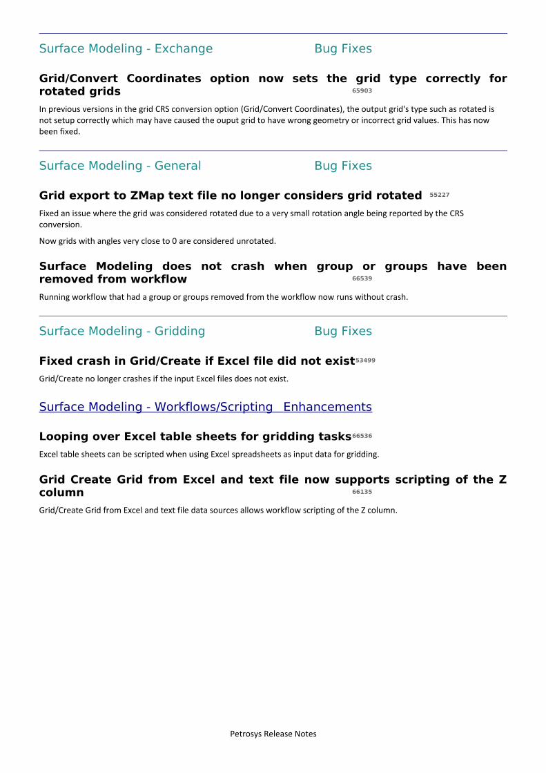
Surface Modeling - Exchange Bug Fixes
Grid/Convert Coordinates option now sets the grid type correctly forrotated grids 65903
In previous versions in the grid CRS conversion option (Grid/Convert Coordinates), the output grid's type such as rotated is not setup correctly which may have caused the ouput grid to have wrong geometry or incorrect grid values. This has now been fixed.
Surface Modeling - General Bug Fixes
Grid export to ZMap text file no longer considers grid rotated 55227
Fixed an issue where the grid was considered rotated due to a very small rotation angle being reported by the CRS conversion.
Now grids with angles very close to 0 are considered unrotated.
Surface Modeling does not crash when group or groups have beenremoved from workflow 66539
Running workflow that had a group or groups removed from the workflow now runs without crash.
Surface Modeling - Gridding Bug Fixes
Fixed crash in Grid/Create if Excel file did not exist53499
Grid/Create no longer crashes if the input Excel files does not exist.
Surface Modeling - Workflows/Scripting Enhancements
Looping over Excel table sheets for gridding tasks66536
Excel table sheets can be scripted when using Excel spreadsheets as input data for gridding.
Grid Create Grid from Excel and text file now supports scripting of the Zcolumn 66135
Grid/Create Grid from Excel and text file data sources allows workflow scripting of the Z column.
Petrosys Release Notes
4 entries
Detailed Release Notes Summary 17.8.6Enhancements
Connections, Import and Export41631 ODM now supported on SQL Server
Connections, Import and Export - Paradigm-Epos61046 Added support for Paradigm 17 on Linux and Windows
Connections, Import and Export - Petrel65882 Added support for custom Petrel well symbol libraries
Surface Modeling - General65474 Determination of velocity function to Grid/Process/Arithmetic templates added
Petrosys Release Notes
9 entries
Detailed Release Notes Summary 17.8.6Bug Fixes
3D Viewer - General65756 Fixed-value well symbols now render correctly for OpenWorks wells
Connections, Import and Export - OpenWorks65387 Creating OpenWorks mapping polygon sets in an Interp project now sets the correct extents when the CRS is the
same as the Master project 65733 Well Import Wizard - new wells with depths stored in feet from OpenWorks now written to Petrel using correct
units65642 OpenWorks T-D curve time data is now correctly being read as relative to SRD65737 Can now connect to OpenWorks or SeisWorks if Petrosys project path contains ampersand
Connections, Import and Export - Petrel65694 Gradients - Exporting to Petrel .alut file now works without producing error XP:338
Mapping - GIS, Spatial and Culture47516 Esri LYR: Reading data from feature classes inside a "feature dataset" is now supported
Surface Modeling - General65976 Crash fixed in loading existing tsk file and opening dialog for well formation attribute input data66032 Sampled data file statistics gives correct results when run after file/open
Petrosys Release Notes
13 entries
Petrosys Release 17.8.6Detailed Release Notes
3D Viewer - General Bug Fixes
Fixed-value well symbols now render correctly for OpenWorks wells65756
3DViewer displays Fixed-value well symbols for OpenWorks wells correctly.
Connections, Import and Export Enhancements
ODM now supported on SQL Server 41631
Petrosys now supports connecting to ODM projects running on SQL Server, while continuing to support ODM projects running on MS Access.
To connect to an ODM SQL Server project you must create a connections.xml entry. See the help topic MULTIPLE CONNECTIVITY - CONFIGURATION - ODBC.
Petrosys does not currently support ODM projects running on 'SQL Server LocalDB'.
Connections, Import and Export - OpenWorks Bug Fixes
Creating OpenWorks mapping polygon sets in an Interp project now setsthe correct extents when the CRS is the same as the Master project
65387
A bug has been fixed that was causing newly created OpenWorks Mapping Poly Sets from incorrectly setting the extents when being written to an interpretative project view that has the same CRS as the master project.
Well Import Wizard - new wells with depths stored in feet from OpenWorksnow written to Petrel using correct units 65733
The Well Import Wizard now correctly converts well header depths to the units of the Petrel project when loading new wells from OpenWorks.
Previously, if the OpenWorks project had depths stored in feet, values such as the KB and Final TD were treated as though they were in metres, and wrong values were written to Petrel.
OpenWorks T-D curve time data is now correctly being read as relative toSRD 65642
OpenWorks Well T-D curve data reading is now correctly reading all time values as relative to SRD, rather than previously being assumed as being relative to the Well depth datum.
Can now connect to OpenWorks or SeisWorks if Petrosys project pathcontains ampersand 65737
Connections can now be made to OpenWorks on Windows if the Petrosys project path contains an ampersand (&) or carat (^) character. There is still a known issue with directories that contain a percent (%) character.
Previously Petrosys may not have been able to connect to OpenWorks from these projects.
Petrosys Release Notes
Connections, Import and Export - Paradigm-Epos Enhancements
Added support for Paradigm 17 on Linux and Windows 61046
Paradigm 17 is now supported as a data source in all features that previously supported a Paradigm connection on both Linuxand Windows.
Paradigm 2011.3, Paradigm 14, Paradigm 14.1, Paradigm 15 and Paradigm 15.5 continue to be supported as data sources.
Connections, Import and Export - Petrel Enhancements
Added support for custom Petrel well symbol libraries 65882
Petrosys already supported all of the built-in Petrel well symbol libraries, including "User symbols". However, if a new well symbol library is defined and used, Petrel reports the custom library as "unknown" and the default Petrel symbols were displayed in Petrosys. This limitation has now been worked-around by mapping the "unknown" well symbol library in the Petrosys configuration tool.
Connections, Import and Export - Petrel Bug Fixes
Gradients - Exporting to Petrel .alut file now works without producingerror XP:338 65694
The option in the Gradient Editor to export a Petrosys gradient to a Petrel .alut file now works without giving a spurious error message about reference counts.
Mapping - GIS, Spatial and Culture Bug Fixes
Esri LYR: Reading data from feature classes inside a "feature dataset" isnow supported 47516
Fixed a bug in the generation of pslyr files when reading an Esri LYR file that references a feature class inside a feature dataset. This bug caused the LYR file to not display on the map.
Surface Modeling - General Enhancements
Determination of velocity function to Grid/Process/Arithmetic templatesadded 65474
Added a new depth conversion template function named "Vok" to the Grid/Process/Arithmetic task.
Surface Modeling - General Bug Fixes
Crash fixed in loading existing tsk file and opening dialog for wellformation attribute input data 65976
A crash in Surface Modeling when loading an existing task and opening the input data dialog for well formation attribute input data has been fixed.
Sampled data file statistics gives correct results when run after file/open66032
Grid/Statistics/Sample data file gives correct result when run directly after File/Open.
Petrosys Release Notes
2 entries
Detailed Release Notes Summary 17.8.5Enhancements
Connections, Import and Export - OpenWorks57043 Display of OpenWorks Wells can now support native OpenWorks Symbols
Connections, Import and Export - Oracle65197 Support added for Oracle 12 wallets
Petrosys Release Notes
25 entries
Detailed Release Notes Summary 17.8.5Bug Fixes
3D Viewer - General64993 3DViewer Display/Point Data no longer crashes when selecting group from Petrosys Culture File
Application - General64824 Windows installation helper script now handles network drives for logging
Connections, Import and Export64796 Display/Wells/Paradigm-EPOS no longer crashes if a well database or selection list cannot be found50486 Spatial data translator now writes correct attribute name to Petrel
Connections, Import and Export - Petrel65402 Petrel 2D seismic interpretation retrieval correctly calculates gaps in data64940 Well Legend items now display the correct symbol for Petrel wells
Mapping - General64973 Display/Web Map Service shows layers correctly in the selection dialog64974 Display/Web Map Service: improve setting of default CRS 32976 Image Georeferencing - Cursor no longer obscures cross hair65007 When opening grid from GeoFrame, Paradigm or OpenWorks, it now opens the correct connection panel
Mapping - GIS, Spatial and Culture65036 Display/GIS - Show Description column only for Oracle Spatial data source
Mapping - Wells59469 Added better control over display of formation/zone symbols from when data does not exist
Spatial Data Translator59831 Spatial Data Translator writes the Null date value to Petrel correctly64997 Spatial Data Translator output to File Geodatabase handles duplicate column names correctly
Spatial Editor65126 Spatial Editor user interface disabled during startup to prevent a possible crash
Surface Modeling - Contouring62983 Contouring checks for valid input values that could cause the application to crash
Surface Modeling - Exchange65359 Grid Exchange - CRS datum transform check now correctly identifies the use of the same GeogCrs
Surface Modeling - General64880 Import ZMap grid to Petrosys grid now works when extra spaces are encountered in the format62959 Surface modeling no longer crashes when using filtering in scrolled lists64733 Surface modeling - A crash when opening a Grid/Arithmetic task has been fixed
Surface Modeling - Gridding65429 Gridding - SeisWorks 2D seismic - Shift files are now applied correctly65119 Clipped grid has Z values correctly set in the clipped area65049 Gridding now works when gridding inside faults is enabled and faulted polygon area is clipped64658 Gridding with fault sticks now does not give a dummy.fal file not found error
Surface Modeling - Volumetrics64981 Slice volumetrics using polygons no longer report incorrect negative thickness values
Petrosys Release Notes
27 entries
Petrosys Release 17.8.5Detailed Release Notes
3D Viewer - General Bug Fixes
3DViewer Display/Point Data no longer crashes when selecting group fromPetrosys Culture File 64993
3DViewer - Display/Point Data no longer crashes when selecting Culture group from Petrosys Culture File
Application - General Bug Fixes
Windows installation helper script now handles network drives for logging64824
Setting the LogDir value in custom_install.config to a mapped network drive will now re-map the drive to a UNC path so it is available to the elevated (installation) process.
Previously this would not occur, resulting in an error message and no log files would be produced.
Connections, Import and Export Bug Fixes
Display/Wells/Paradigm-EPOS no longer crashes if a well database orselection list cannot be found 64796
When opening a .dbm file containing a Display/Wells/Paradigm-EPOS layer that restricts the wells displayed using a Paradigm-EPOS-selection-list or Paradigm-EPOS-Well-DBs which can not be found anymore, Petrosys no longer crashes or loses the connection.
This can occur if the Paradigm-EPOS Well database has been renamed, or a selection list is removed from a project.
Spatial data translator now writes correct attribute name to Petrel 50486
On exporting data to Petrel, Spatial Data Translator now writes correct Petrel object name. In previous versions, it might write an arbitrary name instead of the name entered by the user.
Connections, Import and Export - OpenWorks Enhancements
Display of OpenWorks Wells can now support native OpenWorks Symbols57043
The direct display of OpenWorks wells in Mapping now has the ability to use and display native OpenWorks Symbols. The information regarding the OpenWorks Symbols is determined using information about the connection used to display the wells from known environment settings and connections.xml entires. If for some reason the OpenWorks Symbol directory can not be determined, the fallback behaviour is to continue to use the Petrosys Well Symbol mappings as with previous versions of the software.
Petrosys Release Notes
Connections, Import and Export - Oracle Enhancements
Support added for Oracle 12 wallets 65197
Support for connecting to Oracle 12 databases using Oracle 12 format wallets has been added. Previously wallets had to be inOracle 11 format.
Connections, Import and Export - Petrel Bug Fixes
Petrel 2D seismic interpretation retrieval correctly calculates gaps in data65402
The method for calculating the gaps in Petrel 2D Seismic interpretation data has been changed to better determine where the breaks in values are. This change effects the display and importing to SDF of 2D Seismic interpretation data from Petrel. Both of these features now show/contain the correct interpretation data, as seen in Petrel.
Well Legend items now display the correct symbol for Petrel wells 64940
Legend items generated for Petrel wells now correctly display the Well Symbol image.
Mapping - General Bug Fixes
Display/Web Map Service shows layers correctly in the selection dialog64973
In previous versions, for some particular WMS servers, some WMS layers were incorrectly not made available for selection when using the Display/Web Map Service option.
Display/Web Map Service: improve setting of default CRS 64974
Display/Web Map Service (WMS) now default to the mapsheet or project default CRS on connecting, if the CRS is supported by the server
Image Georeferencing - Cursor no longer obscures cross hair 32976
When georeferencing a raster image and adding in a GCP reference point the screen cursor is now the normal arrow cursor rather than the busy cursor. This allows you to more accurately locate the reference point on the map.
When opening grid from GeoFrame, Paradigm or OpenWorks, it now opensthe correct connection panel 65007
In previous versions when displaying grid colorfill from one data source it may ask for connecting to other data sources such as asking for IHS Kingdom connection when displaying grids from GeoFrame. This has now been fixed.
Mapping - GIS, Spatial and Culture Bug Fixes
Display/GIS - Show Description column only for Oracle Spatial data source65036
Display/GIS now shows only the Description column for Oracle Spatial data sources. In previous version, it showed both the Name and Description columns
Petrosys Release Notes
Mapping - Wells Bug Fixes
Added better control over display of formation/zone symbols from whendata does not exist 59469
More control over the default Formation/Zone symbology has been added to the Wells display dialog for all data sources. It isnow possible to independently choose the symbol style for missing formation/zones for a well, or in the case of WDF, if the zone does exist but has missing attribute values.
Spatial Data Translator Bug Fixes
Spatial Data Translator writes the Null date value to Petrel correctly59831
Spatial Data Translator now writes the Null date value to Petrel correctly.
Spatial Data Translator output to File Geodatabase handles duplicatecolumn names correctly 64997
In previous versions, columns names used when creating new file geodatabase tables were not correctly checked for duplicates resulting in an error and no data being written. Specifically column names with the same letters but different combinations of upper case and lower case were incorrectly not flagged as duplicates.
Spatial Editor Bug Fixes
Spatial Editor user interface disabled during startup to prevent a possiblecrash 65126
In previous versions, it was possible to interact with the Spatial Editor while it was in the process of initialising, which could cause the software to crash in certain circumstances. The user interface is now disabled during start up which prevents this from happening.
Surface Modeling - Contouring Bug Fixes
Contouring checks for valid input values that could cause the applicationto crash 62983
In the contouring process, when the generated contours are going to be too large to be processed, an error message will nowbe displayed. Previously the application could crash when attempting to generate the huge amount of contours that were generated.
Surface Modeling - Exchange Bug Fixes
Grid Exchange - CRS datum transform check now correctly identifies theuse of the same GeogCrs 65359
A bug has been fixed where by an error was being produced when attempting to perform CRS conversions during Grid Exchange from one CRS projection to another CRS projection that used the same Geographic CRS.
Petrosys Release Notes
Surface Modeling - General Bug Fixes
Import ZMap grid to Petrosys grid now works when extra spaces areencountered in the format 64880
Import of Landmark ZMAP grid to Petrosys grids is now working with ZMAP headers containing extra spacing between values
Surface modeling no longer crashes when using filtering in scrolled lists62959
Surface Modeling does not crash when using filtering in scrolled lists.
Surface modeling - A crash when opening a Grid/Arithmetic task has beenfixed 64733
In previous versions Surface Modeling might crash when opening a Grid/Arithmetic task with 'use fault data' enabled. It now has been fixed.
Surface Modeling - Gridding Bug Fixes
Gridding - SeisWorks 2D seismic - Shift files are now applied correctly65429
The shift file is applied correctly when gridding SeisWorks 2d seismic lines.
Clipped grid has Z values correctly set in the clipped area 65119
The 'Grid inside faults' option now honours clipping correctly. The grid node inside faulted areas are clipped with blanking value if they are subject to clipping.
Gridding now works when gridding inside faults is enabled and faultedpolygon area is clipped 65049
Gridding does not fail when gridding inside faults is enabled and the faulted areas have been clipped away.
Gridding with fault sticks now does not give a dummy.fal file not founderror 64658
In previous versions in Surface Modeling when gridding with fault sticks if there is no contact between the fault sticks surfaces and the output grid there was a "dummy.fal" error message popped up. This has now been fixed to give the correct warning message.
Surface Modeling - Volumetrics Bug Fixes
Slice volumetrics using polygons no longer report incorrect negativethickness values 64981
Slice volumetrics doesn't report slice with negative thickness
Petrosys Release Notes
20 entries
Detailed Release Notes Summary 17.8.4Enhancements
Connections, Import and Export61600 Third-party plugin environment data and connection errors are now included in diagnostics log file62899 Connection Manager - Added a Reconnect button to cycle the connection, even when still in use
Connections, Import and Export - Esri63424 Support added for embedded plugin in Esri ArcMap 10.5
Connections, Import and Export - Petrel51574 No longer listing redundant data domains for Petrel 3D surfaces and grids61993 Added support to access well markers of type "Other" from Petrel
Connections, Import and Export - SEGY62979 SEGY reading performance improvement by minimising disk access
Coordinate Reference Systems62707 CRS database upgraded to EPSG 9.0
dbMap - Client57981 dbMap Wells - Formation TVDs for vertical wells are now computed (PPDM clients)64634 PPDM3.8 Formation tops screen can now compute TVD
Mapping - General63444 Display/Web Service Image includes support for Kerberos authentication63739 New well symbols added depicting volcanoes63504 Mapping measure function coordinate and distance information readability improved
Mapping - Wells43666 Modified validity checks for Chronostrat markers when loading Reservoir Summaries into dbMap (Santos only)
Surface Modeling - Exchange58932 Grid Exchange - Support added for CRS conversion63181 Well Import Wizard: SOURCE can be overridden when importing formation tops and checkshot surveys to dbMap
(PPDM38)64127 Surface Modeling Load Fault File upgraded to use new fault selection widget
Surface Modeling - General62793 Workflow files overwrite dialog is wider64506 'Rename Task' option moved below 'Modify Task'
Surface Modeling - Volumetrics39832 Grid-based-slice volumetrics CRS enabled and geometry restrictions relaxed61645 Add ability to have additional levels for Volumetrics/Grid based slices
Petrosys Release Notes
44 entries
Detailed Release Notes Summary 17.8.4Bug Fixes
3D Viewer - General51064 Able to specify new directory when saving MPEG from 3D Viewer63085 3DViewer Display/Point Data no longer displays gradient error64395 Duplicate viewpoints no longer shown in Viewpoints list
Application - General64142 Data Caching - Crash fixed in rare situation
Application - Printing and Publication64773 Chart - Export to PDF - Scaling of text and chart elements is now correct
Configuration - General64481 Custom install script now supports Windows 10
Connections, Import and Export56335 OpenWorks/SeisWorks connections no longer create info_debug_lmk_ps_links.txt
Connections, Import and Export - IHS64619 IHS Kingdom .tks file paths longer than 132 characters now supported62192 Importing fault polygons from IHS Kingdom for a large number of horizons no longer causes file open errors
Connections, Import and Export - OpenWorks64618 OpenWorks mapping polygons read from Interp projects use the correct CRS63824 Velocities/Well Checkshot Depth Conversion - User-defined Well list data selection query now works
Connections, Import and Export - Paradigm-Epos61485 Improved operating system version checking for Paradigm connections on Windows
dbMap - Client63407 Deleting a dbMap 3D bin grid polygon now updates the spatial outline58140 Petrel - Import well header to dbMap PPDM3.8 now loads reference depth type correctly64761 dbMap/Desktop Well Log Curve screen for PPDM 3.8 clients no longer shows duplicate records61761 Display Drilling Opportunity targets now shows depths in correct units (Santos only)60446 Drilling Opportunity Targets now display from PLDB M6B62083 Temperature units field alignment fixed on dbMap Well Logs Run dialog (Santos only)
Mapping - Editors47314 Export of geographic coordinates from the Spatial Editor coordinates table works as expected
Mapping - General64277 Improved error message when temporary picture cache file gets deleted from under a display layer63603 Crash fixed when using BMP format image for titleblock logo
Mapping - GIS, Spatial and Culture63758 The text file define file format dialog only allow selection of XY fields from enabled columns
Mapping - Seismic63806 Display/2D Seismic - runtime parameters are now remembered for data selection queries of third-party
connections62974 Fixed crash due to out of memory when displaying 2D seismic contour cuts64355 3D bin grids from dbMap can now be displayed without a data selection when using a dynamic map sheet63267 Ribbon Map - Fixed hanging when zero increment is used
Mapping - Wells63456 Corrected well formation top and thickness annotation location being reversed in some cases59764 Updated PPDM38 formation tops panel to base subsea depth on pick TVD over pick depth
Petrosys Release Notes
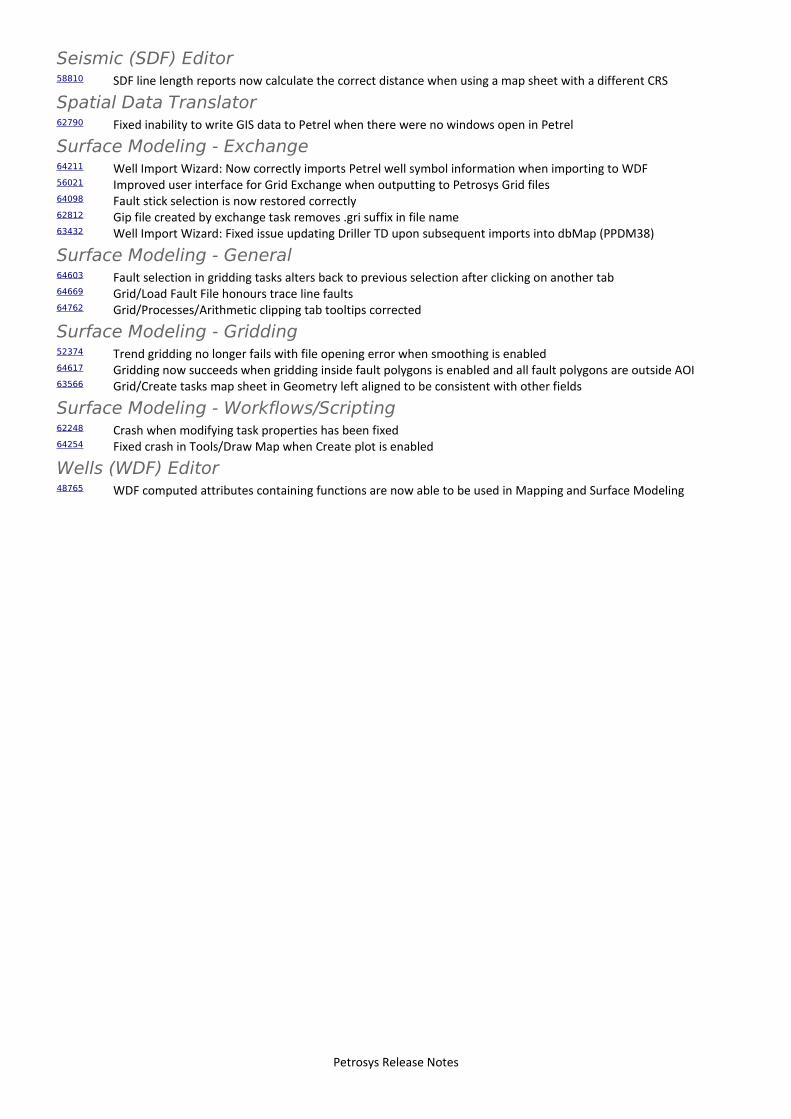
Seismic (SDF) Editor58810 SDF line length reports now calculate the correct distance when using a map sheet with a different CRS
Spatial Data Translator62790 Fixed inability to write GIS data to Petrel when there were no windows open in Petrel
Surface Modeling - Exchange64211 Well Import Wizard: Now correctly imports Petrel well symbol information when importing to WDF56021 Improved user interface for Grid Exchange when outputting to Petrosys Grid files64098 Fault stick selection is now restored correctly62812 Gip file created by exchange task removes .gri suffix in file name63432 Well Import Wizard: Fixed issue updating Driller TD upon subsequent imports into dbMap (PPDM38)
Surface Modeling - General64603 Fault selection in gridding tasks alters back to previous selection after clicking on another tab64669 Grid/Load Fault File honours trace line faults64762 Grid/Processes/Arithmetic clipping tab tooltips corrected
Surface Modeling - Gridding52374 Trend gridding no longer fails with file opening error when smoothing is enabled64617 Gridding now succeeds when gridding inside fault polygons is enabled and all fault polygons are outside AOI63566 Grid/Create tasks map sheet in Geometry left aligned to be consistent with other fields
Surface Modeling - Workflows/Scripting62248 Crash when modifying task properties has been fixed64254 Fixed crash in Tools/Draw Map when Create plot is enabled
Wells (WDF) Editor48765 WDF computed attributes containing functions are now able to be used in Mapping and Surface Modeling
Petrosys Release Notes
64 entries
Petrosys Release 17.8.4Detailed Release Notes
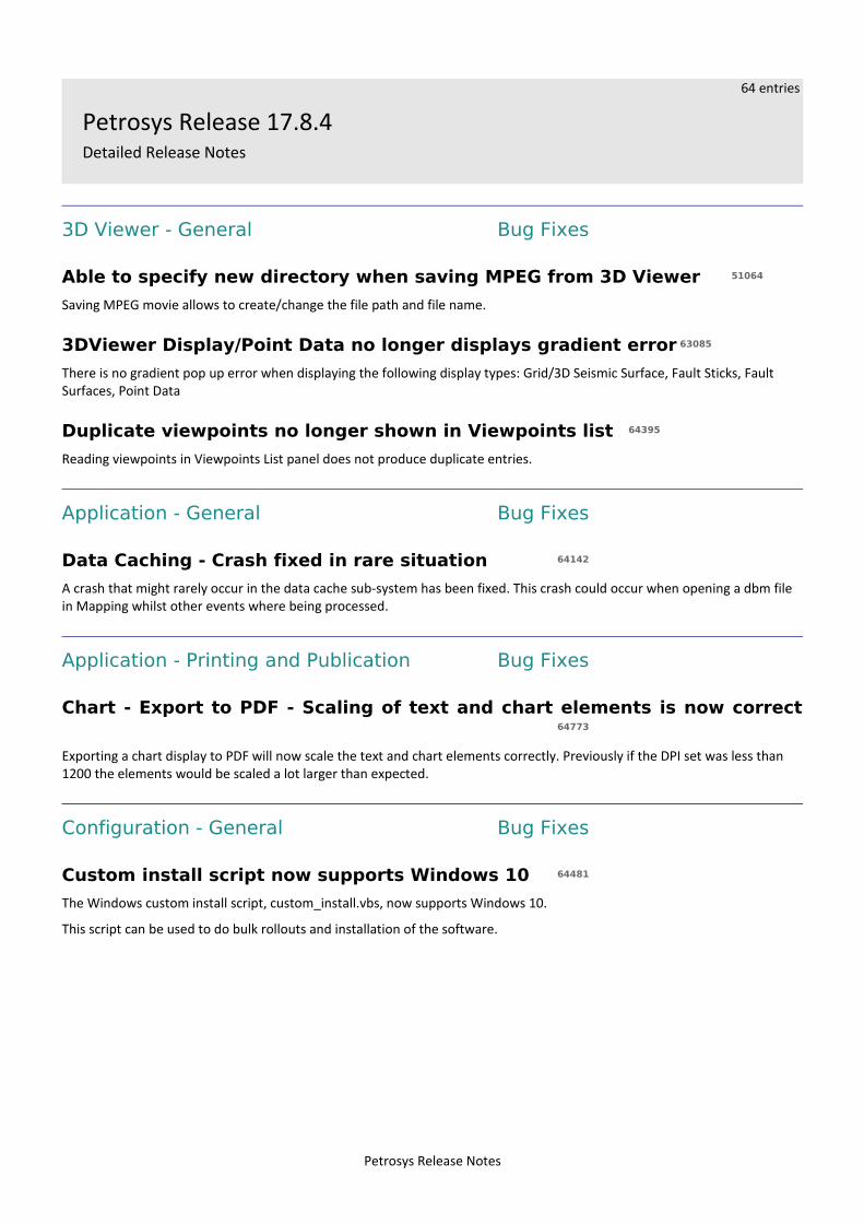
3D Viewer - General Bug Fixes
Able to specify new directory when saving MPEG from 3D Viewer 51064
Saving MPEG movie allows to create/change the file path and file name.
3DViewer Display/Point Data no longer displays gradient error 63085
There is no gradient pop up error when displaying the following display types: Grid/3D Seismic Surface, Fault Sticks, Fault Surfaces, Point Data
Duplicate viewpoints no longer shown in Viewpoints list 64395
Reading viewpoints in Viewpoints List panel does not produce duplicate entries.
Application - General Bug Fixes
Data Caching - Crash fixed in rare situation 64142
A crash that might rarely occur in the data cache sub-system has been fixed. This crash could occur when opening a dbm file in Mapping whilst other events where being processed.
Application - Printing and Publication Bug Fixes
Chart - Export to PDF - Scaling of text and chart elements is now correct64773
Exporting a chart display to PDF will now scale the text and chart elements correctly. Previously if the DPI set was less than 1200 the elements would be scaled a lot larger than expected.
Configuration - General Bug Fixes
Custom install script now supports Windows 10 64481
The Windows custom install script, custom_install.vbs, now supports Windows 10.
This script can be used to do bulk rollouts and installation of the software.
Petrosys Release Notes
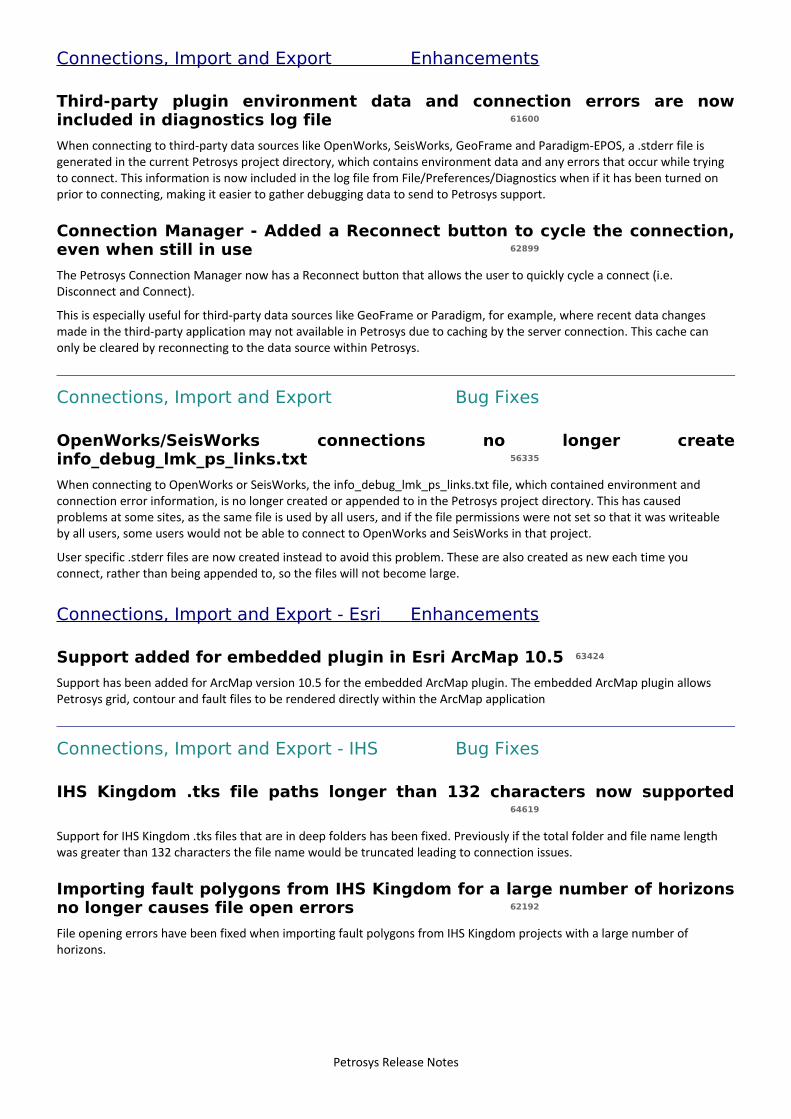
Connections, Import and Export Enhancements
Third-party plugin environment data and connection errors are nowincluded in diagnostics log file 61600
When connecting to third-party data sources like OpenWorks, SeisWorks, GeoFrame and Paradigm-EPOS, a .stderr file is generated in the current Petrosys project directory, which contains environment data and any errors that occur while trying to connect. This information is now included in the log file from File/Preferences/Diagnostics when if it has been turned on prior to connecting, making it easier to gather debugging data to send to Petrosys support.
Connection Manager - Added a Reconnect button to cycle the connection,even when still in use 62899
The Petrosys Connection Manager now has a Reconnect button that allows the user to quickly cycle a connect (i.e. Disconnect and Connect).
This is especially useful for third-party data sources like GeoFrame or Paradigm, for example, where recent data changes made in the third-party application may not available in Petrosys due to caching by the server connection. This cache can only be cleared by reconnecting to the data source within Petrosys.
Connections, Import and Export Bug Fixes
OpenWorks/SeisWorks connections no longer createinfo_debug_lmk_ps_links.txt 56335
When connecting to OpenWorks or SeisWorks, the info_debug_lmk_ps_links.txt file, which contained environment and connection error information, is no longer created or appended to in the Petrosys project directory. This has caused problems at some sites, as the same file is used by all users, and if the file permissions were not set so that it was writeable by all users, some users would not be able to connect to OpenWorks and SeisWorks in that project.
User specific .stderr files are now created instead to avoid this problem. These are also created as new each time you connect, rather than being appended to, so the files will not become large.
Connections, Import and Export - Esri Enhancements
Support added for embedded plugin in Esri ArcMap 10.5 63424
Support has been added for ArcMap version 10.5 for the embedded ArcMap plugin. The embedded ArcMap plugin allows Petrosys grid, contour and fault files to be rendered directly within the ArcMap application
Connections, Import and Export - IHS Bug Fixes
IHS Kingdom .tks file paths longer than 132 characters now supported64619
Support for IHS Kingdom .tks files that are in deep folders has been fixed. Previously if the total folder and file name length was greater than 132 characters the file name would be truncated leading to connection issues.
Importing fault polygons from IHS Kingdom for a large number of horizonsno longer causes file open errors 62192
File opening errors have been fixed when importing fault polygons from IHS Kingdom projects with a large number of horizons.
Petrosys Release Notes
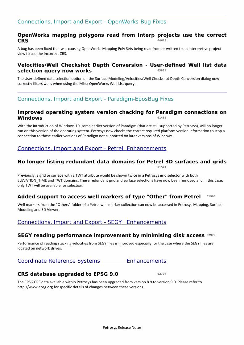
Connections, Import and Export - OpenWorks Bug Fixes
OpenWorks mapping polygons read from Interp projects use the correctCRS 64618
A bug has been fixed that was causing OpenWorks Mapping Poly Sets being read from or written to an interpretive project view to use the incorrect CRS.
Velocities/Well Checkshot Depth Conversion - User-defined Well list dataselection query now works 63824
The User-defined data selection option on the Surface Modeling/Velocities/Well Checkshot Depth Conversion dialog now correctly filters wells when using the Misc: OpenWorks Well List query .
Connections, Import and Export - Paradigm-EposBug Fixes
Improved operating system version checking for Paradigm connections onWindows 61485
With the introduction of Windows 10, some earlier version of Paradigm (that are still supported by Petrosys), will no longer run on this version of the operating system. Petrosys now checks the correct required platform version information to stop a connection to those earlier versions of Paradigm not supported on later versions of Windows.
Connections, Import and Export - Petrel Enhancements
No longer listing redundant data domains for Petrel 3D surfaces and grids51574
Previously, a grid or surface with a TWT attribute would be shown twice in a Petrosys grid selector with both ELEVATION_TIME and TWT domains. These redundant grid and surface selections have now been removed and in this case, only TWT will be available for selection.
Added support to access well markers of type "Other" from Petrel 61993
Well markers from the "Others" folder of a Petrel well marker collection can now be accessed in Petrosys Mapping, Surface Modeling and 3D Viewer.
Connections, Import and Export - SEGY Enhancements
SEGY reading performance improvement by minimising disk access 62979
Performance of reading stacking velocities from SEGY files is improved especially for the case where the SEGY files are located on network drives.
Coordinate Reference Systems Enhancements
CRS database upgraded to EPSG 9.0 62707
The EPSG CRS data available within Petrosys has been upgraded from version 8.9 to version 9.0. Please refer to http://www.epsg.org for specific details of changes between these versions.
Petrosys Release Notes

dbMap - Client Enhancements
dbMap Wells - Formation TVDs for vertical wells are now computed (PPDMclients) 57981
The Lists/Wells/dbMap/Edit/Selected Wells/Compute formation TVD option now supports computing the TVDs for wells that are flagged as vertical to match the measured depth. Previously these wells were skipped if they did not have a directional survey defined.
This is only supported for Petrosys-dbMap PPDM clients that have a Profile type or Hole trajectory flag on the well header, to indicate that a well is vertical.
PPDM3.8 Formation tops screen can now compute TVD 64634
Petrosys dbMap PPDM3.8 clients now have the ability to compute formation top TVD values on the well formation dialog.
The Compute TVD button calculates the Pick TVD values using the preferred directional survey for either the currently selected formation top, or all formation tops for the current well.
dbMap - Client Bug Fixes
Deleting a dbMap 3D bin grid polygon now updates the spatial outline63407
Deleting a polygon outline from a dbMap 3D seismic bin grid now correctly updates the database spatial outline.
Previously, the deleted polygon would remain visible via the PETROSYS_BIN_GRIDS database view.
Petrel - Import well header to dbMap PPDM3.8 now loads reference depthtype correctly 58140
For dbMap PPDM3.8 clients, importing well data from Petrel using the Wells Import Wizard, now correctly loads the well header Reference depth type (KB, RT, etc)
dbMap/Desktop Well Log Curve screen for PPDM 3.8 clients no longershows duplicate records 64761
The dbMap Well Log Curve screen for PPDM 3.8 clients could display duplicate records in the list depending on the log curve dictionary being referenced. The screen has been fixed to no longer display duplicate records in the list.
Display Drilling Opportunity targets now shows depths in correct units(Santos only) 61761
MAPPING/Display/Prospects/Drilling Opportunities now displays target depths in the correct units based on the Depth units option.
Previously, target depths were shown in feet when Metric was selected, and large incorrect values were shown then Imperialwas selected.
Drilling Opportunity Targets now display from PLDB M6B 60446
The Display/Prospects/Drilling opportunities option has been upgraded to support database structure changes for PLDB Milestone 6B
Temperature units field alignment fixed on dbMap Well Logs Run dialog(Santos only) 62083
The Santos dbMap Well Logs run dialog now shows the Temperature units aligned correctly with the field. Previously the units appeared on the far right of the screen.
Petrosys Release Notes
Mapping - Editors Bug Fixes
Export of geographic coordinates from the Spatial Editor coordinates tableworks as expected 47314
In the spatial editor, the right mouse options "Export to Excel.." and "Export to Text File" from the "Coordinates" table now write geographic coordinates correctly to the output file.
Mapping - General Enhancements
Display/Web Service Image includes support for Kerberos authentication63444
Support for authentication using Kerberos has been added to the Display/Web Map Service option. This is available in the dialog under the name "Operating System" authentication (which also used to select NTLM authentication).
New well symbols added depicting volcanoes 63739
New well symbols have been added to depict a volcano. One is un-filled and one is filled. These are symbol numbers 961 and 962 respectively.
Mapping measure function coordinate and distance informationreadability improved 63504
The readability of the coordinate and distance information in the status bar (bottom) of the map window has been improved.The coordinates are now shown in brackets and the segment and cumulative distance is shown more clearly.
Mapping - General Bug Fixes
Improved error message when temporary picture cache file gets deletedfrom under a display layer 64277
The error message that appears when files that are used for caching the display of certain data are deleted is now much improved. The error message now helps point out what might have caused the file to be deleted and which layers on the map are affected. Usually this error is caused by temp file cleanup scripts that clean out files that are in use from the temporary file directory (e.g. /tmp on Linux).
Crash fixed when using BMP format image for titleblock logo 63603
A crash has been fixed when a Windows BMP format image file was used in a titleblock.
Mapping - GIS, Spatial and Culture Bug Fixes
The text file define file format dialog only allow selection of XY fields fromenabled columns 63758
In previous versions the X and Y field selectors incorrectly included columns that had been explicitly disabled.
Petrosys Release Notes
Mapping - Seismic Bug Fixes
Display/2D Seismic - runtime parameters are now remembered for dataselection queries of third-party connections 63806
When using a database query to filter the display of 2D seismic lines from third party data sources, such as OpenWorks, run time parameters are now remembered when modifying the layer.
Previously, if you modified the 2D seismic layer, and changed something like the line color, no lines would appear on the map.
Fixed crash due to out of memory when displaying 2D seismic contour cuts62974
In previous versions, Mapping may crash due to running out of memory when displaying 2D seismic data contour cuts. This has been fixed.
3D bin grids from dbMap can now be displayed without a data selectionwhen using a dynamic map sheet 64355
A bug has been fixed which caused no Petrosys dbMap 3D bin grids to display on a dynamic map sheet when data selection filtering was disabled.
Ribbon Map - Fixed hanging when zero increment is used 63267
The Seismic Ribbon Map display has been improved to handle invalid input data correctly, where previously this data could cause the option to freeze the application.
Mapping - Wells Enhancements
Modified validity checks for Chronostrat markers when loading ReservoirSummaries into dbMap (Santos only) 43666
When creating new or editing existing Reservoir Summary data for Chronostrat markers, interval checking is now done using only regionally correlated markers and ignores any unconformity or local markers.
Mapping - Wells Bug Fixes
Corrected well formation top and thickness annotation location beingreversed in some cases 63456
When annotating formation tops or thicknesses, the annotation location could become reversed in some cases where annotations set to be above a point were made below and vice-versa. This has now been fixed and the annotation location is now honoured for all cases.
Updated PPDM38 formation tops panel to base subsea depth on pick TVDover pick depth 59764
Previously, the subsea depth was computed from the pick depth field. Now the pick TVD is used in preference over the pick depth to compute the subsea depth.
Petrosys Release Notes
Seismic (SDF) Editor Bug Fixes
SDF line length reports now calculate the correct distance when using amap sheet with a different CRS 58810
The SDF Line Length report now correctly calculates the length of a line when using a map sheet that has a different CRS to that of the SDF.
Spatial Data Translator Bug Fixes
Fixed inability to write GIS data to Petrel when there were no windowsopen in Petrel 62790
Writing GIS data to Petrel would stop prematurely when there were no windows open in the Petrel project. This has now been fixed.
Surface Modeling - Exchange Enhancements
Grid Exchange - Support added for CRS conversion58932
The Grid Exchange option now has support for CRS conversion. The grids will be CRS converted as long as there is a valid transformation for the source and destination CRSes. A confirmation dialog will be displayed to allow the user to control whether the conversion should proceed.
Well Import Wizard: SOURCE can be overridden when importing formationtops and checkshot surveys to dbMap (PPDM38) 63181
The user now has the ability to optionally override the formation tops and checkshot survey SOURCE when importing well data into a PPDM3.8 dbMap database.
Surface Modeling Load Fault File upgraded to use new fault selectionwidget 64127
In previous versions, the Surface Modeling option Grid/Load Fault File... did not support OpenWorks connection.
Now OpenWorks connection is supported and the previous tasks which use SeisWorks projects can also be opened and then upgraded to using OpenWorks connections.
Surface Modeling - Exchange Bug Fixes
Well Import Wizard: Now correctly imports Petrel well symbol informationwhen importing to WDF 64211
A bug has been fixed whereby well symbol values were not being translated correctly to the Petrosys Well Symbol catalogue when importing wells from Petrel into a WDF.
Improved user interface for Grid Exchange when outputting to PetrosysGrid files 56021
When outputting grids to Petrosys grid file, it wasn't clear the user interface was expecting an output directory. A new 'Output directory' label and improved error messages have been added.
Fault stick selection is now restored correctly 64098
In previous versions in surface modeling task 'Exchange/Fault Sticks' fault sticks selection could not be restored from saved .tsk. This now has been fixed.
Petrosys Release Notes
Gip file created by exchange task removes .gri suffix in file name 62812
The gip file name follows the output grid name and the file is stored in the same directory as the output grid.
Well Import Wizard: Fixed issue updating Driller TD upon subsequentimports into dbMap (PPDM38) 63432
A bug has been fixed that caused incorrect merging of the well header field Drillers TD upon subsequent imports into a PPDM3.8 dbMap database.
Surface Modeling - General Enhancements
Workflow files overwrite dialog is wider 62793
Files overwrite dialog has been made wider for easier reading.
'Rename Task' option moved below 'Modify Task' 64506
Moved 'Rename Task' under 'Modify Task...' option.
Surface Modeling - General Bug Fixes
Fault selection in gridding tasks alters back to previous selection afterclicking on another tab 64603
Grid/Create Grid fault selection is remembered after clicking to other tabs and then returning to Fault tab.
Grid/Load Fault File honours trace line faults 64669
In previous version 'Grid/Load Fault File' fault trace lines became fault polylines after being loaded into Petrosys grid file. It now has been fixed.
Grid/Processes/Arithmetic clipping tab tooltips corrected 64762
Grid/Process/Arithmetic clipping polygons 'Select All' and 'Select None' buttons have correct tooltips.
Surface Modeling - Gridding Bug Fixes
Trend gridding no longer fails with file opening error when smoothing isenabled 52374
Trend gridding with smoothing enabled now works correctly.
Gridding now succeeds when gridding inside fault polygons is enabled andall fault polygons are outside AOI 64617
Gridding finishes successfully when gridding inside fault polygons option is enabled and all fault polygons lie outside the gridding area of interest. Previously gridding reported a failure in this scenario.
Grid/Create tasks map sheet in Geometry left aligned to be consistent withother fields 63566
Mapsheet name in Geometry tab has been left aligned to be consistent with other fields.
Petrosys Release Notes
Surface Modeling - Volumetrics Enhancements
Grid-based-slice volumetrics CRS enabled and geometry restrictionsrelaxed 39832
Restrictions for Top/Base grid-based slice volumetrics have been relaxed, with non-empty overlap only now required to run calculations.
Also Merge/Overlay options error notifications have changed. Grids no longer have to match geometrically, instead they haveto have non-empty overlap and be co-nodular.
Add ability to have additional levels for Volumetrics/Grid based slices61645
Additional levels have been added for Volumetrics/Grid based slices option.
Surface Modeling - Workflows/Scripting Bug Fixes
Crash when modifying task properties has been fixed62248
In previous versions Surface Modeling may have crashed when opening a task panel via the Modify option and the task was created by copying and pasting an existing task. This has been fixed.
Fixed crash in Tools/Draw Map when Create plot is enabled 64254
Tools/DrawMap does not crash when Create plot is selected and the workflow is run repeatedly in the same session.
Wells (WDF) Editor Bug Fixes
WDF computed attributes containing functions are now able to be used inMapping and Surface Modeling 48765
If you have created a computed attribute in a WDF that makes use of a function, such as POW, it can now be displayed in Mapping and used to create grids in Surface Modeling.
Previously, a computed attribute like this could be viewed in the WDF Editor spreadsheet, but nothing appeared when used in Mapping or Surface Modeling.
Petrosys Release Notes
10 entries
Detailed Release Notes Summary 17.8.3Enhancements
Application - General42008 'File Manager (Explorer)' option added to the File menu in the Mapping, 3dViewer and Surface Modeling
applications
Application - User Interface62324 Redesigned Fault Polygon selection user interface
Connections, Import and Export - IHS40162 Support added for reading Fault Sticks from IHS Kingdom
Connections, Import and Export - OpenWorks50729 Added OpenWorks Mapping Poly Sets as an input and output data source to Spatial Data Translator61873 Added reading of OpenWorks Mapping Poly Sets24288 Accessing fault polygons from Landmark now uses an OpenWorks connection63404 Performance improvement for retrieving list of SeisWorks fault sticks
Mapping - General63235 Support added for display of raster imagery from non-tiled ArcGIS web map services
Surface Modeling - Gridding64150 Mistie report in Well Tie now shows relative value for Correction column
Surface Modeling - Workflows/Scripting56555 Automatic substitution of Petrel project names in Spatial Data Translator tasks
Petrosys Release Notes
15 entries
Detailed Release Notes Summary 17.8.3Bug Fixes
3D Viewer - General63327 Hang when Petrel triangulated grids are displayed and updated fixed63029 Crash when using a Map File layer and then updating the layer fixed
Mapping - Editors63408 Spatial editor shows modified regions correctly for grid input data when polygon clip is used
Mapping - General34590 Support added for NTLM proxy server authentication63760 Display/Web Map Service prompts for proxy server user name and password63669 Drag and drop of files onto the Mapping window from Linux works again
Mapping - Map Sheets63594 Placement of map elements in zoom area now works correctly
Mapping - Publication63531 File/Export/Raster supports the "map contents only" option correctly
Mapping - Wells25594 Display/Wells/Wdf - Well annotation offset now supports decimal values
Spatial Editor64032 Intermittent crash when smoothing faults in the Spatial Editor no longer occurs63217 Spatial Editor no longer corrupts the shapefile that is displayed via Display/GIS63372 Grid editing operations correctly handle editing a grid on a map sheet with a different CRS
Surface Modeling - Exchange63573 Grid Exchange - OpenWorks output field names are now consistent with Landmark software63406 Fixed Exchange writing SeisWorks fault sticks
Surface Modeling - Gridding63809 Grid/Create Grid - gridding inside faults pops up gridding progress dialog for each fault gridded
Petrosys Release Notes
25 entries
Petrosys Release 17.8.3Detailed Release Notes
3D Viewer - General Bug Fixes
Hang when Petrel triangulated grids are displayed and updated fixed63327
Petrel triangulated grids display works correctly. Previously, displaying a Petrel triangulated grid could cause the 3D Viewer tohang.
Crash when using a Map File layer and then updating the layer fixed63029
Map File layers display now works correctly in all cases. Previously the application could crash if the layer properties were modified after it was created.
Application - General Enhancements
'File Manager (Explorer)' option added to the File menu in the Mapping,3dViewer and Surface Modeling applications 42008
The 'File Manager (Explorer)' option from the File menu in the Launcher window has also been added to the File menu in the Mapping, 3dViewer and Surface Modeling applications. This option launches the local operating system file manager to allow you to browse the files in the project directory/folder.
Application - User Interface Enhancements
Redesigned Fault Polygon selection user interface62324
The user interface for selecting Fault Polygons has been redesigned in Mapping, Display/Faults and on the Fault tab of the following processes in Surface Modeling; Grid/Create Grid, Grid/Well tie, Grid/Phantom and Grid/Processes/Arithmetic.
Connections, Import and Export - IHS Enhancements
Support added for reading Fault Sticks from IHS Kingdom 40162
Initial support for reading fault sticks from IHS Kingdom has been added to the following options:
➢ Surface Modeling - Grid/Create Grid➢ Exchange/Fault Sticks➢ 3D viewer/Display/Fault Sticks
Due to the wide variation of fault stick data in Kingdom projects, this functionality has been marked as a ‘Functionality Preview’. This means that it has not been extensively tested with a broad range of data by Petrosys. Please carefully check the results to ensure the correct fault sticks have been extracted and contact Petrosys support if you encounter issues with your fault stick data.
Petrosys Release Notes
Connections, Import and Export - OpenWorks Enhancements
Added OpenWorks Mapping Poly Sets as an input and output data sourceto Spatial Data Translator 50729
OpenWorks Mapping Poly Sets has been made available for reading and writing in the Spatial Data Translator. This allows theeasy loading of polygons into OpenWorks from all supported data types, with full support for all 'Polygon Set' data types.
Added reading of OpenWorks Mapping Poly Sets 61873
Petrosys now has the ability to read all types of Mapping Poly Sets from OpenWorks as a GIS data source. Fault Polygons is one example of a Mapping Poly Set type, which we read specifically as a fault data type. OpenWorks is now an available data source for direct display in Mapping under Display/GIS, as well as an input in the Spatial Data Translator. In both cases all types of Mapping Poly Sets are made available (including Fault Polygons) to be read as generic GIS data. This functionality now also allows users to utilise Polygon Type information for Inclusive and Exclusive when reading Mapping Poly Sets from OpenWorks.
Accessing fault polygons from Landmark now uses an OpenWorksconnection 24288
Previously, to access Fault Polygons from an OpenWorks project the user needed to setup and use a SeisWorks based connection. This requirement has now been removed and all features accessing Fault Polygons from Landmark projects now use an OpenWorks connection. This includes, but not limited to, direct display of Fault Polygons in Mapping and the use of Fault Polygons to create grids in Surface Modeling.
Existing DBM and TSK files that previously used a SeisWorks connection to access Fault Polygons will be upgraded to use the new method of access through the OpenWorks connection. This will be done automatically upon opening/loading one of these existing files.
Performance improvement for retrieving list of SeisWorks fault sticks63404
The amount of time needed to retrieve the list of SeisWorks fault sticks has been significantly improved by utilising the connection to the OpenWorks Oracle database. This change has a positive effect on the opening of dialogs that display lists offault sticks from SeisWorks in Surface Modeling and 3D Viewer.
Mapping - Editors Bug Fixes
Spatial editor shows modified regions correctly for grid input data whenpolygon clip is used 63408
When grids are edited using the spatial editor, the localised regridding option allows regridding of just the AOI in which edits have been made. In previous versions, the polygon clip option would incorrectly flag contours or faults as modified that were outside the polygon being used for clipping.
Mapping - General Enhancements
Support added for display of raster imagery from non-tiled ArcGIS webmap services 63235
Petrosys now supports display of images from ArcGIS server web services via a "map export". This is supported for all types ofmap services, including those based on a tile cache, and allows customisation of layers to display (when supported by the service).
Petrosys Release Notes
Mapping - General Bug Fixes
Support added for NTLM proxy server authentication34590
Proxy server authentication using the NTLM protocol is now supported. No explicit change is required to enable this.
Display/Web Map Service prompts for proxy server user name andpassword 63760
In version 17.8.2, the Display/Web Map Service option did not prompt to enter the user name and password required to access a configured proxy server.
Drag and drop of files onto the Mapping window from Linux works again63669
Version 17.8.1 introduced a bug where, on Linux, drag-and-drop of files onto the Mapping window did not work as expected. This problem has now been fixed.
Mapping - Map Sheets Bug Fixes
Placement of map elements in zoom area now works correctly 63594
Fixed intermittent crash of placing map elements in zoom area.
Mapping - Publication Bug Fixes
File/Export/Raster supports the "map contents only" option correctly63531
In Petrosys version 17.8sp2, the "map contents only" option was not honoured when exporting a map to a raster image.
Mapping - Wells Bug Fixes
Display/Wells/Wdf - Well annotation offset now supports decimal values25594
The display of well data from a WDF now allows the text offsets for well header and zone items to now use decimal values. This allows more precision when annotating wells.
Spatial Editor Bug Fixes
Intermittent crash when smoothing faults in the Spatial Editor no longeroccurs 64032
A bug was introduced in version 17.8.1, that could result in a crash when operations (such as smoothing) were performed on certain faults.
Spatial Editor no longer corrupts the shapefile that is displayed viaDisplay/GIS 63217
In previous versions, saving a shapefile in the Spatial Editor while the shapefile was also displayed on the map via Display/GIS could corrupt the shapefile. This is now fixed.
Petrosys Release Notes
Grid editing operations correctly handle editing a grid on a map sheet witha different CRS 63372
The following grid based operations in the spatial editor did not work as expected if the grid CRS was different to the map sheet CRS:
➢ Interpolation of missing grid values➢ Grid circle based relative adjustment➢ Display of grid values (symbols and text)➢ Grid edit single node (specifically the post-edit redraw and recontouring steps)
These now handle CRS conversion correctly.
Surface Modeling - Exchange Bug Fixes
Grid Exchange - OpenWorks output field names are now consistent withLandmark software 63573
The field labels shown in the Grid Exchange user interface when using OpenWorks as an output data source have been updated to use the same terminology as a user would see in the majority of Landmark applications. This has been done to alleviate some confusion as to what each field is used for when writing the grid to OpenWorks and then being able to find it in Landmark applications.
Fixed Exchange writing SeisWorks fault sticks 63406
Writing fault sticks to SeisWorks projects now works correctly. Previously, an Exchange task that wrote to SeisWorks fault sticks task could fail.
Surface Modeling - Gridding Enhancements
Mistie report in Well Tie now shows relative value for Correction column64150
Well tie mistie report shows the correction values as relative values in addition to the absolute values. The new column header has been named Rel Correction.
Surface Modeling - Gridding Bug Fixes
Grid/Create Grid - gridding inside faults pops up gridding progress dialogfor each fault gridded 63809
Gridding inside fault polygons option only shows overall progress for all fault polygons rather than individual fault polygons progress bars.
Surface Modeling - Workflows/Scripting Enhancements
Automatic substitution of Petrel project names in Spatial Data Translatortasks 56555
The Petrel project name is automatically substituted with the current Petrel connection name. This makes it easier to re-use aSpatial Data Translator task with different Petrel projects.
Petrosys Release Notes
17 entries
Detailed Release Notes Summary 17.8.2Enhancements
Application - Printing and Publication62700 Export Raster default compression for PNG images increased to produce smaller files with same quality level
Application - User Interface60370 Lookup lists for database fields, search functionality now selects the item found41061 Gradient - Fixed custom range - Improved keyboard entry of min/max Z-values
Connections, Import and Export21056 Support added for importing ER Mapper .ers files into Petrosys grids62863 Added in support for displaying Windows BMP format raster image files in Mapping
Connections, Import and Export - Petrel62539 Added Petrel drag and drop support for Model Faults
Coordinate Reference Systems62017 Support for Robinson, Bonne, Cassini, Gall Stereographic and Times projections added52445 EPSG CRS database upgraded to 8.9
Mapping - Editors60916 Drag and drop layers from Mapping directly into grid layers in the Spatial Editor
Mapping - General32070 Support for displaying raster data from tiled web map services24333 Support added for accessing web services via https
Mapping - GIS, Spatial and Culture62773 Removed point limit on use of outline fill for polygon style
Mapping - Wells62770 New star well symbols added
Surface Modeling - Exchange62892 Well Import Wizard: Updates to client configuration (Origin only)
Surface Modeling - General59322 Improvements to make it easier to clear cached data, including in workflows
Surface Modeling - Gridding34550 Grid/Create Grid can now create fault polygon surface data on the fly when creating grids
Surface Modeling - Volumetrics60317 Volumetrics CSV reports for depth/volume, depth/area/thickness and other data
Petrosys Release Notes
29 entries
Detailed Release Notes Summary 17.8.2Bug Fixes
3D Viewer - General56432 Update and Update All display list functions reinstated
Application - General59798 Database upgrade more robust (Windows only)
Application - User Interface63227 Fixed alignment of Magnetic Declination direction field on the Well Directional Survey header dialog
Configuration - Licensing56128 SafeNet Sentinel driver version now supports Windows 8+
Connections, Import and Export59697 Raster Image Export sets the image dpi/physical size correctly
Connections, Import and Export - Esri40740 Esri File Geodatabase display performance significantly improved
Connections, Import and Export - OpenWorks62514 Reading fault sticks from large SeisWorks project in Create Grid task is now faster
Connections, Import and Export - Paradigm-Epos62908 Paradigm 3D seismic data now shown when connected to survey
Connections, Import and Export - Petrel62653 Added Petrel drag and drop support for grids located in interpretation folders outside of the seismic root56494 Exchange 3D Seismic Surface: All Petrel horizon data types are now read62687 Added Petrel drag and drop support for grids located in standard Petrel folders within an interpretation folder62658 Petrel fault sticks path is now reported correctly when it is not under seismic root
dbMap - Client60953 Computing formation TVDs now supported for PPDM3.8 dbMap wells
dbMap/Web - General49467 Display Bubble Map filter option of Text and Excel preview list is now disabled
Documentation - Online Help63020 Updated help documentation with information relevant to supporting Paradigm 15.5
Mapping - General35939 Thematically mapped point and line data appears correctly in legends61512 Display List crash when re-ordering layers and using undo is now fixed60852 Map elements: Legend now has the correct location and highlight box
Mapping - Map Sheets60400 Map Elements can now be placed in current map zoom area60833 Loading a dbm without loading the map sheet now positions map elements correctly62320 Displaying title block highlight box is now erased if the title block is disabled
Mapping - Wells60550 Filtering of wells now handles NULLs returned by Santos web service
Surface Modeling - Exchange60163 Well Import Wizard now correctly imports thirdparty data source well symbol information when importing to
PPDM3.8 dbMap database61752 Well Import Wizard now allows Well Primary Source to be specified (PPDM3.8 only)
Petrosys Release Notes
Surface Modeling - General61833 Surface Modeling task list is always visible62558 Zone button name shows correct zone name when the zone value is scripted62497 Selecting feature class if no File Geodatabase is selected works correctly
Surface Modeling - Gridding62869 Store runtime modified variogram parameters to task content after task run61899 Gridding fault sticks generates correct fault polygons if fault sticks have different CRS than output grid
Petrosys Release Notes
46 entries
Petrosys Release 17.8.2Detailed Release Notes
3D Viewer - General Bug Fixes
Update and Update All display list functions reinstated 56432
UI options "Updated All" and "Update Selected" have been reinstated to the 3D Viewer.
Application - General Bug Fixes
Database upgrade more robust (Windows only) 59798
The application Upgrade Database now handles backup directory more robustly on Windows. In previous version, the application would fail if the backup directory was not set to project directory.
Application - Printing and Publication Enhancements
Export Raster default compression for PNG images increased to producesmaller files with same quality level 62700
The default compression level for saving PNG images from the /File/Export/Raster image option has been increased from 3 to8. This can significantly decrease the resultant size of the PNG file without affecting the image quality.
Application - User Interface Enhancements
Lookup lists for database fields, search functionality now selects the itemfound 60370
When searching for items in the selection lists used for database lookup fields, the item found by the search will be automatically selected. I.e. the blue selection highlight will follow the green selection highlight of the search.
Gradient - Fixed custom range - Improved keyboard entry of min/max Z-values 41061
The entry of the minimum and maximum values using the keyboard for a gradient is now much easier. Previously trying to type in values with a decimal point caused the cursor and values to jump around making it difficult to type in the precise number required.
Application - User Interface Bug Fixes
Fixed alignment of Magnetic Declination direction field on the WellDirectional Survey header dialog 63227
The alignment of the Well Directional Survey magnetic declination direction lookup button has been modified to show the information next to the magnetic declination value. The lookup button was previously located off to the far right and could be missed when looking through a Wells Directional Survey header information.
Petrosys Release Notes
Configuration - Licensing Bug Fixes
SafeNet Sentinel driver version now supports Windows 8+ 56128
The SafeNet (Gemalto) Sentinel dongle driver now installed when using a dongle for licensing has been upgraded to version 7.5.8 to better support Windows 8 and above.
If using a server based license, the service may need to be restarted after the installer and associated driver configuration hascompleted. This can take several minutes.
Connections, Import and Export Enhancements
Support added for importing ER Mapper .ers files into Petrosys grids21056
ER Mapper .ers files can now be imported to Petrosys grid files using the '/Import/Raster (TIFF, ECW, BIL, ADF, IMG, ERS)...' option from the Launcher or Surface Modeling application.
Added in support for displaying Windows BMP format raster image files inMapping 62863
Support for displaying Windows BMP format raster files has been re-added to Mapping.
Connections, Import and Export Bug Fixes
Raster Image Export sets the image dpi/physical size correctly 59697
Raster images exported via the option 'File/Export/Raster Image..' will now have the correct image dpi set in the metadata of the resultant raster file.
Connections, Import and Export - Esri Bug Fixes
Esri File Geodatabase display performance significantly improved 40740
The display and interaction performance of Esri File Geodatabases has been significantly improved. The largest improvement in performance will be seen when displaying a small subset of data from a much larger dataset.
Connections, Import and Export - OpenWorks Bug Fixes
Reading fault sticks from large SeisWorks project in Create Grid task isnow faster 62514
In previous versions, it took long time to read fault sticks data types from SeisWorks project if there were many fault sticks surfaces in that project. This has now been fixed.
Connections, Import and Export - Paradigm-EposBug Fixes
Paradigm 3D seismic data now shown when connected to survey 62908
In previous versions, reading 3D seismic surface from Paradigm EPOS did not work if the 3D survey was directly connected. This has now been fixed.
Petrosys Release Notes
Connections, Import and Export - Petrel Enhancements
Added Petrel drag and drop support for Model Faults62539
Model faults can now be selected using drag and drop. For mapping, the model faults cannot be selected individually, but theassociated faults are now brought across automatically when dragging a model horizon.
Connections, Import and Export - Petrel Bug Fixes
Added Petrel drag and drop support for grids located in interpretationfolders outside of the seismic root 62653
Grids can now be located outside of the Petrel seismic root folder and be used with the Petrel drag and drop link.
Exchange 3D Seismic Surface: All Petrel horizon data types are now read56494
A bug has been fixed in 3D Seismic Surface Exchange, which was limiting the data types for Petrel as an input data source, to only have ELEVATION_TIME and / or ELEVATION_DEPTH. The list of data types is now correctly populated from all the 3D Seismic Surfaces in the connected Petrel project.
Added Petrel drag and drop support for grids located in standard Petrelfolders within an interpretation folder 62687
Grids can now be located within standard Petrel folders which are children of seismic interpretation folders and be used with the Petrel drag and drop link.
Petrel fault sticks path is now reported correctly when it is not underseismic root 62658
The folder reported for fault sticks located outside of the Petrel seismic root folder are no longer prefixed with "Seismic/"
Coordinate Reference Systems Enhancements
Support for Robinson, Bonne, Cassini, Gall Stereographic and Timesprojections added 62017
Petrosys includes support for the following projection types: Robinson, Bonne, Cassini, Gall Stereographic and Times
EPSG CRS database upgraded to 8.9 52445
The EPSG CRS data available within Petrosys has been upgraded from version 8.5 to version 8.9.0. Please refer to http://www.epsg.org for specific details of changes between these versions.
dbMap - Client Bug Fixes
Computing formation TVDs now supported for PPDM3.8 dbMap wells60953
For dbMap PPDM3.8 clients, the Mapping/Lists/Wells/dbMap/Edit/Selected wells/Compute formation TVDs option is now supported.
Previously the option was available, but it did not compute any formation TVD values.
Petrosys Release Notes
dbMap/Web - General Bug Fixes
Display Bubble Map filter option of Text and Excel preview list is nowdisabled 49467
The Display/Bubble Map... option now has the Filter option of the Text and Excel preview list disabled. The Filter option is confusing some users as they expected the filtered out values not to be displayed on the map.
Documentation - Online Help Bug Fixes
Updated help documentation with information relevant to supportingParadigm 15.5 63020
The Paradigm connections topic has been updated with information relevant to supporting for Paradigm 15.5.
Mapping - Editors Enhancements
Drag and drop layers from Mapping directly into grid layers in the SpatialEditor 60916
Spatial Editor now supports drag and drop layers directly from Mapping Display list to its grid layer.
Mapping - General Enhancements
Support for displaying raster data from tiled web map services 32070
Support has been added for displaying tiled raster imagery from web sources:
➢ WMTS➢ ArcGIS server➢ Bing Maps (requires a Bing Maps license, which is not provided by Petrosys)
This functionality is available in a new Display/Web Service Image display option in Mapping.
Support added for accessing web services via https24333
Display of web data supports access via secure https addresses. This includes the existing WMS display options and the newlyadded tiled raster display option. The https relies on certificates located in the standard operating system locations.
Please contact your IT system administrator for assistance with installing security certificates.
Mapping - General Bug Fixes
Thematically mapped point and line data appears correctly in legends35939
Thematically mapped GIS point data now appears correctly in Legend.
Display List crash when re-ordering layers and using undo is now fixed61512
A crash that could occur when reordering the display list layers in Mapping, particularly when dragging layers into sub groups,has now been fixed.
Petrosys Release Notes
Map elements: Legend now has the correct location and highlight box60852
Fixed bug where legend has incorrect highlight bounding box when its dimension is changed.
Mapping - GIS, Spatial and Culture Enhancements
Removed point limit on use of outline fill for polygon style 62773
The 6,000 polygon point limit for filling polygons with a percentage fill width has been removed. Now any size polygon will work with this fill width percentage. For example when displaying lease boundaries in the /Display/GIS option, setting a 25% fill width in "Fill style" option will fill the border of all polygons to a ratio of 25%.
Mapping - Map Sheets Bug Fixes
Map Elements can now be placed in current map zoom area 60400
A new button "Place in current zoom area" has been added to map elements edit dialog when the map sheet is in zoom in mode. This allows the map element to be re-position in the current zoom area of the map.
Loading a dbm without loading the map sheet now positions mapelements correctly 60833
When loading a dbm file without loading the map sheet used to save the dbm, map elements sizes and locations are not calculated correctly in earlier versions. This is now fixed and map elements sizes and locations are now relative to the 4 corners of the map sheet.
Displaying title block highlight box is now erased if the title block isdisabled 62320
Fixed bug where display title block highlight box is still drawn when the title block has been disabled (hidden).
Mapping - Wells Enhancements
New star well symbols added 62770
Two new well symbols, a hollow star and solid-filled star, have been added to the standard set of symbols.
Mapping - Wells Bug Fixes
Filtering of wells now handles NULLs returned by Santos web service60550
Well fields filtering now handles NULLs properly when they are returned by Santos web service
Surface Modeling - Exchange Enhancements
Well Import Wizard: Updates to client configuration (Origin only) 62892
Origins client configuration for importing of Wells through the Well Import Wizard has been updated to allow:
➢ Grouping of Wells by Permit when importing to Petrel➢ Overriding Well Source when importing to dbMap database
Petrosys Release Notes
Surface Modeling - Exchange Bug Fixes
Well Import Wizard now correctly imports thirdparty data source wellsymbol information when importing to PPDM3.8 dbMap database 60163
A bug has been fixed which was causing incorrect well symbol information to be imported into a PPDM3.8 dbMap database when transferring well data from a thirdparty data source. The well symbol information was already correctly being importedinto a WDF from these same thirdparty data sources.
Well Import Wizard now allows Well Primary Source to be specified(PPDM3.8 only) 61752
The Well Import Wizard now allows the Well Primary Source to be optionally specified when importing Well headers in to a PPDM3.8 database.
Surface Modeling - General Enhancements
Improvements to make it easier to clear cached data, including inworkflows 59322
Surface Modeling now allows clearing cached data. Cache can be cleared for either individual tasks or all tasks.
Surface Modeling - General Bug Fixes
Surface Modeling task list is always visible 61833
The task list has been set to be always visible.
Zone button name shows correct zone name when the zone value isscripted 62558
The Back Interpolate to WDF task zone button shows the correct name when the zone value is scripted.
Selecting feature class if no File Geodatabase is selected works correctly62497
Selecting feature class in Grid/Create Grid spatial datasource if no File Geodatabase was selected does not cause a crash.
Surface Modeling - Gridding Enhancements
Grid/Create Grid can now create fault polygon surface data on the fly whencreating grids 34550
When creating a grid with faults, the fault polygon surface can now be generated as part of the gridding task. To select this, simply turn on the "Grid inside fault" toggle on the fault tab of the Surface Modeling Grid/Create Grid option.
Surface Modeling - Gridding Bug Fixes
Store runtime modified variogram parameters to task content after taskrun 62869
In previous versions, when using griding method 'Kriging' or 'Kriging with External Drift' user run-time modified variogram parameters were not saved into to task content after the task was run. This has been fixed.
Petrosys Release Notes
Gridding fault sticks generates correct fault polygons if fault sticks havedifferent CRS than output grid 61899
Gridding fault sticks using different CRS than the output grid will produce correct fault polygons with correct Z-values.
Surface Modeling - Volumetrics Enhancements
Volumetrics CSV reports for depth/volume, depth/area/thickness and otherdata 60317
Volumetrics reporting offers export of top and base depths, area and cumulative volume in .CSV format.
Petrosys Release Notes
37 entries
Detailed Release Notes Summary 17.8.1Enhancements
3D Viewer - General60511 Display Fault sticks in 3DViewer - introduced 'Auto' coloring
Application - Printing and Publication61821 Picture View - Export to PDF option now has 'fit to page' option62307 Export PDF and Raster now remember the last used folder/directory61805 PowerPoint Export "Lock aspect ratio" option on by default for the picture properties
Connections, Import and Export35195 New option to import DEM, GeoTiff, ECW, Arc BinaryGrid, ERDAS IMAGINE and BIL image files to Petrosys grid files
Connections, Import and Export - Excel47390 Spatial Editor and Spatial Data Translator now support writing lines and polygons to Excel file
Connections, Import and Export - Petrel60893 Added support to drag-and-drop data from Petrel to Petrosys Mapping and Surface Modeling61266 Display of Petrel wells in Mapping and 3D Viewer now uses Petrel Well Symbol library and images
Connections, Import and Export - SeisWare50916 Support for SeisWare 9.1 added
dbMap - Administration60386 Added support for Permits, Fields, Facilities & Basins in Admin/Reports/Edit
dbMap - Client61847 Well status can now be linked to plot symbol (PPDM3.8)
dbMap/Web - PLDB62479 Auto removal of replicated wells when DOP/Prospect status is changed to a non-replicated state.
Mapping - General16019 Color palette importer now allows more than 100 colors to be imported62439 New pattern fill styles with vertical bands at 2:1 ratio
Mapping - GIS, Spatial and Culture48587 Text and Excel file format definition now defaults to having no Z-value column selected
Mapping - Wells52745 Added Permeability attribute fields to Reservoir Summary dialogs (Santos only)
Spatial Data Translator60629 Support date/time attribute for Excel file
Spatial Editor47726 New options to join or closed selected line segments49298 New option to create a polygon by tracing segments from other shapes49299 Hovering over a shape shows details relevant to the shape in the status bar47448 Vertices selected in the Coordinates table are also selected on the map (in vertex editing mode)46263 Status bar shows units for reported length and area47724 New option to export selected shapes59984 Buffer Shapes option populates attributes from source shapes onto the generated buffers 45791 Coordinate table allows more control over how coordinates are displayed60182 Fault vertex related functionality can be run from a popup menu on the map61235 Added support for display and editing of vertex Z-values61601 Shape tracing will jump to intersecting shapes
Petrosys Release Notes
Surface Modeling - Exchange61493 Grid Exchange - Added a select existing button for the Attribute field61127 Grid Exchange - Added a tooltip for Bulk Apply when writing grids to OpenWorks
Surface Modeling - Gridding61183 Enable wells query param field for scripting for Grid/Create Grid tasks51746 Mistie report in Well Tie now shows absolute value for Correction column
Surface Modeling - Workflows/Scripting24688 Allow looping over over list of formations37964 Allow looping over third-party seismic horizons60996 Improved responsiveness of interactive prompt panel on OK click61828 3D seismic survey in output geometry is now scriptable for Grid/Processes/Arithmetic, grid resample, grid blend,
grid merge and distance grid58972 Scripting task parameter list now shows the task type
Petrosys Release Notes
49 entries
Detailed Release Notes Summary 17.8.1Bug Fixes
Application - Printing and Publication61382 CGM Reading - Support added for patterned polygons as output by Geolog61555 Map Elements are drawn correctly on exported output file when "Map contents only" option is selected
Application - User Interface57245 Windows - Can now select any file in the file selector regardless of whether it is the same name as the folder61808 Fixed switching of temperature field values between metric and imperial units62117 Well Header - Permit lookup now displays '&' characters correctly
Connections, Import and Export61783 Display 2D seismic IESX now shows all available data types
Connections, Import and Export - DUG Insight60887 Invalid DUG Insight grids are no longer available for selection
Connections, Import and Export - Esri47442 Display Esri LYR now let user select a database connection if no matching connection is found in connections.xml
Connections, Import and Export - Paradigm-Epos60742 Paradigm EPOS 3D seismic horizon data is now read correctly for sub-grids60756 Paradigm-EPOS - Better handling for custom projected CRS using standard projections60250 Paradigm grid exchange to Petrel - Petrosys missing values are not treated as valid grid values any more
Connections, Import and Export - Petrel58824 Petrel data within standard folders nested in Seismic Interpretation folders is now accessible58093 Petrel - Importing a Model Grid is now working properly when data cache is enabled
Coordinate Reference Systems61834 Lambert Conformal Conic with two std parallels set to the same value applies scale factor
Mapping - General59260 Fault polygon symbols displayed correctly61475 Imported Faults symbols direction matches direct display from Petrel60671 Selecting faults correctly draws the highlighted annotation
Mapping - GIS, Spatial and Culture61642 Petrosys .ply polygon display - Polygon summary option now handles long filenames62008 Bubble Maps - Pattern fill style selection unnecessary error dialog removed62056 Display GIS - Thematic Mapping - Exact match and range options color selectors have correct default23497 ZGF display only adds used colors to the Petrosys palette
Mapping - Grids, Surfaces and Sampled Data Files54431 Display/Grid user interface no longer resizes as datasource is changed
Mapping - Wells58533 Wells cache now honours User-defined or Using-form selection after all wells have been displayed
Spatial Data Translator60753 Spatial data translator writes attributes with spaces correctly to dbMap culture
Spatial Editor47129 New shapes created with the cut tool are more obviously visible49302 Fault flags are automatically set and maintained through editing operations51791 Exit and close confirmation dialog allows Save As for modified layers59300 Faults opened after previously opening contour data are loaded correctly61126 Editing coordinates in the Coordinate Table in vertex mode updates the shape on the map immediately
Petrosys Release Notes
62063 Point annotation is drawn correctly when zooming
Surface Modeling - Exchange59769 Directional surveys grid north azimuth type is now correctly mapped when exchanging wells from DUG Insight and
Petrel to dbMap59770 Grid Exchange - Updated field labels when OpenWorks is an output to match terminology in the OpenWorks
application
Surface Modeling - General59666 Grid/DumpFaultFile now populates Z-values of FTRAC faults with correct values for the up and down Z-values57873 Grid Statistics now works correctly for rotated grids61330 Surface Modeling no longer hangs when running task Compute Velocities From Stacking Velocities47909 Won't get a replaced Petrel connection warning any more for every task executed in a workflow53467 Faults 'Use Z Values' is now enabled for Paradigm-EPOS on Well tie panel53952 Grid contouring task now creates auto-generated contour file when grid name includes special characters60398 Grid/Process Arithmetic no longer crashes when map sheet file and map sheet name are interactively scripted60604 WDF attribute lookup value is kept when switching between Compute type and Number type
Surface Modeling - Gridding54587 File/Import/XYZ Ascii to grid file now handles scientific format correctly60101 Fault polygon geometry was sometimes read incorrectly52180 Surface modeling no longer crashes when running Kriging and cross validation
Surface Modeling - Workflows/Scripting62459 Improved file performance when using WDF files in workflows33505 Scripting for 3D Seismic Surveys in the output geometry tab now works
Velocities/Depth Converter60713 Data points are now re-populated after WDF is changed
Wells (WDF) Editor55045 Wells (WDF) - Improved sorting in lists with values using scientific notation61002 Fixed crash on exit when closing via double clicking on window X button60618 Crash on back interpolate from grid fixed
Petrosys Release Notes
86 entries
Petrosys Release 17.8.1Detailed Release Notes
3D Viewer - General Enhancements
Display Fault sticks in 3DViewer - introduced 'Auto' coloring 60511
The display of fault sticks now offers an auto coloring option to better visualize different fault stick surfaces without the need to create separate layers for each.
Application - Printing and Publication Enhancements
Picture View - Export to PDF option now has 'fit to page' option 61821
The /File/Export/PDF option in the /Apps/Picture View application now has the 'Fit to page' checkbox visible. This allows control over how the picture/CGM file is sized in the final PDF document.
Export PDF and Raster now remember the last used folder/directory62307
The Export to PDF and Raster options will now remember the previously used folder or directory.
PowerPoint Export "Lock aspect ratio" option on by default for the pictureproperties 61805
The PowerPoint export option now sets the picture's "Lock aspect ratio" by default in the "Size and Position" properties.
This means the picture will maintain its original aspect ratio when resized using the corner drag handles, without the need to hold down the shift key.
Additionally, a bug was fixed where the picture was placed twice in the slide when an existing picture was the current selection.
Application - Printing and Publication Bug Fixes
CGM Reading - Support added for patterned polygons as output by Geolog61382
CGMs output by Geolog and now drawn with the correct pattern fill.
Map Elements are drawn correctly on exported output file when "Mapcontents only" option is selected 61555
A bug in the File/Export/Raster Image where map elements were not drawn at the correct position on the output raster file when the "Map contents only" option is selected has been fixed.
Petrosys Release Notes
Application - User Interface Bug Fixes
Windows - Can now select any file in the file selector regardless ofwhether it is the same name as the folder 57245
An issue where it was not possible to select certain files in the Windows file selector has been resolved. The issue showed itself when the filename being selected was the same as the name of folder it was within, and Windows was configured to not show file extensions. This was most commonly seen when selecting IHS Kingdom tks files for connection.
Fixed switching of temperature field values between metric and imperialunits 61808
A bug has been fixed that stopped the conversion of temperature values between Celsius and Fahrenheit when using the Metric/Imperial toggle button.
Well Header - Permit lookup now displays '&' characters correctly 62117
Buttons on panels now display values that contain the ampersand "&" character correctly. Previously if the lookup value had an '&' it would not display and the next character would be shown with an underscore. Specifically, this was showing up in thepermit lookup field in the Well Header panel for some databases.
Connections, Import and Export Enhancements
New option to import DEM, GeoTiff, ECW, Arc BinaryGrid, ERDAS IMAGINEand BIL image files to Petrosys grid files 35195
New options have been added to the Import menu to enable importing of DEM, GeoTiff, Arc BinaryGrid, ERDAS IMAGINE, ECW and BIL image files to Petrosys grid files.
These options are "Import/DEM..." and "Import/Raster (TIFF, ECW, BIL, ADF, IMG)" accessible from the main Launcher windowand in the Surface Modeling application.
Note that not all raster image files are suitable for importing to Petrosys grid files. The images need to have georeferencing information and the data must be defined as the raw Z value that represents the actual data, not as RGB values. RGB color information is not able to be translated back into the original data values.
Connections, Import and Export Bug Fixes
Display 2D seismic IESX now shows all available data types 61783
Mapping/Display/2D Seismic from IESX now shows all available horizon data types. Previously the dialog would only show Depth and/or Time data types, even though others were available.
Connections, Import and Export - DUG Insight Bug Fixes
Invalid DUG Insight grids are no longer available for selection 60887
Previously, all DUG Insight grids were shown in the Petrosys grid selectors, even if they didn't have data attached. Now, invalidDUG grids are not displayed in the grid selectors.
Petrosys Release Notes

Connections, Import and Export - Esri Bug Fixes
Display Esri LYR now let user select a database connection if no matchingconnection is found in connections.xml 47442
Petrosys Mapping Display/Esri LYR files now prompts user to select a database connection if one cannot be matched in the connections.xml.
Connections, Import and Export - Excel Enhancements
Spatial Editor and Spatial Data Translator now support writing lines andpolygons to Excel file 47390
Spatial Data Translator and Spatial Editor can now write polygon and line shapes to Excel file. The output Excel file can be automatically read and displayed as polygons and lines in Display/GIS.
Connections, Import and Export - Paradigm-EposBug Fixes
Paradigm EPOS 3D seismic horizon data is now read correctly for sub-grids60742
In previous versions there was bug where 3D horizon data from Paradigm may not be read correctly if the horizon data is in a sub grid area. This is now fixed.
Paradigm-EPOS - Better handling for custom projected CRS using standardprojections 60756
If you have a custom projected CRS defined in Paradigm-EPOS, which makes use of certain standard projections (e.g. UTM), Petrosys now correctly maps this to the correct CRS if it matches a standard EPSG one, or creates a custom CRS on the fly if required.
Previously, for example, UTM projections could be incorrectly matched to the BLM equivalent. This was due to Petrosys reading the EPSG aliases for these projections from Paradigm-EPOS in order to match the CRS, however in these cases, two EPSG aliases existed, and it was picking up the BLM code instead.
This was not a problem for standard projected CRSs defined in Paradigm-EPOS.
Paradigm grid exchange to Petrel - Petrosys missing values are nottreated as valid grid values any more 60250
In previous versions, there is a bug that 'missing' grid values may be treated as valid grid values when doing grid exchange from Paradigm to Petrel.
Connections, Import and Export - Petrel Enhancements
Added support to drag-and-drop data from Petrel to Petrosys Mapping andSurface Modeling 60893
Petrel users can now drag supported data from Petrel directly into Petrosys. The following areas are supported for Petrel drag-and-drop.
You can drag the following data types from the Petrel input tree directly to the Petrosys mapping canvas:
➢ Wells➢ 2D seismic lines➢ 3D seismic surveys➢ Grids
Petrosys Release Notes
➢ Faults➢ GIS points and polygons➢ Formations➢ Seismic interpretation➢ Windows (maps all supported data displayed in that Window)
Key areas of the Grid/Create Grid, Well Tie, Phantom process have been Petrel drag-and-drop enabled:
➢ Datasource input➢ Grid AOI (3D Survey)➢ Faults
Also, the Velocities/Well Checkshot Depth Conversion and Velocities/Well Time Depth Trend Conversion dialogs are drag-and-drop enabled for Petrel wells.
3D Viewer and Import/Export/Exchange are not yet supported.
Display of Petrel wells in Mapping and 3D Viewer now uses Petrel WellSymbol library and images 61266
When displaying wells from Petrel, if the user chooses to display Well Symbols using the 'Current' value, Petrosys will now read the native Petrel Well Symbol library to determine the Well Symbol image and display this in Mapping and 3D Viewer. The user can still use the Petrosys Well Symbol library by using the 'Fixed' value option.
Connections, Import and Export - Petrel Bug Fixes
Petrel data within standard folders nested in Seismic Interpretationfolders is now accessible 58824
Previously, any data placed within a standard Petrel folder that was nested within a Seismic Interpretation folder was not visible to Petrosys. This limitation has been rectified, allowing this data to be displayed, gridded or exchanged.
Petrel - Importing a Model Grid is now working properly when data cacheis enabled 58093
In previous versions there is a bug where Petrosys may hang when importing Model Grids from Petrel if the data cache is enabled.
Connections, Import and Export - SeisWare Enhancements
Support for SeisWare 9.1 added 50916
Petrosys now fully supports connectivity for SeisWare 9.1
Prior to this it was possible to connect to a SeisWare 9.1 project and read some seismic and fault data, but reading well data and horizons did not work.
Petrosys continues to maintain support for connections to SeisWare 9.0 and SeisWare 8.x.
Coordinate Reference Systems Bug Fixes
Lambert Conformal Conic with two std parallels set to the same valueapplies scale factor 61834
In previous versions, a Lambert Conformal Conic with two identical standard parallel parameters incorrectly assumed a scale factor of 1.0.
Petrosys Release Notes
dbMap - Administration Enhancements
Added support for Permits, Fields, Facilities & Basins inAdmin/Reports/Edit 60386
It is now possible to edit Permits, Fields, Facilities & Basins reports and data selection queries using Admin/Reports/Edit... This is only available to clients using those modules in dbMap/Web.
dbMap - Client Enhancements
Well status can now be linked to plot symbol (PPDM3.8) 61847
Petrosys PPDM3.8 dbMap clients now have the ability to directly link well symbols with the current status of the well.
Using the Mapping/Admin/Reference Tables/PPDM/General Reference/R_WELL_STATUS dialog, the well symbols can optionally be assigned to well status values.
Then when on the Mapping/Lists/Wells/dbMap/Edit/Well header dialog, when you select a current status that has a symbol assigned it will populate the correct symbols on the well header.
dbMap/Web - PLDB Enhancements
Auto removal of replicated wells when DOP/Prospect status is changed toa non-replicated state. 62479
The PLDB Drilling Opportunity to Well Replication functionality has been enhanced to handle Opportunities that no longer quality for well replication, such as a change of status or designation. In this case, the 'replicated well' is removed from the wells database.
Mapping - General Enhancements
Color palette importer now allows more than 100 colors to be imported16019
The palette import option (File/Preferences/Palette/Import) now allows an unlimited amount of colors to be imported. Previously there was a 100 color limit
New pattern fill styles with vertical bands at 2:1 ratio 62439
Two new pattern fill styles have been added. These patterns are vertical stripes with a 2:1 ratio.
Mapping - General Bug Fixes
Fault polygon symbols displayed correctly 59260
In some cases, fault polygon symbols were incorrectly drawn where either symbols were drawn for every fault polygon point or no symbols were drawn at all.
Imported Faults symbols direction matches direct display from Petrel61475
Imported faults and the same directly displayed faults will now have matching fault symbols.
Selecting faults correctly draws the highlighted annotation 60671
In previous versions for the display of faults, when a fault is selected its annotation may be drawn with wrong the font size.
Petrosys Release Notes
Mapping - GIS, Spatial and Culture Enhancements
Text and Excel file format definition now defaults to having no Z-valuecolumn selected 48587
When reading a text or Excel file for spatial data, Petrosys will now not select by default the first column with numeric data as the Z-value column. In previous versions, the first numeric column which is not the XY column was automatically interpreted as the Z-value column.
Mapping - GIS, Spatial and Culture Bug Fixes
Petrosys .ply polygon display - Polygon summary option now handles longfilenames 61642
The "Polygon Summary" option which reports on the area of the currently display Petrosys .ply polygon file will now handle filenames that up to the maximum system length of 256 characters. Previously the application could crash if the filename length was over 120 characters.
Bubble Maps - Pattern fill style selection unnecessary error dialogremoved 62008
When using patterned fill styles in the Bubble Map option, the spurious error "No pattern library available" has been removed.
Additionally the pattern sizes are now applied correctly if using multiple patterns per bubble with different sizes.
Display GIS - Thematic Mapping - Exact match and range options colorselectors have correct default 62056
In the thematic mapping option for the GIS display in Mapping, when using the 'Series (Exact match)' and 'Series (Range - color)' option the popup color selectors now have the correct default color.
ZGF display only adds used colors to the Petrosys palette 23497
The display of Landmark ZGF files in the /Display/GIS option will now only add in colors that are used in the ZGF to the Petrosys palette, rather than all colours defined in the ZGF color table.
Mapping - Grids, Surfaces and Sampled Data FilesBug Fixes
Display/Grid user interface no longer resizes as datasource is changed54431
In previous versions on Mapping display grid colorfill panel the layout on the top changes dramatically when changing data source type. This is now fixed.
Mapping - Wells Enhancements
Added Permeability attribute fields to Reservoir Summary dialogs (Santosonly) 52745
New Permeability fields have been added to the Reservoir Summary view, edit and history dialogs.
Petrosys Release Notes
Mapping - Wells Bug Fixes
Wells cache now honours User-defined or Using-form selection after allwells have been displayed 58533
Display/Wells now honour user-defined and using-form selection filtering. In previous version, Display/Wells might draw all wells if data caching is turned on
Spatial Data Translator Enhancements
Support date/time attribute for Excel file 60629
Spatial Data Translator now supports reading Excel date/time data.
Spatial Data Translator Bug Fixes
Spatial data translator writes attributes with spaces correctly to dbMapculture 60753
Spatial Data Translator can now write input attributes with spaces to dbMap Culture. In previous versions attributes with space would be ignored.
Spatial Editor Enhancements
New options to join or closed selected line segments47726
New options have been added (toolbar icons and right mouse button menu options) to make it easier to join line segments. The join operation will link all selected lines in the best way. The close operation does the same, but will close the resulting shape.
In addition, a new dialog (available under the Operations/Join Shapes by Proximity menu) allows more sophisticated tolerancebased joining of shapes.
New option to create a polygon by tracing segments from other shapes49298
A new option has been added (toolbar icon) which allows creation and optional export of a closed polygon by tracing outlines of visible shapes. In previous versions, this was possible but not obvious and required creation into a layer rather than directlyinto an external file.
Hovering over a shape shows details relevant to the shape in the statusbar 49299
In contexts where it makes sense, when the mouse cursor is placed a point, line or polygon, the status bar is updated to show any relevant details for that shape (for example, contour level).
Vertices selected in the Coordinates table are also selected on the map (invertex editing mode) 47448
In vertex edit mode, selecting vertices on the map would select the corresponding rows in the table. This now also works when selecting rows in the Coordinate table - the corresponding vertices on the map are selected.
Status bar shows units for reported length and area46263
The status bar is used to show the length and area for selected shapes (where this is relevant). These now include the applicable units.
Petrosys Release Notes
New option to export selected shapes 47724
A new option (toolbar button and right-mouse-button menu option) has been added that allows export of the currently selected shapes to a file or layer within the editor. In previous versions, this required manually opening the file to export to in the editor and copying and pasting shapes.
Buffer Shapes option populates attributes from source shapes onto thegenerated buffers 59984
The Buffer Shapes option is used to create a larger or small version of a shape. Now when this is done, the attributes from thesource shape are copied to the generated buffer - for example the name in a ply polygon file will be set correctly. If the optionto merge overlapping buffers is selected, then this does not occur (as multiple input shapes contribute to a single buffer).
Coordinate table allows more control over how coordinates are displayed45791
In previous versions, the Coordinates table always showed vertex information in the native CRS of the data being shown. This table now allows more control over how coordinates are shown including the CRS to use, and the format (for example DMS versus decimal degrees). It should be noted that editing of coordinates is only allowed when coordinates are being shown in the native CRS of the data.
Fault vertex related functionality can be run from a popup menu on themap 60182
When faults are selected, the Coordinates table has a right mouse button popup menu that allows various operations (for example interpolation, clear, set or add values or flags) to be run on selected rows in the table (vertices). An equivalent menu is now available through a right mouse button popup menu on the map when faults are being edited using the vertex edit tool.
Added support for display and editing of vertex Z-values 61235
Vertex editing mode allows display of vertex Z-values, and direct editing (by double-click). Fault layers support display and editing of whichever flags are Z-values are applicable to the fault type.
Shape tracing will jump to intersecting shapes 61601
The Spatial Editor supports creating a shape by tracing the outline of other shapes. If a shape is being traced, and a point is added on another shape that intersects the current shape, tracing will automatically trace the outlines of both shapes to continue uninterrupted. In previous versions, a straight line connection would be made, which required an explicit point to beadded at the intersection of the shapes.
Spatial Editor Bug Fixes
New shapes created with the cut tool are more obviously visible 47129
In previous versions, when the cut tool was applied, there was no visual change to the shapes, meaning that it was not clear ifthe cut had worked. This has been changed to draw vertices at the ends of open lines, which give a visual indication when shapes are cut.
Fault flags are automatically set and maintained through editingoperations 49302
In previous versions, polyline fault flags were not automatically assigned for new faults and flags that were assigned would usually be blanked by editing operations such as smoothing or bending. This would result in fault symbols not being drawn forthe sections of faults that were edited.
Petrosys Release Notes
Exit and close confirmation dialog allows Save As for modified layers51791
When a modified layer is closed in the Spatial Editor (either by closing the particular layer or exiting the editor or Mapping) a confirmation dialog is displayed. In previous versions, this allow changes to be saved or discarded. This dialog now allows SaveAs to allow modified layers to be saved under a different name.
Faults opened after previously opening contour data are loaded correctly59300
In previous versions, loading fault data after loading a different type of data (such as contours) would result in nothing being loaded.
Editing coordinates in the Coordinate Table in vertex mode updates theshape on the map immediately 61126
In previous versions there was a bug which required another unrelated edit to be made to the shape on the map, before the changes would be visible.
Point annotation is drawn correctly when zooming62063
In previous versions, zooming could result in point annotation being drawn at the wrong size and wrong offset. This was more likely to happen when zooming using icons rather than mouse wheel.
Surface Modeling - Exchange Enhancements
Grid Exchange - Added a select existing button for the Attribute field61493
When using OpenWorks as an output data source in Grid Exchange the Attribute field now has a button to allow the user to select an existing attribute from a list that is read from the OpenWorks connection.
Grid Exchange - Added a tooltip for Bulk Apply when writing grids toOpenWorks 61127
Added tooltip to 'Bulk Apply' button available when writing grids to an OpenWorks data source.
Surface Modeling - Exchange Bug Fixes
Directional surveys grid north azimuth type is now correctly mapped whenexchanging wells from DUG Insight and Petrel to dbMap 59769
When well directional surveys are exchanged from DUG Insight and Petrel to dbMap using the Wells Import Wizard, the Grid North azimuth type is now correctly mapped in dbMap. This change does not affect the azimuth value which was correct previously.
Grid Exchange - Updated field labels when OpenWorks is an output tomatch terminology in the OpenWorks application 59770
The field labels shown in the Grid Exchange user interface when using OpenWorks as an output data source have been updated to use the same terminology as a user would see in the OpenWorks application. This has been done to alleviate some confusion as to what each field is used for when writing the grid to OpenWorks and then being able to find it in the OpenWorks application.
Petrosys Release Notes
Surface Modeling - General Bug Fixes
Grid/DumpFaultFile now populates Z-values of FTRAC faults with correctvalues for the up and down Z-values 59666
When back-interpolating grids to faults using the Surface Modeling option: "Grid/Dump fault file...", fault representations thatare lines rather than polygons now have Z-values read from the grid on both sides of the fault. The down thrown Z and up thrown Z-value are now read correctly from the grid. Prior to this fix, both up and down Z-values were incorrectly populated with the same value. For closed fault polygon, the back interpolated Z-values are now consistently read from locations just outside the fault polygon.
Grid Statistics now works correctly for rotated grids57873
Statistics reporting now generates all information for rotated grids. Previously the statistics for a rotated grid not have included all statistics.
Surface Modeling no longer hangs when running task Compute VelocitiesFrom Stacking Velocities 61330
There is a bug in previous versions where 'Compute velocities from stacking velocities' option could cause Petrosys to hang if the checkbox 'Add velocity at time 0 if not present' is ticked on. This is now fixed.
Won't get a replaced Petrel connection warning any more for every taskexecuted in a workflow 47909
In previous versions when running a Surface Modeling workflow against a Petrel project which is not the original project where the task was created it will prompt Petrel connection replacement warnings when every individual task is run.
Now no Petrel connection replacement warning is displayed. Instead the connection replacement information is output to diagnostics if diagnostics is enabled.
Faults 'Use Z Values' is now enabled for Paradigm-EPOS on Well tie panel53467
In previous versions there is a bug on well tie panel that 'Use Z values' on Faults tab is disabled for Paradigm data source. This is now fixed.
Grid contouring task now creates auto-generated contour file when gridname includes special characters 53952
Grid contouring task creates auto-generated contour file for grids that contain special characters in their names.
Grid/Process Arithmetic no longer crashes when map sheet file and mapsheet name are interactively scripted 60398
In previous versions there was bug where Petrosys may crash when running Grid Arithmetic task with map sheet file and map sheet name interactively scripted. This is now fixed.
WDF attribute lookup value is kept when switching between Compute typeand Number type 60604
The WDF attribute lookup value is now remembered when switching between different types. Previously, the lookup would be cleared when changing types.
Petrosys Release Notes
Surface Modeling - Gridding Enhancements
Enable wells query param field for scripting for Grid/Create Grid tasks61183
Wells query parameters are enabled for scripting.
Mistie report in Well Tie now shows absolute value for Correction column51746
Well tie mistie report shows the correction values as absolute values and the column header has been renamed to Abs Correction. Previously the correction was shown as a signed value, meaning large negative values could be overlooked.
Surface Modeling - Gridding Bug Fixes
File/Import/XYZ Ascii to grid file now handles scientific format correctly54587
File/Import/XYZ ASCII will scan data correctly if numbers are in scientific format.
Fault polygon geometry was sometimes read incorrectly 60101
Faults with points very close to each other were sometimes being removed incorrectly. This potentially led to incorrect fault geometries where the fault polygon was not a simple closed shape any more, affecting grid creation when using these faults. This has been fixed.
Surface modeling no longer crashes when running Kriging and crossvalidation 52180
In previous versions there is a bug that Petrosys may crash when clicking OK or Cancel button on Kriging variogram panel. Thishas now been fixed.
Surface Modeling - Workflows/Scripting Enhancements
Allow looping over over list of formations 24688
Formation is added as a new scripting looping data type.
Allow looping over third-party seismic horizons 37964
Seismic horizon is added as a new scripting looping data type.
Improved responsiveness of interactive prompt panel on OK click 60996
The workflow starts faster after clicking OK on the interactive prompt panel.
3D seismic survey in output geometry is now scriptable forGrid/Processes/Arithmetic, grid resample, grid blend, grid merge anddistance grid 61828
3D seismic survey in output geometry is now scriptable for Grid/Processes/Arithmetic, grid resample, grid blend, grid merge and distance grid tasks.
Scripting task parameter list now shows the task type 58972
The list allowing the selection of scripting fields now shows task type to make selection of the right field easier.
Petrosys Release Notes
Surface Modeling - Workflows/Scripting Bug Fixes
Improved file performance when using WDF files in workflows 62459
A sub-optimal file access pattern has been addressed in Surface Modeling workflows. This occurred when WDF files were partof workflow tasks that had a lot of steps or loops.
Scripting for 3D Seismic Surveys in the output geometry tab now works33505
Scripting for 3D Seismic Surveys in the output geometry tab now works.
Velocities/Depth Converter Bug Fixes
Data points are now re-populated after WDF is changed 60713
In previous versions on "Velocities/Well Time Depth Trend Conversion..." panel changing WDF did not update data points. This is now fixed.
Wells (WDF) Editor Bug Fixes
Wells (WDF) - Improved sorting in lists with values using scientificnotation 55045
In the Wells (WDF) application, lists that have scientific values are now sorted correctly.
Fixed crash on exit when closing via double clicking on window X button61002
In the Wells (WDF) application, a crash that could occur when doubling clicking rapidly on the window close X button has been fixed.
Crash on back interpolate from grid fixed 60618
The Wells (WDF) application does not crash when back interpolating from grid.
Petrosys Release Notes
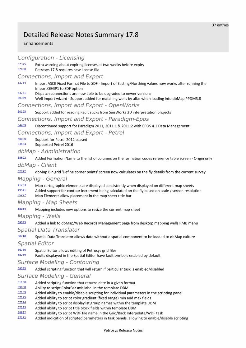
37 entries
Detailed Release Notes Summary 17.8Enhancements
Configuration - Licensing57375 Extra warning about expiring licenses at two weeks before expiry57050 Petrosys 17.8 requires new license file
Connections, Import and Export53764 Import ASCII Fixed Format File to SDF - Import of Easting/Northing values now works after running the
Import/SEGP1 to SDF option53751 Dispatch connections are now able to be upgraded to newer versions60359 Well import wizard - Support added for matching wells by alias when loading into dbMap PPDM3.8
Connections, Import and Export - OpenWorks60193 Support added for reading Fault sticks from SeisWorks 2D interpretation projects
Connections, Import and Export - Paradigm-Epos54489 Discontinued support for Paradigm 2011, 2011.1 & 2011.2 with EPOS 4.1 Data Management
Connections, Import and Export - Petrel60080 Support for Petrel 2012 ceased53464 Supported Petrel 2016
dbMap - Administration58602 Added Formation Name to the list of columns on the formation codes reference table screen - Origin only
dbMap - Client52722 dbMap Bin grid 'Define corner points' screen now calculates on the fly details from the current survey
Mapping - General41733 Map cartographic elements are displayed consistently when displayed on different map sheets49541 Added support for contour increment being calculated on the fly based on scale / screen resolution55277 Map Elements allow placement in the map sheet title bar
Mapping - Map Sheets58054 Mapping includes new options to resize the current map sheet
Mapping - Wells59383 Added a link to dbMap/Web Records Management page from desktop mapping wells RMB menu
Spatial Data Translator58718 Spatial Data Translator allows data without a spatial component to be loaded to dbMap culture
Spatial Editor36730 Spatial Editor allows editing of Petrosys grid files58259 Faults displayed in the Spatial Editor have fault symbols enabled by default
Surface Modeling - Contouring58285 Added scripting function that will return if particular task is enabled/disabled
Surface Modeling - General51150 Added scripting function that returns date in a given format59068 Ability to script ColorBar axis label in the template DBM57169 Added ability to enable/disable scripting for individual parameters in the scripting panel57195 Added ability to script color gradient (fixed range) min and max fields57194 Added ability to script displaylist group names within the template DBM57193 Added ability to script title block fields within template DBM58887 Added ability to script WDF file name in the Grid/Back Interpolate/WDF task57172 Added indication of scripted parameters in task panels, allowing to enable/disable scripting
Petrosys Release Notes

57177 Added scripting function returning user name(ID)59134 Added scripting function that translates searched values to replaced values59319 Added scripting function to return WDF units58287 Added scripting support for enabling/disabling template DBM groups58658 Added task to create well attribute for given WDF57199 Added Time Depth Trend conversion task60229 Exposed contour and grid increments to be scriptable fields in Tools/DrawMap
Surface Modeling - Gridding57188 Added cross plot data analysis to KED
Surface Modeling - Volumetrics44121 Volumetrics report exports depth and area pairs to separate CSV files based on the report file name and the
selected polygon names
Petrosys Release Notes
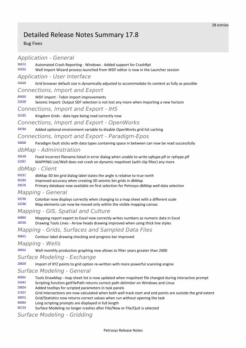
28 entries
Detailed Release Notes Summary 17.8Bug Fixes
Application - General56572 Automated Crash Reporting - Windows - Added support for CrashRpt52032 Well Import Wizard process launched from WDF editor is now in the Launcher session
Application - User Interface54429 Grid browser default size is dynamically adjusted to accommodate its content as fully as possible
Connections, Import and Export60450 WDF import - Tobin import improvements53538 Seismic Import: Output SDF selection is not lost any more when importing a new horizon
Connections, Import and Export - IHS52185 Kingdom Grids - data type being read correctly now
Connections, Import and Export - OpenWorks59784 Added optional environment variable to disable OpenWorks grid list caching
Connections, Import and Export - Paradigm-Epos59008 Paradigm fault sticks with data types containing space in between can now be read successfully
dbMap - Administration59128 Fixed incorrect filename listed in error dialog when unable to write sqltype.plf or rpttype.plf51947 MAPPING List/Well does not crash on dynamic mapsheet (with clip filter) any more
dbMap - Client60167 dbMap 3D bin grid dialog label states the angle is relative to true north60184 Improved accuracy when creating 3D seismic bin grids in dbMap59576 Primary database now available on first selection for Petrosys-dbMap well data selection
Mapping - General54746 Colorbar now displays correctly when changing to a map sheet with a different scale53796 Map elements can now be moved only within the visible mapping canvas
Mapping - GIS, Spatial and Culture60860 Mapping report export to Excel now correctly writes numbers as numeric data in Excel28700 Drawing Tools Lines - Arrow heads drawing improved when using thick line styles
Mapping - Grids, Surfaces and Sampled Data Files56821 Contour label drawing checking and progress bar improved
Mapping - Wells58552 Well monthly production graphing now allows to filter years greater than 2000
Surface Modeling - Exchange26839 Import of XYZ points to grid option re-written with more powerful scanning engine
Surface Modeling - General60001 Tools DrawMap - map sheet list is now updated when mapsheet file changed during interactive prompt52447 Scripting function getFilePath returns correct path delimiter on Windows and Linux59854 Added tooltips for scripted parameters in task panels57437 Grid intersections are now calculated when both well track start and end points are outside the grid extent59972 Grid/Statistics now returns correct values when run without opening the task60064 Long scripting prompts are displayed in full length60734 Surface Modeling no longer crashes after File/New or File/Quit is selected
Surface Modeling - Gridding
Petrosys Release Notes

55995 Grid/Create/[Grid|WellTie|Phantom] tasks have BOTH fault type option available on fault tab
Petrosys Release Notes
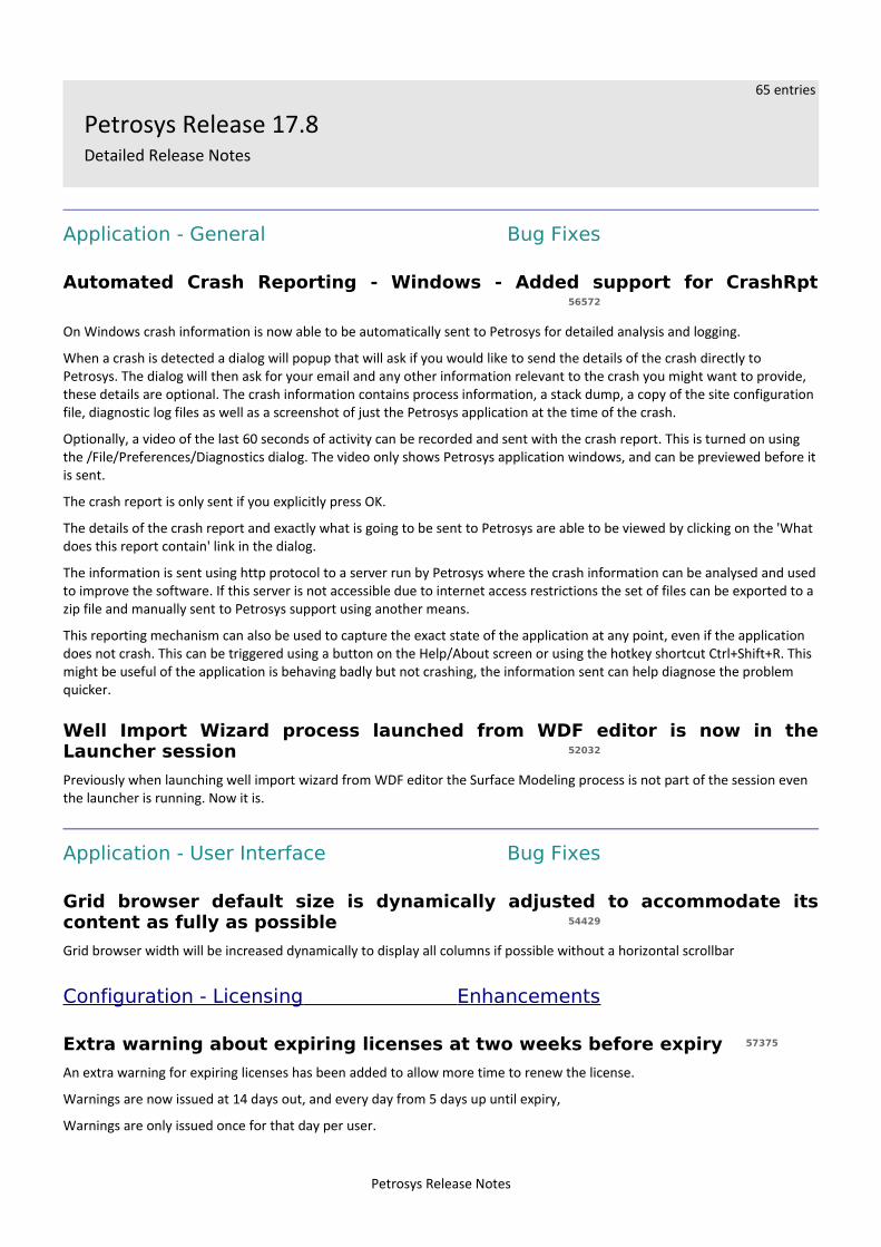
65 entries
Petrosys Release 17.8Detailed Release Notes
Application - General Bug Fixes
Automated Crash Reporting - Windows - Added support for CrashRpt56572
On Windows crash information is now able to be automatically sent to Petrosys for detailed analysis and logging.
When a crash is detected a dialog will popup that will ask if you would like to send the details of the crash directly to Petrosys. The dialog will then ask for your email and any other information relevant to the crash you might want to provide, these details are optional. The crash information contains process information, a stack dump, a copy of the site configuration file, diagnostic log files as well as a screenshot of just the Petrosys application at the time of the crash.
Optionally, a video of the last 60 seconds of activity can be recorded and sent with the crash report. This is turned on using the /File/Preferences/Diagnostics dialog. The video only shows Petrosys application windows, and can be previewed before itis sent.
The crash report is only sent if you explicitly press OK.
The details of the crash report and exactly what is going to be sent to Petrosys are able to be viewed by clicking on the 'What does this report contain' link in the dialog.
The information is sent using http protocol to a server run by Petrosys where the crash information can be analysed and usedto improve the software. If this server is not accessible due to internet access restrictions the set of files can be exported to a zip file and manually sent to Petrosys support using another means.
This reporting mechanism can also be used to capture the exact state of the application at any point, even if the application does not crash. This can be triggered using a button on the Help/About screen or using the hotkey shortcut Ctrl+Shift+R. This might be useful of the application is behaving badly but not crashing, the information sent can help diagnose the problem quicker.
Well Import Wizard process launched from WDF editor is now in theLauncher session 52032
Previously when launching well import wizard from WDF editor the Surface Modeling process is not part of the session even the launcher is running. Now it is.
Application - User Interface Bug Fixes
Grid browser default size is dynamically adjusted to accommodate itscontent as fully as possible 54429
Grid browser width will be increased dynamically to display all columns if possible without a horizontal scrollbar
Configuration - Licensing Enhancements
Extra warning about expiring licenses at two weeks before expiry 57375
An extra warning for expiring licenses has been added to allow more time to renew the license.
Warnings are now issued at 14 days out, and every day from 5 days up until expiry,
Warnings are only issued once for that day per user.
Petrosys Release Notes
Petrosys 17.8 requires new license file 57050
Petrosys 17.8 requires a new Flex license file to be installed. The 17.8 licenses are backwards compatible with earlier versionsof Petrosys. Petrosys support will advise where the 17.8 license can be downloaded from.
Connections, Import and Export Enhancements
Import ASCII Fixed Format File to SDF - Import of Easting/Northing valuesnow works after running the Import/SEGP1 to SDF option 53764
The 'Import/ASCII Fixed Format File to SDF' option now works correctly if you have previously run the 'Import/SEGP1 to SDF' option. Previously if you had the SEGP1 option directly before the easting/northing coordinates would not import correctly.
Dispatch connections are now able to be upgraded to newer versions53751
The Mapping/File/Connection manager/Upgrade option has been extended to also support upgrading the database and version of dispatch server connections to OpenWorks, SeisWorks and GeoFrame.
Well import wizard - Support added for matching wells by alias whenloading into dbMap PPDM3.8 60359
When using Well Import Wizard to load wells into the Petrosys-dbMap PPDM3.8 database model, it now has an option to match wells based on aliases stored in the WELL_ALIAS table.
Connections, Import and Export Bug Fixes
WDF import - Tobin import improvements 60450
The Tobin well WCS file format importer in the WDF Editor has been improved:
➢ The correct longitudes values are now used as the Tobin file had an implicit assumption of being in the western hemisphere.
➢ The full 12 digit API number is now used for the UWI➢ The mapping of the well status codes to Petrosys well symbols has been expanded to use the full set of known Tobin
well status codes.➢ County codes are now mapped to county names➢ State codes are now mapped to the two digit state abbreviations➢ Bottom hole coordinates are now loaded. The bottom hole well symbol is set to be the same as the top hole symbol
Seismic Import: Output SDF selection is not lost any more when importinga new horizon 53538
In previous version there was a bug on seismic import to SDF panel that output SDF is blanked out if some new horizons are created during importing, it's now fixed.
Connections, Import and Export - IHS Bug Fixes
Kingdom Grids - data type being read correctly now52185
In previous version there was a bug that if table T_Survey is empty in IHS Kingdom project the grid data types will not be loaded, now it's fixed.
Petrosys Release Notes
Connections, Import and Export - OpenWorks Enhancements
Support added for reading Fault sticks from SeisWorks 2D interpretationprojects 60193
It is now possible to use fault sticks from SeisWorks 2D interpretation project connections for all options supported. e.g. Exchange/Fault sticks, Surface Modeling, 3D Viewer.
Previously you had to select a 3D seismic survey, which meant fault sticks were restricted to being read from SeisWorks 3D projects only.
Connections, Import and Export - OpenWorks Bug Fixes
Added optional environment variable to disable OpenWorks grid listcaching 59784
The PS_DISABLE_OW_GRID_CACHE environment variable is now checked when determining whether or not to re-query OpenWorks for the list of grids. If the PS_DISABLE_OW_GRID_CACHE exists, the grid list cache will be cleared each time Petrosys queries for the list of grids. This can be useful when working with OpenWorks data and wanting to work with the same new data in Petrosys.
Note: There is no change in the default behavior. By default, the grid list is still cached.
Connections, Import and Export - Paradigm-Epos Enhancements
Discontinued support for Paradigm 2011, 2011.1 & 2011.2 with EPOS 4.1Data Management 54489
Support for importing and direct display of Paradigm 2011, 2011,1 and 2011.2 with Epos 4.1 Data Management by Petrosys has been discontinued.
Currently supported versions of Paradigm are Paradigm 2011.3, 14, 14.1, 15 (Enterprise Linux 5+, Windows 7+) and 15.5 (Enterprise Linux 6+, Windows 7+).
Connections, Import and Export - Paradigm-EposBug Fixes
Paradigm fault sticks with data types containing space in between cannow be read successfully 59008
Paradigm fault sticks with data type names having space in it such as 'Time Migrated' can now be read.
Connections, Import and Export - Petrel Enhancements
Support for Petrel 2012 ceased 60080
Petrel 2012 is no longer supported. Petrosys continues to maintain support for Petrel 2013 through to Petrel 2016.
Supported Petrel 2016 53464
Petrosys connectivity to Schlumberger's Petrel now supports direct interaction with Petrel 2016.1.
Support for Petrel 2016.1 includes the ability to:
➢ Import Model grid horizons and 3D seismic interpretation horizons to a Petrosys grid file➢ Import faults from Model grids to a Petrosys fault file➢ Import 2D and 3D seismic navigation and horizon interpretation data to a Petrosys SDF➢ Directly display Model grid horizons, Input surface grids and 3D seismic interpretation horizons in Mapping
Petrosys Release Notes
➢ Directly contour Model grid horizon data and Input surface grids in Surface Modeling➢ Directly grid 2D and 3D seismic horizon interpretation data in Surface Modeling➢ Directly display, grid and import well data.➢ Directly display 2D seismic navigation and horizon interpretation in Mapping➢ Directly display 3D seismic bin grids in Mapping➢ Directly display Structural Model fault surfaces in 3DViewer➢ Directly display fault sticks in 3DViewer➢ Export Petrosys and other third party grids to Petrel
Petrosys continues to maintain support for connections to Petrel 2013.x., 2014.x, 2015.x
dbMap - Administration Enhancements
Added Formation Name to the list of columns on the formation codesreference table screen - Origin only 58602
Now display a Formation Name column in the admin panel for PPDM Formation Codes.
dbMap - Administration Bug Fixes
Fixed incorrect filename listed in error dialog when unable to writesqltype.plf or rpttype.plf 59128
When using the query administration tools and the system is unable to write either the sqltype.plf or rpttype.plf file, the error dialog now shows the correct file name.
MAPPING List/Well does not crash on dynamic mapsheet (with clip filter)any more 51947
In previous version there was a bug that Mapping crashed when list wells from a connection it's now fixed.
dbMap - Client Enhancements
dbMap Bin grid 'Define corner points' screen now calculates on the flydetails from the current survey 52722
Previously the dbMap Bin grid 'Define corner points' screen showed the values that were last entered by a user. Those numbers could have related to a different bin grid survey. The 'Define corner points' screen has been updated to now compute the corner points on the fly based on the current survey.
dbMap - Client Bug Fixes
dbMap 3D bin grid dialog label states the angle is relative to true north60167
On the dbMap bin grid header screen, the label for the rotation angle field has been updated to make clear the angle is relative to True north (as opposed to Grid north).
Improved accuracy when creating 3D seismic bin grids in dbMap 60184
When creating a 3D seismic bin grid in dbMap using the Define corner points option it now produces a more accurate result, as it takes the decimal places of the Easting/Northing values into consideration, and the storage of the origin latitude/longitude has been increased from 6 to 7 decimal places.
Petrosys Release Notes
Previously, it was only using integer Easting/Northing values, which along with the reduced decimal places, meant that the resulting bin grid origin would not match exactly what you had entered in the Define corner points screen.
Primary database now available on first selection for Petrosys-dbMap welldata selection 59576
The dbMap primary database is now always available when accessing wells data from a Petrosys-dbMap data source. Previously, if the primary database had not already been connected, the primary database was not listed as a current connection and needed to be added via the Add button.
Mapping - General Enhancements
Map cartographic elements are displayed consistently when displayed ondifferent map sheets 41733
When the current map sheet changes (either through editing or selection of a different map sheet), map elements will retain their relative sizes and positions where possible. In cases where relative sizes cannot be maintained, new sizes will be determined to ensure the elements are placed sensibly.
The specific map elements that have been enhanced are as follows:
➢ Scale Bar➢ Color Bar➢ Title Block➢ North Arrow➢ Location Map➢ Legend
In previous versions, changes to map sheet were inconsistently handled and typically resulted in elements changing size, shifting position so that they were not visible, or both.
Added support for contour increment being calculated on the fly based onscale / screen resolution 49541
Contour increments are calculated on the fly based on grid/surface min/max scale values.
Map Elements allow placement in the map sheet title bar 55277
The cartographic map elements (namely scale bar, location map, title block, north arrow and color bar) now have an option to display relative to the map sheet title bar. Previously only the legend had support for this.
Mapping - General Bug Fixes
Colorbar now displays correctly when changing to a map sheet with adifferent scale 54746
In previous versions, the color bar could disappear when displayed on a map sheet with a different scale.
Map elements can now be moved only within the visible mapping canvas53796
Map elements are now able to be positioned only within the bounds of the current map sheet.
Petrosys Release Notes
Mapping - GIS, Spatial and Culture Bug Fixes
Mapping report export to Excel now correctly writes numbers as numericdata in Excel 60860
A bug was introduced in 17.7sp3 where exporting to Excel from a list or a report was writing numbers formatted as string data. This is now fixed and numeric data in Petrosys is now correctly interpreted by Excel as numeric data.
Drawing Tools Lines - Arrow heads drawing improved when using thick linestyles 28700
The Mapping 'Display/Drawing Tools/Curve' option renders arrow heads with thick lines in a much improved manner. Previously the arrow head point could have had the line extend through it making the arrow head look blunted or just look very odd.
Mapping - Grids, Surfaces and Sampled Data FilesBug Fixes
Contour label drawing checking and progress bar improved 56821
Contour display includes some processing to determine the optimum position for the contour labels, which can take a little time depending on how many labels need to be positioned and drawn. This has been improved:
➢ invalid parameters now produce an error (such as a label size of 0)➢ the progress bar includes a hint that contour label and/or size may have an impact on processing time
Mapping - Map Sheets Enhancements
Mapping includes new options to resize the current map sheet 58054
Mapping includes new options to resize the current map sheet:
➢ increase by 10%➢ increase by 100%➢ resize to an interactively selected sub-region of the current map sheet
These options are available under the Mapping/Map Sheet/Resize menu.
Mapping - Wells Enhancements
Added a link to dbMap/Web Records Management page from desktopmapping wells RMB menu 59383
For dbMap/Web clients, a link has now been added to the desktop mapping application's context-sensitive menu for wells which will open the dbMap/Web records management page for the given well.
Mapping - Wells Bug Fixes
Well monthly production graphing now allows to filter years greater than2000 58552
When filtering production data in the monthly production chart using View/Preferences, the date filter now allows years greater than 2000.
Petrosys Release Notes
Spatial Data Translator Enhancements
Spatial Data Translator allows data without a spatial component to beloaded to dbMap culture 58718
In previous versions, the Spatial Data Translator only supported importing data that contained a spatial component (i.e. a valid point, line or polygon). This restriction has been removed when dbMap culture is selected as the output.
The Excel and Text file input sources, include a new checkbox ("This data source does not have coordinate columns") in the "Define Format" dialog to indicate that the source file does not have any spatial data.
Spatial Editor Enhancements
Spatial Editor allows editing of Petrosys grid files 36730
The Spatial Editor has been enhanced to allow editing of Petrosys grid files. This includes editing of corresponding contours, faults and clipping polygons, which are linked together with the grid.
Two different methodologies of editing are supported:
➢ Direct manipulation of grid nodes - including smoothing, adjusting grid values via edit circle or polygon and interpolation of missing values by regridding
➢ Contour based editing - contours are generated on the fly from the grid and can then be edited using exist means. The areas that have been modified are automatically tracked and the change portion of the grid can be updated via a localised regrid.
In both methods, faults and clipping polygons can be edited and applied to the grid when required
This new functionality supercedes the grid editor available in previous versions.
Faults displayed in the Spatial Editor have fault symbols enabled bydefault 58259
In previous versions, faults symbol display had to be enabled manually for each new fault layer displayed.
Surface Modeling - Contouring Enhancements
Added scripting function that will return if particular task isenabled/disabled 58285
Added scripted function that returns whether a particular task is enabled/disabled.
Surface Modeling - Exchange Bug Fixes
Import of XYZ points to grid option re-written with more powerfulscanning engine 26839
Scanning algorithm has been optimized to make it more robust, tolerant to data variations.
Also accuracy of estimates is increased, and also there is some mild increase of performance.
Surface Modeling - General Enhancements
Added scripting function that returns date in a given format 51150
Added scripting function that returns date and time strings. The output format is configurable by the user.
Petrosys Release Notes
Ability to script ColorBar axis label in the template DBM 59068
Tools DrawMap option allows scripting of axis for Color Bar map elements layers.
Added ability to enable/disable scripting for individual parameters in thescripting panel 57169
Added ability to enable/disable field scripting without the need to delete the script.
Added ability to script color gradient (fixed range) min and max fields57195
Tools DrawMap option allows scripting of color gradient (fixed range) min and max range for Grid/Colorfill layers.
Added ability to script displaylist group names within the template DBM57194
Tools DrawMap option allows scripting of group names that appear in the display list.
Added ability to script title block fields within template DBM 57193
Tools DrawMap option allows scripting of title block mapping element layers.
Added ability to script WDF file name in the Grid/Back Interpolate/WDFtask 58887
Grid/Back Interpolate/WDF makes the WDF file name available for scripting.
Added indication of scripted parameters in task panels, allowing toenable/disable scripting 57172
Added scripting parameters indication on task panels with colored highlighting box. The scripting status (enabled/disabled) can be altered via CTRL+SHIFT plus mouse left click on the field. The highlighting line width can be set via Tools/Configurationunder Surface Modeling.
Added scripting function returning user name(ID) 57177
Added scripting function returning user ID on the system.
Added scripting function that translates searched values to replacedvalues 59134
Added scripting function 'translate' that allows to substitute a single string into another single string based on a one-to-one substitution list.
Added scripting function to return WDF units 59319
Added scripting function that returns the well data file (WDF) units.
Added scripting support for enabling/disabling template DBM groups58287
Tools DrawMap option allows scripting of group names activities that appear in the display list. That is the group can be scripted to be ON or OFF.
Added task to create well attribute for given WDF 58658
Added new menu option for creating WDF attributes for a given WDF file. The option is under Tools/Create WDF Attributes.
Petrosys Release Notes
Added Time Depth Trend conversion task 57199
Time Depth Trend Conversion method has been added. It is located under /Velocities/Well Time Depth Trend Conversion menu option. The method creates a trend based on the input data points from time grid and well data. The trend can be thenused for time-depth conversion.
Exposed contour and grid increments to be scriptable fields inTools/DrawMap 60229
Tools DrawMap option allows scripting of grid and contour increments for Grid/Colorfill layers.
Surface Modeling - General Bug Fixes
Tools DrawMap - map sheet list is now updated when mapsheet filechanged during interactive prompt 60001
The Tools/DrawMap task updates the list of map sheet names when the map sheet file is changed during interactive prompt screen.
Scripting function getFilePath returns correct path delimiter on Windowsand Linux 52447
Scripting function getFilepath returns correct 'slash' in the file path string.
Added tooltips for scripted parameters in task panels 59854
The scripted task parameters generate tool tips with scripting information on task panels if the user hover over a scripted field for a prolonged time.
Grid intersections are now calculated when both well track start and endpoints are outside the grid extent 57437
When calculating well path or fault sticks intersections with grids, no intersection was calculated when both the beginning and end of the intersecting path segment was located outside the grid extents. A valid intersection is now returned.
Grid/Statistics now returns correct values when run without opening thetask 59972
Grid statistics task returns correct values when run without opening the task.
Long scripting prompts are displayed in full length60064
Long prompt labels for interactively scripted fields are fully displayed across multiple lines.
Surface Modeling no longer crashes after File/New or File/Quit is selected60734
Surface Modeling does not crash when running File/New or File/Quit menu options.
Surface Modeling - Gridding Enhancements
Added cross plot data analysis to KED 57188
Kriging with external drift has been extended with a cross plot data analysis.
Petrosys Release Notes
Surface Modeling - Gridding Bug Fixes
Grid/Create/[Grid|WellTie|Phantom] tasks have BOTH fault type optionavailable on fault tab 55995
Grid/Create Grid, WellTie, Phantom tasks have fault type BOTH available on fault tab when using faults for gridding.
Surface Modeling - Volumetrics Enhancements
Volumetrics report exports depth and area pairs to separate CSV filesbased on the report file name and the selected polygon names 44121
Volumetrics reporting offers export of depth and area pairs in .CSV format.
Petrosys Release Notes