Embed Size (px)
Citation preview

Better exploration decisions from more powerful maps and flexible data management tools
Find elusive targets by rapidly testing a wider range of geological scenarios
Refine reservoir attributes and shapes in a map view before committing to reservoir models
Apply standardised processes for reserves estimation and cataloguing
Track the performance and manage development of producing fields
The intuitive interface and powerful connectivity of Petrosys mapping and surface modeling means that geoscientists and engineers can move easily between the wide range of technical and commercial challenges encountered across all stages of the petroleum exploration and development cycle.
Built with access to a broad range of data management tools and stores, and having excellent dynamic handling of global and historic coordinate reference systems, Petrosys provides a solid foundation for working with geotechnical data both at the regional and the field scale.
In addition to surface modeling and production quality mapping with intuitive display options specific to well, seismic, and geomodeling display types, Petrosys features a surprising array of additional tools that have been identified as useful additions to workflows by our established base of enthusiastic users.
Directional survey computations, seismic velocity handling, vertical time to depth conversion, well tie operations, geostatistics, and a range of data exchange tools are all accessible to the Petrosys user, allowing extensive parts of exploration and development workflows to be completed in the Petrosys environment.
FieldDevelopment
ProjectEvaluation
Regional Exploration
E&P WORKFLOWS
www.petrosys.com.au 01

Regional AssessmentIn the reconnaissance stages of exploration, Petrosys lets you make the best use of available regional data sets. The Petrosys GIS display can access GIS data sets whether they are in files such as Arc Shapefiles, MapInfo, DGN or ZGF; in spatial databases such as ArcSDE or Oracle Spatial; from direct links to data vendors; or are raster images or WMS feeds.
Full EPSG coordinate reference systems support quickly puts you in the right location in even the least explored parts of the world.
Using thematic mapping, lease outlines can be posted to graphically highlight the current status of blocks, with dynamic querying of linked data.
Exploration SeismicAs soon as interpretation of the first seismic is available you can start assembling a time surface model in Petrosys. Whether your geophysics is coming from Kingdom, GeoFrame, Petrel, Epos, SeisWorks or SeisWare, Petrosys gives you the option of working on or offline with the interpretation data.
The Petrosys surface model, with its excellent handling of faults and tailored geophysical displays may suggest alternate structural trends that can be modeled in Petrosys and lead to refinement of the evolving interpretation.
Earlier seismic surveys and interpretation, such as from previous operators or JV partners, can be added to your map, allowing you to take into account previous ideas without the overhead of loading seismic data or introducing additional interpretation software.
RE
GIO
NA
L A
SS
ES
SM
EN
TE
XP
LO
RA
TIO
N S
EIS
MIC
www.petrosys.com.au02
Refine SeismicInterpretation
Review Time Map
GIS DATA
SeismicInterpretation
Compute Petrosys
Grid
Vendors
Agencies
Esri
Spatial Energy
IHS
Regional Prospect Map
SEISMIC
IHS Kingdom
Petrel
GeoFrame
OpenWorks
SeisWare
RegionalMapping
Geology and
Leases
Petrosys TimeSurface with Good Faults
Fault Editing to Refine
Fault MappPetrosys Time Surface with Simple Faults
WE
LL
TIE
D D
EP
TH
MA
PP
ING
TIM
E T
O D
EP
TH
CO
NV
ER
SIO
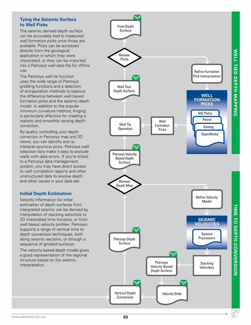
NTying the Seismic Surface to Well PicksThe seismic derived depth surface can be accurately tied to measured well formation picks once those are available. Picks can be accessed directly from the geological application in which they were interpreted, or they can be imported into a Petrosys well data file for offline use.The Petrosys well tie function uses the wide range of Petrosys gridding functions and a selection of extrapolation methods to balance the difference between well based formation picks and the seismic depth model. In addition to the popular minimum curvature method, Kriging is particularly effective for creating a realistic and smoothly varying depth correction.By quality controlling your depth correction in Petrosys map and 3D views, you can identify and re-interpret spurious picks. Petrosys well selection lists make it easy to exclude wells with data errors. If you’re linked to a Petrosys data management system, you may have direct access to well completion reports and other unstructured data to resolve depth and other issues in your data set.
Initial Depth EstimationVelocity information for initial estimation of depth surfaces from interpreted seismic can be derived by interpolation of stacking velocities to 2D interpreted time horizons, or from well based velocity profiles. Petrosys supports a range of vertical time to depth conversion techniques, both along seismic sections, or through a sequence of gridded surfaces.The velocity based depth model gives a good representation of the regional structure based on the seismic interpretation.
03www.petrosys.com.au
Well Formation
Picks
Review Depth Map
WELL FORMATION
PICKS
Refine VelocityModel
StackingVelocities
Refine Formation Pick Interpretation
Well TieOperation
IHS Petra
Petrel
Geolog
OpenWorks
Seismic Processors
Well Tied Depth Surface
SEISMIC VELOCITIES
Velocity Grids
Final Depth Surface
Petrosys Velocity Based Depth
Surface
Petrosys Depth Surface
Petrosys Velocity Based Depth Surface
Vertical Depth Conversion
Review Picks

ResevoirAttribute
Measurements
Describe Your Reservoir GeologyUnderstanding the hydrocarbon potential of a structure requires analysis of a broad range of science ranging from regional petroleum systems modeling to detailed geochemistry. Irrespective of the specialised software and expert data sources most appropriate to regional needs, Petrosys can be used to collate and rationalise the data into consistent grid models allowing map and 3D presentations for a more informed interpretation of the subsurface.
Standardise Net Pay MapsMap views of reservoir units with associated engineering and economic elements such as drainage areas, lease outlines and transportation infrastructure provide a standardised report format best suited to the short term management and long term auditing of field developments. Changes to surface interpretations, zone thicknesses or reservoir attributes can be documented on map views to enable a rigorous version control over what goes into solid reservoir models.
Drive Reservoir SimulatorsPetrosys map based interpretation of surface and fault geometries can be readily converted into grids of varying resolutions to help build both static and dynamic reservoir models. Easily repeated surface modeling workflows allow significant changes in subsurface interpretation to be rapidly propagated to the gridded data inputs for the rebuilding of a solid model.Output from diverse modeling applications can be put back together to create a coherent geotechnical account on Petrosys maps, for example to demonstrate water encroachment during a modeled exploitation program.
www.petrosys.com.au04
GE
OL
OG
ICA
L M
OD
EL
ING
RE
SE
RV
OIR
MO
DE
LIN
G
Assess Static Model
SOLID MODELS SURFACE MODELS
Contour and Faults Editing
ReservoirAttribute Gridding
Updated Sand Maps + Reservoir
Geometry
GEOHISTORY MODELS
STATIC GEOLOGICAL
MODELS
DYNAMIC RESERVOIR
MODELS
Surfaces and Faults
ReservoirAttribute Grids
IES Petromod
PRA BasinMod
GOCAD
Jewel Suite
Petrel
Eclipse
Coats-Sensor
Nexus
VIP

Automate Reservoir ManagementPetrosys mapping and data management tools can be put together with custom database connectors, web service interfaces and heavy duty batch processing for effective implementation of real time reservoir management operations.
Protect, Preserve and Publish DataSubsurface assets, in particular, depend on data for their definition. Accurate spatial knowledge, reliable metadata, and a sustainable balance between useful structured and unstructured forms of technical detail can be delivered through a carefully designed Petrosys data management strategy. Long term preservation and vendor neutral access is encouraged through the use of the PPDM data model.
Plan Future InvestmentA wide range of factors which influence future E&P investment decisions can be brought together for discussion from the Petrosys map and interfaces. Infrastructure and logistical information from GIS systems can be seen alongside geoscience and reservoir engineering data from E&P applications and stores.
The Petrosys Prospect & Leads development helps manage your E&P asset portfolio, with extensive tools to base future estimates on past performance.
Catalogue ReservesPetrosys’ extensively tested volume calculations provide rapid and repeatable surface model volumetrics, providing the bottom line numbers underlying net pay maps.
Workflow automation and XML scriptable output make Petrosys the ideal basis for the development of custom reserves catalogue systems suited to individual corporate needs.
05
Field Performance Maps
PR
OD
UC
TIO
NW
EL
L P
LA
NN
ING
RE
SE
RV
ES
ES
TIM
AT
ION
ReservesCatalogue
www.petrosys.com.au
OPERATIONS
Refine Reservoir Attributes
Volumetrics
dbMap Well Data Management and Reporting
Custom Data Exchange Tools
Gridding of Field Monitoring Data
dbMap Prospects and Leads
REAL TIME OPERATIONS
CORPORATE DATA STORES
4D Seismic Field Monitoring
Logging whilst Drilling
Production Master
Well Master
Prospects and Leads