Embed Size (px)
Citation preview

Cable Route Survey - Hardangerfjorden
02 17.12.2010 Issued for Company Comments BL / RR AG GNH
01 17.12.2010 Issued for IDC BL / RR AG GNH
Revision Date Reason for Issue Originator Checked Approved
Organisation Unit Person Title Signature Date
Originator DOF Subsea Norway AS Bruce Lindsay / Rolf Ranes Senior Surveyor / Senior Geologist 17.12.2010
Checked DOF Subsea Norway AS Arild Gravdal Senior Geologist 17.12.2010
Approved DOF Subsea Norway AS Gunbjørg Nygård Haugstulen Project Manager 17.12.2010
Title:
SV GEOGRAPH 2010
SN2010_05 CABLE ROUTE SURVEY - HARDANGERFJORDEN
Responsible Party:
No of Sheets:
167 DOF Subsea Norway AS Project No.
600106 Doc. Type Code:
Area Code:
Company Document Number:
600106-GGRA-O15-100002
02 DOF Subsea Norway AS Document Number:
600106-GGRA-O15-100002 Contract Number:
1453664 System:
Project Code
Orig. Code
Area/ System
Disc. Code
Doc. Type Seq. No. Rev.

Document title Revision date Page
SN2010_05 CABLE ROUTE SURVEY -
HARDANGERFJORDEN
17.12.2010 2 of 167 Doc. No. Rev.
600106-GGRA-O15-100002 02 SN2010_05-GGRA-O15-100002 02
DOF Subsea Norway Project No.: 600106 Contract 1453664
Revision Record Sheet:
Rev. Date Description 01 17.12.2010 Issued for IDC 02 17.12.2010 Issued for Company Comments

Document title Revision date Page
SN2010_05 CABLE ROUTE SURVEY -
HARDANGERFJORDEN
17.12.2010 3 of 167 Doc. No. Rev.
600106-GGRA-O15-100002 02 SN2010_05-GGRA-O15-100002 02
DOF Subsea Norway Project No.: 600106 Contract 1453664
TABLE OF CONTENTS ........................................................................................................... Page 1 INTRODUCTION ................................................................................................................................. 6
1.1 GENERAL PROJECT DESCRIPTION ..................................................................................... 6 1.2 ACRONYMS AND ABBREVIATIONS....................................................................................... 8 1.3 REFERENCES.......................................................................................................................... 9 1.4 RESPONSIBILITY AND AUTHORITY .................................................................................... 13
2 SURVEY DESCRIPTION .................................................................................................................. 14
2.1 SCOPE OF WORK ................................................................................................................. 14 2.2 WORK PERFORMED ............................................................................................................. 14
2.2.1 VESSEL MOUNTED EQUIPMENT SURVEY ......................................................... 14 2.2.2 ROV MOUNTED EQUIPMENT SURVEY ............................................................... 19 2.2.3 GEOTECHNICAL SAMPLING ................................................................................. 23
2.3 KP DATABASES ..................................................................................................................... 25 2.3.1 VESSEL SUPPLIED KP DATABASES ................................................................... 25 2.3.2 ROV SUPPLIED KP DATABASES.......................................................................... 25
2.4 SURVEY OPERATIONS ......................................................................................................... 25 2.4.1 SURVEY PERFORMANCE / DATA QUALITY ........................................................ 26 2.4.2 ENVIRONMENTAL DATA ....................................................................................... 35 2.4.3 SEABED SAMPLING .............................................................................................. 35
2.5 EQUIPMENT ........................................................................................................................... 35
3 SUMMARY OF RESULTS ................................................................................................................ 37
4 DETAILED RESULTS....................................................................................................................... 38
4.1 GENERAL ............................................................................................................................... 38 4.2 ROV SURVEY ......................................................................................................................... 38
4.2.1 CENTERLINE .......................................................................................................... 38 4.2.2 EIKNES AREA ......................................................................................................... 47 4.2.3 VALLAVIK ................................................................................................................ 49 4.2.4 DJØNNANESET ...................................................................................................... 51 4.2.5 SLÅTTNES .............................................................................................................. 53 4.2.6 KVANDAL ................................................................................................................ 56 4.2.7 URAVIKA ................................................................................................................. 59 4.2.8 ÅLVIK ....................................................................................................................... 60 4.2.9 SEIANES ................................................................................................................. 61 4.2.10 NANES .................................................................................................................... 62 4.2.11 SAMLANESET ......................................................................................................... 63 4.2.12 KVAMSØY ............................................................................................................... 66 4.2.13 AKSNES .................................................................................................................. 68 4.2.14 EIDESVÅGEN ......................................................................................................... 71
5 DATA INDEX .................................................................................................................................... 75
5.1 DIGITAL REPORT DELIVERY ............................................................................................... 75 5.1.1 REV.02 .................................................................................................................... 75
5.2 CHART INDEX ........................................................................................................................ 76 5.3 DTM ........................................................................................................................................ 78 5.4 SHADED RELIEF INDEX ....................................................................................................... 82 5.5 SOUNDINGS .......................................................................................................................... 86 5.6 NAVIMODEL PROJECTS ..................................................................................................... 104 5.7 SBP TIFF FILES ................................................................................................................... 104 5.8 SSS TIFF FILES ................................................................................................................... 105 5.9 ACAD VECTOR FILES ......................................................................................................... 108

Document title Revision date Page
SN2010_05 CABLE ROUTE SURVEY -
HARDANGERFJORDEN
17.12.2010 4 of 167 Doc. No. Rev.
600106-GGRA-O15-100002 02 SN2010_05-GGRA-O15-100002 02
DOF Subsea Norway Project No.: 600106 Contract 1453664
5.10 ESRI GEODATABASES ....................................................................................................... 108
APPENDIX A: SURVEY DATA FORM .......................................................................................................... 109
SURVEY CONTROL ....................................................................................................................... 110 CALIBRATION ................................................................................................................................ 111 DATA ACQUISITION AND PROCESSING SOFTWARE ............................................................... 112 CTD SUMMARY .............................................................................................................................. 113 VESSEL OFFSET DIAGRAM ......................................................................................................... 116 EQUIPMENT SPECIFICATION ...................................................................................................... 118
APPENDIX B: ROV EVENT LISTS ............................................................................................................... 119
APPENDIX C: DIARY OF EVENTS ............................................................................................................... 120
APPENDIX D: DSN PERSONNEL ................................................................................................................ 148
APPENDIX E: EMAIL ..................................................................................................................................... 150
APPENDIX F: QC GRAPHS .......................................................................................................................... 161
APPENDIX G: GEOTECHNICAL REPORT .................................................................................................. 166
APPENDIX H: MARINE BIOLOGIST REPORT ............................................................................................ 167
LIST OF FIGURES ................................................................................................................... Page Figure 1.1 Overview of the Hardangerfjorden survey area ........................................................................... 6Figure 1.2 Hardangerfjord location ............................................................................................................... 7Figure 2.1 Overview of the defined EM710 Survey areas in Hardangerfjorden ......................................... 15Figure 2.2 Overview of Eiknes area showing outline of survey area compared to achieved coverage due
to shallow depth ......................................................................................................................... 18Figure 2.3 ICE signal quality and coverage plot ......................................................................................... 27Figure 2.4 DTM of EM710 data of Hardangerfjord in the Kvandal area ..................................................... 29Figure 2.5 Shaded Relief of EM710 data, Hardangerfjord in Aksneset area ............................................. 30Figure 2.6 DTM of ROV 7125 data of Kvamsoy area, Hardangerfjord ....................................................... 31Figure 2.7 Shaded Relief of ROV 7125 data, Kvamsoy area, Hardangerfjord ........................................... 32Figure 2.8 SBP data quality example from KP 25.23 to KP 25.83. Horizontal scale lines: 25m, Vertical
scale lines: 10ms (7.5m). ........................................................................................................... 33Figure 2.9 SSS data example from approximately KP 22.40 to KP 23.10 ................................................. 34Figure 3.1 Overview of the Hardangerfjord Area ........................................................................................ 37Figure 4.1 The slide escarpment at around KP 14.6 has seabed gradients up to 11.0° of the surveyed
area (5m contours) .................................................................................................................... 39Figure 4.2 The slide escarpment at around KP 18.1 has seabed gradients up to 22.5° (5m contours) .... 39Figure 4.3 The slide escarpment at around KP 22.7 has seabed gradients up to 34.2° (5m contours) 40Figure 4.4 The slide escarpment at around KP 24.6 has seabed gradients up to 7° (5m contours). 40Figure 4.5 The slide escarpment at around KP 26.7 has seabed gradients up to 39.0° (5m
contours). ................................................................................................................................. 41Figure 4.6 The slide escarpment at around KP 43.6 has seabed gradients up to 34.0° (5m
contours). ................................................................................................................................. 41Figure 4.7 SSS data example From approximately KP 22.40 to KP 23.10 ................................................ 44Figure 4.8 SBP data example from KP 25.23 to KP 25.83. Horizontal scale lines: 25m, Vertical scale
lines: 10ms (7.5m). .................................................................................................................... 46Figure 4.9 DTM with overview of the bathymetry of the surveyed area (5m contours) .............................. 47Figure 4.10 DTM with overview of the slope angles of the surveyed area (5m contours) ........................... 48Figure 4.11 DTM with overview of the bathymetry of the surveyed area (5m contours) .............................. 50Figure 4.12 DTM with overview of the slope angles of the surveyed area (5m contours) ........................... 50

Document title Revision date Page
SN2010_05 CABLE ROUTE SURVEY -
HARDANGERFJORDEN
17.12.2010 5 of 167 Doc. No. Rev.
600106-GGRA-O15-100002 02 SN2010_05-GGRA-O15-100002 02
DOF Subsea Norway Project No.: 600106 Contract 1453664
Figure 4.13 DTM with overview of the bathymetry of the surveyed area (5m contours) .............................. 52Figure 4.14 DTM with overview of the slope angles of the surveyed area (5m contours) ........................... 53Figure 4.15 DTM with overview of the bathymetry of the surveyed area (5m contours) .............................. 54Figure 4.16 DTM with overview of the slope angles of the surveyed area (5m contours) ........................... 55Figure 4.17 DTM with overview of the bathymetry of the surveyed area (5m contours) .............................. 57Figure 4.18 DTM with overview of the slope angles of the surveyed area ................................................... 58Figure 4.19 Video data example showing marine life on outcrop. ................................................................ 59Figure 4.20 Video data example showing marine life on outcrop. ................................................................ 60Figure 4.21 Video data example showing marine life on outcrops. .............................................................. 61Figure 4.22 Video data example showing marine life on outcrop. ................................................................ 62Figure 4.23 Video data example showing marine life on soft seabed. ......................................................... 63Figure 4.24 DTM with overview of the bathymetry of the surveyed area (1m contours) .............................. 64Figure 4.25 DTM with overview of the slope angles of the surveyed area (1m contours) ........................... 65Figure 4.26 DTM with overview of the bathymetry of the surveyed area (5m contours) .............................. 66Figure 4.27 DTM with overview of the slope angles of the surveyed area (5m contours) ........................... 67Figure 4.28 Video data example showing marine life on outcrops. .............................................................. 68Figure 4.29 DTM with overview of the bathymetry of the surveyed area (5m contours) .............................. 69Figure 4.30 DTM with overview of the slope angles of the surveyed area (5m contours) ........................... 70Figure 4.31 Video data example showing marine life on outcrops. .............................................................. 71Figure 4.32 DTM with overview of the bathymetry of the surveyed area (5m contours) .............................. 72Figure 4.33 DTM with overview of the slope angles of the surveyed area (5m contours) ........................... 73Figure 4.34 Video data example showing marine life on outcrop. ................................................................ 74Figure 5.1 Difference between HP and XP, Eastings, 8th November 2010 .............................................. 162Figure 5.2 Difference between HP and XP, Northings, 8th November 2010 ............................................ 162Figure 5.3 Time Series – HP and XP Easting / Northing, 8th November 2010 ......................................... 163Figure 5.4 HAIN v HiPAP Positioning, 10th November 2010 .................................................................... 163Figure 5.5 DQ Comparison 18th November 2010 ..................................................................................... 164Figure 5.6 Sound Velocity Comparison, Hardangerfjorden 10–12 Nov 2010 .......................................... 165 LIST OF TABLES ..................................................................................................................... Page Table 1.1 Project SOW & Procedures ......................................................................................................... 9Table 1.2 Taskplan Listing ........................................................................................................................... 9Table 1.3 Project Documentation (Field Reports and Field Memos) ........................................................ 11Table 1.4 DSN Procedures and Reports ................................................................................................... 11Table 2.1 SV Geograph – Hull mounted EM710 work performed ............................................................. 16Table 2.2 ROV - Work performed in Hardangerfjorden ............................................................................. 19Table 2.3 Geotechnical Samples ............................................................................................................... 24Table 2.4 Failure Reports .......................................................................................................................... 26Table 2.5 SV Geograph Vessel equipment ............................................................................................... 35Table 2.6 ROV equipment ......................................................................................................................... 36Table 4.1 Soil conditions ............................................................................................................................ 45

Document title Revision date Page
SN2010_05 CABLE ROUTE SURVEY -
HARDANGERFJORDEN
17.12.2010 6 of 167 Doc. No. Rev.
600106-GGRA-O15-100002 02 SN2010_05-GGRA-O15-100002 02
DOF Subsea Norway Project No.: 600106 Contract 1453664
1 INTRODUCTION
1.1 GENERAL PROJECT DESCRIPTION
DSN were tasked by Stattnett to undertake survey and seabed sampling work in Hardangerfjorden. The survey work to be performed was described in the contract SN2010_05_Cable route survey – Hardangerfjorden, the main objective being to perform an inspection of the planned cable route, and surrounding seabed and slopes from Simadalen to Nordheimsund. The area surveyed was described in the Template Survey Geodatabase as supplied by Company. The tasks performed are summarized in 4 points in the contract.
• Step 1 Vessel mounted MBE survey • Step 2 ROV survey with MBE, SSS and SBP • Step 3 Geotechnical sampling • Step 4 ROV site inspection
Figure 1.1 Overview of the Hardangerfjorden survey area

Document title Revision date Page
SN2010_05 CABLE ROUTE SURVEY -
HARDANGERFJORDEN
17.12.2010 7 of 167 Doc. No. Rev.
600106-GGRA-O15-100002 02 SN2010_05-GGRA-O15-100002 02
DOF Subsea Norway Project No.: 600106 Contract 1453664
Figure 1.2 Hardangerfjord location

Document title Revision date Page
SN2010_05 CABLE ROUTE SURVEY -
HARDANGERFJORDEN
17.12.2010 8 of 167 Doc. No. Rev.
600106-GGRA-O15-100002 02 SN2010_05-GGRA-O15-100002 02
DOF Subsea Norway Project No.: 600106 Contract 1453664
1.2 ACRONYMS AND ABBREVIATIONS
C-O Calculated minus Observed CPT Core Penetration Test CTD Conductivity, Temperature and Density CRP Common reference point DCC Distance Cross Course DGPS Differential Global Positioning System DP Dynamic Positioning DSN DOF Subsea Norway DTM Digital Terrain Model EPSG European Petroleum Survey Group GPS Global Positioning System HAIN Hydro-acoustic Aided Inertial Navigation HiPAP High Precision Acoustic Positioning system HP Fugro StarFix HP HSE Health, Safety and Environment IMU Inertial Measurement Unit MBE MultiBeam Echo Sounder MPT Multifunction Positioning Transponder MRU Motion Reference Unit MSL Mean Sea Level MV Motor Vessel NaviPac Navigation and Data Acquisition software OAS Obstacle Avoidance Sonar OM Offshore Manager QC Quality control PDOP Position Dilution of Precision PPS Pulse Per Second RLG Ring Laser Gyro ROV Remotely Operated Vehicle RPT ROV Positioning Transponder SBP Sub Bottom Profiler SJA Safe Job Analysis S/N Serial Number SOW Scope of Work SSS Side Scan Sonar STDEV Standard Deviation 1 Sigma SUR Survey SV Survey Vessel SVS Sound Velocity Sensor SVP Sound-Velocity Probe/profile TP Transponder USBL Ultra Short Baseline (acoustic positioning) UTM Universal Transverse Mercator projection WGS-84 World Geodetic System of 1984 XP Fugro SkyFix XP DGPS VR Vessel Representative ZDA Date and Time (NMEA sentence)
Document title Revision date Page
SN2010_05 CABLE ROUTE SURVEY -
HARDANGERFJORDEN
17.12.2010 9 of 167 Doc. No. Rev.
600106-GGRA-O15-100002 02 SN2010_05-GGRA-O15-100002 02
DOF Subsea Norway Project No.: 600106 Contract 1453664
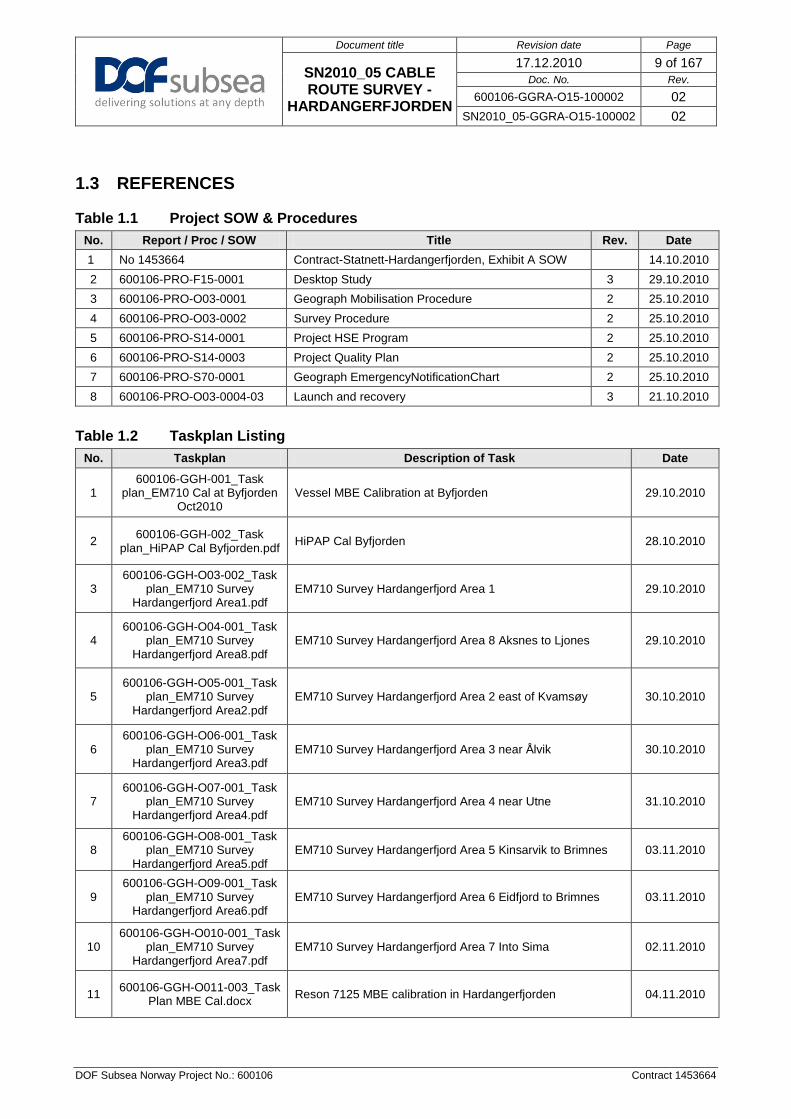
1.3 REFERENCES
Table 1.1 Project SOW & Procedures No. Report / Proc / SOW Title Rev. Date 1 No 1453664 Contract-Statnett-Hardangerfjorden, Exhibit A SOW 14.10.2010 2 600106-PRO-F15-0001 Desktop Study 3 29.10.2010 3 600106-PRO-O03-0001 Geograph Mobilisation Procedure 2 25.10.2010 4 600106-PRO-O03-0002 Survey Procedure 2 25.10.2010 5 600106-PRO-S14-0001 Project HSE Program 2 25.10.2010 6 600106-PRO-S14-0003 Project Quality Plan 2 25.10.2010 7 600106-PRO-S70-0001 Geograph EmergencyNotificationChart 2 25.10.2010 8 600106-PRO-O03-0004-03 Launch and recovery 3 21.10.2010
Table 1.2 Taskplan Listing
No. Taskplan Description of Task Date
1 600106-GGH-001_Task
plan_EM710 Cal at Byfjorden Oct2010
Vessel MBE Calibration at Byfjorden 29.10.2010
2 600106-GGH-002_Task plan_HiPAP Cal Byfjorden.pdf HiPAP Cal Byfjorden 28.10.2010
3 600106-GGH-O03-002_Task
plan_EM710 Survey Hardangerfjord Area1.pdf
EM710 Survey Hardangerfjord Area 1 29.10.2010
4 600106-GGH-O04-001_Task
plan_EM710 Survey Hardangerfjord Area8.pdf
EM710 Survey Hardangerfjord Area 8 Aksnes to Ljones 29.10.2010
5 600106-GGH-O05-001_Task
plan_EM710 Survey Hardangerfjord Area2.pdf
EM710 Survey Hardangerfjord Area 2 east of Kvamsøy 30.10.2010
6 600106-GGH-O06-001_Task
plan_EM710 Survey Hardangerfjord Area3.pdf
EM710 Survey Hardangerfjord Area 3 near Ålvik 30.10.2010
7 600106-GGH-O07-001_Task
plan_EM710 Survey Hardangerfjord Area4.pdf
EM710 Survey Hardangerfjord Area 4 near Utne 31.10.2010
8 600106-GGH-O08-001_Task
plan_EM710 Survey Hardangerfjord Area5.pdf
EM710 Survey Hardangerfjord Area 5 Kinsarvik to Brimnes 03.11.2010
9 600106-GGH-O09-001_Task
plan_EM710 Survey Hardangerfjord Area6.pdf
EM710 Survey Hardangerfjord Area 6 Eidfjord to Brimnes 03.11.2010
10 600106-GGH-O010-001_Task
plan_EM710 Survey Hardangerfjord Area7.pdf
EM710 Survey Hardangerfjord Area 7 Into Sima 02.11.2010
11 600106-GGH-O011-003_Task Plan MBE Cal.docx Reson 7125 MBE calibration in Hardangerfjorden 04.11.2010

Document title Revision date Page
SN2010_05 CABLE ROUTE SURVEY -
HARDANGERFJORDEN
17.12.2010 10 of 167 Doc. No. Rev.
600106-GGRA-O15-100002 02 SN2010_05-GGRA-O15-100002 02
DOF Subsea Norway Project No.: 600106 Contract 1453664
No. Taskplan Description of Task Date
12
600106-GGH-O014-002_Task plan_ROV Survey
Hardangerfjord Eiesvågen Area.pdf
Reson 7125 MBE - ROV Survey Hardangerfjorden 16.11.2010
13
600106-GGH-O015-001_Task plan_ROV Survey
Hardangerfjord Eiknes Area.pdf
Reson 7125 MBE - ROV Survey Hardangerfjorden 05.11.2010
14
600106-GGH-O016-001_Task plan_ROV Survey
Hardangerfjord Vallavik Area.pdf
Reson 7125 MBE - ROV Survey Hardangerfjorden 08.11.2010
15
600106-GGH-O017-001_Task plan_ROV Survey
Hardangerfjord Djønnaneset Area.pdf
Reson 7125 MBE - ROV Survey Hardangerfjorden 09.11.2010
16 600106-GGH-O018-001_Task plan_ROV Survey Verification
Eiknes Area.pdf Reson 7125 MBE - ROV Survey Hardangerfjorden 05.11.2010
17
600106-GGH-O019-001_Task plan_ROV Survey
Hardangerfjord Slottnes Area.pdf
Reson 7125 MBE - ROV Survey Hardangerfjorden 09.11.2010
18
600106-GGH-O020-003_Task plan_ROV Survey
Hardangerfjord Kvandal Area.pdf
Reson 7125 MBE - ROV Survey Hardangerfjorden 10.11.2010
19
600106-GGH-O021-002_Task plan_ROV Survey
Hardangerfjord Uravika Area.pdf
Reson 7125 MBE - ROV Survey Hardangerfjorden 13.11.2010
20
600106-GGH-O022-002_Task plan_ROV Survey
Hardangerfjord Seianes Area.pdf
Reson 7125 MBE - ROV Survey Hardangerfjorden 13.11.2010
21 600106-GGH-O023-002_Task
plan_ROV Survey Hardangerfjord Ålvik Area.pdf
Reson 7125 MBE - ROV Survey Hardangerfjorden 13.11.2010
22
600106-GGH-O024-001_Task plan_ROV Survey
Hardangerfjord Kvamsøy Area.pdf
Reson 7125 MBE - ROV Survey Hardangerfjorden 15.11.2010
23
600106-GGH-O025-001_Task plan_ROV Survey
Hardangerfjord Aksneset Area.pdf
Reson 7125 MBE - ROV Survey Hardangerfjorden 16.11.2010
24
600106-GGH-O026-001_Task plan_ROV Survey
Hardangerfjord CL from Eiknes to Vallavik.pdf
Reson 7125 MBE - ROV Survey Hardangerfjorden, SSS primary data 08.11.2010
25
600106-GGH-O027-001_Task plan_ROV Survey
Hardangerfjord CL from Vallavik to end.pdf
Reson 7125 MBE - ROV Survey Hardangerfjorden, SSS primary data 09.11.2010

Document title Revision date Page
SN2010_05 CABLE ROUTE SURVEY -
HARDANGERFJORDEN
17.12.2010 11 of 167 Doc. No. Rev.
600106-GGRA-O15-100002 02 SN2010_05-GGRA-O15-100002 02
DOF Subsea Norway Project No.: 600106 Contract 1453664
No. Taskplan Description of Task Date
26 600106-GGH-O028-001_Task
plan_ROV Survey Hardangerfjord Samlaneset
Area.pdf
Reson 7125 MBE - ROV Survey Hardangerfjorden, SSS primary data 14.11.2010
27 600106-GGH-O031-001_Task
plan_EM710 Survey Hardangerfjord Area8
Extension.pdf
EM710 Survey Hardangerfjord Area 8 Extension - Tørvikbygd 16.11.2010
28 600106-PRO-SN2010_05-GGRA-O15-100002 CPT and PC taskplan 19.11.2010
Table 1.3 Project Documentation (Field Reports and Field Memos)
No. Report / Memo No. Title Rev. Date
1 600106-GGRA-O15-100001 SN2010_05 CABLE ROUTE SURVEY – HARDANGERFJORDEN – Field Report 02 26.11.2010
2 600106-GGRA-O15-100001 Mobilisation and Calibration Report 3 21.11.2010
3 SUR-GGRA-O15-100001-07 Geograph Dimensional Control Survey Report 7 29.10.2010
Table 1.4 DSN Procedures and Reports No. Report / Proc / SOW Title Rev Date 1 DSN-SUR-O03-0001 Survey Department Organisation and Responsibility 08i 01.07.2008 2 DSN-SUR-O03-0003 USBL Calibration and Verification 06i 14.07.2009 3 DSN-SUR-O03-0004 DGPS Configuration Procedure 05i 02.07.2008 4 DSN-SUR-O03-0006 Doppler Velocity Log Alignment Procedure 09i 02.07.2008
5 DSN-SUR-O03-0008 Heading Sensor Calibration and Verification Procedure 12i 02.07.2008
6 DSN-SUR-O03-0009 Motion Reference Sensor Calibration and Verification 04i 02.07.2008 7 DSN-SUR-O03-0010 Sound Velocity Sensor Verification Procedure 05i 02.07.2008 8 DSN-SUR-O03-0013 Multibeam Echo Sounder Calibration and Verification 04i 02.07.2008 9 DSN-SUR-O03-0014 Dimensional Control Procedure 10 DSN-SUR-O03-0015 TSS 440 Pipe Tracker Operating Procedure 05i 02.07.2008
11 DSN-SUR-O03-0016 Survey QA Checklist 03i 02.07.2008
12 DSN-SUR-O03-0017 Online Operation Procedure 07i 02.07.2008 13 DSN-SUR-O03-0018 Survey Online Log 03i 02.07.2008 14 DSN-SUR-O03-0019 Transfer of Data And Information To Online Surveyor 07i 02.07.2008 15 DSN-SUR-O03-0020 Collection of Survey Data 16 DSN-SUR-O03-0021 Acceptance Test 03i 02.07.2008
17 DSN-SUR-O03-0022 Pressure Sensor for Draught Measurement Installation and Calibration 04i 02.07.2008
18 DSN-SUR-O03-0023 Control and Calibration of total Stations 03i 02.07.2008 19 DSN-SUR-O03-0025 Cathodic Potential (CP) Survey Procedure 03i 02.07.2008 20 DSN-SUR-O03-0026 Survey Equipment Tracking Procedure 06i 02.07.2008 21 DSN-SUR-O03-0027 Reson Seabat 7125 Multibeam User Procedure 02i 02.07.2008 22 DSN-SUR-O03-0029 Doppler and Hain checks 23 DSN-SUR-O03-0032 CDL MiniRLG2 User Procedure 03i 02.07.2008
24 DSN-SUR-O03-0033 Paroscientific Digiquartz Depth Sensor User Procedure 02i 02.07.2008
25 DSN-SUR-O03-0035 SAIV SD204v STD-CTD operating Procedure

Document title Revision date Page
SN2010_05 CABLE ROUTE SURVEY -
HARDANGERFJORDEN
17.12.2010 12 of 167 Doc. No. Rev.
600106-GGRA-O15-100002 02 SN2010_05-GGRA-O15-100002 02
DOF Subsea Norway Project No.: 600106 Contract 1453664
No. Report / Proc / SOW Title Rev Date 26 DSN-SUR-O03-0038 Survey Process 07i 03.07.2008 27 DSN-SUR-O03-0043 Laser Operating Procedure 02i 21.07.2008
28 DSN-SUR-O03-0045 Navitag (Timebox) Configuration & Operating Procedure 02i 01.07.2008
29 DSN-SUR-O03-0053 Visualsoft Online User Procedure 04i 01.07.2008 30 DSN-SUR-O03-0054 Valeport MiniSVS Operating Procedure 02i 01.07.2008 31 DSN-SUR-O03-0057 LEICA Builder R200M Total Station Procedure 02i 01.07.2008 32 DSN-SUR-O03-0058 DGPS Health Check Procedure 02i 01.07.2008 34 DSN-SUR-O03-0064 Edgetech / Coda SBP User Procedure 02i 01.07.2008 35 DSN-SUR-O03-0066 Dynamic MRU Calibration Procedure 02i 01.07.2008 36 DSN-SUR-O03-0067 Tritech Dual Head Scanning Profiler Procedure 02i 01.07.2008 37 MGI-GEO-O03-0001 Process Management - Geology 04i 07.07.2008 38 MGI-GEO-O03-0003 Video Eventing Procedure 07i 07.07.2008 39 MGI-GEO-O03-0005 Visualworks Basics for ROV and Online 03i 07.07.2008 40 MGI-MAP-O03-0001 Processing Procedure 06i 02.02.2009 41 MGI-MAP-O03-0002 Crew change and Project Start-up Procedure 03i 06.02.2009 42 MGI-MAP-O03-0003 Survey Data Corrections 06i 05.02.2009
43 MGI-MAP-O03-0004 Terrain Modelling Procedure 06i 04.02.2009
44 MGI-MAP-O03-0005 Presentation 03i 05.02.2008 45 MGI-MAP-O03-0006 Software QA Procedure 08i 03.02.2009 46 MGI-MAP-O03-0007 Data Security 03i 05.02.2009 47 MGI-MAP-O03-0009 Internal Reporting Procedure 06i 04.02.2009 48 MGI-MAP-O03-0010 Isopach Modelling 03i 05.02.2009 49 MGI-MAP-O03-0011 Hain Post Processing in Navlab 03i 05.02.2009 50 MGI-MAP-O04-0001 Collection and use of CTD/SVP Data 06i 03.02.2009 51 MGI-MAP-O04-0003 MBE Calibration 03i 02.02.2009 52 MGI-MAP-O04-0004 NaviEdit Manual 04i 04.07.2008 53 MGI-MAP-O04-0005 Imaging manual 03i 05.02.2009 54 MGI-MAP-O04-0007 Surfer Manual 06i 01.02.2009 55 MGI-MAP-O04-0008 CFloor Manual 05i 05.02.2009 56 MGI-MAP-O04-0009 Navimodel Manual 03i 13.02.2009 57 MGI-MAP-O04-0010 ArcGIS 04i 04.02.2009 58 MGI-MAP-O04-0012 Autochart Manual 05i 04.01.2009 59 MGI-MAP-O04-0013 Transferring Data from AutoCad to ARCGIS 04i 04.02.2009 60 MGI-MAP-O04-0014 StatoilHydro GIS Manual 03i 13.02.2009 61 MGI-MAP-O04-0015 Seabed Feature Interp Using MPOLYGONS 04i 04.02.2009 62 MGI-MAP-O04-0016 Isopach Modelling Manual 03i 04.02.2009 63 MGI-MAP-O04-0017 Pipeline Inspection Manual 03i 04.02.2009
64 MGI-MAP-O04-0022 Designing and Maintaining the AutoCad Production Line 08i 05.02.2009
65 DSN-SUR-O15-006-05 Survey Control Points DOF Subsea Dokken 5 23.04.2009
66 DSN-SUR-O87-09-0001A-03 Technical Report HiPAP Calibration Site Byfjorden (Bunnpunkt) 3 18.09.2009
67 SUR-GGRA-O15-100001-07 SV Geograph Dimensional Control Survey Report 07i 29.10.2010 68 SUR-GGRA-O15-100004 ROX XLX38 Dimensional Control Survey Report 0 29.10.2010

Document title Revision date Page
SN2010_05 CABLE ROUTE SURVEY -
HARDANGERFJORDEN
17.12.2010 13 of 167 Doc. No. Rev.
600106-GGRA-O15-100002 02 SN2010_05-GGRA-O15-100002 02
DOF Subsea Norway Project No.: 600106 Contract 1453664
1.4 RESPONSIBILITY AND AUTHORITY
• The Senior Surveyor / Senior Geologist is responsible for the preparation of this document
• The Senior Geologist is responsible for checking this document • The Project Manager is responsible for approval of this document

Document title Revision date Page
SN2010_05 CABLE ROUTE SURVEY -
HARDANGERFJORDEN
17.12.2010 14 of 167 Doc. No. Rev.
600106-GGRA-O15-100002 02 SN2010_05-GGRA-O15-100002 02
DOF Subsea Norway Project No.: 600106 Contract 1453664
2 SURVEY DESCRIPTION
2.1 SCOPE OF WORK
The basis for the work conducted by MV Geograph for Hardangerfjorden Cable Route seabed survey was as outlined in the Survey Procedure 600106-PRO-O03-0002-02. The following activities were detailed in the SOW:
• Hull mounted MBE • Detailed ROV MBE, SSS and SBP • Visual inspection of targets • Geotechnical works
2.2 WORK PERFORMED
2.2.1 VESSEL MOUNTED EQUIPMENT SURVEY The table below outlines the work conducted by SV Geograph during the seabed survey in Hardangerfjorden. EM710 Survey lines were created from Statnett supplied drawings indicating the survey outline to be covered. Some areas were to shallow for the vessel hull mounted EM710 unit to cover. See Table 2.1
Document title Revision date Page
SN2010_05 CABLE ROUTE SURVEY -
HARDANGERFJORDEN
17.12.2010 15 of 167 Doc. No. Rev.
600106-GGRA-O15-100002 02 SN2010_05-GGRA-O15-100002 02
DOF Subsea Norway Project No.: 600106 Contract 1453664
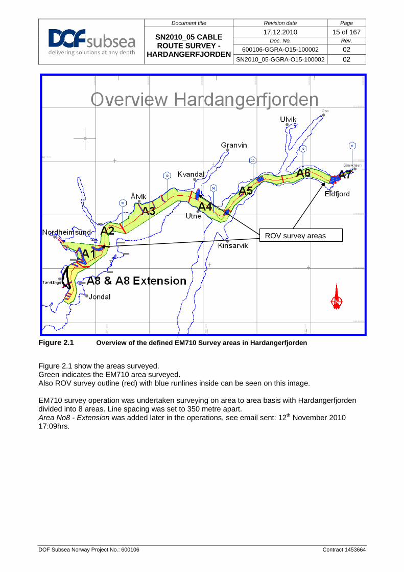
Figure 2.1 Overview of the defined EM710 Survey areas in Hardangerfjorden
Figure 2.1 show the areas surveyed. Green indicates the EM710 area surveyed. Also ROV survey outline (red) with blue runlines inside can be seen on this image. EM710 survey operation was undertaken surveying on area to area basis with Hardangerfjorden divided into 8 areas. Line spacing was set to 350 metre apart. Area No8 - Extension was added later in the operations, see email sent: 12th November 2010 17:09hrs.
ROV survey areas

Document title Revision date Page
SN2010_05 CABLE ROUTE SURVEY -
HARDANGERFJORDEN
17.12.2010 16 of 167 Doc. No. Rev.
600106-GGRA-O15-100002 02 SN2010_05-GGRA-O15-100002 02
DOF Subsea Norway Project No.: 600106 Contract 1453664
Table 2.1 SV Geograph – Hull mounted EM710 work performed
Runline Name Length (km)
Start Date/Time (UTC)
End Date/Time (UTC) Comment
Area 1 Area_1.rlx 66.600 29/10/2010 02:17 29/10/2010 17:22 Main survey lines to cover the area
No1 Area1_Line_west.rlx 5.965 30/10/2010 13:27 30/10/2010 13:38 Western edge of area1 Area1_infill1.rlx 2.749 30/10/2010 08:59 30/10/2010 09:37 Infill due to shallow water Area1_infill2.rlx 1.780 30/10/2010 09:52 30/10/2010 10:32 Infill due to shallow water Area1_infill2+60.rlx 1.780 30/10/2010 11:19 30/10/2010 11:42 Area1_infill2-60.rlx 1.780 30/10/2010 12:04 30/10/2010 12:58 Area1_infill3.rlx 1.952 30/10/2010 10:32 30/10/2010 11:00 Infill due to shallow water Area1_infill4.rlx 2.220 30/10/2010 11:42 30/10/2010 11:55 Area1_infill5.rlx 1.555 29/10/2010 19:30 29/10/2010 19:56 Infill due to data gap Area1_infill5.rlx 1.555 30/10/2010 11:42 30/10/2010 11:55
Area1_infill6.rlx 4.015 29/10/2010 20:20 29/10/2010 21:22 Infill due to very poor data in the steep slope in Area1
Area1_infill7.rlx 4.204 29/10/2010 21:26 29/10/2010 22:31 Infill due to very poor data in the steep slope in Area1
Area1_infill8.rlx 1.619 29/10/2010 18:54 29/10/2010 19:23 Area1_line_west.rlx 5.965 30/10/2010 07:44 30/10/2010 08:59 Area1_line_west+60.rlx 5.965 30/10/2010 13:06 30/10/2010 13:20 TOTAL 109.704 100% Complete
Area 2 Area_2.rlx 5.841 31/10/2010 02:31 31/10/2010 03:48 Area 2 -1400 7.916 30/10/2010 19:51 30/10/2010 21:32
Area 2 -1050 7.397 30/10/2010 21:40 30/10/2010 23:18 Area 2 -700 6.878 30/10/2010 23:24 31/10/2010 00:53 Area 2 -350 6.360 31/10/2010 01:00 31/10/2010 02:25 Total 34.392 100% Complete
Area 3 Area3 Centre 13.586 31/10/2010 04:04 31/10/2010 06:52 Area3 -350 13.887 31/10/2010 07:02 31/10/2010 11:02 Area3 -700 14.187 31/10/2010 11:16 31/10/2010 14:09 Area3 -1050 14.487 31/10/2010 14:26 31/10/2010 17:24 Area3 -1400 14.788 31/10/2010 17:29 31/10/2010 20:33 Area3 -1750 13.341 01/11/2010 07:11 01/11/2010 09:52 Area3 -1750 1.747 01/11/2010 14:21 01/11/2010 14:47 Area3 -2100 12.810 01/11/2010 22:27 02/11/2010 01:03 Area3 -2450 3.864 01/11/2010 10:14 01/11/2010 10:42 Area3_Alvik 3.834 01/11/2010 12:17 01/11/2010 12:47 Area3_Alvik+110 3.787 01/11/2010 13:01 01/11/2010 13:28 Area3_Alvik+220 3.740 01/11/2010 13:42 01/11/2010 14:02 Area3_Alvik+350 1.678 01/11/2010 11:11 01/11/2010 12:06 Area3_Alvik-2700 1.083 01/11/2010 13:29 01/11/2010 13:40 Total 116.819 100% Complete
Area 4 Area4.rlx Centre 8.491 01/11/2010 03:03 01/11/2010 04:38 Area4.rlx +350 8.526 01/11/2010 00:55 01/11/2010 02:58 Area4.rlx +700 8.561 01/11/2010 04:21 01/11/2010 06:06 Area4.rlx +1050 8.596 01/11/2010 02:22 01/11/2010 04:15 Area4.rlx +1400 8.631 31/10/2010 21:29 31/10/2010 23:12 Area4.rlx +1750 8.666 01/11/2010 00:12 01/11/2010 02:08 Area4.rlx +2100 1.487 31/10/2010 23:17 31/10/2010 23:44

Document title Revision date Page
SN2010_05 CABLE ROUTE SURVEY -
HARDANGERFJORDEN
17.12.2010 17 of 167 Doc. No. Rev.
600106-GGRA-O15-100002 02 SN2010_05-GGRA-O15-100002 02
DOF Subsea Norway Project No.: 600106 Contract 1453664
Runline Name Length (km)
Start Date/Time (UTC)
End Date/Time (UTC) Comment
Area4_Kvandal_Line1 2.498 01/11/2010 07:03 01/11/2010 07:37 Area4_Kvandal_Line2 1.673 01/11/2010 07:46 01/11/2010 08:12 Area4_Kvandal_Line3 2.847 01/11/2010 05:17 01/11/2010 05:57 Area4_Kvandal_Line4 1.195 01/11/2010 08:14 01/11/2010 08:37 Area4_Kvandal_Line5 1.391 01/11/2010 04:47 01/11/2010 05:09 Area4_Kvandal_Line5 1.504 01/11/2010 08:49 01/11/2010 09:11 Total 64.066 100% Complete
Area 5 Area5.rlx Centre 13.592 04/11/2010 20:24 04/11/2010 23:10 Area5.rlx +350 13.184 03/11/2010 21:19 06/11/2010 23:22 Area5.rlx+700 12.777 03/11/2010 08:05 03/11/2010 21:13 Area5.rlx+1050 12.402 04/11/2010 00:10 05/11/2010 05:37 Total 51.955 100% Complete
Area 6 Area6.rlx Centre 10.577 03/11/2010 02:15 03/11/2010 04:23 Area6.rlx +350 10.466 03/11/2010 04:30 04/11/2010 05:26 Area6.rlx+700 10.354 03/11/2010 05:59 04/11/2010 04:32 Area6.rlx+1050 10.242 04/11/2010 00:10 04/11/2010 03:41 Area6.rlx+1400 7.258 04/11/2010 16:34 04/11/2010 18:05 Total 48.897 100% Complete
Area 7 Area7_1.rlx 3.507 02/11/2010 13:36 02/11/2010 14:26 Area7_2.rlx 3.743 02/11/2010 14:27 02/11/2010 15:23 Area7_1+125 3.500 02/11/2010 15:53 02/11/2010 16:35 Area7_1+50 3.504 02/11/2010 16:35 02/11/2010 17:18 Area7_1+75 3.503 02/11/2010 22:26 02/11/2010 22:45 Area7_1+100 3.501 02/11/2010 22:50 02/11/2010 23:08 Area7 +150 3.498 02/11/2010 23:14 02/11/2010 23:43 Area7 +175 3.497 02/11/2010 23:50 03/11/2010 00:20 Area7_1+25 3.506 03/11/2010 00:24 03/11/2010 00:43 Area7 +200 3.495 03/11/2010 00:49 03/11/2010 01:09 Area7 +225 3.494 03/11/2010 01:13 03/11/2010 01:32 Area7 +250 3.492 03/11/2010 01:38 03/11/2010 01:53 Area7 infill 1.082 03/11/2010 01:58 03/11/2010 02:09 Area7 infill 0.230 04/11/2010 05:33 04/11/2010 05:42 Total 43.322 100% Complete
Area 8 Area8_centre.rlx 8.615 29/10/2010 22:33 30/10/2010 00:31 Area8 +350 8.600 30/10/2010 00:38 30/10/2010 02:26 Area8 -350 8.631 30/10/2010 02:36 30/10/2010 04:36 Area8 -700 8.582 30/10/2010 04:42 30/10/2010 05:31 Area 8 -700 3.816 30/10/2010 06:46 30/10/2010 07:44 Area 8 +700 3.561 30/10/2010 14:27 30/10/2010 15:08 Area 8 +700 (b) 3.140 30/10/2010 15:26 30/10/2010 15:57 Area8 +1050 3.885 30/10/2010 16:16 30/10/2010 16:56

Document title Revision date Page
SN2010_05 CABLE ROUTE SURVEY -
HARDANGERFJORDEN
17.12.2010 18 of 167 Doc. No. Rev.
600106-GGRA-O15-100002 02 SN2010_05-GGRA-O15-100002 02
DOF Subsea Norway Project No.: 600106 Contract 1453664
Runline Name Length (km)
Start Date/Time (UTC)
End Date/Time (UTC) Comment
Area8 +1050 infill 2.755 30/10/2010 17:04 30/10/2010 17:37 Area8 +700 infill 1.092 30/10/2010 17:44 30/10/2010 17:57 Total 52.677 100% Complete
Area 8 - Extension Western_line 4.021 16/11/2010 13:52 16/11/2010 14:58 Centre_line 2.602 16/11/2010 15:06 16/11/2010 15:44 Eastern_line 4.298 16/11/2010 16:02 16/11/2010 16:54 Total 10.921 100% Complete
Figure 2.2 Overview of Eiknes area showing outline of survey area compared to achieved coverage due to shallow depth
Eiknes area was surveyed to 72% due to shallow water limitations
To shallow

Document title Revision date Page
SN2010_05 CABLE ROUTE SURVEY -
HARDANGERFJORDEN
17.12.2010 19 of 167 Doc. No. Rev.
600106-GGRA-O15-100002 02 SN2010_05-GGRA-O15-100002 02
DOF Subsea Norway Project No.: 600106 Contract 1453664
2.2.2 ROV MOUNTED EQUIPMENT SURVEY
The table below outlines the work conducted by ROV - XLX38 during the seabed survey in Hardangerfjorden. ROV Survey lines were created from Statnett supplied drawings indicating the survey outline to be covered. See Figure 2.1. Further visual surveys were undertaken on survey lines supplied by Havforskningsinstituttet as detailed in below. The limit for shallow survey was set to 25 meter. This was bound by the water depth needed for ROV TMS operation. Table 2.2 ROV - Work performed in Hardangerfjorden
Runline Name Length (km)
Start Date/Time
(UTC)
End Date/Time
(UTC) Comment
Hardangerfjorden Centre Line Survey SSS data primary
Hardanger_CL 13.108 08/11/2010 14:03 08/11/2010 19:22 Simafjord to Vallavik Hardanger_CL 4.734 09/11/2010 08:55 09/11/2010 11:05 Vallavik to Djønnaneset Hardanger_CL 5.366 09/11/2010 14:44 09/11/2010 17:31 Djønnaneset to Slåttnes Hardanger_CL 1.038 10/11/2010 08:48 10/11/2010 09:36 Slåttnes towards Kvandal Hardanger_Alt_01 3.378 10/11/2010 17:14 10/11/2010 18:47 Alternative_CL_01 Hardanger_CL 5.426 10/11/2010 19:36 11/11/2010 21:56 Slåttnes to Kvandal Hardanger_CL 6.351 13/11/2010 04:11 13/11/2010 06:40 Kvandal to Uravika Hardanger_CL 1.000 13/11/2010 13:59 13/11/2010 14:33 Uravika to Seianes Hardanger_CL 1.185 13/11/2010 16:02 13/11/2010 16:32 Uravika to Seianes Hardanger_CL 2.394 13/11/2010 20:53 13/11/2010 22:03 Seianes to Ålvik Hardanger_CL 1.138 14/11/2010 05:45 14/11/2010 06:25 Ålvik towards Samlaneset Hardanger_CL 3.090 14/11/2010 11:31 14/11/2010 12.59 Ålvik towards Samlaneset Hardanger_CL 2.471 14/11/2010 14:31 14/11/2010 16:17 Ålvik towards Samlaneset Hardanger_CL 3.445 15/11/2010 00:14 15/11/2010 01:49 Samlaneset to Kvamsøy Hardanger_CL 4.340 15/11/2010 19:32 15/11/2010 22:50 Kvamsøy towards Aksneset Hardanger_CL 1.480 17/11/2010 23:27 18/11/2010 00:16 Eidesvågen to Aksneset TOTAL 82% Complete
Runline Name Length (km)
Start Date/Time (UTC)
End Date/Time (UTC) Comment
Eikenes Area Eiknes_1 08/11/2010 05:40 08/11/2010 05:46 limited by shallow water Eiknes_2 08/11/2010 05:08 08/11/2010 05:22 limited by shallow water Eiknes_3 08/11/2010 04:34 08/11/2010 04:54 limited by shallow water Eiknes_4 08/11/2010 03:34 08/11/2010 04:07 limited by shallow water Eiknes_5 08/11/2010 02:51 08/11/2010 03:24 limited by shallow water Eiknes_6 08/11/2010 01:57 08/11/2010 02:38 limited by shallow water Eiknes_7 08/11/2010 00:25 08/11/2010 01:05 limited by shallow water Eiknes_8 07/11/2010 23:17 08/11/2010 00:12 limited by shallow water Eiknes_9 07/11/2010 22:00 07/11/2010 23:01 limited by shallow water Eiknes_10 07/11/2010 19:25 07/11/2010 21:09 limited by shallow water Eiknes_11 07/11/2010 17:36 07/11/2010 19:17 limited by shallow water Eiknes_12 07/11/2010 16:12 07/11/2010 17:25 limited by shallow water Eiknes_13 07/11/2010 12:32 07/11/2010 15:48 limited by shallow water Eiknes_14 06/11/2010 06:08 06/11/2010 08:06 limited by shallow water Eiknes_15 06/11/2010 08:35 06/11/2010 10:48 Eiknes_16 06/11/2010 11:15 06/11/2010 12:51 limited by shallow water Eiknes_17 06/11/2010 13:17 06/11/2010 14:19 limited by shallow water Eiknes_18 06/11/2010 15:02 08/11/2010 06:08 limited by shallow water Eiknes_19 08/11/2010 08:41 08/11/2010 09:08 limited by shallow water Eiknes_20 08/11/2010 09:14 08/11/2010 09:42 limited by shallow water

Document title Revision date Page
SN2010_05 CABLE ROUTE SURVEY -
HARDANGERFJORDEN
17.12.2010 20 of 167 Doc. No. Rev.
600106-GGRA-O15-100002 02 SN2010_05-GGRA-O15-100002 02
DOF Subsea Norway Project No.: 600106 Contract 1453664
Eiknes_21 08/11/2010 10:02 08/11/2010 10:20 limited by shallow water Eiknes_22 08/11/2010 10:24 08/11/2010 10:42 limited by shallow water Eiknes_23 08/11/2010 10:50 08/11/2010 11:05 limited by shallow water Eiknes_24 08/11/2010 11:12 08/11/2010 11:22 limited by shallow water Eiknes_25 08/11/2010 11:37 08/11/2010 11:41 limited by shallow water Eiknes_SBP_Cross 08/11/2010 12:25 08/11/2010 13:23 Eiknes_26.rlx na na Not run, too shallow Eiknes_27.rlx na na Not run, too shallow Eiknes_28.rlx na na Not run, too shallow Eiknes_29.rlx na na Not run, too shallow TOTAL 72% Complete
Runline Name Length (km)
Start Date/Time (UTC)
End Date/Time (UTC) Comment
Vallavik Area Vallavik_4 +60 1.274 09/11/2010 04:55 09/11/2010 05:38 Vallavik_4 +120 1.274 09/11/2010 04:07 09/11/2010 04:50 Vallavik_4 +180 1.274 09/11/2010 03:20 09/11/2010 04:02 Vallavik_4 +240 1.274 09/11/2010 02:35 09/11/2010 03:15 Vallavik_4 +300 1.274 09/11/2010 01:47 09/11/2010 02:27 Vallavik_4 +360 1.274 09/11/2010 01:02 09/11/2010 01:41 Vallavik_4 +420 1.274 09/11/2010 00:13 09/11/2010 00:57 Vallavik_4 +480 1.274 08/11/2010 23:24 09/11/2010 00:10 Vallavik_4 +540 1.274 08/11/2010 22:44 08/11/2010 23:22 Vallavik_4 +600 1.274 08/11/2010 21:58 08/11/2010 22:41 Vallavik_5 0.238 08/11/2010 21:06 08/11/2010 21:16 Vallavik_6 0.477 08/11/2010 21:17 08/11/2010 21:42 Vallavik_7 1.146 08/11/2010 20:12 08/11/2010 21:03 Vallavik_SBP Xline_01 0.620 09/11/2010 06:25 09/11/2010 06:49 Total 100% Complete
Runline Name Length (km)
Start Date/Time (UTC)
End Date/Time (UTC) Comment
Slåttnes Area Slåttnes_1 1.246 09/11/2010 18:20 09/11/2010 19:03 Slåttnes_1+60 1.227 09/11/2010 19:05 09/11/2010 19:46 Slåttnes_1+120 1.203 10/11/2010 00:11 10/11/2010 00:53 Slåttnes_1+180 1.179 10/11/2010 01:02 10/11/2010 01:48 Slåttnes_1+240 1.155 10/11/2010 01:52 10/11/2010 02:36 Slåttnes_1+300 1.131 10/11/2010 02:43 10/11/2010 03:25 Slåttnes_1+360 1.107 10/11/2010 03:29 10/11/2010 04:10 Slåttnes_1+420 1.083 10/11/2010 04:16 10/11/2010 04:57 Slåttnes_1+480 1.059 10/11/2010 05:01 10/11/2010 05:40 Slåttnes_1+540 0.859 10/11/2010 05:46 10/11/2010 06:20 Slåttnes_1+600 0.562 10/11/2010 06:26 10/11/2010 06:44 Slåttnes_1+660 0.264 10/11/2010 06:58 10/11/2010 07:18 SBP_Xline 0.700 10/11/2010 07:33 10/11/2010 08:11 Total 100% Complete
Runline Name Length (km)
Start Date/Time (UTC)
End Date/Time (UTC) Comment

Document title Revision date Page
SN2010_05 CABLE ROUTE SURVEY -
HARDANGERFJORDEN
17.12.2010 21 of 167 Doc. No. Rev.
600106-GGRA-O15-100002 02 SN2010_05-GGRA-O15-100002 02
DOF Subsea Norway Project No.: 600106 Contract 1453664
Kvandal Area
Kvandal_1 0.703 10/11/2010 22:42 10/11/2010 23:13 Steep section missed on instruction
from client 0.731 11/11/2010 14:13 11/11/2010 15:00
Kvandal_2 0.712 10/11/2010 23:16 10/11/2010 23:48 Steep section missed on instruction
from client 0.708 11/11/2010 13:18 11/11/2010 14:05
Kvandal_3 0.717 10/11/2010 23:51 11/11/2010 00:23 Steep section missed on instruction
from client 0.729 11/11/2010 12:21 11/11/2010 13:08
Kvandal_4 0.727 11/11/2010 00:26 11/11/2010 00:56 Steep section missed on instruction
from client 0.730 11/11/2010 01:04 11/11/2010 01:35
Kvandal_5 0.762 11/11/2010 11:23 11/11/2010 12:12
0.548 12/11/2010 07:19 12/11/2010 08:02
0.753 11/11/2010 10:36 11/11/2010 11:13
Kvandal_6
0.791 11/11/2010 01:40 11/11/2010 02:11
0.545 12/11/2010 06:00 12/11/2010 06:42
0.726 11/11/2010 09:53 11/11/2010 10:29
0.879 13/11/2010 00:08 13/11/2010 01:55 Visual Survey
Kvandal_7 0.805 11/11/2010 02:16 11/11/2010 02:45
0.541 12/11/2010 04:38 12/11/2010 05:21
0.716 11/11/2010 09:02 11/11/2010 09:45
Kvandal_8 0.830 11/11/2010 02:52 11/11/2010 03:25
0.531 12/11/2010 03:26 12/11/2010 04:12
0.607 11/11/2010 08:10 11/11/2010 08:52
Kvandal_9 0.688 11/11/2010 03:29 11/11/2010 04:01
0.522 12/11/2010 01:20 12/11/2010 02:57
0.437 11/11/2010 07:27 11/11/2010 08:00 Kvandal_10 0.940 11/11/2010 04:30 11/11/2010 07:13 Kvandal_11 Removed by client
Kvandal_Extra 1.722 11/11/2010 17:04 11/11/2010 18:34 SBP_Xline_01 0.612 12/11/2010 18:43 12/11/2010 19:08 SBP_Xline_02 0.641 11/11/2010 15:14 11/11/2010 15:58 Kvandal 350m contour 0.587 12/11/2010 11:34 12/11/2010 13:44 Kvandal 365m contour 0.594 12/11/2010 14:19 12/11/2010 15:06 Kvandal 380m contour 1.207 12/11/2010 15:28 12/11/2010 16:20 Kvandal 400m contour 1.167 12/11/2010 09:47 12/11/2010 11:10 Kvandal 415m contour 0.979 12/11/2010 16:28 12/11/2010 18:06 Total 100% Complete
Runline Name Length (km)
Start Date/Time (UTC)
End Date/Time (UTC) Comment
Uravika Area Uravika_4.rln 1.288 13/11/2010 10:29 13/11/2010 12:55 Too shallow to continue
Total 86% Complete
Runline Name Length (km)
Start Date/Time (UTC)
End Date/Time (UTC) Comment
Seianes Area Seianes_4.rlx 1.236 13/11/2010 16:55 13/11/2010 19:44 Too shallow to continue
Document title Revision date Page
SN2010_05 CABLE ROUTE SURVEY -
HARDANGERFJORDEN
17.12.2010 22 of 167 Doc. No. Rev.
600106-GGRA-O15-100002 02 SN2010_05-GGRA-O15-100002 02
DOF Subsea Norway Project No.: 600106 Contract 1453664
Total 96% Complete
Runline Name Length (km)
Start Date/Time (UTC)
End Date/Time (UTC) Comment
Ålvik Area Ålvil_5.rln 1.850 13/11/2010 22:19 14/11/2010 01:55 Too shallow to continue
Total 95% Complete
Runline Name Length (km)
Start Date/Time (UTC)
End Date/Time (UTC) Comment
Samlaneset Area
Samlaneset.rlx 1.000 14/11/2010 16:24 14/11/2010 17:03
Samlaneset.rlx +60 1.034 14/11/2010 17:06 14/11/2010 17:44
Samlaneset.rlx +120 1.000 14/11/2010 17:48 14/11/2010 18:21
Samlaneset.rlx +180 1.016 14/11/2010 18:24 14/11/2010 18:58
Samlaneset.rlx +240 1.024 14/11/2010 19:04 14/11/2010 19:36
Total 100% Complete
Runline Name Length (km)
Start Date/Time (UTC)
End Date/Time (UTC) Comment
Kvamsøy Area Kvamsøy _11.rln 1.015 15/11/2010 13:15 15/11/2010 13:58
Client instructs to only survey shelf and not steep slope to fjord floor. See email instruction Mon 15/11/2010 19:17
Kvamsøy _12.rln 1.197 15/11/2010 12:06 15/11/2010 13:03
Kvamsøy _13.rln 1.692 15/11/2010 10:18 15/11/2010 11:57
Kvamsøy _14.rln 1.709 15/11/2010 06:18 15/11/2010 08:03
Kvamsøy _15.rln 1.724 15//11/2010 04:45 15/11/2010 06:09
Kvamsøy _16.rln 1.764 15/11/2010 14:18 15/11/2010 15:30
Kvamsøy _17.rln 1.783 15/11/2010 15:40 15/11/2010 16:55
Kvamsøy_Videoline_18.rln 2.310 15/11/2010 02:10 15/11/2010 04:39
Total 80% Complete
Runline Name Length (km)
Start Date/Time (UTC)
End Date/Time (UTC) Comment
Aksneset Area
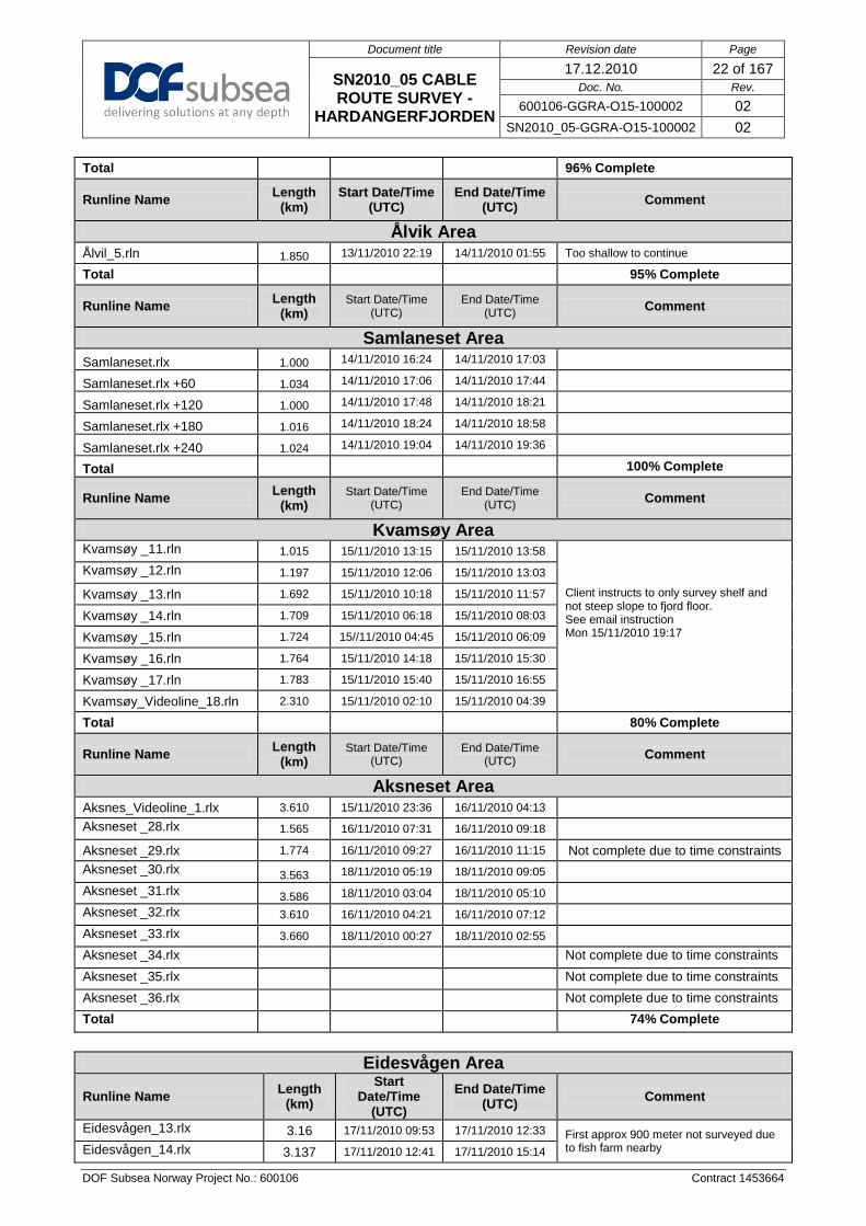
Aksnes_Videoline_1.rlx 3.610 15/11/2010 23:36 16/11/2010 04:13 Aksneset _28.rlx 1.565 16/11/2010 07:31 16/11/2010 09:18 Aksneset _29.rlx 1.774 16/11/2010 09:27 16/11/2010 11:15 Not complete due to time constraints Aksneset _30.rlx 3.563 18/11/2010 05:19 18/11/2010 09:05 Aksneset _31.rlx 3.586 18/11/2010 03:04 18/11/2010 05:10 Aksneset _32.rlx 3.610 16/11/2010 04:21 16/11/2010 07:12 Aksneset _33.rlx 3.660 18/11/2010 00:27 18/11/2010 02:55 Aksneset _34.rlx Not complete due to time constraints Aksneset _35.rlx Not complete due to time constraints Aksneset _36.rlx Not complete due to time constraints Total 74% Complete
Eidesvågen Area
Runline Name Length (km)
Start Date/Time
(UTC)
End Date/Time (UTC) Comment
Eidesvågen_13.rlx 3.16 17/11/2010 09:53 17/11/2010 12:33 First approx 900 meter not surveyed due to fish farm nearby Eidesvågen_14.rlx 3.137 17/11/2010 12:41 17/11/2010 15:14

Document title Revision date Page
SN2010_05 CABLE ROUTE SURVEY -
HARDANGERFJORDEN
17.12.2010 23 of 167 Doc. No. Rev.
600106-GGRA-O15-100002 02 SN2010_05-GGRA-O15-100002 02
DOF Subsea Norway Project No.: 600106 Contract 1453664
2.2.3 GEOTECHNICAL SAMPLING
Locations for the geotechnical sampling were chosen by Stattnett, after reviewing the survey data with geologists onboard Geograph. Table 2.3 below shows the locations and types of geotechnical sampling taken during this phase of the operation. Work began on 19th November 2010 and was completed on 21st November.
Eidesvågen_15.rlx 3.784 17/11/2010 03:15 17/11/2010 05:54 Eidesvågen_16.rlx 3.093 17/11/2010 00:40 17/11/2010 03:11 Eidesvågen_17.rlx 3.072 17/11/2010 15:41 17/11/2010 18:14 Eidesvågen_18.rlx 2.167 17/11/2010 19:28 17/11/2010 21:20 Eidesvågen_19_video.rlx 3.773 16/11/2010 18:53 17/11/2010 00:08 limited by shallow water Total 88% Complete
Havforskningsinstituttet Videolines
Runline Name Length (km)
Start Date/Time
(UTC) End Date/Time
(UTC) Comment
Kvandal Videoline.rln 1.538 11/11/2010 21:16 11/11/2010 23:38 Visual survey for Havforskningsinstituttet
Utne videoline.rln 0.795 13/11/2010 03:04 13/11/2010 03:55 Visual survey for Havforskningsinstituttet
Aalvik nord videoline_rev2 0.547 13/11/2010 14:48 13/11/2010 15:37 Visual survey for Havforskningsinstituttet
Ålvik videoline.rln 0.616 14/11/2010 02:54 14/11/2010 05:16 Visual survey for Havforskningsinstituttet
Nanes videoline.rln 0.514 14/11/2010 13:08 14/11/2010 13:53 Visual survey for Havforskningsinstituttet
Kvamsøy coral videoline.RLN 0.399 14/11/2010 20:35 14/11/2010 22:50 Visual survey for Havforskningsinstituttet Not completed due to Fishing gear debris
200m from end of line
Indre Eiknes videoline.RLN 0.300 28/11/2010 10:34 28/11/2010 11:28 Visual survey for Havforskningsinstituttet ended early due to cable across line
Ytre Eiknes videoline.RLN 0.710 28/11/2010 12:16 28/11/2010 12:59 Visual survey for Havforskningsinstituttet
Vallavik videoline.RLN 0.841 28/11/2010 14:09 28/11/2010 15:02 Visual survey for Havforskningsinstituttet
Slottnes nord.RLN 0.787 28/11/2010 16:06 28/11/2010 17:06 Visual survey for Havforskningsinstituttet
Slottnes sør.RLN 0.792 28/11/2010 18:35 28/11/2010 19:36 Visual survey for Havforskningsinstituttet

Document title Revision date Page
SN2010_05 CABLE ROUTE SURVEY - HARDANGERFJORDEN
17.12.2010 24 of 167 Doc. No. Rev.
600106-GGRA-O15-100002 02 SN2010_05-GGRA-O15-100002 02
DOF Subsea Norway Project No.: 600106 Contract 1453664
Table 2.3 Geotechnical Samples
Planned CPT Piston Core
Actual Difference St Dev Actual Difference St Dev Notes
Core Depth Easting Northing Easting Northing Easting Northing Easting Northing Easting Northing Easting Northing Easting Northing Sample Length
01 34 396179.17 6707660.49 396175.77 6707657.15 3.40 3.34 0.13 0.18 Cancelled by Client 02 18 395220.18 6707165.18 395219.49 6707165.97 0.69 -0.79 0.11 0.15 395197.07 6707190.23 23.11 -25.05 0.529 0.319 2.20m 1 03 79 394657.24 6706862.75 394656.29 6706862.70 0.95 0.05 0.08 0.125 394655.95 6706861.76 1.29 0.99 0.50 0.56 1.10m
03A 394847.00 6706921.00 394847.12 6706921.74 -0.12 -0.74 0.20 0.22 394849.11 6706924.17 -2.11 -3.17 0.871 0.76 0.55 04 ~50 394325.82 6706098.02 Cancelled by Client Cancelled by Client 05 140 394106.00 6706217.95 - - - - - - 394105.66 6706218.38 0.34 -0.43 0.162 0.405 2.40m 06 213 393876.73 6706375.10 393875.16 6706376.51 1.57 -1.41 0.25 0.09 Cancelled by Client 07 387 389689.31 6708032.12 - - - - - - 389681.28 6708029.95 8.03 2.17 0.166 0.177 1.30m 08 426 384912.33 6706627.68 Cancelled by Client 384912.51 6706626.2 -0.18 1.48 0.575 0.177 2.20m 09 ~280 384884.56 6708349.22 Cancelled by Client 384885.67 6708351.11 -1.11 -1.89 0.244 0.125
10_A 471 380995.76 6706720.82 380995.61 6706719 0.15 1.87 0.467 0.433 Cancelled by Client 10 479 380800.13 6706492.68 380837.06 6706527 -36.93 -34.35 0.318 0.395 Cancelled by Client 2
10_B 494 380574.50 6706310.17 Cancelled by Client Cancelled by Client 11 446 380570.94 6706606.48 Cancelled by Client 380573.67 6706606.18 -2.73 0.30 0.241 0.198 2.30m 3
12_A 555 377328.90 6703917.40 Cancelled by Client Cancelled by Client 12 558 377192.64 6703849.23 377194.24 6703847.2 -1.60 2.05 0.627 0.631 Cancelled by Client
12_B 575 377087.17 6703736.99 Cancelled by Client Cancelled by Client 13 645 374572.98 6700862.31 374573.44 6700862.4 -0.46 -0.05 0.336 0.293 374575.87 6700862.62 -2.89 -0.31 0.304 0.331 1.53m
13_A 664 374496.57 6700781.88 Cancelled by Client Cancelled by Client 13_B 688 374554.73 6700503.54 Cancelled by Client Cancelled by Client
14 720 373335.36 6699208.58 - - - - - - Cancelled by Client 15 739 368970.77 6703326.74 Cancelled by Client 368971.26 6703323.8 -0.49 2.94 0.628 0.74 1.10m 16 217 369151.76 6704862.38 369154.38 6704861.7 -2.62 0.71 0.369 0.331 369154.55 6704862.06 -2.79 0.32 0.371 0.265 2.20m 17 209 368973.73 6705226.37 Cancelled by Client Cancelled by Client 18 818 360227.68 6700833.68 360227.82 6700833.8 -0.14 -0.15 0.393 0.58 360230.13 6700836.02 -2.45 -2.34 0.452 0.385 1.35m
18_A 836 359994.10 6700707.87 Cancelled by Client Cancelled by Client 19 857 351353.67 6693522.21 Cancelled by Client 351356.57 6693521.02 -2.90 1.19 0.425 0.58 2.50m K1 346907.72 6694021.84 346910.76 6694020.8 -3.04 1.06 0.167 0.177 346911.40 6694022.51 -3.68 -0.67 0.254 0.153 1.05m 20 855 345803.67 6689886.97 345805.44 6689885.90 -1.77 1.07 0.576 0.424 345806.6 6689887.02 -2.93 -0.05 0.513 0.459 2.00m 21 345456.29 6689337.14 345457.8 6689335.38 -1.51 1.76 0.865 0.723 Cancelled by Client E2 344405.73 6687177.66 Cancelled by Client 344384.35 6687288.54 -4.35 -61.54 0.524 0.265 0.5m 4 E1 344196.63 6686835.68 Cancelled by Client 344287.08 6686841.61 -6.08 -4.61 0.291 0.364 1.2m 5

Document title Revision date Page
SN2010_05 CABLE ROUTE SURVEY -
HARDANGERFJORDEN
17.12.2010 25 of 167 Doc. No. Rev.
600106-GGRA-O15-100002 02 SN2010_05-GGRA-O15-
100002 02
DOF Subsea Norway Project No.: 600106 Contract 1453664
Notes: 1- Client moved Piston Core location 30m @315° to avoid cable marked on Navigation
Chart 2 - Client moved CPT location 50m @45° as CPT rig slid down steep terrain at original location
3 - Not able to get CPT due to steep terrain 4 - Client moved location 5 - Client moved location. Not able to get CPT due to steep terrain
2.3 KP DATABASES
2.3.1 VESSEL SUPPLIED KP DATABASES There were no vessel supplied KP databases by Statnett for the Hardangerfjorden scope. DSN made their own runlines in collaboration with Statnett from the GIS database supplied by Statnett. DSN runlines can be found in SN2010_05_Hardangerfjorden_WGS84_LL_FEATURES_20101018.gdb. 2.3.2 ROV SUPPLIED KP DATABASES There were no KP databases supplied by Statnett for the Hardangerfjorden scope. DSN made their own runlines in collaboration with Statnett from the GIS database supplied by Statnett. DSN runlines can be found in SN2010_05_Hardangerfjorden_WGS84_LL_FEATURES_20101018.gdb.
2.4 SURVEY OPERATIONS
SV Geograph was tasked to carry out seabed investigations in Hardangerfjorden using both vessel and ROV based systems. The Survey began on the 29th October 2010 with a vessel MBE survey covering the whole survey area. Vessel MBE survey was completed on the 6th of November. On 16th November the Area number # 8-Extension was surveyed, which was an extra SOW received on the 12th of November. Sequence of vessel hull mounted EM710 operations.
• Area number # 1 • Area number # 8 • Area number # 2 • Area number # 3 & 4 Due to operational reasons. • Area number # 7 • Area number # 5 & 6 Due to operational reasons. • Area number # 8 Extension Extra SOW received 12th of November
The final vessel based survey was completed on 16th November 2010. ROV based surveys was started on the 6th of November. The Step 4 ROV site inspection - visual Lines for the marine Biologists was added to the operations on the 11th of November. From this time on Step 2 and Step 4 was carried out simultaneously.

Document title Revision date Page
SN2010_05 CABLE ROUTE SURVEY -
HARDANGERFJORDEN
17.12.2010 26 of 167 Doc. No. Rev.
600106-GGRA-O15-100002 02 SN2010_05-GGRA-O15-
100002 02
DOF Subsea Norway Project No.: 600106 Contract 1453664
Sequence of ROV survey operations. • Eiknes area in the outlet from Simafjorden. • Vallavik area. • Djønnaneset area. • Slåttnes area. • Kvandal area. • Uravika • Seianeset • Ålvik • Samlaneset • Kvamsøy • Aksneset • Eidesvågen • The centre route line was surveyed as the ROV transited from one site location to the next.
Due to time constraints ROV based survey was stopped incomplete on 18th November 2010. On the 27th Nov the ROV was re-mobilised and five video lines were completed by the 29th November. Sequence of Geotechnical Sampling operations. The Geotechnical work began at the eastern (inland), end of Hardangerfjord and proceeded westwards. 2.4.1 SURVEY PERFORMANCE / DATA QUALITY The equipment mobilised on the SV Geograph performed within specifications and suffered the following breakdowns during this project.
2.4.1.1 Failure reports Table 2.4 Failure Reports
Failure Report no. Failure description Date
600106-GG-Q15-2010-001.pdf During operation it was noticed that the digiquartz had very unsuspected depth reading on deck and then "lagged" the other unit when dived and performing a profile. During Fault finding the unit failed to communicate to Digiquartz interactive through the online PC.
2010-11-07
600106-GG-Q15-2010-002.pdf
After replacing a faulty unit (see FR 600106-GG-Q15-2010-001) with one from onboard spares a profile was performed whilst monitoring both units on the ROV, an on deck reading from unit 96334 was -1.89m with 11.23psi and a more normal reading from unit 96321. Once dived the two units had very different readings at shallow depths with unit 96334 more closely following what Saiv unit's output and this seemed to agree with the known depth of ROV near the surface as this could be seen physically. Therefore we have no confidence in either of these units as 96334 is two years out of date for cal. and has dodgy readings on deck and the unit 96321 is reading around 30m when it can be seen that the ROV is around 3m depth and then seems to lag the actual depth all the way down.
2010-11-07
600106-GG-Q15-2010-003.pdf During operation we restarted the reson topsides. The stbd system would not boot up again after restart. Swapped it for spare, and did some bench tests. Gives out various bios error codes, and sometimes does not start at all. Also one of the cpu fans has been taken to fix another noisy topside unit.
2010-11-08
600106-GG-Q15-2010-004.pdf The /p topside unit had a really noisy fan that also caused it to crash from time to time. Took one CPU fan from another dead topside unit to replace it. 2010-11-10
600106-GG-Q15-2010-005.pdf Unit was deployed 3 times by crane and manually started. Unit only recorded a few meters of data each time then stopped logging. 2010-11-10
600106-GG-Q15-2010-007.pdf The unit is giving a partial ground on the ROV and drops out of
HAIN occasionally. On inspection it was seen that although the unit continues to output a string one of the beams returns zeroes.
2010-11-18

Document title Revision date Page
SN2010_05 CABLE ROUTE SURVEY -
HARDANGERFJORDEN
17.12.2010 27 of 167 Doc. No. Rev.
600106-GGRA-O15-100002 02 SN2010_05-GGRA-O15-
100002 02
DOF Subsea Norway Project No.: 600106 Contract 1453664
2.4.1.2 Surface Positioning The different surface position systems are regularly compared to each other to monitor their performance. Based on these comparisons, it is decided which system to be used as primary and secondary position system. Due to the surrounding mountains in the Hardangerfjord we had to swop between navigation systems. Loss of correction signals was likely to occur in certain areas due to the terrain. Therefore to cope with this we mobilized equipment to enable two alternative ways of receiving correction signal, and a post processing option that was independent of correction signals.
1. Correction signals using the NMT network, (ICE). 2. Correction signal transmitted from a radio covering the Simafjord area. 3. Post processing using “Precise Point Positioning” with the Terrapos software
The correction signals transmitted from a land based demodulator station was placed optimally to cover the area where the ICE net was expected to have a poor signal. 2 installations were needed to cover all areas. See Figure 2.3 ICE signal quality and coverage plot for the areas where we needed to receive corrections by radio signals.
Figure 2.3 ICE signal quality and coverage plot
The Terrapos software was a good alternative if all correction signals were lost. The Terrapos software uses known orbit data for the satellites, clock correction files for the satellites, and estimates the atmospheric corrections. Terrapos can use Glonass satellite signals as well. The Terrapos software manual stated that the software produced a result of horizontal accuracy of 0.05m RMS for a survey period longer than 6 hours.

Document title Revision date Page
SN2010_05 CABLE ROUTE SURVEY -
HARDANGERFJORDEN
17.12.2010 28 of 167 Doc. No. Rev.
600106-GGRA-O15-100002 02 SN2010_05-GGRA-O15-
100002 02
DOF Subsea Norway Project No.: 600106 Contract 1453664
Satellite receivers were upgraded to use all available Glonass satellites as well as GPS satellites. This was added to the available number of satellites. Starpac G2 receivers were mobilized for this job. Glonass currently have approximately 20 satellites operational. The graphs in Appendix F – QC Graphs, show examples of normal distribution of differences between the Primary and Secondary surface positioning systems for both Easting and Northing. The differences from primary to secondary DGPS are continually monitored online and were seen to be generally less than 0.3m. In this sample data set, the average difference in Easting is 0.03m and the average difference for Northing is 0.02m. Surface navigation comparisons such as these are made on a regular basis as part of the daily QC programme. HP G2 Fugro HP G2 system was used as the primary. This system performed well throughout the survey. HP Fugro HP system was used as the secondary. This system performed well throughout the survey. XP Fugro Skyfix XP was used as the tertiary. This system performed well throughout the survey.
2.4.1.3 Subsea Positioning The different subsea position systems are regularly compared to each other to monitor their performance. Kongsberg-Simrad HiPAP This system has performed well during the surveys. Kongsberg-Simrad HAIN Integrated Inertial Navigation The positions derived from the data sets shows there to be a good general agreement between the two systems. In the dynamic example shown in Appendix F the HAIN track is seen to be following the HiPaP data closely as it should and smoothing the occasional HiPAP jump. The offline processing used both the online processed HAIN and checked this against processed raw HAIN.
2.4.1.4 Depth Sensor Data The graph in Appendix F– QC Graphs, shows a comparison of the observed ROV Digiquartz depth of the two Digiquartz on the vehicle while the ROV was surveying in the Aksneset area. It can be seen from the comparisons that no exceptional spikes are evident in the recorded data and both Digiquartz record comparable depth. This would indicate that the Digiquartz unit was not producing any anomalous data.
2.4.1.5 Kongsberg EM710 MBE System The Kongsberg EM710 Multi Beam Echo Sounder is a high resolution Echosounder operating at between 70 and 100 kHz. The MBE systems received sound velocity in real time from a SV sensor close to the transducers. The system is run in ‘Hi-Density equi-distant’ beam spacing mode had a maximum operating angle on this survey of ±60°. This was used in conjunction with the manual swath width function which was initially set to ±200m.

Document title Revision date Page
SN2010_05 CABLE ROUTE SURVEY -
HARDANGERFJORDEN
17.12.2010 29 of 167 Doc. No. Rev.
600106-GGRA-O15-100002 02 SN2010_05-GGRA-O15-
100002 02
DOF Subsea Norway Project No.: 600106 Contract 1453664
The EM710 system performed well during the survey. Figure 2.4 below shows DTM data, produced from the EM710 survey, of Hardangerfjord in the Kvandal area. Water depth varies from 50m to 870m deep. Figure 2.5 below shows shaded relief from the EM710 survey, of Hardangerfjord in the Askneset area.
Figure 2.4 DTM of EM710 data of Hardangerfjord in the Kvandal area

Document title Revision date Page
SN2010_05 CABLE ROUTE SURVEY -
HARDANGERFJORDEN
17.12.2010 30 of 167 Doc. No. Rev.
600106-GGRA-O15-100002 02 SN2010_05-GGRA-O15-
100002 02
DOF Subsea Norway Project No.: 600106 Contract 1453664
Figure 2.5 Shaded Relief of EM710 data, Hardangerfjord in Aksneset area
2.4.1.6 ROV mounted Seabat 7125 The Reson Seabat 7125 system performed well, minor drop outs were noted by these were within limits accepted by the on board client representative. During post-processing no significant gaps were observed. Figure 2.6 below shows DTM data from the ROV 7125 survey of the Kvamsoy area with water depth between 300m and 550m deep. Figure 2.7 below shows shaded relief for a section of the DTM shown in Figure 2.6. . The depth in this example of the area near Kvamsoy is between 370m and 470m.

Document title Revision date Page
SN2010_05 CABLE ROUTE SURVEY -
HARDANGERFJORDEN
17.12.2010 31 of 167 Doc. No. Rev.
600106-GGRA-O15-100002 02 SN2010_05-GGRA-O15-
100002 02
DOF Subsea Norway Project No.: 600106 Contract 1453664
Figure 2.6 DTM of ROV 7125 data of Kvamsoy area, Hardangerfjord

Document title Revision date Page
SN2010_05 CABLE ROUTE SURVEY -
HARDANGERFJORDEN
17.12.2010 32 of 167 Doc. No. Rev.
600106-GGRA-O15-100002 02 SN2010_05-GGRA-O15-
100002 02
DOF Subsea Norway Project No.: 600106 Contract 1453664
Figure 2.7 Shaded Relief of ROV 7125 data, Kvamsoy area, Hardangerfjord
2.4.1.7 ROV mounted SBP Data

Document title Revision date Page
SN2010_05 CABLE ROUTE SURVEY -
HARDANGERFJORDEN
17.12.2010 33 of 167 Doc. No. Rev.
600106-GGRA-O15-100002 02 SN2010_05-GGRA-O15-
100002 02
DOF Subsea Norway Project No.: 600106 Contract 1453664
The Edgetech SBP system yielded the best results using 2-8 kHz frequency. The SBP data quality was good and the penetration was satisfactory. An average sound velocity of 1500 m/s was used for the sediment strata. The Edgetech SBP performed well during the survey.
Figure 2.8 SBP data quality example from KP 25.23 to KP 25.83. Horizontal scale lines: 25m, Vertical scale lines: 10ms (7.5m).
.
2.4.1.8 ROV mounted SSS Data The Edgetech 4200 system provided good quality data, utilizing the 600kHz frequency it was able to detect several small targets. The SSS system performed very well throughout the survey and produced some very clear images.

Document title Revision date Page
SN2010_05 CABLE ROUTE SURVEY -
HARDANGERFJORDEN
17.12.2010 34 of 167 Doc. No. Rev.
600106-GGRA-O15-100002 02 SN2010_05-GGRA-O15-
100002 02
DOF Subsea Norway Project No.: 600106 Contract 1453664
Figure 2.9 SSS data example from approximately KP 22.40 to KP 23.10
2.4.1.9 Navigation/Acquisition Software suites Eiva Timebox Eiva Timebox was used to time stamp all incoming data before it was recorded by NaviScan. The StarFix HP and AD492 antenna (L1,L2,Glonass & Spot) was used as the source of PPS and ZDA time. Eiva NaviPac The system has performed well during the period of survey. Eiva NaviScan The system has performed well during the period of survey. Kongsberg SIS The system performed well during the seabed survey. IXSEA / Edgetech Discover This system generally performed well throughout the survey. At start up of project our new IXSEA processing software went through some minor problems that were resolved quickly by use of the support function.

Document title Revision date Page
SN2010_05 CABLE ROUTE SURVEY -
HARDANGERFJORDEN
17.12.2010 35 of 167 Doc. No. Rev.
600106-GGRA-O15-100002 02 SN2010_05-GGRA-O15-
100002 02
DOF Subsea Norway Project No.: 600106 Contract 1453664
2.4.2 ENVIRONMENTAL DATA
2.4.2.1 Sound Velocity and CTD data Sound velocity and CTD profiles were recorded during every launch and recovery of the vehicle. As would be expected, variations in the profiles over both space and time were observed throughout the course of the operation. The crane was used to obtain the first CTD profile for vessel based MBE work by mounting the stand alone SAIV SD204 and two Valeport MIDAS SVX2 units on the wire and taking it to seabed and back. The summary sheet for these profiles has been included in Appendix A: Survey Data Form, with the profile graphs included in Appendix F: QC graphs. The sound velocity profiles were loaded into the HiPAP system prior to commencing or continuing with positioning operations. The MBE systems received sound velocity in real time from a SV sensor positioned close to the transducers and the CTD profiles were loaded to the EM710 system as *.asvp files for real-time data acquisition. All CTD measurements were processed using the UNESCO-formula. The processed data was used to post-process the pressure-data logged by the Digiquartz sensor.
2.4.2.2 Tidal Corrections All MBE data presented in the project drawings or delivered as DTMs, were reduced to MSL using measured tide from tide gauges located at Eidfjord, Kvanndal, and Tørvikbygd. Aandera and SAIV Water Level Recorders were placed in 3 locations of Hardangefjorden. Water levels were recorded every 10 minutes.
2.4.2.3 Air Pressure Air pressure data was recorded on an Aanderaa Digital Barograph Data-logger. The atmospheric pressure is logged at 30 second intervals within the online navigation suite and was then extracted during the post processing operations. 2.4.3 SEABED SAMPLING Two types of seabed sampling, CPT, and Piston Coring took place at locations provided by Stattnett.
2.5 EQUIPMENT
Table 2.5 SV Geograph Vessel equipment
Item Instrument
Primary / Secondary Fugro Starpack HP G2 DGPS (HP) with StarFix HP and AD492 antenna (L1,L2,Glonass & Spot), corrections via Inmarsat, Spotbeam, radio, ICE and NTRIP (nominal Secondary).
Secondary / Primary Fugro Starpack XP DGPS (XP) with Multifix 6 software and AD492 antenna (L1,L2,Glonass & Spot), corrections via Inmarsat, 2 x spotbeam, radio, ICE and NTRIP (nominal Primary).
Vessel Gyro 1 Seatex Seapath 200 heading and attitude sensor, Version 2.03, MRU Ser. No.3754, Top side Ser. No. 7230, mobilised 4th December 2007. Seatex Seapath 200 is the primary sensor.
Vessel Gyro 2 1 x Sperry Navigat 2100 Fibre-optic Gyro Ser. No. 1589.

Document title Revision date Page
SN2010_05 CABLE ROUTE SURVEY -
HARDANGERFJORDEN
17.12.2010 36 of 167 Doc. No. Rev.
600106-GGRA-O15-100002 02 SN2010_05-GGRA-O15-
100002 02
DOF Subsea Norway Project No.: 600106 Contract 1453664
Item Instrument
Vessel Gyro 3 Sperry Marine Navigat X digital gyro compasses. Vessel Gyro 4 Sperry Marine Navigat X digital gyro compasses.
MRU 1 Seatex Seapath 200 heading and attitude sensor, Version 2.03, MRU Ser. No.3754, Top side Ser. No. 7230, mobilised 4th December 2007. Seatex Seapath 200 is the primary sensor.
MRU 2 Seatex MRU5 motion sensor Ser. No. 3759 (“stand alone” for DP system) SSBL Stbd HiPAP 500 SSBL Port HiPAP 500 Barograph 1 Aanderaa pressure sensor 2810 Barograph 2 SAIV TD301R (Keel) Vessel Sound Velocity CTD 1 Hull mounted Valeport miniSVS Vessel Sound Velocity CTD 2 Valeport MIDAS SVX2 for crane deployment Vessel MBE Kongsberg EM710 TX Vessel SBP Gondola mounted Kongsberg Maritime SBP120
Table 2.6 ROV equipment
Item Instrument
Responder Kongsberg 319 Transponder Kongsberg 319 INS Konsberg HAIN ROV INS / MRU 1 TSS Orion Gyro compass ROV INS / MRU 2 CDL Mini RLG ROV Doppler RDI Doppler log 300kHz
ROV Sound Velocity CTD 1 SAIV SD204 ROV Sound Velocity CTD 2 Valeport Mini SVS ROV MBE Head 1 Reson Seabat 7125 (stb) ROV MBE Head 2 Reson Seabat 7125 (port) ROV Depth Sensor 1 Paroscientific Digiquartz 2000m
ROV Depth Sensor 2 Paroscientific Digiquartz 2000m
ROV Altimeter RDI Doppler 300kHz
ROV Port Camera Kongsberg Colour Zoom 1366 ROV Centre Camera Kongsberg Colour Zoom 1366 ROV Starboard Camera Kongsberg Colour Zoom 1366 Laser Imenco Stereo Laser System Obstacle Avoidance Sonar Kongsberg MS1000 ROV SSS Edgetech 4200 FS 300/600 kHz ROV SBP Edgetech FS 2400 2-15 kHz

Document title Revision date Page
SN2010_05 CABLE ROUTE SURVEY -
HARDANGERFJORDEN
17.12.2010 37 of 167 Doc. No. Rev.
600106-GGRA-O15-100002 02 SN2010_05-GGRA-O15-
100002 02
DOF Subsea Norway Project No.: 600106 Contract 1453664
3 SUMMARY OF RESULTS
The following summarises the results of the operations completed by the SV Geograph over the course of the Hardangerfjorden Cable route survey, from 28th of October to 29th November 2010. It must be noted that the project was split into two parts the first being the majority of the survey from the 28th October to the 22nd November and then some infill video lines for the Marine Institute from the 27th -29th November.
Figure 3.1 Overview of the Hardangerfjord Area
The deepest part of the route is found in the west (860m). Bathymetry:
The landfall areas (Eiknes and Eidesvågen) are the steepest areas along the route with gradients up to 79°. The fjord bottom is relatively flat but is cut by six major slide escarpments at KP 14.6, KP 18.1, KP 22.7, KP 24.6, KP 26.7 and KP 43.6. The escarpments have slope angles ranging from 7° to 39° (Error! Reference source not found.).
A total of 1818 possible boulders and debris was picked. Seabed Features:
Two wrecks were observed at KP 26.49 and KP 60.42. Six major slide escarpments were observed along the route, At KP 14.6, KP 18.1, KP 22.7, KP 24.6, KP 26.7 and KP 43.6. The slide escarpments are associated with higher sediment influx from the fjord side. Further investigation to these areas is recommended. The main type of sediments along the route is fine sediments, CLAY, sandy CLAY and SILT. Closer to the fjord walls and landfalls outcrops and areas of boulders are present.
6 units have been interpreted, ranging from structureless sand to fine laminated clay and silt. Shallow Geology:
The fjord bottom mainly consists of deep fine laminated clay and silt.

Document title Revision date Page
SN2010_05 CABLE ROUTE SURVEY -
HARDANGERFJORDEN
17.12.2010 38 of 167 Doc. No. Rev.
600106-GGRA-O15-100002 02 SN2010_05-GGRA-O15-
100002 02
DOF Subsea Norway Project No.: 600106 Contract 1453664
4 DETAILED RESULTS
4.1 GENERAL
The following summarises the results of the operations completed by the SV Geograph over the course of the Hardangerfjorden Cable route survey, from 28th of October to 29th November 2010. It must be noted that the project was split into two parts the first being the majority of the survey from the 28th October to the 22nd November and then some infill video lines for the Marine Institute from the 27th -29th November. (All UTM coordinates, depths and linear dimensions quoted in this report are in metres, unless otherwise stated). In the following the terms PC and CPT are used referring to geotechnical sampling methods i.e. Piston Core (PC) and Cone Penetration Test (CPT).
4.2 ROV SURVEY
4.2.1 CENTERLINE The Hardangerfjorden Cable Route Survey Centreline was surveyed from the 08th of November to 17th of November 2010.
4.2.1.1 Bathymetry The water depth in the surveyed area ranges from a minimum of 8.7 m (MSL) in the eastern part to a maximum of 860 m (MSL) in the western part. The route is relatively flat throughout the fjord; however areas of significant morphological seabed changes occur and can be seen in the figures below.

Document title Revision date Page
SN2010_05 CABLE ROUTE SURVEY -
HARDANGERFJORDEN
17.12.2010 39 of 167 Doc. No. Rev.
600106-GGRA-O15-100002 02 SN2010_05-GGRA-O15-
100002 02
DOF Subsea Norway Project No.: 600106 Contract 1453664
Figure 4.1 The slide escarpment at around KP 14.6 has seabed gradients up to 11.0° of the surveyed area (5m contours)
Figure 4.2 The slide escarpment at around KP 18.1 has seabed gradients up to 22.5° (5m contours)
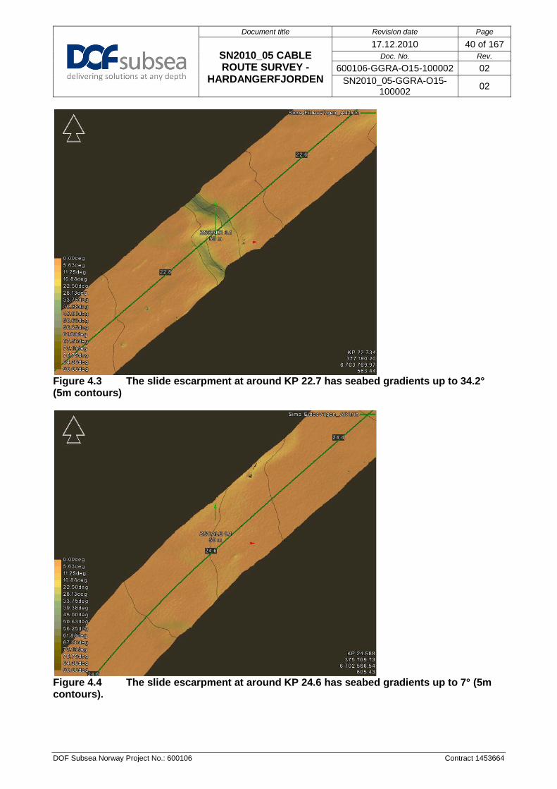
Document title Revision date Page
SN2010_05 CABLE ROUTE SURVEY -
HARDANGERFJORDEN
17.12.2010 40 of 167 Doc. No. Rev.
600106-GGRA-O15-100002 02 SN2010_05-GGRA-O15-
100002 02
DOF Subsea Norway Project No.: 600106 Contract 1453664
Figure 4.3 The slide escarpment at around KP 22.7 has seabed gradients up to 34.2° (5m contours)
Figure 4.4 The slide escarpment at around KP 24.6 has seabed gradients up to 7° (5m contours).

Document title Revision date Page
SN2010_05 CABLE ROUTE SURVEY -
HARDANGERFJORDEN
17.12.2010 41 of 167 Doc. No. Rev.
600106-GGRA-O15-100002 02 SN2010_05-GGRA-O15-
100002 02
DOF Subsea Norway Project No.: 600106 Contract 1453664
Figure 4.5 The slide escarpment at around KP 26.7 has seabed gradients up to 39.0° (5m contours).
Figure 4.6 The slide escarpment at around KP 43.6 has seabed gradients up to 34.0° (5m contours). For bathymetry of the two landfalls please see the site surveys Eiknes area and Eidesvågen area in sections 4.2.2 and 4.2.14.

Document title Revision date Page
SN2010_05 CABLE ROUTE SURVEY -
HARDANGERFJORDEN
17.12.2010 42 of 167 Doc. No. Rev.
600106-GGRA-O15-100002 02 SN2010_05-GGRA-O15-
100002 02
DOF Subsea Norway Project No.: 600106 Contract 1453664
4.2.1.2 Seabed Features
A total of 301 targets are observed along the route. Eight are unidentified and the largest measures 4.2mx1.5mx0.3m. 293 are possible boulders were the largest measure 26.4mx43.0mx10.4m and is located at KP 6.90. See SN2010_05_Hardangerfjorden_WGS84_LL_FEATURES_20101018.gdb
Eiknes to Vallavik KP2.75 to KP 17.60:
The route is cut by a slide escarpment (KP 3.38). Below the slide escarpment the slope is dominated by outcrops (probably of underlying stiffer sediments) and submarine gullies. The route crosses two areas of boulders at KP 3.15 and KP 4.20. Also at KP 4.20 the route crosses an outcrop area. From KP 5.00 the route is relatively flat, but it crosses a slide escarpment around KP 14.60. The slide escarpment is associated with higher sediment influx from the fjord side. Further investigation to these areas is recommended. Up to KP 4.00 the main sediment type is gravelly MUD. Between KP 4.00 (PC5) and KP 8.00 (PC7) the sediment type changes from gravelly MUD to CLAY. Changes in SSS reflectivity is not observed and indicates a lateral gradual change in facies.
A total of 20 possible boulders are observed along the route. The largest measure 3.2mx1.3mx2.6m and is located at KP 19.33. See SN2010_05_Hardangerfjorden_WGS84_LL_FEATURES_20101018.gdb
Vallavik to Djonnaneset KP 17.60 to KP 22.40:
At KP 18.00 a slide escarpment crosses the route, directly south of this an area of boulders are located, possibly deposits from mass movement down the fjord side. North of the route a lobe of sandy SILT (PC11) is observed from KP 18.10 to KP 18.80. The seabed is relative flat up to KP 22.40 (Djonnaneset). From KP 18.50 to KP 18.94 a possible cable is observed running parallel along the route on the south side. Between KP 14.00 (PC8) and KP 18.00 (CPT10) the sediment type changes from CLAY to sandy CLAY. Changes in SSS reflectivity is not observed and indicates a lateral gradual change in facies.
A total of 71 targets are observed along the route. Two are unidentified where the largest is 10.2mx3.3mx0.4m and is located approximately at KP 27.06. Of the 69 possible boulders the largest measure 3.2mx2.0mx3.1m and is located at KP 26.70. See SN2010_05_Hardangerfjorden_WGS84_LL_FEATURES_20101018.gdb
Djonnaneset to Slåttnes KP 22.40 to KP 26.40:
At KP 22.70 and KP 24.50 slide escarpments crosses the route. The slide escarpments are associated with higher sediment influx from the fjord side. Further investigation to these areas is recommended. According to the background information three cables crosses the route approximately at KP 22.90, KP 22.94 and KP 23.25 (not observed on SSS). Between KP 22.60 (CPT12) and KP 26.70 (CPT13 and PC13) the sediment type changes from sandy CLAY to SILT. Changes in SSS reflectivity is not observed and indicates a lateral gradual change in facies. Slåttnes to Kvandal KP 26.40 to KP 33.70
Document title Revision date Page
SN2010_05 CABLE ROUTE SURVEY -
HARDANGERFJORDEN
17.12.2010 43 of 167 Doc. No. Rev.
600106-GGRA-O15-100002 02 SN2010_05-GGRA-O15-
100002 02
DOF Subsea Norway Project No.: 600106 Contract 1453664
A total of 55 targets are observed along the route. Two are possible debris and the largest measures 2.7mx0.2mx0.6m, and is located approximately at KP 27.82. Of 53 possible boulders the largest measure 2.2mx1.3mx1.6m and is located KP 34.24. See SN2010_05_Hardangerfjorden_WGS84_LL_FEATURES_20101018.gdb A major slide escarpment crosses the route at KP 26.70. The slide escarpment is associated with higher sediment influx from the fjord side. Further investigation to these areas is recommended. From KP 27.20 to KP 33.70 (Kvandal) the seabed is relatively flat. According to the company provided background information two cables crosses the route at KP 30.16 and KP 30.64 (not seen on SSS). From Slåttnes to Kvandal the main sediment type is SILT (PC13, CPT13 and CPT15). From approximately KP 28.00 to KP 29.60 an alternative loop has been surveyed in addition to the main route. A possible cable is observed in the eastern part of the loop, close to KP 27.75. The alternative loop is relative flat and the seabed evaluated to consist of similar sediments as mentioned above.
A total of 18 possible boulders are observed along the route. The largest measures 6.5mx1.9mx1.4m, and is located at KP 36.63. See SN2010_05_Hardangerfjorden_WGS84_LL_FEATURES_20101018.gdb
Kvandal to Samlaneset KP33.70 to KP 52.73:
At KP 43.50 a slide escarpment crosses the route. The slide escarpment is associated with higher sediment influx from the fjord side. Further investigation to these areas is recommended. The main type of sediments from Kvandal to Samlaneset is SILT. From KP 46.16 to KP 48.27 a fish farm’s anchor lines crossed the route and the ROV got entangled, Due to danger to the ROV and the fish farm the client accepted that no ROV survey was done between these KPs.
A total of 11 targets are observed along the route. One is classified as debris and one is wreck, the wreck measures 23.9x10.3mx4.3m and is located at KP 60.42 (possible barge). Nine are possible boulders were the largest measure 2.4mx1.5mx0.6m and is located at KP 59.04. See SN2010_05_Hardangerfjorden_WGS84_LL_FEATURES_20101018.gdb
Samlaneset to Aksneset KP 52.73 to KP 61.10:
At KP 59.20 and KP 59.49 two seabed scars or possible cables crosses the route. From KP 52.73 to KP 61.10 the route is relative flat. The main type of sediment is SILT.
A total of 19 possible boulders are observed along the route. The largest measures 11.0mx12.9mx6.3m and is located 130m north of the route at KP 64.75. See SN2010_05_Hardangerfjorden_WGS84_LL_FEATURES_20101018.gdb
Aksneset to Eidesvågen KP 61.10 to KP 67.88:
According to the company provided background information three cables crosses the route at KP 63.07, KP 63.26 and KP 63.29. No cables were observed on the SSS data. From KP 67.40 to KP

Document title Revision date Page
SN2010_05 CABLE ROUTE SURVEY -
HARDANGERFJORDEN
17.12.2010 44 of 167 Doc. No. Rev.
600106-GGRA-O15-100002 02 SN2010_05-GGRA-O15-
100002 02
DOF Subsea Norway Project No.: 600106 Contract 1453664
67.80 four cables are crossing or running close to the route, these cables have also been observed on SSS and show an offset compared to the background information. Between KP 57.00 and KP 64.35 the sediments changes from SILT to CLAY (CPT20, PC20 and CPT21). At KP 64.85 the route enters an outcrop area or outcrops with veneer sediments on top. At KP 67.30 PCE2 shows gravelly SAND in the upper part of the slope. On the shelf at KP 67.75 PCE1 shows CLAY. It is very difficult to precisely determine where the sediment boundaries are from the SSS data. From KP 63.01 to KP 64.35 no ROV survey was done.
Figure 4.7 SSS data example From approximately KP 22.40 to KP 23.10
4.2.1.3 Shallow Geology
From KP 4.67 to KP 7.66 the laminated CLAY unit increases from 0.7 to 3.8m, and overlies a SAND unit. Between KP 7.66 and KP 14.50 the seabed comprises of undisturbed sediments, divided into 3 units; an upper and lower unit of laminated CLAY and SILT, and a homogenous body of SILT or SAND. From KP 14.50 to KP 17.60 the lower laminated CLAY and SILT unit is covered by slide debrites varying in thickness from 1 to 5 metres. At top there is less than a meter of hemipelagic sediments.
Eiknes to Vallavik KP 4.67 to KP 17.60:
200m

Document title Revision date Page
SN2010_05 CABLE ROUTE SURVEY -
HARDANGERFJORDEN
17.12.2010 45 of 167 Doc. No. Rev.
600106-GGRA-O15-100002 02 SN2010_05-GGRA-O15-
100002 02
DOF Subsea Norway Project No.: 600106 Contract 1453664
Between Vallavik and Djønnaneset the slide debrites varies in thickness from 1.5 to 8 metres, covered by less than a meter of hemipelagic sediments. The normally undisturbed lower laminated CLAY and SILT unit is disturbed and acoustic masked between KP 18.11 and KP 20.47.
Vallavik to Djonnaneset KP 17.60 to KP 22.40:
Between Djønnaneset and Slåttnes Unit 5 (undisturbed lower laminated CLAY and SILT) is at places covered disturbed laminated sediments (Unit 4). Overlaying this is 1.5 to 3 metres of slide debrites (Unit 2), covered by 1 to 2.5 metres of hemipelagic sediments (Unit 1). This indicates that several slides have been triggered in this area, and also that the slide events might be older than the slides around Vallavik (KP 14.5 and KP 18.2).
Djonnaneset to Slåttnes KP 22.40 to KP 26.40:
At KP 26.72 there is a major slide escarpment, 33 m high. The slide debrites (Unit 2) is only between 0.4 and 4 m here, but the thickness of Unit 4 (disturbed sediments) is unknown. Unit 2 is covered by 1 to 2m hemipelagic sediments.
Slåttnes to Kvandal KP 26.40 to KP 33.45
At KP 28.48 the Centre Line crosses a topographic high (12m) which has acted as an obstacle for the slide debrites. On the downslope side of this topographic high, which might be an intact slide block from the former major slide event, the seabed comprises of more normal hemipelagic sediments. Above the massive unit of laminated CLAY and SILT, there is approximately 2m of uniform sediments (SILT or SAND), with approximately 2m of laminated SILT and CLAY (Unit 1) on top.
At KP 33.45 there is a slide escarpment, and the disturbed sediments (Unit 4) are covered by both uniform sediments (Unit 3) and laminated sediments (Unit 1). Unit 4 decreases rapidly in thickness, and thins out at KP 34.15. From here, until KP 43.51, undisturbed laminated sediments (Unit 5) are overlain by 1 to 3.5m SILT (Unit 3) and 1 to 2.5m laminated sediments (Unit 1).
Kvandal to Samlaneset KP33.45 to KP 52.73:
At KP 43.54 there is also a slide escarpment, and the slide debrites (Unit 2) thins out at KP 44.52. Beyond this, Unit 3 varies between 5 and 9m, and Unit 1 varies between 1.5 and 3m. From KP 46.16 to KP 48.27 no ROV survey was done.
Above the massive laminated Unit 5, there is a homogenous unit of most likely SILT (Unit 3), varying in thickness from 5.5 to 9m. Above this, there is 2 to 3m of laminated CLAY and SILT (Unit 1).
Samlaneset to Aksneset KP 52.73 to KP 61.10:
The bottom of Unit 3 was not detected in this area, but Unit 3 is most likely 9m thick. Unit 1 is between 2.5 and 4m in this area.
Aksneset to Eidesvågen KP 61.10 to KP 63.01:
Table 4.1 Soil conditions
Unit Seismic character Geological interpretation
1 Parallel to sub-parallel continuous medium to high amplitude reflectors Laminated CLAY and SILT
2 Acoustically transparent unit (low amplitude reflection) of varying thickness Slide debrites
3 Acoustically uniform unit (low to medium amplitude reflection) with occasional parallel reflectors SAND or SILT, occasionally laminated
4 Chaotic medium to high amplitude reflectors Disturbed laminated sediments, SILT and
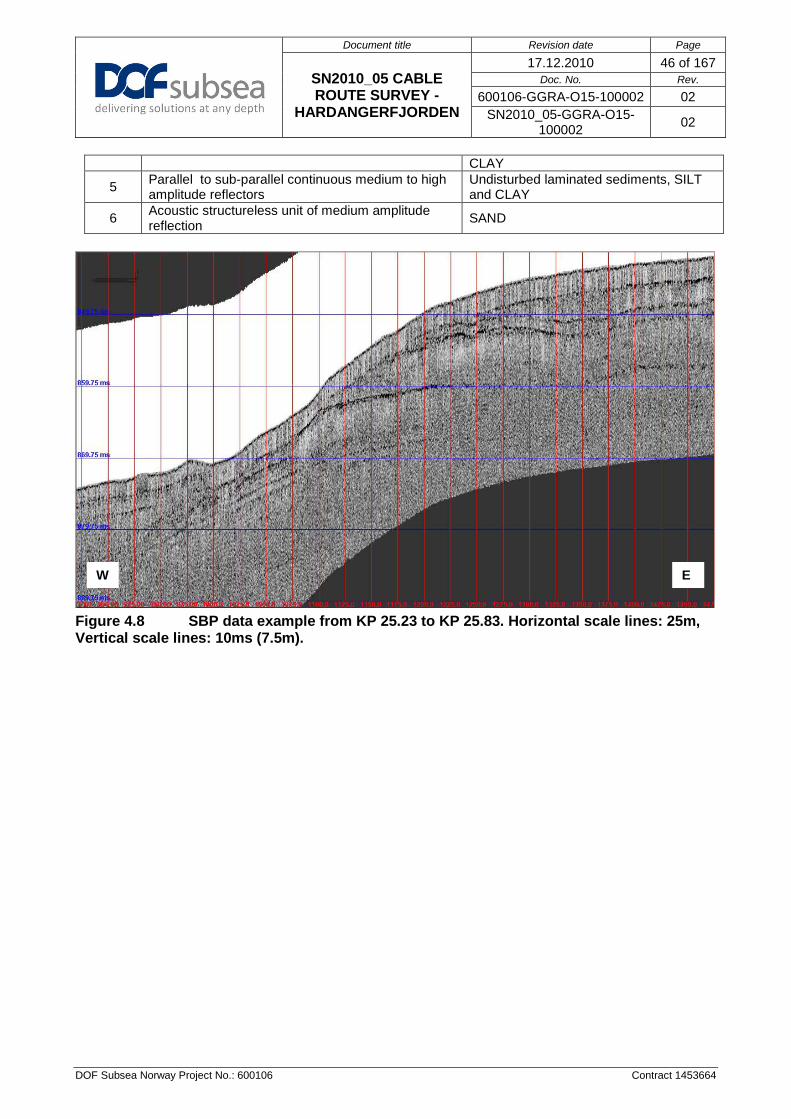
Document title Revision date Page
SN2010_05 CABLE ROUTE SURVEY -
HARDANGERFJORDEN
17.12.2010 46 of 167 Doc. No. Rev.
600106-GGRA-O15-100002 02 SN2010_05-GGRA-O15-
100002 02
DOF Subsea Norway Project No.: 600106 Contract 1453664
CLAY
5 Parallel to sub-parallel continuous medium to high amplitude reflectors
Undisturbed laminated sediments, SILT and CLAY
6 Acoustic structureless unit of medium amplitude reflection SAND
Figure 4.8 SBP data example from KP 25.23 to KP 25.83. Horizontal scale lines: 25m, Vertical scale lines: 10ms (7.5m).
W E

Document title Revision date Page
SN2010_05 CABLE ROUTE SURVEY -
HARDANGERFJORDEN
17.12.2010 47 of 167 Doc. No. Rev.
600106-GGRA-O15-100002 02 SN2010_05-GGRA-O15-
100002 02
DOF Subsea Norway Project No.: 600106 Contract 1453664
4.2.2 EIKNES AREA The Eiknes area was surveyed from the 6th of November to 8th of November 2010.
4.2.2.1 Bathymetry The water depth in the surveyed area ranges from a minimum of 8.7 m (MSL) in the north eastern part to a maximum of 200 m (MSL) in the south west part. See Figure 4.9.
Figure 4.9 DTM with overview of the bathymetry of the surveyed area (5m contours)
Seabed gradients across the surveyed area are on average about 7º however steeper slopes up to approximately 63 º occur in the submarine gullies in the central part of the slope towards the fjord bottom. At the top slope escarpments cuts the area with slope angles up to 34º. See Figure 4.10.

Document title Revision date Page
SN2010_05 CABLE ROUTE SURVEY -
HARDANGERFJORDEN
17.12.2010 48 of 167 Doc. No. Rev.
600106-GGRA-O15-100002 02 SN2010_05-GGRA-O15-
100002 02
DOF Subsea Norway Project No.: 600106 Contract 1453664
Figure 4.10 DTM with overview of the slope angles of the surveyed area (5m contours)
4.2.2.2 Seabed Features A total of 258 targets have been picked in the Eiknes area. Two of them are unidentified were the largest is 0.7mx1.2mx5.3m. 256 are possible boulders were the largest is 9.6mx8.2mx3.6m. See SN2010_05_Hardangerfjorden_WGS84_LL_FEATURES_20101018.gdb The Eiknes area is dominated by escarpments and submarine gullies after a massive slope failure cutting NE to SW, the outcrop areas in the central part is probably stiff sediments, while the outcrops exposed on the fjord sides is bedrock. Associated with the fjord side to the south east an area of boulders is observed. The main sediment type is gravelly MUD which probably changes into CLAY between PC5 and CPT6. It is possible that the slope failure is a consequence of the devastating floods (jøkulhlaup) happening in the late 19th and early 20th century in Simadalen. This could have triggered the slope

Document title Revision date Page
SN2010_05 CABLE ROUTE SURVEY -
HARDANGERFJORDEN
17.12.2010 49 of 167 Doc. No. Rev.
600106-GGRA-O15-100002 02 SN2010_05-GGRA-O15-
100002 02
DOF Subsea Norway Project No.: 600106 Contract 1453664
failure directly or lead to an over steepening of the slope because of excessive and rapid sediment deposition causing slope failure.
4.2.2.3 Visual Survey Two visual survey lines were carried out on the 28th of November in the Eiknes area for biological investigations. Indre Eiknes and Ytre Eiknes. 4.2.3 VALLAVIK The Vallavik area was surveyed from the 08th of November to 09th of November 2010.
4.2.3.1 Bathymetry The water depth in the surveyed area ranges from a minimum of 430 m (MSL) in the north eastern part to a maximum of 496 m (MSL) in the south western part. See Figure 4.11.

Document title Revision date Page
SN2010_05 CABLE ROUTE SURVEY -
HARDANGERFJORDEN
17.12.2010 50 of 167 Doc. No. Rev.
600106-GGRA-O15-100002 02 SN2010_05-GGRA-O15-
100002 02
DOF Subsea Norway Project No.: 600106 Contract 1453664
Figure 4.11 DTM with overview of the bathymetry of the surveyed area (5m contours)
Seabed gradients across the surveyed area are relatively flat; however steeper slopes up to approximately 20º occur along an elongated ridge in the central part of the area. See Figure 4.12.
Figure 4.12 DTM with overview of the slope angles of the surveyed area (5m contours)
4.2.3.2 Seabed Features A total of 111 targets have been picked in the Vallavik area. Three are unidentified and the largest is 12.4mx0.8mx0.8m. 108 are possible boulders were the largest is 9.4mx2.0mx1.8m. See SN2010_05_Hardangerfjorden_WGS84_LL_FEATURES_20101018.gdb The Vallavik site has four areas of boulders, one on the southern side and three on the northern side of the fjord; they are probably the result of mass movement down the fjord sides. The elongated ridge in the central part consists of sandy SILT and is possibly the result of mass movement. To the very south the area is dominated by outcrops. The main type of sediment is sandy CLAY in the Vallavik site.

Document title Revision date Page
SN2010_05 CABLE ROUTE SURVEY -
HARDANGERFJORDEN
17.12.2010 51 of 167 Doc. No. Rev.
600106-GGRA-O15-100002 02 SN2010_05-GGRA-O15-
100002 02
DOF Subsea Norway Project No.: 600106 Contract 1453664
A possible cable is observed running East-West in the southern part of the area. A U-shaped slide escarpment is visible in the South-East, and as mentioned above, it is associated with higher sediment influx from the fjord side. Further investigation to these areas is recommended.
4.2.3.3 Visual Survey One visual survey line was carried out on the 28.11.2010 in the Vallavik area for biological investigations. 4.2.4 DJØNNANESET The Djønnaneset site was surveyed on the 09th of November 2010.
4.2.4.1 Bathymetry The water depth in the surveyed area ranges from a minimum of 541 m (MSL) in the north eastern part to a maximum of 585 m (MSL) in the south western part. See Figure 4.13.
Document title Revision date Page
SN2010_05 CABLE ROUTE SURVEY -
HARDANGERFJORDEN
17.12.2010 52 of 167 Doc. No. Rev.
600106-GGRA-O15-100002 02 SN2010_05-GGRA-O15-
100002 02
DOF Subsea Norway Project No.: 600106 Contract 1453664
Figure 4.13 DTM with overview of the bathymetry of the surveyed area (5m contours)
Seabed gradients across the surveyed area are generally less than 4.5º, however steeper slopes up to approximately 36º occur on the slide escarpment crossing the area in the north eastern part. See Figure 4.14.

Document title Revision date Page
SN2010_05 CABLE ROUTE SURVEY -
HARDANGERFJORDEN
17.12.2010 53 of 167 Doc. No. Rev.
600106-GGRA-O15-100002 02 SN2010_05-GGRA-O15-
100002 02
DOF Subsea Norway Project No.: 600106 Contract 1453664
Figure 4.14 DTM with overview of the slope angles of the surveyed area (5m contours)
4.2.4.2 Seabed Features A total of 27 targets have been picked in the Djønnaneset area. Two are unidentified and the largest measures 1.6mx0.3mx0.5m. 25 are possible boulders were the largest is 3.2mx2.1mx1.5m. See SN2010_05_Hardangerfjorden_WGS84_LL_FEATURES_20101018.gdb The main sediment type is sandy CLAY (CPT 12). A U-shaped slide escarpment crosses the area from North to South and is associated with higher sediment influx from the fjord sides. Further investigation to these areas is recommended.
4.2.5 SLÅTTNES The Slåttnes site was surveyed from the 09th of November to 10th of November 2010.

Document title Revision date Page
SN2010_05 CABLE ROUTE SURVEY -
HARDANGERFJORDEN
17.12.2010 54 of 167 Doc. No. Rev.
600106-GGRA-O15-100002 02 SN2010_05-GGRA-O15-
100002 02
DOF Subsea Norway Project No.: 600106 Contract 1453664
4.2.5.1 Bathymetry The water depth in the surveyed area ranges from a minimum of 603 m (MSL) in the eastern part to a maximum of 695 m (MSL) in the south part. See Figure 4.15.
Figure 4.15 DTM with overview of the bathymetry of the surveyed area (5m contours)
Seabed gradients across the surveyed area are relatively flat, close to 0.0°, however steeper slopes up to approximately 45° occur on the slide escarpment crossing the centre part of the area, see Figure 4.16.

Document title Revision date Page
SN2010_05 CABLE ROUTE SURVEY -
HARDANGERFJORDEN
17.12.2010 55 of 167 Doc. No. Rev.
600106-GGRA-O15-100002 02 SN2010_05-GGRA-O15-
100002 02
DOF Subsea Norway Project No.: 600106 Contract 1453664
Figure 4.16 DTM with overview of the slope angles of the surveyed area (5m contours)
4.2.5.2 Seabed Features A total of 94 targets have been picked in the Slåttnes area. One is unidentified and measures 2.4mx1.4mx0.5m. 93 are possible boulders were the largest is 4.0mx2.0mx2.7m. One wreck is observed south of the route at KP 26.49 and measures 28.7mx9.4mx7.2m. See SN2010_05_Hardangerfjorden_WGS84_LL_FEATURES_20101018.gdb The Slåttnes site has one area of boulders in the north eastern part, and it is associated with a possible slide deposit in the north, probably the result of mass movement down the fjord sides. To the NW and SE outcrops are dominating. The main type of sediment is sandy CLAY in the Slåttnes area (CPT13).

Document title Revision date Page
SN2010_05 CABLE ROUTE SURVEY -
HARDANGERFJORDEN
17.12.2010 56 of 167 Doc. No. Rev.
600106-GGRA-O15-100002 02 SN2010_05-GGRA-O15-
100002 02
DOF Subsea Norway Project No.: 600106 Contract 1453664
A U-shaped slide escarpments is visible cutting West to East, the slide escarpment is associated with higher sediment influx from the fjord side. Further investigation to these areas is recommended.
4.2.5.3 Visual Survey Two visual survey lines were carried out on the 28.11.2010 in the Slåttnes area for biological investigations. Slåttnes North and Slåttnes South.
4.2.6 KVANDAL The Kvandal site was surveyed from the 10th of November to 13th of November 2010.
4.2.6.1 Bathymetry The water depth in the surveyed area ranges from a minimum of 603 m (MSL) in the eastern part to a maximum of 724 m (MSL) in the south part. (Figure 4.15).

Document title Revision date Page
SN2010_05 CABLE ROUTE SURVEY -
HARDANGERFJORDEN
17.12.2010 57 of 167 Doc. No. Rev.
600106-GGRA-O15-100002 02 SN2010_05-GGRA-O15-
100002 02
DOF Subsea Norway Project No.: 600106 Contract 1453664
Figure 4.17 DTM with overview of the bathymetry of the surveyed area (5m contours)
Seabed gradients across the surveyed area vary a great deal. The fjord bottom is relatively flat, close to the slope it is around 20° and flat in the south part. The sill area (plateau) are also relatively flat, however slopes up to approximately 60° occur on the many slide escarpments. The slope is very steep, with an average slope steepness of more than 50°, see Figure 4.18

Document title Revision date Page
SN2010_05 CABLE ROUTE SURVEY -
HARDANGERFJORDEN
17.12.2010 58 of 167 Doc. No. Rev.
600106-GGRA-O15-100002 02 SN2010_05-GGRA-O15-
100002 02
DOF Subsea Norway Project No.: 600106 Contract 1453664
Figure 4.18 DTM with overview of the slope angles of the surveyed area
4.2.6.2 Seabed Features A total of 369 targets have been picked in the Kvandal area. Six are debris or unidentified and the largest measures 19.3mx8.5mx0.5m (possible tree). 363 are possible boulders were the largest is 5.2mx3.9mx6.3m. The background information shows one cable, however two possible cables are observed from SSS data running south-north in the central shelf area and the lower central slope area. The Kvandal site is divided into three parts, deep, slope and shelf. The slope is mainly outcrops, naturally explained by the steepness (50°). The deep part has two areas of boulders in the northeast corner and northwest corner and is interpreted to be slide deposits coming from the slope. In the north western part of the shelf, areas of outcrop are seen.

Document title Revision date Page
SN2010_05 CABLE ROUTE SURVEY -
HARDANGERFJORDEN
17.12.2010 59 of 167 Doc. No. Rev.
600106-GGRA-O15-100002 02 SN2010_05-GGRA-O15-
100002 02
DOF Subsea Norway Project No.: 600106 Contract 1453664
The main type of sediment is SILT in the Kvandal area (PC15, PC16, CPT16). Some areas of slide escarpments can be seen in the north western and central part of the shelf area. In the northwest corner of the deep part a round depression can be seen, and is probably the result of scouring after mass transport of sediments channelled through an incision along the west side of the slope.
4.2.6.3 Visual Survey One visual survey line were carried out from the 12th of November and 13th of November. in the Kvandal area for biological investigations. To discern between the deeper habitat and the shallow habitat the survey was divided in two, upper and lower.
Figure 4.19 Video data example showing marine life on outcrop.
4.2.7 URAVIKA The Uravika line was surveyed on the 13th of November 2010.

Document title Revision date Page
SN2010_05 CABLE ROUTE SURVEY -
HARDANGERFJORDEN
17.12.2010 60 of 167 Doc. No. Rev.
600106-GGRA-O15-100002 02 SN2010_05-GGRA-O15-
100002 02
DOF Subsea Norway Project No.: 600106 Contract 1453664
4.2.7.1 Visual Survey Two visual survey lines were carried out on the 28.11.2010 in the Uravika area for biological investigations.
Figure 4.20 Video data example showing marine life on outcrop.
4.2.8 ÅLVIK The Ålvik line was surveyed from the 13th of November to 14th of November 2010.
4.2.8.1 Visual Survey A visual survey was carried out on the 13th of November to 14th of November 2010 in the Ålvik area for biological investigations.
Document title Revision date Page
SN2010_05 CABLE ROUTE SURVEY -
HARDANGERFJORDEN
17.12.2010 61 of 167 Doc. No. Rev.
600106-GGRA-O15-100002 02 SN2010_05-GGRA-O15-
100002 02
DOF Subsea Norway Project No.: 600106 Contract 1453664
Figure 4.21 Video data example showing marine life on outcrops.
4.2.9 SEIANES The Seianes line was surveyed on the 13th of November 2010.
4.2.9.1 Visual Survey A visual survey was carried out on the 13th of November to 14th of November 2010 in the Seianes area for biological investigations.

Document title Revision date Page
SN2010_05 CABLE ROUTE SURVEY -
HARDANGERFJORDEN
17.12.2010 62 of 167 Doc. No. Rev.
600106-GGRA-O15-100002 02 SN2010_05-GGRA-O15-
100002 02
DOF Subsea Norway Project No.: 600106 Contract 1453664
Figure 4.22 Video data example showing marine life on outcrop.
4.2.10 NANES The Nanes line was surveyed on the 14th of November 2010.
4.2.10.1 Visual Survey A visual survey was carried out on the 14th of November 2010 in the Nanes area for biological investigations.

Document title Revision date Page
SN2010_05 CABLE ROUTE SURVEY -
HARDANGERFJORDEN
17.12.2010 63 of 167 Doc. No. Rev.
600106-GGRA-O15-100002 02 SN2010_05-GGRA-O15-
100002 02
DOF Subsea Norway Project No.: 600106 Contract 1453664
Figure 4.23 Video data example showing marine life on soft seabed. 4.2.11 SAMLANESET The Samlaneset site was surveyed on the 14th of November 2010.
4.2.11.1 Bathymetry The water depth in the surveyed area ranges from a minimum of 849 m (MSL) in the northern part to a maximum of 852 m (MSL) in the southern part.

Document title Revision date Page
SN2010_05 CABLE ROUTE SURVEY -
HARDANGERFJORDEN
17.12.2010 64 of 167 Doc. No. Rev.
600106-GGRA-O15-100002 02 SN2010_05-GGRA-O15-
100002 02
DOF Subsea Norway Project No.: 600106 Contract 1453664
Figure 4.24 DTM with overview of the bathymetry of the surveyed area (1m contours)
Seabed gradients across the surveyed area are very low and the seabed appears flat. See Figure 4.25.
Document title Revision date Page
SN2010_05 CABLE ROUTE SURVEY -
HARDANGERFJORDEN
17.12.2010 65 of 167 Doc. No. Rev.
600106-GGRA-O15-100002 02 SN2010_05-GGRA-O15-
100002 02
DOF Subsea Norway Project No.: 600106 Contract 1453664
Figure 4.25 DTM with overview of the slope angles of the surveyed area (1m contours)
4.2.11.2 Seabed Features A total of four targets have been picked in the Samlaneset area. They are possible boulders were the largest is 7.2mx1.3mx0.4m. See SN2010_05_Hardangerfjorden_WGS84_LL_FEATURES_20101018.gdb The Samlaneset site is relatively flat and only in a very small part in the SE outcrops are observed. The main type of sediment is SILT in the Samlaneset area (PC18, PC19, CPT18). Samlaneset is marked (and possibly used) as an ammunition dump site by the Norwegian Royal Navy.

Document title Revision date Page
SN2010_05 CABLE ROUTE SURVEY -
HARDANGERFJORDEN
17.12.2010 66 of 167 Doc. No. Rev.
600106-GGRA-O15-100002 02 SN2010_05-GGRA-O15-
100002 02
DOF Subsea Norway Project No.: 600106 Contract 1453664
4.2.12 KVAMSØY The Kvamsøy site was surveyed from the 14th of November to 15th of November 2010.
4.2.12.1 Bathymetry The water depth in the surveyed area ranges from a minimum of 307 m (MSL) in the western part to a maximum of 535 m (MSL) in the eastern part. See Figure 4.30.
Figure 4.26 DTM with overview of the bathymetry of the surveyed area (5m contours)
Seabed gradients across the surveyed area vary; the area deepens towards west and is riddled with slide escarpments with gradients from approximately 30° to 40°. The areas between these scars are relatively flat. Steeper slopes up to approximately 70° occur in the bedrock area in the north east.

Document title Revision date Page
SN2010_05 CABLE ROUTE SURVEY -
HARDANGERFJORDEN
17.12.2010 67 of 167 Doc. No. Rev.
600106-GGRA-O15-100002 02 SN2010_05-GGRA-O15-
100002 02
DOF Subsea Norway Project No.: 600106 Contract 1453664
Figure 4.27 DTM with overview of the slope angles of the surveyed area (5m contours)
4.2.12.2 Seabed Features A total of 134 targets have been picked in the Kvamsøy area. Four of these are debris or unidentified and the largest measures 6.8mx2.1mx2.0m (possible tree). 130 are possible boulders were the largest is 5.0mx3.9mx2.5m. See SN2010_05_Hardangerfjorden_WGS84_LL_FEATURES_20101018.gdb The Kvamsøy site is a shelf running east-west. Outcrops are found in the deeper part and continuing up the slope on the north side. On the south side an outcrop can be seen in the central part of the area. Six small areas of boulders are observed in the central lower part of the area. Slide escarpments can be seen on the top, middle and deepest part of the area. Since no geotechnical sampling was performed in this area, the sediment has been classified as “other” with a comment suggesting possible CLAY.
Document title Revision date Page
SN2010_05 CABLE ROUTE SURVEY -
HARDANGERFJORDEN
17.12.2010 68 of 167 Doc. No. Rev.
600106-GGRA-O15-100002 02 SN2010_05-GGRA-O15-
100002 02
DOF Subsea Norway Project No.: 600106 Contract 1453664
4.2.12.3 Visual Survey A visual survey was carried out on the 14th of November to 15th of November 2010 in the Kvamøy area for biological investigations.
Figure 4.28 Video data example showing marine life on outcrops.
4.2.13 AKSNES The Aksnes site was surveyed from the 16th of November to 17th of November 2010.
4.2.13.1 Bathymetry The water depth in the surveyed area ranges from a minimum of 190 m (MSL) in the north part to a maximum of 860 m (MSL) in the south part. See Figure 4.29.

Document title Revision date Page
SN2010_05 CABLE ROUTE SURVEY -
HARDANGERFJORDEN
17.12.2010 69 of 167 Doc. No. Rev.
600106-GGRA-O15-100002 02 SN2010_05-GGRA-O15-
100002 02
DOF Subsea Norway Project No.: 600106 Contract 1453664
Figure 4.29 DTM with overview of the bathymetry of the surveyed area (5m contours)
Seabed gradients across the surveyed area vary. The top is relatively flat and the seabed is generally less than 2°. Slide escarpments that mark the start of the middle ground are around 25°. The middle ground has an average slope angle of around 9° with slide escarpments up to 35°. Finally the deepest part of the slope down to the fjord bottom is on average steeper than 50° but slopes angles up to 80° occur. See Figure 4.30.

Document title Revision date Page
SN2010_05 CABLE ROUTE SURVEY -
HARDANGERFJORDEN
17.12.2010 70 of 167 Doc. No. Rev.
600106-GGRA-O15-100002 02 SN2010_05-GGRA-O15-
100002 02
DOF Subsea Norway Project No.: 600106 Contract 1453664
Figure 4.30 DTM with overview of the slope angles of the surveyed area (5m contours)
4.2.13.2 Seabed Features A total of 290 targets have been picked in the Aksnes area. Six are debris or unidentified and the largest measures 6.8mx3.0mx0.9m. 284 are possible boulders were the largest measures 16.7mx9.4mx3.9m. The Aksnes area is one of the possible landfalls. The area is part of an incised funnel shape in the fjord side. The funnel is narrowest at the top and outcrops are seen on both sides (NW and NE) The NE outcrops can be traced down to where the slope steepens and outcrops dominate the entire area down to the fjord bottom. 14 areas of boulders are observed in the central part of the area.

Document title Revision date Page
SN2010_05 CABLE ROUTE SURVEY -
HARDANGERFJORDEN
17.12.2010 71 of 167 Doc. No. Rev.
600106-GGRA-O15-100002 02 SN2010_05-GGRA-O15-
100002 02
DOF Subsea Norway Project No.: 600106 Contract 1453664
Some areas of slide escarpments can be seen in the top and middle part of the slope. The deep part or fjord bottom consists of mainly SILT. The slope and top part of the area consists of CLAY (CPTK1 and PCK1).
4.2.13.3 Visual Survey A visual survey was carried out on the 15th of November to 16th of November 2010 in the Aksneset area for biological investigations and Statnett purposes.
Figure 4.31 Video data example showing marine life on outcrops.
4.2.14 EIDESVÅGEN The Eidesvågen site was surveyed on the 17th of November 2010.
4.2.14.1 Bathymetry The water depth in the surveyed area ranges from a minimum of 26 m (MSL) in the south part to a maximum of 845 m (MSL) in the north part. See Figure 4.32.

Document title Revision date Page
SN2010_05 CABLE ROUTE SURVEY -
HARDANGERFJORDEN
17.12.2010 72 of 167 Doc. No. Rev.
600106-GGRA-O15-100002 02 SN2010_05-GGRA-O15-
100002 02
DOF Subsea Norway Project No.: 600106 Contract 1453664
Figure 4.32 DTM with overview of the bathymetry of the surveyed area (5m contours)
Seabed gradients across the surveyed area are generally around than 26°, however steeper slopes up to approximately 76° occur on short distances on the slope. See Figure 4.33.

Document title Revision date Page
SN2010_05 CABLE ROUTE SURVEY -
HARDANGERFJORDEN
17.12.2010 73 of 167 Doc. No. Rev.
600106-GGRA-O15-100002 02 SN2010_05-GGRA-O15-
100002 02
DOF Subsea Norway Project No.: 600106 Contract 1453664
Figure 4.33 DTM with overview of the slope angles of the surveyed area (5m contours)
4.2.14.2 Seabed Features A total of 19 targets have been picked in the Eidesvågen area. All are possible boulders were the largest measure 10.9mx12.9mx6.3m. Because the outcrops are abundant in the slope, no targets have been picked here; the targets are all picked at the top and at the fjord bottom of Eidesvågen. See SN2010_05_Hardangerfjorden_WGS84_LL_FEATURES_20101018.gdb The top part consists of CLAY (PCE1), PCE2 shows gravelly SAND in upper part of the slope. Other areas are classified as outcrops with a veneer of sediments on top. The fjord bottom consists of CLAY (CPT21).

Document title Revision date Page
SN2010_05 CABLE ROUTE SURVEY -
HARDANGERFJORDEN
17.12.2010 74 of 167 Doc. No. Rev.
600106-GGRA-O15-100002 02 SN2010_05-GGRA-O15-
100002 02
DOF Subsea Norway Project No.: 600106 Contract 1453664
4.2.14.3 Visual Survey A visual survey was carried out on the 16th of November to 17th of November 2010 in the Eidesvågen area for biological investigations and Statnett purposes.
Figure 4.34 Video data example showing marine life on outcrop.

Document title Revision date Page
SN2010_05 CABLE ROUTE SURVEY -
HARDANGERFJORDEN
17.12.2010 75 of 167 Doc. No. Rev.
600106-GGRA-O15-100002 02 SN2010_05-GGRA-O15-
100002 02
DOF Subsea Norway Project No.: 600106 Contract 1453664
5 DATA INDEX
5.1 DIGITAL REPORT DELIVERY
5.1.1 REV.02 1 x copy of 1 x 500 GB HDD (S/N WXR1E30TEY48M) containing:
1 x Survey Report this document (DOC/PDF “intelligent” formats) 1 x Field Report SN2010_05-GGRA-O15-100001 (DOC/PDF “intelligent” format)
70 x Charts (DWG/PDF files) 35 x DTM Depth data 1m grid, and shaded relief images (XYZ, PNG formats) 127 x DTM Depth data 0.2m grid, and shaded relief images (XYZ, PNG formats) 162 x Shaded Relief (PNG format)
785 x Soundings (ASCII files) 2 x NaviModel Projects (DB files) 97 x SSS (GEO TIFF files) 38 x SBP (GEO TIFF files) 13 x Acad Vector Files (DWG format) 2 x ESRI Geodatabases (GDB format)

Document title Revision date Page
SN2010_05 CABLE ROUTE SURVEY -
HARDANGERFJORDEN
17.12.2010 76 of 167 Doc. No. Rev.
600106-GGRA-O15-100002 02 SN2010_05-GGRA-O15-
100002 02
DOF Subsea Norway Project No.: 600106 Contract 1453664
5.2 CHART INDEX
Chart No. Rev. Chart Title Scale Start KP End KP
SN2010_05-GGRA-O59-0001 02 Overview Chart Bathymetry from EM710 Survey 10000 0.000 7.032
SN2010_05-GGRA-O59-0002 02 Overview Chart Bathymetry from EM710 Survey 10000 6.805 13.709
SN2010_05-GGRA-O59-0003 02 Overview Chart Bathymetry from EM710 Survey 10000 13.506 20.458
SN2010_05-GGRA-O59-0004 02 Overview Chart Bathymetry from EM710 Survey 10000 20.195 26.408
SN2010_05-GGRA-O59-0005 02 Overview Chart Bathymetry from EM710 Survey 10000 25.013 33.763
SN2010_05-GGRA-O59-0006 02 Overview Chart Bathymetry from EM710 Survey 10000 30.873 37.420
SN2010_05-GGRA-O59-0007 02 Overview Chart Bathymetry from EM710 Survey 10000 37.220 44.591
SN2010_05-GGRA-O59-0008 02 Overview Chart Bathymetry from EM710 Survey 10000 42.635 50.236
SN2010_05-GGRA-O59-0009 02 Overview Chart Bathymetry from EM710 Survey 10000 48.103 55.481
SN2010_05-GGRA-O59-0010 02 Overview Chart Bathymetry from EM710 Survey 10000 54.681 60.544
SN2010_05-GGRA-O59-0011 02 Overview Chart Bathymetry from EM710 Survey 10000 60.302 63.480
SN2010_05-GGRA-O59-0012 02 Overview Chart Bathymetry from EM710 Survey 10000 60.682 68.418
SN2010_05-GGRA-O59-0013 02 Overview Chart Bathymetry from EM710 Survey 10000 na na
SN2010_05-GGRA-O60-0001 02 Route Chart Plan View and Longitudinal
Profiles 2000/200 0.000 1.200
SN2010_05-GGRA-O60-0002 02 Route Chart Plan View and Longitudinal Profiles 2000/200 1.200 2.400
SN2010_05-GGRA-O60-0003 02 Route Chart Plan View and Longitudinal Profiles 2000/200 2.400 3.600
SN2010_05-GGRA-O60-0004 02 Route Chart Plan View and Longitudinal Profiles 2000/200 3.600 4.800
SN2010_05-GGRA-O60-0005 02 Route Chart Plan View and Longitudinal Profiles 2000/200 4.800 6.000
SN2010_05-GGRA-O60-0006 02 Route Chart Plan View and Longitudinal Profiles 2000/200 6.000 7.200
SN2010_05-GGRA-O60-0007 02 Route Chart Plan View and Longitudinal Profiles 2000/200 7.200 8.400
SN2010_05-GGRA-O60-0008 02 Route Chart Plan View and Longitudinal Profiles 2000/200 8.400 9.600
SN2010_05-GGRA-O60-0009 02 Route Chart Plan View and Longitudinal Profiles 2000/200 9.600 10.800
SN2010_05-GGRA-O60-0010 02 Route Chart Plan View and Longitudinal Profiles 2000/200 10.800 12.000
SN2010_05-GGRA-O60-0011 02 Route Chart Plan View and Longitudinal Profiles 2000/200 12.000 13.200
SN2010_05-GGRA-O60-0012 02 Route Chart Plan View and Longitudinal Profiles 2000/200 13.200 14.400
SN2010_05-GGRA-O60-0013 02 Route Chart Plan View and Longitudinal Profiles 2000/200 14.400 15.600
SN2010_05-GGRA-O60-0014 02 Route Chart Plan View and Longitudinal Profiles 2000/200 15.600 16.800
SN2010_05-GGRA-O60-0015 02 Route Chart Plan View and Longitudinal Profiles 2000/200 16.800 18.000
SN2010_05-GGRA-O60-0016 02 Route Chart Plan View and Longitudinal Profiles 2000/200 18.000 19.200
SN2010_05-GGRA-O60-0017 02 Route Chart Plan View and Longitudinal 2000/200 19.200 20.400
Document title Revision date Page
SN2010_05 CABLE ROUTE SURVEY -
HARDANGERFJORDEN
17.12.2010 77 of 167 Doc. No. Rev.
600106-GGRA-O15-100002 02 SN2010_05-GGRA-O15-
100002 02
DOF Subsea Norway Project No.: 600106 Contract 1453664
Chart No. Rev. Chart Title Scale Start KP End KP Profiles
SN2010_05-GGRA-O60-0018 02 Route Chart Plan View and Longitudinal Profiles 2000/200 20.400 21.600
SN2010_05-GGRA-O60-0019 02 Route Chart Plan View and Longitudinal Profiles 2000/200 21.600 22.800
SN2010_05-GGRA-O60-0020 02 Route Chart Plan View and Longitudinal Profiles 2000/200 22.800 24.000
SN2010_05-GGRA-O60-0021 02 Route Chart Plan View and Longitudinal Profiles 2000/200 24.000 25.200
SN2010_05-GGRA-O60-0022 02 Route Chart Plan View and Longitudinal Profiles 2000/200 25.200 26.400
SN2010_05-GGRA-O60-0023 02 Route Chart Plan View and Longitudinal Profiles 2000/200 26.400 27.600
SN2010_05-GGRA-O60-0024 02 Route Chart Plan View and Longitudinal Profiles 2000/200 27.600 28.800
SN2010_05-GGRA-O60-0025 02 Route Chart Plan View and Longitudinal Profiles 2000/200 28.800 30.000
SN2010_05-GGRA-O60-0026 02 Route Chart Plan View and Longitudinal Profiles 2000/200 30.000 31.200
SN2010_05-GGRA-O60-0027 02 Route Chart Plan View and Longitudinal Profiles 2000/200 31.200 32.400
SN2010_05-GGRA-O60-0028 02 Route Chart Plan View and Longitudinal Profiles 2000/200 32.400 33.600
SN2010_05-GGRA-O60-0029 02 Route Chart Plan View and Longitudinal Profiles 2000/200 33.600 34.800
SN2010_05-GGRA-O60-0030 02 Route Chart Plan View and Longitudinal Profiles 2000/200 34.800 36.000
SN2010_05-GGRA-O60-0031 02 Route Chart Plan View and Longitudinal Profiles 2000/200 36.000 37.200
SN2010_05-GGRA-O60-0032 02 Route Chart Plan View and Longitudinal Profiles 2000/200 37.200 38.400
SN2010_05-GGRA-O60-0033 02 Route Chart Plan View and Longitudinal Profiles 2000/200 38.400 39.600
SN2010_05-GGRA-O60-0034 02 Route Chart Plan View and Longitudinal Profiles 2000/200 39.600 40.800
SN2010_05-GGRA-O60-0035 02 Route Chart Plan View and Longitudinal Profiles 2000/200 40.800 42.000
SN2010_05-GGRA-O60-0036 02 Route Chart Plan View and Longitudinal Profiles 2000/200 42.000 43.200
SN2010_05-GGRA-O60-0037 02 Route Chart Plan View and Longitudinal Profiles 2000/200 43.200 44.400
SN2010_05-GGRA-O60-0038 02 Route Chart Plan View and Longitudinal Profiles 2000/200 44.400 45.600
SN2010_05-GGRA-O60-0039 02 Route Chart Plan View and Longitudinal Profiles 2000/200 45.600 46.800
SN2010_05-GGRA-O60-0040 02 Route Chart Plan View and Longitudinal Profiles 2000/200 46.800 48.000
SN2010_05-GGRA-O60-0041 02 Route Chart Plan View and Longitudinal Profiles 2000/200 48.000 49.200
SN2010_05-GGRA-O60-0042 02 Route Chart Plan View and Longitudinal Profiles 2000/200 49.200 50.400
SN2010_05-GGRA-O60-0043 02 Route Chart Plan View and Longitudinal Profiles 2000/200 50.400 51.600
SN2010_05-GGRA-O60-0044 02 Route Chart Plan View and Longitudinal Profiles 2000/200 51.600 52.800
SN2010_05-GGRA-O60-0045 02 Route Chart Plan View and Longitudinal Profiles 2000/200 52.800 54.000
SN2010_05-GGRA-O60-0046 02 Route Chart Plan View and Longitudinal Profiles 2000/200 54.000 55.200
SN2010_05-GGRA-O60-0047 02 Route Chart Plan View and Longitudinal Profiles 2000/200 55.200 56.400
SN2010_05-GGRA-O60-0048 02 Route Chart Plan View and Longitudinal 2000/200 56.400 57.600

Document title Revision date Page
SN2010_05 CABLE ROUTE SURVEY -
HARDANGERFJORDEN
17.12.2010 78 of 167 Doc. No. Rev.
600106-GGRA-O15-100002 02 SN2010_05-GGRA-O15-
100002 02
DOF Subsea Norway Project No.: 600106 Contract 1453664
Chart No. Rev. Chart Title Scale Start KP End KP Profiles
SN2010_05-GGRA-O60-0049 02 Route Chart Plan View and Longitudinal Profiles 2000/200 57.600 58.800
SN2010_05-GGRA-O60-0050 02 Route Chart Plan View and Longitudinal Profiles 2000/200 58.800 60.000
SN2010_05-GGRA-O60-0051 02 Route Chart Plan View and Longitudinal Profiles 2000/200 60.000 61.200
SN2010_05-GGRA-O60-0052 02 Route Chart Plan View and Longitudinal Profiles 2000/200 61.200 62.400
SN2010_05-GGRA-O60-0053 02 Route Chart Plan View and Longitudinal Profiles 2000/200 62.400 63.600
SN2010_05-GGRA-O60-0054 02 Route Chart Plan View and Longitudinal Profiles 2000/200 63.600 64.800
SN2010_05-GGRA-O60-0055 02 Route Chart Plan View and Longitudinal Profiles 2000/200 64.800 66.000
SN2010_05-GGRA-O60-0056 02 Route Chart Plan View and Longitudinal Profiles 2000/200 66.000 67.200
SN2010_05-GGRA-O60-0057 02 Route Chart Plan View and Longitudinal Profiles 2000/200 67.200 68.400
5.3 DTM
EM710_1mx1m (XYZ) SN2010_05_600106_DTM_Hardanger_001_20101129_EM710_WGS84UTM32.xyz SN2010_05_600106_DTM_Hardanger_002_20101129_EM710_WGS84UTM32.xyz SN2010_05_600106_DTM_Hardanger_003_20101129_EM710_WGS84UTM32.xyz SN2010_05_600106_DTM_Hardanger_004_20101129_EM710_WGS84UTM32.xyz SN2010_05_600106_DTM_Hardanger_005_20101129_EM710_WGS84UTM32.xyz SN2010_05_600106_DTM_Hardanger_006_20101129_EM710_WGS84UTM32.xyz SN2010_05_600106_DTM_Hardanger_007_20101129_EM710_WGS84UTM32.xyz SN2010_05_600106_DTM_Hardanger_008_20101129_EM710_WGS84UTM32.xyz SN2010_05_600106_DTM_Hardanger_009_20101129_EM710_WGS84UTM32.xyz SN2010_05_600106_DTM_Hardanger_010_20101129_EM710_WGS84UTM32.xyz SN2010_05_600106_DTM_Hardanger_011_20101129_EM710_WGS84UTM32.xyz SN2010_05_600106_DTM_Hardanger_012_20101129_EM710_WGS84UTM32.xyz SN2010_05_600106_DTM_Hardanger_013_20101129_EM710_WGS84UTM32.xyz SN2010_05_600106_DTM_Hardanger_014_20101129_EM710_WGS84UTM32.xyz SN2010_05_600106_DTM_Hardanger_015_20101129_EM710_WGS84UTM32.xyz SN2010_05_600106_DTM_Hardanger_016_20101129_EM710_WGS84UTM32.xyz SN2010_05_600106_DTM_Hardanger_017_20101129_EM710_WGS84UTM32.xyz SN2010_05_600106_DTM_Hardanger_018_20101129_EM710_WGS84UTM32.xyz SN2010_05_600106_DTM_Hardanger_019_20101129_EM710_WGS84UTM32.xyz SN2010_05_600106_DTM_Hardanger_020_20101129_EM710_WGS84UTM32.xyz SN2010_05_600106_DTM_Hardanger_021_20101129_EM710_WGS84UTM32.xyz SN2010_05_600106_DTM_Hardanger_022_20101129_EM710_WGS84UTM32.xyz SN2010_05_600106_DTM_Hardanger_023_20101129_EM710_WGS84UTM32.xyz SN2010_05_600106_DTM_Hardanger_024_20101129_EM710_WGS84UTM32.xyz SN2010_05_600106_DTM_Hardanger_025_20101129_EM710_WGS84UTM32.xyz SN2010_05_600106_DTM_Hardanger_026_20101129_EM710_WGS84UTM32.xyz SN2010_05_600106_DTM_Hardanger_027_20101129_EM710_WGS84UTM32.xyz SN2010_05_600106_DTM_Hardanger_028_20101129_EM710_WGS84UTM32.xyz

Document title Revision date Page
SN2010_05 CABLE ROUTE SURVEY -
HARDANGERFJORDEN
17.12.2010 79 of 167 Doc. No. Rev.
600106-GGRA-O15-100002 02 SN2010_05-GGRA-O15-
100002 02
DOF Subsea Norway Project No.: 600106 Contract 1453664
SN2010_05_600106_DTM_Hardanger_029_20101129_EM710_WGS84UTM32.xyz SN2010_05_600106_DTM_Hardanger_030_20101129_EM710_WGS84UTM32.xyz SN2010_05_600106_DTM_Hardanger_031_20101129_EM710_WGS84UTM32.xyz SN2010_05_600106_DTM_Hardanger_032_20101129_EM710_WGS84UTM32.xyz SN2010_05_600106_DTM_Hardanger_033_20101129_EM710_WGS84UTM32.xyz SN2010_05_600106_DTM_Hardanger_034_20101129_EM710_WGS84UTM32.xyz SN2010_05_600106_DTM_Hardanger_035_20101129_EM710_WGS84UTM32.xyz
SB7125_0.2mx0.2m (XYZ)
SN2010_05_600106_DTM_Hardanger_Aksneset_01_20101129_SB7125_WGS84UTM32.xyz
SN2010_05_600106_DTM_Hardanger_Aksneset_02_20101129_SB7125_WGS84UTM32.xyz
SN2010_05_600106_DTM_Hardanger_Aksneset_03_20101129_SB7125_WGS84UTM32.xyz
SN2010_05_600106_DTM_Hardanger_Aksneset_04_20101129_SB7125_WGS84UTM32.xyz
SN2010_05_600106_DTM_Hardanger_Aksneset_05_20101129_SB7125_WGS84UTM32.xyz
SN2010_05_600106_DTM_Hardanger_Aksneset_06_20101129_SB7125_WGS84UTM32.xyz
SN2010_05_600106_DTM_Hardanger_Aksneset_07_20101129_SB7125_WGS84UTM32.xyz
SN2010_05_600106_DTM_Hardanger_Aksneset_08_20101129_SB7125_WGS84UTM32.xyz
SN2010_05_600106_DTM_Hardanger_Aksneset_09_20101129_SB7125_WGS84UTM32.xyz
SN2010_05_600106_DTM_Hardanger_Aksneset_10_20101129_SB7125_WGS84UTM32.xyz
SN2010_05_600106_DTM_Hardanger_Alternative_CL_01_20101129_SB7125_WGS84UTM32.xyz
SN2010_05_600106_DTM_Hardanger_Eidesvaagen_01_20101129_SB7125_WGS84UTM32.xyz
SN2010_05_600106_DTM_Hardanger_Eidesvaagen_02_20101129_SB7125_WGS84UTM32.xyz
SN2010_05_600106_DTM_Hardanger_Eidesvaagen_03_20101129_SB7125_WGS84UTM32.xyz
SN2010_05_600106_DTM_Hardanger_Eidesvaagen_04_20101129_SB7125_WGS84UTM32.xyz
SN2010_05_600106_DTM_Hardanger_Eidesvaagen_05_20101129_SB7125_WGS84UTM32.xyz
SN2010_05_600106_DTM_Hardanger_Eidesvaagen_06_20101129_SB7125_WGS84UTM32.xyz
SN2010_05_600106_DTM_Hardanger_Eidesvaagen_07_20101129_SB7125_WGS84UTM32.xyz
SN2010_05_600106_DTM_Hardanger_Eidesvaagen_08_20101129_SB7125_WGS84UTM32.xyz
SN2010_05_600106_DTM_Hardanger_Eidesvaagen_09_20101129_SB7125_WGS84UTM32.xyz
SN2010_05_600106_DTM_Hardanger_Eiknes_01_20101129_SB7125_WGS84UTM32.xyz
SN2010_05_600106_DTM_Hardanger_Eiknes_02_20101129_SB7125_WGS84UTM32.xyz
SN2010_05_600106_DTM_Hardanger_Eiknes_03_20101129_SB7125_WGS84UTM32.xyz
SN2010_05_600106_DTM_Hardanger_Eiknes_04_20101129_SB7125_WGS84UTM32.xyz
SN2010_05_600106_DTM_Hardanger_Eiknes_05_20101129_SB7125_WGS84UTM32.xyz
SN2010_05_600106_DTM_Hardanger_Eiknes_06_20101129_SB7125_WGS84UTM32.xyz
SN2010_05_600106_DTM_Hardanger_Eiknes_07_20101129_SB7125_WGS84UTM32.xyz
SN2010_05_600106_DTM_Hardanger_Eiknes_08_20101129_SB7125_WGS84UTM32.xyz
SN2010_05_600106_DTM_Hardanger_Eiknes_09_20101129_SB7125_WGS84UTM32.xyz
SN2010_05_600106_DTM_Hardanger_Eiknes_10_20101129_SB7125_WGS84UTM32.xyz
SN2010_05_600106_DTM_Hardanger_Eiknes_11_20101129_SB7125_WGS84UTM32.xyz
SN2010_05_600106_DTM_Hardanger_Eiknes_12_20101129_SB7125_WGS84UTM32.xyz
SN2010_05_600106_DTM_Hardanger_Eiknes_13_20101129_SB7125_WGS84UTM32.xyz
SN2010_05_600106_DTM_Hardanger_Eiknes_14_20101129_SB7125_WGS84UTM32.xyz
SN2010_05_600106_DTM_Hardanger_Kp004960_Kp005810_20101129_SB7125_WGS84UTM32.xyz
SN2010_05_600106_DTM_Hardanger_Kp005810_Kp006730_20101129_SB7125_WGS84UTM32.xyz
SN2010_05_600106_DTM_Hardanger_Kp006730_Kp007630_20101129_SB7125_WGS84UTM32.xyz

Document title Revision date Page
SN2010_05 CABLE ROUTE SURVEY -
HARDANGERFJORDEN
17.12.2010 80 of 167 Doc. No. Rev.
600106-GGRA-O15-100002 02 SN2010_05-GGRA-O15-
100002 02
DOF Subsea Norway Project No.: 600106 Contract 1453664
SB7125_0.2mx0.2m (XYZ) SN2010_05_600106_DTM_Hardanger_Kp007630_Kp008510_20101129_SB7125_WGS84UTM32.xyz
SN2010_05_600106_DTM_Hardanger_Kp008510_Kp009330_20101129_SB7125_WGS84UTM32.xyz
SN2010_05_600106_DTM_Hardanger_Kp009330_Kp010190_20101129_SB7125_WGS84UTM32.xyz
SN2010_05_600106_DTM_Hardanger_Kp010190_Kp011060_20101129_SB7125_WGS84UTM32.xyz
SN2010_05_600106_DTM_Hardanger_Kp011060_Kp011900_20101129_SB7125_WGS84UTM32.xyz
SN2010_05_600106_DTM_Hardanger_Kp011900_Kp012730_20101129_SB7125_WGS84UTM32.xyz
SN2010_05_600106_DTM_Hardanger_Kp012730_Kp013550_20101129_SB7125_WGS84UTM32.xyz
SN2010_05_600106_DTM_Hardanger_Kp013550_Kp014360_20101129_SB7125_WGS84UTM32.xyz
SN2010_05_600106_DTM_Hardanger_Kp014360_Kp015160_20101129_SB7125_WGS84UTM32.xyz
SN2010_05_600106_DTM_Hardanger_Kp015160_Kp015960_20101129_SB7125_WGS84UTM32.xyz
SN2010_05_600106_DTM_Hardanger_Kp015960_Kp016770_20101129_SB7125_WGS84UTM32.xyz
SN2010_05_600106_DTM_Hardanger_Kp016770_Kp017580_20101129_SB7125_WGS84UTM32.xyz
SN2010_05_600106_DTM_Hardanger_Kp019270_Kp019980_20101129_SB7125_WGS84UTM32.xyz
SN2010_05_600106_DTM_Hardanger_Kp019980_Kp020750_20101129_SB7125_WGS84UTM32.xyz
SN2010_05_600106_DTM_Hardanger_Kp020750_Kp021510_20101129_SB7125_WGS84UTM32.xyz
SN2010_05_600106_DTM_Hardanger_Kp021510_Kp022280_20101129_SB7125_WGS84UTM32.xyz
SN2010_05_600106_DTM_Hardanger_Kp022580_Kp023050_20101129_SB7125_WGS84UTM32.xyz
SN2010_05_600106_DTM_Hardanger_Kp023050_Kp023810_20101129_SB7125_WGS84UTM32.xyz
SN2010_05_600106_DTM_Hardanger_Kp023810_Kp024730_20101129_SB7125_WGS84UTM32.xyz
SN2010_05_600106_DTM_Hardanger_Kp024710_Kp025480_20101129_SB7125_WGS84UTM32.xyz
SN2010_05_600106_DTM_Hardanger_Kp025480_Kp026230_20101129_SB7125_WGS84UTM32.xyz
SN2010_05_600106_DTM_Hardanger_Kp027956_Kp028618_20101129_SB7125_WGS84UTM32.xyz
SN2010_05_600106_DTM_Hardanger_Kp028618_Kp029152_20101129_SB7125_WGS84UTM32.xyz
SN2010_05_600106_DTM_Hardanger_Kp029152_Kp029976_20101129_SB7125_WGS84UTM32.xyz
SN2010_05_600106_DTM_Hardanger_Kp029976_Kp030778_20101129_SB7125_WGS84UTM32.xyz
SN2010_05_600106_DTM_Hardanger_Kp030778_Kp031576_20101129_SB7125_WGS84UTM32.xyz
SN2010_05_600106_DTM_Hardanger_Kp031576_Kp032412_20101129_SB7125_WGS84UTM32.xyz
SN2010_05_600106_DTM_Hardanger_Kp032412_Kp033375_20101129_SB7125_WGS84UTM32.xyz
SN2010_05_600106_DTM_Hardanger_Kp034438_Kp035301_20101129_SB7125_WGS84UTM32.xyz
SN2010_05_600106_DTM_Hardanger_Kp035301_Kp036332_20101129_SB7125_WGS84UTM32.xyz
SN2010_05_600106_DTM_Hardanger_Kp036332_Kp037333_20101129_SB7125_WGS84UTM32.xyz
SN2010_05_600106_DTM_Hardanger_Kp037333_Kp038342_20101129_SB7125_WGS84UTM32.xyz
SN2010_05_600106_DTM_Hardanger_Kp038342_Kp039350_20101129_SB7125_WGS84UTM32.xyz
SN2010_05_600106_DTM_Hardanger_Kp039350_Kp040218_20101129_SB7125_WGS84UTM32.xyz
SN2010_05_600106_DTM_Hardanger_Kp040218_Kp041099_20101129_SB7125_WGS84UTM32.xyz
SN2010_05_600106_DTM_Hardanger_Kp041099_Kp042143_20101129_SB7125_WGS84UTM32.xyz
SN2010_05_600106_DTM_Hardanger_Kp042143_Kp043211_20101129_SB7125_WGS84UTM32.xyz
SN2010_05_600106_DTM_Hardanger_Kp043211_Kp044318_20101129_SB7125_WGS84UTM32.xyz
SN2010_05_600106_DTM_Hardanger_Kp044318_Kp045423_20101129_SB7125_WGS84UTM32.xyz
SN2010_05_600106_DTM_Hardanger_Kp045423_Kp046155_20101129_SB7125_WGS84UTM32.xyz
SN2010_05_600106_DTM_Hardanger_Kp048245_Kp049191_20101129_SB7125_WGS84UTM32.xyz
SN2010_05_600106_DTM_Hardanger_Kp049191_Kp050273_20101129_SB7125_WGS84UTM32.xyz
SN2010_05_600106_DTM_Hardanger_Kp050273_Kp051340_20101129_SB7125_WGS84UTM32.xyz
SN2010_05_600106_DTM_Hardanger_Kp051340_Kp052737_20101129_SB7125_WGS84UTM32.xyz

Document title Revision date Page
SN2010_05 CABLE ROUTE SURVEY -
HARDANGERFJORDEN
17.12.2010 81 of 167 Doc. No. Rev.
600106-GGRA-O15-100002 02 SN2010_05-GGRA-O15-
100002 02
DOF Subsea Norway Project No.: 600106 Contract 1453664
SB7125_0.2mx0.2m (XYZ) SN2010_05_600106_DTM_Hardanger_Kp052737_Kp053159_20101129_SB7125_WGS84UTM32.xyz
SN2010_05_600106_DTM_Hardanger_Kp053159_Kp053558_20101129_SB7125_WGS84UTM32.xyz
SN2010_05_600106_DTM_Hardanger_Kp053558_Kp053964_20101129_SB7125_WGS84UTM32.xyz
SN2010_05_600106_DTM_Hardanger_Kp053964_Kp054967_20101129_SB7125_WGS84UTM32.xyz
SN2010_05_600106_DTM_Hardanger_Kp054967_Kp055970_20101129_SB7125_WGS84UTM32.xyz
SN2010_05_600106_DTM_Hardanger_Kp055970_Kp057008_20101129_SB7125_WGS84UTM32.xyz
SN2010_05_600106_DTM_Hardanger_Kp057008_Kp057844_20101129_SB7125_WGS84UTM32.xyz
SN2010_05_600106_DTM_Hardanger_Kp057844_Kp058898_20101129_SB7125_WGS84UTM32.xyz
SN2010_05_600106_DTM_Hardanger_Kp058898_Kp060014_20101129_SB7125_WGS84UTM32.xyz
SN2010_05_600106_DTM_Hardanger_Kp060014_Kp061153_20101129_SB7125_WGS84UTM32.xyz
SN2010_05_600106_DTM_Hardanger_Kp061589_Kp063015_20101129_SB7125_WGS84UTM32.xyz
SN2010_05_600106_DTM_Hardanger_Kvamsoy_01_20101129_SB7125_WGS84UTM32.xyz
SN2010_05_600106_DTM_Hardanger_Kvamsoy_02_20101129_SB7125_WGS84UTM32.xyz
SN2010_05_600106_DTM_Hardanger_Kvamsoy_03_20101129_SB7125_WGS84UTM32.xyz
SN2010_05_600106_DTM_Hardanger_Kvamsoy_04_20101129_SB7125_WGS84UTM32.xyz
SN2010_05_600106_DTM_Hardanger_Kvamsoy_05_20101129_SB7125_WGS84UTM32.xyz
SN2010_05_600106_DTM_Hardanger_Kvandal_01_20101129_SB7125_WGS84UTM32.xyz
SN2010_05_600106_DTM_Hardanger_Kvandal_02_20101129_SB7125_WGS84UTM32.xyz
SN2010_05_600106_DTM_Hardanger_Kvandal_03_20101129_SB7125_WGS84UTM32.xyz
SN2010_05_600106_DTM_Hardanger_Kvandal_04_20101129_SB7125_WGS84UTM32.xyz
SN2010_05_600106_DTM_Hardanger_Kvandal_05_20101129_SB7125_WGS84UTM32.xyz
SN2010_05_600106_DTM_Hardanger_Kvandal_06_20101129_SB7125_WGS84UTM32.xyz
SN2010_05_600106_DTM_Hardanger_Kvandal_07_20101129_SB7125_WGS84UTM32.xyz
SN2010_05_600106_DTM_Hardanger_Kvandal_08_20101129_SB7125_WGS84UTM32.xyz
SN2010_05_600106_DTM_Hardanger_Kvandal_09_20101129_SB7125_WGS84UTM32.xyz
SN2010_05_600106_DTM_Hardanger_Kvandal_10_20101129_SB7125_WGS84UTM32.xyz
SN2010_05_600106_DTM_Hardanger_Kvandal_11_20101129_SB7125_WGS84UTM32.xyz
SN2010_05_600106_DTM_Hardanger_Kvandal_12_20101129_SB7125_WGS84UTM32.xyz
SN2010_05_600106_DTM_Hardanger_Kvandal_13_20101129_SB7125_WGS84UTM32.xyz
SN2010_05_600106_DTM_Hardanger_Kvandal_14_20101129_SB7125_WGS84UTM32.xyz
SN2010_05_600106_DTM_Hardanger_Kvandal_15_20101129_SB7125_WGS84UTM32.xyz
SN2010_05_600106_DTM_Hardanger_Slaattnes_01_20101129_SB7125_WGS84UTM32.xyz
SN2010_05_600106_DTM_Hardanger_Slaattnes_02_20101129_SB7125_WGS84UTM32.xyz
SN2010_05_600106_DTM_Hardanger_Slaattnes_03_20101129_SB7125_WGS84UTM32.xyz
SN2010_05_600106_DTM_Hardanger_Slaattnes_04_20101129_SB7125_WGS84UTM32.xyz
SN2010_05_600106_DTM_Hardanger_Slaattnes_05_20101129_SB7125_WGS84UTM32.xyz
SN2010_05_600106_DTM_Hardanger_Slaattnes_06_20101129_SB7125_WGS84UTM32.xyz
SN2010_05_600106_DTM_Hardanger_Vallavik_01_20101129_SB7125_WGS84UTM32.xyz
SN2010_05_600106_DTM_Hardanger_Vallavik_02_20101129_SB7125_WGS84UTM32.xyz
SN2010_05_600106_DTM_Hardanger_Vallavik_03_20101129_SB7125_WGS84UTM32.xyz
SN2010_05_600106_DTM_Hardanger_Vallavik_04_20101129_SB7125_WGS84UTM32.xyz
SN2010_05_600106_DTM_Hardanger_Vallavik_05_20101129_SB7125_WGS84UTM32.xyz
SN2010_05_600106_DTM_Hardanger_Vallavik_06_20101129_SB7125_WGS84UTM32.xyz
SN2010_05_600106_DTM_Hardanger_Vallavik_07_20101129_SB7125_WGS84UTM32.xyz

Document title Revision date Page
SN2010_05 CABLE ROUTE SURVEY -
HARDANGERFJORDEN
17.12.2010 82 of 167 Doc. No. Rev.
600106-GGRA-O15-100002 02 SN2010_05-GGRA-O15-
100002 02
DOF Subsea Norway Project No.: 600106 Contract 1453664
SB7125_0.2mx0.2m (XYZ) SN2010_05_600106_DTM_Hardanger_Vallavik_08_20101129_SB7125_WGS84UTM32.xyz
SN2010_05_600106_DTM_Hardanger_Vallavik_09_20101129_SB7125_WGS84UTM32.xyz
5.4 SHADED RELIEF INDEX
Shaded Relief (PNG) SN2010_05_600106_DTM_Hardanger_Kp12.730-Kp13.550_20101129_SB7125_WGS84UTM32_Shade.png
SN2010_05_600106_DTM_Hardanger_Kp13.550-Kp14.360_20101129_SB7125_WGS84UTM32_Shade.png
SN2010_05_600106_DTM_Hardanger_Kp14.360-Kp15.160_20101129_SB7125_WGS84UTM32_Shade.png
SN2010_05_600106_DTM_Hardanger_Kp15.160-Kp15.960_20101129_SB7125_WGS84UTM32_Shade.png
SN2010_05_600106_DTM_Hardanger_Kp15.960-Kp16.770_20101129_SB7125_WGS84UTM32_Shade.png
SN2010_05_600106_DTM_Hardanger_Kp16.770-Kp17.580_20101129_SB7125_WGS84UTM32_Shade.png
SN2010_05_600106_DTM_Hardanger_Kp19.270-Kp19.980_20101129_SB7125_WGS84UTM32_Shade.png
SN2010_05_600106_DTM_Hardanger_Kp19.980-Kp20.750_20101129_SB7125_WGS84UTM32_Shade.png
SN2010_05_600106_DTM_Hardanger_Kp20.750-Kp21.510_20101129_SB7125_WGS84UTM32_Shade.png
SN2010_05_600106_DTM_Hardanger_Kp21.510-Kp22.280_20101129_SB7125_WGS84UTM32_Shade.png
SN2010_05_600106_DTM_Hardanger_Kp22.580-Kp23.050_20101129_SB7125_WGS84UTM32_Shade.png
SN2010_05_600106_DTM_Hardanger_Kp23.050-Kp23.810_20101129_SB7125_WGS84UTM32_Shade.png
SN2010_05_600106_DTM_Hardanger_Kp23.810-Kp24.730_20101129_SB7125_WGS84UTM32_Shade.png
SN2010_05_600106_DTM_Hardanger_Kp24.710-Kp25.480_20101129_SB7125_WGS84UTM32_Shade.png
SN2010_05_600106_DTM_Hardanger_Kp25.480-Kp26.230_20101129_SB7125_WGS84UTM32_Shade.png
SN2010_05_600106_DTM_Hardanger_Kp27.956-Kp28.618_20101129_SB7125_WGS84UTM32_Shade.png
SN2010_05_600106_DTM_Hardanger_Kp28.618-Kp29.152_20101129_SB7125_WGS84UTM32_Shade.png
SN2010_05_600106_DTM_Hardanger_Kp29.152-Kp29.976_20101129_SB7125_WGS84UTM32_Shade.png
SN2010_05_600106_DTM_Hardanger_Kp29.976-Kp30.778_20101129_SB7125_WGS84UTM32_Shade.png
SN2010_05_600106_DTM_Hardanger_Kp30.778-Kp31.576_20101129_SB7125_WGS84UTM32_Shade.png
SN2010_05_600106_DTM_Hardanger_Kp31.576-Kp32.412_20101129_SB7125_WGS84UTM32_Shade.png
SN2010_05_600106_DTM_Hardanger_Kp32.412-Kp33.375_20101129_SB7125_WGS84UTM32_Shade.png
SN2010_05_600106_DTM_Hardanger_Kp34.438-Kp35.301_20101129_SB7125_WGS84UTM32_Shade.png
SN2010_05_600106_DTM_Hardanger_Kp35.301-Kp36.332_20101129_SB7125_WGS84UTM32_Shade.png
SN2010_05_600106_DTM_Hardanger_Kp36.332-Kp37.333_20101129_SB7125_WGS84UTM32_Shade.png
SN2010_05_600106_DTM_Hardanger_Kp37.333-Kp38.342_20101129_SB7125_WGS84UTM32_Shade.png
SN2010_05_600106_DTM_Hardanger_Kp38.342-Kp39.350_20101129_SB7125_WGS84UTM32_Shade.png
SN2010_05_600106_DTM_Hardanger_Kp39.350-Kp40.218_20101129_SB7125_WGS84UTM32_Shade.png
SN2010_05_600106_DTM_Hardanger_Kp40.218-Kp41.099_20101129_SB7125_WGS84UTM32_Shade.png
SN2010_05_600106_DTM_Hardanger_Kp41.099-Kp42.143_20101129_SB7125_WGS84UTM32_Shade.png
SN2010_05_600106_DTM_Hardanger_Kp42.143-Kp43.211_20101129_SB7125_WGS84UTM32_Shade.png
SN2010_05_600106_DTM_Hardanger_Kp43.211-Kp44.318_20101129_SB7125_WGS84UTM32_Shade.png
SN2010_05_600106_DTM_Hardanger_Kp44.318-Kp45.423_20101129_SB7125_WGS84UTM32_Shade.png
SN2010_05_600106_DTM_Hardanger_Kp45.423-Kp46.155_20101129_SB7125_WGS84UTM32_Shade.png
SN2010_05_600106_DTM_Hardanger_Kp48.245-Kp49.191_20101129_SB7125_WGS84UTM32_Shade.png
SN2010_05_600106_DTM_Hardanger_Kp49.191-Kp50.273_20101129_SB7125_WGS84UTM32_Shade.png
SN2010_05_600106_DTM_Hardanger_Kp50.273-Kp51.340_20101129_SB7125_WGS84UTM32_Shade.png

Document title Revision date Page
SN2010_05 CABLE ROUTE SURVEY -
HARDANGERFJORDEN
17.12.2010 83 of 167 Doc. No. Rev.
600106-GGRA-O15-100002 02 SN2010_05-GGRA-O15-
100002 02
DOF Subsea Norway Project No.: 600106 Contract 1453664
Shaded Relief (PNG) SN2010_05_600106_DTM_Hardanger_Kp51.340-Kp52.737_20101129_SB7125_WGS84UTM32_Shade.png
SN2010_05_600106_DTM_Hardanger_Kp52.737-Kp53.159_20101129_SB7125_WGS84UTM32_Shade.png
SN2010_05_600106_DTM_Hardanger_Kp53.159-Kp53.558_20101129_SB7125_WGS84UTM32_Shade.png
SN2010_05_600106_DTM_Hardanger_Kp53.558-Kp53.964_20101129_SB7125_WGS84UTM32_Shade.png
SN2010_05_600106_DTM_Hardanger_Kp53.964-Kp54.967_20101129_SB7125_WGS84UTM32_Shade.png
SN2010_05_600106_DTM_Hardanger_Kp54.967-Kp55.970_20101129_SB7125_WGS84UTM32_Shade.png
SN2010_05_600106_DTM_Hardanger_Kp55.970-Kp57.008_20101129_SB7125_WGS84UTM32_Shade.png
SN2010_05_600106_DTM_Hardanger_Kp57.008-Kp57.844_20101129_SB7125_WGS84UTM32_Shade.png
SN2010_05_600106_DTM_Hardanger_Kp57.844-Kp58.898_20101129_SB7125_WGS84UTM32_Shade.png
SN2010_05_600106_DTM_Hardanger_Kp58.898-Kp60.014_20101129_SB7125_WGS84UTM32_Shade.png
SN2010_05_600106_DTM_Hardanger_Kp60.014-Kp61.153_20101129_SB7125_WGS84UTM32_Shade.png
SN2010_05_600106_DTM_Hardanger_Kp61.589-Kp63.015_20101129_SB7125_WGS84UTM32_Shade.png
SN2010_05_600106_DTM_Hardanger_Kvamsoy-01_20101129_SB7125_WGS84UTM32_Shade.png
SN2010_05_600106_DTM_Hardanger_Kvamsoy-02_20101129_SB7125_WGS84UTM32_Shade.png
SN2010_05_600106_DTM_Hardanger_Kvamsoy-03_20101129_SB7125_WGS84UTM32_Shade.png
SN2010_05_600106_DTM_Hardanger_Kvamsoy-04_20101129_SB7125_WGS84UTM32_Shade.png
SN2010_05_600106_DTM_Hardanger_Kvamsoy-05_20101129_SB7125_WGS84UTM32_Shade.png
SN2010_05_600106_DTM_Hardanger_Kvandal_01_20101129_SB7125_WGS84UTM32_Shade.png
SN2010_05_600106_DTM_Hardanger_Kvandal_02_20101129_SB7125_WGS84UTM32_Shade.png
SN2010_05_600106_DTM_Hardanger_Kvandal_03_20101129_SB7125_WGS84UTM32_Shade.png
SN2010_05_600106_DTM_Hardanger_Kvandal_04_20101129_SB7125_WGS84UTM32_Shade.png
SN2010_05_600106_DTM_Hardanger_Kvandal_05_20101129_SB7125_WGS84UTM32_Shade.png
SN2010_05_600106_DTM_Hardanger_Kvandal_06_20101129_SB7125_WGS84UTM32_Shade.png
SN2010_05_600106_DTM_Hardanger_Kvandal_07_20101129_SB7125_WGS84UTM32_Shade.png
SN2010_05_600106_DTM_Hardanger_Kvandal_08_20101129_SB7125_WGS84UTM32_Shade.png
SN2010_05_600106_DTM_Hardanger_Kvandal_09_20101129_SB7125_WGS84UTM32_Shade.png
SN2010_05_600106_DTM_Hardanger_Kvandal_10_20101129_SB7125_WGS84UTM32_Shade.png
SN2010_05_600106_DTM_Hardanger_Kvandal_11_20101129_SB7125_WGS84UTM32_Shade.png
SN2010_05_600106_DTM_Hardanger_Kvandal_12_20101129_SB7125_WGS84UTM32_Shade.png
SN2010_05_600106_DTM_Hardanger_Kvandal_13_20101129_SB7125_WGS84UTM32_Shade.png
SN2010_05_600106_DTM_Hardanger_Kvandal_14_20101129_SB7125_WGS84UTM32_Shade.png
SN2010_05_600106_DTM_Hardanger_Kvandal_15_20101129_SB7125_WGS84UTM32_Shade.png
SN2010_05_600106_DTM_Hardanger_Slaattnes_01_20101129_SB7125_WGS84UTM32_Shade.png
SN2010_05_600106_DTM_Hardanger_Slaattnes_02_20101129_SB7125_WGS84UTM32_Shade.png
SN2010_05_600106_DTM_Hardanger_Slaattnes_03_20101129_SB7125_WGS84UTM32_Shade.png
SN2010_05_600106_DTM_Hardanger_Slaattnes_04_20101129_SB7125_WGS84UTM32_Shade.png
SN2010_05_600106_DTM_Hardanger_Slaattnes_05_20101129_SB7125_WGS84UTM32_Shade.png
SN2010_05_600106_DTM_Hardanger_Slaattnes_06_20101129_SB7125_WGS84UTM32_Shade.png
SN2010_05_600106_DTM_Hardanger_Vallavik_01_20101129_SB7125_WGS84UTM32_Shade.png
SN2010_05_600106_DTM_Hardanger_Vallavik_02_20101129_SB7125_WGS84UTM32_Shade.png
SN2010_05_600106_DTM_Hardanger_Vallavik_03_20101129_SB7125_WGS84UTM32_Shade.png
SN2010_05_600106_DTM_Hardanger_Vallavik_04_20101129_SB7125_WGS84UTM32_Shade.png
SN2010_05_600106_DTM_Hardanger_Vallavik_05_20101129_SB7125_WGS84UTM32_Shade.png

Document title Revision date Page
SN2010_05 CABLE ROUTE SURVEY -
HARDANGERFJORDEN
17.12.2010 84 of 167 Doc. No. Rev.
600106-GGRA-O15-100002 02 SN2010_05-GGRA-O15-
100002 02
DOF Subsea Norway Project No.: 600106 Contract 1453664
Shaded Relief (PNG) SN2010_05_600106_DTM_Hardanger_Vallavik_06_20101129_SB7125_WGS84UTM32_Shade.png
SN2010_05_600106_DTM_Hardanger_Vallavik_07_20101129_SB7125_WGS84UTM32_Shade.png
SN2010_05_600106_DTM_Hardanger_Vallavik_08_20101129_SB7125_WGS84UTM32_Shade.png
SN2010_05_600106_DTM_Hardanger_Vallavik_09_20101129_SB7125_WGS84UTM32_Shade.png
SN2010_05_600106_Shade_DTM_Hardanger_001_20101129_EM710_WGS84UTM32.png
SN2010_05_600106_Shade_DTM_Hardanger_002_20101129_EM710_WGS84UTM32.png
SN2010_05_600106_Shade_DTM_Hardanger_003_20101129_EM710_WGS84UTM32.png
SN2010_05_600106_Shade_DTM_Hardanger_004_20101129_EM710_WGS84UTM32.png
SN2010_05_600106_Shade_DTM_Hardanger_005_20101129_EM710_WGS84UTM32.png
SN2010_05_600106_Shade_DTM_Hardanger_006_20101129_EM710_WGS84UTM32.png
SN2010_05_600106_Shade_DTM_Hardanger_007_20101129_EM710_WGS84UTM32.png
SN2010_05_600106_Shade_DTM_Hardanger_008_20101129_EM710_WGS84UTM32.png
SN2010_05_600106_Shade_DTM_Hardanger_009_20101129_EM710_WGS84UTM32.png
SN2010_05_600106_Shade_DTM_Hardanger_010_20101129_EM710_WGS84UTM32.png
SN2010_05_600106_Shade_DTM_Hardanger_011_20101129_EM710_WGS84UTM32.png
SN2010_05_600106_Shade_DTM_Hardanger_012_20101129_EM710_WGS84UTM32.png
SN2010_05_600106_Shade_DTM_Hardanger_013_20101129_EM710_WGS84UTM32.png
SN2010_05_600106_Shade_DTM_Hardanger_014_20101129_EM710_WGS84UTM32.png
SN2010_05_600106_Shade_DTM_Hardanger_015_20101129_EM710_WGS84UTM32.png
SN2010_05_600106_Shade_DTM_Hardanger_016_20101129_EM710_WGS84UTM32.png
SN2010_05_600106_Shade_DTM_Hardanger_017_20101129_EM710_WGS84UTM32.png
SN2010_05_600106_Shade_DTM_Hardanger_018_20101129_EM710_WGS84UTM32.png
SN2010_05_600106_Shade_DTM_Hardanger_019_20101129_EM710_WGS84UTM32.png
SN2010_05_600106_Shade_DTM_Hardanger_020_20101129_EM710_WGS84UTM32.png
SN2010_05_600106_Shade_DTM_Hardanger_021_20101129_EM710_WGS84UTM32.png
SN2010_05_600106_Shade_DTM_Hardanger_022_20101129_EM710_WGS84UTM32.png
SN2010_05_600106_Shade_DTM_Hardanger_023_20101129_EM710_WGS84UTM32.png
SN2010_05_600106_Shade_DTM_Hardanger_024_20101129_EM710_WGS84UTM32.png
SN2010_05_600106_Shade_DTM_Hardanger_025_20101129_EM710_WGS84UTM32.png
SN2010_05_600106_Shade_DTM_Hardanger_026_20101129_EM710_WGS84UTM32.png
SN2010_05_600106_Shade_DTM_Hardanger_027_20101129_EM710_WGS84UTM32.png
SN2010_05_600106_Shade_DTM_Hardanger_028_20101129_EM710_WGS84UTM32.png
SN2010_05_600106_Shade_DTM_Hardanger_029_20101129_EM710_WGS84UTM32.png
SN2010_05_600106_Shade_DTM_Hardanger_030_20101129_EM710_WGS84UTM32.png
SN2010_05_600106_Shade_DTM_Hardanger_031_20101129_EM710_WGS84UTM32.png
SN2010_05_600106_Shade_DTM_Hardanger_032_20101129_EM710_WGS84UTM32.png
SN2010_05_600106_Shade_DTM_Hardanger_033_20101129_EM710_WGS84UTM32.png
SN2010_05_600106_Shade_DTM_Hardanger_034_20101129_EM710_WGS84UTM32.png
SN2010_05_600106_Shade_DTM_Hardanger_035_20101129_EM710_WGS84UTM32.png
SN2010_05_600106_Shade_DTM_Hardanger_Aksneset-01_20101129_SB7125_WGS84UTM32.png
SN2010_05_600106_Shade_DTM_Hardanger_Aksneset-02_20101129_SB7125_WGS84UTM32.png
SN2010_05_600106_Shade_DTM_Hardanger_Aksneset-03_20101129_SB7125_WGS84UTM32.png
SN2010_05_600106_Shade_DTM_Hardanger_Aksneset-04_20101129_SB7125_WGS84UTM32.png

Document title Revision date Page
SN2010_05 CABLE ROUTE SURVEY -
HARDANGERFJORDEN
17.12.2010 85 of 167 Doc. No. Rev.
600106-GGRA-O15-100002 02 SN2010_05-GGRA-O15-
100002 02
DOF Subsea Norway Project No.: 600106 Contract 1453664
Shaded Relief (PNG) SN2010_05_600106_Shade_DTM_Hardanger_Aksneset-05_20101129_SB7125_WGS84UTM32.png
SN2010_05_600106_Shade_DTM_Hardanger_Aksneset-06_20101129_SB7125_WGS84UTM32.png
SN2010_05_600106_Shade_DTM_Hardanger_Aksneset-07_20101129_SB7125_WGS84UTM32.png
SN2010_05_600106_Shade_DTM_Hardanger_Aksneset-08_20101129_SB7125_WGS84UTM32.png
SN2010_05_600106_Shade_DTM_Hardanger_Aksneset-09_20101129_SB7125_WGS84UTM32.png
SN2010_05_600106_Shade_DTM_Hardanger_Aksneset-10_20101129_SB7125_WGS84UTM32.png
SN2010_05_600106_Shade_DTM_Hardanger_Alternative-CL_01_20101129_SB7125_WGS84UTM32.png
SN2010_05_600106_Shade_DTM_Hardanger_Eidesvaagen-01_20101129_SB7125_WGS84UTM32.png
SN2010_05_600106_Shade_DTM_Hardanger_Eidesvaagen-02_20101129_SB7125_WGS84UTM32.png
SN2010_05_600106_Shade_DTM_Hardanger_Eidesvaagen-03_20101129_SB7125_WGS84UTM32.png
SN2010_05_600106_Shade_DTM_Hardanger_Eidesvaagen-04_20101129_SB7125_WGS84UTM32.png
SN2010_05_600106_Shade_DTM_Hardanger_Eidesvaagen-05_20101129_SB7125_WGS84UTM32.png
SN2010_05_600106_Shade_DTM_Hardanger_Eidesvaagen-06_20101129_SB7125_WGS84UTM32.png
SN2010_05_600106_Shade_DTM_Hardanger_Eidesvaagen-07_20101129_SB7125_WGS84UTM32.png
SN2010_05_600106_Shade_DTM_Hardanger_Eidesvaagen-08_20101129_SB7125_WGS84UTM32.png
SN2010_05_600106_Shade_DTM_Hardanger_Eidesvaagen-09_20101129_SB7125_WGS84UTM32.png
SN2010_05_600106_Shade_DTM_Hardanger_Eiknes_01_20101129_SB7125_WGS84UTM32.png
SN2010_05_600106_Shade_DTM_Hardanger_Eiknes_02_20101129_SB7125_WGS84UTM32.png
SN2010_05_600106_Shade_DTM_Hardanger_Eiknes_03_20101129_SB7125_WGS84UTM32.png
SN2010_05_600106_Shade_DTM_Hardanger_Eiknes_04_20101129_SB7125_WGS84UTM32.png
SN2010_05_600106_Shade_DTM_Hardanger_Eiknes_05_20101129_SB7125_WGS84UTM32.png
SN2010_05_600106_Shade_DTM_Hardanger_Eiknes_06_20101129_SB7125_WGS84UTM32.png
SN2010_05_600106_Shade_DTM_Hardanger_Eiknes_07_20101129_SB7125_WGS84UTM32.png
SN2010_05_600106_Shade_DTM_Hardanger_Eiknes_08_20101129_SB7125_WGS84UTM32.png
SN2010_05_600106_Shade_DTM_Hardanger_Eiknes_09_20101129_SB7125_WGS84UTM32.png
SN2010_05_600106_Shade_DTM_Hardanger_Eiknes_10_20101129_SB7125_WGS84UTM32.png
SN2010_05_600106_Shade_DTM_Hardanger_Eiknes_11_20101129_SB7125_WGS84UTM32.png
SN2010_05_600106_Shade_DTM_Hardanger_Eiknes_12_20101129_SB7125_WGS84UTM32.png
SN2010_05_600106_Shade_DTM_Hardanger_Eiknes_13_20101129_SB7125_WGS84UTM32.png
SN2010_05_600106_Shade_DTM_Hardanger_Eiknes_14_20101129_SB7125_WGS84UTM32.png
SN2010_05_600106_Shade_DTM_Hardanger_Kp04.960-Kp05.810_20101129_SB7125_WGS84UTM32.png
SN2010_05_600106_Shade_DTM_Hardanger_Kp05.810-Kp06.730_20101129_SB7125_WGS84UTM32.png
SN2010_05_600106_Shade_DTM_Hardanger_Kp06.730-Kp07.630_20101129_SB7125_WGS84UTM32.png
SN2010_05_600106_Shade_DTM_Hardanger_Kp07.630-Kp08.510_20101129_SB7125_WGS84UTM32.png
SN2010_05_600106_Shade_DTM_Hardanger_Kp08.510-Kp09.330_20101129_SB7125_WGS84UTM32.png
SN2010_05_600106_Shade_DTM_Hardanger_Kp09.330-Kp10.190_20101129_SB7125_WGS84UTM32.png
SN2010_05_600106_Shade_DTM_Hardanger_Kp10.190-Kp11.060_20101129_SB7125_WGS84UTM32.png
SN2010_05_600106_Shade_DTM_Hardanger_Kp11.060-Kp11.900_20101129_SB7125_WGS84UTM32.png
SN2010_05_600106_Shade_DTM_Hardanger_Kp11.900-Kp12.730_20101129_SB7125_WGS84UTM32.png

Document title Revision date Page
SN2010_05 CABLE ROUTE SURVEY -
HARDANGERFJORDEN
17.12.2010 86 of 167
Doc. No. Rev.
600106-GGRA-O15-100002 02 SN2010_05-GGRA-O15-100002 02
DOF Subsea Norway Project No.: 600106 Contract 1453664
5.5 SOUNDINGS
XYZ. File Comment
SN2010_05_600106_Soundings_Area1_EM710_WGS84UTM32_0002_20101029_021758_Geograph.xyz EM710
SN2010_05_600106_Soundings_Area1_EM710_WGS84UTM32_0003_20101029_025416_Geograph.xyz EM710
SN2010_05_600106_Soundings_Area1_EM710_WGS84UTM32_0004_20101029_032416_Geograph.xyz EM710
SN2010_05_600106_Soundings_Area1_EM710_WGS84UTM32_0005_20101029_035426_Geograph.xyz EM710
SN2010_05_600106_Soundings_Area1_EM710_WGS84UTM32_0006_20101029_042427_Geograph.xyz EM710
SN2010_05_600106_Soundings_Area1_EM710_WGS84UTM32_0007_20101029_045427_Geograph.xyz EM710
SN2010_05_600106_Soundings_Area1_EM710_WGS84UTM32_0008_20101029_052910_Geograph.xyz EM710
SN2010_05_600106_Soundings_Area1_EM710_WGS84UTM32_0009_20101029_055910_Geograph.xyz EM710
SN2010_05_600106_Soundings_Area1_EM710_WGS84UTM32_0010_20101029_062910_Geograph.xyz EM710
SN2010_05_600106_Soundings_Area1_EM710_WGS84UTM32_0011_20101029_065811_Geograph.xyz EM710
SN2010_05_600106_Soundings_Area1_EM710_WGS84UTM32_0012_20101029_072812_Geograph.xyz EM710
SN2010_05_600106_Soundings_Area1_EM710_WGS84UTM32_0013_20101029_075812_Geograph.xyz EM710
SN2010_05_600106_Soundings_Area1_EM710_WGS84UTM32_0014_20101029_083504_Geograph.xyz EM710
SN2010_05_600106_Soundings_Area1_EM710_WGS84UTM32_0015_20101029_090504_Geograph.xyz EM710
SN2010_05_600106_Soundings_Area1_EM710_WGS84UTM32_0016_20101029_093504_Geograph.xyz EM710
SN2010_05_600106_Soundings_Area1_EM710_WGS84UTM32_0017_20101029_095327_Geograph.xyz EM710
SN2010_05_600106_Soundings_Area1_EM710_WGS84UTM32_0018_20101029_102327_Geograph.xyz EM710
SN2010_05_600106_Soundings_Area1_EM710_WGS84UTM32_0019_20101029_105328_Geograph.xyz EM710
SN2010_05_600106_Soundings_Area1_EM710_WGS84UTM32_0020_20101029_111427_Geograph.xyz EM710
SN2010_05_600106_Soundings_Area1_EM710_WGS84UTM32_0021_20101029_114428_Geograph.xyz EM710
SN2010_05_600106_Soundings_Area1_EM710_WGS84UTM32_0022_20101029_121427_Geograph.xyz EM710
SN2010_05_600106_Soundings_Area1_EM710_WGS84UTM32_0023_20101029_124234_Geograph.xyz EM710
SN2010_05_600106_Soundings_Area1_EM710_WGS84UTM32_0024_20101029_131234_Geograph.xyz EM710
SN2010_05_600106_Soundings_Area1_EM710_WGS84UTM32_0025_20101029_134234_Geograph.xyz EM710
SN2010_05_600106_Soundings_Area1_EM710_WGS84UTM32_0026_20101029_135701_Geograph.xyz EM710
SN2010_05_600106_Soundings_Area1_EM710_WGS84UTM32_0027_20101029_142701_Geograph.xyz EM710
SN2010_05_600106_Soundings_Area1_EM710_WGS84UTM32_0028_20101029_145701_Geograph.xyz EM710
SN2010_05_600106_Soundings_Area1_EM710_WGS84UTM32_0029_20101029_150730_Geograph.xyz EM710
SN2010_05_600106_Soundings_Area1_EM710_WGS84UTM32_0030_20101029_153729_Geograph.xyz EM710
SN2010_05_600106_Soundings_Area1_EM710_WGS84UTM32_0031_20101029_155931_Geograph.xyz EM710
SN2010_05_600106_Soundings_Area1_EM710_WGS84UTM32_0032_20101029_162931_Geograph.xyz EM710
SN2010_05_600106_Soundings_Area1_EM710_WGS84UTM32_0033_20101029_164518_Geograph.xyz EM710
SN2010_05_600106_Soundings_Area1_EM710_WGS84UTM32_0034_20101029_171518_Geograph.xyz EM710
SN2010_05_600106_Soundings_Area1_EM710_WGS84UTM32_0035_20101029_185448_Geograph.xyz EM710
SN2010_05_600106_Soundings_Area1_EM710_WGS84UTM32_0036_20101029_193018_Geograph.xyz EM710
SN2010_05_600106_Soundings_Area1_EM710_WGS84UTM32_0037_20101029_202052_Geograph.xyz EM710
SN2010_05_600106_Soundings_Area1_EM710_WGS84UTM32_0038_20101029_205050_Geograph.xyz EM710
SN2010_05_600106_Soundings_Area1_EM710_WGS84UTM32_0039_20101029_212051_Geograph.xyz EM710
SN2010_05_600106_Soundings_Area1_EM710_WGS84UTM32_0040_20101029_212636_Geograph.xyz EM710
SN2010_05_600106_Soundings_Area1_EM710_WGS84UTM32_0041_20101029_215636_Geograph.xyz EM710
SN2010_05_600106_Soundings_Area1_EM710_WGS84UTM32_0042_20101029_222636_Geograph.xyz EM710
SN2010_05_600106_Soundings_Area1_EM710_WGS84UTM32_0059_20101030_074618_Geograph.xyz EM710
SN2010_05_600106_Soundings_Area1_EM710_WGS84UTM32_0060_20101030_081618_Geograph.xyz EM710

Document title Revision date Page
SN2010_05 CABLE ROUTE SURVEY -
HARDANGERFJORDEN
17.12.2010 87 of 167 Doc. No. Rev.
600106-GGRA-O15-100002 02 SN2010_05-GGRA-O15-
100002 02
DOF Subsea Norway Project No.: 600106 Contract 1453664
XYZ. File Comment
SN2010_05_600106_Soundings_Area1_EM710_WGS84UTM32_0061_20101030_084617_Geograph.xyz EM710
SN2010_05_600106_Soundings_Area1_EM710_WGS84UTM32_0062_20101030_091617_Geograph.xyz EM710
SN2010_05_600106_Soundings_Area1_EM710_WGS84UTM32_0063_20101030_095210_Geograph.xyz EM710
SN2010_05_600106_Soundings_Area1_EM710_WGS84UTM32_0064_20101030_102210_Geograph.xyz EM710
SN2010_05_600106_Soundings_Area1_EM710_WGS84UTM32_0065_20101030_105210_Geograph.xyz EM710
SN2010_05_600106_Soundings_Area1_EM710_WGS84UTM32_0066_20101030_111901_Geograph.xyz EM710
SN2010_05_600106_Soundings_Area1_EM710_WGS84UTM32_0067_20101030_114901_Geograph.xyz EM710
SN2010_05_600106_Soundings_Area1_EM710_WGS84UTM32_0068_20101030_121901_Geograph.xyz EM710
SN2010_05_600106_Soundings_Area1_EM710_WGS84UTM32_0069_20101030_124901_Geograph.xyz EM710
SN2010_05_600106_Soundings_Area1_EM710_WGS84UTM32_0070_20101030_130644_Geograph.xyz EM710
SN2010_05_600106_Soundings_Area1_EM710_WGS84UTM32_0071_20101030_132704_Geograph.xyz EM710
SN2010_05_600106_Soundings_Area1_EM710_WGS84UTM32_0072_20101030_135222_Geograph.xyz EM710
SN2010_05_600106_Soundings_Area2_EM710_WGS84UTM32_0001_20101030_195136_Geograph.xyz EM710
SN2010_05_600106_Soundings_Area2_EM710_WGS84UTM32_0002_20101030_202135_Geograph.xyz EM710
SN2010_05_600106_Soundings_Area2_EM710_WGS84UTM32_0003_20101030_205135_Geograph.xyz EM710
SN2010_05_600106_Soundings_Area2_EM710_WGS84UTM32_0004_20101030_212135_Geograph.xyz EM710
SN2010_05_600106_Soundings_Area2_EM710_WGS84UTM32_0005_20101030_214002_Geograph.xyz EM710
SN2010_05_600106_Soundings_Area2_EM710_WGS84UTM32_0006_20101030_221002_Geograph.xyz EM710
SN2010_05_600106_Soundings_Area2_EM710_WGS84UTM32_0007_20101030_224002_Geograph.xyz EM710
SN2010_05_600106_Soundings_Area2_EM710_WGS84UTM32_0008_20101030_231002_Geograph.xyz EM710
SN2010_05_600106_Soundings_Area2_EM710_WGS84UTM32_0009_20101030_232429_Geograph.xyz EM710
SN2010_05_600106_Soundings_Area2_EM710_WGS84UTM32_0010_20101030_235429_Geograph.xyz EM710
SN2010_05_600106_Soundings_Area2_EM710_WGS84UTM32_0011_20101031_002429_Geograph.xyz EM710
SN2010_05_600106_Soundings_Area2_EM710_WGS84UTM32_0013_20101031_010009_Geograph.xyz EM710
SN2010_05_600106_Soundings_Area2_EM710_WGS84UTM32_0014_20101031_013009_Geograph.xyz EM710
SN2010_05_600106_Soundings_Area2_EM710_WGS84UTM32_0015_20101031_020009_Geograph.xyz EM710
SN2010_05_600106_Soundings_Area2_EM710_WGS84UTM32_0016_20101031_023116_Geograph.xyz EM710
SN2010_05_600106_Soundings_Area2_EM710_WGS84UTM32_0017_20101031_030116_Geograph.xyz EM710
SN2010_05_600106_Soundings_Area2_EM710_WGS84UTM32_0018_20101031_033116_Geograph.xyz EM710
SN2010_05_600106_Soundings_Area3_EM710_WGS84UTM32_0019_20101031_040430_Geograph.xyz EM710
SN2010_05_600106_Soundings_Area3_EM710_WGS84UTM32_0020_20101031_043431_Geograph.xyz EM710
SN2010_05_600106_Soundings_Area3_EM710_WGS84UTM32_0021_20101031_050431_Geograph.xyz EM710
SN2010_05_600106_Soundings_Area3_EM710_WGS84UTM32_0022_20101031_053430_Geograph.xyz EM710
SN2010_05_600106_Soundings_Area3_EM710_WGS84UTM32_0023_20101031_060430_Geograph.xyz EM710
SN2010_05_600106_Soundings_Area3_EM710_WGS84UTM32_0024_20101031_063430_Geograph.xyz EM710
SN2010_05_600106_Soundings_Area3_EM710_WGS84UTM32_0025_20101031_070213_Geograph.xyz EM710
SN2010_05_600106_Soundings_Area3_EM710_WGS84UTM32_0026_20101031_073213_Geograph.xyz EM710
SN2010_05_600106_Soundings_Area3_EM710_WGS84UTM32_0027_20101031_080213_Geograph.xyz EM710
SN2010_05_600106_Soundings_Area3_EM710_WGS84UTM32_0028_20101031_093134_Geograph.xyz EM710
SN2010_05_600106_Soundings_Area3_EM710_WGS84UTM32_0029_20101031_100135_Geograph.xyz EM710
SN2010_05_600106_Soundings_Area3_EM710_WGS84UTM32_0030_20101031_103134_Geograph.xyz EM710
SN2010_05_600106_Soundings_Area3_EM710_WGS84UTM32_0031_20101031_110134_Geograph.xyz EM710
SN2010_05_600106_Soundings_Area3_EM710_WGS84UTM32_0032_20101031_111615_Geograph.xyz EM710
SN2010_05_600106_Soundings_Area3_EM710_WGS84UTM32_0033_20101031_114615_Geograph.xyz EM710
SN2010_05_600106_Soundings_Area3_EM710_WGS84UTM32_0034_20101031_115115_Geograph.xyz EM710

Document title Revision date Page
SN2010_05 CABLE ROUTE SURVEY -
HARDANGERFJORDEN
17.12.2010 88 of 167 Doc. No. Rev.
600106-GGRA-O15-100002 02 SN2010_05-GGRA-O15-
100002 02
DOF Subsea Norway Project No.: 600106 Contract 1453664
XYZ. File Comment
SN2010_05_600106_Soundings_Area3_EM710_WGS84UTM32_0035_20101031_122115_Geograph.xyz EM710
SN2010_05_600106_Soundings_Area3_EM710_WGS84UTM32_0036_20101031_125115_Geograph.xyz EM710
SN2010_05_600106_Soundings_Area3_EM710_WGS84UTM32_0037_20101031_132115_Geograph.xyz EM710
SN2010_05_600106_Soundings_Area3_EM710_WGS84UTM32_0038_20101031_135115_Geograph.xyz EM710
SN2010_05_600106_Soundings_Area3_EM710_WGS84UTM32_0039_20101031_142557_Geograph.xyz EM710
SN2010_05_600106_Soundings_Area3_EM710_WGS84UTM32_0040_20101031_145557_Geograph.xyz EM710
SN2010_05_600106_Soundings_Area3_EM710_WGS84UTM32_0041_20101031_152556_Geograph.xyz EM710
SN2010_05_600106_Soundings_Area3_EM710_WGS84UTM32_0042_20101031_155556_Geograph.xyz EM710
SN2010_05_600106_Soundings_Area3_EM710_WGS84UTM32_0043_20101031_162556_Geograph.xyz EM710
SN2010_05_600106_Soundings_Area3_EM710_WGS84UTM32_0044_20101031_165556_Geograph.xyz EM710
SN2010_05_600106_Soundings_Area3_EM710_WGS84UTM32_0045_20101031_172556_Geograph.xyz EM710
SN2010_05_600106_Soundings_Area3_EM710_WGS84UTM32_0046_20101031_172934_Geograph.xyz EM710
SN2010_05_600106_Soundings_Area3_EM710_WGS84UTM32_0047_20101031_175934_Geograph.xyz EM710
SN2010_05_600106_Soundings_Area3_EM710_WGS84UTM32_0048_20101031_182934_Geograph.xyz EM710
SN2010_05_600106_Soundings_Area3_EM710_WGS84UTM32_0049_20101031_185934_Geograph.xyz EM710
SN2010_05_600106_Soundings_Area3_EM710_WGS84UTM32_0050_20101031_192933_Geograph.xyz EM710
SN2010_05_600106_Soundings_Area3_EM710_WGS84UTM32_0051_20101031_195933_Geograph.xyz EM710
SN2010_05_600106_Soundings_Area3_EM710_WGS84UTM32_0052_20101031_202933_Geograph.xyz EM710
SN2010_05_600106_Soundings_Area3_EM710_WGS84UTM32_0071_20101101_071123_Geograph.xyz EM710
SN2010_05_600106_Soundings_Area3_EM710_WGS84UTM32_0072_20101101_074123_Geograph.xyz EM710
SN2010_05_600106_Soundings_Area3_EM710_WGS84UTM32_0073_20101101_081123_Geograph.xyz EM710
SN2010_05_600106_Soundings_Area3_EM710_WGS84UTM32_0074_20101101_084123_Geograph.xyz EM710
SN2010_05_600106_Soundings_Area3_EM710_WGS84UTM32_0075_20101101_091123_Geograph.xyz EM710
SN2010_05_600106_Soundings_Area3_EM710_WGS84UTM32_0076_20101101_094123_Geograph.xyz EM710
SN2010_05_600106_Soundings_Area3_EM710_WGS84UTM32_0077_20101101_101420_Geograph.xyz EM710
SN2010_05_600106_Soundings_Area3_EM710_WGS84UTM32_0078_20101101_104420_Geograph.xyz EM710
SN2010_05_600106_Soundings_Area3_EM710_WGS84UTM32_0079_20101101_111133_Geograph.xyz EM710
SN2010_05_600106_Soundings_Area3_EM710_WGS84UTM32_0080_20101101_114133_Geograph.xyz EM710
SN2010_05_600106_Soundings_Area3_EM710_WGS84UTM32_0081_20101101_121739_Geograph.xyz EM710
SN2010_05_600106_Soundings_Area3_EM710_WGS84UTM32_0082_20101101_130147_Geograph.xyz EM710
SN2010_05_600106_Soundings_Area3_EM710_WGS84UTM32_0083_20101101_132905_Geograph.xyz EM710
SN2010_05_600106_Soundings_Area3_EM710_WGS84UTM32_0084_20101101_134207_Geograph.xyz EM710
SN2010_05_600106_Soundings_Area3_EM710_WGS84UTM32_0085_20101101_142127_Geograph.xyz EM710
SN2010_05_600106_Soundings_Area3_EM710_WGS84UTM32_0087_20101101_222714_Geograph.xyz EM710
SN2010_05_600106_Soundings_Area3_EM710_WGS84UTM32_0088_20101101_225714_Geograph.xyz EM710
SN2010_05_600106_Soundings_Area3_EM710_WGS84UTM32_0089_20101101_232714_Geograph.xyz EM710
SN2010_05_600106_Soundings_Area3_EM710_WGS84UTM32_0090_20101101_235713_Geograph.xyz EM710
SN2010_05_600106_Soundings_Area3_EM710_WGS84UTM32_0091_20101102_002713_Geograph.xyz EM710
SN2010_05_600106_Soundings_Area4_EM710_WGS84UTM32_0053_20101031_212911_Geograph.xyz EM710
SN2010_05_600106_Soundings_Area4_EM710_WGS84UTM32_0054_20101031_215911_Geograph.xyz EM710
SN2010_05_600106_Soundings_Area4_EM710_WGS84UTM32_0055_20101031_222911_Geograph.xyz EM710
SN2010_05_600106_Soundings_Area4_EM710_WGS84UTM32_0056_20101031_225911_Geograph.xyz EM710
SN2010_05_600106_Soundings_Area4_EM710_WGS84UTM32_0057_20101031_231717_Geograph.xyz EM710
SN2010_05_600106_Soundings_Area4_EM710_WGS84UTM32_0058_20101101_001237_Geograph.xyz EM710
SN2010_05_600106_Soundings_Area4_EM710_WGS84UTM32_0059_20101101_004237_Geograph.xyz EM710
Document title Revision date Page
SN2010_05 CABLE ROUTE SURVEY -
HARDANGERFJORDEN
17.12.2010 89 of 167 Doc. No. Rev.
600106-GGRA-O15-100002 02 SN2010_05-GGRA-O15-
100002 02
DOF Subsea Norway Project No.: 600106 Contract 1453664
XYZ. File Comment
SN2010_05_600106_Soundings_Area4_EM710_WGS84UTM32_0060_20101101_011237_Geograph.xyz EM710
SN2010_05_600106_Soundings_Area4_EM710_WGS84UTM32_0061_20101101_014237_Geograph.xyz EM710
SN2010_05_600106_Soundings_Area4_EM710_WGS84UTM32_0063_20101101_022226_Geograph.xyz EM710
SN2010_05_600106_Soundings_Area4_EM710_WGS84UTM32_0064_20101101_025226_Geograph.xyz EM710
SN2010_05_600106_Soundings_Area4_EM710_WGS84UTM32_0065_20101101_032226_Geograph.xyz EM710
SN2010_05_600106_Soundings_Area4_EM710_WGS84UTM32_0066_20101101_035226_Geograph.xyz EM710
SN2010_05_600106_Soundings_Area4_EM710_WGS84UTM32_0067_20101101_042106_Geograph.xyz EM710
SN2010_05_600106_Soundings_Area4_EM710_WGS84UTM32_0068_20101101_045107_Geograph.xyz EM710
SN2010_05_600106_Soundings_Area4_EM710_WGS84UTM32_0069_20101101_052108_Geograph.xyz EM710
SN2010_05_600106_Soundings_Area4_EM710_WGS84UTM32_0070_20101101_055108_Geograph.xyz EM710
SN2010_05_600106_Soundings_Area4_EM710_WGS84UTM32_0093_20101102_010650_Geograph.xyz EM710
SN2010_05_600106_Soundings_Area4_EM710_WGS84UTM32_0094_20101102_013650_Geograph.xyz EM710
SN2010_05_600106_Soundings_Area4_EM710_WGS84UTM32_0095_20101102_020650_Geograph.xyz EM710
SN2010_05_600106_Soundings_Area4_EM710_WGS84UTM32_0096_20101102_023651_Geograph.xyz EM710
SN2010_05_600106_Soundings_Area4_EM710_WGS84UTM32_0097_20101102_030302_Geograph.xyz EM710
SN2010_05_600106_Soundings_Area4_EM710_WGS84UTM32_0098_20101102_033302_Geograph.xyz EM710
SN2010_05_600106_Soundings_Area4_EM710_WGS84UTM32_0099_20101102_040302_Geograph.xyz EM710
SN2010_05_600106_Soundings_Area4_EM710_WGS84UTM32_0100_20101102_043302_Geograph.xyz EM710
SN2010_05_600106_Soundings_Area4_EM710_WGS84UTM32_0101_20101102_044717_Geograph.xyz EM710
SN2010_05_600106_Soundings_Area4_EM710_WGS84UTM32_0102_20101102_051658_Geograph.xyz EM710
SN2010_05_600106_Soundings_Area4_EM710_WGS84UTM32_0103_20101102_054658_Geograph.xyz EM710
SN2010_05_600106_Soundings_Area4_EM710_WGS84UTM32_0104_20101102_070249_Geograph.xyz EM710
SN2010_05_600106_Soundings_Area4_EM710_WGS84UTM32_0105_20101102_073248_Geograph.xyz EM710
SN2010_05_600106_Soundings_Area4_EM710_WGS84UTM32_0106_20101102_074613_Geograph.xyz EM710
SN2010_05_600106_Soundings_Area4_EM710_WGS84UTM32_0107_20101102_081434_Geograph.xyz EM710
SN2010_05_600106_Soundings_Area4_EM710_WGS84UTM32_0108_20101102_084434_Geograph.xyz EM710
SN2010_05_600106_Soundings_Area4_EM710_WGS84UTM32_0109_20101102_084946_Geograph.xyz EM710
SN2010_05_600106_Soundings_Area5_EM710_WGS84UTM32_0140_20101103_081900_Geograph.xyz EM710
SN2010_05_600106_Soundings_Area5_EM710_WGS84UTM32_0141_20101103_084900_Geograph.xyz EM710
SN2010_05_600106_Soundings_Area5_EM710_WGS84UTM32_0142_20101103_091901_Geograph.xyz EM710
SN2010_05_600106_Soundings_Area5_EM710_WGS84UTM32_0143_20101103_094901_Geograph.xyz EM710
SN2010_05_600106_Soundings_Area5_EM710_WGS84UTM32_0145_20101103_204944_Geograph.xyz EM710
SN2010_05_600106_Soundings_Area5_EM710_WGS84UTM32_0146_20101103_211911_Geograph.xyz EM710
SN2010_05_600106_Soundings_Area5_EM710_WGS84UTM32_0151_20101103_234411_Geograph.xyz EM710
SN2010_05_600106_Soundings_Area5_EM710_WGS84UTM32_0171_20101104_202401_Geograph.xyz EM710
SN2010_05_600106_Soundings_Area5_EM710_WGS84UTM32_0172_20101104_205402_Geograph.xyz EM710
SN2010_05_600106_Soundings_Area5_EM710_WGS84UTM32_0173_20101104_212401_Geograph.xyz EM710
SN2010_05_600106_Soundings_Area5_EM710_WGS84UTM32_0174_20101104_215402_Geograph.xyz EM710
SN2010_05_600106_Soundings_Area5_EM710_WGS84UTM32_0175_20101104_222402_Geograph.xyz EM710
SN2010_05_600106_Soundings_Area5_EM710_WGS84UTM32_0176_20101104_225401_Geograph.xyz EM710
SN2010_05_600106_Soundings_Area5_EM710_WGS84UTM32_0178_20101105_030335_Geograph.xyz EM710
SN2010_05_600106_Soundings_Area5_EM710_WGS84UTM32_0179_20101105_033335_Geograph.xyz EM710
SN2010_05_600106_Soundings_Area5_EM710_WGS84UTM32_0180_20101105_040335_Geograph.xyz EM710
SN2010_05_600106_Soundings_Area5_EM710_WGS84UTM32_0181_20101105_043335_Geograph.xyz EM710
SN2010_05_600106_Soundings_Area5_EM710_WGS84UTM32_0225_20101106_193302_Geograph.xyz EM710

Document title Revision date Page
SN2010_05 CABLE ROUTE SURVEY -
HARDANGERFJORDEN
17.12.2010 90 of 167 Doc. No. Rev.
600106-GGRA-O15-100002 02 SN2010_05-GGRA-O15-
100002 02
DOF Subsea Norway Project No.: 600106 Contract 1453664
XYZ. File Comment
SN2010_05_600106_Soundings_Area5_EM710_WGS84UTM32_0226_20101106_200302_Geograph.xyz EM710
SN2010_05_600106_Soundings_Area5_EM710_WGS84UTM32_0227_20101106_203302_Geograph.xyz EM710
SN2010_05_600106_Soundings_Area5_EM710_WGS84UTM32_0228_20101106_210302_Geograph.xyz EM710
SN2010_05_600106_Soundings_Area5_EM710_WGS84UTM32_0229_20101106_213302_Geograph.xyz EM710
SN2010_05_600106_Soundings_Area5_EM710_WGS84UTM32_0232_20101106_231003_Geograph.xyz EM710
SN2010_05_600106_Soundings_Area6_EM710_WGS84UTM32_0128_20101103_021458_Geograph.xyz EM710
SN2010_05_600106_Soundings_Area6_EM710_WGS84UTM32_0129_20101103_024458_Geograph.xyz EM710
SN2010_05_600106_Soundings_Area6_EM710_WGS84UTM32_0130_20101103_031458_Geograph.xyz EM710
SN2010_05_600106_Soundings_Area6_EM710_WGS84UTM32_0131_20101103_034458_Geograph.xyz EM710
SN2010_05_600106_Soundings_Area6_EM710_WGS84UTM32_0132_20101103_041458_Geograph.xyz EM710
SN2010_05_600106_Soundings_Area6_EM710_WGS84UTM32_0133_20101103_043000_Geograph.xyz EM710
SN2010_05_600106_Soundings_Area6_EM710_WGS84UTM32_0134_20101103_050000_Geograph.xyz EM710
SN2010_05_600106_Soundings_Area6_EM710_WGS84UTM32_0135_20101103_053000_Geograph.xyz EM710
SN2010_05_600106_Soundings_Area6_EM710_WGS84UTM32_0136_20101103_055905_Geograph.xyz EM710
SN2010_05_600106_Soundings_Area6_EM710_WGS84UTM32_0137_20101103_062905_Geograph.xyz EM710
SN2010_05_600106_Soundings_Area6_EM710_WGS84UTM32_0138_20101103_071901_Geograph.xyz EM710
SN2010_05_600106_Soundings_Area6_EM710_WGS84UTM32_0139_20101103_074901_Geograph.xyz EM710
SN2010_05_600106_Soundings_Area6_EM710_WGS84UTM32_0155_20101104_013443_Geograph.xyz EM710
SN2010_05_600106_Soundings_Area6_EM710_WGS84UTM32_0156_20101104_014013_Geograph.xyz EM710
SN2010_05_600106_Soundings_Area6_EM710_WGS84UTM32_0157_20101104_021012_Geograph.xyz EM710
SN2010_05_600106_Soundings_Area6_EM710_WGS84UTM32_0158_20101104_024012_Geograph.xyz EM710
SN2010_05_600106_Soundings_Area6_EM710_WGS84UTM32_0159_20101104_031012_Geograph.xyz EM710
SN2010_05_600106_Soundings_Area6_EM710_WGS84UTM32_0160_20101104_034012_Geograph.xyz EM710
SN2010_05_600106_Soundings_Area6_EM710_WGS84UTM32_0161_20101104_034751_Geograph.xyz EM710
SN2010_05_600106_Soundings_Area6_EM710_WGS84UTM32_0162_20101104_041751_Geograph.xyz EM710
SN2010_05_600106_Soundings_Area6_EM710_WGS84UTM32_0163_20101104_043831_Geograph.xyz EM710
SN2010_05_600106_Soundings_Area6_EM710_WGS84UTM32_0164_20101104_050831_Geograph.xyz EM710
SN2010_05_600106_Soundings_Area6_EM710_WGS84UTM32_0165_20101104_053345_Geograph.xyz EM710
SN2010_05_600106_Soundings_Area6_EM710_WGS84UTM32_0167_20101104_163435_Geograph.xyz EM710
SN2010_05_600106_Soundings_Area6_EM710_WGS84UTM32_0168_20101104_170435_Geograph.xyz EM710
SN2010_05_600106_Soundings_Area6_EM710_WGS84UTM32_0169_20101104_173434_Geograph.xyz EM710
SN2010_05_600106_Soundings_Area6_EM710_WGS84UTM32_0185_20101105_122434_Geograph.xyz EM710
SN2010_05_600106_Soundings_Area6_EM710_WGS84UTM32_0186_20101105_125434_Geograph.xyz EM710
SN2010_05_600106_Soundings_Area6_EM710_WGS84UTM32_0188_20101105_141718_Geograph.xyz EM710
SN2010_05_600106_Soundings_Area7_EM710_WGS84UTM32_0110_20101102_133652_Geograph.xyz EM710
SN2010_05_600106_Soundings_Area7_EM710_WGS84UTM32_0111_20101102_140652_Geograph.xyz EM710
SN2010_05_600106_Soundings_Area7_EM710_WGS84UTM32_0112_20101102_142746_Geograph.xyz EM710
SN2010_05_600106_Soundings_Area7_EM710_WGS84UTM32_0113_20101102_145747_Geograph.xyz EM710
SN2010_05_600106_Soundings_Area7_EM710_WGS84UTM32_0114_20101102_155320_Geograph.xyz EM710
SN2010_05_600106_Soundings_Area7_EM710_WGS84UTM32_0115_20101102_162320_Geograph.xyz EM710
SN2010_05_600106_Soundings_Area7_EM710_WGS84UTM32_0116_20101102_165320_Geograph.xyz EM710
SN2010_05_600106_Soundings_Area7_EM710_WGS84UTM32_0117_20101102_222615_Geograph.xyz EM710
SN2010_05_600106_Soundings_Area7_EM710_WGS84UTM32_0118_20101102_225034_Geograph.xyz EM710
SN2010_05_600106_Soundings_Area7_EM710_WGS84UTM32_0119_20101102_231401_Geograph.xyz EM710
SN2010_05_600106_Soundings_Area7_EM710_WGS84UTM32_0120_20101102_234400_Geograph.xyz EM710
Document title Revision date Page
SN2010_05 CABLE ROUTE SURVEY -
HARDANGERFJORDEN
17.12.2010 91 of 167 Doc. No. Rev.
600106-GGRA-O15-100002 02 SN2010_05-GGRA-O15-
100002 02
DOF Subsea Norway Project No.: 600106 Contract 1453664
XYZ. File Comment
SN2010_05_600106_Soundings_Area7_EM710_WGS84UTM32_0121_20101102_235024_Geograph.xyz EM710
SN2010_05_600106_Soundings_Area7_EM710_WGS84UTM32_0122_20101103_002024_Geograph.xyz EM710
SN2010_05_600106_Soundings_Area7_EM710_WGS84UTM32_0123_20101103_002404_Geograph.xyz EM710
SN2010_05_600106_Soundings_Area7_EM710_WGS84UTM32_0124_20101103_004730_Geograph.xyz EM710
SN2010_05_600106_Soundings_Area7_EM710_WGS84UTM32_0125_20101103_011337_Geograph.xyz EM710
SN2010_05_600106_Soundings_Area7_EM710_WGS84UTM32_0126_20101103_013800_Geograph.xyz EM710
SN2010_05_600106_Soundings_Area7_EM710_WGS84UTM32_0127_20101103_015803_Geograph.xyz EM710
SN2010_05_600106_Soundings_Area8_EM710_WGS84UTM32_0002_20101116_135326_Geograph.xyz EM710
SN2010_05_600106_Soundings_Area8_EM710_WGS84UTM32_0003_20101116_142325_Geograph.xyz EM710
SN2010_05_600106_Soundings_Area8_EM710_WGS84UTM32_0004_20101116_145325_Geograph.xyz EM710
SN2010_05_600106_Soundings_Area8_EM710_WGS84UTM32_0005_20101116_150623_Geograph.xyz EM710
SN2010_05_600106_Soundings_Area8_EM710_WGS84UTM32_0006_20101116_153622_Geograph.xyz EM710
SN2010_05_600106_Soundings_Area8_EM710_WGS84UTM32_0007_20101116_160159_Geograph.xyz EM710
SN2010_05_600106_Soundings_Area8_EM710_WGS84UTM32_0008_20101116_163159_Geograph.xyz EM710
SN2010_05_600106_Soundings_Area8_EM710_WGS84UTM32_0043_20101029_223336_Geograph.xyz EM710
SN2010_05_600106_Soundings_Area8_EM710_WGS84UTM32_0044_20101029_230336_Geograph.xyz EM710
SN2010_05_600106_Soundings_Area8_EM710_WGS84UTM32_0045_20101029_233336_Geograph.xyz EM710
SN2010_05_600106_Soundings_Area8_EM710_WGS84UTM32_0046_20101030_000336_Geograph.xyz EM710
SN2010_05_600106_Soundings_Area8_EM710_WGS84UTM32_0047_20101030_003842_Geograph.xyz EM710
SN2010_05_600106_Soundings_Area8_EM710_WGS84UTM32_0048_20101030_010842_Geograph.xyz EM710
SN2010_05_600106_Soundings_Area8_EM710_WGS84UTM32_0049_20101030_013842_Geograph.xyz EM710
SN2010_05_600106_Soundings_Area8_EM710_WGS84UTM32_0050_20101030_020843_Geograph.xyz EM710
SN2010_05_600106_Soundings_Area8_EM710_WGS84UTM32_0051_20101030_023556_Geograph.xyz EM710
SN2010_05_600106_Soundings_Area8_EM710_WGS84UTM32_0052_20101030_030556_Geograph.xyz EM710
SN2010_05_600106_Soundings_Area8_EM710_WGS84UTM32_0053_20101030_033556_Geograph.xyz EM710
SN2010_05_600106_Soundings_Area8_EM710_WGS84UTM32_0054_20101030_040556_Geograph.xyz EM710
SN2010_05_600106_Soundings_Area8_EM710_WGS84UTM32_0055_20101030_044239_Geograph.xyz EM710
SN2010_05_600106_Soundings_Area8_EM710_WGS84UTM32_0056_20101030_051240_Geograph.xyz EM710
SN2010_05_600106_Soundings_Area8_EM710_WGS84UTM32_0057_20101030_064618_Geograph.xyz EM710
SN2010_05_600106_Soundings_Area8_EM710_WGS84UTM32_0058_20101030_071618_Geograph.xyz EM710
SN2010_05_600106_Soundings_Area8_EM710_WGS84UTM32_0073_20101030_142710_Geograph.xyz EM710
SN2010_05_600106_Soundings_Area8_EM710_WGS84UTM32_0074_20101030_145709_Geograph.xyz EM710
SN2010_05_600106_Soundings_Area8_EM710_WGS84UTM32_0075_20101030_152600_Geograph.xyz EM710
SN2010_05_600106_Soundings_Area8_EM710_WGS84UTM32_0076_20101030_155600_Geograph.xyz EM710
SN2010_05_600106_Soundings_Area8_EM710_WGS84UTM32_0077_20101030_161649_Geograph.xyz EM710
SN2010_05_600106_Soundings_Area8_EM710_WGS84UTM32_0078_20101030_164650_Geograph.xyz EM710
SN2010_05_600106_Soundings_Area8_EM710_WGS84UTM32_0079_20101030_170410_Geograph.xyz EM710
SN2010_05_600106_Soundings_Area8_EM710_WGS84UTM32_0080_20101030_173410_Geograph.xyz EM710
SN2010_05_600106_Soundings_Area8_EM710_WGS84UTM32_0081_20101030_174458_Geograph.xyz EM710
Areas XYZ. Files Comment
SN2010_05_600106_Soundings_Aksneset_SeaBat7125_WGS84UTM32_J320N012.xyz SeaBat7125
SN2010_05_600106_Soundings_Aksneset_SeaBat7125_WGS84UTM32_J320N013.xyz SeaBat7125
SN2010_05_600106_Soundings_Aksneset_SeaBat7125_WGS84UTM32_J320N014.xyz SeaBat7125
SN2010_05_600106_Soundings_Aksneset_SeaBat7125_WGS84UTM32_J320N015.xyz SeaBat7125

Document title Revision date Page
SN2010_05 CABLE ROUTE SURVEY -
HARDANGERFJORDEN
17.12.2010 92 of 167 Doc. No. Rev.
600106-GGRA-O15-100002 02 SN2010_05-GGRA-O15-
100002 02
DOF Subsea Norway Project No.: 600106 Contract 1453664
Areas XYZ. Files Comment
SN2010_05_600106_Soundings_Aksneset_SeaBat7125_WGS84UTM32_J320N016.xyz SeaBat7125
SN2010_05_600106_Soundings_Aksneset_SeaBat7125_WGS84UTM32_J320N017.xyz SeaBat7125
SN2010_05_600106_Soundings_Aksneset_SeaBat7125_WGS84UTM32_J320N018.xyz SeaBat7125
SN2010_05_600106_Soundings_Aksneset_SeaBat7125_WGS84UTM32_J320N019.xyz SeaBat7125
SN2010_05_600106_Soundings_Aksneset_SeaBat7125_WGS84UTM32_J320N020.xyz SeaBat7125
SN2010_05_600106_Soundings_Aksneset_SeaBat7125_WGS84UTM32_J320N021.xyz SeaBat7125
SN2010_05_600106_Soundings_Aksneset_SeaBat7125_WGS84UTM32_J320N022.xyz SeaBat7125
SN2010_05_600106_Soundings_Aksneset_SeaBat7125_WGS84UTM32_J320N023.xyz SeaBat7125
SN2010_05_600106_Soundings_Aksneset_SeaBat7125_WGS84UTM32_J320N024.xyz SeaBat7125
SN2010_05_600106_Soundings_Aksneset_SeaBat7125_WGS84UTM32_J320N025.xyz SeaBat7125
SN2010_05_600106_Soundings_Aksneset_SeaBat7125_WGS84UTM32_J320N026.xyz SeaBat7125
SN2010_05_600106_Soundings_Aksneset_SeaBat7125_WGS84UTM32_J320N027.xyz SeaBat7125
SN2010_05_600106_Soundings_Aksneset_SeaBat7125_WGS84UTM32_J320N028.xyz SeaBat7125
SN2010_05_600106_Soundings_Aksneset_SeaBat7125_WGS84UTM32_J320N029.xyz SeaBat7125
SN2010_05_600106_Soundings_Aksneset_SeaBat7125_WGS84UTM32_J320N030.xyz SeaBat7125
SN2010_05_600106_Soundings_Aksneset_SeaBat7125_WGS84UTM32_J320N031.xyz SeaBat7125
SN2010_05_600106_Soundings_Aksneset_SeaBat7125_WGS84UTM32_J320N032.xyz SeaBat7125
SN2010_05_600106_Soundings_Aksneset_SeaBat7125_WGS84UTM32_J322N001.xyz SeaBat7125
SN2010_05_600106_Soundings_Aksneset_SeaBat7125_WGS84UTM32_J322N002.xyz SeaBat7125
SN2010_05_600106_Soundings_Aksneset_SeaBat7125_WGS84UTM32_J322N003.xyz SeaBat7125
SN2010_05_600106_Soundings_Aksneset_SeaBat7125_WGS84UTM32_J322N004.xyz SeaBat7125
SN2010_05_600106_Soundings_Aksneset_SeaBat7125_WGS84UTM32_J322N005.xyz SeaBat7125
SN2010_05_600106_Soundings_Aksneset_SeaBat7125_WGS84UTM32_J322N006.xyz SeaBat7125
SN2010_05_600106_Soundings_Aksneset_SeaBat7125_WGS84UTM32_J322N007.xyz SeaBat7125
SN2010_05_600106_Soundings_Aksneset_SeaBat7125_WGS84UTM32_J322N008.xyz SeaBat7125
SN2010_05_600106_Soundings_Aksneset_SeaBat7125_WGS84UTM32_J322N009.xyz SeaBat7125
SN2010_05_600106_Soundings_Aksneset_SeaBat7125_WGS84UTM32_J322N010.xyz SeaBat7125
SN2010_05_600106_Soundings_Aksneset_SeaBat7125_WGS84UTM32_J322N011.xyz SeaBat7125
SN2010_05_600106_Soundings_Aksneset_SeaBat7125_WGS84UTM32_J322N012.xyz SeaBat7125
SN2010_05_600106_Soundings_Aksneset_SeaBat7125_WGS84UTM32_J322N013.xyz SeaBat7125
SN2010_05_600106_Soundings_Aksneset_SeaBat7125_WGS84UTM32_J322N014.xyz SeaBat7125
SN2010_05_600106_Soundings_Aksneset_SeaBat7125_WGS84UTM32_J322N015.xyz SeaBat7125
SN2010_05_600106_Soundings_Aksneset_SeaBat7125_WGS84UTM32_J322N016.xyz SeaBat7125
SN2010_05_600106_Soundings_Aksneset_SeaBat7125_WGS84UTM32_J322N017.xyz SeaBat7125
SN2010_05_600106_Soundings_Aksneset_SeaBat7125_WGS84UTM32_J322N018.xyz SeaBat7125
SN2010_05_600106_Soundings_Aksneset_SeaBat7125_WGS84UTM32_J322N019.xyz SeaBat7125
SN2010_05_600106_Soundings_Aksneset_SeaBat7125_WGS84UTM32_J322N020.xyz SeaBat7125
SN2010_05_600106_Soundings_Aksneset_SeaBat7125_WGS84UTM32_J322N021.xyz SeaBat7125
SN2010_05_600106_Soundings_Aksneset_SeaBat7125_WGS84UTM32_J322N022.xyz SeaBat7125
SN2010_05_600106_Soundings_Aksneset_SeaBat7125_WGS84UTM32_J322N023.xyz SeaBat7125
SN2010_05_600106_Soundings_Aksneset_SeaBat7125_WGS84UTM32_J322N024.xyz SeaBat7125
SN2010_05_600106_Soundings_Aksneset_SeaBat7125_WGS84UTM32_J322N025.xyz SeaBat7125
SN2010_05_600106_Soundings_Aksneset_SeaBat7125_WGS84UTM32_J322N026.xyz SeaBat7125

Document title Revision date Page
SN2010_05 CABLE ROUTE SURVEY -
HARDANGERFJORDEN
17.12.2010 93 of 167 Doc. No. Rev.
600106-GGRA-O15-100002 02 SN2010_05-GGRA-O15-
100002 02
DOF Subsea Norway Project No.: 600106 Contract 1453664
Areas XYZ. Files Comment
SN2010_05_600106_Soundings_Djonnaneset_SeaBat7125_WGS84UTM32_J313N030.xyz SeaBat7125
SN2010_05_600106_Soundings_Djonnaneset_SeaBat7125_WGS84UTM32_J313N031.xyz SeaBat7125
SN2010_05_600106_Soundings_Djonnaneset_SeaBat7125_WGS84UTM32_J313N032.xyz SeaBat7125
SN2010_05_600106_Soundings_Djonnaneset_SeaBat7125_WGS84UTM32_J313N033.xyz SeaBat7125
SN2010_05_600106_Soundings_Djonnaneset_SeaBat7125_WGS84UTM32_J313N034.xyz SeaBat7125
SN2010_05_600106_Soundings_Djonnaneset_SeaBat7125_WGS84UTM32_J313N035.xyz SeaBat7125
SN2010_05_600106_Soundings_Djonnaneset_SeaBat7125_WGS84UTM32_J313N036.xyz SeaBat7125
SN2010_05_600106_Soundings_Djonnaneset_SeaBat7125_WGS84UTM32_J313N037.xyz SeaBat7125
SN2010_05_600106_Soundings_Djonnaneset_SeaBat7125_WGS84UTM32_J313N038.xyz SeaBat7125
SN2010_05_600106_Soundings_Djonnaneset_SeaBat7125_WGS84UTM32_J313N039.xyz SeaBat7125
SN2010_05_600106_Soundings_Djonnaneset_SeaBat7125_WGS84UTM32_J321N001.xyz SeaBat7125
SN2010_05_600106_Soundings_Djonnaneset_SeaBat7125_WGS84UTM32_J321N002.xyz SeaBat7125
SN2010_05_600106_Soundings_Djonnaneset_SeaBat7125_WGS84UTM32_J321N003.xyz SeaBat7125
SN2010_05_600106_Soundings_Djonnaneset_SeaBat7125_WGS84UTM32_J321N004.xyz SeaBat7125
SN2010_05_600106_Soundings_Djonnaneset_SeaBat7125_WGS84UTM32_J321N005.xyz SeaBat7125
SN2010_05_600106_Soundings_Djonnaneset_SeaBat7125_WGS84UTM32_J321N006.xyz SeaBat7125
SN2010_05_600106_Soundings_Djonnaneset_SeaBat7125_WGS84UTM32_J321N007.xyz SeaBat7125
SN2010_05_600106_Soundings_Djonnaneset_SeaBat7125_WGS84UTM32_J321N008.xyz SeaBat7125
SN2010_05_600106_Soundings_Djonnaneset_SeaBat7125_WGS84UTM32_J321N009.xyz SeaBat7125
SN2010_05_600106_Soundings_Djonnaneset_SeaBat7125_WGS84UTM32_J321N010.xyz SeaBat7125
SN2010_05_600106_Soundings_Djonnaneset_SeaBat7125_WGS84UTM32_J321N011.xyz SeaBat7125
SN2010_05_600106_Soundings_Djonnaneset_SeaBat7125_WGS84UTM32_J321N012.xyz SeaBat7125
SN2010_05_600106_Soundings_Djonnaneset_SeaBat7125_WGS84UTM32_J321N013.xyz SeaBat7125
SN2010_05_600106_Soundings_Djonnaneset_SeaBat7125_WGS84UTM32_J321N014.xyz SeaBat7125
SN2010_05_600106_Soundings_Djonnaneset_SeaBat7125_WGS84UTM32_J321N015.xyz SeaBat7125
SN2010_05_600106_Soundings_Djonnaneset_SeaBat7125_WGS84UTM32_J321N016.xyz SeaBat7125
SN2010_05_600106_Soundings_Djonnaneset_SeaBat7125_WGS84UTM32_J321N017.xyz SeaBat7125
SN2010_05_600106_Soundings_Djonnaneset_SeaBat7125_WGS84UTM32_J321N018.xyz SeaBat7125
SN2010_05_600106_Soundings_Djonnaneset_SeaBat7125_WGS84UTM32_J321N019.xyz SeaBat7125
SN2010_05_600106_Soundings_Djonnaneset_SeaBat7125_WGS84UTM32_J321N020.xyz SeaBat7125
SN2010_05_600106_Soundings_Djonnaneset_SeaBat7125_WGS84UTM32_J321N021.xyz SeaBat7125
SN2010_05_600106_Soundings_Djonnaneset_SeaBat7125_WGS84UTM32_J321N022.xyz SeaBat7125
SN2010_05_600106_Soundings_Djonnaneset_SeaBat7125_WGS84UTM32_J321N023.xyz SeaBat7125
SN2010_05_600106_Soundings_Djonnaneset_SeaBat7125_WGS84UTM32_J321N024.xyz SeaBat7125
SN2010_05_600106_Soundings_Djonnaneset_SeaBat7125_WGS84UTM32_J321N025.xyz SeaBat7125
SN2010_05_600106_Soundings_Djonnaneset_SeaBat7125_WGS84UTM32_J321N026.xyz SeaBat7125
SN2010_05_600106_Soundings_Djonnaneset_SeaBat7125_WGS84UTM32_J321N027.xyz SeaBat7125
SN2010_05_600106_Soundings_Djonnaneset_SeaBat7125_WGS84UTM32_J321N028.xyz SeaBat7125
SN2010_05_600106_Soundings_Djonnaneset_SeaBat7125_WGS84UTM32_J321N029.xyz SeaBat7125
SN2010_05_600106_Soundings_Djonnaneset_SeaBat7125_WGS84UTM32_J321N030.xyz SeaBat7125
SN2010_05_600106_Soundings_Djonnaneset_SeaBat7125_WGS84UTM32_J321N031.xyz SeaBat7125
SN2010_05_600106_Soundings_Djonnaneset_SeaBat7125_WGS84UTM32_J321N032.xyz SeaBat7125
SN2010_05_600106_Soundings_Djonnaneset_SeaBat7125_WGS84UTM32_J321N033.xyz SeaBat7125

Document title Revision date Page
SN2010_05 CABLE ROUTE SURVEY -
HARDANGERFJORDEN
17.12.2010 94 of 167 Doc. No. Rev.
600106-GGRA-O15-100002 02 SN2010_05-GGRA-O15-
100002 02
DOF Subsea Norway Project No.: 600106 Contract 1453664
Areas XYZ. Files Comment
SN2010_05_600106_Soundings_Djonnaneset_SeaBat7125_WGS84UTM32_J321N034.xyz SeaBat7125
SN2010_05_600106_Soundings_Djonnaneset_SeaBat7125_WGS84UTM32_J321N035.xyz SeaBat7125
SN2010_05_600106_Soundings_Djonnaneset_SeaBat7125_WGS84UTM32_J321N036.xyz SeaBat7125
SN2010_05_600106_Soundings_Djonnaneset_SeaBat7125_WGS84UTM32_J321N037.xyz SeaBat7125
SN2010_05_600106_Soundings_Djonnaneset_SeaBat7125_WGS84UTM32_J321N038.xyz SeaBat7125
SN2010_05_600106_Soundings_Djonnaneset_SeaBat7125_WGS84UTM32_J321N039.xyz SeaBat7125
SN2010_05_600106_Soundings_Djonnaneset_SeaBat7125_WGS84UTM32_J321N040.xyz SeaBat7125
SN2010_05_600106_Soundings_Djonnaneset_SeaBat7125_WGS84UTM32_J321N041.xyz SeaBat7125
SN2010_05_600106_Soundings_Djonnaneset_SeaBat7125_WGS84UTM32_J321N042.xyz SeaBat7125
SN2010_05_600106_Soundings_Djonnaneset_SeaBat7125_WGS84UTM32_J321N043.xyz SeaBat7125
SN2010_05_600106_Soundings_Djonnaneset_SeaBat7125_WGS84UTM32_J321N044.xyz SeaBat7125
SN2010_05_600106_Soundings_Djonnaneset_SeaBat7125_WGS84UTM32_J321N045.xyz SeaBat7125
SN2010_05_600106_Soundings_Djonnaneset_SeaBat7125_WGS84UTM32_J321N046.xyz SeaBat7125
SN2010_05_600106_Soundings_Djonnaneset_SeaBat7125_WGS84UTM32_J321N047.xyz SeaBat7125
SN2010_05_600106_Soundings_Eidesvaagen_SeaBat7125_WGS84UTM32_J321N001.xyz SeaBat7125
SN2010_05_600106_Soundings_Eidesvaagen_SeaBat7125_WGS84UTM32_J321N002.xyz SeaBat7125
SN2010_05_600106_Soundings_Eidesvaagen_SeaBat7125_WGS84UTM32_J321N003.xyz SeaBat7125
SN2010_05_600106_Soundings_Eidesvaagen_SeaBat7125_WGS84UTM32_J321N004.xyz SeaBat7125
SN2010_05_600106_Soundings_Eidesvaagen_SeaBat7125_WGS84UTM32_J321N005.xyz SeaBat7125
SN2010_05_600106_Soundings_Eidesvaagen_SeaBat7125_WGS84UTM32_J321N006.xyz SeaBat7125
SN2010_05_600106_Soundings_Eidesvaagen_SeaBat7125_WGS84UTM32_J321N007.xyz SeaBat7125
SN2010_05_600106_Soundings_Eidesvaagen_SeaBat7125_WGS84UTM32_J321N008.xyz SeaBat7125
SN2010_05_600106_Soundings_Eidesvaagen_SeaBat7125_WGS84UTM32_J321N009.xyz SeaBat7125
SN2010_05_600106_Soundings_Eidesvaagen_SeaBat7125_WGS84UTM32_J321N010.xyz SeaBat7125
SN2010_05_600106_Soundings_Eidesvaagen_SeaBat7125_WGS84UTM32_J321N011.xyz SeaBat7125
SN2010_05_600106_Soundings_Eidesvaagen_SeaBat7125_WGS84UTM32_J321N012.xyz SeaBat7125
SN2010_05_600106_Soundings_Eidesvaagen_SeaBat7125_WGS84UTM32_J321N013.xyz SeaBat7125
SN2010_05_600106_Soundings_Eidesvaagen_SeaBat7125_WGS84UTM32_J321N014.xyz SeaBat7125
SN2010_05_600106_Soundings_Eidesvaagen_SeaBat7125_WGS84UTM32_J321N015.xyz SeaBat7125
SN2010_05_600106_Soundings_Eidesvaagen_SeaBat7125_WGS84UTM32_J321N016.xyz SeaBat7125
SN2010_05_600106_Soundings_Eidesvaagen_SeaBat7125_WGS84UTM32_J321N017.xyz SeaBat7125
SN2010_05_600106_Soundings_Eidesvaagen_SeaBat7125_WGS84UTM32_J321N018.xyz SeaBat7125
SN2010_05_600106_Soundings_Eidesvaagen_SeaBat7125_WGS84UTM32_J321N019.xyz SeaBat7125
SN2010_05_600106_Soundings_Eidesvaagen_SeaBat7125_WGS84UTM32_J321N020.xyz SeaBat7125
SN2010_05_600106_Soundings_Eidesvaagen_SeaBat7125_WGS84UTM32_J321N021.xyz SeaBat7125
SN2010_05_600106_Soundings_Eidesvaagen_SeaBat7125_WGS84UTM32_J321N022.xyz SeaBat7125
SN2010_05_600106_Soundings_Eidesvaagen_SeaBat7125_WGS84UTM32_J321N023.xyz SeaBat7125
SN2010_05_600106_Soundings_Eidesvaagen_SeaBat7125_WGS84UTM32_J321N024.xyz SeaBat7125
SN2010_05_600106_Soundings_Eidesvaagen_SeaBat7125_WGS84UTM32_J321N025.xyz SeaBat7125
SN2010_05_600106_Soundings_Eidesvaagen_SeaBat7125_WGS84UTM32_J321N026.xyz SeaBat7125
SN2010_05_600106_Soundings_Eidesvaagen_SeaBat7125_WGS84UTM32_J321N027.xyz SeaBat7125
SN2010_05_600106_Soundings_Eidesvaagen_SeaBat7125_WGS84UTM32_J321N028.xyz SeaBat7125
SN2010_05_600106_Soundings_Eidesvaagen_SeaBat7125_WGS84UTM32_J321N029.xyz SeaBat7125

Document title Revision date Page
SN2010_05 CABLE ROUTE SURVEY -
HARDANGERFJORDEN
17.12.2010 95 of 167 Doc. No. Rev.
600106-GGRA-O15-100002 02 SN2010_05-GGRA-O15-
100002 02
DOF Subsea Norway Project No.: 600106 Contract 1453664
Areas XYZ. Files Comment
SN2010_05_600106_Soundings_Eidesvaagen_SeaBat7125_WGS84UTM32_J321N030.xyz SeaBat7125
SN2010_05_600106_Soundings_Eidesvaagen_SeaBat7125_WGS84UTM32_J321N031.xyz SeaBat7125
SN2010_05_600106_Soundings_Eidesvaagen_SeaBat7125_WGS84UTM32_J321N032.xyz SeaBat7125
SN2010_05_600106_Soundings_Eidesvaagen_SeaBat7125_WGS84UTM32_J321N033.xyz SeaBat7125
SN2010_05_600106_Soundings_Eidesvaagen_SeaBat7125_WGS84UTM32_J321N034.xyz SeaBat7125
SN2010_05_600106_Soundings_Eidesvaagen_SeaBat7125_WGS84UTM32_J321N035.xyz SeaBat7125
SN2010_05_600106_Soundings_Eidesvaagen_SeaBat7125_WGS84UTM32_J321N036.xyz SeaBat7125
SN2010_05_600106_Soundings_Eidesvaagen_SeaBat7125_WGS84UTM32_J321N037.xyz SeaBat7125
SN2010_05_600106_Soundings_Eidesvaagen_SeaBat7125_WGS84UTM32_J321N038.xyz SeaBat7125
SN2010_05_600106_Soundings_Eidesvaagen_SeaBat7125_WGS84UTM32_J321N039.xyz SeaBat7125
SN2010_05_600106_Soundings_Eidesvaagen_SeaBat7125_WGS84UTM32_J321N040.xyz SeaBat7125
SN2010_05_600106_Soundings_Eidesvaagen_SeaBat7125_WGS84UTM32_J321N041.xyz SeaBat7125
SN2010_05_600106_Soundings_Eidesvaagen_SeaBat7125_WGS84UTM32_J321N042.xyz SeaBat7125
SN2010_05_600106_Soundings_Eidesvaagen_SeaBat7125_WGS84UTM32_J321N043.xyz SeaBat7125
SN2010_05_600106_Soundings_Eidesvaagen_SeaBat7125_WGS84UTM32_J321N044.xyz SeaBat7125
SN2010_05_600106_Soundings_Eidesvaagen_SeaBat7125_WGS84UTM32_J321N045.xyz SeaBat7125
SN2010_05_600106_Soundings_Eidesvaagen_SeaBat7125_WGS84UTM32_J321N046.xyz SeaBat7125
SN2010_05_600106_Soundings_Eidesvaagen_SeaBat7125_WGS84UTM32_J321N047.xyz SeaBat7125
SN2010_05_600106_Soundings_Eiknes_SeaBat7125_WGS84UTM32_J310N016.xyz SeaBat7125
SN2010_05_600106_Soundings_Eiknes_SeaBat7125_WGS84UTM32_J310N017.xyz SeaBat7125
SN2010_05_600106_Soundings_Eiknes_SeaBat7125_WGS84UTM32_J310N018.xyz SeaBat7125
SN2010_05_600106_Soundings_Eiknes_SeaBat7125_WGS84UTM32_J310N019.xyz SeaBat7125
SN2010_05_600106_Soundings_Eiknes_SeaBat7125_WGS84UTM32_J310N020.xyz SeaBat7125
SN2010_05_600106_Soundings_Eiknes_SeaBat7125_WGS84UTM32_J310N021.xyz SeaBat7125
SN2010_05_600106_Soundings_Eiknes_SeaBat7125_WGS84UTM32_J310N022.xyz SeaBat7125
SN2010_05_600106_Soundings_Eiknes_SeaBat7125_WGS84UTM32_J310N023.xyz SeaBat7125
SN2010_05_600106_Soundings_Eiknes_SeaBat7125_WGS84UTM32_J310N024.xyz SeaBat7125
SN2010_05_600106_Soundings_Eiknes_SeaBat7125_WGS84UTM32_J310N025.xyz SeaBat7125
SN2010_05_600106_Soundings_Eiknes_SeaBat7125_WGS84UTM32_J310N026.xyz SeaBat7125
SN2010_05_600106_Soundings_Eiknes_SeaBat7125_WGS84UTM32_J310N027.xyz SeaBat7125
SN2010_05_600106_Soundings_Eiknes_SeaBat7125_WGS84UTM32_J310N028.xyz SeaBat7125
SN2010_05_600106_Soundings_Eiknes_SeaBat7125_WGS84UTM32_J310N029.xyz SeaBat7125
SN2010_05_600106_Soundings_Eiknes_SeaBat7125_WGS84UTM32_J310N030.xyz SeaBat7125
SN2010_05_600106_Soundings_Eiknes_SeaBat7125_WGS84UTM32_J310N031.xyz SeaBat7125
SN2010_05_600106_Soundings_Eiknes_SeaBat7125_WGS84UTM32_J310N032.xyz SeaBat7125
SN2010_05_600106_Soundings_Eiknes_SeaBat7125_WGS84UTM32_J310N033.xyz SeaBat7125
SN2010_05_600106_Soundings_Eiknes_SeaBat7125_WGS84UTM32_J310N034.xyz SeaBat7125
SN2010_05_600106_Soundings_Eiknes_SeaBat7125_WGS84UTM32_J310N035.xyz SeaBat7125
SN2010_05_600106_Soundings_Eiknes_SeaBat7125_WGS84UTM32_J310N036.xyz SeaBat7125
SN2010_05_600106_Soundings_Eiknes_SeaBat7125_WGS84UTM32_J311N000.xyz SeaBat7125
SN2010_05_600106_Soundings_Eiknes_SeaBat7125_WGS84UTM32_J311N001.xyz SeaBat7125
SN2010_05_600106_Soundings_Eiknes_SeaBat7125_WGS84UTM32_J311N002.xyz SeaBat7125
SN2010_05_600106_Soundings_Eiknes_SeaBat7125_WGS84UTM32_J311N003.xyz SeaBat7125

Document title Revision date Page
SN2010_05 CABLE ROUTE SURVEY -
HARDANGERFJORDEN
17.12.2010 96 of 167 Doc. No. Rev.
600106-GGRA-O15-100002 02 SN2010_05-GGRA-O15-
100002 02
DOF Subsea Norway Project No.: 600106 Contract 1453664
Areas XYZ. Files Comment
SN2010_05_600106_Soundings_Eiknes_SeaBat7125_WGS84UTM32_J311N004.xyz SeaBat7125
SN2010_05_600106_Soundings_Eiknes_SeaBat7125_WGS84UTM32_J311N005.xyz SeaBat7125
SN2010_05_600106_Soundings_Eiknes_SeaBat7125_WGS84UTM32_J311N006.xyz SeaBat7125
SN2010_05_600106_Soundings_Eiknes_SeaBat7125_WGS84UTM32_J311N007.xyz SeaBat7125
SN2010_05_600106_Soundings_Eiknes_SeaBat7125_WGS84UTM32_J311N008.xyz SeaBat7125
SN2010_05_600106_Soundings_Eiknes_SeaBat7125_WGS84UTM32_J311N009.xyz SeaBat7125
SN2010_05_600106_Soundings_Eiknes_SeaBat7125_WGS84UTM32_J311N010.xyz SeaBat7125
SN2010_05_600106_Soundings_Eiknes_SeaBat7125_WGS84UTM32_J311N011.xyz SeaBat7125
SN2010_05_600106_Soundings_Eiknes_SeaBat7125_WGS84UTM32_J311N012.xyz SeaBat7125
SN2010_05_600106_Soundings_Eiknes_SeaBat7125_WGS84UTM32_J311N013.xyz SeaBat7125
SN2010_05_600106_Soundings_Eiknes_SeaBat7125_WGS84UTM32_J311N014.xyz SeaBat7125
SN2010_05_600106_Soundings_Eiknes_SeaBat7125_WGS84UTM32_J311N015.xyz SeaBat7125
SN2010_05_600106_Soundings_Eiknes_SeaBat7125_WGS84UTM32_J311N016.xyz SeaBat7125
SN2010_05_600106_Soundings_Eiknes_SeaBat7125_WGS84UTM32_J311N017.xyz SeaBat7125
SN2010_05_600106_Soundings_Eiknes_SeaBat7125_WGS84UTM32_J311N018.xyz SeaBat7125
SN2010_05_600106_Soundings_Eiknes_SeaBat7125_WGS84UTM32_J311N019.xyz SeaBat7125
SN2010_05_600106_Soundings_Eiknes_SeaBat7125_WGS84UTM32_J311N020.xyz SeaBat7125
SN2010_05_600106_Soundings_Eiknes_SeaBat7125_WGS84UTM32_J311N021.xyz SeaBat7125
SN2010_05_600106_Soundings_Eiknes_SeaBat7125_WGS84UTM32_J311N022.xyz SeaBat7125
SN2010_05_600106_Soundings_Eiknes_SeaBat7125_WGS84UTM32_J311N023.xyz SeaBat7125
SN2010_05_600106_Soundings_Eiknes_SeaBat7125_WGS84UTM32_J311N024.xyz SeaBat7125
SN2010_05_600106_Soundings_Eiknes_SeaBat7125_WGS84UTM32_J311N025.xyz SeaBat7125
SN2010_05_600106_Soundings_Eiknes_SeaBat7125_WGS84UTM32_J311N026.xyz SeaBat7125
SN2010_05_600106_Soundings_Eiknes_SeaBat7125_WGS84UTM32_J311N027.xyz SeaBat7125
SN2010_05_600106_Soundings_Eiknes_SeaBat7125_WGS84UTM32_J311N028.xyz SeaBat7125
SN2010_05_600106_Soundings_Eiknes_SeaBat7125_WGS84UTM32_J312N000.xyz SeaBat7125
SN2010_05_600106_Soundings_Eiknes_SeaBat7125_WGS84UTM32_J312N001.xyz SeaBat7125
SN2010_05_600106_Soundings_Eiknes_SeaBat7125_WGS84UTM32_J312N003.xyz SeaBat7125
SN2010_05_600106_Soundings_Eiknes_SeaBat7125_WGS84UTM32_J312N004.xyz SeaBat7125
SN2010_05_600106_Soundings_Eiknes_SeaBat7125_WGS84UTM32_J312N005.xyz SeaBat7125
SN2010_05_600106_Soundings_Eiknes_SeaBat7125_WGS84UTM32_J312N006.xyz SeaBat7125
SN2010_05_600106_Soundings_Eiknes_SeaBat7125_WGS84UTM32_J312N007.xyz SeaBat7125
SN2010_05_600106_Soundings_Eiknes_SeaBat7125_WGS84UTM32_J312N008.xyz SeaBat7125
SN2010_05_600106_Soundings_Eiknes_SeaBat7125_WGS84UTM32_J312N009.xyz SeaBat7125
SN2010_05_600106_Soundings_Eiknes_SeaBat7125_WGS84UTM32_J312N010.xyz SeaBat7125
SN2010_05_600106_Soundings_Eiknes_SeaBat7125_WGS84UTM32_J312N012.xyz SeaBat7125
SN2010_05_600106_Soundings_Eiknes_SeaBat7125_WGS84UTM32_J312N013.xyz SeaBat7125
SN2010_05_600106_Soundings_Eiknes_SeaBat7125_WGS84UTM32_J312N014.xyz SeaBat7125
SN2010_05_600106_Soundings_Eiknes_SeaBat7125_WGS84UTM32_J312N015.xyz SeaBat7125
SN2010_05_600106_Soundings_Eiknes_SeaBat7125_WGS84UTM32_J312N016.xyz SeaBat7125
SN2010_05_600106_Soundings_Eiknes_SeaBat7125_WGS84UTM32_J312N017.xyz SeaBat7125
SN2010_05_600106_Soundings_Eiknes_SeaBat7125_WGS84UTM32_J312N018.xyz SeaBat7125
SN2010_05_600106_Soundings_Eiknes_SeaBat7125_WGS84UTM32_J312N019.xyz SeaBat7125

Document title Revision date Page
SN2010_05 CABLE ROUTE SURVEY -
HARDANGERFJORDEN
17.12.2010 97 of 167 Doc. No. Rev.
600106-GGRA-O15-100002 02 SN2010_05-GGRA-O15-
100002 02
DOF Subsea Norway Project No.: 600106 Contract 1453664
Areas XYZ. Files Comment
SN2010_05_600106_Soundings_Eiknes_SeaBat7125_WGS84UTM32_J312N020.xyz SeaBat7125
SN2010_05_600106_Soundings_Eiknes_SeaBat7125_WGS84UTM32_J312N021.xyz SeaBat7125
SN2010_05_600106_Soundings_Eiknes_SeaBat7125_WGS84UTM32_J312N022.xyz SeaBat7125
SN2010_05_600106_Soundings_Eiknes_SeaBat7125_WGS84UTM32_J312N023.xyz SeaBat7125
SN2010_05_600106_Soundings_Eiknes_SeaBat7125_WGS84UTM32_J312N024.xyz SeaBat7125
SN2010_05_600106_Soundings_Eiknes_SeaBat7125_WGS84UTM32_J312N025.xyz SeaBat7125
SN2010_05_600106_Soundings_Eiknes_SeaBat7125_WGS84UTM32_J312N026.xyz SeaBat7125
SN2010_05_600106_Soundings_Eiknes_SeaBat7125_WGS84UTM32_J312N027.xyz SeaBat7125
SN2010_05_600106_Soundings_Eiknes_SeaBat7125_WGS84UTM32_J312N028.xyz SeaBat7125
SN2010_05_600106_Soundings_Kvamsoy_SeaBat7125_WGS84UTM32_J319N013.xyz SeaBat7125
SN2010_05_600106_Soundings_Kvamsoy_SeaBat7125_WGS84UTM32_J319N014.xyz SeaBat7125
SN2010_05_600106_Soundings_Kvamsoy_SeaBat7125_WGS84UTM32_J319N015.xyz SeaBat7125
SN2010_05_600106_Soundings_Kvamsoy_SeaBat7125_WGS84UTM32_J319N016.xyz SeaBat7125
SN2010_05_600106_Soundings_Kvamsoy_SeaBat7125_WGS84UTM32_J319N017.xyz SeaBat7125
SN2010_05_600106_Soundings_Kvamsoy_SeaBat7125_WGS84UTM32_J319N018.xyz SeaBat7125
SN2010_05_600106_Soundings_Kvamsoy_SeaBat7125_WGS84UTM32_J319N019.xyz SeaBat7125
SN2010_05_600106_Soundings_Kvamsoy_SeaBat7125_WGS84UTM32_J319N020.xyz SeaBat7125
SN2010_05_600106_Soundings_Kvamsoy_SeaBat7125_WGS84UTM32_J319N021.xyz SeaBat7125
SN2010_05_600106_Soundings_Kvamsoy_SeaBat7125_WGS84UTM32_J319N022.xyz SeaBat7125
SN2010_05_600106_Soundings_Kvamsoy_SeaBat7125_WGS84UTM32_J319N023.xyz SeaBat7125
SN2010_05_600106_Soundings_Kvamsoy_SeaBat7125_WGS84UTM32_J319N024.xyz SeaBat7125
SN2010_05_600106_Soundings_Kvamsoy_SeaBat7125_WGS84UTM32_J319N025.xyz SeaBat7125
SN2010_05_600106_Soundings_Kvamsoy_SeaBat7125_WGS84UTM32_J319N026.xyz SeaBat7125
SN2010_05_600106_Soundings_Kvamsoy_SeaBat7125_WGS84UTM32_J319N027.xyz SeaBat7125
SN2010_05_600106_Soundings_Kvamsoy_SeaBat7125_WGS84UTM32_J319N028.xyz SeaBat7125
SN2010_05_600106_Soundings_Kvamsoy_SeaBat7125_WGS84UTM32_J319N029.xyz SeaBat7125
SN2010_05_600106_Soundings_Kvamsoy_SeaBat7125_WGS84UTM32_J319N030.xyz SeaBat7125
SN2010_05_600106_Soundings_Kvamsoy_SeaBat7125_WGS84UTM32_J319N031.xyz SeaBat7125
SN2010_05_600106_Soundings_Kvamsoy_SeaBat7125_WGS84UTM32_J319N032.xyz SeaBat7125
SN2010_05_600106_Soundings_Kvamsoy_SeaBat7125_WGS84UTM32_J319N033.xyz SeaBat7125
SN2010_05_600106_Soundings_Kvamsoy_SeaBat7125_WGS84UTM32_J319N034.xyz SeaBat7125
SN2010_05_600106_Soundings_Kvamsoy_SeaBat7125_WGS84UTM32_J319N035.xyz SeaBat7125
SN2010_05_600106_Soundings_Kvamsoy_SeaBat7125_WGS84UTM32_J319N036.xyz SeaBat7125
SN2010_05_600106_Soundings_Kvamsoy_SeaBat7125_WGS84UTM32_J319N037.xyz SeaBat7125
SN2010_05_600106_Soundings_Kvamsoy_SeaBat7125_WGS84UTM32_J319N038.xyz SeaBat7125
SN2010_05_600106_Soundings_Kvamsoy_SeaBat7125_WGS84UTM32_J319N039.xyz SeaBat7125
SN2010_05_600106_Soundings_Kvamsoy_SeaBat7125_WGS84UTM32_J319N040.xyz SeaBat7125
SN2010_05_600106_Soundings_Kvamsoy_SeaBat7125_WGS84UTM32_J319N041.xyz SeaBat7125
SN2010_05_600106_Soundings_Kvamsoy_SeaBat7125_WGS84UTM32_J319N042.xyz SeaBat7125
SN2010_05_600106_Soundings_Kvanndal_SeaBat7125_WGS84UTM32_J314N045.xyz SeaBat7125
SN2010_05_600106_Soundings_Kvanndal_SeaBat7125_WGS84UTM32_J314N046.xyz SeaBat7125
SN2010_05_600106_Soundings_Kvanndal_SeaBat7125_WGS84UTM32_J314N047.xyz SeaBat7125
SN2010_05_600106_Soundings_Kvanndal_SeaBat7125_WGS84UTM32_J314N048.xyz SeaBat7125

Document title Revision date Page
SN2010_05 CABLE ROUTE SURVEY -
HARDANGERFJORDEN
17.12.2010 98 of 167 Doc. No. Rev.
600106-GGRA-O15-100002 02 SN2010_05-GGRA-O15-
100002 02
DOF Subsea Norway Project No.: 600106 Contract 1453664
Areas XYZ. Files Comment
SN2010_05_600106_Soundings_Kvanndal_SeaBat7125_WGS84UTM32_J314N049.xyz SeaBat7125
SN2010_05_600106_Soundings_Kvanndal_SeaBat7125_WGS84UTM32_J315N000.xyz SeaBat7125
SN2010_05_600106_Soundings_Kvanndal_SeaBat7125_WGS84UTM32_J315N001.xyz SeaBat7125
SN2010_05_600106_Soundings_Kvanndal_SeaBat7125_WGS84UTM32_J315N002.xyz SeaBat7125
SN2010_05_600106_Soundings_Kvanndal_SeaBat7125_WGS84UTM32_J315N003.xyz SeaBat7125
SN2010_05_600106_Soundings_Kvanndal_SeaBat7125_WGS84UTM32_J315N004.xyz SeaBat7125
SN2010_05_600106_Soundings_Kvanndal_SeaBat7125_WGS84UTM32_J315N005.xyz SeaBat7125
SN2010_05_600106_Soundings_Kvanndal_SeaBat7125_WGS84UTM32_J315N006.xyz SeaBat7125
SN2010_05_600106_Soundings_Kvanndal_SeaBat7125_WGS84UTM32_J315N007.xyz SeaBat7125
SN2010_05_600106_Soundings_Kvanndal_SeaBat7125_WGS84UTM32_J315N008.xyz SeaBat7125
SN2010_05_600106_Soundings_Kvanndal_SeaBat7125_WGS84UTM32_J315N009.xyz SeaBat7125
SN2010_05_600106_Soundings_Kvanndal_SeaBat7125_WGS84UTM32_J315N010.xyz SeaBat7125
SN2010_05_600106_Soundings_Kvanndal_SeaBat7125_WGS84UTM32_J315N011.xyz SeaBat7125
SN2010_05_600106_Soundings_Kvanndal_SeaBat7125_WGS84UTM32_J315N012.xyz SeaBat7125
SN2010_05_600106_Soundings_Kvanndal_SeaBat7125_WGS84UTM32_J315N013.xyz SeaBat7125
SN2010_05_600106_Soundings_Kvanndal_SeaBat7125_WGS84UTM32_J315N014.xyz SeaBat7125
SN2010_05_600106_Soundings_Kvanndal_SeaBat7125_WGS84UTM32_J315N015.xyz SeaBat7125
SN2010_05_600106_Soundings_Kvanndal_SeaBat7125_WGS84UTM32_J315N016.xyz SeaBat7125
SN2010_05_600106_Soundings_Kvanndal_SeaBat7125_WGS84UTM32_J315N017.xyz SeaBat7125
SN2010_05_600106_Soundings_Kvanndal_SeaBat7125_WGS84UTM32_J315N018.xyz SeaBat7125
SN2010_05_600106_Soundings_Kvanndal_SeaBat7125_WGS84UTM32_J315N019.xyz SeaBat7125
SN2010_05_600106_Soundings_Kvanndal_SeaBat7125_WGS84UTM32_J315N020.xyz SeaBat7125
SN2010_05_600106_Soundings_Kvanndal_SeaBat7125_WGS84UTM32_J315N021.xyz SeaBat7125
SN2010_05_600106_Soundings_Kvanndal_SeaBat7125_WGS84UTM32_J315N022.xyz SeaBat7125
SN2010_05_600106_Soundings_Kvanndal_SeaBat7125_WGS84UTM32_J315N023.xyz SeaBat7125
SN2010_05_600106_Soundings_Kvanndal_SeaBat7125_WGS84UTM32_J315N024.xyz SeaBat7125
SN2010_05_600106_Soundings_Kvanndal_SeaBat7125_WGS84UTM32_J315N025.xyz SeaBat7125
SN2010_05_600106_Soundings_Kvanndal_SeaBat7125_WGS84UTM32_J315N026.xyz SeaBat7125
SN2010_05_600106_Soundings_Kvanndal_SeaBat7125_WGS84UTM32_J315N027.xyz SeaBat7125
SN2010_05_600106_Soundings_Kvanndal_SeaBat7125_WGS84UTM32_J315N028.xyz SeaBat7125
SN2010_05_600106_Soundings_Kvanndal_SeaBat7125_WGS84UTM32_J315N029.xyz SeaBat7125
SN2010_05_600106_Soundings_Kvanndal_SeaBat7125_WGS84UTM32_J315N030.xyz SeaBat7125
SN2010_05_600106_Soundings_Kvanndal_SeaBat7125_WGS84UTM32_J315N031.xyz SeaBat7125
SN2010_05_600106_Soundings_Kvanndal_SeaBat7125_WGS84UTM32_J315N032.xyz SeaBat7125
SN2010_05_600106_Soundings_Kvanndal_SeaBat7125_WGS84UTM32_J315N033.xyz SeaBat7125
SN2010_05_600106_Soundings_Kvanndal_SeaBat7125_WGS84UTM32_J315N034.xyz SeaBat7125
SN2010_05_600106_Soundings_Kvanndal_SeaBat7125_WGS84UTM32_J315N035.xyz SeaBat7125
SN2010_05_600106_Soundings_Kvanndal_SeaBat7125_WGS84UTM32_J315N036.xyz SeaBat7125
SN2010_05_600106_Soundings_Kvanndal_SeaBat7125_WGS84UTM32_J315N037.xyz SeaBat7125
SN2010_05_600106_Soundings_Kvanndal_SeaBat7125_WGS84UTM32_J315N038.xyz SeaBat7125
SN2010_05_600106_Soundings_Kvanndal_SeaBat7125_WGS84UTM32_J315N039.xyz SeaBat7125
SN2010_05_600106_Soundings_Kvanndal_SeaBat7125_WGS84UTM32_J315N040.xyz SeaBat7125
SN2010_05_600106_Soundings_Kvanndal_SeaBat7125_WGS84UTM32_J315N041.xyz SeaBat7125

Document title Revision date Page
SN2010_05 CABLE ROUTE SURVEY -
HARDANGERFJORDEN
17.12.2010 99 of 167 Doc. No. Rev.
600106-GGRA-O15-100002 02 SN2010_05-GGRA-O15-
100002 02
DOF Subsea Norway Project No.: 600106 Contract 1453664
Areas XYZ. Files Comment
SN2010_05_600106_Soundings_Kvanndal_SeaBat7125_WGS84UTM32_J315N042.xyz SeaBat7125
SN2010_05_600106_Soundings_Kvanndal_SeaBat7125_WGS84UTM32_J315N043.xyz SeaBat7125
SN2010_05_600106_Soundings_Kvanndal_SeaBat7125_WGS84UTM32_J315N044.xyz SeaBat7125
SN2010_05_600106_Soundings_Kvanndal_SeaBat7125_WGS84UTM32_J315N045.xyz SeaBat7125
SN2010_05_600106_Soundings_Kvanndal_SeaBat7125_WGS84UTM32_J315N046.xyz SeaBat7125
SN2010_05_600106_Soundings_Kvanndal_SeaBat7125_WGS84UTM32_J315N047.xyz SeaBat7125
SN2010_05_600106_Soundings_Kvanndal_SeaBat7125_WGS84UTM32_J315N048.xyz SeaBat7125
SN2010_05_600106_Soundings_Kvanndal_SeaBat7125_WGS84UTM32_J315N049.xyz SeaBat7125
SN2010_05_600106_Soundings_Kvanndal_SeaBat7125_WGS84UTM32_J315N050.xyz SeaBat7125
SN2010_05_600106_Soundings_Kvanndal_SeaBat7125_WGS84UTM32_J316N001.xyz SeaBat7125
SN2010_05_600106_Soundings_Kvanndal_SeaBat7125_WGS84UTM32_J316N002.xyz SeaBat7125
SN2010_05_600106_Soundings_Kvanndal_SeaBat7125_WGS84UTM32_J316N003.xyz SeaBat7125
SN2010_05_600106_Soundings_Kvanndal_SeaBat7125_WGS84UTM32_J316N004.xyz SeaBat7125
SN2010_05_600106_Soundings_Kvanndal_SeaBat7125_WGS84UTM32_J316N005.xyz SeaBat7125
SN2010_05_600106_Soundings_Kvanndal_SeaBat7125_WGS84UTM32_J316N006.xyz SeaBat7125
SN2010_05_600106_Soundings_Kvanndal_SeaBat7125_WGS84UTM32_J316N007.xyz SeaBat7125
SN2010_05_600106_Soundings_Kvanndal_SeaBat7125_WGS84UTM32_J316N008.xyz SeaBat7125
SN2010_05_600106_Soundings_Kvanndal_SeaBat7125_WGS84UTM32_J316N009.xyz SeaBat7125
SN2010_05_600106_Soundings_Kvanndal_SeaBat7125_WGS84UTM32_J316N010.xyz SeaBat7125
SN2010_05_600106_Soundings_Kvanndal_SeaBat7125_WGS84UTM32_J316N011.xyz SeaBat7125
SN2010_05_600106_Soundings_Kvanndal_SeaBat7125_WGS84UTM32_J316N012.xyz SeaBat7125
SN2010_05_600106_Soundings_Kvanndal_SeaBat7125_WGS84UTM32_J316N013.xyz SeaBat7125
SN2010_05_600106_Soundings_Kvanndal_SeaBat7125_WGS84UTM32_J316N014.xyz SeaBat7125
SN2010_05_600106_Soundings_Kvanndal_SeaBat7125_WGS84UTM32_J316N015.xyz SeaBat7125
SN2010_05_600106_Soundings_Kvanndal_SeaBat7125_WGS84UTM32_J316N016.xyz SeaBat7125
SN2010_05_600106_Soundings_Kvanndal_SeaBat7125_WGS84UTM32_J316N017.xyz SeaBat7125
SN2010_05_600106_Soundings_Kvanndal_SeaBat7125_WGS84UTM32_J316N018.xyz SeaBat7125
SN2010_05_600106_Soundings_Kvanndal_SeaBat7125_WGS84UTM32_J316N019.xyz SeaBat7125
SN2010_05_600106_Soundings_Kvanndal_SeaBat7125_WGS84UTM32_J316N020.xyz SeaBat7125
SN2010_05_600106_Soundings_Kvanndal_SeaBat7125_WGS84UTM32_J316N022.xyz SeaBat7125
SN2010_05_600106_Soundings_Kvanndal_SeaBat7125_WGS84UTM32_J316N023.xyz SeaBat7125
SN2010_05_600106_Soundings_Kvanndal_SeaBat7125_WGS84UTM32_J316N025.xyz SeaBat7125
SN2010_05_600106_Soundings_Kvanndal_SeaBat7125_WGS84UTM32_J316N026.xyz SeaBat7125
SN2010_05_600106_Soundings_Kvanndal_SeaBat7125_WGS84UTM32_J316N027.xyz SeaBat7125
SN2010_05_600106_Soundings_Kvanndal_SeaBat7125_WGS84UTM32_J316N028.xyz SeaBat7125
SN2010_05_600106_Soundings_Kvanndal_SeaBat7125_WGS84UTM32_J316N029.xyz SeaBat7125
SN2010_05_600106_Soundings_Kvanndal_SeaBat7125_WGS84UTM32_J316N030.xyz SeaBat7125
SN2010_05_600106_Soundings_Kvanndal_SeaBat7125_WGS84UTM32_J316N031.xyz SeaBat7125
SN2010_05_600106_Soundings_Kvanndal_SeaBat7125_WGS84UTM32_J316N032.xyz SeaBat7125
SN2010_05_600106_Soundings_Kvanndal_SeaBat7125_WGS84UTM32_J316N033.xyz SeaBat7125
SN2010_05_600106_Soundings_Kvanndal_SeaBat7125_WGS84UTM32_J316N034.xyz SeaBat7125
SN2010_05_600106_Soundings_Kvanndal_SeaBat7125_WGS84UTM32_J316N035.xyz SeaBat7125
SN2010_05_600106_Soundings_Kvanndal_SeaBat7125_WGS84UTM32_J316N036.xyz SeaBat7125

Document title Revision date Page
SN2010_05 CABLE ROUTE SURVEY -
HARDANGERFJORDEN
17.12.2010 100 of 167 Doc. No. Rev.
600106-GGRA-O15-100002 02 SN2010_05-GGRA-O15-
100002 02
DOF Subsea Norway Project No.: 600106 Contract 1453664
Areas XYZ. Files Comment
SN2010_05_600106_Soundings_Kvanndal_SeaBat7125_WGS84UTM32_J316N037.xyz SeaBat7125
SN2010_05_600106_Soundings_Kvanndal_SeaBat7125_WGS84UTM32_J316N038.xyz SeaBat7125
SN2010_05_600106_Soundings_Kvanndal_SeaBat7125_WGS84UTM32_J316N039.xyz SeaBat7125
SN2010_05_600106_Soundings_Kvanndal_SeaBat7125_WGS84UTM32_J316N040.xyz SeaBat7125
SN2010_05_600106_Soundings_Kvanndal_SeaBat7125_WGS84UTM32_J316N042.xyz SeaBat7125
SN2010_05_600106_Soundings_Kvanndal_SeaBat7125_WGS84UTM32_J316N043.xyz SeaBat7125
SN2010_05_600106_Soundings_SamlanesetSpoilGround_SeaBat7125_WGS84UTM32_J318N027.xyz SeaBat7125
SN2010_05_600106_Soundings_SamlanesetSpoilGround_SeaBat7125_WGS84UTM32_J318N028.xyz SeaBat7125
SN2010_05_600106_Soundings_SamlanesetSpoilGround_SeaBat7125_WGS84UTM32_J318N029.xyz SeaBat7125
SN2010_05_600106_Soundings_SamlanesetSpoilGround_SeaBat7125_WGS84UTM32_J318N030.xyz SeaBat7125
SN2010_05_600106_Soundings_SamlanesetSpoilGround_SeaBat7125_WGS84UTM32_J318N031.xyz SeaBat7125
SN2010_05_600106_Soundings_SamlanesetSpoilGround_SeaBat7125_WGS84UTM32_J318N032.xyz SeaBat7125
SN2010_05_600106_Soundings_SamlanesetSpoilGround_SeaBat7125_WGS84UTM32_J318N033.xyz SeaBat7125
SN2010_05_600106_Soundings_SamlanesetSpoilGround_SeaBat7125_WGS84UTM32_J318N034.xyz SeaBat7125
SN2010_05_600106_Soundings_SamlanesetSpoilGround_SeaBat7125_WGS84UTM32_J318N035.xyz SeaBat7125
SN2010_05_600106_Soundings_SamlanesetSpoilGround_SeaBat7125_WGS84UTM32_J318N036.xyz SeaBat7125
SN2010_05_600106_Soundings_Slaattnes_SeaBat7125_WGS84UTM32_J313N049.xyz SeaBat7125
SN2010_05_600106_Soundings_Slaattnes_SeaBat7125_WGS84UTM32_J313N050.xyz SeaBat7125
SN2010_05_600106_Soundings_Slaattnes_SeaBat7125_WGS84UTM32_J313N051.xyz SeaBat7125
SN2010_05_600106_Soundings_Slaattnes_SeaBat7125_WGS84UTM32_J313N052.xyz SeaBat7125
SN2010_05_600106_Soundings_Slaattnes_SeaBat7125_WGS84UTM32_J313N053.xyz SeaBat7125
SN2010_05_600106_Soundings_Slaattnes_SeaBat7125_WGS84UTM32_J313N054.xyz SeaBat7125
SN2010_05_600106_Soundings_Slaattnes_SeaBat7125_WGS84UTM32_J314N001.xyz SeaBat7125
SN2010_05_600106_Soundings_Slaattnes_SeaBat7125_WGS84UTM32_J314N002.xyz SeaBat7125
SN2010_05_600106_Soundings_Slaattnes_SeaBat7125_WGS84UTM32_J314N003.xyz SeaBat7125
SN2010_05_600106_Soundings_Slaattnes_SeaBat7125_WGS84UTM32_J314N004.xyz SeaBat7125
SN2010_05_600106_Soundings_Slaattnes_SeaBat7125_WGS84UTM32_J314N005.xyz SeaBat7125
SN2010_05_600106_Soundings_Slaattnes_SeaBat7125_WGS84UTM32_J314N006.xyz SeaBat7125
SN2010_05_600106_Soundings_Slaattnes_SeaBat7125_WGS84UTM32_J314N007.xyz SeaBat7125
SN2010_05_600106_Soundings_Slaattnes_SeaBat7125_WGS84UTM32_J314N008.xyz SeaBat7125
SN2010_05_600106_Soundings_Slaattnes_SeaBat7125_WGS84UTM32_J314N009.xyz SeaBat7125
SN2010_05_600106_Soundings_Slaattnes_SeaBat7125_WGS84UTM32_J314N010.xyz SeaBat7125
SN2010_05_600106_Soundings_Slaattnes_SeaBat7125_WGS84UTM32_J314N011.xyz SeaBat7125
SN2010_05_600106_Soundings_Slaattnes_SeaBat7125_WGS84UTM32_J314N012.xyz SeaBat7125
SN2010_05_600106_Soundings_Slaattnes_SeaBat7125_WGS84UTM32_J314N013.xyz SeaBat7125
SN2010_05_600106_Soundings_Slaattnes_SeaBat7125_WGS84UTM32_J314N014.xyz SeaBat7125
SN2010_05_600106_Soundings_Slaattnes_SeaBat7125_WGS84UTM32_J314N015.xyz SeaBat7125
SN2010_05_600106_Soundings_Slaattnes_SeaBat7125_WGS84UTM32_J314N016.xyz SeaBat7125
SN2010_05_600106_Soundings_Slaattnes_SeaBat7125_WGS84UTM32_J314N017.xyz SeaBat7125
SN2010_05_600106_Soundings_Slaattnes_SeaBat7125_WGS84UTM32_J314N018.xyz SeaBat7125
SN2010_05_600106_Soundings_Slaattnes_SeaBat7125_WGS84UTM32_J314N019.xyz SeaBat7125
SN2010_05_600106_Soundings_Slaattnes_SeaBat7125_WGS84UTM32_J314N020.xyz SeaBat7125
SN2010_05_600106_Soundings_Slaattnes_SeaBat7125_WGS84UTM32_J314N021.xyz SeaBat7125

Document title Revision date Page
SN2010_05 CABLE ROUTE SURVEY -
HARDANGERFJORDEN
17.12.2010 101 of 167 Doc. No. Rev.
600106-GGRA-O15-100002 02 SN2010_05-GGRA-O15-
100002 02
DOF Subsea Norway Project No.: 600106 Contract 1453664
Areas XYZ. Files Comment
SN2010_05_600106_Soundings_Slaattnes_SeaBat7125_WGS84UTM32_J314N022.xyz SeaBat7125
SN2010_05_600106_Soundings_Slaattnes_SeaBat7125_WGS84UTM32_J314N023.xyz SeaBat7125
SN2010_05_600106_Soundings_Slaattnes_SeaBat7125_WGS84UTM32_J314N024.xyz SeaBat7125
SN2010_05_600106_Soundings_Slaattnes_SeaBat7125_WGS84UTM32_J314N025.xyz SeaBat7125
SN2010_05_600106_Soundings_Slaattnes_SeaBat7125_WGS84UTM32_J314N026.xyz SeaBat7125
SN2010_05_600106_Soundings_Slaattnes_SeaBat7125_WGS84UTM32_J314N027.xyz SeaBat7125
SN2010_05_600106_Soundings_Vallavik_SeaBat7125_WGS84UTM32_J312N045.xyz SeaBat7125
SN2010_05_600106_Soundings_Vallavik_SeaBat7125_WGS84UTM32_J312N047.xyz SeaBat7125
SN2010_05_600106_Soundings_Vallavik_SeaBat7125_WGS84UTM32_J312N048.xyz SeaBat7125
SN2010_05_600106_Soundings_Vallavik_SeaBat7125_WGS84UTM32_J312N049.xyz SeaBat7125
SN2010_05_600106_Soundings_Vallavik_SeaBat7125_WGS84UTM32_J312N050.xyz SeaBat7125
SN2010_05_600106_Soundings_Vallavik_SeaBat7125_WGS84UTM32_J312N051.xyz SeaBat7125
SN2010_05_600106_Soundings_Vallavik_SeaBat7125_WGS84UTM32_J312N052.xyz SeaBat7125
SN2010_05_600106_Soundings_Vallavik_SeaBat7125_WGS84UTM32_J312N053.xyz SeaBat7125
SN2010_05_600106_Soundings_Vallavik_SeaBat7125_WGS84UTM32_J312N054.xyz SeaBat7125
SN2010_05_600106_Soundings_Vallavik_SeaBat7125_WGS84UTM32_J312N055.xyz SeaBat7125
SN2010_05_600106_Soundings_Vallavik_SeaBat7125_WGS84UTM32_J312N056.xyz SeaBat7125
SN2010_05_600106_Soundings_Vallavik_SeaBat7125_WGS84UTM32_J312N057.xyz SeaBat7125
SN2010_05_600106_Soundings_Vallavik_SeaBat7125_WGS84UTM32_J312N058.xyz SeaBat7125
SN2010_05_600106_Soundings_Vallavik_SeaBat7125_WGS84UTM32_J313N000.xyz SeaBat7125
SN2010_05_600106_Soundings_Vallavik_SeaBat7125_WGS84UTM32_J313N001.xyz SeaBat7125
SN2010_05_600106_Soundings_Vallavik_SeaBat7125_WGS84UTM32_J313N002.xyz SeaBat7125
SN2010_05_600106_Soundings_Vallavik_SeaBat7125_WGS84UTM32_J313N003.xyz SeaBat7125
SN2010_05_600106_Soundings_Vallavik_SeaBat7125_WGS84UTM32_J313N004.xyz SeaBat7125
SN2010_05_600106_Soundings_Vallavik_SeaBat7125_WGS84UTM32_J313N005.xyz SeaBat7125
SN2010_05_600106_Soundings_Vallavik_SeaBat7125_WGS84UTM32_J313N006.xyz SeaBat7125
SN2010_05_600106_Soundings_Vallavik_SeaBat7125_WGS84UTM32_J313N007.xyz SeaBat7125
SN2010_05_600106_Soundings_Vallavik_SeaBat7125_WGS84UTM32_J313N008.xyz SeaBat7125
SN2010_05_600106_Soundings_Vallavik_SeaBat7125_WGS84UTM32_J313N009.xyz SeaBat7125
SN2010_05_600106_Soundings_Vallavik_SeaBat7125_WGS84UTM32_J313N010.xyz SeaBat7125
SN2010_05_600106_Soundings_Vallavik_SeaBat7125_WGS84UTM32_J313N011.xyz SeaBat7125
SN2010_05_600106_Soundings_Vallavik_SeaBat7125_WGS84UTM32_J313N012.xyz SeaBat7125
SN2010_05_600106_Soundings_Vallavik_SeaBat7125_WGS84UTM32_J313N013.xyz SeaBat7125
SN2010_05_600106_Soundings_Vallavik_SeaBat7125_WGS84UTM32_J313N014.xyz SeaBat7125
SN2010_05_600106_Soundings_Vallavik_SeaBat7125_WGS84UTM32_J313N015.xyz SeaBat7125
SN2010_05_600106_Soundings_Vallavik_SeaBat7125_WGS84UTM32_J313N016.xyz SeaBat7125
SN2010_05_600106_Soundings_Vallavik_SeaBat7125_WGS84UTM32_J313N017.xyz SeaBat7125
SN2010_05_600106_Soundings_Vallavik_SeaBat7125_WGS84UTM32_J313N018.xyz SeaBat7125
SN2010_05_600106_Soundings_Vallavik_SeaBat7125_WGS84UTM32_J313N019.xyz SeaBat7125
SN2010_05_600106_Soundings_Vallavik_SeaBat7125_WGS84UTM32_J313N020.xyz SeaBat7125
SN2010_05_600106_Soundings_Vallavik_SeaBat7125_WGS84UTM32_J313N021.xyz SeaBat7125
SN2010_05_600106_Soundings_Vallavik_SeaBat7125_WGS84UTM32_J313N022.xyz SeaBat7125

Document title Revision date Page
SN2010_05 CABLE ROUTE SURVEY -
HARDANGERFJORDEN
17.12.2010 102 of 167 Doc. No. Rev.
600106-GGRA-O15-100002 02 SN2010_05-GGRA-O15-
100002 02
DOF Subsea Norway Project No.: 600106 Contract 1453664
Eiknes_Vallavik_CL XYZ. Files Comment SN2010_05_600106_Soundings_HardangerDigitized20101108_kp004.677_kp005.323_SeaBat7125_WGS84UTM32_J312N029.xyz SeaBat7125
SN2010_05_600106_Soundings_HardangerDigitized20101108_kp005.320_kp006.066_SeaBat7125_WGS84UTM32_J312N030.xyz SeaBat7125
SN2010_05_600106_Soundings_HardangerDigitized20101108_kp006.063_kp006.856_SeaBat7125_WGS84UTM32_J312N031.xyz SeaBat7125
SN2010_05_600106_Soundings_HardangerDigitized20101108_kp006.852_kp007.736_SeaBat7125_WGS84UTM32_J312N032.xyz SeaBat7125
SN2010_05_600106_Soundings_HardangerDigitized20101108_kp007.733_kp008.600_SeaBat7125_WGS84UTM32_J312N033.xyz SeaBat7125
SN2010_05_600106_Soundings_HardangerDigitized20101108_kp008.597_kp009.465_SeaBat7125_WGS84UTM32_J312N034.xyz SeaBat7125
SN2010_05_600106_Soundings_HardangerDigitized20101108_kp009.460_kp010.326_SeaBat7125_WGS84UTM32_J312N035.xyz SeaBat7125
SN2010_05_600106_Soundings_HardangerDigitized20101108_kp010.323_kp011.176_SeaBat7125_WGS84UTM32_J312N036.xyz SeaBat7125
SN2010_05_600106_Soundings_HardangerDigitized20101108_kp011.172_kp012.027_SeaBat7125_WGS84UTM32_J312N037.xyz SeaBat7125
SN2010_05_600106_Soundings_HardangerDigitized20101108_kp012.023_kp012.881_SeaBat7125_WGS84UTM32_J312N038.xyz SeaBat7125
SN2010_05_600106_Soundings_HardangerDigitized20101108_kp012.877_kp013.718_SeaBat7125_WGS84UTM32_J312N039.xyz SeaBat7125
SN2010_05_600106_Soundings_HardangerDigitized20101108_kp013.715_kp014.541_SeaBat7125_WGS84UTM32_J312N040.xyz SeaBat7125
SN2010_05_600106_Soundings_HardangerDigitized20101108_kp014.537_kp015.372_SeaBat7125_WGS84UTM32_J312N041.xyz SeaBat7125
SN2010_05_600106_Soundings_HardangerDigitized20101108_kp015.369_kp016.219_SeaBat7125_WGS84UTM32_J312N042.xyz SeaBat7125
SN2010_05_600106_Soundings_HardangerDigitized20101108_kp016.215_kp017.048_SeaBat7125_WGS84UTM32_J312N043.xyz SeaBat7125
SN2010_05_600106_Soundings_HardangerDigitized20101108_kp017.045_kp017.787_SeaBat7125_WGS84UTM32_J312N044.xyz SeaBat7125
Vallavik_Djonnaneset_CL XYZ. Files Comment
SN2010_05_600106_Soundings_HardangerDigitized20101108_kp017.566_kp018.234_SeaBat7125_WGS84UTM32_J313N023.xyz SeaBat7125
SN2010_05_600106_Soundings_HardangerDigitized20101108_kp018.231_kp018.985_SeaBat7125_WGS84UTM32_J313N024.xyz SeaBat7125
SN2010_05_600106_Soundings_HardangerDigitized20101108_kp018.982_kp019.759_SeaBat7125_WGS84UTM32_J313N025.xyz SeaBat7125
SN2010_05_600106_Soundings_HardangerDigitized20101108_kp019.755_kp020.533_SeaBat7125_WGS84UTM32_J313N026.xyz SeaBat7125
SN2010_05_600106_Soundings_HardangerDigitized20101108_kp020.529_kp021.331_SeaBat7125_WGS84UTM32_J313N027.xyz SeaBat7125
SN2010_05_600106_Soundings_HardangerDigitized20101108_kp021.328_kp022.176_SeaBat7125_WGS84UTM32_J313N028.xyz SeaBat7125
SN2010_05_600106_Soundings_HardangerDigitized20101108_kp022.173_kp022.524_SeaBat7125_WGS84UTM32_J313N029.xyz SeaBat7125
Djonnaneset_Slattnes_CL XYZ. Files Comment
SN2010_05_600106_Soundings_HardangerDigitized20101108_kp022.353_kp022.966_SeaBat7125_WGS84UTM32_J313N040.xyz SeaBat7125
SN2010_05_600106_Soundings_HardangerDigitized20101108_kp022.964_kp023.594_SeaBat7125_WGS84UTM32_J313N041.xyz SeaBat7125
SN2010_05_600106_Soundings_HardangerDigitized20101108_kp023.591_kp024.223_SeaBat7125_WGS84UTM32_J313N042.xyz SeaBat7125
SN2010_05_600106_Soundings_HardangerDigitized20101108_kp024.220_kp024.985_SeaBat7125_WGS84UTM32_J313N043.xyz SeaBat7125
SN2010_05_600106_Soundings_HardangerDigitized20101108_kp024.982_kp025.635_SeaBat7125_WGS84UTM32_J313N044.xyz SeaBat7125
SN2010_05_600106_Soundings_HardangerDigitized20101108_kp025.632_kp026.279_SeaBat7125_WGS84UTM32_J313N045.xyz SeaBat7125
SN2010_05_600106_Soundings_HardangerDigitized20101108_kp026.276_kp026.927_SeaBat7125_WGS84UTM32_J313N046.xyz SeaBat7125
SN2010_05_600106_Soundings_HardangerDigitized20101108_kp026.923_kp027.644_SeaBat7125_WGS84UTM32_J313N047.xyz SeaBat7125
SN2010_05_600106_Soundings_HardangerDigitized20101108_kp027.640_kp027.941_SeaBat7125_WGS84UTM32_J313N048.xyz SeaBat7125
Slaattnes_Kvandal_CL XYZ. Files Comment
SN2010_05_600106_Soundings_HardangerDigitized20101108_kp027.664_kp027.956_SeaBat7125_WGS84UTM32_J314N028.xyz SeaBat7125
SN2010_05_600106_Soundings_HardangerDigitized20101108_kp027.953_kp028.606_SeaBat7125_WGS84UTM32_J314N029.xyz SeaBat7125
SN2010_05_600106_Soundings_HardangerDigitized20101108_kp028.602_kp028.930_SeaBat7125_WGS84UTM32_J314N030.xyz SeaBat7125
SN2010_05_600106_Soundings_HardangerDigitized20101108_kp028.791_kp029.347_SeaBat7125_WGS84UTM32_J314N037.xyz SeaBat7125
SN2010_05_600106_Soundings_HardangerDigitized20101108_kp029.344_kp030.115_SeaBat7125_WGS84UTM32_J314N038.xyz SeaBat7125
SN2010_05_600106_Soundings_HardangerDigitized20101108_kp030.112_kp030.964_SeaBat7125_WGS84UTM32_J314N039.xyz SeaBat7125
SN2010_05_600106_Soundings_HardangerDigitized20101108_kp030.959_kp031.821_SeaBat7125_WGS84UTM32_J314N040.xyz SeaBat7125
SN2010_05_600106_Soundings_HardangerDigitized20101108_kp031.816_kp032.675_SeaBat7125_WGS84UTM32_J314N041.xyz SeaBat7125
SN2010_05_600106_Soundings_HardangerDigitized20101108_kp032.671_kp033.512_SeaBat7125_WGS84UTM32_J314N042.xyz SeaBat7125
SN2010_05_600106_Soundings_HardangerDigitized20101108_kp033.508_kp034.349_SeaBat7125_WGS84UTM32_J314N043.xyz SeaBat7125
SN2010_05_600106_Soundings_HardangerDigitized20101108_kp034.346_kp034.356_SeaBat7125_WGS84UTM32_J314N044.xyz SeaBat7125
Kvanndal_Aalvik_CL XYZ. Files Comment
SN2010_05_600106_Soundings_HardangerDigitized20101108_kp034.108_kp034.683_SeaBat7125_WGS84UTM32_J317N012.xyz SeaBat7125
SN2010_05_600106_Soundings_HardangerDigitized20101108_kp034.679_kp035.521_SeaBat7125_WGS84UTM32_J317N013.xyz SeaBat7125
SN2010_05_600106_Soundings_HardangerDigitized20101108_kp035.517_kp036.428_SeaBat7125_WGS84UTM32_J317N014.xyz SeaBat7125
SN2010_05_600106_Soundings_HardangerDigitized20101108_kp036.425_kp037.349_SeaBat7125_WGS84UTM32_J317N015.xyz SeaBat7125
SN2010_05_600106_Soundings_HardangerDigitized20101108_kp037.345_kp038.263_SeaBat7125_WGS84UTM32_J317N016.xyz SeaBat7125

Document title Revision date Page
SN2010_05 CABLE ROUTE SURVEY -
HARDANGERFJORDEN
17.12.2010 103 of 167 Doc. No. Rev.
600106-GGRA-O15-100002 02 SN2010_05-GGRA-O15-
100002 02
DOF Subsea Norway Project No.: 600106 Contract 1453664
Kvanndal_Aalvik_CL XYZ. Files Comment SN2010_05_600106_Soundings_HardangerDigitized20101108_kp038.258_kp039.177_SeaBat7125_WGS84UTM32_J317N017.xyz SeaBat7125
SN2010_05_600106_Soundings_HardangerDigitized20101108_kp039.172_kp040.081_SeaBat7125_WGS84UTM32_J317N018.xyz SeaBat7125
SN2010_05_600106_Soundings_HardangerDigitized20101108_kp040.075_kp040.462_SeaBat7125_WGS84UTM32_J317N019.xyz SeaBat7125
SN2010_05_600106_Soundings_HardangerDigitized20101108_kp040.429_kp040.884_SeaBat7125_WGS84UTM32_J317N032.xyz SeaBat7125
SN2010_05_600106_Soundings_HardangerDigitized20101108_kp040.880_kp041.462_SeaBat7125_WGS84UTM32_J317N033.xyz SeaBat7125
SN2010_05_600106_Soundings_HardangerDigitized20101108_kp041.350_kp042.185_SeaBat7125_WGS84UTM32_J317N037.xyz SeaBat7125
SN2010_05_600106_Soundings_HardangerDigitized20101108_kp042.182_kp042.646_SeaBat7125_WGS84UTM32_J317N038.xyz SeaBat7125
SN2010_05_600106_Soundings_HardangerDigitized20101108_kp042.585_kp043.091_SeaBat7125_WGS84UTM32_J317N048.xyz SeaBat7125
SN2010_05_600106_Soundings_HardangerDigitized20101108_kp043.088_kp043.871_SeaBat7125_WGS84UTM32_J317N049.xyz SeaBat7125
SN2010_05_600106_Soundings_HardangerDigitized20101108_kp043.868_kp044.704_SeaBat7125_WGS84UTM32_J317N050.xyz SeaBat7125
SN2010_05_600106_Soundings_HardangerDigitized20101108_kp044.701_kp045.038_SeaBat7125_WGS84UTM32_J317N051.xyz SeaBat7125
Aalvik_Norheimsund_CL XYZ. Files Comment
SN2010_05_600106_Soundings_HardangerDigitized20101108_kp044.990_kp045.591_SeaBat7125_WGS84UTM32_J318N012.xyz SeaBat7125
SN2010_05_600106_Soundings_HardangerDigitized20101108_kp045.587_kp046.183_SeaBat7125_WGS84UTM32_J318N013.xyz SeaBat7125
SN2010_05_600106_Soundings_HardangerDigitized20101108_kp048.246_kp048.751_SeaBat7125_WGS84UTM32_J318N014.xyz SeaBat7125
SN2010_05_600106_Soundings_HardangerDigitized20101108_kp048.749_kp049.534_SeaBat7125_WGS84UTM32_J318N015.xyz SeaBat7125
SN2010_05_600106_Soundings_HardangerDigitized20101108_kp049.529_kp050.341_SeaBat7125_WGS84UTM32_J318N016.xyz SeaBat7125
SN2010_05_600106_Soundings_HardangerDigitized20101108_kp050.337_kp051.090_SeaBat7125_WGS84UTM32_J318N017.xyz SeaBat7125
SN2010_05_600106_Soundings_HardangerDigitized20101108_kp051.086_kp051.337_SeaBat7125_WGS84UTM32_J318N018.xyz SeaBat7125
SN2010_05_600106_Soundings_HardangerDigitized20101108_kp051.275_kp051.644_SeaBat7125_WGS84UTM32_J318N022.xyz SeaBat7125
SN2010_05_600106_Soundings_HardangerDigitized20101108_kp051.641_kp052.085_SeaBat7125_WGS84UTM32_J318N023.xyz SeaBat7125
SN2010_05_600106_Soundings_HardangerDigitized20101108_kp052.083_kp052.535_SeaBat7125_WGS84UTM32_J318N024.xyz SeaBat7125
SN2010_05_600106_Soundings_HardangerDigitized20101108_kp052.531_kp053.164_SeaBat7125_WGS84UTM32_J318N025.xyz SeaBat7125
SN2010_05_600106_Soundings_HardangerDigitized20101108_kp053.161_kp053.804_SeaBat7125_WGS84UTM32_J318N026.xyz SeaBat7125
SN2010_05_600106_Soundings_HardangerDigitized20101108_kp053.671_kp054.104_SeaBat7125_WGS84UTM32_J319N044.xyz SeaBat7125
SN2010_05_600106_Soundings_HardangerDigitized20101108_kp054.101_kp054.857_SeaBat7125_WGS84UTM32_J319N045.xyz SeaBat7125
SN2010_05_600106_Soundings_HardangerDigitized20101108_kp054.852_kp055.716_SeaBat7125_WGS84UTM32_J319N046.xyz SeaBat7125
SN2010_05_600106_Soundings_HardangerDigitized20101108_kp055.712_kp056.578_SeaBat7125_WGS84UTM32_J319N047.xyz SeaBat7125
SN2010_05_600106_Soundings_HardangerDigitized20101108_kp056.574_kp057.416_SeaBat7125_WGS84UTM32_J319N048.xyz SeaBat7125
SN2010_05_600106_Soundings_HardangerDigitized20101108_kp057.413_kp058.274_SeaBat7125_WGS84UTM32_J319N049.xyz SeaBat7125
SN2010_05_600106_Soundings_HardangerDigitized20101108_kp058.271_kp059.100_SeaBat7125_WGS84UTM32_J319N050.xyz SeaBat7125
SN2010_05_600106_Soundings_HardangerDigitized20101108_kp059.096_kp059.958_SeaBat7125_WGS84UTM32_J319N051.xyz SeaBat7125
SN2010_05_600106_Soundings_HardangerDigitized20101108_kp059.953_kp060.812_SeaBat7125_WGS84UTM32_J319N052.xyz SeaBat7125
SN2010_05_600106_Soundings_HardangerDigitized20101108_kp060.809_kp061.534_SeaBat7125_WGS84UTM32_J319N053.xyz SeaBat7125
Vangsvik-Aksneset XYZ. Files Comment
SN2010_05_600106_Soundings_HardangerDigitized20101108_kp061.446_kp061.449_SeaBat7125_WGS84UTM32_J322N000.xyz SeaBat7125
SN2010_05_600106_Soundings_HardangerDigitized20101108_kp061.447_kp062.034_SeaBat7125_WGS84UTM32_J321N050.xyz SeaBat7125
SN2010_05_600106_Soundings_HardangerDigitized20101108_kp062.032_kp062.617_SeaBat7125_WGS84UTM32_J321N049.xyz SeaBat7125
SN2010_05_600106_Soundings_HardangerDigitized20101108_kp062.615_kp063.013_SeaBat7125_WGS84UTM32_J321N048.xyz SeaBat7125
Slaattnes_Kvandal_Alternative_CL_01 XYZ. Files Comment
SN2010_05_600106_Soundings_SlaattnesKvandalAlternativeCL_SeaBat7125_WGS84UTM32_J314N032.xyz SeaBat7125
SN2010_05_600106_Soundings_SlaattnesKvandalAlternativeCL_SeaBat7125_WGS84UTM32_J314N033.xyz SeaBat7125
SN2010_05_600106_Soundings_SlaattnesKvandalAlternativeCL_SeaBat7125_WGS84UTM32_J314N034.xyz SeaBat7125
SN2010_05_600106_Soundings_SlaattnesKvandalAlternativeCL_SeaBat7125_WGS84UTM32_J314N035.xyz SeaBat7125
SN2010_05_600106_Soundings_SlaattnesKvandalAlternativeCL_SeaBat7125_WGS84UTM32_J314N036.xyz SeaBat7125

Document title Revision date Page
SN2010_05 CABLE ROUTE SURVEY -
HARDANGERFJORDEN
17.12.2010 104 of 167 Doc. No. Rev.
600106-GGRA-O15-100002 02 SN2010_05-GGRA-O15-
100002 02
DOF Subsea Norway Project No.: 600106 Contract 1453664
5.6 NAVIMODEL PROJECTS
EM710: SN2010_05_600106_NaviModel_Hardanger_20101129_EM710_WGS84UTM32.DB SB7125: SN2010_05_600106_NaviModel_Hardanger_20101211_SeaBat7125_WGS84UTM32.DB
5.7 SBP TIFF FILES
SBP TIFF Files SN2010_05_600106_SBPImage_CentreLine_20101612_KP04_674_KP06_115.TIF SN2010_05_600106_SBPImage_CentreLine_20101612_KP06_126_KP07_897.TIF SN2010_05_600106_SBPImage_CentreLine_20101612_KP07_889_KP09_705.TIF SN2010_05_600106_SBPImage_CentreLine_20101612_KP09_697_KP10_605.TIF SN2010_05_600106_SBPImage_CentreLine_20101612_KP10_596_KP11_300.TIF SN2010_05_600106_SBPImage_CentreLine_20101612_KP11_300_KP13_078.TIF SN2010_05_600106_SBPImage_CentreLine_20101612_KP13_070_KP14_821.TIF SN2010_05_600106_SBPImage_CentreLine_20101612_KP14_813_KP16_588.TIF SN2010_05_600106_SBPImage_CentreLine_20101612_KP16_580_KP17_775.TIF SN2010_05_600106_SBPImage_CentreLine_20101612_KP17_567_KP18_711.TIF SN2010_05_600106_SBPImage_CentreLine_20101612_KP18_712_KP19_958.TIF SN2010_05_600106_SBPImage_CentreLine_20101612_KP19_959_KP21_242.TIF SN2010_05_600106_SBPImage_CentreLine_20101612_KP21_242_KP22_520.TIF SN2010_05_600106_SBPImage_CentreLine_20101612_KP22_421_KP24_495.TIF SN2010_05_600106_SBPImage_CentreLine_20101612_KP24_496_KP26_693.TIF SN2010_05_600106_SBPImage_CentreLine_20101612_KP26_693_KP27_882.TIF SN2010_05_600106_SBPImage_CentreLine_20101612_KP27_661_KP28_897.TIF SN2010_05_600106_SBPImage_CentreLine_20101612_KP28_791_KP31_191.TIF SN2010_05_600106_SBPImage_CentreLine_20101612_KP31_192_KP33_962.TIF SN2010_05_600106_SBPImage_CentreLine_20101612_KP33_962_KP34_349.TIF SN2010_05_600106_SBPImage_CentreLine_20101612_KP34_104_KP36_662.TIF SN2010_05_600106_SBPImage_CentreLine_20101612_KP36_663_KP37_465.TIF SN2010_05_600106_SBPImage_CentreLine_20101612_KP37_466_KP39_660.TIF SN2010_05_600106_SBPImage_CentreLine_20101612_KP39_665_KP40_427.TIF SN2010_05_600106_SBPImage_CentreLine_20101612_KP40_426_KP41_429.TIF SN2010_05_600106_SBPImage_CentreLine_20101612_KP41_350_KP42_650.TIF SN2010_05_600106_SBPImage_CentreLine_20101612_KP42_011_KP44_952.TIF SN2010_05_600106_SBPImage_CentreLine_20101612_KP42_594_KP44_005.TIF SN2010_05_600106_SBPImage_CentreLine_20101612_KP44_953_KP45_013.TIF SN2010_05_600106_SBPImage_CentreLine_20101612_KP44_988_KP46_152.TIF SN2010_05_600106_SBPImage_CentreLine_20101612_KP48_265_KP50_640.TIF SN2010_05_600106_SBPImage_CentreLine_20101612_KP50_641_KP51_329.TIF SN2010_05_600106_SBPImage_CentreLine_20101612_KP51_272_KP52_722.TIF SN2010_05_600106_SBPImage_CentreLine_20101612_KP52_723_KP53_796.TIF SN2010_05_600106_SBPImage_CentreLine_20101612_KP53_666_KP55_961.TIF SN2010_05_600106_SBPImage_CentreLine_20101612_KP55_963_KP58_749.TIF SN2010_05_600106_SBPImage_CentreLine_20101612_KP58_751_KP61_519.TIF

Document title Revision date Page
SN2010_05 CABLE ROUTE SURVEY -
HARDANGERFJORDEN
17.12.2010 105 of 167 Doc. No. Rev.
600106-GGRA-O15-100002 02 SN2010_05-GGRA-O15-
100002 02
DOF Subsea Norway Project No.: 600106 Contract 1453664
SBP TIFF Files SN2010_05_600106_SBPImage_CentreLine_20101612_KP63_014_KP61_459.TIF
5.8 SSS TIFF FILES
SSS TIFF FILES Areas
Aksnes_Area_20101212
SN2010_05_600106_SSS_Mosaic_Aksnes_20101117_WGS84UTM32_001.tif
SN2010_05_600106_SSS_Mosaic_Aksnes_20101117_WGS84UTM32_002.tif
SN2010_05_600106_SSS_Mosaic_Aksnes_20101117_WGS84UTM32_003.tif
SN2010_05_600106_SSS_Mosaic_Aksnes_20101117_WGS84UTM32_004.tif
SN2010_05_600106_SSS_Mosaic_Aksnes_20101117_WGS84UTM32_005.tif
SN2010_05_600106_SSS_Mosaic_Aksnes_20101117_WGS84UTM32_006.tif
Djonnaneset Area_20101212
SN2010_05_600106_SSSmosaic_Djonnaneset_20101111.tif
Eidesvågen Area_20101212
SN2010_05_600106_SSSMosaic_Eidesvågen_Area_20101120_WGS84UTM32.tif
Eiknes Area_20101212
SN2010_05_600106_SSSmosaic_Eiknes_20101111.tif
Kvamsøy Area_20101212
SN2010_05_600106_SSSMosaic_Kvamsøy_20101117_WGS84UTM32.tif
Kvandal_Area_20101212
SN2010_05_600106_Hardangerfjorden_SSS_Kvandal_Deep_SSS_20101116.tif
SN2010_05_600106_Hardangerfjorden_SSS_Kvandal_Shelf_SSS_20101116.tif
SN2010_05_600106_Hardangerfjorden_SSS_Kvandal_Slope_SSS_1_20101116.tif
SN2010_05_600106_Hardangerfjorden_SSS_Kvandal_Slope_SSS_2_20101116.tif
SN2010_05_600106_Hardangerfjorden_SSS_Kvandal_Slope_SSS_3_20101116.tif
Samlaneset Area_20101212
SN2010_05_600106_SSSMosaic_Samlaneset_Area_20101117_WGS84UTM32.tif
Slåttnes Area_20101212
SN2010_05_600106_SSSmosaic_Slåttnes_20101111.tif
Vallavik Area_20101212
SN2010_05_600106_SSSmosaic_Vallavik_20101112.tif
Centreline Alternativ Loop_20101212
SN2010_05_600106_SSSMosaic_Alternativ_Loop_20101115_WGS84UTM32_001.tif
SN2010_05_600106_SSSMosaic_Alternativ_Loop_20101115_WGS84UTM32_002.tif
SN2010_05_600106_SSSMosaic_Alternativ_Loop_20101115_WGS84UTM32_003.tif
SN2010_05_600106_SSSMosaic_Alternativ_Loop_20101115_WGS84UTM32_004.tif
Djonnaneset to Slattnes_20101212 SN2010_05_600106_SSSMosaic_Djonnaneset_to_Slattnes_Kp22.422_to_Kp27.887_20101117_WGS84UTM32_000.tif

Document title Revision date Page
SN2010_05 CABLE ROUTE SURVEY -
HARDANGERFJORDEN
17.12.2010 106 of 167 Doc. No. Rev.
600106-GGRA-O15-100002 02 SN2010_05-GGRA-O15-
100002 02
DOF Subsea Norway Project No.: 600106 Contract 1453664
SSS TIFF FILES SN2010_05_600106_SSSMosaic_Djonnaneset_to_Slattnes_Kp22.422_to_Kp27.887_20101117_WGS84UTM32_001.tif
SN2010_05_600106_SSSMosaic_Djonnaneset_to_Slattnes_Kp22.422_to_Kp27.887_20101117_WGS84UTM32_002.tif
SN2010_05_600106_SSSMosaic_Djonnaneset_to_Slattnes_Kp22.422_to_Kp27.887_20101117_WGS84UTM32_003.tif
SN2010_05_600106_SSSMosaic_Djonnaneset_to_Slattnes_Kp22.422_to_Kp27.887_20101117_WGS84UTM32_004.tif
SN2010_05_600106_SSSMosaic_Djonnaneset_to_Slattnes_Kp22.422_to_Kp27.887_20101117_WGS84UTM32_005.tif
SN2010_05_600106_SSSMosaic_Djonnaneset_to_Slattnes_Kp22.422_to_Kp27.887_20101117_WGS84UTM32_006.tif
SN2010_05_600106_SSSMosaic_Djonnaneset_to_Slattnes_Kp22.422_to_Kp27.887_20101117_WGS84UTM32_007.tif
Eiknes to Vallavik_20101212
SN2010_05_600106_SSSMosaic_Eiknes_to_Vallavik_20101114_WGS84UTM32_001.tif
SN2010_05_600106_SSSMosaic_Eiknes_to_Vallavik_20101114_WGS84UTM32_002.tif
SN2010_05_600106_SSSMosaic_Eiknes_to_Vallavik_20101114_WGS84UTM32_003.tif
SN2010_05_600106_SSSMosaic_Eiknes_to_Vallavik_20101114_WGS84UTM32_004.tif
SN2010_05_600106_SSSMosaic_Eiknes_to_Vallavik_20101114_WGS84UTM32_005.tif
SN2010_05_600106_SSSMosaic_Eiknes_to_Vallavik_20101114_WGS84UTM32_006.tif
SN2010_05_600106_SSSMosaic_Eiknes_to_Vallavik_20101114_WGS84UTM32_012.tif
SN2010_05_600106_SSSMosaic_Eiknes_to_Vallavik_20101114_WGS84UTM32_013.tif
SN2010_05_600106_SSSMosaic_Eiknes_to_Vallavik_20101114_WGS84UTM32_014.tif
SN2010_05_600106_SSSMosaic_Eiknes_to_Vallavik_20101211_WGS84UTM32_007.tif
SN2010_05_600106_SSSMosaic_Eiknes_to_Vallavik_20101211_WGS84UTM32_008.tif
SN2010_05_600106_SSSMosaic_Eiknes_to_Vallavik_20101211_WGS84UTM32_009.tif
SN2010_05_600106_SSSMosaic_Eiknes_to_Vallavik_20101211_WGS84UTM32_010.tif
SN2010_05_600106_SSSMosaic_Eiknes_to_Vallavik_20101211_WGS84UTM32_011.tif
Hardanger CL_Kp53.671 to Kp61.524_20101212
SN2010_05_600106_SSSMosaic_CL_Kp_53.671_to_Kp_54.210_20101116_WGS84UTM32_000.tif
SN2010_05_600106_SSSMosaic_CL_Kp_54.727_to_Kp_55.123_20101116_WGS84UTM32_001.tif
SN2010_05_600106_SSSMosaic_CL_Kp_55.126_to_Kp_55.848_20101116_WGS84UTM32_002.tif
SN2010_05_600106_SSSMosaic_CL_Kp_56.123_to_Kp_57.055_20101116_WGS84UTM32_003.tif
SN2010_05_600106_SSSMosaic_CL_Kp_57.127_to_Kp_58.055_20101116_WGS84UTM32_004.tif
SN2010_05_600106_SSSMosaic_CL_Kp_58.073_to_Kp_59.032_20101116_WGS84UTM32_005.tif
SN2010_05_600106_SSSMosaic_CL_Kp_59.046_to_Kp_60.025_20101116_WGS84UTM32_006.tif
SN2010_05_600106_SSSMosaic_CL_Kp_60.039_to_Kp_61.018_20101116_WGS84UTM32_007.tif
SN2010_05_600106_SSSMosaic_CL_Kp_61.021_to_Kp_61.524_20101116_WGS84UTM32_008.tif
Kvandal to Uravik_20101212
SN2010_05_600106_SSSMosaic_CL_Kp34.109_to_Kp34.780_20101116_WGS84UTM32_001.tif
SN2010_05_600106_SSSMosaic_CL_Kp34.780_to_Kp35.782_20101116_WGS84UTM32_002.tif
SN2010_05_600106_SSSMosaic_CL_Kp35.786_to_Kp36.833_20101116_WGS84UTM32_003.tif
SN2010_05_600106_SSSMosaic_CL_Kp36.834_to_Kp37.890_20101116_WGS84UTM32_004.tif
SN2010_05_600106_SSSMosaic_CL_Kp37.892_to_Kp38.948_20101116_WGS84UTM32_005.tif
SN2010_05_600106_SSSMosaic_CL_Kp38.948_to_Kp39.992_20101116_WGS84UTM32_006.tif
SN2010_05_600106_SSSMosaic_CL_Kp39.992_to_Kp40.431_20101116_WGS84UTM32_007.tif
Seianes to Åalvik_20101212
SN2010_05_600106_SSSMosaic_Kp42.598_to_Kp43.248_20101117_WGS84UTM32_000.tif
SN2010_05_600106_SSSMosaic_Kp43.251_to_Kp44.177_20101117_WGS84UTM32_001.tif
Document title Revision date Page
SN2010_05 CABLE ROUTE SURVEY -
HARDANGERFJORDEN
17.12.2010 107 of 167 Doc. No. Rev.
600106-GGRA-O15-100002 02 SN2010_05-GGRA-O15-
100002 02
DOF Subsea Norway Project No.: 600106 Contract 1453664
SSS TIFF FILES
SN2010_05_600106_SSSMosaic_Kp44.182_to_Kp45.019_20101117_WGS84UTM32_002.tif
Slattnes to Kvandal_20101212
SN2010_05_600106_SSSMosaic_Slattnes_to_Kvandal_20101115_WGS84UTM32_001.tif
SN2010_05_600106_SSSMosaic_Slattnes_to_Kvandal_20101115_WGS84UTM32_002.tif
SN2010_05_600106_SSSMosaic_Slattnes_to_Kvandal_20101115_WGS84UTM32_003.tif
SN2010_05_600106_SSSMosaic_Slattnes_to_Kvandal_20101115_WGS84UTM32_004.tif
SN2010_05_600106_SSSMosaic_Slattnes_to_Kvandal_20101115_WGS84UTM32_005.tif
SN2010_05_600106_SSSMosaic_Slattnes_to_Kvandal_20101115_WGS84UTM32_006.tif
SN2010_05_600106_SSSMosaic_Slattnes_to_Kvandal_20101115_WGS84UTM32_007.tif
SN2010_05_600106_SSSMosaic_Slattnes_to_Kvandal_20101115_WGS84UTM32_008.tif
SN2010_05_600106_SSSMosaic_Slattnes_to_Kvandal_20101115_WGS84UTM32_009.tif
SN2010_05_600106_SSSMosaic_Slattnes_to_Kvandal_20101115_WGS84UTM32_010.tif
Uranes to Seines_20101212
SN2010_05_600106_SSSMosaic_CL_Kp_40.431_to_Kp_40.982_20101115_WGS84UTM32_001.tif
SN2010_05_600106_SSSMosaic_CL_Kp_40.983_to_Kp_41.418_20101115_WGS84UTM32_002.tif
SN2010_05_600106_SSSMosaic_CL_Kp_41.354_to_Kp_42.297_20101115_WGS84UTM32_003.tif
SN2010_05_600106_SSSMosaic_CL_Kp_42.299_to_Kp_42.617_20101115_WGS84UTM32_004.tif
Vallavik to Djonnaneset_20101212
SN2010_05_600106_SSSMosaic_Vallavik_to_Djonnaneset_20101114_WGS84UTM32_001.tif
SN2010_05_600106_SSSMosaic_Vallavik_to_Djonnaneset_20101114_WGS84UTM32_002.tif
SN2010_05_600106_SSSMosaic_Vallavik_to_Djonnaneset_20101114_WGS84UTM32_003.tif
SN2010_05_600106_SSSMosaic_Vallavik_to_Djonnaneset_20101114_WGS84UTM32_004.tif
SN2010_05_600106_SSSMosaic_Vallavik_to_Djonnaneset_20101114_WGS84UTM32_005.tif
SN2010_05_600106_SSSMosaic_Vallavik_to_Djonnaneset_20101114_WGS84UTM32_006.tif
Vangsvik to Aksneset_20101212
SN2010_05_600106_SSSMosaic_CL_Kp_61.841_to_Kp_61.545_20101119_WGS84UTM32_002.tif
SN2010_05_600106_SSSMosaic_CL_Kp_62.527_to_Kp_61.852_20101119_WGS84UTM32_001.tif
SN2010_05_600106_SSSMosaic_CL_Kp_63.003_to_Kp_62.536_20101119_WGS84UTM32_000 .tif
Åalvik to Norheimsund_20101212
SN2010_05_600106_SSSMosaic_CL_Kp_44.993_to_Kp_45.676_20101117_WGS84UTM32_000.tif
SN2010_05_600106_SSSMosaic_CL_Kp_45.699_to_Kp_46.158_20101117_WGS84UTM32_001.tif
SN2010_05_600106_SSSMosaic_CL_Kp_48.597_to_Kp_48.910_20101117_WGS84UTM32_002.tif
SN2010_05_600106_SSSMosaic_CL_Kp_48.921_to_Kp_49.864_20101117_WGS84UTM32_003.tif
SN2010_05_600106_SSSMosaic_CL_Kp_49.868_to_Kp_50.757_20101117_WGS84UTM32_004.tif
SN2010_05_600106_SSSMosaic_CL_Kp_50.769_to_Kp_51.330_20101117_WGS84UTM32_005.tif
SN2010_05_600106_SSSMosaic_CL_Kp_51.285_to_Kp_51.717_20101117_WGS84UTM32_006.tif
SN2010_05_600106_SSSMosaic_CL_Kp_51.733_to_Kp_52.230_20101117_WGS84UTM32_007.tif
SN2010_05_600106_SSSMosaic_CL_Kp_52.248_to_Kp_52.842_20101117_WGS84UTM32_008.tif
SN2010_05_600106_SSSMosaic_CL_Kp_52.862_to_Kp_53.575_20101117_WGS84UTM32_009.tif
SN2010_05_600106_SSSMosaic_CL_Kp_53.594_to_Kp_53.799_20101117_WGS84UTM32_010.tif
Document title Revision date Page
SN2010_05 CABLE ROUTE SURVEY -
HARDANGERFJORDEN
17.12.2010 108 of 167 Doc. No. Rev.
600106-GGRA-O15-100002 02 SN2010_05-GGRA-O15-
100002 02
DOF Subsea Norway Project No.: 600106 Contract 1453664
5.9 ACAD VECTOR FILES
• SN2010_05_600106_Contours_Hardanger_20101128_EM710_WGS84UTM32.dwg • SN2010_05_600106_Contours_Hardanger_20101128_SeaBat7125_WGS84UTM32.dwg • SN2010_05_600106_GeotechnicalSample_Hardanger_20101112_ WGS84UTM32.dwg • SN2010_05_600106_MBE-Coverage_Hardanger_20101130_EM710_WGS84UTM32.dwg • SN2010_05_600106_MBE-Coverage_Hardanger_20101130_SeaBat7125_WGS84UTM32.dwg • SN2010_05_600106_NaviTrack_Hardanger_20101130_Geograph_WGS84UTM32.dwg • SN2010_05_600106_NaviTrack_Hardanger_20101130_XLX38-Hain_WGS84UTM32.dwg • SN2010_05_600106_NaviTrack_Hardanger_20101130_XLX38-Postprocessed_WGS84UTM32.dwg • SN2010_05_600106_NaviTrack_Hardanger_20101130_XLX38-RawHiPAP_WGS84UTM32.dwg • SN2010_05_600106_SeabedFeature-Area_Hardanger_20101216_ WGS84UTM32.dwg • SN2010_05_600106_SeabedFeature-Line_Hardanger_20101216_ WGS84UTM32.dwg • SN2010_05_600106_SeabedFeature-Point_Hardanger_20101211_ WGS84UTM32.dwg • SN2010_05_600106_SSS-Coverage_Hardanger_20101130_XLX38-SSS_WGS84UTM32.dwg
5.10 ESRI GEODATABASES
• SN2010_05_Hardangerfjorden_WGS84_LL_FEATURES_20101018.gdb • SN2010_05_Hardangerfjorden_WGS84_LL_RASTER_20100615.gdb
Document title Revision date Page
SN2010_05 CABLE ROUTE SURVEY -
HARDANGERFJORDEN
17.12.2010 109 of 167 Doc. No. Rev.
600106-GGRA-O15-100002 02 SN2010_05-GGRA-O15-
100002 02
DOF Subsea Norway Project No.: 600106 Contract 1453664
Appendix A: Survey Data Form

Document title Revision date Page
SN2010_05 CABLE ROUTE SURVEY -
HARDANGERFJORDEN
17.12.2010 110 of 167 Doc. No. Rev.
600106-GGRA-O15-100002 02 SN2010_05-GGRA-O15-
100002 02
DOF Subsea Norway Project No.: 600106 Contract 1453664
SURVEY CONTROL
Values Projection UTM Zone 32 Central Meridian 9 degrees East False Easting, in grid units 500000.00 False Northing, in grid units 0.00 Scale factor at natural origin 0.9996 Spheroid (Final) WGS84 Semi major axis size (a) 6378137.000 Semi minor axis size (b) 6356752.314 Eccentricity (e²) 0.081819190843 Flattening (1/f) 1/298.257223563 Spheroid (GPS) WGS84 dX 0 dY 0 dZ 0 rX 0 rY 0 rZ 0 DS 0

Document title Revision date Page
SN2010_05 CABLE ROUTE SURVEY -
HARDANGERFJORDEN
17.12.2010 111 of 167 Doc. No. Rev.
600106-GGRA-O15-100002 02 SN2010_05-GGRA-O15-
100002 02
DOF Subsea Norway Project No.: 600106 Contract 1453664
CALIBRATION
Verifications and calibrations were carried out on SV Geograph and ROV XLX 38 between 22nd and 28th October 2010 alongside Dokken, Bergen and in Byfjorden nearby. Further ROV calibrations took place in Hardangerfjord on 4th November 2010. The results of these can be found in Ref Table 1.3 – 2: 600106-GGRA-O15-100001-03 Mobilisation and Calibration Report.
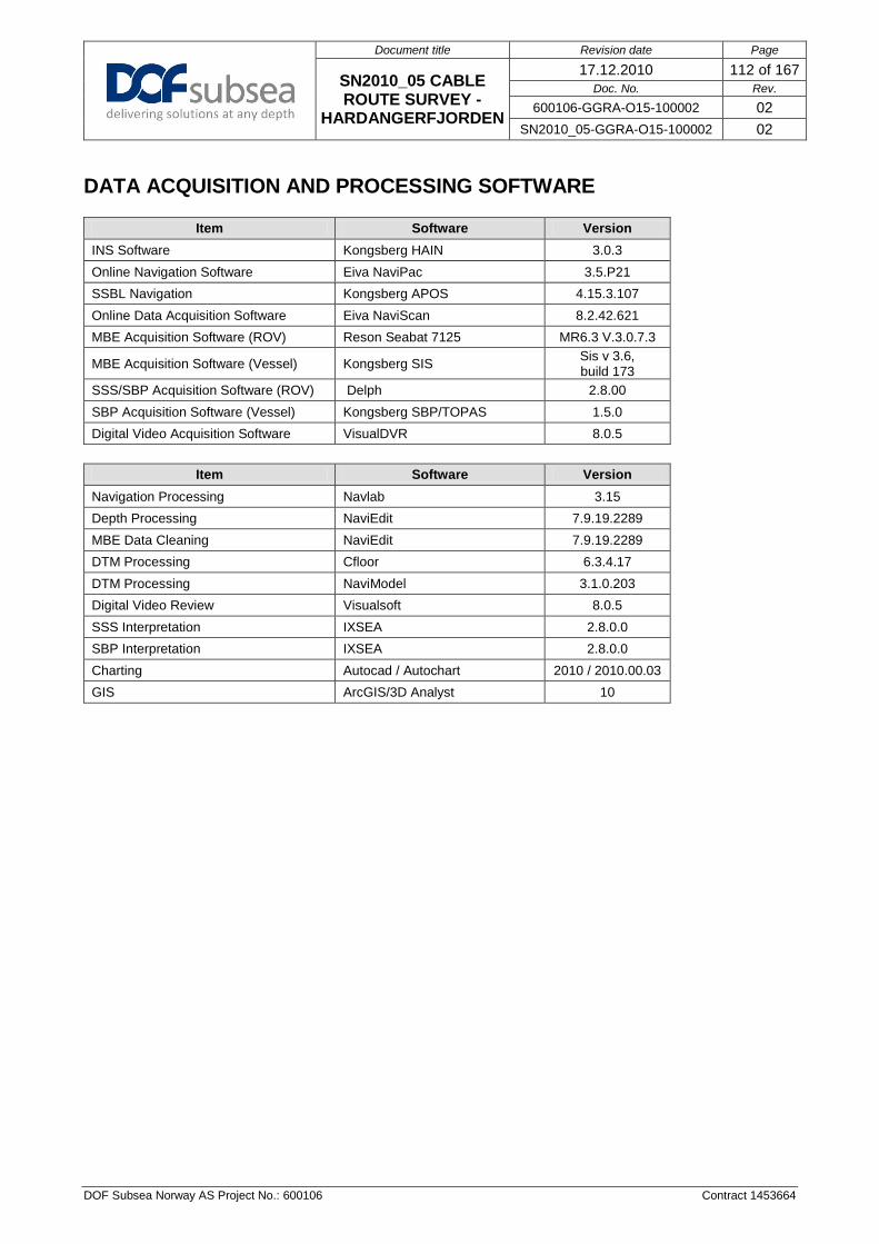
Document title Revision date Page
SN2010_05 CABLE ROUTE SURVEY -
HARDANGERFJORDEN
17.12.2010 112 of 167 Doc. No. Rev.
600106-GGRA-O15-100002 02 SN2010_05-GGRA-O15-100002 02
DOF Subsea Norway AS Project No.: 600106 Contract 1453664
DATA ACQUISITION AND PROCESSING SOFTWARE
Item Software Version INS Software Kongsberg HAIN 3.0.3 Online Navigation Software Eiva NaviPac 3.5.P21 SSBL Navigation Kongsberg APOS 4.15.3.107 Online Data Acquisition Software Eiva NaviScan 8.2.42.621 MBE Acquisition Software (ROV) Reson Seabat 7125 MR6.3 V.3.0.7.3
MBE Acquisition Software (Vessel) Kongsberg SIS Sis v 3.6, build 173
SSS/SBP Acquisition Software (ROV) Delph 2.8.00 SBP Acquisition Software (Vessel) Kongsberg SBP/TOPAS 1.5.0 Digital Video Acquisition Software VisualDVR 8.0.5
Item Software Version
Navigation Processing Navlab 3.15 Depth Processing NaviEdit 7.9.19.2289 MBE Data Cleaning NaviEdit 7.9.19.2289 DTM Processing Cfloor 6.3.4.17 DTM Processing NaviModel 3.1.0.203 Digital Video Review Visualsoft 8.0.5 SSS Interpretation IXSEA 2.8.0.0 SBP Interpretation IXSEA 2.8.0.0 Charting Autocad / Autochart 2010 / 2010.00.03 GIS ArcGIS/3D Analyst 10

Document title Revision date Page
SN2010_05 CABLE ROUTE SURVEY - HARDANGERFJORDEN
17.12.2010 113 of 167 Doc. No. Rev.
600106-GGRA-O15-100002 02 SN2010_05-GGRA-O15-100002 02
DOF Subsea Norway AS Project No.: 600106 Contract 1453664
CTD SUMMARY
Date Time Product / Location KP Easting Northing Water
Depth SV at 10m (m/s)
SV at seabed (m/s)
Average SV
(m/s)
Temp at seabed
(ºC)
Cond. at
seabed
Density at seabed (Kg/m3)
Average density (Kg/m3)
Gravity at seabed
24/10/2010 08:47 na xxx.xx 123456.78 1234567.9 6 0.00 1491.63 1475.06 11.74 35.634 1019.16202 1017.88335 9.81940449
26/10/2010 12:04 na xxx.xx 123456.78 1234567.9 15 1492.19 1492.78 1490.84 11.92 36.46 1023.26053 1022.69233 9.81940449
28/10/2010 00:14 Bunnpunkt Valeport 32374 xxx.xx 623983 6703412 217 1492.25 1485.54 1486.94 7.92 36.316 1027.1227 1025.90949 9.81940449
28/10/2010 00:13 Bunnpunkt Valeport 32376 xxx.xx 623984 6703414 216 1492.21 1485.30 1486.76 7.92 36.254 1027.06365 1025.85281 9.81940449
28/10/2010 00:15 Bunnpunkt SAIV 304 xxx.xx 623985 6703414 215 1492.02 1485.61 1487.07 7.92 36.17 1026.99147 1025.77615 9.81940449
28/10/2010 08:10 EM710 Cal 0.000 624670 6702169 339 1492.97 1487.56 1486.80 7.88 36.21 1027.55319 1026.36422 9.81940449
28/10/2010 08:09 EM710 Cal 0.000 624670 6702169 341 1493.06 1487.22 1486.53 7.89 36.296 1027.65269 1026.47574 9.81940449
29/10/2010 01:11 Hardangerfjorden used 56.500 352719 6693920 605 1486.29 1490.08 1486.64 7.43 36.128 1028.56595 1027.02466 9.81944351
29/10/2010 01:11 Hardangerfjorden 56.500 352719 6693129 605 1486.46 1489.81 1486.41 7.43 36.074 1028.52393 1027.01168 9.81944351
29/10/2010 01:12 Hardangerfjorden 56.500 352719 6693129 601 1484.70 1490.28 1486.52 7.42 36.02 1028.41823 1026.88195 9.81944351
29/10/2010 17:35 Hardangerfjorden used 57.000 348297 6690728 837 1484.20 1493.79 1488.07 7.41 36.218 1029.18219 1027.54402 9.81942791
29/10/2010 17:36 Hardangerfjorden 57.000 348297 6690728 837 1484.10 1493.49 1487.83 7.41 36.236 1029.15406 1027.51688 9.81942791
29/10/2010 17:37 Hardangerfjorden 57.000 348297 6690728 832 1484.13 1494.09 1488.41 7.40 36.15 1029.1698 1027.50489 9.81942791
30/10/2010 05:33 Hardangerfjorden used Area 8 345535 6686838 829 1483.93 1494.12 1488.32 7.40 36.22 1029.08037 1027.39564 9.81939668
30/10/2010 05:26 Hardangerfjorden Area 8 345535 6686838 834 1483.72 1493.73 1488.08 7.41 36.206 1029.15314 1027.46422 9.81939668
30/10/2010 05:27 Hardangerfjorden Area 8 345535 6686838 834 1483.60 1493.44 1487.83 7.41 36.158 1029.1156 1027.4355 9.81939668
30/10/2010 18:28 Hardangerfjorden Area 2 351833 6693931 832 1482.41 1493.43 1487.77 7.42 36.176 1029.08769 1027.3066 9.81944351
30/10/2010 18:27 Hardangerfjorden used Area 2 351833 6693931 832 1482.42 1493.74 1488.02 7.42 36.23 1029.13002 1027.33961 9.81944351
30/10/2010 18:29 Hardangerfjorden Area 2 351833 6693931 827 1482.17 1493.91 1488.17 7.41 36.07 1028.96999 1027.14893 9.81944351
31/10/2010 08:25 Hardangerfjorden used 6.500 360710 6700693 806 1486.53 1493.10 1487.71 7.44 36.186 1029.01959 1027.24774 9.81949807
31/10/2010 08:26 Hardangerfjorden 6.500 360710 6700693 807 1485.49 1493.40 1487.95 7.44 36.224 1029.04266 1027.24888 9.81949807
31/10/2010 08:25 Hardangerfjorden 6.500 360710 6700693 802 1486.38 1493.63 1488.13 7.43 36.11 1028.93613 1027.15402 9.81949807
31/10/2010 20:41 Hardangerfjorden Area4 368049 6703266 747 1481.95 1492.52 1487.62 7.46 36.224 1028.87463 1027.10676 9.81949807
31/10/2010 20:42 Hardangerfjorden Area4 123456 1234567 741 1481.45 1492.72 1487.75 7.46 36.11 1028.74276 1026.93411 9.81949807

Document title Revision date Page
SN2010_05 CABLE ROUTE SURVEY - HARDANGERFJORDEN
17.12.2010 114 of 167 Doc. No. Rev.
600106-GGRA-O15-100002 02 SN2010_05-GGRA-O15-100002 02
DOF Subsea Norway Project No.: 600106 Contract 1453664
Date Time Product / Location KP Easting Northing Water
Depth SV at 10m (m/s)
SV at seabed (m/s)
Average SV
(m/s)
Temp at seabed
(ºC)
Cond. at
seabed
Density at seabed (Kg/m3)
Average density (Kg/m3)
Gravity at seabed
01/11/2010 06:16 Hardangerfjorden used Area4 367090 6703695 777 1479.27 1492.92 1487.83 7.44 36.22 1028.93952 1027.10207 9.81952143
02/11/2010 06:04 Hardangerfjorden used Area4/3 366847 6703990 782 1482.16 1493.00 1487.88 7.44 36.228 1028.96036 1027.11805 9.81952143
02/11/2010 10:06 area 4 373949 6699951 702 1481.60 1491.75 1487.38 7.45 36.212 1028.74314 1026.91093 9.81952143
02/11/2010 12:39 Hardangerfjorden used xxx.xx 394476 6706679 72 1486.19 1485.60 1490.60 8.68 36.666 1024.422 1022.38733 9.81954478
02/11/2010 17:29 Hardangerfjorden Area 8 394379 6706716 94 1486.10 1484.08 1488.74 8.17 36.362 1025.12512 1022.83848 9.81954478
02/11/2010 17:30 Hardangerfjorden used Area 8 394379 6706716 95 1486.41 1484.33 1488.80 8.16 36.432 1025.11939 1022.61523 9.81954478
03/11/2010 06:39 Hardangerfjorden used 3.400 388029 6707307 399 1487.64 1486.55 1485.94 7.45 36.034 1027.73711 1025.94325 9.81955256
02/11/2010 06:39 Hardangerfjorden 3.400 388029 6707307 399 1487.72 1486.81 1486.15 7.45 36.088 1027.78159 1025.98038 9.81955256
02/11/2010 18:46 Hardangerfjorden used Area 5 375642 6702238 599 1482.65 1490.07 1486.84 7.45 36.18 1028.42857 1026.55779 9.81951365
02/11/2010 18:47 Hardangerfjorden area 5 123456 1234567 599 1482.66 1489.79 1486.60 7.45 36.13 1028.38835 1026.52117 9.81951365
04/11/2010 05:58 Hardangerfjorden used 8.300 393487 6706010 235 1472.47 1484.61 1485.52 7.63 36.144 1026.66944 1024.15356 9.81954478
04/11/2010 07:56 ROV Cal, not used 0.000 394429 6706866 97 1472.23 1484.68 1487.15 8.17 36.36 1024.37746 1021.37246 9.81954478
04/11/2010 18:20 Hardangerfjorden used Area 6 383864 6706412 421 1478.17 1487.13 1485.86 7.44 36.06 1027.75538 1025.69089 9.81954478
04/11/2010 18:20 Hardangerfjorden Area 6 383864 6706412 421 1478.08 1486.87 1485.65 7.44 36.032 1027.73965 1025.70264 9.81954478
04/11/2010 18:27 Hardangerfjorden Area 6 383864 6706412 432 1470.38 1487.66 1485.97 7.43 36.09 1027.71209 1025.44692 9.81954478
05/11/2010 06:17 Hardangerfjorden used 0.000 385820 6706725 414 1474.34 1486.74 1485.59 7.43 36.032 1027.71136 1025.6411 9.81954478
05/11/2010 06:17 Hardangerfjorden 0.000 385820 6706725 415 1474.53 1487.02 1485.81 7.44 36.06 1027.72944 1025.64279 9.81954478
05/11/2010 15:39 Hardangerfjorden 0.000 394050 6706264 164 0.00 1484.25 1487.70 7.68 36.16 1026.08684 1024.01235 9.81954478
05/11/2010 17:28 Hardangerfjorden 0.000 394049 6706264 164 0.00 1484.27 1487.09 7.70 36.18 1025.89935 1023.23994 9.81954478
06/11/2010 02:05 Hardangerfjorden used Eiknes 16 0.747 394175 6706309 127 1481.20 1484.57 1488.09 7.97 36.32 1025.27722 1022.50844 9.81954478
06/11/2010 04:32 Hardangerfjorden used Eiknes 14 -0.080 393338 6705917 195 1476.15 1484.54 1487.04 7.62 36.17 1026.28876 1023.76057 9.81954478
07/11/2010 10:08 Hardnagerfjorden used Eilnes 14 0.000 393318 6705937 197 1485.08 1484.61 1485.74 7.63 36.2 1026.58669 1024.2109 9.81954478
07/11/2010 14:29 OK 0.000 394453 6706693 89 1482.37 1485.59 1490.03 8.41 36.54 1024.22888 1021.28515 9.81954478
08/11/2010 01:14 Hardangerfjorden used Eiknes 7 0.650 393657 6706625 237 1478.80 1485.25 1486.19 7.62 36.2 1026.76709 1024.35315 9.81954478
08/11/2010 19:34 Hardangerfjorden used Vallavik 0.000 381160 6706636 467 1489.23 1488.26 1486.57 7.42 36.13 1028.04552 1026.17427 9.81954478
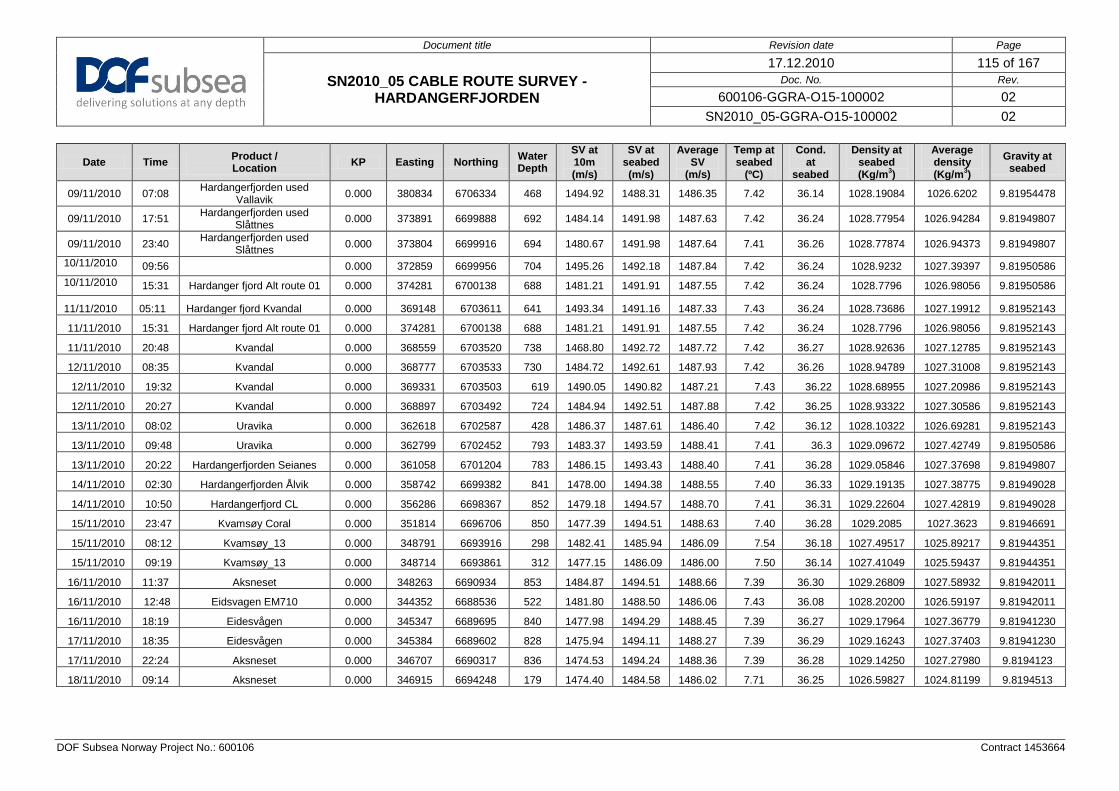
Document title Revision date Page
SN2010_05 CABLE ROUTE SURVEY - HARDANGERFJORDEN
17.12.2010 115 of 167 Doc. No. Rev.
600106-GGRA-O15-100002 02 SN2010_05-GGRA-O15-100002 02
DOF Subsea Norway Project No.: 600106 Contract 1453664
Date Time Product / Location KP Easting Northing Water
Depth SV at 10m (m/s)
SV at seabed (m/s)
Average SV
(m/s)
Temp at seabed
(ºC)
Cond. at
seabed
Density at seabed (Kg/m3)
Average density (Kg/m3)
Gravity at seabed
09/11/2010 07:08 Hardangerfjorden used Vallavik 0.000 380834 6706334 468 1494.92 1488.31 1486.35 7.42 36.14 1028.19084 1026.6202 9.81954478
09/11/2010 17:51 Hardangerfjorden used Slåttnes 0.000 373891 6699888 692 1484.14 1491.98 1487.63 7.42 36.24 1028.77954 1026.94284 9.81949807
09/11/2010 23:40 Hardangerfjorden used Slåttnes 0.000 373804 6699916 694 1480.67 1491.98 1487.64 7.41 36.26 1028.77874 1026.94373 9.81949807
10/11/2010 09:56 0.000 372859 6699956 704 1495.26 1492.18 1487.84 7.42 36.24 1028.9232 1027.39397 9.81950586 10/11/2010 15:31 Hardanger fjord Alt route 01 0.000 374281 6700138 688 1481.21 1491.91 1487.55 7.42 36.24 1028.7796 1026.98056 9.81950586
11/11/2010 05:11 Hardanger fjord Kvandal 0.000 369148 6703611 641 1493.34 1491.16 1487.33 7.43 36.24 1028.73686 1027.19912 9.81952143
11/11/2010 15:31 Hardanger fjord Alt route 01 0.000 374281 6700138 688 1481.21 1491.91 1487.55 7.42 36.24 1028.7796 1026.98056 9.81952143
11/11/2010 20:48 Kvandal 0.000 368559 6703520 738 1468.80 1492.72 1487.72 7.42 36.27 1028.92636 1027.12785 9.81952143
12/11/2010 08:35 Kvandal 0.000 368777 6703533 730 1484.72 1492.61 1487.93 7.42 36.26 1028.94789 1027.31008 9.81952143
12/11/2010 19:32 Kvandal 0.000 369331 6703503 619 1490.05 1490.82 1487.21 7.43 36.22 1028.68955 1027.20986 9.81952143
12/11/2010 20:27 Kvandal 0.000 368897 6703492 724 1484.94 1492.51 1487.88 7.42 36.25 1028.93322 1027.30586 9.81952143
13/11/2010 08:02 Uravika 0.000 362618 6702587 428 1486.37 1487.61 1486.40 7.42 36.12 1028.10322 1026.69281 9.81952143
13/11/2010 09:48 Uravika 0.000 362799 6702452 793 1483.37 1493.59 1488.41 7.41 36.3 1029.09672 1027.42749 9.81950586
13/11/2010 20:22 Hardangerfjorden Seianes 0.000 361058 6701204 783 1486.15 1493.43 1488.40 7.41 36.28 1029.05846 1027.37698 9.81949807
14/11/2010 02:30 Hardangerfjorden Ålvik 0.000 358742 6699382 841 1478.00 1494.38 1488.55 7.40 36.33 1029.19135 1027.38775 9.81949028
14/11/2010 10:50 Hardangerfjord CL 0.000 356286 6698367 852 1479.18 1494.57 1488.70 7.41 36.31 1029.22604 1027.42819 9.81949028
15/11/2010 23:47 Kvamsøy Coral 0.000 351814 6696706 850 1477.39 1494.51 1488.63 7.40 36.28 1029.2085 1027.3623 9.81946691
15/11/2010 08:12 Kvamsøy_13 0.000 348791 6693916 298 1482.41 1485.94 1486.09 7.54 36.18 1027.49517 1025.89217 9.81944351
15/11/2010 09:19 Kvamsøy_13 0.000 348714 6693861 312 1477.15 1486.09 1486.00 7.50 36.14 1027.41049 1025.59437 9.81944351
16/11/2010 11:37 Aksneset 0.000 348263 6690934 853 1484.87 1494.51 1488.66 7.39 36.30 1029.26809 1027.58932 9.81942011
16/11/2010 12:48 Eidsvagen EM710 0.000 344352 6688536 522 1481.80 1488.50 1486.06 7.43 36.08 1028.20200 1026.59197 9.81942011
16/11/2010 18:19 Eidesvågen 0.000 345347 6689695 840 1477.98 1494.29 1488.45 7.39 36.27 1029.17964 1027.36779 9.81941230
17/11/2010 18:35 Eidesvågen 0.000 345384 6689602 828 1475.94 1494.11 1488.27 7.39 36.29 1029.16243 1027.37403 9.81941230
17/11/2010 22:24 Aksneset 0.000 346707 6690317 836 1474.53 1494.24 1488.36 7.39 36.28 1029.14250 1027.27980 9.8194123
18/11/2010 09:14 Aksneset 0.000 346915 6694248 179 1474.40 1484.58 1486.02 7.71 36.25 1026.59827 1024.81199 9.8194513

Document title Revision date Page
SN2010_05 CABLE ROUTE SURVEY -
HARDANGERFJORDEN
17.12.2010 116 of 167 Doc. No. Rev.
600106-GGRA-O15-100002 02 SN2010_05-GGRA-O15-100002 02
DOF Subsea Norway AS Project No.: 600106 Contract 1453664
VESSEL OFFSET DIAGRAM
On Monday 29th October 2007 the SV Geograph was put into dry dock in Horten, Norway. Between the 29st October and 17th November the vessel was dimensional controlled. Further verifications were conducted in December 2007 after the vessel had left the dry dock. Reference to dimensional control Report: SUR-GGRA-O15-100001-07 Geograph Dimensional Control Survey Report.pdf Survey Accuracies The Leica TC1800 total station can measure to an accuracy of 1”. The accuracy concerning position of a point is +/- 2mm.
Summary of Results from the dimensional Report SV Geograph. SV Geograph Datum’s: -Horizontal: The CRP -Vertical: The CRP -Orientation: Forward has been defined as a line from centre of the stern to the centre of the bow. -Pitch Convention: Positive pitch is BOW UP -Roll Convention: Positive roll is PORT UP -Coordinate Frame: Positive X is towards the STARBOARD Positive Y is towards BOW Positive Z is UP Antenna Offsets. X (m) Y (m) Z (m) HP AE (AD492 antenna) -0.349 8.065 21.769 XP AE (AD492 antenna) -0.749 8.064 21.769 Seapath AE Port -1.450 8.055 21.757 Seapath AE Stbd 1.551 8.059 21.748 Spotbeam Antenna 1.411 8.621 21.744 MX MARINE No1 0.850 8.059 21.783 MX MARINE No2 0.452 8.062 21.788 SAT C No1 Antenna 0.053 8.029 22.092 SAT C No2 Antenna 0.047 8.644 22.410 GPS MX421 -0.940 8.742 21.752 SV Geograph HiPAP Offsets X (m) Y (m) Z (m) Description
-3.291 -0.608 -6.356 Port HiPAP Centre of Hole - Hull Underside -3.306 -0.608 -9.020 Port HiPAP Pole Fully deployed - Centre of Head 3.332 -0.602 -6.387 Stbd HiPAP Centre of Hole - Hull Underside 3.329 -0.614 -9.029 Stbd HiPAP Pole Fully deployed - Centre of Head 4.476 -1.203 -6.316 Hugin HiPAP Centre of Hole - Hull Underside

Document title Revision date Page
SN2010_05 CABLE ROUTE SURVEY -
HARDANGERFJORDEN
17.12.2010 117 of 167 Doc. No. Rev.
600106-GGRA-O15-100002 02 SN2010_05-GGRA-O15-100002 02
DOF Subsea Norway AS Project No.: 600106 Contract 1453664
SV Geograph MRU Offsets & Heading
X (m) Y (m) Z (m) Yaw (°)
Description
DP MRU5 -0.165 0.296 0.290 0.265 MRU5 top of centre MRU unit – Level arms reference point
Seapath MRU5 0.096 0.297 0.290 0.265 Seapath MRU5 top of centre MRU unit – Level arms reference point
SV Geograph Echosounders Offsets X (m) Y (m) Z (m) Description TX EM 122 Centre 0.005 11.430 -7.676 Intersection of four corners RX EM 122 Centre 0.008 7.089 -7.797 Intersection of four corners TX EM 710 Centre -1.593 9.120 -7.743 Intersection of four corners RX EM 710 Centre -1.248 7.642 -7.789 Intersection of four corners
SV Geograph Underside Blisters fitted with EM122/Em710 & SBP120
NOTE! Seen from below.
FWD

Document title Revision date Page
SN2010_05 CABLE ROUTE SURVEY -
HARDANGERFJORDEN
17.12.2010 118 of 167 Doc. No. Rev.
600106-GGRA-O15-100002 02 SN2010_05-GGRA-O15-100002 02
DOF Subsea Norway AS Project No.: 600106 Contract 1453664
EQUIPMENT SPECIFICATION
Operating
Range Horizontal Beam
Width Resolution along
Track Resolution across
track Edgetech 4200 SSS 100kHZ 500m 0.64° 2.5m at 200m 8cm Edgetech 4200 SSS 400kHZ 150m 0.3° 0.5m at 100m 2cm Edgetech ROV SBP 2-16kHz
Beam Width 15° - 25°
Resolution 6-10cm
Seabat 7125 Dual head 400kHZ
Ping rate 40 Hz max
Swath coverage - Up to 140°
Depth Resolution 3mm
Beam Width 0.5°
TSS Orion Heading accuracy
0.15° Heading Resolution
0.01° RP accuracy
0.01° RP Resolution
0.01°
CDL - miniRLG2 Heading accuracy 0.169°
RP accuracy 0.028°
DQ Pressure accuracy
0.01% SAIV SD204 Temperature Pressure Conductivity Salinity Sound Velocity Range -2°C to 40°C 2000m 0-70mS/cm 0 to 40ppt 1300 to 1700m/s Accuracy 0.01°C 0.02% 0.02 mS/cm 0.02ppt 10cm/s Resolution 0.01mS/cm 0.01dBar 0.01mS/cm 0.01ppt 5cm/s EM710 70 - 100 kHz
Ping Rate 30 Hz max
Swath coverage - Up to 130°
Depth Resolution 1cm
Beam width 0.5°
Valeport miniSVS Pressure SV Accuracy 0.1% of range 0.03m/s Resolution 0.001% of range 0.001m/s Aanderaa WLR Temperature Pressure Conductivity Range -3°C - 35°C 0-700kPa 0-77mmho/cm Accuracy 0.1°C 0.02% of range 0.25 mmho/cm Resolution 0.04°C 0.001% of range 0.1% of range

Document title Revision date Page
SN2010_05 CABLE ROUTE SURVEY -
HARDANGERFJORDEN
17.12.2010 119 of 167 Doc. No. Rev.
600106-GGRA-O15-100002 02 SN2010_05-GGRA-O15-100002 02
DOF Subsea Norway AS Project No.: 600106 Contract 1453664
Appendix B: ROV event lists
Please see SN2010_05_Hardangerfjorden_WGS84_LL_FEATURES_20101018.gdb

Document title Revision date Page
SN2010_05 CABLE ROUTE SURVEY -
HARDANGERFJORDEN
17.12.2010 120 of 167 Doc. No. Rev.
600106-GGRA-O15-100002 02 SN2010_05-GGRA-O15-100002 02
DOF Subsea Norway AS Project No.: 600106 Contract 1453664
Appendix C: Diary of Events

Document title Revision date Page
SN2010_05 CABLE ROUTE SURVEY -
HARDANGERFJORDEN
17.12.2010 121 of 167 Doc. No. Rev.
600106-GGRA-O15-100002 02 SN2010_05-GGRA-O15-100002 02
DOF Subsea Norway AS Project No.: 600106 Contract 1453664
The following logs are extracted from the Daily Progress Reports. All times are in UTC
UTC Time Operations 22.10.2010 Start End Remarks Start KP End KP 12:00 24:00 Mobilisation. DSN personnel arriving onboard
UTC Time Operations 23.10.2010
Start End Remarks Start KP End KP
00:00 24:00 Mobilisation
UTC Time Operations 24.10.2010 Start End Remarks Start KP End KP
00:00 24:00
Mobilisation ongoing, Verification of Draft sensor, SVP/CTD, Seapath, Dimcon ROV frame, making brackets for survey sensors and assembling equipment on ROV
UTC Time Operations 25.10.2010 Start End Remarks Start KP End KP
00:00 24:00
Mobilisation ongoing, Gyro calibration, JAVAD split NTAG, Barometer verification, ROV making brackets and assemble survey sensors
UTC Time Operations 26.10.2010 Start End Remarks Start KP End KP
00:00 24:00
Mobilising. Stby for permission to depart Byfjorden for HiPAP and EM710 calibration/verfication. ROV assembling/testing survey sensors
UTC Time Operations 27.10.2010 Start End Remarks Start KP End KP
00:00 20:30 Mobilisation cont. Preparations for Statnett project while waiting for permission to leave quay for calibrations/verifications at "Bunnmerket"
20:30 23:00 Mobilisation cont. Bunkering 23:00 23:30 Mobilisation cont. Stby for Additional personnel
23:30 23:34 Mobilisation cont. Additional crew arriving with Cypros accepted Seamans books to allow vessel to depart
23:34 24:00 Mobilisation cont. Relocating to Bunnmerket.
UTC Time Operations 28.10.2010 Start End Remarks Start KP End KP
00:00 00:50 SVP Sensors on deck 00:50 01:25 Processing data
01:25 02:10 Problems with HiPAP & transponders at bunnpunktet. Restarting transducers.
02:10 02:40 Restarting APOS

Document title Revision date Page
SN2010_05 CABLE ROUTE SURVEY -
HARDANGERFJORDEN
17.12.2010 122 of 167 Doc. No. Rev.
600106-GGRA-O15-100002 02 SN2010_05-GGRA-O15-100002 02
DOF Subsea Norway AS Project No.: 600106 Contract 1453664
UTC Time Operations 28.10.2010 Start End Remarks Start KP End KP 02:40 03:10 Testing DGPS - HP corrections dropping out at easterly course 03:10 03:44 DGPS ok with vessel heading north and east 03:44 04:46 Setting up to do EM710 verification lines 04:46 07:34 Running lines 1 to and including 7 07:34 08:00 CTD using crane
08:00 09:08 Vessel relocate back to "bunnpunktet". Mob boat transferring Fugro service eng to modify DGPS correction system
09:08 10:30 Resetting HiPAP transducers and APOS'es.Port HiPAP pole transducer not responding. No replay from transponder B35
10:30 11:23 DGPS testing and modifications 11:23 13:09 Logging DGPS different headings 13:09 15:10 HiPAP alignment values entered 15:10 16:05 Continue DGPS diff checks 16:05 18:15 HiPAP verification 18:15 24:00 Transit to Hardangerfjorden
UTC Time Operations 29.10.2010 Start End Remarks Start KP End KP 00:00 01:00 Continue Transit to Hardangerfjorden 01:00 01:15 On Hire (03:00 Local time) - Setting up on location 01:15 02:02 Obtainging SVP and update in EM710 02:02 02:17 Setting up to start Survey Area 1 02:17 03:47 Survey line 001 03:47 03:54 Setting up next line 03:54 05:17 Survey line 002 05:17 05:29 Setting up next line 05:29 06:58 Survey line 003 06:58 06:58 Continuing next line 06:58 08:24 Survey line -1050 08:24 08:35 Setting up next line 08:35 09:43 Survey line -1400 09:43 09:53 Setting up next line 09:53 11:04 Survey line -1750 11:04 11:14 Setting up next line 11:14 12:39 Survey line -2100 12:39 12:42 Setting up next line 12:42 13:46 Survey line -2450 13:46 13:57 Setting up next line 13:57 15:05 Survey line -2800 15:05 15:08 Setting up next line 15:08 15:49 Survey line -3150 15:49 15:59 Setting up next line 15:59 16:38 Survey line -3500 16:38 16:45 Setting up next line 16:45 17:20 Survey line -3850 17:20 17:36 Relocate and setting up to do CTD

Document title Revision date Page
SN2010_05 CABLE ROUTE SURVEY -
HARDANGERFJORDEN
17.12.2010 123 of 167 Doc. No. Rev.
600106-GGRA-O15-100002 02 SN2010_05-GGRA-O15-100002 02
DOF Subsea Norway AS Project No.: 600106 Contract 1453664
UTC Time Operations 29.10.2010 Start End Remarks Start KP End KP 17:36 18:20 CTD sensor On deck
18:20 18:40 Downloading data from CTD to EM710 and relocating vessel to start location next line
18:40 18:54 Uploading data 18:54 19:23 Survey infill 4 19:23 19:30 Setting up for next infill 19:30 19:56 Survey infill 5 19:56 20:20 Setting up for next infill 20:20 21:22 Survey infill 6 21:22 21:26 Setting up for next infill 21:26 22:31 Survey infill 7 22:31 22:33 Setting up for Suvey Area 8 22:33 24:00 Survey centre line
UTC Time Operations 30.10.2010 Start End Remarks Start KP End KP 00:00 00:31 Continuing Survey Area 8 Centre line O 00:31 00:38 Setting up next line O 00:38 02:26 Survey line +350 O 02:26 02:36 Setting up next line O 02:36 04:36 Survey line -350 O 04:36 04:42 Setting up next line O 04:42 05:31 Survey line -700 O 05:31 05:45 Pause survey to do CTD. Relocating to deeper water O 05:45 06:18 Launch and recover CTD sensor using vessel crane O 06:18 06:46 Download data and set up for next line O 06:46 07:44 Continue Survey Area 8 Line -700 O 07:44 07:44 Continue Area 1 Line West O 07:44 08:59 Survey Area 1 Line West O 08:59 08:59 Continue Area 1 infill 1 O 08:59 09:37 Survey Area 1 infill 1 O 09:37 09:52 Setting up for infill 2 O 09:52 10:32 Survey Area 1 infill 2 O 10:32 11:00 Continue Area 1 infill3 O 11:00 11:14 Setting up Area 1 infill 2 +60 O 11:14 11:42 Survey Area 1 infill 2 +60 O 11:42 11:55 Survey Area 1 infill 4 O 11:55 12:04 Survey Area 1 infill 5 O 12:04 12:58 Survey Area 1 infill 2 -60 O 12:58 13:06 Setting up Area 1 west +60 O 13:06 13:20 Survey Area 1 west +60 O 13:20 13:27 Setting up Area 1 infill 3 -90 O 13:27 13:38 Survey Area 1 infill 3 -90 O 13:38 13:52 Setting up Area 1 line west O 13:52 14:00 Survey Area 1 infill 3 -90 O

Document title Revision date Page
SN2010_05 CABLE ROUTE SURVEY -
HARDANGERFJORDEN
17.12.2010 124 of 167 Doc. No. Rev.
600106-GGRA-O15-100002 02 SN2010_05-GGRA-O15-100002 02
DOF Subsea Norway AS Project No.: 600106 Contract 1453664
UTC Time Operations 30.10.2010 Start End Remarks Start KP End KP 14:00 14:21 Setting up Area 8 +700 O 14:21 15:08 Survey Area 8 +700 O 15:08 15:26 Setting up Area 8 +700(b) O 15:26 15:57 Survey Area 8 +700(B) O 15:57 16:16 Setting up Area 8 +1050 O 16:16 16:56 Survey Area 8 +1050 O 16:56 17:04 Setting up Area 8 +1050 infill O 17:04 17:37 Survey Area 8 +1050 infill O 17:37 17:45 Setting up Area 8 +700 infill O 17:45 17:57 Survey Area 8 +700 infill O 17:57 18:25 Relocating to deeper water CTD position O
18:25 18:59 Launch and recover CTD sensor using vessel crane. ROV test dive in parallel O
18:59 19:26 Download data. ROV Test dive in parallel O 19:26 19:38 ROV Test Dive recovering M
19:38 19:51 Relocation to next line and setting up (on mobilisation time as relocation could have been done while downloading CTD data M
19:51 21:32 Survey Area 2 -1400 O 21:32 21:40 Setting up Area 2 -1050 O 21:40 23:18 Survey Area 2 -1050 O 23:18 23:24 Setting up for survey Area 2 -700 O 23:24 24:00 Survey Area 2 -700 O
UTC Time Operations 31.10.2010 Start End Remarks Start KP End KP 00:00 00:53 Survey Area2 -700 00:53 01:00 Setting up for survey Area 2 -350 01:00 02:17 Survey Area2 -350 02:17 02:24 HP Dropout 02:24 02:31 Setting up for survey Area 2 North - South line 02:31 03:48 Survey Area 2 North - South line 03:48 04:04 Setting up for survey Area 3 North - South line 04:04 06:52 Survey Area 3 North - South line 06:52 07:02 Setting up for survey Area 3 -350 07:02 08:29 Survey Area 3 -350 08:29 08:39 Pause survey to do CTD 08:39 09:15 Obtain CTD and dowload/upload data to EM710 09:15 09:31 Setting up to continue survey Area 3 -350 09:31 11:02 Continue Survey Area 3 -350 11:02 11:16 Setting up for survey Area 3 -700 11:16 14:09 Survey Area 3 -700 14:09 14:20 Setting up for survey Area 3 -1050 14:20 17:24 Survey Area 3 -1050 17:24 17:29 Setting up for survey Area 3 -1400 17:29 20:33 Survey Area 3 -1400 20:33 20:45 Pause survey to do CTD

Document title Revision date Page
SN2010_05 CABLE ROUTE SURVEY -
HARDANGERFJORDEN
17.12.2010 125 of 167 Doc. No. Rev.
600106-GGRA-O15-100002 02 SN2010_05-GGRA-O15-100002 02
DOF Subsea Norway AS Project No.: 600106 Contract 1453664
UTC Time Operations 31.10.2010 Start End Remarks Start KP End KP 20:45 21:21 Obtain CTD and dowload/upload data to EM710 21:21 21:29 Setting up for survey Area 4 +1400 21:29 23:12 Survey Area 4 +1400 23:12 23:17 Setting up for survey Area 4 +2100 23:17 23:44 Survey Area 4 +2100 23:44 24:00 Setting up for Area 4 +1750
UTC Time Operations 1.11.2010 Start End Remarks Start KP End KP
00:00 00:12 Continue Setting up for Area 4 +1750
00:12 02:08 Survey Area 4 +1750
02:08 02:22 Setting up for Area 4 +1050
02:22 04:15 Survey Area 4 +1050
04:15 04:21 Setting up for Area 4 +700
04:21 06:06 Survey Area 4 +700
06:06 06:22 Pause survey to do CTD
06:22 06:58 Obtain CTD and dowload/upload data to EM710
06:58 07:11 Setting up for Area 3 -1750
07:11 09:52 Survey Area 3 -1750
09:52 10:14 Setting up for Area 3 -2450
10:14 10:52 Survey Area 3 -2450. Close to shore
10:52 11:11 Setting up for close to shore lines Area 3 Ålvik
11:11 12:06 Survey Area 3 close to shore lines Ålvik
12:06 12:17 Setting up for Area 3 Ålvik +350
12:17 12:47 Survey Area 3 Ålvik +350
12:47 13:01 Setting up for Area 3 Ålvik +110
13:01 13:28 Survey Area 3 Ålvik +110
13:28 13:29 Setting up for Area 3 Ålvik +100
13:29 13:40 Survey Area 3 Ålvik +100
13:40 13:42 Setting up for Area 3 Ålvik +220
13:42 14:02 Survey Area 3 Ålvik +220
14:02 14:21 Setting up for Area 3 -1750 (continuing)
14:21 14:47 Survey Area 3 -1750
14:47 15:48 Relocating vessel to ROV MBE Calibration site Norheimsund
15:48 17:52 Obtaining CTD & Setting up for ROV Calibration/Verification dive
17:52 21:46 ROV test dive.Hain/Doppler/navipack probles. Fault finding and testing
21:46 22:27 ROV on deck. Relocation to survey area
22:27 24:00 Survey Area 3 -2100
UTC Time Operations 2.11.2010 Start End Remarks Start KP End KP
00:00 01:03 Survey Area 3 -2100
01:03 01:07 Setting up for Area 4 +350

Document title Revision date Page
SN2010_05 CABLE ROUTE SURVEY -
HARDANGERFJORDEN
17.12.2010 126 of 167 Doc. No. Rev.
600106-GGRA-O15-100002 02 SN2010_05-GGRA-O15-100002 02
DOF Subsea Norway AS Project No.: 600106 Contract 1453664
UTC Time Operations 2.11.2010 Start End Remarks Start KP End KP
01:07 02:58 Survey Area 4 +350. not possible to survey area close to shore safely at night time
02:58 03:03 Setting up for Area 4 Start line - SE-NW
03:03 04:38 Survey Area 4 Start line - SE-NW
04:38 04:47 Setting up for Kvandal Line S
04:47 05:09 Survey Kvandal Line S
05:09 05:17 Setting up for Kvandal Line 3
05:17 05:57 Survey Kvandal Line 3
05:57 06:15 Relocating to do CTD
06:15 07:03 Obtain CTD and dowload/upload data to EM710 & setting up to survey Kvandal line 1
07:03 07:37 Survey Area Kvandal line 1
07:37 07:46 Setting up for Kvandal Line 2
07:46 08:12 Survey Kvandal Line 2
08:12 08:14 Setting up for Kvandal Line 4
08:14 08:44 Survey Kvandal Line 4
08:44 08:49 Setting up for Kvandal Line 6
08:49 09:11 Survey Kvandal Line 6
09:11 10:06 Transit to Simadalen Area 7
10:06 12:00 CTD Area 4
12:00 12:36 Continue transit to Simadalen Area 7
12:36 13:18 Setting & obtaining CTD using vessel crane, download to EM710. Simultanous ROV test dive
13:18 13:31 ROV Recovering
13:31 13:36 Setting up for Area 7 line 1
13:36 14:26 Survey Area 7 line 1
14:26 14:27 Setting up for Area 7 line 2
14:27 15:23 Survey Area 7 line 2
15:23 15:53 Setting up for Area 7 line 1 +125
15:53 16:35 Survey Area 7 line 1 +125
16:35 17:18 Continuing Area 7 line 1 +50
17:18 17:30 Relocating to do CTD position
17:30 18:02 Obtaining CTD using vessel crane, download to EM710. Simultanous ROV test dive
18:02 21:15 ROV test - Doppler log calibration
21:15 22:18 ROV test - Doppler log verification - (need to be redone)
22:18 22:26 Setting up for Survey Area 7_1 +75
22:26 22:45 Survey Area 7_1 +75
22:45 22:50 Setting up for Survey Area 7_1 +100
22:50 23:08 Survey Area 7_1 +100
23:08 23:14 Setting up for Survey Area 7_1 +150
23:14 23:43 Survey Area 7_1 +150
23:43 23:50 Setting up for Survey Area 7 +175
23:50 24:00 Survey Area 7 +175
UTC Time Operations 3.11.2010

Document title Revision date Page
SN2010_05 CABLE ROUTE SURVEY -
HARDANGERFJORDEN
17.12.2010 127 of 167 Doc. No. Rev.
600106-GGRA-O15-100002 02 SN2010_05-GGRA-O15-100002 02
DOF Subsea Norway AS Project No.: 600106 Contract 1453664
Start End Remarks Start KP End KP
00:00 00:20 Continue Survey Area 7 +175
00:20 00:24 Setting up for Survey Area 7_1 +25
00:24 00:43 Survey Area 7_1 +25
00:43 00:49 Setting up for Survey Area 7 +200
00:49 01:09 Survey Area 7 +200
01:09 01:13 Setting up for Survey Area 7 +225
01:13 01:32 Survey Area 7 +225
01:32 01:38 Setting up for Survey Area 7 +250
01:38 01:53 Survey Area 7 +250
01:53 01:58 Setting up for Survey Area 7 Infill1
01:58 02:09 Survey Area 7 infill1
02:09 02:15 Setting up for Area 6 Centre Line East -West
02:15 04:23 Survey Area 6 Centre Line East -West
04:23 04:30 Setting up for Area 6 +350
04:30 05:52 Survey Area 6 +350
05:52 05:59 Setting up for Area 6 +700
05:59 06:35 Survey Area 6 +700
06:35 07:10 Obtain CTD and dowload/upload data to EM710
07:10 07:19 Setting up to continue survey Survey Area 6 +700
07:19 08:05 Continue survey Survey Area 6 +700
08:05 10:11 Continue survey Survey Area 5 +700
10:11 11:15 Abort survey to go to Ålvik for crew change
11:15 12:45 Planned alogside chrew change time
12:45 17:01 Stby alongside for reconfiguration of VSAT Antennae
17:01 18:40 Relocation from Ålvik to survey break off point and setting up in position
18:40 19:30 Obtain CTD and dowload/upload data to EM710. Simultanous ROV test dive
19:30 20:12 ROV Test dive
20:12 20:16 Set up to continue survey Survey Area 5 +700
20:16 21:13 Continue survey Survey Area 5 +700
21:13 21:19 Set up for Survey Area 5 +350
21:19 23:33 Survey Area 5 +350 Strong current and wind along track. Difficult to keep speed and position on track
23:33 23:44 Pause to let ferry pas
23:44 24:00 Survey Area 5 +350
UTC Time Operations 4.11.2010 Start End Remarks Start KP End KP
00:00 00:10 Setting up for Area 6 +1050
00:10 00:49 Survey Area 6 +1050
00:49 01:26 Standby for ferry to pass
01:26 01:34 Setting up for Area 6 +1050
01:34 04:32 Survey Area 6 +1050 vessel close to shore.
04:32 04:38 Setting up for Area 6 +350
04:38 05:26 Survey Area 6 +350.
05:26 05:33 Setting up for survey Area7

Document title Revision date Page
SN2010_05 CABLE ROUTE SURVEY -
HARDANGERFJORDEN
17.12.2010 128 of 167 Doc. No. Rev.
600106-GGRA-O15-100002 02 SN2010_05-GGRA-O15-100002 02
DOF Subsea Norway AS Project No.: 600106 Contract 1453664
UTC Time Operations 4.11.2010 Start End Remarks Start KP End KP
05:33 05:47 Survey Area7 Infill
05:47 06:04 Relocating and Setting up for CTD
06:04 06:30 SVP updated
06:30 07:05 Toolboks for Verification/calibration Test
07:05 07:53 Deck testing and setup of sensors
07:53 08:33 ROV Off Deck Logging ROV CTD
08:33 08:35 Setting up for DVL calibration
08:35 09:46 DVL Calibration
09:46 10:02 DVL Verification 1st run
10:02 10:17 DVL Verification 2nd run
10:17 11:03 Setting up for MBE7125 Calibration and processing DVL data
11:03 11:14 MBE Line 1
11:14 11:36 Setup and MBE Line 2
11:36 11:48 Setup and MBE Line 3
11:48 13:05 Poor GPS configuration vessel lost Seapath heading. Reset Seapath.
13:05 13:15 MBE Line 3
13:15 13:30 Setup and MBE Line 2
13:30 13:43 Setup and MBE Line 4
13:43 14:03 Setup and MBE Line 7
14:03 14:21 Setup and MBE Line 5
14:21 14:35 Setup and MBE Line 6
14:35 14:56 Setup and MBE Line 8
14:56 15:12 Setup SSS CL
15:12 15:22 SSS CL
15:22 15:25 Setup SSS CL
15:25 15:33 SSS CL
15:33 15:53 Video verification Test
15:53 16:10 ROV to TMS and recover to deck
16:10 16:34 Relocation to and setting for Area 6 +1400
16:34 18:05 Survey Area 6 +1400
18:05 18:21 Relocating to CTD position
18:21 18:55 Obtain CTD and dowload/upload data to EM710, Simultanous ROV test dive SBP
18:55 20:00 Testing SBP. Date visible in Edgetech Discover- Likely Delph software problem - ROV recovered to deck
20:00 20:24 Relocation to and setting for Area 6 +1400
20:24 23:10 Survey Area 6 +1400m
23:10 23:34 Relocating and setting up for ROV tests. SBP diagnostics
23:34 24:00 ROV test dive SBP diagnostics
UTC Time Operations 5.11.2010 Start End Remarks Start KP End KP 00:00 00:55 Continuing ROV test dive SBP diagnostics 00:55 00:58 MBE test line for Roll fine adjustment W-E 00:58 01:02 MBE test line for Roll fine adjustment E-W

Document title Revision date Page
SN2010_05 CABLE ROUTE SURVEY -
HARDANGERFJORDEN
17.12.2010 129 of 167 Doc. No. Rev.
600106-GGRA-O15-100002 02 SN2010_05-GGRA-O15-100002 02
DOF Subsea Norway AS Project No.: 600106 Contract 1453664
UTC Time Operations 5.11.2010 Start End Remarks Start KP End KP 01:02 01:56 Laser/Target Position verification
01:56 02:09 MBE verification line for Roll fine adjustment W-E 15m above seabed
02:09 02:18 MBE verification line for Roll fine adjustment E-W 15m above seabed
02:18 02:52 ROV recovering to deck 02:52 03:03 Setting up for survey Area 5 +1050
03:03 05:48 Survey Area 5 +1050 (loss of positioning -line was was later resurveyed)
05:48 06:15 Line aborted due to insufficient positioning relocating to regain navigation.
06:15 06:50 Obtaining CTD for EM710
06:50 07:03 Transit to Start point workscope Step 2 and set up at Verification line start
07:03 07:10 Starting Verification test dive 07:10 07:23 Test logging SBP 07:23 09:04 Vessel lost GPS position, Survey OK on HP. ROV to TMS 09:04 09:19 Reestablishing position in navigation system 09:19 10:03 ROV out of TMS testing MBE
10:03 11:30 Additional GPS Diff correction radio station at Nesheim, old one swithed off.
11:30 11:48 ROV recovers to investigate MBE7125 problem 11:48 12:24 ROV on deck relocating and setting up to rerun areas 6/7 gaps
12:24 13:10 Rerun Area 6/7gaps due to lost positioning/GPS coverage near shore
13:10 14:17 Relocationing to Start point Step 2 14:17 14:27 Area 6 infill area not covered previously due to water depth 14:27 14:50 Setting up on DP preparing for ROV verification test 14:50 15:36 Performing Toolbox, testing all equipment on deck
15:36 16:35 ROV Offf deck. Doing water tests of all equipment. No communication with SBP. Problem with Seabat's when attempting to transmit. Replacing MBE surface unit.
16:35 17:25 ROV on deck faultfinding/diagnostics SBP 17:25 18:00 ROV off deck, CTD & static bathy 2,5 m altitude. Testing SBP 18:00 18:11 ROV recovering SBP problem
18:11 19:12 ROV on deck. Fult identified to be SBP interface cable to ROV. Starting making/repairing cable.
19:12 19:57 Vessel moving to area 5 to do internal EM710 configuration optimalisation tests
19:57 20:10 Cable ready for testing. Vessel setting up for test 20:10 20:24 ROV off deck
20:24 21:14
ROV at 10 m altitude. SBP functions ok. DOF's geo's claim data is acceptable. Statnett claims data quality is unacceptable and noise must be removed before any further verification test are done.
21:14 21:28 ROV recovering to deck
21:28 22:42 ROV relocating cables and SBP hydrophones, Vessel doing interal EM710 optimalisation test with dataprocessors
22:42 22:42 ROV off deck for additonal SBP test. 22:42 23:26 Testing & assessing SBP data 23:26 23:33 Running SBP test line N-S

Document title Revision date Page
SN2010_05 CABLE ROUTE SURVEY -
HARDANGERFJORDEN
17.12.2010 130 of 167 Doc. No. Rev.
600106-GGRA-O15-100002 02 SN2010_05-GGRA-O15-100002 02
DOF Subsea Norway AS Project No.: 600106 Contract 1453664
UTC Time Operations 5.11.2010 Start End Remarks Start KP End KP 23:33 23:55 Running SBP test line S-N 23:55 24:00 Assessing SBP data
UTC Time Operations 6.11.2010 Start End Remarks Start KP End KP 00:00 00:13 Assessing SBP data 00:13 00:35 SBP test line N-S 0,7 kts 18-20m altitude 00:35 00:57 Recovering ROV and assessing data.
00:57 02:02 Trying more modification shielding of cables and hydrophones while relocating to Eiknes area verification site.
02:02 02:46 ROV off deck CTD downcast & Static bathy 02:46 03:08 SOL Eiknes_16 Survey Verification 03:08 03:14 EOL Bridge lost GPS moving back and restarting 03:14 03:30 SOL Eiknes_16 Survey Verification 18 m altitude 1 kts SW-NE 03:30 03:53 EOL Verification. Relocating to Eiknes_14 SOL 03:53 04:30 Relocating vessel and setting up in position 04:30 04:32 Launching ROV Start Step 2. Logged in time group E. 04:32 04:49 ROV off deck CTD downcast 04:49 04:55 SOL Static bathy 04:55 05:10 Running up Hain 05:10 05:35 Setting up Vessel & ROV for SOL 05:35 06:08 SOL Eiknes 14. Aborted Digiquartz problem 06:08 06:21 SOL Eiknes 14. 06:21 06:33 Restarting Hain. Overlapping 06:33 08:06 Continue Eiknes 14. 08:06 08:33 Setting up Vessel & ROV for Eiknes 15 08:33 09:34 SOL Eiknes 15 09:34 09:52 Aborted due to SSS problem. Restarting & overlapping 09:52 10:45 Continue Eiknes 15 10:45 11:15 Setting up Vessel & ROV for Eiknes 16 11:15 11:40 SOL Eiknes 16 11:40 11:49 EOL due to shallow area - ROV altitude/depth. Reconfiguring 11:49 12:51 Continue Eiknes 16 12:51 13:17 Setting up Vessel & ROV for Eiknes 17 13:17 14:19 SOL Eiknes 17 14:19 14:40 Setting up Vessel & ROV for Eiknes 19 14:40 15:02 SOL Eiknes 19
15:02 15:39 Stop logging. Dead ROV/TMS. Assessing situation moving vessel to safe position.
15:39 16:28 Toolbox talk on the bridge for emergency recovery.
16:28 16:30 ROV Crew manage to re-establish communication with ROV by bypassing fiber in slipring
16:30 17:18 ROV in TMS.
17:18 17:29 Starting normal recovery to deck. Emergency recovery not required.
17:29 18:11 ROV on deck. Repairs ongoing

Document title Revision date Page
SN2010_05 CABLE ROUTE SURVEY -
HARDANGERFJORDEN
17.12.2010 131 of 167 Doc. No. Rev.
600106-GGRA-O15-100002 02 SN2010_05-GGRA-O15-100002 02
DOF Subsea Norway AS Project No.: 600106 Contract 1453664
UTC Time Operations 6.11.2010 Start End Remarks Start KP End KP
18:11 19:33 Vessel relocating to area with better VSAT coverage and to run test & optimization lines with EM710
19:33 23:10 Test & optimization lines with EM710 23:10 24:00 Awaiting ROV repairs
UTC Time Operations 7.11.2010 Start End Remarks Start KP End KP 00:00 07:00 Awaiting ROV repairs. Relocating vessel for best VSAT coverage 07:00 07:32 Relocating and setting up to continue survey 07:32 08:00 Predive checks and testing survey equipment 08:00 09:08 Verifying all equipment. 09:08 09:21 ROV off deck, CTD Downcast, 09:21 09:44 CTD readings not good. Redoing 09:44 09:51 CTD downcast 09:51 10:20 HiPAP updated with new SV. Running up Hain (settling) 10:20 10:26 Setting up Vessel & ROV for Eiknes 14 10:26 10:41 SOL Eiknes 14 10:41 11:02 Setting up Vessel & ROV for Eiknes 18 11:02 11:49 SOL Eiknes 18
11:49 12:32 Losing GPS as predicted. Relocating and trying to re establish position
12:32 13:12 SOL Eiknes 13 13:12 13:39 Setting up Vessel & ROV for Eiknes 12 13:39 14:29 Recover ROV and replace digiquartz 14:29 14:35 ROV off deck, CTD Downcast, 14:35 14:51 Running up Hain 14:51 15:02 Setting up to continue Eiknes 13 15:02 15:48 Continue Eiknes 13 15:48 16:12 Setting up for Eiknes 12 16:12 17:25 SOL Eiknes 12 17:25 17:36 Setting up for Eiknes 11 17:36 18:21 SOL Eiknes 11
18:21 18:37 Lost hydraulics on ROV. ROV to TMS to investigate. Restart all OK
18:37 18:47 Setting up to continue Eiknes 11 18:47 19:17 Continue Eiknes 11 19:17 19:25 Setting up for Eiknes 10 19:25 19:45 SOL Eiknes 10 19:45 20:15 Server full. Restarting 20:15 21:08 Continue Eiknes10
21:08 21:47 EOL 19 m depth. TBT with bridge and ROV on how to survey lines close to land
21:47 22:00 Setting up to survey Eiknes 9 22:00 23:01 SOL Eiknes 9 23:01 23:17 Setting up for Eiknes 8 23:17 24:00 SOL Eiknes 8

Document title Revision date Page
SN2010_05 CABLE ROUTE SURVEY -
HARDANGERFJORDEN
17.12.2010 132 of 167 Doc. No. Rev.
600106-GGRA-O15-100002 02 SN2010_05-GGRA-O15-100002 02
DOF Subsea Norway AS Project No.: 600106 Contract 1453664
UTC Time Operations 8.11.2010 Start End Remarks Start KP End KP 00:00 00:11 Continuing Eiknes 8 00:11 00:25 Setting up for Eiknes 7 00:25 01:05 SOL Eiknes 7 - aborting due to shallow area 01:05 01:21 ROV to surface CTD upcast/downcast. 01:21 01:25 Static Bathy 01:25 01:38 Setting up to continue Eiknes 7 01:38 01:46 SOL Eiknes 7 01:46 01:57 Setting up for Eiknes 6 01:57 02:38 SOL Eiknes 6 02:38 02:51 Setting up for Eiknes 5 02:51 03:24 SOL Eiknes 5 03:24 03:34 Setting up for Eiknes 4 03:34 04:00 SOL Eiknes 4 04:00 04:07 Vessel stopped close to shore. ROV continuing 04:07 04:16 ROV stopped. Settign up for Eiknes 3 04:16 04:18 SOL Eiknes 3 04:18 04:34 Stopped due to problem with MBE Surface unit. Restarting 04:34 04:54 Continue Eiknes 3 04:54 05:08 Setting up for Eiknes 2 05:08 05:22 SOL Eiknes 2 05:22 05:40 Setting up for Eiknes 1 05:40 05:46 SOL Eiknes 1 05:46 06:58 ROV in TMS moving to and setting up for Eiknes 18 06:58 07:08 SOL Eiknes 18
07:08 07:39 Setting up for Eiknes 19. Very shallow water. Toolbox with Online/Bridge/ROV initiated
07:39 07:59 Toolbox on the bridge.
07:59 08:41 Repositioning vessel to agreed start point. Setting up for Eiknes 19
08:41 09:08 SOL Eiknes 19 09:08 09:14 Setting up for Eiknes 20 09:14 09:42 SOL Eiknes 20 09:42 10:02 Setting up for Eiknes 21 10:02 10:21 SOL Eiknes 21 10:21 10:24 Setting up for Eiknes 22 10:24 10:42 SOL Eiknes 22 10:42 10:50 Setting up for Eiknes 23 10:50 11:03 SOL Eiknes 23 11:03 11:12 Setting up for Eiknes 24 11:12 11:22 SOL Eiknes 24 11:22 11:37 Setting up for Eiknes 25 11:37 11:41 SOL Eiknes 25 11:41 12:25 Setting up for Eiknes SBP Crossline 12:25 13:23 SOL Eiknes SBP Crossline 13:23 14:03 Setting up for Survey of Centre Line to Vallavik area

Document title Revision date Page
SN2010_05 CABLE ROUTE SURVEY -
HARDANGERFJORDEN
17.12.2010 133 of 167 Doc. No. Rev.
600106-GGRA-O15-100002 02 SN2010_05-GGRA-O15-100002 02
DOF Subsea Norway AS Project No.: 600106 Contract 1453664
UTC Time Operations 8.11.2010 Start End Remarks Start KP End KP
14:03 19:22 SOL CL Eiknes to Vallavik. Toolbox talk on the bridge for Vallavik area
19:22 19:46 ROV to surface CTD upcast/downcast.Static Bathy 19:46 20:12 Setting up for Vallavik 7 E-W 20:12 20:33 SOL Vallavik 7 E-W 20:33 20:40 ROV off line Moving back 20:40 21:03 Continuing Vallavik 7 E-W 21:03 21:06 Setting up for Vallavik 5 W-E 21:06 21:16 SOL Vallavik 5 W-E 21:16 21:17 Setting up for Vallavik 6 E-W 21:17 21:42 SOL Vallavik 6 E-W
21:42 21:58 Setting up for Vallavik +600 chaning 7125 surface unit during setup/turning
21:58 22:41 SOL Vallavik +600 22:41 22:44 Setting up for Vallavik +540 22:44 23:22 SOL Vallavik +540 23:22 23:24 Setting up for Vallavik +480 23:24 24:00 SOL Vallavik +480
UTC Time Operations 9.11.2010 Start End Remarks Start KP End KP 00:00 00:10 Continuing Vallavik +480 00:10 00:13 Setting up for Vallavik +420 00:13 00:57 SOL Vallavik +420 00:57 01:02 Setting up for Vallavik +360 01:02 01:42 SOL Vallavik +360 01:42 01:47 Setting up for Vallavik +300 01:47 02:27 SOL Vallavik +300 02:27 02:35 Setting up for Vallavik +240 02:35 03:15 SOL Vallavik +240 03:15 03:20 Setting up for Vallavik +180 03:20 04:02 SOL Vallavik +180 04:02 04:07 Setting up for Vallavik +120 04:07 04:50 SOL Vallavik +120 04:50 04:55 Setting up for Vallavik +60 04:55 05:38 SOL Vallavik +60 05:38 06:25 Relocate and set up for SBP crossline 06:25 06:49 SOL SBP crossline 06:49 07:12 CTD upcast. ROV to deck. 07:12 07:51 Relocat and setup on next location 07:51 08:30 Repairing CDL gyro connectino 08:30 08:55 ROV launch, stabilsing and setup on line. 08:55 11:05 SOL Hardangerfjorden Centerline Vallavik - Djønnanest 11:05 11:15 Setting up for Djønnaneset -180 11:15 11:38 SOL Djønnaneset -180 11:38 11:41 Setting up for Djønnaneset -120

Document title Revision date Page
SN2010_05 CABLE ROUTE SURVEY -
HARDANGERFJORDEN
17.12.2010 134 of 167 Doc. No. Rev.
600106-GGRA-O15-100002 02 SN2010_05-GGRA-O15-100002 02
DOF Subsea Norway AS Project No.: 600106 Contract 1453664
UTC Time Operations 9.11.2010 Start End Remarks Start KP End KP 11:41 12:08 SOL Djønnaneset -120 12:08 12:13 Setting up for Djønnaneset -60 12:13 12:38 SOL Djønnaneset -60 12:38 12:45 Setting up for Djønnaneset 1 12:45 13:17 SOL Djønnaneset 1 13:17 13:53 Relocate and set up for SBP crossline 13:53 14:06 SOL SBP crossline
14:06 14:44 Relocate and set up for Hardangerfjorden Centerline Djønnaneset - Slåttnes
14:44 17:31 SOL Hardangerfjorden Centerline Djønnaneset - Slåttnes 17:31 18:07 ROV upcast/downcast 18:07 18:20 Setting up for Slåttnes 1 18:20 19:03 SOL Slåttnes 1 19:03 19:05 Setting up for Slåttnes 1 +60 19:05 19:46 SOL Slåttnes 1 +60 19:46 20:07 ROV Recovering to deck for T4 manipulator maintenance 20:07 23:38 T4 manipulator maintenance
23:38 24:00 ROV launch (manipulator disassembled), stabilising and setup on line.
UTC Time Operations 10.11.2010 Start End Remarks Start KP End KP
00:00 00:11 Continuing ROV launch, stabilsing, Hain and setup on line.
00:11 00:53 SOL Slåttnes +120
00:53 01:02 Setting up for Slåttnes +180
01:02 01:48 SOL Slåttnes +180
01:48 01:52 Setting up for Slåttnes +240
01:52 02:36 SOL Slåttnes +240
02:36 02:43 Setting up for Slåttnes +300
02:43 03:25 SOL Slåttnes +300
03:25 03:29 Setting up for Slåttnes +360
03:29 04:10 SOL Slåttnes +360
04:10 04:16 Setting up for Slåttnes +420
04:16 04:57 SOL Slåttnes +420
04:57 05:01 Setting up for Slåttnes +480
05:01 05:40 SOL Slåttnes +480
05:40 05:46 Setting up for Slåttnes +540
05:46 06:20 SOL Slåttnes +540
06:20 06:26 Setting up for Slåttnes +600
06:26 06:44 SOL Slåttnes +600
06:44 06:58 Setting up for Slåttnes +660
06:58 07:18 SOL Slåttnes +660
07:18 07:33 Relocate and set up for SBP crossline
07:33 08:11 SOL SBP crossline
08:11 08:20 ROV to TMS

Document title Revision date Page
SN2010_05 CABLE ROUTE SURVEY -
HARDANGERFJORDEN
17.12.2010 135 of 167 Doc. No. Rev.
600106-GGRA-O15-100002 02 SN2010_05-GGRA-O15-100002 02
DOF Subsea Norway AS Project No.: 600106 Contract 1453664
UTC Time Operations 10.11.2010 Start End Remarks Start KP End KP
08:20 08:48 Relocating to start point to continue CL survey and setting up on line
08:48 09:36 SOL CL survey EOL Aborting CL survey for crew chagne
09:36 10:01 Recover ROV to deck
10:01 11:00 Transit to Ålvik for crew change
11:00 13:15 Crew change and taking fresh provisions
13:15 14:00 Alogside stby for completion of Statnett handover
14:00 15:00 Arrival at startup point for alternative CL route point
15:00 15:26 Setting up on locaton
15:26 17:15 Launch ROV, CTD downcast, stabilising systems and setting up on line
17:15 18:47 SOL Alternative CL
18:47 19:29 Relocating to CL brakoff point
19:29 19:36 Setting up for CL survey from brakoff point
19:36 21:56 SOL CL survey
21:56 22:42 Relocating to Startpoint Kvandal Area.Toolboks talk on bridge while setting up in position.
22:42 23:13 SOL Kvandal 1 N
23:13 23:16 Setting up for Kvandal -2
23:16 23:48 SOL Kvandal -2
23:48 23:51 Setting up for Kvandal -3
23:51 24:00 SOL Kvandal -3
UTC Time Operations 11.11.2010
Start End Remarks Start KP End KP
00:00 00:23 Continue Kvandal -3
00:23 00:26 Setting up for Kvandal -4
00:26 00:55 SOL Kvandal -4
00:55 01:04 Setting up for Kvandal -5
01:04 01:35 SOL Kvandal -5
01:35 01:40 Setting up for Kvandal -6
01:40 02:11 SOL Kvandal -6
02:11 02:16 Setting up for Kvandal -7
02:16 02:49 SOL Kvandal -7
02:49 02:52 Setting up for Kvandal -8
02:52 03:25 SOL Kvandal -8
03:25 03:30 Setting up for Kvandal -9
03:30 04:01 SOL Kvandal -9
04:01 04:30 Setting up for Kvandal -10
04:30 04:54 SOL Kvandal -10
04:54 04:56 Tether snagged on SBP cable. Recover to TMS and to deck to correct.
04:56 05:16 ROV recovery. Obtaining CTD during recovery.
05:16 05:28 ROV on deck
05:28 06:09 Launch ROV. Stabilising Hain and moving into position
06:09 07:13 Continue Kvandal -10 to top of shelf area

Document title Revision date Page
SN2010_05 CABLE ROUTE SURVEY -
HARDANGERFJORDEN
17.12.2010 136 of 167 Doc. No. Rev.
600106-GGRA-O15-100002 02 SN2010_05-GGRA-O15-100002 02
DOF Subsea Norway AS Project No.: 600106 Contract 1453664
UTC Time Operations 11.11.2010 Start End Remarks Start KP End KP
07:13 07:27 Setting up for Kvandal -9 shelf area
07:27 08:00 SOL Kvandal -9
08:00 08:10 Setting up for Kvandal -8 shelf area
08:10 08:52 SOL Kvandal -8
08:52 09:02 Setting up for Kvandal -7
09:02 09:45 SOL Kvandal -7
09:45 09:53 Setting up for Kvandal -6
09:53 10:29 SOL Kvandal -6
10:29 10:36 Setting up for Kvandal -5
10:36 11:13 SOL Kvandal -5
11:13 11:23 Setting up for Kvandal -4
11:23 12:12 SOL Kvandal -4
12:12 12:21 Setting up for Kvandal -3
12:21 13:08 SOL Kvandal -3
13:08 13:18 Setting up for Kvandal -2
13:18 14:05 SOL Kvandal -2
14:05 14:13 Setting up for Kvandal -1
14:13 15:00 SOL Kvandal -1
15:00 15:14 Setting up for SBP crossline
15:14 15:58 SOL SBP crossline
15:58 16:01 ROV to TMS,
16:01 16:21 Relocate for additional line going in to Kvandal
16:21 17:04 Test of video cameras at seabed for marine bilogists
17:04 17:58 SOL Kvandal extra line
17:58 18:12 Bridge change vessel heading
18:12 18:34 Continue survey additional line to Kvandal
18:34 18:50 ROV recovering to deck
18:50 19:10 Vessel Relocating to SOL for first video Inspection
19:10 20:38 Adjusting Cameras to optimise for marine biologist video survey
20:38 20:45 Launch ROV.
21:08 21:16 Setting up at start point
21:16 22:17 Video Survey Kvandal Lower
22:17 23:39 Video Survey Kvandal Upper
23:39 23:42 ROV return to TMS
23:42 24:00 Relocating to SOL
UTC Time Operations 12.11.2010 Start End Remarks Start KP End KP
00:00 00:23 Continue Relocating to SOL Kvandal 9 ROV reverse on clients request
00:23 00:41 SOL Kvandal 9 Reverse test
00:41 00:46 ROV survey reverse down steep slope aborted. ROV to TMS
00:46 01:20 Vessel relocating to SOL Kvandal 9 south end steep slope
01:20 02:58 SOL Kvandal 9
02:58 03:26 Relocating and setting up for Kvandal 8

Document title Revision date Page
SN2010_05 CABLE ROUTE SURVEY -
HARDANGERFJORDEN
17.12.2010 137 of 167 Doc. No. Rev.
600106-GGRA-O15-100002 02 SN2010_05-GGRA-O15-100002 02
DOF Subsea Norway AS Project No.: 600106 Contract 1453664
UTC Time Operations 12.11.2010 Start End Remarks Start KP End KP
03:26 04:12 SOL Kvandal 8
04:12 04:39 Relocating and setting up for Kvandal 7
04:39 05:21 SOL Kvandal 7
05:21 06:00 Relocating and setting up for Kvandal 6
06:00 06:42 SOL Kvandal 6
06:42 07:19 Relocating and setting up for Kvandal 5
07:19 07:40 SOL Kvandal 5
07:40 08:02 Redused positionining due to topography Hain loosing doppler no contact with seabed and HiPAP dropping out
08:02 08:35 Relocating to Kvandal 4
08:35 08:54 Obtaining CTD
08:54 08:58 Client requests change - abort vertical runs and do crossline following depth contour
08:58 09:47 Relocating and setting up to do horisontal contour line - 400m
09:47 11:00 SOL 400 contour line
11:00 11:30 Relocating and setting up for 350m contour line
11:30 11:34 SOL 350 contour line incorrect setup restart required
11:34 12:00 Restarting SOL 350 contour line, unable to get good nav data due to steep slope. Aborting to retry
12:00 12:24 Trying to improve navigation data. Not possible in the outer fjord side area.
12:24 12:59 Setting up to continue survey
12:59 13:44 Continuing 350m contour line - areas with degraded navigation/not possible to get DVL returns due to topography
13:44 14:19 Setting up for the 365 m contour line
14:19 15:06 SOL 365 contour line - areas with degraded navigation/not possible to get DVL returns due to topography
15:06 15:25 Setting up for the 380 m contour line
15:25 16:20 SOL 380m contour line - areas with degraded navigation/not possible to get DVL returns due to topography
16:20 16:28 Setting up for the 415 m contour line
16:28 18:06 SOL 415m contour line - areas with degraded navigation/not possible to get DVL returns due to topography
18:06 18:43 Relocating to do SBP crossline at bottom area below steep slope
18:43 19:08 SOL SBP crossline 01
19:08 19:16 ROV to seabed to check laser setting
19:16 19:37 Obtaining CTD while recovering ROV
19:37 19:59 Relocating vessel to startpoint Kvandal 6 video survey
19:59 20:24 Realigning lasers to 50 cm spacig as required by client
20:24 20:31 Launching ROV
20:31 20:37 Testing lasers on TMS at 60m depth
20:37 21:01 Continue launch, ROV settingup in position to continue, stabilising sensors
21:01 21:54 SOL Visual Survey Kvandal 6. Stopped due to light and camera settings
21:54 22:15 Stopping survey adjusting light settings setting up to restart
22:15 22:34 Vessel relocating back to start point
22:34 22:55 Discussion and toolbox with client and ROV on camera and light settings
22:55 23:44 Recover ROV to deck for adjustment of light positions

Document title Revision date Page
SN2010_05 CABLE ROUTE SURVEY -
HARDANGERFJORDEN
17.12.2010 138 of 167 Doc. No. Rev.
600106-GGRA-O15-100002 02 SN2010_05-GGRA-O15-100002 02
DOF Subsea Norway AS Project No.: 600106 Contract 1453664
UTC Time Operations 12.11.2010 Start End Remarks Start KP End KP
23:44 24:00 ROV on deck adjusting lights
UTC Time Operations 13.11.2010 Start End Remarks Start KP End KP 00:00 00:08 ROV launch 6 setting up to rerun Kvandal 6 00:08 01:00 SOL Rerun Kvandal 6 passing Kp 1 051 01:00 01:55 Continue Kvandal 6 01:55 03:04 ROV to TMS. Relocating to and setting up for Utne Video line 03:04 03:55 Sol Utne Video Line 03:55 04:11 Relocating to continue Hardangerfjorden CL 04:11 06:40 SOL Hardangerfjorden CL 06:40 07:01 Relocating to and setting up for Uravik Video line
07:01 07:48 SOL Uravik Video line. Parts of line straight up loosing DVL return & HiPAP
07:48 09:40 Recover ROV to deck to adjust lasers. Lasers on pan/tilt revert to 0,15 cm spacing
09:40 10:17 ROV Launch. Obtaining CTD downcast. Updating SVP. Stabilising Hain
10:17 10:29 Setting up to continue Uravik Video line 10:29 12:55 SOL Uravik Video line 12:55 13:59 Relocating to continue Hardangerfjorden CL 13:59 14:33 SOL Hardangerfjorden CL 14:33 14:48 Relocating to Ålvik Video line 14:48 15:37 SOL Ålvik Video line 15:37 16:02 Relocating to continue Hardangerfjorden CL 16:02 16:32 SOL Hardangerfjorden CL 16:32 16:55 Relocating to Seianes Video line 16:55 19:44 SOL Seianes Video line
19:44 19:57 ROV close to surface. Recovering to deck for relocation to continue centerline
19:57 20:20 ROV on deck relocating to Hardangerfjorden CL
20:20 20:53 ROV Off deck. Obtaining CTD. SVP in APOS, Stabilising Hain, Setup to continue Hardangerfjorden CL
20:53 22:03 SOL Hardangerfjorden CL 22:03 22:19 Relocating to Ålvik S Video Line 22:19 22:53 SOL Ålvik S Videoline 22:53 22:53 Peak coming straight up from seabed 22:53 24:00 Continuing Ålvik S Video Line
UTC Time Operations 14.11.2010 Start End Remarks Start KP End KP
00:00 01:55 Continuing Ålvik S Video Line
01:55 02:05 Recover ROV to deck
02:05 02:27 Relocating vessel to start Ålvik videoline
02:27 02:54 ROV Off deck. Obtaining CTD. SVP in APOS, Stabilising Hain, Setup to Ålvik video line (lower)

Document title Revision date Page
SN2010_05 CABLE ROUTE SURVEY -
HARDANGERFJORDEN
17.12.2010 139 of 167 Doc. No. Rev.
600106-GGRA-O15-100002 02 SN2010_05-GGRA-O15-100002 02
DOF Subsea Norway AS Project No.: 600106 Contract 1453664
UTC Time Operations 14.11.2010 Start End Remarks Start KP End KP
02:54 03:51 SOL Ålvik Video line. Logging off due to steep area downhill.
03:51 04:05 Relocating to north end of the line
04:05 05:16 SOL Ålvik Video line. Unstable Hain data due to lose of return for DVL caused by topography/steep area
05:16 05:46 Relocate and setup to continue Hardangerfjorden CL
05:46 06:25 SOL Continue Hardangerfjorden CL
06:25 07:00 ROV stop survey to check TMS
07:00 09:02
TMS umbilical caught on line going across the fjord. Toolbox in ROV container. Water depth 850m, rope intersecting umbilical at 650m. Vessel steps back towards line while coming up on TMS. Rope is pointing in direction of fish farm 1100m away close to shore
09:02 09:40
TMS free of rope. Recovering to check system status. Multiple turns in tether caused by TMS rotating when pulled along line. Tether twists cleared by gently using manipulator
09:40 10:08 ROV in TMS. Recover to deck. Obtaining CTD
10:08 10:48 ROV on deck system check. Vessel moving 2 km along line
10:48 11:31 ROV Off deck. Obtaining CTD. SVP in APOS, Stabilising Hain, Setup to continue Hardangerfjorden CL
11:31 12:59 SOL Continue Hardangerfjorden CL
12:59 13:08 Relocating and setup for Step 4 ROV Site inspection Nanes Video Inspection
13:08 13:53 SOL ROV Site inspection Nanes Video Inspection
13:53 14:37 Relocate and setup to continue Hardangerfjorden CL
14:37 16:17 SOL Continue Hardangerfjorden CL. Toolbox talk Samlaneset
16:17 16:24 Relocate and setup ROV survey Samlaneset
16:24 17:03 SOL ROV Survey Samlaneset
17:03 17:06 Setup for Samlaneset +60
17:06 17:44 SOL Survey Samlaneset +60
17:44 17:48 Setup for Samlaneset +120
17:48 18:21 SOL Survey Samlaneset +120
18:21 18:24 Setup for Samlaneset +180
18:24 18:58 SOL Survey Samlaneset +180
18:58 19:04 Setup for Samlaneset +240
19:04 19:36 SOL Survey Samlaneset +240
19:36 20:33 ROV moving to TMS. Relocating to Kvamsøy possible Coral site inspection
20:33 22:42 SOL Kvamsøy possible coral site inspection
22:42 22:50 Rope - fishing gear close to survey line floating and crossing line
22:50 22:50 Stop survey due to risk to get entangled in fishing gear. Recover ROV with fishing line
22:50 23:14 ROV on deck.
23:14 23:45 Clearing fishing rope of ROV. Relocating vessel to start point
23:45 24:00 Launch ROV. Setting up to continue Kvamsøy possible coral site inspection
UTC Time Operations 15.11.2010 Start End Remarks Start KP End KP

Document title Revision date Page
SN2010_05 CABLE ROUTE SURVEY -
HARDANGERFJORDEN
17.12.2010 140 of 167 Doc. No. Rev.
600106-GGRA-O15-100002 02 SN2010_05-GGRA-O15-100002 02
DOF Subsea Norway AS Project No.: 600106 Contract 1453664
UTC Time Operations 15.11.2010 Start End Remarks Start KP End KP
00:00 00:14 Continue Launch ROV. Change plan to set up to continue Hardangerfjorden Centre Line
00:14 01:49 SOL Hardangerfjorden CL
01:49 02:10 Relocating to Kvamsøy video line. TBT during relocation and setup
02:10 04:39 SOL Kvamsøy video line
04:39 04:45 Setting up for Kvamsøy 15
04:45 06:09 SOL Kvamsøy 15
06:09 06:18 Setting up for Kvamsøy 14
06:18 08:03 SOL Kvamsøy 14
08:03 08:15 Obtaining CTD. ROV Recovering to change TMS battery. Relocating to next linestart
08:15 08:25 ROV on deck Replacing transponder
08:25 09:15 Personel from fish farm (Linga Laks) onboard to discuss situation with snagged mooring line and possible parted mooring lines
09:15 09:28 ROV launch, CTD downcast, setting up for Kvamsøy 13
09:28 10:18 Problems with Hain. DVL unstable. Error messages and restarts
10:18 11:57 SOL Kvamsøy 13
11:57 12:06 Setting up for Kvamsøy 12
12:06 13:03 SOL Kvamsøy 12
13:03 13:15 Setting up for Kvamsøy 11
13:15 13:58 SOL Kvamsøy 11
13:58 14:18 Setting up for Kvamsøy 16
14:18 15:30 SOL Kvamsøy 16
15:30 15:40 Setting up for Kvamsøy 17
15:40 16:55 SOL Kvamsøy 17
16:55 17:15 Obtaining CTD. ROV Recovering
17:15 17:45 Relocating to continue Hardangerfjorden CL
17:45 18:16 ROV launch, CTD downcast, Stabilising Hain and setting up to continue Hardangerfjorden CL
18:16 18:19 SOL Hardangerfjorden CL rerun first section due to degraded navigation previous run
18:19 19:32 Problems with Hain. DVL unstable. Error messages and restarts. Investigating & system diagnostics
19:32 21:06 SOL Hardangerfjorden CL rerun
21:06 22:50 Passing log off point for degraded data. Continue Hardangerfjorden CL
22:50 23:04 Relocating to Aksneset Video line
23:04 23:09 SOL Aksneset Video line
23:09 23:36 Video not being recorded properly. Relocating and setting up to restart
23:36 24:00 SOL Aksneset Video line
UTC Time Operations 16.11.2010 Start End Remarks Start KP End KP
00:00 01:42 Continue Aksneset Video line
01:42 01:51 Problems with Visual Soft DVR - continuing survey while investigating
01:51 01:53 Stop Survey moving back

Document title Revision date Page
SN2010_05 CABLE ROUTE SURVEY -
HARDANGERFJORDEN
17.12.2010 141 of 167 Doc. No. Rev.
600106-GGRA-O15-100002 02 SN2010_05-GGRA-O15-100002 02
DOF Subsea Norway AS Project No.: 600106 Contract 1453664
UTC Time Operations 16.11.2010 Start End Remarks Start KP End KP
01:53 02:18 Setting up for rerun
02:18 02:38 Rerun Aksneset Video line
02:38 02:49 Continue Aksneset Video line
02:49 03:11 Problems with Visual Soft DVR investigating and restarting
03:11 03:13 Rerun Aksneset Video line
03:13 04:13 Continue Aksneset Video line
04:13 04:21 Setting up for Aksneset 32
04:21 07:12 SOL Aksneset 32
07:12 07:31 Setting up for Aksneset 28
07:31 09:18 SOL Aksneset 28
09:18 09:27 Setting up for Aksneset 27
09:27 11:15 SOL Aksneset 27
11:15 11:41 Obtaining CTD upcast. Recover ROV
11:41 12:42 Relocating to start EM710 survey
12:42 13:25 CTD readings done with ROV suspect. Perform CTD using crane to verify
13:25 13:52 Setting up to start EM710 Eidesvågen
13:52 14:58 SOL EM710 Eidesvågen Western line
14:58 15:06 Setting up for EM710 Eidesvågen Centre line
15:06 15:44 SOL EM710 Eidesvågen Centre line
15:44 16:02 Setting up for EM710 Eidesvågen Easterly line
16:02 16:54 SOL EM710 Eidesvågen Easterly line
16:54 18:16 Relocating and setting up to continue ROV survey Eidesvågen
18:16 18:46 Launch ROV, Obtaining new CTD and setting up for video survey
18:46 18:53 Visual soft crash during run in restarting Eidesvågen Visual Survey.
18:53 19:11 SOL Eidesvågen Visual Survey.
19:11 19:20 High temp ROV HPU.Halt survey
19:20 19:29 Continue Eidesvågen Visual Survey
19:29 19:48
Stand by while checking safety distance to fish farm. Talked with Erlend Haugervoll and Stein Ove Tveiten agreed a 1000m safety zone should be ok
19:48 20:26 Continue Eidesvågen Visual Survey
20:26 20:50 Hain problem. Rerunning to log off point
20:50 23:24 Continue Eidesvågen Visual Survey
23:24 23:28 Halt survey to evaluate position rope possible/mooring line at seabed
23:28 24:00 Continue Eidesvågen Visual Survey
UTC Time Operations 17.11.2010 Start End Remarks Start KP End KP
00:00 00:08 Continue Eidesvågen Visual Survey
00:08 00:40 Setting up for Eidesvågen 16
00:40 03:11 SOL Eidesvågen 16
03:11 03:15 Setting up for Eidesvågen 15
03:15 05:54 SOL Eidesvågen 15

Document title Revision date Page
SN2010_05 CABLE ROUTE SURVEY -
HARDANGERFJORDEN
17.12.2010 142 of 167 Doc. No. Rev.
600106-GGRA-O15-100002 02 SN2010_05-GGRA-O15-100002 02
DOF Subsea Norway AS Project No.: 600106 Contract 1453664
UTC Time Operations 17.11.2010 Start End Remarks Start KP End KP
05:54 06:32 Setting up to inspect mooring/cable crossing lines observed on visual survey yesterday 23:24
06:32 09:39
Inspecting lines on seabed and going off seabed. Freespan up to 40m above seabed in survey area at approx 250m water depth. Position corresponds to electrical cable marked in map. Plotting positions to avoid risk of snagging TMS
09:39 09:53 Setting up for Eidesvågen 14
09:53 12:33 SOL Eidesvågen 14. Stop suvey line due to safety distance to fish farm
12:33 12:41 Setting up to continue Eidesvågen 14
12:41 15:14 SOL continue Eidesvågen 14
15:14 15:41 Setting up to continue Eidesvågen 17
15:41 18:14 SOL Eidesvågen 17
18:14 18:54 Obtaining CTD. ROV Recovering and going down again
18:54 19:28 Moving to and setting up for Eidesvågen 18
19:28 21:20 SOL Eidesvågen 18
21:20 21:31 Recover ROV to deck
21:31 22:15 Relocating to start Hardangerfjorden CL
22:15 22:22 Launch ROV, Recover due to problem with TMS - restart OK
22:22 23:17 Launch ROV. CTD downcast, setting up on line stabilising
23:17 24:00 SOL Hardangerfjorden CL towards Aksneset
UTC Time Operations 18.11.2010 Start End Remarks Start KP End KP
00:00 00:16 Continue Hardangerfjorden CL towards Aksneset
00:16 00:28 Setting up for Aksneset 33
00:28 02:55 SOL Aksneset 33
02:55 03:04 Setting up for Aksneset 31
03:04 05:10 SOL Aksneset 31
05:10 05:19 Setting up for Aksneset 30
05:19 08:07 SOL Aksneset 30
08:07 08:18 EOL Aborting and starting Recovery of ROV to be at Fjellstrand 11:00 (local time)
08:18 08:29 Aborting recovery to continue survey as delegation of visitors are delayed
08:29 09:05 Continue Aksneset 30
09:05 09:18 Aborting survey to be at Fjellstrand 12:00 (local time)
09:18 10:50 ROV on deck. Transit to Omastrand, Fjellstrand
10:50 11:17 Alongside Fjellstrand. ROV site inspection team & part of ROV team departing. Statnett visitors arriving onboard.
11:17 11:26 Vessel relocating off quay for ROV demonstration dive for Statnett guests.
11:26 11:52 ROV demonstration dive
11:52 12:08 Vessel relocating back to quay quay
12:08 14:20 Alongside Fjellstrand. Statnett meeting/conference. Onsigning personell onboard. Personell familiarisation
14:20 15:10 SJA Mobilisation, Mobilisation kick off meeting, Toolbox mobilisation

Document title Revision date Page
SN2010_05 CABLE ROUTE SURVEY -
HARDANGERFJORDEN
17.12.2010 143 of 167 Doc. No. Rev.
600106-GGRA-O15-100002 02 SN2010_05-GGRA-O15-100002 02
DOF Subsea Norway AS Project No.: 600106 Contract 1453664
UTC Time Operations 18.11.2010 Start End Remarks Start KP End KP
15:10 24:00 Mobilisation for Step3 ongoing. Loading and seafastening equipment.
UTC Time Operations 19.11.2010 Start End Remarks Start KP End KP
00:00 01:00 All Geotechnical equipment onboard and seafastened
01:00 03:58 Gardline hooking up equipment. Confirms ready for departure. Gardline continuing hookup and testing in transit.
03:58 04:58 Transit to start of SBP120 survey Hardangerfjorden CL
04:58 08:25 SOL SBP120 survey Hardangerfjorden CL
08:25 08:49 Setting up in Simadalfjorden to do CPT
08:49 09:22 Degraded navigation vessel not able to keep position on DP. Reconfiguring systems
09:22 09:26 Setting up in Simadalfjorden to do CPT
09:26 09:33 CPT off deck positioned and landed on seabed
09:33 09:58 CPT no 1 completed - 5,20m
09:58 10:26 Relocating to next location
10:26 10:40 CPT no 2 completed - 5,08m
10:40 12:05 Bringing CPT rig on deck to change batteries
12:05 12:20 Fault finding & repairs electronics CPT
12:20 12:46 CPT off deck positioned and landed on seabed
12:46 12:57 CPT no 3 completed - 5,06 m
12:57 13:04 CPT relocation to location 4
13:04 13:49 Watersupply pipe at sample location - location cancelled - relocating to location 06
13:49 13:59 CPT off deck positioned and landed on seabed
13:59 14:06 CPT no 6 completed - 1,54m
14:06 14:18 Recover CPT
14:18 14:39 Relocation to position 3A
14:39 14:46 CPT off deck positioned and landed on seabed
14:46 14:57 CPT no 3A completed - 5,04m
14:57 15:00 CPT on deck
15:00 16:34 Preparing Piston/Gravity Corer
16:34 16:37 GC 03a off deck
16:37 17:07 Repeated attempts with Corer to optimise setup for soil conditions
17:07 17:13 Shift handovers
17:13 17:42 Continuing test with Corer at location 2 to optimise setup for soil conditions
17:42 18:18 No core sample obtained at location 1 & 2 .
18:18 18:29 Relocating to location 3 to test Piston Corer at deeper location
18:29 18:50 1 st attempt in location 3 completed. PC nr 1
18:50 19:44 Assessing different options to modify corer to improve care sample length/penetration
19:44 20:45 2 nd attempt in location 3 completed. 1,1 m sample obtained. PC nr 2
20:45 21:41 Vessel relocates to Sample position 05
21:41 21:59 GC location 05. 1,3 m sample obtained. PC nr 3

Document title Revision date Page
SN2010_05 CABLE ROUTE SURVEY -
HARDANGERFJORDEN
17.12.2010 144 of 167 Doc. No. Rev.
600106-GGRA-O15-100002 02 SN2010_05-GGRA-O15-100002 02
DOF Subsea Norway AS Project No.: 600106 Contract 1453664
UTC Time Operations 19.11.2010 Start End Remarks Start KP End KP
21:59 22:55 Client confirms location 6 cancelled. Re sample location 05
22:55 23:21 Setup for resample location 5
23:21 23:43 GC resample location 05. 2,4 m sample obtained. PC nr 4
23:43 24:00 Relocating to sample location 2A
UTC Time Operations 20.11.2010 Start End Remarks Start KP End KP
00:00 00:30 GC sample location 02A. 2,2 m sample obtained. PC nr 5
00:30 00:47 Relocating to sample location 3A
00:47 01:07 GC sample location 03A. 0,6 m sample obtained. PC nr 6
01:07 01:38 GC resample location 03A. 0,55 m sample obtained. PC nr 7
01:38 02:32 Relocating to sample location 07
02:32 03:02 GC sample location 07. 1,3 m sample obtained. PC nr 8
03:02 03:55 Relocating to sample location 08
03:55 04:39 GC sample location 08. 2,2 m sample obtained. PC nr 9
04:39 05:35 Relocating to sample location 09
05:35 05:58 GC sample location 09. No sample obtained. PC nr 10
05:58 06:46 GC resample location 09. 3,1 m sample obtained. PC nr 11
06:46 06:59 Relocating to sample location 10
06:59 07:30 Requested by client to relocate to sample location 11
07:30 08:04 GC sample location 11. 2,3m sample obtained. PC nr 12
08:04 08:39 Setup and prepare to use CPT rig
08:39 08:57 CPT off deck lowered to 427m. Gardline requests to come back on deck due to problems with tool
08:57 10:33 CPT on deck. Repairs ongoing
10:33 10:53 CPT off deck positioned and landed on seabed
10:53 11:03 CPT rig unstable on seabed.
11:03 11:12 Lift off relocate vessel to find suitable position
11:12 11:18 Land and position CPR rig on the seabed
11:18 11:51 CPR rig not stable on seabed. Recover and inspect rig. Relocate vessel simultanously
11:51 12:10 Attempting to land rig and find stable position
12:10 12:59 Relocate vessel to new CPT position nr 10
12:59 13:15 Land and position CPR rig on the seabed
13:15 13:29 CPT location 10 completed - 5,5 m
13:29 14:03 Relocating to CPT location 10a
14:03 14:15 Gardline problem with winch
14:15 14:18 Land and position CPT rig on the seabed
14:18 14:20 CPT location 10a completed - 3,4 m
14:20 14:28 Recover CPT Rig
14:28 15:20 Relocating to CPT location 12
15:20 15:24 CPT off deck. CPT umbilical connection broke during launch
15:24 15:27 CPR recovered
15:27 17:36 Gardline repairing umbilical
17:36 17:58 CPT off deck lowering.

Document title Revision date Page
SN2010_05 CABLE ROUTE SURVEY -
HARDANGERFJORDEN
17.12.2010 145 of 167 Doc. No. Rev.
600106-GGRA-O15-100002 02 SN2010_05-GGRA-O15-100002 02
DOF Subsea Norway AS Project No.: 600106 Contract 1453664
UTC Time Operations 20.11.2010 Start End Remarks Start KP End KP
17:58 18:37 Gardline problems with umbilical
18:37 18:43 Continue lowering CPT and landing on the seabed
18:43 18:56 CPT location 12 completed - 5 m
18:56 19:19 Recovering CPT rig
19:19 20:02 Relocating to CPT location 13
20:02 20:35 CPT launched and landed on seabed
20:35 20:46 CPT location 13 completed - 5 m
20:46 21:10 Recover CPT rig to deck
21:10 21:32 Setting up for GC
21:32 22:17 GC sample location 13. 1,53 m sample obtained. PC nr 13
22:17 23:24 Relocating to sample location 15
23:24 23:51 GC sample location 15. 1,2m sample obtained. PC nr 14
23:51 24:00 Client requests resample at location 15 - ongoing
UTC Time Operations 21.11.2010 Start End Remarks Start KP End KP
00:00 00:42 GC resample location 15. 1,1m sample obtained. PC nr 15 00:00 00:42 00:42 01:20 VesseL relocate to Positon 16 00:42 01:20 01:20 01:44 GC sample location 16. 2,5m sample obtained. PC nr 16 01:20 01:44 01:44 02:13 Setting up for CPT 01:44 02:13 02:13 02:23 CPT launched and landed on seabed 02:13 02:23 02:23 02:33 CPT location 16 completed - 5,3 m 02:23 02:33 02:33 02:42 CPT on deck 02:33 02:42 02:42 03:36 Vessel relocate to Positon 18 02:42 03:36 03:36 04:02 CPT launched and landed on seabed 03:36 04:02 04:02 04:04 CPT location 18 completed - 5,3 m 04:02 04:04 04:04 04:38 CPT on deck 04:04 04:38 04:38 05:48 GC sample location 18. 1,35m sample obtained. PC nr 17 04:38 05:48 05:48 06:55 Vessel relocate to Positon 19 05:48 06:55 06:55 07:44 GC sample location 19. 2,5m sample obtained. PC nr 18 06:55 07:44 07:44 08:22 Vessel relocate to Positon K1 07:44 08:22 08:22 08:42 GC sample location K1. 1,05m sample obtained. PC nr 19 08:22 08:42 08:42 09:01 Setting up for CPT K1 08:42 09:01 09:01 09:10 CPT launched and landed on seabed 09:01 09:10 09:10 09:12 CPT location 16 completed - 5,3 m 09:10 09:12 09:12 09:31 CPT on deck 09:12 09:31 09:31 10:26 Vessel relocate to Positon 20 09:31 10:26 10:26 10:42 CPT launched 10:26 10:42 10:42 11:25 Umbilical broken recovering CPT Rig and umbilical 10:42 11:25 11:25 11:40 Fault finding and repairs CPT 11:25 11:40 11:40 12:32 Vessel relocates to position E1 11:40 12:32 12:32 12:40 CPT launched and landed on seabed 12:32 12:40 12:40 12:54 CPT inclination 15 degrees not possible to do CPT at location 12:40 12:54 12:54 13:13 Recover CPT rig 12:54 13:13 13:13 13:41 GC sample location E1. No sample obtained. PC nr 20 13:13 13:41

Document title Revision date Page
SN2010_05 CABLE ROUTE SURVEY -
HARDANGERFJORDEN
17.12.2010 146 of 167 Doc. No. Rev.
600106-GGRA-O15-100002 02 SN2010_05-GGRA-O15-100002 02
DOF Subsea Norway AS Project No.: 600106 Contract 1453664
UTC Time Operations 21.11.2010 Start End Remarks Start KP End KP
13:41 14:15 GC resample location E1. 1,2m sample obtained. PC nr 21 13:41 14:15 14:15 14:44 Vessel relocate to E2 14:15 14:44 14:44 14:51 GC sample location E2. 0,5m sample obtained. PC nr 22 14:44 14:51 14:51 15:44 Vessel relocate to 21 14:51 15:44 15:44 16:02 CPT launched and landed on seabed 15:44 16:02 16:02 16:17 CPT location 21 completed - 5,3 m 16:02 16:17 16:17 16:37 CPT on deck 16:17 16:37 16:37 17:05 Vessel relocate to 20 16:37 17:05 17:05 17:18 CPT launched and landed on seabed 17:05 17:18 17:18 17:34 CPT location 20 completed - 5,3 m 17:18 17:34 17:34 17:48 CPT on deck 17:34 17:48 17:48 18:05 Setting up for GC 17:48 18:05 18:05 18:44 GC sample location 20. No sample obtained. PC nr 23 18:05 18:44 18:44 19:41 GC resample location 20. 2m sample obtained. PC nr 24 18:44 19:41
19:41 20:46 Seafastening and making ready fro transit to Bergen for demob of Geotechnical equipment 19:41 20:46
20:46 24:00 Transitt to Bergen Dokken 20:46 24:00
UTC Time Operations 22.11.2010 Start End Remarks Start KP End KP
00:00 03:30 Vessel in transit to Bergen. 03:30 12:00 Demob Geotechnical equipment and bunkering water. 12:00 24:00 Vessel Standby - Due to contract issues
UTC Time Operations 27.11.2010
Start End Remarks Start KP End KP
00:00 11:30 Vessel in transit to Bergen, Dokken Quay. Project No. 600106 Hardanger Cable Route Survey
11:30 13:30 Personnel and equipment arriving. 13:30 13:40 Toolbox talk covering ROV mobilisation. 13:40 16:21 Survey Equipment mounted on ROV.
16:21 20:35 Splitting TMS to make temporary repair to umbilical and configuring survey equipment.
20:35 21:10 Departing quay for ROV wet test. 21:10 21:37 Vessel at test location ROV completing Pre dive check list.
21:37 21:49 ROV off deck, at 50m depth water alarm sounded on ROV system, recovered to deck.
21:49 22:01 ROV on deck problem resolved. 22:01 22:16 ROV off deck, problem with hydraulic pressure. 22:16 23:32 Changing pressure relief valve on ROV main hydraulics. 23:32 23:50 ROV off deck confirming all systems working, client observing. 23:50 24:00 ROV heading to TMS ready to recover.
UTC Time Operations 28.11.2010
Start End Remarks Start KP End KP
00:00 09:39 Vessel in transit to Hardanger, Indre Eiknes.

Document title Revision date Page
SN2010_05 CABLE ROUTE SURVEY -
HARDANGERFJORDEN
17.12.2010 147 of 167 Doc. No. Rev.
600106-GGRA-O15-100002 02 SN2010_05-GGRA-O15-100002 02
DOF Subsea Norway AS Project No.: 600106 Contract 1453664
UTC Time Operations 28.11.2010 Start End Remarks Start KP End KP
09:39 10:02 DP trials and ROV Pre dive checks
10:02 10:34 Diving ROV.
10:34 11:06 Indre Eiknes length of line reduced due to subsea cable, OK'd by IMR. 0.700 0.393
11:06 12:16 Recovering ROV-relocating vessel to next line and then deploying ROV.
12:16 12:59 Ytre Eiknes video line -0.043 0.710
12:59 14:09 Recovering ROV-relocating vessel to next line and then deploying ROV.
14:09 15:02 Vallavik line video line 0.000 0.841
15:02 16:06 Recovering ROV-relocating vessel to next line and then deploying ROV.
16:06 17:06 Slottnes Nord video line -0.043 0.787
17:06 18:35 Recovering ROV-relocating vessel to next line and then deploying ROV.
18:35 19:36 Slottnes Nør video line -0.016 0.790
19:36 20:00 Recovering ROV and securing for transit.
20:00 24:00 Vessel in transit to Bergen, Dokken quay.
UTC Time Operations 29.11.2010 Start End Remarks Start KP End KP
00:00 05:00 Vessel in transit to Bergen. 05:00 07:00 Vessel demob Dokken quay. Project Complete
Project No. 99999 Off hire

Document title Revision date Page
SN2010_05 CABLE ROUTE SURVEY -
HARDANGERFJORDEN
17.12.2010 148 of 167 Doc. No. Rev.
600106-GGRA-O15-100002 02 SN2010_05-GGRA-O15-100002 02
DOF Subsea Norway AS Project No.: 600106 Contract 1453664
Appendix D: DSN Personnel

Document title Revision date Page
SN2010_05 CABLE ROUTE SURVEY -
HARDANGERFJORDEN
17.12.2010 149 of 167 Doc. No. Rev.
600106-GGRA-O15-100002 02 SN2010_05-GGRA-O15-100002 02
DOF Subsea Norway AS Project No.: 600106 Contract 1453664
Name Date on Date off Date on Date off Position Inge Skagen 22.10.10 22.11.10 Offshore Manager Julian Bell 22.10.10 26.10.10 Senior Surveyor Lawrence Baker 22.10.10 10.11.10 Senior Surveyor Jørn Thomassen 22.10.10 18.11.10 Senior Surveyor Bruce Lindsay 10.11.10 22.11.10 Senior Surveyor Sten Åge Stensen 22.10.10 22.11.10 Data Processor Frode Sørhaug 22.10.10 22.11.10 Data Processor Andres Lykken 26.10.10 10.11.10 Data Processor Rune Moe 26.10.10 18.11.10 Data Processor Morgens Eikeland 10.11.10 22.11.10 Data Processor Tommy Westervik 22.10.10 26.10.10 10.11.10 22.11.10 Online Surveyor Thommas Watts 24.10.10 10.11.10 Online Surveyor Thomas Remme 26.10.10 18.11.10 Online Surveyor Roy Sellers 03.11.10 22.11.10 Survey Tech/Online Gerry O'Neill 22.10.10 26.10.10 Survey Tech Martin Bransæter 26.10.10 3.11.10 Survey Tech Jan Brede bøen 26.10.10 18.11.10 Survey Tech Elise Søyland 26.10.10 10.11.10 Geologist / QC Arild Gravdal 10.11.10 18.11.10 Geologist / QC Jamie Simpson 26.10.10 10.11.10 Geologist Philip Coles 03.11.10 17.11.10 Geologist Andre Facetti 03.11.10 22.11.10 Geologist Jarle Andrè Vikebø 03.11.10 17.11.10 18.11.10 22.11.10 Geologist Rolf Ranes 10.11.10 22.11.10 Geologist Ståle Solbakken 17.11.10 22.11.10 Geologist Henri Batoufflet 03.11.10 05.11.10 IXSEA Brynjar Wiik 22.10.10 27.10.10 ROV Supervisor Dag Sølve Børdal 26.10.10 03.11.10 ROV Supervisor John Einar Børdal 27.10.10 31.10.10 ROV Supervisor Rune Haldorsen 27.10.10 10.11.10 ROV Supervisor Olav Siqveland 03.11.10 18.11.10 ROV Supervisor Timothy Parkes 10.11.10 18.11.10 ROV Supervisor Trond Sørgård 22.10.10 27.10.10 ROV pilot Alexander Milne 22.10.10 03.11.10 ROV pilot Frode Lægreid 26.10.10 27.10.10 ROV pilot John Tomas Lohne 03.11.10 18.11.10 ROV pilot Michael Parkinson 03.11.10 18.11.10 ROV pilot Morten Rasmussen 03.11.10 18.11.10 ROV pilot Rolf Erik Utne 03.11.10 18.11.10 ROV pilot Karl Egil Klevstadlien 18.11.10 22.11.10 Deck Foreman Terje Holmstrand 18.11.10 22.11.10 Deck Foreman Simon Langsholdt 18.11.10 22.11.10 Rigger Freddy Haulan 18.11.10 22.11.10 Rigger Asbjørn Meisal 18.11.10 22.11.10 Crane driver Jason Binnie 18.11.10 22.11.10 Gardline Mohammed Srir Daouadjl 18.11.10 22.11.10 Gardline Andrew Molloy 18.11.10 22.11.10 Gardline Leigh Hammond 18.11.10 22.11.10 Gardline Dave Pickles 18.11.10 22.11.10 Gardline

Document title Revision date Page
SN2010_05 CABLE ROUTE SURVEY -
HARDANGERFJORDEN
17.12.2010 150 of 167 Doc. No. Rev.
600106-GGRA-O15-100002 02 SN2010_05-GGRA-O15-100002 02
DOF Subsea Norway AS Project No.: 600106 Contract 1453664
Appendix E: Email

Document title Revision date Page
SN2010_05 CABLE ROUTE SURVEY -
HARDANGERFJORDEN
17.12.2010 151 of 167 Doc. No. Rev.
600106-GGRA-O15-100002 02 SN2010_05-GGRA-O15-100002 02
DOF Subsea Norway AS Project No.: 600106 Contract 1453664

Document title Revision date Page
SN2010_05 CABLE ROUTE SURVEY -
HARDANGERFJORDEN
17.12.2010 152 of 167 Doc. No. Rev.
600106-GGRA-O15-100002 02 SN2010_05-GGRA-O15-100002 02
DOF Subsea Norway AS Project No.: 600106 Contract 1453664

Document title Revision date Page
SN2010_05 CABLE ROUTE SURVEY -
HARDANGERFJORDEN
17.12.2010 153 of 167 Doc. No. Rev.
600106-GGRA-O15-100002 02 SN2010_05-GGRA-O15-100002 02
DOF Subsea Norway AS Project No.: 600106 Contract 1453664

Document title Revision date Page
SN2010_05 CABLE ROUTE SURVEY -
HARDANGERFJORDEN
17.12.2010 154 of 167 Doc. No. Rev.
600106-GGRA-O15-100002 02 SN2010_05-GGRA-O15-100002 02
DOF Subsea Norway AS Project No.: 600106 Contract 1453664

Document title Revision date Page
SN2010_05 CABLE ROUTE SURVEY -
HARDANGERFJORDEN
17.12.2010 155 of 167 Doc. No. Rev.
600106-GGRA-O15-100002 02 SN2010_05-GGRA-O15-100002 02
DOF Subsea Norway AS Project No.: 600106 Contract 1453664

Document title Revision date Page
SN2010_05 CABLE ROUTE SURVEY -
HARDANGERFJORDEN
17.12.2010 156 of 167 Doc. No. Rev.
600106-GGRA-O15-100002 02 SN2010_05-GGRA-O15-100002 02
DOF Subsea Norway AS Project No.: 600106 Contract 1453664

Document title Revision date Page
SN2010_05 CABLE ROUTE SURVEY -
HARDANGERFJORDEN
17.12.2010 157 of 167 Doc. No. Rev.
600106-GGRA-O15-100002 02 SN2010_05-GGRA-O15-100002 02
DOF Subsea Norway AS Project No.: 600106 Contract 1453664

Document title Revision date Page
SN2010_05 CABLE ROUTE SURVEY -
HARDANGERFJORDEN
17.12.2010 158 of 167 Doc. No. Rev.
600106-GGRA-O15-100002 02 SN2010_05-GGRA-O15-100002 02
DOF Subsea Norway AS Project No.: 600106 Contract 1453664

Document title Revision date Page
SN2010_05 CABLE ROUTE SURVEY -
HARDANGERFJORDEN
17.12.2010 159 of 167 Doc. No. Rev.
600106-GGRA-O15-100002 02 SN2010_05-GGRA-O15-100002 02
DOF Subsea Norway AS Project No.: 600106 Contract 1453664

Document title Revision date Page
SN2010_05 CABLE ROUTE SURVEY -
HARDANGERFJORDEN
17.12.2010 160 of 167 Doc. No. Rev.
600106-GGRA-O15-100002 02 SN2010_05-GGRA-O15-100002 02
DOF Subsea Norway AS Project No.: 600106 Contract 1453664

Document title Revision date Page
SN2010_05 CABLE ROUTE SURVEY -
HARDANGERFJORDEN
17.12.2010 161 of 167 Doc. No. Rev.
600106-GGRA-O15-100002 02 SN2010_05-GGRA-O15-100002 02
DOF Subsea Norway AS Project No.: 600106 Contract 1453664
Appendix F: QC Graphs

Document title Revision date Page
SN2010_05 CABLE ROUTE SURVEY -
HARDANGERFJORDEN
17.12.2010 162 of 167 Doc. No. Rev.
600106-GGRA-O15-100002 02 SN2010_05-GGRA-O15-100002 02
DOF Subsea Norway AS Project No.: 600106 Contract 1453664
Figure 5.1 Difference between HP and XP, Eastings, 8th November 2010
Figure 5.2 Difference between HP and XP, Northings, 8th November 2010
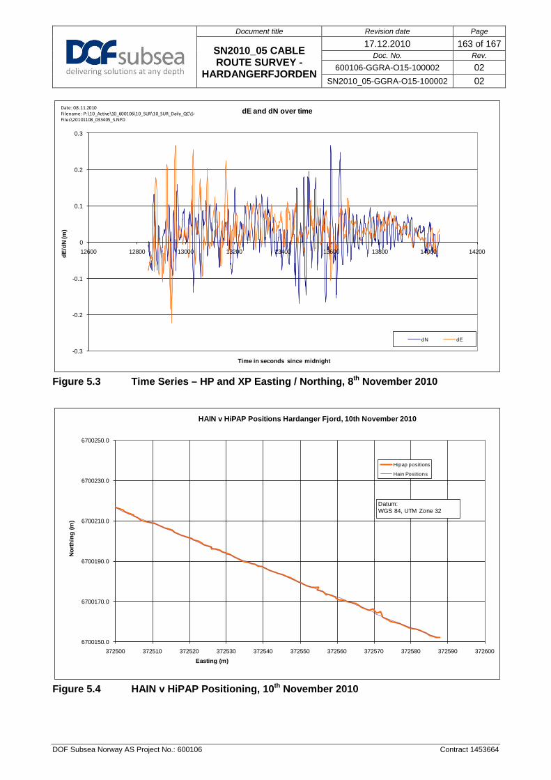
Document title Revision date Page
SN2010_05 CABLE ROUTE SURVEY -
HARDANGERFJORDEN
17.12.2010 163 of 167 Doc. No. Rev.
600106-GGRA-O15-100002 02 SN2010_05-GGRA-O15-100002 02
DOF Subsea Norway AS Project No.: 600106 Contract 1453664
Figure 5.3 Time Series – HP and XP Easting / Northing, 8th November 2010
Figure 5.4 HAIN v HiPAP Positioning, 10th November 2010
-0.3
-0.2
-0.1
0
0.1
0.2
0.3
12600 12800 13000 13200 13400 13600 13800 14000 14200dE/d
N (m
)
Time in seconds since midnight
dE and dN over time
dN dE
Date: 08.11.2010 Filename: P:\10_Active\10_600106\10_SUR\10_SUR_Daily_QC\S-Files\20101108_033405_S.NPD
6700150.0
6700170.0
6700190.0
6700210.0
6700230.0
6700250.0
372500 372510 372520 372530 372540 372550 372560 372570 372580 372590 372600
North
ing
(m)
Easting (m)
HAIN v HiPAP Positions Hardanger Fjord, 10th November 2010
Hipap positions
Hain Positions
Datum: WGS 84, UTM Zone 32

Document title Revision date Page
SN2010_05 CABLE ROUTE SURVEY -
HARDANGERFJORDEN
17.12.2010 164 of 167 Doc. No. Rev.
600106-GGRA-O15-100002 02 SN2010_05-GGRA-O15-100002 02
DOF Subsea Norway AS Project No.: 600106 Contract 1453664
Figure 5.5 DQ Comparison 18th November 2010
260
265
270
275
280
285
290
295
300
13000 13100 13200 13300 13400 13500 13600
Dep
th (m
)
Time in secs after midnight
DQ Comparison 18th November 2010
Port DQ
Starboard DQ

Document title Revision date Page
SN2010_05 CABLE ROUTE SURVEY -
HARDANGERFJORDEN
17.12.2010 165 of 167 Doc. No. Rev.
600106-GGRA-O15-100002 02 SN2010_05-GGRA-O15-100002 02
DOF Subsea Norway AS Project No.: 600106 Contract 1453664
Figure 5.6 Sound Velocity Comparison, Hardangerfjorden 10–12 Nov 2010
0.0
100.0
200.0
300.0
400.0
500.0
600.0
700.0
800.0
1460.0 1465.0 1470.0 1475.0 1480.0 1485.0 1490.0 1495.0 1500.0
Dept
h (m
)
Sound Velocity (m/s)
Sound Velocity profiles 10-12.11.2010
10.11.2010 15:31
11.11.2010 05:11
11.11.2010 20:48
12.11.2010 08:35
12.11.2010 19:32
12.11.2010 20:27

Document title Revision date Page
SN2010_05 CABLE ROUTE SURVEY -
HARDANGERFJORDEN
17.12.2010 166 of 167 Doc. No. Rev.
600106-GGRA-O15-100002 02 SN2010_05-GGRA-O15-100002 02
DOF Subsea Norway AS Project No.: 600106 Contract 1453664
Appendix G: Geotechnical Report

Document title Revision date Page
SN2010_05 CABLE ROUTE SURVEY -
HARDANGERFJORDEN
17.12.2010 167 of 167 Doc. No. Rev.
600106-GGRA-O15-100002 02 SN2010_05-GGRA-O15-100002 02
DOF Subsea Norway AS Project No.: 600106 Contract 1453664
Appendix H: Marine Biologist Report