Embed Size (px)
Citation preview

Seismic data acquisition on the seabedThe Age of Enlightenment

Agenda
What lies beneath?
Why Seabed?
Why Seabed Geosolutions?
Examples
Good information leads to good decisions and good economics
Summary and Conclusions

Without light you won’t see anything
– Grab a torch to illuminate the object.
You see an object, it’s the right size but are you sure of it’s position?
– Look at it from all possible angles
– Look at it from different distances
What is the nature of the object. What colour is it for example?
– Think about the light you are using to illuminate it and don’t forget you wearing sunglasses Sean
What if there it was at the shallow end of the pool and there was a big airbed floating above it?
– You’d need to get close to the surface and maybe a mirror would be helpful
What if the jacuzzi is on with bubbles obscuring your view?
– Wouldn’t it be useful to see through the bubbles?
Is the box empty or full?
– Wouldn’t it be great to be able to give it a poke with a stick and see how it feels?
What lies beneath?

Decision de-risking
Good decisions lead to efficient and profitable actions
To make the best decision 007 needed the best information available.
The oil company is our smartly dressed but cautious hero
The seabed seismic acquisition contractor is offering tools that allow gathering of the
information to de-risk the decision.

Torch Light = sound wave
Looking from different directions = full azimuth data
From different distances = Full offset data
White light = Broadband sound
Seeing past the obstrucion = listening on the seabed bouncing waves off the sea surface
Seeing through bubbles = shear waves
Determining characteristics of the material in question = inversion using shear waves
What is in the tool box?
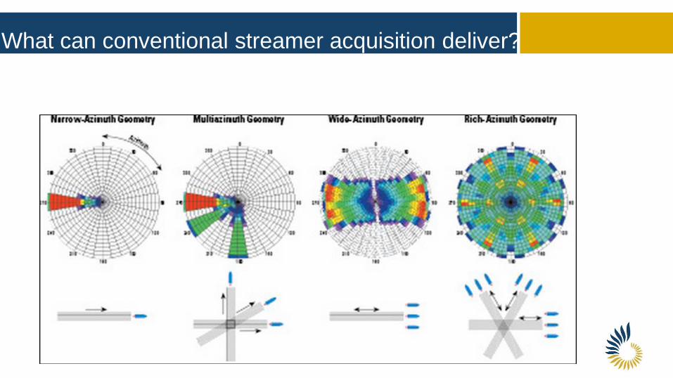
What can conventional streamer acquisition deliver?

What can ocean bottom seismic deliver?

What Does Seabed Geosolutions Deliver?
Global expertise acquiring seabed multicomponent data
Comprehensive, custom-designed ocean bottom seismic acquisition services
Utilizing leading technology to resolve operational and geophysical challenges in water depths of
0 - 3000 meters
Delivering high-resolution broadband images of the subsurface - full azimuth, long offsets to
improve reservoir illumination
DERISKS DIFFICULT DECISIONS

Extensive global expertise with more than 25,000 km2 of seismic data collected since 2005
Global Experience

Marine environments
from transition zone to
deepwater
Soon we will have a 4
component sensor
package call Manta that
can operate in unlimited
water depth and in
unlimited geometries.
Operating Environments

Manta™ OBN - a Step Change
Compact node design enables higher node
count
Variable in-line receiver spacing to optimize
cost
Flexible, highly automated deployment and
recovery for safe and efficient operations
Advanced rechargeable power-dense
battery technology
Single design for all water depths ranging
from 0 – 3000 meters

What about in the real world?

Dan Field - North Sea Danish sector
Chalk reservoir
Complex structure
Water injection
Streamer baseline survey
2012 4D monitoring survey:
combined streamers and
nodes
225m node interval
37.5m shot interval

Dome structure, main fault, gas cap
Challenging chalk reservoirs, low permeability, high porosity
Production since 1972; water injection since 1988
108 active wells
– 58 oil producers
– 50 water injectors
Seismic data
– 1988, 2005: streamer
– 2012: Streamer + OBN
OBN survey layout
– 225x225m node patch
– 37.5x37.5 shot patch
Dan Field
Top Chalk: Structure

Streamer to OBS comparison - Maersk Dan Field
2012 Streamer with infill Ocean Bottom Seismic
Images courtesy of Maersk

1. Streamer 2012 2. OBN 2012
~2km
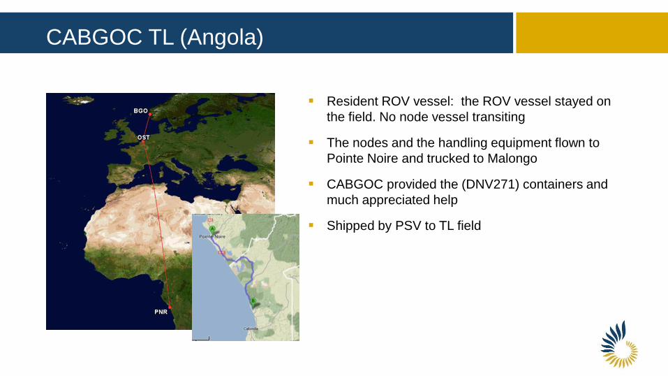
CABGOC TL (Angola)
Resident ROV vessel: the ROV vessel stayed on
the field. No node vessel transiting
The nodes and the handling equipment flown to
Pointe Noire and trucked to Malongo
CABGOC provided the (DNV271) containers and
much appreciated help
Shipped by PSV to TL field
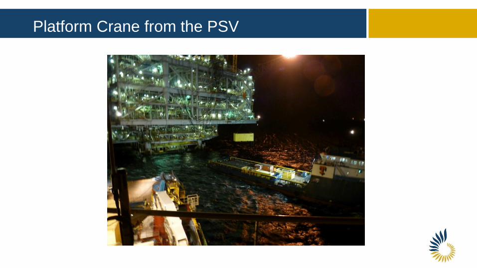
Platform Crane from the PSV

Nodes and Crew in Containers

ROV Skid and Node Handling

TL Platform Undershoot
© 2014 Chevron U.S.A. Inc. CONFIDENTIAL – This information is proprietary to Chevron and is to
be used, disclosed or reproduced only under permission granted by Chevron. All rights reserved.
Rx distance: 300 m
Sx distance: 37.5 m
Min in-line offset: 2.5 km
Min x-line offset : 2.5 km
WD 320-440 m

Remember the mirrors
Dash et al, 2009
Up
Down

Avoiding the jelly fish
Down-going OBS data
provides 3D image of
hazards below platform as
shallow as 20m below
seabed
90m
20m
360m
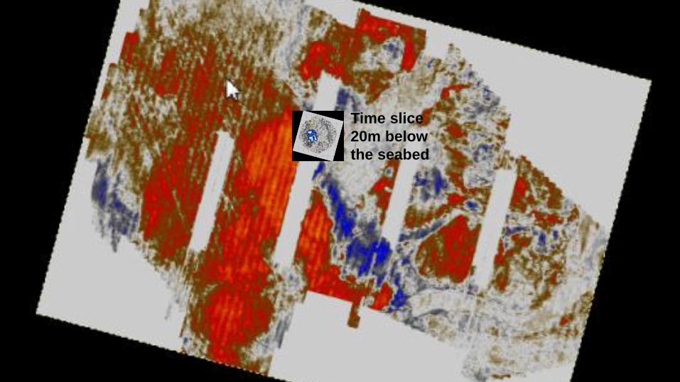
Main business driver: Obstructions
Time slice
20m below
the seabed

Nodes 3D Streamer 2D 3D Streamer Undershoot

The Jacuzzi conundrum
EAGE 2014: Acknowledgement PETRONAS and PETRONAS Carigali Sdn. Bh
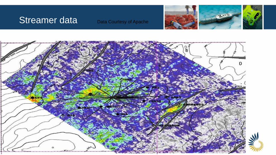
Streamer data Data Courtesy of Apache
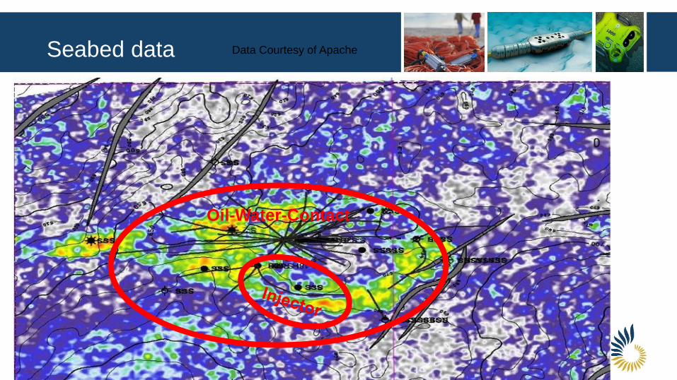
Seabed data Data Courtesy of Apache
Oil-Water-Contact

Value of Information

Value of Information

Ocean bottom seismic offers the
best azimuthal coverage
Recent developments have led
to larger spreads
Unparalleled imaging around
and under obstructions
Seabed Geosolutions has the
tools to give you the full picture
and help you make enlightened
and profitable decisions
Summary

Conclusion
Welcome to the
Age of
Enlightenment