Embed Size (px)
DESCRIPTION
To combine sea and mountains has never been easier. With 300 metre cliffs and more than 5,600 hectares, the natural park of Sierra Helada, the first marine and terrestrial park of the Valencia region and rises majestically behind the Mediterranean.
Citation preview

Routes along Sierra Helada

We begin the journey from the Albir recreational area, with a steady meandering climbing that starts from the stones stairs, until we get to the road accessing the relay station and aerials, past an old quarry.
“Alt del Governador”At the end of this path we get to the highest point in Sierra Helada (438 m) where a telecommunications relay station is located. If we push along the asphalted trail down, we will join the path again. Almost on the brink of the cliffs is a geodesical vertex, from where we can see the breathtaking cliffs. The yellow-legged seagulls fl ying hundreds of meters below us will seem tiny to our eyes.
“L´Illa Mitjana”The journey along the Sierra continues with constant ups and down. We go past the ruins of an old coast watchtower and a small well in the depression. Half-way we will walk into an area where there is a small pine grove, good for resting awhile. A beautiful view of l´Illa Mitjana can be seen.
La CruzThe last section of our journey goes past the last look out point where we can see the cliffs again. From there onwards, attention must be paid so that we do not lose sight of the path that goes between the undergrowth and the naked rock. A few minutes later, we will arrive at a cross above Racó de l oix, where an asphalted track connecting to itinerary ‘Punta de Cavall’ begins.
In case of an emergency, call 112
www.benidorm.es 96 585 13 11
Crossing Sierra Helada
Lenght: 8 km. (only going).Duration: 4 - 4’30 hoursSteep: 438 m.Accesibility: Only suitable for trekking.
Rating: Medium-diffi cult. Lots of water must be carried due to lack of fountains. The path goes up and down very steeply, although we can avoid it by taking diversions to keep level.
1
2
3
4
1
2
4
3
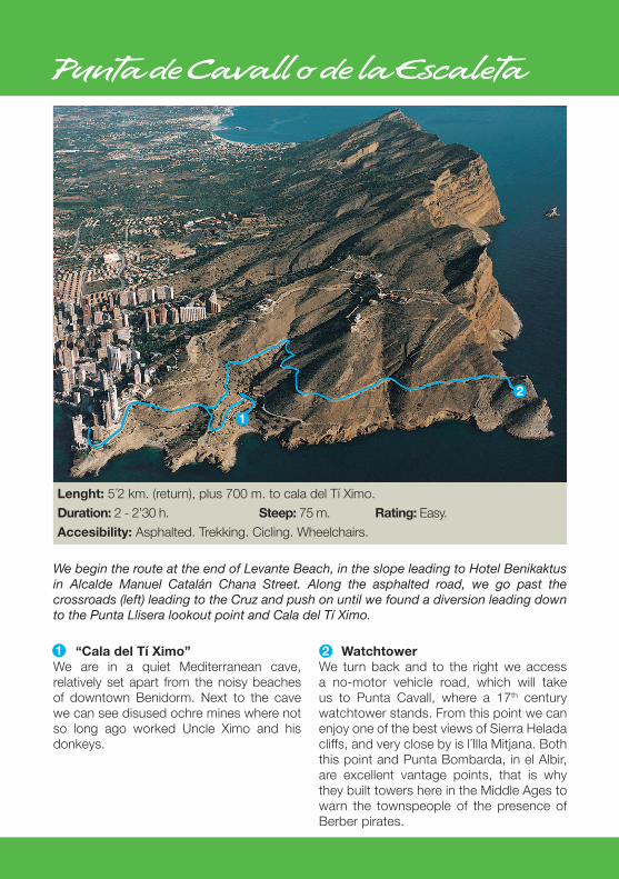
“Cala del Tí Ximo”We are in a quiet Mediterranean cave, relatively set apart from the noisy beaches of downtown Benidorm. Next to the cave we can see disused ochre mines where not so long ago worked Uncle Ximo and his donkeys.
WatchtowerWe turn back and to the right we access a no-motor vehicle road, which will take us to Punta Cavall, where a 17th century watchtower stands. From this point we can enjoy one of the best views of Sierra Helada cliffs, and very close by is l´Illa Mitjana. Both this point and Punta Bombarda, in el Albir, are excellent vantage points, that is why they built towers here in the Middle Ages to warn the townspeople of the presence of Berber pirates.
Punta de Cavall o de la Escaleta
Lenght: 5´2 km. (return), plus 700 m. to cala del Tí Ximo.Duration: 2 - 2’30 h. Steep: 75 m. Rating: Easy.Accesibility: Asphalted. Trekking. Cicling. Wheelchairs.
We begin the route at the end of Levante Beach, in the slope leading to Hotel Benikaktus in Alcalde Manuel Catalán Chana Street. Along the asphalted road, we go past the crossroads (left) leading to the Cruz and push on until we found a diversion leading down to the Punta Llisera lookout point and Cala del Tí Ximo.
1
2
1

La Cruz (The Cross)
Starting off from Berlin ST (an extension to Mediterranean Ave, PLEASE NOTE that the fi rst section is a no-way for cars) we arrive at a big crossroads which to the right will take us to Sierra Dorada Apartments.
The second choice is to go up Hamburgo ST and make a diversion at the fi rst crossroads to the left towards Castell de Mar, where we can link with the previous route.
From this point on the way up will provide us with wonderful views of all the coastline, marked by coves and the Isle of Benidorm. We can either go to the right up to a lookout point, where we can have delightful views of the cliffs or keep going up to the left, where the end of the road will take us to a little path leading to the ‘Cruz’ , a traditionally romantic place where you can enjoy one of the best panoramas of Benidorm.
Lenght: 5 km. (return) Duration: 3 horasSteer: 237 m.Accesibility: Car, bicycle, on foot. Raring: Easy.
This route is signposted Yellow and White from the Tourist Information Point, where Gerona St meets Derramador Ave. From this spot we go to the Sierra along Gerona St, to take a turn later for the beach along Ametlla de Mar Ave. from this avenue we have two choices:
12
1
2
4
3
3
4