Embed Size (px)
Citation preview

REHABILI'rA'rION OF MINING LANDS 'rRUS'r FUND Repol1 on Works undel1aken .. 2000 - 200 I Financial Year
Contents
I ntrod u cti on
By Revel Munro October 2001
- 1 NOV 2001
TASMANIA
1. Cat Gully area adjacent to Blue Lake, Endurance Mine, South Mt Cameron. • Background • Rehabilitation Treatment - Planned and undertaken • Further comments with photographic illustrations - Cat Gully • Materials used - Cat Gully mine rehabilitation 2000 1 2001
2. Star Hill (Garfield, Lawrys) Mine, Gladstone. • Background • Rehabilitation Treatment - Planned and undertaken
3. Shallamar Creek gully restoration, Old Monarch Mine, northern flank of Mt Cameron. • Background • Repairs to failed gabions. 1999/2000 • Repairs to failed gabions. 2000/2001
4. N2 Gully Maintainance, Endurance Mine, South Mt Cameron. • Background and Works 2000/2001
5. Ruby Creek Diversion, Riffle and Channel Erosion, vicinity of the Endurance Mine, South Mt Cameron. • Background and Works 2000/2001

REHABILI'I'A'I'IOII OF MIIIIIIG LAIIDS 'l'RUS'I' FUIID Report on Works undertaken ... 2000 - 2001 Fjnancjal Year
Introduction This report details rehabilitation of abandoned alluvial tin mining operations in the Gladstone area in the past year. These works are a continuation of sites first targeted in 1998, and could be categorised as:
• A project extending in area of successful rehabilitation'" Star Hill. • A project with a blend of innovation and high priority '" Cat Gully,
Endurance Mine. • Projects in need of ongoing monitoring and maintenance'" Ruby Creek
Deviation & N2 gully, Endurance Mine. • A project in need of rectification due to failure of engineering works '"
Shalla mar Creek Gully, Monarch.
All nominated works were completed within budget and were only marginally affected by delays, such as plant and personal availability. Revel Munro is confident of successful rehabilitation outcomes at all sites, though notes that there are various levels of surety for the range of techniques and conditions. Mining rehabilitation in a variety of forms has been undertaken for over twenty years in the Gladstone area. Most successful has been the medium to low "tech" and moderately high labour input works that have been coupled with low cost local materials and flexible non-prescriptive approach to implementing a general works program.
With the aid of plentiful photographs and summary maps mining rehabilitation procedures and outcomes for five NE projects are detailed below. The Projects are listed in decreasing size of the works undertaken this year.

1 Cat Gully area adjacent to Blue Lake, Endurance Mine, South Mt Cameron.
Background
Features of this Project area are shown on Figure 1 of this report, while figure 2, an aerial photo enlargement depicts the gully erosion present. A detailed report and plan for remedial work for this period, entitled; A proposed program to rectify severe gully erosion in the vicinity of Cat Gully, the Endurance Mine, South Mt Cameron, NE Tasmania, determined the works undertaken at Cat Gully. Portions of this section are drawn from that report. An area of three hectares of soft, deeply weathered granite is actively eroding and weathering and if unmanaged will grossly affect a further four hectares of land. The threatened adjacent areas still retain a readily erodable remnant horizon of clays and gravels. This thin mantle of Quaternary sediments represent strata judged to be too low in cassiterite content when the area was subject to scraper mining for Endurance No 1 operation about twenty years ago. A network of gullies, totaling at least 1S00m in length and reaching up to 9m in depth coupled with slumping and runoff erosion are contributing an estimated 3000 tons of suspended solids into the Ringarooma River per year from this relatively small area. Erosion at similar rates could be expected to continue, if uncontrolled, for decades. This example of intense erosion is essentially a recent event (when compared with over a century of tin mining at South Mt Cameron) and is due to a combination of factors, the main ones being: • The erodibility, of exposed weathered granite basement rock, with their very soft,
kaolinized feldspars. • Dragline excavation of Cat Gully in 1968, lowering an old drainage line by about Sm. • Scraper mining operation removing vegetation, soil and subsoil to an impervious
clay base. • Superficial post mining revegetation effort, resulting in only scant vegetation cover.
Trust funds have previously been directed to the Cat Gully site in autumn 1998. On that occasion consultants, SEMF engaged Stornoway Civil Pty. Ltd. to rehabilitate one of the Cat Gully tributary gullies. The work was abandoned due to the onset of May rains, was never completed. It has not been a beneficial activity to the current project.

rTRACK
to WESRTERN
ENDUHII.DI<.t
( Scraper Operatioll,s' late 1970,s)
CAT GULLY Bragline l:hannel
• ",
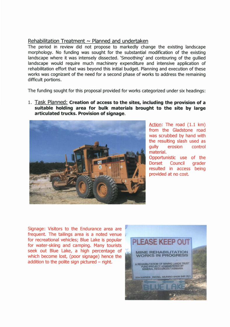
Rehabilitation Treatment <V Planned and undertaken The period in review did not propose to markedly change the existing landscape morphology. No funding was sought for the substantial modification of the existing landscape where it was intensely dissected. 'Smoothing' and contouring of the gullied landscape would require much machinery expenditure and intensive application of rehabilitation effort that was beyond this initial budget. Planning and execution of these works was cognizant of the need for a second phase of works to address the remaining difficult portions.
The funding sought for this proposal provided for works categorized under six headings:
1. Task Planned: Creation of access to the sites, including the provision of a suitable holding area for bulk materials brought to the site by large articulated trucks. Provision of signage.
Signage: Visitors to the Endurance area are frequent. The tailings area is a noted venue for recreational vehicles; Blue Lake is popular for water-skiing and camping. Many tourists seek out Blue Lake, a high percentage of which become lost, (poor signage) hence the addition to the polite sign pictured - right.
Action: The road (1.1 km) from the Gladstone road was scrubbed by hand with the resulting slash used as gully erosion control material. Opportunistic use of the Dorset Council grader resulted in access being provided at no cost.

Photograph shows gullies (numbeled according to table in report)
100_.
. / • I
-. f'roI'OSQJ.. "c..n ~. S f oo"'hl'\,. d.-.. o.J,. ...... ~
E ')( i.;Ie\\ .• ~ tA...ro..' 'A'$.

2 Task Planned: Stabilise the heads of many of the active gullies utilizing the following techniques and materials:
• Mining rock debris and sluicebox oversize in heads of gullies
Action: The heads of gullies was filled with Endurance Deep Lead mine waste that was primarily sluicebox oversize forkings - quartz, cemented grits, and clay balls. Timber, both
Tertiary vegetation remnants and sluicebox remains were common. The photo to the left shows the surface rock to be oxidized. The heaps just below the surface are pyritic, and the sulfurous nature of the material is not conducive for plant growth.
• A covering layer of mine tailings from the Endurance Mine. Action: photo shows some of the hundreds of m3 of mine waste with piles of tailings, (also grey) positioned to cover the mine waste. A veneer of less pyritic tailings now covers the highly sulfurous mine debris in all the gully heads.
• Additions of a tailings/pyrethrum/lime/gypsum/fertiliser mix and also scrub. Action: This did not occur, as the excavator was unavailable for the mixing process.
• Pipe works, sand bags, sheet metal, rock drop structures in gullies that still carry significant water.
Action: Not necessary, all drainage to gullies diverted to cut-off drains. See section 3.

3. Task Planned: Control drainage into gullies by means of contoured, armored or graded spoon drains and I or diversions utilizing the following techniques and materials: • Surveyed routes collecting a number of channels. Action: Surveys conducted, control established. • Wide spoon drains using geotextile in critical areas, and hay, scrub, sand bags to
absorb and hinder runoff. Action: Uncontrolled drainage to the heads of gullies has been eliminated. This has been a major component of this project. Contour and cutoff drain locations are shown on figure 3. They total some 600m in length. Such drains vary in their construction method accord to resources, catchment area and occurrence of surface indurated horizons.
Some channels were excavator dug, (example pictured right), and also fully lined.
Most were lined with straw and hay and covered with jute. The large channel that is part of gully [0] and pictured here with people laying the jute matting has moderate fall and is also underlain by geotextile.

Cvt-~~ ()r~-.s. ,\ ~~uft. ~~AbillW,ci", Fi~"'re.. 2-Photograph shows gullies (numlbered according to table in report)
=::...-"..".""
5 "'
, •
... , .. ... ' • .,.1 .. }
... ." ... , .... i. . • j ••
, ...... -,. / , . . ! • ~ ~
) , , • / '1, , ..
....
• • .... j .. .ffI'J. ' ..,,;" , .. ~ . .... /... . : . ',If
. f t
/ I ,
/ , / t .
/

Other are essentially shallow depressions, (pictured right), with flow determined by levee banks.
gec)te)ct:ile underlay. Action: Approximately 60 metres of such drains were constructed where cutoff drains 'dropped' into gullies [k] and En]. These shallow v shaped, rock over geotextile, 20% slope drains were constructed by excavator, pictured left and below.

F i~ ",..e.. 1+ ......, 1" 'l"e.el.t ...... t ~ c;,,\\ \e.!. I?lf1IotcgralpW shews gullies (numlberecll according to table in report)
. 1
\
• •
•
,. I
/ . ./
, / ' >
./ •
Y ", t • ., .
Jute. M"~\~ \~iL. O~t.or i ... ·h .... ,.\ut. {o,..! -~.
_._ ._. Pr:::rr'C_ ~.~ J1""
d_ "- '_

• Use double layer jute matting to secure materials. Action: Double layer jute matting was not used as the matting was a tighter weave than anticipated. Single layer, as described above was used extensively. • Sow native seeds and/or short term grasses Action: Sown, see point 4. • Construct small impoundments if necessary Action: Not necessary.
4. Task Planned: Decrease sheet runoff adjacent to these gullies utilizing the following techniques and materials:
• Scarify or rip if necessary and incorporate up to 3cm of tailings/pyrethrum/lime/gyps
urn/fertiliser mix with native seed +/- grass, maybe in bands.
Action: Figure 4 shows the areas so treated in green. Bare areas, were thoroughly scarified with the tractor pictured. Mine tailings were added to improve the structure/permeability of a smaller area adjacent to some gullies. Thick applications of pyrethrum, fertilizer and lime together with native native seed were applied.
• Add hay, scrub and jute matting to the most unstable areas. Action: Figure 4 shows the areas so treated in orange. large areas were covered with jute matting using about eleven bales (about 6000m2
) of material. large quantities of small square and 5x4 foot round bales were used.
The small square bales of cereal straw were applied to the more inaccessible areas by hand. They 'fluffed' up well ~ pictured.
The round bales of triticale straw were difficult to lay evenly by tractor. Some hand laying was also used. Some of the ingredients are pictured below.

_._._.
E o
"'
~f("l~ d...VIL\ .... ~
Ek\~ \\ .. ~ tJ.,.",,; • .\\

PHOTOS OF SOME OF THE MATERIALS USED ~ CEREAL STRAW, SCRUB, ROUND BALES & PYRETHRUM .
5. Task Planned: Increase the fertility, pH and organic matter content of gully flanks, (where accessible) and encourage some stabilisation through revegetation by applying a native seed mix utilizing the following techniques and materials: • Spin on with tractor or hired truck a heavy dose of pyrethrum/lime/gypsum/fertiliser
mix with seed added. Action: See details in section 6. below.

6. Task Planned: Increase the infiltration rate, fertility, pH and organic matter content of bare and sparsely covered, adjacent mined land and vegetate with native seed mix utilizing the following techniques and materials:
• Spin on with hired truck a heavy dose of pyrethrumjlimejgypsumjfertiliser mix with additional seed and fertiliser added.
purposely not applied evenly. applications were spun on the barest and most erodable areas. The trucks were also instructed to back up and spin over the gullies where possible.
Action: Figure 5 shows an area of about 15 hectares subject to broad acre treatment hatched in orange. Pyrethrum ~ 360 m3 (6 walking floor truckloads, pictured), 40 m3 of lime, and 6t of fertilizer were applied by truck and Fast track tractor, both pictured. The fertilizer applied by truck was not the intended high analysis 10.17.8.1. An error by Impact Fertilisers resulted in the cheaper, low grade, 'potato mix' 8.4.10.14 being used. These soil conditioners were
Native seed to intensive areas was applied by hand. The flat 'hinterland' was sown with a tractor and spinner. In both cases the seed was heavily bulked with gypsum.
Most native seed was purchased from Forestry Tasmania and or Wildseed. Efforts were made to collect local provenance boobyalla and narrow leaf wattle (Acacia sophorae & A. mucranata) seed. For rehabilitation at South Mt Cameron, acacias with their prostrate to semi prostrate habits are superior species for erosion control. The seasonal seed set for summer 2001 was not good. A useful but hard won total of some 4kg of predominantly boobyalla was gathered from around the mine site. Its scarcity resulted in the local gathering of seed activity costing about 150% of commercial but non-local seed option.

Further comments with photographic illustrations - Cat Gully
Gully m, (pictured right) has been previously battered by Stomoway Constructions in 1998 as part of the incomplete rehabilitation treatment. The works have subsequently continued to erode leaving a large, steep, central gutter and a rilled amphitheatre.
Action: Rehabilitation has commenced without the reintroduction of machinery. Scrub, seed, fertiliser and hay have been applied and runoff controlled. Erosion has been minimal this winter.
Gully [m] (see) Figure 2. Before treatment took the form of a 9m high face resulting from mass movement. In the wetter months soft decomposed granite continually slumped, forming a receding steep face.
Action: Many truckloads of tailings were tipped over the bank covering the area at the angle of rest. With some difficulty, a straw / jute matting / straw covering 'sandwich' was secured over the gravels. Heavy doses of seed and fertilizer were broadcast. Considering the steepness of the works slumping failure of the works is a possibility. When last inspected in September all treatment was intact.
Flat, but rilled surfaces of bare decomposed granite were in need of rehabilitation. The photo on the left is an example after treatment.
Action: Rehabilitation has involved filling gullies and scarifying with the tractor. Straw and covering jute matting was

applied to the worked up surface. Native seed and fertiliser was applied. Triticale from the straw has germinated. Only in inaccessible gullies has cereal growth escaped severe browsing by macropods and rabbits. Such treated surfaces have been very stable in the five months since treatment.
Pictured right are markers delineating a monitoring site that was subject to a range of treatments with respect to scarifying, liming, fertiliser application and seeding . Unfortunately the site was partially destroyed by a bogged fertiliser truck and winter rains inundation has flooded other portions.
Pictured left is Gully [b] after treatment. This gully is typical of most that were mainly created by runoff.
Action: Application of mine rubble, tailings, straw and jute matting with seed and fertiliser added, has successfully (to date) stabilized all gullies treated.
Some erosion to the flank of a rock chute (pictured left) was caused in August 2001 by a breeched levee. The levee was later repaired by hand.

Gullies not yet treated such as this portion of [I] system have continued to slump and erode during the winter wet of winter and spring of 2001.
Materials used tv Cat Gully mine rehabilitation 2000 I 2001 Materials to be used ~uantity estimated in Quantity Used
Budqet Rock (silcrete and forI<ings from Endurance 104 m' /13 loads 200 m' / 25 loads
mine) Tailings (from Endurance mine) 640 m' / 560 m' / 70 loads
40 to 80 loads Pyrethrum (soent marc) 240 m' / 4 loads 360 m' / 6 loads
Ume (agricultural) 40 m' /2 loads 40 m' /2 loads Gypsum (conditioner) 60 x 50kg bags 20 x 50kg bags
Fertiliser (high analysis, maybe with trace 6 tonnes, some in a 2'~ 6 tonnes, elements) application (of low analYsis)
Jute Matting @ 500m x1.2m + staples 6000m2 6600m2 Geotextile 1 roll 1 roll
Grass seed ~.g. cheap !amma ryegrass 4 bags - 100kg? nil Scrub 50 trailer loads 15 trailer loads
Hay / straw 20 round bales 50 round bales Hay / straw 300 bales 100 bales Sandbags 100 nil Cement 12 0
Native Seed Balance of stock Balance of stock Native Seed (Acae" sophore of local
providen";) 8 kg 4 kg
Pipe & elbows -probably 100mm sewer ? Nil - no pipe woll< needed
Misc.- Materials Extra steel skewers

1 Star Hill (Garfield, Lawrys) Mine, Gladstone. Background The location of the Star Hill Project is shown on Figure 6. This elevated and geologically distinctive area several kilometres east of Gladstone has a long history of tin mining exploitation, dominated by medium sized operators. Ron Lawry was the most notable recent miner. His operations in the 1970's to 1982 are
characterized by: • the use of mobile (sledge mounted) treatment plants, usually connected to the
HEC grid; • extensive use of bulldozers to supplement hydraulic monitors, break up cement
layers, strip ground, move plant and construct innumerable earth structures; • Ron constructed a complex network of tailings dams, dams and races to recycle
water and thus limit the quantity of purchased Mt Cameron Water Race Board water;
• frequent relocation of operations within his leases. Thus extensions to areas previously mined, reworked ground, and part obliteration of previously worked ground has lead to a varied, 'pocketed' and difficult to interpret landscape;
• relics of past set-ups, e.g. workshop sheds (with relic bolts, flanges, and steel scraps), sluice box races ( use of old drill steel stakes common), expired vehicles (especially Peugeots), dozer parts, and treatment plant/sledge remains are common.
The area long exploited and known as Hardins Ravine (to the west of Star Hill Mine and Figure 6) was not part of Ron Lawry's leased ground. Other operators last worked it over the same period. The Mines Rehabilitation Trust through SEMF j Brambles constructed a gabionjrock lined outfall in 1999 at the downstream end of Hardins
Ravine. The old Cybele Working dominates the other end of the low east -west ridge that characterizes the Star Hill deposit (see orange stippled area on Figure 6). Extensive (some 7.5ha of works) and successful Mines Rehabilitation Trust mine rehabilitation through SEMF j RG & SD Gerke was undertaken over the sandy Cybele Workings in 1998. An excavator was used reshape a dissected, within-basin landscape for follow-up native seed direct drilling. Although the SEMF designed, 'within basin' wetland system of linked mine holes with anticipated aquatic vegetative regrowth has not occurred, the establishment of vigorous, healthy cover from direct seeding on the well drained, smoothed surfaces is most apparent. The success of the direct seeding component forms the basis of the current Star Hill program. The picture to the left shows typical regrowth from the April 1998 program.

Mine Water Retic:u/, '/rlfll X. Tailings Dam
lVIine Water ·-~;cctiarrl)n
Dam
A MAP STAR HILL I G lELD Alluvial Tin Mining' 4880's to 1982 Mine Rehabilitation tJtment
- 1999 Rehab. ~ 2000 - 2001 Rehab
T I
• • Tailings
0013
= Areas too • soft for dozer
. not r~hl!"lbllltt'1tl~dli
~ = Major dozer bogged sites
5 '"

Rehabilitation Treatment N Planned and undertaken • The location: The area rehabilitated in 2000/2001 at Star Hill is shown in Figure 6.
Many discontinuous areas totaling 19.5 ha have been treated this year. They consist of the balance of mined ground and tailings available for treatment by this equipment. The ground treated was variable. The range included; gullied bedrock (soft sandstone), sandy and clayey sluice sites, higher gravel/yellow clay banks, silt flats and sand/gravel tailings.
Examples are pictured below.
Ripped and sown ~Gravel and clay banks (above)
Ripped and sown ~ tailings (above)
Ripped and sown ~ sandy sluiced area (above)

Untreated, sand/clay sluiced area (right) • Equipment: The same
equipment proven by the _ 1998 project undertook works at Star Hill between April 25th and May 31st 2001. The unit consisted of a Caterpillar D6 bulldozer with a specia lIy constructed three run seed drill integrated with three rippers. The bin section featured a separate fertiliser and seed units for each run. Capacities for each bin exceeded 100kg. Early in the current program the drive to the drill was changed to an operator controlled electric system (pictured left). Previously a weighted, toothed, trailed drive wheel provided ground drive. That system had shortcomings in respect to slippage and obstruction / proneness to damage when in reversing mode. A picture below of the bogged unit shows the original drive system. Drop tubes on the unit were positioned to place the seed/fertiliser mix to the margin of the furrow. No seed-covering feature was fitted to the drill.
Treatment: Native seed was sown over rip lines one meter apart, together with high analysis fertiliser 10.17.8.1. This spacing resulted in ten kilometers of rip lines per hectare. The seed mix initially consisted of the following species left over from the previous project.
Acacia mucranata Acacia sophorae Acacia terminalis Acacia delbata Acacia verticil/ata Allocasurina vericil/ata
Allocasurina lit/oralis Kunzia ambigua Callistemon linearis
Leptospermum scoparium Leptospermum scoparium
horizontalis
Eucalyptus Amygdalina Eucalyptus Pauciflora Eucalyptus Siberi Eucalyptus Viminalis Lomandra longifolia Melaleuca squarrosa Poa lab.
Once old stock was exhausted the simpler mixes were used. Use of casurina species and sags was discontinues due to poor germination. The seed mix weighting of eucalypts was lessened with E. siberi, a non-local, no longer used. Woolly tea tree was introduced to colonize the wetter areas. The last used mix is listed below.
Acacia mucranata Acacia sophorae Acacia terminalis
Kunzia ambigua Leptospermum lanigerum
Leptospermum scoparium
Eucalyptus Viminalis Melaleuca squarrosa Poa lab.
• -

Acacia delbata Eucalyptus Amygdalina The seed was weighed into amounts suitable for adding to SOkg bags of the bulking agent, gypsum. Seed requiring boiling treatment was kept separate. The drill was calibrated to apply 400g of seed mix per rip line kilometer. Some initial problems were encountered with seed flowage due to damp gypsum.
The ground conditions: The types of sites are described in the location section above. During the first hundred meters of drill calibration tests it became apparent that bogging of the dozer would become an ever-present hazard. This was not anticipated as ground conditions varied from the previous project in respect of:
• The autumn wet break had arrived. • The previous project at Star Hill had involved the simultaneous use of an excavator
and this bulldozer. Help was at hand when the dozer became stuck. • Mining methods and subsequent ground conditions differed between the two sites.
For numerous mined areas subject to the current work tailings and their fans of
sinking into oozing silt. (Years ago an excavator meet a similar fate, being essentially ruined by the seepage of silts into the engine etc.) The large tractor pictured below only narrowly avoided being seriously bogged. Following this early experience large areas of ground was excluded from the works program. Margins of tailings dams, such as pictured below were definite 'no go areas'.
slimes had often filled earlier workings. In places a thin crust masked thick accumulations of slimes. Pictured are photos of major bogged event No.1 where an excavator was eventually required to dig the machine out on day three of lost time. Much time and energy was earlier expended on placing large quantities of materials under the tracks in an effort to keep the machine from

The methodology: Selection of target areas for direct seeding was a cooperative exercise between John Pemberton and David Gatehouse of MRT, Revel Munro and the bulldozer driver. The driver determined the intensity of treatment in respect of leveling and avoiding self-regenerating portions and soft conditions.
On one tailings heap he was instructed not to avoid rehabilitation pinus radiata trees. This instruction is on the basis that pines have been observed to be a growing weed threat in bushland surrounding their mine site plantings (see photo, left).

3. Shallamar Creek gully restoration, Old Monarch Mine, northern flank of Mt Cameron. Background Shallamar Creek is a drainage line originating on Mt Cameron that, at the break of slope passes through the Old Monarch Tin Mining Co. flooded mine hole. The users of the MT Cameron Field Study Centre use this picturesque lake for water sports. A campsite is nearby. The Creek then drops into a channel within the dragline excavated operations of the BMI Mining tin mining workings. In the period since 1974 when the dragline last worked the creek has back cut as a gully up to four meters deep. Progressive back cutting would result in the mine hole being drained. In 1998 the Trust acted to stabilize the gully. Consultants, SEMF designed and supervised tenderers, Stornoway Constructions with gully stabilization structures. The location of these gully works is shown on Figure 7, with Figure 8 showing more detail. These works consisted of seven, one metre high gabion basket structures some twenty metres apart within the gully. The gabions were placed in a tiered manner upon fill from an adjacent tailings source. Inadequacies of the gabion structures were apparent from the onset of the first winter rains. The western margins Gabions 4 and 6 were breeched, temporarily repaired and subsequently repaired and strengthened with rock armor. During a flash flood on January 4th 2000 the other margin of gabion 6 was breeched. Possibly in domino fashion, Gabions 5, 4, 3, & 2 slumped and were subsequently breached as their supporting reno mattresses also slumped. Large volumes of the supporting tailings were rapidly eroded by the flash flood. The photos below show the resultant damage.

-66
Location Map - Shallamar Creek st bilisation h mine. 2000-01 - Basalt rock engthenlng and
replacement of gablon baskets Nos. • to
It cameron field Study C8 ter
I Campsite
\\\1. --
~~r~tlborro. . Hi Cam rOD
Monarch Tin Mlnlhg
Workings
'1iI~8nter Project.
'" 3
R Munro ·Oct 2001

FiB ore. g Survey plan of Monarch Rehabilitation Gully
Shallimar Creek, vicinity of Mt. Cameron North East Tasmania.
Plan showing location of gabbion structures and S~Qt h~ight5 (arb!ta!"}' datum),post January 2000 flash flood event(s)
1: 500 SUf'!eyed and drawn by R. !\.4unrQ - ~l!a~1 2000
5cm
I ... ;f.4l .. c."' ... \:",\.~~,.", 4 SKM.F./~ .... w"" ... S, ..... _ ..... lC\'ll
R .. ~, .. !o -b, W. ~~s. ~ c;.1t-~(t.'''' e-.-.1.l6'~Sf'~ ctlf - -
R.e\'(~;\-~ (~.,I') {p C~"'-\:,·L<>"'- ~ "- Ro-" ~r:-<" . .... W\>\: ".. ~OI)
R.u.oW\..~t ('VdlO~ 0", (;.-..Ioio~ :1, '!., 't- ) S' l7 ~ S" .... o ... $ '" So U~ W\.e.'I"' ,"001
tJ\\~~ l.,;:\l\~~
2:>
~O"'f"W p~~
· ______ -'-=I}:;;;· ~=\";;.;'''';;_~~Q.C.k~~ )O.A;kf.."'" ~\\:: h.", •• a:
I
./ -- 'I)
glt'lf ",.. ,-
",.
,If ~M. \ f\I\.'",i .. ~ c:l..,. .. ~ \\",c., I ~" )fC.". .... ~ \0..... \ q ., 1+
/
-
'. q~
I' __ . I . <.~/~ I ' '1'.1'!> ~, ", ...... ,(
f ''tl:~ 'II~ f ( I . r,~,'-t &;,.
f f ' C ~e
\" P-L '1s-a." b .. \lo ... i>I< p..,cl
, .... a.'Bo
f "oSs' ~ I? I S "'::.-:. f"
" '''~,s. -
/
I
"
(
\
."" I I
I
f I
/ I
( (i", . . -, ~--- ..•
. I
/
01"-M Oil'#- ~c,. "'-
Mi .... c....
(Floo.L.~cl )
I
~I
@k 1'Nftt. /
/ /
SIt. 1£
f
/

Repairs to failed gabions. 1999/2000
Following consultation with engineers a rock fill solution to repair task was chosen. In May of 2000, local contractor Ray Symons carted some 1000 tones of basalt mine overburden from the Brisies Mine (pictured).
To allow for easy repairs to Gabion 6, Shallimar Creek was diverted with a short drain (pictured right) into an adjacent old tailrace. This diversion was left in place for almost a year. Indeed it could have been a very cheap solution to the total gully problem! The course of the diverted water is shown on Figure 7. Thick gahnia radula regrowth on sedgeland flats together with a long and very gentle gradient ensured that the bypass outlet did not erode.
A portion of the stockpile was immediately used to repair Gabion 6 (pictured after repairs with rock and geotextile, left).

Repairs to failed gabions. 2000/2001 Ray Symons of Gladstone was again hired this summer to complete repairs to the gully affected by the collapsed gabion structures utilizing the rock stockpile and geotextile. Rock chute structures were constructed to either encompass or replace Gabions 2, 3, 4 and 5. Gabion 1 above the gully remained intact and in no need of maintenance. Gabion 6 was adequately repaired the previous year. The lowest structure, Gabion 7 has been substantially strengthened and armored as its stability is most crucial to the integrity of the whole project. Access to the structures was a difficulty. A track had to be cleared between the gully and the bypass tailrace and ramps constructed to each gabion site. The excavator, due to the fluid nature of the underlying tailings could not access the gully floor. This precaution was reinforced on one occasion when the excavator got into a potentially serious bogged situation.
Gabions 2 and 3 were the most seriously affected control structures. The distorted wire baskets have now been buried and replaced with a continuous rock ramp (pictured left) that has been keyed at depth. Extensive channel armoring, and a design to incorporate a side flood overflow channel are part of the latest works.
Shalla mar Creek has now been redirected back into the gully. Ponds are now features behind the lower gabionjrock structures (pictured left). The neighbouring tailrace remains an outlet for flood event runoff.

Pictured left, looking up the drainage line are repairs to Gabions 2, 3, and 4 carried out this year.

4. N2 Gully Maintainance, Endurance Mine, South Mt Cameron. Background and Works 2000[2001 A network of steep gradient, steep sided erosion gullies draining scraper mined portions of the 1976 - 1981 'Clay Pit" stockpile sluice operations were rehabilitated by the Trust
in 1998 . ., Major landscaping and gabion
structures were constructed (see pictures taken in 1999, left and below) . Attributes of this project are shown on Figure 9. Ongoing modifications and maintainance have been necessary. Such activities has recently (the year 2000) involved labour intensive laying of scrub and straw, construction of small drainage control of structures, reinforcing the gabions and heavy fertiliser applications.
These measures have been most successful. Erosion is minimal and regrowth is steady.
The area has again been top dressed by hand this year with high analysis [10.17.8.1] fertiliser.

"'j NE T AS TN MI'£ REHABLITA TION PROJECT Location Photo-Map N2 Gully Maintenance F,,"r~ '1.
MINES REHABILITATION TRUST FUND
_ .,x RJ..l.,\t~ G-J\ ~ ~ .. Ioi.""- \~1...\ • ....s. :.' .~. An. Se..l..! ,. "~\l~ • .... .

1. Ruby Creek Diversion, Riffle and Channel Erosion, vicinity of the Endurance Mine, South Mt Cameron.
Background and Works 2000/2001 In the late winter of 1999 it was necessary to hastily construct a riffle from imported basalt rock to stem very active back cutting channel that was close to draining a mine wetland. The location of this riffle and the associated diversion channel are shown in Figure 10. The riffle, before a follow-up maintenance and addition of more rock is pictured below. The logs in the foreground were displaced by water action.
Works this year has been limited to continued inspection. Both the riffle and the channel are stable. Ongoing inspection is recommended as it is apparent that the drain carries large amounts of runoff at times.

\
\
granite knoll
I. , \ \ \ "
granite knoll
'-~~--Endurance Tailings
The Concrete Dam
/
/
/
Watts Mine Hole
;' Diversion
.' Canal
n urance , Tailings
Eroded Chanel
X Watts steam engine
'" n 3
R Munro 10 /2001

!. I.
1'333.765153 ROS 965435
Mineral Resources Tasmania: Storys Creek acid drainage remediation: anoxic limestone drain construction report / John Miedecke and Partners 2001


![portal.ct.gov...3 ericsson RRUS 11 B12 3 rfs celwave ATMAA1412D-1A20 160.0 1 tower mounts Platform Mount [LP 1201-1] 153.0 153.0 3 ericsson RRUS 11 3 ericsson RRUS 32 B2 - - …](https://img.dokumen.tips/doc/110x75/60fe50e7bbf2160048061402/-3-ericsson-rrus-11-b12-3-rfs-celwave-atmaa1412d-1a20-1600-1-tower-mounts-platform.jpg)