Embed Size (px)
Citation preview
Advisian
4321 Still Creek Drive
Burnaby BC V5C 6S7
Canada
P: +1 604 298 1616
A business of WorleyParsons Canada Services Ltd
www.advisian.com
307071-01144-01-EN-LET-0002_R0.docx Page 1 of 3
15 March 2018
Ryan Wickham, Project Manager
Anthem Duncan Developments LP
Suite 300 Bentall 5, 550 Burrard Street
Vancouver, BC V6C 2B5
Dear Mr. Wickham:
RE: DFO Self-Screening Assessment – Sediment Remediation and Dike
Construction
Anthem Duncan Developments LP (Anthem) is planning to construct a townhouse development at 41 and 175
Duncan Street in New Westminster, British Columbia (BC), which was previously an industrial facility (the Site).
The Project is located in the Queensborough neighbourhood of New Westminster, BC, on northeast Lulu
Island, facing the south side of Poplar Island (49˚11.475’N, 122˚55.829’W, see Figure 1, Attachment 1).
Lulu Island and Annacis Island (south of Lulu) are between the north and south arms of the Fraser River.
Several activities are required prior to the initiation of the construction of the townhouse development, which
includes sediment remediation and the construction of a dike along the foreshore of the site (the Project).
Advisian was retained to providing engineering design for the dike and permitting support for the Project.
Sections 35 and 36 of the Fisheries Act, of which Fisheries and Oceans Canada (DFO) and Environment and
Climate Change Canada (ECCC) are the regulatory authorities (RAs) are pertinent to the Program. Section 35
of the Fisheries Act prohibits serious harm to fish, which is defined as “the death of fish or any permanent
alteration to, or destruction of, fish habitat.”
Under this legislation, proponents are required to avoid or mitigate serious harm to fish that are part of or
support a commercial, recreational, or Aboriginal (CRA) fishery. Consultation with DFO is necessary when it is
determined that residual serious harm to fish may occur (Section 35(2) Fisheries Act Authorization [FAA]), or
when seeking advice on the potential for serious harm (Request for Review [RFR]). It is the responsibility of the
proponent to conduct a “self-assessment” of their activities to determine if there may be serious harm.
This letter provides written documentation of the Project self-assessment conducted by a Qualified
Environmental Professional (QEP). The primary objectives of this self-assessment are to determine the
potential of serious harm to fish, fish habitat, or fish that support such fisheries, provide mitigations to avoid
serious harm, and limit adverse environmental effects to the marine environment during the Project.
Aquatic construction activities for the Project have been categorized as those that are proposed to occur
within the Vancouver Fraser Port Authority (VFPA) jurisdiction, and those that are above the VFPA jurisdiction
but below the High Water Line (HWL) (see Table A). A Project and Environmental Review Category C
Application (hereafter referred to as the Application) was submitted to the VFPA on March 9, 2018. Advisian
prepared a Construction Environmental Management Plan (Sediment Remediation and Dike Construction
CEMP [Advisian 2018]) for these activities along with the submission. An additional CEMP will be completed
that encompasses all proposed activities below the HWL.
307071-01144-01-EN-LET-0002_R0.docx Page 2 of 3
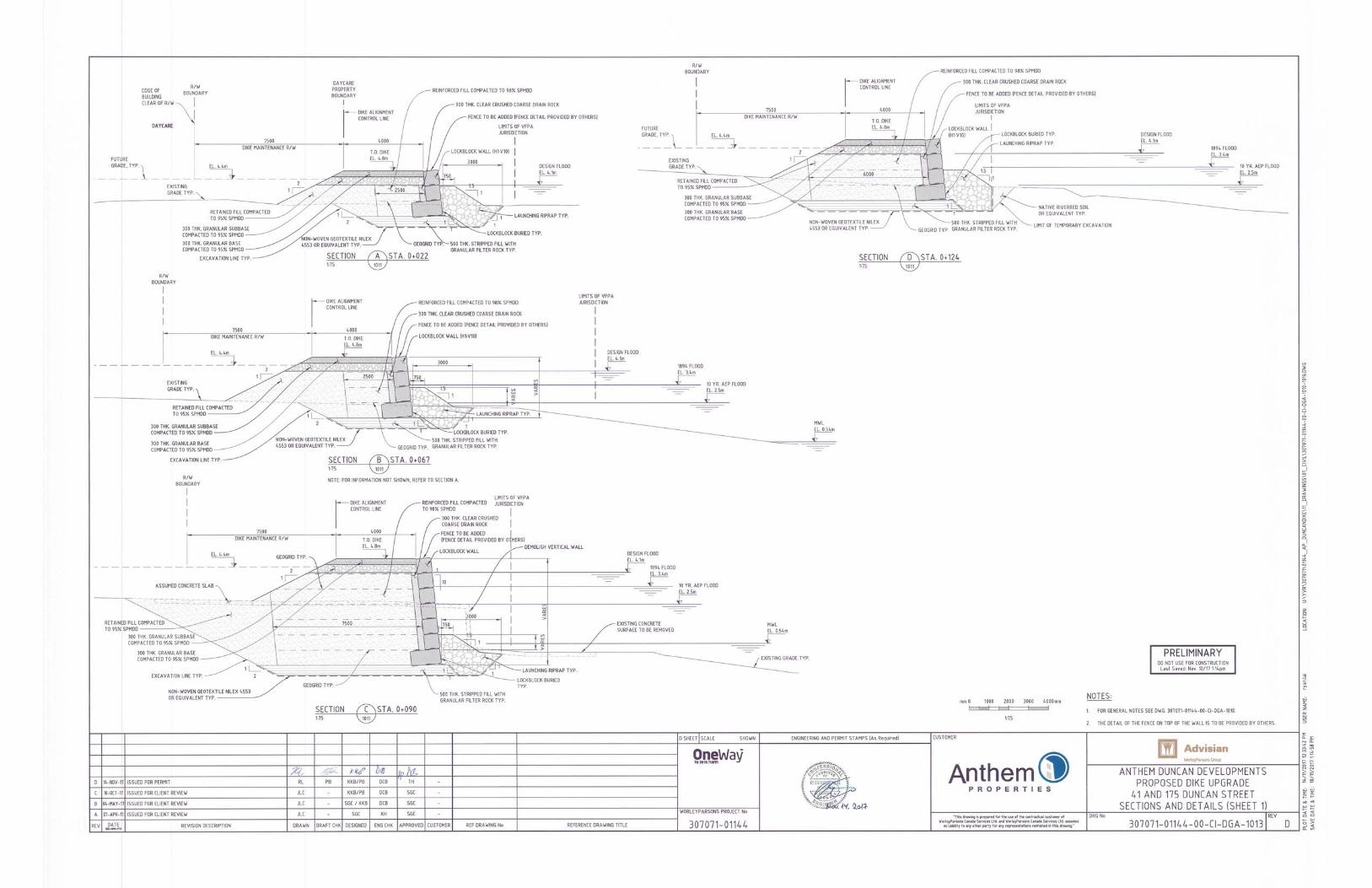
Engineering drawings showing dike construction are provided in Attachment 2 as follows:
307071-01144-00-CI-DGA-1010 - General Notes and Design Criteria
307071-01144-00-CI-DGA-1011 - Plan and Profile
307071-01144-00-CI-DGA-1012 - Lockblock Wall Elevation View
307071-01144-00-CI-DGA-1013 - Sections and Details (Sheet 1)
307071-01144-00-CI-DGA-1014 - Sections and Details (Sheet 12)
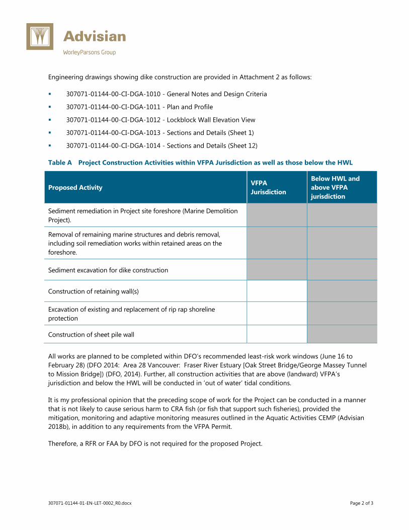
Table A Project Construction Activities within VFPA Jurisdiction as well as those below the HWL
Proposed Activity VFPA
Jurisdiction
Below HWL and
above VFPA
jurisdiction
Sediment remediation in Project site foreshore (Marine Demolition
Project).
Removal of remaining marine structures and debris removal,
including soil remediation works within retained areas on the
foreshore.
Sediment excavation for dike construction
Construction of retaining wall(s)
Excavation of existing and replacement of rip rap shoreline
protection
Construction of sheet pile wall
All works are planned to be completed within DFO’s recommended least-risk work windows (June 16 to
February 28) (DFO 2014: Area 28 Vancouver: Fraser River Estuary [Oak Street Bridge/George Massey Tunnel
to Mission Bridge]) (DFO, 2014). Further, all construction activities that are above (landward) VFPA’s
jurisdiction and below the HWL will be conducted in ‘out of water’ tidal conditions.
It is my professional opinion that the preceding scope of work for the Project can be conducted in a manner
that is not likely to cause serious harm to CRA fish (or fish that support such fisheries), provided the
mitigation, monitoring and adaptive monitoring measures outlined in the Aquatic Activities CEMP (Advisian
2018b), in addition to any requirements from the VFPA Permit.
Therefore, a RFR or FAA by DFO is not required for the proposed Project.


307071-01144-01-EN-LET-0002_R0.docx Attachments
Attachment 1 Figures

Poplar Island
Fraser River
122°55'0"W122°56'0"W
49°12'0"N
5050005450000
ANTHEM PROPERTIES
307071-01144 1 0
KR
15/03/2018
KR
VB
PLOT DATE & TIM
E: 15/03/2018 10:43:18 AM
SAVE DATE & TIM
E: 15/03/2018 10:43:18 AM
USER NAME: kenneth.w.ritchie
ISSUING OFFICE: BURNABY GIS
FILE LOCATION: \\WorleyParsons.com\CA\Data\YVR\307071\01144_AP_DuncanDike\10_Eng\16_Geomatics\01_Mxd\Anthem_Dike_Self_Assessment\Figure1_20180315_Location_Rev0.mxd
SCALE: SHOWN
"This drawing is prepared for the use of our customer as specified in the accompanying report. WorleyParsons Canada Ltd.assumes no liability to any other party for any representations
contained in this drawing."
CUSTOMER:A SHEET
WORLEYPARSONS PROJECT No: FIG No: REV
DATE:
DRAWN:
EDITED:
APPROVED:
Site Location
Service Layer Credits: Sources: Esri, HERE, DeLorme, Intermap, increment P Corp., GEBCO, USGS, FAO, NPS, NRCAN, GeoBase, IGN, Kadaster NL, Ordnance Survey, Esri Japan, METI, Esri China (Hong Kong), swisstopo, MapmyIndia, © OpenStreetMap contributors, and the GIS User
Community
Legend
VFPA Boundary
Site Location
SITE LOCATION
0 100 200 30050
Metres ±

Approximate location of Retaining Wall(to be removed)
1 2 3
West Foreshore Mid Foreshore East Foreshore
122°55'38"W122°55'39"W122°55'40"W122°55'41"W122°55'42"W122°55'43"W122°55'44"W122°55'45"W122°55'46"W122°55'47"W122°55'48"W122°55'49"W122°55'50"W122°55'51"W122°55'52"W122°55'53"W
49°11'49"N
49°11'48"N
49°11'47"N
49°11'46"N
49°11'45"N
49°11'44"N
505000 505100 505200 505300
5449200
5449300
PLOT DATE & TIME: 15/03/2018 10:45:32 AM
SAVE DATE & TIME: 15/03/2018 10:45:32 AM
USER NAME: kenneth.w.ritchie
ISSUING OFFICE: BURNABY GIS
FILE LOCATION: U:\YVR\307071\01144_AP_DuncanDike\10_Eng\16_Geomatics\01_Mxd\Anthem_Dike_Self_Assessment\Figure2_20180315_RMA_Rev0.mxd
SCALE: SHOWN CUSTOMER:B SHEET
DATE:
DRAWN:
EDITED:
APPROVED:
K.R.
Y.M.
V.B.
307071-01144
15/03/2018
"This drawing is prepared for the use of our customer as specified in the accompanying report. WorleyParsons Canada Ltd.assumes no liability to any other party for any representations
contained in this drawing."
WORLEYPARSONS PROJECT No: FIG No: REV
Service Layer Credits: Source: Esri, DigitalGlobe, GeoEye, Earthstar Geographics, CNES/Airbus DS, USDA, USGS, AeroGRID, IGN, and the GIS User Community
Lot information from City of New Westminster.VFPA Jurisdiction supplied by Port of Vancouver.
Legend
High High Water Level
Low Low Water Level
RAR 30m Buffer
Dike Layout
Limit of VFPA Jurisdiction
Lot Boundary (Approx.)
Risk Management
Ground Truth ClassificationBased On Survey
Low Productivity
Moderate Productivity
0 10 205
Metres ±ANTHEM PROPERTIES
RISK MANAGEMENT AREAS AND DIKE FOOTPRINTFOR THE UPCOMING ANTHEM PROJECT
2 0

307071-01144-01-EN-LET-0002_R0.docx Attachments
Attachment 2 Engineering Drawings