Embed Size (px)
Citation preview

l • J !
I '
. ~ .
. I
I
C.~LJA LiBRARy NOT - ARCHtt£
FOR 1.JJ.AN
P:ROVISIONAL REPORT I .
ALBANY SHIRE NATURE- RESERVES ,,
,'
Andrew A. E. Williams,,
\
REPORT ITEM DIS062
129

11\\111 "111 "111 \I"\\\\" 1111\ \Ill \\II 004536
T' c & LAl\JU IVIAl\JAlitMtN I
WESTERN AUSTRALIA
Department of Fisheries & Wildlife W.A. Wildlife Research Centre
PROVISIONAL REPORT ON 3 NATURE RESERVES IN ALBANY SHIRE
Introduction:
This is the first of a series of reports on the
Nature Reserves of Albany Shire. The aim is simply
to present a basic picture of each reserve, where
applicable pointing out items of special interest . For
the sake of continuity the reports have been set out
under a series of pre-arranged headings - i.e. Background,
Physical Characteristics, Vegetation, etc. The data
was obtained by Andrew Williams and Graeme Folley on two
short expeditions to the Shire in February and March 1980.
Each reserve was visited twice.
Weather conditions were ideal throughout, being
sunny with some intermi tten't cloud cover. Most t ime
was devoted to examining the vegetation on each reserve,
but notes on birds and mammals were also taken. These,
however, are only of a superficial nature as insuff icient
time was allowed for detailed observations . Habitat
photographs and diagramatic ve getation maps have been
produced for each area. The vegetation was ·classified
following the B.G. Muir System as used in the W. A. Wheatbelt
Survey . It proved reasonably satisfactory for the south
west's vegetation. Bird nom~clature follows Slater 's
Field Guide to Australian Birds.
REPORT ITEM DIS062
130

•.• /2
The ultimate object of the exercise is to bring
together reports for each of the mainland Nature Reserves
falling within the Albany Shire boundaries. With this
information it should then be possible to lay down a
series of guide lines for the management of the reserves
within the "Shire Unit", with special re f erence being paid
to the problems peculiar to the area.
Thanks are due to Dr S. D. Hopper of the W. A. W. R.C.
for his help in identifying plant specimens collected in
the field. The herbarium collection at Two Peoples Bay
Nature Reserve also proved extremely useful. My personal
thanks are due to ~lr Graeme Folley for his hospitality, and
assistance in the field. It should be noted that he will
be producing the reports for most of the remaining Nature
Reserves in Albany Shire. Mr J. A. K. Lane and Mr G.B. Pearson
kindly allowed me to use rec·ords from their water-bird surveys
of the south west.
REPORT ITEM DIS062
131

TABLE .1: VEGETATION CLASSIFICATION AS USED IN WHEATilELT SURVEY
LIFE FORM/HEiCHT CLAssf _____ ------ -- ----- CA;'ZOPY COVER
.
T Trecs>30m M Trees l S-30m LA Trees 5· l 5m LE Trees <S m
KT Ma!lce tree form KS M:iilcc shrub form
s Shrubs>2m SA Shrubs I .S·2.0m SB Shmbs I 0-1.Sm SC Shrubs O.S· 1.0m SD Shrubs 0.0-0.Sm
p Mat pl:ints H Hummock Grass
GT Bunch grass >0.5m Gt. Bunch crass <0.5m 1 ·Herbaceous spp.
Vi Scdges>O.Sm YL Scdbcs <O.Sm
x Ferm Mosses, liverwort
I- DENSJ1 d 70-100%
I
I r
I
Dense Tall Forest Dense Fores! Dense Low Forest A Dense Low Fores: B
Dense Tree Malice Dense Shrub Mallce
Dense Thicket Dense Heath A Dense Heath B Dense Low Heath C Dense Low Heath D
Dense Mat Pian ts Dense Hummock
Grass Dense T:ill Grass Dense Low Grass Dense Herbs
Dense Tall Sedges Dense Low Sedges
Dense Fems Dense Mosses
Mm-DENSE 30-70% c
1,---Tall Forest Forest
· 1 Low Forest A Low Forl!st B
Tree M:i.!lce I Shmb Malice 1
Thicket Heath A Heath B Low He:ith C Low Heath D
Mat Plants Mid· Dens;,:
Hummock Crass Tali Grass Low Grass
I Herbs
Tai! Sedges Low Sed~es
I Fems Mosses
I
I l
r
SPARSE • 10-30% l
Tall Woodl:ind Wood land Low Wood!::md A Low Wcodl:ind B
Open Tree M:i.llec Open Shnib Maller:.
Scrub Low Scr..ib A Low Scrub il Dwarf Scrub C Dwarf Scrub D
Open !\fat Plants Hummock Grass
Open .Tan Crass Open Low Crass Open Herbs
Open Tall Scd~cs Op\!n Low Sedse.s
Open Ferns Open Mosses
vmw SPARSE -2-!0% •
Open Tall Woodfond Open Woodland Open Low Woodland A
I Open Low Woodland !3 I 1-- ~
, . Very Open Tree Ma!!cc Very Open Shrub Malle c
. Open Scrub Open Low Scrub A
l Open Low Scrub Il Open Dwtirf Scmb C Open Dwarf Scrub D
Very Open M::t Plants Open Hummock Grass
Very Open Tall Crass Very Open I.ow Ci.iss Very Open Herbs
I Very Open Tall Sedges Very Open Low Sedges
Very Open Ferns V cry Open M oss..:s
•
........... VJ
REPORT ITEM DIS062
132

./4
LAKE PLEASANT VIEW - RESERVE No. A.15107
E
B
(lake)
A
N.
Granite outcrop - lS:SSJ Firebreak tracks
Reserve Boundary
AREA A: Tall Sedges to Open Tall Sedges. AREA B· ·• Open Low Woodland A over Open Low Scrub B
over low Sedges. AREA C: Open Low Woodland A over Open Low Scrub A
over Open Low Sedges. AREA D: Dense Heath A over Low Sedges. AREA E: Woodland over Thicket to Low Scrub B, over
Open Low Sedges. AREA F: Low Woodland A over Heath A over Dense Tall Sedges.
REPORT ITEM DIS062
133

••• /5
LAKE PLEASANT VIEW - RESERVE No. A.15107
Location:
Situated on the northern side of Hassell Road,
ea. 32 kms N. E. of Albany , and sharing a common boundary
with Manypeaks Townsite. Located on Lithograph .
2528-111-Two Peoples Bay.
Background:
Lake Pleasant View was originally gazetted on 5th
December 1913 for the purpose of water. On 27th May 1955
the area was first increased to 282 acres, and then again
on 19th July 1957 to about 500 acres (ca 202.3428 ha).
On 3rd April 1959 the purpose was ammended to
"Water and Conservation of Flora and Fauna", classified
as a . Class 'A'· Reserve and vested in the Fauna Protection
Advisory Committee. The area was again increased with
the inclusion of Lot 2702 (formerly Reserve No. 15078)
to its present size of 267.0925 ha.
Physical Characteristics:
This reserve covers an area of 267.0925 ha. It is
bordered by farmland to the east, north and west, and
by the Hassell Road to the south east. The south west
section shares a common though irregular boundary with
Manypeaks Townsite which is at present uncleared.
A shallow lake depression occupies most of the
reserve area, though the water level varies according to
seasonal rainfallQ Al ong the eastern and southern sides
REPORT ITEM DIS062
134

••• /6
of the reserve the land rises slightly to support a narrow
belt of Jarrah/Redgum dominated forest. On the southern
border between the road and the lake a high granite
outcrop protrudes into the reserve. A motorable track
skirts along the south eastern and eastern sides of the
lake. Fire breaks have been constructed along the
entire per~meter of the reserve, and the remains of an a.r"
old dam is located on the northern side of the lake.
The soil throughout the reserve is made up of a light
coloured sand. The altitude ranges from approximately
90 - 100 metres above sea level.
Vegetation:
The vegetation can be readily separated into the six
associations shown on the diagr amatic map f or the area.
This breakdmvn covers a transition from the l ake's sedges,
through the Melaleuca dominated shoreline, to the Jarrah
and Redgum Woodland on the higher ground. There is a
distinct tendancy for s ome of the understorey species
found in the Redgum/Jarrah Wo odland to encroach down onto
the sloping margins of the lake.
Area A: A shallow lake, for the most part supporting
numerous sedges - its size dependent on seasonal rainfall.
The sedges range from 0.75 to 2 metres in height depending
on the species. They grow densely in places but thin out
towards the centre of the lake where there are large
areas of open water. The Flag Rush, Baumea articulata,
was common.
REPORT ITEM DIS062
135

••• /7
Area B:: Supports 'Open Low Woodland A' made up of
scattered Paperbark trees, Melaleuca cuticularis growing
from 12 to 15 metres over 'Open Low Scrub B' consisting
primarily of Hakea varia, Leucopogon sp. and Acacia sp.
This scrub in turn grows over 'Open Low Sedges' to a
height of ca 0.5 metres.
Area C: This area supports an association of
scattered Paperbarks, Melaleuca cuticularis to 12 metres,
and Eucalyptus occidentalis from 6 to 14 metres, the latter
mainly along the upper lake margins. They grow over
'Open Low Scrub A', made up of several species including
young E. occidentalis, Hakea varia, Oxylobium cuneatum
and Melaleuca sp. The ground is covered with 'Open Low
Sedges' to ca 0.5 metres.
Area D: A limited area of 'Dense Heath A' made up
in more or less equel proportions of Hakea varia and Hakea
trifurcata growing to 1.5 metres, over 'Open Low Sedges'
growing to 0.5 metres.
Area E: · Dominated by mixed Eucalyptus calophylla,
and Eucalyptus marginata Woodland to 18 metres with a
variable understorey. In some parts this consisted of
'Thickets' of predominantly Bossiaea linophylla, Agonis
parviceps and Oxylobium lanceolatum to ca 3 metres.
In others it was classed as 'Low Scrub B' to 1.5 metres
and made up of many species including Hakea varia, Hakea
REPORT ITEM DIS062
136

•.• /8
cera tophylla, I,sopogon formosus, Banksia grandis and a
Daviesia sp. Also noted were examples of Casuarina
frazeriana, Agonis flexuosa, Melaleucas, Acacias and
Blackboys. Sedges, grasses and Patersonia occidentalis
made up much of the ground cover. Specimens of the
rare Banksia driandroides and the Swamp Banksia, B. litoralis,
were found in whitish sand along the south eastern part of
the Reserve where this association graded into swampy
sedges along the lake shore.
Area F: Supports stands of young Eucalyptus occidentalis
trees growing to a maximum height of 6 metres and quite
dense in places, over 'Heath A' of predominantly Hakea varia
and Oxylobium cuneatum to ca 1.5 metres. This over
'Densa Tall Sedges' to ca 1 metre. An Acacia SE• and
Melaleuca sp. to 1 metre were also noted.
Human Usage:
In the past the reserve has been used by local
farmers as a rubbish dump, but action on the part of local
Wildlife Officers put a stop to this practice. Most of
the debris has since been removed by the offenders.
However, there are still some signs including .a rusty
car body on the S.E. boundary. Along the north eastern
edge of the lake is an old decayed cattle carcass.
According to the Department of Fisheries & Wildlife
sign erected on the Hassell Road boundary, the reserve is
also seasonally open to both quail and duck shooting.
REPORT ITEM DIS062
137

••• /9
Fire History:
The Jarrah/Redgum Woodland shows signs of an old
fire, but the reserve as a whole does not appear to have
been burnt in recent years. However, a minor fire was
reported to have burnt a small area of the reserve in
December 1976. The damage was restricted to about one
hectare along the edge of the lake and apparently originated
from the Manypeaks Townsite dump.
The reserve has an excellent firebreak system
though some of them are now in need of attention.
FAUNA
Mammals:
3 Grey Kangaroo - :Macropus fuli ginosus - in N. E. corner
Rabbits - little sign.
Birds:
4 Australian Little Grebe - Podiceps novaehollandiae
1 Little Black Cormorant - Phalacrocorax suleirostris
4 Little Pied Cormorant - Phalacrocorax melanoleucos.
37 Whi te faced Heron - Ardea novaehollandiae
1 Black Duck - Anas superciliosa
7 Musk Duck - Biziura lobata
1 Biack-shouldered Kite - Elanus notatus
2 Whistling Kite - Haliastur sphenurus
2 Swamp Harrier - Cireus approximans
1 Little Falcon - Falco longipennis
2 Brown Falcon - Falco berigora
2 Swamphen - Porphyrio p:o1rphyrio
2 Coots - Fulica atra
REPORT ITEM DIS062
138

. .
••• /10
3 Greenshank - Tringa nebularia
1 Common Bronzewing - Phaps chalcoptera
1 Fan-tailed Cuckoo - Cacomantis pyrrhophanus
1 Laughing Kookaburra - Dacelo gigas
12 Tree Martin Petrochelidon nigrigan~
1 Black-faced Cuckoo- shrike - Coracina novaehollandiae
2 Grey Fantail - Rhipidura fuliginosa
1 Willie Wagtail - Rhipidura leucophrys
2 Australian Raven - Corvus coronoides
8 Western Silvereye - Zosterops lateralis
Other s pecies previously reported from the Reserve but
not encountered on this survey include Black Swans,
Cygnus atratus, Western Warbler - Gerygone fusca, Brown
Flycatcher - Microeca leucophaea, Golden Whistler -
Pachycephala peetoralis, and the Western Shrike-thrush -
Colluricincla harmonica.
Reptiles and Amphibians
Three species of small fro~ were found to be abundant
·' in the sedges growing along the lake fringes .
Dugites and Tiger snake s have also been sighted
on the granite outcrop in the past.
Remarks and Su.mmary:
This is an important reserve for several reasons.
Firstly, it acts as a suitable refuge for both migratory
and resident birds, with its combination of wetland and
woodland habitatso It is an aesthetically pleasing area
REPORT ITEM DIS062
139

... ;ii
and is used by hunters in the duck and quail shooting season.
The rare Banksia, B. dryandroides, was located along
the south eastern side of the lake growing in sandy soil.
The reserve is now almost completely surrounded by cleared
farmland.
REPORT ITEM DIS062
140

Reserve No. A 15107 ••• /12
' .
View onto reserve from the Hassell Road boundary
South eastern shore of lake with granite outcrop clearly visible in the background.
REPORT ITEM DIS062
141

••• /13
View from the northern boundary looking across the lake. Note Melaleuca cuticularis and sedges along shoreline, with open water towards the centre.
Looking S.E. across Lake Pleasant View with Mt. Manypeaks in the background.
REPORT ITEM DIS062
142

••• /14
Banksia dryandroides along the S.E. shore of the lake.
REPORT ITEM DIS062
143

••• /15
MOLLOCULLOP SPRING - RESERVE No. 16367
N.
x
A
F
. ""'· Reserve boundary
Fence lines
AREA A:
AREA B: AREA C: AREA D:
AREA E: AREA F: AREA G: AREA H:
NOTE:
Isolated patches of Low Forest A over Open Low Scrub A over Open Low Grass and Sedges.
Lo~ Forest A over Thicket over Dense Tall Sedges. Dense Thicket Patches of Open Low Woodland B; over Open Low Scrub A
over Low Heath C. Low Forest. A over Low Scrub A over Very Open Sedges. Shrub Mallee over Open Low Grasses. Open Shrub Mallee over Heath B. Melaleuca cuticularis Open Low Woodland A
(marked green on map)
The Flag Rush, Baumea articulata, occurs sporadically along the southern edge of the lake.
REPORT ITEM DIS062
144

••• /16
MOLLOCULLOP SPRING - RESERVE No . 16367
Location:
Situated on the Warriup Road ca 1.5 kms south east
of Reserve No. 26234 and ca 31 lans north east of
Manypeaks Townsite. Shown on lithograph 2528 - 1
(Green Range).
Background.:
Reserve No. 16367 was originally gazetted on 20th
April 1916. Its area was decreased on 6th May 1921, and
on 5th October 1923 it came under the control of Albany
Shire. On 26th April 1968 the purpose was amended from
"Water & Camping" to "Water, Camping and Conservation of
Flora and Fauna", and vested in the Shire of Albany .
On 24th October 1975 the reserve area was decreased to
its present siza of 115.6548 ha by the construction of
road No. 15508 through part of the reserve .
Physical Characteristics:
This reserve has an overall area of 115.6548 ha.
It is basically rectangular, though with a large bite out
of the northern boundary and minus the south ~est corner.
The longer axis runs east and westo
Some 50% of the area is taken up by a permanent
fresh water lakeo The land to the east and north east
is dominated by two laterite rocky ridges which extend
into the reserve before falling off sharply close to the
lake's edge. Along the northern side the reserve boundary
REPORT ITEM DIS062
145

••• /17
f or the mo s t part f ollows clos e to the edge of the l ake.
The western and s outh western side s are dominated by
a hillside wi th large granite boulders. Along the
southern boundary the rim of the l ake- basin rises only
a few metres above the water level befor e dropping down
again towards the sea. The total perimeter of the
reserve measures ca 4.25 kms.
To the north of the reserve lies an extensive tract
of woodland which reaches down to the l ake. Along the
southern and eastern sides the vegeta tion is l ar gely
undisturbed; the rocky r idge to the east i s unsuitable
f or grazing and as such still retains its natural
vegeta tion. The altitude on the reserve varies from
50 metr es in the south west corner and ca 45 metres
along the eastern rocky ridge to the lake level which
averages at just under 20 m.etres above sea l evel.
The Warriup Road runs through the reserve from west
to east, pass ing alongside the southern and eastern
edges of the l ake.
Vegetation:
The vegetation on Mollocullop Spring can be readily
separated into 8 distinct zones as shown on the diagramatic
map for the area. The central part of the reserve is
taken up by a permanent fres h water lake. This supports
little vegetation other than a few stands of the Flag Rush,
Baumea articulata, mainly along the southern side. The
rest of the reserve is split up into the following associations.
REPORT ITEM DIS062
146

••• /18
Area A:
Consists of isolated small patches of E. calophylla,
E. marginata and Nuytsia floribunda 'Low Forest A' from
4 to 6 me t res over 'Open Low Scrub A' of predominantly
Agonis S£• to 2 metres, Dryandra sessilis and stunted
Banksia grandis. This over 'Open Low Grasses'. Ground
species re corded included Dryandra nivea and Astroloma
ciliatum. This is a somewhat degenerate area as it
has in the past been grazed by cattle.
Area B:
Supports a mixed 'Low Forest A' association, made up
of Agonis flexuosa to 8 metres, E. cornata and
E. occidentalis to 10 metres, Banksia litoralis to 10
metres and Melaleuca cuticularis to 6 metres. This
over "Thicket", consisting of young Melaleuca cuticularis,
Hakea varia and Adenanthos ~ericea to 3 metreso This
in turn over 'Dense Tall Sedges' to 1 metre including
the Knotted Club Rush, Scirpus nodosus.
Area C:
'Dense Thicket' to 3 metres made up almost entirely
of the Woolly Bush, Adenanthos sericea, growing on
whitish deep sando
Area D:
Dominated by a l arge granite rocky hillside and
characterized by rather degenerate windblown vegetation
growing on the exposed slope. It supports patchy 'Open
REPORT ITEM DIS062
147

••• /19
Low Woodland B' malfo up predominantly of E. colophylla
and ~~sia fl~~~-~~da to 5 metres, over 'Open Low Scrub A'
made up mainly of Calothamnus quadrifidus _, Acacia cyclops,
Acacia sp., Dryandra sessilis. and stunted Banksia grandis.
This in turn over 'Low Heath C' made up largely of
Casuarina . humilis to 1 metre, A~acia sp. to 1 metre
and Stirlingia latifoli~. Also noted was an Astroloma sp.
to 0.5 metres.
In several sections stands of E. calophylla grew
in shrub-like formati on to 3 metres.
Area E:
This association is found along the western and
north eastern sides of the lake, of ten in areas where
seasonal flooding occurs. Composed of 'Low Forest A'
E. occidentalis to 10 metres over'Low Scrub A' composed
of young Melaleuca cuticularis, young Agonis flexuosa
and an Acacia sp., over ' VeTy Open Low Sedges'. Where
this association occurs in the N.E. of the reserve, the
understory is largely absent presumably due to past
grazing by cattle.
Area F:
This association occurs along the northern face of
a rocky ridge and supports a mallee dominated vegetation
quite unlike anything else found on the reserve.
Consists of 'Shrub Mallee ' made up of E. angulosa,
E. decipiens, E. lehmannii and E. goniantha affin. to
6 metres, with little understorey other than 'Open Low
Grasses' to less than 0.5 metres.
REPORT ITEM DIS062
148

••• /20
Area G:
'Open Shrub Mallee' of predominantly E. lehmannii to
ca 5 metres over 'Heath B' made up of Calothamnus
quadrifidus, Calothamnus sp., Agonis sp., Hakea trifurcata
and stunted Banksia grandis on rocky soil.
Area H~ (marked in green on the diagramatic map)
Narrow margin round lake edge of 'Open Low Woodland A'
made up of the Paperbark tree, Melaleuca cuticularis, to
ca 6 metres.
Human Usage .: Considerable.
1. The reserve is apparently used by local residents
for recreational purposes. These include both boating
and water skiing on the lake.
2. Stock. Local resident land owner , Mr W. A. Hassell,
waters his stock on the eastern side of the l ake .
Judging from tracks , cattle mainly use the Warriup Road
to reach the water. Two fence lines constructed WITHIN
the reserve and a gate across the main road prevent them
f rom wandering elsewhere on the reserve (see diagram).
From a discussion with Mr Colin Hassell it seems that
stock have been watered in this way f or several years -
through some prior arrangement wi th the Shire. It would
be interesting to establish just what arrangement exists
and if the Reserve purpose of "Water" gives Mr Hassell
the right to water his stock on the reserve.
REPORT ITEM DIS062
149

••• /21
3. The Warriup Road passes through the reserve and as
such provide s public ac cess and some vehicle disturbance.
4. There was almos t no sign of rubbish on the reserve
apart fr om an old bar-bt-que and "dunny" found in the
Melaleuca woodland a long the no r th eastern edge of the
lake (marke d x on the map)
5. Near the south west corner a gravel pit has been
dug for road maintenanc e purposes. As survey markers
for this section were not located it was impos sible
to ascertain whether these excavations were on the
reserve.
Fire History:
There were no signs of recent fire on the reserve.
The Warriup Road acts as .an excellent firebreak. Even
though the reserve has been set aside for camping no
evidence of camp fires was seen. According to Mr Colin
Hassell, the fire which passed through the nearby
Tinkelelup Reserve some 12 to 15 years ago also went
through Mollocullop Spring, though the effects on the
latter are not so readily apparent.
FAUNA
Mammals:
4 x Grey Kangaroo - Macropus fuli ginosus
Rabbit - little sign.
REPORT ITEM DIS062
150

••• /22
Bl.rds:
6 Hoary-headed Grebe - Podiceps poliocephalus
2 Little Pied Cormorant - Phalacrocorax melanoleucos
14 Mountain duck - Tadorna tadornoides
3 Grey Teel - Anas gibberifrons
4 Wood Duck - Chenonetta jubata
1 Whistling Kite - Haliastur sphenurus
1 White-breasted Sea-Eagle Haliaetus leucogaster
9 Coot - Fulica atra
2 Common Bronzewing - Phaps chalcoptera
5 ·white-tailed Cockatoo - Calypt,orhynchus funereus
1 White-winged Triller - Lalage sueurii
4 Blue-breasted Wren - Malurus pulcherrimus
5 Yell ow tailed Thornbill Acanthiza chrysorrhoa
1 Spotted Scrub-Wren
i Scarlet Robin
1 Willie Wagtail
1 Restless Flycatcher
14 Western Silvereye
2 Brown Honeyeater
- Sericornis frontalis maculatus
- Petroica multic olor
- Rhipidura leucophrys
- Myiagra inquieta.
- fostero£S laterolis gouldi
- Lichmera indistinata
1 Western Spinebill - Acanthorµynchus superciliosus
50+ Ne~ Holland Honeyeater !:hYlidonyris novachollandiae
18 Red Wattle-bird - Anthochaera carunculata
3 Australian Magpies - Gymnorhina dorsalis
Birds previously reported but not encountered on.
this survey include Pied Cormorant - Phalacroc orax varius,
White-faced Heron - Ardea novaehollandiae, Nankeen Night
REPORT ITEM DIS062
151
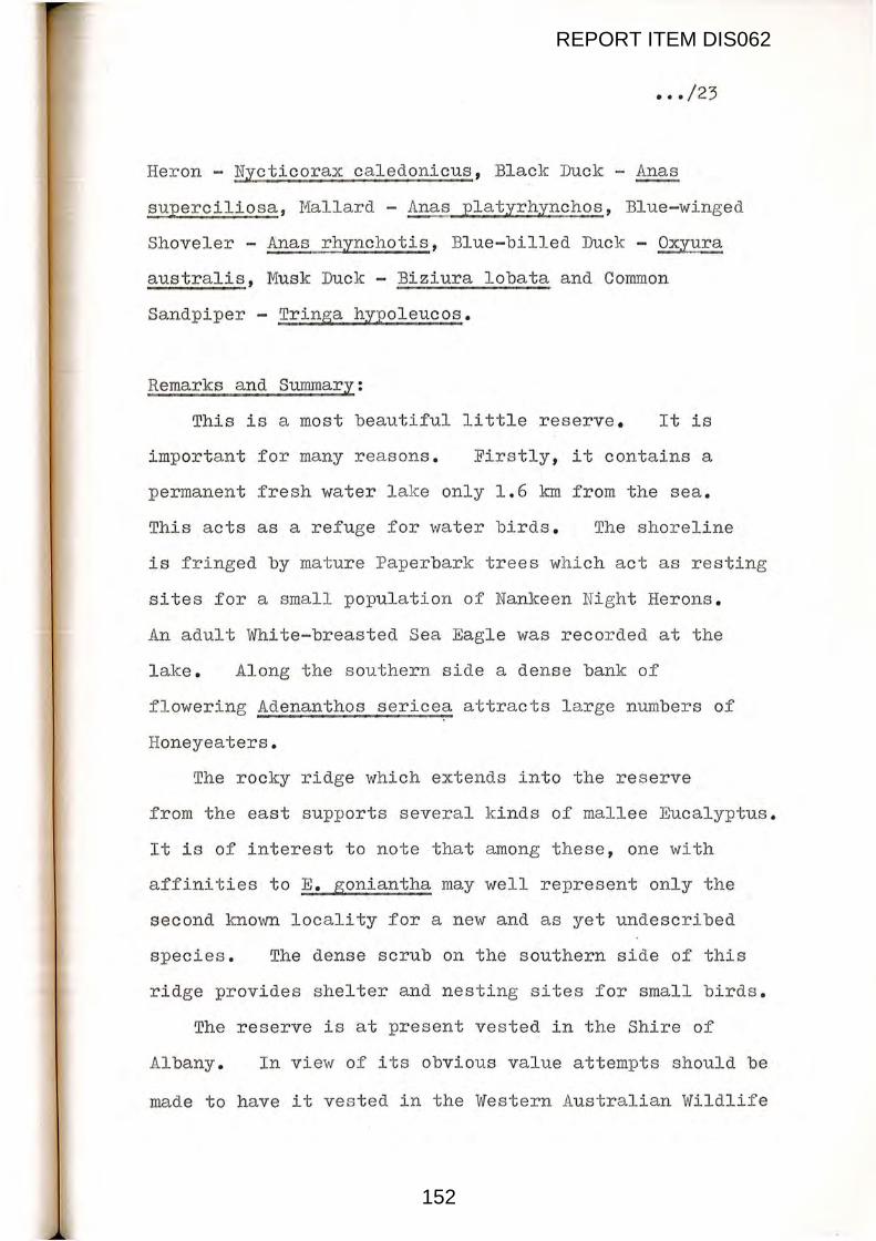
••• /23
Heron - Nycticorax caledonicus, Black Duck - ~
superciliosa, Mallard - Anas platyrhynchos, Blue-winged
Shoveler - Anas rhynchotis, Blue-billed Duck - Oxiura
australis, Musk Duck - Biziura lobata and Common
Sandpiper - Tringa hypoleucos.
Remarks and Summary:
This is a most beautiful little reserve. It is
important for many rea sons. Firstly, it contains a
permanent fresh water lake only 1.6 km from the sea.
This acts as a refuge for water birds. The shoreline
is fringed by mature Paperbark trees which act as resting
sites for a small population of Nankeen Ni ght Herons.
An adult White-breasted Sea Eagle was recorded at the
lake. Along the southern side a dense bank of
flowering Adenanthos sericea attracts l a rge numbers of
Honeyeaters.
The rocky ridge which extends into the reserve
from the east supports several kinds of mallee Eucalyptus.
It is of interest to note that among these, one with
affinities to E. goniantha may well represent only the
second known locality for a new and as yet undescribed
species. The dense scrub on the southern side of this
ridge provides shelter and nesting sites for small birds.
The reserve is at present vested in the Shire of
Albany. In view of its obvious value attempts should be
made to have it ve s ted in the Western Australian Wildlife
REPORT ITEM DIS062
152

••• /24
.Authority. An alternative watering site should be found
for the cattle presently using the r eserve and
investigations carried out to establish what disturbance
is caused by the use of the reserve for recrea tional
purposes. From the management standpoint attempts
should be made to acquire or purchase the privately
owned land along the northern shore of the lake, thus
turning the reserve into a compact rectangular block.
Should this area be cleared the value of the reserve
would diminish considerablyo From conversations with
Mr G. Folley it seems that Mr Hassell is conservation
minded and might be willing to relinquish his hold on this
portion of land.
REPORT ITEM DIS062
153

Reserve No. 16367 ••• /25
View looking N.E. from the southern shore of the lake. Note the mallee-eucalyptus covered ridge in the background.
View across the reserve from the S.W. corner.
REPORT ITEM DIS062
154

~~~-...........-------------.............. .. ••• /26
View across the reserve from the N.E. corner.
Dense thicket of Adenanthos sericea along the southern side of the reserve.
REPORT ITEM DIS062
155

••• /27
GREEN RANGE (TINKELELUP ) - RESERVE No . 26234
5
Burnt area
Reserve Boundary .
REPORT ITEM DIS062
156

•.• /28
GREEN RANGE (TINKELELUP) - RESERVE No. 26234
Vegetation areas shown on map:
Area 1: Open Low Woodland B and Thicket over Dense
Low Heath C.
Area 2: Open Low Woodland B over Low Heath C and
Dense Low Heath c. Area 3: Low Woodland A over Heath A and Dense Heath A.
Area 4: Low Forest A over Thicket
Area 5: Low Woodland B\ over Heath A and Dense Heath A.
Area, 6: Open Low Woodland A over Thicket over
Tall Sedges.
Area 7: Open Low Woodland A over Dens e Thicket.
REPORT ITEM DIS062
157

.... /29
GREEN RANGE (TINKELELUP) - RESERVE No. 26234
Location:
Ca 30 lans north east of Manypeaks Townsite and shown L
on J ithograph 2528 - 1 - Green Range .
Background:
Reserve 26234 was originally set aside f or the
purpose "Conservation of Flora and Access". By
Government Gazette notice of 30th May 1975, the purpose
was changed to Conservation of Flora and Fauna, and
vested in the Wesu Australian Wildlife Authority .
Physical Characteristics:
This area, locally known as the Tinkelelup Reserve,
has a total area of 575.5186 ha. The bulk of the reserve
is made up of a roughly rec~angular block of land, with
its longer axis running north and south. From the
south west corner of this rectangle protrudes a long
narrow strip which reaches south 2.75 kms . to the Warriup
Road . A firebreak/track, ca 16 kms in length, has been
pushed around the perimeter of the reserve. Three lateral
firebreaks cut through the reserve from east to west and
lie approximately equidistant from each other.. The
northern part of this reserve cuts across the eastern
end of Green Range, where it reaches an elevation of some
210 metres. The terrain is broken up into a series of
hills and gullies as it descends rapidly towards the
REPORT ITEM DIS062
158

••• /30
south, reaching a low of 50 metres at the S.E. corner of
the southern extension. The Mollocullop Creek system
winds through the reserve where several of its main
tributaries originate. Along these stream gullies
vegetation is denser and taller due to the added moisture
and protection afforded by the terrain. On the hill
tops and unprotected slopes the vegetation has a wind
pruned appearance.
The surface soil falls into two basic categories,
with most of the hills and ridges composed of laterite
and in parts laterite gravel mixed with sand. The
creek valleys and depressions between the ridges contain
whitish sand.
The reserve is completely surrounded by privately owned
land, though at the present time much of this is still
uncleared. Ultimately the reserve will no doubt be
cut off from the surrounding natural habitat when the
area is opened up for farming.
Vegetation:
The Tinkelelup Reserve has a fairly complex mosaic
of vegetation types . It is possible to break these
down into 7 distinct associations although there is
considerable overlap in some parts where one zone merges
into another. The basic formati ons shown on the
diagramatic map are listed below:-
1. 'Open Low Woodland B' of scatfered E. marginata and
REPORT ITEM DIS062
159

••• /31
mallee E. decipiens to 4 metres over tall Hakea cucullata
'Thicket' to 3 metres over 'Dense Low Heath C' - this
made up of many species including Hakea ruscifolia.,
Hakea trifurcata, Beaufortia annisandra, Dryandra
mucronulata affin., Dryandra pteridifolia, Daviesia sp.,
Stirl.ingia . latifolia, Dryandra nivea. and the Grassboy,
Kingia australis. It should be noted that much of
this association has been recently burnt.
2. On deep whitish-grey sand. 'Open Low Woodland B'
mainly Banksia attenuata 2 to 5 metres with stunted
E. marginata and E. calophylla to 4 metres. This over
'Low Heath C' to 'Dense Low Heath C' made up of many
species including Adenanthos c.uniatum, Hakea ruscifolia,
Hakea trifurcata, Beaufortia annisandra and Stirlingia
latifolia. Also noted were Daviesia sp., Melaleuca sp.,
Casuarina sp., ~.!§! sp., · a small A£onis sp. and several
grasses and sedges. The Kangaroo Paw, Anigozanthos ru~,
was common along the firebreaks.
3. 'Low Woodland A' of stunted E. marginata and
E. calophylla to 6 metres over an understory of
'Heath A' to ' Dense Heath A' made up of several species,
with the Hakeasand Dryandras being dominant. Species
noted include Hakea trifurcata to ca 2 metres, Hakea
varia, Hakea ruscifolia, Dryandra mucronulata affin.,
Adenanthos cune~~, Isopogon formosa, Lambertin uniflora,
Melaleuca striata, Beaufortia annisandra and the Tassel
REPORT ITEM DIS062
160

••• /32
Flower, Leucopogon verticilliata. Examples of two small
Banksias, .!h_dryandroides and B. prostrata were also
recorded in this area. Note:- Along the southern
side of the northern block Dryandra mucronulata affin.
is totally dominant with Hakea varia common.
4. Confined to the deeper valleys along the Mollocullop
Creek system, 'Low Forest A' of E. marginata and E. calophylla_
canopy cover ca 30%, over 'Thicket', made up of Bossiaea
linophylla, Agonis s;p., Spyridium globulosum and Acac.ia sp.
Along the moist creek beds'Tall Sedges ' to ca 2 metres,
with Hakea trifurcata to 2~ metres the dominant understory
species on the higher ground. Banksia dryandroides to
ca Oo75 metres was also common.
5. tLow Woodland B' of E. marginata, E. calophylla and
mallee E. decipiens to 3 metres over 'Heath A' to ' Dense
Heath A' made up of predominantly Hakea trifurcataand
Dryandra mucronulata_ affin., with Hakea varia, Beaufortia
annisandra:, Isopogon formosa, Banksia s;phaerocarpa,
Banksia prostrata and Banksia grandis also noted.
There are some open areas which support 'Open Mat Plants'.
This association in fact represents a more stunted
version of Area 3. In places the shrub-form E. marginata
and E. calophylla form a single upper canopy level with
Hakea trifurcata.
6. Wetter areas along the Mollocullop and Tinkelelup Creek
beds. 'Open Low Woodland A' of scattered Paperbark trees,
REPORT ITEM DIS062
161

••• /33
Melaleuca preissiana to 8 metres and Banksia li t toralis
trees to 6 metres over 'Thicket' made up of Agonis sp.
and Oxylobium lanceolatum, ove r 'Open Tall Sedges '.
7. Stands of 'Open Low Woodland A' of E. cornuta and
E. decipiens to 5 metres over 'Dense Thicket' of
Oxylobium cuneatum to ca 3 metres. Where this
association occurs in the south of the reserve small
specimens of Agonis flexuosa are also present .
Hilman Usage:
Tinkelelup Reserve is free from rubbish. There
was no sign of human activity on the reserve apart
from the tracks put in for fire control purposes.
Adequate fences have been erected where farmland
adjoins the reserve. According to Mr Colin Hassell
poachers occasionally hunt kangaroos on the reserve.
Fire History:
Virtually the entire reserve, toge ther with all
the surrounding bushland, appears to have carried a very
hot fire some 12 tD 15 years ago. The burnt tops of
many of the trees still bear testimony to the- blaze.
Time has, however, allowed considerable regeneration to
take place.
During the past year the local Bush Fires Brigade
was responsible for a control burn on the southern end of
the reserve extension, from the Warriup Road to the firs t
REPORT ITEM DIS062
162
••• /34
f ire_break. Apparently the present arrangement allows
for the next section to be burnt after a 3 year interval.
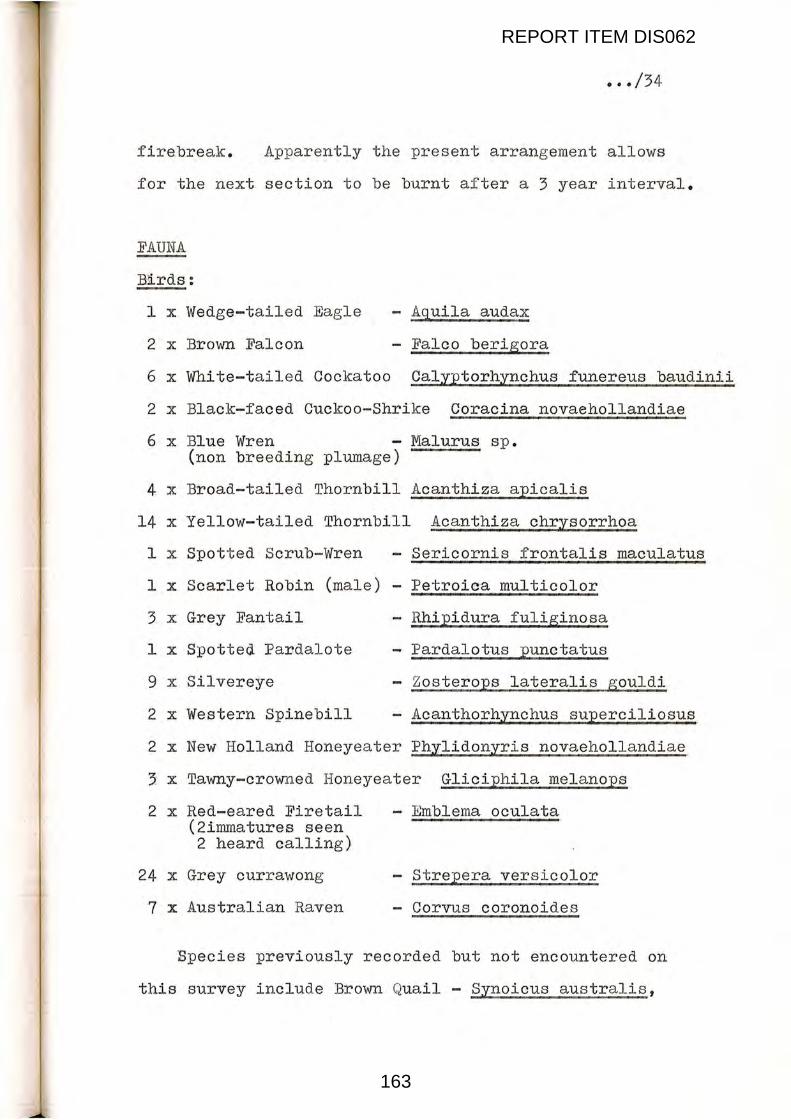
FAUNA
Bli.rds:
1 x Wedge-tailed Eagle - Aquila audax
2 x Brown Falcon - Falco berigora
6 x White-tailed Cockatoo Calyptorhynchus funereus baudinii
2 x Black-faced Cuckoo-Shrike Coracina novaehollandiae
6 x Blue Wren - Malurus sp. (non breeding plumage)
4 x Broad-tailed Thornbill Acanthiza apicalis
14 x Yellow-tailed Thornbill Acanthiza chrysorrhoa
1 x Spotted Scrub-Wren - Sericornis frontalis maculatus
1 x Scarlet Robin (male) - Petroica multicolor
~ x Grey Fantail
1 x Spotted Pardalote
9 x Silvereye
2 x Western Spinebill
- Rhipidura fuliginosa
- Pardalotus punctatus
- Zosterops lateralis gouldi
- Acanthorhynchus superciliosus
2 x New Holland Honeyeater Phylidonyris novaehollandiae
~ x Tawny-crowned Honeyeater Gliciphila melanops
2 x Red-eared Firetail - Emblema oculata (2immatures seen 2 heard calling)
24 x Grey currawong - Strepera versicolor
7 x Australian Raven - Corvus coronoides
Bpecies previously recorded but not encountered on
this survey include Brown Quail - Synoicus australis,
REPORT ITEM DIS062
163

••• /35
Galah - Eolophus roseicapillus and Golden Whistler -
Pachycephala peetoralis.
Mammals:
2 x Brush-tail Wallaby
7 x Grey Kangaroo (5 adult 2 sub-adult)
1 x Fox
Macropus irma
- Macropus fuliginosus
Als o diggings of a small unidentified mammal
(scrapings in the soil~. Some sign of rabbits but
none seen.
Reptiles:
1 x Bobtail Lizard - Teliqua rugosa
1 x Varanus Lizard - V-aranus gouldii
1 small unidentified snake sighted at the base of a
Melaleuca tree near the north east corner of the
reserve.
Remarks and Summary:
This is a most interesting reserve and due to its
varied topography contains a considerable number of
habitat types. Situated as it is on the eastern end
of Green Range it commands an impressive view overlooking
the sea to the south east and the Stirling Ranges to the
north west. From a botanical standpoint the fl ora is
diverse, and seven species of Banksia were recorded:
REPORT ITEM DIS062
164
••• /36
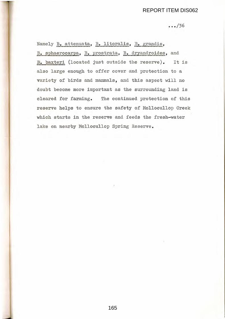
Namely B. attenuata, B·. litoralis, B. grandi~,
B. sphaerocarpa1 B. prostrata, B. dryandroides, and
B.~ baxteri (located just outside the reserve). It is
also large enough to off er cover and protection to a
variety of birds and mammals, and this aspect will no
doubt become more important as the surrounding land is
cleared for farming. The continued protection of this
reserve helps to ensure the safety of Mollocullop Creek
which starts in the reserve and feeds the fresh-water
lake on nearby Moll ocullop Spring Reserve .
REPORT ITEM DIS062
165

Reserve No. 26234 ••• /37
View facing S.S.W. from the N. E. corner. Note the burnt tops to the eucalyptus trees.
Firebreak along the southern edge of the northern block o Note the r apid interchange of soils.
REPORT ITEM DIS062
166

••• /38
Recently 'chained' vegetation on privately owned land along the eastern firebreak .
E. cal~hyll~ and ~marginata over u~derstory domina ed oy Dryandra mucronulata affin. Note: Local Tea Picker.
REPORT ITEM DIS062
167


![FRANÇAIS Mission (im)possible : [M:I - SIAMS] · 74 I EUROTEC N O I 2 / 2018 SIAMS 2018, Moutier, Suisse FRANÇAIS Mission (im)possible : [M:I - SIAMS] La première chose qu’évoque](https://img.dokumen.tips/doc/110x75/60447bde9803281c57093ebd/franais-mission-impossible-mi-siams-74-i-eurotec-n-o-i-2-2018-siams.jpg)