Embed Size (px)
Citation preview

PROPOSED RESiDEntial DEvElOPmEnt alDERmaStOn whaRf, PaDwORth
DESIGN AND ACCESS STATEMENT
November 2010
STRIDE TREGLOWN JOB NO.PREPARED BYCHECKED BYDATEFILEREVISION NO.
30892DADJENovember 201030892_R01_101129_D+A Statement_PLANNING.indd-

cOntEntS
11123567 889999
111212131416181819
2020202020
2020
2121
212121
22
INTRODUCTIONRole of DocumentThe ApplicantThe Site ContextHistorical ContextSite CharacteristicsExisting BuildingsSurrounding Land UseLocal Architectural CharacterArchitectural PrecedentCommunity InvolvementPlanning HistoryPlanning Policy ContextPlanning PoliciesDevelopment Objectives
DESIGN STATEMENTDescription of Development Use and AmountVisitor Centre Car ParkingDesign DevelopmentLayoutScaleAppearanceAmenity SpaceLandscaping
ACCESS STATEMENTInclusive DesignInternal and External accessEmergency and Service Vehicle AccessPedestrian and CyclingPublic Transport
DRAINAGEFoul Water DrainageStorm Water Drainage
SUSTAINABILITYSustainable InitiativesEnvironmental AssessmentPhysical EnvironmentCode for Sustainable HomesBRE Green Guide on Materials
BUILDINGS FOR LIFE
11.11.21.31.41.51.61.71.81.9
1.101.111.121.131.14
22.12.22.32.42.52.62.72.82.9
33.13.23.33.43.5
44.14.2
55.15.25.35.45.5
6
H2O Urban8 Cork StreetMayfairLondonW1S 3LJ
British Waterways 1 Sheldon SquarePaddington CentralLondonW2 6TT
Promenade HouseThe PromenadeClifton DownBristolBS8 3NE
StRiDE tREGlOwn - alDERmaStOn whaRf, PaDwORth DESiGn anD accESS StatEmEnt 1
This Design and Access Statement is written in support of the Planning Application for a proposed residential development at Aldermaston Wharf, Padworth, Berkshire submitted to West Berkshire Council for :
13 no. new dwellings and associated parking including forming new accesses from the public highway. Also associated with the proposed development is the reprovision of 14 no. visitors spaces for the use of the Aldermaston Wharf Visitor Centre.
The format of the document reflects the guidance described in Section 3 of the Department for Communities and Local Government Circular 01/2006.
The submission provides details relating to the siting, design and external appearance of the proposed development and explains how it is to be landscaped. It also provides details of the access and car parking arrangements within and surrounding the site and sustainability.
The intention of this document is to allow local communities, voluntary groups and other stakeholders to involve themselves more directly in the planning process and to clarify the proposals in addition to the submitted drawings.
This document should be read in conjunction with the drawings listed in the issue sheet.
1.1 Role of Document
1.2 The Applicant
1 intRODUctiOn
The applicant is H2O Urban LLP in partnership with British Waterways. British Waterways is the inland navigation authority for England, Scotland and Wales, and a public corporation sponsored by DEFRA.
British Waterways is the guardian of 2,200 miles of historic canals, rivers and docks, and the 200-year old network, is considered one of the finest examples of industrial heritage in the world. British Waterways’ estate comprises the country’s third largest collection of listed structures and a wealth of important urban and rural habitats that support a variety of familiar and endangered species.
The waterways attract over 13 million people each year for primarily recreational purposes. British Waterways works with local communities, businesses and councils to unlock the potential of the waterways to benefit waterside areas and to secure the funds needed to maintain and repair the system.
British Waterways, in partnership with specialist regeneration company bloc, have created H2O Urban LLP as a joint venture to regenerate selected sites. The joint venture enables funds to be generated from sensitive development and regeneration, for reinvestment into maintaining and improving British Waterways’ local and national canal infrastructure.
The regeneration company combines the enterprise and ambition of a private development company, with the social responsibility of an established public body.
1.3 Site Context
Aldermaston Wharf is a small, but busy rural village, situated 1.5 miles north-northwest of Aldermaston in the West Berkshire District of the County of Berkshire. It lies at the junction of two main roads, with a station on the Great Western Railway line from London to the West. The Kennet & Avon Canal runs the length of the southern side of the village. Aldermaston Wharf was designated as a Conservation Area by West Berkshire District Council in 1970.
The site, which measures approximately 0.37 hectares is situated in the eastern end of the village accessed from Wharfside. Basingstoke Road (A340) borders the site to the west, with Wharfside to the north and the Kennet and Avon Canal to the south.
The site currently comprises a mixture of uses incorporating a public car park, a Grade II Listed Visitor Centre / cafe with a small former Toll Office building (also listed), vacant scrub land and utilities structures. A tow path runs along the entire sounthern boundary of the site.
The immediate vicinity off Wharfside comprises a range of semi-detached houses and terraced cottages dating from various eras. To the west is Wharf Cottages lying parallel to Basingstoke Road and to the east is Wharf House with its garage and out buildings. In the ownership of the apllicant but outside the scope of this application is a neighbouring pair of indistinct semi-detached houses.
Wharfside terminates at the entrance to a privately operated marina servicing the leisure and boating business.
A 340 (
BASINGSTOKE R
OAD)
A 4 ( B AT H R O A D )
ALDERMASTON WHARF

1 intRODUctiOn
2
1.4 Historical Context
The historical importance of Aldermaston Wharf relates to its connection with the construction of a direct waterway which eventually linked London and Bristol. The River Kennet adjacent to Aldermaston Wharf was made navigable between 1718 and 1723 under the supervision of the engineer John Hore of Newbury and opened as the Kennet Navigation in 1723 pre-dating the eventual formation of the Kennet and Avon Canal in 1810. The Kennet Navigation had wharves at either end of its length, at Newbury and Reading, and in Aldermaston which was about the mid-point.
The existence of a wharf allowed a trading community to develop around it. In addition carpenters were required to service the locks and bridges which added to the local growth and the formation of a central carpentry depot. On completion of the Kennet and Avon Canal, local trade flourished even more with exports of timber products, malt and flour to London and imports of coal, groceries and manufactured goods. When the Great Western Railway bought the canal in the 1850s a canal spur was constructed to the railway sidings to allow transfer of goods between canal and rail. Some of this has now been infilled although the line is visible.
The Kennet Navigation handled boats which were similar to those which plied the Thames, much larger than the normal canal narrow boat. The large locks needed to cope with these barges, together with the timber swing bridges allowing traffic across the canal became characteristic of the Kennet Navigation.
The Grade II Listed Aldermaston Lock to the west of the village was built between 1718 and 1723. It was originally turf-sided, but enlarged in the mid-eighteenth century and given scalloped brick walls which is a unique feature on this canal. It was altered in the late twentieth century when the walls were raised to the full height of the lock. It was originally called Brewhouse Lock because of Strange’s Brewery stood beside it.
Linked to the brewery was Bridge House which sits adjacent to the current lifting bridge and is immediately south of the application site. Bridge House is a Grade II listed building believed to have been built after the canal was completed in 1723 for the family of the brewery owner and since 1987 has been the home of Alder Bridge Steiner Waldorf school.
To the east of Bridge House lies a row of half-timber cottages known as the Malthouse. Historically they were used as maltings for the brewery before being converted into cottages in the early part of the 20th Century.
The site itself contains two historically important buildings namely the Wharf Cottage (now acting as a visitor centre / cafe to the canal) and the smaller Toll Office within its curtilage. Both buildings became Grade II Listed in January 2009.
An engraving of the timber swing bridge over the Kennet and Avon Canal with Bridge House in the background.
Wharf Cottages adjacent to the lift bridge over the canal Aldermaston Lock with the Wharf Cottages behind.
18th Century Bridge House built by the owner of the former Strange’s Brewery.
Wharf Cottage and Toll Office contemporary with the construction of the canal and now a Canal Visitor Centre

3StRiDE tREGlOwn - alDERmaStOn whaRf, PaDwORth DESiGn anD accESS StatEmEnt
1 intRODUctiOn
1.5 Site Characteristics
In its present condition, the site comprises of the Visitor Centre and garden, with car parking adjacent to the buildings and also contains an existing electric substation, bridge lifting mechanism and a foul pumping station. The remainder of the site area is scrub and vacant land.
The topography of the site is fairly flat, however the existing buildings, trees and shape of the site pose a great challenge to the proposal.
The site is a complex shape, being formed around a number of existing buildings including numbers 14 and 15 Wharfside (under the applicants ownership) and the listed Visitors Centre and associated, listed, Toll House. A large proportion of the site fronts the Kennet and Avon Canal.
The site contains a number of constraints and abnormalities which have influenced the layout. These include the sewage pump, which is being relocated as part of the proposed development. Access to the existing substation, the retention of the existing trees, accommodating the visitors car park associated with the Visitor Centre and responding to the listing of the Visitor Centre and Toll House half way through the design process.
However, notwithstanding these issues, there is potential for a high quality scheme of simplicity in layout and form, which could enhance and reinforce the natural character of the site and surrounding area.
Tow-path to south of site looking east with the site to the left.
Tow-path to south of site looking west with the site to the right.
View into the site from Wharfside with the Wharf Cottage in view.
Nos. 14 and 15 Wharfside under the ownership of British Waterways.
Existing car-parking on site.
Scrub vegetation adjacent to 14 Wharfside with Wharf Cottages in the background.
Approach along Wharfside with existing visitor’s car park entrance to the right.
Entrance to Wharfside off Basingstoke Road with scrub vegetation on the north-west corner of the site.

1 intRODUctiOn
4
Existing Site Plan Showing Constraints

1.6 Existing Buildings
The site contains two buildings which are thought to be contemporary to the construction of the canal. Known as the Wharf Cottage and the Toll Office, both are Grade II Listed.
The Wharf Cottage appears to date from the 18th Century with some 19th/20th Century alterations. The period of construction of the cottage would coincide with the construction of the original 1723 Kennet Navigation, providing the building with a significant waterway heritage value. The front elevation of the cottage is highly visible from the canal-side. Also of historical interest are GWR iron boundary markers at the south-west corner of the house and a second immediately outside entrance from canalside. These are significant examples of canal heritage dating from the era of ownership of the K & A Canal by the Great Western Railway in the later 19th/20th Century.
The Toll Office like the main building appears to date from the18th Century. This also suggests a connection with the 1723 Kennet Navigation. It is a small single storey structure witha pitched clay tile roof. The masonry is red brick in a Flemish Bond with a gable end chimney stack to the NW. The opposing gable (SE) is timber framed painted black with rendered brick infill and brickwork below, both in white. Although it is generally called the Toll Office, there is no evidence to show that it was built as such and the plan form, range and associated copper suggest it was a wash-house possibly used for communal purposes. This is supported by an oral account of the building’s function from a local source. It is not known if it also served as a dwelling in the past. The front and end elevations are visible from the wharf. Untypically, like the Wharf Cottage this building is also not in alignment with the canal.
The Wharf Cottage and Toll Office have group value as a composition of historic buildings with the Toll Office forming a unique example on the K & A with significant heritage value, differing in design fundamentally from the only other Toll Office at Dundas Wharf near Bath.
More detailed information is provided under the Historical Impact Assessment included with the application.
The cottage was built as a 2 storey dwelling with 3 bays facing the canal with a half hipped clay tile roof and a flat roofed single storey extension to rear (NW). The central door has a hood supported by timber brackets. The building is white painted and partially rendered brick.
The dwelling is now used as a Visitor Centre and tea rooms but in plan contains 2 living rooms, kitchen and bathroom downstairs with 2 bedrooms upstairs. The original fireplace relating to the removed stack is bricked up, but the tongue and groove stair panelling and internal ledged doors with wrought iron latches are likely to be original features. The roof timbers are elm with purlins supported by 2 queen post trusses constructed with pegged joints.
Front south-east elevation of the Wharf Cottage at an angle to the canal.
View of Wharf Cottage from footpath on Wharfside.
Toll Office from canal tow-path. Rear of Toll Office.
Interior of Wharf Cottage. Wharf Cottage and Toll Office in foreground from tow-path.
5StRiDE tREGlOwn - alDERmaStOn whaRf, PaDwORth DESiGn anD accESS StatEmEnt
1 intRODUctiOn

Wharfside located to north of the site.
Wharf Cottages on Basingstoke Road located to the south-west corner of the site
Wharf House located to east of the site. Boat yard located to far east of the site.
Canal path to the south of the site with houses and garages on opposite canal bank.
1.7 Surrounding Land-Use
A range of historic and modern land-uses surround the site:
• Directly to the north of the site, Wharfside, is a residential area.• Wharf Cottages to the south-west, provides 4 terraced houses along Basingstoke Road.• Adjacent to Wharf Cottages is a canal crossing which is serviced by a lifting bridge, the mechanism
of which is powered from a pump room within the site.• Immediately to the east of the site is the Wharf House with its outbuildings.• Further to the east of the site is ABC Leisure, offering canal based leisure opportunities to the community.• To the south of the site is the Kennet and Avon Canal, with public footpath and major cycle route along the canal and further residential units beyond.• The opposite side of the canal on the south consists of a mixture of buildings including the
aforementioned Bridge House and Malthouse Cottages and associated modern garages.
1 intRODUctiOn
Typical houses on Wharfside.
Lifting bridge on the adjacent to Wharf Cottages The Malthouse Cottages on the opposite canal bank.
View of tow-path to the south of the site taken from the lifting bridge.
View of tow-path to the east of the site looking towards boat yard.
6
1 intRODUctiOn
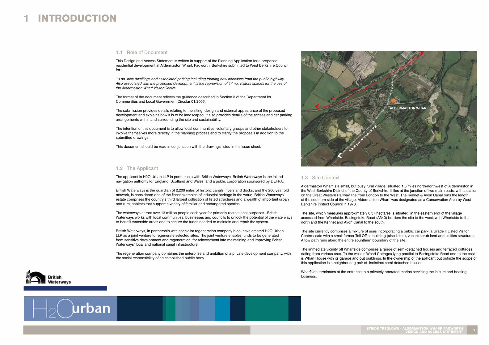
1.8 Local Architectural Character
The growth of Aldermaston Wharf has not generated a distinct architectural character for the area, instead creating a mixture of styles linked with either the period of construction or its function. The buildings of importance are set in or around the wharf including the Wharf Cottages, Wharf House, the Canal Visitor’s Centre and nearby Bridge House and the Malthouse. The boatyard adjacent to the site contains a few relatively modern buildings of an industrial nature. Much of the rest of the village is quite modern in construction with an architectural identity which is more sub-urban than rural.
Common unifying materials for houses are brick walls, some painted and clay roof tiles. However, this is not homogenous and examples of half timber walls, tile hanging and render are in evidence. Roofing materials also vary with clay tiles dominating, but also examples of slate sheet metal in use.
Semi detached houses on Wharfside located to north of the site.
Modern housing development on the former brewery site on the south side of the canal.
The Grade II Listed Canal Visitor Centre and Toll Office
Wharf Cottages to the west of the site.
Modern metal roofed houses off Mill Lane to the south of the village.
The Malthouse Cottages on the opposite bank of the canal.
Traditional cottages at the north end of the village off Basingstoke Road.
The Georgian Grade II Listed Bridge House built by the owner of Strange’s Brewery following the construction of the canal. The building is now in use as a Steiner School.
Typical boatyard buildings to the east of the site.
View of tow-path to the east of the site looking towards boat yard. Wharf House to the east of the site.
Modern apartments on the north side of the canal to the west of the site adjacent to Aldermaston Lock.
7StRiDE tREGlOwn - alDERmaStOn whaRf, PaDwORth DESiGn anD accESS StatEmEnt
1 intRODUctiOn
8
1.9 Architectural Precedent
The architectural character of the proposals have evolved from a rigourous analysis of local vernacular, industrial and waterside precedents to create a design which acknowledges the context of the site, it’s historical importance as part of the locality’s canal-scape and its distinct character through its proximity to the Listed Wharf Cottage(Visitor Centre) and Toll Office.
At the heart of the design intention, is maintaining the characteristics of the historic buildings on the site. This is primarily established by the relationship of new to the existing buildings, their appearance and the spaces which surround them.
The proposals therefore, carefully attempts to reinforce the individuality of the Wharf Cottage, by being visually different in materials but respectful in scale and positioning so that the Listed Buildings remain the strong focus of the site.
The use of materials for the new buildings aligns with the site’s location and former industrial nature reflecting the traditional design of local cottages and boat yards using a palette of materials which are robust and durable. In recognition of the canal’s industrial history, the proposals are inspired by materials which are related to the creation of trade in Aldermaston Wharf such as timber, at one time a significant industry here and reflected by its use on the site historically for cladding. The light render finish is in response to the painted brick and render used on the canal-side cottages. The zinc roof is a hint to an industrial past reflecting the more utalitarian buildings of the current boatyard.
The images below, display a collection of ideas which have played a part in the evolution of the design to create buildings which maintains the desired ‘spirit of the canal’.
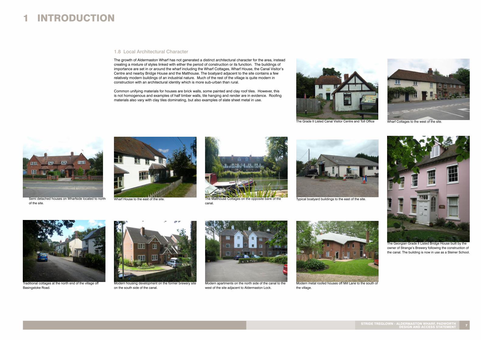
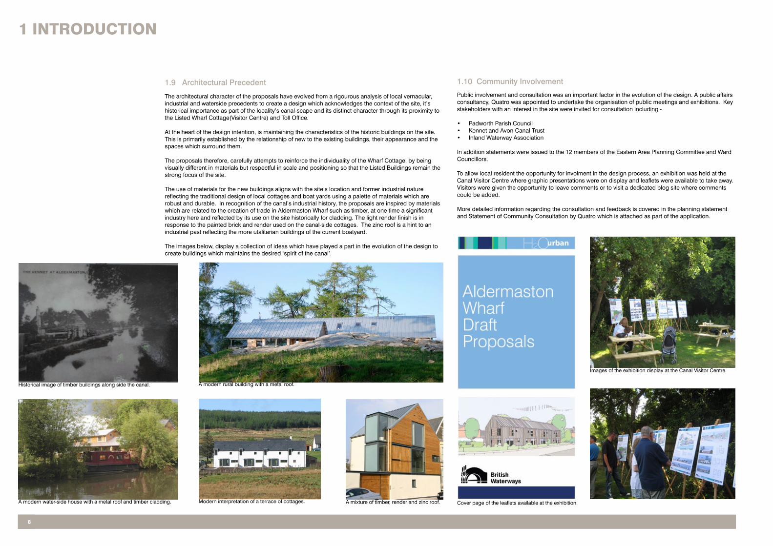
1.10 Community Involvement
Public involvement and consultation was an important factor in the evolution of the design. A public affairs consultancy, Quatro was appointed to undertake the organisation of public meetings and exhibitions. Key stakeholders with an interest in the site were invited for consultation including -
• Padworth Parish Council• Kennet and Avon Canal Trust• Inland Waterway Association
In addition statements were issued to the 12 members of the Eastern Area Planning Committee and Ward Councillors.
To allow local resident the opportunity for involment in the design process, an exhibition was held at the Canal Visitor Centre where graphic presentations were on display and leaflets were available to take away. Visitors were given the opportunity to leave comments or to visit a dedicated blog site where comments could be added.
More detailed information regarding the consultation and feedback is covered in the planning statement and Statement of Community Consultation by Quatro which is attached as part of the application.
Cover page of the leaflets available at the exhibition.
Images of the exhibition display at the Canal Visitor Centre
Historical image of timber buildings along side the canal. A modern rural building with a metal roof.
A modern water-side house with a metal roof and timber cladding. Modern interpretation of a terrace of cottages. A mixture of timber, render and zinc roof.

9StRiDE tREGlOwn - alDERmaStOn whaRf, PaDwORth DESiGn anD accESS StatEmEnt
1 intRODUctiOn
1.11 Planning History
West Berkshire District Council’s records show that the application site has a limited planning history which is set out in the supporting Planning Statement.
1.12 Planning Policy Context
The proposed development at Aldermaston Wharf has been assessed in line with relevant National, Regional and Local Planning Policy Guidance.
This document has been prepared in accordance with the Quality Design West Berkshire Supplementary Planning Documents. It responds to the requirements of the Town & Country Planning (General Development Procedure) (Amendment) (England) Order 2006 which requires planning applications to be accompanied by a Design & Access Statement that explains the design concepts that have been applied to the development and how access routes have been taken into account.
A detailed analysis of national, strategic and local planning policy is contained within the Planning Statement Document and identifies issues relevant to a consideration of the design of the proposed scheme.
The importance of design and access issues, as stressed in planning policy, has been taken into account in finalizing the form of the scheme that is the subject of this application. These issues include building form, scale, layout, orientation and height with emphasis on enhancing the local environment.
1.13 Planning Policies
For further planning details and Planning Policies , please, refer to the Planning Statement Document.
1.14 Development Objectives
Having undertaken extensive public consultation, and both site and market analysis, British Waterways have come to the conclusion that the most appropriate and viable use for the site is for residential dwellings. As a result, British Waterways is aiming to provide high quality residential accommodation, in an attractive and sustainable architectural language, which respects the character of the Conservation Area and Listed Buildings of the local area.
The principal development objectives are to:
• Create a high quality residential scheme based upon exemplary design.• Produce a scheme which retains the spirit of the historic area and the site’s heritage.• Enhance the character and appearance of the conservation area.• Integrate with the canal-side context and the local vernacular architecture by using sympathetic forms and materials.• Respect the historic context of the site.• Positively address the canal frontages, with enhanced views across and along the canal and creating a strong and appropriate canal edge.• Retain the visitor parking.• Protect the Listed Buildings and the setting of the buildings.

DESiGn anD accESS StatEmEnt
10

11StRiDE tREGlOwn - alDERmaStOn whaRf, PaDwORth DESiGn anD accESS StatEmEnt
2.1 Description of Development
The proposed development comprises of 13 new residential units, the relocation of existing car parking for the Visitor Centre and relocation of the existing sewage pump station.
The site is a complex shape, being formed around a number of existing buildings including numbers 14 and 15 Wharfside and the listed Visitors Centre and associated, listed, Toll Office. The site also contains a number of constraints and abnormalities which has an influence on the layout. These include the foul pump station, which is being relocated as part of the proposed development, access to the existing electrical substation, the retention of existing trees and accommodating the visitors car park associated with the Visitors Centre.
The main opportunities available to the site relate to the existing features which create the site’s identity, particularly the proximity to the canal and its relationship to the historical canal related buildings. These factors form the framework which underpins the design approach.
2 DESiGn StatEmEnt
A large proportion of the site fronts the Kennet and Avon Canal, and the layout maximises the number of houses that benefits from this attractive waterside amenity. A respectful approach in relation to the siting of the new buildings and their relationship with the Visitor Centre and Toll office is undertaken in terms of spatial arrangement, materials and scale.
The site will consist of 3 individual terraces (a mixture of 1.5, 2 and 2.5 storeys in height) with formal spaces to the front and more private spaces to the rear, with associated car parking.
The proposed arrangement of the individual buildings has been designed to reflect the shape of the site, the site constraints and the site context. However, because of the nature of the site, all building frontages are relatively public in the sense that they either face the canal tow-path, Basingstoke Road or parking courts and therefore the designs have taken this factor on board. Ultimately, each location has different features which have generated a design response that has influenced the proposed building on that specific site.

1 intRODUctiOn
12
The proposals to insert new dwellings into the site and to emphasise the site’s strengths leads to the need to relocate the existing 14 Canal Visitor Centre parking.
The visitor parking is a major concern to local residents and has two principle elements. Namely, the loss of visitor parking provision, and that the visitor spaces will be used by residents of the development. Both issues have been addressed within the scheme to ensure the development does not add any additional pressure to the local road network.
14 public car parking spaces have been retained and carefully sited for use in association with the Visitor Centre - the same number as are presently useable. Whilst a recent car park utilisation study indicated that a reduction in the number of public car parking spaces would be justified, having heard representations from the K&A Trust, local residents and the PC, and to support the future viability of the visitor centre the redevelopment of the site will not result in a reduction in the number of public car parking spaces.
The visitor car park was historically controlled by a coin based ticket machine and inspection programme. The system was not effective and ultimately the machine was removed. This has lead to an increase in long term parking and other issues.
To ensure the car park is used for visitors and not commuters a “ring-go” style contract will be set up to ensure the spaces are regularly vacated. A small fee would be charged for say the first two hours as not to deter users whilst ensuring the spaces regularly churn and are freed up for new arrivals. Tickets will also be available from the Visitor Centre.
Outside of say 0900 to 1800 parking will be free and this will then enable visitors to the development to park without burdening the local road network.
We believe that this management structure and parking regime will overcome any problems with parking, ensure the spaces are used efficiently, allow greater public access to the site and ensure people visiting the dwellings will be able to park. There will also be disabled parking provision.
Too much parking would be unsightly and out of keeping with the Conservation Area and BW has generously gifted land to West Berkshire Council to improve pedestrian access to Aldermaston Station Car Park and improve safety for the wider community.
2.3 Visitor Centre Car Parking
The application relates to the provision of new residential accommodation. Although the external approach and parking to the listed Visitor Centre is to be altered, this application does not involve any works which physically affects the built fabric of the Visitor Centre or its associated Toll Office. The proposed scheme comprises of the following:
• 13 residential units in three buildings with private front and rear spaces, external storage space and associated car parking.• Relocation of car parking for the Visitor Centre• Relocation of existing sewage pump station
Site analysis, public consultation and market research has concluded that residential development is the most appropriate, sustainable and sympathetic use for the site making it compatible with the surrounding use of the locality.
The dwellings are to be marketed primarily to couples and retirees, with a few larger units providing family homes. As a result, the size of dwelling unit has been carefully considered to provide a good mixed demographic appeal.
The proposed accommodation schedule comprises the following:-
• 8 x 2 bedroom house at 900sqft • 2 x 3 bedroom house at 1100sqft.• 3 x 4 bedroom house at 1350sqft.
Therefore, the total number of dwellings is 13, with a total gross internal area of 13,450sqft.
Parking
Parking for residents is located adjacent to each building and designed in accordance with Quality Design Guide WBDC Supplementary Planning Document, which is:
1.5 car parking spaces .............................................................................................................per 2 bed house2 car parking spaces .........................................................................................................per 3 & 4 bed house
The overall amount of the proposed residential car parking spaces is 22 in total. For the terraces A and part of B, the parking is grouped together in two private parking courts. Terrace B has its car parking located and accessed off Wharfside, with protecting bollards. Terrace C has a more conventional parking arrangement with the cars being located in front of the building with access directly off Wharfside.
Due to the nature of the design and sensitivity of the site, some of the parking is distributed unconvetionally to reduce its impact. We have carried out swept path studies to ensure that these spaces are suitably accessible. Please see the adjacent diagram.
Existing car parking to the Visitor Centre has been relocated, providing 14 spaces and is described in the following section.
2.2 Use and Amount
GP
G
P
GP
G
P
GP
P
GPP
G
P
P
G
PP
GP
GP
GP
GP
GPP
BA
SIN
GS
TO
KE
RO
AD
(A
340)
43/4
1
3
1/2
2
5
5
9
9
8
7
7
8
6
6
v6
v7
v8
v9
v5
v4
v3
v2
v1
v10
v11
v12
v13
v14
10 10/1111
12
12/13 13
visitor centre car parking(14 spaces in total)
residential car parking(4 units - building B)
proposed vehicularaccess to car parking(residential and visitor centre)
residential car parking(5 units - building A & B)
KENNET & AVON CANAL
towpath
relocated pumpstation
WH
AR
F C
OT
TA
GE
S
proposed vehicular access tocar parking
pedestrian accessto Visitor Centre
ELECTRICAL.SUBSTATION
VISITORCENTRE
TOLLHOUSE
residential car parking(4 units - building C)
bincollectionpoint
vehicle access to el.substation
paved pedestrian linkbetween car park andcanal
Garage toWharf House
Outhouse toWharf House
cross hatching shows area ofreinforced grass to allowoccasional vehicle access
disabledpersonsspace
parking informationand payment detailsboard
information board
visitor centre parkingaccessed off Wharfside
proposed vehicular access tocar parking for Visitor Centre
21
mete
r line
13.5 metres to gable
No 14 Wharfside
No 15 Wharfside
single storey garage and porch tosemi-detached 2 storey house.
timber clad acousticfence along boundaryadjacent access road
BUILDING A
BUILDING B
BUILDING C
proposed planning application boundary
ownership boundary
existing buildings
proposed trees
existing trees
pedestrian link for canal users
vehicular access route to existingel. substation
0 5m 10m
Scale Bar at 1:200
1 2 3 4
PROJECT
DRAWING TITLE
SCALEDATE DRAWN BY CHECKED BY
REVISION NO.DRAWING NUMBER
Responsibility is not accepted for errors made by others in scaling fromthis drawing. All construction information should be taken from figureddimensions only.
A1OriginalSheet Size
0mm 100mm50mm
date rev name chk note
Promenade House, The Promenade, Clifton Down, Bristol BS8 3NET 0117 9743271 F 0117 9745207 www.stridetreglown.co.uk
Architecture Town Planning Interior Design Building Surveying Landscape Design Graphic Design
Stride Treglown
Padworth
Asindicated
25/1
1/2
010 1
6:2
4:5
4\\
str
idetr
eglo
wn.local\stl\3
0892\D
wg\R
evit\3
0892_N
ew
Site_dougal.rv
t
Proposed Site Plan
Nov 2010 an dje
P 10030892_
Aldermaston Wharf
- 1 : 200
PROPOSED SITE PLAN
north
Proposed Building Types
Building A2 bed house - 900sqft (1.5 storey)...............................4 no
Amenity Area - Requirements
2 bedroom house......................................70 sq.m3 bedroom house....................................100 sq.m4 bedroom house....................................100 sq.m
Building B3 bed house - 1100sqft (1.5 storey).............................2 no4 bed house - 1350sqft (2.5 storey).............................3 no
Building C2 bed house - 900sqft (1.5 storey)...............................4 no
PLANNING ISSUE
- - - -
Key
NOTE:Please read this drawing in conjunction with the drawingsP_107 and P_108 which provides information on landscaping.
1:200...............
1
2
3
4
56
7 8
9
1011
1213
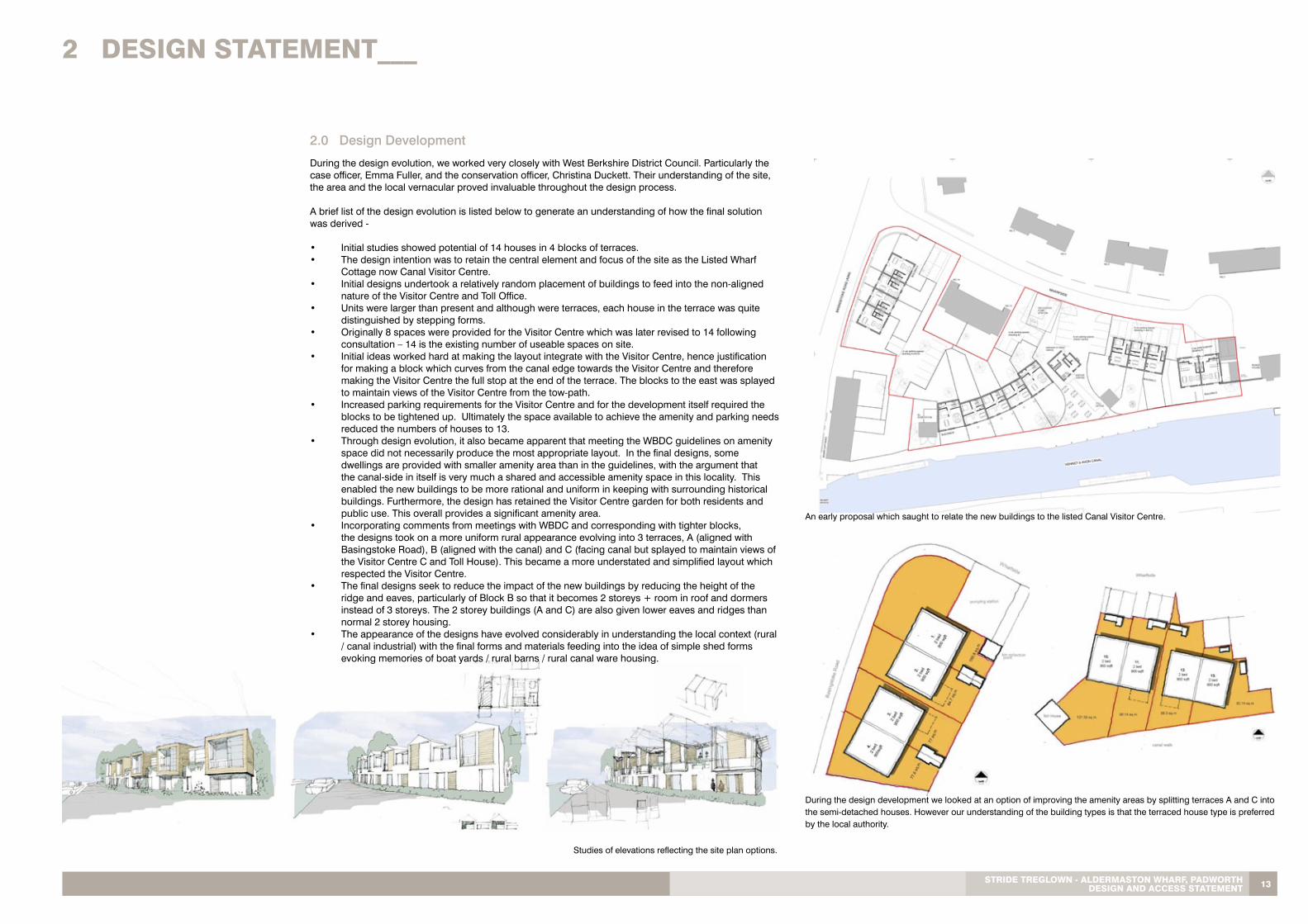
2.0 Design Development
Studies of elevations reflecting the site plan options.
During the design evolution, we worked very closely with West Berkshire District Council. Particularly the case officer, Emma Fuller, and the conservation officer, Christina Duckett. Their understanding of the site, the area and the local vernacular proved invaluable throughout the design process.
A brief list of the design evolution is listed below to generate an understanding of how the final solution was derived -
• Initial studies showed potential of 14 houses in 4 blocks of terraces.• The design intention was to retain the central element and focus of the site as the Listed Wharf Cottage now Canal Visitor Centre.• Initial designs undertook a relatively random placement of buildings to feed into the non-aligned nature of the Visitor Centre and Toll Office.• Units were larger than present and although were terraces, each house in the terrace was quite distinguished by stepping forms.• Originally 8 spaces were provided for the Visitor Centre which was later revised to 14 following consultation – 14 is the existing number of useable spaces on site.• Initial ideas worked hard at making the layout integrate with the Visitor Centre, hence justification for making a block which curves from the canal edge towards the Visitor Centre and therefore making the Visitor Centre the full stop at the end of the terrace. The blocks to the east was splayed to maintain views of the Visitor Centre from the tow-path.• Increased parking requirements for the Visitor Centre and for the development itself required the blocks to be tightened up. Ultimately the space available to achieve the amenity and parking needs reduced the numbers of houses to 13.• Through design evolution, it also became apparent that meeting the WBDC guidelines on amenity
space did not necessarily produce the most appropriate layout. In the final designs, some dwellings are provided with smaller amenity area than in the guidelines, with the argument that the canal-side in itself is very much a shared and accessible amenity space in this locality. This enabled the new buildings to be more rational and uniform in keeping with surrounding historical buildings. Furthermore, the design has retained the Visitor Centre garden for both residents and public use. This overall provides a significant amenity area.
• Incorporating comments from meetings with WBDC and corresponding with tighter blocks, the designs took on a more uniform rural appearance evolving into 3 terraces, A (aligned with Basingstoke Road), B (aligned with the canal) and C (facing canal but splayed to maintain views of the Visitor Centre C and Toll House). This became a more understated and simplified layout which respected the Visitor Centre.• The final designs seek to reduce the impact of the new buildings by reducing the height of the ridge and eaves, particularly of Block B so that it becomes 2 storeys + room in roof and dormers instead of 3 storeys. The 2 storey buildings (A and C) are also given lower eaves and ridges than normal 2 storey housing.• The appearance of the designs have evolved considerably in understanding the local context (rural / canal industrial) with the final forms and materials feeding into the idea of simple shed forms evoking memories of boat yards / rural barns / rural canal ware housing.
13StRiDE tREGlOwn - alDERmaStOn whaRf, PaDwORth DESiGn anD accESS StatEmEnt
2 DESiGn StatEmEnt___
During the design development we looked at an option of improving the amenity areas by splitting terraces A and C into the semi-detached houses. However our understanding of the building types is that the terraced house type is preferred by the local authority.
An early proposal which saught to relate the new buildings to the listed Canal Visitor Centre.

2.5 Layout
The proposed development is essentially divided into three separate buildings, which have been placed on site mostly by its relationship with the Visitor Centre, Canal and Basingstoke Road. However the proposed development has been designed to complement and enhance existing buildings and to reinforce local identity and create a sense of place.
Placement of each building allows for a front defensible space creating continuation of the building line, as well as a rear private space. However, the buidings are visibly open to the public on both sides, either from the canal or from Basingstoke Road and therefore are designed to account for this.
The site is formed around a number of existing buildings including numbers 14 and 15 Wharfside, the listed Visitor Centre and associated, listed Toll House. A large proportion of the site fronts the Kennet and Avon Canal.
GP
G
P
GP
G
P
GP
P
GPP
G
P
P
G
PP
GP
GP
GP
GP
GPP
BA
SIN
GS
TO
KE
RO
AD
(A
340)
43/4
1
3
1/2
2
5
5
9
9
8
7
7
8
6
6
v6
v7
v8
v9
v5
v4
v3
v2
v1
v10
v11
v12
v13
v14
10 10/1111
12
12/13 13
visitor centre car parking(14 spaces in total)
residential car parking(4 units - building B)
proposed vehicularaccess to car parking(residential and visitor centre)
residential car parking(5 units - building A & B)
KENNET & AVON CANAL
towpath
relocated pumpstation
WH
AR
F C
OT
TA
GE
S
proposed vehicular access tocar parking
pedestrian accessto Visitor Centre
ELECTRICAL.SUBSTATION
VISITORCENTRE
TOLLHOUSE
residential car parking(4 units - building C)
bincollectionpoint
vehicle access to el.substation
paved pedestrian linkbetween car park andcanal
Garage toWharf House
Outhouse toWharf House
cross hatching shows area ofreinforced grass to allowoccasional vehicle access
disabledpersonsspace
parking informationand payment detailsboard
information board
visitor centre parkingaccessed off Wharfside
proposed vehicular access tocar parking for Visitor Centre
21
mete
r line
13.5 metres to gable
No 14 Wharfside
No 15 Wharfside
single storey garage and porch tosemi-detached 2 storey house.
timber clad acousticfence along boundaryadjacent access road
BUILDING A
BUILDING B
BUILDING C
proposed planning application boundary
ownership boundary
existing buildings
proposed trees
existing trees
pedestrian link for canal users
vehicular access route to existingel. substation
0 5m 10m
Scale Bar at 1:200
1 2 3 4
PROJECT
DRAWING TITLE
SCALEDATE DRAWN BY CHECKED BY
REVISION NO.DRAWING NUMBER
Responsibility is not accepted for errors made by others in scaling fromthis drawing. All construction information should be taken from figureddimensions only.
A1OriginalSheet Size
0mm 100mm50mm
date rev name chk note
Promenade House, The Promenade, Clifton Down, Bristol BS8 3NET 0117 9743271 F 0117 9745207 www.stridetreglown.co.uk
Architecture Town Planning Interior Design Building Surveying Landscape Design Graphic Design
Stride Treglown
Padworth
Asindicated
25/1
1/2
010 1
3:3
9:5
9\\
str
idetr
eglo
wn.local\stl\3
0892\D
wg\R
evit\3
0892_N
ew
Site_dougal.rv
t
Proposed Site Plan
Nov 2010 an dje
P 10030892_
Aldermaston Wharf
- 1 : 200
PROPOSED SITE PLAN
north
Proposed Building Types
Building A2 bed house - 900sqft (1.5 storey)...............................4 no
Amenity Area - Requirements
2 bedroom house......................................70 sq.m3 bedroom house....................................100 sq.m4 bedroom house....................................100 sq.m
Building B3 bed house - 1100sqft (1.5 storey).............................2 no4 bed house - 1350sqft (2.5 storey).............................3 no
Building C2 bed house - 900sqft (1.5 storey)...............................4 no
PLANNING ISSUE
- - - -
Key
NOTE:Please read this drawing in conjunction with the drawingsP_107 and P_108 which provides information on landscaping.
1:200...............
1
2
3
4
56
7 8
9
1011
1213
The external layout within the garden space around the Visitor Centre and the Toll House has been retained as far as possible whilst allowing a separate access to the towpath for Canal users.
With reference to the site plan, the three proposed terraced buildings, A, B and C, are distributed throughout the site. In particular, attention was paid to the location and orientation of the terrace B during the design development, to maintain an acceptable spatial separation between existing Wharfside No 14 & 15, and to minimise the potential overlooking by placing the terrace as near as practicable to the towpath and also in designing fenestration in a manner to maintain privacy. Each location has different features which have generated a design response that has influenced the proposed building on that specific site.
2 DESiGn StatEmEnt
14

15StRiDE tREGlOwn - alDERmaStOn whaRf, PaDwORth DESiGn anD accESS StatEmEnt
2 DESiGn StatEmEnt
In Terrace A , the ground floor plan has responded to the busy road in front, providing a front door to each house in this elevation, and recognises that the main pedestrian access is from the quiet private parking court to the rear. The entrance lobby and stairs are accessed from the rear door. The overall form of the building is traditional with pitched roof and simple fenestration pattern. The primary rooms, which include the living room on the ground floor and the master bedroom on the first, are located to the quieter rear of the building. Balconies are provided to the two central houses to provide a fantastic feature to the main bedroom and to compensate for the reduced amenity space that result from being located mid terrace.
Terrace A
Terrace A is a two storey terrace adjacent to Wharf Cottages containing four 2 bedroom houses, each 900 sqft.
It is located at the far west end of the site fronting Basingstoke Road, and is adjacent to the existing Wharf Cottages terrace which also fronts the road. This terrace is charming, small in scale, and have their front doors accessed off the private road at the rear car parking court. The location of this terrace has influenced its access and internal layout considerably which is described in the following sections.
Terrace B
Terrace B is a mixed terrace of three in number two and a half storey 4 bedroom houses of 1350 sqft, and two one and a half storey, 3 bedroom houses, of 1100 sqft respectively.
The building is located within the site adjacent to the existing listed Visitors Centre. It faces south, overlooking the canal, and is parallel to the canal to match and respect the existing two and a half storey buildings opposite. Its positioning aligned with the canal maximises its separation from 14 & 15 Wharfside, whilst its proximity to the canal creates a strong sense of place through its use of roof terraces and steeping forms. Terrace A - 2 bedroom house
Terrace C
Terrace C is located to the east of the site adjacent to Wharf House, and is a two storey building containing four 2 bedroom houses at 900 sqft each. Although this building is located adjacent to the Canal, with south facing gardens, it is not placed parallel to the canal, as building B, but is angled so that people walking, or boating, towards the west, are drawn towards the Visitors Centre as the sight lines open out beyond the terrace C.
Internal Layout
The proposed buildings are designed to form terraces (buildings A, B, C) and each in its own architectural style giving each building an identity and responding to its immediate locality, however the use of materials throughout the scheme brings all three buildings together creating well balanced scheme.
The principle of internal layout lies in location of day zone with living, dining and kitchen on the ground floor, and night zone with bedrooms and bathroom on the upper floors. As an option, study area can be located within living room of each house.
A view of Terrace A from Basingstoke Road
South Elevation of Terrace B facing the Kennet and Avon Canal
Basingstoke Road Elevation
Entrance from Car Park Court
South Elevation of Terrace C facing the Kennet and Avon Canal
2 DESiGn StatEmEnt
16
DINING
KITCHEN
LIVING
DINING
KITCHEN
LIVING
DINING
KITCHEN
LIVING
KITCHEN
DINING
LIVING
KITCHEN
DINING
LIVING
BBAA
BEDROOM 2
BEDROOM 3
BATHROOM BATHROOM BATHROOM
BATHROOM BATHROOMEN-SUITE EN-SUITE
MASTERBEDROOM
BEDROOM 2
BEDROOM 3
MASTERBEDROOM
BEDROOM 2
BEDROOM 3
TERRACE TERRACE TERRACE
BEDROOM 3 BEDROOM 3
BEDROOM 2 BEDROOM 2
BB
AA
BB
AA
metal framed projectingdormer window
metal standing seamroofing
s/steel handrail
metal standing seam roof to canopy withvertical timber boarded side panel
metal standing seam roof to canopy
metal framed dormer windows
timber sliding screens
EN-SUITE EN-SUITEMASTERBEDROOM
MASTERBEDROOM
BEDROOM 4 BEDROOM 4 BEDROOM 4
EN-SUITEMASTERBEDROOM
BB
AA
LIVING DINING
BEDROOM 1 LANDING
ROOF SPACE
2475
ffl_54.10m
ffl_56.85m
ffl_59.60m
LIVING KITCHEN
BEDROOM1 BEDROOM2
MASTERBEDROOM
BEDROOM 4
DINING
TERRACE
patio deck
ROOF SPACE
vertical timber cladding - FSC treated, natural colour finish1
2
3
through colour render or similar
5
metal standing seam roof
6
slatted timber panel sliding / folding screen
7 metal profiled channel
metal galvanised rainwater goods
0 5m 10m
Scale Bar at 1:100
1 2 3 4
PROJECT
DRAWING TITLE
SCALEDATE DRAWN BY CHECKED BY
REVISION NO.DRAWING NUMBER
Responsibility is not accepted for errors made by others in scaling fromthis drawing. All construction information should be taken from figureddimensions only.
A1OriginalSheet Size
0mm 100mm50mm
date rev name chk note
Promenade House, The Promenade, Clifton Down, Bristol BS8 3NET 0117 9743271 F 0117 9745207 www.stridetreglown.co.uk
Architecture Town Planning Interior Design Building Surveying Landscape Design Graphic Design
Stride Treglown
Padworth
Asindicated
25/1
1/2
010 1
3:4
2:1
1\\
str
idetr
eglo
wn.local\stl\3
0892\D
wg\R
evit\3
0892_N
ew
Site_dougal.rv
t
Block BProposed Plans, Sections &Elevations
Nov 2010 an dje
P 10230892_
Aldermaston Wharf
-
1 : 100
PROPOSED GROUND FLOOR PLAN - Block B
1 : 100
PROPOSED FIRST FLOOR PLAN - Block B
key plan1:1250
1 : 100
PROPOSED ROOF PLAN - Block B
1 : 100
PROPOSED SOUTH ELEVATION - B block
1 : 100
PROPOSED EAST ELEVATION - B block
1 : 100
PROPOSED NORTH ELEVATION - B block
1 : 100
PROPOSED WEST ELEVATION - B block
1 : 100
PROPOSED SECOND FLOOR PLAN - Block B
north
key materials1
6
3
7
1
1
2
5
6
1
3
2
7
2
2
PLANNING ISSUE
- - - -
north
6
2
7
Terrace B - 3 bedroom houseTerrace B - 4 bedroom house
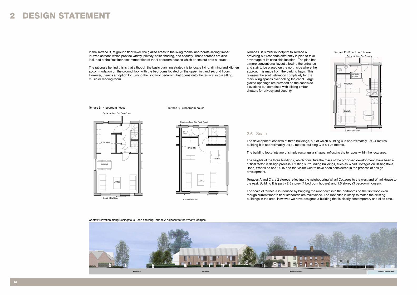
2.6 Scale
The development consists of three buildings, out of which building A is approximately 8 x 24 metres, building B is approximately 9 x 30 metres, building C is 8 x 23 metres.
The building footprints are of simple rectangular shapes, reflecting the terraces within the local area.
The heights of the three buildings, which constitute the mass of the proposed development, have been a critical factor in design process. Existing surrounding buildings, such as Wharf Cottages on BasingstokeRoad, Wharfside nos 14-15 and the Visitor Centre have been considered in the process of design development.
Terraces A and C are 2 storeys reflecting the neighbouring Wharf Cottages to the west and Wharf House to the east. Building B is partly 2.5 storey (4 bedroom houses) and 1.5 storey (3 bedroom houses).
The scale of terrace A is reduced by bringing the roof down into the bedrooms on the first floor, even though current floor to floor standards are maintained. The roof pitch is steep to match the existing buildings in the area. However, we have designed a building that is clearly contemporary and of its time.
In the Terrace B, at ground floor level, the glazed areas to the living rooms incorporate sliding timber louvred screens which provide variety, privacy, solar shading, and security. These screens are also included at the first floor accommodation of the 4 bedroom houses which opens out onto a terrace.
The rationale behind this is that although the basic planning strategy is to locate living, dinning and kitchen accommodation on the ground floor, with the bedrooms located on the upper first and second floors. However, there is an option for turning the first floor bedroom that opens onto the terrace, into a sitting, music or reading room.
Canal Elevation
Entrance from Car Park Court
Canal Elevation
Entrance from Car Park Court
Terrace C is similar in footprint to Terrace A providing but responds differently in plan to take advantage of its canalside location. The plan has a more conventional layout allowing the entrance and stair to be placed on the north side where the approach is made from the parking bays. This releases the south elevation completely for the main living spaces overlooking the canal. Large glazed openings are provided on the canalside elevations but combined with sliding timber shutters for privacy and security.
Terrace C - 3 bedroom house
Canal Elevation
Entrance from Car Parking
Context Elevation along Basingstoke Road showing Terrace A adjacent to the Wharf Cottages

17StRiDE tREGlOwn - alDERmaStOn whaRf, PaDwORth DESiGn anD accESS StatEmEnt
2 DESiGn StatEmEnt
Perspective sketch lokking towards the Visitor Centre with the new buildings in place.
The relationship of building B and C to the Visitor Centre considered to be very sensitive, and as such their height has been kept to a minimum, the roof pitches matching the Visitor Centre have been kept below the roof ridge of Visitor Centre.
Terrace B
The massing of terrace B has been carefully balanced with the context of the adjacent Visitor’s Centre, with the desire to utilise the accommodation on this prime location. Our response is to step the building down from two and a half storey’s, at the west end, down to one and a half storeys directly adjacent to the Visitor Centre.
Because of the reduced eaves levels, dormers have been included to the upper bedrooms. These are made out of aluminium and are simple in form and detail, and would be seen as a continuation of the metal, standing seam roof. Setting back the first and second floor of the 4 bedroom houses which leaves the ground floor in line with the adjacent 3 bedroom houses helps improve the form of the terrace and creates additional roof terraced amenity spaces. The massing is further broken down by the chosen materials, which includes white render (or similar) to the 3 bedroom houses, front and rear, which continues through the ground floor of the 4 bedroom houses. Timber cladding is utilised on the upper floors of the 2.5 storey dwellings to reduce the impact of the massing and provides a lighter weight feel to counter-act the height.
Terrace C
As with building A, the overall height of the building C has been reduced by lowering the eaves so that part of the first floor accommodation is within the roof space. Building C is a mix of buildings A and B. with a combination of render at ground floor and vertical timber at first floor. Sliding louvred screens are also incorporated into the glazing to the living rooms.
Generally the proposed buildings vary between 1.5 to 2 storey in height. This provides variety across the site yet allows for consistent and harmonious development to be created.
The overall scale of the proposals will therefore protect the amenity of existing residential accommodation in terms of daylight, sunlight, outlook and privacy.
The perspective views illustrated in this document provide a true visualization of the developments scale as viewed by pedestrians.
Context Elevation along the Kennet and Avon Canal showing Terraces B and C adjacent to the Visitor Centre and Toll Office in the middle of the image

2 DESiGn StatEmEnt
18
2.7 Appearance
The presence of the Canal Visitor Centre with its outdoor seating, a footpath along the Canal widely used by the locals and visitors creates a specific character to this site. Our aim is to preserve and enhance the quality of this space.
Each building has been designed in way giving individual identity and style, yet forming a scheme as a whole. Outdoor spaces provides private areas yet still contributing to the natural surveillance of the area.The doors, windows and associated detailing are of a human scale and responds to the design characteristics of the surrounding area.
The window arrangement and proportions on the buildings are particularly important. The types and sizes of the windows across all of the buildings are used to give the scheme continuity of appearance and aesthetics. The orientation of the buildings reflects the need of sliding sun-screening as well as a barrier to avoid potential overlooking into individual gardens and from the canal footpath. Solid timber screens are proposed to provide acoustics barrier protecting the building A from the busy Basingstoke Road.
Architectural Forms
The building footprint is of a simple rectangular shape, reflecting the terraces within the local area. As with the footprint, the pitched roofs are simple with dormer windows to building B, responding to the local architectural features.
Materials
In developing the elevation treatment, the influences of surrounding buildings have helped to guide not only the height, but also materials to be used.
We propose timber boarding through out the scheme in combination with render to terraces B and C. Metal standing seam is proposed to pitched roofs.
Materials are simple, with untreated Western Red Cedar timber cladding to all the elevations and a standing seam metal roof which brings lightness to the building and an industrial theme relevant to the canal and locks.
The timber cladding, which is used in the area both in historically and currently, is applied vertically, instead of horizontally, to deliberately add a twist to a traditional configuration. . The durability of timber cladding is dependent on the quality of the timber specified as well as the species. In this case, our proposal to use western red cedar (Class 2 - durable), results in a highly durable and stable species with a service life ranging from 40 to 60 years.
Over and above the timber specification, the detailing of the timber elevations are also highly important. The natural aging of the timber will see the colour alter from the original honey /brown to silver which at the same time increases its durability as it stabalises. At a design level the positioning of the timber and how it relates to other elements of building is crucial to enable an even colouration. Avoiding large overhangs allows the sun to evenly bleach the timber giving a uniform weathered appearance.
To enliven the elevations, and to practically respond to the noise from the traffic, and to increase privacy and security, we have included sliding and folding timber screens, to the windows. On terrace A these would be solid for maximum acoustic and car headlight attenuation. On terraces B and C, they would be louvred to allow sun shading as well as adding privacy and security. These elements are also a reference to the traditional screens and shutters of the area and provide a high level of security.
To feed into the industrial modern aesthetic and to add to longevity, it is proposed to use aluminium face windows with a suitably coloured finish.
GP
G
P
GP
G
P
GP
P
GPP
G
P
P
G
PP
GP
GP
GP
GP
GPP
67.67 m²728.4 ft²
159.51 m²1716.9 ft²
100.10 m²1077.5 ft²
107.60 m²1158.2 ft²
167.83 m²1806.5 ft²
88.85 m²956.4 ft²
66.07 m²711.1 ft²
70.00 m2753.47 ft2
60.30 m2649.07 ft2
WHARFSIDE
BA
SIN
GS
TO
KE
RO
AD
(A
340)
KENNET & AVON CANAL
43/4
1
3
1/2
2
5
5
9
9
8
1.2 bed900 ft²
2.2 bed900 ft²
3.2 bed900 ft²
4.2 bed900 ft²
5.4 bed
1350 ft²
6.4 bed
1350 ft²
7.4 bed
1350 ft²
8.3 bed
1100 ft²
9.3 bed
1100 ft²
7
7
8
6
6
v6
v7
v8
v9
v5
v4
v3
v2
v1
v10
v11
v12
v13
v14
10.2 bed900 ft²
11.2 bed900 ft²
12.2 bed900 ft²
13.2 bed900 ft²
10 10/1111
12
12/13 13
visitor centre car parking(14 spaces in total)
residential car parking(4 units - building B)
residential car parking(5 units - building A & B)
residential car parking(4 units - building C)
bincollectionpoint
Area indicating first floor terraces
Legend
Compliant
Non Compliant
TOLLOFFICE
GARAGE
STONEBUILDING
VISITORCENTRE
NO 14
NO 15
Area indicating first floor balconies(included in total amenity area)
disabledpersonsspace
100.65 m²1083.4 ft²
60.80 m²654.4 ft²
55.60 m²598.5 ft²
72.41 m²779.4 ft²
PROJECT
DRAWING TITLE
SCALEDATE DRAWN BY CHECKED BY
REVISION NO.DRAWING NUMBER
Responsibility is not accepted for errors made by others in scaling fromthis drawing. All construction information should be taken from figureddimensions only.
A1OriginalSheet Size
0mm 100mm50mm
date rev name chk note
Promenade House, The Promenade, Clifton Down, Bristol BS8 3NET 0117 9743271 F 0117 9745207 www.stridetreglown.co.uk
Architecture Town Planning Interior Design Building Surveying Landscape Design Graphic Design
Stride Treglown
Padworth
1 : 200
25/1
1/2
010 1
4:0
8:0
7\\
str
idetr
eglo
wn.local\stl\3
0892\D
wg\R
evit\3
0892_N
ew
Site_dougal.rv
t
Proposed Amenity Areas Plan
Nov 2010 an dje
P 11030892_
Aldermaston Wharf
1 : 200
Proposed Amenity Areas Plan
north
PLANNING ISSUE
- - - -
Proposed Building Types(Client's requirements)
Building A2 bed house - 900sqft...............................4 no
Amenity Area(LPA requirements)
2 bedroom house......................................70 sq.m3 bedroom house....................................100 sq.m4 bedroom house....................................100 sq.m
Building B3 bed house - 1100sqft .............................2 no4 bed house - 1350sqft .............................3 no
Building C2 bed house - 900sqft ...............................4 no
Plot Amenity Area (sq.m) - current
1 (A) 167.83 sq.m (97.83 sqm more)
2 (A)
3 (A)
4 (A)
5 (B)
6 (B)
7 (B)
8 (B)
9 (B)
10 (C)
11 (C)
12 (C)
13 (C)
60.80 sq.m (9.2 sqm less)
55.60 sq.m (4.4sqm less)
88.85 sq.m (18.85 sqm more)
159.51 sq.m (59.51 sqm more)
100.10 sq.m
107.60 sq.m (7.6 sqm more)
66.07 sq.m (33.93 sqm more)
100.65 sq.m
72.41 sq.m (2.41 sqm more)
70.00 sq.m
60.30 sq.m (9.70 sqm less)
67.67 sq.m (2.33 sqm less)
Required Area (sq.m)
70 sq.m
70 sq.m
70 sq.m
70 sq.m
100 sq.m
100 sq.m
100 sq.m
100 sq.m
100 sq.m
70 sq.m
70 sq.m
70 sq.m
70 sq.m
Each dwelling has allocated amenity space based on the requirements of the Quality Design Supplementary Planning Document WBDC . We have achieved the required standards to eight of the houses, and fall slightly short on houses 2, 3,8,12 and 13. We consider a case to include as a material consideration the surrounding space of the towpath, Visitor Centre garden and nearby open spaces as an appropriate and attractive amenity to the area.
An alternative approach was investigated to split buildings A and B into 4 semi detached dwellings, as indicated on the study sketches. This would distribute the available amenity space more evenly between the houses so that all the dwellings comply. However, we have specifically pursued a terraced approach because that is more in keeping with the local building types.
All the houses have external cycle, bin storage and general storage for lawn mowers tools etc.
Example of a metal dormer.
Example of a metal roof
Metal windows and timber screens
A detail of terrace A
2.7 Amenity Space
2 DESiGn StatEmEnt
19StRiDE tREGlOwn - alDERmaStOn whaRf, PaDwORth DESiGn anD accESS StatEmEnt
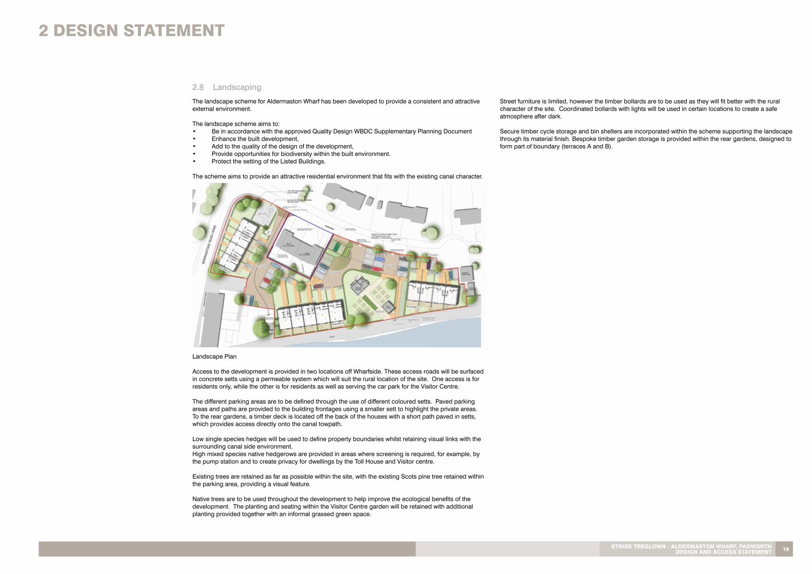
The landscape scheme for Aldermaston Wharf has been developed to provide a consistent and attractive external environment.
The landscape scheme aims to:• Be in accordance with the approved Quality Design WBDC Supplementary Planning Document• Enhance the built development,• Add to the quality of the design of the development, • Provide opportunities for biodiversity within the built environment. • Protect the setting of the Listed Buildings. The scheme aims to provide an attractive residential environment that fits with the existing canal character.
Landscape Plan
Access to the development is provided in two locations off Wharfside. These access roads will be surfaced in concrete setts using a permeable system which will suit the rural location of the site. One access is for residents only, while the other is for residents as well as serving the car park for the Visitor Centre.
The different parking areas are to be defined through the use of different coloured setts. Paved parking areas and paths are provided to the building frontages using a smaller sett to highlight the private areas. To the rear gardens, a timber deck is located off the back of the houses with a short path paved in setts, which provides access directly onto the canal towpath.
Low single species hedges will be used to define property boundaries whilst retaining visual links with the surrounding canal side environment. High mixed species native hedgerows are provided in areas where screening is required, for example, by the pump station and to create privacy for dwellings by the Toll House and Visitor centre. Existing trees are retained as far as possible within the site, with the existing Scots pine tree retained within the parking area, providing a visual feature.
Native trees are to be used throughout the development to help improve the ecological benefits of the development. The planting and seating within the Visitor Centre garden will be retained with additional planting provided together with an informal grassed green space.
2.8 Landscaping
Street furniture is limited, however the timber bollards are to be used as they will fit better with the rural character of the site. Coordinated bollards with lights will be used in certain locations to create a safe atmosphere after dark.
Secure timber cycle storage and bin shelters are incorporated within the scheme supporting the landscape through its material finish. Bespoke timber garden storage is provided within the rear gardens, designed to form part of boundary (terraces A and B).
3 accESS StatEmEnt
4.1 Existing Drainage
A 150 mm dia foul gravity Authority’s drain crosses the site from north to south falling to a point on the southern edge of the existing site where it combines at a manhole with a 225 mm dia connection before continuing eastwards to connect to the existing sewage pumping station.
From the existing pumping station a 125 mm dia pumped rising main crosses the proposed site parallel to the 150 mm gravity drain in a south north direction.
There is a separate 150 mm dia Authority’s surface water drain to the west of the site which connects to a manhole adjacent to the north west corner of the site, thus combining it with the foul drainage system.
As no surface water drains are apparent on the site it is assumed that a considerable proportion of surface water run off currently discharges into the adjacent canal.
Existing sewer connections are currently made to the sewers in Wharfside, Basingstoke Road and south of the site to the pumping station and we understand there is capacity to accommodate the dwellings needs.
4.2 Proposed Drainage
The scheme will be designed to accommodate Sustainable Urban Drainage Systems (SUDS) in the form of permeable paving system to hard surfaces.
The private drains will be designed and constructed in accordance with the Building Regulations Part H.
Generally the proposed drainage will be as follows:-
With the relocation of the sewerage pumping station new gravity drains will have to be installed from the proposed and existing buildings on the site, with falls to the new location. These works will incorporate the existing 225 mm dia drain connection crossing the canal from Mill Lane and that from Wharf side.
Similarly the pumped rising main will also have to be diverted to the new pumping station location.
All redundant drains will be removed / backfilled.
As with the existing surface water drainage installation, outfalls into the canal will be utilized with the remainder discharging into the surface water/combined drainage system.
4 DRainaGE
20
3.2 Internal and External Access
The proposals incorporate the principles for delivering inclusive access. This will allow for the development to be accessible and appealing to everyone, regardless of their physical ability, age, gender or circumstances.
Reference will be made to the following documents in the development of this project to ensure that inclusive design principles are integrated to the proposals:
• Approved Document to Part M (2004)• BS8300:2001 (incorporating amendment No 1 and corrigendum No 1)• BS5588:Part 8:1999• Planning and Access Statements (DRC)• Guidance on the use of tactile paving surfaces (DETR)
Design of access provision will be that stipulated within the Approved Document to Part M of the Building Regulations (2004), which includes:
• anti-slip paving materials with minimal undulations and joints• level access routes wherever possible• guarded hazards within access routes to assist people with impaired vision• sensitively designed tactile paving at canal edges.
All buildings will comply with Part M of the Building Regulations, which covers layout, door opening sizes, wheelchair accessibility and toilet facilities. Flush thresholds are provided at each front door to facilitate ease of access.
Vehicular and pedestrian access throughout the development will be designed to meet the required standards for safe, easy access for all people to all areas where it would be consistent with creating a safe environment.
The revised car parking layout will also improve access to the Canal Visitor Centre especially with the provision of a disabled persons parking bay and accessible paving to the entrance of the Visitor Centre.
Inclusion of a clear footpath through the site which leads to the canal helps with accentuating the canal as an amenity for the local area.
3.1 Inclusive Design
3.5 Public Transport
Aldermaston Wharf is served by a train station a short distance from the site.Bus routes also run through the village.
3.4 Pedestrian and Cycling
Cycle storage will be provided to every property, in the form of an external secure storage of sufficient size to house, two bicycles per dwelling. Storage for 4 cycles will be provided for 4 bedroom houses. Main cycle route runs along south of the site, the canal walk.
3.3 Emergency and Service Vehicle Access
The scheme has been designed to accommodate easy access for emergency vehicle. Two bin collection points have been provided to allow easy collection.
An aspect incorporated into the layout of the designs is the access required for maintenance vehicles to service both the electrical sub-station and the bridge lifting mechanism to the west of the site. The latter requires vehicular access through the site onto the canal tow-path on an occasional basis. This has been carefully designed so that minimal disturbance would be caused to the Visitor Centre Car Park when access is required.

21StRiDE tREGlOwn - alDERmaStOn whaRf, PaDwORth DESiGn anD accESS StatEmEnt
Our client is highly committed to delivering a sustainable community at the Aldermaston Wharf site. The proposals will assist with the delivery of this given the:
• Mix of housing being provided, in terms of size, type and tenure• Accessibility of the site to public transport and the pedestrian, and cycle links available from the site• Commitment towards providing employment and commercial activity as part of the whole development• High standards of design being incorporated across the site• Measures to ensure that the environment is inclusive and safe• Monitoring sustainability during construction and post completion
The opportunity for making Aldermaston Wharf site an exemplar in sustainable design and living is further enhanced by the commitment that the client is giving to the following programmes:
5.1 Sustainable Initiatives
5 SUStainaBilitY
5.4 Code for Sustainable Homes - Level 3
The BRE Green Guide to Specification provides a quick and easy way to assess the environmental performance of over 250 construction specifications ranging from external walls, roofs and landscaping to internal elements such as partitioning, raised floors, insulation and doors. Each entry is ranked on a scale of A to C (with A representing the least impact and C the highest). The ratings are assessed on the basis of impacts relating to climate change, ozone depletion, consumption of materials, water and fossil fuels, emission of pollutants and waste.
The design of the development maximizes the density within the planning constraints for the envelope of the building. Robust materials will be specified, considering not only environmental impact of the extraction of raw materials and their manufacture, but also the final embodied energy in materials used on site. Choice of materials will be made with reference to the Green Guide to Specification, preferable with A rating. Materials will be selected to minimize maintenance.
5.5 BRE Green Guide on Materials
5.2 Environmental Assessment
This development has been designed to comply with the Code for Sustainable Homes Level 3.
This includes a commitment to select a contractor through the ‘’Considerate Contractor’’ scheme who can demonstrate a strategy to monitor, sort and recycle construction waste on site and instigates measures to limit resources, and minimizes pollution and dust from site.
The site as a whole is under utilised creating pockets of unkempt scrub which is difficult to cost effectively manage. This development maximizes its potential in terms of increased density and urban land use and would positively add to the accessibility o dthe canal-side..
5.3 Physical Environment
The use of buildings will produce minimal air and noise pollution. Light pollution will be minimized through the use of external luminaries that direct the light downwards rather than multiple directions. The principles of energy efficiency and minimizing the energy consumption will be incorporated throughout the new development, achieving an appropriate balance between capital and running costs.
The Code for Sustainable Homes Level 3 and new Approved Building Regulation Document L (ADL1) requires improved building fabric and air tightness performance in new buildings. New residential units built to these new standards will be at least 25% more energy efficient than homes built under previous Building Regulations.
This development will be designed to meet the specific requirements of the Building Regulations ADL1 2006 with focus on maximizing building energy efficiency. However improvements in U-values, air permeability, and glazing together with energy conservation measures described bellow exceed the required compliance:
• water meters• robust and energy rated materials specified • waste water discharge / recycling• water taps, wc flushing• energy saving light fitting and bulbs• A-rated white energy efficient appliances• SUDS system designed• heating by high COP air sourced heat pumps
This development has been designed to achieve the Code for Sustainable Homes Level 3 designation.
The Code for Sustainable Homes is an environmental assessment method for rating and certifying the performance of new homes. It is a national standard for use in the design and construction of new homes with a view to encouraging continuous improvement in sustainable home building.
The Code assesses the scheme’s environmental performance in a two stage process (Design stage and Post-construction) using objective criteria and verification. The results of the Code assessment are recorded on a certificate assigned to the dwelling.
The Code for sustainable homes covers nine categories of sustainable design including:• Energy and CO2 Emissions• Water• Materials• Surface Water Run-off• Waste• Pollution• Health and Wellbeing• Management• Ecology
Each category includes a number of environmental issues. Each issue is a source of impact on the environment which can be assessed against a performance target and awarded one or more credits.
The performance targets are more demanding than the minimum standard needed to satisfy current Building Regulations or other legislation. They represent good or best practice, are technically feasible, and can be delivered by the building industry. Homes have already been built to Code level 4 and above by the industry.
A Code for Sustainable Home Pre-Assessment Document has been prepared, in support of this application, identifying the potential of this project to meet Code Level 3.
Included within the means of achieving Code Level 3, are high levels of thermal insulation, on-site water collection and passive solar control via moveable screens.

22
BUilDinGS fOR lifE

1. Does the development provide (or is it close to) community facilities, such as a school, parks, play areas, shops, pubs or cafes?Aldermaston Wharf is a rural small village and the development is sited near the historical centre of the village. The most attractive amenity for residents is the access to the canal tow-path and waterway. There are a number of schools in nearby villages and the locality is serviced with a pub on the outskirts of the village and a café at the canal visitors centre.
2. Is there an accommodation mix that reflects the needs and aspirations of the local community?The proposed scheme offers 2 bedroom, 3 bedroom and 4 bedroom houses which allows a wide mix of property types to suit the needs of the locality.
3. Is there a tenure mix that reflects the needs of the local community?The development is private.
4. Does the development have easy access to public transport?The site is located close to A4 Bath Road and A340 Basingstoke Road, and within walking distance to the local train station. The cycle route runs to the south of the site along the Canal. Aldermaston Wharf is served by busses travelling between Newbury and Reading which stop on the A4 adjacent to the station.
5. Does the development have any features that reduce its environmental impact?This development will be designed to meet the criteria to achieve Code for Sustainable Homes Level 3. Improvements in U-values, air permeability and glazing together with energy conservation measures, such as water meters, water butts, robust and energy rated materials specified, waste water discharge/recycling, water taps/wc flushing, energy saving light fittings, white energy efficient appliances and suds, exceed the required compliance.
6.1 Environment and Community
6 BUiDinGS fOR lifE
16. Is public space well designed and does it have suitable management arrangements in place?The scheme’s greatest amenity is its proximity to the canal. The public spaces adjacent to the scheme are related to the canal tow-path and visitor centre and is maintained by British Waterways.
17. Do the buildings exhibit architectural quality?The proposals are site specific, responding to the character and topography. Special features have been designed to reflect this, for example solid timber screens, providing acoustic barrier as well as security, timber solar screens proving solar shading as well as security. These aspects create an air of architectural quality in combination with the rigorously designed fenestration and use of simple vernacular forms.
18. Do internal spaces and layout allow for adaptation, conversion or extension?The internal spaces are generous and can be adatpted if required. Extension opportunities are limited due to the nature of the site and the cohesive design.
19. Has the scheme made use of advances in construction or technology that enhance its performance, quality and attractiveness?The scheme is based on using the BRE Green Guide to Specification for selection of energy efficient materials and technologies, such as FSC timber, A-rated materials or white appliances and fittings.
20. Do buildings or spaces outperform statutory minima, such as building regulations?The buildings have been designed to achieve Code for Sustainable Homes Level 3.
6.4 Design and Construction
6. Is the design specific to the scheme?The proposed scheme has been designed to complement and enhance the existing buildings and reinforces local identity to create a sense of place. The scheme, as proposed, has a simplicity in layout and form which is derived from the character of the site in respect to its relationship with the canal and adjacent historical buildings.
7. Does the scheme exploit existing buildings, landscape or topography?The layout and the design are a direct response to the sites key features, namely the listed Canal Cottage and Toll Office, the canal itself and Basingstoke Road. The design carefully aligns the massing and forms of the new buildings to respect the main site features. Important trees are retained. The design also undertakes improving existing car parking to the Canal Visitor Centre and creates a defined link from the car park to the canal tow-path for leisure activities.
8. Does the scheme feel like a place with distinctive character?All terraces are designed in way to reflect the local language as well as their location within the site, forming and finishing the street lines. The design is influenced by the vernacular/industrial essence of the former wharf and therefore is particularly distinctive in its character. Although contemporary in character, the design reflects architectural forms within the locality, such as terraced buildings, pitched roofs and dormer windows.
9. Do the buildings and layout make it easy to find your way around?Each building has its own identity and the all the layouts respond to the site layout, providing an easy and safe access.
10. Are streets defined by a well-structured building layout?The nature of the site means that the buildings relate to the canal rather than a traditional street. However, in this sense the layout reflects the dominance of the canal and sensitively respects the adjacent historical buildings providing main frontages onto the canal and parking and access from the land-side. This format is taken through to the Basingstoke Road terrace whose frontage adopts a traditional cottage language with small gardens and cars and parking are hidden to the rear.
6.2 Character
6.3 Roads, Parking and Pedestrianisation
11. Does the building layout take priority over the streets and car parking, so that the highways do not dominate?The building layouts address the main site features. Parking has been designed to be complementary and informal to this and therefore does not dictate the layout. The scheme offers well balanced design, providing comfortable, easy and safe access around as well as providing the required car parking for both, residential and existing Visitor Centre users.
12. Is the car parking well integrated and situated so it supports the street scene?The proposed car parking is well integrated within the scheme, providing easy access from the Wharfside.
13. Are the streets pedestrian, cycle and vehicle friendly?Aldermaston is a small village, providing safe routes for pedestrians, bike riders and vehicle users. The scheme has been designed in pedestrian, cycle and vehicle friendly way.
14. Does the scheme integrate with existing streets, paths and surrounding development?The scheme is well integrated with existing roads, paths and the surroundings. The pavement along Basingstoke Roads is proposed to be widened and taken around the corner to Wharfside, improving the access and route for pedestrians.
15. Are public spaces and pedestrian routes overlooked and do they feel safe?The scheme has been design with visual clarity and safety in mind and all spaces are well overlooked.
StRiDE tREGlOwn - alDERmaStOn whaRf, PaDwORth DESiGn anD accESS StatEmEnt 23

BathSt George’s Lodge33 Oldfield RoadBath BA2 3NET: 01225 466173 F: 01225 428492
BristolPromenade HouseThe PromenadeClifton DownBristol BS8 3NET: 0117 974 3271 F: 0117 974 5207
CardiffOcean HouseOcean Way Cardiff CF24 5PET: 029 2043 5660F: 029 2047 0422
London3 Cosser StreetLondon SE1 7BUT: 020 7401 0700F: 020 7401 0701
ManchesterCommercial Wharf6 Commercial StreetManchester M15 4PZT: 0161 832 9460F: 0161 839 0424
PlymouthNorbury CourtThe MillfieldsPlymouth PL1 3LLT: 01752 202088F: 01752 202089
Truro55 Lemon StreetTruro TR1 2PET: 01872 241300F: 01872 275560 stridetreglown.co.uk