Embed Size (px)
Citation preview

Taylor Baines
Proposed District Centre Plan Change(PC22 - Styx Centre)
Social Impact Assessment
prepared for Calco Developments Limitedby
Taylor Baines & Associates
June 2009

Taylor Baines
TABLE OF CONTENTS
1 INTRODUCTION . . . . . . . . . . . . . . . . . . . . . . . . . . . . . . . . . . . . . . . . . . . . . . . . . . . 11.1 Strategic Social Impact Assessment . . . . . . . . . . . . . . . . . . . . . . . . . . . . . . . 11.2 Brief for this SIA . . . . . . . . . . . . . . . . . . . . . . . . . . . . . . . . . . . . . . . . . . . . . . 11.3 Scope of work . . . . . . . . . . . . . . . . . . . . . . . . . . . . . . . . . . . . . . . . . . . . . . . . 21.4 Structure of this SIA report . . . . . . . . . . . . . . . . . . . . . . . . . . . . . . . . . . . . . . 2
2 SIA APPROACH & METHODOLOGY . . . . . . . . . . . . . . . . . . . . . . . . . . . . . . . . . . . 32.1 Statutory framework for the SIA . . . . . . . . . . . . . . . . . . . . . . . . . . . . . . . . . . 32.2 Approach and methods of assessment . . . . . . . . . . . . . . . . . . . . . . . . . . . . . 4
3 COMMUNITY AND INSTITUTIONAL CONTEXT . . . . . . . . . . . . . . . . . . . . . . . . . . . 53.1 Introduction . . . . . . . . . . . . . . . . . . . . . . . . . . . . . . . . . . . . . . . . . . . . . . . . . . 53.2 Institutional context . . . . . . . . . . . . . . . . . . . . . . . . . . . . . . . . . . . . . . . . . . . . 53.3 Community context . . . . . . . . . . . . . . . . . . . . . . . . . . . . . . . . . . . . . . . . . . . 12
4 NATURE OF THE PROPOSAL . . . . . . . . . . . . . . . . . . . . . . . . . . . . . . . . . . . . . . . 194.1 Zoning change . . . . . . . . . . . . . . . . . . . . . . . . . . . . . . . . . . . . . . . . . . . . . . 194.2 Control parameters . . . . . . . . . . . . . . . . . . . . . . . . . . . . . . . . . . . . . . . . . . . 194.3 Assessment criteria . . . . . . . . . . . . . . . . . . . . . . . . . . . . . . . . . . . . . . . . . . . 204.4 Assumptions about overall intentions . . . . . . . . . . . . . . . . . . . . . . . . . . . . . 21
5 STRATEGIC ASSESSMENT OF SOCIAL EFFECTS . . . . . . . . . . . . . . . . . . . . . . 255.1 Overview of issues and social effects . . . . . . . . . . . . . . . . . . . . . . . . . . . . . 255.2 Citywide issues and social effects . . . . . . . . . . . . . . . . . . . . . . . . . . . . . . . 255.3 Local community issues and social effects . . . . . . . . . . . . . . . . . . . . . . . . . 29
6 SUMMARY & CONCLUSIONS . . . . . . . . . . . . . . . . . . . . . . . . . . . . . . . . . . . . . . . . 35
7 APPENDICES . . . . . . . . . . . . . . . . . . . . . . . . . . . . . . . . . . . . . . . . . . . . . . . . . . . . . 36
Taylor Baines
-1-
1 INTRODUCTION
1.1 Strategic Social Impact Assessment
This report describes a strategic-level social impact assessment (SIA) of Proposed PlanChange 22 (PC22). PC22 embodies a proposal to address the future need for a town centredevelopment in the northern sector of Christchurch City. Specifically, it proposes a changeof land-use zoning for the site adjacent to and south of the intersection of Radcliffe Roadand Main North Road, (hereafter referred to as the ‘assessment site’). The change ofzoning, from Rural to B2, would allow a future application for an integrated town centredevelopment.
The social, environmental and institutional context within which this assessment is mademust of necessity encompass elements of a vision of the future of this part of the Cityextending out some thirty years or more. It is not sufficient to use the present circumstancesand issues which exist in the northern part of the City as the basis for assessing socialeffects.
Major changes assumed in the form and function of the City generally, and specifically forthe northern sector of the City should include -
- a more consolidated form of urban development which constrains the extent ofoverall urban sprawl within specified urban limits and focuses such developmentaround multi-functional centres, both existing and new, with PC22 proposing achange to land-use zoning that would enable a new centre to establish in the futurein the northern sector of the City;
- population growth and a mix of lot types and densities associated with the centres-based urban form;
- employment opportunities in reasonable proximity to residential locations distributedaround the City;
- realisation of the Styx River concept through various approaches to land acquisitionor partnerships along the course of the River;
- changes in transport and traffic patterns, including the construction of the NorthernArterial and the Western Bypass roads, and the possibility of suburban rail services.
1.2 Brief for this SIA
This SIA has been commissioned by Calco Developments Ltd, the applicant for PC22. Thebrief was to provide social analysis and social impact assessment findings relevant to theproposed Plan Change.

Taylor Baines
-2-
1.3 Scope of work
The analysis covers three aspects, which necessarily overlap and complement each other,namely -
(1) to assess the social arguments for establishing a new town centre at on the assessmentsite, to ensure consistency with the CCC City Plan and other relevant current policies andplans;
(2) to assess the likely social effects on existing centres of establishing a new town centre atthe assessment site; and
(3) to carry out a needs assessment for community and social services and relatedinfrastructure for the residential community primarily served by the proposed new towncentre
1.4 Structure of this SIA report
This report contains sections which describe -
- the approach and methodology adopted for the SIA of PC22 - Section 2- the institutional and community context for PC22 - Section 3- the nature and key elements of PC22 - Section 4- a strategic assessment of social effects and issues relating to PC22 - Section 5; and- conclusions from this SIA - Section 6.

Taylor Baines
-3-
2 SIA APPROACH & METHODOLOGY
2.1 Statutory framework for the SIA
The Resource Management Act 1991 (RMA) sets out a statutory framework which aims todirect the assessment of whether the proposed Plan Change would promote the sustainablemanagement of resources in a way or at a rate that enables people and communities toprovide for their social, cultural and economic well being as provided for in section 5 of theAct. The requirement in the Act is to consider the potential effects on people andcommunities.
Carrying out a social impact assessment within this statutory framework requires attention toa conceptual framework for thinking about social well being, and the factors which mightcontribute to people’s experience of social well being. This conceptual framework is set outbriefly and referenced in Appendix 1.
Elements likely to be of most relevance to this strategic social assessment includeconsideration of -
- the state of physical and mental health - in this case influenced by access to primary healthservices within a town centre;
- the quality of housing, shelter, neighbourhood and living place - in this case influenced bythe role of a town centre in supporting the future development of higher-density residentialliving within walkable distances from civic and commercial amenities;
- opportunities for income, employment and the quality of working life - in this caseinfluenced by the role of a town centre as a focus for substantial levels of employment in avariety of occupations;
- opportunities for leisure and recreation, time to enjoy them, and access to qualityoutdoors/open space - in this case influenced by the provision of leisure-related venueswithin a town centre and the relationship between the proposed town centre and the StyxRiver green corridor;
- access to public facilities, transport, communications, and access to goods and services -in this case influenced by access to shops and transport connections;
- the quality of the physical environment, a clean environment with aesthetic appeal - in thiscase influenced by overall design parameters for the proposed town centre, and theprovision of public open spaces within the town centre;
- influences on family life, social attachment, social contact, interaction and support - in thiscase influenced by opportunities for social interaction within a town centre, as well as accessto support services that might be located within or nearby;
- influences on participation in community and society, including participation in organisedgroups and social activities - in this case influenced by the provision of community facilitieswhich facilitate group activities, as well as the role of the town centre in providing a sense ofidentity at the sectoral level (i.e. for the whole northern sector of the City);

Taylor Baines
1 Including the applicants proposal, assessments of that proposal carried out by otherconsultants, Council Plan and Strategy documents, summaries of written submissions onPC22, and relevant local research reports - for example, the research commissioned by theBelfast Community Network. These sources are referenced in footnotes throughout this report.
2 Community workshops organised by the applicant at Belfast in December 2007 and July 2008;meetings with Residents Association Representatives in March and April 2009.
-4-
- influences on personal safety, public safety, autonomy or freedom from too much risk - inthis case influenced by provision for safe access between the town centre and itsneighbouring residential areas, as well as by security arrangements within the town centre.
2.2 Approach and methods of assessment
Social assessment typically involves the use of a variety of assessment activities and accessto a variety of information sources, both quantitative and qualitative.
This assessment has incorporated the review of documents1, the analysis of census data, attendance at community workshops and meetings2, and key informant interviews with arange of local residents and service providers (see Appendix 2).

Taylor Baines
3 http://www.greaterchristchurch.org.nz/Strategy/ downloaded 13 May 2009
-5-
3 COMMUNITY AND INSTITUTIONAL CONTEXT
3.1 Introduction
This section of the report and the associated Appendices provide contextual informationagainst which the assessment of social effects has been made. Two aspects of context aredescribed. They are the institutional context and the community context
3.2 Institutional context
The institutional context involves the mix of public policies, plans and strategies which havea bearing on the future development of the northern sector of the City, and the extent towhich communities there are enabled to provide for their social well being in the future. They include -
- the Greater Christchurch Urban Development Strategy (UDS);- proposed changes to the Regional Policy Statement (RPS);- Variation 86 which focussed on a centres-based approach to urban development,particularly as it relates to the planning of centres;- the Belfast Area Plan;- the Libraries 2025 Facilities Plan; - the 2025 Community Facilities Plan; and- the Styx River Vision and Styx Project.
3.2.1 The Greater Christchurch Urban Development Strategy (UDS)
In simple terms the purpose of the Greater Christchurch UDS “is to provide for GreaterChristchurch over the next 35 years a clear strategic direction of what we want Christchurchto look like, including:
* where we want future housing, * where we want to develop or enhance social and retail centres of activity, * where we want areas of new employment, and * how we want to integrate transport networks to service these areas.”3
Greater detail on the social outcomes expected of the UDS have been summarised inAppendices 4 and 4a.
The UDS identifies the following community expectations of particular relevance to socialoutcomes -
- more concentrated settlement patterns and well-defined centres;- affordable travel through more choice of transport options, particularly walking, cycling andpublic transport;- public passenger transport integrated with commercial and residential development;- enhanced community character, diversity and facilities, and - enhanced ‘sense of place’, heritage, open space networks, and urban and site design.

Taylor Baines
4 Table 2 of the PC1 Officers Report indicates that the revised airport noise contours could result in the lossof 200 households from greenfields area CN1, 890 households from CN2 and 558 households from CN3,for a total of 1648 households from the northern sector of the City.
-6-
The UDS sets out some important assumptions about the future, including -
- growth in population (see Section 3.2.2 for more detail) - much of this growth in thenorthern sector of the City, with some occurring in the period to 2016 and some in the period2017-2026;- establishment of urban limits (see Section 3.2,2 for more detail);- construction of the northern arterial road, now expected to be completed between 2013and 2016; and - passenger rail as a possible future option.
The UDS also provides guidance on elements of social well being which were taken intoaccount in evaluating the various settlement options. These include consideration of -
- access to employment,- community identity and social cohesion,- community health,- community education and learning,- access to open space, and- robustness and adaptability to changing circumstances such as increases in fuel prices.
Corresponding with the above assumptions and option evaluations for the northern sector ofthe City, the Indicative UDS Settlement Plan (reproduced as Appendix 4a of this report)shows an Activity Centre and several greenfield residential growth areas, as well as 98hectares of greenfield business-zoned land to the north-east of Belfast.
3.2.2 Proposed changes to the Regional Policy Statement (RPS)
Proposed Change 1 (PC1) to the RPS is designed to give effect to the UDS, which is itselfalready the adopted policy of the Regional Council and territorial authorities.
To give effect to the UDS, PC1 proposes specific Urban Limits, promotes intensification ofresidential development, reinforces the centres-based approach to the future structure ofurban development, and provides for the progressive release (sequencing) of greenfieldsland for development within the Urban Limits.
The ECan map reproduced in Appendix 5 of this report shows the locations of severalgreenfield residential development areas, marked CN1, CN2, CN3 and CN4.
Variation 4 to PC1 reflects an airport noise contour constraint on noise-sensitivedevelopment (including greenfield residential development), and has implications fornorthern sector residential development. Specifically, Environment Canterbury hasestimated4 that confirmation of the airport’s 50 dBA Ldn Outer Control Boundary is likely toreduce the number of households projected for the northern sector of the City by the year2041 by about 1,250. These are households which would have been expected to be servedby the new Key Activity Centre. The map in Appendix 5 indicates the location of theproposed Outer Control Boundary for the airport.
Taylor Baines
5 Proposed Change No.1 for new Chapter 12A, Development of Greater Christchurch. OfficerReport, Table 2, p.18.
6 Ibid, pp.15-16.
-7-
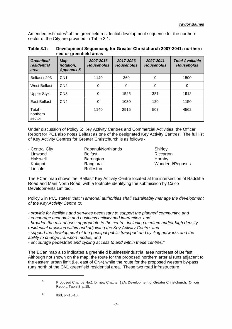
Amended estimates5 of the greenfield residential development sequence for the northernsector of the City are provided in Table 3.1.
Table 3.1: Development Sequencing for Greater Christchurch 2007-2041: northernsector greenfield areas
Greenfieldresidentialarea
Mapnotation,Appendix 5
2007-2016Households
2017-2026Households
2027-2041Households
Total AvailableHouseholds
Belfast s293 CN1 1140 360 0 1500
West Belfast CN2 0 0 0 0
Upper Styx CN3 0 1525 387 1912
East Belfast CN4 0 1030 120 1150
Total -northernsector
1140 2915 507 4562
Under discussion of Policy 5: Key Activity Centres and Commercial Activities, the OfficerReport for PC1 also notes Belfast as one of the designated Key Activity Centres. The full listof Key Activity Centres for Greater Christchurch is as follows -
- Central City Papanui/Northlands Shirley- Linwood Belfast Riccarton- Halswell Barrington Hornby- Kaiapoi Rangiora Woodend/Pegasus- Lincoln Rolleston.
The ECan map shows the ‘Belfast’ Key Activity Centre located at the intersection of RadcliffeRoad and Main North Road, with a footnote identifying the submission by CalcoDevelopments Limited.
Policy 5 in PC1 states6 that “Territorial authorities shall sustainably manage the developmentof the Key Activity Centre to:
- provide for facilities and services necessary to support the planned community, and- encourage economic and business activity and interaction, and- broaden the mix of uses appropriate to the centre, including medium and/or high densityresidential provision within and adjoining the Key Activity Centre, and- support the development of the principal public transport and cycling networks and theability to change transport modes, and- encourage pedestrian and cycling access to and within these centres.”
The ECan map also indicates a greenfield business/industrial area northeast of Belfast. Although not shown on the map, the route for the proposed northern arterial runs adjacent tothe eastern urban limit (i.e. east of CN4) while the route for the proposed western by-passruns north of the CN1 greenfield residential area. These two road infrastructure

Taylor Baines
7 Taylor Baines & Associates, 2004. Social Analysis in relation to the City Plan Variation onretail distribution. Prepared for the Christchurch City Council, June 2004. 31p. + appendices.
8 Statement of James Talbot Baines, August 2007.
9 Environment Court decision C152/2007, at paragraphs [15] to [17].
10 Decision C3/2008, at paragraphs [129] to [131]
-8-
developments will therefore define the future boundary of the contiguous northern residentialarea of the City.
3.2.3 Variation 86
Variation 86 was a Plan Variation advanced by the Christchurch City Council and heard inthe Environment Court in 2007. From a social perspective, the main purpose of Variation 86was to manage future retail distribution across the City and the development ofcommercial/shopping centres. This was because of the potential for distributional effects tobe disenabling of communities, if not appropriately managed.
Taylor Baines & Associates prepared social analysis in relation to Variation 867 and alsopresented evidence in the Environment Court in support of Variation 868. Relevant extractsfrom these two documents are provided in Appendix 6. These extracts demonstrate that theintention of Variation 86 was not to prohibit the establishment of new centres but rather toensure that the development of new integrated centres as new focal points for thecommunity occurred through a process of coordinated planning by public, private andcommunity interests, so that new centres come into existence as a result of a Plan process,not a single, ad hoc consent process. Indeed, the Court’s decision9 stated -
“Overall we conclude that the provisions make it clear that the intent of Variation 86 isto allow for a forward-looking approach to planning for retail in Christchurch. Theobjectives and policies now clearly indicate that it is intended that change can occurand that new district or large format retail parks areas might be established. However,the Plan as varied now envisages that change will occur through amendments to thePlan. In our view that is entirely consistent with the overall approach of the Plantowards the centres and business retail parks. ...... in our view, establishes a clearbalance between the certainty necessary for ordered development and confidenceand the flexibility to allow for change and growth.”
At the end of the Variation 86 hearing, the Environment Court made some generalcomments in its final decision10 on the need for the Council to show leadership ininvestigating the need for new district centres, and to be pro-active in ensuring there issufficient provision to meet demands for commercial and retail space. In the context ofPC22 and the UDS time horizon, this is a particularly pertinent issue.
3.2.4 Other relevant planning initiatives in progress
Several other planning initiatives of the City Council, relevant to this northern sector arecurrently in progress. These are the Belfast Area Plan, the Libraries 2025 Facilities Planand the 2025 Community Facilities Plan.

Taylor Baines
11 CCC, 2009. The Belfast Area Plan Update, April 2009.
12 http://www.ccc.govt.nz/AreaPlans/Belfast/WhatHasBeenDone/ accessed 13 May 2009
-9-
The Belfast Area Plan:
The Belfast Area Plan (BAP) has been in progress for more than a year. The aim11 is to
“provide a detailed plan for the Belfast area including:
- how and where development should be located;- the implementation and staging of development;- the provision of pleasant and safe communities;- consideration both of costs and ‘who pays’ for such growth.
The Area Plan will help anchor Belfast’s growth in the Greater Christchurch UrbanDevelopment Strategy (UDS) framework.”
The area covered by the BAP is centred on the long-established settlement of Belfast, butalso extends in all directions to incorporate the various greenfield residential areas identifiedin Proposed Change 1 to the RPS (see section 3.2.2 above) labeled CN1 and CN4, and thenorthern tip of CN3. The planning area essentially adopts the Styx River as its southernboundary, although the map shown on the most recent Update indicates that the relativelynew residential development of Redwood Springs on the southern side of the River isincluded in the BAP. From a social and community perspective, this is something of ananomaly, since access into Redwood Springs is gained exclusively from the south, throughthe suburban area of Redwood, which is not itself included in the BAP area.
Consequently, the area covered by the BAP is somewhat more restrictive than thecommunity of interest covered in the other Council planning initiatives.
Progress on the BAP is currently reported on the Council website12, with formal publisheddocuments due in July 2009. The website currently points to a range of elements whichcould be interpreted as describing an expected future scenario for the BAP area, including -
Transport Network:
- Northern Arterial and Western By-pass scheduled after 20015/16;- an off-road cycleway along the Main North Railway line corridor;
Housing:
- a permeable urban block structure that facilitates non-vehicular travel;- higher residential densities around activity centres, areas of high amenity (e.g. the StyxRiver and Kaputone Stream) and adjacent to the movement network;
Open Space:
- creation of green corridors to link major parks, and protect the functioning and recreationalvalue of esplanade areas adjacent to the Styx River and Kaputone Stream;- a ‘green gap’ between Belfast and Christchurch City, based on a substantial esplanadereserve adjacent to the Styx River;- higher residential densities adjacent to significant areas of open space or to appropriaterivers and wetlands;

Taylor Baines
13 CCC, 2008. Libraries 2025 Facilities Plan. September 2008, pp.40-41
14 Ibid, Table 1, p.17
15 Ibid, Table 3, p.32
16 Ibid, pp.20-21
-10-
- increased provision of walking paths and cycle lanes which are linked to open space areasand transport networks;
Community facilities:
- access to an appropriate range of community services and facilities;- ensure equitable provision of community facilities in North West Christchurch, and Belfastin particular, and ensure facility provision matches population growth - notably in relation toprimary schools and library services;
Business and Industrial:
- the potential for business and employment growth particularly around the Chaney’sIndustrial area;
Commercial Development:
- the PC22 assessment site is shown as the location for significant commercialdevelopments;- predominantly 1-2 level retail, commercial and leisure activities, centred around the existingSupa Centa commercial infrastructure;- maximised connections with the existing Supa Centa and developing residential areas;a network of internal streets and open spaces to encourage internal walking and gatheringspaces;- landscape planting to provide ‘green fingers’ linking to an enlarged Styx River corridor;- landscaping and screening to mitigate any bulky buildings where visible from public streets.
Libraries 2025 Facilities Plan
The map13 provided in Appendix 8 shows the distribution of existing and proposed libraryfacilities across the City. It indicates that a proposed new library in the Belfast area is one ofthe next priorities14, showing that such a new library facility is intended cater for the needs ofa growing residential community that incorporates existing Belfast, Redwood, Styx Mill andNorthwood, as well as the greenfield areas identified in PC1 to the RPS. The site for theproposed library has yet to be selected15.
The background report16 identifies a number of principles underpinning library provision,including -
- libraries are important community hubs and help strengthen communities;- library facilities and services increase leisure and learning opportunities and communityparticipation;- libraries for a citywide network, supporting the development of metropolitan, suburban andneighbourhood activity centres.

Taylor Baines
17 Ibid, p.13
18 CCC, undated. Draft Community Facilities Network Vision.
19 CCC, 2007. Strengthening Communities Strategy: Incorporating Community Group GrantsReview and Community Facilities Plan. July 2007. p.65.
20 CCC, 2006. The Styx - Purakaunui. April 2006 Issue 11.
-11-
In terms of location preferences, the Plan identifies17 -
- near local shops/supermarket/mall/bank/medical centre/schools/playground/toy library;- on bus route/near transport hubs;- handy walking distance and easy, accessible, plentiful car parking.
2025 Community Facilities Plan.
The map in Appendix 9 indicates the citywide spread in suburban community facilitiesanticipated under the Plan18. It also indicates a future proposed suburban community facilityof the wider Belfast area, servicing the growing needs of residents within a 2.5 km radius ofthe site when it is chosen.
The associated Plan document19 indicates that different types of community facilities areintended at different scales of community across the City. These include -
- metropolitan facilities: meeting a diverse range of citywide needs and serving regionalcommunities of interest;- suburban facilities: serving suburban catchments with radii of about 2km to 5km, attractingusers across different neighbourhoods and typically accommodating a range of differentactivities;- neighbourhood facilities: designed to meet local/neighbourhood needs within 1km to 2km,and typically offering a limited range of activities.
3.2.5 The Styx River Vision and Styx Project.
The 40 year vision for the Styx catchment commenced in 200020. Vision statements 2 and 5are most relevant to this assessment. Vision 2 refers to the ‘Source to Sea’ concept, whichwould enable people to experience and learn about the river system, through thedevelopment of a continuous walkway along its length, and notes recent Council purchasesof property aimed at facilitating this vision. Vision 5 focuses on the need to foster“Partnerships” and notes that this will be achieved through raising the quality of relationshipsand moving forward together.
3.2.6 Implications of the institutional context for assessment
Having considered the range of contextual matters summarised in the precedingparagraphs, it is essential that the PC22 proposal be interpreted in the context of the futurepattern of development envisaged for the northern sector of Christchurch City egincorporating the anticipated development of a Key Activity Centre at Radcliffe Road, thepattern of surrounding residential developments and the long-term vision for the adjacentStyx River - and not interpreted in the context of the present extent of development.
It is interesting to observe from hindsight that, in the case of the area zoned for businessdevelopment in Riccarton, which has only recently reached its fullest extent of development,

Taylor Baines
21 RW Batty, Pers.Comm.
-12-
the spatial extent achieved now was anticipated in planning documents as far back as the1960s21.
Nevertheless, it is also necessary to understand the nature of existing communities in thenorthern sector, and something of their background.
3.3 Community context
3.3.1 Historical and future population growth and land-use change
Until the new millennium, there was nothing exceptional about recent population growth inthe northern sector of the City. Between 1996 and 2001, the population of Belfast grew by4.8% and that of Redwood/Styx did not change at all. In terms of residential patterns, thenorthern boundary of the City was marked clearly by the transition from urban to rural whichoccurred at the Styx River. Belfast was an entirely distinct community, surrounded by ruralland.
Only a decade later, that situation has changed markedly and the changes are evidentthroughout the northern sector of the City. In the mid-1990s, the residential sub-division atthe north end of Redwood, between the railway line and the Styx River, and known asRegents’ Park was developed, and became fully taken early in the new millennium. Not longafter, the Applefields block was converted from apple orchards to the residential sub-divisionof Northwood; two and half thousand people had moved in by 2006. Similarly, the new sub-division of Redwood Springs was establishing at much the same time, with almost 500residents coming into this area on the south bank of the Styx River by 2006. During thissame period, the population of Belfast itself grew dramatically - 10% within five years - andthe population of Redwood/Styx increased as well.
Significant commercial developments occurred during this period as well. The establishmentof the large format Supa Centa just north of the Radcliffe Road intersection with the MainNorth Road, resulted within a short space of time, in the establishment a substantial level ofretail and service activity on this site. At the same time, the supermarket which had beensituated in the small B2 centre of Belfast, closed and re-located adjacent to the Supa Centa. The PPCS meatworks remains a significant industrial employer in the north east of Belfast.
Redwood is no longer on the rural fringe; the rural-urban interface has already moved northof Belfast. Given the UDS planning scenario described earlier, within the next 10-15 years, the rural appearance will have altered substantially in the greenfield areas designated CN1,CN3 and CN4. Residential development will have occurred on both sides of the Styx Riverand north of Johns Road. The Northern Arterial and Western Bypass roads are likely tohave been constructed to improve access between the City and the burgeoning populationof North Canterbury, beyond the new city limits. Most of what is currently rural land withinthe BAP area will have been converted to other uses.
3.3.2 Different levels of community: different demographics and social needs
As a result of these cumulative changes, the residential community of the northern sectorwill comprise a mix of local neighbourhoods, some based on the long-established areassuch as what is now Belfast and Redwood, and others based around new greenfielddevelopments, such as Styx Mill, Northwood and Redwood Springs. Based on an analysis

Taylor Baines
22 Appendix 10 provides a comparative demographic analysis of different local communities in thenorthern sector. The data reveal a number of demographic differences between older andnewer neighbourhoods.
-13-
of 2006 census data for these residential communities22, it is likely that theseneighbourhoods will have some contrasting demographic characteristics. For example, theolder neighbourhoods (Belfast and Redwood) have higher percentages of elderly residents,while some of the newer neighbourhoods (Regents Park and Redwood Springs have verylow percentages of elderly residents, but above-average proportions of children. This agepattern corresponds to a distinct contrast between older and newer neighbourhoodsregarding types of household: one-family households are much more dominant in newerneighbourhoods than older neighbourhoods, while the reverse holds for one-personhouseholds - elderly people living on their own. The exception to this pattern is O’NeillAvenue, which is a new neighbourhood planned with elderly residents in mind. Anothernotable difference between older and newer neighbourhoods is the ethnic composition of thecommunities: the main ethnic minority in Belfast and Redwood is Maori, while the mainethnic minority in all the newer neighbourhoods is people of Asian origin. Occupationaltypes similarly distinguish older and newer neighbourhoods. With the industrial area on itsnorth eastern boundary, Belfast has a high percentage of manual and trades workers andlower percentages of managerial and professional workers, while the opposite holds true forRedwood Springs, Regents Park and Northwood.
Because of their different demographic characteristics, and because older and newerneighbourhoods will have different endowments of community facilities, there will be differentsocial needs in each case. For example, in some cases demand for older people’s serviceswill be high, while in others the social needs for youth or young families will require moreattention.
In this assessment, it is helpful to keep in mind a notion of spatial hierarchy: peopleexperience ‘community’ at different levels, and derive social well being from each level ofcommunity. The aim of establishing a Key Activity Centre in the northern part of Christchurchis not to submerge or sublimate interests at the local or neighbourhood level. Rather it is toprovide access to things that normally wouldn't be provided at a very local level.
3.3.3 Changing notions of communities of interest
As well as the expansion of residential development northward across the traditional town-country boundary, generally associated with the Styx River, another important social changehas begun to occur. The traditional community distinctions are already becoming blurred. Indeed, the concept of ‘community’ is itself multi-faceted. Individuals frequently belong tomore than one ‘community of interest’. Even a defined residential area or suburb is only oneaspect of ‘community’ in contemporary urban living. Individuals have associations withothers not only by virtue of their place of residence, but also by virtue of work associations,regular access to services, or shared interests in recreational, cultural, professional orservice activities. Yet other social interactions are associated with kinship relations, whichare not necessarily geographically focussed.
Thus there are other social catchments already emerging in this northern sector of the City.These relate to shared recreational activities (sports, leisure), shared cultural activities(churches), distribution of work places, locations to access services (schools, pre-school,primary health, ..) and so on.

Taylor Baines
23 In this case, “currently’ means at the 2006 census.
24 Belfast, Belfast South (=Northwood), Styx Mill and Redwood North.
25 The 2006 census revealed 3,219 people working in locations in the northern sector, but only774 of these people lived there. At the same time, 7,302 people lived in the northern sectorand were working full time or part time, indicating that 6,528 (or 89%) of them travelled outsidethe northern sector to work.
-14-
For example, interviews for this assessment with 24 service providers or community-basedorganisations operating from premises in Belfast and Redwood identified that -
- in 13 cases, the social catchment encompasses the northern sector of Christchurch - i.e.Belfast, Redwood and adjacent suburban residential areas;- in 7 cases, the social catchment covers an even broader area - across the City andreaching out across the Waimakariri River; and- in 4 cases, the social catchments are specifically localised - schools with enrolmentschemes and early childhood services catering mainly to their immediate neighbourhood.
Appendix 11 and Appendix 12 provide data on the relationship between where people liveand where they work. Appendix 11 shows the distribution of places of residence for peoplewho currently23 work in the long-established part of Belfast, in the SupaCenta and also, forcomparison, in the large district centre of Papanui/Northlands. A high proportion of thosewho work in Belfast live relatively close by; mostly in the northern sector of the City, withsome commuting from across the Waimakariri River from places such as Kaiapoi andOhoka. As the centre of employment increases in scale (e.g. the Supa Centa comparedwith Belfast), the spatial distribution of workers’ residences increases, including Rangioraand Woodend in the north and a large part of the northern half of Christchurch City (i.e. in anarc south of the work location). Further comparison with the case of Papanui/ Northlandsshows the effect of scale on this relationship. Appendix 12 takes the same type of data andpresents analyses looking in the opposite direction; that is to say, these maps indicate howworkers living in the various Census Area Units of the northern sector24 of the City aredistributed around the City in terms of where they go to work. Not surprisingly, when peoplewanting work outnumber employment opportunities in an area, they are inclined to head formajor employment nodes, being industrial zones or commercial centres around the City -including the City Centre itself. At the present time25, the northern sector of the City is a nettexporter of workers to other parts of the City. This is discussed further in Section 5.3.2.
This is the existing pattern of ‘communities of interest’ associated with this part of the City. Agrowing residential population in the northern sector is likely to create greater demands forwork locally than can presently be supplied. It is also likely to result in residents of thenorthern sector increasingly experiencing ‘community’ at several levels - fromneighbourhood, to suburban cluster, to the City as a whole.
While the Styx River may indeed become the ‘green gap’ between the City and what used tobe the rural town of Belfast, it is also likely to become one of the important focal points of thenorthern sector - an attraction in its own right, and also a corridor for the movement ofwildlife and people. Indeed, the vision for the Styx River incorporates notions of educational,recreational and leisure activities at various points along the River, from its source to thesea; ‘social’ activities or even residential development and pedestrian/cycle linkages andpotential multiple crossing points along the way.

Taylor Baines
26 CCC, 2007. Community Facilities Plan, as Incorporated in the Christchurch City Council’sStrengthening Communities Strategy (July 2007) - no page numbers.
27 The churches in Belfast and Redwood are used for ballet classes, Weightwatchers meetings,university exams, and other group meetings.
28 In the case of Redwood, Belfast and Marshland Schools, such uses include music, ballet,dancing classes, Probus and Toastmasters groups, guides, OSCAR programmes, churchgroups, sports club and community meetings.
29 For example, the Riccarton Service Centre rents space from the Post Shop.
-15-
3.3.4 The status of community facilities in the northern sector
Older residential communities (Belfast, Redwood) have better-established communitynetworks and bases for service provision. Facilities there are generally a legacy fromprevious eras - in a mix of government, city, private sector and local community ownership.However, more than one-third of the organisations interviewed in Belfast and Redwoodindicated that the premises they operate from are constrained in their capacity. Newer residential communities (Styx Mill, Northwood) tend to have less well-establishedcommunity networks and relatively few community facilities. These have not often beenthought about and provided for when development occurred.
It is useful to reflect on what is meant by the phrase “community facilities”. In one sense,community facilities are those which are ‘owned by the community’. These include buildingsowned by the City Council on behalf of the local community - halls, community cottages,service centres, scout dens, volunteer libraries, sometimes the land on which sports clubshave their buildings, although the buildings themselves may be owned by the clubs, as in thecase of the Belfast Rugby Club and Belfast Bowling Club. Thus, the City Council has atraditional role in maintaining a stock of community-owned buildings spread around the City. As the map26 in Appendix 13 shows, the northern sector of the City has relatively fewCouncil-owned community centres and halls. Churches too have traditionally ownedbuildings in most older residential areas of the City, and made halls available for varioususes by community groups27. In Belfast and Redwood, such facilities are owned by theAnglican and Presbyterian Churches, the Salvation Army and the Christchurch North ElimChurch. Kindergartens and playcentres have sometimes operated from premises owned bya community agency. School facilities - primary and secondary schools - are also publiclyowned on behalf of their communities and are frequently used out of school hours and atweekends by a variety of community groups28.
Community ownership is one possible dimension of community facilities. However,increasingly, a range of community services and activities are run out of privately-owned butrented premises. For example, Council Service Centres sometimes operate from rentedspace29, while the most recent community library in Christchurch, at Upper Riccarton, wasbuilt on land owned by the Ministry of Education at Riccarton High School. Leisure andrecreational activities - for example the Redwood Citizens Club, the Belfast-RedwoodProbus Club and the Friendly Club operate by hiring rooms to meet in. The BelfastCommunity Network leases a building from a church.
A range of medical and health-related services are also considered important local facilities. Even though they are often operated on a private commercial basis from privately-ownedpremises, they are largely, if not exclusively funded by central government to provide

Taylor Baines
30 Prepared for the Belfast Community Network by Sarah Wylie, May 2006.
31 In May 2007, December 2007 and July 2008.
-16-
services. These include medical centres, pharmacies, dentists and physiotherapists, as wellas Early Childhood Education services.
In summary, access to community facilities for various groups in a community can beprovided through a mix of Council ownership of premises, charitable or commercial leasingarrangements sometimes facilitated by Council, or direct government funding of essentialsocial services.
The Community and Recreation Needs Analysis and Community Facility Plan for Belfast30
made a number of relevant findings about the state of community facilities in the northernsector of the City. While the existing population is well serviced for health, social andeducation services, an increasing population will create more demands for such services. The options in primary school services were seen as increasingly limited. There is a needfor accessible recreational opportunities for young people. However, existing communityfacilities available for use by others are either affiliated to churches or have liquor licences,which make them unsuitable for some groups. Even now, there is little capacity foradditional user groups. Other needs identified were a designated community meetingspace, a hub to help integrate new communities into Belfast, and a community centre. Other‘gaps’ were noted in easily accessible banking facilities, postal services and public toilets.
A series of three workshops have been held during the course of consultation for PC2231. These workshops established local interest the inclusion of some community facilities withinthe proposed Town Centre, including banks, medical services and possibly a library; ashared-use, multi-purpose facility for hire by community groups and community meetingrooms for hire at nominal rents, a Council Service Centre, a base for a CommunityConstable, a CIB/Information Centre and a safe outdoor play area.
Interviews with government agencies were conducted to establish what strategic provision ofservices or facilities is anticipated for the northern sector of the City over the comingdecades.
Ministry of Education:
The changing concept of primary schools - seeking to encourage multiple community usesand changes in teaching/learning environments - means that new primary schools are likelyto be embedded within residential communities with more entry/exit connections thanhistorically. For new secondary schools, the Ministry is interested in proximity to towncentres.
The Ministry is currently going through a forward planning exercise on likely future demandfor schools in the northern sector. With the prospect of substantial population growth in thenorthern sector of the City, the Ministry would normally be seeking to identify suitablelocations and purchase parcels of land for future school development. However, theMinistry’s policy settings have changed since the change of government, and this is affectingtheir approach to land acquisition. As a result of working with the City Council on the SouthWest Area Plan, the Council is now recommending to private developers that they pro-actively contact the Ministry to discuss the future demand for school facilities to ensure thatopportunities are not foreclosed completely.

Taylor Baines
-17-
While Redwood Primary School is constrained in the size of its land parcel, Belfast School islikely to expand its roll from ~400 to somewhere in the region of 700-750 pupils. While thepossible number and location of future primary schools in the northern sector is notdetermined as yet, Ministry advice is that it is more likely to be two rather than three in thelonger term. A new secondary school in the northern sector is even less certain.
In terms of early childhood education, discussions with the Ministry’s ECE NetworkCoordinator concluded that -
- private providers are expected to predominate in the northern sector of the City;- ECE services will be offered in a variety of settings;- ECE providers are increasingly establishing within residential neighbourhoods where thelocal demand originates, so not all providers necessarily look to commercial centres tolocate ECE services; but ...- a well-planned and successful Town Centre will need to accommodate ECE servicesbecause people working there will create the demand for them; in a sense, the primary needis for the Centre to be self-catering in enabling the provision of ECE services for people whowork there;- if an ECE service is located in a centre, particularly for all-day occupation, its physicalenvironment is important - this needs attention to accessibility for users, access for childrento open space and green space, safety for the children, environmental quality such as carexhaust fumes, etc.; and- while there is a place for ECE services within a modern centre, there are many otheropportunities for such services to locate.
Canterbury District Health Board:
Primary health providers covers a broad range of health services - GP/medical practices,nursing services, pharmacies, physiotherapists, occupational therapists, rehabilitationactivities, diagnostic labs, community mental health services, family planning services.
These are typically small businesses which are largely publicly funded; therefore they areeffectively community services/facilities. Public funding comes from a variety of sources -from the CDHB, direct from the Ministry of Health, and from ACC. The last of these alreadyhas its main South Island offices located in the Supa Centa.
Primary health services will increasingly be based around GP teams (the navigators ofprofessional health care), located in the community and supported by other private and NGOproviders (the supporting cast of specialist services). It is important to remember thatdemand for health services is not uniform across residents; 65+ years and under-5s areparticularly high users. Occupational therapy services will become increasingly important aspart of the ‘aging in place’ policy, as will health-related exercise and activity programmessuch as Tai Chi classes. This places an increasing importance on access to community-based facilities for these activities.
Discussions with the CDHB Planning & Funding Manager concluded that -
- since the future of primary health services and facilities in the City is based around adecentralised model, there is likely to be an important role for a new town centre;- primary health providers are effectively essential community services and facilities to whicheasy local access is important; therefore they will need to be an important part of the mix ofany new Town Centre tenanting;- co-location of primary health services and other social services is an advantage forproviders and clients; and
Taylor Baines
-18-
- there will be plenty of future demand for more primary health providers in the northernsector as the population grows; therefore there should be no concern about displacingexisting providers.
Christchurch City Council - libraries:
Discussions with the Christchurch City Council Libraries manager concluded that -
- while the proposed Styx Town Centre offers an exciting prospect for a library development,it is not the only good prospect in the northern sector; Belfast Primary School also offersgood prospects for a new library location;- these two possible locations offer different mixes of advantages/disadvantages;- the kind of library facility that might locate in the Town Centre or at the school would notnecessarily be the same; for example, a library located in the Town Centre would not belikely to include its own café since there would be plenty of cafes nearby anyway;- the final decision on library location will be made by local politicians, not library planners;- the timing of the proposed centre (if plan changes and designs are accepted) is reasonablymatched to the timing of the development of the proposed Belfast library; and - it is possible that in future, ‘satellite’ library services might evolve - i.e. much smaller pick-up/drop-off locations established away from a library but adding convenience for someusers.
Christchurch City Council - community facilities:
Discussions with the Community Facilities Manager concluded that -
- large areas of greenfield residential development in the northern sector are not wellprovided with community facilities; and- any proposed Town Centre may have a role in partnering with the Council to accommodatesuburban-level community facilities, rather than neighbourhood facilities.

Taylor Baines
32 Calco Developments Ltd, 2007. Plan Change Request for Proposed Business 2 Zoning: Styx Centre. October 2007. Section 1, para.1.1
33 Boffa Miskell Limited, 2007, Proposed District Centre Plan Change (Styx Centre): UrbanDesign and Landscape Assessment. Prepared for Calco Developments Limited by BoffaMiskell Limited, October 2007 p.4: extract from City Plan
34 Calco Developments Ltd, 2007. Section 3, paras.3.7, p.3
35 Ibid, Section 3.4.4, p.10. Note: these may have altered subject to consultation since theapplication was first lodged.
-19-
4 NATURE OF THE PROPOSAL
This section describes the key elements and assumptions about the proposed changeswhich underpin the assessment of effects.
The zoning change describe here does not in itself grant consents to the applicant toproceed with a town centre development. The zoning change, if approved, would merelyenable such an application for consents to be made subsequently. Clearly, no detailed towncentre proposal has been prepared at this point, although conceptual discussions betweenurban design professionals and the applicant have taken place as a means of preliminarychecks on overall feasibility.
In the absence of more detail about the town centre design and occupancy at the proposedStyx Centre, reference is made to the only genuine comparison case available in NewZealand, that of the Botany Town Centre which was developed by AMP, the organisationwhich will become the owner and manager if and when the Styx Town Centre is developed.Reference is made to this comparison case because it is helpful in indicating what ispossible when a town centre is developed as an integrated project, rather than a piece-mealseries of separate developments over time, as so often occurs.
4.1 Zoning change
The purpose of this Proposed Plan Change is to re-zone the assessment site from Rural 3 toBusiness 2 (District Centre). The site is located to the south and east of the Main NorthRoad / Radcliffe Road intersection. The proposed District Centre is hereafter referred to asthe Styx Centre32.
Re-zoning to B2 “provides for building development of a significant scale and intensityappropriate to the function of larger district centres and to the amenities of any livingenvironment adjoining the zone. .... identifies the core of business activity within a districtcentre, particularly with regard to retailing. ....contain important community facilities, whetherin public or private ownership.”33
Zoning establishes development control parameters within which detailed design can followlater at each stage of the development34.
4.2 Control parameters
Control parameters have the effect of entrenching specific design considerations which mustbe adhered to in any subsequent resource consent application. The control parameters putforward in this application state35 that within the Business 2 Zone (Styx Centre only) thefollowing shall also apply:

Taylor Baines
36 Ibid, Section 6.5.4, p.17.
37 Specifically, pedestrian/cyclist access will be provided to the site at four locations: twoat the signalised intersection of Main North Road and Radcliffe Road; at the signalisedcrossing/vehicular entrance on Main North Road near southern end of the site; at thecrossing/vehicular entrance on Radcliffe Road between existing Supa Centa andproposed Styx Centre; and across the Styx River at the southeast corner of the site.
-20-
- three vehicular access points and two view shaft protection areas, shall be provided in theindicative locations shown on the Special Provision Plan at Part 3 (Appendix X of the CDLPlan Change application, updated and reproduced here as Appendix 14). No buildings shallbe located within the view shaft protection areas.
- a minimum building setback of 20m shall be provided from the Styx River and planted withnative species. For the purpose of this Rule the setback shall be measured from the centreline of the river.
- a minimum 3m wide landscape strip shall be provided along the Main North Road andRadcliffe Road frontages, measured from the road boundary.
- a minimum 16m building setback shall be provided to the Radcliffe Road frontage.
- underground parking with access ramps shall be provided within the indicative area shownand five community linkage points established for cyclists and pedestrians.
- the Styx Centre shall include a north / south main street connecting Main North Road andRadcliffe Road through the site.
- the maximum building heights in the Styx Centre shall be 20m at the northern end, steppeddown to 11.2m at the southern end closest to the Styx River.
4.3 Assessment criteria
Within the Business 2 (Styx Centre), the following additional assessment criteria will apply36:
The extent to which:
- any building is located to maintain the purpose of the view shaft protection areas, inparticular to protect the views of the Styx River from Main North Road;
- the provision of a road and footpath network improves the permeability of the site, andensures connectivity and convenience for pedestrians and cyclists37;
- buildings located adjacent to Main North Road and Radcliffe Road provide active roadfacades and modulation of built form;
- a main street is provided within the District Centre which establishes a link between MainNorth Road and Radcliffe Road and creates a clear principal route through the site and ahigh quality pedestrian environment;
- community linkages are provided to improve connections to the surrounding areas forpedestrians and cyclists;

Taylor Baines
38 including 14-15,000m² anchor tenants
39 Discussions with the applicant indicate that the inclusion of a residential component in theproposed Styx Centre would be considered on its commercial merits closer to the time ofproject development and final design.
-21-
- public open spaces are provided to create usable and attractive spaces, which arelandscaped to a high standard;
- native planting is provided within the Styx River setback to enhance the ecological valuesassociated with the River;
- any new building located in the building setback from the Styx River detracts from theecological value or setting of the River;
- the car parking has been located underground so as to minimise the level of at-gradeparking spaces and associated visual impact;
- the existing tree shelter belts located along Main North Road and Radcliffe Road can beincorporated into the design of the District Centre, having regard to the health of the trees,site visibility considerations (including providing visual connectivity to the existing NorthwoodSupa Centa) and activation of the road frontages.
4.4 Assumptions about overall intentions
Intentions for the Styx Centre:
The Styx Centre is proposed as a comprehensively planned District Centre, with controlsthat are designed to ensure that the layout and overall form of the new Centre results in anintegrated development. The key intention is to establish a District Centre with a highstandard of amenity that meets the needs of the growing residential communities in theimmediate locale and the greater Christchurch area. It is also intended to result in a builtenvironment that is lively and inviting to visitors during both day and night. In order to ensurethat a good outcome is achieved on the assessment site, these provisions require that thedevelopment is planned for, and occurs, in an integrated and comprehensive manner.
The completed Styx Centre is expected to accommodate 35,000m² of retail space,comprising 20,000m² of large format stores38, 15,000m² of standard retail, food and drink,commercial services, medical services, etc. and 10,000m² office space. It should be notedthat B2 zoning does not preclude residential uses within a town centre39.
Because of the extent of underground car parking proposed, it is not feasible to develop theStyx Centre site in stages. Therefore significant development is not expected to becompleted before 2016/2017 at the earliest, at which point much of the proposed Centre willopen.
A setback from the Styx River is required to protect the setting of this importantenvironmental asset. Public access to the water’s edge and the integration of the Styx Riverinto the overall development will be encouraged. Native planting will be required within theRiver setback to further contribute to the ecological value of the River.
The Poplar and Alder trees located along the Main North Road and Radcliffe Road frontagesare considered to contribute to the character of the area. The retention of the trees, subject

Taylor Baines
-22-
to the assessment matter, will provide a legacy of the historical market gardening andhorticultural activities previously carried out on the site.
The purpose of the two view shaft protection areas is to maintain a view corridor along theStyx River and into the District Centre itself from Main North Road. In particular the viewtowards the Styx River is considered important to the character of the locality and provides aphysical separation and sense of arrival into the Belfast/Northwood area. The view shaftprotection area across the site will ensure that a continuous building line is not establishedalong the entire Main North Road frontage.
Underground parking will be provided on the site as this offers planning benefits, such asfreeing up space to be used for landscaping, on-site amenity, and innovative building design.
Community linkages are important to ensure appropriate levels of connectivity are providedto the surrounding commercial, residential and recreation areas.
Experience at Botany Town Centre:
In order to further interpret the concepts incorporated by the Control Parameters andAssessment Criteria discussed in the previous two sections into a practical proposition forthe purposes of this social assessment, reference is made here to the experience of theBotany Town Centre. This comparison case allows for a discussion of the likely compositionof tenancies, including some indications as to key community facilities that could beconsidered. Further detail is also provided on the experience with the public library and thecommunity meeting room, both located within the Botany Town Centre.
Appendix 15 contains a visitor map for the Botany Town Centre, which is a two-storeydevelopment. It should be noted that a substantial area of large format retailing also existsadjacent to the Botany Town Centre, in much the same way that the existing Supa Centa isadjacent to the assessment site.
The information contained in Appendix 15 demonstrates clearly the elements of mixed-use:retail, business services, offices, cafes/restaurants, cinemas, community facilities, healthservices, education services, open space. There is no residential component in the BotanyTown Centre. Reported experience suggests that with the benefit of hindsight, someresidential component would be preferable. It was suggested that upper-level apartmentsand even a hotel would probably work well and complement the rest of the development.
Botany Town centre shows strong evidence of co-location with retail activity as the coreattraction; the other services complement this retail core. Signage and naming are importantfor helping people find their way around. Public transport access is provided around theperimeter of town centre.
The Botany Town Centre has a triangular layout of three anchors and connecting streets,with a main street and town square. The streets comprise a mix of totally enclosed street,partially enclosed street, and mostly outdoor space. The main street allows private caraccess, but is locked off when the shops are closed at night. Garden Lane with a focus onchildren (children’s shops, outdoor play areas and play facilities) works well and is popular.
Protection of pedestrians from wind and rain exposure is provided via a mix of indoor andoutdoor designs and spaces. Provision is made for wheelchair access, including parkingpriority, lifts as well as stairs, and mobility equipment available to be booked. Similarly, provision is made for parents with infants and toddlers, including parking priority, ‘full-service’ parents rooms, and a playcentre

Taylor Baines
40 Medical services include a general medical practice, a medical specialist centre, hearingservices, a dentist, a diagnostic medical laboratory, a medical scanning service, a molemapping specialist.
41 An email reply to enquiries made for this assessment.
42 Such as book launches, guest speakers and library presentations.
-23-
In terms of retail composition, the Botany Town Centre has distinct shopping precincts -women’s fashion, children’s stores, men’s stores - and each precinct has a distinctly differentambience - mix of indoor and outdoor - offering variety.
Botany Town Centre incorporates the following community facilities -
- a community room for nominal rent (see below for more detail);- a CrimeWatch office at nominal rent, - a Community Constable’s office (no rent), - public library and meeting rooms (commercial rent) (see below for more detail); - town square with stage, grassed/paved areas, seating and surrounding restaurants- health services40 and medical practices (commercial rent) and two pharmacies; - a women-only gym (commercial rent)
Office space on upper floor and business/financial services (banks, insurance, etc.) tend tobe on the outside. The ‘streets’ surrounding the town centre are actually private roads.
Library experience at Botany Town Centre:
The Manukau City Library occupies 930m2 on the upper floor near the cinemas. A small partof this footprint is sub-leased to a café which is operated independently of the library andhas separate access. The library has two meeting rooms, which also attract high usagefrom regular library patrons. A description of the use of these meeting rooms is provided inAppendix 1641, along with photographs of the two meeting rooms in use.
In further discussions with the librarian, other observations made about the meeting roomswere that the main constraints on their use by outside groups arose from the high level ofuse they receive from regular library patrons and also from the fact that there is no securityarrangement for the meeting rooms independent of the library itself, so that after-hours usewould require library staff to stay on simply for security purposes. However, the meetingrooms have two particular benefits; they allow a greater diversity of library uses to occur42,and they promote a sense of town identity and democracy, since the room is used regularlyfor Community Board meetings and mayoral public meetings.
With four other libraries within 5km of Botany Town Centre servicing older establishedsuburban areas,, the Botany library tends to cater to people living in newer sub-divisionswithin about 2km of the Centre.
The librarian pointed out that because the Town Centre is a popular place for youth togather, the library has a relatively high rate of youth visitors; the young adult section of thelibrary is a particularly high issuing section of library activity. Apart from location in the TownCentre, the librarian attributed this to the modern ambience of the library and the availabilityof a mezzanine-level Leisure Lounge within the library, which is popular with youth.

Taylor Baines
43 Weightwatchers use it half a day each day from Wednesday-Saturday; a local Charity uses itfor half a day on Fridays, while the Salvation Army runs music sessions for half a day onThursday.
-24-
Community meeting room experience at Botany Town Centre:
The Community Room provided in the Botany Town Centre is 70m2 in size and is locatedadjacent to the Centre Management offices, close to the Community Constable’s office andnot far from the library. Equipment includes stackable chairs, lockable cabinets and foldingtables.
The room can be booked through the Visitors Centre 7 days a week until 10pm at night. Charities and community groups can use the room free of charge while businesses arecharged $35 for half a day and $70 for a full day hire.
Experience so far has been that the room is used about 60% of the time, and is busiest fromWednesday through to Saturday. Three community groups have regular weekly use for half-day sessions43. The room is used for medical training-related activities for 4 full days eachmonth, and the local retailers association average about 5 half-day bookings each year.

Taylor Baines
44 Of the 100 submitters, 69 came from identifiable street addresses in the Redwood Springsarea, 4 from identifiable street addresses in other parts of Christchurch, 9 gave no identifiablestreet address, while 16 came from institutional submitters and 2 came from ResidentsAssociations - In Northwood and Redwood.
-25-
5 STRATEGIC ASSESSMENT OF SOCIAL EFFECTS
5.1 Overview of issues and social effects
Issues and effects that are significant from a social and community perspective have beenidentified and collated from a review of workshop discussions and public submissions onPC22. In terms of the public submissions, there were few Citywide submitters on PC22; theproposed Plan Change appeared to excite interest largely from a localised group ofresidents in Redwood Springs44. Another source of information for identifying relevantissues was the series of workshops convened by the applicant.
Issues and social effects of concern from these sources have been collated in Appendix 17. These will now be discussed in two sections below, which deal respectively with Citywideissues and effects (Section 5.2) and local community issues and effects (Section 5.3).
5.2 Citywide issues and social effects
An important issue to address is the extent to which PC22 is consistent with the policies,plans and strategies of the City.
In terms of actual effects that are assessed as likely to occur, there is the potential for socialeffects to occur not only at the local level but also over a wider area of the City. These arethe effects often referred to as distributional effects.
5.2.1 Consistency with City policies, plans and strategies
The UDS and RPS:
As noted in Section 3.2.1, the UDS identifies the following community expectations ofparticular relevance to social outcomes -
- more concentrated settlement patterns and well-defined centres;- affordable travel through more choice of transport options, particularly walking, cycling andpublic transport;- public passenger transport integrated with commercial and residential development;- enhanced community character, diversity and facilities, and - enhanced ‘sense of place’, heritage, open space networks, and urban and site design.
The UDS also provides guidance on elements of social well being which were taken intoaccount in evaluating the various settlement options. These include consideration of -
- access to employment,- community identity and social cohesion,- community health,- community education and learning,- access to open space, and- robustness and adaptability to changing circumstances such as increases in fuel prices.

Taylor Baines
45 http://www.ccc.govt.nz/AreaPlans/Belfast/WhatHasBeenDone/ in section entitled“Commercial Development”
46 The future residential areas are shown in three colours - red, blue and black. People living inthe red area start to be significantly disadvantaged in terms of access distance to the centre ifthe centre is located progressively north of the assessment site. Similarly, people living in theblack area will start to be significantly disadvantaged in terms of access distance to the centre ifthe centre is located progressively south of Sheldon Park. People living in the blue area shouldbe generally indifferent to locations between the assessment site and Sheldon Park.
-26-
As noted in Section 3.2.2, to give effect to the UDS, PC1 to the RPS proposes specificUrban Limits, promotes intensification of residential development, reinforces the centres-based approach to the future structure of urban development, and provides for theprogressive release (sequencing) of greenfields land for development within the UrbanLimits. The ECan map goes further and shows the ‘Belfast’ Key Activity Centre located atthe intersection of Radcliffe Road and Main North Road - on the assessment site.
Thus, both the UDS and the RPS anticipate a Key Activity Centre establishing in thislocation, as does the Belfast Area Plan, although in the latter case, the specifically identifiedsite south of Radcliffe Road45 shows a smaller area than that proposed for commercialdevelopment under PC22.
From a social well being perspective, the assessment site has a number of advantageswhich it would be difficult to replicate or improve upon at any other feasible site in thenorthern sector. Any (alternative) site considered for the future Key Activity Centre needs toaddress simultaneously a number of factors, including adequate size for present and futurecentre development, relationship to the residential catchment it serves and to theinfrastructure servicing the various modes of transport within that catchment, relationship toexisting community focal points at the neighbourhood level, and the scope for facilitatinghigher-density residential development nearby. Site ownership is also a criticalconsideration.
Given the importance accorded in the UDS to proximity and accessibility by multiple modesof transport, the assessment site has the potential for good linkages with the Styx Rivercorridor (for walking and cycling access), the rail corridor, and the main road network. Furthermore, as indicated by the map in Appendix 1846, for any site to be reasonably centralto the future distribution of residential population in the northern sector, it would have to belocated in a relatively narrow envelope - essentially between the assessment site andSheldon Park. No viable alternatives to the assessment site present themselves in thisenvelope.
The location of a town centre on the assessment site supports the City Plan’s centres-basedpolicy of encouraging higher density residential development in close proximity. The BelfastArea Plan identifies the greenfield sites adjacent to the assessment site and close to theStyx River or Kaputone Stream for higher-density residential development. In fact, there arefew other logical greenfield areas for such higher-density residential development in thenorthern sector that would meet the other criteria discussed in this section. The combinationof social amenities derived from proximity to a well designed, integrated centre - affordinggood access to retailing, leisure and recreational venues, public open spaces, communityfacilities and public transport - combined with proximity to a potentially high-quality greenspace - the Styx River or the Kaputone Stream - is the kind of compensating amenity valuethat encourages people to accept the lesser provision of amenities within the smallerconfines of higher-density residential developments. This would justify extending the zoneof higher-density greenfield residential development to offset the loss of such land to a B2
Taylor Baines
47 Typically indicated by a walking distance of 800m.
48 The map in Appendix 19 shows two bounded areas - green and red. These are 800mpedsheds centred on the assessment site and Sheldon Park respectively.
-27-
zoning if PC22 proceeds. Alternatively, the applicant could be encouraged by the Council toinclude a residential component within the mixed uses of the proposed Styx Centre.
In terms of the future distribution of residential population across the northern sector,walkable access47 to a Town Centre is maximised by this site - there are no other feasiblesites which could provide walkable access to a larger number of future residents withoutdominating the existing community of Belfast - see map in Appendix 1948.
Development of a Town Centre on the assessment site allows for the existing community ofBelfast to retain its neighbourhood characteristics, while at the same time providing servicesand facilities for the presently under-provided new residential areas and the greenfieldresidential areas yet to be developed.
Itself a greenfield site, the assessment site appears to be the only site in the northern sectorwhere a comprehensive integrated town centre development could be planned while stillproviding the other benefits described above. This greenfield site allows the development ofunderground car parking that will avoid the asphalt wildernesses or multi-level parkingbuildings that dominate other district centres around the City and detract from theenvironmental qualities of those locations. For this reason, re-modelling the existing SupaCenta would not be possible without shutting the Supa Centa down for several years,causing substantial inconvenience and disruption to retailing businesses and customersalike.
Finally, in a City planning context, the fact that the Supa Centa exists adjacent to theassessment site provides a degree of certainty that the long-term needs for commerciallyzoned land in the northern sector of the City have been provided for adequately.This avoids the problems of subsequently trying to expand a centre’s commercial footprint inthe face of long-established local community expectations and residential amenity valuesenjoyed by neighbours.
Variation 86 to the City Plan:
PC22 is consistent with the proposition advanced in Variation 86 that a new centre shouldbe a matter addressed at the Plan level first before any consideration of resource consents.
As noted in Section 3.2.3, the intention of Variation 86 was not to prohibit the establishmentof new centres but rather to ensure that the development of new integrated centres as newfocal points for the community occurred through a process of coordinated planning by public,private and community interests.
PC22 has been subject to a range of effects assessments, as provided for in the Variation86 amendments to the City Plan.
Facilities planning:
It is well documented that many existing community facilities and services in Redwood andBelfast have reached their present physical capacity. It is also well understood that recentlydeveloped residential sub divisions are generally under-provided for community facilities. At

Taylor Baines
49 Additional submission details for Proposed Plan Change 22, prepared by the NorthwoodResidents Association, 1 April 2009.
-28-
the present time there is widespread uncertainty as well as expectation about what will bedone to address these needs.
Several Council units (Libraries and Community Facilities) have plans and strategies underdevelopment which are at a stage where staff are intending to initiate consultation withaffected communities during 2009. Other public agencies (CDHB and Ministry of Education)are also working on future plans for the northern sector of the City which are inconclusive atthis stage.
The applicant has already declared an intention to provide a minimum of 1,600m2 ofcommunity facilities within the proposed Styx Centre. This intention has been generallyreceived favourably.
Thus, agreement for PC22 to proceed would create an opportunity to take a coordinatedapproach to the development of community facilities in the northern Sector and consideralternatives - involving both private and public provision and involving neighbourhood-leveland suburban-level facilities in a complementary way. The Town Centre itself is likely toinclude a good representation of the range of services that many in the older and newerresidential communities have said they want access to (see Section 4.4 and Appendices 15and 16).
Such a coordinated approach would have the benefit of creating a degree of certainty aboutwhat facilities can be expected to develop in future, in which locations, and under whoseresponsibility.
Styx River Vision:
If PC22 is successful and the Styx Centre is constructed in future, it will have the potential toact as a major stimulus to the cumulative development of the Source to Sea concept and thecommunity’s appreciation of this concept by bringing large numbers of people to a locationthat is close by the Styx River. The Northwood Residents Association view this developmentproposal as an opportunity for the Council “to further explore the safe and functionalextension of the Styx River walkway across the Main North Road and to develop accesspoints to the river particularly around residential areas.”49 They note that “the improvedaccessibility of the Styx River corridor for walkers will further strengthen the special nature ofthis area.”
However, care will be needed in the design, construction and management stages of such aTown Centre development to avoid adverse ecological impacts, either from physicalinfrastructure or from human activities. This will be an important aspect on which to reachagreement between the applicant and the Council.
The development of riparian areas adjacent to the Town Centre development, including the“community linkages” indicated in Appendix 14, will complement future intentions describedfor increasing walking and cycling infrastructure along the Styx River corridor.
5.2.2 Retail distribution effects
Retail distribution effects are of interest in assessing potential social effects, because thesocial effects are direct consequences of changes in consumer behaviour and particularly
Taylor Baines
50 Refer to Appendix 6 for more discussion.
51 Carried out by Mr Heath on behalf of the Christchurch City Council and detailed in a series ofdocuments exchanged between Mr Tansley and Mr Heath.
52 We have been provided with no plausible scenario of retail distribution effects which could beused to assess possible social consequences.
-29-
locations of consumer activity. In certain circumstances, the establishment of substantialout-of-centre retailing activities poses significant risks to a range of social amenity values inexisting centres nearby - reduction in choice, reduction in accessibility and adverse effectson the social environment. These social amenity effects are usually inequitably distributed50.
In the context of PC22, the proposition which requires assessment is whether or not theestablishment of a substantial retail hub in the Styx Centre would risk imposing adverseamenity effects on already existing neighbouring centres, such as Papanui/Northlands orShirley.
According to Mr Tansley’s assessment, growth in retail demand to 2016/2018 is available toall existing centres to absorb, before the Styx Centre opens. By his analysis, there issufficient growth in total retail demand to enable growth of existing centres as well asaccommodating the proposed Styx Centre. Mr Tansley’s Study Area assumes some ‘cross-boundary ‘exchanges of retail supply and demand; existing centres experience this kind ofpermeability. Retail analysis assumes a decay in demand share with increasing distancefrom supply. Growth in demand after 2018 is available to all centres existing over thatperiod.
Mr Tansley has concluded that there will be no significant retail distributional effects whenthe Styx Centre opens. Furthermore, the critique of Mr Tansley’s assessment by PropertyEconomics51 has ultimately concluded no fault in approach or method. It is thereforelogical52 to conclude that PC22 poses no significant risk of adverse social amenity effects forusers of existing centres, if the Styx Centre should open in 2016/18.
Variation 86 acknowledged the possibility of minor and transient distributional effects when anew centre opens, as the supply-demand balance reaches a new equilibrium. The importantfeature of Variation 86 in this regard was that a new centre should be the subject of astrategic-level (Plan-level) initiative and the associated assessment, and not the result of anindividual, project-level consent application.
5.3 Local community issues and social effects
The northern sector of the City, which the proposed Styx Centre would be designed to serve,comprises a variety of distinct local communities, with more yet to be developed in future. As pointed out in Section 3.2.2, the existing communities are already diversedemographically. Their provisional responses to the PC22 proposal also reflect differentperspectives. While generally supportive of the PC22 proposal, Belfast residents do notwant to lose their own community identity, and do not want their community’s needs foradditional community facilities overlooked. Similarly, Northwood residents are generallysupportive, and particularly want better provision of community facilities and services and amaturing of identity for these northern communities that would come with having somefacilities and activities shared with neighbouring Belfast and Redwood. Like Belfast,Redwood has its own community focus which is important; its residents are perhaps mostaccustomed at the present time to turn towards Papanui and Northlands for their higher-order needs. Redwood Springs is the residential community with the greatest focus on local
Taylor Baines
53 The notion of ‘cultural diversity’ here refers, for example, to the need to consider that somepeople are happy to use facilities provided by churches, or facilities where liquor licences areoperative, while this may be less appropriate for others.
-30-
amenity issues, because they were attracted to a place which for so long has had a ruraloutlook. However, the fact that this rural outlook will disappear over time, has more to dowith the UDS and RPS than with PC22 per se. Across the Styx River and north of RedwoodSprings, the change of land use associated with PC22 is but one component of the changesthat will occur in the future. All that is currently rural land on the northern bank of the StyxRiver at this point will, under the UDS be developed for higher-density residential purposes. Even if PC22 does not proceed, land use along this stretch of River will changecomprehensively over the next few decades, with corresponding changes to the amenityvalues for Redwood Springs residents.
5.3.1 Community focal points and facilities
Past research has demonstrated the role of shopping centres as community focal points dueto the propensity of commercial activities to co-locate - a natural response in the market. Where traditional community facilities such as community centres and church halls havebeen nearby, they too have benefited serendipitously from this co-location, as have publicagencies such as WINZ offices or Council Service Centres. A planned and integratedcentre - such as that proposed under PC22 - has the potential to enhance this role byencouraging a balanced mix of commercial activities amongst the Centre’s prospectivetenants (see Section 4.4 and Appendix 15), deliberately planned public open spaces withinthe urban environment, and the specific inclusion of community facilities. Taken together,these factors promote positive social contact, social interaction and social support.
It is extremely likely that many of the facilities expressly desired by residents in the northernsector will be provided in the proposed Styx Centre; facilities such as a broad range ofprimary health services, a selection of banks and ATMs, a selection of cafes andrestaurants, a childcare facility, family-friendly toilets and baby-care facilities, a communityconstable’s office, an Information Centre, and so on. Many of these are the sorts of facilitieswhich naturally locate where there is sufficient potential foot traffic to support them. Othersare provided at the initiative of the developer. Providing these in an environment wherethere is specific attention to public security on behalf of the Centre management offers asocial benefit that is less certain in other parts of the City.
The applicant has already proposed a minimum of 1,600m2 of community facilities belocated within the Town Centre. This would be sufficient to accommodate a moderncommunity library and multi-purpose community meeting rooms (see Appendix 16).
In whatever form this is taken up, it could support participation in community or groupactivities as well as being the local venue for civic democracy.
Decisions about the siting of one-off and more substantial community facilities - such as alibrary or a community centre - need to be made as a result of considering the alternativepossible sites and also the potential distribution of similar facilities elsewhere throughout thenorthern sector. Considerations of accessibility and equity of access will be important, aswill consideration of the need to provide for some degree of cultural diversity53 to cater fordifferent groups within the communities of the northern sector of the City - youth, retired,elderly, new migrants, and so on.

Taylor Baines
54 The primary issues to be addressed at the Sheldon Park location are the community identity ofBelfast itself, and the fact that its existing facilities are already being used to capacity.
55 Even now, some medical practices in the northern sector have closed books and cannot takeadditional patients from new residential areas.
-31-
On the assumption that a more substantial community facility, such as a library, is intendedto service the needs of the wider northern sector, then the scope for potential locations isvery similar to that argued for the Town Centre itself (see Section 5.2.1 above). Twofeasible sites have been suggested during discussions for this assessment - adjacent toBelfast School and somewhere in the proposed Styx Centre on the assessment site. Asindicated by Appendices 18 and 19, either possible library location is equally well placed foroverall accessibility by future residents throughout the northern sector, but the Styx Centrelocation is probably better situated for walking access. The Styx Centre location would alsobe well served by its proximity to a large car park facility, underground in the Town Centreitself.
While the Styx Centre location provides reasonably walkable access for some residents inRedwood, Northwood, Belfast and in the higher-density residential development area ofCN4, the Belfast School location would provide reasonably walkable access only for someresidents in Belfast itself. Another aspect which has emerged from the Botany Town libraryexperience is that the library there has become an important focal point for some youth inthe community. The need for more facilities relevant to youth in the northern sector ofChristchurch has been a recurring theme in discussions with a range of community interestsin Belfast and Redwood. While Sheldon Park undoubtedly provides one important focus foryouth with sports affiliations, there could well be significant benefits from having analternative focus for youth in the proposed Town Centre.
It has been made clear, during discussions for this assessment, that the final decision onfuture library location will be taken by Councillors. It would be conceivable that the twodifferent functions could be separated. In other words, a library function could be located inone place and a meeting room/community centre function located in another.
Nevertheless, the proposed Styx Town Centre undoubtedly offers an appropriate location fora substantial community facility of some sort, which is aimed at fostering social cohesionover the wider geographical area, and enhancing a sense of community identity over thiswider geographical area. Decisions about a dedicated community facility at proposed StyxCentre would need to reference whatever is planned for the Belfast ‘community hub’ atSheldon Park54, whatever is planned for Redwood, as well as the future location of two newprimary schools in the northern sector.
Ultimately, the overall array of community facilities available within the proposed Centre islikely to provide significant benefits to all neighbouring communities, more so to some thanto others55. A strength of the proposed Styx Centre location is its well-distributedaccessibility via multiple modes of transport (see Section 5.3.3).
5.3.2 Local employment opportunities
As noted in Section 3.3.3, the northern sector of the City is a significant nett exporter ofworkers and work skills. In 2006, only 11% of people with jobs who lived in the northernsector worked there as well. In 2006, this northern sector of the City was the location whereat total of 3,219 people worked. Twice as many people (6,528) travelled out of the area towork.

Taylor Baines
56 Tansley MG, 2009. Pers Comm by email 17 April 2009
57 1,140 new dwellings in area CN1 x 2.7 pp/hhold x 53% labour force participation rate = 1,590,compared with 7,302 in 2006.
58 Tansley’s estimate of 2,600 retail and service jobs in 2018, less his estimate of 453 retail jobsand 428 hospitality jobs in 2006 = 1,719 additional jobs in 2018 compared with 3,219 in 2006.
-32-
PC22 has the potential to alter this situation significantly, since the Styx Centre will be thelocation of a substantial number of new jobs.
Mr Tansley has estimated56 that “the expanded but still relatively immature centre” can beexpected in September 2018 to provide 1,350 jobs in retail employment and 1,250 jobs inother employment including food and beverage services, for a total of 2,600 jobs. This doesnot include jobs provided in 10,000m2 of office space proposed for the Styx Centre.
The working-age population57 of the northern sector is expected to increase by some 22%over the period 2006/2017. Even if only the retail and service jobs are included (i.e. noallowance for office jobs and no allowance for growth in other industrial jobs over the sameperiod), the number of jobs expected to be available in the northern sector by 2018 wouldincrease by some 53%58. Thus the availability of jobs in the northern sector would likelyincrease substantially more than the population increase when the new Styx Centre cameinto operation. The ratio of local jobs available to local workers available would haveincreased from 0.44 in 2006 to 0.55 in 2018.
This has potentially significant implications for enabling people living in the northern sector ofthe City to find work relatively close or closer to where they live.
5.3.3 Feasibility of linkages and mixed-mode access to the Styx Centre
The importance of connectivity to the adjacent residential neighbourhoods has been aconsistent theme throughout the workshops and the written submissions. Because of thediversity of individual and household circumstances in any residential community,importance has also been attached to providing effectively for a range of modes of travel,including walking and cycling, public transport (taxis, buses and possibly suburban rail in thefuture) and the private car. The following discussion of access options for each mode oftransport confirms that the assessment site is well located to provide good connectivity tothe adjacent residential neighbourhoods as well as other residential areas across thenorthern sector.
Walking:
It has already been pointed out that the assessment site is likely to provide for the greatestextent of walkable catchment in terms of future resident population, extending into Belfast,Northwood, Redwood Springs and the future higher-density residential area of CN4 (seeAppendix 19). Community linkages are to be provided at each corner of the assessment siteas shown in Appendix 14. Connecting with the Styx River corridor and its future users is animportant element of this.
Cycling:
The Belfast Area Plan envisages an off-road cycleway along the Main North Railway Line(see Section 3.2.4). When this proceeds, it will provide an alternative cycling option for all ofthe Belfast community. Direct observations of the success of the cycleway/walkway

Taylor Baines
59 http://www.metroinfo.org.nz/timetable_maps.html, downloaded 17 May 2009
60 Taylor Baines & Associates, 2004. Appendix 3.
-33-
established several years ago alongside the Main North Railway Line between Northcoteand Riccarton demonstrates the value of such an off-road option. The Styx River corridor isalso expected to include cycleway capacity. PC22 proposes that the community linkagesacross the Main North Road and Radcliffe Road are signalised to allow for pedestrians andcyclists, as is the case for cycling routes throughout the rest of the City. Cycleway provisionin the future CN4 residential development would ensure that cycling access to theassessment site will be achieved from all directions.
Bus services:
At the present time, five Metro bus services59 connect various nearby residentialneighbourhoods with the Supa Centa, which is adjacent to the assessment site. Threeprovide services connecting to Belfast, two to Northwood, and one each to Styx Mill andRedwood.
Previous research for the City Council60 demonstrated that the number of bus servicesconnecting to a shopping centre bears a strong relationship to the place of that centre withinthe Citywide hierarchy of centres. Existing Key Activity Centres act as local public transporthubs. The same would be expected of the Styx Centre if PC22 proceeds, given its locationon the City’s main road system.
Suburban rail services:
As noted in Section 3.2.1, the UDS anticipates the possibility of suburban passenger railservices. The assessment site is bounded on its eastern side by the Main North RailwayLine and on its western side by the main North Road, with Radcliffe Road linking the two inan east-west direction. Not only would the Radcliffe Road area be a logical potentiallocation for a suburban transport terminus, providing a link between train and bus services, itis the location in the northern sector of the City where the railway line and the Main NorthRoad are closest together.
Taxis and private cars:
PC22 proposes underground car parking sufficient for staff and visitors to the Centre. It isalso intended that the ‘main street’ be open to private cars during the Centre’s openinghours.
5.3.4 Other issues and social effects arising from submissions and workshops
Issues and effects acknowledged in the written submissions and the community workshopsorganised by the applicant cover both positive effects and concern about potential adverseeffects.
Positive effects envisaged as a consequence of PC22 are improved access to shopping andother amenities and services in the Styx Centre, and good access to additional communityfacilities, particularly for areas currently experiencing a deficit.

Taylor Baines
-34-
Adverse effects include the risk of various off-site, spill-over effects -
- noise from activities in the Centre affecting nearby residential amenity values;- the visual impact of sizeable structures in the proposed Town Centre affecting nearbyresidential amenity values;- spill-over off-site parking in the event that there is insufficient on-site parking provided,particular for people working in the Centre, and taking up parking space in nearby residentialstreets, as has occurred around existing Centres across the City;- security risks for neighbouring residents caused by unruly behaviour spilling over fromentertainment venues in the Centre to neighbouring residential areas;- increased traffic congestion in the vicinity of the assessment site, adding to existing,unresolved traffic management issues in the area;- the risk of adverse effects on the adjacent Styx River, particularly ecological andhydrological risks from site drainage;- construction-phase amenity effects such as noise, dust, run-off and construction traffic.
In some cases, these concerns are due to the loss of rural outlook and rural amenity values,principally for residents of Redwood Springs. However, this is a consequence of the UDSand RPS, not a consequence of PC22. Other concerns are matters that should be managedand mitigated at the time a specific Town Centre design proposal is being developed, if thePlan Change is accepted. However, to the extent that these concerns require a screeningassessment related to PC22, these have been carried out as follows -
- landscape and visual impact assessment - by Boffa Miskell Ltd- assessment of drainage issues - by Eliot Sinclair Partners Ltd- traffic assessment - by Traffic Design Group Ltd.
There is no doubt that off-site noise, off-site parking and off-site security issues will requiremonitoring. It is becoming standard practice to establish Community Liaison Groupmechanisms during construction of major infrastructure projects. Furthermore, there areexisting standards for noise in residential areas which must be adhered to.

Taylor Baines
-35-
6 SUMMARY & CONCLUSIONS
This strategic-level social impact assessment has been based on a consideration of theprevailing institutional context (UDS, RPS, BAP, Styx River Vision) and developing anunderstanding of how the northern sector of the City is likely to change in the future as aresult of the way the private and public sectors respond to this institutional context. Theassessment has also been based on direct observations of the area and consultation with arange of public agencies and stakeholder groups including social service providers andrepresentatives of existing residential communities.
The assessment has found that PC22 -
- is broadly consistent with the relevant policies and plans of the City and the region, insofaras these relate to social outcomes;
- is consistent in approach with that advocated by the recently confirmed Variation 86 to theCity Plan;
- significantly improves accessibility to a wide range of commercial and retail services formost residents of the northern sector of the City;
- offers the potential for significant contributions to community facilities in the northernsector, in a way which complements existing communities rather than crowds them out;
- offers potential synergy with the Styx River Vision, similar to the relationship of the AvonRiver and the City Centre, so long as adequate provision is made to safeguard essentialecological values and amenity values where the two zones intersect;
- will generate no significant adverse distributional effects for existing centres;
- supports the development of a significant community focal point in the northern sector ofthe City, catering to people and residential communities within 2km of the site;
- offers the prospects of substantial increase in local employment opportunities, therebyreducing the average trip distance from home to work and the proportion of northern sectorresidents who go elsewhere in the City to work;
- offers as good connectivity prospects as any feasible site in the northern sector.
It can be concluded, on the basis of this assessment, that PC22 offers prospects of manysocial well being benefits. Granting approval for PC22 to proceed would significantlyimprove planning certainties for many other parties interested in the future development ofthe northern sector. Overall, it is concluded that PC22 would be strongly enabling for thepeople and communities in the future northern sector of the City.
Taylor Baines
-36-
7 APPENDICES
Appendix 1: The Social Wellbeing Framework
Appendix 2: List of interviewees and meetings for this assessment
Appendix 3: References
Appendix 4: Extracts from the Urban Development Strategy related to social outcomesAppendix 4a Indicative UDS Settlement Plan
Appendix 5: Environment Canterbury Map (E6) of the northern sector, in PC1
Appendix 6: Extracts from Social Analysis Report and Environment Court Evidence onVariation 86
Appendix 7: Extract from Environment Court decision on Ferrymead appeals (DecisionC3/2008)
Appendix 8: Christchurch City Council Library provision and proposed newdevelopments
Appendix 9: Christchurch City Council 2025 Suburban Network Vision - CommunityFacilities
Appendix 10: Demographic profiles of communities in the northern sector of the City
Appendix 11a: Usual Residence 2006 of people working in Belfast TownshipAppendix 11b: Usual Residence 2006 of people working in the Supa CentaAppendix 11c: Usual Residence 2006 of people working Papanui/Northlands
Appendix 12a: Workplace of Belfast CAU Usual Resident Population 2006Appendix 12b: Workplace of Belfast South CAU Usual Resident Population 2006Appendix 12c: Workplace of Styx Mill CAU Usual Resident Population 2006Appendix 12d: Workplace of Redwood North CAU Usual Resident Population 2006
Appendix 13: Christchurch City Council-owned community centres and halls, 2006
Appendix 14: Special Provision Plan - Styx Centre
Appendix 15: Botany Town Centre - layout map and current tenancies
Appendix 16: Use of meeting rooms in the Manukau City Library in Botany Town Centre
Appendix 17: Summary of issues and social effects raised in written submissions orduring community workshops/meetings organised by the applicant
Appendix 18: Northern sector of Christchurch City - Residential areas in relation toalternative sites for a Town Centre
Appendix 19: 800m pedsheds from alternative sites - assessment site and SheldonPark/Belfast School

1 e.g. Assessment of the effects of project Aqua on local communities and development ofcommunity mitigation proposals, for Kurow Aqua Liaison Committee, 2003; SIAs carried out onseveral wind farm proposals between 2005 and 2007 and on the Wairau Valley HEPS in 2005;social analyses carried out for assessing the social implications of commercial retail strategydevelopment in Christchurch City between 2003 and 2005, social assessment carried out on aStructure Plan proposal in North Shore City in 2007.
2 OECD, 1998.
3 e.g. Ministry of Social Development, 2003.
Appendix 1: The Social Wellbeing Framework
The Resource Management Act 1991 (RMA) sets out a statutory framework which aims todirect the assessment of whether the proposed Plan Change would promote the sustainablemanagement of resources in a way or at a rate that enables people and communities toprovide for their social, cultural and economic well being as provided for in section 5 of theAct. The requirement in the Act is to consider the potential effects on people andcommunities.
Carrying out a social impact assessment within this statutory framework requires attention toa conceptual framework for thinking about social well being, and the factors which mightcontribute to people’s experience of social well being. Such a conceptual framework, whichhas been adopted in a range of other SIAs1 and social research contexts in New Zealand inrecent years comes from social indicators work in the OECD2 and closely parallels theframework adopted by the Ministry of Social Development3. The OECD study identified keyareas of social life which shape well being:
- the state of physical and mental health;- the quality of housing, shelter, neighbourhood and living place;- opportunities for formal education and lifelong learning;- opportunities for income, employment and the quality of working life;- opportunities for leisure and recreation, time to enjoy them, and access to qualityoutdoors/open space;- access to public facilities, transport, communications, and access to goods and services;- the quality of the physical environment, a clean environment with aesthetic appeal;- influences on family life, social attachment, social contact, interaction and support;- influences on participation in community and society, including participation in organisedgroups and social activities; and- influences on personal safety, public safety, autonomy or freedom from too much risk.
In conducting this SIA, consideration was given to whether or not the proposed Plan Changeis likely to have consequential effects on any of these areas of social life.

Appendix 2: List of interviewees and meetings for this assessment
Botany Town Centre manager Jennifer ManningPlanner, contracted to CCC for developing the Belfast Area Plan Matt BonisCCC, responsible for Styx River Vision programme Christine HeremiaBelfast Community Network Lynda GoodrickCanterbury District Health Board Felicity WoodhamMinistry of Education, Strategic Network Dev., Pri.&Sec. Carey ClarkCCC, Strong Communities Programme Manager Alan BywaterCCC, City Libraries Development Manager Sally ThompsonMinistry of Education, Early Childhood Education Jenny KeetleyCCC, Community Facilities Manager Rachel WesternCCC, Community Development Advisor, Papanui Bruce MederManukau City Council, Botany Town Library Manager Pip HendersonACC, Northwood Darren VaeluagaRedwood Residents Ass Howard BoothRedwood Senior Citizens Ruth LegroseRedwood Primary school John StackhouseMarshlands Primary School Jackie Kidsfirst Kindergarten Redwood Shona RobinsonNorthcote Primary School Neil BakerRedwood Medical Clinic Rachel MacCallumRedwood Family Dentist Shane SummerfieldRedwood Pharmacy Peter MorganRedwood Physiotherapy Barry DonaldsonDr John Law Medical centre Dr John LawBelfast Residents Ass Gary Priest, Ivan Hibberd, William
LambieBelfast Primary School Peter SimpsonBelfast Preschool Valerie GLuyasLisa Crabbe Belfast Plunket committee Lisa CrabbeBelfast Kidsfirst Kindergarten Rosemary BoothBelfast North Medical Debbie MorrisonSalvation Army Tiko Toga Ni Va LuNorma Eviers Belfast Rugby Norma EviersBelfast Bowls Carol ReardonNorthwood Residents Ass Clive Smith , David GutschlagRedwood Friendly club Nyra BarryRedwood Early childhood Centre Aleisha Hastings

Appendix 3: References
Baines J.T, 2007. Statement of James Talbot Baines to the Environment Court on Variation86, August 2007.
Belfast Community Network, 2006. Community and Recreation Needs Analysis andCommunity Facility Plan for Belfast. Prepared for the Belfast Community Network by SarahWylie, May 2006.
Boffa Miskell Limited, 2007, Proposed District Centre Plan Change (Styx Centre): UrbanDesign and Landscape Assessment. Prepared for Calco Developments Limited by BoffaMiskell Limited, October 2007.
Calco Developments Ltd, 2007. Plan Change Request for Proposed Business 2 Zoning:Styx Centre. October 2007.
CCC, 2006. The Styx - Purakaunui. April 2006 Issue 11.
CCC, 2007. http://www.greaterchristchurch.org.nz/Strategy/ downloaded 13 May 2009
CCC, 2007. Strengthening Communities Strategy: Incorporating Community Group GrantsReview and Community Facilities Plan. July 2007. p.65.
CCC, 2008. Libraries 2025 Facilities Plan. September 2008
CCC, 2009. The Belfast Area Plan Update, April 2009.
CCC, 2009. http://www.ccc.govt.nz/AreaPlans/Belfast/WhatHasBeenDone/ accessed 13May 2009
CCC, undated. Draft Community Facilities Network Vision.
Environment Canterbury, 2009. http://www.metroinfo.org.nz/timetable_maps.html,downloaded 17 May 2009
Environment Canterbury, 2008. Proposed Change No.1 for new Chapter 12A, Developmentof Greater Christchurch. Officer Report
Environment Court decision C152/2007 in relation to Variation 86
Environment Court Decision C3/2008 in relation to Variation 86
Ministry of Social Development, 2003. The Social Report 2003: Indicators of social wellbeing in New Zealand. Wellington.
OECD, 1998. Living Conditions in OECD Countries: a compendium of social indicators. OECD Social Policy Studies No.5. Paris.
Statistics NZ, various dates. Census of Population and Dwellings. 1996, 2001, 2006.
Taylor Baines & Associates, 2004. Social Analysis in relation to the City Plan Variation onretail distribution. Prepared for the Christchurch City Council, June 2004. 31p. +appendices.

1 http://www.greaterchristchurch.org.nz/Strategy/ downloaded 13 May 2009
2 UDS & Action Plan 2007, p.12
3 Ibid, p.23
Appendix 4: Extracts from the Urban Development Strategy related to socialoutcomes
Aspects of particular relevance to this assessment of the proposed Styx Town Centre havebeen underlined.
In simple terms the purpose of the Greater Christchurch UDS “is to provide for GreaterChristchurch over the next 35 years a clear strategic direction of what we want Christchurchto look like, including:
* where we want future housing, * where we want to develop or enhance social and retail centres of activity, * where we want areas of new employment, and * how we want to integrate transport networks to service these areas.”1
Section 1.5 of the UDS states that the Strategy aims to satisfy three sets of values andexpectations. The first of these is “Community values and expectations” which wereidentified as follows -
“- Protection of the groundwater quality in aquifers;- Protection and enhancement of ecosystems and outstanding natural and rural landscapes;- Minimum loss of productive rural land;- More concentrated settlement/development patterns focussed on well defined existingurban centres;- A defined boundary between urban and rural areas;- Affordable travel through more choice of transport options, particularly walking, cycling andpublic transport;- Public passenger transport integrated with commercial and residential development;- Enhanced community character, diversity and facilities, and - Enhanced ‘sense of place’, heritage, open space networks, and urban and site design.”2
The second of these is “Business Sector Values and expectations” which were identified asfollows “better integration between land-use infrastructure and funding, to provide certaintyand to support and enhance a diverse and prosperous local economy.”
Section 3.5 of the UDS draws attention to the a umber of growth issues including -
“- Dispersed urban growth in Greater Christchurch has resulted in a loss of connectivitybetween living and working. People are now travelling increased distances to see friends, goto work or obtain goods and services;
- Increasing urban development puts pressure on suburban centres and towns to maintaintheir individual and district identities.”3
In respect of managing future growth, Section 3.6 states -
“- The area is not constrained by local authority boundaries;- The Strategy provides for an additional 87,800 people in the Greater Christchurch from2006 to 2026, and a further 47,000 in the following 15 years to 2041;- A Greater Christchurch Urban Limit will be established to ensure that growth is containedwithin an urban boundary;

4 Ibid, p.26
5 Ibid, p.31
6 Ibid, p.33
7 Ibid, p.40
- The key transport networks will be in place north and south of Christchurch so residentialand employment growth is accommodated. In particular, the Southern Motorway will be inplace between 2010 and 2013, provided funding indicated in the State Highway forecast isreleased, and the Northern arterial between 2013 and 2016. - Transport choices, including public passenger transport, walking and cycling will beencouraged to achieve a greater share of trips.- Public passenger transport will focus on buses for the short to medium term. Passenger railwill not be excluded as a potential transport option.”4
In the process for evaluating options under the UDS, “options were developed and assessedaccording to the following criteria -
Economic Well-being: future economy and distribution; access to employment andcommercial activity; public cost (or benefit); private cost.
Social Well-being: community identity and social cohesion; residential quality; communityhealth; community education and learning; access to open space.
Cultural Well-being: cultural identity; heritage well-being.
Environmental Well-being: impacts on energy use; impacts on air emissions; impacts onwater; impacts on land; impacts on strategic infrastructure; risks from natural hazards.
Other: robustness and adaptability of development patterns to changing circumstances suchas increases in immigration and fuel prices and changing weather patterns.”5
Development of the UDS involved an “Inquiry by Design” approach which “resulted in thedevelopment of preferred patterns for the following networks:
Green network (existing and future open space);
Blue network (river, streams, waterways and links to the coast);
Movement network (all transport modes);
Social network (community facilities); and
Economic network (activity centres, future employment and commerce).
The practical effect of the Inquiry by Design is to demonstrate a potential settlement patternfor the area that best takes into account all of the networks outlined. The Inquiry by Designprovides an important contribution to the Strategy and forms one component forinvestigating options for future urban development.”6
For the northern sector of the City, Section 5.5.2 states “North Christchurch is provided withnew residential areas focused around Belfast, which forms the northern gateway into theCity and a community services focal point. There will also be limited opportunities for employment growth.”7

8 Ibid, p.44
Table 48 shows that under the UDS assumptions, the following greenfield residential areascan be expected to develop -
- Belfast s293 - 2007-16- East Belfast, West Belfast, Upper Styx - 2017-2026.

Appendix 4a: Indicative UDS Settlement Plan

Appendix 5:Environment Canterbury Map (E6) of the northern sector, in PC1

1 Taylor Baines & Associates, 2004. Social Analysis in relation to the City Plan Variation onRetail Distribution. Prepared for the Christchurch City Council, June 2004. 31p. + 7appendices.
2 Statement of evidence of James Talbot Baines to the Environment Court on Variation 86Appeals, August 2007.
Appendix 6: Extracts from Social Analysis Report1 and Environment Court Evidence2
on Variation 86
Extract from Social Analysis Report
CITY PLAN - POLICY FRAMEWORK
The Proposed City Plan provides a policy framework for managing the future development ofcommercial activities. It is a framework which recognises explicitly the important role thatcommercial centres have in enabling urban communities to provide for their social andeconomic well being.
Any controls on the location of future commercial development (particularly retaildevelopment) must address the issues identified in the previous section, particularly at thestrategic level, i.e. whenever retail developments are proposed which are outside the centralcity and existing B1 and B2 zones, and which are not already permitted by the Plan.
The regulatory approach being proposed through the Plan Variation is one which requires anassessment of effects for certain retail proposals outside the central city or existing B1 or B2zones. This is because such proposals have the potential for significant distributional effectson the retailing activity in one or more existing centres and therefore might have significanteffects on the functional and social amenity values of those centres.
Such assessments will be strategic in nature. In other words, they are intended primarily toestablish consistency (or otherwise) with City-wide policies, including those establishedthrough Variation 86, where the scope of effects to be assessed is broad enough toencompass not just local effects but also potential effects on the functional and socialamenity values of existing centres.
For such strategic assessments, there is a cluster of policies in the Proposed City Planwhich are particularly relevant. They include the policy on Distribution of CommercialActivity, the policy on the Cumulative Effects of Commercial Activity, policy on NewCommercial Centres, and policy on Expansion of Suburban Centres. Once made operative,and taken together, they provide the policy framework within which the appropriateness ofnew retail proposals are to be assessed.
Extract from Environment Court evidence
SOCIAL REASONS FOR MANAGING RETAIL DISTRIBUTION (In original, these were paragraphs 23-33)
The social arguments for managing the pattern of retail distribution focus on severalparticular issues.
The first critical issue concerns the maintenance and enhancement of amenity values, andthe efficient use of natural and physical resources.

3 CCC Fact Sheets, October 2003.
Creating additional functional and social amenity with further retail development in newlocations away from existing centres runs the risk of un-managed declining amenity inexisting centres and the associated loss of social well being.
Furthermore, given the evidence of inadequacies in the City’s existing public transportservices I do not believe that these services provide compensating accessibility comparablewith private vehicles or walking. It would be difficult and an inefficient use of physicalresources to remedy such inadequacies in an environment where supposedly ‘fixed route’travel was subject to significant uncertainty in the future, since it is impossible to maintainthe efficiency of networked infrastructure such as roading and public transport if the networkitself is subject to repeated change.
The second critical issue is the need to ensure that all people and communities within theCity are able fairly to provide for their social, economic and cultural well being and for theirhealth and safety, regardless of their socio-economic status or advantage.
I understand that evidence will be produced by other witnesses that distributed retail (i.e.retail outside existing centres) can result in a reduction in shopper numbers and retailexpenditure at existing centres. If that reduction is significant enough over time that it resultsin reduced retail diversity then the centre will lose function and social amenity. This loss willcause a corresponding loss in the capacity of the centre to contribute to the social well beingof all centre users living in the affected community. Furthermore, the reduced number ofpeople visiting the existing centre will result in fewer people using community facilities andother non-commercial services in the local area (i.e. potentially affecting other aspects ofwell being such as cultural and health aspects). All these effects are evident in the Aranuicase study, which I will describe later in my evidence.
The gains and losses in social amenity that result from this distributed retailing effect arerarely zero-sum equations. Commercial centres which have been in existence for some timewill generally have attracted a significant degree of co-location amongst retail, commercial,public and community facilities. The Council’s demographic analysis3 shows the extent towhich many existing centres have also attracted less mobile groups of residents to co-locatenearby. Such groups are likely to be disproportionately affected by any decline in the levelof social amenity associated with these centres.
The broadest extent of such co-location is not easily or readily replaced at a completely newretail location, unless it is actively planned for with collaboration between private and publicinterests. Thus, a loss of functional amenity in retailing at the existing centre (particularly if itis related to core convenience shopping such as basic supermarket shopping) is likely toresult in loss of functional amenity and social amenity related to services and leisureactivities which may not be substituted, either quickly or at all, at the new location.
Also, the gains and losses are rarely zero-sum equations in a social equity sense. There isno certainty and often little likelihood that the groups of people who benefit fromdistributional effects are the same as the groups of people who lose amenity and social wellbeing from the same distributional effects. While the former are likely to be better enabled toprovide for their social well being through the new retail development, the latter areconversely likely to be disenabled.

HOW THE CENTRES-BASED APPROACH PROVIDES SOCIAL AND COMMUNITYBENEFITS
I consider the potential for the amenity and equity imbalances described above is generallyavoided for an existing centre where the new retail activity is located within that centre, or aspart of the contiguous expansion of the same centre. The imbalance may also be minimisedwhere a new centre is appropriate in order to meet shopping needs not provided for inexisting centres (e.g. large format/trade services, etc.) and where it is limited to these sortsof retail activities, or to meet increased demand from new areas of residential development(i.e. to meet overall growth in demand). This is because a new centre - under thesecircumstances - is not reliant on attracting customers who are already well served by theirexisting centres.
From a social assessment perspective I expect that the centres-based approach that isapplied by Variation 86 should provide the following social and community benefit -
- it will encourage the consolidation of existing shopping centres and make it morelikely that any new centres will be developed in an orderly and coordinated way,improving the prospect of new centres meeting the broader social needs of affectedcommunities without unnecessarily undermining the amenity of existing centre.
- it should reduce the risks to amenity values in existing centres and the social wellbeing in their associated communities whenever a new integrated centre/communityfocal point is established.
Appendix 7: Extract from Environment Court decision on Ferrymead appeals(Decision C3/2008)
[129] It is now a matter of some urgency for the Council to investigate whether there are anyappropriate new district centres and to adopt some leadership in terms of retailing within thePlan. To date the actions have largely been retrospective, based upon the Council grantingconsents and then seeking to change the Plan at the next opportunity. It would be helpful toutilise outline development plans for new district centres. From the understanding we havefrom reading all the evidence in this case, the Plan's approach of setting up B2 Zones tocover both local centres and district centres does not recognise those areas where there isreal pressure for retail growth. In particular, the district centres could easily justify centre-specific rules, identifying common themes, and the reasons differences exist. This has beendone for the central city and appears to us to be justifiable for the other major centres,particularly Westfield, Northlands, Merivale, Eastgate, Ferrymead and Hornby.
[130] We conclude there has been an over-focus on retailing in Variation 86, without a clearvision for a mix of uses to occur within the Business Zones and how these will beaccommodated. Variation 86 now incorporated into the Plan envisages that district centreswill be planned in the future and, accordingly, that there is less prospect of consent beinggranted outside the planned areas. To Enable that to be achieved, however, the Council willneed to become pro-active in ensuring there is sufficient provision to meet demands forcommercial and retail space. We strongly commend to the Council their further examinationof the evidence of Mr Cullen, who we understand has been involved in preparation of theurban development strategy.
[131] There is a strong argument for the development of town centres, namely a mix ofcommercial, residential and retail activity, in each of the district centres, and issues as tohow this can be complementary to the central business district and be responsive to theneeds of the local community must be addressed. In our view the zoning review of theFerrymead area that the Council indicated that it is proposing to undertake is now due if notoverdue. We would encourage the Council to commence this review as soon as practical.
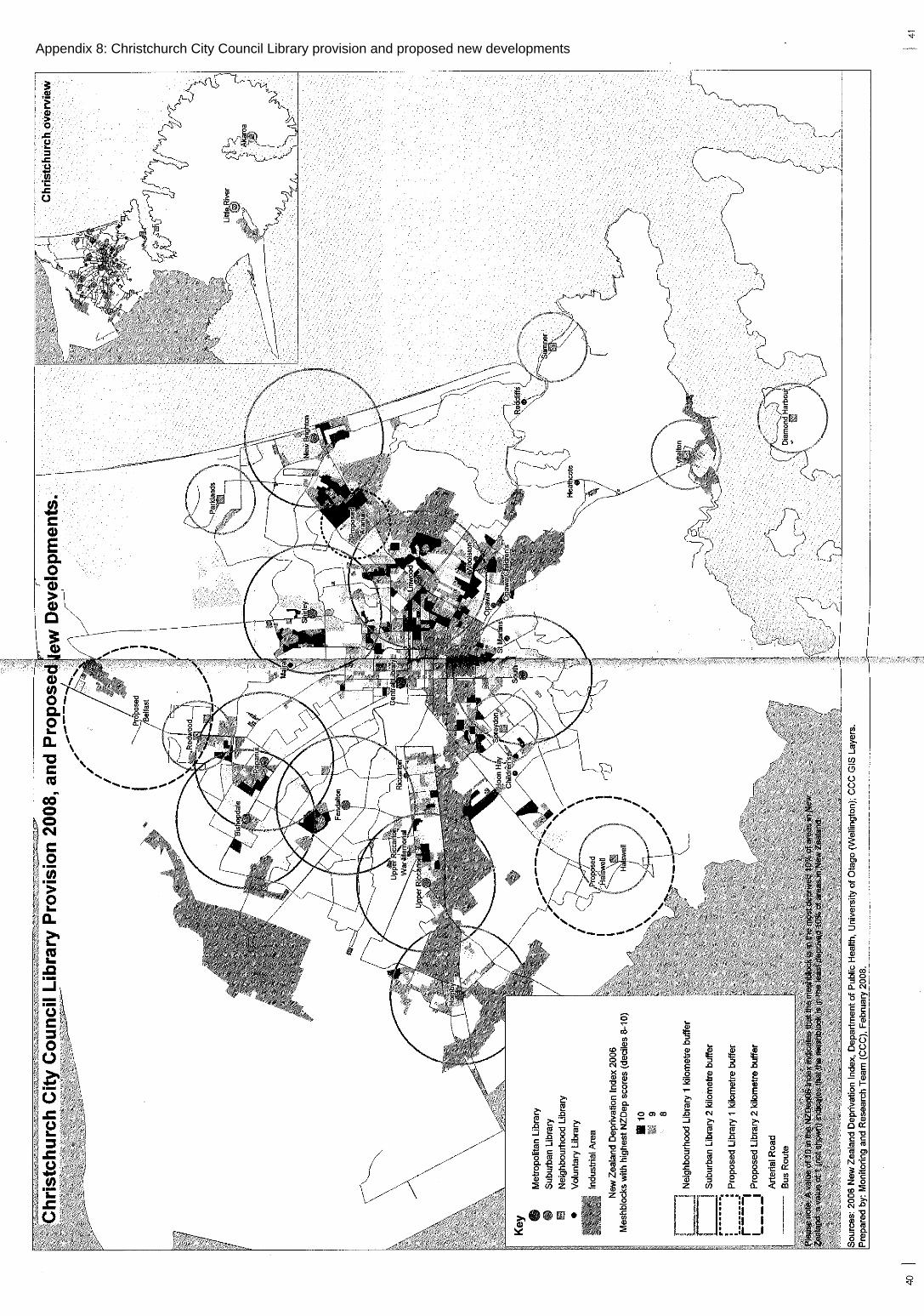
Appendix 8:Christchurch City Council Library provision and proposed new developments

App
endi
x 9:
C
hris
tchu
rch
City
Cou
ncil
2025
Sub
urba
n N
etw
ork
Vis
ion
- Com
mun
ity F
acili
ties

Appendix 10: Demographic profiles of communities in the northern sector of the City
This profile of the following six communities was compiled from 2006 census statistics:
(1) Belfast: Belfast Area Unit - older, established neighbourhood(2) Belfast South: Belfast South Area Unit - commonly referred to as Northwood; newneighbourhood(3) O'Neill Ave: MB2529013 from Belfast South Area Unit - sub-area within Northwood with a acluster of older persons housing units(4) Styx Mill North: MB2512800 from Styx Mill Area Unit - Regents Park, a relatively newneighbourhood(5) Redwood Springs: MB2510000 from Redwood North Area Unit - a new neighbourhood(6) Styx Mill-Redwood: The sum of data from the Styx Mill and Redwood North Area units lessthe data from Styx Mill North (MB2512800) and Redwood Springs (MB2510000) communities -older, established neighbourhood.
Census data for these six communities were collected for the following key variables:usually resident population - 1996, 2001, 2006age and sex structurehousehold typefamily typeethnic compositioneducational qualificationslabour force statusoccupationsemployment by industry - for residents of the areasources of income received from governmenttotal household incomedwelling tenurenumber of motor vehicles per household.
Usually Resident Population
Table 1 : Changes in usually resident population - 1996 to 2006
Belfast BelfastSouth
O’NeillAvenue
Styx MillNorth
RedwoodSprings
Styx Mill -Redwood
URpopulation2006
3966 2460 288 846 471 6003
URpopulation2001
3597 198 6 294 0 5811
URpopulation1996
3432 207 15 66 0 5808
% change inpopulation1996-2006
15.6 1088.4 1820.0 1181.8 - 3.4
Source: Statistics New Zealand

Age and Sex Structure
Table 2: Age structure of the population - 2006
Age group Per cent of population
Belfast BelfastSouth
O’NeillAvenue
Styx MillNorth
RedwoodSprings
Styx Mill-Redwood
0 - 14 yrs 21.0 19.9 14.9 23.8 28.0 21.7
15- 64 yrs 65.0 68.5 55.3 70.8 70.1 64.3
65 years+ 13.9 11.7 29.8 5.6 1.9 13.9
Total numberof persons
3963 2463 282 852 471 6003
Source: Statistics New Zealand
Dependency ratio 2006: Belfast 0.54, Belfast South 0.46, O’Neill Avenue 0.81, Styx Mill North 0.42, RedwoodSprings 0.43, Styx Mill-Redwood 0.55, New Zealand 0.51. Sex ratio M/F 2006: Belfast 0.94, Belfast South 0.97, O’Neill Avenue 0.92, Styx Mill North 1.07, RedwoodSprings 0.96, Styx Mill-Redwood 0.92, New Zealand 0.95.
Household type
Table 3: Types of households - 2006
Type ofhousehold
Per cent of households
Belfast BelfastSouth
O’NeillAvenue
Styx MillNorth
RedwoodSprings
Styx Mill-Redwood
One family 71.1 81.9 63.4 93.0 91.7 71.8
Two families 1.7 2.7 4.9 2.3 - 1.6
Three families 0.2 - - - - -
Multi-person 3.3 2.0 2.4 - 4.2 4.4
One person 22.9 12.6 29.3 4.7 4.2 22.0
Not classified 0.8 0.7 - - - 0.3
Total numberof households
1545 879 123 258 144 2265
Source: Statistics New Zealand

Family type
Table 4: Family types - 2006
Family type Per cent of families
Belfast BelfastSouth
O’NeillAvenue
Styx MillNorth
RedwoodSprings
Styx Mill-Redwood
Couple only 44.4 46.1 55.2 32.9 34.8 37.8
Two parent 39.7 45.3 34.5 63.4 54.3 42.9
One parent 15.8 8.5 10.3 3.7 10.9 19.3
Total numberof families
1155 774 87 246 138 1692
Source: Statistics New Zealand
Educational qualifications
Table 5: Highest educational qualifications held by residents - 2006
Family type Per cent of residents
Belfast BelfastSouth
O’NeillAvenue
Styx MillNorth
RedwoodSprings
Styx Mill-Redwood
Noqualifications
31.6 18.1 20.5 13.4 12.5 27.0
Secondary 31.6 38.2 38.6 40.7 43.8 34.1
Tertiary 28.9 38.8 32.5 43.1 42.0 31.4
Not specified 7.8 4.8 8.4 2.8 1.8 7.5
Total number ofresidents
3138 1986 249 648 336 4698
Source: Statistics New Zealand
Labour force status
Table 6: Labour force status of residents - 2006
Labour forcestatus
Per cent of residents
Belfast BelfastSouth
O’NeillAvenue
Styx MillNorth
RedwoodSprings
Styx Mill-Redwood
Employed full-time
51.7 51.4 37.8 55.1 62.8 49.9
Employed part-time
15.6 16.1 14.6 17.6 19.5 15.1
Unemployed 1.8 2.0 1.2 1.9 1.8 2.3
Not in labourforce
29.7 29.7 45.1 25.5 15.9 32.1
Not specified 1.2 0.8 1.2 - - 0.6
Total number ofresidents
3135 1971 246 648 339 4695
Source: Statistics New Zealand

Employment status
Table 7: Employment status of residents - 2006
Employmentstatus
Per cent of residents
Belfast BelfastSouth
O’NeillAvenue
Styx MillNorth
RedwoodSprings
Styx Mill-Redwood
Paid employee 81.7 75.3 70.5 71.3 78.5 84.3
Employer 6.5 9.0 13.6 15.3 10.8 4.2
Self employed 9.1 12.8 9.1 12.1 8.6 8.3
Unpaid familyworker
1.0 1.8 4.5 1.3 2.2 0.5
Not specified 1.7 1.1 2.3 - - 2.7
Total number ofresidents
2109 1338 132 471 279 3054
Source: Statistics New Zealand
Occupations
Table 8: Occupations of residents - 2006
Occupationalcategory
Per cent of residents
Belfast BelfastSouth
O’NeillAvenue
Styx MillNorth
RedwoodSprings
Styx Mill-Redwood
Manager 14.1 22.5 25.0 24.8 20.0 13.2
Professional 12.0 21.1 22.7 21.0 22.1 14.3
Technicians &trades worker
14.9 8.8 6.8 10.8 11.6 14.4
Commercial &personal service
8.1 7.6 6.8 6.4 6.3 8.3
Clerical &administrative
12.4 15.3 11.4 16.6 14.7 14.2
Sales 11.7 11.2 9.1 11.5 10.5 12.3
Machinery operator& driver
8.1 4.5 4.5 1.3 5.3 7.1
Labourer 13.1 5.2 6.8 4.5 7.4 10.5
Not specified 5.4 3.8 6.8 3.2 2.1 5.6
Total number ofresidents
2100 1335 132 471 285 3054
Source: Statistics New Zealand

Sources of income received from government
Table 9: Sources of income from government received by residents - 2006
Type of income fromgovernment
Per cent of residents
Belfast BelfastSouth
O’NeillAvenue
Styx MillNorth
RedwoodSprings
Styx Mill-Redwoo
d
NZ superannuation/veteranspension
16.1 13.7 32.9 7.4 2.7 17.1
Unemployment benefit 0.7 0.8 - - 1.8 2
Sickness benefit 1.7 0.6 - 0.9 0.9 2.2
Domestic purposes benefit 2.5 0.6 1.2 - - 3.4
Invalids benefit 4.1 1.7 1.2 0.9 0.9 3.2
Student allowance 0.6 1.2 1.2 2.3 1.8 1.3
Other Government benefits 3.8 2.1 2.4 0.5 1.8 3.6
Total payments received /numberof residents (%)
29.5 20.7 39 12.1 9.7 32.9
Total payments received 924 408 96 78 33 1545
Number of residents (15 years &over)
3132 1971 246 645 339 4698
Source: Statistics New Zealand
Household incomes
Table 10: Distribution of household incomes - 2006
Household incomerange
Per cent of households
Belfast BelfastSouth
O’NeillAvenue
Styx MillNorth
RedwoodSprings
Styx Mill-Redwood
$20,000 & under 14.5 9.2 20 2.3 4.1 14.6
$20,001 - $50,000 31.3 20.7 32.5 10.5 14.3 30.4
$50,001 - $100,000 31.5 32 20 27.9 38.8 32.4
$100,001 or more 11.4 27.6 15 47.7 32.7 11.1
Not stated 11.4 10.5 12.5 11.6 10.2 11.6
Total number ofhouseholds
1533 882 120 258 147 2253
Source: Statistics New Zealand

Dwelling tenure
Table 11: Tenure of dwellings - 2006
Tenure of dwellings Per cent of dwellings
Belfast BelfastSouth
O’NeillAvenue
Styx MillNorth
RedwoodSprings
Styx Mill-Redwood
Owned or partly owned 65.8 61.2 58.5 64 61.2 63.2
Not owned 21.7 18.7 19.5 9.3 14.3 25.6
Held in a family trust 8.6 17 14.6 26.7 24.5 7.6
Not specified 3.9 3.1 7.3 - - 3.6
Total number of dwellings 1536 882 123 258 147 2256Source: Statistics New Zealand
Access to motor vehicles by households
Table 12: Vehicle ownership by households - 2006
Number of MotorVehicles
Per cent of households
Belfast BelfastSouth
O’NeillAvenue
Styx MillNorth
RedwoodSprings
Styx Mill-Redwood
None 4.1 1 2.5 - - 7.2
One 35.4 26.1 50 10.5 12.5 35.3
Two 40.8 54.6 32.5 58.1 60.4 40
Three or more 17.4 17.3 12.5 31.4 27.1 15.9
Not specified 2.3 1 2.5 - - 1.6
Total number ofhouseholds
1536 885 120 258 144 2259
Source: Statistics New Zealand

BelfastTownship
Kaiapoi North = 6
Kaiapoi West = 3
Ohoka = 6
Redwood North = 9
Styx Mill = 6
Belfast South = 6
Sawyers Arms = 3
Belfast = 120
Styx = 15
Rutland = 3
1000 0 1000 2000 3000 m
Appendix 11a: Usual Residence 06 of people working in Belfast Township
Waimakariri District = 102
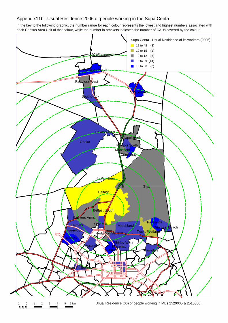
I e
Appendix11b: Usual Residence 2006 of people working in the Supa Centa.
n the key to the following graphic, the number range for each colour represents the lowest and highest numbers associated with1 0 1 2 3
ach Census Area Unit o
Rangiora North
MansfieldKaiapoi South
Kaiapoi NorthOhoka
BelfastStyx
Belfast South
Shirley West
Redwood South
Sawyers Arms
MarshlandStyx Mill
Harewood
Russley
Kaimahi
Travis Wetland
ParklandsWaimairi Beach
MairehauAvondaleRutland
Aorangi
Upper Riccarton
Courtenay
Rangiora West
SouthbrookWoodend
4 kilometers
10 kilometers
20 kilometers
4 5 6 km Usual Residence (06) of people working in MBs 2529005 & 2513800.
Supa Centa - Usual Residence of its workers (2006)15 to 48 (3)
12 to 15 (1)
9 to 12 (6)
6 to 9 (14)
3 to 6 (6)
f that colour, while the number in brackets indicates the number of CAUs covered by the colour.

5 kilometres
10 kilometres
15 kilometres
30 kilometres
20 kilometres
2 0 2 4 6 8 10 12 14 km
Northlands/Papanui - Usual Residence of its workers (2006)24 to 108
15 to 24
12 to 15
9 to 12
3 to 9
Usual Residence (06) of people working in MBs 2665000, 2661900, 2662200, 2662300, 2663000, 2663300 & 2663800.
Appendix 11c:Usual Residence 2006 of people working Papanui/Northlands

0
0
00
00
0
0
00
000
0
0
0
00
24 12
6
33
39
06
27 00
0
0
00
0
0
0
3 9
18
6
06
6 63
51
150
00
012
0
00
00
00
0 0 48
375
60
00
9
0 030
6
00
120
105
5724
39 243
6
0
6 03
0
009
0 0
0 0 0
00 0
0
0 12
00
0
120
00
0 009
219
0
00
0
0
00
0
0 0
0
0
0
0
00
0
00
0
00
000
0
0
10
12
34
56
78
910
11 k
m
Chc
h_A
Us
by W
orkp
lace
_Bel
fast
24 to
375
(13
)
21 to
24
(1)
18 to
21
(1)
15 to
18
(1)
12 to
15
(5)
9 to
12
(5)
3 to
9
(14)
Wor
kpla
ce o
f Bel
fast
Usu
al R
esid
ent P
opul
atio
n 20
06
Appendix 12a:Workplace of Belfast CAU Usual Resident Population 2006
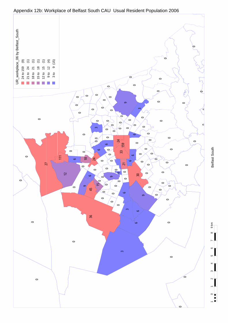
0
00
0
0
00
3 6
6
9
36
03
6 00
0
0
00
0
0
0
0 0
6
0
111
12
0 96
45
150
00
09
0
00
00
00
0
0
30
27
00
00
0
6 021
6
00
00
159
3324
18 240
0
0
6 06
0
003
0 0
0 0
0
00 0
0
0 0
00
0
90
30
0 006
06
0
00
0
0
00
0
0 0
0
0
0
0
00
0
0
0
0
0
00
0
10
12
34
56
78
9 km
Bel
fast
Sou
th
UR
_wor
kpla
ce_0
6 by
Bel
fast
_Sou
th24
to 1
59 (
9)
21 to
24
(1)
18 to
21
(1)
15 to
18
(1)
12 to
15
(1)
9 to
12
(4)
3 to
9
(15)
Appendix 12b:Workplace of Belfast South CAU Usual Resident Population 2006

00
00
00
0
00
000
0
00
18 9
6
15
27
00
6 00
0
0
00
3
0
0
0
9 0
135
6
09
6 1518
21
120
00
09
0
00
00
00
9 0
51
18
00
00
0
0 69
6
00
90
135
3318
30 210
3
0
12 06
0
003
0 0
0 0 0
00 0
0
0 3
00
0
99
00
0 000
153
0
00
0
0
00
0
9 0
0
0
0
0
00
0
0
0
00
0
0
0
00
00
10
12
34
56
78
910
11 k
m
Chc
h_A
Us
by W
orkp
lace
_Sty
x_M
ill27
to 1
35 (
6)
21 to
27
(2)
18 to
21
(4)
15 to
18
(3)
12 to
15
(2)
9 to
12
(10
)
3 to
9
(12)
Wor
kpla
ce o
f Sty
x M
ill U
sual
Res
iden
t Pop
ulat
ion
2006
Appendix 12c:Workplace of Styx Mill CAU Usual Resident Population 2006

0
00
0
0
00
15 6
12 33
42
09
33 00
0
0
00
0
0
0
153 0
12
12
06
0 2112
39
213
00
012
0
00
00
00
120
48
57
96
00
0
6 015
15
90
120
195
7215
84 303
9
12
9 06
0
009
0 0
0 0 0
00 0
0
0 6
66
0
150
63
0 009
336
0
00
0
0
00
0
0 0
0
0
0
0
00
6
0
0
0
0
0
00
0
10
12
34
56
78
9 km
Red
woo
d N
orth
UR
_wor
kpla
ce_0
6 by
Red
woo
d_N
orth
33 to
195
(11
)
30 to
33
(1)
21 to
30
(2)
15 to
21
(5)
12 to
15
(8)
9 to
12
(7)
3 to
9
(14)
Appendix 12d:Workplace of Redwood North CAU Usual Resident Population 2006
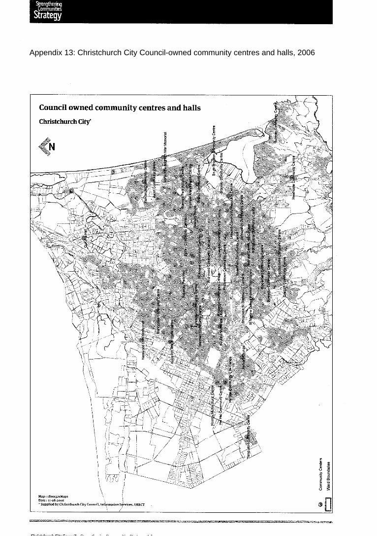
Appendix 13:Christchurch City Council-owned community centres and halls, 2006

S c a l e - 1 : 3 0 0 0 @ A 4
150m75300
Appendix D - Special Provision Plan - Styx Centre
Styx River
Mai
n N
orth
Roa
d
Styx River Setback
B2 Styx Centre Zone Boundary
Vehicle Access Points
Community Linkages
Indicative Alignment of north/south Main Street
Indicative Extent of Underground Carparking
Building Restriction Area
Key
Radcliffe Road
Mai
n N
orth
Rai
l Lin
e
Area B
Special Area B
Special Area A
Area A
Appendix 14:Special Provision Plan - Styx Centre
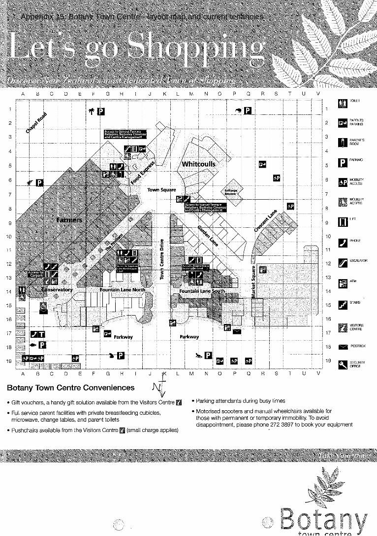
Appendix 15:Botany Town Centre - layout map and current tenancies


Appendix 16: Use of meeting rooms in the Manukau City Library in Botany TownCentre
[Email to James Baines from Pip Henderson, librarian at Botany Town Centre - 13 May2009]
We have two areas that can be used as meeting spaces.
One is a glass room that seats around 12 - 15 people comfortably, is fitted out withwhiteboards, a retractable screen and data show and also has video and audio conferencingcapabilities. There are comfortable tub chairs and three lower coffee tables. This is referredto as the Focus Room.
Our second area is called the Showcase Room and this is a larger space which can seat 50- 60 people in row seating. This too has a retractable screen and a data show. We also havea cafe adjacent to this space.
Both these spaces are used by library patrons on a day to day basis. The showcase roomcan be closed off by pivoting and sliding doors (solid) and has a separate entrance that isused when this space is isolated from the library. Normally there is just three square tablesand chairs, and some large leather easy chairs, squabs and small tables in this room.Behind another set of sliding doors at one end of the room is a huge walk in cupboard thatspans the width of the room where we store tables and chairs.
Currently we have community board meetings and workshops twice a month in theShowcase Room. These are the only meetings that are held out of library opening hours.Other council groups have workshops during the day, our town centre security meetings areheld here and we do have paying customers from local businesses from time to time.
We have ESOL groups, study groups, J.Ps cottage meetings and library meetings in thefocus room - all of whom we do not charge for.
Apart from an initial couple of test runs with the video conferencing facilities, there has notbeen any further use of this. Occasionally I field enquiries regarding this service but this is asfar as it goes.
Revenue from these spaces is limited at present, but new rates are to be struck in thecoming financial year and it will mean user pays for all - but clearly community groups andcouncil will only pay a nominal fee.We can go in to this more on the telephone.
Internal (council) bookings are done through Outlook Calendar and external bookings aredone directly with one of three library personnel who also manage the calendar.
The library is open -
Monday 9 - 5.30 Tues/Wed 9 - 7 Th/Fri 9 - 9 Sat 9 - 5.30 Sun 10 - 5.30 and around half the public holidays
The spaces while well used by patrons are not well used as meeting rooms. As well as ouropening hours we are limited by other events that might be occuring in the library andrequirements for privacy and quiet that we cannot meet. The library attracts a considerableamount of 'mall' noise as we are directly above the food court which is accessed by a

humming escalator. Additionally we are not a "sssshhhhhh" library and the children's area,albiet compact, is adjacent to the showcase room.
We overcome this noise factor for our patrons by providing a reasonably soundproofed areacalled the Peaceful Place. This however is never used for meetings as it is one of the mostpopular spots for studying, reading the newspaper and quiet reflection with a lot of naturallight and a pleasant outlook.
The Showcase Room is a fantastic space for book launches, guest speakers, and librarypresentations. It takes little more than a few minutes to transform it into a separate spaceand without any collections being housed in there, it means no one is denied access toanything when it is being used (except space)
Because we do not have the Showcase Room alarmed separately we are unable to holdafter hours meetings. In the case of the community board the democratic services personfrom council overseas these meetings- and during the monthly community meetings open tothe public they have a security guard present.
In terms of advantages of our location - Botany Town Centre is still a popular destination,especially for youth which means we too reap the benefits of this. We are in attractive andwell kept surroundings, it is an appealing place for staff to work, we feel safe because ofTown Centre security and we receive a lot of ad hoc visitors simply because of their curiosityor the need for internet use (no other internet cafe's in close proximity) Our membership hascontinued to grow, we are smack bang in the middle of a young multi cultural communitywhich has experienced huge exponential growth in the past few years .
There are no major disadvantages, once you get used to being a 'tenant' and advising TownCentre Management of any out of hours events we may run (e.g. the library has been turnedin to a nightclub at the conclusion of our Young Adult reading challenge) and sort out who isresponsible for what maintenance (Town Centre vs Council) and advise T.C which publicholidays we are closing and a few other minor issues then it is pretty smooth sailing.
We have just completed our annual survey and at a glance the most common commentsabout what people like about his library are -
Close to Home In the Shopping Centre Great Decor Warm, Safe, Comfortable.
Only disadvantages to our patrons are that parking can be an issue, and our after hoursreturns bins are only accessible while the doors to the food court are open, and this dependson what time the last movie starts (the cinema is our neighbour) in the evenings. Thepatrons have to find a park, troop up the escalator, stairs or lifts (which can also be aproblem for disabled users) if all they want to do is return books. A drive by returns bin onground level (something like a dumb waiter) would be ideal and is one thing that could bemade a feature of (a bit like a glass elevator!)


Appendix 17: Summary of issues and social effects raised in writtensubmissions or during community workshops/meetingsorganised by the applicant
Workshop May 2007
WorkshopDec 2007
WorkshopJuly 2008
Written submissions
- connectivity to Belfast andto Redwood- need to improve localPublic Transportconnections- inclusion of communityfacilities (banks, library,medical facilities),community focus, sense ofownership- definitely needs a ‘highstreet” theme - open air,pedestrian friendly, qualitypublic spaces- flexibility of operatinghours - not 9-5- create special identity,sense of place- address traffic issues - recognise Styx River
- importance of StyxRiver- connectivity to area- create community focus- create Town Centre24/7 environment- traffic, access, safety- avoid adverse retaileffects elsewhere- right level of retail? cfBAP- higher-density resid.?- traffic issues? - pedestrian access?- connectivity toRedwood/elsewhere?- Styx River setback?- public open space?- on-site communityuses?
- which types of facilitiesare best suited to a TownCentre location (cf local,neighbourhood location),and issues of locationwithin the Town Centre- co-ordinate provision ofcommunity facilities acrosswhole area- keep community facilitiesdistinct from retail activities
- connectivity withsurrounding areas, bymixed modes of travel- visual impact onneighbouring residents- new source ofenvironmental noise forneighbouring residents- security issues, parkingspill-over and anti-socialbehaviours >> impacts onneighbours- maintaining amenityvalue of Styx Rivercorridor- mixed-mode access forneighbouring residents- improved access tolocal shopping- increasing trafficcongestion- need for multi-purposecommunity facilityavailable for community-based interest groups (atnominal rent)- adequacy of opportunityfor community facilitieswithin the proposed TownCentre- construction-phaseeffects - noise, dust, run-off, etc.- location of futureschools and associatedschool facilities

Appendix 18: Northern sector of Christchurch City - Residential areas in relation toalternative sites for a Town Centre

Sheldon Park
Assessment Site
500 0 m 800 metre Pedsheds
Appendix 19: 800 m pedsheds from alternative sites - assessment site and Sheldon Park/ Belfast School


![Styx y Stygius[1]](https://img.dokumen.tips/doc/110x75/55cf9138550346f57b8ba3c9/styx-y-stygius1.jpg)


