Embed Size (px)
Citation preview

MIT Lincoln Laboratory WakeNet-1
Probabilistic Wind Forecasts for WTMA-S (Wake Turbulence Mitigation for Arrivals – System)
Cynthia Engholm David A. Clark
Team: Vaibhav Andleigh Suilou Huang Frank Robasky
WakeNet3-Europe 28-29 February 2012
This work was sponsored by the Federal Aviation Administration under Air Force Contract No. FA8721-05-C-0002.
Opinions, interpretations, conclusions, and recommendations are those of the authors and are not necessarily
endorsed by the United States Government.

MIT Lincoln Laboratory WakeNet-2
Outline
• History of two-tier forecast (Nowcast, Outlook)
• New Probablistic Outlook Concept
• Sample Concept Display
• Summary

MIT Lincoln Laboratory WakeNet-3
Review of Wind Forecast for WTMD
• Wind-dependent procedures for
reduced separations on departure
• Wind forecast requirements
– 20-minute wind forecast with
3-minute safety criticality
– Forecast from surface to 1000 feet
ASOSASOS
30L30R
RUCRUC
RUCRUC RUCRUC
RUCRUC
ASOSASOS
30L30R
RUCRUC
RUCRUC RUCRUC
RUCRUCRUC-3
RUC-1 RUC-2
RUC-4
ASOS
• Wind Forecast Algorithm: Predicts
“Lower bound” crosswind separately
for surface and aloft
– Surface crosswind: Statistical forecast
based on 1-minute 10m ASOS wind
– Aloft : derived from RUC model profiles
surrounding airport

MIT Lincoln Laboratory WakeNet-4
WTMA-S Design Concept
• WTMA-S “Outlook” forecast (1-6 hours)
– Predicts WTMA-S availability at longer
time horizon, for planning purposes
– Risk is excess throughput into
TRACON if WTMA becomes
unavailable (operational, not safety)
– Increases “beneficiaries” beyond
TRACON Departure
Queue
• WTMA-S “Nowcast” (~20 minutes)
– Analogous to WTMD (departures)
– Increase arrival throughput via
compression within TRACON
– Benefit to limited number of aircraft

MIT Lincoln Laboratory WakeNet-5
Probabilistic Concept
Provide categorical forecast of future WTMA-S availability as
a planning aid out several hours
Now Now+60min
Very
Confident
>90%
Not Expected
<50%
Likely
70-90% Possible
50-70%

MIT Lincoln Laboratory WakeNet-6
Likelihood Computation
ASOS ASOS
30L 30R
RUC RUC
RUC RUC RUC RUC
RUC RUC RUC RUC
RUC RUC RUC RUC
RUC RUC RUC - 3
R 1 RUC - 2
RUC - 4
Long forecast horizons
required input to be
based solely on
numerical model
input.
Development based on
current operational
model (RUC 13km
grid spacing)
Model forecasts run every
hour with forecast
horizons past 12
hours
Model Forecast Model Forecast
Model Forecast Model Forecast
MIT Lincoln Laboratory WakeNet-7
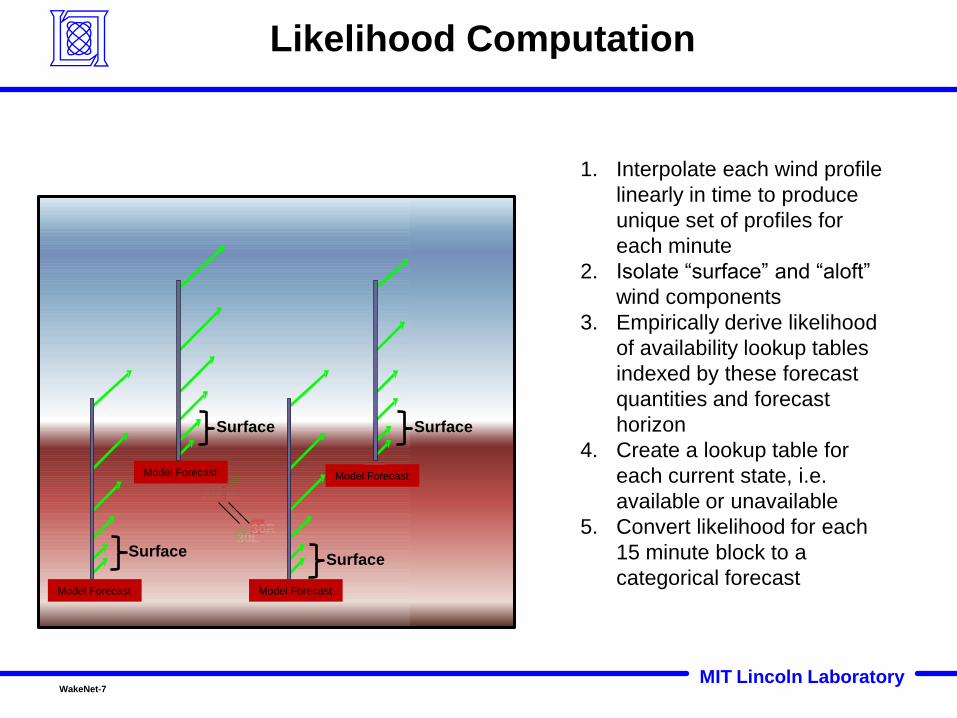
Likelihood Computation
ASOS ASOS
30L 30R
RUC RUC
RUC RUC RUC RUC
RUC RUC RUC RUC
RUC RUC RUC RUC
RUC RUC RUC - 3
RUC - 1 RUC - 2
RUC - 4
Surface
Surface Surface
Surface
1. Interpolate each wind profile
linearly in time to produce
unique set of profiles for
each minute
2. Isolate “surface” and “aloft”
wind components
3. Empirically derive likelihood
of availability lookup tables
indexed by these forecast
quantities and forecast
horizon
4. Create a lookup table for
each current state, i.e.
available or unavailable
5. Convert likelihood for each
15 minute block to a
categorical forecast
Model Forecast Model Forecast
Model Forecast Model Forecast

MIT Lincoln Laboratory WakeNet-8
BOS-04R/22L Likelihoods WTMA Currently Available
Increasing Forecast Horizon
30 Minute Horizon
60 Minute Horizon
240 Minute Horizon
MIT Lincoln Laboratory WakeNet-9
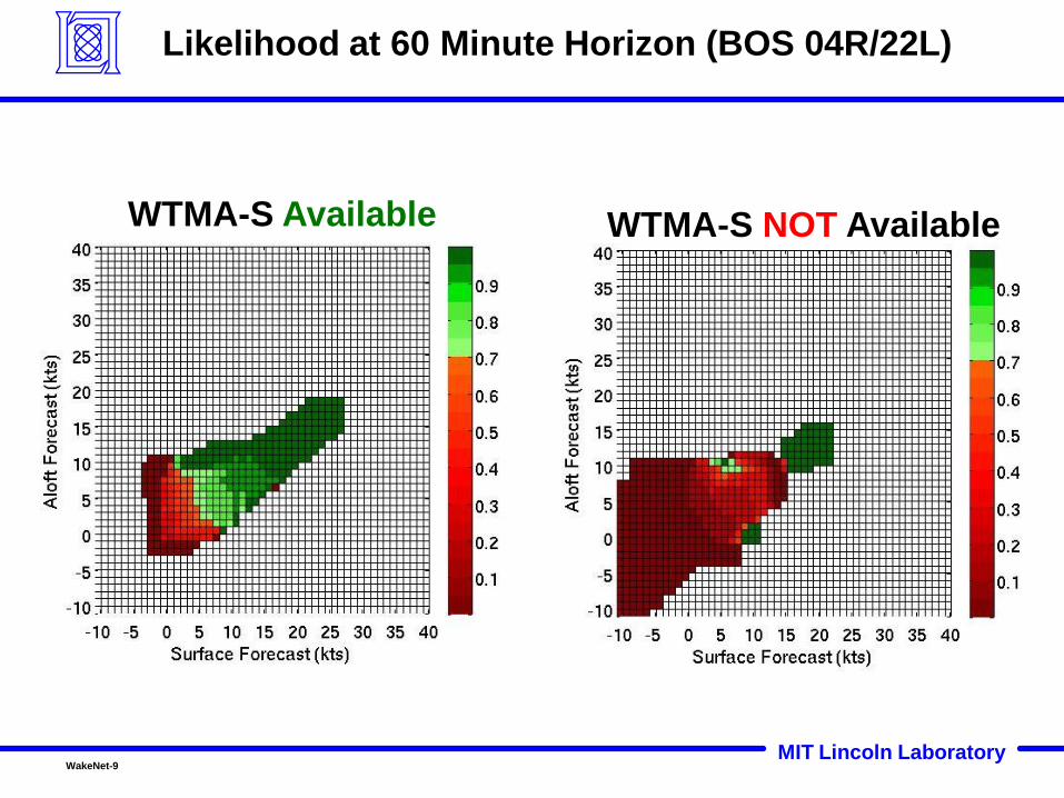
Likelihood at 60 Minute Horizon (BOS 04R/22L)
WTMA-S Available WTMA-S NOT Available

MIT Lincoln Laboratory WakeNet-10
Scoring Measures
1. Confidence: actual probability by category
2. Capture Rate: amount of correctly forecast availability
3. Lead Time: time difference between forecast start of
available period and actual start
4. End Time: time difference between forecast end of
available period and actual end
5. Flicker: the number category changes from max
horizon to current time

MIT Lincoln Laboratory WakeNet-11
Working Idea for Display

MIT Lincoln Laboratory WakeNet-12
BOS Feb 28, 2011
BOS-Logan Airport
Departures on 22R
Arrivals on 22L
6AM/11UTC
8AM/13UTC
10AM/15UTC
Color Weather
Blue Snow
Magenta Ice
Green Rain
Yellow Heavy
Rain
Winds from the southwest at 5-10kts

MIT Lincoln Laboratory WakeNet-13
BOS Feb 28, 2011 Synopsis
Local Time Universal
Time
Arrival
Rate
Arrival
Demand
Weather WTMA-S
Available
on 22L?
6 AM 11z 32 6 Overcast No
7AM 12z 30 28 Freezing
Rain
No
8AM 13Z 30 32 Rain Yes
9AM 14Z 30 25 Rain Yes
10AM 15Z 30 27 Rain Yes
11AM 16Z 30 35 Rain First ½
12PM 17Z 32 34 Rain No
Airport Runway Configuration 6am-11am and (12pm):
•Departures on 22R (33L)
•Arrivals on 22L (27)

MIT Lincoln Laboratory WakeNet-14
WTMA-S Outlook 6AM (11UTC)

MIT Lincoln Laboratory WakeNet-15
Outlook Forecast 6AM (11UTC)

MIT Lincoln Laboratory WakeNet-16
WTMA-S Concept Display Demonstration
MIT Lincoln Laboratory

MIT Lincoln Laboratory WakeNet-17
• Confidence matches desired performance for most time
horizons
• Capture the bulk of most available time periods
• Conservative (late) lead times
• Overforecast (late) end times
• Acceptable flicker levels
Performance
Performance based on 7 candidate airports for 8 months in 2011
utilizing probabilities based on 8 months in 2010

MIT Lincoln Laboratory WakeNet-18
Summary
• Input is numerical model wind forecasts for grid points nearby airport and
ASOS sensor (Nowcast only)
• Nowcast analogous to WTMD; very conservative for safety
• Probabilistic Outlook for planning
– Gives heads up for planning purposes of longer available time
periods
– Self-adjusting to different forecast models/locations
• Display Concept developed for evaluation, expect this to change as needs
of user become apparent
• Forthcoming performance requirements needed to determine
effectiveness and benefits
• Future work will focus on algorithm development (leveraging increased
quantity of input data), real-time system development, and response to
emerging needs and requirements