Embed Size (px)
Citation preview

PNU Campus Map IPhone App
Prepared By:
Afnan Abdulwahab AL-Sahrani 429001255
Bayan Abdullah AL-Sayegh429000654
Fatimah Khalid AL-Jafari429001281
Haifaa Khalid AL-Dossari429000532
Supervised By:
Dr.ziyad AL-Salloum
Princess Noura Bint Abdulrahman University
Collage of computer science and information
Networks and communication systems department
Graduation Project

II
Phone AppMap I CampusPNU

III
Dedication
For our amazing supportive parents we
dedicate this project to you….

IV
Acknowledgments
We wish to express our sincere gratitude to
Dr.Ziyad AL-Salloum, supervisor for his
immeasurable amount of support and
guidance, he was cooperative and
welcoming to our frequent questions all
the time.
We would also like to thank our parents
and our relevant who supportive us until
the end.
Thanks to the incredible cooperative team,
it’s such a pleasure to work with.
V
Table of content
TABLE OF CONTENT ................................................................................................. V
LIST OF TABLE ....................................................................................................... VII
LIST OF FIGURES .................................................................................................. VIII
LIST OF FIGURES ..................................................................................................... IX
ABSTRACT ................................................................................................................. X
KEYWORDS ............................................................................................................ XII
Chapter 1:‘Introduction’ ..................................................................................... 1
1.1 INTRODUCTION.................................................................................................. 2
1.2 PROBLEM STATEMENT: .................................................................................. 3
1.3 PROPOSED SYSTEM: ......................................................................................... 3
1.5 DEFINITIONS OF A NEW TERMS:.................................................................. 4
1.6 WATERFALL: ...................................................................................................... 4
1.7 PROJECT PLAN: .................................................................................................. 7
Capter2:‘BackgroundInformation& Related Work’ ...................................... 10
2.1BACKGROUND INFORMATION: ................................................................... 11
2.2RELATED WORK SURVEY: ............................................................................ 11
2.3 PROPOSED & SIMILAR SYSTEMS COMPARISON: ................................. 16
Chapter 3:‘Requirements Determination& Analysis’ .................................... 18
3.1REQUIREMENTS DETERMINATION & COLLECTION: .......................... 19
3.1.1QUESTIONNAIRESFORM: ............................................................................ 19
3.1.2 QUESTIONNAIRES RESULT: ...................................................................... 21
3.2 REQUIREMENTS ANALYSIS: ........................................................................ 25
Chapter 4:‘System Design’ ................................................................................ 27
4.1SYSTEM ARCHITECTURE: ............................................................................. 28
4.1.1 NETWORK DIAGRAM: ................................................................................. 28
4.1.2 DATA GATHERING: ...................................................................................... 29
4.2IMPLEMENTATION REQUIREMENTS: ....................................................... 31
4.3USER INTERFACE DESIGN: ............................................................................ 32
4.3.1SCREEN SKETCH: .......................................................................................... 32

VI
Chapter 5: ‘Mapping technology’ ..................................................................... 35
5.1 MAPPING TECHNOLOGY: ............................................................................. 36
5.2 WEB MAP SERVICES: ...................................................................................... 36
5.2.1 YAHOO! MAP API: ......................................................................................... 36
5.2.2BING MAP API ................................................................................................. 37
5.2.3 GOOGLE MAPS API: ..................................................................................... 38
5.2.4 HOW IT WORKS ............................................................................................. 40
5.3 CREATING PNU CAMPUS MAP: ................................................................... 40
SUMMARY ................................................................................................................ 43
FUTURE WORK ....................................................................................................... 43
Chapter 7: ............................................................................................................ 44
‘References’ ......................................................................................................... 44
APPENDIX ................................................................................................................. 47
COMMUNICATION PLAN ..................................................................................... 47

VII
List of table
TABLE 1.7.1: PROJECT SCHEDULE ..................................................................... 9
TABLE 2.1:UNIVERSITY APPLICATION COMPARISON .............................. 17
TABLE 5.3.1: COMPARISON BETWEEN SEVERAL MAPS SERVERS ........ 40
TABLE A: COMMUNICATION PLAN ................................................................. 50

VIII
List of figures
FIGURE 1.6.1: WATERFALL ................................................................................... 6
FIGURE2.1 SCREEN SHOT TO CAMPUS ME APP ,FIGURE 2.2: SCREEN
SHOT TO CAMPUS ME SERVICES ..................................................................... 12
FIGURE 2.3: SCREEN SHOT TO CAMPUS ME CLASS , FIGURE 2.4:
SCREEN SHOT TO CAMPUS ME APP MAP ...................................................... 13
FIGURE 2.5: UNH APP INTERFACE , FIGURE 2.6: UNH CAMPUS MAP 14
FIGURE 2.7: TRANSPORTATION ROUTES , FIGURE 2.8:
TRANSPORTATION SCHEDULE ......................................................................... 14
FIGURE 2.9: CSULB APP INTERFACE , FIGURE 2.10: CSULB APP
INTERFACE .............................................................................................................. 15
FIGURE 2.11: BSU APP INTERFACE , FIGURE 2.12: BSU CAMPUS MAP 16
FIGURE 3.1.1: Q1 RESULT .................................................................................... 21
FIGURE 3.1.2: Q2 RESULT .................................................................................... 21
FIGURE 3.1.3: Q3 RESULT .................................................................................... 22
FIGURE 3.1.4: Q4 RESULT .................................................................................... 22
FIGURE 3.1.5: Q5 RESULT .................................................................................... 23
FIGURE 3.1.6: Q 7RESULT .................................................................................... 23
FIGURE 3.1.7: Q8 RESULT .................................................................................... 24
FIGURE 3.1.8: Q9 RESULT .................................................................................... 24
FIGURE 4.1.1: NETWORK DIAGRAM ................................................................ 28
FIGURE 4.2.1: PNU CAMPUS MAPS .................................................................... 30
FIGURE 4.3.1: SKETCH FOR PNU CAMPUS APP INTERFACE .................... 32
FIGURE 4.3.2: SKETCH FOR PNU CAMPUS APP MAIN MENU ................... 32
FIGURE 4.3.3: SKETCH FOR PNU CAMPUS MAP APP .................................. 33
FIGURE 4.3.4: SKETCH FOR PNU CAMPUS APP SERVICES ....................... 33
FIGURE 4.3.6: SKETCH FOR PNU CAMPUS APP HELP................................. 34
FIGURE 4.3.5: SKETCH FOR PNU CAMPUS APP NEWS ................................ 34
FIGURE 5.2.1.: YAHOO! MAP ............................................................................... 37
FIGURE 5.2.2: BING MAP ...................................................................................... 37
FIGURE 5.2.3.: GOOGLE MAP .............................................................................. 38

IX
List of figures
FIGURE 5.3.2: PNU MAP DISPLAY SEVERAL COLLEGE’S.......................... 41
FIGURE 5.3.3: PNU MAP DISPLAY MARKERS ................................................ 41
FIGURE 5.3.4:THE CODE FOR PNU MAP .......................................................... 42

X
Abstract
The educational field became quite competitive on countries level, also locally here in
Saudi Arabia in the gulf region. Universities are important representatives of this
field. A noticeable development has been shown recently from many aspects. The
increment in the number of applying students, working staff, faculties and continues
addition of schools. Also the size of a university campus has increased to huge extend
appearing as small town inside the city.
In Riyadh, Princess Noura University (PNU) was established recently categorized as
one of the biggest universities in Saudi Arabia size and faculty wise. Both students
and staff at PNU are willing to walk from a place to another most of the time. For
long distances, trains provided by the university are used. In both cases, static maps
distributed over the campus are used, as the possibility of getting lost in many cases is
high. For instant, new students or staff, visitors, students needing to go to a different
area.
Base on this issue, our team agreed on implementing an application of a full map of
the university campus. It will be designed as an IPhone application as the popularity
of its usage among the university community is high. The main purpose of it is
showing the map of the university locating the user with helping tools to get him/her
to the right destination. By typing the name of the destination the application will
process the query then shows path.

XI
Abstract
لمستوى المحلي في المملكة أصبح المجال التربوي تنافسي جدا على مستوى البلدان، أيضاً على ا
وقد تبين تطوراً ملحوظاً ,لمجال في هذا االسعودية .وتعتبر الجامعات من أهم المنشئات العربية
للجامعات أعداد الطالب والموظفين المتقدمين وكانت ,الجوانب. في اآلونة األخيرة من العديد
الصغيرةتوسع حجم الحرم الجامعي ليصيح كالقرية ازديادملحوظ، وكذلكيفوالمدارس والكليات
المدينة.داخل
مؤخراً واحده من أكبر الجامعات في المملكة . الجامعة،تأسست جامعة األميرة نورة في الرياض
الطالب والموظفين فيالجامعة على استعداد للسيرعلى األقدام من مكان آلخر لمسافات طويلة
في كال الحالتين تستخدم لوحات إرشادية موزعة ,م القطارات التي قدمتها الجامعة .وكذالك تستخد
. حول الحرم الجامعي في حالة الضياع
للحرم الجامعي وسيتم الكترونيةتطبيق خريطة تنفيذوافق فريقنا على لهذهالمسألة،بالنسبة
الجامعي أن يظهر خريطة الحرم التطبيق،كتطبيق أيفون. الغرض الرئيسي من هذا تصميمها
على الوصول ليساعدهتحديد وجود مكان المستخدم داخل الحرم الجامعي وكذالك
إليه.أو المكان المراد الوصول الوجهةعن طريق كتابة أسم للوجهةالصحيحة
XII
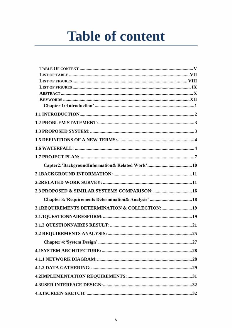
Keywords
Acronym Abbreviation
PNU Princess Noura University
UNH University of New Hampshire
CSULB California State University long beach
BSU Ball state university
App Application
V3 Version 3
MAC Macintosh
API Application programming interface
HTML Hypertext markup language
CSS Cascading style sheet
IOS IPhone operating system
OS Operating system
MoSoCoW Must, Should, Could, and would
PARC Palo Alto Research Center
HTTPS Hypertext transfer protocol security
PARC Xerox Palo Alto Research Center
Long/Lat Longitude/Latitude
ITU International Telecommunication Union
UK United kingdom

1
Chapter1:
‘Introduction’
2
1.1 Introduction
At Geneva, October 11st 2012 International Telecommunication Union (ITU) shows
that there are more than 6 billion cell phones in use, about 3 million phones are sold
every day and the number of smart phones in use globally crossed more than 1.038
billion. Therefore, cell phones and smart phones become a main demand of person
life, regardless of the manufacturer companies. Smart phones participated in many
aspects of life, one of the most important and take huge attention is the education
sector.
Saudi Arabia government spends considerable effort towards female’s education to
reduce illiteracy. The government has invested large amounts of money in women's
education which led to a significantly expansion in Women's schooling at all levels -
elementary, secondary, high school, Institute and universities.
According to ministry of education website (2011/2012 statics), women's schools for
general education are more than 18,710 schools. On the other hand, there is a
significantly growing in Saudi higher education. Whereas the ministry of higher
education website statics shows that number of universities reached 25 and it has 108
colleges Spread all over the Kingdom. Therefore, schools, universities and colleges
for women continued to be built throughout the nation. [12]
The Custodian of the Two Holy Mosques King Abdullah bin Abdul-Aziz Al Saud
issued at 2007 a royal order to construct Princess Nora University (PNU) to ensure the
pursuit of Saudi female’s education. It is considered the largest female University in
the Middle East by total area. The land area of PNU is 8,000,000 square meters. The
campus contain variant colleges, housing, medical centers, main hospital, mosques,
library, student services, administration, kindergarten, boy's and girl's school and
sports center.[9],[12]
However, Smart phones support a lot of educational applications. Right now at the
App Store of Apple Company there are more than 20,000 educational apps, and
36,661 educational apps at the Android market based on the statics. Apps designed for
all kinds of learners, teaching them everything. The learners use apps so they can read
books, organize their schedules, browse the lectures, take notes, make educational
conference, also learners can use navigation apps to direct theme at their schools,
universities, Institutes, academies ...etc.
The huge space of the campus has many facilities; it’s bigger and more complex
than the usual campuses areas. For that getting from site to another requires more
effort than before. Also, it is consuming the student and the staff time especially
when they are heading to a site for the first time. Another case occurs for an external
visitor who can get lost easily. That is why our vision for this project is to give the
visitor our first priority and facilitate his mission from the gate and back again to the
gate.
Any project under construction whether big or small will face problems. The
problems, which faced us so far, are related to the software and the hardware.
3
1. Hardware: Buying MAC computers and IPhones.
2. Software: we found big difficulty for getting the map and we had to keep in
contact with many officials for a long time until they gave us the map.
Unfortunately, the map we got had many shortcoming and we had to walk in
the campus to write the names of the streets as the map had no names for
streets.
First, we searched about several universities that match our solution; you can read
about that in chapter 2. Also, we analyze user and system requirements at chapter 3.
Finally, we design the application in chapter 4.
1.2 Problem statement:
If you ask a random people about their first visit reaction to PNU campus, they will
most likely say that they were unable to find their way easily, do not have a clear idea
about the buildings, waste of time and spend a lot of effort to reach their point.
According to the huge area of PNU it causes the people who visit the campus
disorienting in time and place. Normally visitors feel lost and confused. For an
example one of the faculty members came to the campus for the first time. The
member was unlabeled to find the building that he/she will give lessons at, because
the buildings at the campus look the same. The consequences are wasting in time for
both the students and member, which cause a delay in signing the attendance for the
member. Subsequently, deducted from the salary. Also, there will be a delay in the
course.
1.3 Proposed system:
To solve the problem we tried to find a suitable solution that composed of a series of
solutions.
As a result of many researches and surveys (see chapter 3) about the problem
mentioned at section (1.2) we have reached that the map is the best solution because
the map is a representation that helps to find locations and places. Smart phones
support applications and according to its popularity we decided to build an application
that will be used to help the users to find locations and places by displaying a map and
provide multi services.
As a result creating an application shows a map contains PNU campus and this seems
to be the best solution. This solution built on strategic plan and creative thinking and
with a focus on delivering actionable results.
4
1.5 Definitions of new terms: Map: a representation or an image of a place at a particular point in time of all or part
of the earth surface. Maps appear mirror image makes understanding the reality of
places at different points in time more efficient and easy.
Google Maps: a service provided by Google contains the earth map that supports
many features. A Google map can be used as a navigational tool it displays and
defined any location in different verity of map types.
Application programming interface (API):
It is a set of programming instructions and protocols to build and access software
application. It is software-to-software interfaces, in particular a program request
services from another program.
Geographic coordinate system: A three-dimensional spherical surface that consists
of longitude and latitude coordinates values that use as a reference system to
determine any location on earth.
1.6 Waterfall: Time is the overriding factor in the project. Time will be limited, so re-writing or re-
doing tasks must be avoided as much as possible. For this reason the waterfall
lifecycle were chosen for the project. Also, this lifecycle will help us as a team to be
committed to our tasks and manage our work by clarifies the specific deliverables and
a review process for each phase (Figure 1.1)
.
It starts with the feasibility study and move down through the various phases down
to analysis, design and finally the implementation.
The first phase is feasibility study, which is overall studying and understanding the
problem to solve and identify solutions at the end of the project. Study the problem
contain concepts explanation, ideas discussion, understand different aspects of the
problem and see different ways of approaching, study the required resource and
development time, perform a benefit analysis that feedback on the project.[10]
The study will be shown in (chapter 2) by studying the colleges that provide a solution
to the problem mentioned before at the problem statement.
First phase is Feasibility study:-
In this phase we will an overall understanding of the problem that we will provide
the solution at the end of this project.
In this study, there will be study of the solution in terms of resource required and
development time. Also, perform a benefit analysis that feedback on the project.

5
We will discuss similar solutions for the same problem in literature review (chapter 2)
Second phase is Requirement phase:-
This phase is consisting of two special activates:
1- Requirement gathering and analysis.
2- Requirement specification.
We run a questionnaire for the students and employees of PNU for dedicate their
requirement. (Discussed in chapter 3).
Third phase is Design phase:-
Transform requirements specification into a suitable form for the implementation
process by choose programming language.
There are two approaches in designing phase:
1- Traditional approach
2- Objective oriented approach
At this project we think that the appropriate was objective oriented approach to identify the
user of this application. The users who will be using this application are students, employees
and visitors. (Discussed in chapter 4)
Final phase is implementation phase: -
In this phase we will translate the design into code and test this code. (Discussed in
chapter 5).

6
Implementation
Feasibility Study
Requirement
Design
Figure 1.6.1: Waterfall

7
1.7Project plan:
Goals and Objectives The main purpose of PNU Campus Map IPhone application is to present a map with
some elements and features to help the student, employees and visitors to use clear
map and find places easily.
The goals of this application are:
To provide a campus map of university.
To minimize the time span to reach the place.
To provide identify location and search feature for places in campus.
System Context
Eventually, multiple users will be using the application simultaneously.
In addition, this IPhone application hopefully, can be used to determine the classroom
in future.
Major Constraints
o Time
We only have about three months to finish documentation for the first semester, maps
creation and enhancements. We have a lot of ideas but we cannot implement them due
to time constraint.
Project Estimates
This portion of the document provides effort and time estimates for the project using
various estimation techniques, which will be elaborated in the appropriate section.
Project Resources
o People
This project will require four team members in order to be finished in time. Each
member will have to have specific skills .Team members will have to work in an
interrelated network environment where everyone needs to communicate with other
member on the regular basis.

8
Risk Management
o Scope and activities
We want the application to be free of any defects or errors, but it is hard or at times
almost impossible to develop a system that is free of any defects. To be safe we would
like to have a risk management plan to counter any difficulties that may impact the
development or the creation of the application. For this we will take a look at the
possible risks, how to monitor them and how to manage the risk.
For application development to avoid any risk both error occurs during execution of
Application or when including information on map campus, To be sure of the
accuracy and validity of the information. If team member decides to add some more
functions into the application, this will have major effect on the development of the
application.
o Risk Description
This section describes the risks that are likely to be encountered during this project.
Description of Risks
Development Risks:
If all the requested information resources are not clear and correct to the team, the
application development will fail rises greatly.
Process Risks:
Process risk involves risks regarding to application quality. If application developed
does not meet the correct, clear maps campus and easily application it will fail.
Project Schedule The following is schedule show deliverables planned for each stage of the project
development lifecycle, and their respective planned completion dates.

9
Phase of
Development
Phase Completion
Date
Deliverable Deliverable
Completion
Date
Planning 15/10/12 Project Plan 08/10/12
Requirements
Definition
05/11/12 Draft Requirements Specification
Draft Design Specification
Project Test Plan
Requirements Specification (final)
20/10/12
23/10/12
29/10/12
31/10/12
information
Gathering
25/11/12 Information on campus "colleges,
stations, streets, gates, management,
sports areas, housing"
14/11/12
Maps Design 13/11/12 Add information
29/11/12
Programming 13/01/13 Google maps API 3
Operating Documentation
30/11/12
15/12/12
Integration and
Testing
Test Reports
Training Plan (final)
15/01/13
16/01/13
Table 1.7.1: Project Schedule

11
Capter2:‘Back
groundInformation
& Related Work’
11
2.Background Information & Related Work:
2.1Background Information: Several universities created campus’s map for professors, students and visitors. The
applications were a program on smart phones so that users can use it easily and safely
at any time inside and outside the university. However, each university has its own
way to display and perform the application; some of these universities prefer to do the
application by itself without any help from software companies, while others depend
on some other software companies to make its application more attractive and useful.
We choose four universities that we will talk about in the next sections.
The four applications support IOS and some of them support Android too.[3],[4],[5],[16]
2.2Related Work Survey: Many universities develop an application for their campus; we choose four
universities as an example that we will discuss.
First, Royal Holloway’s university of London developed an application for smart
phones called "CampusMe" (Figure2.1 ( which provides several special help
(Figure2.2). The application tried to provide the users with many services such as
college documents like books, term schedules, course programs and many other
services meant to ease the user’s life at the campus. The university application of
Royal Holloway tried to provide communication and social networks to the users. In
order to enrich the student’s information about the staff the university has provided
the application with files about the personal data of the staff to know them better. The
application did not neglect a library so that users can browse the catalogue to know
the available books.[4]

12
Figure2.1 Screen shot to Campus ME App
Figure 2.2: Screen shot to Campus ME services
The application of Royal Holloway’s university of London provided the users with an
accurate campus map to find out the directions easily around Royal Holloway
(Figure2.3, Figure2.4). One of the benefits of this application is to keep you in touch
with the outside world as it keeps the user informed with the latest news and events
not only in the UK, but also around the world. User can also participate in the
Student’s Union to know the university internal latest news.
As the program was designed to ease your life inside the university, you can use it to
find your lost friend in the campus at any location, Finally the advanced application of
campus map at Royal Holloway’s University provide the users with a guide once they
want to ask about anything.[4]

13
Figure 2.3: Screen shot to Campus ME class
Figure 2.4: Screen shot to Campus ME app map
To support our proposal we would like to give a previous application of University of
New Hampshire (UNH), which created an application to help the university visitors
(Figure 2.5). This application is available to IOS users and Android users. The
advanced application tried to present many services such as a map which included the
locations of some building like academic computer lap, parking, restaurant and
student service. The application provided the search of the building through
alphabetical order. The program explained the subjects of each college to ease the
process of selecting the suitable college. Users of UNH can search for anything inside
the campus and get directions upon demand (Figure 2.6). UNH Map also provides
(Bus Campus Map) which is very good at locating the curses of the buses and the
timetable of each bus (Figure 2.7, Figure 2.8). As the idea is very fruitful we probably
develop a similar map to locate the train stations inside the campus (Train Campus
Map)[16]

14
Figure 2.5: UNH App interface
Figure 2.6: UNH Campus Map
Figure 2.7: Transportation routes
Figure 2.8: Transportation schedule
California State University long beach is one of the largest universities in the United
States of America. The university provides an application called “CSULB Maps” to
help visitors when they get lost inside the campus (Figure 2.9, Figure 2.10). The
application provides maps of friends and places in order to ease life and work inside

15
the university. The application is compatible with IPhone, I Pod touch, and I Pad.
CSULB depended on Google maps version three to develop this program. The
application has many useful features such as the following: The application provides
different views of the map to let the users select their favorite view as it provides the
standard and the hybrid view. The application surface is elegant as the menu is in the
form of lists so that the users can find search option, directory CSULB Map is
“Locate Me” where the user of the map can locate his or her friend easily and the
application can lead him to the position. [5]
Figure 2.9: CSULB App interface
Figure 2.10: CSULB App interface
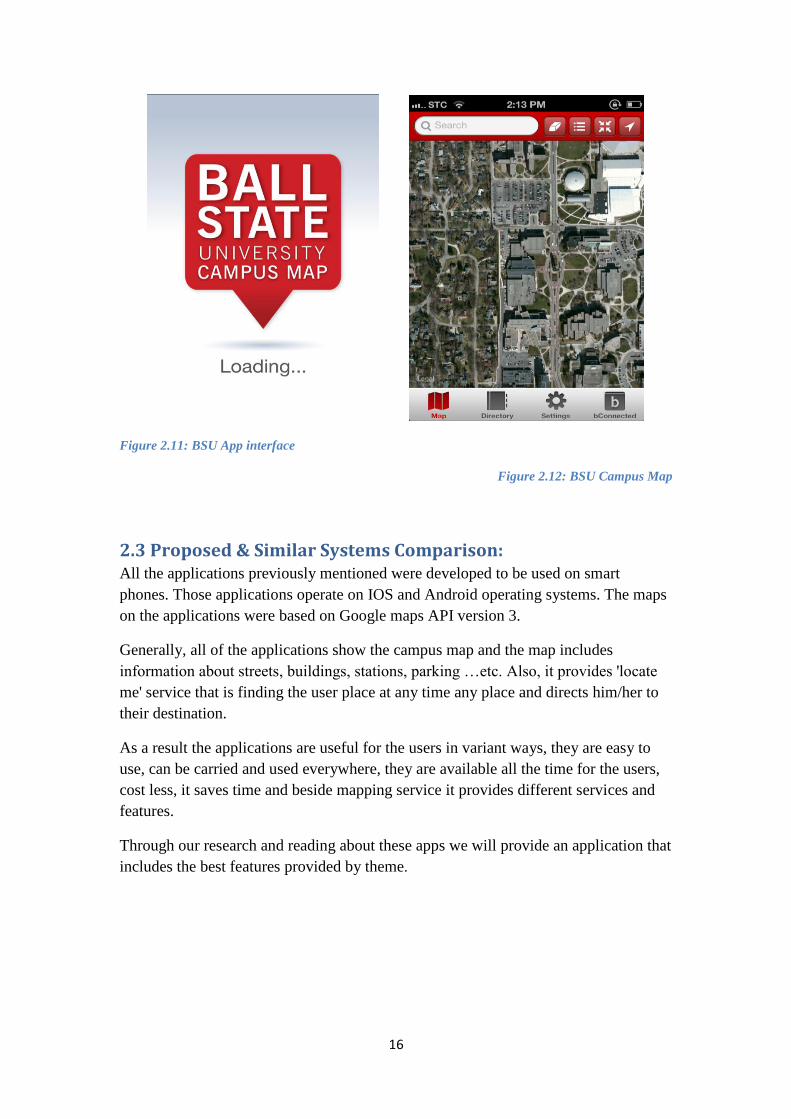
Ball State University (BSU) has a campus map for IPhone and Android using Google
map API (Figure2.11). The map is also providing most of the previous features such
as providing detailed description and information about each building, department and
landmark (Figure 2.12). With one tap, the app becomes a GPS or WI FI position
located anywhere inside the campus so that users can find bus stops, restaurants, ATM
machines and more. The APP can be downloaded from the iTunes APP store on the
Android marketplace.[3]
16
Figure 2.11: BSU App interface
Figure 2.12: BSU Campus Map
2.3 Proposed & Similar Systems Comparison: All the applications previously mentioned were developed to be used on smart
phones. Those applications operate on IOS and Android operating systems. The maps
on the applications were based on Google maps API version 3.
Generally, all of the applications show the campus map and the map includes
information about streets, buildings, stations, parking …etc. Also, it provides 'locate
me' service that is finding the user place at any time any place and directs him/her to
their destination.
As a result the applications are useful for the users in variant ways, they are easy to
use, can be carried and used everywhere, they are available all the time for the users,
cost less, it saves time and beside mapping service it provides different services and
features.
Through our research and reading about these apps we will provide an application that
includes the best features provided by theme.
17
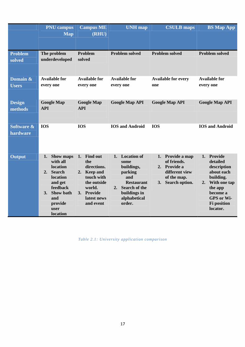
Table 2.1: University application comparison
PNU campus
Map
Campus ME
(RHU)
UNH map CSULB maps BS Map App
Problem
solved
The problem
underdeveloped
Problem
solved
Problem solved Problem solved Problem solved
Domain &
Users
Available for
every one
Available for
every one
Available for
every one
Available for every
one
Available for
every one
Design
methods
Google Map
API
Google Map
API
Google Map API
Google Map API
Google Map API
Software &
hardware
IOS IOS IOS and Android IOS IOS and Android
Output 1. Show maps
with all
location
2. Search
location
and get
feedback
3. Show bath
and
provide
user
location
1. Find out
the
directions.
2. Keep and
touch with
the outside
world.
3. Provide
latest news
and event
1. Location of
some
buildings,
parking
and
Restaurant
2. Search of the
buildings in
alphabetical
order.
1. Provide a map
of friends.
2. Provide a
different view
of the map.
3. Search option.
1. Provide
detailed
description
about each
building.
2. With one tap
the app
become a
GPS or Wi-
Fi position
locator.
18
Chapter 3:
‘Requirements
Determination
Analysis’
19
3.1Requirements Determination & Collection:
3.1.1QuestionnairesForm: During our project we have run a questionnaire on a number of students and labors at
the university including the teaching staff and the admission staff to know the
difficulties that they face to reach the University. We adopted in our statistics the
desired system among user’s and the important information that the map should
provide clearly.
The questions where the following:
1- What is your position?
a- Teaching staff
b- Admission
c- Students
2- Which branch do you study at?
a- Princess Noura University, Alnarjes Neighborhood.
b- Princess Noura University, Exit 9
3- Do you find any difficulty to reach your college?
a- Yes
b- No
c- To some extent
4- Do you suggest existing map to show the directions of the university?
a- Yes
b- No
5- What map do you prefer?
a- Electronic
b- Paper
6- For what reasons do you prefer the electronic map if you prefer it?
………………………………………………………………………………………
7- On which system do you want this map?
a- I phone (IOS)
b- Blackberry (OS)
c- Nokia (Symbian)
d- Samsung (Android)
8- Which information do you want on the map to be clear?
a- Streets
b- Stations
c- Colleges
d- All of the above

21
9- Do you think that the electronic map will help the newcomers to the
university?
a- Yes
b- No
c- To some extent
10- To what extent this application will be successful in the future?
………………………………………………………………………………………

21
3.1.2 Questionnaires Result: 1- What is your position at the University?
The following chart indicates that most of the participants in the questionnaire were
classified as follows:
1- 88 % of students
2- 10 % of teaching staff
3- 2 % of admissions
Figure 3.1.1: Q1 result
2- In which branch do you study? The results were the following:
a- 94 % of students are studying at Alnarjes Branch.
b- 6 % of students are studying at Exit Nine Branch.
Figure 3.1.2: Q2 result
3- Did you find any difficulty to get to the university?
a- 28 % of students answered ( yes)
b- 34 % of students answered ( No)

22
c- 38 % of students answered (to some extent)
Figure 3.1.3: Q3 result
4- Do you suggest a map to indicate the roads of the university?
a- 94 % of students answered ( yes)
b- 4 % of students answered ( no)
Figure 3.1.4: Q4 result
5- What kind of map do you prefer?
a- 86 % of students preferred an electronic map.
b- 10 % of students preferred a paper map.

23
Figure 3.1.5: Q5 result
7-Each one gave a reasonable reason for selecting an electronic map so the
question was:
7- on which system do you want this map?
a- 62 % selected (I phone IOS)
b- 48 % selected (Blackberry OS)
c- 3 % selected (Nokia Symbian)
d- 40 % selected ( Samsung Android)
Figure 3.1.6: Q7result
8-What is the most important information that must be clear in the map?
a- 2 % of students wanted (streets)
b- 4 % of students wanted (stations)
c- 10 % of students wanted (colleges)
d- 82 % of students wanted (all of them)

24
Figure 3.1.7: Q8 result
9-Do you think that the electronic map is going to help newcomers?
a- 88 % answered (yes)
b- 2 % answered (no)
c- 6 % answered ( to some extent)
Figure 3.1.8: Q9 result
10- All participants focused on the importance of the program and expected its
success.

25
3.2 Requirements Analysis:
As a conclusion of the previous questionnaire, the following requirements
where decided:
Must:
1. Show maps with all locations.
2. Search locations and get feedbacks.
3. Provide user location.
4. Show paths.
Should:
5. Show University news.
6. Logo.
Could:
7. Help menu.
8. About us.
Would:
9. Colorful Map.
10. Colorful Icons.
It has been put into this order according to the MoSCoW (Must, Should, Could,
and would) methodology. It is one of the Agile Methods, which are recently used
on the level of company projects to improve the speed, production quality,
teamwork, time management, and many more aspects. It helped our team to
prioritize our tasks with less stress, and improved production. Main tasks are on
the top of the list, and other tasks are prioritized according to the importance, and
time availability.
Functional requirements:
1. Mostly we are going to need maintenance such as cleaning some places.
We are going to need some developments such as redesigning the map.
2. We are going to need to support some other language like Arabic and
French.
3. We can develop this application and make copies of it for other systems
like Android.
4. Show all locations on the map.
5. Searching for a specific location.
6. Get feedback regarding the required location whether found or not.
7. Show the path of the required location if found.
8. Show an error alert if required location not found.

26
Nonfunctional requirements
1- We are not going to need encryption for the data.
2- User-friendly icons will be set for each task.
3- The application portability will be assured as it will be processing on an
IPhone.
4- Flexibility of the application will be applied by:
a. Simplifying the tools to be easily recognized by any user.
b. Accomplishing a task in the least number of steps possible.
c. Easy to reach options (less menus to use).

27
Chapter 4:
‘System Design’

28
Process of how the map
loads on the iPhone
application
The user click on one of the
services provided by the
application
4.1System Architecture:
4.1.1 Network Diagram:
Figure 4.1.1: Network diagram
1. The application accesses
the Internet with a request
to get the Map
2. Internet sends
the replay to the
user
3. User gets the Long/Lat
constantly by satellite
4. IPhone locate the student
position according to the
Long/Lat sent by satellite
29
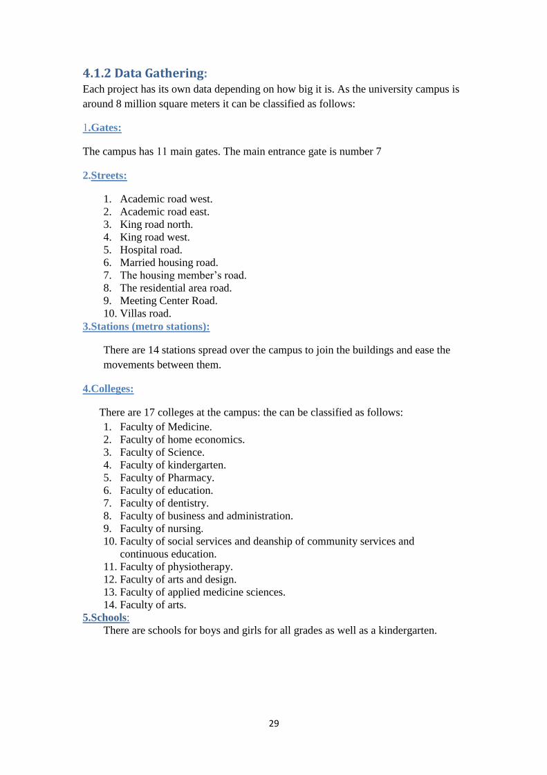
4.1.2 Data Gathering: Each project has its own data depending on how big it is. As the university campus is
around 8 million square meters it can be classified as follows:
1.Gates:
The campus has 11 main gates. The main entrance gate is number 7
2.Streets:
1. Academic road west.
2. Academic road east.
3. King road north.
4. King road west.
5. Hospital road.
6. Married housing road.
7. The housing member’s road.
8. The residential area road.
9. Meeting Center Road.
10. Villas road.
3.Stations (metro stations):
There are 14 stations spread over the campus to join the buildings and ease the
movements between them.
4.Colleges:
There are 17 colleges at the campus: the can be classified as follows:
1. Faculty of Medicine.
2. Faculty of home economics.
3. Faculty of Science.
4. Faculty of kindergarten.
5. Faculty of Pharmacy.
6. Faculty of education.
7. Faculty of dentistry.
8. Faculty of business and administration.
9. Faculty of nursing.
10. Faculty of social services and deanship of community services and
continuous education.
11. Faculty of physiotherapy.
12. Faculty of arts and design.
13. Faculty of applied medicine sciences.
14. Faculty of arts.
5.Schools:
There are schools for boys and girls for all grades as well as a kindergarten.

31
6. Accommodation:
There are three kinds of accommodations.
1- Housing for the teaching staff.
2- Housing for the assistants of the teaching staff.
3- Housing for the students/dormitory.
7. Sports centers and entertainment:
There are sports center and entertainment, one for male teaching staff and the other
for females. There are also sports and entertainment centers for students.
PNU campus maps:
(Figure 4.2.1)
Figure 4.2.1: PNU campus Maps
31
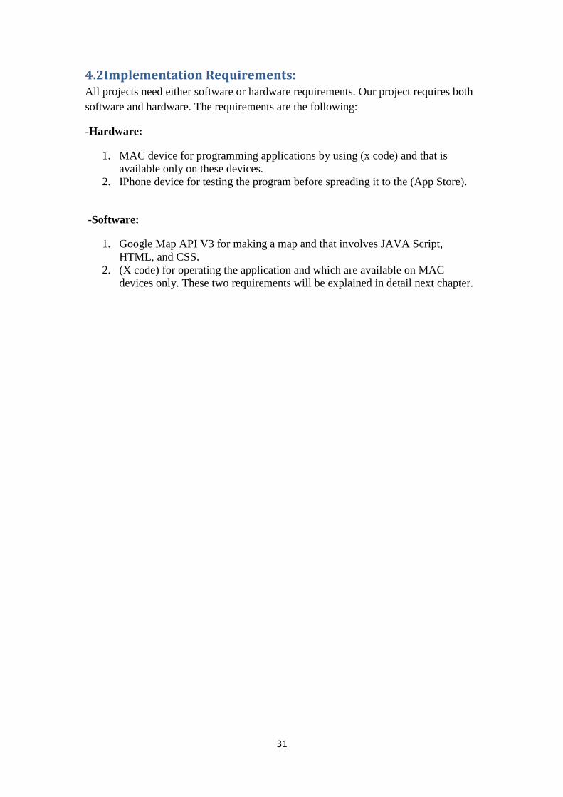
4.2Implementation Requirements: All projects need either software or hardware requirements. Our project requires both
software and hardware. The requirements are the following:
-Hardware:
1. MAC device for programming applications by using (x code) and that is
available only on these devices.
2. IPhone device for testing the program before spreading it to the (App Store).
-Software:
1. Google Map API V3 for making a map and that involves JAVA Script,
HTML, and CSS.
2. (X code) for operating the application and which are available on MAC
devices only. These two requirements will be explained in detail next chapter.

32
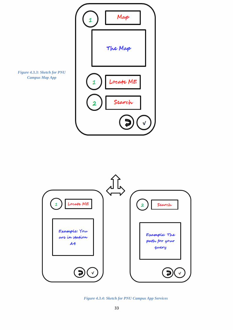
4.3User Interface Design:
4.3.1Screen Sketch: This is our imagination for the app at the final level, we sketch it as the real
application will be (it underdevelop, it may change in the future) see the figures
below.
Figure 4.3.1: Sketch for PNU Campus App interface
Figure 4.3.2: Sketch for PNU
Campus App Main Menu
33
Figure 4.3.3: Sketch for PNU
Campus Map App
Figure 4.3.4: Sketch for PNU Campus App Services

34
Figure 4.3.6: Sketch for PNU Campus App Help
Figure 4.3.5: Sketch for PNU Campus App News
35
Chapter5:
‘Mapping
technology’

36
5.1 Mapping technology: Maps are representation of the earth surface or part of it on a flat surface, in order to
clarify its natural characteristics and other attributes. Every point or phenomenon
displayed at the map is an actual representation in its real geographical location. Maps
have different types, paper maps and internet maps. The invention of the Internet
mapping was an attractive way to publish the maps and it helps when we get lost and
it is an easy way to find directions. Internet maps (Application maps) are easy to use
and more interesting than paper maps. That is to say maps shaped the world we are
living and marked the most important places we need. The first map appear on the
Internet was 1993 in Xerox Palo Alto Research Center (PARC). On today’s Web, we
use the maps to find locations, positions of an address, get driving directions and find
many other things.[13]
The needed information of a location can be displayed on a map. There are several
mapping solutions including Yahoo! Maps and Bing Maps, but the most popular one
is Google Maps.
The API support over 50 languages, regions and has mechanisms for enterprise
developers who want to utilize the Google Maps API within an internet .The API
HTTP services can be accessed over a secure (HTTPS) connection by Google Maps
API Premier customers.[15]
5.2 Web map services:
On today’s Web, mapping solutions are a natural ingredient. We use them to see the
location of things, to search for the position of an address, to get driving directions,
and to do numerous other things. Most information has a location, and if something
has a location, it can be displayed on a map. There are several mapping solutions
including Yahoo! Maps and Bing Maps, but the most popular one is Google Maps.
5.2.1 Yahoo! Map API: Yahoo maps API (figure 5.2.1) establish interactive maps into webs and desktop
applications using Flash, Ajax and Map Image APIs. Also, Yahoo! offers other API
such as geographical information to your maps including Yahoo! Local broadcastings,
Traffic and Weather report, Upcoming events and Flickr Photos.[7]

37
Figure 5.2.1.: Yahoo! map
5.2.2Bing Map API:
Microsoft has launched the beta version of the mapping service within its searching
Bing in an effort to compete with the Google maps service. Bing maps (figure 5.2.2)
uses the Silverlight technology to provide the user a smooth zoom in and out within
the maps to be displayed as a three-dimensional image. Bing maps contain the street
side service that is the same as Google street view feature, which enables the user to
choose a site for panoramic view.[11]
Figure 5.2.2: Bing map
38
5.2.3 Google maps API: Google maps API is a map application provided by Google. It was originally
developed by two Danish brothers, Lars and Jens Rasmussen.
Google maps can be used as a navigational tool for displaying buildings, streets,
stations, houses and universities location …etc. Also, it allows users to identify where
they are. It can be embedded into site by using Google Map Application Programming
Interface (API). [1]
Google Maps package consist of two principal components: Google Map and Google
Map Location. Google Map contains the map itself, which can be configured to
display any location on earth in a variety of map types. [14]
The second component is a
Google Map Location, it is locations that can be created on the map and visitors of the
website can be given the option to create their own locations through the use of an
Asset Builder. Google Map can provide many feature like Scale Control, Google
Earth, Multiple map types and map type control.[15]
Figure 5.2.3.: Google map

39
Feature Google Maps Yahoo! Maps Bing Maps
URL maps.google.com maps.yahoo.com maps.bing.com
Viewing interface
Degrees of Motion Vertical,
Horizontal,
Depth,
Rotation,
360 Panoramic,
3D Mode.
Vertical,
Horizontal,
Depth.
Vertical,
Horizontal,
Depth,
360PaNouramic,
3D Mode,
Rotate
Map Zoom 19
It can be changed
through parameter.
17 19
Map Types Google Maps have 6
map types: 1. Map,
2. Satellite,
3. Hybrid,
4. Street,
5. Traffic,
6. 3D.
Yahoo! Have 3 map
types: 1. Map,
2. Satellite,
3. Hybrid,
Bing have 10 map
types: 1. Road,
2. Aerial,
3. Hybrid,
4. Bird's Eye,
5. Traffic,
6. 3D,
7. Street,
8. London Street
Map,
9. Ordnance Survey
Map,
10. Venue Maps
searching
Location It display Street Name,
Town, Neighborhood,
City, Long/Lat.
It displays Street
Name, Town, and City.
It display Street Name,
Town, City, Zip+4,
Long/Lat
Mobile
Mobile-Specific
Website
Yes No Yes
Mobile-Specific
Application
Yes No Yes
GPS Yes No Yes
Mobiles type of
map
1. Map,
2. Satellite,
3. Terrain,
4. Street
1. Map,
2. Satellite,
3. Hybrid
1. Map,
2. Road,
3. Aerial,
4. Street,
5. London
6. Street Map,
7. Ordnance
8. Survey Map,
9. Venue Maps
Table 5.3.1: comparison between several maps servers

41
Based on the comparison (Table 5.3.1), we chose Google map API V3 to build our
map.
5.2.4 How It Works It works by HTML, Java script and CSS. The map is based on images, and these
images are loaded in the background with Ajax calls and then it will be inserted into
<div> in the HTML pages. When using the map, the API will send two things, the
first is the coordinates and the second is the zoom levels of the map in Ajax calls that
will return new images. The API includes Java script files and these files include
classes with methods and properties used for the map.[15]
5.3 Creating PNU campus map: Step by step we create our map that includes marker places and label buildings.
This is a shot screen to the codes and the map (figure 5.3.1, figure 5.3.2, figure 5.3.3
and figure 5.3.4). (The codes under develop)[1],[6],[15],[17]
Figure 5.3.1: PNU map

41
Figure 5.3.2: PNU map display several college’s
Figure 5.3.3: PNU map display markers

42
Figure 5.3.4: The code for PNU map

43
Summary
Finally, the problem was that whoever visits PNU gets lost. So, after many
researches we have found that Smartphone market has expanded considerably
in the past few years. Therefore people could now download applications
remotely from the device within minutes. In turn the best way to solve the
problem was by designing an application that offer many functions to make
people comfortable and helps them to get there way.
However this is a summary of task which is performed in this project:
1. Identify and analysis the problem that makes the visitors confuse.
2. Gather information about the possible solution.
3. Design the final solution, which was a map application.
4. Present a statistics shows smart phone type in use at Saudi Arabia.
5. Design the map by coding it.
Future Work:
At second semester we will develop the PNU campus map and start building the
application using X-Code 'software developer tool'. At the end of the project we will
make sure that the application will be available at the app store.
44
Chapter 7:
‘References’

45
References
1. Google Maps JavaScript API v3. (2012, July 27). Retrieved from Google
Developers: https://developers.google.com/maps/documentation/javascript/
2. Benedict, J. (2012, Feb 14). Mapping Campus with Google Map Maker.
Retrieved from LINK: http://link.highedweb.org/2012/02/mapping-campus-
with-google-map-maker/
3. Campus Map BSU. (n.d.). Retrieved from Ball State University:
http://www.bsu.edu/map/
4. CampusMe. (n.d.). Retrieved from Royal Holloway's university:
http://www.rhul.ac.uk/it/campusme/home.aspx
5. CSULB Campus Maps. (n.d.). Retrieved from California State University long
beach: http://daf.csulb.edu/maps/
6. Find Latitude and Longitude. (n.d.). Retrieved from
http://www.findlatitudeandlongitude.com/
7. Freedman, C. (2007). Yahoo! Maps Mashups. indianapolis: Wiley / Wrox.
8. Geospatial Training & Consulting, L. (2006, April). Google Maps API "The
New World of Web Mapping". Retrieved from
http://www.geospatialtraining.com/GoogleMaps/Book/Google%20Maps%20
API%20v2.pdf
9. Hamdan, A. (2005). Women and education in Saudi Arabia:Challenges and
achievements. Retrieved from
http://ehlt.flinders.edu.au/education/iej/articles/v6n1/hamdan/paper.pdf
10. Hughes, B., & Cotterell, M. (2009). Software Project Management, 5th
revised edition. McGraw Hill Higher Education.
11. Kebeck, J. (2012). Bing Maps Developer's Guide . Microsoft Press.
12. Ministry Of Higher Education. (n.d.). Retrieved from
http://www.mohe.gov.sa/ar/studyinside/Government-
Universities/Pages/default.aspx
13. Mitchell, T. (2005). Web Mapping Illustrated . Sebastopol: O'Reilly .
14. Ricket, D. (2007). Google Maps API Introduction. Retrieved from
http://doug.ricket.com/gdd2007
46
References
15. Svennerberg, G. (2010). Beginning Google Maps API 3. New York: Apress.
16. UNH Campus Maps. (n.d.). Retrieved from University of New Hampshire:
http://www.unh.edu/unhedutop/map
17. Weigle, D. M. (2009). Google Maps API v3. Retrieved from Internet
Concepts: http://www.cs.odu.edu/~mweigle/CS312-
F09/Sched?action=download&upname=4-6-GoogleMaps.pdf

47
Appendix
Communication plan:
Date Who/Target Way of meeting Purpose/action Next meeting Planes
Monday, The first of October 2012.
Bayan – Afnan-
Fatimah – Haifa. At the university. Make a decision of
group members and approve it.
Chose the graduation project topic.
Sunday, October 7th 2012.
All team members. Conference on the Skype program.
Chose and reserve the topic.
Meet the supervisor.
Saturday, 13th Of October, 2012.
All team members With the supervisor.
At the university Introductory meeting with the supervisor
Gather information
Monday, 22th Tuesday, 23th Wednesday, 24th Of October, 2012.
All team members. Conference on the Skype program.
Gathering information and Understanding the main point.
Meet the supervisor.
Monday, November 12th, 2012.
All team member With the supervisor.
Conference on the Skype program.
Meet the supervisor to clear the project goals.
Gather information; begin to write the goals.
Tuesday, 13th Wednesday, 14th Of November, 2012
All team members. At the university. Clear the project planes and goals.
Create a
methodology to
develop the project
Saturday, 17thOf November, 2012.
All team members. Conference on the Skype program.
Decide and create the water fall methodology.
Complete the water fall.
Sunday, 18thOf November 2012.
All team members. Conference on the Skype program.
Write the waterfall stages.
Meeting with the supervisor.
Monday, 19thOf November 2012.
All team members With the supervisor.
Conference on the Skype program.
Meet the supervisor, he told us to do the abstract.
Complete the waterfall, Make the abstract and gather information about university.
48
Wednesday, November 21, 2012. Thursday, November 22, 2012.
All team members. Conference on the Skype program.
Complete the waterfall.
Make the abstract and gather information about university.
Date Who/Target Way of meeting Purpose/action Next meeting Planes
Saturday, November 24, 2012 Sunday, November 25, 2012
All team members. Meeting at the university.
First draft of abstract.
Meeting with the supervisor, gather information.
Monday, November 26, 2012.
All team members with the supervisor.
Conference on the Skype program.
Meet the supervisor, he told us to recreate the abstract and read about the maps.
Recreate the abstract and read about maps.
Wednesday, November 28, 2012.
All team members. Haifa’s House. Read and understand the maps technology.
Write the first draft of chapter.
Thursday, November 29, 2012.
All team members. Haifa’s House. Write the first draft of the mapping technology chapter.
Search about different types of maps 'Bing, yahoo & Google maps'
Saturday, The first of December 2012. Sunday, December 2th 2012.
All team members. Conference on the Skype program.
Write about Bing, yahoo & Google maps and choose Google maps for the project.
Meet the supervisor and start to code the map.
Monday, 3th Of December 2012.
All team members with the supervisor.
Conference on the Skype program
Meet the supervisor and answer the questions, he told us to complete coding.
Complete coding.
Wednesday, 5th Of December 2012.
All team members. Haifa’s House. Complete coding. Complete coding.
Friday,7th Of December 2012
Fatimah – Haifa. Haifa’s House. Complete coding. Complete coding.
49
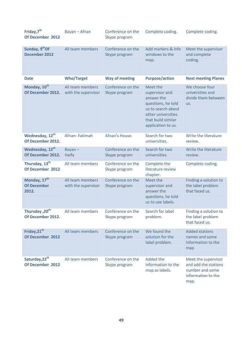
Friday,7th Of December 2012
Bayan – Afnan Conference on the Skype program
Complete coding. Complete coding.
Sunday, 9thOf December 2012
All team members Conference on the Skype program
Add markers & info windows to the map.
Meet the supervisor and complete coding.
Date Who/Target Way of meeting Purpose/action Next meeting Planes
Monday, 10th Of December 2012.
All team members with the supervisor
Conference on the Skype program
Meet the supervisor and answer the questions, he told us to search about other universities that build similar application to us.
We choose four universities and divide them between us.
Wednesday, 12th Of December 2012.
Afnan- Fatimah Afnan’s House. Search for two universities.
Write the literature review.
Wednesday, 12th Of December 2012.
Bayan – Haifa
Conference on the Skype program
Search for two universities.
Write the literature review.
Thursday, 13th Of December 2012
All team members Conference on the Skype program
Complete the literature review chapter.
Complete coding.
Monday, 17th Of December 2012.
All team members with the supervisor
Conference on the Skype program
Meet the supervisor and answer the questions, he told us to use labels.
Finding a solution to the label problem that faced us.
Thursday ,20th Of December 2012.
All team members Conference on the Skype program
Search for label problem.
Finding a solution to the label problem that faced us.
Friday,21th Of December 2012
All team members Conference on the Skype program
We found the solution for the label problem.
Added stations names and some information to the map
Saturday,22th Of December 2012
All team members Conference on the Skype program
Added the information to the map as labels.
Meet the supervisor and add the stations number and some information to the map.

51
Sunday, 23thOf December 2012
All team members with the supervisor
Conference on the Skype program
Meet the supervisor and answer the questions, he told us to stop coding and complete the report.
Screen sketch.
Monday, 24th
Tuesday, 25th
Of December 2012.
All team members Conference on the Skype program
Screen sketch & network diagram.
Write final draft of mapping technology chapter.
Date Who/Target Way of meeting Purpose/action Next meeting Planes
Sunday, 13th
Monday, 14th
Of January 2013
All team members Conference on the Skype program
Check grammar, spelling mistakes & rewrite mapping technology chapter.
Meet the supervisor and try to complete the whole report.
Tuesday, 15th
Of January 2013 All team members with the supervisor
Conference on the Skype program
Meet the supervisor and answer some questions.
Try to complete the whole report.
Tuesday, 15th
Of January 2013 Fatimah – Haifa. Fatimah’s House. Try to complete the
whole report. Try to complete the whole report.
Wednesday , 16th
Thursday, 17th
Friday,18th
Saturday,19th
Sunday, 20th
Of January 2013
All team members Conference on the Skype program
Complete the whole project & sent it to the supervisor.
Wait for the supervisor response & correct the mistakes.
Friday,25th
Of January 2013 All team members Conference on the
Skype program Correct the mistakes based on the supervisor responded
Meet the supervisor and modify the mistakes.
Saturday,26th
Of January 2013
All team members with the supervisor
Conference on the Skype program
Meet the supervisor and answered questions.
Modify the mistakes.
Saturday,26th
Sunday, 27th
Monday, 28th
Of January 2013
All team members Conference on the Skype program
Modify the mistakes.
Finishing the project.
Tuesday, 29th
Wednesday, 30th
Thursday, 31th
Of January 2013
All team members Conference on the Skype program
Modify the mistakes.
Insert our work into the university new template.
Friday,1th
Saturday,2th All team members Conference on the
Skype program Meet the supervisor and
Finishing the project.

51
Sunday, 3th
Monday, 4th of February 2013
answered questions. Insert our work into the university new template.
Tuesday,5th
of February 2013 All team members Conference on the
Skype program Finished the project.
Begins with the project (2)
Table A: Communication plan


![[Scenic China] The Immeasurable China](https://img.dokumen.tips/doc/110x75/54b8dd1d4a7959b7198b456b/scenic-china-the-immeasurable-china.jpg)